Influence of Holocene stratigraphic architecture on ground surface settlements: A case study from...
14
This article appeared in a journal published by Elsevier. The attached copy is furnished to the author for internal non-commercial research and education use, including for instruction at the authors institution and sharing with colleagues. Other uses, including reproduction and distribution, or selling or licensing copies, or posting to personal, institutional or third party websites are prohibited. In most cases authors are permitted to post their version of the article (e.g. in Word or Tex form) to their personal website or institutional repository. Authors requiring further information regarding Elsevier’s archiving and manuscript policies are encouraged to visit: http://www.elsevier.com/copyright
Transcript of Influence of Holocene stratigraphic architecture on ground surface settlements: A case study from...
This article appeared in a journal published by Elsevier. The attachedcopy is furnished to the author for internal non-commercial researchand education use, including for instruction at the authors institution
and sharing with colleagues.
Other uses, including reproduction and distribution, or selling orlicensing copies, or posting to personal, institutional or third party
websites are prohibited.
In most cases authors are permitted to post their version of thearticle (e.g. in Word or Tex form) to their personal website orinstitutional repository. Authors requiring further information
regarding Elsevier’s archiving and manuscript policies areencouraged to visit:
http://www.elsevier.com/copyright
Author's personal copy
Influence of Holocene stratigraphic architecture on ground surface settlements:A case study from the City of Pisa (Tuscany, Italy)
Giovanni Sarti a,⁎, Veronica Rossi b, Alessandro Amorosi b
a Dipartimento di Scienze Biologiche, Geologiche e Ambientali, Università di Bologna, Italyb Dipartimento di Scienze Geologico e Ambientali, Università di Bologna, Italy
a b s t r a c ta r t i c l e i n f o
Article history:Received 10 May 2012Received in revised form 21 August 2012Accepted 23 August 2012Available online 2 September 2012
Editor: J. Knight
Keywords:Facies analysisStratigraphic architectureGround settlementPisa PlainHolocene
The Holocene stratigraphic architecture of modern coastal and deltaic plains has peculiar characteristics thatmay influence ground surface settlements. In the Pisa urban area, the inhomogeneous spatial distribution ofgeotechnically weak layers, typically formed during the mid–late Holocene (highstand) coastal progradation,is inferred to be responsible for urban ground settlement and building damage, as evidenced by the tilt of sev-eral surface structures, among which the famous Leaning Tower of Pisa is the most prominent. On the basis ofintegrated stratigraphic, sedimentological and geotechnical data from a wide georeferenced database, threefacies associations with high deformability potential (Units 1–3) are identified in the uppermost 30 m as op-posed to depositional facies (Units 4–5) with higher geotechnical strength. Whereas Unit 1 represents athick, laterally extensive lagoonal clay deposit, the overlying highly deformable units (Units 2–3) showmore discontinuous spatial distribution controlled by the Holocene paleohydrographic evolution of theArno coastal plain. Unit 2, dated between the Neolithic and the Etruscan age (ca. 5000–2000 yr BP), is com-posed of swamp clays and silty clays recording lagoon infilling due to Arno Delta progradation. Units 3 and 4,which consist of wet levee deposits and stiff floodplain clays, respectively, formed during the subsequentphases of alluvial plain construction started around the Roman age (from ca. 2000 yr BP). Whereas Units 3and 4 are recorded within the uppermost 5 m, fluvial and distributary channel sands (Unit 5) cut the under-lying deltaic–alluvial succession at various stratigraphic levels, down to Unit 1. The spatial distribution ofthese units gives rise to three, locally juxtaposed, stratigraphic motifs in Pisa underground, reflecting differ-ent potential risks for settlement under building loads. We show how lateral changes in stratigraphic archi-tecture account for the irregular spatial distribution of geotechnically weak layers that are responsible forbuilding damage and ground settlement.
© 2012 Elsevier B.V. All rights reserved.
1. Introduction
The widespread socio-economic significance and the intense an-thropogenic pressure that characterize modern alluvial and coastalplains have induced over the last decade an increasing interest to-ward the recent sedimentary evolution of these areas and its relationswith the geotechnical properties of shallow subsurface sediments(Bozzano et al., 2000; Delgado et al., 2003; Campolunghi et al.,2007; Raspa et al., 2008; Dipova, 2010; Martini et al., 2010; Sarti etal., 2010). Since ancient times near-coast regions have hosted thehighest proportion of human population and the world's largest cit-ies, despite a variety of natural hazards including coastal erosion,aquifer saltwater intrusion, subsidence, floods and tsunamis (Cohenet al., 1997; Small et al., 2000; Small and Nicholls, 2003; Crowell
et al., 2007). In these areas, favorable physiographic features, easy ac-cess to the sea and water availability have favored the development ofthe first human settlements. Successively, several cities of great histor-ical and cultural value commonly rose on the banks of river courses, notfar from the coastline (Martini et al., 2010; Bini et al., 2012).
Through time, the development and expansion of urban areas wereconnected to their capacity to adapt to the landscape as well as to themodifications they imparted to the landscape to adjust it to theirneeds (Martini and Chesworth, 2010). Since historic times, significanthuman-induced changes to landscape have occurred at a global scale(Hooke, 2000; Wainwright and Millington, 2010), both by direct im-pacts on land cover (deforestation, agriculture and pasture; Billi andRinaldi, 1997) and by indirect feedbacks via climate and relativesea-level modifications (Ruddiman, 2003; IPCC, 2007; Rahmstorf,2007; Leorri et al., 2008; Horton et al., 2009; Kempet al., 2009; Lambecket al., 2011).
As for the geological context, one of the most relevant issues is thepresence in the shallow subsurface of soft sedimentary layers, the highcompressibility of which can induce local subsidence and differential
Sedimentary Geology 281 (2012) 75–87
⁎ Corresponding author at: Dipartimento di Scienze della Terra, Università di Pisa,Via S. Maria 53, Pisa, Italy. Tel.: +39 050 2215734; fax: +39 050 2215800.
E-mail addresses: [email protected] (G. Sarti), [email protected] (V. Rossi),[email protected] (A. Amorosi).
0037-0738/$ – see front matter © 2012 Elsevier B.V. All rights reserved.http://dx.doi.org/10.1016/j.sedgeo.2012.08.008
Contents lists available at SciVerse ScienceDirect
Sedimentary Geology
j ourna l homepage: www.e lsev ie r .com/ locate /sedgeo
Author's personal copy
settlement of the ground surface. These effects, amplified by groundwa-ter pumping, may cause land inundation, damage to constructionworksand historical buildings, as well as foundation instability, especially forhigh-rise buildings (Chai et al., 2004; Tang et al., 2008; van Asselen etal., 2009; Cui and Tang, 2010; Dipova, 2010). Stability problems relatedto the presence of highly compressible clay layers are common in manycities located on alluvial and deltaic coastal plains worldwide, suchas Rome (Bozzano et al., 2000; Campolunghi et al., 2007), Venice(Carbognini et al., 2005; Zezza, 2010), New Orleans (Saucier andSnowden, 1995; Burkett et al., 2003), Bangkok (Sinsakul, 2000;Phien-Wej et al., 2006), Idku City (Sakr et al., 2009) and Shanghai (Cuiet al., 2010).
Although an engineering approach is essential to address these is-sues, solutions lack careful geological–stratigraphic contextualizationfrequently. In this regard, the detailed reconstruction of shallow strat-igraphic architecture and the characterization of sedimentary bodiesin terms of their peculiar geotechnical properties represent issues ofparamount importance for a reliable support to engineering projects.
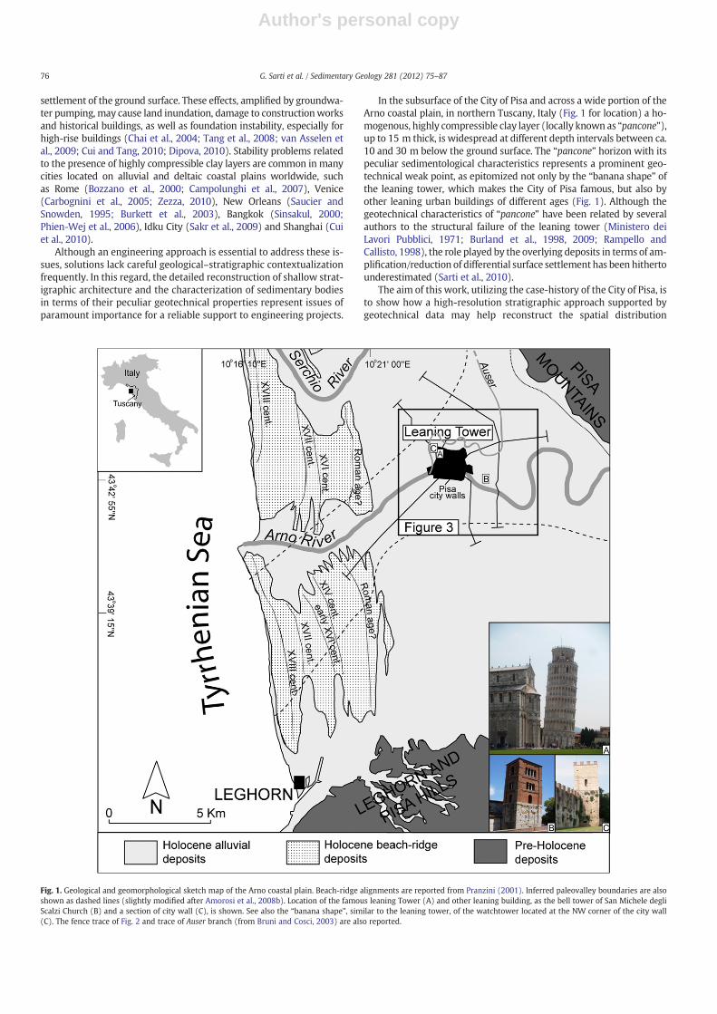
In the subsurface of the City of Pisa and across a wide portion of theArno coastal plain, in northern Tuscany, Italy (Fig. 1 for location) a ho-mogenous, highly compressible clay layer (locally known as “pancone”),up to 15 m thick, is widespread at different depth intervals between ca.10 and 30 m below the ground surface. The “pancone” horizon with itspeculiar sedimentological characteristics represents a prominent geo-technical weak point, as epitomized not only by the “banana shape” ofthe leaning tower, which makes the City of Pisa famous, but also byother leaning urban buildings of different ages (Fig. 1). Although thegeotechnical characteristics of “pancone” have been related by severalauthors to the structural failure of the leaning tower (Ministero deiLavori Pubblici, 1971; Burland et al., 1998, 2009; Rampello andCallisto, 1998), the role played by the overlying deposits in terms of am-plification/reduction of differential surface settlement has been hithertounderestimated (Sarti et al., 2010).
The aim of this work, utilizing the case-history of the City of Pisa, isto show how a high-resolution stratigraphic approach supported bygeotechnical data may help reconstruct the spatial distribution
Fig. 1. Geological and geomorphological sketch map of the Arno coastal plain. Beach-ridge alignments are reported from Pranzini (2001). Inferred paleovalley boundaries are alsoshown as dashed lines (slightly modified after Amorosi et al., 2008b). Location of the famous leaning Tower (A) and other leaning building, as the bell tower of San Michele degliScalzi Church (B) and a section of city wall (C), is shown. See also the “banana shape”, similar to the leaning tower, of the watchtower located at the NW corner of the city wall(C). The fence trace of Fig. 2 and trace of Auser branch (from Bruni and Cosci, 2003) are also reported.
76 G. Sarti et al. / Sedimentary Geology 281 (2012) 75–87
Author's personal copy
patterns of potentially geotechnically-weak layers beneath the urbanarea. A specific objective is to show to what extent the vertical stack-ing of sedimentary units with contrasting geotechnical characteristicsand its variations over short distances may influence ground surfacesettlement.
2. Geomorphological and stratigraphic setting of Pisa area
2.1. Geomorphological context
The City of Pisa is located ca. 15 kmeast of the Tyrrhenian Sea, in themiddle of a flat deltaic-coastal plain (Arno coastal plain; Fig. 1). Thisplain is crossed from east to west by the Arno River course, on thebanks of which Pisa City has developed since ancient Etruscan times(ca. 2500 yr BP).
The Arno coastal plain (ca. 450 km2-wide) is characterized by mildclimatic conditions and is bounded by the Pisa Mountains to the north-east, the Leghorn and Pisa hills to the south, and the Tyrrhenian Sea tothe west. The northern boundary of the coastal plain is not well defined,owing to complex superposition of several paleochannels related to thetwo main river courses of northern Tuscany (Arno River and SerchioRiver; Fig. 1). A complex paleohydrographic network characterized thePisa area during pre-Roman and Roman times (ca. 6000–1600 yr BP),as evidenced by historic documents (Strabone chronicles; see Biraschi,1988, for reference) along with geomorphological (Bruni and Cosci,2003) and stratigraphic subsurface (Rossi et al., 2012) data. In theurban center of Pisa an old branch of the Serchio River, known as Auser,merged with the paleoArno (Fig. 1), while an articulate fluvial patternflowed few hundreds of meters northward. This paleohydrographic net-work persisted up to the late Middle Ages, despite numerous engineer-ing works (levees, canals, and ditches) having been put in placeespecially during the Roman period to defend the City of Pisa againstfloods and wetland formation (Martini et al., 2010; Sarti et al., 2010;Rossi et al., 2012). Only during the XI–XII centuries was the Auserdiverted outside the city walls, leaving one channel (corresponding tothe modern Arno River course) to flow through the city area (Bruniand Cosci, 2003).
At present, the Pisa urban area rises on the Arno River alluvium.This is composed of predominant fine-grained overbank sedimentsand subordinate fine to medium sands, formed by the aggradationof crevasse splays and natural levees. Locally, paleochannels pluggedby silty-sand sediments are exposed and organic-rich clays, depositedin reclaimed swamp areas, occur east and west of Pisa (Della Roccaet al., 1987; Carratori et al., 1994; Sarti et al., 2010; Sarti, 2012). Sea-ward, a set of 3.5–4 m high beach-ridges occurs 5 km west of Pisa(Fig. 1). Archeological remains date the innermost beach-ridge tothe Iron Age (up to ca. 2200 yr BP; Carratori et al., 1994; Federiciand Mazzanti, 1995).
2.2. Late Quaternary sedimentary and paleoenvironmental evolution
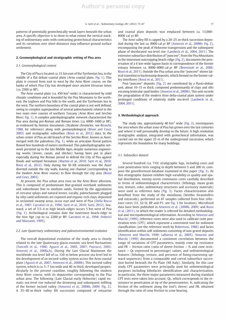
The overall depositional evolution of the study area is closelyrelated to the late Quaternary glacio-eustatic sea-level fluctuations(Fancelli et al., 1986; Aguzzi et al., 2005, 2007; Pascucci, 2005;Amorosi et al., 2008a,b). During the Last Glacial Maximum theworldwide sea-level fall of ca. 120 m below present sea level led tothe development of an incised-valley system across the Arno coastalplain (Aguzzi et al., 2007; Amorosi et al., 2008b). This incised-valleysystem, which is ca. 5–7 kmwide and 40 m thick, developed perpen-dicularly to the present coastline, roughly following the modernArno River course, with its depocenter corresponding to the Pisaurban area. The following (Late Glacial–early Holocene) rapid eu-static sea-level rise induced the drowning and subsequent infillingof the former incised valley (Amorosi et al., 2008b, 2009; Fig. 2).A 35–40 m-thick valley fill succession composed of estuarine
and coastal plain deposits was emplaced between ca. 13,000–8000 cal yr BP.
The Arno valley fill is capped by a 20–25 m-thick succession depos-ited during the last ca. 8000 cal yr BP (Amorosi et al., 2008b; Fig. 2),encompassing the peak of Holocene transgression and the subsequentphase of decelerated sea-level rise (Lambeck et al., 2004, 2011). Theextensive subsurface distribution of “pancone”, from the PisaMountainsto the innermost outcropping beach-ridge (Fig. 2), documents the pres-ervation of a 6 km-wide lagoon basin in correspondence of the formerestuary between ca. 8000–6000 cal yr BP (Benvenuti et al., 2006;Rossi et al., 2011). Outside the Pisa urban area the “pancone” shows lat-eral transition to backswampdeposits, which formed on the former val-ley interfluves (Rossi et al., 2011).
Post-“pancone” deposits (Fig. 2) are constituted by a fluvio-deltaicunit, about 10–15 m thick, composed predominantly of clays and siltsencasing lenticular sand bodies (Amorosi et al., 2008b). This unit recordsthe progradation of the modern Arno delta-coastal plain system underprolonged conditions of relatively stable sea-level (Lambeck et al.,2004, 2011).
3. Methodological approach
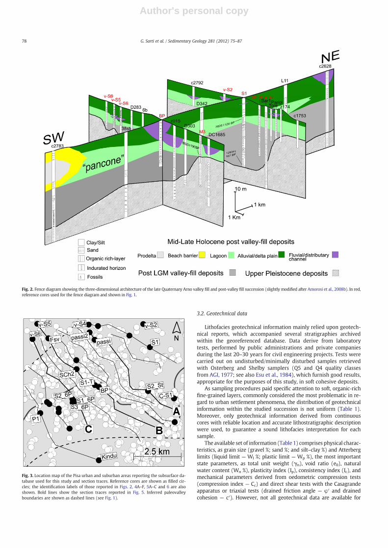
The study site, approximately 40 km2 wide (Fig. 3), encompassesthe area where the urban zone of Pisa has grown over the last centuriesand where it will presumably develop in the future. A high resolutionstratigraphic analysis, integrated with geotechnical information, wascarried out on the upper 25 m of the underground succession, whichrepresents the foundation for many buildings.
3.1. Subsurface dataset
Several hundred (ca. 710) stratigraphic logs, including cores andcone penetration tests ranging in depth between 5 and 200 m, com-pose the georeferenced database examined in this paper (Fig. 3). Asthis stratigraphic dataset exhibits high variability in quality and spa-tial distribution, twenty-seven continuous cores carefully describedin terms of sedimentological characteristics (lithology, mean grainsize, texture, color, sedimentary structures and accessory materials)were used as reference data (Fig. 3). Facies characterization alsobenefited from the study of the meiofauna (benthic foraminifersand ostracods), performed on 47 samples collected from four refer-ence cores (S1, S2-St, BP and P1; see Fig. 3 for location). Microfossildata have been published in Amorosi et al. (2008b, 2009) and Rossiet al. (2011), to which the reader is referred for detailed methodolog-ical and micropaleontological information. According to Amorosi andMarchi (1999), reference cores were also used to calibrate cone pen-etration tests (CPT), which represent a convenient tool for sedimentclassification (see the reference work by Robertson, 1986) and faciesidentification within soft sediments consisting of non-gravel deposits(Amorosi and Marchi, 1999; Lafuerza et al., 2005). Amorosi andMarchi (1999) documented a consistent correlation between therange of variations of CPT parameters, mainly cone tip resistanceand FR — friction ratio (ratio of sleeve friction — fs and cone resis-tance — Qc expressed in percentage) values, and sedimentologicalfeatures (lithology, texture, and presence of fining/coarsening up-ward sequences) from a comparable and coeval subsurface succes-sion buried beneath the Po Plain (NE Italy). Similarly, for this casestudy CPT parameters were principally used for sedimentologicalpurposes including lithofacies identification and characterization.In particular, the three major parameters measured during standardCPT tests were taken into account: Qc, which corresponds to the re-sistance to penetration at tip of the penetrometer; fs, indicating thefriction of the sediment along the tool's sleeve; and FR, obtainedthrough the ratio of cone friction to cone bearing.
77G. Sarti et al. / Sedimentary Geology 281 (2012) 75–87
Author's personal copy
3.2. Geotechnical data
Lithofacies geotechnical information mainly relied upon geotech-nical reports, which accompanied several stratigraphies archivedwithin the georeferenced database. Data derive from laboratorytests, performed by public administrations and private companiesduring the last 20–30 years for civil engineering projects. Tests werecarried out on undisturbed/minimally disturbed samples retrievedwith Osterberg and Shelby samplers (Q5 and Q4 quality classesfrom AGI, 1977; see also Esu et al., 1984), which furnish good results,appropriate for the purposes of this study, in soft cohesive deposits.
As sampling procedures paid specific attention to soft, organic-richfine-grained layers, commonly considered the most problematic in re-gard to urban settlement phenomena, the distribution of geotechnicalinformation within the studied succession is not uniform (Table 1).Moreover, only geotechnical information derived from continuouscores with reliable location and accurate lithostratigraphic descriptionwere used, to guarantee a sound lithofacies interpretation for eachsample.
The available set of information (Table 1) comprises physical charac-teristics, as grain size (gravel %; sand %; and silt–clay %) and Atterberglimits (liquid limit — Wl %; plastic limit — Wp %), the most importantstate parameters, as total unit weight (γn), void ratio (e0), naturalwater content (Wn %), plasticity index (Ip), consistency index (Ic), andmechanical parameters derived from oedometric compression tests(compression index — Cc) and direct shear tests with the Casagrandeapparatus or triaxial tests (drained friction angle — φ′ and drainedcohesion — c′). However, not all geotechnical data are available for
Fig. 2. Fence diagram showing the three-dimensional architecture of the late Quaternary Arno valley fill and post-valley fill succession (slightly modified after Amorosi et al., 2008b). In red,reference cores used for the fence diagram and shown in Fig. 1.
Fig. 3. Location map of the Pisa urban and suburban areas reporting the subsurface da-tabase used for this study and section traces. Reference cores are shown as filled cir-cles; the identification labels of those reported in Figs. 2, 4A–F, 5A–C and 6 are alsoshown. Bold lines show the section traces reported in Fig. 5. Inferred paleovalleyboundaries are shown as dashed lines (see Fig. 1).
78 G. Sarti et al. / Sedimentary Geology 281 (2012) 75–87
Author's personal copy
each sample. Whereas almost all physical and state parameters are in-variably recorded, mechanical parameters are less numerous. Sincefew oedometric tests are available, we chose to apply the Terzaghiand Peak (1967) expression: Cc=0.009 (Wl−10), assuming that thedeposits under examination are normally consolidated. This hypothesisis supported by the consistency index values available from laboratorytests and the overall stratigraphic framework (recent sediments depos-ited within a subsiding basin). Moreover, OCR (overconsolidation ratio)values available in literature for “pancone” fall at the transition betweennormally consolidated and slightly overconsolidated clays (Callisto andCalbresi, 1998; Cavallaro et al., 1998). The application of the Terzaghiand Peak (1967) expression allowed us to obtain a homogeneous aver-age estimate of compressibility potential for each fine-grainedlithofacies.
Previous laboratory tests performed on Pisa shallow subsurfacedeposits, for the most part located in proximity of the Tower of Pisa,were also taken into account for comparison (Rampello and Callisto,1998; Cavallaro et al., 1998; Callisto and Rampello, 2004; Lo Prestiet al., 2009).
3.3. Stratigraphic sections
Eleven cross-sections, roughly oriented perpendicular to the ArnoRiver and evenly spaced (Fig. 3), were used to reconstruct the strati-graphic architecture of the Pisa subsurface. These sections focus onthe spatial distribution of geotechnical weak horizons, including“pancone”, in relation tomid–late Holocene depositional environments.
Spatial distribution patterns of the identified facies associations,here regarded as lithostratigraphic–geotechnical units, led to the re-construction of the main stratigraphic motifs recorded below thePisa urban area and identification of potential geotechnical weakness.
In the paper, ages used to constrain the stratigraphic frameworkare reported in yr BP (Before Present) when dealing with historical/archeological materials and calibrated yr BP (cal yr BP) when basedon radiocarbon dating.
4. Facies associations
Beneath the City of Pisa, five facies associations (named Units 1–5)are identified and described in terms of sedimentological features,spatial distribution and overall geotechnical characteristics.
4.1. Unit 1: lagoonal clays and silty clays (“pancone”)
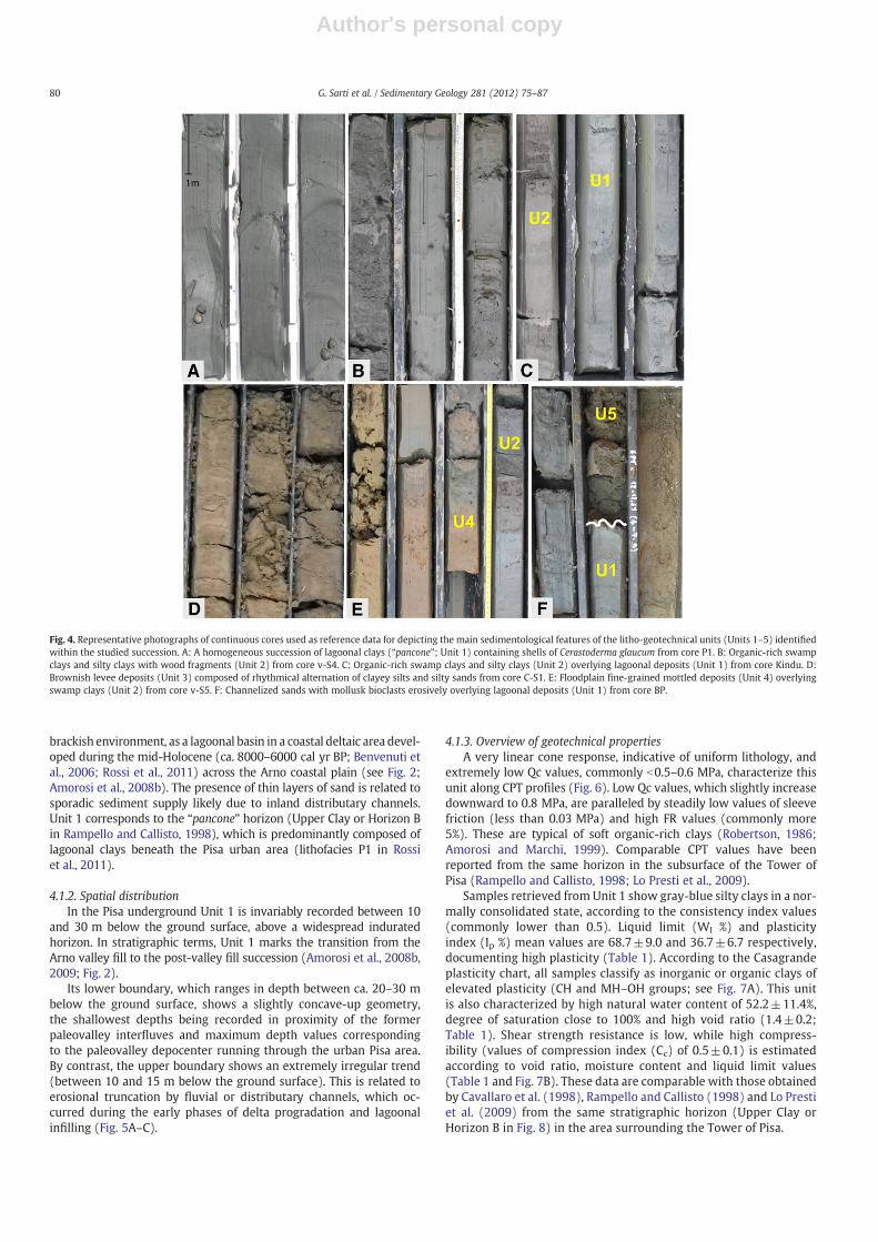
4.1.1. Facies description and interpretationThis facies association is ca. 3–12 m thick and includes a homoge-
neous succession of very soft gray-blue clays and silty clays. Sporadical-ly thin (commonly less than 20 cm) fine barren sandy layers (Fig. 4A)were observed. These layers display a sharp, non-erosive basal contactand are locally characterized by a coarsening upward sequence. Theymainly occur in the upper part of the unit. The gravel (>2 mm size)fraction is small and composed by bioclasts (see granulometry inTable 1). Indeed, abundant shells in living position and disarticulatedvalves of Cerastoderma glaucum, a euryhaline bivalve that typically in-habits Mediterranean lagoonal basins partially closed to the sea(Russel and Petersen, 1973; Millet and Lamy, 2002), are commonly en-countered along with cm-thick layers made up entirely of bioclasts(Fig. 4A). Within the cores, Unit 1 also shows a typical brackishmeiofauna, mainly composed of Ammonia and Cyprideis specimenscommonly found in modern lagoonal basins (D'Onofrio et al., 1976;Albani and Serandrei Barbero, 1990; Montenegro and Pugliese, 1996;Samir, 2000; Murray, 2006; Carboni et al., 2009). Scattered plant re-mains, wood fragments and dark organic-rich horizons document theavailability of organic matter.
Sedimentological features and the peculiar fossil content suggestthat this facies association was formed in an organic-rich, low-energy,Ta
ble1
Litho-ge
otechn
ical
unit(U
nits
1–5)
compo
sing
thesh
allow
subs
urface
succession
ofPisa
urba
narea
.Phy
sical,statean
dmecha
nicalp
aram
etersaresh
ownas
mea
nva
lues
andstan
dard
deviationforea
chun
it.C
cestimations
areob
tained
bytheap
plicationof
theTe
rzag
hian
dPe
ak(1
967)
expression
.Asteriskindicatesda
taob
tained
from
onean
alyz
edsampleon
ly.
Facies
association/un
itSamplenu
mbe
rSamplecore
interval
(m)
Physical
characteristics
Statepa
rameters
Mecha
nicalp
aram
eters
Gravel%
Sand
%Silt–
clay
%W
l%
Wp%
Wn%
Sr%
eOγ n (kN/m
3 )I p
%I c%
C cφ′(°)
c′(kPa
)
Unit1
248–
200.3±
0.3
4.0±
2.5
95.7±
0.3
68.7±
9.0
32.0±5.4
52.2±
11.4
999±3.4
1.4±
0.2
158±
1.7
367±67
0.4±0.2
0.5±
0.1
10.9+
8.9
10.8±
19
Unit2
286–
90.5±
0.5
2.9±
2.3
93.8±
7.9
50.9±
12.2
26.3±4.6
42.0±
13.0
100.6±
3.0
0.9±
0.08
17.2±
1.2
25.4±8.9
0.6±0.2
0.4±
0.1
9.6±
4.1
15.7±
7.8
Unit3
171.5–
52.5*
32.2±
5.3
665±
3542
.5±
9.6
24.7±3.5
292±
5699
7*0.6±
0118
.0±
2.9
17.9±9.0
0.7±0.3
0.3±
0.08
26.4±
3373
±2.8
Unit4
91–
50.07
*0.88
*99
.05*
41.2±
11.4
25.1±2.7
27.3±
3.3
–0.8±
0.09
19.2±
0.6
16.5±10
.20.8±0.2
0.2+
0.1
23*
8.82
*Unit5
153–
120
72.7±
9.5
27.3±
9.5
––
305±
7987
.86*
1.1±
0.6
17.9±
1.4
––
–26
.7±
3.8
12.1±
13.1
–indicatesno
data.
79G. Sarti et al. / Sedimentary Geology 281 (2012) 75–87
Author's personal copy
brackish environment, as a lagoonal basin in a coastal deltaic area devel-oped during the mid-Holocene (ca. 8000–6000 cal yr BP; Benvenuti etal., 2006; Rossi et al., 2011) across the Arno coastal plain (see Fig. 2;Amorosi et al., 2008b). The presence of thin layers of sand is related tosporadic sediment supply likely due to inland distributary channels.Unit 1 corresponds to the “pancone” horizon (Upper Clay or Horizon Bin Rampello and Callisto, 1998), which is predominantly composed oflagoonal clays beneath the Pisa urban area (lithofacies P1 in Rossiet al., 2011).
4.1.2. Spatial distributionIn the Pisa underground Unit 1 is invariably recorded between 10
and 30 m below the ground surface, above a widespread induratedhorizon. In stratigraphic terms, Unit 1 marks the transition from theArno valley fill to the post-valley fill succession (Amorosi et al., 2008b,2009; Fig. 2).
Its lower boundary, which ranges in depth between ca. 20–30 mbelow the ground surface, shows a slightly concave-up geometry,the shallowest depths being recorded in proximity of the formerpaleovalley interfluves and maximum depth values correspondingto the paleovalley depocenter running through the urban Pisa area.By contrast, the upper boundary shows an extremely irregular trend(between 10 and 15 m below the ground surface). This is related toerosional truncation by fluvial or distributary channels, which oc-curred during the early phases of delta progradation and lagoonalinfilling (Fig. 5A–C).
4.1.3. Overview of geotechnical propertiesA very linear cone response, indicative of uniform lithology, and
extremely low Qc values, commonly b0.5–0.6 MPa, characterize thisunit along CPT profiles (Fig. 6). Low Qc values, which slightly increasedownward to 0.8 MPa, are paralleled by steadily low values of sleevefriction (less than 0.03 MPa) and high FR values (commonly more5%). These are typical of soft organic-rich clays (Robertson, 1986;Amorosi and Marchi, 1999). Comparable CPT values have beenreported from the same horizon in the subsurface of the Tower ofPisa (Rampello and Callisto, 1998; Lo Presti et al., 2009).
Samples retrieved from Unit 1 show gray-blue silty clays in a nor-mally consolidated state, according to the consistency index values(commonly lower than 0.5). Liquid limit (Wl %) and plasticityindex (Ip %) mean values are 68.7±9.0 and 36.7±6.7 respectively,documenting high plasticity (Table 1). According to the Casagrandeplasticity chart, all samples classify as inorganic or organic clays ofelevated plasticity (CH and MH–OH groups; see Fig. 7A). This unitis also characterized by high natural water content of 52.2±11.4%,degree of saturation close to 100% and high void ratio (1.4±0.2;Table 1). Shear strength resistance is low, while high compress-ibility (values of compression index (Cc) of 0.5±0.1) is estimatedaccording to void ratio, moisture content and liquid limit values(Table 1 and Fig. 7B). These data are comparable with those obtainedby Cavallaro et al. (1998), Rampello and Callisto (1998) and Lo Prestiet al. (2009) from the same stratigraphic horizon (Upper Clay orHorizon B in Fig. 8) in the area surrounding the Tower of Pisa.
Fig. 4. Representative photographs of continuous cores used as reference data for depicting the main sedimentological features of the litho-geotechnical units (Units 1–5) identifiedwithin the studied succession. A: A homogeneous succession of lagoonal clays (“pancone”; Unit 1) containing shells of Cerastoderma glaucum from core P1. B: Organic-rich swampclays and silty clays with wood fragments (Unit 2) from core v-S4. C: Organic-rich swamp clays and silty clays (Unit 2) overlying lagoonal deposits (Unit 1) from core Kindu. D:Brownish levee deposits (Unit 3) composed of rhythmical alternation of clayey silts and silty sands from core C-S1. E: Floodplain fine-grained mottled deposits (Unit 4) overlyingswamp clays (Unit 2) from core v-S5. F: Channelized sands with mollusk bioclasts erosively overlying lagoonal deposits (Unit 1) from core BP.
80 G. Sarti et al. / Sedimentary Geology 281 (2012) 75–87
Author's personal copy
4.2. Unit 2: swamp clays and silty clays
4.2.1. Facies description and interpretationDark, bioturbated soft clays and silty clays with high organic matter
content characterize this facies association, occasionally formed bypeaty layers. Most sedimentary structures are completely obliteratedby the pervasive action of bioturbation. Locally, mm- to cm-thick hori-zontal laminations are preserved. Lamination is highlighted by eithersubtle grain-size variations, from clay to silty-clay, or concentration oforganic matter. Sporadically, sand layers a few centimeters thick,showing sharp lower boundaries and fining-upward trends, are alsoobserved (see also granulometry in Table 1). Abundant wood frag-ments, scattered shells of terrestrial gastropods (Fig. 4B) and a fewvalves of freshwater ostracods (mainly belonging to Candona andPseudocandona genera, see Amorosi et al., 2009 and Rossi et al., 2011)are also recorded. Across the Pisa area, this unit shows highly variablethickness (2–5 m).
This facies association is consistent with a low-energy, freshwater-oligohaline depositional setting characterized by high organic mattercontent and stagnant waters. A likely environment is a swamplanddeveloped in a delta plain interdistributary area. The thin sand layerstestify to occasional river floods.
4.2.2. Spatial distributionA wide spatial distribution of Unit 2 above Unit 1 is recorded in the
study area between ca. 10–6 m below the ground surface, as a conse-quence of delta plain progradation and lagoonal infilling processes(Fig. 4C). Indeed, extensive interdistributary, paludal areas developedfrom the Neolithic age up to the Etruscan period (around 5000–2000 yrBP), when the coastal plain started to prograde and systematic land rec-lamation of Pisa took place (Sarti et al., 2010; Rossi et al., 2012).Erosional truncation surfaces, overlain by channel bodies, locally inter-rupt the succession of swamp deposits, accounting for its abrupt thick-ness variations (Fig. 5A–C).
From proximal to distal locations, the upper boundary of Unit 2 isprogressively shallower as a consequence of delta and coastal plainprogradation.
4.2.3. Overview of geotechnical propertiesUnit 2 is characterized by Qc values lower than 1 MPa (commonly
b0.8 MPa), which are paralleled by low values of sleeve friction(0.02–0.06 MPa) and FR values commonly ranging between 3.5%and 6%, typical of soft organic-rich clays (Robertson, 1986; Amorosiand Marchi, 1999). The cone response is regular, however sharppeaks of Qc locally occur in correspondence to peats, woods or thinsand layers interrupting the homogenous clay succession (Fig. 6).
This unit is mainly composed of normally consolidated clays andsilty clays (consistency index values commonly lower than 0.6),with slightly higher density values relative to Unit 1. Liquid limit(Wl %) and plasticity index (Ip %), which show average values of50.9±12.2 and 25.4±8.9 respectively, reflecting variable plasticity.The majority of samples from Unit 2 can be classified as inorganic ororganic clays of high plasticity, falling into the MH–OH and CH groupson the plasticity chart of Casagrande (Fig. 7A). However, a few sam-ples belong to the CL group, which includes clays of low to mediumplasticity (Fig. 7A); we interpret these samples as characterized bylower organic matter content. Samples show a natural water contentof 42.0±13.0%, a degree of saturation close to 100% and a void ratio of0.9±0.08 (Table 1).
The estimate of compression index gives an average value of 0.4±0.1, suggesting medium compressibility (Table 1 and Fig. 7B). Theshear strength values commonly exhibit low internal friction angle,due to the small quantity of sand, and cohesion lower than 25 kPa(Table 1).
4.3. Unit 3: alluvial wet clayey and sandy silts
4.3.1. Facies description and interpretationWet clayey silts and sandy silts composing this facies association (see
granulometry in Table 1) are recorded at shallow stratigraphic levels,commonly between 1 and 3 m below sea level (ca. 2–6 m below theground surface), with thickness of b3.5 m. In high-quality subsurfacedata, these deposits are generally represented by a rhythmical cm todm-thick alternation of clayey silts and loose to moderately aggregatedsandy silts to silty sands, characterized by yellow-brownish color andsparse plant debris (Fig. 4D). Small scale cross-laminations formed bymigrating ripples are occasionally preserved. No fossils were encoun-tered within this facies association.
These features suggest an alluvial depositional setting close to theriver channel and subjected to frequent flooding events, such as a nat-ural levee. Post-depositional interaction with the water table couldhave increased significantly the natural water content of these de-posits, as also suggested by the commonly shallow depths (1.5–3 mbelow sea level) of the water table in the subsurface of Pisa.
4.3.2. Spatial distributionLevee deposits belonging to Unit 3 are exclusively recorded in
proximity of modern or historically active river courses flowingacross the Pisa Plain. Owing to the highly dynamic behavior of the al-luvial depositional system, this unit shows a discontinuous spatialdistribution pattern and limited lateral extension within the studiedsuccession (Fig. 5A–C). A wedge-shaped geometry, thinning awayfrom the channel axis, is shown where subsurface data density ishigh. Wet levee deposits (Unit 3) show lateral transition to other al-luvial deposits, such as floodplain clays (Unit 4) and channel sands(Unit 5) described below (Fig. 5A–C).
4.3.3. Overview of geotechnical propertiesThe overall tip resistance (Qc) measured by cone penetration tests
is quite low (between 0.5 and 1.3 MPa), while the sleeve frictionranges between 0.02 and 0.07 MPa (Fig. 6). FR values range between3% and 7%. Slightly higher values of Qc (ca. 1.5–2 MPa) are locallyrecorded in coarser, sand layers (Fig. 6). Comparable Qc values wereobtained by Rampello and Callisto (1998) ca. 4–6 m beneath the lean-ing Tower of Pisa from clayey silts (see horizon A1′ in Fig. 8) and siltysands (see horizon A1″ in Fig. 8).
Samples retrieved from Unit 3 show an average liquid limit valueof 42.5±9.6% and plasticity index of 17.9±9.0% (Table 1), which aretypical of inorganic or organic silts and silty clays of low to mediumplasticity (ML–OL and CL groups). Few samples classify as inorganicclays of high plasticity (CH group in Fig. 7A). These data suggestslightly higher plasticity of Unit 3 relative to the horizon A1 identifiedby Rampello and Callisto (1998) and Lo Presti et al. (2009) at compa-rable depths in the surroundings of the leaning Tower.
Unit volume weight and natural water content show averagevalues of 18.0±8.9 kN/m3 and 29.2±5.6%, respectively. Degree ofsaturation is ca. 100% and the average void ratio is 0.6±0.1 (Table 1).
An overall minor compressibility characterizes Unit 3 relativeto Units 1 and 2 (Table 1 and Fig. 7B), while low cohesion values(commonly 10 kPa) are invariably recorded along with an average in-ternal friction angle of about 26°, due to the remarkable quantity ofsand-size material mixed with silts and clays (Table 1).
4.4. Unit 4: floodplain clays and silty clays
4.4.1. Facies description and interpretationThis facies association is composed of dry, stiff clays and silty clays
with low organic-matter content and evidence of subaerial exposure,including calcareous pedogenic nodules and yellow-brown mottlesdue to iron and manganese oxides (Fig. 4E). Scattered plant remainsare encountered, while no fossils are found. Unit 4 shows variable
81G. Sarti et al. / Sedimentary Geology 281 (2012) 75–87

Author's personal copy
82 G. Sarti et al. / Sedimentary Geology 281 (2012) 75–87
Author's personal copy
thickness ranging between 2 and 5 m. Occasionally, sharp-basedlayers made up of fine sands, a fewmm- to cm-thick, can be observed.These sedimentological features suggest an alluvial depositional set-ting, such as a floodplain, far from the active river channel and rarelyaffected by floods.
4.4.2. Spatial distributionUnit 4 crops out extensively across the study area (Sarti, 2012),
reaching the maximum depth of 5–6 m below the ground surface(Fig. 5A–C). Similar to Unit 3, this unit shows transition to other allu-vial deposits. Commonly, Unit 4 overlies swamp deposits of Unit 2(Fig. 4E), documenting the onset of an alluvial depositional system(Fig. 5A–C).
4.4.3. Overview of geotechnical propertiesCPT parameters of Unit 4 are typical of floodplain clayey deposits
(Robertson, 1986; Amorosi and Marchi, 1999) with low to mediumQc values (ca. 1–3 MPa), sleeve friction commonly ranging between0.05 and 0.15 MPa, and irregular Qc profile due to the occurrence of
calcareous nodules and thin sand layers (Fig. 6). In particular, sharppeaks of Qc, paralleled by an abrupt increase of sleeve friction, canbe indicative of pedogenized horizons (Amorosi and Marchi, 1999).FR commonly ranges between 5% and 9%.
Due to the very shallow subsurface spatial distribution of Unit 4,few samples were collected and analyzed in the laboratory. However,in spite of the limited geotechnical dataset available, general informa-tion regarding physical-state parameters of Unit 4 could be obtained(Table 1). Unit 4 shows the highest values of unit volume weight(17.45–19.9 kN/m3) and consistency index, the latter being invari-ably >0.6. The average natural water content (27.3±3.3%) is closeto the plastic limit (25.1±2.7%) or, less frequently, between the plas-tic limit and the liquid limit (41.2±11.4%; see Table 1). All thesephysical parameters are indicative of high consistency and low plas-ticity (ML–OL group in the plasticity chart of Casagrande; Fig. 7A).Low compressibility potential (an average value of 0.2±0.1) is alsoattested (Table 1 and Fig. 7B). Unfortunately, only one direct sheartest is available. This shows a cohesion value of ca. 9 kPa and internalfriction angle of 23°.
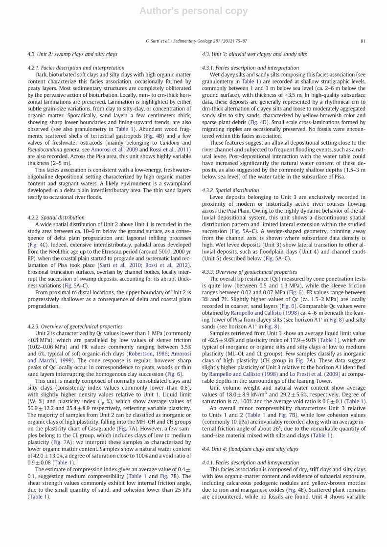
Fig. 5. Cross-sections transverse to the modern Arno River course showing the spatial distribution and the stratigraphic relationships existing among Units 1–5 within the studiedsuccession at proximal locations (A), around the city center of Pisa (B) and at distal locations (C). Core S_Mich is located very close to the San Michele degli Scalzi Church (see Fig. 1for location). Different vertical stacking patterns of Units 2–5 above the “pancone” succession (Unit 1) correspond to the stratigraphic motifs 1–3 reported in figure and described intext. The dashed lines trace local water table surface derived from detailed subsurface data. TS: transgressive surface. Reference cores are shown in red. Section traces are reportedin Fig. 3.
Fig. 6. Different response of litho-geotechnical Units 1–5 to cone penetration tests coincident with cores C-S1 and v-S4. U1, U2 and U3 units show a lower Qc values with respect toU4 and U5. U1 is characterized by a very low (lower than 0.5–0.6 MPa) and uniform Qc profile; Qc values in U2 are commonly lower than 0.8 MPa. Isolated sharp peaks of Qc arerelated to the occurrence of thin peat or sandy layers and tree trunks. U3 displays a Qc ranging between 0.5 and 1.3 MPa. Locally Qc can increase in correspondence to coarser sandylayers and calcareous nodules. Qc profile is almost irregular in U4 due to the presence of pedogenized or sandy horizons. Qc values are generally comprised between 1 and 3 MPa.U5 shows the higher Qc values that are commonly higher than 3 MPa.
83G. Sarti et al. / Sedimentary Geology 281 (2012) 75–87
Author's personal copy
4.5. Unit 5: fluvial-channel sands
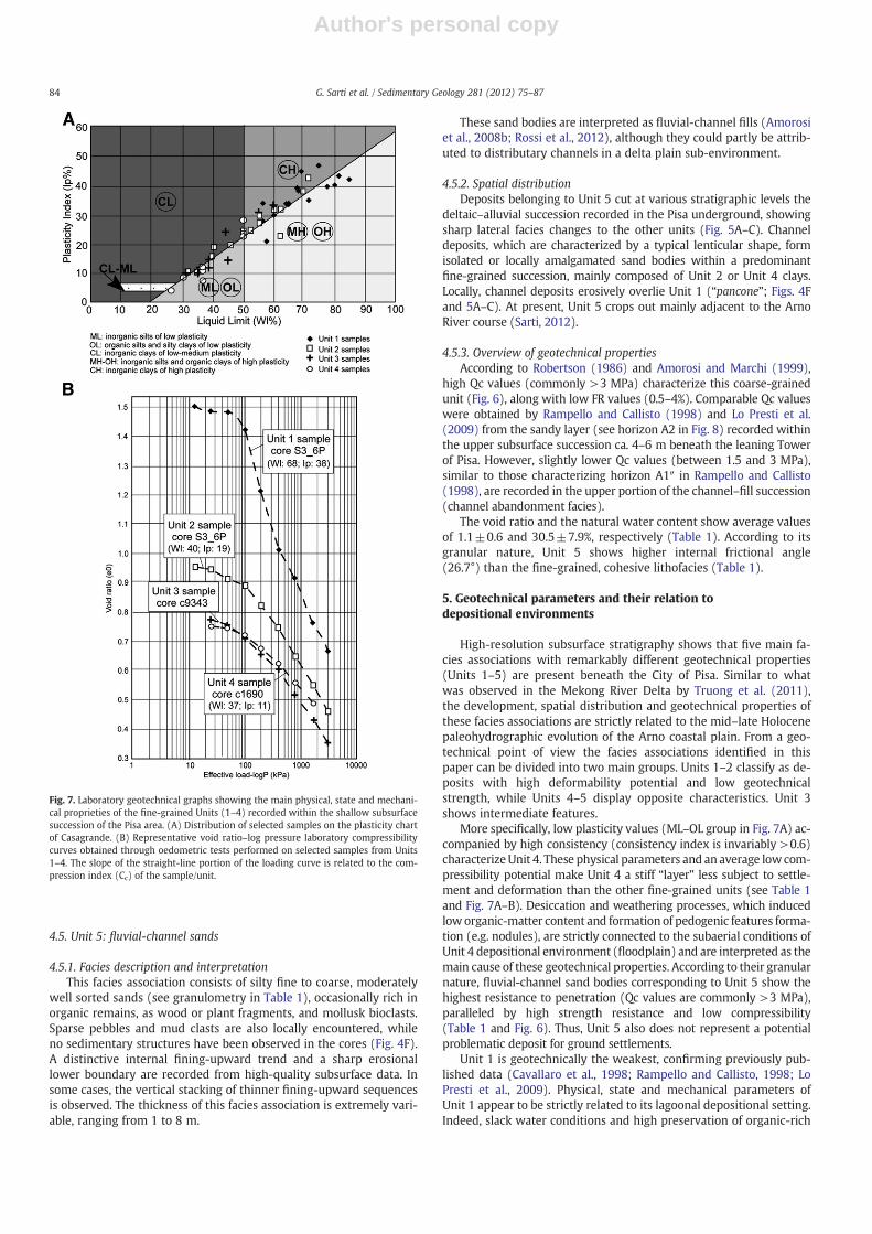
4.5.1. Facies description and interpretationThis facies association consists of silty fine to coarse, moderately
well sorted sands (see granulometry in Table 1), occasionally rich inorganic remains, as wood or plant fragments, and mollusk bioclasts.Sparse pebbles and mud clasts are also locally encountered, whileno sedimentary structures have been observed in the cores (Fig. 4F).A distinctive internal fining-upward trend and a sharp erosionallower boundary are recorded from high-quality subsurface data. Insome cases, the vertical stacking of thinner fining-upward sequencesis observed. The thickness of this facies association is extremely vari-able, ranging from 1 to 8 m.
These sand bodies are interpreted as fluvial-channel fills (Amorosiet al., 2008b; Rossi et al., 2012), although they could partly be attrib-uted to distributary channels in a delta plain sub-environment.
4.5.2. Spatial distributionDeposits belonging to Unit 5 cut at various stratigraphic levels the
deltaic–alluvial succession recorded in the Pisa underground, showingsharp lateral facies changes to the other units (Fig. 5A–C). Channeldeposits, which are characterized by a typical lenticular shape, formisolated or locally amalgamated sand bodies within a predominantfine-grained succession, mainly composed of Unit 2 or Unit 4 clays.Locally, channel deposits erosively overlie Unit 1 (“pancone”; Figs. 4Fand 5A–C). At present, Unit 5 crops out mainly adjacent to the ArnoRiver course (Sarti, 2012).
4.5.3. Overview of geotechnical propertiesAccording to Robertson (1986) and Amorosi and Marchi (1999),
high Qc values (commonly >3 MPa) characterize this coarse-grainedunit (Fig. 6), along with low FR values (0.5–4%). Comparable Qc valueswere obtained by Rampello and Callisto (1998) and Lo Presti et al.(2009) from the sandy layer (see horizon A2 in Fig. 8) recorded withinthe upper subsurface succession ca. 4–6 m beneath the leaning Towerof Pisa. However, slightly lower Qc values (between 1.5 and 3 MPa),similar to those characterizing horizon A1″ in Rampello and Callisto(1998), are recorded in the upper portion of the channel–fill succession(channel abandonment facies).
The void ratio and the natural water content show average valuesof 1.1±0.6 and 30.5±7.9%, respectively (Table 1). According to itsgranular nature, Unit 5 shows higher internal frictional angle(26.7°) than the fine-grained, cohesive lithofacies (Table 1).
5. Geotechnical parameters and their relation todepositional environments
High-resolution subsurface stratigraphy shows that five main fa-cies associations with remarkably different geotechnical properties(Units 1–5) are present beneath the City of Pisa. Similar to whatwas observed in the Mekong River Delta by Truong et al. (2011),the development, spatial distribution and geotechnical properties ofthese facies associations are strictly related to the mid–late Holocenepaleohydrographic evolution of the Arno coastal plain. From a geo-technical point of view the facies associations identified in thispaper can be divided into two main groups. Units 1–2 classify as de-posits with high deformability potential and low geotechnicalstrength, while Units 4–5 display opposite characteristics. Unit 3shows intermediate features.
More specifically, low plasticity values (ML–OL group in Fig. 7A) ac-companied by high consistency (consistency index is invariably >0.6)characterizeUnit 4. These physical parameters and an average lowcom-pressibility potential make Unit 4 a stiff “layer” less subject to settle-ment and deformation than the other fine-grained units (see Table 1and Fig. 7A–B). Desiccation and weathering processes, which inducedloworganic-matter content and formation of pedogenic features forma-tion (e.g. nodules), are strictly connected to the subaerial conditions ofUnit 4 depositional environment (floodplain) and are interpreted as themain cause of these geotechnical properties. According to their granularnature, fluvial-channel sand bodies corresponding to Unit 5 show thehighest resistance to penetration (Qc values are commonly >3 MPa),paralleled by high strength resistance and low compressibility(Table 1 and Fig. 6). Thus, Unit 5 also does not represent a potentialproblematic deposit for ground settlements.
Unit 1 is geotechnically the weakest, confirming previously pub-lished data (Cavallaro et al., 1998; Rampello and Callisto, 1998; LoPresti et al., 2009). Physical, state and mechanical parameters ofUnit 1 appear to be strictly related to its lagoonal depositional setting.Indeed, slack water conditions and high preservation of organic-rich
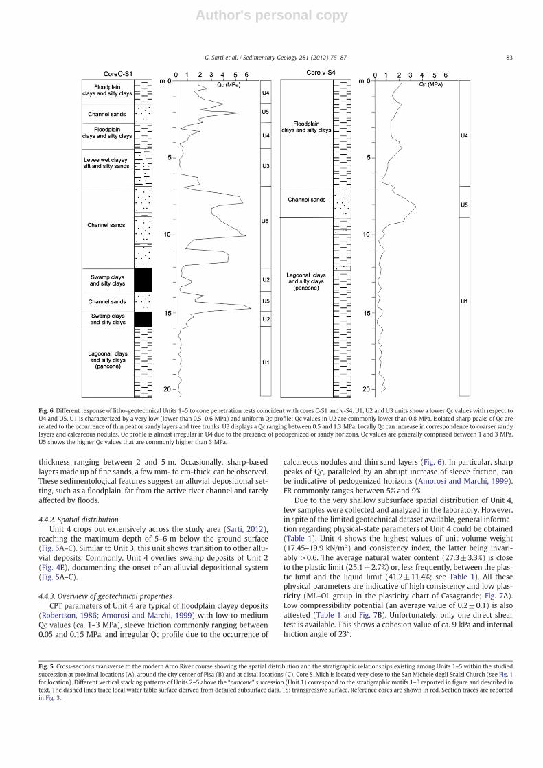
Fig. 7. Laboratory geotechnical graphs showing the main physical, state and mechani-cal proprieties of the fine-grained Units (1–4) recorded within the shallow subsurfacesuccession of the Pisa area. (A) Distribution of selected samples on the plasticity chartof Casagrande. (B) Representative void ratio–log pressure laboratory compressibilitycurves obtained through oedometric tests performed on selected samples from Units1–4. The slope of the straight-line portion of the loading curve is related to the com-pression index (Cc) of the sample/unit.
84 G. Sarti et al. / Sedimentary Geology 281 (2012) 75–87
Author's personal copy
remains determine elevated natural water content and remarkableamount of organic matter, respectively (Malkawi et al., 1999;Massey et al., 2006; van Asselen et al., 2009), the combined effect ofwhich causes the high deformability of Unit 1 (Table 1 and Fig. 7A–B). In particular, the high water content, which is often close to theliquid limit determines the soft/plastic physical state of Unit 1 andits low shear strength. The plasticity chart of Fig. 7A and the verylow values of consistency index (Table 1) document the high plastic-ity and softness of this layer (CH and MH–OH groups), which isparalleled by a very high compressibility potential (see Cc values inTable 1), as confirmed by the oedometric tests (Fig. 7B).
Low shear strength and remarkable plasticity also characterizeUnit 2, which is mainly classified as clay of high plasticity, fallinginto the MH–OH and CH groups on the plasticity chart of Casagrande(Fig. 7A). However, a slightly higher geotechnical strength relative toUnit 1 is revealed by samples with low–medium plasticity (CLgroup); lower compression index values (Table 1) and reduced steep-ness of the straight-line portion of the loading curve obtained fromthe available oedometric tests (Fig. 7B). Similar to Unit 1, the highdeformability potential under loads of Unit 2 derives from its deposi-tional environment, which comprises low-lying swamp areas charac-terized by remarkable amounts of natural water and organic matter.These areas developed during the first phases of delta progradation,which led to rapid lagoon infilling (Rossi et al., 2011).
Classification of Unit 3 is complicated. Although Unit 3 is charac-terized by lower compressibility potential, void ratio and naturalwater content (between the liquid limit and plastic limit), as well asby a slight increase of consistency index (Table 1 and Fig. 7A–B), weare inclined to consider this unit as a potentially weak “layer” withinthe Pisa underground. Indeed, low Qc and cohesion values (Fig. 6 andTable 1) highlight a weak resistance to deformation possibly relatedto the mixed granular-cohesive state of Unit 3 and to its saturatedconditions, due to interaction with the water table (Fig. 5A–C). Simi-lar to “collapsible” or “metastable” deposits, saturated conditions de-termined by water addition may reduce the capillary forces that bringtogether sediment particles of Unit 3. Collapse could result from ei-ther softening of the clay bridges between larger (silt to fine sand)particles or the loss of particle-to-particle cementation due to wet-ting. Upon wetting, these deposits can go through a great loss of vol-ume, especially if they are subject to high stress as load frombuildings (see Rogers, 1995). Thus, contrary to what is observed forUnits 1 and 2, the relatively low geotechnical strength of Unit 3 isstrictly related to the post-depositional addition of water, which ulti-mately reduces friction between particles. As a consequence, a certaindegree of variability should affect the geotechnical properties of Unit3, following unpredictable water table depth oscillations across thestudy area. The wide range of values recorded for total unit volumeweight and consistency index (Table 1), which reflects a certain de-gree of variability of the geotechnical properties of Unit 3, is likely
related to depth oscillations of the water table. The variable thicknessand discontinuous spatial distribution of Unit 3 represent additionalfactors that could favor inhomogeneous mechanical behavior of thesubsurface of Pisa urban area and thus differential ground settlement.
6. Ground settlement problems as a function ofstratigraphic architecture
The local variation in shallow subsurface compressibility potential,as inferred by the reconstruction of the high-resolution stratigraphicarchitecture, is an issue of paramount relevance for the managementof urban areas and might be a valuable support to engineers when itcomes to plan new buildings and preserve older ones.
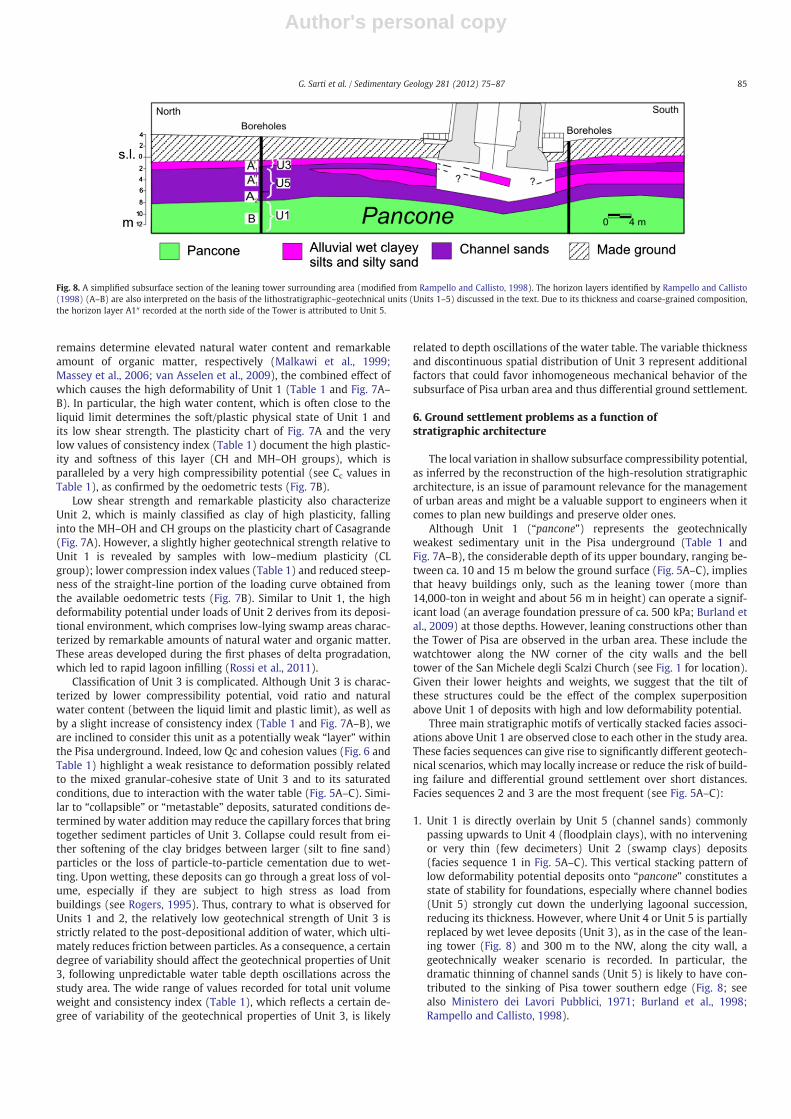
Although Unit 1 (“pancone”) represents the geotechnicallyweakest sedimentary unit in the Pisa underground (Table 1 andFig. 7A–B), the considerable depth of its upper boundary, ranging be-tween ca. 10 and 15 m below the ground surface (Fig. 5A–C), impliesthat heavy buildings only, such as the leaning tower (more than14,000-ton in weight and about 56 m in height) can operate a signif-icant load (an average foundation pressure of ca. 500 kPa; Burland etal., 2009) at those depths. However, leaning constructions other thanthe Tower of Pisa are observed in the urban area. These include thewatchtower along the NW corner of the city walls and the belltower of the San Michele degli Scalzi Church (see Fig. 1 for location).Given their lower heights and weights, we suggest that the tilt ofthese structures could be the effect of the complex superpositionabove Unit 1 of deposits with high and low deformability potential.
Three main stratigraphic motifs of vertically stacked facies associ-ations above Unit 1 are observed close to each other in the study area.These facies sequences can give rise to significantly different geotech-nical scenarios, which may locally increase or reduce the risk of build-ing failure and differential ground settlement over short distances.Facies sequences 2 and 3 are the most frequent (see Fig. 5A–C):
1. Unit 1 is directly overlain by Unit 5 (channel sands) commonlypassing upwards to Unit 4 (floodplain clays), with no interveningor very thin (few decimeters) Unit 2 (swamp clays) deposits(facies sequence 1 in Fig. 5A–C). This vertical stacking pattern oflow deformability potential deposits onto “pancone” constitutes astate of stability for foundations, especially where channel bodies(Unit 5) strongly cut down the underlying lagoonal succession,reducing its thickness. However, where Unit 4 or Unit 5 is partiallyreplaced by wet levee deposits (Unit 3), as in the case of the lean-ing tower (Fig. 8) and 300 m to the NW, along the city wall, ageotechnically weaker scenario is recorded. In particular, thedramatic thinning of channel sands (Unit 5) is likely to have con-tributed to the sinking of Pisa tower southern edge (Fig. 8; seealso Ministero dei Lavori Pubblici, 1971; Burland et al., 1998;Rampello and Callisto, 1998).
Fig. 8. A simplified subsurface section of the leaning tower surrounding area (modified from Rampello and Callisto, 1998). The horizon layers identified by Rampello and Callisto(1998) (A–B) are also interpreted on the basis of the lithostratigraphic–geotechnical units (Units 1–5) discussed in the text. Due to its thickness and coarse-grained composition,the horizon layer A1″ recorded at the north side of the Tower is attributed to Unit 5.
85G. Sarti et al. / Sedimentary Geology 281 (2012) 75–87
Author's personal copy
2. Unit 2 is sandwiched between Unit 1 and a complex alluvial suc-cession made up of poorly deformable litho-geotechnical units(Units 4 and 5). Unit 3 can occur locally (see facies sequence 2 inFig. 5A–C). This facies sequence, which invariably includes thicksuccessions of the two most compressible units, corresponds tothe geotechnically weakest scenario, especially where poorly com-pressible deposits are thin and/or Unit 3 also occurs.
3. A variant of facies sequence 2 is the presence of channel bodies(Unit 5), a few m thick, separating Unit 1 from overlying Unit 2(Fig. 5A–C). The presence of almost uncompressible sandy depositsbetween the two highest compressible units of Pisa undergroundsuggests increased stability relative to facies sequence 2. However,this vertical stacking pattern of litho-geotechnical units remains ageotechnically weak scenario with potential for deformationunder loads from buildings, as documented by the San Micheledegli Scalzi Church (see Figs. 1 and 5B).
7. Conclusions
In summary, this study is an attempt to investigate relationshipsbetween depositional facies and geotechnical properties and evaluatethe spatial variability of subsurface geomechanical behavior and its po-tential influence on differential ground settlements in a subsidingcoastal-alluvial plain. The vertical stacking pattern of swamp and alluvi-al deposits onto soft lagoonal clays illustrated in this paper should notbe regarded as peculiar to the mid–late Holocene succession of theArno coastal plain. Similar facies sequences have been reported fromthe coeval subsurface successions of several Mediterranean coastalplains, such as Tiber Delta (Milli, 1997; Amorosi and Milli, 2001),Ombrone Delta (Bellotti et al., 2004), Venetian Plain (Carbognini et al.,2005; Zezza, 2010), Po Plain (Amorosi et al., 2004) and Rhône Delta(Vella et al., 2005). Given the strong influence of sea-level change onmid–late Holocene stratigraphic architecture worldwide (Bard et al.,1996; Liu et al., 2004), comparable stratigraphic motifs are expectedfrom the subsurface of other modern alluvial and deltaic plains, formedin response to generalized highstand progradation. However, localpaleohydrographic evolution may strongly affect the spatial distribu-tion of deltaic and alluvial lithofacies with different geotechnicalproperties. In general, more stable conditions are expected to be en-countered on paleochannels, where the thickness of cohesive, highlycompressible layers is strongly reduced. On the other hand, rapid shiftsin river course position are likely to give rise to contrasting facies se-quences over short distances in floodplains/interdistributary areas,augmenting the risk of differential ground settlements between chan-nel fills and extra-channel deposits.
Acknowledgments
Dr. J. Knight and three anonymous reviewers greatly enhancedthis paper through their helpful reviews. We are strongly indebtedto Riccardo Giaccari for his scientific support. Thanks are also due toAldo Ianuzza and Patrizia Bartalini for their support and to SerenaGiacomelli and Duccio Bertoni for their helpful suggestions on an ear-lier version of the manuscript. This research received funding throughan agreement between Comune di Pisa and University of Pisa in aform of a grant to Giovanni Sarti. We are glad to thank the personnelof Comune di Pisa and particularly Marco Redini.
References
Aguzzi, M., Amorosi, A., Sarti, G., 2005. Stratigraphic architecture of Late Quaternarydeposits in the lower Arno Plain (Tuscany, Italy). Geologica Romana 38, 1–10.
Aguzzi, M., Amorosi, A., Colalongo, M.L., Ricci Lucchi, M., Rossi, V., Sarti, G., Vaiani, S.C.,2007. Late Quaternary climatic evolution of the Arno coastal plain (Western Tuscany,Italy) from subsurface data. Sedimentary Geology 202, 211–229.
Albani, A.D., Serandrei Barbero, R., 1990. I Foraminiferi della Laguna e del Golfo diVenezia. Memorie della Società Geologica Padova 42, 271–341.
Amorosi, A., Marchi, N., 1999. High-resolution sequence stratigraphy from piezoconetests: an example from late Quaternary deposits of the southeastern Po Plain.Sedimentary Geology 128, 67–81.
Amorosi, A., Milli, S., 2001. Late Quaternary depositional architecture of Po and Tevereriver deltas (Italy) and worldwide comparison with coeval deltaic successions.Sedimentary Geology 144, 357–375.
Amorosi, A., Colalongo, M.L., Fiorini, F., Fusco, F., Pasini, G., Vaiani, S.C., Sarti, G., 2004.Paleogeographic and paleoclimatic evolution of the Po Plain from 150-ky core re-cords. Global and Planetary Change 40, 1–24.
Amorosi, A., Pavesi, M., Ricci Lucchi, M., Sarti, G., Piccin, A., 2008a. Climatic signature ofcyclic fluvial architecture from the Quaternary of northern Po Plain, Italy. Sedimen-tary Geology 209, 58–68.
Amorosi, A., Sarti, G., Rossi, V., Fontana, V., 2008b. Anatomy and sequence stratigraphyof the late Quaternary Arno valley fill (Tuscany, Italy). In: Amorosi, A., Haq, B.U.,Sabato, L. (Eds.), Advances in Application of Sequence Stratigraphy in Italy:GeoActa Special Publication, 1, pp. 55–66. Editografica s.r.l, Bologna.
Amorosi, A., Ricci Lucchi, M., Rossi, V., Sarti, G., 2009. Climate change signature of small-scale parasequences from Late Glacial–Holocene transgressive deposits of the Arnovalley fill. Palaeogeography Palaeoclimatology Palaeoecology 273, 142–152.
Associazione Geotecnica Italiana (AGI), 1977. Raccomandazioni sulla programmazioneed esecuzione delle indagini geotecniche. Roma . 96 pp.
Bard, E., Hamelin, B., Arnold, M., Montaggioni, L., Cabioch, G., Faure, G., Rougerie, F.,1996. Deglacial sea-level record from Tahiti corals and the timing of global melt-water discharge. Nature 382, 241–244.
Bellotti, P., Caputo, C., Davoli, L., Evangelista, S., Garzanti, E., Pugliese, F., Valeri, P., 2004.Morpho-sedimentary characteristics and Holocene evolution of the Ombrone RiverDelta (Southern Tuscany). Geomorphology 61, 71–90.
Benvenuti, M., Mariotti Lippi, M., Pallecchi, P., Sagri, M., 2006. Late-Holocene cata-strophic floods in the terminal Arno River (Pisa, Central Italy) from the story of aRoman riverine harbour. The Holocene 16, 863–876.
Billi, P., Rinaldi, M., 1997. Human impact on sediment yield and channel dynamics inthe Arno River basin (central Italy). In: Walling, D.E., Probst, J.L. (Eds.), HumanImpact on Erosion and Sedimentation: Proceedings of Rabat Symposium: IAHSPublication, 245, pp. 301–311.
Bini, M., Brückner, H., Chelli, A., Pappalardo, M., Da Prato, S., Gervasini, L., 2012.Palaeogeographies of the Magra Valley coastal plain to constrain the location ofthe Roman harbour of Luna (NW Italy). Palaeogeography, Palaeoclimatology, Pa-laeoecology 337–338, 37–51.
Biraschi, A.M., 1988. Strabone, Geografia. L'Italia, Rizzoli (BUR), Milano . 388 pp.Bozzano, F., Andreucci, A., Gaeta, M., Salucci, R., 2000. A geological model of the buried
Tiber River valley beneath the historical centre of Rome. Bulletin of EngineeringGeology and the Environment 59, 1–21.
Bruni, S., Cosci, M., 2003. Alpheae veterem contemptlor originis urbem, quam cinguntgeminis Arnus et Ausur aquis. Il paesaggio di Pisa etrusca e romana:materiali eproblemi. In: Bruni, S. (Ed.), Il porto urbano di Pisa. La fase etrusca. Il contesto e ilrelitto ellenistico, pp. 29–43.
Burkett, V.R., Zikoskii, D.B., Hart, D.A., 2003. Sea-level rise and subsidence: implicationfor flooding in New Orleans, Louisiana. U.S. Geological Survey Subsidence InterestGroup Conference: Proceedings for the Technical Meeting, USGS Water ResourceDivision, Open File Report Series 03 308, pp. 63–70.
Burland, J., Jamiolkowski, M.B., Viggiani, C., 1998. Stabilising the leaning tower of Pisa.Bulletin of Engineering Geology and Environment 57, 91–99.
Burland, J., Jamiolkowski, M.B., Viggiani, C., 2009. Leaning Tower of Pisa: behaviour afterstabilization operations. International Journal of Geoengineering Case Histories 1,156–169.
Callisto, L., Calbresi, G., 1998. Mechanical behavior of a natural soft clay. Geotechnique48, 495–513.
Callisto, L., Rampello, S., 2004. An interpretation of structural degradation for three nat-ural clays. Canadian Geotechnical Journal 41, 392–407.
Campolunghi, M.P., Capelli, G., Funiciello, R., Lanzini, M., 2007. Geotechnical studies forfoundation settlement in Holocenic alluvial deposits in the City of Rome (Italy).Engineering Geology 89, 9–35.
Carbognini, L., Teatini, P., Tosi, L., 2005. Land subsidence in the Venetian area: knownand recent aspects. Giornale di Geologia Applicata 1, 5–11.
Carboni, M.G., Succi, M.C., Bergamin, L., di Bella, L., Frezza, V., Landini, B., 2009. Benthicforaminifera from two coastal lakes of southern Latium (Italy). Preliminary evalu-ation of environmental quality. Marine Pollution Bulletin 59, 268–280.
Carratori, L., Ceccarelli Lemut, M.L., Frattarelli Fischer, L., Garzella, G., Greco, G., GrifoniCremonesi, R., Mazzanti, R., Morelli, P., Nencini, C., Pasquinucci, M., PescagliniMonti, R., Pult Quaglia, A.M., Rau, A., Ronzani, M.E., Tozzi, C., 1994. Carta deglielementi naturalistici e storici della Pianura di Pisa e dei rilievi contermini, scala1:50.000. In: Mazzanti R. (Ed.), La pianura di Pisa e i rilievi contermini la naturae la storia: Memorie Società Geografica Italiana, L, pp. 491.
Cavallaro, A., Lo Presti, D.C.F., Maugeri, M., Pallara, O., 1998. Strain rate effect on stiff-ness and damping ratio of clays. Rivista Italiana di Geotecnica 32, 30–49.
Chai, J.C., Shen, S.L., Zhu, H.H., Zhang, X.L., 2004. Land subsidence due to groundwaterdrawdown in Shanghai. Gèotechnique 54, 143–147.
Cohen, J.E., Small, C., Mellinger, A., Gallup, J., Sachs, J., 1997. Estimates of coastalpopulations. Science 278, 1211–1212.
Crowell, M., Edelman, S., Coulton, K., McAfee, S., 2007. How many people live in coastalareas? Journal of Coastal Research 23, iii–vi.
Cui, Z.D., Tang, Y.Q., 2010. Land subsidence and pore structure of soils caused by thehigh-rise building group through centrifuge model test. Engineering Geology113, 44–52.
Cui, Z.D., Tang, Y.Q., Yan, X.C.X., Yan, C.L., Wang, H.M., Wang, J.X., 2010. Evaluation ofthe geology–environmental capacity of buildings based on the ANFIS model of
86 G. Sarti et al. / Sedimentary Geology 281 (2012) 75–87
Author's personal copy
the floor area ratio. Bulletin of Engineering and Geological Environments 69,111–118.
D'Onofrio, S., Marabini, F., Vivalda, P., 1976. Foraminiferi di alcune lagune del delta delPo. Giornale di Geologia 40, 267–276.
Delgado, J., Alfaro, P., Andreu, J.M., Cuenca, A., Doménech, C., Estévez, A., Soria, J.M.,Tomas, R., Yébenes, A., 2003. Engineering–geological model of the Segura Riverflood plain (SE Spain). A case study for engineering planning. Engineering Geology68, 171–187.
Della Rocca, B., Mazzanti, R., Pranzini, E., 1987. Studio geomorfologico della pianura diPisa. Geografia Fisica e Dinamica Quaternaria 10, 56–84.
Dipova, N., 2010. Geotechnical characterization and facies change detection of theBogacay Plain (Antalya, Turkey) soils. Environment Earth Science 62, 883–896.
Esu, F., Manfredini, G., Maugeri, M., 1984. Site investigation practice in Italy. RivistaItaliana di Geotecnica 18, 7–20.
Fancelli, R., Grifoni, R., Mazzanti, R., Menchelli, S., Nencini, C., Pasquinucci, M., Tozzi, C.,1986. Evoluzione della Pianura di Pisa. In: Mazzanti, R., Grifoni Cremonesi, R.,Pasquinucci, M., Pult Quaglia, A.M. (Eds.), Terre e Paduli. Reperti, documenti,immagini per la storia di Coltano, pp. 23–29. Bandecchi e Vivaldi, Pontedera.
Federici, P.R., Mazzanti, R., 1995. Note sulle pianure costiere della Toscana. Memoriedella Società Geografica Italiana 58, 165–270.
Hooke, R. LeB, 2000. On the history of human as geomorphic agents. Geology 28,843–864.
Horton, B.P., Peltier, W.R., Culver, S.J., Drummond, R., Engelhart, S.E., Kemp, A.C.,Mallinson, D., Thieler, E.R., Riggs, S.R., Ames, D.V., Thomson, K.H., 2009. Holocenesea-level changes along the North Carolina coastline and their implications for gla-cial isostatic adjustment models. Quaternary Science Reviews 28, 1725–1736.
IPCC, 2007. Climate Change 2007: Synthesis Report. Summary for Policymakers. Inter-governmental Panel on Climate Change Fourth Assessment Report. CambridgeUniversity Press, Cambridge.
Kemp, A.C., Horton, B.P., Culver, S.J., Corbett, D.R., van de Plassche, O., Gehrels, W.R.,Douglas, B.C., 2009. The timing and magnitude of recent accelerated sea-levelrise (North Carolina, USA). Geology 37, 1035–1038.
Lafuerza, S., Canals, M., Casamor, J.L., Devincenzi, J.M., 2005. Characterization of deltaicsediment bodies based on in situ CPT/CPTU profiles: a case study on the Llobregatdelta plain, Barcelona, Spain. Marine Geology 222–223, 497–510.
Lambeck, K., Antonioli, F., Purcell, A., Silenzi, S., 2004. Sea-level change along the Italiancoast for the past 10,000 yr. Quaternary Science Reviews 23, 1567–1598.
Lambeck, K., Antonioli, F., Anzidei, M., Ferranti, L., Leoni, G., Scicchitano, G., Silenzi, S.,2011. Sea level change along the Italian coast during the Holocene and projectionsfor the future. Quaternary International 232, 250–257.
Leorri, E., Horton, B.P., Cearreta, A., 2008. Development of a foraminifera-based transferfunction in the Basque marshes, N. Spain: implications for sea-level studies in theBay of Biscay. Marine Geology 251, 60–74.
Liu, J.P., Milliman, J.D., Gao, S., Cheng, P., 2004. Holocene development of the YellowRiver's subaqueous delta, North Yellow Sea. Marine Geology 209, 45–67.
Lo Presti, D.C.F., Meisina, C., Squeglia, N., 2009. Applicabilità di prove penetro metrichestatiche nella ricostruzione del profilo stratigrafico. Rivista Italiana di Geotecnica43, 9–33.
Malkawi, A.I.H., Alawneh, A.S., Abu-Safaqah, O.T., 1999. Effects of organic matter on thephysical and the physicochemical properties of an illitic soil. Applied Clay Science14, 257–278.
Martini, I.P., Chesworth, W., 2010. Landscape and Societies. Springer, Netherlands.Martini, I.P., Sarti, G., Pallecchi, P., Costantini, A., 2010. Landscape influences on the de-
velopment of the Medieval–Early Renaissance city-states of Pisa, Florence, andSiena, Italy. In: Martini, P., Chesworth, W. (Eds.), Landscape and Societies. Springer,Netherlands, pp. 203–223.
Massey, A.C., Paul, M.A., Gehrels, W.R., Charman, D.J., 2006. Autocompaction in Holocenecoastal back-barrier sediments from south Devon, southwest England, UK. MarineGeology 226, 225–241.
Millet, B., Lamy, N., 2002. Spatial patterns and seasonal strategy of macrobenthic speciesrelating to hydrodynamics in a coastal bay. Journal de Recherche Oceanographique27, 30–42.
Milli, S., 1997. Depositional setting and high-frequency sequence stratigraphy of theMiddle–Upper Pleistocene to Holocene deposits of the Roman Basin. GeologicaRomana 33, 99–136.
Ministero dei Lavori Pubblici, 1971. Ricerche e studi sulla Torre pendente di Pisa e ifenomeni connessi alle condizioni d'ambiente. Istituto Geografico Militare, FirenzeI, II, II.
Montenegro, M.E., Pugliese, N., 1996. Autoecological remarks on the ostracod distribu-tion in the Marano and Grado Lagoons (Northern Adriatic Sea, Italy). Bollettinodella Società Paleontologica Italiana 3, 123–132.
Murray, J.W., 2006. Ecology and Applications of Benthic Foraminifera. CambridgeUniversity Press, Cambridge.
Pascucci, V., 2005. Neogene evolution of the Viareggio Basin, northern Tuscany (Italy).GeoActa 4, 123–138.
Phien-Wej, N., Giao, P.H., Nutulaya, P., 2006. Land subsidence in Bangkok, Thailand.Engineering Geology 82, 187–201.
Pranzini, E., 2001. Updrift river mouth migration on cuspate deltas: two examples fromthe coast of Tuscany (Italy). Geomorphology 38, 125–132.
Rahmstorf, S., 2007. A semi-empirical approach to projecting future sea-level rise.Science 315, 368–370.
Rampello, S., Callisto, L., 1998. A study on the subsoil of the Tower of Pisa based on re-sults from standard and high-quality samples. Canadian Geotechnical Journal 35,1074–1092.
Raspa, G., Moscatelli, M., Stigliano, F., Patera, A., Marconi, F., Folle, D., Vallone, R.,Mancini, M., Cavinato, G.P., Milli, S., Coimbra Leite Costa, J.F., 2008. Geotechnicalcharacterization of the Upper Pleistocene–Holocene alluvial deposits of Rome(Italy) by means of multivariate geostatistics: cross-validation results. EngineeringGeology 101, 251–268.
Robertson, P.K., 1986. In situ testing and its application to foundation engineering.Canadian Geotechnical Journal 23, 573–594.
Rogers, C.D.F., 1995. Types and distribution of collapsible soils. In: Genesis and Propertiesof Collapsible Soils. NATO ASI Series C: Mathematical and Physical Sciences, 468.Kluwer Academic Publishers, pp. 1–17.
Rossi, V., Amorosi, A., Sarti, G., Potenza, M., 2011. Influence of inherited topography onthe Holocene sedimentary evolution of coastal systems: an example from Arnocoastal plain (Tuscany, Italy). Geomorphology 135, 117–128.
Rossi, V., Amorosi, A., Sarti, G., Romagnoli, R., 2012. New stratigraphic evidence for themid-late Holocene fluvial evolution of the Arno coastal plain (Tuscany, Italy).Géomorphologie: relief, processus, environnement 2, 201–214.
Ruddiman, W.F., 2003. The anthropogenic greenhouse era began thousands of yearsago. Climate Change 61, 261–293.
Russel, P.J., Petersen, G.H., 1973. The use of ecological data in the elucidation of someshallow water European Cardium species. Malacologia 14, 223–232.
Sakr, M.A., Shahin, M.A., Metwally, Y.M., 2009. Utilization of lime for stabilizing softclay soil of high organic content. Geotechnical and Geological Engineering 27,105–113.
Samir, A.M., 2000. The response of benthic foraminifera and ostracods to various pollu-tion sources: a study from two lagoons in Egypt. Journal of Foraminiferal Research30, 83–98.
Sarti, G., 2012. LaMacro-Area: la pianura di Pisa. Tutela della costa pisana dall'ingressionemarina. Comune di Pisa Ed, pp. 64–95. http://cdn.soloict.it/graffiti/index.html#/70/.
Sarti, G., Bini, M., Giacomelli, S., 2010. Correlations between landscape, geology and thegrowth and decline of Pisa (Tuscany, Italy) up to the Middle Ages. In: Sarti, G.,Martini, I.P. (Eds.), Italian Journal of Quaternary Science, 23(2bis), pp. 311–322.
Saucier, R.T., Snowden, J.O., 1995. Engineering Geology of the New Orleans Area.Geological Society of America Annual Meeting 2995, New Orleans, Louisiana,Field Trip Guide Book 6a–6b, pp. 131–153.
Sinsakul, S., 2000. Late Quaternary geology of the Lower Central Plain, Thailand. Journalof Asian Sciences 18, 415–426.
Small, C., Nicholls, R., 2003. A global analysis of human settlement in coastal zone. Journalof Coastal Research 19, 584–599.
Small, C., Gornitz, V., Cohen, J.E., 2000. Coastal hazards and the global distribution ofhuman population. Environmental Geoscience 7, 3–12.
Tang, Y.Q., Cui, Z.D., Wang, J.X., Lu, C., Yan, X.X., 2008. Model test study of land subsidencecaused by the high-rise building group. Bulletin of Engineering and Geological Envi-ronments 67, 173–179.
Terzaghi, K., Peak, R.B., 1967. Soil Mechanics in Engineering Practice. Wiley, New York.Truong, M.H., Nguyen, V.L., Oanh Ta, T.K., Takemura, J., 2011. Changes in late Pleisto-
cene-Holocene sedimentary facies of the Mekong River Delta and the influenceof sedimentary environment on geotechnical engineering properties. EngineeringGeology 122, 146–159.
van Asselen, S., Stouthamer, E., van Asch, Th.W.J., 2009. Effects of peat compaction ondelta evolution: a review on processes, responses, measuring and modelling.Earth-Science Reviews 92, 35–51.
Vella, C., Fleury, T.-J., Raccasi, G., Provansal, M., Sabatier, F., Bourcier, M., 2005. Evolution ofthe Rhône delta plain in the Holocene. Marine Geology 222–223, 235–265.
Wainwright, J., Millington, J.D.A., 2010. Mind, the gap in landscape-evolution model-ling. Earth Surface Processes and Landforms 35, 842–855.
Zezza, F., 2010. The sedimentary structure of the Upper Pleistocene–Holocene depositsin Venice and its effects on the stability of the historic centre. Rendiconti FisicaAccademia dei Lincei 21, 211–227.
87G. Sarti et al. / Sedimentary Geology 281 (2012) 75–87