Cadmos-serpent en Illyrie. Itinéraire d'un héros civilisateur, Pisa, Pisa University Press, 2010.

Palaeogeography, Palaeoclimatology, Palaeoecology 424 (2015) 183–195
Contents lists available at ScienceDirect
Palaeogeography, Palaeoclimatology, Palaeoecology
j ourna l homepage: www.e lsev ie r .com/ locate /pa laeo
Climatic signature of two mid–late Holocene fluvial incisions formedunder sea-level highstand conditions (Pisa coastal plain, NWTuscany, Italy)
G. Sarti a,⁎, V. Rossi b, A. Amorosi b, M. Bini a, S. Giacomelli a, M. Pappalardo a, C. Ribecai a,A. Ribolini a, I. Sammartino b
a Department of Earth Science, University of Pisa, Pisa, Italyb Department of Biological, Geological and Environmental Sciences, University of Bologna, Italy
⁎ Corresponding author. Tel.:+39 502215730.E-mail addresses: [email protected] (G. Sarti), veronica
[email protected] (A. Amorosi).
http://dx.doi.org/10.1016/j.palaeo.2015.02.0200031-0182/© 2015 Elsevier B.V. All rights reserved.
a b s t r a c t
a r t i c l e i n f oArticle history:Received 17 September 2014Received in revised form 4 February 2015Accepted 8 February 2015Available online 17 February 2015
Keywords:Mid–late HoloceneStratigraphic architectureChannel incisionPollenClimate changePisa Plain
Amulti-proxy (stratigraphic, geomorphological, palynological, geophysical) study of mid–late Holocene deltaic–al-luvial deposits beneath the Pisa Plain (Tuscany, Italy) reveals short-term enhances of fluvial activity under relativesea-level highstand (HST) conditions (last ~7000 cal yr BP). Early HST delta progradation led to the progressive infillof a broad lagoon area (~5000 cal yr BP), followed by the development of a stable alluvial depositional environment(~4000 cal yr BP). The intense phase of alluvial aggradationwas punctuated by two events of enhanced fluvial inci-sion that cut down to 10m the underlying lagoonal substrate. The two erosive events,which reflect centennial-scalechanges in the aggradation/degradation ratio, are chronologically constrained to the Eneolithic–Bronze age transi-tion (~3800 cal yr BP) and to the Bronze–Iron age transition (2900–2800 cal yr BP), respectively.A detailed pollen profile highlights the correlation between these erosive events and two phases of increasedhumidity (Abies peaks 1 and 2) recorded in several sites of Europe. This correlation suggests a key-role of climatefluctuations in triggering channel incision. The peculiar high compressibility of the lagoonal substrate can alsohave acted as a factor able to foster the deepening of the channels. In contrast, the role of relative sea-level chang-es and human impact on the activation of the two erosive processes appears negligible.
© 2015 Elsevier B.V. All rights reserved.
1. Introduction
Under long-term highstand sea-level conditions, the majority ofdepositional models agree with the development of aggradational toprogradational deltaic–alluvial sequences, in which isolated, high-sinuosity fluvial channels are cut through overbank fine-graineddeposits (Posamentier et al., 1988; Catuneanu, 2006; Catuneanu et al.,2009). However, in Quaternary successions the complex interplay ofregional (sea-level, climate), local (geological and tectonic setting,physiography) and human-induced forcing factors may stronglyinfluence river activity on a sub-Milankovitch scale, inducing high-frequency changes in sedimentation patterns (Starkel, 1983, 2000;Maddy et al., 2001; Benito et al., 2003; Lewin et al., 2005; Jones et al.,2010; Macklin et al., 2012; Turner et al., 2013).
In this regard, the deltaic–alluvial successions formed during themid–lateHolocene period (ca. the last 8000–7000 cal yr BP) under deceleratingsea-level rise (less than 1 mm yr−1; Stanley and Warne, 1994; Lambeck
[email protected] (V. Rossi),
et al., 2004) and increasing sediment supply due to both anthropogenicand climatic factors represent valuable sedimentary archives for a de-tailed comprehension of fluvial system dynamics and a pertinent evalua-tion of the main driving factors (Posamentier et al., 1988; Somoza et al.,1998; Catuneanu, 2006). Although generally weaker in amplitude andmagnitude than Lateglacial (Heinrich stadial 1, BØlling–AllerØd intersta-dial and Younger Dryas) and last glacial (Dansgaard–Oeschger andHeinrich events) events (Alley et al., 2003; Hemming, 2004; Steffensenet al., 2008), the mid–late Holocene short-term climate oscillations(Mayewski et al., 2004;Wanner et al., 2008;Helamaet al., 2010) are prov-en to leave identifiable traces in the fluvial record. Across western andcentral Europe, slack water flood deposits provide a centennial-scale re-cord of flood frequency increase, potentially correlative to mid–lateHolocene climatic changes (Macklin and Lewin, 2003; Lewin et al.,2005; Macklin et al., 2006; Starkel et al., 2006; Thorndycraft and Benito,2006).
Valuable insights on high-frequency fluvial dynamics–climate–landuse interactions can be inferred through a multiproxy, high-resolutionexamination of the mid–late Holocene stratigraphy recorded beneaththe subsiding Mediterranean coastal plains. Here, the abundance offine-grained deposits, where pollen and traces of human occupationare well preserved, and the good chronological control offered by

Table 1Archeological chronology for the Pisa Plain (slight modified from http://www.mappaproject.arch.unipi.it).
Age Chronology Time range(yr BC/AD)
Time range(cal yr BP)
Prehistoric Neolithic (5500–3300 BC) ca. (7500–5300)Proto-historic Eneolithic (3300–1900 BC) ca. (5300–3800)
Bronze age (1900–901 BC) ca. (3800–2850)Iron age (900–721 BC) ca. (2850–2700)
Historical Early Etruscan period (720–481 BC) ca. (2700–2400)Late Etruscan period (480–90 BC) ca. (2400–2000)Early Roman period (89 BC–192 AD) ca. (2000–1750)Late Roman period (193–600 AD) ca. (1750–1350)Early middle ages (601–1000 AD) ca. (1350–950)Late middle ages (1001–1491 AD) ca. (950–450)Modern age (1492–1814 A) ca. (450–150)Contemporary age (1815 AD–present) ca. (150–present)
184 G. Sarti et al. / Palaeogeography, Palaeoclimatology, Palaeoecology 424 (2015) 183–195
radiocarbon dates coupled with widespread archeological remainspotentially make these highstand sedimentary wedges (HighstandSystems Tract-HST) a truly effective and powerful natural laboratoryon which to infer the potential response of the coastal plain to futureclimatic variations due to both anthropogenic and natural causes.
In the Pisa coastal plain (NW Tuscany, Italy; Fig. 1A), located withinthe southern portion of the extensional Viareggio Basin (Malinvernoand Ryan, 1986; Martini and Sagri, 1993; Patacca et al., 1993; Pascucci,2005), the mid–late Holocene deltaic–alluvial succession is remarkablythick (10–15m; Amorosi et al., 2013a) and rests on a laterally extensivestratigraphic marker, composed of homogeneous, soft lagoonalclays deposited during the late transgressive–early highstand phases(ca. 8000–5000 cal yr BP-Neolithic age in Table 1; Benvenuti et al.,2006; Rossi et al., 2011; Amorosi et al., 2013a). The prograding delta-ic–alluvial wedge is made up of swamp soft clays, which in turn areoverlain by poorly drained floodplain clays chronologically constrainedto the proto-historic period (Table 1; Amorosi et al., 2013a). These fine-grained deposits are locally juxtaposed to crevasse splay/levee silty–sandy complex and fluvial sand bodies, deeply truncating theunderlying succession (Sarti et al., 2012; Amorosi et al., 2013a) (Fig. 1).
Fig. 1.A) Geological sketchmap of the Pisa Plainwith indication of the outcropping, juxtaposedfrom Pranzini, 2001 and Sarti et al., 2010). The location of cores mentioned in text is also reportMedieval city walls are shown with a bold line. The Auser paleocourse is also reported along w
The overall vertical stacking pattern of facies in the Pisa Plaindocuments a typically progradational evolutionary trend that led tothe formation of the modern deltaic and alluvial plains (Somoza et al.,
coastal beach ridges and the Auser paleocourse hypothesized by Strabo (partially modifieded. B) Close-up of the study area corresponding to the Pisa urban and suburban zones. Theith the location of the archeological site of Pisa S. Rossore.
185G. Sarti et al. / Palaeogeography, Palaeoclimatology, Palaeoecology 424 (2015) 183–195
1998; Amorosi and Milli, 2001; Vella et al., 2005; Fanget et al., 2014). Inthe Pisa urban area the establishment of a genuine alluvial depositionalsystem was the result of the activity of the Arno River and a formerbranch of the Serchio River, known as Auser, flowing from the PisaMountains to the city (Fig. 1A–B). Up to the Etruscan age (ca. 2500–2000 cal yr BP; Table 1) these rivers were subjected to recurringprocesses of migration and avulsion favored by the very low gradientsand high sinuosity (Amorosi et al., 2013a). This natural tendency wasgreatly thwarted by Roman waterworks and systematic land reclama-tion (Roman Centuriatio, starting from ca. 2000 cal yr BP), which led tothe development of an extensive well-drained floodplain in the Pisaurban and suburban areas. Only during the Middle Ages (XI century;Bruni and Cosci, 2003) human intervention definitively forced theAuser outside the city walls.
This paper aims to improve our understanding of fluvial systemsevolution in relation to natural and human-induced changes duringthe mid–late Holocene, a crucial period in the evolution of modernMediterranean alluvial and coastal plains. Interpretation was strength-ened by correlation of high-resolution stratigraphic, geomorphologicaland shallow geophysics data along with on-site pollen and archeolog-ical records.
Specifically, we focus on the role of two deep fluvial incisionsoccurred in the Pisa area under relative sea-level highstand conditions,during the Bronze–Iron ages (between ca. 4000 and 2500 cal yr BP;Table 1).
2. Materials and methods
2.1. Stratigraphic data and analysis
The stratigraphic architecture of the Pisa Plain prograding sedimenta-ry wedge was investigated by means of a dense grid of cross-sections,
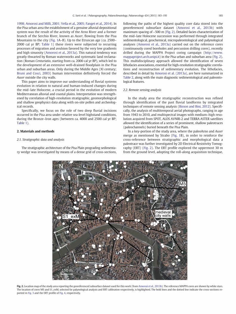
Fig. 2. Locationmapof the study area reporting the georeferenced subsurface dataset used for thThe location of cores M5 and S1_exM, selected for palynological analysis and ERT calibration reported in Fig. 3 and the ERT profile of Fig. 4, respectively.
following the paths of the highest quality core data stored into thegeoreferenced subsurface dataset (Amorosi et al., 2013b) withmaximum spacing of ~500 m (Fig. 2). Detailed facies characterization ofthe mid–late Holocene succession was performed through integratedsedimentological, geochemical, micropaleontological and palynologicalanalyses (Amorosi et al., 2013a) carried out on the reference cores(continuously cored boreholes and percussion drilling cores), recentlydrilled during the MAPPA Project coring campaign (http://www.mappaproject.arch.unipi.it) in the Pisa urban and suburban area (Fig. 2).This multidisciplinary approach allowed the identification of sevenlithofacies associations, essential for high-resolution stratigraphic correla-tions and reconstruction of sedimentary evolution. The lithofacies,described in detail by Amorosi et al. (2013a), are here summarized inTable 2, along with the main diagnostic sedimentological and paleonto-logical features.
2.2. Remote sensing analysis
In the study area the stratigraphic reconstruction was refinedthrough identification of the past fluvial landforms by integratedtechniques of remote sensing analysis (Bisson and Bini, 2012). Specifi-cally, the analysis of multitemporal aerial photographs, ranging in agefrom 1943 to 2010, and multispectral images with medium–high reso-lution acquired from SPOT, ALOS AVNIR-2 and TERRA ASTER satellitesallowed the identification of a series of prominent, shallow paleotraces(paleochannels) buried beneath the Pisa Plain.
In a key-portion of the study area, where the paleoArno and Ausermerge as mentioned by Strabo (Fig. 1B), in order to reinforce thecross-reference between stratigraphic and morphological data apaleotrace was further investigated by 2D Electrical Resistivity Tomog-raphy (ERT) (Fig. 2). The ERT profile explored the uppermost 30 mfrom the ground level, adopting the roll-along acquisition technique,
iswork (fromAmorosi et al., 2013b). The referenceMAPPA cores are shown bywhite stars.spectively, is highlighted. The bold lines and the dotted line indicate the cross-sections re-

Table 2Diagnostic sedimentological and paleontological features and interpretation of the main lithofacies associations from the mid–late Holocene subsurface succession of the Pisa Plaindepicted in Fig. 3 (from Amorosi et al., 2013a).
Lithofacies Sedimentological features Micropaleontological content Palynological content
Fluvial/distributarychannel
Gray to yellow-brown, fine- to coarse-grained sandbodies with erosional lower boundary and distinctivefining-upward trend
Barren or poorly-preserved marine,brackish foraminifers and ostracods
No sampled
Crevasse splay,levee andsubdelta
Silty sand and fine sand with characteristiccoarsening-upward trend (crevasse splay andsubdelta) or rhythmical sand–silt alternation (levee).Scattered plant remains, wood and small-sized,unidentifiable mollusc fragments are present, alongwith rare calcareous nodules and yellow-brownmottles
Barren or poorly-preserved marine,brackish foraminifers and ostracods
No sampled
Well-drainedfloodplain
Dry, stiff, light brown silty clay with loworganic-matter content and evidence of subaerialexposure, including indurated horizons, calcareousnodules and yellow-brown mottles, due to iron andmanganese oxides
Barren Dark-brown to brown reworked phytoclasts andheterogeneous continental palynomorphs with manyreworked specimens
Poorly-drainedfloodplain
Monotonous succession of light gray, soft clay andsilty clay, with scarce organic matter and isolated,large (up to 3 cm) calcareous nodules. Sharp-basedcm- to dm-thick sand and silt layers occur. Scatteredplant remains were encountered along with few,thin-shelled mollusc fragments
Barren or few valves of P. albicans orC. torosa, the latter within organic-richlayers
Rounded, dark brown to black phytoclasts,homogeneous in size with AOM, the lattersporadically abundant within organic-rich layers.Many reworked specimens derived from eitherancient sediments or adjacent lands
Lower/upperswamp
Dark soft clay and silty clay, with local presence ofcm- to dm-thick sand layers. Wood fragments andpeat layers are very abundant. Scattered fragmentsand shells of freshwater gastropods are also recorded
Scarce oligotypic ostracod fauna mainlycomposed of Pseudocandona albicans andaccompanied by rare Candona neglecta andIlyocypris species
Abundant, light orange to brown/black phytoclasts(majority N 100 μm). AOM abundant
Lagoon(“pancone”)
Monotonous succession of soft blue-gray clay andsilty clay with abundant shells of Cerastodermaglaucum. Cm-thick fine sand intercalations. Wood andplant fragments scattered
Moderately to highly marine-influencedbrackish water meiofauna, dominated byAmmonia tepida and A. parkinsoniana andCyprideis torosa
Orange-brown phytoclasts (b500 μm) and AOM —
amorphous organic matter sporadically present,along with marine-related as dinocysts, foraminiferallinings and scolecodonts
186 G. Sarti et al. / Palaeogeography, Palaeoclimatology, Palaeoecology 424 (2015) 183–195
with electrodes spacing of 2m. A Schlumberger andWenner configura-tion combined with dipole–dipole array was used. The 2D inversions ofapparent resistivity were undertaken using the TomoLab software(www.geostudiastier.com).
2.3. Palynological analysis
Fifteen samples from clay and silt deposits of core M5 (Fig. 2 forlocation) were collected for palynological analysis. The presence of athick, continuous fine-grained succession of lagoon, swamp andpoorly-drained floodplain deposits (see Section 1), where pollen grainsare expected to be well preserved, made M5 the reference core for thereconstruction of the pollen sequence. Within the lower portion of thecore, between 10.5 and 6 m core depth, samples were taken at 20–40 cm intervals. Only two samples were collected from the uppermostpart of the core, where pollen and spores are rare and badly preservedwithin crevasse splay sands and stiff, well-drained floodplain clays.
Standard palynological techniques (HCl, HF, chemical treatment) formineral dissolution were applied on 10 g of each sample (Fægri andIversen, 1989). In order to preserve all the organic components, neitheroxidative nor alkali treatments were applied. The concentration ofpollen, spores and other palynomorphs is estimated by adding a tabletcontaining a known amount of Lycopodium spores. At least 200 well-preserved pollen and non-pollen palynomorphs were counted persample, and the relative abundance of each taxa was calculated. Pollentaxa were identified according to the literature (Reille, 1992, 1995,1998 and online databases, http://www.europeanpollendatabase.net)and grouped on the basis of their ecological and climatic affinities,following the indications of previous works carried out in the Arnocoastal plain (Aguzzi et al., 2007; Ricci Lucchi, 2008; Amorosi et al.,2009).
Among the non-pollen palynomorphs the marine-related elements,including dinocysts, foraminiferal linings and scolecodonts, and thepteridophyte spores were identified (Traverse, 1988) providing furtherpaleoenvironmental information. In addition, reworked pre-Quaternaryelements were counted to highlight phases of intense fluvial activity.
2.4. Chronology
The chronological framework of the studied successionbenefited from14 radiocarbon dates (Table 3) and scattered ceramic remains from theuppermost stratigraphic interval. AMS 14C analyses were performed onwood fragments, organic matter and mollusc shells at CIRCE Laboratoryof Caserta (Naples University). Conventional ages were calibrated usingthe CALIB5 program and the INTCAL09 or MARINE09 calibration curves(Reimer et al., 2009) for terrestrial and marine materials, respectively. Inorder to compensate for the reservoir effect, mollusc samples were cali-brated using an average value of DeltaR (35 ± 42), estimated for thenorthern Tyrrhenian Sea from online databases (http://calib.qub.ac.uk/marine/). In this study, the ages are reported as the highest probabilityrange (cal yr BP) obtained using two standard deviations-2σ (Table 3).
3. Mid–late Holocene deltaic–alluvial sedimentation andchannel dynamics
3.1. Subsurface stratigraphic architecture
The mid–late Holocene deltaic–alluvial succession of the Pisa Plainrecords the gradual filling of a wide lagoon basin and the establishmentaround 5000 cal yr BP of a delta system that was replaced by an alluvialplain one thousand years later (Fig. 3A–D; Amorosi et al., 2013a). Interms of sequence stratigraphy, this prograding sedimentary wedgerepresents the HST of the late Quaternary depositional sequence anddisplays, as a whole, the distinctive sedimentary signature of a high-accommodation depositional setting (Miall, 1996; Catuneanu, 2006).Indeed, the occurrence of isolated to locally amalgamated channeldeposits within a dominantly fine-grained succession (Fig. 3A–D)reflects the cumulative effect of highstand relative sea-level conditionsand tectonic subsidence experienced by the study area during theHolocene (Lambeck et al., 2004; Pascucci, 2005).
According to previous work (Rossi et al., 2012; Amorosi et al.,2013a), the lower portion of the deltaic–alluvial succession is made up

Table 3Radiocarbon chronology. List of the radiocarbon dates obtained from different core sam-ples and discussed in this paper. Calibration has been performed using intcal09.14c(Reimer et al., 2009). Local reservoir correctionDeltaR (35±42)was applied to shell sam-ples (Cerastoderma glaucum valves).
Code sample Conventional age(14C yr BP)
Calibrated age(14C yr BP ±2σ)
Material
M9_5.35 2456 ± 41 2360–2618 Wood fragmentM9_2.75 827 ± 23 690–780 Wood fragmentM10_7.85 3613 ± 137 3572–4298 Organic clayM10_5.30 2465 ± 27 2525 ± 94 Wood fragmentM4_8.15 3610 ± 24 3850–3978 Wood fragmentM4_3.80 1642 ± 26 1507–1613 SoilM6_10.75 4915 ± 35 4990–5318 Mollusc shellsM6_8.70 4708 ± 47 4770–5133 Mollusc shellsM6_6.04 3395 ± 25 3576–3696 Organic clayM7_11.40 2843 ± 23 2870–3005 Wood fragmentM7_8.77 2773 ± 23 2792–2929 Wood fragmentM7_7.10 2559 ± 28 2697–2752 Wood fragmentM5_8.76 3842 ± 24 4153–4300 Organic clayM3_5.75 3496 ± 27 3694–3840 Wood fragments
187G. Sarti et al. / Palaeogeography, Palaeoclimatology, Palaeoecology 424 (2015) 183–195
of swamp clays, 1 to 3 m-thick, dated around 5000–4000 cal yr BP(Eneolithic age; Tables 1, 3). Up to 2 m-thick subdelta and distributarychannel sand bodies, with top at ~6 mbsl, locally interrupt the lateralcontinuity of the swamp layers (cores S1_T, S1_6P and M19 inFig. 3C–D). However, isolated to locally amalgamated channel bodies
Fig. 3. Representative cross-sections depicting the mid–late Holocene lithofacies distribution astudy area (section traces reported in Fig. 2). ReferenceMAPPA cores are in bold. Radiocarbon daet al. (2013a) are reported in century BC/AD. Ages from reworked Cardium shells (asterisks) refbon ages projected from core M7 (see Fig. 1 for location).
up to 5–4 m-thick and with top-of sand at ~5 mbsl locally truncatethe underlying swamp and lagoon succession down to 10 mbsl(Fig. 3A–D). These channel sands grade upwards into poorly-drainedfloodplain clays or levee/crevasse sandy deposits (Fig. 3A–D). Facies ar-chitecture integrated with the available radiocarbon ages constrainsthe timing of fluvial incision to the Eneolithic–Bronze age transition(around4000–3800 cal yr BP in Table 1). Upwards, poorly-drainedflood-plain clays, up to 4 m-thick, show vertical and lateral transition to cre-vasse splay/levee and fluvial channel sands, whose upper boundariesmainly cluster around 4 m and 1 mbsl (Fig. 3A–D). Channel depositswith top-of-sand at ~4 mbsl form remarkably thick (up to 5–6 m) sandbodies, which further erode the floodplain–swamp–lagoon successiondown to 10 mbsl. Radiocarbon and archeological data constrain the ac-tivity of these channels to the Bronze–Iron transition (around 2900–2800 cal yr BP in Table 1).
In contrast, the channel bodies clustering at shallower depths (top-of-sand ~1 mbsl) are thinner (~2 m) and show lens-shaped geometries(core S5_SC in Fig. 3C). Upwards, around the present sea level, poorly-drained floodplain clays are overlain by well-drained floodplain siltyclays dating back to the early Roman period (Fig. 3A–D and Table 1).Crevasse splay/levee deposits and isolated fluvial-channel bodies, withtop-of sand around or above the present sea level, are mainly recordedbeneath the modern Arno River course (Fig. 3A, C–D). A differentstacking pattern of fine-grained lithofacies characterizes the historicalPisa city center, north of the modern Arno River course, where laterally
nd stratigraphic architecture of the deltaic–alluvial prograding wedge buried beneath theta are reported as calibrated yr BP (see Table 3), while the archeological data fromAmorosier to lagoon environments pre-dating channel activity. Double asterisks indicate radiocar-

188 G. Sarti et al. / Palaeogeography, Palaeoclimatology, Palaeoecology 424 (2015) 183–195
extensive clay deposits formed in ephemeral and shallow backswampsoccur around 2mbsl (Fig. 3A–D). Radiocarbon ages and several ceramicmaterials constrain the development of these low-lyingwetlands to thelate Iron–early Etruscan age (ca. 2500 cal yr BP/ca. 7th–5th century BC;Amorosi et al., 2013a). Anthropogenic structures, dated from theRomanperiod onwards, cut the alluvial succession at various stratigraphiclevels.
3.2. Fluvial paleodrainage network
More than 10 distinct fluvial paleotraces were identified by remotesensing in the Pisa urban and suburban area (Fig. 4A), documentingthe significant contribution of thefluvial network to the geomorpholog-ical evolution of the plain (Amorosi et al., 2013a).
Specifically, an east–west oriented paleochannel chronologicallyconstrained to the Eneolithic–Bronze age transition (top-of-sand~5mbsl; Section 3.1. and Fig. 3A–D)was identified north of themodernArno River (paleoArno; Fig. 4A). Consistent with Strabo's chronicles, asemi-coeval north–south oriented paleochannel flowing close to thewest medieval city wall is referred to the Auser branch (paleoSerchio),which merged into the paleoArno close to the Arsenali area (Figs. 1and 4A; Amorosi et al., 2013a). A further paleoachannel, active duringthe Eneolithic–Bronze age transition was identified in the eastern por-tion of the Pisa Plain with east–west flowing direction. On the basis ofits position and orientation (see Figs. 1 and 4A), this paleochannel isinterpreted as the Auser branch that flowed from the Pisa Mountainsto the city area, running along the north medieval city wall beforesplitting into two or more branches as mentioned by the Greek geogra-pher Strabo (chronicles, V, 2, 5, C 222). Neither stratigraphic normorphological data allow to recognize the westward prolongation ofthis paleochannel, which was likely connected with the north–southAuser branch in the Arsenali area.
Fig. 4.A) Paleodrainage evolution of the Pisa Plain in proto-historic times (see Fig. 3A–D), reconsC) Core S1_exM stratigraphy are also shown.
Concerning the drainage network active at the Bronze–Iron transi-tion and related to the second phase of rapid channel incision and fill(top-of-sand ~4 mbsl; Fig. 3C–D), two paleotraces were identified im-mediately south of the modern Arno River (Fig. 4A). These traces docu-ment the abrupt southward shift of the paleoArno and two rapid phasesof meander migration (Figs. 3C, D and 4A). In contrast, no paleotracespotentially pertaining to the Auser River course were identified (Fig. 4).
The ERT profile carried out along the north–south orientedAuserRiverpaleotrace (Figs. 2 and 4A, B) reinforces our paleogeomorphological inter-pretation and traces out the geometry of the paleochannels involved inthe first phase of rapid channel incision and fill.
Three sub-elliptical areas with high resistivity (300–1000 Ω m)are the most striking feature observed at 7–8 m depth (4–5 m ca. bsl)across the whole ERT section (4–5 m ca. asl, Fig. 4B). These areas showsharp contactswith the overlying low-resistivity layer and a progressivedecrease in resistivity down to the lower limit of investigation (c.a. 14–15m depth). Core S1_exMdrilled nearby enabled lithofacies calibrationof the electrical resistivity data (Fig. 4C). The rapid increase in resistivityat 7–8 m is coherent with the boundary between floodplain clays andthe underlying thick succession of fluvial–channel sands. Thecontouring of these high-resistivity sands shows a sub-ellipticalshape that can be related to a fluvial channel cross-section. Close tothe lower limit of ERT resolution (c.a.12 m depth), the decrease ofresistivity fits with the sharp transition to clayey lagoon sediments.In this respect, electrical resistivity data support the hypothesis thatfluvial channels were carved into more conductive, fine-grainedsediments.
4. Mid–late Holocene pollen record
Samples from core M5 contain a rich, autochthonous palynologicalassociation mainly composed of pollen grains and spores. Otherpalynomorphs (algae, dinoflagellates, scolecodonts and foraminiferal
tructed on the basis of integrated stratigraphic-remote sensing analyses. B) ERT profile and

189G. Sarti et al. / Palaeogeography, Palaeoclimatology, Palaeoecology 424 (2015) 183–195
linings) are recorded within lagoonal sediments in the lowermost partof the core. The state of preservation is generally good, with 3% indeter-minable or unknown grains, while pollen concentration strongly fluctu-ates throughout the cored succession. Pollen concentration from lagoonsediments and the lowermost swamp succession varies from 13,434 to16,126 grains/g.Within the overlying swamp clays, between8.76mand8.60 m core–depth, the concentration abruptly drops to 4475 grains/g,and then further gradually decreases upwards. In contrast, pre-Quaternary palynomorphs generally exhibit an upward increasingtrend in relative percentages with respect to the total autochthonousplus allochthonous assemblage.
Despite the overall dominance of arboreal pollen (AP), which is dis-tinctive feature of the Holocene successions across the Mediterraneanarea (Bellini et al., 2009; Di Rita andMagri, 2012), high-frequency abun-dance changes of specific pollen groups (see Section 2.3) allow the dis-tinction of four main pollen zones (1–4), corresponding to distinctvegetation phases (Fig. 5). These zones are described and interpretedin terms of past climatic conditions and environmental features, asfollows (Fig. 5).
4.1. Zone 1: 10.50–9.60 m
4.1.1. DescriptionThis zone is characterized by an autochthonous pollen association
mainly composed of riparians (17–32%), almost entirely representedby Alnus, and deciduous/evergreen trees, such as Quercus and Corylus(~5–15% and 6–9.5%, respectively). Both groups show decreasingupward trends. Mountain and Mediterranean trees are also presentwith remarkable percentages (6–8% and 4–10.5%, respectively— Fig. 5).
The herbaceous taxa (NAP) are mainly represented by ubiquitous(up to ~31% at the top of the zone) and aquatic (~2–6%) plants.
Among non-pollen palynomorphs, pteridophyte spores are themostabundant (~10–12.5%), whilemarine-related elements (dinocysts, fora-miniferal linings and scolecodonts) show low percentages. Reworkedpre-Quaternary palynomorphs (pollen grains and dynocysts) are veryscarce throughout this zone, peaking at ~4% close to its upper boundary(Fig. 5). The most common components of this group are species of
Fig. 5.Mid–late Holocene pollen record of coreM5 (see Figs. 1 and 2 for location), with indicatioThe sandy interval (crevasse splay) is not sampled. Pollen taxa are grouped following Amoropalynomorph percentages are also reported. Within zone M5-3, the Abies peaks 1 and 2 discuthe lithological key of core M5 see Fig. 4. Lithofacies interpretation of core M5 is from Amorosi
Corollina genus, an extinct pollen taxon commonly found within lowerMesozoic sequences in both hemispheres (Traverse, 1988).
4.1.2. InterpretationThe high pollen concentration values and the scarce occurrence of
reworked pre-Quaternary palynomorphs fit well with the develop-ment, in the Pisa Plain, of a wide lagoonal basin during the Neolithicage (Figs. 3 and 4), as recently documented by Amorosi et al. (2013a).The high abundance of Alnus and pteridophytes as well as theoccurrence of marine-related palynomorphs are also consistent withthis paleoenvironmental interpretation. Moreover, the presence ofreworked Corollina specimens suggests sediment supplied by non-metamorphic Mesozoic sedimentary sequences cropping out north ofPisa.
The occurrence of mixed deciduous/evergreen oak forests, similar tothose characterizing the west coasts of Italy between ca. 8000 and5000 cal yr BP (Amorosi et al., 2009; Ribecai, 2011; Di Rita and Magri,2012) indicates optimal warm and humid climate conditions.
4.2. Zone 2: 9.60–8.10 m
4.2.1. DescriptionThis zone is characterized by a significant drop in pollen concentra-
tion (from 16,126 to 4475 grains/g), paralleled by the upward decreaseof the AP/NAP ratio (~1) close to the upper boundary. Themain charac-ter of the pollen association is the strong increase of riparians, mainlyrepresented by Alnus, which peaks (~50%) close to the lower boundaryof the zone and progressively decreases upwards (Fig. 5). Deciduouswoody taxa (dominant Ulmus and subordinate Quercus and Corylus)are still present with considerable percentages (8–17%; Fig. 5).Mountain and Mediterranean trees invariably exhibit values lowerthan 5%.
Among the herbs, Poaceae display the highest percentages of thewhole core (up to 25%; Fig. 5). The aquatic plants are abundant acrossthe entire zone, with a distinct peak (~30.5%) close to its upperboundary, where pteridophytes also show very high percentages(~20%; Fig. 5).
n of themain vegetation phases/pollen zone (see Section 5 formore detailed information).si et al. (2009). Pollen concentration, AP/NAP ratio, pre-Quaternary and marine-relatedssed in text are highlighted. Radiocarbon ages are reported as cal yr BP (see Table 3). Foret al. (2013a); see Table 2 for more detailed facies information.

190 G. Sarti et al. / Palaeogeography, Palaeoclimatology, Palaeoecology 424 (2015) 183–195
Reworked pre-Quaternary palynomorphs, mainly represented byCorollina spp., slightly increase in concentration relative to the under-lying zone 1, with 10% relative abundance at the upper boundary(Fig. 5).
4.2.2. InterpretationThe rapid expansion of Alnus, a hygrophilous tree taxa requiring
moist soils habitat (Di Rita and Magri, 2012) is consistent with thereplacement of the lagoon by a vast wetland area around the Pisa citycenter at the transition to the Eneolithic age (around 5000 cal yr BP;Figs. 4 and 5; Amorosi et al., 2013a). The high percentages of bothaquatic plants and pteridophytes in the uppermost portion of the pollenzone also testify to the progressive filling of the lagoon and to the estab-lishment of distinct paludal conditions. Similarly, an upward increasingtrend is shown by the reworked pre-Quaternary palynomorphs,reflecting the progressive influence of the drainage network at thecore site area.
As a whole, the pollen association indicates the development of amarshland at the beginning of the Eneolithic age, rapidly followed bymixed woodlands and Alnus carrs, in accordance with other pollenrecords from the west coast of Italy (Di Rita and Magri, 2012). Interest-ingly, in the upper portion of the zone our data clearly indicate thepartial replacement of deciduous-Alnus forests by grasslands, mainlycomposed of Poaceae, aquatics and ferns (pteridophytes), and a strongdecrease of mountain trees (Fig. 5). These vegetation changes and theconcomitant drop of both AP/NAP ratio and pollen concentration pointto a phase of forest reduction around 4200–4000 cal yr BP (radiocarbonages in Fig. 5), reasonably related to a short-term climatic perturbationtowards drier conditions. A comparable and semi-coeval event of forestdecline (ranging between 4500 and 3900 cal yr BP in Europe) has beenrecently reported from several coastal sites of central-southern Italy(Drescher-Schneider et al., 2007;Magri, 2007; Di Rita et al., 2010; Sadoriet al., 2011; Di Rita and Magri, 2012) and related to the temporarylatitudinal displacement of the inter-tropical convergence zone. Thisdeterioration of climate conditions appears to be contemporary with awell-known, global climate event centered around 4200 cal yr BP, theso-called 4.2 ka event or event 3 of Bond et al. (1997, 2001), widely re-corded by several proxies across the Mediterranean area (Magny et al.,2002, 2009; Mayewski et al., 2004; Piva et al., 2008; Bar-Matthewsand Ayalon, 2011; Giraudi et al., 2011; Zanchetta et al., 2013).
These paleoclimatic records offer a complex picture of the 4.2 kaevent with latitudinal and longitudinal contrasting humidity conditions(Magny et al., 2012a,b), probably due to the combined effect of cyclonicactivity and seasonal, local patterns, and suggest for the centralMediterranean area a close succession of events (wet/dry/wet)between 4300 and 3800 cal yr BP (Magny et al., 2009; Zanchetta et al.,2013).
4.3. Zone 3: 8.10–6.50 m
4.3.1. DescriptionThis zone is characterized by an abrupt decrease of the riparian trees
(b10%) and aquatic plants. This trend is paralleled by a strong increase inPinus (up to ~27.5%), which becomes the dominant arboreal taxon, andherbs, mainly represented by ubiquist and steppic taxa (Fig. 5). Mixedoak woods (Quercus, Corylus, Ulmus and Tilia) occur as secondary taxawith remarkable percentages (7–10%), while the Mediterranean andmountain trees are generally present at very low values (b4%; Fig. 5).Two anomalous samples close to the zone boundaries (~8 m and~6.50 m core depth) show an increase of mountain trees (up to 10%),almost exclusively represented by Abies grains (Abies peaks 1 and 2 inFig. 5). Reworked palynomorphs, derived from pre-Quaternary outcrop-ping formations (Corollina spp., Rhetipollis germanicus and various Juras-sic–Cretaceous dinoflagellates and spores) also peak within the samestratigraphic intervals, reaching the highest percentages of the wholecored succession (Fig. 5). Consistently, peaks of reworked dinocysts,
foraminiferal linings and scolecodonts derived from the underlyinglagoonal deposits cap the zone (~5%; Fig. 5).
4.3.2. InterpretationThe high amounts of Pinus grains, strongly resistant to mechanical
stress, and the increasing abundance of the herbaceous taxa (Fig. 5)reflect the establishment of a genuine alluvial landscape (Amorosiet al., 2013a) with sparsely wooded grasslands during the Bronze–Ironages (Figs. 3 and 5). On shorter timescales, two peaks of reworkedpalynomorphs (both pre-Quaternary and lagoon-derived) are recordedclose to the lower and upper boundaries of this zone, recording rapid,high-energy flood events (Fig. 5). In the same stratigraphic intervals,two peaks of Abies (Abies peaks 1 and 2 in Fig. 5) reveal short-livedphases of increasing moistness. Indeed, Abies grows and spreads underhigh-humidity conditions only (Tinner and Lotter, 2006; Mariotti Lippiet al., 2007; Ricci Lucchi, 2008), and is currently found as scattered com-munities in the Tuscan Apennines at elevations higher than 1000 m.
To date, no comparable proto-historic events of Abies expansionhave been recorded from other Italian coastal sites, possibly due to acombined effect of local climate and high human pressure (Tinneret al., 2013; Di Pasquale et al., 2014). Unique exception is the pollenrecord recovered from the near archeological site of Pisa S. Rossore(Fig. 1B), where remarkable percentages of drought-sensitivemountaintrees (Fagus and Abies) have been encountered within the pre-Romanunit that overlies the Neolithic lagoon clays (Mariotti Lippi et al.,2007). Unfortunately, the available radiocarbon ages do not furnish amore precise chronological framework for this unit.
Nevertheless, our observations are in general agreement with themulti-proxy evidence of millennial to centennial-scale climate variabilityacross the Mediterranean region during proto-historic times (Mayewskiet al., 2004; Piva et al., 2008; Nieto-Moreno et al., 2011; Drake, 2012).
4.4. Zone 4: 4.5–2 m
4.4.1. DescriptionSimilar to the upper part of the underlying zone M5-3, this zone
exhibits low concentration values (from 840 to 1160 grains/g), and anautochthonous association dominated by Pinus and herbaceous taxa(Fig. 5).
4.4.2. InterpretationWith respect to the underlying zone 3, this pollen association
indicates the development of a more open vegetation (grassland),with few oaks and Mediterranean trees. A similar vegetation cover hasbeen widely reported from the west coasts of Italy during the last2000 years (Di Rita and Magri, 2012).
5. Highstand sedimentation patterns, fluvial dynamics andvegetation landscapes
The mid–late Holocene stratigraphic architecture, combined withthe network of paleochannels identified through remote sensing,geomorphological and geophysical analyses, documents a multifaceteddepositional history of the Pisa Plain. Based on a multi-proxy record,changes in sedimentation patterns and paleodrainage system areframed in the local environmental–climate conditions deduced fromthe pollen record of core M5 (Fig. 5 and Section 5).
5.1. Pre-alluvial phase (Eneolithic age: ca. 5000–4000 cal yr BP)
If compared with the decelerating sea-level trend starting at ca.7000 cal yr BP along the Italian coasts under highstand conditions(Lambeck et al., 2004, 2011), siltation of the wide lagoon basin orig-inally developed in the Pisa area during the maximummarine trans-gression took place ca. 2000 years later (Fig. 3A–D). Around5000 cal yr BP, at the beginning of the Eneolithic age (Fig. 3A–D

191G. Sarti et al. / Palaeogeography, Palaeoclimatology, Palaeoecology 424 (2015) 183–195
and Table 1), the lagoon evolved into a vast marshland, crossed bydistributary channels attributable to both Arno and Serchio rivers(Amorosi et al., 2013a). This phase was concomitant with a majorchange in vegetation cover (transition from pollen zones 1 to 2;Fig. 5). The replacement of mixed deciduous/evergreen oak forestsby mixed woodlands and Alnus carrs with grasslands reflects theend of the Holocene climatic optimum (Fletcher and Sánchez Goñi,2008; Combourieu Nebout et al., 2009) and the establishment ofless humid conditions (Fig. 5). This long-term trend of increasingaridity/forest regression, extensively recorded across the WestMediterranean after 5000 cal yr BP (Jalut et al., 2000; Magny et al.,2002), reasonably promoted high sediment delivery, which, inturn, favored lagoon infilling and delta development.
The relationship between climatic aridification and coastalprogradation appears to climax at the transition from deltaic to allu-vial sedimentation. Indeed, alluvial plain development was precededby a short-lived phase of pronounced forest reduction (AP/NAPratio) and decline of drought-sensitive mountain trees, probablyreflecting the arid episode of the well-known 4.2 ka event (Fig. 5).
5.2. Alluvial phase (Bronze age–Present: ca. last 4000 cal yr BP)
5.2.1. Bronze–Iron age (ca. 4000–2500 cal yr BP)Following the characteristic mid–late Holocene progradation trend,
shared by all major Mediterranean delta systems (Somoza et al., 1998;Bellotti et al., 2004; Aguzzi et al., 2005; Vella et al., 2005; Amorosiet al., 2008, 2013b; Milli et al., 2013), the marshlands emerged andabruptly turned into floodplain areas at the transition with the Bronzeage, around 3800 cal yr BP (Fig. 3A–D). The establishment of an alluvialplain subject to recurring flooding events is testified by poorly-drainedfloodplain conditions and by the widespread occurrence of thick,coarse-grained overbank successions (Fig. 3A–D). These depositionalfeatures along with the rapidly changing drainage configuration(Fig. 4A) point to a Bronze–Iron phase of intense fluvial activity, highrunoff rates and floodplain sedimentation, reasonably promoted by adense channel network (Fig. 4A) and the progressive reduction offorests (sparsely wooded grasslands of pollen zone 3; Fig. 5). A semi-coeval phase of alluvial plain overflow has been inferred by Marraet al. (2013) for the Tiber Plain during the last 3500 cal yr BP. Consistentwith our paleohydrographic reconstructions (Fig. 4A), Benvenuti et al.(2006) documented at the nearby Pisa San Rossore archeological site(Fig. 1) a pre-Roman channel-fill, truncated by Roman fluvial sands,and a genetically-related overbank succession, whose upper portion isdated to the Iron age.
However, two events of rapid channel incision and fill abruptlyinterrupted this phase of intense alluvial aggradation, as clearlydocumented by stratigraphic and ERT data (Figs. 3, 4C). The suddenoccurrence of high-energy, erosional phases is also recorded by thetwo concomitant peaks in reworked pollen grains and lagoon-derivedmarine palynomorphs from the floodplain succession of core M5(Fig. 5).
Across the study area, the first erosive phase produced a 4–5m-deepincision within the underlying lagoon–paludal succession (Figs. 3B, 4C).Subsurface stratigraphy and the available radiocarbon ages constrainchronologically this event to the Eneolithic–Bronze transition, betweenca. 3800 and 3600 cal yr BP, i.e. shortly after alluvial plain development(Fig. 3).
The timing of the second incision-fill event is more accuratelyconstrained by a series of radiocarbon ages available from the fluvial–channel succession recovered at core M7 (Fig. 3D). Fluvial incisionoccurred at the Bronze–Iron transition, cutting the underlying lagoon–paludal–floodplain clays down to ~5–6 m (Fig. 3C, D). In less than200 years the river channel was filled (Fig. 3D), and alluvial aggradationpersisted up to the beginning of the Etruscan age (ca. 2500 cal yr BP). Inconjunction with this high-energy fluvial event, the paleoArno River
abruptly changed its position and for the first time shifted south of itsmodern course (Fig. 4A).
Interestingly, two short-lived (centennial-scale) climatic events ofincreased humidity are recorded within the Bronze–Iron floodplainsuccession of coreM5 (Abies peaks 1 and 2; Fig. 5), at stratigraphic inter-vals correlative with the top-of-channel bodies formed during the rapidincision-fill phases (see Figs. 3D and 5).
The integration of stratigraphic, geomorphological, geophysical andpalynological data documents good synchronicity of highstand sedi-mentation patterns, fluvial dynamics (aggradation/degradation ratio)and local climate changes, on a variety of time scales. In contrast, nodirect (archeological) or indirect (palynological) evidence of stronghuman frequentation and impact on the Pisa Plain landscape has beenrecovered for the Bronze–Iron period, to date (Ribecai, 2011; Di Ritaand Magri, 2012; Amorosi et al., 2013a).
5.2.2. Etruscan age to Present (ca. 2500 cal yr BP–Present)The beginning of the Etruscan age was characterized by the
development of a complex alluvial setting under uninterruptedaggradational conditions. Low-lying backswamps, which became pro-gressively inhabited, were formed north of the modern Arno River, be-tween the proto-historic fluvial–channel systems (Amorosi et al., 2013a;Figs. 3, 4).
The transition to the Roman age (ca. 2000 cal yr BP) marked theearly stage of the development of the modern Pisa Plain. This phasewas characterized by the extensive growth of a well-drained alluvialplain, with widespread development of indurate horizons andgrasslands (Figs. 3, 5). The natural tendency of both paleoArno andpaleoSerchio branches to change their courses was radically reducedby numerous waterworks (Martini et al., 2011), and wetland areaswere partially reclaimed (Sarti et al., 2010). Since the Middle Agesonwards (ca. 1300–1400 cal yr BP; Table 1), an anthropogenicstratification occurred, revealing the progressive urbanization of thestudy area.
6. Discussion
The two events of channel incision and infill detected beneath thePisa Plain at the transition between the Eneolithic–Bronze ages andthe Bronze–Iron ages (~3800 cal yr BP and 2900–2800 cal yr BP;Figs. 3, 5) indicate the occurrence of high-frequency (centennial-scale), prominent changes in the aggradation/degradation ratio duringthe mid–late Holocene sea-level highstand.
In particular, increased fluvial activity:
a) could be related to rapid (centennial-scale) climatic changestowards more humid conditions;
b) could be the result of small amplitude relative sea-level changes(i.e. base-level changes);
c) could represent the effect of human impact.
6.1. Climate
Aswidely documented in the literature (Ashley andHamilton, 1993;Blum and Törnqvist, 2000; Lewis et al., 2001; Macklin et al., 2002;Straffin and Blum, 2002; Vandenberghe, 2003; Döll and Schmied,2012), climate fluctuations at regional/sub-regional or global scale caninduce significant changes in both discharge regime and sedimentproduction and delivery to downstream locations. In the Pisa Plain,two (centennial-scale) climatic events of increased humidity occurredduring the Eneolithic–Iron age, interrupting the long-term mid–lateHolocene aridification trend (Abies peaks 1 and 2; Fig. 5). Radiocarbonand archeological dates (Fig. 3) allow to assign the two peaks of Abies

192 G. Sarti et al. / Palaeogeography, Palaeoclimatology, Palaeoecology 424 (2015) 183–195
to the Eneolithic–Bronze and Bronze–Iron transitions, around~3800 cal yr BP and 2900–2800 cal yr BP, respectively (Fig. 5).
Within comparable timewindows (Table 4), a number of multiproxyMediterranean records provide evidence for two centennial-scale cli-matic events with similar characteristics (Nieto-Moreno et al., 2011;Roberts et al., 2011; Magny et al., 2012a,b; Fletcher and Zielhofer,2013; Benito et al., 2015). The older one falls within the chronological in-terval of thewell-known 4.2 ka event (Bond et al., 1997;Mayewski et al.,2004; Finné et al., 2011), which apparently shows a tripartite humidityoscillation between ~4300 and 3800 cal yr BP in the central-westernMediterranean area (Magny et al., 2009). In this regard, the first Abiespeak recorded in core M5 might correspond to the wet phase closingthe 4.2 ka event (Fig. 5).
Similarly, the youngest Abies peak recognized in core M5 (Fig. 5) re-sembles the new increase in humidity condition documented around2800 cal yr BP from the western Mediterranean (Biserni and van Geel,2005; Magny et al., 2007; Giraudi et al., 2011) and from west-centralEurope (Magny, 2004) by high lake levels and pollen data.
As a whole, our data suggests i) the regional or supra-regionalcharacter of the two humidity peaks documented in this paper andii) the close relationships between high-frequency climatic fluctua-tions and stratigraphic architecture, as shown by the strict corre-spondence between pollen signature and phases of fluvial erosionparalleled by an increase in reworked palynomorphs.
These data point towards the role played by climate fluctuations intriggering channel incision.
6.2. Relative sea-level changes
Relative sea-level (RSL) changes result from the interaction betweenglobal (eustatism) and local factors (i.e. hydrostasia, tectonic and sedi-ment compaction), and produce a re-adjustment of the river longitudi-nal profile to the new base-level position. Specifically, fluvial incisioncan be triggered by RSL fall, although a direct, simple cause–effect rela-tionship cannot be stated a priori (Schumm, 1993; Legarreta andUliana,1998).
Since the pioneering work of Pirazzoli (1976), the Holocene RSLhistory of the central Mediterranean basin has been investigated usingdifferent types of markers. The two most recent and reliable models(Spada and Stocchi, 2007; Lambeck et al., 2011) have been workedout cross-checking predictions with field data. Nevertheless, the twomodels misfit. Although the amount of available index pointsconcerning the Holocene sea level in this area is remarkable and con-stantly increasing, there is still a certain amount of uncertainty on sea-level elevation even during the late Holocene (Morhange et al., 2001,2006, 2013; Antonioli et al., 2007, 2009; Furlani et al., 2011; Primaveraet al., 2011; Spampinato et al., 2011; Bini et al., 2012; Evelpidou et al.,2012; Amato et al., 2013).
Small-amplitude sea-level lowering along the Tyrrhenian coastlineduring the late Holocene has been hypothesized by Benvenuti et al.(2006) and Marra et al. (2013). However, clear evidence of proto-historic eustatic fall episodes has not been reported, to date. In contrast,all most detailed RSL predicted curves (Lambeck et al., 2004, 2011;Spada and Stocchi, 2007) match on a progressive rising trend sinceabout 6000 cal yr BP. Moreover, the extensional tectonic context of
Table 4Bronze–Iron age centennial flooding events in the Mediterranean regions based on 14C-dated H
Central Italy (this study) Southern Italy (cal yr BP) E-Iberian Peninsula (cal yr BP) S
≈3800 4200–4100
3450–3000≈2900–2800 3
2850–27002350–1850 2450–2150 2
the Pisa Plain, placed within the subsiding Viareggio Basin (Marianiand Prato, 1988; Argnani et al., 1997; Pascucci, 2005) and land subsi-dence induced by high compressible fine-grained deposits compaction(Rossi et al., 2011; Sarti et al., 2012) have enhanced this RSL risingtrendthrough the addition of new accommodation space (Posamentieret al., 1988; Catuneanu, 2006; Hu and Plint, 2009).
Based on these data, there is currently no evidence of a link betweenRSL and the triggering of the two erosive processes. Conversely, the pe-culiar geotechnical features (high compressibility and plasticity) of thelagoon clays beneath the city of Pisa (Ministero dei Lavori Pubblici,1971; Callisto and Calbresi, 1998; Sarti et al., 2012) could have enhancedto some degree the rate and the value of channel incisions, as docu-mented by experimental data achieved in the Venice lagoon deposits(Amos et al., 2010).
6.3. Human impact
An intensive human frequentation of the Pisa Plain area started offduring the Iron–Etruscan transition (around 2500 cal yr BP), aboutthree centuries later than the most recent proto-historic channel inci-sion (Benvenuti et al., 2006; Mariotti Lippi et al., 2007; Bellini et al.,2009; Ribecai, 2011; Di Rita and Magri, 2012; Amorosi et al., 2013a).Only sporadic human settlements dated to the proto-historic periodare documented on the surrounding highlands (Bagnone, 1982;Pasquinucci, 1994; Grifoni Cremonesi, 2006). In this respect, changesin land use patterns or any other type of human influence appear tobe unrelated to the onset and/or amplification of the two events of flu-vial incision.
7. Conclusions
A multi-proxy study of the mid–late Holocene deltaic–alluvialsuccession in the Pisa Plain reveals short-term fluvial evolution andchanges in sedimentation patterns under relative sea-levelhighstand conditions (last ~7000 cal yr BP). The integration ofhigh-resolution stratigraphic and paleohydrographic reconstruc-tions with pollen data provides valued information about the rela-tionships between fluvial dynamics and local paleoenvironmental–paleoclimate conditions.
The major outcomes of this study can be summarized as follows:
(i) deltaic progradation took place with a long-term mid–lateHolocene aridification. The transition to a genuine alluvial plainwas immediately predated by a short-lived phase of pronouncedforest reduction around 4200 cal yr BP;
(ii) stratigraphic and paleohydrographic features reveal a Bronze–Iron age phase of high fluvial activity, increased runoff and flood-plain sedimentation promoted by a dense channel network,involving Arno and Auser river courses, in an open vegetationlandscape (sparsely wooded grasslands);
(iii) the proto-historic phase of intense alluvial aggradation waspunctuated by two rapid events of enhanced fluvial incisionthat cut down to 10 m the underlying lagoonal substrate.Radiocarbon and archeological data constrain these events tothe Eneolithic–Bronze age and Bronze–Iron age transitions(~3800 cal yr BP and 2900–2800 cal yr BP, respectively);
olocene fluvial deposits (modified after Benito et al., 2014).
outhern France (cal yr BP) Tunisia (cal yr BP) Eastern Mediterranean (cal yr BP)
4100–3700 4100–3700
000–2750 3300–3000 3400–32002850–2350
300–1750
193G. Sarti et al. / Palaeogeography, Palaeoclimatology, Palaeoecology 424 (2015) 183–195
(iii) the correlation between these events and two phases ofincreased humidity (Abies peaks 1 and 2) suggests that climateplayed a role in triggering channels incision;
(iv) relative sea-level changes did not played a significant role in theactivation of fluvial incision, while the substrate nature (highlycompressible lagoon clays) may have fostered the deepening ofthe channels;
(vi) mid–late Holocene (HST) coastal plain deposits formed insubsiding basin settings are excellent archive to elaborate high-resolution depositional models, and may represent reliable pastanalogues on which to infer the potential response of modernenvironments to future climatic variations.
Acknowledgments
We thank the archeological staff of theMAPPA project for its supportand suggestions. We are also grateful to Prof. Thierry Corrège and thereviewers for their useful comments.
References
Aguzzi, M., Amorosi, A., Sarti, G., 2005. Stratigraphic architecture of Late Quaternary de-posits in the lower Arno Plain (Tuscany, Italy). Geol. Romana 38, 1–10.
Aguzzi, M., Amorosi, A., Colalongo, M.L., Ricci Lucchi, M., Rossi, V., Sarti, G., Vaiani, S.C.,2007. Late Quaternary climatic evolution of the Arno coastal plain (Western Tuscany,Italy) from subsurface data. Sediment. Geol. 202, 211–229.
Alley, R.B., Marotzke, J., Nordhaus, W.D., Overpeck, J.T., Peteet, D.M., Pielke, R.A., Wallace,J.M., 2003. Abrupt climate change. Science 299 (5615), 2005–2010.
Amato, V., Aucelli, P.P.C., Ciampo, G., Cinque, A., Di Donato, V., Pappone, G., Petrosino, P.,Romano, P., Rosskopf, C.M., Russo Ermolli, E., 2013. Relative sea level changes and pa-leogeographical evolution of the southern Sele plain (Italy) during the Holocene.Quat. Int. 288, 112–128.
Amorosi, A., Milli, S., 2001. Late Quaternary depositional architecture of Po and Tevereriver deltas (Italy) and worldwide comparison with coeval deltaic successions.Sediment. Geol. 144 (3), 357–375.
Amorosi, A., Dinelli, E., Rossi, V., Vaiani, S.C., Sacchetto, M., 2008. Late Quaternarypalaeoenvironmental evolution of the Adriatic coastal plain and the onset of PoRiver Delta. Palaeogeogr. Palaeoclimatol. Palaeoecol. 268 (1–2), 80–90.
Amorosi, A., Ricci Lucchi, M., Rossi, V., Sarti, G., 2009. Climate change signature of small-scale parasequences from Lateglacial–Holocene transgressive deposits of the Arnovalley fill. Palaeogeogr. Palaeoclimatol. Palaeoecol. 273, 142–152.
Amorosi, A., Rossi, V., Sarti, G., Mattei, R., 2013a. Coalescent valley fills from the lateQuaternary record of Tuscany (Italy). Quat. Int. 288, 129–138.
Amorosi, A., Bini, M., Giacomelli, S., Pappalardo, M., Ribecai, C., Rossi, V., Sammartino, I.,Sarti, G., 2013b. Middle to late Holocene environmental evolution of the Pisa coastalplain (Tuscany, Italy) and early human settlements. Quat. Int. 303, 93–106.
Amos, C.L., Umgiesser, G., Ferrarin, C., Thompson, C.E.L., Whitehouse, R.J.S., Sutherland,T.F., Bergamasco, A., 2010. The erosion rates of cohesive sediments in Venice lagoon.Cont. Shelf Res. 30, 859,870.
Antonioli, F., Anzidei, M., Lambeck, K., Auriemma, R., Gaddi, D., Furlani, S., Orrù, P., Solinas,E., Gaspari, A., Karinja, S., Kovačić, V., Surace, L., 2007. Sea-level change during theHolocene in Sardinia and in the northeastern Adriatic (central Mediterranean Sea)from archaeological and geomorphological data. Quat. Sci. Rev. 26 (19–21),2463–2486.
Antonioli, F., Ferranti, L., Fontana, A., Amorosi, A., Bondesan, A., Braitenberg, C., Dutton, A.,Fontolan, G., Furlani, S., Lambeck, K., Mastronuzzi, G., Monaco, C., Spada, G., Stocchi, P.,2009. Holocene relative sea-level changes and vertical movements along the Italianand Istrian coastlines. Quat. Int. 206 (1–2), 102–133.
Argnani, A., Bernini, M., Di Dio, G.M., Papani, G., Rogledi, S., 1997. Stratigraphic record ofcrustal scale tectonics in the Quaternary of the Northern Apennines (Italy). IlQuaderno 10, 595–602.
Ashley, G.M., Hamilton, T.D., 1993. Fluvial response to late Quaternary climatic fluctua-tions, central Kobuk Valley, northwestern Alaska. J. Sediment. Res. 63 (5).
Bagnone, D., 1982. L'insediamento neolitico e dell'inizio dell'età dei metalli di Poggio diMezzo (San Rossore, Pisa). Atti Soc. Toscana Sci. Nat. Resid. Pisa Mem. Ser. A 89,61–82.
Bar-Matthews, M., Ayalon, A., 2011. Mid-Holocene climate variations revealed by high-resolution speleothem records from Soreq Cave, Israel and their correlation withcultural changes. The Holocene 21 (1), 163–171.
Bellini, C., Mariotti Lippi, M., Montanari, C., 2009. The Holocene landscape history of theNW Italian coasts. The Holocene 19 (8), 1161–1172.
Bellotti, P., Caputo, C., Davoli, L., Evangelista, S., Garzanti, E., Pugliese, F., Valeri, P., 2004.Morpho-sedimentary characteristics and Holocene evolution of the emergent partof the Ombrone River delta (southern Tuscany). Geomorphology 61 (1), 71–90.
Benito, G., Sopeña, A., Sánchez-Moya, Y., Machado, M.J., Pérez-González, A., 2003.Palaeoflood record of the Tagus River (Central Spain) during the Late Pleistoceneand Holocene. Quat. Sci. Rev. 22 (15–17), 1737–1756.
Benito, G., Macklin, M.G., Zielhofer, C., Jones, A.F., Machado, M.J., 2014. Holocene floodingand climate change in the Mediterranean. Catena http://dx.doi.org/10.1016/j.catena.2014.11.014.
Benito, G., Macklin,M.G., Cohen, K.M., Herget, J., 2015. Past hydrological extreme events ina changing climate. Catena http://dx.doi.org/10.1016/j.catena.2014.12.001.
Benvenuti, M., Mariotti Lippi, M., Pallecchi, P., Sagri, M., 2006. Late-Holocene catastrophicfloods in the terminal Arno River (Pisa, Central Italy) from the history of a Romanriverine harbor. The Holocene 16 (6), 863–876.
Bini, M., Brückner, H., Chelli, A., Pappalardo, M., Da Prato, S., Gervasini, L., 2012.Palaeogeographies of the Magra Valley coastal plain to constrain the location of theRoman harbour of Lunae (NW Italy). Palaeogeogr. Palaeoclimatol. Palaeoecol. 337,37–51.
Biserni, G., Van Geel, B., 2005. Reconstruction of Holocene palaeoenvironment andsedimentation history of the Ombrone alluvial plain (South Tuscany, Italy). Rev.Palaeobot. Palynol. 136 (1), 16–28.
Bisson, M., Bini, M., 2012. A multidisciplinary approach to reveal palaeohydrographicfeatures: the case study of Luna archaeological site surroundings. Int. J. Geogr. Inf.Sci. 26, 327–343.
Blum, M.D., Törnqvist, T.E., 2000. Fluvial responses to climate and sea-level change: areview and look forward. Sedimentology 47 (1), 2–48.
Bond, G., Showers, W., Cheseby, M., Lotti, R., Almasi, P., DeMenocal, P., Priore, P., Cullen, H.,Hajdas, I., Bonani, G., 1997. A pervasive millennial-scale cycle in North AtlanticHolocene and glacial climates. Science 278 (5341), 1257–1266.
Bond, G., Kromer, B., Beer, J., Muscheler, R., Evans, M.N., Showers, W., Hoffmann, S.,Lotti-Bond, R., Hajdas, I., Bonani, G., 2001. Persistent solar influence on NorthAtlantic climate during the Holocene. Science 294 (5549), 2130–2136.
Bruni, S., Cosci, M., 2003. Alpheae veterem contemptlor originis urbem, quam cinguntgeminis Arnus et Ausur aquis. Il paesaggio di Pisa etrusca e romana: materiali eproblemi. In: Bruni, S. (Ed.), Il porto urbano di Pisa. La fase etrusca. Il contesto e ilrelitto ellenistico, Pisa, pp. 29–43.
Callisto, L., Calbresi, G., 1998. Mechanical behavior of natural soft clay. Geotechnique 48,495–513.
Catuneanu, O., 2006. Principles of Sequence Stratigraphy. Elsevier, Amsterdam, p. 375.Catuneanu, O., Abreu, V., Bhattacharya, J.P., Blum, M.D., Dalrymple, R.W., Eriksson, P.G.,
Fielding, C.R., Fisher, W.L., Galloway, W.E., Gibling, M.R., Giles, K.A., Holbrook, J.M.,Jordan, R., Kendall, C.G.St.C., Macurda, B., Martinsen, O.J., Miall, A.D., Neal, J.E.,Nummedal, D., Pomar, L., Posamentier, H.W., Pratt, B.R., Sarg, J.F., Shanley, K.W.,Steel, R.J., Strasser, A., Tucker, M.E., Winker, C., 2009. Towards the standardizationof sequence stratigraphy. Earth Sci. Rev. 92 (1), 1–33.
Combourieu Nebout, N., Peyron, O., Dormoy, I., Desprat, S., Beaudouin, C., Kotthoff,U., Marret, F., 2009. Rapid climatic variability in the west Mediterranean dur-ing the last 25,000 years from high-resolution pollen. Clim. Past 5 (3),503–521.
Di Pasquale, G., Allevato, E., Cocchiararo, A., Moser, D., Pacciarelli, M., Saracino, A., 2014.Late Holocene persistence of Abies alba in low–mid altitude deciduous forests ofcentral and southern Italy: new perspectives from charcoal data. J. Veg. Sci. 25 (5),1299–1310.
Di Rita, F., Magri, D., 2012. An overview of the Holocene vegetation history from thecentral Mediterranean coasts. J. Mediterr. Earth Sci. 4, 35–52.
Di Rita, F., Celant, A., Magri, D., 2010. Holocene environmental instability in the wetlandnorth of the Tiber delta (Rome, Italy): sea–lake–man interactions. J. Paleolimnol. 44(1), 51–67.
Döll, P., Schmied, H.M., 2012. How is the impact of climate change on river flow regimesrelated to the impact on mean annual runoff? A global-scale analysis. Environ. Res.Lett. 7 (1), 014037.
Drake, B.L., 2012. The influence of climatic change on the Late Bronze Age Collapse andthe Greek Dark Ages. J. Archaeol. Sci. 39, 1862–1870.
Drescher-Schneider, R., De Beaulieu, J.-L., Magny, M., Walter-Simonnet, A.-V., Bossuet, G.,Millet, L., Brugiapaglia, E., Drescher, A., 2007. Vegetation history, climate and humanimpact over the last 15,000 years at Lago dell'Accesa (Tuscany, Central Italy). Veg.Hist. Archaeobot. 16 (4), 279–299.
Evelpidou, N., Pirazzoli, P., Vassilopoulos, A., Spada, G., Ruggieri, G., Tomasin, A., 2012. LateHolocene sea level reconstructions based on observations of roman fish tanks,Tyrrhenian coast of Italy. Geoarchaeology 27 (3), 259–277.
Fægri, K., Iversen, J., 1989. In: Fægri, K., Kaland, P., Krzywinski, K. (Eds.), Textbook ofPollen Analysis, fourth ed. Wiley, Chichester.
Fanget, A.S., Berné, S., Jouet, G., Bassetti, M.A., Dennielou, B., Maillet, G.M., Tondut, M.,2014. Impact of relative sea level and rapid climate changes on the architectureand lithofacies of the Holocene Rhone subaqueous delta (Western MediterraneanSea). Sediment. Geol. 305, 35–53.
Finné, M., Holmgren, K., Sundqvist, H.S., Weiberg, E., Lindblom, M., 2011. Climate in theeastern Mediterranean, and adjacent regions, during the past 6000 years. A review.J. Archaeol. Sci. 38 (12), 3153–3173.
Fletcher, W.J., Sánchez Goñi, M.F., 2008. Orbital- and sub-orbital-scale climate impacts onvegetation of the western Mediterranean basin over the last 48,000 yr. Quat. Res. 70,451–464.
Fletcher, W.J., Zielhofer, C., 2013. Fragility of Western Mediterranean landscapes duringHolocene rapid climate changes. Catena 103, 16–29.
Furlani, S., Biolchi, S., Cucchi, F., Antonioli, F., Busetti, M., Melis, R., 2011. Tectonic effects onLate Holocene sea level changes in the Gulf of Trieste (NE Adriatic Sea, Italy). Quat.Int. 232 (1–2), 144–157.
Giraudi, C., Magny, M., Zanchetta, G., Drysdale, R.N., 2011. The Holocene climatic evolu-tion of Mediterranean Italy: a review of the continental geological data. The Holocene21 (1), 105–115.
Grifoni Cremonesi, R., 2006. Il neolitico e l'età dei metalli in Toscana: sviluppi culturali estrategie insediative. In: Peruzzi, A. (Ed.), Pianeta Galileo, pp. 199–211 (Firenze).

194 G. Sarti et al. / Palaeogeography, Palaeoclimatology, Palaeoecology 424 (2015) 183–195
Helama, S., Fauria, M.M., Mielikäinen, K., Timonen, M., Eronen, M., 2010. Sub-Milankovitch solar forcing of past climates: mid and late Holocene perspectives.Geol. Soc. Am. Bull. 122 (11–12), 1981–1988.
Hemming, S.R., 2004. Heinrich events: massive late Pleistocene detritus layers of theNorth Atlantic and their global climate imprint. Rev. Geophys. 42 (1), RG1005.http://dx.doi.org/10.1029/2003RG000128.
Hu, Y.G., Plint, A.G., 2009. An allostratigraphic correlation of a mudstone-dominated, syn-tectonic wedge: the Puskwaskau Formation (Santonian–Campanian) in outcrop andsubsurface, Western Canada Foreland Basin. Bull. Can. Petrol. Geol. 57 (1), 1–33.
Jalut, G., Esteban Amat, A., Bonnet, L., Gauquelin, T., Fontugne, M., 2000. Holocene climaticchanges in the Western Mediterranean, from southeast France to south-east Spain.Palaeogeogr. Palaeoclimatol. Palaeoecol. 160 (3–4), 255–290.
Jones, A.F., Macklin, M.G., Lewin, J., 2010. Flood series data for the later Holocene:available approaches, potential and limitations from UK alluvial sediments. TheHolocene 20, 1123–1135.
Lambeck, K., Antonioli, F., Purcell, A., Silenzi, S., 2004. Sea-level change along the Italiancoast for the past 10,000 yr. Quat. Sci. Rev. 23 (14), 1567–1598.
Lambeck, K., Antonioli, F., Anzidei, M., Ferranti, L., Leoni, G., Scicchitano, G., Silenzi, S.,2011. Sea level change along the Italian coast during the Holocene and projectionsfor the future. Quat. Int. 232 (1–2), 250–257.
Legarreta, L., Uliana, M.A., 1998. Anatomy of hinterland depositional sequences: UpperCretaceous fluvial strata, Neuquen Basin, West-Central Argentina. In: Shanley, K.W.,McCabe, P.J. (Eds.), Relative Role of Eustasy, Climate, and Tectonism in ContinentalRocks. Spec. Publ. Soc. Econ. Paleont. Miner. 59, pp. 83–92.
Lewin, J., Macklin, M.G., Johnstone, E., 2005. Interpreting alluvial archives: sedimentolog-ical factors in the British Holocene fluvial record. Quat. Sci. Rev. 24, 1873–1889.
Lewis, S.G., Maddy, D., Scaife, R.G., 2001. The fluvial system response to abrupt climatechange during the last cold stage: the Upper Pleistocene River Thames fluvial succes-sion at Ashton Keynes, UK. Glob. Planet. Chang. 28 (1), 341–359.
Macklin, M.G., Lewin, J., 2003. River sediments, great floods and centennial‐scaleHolocene climate change. J. Quat. Sci. 18 (2), 101–105.
Macklin, M.G., Fuller, I.C., Lewin, J., Maas, G.S., Passmore, D.G., Rose, J., Woodward, J.C.,Black, S., Hamblin, R.H.B., Rowan, J.S., 2002. Correlation of fluvial sequences in theMediterranean basin over the last 200 ka and their relationship to climate change.Quat. Sci. Rev. 21, 1633–1641.
Macklin, M.G., Benito, G., Gregory, K.J., Johnstone, E., Lewin, J., Michczyńska, D.J., Soja, R.,Starkel, L., Thorndycraft, V.R., 2006. Past hydrological events reflected in the Holocenefluvial record of Europe. Catena 66 (1), 145–154.
Macklin, M.G., Lewin, J., Woodward, J.C., 2012. The fluvial record of climate change.Philosophical Transactions of the Royal Society A: mathematical. Phys. Eng. Sci. 370(1966), 2143–2172.
Maddy, D., Bridgland, D., Westaway, R., 2001. Uplift-driven valley incision and climate-controlled river terrace development in the Thames Valley, UK. Quat. Int. 79 (1), 23–36.
Magny, M., 2004. Holocene climatic variability as reflected by mid-European lake-levelfluctuations, and its probable impact on prehistoric human settlements. Quat. Int.113, 65–79.
Magny, M., Miramont, C., Sivan, O., 2002. Assessment of the impact of climate and anthro-pogenic factors on Holocene Mediterranean vegetation in Europe on the basis ofpalaeohydrological records. Palaeogeogr. Palaeoclimatol. Palaeoecol. 186, 47–59.
Magny, M., de Beaulieu, J.-L., Bégeot, C., Heiri, O., Millet, L., Peyron, O., Walter-Simonnet,A.V., 2007. Holocene climate changes in the central Mediterranean as recorded bylake-level fluctuations at Lake Accesa (Tuscany, Italy). Quat. Sci. Rev. 26 (13),1736–1758.
Magny, M., Vannière, B., Zanchetta, G., Fouache, E., Touchais, G., Petrika, L., Coussot, C.,Walter-Simonnet, A.-V., Arnaud, F., 2009. Possible complexity of the climatic eventaround 4300–3800 cal. BP in the central and western Mediterranean. The Holocene19 (6), 823–833.
Magny, M., Peyron, O., Sadori, L., Ortu, E., Zanchetta, G., Vannière, B., Tinner, W., 2012a.Contrasting patterns of precipitation seasonality during the Holocene in the southand north-central Mediterranean. J. Quat. Sci. 27 (3), 290–296.
Magny, M., Arnaud, F., Billaud, Y., Marguet, A., 2012b. Lake-level fluctuations at LakeBourget (eastern France) around 4500–3500 cal. a BP and their palaeoclimatic andarchaeological implications. J. Quat. Sci. 27 (5), 494–502.
Magri, D., 2007. Advances in Italian palynological studies: late Pleistocene and Holocenerecords. GFF 129 (4), 337–344.
Malinverno, A., Ryan, W.B., 1986. Extension in the Tyrrhenian Sea and shortening in theApennines as result of arc migration driven by sinking of the lithosphere. Tectonics5 (2), 227–245.
Mariani, M., Prato, R., 1988. I bacini neogenici costieri del margine tirrenico: approcciosismico stratigrafico. Geol. Ital. Mem. 41, 519–531.
Mariotti Lippi, M.M., Bellini, C., Trinci, C., Benvenuti, M., Pallecchi, P., Sagri, M., 2007. Pollenanalysis of the ship site of Pisa San Rossore, Tuscany, Italy: the implications for cata-strophic hydrological events and climatic change during the late Holocene. Veg. Hist.Archaeobot. 16 (6), 453–465.
Marra, F., Bozzano, F., Cinti, F.R., 2013. Chronostratigraphic and lithologic features of theTiber River sediments (Rome, Italy): implications on the post-glacial sea-level riseand Holocene climate. Glob. Planet. Chang. 107, 157–176.
Martini, I.P., Sagri,M., 1993. Tectono-sedimentary characteristics of LateMiocene–Quaternaryextensional basins of the Northern Apennines, Italy. Earth Sci. Rev. 34 (3), 197–233.
Martini, I.P., Sarti, G., Pallecchi, P., Costantini, A., 2011. Landscape influences on the devel-opment of the Medieval–Early Renaissance city-states of Pisa, Florence, and Siena,Italy. Landscapes and Societies (pp. 203–221). Springer, Netherlands, p. 467.
Mayewski, P.A., Rohling, E.E., Stager, J.C., Karlen, W., Maasch, K.A., Meeker, L.D., Meyerson,E.A., Gasse, F., van Kreveld, S., Holmgren, K., Lee-Thorp, J., Rosqvist, G., Rack, F.,Staubwasser, M., Schneider, R.R., Steig, E.J., 2004. Holocene climate variability. Quat.Res. 62, 243–255.
Miall, A.D., 1996. The Geology of Fluvial Deposits. Springer-Verlag, p. 582.Milli, S., D'Ambrogi, C., Bellotti, P., Calderoni, G., Carboni, M.G., Celant, A., Di Bella, L., Di
Rita, F., Frezza, V., Magri, D., Pichezzi, R.M., Ricci, V., 2013. The transition fromwave-dominated estuary to wave-dominated delta: the Late Quaternary stratigraphicarchitecture of Tiber River deltaic succession (Italy). Sediment. Geol. 284–285,159–180.
Ministero dei Lavori Pubblici, 1971. Ricerche e studi sulla Torre pendente di Pisa e Ifenomeni connessi alle condizioni d'ambiente. Istituto Geografico Militare, Firenze(I, II, II).
Morhange, C., Laborel, J., Hesnard, A., 2001. Changes of relative sea level during the past5000 years in the ancient harbor of Marseilles, Southern France. Palaeogeogr.Palaeoclimatol. Palaeoecol. 166 (3–4), 319–329.
Morhange, C., Pirazzoli, P.A., Marriner, N., Montaggioni, L.F., Nammour, T., 2006. LateHolocene relative sea-level changes in Lebanon, Eastern Mediterranean. Mar. Geol.230 (1–2), 99–114.
Morhange, C., Marriner, N., Excoffon, P., Bonnet, S., Flaux, C., Zibrowius, H., Goiran, J.P.,Amouri, M.E., 2013. Relative sea-level changes during Roman Times in the NorthwestMediterranean: the 1st century A.D. Fish tank of Forum Julii, Fréjus, France.Geoarchaeology 28 (4), 363–372.
Nieto-Moreno, V., Martínez-Ruiz, F., Giralt, S., Jiménez-Espejo, F., Gallego-Torres, D.,Rodrigo-Gámiz, M., García-Orellana, J., Ortega-Huertas, M., De Lange, G.J., 2011.Tracking climate variability in the western Mediterranean during the Late Holocene:a multiproxy approach. Clim. Past 7 (4), 1395–1414.
Pascucci, V., 2005. Neogene evolution of the Viareggio Basin, northern Tuscany (Italy).Geol. Acta 4, 123–138.
Pasquinucci, 1994. Il popolamento dall'età del Ferro al Tardo Antico. In: Mazzanti, R. (Ed.),La pianura di Pisa ed i rilievi contermini.
Patacca, E., Sartori, P., Scandone, P., 1993. Tyrrhenian basin and Apennines. Kinematicevolution and related dynamic constraints. In: Boschi, E., Mantovani, E., Morelli, A.(Eds.), Recent Evolution and Seismicity of the Mediterranean Region. KluwerAcademic Publishers, Dordrecht, Netherlands, pp. 161–171.
Pirazzoli, P.A., 1976. Sea level variations in the northwest Mediterranean during Romantimes. Science 194 (4264), 519–521.
Piva, A., Asioli, A., Trincardi, F., Schneider, R.R., Vigliotti, L., 2008. Late-Holocene climatevariability in the Adriatic sea (Central Mediterranean). The Holocene 18 (1),153–167.
Posamentier, H.W., Jervey, M.T., Vail, P.R., 1988. Eustatic controls on clastic deposi-tion I — conceptual framework. In: Wilgus, C.K., Hastings, B.S., C. G. St, Kendall,C., Posamentier, H.W., Ross, C.A., Van Wagoner, J.C. (Eds.), Sea Level Change:An Integrated Approach. SEPM Special Publication 42, pp. 110–124.
Pranzini, E., 2001. Updrift river mouth migration on cuspate deltas: two examples fromthe coast of Tuscany (Italy). Geomorphology 38 (1–2), 125–132.
Primavera, M., Simone, O., Fiorentino, G., Caldara, M., 2011. The palaeoenvironmentalstudy of the Alimini Piccolo lake enables a reconstruction of Holocene sea-levelchanges in southeast Italy. The Holocene 21 (4), 553–563.
Reille, M., 1992–98. Pollen et spores d'Europe et d'Afrique du Nord. Laboratoire debotanique historique et palynologie, Marseille.
Reimer, P.J., Baillie, M.G.L., Bard, E., Bayliss, A., Beck, J.W., Blackwell, P.G., Bronk Ramsey, C.,Buck, C.E., Burr, G.S., Edwards, R.L., Friedrich, M., Grootes, P.M., Guilderson, T.P.,Hajdas, I., Heaton, T.J., Hogg, A.G., Hughen, K.A., Kaiser, K.F., Kromer, B., McCormac,F.G., Manning, S.W., Reimer, R.W., Richards, D.A., Southon, J.R., Talamo, S., Turney,C.S.M., van der Plicht, J., Weyhenmeyer, C.E., 2009. INTCAL 09 and MARINE09 radio-carbon age calibration curves, 0, 50,000 years Cal BP. Radiocarbon 51, 1111–1150.
Ribecai, C., 2011. Synthesis of Late Quaternary palynological studies in the Arno coastalplain and surroundings: toward a comprehensive Late Quaternary palaeovegetationalhystory. Atti Soc. Toscana Sci. Nat. Mem. Ser. A 116, 163–170.
Ricci Lucchi, M., 2008. Vegetation dynamics during the last interglacialeglacial cycle in theArno coastal plain (Tuscany, western Italy): location of a new tree refuge. Quat. Sci.Rev. 27, 2456–2466.
Roberts, N., Eastwood,W.J., Kuzucuo lu, C., Fiorentino, G., Caracuta, V., 2011. Climatic, veg-etation and cultural change in the eastern Mediterranean during the mid-Holoceneenvironmental transition. The Holocene 21 (1), 147–162.
Rossi, V., Amorosi, A., Sarti, G., Potenza, M., 2011. Influence of inherited topography on theHolocene sedimentary evolution of coastal systems: an example from Arno coastalplain (Tuscany, Italy). Geomorphology 135 (1), 117–128.
Rossi, V., Amorosi, A., Sarti, G., Romagnoli, R., 2012. New stratigraphie evidence for themid–late Holocene fluvial evolution of the Arno coastal plain (Tuscany, Italy)[Données stratigraphiques nouvelles concernant l'évolution fluviale de la plainecôtière de Arno (Toscane, Italie) à l'Holocène moyen-supérieur]. Geomorphol. ReliefProcess. Environ. 2, 201–214.
Sadori, L., Jahns, S., Peyron, O., 2011. Mid-Holocene vegetation history of the centralMediterranean. The Holocene 21 (1), 117–129.
Sarti, G., Bini, M., Serena, G., 2010. The growth and the decline of Pisa (Tuscany, Italy) upto the Middle Ages: correlations with landscape and geology. In: geological settingand urban development of selected Italian towns up to the Middle Ages and legaciesof ancient problems throughout the ages. Il Quaderno dell'Ostetrica Ital. J. Quat. Sci.23 (2bis), 311–322.
Sarti, G., Rossi, V., Amorosi, A., 2012. Influence of Holocene stratigraphic architecture onground surface settlements: a case study from the City of Pisa (Tuscany, Italy).Sediment. Geol. 281, 75–87.
Schumm, S.A., 1993. River response to base level change: implications for sequencestratigraphy. J. Geol. 101, 279–294.
Somoza, L., Barnolas, A., Arasa, A., Maestro, A., Rees, J.G., Hernández-Molina, F.J., 1998.Architectural stacking patterns of the Ebro delta controlled by Holocene high-frequency eustatic fluctuations, delta-lobe switching and subsidence processes.Sediment. Geol. 117 (1), 11–32.

195G. Sarti et al. / Palaeogeography, Palaeoclimatology, Palaeoecology 424 (2015) 183–195
Spada, G., Stocchi, P., 2007. SELEN: a Fortran 90 program for solving the “sea-levelequation”. Comput. Geosci. 33 (4), 538–562.
Spampinato, C.R., Costa, B., Di Stefano, A., Monaco, C., Scicchitano, G., 2011. The contribu-tion of tectonics to relative sea-level change during the Holocene in coastal south-eastern Sicily: new data from boreholes. Quat. Int. 232 (1–2), 214–227.
Stanley, D.J., Warne, A.G., 1994. Worldwide initiation of Holocene marine deltas by decel-eration of sea-level rise. Science 265 (5169), 228–231.
Starkel, L., 1983. The reflection of hydrologic changes in the fluvial environment of the tem-perate zone during the last 15,000 years. Background to Palaeohydrologypp. 213–235.
Starkel, L., 2000. Heavy Rains and Floods in Europe During Last Millennium. Reconstruc-tions of Climate and Its Modeling, Prace geograficzne, l07. Institute of Geography ofthe Jagiellonian University, Cracow, pp. 55–62.
Starkel, L., Soja, R., Michczyńska, D.J., 2006. Past hydrological events reflected in Holocenehistory of Polish rivers. Catena 66 (1), 24–33.
Steffensen, J.P., Andersen, K.K., Bigler, M., Clausen, H.B., Dahl-Jensen, D., Fischer, H., Goto-Azuma, K., Hansson, M., Johnsen, S.J., Jouzel, J., Masson-Delmotte, V., Popp, T.,Rasmussen, S.O., Röthlisberger, R., Ruth, U., Stauffer, B., Siggaard-Andersen, M.L.,Sveinbjörnsdóttir, Á.E., Svensson, A., White, J.W.C., 2008. High-resolution Greenlandice core data show abrupt climate change happens in few years. Science 321(5889), 680–684.
Straffin, E.C., Blum, M.D., 2002. Holocene fluvial response to climate change and humanactivities; Burgundy, France. Neth. J. Geosci. Geol. Mijnb 81 (3), 417–430.
Thorndycraft, V.R., Benito, G., 2006. Late Holocene fluvial chronology of Spain: the role ofclimatic variability and human impact. Catena 66 (1), 34–41.
Tinner, W., Lotter, A.F., 2006. Holocene expansions of Fagus sylvatica and Abies alba inCentral Europe: where are we after eight decades of debate? Quat. Sci. Rev. 25(5–6), 526–549.
Tinner, W., Colombaroli, D., Heiri, O., Henne, P.D., Steinacher, M., Untenecker, J., Vescovi,E., Allen, J.R.M., Carraro, G., Conedera, M., Joos, F., Lotter, A.F., Luterbacher, J.,Samartin, S., Valsecchi, V., 2013. The past ecology of Abies alba provides new perspec-tives on future responses of silver fir forests to global warming. Ecol. Monogr. 83 (4),419–439.
Traverse, A., 1988. Plant evolution dances to a different beat: plant and animal evolution-ary mechanisms compared. Hist. Biol. 1 (4), 277–301.
Turner, F., Tolksdorf, J.F., Viehberg, F., Schwalb, A., Kaiser, K., Bittmann, F., von Bramann,U., Pott, R., Staesche, U., Breest, K., Veil, S., 2013. Lateglacial/early Holocene fluvialreactions of the Jeetzel River (Elbe valley, northern Germany) to abrupt climaticand environmental changes. Quat. Sci. Rev. 60, 91–109.
Vandenberghe, J., 2003. Climate forcing of fluvial system development: an evolution ofideas. Quat. Sci. Rev. 22 (20), 2053–2060.
Vella, C., Fleury, T.J., Raccasi, G., Provansal, M., Sabatier, F., Bourcier, M., 2005. Evolution ofthe Rhône delta plain in the Holocene. Mar. Geol. 222, 235–265.
Wanner, H., Beer Wanner, H., Beer, J., Bütikofer, J., Crowley, T.J., Cubasch, U., Flückiger, J.,Goosse, H., Grosjean, M., Joos, F., Kaplan, J.O., Küttel, M., Müller, S.A., Prentice, I.C.,Solomina, O., Stocker, T.F., Tarasov, P., Wagner, M., Widmann, M., 2008. Mid- toLate Holocene climate change: an overview. Quat. Sci. Rev. 27 (19), 1791–1828.
Zanchetta, G., Bini, M., Cremaschi, M., Magny, M., Sadori, L., 2013. The transition fromnatural to anthropogenic-dominated environmental change in Italy and thesurrounding regions since the Neolithic: an introduction. Quat. Int. 303, 1–9.
Copyright © 2022 FDOKUMEN