Stratigraphic use of fossil
29
Role of Fossils in Stratigraphy • Biostratigraphy • Chronostratigraphy
Transcript of Stratigraphic use of fossil

Role of Fossils in Stratigraphy
• Biostratigraphy
• Chronostratigraphy

Biostratigraphy

Definition (1/3)• Biostratigraphy - That element of stratigraphy that deals with organization of strata into units based on their fossil content.
• Biostratigraphic classification - The systematic subdivision and organization of the stratigraphic section into formally named units based on their fossil content.
• Biostratigraphic zone (Biozone) - A general term for any kind of biostratigraphic unit regardless of thickness or geographic extent. Biozones vary greatly in thickness, geographic extent, and represented time span.

Definition (2/3)– Biostratigraphic units (Biozones) are bodies of strata that are
defined or characterized on the basis of their fossil content.
– A biostratigraphic unit may be based on a single taxon, on combinations of taxa, on relative abundances or on specified morphological features of fossils in strata.
– Biostratigraphic units are distinct from other kinds of stratigraphic units in that they reflect evolutionary changes of fossil organisms through geologic time that are not repeated in the stratigraphic record.
– Biostratigraphic units exist only where the particular diagnostic feature or attribute on which they are based has been identified. Hence, biozones are objective units.
– Biostratigraphic units are taxonomy dependent. Changes in taxonomy may enlarge or reduce the body of strata included in a particular biostratigraphic unit.
– The same interval of strata may be zoned differently depending on the chosen fossil group.

Definition (3/3)• Biostratigraphic horizon (Biohorizon) - A stratigraphic boundary or surface across which there is a significant change in biostratigraphic character. A biohorizon has no thickness and should not be used to describe very thin stratigraphic units that are especially distinctive.
• Subbiozone (Subzone) - A subdivision of a biozone.
• Superbiozone (Superzone) - A grouping of two or more biozones with related biostratigraphic attributes.

Assemblage Zone– The body of strata
characterized by an assemblage of three or more fossil taxa that, taken together, distinguishes it in biostratigraphic character from adjacent strata.
– The boundaries of an assemblage zone are drawn at biohorizons marking the limits of occurrence of the specified assemblage that is characteristic of the unit.
– Not all members of the assemblage need to occur in order for a section to be assigned to an assemblage zone.
– Total range of any of its constituent taxa may extend beyond the boundaries of the zone.

Taxon Range Zone• The body of strata representing
the known range of stratigraphic and geographic occurrence of a particular taxon.
• It is the sum of the documented occurrences in all individual sections and localities from which the particular taxon has been identified.
• The boundaries of a taxon-range zone are biohorizons marking the outermost limits of known occurrence in every local section of specimens whose range is to be represented by the zone. The boundaries of a taxon-range zone in any one section are the horizons of lowest stratigraphic occurrence and highest stratigraphic occurrence of the specified taxon in that section.

Concurrent Range Zone– The body of strata including
the overlapping parts of the range of two specified taxa. This type of zone may include taxa additional to those specified as characterizing elements of the zone, but only the two specified taxa are used to define the boundaries of the zone.
– The boundaries of a concurrent-range zone are defined in any particular stratigraphic section by the lowest stratigraphic occurrence of the higher-ranging of the two defining taxa and the highest stratigraphic occurrence of the lower-ranging of the two defining taxa.

Interval Zone– The body of
fossiliferous strata between two specified biohorizons. Such a zone is not itself necessarily the range zone of a taxon or concurrence of taxa; it is defined and identified only on the basis of its bounding biohorizons
– The boundaries of an interval zone are defined by the occurrence of the biohorizons selected for its definition.

Acme Zone
• Body of strata representing the acme or maximum development (e.g. maximum abundance) of occurrence of some taxon, but not its total range. May be influenced by local factors.

Biostratigraphic Correlation
• It is recommended that the definition of a biostratigraphic unit include one or more specific reference sections that demonstrate the stratigraphic context of the taxon or taxa diagnostic of the unit.
• Biostratigraphic units are extended away from their reference sections by biostratigraphic correlation, which is the establishment of correspondence in biostratigraphic character and position between geographically separated sections or outcrops based on their fossil content.
• Biostratigraphic correlation is not necessarily time-correlation.
• It may approximate time correlation, or it may be the identification of the same biofacies, which may be diachronous.

Chronozone of a Biozone• Chronozone of a biozone is the
body of rocks formed anywhere during the time span of the designated biostratigraphic unit. The corresponding geochronologic unit is the chron.
• Time span of a chronozone is the time span of the biozone. While the biozone on which the chronozone is based extends geographically only as far as its diagnostic taxon/taxa can be recognized, the corresponding chronozone includes all rocks formed everywhere during the time span represented by the designated biozone. The geographic extent of a chronozone is, in theory, worldwide.

CHRONOSTRATIGRAPHY

Definition• Chronostratigraphy- It is that element of stratigraphy that deals with the age of strata and their time relations.
• Chronostratigraphic classification- the organization of rock strata into units on the basis of their age.
• Chronostratigraphic unit- is a body of rock strata that is unified by being the rocks formed during a specific interval of geological time. Such units are bounded by isochronous surfaces (e.g. biohorizons, ash beds, horizons of magnetic reversals, etc).

Stratotype• Stratotype- serves as the
standard for definition and recognition of stratigraphic unit and/or boundary.
• Unit-stratotype: The type section of strata serving as the standard for definition and recognition of a stratigraphic unit. A unit-stratotype may be formed by several intervals of strata known as Component-stratotypes.
• Boundary-stratotype: These are specific points in specific sequence of rock strata that serve as the standard for stratigraphic boundaries.
• Type locality: Specific locality in which stratotype (unit or boundary) is located.
• Type area: Type area is the geographic territory surrounding the type locality.

• Holostratotype: the original stratotype designated by the original author at the time of proposing a stratigraphic unit or boundary.
• Parastratotype: a supplementary stratotype used in the original definition by the original author to illustrate the diversity or heterogeneity of the defined stratigraphic unit or some critical feature not evident or exposed in the holostratotype.
• Lectostratotype: a stratotype for a previously described stratigraphic unit selected later in the absence of an adequately designated original stratotype (holostratotype).
• Neostratotype: a new stratotype selected to replace an older one which has been destroyed, covered, or otherwise made inaccessible.
• Hypostratotype: a stratotype proposed after the original designation of the holostratotype (and parastratotype) in order to extend knowledge of the unit or boundary to other geographic areas. It is always subordinate to the holostratotype.

Chronostratigraphic boundaries• For past 150 years, so-called ‘standard’ time or rock units were
differently defined, hence the need for standardization on a global scale.
• Chronostratigraphic units are not based on unit stratotypes, but are based on boundary stratotypes.
• International Union of Geological Sciences (IUGS), constituted by 120 member countries, looks after the geological international standards.
• The International Commission on Stratigraphy (ICS) functions under the IUGS to provide global standards for expressing the history of the Earth. There are several subcommissions of ICS as follows:
Subcommission on Precambrian Stratigraphy Subcommission on Cambrian Stratigraphy Subcommission on Ordovician StratigraphySubcommission on Silurian StratigraphySubcommission on Devonian StratigraphySubcommission on Carboniferous StratigraphySubcommission on Permian StratigraphySubcommission on Triassic StratigraphySubcommission on Jurassic StratigraphySubcommission on Cretaceous StratigraphySubcommission on Paleogene StratigraphySubcommission on Neogene StratigraphySubcommission on Quaternary Stratigraphy
Subcommission on Stratigraphic Classification

Subcommission on Precambrian Stratigraphy: Redefine Precambrian time scale (4.55 Ga-542 Ma) based on first order events.
Subcommission on Cambrian Stratigraphy: To define the series and stages of the Cambrian system by means of the internationally agreed rules of the ICS.
Subcommission on Stratigraphic Classification: It advertises new developments in stratigraphic methods, checks that the procedures are carefully followed, and monitors the application of the accepted rules.

Global Stratotype Section and Point, GSSP
• Stage is the working unit in chronostratigraphy.• A formal stage boundary is known by its Global Stratotype
Section and Point (GSSP).• Hollis D. Hedberg was primarily responsible for bringing
up the boundary stratotype based permanently defined standard global geochronologic/chronostratigraphic units.
• GSSPs are classificatory pigeonholes for thr subdivision of geologic time, analogous to grain-size pigeonholes used for classifying clastic sediments.

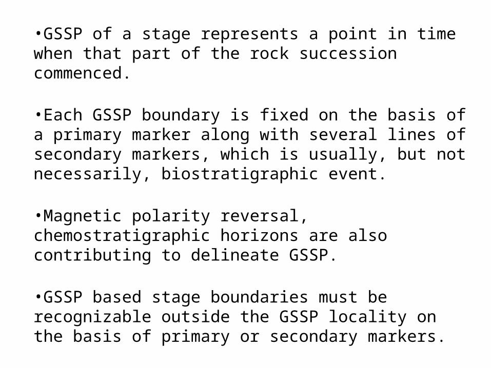
•GSSP of a stage represents a point in time when that part of the rock succession commenced.
•Each GSSP boundary is fixed on the basis of a primary marker along with several lines of secondary markers, which is usually, but not necessarily, biostratigraphic event.
•Magnetic polarity reversal, chemostratigraphic horizons are also contributing to delineate GSSP.
•GSSP based stage boundaries must be recognizable outside the GSSP locality on the basis of primary or secondary markers.
•Before defining a GSSP, its practical value of correlation potential is tested.
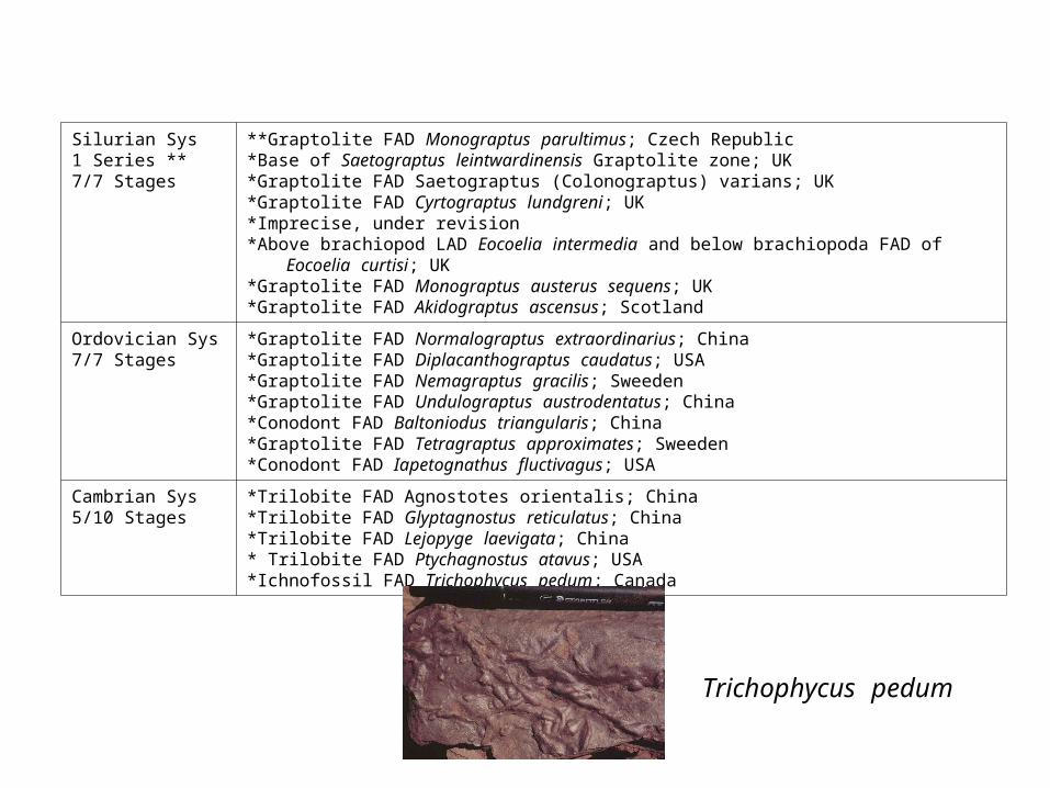
Silurian Sys1 Series **7/7 Stages
**Graptolite FAD Monograptus parultimus; Czech Republic*Base of Saetograptus leintwardinensis Graptolite zone; UK*Graptolite FAD Saetograptus (Colonograptus) varians; UK*Graptolite FAD Cyrtograptus lundgreni; UK*Imprecise, under revision*Above brachiopod LAD Eocoelia intermedia and below brachiopoda FAD of
Eocoelia curtisi; UK*Graptolite FAD Monograptus austerus sequens; UK*Graptolite FAD Akidograptus ascensus; Scotland
Ordovician Sys7/7 Stages
*Graptolite FAD Normalograptus extraordinarius; China *Graptolite FAD Diplacanthograptus caudatus; USA*Graptolite FAD Nemagraptus gracilis; Sweeden*Graptolite FAD Undulograptus austrodentatus; China*Conodont FAD Baltoniodus triangularis; China*Graptolite FAD Tetragraptus approximates; Sweeden*Conodont FAD Iapetognathus fluctivagus; USA
Cambrian Sys5/10 Stages
*Trilobite FAD Agnostotes orientalis; China*Trilobite FAD Glyptagnostus reticulatus; China*Trilobite FAD Lejopyge laevigata; China* Trilobite FAD Ptychagnostus atavus; USA*Ichnofossil FAD Trichophycus pedum; Canada
Trichophycus pedum

Permian Sys6/9 Stages
*Conodont FAD Clarkina wangi; China*Conodont FAD Clarkina postbitteri postbitteri; China*Conodont FAD Jinogondolella postserrata; USA*Conodont FAD Jinogondolella aserrata; USA*Conodont FAD Jinogondolella nankingensis; USA*Conodont FAD Streptognathodus isolatus; Khazakstan
Carbonifeous Sys
3/7 Stages
*Conodont FAD Declinognathodus noduliferus; USA *Benthic foraminifera FAD Eoparastaffella simplex; China *Conodont FAD Siphonodella sulcata; France
Devonian Sys7/7 Stages
*Conodont FAD Palmatolepis triangularis; France*Conodont FAD Ancyrodella rotundiloba; France*Conodont FAD Polygnathus hemiansatus; Morocco*Conodont FAD Polygnathus costatus partitus; Germany*Conodont FAD Polygnathus kitabicus; Uzbekistan*Conodont FAD Eognathodus sulcatus sulcatus and Latericriodus steinachensis Morph
beta; Czech Republic*Graptolite FAD Monograptus uniformis; Czech Republic

Cretaceous Sys4/12 Stages
*Ammonoid FAD Pachydiscus neubergicus; France*Bivalve FAD Platyceramus undulatoplicatus; Spain*Ammonoid FAD Watinoceras devonense; USA*Planktonic foraminifera FAD Rotalipora globotruncanoides; France
Jurassic Sys7/11 Stages
*Ammonoid FAD Gonolkites convergens; France*Ammonoid FAD Hyperhoceras mundum; Portugal*Ammonoid FAD Leioceras opalinum; Spain*Ammonoid FAD Dactylioceras simplex; Portugal*Ammonoid FAD Bifericeras donovani and Apoderoceras sp.; UK*Ammonoid FAD Vermiceras quantoxense, Vermiceras palmeri; UK*Ammonoid FAD Psiloceras spelae tirolicum: Austria
Triassic Sys3/7 Stages
*Ammonoid FAD Daxatina canadensis; USA*Ammonoid FAD Eoprotrachyceras curionii; Italy*Conodont FAD Hindeodus parvus; China

Holocene Sr
1/1
Climatic - End of the Younger Dryas cold spell, which is reflected in a shift in deuterium excess values; Greenland
Pleistocene Sr
2/4 Stages
* Magnetic - ~15 kyr after end of Olduvai (C2n) normal polarity chron; Italy* Magnetic - Matuyama/Gauss boundary (C2r/C2An) is 1m below GSSP. GSSP level
is within Marine Isotope Stage 103.
Pliocene Sr
2/2 Stages
*Magnetic - Gauss/Gilbert (C2An/C2Ar) magnetic reversal is recorded immediately above the GSSP; Italy
*Magnetic - base of the Thvera magnetic event (C3n.4n) is only 96 kyr (5 precession cycles) younger than the GSSP; Italy
Miocene Sr
4/6 Stages
*Planktonic foraminifer first regular occurrence of Globorotalia miotumida, and calcareous nannofossil FAD Amaurolithus delicates; Morocco
*Calcareous nannofossil LAD Discoaster kugleri; Italy*Oxygen-isotope event of global cooling episode Mi3b, near calcareous
nannofossil LAD Sphenolithus heteromorphus; Malta*Magnetic - base of Chron C6Cn.2n, planktonic foraminifer FAD Paragloborotalia
kugleri, calcareous nannofossil near LAD Reticulofenestra bisecta (base Zone NN1); Oxygen isotopic event Mi-1; Italy
Oligocene Sr
1/2 stages
* Planktonic foraminifera LAD Hantkenina and Cribrohantkenina
Eocene Sr2/4
Stages
*Calcareous nannofossil FAD Blackites inflatus; Spain *Carbon Isotope Excursion (CIE); Egypt
Paleocene Sr
3/3 Stages
* Magnetic - Base of Chron C26n; Spain* Second radiation of the fasciculith group of calcareous nannofossils;
Spain* Iridium geochemical anomaly; Tunesia
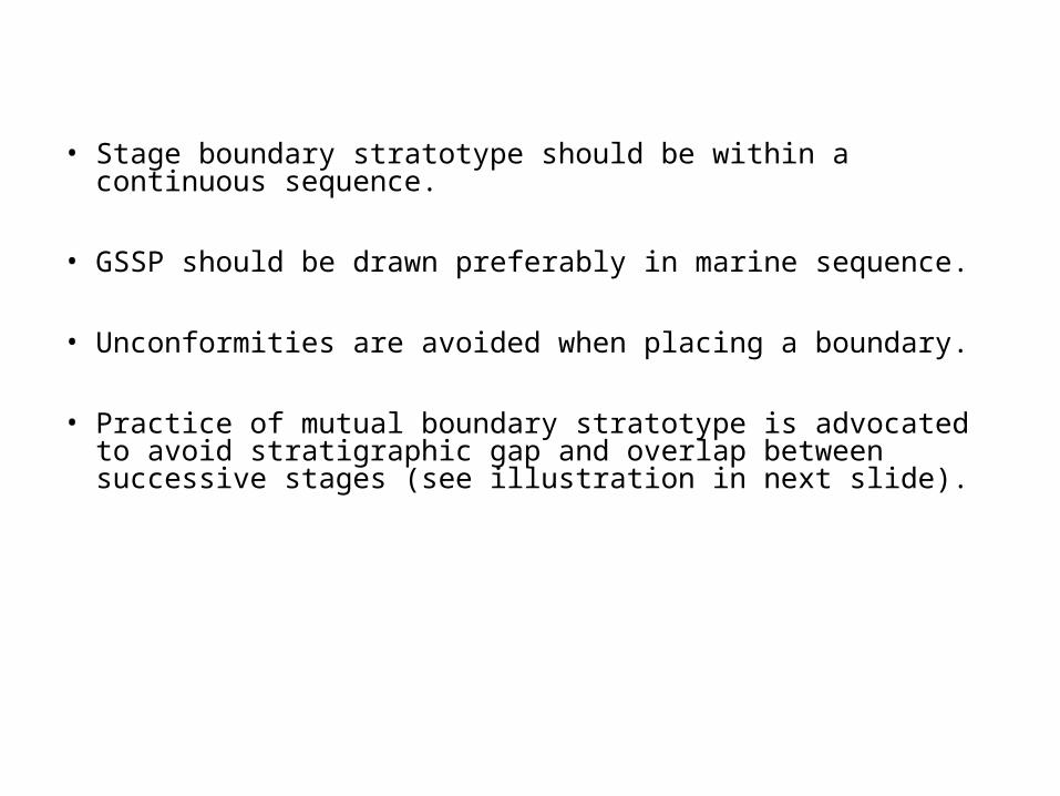
• Stage boundary stratotype should be within a continuous sequence.
• GSSP should be drawn preferably in marine sequence.
• Unconformities are avoided when placing a boundary.
• Practice of mutual boundary stratotype is advocated to avoid stratigraphic gap and overlap between successive stages (see illustration in next slide).

After Walsh et al. (2004)

Significance of fossils• Evolution produces unidirectional and irreversible changes in organism.
• Typical organic association marks particular time intervals.
• Lineage study may provide the basis of recognizing depositional continuity for drawing boundary stratotypes.
• Land to ocean transect can be correlated by equivalence in land plants/animals, spore/pollens, shallow marine benthonic organism and offshore pelagic organisms.

References:
International Stratigraphic Guide: A Guide to Stratigraphic Classification, Terminology, and Procedure, 1976, Editor: Hollis Dow Hedberg.
International Stratigraphic Guide: A Guide to Stratigraphic Classification, Terminology, and Procedure,1994, Editor: Amos Salvador.
Walsh, S.L., Gradstein, F.M. and Ogg, J.G. 2004. Lethaia, 37, p. 201-218.
http://www.iugs.org
http://www.stratigraphy.org