Identifying rift zones on volcanoes: an example from La Réunion island, Indian Ocean
20
RESEARCH ARTICLE Identifying rift zones on volcanoes: an example from La Réunion island, Indian Ocean Fabio Luca Bonali & Claudia Corazzato & Alessandro Tibaldi Received: 6 May 2009 / Accepted: 18 September 2010 / Published online: 5 October 2010 # Springer-Verlag 2010 Abstract We describe a methodology for identifying complex rift zones on recent or active volcanoes, where structures hidden by recent deposits and logistical conditions might prevent carrying out detailed fieldwork. La Réunion island was chosen as a test-site. We used georeferenced topographic maps, aerial photos and digital terrain models to perform a statistical analysis of several morphometric parameters of pyroclastic cones. This provides a great deal of geometric information that can help in distinguishing the localisation and orientation of buried magma-feeding fractures, which constitute the surface expression of rift zones. It also allowed the construction of a complete GIS database of the pyroclastic cones. La Réunion is a perfect example where past and active volcanic rift zones are mostly expressed by clusters of monogenic centres. The data has been validated in the field and compared and integrated with the distribution and geometry of dyke swarms. Results show the presence of several main and secondary rift segments of different ages, locations and orientations, whose origin is discussed considering regional tectonics, local geomorphology, and volcano deformation. Keywords Pyroclastic cones . GIS (Geographic Information System) . La Réunion . Tectonics . Rift zones Introduction Basic magma is normally supplied to the surface along planar and mostly steeply inclined intrusive sheets that may group to form dyke swarms (Dieterich 1988; Carracedo 1994; Moore et al. 1994; Walter and Schmincke 2002), and eventually rift zones formed by hundreds of such parallel dykes (Fiske and Jackson 1972; Walker 1999). Rift zones may contribute to the endogenous growth of volcanoes by up to 30% or more (Annen et al. 2001; Walter and Schmincke 2002) and are usually expressed at the surface by aligned pyroclastic centres and swarms of fissures and faults. The importance of correctly locating rift zones is linked to the volcanic hazard assessment of possible new vent openings, as well as to the understanding of the structure of a volcano, its general behaviour, and possible lateral instability (Tibaldi et al. 2009, and references therein). At recent and active volcanoes, rift zone fissures and faults are usually hidden under widespread pyroclastic, lava and epiclastic deposits, preventing the identification of volcanic structures and consequently of rift location and orientation. In this scenario, morphometric data of pyroclastic cones can be used as an indirect method to reconstruct magma-feeding fractures (Tibaldi 1995). Previous studies have shown that dykes tend to propagate parallel to the maximum horizontal principal stress (σ Hmax ), forming aligned parasitic cones (eg Nakamura 1977), and that the alignment of volcanic centres can be used to infer σ Hmax (eg Johnson and Harrison 1990; Strecker and Bosworth 1991). Tibaldi (1995) defined 9 morphometric parameters of pyroclastic cones, showing their use in inferring magma-feeding fracture geometry. He devised a method using these parameters that allows magma-feeding systems to be defined and the tectonic evolution of the volcano or region to be reconstructed. Editorial responsibility: B. van Wyk de Vries F. L. Bonali : C. Corazzato : A. Tibaldi (*) Dipartimento di Scienze Geologiche e Geotecnologie, Università di Milano-Bicocca, Piazza della Scienza 4, 20126 Milan, Italy e-mail: [email protected] Bull Volcanol (2011) 73:347–366 DOI 10.1007/s00445-010-0416-1
-
Upload
uninsubria -
Category
Documents
-
view
0 -
download
0
Transcript of Identifying rift zones on volcanoes: an example from La Réunion island, Indian Ocean

RESEARCH ARTICLE
Identifying rift zones on volcanoes: an examplefrom La Réunion island, Indian Ocean
Fabio Luca Bonali & Claudia Corazzato &
Alessandro Tibaldi
Received: 6 May 2009 /Accepted: 18 September 2010 /Published online: 5 October 2010# Springer-Verlag 2010
Abstract We describe a methodology for identifying complexrift zones on recent or active volcanoes, where structureshidden by recent deposits and logistical conditions mightprevent carrying out detailed fieldwork. La Réunion island waschosen as a test-site. We used georeferenced topographic maps,aerial photos and digital terrain models to perform a statisticalanalysis of several morphometric parameters of pyroclasticcones. This provides a great deal of geometric information thatcan help in distinguishing the localisation and orientation ofburied magma-feeding fractures, which constitute the surfaceexpression of rift zones. It also allowed the construction of acomplete GIS database of the pyroclastic cones. La Réunion isa perfect example where past and active volcanic rift zones aremostly expressed by clusters of monogenic centres. The datahas been validated in the field and compared and integratedwith the distribution and geometry of dyke swarms. Resultsshow the presence of several main and secondary rift segmentsof different ages, locations and orientations, whose origin isdiscussed considering regional tectonics, local geomorphology,and volcano deformation.
Keywords Pyroclastic cones .
GIS (Geographic Information System) . La Réunion .
Tectonics . Rift zones
Introduction
Basic magma is normally supplied to the surface alongplanar and mostly steeply inclined intrusive sheets that maygroup to form dyke swarms (Dieterich 1988; Carracedo1994; Moore et al. 1994; Walter and Schmincke 2002), andeventually rift zones formed by hundreds of such paralleldykes (Fiske and Jackson 1972; Walker 1999). Rift zonesmay contribute to the endogenous growth of volcanoes byup to 30% or more (Annen et al. 2001; Walter andSchmincke 2002) and are usually expressed at the surfaceby aligned pyroclastic centres and swarms of fissures andfaults. The importance of correctly locating rift zones islinked to the volcanic hazard assessment of possible new ventopenings, as well as to the understanding of the structure of avolcano, its general behaviour, and possible lateral instability(Tibaldi et al. 2009, and references therein).
At recent and active volcanoes, rift zone fissures and faultsare usually hidden under widespread pyroclastic, lava andepiclastic deposits, preventing the identification of volcanicstructures and consequently of rift location and orientation. Inthis scenario, morphometric data of pyroclastic cones can beused as an indirect method to reconstruct magma-feedingfractures (Tibaldi 1995). Previous studies have shown thatdykes tend to propagate parallel to the maximum horizontalprincipal stress (σHmax), forming aligned parasitic cones (egNakamura 1977), and that the alignment of volcanic centrescan be used to infer σHmax (eg Johnson and Harrison 1990;Strecker and Bosworth 1991). Tibaldi (1995) defined 9morphometric parameters of pyroclastic cones, showing theiruse in inferring magma-feeding fracture geometry. Hedevised a method using these parameters that allowsmagma-feeding systems to be defined and the tectonicevolution of the volcano or region to be reconstructed.
Editorial responsibility: B. van Wyk de Vries
F. L. Bonali : C. Corazzato :A. Tibaldi (*)Dipartimento di Scienze Geologiche e Geotecnologie,Università di Milano-Bicocca,Piazza della Scienza 4,20126 Milan, Italye-mail: [email protected]
Bull Volcanol (2011) 73:347–366DOI 10.1007/s00445-010-0416-1

As far as we know, Tibaldi’s (1995) method has beenapplied up to now only on relatively simple volcanic riftzones (e.g. Mazzarini and Armienti 2001; Corazzato andTibaldi 2006; Guzmán et al. 2006; Lara et al. 2006; Munnet al. 2006). Here we test this approach at a more complexsetting, the volcanic island of La Réunion (Indian Ocean),where hundreds of pyroclastic cones form poorly con-strained swarms (Fig. 1). This setting is probably related tothe long volcanic history of the island, where successiverifts were emplaced with different geometries (Lenat et al.2001, 2009). Rift-related fissures and fractures are visible atthe surface only at the very active summit part of Piton dela Fournaise at the southeastern end of the island(Bachelery 1981; Carter et al. 2007; Letourneur et al.2008).
We study the entire pyroclastic cone population of LaRéunion island, in order to define rift locations, andreconstruct the geometry and relative age of the differentrift arms. The analysis of five morphometric parameters foreach cone has been integrated with a statistical andstructural-geological approach to define volcanic weaknesszones. Apart from the general interest of this approach, theresults can be also useful in determining the structure of theisland, and as a contribution to the assessment of volcanichazards linked to the presence of the very active Piton de laFournaise volcano. Also, this is the first time that acomplete database of the pyroclastic cones of La Réunionisland has been prepared.
Geological setting
La Réunion is a volcanic island located in the easternIndian Ocean at 21°7′S latitude and 55°32′E longitude(Fig. 1), east of Madagascar. The island is elliptical in shape(50×70 km) with a NW-SE elongation. It represents theemerged part of a volcanic complex that is 220 to 240 kmin diameter and about 7 to 8 km in height from the seabottom. La Réunion is built on a Cretaceous ocean plateaffected by a system of NW-SE-striking paleo-rift segmentsoffset by a system of NE-SW-striking fracture zones(Oehler et al. 2008; Fig. 1b).
La Réunion is composed of different volcanic edifices,including the major, and dormant, Piton des Neiges, theLes Alizés submarine volcano, and the active Piton de laFournaise, that was emplaced on the SE part of theisland (Malengreau et al. 1999; Fig. 1). Piton des Neigesemerged from the sea before at least 2.1 Ma (Deniel et al.1992), and presently rises up to 3069 ma.s.l.. Its subaerialvolcanic activity started with the growth of a basalticshield volcano from before 2.08 Ma (McDougall 1971) toabout 0.423 Ma (Oehler et al. 2008). Between 330 and12 ka it erupted alkaline-differentiated lavas, the “Differ-entiated Series” (McDougall 1971; Gillot and Nativel1982; Deniel et al., 1992). This volcano is dissected bydeep valleys departing from three depressions known asthe Cirques of Mafate, Salazie, and Cilaos (Fig. 1). To theeast of the Cirque of Salazie there is also the Cirque of
Fig. 1 a Shaded relief view ofLa Réunion island showing thepyroclastic cones that have beenidentified and studied in thepresent work (yellow dots), andthe main collapse traces(after Nehlig et al. 2006, andLetourneur 2008). PN = Pitondes Neiges, PF = Piton de laFournaise, RRV = Riviere desRemparts Valley. Digitalelevation model data from IGN(www.ign.fr), UTM-WGS84coordinates in m. b Geodynamicsetting of La Réunion islandin the Indian Ocean(after UNESCO 2002, and Lenatet al. 2001). Mad = Madagascar,Mau = Mauritius; AfP = AfricanPlate, IP = Indian Plate, AnP =Antartic Plate, SWR =Southwest Indian Ocean Ridge,SER = Southeast IndianOcean Ridge
348 Bull Volcanol (2011) 73:347–366
Marsouins, partially filled by lava flows (Kieffer 1990;Deniel et al. 1992).
The known eruptive history of Piton de la Fournaise startedat about 527–530 ka (Gillot and Nativel 1989; Bachèlery andMairine 1990) growing up to at least 2631 ma.s.l.. Thegrowth of this volcano has been divided in two phases: the“ancient shield” (older than 150 ka) and the “recent shield”(more recent than 150 ka), punctuated by several majorvolcano-tectonic events (Bachèlery and Mairine 1990). Itsmorphology is characterized by four deep valleys with depthsin the order of 1000 m and a series of caldera-like rims. Forsome authors these rims result from classic caldera collapses(Chevallier and Bachèlery 1981; Bachèlery and Mairine1990; Bachèlery 1995), whereas for others they could be theheadwalls of successive huge landslides (Duffield et al. 1982;Lénat and Labazuy 1990; Lénat and Bachélery 1990; Lénatet al. 2001; Labazuy 1991, 1996; Gillot et al. 1994). Merleand Lénat (2003) have proposed a hybrid model where avertical collapse could have been generated in response to aflank landslide. In any case, authors generally agree that theeasternmost structure, the Grand Brûlé depression, is the scarof a huge landslide at 5 ka (Bachèlery and Mairine 1990;Labazuy 1991, 1996; Mohamed-Abchir 1996). The EnclosFouqué caldera (Bachèlery and Mairine 1990) hosts the mostrecent summit cone, with the Bory and Dolomieu craters atthe top. Bory is the oldest crater, located west of Dolomieu,which is the youngest and most active crater.
Methodology
Morphometric parameters
Several morphometric features and parameters for pyroclasticcones have been proposed (e.g. Porter 1972; Settle 1979;Wood 1980; Hasenaka and Carmichael 1985), whichessentially consider the absolute dimension of the conesand some ratios of these dimensions. Other authors havedemonstrated that monogenic volcanoes provide a great dealof geometric information that can help in distinguishingburied magma-feeding fractures (e.g. for pyroclastic cones:Settle 1979; Pasquaré et al. 1988; Tibaldi et al. 1989; Ferrariand Tibaldi 1991; Tibaldi 1995; Corazzato and Tibaldi 2006;for domes: Pasquarè and Tibaldi 2003). The use ofmorphometric data of pyroclastic cones as an indirectmethod for locating magma-feeding fractures, can beparticularly useful in areas where an extensive cover ofvolcanic and epiclastic deposits, or dense vegetation, preventsthe direct identification of volcanic structures. Among the nineparameters advanced by Tibaldi (1995), we have selected andmeasured the parameters which are most useful in inferringthe geometry of the magma-feeding fractures at La Réunion.These morphometric values are accompanied by measure-
ments of the substrate inclination around each cone, asTibaldi (1995) showed that the morphology of pyroclasticcones grown on an inclined substrate topography (>9°) isinfluenced by the effects of gravity induced by the slope.
We have recognized and analyzed 315 cones. Themorphometric parameters measured on each cone are:
1) Ellipticity, calculated using the minimum (Dbm) andmaximum (DbM) diameters of the cone base and theminimum (Dcm) and maximum (DcM) diameters of thecrater (Fig. 2b). Only craters with an almost continuousrim were measured, whereas those interrupted bybreaching or fractures were not considered. The higherthe number of elliptical cones with respect to the entirepopulation, the more robust are the results of the analysis.
2) Azimuth orientation of crater elongation (AceM). It isassumed that the AceM is parallel to the geometry ofthe underlying magma-feeding fracture (Fig. 2a–b).
3) Azimuth orientation of cone-base elongation (AbeM). Itis assumed that the AbeM is parallel to the geometry ofthe underlying magma-feeding fracture (Fig. 2a–b).
4) Azimuth of the line connecting crater-rim depressedpoints (Acdp), which is assumed to parallel the magma-feeding fracture geometry in the substrate (Fig. 2a). In acompletely developed pyroclastic cone, the presence ofelevated and depressed points on the crater rim repre-sents the equivalent of the scoria rampart in the inceptionstage of Strombolian activity. The scoria rampartnormally develops parallel to the eruptive fissure (Ollier1988; Tibaldi 1998). This feature can be present andtaken into account also on circular cones, even if they donot provide information related to cone elongation.
5) Azimuth of the alignment of the centre points of coevalcraters (Acc) (Fig. 2a), which is assumed to parallel themagma-feeding fracture. It was observed (Ollier 1988)that cones usually develop one after the other with anupslope propagation along the eruptive fissure until thisis sutured. Examples of aligned vents emplaced on thesummit flank of Piton de la Fournaise formed duringsingle eruptive phases are shown in Fig. 2c.
The morphometric parameters of the pyroclastic cones wereobtained by analyzing six georeferenced topographic maps ofthe island at 1:25,000 scale (Institut Geographique National-IGN) and aerial photos of the entire island (IGN, www.geoportail.fr), integrated with field verification. Recognizing apyroclastic cone on a topographic map is a meticulous task,especially when dealing with eroded edifices. In carrying outthis study it was fundamental to use a GIS tool because itenabled us to georeference all of the analyzed geomorphologicalobjects and to integrate the morphometric parameters in adatabase. Once the morphological features were recognised and
Bull Volcanol (2011) 73:347–366 349
the lines corresponding to the azimuths (e.g.AbeM, AceM) weretraced, a GIS tool provided automatically the azimuths of suchlines. An IGN (www.ign.fr) high resolution digital terrainmodel, with a 25-m pixel size, was used to evaluate thesubstrate inclination around each cone: GIS-derived slopemaps were analysed and the measurements were determinedby averaging the slope values around the cone.
Information on the relative age of the cones was also obtainedby applying the method proposed by Hasenaka and Carmichael(1985). This method classifies the degradation stage of theedifice by means of morphological indices such as gullydensity and the surface morphology of associated lava flows.Cones have been classified into two classes: old and young.
In case of ambiguity in the data, field checks were carriedout. The resulting validated data were then analyzed by bothstatistical and structural-geological methods, in order to definevolcanic rift zones, as explained in the following section.
Statistical analysis
The statistical approach that we applied in analysis of thevarious parameters can be summarized as follows.
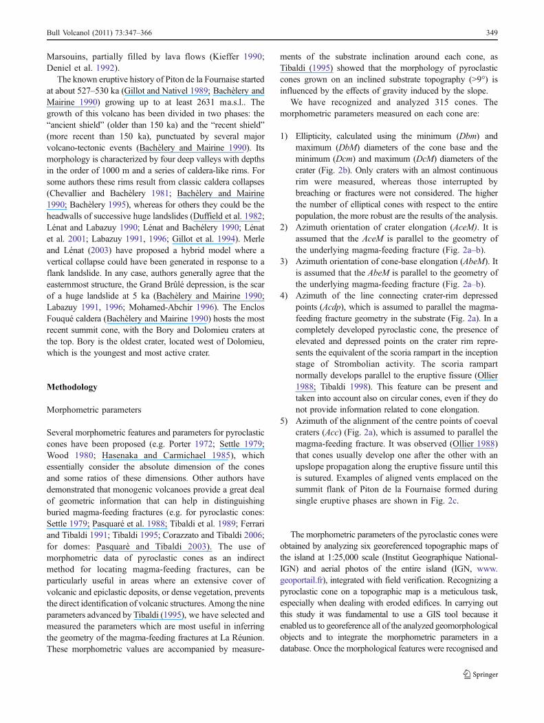
A first classification of the cones is based on theellipticity of the base and/or of the crater (Fig. 3). If thereare only base or only crater diameter measurements, theellipticity is given by:
Dm=DM
where Dm is the minimum diameter and DM is themaximum diameter.
If there are both base and crater diameter measurements,the ellipticity is given by:
DbmDbM � NbNt þ Dcm
DcM � NcNtNbNt þ Nc
Nt
Fig. 3 Ellipticity plot showing ratios between minimum andmaximum cone axes, considering both bases and craters. Two classesof ellipticity degree are considered with their relative percentage(inset): circular cones (C), 12%; elliptical cones (E), 88%
Fig. 2 a 3-D sketch of themeasured morphometricparameters of pyroclastic conesand their relationship with theorientation of the underlyingfeeding fracture (modified afterCorazzato and Tibaldi 2006):fracture-parallel crater elongation,crater rim depressed points andcoeval cone alignment. Acdp =Azimuth of the line connectingcrater-rim depressed points; Acc =Azimuth of the alignment of thecentre points of coeval craters. bExample of a cone and relatedfeeding fracture. Dbm, DbM =minimum and maximum diameterof cone base; Dcm, DcM =minimum and maximum diameterof crater; AbeM = azimuthorientation of cone-base elonga-tion; AceM = azimuth orientationof crater elongation. c Aligned orelongated vents emplaced on thesummit flank of Piton de laFournaise volcano during varioussingle eruptive phases
350 Bull Volcanol (2011) 73:347–366
where Nt is the total number of cones, Nb the number ofcones having base data and Nc the number of cones havingcrater data. This equation weights cone ellipticity againstfrequency of the base and crater data. Cones are classifiedaccording to their ellipticity into two classes (conventionally,the “[” symbol in a range indicates that the closest value isincluded in this class, on the contrary the “)” means that theclosest value is excluded from this class):
Circular cones : 1� 0:9½ Þ;Elliptical cones : 0:9� 0½ Þ:
Then, the azimuth of eruptive fractures is evaluated by aquantitative analysis of the dataset.
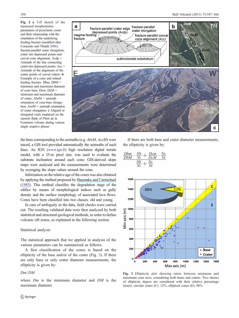
The inclination of the substrate topography must beconsidered as it influences the level of reliability of themorphometric parameters to be used in determining the azimuthof magma-feeding fractures (Tibaldi 1995). Such inclinationswere determined by averaging the slope values around eachcone on a detailed slope map that was GIS-derived from theIGN digital elevation model (25-m pixel size) (Fig. 4)
– on pyroclastic cones grown on a horizontal orsubhorizontal substrate topography (slope<9°) weconsider in decreasing order: 1) Acdp; 2) AbeM orAceM for non circular cones; 3) Acc.
– For pyroclastic cones grown on a substrate topographywith slopes between 9° and 12° we consider indecreasing order: 1) Acc; 2) Acdp; 3) AbeM or AceMfor non circular cones. For circular cones we use 1)Acdp and 2) Acc.
– For slopes >12° we use Acc.
With this procedure, we defined 216 magma-feedingfractures. These were separated into two sub-classes basedon relative age of the cones, old or young. Each of thesesub-classes was then further divided into azimuth frequencyclasses every 5°, from 0° to 180°. These frequency classesare used to plot spider diagrams, and are then used forspatial analysis. In spider diagrams, the abscissa axisreports the central values of each of the established classes(e.g., in class [0–5), central value of 2.5 is reported). Theordinate axis reports the frequency of each class. For bothold and young fracture datasets, we obtained separatorvalues for spatial analysis classes by taking those values onthe abscissa axis that represent a relative or an absoluteminimum between two maximum values. Using suchseparator values, we reclassified the two datasets indirectional classes.
Once the cones were classified by age and azimuth ofmagma-feeding fractures, the isodensity distribution areasfor each class were quantitatively determined by spatial
Fig. 4 Distribution of pyroclastic cones with respect to their substrateinclination; 187 cones are located on a horizontal or subhorizontalsubstrate topography (<9°), 27 cones on topography between 9–11°,
79 cones on topography between 12–19°, and the remaining 22 coneson topography between 20–30°. The maximum substrate inclinationon the island is 84.2°
Bull Volcanol (2011) 73:347–366 351

analysis (“calculate density” tool, ARCGIS® software). Itwas then possible to identify the rift zones based on thepreferential elongation direction of such areas, calculated asthe mean (with standard deviation) of the azimuth of themagma-feeding fractures for each class.
Results
Morphometric analysis
Out of the 315 recognised pyroclastic cones, 236 have awell defined base and 48 have a well-preserved crater-rim;for these it was possible to calculate the related morphometric
measurements AbeM and AceM. A population of 105 conesshows alignment of coeval edifices, and 67 cones show crater-rim depressed points, where it was possible to define Acc andAcdp respectively; 59 cones show breached morphostructures.
Using base and/or crater measurements, ellipticity wasdefined for 250 cones (66% of the entire population); 30(12%) classify as circular, 208 (83%) as elliptical and 12(5%) as strongly elliptical (Fig. 3). Using AbeM and AceMfor elliptical cones together with Acdp and Acc, we defined216 (68%) magma-feeding fracture directions out of the315 pyroclastic cones. Of these, 54 (25%) are linked to“old” cones and 162 (75%) are linked to “young” cones.
Out of the entire cone population, 187 cones are locatedon a horizontal or subhorizontal substrate topography (<9°),
Fig. 5 Projection of single morphometric parameters measured at old and young pyroclastic cones. Note from the rose diagrams the similarity ofresults among the various parameters for each cone generation
352 Bull Volcanol (2011) 73:347–366

27 cones on topography between 9–11°, 79 cones ontopography between 12–19°, and the remaining cones ontopography between 20–30°. The maximum substrateinclination on the island is 84.2° (Fig. 4).
The obtained azimuths for each morphometric parameterat each cone are plotted in Fig. 5. Comparing the results ofold and young cones, it is possible to note the strongsimilarity of orientation of the azimuths of the variousparameters, always with a dominant NW-SE component.For each cone, the azimuth of the most reliable parameteraccording to the substrate slope is then chosen. Theseazimuths are shown in Fig. 6 as rose and spider diagrams.For old cones, the fractures predominantly strike NW-SE,NE-SW, E-W and N-S, in decreasing order of frequency.For young cones, the fractures predominantly strike NW-SE, N-S, NNE-SSW, NE-SW and E-W, in decreasing orderof frequency. The spider diagrams were used to defineseveral azimuth classes (Fig. 6b and d); for the old cones, indecreasing frequency: [132.5–152.5°), [117.5–132.5°),[32.5–67.5°), and secondary classes such as [67.5–87.5°),[102.5–117.5°), etc.; for the young cones, in decreasingfrequency: [142.5–172.5°), [127.5–142.5°), [177.5–12.5°),[112.5–127.5°), and other secondary classes.
The isodensity areas of old and young cones havingeruptive fissure azimuths, computed with the Kernel
method in a GIS workspace using a search radius of1650 m, are shown in Fig. 7a and b respectively. This valuehas been chosen based on the maximum distance betweentwo vents grown during the same eruptive event (accordingto Tibaldi 1995) plus the mean cone base diameter. Theisodensity areas are classified into three classes, by equalintervals with respect to the maximum value. These areas ofold cones are located on the SW and SE flanks of Piton desNeiges and on the NW, SW and S flanks of Piton de laFournaise, behind the second collapse scarp (C2 in Fig. 8a).The highest densities are located between the E flank ofPiton des Neiges and the NW flank of Piton de laFournaise. These areas are NW-SE-elongated and cut thetwo older collapse scars (scarp C1 and scarp C2 in Fig. 8a).The young cone areas are located only on Piton de laFournaise and the density values are higher than for oldcones. Most areas are located on the NW, SE andsubordinately NNE flanks of the Piton de la Fournaisevolcano. On the NW and SE flanks, areas with the highestdensities are elongated NW-SE, cutting all the threecollapse scars and the crater zone. The highest densitiesare located in the Enclos Fouqué depression close to thecrater zone. There is a superposition region of the old andyoung cone distribution located on the NW flank of Pitonde la Fournaise passing through the scarp C1.
Fig. 6 Old cones: a Rose diagramof the azimuths of magmafeeding-fractures. The length ofeach petal in the rose diagram isproportional to the number ofmeasurements. Fracturespredominantly strike NW-SE,NE-SW, E-W and N-S. b Spiderdiagram that enables to classify theazimuths of magma feeding-fractures in the following 9classes: [12.5–32.5°), [32.5–67.5°), [67.5–87.5°), [87.5–102.5°), [102.5–117.5°), [117.5–132.5°), [132.5–147.5°), [147.5–165°) and [165–12.5°). Youngcones: c Rose diagram of theazimuths of magma feeding-fractures. Fractures predominantlystrike NW-SE, N-S, NNE-SSW,NE-SW and E-W. d Spiderdiagram that enables to classify theazimuths of magma feeding-fractures in the following 10classes: [12.5–27.5°), [27.5–47.5°), [47.5–62.5°), [62.5–87.5°),[87.5–112.5°), [112.5–127.5°),[127.5–142.5°), [142.5–172.5°),[172.5–177.5°) and [177.5–12.5°)
Bull Volcanol (2011) 73:347–366 353

Figures 8 and 9 show the isodensity areas of old andyoung cones, respectively, separated by the azimuth classesdefined using the spider diagrams. Some areas are moresignificant because they have large number of cones, showthe well-defined magma feeding-fractures, and showelongation trends. Regarding the older cones, areas withthe eruptive fissures striking NE-SW (classes [32.5–87.5°),Fig. 8b–c) are mostly developed on the flanks of Piton desNeiges, although some are located on the NW and SWflanks of Piton de la Fournaise. The eruptive fissuresstriking NW-SE (classes [117.5–147.5°), Fig. 8f–g) belongto cones located west of scarp C2, consistent with the relativelyolder age of these cones. The most important area with NW-SEtrending cones is located from the SE flank of Piton des Neigesto the NW flank of Piton de la Fournaise. The less representedclasses of fissures striking NNW-SSE to N-S are located west
of scarp C2 (Fig. 8h–i). The other classes striking [12.5–32.5°), [87.5–102.5°) and [102.5–117.5°) (Fig. 8a and d–e,respectively) are less significant and do not show anyelongation trend, and belong to cones located on rocksuccessions that pre-date scarp C1 and scarp C2.
Regarding the younger cones, the most abundant classesare in the range [127.5–172.5°) (Fig. 9g–h) and belong totwo areas aligned NW-SE. The first is located from scarpC1 to scarp C3 and is 5 km long. The second area is locatedon the SE flank of Piton de la Fournaise, from the pit craterzone to the coast line, and is 10 km long. A similargeometry can be drawn for the class [112.5–127.5°)(Fig. 9f). These data suggest the presence of a swarm oferuptive fissures striking NW-SE and passing across thePiton de la Fournaise edifice from scarp C1 towards thecoast. The other classes are more limited to certain zones ofPiton de la Fournaise: Fractures striking N-S to NNE-SSW(classes [177.5–12.5°), Fig. 9l, and [12.5–27.5°), Fig. 9a)are mostly present on the summit of Piton de la Fournaiseand extend towards the northern flank showing a clearelongated and continuous zone. The less abundant classes[27.5–.47.5°), [47.5–62.5°), [62.5–87.5°) and [87.5–112.5°)are mostly present inside the amphitheatre of scarp C3. The[27.5–62.5°) classes depict a short zone trending NE-SW onthe northern flank of the summit part of Piton de laFournaise and completely contained within the collapsedepression C3 (Fig. 9b). The other two classes depict azone of E-W-elongated fractures (Fig. 9d–e).
Field data
Field checks were carried out to verify problematic casesand to collect additional structural data. Here we will cite afew examples.
All cones west of the summit region of Piton de laFournaise were surveyed in the field. Also in the field it ispossible to appreciate the NW-SE elongation of the areaaffected by the presence of pyroclastic cones west of scarpC2 (Fig. 10a). For example, the cone named Formica Leo(Fig. 1), located close to scarp C3 (Fig. 10b–c), is a recentcone that has a NW-SE-oriented base and crater major axis,coincident with the line connecting the two depressedpoints of the crater rim (differences ≤ 4°). This cone islocated exactly along the NW-SE elongated zone of youngand old cones crossing through C1, C2 and C3 scarps.
Cones were also surveyed in order to find dykes,which give direct evidence of the geometry of magma-feeding fractures. In four cones belonging to the NW-SE zone, we found dykes intruding up to about half or2/3 of the cone height (e.g. Fig. 10d–e). They areusually less than 1 m thick, and have a NW-SE strike. Ateach cone showing a dyke, we compared the variousmorphometric parameters with the dyke strike, confirm-
Fig. 7 a Isodensity areas of old cones having eruptive fissureazimuths, represented in graduated blue colour. b Isodensity areas ofyoung cones having eruptive fissure azimuths, represented ingraduated red colour. Isodensity has been computed by Kernel methodin a GIS workspace, with a search radius of 1650 m
354 Bull Volcanol (2011) 73:347–366

ing the NW-SE orientation of the magma-feedingfracture.
On Piton des Neiges, Letourneur (2008) showed thepredominance of dykes striking N30° in the Cilaos
depression in the southern part of the volcano, N120° andN160° in the Mafate depression in the northern part, andN10–20° and N140–150° in the Salazie depression (Fig. 11,stereograms A). On the western flank of Piton des Neiges,
Fig. 8 Isodensity areas of oldcones having eruptive fissureazimuths, as classified byazimuth values based on thespider diagrams (cfr. Fig. 6b).Isodensity areas are representedin graduated blue colour, andwere computed by a Kernelmethod in a GIS workspace,with a search radius of 1650 m.C1: first collapse scar(the oldest); C2: second collapsescar; C3: third collapsescar (the youngest); EF:Enclos Fouqué
Bull Volcanol (2011) 73:347–366 355

along the centre of the western part of the scarp C3, dykesstrike N120–125°, and N0–30° along the northern part ofthe scarp C3 (Fig. 11, stereograms B) (Letourneur et al.2008). We completed this data-set by measuring the 55dykes cropping out along the northwestern coast of theisland (e.g. Fig. 10f). In this area dykes dominantly strikeN130–145° (stereogram C, Fig. 11).
Discussion
Surface magma-feeding fractures versus dykes
Intrusive sheet paths are sensitive to the stress conditions ofthe surrounding host rock which, in turn, is a function of aseries of geological, structural and geomorphologicalvariables, from regional to local in scale (Fiske and Jackson1972; Gudmundsson 1990; Tibaldi 1996, 2003; Ida 2009;Tibaldi et al. 2009). Sheets follow paths that contain thegreatest (σ1) and intermediate (σ2) principal stresses. At aregional scale under a tectonic extensional stress field andwith a horizontal topography, σ1 is vertical and the least
principal stress (σ3) is horizontal and normal to rift strike,so intrusive sheets are expected to develop as swarms ofvertical parallel dykes. Approaching the horizontal surfaceand under the regional stress field, the geometry of a singledyke depends also upon the characteristics of the magmasupply (mainly pressure, single or multiple injections, andthermal conditions) and of the host-rocks (mainly elasticproperties) (Gudmundsson 1983; Lister and Kerr 1991;Rubin 1995; Walker et al. 1995; Paquet et al. 2007; Tibaldiand Pasquarè 2008). These parameters usually have theeffect of changing the dyke thickness and/or dip angle, andeventually arresting the intrusion (review in Gudmundsson2002, 2006), but they have a low effect on dyke strike.Thus, at a horizontal surface, there is generally a goodapproximation between the feeder dyke strike and theorientation of the related eruptive fissure.
Regarding the control on magma paths exerted by thelocal stress field linked to topographic irregularities, severalstudies have been carried out in recent years. At the scale ofan entire volcano, theoretical studies showed the role ofelongate edifices (Fiske and Jackson 1972; Hyndman andAlt 1987) and the role of edifice loading (Chadwick and
Fig. 9 Isodensity areas ofyoung cones having eruptivefissure azimuths, as classified byazimuths values based on thespider diagrams (cfr. Fig. 6d).They are represented in gradu-ated red colour and were com-puted by a Kernel method in aGIS workspace, with a searchradius of 1650 m. C1: Firstcollapse scar (the oldest); C2:second collapse scar; C3: thirdcollapse scar (the youngest); EF:Enclos Fouqué
356 Bull Volcanol (2011) 73:347–366

Dieterich 1995) on intrusive patterns. At a more local scale,the potential of morphological irregularities for modifyingsheet paths by reorienting the σ3 has been demonstrated atMt Etna, Italy, by geophysical studies during dyke-federuptions in the 1970’s and 1980’s (McGuire and Pullen 1989;McGuire et al. 1990, 1991, 1997) and during the July–August 2001 event (Tibaldi and Groppelli 2002). Thisreorientation has been explained by the presence of thesub-vertical, hundreds-of-metres-high escarpment of theValle del Bove depression or the minor Valle del Leonedepression. At Stromboli volcano, Italy, the control exertedby a huge depression surrounded by vertical scarps on sheetpaths during contemporary eruptions has also been shown(Acocella and Tibaldi 2005). For the same volcano, and overa longer time perspective, modification of sheet trajectoriesclose to the topographic surface due tomorphological changes
that occurred in Holocene times has been demonstrated(Tibaldi 1996; 2001). Similar relationships have been alsofound at Tenerife (Canary Islands) by Walter and Schmincke(2002). The effect of large topographic gradients has alsobeen numerically quantified and compared with field data byTibaldi et al. (2009). These authors showed that at Strombolithe distance of influence of the Sciara del Fuoco depression(about 1 km wide, and from 100 m to 300 m deep withrespect to surrounding volcano flanks) in modifying thestress field is on the order of 500 m, and decreases quiterapidly with distance from the escarpment. At Piton de laFournaise, numerical models simulating the co-eruptivedeformation observed using SAR-interferometric images,showed that the transition depth at which dykes transforminto eruptive fissures, that is the depth at which stressesbecome sensitive to local slope perturbation, is from 200 m
Fig. 10 a Field view of theNW-SE elongated area affectedby the presence of pyroclasticcones west of scarp C2. Most ofthese cones have morphometricparameters that indicate magma-feeding fractures with the sameNW-SE strike. b Aerial photo andc field photo of the recentFormica Leo pyroclastic cone asan example of an edifice showingconsistent parameters: it displaysNW-SE basal and crater majoraxis, and orientation of the lineconnecting the two depressedpoints of the crater rim. This coneis located exactly along the NW-SE elongated zone of youngcones and old cones crossing C1,C2 and C3 scarps. d and eexamples of cones belonging tothe NW-SE zone showing NW-striking dykes. f Example of aNW-striking dyke cropping outalong the northwestern coast ofthe island. It belongs to a swarmof parallel dykes
Bull Volcanol (2011) 73:347–366 357

below the volcano top to 100 m below the volcano base(Fukushima et al. 2005), consistent with the results of vanWyk de Vries and Matela (1998).
All of these studies suggest that the orientation of afissure eruption can be different from that of the feederdyke depending upon the steepness of, and distance from,the volcano slope. On inclined slopes, another effect can bethe rupture of the dyke, which assumes an en-echelongeometry (Cayol and Cornet 1998; Battaglia and Bachèlery2003; Fukushima et al. 2005; Peltier et al. 2005). For allthese reasons, the work carried out here has taken intoaccount the local slope at each pyroclastic cone and thedistance from steeper slopes. As put forward by Tibaldi(1995), the morphological control exerted on pyroclasticcones by magma-feeding paths is also a function of thelocal slope inclination for slope angles ≥9°. Therefore wegave parameters different weight according to local slopeangles. In order to check the correspondence between dykesand magma-feeding fractures obtained by the morphometricparameters of pyroclastic cones, we performed a compar-ison between the orientation of these structures at siteswhere they are both present. These sites are: the westernflank of the Cilaos depression (dykes) and the southernflank of Piton des Neiges (cones), the northern part of scarpC3 (dykes) and the northern flank of Piton de la Fournaise(cones), the western part of scarp C3 (dykes) and the zone
further west (cones) (Fig. 11). At each site, dykes andmagma-feeding fractures show a range in strike from 15 to30°, but there is a very good coincidence in theirorientations. This range in values is consistent with thecommon variance measured along rift zones in flat regions(e.g. Gudmundsson 1990), since it is common for volcanicrifts to have faults and eruptive fissures that do not exactlyparallel the rift axis. We consider a volcanic rift zone asbeing the expression of multiple ruptures and magmaticevents that, taken individually, can deviate up to 10–15°from the mean value. This mean value can thus betaken as the orientation of the rift, in the sense of thesurface expression of the weakness zone guiding magmaascent.
We infer that at slope angles <9° and at a distance fromsteep slopes ≥500 m, the eruptive fracture orientation does notdiffer significantly from the feeder dyke orientation, and theirorientations are not influenced by local morphologicalfeatures. Under different conditions, the orientations of bothfeeder dyke and associated eruptive fracture can be influencedby present or past local geological and geomorphologicalsettings. For this reason, we stress that our assessment of theorientation and location of rift zones takes into account themean value obtained from the comparison of several magma-feeding fractures at each rift zone. The resulting location andgeometry of the rift zones can therefore depend upon the
Fig. 11 Rose diagrams of dykes (in black) measured in the field in thepresent work and by other authors, and of magma-feeding fracturesobtained from pyroclastic cone morphometry (in grey). Stereograms A,after Letourneur (2008), show the predominance of dykes striking N30°in the Cilaos depression in the southern part of Piton des Neigesvolcano, N120° and N160° in the Mafate depression in the northernpart, and N10–20° and N140–150° in the Salazie depression. Rose
diagrams B, after Letourneur et al. (2008) show dykes striking N120–125° along the western part and N0–30° along the northern part of thescarp C3. Rose diagram C shows the data collected in the present workalong the northwestern coast of the island; here the 55 dykes dominantlystrike N130–145°. Rose diagrams D, from the present work, show agood coincidence between magma-feeding fractures and dyke strikes
358 Bull Volcanol (2011) 73:347–366

influence of local stresses as much as each single intrusion,and eruptive fracture is controlled by the local stress field.
Location of rift zones
The data are used here to delineate rift zones. Where thecone parameters show consistent results, a rift zone hasbeen traced along the areas of highest cone density bearingthe same strike as the magma-feeding fracture ±10°(Figs. 12 and 13). The width of the rift zone correspondsto the areal distribution of the cones with the same strike(±10°) as the magma-feeding fracture, and young rift zoneshave been distinguished from old rift zones (Fig. 13). Theserift zones also take into account the dyke distribution andorientation shown in Fig. 11. It is possible to distinguishmain rift zones from secondary rift zones based on theirlength and width. Among the main rift zones, it appears thatthe whole island is crossed axially by a weakness zonetrending NW-SE, which coincides with the main N120–130°-trending rift zone indicated by previous authors (e.g.Chevallier 1979; Michon et al. 2007). The island itself hasan elongated shape that corresponds to the alignment ofPiton de la Fournaise and Piton des Neiges in this direction.Gravimetric data show that there are two main orientationsof deep gravity anomalies at N40° and N120–130° that arelocated below Piton des Neiges and Piton de la Fournaiserespectively (Malengreau et al. 1999).
In detail, our results show that the weakness zone crossingthe island is segmented into two en-echelon, right-stepping
rift zones trending N120° interconnected by two rift zonestrending N140–145° (Fig. 13). Each single rift segment is 20to 25 km long. The rift zones on the northwestern part of theisland are indicated by dyke swarms, in the central part byold pyroclastic cones, and in the southeastern part by youngpyroclastic cones. These data, together with the presence ofthe oldest Alizés volcano SE of Piton de la Fournaise,suggest a series of migrations of volcanic activity along theseNW-SE rift zones.
Another result is the recognition of other zones ofmagma effusion that have been controlled by fractures alsostriking N120–130°, but offset with respect to the islandaxis. These zones are present along the southwestern andnortheastern coast (Fig. 13), where pyroclastic cones showevidence of magma-feeding fractures with this strike. Thesesegments are 7 to 10 km long.
Two other main rift zones strike N40°. One is located onthe southwestern flank of Piton des Neiges and coincideswith the Etang Salé Rift zone defined by Michon et al.(2007). These authors indicated that the Etang Salé Riftzone presents a cone alignment, a strong magnetic anomaly,and is connected to the summit of Piton des Neiges byN30° dykes that turn to N55° close to the summit. Theseauthors also suggest that the rift extends offshore, based onthe presence of a topographic ridge in the bathymetry. Weindicate however that along this rift the onshore effusive
Fig. 13 Main rift zones at La Réunion island resulting from thepresent work. The blue areas refer to the relatively older rift zonesobtained by the integration of azimuths of the magma-feedingfractures and the distribution of the related older pyroclastic cones,or, in the case of the north-westernmost area, obtained by the dykeswarm surveyed by the authors. The red areas refer to magma-feedingfractures of the younger pyroclastic cones. In the Mafate, Salazie andCilaos depressions, rift trends are based on orientations of dykessurveyed by Letourneur (2008) and Letourneur et al. (2008) asportrayed in Fig. 11, stereogram A. In Riviere des Remparts the riftzone is based upon dykes of Mairine and Bachelery (1997)
Fig. 12 Main rift zones at Piton de La Fournaise resulting from thepresent work. On the summit of the volcano are shown the historicaldykes (in yellow) from Michon et al. (2009). PdO = Plaine desOsmondes; PdS = Plaine des Sable; PdC = Plaine des Cafres. A, Band C refer to secondary rift zones discussed in the text
Bull Volcanol (2011) 73:347–366 359

manifestations controlled by N40° structures end about 7 kmfrom the coast because the coastal pyroclastic cones follow theN120–130° structural trend (Fig. 13). We agree with Michonet al. (2007) that the occurrence of the N10° rift zone in thesouthern part of Piton des Neiges is highly questionable. Ourdata suggest that another N35–40° rift zone is presentimmediately west of the scarp C1 (Fig. 13). Here oldpyroclastic cones have morphometric parameters consistentwith this orientation and cross the main N120° rift zone. AN-S rift zone is located on the northern flank of Piton desNeiges mainly based on a swarm of dykes, and coincideswith the zone already indicated by Letourneur (2008).
On Piton des Neiges, Chevallier (1979) suggested thedevelopment of four paleorift zones presenting a star-likedistribution (N10°, N45°, N120° and N160°) and theformation of three main fault trends (N30°, N70° andN120°) in the Salazie, Mafate and Cilaos depressions. Otherstudies confirmed the occurrence of radial intrusions andfractures (Robert 1980; Haurie 1987; Rocher 1988). Morerecently, Maillot (1999) recognized only two main N30° andN55° intrusion trends in the western margin of the Cilaosdepression and did not observe any N10°-striking dykes.The main differences emerging from our work with respectto the structural field observations of some of the previousauthors are: 1) the N10° arm is limited to the northern flankof Piton des Neiges, 2) no match exists between the N70°faults and any magmatic rift zone; 3) a N145° rift zoneexists, and 4) there is no match with the N30° faults and theN160° paleorift.
On Piton de la Fournaise the young pyroclastic conesindicate the presence of six rift zones (Figs. 12 and 13). Inaddition to the already cited N120° and N145° rifts, there isa rift to the north bearing a NE-SW orientation, two to thesouth showing a N-S and N150° orientation, and one to theeast trending N90–100°. The NE-SW and N150° rift zonescoincide with the known NE Rift and SE Rift, respectively,traced by several other authors based on eruptive fissures,fractures and the distribution of pyroclastic cones (Carter etal. 2007; Michon et al. 2007, 2009; Letourneur et al. 2008).The N-S arm coincides with the weakness zone suggestedby Carter et al. (2007). Higher detail has been obtained withthe data of pyroclastic cone morphometry. The NE Rift indetail is composed of a southwestern part trending NNE-SSW with the NE part then bending northeastward to a NE-SW trend (Fig. 12). In Fig. 12 on the summit of the volcanowe have also included the historical dykes from Michon etal. (2009). Here, the NNE-SSW rift segment shows a goodcontinuity and coincidence with these dykes, as well as theN90–100° rift. The SE Rift based on pyroclastic conemorphometry does not show a gradual rotation, as usuallyreported, but instead two segments can be recognized: oneto the northwest trending N150° and one to the southeasttrending N145°.
Four other minor weakness zones (A, B and C inFig. 12) are located in the southeastern part of the island,and each of them is about 4 km long. Two of them (A) arelocated close to the C2 and C3 scarps, strike N-S to NNW-SSE and host young pyroclastic cones, whereas the othertwo (B-C) are located near the coast. Zone B shows aNNW-SSE elongation and zone C is ENE-WSW-elongatedand is sub-parallel to the coast line.
The proposed rift zones coincide with an increase indyke abundance, and/or the presence of a large populationof pyroclastic cones with similar morphometric parameterazimuths, and/or an increase in the number of mechanicaldiscontinuities, such as faults and fissures (e.g. Michon etal. 2009). These are the classical features of volcanic riftzones, and thus the suggested areas should be considered aszones where a combination of stress state and a decrease ofthe mechanical rock-mass properties favoured magmapaths.
Possible origin of La Réunion rift zones
Although several hypotheses have been put forward on theorigin of La Réunion rift zones, we think that the new datahere presented merit a brief discussion in light of theavailable information on regional and local structures. TheLa Réunion volcanic complex grew on an oceaniclithosphere characterized by N30–40° transform fault zones(Fig. 1b), N120–130° magnetic anomalies (Fretzdorff et al.1998), and local N80° magnetic anomalies east of the island(Lenat et al. 2001). The N120–130° orientation correspondsto the overall elongation of La Réunion produced by theemplacement of three volcanoes along this axis (Les Alizes,Piton des Neiges and Piton de la Fournaise; Lenat et al.2001). Gravimetric anomalies have also been shown to linkPiton de la Fournaise and Piton des Neiges (Malengreau etal. 1999). The N120–130° crustal orientation is also presentbelow the island as suggested by the alignment of themagmatic massifs of La Réunion and an elongatedseamount located on the western submarine flank (Michonet al. 2007). The N120° orientation is consequently a strongstructural orientation that influenced magma upwelling,dyke intrusions, and eruptive fractures. This is consistentwith the interpretation that the main axial rift zone crossingthe La Réunion island is controlled by crustal structures(Chevallier 1979; Michel and Zlotnicki 1998; Michon et al.2007).
The azimuths of the dyke swarms surveyed in the field andobtained from the morphometric parameters of the old andyoung pyroclastic cones suggest that the main weakness zonecrossing the island is composed not only of the N120° riftsegments, but that these are in turn interconnected with theN145° rift segments (Fig. 13). On the southern flank of Pitonde la Fournaise, an audiomagnetotelluric (AMT) survey
360 Bull Volcanol (2011) 73:347–366

revealed the occurrence of N145–150°- and N65°-trendingpreferential orientations of the subsurface basement, whichhave been interpreted as large structural discontinuities(Courteaud et al. 1996). Structural interpretation of lineamentsrecognized on the detailed IGN DEM of Piton de la Fournaiseshows two predominant lineament trends: N145–155° andN80° (Michon et al. 2007). Although the dense vegetationprevented detailed field observations, Michon et al. (2007)proposed that the parallelism of these lineaments inferred fromDEM analysis with the faults observed in the basement in thelower part of the southern flank of Piton de la Fournaise byCourteaud et al. (1996), suggests a tectonic origin for thelineaments. Also the southern submarine flank of Piton de laFournaise is characterised by a N150° lineament for whichsonar images suggest a tectonic origin (Michon et al. 2007).We thus consider that the substrate of the La Réunion volcaniccomplex is affected by a network of main N120–130° andminor N145–155° faults, and that this structural architecture isreflected in the geometry of the main weakness axial zone ofLa Réunion. The difference in orientation of these riftsegments, on the order of 20–30°, can be easily reconciledwith the zig-zag pattern that is typical of extensional settings.Several field observations in different parts of the world haveshown that extensional domains can develop normal faults orvertical fissures that differ in orientation by up to 25–30° andthat show a zig-zag pattern in plan view (e.g. Tibaldi 1989;Jackson et al. 2002).
Regarding the N40° rift zones, a large and pre- Piton dela Fournaise structure was found on the submarine flank ofLa Réunion by a sea-level magnetic survey, a N35° reverseanomaly that corresponds to the offshore continuity of theEtang Salé Rift zone of Piton des Neiges (Lenat et al.2001). This magnetic anomaly suggests that a NE-SWmagmatic body exists offshore southwest of the islandcoast. This magmatic body might correspond with theonshore N40° Etang Salé Rift zone, although in relativelyrecent times at the crossing between this rift and a N120°discontinuity, along the coast, a series of pyroclastic coneshas been emplaced along the N120° trend. Additionally,aeromagnetic, seismic, and bathymetric surveys indicate thepresence of N40° structures in the oceanic crust surroundingLa Réunion and Mauritius islands (Dyment 1991; de Voogdet al. 1999; Lenat et al. 2001). Around the islands, thelithosphere shows N30–40°-striking transform fault zonesand N120–130°-trending magnetic anomalies (Fretzdorff etal. 1998) (Fig. 1b). As a consequence, the N120° and N145°rift zones seem to be linked to extensional deformationproduced by horizontal tensional stresses or upwelling-magma push consistent with the presence of NW-SE-trending magnetic anomalies; whereas the N40° rift zonesmight be geometrically linked to tectonic discontinuities thathave been acting as transform fault zones. This interpretationis also consistent with the findings on La Réunion island of
N40°-striking faults showing striae compatible with a largecomponent of strike-slip motion (Michon et al. 2007), aswould be expected along this direction. The fact that dykesand pyroclastic cones have been emplaced following bothN40° and N120° trends, and that deep gravity anomaliestrending N40° and N120–130° are located below Piton desNeiges and the Piton des Neiges—Piton de la Fournaisealignment, respectively (Malengreau et al. 1999), suggestthat magma upwelling followed both the oceanic magmatictrend as well as the weakness zones dictated by transformfaults. A similar control on magma has also been observed atthe Hawaiian Islands, where Walker (1990) showed that therift zones tend to be aligned alternately parallel to thedirection of motion of the Pacific Plate over the Hawaiianhotspot, and to major transform faults. Likewise at Samoa,rift zones are aligned mainly parallel to the plate-motiondirection, but also to the North Fiji transform fault (Walker1993).
Regarding the eruptive structure of Piton de la Fournaise, itis assumed to involve two feeding paths: i) a central plumbingsystem, allowing the transport of magma from a shallowmagma chamber to the summit crater (Lénat and Bachèlery1990; Nercessian et al. 1996; Peltier et al. 2005), and ii) asystem of rift zones connected to the central plumbingsystem that allows the lateral flow of magma (Bachelery1981; Lénat and Bachèlery 1990; Fukushima 2005; Peltier etal. 2005). Along the northeastern and southeastern flanks ofPiton de la Fournaise, two of these segments have beennamed the N10° and N170° rift zones, respectively, and wereinferred from eruptive fissure distribution by Bachelery(1981), and subsequently re-named the NE Rift zone andSE Rift zone, respectively, showing their tendency to enlargeand rotate at lower altitudes. These two trends coincide withthe two positive self-potential anomalies determined in1992–1993 and in 1993–1997 by Michel and Zlotnicki(1998), who interpreted them as caused by the upwardmigration of fluids along fracture zones. These NE and SE riftzones are thought to have a strong control on magmadistribution because of a quasi-isostatic stress state (Cayol andCornet 1998) and a weaker Young’s modulus (Gudmundsson2002; Peltier et al. 2005). By comparing field data withanalogue modelling, it has been recently suggested that theNE and SE rift location might have been influenced byseaward large-scale sliding phenomena of the eastern flank ofPiton de la Fournaise, and that there could be a feedbackrelationship between rift zone ‘push’ and sliding (Carter et al.2007). This is similar to what has been found at other unstablevolcanoes (Walter et al. 2005; Tibaldi et al. 2009) and byother analogue experiments (Walter et al. 2006). Carter et al.(2007) also showed the presence of extensional structuresstriking N-S and located behind the head of the slide (i.e. tothe west), suggesting their possible origin from the slidingeffect of the eastern flank of Piton de la Fournaise.
Bull Volcanol (2011) 73:347–366 361

Our data on Piton de la Fournaise confirm thecomplexity of this volcano from a structural point of view.In the immediate vicinity of the volcano summit, around theDolomieu crater, the eruptive and dry fissures are radiallyarranged. At the very summit of a volcano, radial dryfissures and faults can accommodate dilation of the summitthat results from episodes of magma inflation. Michon et al.(2009) suggested for the area surrounding the Dolomieucrater that the flank fractures might be linked to the outwardinflation and tilting of the eastern part of the cone. In thisview, structures in the summit area, or more distal dryfissures, may be misleading for assessing rift locations. Thedata we used, which refer to eruptive features, show that ata short distance from the Dolomieu crater, they tend toconcentrate along six rift segments.
On the southern flank of Piton de la Fournaise, the SERift shows in its northwestern and southeastern parts clearN160° and 145° trends, respectively (Figs. 12 and 13).Some fissures with this orientation affected the floor of theDolomieu crater (Letourneur 2008) and are present also on theopposite northwestern flank. Here, a fissure eruption strikingN157° developed on November 2005, and southwest ofDolomieu crater a N147° eruptive fissure opened on July2006 (Michon et al. 2009). The same trend is present asmagma-feeding fractures of cones located along the northernpart of Plaine des Cafres (Fig. 12). Close to the summit ofPiton de la Fournaise, south of Dolomieu crater, these N140–155° features intersect with N-S structures. This could suggesta rotation of the SE Rift, but our data indicate that two riftscrosscut each other: the N145° rift and a N-S rift, outlined byvents. Our data also indicate that a N140–150° rift zoneextends from the southeastern flank of Piton de la Fournaiseacross the summit zone. Based on this geometry, the originallocation of the SE Rift can be explained as linked to theN145° rift zones. We thus suggest that the origin of the SERift could have a regional significance.
North of Dolomieu crater, N150° and N-S structuresagain crosscut each other (Fig. 12), although they may belinked to summit inflation phases. About 700–800 mfurther north of the Dolomieu crater, the structures show amuch higher parallelism assuming a strike range of N0–30°up to the scarp C3 (Fig. 12). North of this scarp theygradually rotate clockwise, defining as a whole the NE Rift.The NNE-SSW structures of the NE Rift also extendsouthwest of Dolomieu crater for 1 km, as already indicatedby Michon et al. (2009). Similarly, a swarm of NE-SWstructures extends southeast of the crater, ending at 2.4 kmfrom the crater rim. Further southwest, no other NE-SWstructure is found until a dyke swarm, older than 0.30 Ma,is present in the Riviere des Remparts (Mairine andBachelery 1997) (Figs. 12 and 13). This indicates that atleast one NE-SW rift zone developed during the first phaseof construction of the “ancient” Piton de la Fournaise,
whereas in more recent times magma outpoured only fromthe summit zone of modern Piton de la Fournaise andtowards the NE Rift. In summary, both the NE and SE riftzones could have been longer during the first phases ofdevelopment of Piton de la Fournaise, and thus we agreewith Michon et al. (2008) that the current NE and SE riftzones are inherited from the pre-Enclos volcano (i.e.previous to the formation of scarp C3). In particular, thedistribution and orientation of magma-feeding fracturessuggest that the SE Rift (or N140–150° Rift in Fig. 13) mightbelong to a longer zone of weakness inherited from majorstructures of regional importance. This is corroborated by thefact that a much higher number of eruptive centres arelocated along this N140–150° Rift than along the NE Rift.
Regarding the most recent evolution of the NE and SErifts, the parallelism between these rift zones and the C2escarpment is striking. This escarpment was possiblyproduced by erosion following the collapse of the MorneLangevin caldera at 0.15 Ma (Bachèlery and Mairine 1990).This event led to an eastward shift of the ancient summitvolcanic centre of Piton de la Fournaise and a reorganisationof the geometry of the feeding zones with the formation ofthe NE and SE rift zones (Bachelery 1981). Although theMorne Langevin event has been interpreted as a verticalcaldera collapse of the summit, more recently Oehler et al.(2004) and Oehler (2005) suggested that part of the offshoredebris avalanche deposits resulted from this large failure,thus reinterpreting it as a lateral collapse. Similarly, thePlaine des Sables caldera resulted from several collapseevents starting at 60 ka (Bachèlery and Mairine 1990) thathave been linked to the debris avalanche deposits dredgedoffshore and associated to large flank failures (Labazuy1996). Taking into account that the SE and NE rifts wereoriginally longer, it is possible to conclude that the presentNE and SE rifts derive from a reorganisation of the mainmagma feeding zones as a consequence of the lateralcollapse events that produced the formation of scarp C2.The parallelism between the NE and SE rifts and scarp C2might thus indicate that the present rift geometry has beeninherited from possible gravity effects of flank instabilitytowards the ESE of the pre-Enclos Piton de la Fournaisevolcano.
Finally, the short zone A (Fig. 12) is parallel to the scarpC3. This geometry is confirmed by the dykes surveyed inthe Plaine des Osmondes by Letourneur (2008), whose N-Strend coincides with the orientation of the scarp C3. Thisintrusion zone can be explained as guided by the localorientation of the scarp due to the influence of a downslopeσ3, as found at Stromboli (Tibaldi 2001), at Tenerife,Canary Islands (Walter and Schmincke 2002), at Ollaguevolcano, Chile-Bolivia (Tibaldi et al. 2006), as well as byanalogue modelling (Walter and Troll 2003; Acocella andTibaldi 2005). A strong control exerted by the slope was
362 Bull Volcanol (2011) 73:347–366

also noted for the 1677 eruption of La Palma (CanaryIslands) by Carracedo et al. (1996). The appearance ofdykes along scarp C3 does not necessarily imply that theypre-date the scarp, since backward erosion of the scarp wallmight have occurred. If these dykes or pyroclastic coneswere emplaced before the development of the scarp, theirorientation cannot be reconciled with debuttressing alongthe scarp. In this case, we suggest that they were emplacedfollowing tension zones that were forming during earlierstages of development of the collapse event. For example,zone A close to scarp C3 may have been influenced by alocal tensional stress field occurring prior to the completedevelopment of the Enclos collapse. This has beeninterpreted as due to a caldera (Bachelery 1981), a largeflank landslide (Duffield et al. 1982; Labazuy 1991; Gillotet al. 1994), a summit deformation induced by the slide ofthe Grand Brûlé (Merle and Lénat 2003), or deformation ofthe hydrothermal system of the pre-Enclos volcano withcollapse of the summit zone linked to the downward drag ofthe Alizés intrusive complex (Michon et al. 2008). In allthese possible origins, one should expect to have tensionaleffects on the developing headwalls of the collapse, becausedeformation might occur through creep or fissuring, andpotential space for dyking is created along the lateralmargins of the developing unstable sector.
Conclusions
We distinguished 315 pyroclastic cones that developed onthe island of La Réunion during late Quaternary times, andcalculated five morphometric parameters for each cone.This data enabled us to localise and reconstruct theorientation of buried magma-feeding fractures, whichconstitute the surface expression of rift zones. It alsoallowed the construction of a complete database of thepyroclastic cones of the island in a GIS environment. Themajor results are here summarized:
– Our data integrated with original and published surveysof dykes show that the major weakness zone crossingthe island is segmented into two en-echelon rift zonestrending N120°, interconnected by two other rift zonestrending N145°. Each rift segment is 20 to 25 km long.
– The rift zones on the northwestern part of the island areindicated by dyke swarms, in the central part by oldpyroclastic cones, and in the southeast part by youngpyroclastic cones. This suggests a migration of volcanicactivity towards the SE.
– There are other zones of magma effusion that havebeen controlled by fractures striking N120–130° butoffset with respect to the island axis. These zones arepresent along the southwestern and northeastern coasts.
– We interpret the N120° and N145° rift zones asreflecting the structure of the crustal basement of LaRéunion volcanic complex that is affected by a networkof main N120–130° and minor N145–155° faults. Thedifference in orientation of these rift segments, on theorder of 20–30°, can be easily reconciled with the zig-zag pattern that is typical of extensional deformation.
– Piton des Neiges also shows a N40° rift on thesouthwestern flank and a N-S rift on the northern flank,both consistent with previous studies (dyke data inFig. 11). Another N40° rift is located along the contactbetween Piton des Neiges and Piton de la Fournaise.
– Whereas the N120° and N145° rift zones seem to belinked to extensional deformation produced by horizontaltensional stresses or magma push consistent with thepresence of NW-trending magnetic anomalies, the N40°rift zones could be geometrically linked to tectonicdiscontinuities that have been acting as transform faultzones.
– On Piton de la Fournaise, our data indicate six riftzones: a N120° and a N145° rift on the western flank, arift to the north bearing a NE-SW orientation, two riftsto the south showing a N-S and N150° orientation, anda rift to the east trending N90–100°. Although the NE-SW and N150° rift zones coincide with the known NERift and SE Rift, respectively, the pyroclastic conemorphometric parameters indicate that the NE Rift iscomposed of two rift segments trending NNE-SSW andNE-SW. The SE Rift does not show a gradual rotation,as usually reported, but instead a segment to thenorthwest trending N160° and one to the southeasttrending N145°.
– The NE and SE rift zones were longer during the firstphases of development of Piton de la Fournaise, andtheir present configuration could be inherited fromgravity effects of flank instability towards the ESE ofthe pre-Enclos volcano.
– Other minor intrusion/effusion zones are located alongstructural discontinuities of pre-Enclos and Enclosedifices, and can be explained as guided by the localscarp orientations due to the influence of a downslopeσ3, or by zones of tension that were forming during theearlier stages of development of the collapse events.
The proposed methodology revealed itself as a usefultool for identifying complex rift zones on volcanoes fromthe analysis of monogenetic cones, coupled with fieldvalidation and integrated with the distribution and geometryof dyke swarms. This methodology is particularly useful fordistinguishing the localisation and orientation of buriedmagma-feeding fractures, especially where structures arehidden by recent deposits and/or logistical conditions mightprevent carrying out detailed fieldwork.
Bull Volcanol (2011) 73:347–366 363

Acknowledgments The authors wish to acknowledge P. Grosse and L.Michon for careful reviews of the manuscript, B. van Wyk de Vries foruseful comments and for providing the high resolution IGN DEM, and J.White for final English improvements. This work was carried out in theframework of the International Lithosphere Program, Task Force II “Newtectonic causes of volcano failure and possible premonitory signals”.
References
Acocella V, Tibaldi A (2005) Dike propagation driven by volcanocollapse: a general model tested at Stromboli, Italy. Geophys ResLet 32:L08308. doi:10.1029/2004GL022248
Annen C, Lénat J-F, Provost A (2001) The long-term growth of volcanicedifices: numerical modelling of the role of dyke intrusion and lava-flow emplacement. J Volcanol Geotherm Res 105:263–289
Bachelery P (1981) Le Piton de la Fournaise (Ile de La Réunion).Etude volcanologique, structurale et petrologique, UnpublishedPh.D. thesis, pp 215, Univ. Clermont-Ferrand II, Clermont-Ferrand, France
Bachèlery P (1995) Quelques réflexions à propos de concepts récentssur la structure du Piton de la Fournaise, Réunion. RapportQuadriennal 1991–1994, Comité National Français de Géodésieet de Géophysique, Paris, pp 107–112
Bachèlery P, Mairine P (1990) Evolution volcano-structurale du Pitonde la Fournaise depuis 0.53 Ma. In: J-F Lenat (ed) Le Volcanismede la Re´union, Monographie, pp 213–242, Cent. de Rech.Volcanol., Clermont-Ferrand, France
Battaglia J, Bachèlery P (2003) Dynamic dyke propagation deduced fromtilt variations preceding the March 9, 1998, eruption of the Piton dela Fournaise volcano. J Volcanol Geotherm Res 120:289–310
Carracedo JC (1994) The Canary-Islands—an example of structuralcontrol on the growth of large oceanic-island volcanoes. JVolcanol Geotherm Res 60:225–241
Carracedo JC, Day S, Guillou H, Badiola ER (1996) The 1677eruption of La Palma, Canary Islands. Estud Geol 52:103–114
Carter A, van Wyk de Vries B, Kelfoun K, Bachèlery P, Briole P(2007) Pits, rifts and slumps: the summit structure of Piton de laFournaise. Bull Volcanol 69:741–756
Cayol V, Cornet FH (1998) Three-dimensional modeling of the 1983–1984 eruption at Piton de la Fournaise Volcano, Réunion Island. JGeophys Res Solid Earth 103:18025–18037
Chadwick WW, Dieterich JH (1995) Mechanical modelling ofcircumferential and radial dyke intrusion on Galapagos volca-noes. J Volcanol Geotherm Res 66:37–52
Chevallier L (1979) Structures et évolutions du volcan Piton des Neiges, îlede la Réunion, leurs relations avec les structures du bassin desMascareignes—Océan Indien occidental. Thèse Université Scientifiqueet Médicale de Grenoble, pp 187
Chevallier L, Bachèlery P (1981) Evolution structurale du volcan actifdu Piton de la Fournaise, Ile de la Réunion, Océan Indienoccidental. Bull Volcanol 44:723–741
Corazzato C, Tibaldi A (2006) Basement fracture control on type,distribution, and morphology of parasitic volcanic cones: anexample from Mt. Etna, Italy. In: Tibaldi A, Lagmay M (eds)Interaction between volcanoes and their basement. J VolcanolGeotherm Res 158:177–194
Courteaud M, Ritz M, Descloitres M, Robineau B, Coudray J (1996)Cartographie AMT du biseau sale’ sur le flanc sud du Piton de laFournaise (Ile de la Réunion). C R Acad Sci 322:93–100
de Voogd B, Palome SP, Hirn A, Charvis P, Gallart J, Rousset D,Danobeitia J, Perroud H (1999) Vertical movements and materialtransport during hotspot activity: seismic reflection profilingoffshore La Réunion. J Geophys Res Solid Earth 104:2855–2874
Deniel C, Kieffer G, Lecointre J (1992) New 230Th-238U and 14C agedeterminations from Piton des Neiges Volcano, Réunion—arevised chronology for the differentiated Series. J VolcanolGeotherm Res 51:253–267
Dieterich JH (1988) Growth and persistence of Hawaiian volcanic riftzones. J Geophys Res Solid Earth 93:4258–4270
Duffield WA, Stieltjes L, Varet J (1982) Huge landslide blocks in thegrowth of Piton de la Fournaise, La Réunion and KilaueaVolcano, Hawaii. J Volcanol Geotherm Res 12:47–160
Dyment J (1991) Structure et évolution de la lithosphère océaniquedans l’océan Indien: apport des anomalies magnétiques. Ph.DThesis, University of Strasbourg, Strasbourg, pp 374
Ferrari L, Tibaldi A (1991) I coni avventizi dell’Etna: influenza dellageometria delle discontinuità sulla crescita degli apparati vulcanici.Resoconti Conv Soc Geol It, Giornate in Memoria di Leo Ogniben,Naxos, Italia, 6–8 giugno 1991, 212–213.
Fiske RS, Jackson ED (1972) Orientation and growth of Hawaiianvolcanic rifts: the effect of regional structure and gravitationalstresses. Proc R Soc Lond 329:299–326
Fretzdorff S, Stoffers P, Devey CW, Munschy M (1998) Structure andmorphology of submarine volcanism in the hotspot region aroundRéunion Island, western Indian Ocean. Mar Geol 148:39–53
Fukushima Y (2005) Transferts de magma au volcan du Piton de laFournaise déterminés par la modélisation 3D de donnéesd’interférométrie radar entre 1998 et 2000. Unpublished Ph.D.Thesis, Université Blaise Pascal, Clermont-Ferrand, pp 182
Fukushima Y, Cayol V, Durand P (2005) Finding realistic dike modelsfrom interferometric synthetic aperture radar data: the February2000 eruption at Piton de la Fournaise. J Geophys Res SolidEarth 110:B03206. doi:03210.01029/02004JB003268
Gillot PY, Nativel P (1982) K-Ar chronology of the ultimate activityof Piton des Neiges Volcano, Réunion Island, Indian Ocean. JVolcanol Geotherm Res 13:131–146
Gillot PY, Nativel P (1989) Eruptive history of the Piton de laFournaise Volcano, Réunion Island, Indian Ocean. J VolcanolGeotherm Res 36:53–65
Gillot P, Lefèvre J, Nativel P (1994) Model for the structural evolution ofthe volcanoes of Réunion Island. Earth Plan Sci Letters 122:291–302
Gudmundsson A (1983) Form and dimensions of dykes in easternIceland. Tectonoph 14:164–166
Gudmundsson A (1990) Emplacement of dikes, sills and crustalmagma chambers at divergent plate boundaries. Tectonoph176:257–275
Gudmundsson A (2002) Emplacement and arrest of sheets and dikesin central volcanoes. J Volcanol Geotherm Res 116:279–298
Gudmundsson A (2006) How local stresses control magma-chamberruptures, dyke injections, and eruptions in composite volcanoes.Earth Sci Rev 79:1–31
Guzmán SR, Petrinovic IA, Brod JA (2006) Pleistocene maficvolcanoes in the Puna-Cordillera Oriental boundary, NW-Argentina. J Volcanol Geotherm Res 158:51–69. doi:10.1016/j.jvolgeores.2006.04.014
Hasenaka T, Carmichael ISE (1985) The cinder cones of Michoacan–Guanajuato, central Mexico: their age, volume and distribution,and magma discharge rate. J Volcanol Geotherm Res 25:104–124
Haurie J-L (1987) Geodynamique des cirques de la Réunion:implications geotechniques et stabilité des versants, UnpublishedPh.D. thesis, 284 pp., Univ. Grenoble, Grenoble, France
Hyndman DW, Alt D (1987) Radial dykes, laccoliths and gelatinemodels. J Geol 95:763–774
Ida Y (2009) Dependence of volcanic systems on tectonic stressconditions as revealed by features of volcanoes near Izupeninsula, Japan. J Volcanol Geotherm Res 181:35–46
Jackson CA-L, Gawthorpe RL, Sharp IR (2002) Growth and linkageof the East Tanka fault zone, Suez rift: structural style and syn-rift
364 Bull Volcanol (2011) 73:347–366

stratigraphic response. J Geol Soc 159(2):175–187. doi:10.1144/0016-764901-100
Johnson CA, Harrison CGA (1990) Neotectonics in central Mexico.Phys Earth Planet Inter 64:187–210
Kieffer G (1990) Grands traits morphologiques de l’Ile de la Réunion.In: Lénat JF (ed) Le volcanisme de la Réunion, Monographie.Cent Rech Volcanol, Clermont-Ferrand, France, 75–114
Labazuy P (1991) Instabilités au cours de l’évolution d’un édificevolcanique en domaine intraplaque océanique: Le Piton de laFournaise (Ile de la Réunion). Unpublished Ph.D. thesis, Univ.Blaise Pascal, Clermont-Ferrand, pp 260
Labazuy P (1996) Recurrent landslides events on the submarine flankof Piton de la Fournaise volcano (Réunion Island). In: WJMcGuire, AP Jones (eds) Volcano instability on the earth andother planets. J Neuberg Geol Soc Spec Publ 110:293–305
Lara LE, Lavenu A, Cembrano J, Rodríguez C (2006) Structuralcontrols of volcanism in transversal chains: resheared faults andneotectonics in the Cordón Caulle-Puyehue area (40.5°S),Southern Andes. J Volcanol Geotherm Res 158:70–86.doi:10.1016/j.jvolgeores.2006.04.017
Lénat J-F, Bachèlery P (1990) Structure et fonctionnement de lazone centrale du Piton de La Fournaise. In: Lénat J-F (ed) Levolcanisme de la Réunion. CRV, Clermont-Ferrand, pp 257–296
Lénat JF, Labazuy P (1990) Morphologies et structures sous-marinesde la Réunion. In: Lénat JF (ed) Le volcanisme de la Réunion,Monographie. Cent Rech Volcanol, Clermont-Ferrand, France,43–74
Lenat J-F, Gibert-Malengreau B, Galdeano A (2001) A new model forthe evolution of the volcanic island of Réunion (Indian Ocean). JGeophys Res 106:8646–8663
Lenat J-F, Boivin P, Deniel C, Gillot P-Y, Bachelery P, Fournaise 2Team (2009) Age and nature of deposits on the submarine flanksof Piton de la Fournaise (Réunion Island). J Volcanol GeothermRes 184:199–207. doi:10.1016/j.jvolgeores.2009.01.013
Letourneur L (2008) Structure and dynamics of plumbing systems ofoceanic shield volcanoes: an example from Réunion Island.Unpublished PhD Thesis, Universität zu Göttingen, pp 145
Letourneur L, Peltier A, Staudacher T, Gudmundsson A (2008) Theeffects of rock heterogeneities on dyke paths and asymmetricground deformation: the example of Piton de la Fournaise(Réunion Island). J Volcanol Geotherm Res 173:289–302.doi:10.1016/j.jvolgeores.2008.01.018
Lister JR, Kerr RC (1991) Fluid-mechanical models of crackpropagation and their application to magma transport in dykes.J Geophys Res Solid Earth 96:10049–10077
Maillot E (1999) Les systèmes intrusifs des volcans boucliersocéaniques: Ile de la Réunion (Océan Indien). Approchestructurale et expérimentale. Unpublished PhD Thesis, Universitéde la Réunion, Saint-Denis
Mairine P, Bachelery P (1997) Un grand épisode érosionnel dansl’histoire ancienne du Piton de la Fournaise (ıle de la Réunion). CR Acad Sci 325:243–249
Malengreau B, Lénat J-F, Froger J-L (1999) Structure of RéunionIsland (Indian Ocean) inferred from the interpretation of gravityanomalies. J Volcanol Geotherm Res 88:131–146
Mazzarini F, Armienti P (2001) Flank cones at Mount Etna volcano:do they have a power-law distribution? Bull Volcanol 62:420–430
McDougall I (1971) The geochronology and evolution of the youngvolcanic island of Réunion, Indian Ocean. Geochim CosmochimActa 35:261–288
McGuire WJ, Pullen AD (1989) Location and orientation of eruptivefissures and feeder-dykes at Mount Etna; influence of gravitationaland regional tectonic stress regimes. J Volcanol Geotherm Res38:325–344
McGuire WJ, Pullen AD, Saunders SJ (1990) Recent dyke-inducedlarge-scale block movement at Mount Etna and potential slopefailure. Nature 343:357-359. doi:10.1038/343357a0
McGuire WJ, Murray JB, Pullen AD, Saunders SJ (1991) Grounddeformation monitoring at Mt Etna; evidence for dike emplace-ment and slope instability. J Geol Soc London 148:577–583
McGuire WJ, Stewart IS, Saunders SJ (1997) Intra-volcanic rifting atMount Etna in the context of regional tectonics. Acta Vulcanol9:147–156
McGuire WJ, Pullen AD, Saunders SJ (1990) Recent dyke-inducedlarge-scale block movement at Mount Etna and potential slopefailure. Nature 343:357–359. doi:10.1038/343357a0
Merle O, Lénat J-F (2003) Hybrid collapse mechanism at Piton de laFournaise volcano, Réunion Island, Indian Ocean. J Geophys ResSolid Earth 108:2166. doi:2110.1029/2002JB002014
Michel S, Zlotnicki J (1998) Self-potential and magnetic surveying ofLa Fournaise volcano (Réunion Island): correlations with faulting,fluid circulation, and eruption. J Geophys Res Solid Earth103:17845–17857
Michon L, Saint-Ange F, Bachelery P, Villeneuve N, Staudacher T(2007) Role of the structural inheritance of the oceaniclithosphere in the magmato-tectonic evolution of Piton de laFournaise volcano (La Réunion Island). J Geophys Res 112:B04205. doi:10.1029/2006JB004598
Michon L, Villeneuve N, Catry T, Merle O (2008) How summitcalderas collapse on basaltic volcanoes: new insights from theApril 2007 caldera collapse of Piton de la Fournaise volcano. JVolcanol Geotherm Res 184:138–151. doi:10.1016/j.jvolgeores.2008.11.003
Michon L, Cayol V, Letourneur L, Peltier A, Villeneuve N, StaudacherT (2009) Edifice growth, deformation and rift zone developmentin basaltic setting: insights from Piton de la Fournaise shieldvolcano (Réunion Island). J Volcanol Geotherm Res 184:14–30.doi:10.1016/j.jvolgeores.2008.11.002
Mohamed-Abchir MA (1996) Les Cendres de Bellecombe: Unévénement majeur dans le passé récent du Piton de la Fournaise,Ile de la Réunion. Ph.D. thesis, University of Paris VII, Paris,France
Moore JG, Normark WR, Holcomb RT (1994) Giant hawaiianlandslides. Annual Rev Earth Plan Sci 22:119–144
Munn S, Walter TR, Klugel A (2006) Gravitational spreading controlsrift zones and flank instability on El Hierro, Canary Islands. GeolMag 143(3):257–268
Nakamura K (1977) Volcanoes as possible indicators of tectonic stressorientation—principle and proposal. J Volcanol Geotherm Res2:1–16
Nehlig P, Quinquis J-P, Bucelle M, Odon O (2006) Carte Géologiquede la Réunion. BRGM
Nercessian A, Hirn A, Lepine JC, Sapin M (1996) Internal structure ofPiton de la Fournaise volcano from seismic wave propagationand earthquake distribution. J Volcanol Geotherm Res 70:123–143
Oehler J-F (2005) Les déstabilisations de flanc des volcans de l’Ile deLa Réunion (Ocean Indien): Mise en evidence, implications etorigins. Unpublished Ph.D. thesis, pp 422, Univ. ClermontFerrand II, Clermont Ferrand, France
Oehler J-F, Labazuy P, Lenat J-F (2004) Recurrence of major flanklandslides during the last 2-Ma-history of Réunion Island. BullVolcanol 66:585–598. doi:10.1007/s00445-004-0341-2
Oehler J-F, Lénat J-F, Labazuy P (2008) Growth and collapse of theRéunion Island volcanoes. Bull Volcanol 70(6):717–742.doi:10.1007/s00445-007-0163-0
Ollier C (1988) Volcanoes. Basil Blackwell, New YorkPaquet F, Dauteuil O, Hallot E, Moreau F (2007) Tectonics and
magma dynamics coupling in a dyke swarm of Iceland. J StructGeol 29:1477–1493
Bull Volcanol (2011) 73:347–366 365

Pasquarè FA, Tibaldi A (2003) Do transcurrent faults guide volcanogrowth? The case of NW Bicol Volcanic Arc, Luzon, Philippines.Terra Nova 15(3):204–212
Pasquaré G, Tibaldi A, Attolini C, Cecconi G (1988) Morphometry,spatial distribution and tectonic control of Quaternary volcanoesin northern Michoacan, Mexico. Rend Soc Ital Mineral Petrol 43(4):1215–1225
Peltier A, Ferrazzini V, Staudacher T, Bachèlery P (2005) Imaging thedynamics of dyke propagation prior to the 2000–2003 flankeruptions at Piton de La Fournaise, Réunion Island. Geophys ResLett 32:doi:10.1029/2005GL023720
Porter SC (1972) Distribution, morphology and size frequency ofcinder cones on Mauna Kea volcano, Hawaii. Geol Soc AmerBull 83:3607–3612
Robert D (1980) Inventaire et analyse systématiques des differentsensembles d’intrusions volcaniques (dykes et sills) de l’Ile de laRéunion, Rap. BRGM 80 SGN 532 GTH/80 REU 17, 71 pp.,Bur de Rech Geol Et Min, Orleans, France
Rocher P (1988) Contexte volcanique et structural de l’hydrothermalismerecent dans le massif du Piton des Neiges, ile de la Réunion: Etudedé taillée du cirque de Salazie, Ph.D. thesis, 443 pp, Univ. Paris-Sud,Paris
Rubin AM (1995) Propagation of magma-filled cracks. Ann Rev EarthPlanet Sci 23:287–336
Settle M (1979) The structure and emplacement of cinder cone fields.Am J Sci 279:1089–1107
Strecker M, Bosworth W (1991) Quaternary stress-field change in theGregory Rift, Kenya. Eos Trans, AGU 72:17–22
Tibaldi A (1989) The Pleistocene fault pattern in northern Michoacan,Mexico: an example of three-dimensional strain. Ann Tecton III1:34–43
Tibaldi A (1995) Morphology of pyroclastic cones and tectonics. JGeophys Res 100(B12):24521–24535
Tibaldi A (1996) Mutual influence of diking and collapses atStromboli volcano, Aeolian Arc, Italy. Geol Soc London SpecPubl 110:55–63
Tibaldi A (1998) Geomorfologia del vulcanismo subaereo. VLU,Libreria Universitaria Multimediale srl, Milano, p 96
Tibaldi A (2001) Multiple sector collapses at Stromboli volcano, Italy:how they work. Bull Volcanol 63(2/3):112–125
Tibaldi A (2003) Influence of volcanic cone morphology on dikes,Stromboli, Italy. J Volcanol Geotherm Res 126:79–95
Tibaldi A, Groppelli G (2002) Volcano-tectonic activity along thestructures of the unstable NE flank of Mt. Etna, Italy. J VolcanolGeotherm Res 115(3–4):277–302
Tibaldi A, Pasquarè F (2008) A new mode of inner volcano growth:the “flower intrusive structure”. Earth Plan Sci Lett 271:202–208
Tibaldi A, Civelli G, Pecchio M (1989) Tectonic control onmorphometry of cinder cones in Lanzarote and Fuerteventura,Canary Islands. Proceedings of the International Meeting onCanarian Volcanism, Lanzarote, Canary Islands. EuropeanScience Foundation, pp 216–219
Tibaldi A, Bistacchi A, Pasquaré FA, Vezzoli L (2006) Extensionaltectonics and volcano lateral collapses: insights from Ollaguevolcano (Chile-Bolivia) and analogue modelling. Terra Nova 18(4):282–289. doi:10.1111/j.1365-3121.2006.00691.x
Tibaldi A, Corazzato C, Gamberi F, Marani M (2009) Subaerial-submarine evidence of structures feeding magma to StromboliVolcano, Italy, and relations with edifice flank failure and creep.Tectonoph 469:112–136
UNESCO (2002) Geological Map of the World, scale 1:50000000.Commission of the Geological Map of the World
van Wyk de Vries B, Matela R (1998) Styles of volcano-induceddeformation: numerical models of substratum flexure, spreadingand extrusion. J Volcanol Geotherm Res 81:1–18
Walker GPL (1990) Geology and volcanology of the HawaiianIslands. Pacific Sci 44:315–347
Walker GPL (1993) Basaltic-volcano systems. Geol Soc London SpecPubl 76:3–38. doi:10.1144/GSL.SP.1993.076.01.01
Walker GPL (1999) Volcanic rift zones and their intrusion swarms. JVolcanol Geotherm Res 94:21–34
Walker GPL, Eyre PR, Spengler SR, Knight MD, Kennedy K (1995)Congruent dike-width in large basaltic volcanoes. In: Baer G,Hernann A (eds) Physics and chemistry of dykes. Balkema,Rotterdam, pp 35–40
Walter TR, Schmincke H-U (2002) Rifting, recurrent landsliding andMiocene structural reorganization on NW-Tenerife (CanaryIslands). Int J Earth Sci 91:615–628
Walter TR, Troll VR (2003) Experiments on rift zone evolution inunstable volcanic edifices. J Volcanol Geotherm Res 127:107–120
Walter TR, Troll VR, Cailleau B, Belousov A, Schmincke HU,Amelung F, Bogaard P (2005) Rift zone reorganization throughflank instability in ocean island volcanoes: an example fromTenerife, Canary Islands. Bull Volcanol 67:281-291. doi:10.1007/s00445-004-0352-z.
Walter TR, Klugel A, Munn S (2006) Gravitational spreading andformation of new rift zones on overlapping volcanoes. TerraNova 18:26-33. doi:10.1111/j.1365-3121.2005.00656.x
Wood CA (1980) Morphometric evolution of cinder cones. J VolcanolGeotherm Res 7:387-413
366 Bull Volcanol (2011) 73:347–366