Active volcanoes of Kamchatka and northern Kurils in 2005
11
237 ISSN 0742-0463, Journal of Volcanology and Seismology, 2007, Vol. 1, No. 4, pp. 237–247. © Pleiades Publishing, Ltd., 2007. Original Russian Text © O.A. Girina, A.G. Manevich, N.A. Malik, D.V. Mel’nikov, S.V. Ushakov, Yu.V. Demyanchuk, L.V. Kotenko, 2007, published in Vulkanologiya i Seismologiya, 2007, No. 4, pp. 29–40. INTRODUCTION Active volcanoes in Kamchatka and northern Kurils are subject to complex monitoring within the scope of the KVERT project [4, 6] in a close collaboration between the Institute of Volcanology and Seismology (IViS DVO RAN), the Kamchatka Branch of the Geo- physical Service (KF GS RAN), and the Alaskan Vol- canological Observatory (AVO, USA). The monitoring of the volcanoes includes an analysis of seismic activity performed by KF GS RAN, visual and video observa- tions of the Klyuchevskoy, Shiveluch, and Bezymyan- nyi volcanoes (KF GS RAN), field work in the regions of active volcanoes aimed at studying the processes that occur before and during eruptions, and the processing of satellite data in order to reveal thermal anomalies, ash ejections, and ash and steam–gas plumes. In 2005 six strong eruptions of four Kamchatka vol- canoes (Bezymyannyi, Klyuchevskoy, Shiveluch, and Karymskii) occurred and the Avachinskii, Mutnovskii, and Gorelyi volcanoes in Kamchatka, as well as the Ebeko and Chikurachki volcanoes in the northern Kurils, were in a state of increased activity. The times of these events are indicated in this paper in Greenwich time (UTC) (local time = Greenwich time +12 h in win- ter or +13 h in summer). KAMCHATKA Shiveluch Volcano is the most northern, and one of the most active volcanoes, in Kamchatka. The current cycle of its eruptive activity began in 1980. Two erup- tions related to the growth of its lava dome occurred in 2005: on February 27 the largest explosive eruption occurred since the paroxysm of 1964, a small explosive event accompanied by a landslide occurred on Septem- ber 22 as well. From January to February of 2005, volcano seismic- ity was above the background level and surface earth- quakes and spasmodic volcanic tremor were registered every day. However, a clearly defined seismic prepara- tion before the eruptive event of February 27, 2005, was not observed in the region of the Molodoi Shiveluch Volcano. Luminosity of individual dome areas was observed between February 20 and 22, which indicated that the extrusive process had intensified. This phenom- enon also was linked with an increase in the number of isolated hot blocks and avalanches from the dome. Strong explosive activity of the volcano began at 0625 UTC on February 27 (according to the KF GS RAN seismic data). Seismicity increased at 1150 UTC on that day, and the SVL seismic station, located 8 km from the lava dome, stopped operating at approxi- mately the same time. At the Klyuchi seismic station, it was not possible to detect seismic signals related to eruptive events at the Shiveluch Volcano because of the high activity of the Klyuchevskoy Volcano. The erup- tion duration, estimated by KF GS RAN based on the seismic data from remote (e.g., up to 200 km from the volcano) seismic stations, was about 6 h 35 min (from 0625 to 1300 UTC on February 27). According to the information from pilots flying on international air routes near Kamchatka, the height of the eruptive column was approximately 8.5 km above sea level (asl) at 0745 UTC on February 27. As the result of intense cyclonic activity, an eruptive cloud moved westward from the volcano, although ash also precipitated in Klyuchi that day. The depth of snow contaminated with ash was 2–3 cm in this region. According to the data of Elizovo AMTs, ash also precip- itated in Ust’-Khairyuzovo (on the western Kamchatka coast) from 2140 UTC on February 27 to 1940 UTC on February 28. The Ust’-Khairyuzovo airport was closed Active Volcanoes of Kamchatka and Northern Kurils in 2005 O. A. Girina, A. G. Manevich, N. A. Malik, D. V. Mel’nikov, S. V. Ushakov, Yu. V. Demyanchuk, and L. V. Kotenko Institute of Volcanology and Seismology, Far East Division, Russian Academy of Sciences, Petropavlovsk-Kamchatskii, 683006 Russia Received August 22, 2006 Abstract—In 2005, six major eruptions of four Kamchatka volcanoes (Bezymyannyi, Klyuchevskoy, Shive- luch, and Karymskii) occurred and the Avachinskii, Mutnovskii, and Gorelyi Kamchatka volcanoes and the Ebeko and Chikurachki volcanoes in northern Kurils were in a state of increased activity. Owing to a close col- laboration between the KVERT project, Elizovo airport meteorological center, and volcanic ash advisory cen- ters in Tokyo, Anchorage, and Washington (Tokyo, Anchorage, and Washington VAACs), all necessary mea- sures for safe airplane flights near Kamchatka were taken and fatal accidents related to volcanic activity did not occur. DOI: 10.1134/S0742046307040021
Transcript of Active volcanoes of Kamchatka and northern Kurils in 2005

237
ISSN 0742-0463, Journal of Volcanology and Seismology, 2007, Vol. 1, No. 4, pp. 237–247. © Pleiades Publishing, Ltd., 2007.Original Russian Text © O.A. Girina, A.G. Manevich, N.A. Malik, D.V. Mel’nikov, S.V. Ushakov, Yu.V. Demyanchuk, L.V. Kotenko, 2007, published in Vulkanologiya iSeismologiya, 2007, No. 4, pp. 29–40.
INTRODUCTION
Active volcanoes in Kamchatka and northern Kurilsare subject to complex monitoring within the scope ofthe KVERT project [4, 6] in a close collaborationbetween the Institute of Volcanology and Seismology(IViS DVO RAN), the Kamchatka Branch of the Geo-physical Service (KF GS RAN), and the Alaskan Vol-canological Observatory (AVO, USA). The monitoringof the volcanoes includes an analysis of seismic activityperformed by KF GS RAN, visual and video observa-tions of the Klyuchevskoy, Shiveluch, and Bezymyan-nyi volcanoes (KF GS RAN), field work in the regionsof active volcanoes aimed at studying the processes thatoccur before and during eruptions, and the processingof satellite data in order to reveal thermal anomalies,ash ejections, and ash and steam–gas plumes.
In 2005 six strong eruptions of four Kamchatka vol-canoes (Bezymyannyi, Klyuchevskoy, Shiveluch, andKarymskii) occurred and the Avachinskii, Mutnovskii,and Gorelyi volcanoes in Kamchatka, as well as theEbeko and Chikurachki volcanoes in the northernKurils, were in a state of increased activity. The timesof these events are indicated in this paper in Greenwichtime (UTC) (local time = Greenwich time +12 h in win-ter or +13 h in summer).
KAMCHATKA
Shiveluch Volcano
is the most northern, and one ofthe most active volcanoes, in Kamchatka. The currentcycle of its eruptive activity began in 1980. Two erup-tions related to the growth of its lava dome occurred in2005: on February 27 the largest explosive eruptionoccurred since the paroxysm of 1964, a small explosiveevent accompanied by a landslide occurred on Septem-ber 22 as well.
From January to February of 2005, volcano seismic-ity was above the background level and surface earth-quakes and spasmodic volcanic tremor were registeredevery day. However, a clearly defined seismic prepara-tion before the eruptive event of February 27, 2005, wasnot observed in the region of the Molodoi ShiveluchVolcano. Luminosity of individual dome areas wasobserved between February 20 and 22, which indicatedthat the extrusive process had intensified. This phenom-enon also was linked with an increase in the number ofisolated hot blocks and avalanches from the dome.
Strong explosive activity of the volcano began at0625 UTC on February 27 (according to the KF GSRAN seismic data). Seismicity increased at 1150 UTCon that day, and the SVL seismic station, located 8 kmfrom the lava dome, stopped operating at approxi-mately the same time. At the Klyuchi seismic station, itwas not possible to detect seismic signals related toeruptive events at the Shiveluch Volcano because of thehigh activity of the Klyuchevskoy Volcano. The erup-tion duration, estimated by KF GS RAN based on theseismic data from remote (e.g., up to 200 km from thevolcano) seismic stations, was about 6 h 35 min (from0625 to 1300 UTC on February 27).
According to the information from pilots flying oninternational air routes near Kamchatka, the height ofthe eruptive column was approximately 8.5 km abovesea level (asl) at 0745 UTC on February 27. As theresult of intense cyclonic activity, an eruptive cloudmoved westward from the volcano, although ash alsoprecipitated in Klyuchi that day. The depth of snowcontaminated with ash was 2–3 cm in this region.According to the data of Elizovo AMTs, ash also precip-itated in Ust’-Khairyuzovo (on the western Kamchatkacoast) from 2140 UTC on February 27 to 1940 UTC onFebruary 28. The Ust’-Khairyuzovo airport was closed
Active Volcanoes of Kamchatka and Northern Kurils in 2005
O. A. Girina, A. G. Manevich, N. A. Malik, D. V. Mel’nikov,S. V. Ushakov, Yu. V. Demyanchuk, and L. V. Kotenko
Institute of Volcanology and Seismology, Far East Division, Russian Academy of Sciences, Petropavlovsk-Kamchatskii, 683006 Russia
Received August 22, 2006
Abstract
—In 2005, six major eruptions of four Kamchatka volcanoes (Bezymyannyi, Klyuchevskoy, Shive-luch, and Karymskii) occurred and the Avachinskii, Mutnovskii, and Gorelyi Kamchatka volcanoes and theEbeko and Chikurachki volcanoes in northern Kurils were in a state of increased activity. Owing to a close col-laboration between the KVERT project, Elizovo airport meteorological center, and volcanic ash advisory cen-ters in Tokyo, Anchorage, and Washington (Tokyo, Anchorage, and Washington VAACs), all necessary mea-sures for safe airplane flights near Kamchatka were taken and fatal accidents related to volcanic activity did notoccur.
DOI:
10.1134/S0742046307040021

238
JOURNAL OF VOLCANOLOGY AND SEISMOLOGY
Vol. 1
No. 4
2007
GIRINA et al.
during this period. A thin layer of fine reddish ash cov-ered snow in the settlement. According to a hunter, thethickness of wine-colored ash together with snow was1 cm at a distance of 20 km from VerkhneeKhairyuzovo. According to the data of the KamchatkaHydrometeorological Center (KHC) the thickness ofpure ash there was 2–3 cm in the region of LakeDvukhyurtochnoe. The total area covered with tephrawas 25 thousand km
2
[2]. Unfortunately, dense cloudsabove the peninsula made it impossible to continuouslytrace the volcanic eruption.
At 1656 UTC on February 28, a thermal anomaly of45 pixels was observed on a NOAA-16 AVHRR satel-lite photograph in the region of the volcano [2]. Theanomaly was related to deposits from a pyroclastic flowover a large area, which filled the Baidarnaya River Val-ley on the southwestern flank of the volcano. The extentof this flow was estimated from TERRA MODIS andASTER satellite photographs and was subsequentlyverified during field studies performed in July 2005with the use of GPS (28 km) [5]. High flow gas-satura-tion and temperature (
402°ë
at a depth of 167 cm) wereregistered in March when the flow deposits were inves-tigated. The in situ density of hot deposits in one of thebranches of pyroclastic flow (with a thickness rangingfrom 0.5 to 5–10 m) varied from 1.65 to 1.79 g cm
–3
ata depth of 4–7 cm from the surface within a distance ofseveral kilometers from the front-most portion of theflow. In the widest part of the flow, before it branched,the thickness of the deposits was about 20 m, the depos-its were gas-saturated, and their in situ density was
1.48–1.50 g cm
–3
. Numerous depressions caused bysecondary phreatic explosions were observed on thesurface of the flow. The flow destroyed a forested areameasuring more than 10 km
2
; many trees were partiallyburied in the flow deposits, and other trees remained atthe surface of the flow (Fig. 1). Deposits from pyroclas-tic waves were located on the flow surface at the flowfront and between the flow tongues. The thickness andvolume of the pyroclastic flow deposits were about21 km
2
and 0.2 km
3
, respectively [5].
Instrumental measurements performed on March 5in Klyuchi (45 km from the volcano) indicated that thevisible height of the lave dome decreased by approxi-mately 130 m as a result of the eruption. A new extru-sive block was noted in the western portion of the domeimmediately after the eruption. Activity at the domeconsisted primarily of steam and gas, along with asmall amount of ash, in March and April. By the begin-ning of April, the height of the eastern and growingwestern dome areas became approximately identical.Subsequently, the growth of the dome deceleratedslightly, and relatively rare explosions occurred to aheight of 7–8 km asl. The first ash ejection after theFebruary eruption, with a height of 4 km asl, was regis-tered on June 1. Dome block failures, accompanied byred-hot avalanches, were rare in May, June, and Augustbut were almost constant in July. Volcanologists whowere working on the flank of the volcano observed con-tinuous red-hot avalanches and the formation of aneruptive column to a height of 3–5 km asl for about40 min from 1725 UTC on June 30. The most powerful
1.8 m
Fig. 1.
Pyroclastic flow deposits of Shiveluch Volcano on February 27, 2005 (photographed by O.A. Girina).

JOURNAL OF VOLCANOLOGY AND SEISMOLOGY
Vol. 1
No. 4
2007
ACTIVE VOLCANOES OF KAMCHATKA AND NORTHERN KURILS 239
Fig. 2.
Ash explosion of Shiveluch Volcano to a height of 7.5 asl on July 7, 2005 (photographed by O.A. Girina).
of these avalanches extended to within 4.5 km from thebottom of the dome. Secondary phreatic explosions onthe pyroclastic flow were also often observed in Juneand July. A seismic event with a duration of 11 min wasregistered at 1240 UTC on July 7 at the Klyuchi seismicstation, which is located at a distance of 45 km from thevolcano. According to volcanologists who were work-ing on the flank of the volcano, the height of the ashexplosion was approximately 7.5 km asl (Fig. 2). Weshould note that volcanic activity increased in July: ashejections and red-hot avalanches were observed almostevery day, explosive ash reached a height of 7.5 km asl,and ash caused by red-hot avalanches reached a heightof 4.5 km asl. Ash plumes mainly propagated west-ward.
A new volcanic eruption occurred at 0515 UTC onSeptember 22. This eruption was related to the gravita-tional failure of a portion of the viscous lava block inthe southwestern part of the dome, which was probablyprovoked by explosive volcanic activity. According tothe KF GS RAN data, a volcanic tremor with
A
/
T
max
from 0.11 to 0.22
µ
m s
–1
was registered in the region ofthe volcano October 20–21. During the eruption, theash column reached a height of 7.5 km asl according tothe seismic and satellite data. According to visual datafrom seismologists who were working on the south-western crest above the Baidarnaya River valley at a
distance of approximately 9 km from the lava dome,ash precipitated in their camp from 0600 to 0800 UTCon September 22. According to satellite data, the ashplume extended 480 km southeastward from the vol-cano. According to Yu.V. Demyanchuk’s information,the axis of the ash fall passed slightly west of theSukhaya Khapitsa River. On the Klyuchevskoy Volcanoflank at a distance of 60 km from the Shiveluch Vol-cano, the ash thickness reached 0.3–0.5 cm, and theamount of the precipitated ash was about 200 g m
–2
. Apyroclastic flow up to 20 km in extension and with avolume of 0.01 km
3
was formed on the southwesternflank of the volcano (Fig. 3) [5]. After the volcaniceruption, viscous lava continued pressing on the domeduring September–December 2005 and was sometimesaccompanied by small red-hot avalanches. From Octo-ber to December 2005, volcanic activity graduallydecreased.
Klyuchevskoy Volcano
is the highest active vol-cano in Eurasia and one of the most productive volca-noes in the world. A strong explosive eruption of thevolcano occurred from January to April 2005; subse-quently, the volcano was in a moderately active state.Previous Strombolian–Vulcanian activity was observedfrom September 2003 to January 2004. Ash ejections toa height of 5–7 km asl and the formation of a slag conewithin the crater were observed at that time. Luminos-

240
JOURNAL OF VOLCANOLOGY AND SEISMOLOGY
Vol. 1
No. 4
2007
GIRINA et al.
Pyroclasticflow
Fig. 3.
Pyroclastic flow deposits of Shiveluch Volcano on September 22 (photographed by V.V. Yashchuk).
ity above the volcano, caused by filling of the craterwith lava and by Strombolian activity, was observed fortwo weeks from the 11th to the 26th of January, 2004.
Active seismic preparation was registered before theeruption in 2005. From the end of October 2004 to Jan-uary 11, 2005, seismicity of the volcano was mostly atthe background level. Surface earthquakes with a mag-nitude of 1.0–2.2 were consistently registered from Jan-uary 6 until the end of the explosive eruption in the vol-canic edifice. On January 12, 2005, the seismicity of thevolcano exceeded the background level. Spasmodicvolcanic tremor was interrupted at that time andbecame constant from January 14. From January 15,recording of earthquakes from a depth of 30 km ceased,and a thermal anomaly was observed above the volca-nic crater in the satellite photographs. Up until January16, 2005, only steam and gas activity of differing inten-sities, with an average height of the steam-and-gas col-umn of up to 5 km asl, was observed on the volcano.From January 16, the height of the fumarolic columnincreased to 6 km asl, and ash was observed in this col-umn.
Luminosity above the crater, as it began to fill withlava, was first registered on January 16, when the cul-mination stage of the volcanic eruption began. Lumi-nosity was observed for eight days, but the beginning ofStrombolian–Vulcanian activity was registered only onJanuary 21. That day, ash plumes extending up to 40 km
northeastward from the volcano were registered in sat-ellite photographs. The effusive phase of the eruptionbegan on January 31, as lava flowed along the Kre-stovskii barranco. According to information from log-gers, a mudflow passed along the Kruten’kaya Riveralmost to the Klyuchi–Apakhonchich road, which theyobserved at a distance of 6 km southeast of Klyuchi.The mudflow front, with a height of up to severalmeters, carried mud, huge stones, and trees. On Febru-ary 1, the members of the Levinson-Lessing Kam-chatka Volcanological Station investigated the riverbed. The bed depth was about 5 m. The area on bothsides of the bed was covered with stones and mud at adistance of up to 100 m. Mud was also observed on treetrunks at a height of up to 1.5 m. Thus, the mudflowthickness was about 6.5 m. These lava and mud flowswere registered by KVERT members and also onTERRA MODIS satellite photographs beginning from0023 UTC on February 1 (Fig. 4).
The volcanic eruption intensified from February toMarch as lava flowed along the Krestovskii barranco onFebruary 2 (Fig. 5a). Due to the lava flow, a thermalanomaly on satellite photographs increased to 20 pixelsand subsequently varied from 15 to 60 pixel. DuringFebruary, red-hot bombs were ejected to a height of upto 300 m above the crater edge at an interval of 15–30 s.Vulcanian activity was evident starting on February 6.Steam and gas ejections from the summit crater with

JOURNAL OF VOLCANOLOGY AND SEISMOLOGY
Vol. 1
No. 4
2007
ACTIVE VOLCANOES OF KAMCHATKA AND NORTHERN KURILS 241
differing amounts of ash, which reached heights of upto 6–7.5 km asl, were observed almost every day, aswell as ash plumes extending up to 50–250 km from thevolcano. Powerful phreatic explosions reaching heightsof up to 7–8 km asl occurred in the Krestovskii bar-ranco as a result of the intrusion of lava flow into gla-ciers (Fig. 5b). Ash plumes mostly propagated north-eastward and northwestward. A slag cone was observedin the volcanic crater which was higher than the crateredge by approximately 100 m. When members of IViSDVO RAN flew around the volcano on February 16,they observed that the lava flow descended to a heightof 2.5 km asl and the mudflow extension was about27 km. Powerful Strombolian activity of the volcanowas observed from the end of February to the middle ofMarch as the height of red-hot bomb ejections reached1 km above the crater. From March 15, lava movedalong the Krestovskii barranco and the volcanic slopein several branches. On March 23–24, ash was ejectedto a height of 8.8 km asl. Ash plumes extended mostlynorthward and northwestward from the volcanowithin distances of up to 250–350 km (up to 600 kmon March 23 and 24).
From March 13, the amplitude of continuous volca-nic tremors began to decrease. Up to April 3, ash col-umns ascended from the volcanic crater to a height of6.0–7.5 km asl. About eight ash falls, the strongest ofwhich occurred in Klyuchi on March 23–24, were
observed in February and March in Klyuchi andKozyrevsk, the closest settlements to the volcano.
Volcanic activity gradually decreased at the end ofMarch and in April, volcanic seismicity decreased tothe background level on April 29, and the explosive–effusive eruption of 2005 came to the end.
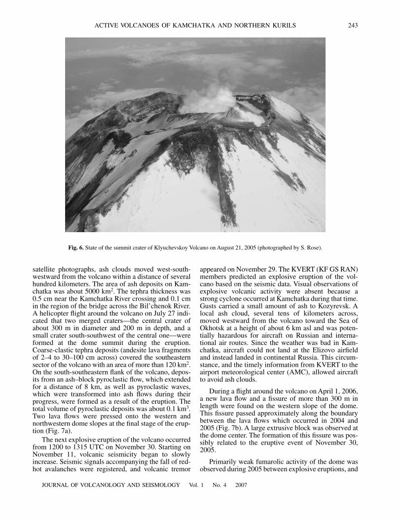
During a flight around the volcanic crater in August2005, it was elucidated that a slag cone that had formedduring the last eruption occupied almost the entire cra-ter (Fig. 6).
Weak bursts of volcanic activity were registered inJuly and September 2005. Surface earthquakes wereregistered in the volcanic edifice below the central cra-ter. According to volcanologists who worked in theBezymyannyi Volcano region, a small ejection of ashfrom the Klyuchevskoy Volcano crater rising to a heightof about 100 m occurred at 2222 UTC on July 21. Thisejection was possibly caused by the beginning of thedestruction of the slag cone within the crater which wasrelated to magma outflow along the crater channel.According to the data from climbers who reached thevolcanic summit in the summer of 2006, the slag conewas already absent in the crater. From June to Novem-ber primarily fumarolic activity was observed, whichwas accompanied by the ascent of a steam and gas col-umn to a height of up to 5–6 km asl. A weak thermalanomaly near the volcanic summit was occasionallyregistered in July–October.
AshplumeLakhar
Lavaflow Klyuchevskoy Volcano
Fig. 4.
Ash plume and lava and mud flows on the slope of Klyuchevskoy Volcano at 0023 UTC on February 1, 2005 (the TERRAMODIS photograph). The data were processed by O. Girina and D. Mel’nikov.

242
JOURNAL OF VOLCANOLOGY AND SEISMOLOGY
Vol. 1
No. 4
2007
GIRINA et al.
Bezymyannyi Volcano,
one of the most active vol-canoes of Kamchatka, is located in the central part ofthe Klyuchevskoy volcanic group. Two explosive erup-tions of this volcano took place in 2005, and both erup-tions were predicted by KVERT (KF GS RAN) mem-bers based on seismic and satellite data.
The explosive eruption of the volcano began at0802 UTC on January 11 [1, 7]. According to the seis-mic data, the most active eruption phase, accompaniedby an ash cloud ascent to a height of 8–10 km asl, tookplace from 0802 to 0845 UTC. According to the NOAAAVHRR, GOES, and MODIS (TERRA and AQUA)
(b)
(a)
Fig. 5.
Activity of Klyuchevskoy Volcano: (a) lava flow and (b) phreatic explosions in the Krestovskii barranco (photographed byV.G. Ushakov).
JOURNAL OF VOLCANOLOGY AND SEISMOLOGY
Vol. 1
No. 4
2007
ACTIVE VOLCANOES OF KAMCHATKA AND NORTHERN KURILS 243
satellite photographs, ash clouds moved west-south-westward from the volcano within a distance of severalhundred kilometers. The area of ash deposits on Kam-chatka was about 5000 km
2
. The tephra thickness was0.5 cm near the Kamchatka River crossing and 0.1 cmin the region of the bridge across the Bil’chenok River.A helicopter flight around the volcano on July 27 indi-cated that two merged craters—the central crater ofabout 300 m in diameter and 200 m in depth, and asmall crater south-southwest of the central one—wereformed at the dome summit during the eruption.Coarse-clastic tephra deposits (andesite lava fragmentsof 2–4 to 30–100 cm across) covered the southeasternsector of the volcano with an area of more than 120 km
2
.On the south-southeastern flank of the volcano, depos-its from an ash–block pyroclastic flow, which extendedfor a distance of 8 km, as well as pyroclastic waves,which were transformed into ash flows during theirprogress, were formed as a result of the eruption. Thetotal volume of pyroclastic deposits was about 0.1 km
3
.Two lava flows were pressed onto the western andnorthwestern dome slopes at the final stage of the erup-tion (Fig. 7a).
The next explosive eruption of the volcano occurredfrom 1200 to 1315 UTC on November 30. Starting onNovember 11, volcanic seismicity began to slowlyincrease. Seismic signals accompanying the fall of red-hot avalanches were registered, and volcanic tremor
appeared on November 29. The KVERT (KF GS RAN)members predicted an explosive eruption of the vol-cano based on the seismic data. Visual observations ofexplosive volcanic activity were absent because astrong cyclone occurred at Kamchatka during that time.Gusts carried a small amount of ash to Kozyrevsk. Alocal ash cloud, several tens of kilometers across,moved westward from the volcano toward the Sea ofOkhotsk at a height of about 6 km asl and was poten-tially hazardous for aircraft on Russian and interna-tional air routes. Since the weather was bad in Kam-chatka, aircraft could not land at the Elizovo airfieldand instead landed in continental Russia. This circum-stance, and the timely information from KVERT to theairport meteorological center (AMC), allowed aircraftto avoid ash clouds.
During a flight around the volcano on April 1, 2006,a new lava flow and a fissure of more than 300 m inlength were found on the western slope of the dome.This fissure passed approximately along the boundarybetween the lava flows which occurred in 2004 and2005 (Fig. 7b). A large extrusive block was observed atthe dome center. The formation of this fissure was pos-sibly related to the eruptive event of November 30,2005.
Primarily weak fumarolic activity of the dome wasobserved during 2005 between explosive eruptions, and
Fig. 6.
State of the summit crater of Klyuchevskoy Volcano on August 21, 2005 (photographed by S. Rose).

244
JOURNAL OF VOLCANOLOGY AND SEISMOLOGY
Vol. 1
No. 4
2007
GIRINA et al.
a steam and gas column occasionally reached a heightof 1200 m above the dome crest. Steam and gas plumesgenerally extended eastward, southeastward, and west-ward from the volcano.
Karymskii Volcano
was in a state of Strombolian–Vulcanian activity in 2005. Since the volcano is locatedat a large distance from settlements, its state was mainlyassessed based on data from the Karymskaya seismicstation (KRY) operated by KF GS RAN. During this
year, the seismic activity of the volcano was unstable asthree sharp (on April 13, June 29, and August 30) andtwo weaker (on April 25 and May 14) increases inactivity were observed.
Visual observations of the volcano revealed the fol-lowing types of activity: (a) the steam and gas type,with emissions with differing, but small, amounts ofash; (b) the Strombolian type, in which ash ejections toa height of 200–500 m above the crater occurred at
(b)
(a)
A
CB
N
S
N
S
Fig. 7.
Lava dome of Bezymyannyi Volcano. (a) August 20, 2005; (A) explosive crater, (B) less viscous lava flow, and (C) viscouslava flow (photographed by S. Rose). (b) April 1, 2006 (photographed by Yu.V. Demyanchuk).

JOURNAL OF VOLCANOLOGY AND SEISMOLOGY
Vol. 1
No. 4
2007
ACTIVE VOLCANOES OF KAMCHATKA AND NORTHERN KURILS 245
intervals of 3–20 min; and (c) the Vulcanian type, withpowerful ash ejections to a height of up to 5 km asl,before which pauses in the eruptive and seismic activitywere usually observed. Ejections were accompanied byairborne shock waves and bombs widely scattered overthe cone slopes (Fig. 8).
As a result of the explosions, ash plumes wereformed, the density and extension of which dependedon the power of ash ejections and wind strength. Ashdeposits were observed mostly in the 90
°
–270
°
azi-muthal sector within a distance of up to several tens ofkilometers from the volcano.
During fieldwork performed from April 20 to May 3,a pyroclastic flow with a length of about 1.6 km and awidth of 150–200 m across its frontal portion was dis-covered in the southwestern part of the cone. An analy-sis of the volcanic seismicity allows us to assume thatthe flow was formed during the activation of the vol-cano on April 13.
At the end of September, a lava dome was discov-ered in the volcanic crater (http://www.ksc-
net.ru/ivs/kvert/current/krm/new.html). By the end ofOctober, the dome filled the major portion of the crater.To all appearances, this dome was often partiallydestroyed as a result of powerful explosions, which isconfirmed by pumice fragments measuring up to 10–15 cm across which were found in December on snowlocated 3–4 km from the crater. Most likely, a newdome was observed in the volcanic crater on Decem-ber 18. Judging by the dome morphology, this domewas less viscous than the previously destroyed cone.
The satellite photographs showed an almost contin-uous 13-pixel thermal anomaly in the region of the vol-cano in 2005. Most likely, the small value of the ther-mal anomaly was primarily caused by the fact that thesatellite photographs were obtained during explosive,and especially, the Strombolian, activity of the volcano.The extension of the thermal anomaly in the region ofthe crater makes it possible to distinguish three phasesof volcanic activation in 2005, which occurred in themiddle of April, the middle of July, and the end ofAugust, which is in good agreement with the data of the
Fig. 8.
Explosive activity of Karymskii Volcano on December 22, 2005 (photographed by A.G. Manevich).

246
JOURNAL OF VOLCANOLOGY AND SEISMOLOGY
Vol. 1
No. 4
2007
GIRINA et al.
seismic and visual observations. This volcanic eruptionis presently continuing.
Avachinskii Volcano
was in a state of fumarolicactivity in 2005. The number of isolated seismic eventsand their series increased twice during the year. Thefirst increase occurred in the middle of November of2004 and continued until February of 2005. Weakearthquakes, with the magnitude less than 1.0, occurredprimarily in the volcanic edifice, or at a depth of up to0.5 km; the number of earthquakes was not more thannine per day. A following increase in seismicity wasregistered during November 15–28.
A thermal anomaly in the region of the Avachinskiivolcanic crater was registered in satellite photographson November 7, 21, 22, and 29.
In 2005, the fumarolic activity of the volcano waslow. In February and March, the height of the steam andgas column was not more than 600 m above the crater,with an increase in seismicity. Columns of fumarolicgases reaching a height of 700 m were observed in Julyand September. The usual height of these columns wasnot more than 100–300 m. The temperature of thefumarole operating at the western edge of the crater wasnot higher than 200
°
C during the year.
Mutnovskii and Gorelyi volcanoes
were in a stateof weak activity in 2005. The seismicity of these volca-noes was generally no higher than the background leveljudging by the data from one seismic station located onthe flank of the Gorelyi Volcano.
Mutnovskii Volcano
showed moderate fumarolic activity, and the height ofthe fumarolic column only occasionally reached 600–700 m above the edge of the active crater. A weak (1–2 pixel) thermal anomaly was repeatedly registered onthe volcano during the year. The temperature of thefumaroles in the lower fumarolic field of the volcanowas about 100
°
C. A fumarolic column with a height of150 m above the crater edge was only registered onFebruary 13 at the
Gorelyi Volcano
and the volcanowas usually quiescent.
NORTHERN KURILS
Chikurachki Volcano
is the most active volcano inthe northern Kurils. In 2005, volcano activation wasobserved in March and April [3]. On March 1, huntersand navigators informed KVERT that a steam and gascolumn with a height of up to 400 m above the craterwas observed on the volcano for the first time after along quiescent period. According to visual observationsat the beacon on Cape Podgornyi, weak ash ejectionsfrom the volcanic crater occurred on March 10.According to information from pilots, ash depositswere found southeast of the volcano on March 29.Anglers reported that ash ejections were sometimesobserved until April 7. KVERT members observed ashplumes March 12 and 23, which extended 40 km north-northwestward and 70 km eastward from the volcano,on the TERRA MODIS and NOAA AVHRR satellite
photographs. Subsequently, eruptive volcanic activitywas not registered visually or on the satellite images.
Ebeko Volcano,
located at a distance of 7 km fromSevero-Kuril’sk, is in a state of constant weak activity.From the end of January to April, a steam and gas col-umn reached a height of 600 m above the crater, and theodor of hydrogen sulfide was sometimes observed inthe town [3]. Investigations of the volcano indicatedthat changes took place in the active crater. New fuma-roles appeared, a lake appeared and disappeared, andsmall ash ejections and weak ash falls were observed atthat time in Severo-Kuril’sk and above the SecondKuril Strait. Activation of Ebeko was observed againfrom July to November.
(1) A new fumarolic field was formed on the outernortheastern slope of the active crater, which wasnamed the July field according to its date of formation.From July to November, the field area considerablyincreased, the number of powerful fumaroles increasedfrom two to twenty, the intensity of scattered seamingover the field area increased, and gas temperature at themouth outlet reached 529
°
C in the upper field andincreased from 110–123 to 155
°
C in the lower field.The entire area of this fumarolic field was covered withsulfur sublimates, fissures, and gaps, from which gasesintensely released and a strong sulfuric odor was sensed(Fig. 9).
(2) A lake, whose size changed from 15
×
30 m onJuly 16 to 10
×
15 m on September 8, was found in theactive crater. The water temperature was approxi-mately 40
°
C, and the pH was 0.8. The area of heatingin the active crater increased. New fumaroles and ther-mal sites were observed on the inner northeastern wallof this crater, the activity of these fumaroles and sitesincreased, the fumarole temperature was 480
°
C onSeptember 8, black sulfur deposits were observed nearthese fumaroles, hydrogen sulfide and chlorine pre-dominated in the composition of gases, and threeactive fumaroles on the northeaster inner slope andone fumarole on the outer slope were registered onSeptember 15.
(3) An explosive hole of about 1 m in diameter and3 m in depth was formed in the upper reaches of theLagernyi creek, from the bottom of which steam jetswith a temperature of 70–100
°
C ascended; the entiresurface around the hole was covered with black mudand sulfur phenocrysts within a radial distance of 7–9 m. By September 29, the hole diameter increased to
1
×
3
m, and fragments of sulfur with pyrite crystalsappeared within a radial distance of 50 m around thishole.
(4) On September 29, a
70
×
10
m thermal site anda hot spring of 3 m in diameter beneath this site werediscovered on the inner eastern wall of the Eastern cir-que.
Fumarolic activity of the volcano along with a steamand gas column that ascended to a height of 500 m and,on November 29, to 1800 m above the volcanic crater,

JOURNAL OF VOLCANOLOGY AND SEISMOLOGY
Vol. 1
No. 4
2007
ACTIVE VOLCANOES OF KAMCHATKA AND NORTHERN KURILS 247
were observed from July through December. Steamand gas plumes extended east-southeastward andnorthward from the volcano to a distance of 20 km onSeptember 15–16. From August through December,the odor of hydrogen sulfide and chlorine, sometimesstrong enough to provoke coughing, was observed fromthree to eight days per month in Severo-Kuril’sk.
CONCLUSIONS
The Ebeko and Chikurachki volcanoes were in astate of increased activity in the northern Kurils in2005. The activity of volcanoes in Kamchatka was veryhigh, especially for the volcanoes in the Northerngroup. Eruptive clouds reached a height of 10 km asl,and ash plumes which extended several hundred kilo-meters from the volcanoes were very hazardous for air-craft flying in the region of the peninsula. Owing toclose cooperation between the participants in theKVERT project, the meteorological center of the Eli-zovo airport, and the Tokyo, Anchorage, and Washing-ton VAACs, all necessary measures for safe flights nearKamchatka were taken and fatal accidents related toexplosive volcanic activity did not occur.
REFERENCES
1. Girina, O.A. and Gorbach, N.V., Bezymyannyi VolcanoEruption of January 11, 2005, in
Materialy Mezhduna-rodnogo simpoziuma po problemam eksplozivnogo vul-kanizma (Proc. Int. Symposium on Problems of Explo-sive Volcanism)
, Petropavlovsk-Kamchatskii, 2006,pp.
87–97.
2. Girina, O.A., Demyanchuk, Yu.V., Mel’nikov, D.V.,et
al., New Paroxysmal Phase of the Molodoi ShiveluchEruption, Kamchatka, February 27, 2005 (PreliminaryReport),
Vulkanol. Seismol.
, 2006, no. 1, pp. 16–23.
3. Girina, O.A., Malik, N.A., and Kotenko, L.V., ActiveVolcanoes on Northern Kurils and Their Activity in2004–2005, in
Materialy ezhegodnoi konferentsii, posvya-shchennoi Dnyu vulkanologa
(Proc. Annual Conf.Devoted to a Day of Volcanologist), Petropavlovsk-Kamchatskii: IViS DVO RAN, 2005, pp. 79–87.
4. Girina, O.A., Senyukov, S.L., and Nil, K.A., KamchatkaVolcanic Eruption Response Team (KVERT) in 2002–2004, in
Materialy 4-go mezhdunarodnogo soveshcha-niya po protsessam v zonakh subduktsii Yaponskoi,Kurilo-Kamchatskoi i Aleutskoi ostrovnykh dug, avgust2004
(Proc. 4th Int. Conference on Processse in thezones of Subduction of the Japan, Kurils–Kamchatka,and Aleutian Island Arcs), Petropavlovsk-Kamchatskii,2004, pp. 31–32.
5. Nuzhdaev, A.A., Girina, O.A., and Mel’nikov, D.V., Cer-tain Results of Studying Pyroclastic Deposits ofMolodoi Shiveluch Eruptions of February 28 and Sep-tember 22, 2005, by Ground-Based and Remote Meth-ods,
Vestn. KRAUNTs, Nauk. Zeml.
, 2005, issue 6,pp.
62–66.
6. Kir’yanov, V.Yu., Nil, K.E., Gordeev, E.I., et al., Kam-chatka Volcanic Eruption Response Team (KVERT),
USG
, 2003.
7. Senyukov, S.L., Droznina, S.Ya., Nuzhdina, I.N., et al.,Studies of the Kamchatka Volcanoes by Remote Meth-ods in 2005, in
Materialy Mezhdunarodnogo simpozi-uma po problemam eksplozivnogo vulkanizma
(Proc. Int.Symposium on Problems of Explosive Volcanism),Petropavlovsk-Kamchatskii, 2006, pp. 64–75.
Vetrennaya mount
Northeastern fumarolicfield
July fumarolicfield
Fig. 9.
July fumarolic field on Ebeko Volcano (photographed by L.V. Kotenko).