Infrasound monitoring of volcanoes to probe high-altitude winds
Upload
independentCategory
view
0download
0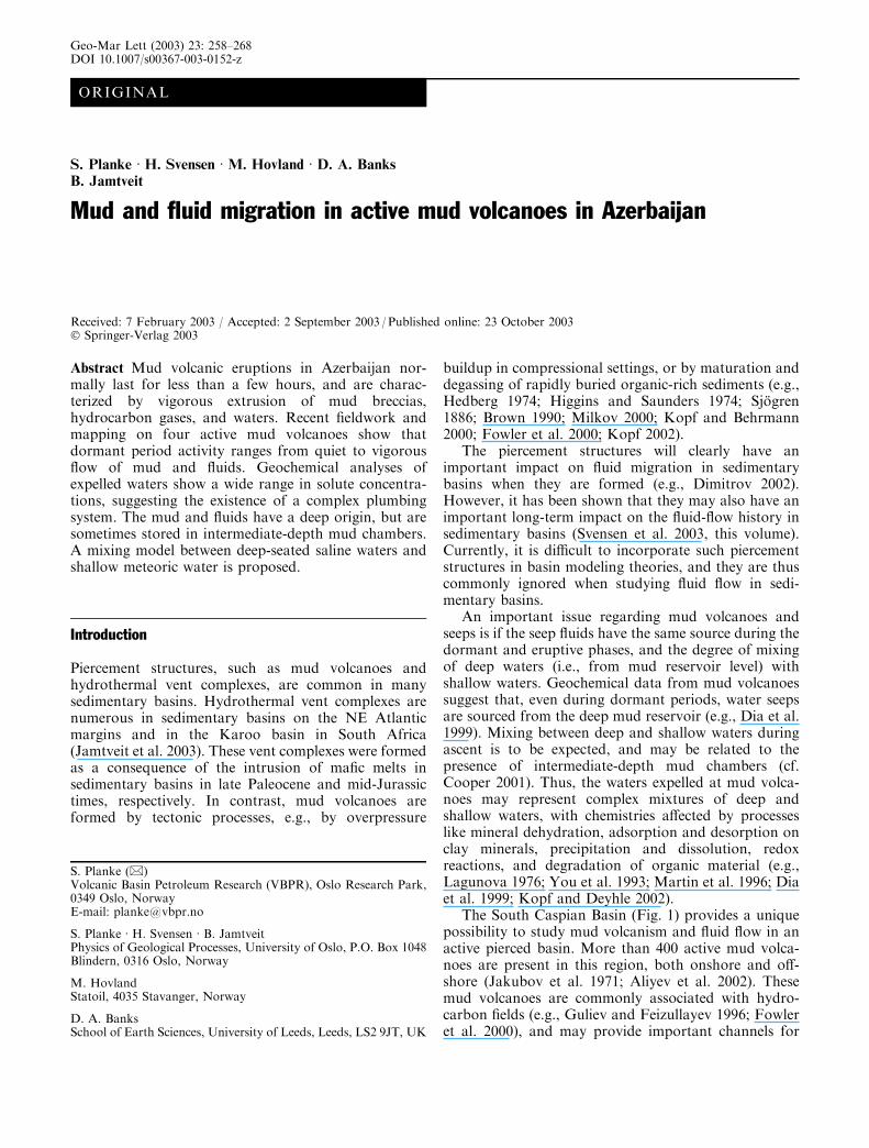
ORIGINAL
S. Planke Æ H. Svensen Æ M. Hovland Æ D. A. Banks
B. Jamtveit
Mud and fluid migration in active mud volcanoes in Azerbaijan
Received: 7 February 2003 / Accepted: 2 September 2003 / Published online: 23 October 2003� Springer-Verlag 2003
Abstract Mud volcanic eruptions in Azerbaijan nor-mally last for less than a few hours, and are charac-terized by vigorous extrusion of mud breccias,hydrocarbon gases, and waters. Recent fieldwork andmapping on four active mud volcanoes show thatdormant period activity ranges from quiet to vigorousflow of mud and fluids. Geochemical analyses ofexpelled waters show a wide range in solute concentra-tions, suggesting the existence of a complex plumbingsystem. The mud and fluids have a deep origin, but aresometimes stored in intermediate-depth mud chambers.A mixing model between deep-seated saline waters andshallow meteoric water is proposed.
Introduction
Piercement structures, such as mud volcanoes andhydrothermal vent complexes, are common in manysedimentary basins. Hydrothermal vent complexes arenumerous in sedimentary basins on the NE Atlanticmargins and in the Karoo basin in South Africa(Jamtveit et al. 2003). These vent complexes were formedas a consequence of the intrusion of mafic melts insedimentary basins in late Paleocene and mid-Jurassictimes, respectively. In contrast, mud volcanoes areformed by tectonic processes, e.g., by overpressure
buildup in compressional settings, or by maturation anddegassing of rapidly buried organic-rich sediments (e.g.,Hedberg 1974; Higgins and Saunders 1974; Sjogren1886; Brown 1990; Milkov 2000; Kopf and Behrmann2000; Fowler et al. 2000; Kopf 2002).
The piercement structures will clearly have animportant impact on fluid migration in sedimentarybasins when they are formed (e.g., Dimitrov 2002).However, it has been shown that they may also have animportant long-term impact on the fluid-flow history insedimentary basins (Svensen et al. 2003, this volume).Currently, it is difficult to incorporate such piercementstructures in basin modeling theories, and they are thuscommonly ignored when studying fluid flow in sedi-mentary basins.
An important issue regarding mud volcanoes andseeps is if the seep fluids have the same source during thedormant and eruptive phases, and the degree of mixingof deep waters (i.e., from mud reservoir level) withshallow waters. Geochemical data from mud volcanoessuggest that, even during dormant periods, water seepsare sourced from the deep mud reservoir (e.g., Dia et al.1999). Mixing between deep and shallow waters duringascent is to be expected, and may be related to thepresence of intermediate-depth mud chambers (cf.Cooper 2001). Thus, the waters expelled at mud volca-noes may represent complex mixtures of deep andshallow waters, with chemistries affected by processeslike mineral dehydration, adsorption and desorption onclay minerals, precipitation and dissolution, redoxreactions, and degradation of organic material (e.g.,Lagunova 1976; You et al. 1993; Martin et al. 1996; Diaet al. 1999; Kopf and Deyhle 2002).
The South Caspian Basin (Fig. 1) provides a uniquepossibility to study mud volcanism and fluid flow in anactive pierced basin. More than 400 active mud volca-noes are present in this region, both onshore and off-shore (Jakubov et al. 1971; Aliyev et al. 2002). Thesemud volcanoes are commonly associated with hydro-carbon fields (e.g., Guliev and Feizullayev 1996; Fowleret al. 2000), and may provide important channels for
S. Planke (&)Volcanic Basin Petroleum Research (VBPR), Oslo Research Park,0349 Oslo, NorwayE-mail: [email protected]
S. Planke Æ H. Svensen Æ B. JamtveitPhysics of Geological Processes, University of Oslo, P.O. Box 1048Blindern, 0316 Oslo, Norway
M. HovlandStatoil, 4035 Stavanger, Norway
D. A. BanksSchool of Earth Sciences, University of Leeds, Leeds, LS2 9JT, UK
Geo-Mar Lett (2003) 23: 258–268DOI 10.1007/s00367-003-0152-z
petroleum migration (Katz et al. 2000; Guliyev 2002).The aim of this paper is to document the main processesof mud volcano eruptions, mud breccia emplacement,and fluid migration based on fieldwork on four activemud volcanoes in Azerbaijan and geochemical analysisof seep waters from two of these.
Mud volcanic processes and terminology
Mud volcanism shows many similarities to magmaticvolcanism, and a substantial part of the terminologyused to describe volcanic processes and deposits (e.g.,Sigurdsson 2000) can be applied to mud volcanoes andmud volcanism. There is, however, also a separateterminology related to mud volcanoes (e.g., Hovlandet al. 1997; Milkov 2000; Aliyev et al. 2002; Dimitrov2002; Kopf 2002). Although the terminology of mudvolcanoes has become more rigorous and consistent(e.g., Milkov 2000; Kopf 2002), there is still a need tomake a clearer distinction between the active anddormant stages of mud volcanoes. The importance ofthe active/dormant distinction is crucial when esti-mating gas and fluid fluxes from mud volcanoes, andwhen determining their impact on the release ofmethane to the atmosphere. What are commonly re-ferred to as active mud volcanoes in the literature arein many cases only manifestations of seep activityduring the dormant period (e.g., gryphons and salses).Most of the flux estimates from mud volcanoes arecalculated from dormant volcanoes (see Dimitrov2002). The bulk of the fluid and mass is, however,released during eruptions (cf. Kopf and Deyhle 2002;Dimitrov 2002), but quantitative measurements oferuption parameters are scarce. According to Dimitrov
(2002), the integrated annual fluxes of methane frommud volcanoes worldwide during eruptions are 7 times(average value) higher than the seep activity in thedormant periods. The estimated value for Azeri mudvolcanoes is a 16 times higher annual flux duringeruptions (Guliyiev and Feizullayev 1994, in Dimitrov2002).
Mud volcanoes can be classified as active, extinct, orburied, and mud volcanism may represent a major land-building process. A mud volcano eruption can beexplosive or effusive, and may occur both in subaerialand subaqueous environments. Hydrocarbon gases arecommonly erupted. These gases may self-ignite, and upto 1-km-high fire-columns have been observed duringmud volcanic eruptions in Azerbaijan (Aliyev et al.2000). The erupted solid material is present as fall orflow deposits. Breccia flows are commonly emplacedduring mud volcanic eruptions. These flows consist ofangular boulders and clasts (�xenoliths�) derived from thecountry rocks that are cut by the plumbing system, beingembedded in a mud-dominated matrix.
Active mud volcanoes show a variable degree ofdormant activity. Many are quiet, with no surface seepactivity or ground deformation. However, seep activityis common on many mud volcanoes, expelling muds,liquids, and gases. The seep activity leads to theformation of scenic features such as gryphons (<3 mhigh, steep-sided cones extruding mud), mud cones(<10 m high cones extruding mud and rock fragments),salses (water-dominated pools with gas seeps), springs(<0.5 m small, water-dominated outlets), burning fires,scoria cones formed by heating of mud deposits duringthe fires (e.g., Jakubov et al. 1971; Hovland et al. 1997;Guliyev and Feizullayev 1997), and hydrocarbondeposits (Higgins and Saunders 1974; Aliyev et al. 2002).The seep activity is dominantly effusive, but smallexplosive events do also occur.
South Caspian Basin
The South Caspian Basin is a Tertiary back-arc basinwith an up to 25–30 km thick sedimentary package (e.g.,Guliyev and Feizullayev 1996; Abrams and Narimanov1997; Devlin et al. 1999; Guliyev et al. 2002). The SouthCaspian Basin was a depression from the mid Jurassic,with deposition of marine sediments upon LowerJurassic oceanic crust formed during back-arc spreading(Abrams and Narimanov 1997). Further collision in theAlpine-Himalayan zone led to regional uplift in theMiocene–Pliocene, with associated rapid deposition of10 km of deltaic and lacustrine sediments in the SouthCaspian region. Sedimentation rates during the Qua-ternary were as high as 2.4 km/106 years (Nadirov et al.1997), and 5–8 km of sediments has been deposited thelast 5·106 years (Tagiyev et al. 1997).
The geothermal gradient in the South CaspianBasin is low (10–18 �C/km), providing hydrocarbonmaturation down to great depths (14 km to the onset
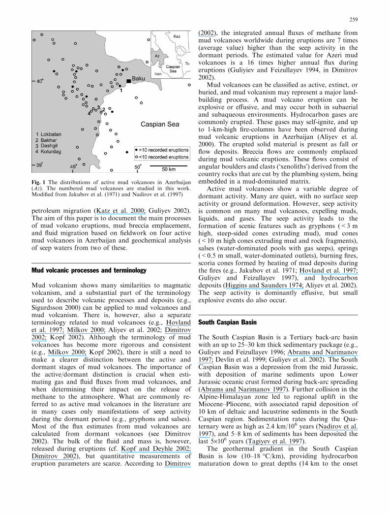
Fig. 1 The distributions of active mud volcanoes in Azerbaijan(Az). The numbered mud volcanoes are studied in this work.Modified from Jakubov et al. (1971) and Nadirov et al. (1997)
259
of the gas window; Abrams and Narimanov 1997;Nadirov et al. 1997). The typically 1–2 km thickMaykop Fm. is regarded as the major source of boththe extruded mud and the petroleum (Inan et al. 1997;Fowler et al. 2000). However, mud breccias from themud volcanoes often contain clasts from formationsbelow the Maikop Fm., suggesting that some of themud may have an even deeper source (Inan et al.1997). The Maikop Fm. is locally very deeply bur-ied—it is located between 8.5- and 11-km depth off-shore Baku, and at 5.5-km depth underneath theoffshore Shah Deniz structure (Fowler et al. 2000).The mud reservoirs for the extrusive volcanism maybe as deep as 14 km, with intermediate mud chambersat 2–4 km depth (Cooper 2001).
The rapid Miocene–Pliocene sedimentation and bur-ial led to increased maturation of organic material,created structural traps, and caused initiation of mudvolcanism (Abrams and Narimanov 1997). Almost 300historic small and large mud volcano eruptions aredocumented in Azerbaijan, occurring on 76 mud vol-canoes (Aliyev et al. 2002). The mud volcanoes, andassociated hydrocarbon reservoirs, are often foundwithin large anticlines (Jakubov et al. 1971; Guliyev andFeizullayev 1996; Narimanov et al. 1998; Fowler et al.2000; Guliyev et al. 2002).
Materials and methods
Fieldwork was performed at four active mud volca-noes—Bakhar, Dashgil, Koturdag, and Lokbatan,during October 2002 (Fig. 1). Two of the mud volca-noes, Bakhar and Dashgil, are good examples of mudvolcanoes with a high seep activity in the dormantperiod. In contrast, the active Kotyrdag and Lokbatanmud volcanoes are quiet, and recently eruptivedeposits and structures are well exposed. Finally, asatellite vent 1 km west of the Bakhar mud volcanowas visited.
Detailed mapping of the Dashgil and Lokbatanmud volcanoes was done using a Garmin etrex GPSwith a relative accuracy of four meters. Water sampleswere collected from Dashgil and Bakhar, both fromsalses, springs, and gryphons. Temperatures weremeasured in-situ with a thermocouple thermometer.Mud and water was separated by settling (to minimizerelease of elements adsorbed to clay minerals; cf. Youet al. 1996), filtered using a 2-lm mesh, and analyzedin January 2003 at the School of Earth Sciences,Leeds, UK.
Cations and iodide were measured by ICP-MS (Ag-ilent 7500c) on filtered water samples. Anions weremeasured by ion chromatography using a Dionex 600.Accuracy and precision of both methods was checked byexternal standards. Precision in all instances was betterthan 5% RSD (residual standard deviation) and accu-racy better than 4%.
Eruptions
The Lokbatan mud volcano
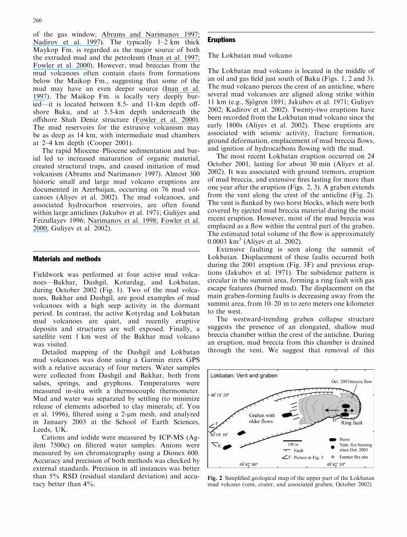
The Lokbatan mud volcano is located in the middle ofan oil and gas field just south of Baku (Figs. 1, 2 and 3).The mud volcano pierces the crest of an anticline, whereseveral mud volcanoes are aligned along strike within11 km (e.g., Sjogren 1891; Jakubov et al. 1971; Guliyev2002; Kadirov et al. 2002). Twenty-two eruptions havebeen recorded from the Lokbatan mud volcano since theearly 1800s (Aliyev et al. 2002). These eruptions areassociated with seismic activity, fracture formation,ground deformation, emplacement of mud breccia flows,and ignition of hydrocarbons flowing with the mud.
The most recent Lokbatan eruption occurred on 24October 2001, lasting for about 30 min (Aliyev et al.2002). It was associated with ground tremors, eruptionof mud breccia, and extensive fires lasting for more thanone year after the eruption (Figs. 2, 3). A graben extendsfrom the vent along the crest of the anticline (Fig. 2).The vent is flanked by two horst blocks, which were bothcovered by ejected mud breccia material during the mostrecent eruption. However, most of the mud breccia wasemplaced as a flow within the central part of the graben.The estimated total volume of the flow is approximately0.0003 km3 (Aliyev et al. 2002).
Extensive faulting is seen along the summit ofLokbatan. Displacement of these faults occurred bothduring the 2001 eruption (Fig. 3F) and previous erup-tions (Jakubov et al. 1971). The subsidence pattern iscircular in the summit area, forming a ring fault with gasescape features (burned mud). The displacement on themain graben-forming faults is decreasing away from thesummit area, from 10–20 m to zero meters one kilometerto the west.
The westward-trending graben collapse structuresuggests the presence of an elongated, shallow mudbreccia chamber within the crest of the anticline. Duringan eruption, mud breccia from this chamber is drainedthrough the vent. We suggest that removal of this
Fig. 2 Simplified geological map of the upper part of the Lokbatanmud volcano (vent, crater, and associated graben; October 2002)
260
material caused subsidence and collapse of the roofrocks, forming the graben structure. Subsequent infillingof the graben by the erupted mud breccia increased theload on the mud chamber, causing further surface sub-sidence. A shallow mud chamber hypothesis is alsoconsistent with the observation of a negative gravityanomaly above the mud volcano, suggesting the pres-ence of light, buoyant material within the crest of theanticline (Kadirov et al. 2002).
The Kotyrdag mud volcano
The cone-shaped Koturdag mud volcano is locatedabout 50 km south of Baku (Figs. 1 and 4; Jakubovet al. 1971). This dormant mud volcano is currentlyquiet. A single circular crater is found on the summit ofthe volcano. No faults were identified outside the crater.
The geometry of Koturdag is similar to a sim-ple, cone-shaped composite magmatic volcano of
intermediate composition. The morphology of compos-ite volcanoes is controlled by a complex interaction ofaggradation (i.e., eruption and emplacement) anddegradation (i.e., erosion and gravity flow) processes(e.g., Davidson and De Silva 2000). Whereas compositevolcanoes have been extensively studied, no compre-hensive studies of mud volcanic eruptions (detailedseismicity surveys, ground deformation measurements,or gas and fluid emission sampling) are available. Theunderstanding of the ascent and eruption processes ofcomposite mud volcanoes is therefore limited.
The most recent breccia flow was erupted from thesummit crater and emplaced on the northeastern flank ofthe volcano. The flow is 1 km long and can be subdi-vided into two main parts—an upper channelized parton the steep flanks of the volcano, and a lower lobatepart on the less steep, lower parts of the volcano. Theflow is blocky in the channel, and the presence of red,oxidized mud breccia and scoria shows that escapinggases have ignited and burned during the emplacement
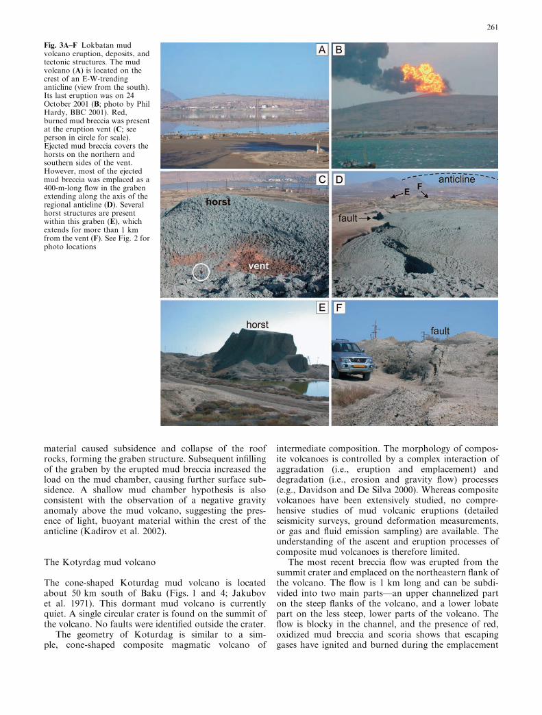
Fig. 3A–F Lokbatan mudvolcano eruption, deposits, andtectonic structures. The mudvolcano (A) is located on thecrest of an E-W-trendinganticline (view from the south).Its last eruption was on 24October 2001 (B; photo by PhilHardy, BBC 2001). Red,burned mud breccia was presentat the eruption vent (C; seeperson in circle for scale).Ejected mud breccia covers thehorsts on the northern andsouthern sides of the vent.However, most of the ejectedmud breccia was emplaced as a400-m-long flow in the grabenextending along the axis of theregional anticline (D). Severalhorst structures are presentwithin this graben (E), whichextends for more than 1 kmfrom the vent (F). See Fig. 2 forphoto locations
261

(Fig. 4B). The lower lobe is characterized by a smoothersurface and the presence of curved pressure ridges. Theeruption terminated by slow extrusion of very viscous,plastic mud breccia (Fig. 4D). The emplacement rate ofsimilar extruded mud breccia has been measured to be2–15 m/year, lasting for several years after the maineruption event (e.g., Guliyev and Feizullayev 1997).
Dormant period
The study of the seep activity during the dormant peri-ods may provide important insight into the mud volca-nic process, and is particularly important because nomud volcanic eruptions have been monitored in detail.In addition, studies of seep gases are important becausemethane and other gases may contribute significantly tothe global greenhouse gas budget (e.g., Hovland et al.1997; Milkov 2000; Dimitrov 2002), and because mudvolcanoes are important conduits for petroleum migra-tion (e.g., Katz et al. 2000).
Vigorous seep activity was taking place in October2002 on both the dormant Dashgil and Bakhar mudvolcanoes (Figs. 1, 5, and 6). In contrast, the dormantKotyrdag and Lokbatan mud volcanoes were quiet, withthe exception of a small fire in the Lokbatan vent(Fig. 6D).
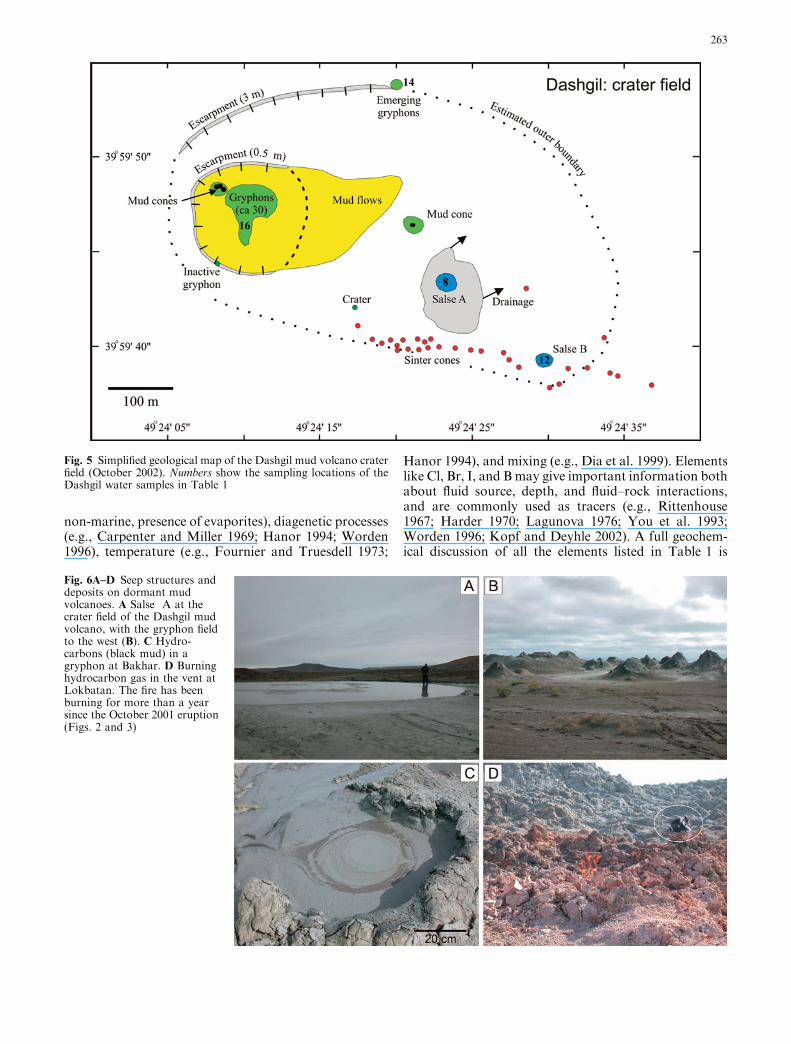
Seep structures on the Dashgil crater field weredescribed by Hovland et al. (1997), and include a gry-phon cluster, mud cones, salses, and sinter cones (Figs. 5and 6). Natural oil seeps are further found on the flanksof the mud volcano. A re-mapping of the crater field inOctober 2002 (Fig. 5) reveals the same seep features as
present in 1995, but some of the gryphons and mudcones are up to 50% larger. The only major difference isthe addition of a mud cone field formed during a smalleruption in May 2001 (Aliyev et al. 2002).
Active gryphons, mud cones, and springs were alsofound at the Bakhar mud volcano and a nearby satellitevent. The circular satellite crater is about 10 m deep witha diameter of about 50 m, and is located in an area withnatural oil seeps. The crater was formed by an explosiveeruption in 1998 on a gryphon field.
Waters from several of the gryphons, mud cones,salses, and springs were sampled. The salses and springsare dominated by water and gas, whereas the gryphonsand mud cones are filled with intermediate- to high-viscosity fluids consisting of mud, water, gas, and oil.The temperatures of these fluids are up to 2–3 �C abovethe ambient temperature (Table 1).
The gases seeping through the mud volcanoes inAzerbaijan during the dormant periods are dominatedby methane (>90%; Sokolov et al. 1968; Valyaev et al.1985; Guliev and Feizullayev 1996; Aliyev et al. 2002).The isotopic composition of the seep methane overlapswith the isotopic composition of methane from petro-leum fields in the Caucasus (Valyaev et al. 1985; Gulievand Feizullayev 1996), emphasizing the intimate rela-tionship between petroleum formation, secondarymigration, and mud volcanism.
Composition of expelled waters
The major element composition of the expelled waters iscontrolled by the depositional environment (e.g., marine/
Fig. 4A–D Eruptive deposits ofthe 200-m-high Kotyrdag mudvolcano (A). A 1-km-longchannelized mud breccia flow(B) extends from the maincrater down the flank of thevolcano. Large boulders andclasts are common in thebreccia flow (C; 1.5-m-highcliff). The eruption ended byslow extrusion of viscous,plastic mud breccia (D). Notewell-defined striations and thepresence of burned breccia atthe edge of the extruded mudbreccia sheet. Photo locationsare shown by arrow on A
262
non-marine, presence of evaporites), diagenetic processes(e.g., Carpenter and Miller 1969; Hanor 1994; Worden1996), temperature (e.g., Fournier and Truesdell 1973;
Hanor 1994), and mixing (e.g., Dia et al. 1999). Elementslike Cl, Br, I, and Bmay give important information bothabout fluid source, depth, and fluid–rock interactions,and are commonly used as tracers (e.g., Rittenhouse1967; Harder 1970; Lagunova 1976; You et al. 1993;Worden 1996; Kopf and Deyhle 2002). A full geochem-ical discussion of all the elements listed in Table 1 is
Fig. 5 Simplified geological map of the Dashgil mud volcano craterfield (October 2002). Numbers show the sampling locations of theDashgil water samples in Table 1
Fig. 6A–D Seep structures anddeposits on dormant mudvolcanoes. A Salse A at thecrater field of the Dashgil mudvolcano, with the gryphon fieldto the west (B). C Hydro-carbons (black mud) in agryphon at Bakhar. D Burninghydrocarbon gas in the vent atLokbatan. The fire has beenburning for more than a yearsince the October 2001 eruption(Figs. 2 and 3)
263

beyond the scope of this contribution, and would need abigger dataset. Although our dataset is limited, we maydraw important conclusions about the main fluid reser-voirs that hosted the expelled waters.
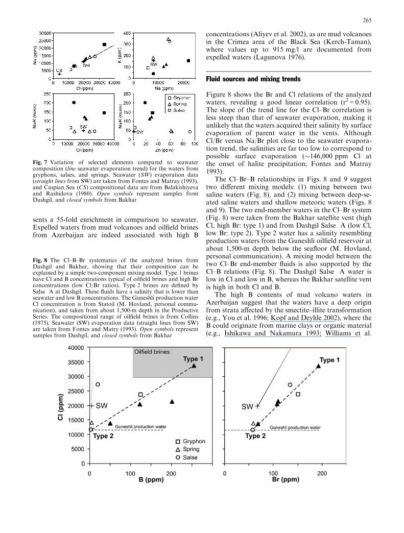
The expelled waters have a composition with Na andCl as dominant ions (Table 1). The Cl content range isfrom 11,000 to 33,000 ppm, from the Dashgil Salse Aand the Bakhar satellite vent, respectively. There is aconsiderable range in concentration of major solutes (Cl,Na) within both the Dashgil and Bakhar localities(Table 1), consistent with what is documented fromother mud volcanoes in Azerbaijan (Jukabov et al. 1971;Aliyev et al. 2002) and elsewhere (e.g., Lagunova 1976;Dia et al. 1999). Na and Cl correlate linearly (Fig. 7),and the Na–K–Cl relations group according to locality.Furthermore, the most K-rich waters (175–341 ppm)have the highest Zn concentrations (61–92 ppm). Thesulfate content of all the waters is low, the one exceptionbeing water from a water–mud mixture from a gryphonat Dashgil (SO4 value of 3,000 ppm). This is in accor-dance with published data on both expelled waters andreservoir waters (Aliyev et al. 2002). Charge balance
considerations do not suggest that bicarbonate isabundant in the waters, also in agreement with pub-lished data from the region (Jakubov et al. 1971).
The analyzed waters are enriched in B and metals(Al, Cr, Fe, Mn, Ni, Cu, Zn) compared to seawater(Table 1), oilfield brines (Collins 1975), and expelledwaters from other mud volcanoes worldwide (e.g., Diaet al. 1999; Kopf and Deyhle 2002). The concentra-tions of metals like Cu, Ni, and Cr, which are solublein the reduced state, are very high (84–105 ppm), andindependent of the Cl concentration in the waters(Table 1). Metals like Cu, Cr, and Ni are usuallypresent in parts per billion in oilfield brines (Collins1975). Intriguingly, elements like Na, Cl, Mg, K, andB vary considerably in the analyzed waters, whereasmost of the metals show no concentration variations(Table 1). The standard deviation for the average of allanalyses in Table 1 is less than 5% for Cr, Mn, Ni,and Cu.
Furthermore, the B content is high (50–254 ppm;Fig. 8), with the exception of two waters from Dashgil(<2 ppm). A boron concentration of 250 ppm repre-
Table 1 Composition of water seeps from mud volcanoes (all values in ppm)
Sample AZ02-2 A202-3 AZ02-4 AZ02-7 AZ02-8 AZ02-12 AZ02-14 AZ02-16 Seawaterc CaspianLocality Bakhar Bakhar Bakhar Bakhar s. v.b Dashgil Dashgil Dashgil Dashgil SeaType Springa Spring Spring Spring Salse A Salse B Spring GryphonTemp. (�C) 20.3 20.3 21.5 22.5 21.6 18.5 19.9
N 40�00¢03.93¢¢ 40�00¢03.97¢¢ 40�00¢03.86¢¢ 39�59¢53.53¢¢ 39�59¢43.81¢¢ 39�59¢39.56¢¢ 39�59¢53.80¢¢ 39�59¢46.50¢¢E 49�28¢13.60¢¢ 49�26¢13.91¢¢ 49�28¢14.67¢¢ 49�27¢18.71¢¢ 49�24¢23.03¢¢ 49�24¢30.29¢¢ 49�24¢20.19¢¢ 49�24¢09.68¢¢Li 0.2 0.2 0.15 0.25 0.2 0.25 0.2 0.26 0.18B 49 122 201 254 <2 16 <2 125 4.5Na 8,056 12,170 13,230 22,340 5,842 14,560 7,876 14,010 10,763 3,250Mg 116 121 135 153 160 504 306 270 1,292 817Al 85 87 86 88 86 66 66 89 0.01K 40 100 119 154 90 323 175 341 399 90Ca 170 175 155 178 189 196 198 184 411 387Cr 101 102 102 105 102 102 102 102 5E)05Fe 279 284 320 296 324 497 295 299 0.01Mn 41 42 42 44 42 42 42 42 0.002Ni 91 92 93 93 91 93 93 95 0.002Cu 85 91 90 93 84 91 92 100 0.003Zn 19 29 26 31 1.6 92 61 62 0.01As 17 17 17 18 17 18 19 17 0.003Rb 0.03 0.04 0.03 0.04 0.04 0.03 0.04 0.04 0.12Sr 0.5 0.5 0.6 0.8 0.9 6.3 2.9 1.4 8.0Cd 0.03 0.07 0.05 0.07 0.02 0.03 0.08 0.07 0.0001Ba 0.2 0.2 0.2 0.4 0.3 2.2 0.2 0.1 0.03Pb 0.003 0.02 0.014 0.015 0.004 0.02 0.03 0.015 3E)05U 0.12 0.32 0.2 0.22 0.09 0.13 0.37 0.17 0.003F <1 <1 <1 <1 <1 <1 <1 <1 1.3Cl 13,608 20,534 21,450 33,464 11,457 27,168 13,895 23,938 19,354 5,650Br 69 108 110 193 58 134 59 150 67 9NO3 6 19 13 <2 <2 <2 <2 252 0.5SO4 84 247 235 161 2 57 832 2,985 2,710 3,167I <5 <5 <5 <5 <5 <5 <5 <5 0.06Cl/Br 197 190 195 173 198 203 236 160 291 628Na/Br 117 113 120 116 101 109 133 93 162 361CI/B 278 168 107 132 >5,729 1,698 >6,948 192 278
aThe springs are water-dominated with varying degrees of mudbBakhar satellite ventcSeawater composition is compiled from Fontes and Matray (1993)for major elements, and Mason (1966) for trace elements. The
seawater data are recalculated from mg/l values to ppm using adensity of 1,022 kg/l (Fontes and Matray 1993). The (cen-tral) Caspian Sea data are from Balakishiyeva and Rashidova(1980)
264
sents a 55-fold enrichment in comparison to seawater.Expelled waters from mud volcanoes and oilfield brinesfrom Azerbaijan are indeed associated with high B
concentrations (Aliyev et al. 2002), as are mud volcanoesin the Crimea area of the Black Sea (Kerch-Taman),where values up to 915 mg/l are documented fromexpelled waters (Lagunova 1976).
Fluid sources and mixing trends
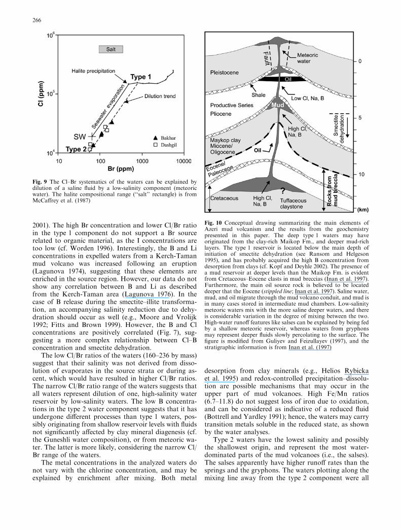
Figure 8 shows the Br and Cl relations of the analyzedwaters, revealing a good linear correlation (r2=0.95).The slope of the trend line for the Cl–Br correlation isless steep than that of seawater evaporation, making itunlikely that the waters acquired their salinity by surfaceevaporation of parent water in the vents. AlthoughCl/Br versus Na/Br plot close to the seawater evapora-tion trend, the salinities are far too low to correspond topossible surface evaporation (�146,000 ppm Cl atthe onset of halite precipitation; Fontes and Matray1993).
The Cl–Br–B relationships in Figs. 8 and 9 suggesttwo different mixing models: (1) mixing between twosaline waters (Fig. 8), and (2) mixing between deep-se-ated saline waters and shallow meteoric waters (Figs. 8and 9). The two end-member waters in the Cl–Br system(Fig. 8) were taken from the Bakhar satellite vent (highCl, high Br: type 1) and from Dashgil Salse A (low Cl,low Br: type 2). Type 2 water has a salinity resemblingproduction waters from the Guneshli oilfield reservoir atabout 1,500-m depth below the seafloor (M. Hovland,personal communication). A mixing model between thetwo Cl–Br end-member fluids is also supported by theCl–B relations (Fig. 8). The Dashgil Salse A water islow in Cl and low in B, whereas the Bakhar satellite ventis high in both Cl and B.
The high B contents of mud volcano waters inAzerbaijan suggest that the waters have a deep originfrom strata affected by the smectite–illite transformation(e.g., You et al. 1996; Kopf and Deyhle 2002), where theB could originate from marine clays or organic material(e.g., Ishikawa and Nakamura 1993; Williams et al.
Fig. 7 Variation of selected elements compared to seawatercomposition (line seawater evaporation trend) for the waters fromgryphons, salses, and springs. Seawater (SW) evaporation data(straight lines from SW) are taken from Fontes and Matray (1993),and Caspian Sea (CS) compositional data are from Balakishiyevaand Rashidova (1980). Open symbols represent samples fromDashgil, and closed symbols from Bakhar
Fig. 8 The Cl–B–Br systematics of the analyzed brines fromDashgil and Bakhar, showing that their composition can beexplained by a simple two-component mixing model. Type 1 brineshave Cl and B concentrations typical of oilfield brines and high Brconcentrations (low Cl/Br ratios). Type 2 brines are defined bySalse A at Dashgil. These fluids have a salinity that is lower thanseawater and low B concentrations. The Guneshli production waterCl concentration is from Statoil (M. Hovland, personal commu-nication), and taken from about 1,500-m depth in the ProductiveSeries. The compositional range of oilfield brines is from Collins(1975). Seawater (SW) evaporation data (straight lines from SW)are taken from Fontes and Matry (1993). Open symbols representsamples from Dashgil, and closed symbols from Bakhar
265
2001). The high Br concentration and lower Cl/Br ratioin the type 1 component do not support a Br sourcerelated to organic material, as the I concentrations aretoo low (cf. Worden 1996). Interestingly, the B and Liconcentrations in expelled waters from a Kerch-Tamanmud volcano was increased following an eruption(Lagunova 1974), suggesting that these elements areenriched in the source region. However, our data do notshow any correlation between B and Li as describedfrom the Kerch-Taman area (Lagunova 1976). In thecase of B release during the smectite–illite transforma-tion, an accompanying salinity reduction due to dehy-dration should occur as well (e.g., Moore and Vrolijk1992; Fitts and Brown 1999). However, the B and Clconcentrations are positively correlated (Fig. 7), sug-gesting a more complex relationship between Cl–Bconcentration and smectite dehydration.
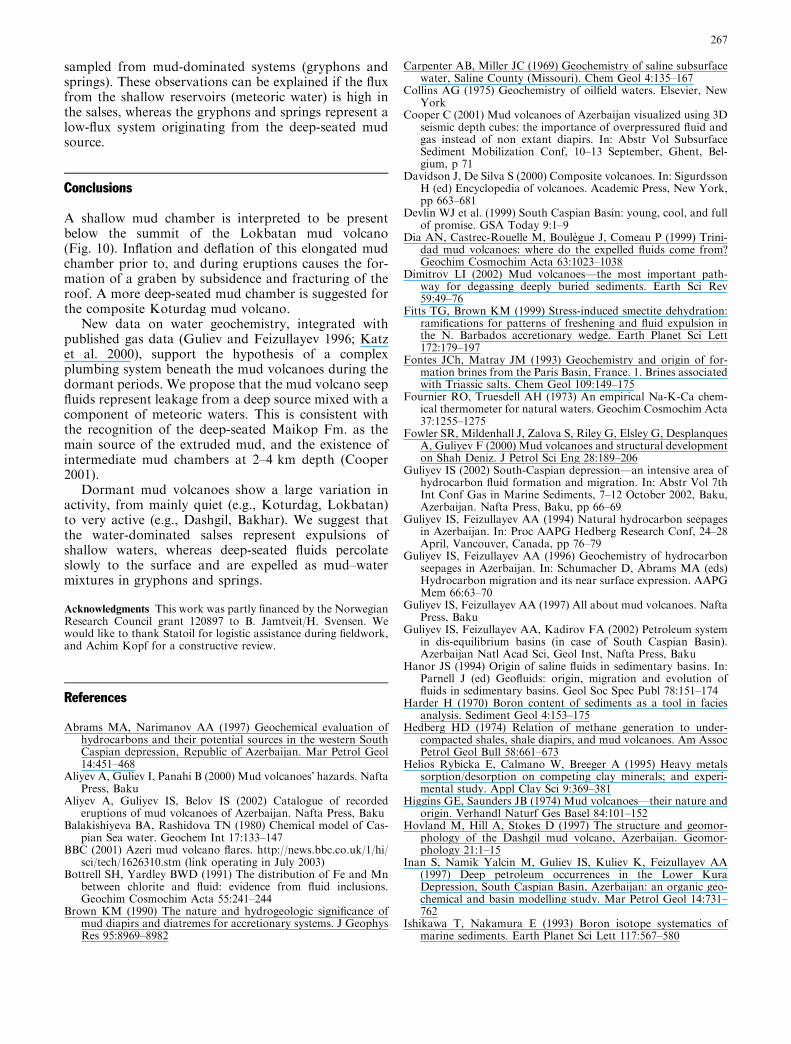
The low Cl/Br ratios of the waters (160–236 by mass)suggest that their salinity was not derived from disso-lution of evaporates in the source strata or during as-cent, which would have resulted in higher Cl/Br ratios.The narrow Cl/Br ratio range of the waters suggests thatall waters represent dilution of one, high-salinity waterreservoir by low-salinity waters. The low B concentra-tions in the type 2 water component suggests that it hasundergone different processes than type 1 waters, pos-sibly originating from shallow reservoir levels with fluidsnot significantly affected by clay mineral diagenesis (cf.the Guneshli water composition), or from meteoric wa-ter. The latter is more likely, considering the narrow Cl/Br range of the waters.
The metal concentrations in the analyzed waters donot vary with the chlorine concentration, and may beexplained by enrichment after mixing. Both metal
desorption from clay minerals (e.g., Helios Rybickaet al. 1995) and redox-controlled precipitation–dissolu-tion are possible mechanisms that may occur in theupper part of mud volcanoes. High Fe/Mn ratios(6.7–11.8) do not suggest loss of iron due to oxidation,and can be considered as indicative of a reduced fluid(Bottrell and Yardley 1991); hence, the waters may carrytransition metals soluble in the reduced state, as shownby the water analyses.
Type 2 waters have the lowest salinity and possiblythe shallowest origin, and represent the most water-dominated parts of the mud volcanoes (i.e., the salses).The salses apparently have higher runoff rates than thesprings and the gryphons. The waters plotting along themixing line away from the type 2 component were all
Fig. 9 The Cl–Br systematics of the waters can be explained bydilution of a saline fluid by a low-salinity component (meteoricwater). The halite compositional range (‘‘salt’’ rectangle) is fromMcCaffrey et al. (1987)
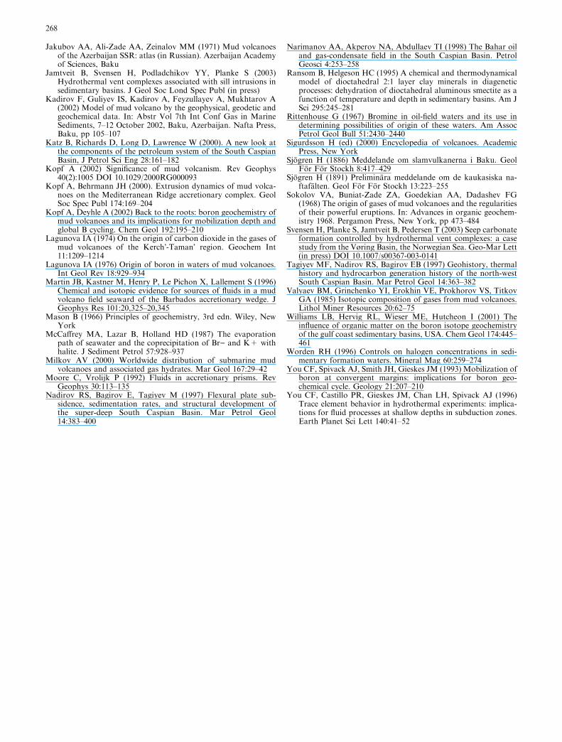
Fig. 10 Conceptual drawing summarizing the main elements ofAzeri mud volcanism and the results from the geochemistrypresented in this paper. The deep type 1 waters may haveoriginated from the clay-rich Maikop Fm., and deeper mud-richlayers. The type 1 reservoir is located below the main depth ofinitiation of smectite dehydration (see Ransom and Helgeson1995), and has probably acquired the high B concentration fromdesorption from clays (cf. Kopf and Deyhle 2002). The presence ofa mud reservoir at deeper levels than the Maikop Fm. is evidentfrom Cretaceous–Eocene clasts in mud breccias (Inan et al. 1997).Furthermore, the main oil source rock is believed to be locateddeeper that the Eocene (stippled line; Inan et al. 1997). Saline water,mud, and oil migrate through the mud volcano conduit, and mud isin many cases stored in intermediate mud chambers. Low-salinitymeteoric waters mix with the more saline deeper waters, and thereis considerable variation in the degree of mixing between the two.High-water runoff features like salses can be explained by being fedby a shallow meteoric reservoir, whereas waters from gryphonsmay represent deeper fluids slowly percolating to the surface. Thefigure is modified from Guliyev and Feizullayev (1997), and thestratigraphic information is from Inan et al. (1997)
266
sampled from mud-dominated systems (gryphons andsprings). These observations can be explained if the fluxfrom the shallow reservoirs (meteoric water) is high inthe salses, whereas the gryphons and springs represent alow-flux system originating from the deep-seated mudsource.
Conclusions
A shallow mud chamber is interpreted to be presentbelow the summit of the Lokbatan mud volcano(Fig. 10). Inflation and deflation of this elongated mudchamber prior to, and during eruptions causes the for-mation of a graben by subsidence and fracturing of theroof. A more deep-seated mud chamber is suggested forthe composite Koturdag mud volcano.
New data on water geochemistry, integrated withpublished gas data (Guliev and Feizullayev 1996; Katzet al. 2000), support the hypothesis of a complexplumbing system beneath the mud volcanoes during thedormant periods. We propose that the mud volcano seepfluids represent leakage from a deep source mixed with acomponent of meteoric waters. This is consistent withthe recognition of the deep-seated Maikop Fm. as themain source of the extruded mud, and the existence ofintermediate mud chambers at 2–4 km depth (Cooper2001).
Dormant mud volcanoes show a large variation inactivity, from mainly quiet (e.g., Koturdag, Lokbatan)to very active (e.g., Dashgil, Bakhar). We suggest thatthe water-dominated salses represent expulsions ofshallow waters, whereas deep-seated fluids percolateslowly to the surface and are expelled as mud–watermixtures in gryphons and springs.
Acknowledgments This work was partly financed by the NorwegianResearch Council grant 120897 to B. Jamtveit/H. Svensen. Wewould like to thank Statoil for logistic assistance during fieldwork,and Achim Kopf for a constructive review.
References
Abrams MA, Narimanov AA (1997) Geochemical evaluation ofhydrocarbons and their potential sources in the western SouthCaspian depression, Republic of Azerbaijan. Mar Petrol Geol14:451–468
Aliyev A, Guliev I, Panahi B (2000) Mud volcanoes� hazards. NaftaPress, Baku
Aliyev A, Guliyev IS, Belov IS (2002) Catalogue of recordederuptions of mud volcanoes of Azerbaijan. Nafta Press, Baku
Balakishiyeva BA, Rashidova TN (1980) Chemical model of Cas-pian Sea water. Geochem Int 17:133–147
BBC (2001) Azeri mud volcano flares. http://news.bbc.co.uk/1/hi/sci/tech/1626310.stm (link operating in July 2003)
Bottrell SH, Yardley BWD (1991) The distribution of Fe and Mnbetween chlorite and fluid: evidence from fluid inclusions.Geochim Cosmochim Acta 55:241–244
Brown KM (1990) The nature and hydrogeologic significance ofmud diapirs and diatremes for accretionary systems. J GeophysRes 95:8969–8982
Carpenter AB, Miller JC (1969) Geochemistry of saline subsurfacewater, Saline County (Missouri). Chem Geol 4:135–167
Collins AG (1975) Geochemistry of oilfield waters. Elsevier, NewYork
Cooper C (2001) Mud volcanoes of Azerbaijan visualized using 3Dseismic depth cubes: the importance of overpressured fluid andgas instead of non extant diapirs. In: Abstr Vol SubsurfaceSediment Mobilization Conf, 10–13 September, Ghent, Bel-gium, p 71
Davidson J, De Silva S (2000) Composite volcanoes. In: SigurdssonH (ed) Encyclopedia of volcanoes. Academic Press, New York,pp 663–681
Devlin WJ et al. (1999) South Caspian Basin: young, cool, and fullof promise. GSA Today 9:1–9
Dia AN, Castrec-Rouelle M, Boulegue J, Comeau P (1999) Trini-dad mud volcanoes: where do the expelled fluids come from?Geochim Cosmochim Acta 63:1023–1038
Dimitrov LI (2002) Mud volcanoes—the most important path-way for degassing deeply buried sediments. Earth Sci Rev59:49–76
Fitts TG, Brown KM (1999) Stress-induced smectite dehydration:ramifications for patterns of freshening and fluid expulsion inthe N. Barbados accretionary wedge. Earth Planet Sci Lett172:179–197
Fontes JCh, Matray JM (1993) Geochemistry and origin of for-mation brines from the Paris Basin, France. 1. Brines associatedwith Triassic salts. Chem Geol 109:149–175
Fournier RO, Truesdell AH (1973) An empirical Na-K-Ca chem-ical thermometer for natural waters. Geochim Cosmochim Acta37:1255–1275
Fowler SR, Mildenhall J, Zalova S, Riley G, Elsley G, DesplanquesA, Guliyev F (2000) Mud volcanoes and structural developmenton Shah Deniz. J Petrol Sci Eng 28:189–206
Guliyev IS (2002) South-Caspian depression—an intensive area ofhydrocarbon fluid formation and migration. In: Abstr Vol 7thInt Conf Gas in Marine Sediments, 7–12 October 2002, Baku,Azerbaijan. Nafta Press, Baku, pp 66–69
Guliyev IS, Feizullayev AA (1994) Natural hydrocarbon seepagesin Azerbaijan. In: Proc AAPG Hedberg Research Conf, 24–28April, Vancouver, Canada, pp 76–79
Guliyev IS, Feizullayev AA (1996) Geochemistry of hydrocarbonseepages in Azerbaijan. In: Schumacher D, Abrams MA (eds)Hydrocarbon migration and its near surface expression. AAPGMem 66:63–70
Guliyev IS, Feizullayev AA (1997) All about mud volcanoes. NaftaPress, Baku
Guliyev IS, Feizullayev AA, Kadirov FA (2002) Petroleum systemin dis-equilibrium basins (in case of South Caspian Basin).Azerbaijan Natl Acad Sci, Geol Inst, Nafta Press, Baku
Hanor JS (1994) Origin of saline fluids in sedimentary basins. In:Parnell J (ed) Geofluids: origin, migration and evolution offluids in sedimentary basins. Geol Soc Spec Publ 78:151–174
Harder H (1970) Boron content of sediments as a tool in faciesanalysis. Sediment Geol 4:153–175
Hedberg HD (1974) Relation of methane generation to under-compacted shales, shale diapirs, and mud volcanoes. Am AssocPetrol Geol Bull 58:661–673
Helios Rybicka E, Calmano W, Breeger A (1995) Heavy metalssorption/desorption on competing clay minerals; and experi-mental study. Appl Clay Sci 9:369–381
Higgins GE, Saunders JB (1974) Mud volcanoes—their nature andorigin. Verhandl Naturf Ges Basel 84:101–152
Hovland M, Hill A, Stokes D (1997) The structure and geomor-phology of the Dashgil mud volcano, Azerbaijan. Geomor-phology 21:1–15
Inan S, Namik Yalcin M, Guliev IS, Kuliev K, Feizullayev AA(1997) Deep petroleum occurrences in the Lower KuraDepression, South Caspian Basin, Azerbaijan: an organic geo-chemical and basin modelling study. Mar Petrol Geol 14:731–762
Ishikawa T, Nakamura E (1993) Boron isotope systematics ofmarine sediments. Earth Planet Sci Lett 117:567–580
267
Jakubov AA, Ali-Zade AA, Zeinalov MM (1971) Mud volcanoesof the Azerbaijan SSR: atlas (in Russian). Azerbaijan Academyof Sciences, Baku
Jamtveit B, Svensen H, Podladchikov YY, Planke S (2003)Hydrothermal vent complexes associated with sill intrusions insedimentary basins. J Geol Soc Lond Spec Publ (in press)
Kadirov F, Guliyev IS, Kadirov A, Feyzullayev A, Mukhtarov A(2002) Model of mud volcano by the geophysical, geodetic andgeochemical data. In: Abstr Vol 7th Int Conf Gas in MarineSediments, 7–12 October 2002, Baku, Azerbaijan. Nafta Press,Baku, pp 105–107
Katz B, Richards D, Long D, Lawrence W (2000). A new look atthe components of the petroleum system of the South CaspianBasin, J Petrol Sci Eng 28:161–182
Kopf A (2002) Significance of mud volcanism. Rev Geophys40(2):1005 DOI 10.1029/2000RG000093
Kopf A, Behrmann JH (2000). Extrusion dynamics of mud volca-noes on the Mediterranean Ridge accretionary complex. GeolSoc Spec Publ 174:169–204
Kopf A, Deyhle A (2002) Back to the roots: boron geochemistry ofmud volcanoes and its implications for mobilization depth andglobal B cycling. Chem Geol 192:195–210
Lagunova IA (1974) On the origin of carbon dioxide in the gases ofmud volcanoes of the Kerch�-Taman� region. Geochem Int11:1209–1214
Lagunova IA (1976) Origin of boron in waters of mud volcanoes.Int Geol Rev 18:929–934
Martin JB, Kastner M, Henry P, Le Pichon X, Lallement S (1996)Chemical and isotopic evidence for sources of fluids in a mudvolcano field seaward of the Barbados accretionary wedge. JGeophys Res 101:20,325–20,345
Mason B (1966) Principles of geochemistry, 3rd edn. Wiley, NewYork
McCaffrey MA, Lazar B, Holland HD (1987) The evaporationpath of seawater and the coprecipitation of Br) and K+ withhalite. J Sediment Petrol 57:928–937
Milkov AV (2000) Worldwide distribution of submarine mudvolcanoes and associated gas hydrates. Mar Geol 167:29–42
Moore C, Vrolijk P (1992) Fluids in accretionary prisms. RevGeophys 30:113–135
Nadirov RS, Bagirov E, Tagiyev M (1997) Flexural plate sub-sidence, sedimentation rates, and structural development ofthe super-deep South Caspian Basin. Mar Petrol Geol14:383–400
Narimanov AA, Akperov NA, Abdullaev TI (1998) The Bahar oiland gas-condensate field in the South Caspian Basin. PetrolGeosci 4:253–258
Ransom B, Helgeson HC (1995) A chemical and thermodynamicalmodel of dioctahedral 2:1 layer clay minerals in diageneticprocesses: dehydration of dioctahedral aluminous smectite as afunction of temperature and depth in sedimentary basins. Am JSci 295:245–281
Rittenhouse G (1967) Bromine in oil-field waters and its use indetermining possibilities of origin of these waters. Am AssocPetrol Geol Bull 51:2430–2440
Sigurdsson H (ed) (2000) Encyclopedia of volcanoes. AcademicPress, New York
Sjogren H (1886) Meddelande om slamvulkanerna i Baku. GeolFor For Stockh 8:417–429
Sjogren H (1891) Preliminara meddelande om de kaukasiska na-ftafalten. Geol For For Stockh 13:223–255
Sokolov VA, Buniat-Zade ZA, Goedekian AA, Dadashev FG(1968) The origin of gases of mud volcanoes and the regularitiesof their powerful eruptions. In: Advances in organic geochem-istry 1968. Pergamon Press, New York, pp 473–484
Svensen H, Planke S, Jamtveit B, Pedersen T (2003) Seep carbonateformation controlled by hydrothermal vent complexes: a casestudy from the Vøring Basin, the Norwegian Sea. Geo-Mar Lett(in press) DOI 10.1007/s00367-003-0141
Tagiyev MF, Nadirov RS, Bagirov EB (1997) Geohistory, thermalhistory and hydrocarbon generation history of the north-westSouth Caspian Basin. Mar Petrol Geol 14:363–382
Valyaev BM, Grinchenko YI, Erokhin VE, Prokhorov VS, TitkovGA (1985) Isotopic composition of gases from mud volcanoes.Lithol Miner Resources 20:62–75
Williams LB, Hervig RL, Wieser ME, Hutcheon I (2001) Theinfluence of organic matter on the boron isotope geochemistryof the gulf coast sedimentary basins, USA. Chem Geol 174:445–461
Worden RH (1996) Controls on halogen concentrations in sedi-mentary formation waters. Mineral Mag 60:259–274
You CF, Spivack AJ, Smith JH, Gieskes JM (1993) Mobilization ofboron at convergent margins: implications for boron geo-chemical cycle. Geology 21:207–210
You CF, Castillo PR, Gieskes JM, Chan LH, Spivack AJ (1996)Trace element behavior in hydrothermal experiments: implica-tions for fluid processes at shallow depths in subduction zones.Earth Planet Sci Lett 140:41–52
268
Copyright © 2022 FDOKUMEN