The Randolph Glacier Inventory: a globally complete inventory of glaciers
Upload
khangminh22Category
view
3download
0
National Park Service U.S. Department of the Interior
Natural Resource Stewardship and Science
Vegetation Mapping Inventory Project Hawaiʻi Volcanoes National Park Natural Resource Report NPS/PACN/NRR—2015/966

ON THE COVER ʻŌhiʻa (Metrosideros polymorpha) trees and coastal grasslands, Hawai‘i Volcanoes National Park. Photograph by: Kass Green

Vegetation Mapping Inventory Project Hawaiʻi Volcanoes National Park Natural Resource Report NPS/PACN/NRR—2015/966
Kass Green1, Mark Hall2, Chad Lopez3, Alison Ainsworth4, Meagan Selvig5, Kathryn Akamine5, Steve Fugate1, Keith Schulz2, David Benitez6, Mark Wasser6, and Greg Kudray4. 1Kass Green & Associates 1101 High Court Berkeley, CA 94708 2NatureServe 2108 55th Street, Suite 220 Boulder, CO 80301 3Photo Science, a Quantum Company 10033 Martin Luther King Street, Suite 200 St. Petersburg, Florida 33716 4National Park Service Pacific Island Network – Inventory and Monitoring PO Box 52 Hawaii National Park, HI 96718 5Pacific Cooperative Studies Unit (PCSU) University of Hawaii at Hilo 200 W. Kawili St. Hilo, HI 96720 6National Park Service Hawaiʻi Volcanoes National Park – Resource Management PO Box 52 Hawaii National Park, HI 96718
re
May, 2015 U.S. Department of the Interior National Park Service Natural Resource Stewardship and Science Fort Collins, Colorado

ii
The National Park Service, Natural Resource Stewardship and Science office in Fort Collins, Colorado, publishes a range of reports that address natural resource topics. These reports are of interest and applicability to a broad audience in the National Park Service and others in natural resource management, including scientists, conservation and environmental constituencies, and the public.
The Natural Resource Report Series is used to disseminate comprehensive information and analysis about natural resources and related topics concerning lands managed by the National Park Service. The series supports the advancement of science, informed decision-making, and the achievement of the National Park Service mission. The series also provides a forum for presenting more lengthy results that may not be accepted by publications with page limitations.
All manuscripts in the series receive the appropriate level of peer review to ensure that the information is scientifically credible, technically accurate, appropriately written for the intended audience, and designed and published in a professional manner. Data in this report were collected and analyzed using methods based on established, peer-reviewed protocols and were analyzed and interpreted within the guidelines of the protocols. Views, statements, findings, conclusions, recommendations, and data in this report do not necessarily reflect views and policies of the National Park Service, U.S. Department of the Interior. Mention of trade names or commercial products does not constitute endorsement or recommendation for use by the U.S. Government.
This report is available in digital format from The Pacific Island Network and the Natural Resource Publications Management website (http://www.nature.nps.gov/publications/nrpm/). To receive this report in a format optimized for screen readers, please email [email protected].
Please cite this publication as:
Green, K., M. Hall, C. Lopez, A. Ainsworth, M. Selvig, K. Akamine, S. Fugate, K. Schulz, D. Benitez, M. Wasser, and G. Kudray. 2015. Vegetation mapping inventory project: Hawaiʻi Volcanoes National Park. Natural Resource Report NPS/PACN/NRR—2015/966. National Park Service, Fort Collins, Colorado.
NPS 124/128594, May, 2015

iii
Contents Page
Figures.................................................................................................................................................. vii
Tables .................................................................................................................................................... ix
Appendices or Appendixes ................................................................................................................... ix
Executive Summary .............................................................................................................................. xi
Acknowledgments ...............................................................................................................................xiii
Introduction ............................................................................................................................................ 1
Vegetation Classification and Mapping, Hawaiʻi Volcanoes National Park .................................. 1
National Park Service Inventory and Monitoring Program ............................................................ 2
Overview ................................................................................................................................... 2
NPS Guidance for Vegetation Inventories ................................................................................ 3
National Vegetation Classification Standard ............................................................................. 4
Project Partners’ Roles and Responsibilities .................................................................................. 6
Pacific Island Network, Inventory and Monitoring Program .................................................... 6
NatureServe ............................................................................................................................... 8
Kass Green & Associates .......................................................................................................... 9
Hawaiʻi Volcanoes National Park .................................................................................................. 9
Location and Setting .................................................................................................................. 9
History ..................................................................................................................................... 15
Vegetation Studies at Hawai‘i Volcanoes National Park ........................................................ 16
Vegetation Classification and Mapping Methods ................................................................................ 19
Development of the Proposal and Study Plan (Steps 1-3)............................................................ 19
Classification Sampling Design and Data Collection (Step 4) ..................................................... 19
Introduction ............................................................................................................................. 19
Sampling Design ..................................................................................................................... 19
Field Data Collection ............................................................................................................... 20
Development of Vegetation Classification, Vegetation Type Descriptions and Field Key (Step 5) .................................................................................................................................. 22
Introduction ............................................................................................................................. 22
Data Preparation and Screening .............................................................................................. 23

iv
Contents (continued) Page
Multivariate Analysis .............................................................................................................. 24
Development of Vegetation Association Descriptions and Association Key ......................... 30
Acquire and Prepare Imagery (Step 7) ......................................................................................... 31
Imagery Analysis / Classification (Step 8) / GIS Project Preparation (Step 9) ............................ 32
Introduction ............................................................................................................................. 32
Image Segmentation ................................................................................................................ 33
Collect and Process Ancillary Data ......................................................................................... 35
Calibration Trip ....................................................................................................................... 37
Creation of the Classification and Regression Tree (CART) Sample Database ..................... 38
CART Modeling ...................................................................................................................... 39
Editing ..................................................................................................................................... 40
Modeling ................................................................................................................................. 41
Validation (Step 10) ..................................................................................................................... 41
Draft Map and Digital Database Production ........................................................................... 42
Formal Accuracy Assessment (Step 11) ....................................................................................... 44
Introduction ............................................................................................................................. 44
Sampling Design ..................................................................................................................... 45
Field Data Collection ............................................................................................................... 46
Quality Control ........................................................................................................................ 47
Analysis ................................................................................................................................... 48
Develop the Mapping Model (Step 6) .......................................................................................... 48
Final Map, Reports, and GIS Database (Step 12)......................................................................... 49
Results .................................................................................................................................................. 51
Vegetation Sampling .................................................................................................................... 51
Vegetation Classification .............................................................................................................. 51
Vegetation Mapping ..................................................................................................................... 58
Accuracy Assessment ................................................................................................................... 74
Vegetation Distribution ................................................................................................................ 95

v
Contents (continued) Page
Discussion .......................................................................................................................................... 101
Classification Sampling Design and Data Collection (Step 4) ................................................... 101
Sample Design ....................................................................................................................... 101
Data Collection ...................................................................................................................... 101
Develop Vegetation Classification, Vegetation Type Descriptions, and Field Key (Step 5) ....................................................................................................................................... 102
Zonal Climatic Factors and Implementation of the National Vegetation Classification Standard .......................................................................................................... 102
Invasive Species and Disturbance ......................................................................................... 102
Acquire and Prepare Imagery (Step 7) ....................................................................................... 103
Imagery Analysis and Classification (Step 8) ............................................................................ 103
Accuracy Assessment (Step 11) ................................................................................................ 104
Data Collection ...................................................................................................................... 104
Analysis ................................................................................................................................. 104
Map Model (Step 6).................................................................................................................... 105
Research Opportunities .............................................................................................................. 105
Literature Cited .................................................................................................................................. 107


vii
Figures Page
Figure 1. National Park Service Networks. ........................................................................................... 3
Figure 2. Map of PACN National Parks within the Pacific Island Network ........................................ 8
Figure 3. Landsat TM true color satellite imagery of the island of Hawaiʻi showing the HAVO boundary. ................................................................................................................................. 10
Figure 4. Shaded relief map of HAVO and surroundings showing the elevation variability of the park. .......................................................................................................................... 11
Figure 5. Large Metrosideros polymorpha trees dominating over dense forests of Cheirodendron spp. and Cibotium spp. in ʻŌla‘a. ............................................................................... 12
Figure 6. Coastal grasslands reaching from the Chain of Craters Road on the coast, northwest to the Aleurites moluccana and sparse Diospyros sandwicensis forests of Holei Pali. ...................................................................................................................................................... 12
Figure 7. Dry Metrosideros polymorpha woodlands with Leptecophylla tameiameiae and Dodonaea viscosa shrubs in the Kaʻū Desert. ..................................................................................... 13
Figure 8. Acacia koa over non-native grasslands near the Mauna Loa Strip Road. ........................... 13
Figure 9. Sparse Sophora chrysophylla woodland in the far northwest portion of Kahuku. .............. 14
Figure 10. Dense Metrosideros polymorpha over native ferns and non-native grass near Punalu‘u Kahawai in Kahuku. ............................................................................................................. 14
Figure 11. Dates of acquisition of HAVO parcels. ............................................................................. 16
Figure 12. Distribution of classification plots at HAVO. ................................................................... 23
Figure 13. Cluster dendrogram of classification plot data collected from lowlands ........................... 26
Figure 14. Bray-Curtis ordination scatterplot diagram of classification plots from lowlands ............................................................................................................................................... 27
Figure 15. Cluster dendrogram of vegetation plots representing lowland and montane woodlands dominated by Metrosideros polymorpha ........................................................................... 28
Figure 16. Bray-Curtis ordination scatterplot diagram of classification plots vegetation plots representing lowland and montane woodlands dominated by Metrosideros polymorpha. ......................................................................................................................................... 29
Figure 17. Cluster dendrogram of vegetation plots representing shrublands dominated by Leptecophylla tameiameiae and Dodonaea viscosa ............................................................................ 30
Figure 18. Dates of Worldview2 imagery used to map HAVO vegetation. ....................................... 32

viii
Figures (continued) Page
Figure 19. Delineation of HAVO into regions for image segmentation ............................................. 34
Figure 20. Calibration field data entry at HAVO on a Trimble Yuma. .............................................. 38
Figure 21. Conceptual illustration of the CART data mining and rule creation process. ................... 40
Figure 22. Coastal grassland model used to label the draft map coastal grasslands. .......................... 41
Figure 23. Draft HAVO vegetation map, Kīlauea area. ...................................................................... 42
Figure 24. Draft HAVO vegetation map, Mauna Loa Strip Road and ʻŌla‘a areas. .......................... 43
Figure 25. Draft HAVO vegetation map, Kahuku area. ..................................................................... 44
Figure 26. Distribution of HAVO AA sites. ....................................................................................... 47
Figure 27. Area south of Kīlauea Iki Crater depicting corrections made to the final map based on information gained from AA samples ................................................................................... 49
Figure 28. Final coastal grassland model used to label HAVO’s coastal grasslands. ......................... 60
Figure 29. Final HAVO vegetation map, Kīlauea area. ...................................................................... 70
Figure 30. Final HAVO vegetation map, Mauna Loa strip and ʻŌla‘a areas. .................................... 71
Figure 31. Final HAVO vegetation map, Kahuku area. ...................................................................... 72
Figure 32. Percentage of HAVO vegetation by life form. .................................................................. 73
Figure 33. Forest and woodland types at HAVO. ............................................................................... 73
Figure 34. Acacia koa / Ehrharta stipoides Semi-natural Montane Woodland. ................................. 95
Figure 35. Metrosideros polymorpha / (Leptecophylla tameiameiae - Dodonaea viscosa) Montane Sparse Vegetation. ................................................................................................................ 96
Figure 36. Metrosideros polymorpha snag sprouts in East Rift areas that burned in 2002 and 2003. .............................................................................................................................................. 97
Figure 37. Hyparrhenia rufa - Melinis spp. Semi-Natural Herbaceous Vegetation. .......................... 98
Figure 38. Heteropogon contortus Sparse Vegetation. ....................................................................... 98

ix
Tables Page
Table 1a. Summary of USNVC upper hierarchy levels and criteria for natural vegetation ................. 5
Table 1b. Summary of USNVC mid hierarchy levels and criteria for natural vegetation .................... 5
Table 1c. Summary of USNVC lower hierarchy levels and criteria for natural vegetation .................. 5
Table 2. Roles and responsibilities for the HAVO vegetation inventory project. ................................. 7
Table 3a. Vegetation strata. ................................................................................................................. 21
Table 3b. Cover classes. ...................................................................................................................... 21
Table 4. Segmentation parameters for each region of HAVO ............................................................ 35
Table 5. Ancillary data sources for CART independent variables and reference data. ....................... 36
Table 6. VIP sampling protocol for AA points. .................................................................................. 46
Table 7. USNVC hierarchical classification of vegetation at HAVO organized by macrogroup, group, and association. ................................................................................................... 52
Table 8. Associations and the map classes found at HAVO. .............................................................. 61
Table 9. Error matrix for the HAVO draft map .................................................................................. 76
Table 10. Draft map class user’s and producer’s accuracies excluding the coastal grasslands ............................................................................................................................................. 87
Table 11. Error matrix and user’s accuracy for the coastal grasslands map classes ........................... 92
Appendices Page
Appendix A: Classification Plot Form ....................................................................................... App A.1
Appendix B: Plant Species Found within Plots at Hawai‘i Volcanoes National Park............... App B.1
Appendix C: Vegetation Association Key ................................................................................. App C.1
Appendix D: Vegetation Association Descriptions ................................................................... App D.1
Appendix E: Field Plot Crosswalk to National Vegetation Classification Standard Associations ................................................................................................................................ App E.1
Appendix F: Accuracy Assessment Form ................................................................................... App F.1
Appendix G: Map Classes with Post-Hoc Changes ................................................................... App G.1
Appendix H: Map Class Descriptions ........................................................................................ App H.1


xi
Executive Summary This report details the methods used and results of the vegetation inventory for Hawai‘i Volcanoes National Park (HAVO). HAVO’s unique vegetation spans 130,888 ha (323,431 ac) on the Hawaiian Island of Hawai‘i and includes two active volcanoes, Kīlauea and Mauna Loa. The park’s dynamic landscape, huge expanse, and extreme range of elevation and climate combine to create a distinctive and exciting national park. The vegetation inventory was a team effort managed by the National Park Service (NPS), Pacific Island Network Inventory and Monitoring Program (PACN), and staffed by personnel from the NPS, University of Hawaii, Cogan Technology, Inc., NatureServe, and Kass Green & Associates (KGA).
The objective of a vegetation inventory is to “produce high-quality, standardized maps and associated data sets of vegetation and other land-cover occurring within parks” in support of resource assessment, park management and conservation needs (NPS 2013c). NPS vegetation inventories rely on a 12 Step Guidance Document which outlines the tasks to be completed in a NPS vegetation inventory:
1. Review Existing Data and "Best Practices" to Develop a Brief Proposal (1-5 pages) to
Develop a Park or Network Vegetation Inventory Study Plan
2. Planning and Scoping to Gather the Detailed Information Needed to Develop the
Study Plan
3. Develop and Submit a Detailed Study Plan for Approval of Funding
4. Field Plot Data Collection (for the Ecological Classification)
5. Develop Vegetation Classification, Vegetation Type Descriptions, and Field Key
6. Develop Mapping Model (Calibration)
7. Acquire and Prepare Imagery
8. Imagery Analysis / Imagery Classification
9. Geographic Information System (GIS) Project Preparation
10. Validation of Thematic Accuracy of Map Products
11. Formal Accuracy Assessment (AA)
12. Deliver Final Reports, GIS Database and Required Products (NPS 2013c).
Following completion of the first three steps, the NPS collected 590 vegetation classification plots and observation sites. NatureServe used these data to classify 77 vegetation associations at HAVO. A dichotomous key included 68 of these associations and detailed descriptions were developed for 49 of these associations. To ensure data compatibility throughout the NPS and other agencies the National Vegetation Classification Standard, Version 2 was used to characterize HAVO’s vegetation.
Digital Globe Quickbird and Worldview2 imagery of HAVO were obtained from the US Department of Agriculture – National Resource Conservation Service. The imagery was segmented in eCognition software and both the imagery and the segments were taken to the field to support the calibration trip.

xii
During the calibration trip to HAVO by KGA, NatureServe, and PACN staff, four additional vegetation associations were discovered and added to the association key and HAVO staff provided a model for assignment of labels to the coastal grasslands. Following the calibration trip, KGA labeled the segments using the imagery, ancillary data sets, and classification and regression tree analysis to create a preliminary map. The preliminary map was reviewed by PACN staff, carefully compared to the 1992 vegetation map of HAVO, and assessed in the field with KGA during the validation trip. Manual edits based on the comparison, comments and results from the validation trip were made to the preliminary map to create HAVO’s draft vegetation map.
PACN personnel collected 964 accuracy assessment (AA) samples of HAVO’s vegetation. The sample reference labels were compared to the draft map labels at each sample location to create an error matrix. PACN and KGA personnel reviewed the AA data and decided which associations would be collapsed into map classes for creation of HAVO’s final vegetation map, resulting in 80 vegetated and four unvegetated map classes.
Following the AA, a short second validation trip was conducted with KGA, PACN, and HAVO staff. During that trip the coastal grasslands model was updated and some of the AA reference labels were clarified. KGA then edited the areas of error in the draft map and applied the new coastal grasslands model to produce the final map.

xiii
Acknowledgments The production of this vegetation inventory for an important ecological site required the enthusiasm and energy of many people over several years. The authors gratefully acknowledge the dedication of all involved in the production of this report.
We are grateful to the staff at Hawai‘i Volcanoes National Park (HAVO) and the Pacific Island Network (PACN), who went out of their way to support field checking, assisting the field crews, and providing expert advice. Their support and hospitality were critical to the success of the project from arranging logistics, to trekking across distant reaches of HAVO, to reviewing the results and suggesting valuable changes. Specifically, we would like to recognize Rhonda Loh at HAVO for her continued support during this project.
We would like to thank National Park Service Volunteers-in-Park (Eric Teitelbaum, Beth Morrison, Eric Brucks, and Shea Uehana), Haleakalā National Park staff (Colin Meston), and Pacific Island Inventory and Monitoring (PACN) staff (Julie Christian, Corie Yanger, Lauren Greig, Daemerson Awong, Reid Loo, Laura Arnold, Melissa Simon, Corbett Nash, and Elizabeth Urbanski) for their assistance during field work.
Bryan Everett, with the University of Hawaii-NPS cooperative agreement, provided assistance in data entry and analysis in addition to report writing and editing.
Penny Latham with the Pacific West Region Inventory and Monitoring Program provided important program oversight. Kelly Kozar and Scott Kichman also with PACN provided critical data support and assistance through all aspects of this project.
We would also like to thank Marion Reid, the NatureServe project manager.
Dr. Patrick Hart, the principal investigator for the University of Hawaii-NPS cooperative agreement, provided important oversight, support for accuracy assessment field work, and report writing.
Tony Kimmit of the US Department of Agriculture was always generous with his time and was essential to the NPS gaining access to the USDA purchased Digital Globe high resolution satellite imagery used in the project.
We are appreciative to all who provided mapping support which was integral to the production of the HAVO vegetation map. Gene Forsburg of Kass Green & Associates provided support during calibration and validation field data collection as well as access to numerous publications on the vegetation of Hawaii from his personal library. Thai Truong, Chin Chan, and Emilly Foster with Photo Science provided additional contributions to the project.
Special recognition goes to Dr. Karl Brown and Tammy Cook with NPS for prioritizing the need for this project and providing funding. Without the financial support from the NPS Vegetation Inventory Program the project would not have been possible.


1
Introduction Vegetation Classification and Mapping, Hawaiʻi Volcanoes National Park Vegetation classification and mapping of National Park Service (NPS) units is one of the twelve resource inventories tasked to NPS’s Inventory and Monitoring Program (I&M). In 2006, the NPS I&M began planning for vegetation inventories of the NPS units in the Pacific Island Network (PACN). Over the next several years, NPS personnel collected classification plot data for the PACN units, and NatureServe was retained to analyze the field data for developing the vegetation association keys and descriptions for each. In 2006, PACN retained Cogan Technology, Inc. (CTI) to design the sampling plan (Step 2) for Hawaiʻi Volcanoes National Park (HAVO) and several other PACN units. In 2009, PACN contracted with Kass Green & Associates (KGA) (DBA The Alta Vista Company) to design the sampling plan for Kalaupapa National Historical Park (KALA), Haleakalā National Park (HALE), and the National Park of American Samoa (NPSA) and to create the vegetation maps and analyze the accuracy of HAVO, KALA, HALE, and NPSA. In 2011, PACN contracted University of Hawaii (UH) staff to lead the accuracy assessment (AA) work with NPS staff at NPSA, KALA, HAVO, and HALE.
This report details the methods used and results of the vegetation inventory for HAVO. The park’s dynamic landscape, huge expanse, and extreme range of elevation and climate combine to create a distinctive and exciting national park. Spanning 130,888 ha (323,431 ac) on Hawaiʻi Island, HAVO’s unique vegetation ranges from expanses of non-native grasslands and clumps of native Scaevola taccada Coastal Dry Shrubland on the coast; to Leptecophylla tameiameiae – (Vaccinium reticulatum) Montane and Subalpine Sparse Vegetation below the peak of Mauna Loa; and from Metrosideros polymorpha / (Leptecophylla tameiameiae - Dodonaea viscosa) Lowland Sparse Vegetation in the Kaʻū Desert to dense thickets of Cibotium glaucum Montane Forest in ʻŌla‘a forest.
This report on the vegetation of HAVO is organized as follows: • The remainder of this introduction presents an overview of the NPS I&M Program, I&M’s
PACN, the NPS Guidance for vegetation inventories, and the National Vegetation Classification Standard (NVCS). This section concludes with an overview of the roles and responsibilities of the team members who contributed to the HAVO vegetation inventory and presents the timeline for the project.
• The second section provides a brief summary of the setting and history of HAVO and reviews prior vegetation maps completed for the park.
• The third section details the vegetation classification and mapping methods used to inventory the park’s vegetation and to assess the accuracy of the resulting maps. This section’s organization parallels that of the NPS Twelve Step Guidance Document (NPS 2013b).
• The fourth section presents the results of the classification, mapping, and AA efforts.
• The final section discusses the results and reviews lessons learned.

2
• The appendices provide several documents critical for the effective use of the vegetation maps, including the association and map keys and descriptions.
National Park Service Inventory and Monitoring Program Overview In 1998, Congress mandated the creation of the NPS Natural Resource I&M Program to:
• Inventory NPS natural resources to determine their nature and status.
• Monitor park ecosystems to better understand their dynamic nature and condition and provide reference points for comparison with other environments.
• Establish natural resource inventory and monitoring as a standard practice throughout the National Park System that transcends traditional program, activity, and funding boundaries.
• Integrate natural resource inventory and monitoring information into NPS planning, management, and decision making.
• Share NPS accomplishments and information with other natural resource organizations and form partnerships for attaining common goals and objectives (NPS 2013a).
The I&M Program is charged with establishing 12 basic resource inventories of species occurrence and distribution on 270 NPS units which have been organized into 32 ecoregional networks as illustrated in Figure 1. Specific inventories include:
• Natural Resource Bibliography
• Base Cartography Data
• Air Quality Data
• Air Quality Related Values
• Climate
• Geologic Resources
• Soil Resources
• Water Body Location and Classification
• Baseline Water Quality Data
• Vegetation
• Species Lists
• Species Occurrence and Distribution

3
Figure 1. National Park Service Networks. Source http://science.nature.nps.gov/im/assets/docs/IM_Program_Brief.pdf
NPS Guidance for Vegetation Inventories The objective of a vegetation inventory is to; “produce high-quality, standardized maps and associated data sets of vegetation and other land-cover occurring within parks” in support of resource assessment, park management and conservation needs (NPS 2013c). By the end of 2013, the NPS has classified and mapped the vegetation of 173 national park units. Vegetation inventory on 94 additional units is in process.
NPS Vegetation Inventories rely on a 12 Step Guidance Document which outlines each step to be taken in the process of implementing a vegetation inventory. The Guidance captures the “best management practices” and provides examples and standards for developing vegetation maps and associated databases (NPS 2013b). The 12 steps of a NPS vegetation inventory are:
1. Review Existing Data and "Best Practices" to Develop a Brief Proposal (1-5 pages) to
Develop a Park or Network Vegetation Inventory Study Plan
2. Planning and Scoping to Gather the Detailed Information Needed to Develop the
Study Plan
3. Develop and Submit a Detailed Study Plan for Approval of Funding
4. Field Plot Data Collection (for the Ecological Classification)
5. Develop Vegetation Classification, Vegetation Type Descriptions, and Field Key

4
6. Develop Mapping Model (Calibration)
7. Acquire and Prepare Imagery
8. Imagery Analysis / Imagery Classification
9. Geographic Information System (GIS) Project Preparation
10. Validation of Thematic Accuracy of Map Products
11. Formal Accuracy Assessment (AA)
12. Deliver Final Reports, GIS Database and Required Products (NPS 2013c)
National Vegetation Classification Standard In 1994, the NPS GIS Division began five prototype Park mapping efforts, and funded the first development of uniform vegetation classification concepts with the Nature Conservancy. By 1997, the US Geological Survey (USGS) Center for Biological Informatics and the NPS shared the development and project support that later became the NPS Vegetation Inventory Program (VIP) under the NPS Natural Resource I&M. The objective of this program was to create a Service-wide process for mapping that uses the best available technologies, uses the developing taxonomic concepts that form a hierarchical classification standard and methodology, and meets the management needs of the Parks.
The VIP adopted the U.S. National Vegetation Classification (USNVC) (Grossman et al. 1998) as a basis for the a priori definition of vegetation units to be inventoried. The USNVC has since been revised by NatureServe and in 2008 the Federal Geographic Data Committee (FGDC) formally adopted the rules and structure of the National Vegetation Classification Standard (NVCS; FGDC 2008).
Use of a standardized vegetation classification system, such as the NVCS helps to ensure data compatibility throughout the NPS and other agencies. This is critical for a systematic inventory and classification of the nation’s biological resources to foster efficient stewardship and prioritize conservation efforts. The NVCS is being used for vegetation classification and mapping projects at PACN parks. It evolved from the original USNVC, which was developed jointly by The Nature Conservancy (TNC) with NPS support and the Natural Heritage Program network over more than two decades (TNC and ESRI 1994a; Grossman et al. 1998).
The NVCS is a hierarchical system that allows for vegetation classification at multiple scales. There are eight levels with specific criteria set for each level as summarized in Table 1. The upper three levels are based on climate and physiognomic characteristics that reflect geographically widespread (global) topographic and edaphic factors. The middle three levels focus largely on broad sets of diagnostic plant species and habitat factors along regional-to-continental topographic, edaphic, and disturbance gradients. These middle levels have been drafted and are undergoing peer review. The lower two levels, as in the original USNVC, are the alliance and association and are distinguished by differences in local floristic composition. The broader alliances are physiognomically distinct groups of plant associations sharing one or more differential or diagnostic species (Mueller-Dombois and Ellenberg 1974). These are commonly the dominant(s) found in the uppermost strata of vegetation.

5
The plant association is the fundamental base unit of the classification, and following the International Botanical Congress of 1910, is defined as a community of definite floristic composition (i.e., a repeating assemblage of species), uniform physiognomy, and habitat conditions (Mueller- Dombois and Ellenberg 1974).
Table 1a. Summary of USNVC upper hierarchy levels and criteria for natural vegetation. Physiognomy plays a predominant role in these levels.
Hierarchy Level Criteria
L1 – Formation Class Broad combinations of general dominant growth forms that are adapted to basic temperature (energy budget), moisture, and substrate/aquatic conditions.
L2 - Formation Subclass Combinations of general dominant and diagnostic growth forms that reflect global macroclimatic factors driven primarily by latitude and continental position, or that reflect overriding substrate/aquatic conditions.
L3 – Formation Combinations of dominant and diagnostic growth forms that reflect global macroclimatic factors as modified by altitude, seasonality of precipitation, substrates, and hydrologic conditions.
Table 2b. Summary of USNVC mid hierarchy levels and criteria for natural vegetation. Floristics and physiognomy play predominant roles in these levels.
Hierarchy Level Criteria
L4 – Division
Combinations of dominant and diagnostic growth forms and a broad set of diagnostic plant species that reflect biogeographic differences in composition and continental differences in mesoclimate, geology, substrates, hydrology, and disturbance regimes.
L5 – Macrogroup
Combinations of moderate sets of diagnostic plant species and diagnostic growth forms, that reflect biogeographic differences in composition and sub-continental to regional differences in mesoclimate, geology, substrates, hydrology, and disturbance regimes.
L6 – Group
Combinations of relatively narrow sets of diagnostic plant species (including dominants and co-dominants), broadly similar composition, and diagnostic growth forms that reflect regional mesoclimate, geology, substrates, hydrology and disturbance regimes.
Table 3c. Summary of USNVC lower hierarchy levels and criteria for natural vegetation. Floristics plays a predominant role in these levels. .
Hierarchy Level Criteria
L7 – Alliance
Diagnostic species, including some from the dominant growth form or layer, and moderately similar composition that reflect regional to subregional climate, substrates, hydrology, moisture/nutrient factors, and disturbance regimes.
L8 – Association Diagnostic species, usually from multiple growth forms or layers, and more narrowly similar composition that reflect topo-edaphic climate, substrates, hydrology, and disturbance regimes.
In addition, there is a category of classification confidence used in the classification of vegetation types for park units in PACN: Provisional (FGDC 2008). Provisional types are types where a clear

6
effort has been made to apply the NVC to vegetation units that do not appear to be covered by the concepts of known units for the area being classified (FGDC 2008). These types have not yet been formally accepted into the USNVC through the peer review process and are designated as “Provisional” in the name (FGDC 2008).
The USNVC is maintained by NatureServe and the network of affiliated Natural Heritage Programs and Conservation Data Centers for use by government agencies and the public. The USNVC database allows for tracking of vegetation at all scales and provides narrative descriptions of many alliances and associations. Descriptions of Macrogroups and Groups are being written in three phases. Phase 1 descriptions are currently undergoing peer review. The content of this database is available to the public and is regularly updated through NatureServe Explorer (http://www.natureserve.org/explorer).
Associations are generally the same as the original USNVC, although revisions have begun in certain areas such as PACN projects. Substantial revisions of the alliances have begun and will continue in the future. For HAVO, Macrogroups, Groups, and plant associations have been developed for this project and NatureServe will continue vegetation hierarchical unit review and revision as other PACN vegetation inventory projects are completed. Although NatureServe’s documentation of vegetation alliances and associations is the most accessible national listing (www.natureserve.org/explorer/), the data within the USNVC are not complete, and projects such as this one constantly add to the documentation and listing of USNVC types.
NVC associations and alliances are commonly used for vegetation inventory projects. Their use within the VIP facilitates effective resource stewardship by ensuring compatibility and widespread use of the information throughout the NPS as well as by other federal and state agencies. These vegetation maps and associated information support a wide variety of resource assessment, park management, and planning needs. In addition they can be used to provide a structure for framing and answering critical scientific questions about vegetation communities and their relationship to environmental conditions and ecological processes across the landscape.
Project Partners’ Roles and Responsibilities The vegetation classification and mapping of HAVO was managed by the NPS’s PACN and carried out by a mixture of NPS employees, UH cooperators, NatureServe and contractors KGA and CTI. The roles of each organization in the implementation of the 12 vegetation inventory steps are summarized in Table 2. The following paragraphs provide a brief introduction to the organizations and a summary of their responsibilities in the HAVO vegetation inventory.
Pacific Island Network, Inventory and Monitoring Program PACN (http://science.nature.nps.gov/im/units/pacn/) was established to provide an efficient means of carrying out expanded natural resource inventory and monitoring activities for all 11 national park units scattered across the Pacific Ocean (Figure 2). PACN personnel include scientists, data management staff, biological technicians, volunteers, and administrative staff supplying reliable, organized and retrievable information about the Pacific Island parks.

7
Currently PACN contains a mixture of both small and large parks including Ala Kahakai National Historic Trail (ALKA), American Memorial Park (AMME), KALA, HALE, Kaloko-Honokōhau National Historical Park (KAHO), NPSA, Puʻukoholā Heiau National Historic Site (PUHE), Puʻuhonua o Hōnaunau National Historical Park (PUHO), HAVO, World War II Valor in the Pacific National Monument (VALR), and War in the Pacific National Historical Park (WAPA). VALR does not contain significant natural resources and does not host PACN activities. The larger parks, HAVO, HALE, and KALA are located on the islands of Hawaiʻi, Maui, and Molokaʻi, respectively and VALR (formally the USS Arizona Memorial) is located on the island of Oahu. NPSA spans three American Samoa islands and the smaller parks, PUHE, PUHO, KAHO, and ALKA are located on Hawaiʻi Island. AMME is located on the island of Saipan, and WAPA is located on Guam. All of the parks in the PACN occur on remote islands ranging from approximately 4,000 to 10,000 km (2,500 to 6,200 mi) west and southwest of the United States mainland.
Table 2. Roles and responsibilities for the HAVO vegetation inventory project.
Roles NPS PACN NatureServe Kass Green &
Associates Cogan
Technologies
1. & 2. Planning and Scoping
3. Study Plan
4. Classification Field Plot Data Collection
5. Vegetation Classification, Descriptions & Field Key
6. Develop Mapping Model
7. Acquire and Prepare Imagery
8. Imagery Analysis / Classification
9. GIS Project Preparation
10. Validation
11. Formal Accuracy Assessment
12. Final Reports, GIS Database & Required Products
PACN is involved in numerous activities such as organizing and cataloging data, data analysis and synthesis, modeling, providing data and expertise to park planners, providing data and expertise for resource assessments and resource stewardship strategies, and contributing to performance reporting. PACN is a key source and supplier of reliable, organized, and retrievable information about the Pacific Island park units. Their primary responsibilities include facilitating baseline inventories, collecting, managing, analyzing and reporting long-term data on vital signs (measurements of resource condition), and effectively delivering data and information on resource condition to park managers, planners, interpreters, and other key audiences (NPS 2013d). Besides managing the HAVO project, PACN personnel and volunteers were integrally involved in every step of the vegetation inventory process. Data and reports for PACN projects can be accessed online at: http://science.nature.nps.gov/im/units/pacn/index.cfm.

8
Figure 2. Map of PACN National Parks within the Pacific Island Network. Source http://science.nature.nps.gov/im/units/pacn/parks/index.cfm#map.
NatureServe NatureServe is a non-profit conservation organization whose mission is to provide the scientific basis for effective conservation action. NatureServe collects and manages detailed local information on plants, animals, and ecosystems, and also develops information products, data management tools, and conservation services to help meet local, national, and global conservation needs. NatureServe ecology staff in the western U.S. has been engaged in various roles in some three dozen NPS vegetation mapping efforts over the past 15 years. For the HAVO project, NatureServe analyzed the classification field plot data to create the vegetation field key (Appendix C), and wrote the vegetation association descriptions (Appendix D) which are the products of Step 5, and wrote portions of this final report (part of Step 12). NatureServe staff also assisted in map calibration field work and provided mapping support during conference calls throughout much of the project. The NatureServe ecologist’s time in field with the mapping team provided valuable insights in how to improve the vegetation association key and clarify classification issues with the mapping team.

9
Kass Green & Associates In 2009, KGA was chosen by the NPS to map the vegetation of HAVO using a NVCS compliant classification. KGA is a woman-owned small firm that consults on remote sensing and GIS technology and policy issues to private, educational, and public organizations. KGA revolutionized vegetation association mapping from high resolution imagery through the introduction of object oriented image classification using image segmentation and classification and regression tree analysis. For the HAVO mapping project, KGA collaborated with PACN to develop the mapping model (Step 6), worked with PACN and US Department of Agriculture Natural Resource Conservation Service (USDA NRCS) to acquire and prepare the satellite imagery used in the project (Step 7), classified the imagery (Step 8), prepared the GIS project (Step 9), validated the vegetation map (Step 10), analyzed the AA data collected by NPS personnel (part of Step 11), and led the preparation of this final report and development of the GIS database and required products (Step 12).
Hawaiʻi Volcanoes National Park Location and Setting HAVO occupies much of the southern half of Hawai‘i Island in the State of Hawaii (Figures 3 and 4). While much of the visitor experience at HAVO is focused on the volcanic activity in the park, its ecological variation is dramatic, ranging from the massive peak of Mauna Loa, to the rain forests of ʻŌla‘a, to vast grasslands on the coast, to fast growing Acacia koa forests on the slopes of Mauna Loa, to the former ranch lands of Kahuku. Much of the park is dominated by vegetation native to Hawai‘i with Metrosideros polymorpha, Acacia koa, Leptecophylla tameiameiae, and Dodonaea viscosa being the most abundant. However, several areas have been aggressively invaded by non-native species such as Morella faya, Psidium cattleianum, Schinus terebinthifolius, and Andropogon virginicus. Figures 5 through 10 provide examples of the ecological diversity of HAVO.

10
Figure 3. Landsat TM true color satellite imagery of the island of Hawaiʻi showing the HAVO boundary.

11
Figure 4. Shaded relief map of HAVO and surroundings showing the elevation variability of the park.

12
Figure 5. Large Metrosideros polymorpha trees dominating over dense forests of Cheirodendron spp. and Cibotium spp. in ʻŌla‘a.
Figure 6. Coastal grasslands reaching from the Chain of Craters Road on the coast, northwest to the Aleurites moluccana and sparse Diospyros sandwicensis forests of Holei Pali.

13
Figure 7. Dry Metrosideros polymorpha woodlands with Leptecophylla tameiameiae and Dodonaea viscosa shrubs in the Kaʻū Desert.
Figure 8. Acacia koa over non-native grasslands near the Mauna Loa Strip Road.

14
Figure 9. Sparse Sophora chrysophylla woodland in the far northwest portion of Kahuku.
Figure 10. Dense Metrosideros polymorpha over native ferns and non-native grass near Punalu‘u Kahawai in Kahuku.

15
History The island of Hawai‘i rose above the sea level of the Pacific Ocean approximately 460,000 years ago as the result of over 70 million years of volcanic activity. It is the youngest, largest and most southern island of the Hawaiian archipelago. Its second highest peak, Mauna Loa is the largest freestanding mountain in the world rising more than 17,068 m (56,000 ft) from its foundation on the ocean floor (NPS 2014). Prior to the arrival of the Polynesians, the archipelago’s isolation from the rest of the world’s landmasses produced a unique flora and fauna which had been transported over vast distances to the islands either by the wind or the sea (Lamoureux, 1976).
The first Polynesians are believed to have arrived in Hawaiʻi between the 5th and 7th centuries with another group arriving in the 13th century (Tuggle and Tomonari-Tuggle 2008). They brought with them domestic animals, agricultural crops, and tree seeds resulting in the “greatest force leading to environmental change in pre-contact times” (Kirch 1985). Most of the areas of Hawaiʻi encompassed by HAVO had limited agricultural use by the Polynesians because of the poor soils and rare freshwater. However, the south coast of the park did support several fishing villages and remnants of several heiau have been found within the park (NPS1980).
The first Europeans arrived in Hawaiʻi in 1779 with Captain Cook’s expedition. Soon after, missionaries arrived and trade with the islands became robust spurred by China’s demand for sandalwood, whaling, and the California Gold rush. European contact greatly altered the vegetation of Hawaii not only through agriculture (primarily sugar, coffee, pineapple) and logging, but also through the decimation of the native Hawaiian population resulting from the introduction of contagious diseases (Cuddihy and Stone 1990).
Established in 1916, Hawaiʻi National Park was the nation’s 15th national park (National Park Service 2014e). Its early inclusion in the National Park System (before the National Park Service was created) is a testament to HAVO’s unique geography and environment. Prior to its establishment, Kīlauea Crater was already a popular destination visited by native Hawaiians, missionaries, and sailors prior to 1845, and increasingly by tourists, thereafter. In 1877 a modern hotel was built at the edge of the Crater which was later purchased by the publisher Lorrin Thurston (a grandson of one of the first missionaries). Thurston and scientist Thomas Jaggar who became the most vocal and influential proponents of the establishment of HAVO (Nakamura 2014).
At 30,325 ha (74,935 ac) the park at first encompassed the summits of Kīlauea and Mauna Loa on the island of Hawaiʻi, a thin strip of land connecting the summits, and the summit of Haleakalā on the island of Maui1 (National Park Service 2014e). Over the years, the NPS acquired additional lands growing the size of the park to 130,887 ha (323,430 ac) (Figure 11). The most recent acquisition is the addition of 46,944 ha (116,000 ac) of Kahuku Ranch in 2003. Unique to any other national park, HAVO’s size also increases as a result of lava flows from Kīlauea which has been in continuous eruption since 1983.
1 Haleakalā was designated as its own national park in 1961.

16
Figure 11. Dates of acquisition of HAVO parcels. Source: Tuggle and Tomonari-Tuggle, 2008.
Vegetation Studies at Hawai‘i Volcanoes National Park The first vegetation map of HAVO was part of a larger effort to map the vegetation of the Hawaiian Islands (Ripperton and Hosaka 1942). The map was small scale (1:1.5 million for the island of Hawaii) and presents a generalized view of the potential vegetation of the islands.
The first large scale map of the park was completed in 1966 by Mueller-Dombois and Fosberg (1974) as an appendix to the Atlas for Bioecology Studies in Hawaii Volcanoes National Park created by Doty and Mueller-Dombois (1966). Created from 1:12,000 black and white aerial photos captured in 1954, the 31 class, 1:52,000 scale map is according to its authors “a vegetation image ‘frozen’ in time” which shows the vegetation of the park prior to numerous recent eruptions of Kīlauea.
In 1989, Jacobi produced vegetation maps of the upland plant communities of Hawai‘i, Maui, Moloka‘i and Lana‘i based on 1:40,000 black and white aerial photographs captured in 1976-77 (Jacobi 1989) to support the US Fish and Wildlife Service’s Hawaii Forest Bird Survey. Information from the aerial photographs was transferred to 1:24,000 USGS quadrangles to produce maps of tree canopy cover, tree canopy height, tree species composition, species association type, understory species composition and other information.
Prior to the current effort, the most recent detailed vegetation map of HAVO was created by Loh at 1:24,000 scale in the mid 1990’s from 1992-1993 1:12,000 infrared aerial photography (Loh 2004). The map classification scheme is based on the 1994 Vegetation Mapping Program: Standardized

17
National Vegetation Classification System (The Nature Conservancy 1994a) and includes 61 alliances and 118 associations as well as fuel classifications.
In 2005, the National Oceanic and Atmospheric Administration (NOAA 2005) used high resolution satellite imagery and field reconnaissance to create a life form map of all of Hawaiʻi, including HAVO.

19
Vegetation Classification and Mapping Methods This section of the report reviews the methods used to implement the 12 steps of the NPS vegetation inventory at HAVO. The methods are presented step by step; however, Step 6 (Development of the Mapping Model) was moved to follow AA since we mapped to association for the draft map.
Development of the Proposal and Study Plan (Steps 1-3) In 2006, the PACN contracted with CTI to create the draft report, Vegetation Classification and Mapping Recommendations, Pacific Island Network (Cogan 2007). CTI met with PACN personnel to document park needs, existing data, and current efforts. The report summarized their findings and was the basis for a 2007 proposal from PACN to the NPS Vegetation Inventory Program for the initiation of vegetation mapping of PACN parks.
In 2009, CTI and NPS personnel cooperated to develop the Vegetation Classification and Inventory Work Plan which identifies the tasks required, provides a timeline, and details cost estimates for vegetation mapping of each PACN national park (Cogan and Kudray 2009).
Classification Sampling Design and Data Collection (Step 4) Introduction The fourth step in a vegetation inventory is the collection of field plot data to (1) “serve as the raw data from which to build the park ecological classification, and thus, the map classification”, and (2) “as a permanent record of the floristic characteristics of each vegetation type” (NPS 2013c). Two tasks are required to collect field data: creation of a sampling design which guides field personnel in the placement of field plot locations, and actual collection of the field data.
Sampling Design The vegetation classification plot sampling design for HAVO was developed by CTI. Based on its size, HAVO falls into the large park size category (TNC 1994b) for vegetation mapping. Because of HAVO’s size, CTI chose a gradsect (gradient-oriented transect) approach (Austin and Heyligers 1989) which relies on developing a map of biophysical units (BPUs) to determine the areas sampled. The process involves combining a cost surface layer, a bio-physical map, and stratifying the project area into work zones. The design is based on the premise that if the field crews visit the full spectrum of physical environments at easy to moderately difficult-to-access representative sites, in a step-wise fashion, then most of the vegetation types will be economically sampled. Derivatives of these methods have been statistically shown to capture more information than standard designs based on systematic grids (Gillison and Brewer 1985, and Austin and Heyligers 1989).
First, HAVO was divided into zones or subunits that represent reasonable work areas based on current management zones, ranger districts, and portions of the park that have natural geographic divides, or areas that have different access routes and camping locations. Once the work zones were established, the gradsect was developed by creating a polygon map of the BPUs based on local knowledge of the vegetation. A combination of existing vegetation maps, geology, hydrology, and elevation models (to derive slope, aspect, elevation breaks, and solar insolation) were used. Next, the resulting BPUs for each work zone were combined with an economic or a cost-surface analysis,

20
which determines the accessibility of the BPU and the relative time it will take for a field crew to access each site. Elements of the cost-surface included determining the average slope of the BPU, the BPU distance from the nearest road or trail and how strenuous it is to travel to the BPU. Finally, all of the work zones, BPUs, and existing data were provided to the field crews as both printed maps and digital GPS background layers.
Field Data Collection The field methods used for developing the classification and conducting the AA at HAVO followed the methodology outlined by the VIP (TNC and ESRI 1994b) for large sized park units. Field crews were composed of PACN and HAVO ecologists with plant community sampling experience in the Pacific Islands and other landscapes. The sampling goal was to collect between three and five classification plots in every plant association within the HAVO project area. However, some common associations were sampled more often and some rare types were sampled less often. An effort was made to achieve a good spatial distribution of plots across the landscape and to capture the full range of vegetation variation within the park. When a representative stand of vegetation was located, a relevé macroplot was established to record stand characteristics; transitional areas such as ecotones were usually avoided unless they exceeded the project minimum mapping unit (MMU) of 0.5 ha (1.2 ac). Highly disturbed areas were also avoided unless they supported a distinct plant community. Classification plots were generally located in stands exceeding the MMU; however a few plots were sampled in smaller patches if the vegetation was rare and distinctive (such as coastal strand sites). Plots were 400 m2 and circular in shape.
Environmental data were recorded on the plot field forms (Appendix A) including elevation, slope, aspect, landform, topographic position, soil texture and drainage, hydrologic (flooding) regime, and evidence of disturbance or wildlife use. The unvegetated surface was estimated and recorded as percent cover of: bedrock, litter and duff, wood, bare soil, large rocks (>10 cm), small rocks (0.2-10 cm), sand (0.1-2 mm), lichens, and mosses. Vegetation within the plot was also recorded on the field form (Appendix A). Vegetation was visually divided into strata (Table 3a), with the height and canopy cover of the dominant vegetation estimated for each stratum. Additionally, within each stratum, all taxa were identified and assigned a cover class based on ocular foliar cover estimates (Table 3b).
In addition to the vegetation classification plots, PACN field crews collected vegetation and environmental data at several observation points. Data recorded at observation points reflected the vegetation of an area of variable spatial extent around the point rather than a measured plot, and were less detailed. Overall conditions at each observation point were documented by one or more digital photographs. These data were intended primarily to support modeling and interpretation of the base imagery, but were also used to help describe plant associations when local descriptions were prepared. Specifically, observation point data were collected when:
• The vegetation was homogenous, representative, and several classification plots had been sampled;
• The vegetation was highly disturbed, ecotonal, or otherwise anomalous and therefore unlikely to be classified under the USNVC;

21
• To document special features as requested by HAVO staff including invasive plant stands; • To document a vegetation type that consistently occurred in stands smaller than the 0.5 ha (1.2
ac) MMU; • The sample point could not be safely accessed to complete the full plot.
Table 3a. Vegetation strata.
Strata Description
T1 Emergent Canopy
T2 Main Canopy
T3 Subcanopy
S1 Tall Shrubs
S2 Short Shrubs
S3 Dwarf-shrubs
H1 Herbaceous (Graminoids)
H2 Herbaceous (Forbs)
H3 Herbaceous (Ferns)
H4 Herbaceous (Tree seedlings)
A1 Floating-leaved aquatics
A2 Submerged-leaved aquatics
Table 3b. Cover classes.
Cover Class Percent Cover
T 0–1%
P >1–5%
1 >5–15%
2 >15–25%
3 >25–35%
4 >35–45%
5 >45–55%
6 >55–65%
7 >65–75%
8 >75–85%
9 >85–95%
10 >95%
To supplement the 345 classification plots and observation points collected as described above, 245 legacy plots were also analysed to bolster the vegetation classification information. Legacy datasets were collected by HAVO resource managers during other vegetation inventories on Mauna Loa in 1997 and within Kahuku in 2006. Although plot shape (square or rectangular) and size (100-1000

22
m2) differed from those of the NPS mapping project, necessary parameters such as location, elevation, and vegetation cover were provided in these datasets. Legacy data were vital to the vegetation classification dataset as it nearly doubled the number of plots acorss the vast regions of HAVO that otherwise would have likely been under represented in the classification plot dataset.
Quality Control Upon completion of the plot data collection, plot data were entered into the PLOTS 2.0 database by PACN staff. The PLOTS database is the standard NPS NVIP database which uses Microsoft Access. The database mirrors the standard field form with fields and tables that match all of the data recorded on the field forms. Following data entry, error checking was performed to minimize errors associated with duplicate entries or erroneously selected plant or association names or types. Next, the database was converted to meet NatureServe standards and all of the plant taxonomy was standardized to the USDA. Unknown species, especially those with high cover were identified and mostly resolved as were other taxonomic issues including grouping subspecies and varieties judged to be ecologically similar. All digital data were subjected to a second quality check (QC) to eliminate data entry errors. The final classification to HAVO’s USNVC association, along with the association-specific code (i.e. Elcode), was added as an attribute for each plot, and these were incorporated into the master database maintained by PACN data management. Figure 12 shows the distribution of classification plots at HAVO.
Development of Vegetation Classification, Vegetation Type Descriptions and Field Key (Step 5) Introduction The primary dataset used for the vegetation classification of HAVO included 535 classification plots and 55 observation points including legacy plots (1997-2006) and new data collected between 2008 and 2011 by PACN (Figure 12). The data were classified using standard quantitative techniques including cluster analysis, ordination, summary statistics and indicator species analysis. Each sample from the HAVO dataset was reviewed and assigned to an existing USNVC association if possible and when not, a new association or local community type was developed. Species throughout the report are documented based on PACN taxonomic standard. Preferred PACN names for all species encountered in this project are presented in Appendix B. Following the map calibration trip, five associations were added to account for associations discovered or known to exist at HAVO, but not sampled during the classification field work (e.g. Cocos nucifera Coastal Strand Woodland, Aleurites moluccana Dry Forest [Park Special]).

23
Figure 12. Distribution of classification plots at HAVO.
Data Preparation and Screening Of the 590 classification plots collected, 580 were used in the data analysis. Of these plots, 245 were collected from previous projects and 345 were collected exclusively for the classification project. The 10 excluded plots were those previously considered unclassifiable due to insufficient species data, those sampled at burned sites or those with no elevation or location data.
Prior to data analysis, standard screening and preparations were performed to facilitate the interpretation of results. In large datasets such as this, data transcription errors and data entry errors are problematic and common, the most frequent of which are duplicate species records, synonymy of scientific names, species records without plant symbols or missing cover data. Using field data records, standard taxonomic information and database queries, species records were updated wherever possible. Species strata data were also reviewed to ensure species were consistently given the same strata or life-form code: Grasses and grass-like herbaceous plants- H1, Forbs- H2, most Ferns- H3. Woody species form distinct strata. Tree species were recorded as Emergent (T1), Main canopy (T2), Sub canopy (T3), and Seedling (H4). Tree ferns were treated as trees, usually as T3. Shrub strata included Tall shrub (S1), Short shrub (S2), Dwarf-shrub (S3). Mosses and lichens formed the non-vascular stratum (N). These strata are briefly defined in NVCS document (FGDC 2008). For more discussion on strata see Jennings et al. (2009) and Tart et al (2005). After species records were complete, additional data deletions and transformations were performed to better inform the analysis. Species records were deleted that were determined to not be informative in the analysis or that would create unnecessary confusion. These records included any unknown
HAVO boundary
Classification plot location

24
species or species identified only to genus or family. Species recorded in only one plot were also eliminated to reduce the outlier effect in clusters and ordinations. In some cases, cover of a woody species was recorded with multiple strata codes (T1, T2, T3) or (S1, S2, S3) within a single plot. While this reflected the canopy structure of the plot, for analysis these strata were simplified into a single T or S abundance measure with cover values combined using methods outlined below. The formulae used to combine cover values and account for overlapping canopies: A'= A+ (B*(1-A)) to combine two layers and A' + (C*(1-A')) to combine a third, where A, B and C equaled species percent cover in each strata (National Park Service 2011). A simple summation, especially in tropical rain forests, would have resulted in an overestimate of the total tree cover. An algorithm was written in Microsoft Access to facilitate this step. The dataset was exported in list format from the database, and then imported directly into a matrix for analysis using PC-Ord (McCune and Mefford 1999) after species names and cover classes had been formatted to meet PC-Ord requirements.
Due to the level of variation and volume of plot data, seven data subsets were assembled based on elevation zones to later be used to assign a priori groups for analysis assuming vegetation patterns were highly influenced by elevation. These groups included plots from <500 m, 400-700 m, 600-800 m, 700-1000 m, 900-1200 m, 1100-1500 m, and >1400 m elevation. The overlap in elevation zones meant some plots were assigned to two different analytical groups which was intentional to ensure vegetation types would not be split across arbitrary elevation breaks. Finally, the dataset was exported in list format from the PLOTS database, and then imported directly into a matrix for analysis using PC-Ord (McCune and Mefford 1999) after species names and cover classes were formatted to meet PC-Ord requirements. Multivariate Analysis Vegetation classification was accomplished through a multivariate analysis of the plot data using standard techniques including cluster analysis, ordination, and indicator species analysis. Cluster analysis was performed using Lance-Williams Flexible-Beta linkage method (beta value = -0.25) and the Bray-Curtis dissimilarity measure. Ordination was performed using nonmetric multi-dimensional scaling (NMS) using the Sorenson (Bray-Curtis) distance measure.
Cluster analysis and ordinations were first performed using raw species cover values on all seven elevation zone subsets. However, significant differences in total cover between plots were frequent in the data. This was most often the result of natural variation among communities or, differences in cover estimates between field personnel. In groups where this was common, cover values were sometimes relativized by site totals to equalize the weight of plots with highly variable cover scores that were otherwise floristically similar. In other analyses, cover values relativized by species maxima were used to increase the influence of less common species. These techniques were especially useful to validate the differences among floristic groups which separated poorly in analyses using raw cover values due to the presence of ubiquitous common species.
Indicator species analysis (ISA) (Dufrêne and Legendre 1997) as implemented in PC-Ord (McCune and Mefford 1999) and cluster summary queries were used to interpret the groups revealed by cluster analysis in an ecologically meaningful fashion. ISA is a technique to identify the species that

25
characterize a group of sampling units. The procedure gives a score for each species in each group summarizing how constant a species is to that group as well as how exclusive it is to that group. A good indicator species occurs with high relative abundance and high frequency in its own group. Indicator values range from zero (no indication) to 100 (perfect indication). The analysis also uses a randomization (Monte Carlo) technique to estimate the statistical significance (p-value) of the scores. One commonly used method is to retain only those indicator species which have a p ≤ 0.05, and an indicator value ≥ 25 (Dufrêne and Legendre 1997).
Ordinations, cluster analysis and ISA results proved informative, but only within certain groups of plots. Some less complicated groups of plots such as coastal grasslands separated very clearly (Figure 13 & 14). However, analysis of plot data from HAVO presented unique challenges. First, the fundamental classification scheme used for Hawaiian vegetation differs from that of the scheme on the mainland in using moisture and elevation zones as the basis for classification of communities that are mostly dominated by several ubiquitous species. Second, the historical impact of humans on the landscape has resulted in many communities being defined by non-native species that tend to exhibit less environmental preference than native species thus making them poor indicators. Taking into account these factors, identifying subtleties between communities based on species’ response to environmental variables was not always possible. For example, elevation is clearly a major influence in shaping species composition in certain communities. In Figures 15 and 16, a fairly clear separation of plots representing woodlands dominated by Metrosideros polymorpha analysis indicated that elevation is likely correlated with the first axis within the ordination. However, some associations were classified originally based on moisture availability such as Leptecophylla tameiameiae - Dodonaea viscosa shrublands which occurred across several moisture gradients. The Leptecophylla tameiameiae - Dodonaea viscosa Montane Dry Shrubland and Leptecophylla tameiameiae - Dodonaea viscosa Montane Mesic Shrubland associations were later combined as cluster and indicator species analysis that might suggest a floristic distinction between the moisture regimes proved inconclusive (Figure 17).
When groups identified by the analysis could not be parsed further with these methods, individual plots were inspected and assigned to associations or alliances based on species composition, cover and environmental data. Many of these associations matched well documented concepts in the USNVC and were attributed to those associations. Others were considered to intersect more narrowly defined USNVC associations and the concepts were expanded to include those plots from HAVO. Other associations from HAVO represent new concepts which were not currently documented in the NVC. These new concepts were subjected to literature review to determine if standard, provisional or park special status was appropriate.

26
Figure 13. Cluster dendrogram of classification plot data collected from <400 m elevation. Each color represents a set of classification plots that parsed out into the same USNVC association.

27
Figure 14. Bray-Curtis ordination scatterplot diagram of classification plots from <400 m elevation. Each color represents a set of classification plots that parsed out into the same USNVC association.

28
Figure 15. Cluster dendrogram of vegetation plots representing lowland and montane woodlands dominated by Metrosideros polymorpha. Plot numbers colored green are classified as Metrosideros polymorpha / Leptecophylla tameiameiae / Deschampsia nubigena - Morelotia gahniiformis Montane Woodland. Plots colored red are classified as Metrosideros polymorpha / Leptecophylla tameiameiae - (Dodonaea viscosa) Lowland Dry Woodland. These two associations were found not to be distinguishable and were later collapsed into one map class.
005K063K133K002K045K066K072K047K097K098K075K004K061K083K082K070K036K069K039K109K041K001K044K038K055K096K051K093K058K074K2253071K059K094K100K006K009K032K031K017K008K016K21802269101K2174202721912194209421212246010K018K019K22490036L2122157K172K210921259063113K171K2092218122562257007K0042L22501035L212320019065115K117K2030207623320112L1005L1008L1007L121K122K0008L20110119L1006L0004L0010L0019L0014L1046L1049L0005L2084102K114K2144

29
Figure 16. Bray-Curtis ordination scatterplot diagram of classification plots vegetation plots representing lowland and montane woodlands dominated by Metrosideros polymorpha. Plots colored green are classified as Metrosideros polymorpha / Leptecophylla tameiameiae / Deschampsia nubigena - Morelotia gahniiformis Montane Woodland. Plots colored red are classified as Metrosideros polymorpha / Leptecophylla tameiameiae - (Dodonaea viscosa) Lowland Dry Woodland.
Axis 1
Axi
s 2

30
Figure 17. Cluster dendrogram of vegetation plots representing shrublands dominated by Leptecophylla tameiameiae and Dodonaea viscosa. Plots in red represent Leptecophylla tameiameiae - Dodonaea viscosa Montane Dry Shrublands and those in green represent Leptecophylla tameiameiae - Dodonaea viscosa Mesic Shrublands.
The draft classification was reviewed by PACN and the local ecologist and was tested along with the field key to associations and local descriptions during map segmentation and validation field work. Information was collected during the map calibration field work that led to the refinement of the existing classification and the addition of five new associations. This combination of PACN reviews and additional field work created an iterative process to finalizing the vegetation classification.
Development of Vegetation Association Descriptions and Association Key NatureServe used the classification to draft a dichotomous field key to plant associations of HAVO (Appendix C) which is designed to assist users in identifying vegetation associations in the field. The key has two levels; the first level is defined by the physiognomy of the vegetation, (i.e. sparse vegetation, forest and woodlands, shrublands and herbaceous). The second level focuses on the dominant species' canopy cover. Within the second level, strata tiers are indicated by a “/”, co-dominance is indicated by a “-” and parenthesis () indicate that a species may or may not be present at the site.
Because the key is based on a sample of the vegetation, it probably does not account for all associations occurring within the park, nor does it explain the full range of variation of all associations as they appear in the park.
Field keys need to be more inclusive than the descriptions, as the plot data collected is only a small selection of the total range of variation one may see in the field. Therefore the key is based on the
31
classified information, but is not restricted to maximum or minimum percent cover, and has couplets that allow for new associations not previously described. The field key was tested by NatureServe, KGA and PACN ecologists in the field before and during the calibration, validation, and AA phases of this project. Areas where the key was confusing or unclear were identified and solutions proposed. The field key in Appendix C is the final version (June, 2013) of the association key containing revisions based on these suggestions. It also contains the new associations discovered during the calibration, validation and AA phases of the project as well as the map class codes in which the associations can be found on the map.
Park specific (called “local”) plant association descriptions were written for selected communities by NatureServe ecologists and were based on plot information collected for each type. Descriptive information included the range of cover of consistently present species along with a list of commonly recorded species. Environmental data were used to describe the typical setting including the range in elevation, slope, aspect, and soil characteristics for each association. Draft local descriptions were reviewed by PACN staff and edits incorporated by NatureServe ecologists into final local descriptions as part of the NVC. These local descriptions were then updated and finalized by NatureServe and delivered to PACN.
PACN staff then modified some of the local descriptions to match their plant taxonomic standard for this report because the NatureServe plant taxonomic standard is different than the standard used by PACN. NatureServe uses Kartesz (1999), which is very similar to USDA PLANTS. PACN modified scientific names are based on the taxonomy of the Manual of the Flowering Plants of Hawaii (Wagner et al. 1999), Hawaii’s Fern and Fern Allies (Palmer 2003), and Hawaiian Vascular Plant Updates: A Supplement to the Manual of the Flowering Plants of Hawaiʻi and Hawaiʻi’s Fern and Fern Allies (Wagner et al. 2012). Plant common names (non-scientific names) were standardized by PACN staff and inserted into the HAVO vegetation classification (Tables 7 and 8 in the Results section), the associations field key (Appendix C) and the local descriptions (Appendix D). Species names in the USNVC associations that have been modified from those posted on the NatureServe website (www.natureserve.org/explorer) are identified with a footnote.
Acquire and Prepare Imagery (Step 7) Multiple imagery datasets were used in the HAVO vegetation mapping project, including Worldview2 4 and 8 band optical imagery captured between 2010 and 2012 (Figure 18), Quickbird 4 band optical imagery collected between 2003 and 2009, Landsat 7 band imagery from 2003, and interferometric synthetic aperture radar imagery flown by Intermap in 2005.
All high resolution imagery was obtained either from the NPS or from the USDA NRCS National Geospatial Center of Excellence in Fort Worth, Texas. NRCS ordered 1:12,000 terrain corrected and georeferenced imagery from Digital Globe for all of the Hawaiian Islands and represent the best available products that were acquired and licensed by the US government. NRCS mosaicked and color balananced the imagery to provide continuous imagery by USGS quadrangle and to remove clouds and shadows where possible. Digital Globe 1:12,000 product standards maintain no more than 10-12 m (33 – 40 ft.) positional error for Quickbird data, and 3-6 m (10 – 20 ft.) positional error for Worldview2 data. These high resolution data were delivered to KGA over the course of the project

32
with the Quickbird imagery for the entire park and the Worldview2 imagery for the Kīlauea area (except ʻŌla‘a) arriving in early 2012 and the updated Worldview2 imagery for the entire park (except ʻŌla‘a) arriving in 2013. Upon receipt of imagery, KGA reviewed the data sets for quality and registration. All high resolution data sets were determined to be within NPS standards for positional accuracy for use in the vegetation mapping project except the interferometric synthetic aperture radar imagery which was too noisy. The high resolution Worldview2 imagery and its NRCS metadata were delivered to PACN at the end of the project where they are archived and available by contacting PACN.
Figure 18. Dates of Worldview2 imagery used to map HAVO vegetation.
Imagery Analysis / Classification (Step 8) / GIS Project Preparation (Step 9) Introduction Using remotely sensed data and ancillary information to map vegetation type is effective only because a high correlation exists between variation in the imagery and ancillary data, and variation in vegetation as specified by the classification scheme. In other words, when the vegetation on the ground changes, the spectral response of the imagery and/or the classes of ancillary data also change. Using remotely sensed data and ancillary information to map land cover and land use requires understanding what factors cause variation on the ground and how the imagery and ancillary information represent those variations. Therefore, vegetation mapping requires completion of three basic steps:

33
• Develop a classification scheme to specify the type of land cover and land use characteristics to be detected and mapped,
• control variation in the imagery and ancillary information that is not related to variation in the classification scheme, and
• classify variation that is related to the variation in the classification scheme.
Since early last century these steps have been completed through the manual photo interpretation of remotely sensed data to delineate and identify vegetation by relying on seven indicators of vegetation type; color, tone, texture, location, context, height, and shape of the feature of interest (Spurr, 1948). While a mainstay for decades, manual interpretation can be extremely time consuming, costly, and inconsistent. Semi-automated classification involves data exploration to establish relationships between the imagery, ancillary information, and features on the ground. Semi-automated methods can be more cost effective and consistent than manual interpretation by allowing computer data analysis to label the easily identified features, thereby focusing the skilled remote sensing analysts’ efforts on difficult and complex features. This project employed semi-automated techniques.
Innovations over the last decade have resulted in the development of the semi-automated classification method of object oriented classification. Object oriented image classification classifies image objects (polygons) instead of single pixels, allowing for the incorporation of not only texture, tone, and color, but also shape and context into the creation of vegetation data. Object oriented classification closely mimics manual interpretation by creating vegetation polygons, yet brings substantial increase to the speed of map production, consistency, accuracy, and detail. While powerful in the classification of medium resolution data (e.g. Landsat), object oriented classification is pivotal for semi-automated classification of high resolution airborne imagery, (such as Quickbird and Worldview imagery) because of the mixture of shadow and illuminated features in the imagery and the need to group pixels together to map vegetation classes instead of individual vegetation features such as individual trees.
This project’s semi-automated techniques included object oriented image segmentation, classification and regression tree (CART) analysis, local expertise, field data collection, manual image interpretation and editing, and GIS modeling to create a vegetation map for HAVO. Image Segmentation KGA employed Trimble’s (formally Definiens) eCognition software (http://www.ecognition.com/) to segment the high resolution imagery into spectrally unique objects. Similar to the manual delineation of polygons in photo interpretation, segmentation algorithms delineate digital imagery into groups of pixels, called objects or segments, which have more spectral variation between than within segments, based on a user defined set of inputs. Automated segmentation improves on manual delineation by forcing consistency and increasing detail in the delineation process.
HAVO is a large park which required that it be divided into regions for segmentation as illustrated in Figure 19. Region 5 is not vegetated and was not segmented. Region 2 was separated from Region 1 to better capture the woodland mosaics of the former Kahuku ranchlands. Region 6 was segmented

34
using the first NRCS delivery of Worldview2 imagery. The rest of HAVO was segmented using the Quickbird imagery because Worldview2 imagery was not available for the other regions at the time of the calibration trip in the spring of 2012.
Figure 19. Delineation of HAVO into regions for image segmentation. The regions are slightly buffered beyond HAVO boundary to ensure that imagery of all of the park is captured.
Table 4 presents the input bands and eCognition parameters used to create the HAVO segments from the Worldview2 and Quickbird imagery. At the end of the mapping process, delineations between adjacent segments with the same map and modifier classes were dissolved to create map vegetation polygons.

35
Table 4. Segmentation parameters for each region of HAVO. Region 5 is not vegetated and was not segmented.
Region Input Image Bands Band
Weight Shape Compactness Scale Segmentation
Cycles
1
QB Red band 1
0.3 0.7 85 10
QB Green band 1
QB Blue band 1
QB NIR texture 9x9 2
QB NIR texture 20x20 2
2
QB NIR band 1
0.3 0.7 150 10 QB Red band 1
QB Green band 1
QB NIR texture 30x30 1
3
QB Red band 1
0.3 0.7 85 10
QB Green band 1
QB Blue band 1
QB NIR texture 9x9 2
QB NIR texture 20x20 2
4
QB Red band 1
0.3 0.7 85 10
QB Green band 1
QB Blue band 1
QB NIR texture 9x9 2
QB NIR texture 20x20 2
6
QB Red band 1
0.3 0.7 85 10
QB Green band 1
QB Blue band 1
QB NIR texture 9x9 2
QB NIR texture 20x20 2
Collect and Process Ancillary Data While many of the indicators of vegetation type can be derived from remotely sensed data (i.e. color, tone, texture, shape, and height), others such as location and context must be derived from ancillary data. Data ancillary to the imagery are critical to vegetation map creation because they can capture causes of variation in vegetation type that are not captured by the imagery.
The NPS supplied KGA with numerous geodatabases of ancillary data. KGA also acquired multiple datasets and created several ancillary data layers. Measures of each segment’s mean color and tone, and texture (color and tone variance across the segment) were separately derived from the QuickBird, Worldview2, and Landsat TM imagery. Measures of shape were obtained from the eCognition segment shape outputs. Location information was acquired from ancillary data layers such as digital elevation models (DEM), stream and shoreline coverages, climate zones, and soil. Table 5 summarizes ancillary data used in the HAVO vegetation mapping project.

36
Once the independent variable layers were created or acquired, they were reviewed for quality and registration. Verification and co-registration of ancillary data and imagery is an important task which ensures that the independent variables being sampled are associated with the vegetation class of interest. Following review, several ancillary data sets were rejected for use in CART and were used as reference data only.
Next, each independent variable layer was intersected with the segment layer in ArcGIS and segment zonal statistics for each layer (usually the mean and the standard deviation) were created for each variable for each segment. A relational database of each sample segment’s dependent variable (i.e. vegetation association or map class) and independent variables (from either eCognition or ArcGIS) was created in Microsoft Access.
Other ancillary data depicting the vegetation of the project area from earlier or smaller scale projects were also acquired but used only as reference data in map review, and not in CART analysis. Legacy vegetation data included the NPS observation and classification field plots, Jacobi’s 1989 upland vegetation map (Jacobi, 1989), Loh’s 1992 map (Loh, 2003) and NOAA’s 2005 life form map.
Table 5. Ancillary data sources for CART independent variables and reference data.
Dataset Description File Type Used For Digital Surface Model from IfSAR, 5m resolution raster reference
Geologic Units lava flow dates vector CART
Geologic Units geologic age vector CART
Hawsoil 3 class erosion potential vector CART
Image texture texture bands from satellite imagery NIR bands raster CART
Landsat imagery 2003 Landsat raster CART
Mean temperature temp range in degrees F vector CART
NED aspect Aspect created from NED DEM raster CART
NED Digital Elevation Model (DEM) NED 10m DEM raster CART
NED slope degree Slope created from NED DEM in degrees raster CART
NED slope percent Slope created from NED DEM in percent raster CART
QuickBird 4 bands 8 bit, 50 cm resolution raster CART
Rainfall amount of rainfall received vector CART
Solar radiation amount of solar radiation received vector CART
Worldview2 4 bands 8 bit, 50 cm resolution raster CART
Worldview2 8 bands 8 bit and 16 bit, 50cm resolution raster CART
2006 high resolution C-CAP NOAA CCAP high resolution land cover raster reference
Digital Raster Graphs topography raster reference
Flora and Fauna inventories flora and fauna present in park vector reference
HAVO 1992 vegetation 1992 vegetation classification vector reference
HAVO USDA vegetation map vegetation map from the USDA vector reference
Kahuku survey regions veg survey regions vector reference
Median rainfall Value ranges of 250, 500, or 1000 vector reference

37
Table 5 (continued). Ancillary data sources for CART independent variables and reference data.
Dataset Description File Type Used For NPS PACN classification field plots NPS vegetation plot points vector reference
NPS HAVO relevé data Older NPS vegetation plot data vector reference
Roads and trails NPS roads and trails vector reference
Wetlands wetland area delineations vector reference
Calibration Trip Field sampling is the most effective way to understand how remotely sensed and ancillary data may be used to map vegetation because it provides an understanding of:
• causes of vegetation variability, and
• the relationship between vegetation variability and that of the imagery and ancillary data layers.
Collection of field data used to create the HAVO vegetation map started with NPS classification field sample collection, continued with KGA calibration and validation sample collection, and ended with NPS formal AA site collection. This section of the report summarizes the calibration trip procedures.
In May of 2012, a 13 day calibration trip was made to HAVO. Three three-person crews (composed of NatureServe, PACN staff, and KGA personnel) collected sample segments throughout accessible portions of the park. Helicopter access by KGA to remote or eruption impacted sections of the park was not possible. As a result, the northwest portions of Kahuku and the far eastern portion of the East Rift were not visited in the field by KGA calibration or validation field crews.
The focus of the calibration trip was to capture as much field verified information as possible and to collect samples in vegetation classes that were under represented in the NPS plots and/or were spectrally interesting. Field sample data were collected on Trimble Yumas (Figure 20) and segments were labeled at every opportunity. Segment labeling was implemented by selecting segments from the processing region segment coverage and choosing the vegetation association from a pull down menu in the attribute table. Detailed field sample data were collected for unique vegetation types using the field forms created for the HAVO vegetation mapping project. The form automatically provides quality control and calculates the vegetation association of the sample segment using the KGA created Autolabeler program. The form also provides the option of selecting 1-2 alternative acceptable vegetation class label(s) for the site for later analysis.

38
Figure 20. Calibration field data entry at HAVO on a Trimble Yuma.
Guidelines for the selection of calibration field sample segments were:
• Informational homogeneity – The sample must represent one and only one vegetation class. Segments including more than one vegetation class were edited to represent only one class.
• Spectral homogeneity – The sample should have more between than within segment spectral response.
• Minimum size – Samples should be larger than the MMU of 0.5 hectares.
• Project-wide distribution – For each class, field personnel attempted to distribute the sites evenly across that class’s distribution in the project area.
• Spectral uniqueness – Samples were collected of vegetation with spectrally unique characteristics.
Creation of the Classification and Regression Tree (CART) Sample Database Upon return from the field, all calibration data underwent quality control. Each sample was reviewed for data entry or logic errors and segments were edited where needed so that each sample segment represented only one vegetation association. Additionally, NPS classification plots were transformed into sample segments where possible by comparing the segment imagery to the USNVC plot label. If the USNVC plot label was an acceptable label for the segment, the segment was given the plot label and it was included as a sample for CART modeling. The USNVC label was rejected if it appeared to

39
not be representative of the segment (i.e. if the plot label was for a vegetation association below the MMU of 0.5 ha; 1.2 ac). The result was a combined set of KGA and NPS sample segments. Finally, all NPS classification data were also run through the autolabeler to check for consistency and errors.
CART Modeling The HAVO vegetation map was created using a combination of CART modeling and manual editing. CART analysis builds “tree” diagrams for predicting variables from categorical and continuous data (Breiman et al. 1984). It “mines” the sample data and builds rules which are if-then statements in hierarchical “trees” that predict vegetation classes. CART is powerful because:
• it can accept both continuous and categorical data inputs,
• the results are easy to interpret,
• unlike a maximum likelihood classifier, no assumptions are required concerning the distributions of the independent variables,
• it identifies simple and complex relationships between variables that other techniques might not uncover, and
• it forces consistency and analytical rigor into the segment labeling process.
CART analysis was performed on the combined NPS and KGA samples using See5 (http://www.rulequest.com/see5-info.html) software. Input variables to CART were the sample segment vegetation associations (the dependent variables), and segment independent variables, such as the various measures from the high resolution imagery (e.g., tone, color, segment shape, texture) and ancillary data sets (e.g., Landsat imagery, slope, aspect, elevation, climate, rainfall). The CART model was built from the sample segments and then the model was applied to the remaining segments. The resultant CART labels were then imported into ArcGIS. Figure 21 provides a conceptual illustration of how CART analysis works.

40
Figure 21. Conceptual illustration of the CART data mining and rule creation process.
Editing Manual edits were conducted to improve the accuracy of the map resulting from CART modeling. Manual editing was done in ArcMap and involved changing a segment’s boundaries and/or changing a segment’s map label to a more accurate map class. Edits were based on manual interpretation of all image sets, field notes, ancillary data, and legacy vegetation maps and data. For quality control, pull down lists of allowable attribute domains were created for map class editing. Typically, manual editing took place at scales between 1:5,000 and 1:10,000. At times, however, analysts would work at larger scales, especially in coastal areas.
During editing, modifiers were added to indicate the presence of Morella faya in a polygon if the polygon was not labeled Morella faya - (Metrosideros polymorpha) Semi-natural Forest. Two modifiers were created: MORELLA_PRESENCE and MORELLA_COVER_CLASS. The MORELLA_PRESENCE modifier is labeled “yes” if the polygon is not labeled Morella faya - (Metrosideros polymorpha) Semi-natural Forest and Morella faya trees are clearly visible in the imagery. Forest, shrub and herbaceous polygons all have the potential of receiving the MORELLA_PRESENCE modifier. The MORELLA_COVER_CLASS modifier was only applied to Metrosideros polymorpha forest map classes not labeled Morella faya - (Metrosideros polymorpha) Semi-natural Forest. Percent cover of Morella faya was estimated to be either 1-25% or 26-50% of the tree cover.
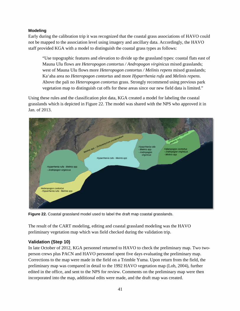
41
Modeling Early during the calibration trip it was recognized that the coastal grass associations of HAVO could not be mapped to the association level using imagery and ancillary data. Accordingly, the HAVO staff provided KGA with a model to distinguish the coastal grass types as follows:
“Use topographic features and elevation to divide up the grassland types: coastal flats east of Mauna Ulu flows are Heteropogon contortus / Andropogon virginicus mixed grasslands; west of Mauna Ulu flows more Heteropogon contortus / Melinis repens mixed grasslands; Kaʻaha area no Heteropogon contortus and more Hyparrhenia rufa and Melinis repens. Above the pali no Heteropogon contortus grass. Strongly recommend using previous park vegetation map to distinguish cut offs for these areas since our new field data is limited.”
Using these rules and the classification plot data, KGA created a model for labeling the coastal grasslands which is depicted in Figure 22. The model was shared with the NPS who approved it in Jan. of 2013.
Figure 22. Coastal grassland model used to label the draft map coastal grasslands.
The result of the CART modeling, editing and coastal grassland modeling was the HAVO preliminary vegetation map which was field checked during the validation trip.
Validation (Step 10) In late October of 2012, KGA personnel returned to HAVO to check the preliminary map. Two two-person crews plus PACN and HAVO personnel spent five days evaluating the preliminary map. Corrections to the map were made in the field on a Trimble Yuma. Upon return from the field, the preliminary map was compared in detail to the 1992 HAVO vegetation map (Loh, 2004), further edited in the office, and sent to the NPS for review. Comments on the preliminary map were then incorporated into the map, additional edits were made, and the draft map was created.

42
Draft Map and Digital Database Production In March of 2013, KGA delivered the HAVO draft vegetation map (Figures 23-25) and digital database to the NPS. The vegetation map feature class attribute tables were formatted according to NPS standards. The following standard fields were included in the attribute tables based on an example table sent to KGA by the NPS and approved by the NPS after delivery of the data.
1. NVC_Elcode – String field, populated with the vegetation association code.
2. Association – String field, populated with the vegetation association name or N/A if no association exists.
3. MapClass_CD – String field, to be populated by the NPS.
4. MapClass – String field, populated with the vegetation map class name.
5. X_Centroid – Double numeric field, populated with the X centroid coordinate for the polygon in meters.
6. Y_Centroid – Double numeric field, populated with the Y centroid coordinate for the polygon in meters.
Some additional fields were included in the attribute tables that were not specifically requested by the NPS.
1. Poly_ID – Long numeric field, populated with a unique identifier number for the polygon.
2. Hectares – Double numeric field, populated with the polygon area in hectares.
3. One or more String fields populated with special “modifier” attributes for certain polygons.
Figure 23. Draft HAVO vegetation map, Kīlauea area.

43
Figure 24. Draft HAVO vegetation map, Mauna Loa Strip Road and ʻŌla‘a areas.

44
Figure 25. Draft HAVO vegetation map, Kahuku area.
Formal Accuracy Assessment (Step 11) Introduction An important and necessary aspect of this project is the AA which entailed collecting independent ground data to determine the accuracy of the vegetation map. As such, users of this product should remember that the GIS mapping and the classification portions of this project were conducted separately from both the classification plot and AA field data collection.
AA is of two types: positional and thematic. Positional accuracy quantifies errors in the locations of geographic position. In the case of the VIP however, the spatial/positional accuracy is relative to the accuracy of Quickbird and Worldview2 imagery and allows for the assumption that all products derived from them are well within the NPS national map accuracy standards for 1:12,000-scale maps (±9 m; 30 ft).

45
Thematic maps capture the spatial variation of one or a small number of themes such as climate, soil type, population density, or vegetation. The HAVO vegetation map is a thematic map of vegetation and land use as defined by the HAVO map class key and map class descriptions.
Sampling Design The thematic accuracy of the vegetation map was assessed using the methodology standards provided by the VIP (Nature Conservancy and ESRI 1994). The protocols include a four step AA process consisting of a sample design, sample site selection, data collection, and data analysis. The design of the HAVO AA sample followed the five scenarios provided in the 1994 field manual with stratified accessible random targets placed in each map class based on their respective frequency and abundance (Table 6).
AA sample points were generated for each map class using ArcGIS. Polygons less than MMU (0.5 ha) were eliminated from the assessment using a definition query. Polygons classified as water or human made features were also removed. Steep areas (≥ 70% slope) were identified (intersected with 5 m DEM) and eliminated from the analysis for crew safety. Inaccessible areas, based on road/trail GIS layers and park-specific knowledge, were also eliminated. In order to generate random points across each map class, all single part polygons per map class were dissolved into one multipart polygon feature. Multipart polygons allow selection of individual map classes to generate the required amount of sampling points across the map class spatial extent. AA sample points were generated for each map class using the random point generator within the dissolved feature class. Three times the required number of sample points were generated per map class to ensure the creation of enough accessible samples. A 45 m buffer was created around each point using the proximity tool to represent a 0.5 ha (1.2 ac) circle with a 5 m (16 ft) buffer accounting for the horizontal error typically encountered in GPS receivers. A random feature ID was assigned and each buffer was unioned with the previously processed map data. Points identified with buffers > 90% within map polygons were selected (964 samples). If necessary, buffers were shifted up to 40 m to fit within polygons (34 samples). Some samples had odd shaped (i.e. linear) polygons in which 0.5 ha circles did not fit, 36 were identified as requiring polygon based sampling. Sample points were rejected when buffers intersected other point’s buffers to ensure no overlapping samples. AA sample points were randomly selected from the list of acceptable points per map class. Point data were exported from GIS into GPS field devices. For map classes that required polygon based sampling, polygon boundaries excluding map class labels were uploaded to GPS units.
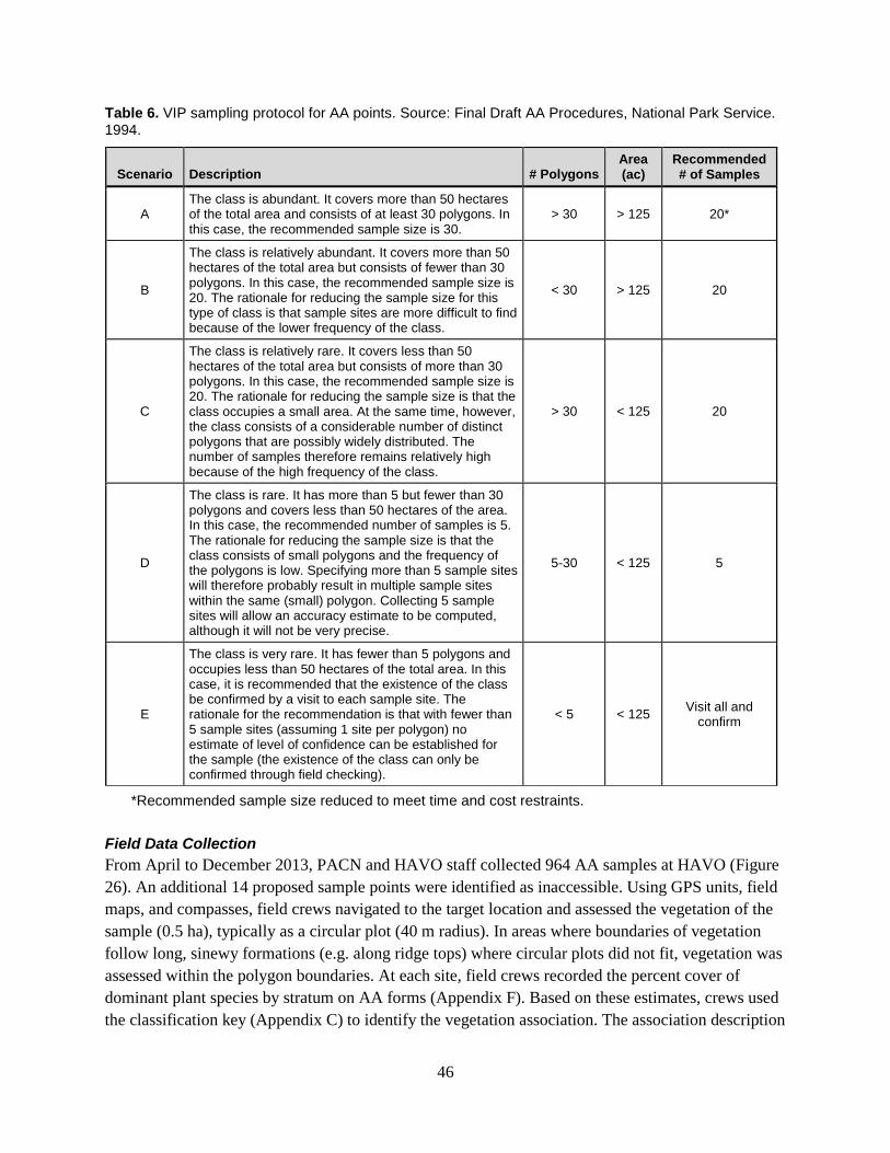
46
Table 6. VIP sampling protocol for AA points. Source: Final Draft AA Procedures, National Park Service. 1994.
Scenario Description # Polygons Area (ac)
Recommended # of Samples
A The class is abundant. It covers more than 50 hectares of the total area and consists of at least 30 polygons. In this case, the recommended sample size is 30.
> 30 > 125 20*
B
The class is relatively abundant. It covers more than 50 hectares of the total area but consists of fewer than 30 polygons. In this case, the recommended sample size is 20. The rationale for reducing the sample size for this type of class is that sample sites are more difficult to find because of the lower frequency of the class.
< 30 > 125 20
C
The class is relatively rare. It covers less than 50 hectares of the total area but consists of more than 30 polygons. In this case, the recommended sample size is 20. The rationale for reducing the sample size is that the class occupies a small area. At the same time, however, the class consists of a considerable number of distinct polygons that are possibly widely distributed. The number of samples therefore remains relatively high because of the high frequency of the class.
> 30 < 125 20
D
The class is rare. It has more than 5 but fewer than 30 polygons and covers less than 50 hectares of the area. In this case, the recommended number of samples is 5. The rationale for reducing the sample size is that the class consists of small polygons and the frequency of the polygons is low. Specifying more than 5 sample sites will therefore probably result in multiple sample sites within the same (small) polygon. Collecting 5 sample sites will allow an accuracy estimate to be computed, although it will not be very precise.
5-30 < 125 5
E
The class is very rare. It has fewer than 5 polygons and occupies less than 50 hectares of the total area. In this case, it is recommended that the existence of the class be confirmed by a visit to each sample site. The rationale for the recommendation is that with fewer than 5 sample sites (assuming 1 site per polygon) no estimate of level of confidence can be established for the sample (the existence of the class can only be confirmed through field checking).
< 5 < 125 Visit all and confirm
*Recommended sample size reduced to meet time and cost restraints.
Field Data Collection From April to December 2013, PACN and HAVO staff collected 964 AA samples at HAVO (Figure 26). An additional 14 proposed sample points were identified as inaccessible. Using GPS units, field maps, and compasses, field crews navigated to the target location and assessed the vegetation of the sample (0.5 ha), typically as a circular plot (40 m radius). In areas where boundaries of vegetation follow long, sinewy formations (e.g. along ridge tops) where circular plots did not fit, vegetation was assessed within the polygon boundaries. At each site, field crews recorded the percent cover of dominant plant species by stratum on AA forms (Appendix F). Based on these estimates, crews used the classification key (Appendix C) to identify the vegetation association. The association description

47
Appendix D) was reviewed and comments were included where necessary (e.g. main descriptive species missing). In sites where the vegetation matched more than one association (e.g. percent covers were near the cut-off between physiognomic groups), crews assigned a secondary and in some cases a tertiary field call. Photos were taken in each plot in all cardinal directions (N-E-S-W), and of the canopy, ground and completed data forms. Nearby vegetation, topographic features, or recent disturbance were also recorded. If the crew encountered a vegetation type that was new to the HAVO vegetation classification, they also completed an environmental field form (Appendix F) and developed a species list for the site.
Figure 26. Distribution of HAVO AA sites.
If the crew could not access the sample (> 12 m from target location) due to steep terrain or dense vegetation, they noted this limitation and assessed the vegetation at the closest proximity. Additionally, crews recorded location data for species with specific ecological importance (e.g. Morella faya). These data were specifically requested by the HAVO park staff and were added as modifiers to the database when encountered within plots to provide additional information about the landscape.
Quality Control AA data forms were reviewed for errors, entered into the NPS Microsoft Access database (PLOTS), and proofed for data entry errors by PACN staff. KGA also reviewed the AA data for errors and ran data for each sample through the autolabeler to check for any inconsistencies in sample labeling. An

48
interim analysis and description of possible errors were transmitted to the PACN staff and most discrepancies in sites were resolved.
Analysis The AA analyses was completed by:
• reviewing each site’s database, scanned field form, and field photos,
• running the reference site data through the autolabeler, and
• comparing the site’s reference AA label to its draft map label, its autolabeler label, the high resolution imagery, and validation and calibration field samples and photos.
KGA and PACN then reviewed the AA data and decided if errors had been made in data entry or labeling and changes were made to the data where warranted. Any post-hoc changes to AA field calls or substantial changes to the vegetation map based on AA are identified in Appendix G. Next, error matrices were developed as detailed in the NPS National Vegetation Mapping Program’s 1994 (NPS, 1994) standards as specified in the mapping contract.
Develop the Mapping Model (Step 6) Ideally, when the vegetation associations change on the ground, the response of the remotely sensed data and the classes of the ancillary data also change, resulting in a one to one relationship between the associations and map classes. However, because vegetation associations are often distinguished from one another by sub canopy and/or scarce indicator species, it is often impossible to map to the association level, resulting in the need to collapse associations into less detailed map model classes. Therefore, a critical step in the HAVO project was the translation of the HAVO ecological USNVC association descriptions and key into a map key and map class descriptions composed of classes which could be mapped from remotely sensed data and ancillary information.
In some NPS vegetation mapping projects which rely on manual photo interpretation, the development of the mapping model occurs following the collection of the imagery and completion of the calibration trip, when the photo interpreters have developed an understanding of what vegetation associations are distinguishable from the imagery and which need to be collapsed upward into more general map classes. In this project, development of the mapping model (Step 6) spanned across Steps 5 through 11. Development of the model started with the USNVC associations developed in Step 5. Following the calibration trip (Step 7) and validation trip (Step 9), several associations were added which were not sampled as part of the original classification work (e.g. Aleurites moluccana Dry Forest [Park Special]) and some were removed because they were not encountered again in the field (e.g. Coprosma ernodeoides Shrubland [Park Special]). Most of the development of the mapping model was performed following AA of the draft map (Step 11). As a result, only associations shown to be confused from the AA were combined.
Following AA, KGA and PACN worked together to finalize the map model classes. For each USNVC association a determination was made regarding if the association was:
• abundant and distinguishable using the imagery and/or ancillary data so as to be mapable using CART modeling coupled with manual editing,

49
• indistinguishable from the imagery and ancillary data and, therefore, needing to be collapsed upward into a map class or modeled using local knowledge of HAVO staff, or
• too rare to be mapped using CART modeling coupled with manual editing, in which case it would appear on the final map only in places where it was field verified during the PACN and KGA field data collection efforts.
Final Map, Reports, and GIS Database (Step 12) Following AA the draft map was edited based on AA results and HAVO staff input to develop the final map. Details of edits per map class can be found in Appendix G. Figure 27 illustrates the impact of the final editing on a portion of HAVO.
Figure 27. Area south of Kīlauea Iki Crater depicting corrections made to the final map based on information gained from AA samples. This example shows the correction of errors of omission of the Morella faya - (Metrosideros polymorpha) Semi-natural Forest.
The most significant edits of the draft map focused on editing errors discovered during AA or changing labels to new map classes. They included:
• Changes in the coastal grassland model to include new input from HAVO staff.
• Correction of errors of omission in the Morella faya - (Metrosideros polymorpha) Semi-natural Forest and Metrosideros polymorpha / Leptecophylla tameiameiae - (Dodonaea viscosa) Lowland Dry Woodland map classes.
• Corrections of errors of commission to the Sapindus saponaria - Coprosma rhynchocarpa Montane Mesic Forest map class.
• Addition of the Burned (2003) Metrosideros polymorpha / Cibotium spp. Montane Wet Forest, Burned (2003) Metrosideros polymorpha / Nephrolepis brownii Semi-natural Woodland, Burned (2003) Metrosideros polymorpha / Dicranopteris linearis Lowland Mesic Woodland, and Burned (2003) Morella faya – (Metrosideros polymorpha) Semi-natural Forest map classes.

50
Final delivery included electronic and digital high resolution PDF maps. Additionally, a geodatabase of the final maps was delivered in Universal Transverse Mercator (UTM) North American Datum of 1983 (NAD83) High Accuracy Reference Network (HARN) datum. All electronic data, including GIS Data, are metadata compliant with Federal Geographic Data Committee Metadata Standards. The following fields were included in the final vegetation map attribute table.
• NVC_ELCODE – String field, populated with the vegetation association code or NA if no code exists.
• Association – String field, populated with the vegetation association name or NA if no association exists.
• MapClass_CD – String field, to be populated by the NPS.
• MapClass – String field, populated with the vegetation map class name.
• MapClass_Common - String field, populated with the vegetation map class common name.
• HECTARES – Double numeric field, populated with the polygon area in hectares.
• Morella_Presence – String field, populated with “Yes” for non-Morella faya type polygons that have Morella faya present.
• Morella_Cover_Class – String field, populated with the values “Low 1%-25%” or “Moderate 25%-50%” indicating the relative coverage of Morella faya in forest/woodland type polygons.
• MMU – Double numeric field, populated with the minimum mapping unit for the class.
• MMU_COMMENT – String field, populated with comments regarding the MMU for the class.

51
Results Vegetation Sampling A total of 590 classification plots were collected from 1997-1998, 2005, and 2009-2011. Three hundred eighty-two species (or genera level) were recorded from the park of which 192 (50%) are indigenous/endemic and 181 (47%) are non-native and nine (2%) have unknown origin. Within the park there are 23 species of endangered vascular plants, two of which were sampled in the plots.
Vegetation composition can be described as belonging to four elevation zones: coastal, lowland, montane, and subalpine. Within these zones there are three moisture regimes: dry, mesic, and wet. In all zones throughout the park, several ubiquitous species including Acacia koa, Metrosideros polymorpha, Leptecophylla tameiameiae, and Dodonaea viscosa occur in various combinations with subtle compositional variations between elevation and moisture zones.
Vegetation Classification The draft HAVO vegetation association keys and descriptions follow the FGDC (2008) NVC Standards and were delivered to PACN in the fall of 2011 and the spring of 2012, respectively. All vegetation associations were placed into the current interpretation of the vegetation hierarchy of the 2008 NVCS.
NatureServe’s analysis of the vegetation data collected at HAVO resulted in the creation of 72 associations of which 68 were addressed in the original HAVO association key. Descriptions were developed for all associations with two or more classification plots which resulted in descriptions for 49 of the 68 associations(Appendix D). Following the map calibration, five more associations Aleurites moluccana Dry Forest [Park Special] (CEPS009723), Cocos nucifera Strand Woodland (CEGL005402), Fraxinus uhdei Semi-natural Lowland Woodland [Park Special] (CEPS009694), Hedychium coronarium Semi-natural Herbaceous Vegetation [Park Special] (CEPS009695), and Dodonaea viscosa - Pluchea carolinensis Semi-natural Shrubland [Park Special] (CEPS009722) were identified at HAVO and added to the key (but not described), resulting in a total of 77 associations (Table 7) which were classified into 11 USNVC macrogroups and 17 USNVC groups. Of these community types, 13 were attributed to existing USNVC associations and the remaining were considered new USNVC associations. Associations are termed “park specials” when they occur only in small stands, are tentatively considered unique to the park, and lack sufficient documentation in the literature, of which there were 22 at HAVO. Park specials are identified in the classification by an Elcode prefix of “CEPS” (Table 7).
Each association or park special is represented by anywhere from zero to 57 classification plot samples (Appendix E). Types with no plots recorded were added either after subsequent field observations were made or recommended by HAVO staff based on previous mapping efforts. These types may be rare in the park, or were simply under sampled as a result of difficult access or limitations of the sampling design.

52
Table 7. USNVC hierarchical classification of vegetation at HAVO organized by macrogroup, group, and association.
USNVC Association Common Name ELCODE USNVC Group USNVC Macrogroup
Morinda citrifolia / Pluchea carolinensis Semi-natural Woodland [Park Special]
Noni / Sourbush Semi-natural Woodland [Park Special] CEPS009646
Hawaiian Lowland - Coastal Seasonal Rainforest
Hawaiian Lowland Rainforest
Acacia koa / Melinis minutiflora Semi-natural Lowland Woodland
Koa / Molasses Grass Semi-natural Lowland Woodland CEGL008141
Hawaiian Lowland Rainforest
Metrosideros polymorpha - (Psidium spp., Schinus terebinthifolius) Woodland
‘Ōhi‘a (Guava species, Christmas berry) Woodland
CEGL008142
Metrosideros polymorpha / Cymbopogon refractus Semi-natural Woodland [Park Special]
‘Ōhi‘a / Barbwire Grass Semi-natural Woodland [Park Special]
CEPS009649
Metrosideros polymorpha / Dicranopteris linearis Lowland Mesic Woodland
‘Ōhi‘a / Uluhe Lowland Mesic Woodland
CEGL008039
Eucalyptus spp. - Mixed Alien Semi-natural Forest/Plantation [Provisional]
Eucalyptus spp. - Mixed Alien Semi-natural Forest/Plantation [Provisional]
CEGL008144
Polynesian Semi-natural Lowland Rainforest
Polynesian Semi-natural Lowland Rainforest
Fraxinus uhdei Semi-natural Lowland Woodland [Park Special]** Tropical Ash Semi-natural Lowland
Woodland [Park Special] CEPS009694
Grevillea robusta Lowland Mesic Semi-natural Forest
Silk Oak Lowland Mesic Semi-natural Forest CEGL008113
Acacia koa / Cibotium spp. Montane Woodland Koa / Hāpuʻu spp. Montane Woodland CEGL008149
Hawaiian Montane Rainforest & Cloud Forest
Hawaiian Montane & Cloud Forest
Cibotium glaucum Montane Forest Hāpuʻu pulu Montane Forest CEGL008151 Metrosideros polymorpha - Cheirodendron trigynum / (Cibotium spp.) Montane Wet Forest
‘Ōhi‘a - Olapa / (Hāpuʻu spp.) Montane Wet Forest CEGL008008
Metrosideros polymorpha / Cibotium spp. Montane Wet Forest
‘Ōhi‘a / Hāpuʻu spp. Montane Wet Forest CEGL008009
Metrosideros polymorpha / Dicranopteris linearis Montane Wet Woodland
‘Ōhi‘a / Uluhe Montane Wet Woodland CEGL008041
Metrosideros polymorpha / Nephrolepis brownii Semi-natural Woodland1
‘Ōhi‘a / Sword fern Semi-natural Woodland CEGL008153
1USNVC name modified based on Wagner et al. (1999) and Wagner et al. (2012). *Associations at HAVO not in the HAVO association key and not occurring on the HAVO final map. **Associations at HAVO based on observations during the map calibration process.

53
Table 7 (continued). USNVC hierarchical classification of vegetation at HAVO organized by macrogroup, group, and association.
USNVC Association Common Name ELCODE USNVC Group USNVC Macrogroup
Sapindus saponaria - Coprosma rhynchocarpa Montane Mesic Forest [Park Special]
Mānele - Pilo Montane Mesic Forest [Park Special] CEPS009654
Hawaiian Montane Rainforest & Cloud Forest (continued)
Hawaiian Montane & Cloud Forest (continued)
Acacia koa / Metrosideros polymorpha Montane Dry Woodland Koa / ‘Ōhi‘a Montane Dry Woodland CEGL008134 Hawaiian Montane-
Subalpine Dry Forest & Woodland Metrosideros polymorpha Montane Dry Woodland* ‘Ōhi‘a Montane Dry Woodland CEGL008042
Acacia koa - (Sapindus saponaria) / Microlepia strigosa Montane Woodland [Park Special]
Koa - (Mānele) / Palapalai Montane Woodland [Park Special] CEPS009655
Hawaiian Montane-Subalpine Mesic Forest
Acacia koa / Cenchrus clandestinus Semi-natural Woodland1
Koa / Kikuyu Grass Semi-natural Woodland CEGL008157
Acacia koa / Ehrharta stipoides Semi-natural Montane Woodland
Koa / Meadowrice Grass Semi-natural Montane Woodland CEGL008154
Acacia koa / Ipomoea indica - Pipturus albidus Woodland [Park Special]
Koa / Koali‘awa - Māmaki Woodland [Park Special] CEPS009656
Acacia koa / Leptecophylla tameiameiae - (Dodonaea viscosa) Montane Woodland1
Koa / Pūkiawe - (A‘ali‘i) Montane Woodland CEGL008155
Acacia koa / Melinis minutiflora Semi-natural Montane Woodland [Park Special]
Koa / Molasses Grass Semi-natural Montane Woodland [Park Special] CEPS009674
Acacia koa / Metrosideros polymorpha / Ehrharta stipoides Montane Mesic Woodland
Koa / ‘Ōhi‘a / Meadowrice Grass Montane Mesic Woodland CEGL008156
Acacia koa / Setaria parviflora Lowland Semi-natural Woodland [Park Special]
Koa / Foxtail Lowland Semi-natural Woodland [Park Special] CEPS009657
Metrosideros polymorpha - Ilex anomala - Myrsine lessertiana Woodland
‘Ōhi‘a - Kāwa‘u - Kolea Lau Nui Woodland CEGL008158
Metrosideros polymorpha / Cenchrus clandestinus Semi-natural Woodland1
‘Ōhi‘a / Kikuyu Grass Semi-natural Woodland CEGL008161
Metrosideros polymorpha / Ehrharta stipoides Semi-natural Woodland
‘Ōhi‘a / Meadowrice Grass Semi-natural Woodland CEGL008159
Metrosideros polymorpha / Melinis spp. - Andropogon virginicus Semi-natural Woodland
‘Ōhi‘a /Melinis spp.- Broomsedge Semi-natural Woodland CEGL008160
1USNVC name modified based on Wagner et al. (1999) and Wagner et al. (2012). *Associations at HAVO not in the HAVO association key and not occurring on the HAVO final map. **Associations at HAVO based on observations during the map calibration process.

54
Table 7 (continued). USNVC hierarchical classification of vegetation at HAVO organized by macrogroup, group, and association.
USNVC Association Common Name ELCODE USNVC Group USNVC Macrogroup Metrosideros polymorpha / Pipturus albidus Montane Mesic Forest [Park Special]
‘Ōhi‘a / Māmaki Montane Mesic Forest [Park Special] CEPS009658 Hawaiian Montane-
Subalpine Mesic Forest (continued)
Hawaiian Montane & Cloud Forest (continued) Metrosideros polymorpha Mesic Montane
Woodland* ‘Ōhi‘a Mesic Montane Woodland CEGL008020
Morella faya - (Metrosideros polymorpha) Semi-natural Forest
Firetree - (‘Ōhi‘a ) Semi-natural Forest CEGL008162
Hawaiian Montane Semi-natural Forest & Woodland
Polynesian Semi-natural Montane Rainforest
Aleurites moluccana Dry Forest [Park Special]** Kukui Dry Forest [Park Special] CEPS009723
Hawaiian Lowland Dry Forest & Woodland
Hawaiian Dry Forest
Metrosideros polymorpha / Leptecophylla tameiameiae - (Dodonaea viscosa) Lowland Dry Woodland1
‘Ōhi‘a / Pūkiawe - (ʻA‘ali‘i) Lowland Dry Woodland CEGL008132
Metrosideros polymorpha Lowland Dry Forest* ‘Ōhi‘a Lowland Dry Forest CEGL008029 Sophora chrysophylla - (Leptecophylla tameiameiae - Dodonaea viscosa) Lowland Dry Woodland1
Māmane - (Pūkiawe - A‘ali‘i) Lowland Dry Woodland CEGL008133
Sophora chrysophylla - Metrosideros polymorpha / (Leptecophylla tameiameiae - Dodonaea viscosa) Lowland Dry Woodland1
Māmane - ‘Ōhi‘a / (Pūkiawe - A‘ali‘i) Lowland Dry Woodland CEGL008139
Metrosideros polymorpha / Dryopteris wallichiana Woodland [Park Special]
‘Ōhi‘a / ‘I‘o nui Woodland [Park Special] CEPS009647
Hawaiian Montane-Subalpine Dry Forest & Woodland
Metrosideros polymorpha / Leptecophylla tameiameiae - Dodonaea viscosa Montane Woodland1
‘Ōhi‘a / Pūkiawe - A‘ali‘i Montane Woodland CEGL008135
Metrosideros polymorpha / Leptecophylla tameiameiae / Deschampsia nubigena - Morelotia gahniiformis Woodland1
‘Ōhi‘a / Pūkiawe / Deschampsia nubigena - Morelotia gahniiformis Woodland
CEGL008136
Myoporum sandwicense Subalpine Woodland Naio Subalpine Woodland CEGL008137 Sophora chrysophylla - (Leptecophylla tameiameiae - Dodonaea viscosa) Montane Woodland1
Māmane - (Pūkiawe - A‘ali‘i) Montane Woodland CEGL008138
Sophora chrysophylla / Ehrharta stipoides Subalpine Semi-natural Woodland
Māmane / Meadow Ricegrass Subalpine Semi-natural Woodland CEGL008140
1USNVC name modified based on Wagner et al. (1999) and Wagner et al. (2012). *Associations at HAVO not in the HAVO association key and not occurring on the HAVO final map. **Associations at HAVO based on observations during the map calibration process.

55
Table 7 (continued). USNVC hierarchical classification of vegetation at HAVO organized by macrogroup, group, and association.
USNVC Association Common Name ELCODE USNVC Group USNVC Macrogroup
Sophora chrysophylla / Hyparrhenia rufa Semi-natural Woodland [Park Special]
Māmane / Thatching Grass Semi-natural Woodland [Park Special] CEPS009648
Hawaiian Montane-Subalpine Dry Forest & Woodland (continued)
Hawaiian Dry Forest (continued)
Dodonaea viscosa Lowland Dry Shrubland A‘ali‘i Lowland Dry Shrubland CEGL008059
Hawaiian Lowland Dry Shrubland & Grassland
Hawaiian Lowland Shrubland, Grassland & Savanna
Dodonaea viscosa - Pluchea carolinensis Semi-natural Shrubland [Park Special]**
A‘ali‘i - Sourbush Semi-natural Shrubland [Park Special] CEPS009722
Heteropogon contortus Lowland Dry Herbaceous Vegetation
Pili Lowland Dry Herbaceous Vegetation CEGL008090
Coprosma ernodeoides Shrubland [Park Special] Kūkaenēnē Shrubland [Park Special] CEPS009660 Hawaiian Lowland Mesic-Wet Shrubland & Grassland
Dicranopteris linearis Wet Herbaceous Mat Uluhe Wet Herbaceous Mat CEGL008048 Leptecophylla tameiameiae - Dodonaea viscosa Lowland Mesic Shrubland1
Pūkiawe - A‘ali‘i Lowland Mesic Shrubland CEGL008164
Andropogon virginicus Semi-natural Lowland Herbaceous Vegetation
Broomsedge Semi-natural Lowland Herbaceous Vegetation CEGL008166
Polynesian Semi-natural Lowland Shrubland, Grassland & Savanna
Polynesian Semi-natural Lowland Shrubland, Grassland & Savanna
Cenchrus clandestinus Semi-natural Herbaceous Vegetation1
Kikuyu Grass Semi-natural Herbaceous Vegetation CEGL005408
Eragrostis brownei Semi-natural Herbaceous Vegetation [Park Special]1
Sheepgrass Semi-natural Herbaceous Vegetation [Park Special]
CEPS009663
Hyparrhenia rufa - Melinis spp. Semi-natural Herbaceous Vegetation
Thatching Grass - Melinis species Semi-natural Herbaceous Vegetation CEGL008168
Lantana camara Semi-natural Shrubland [Provisional]
Lantana Semi-natural Shrubland [Provisional] CEGL008145
Leucaena leucocephala Lowland Dry Semi-natural Shrubland
Koa Haole Lowland Dry Semi-natural Shrubland CEGL008114
Melinis minutiflora - (Schizachyrium condensatum) Semi-natural Herbaceous Vegetation
Molasses Grass - (Beardgrass) Semi-natural Herbaceous Vegetation CEGL008169
Melinis repens Semi-natural Herbaceous Vegetation Natal Redtop Semi-natural Herbaceous Vegetation CEGL005405
Nephrolepis brownii Semi-natural Herbaceous Vegetation1
Sword fern Semi-natural Herbaceous Vegetation CEGL008165
1USNVC name modified based on Wagner et al. (1999) and Wagner et al. (2012). *Associations at HAVO not in the HAVO association key and not occurring on the HAVO final map. **Associations at HAVO based on observations during the map calibration process.

56
Table 7 (continued). USNVC hierarchical classification of vegetation at HAVO organized by macrogroup, group, and association.
USNVC Association Common Name ELCODE USNVC Group USNVC Macrogroup
Deschampsia nubigena Montane and Subalpine Mesic Herbaceous Vegetation
Deschampsia Montane and Subalpine Mesic Herbaceous Vegetation
CEGL008085 Hawaiian Montane-Subalpine Mesic-Wet Shrubland & Grassland
Hawaiian Montane Shrubland, Grassland & Savanna
Dodonaea viscosa Montane Mesic Shrubland [Park Special]
A‘ali‘i Montane Mesic Shrubland [Park Special] CEPS009668
Pteridium aquilinum ssp. decompositum Herbaceous Vegetation [Park Special]
Kīlau Herbaceous Vegetation [Park Special] CEPS009665
Dodonaea viscosa Subalpine Dry Shrubland A‘ali‘i Subalpine Dry Shrubland CEGL008060 Hawaiian Montane-Subalpine Dry Shrubland & Grassland
Leptecophylla tameiameiae - Dodonaea viscosa Montane Shrubland1 Pūkiawe - A‘ali‘i Montane Shrubland CEGL008172
Leptecophylla tameiameiae Montane Dry Shrubland1 Pūkiawe Montane Dry Shrubland CEGL008173
Anthoxanthum odoratum - Mixed Grasses Semi-natural Herbaceous Vegetation [Park Special]
Sweet Vernalgrass - Mixed Grasses Semi-natural Herbaceous Vegetation [Park Special]
CEPS009662
Polynesian Semi-natural Subalpine-Montane Shrubland & Grassland
Polynesian Semi-natural Montane Shrubland, Grassland & Savanna
Cocos nucifera Strand Woodland** Coconut Palm Strand Woodland CEGL005402 Hawaiian Dry Scrub & Herb Coastal Strand
Hawaiian Scrub & Herb Coastal Vegetation
Dubautia scabra ssp. scabra Montane Sparse Vegetation
Na‘ena‘e Montane Sparse Vegetation CEGL008176
Hawaiian Montane Shrubland, Grassland & Savanna
Hawaiian Cliff, Scree & Rock Vegetation
Heteropogon contortus Sparse Vegetation [Park Special] Pili Sparse Vegetation [Park Special] CEPS009669
Hawaiian Dry-Site Lava Flow
Leptecophylla tameiameiae - Dodonaea viscosa Lowland Sparse Vegetation1
Pūkiawe - A‘ali‘i Lowland Sparse Vegetation CEGL008177
Leptecophylla tameiameiae - Vaccinium reticulatum Montane and Subalpine Sparse Vegetation1
Pūkiawe - ‘Ōhelo Montane and Subalpine Sparse Vegetation CEGL008178
Metrosideros polymorpha / (Leptecophylla tameiameiae - Dodonaea viscosa) Lowland Sparse Vegetation1
‘Ōhi‘a / (Pūkiawe - A‘ali‘i) Lowland Sparse Vegetation CEGL008179
1USNVC name modified based on Wagner et al. (1999) and Wagner et al. (2012). *Associations at HAVO not in the HAVO association key and not occurring on the HAVO final map. **Associations at HAVO based on observations during the map calibration process.

57
Table 7 (continued). USNVC hierarchical classification of vegetation at HAVO organized by macrogroup, group, and association.
USNVC Association Common Name ELCODE USNVC Group USNVC Macrogroup Metrosideros polymorpha / (Leptecophylla tameiameiae - Dodonaea viscosa) Montane Sparse Vegetation1
‘Ōhi‘a / (Pūkiawe - A‘ali‘i) Montane Sparse Vegetation CEGL008180
Hawaiian Dry-Site Lava Flow (continued)
Hawaiian Cliff, Scree & Rock Vegetation (continued)
Metrosideros polymorpha / Leptecophylla tameiameiae - Vaccinium reticulatum Montane and Subalpine Sparse Vegetation1
‘Ōhi‘a / Pūkiawe - ‘Ōhelo Montane and Subalpine Sparse Vegetation CEGL008181
Sophora chrysophylla Montane Sparse Vegetation [Park Special]
Māmane Montane Sparse Vegetation [Park Special] CEPS009670
Vaccinium reticulatum Montane Sparse Vegetation [Park Special]
‘Ōhelo Montane Sparse Vegetation [Park Special] CEPS009671
Hedychium coronarium Semi-natural Herbaceous Vegetation [Park Special]**
White Ginger Semi-natural Herbaceous Vegetation CEPS009695 Unclassified
1USNVC name modified based on Wagner et al. (1999) and Wagner et al. (2012). *Associations at HAVO not in the HAVO association key and not occurring on the HAVO final map. **Associations at HAVO based on observations during the map calibration process.

58
Vegetation Mapping Following the validation trips, AA, and literature review, the following additional associations and map classes were determined to also exist at HAVO:
• Four associations described by NatureServe for other parks (Prosopis pallida Coastal Dry Semi-natural Woodland, Scaevola taccada Coastal Dry Shrubland1, Schinus terebinthifolius Semi-natural Scrub Woodland, and Thespesia populnea / Sparse Understory Woodland).
• Twelve additional vegetated map classes identified during field work and review were added (Araucaria columnaris Semi-natural Woodland, Burned (2003) Metrosideros polymorpha / Cibotium spp. Montane Wet Forest, Burned (2003) Metrosideros polymorpha / Dicranopteris linearis Lowland Mesic Woodland, Burned (2003) Metrosideros polymorpha / Nephrolepis brownii Semi-natural Woodland, and Burned (2003) Morella faya - Metrosideros polymorpha Semi-natural Forest, Diospyros sandwicensis Lowland Dry Forest, Juncus effusus - Holcus lanatus Herbaceous Vegetation, Metrosideros polymorpha – (Diospyros sandwicensis) / (Dodonaea viscosa) Lowland Dry Forest, Metrosideros polymorpha / Non-native Grass Semi-natural Woodland, (Metrosideros polymorpha) - Psidium cattleianum - (Cheirodendron spp.) - Cibotium spp. Montane Wet Forest, Mixed Coastal Shrubland, and Mixed Non-native Disturbed Herbaceous Vegetation.
• Two map classes in ʻŌlaʻa based on literature (Waite and Pratt 2007) (Metrosideros polymorpha / Mixed Native Forest and Carex alligata Herbaceous Vegetation).
• Four unvegetated map classes, (Built-up Commercial and Services, Built-up Transportation, Communications and Utilities, Water, and Unvegetated).
Following AA, KGA and PACN personnel collapsed the 96 HAVO associations and map classes into 79 vegetated and four unvegetated map classes. Additionally, another coastal grassland map class was added bringing the total number of map classes to 84. Table 8 compares HAVO’s USNVC associations to the final map classes. The final HAVO map model is a result of the following actions or conditions.
• Four associations were omitted from the map model because they were not included in the NatureServe vegetation association key (Acacia koa / Melinis minutiflora Semi-natural Montane Woodland [Park Special], Metrosideros polymorpha Mesic Montane Woodland, Metrosideros polymorpha Montane Dry Woodland, and Metrosideros polymorpha Lowland Dry Forest).
• Six rare associations (represented by one or two classification plots) were not encountered during calibration, validation, or AA field efforts, and, therefore, were considered too rare to include in the map (Coprosma ernodeoides Shrubland [Park Special], Eragrostis brownei Semi-natural Herbaceous Vegetation [Park Special], Dodonaea viscosa Subalpine Dry Shrubland, Morinda citrifolia / Pluchea carolinensis Semi-natural Woodland [Park Special], Sophora chrysophylla / Hyparrhenia rufa Semi-natural Woodland [Park Special], and Vaccinium reticulatum Montane Sparse Vegetation [Park Special]).

59
• Thirteen forested associations were collapsed into six map classes because it was impossible to distinguish the associations from one another within the map class. The six composite map classes and their associations are:
o Acacia koa / Non-native Grass Semi-natural Woodland map class – consists of three Acacia koa over grass associations (Acacia koa / Ehrharta stipoides Semi-natural Montane Woodland, Acacia koa / Cenchrus clandestinus Semi-natural Woodland1, and Acacia koa / Setaria parviflora Lowland Semi-natural Woodland [Park Special]). These associations were combined because the grass species were indistinguishable from one another using remote sensing and/or GIS modeling.
o Acacia koa / (Metrosideros polymorpha) / Ehrharta stipoides Semi-natural Montane Mesic Woodland map class – consists of two Acacia koa associations (Acacia koa / Ehrharta stipoides Semi-natural Montane Woodland and Acacia koa / Metrosideros polymorpha / Ehrharta stipoides Montane Mesic Woodland).
o Metrosideros polymorpha Native Woodland map class – consists of two woodland associations (Metrosideros polymorpha - Ilex anomala - Myrsine lessertiana Woodland, and Metrosideros polymorpha / Dryopteris wallichiana Woodland [Park Special]). These associations are typically closed canopy forests which are geographically co-located. The density of the canopy prevents identification of the understory from remotely sensed imagery, and their close geographical co-occurrence precludes modeling to break the associations apart.
o Metrosideros polymorpha / Leptecophylla tameiameiae - Dodonaea viscosa Montane Woodland map class – consists of the association with the same name and Metrosideros polymorpha / Leptecophylla tameiameiae / Deschampsia nubigena - Morelotia gahniiformis Woodland which was merged into it because the differing graminoids were indistinguishable on the remote sensing imagery.
o Metrosideros polymorpha / Cenchrus clandestinus Semi-natural Woodland map class – consists of the association with the same name and Metrosideros polymorpha / Pipturus albidus Montane Mesic Forest [Park Special] which was merged into it because Metrosideros polymorpha / Pipturus albidus Montane Mesic Forest [Park Special] is a rare association.
o Thespesia populnea - (Prosopis pallida) Woodland map class – consists of two associations (Prosopis pallida Coastal Dry Semi-natural Woodland and Thespesia populnea / Sparse understory Woodland).
The coastal grassland model was changed to reflect updated input from HAVO staff and results from AA field work, and a new map class was added as illustrated in Figure 28. Of the seven coastal grass map classes at HAVO, three are represented by only one association and four are represented by two to three associations. Because of these one to many relationships between the associations and the map classes, please note that many of the coastal grass map classes are mentioned more than once in Table 8.

60
Figure 28. Final coastal grassland model used to label HAVO’s coastal grasslands.

61
Table 8. Associations and the map classes found at HAVO. For each association, the table shows the resulting map classes, total map class size in hectares, percentage of vegetated land area of HAVO, and the number of classification plots per association.
USNVC Association ELCODE Map Class Map Code Size (ha) % of
HAVO Plots
Acacia koa - (Sapindus saponaria) / Microlepia strigosa Montane Woodland [Park Special]
CEPS009655 Acacia koa - (Sapindus saponaria) / Microlepia strigosa Montane Woodland W_ACSAMI 28.5 0.05 2
Acacia koa / Cibotium spp. Montane Woodland CEGL008149 Acacia koa / Cibotium spp. Montane
Woodland W_ACCI 113.8 0.18 3
Acacia koa / Ehrharta stipoides Semi-natural Montane Woodland CEGL008154
Acacia koa / Non-native Grass Semi-natural Woodland W_ACKONN 444.6 0.71
8
Acacia koa / Cenchrus clandestinus Semi-natural Woodland1 CEGL008157 3
Acacia koa / Setaria parviflora Lowland Semi-natural Woodland [Park Special] CEPS009657 1
Acacia koa / Ipomoea indica - Pipturus albidus Woodland [Park Special] CEPS009656 Acacia koa / Ipomoea indica - Pipturus
albidus Woodland W_ACIPPI 42.9 0.07 1
Acacia koa / Leptecophylla tameiameiae - (Dodonaea viscosa) Montane Woodland1
CEGL008155 Acacia koa / Leptecophylla tameiameiae - (Dodonaea viscosa) Montane Woodland
W_ACLEDO 1062 1.71 5
Acacia koa / Melinis minutiflora Semi-natural Lowland Woodland CEGL008141 Acacia koa / Melinis minutiflora Semi-
natural Lowland Woodland W_ACME_L 5 0.01 2
Acacia koa / Melinis minutiflora Semi-natural Montane Woodland [Park Special]
CEPS009674 Omitted from the key. Not found on map - 1
Acacia koa / Metrosideros polymorpha / Ehrharta stipoides Montane Mesic Woodland
CEGL008156 Acacia koa / (Metrosideros polymorpha) / Ehrharta stipoides Semi-natural Montane Mesic Woodland
W_ACMEEH_M 224 0.36 4
Acacia koa / Ehrharta stipoides Semi-natural Montane Woodland CEGL008154 8
Acacia koa / Metrosideros polymorpha Montane Dry Woodland CEGL008134 Acacia koa / Metrosideros polymorpha
Montane Dry Woodland W_ACME 341.3 0.55 1
Aleurites moluccana Dry Forest [Park Special]* CEPS009723 Aleurites moluccana Dry Forest F_ALMO_D 7.7 0.01 0
1USNVC name modified based on Wagner et al. (1999) and Wagner et al. (2012). *Associations at HAVO based on observations during the map calibration/validation process.

62
Table 8 (continued). Associations and the map classes found at HAVO. For each association, the table shows the resulting map classes, total map class size in hectares, percentage of vegetated land area of HAVO, and the number of classification plots per association.
USNVC Association ELCODE Map Class Map Code Size (ha) % of
HAVO Plots
Andropogon virginicus Semi-natural Lowland Herbaceous Vegetation CEGL008166 Andropogon virginicus - Melinis spp.
Mixed Grassland H_ANME_G 307.4 0.49 12
Andropogon virginicus Semi-natural Lowland Herbaceous Vegetation CEGL008166
Heteropogon contortus - Andropogon virginicus - (Melinis repens) Herbaceous Vegetation
H_HCAVMR 387.4 0.62
12
Heteropogon contortus Lowland Dry Herbaceous Vegetation CEGL008090 10
Heteropogon contortus Sparse Vegetation [Park Special] CEPS009669 1
Andropogon virginicus Semi-natural Lowland Herbaceous Vegetation CEGL008166
Hyparrhenia rufa - Melinis spp. - (Andropogon virginicus) Mixed Grassland H_HYME 6645.4 10.65
12
Hyparrhenia rufa - Melinis spp. Semi-Natural Herbaceous Vegetation CEGL008168 33
Heteropogon contortus Lowland Dry Herbaceous Vegetation CEGL008090
Heteropogon contortus - Hyparrhenia rufa - Melinis spp. - (Andropogon virginicus) Mixed Grassland
H_HEHYMEAN 1364.3 2.19
10
Hyparrhenia rufa - Melinis spp. Semi-Natural Herbaceous Vegetation CEGL008168 33
Andropogon virginicus Semi-natural Lowland Herbaceous Vegetation CEGL008166 12
Anthoxanthum odoratum - Mixed Grasses Semi-natural Herbaceous Vegetation [Park Special]
CEPS009662 Anthoxanthum odoratum - Mixed Grasses Semi-natural Herbaceous Vegetation
H_ANOD 9.5 0.02 2
None - Araucaria columnaris Semi-natural Woodland W_ARCO 0.6 0.00 0
None - Built-up Commercial and Services B_COSE 31.3 NA 0
None - Built-up Transportation, Communications, and Utilities B_TRCOUT 166 NA 0
Metrosideros polymorpha / Cibotium spp. Montane Wet Forest CEGL008009 Burned (2003) Metrosideros polymorpha
/ Cibotium spp. Montane Wet Forest F_MECI_B 632.2 1.02 0
1USNVC name modified based on Wagner et al. (1999) and Wagner et al. (2012). *Associations at HAVO based on observations during the map calibration/validation process.

63
Table 8 (continued). Associations and the map classes found at HAVO. For each association, the table shows the resulting map classes, total map class size in hectares, percentage of vegetated land area of HAVO, and the number of classification plots per association.
USNVC Association ELCODE Map Class Map Code Size (ha) % of
HAVO Plots
Metrosideros polymorpha / Dicranopteris linearis Lowland Mesic Woodland
CEGL008039 Burned (2003) Metrosideros polymorpha / Dicranopteris linearis Lowland Mesic Woodland
W_MEDI_LB 228.6 0.37 0
Metrosideros polymorpha / Nephrolepis brownii Semi-natural Woodland CEGL008153
Burned (2003) Metrosideros polymorpha / Nephrolepis brownii Semi-natural Woodland
W_MENE_B 1067 1.71 0
Morella faya - (Metrosideros polymorpha) Semi-natural Forest CEGL008162
Burned (2003) Morella faya - (Metrosideros polymorpha) Semi-natural Forest
F_MOME_B 70 0.11 0
None - Carex alligata Herbaceous Vegetation H_CAAL 1.5 0.00 0
Cenchrus clandestinus Semi-natural Herbaceous Vegetation1 CEGL005408 Cenchrus clandestinus Semi-natural
Herbaceous Vegetation H_CECL 519.2 0.83 9
Cocos nucifera Strand Woodland* CEGL005402 Cocos nucifera Strand Woodland W_CONU 0.4 0.00 0
Cibotium glaucum Montane Forest CEGL008151 Cibotium glaucum Montane Forest F_CIGL 104.2 0.17 9
Coprosma ernodeoides Shrubland [Park Special] CEPS009660 Rare association. Not found on map - 1
Deschampsia nubigena Montane and Subalpine Mesic Herbaceous Vegetation CEGL008085 Deschampsia nubigena Montane and
Subalpine Mesic Herbaceous Vegetation H_DENU 125 0.2 5
Dicranopteris linearis Wet Herbaceous Mat CEGL008048 Dicranopteris linearis Wet Herbaceous
Mat H_DILI_W 33.3 0.05 1
None - Diospyros sandwicensis Lowland Dry Forest F_DISA 27 0.04 0
None - Metrosideros polymorpha – (Diospyros sandwicensis) / (Dodonaea viscosa) Lowland Dry Forest
F_MEDIDO 26.6 0.04 0
Dodonaea viscosa Lowland Dry Shrubland CEGL008059 Dodonaea viscosa Lowland Dry
Shrubland S_DOVI_L 1313.7 2.11 6
Dodonaea viscosa Montane Mesic Shrubland [Park Special] CEPS009668 Dodonaea viscosa Montane Mesic
Shrubland S_DOVI_M 5.2 0.01 3
1USNVC name modified based on Wagner et al. (1999) and Wagner et al. (2012). *Associations at HAVO based on observations during the map calibration/validation process.

64
Table 8 (continued). Associations and the map classes found at HAVO. For each association, the table shows the resulting map classes, total map class size in hectares, percentage of vegetated land area of HAVO, and the number of classification plots per association.
USNVC Association ELCODE Map Class Map Code Size (ha) % of
HAVO Plots
Dodonaea viscosa Subalpine Dry Shrubland CEGL008060 Rare association. Not found on map - 2
Dodonaea viscosa - Pluchea carolinensis Semi-natural Shrubland [Park Special]* CEPS009722 Dodonaea viscosa - Pluchea carolinensis
Semi-natural Shrubland S_DOPL 118.3 0.19 0
Dubautia scabra ssp. scabra Montane Sparse Vegetation CEGL008176 Dubautia scabra ssp. scabra Montane
Sparse Vegetation SP_DUSC_M 29.1 0.05 3
Eragrostis brownei Semi-natural Herbaceous Vegetation [Park Special] CEPS009663 Rare association. Not found on map - 2
Eucalyptus spp. - Mixed Alien Semi-natural Forest/Plantation [Provisional] CEGL008144 Eucalyptus spp. - Mixed Alien Semi-
natural Forest/Plantation F_EUMS 5.9 0.01 1
Fraxinus uhdei Semi-natural Lowland Woodland [Park Special]* CEPS009694 Fraxinus uhdei Semi-natural Lowland
Woodland W_FRUH 0.5 0.00 0
Grevillea robusta Lowland Mesic Semi-natural Forest CEGL008113 Grevillea robusta Lowland Mesic Semi-
natural Forest F_GRRO 31.6 0.05 1
Hedychium coronarium Semi-natural Herbaceous Vegetation [Park Special]* CEPS009695 Hedychium coronarium Semi-natural
Herbaceous Vegetation H_HECO_R 1.0 0.00 0
Heteropogon contortus Lowland Dry Herbaceous Vegetation CEGL008090
Heteropogon contortus - Melinis repens - (Andropogon virginicus) Herbaceous Vegetation
H_HCMRAV 1005 1.62
10
Heteropogon contortus Sparse Vegetation [Park Special] CEPS009669 1
Melinis repens Semi-natural Herbaceous Vegetation CEGL005405 7
None - Juncus effusus - Holcus lanatus Herbaceous Vegetation H_JEHL 0.4 0.00 0
Lantana camara Semi-natural Shrubland [Provisional] CEGL008145 Lantana camara Semi-natural Shrubland S_LACA 154.3 0.25 1
1USNVC name modified based on Wagner et al. (1999) and Wagner et al. (2012). *Associations at HAVO based on observations during the map calibration/validation process.

65
Table 8 (continued). Associations and the map classes found at HAVO. For each association, the table shows the resulting map classes, total map class size in hectares, percentage of vegetated land area of HAVO, and the number of classification plots per association.
USNVC Association ELCODE Map Class Map Code Size (ha) % of
HAVO Plots
Leptecophylla tameiameiae - Dodonaea viscosa Lowland Mesic Shrubland1 CEGL008164 Leptecophylla tameiameiae - Dodonaea
viscosa Lowland Mesic Shrubland S_LEDO_L 1399.5 2.25 27
Leptecophylla tameiameiae - Dodonaea viscosa Lowland Sparse Vegetation1 CEGL008177 Leptecophylla tameiameiae - Dodonaea
viscosa Montane Sparse Vegetation SP_LEDO_M 45.8 0.07 1
Leptecophylla tameiameiae - Dodonaea viscosa Montane Shrubland1 CEGL008172 Leptecophylla tameiameiae - Dodonaea
viscosa Montane Shrubland S_LEDO_M 4147.8 6.67 27
Leptecophylla tameiameiae - Vaccinium reticulatum Montane and Subalpine Sparse Vegetation1
CEGL008178 Leptecophylla tameiameiae - (Vaccinium reticulatum) Subalpine Sparse Vegetation
SP_LEVA 4758 7.65 11
Leptecophylla tameiameiae Montane Dry Shrubland1 CEGL008173 Leptecophylla tameiameiae Montane Dry
Shrubland S_LETA 1210.9 1.95 19
Leucaena leucocephala Lowland Dry Semi-natural Shrubland CEGL008114 Leucaena leucocephala Lowland Dry
Semi-natural Shrubland S_LELE 56.6 0.09 7
Melinis minutiflora - (Schizachyrium condensatum) Semi-natural Herbaceous Vegetation
CEGL008169 Melinis spp. - (Schizachyrium condensatum) Mixed Grassland H_MESCCO 646.6 1.04 20
Melinis repens Semi-natural Herbaceous Vegetation CEGL005405 Melinis spp. - (Andropogon virginicus)
Mixed Grassland H_MEAV 1014.5 1.63 7
None - (Metrosideros polymorpha) - Psidium cattleianum – (Cheirodendron spp.) - Cibotium spp. Montane Wet Forest
F_MEPSCHCI_M 89 0.14 0
Metrosideros polymorpha - (Psidium spp., Schinus terebinthifolius) Woodland CEGL008142 Metrosideros polymorpha - (Psidium
spp., Schinus terebinthifolius) Woodland W_MEPSSC 178.8 0.29 1
Metrosideros polymorpha - Ilex anomala - Myrsine lessertiana Woodland CEGL008158
Metrosideros polymorpha Native Woodland W_MEPO 492.1 0.79
12
Metrosideros polymorpha / Dryopteris wallichiana Woodland [Park Special] CEPS009647 2
1USNVC name modified based on Wagner et al. (1999) and Wagner et al. (2012). *Associations at HAVO based on observations during the map calibration/validation process.

66
Table 8 (continued). Associations and the map classes found at HAVO. For each association, the table shows the resulting map classes, total map class size in hectares, percentage of vegetated land area of HAVO, and the number of classification plots per association.
USNVC Association ELCODE Map Class Map Code Size (ha) % of
HAVO Plots
Metrosideros polymorpha / (Leptecophylla tameiameiae - Dodonaea viscosa) Lowland Sparse Vegetation1
CEGL008179 Metrosideros polymorpha / (Leptecophylla tameiameiae - Dodonaea viscosa) Lowland Sparse Vegetation
SP_MELEDO_L 3774.4 6.07 26
Metrosideros polymorpha / (Leptecophylla tameiameiae - Dodonaea viscosa) Montane Sparse Vegetation1
CEGL008180 Metrosideros polymorpha / (Leptecophylla tameiameiae - Dodonaea viscosa) Montane Sparse Vegetation
SP_MELEDO_M 1474.5 2.37 7
Metrosideros polymorpha - Cheirodendron trigynum / (Cibotium spp.) Montane Wet Forest
CEGL008008 Metrosideros polymorpha - Cheirodendron spp. / (Cibotium spp.) Montane Wet Forest
F_MECHSPCI 1557.6 2.50 9
Metrosideros polymorpha / Cibotium spp. Montane Wet Forest CEGL008009 Metrosideros polymorpha / Cibotium spp.
Montane Wet Forest F_MECI 3238.3 5.20 31
Metrosideros polymorpha / Cymbopogon refractus Semi-natural Woodland [Park Special]
CEPS009649 Metrosideros polymorpha / Cymbopogon refractus Semi-natural Woodland W_MECY 87.8 0.14 2
Metrosideros polymorpha / Dicranopteris linearis Lowland Mesic Woodland CEGL008039 Metrosideros polymorpha / Dicranopteris
linearis Lowland Mesic Woodland W_MEDI_L 593.3 0.95 1
Metrosideros polymorpha / Dicranopteris linearis Montane Wet Woodland CEGL008041 Metrosideros polymorpha / Dicranopteris
linearis Montane Wet Woodland W_MEDI_M 631.1 1.01 7
Metrosideros polymorpha / Ehrharta stipoides Semi-natural Woodland CEGL008159 Metrosideros polymorpha / Ehrharta
stipoides Semi-natural Woodland W_MEEH 123.3 0.20 9
Metrosideros polymorpha / Leptecophylla tameiameiae - (Dodonaea viscosa) Lowland Dry Woodland1
CEGL008132 Metrosideros polymorpha / Leptecophylla tameiameiae - (Dodonaea viscosa) Lowland Dry Woodland
W_MELEDO_L 7766.4 12.48 45
Metrosideros polymorpha / Leptecophylla tameiameiae - Dodonaea viscosa Montane Woodland1
CEGL008135 Metrosideros polymorpha / Leptecophylla tameiameiae - Dodonaea viscosa Montane Woodland
W_MELEDO_MW 726.2 1.17
12
Metrosideros polymorpha / Leptecophylla tameiameiae / Deschampsia nubigena - Morelotia gahniiformis Woodland1
CEGL008136 57
1USNVC name modified based on Wagner et al. (1999) and Wagner et al. (2012). *Associations at HAVO based on observations during the map calibration/validation process.

67
Table 8 (continued). Associations and the map classes found at HAVO. For each association, the table shows the resulting map classes, total map class size in hectares, percentage of vegetated land area of HAVO, and the number of classification plots per association.
USNVC Association ELCODE Map Class Map Code Size (ha) % of
HAVO Plots
Metrosideros polymorpha / Leptecophylla tameiameiae - Vaccinium reticulatum Montane and Subalpine Sparse Vegetation1
CEGL008181 Metrosideros polymorpha / Leptecophylla tameiameiae - Vaccinium reticulatum Subalpine Sparse Vegetation
SP_MELEVA 3082.6 4.95 8
Metrosideros polymorpha / Melinis spp. - Andropogon virginicus Semi-natural Woodland
CEGL008160 Metrosideros polymorpha / Melinis spp. - Andropogon virginicus Semi-natural Woodland
W_MEMEAN 626.8 1.01 12
None - Metrosideros polymorpha / Mixed Native Forest F_MEMI 6.1 0.01 0
Metrosideros polymorpha / Nephrolepis brownii Semi-natural Woodland CEGL008153 Metrosideros polymorpha / Nephrolepis
brownii Semi-natural Woodland W_MENE 139 0.22 3
Metrosideros polymorpha / Cenchrus clandestinus Semi-natural Woodland1 CEGL008161
Metrosideros polymorpha / Cenchrus clandestinus Semi-natural Woodland W_MPCC_W 2560.6 4.12
20
Metrosideros polymorpha / Pipturus albidus Montane Mesic Forest [Park Special]
CEPS009658 1
Metrosideros polymorpha Lowland Dry Forest CEGL008029 Rare association. Not found on map - 2
Metrosideros polymorpha Mesic Montane Woodland CEGL008020 Rare association. Not found on map - 5
Metrosideros polymorpha Montane Dry Woodland CEGL008042 Rare association. Not found on map - 1
None - Metrosideros polymorpha / Non-native Grass Semi-natural Woodland W_MPAG 5.5 0.01 0
None - Mixed Non-native Disturbed Herbaceous Vegetation H_MIDI 21.4 0.03 0
None - Mixed Coastal Shrubland S_MICO 12.8 0.02 0
Morella faya - (Metrosideros polymorpha) Semi-natural Forest CEGL008162 Morella faya - (Metrosideros polymorpha)
Semi-natural Forest F_MOME 4537 7.29 19
1USNVC name modified based on Wagner et al. (1999) and Wagner et al. (2012). *Associations at HAVO based on observations during the map calibration/validation process.

68
Table 8 (continued). Associations and the map classes found at HAVO. For each association, the table shows the resulting map classes, total map class size in hectares, percentage of vegetated land area of HAVO, and the number of classification plots per association.
USNVC Association ELCODE Map Class Map Code Size (ha) % of
HAVO Plots
Morinda citrifolia / Pluchea carolinensis Semi-natural Woodland [Park Special] CEPS009646 Rare association. Not found on map - 1
Myoporum sandwicense Subalpine Woodland CEGL008137 Myoporum sandwicense Subalpine
Woodland W_MYSA 69 0.22 4
Nephrolepis brownii Semi-natural Herbaceous Vegetation CEGL008165 Nephrolepis brownii Semi-natural
Herbaceous Vegetation H_NEBR 38.4 0.06 5
Pteridium aquilinum ssp. decompositum Herbaceous Vegetation [Park Special] CEPS009665 Pteridium aquilinum ssp. decompositum
Herbaceous Vegetation H_PTAQ 1.9 0.00 1
Sapindus saponaria - Coprosma rhynchocarpa Montane Mesic Forest [Park Special]
CEPS009654 Sapindus saponaria - Coprosma rhynchocarpa Montane Mesic Forest F_SACO 32.2 0.05 2
Scaevola taccada Coastal Dry Shrubland1* CEGL008054 Scaevola taccada Coastal Dry Shrubland S_SCTA 37.7 0.06 0
Schinus terebinthifolius Semi-natural Scrub Woodland* CEGL008148 Schinus terebinthifolius Semi-natural
Scrub Woodland W_SCTE_S 155.2 0.25 0
Sophora chrysophylla - (Leptecophylla tameiameiae - Dodonaea viscosa) Lowland Dry Woodland1
CEGL008133 Sophora chrysophylla - (Leptecophylla tameiameiae - Dodonaea viscosa) Lowland Dry Woodland
W_SOLEDO_L 11.1 0.02 4
Sophora chrysophylla - (Leptecophylla tameiameiae - Dodonaea viscosa) Montane Woodland1
CEGL008138 Sophora chrysophylla - (Leptecophylla tameiameiae - Dodonaea viscosa) Montane Woodland
W_SOLEDO_M 199.9 0.32 3
Sophora chrysophylla - Metrosideros polymorpha / (Leptecophylla tameiameiae - Dodonaea viscosa) Lowland Dry Woodland1
CEGL008139
Sophora chrysophylla - Metrosideros polymorpha / (Leptecophylla tameiameiae - Dodonaea viscosa) Lowland Dry Woodland
W_SOMELEDO 19.4 0.03 7
Sophora chrysophylla / Ehrharta stipoides Subalpine Semi-natural Woodland
CEGL008140 Sophora chrysophylla / Ehrharta stipoides Subalpine Semi-natural Woodland
W_SOCH 132.8 0.21 4
Sophora chrysophylla / Hyparrhenia rufa Semi-natural Woodland [Park Special] CEPS009648 Rare association. Not found on map - 1
1USNVC name modified based on Wagner et al. (1999) and Wagner et al. (2012). *Associations at HAVO based on observations during the map calibration/validation process.

69
Table 8 (continued). Associations and the map classes found at HAVO. For each association, the table shows the resulting map classes, total map class size in hectares, percentage of vegetated land area of HAVO, and the number of classification plots per association.
USNVC Association ELCODE Map Class Map Code Size (ha) % of
HAVO Plots
Sophora chrysophylla Montane Sparse Vegetation [Park Special] CEPS009670 Sophora chrysophylla Montane Sparse
Vegetation SP_SOCH 77.4 0.12 1
Thespesia populnea / Sparse Understory Woodland* CEGL005412
Thespesia populnea - (Prosopis pallida) Woodland W_THPR 1.1 0.00
0
Prosopis pallida Coastal Dry Semi-natural Woodland* CEGL008118 0
None - Unvegetated UNVEG 86627 NA 0
Vaccinium reticulatum Montane Sparse Vegetation [Park Special] CEPS009671 Rare association. Not found on map - 1
None - Water WATER 1433.2 NA 0 1USNVC name modified based on Wagner et al. (1999) and Wagner et al. (2012). *Associations at HAVO based on observations during the map calibration/validation process.
Figures 29-31 show the final HAVO vegetation maps. Fifty-eight percent of HAVO is unvegetated. Of the vegetated areas, 59% is a forest or woodland, 21% is shrubland, and herbaceous vegetation occupies 19% ( Figure 32).

70
Figure 29. Final HAVO vegetation map, Kīlauea area.

71
Figure 30. Final HAVO vegetation map, Mauna Loa strip and ʻŌla‘a areas.
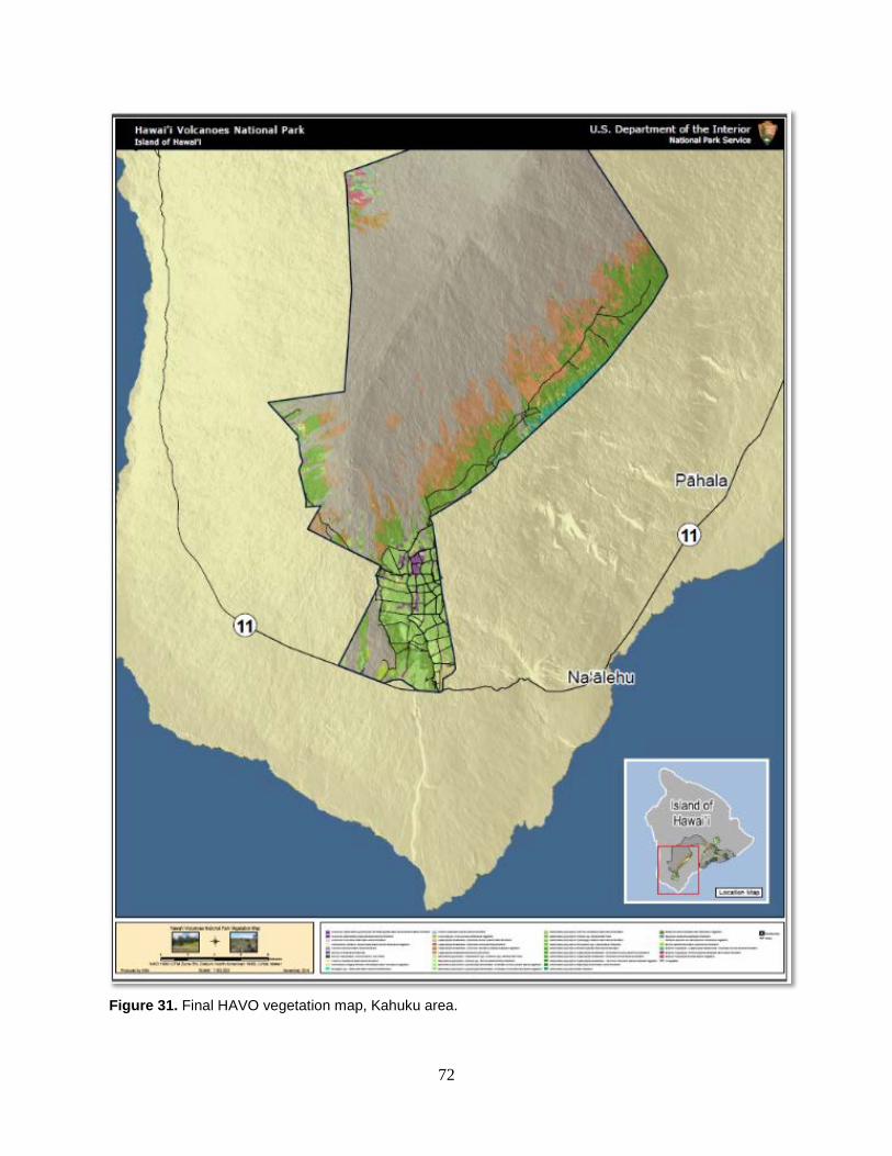
72
Figure 31. Final HAVO vegetation map, Kahuku area.

73
Figure 32. Percentage of HAVO vegetation by life form.
As Figure 33 illustrates, Metrosideros polymorpha dominated or co-dominated map classes comprise the largest portion of HAVO’s forests (78%) with Morella faya and Acacia koa dominated forests at 13% and 6%, respectively. Invasive, non-native species have greatly altered the vegetation at HAVO with 13% of the park’s forest and woodlands dominated by tree species introduced by either Europeans or Americans. Additionally, many of the native dominated forests and woodlands have shrub and/or herbaceous layers dominated by non-native species.
Figure 33. Forest and woodland types at HAVO.
Conversely, HAVO’s shrublands are for the most part dominated or co-dominated by native species, with only 2% dominated by non-natives. Native Leptecophylla tameiameiae and Dodonaea viscosa dominated map classes inhabit the vast majority (97%) of HAVO’s shrublands. Herbaceous lands are perhaps the most impacted by invasive species with 98% of HAVO’s herbaceous lands dominated or co-dominated by non-native species.
25%
9%
8%
58%
0%
Forests and Woodlands Shrubland Herbaceous Unvegetated Built up
78%
6%
13%
3%
Metrosideros polymorpha dominated Acacia koa dominated
Morella faya dominated Other forest types

74
Accuracy Assessment A total of 68 of HAVO’s 80 vegetated map classes were assessed for accuracy. Classes not assessed include:
• Burned (2003) Metrosideros polymorpha / Cibotium spp. Montane Wet Forest and Burned (2003) Morella faya – (Metrosideros polymorpha) Semi-natural Forest which were not map classes at the time of the draft map.
• Carex alligata Herbaceous Vegetation which occurs only in the ʻŌla‘a Trench was mapped from earlier sources (Waite and Pratt 2007).
• Cocos nucifera Strand Woodland which only occurs in two small polygons, both of which were field verified during the calibration trip.
• Dicranopteris linearis Wet Herbaceous Mat which occurs only in small inaccessible polygons on the map.
• Metrosideros polymorpha – (Diospyros sandwicensis) / (Dodonaea viscosa) Lowland Dry Forest, and Mixed Non-native Disturbed Herbaceous Vegetation, which did not exist on the draft map and were added to the final map in response to the AA results.
• Fraxinus uhdei Semi-natural Lowland Woodland which is an isolated occurrence of a persistent silvicultural plantation predating the NPS acquisition of Kahuku.
• Grevillea robusta Lowland Mesic Semi-natural Forest which did not exist on the draft map and was added to the final map after its location was revealed by HAVO staff.
• Juncus effusus - Holcus lanatus Herbaceous Vegetation which is an isolated single field verified polygon in Kahuku.
• Pteridium aquilinum ssp. decompositum Herbaceous Vegetation which is only represented on the map by nine small polygons.
• Mixed Coastal Shrubland
• The non-vegetated classes of Water, Built-up Transportation, Communications, and Utilities, and Built-up Commercial and Services. Unvegetated was assessed.
AA analysis requires examination of each AA sample’s map label and field reference label, and identifying which differences are actually map error and which are caused by some other phenomena such as reference label errors or change in the landscape (e.g wildfires) (Congalton and Green, 2009). Of the total 964 AA samples, 28 were ommitted from the analysis because the sample data were problematic. By far the most significant issue was that 12 of the AA sample locations burned in 2011, before the AA sampling, but after the date of the imagery used to make the map. The fires resulted in significant alteration of the sample’s vegetation and, therefore, the samples could not be used to assess the map. Other reasons for omitting reference samples were that the sample spanned two or more map polygons, or that the sample was assessed from afar, bringing its reference label into question. An additional 11 sites were not used in the analysis because their map classes were created as a result of the AA and therefore are not independent of the analysis [Mixed Non-native Disturbed Herbaceous Vegetation and Metrosideros polymorpha – (Diospyros sandwicensis) /

75
(Dodonaea viscosa) Lowland Dry Forest]. However, the data from these samples were very useful in preparing descriptions of the final map.
Because the HAVO map is very detailed, and because the coastal grass map classes were modeled based on HAVO staff knowledge, AA for HAVO was split into two analyses – one for the coastal grasslands and one for the rest of the park. AA samples were divided into these subclasses based on their reference label.
HAVO Vegetated Areas (excluding coastal grasslands) 81% of the vegetated land base of the park is not considered coastal grassland. Of the total 964 samples at HAVO, 778 were collected outside of the coastal grasslands. Overall draft map accuracy for these areas is 69% using the primary reference label, and 73% when the secondary label is accepted. These are high accuracies for a map of HAVO’s complexity, detail, and size. This is a conservative number, considering the challenges of estimating canopy cover in very dense and very sparse vegetation. For example, 13 of the 14 Cibotium glaucum Montane Forest reference samples were mislabeled due to the difficulty in assessing the cover of scattered emergent trees through a dense canopy of Cibotium glaucum.
Table 9 presents the error matrix for the HAVO draft map. The yellow highlighted cells, also marked with an asterisk, on the diagonal represent samples where the reference and the map labels match. The matrix includes some samples with coastal grassland map labels in places where the map committed an area to a coastal grassland type in error. For example, two AA samples had map labels of Andropogon virginicus - Melinis spp. Mixed Grassland with reference labels of Dodonaea viscosa Lowland Dry Shrubland or Lantana camara Semi-natural Shrubland. While the Andropogon virginicus - Melinis spp. Mixed Grassland accuracy is assessed in the coastal grassland section of this report, these two sites appear in Table 9, as do other coastal grassland map classes which reflect errors of commission.

76
Table 9. Error matrix for the HAVO draft map. The yellow highlighted cells, also marked with an asterisk, on the diagonal represent samples where the reference and the map labels match.
MAP CODE F_MEPSCHCI_M W_ACSAMI W_ACMEEH_M W_ACCI W_ACIPPI W_ACLEDO W_ACME_L W_ACME
F_MEPSCHCI_M 13*
W_ACSAMI 2* 1 1 1
W_ACMEEH_M 18* 3
W_ACCI 20*
W_ACIPPI 1*
W_ACLEDO 15* 1
W_ACME_L 2*
W_ACME 16*
W_ACKONN 1 5 1
F_ALMO_D
H_ANME_G
H_ANOD
W_ARCO
W_MEDI_LB
W_MENE_B
H_CECL
F_CIGL
H_DENU 1
F_DISA
S_DOVI_M
S_DOPL
S_DOVI_L
SP_DUSC_M
F_EUMS
H_HECO_R
H_HCAVMR
H_HYME
S_LACA
SP_LEVA
S_LEDO_L
SP_LEDO_M
S_LEDO_M
S_LETA
S_LELE
H_MEAV
H_MESCCO
W_MEPSSC
F_MECHSPCI
SP_MELEDO_L
SP_MELEDO_M
W_MPCC_W
F_MECI
W_MECY
W_MEDI_M
W_MEDI_L
W_MEEH 4
W_MELEDO_L
W_MELEDO_MW
SP_MELEVA
W_MEMEAN
F_MEMI
W_MENE
W_MPAG
W_MEPO
F_MOME
W_MYSA
H_NEBR
F_SACO 1
S_SCTA
W_SCTE_S
W_SOLEDO_L
W_SOLEDO_M 1
W_SOMELEDO
W_SOCH
SP_SOCH
W_THPR
Unvegetated
Total 13 3 25 20 2 25 2 18
Producer's Accuracy 100% 67% 72% 100% 50% 60% 100% 89%
* Represent samples where the reference and the map labels match.

77
Table 9 (continued). Error matrix for the HAVO draft map. The yellow highlighted cells, also marked with an asterisk, on the diagonal represent samples where the reference and the map labels match.
MAP CODE W_ACKONN F_ALMO_D H_ANME_G H_ANOD W_ARCO W_MEDI_LB W_MENE_B H_CECL
F_MEPSCHCI_M
W_ACSAMI
W_ACMEEH_M
W_ACCI
W_ACIPPI
W_ACLEDO 1
W_ACME_L
W_ACME 1
W_ACKONN 38*
F_ALMO_D 2*
H_ANME_G 0*
H_ANOD 2*
W_ARCO 1*
W_MEDI_LB 7* 10
W_MENE_B 4 17*
H_CECL 15*
F_CIGL
H_DENU
F_DISA
S_DOVI_M
S_DOPL
S_DOVI_L 1
SP_DUSC_M
F_EUMS
H_HECO_R
H_HCAVMR
H_HYME
S_LACA
SP_LEVA
S_LEDO_L
SP_LEDO_M
S_LEDO_M
S_LETA
S_LELE
H_MEAV
H_MESCCO 2
W_MEPSSC
F_MECHSPCI
SP_MELEDO_L
SP_MELEDO_M
W_MPCC_W
F_MECI
W_MECY
W_MEDI_M
W_MEDI_L
W_MEEH
W_MELEDO_L
W_MELEDO_MW
SP_MELEVA
W_MEMEAN
F_MEMI
W_MENE
W_MPAG
W_MEPO
F_MOME
W_MYSA
H_NEBR
F_SACO 3
S_SCTA
W_SCTE_S
W_SOLEDO_L
W_SOLEDO_M
W_SOMELEDO
W_SOCH 1
SP_SOCH
W_THPR
Unvegetated
Total 43 2 0 2 1 11 28 18
Producer's Accuracy 88% 100% 0% 100% 100% 64% 61% 83%
* Represent samples where the reference and the map labels match.

78
Table 9 (continued). Error matrix for the HAVO draft map. The yellow highlighted cells, also marked with an asterisk, on the diagonal represent samples where the reference and the map labels match.
MAP CODE F_CIGL H_DENU F_DISA S_DOVI_M S_DOPL S_DOVI_L SP_DUSC_M F_EUMS
F_MEPSCHCI_M 1
W_ACSAMI
W_ACMEEH_M
W_ACCI
W_ACIPPI
W_ACLEDO
W_ACME_L
W_ACME
W_ACKONN
F_ALMO_D
H_ANME_G 1
H_ANOD
W_ARCO
W_MEDI_LB
W_MENE_B
H_CECL
F_CIGL 0*
H_DENU 2*
F_DISA 5*
S_DOVI_M 1*
S_DOPL 14*
S_DOVI_L 7*
SP_DUSC_M 2*
F_EUMS 3*
H_HECO_R
H_HCAVMR
H_HYME
S_LACA
SP_LEVA
S_LEDO_L
SP_LEDO_M
S_LEDO_M
S_LETA
S_LELE
H_MEAV
H_MESCCO 1
W_MEPSSC
F_MECHSPCI 14
SP_MELEDO_L
SP_MELEDO_M
W_MPCC_W
F_MECI
W_MECY
W_MEDI_M
W_MEDI_L
W_MEEH
W_MELEDO_L
W_MELEDO_MW
SP_MELEVA
W_MEMEAN
F_MEMI
W_MENE
W_MPAG
W_MEPO
F_MOME
W_MYSA
H_NEBR 3
F_SACO
S_SCTA
W_SCTE_S
W_SOLEDO_L
W_SOLEDO_M
W_SOMELEDO
W_SOCH
SP_SOCH
W_THPR
Unvegetated
Total 15 2 5 1 14 12 2 3
Producer's Accuracy 0% 100% 100% 100% 100% 58% 100% 100%
* Represent samples where the reference and the map labels match.

79
Table 9 (continued). Error matrix for the HAVO draft map. The yellow highlighted cells, also marked with an asterisk, on the diagonal represent samples where the reference and the map labels match.
MAP CODE H_HECO_R H_HCAVMR H_HYME S_LACA SP_LEVA S_LEDO_L SP_LEDO_M S_LEDO_M
F_MEPSCHCI_M
W_ACSAMI
W_ACMEEH_M
W_ACCI
W_ACIPPI
W_ACLEDO
W_ACME_L
W_ACME
W_ACKONN
F_ALMO_D
H_ANME_G 1
H_ANOD
W_ARCO
W_MEDI_LB
W_MENE_B
H_CECL
F_CIGL
H_DENU 2
F_DISA 2
S_DOVI_M 1 15
S_DOPL
S_DOVI_L 2
SP_DUSC_M
F_EUMS
H_HECO_R 1*
H_HCAVMR 0*
H_HYME 0*
S_LACA 12*
SP_LEVA 12* 1
S_LEDO_L 11*
SP_LEDO_M 0*
S_LEDO_M 1 8*
S_LETA
S_LELE
H_MEAV
H_MESCCO
W_MEPSSC
F_MECHSPCI
SP_MELEDO_L 1
SP_MELEDO_M 2 5
W_MPCC_W
F_MECI
W_MECY
W_MEDI_M
W_MEDI_L
W_MEEH
W_MELEDO_L 1
W_MELEDO_MW
SP_MELEVA 2 1
W_MEMEAN 1
F_MEMI
W_MENE
W_MPAG
W_MEPO
F_MOME
W_MYSA
H_NEBR
F_SACO
S_SCTA
W_SCTE_S
W_SOLEDO_L
W_SOLEDO_M
W_SOMELEDO 1
W_SOCH
SP_SOCH
W_THPR
Unvegetated
Total 1 0 0 17 14 16 4 31
Producer's Accuracy 100% 0% 0% 71% 86% 69% 0% 26%
* Represent samples where the reference and the map labels match.

80
Table 9 (continued). Error matrix for the HAVO draft map. The yellow highlighted cells, also marked with an asterisk, on the diagonal represent samples where the reference and the map labels match.
MAP CODE S_LETA S_LELE H_MEAV H_MESCCO W_MEPSSC F_MECHSPCI SP_MELEDO_L SP_MELEDO_M
F_MEPSCHCI_M
W_ACSAMI
W_ACMEEH_M
W_ACCI
W_ACIPPI
W_ACLEDO
W_ACME_L
W_ACME
W_ACKONN
F_ALMO_D
H_ANME_G
H_ANOD 1
W_ARCO
W_MEDI_LB
W_MENE_B
H_CECL
F_CIGL
H_DENU
F_DISA
S_DOVI_M
S_DOPL
S_DOVI_L
SP_DUSC_M
F_EUMS
H_HECO_R
H_HCAVMR
H_HYME
S_LACA
SP_LEVA 2
S_LEDO_L
SP_LEDO_M
S_LEDO_M 3
S_LETA 16*
S_LELE 17*
H_MEAV 0* 1
H_MESCCO 0*
W_MEPSSC 3*
F_MECHSPCI 3*
SP_MELEDO_L 8*
SP_MELEDO_M 13*
W_MPCC_W 1
F_MECI 3
W_MECY
W_MEDI_M
W_MEDI_L
W_MEEH
W_MELEDO_L
W_MELEDO_MW
SP_MELEVA 2
W_MEMEAN 1
F_MEMI
W_MENE
W_MPAG
W_MEPO
F_MOME
W_MYSA
H_NEBR
F_SACO
S_SCTA
W_SCTE_S
W_SOLEDO_L
W_SOLEDO_M 1
W_SOMELEDO
W_SOCH
SP_SOCH
W_THPR
Unvegetated
Total 24 17 0 0 3 7 11 13
Producer's Accuracy 67% 100% 0% 0% 100% 43% 73% 100%
* Represent samples where the reference and the map labels match.
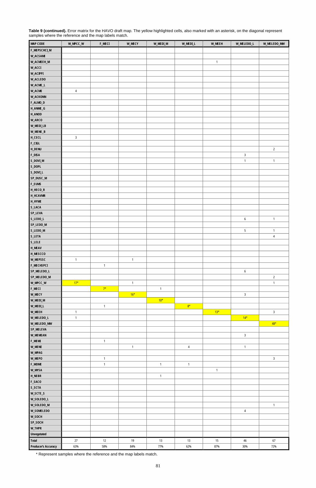
81
Table 9 (continued). Error matrix for the HAVO draft map. The yellow highlighted cells, also marked with an asterisk, on the diagonal represent samples where the reference and the map labels match.
MAP CODE W_MPCC_W F_MECI W_MECY W_MEDI_M W_MEDI_L W_MEEH W_MELEDO_L W_MELEDO_MW
F_MEPSCHCI_M
W_ACSAMI
W_ACMEEH_M 1
W_ACCI
W_ACIPPI
W_ACLEDO
W_ACME_L
W_ACME 4
W_ACKONN
F_ALMO_D
H_ANME_G
H_ANOD
W_ARCO
W_MEDI_LB
W_MENE_B
H_CECL 3
F_CIGL
H_DENU 2
F_DISA 3
S_DOVI_M 1 1
S_DOPL
S_DOVI_L
SP_DUSC_M
F_EUMS
H_HECO_R
H_HCAVMR
H_HYME
S_LACA
SP_LEVA
S_LEDO_L 6 1
SP_LEDO_M
S_LEDO_M 5 1
S_LETA 4
S_LELE
H_MEAV
H_MESCCO
W_MEPSSC 1 1
F_MECHSPCI 1
SP_MELEDO_L 6
SP_MELEDO_M 2
W_MPCC_W 17* 1 1
F_MECI 7* 1
W_MECY 16* 3
W_MEDI_M 10*
W_MEDI_L 1 8*
W_MEEH 1 13* 3
W_MELEDO_L 1 14*
W_MELEDO_MW 48*
SP_MELEVA
W_MEMEAN 3
F_MEMI 1
W_MENE 1 4 1
W_MPAG
W_MEPO 1 3
F_MOME 1 1 1
W_MYSA 1
H_NEBR 1
F_SACO
S_SCTA
W_SCTE_S
W_SOLEDO_L
W_SOLEDO_M 1
W_SOMELEDO 4
W_SOCH
SP_SOCH
W_THPR
Unvegetated
Total 27 12 19 13 13 15 46 67
Producer's Accuracy 63% 58% 84% 77% 62% 87% 30% 72%
* Represent samples where the reference and the map labels match.

82
Table 9 (continued). Error matrix for the HAVO draft map. The yellow highlighted cells, also marked with an asterisk, on the diagonal represent samples where the reference and the map labels match.
MAP CODE SP_MELEVA W_MEMEAN F_MEMI W_MENE W_MPAG W_MEPO F_MOME W_MYSA
F_MEPSCHCI_M
W_ACSAMI
W_ACMEEH_M
W_ACCI
W_ACIPPI
W_ACLEDO
W_ACME_L
W_ACME 1
W_ACKONN
F_ALMO_D
H_ANME_G
H_ANOD 1
W_ARCO
W_MEDI_LB
W_MENE_B
H_CECL
F_CIGL
H_DENU
F_DISA
S_DOVI_M
S_DOPL
S_DOVI_L
SP_DUSC_M
F_EUMS
H_HECO_R
H_HCAVMR
H_HYME
S_LACA
SP_LEVA
S_LEDO_L 1
SP_LEDO_M
S_LEDO_M 1
S_LETA
S_LELE
H_MEAV
H_MESCCO
W_MEPSSC
F_MECHSPCI
SP_MELEDO_L
SP_MELEDO_M 3
W_MPCC_W
F_MECI
W_MECY
W_MEDI_M 1 2
W_MEDI_L
W_MEEH
W_MELEDO_L 4 1
W_MELEDO_MW 1
SP_MELEVA 4*
W_MEMEAN 10*
F_MEMI 0*
W_MENE 2*
W_MPAG 1* 1
W_MEPO 1 14*
F_MOME 19*
W_MYSA 1*
H_NEBR
F_SACO
S_SCTA
W_SCTE_S
W_SOLEDO_L
W_SOLEDO_M
W_SOMELEDO 1
W_SOCH 1
SP_SOCH
W_THPR
Unvegetated
Total 4 14 0 3 3 14 30 3
Producer's Accuracy 100% 71% 0% 67% 33% 100% 63% 33%
* Represent samples where the reference and the map labels match.

83
Table 9 (continued). Error matrix for the HAVO draft map. The yellow highlighted cells, also marked with an asterisk, on the diagonal represent samples where the reference and the map labels match.
MAP CODE H_NEBR F_SACO S_SCTA W_SCTE_S W_SOLEDO_L W_SOLEDO_M W_SOMELEDO W_SOCH
F_MEPSCHCI_M
W_ACSAMI
W_ACMEEH_M
W_ACCI
W_ACIPPI
W_ACLEDO 1
W_ACME_L
W_ACME
W_ACKONN
F_ALMO_D
H_ANME_G
H_ANOD
W_ARCO
W_MEDI_LB
W_MENE_B
H_CECL
F_CIGL
H_DENU
F_DISA
S_DOVI_M
S_DOPL
S_DOVI_L
SP_DUSC_M
F_EUMS
H_HECO_R
H_HCAVMR
H_HYME
S_LACA
SP_LEVA
S_LEDO_L
SP_LEDO_M
S_LEDO_M
S_LETA
S_LELE
H_MEAV
H_MESCCO
W_MEPSSC
F_MECHSPCI
SP_MELEDO_L
SP_MELEDO_M
W_MPCC_W
F_MECI
W_MECY
W_MEDI_M
W_MEDI_L
W_MEEH
W_MELEDO_L
W_MELEDO_MW 1
SP_MELEVA
W_MEMEAN
F_MEMI
W_MENE
W_MPAG
W_MEPO
F_MOME
W_MYSA 2
H_NEBR 0*
F_SACO 2*
S_SCTA 5*
W_SCTE_S 16*
W_SOLEDO_L 3* 2
W_SOLEDO_M 5* 2
W_SOMELEDO 0*
W_SOCH 15*
SP_SOCH
W_THPR
Unvegetated
Total 0 2 5 16 3 6 3 19
Producer's Accuracy 0% 100% 100% 100% 100% 83% 0% 79%
* Represent samples where the reference and the map labels match.

84
Table 9 (continued). Error matrix for the HAVO draft map. The yellow highlighted cells, also marked with an asterisk, on the diagonal represent samples where the reference and the map labels match.
MAP CODE SP_SOCH W_THPR Unvegetated Grand Total User's Accuracy
F_MEPSCHCI_M 14 93%
W_ACSAMI 5 40%
W_ACMEEH_M 22 82%
W_ACCI 20 100%
W_ACIPPI 1 100%
W_ACLEDO 18 83%
W_ACME_L 2 100%
W_ACME 22 73%
W_ACKONN 45 84%
F_ALMO_D 2 100%
H_ANME_G 2 0%
H_ANOD 4 50%
W_ARCO 1 100%
W_MEDI_LB 17 41%
W_MENE_B 21 81%
H_CECL 18 83%
F_CIGL 0 0%
H_DENU 7 29%
F_DISA 10 50%
S_DOVI_M 19 5%
S_DOPL 14 100%
S_DOVI_L 10 70%
SP_DUSC_M 2 100%
F_EUMS 3 100%
H_HECO_R 1 100%
H_HCAVMR 1 1 0%
H_HYME 1 1 0%
S_LACA 12 100%
SP_LEVA 2 17 71%
S_LEDO_L 19 58%
SP_LEDO_M 0 0%
S_LEDO_M 19 42%
S_LETA 20 80%
S_LELE 17 100%
H_MEAV 3 4 0%
H_MESCCO 3 0%
W_MEPSSC 5 60%
F_MECHSPCI 18 17%
SP_MELEDO_L 15 53%
SP_MELEDO_M 1 26 50%
W_MPCC_W 20 85%
F_MECI 11 64%
W_MECY 19 84%
W_MEDI_M 13 77%
W_MEDI_L 9 89%
W_MEEH 21 62%
W_MELEDO_L 21 67%
W_MELEDO_MW 50 96%
SP_MELEVA 1 10 40%
W_MEMEAN 15 67%
F_MEMI 1 0%
W_MENE 8 25%
W_MPAG 2 50%
W_MEPO 19 74%
F_MOME 22 86%
W_MYSA 4 25%
H_NEBR 4 0%
F_SACO 6 33%
S_SCTA 5 100%
W_SCTE_S 16 100%
W_SOLEDO_L 5 60%
W_SOLEDO_M 5 15 33%
W_SOMELEDO 6 0%
W_SOCH 1 18 83%
SP_SOCH 0* 0 0%
W_THPR 1* 1 100%
Unvegetated 0* 0 0%
Total 6 1 9 778
Producer's Accuracy 0% 100% 0% 69%
* Represent samples where the reference and the map labels match.

85
Much of the confusion between the draft map and reference labels occurs between map classes that are very similar and differ only by small percentages of species composition. For example: sites with sparse vegetation were sometimes erroneously lumped into map classes with higher cover value based on AA crew over-estimations of cover in the field. This pattern is found in several places on the matrix and was not fully identified until KGA personnel went into the field with PACN staff during their second validation trip. For example:
• Five samples are confused between Metrosideros polymorpha / Leptecophylla tameiameiae - (Dodonaea viscosa) Lowland Dry Woodland as the reference label and Metrosideros polymorpha / (Leptecophylla tameiameiae - Dodonaea viscosa) Lowland Sparse Vegetation as the draft map label. The vegetative cover of the samples is low, and four of the five samples also received a secondary label of Metrosideros polymorpha / (Leptecophylla tameiameiae - Dodonaea viscosa) Lowland Sparse Vegetation.
• Similarly, five additional samples received reference labels of Leptecophylla tameiameiae - Dodonaea viscosa Montane Shrubland and map labels of Metrosideros polymorpha / (Leptecophylla tameiameiae - Dodonaea viscosa) Montane Sparse Vegetation. The estimates of shrub cover are higher in the reference data than in the draft map, and four of the five samples contained Metrosideros polymorpha, but not at high enough levels for AA crews to give the site a Metrosideros polymorpha label.
Detail about how draft map classes were confused with one another and the edits made for the final map can be found by map class in the map class descriptions in Appendix H. The following summarizes the major sources of confusion:
• The largest source of confusion is between Leptecophylla tameiameiae - Dodonaea viscosa Montane Shrubland and Dodonaea viscosa Mesic Montane Shrubland (15 samples). All of the confused samples are spatially autocorrelated (Congalton and Green, 2009) and are within one map polygon (Northeast portion of OBJECTID 3265 in the final map). The polygon was visited during the second validation trip and edited to Leptecophylla tameiameiae - Dodonaea viscosa Montane Shrubland in the final map.
• Metrosideros polymorpha / Nephrolepis brownii Semi-natural Woodland and Metrosideros polymorpha / Dicranopteris linearis Montane Wet Woodland are consistantly confused both inside and outside of the 2002-2003 fire perimeters because Dicranopteris linearis and Nephrolepis brownii are often comixed and cannot be discerned from one another using remotely sensed imagery or GIS modeling. Combining these two associations into one map class was discussed, but HAVO personnel requested that they be kept separate. Map users should be aware that the two classes can be confused, but only with one another. The final map reflects edits to these two classes to match the pattern of the AA sample labels.
• The sparse classes are confused with one another which is not surprising considering that small percentage differences in vegetation estimates can result in several different classes.
• The Sophora chrysophylla map classes are often confused with one another, but rarely confused with other types.

86
• The AA revealed errors of omission of Morella faya - (Metrosideros polymorpha) Semi-natural Forest, primarily in the sparse forests east of the Ka‘ū Desert. These errors were corrected in the final map.
• The assessment and NPS review also uncovered errors of commission to Sapindus saponaria - Coprosma rhynchocarpa Montane Mesic Forest which were corrected in the final map.
• AA samples were not assigned to the unvegetated class. Yet, nine samples labeled on the draft map as vegetated had reference labels of unvegetated. Four of these were confused with sparse classes, with two of the four having a secondary label which matched the map label. The others were confused with coastal grass map labels. The location of the remaining seven samples and their surrounding areas were edited to unvegetated in the final map.
Table 10 shows the user and producers accuracies for map classes outside the coastal grasslands. For each AA plot, the map label is the map class according to the draft vegetation map whereas the reference or plot label is the map class that the field crew labeled the plot based on the key and descriptions. Ideally, the field reference label matches the map label (yellow highlighted cell). User’s accuracy for each map class is calculated from Table 9 by dividing the yellow highlighted cell (field AA reference or plot label matches map class) by the total number of samples in each row (all field AA plots visited that should have been labeled this map class). Producer’s accuracies for each map class are calculated by dividing the yellow highlighted cell (field AA reference or plot label matches map class) by the total number of samples in each column (all field AA plots assigned this map class regardless of what they are labeled on the map).

87
Table 10. Draft map class user’s and producer’s accuracies excluding the coastal grasslands. AA Map Samples are the number of AA plots in each map class based on the map. AA Reference Samples are the number of AA plots that the field crew assigned to each map class.
Map Class User's Accuracy
Producer's Accuracy
AA Map Samples
AA Ref. Samples
Forest Acacia koa / Cibotium spp. Montane Woodland 100% 100% 20 20 Acacia koa / Melinis minutiflora Semi-natural Lowland Woodland 100% 100% 2 2 Aleurites moluccana Dry Forest 100% 100% 2 2 Araucaria columnaris Semi-natural Woodland 100% 100% 1 1 Eucalyptus spp. - Mixed Alien Semi-natural Forest/Plantation 100% 100% 3 3 Schinus terebinthifolius Semi-natural Scrub Woodland 100% 100% 16 16 Thespesia populnea - (Prosopis pallida) Woodland 100% 100% 1 1 (Metrosideros polymorpha) - Psidium cattleianum - (Cheirodendron spp.) - Cibotium spp. Montane Wet Forest 93% 100% 14 13 Metrosideros polymorpha Native Woodland 74% 100% 19 14 Acacia koa / Non-native Grass Semi-natural Woodland 84% 88% 45 43 Metrosideros polymorpha / Cymbopogon refractus Semi-natural Woodland 84% 84% 19 19 Metrosideros polymorpha / Leptecophylla tameiameiae - Dodonaea viscosa Montane Woodland 96% 72% 50 67 Sophora chrysophylla / Ehrharta stipoides Subalpine Semi-natural Woodland 83% 79% 18 19 Acacia koa / Metrosideros polymorpha Montane Dry Woodland 73% 89% 22 18 Metrosideros polymorpha - (Psidium spp., Schinus terebinthifolius) Woodland 60% 100% 5 3 Sophora chrysophylla - (Leptecophylla tameiameiae - Dodonaea viscosa) Lowland Dry Woodland 60% 100% 5 3 Metrosideros polymorpha / Dicranopteris linearis Montane Wet Woodland 77% 77% 13 13 Acacia koa / (Metrosideros polymorpha) / Ehrharta stipoides Semi-natural Montane Mesic Woodland 82% 72% 22 25 Metrosideros polymorpha / Dicranopteris linearis Lowland Mesic Woodland 89% 62% 9 13 Acacia koa / Ipomoea indica - Pipturus albidus Woodland 100% 50% 1 2

88
Table 10 (continued). Draft map class user’s and producer’s accuracies excluding the coastal grasslands. AA Map Samples are the number of AA plots in each map class based on the map. AA Reference Samples are the number of AA plots that the field crew assigned to each map class.
Map Class User's Accuracy
Producer's Accuracy
AA Map Samples
AA Ref. Samples
Morella faya - (Metrosideros polymorpha) Semi-natural Forest 86% 63% 22 30 Metrosideros polymorpha / Ehrharta stipoides Semi-natural Woodland 62% 87% 21 15 Metrosideros polymorpha / Cenchrus clandestinus Semi-natural Woodland 85% 63% 20 27 Diospyros sandwicensis Lowland Dry Forest 50% 100% 10 5 Acacia koa / Leptecophylla tameiameiae - (Dodonaea viscosa) Montane Woodland 83% 60% 18 25 Burned (2003) Metrosideros polymorpha / Nephrolepis brownii Semi-natural Woodland 81% 61% 21 28 Metrosideros polymorpha / Melinis spp. - Andropogon virginicus Semi-natural Woodland 67% 71% 15 14 Sapindus saponaria - Coprosma rhynchocarpa Montane Mesic Forest 33% 100% 6 2 Metrosideros polymorpha / Cibotium spp. Montane Wet Forest 64% 58% 11 12 Sophora chrysophylla - (Leptecophylla tameiameiae - Dodonaea viscosa) Montane Woodland 33% 83% 15 6 Acacia koa - (Sapindus saponaria) / Microlepia strigosa Montane Woodland 40% 67% 5 3 Metrosideros polymorpha / Leptecophylla tameiameiae - (Dodonaea viscosa) Lowland Dry Woodland 67% 30% 21 46 Metrosideros polymorpha / Nephrolepis brownii Semi-natural Woodland 25% 67% 8 3 Metrosideros polymorpha / Non-native Grass Semi-natural Woodland 50% 33% 2 3 Burned (2003) Metrosideros polymorpha / Dicranopteris linearis Lowland Mesic Woodland 41% 64% 17 11 Metrosideros polymorpha - Cheirodendron spp. / (Cibotium spp.) Montane Wet Forest 17% 43% 18 7 Myoporum sandwicense Subalpine Woodland 25% 33% 4 3 Cibotium glaucum Montane Forest 0% 0% 0 15 Metrosideros polymorpha / Mixed Native Forest 0% 0% 1 0 Sophora chrysophylla - Metrosideros polymorpha / (Leptecophylla tameiameiae - Dodonaea viscosa) Lowland Dry Woodland 0% 0% 6 3
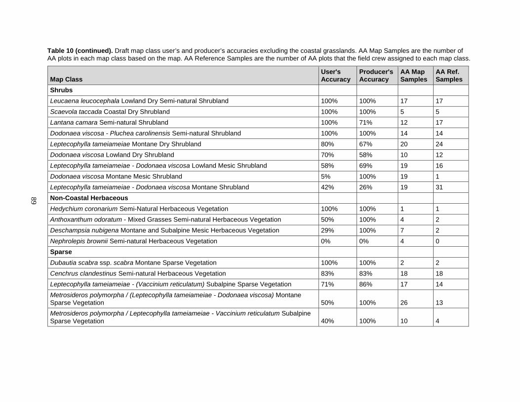
89
Table 10 (continued). Draft map class user’s and producer’s accuracies excluding the coastal grasslands. AA Map Samples are the number of AA plots in each map class based on the map. AA Reference Samples are the number of AA plots that the field crew assigned to each map class.
Map Class User's Accuracy
Producer's Accuracy
AA Map Samples
AA Ref. Samples
Shrubs Leucaena leucocephala Lowland Dry Semi-natural Shrubland 100% 100% 17 17 Scaevola taccada Coastal Dry Shrubland 100% 100% 5 5 Lantana camara Semi-natural Shrubland 100% 71% 12 17 Dodonaea viscosa - Pluchea carolinensis Semi-natural Shrubland 100% 100% 14 14 Leptecophylla tameiameiae Montane Dry Shrubland 80% 67% 20 24 Dodonaea viscosa Lowland Dry Shrubland 70% 58% 10 12 Leptecophylla tameiameiae - Dodonaea viscosa Lowland Mesic Shrubland 58% 69% 19 16 Dodonaea viscosa Montane Mesic Shrubland 5% 100% 19 1 Leptecophylla tameiameiae - Dodonaea viscosa Montane Shrubland 42% 26% 19 31 Non-Coastal Herbaceous Hedychium coronarium Semi-Natural Herbaceous Vegetation 100% 100% 1 1 Anthoxanthum odoratum - Mixed Grasses Semi-natural Herbaceous Vegetation 50% 100% 4 2 Deschampsia nubigena Montane and Subalpine Mesic Herbaceous Vegetation 29% 100% 7 2 Nephrolepis brownii Semi-natural Herbaceous Vegetation 0% 0% 4 0 Sparse Dubautia scabra ssp. scabra Montane Sparse Vegetation 100% 100% 2 2 Cenchrus clandestinus Semi-natural Herbaceous Vegetation 83% 83% 18 18 Leptecophylla tameiameiae - (Vaccinium reticulatum) Subalpine Sparse Vegetation 71% 86% 17 14 Metrosideros polymorpha / (Leptecophylla tameiameiae - Dodonaea viscosa) Montane Sparse Vegetation 50% 100% 26 13 Metrosideros polymorpha / Leptecophylla tameiameiae - Vaccinium reticulatum Subalpine Sparse Vegetation 40% 100% 10 4

90
Table 10 (continued). Draft map class user’s and producer’s accuracies excluding the coastal grasslands. AA Map Samples are the number of AA plots in each map class based on the map. AA Reference Samples are the number of AA plots that the field crew assigned to each map class.
Map Class User's Accuracy
Producer's Accuracy
AA Map Samples
AA Ref. Samples
Metrosideros polymorpha / (Leptecophylla tameiameiae - Dodonaea viscosa) Lowland Sparse Vegetation 53% 73% 15 11 Leptecophylla tameiameiae - Dodonaea viscosa Montane Sparse Vegetation 0% 0% 0 4 Sophora chrysophylla Montane Sparse Vegetation 0% 0% 0 6

91
Coastal Grassland Areas The coastal vegetation was first mapped by life form (grass, shrub, forest and woodland, unvegetated) from the imagery and field reconnaissance. The grasslands were assigned map class labels based on a model jointly developed by HAVO, PACN, and KGA staff (Figure 26). However, AA reference labels of the coastal grasslands are USNVC associations, not modeled map classes. Table 11 is a comparison of the AA reference USNVC association labels with the final modeled coastal grassland map classes. The table includes reference labels of some areas outside of the coastal grasslands to reflect some confusion between coastal and non-coastal map classes. Because a coastal grassland map class can be comprised of more than one association and one association can occur in more than one map class, analysis of the AA for the coastal grasslands is problematic. Samples highlighted in yellow on Table 11 indicate agreement between the map class label and the association assigned by the field crew as the reference label which comprise the map class. User’s accuracies for these composite map classes are calculated by dividing the sum of the yellow highlighted cells by the total number of samples in each row. Producer’s accuracies for the coastal grasslands are not available since the AA reference labels are USNVC associations as opposed to map classes.
As can be expected, user’s accuracies of map classes with multiple associations are high (80-100%) and those for classes comprised of only one association are lower (61-68%). While HAVO’s coastal grasslands exhibit a high amount of species diversity throughout the park, patterns of species dominance do occur and seem to be well correlated with the grasslands model.

92
Table 11. Error matrix and user’s accuracy for the coastal grasslands map classes. Cells highlighted in yellow, and also marked with an asterisk, indicate agreement between the map class label and the USNVC association assigned by the field crew as the reference label which comprise the map class.
Map Label
Andropogon virginicus Semi-natural Lowland Herbaceous Vegetation
Heteropogon contortus Lowland Dry Herbaceous Vegetation
Heteropogon contortus Sparse Vegetation [Park Special]
Hyparrhenia rufa - Melinis spp. Semi-Natural Herbaceous Vegetation
Melinis minutiflora - (Schizachyrium condensatum) Semi-natural Herbaceous Vegetation
Melinis repens Semi-natural Herbaceous Vegetation Total
Users accuracy
Andropogon virginicus - Melinis
spp. Mixed Grassland
11* 4 2 17 65%
Cenchrus clandestinus Semi-natural Herbaceous
Vegetation
1 1
Diospyros sandwicensis
Lowland Dry Forest 1 1
Dodonaea viscosa Lowland Dry Shrubland
1 1 2
Heteropogon contortus -
Andropogon virginicus - (Melinis
repens) Herbaceous Vegetation
4* 1* 5 100%
Heteropogon contortus -
Hyparrhenia rufa - Melinis spp. - (Andropogon
virginicus) Mixed Grassland
5* 1* 2* 2 10 80%
*Indicate agreement between the map class label and the USNVC association assigned by the field crew as the reference label which comprise the map class.

93
Table 11 (continued). Error matrix and user’s accuracy for the coastal grasslands map classes. Cells highlighted in yellow indicate agreement between the map class label and the USNVC association assigned by the field crew as the reference label which comprise the map class.
Map Label
Andropogon virginicus Semi-natural Lowland Herbaceous Vegetation
Heteropogon contortus Lowland Dry Herbaceous Vegetation
Heteropogon contortus Sparse Vegetation
Hyparrhenia rufa - Melinis spp. Semi-Natural Herbaceous Vegetation
Melinis minutiflora- (Schizachyrium condensatum) Semi-natural Herbaceous Vegetation
Melinis repens Semi-natural Herbaceous Vegetation Total
Users accuracy
Heteropogon contortus - Melinis
repens - (Andropogon
virginicus) Herbaceous Vegetation
4* 6* 6* 16 100%
Hyparrhenia rufa - Melinis spp. - (Andropogon
virginicus) Mixed Grassland
5* 2 25* 2 1 35 86%
Lantana camara Semi-natural
Shrubland 1 1 2
Leptecophylla tameiameiae -
Dodonaea viscosa Lowland Mesic
Shrubland
1 1
Leucaena leucocephala
Lowland Dry Semi-natural Shrubland
1 2 3
Melinis spp. - (Andropogon
virginicus) Mixed Grassland
2 2 5 2 17* 29 59%
*Indicate agreement between the map class label and the USNVC association assigned by the field crew as the reference label which comprise the map class.

94
Table 11 (continued). Error matrix and user’s accuracy for the coastal grasslands map classes. Cells highlighted in yellow indicate agreement between the map class label and the USNVC association assigned by the field crew as the reference label which comprise the map class.
Map Label
Andropogon virginicus Semi-natural Lowland Herbaceous Vegetation
Heteropogon contortus Lowland Dry Herbaceous Vegetation
Heteropogon contortus Sparse Vegetation
Hyparrhenia rufa - Melinis spp. Semi-Natural Herbaceous Vegetation
Melinis minutiflora- (Schizachyrium condensatum) Semi-natural Herbaceous Vegetation
Melinis repens Semi-natural Herbaceous Vegetation Total
Users accuracy
Melinis spp. - (Schizachyrium condensatum)
Mixed Grassland
4 13* 2 19 68%
Metrosideros polymorpha /
(Leptecophylla tameiameiae -
Dodonaea viscosa) Lowland Sparse
Vegetation
1 1
Metrosideros polymorpha / Melinis spp. - Andropogon
virginicus Semi-natural Woodland
3 3
Mixed Coastal Shrubland 1 1
Grand Total 28 8 8 37 29 35 145
*Indicate agreement between the map class label and the USNVC association assigned by the field crew as the reference label which comprise the map class.

95
Vegetation Distribution The landscape of HAVO is highly diverse and greatly influenced by terrain, non-native vegetation, lava flows, human activities, and fire. This section of the report summarizes the results of the vegetation mapping by describing the distribution of HAVO’s vegetation.
Once heavily grazed, the lower portions of the Mauna Loa Strip Road are now covered in young Acacia koa trees with native and non-native grasses (Figure 34) and native shrub Leptecophylla tameiameiae and/or Dodonaea viscosa understories. Designated as Special Ecological Areas (SEA’s), Kīpukas Puaulu and Kī, have seen restoration efforts since designation in 1984 and 1991 respectively, and boast unique vegetation to the park (Loh et al. 2014, Tunison and Stone 1992). Today, Kīpuka Puaulu is dominated by large stature Acacia koa, Metrosideros polymorpha, and Sapindus saponaria trees along with a diverse understory mosaicked by Ipomoea indica, Pipturus albidus, Coprosma spp., and numerous non-native species have been controlled and native species have been outplanted. Kīpuka Kī is dominated by the same large stature tree species with an understory of non-native grasses. Higher elevations of the Mauna Loa Strip reveal bare lava fields and Acacia koa forests intermixed with Metrosideros polymorpha and Sophora chrysophylla forests, usually with Leptecophylla tameiameiae and/or Dodonaea viscosa in the understory. Depending on lava age and type, the forests are often striated with lava flows dominated by Leptecophylla tameiameiae and/or Dodonaea viscosa shrublands.
Figure 34. Acacia koa / Ehrharta stipoides Semi-natural Montane Woodland.

96
The subalpine zones of Mauna Loa are quite similar to that of the montane zones in community composition, but with elevation become increasingly sparse and diminutive in stature and with tree species becoming less common to absent (Figure 35). Shrublands of Leptecophylla tameiameiae with Dodonaea viscosa are most common with Vaccinium reticulatum present or codominant with increasing elevation.
West and south of Kīlauea Crater, the Kaʻū desert vegetation consists of unvegetated lava flows and sparse or low vegetative cover areas of Metrosideros polymorpha woodlands and Leptecophylla tameiameiae - Dodonaea viscosa shrublands with a few scattered small kīpukas of Acacia koa.
Figure 35. Metrosideros polymorpha / (Leptecophylla tameiameiae - Dodonaea viscosa) Montane Sparse Vegetation.
Contrastingly, the nearby wet forests of ʻŌla‘a and areas of the park just east of the crater summit are dominated by almost impassible stands of Metrosideros polymorpha, Cheirodendron spp., and Cibotium spp. with understories of Dicranopteris linearis ferns and various herbaceous species. Small forests of Acacia koa / Cibotium spp. Montane Woodland and the invasive tree Psidium cattleianum occupy southern portions of ʻŌla‘a wet forest.
The East Rift zone has been heavily impacted by large fires in 2002, 2003, and 2011. Northern portions of the zone are populated with Metrosideros polymorpha saplings which have sprouted from the base of burned snags (Figure 36). Thickets of invasive Nephrolepis brownii, native Dicranopteris linearis, and/or Cibotium spp. fill in the understory. Southern portions of the zone which have burned

97
numerous times are covered in shrublands of Dodonaea viscosa - Pluchea carolinensis Semi-natural Shrubland or Andropogon virginicus - Melinis spp. Mixed Grassland.
The forests southeast of the crater down to Holei Pali are strongly dominated by invasive Morella faya - (Metrosideros polymorpha) Semi-natural Forest which transition into Metrosideros polymorpha / (Leptecophylla tameiameiae - Dodonaea viscosa) Lowland Sparse Vegetation near the east and southern edges of the Kaʻū Desert. Common grass species in dry and mesic zones are Andropogon virginicus, Schizachyrium condensatum, Melinis repens,and Melinis minutiflora.
Non-lava covered portions of Holei Pali are vegetated with Andropogon virginicus - Melinis spp. Mixed Grassland and Lantana camara Semi-natural Shrubland in the east and composite non-native grasslands in the west, all dotted with isolated patches of Metrosideros polymorpha and less commonly, Diospyros sandwicensis or Aleurites moluccana forests.
Figure 36. Metrosideros polymorpha snag sprouts in East Rift areas that burned in 2002 and 2003.
South of the Holei Pali, the coastal lowlands of HAVO are characterized by grass dominated herbaceous vegetation composed mostly of non-native species (Figure 37). These sites have been burned numerous times for agriculture and in recent times by lava-ignited wildfire control efforts (Loh Personal communication). Typical non-native species include Melinis minutiflora, Melinis repens, Hyparrhenia rufa, Schizachyrium condensatum, and Andropogon virginicus with some communities dominated by the native grass Heteropogon contortus (Figure 38). Shrubs are patchy

98
and common, but are not typically community forming in the coastal area and may include invasive Leucaena leucocephala, and native Dodonaea viscosa and Scaevola taccada.
Figure 37. Hyparrhenia rufa - Melinis spp. Semi-Natural Herbaceous Vegetation.
Figure 38. Heteropogon contortus Sparse Vegetation.
The historically grazed lowland communities of Kahuku are an aggregate of woodlands dominated by Metrosideros polymorpha and/or Acacia koa with understories of non-native Cenchrus clandestinus and Cymbopogon refractus, mixed with pure grasslands of Cenchrus clandestinus. The southern portions of Kahuku also support Metrosideros polymorpha / Leptecophylla tameiameiae - (Dodonaea viscosa) and invasive Schinus terebinthifolius woodlands.

99
Montane communities of Kahuku are quite similar in overall dominant species composition to those of the lowland areas with understory species generally transitioning from abundant non-native understory species at lower elevations to more native species at higher elevations. Tree dominated communities are mostly characterized by forests and woodlands dominated by Acacia koa and/or Metrosideros polymorpha. In dry-mesic zones Leptecophylla tameiameiae and Dodonaea viscosa are the common understory dominants, but not as abundant as in the lower elevations. In the dry mesic communities, native Deschampsia nubigena and Morelotia gahniiformis are the most common understory graminoids. Higher elevation woodlands of Kahuku’s southern portions are dominated by Metrosideros polymorpha forests with Leptecophylla tameiameiae and Dodonaea viscosa, or Ilex anomala, Myrsine lessertiana, and Dryopteris wallichiana in the understory among others. The forests of the northwest corner of Kahuku are dominated by Sophora chrysophylla and Metrosideros polymorpha with small patches of Myoporum sandwicense Subalpine Woodland.
Throughout the park in all elevation and moisture zones there are pāhoehoe and aʻa lava flows which are home to sparsely vegetated communities most commonly dominated by Metrosideros polymorpha, Leptecophylla tameiameiae, Dodonaea viscosa, and Vaccinium reticulatum individually or in combination.


101
Discussion This section of the report discusses the results and lessons learned from this project. It is organized along the significant post planning steps of the 12 Step Mapping Guidance Document (NPS 2013b).
Classification Sampling Design and Data Collection (Step 4) Sample Design The gradsect sampling design resulted in the identification of 72 plant associations at HAVO. Gradsect is a long accepted protocol for vegetation sampling. However, the HAVO design missed several important vegetation types including Aleurites moluccana Dry Forest, (Metrosideros polymorpha) - Psidium cattleianum - (Cheirodendron spp.) - Cibotium spp. Montane Wet Forest, Diospyros sandwicensis Lowland Dry Forest, Schinus terebinthifolius Semi-natural Scrub Woodland, and Scaevola taccada Coastal Dry Shrubland. The gradsect approach should be supplemented by information from legacy vegetation maps, such as the 1992 maps (Loh 2004) [which would have caught the Diospyros sandwicensis Lowland Dry Forest and Scaevola taccada Coastal Dry Shrubland map classes), and a thorough review of the variation apparent in the most current imagery available (which probably would have caught the (Metrosideros polymorpha) - Psidium cattleianum - (Cheirodendron spp.) - Cibotium spp. Montane Wet Forest, Aleurites moluccana Dry Forest, and the Schinus terebinthifolius Semi-natural Scrub Woodland, as well as some of the small, but spectrally unique classes such as the Cocos nucifera Strand Woodland, Fraxinus uhdei Semi-natural Lowland Woodland, and Hedychium coronarium Semi-natural Herbaceous Vegetation].
Data Collection As with other large inventory projects the cost of new field work can be substantial and compiling data collected from previous inventory projects is desirable. Fortunately, at HAVO there was a substantial legacy dataset of plots available for contribution to the classification. Although informative and useful there were two main issues in the classification and analysis using legacy field plots that were not collected solely for the purposes of this project. First, much of the legacy plot data were collected in a transect form where the field teams placed a series of plots at predetermined distances along the slopes of Mauna Loa in the upper Kahuku unit. As with other projects where sample points are predetermined these areas often do not capture vegetation which best represents the surrounding community or the association concept in the USNVC. Predetermined placement of plot samples along transects also often results in sampling floristic and environmental gradation between communities. Second, data collected as a part of past projects included little to no environmental data making correlations of vegetation to environmental gradients difficult. Finally, although the use of legacy data was vital to the classification dataset, it was challenging to use statistically due to various field methodologies and differently designed sampling schemes.
Additionally, during the data collection, numerous PACN staff assisted in the field work, without one specific, repetitive crew collecting data. A rotating field crew is not advised in the future due to the subjective nature of vegetation cover estimation and to reduce the time required in training and calibrating numerous crew members. However, logistical efficiency and botanical expertise was enhanced as HAVO staff were heavily involved in the field data collection.

102
Develop Vegetation Classification, Vegetation Type Descriptions, and Field Key (Step 5) The classification of vegetation of HAVO presented a suite of challenges unique to the study of plant communities of the Hawaiian archipelago and the following is a discussion of those challenges.
Zonal Climatic Factors and Implementation of the National Vegetation Classification Standard The USNVC has long been a work in progress and more recently has undergone a complete revision of the hierarchy. The structure of the USNVC has largely had its origin from vegetation studies conducted in North America which had not been adapted until recently to incorporate the unique composition of plant communities of the Pacific Islands. The structure of classification of vegetation in Hawaii is largely based on a suite of characteristics related to climate and elevation such as lowland, montane, subalpine, dry, mesic, and wet. Although these are major driving factors in species composition on the mainland, the conditions supporting communities there tend to occur on a much larger scale. Conditions on the Hawaiian Islands are far more zonal and smaller in scale as a result of numerous microclimates created by weather and topography. From a classification standpoint this proved to be problematic for several reasons. First, some of the legacy data collected as a part of previous inventory projects often did not include environmental variables such as moisture regime. Furthermore, the landscape of Hawaii is largely dominated by several ubiquitous tree and shrub species occurring across most elevation zones resulting in a dataset where outstanding characteristics are difficult to distinguish. Therefore much of the classification of the sampled vegetation was done based on somewhat artificial elevation breaks and conceptual moisture zones extrapolated from existing map data. The result was the classification of plots often weighted heavily on site characteristics rather than indicator species. For example, the elevation break between lowland and montane is approximately 1000 m in elevation and even though the species composition of a plot might have been more floristically characteristic of the lowland zone, if it exceeded this elevation break it was grouped with a montane association. Therefore, much of the vegetation occupying these transitional zones could not be classified with high confidence. Additionally, many plots did not have location or elevation information and therefore by this classification standard were omitted as unclassifiable. Lastly, conceptually adapting this classification into the USNVC based on zonal characteristics despite tremendous floristic overlap risks proliferation in developing associations without high confidence.
Invasive Species and Disturbance Perhaps the most challenging classification issue for this project was the overwhelming presence and in many cases domination of non-native invasive species which are nearly ubiquitous throughout the park. From the perspective of the classifier this posed several difficulties. First, emphasis was given to native species in defining communities, but this was not always possible during the data analysis phase as the dominance of non-native species meant a reduction in the effect of less abundant native species to inform the analysis. This made it impossible in some cases to distinguish communities that would otherwise be distinguished by dry or mesic native plant indicators. During the indicator species analysis of these communities there were rarely native species with strong indicator values. Also many of the non-native understory species are found in abundance throughout numerous communities. The result during the analysis is that many plot samples that would be conceptually

103
unrelated in a more native state grouped together in clusters and ordinations as a result of the presence of non-native species. It would simplify mapping to omit dominant invaders, but would return a less ecologically relevant product. Lastly, defining physiognomy of some associations was difficult as a result of invasion by non-native species. For example, many shrub communities are heavily invaded by non-native grasses to the degree that they physiognomically could have been treated as either a shrubland or a grassland. In these cases emphasis was given to the native shrub composition to define the community even if shrub cover was low.
Acquire and Prepare Imagery (Step 7) The Digital Globe satellite imagery used in this project was acquired by USDA’s NRCS-National Geospatial Center of Excellence, who worked with Digital Globe to acquire cloud free ortho imagery over the Hawaiian Islands for use by multiple government agencies. The spectral quality and spatial accuracy of the imagery is exceptional. However, its use should be cautioned by the following:
• The imagery products used to make the HAVO vegetation map are mosaics of mostly cloud free imagery captured over multiple dates. While cloud free in most areas of HAVO, mosaic lines and sun angle shifts are apparent within the mosaicked products and, unfortunately, some of the few clouded portions of the imagery are over the East Rift Zone where the vegetation has been highly impacted by wildfires since the older, pre-fire, Quickbird imagery of HAVO was captured.
• While the spatial accuracy of the imagery meets government requirements, the steep terrain of HAVO’s craters results in some registration issues and slight pixel shifts are noticeable between the Quickbird and Worldview2 imagery of HAVO, especially around craters.
Imagery Analysis and Classification (Step 8) Field reconnaissance, image segmentation, CART analysis, and manual image interpretation were used to classify the imagery. This combination of methods was successful, especially for a park the size of HAVO where the economies of scale of automated segmentation and CART modeling can be significant. However, more manual editing was required than anticipated for the following reasons:
• Because HAVO’s landscape is represented by several ubiquitous tree and shrub species occurring across most elevation zones, it is difficult to distinguish between map classes on the ground, much less in remotely sensed imagery, especially in areas of low or sparse vegetation. While elevation rules are helpful for distinguishing many map classes and associations, it is unclear if the rules actually distinguish between different vegetation types.
• The factors which lead to a lack of classification confidence in creation of several of HAVO’s associations also translates to a lack of confidence in mapping those associations. The Ka‘ū Desert and the higher elevations of HAVO consist of low or sparse total vegetation cover where variation in cover estimates can result in multiple map labels. For example, a 5% variation in estimates of montane Metrosideros polymorpha cover in a polygon having between 10-20% total cover could result in six different map labels. Nowhere is this more evident than in portions of the Ka‘ū Desert which were mapped as Leptecophylla tameiameiae - Dodonaea viscosa shrublands in the 1992 map (Loh, 1992) and the draft map, but changed to Metrosideros polymorpha / Leptecophylla tameiameiae - Dodonaea viscosa Montane Woodland in the final map in response to the AA data. Given that even highly trained professionals can vary in their

104
estimates of vegetation cover by 10% (Spurr 1948), the usefulness of creating multiple similar associations which are confidently indistinguishable on the ground is questionable. Future projects should closely evaluate the relevance of the creation of numerous similar associations which may not be mapable or manageable with any confidence, especially where total vegetative cover is low.
• While there are probably too many map classes at HAVO, at least two of the classes (e.g. Metrosideros polymorpha / Leptecophylla tameiameiae - Dodonaea viscosa Montane Woodland and Morella faya - (Metrosideros polymorpha) Semi-natural Forest) had large variation in total percent cover (20-80%) and spectral response which led to confusion in image classification. Future vegetation analysis should consider splitting classes with large total cover variation into separate classes.
Accuracy Assessment (Step 11) AA at HAVO was particularly challenging because of the large number of samples (964) and the number of map classes assessed (84).
Data Collection AA data collection was an immense effort spanning several months and hundreds of personnel hours. The primary challenges involved were that estimates of emergent canopy cover were often hampered by closed canopies of shorter trees. Additionally, accuracy reference estimates of total vegetative cover were consistently higher than that of the draft map. This points to a need for better calibration between mapping and AA personnel and perhaps a higher reliance on the imagery for AA cover estimates. As Spurr (1948) states in his seminal text on photo interpretation, “Because the interpreter, working with aerial photographs can see the entire stand in literally a birds-eye view, he can generally estimate stand density ocularily more accurately than it can be done on the ground.”
Analysis Because of the large number of samples and map classes and the modeling of the coastal grasslands, the AA analysis of HAVO was complex and difficult to execute. The matrix will probably be equally difficult to comprehend. Users need to move beyond the overall and class accuracy percentages and fully understand the error matrix to be aware of which classes are likely to be confused with one another and which are not (e.g., see pages 66-68 for list of most common errors). For example, from the error matrix the user can learn that there is confusion between the Sophora classes, but that the classes are infrequently confused with non-Sophora classes. The error matrix also shows the number of accuracy samples collected per map class. Producer’s and user’s accuracies of classes with low sample sizes have low statistical confidence and those with high sample sizes will have higher statistical confidence.
Some of the most significant changes between the draft and the final map were the result of collapsing some associations into map classes (see below Map Model section), developing a coastal grassland model, and manual editing of the map to incorporate learnings from the AA field work. While this final editing does not affect the accuracy analysis of the draft map, it does improve the

105
map appreciably. The AA samples are an expensive and valuable source of field data which should be incorporated into the final map.
Some areas of HAVO were inaccessible for all vegetation inventory field efforts (i.e. classification plots, calibration, validation and AA samples). The inaccessible areas include the far eastern areas in ʻŌlaʻa, the ʻŌlaʻa trench, Keanakākoʻi and Makaopuhi craters, and Naliʻikakani Point and Kamoaliʻi grasslands. The vegetation of some of these areas (such as ʻŌlaʻa trench) is well documented (Waite and Pratt 2007). Others (such as Keanakākoʻi and Makaopuhi craters) were viewed through binoculars from trails and overlooks during the calibration and validation trip to determine their vegetation associations. Other areas, such as Naliʻikakani Point and Kamoaliʻi grasslands were completely inaccessible due to time constraints and were mapped based solely on image interpretation, and HAVO staff knowledge. If access is gained to these areas for other NPS projects in the future, information should be collected on the distribution of vegetation, and the map should be updated as appropriate.
Map Model (Step 6) The map model (i.e. final map classes) was determined throughout Steps 5-11, rather than prior to image classification which had several advantages:
• Associations were collapsed into map classes only where AA showed the associations to be confused, removing guess work from the map model step.
• Determining the map classes following AA on the association level draft map also allowed for more associations to be retained in the final map.
• The map classes were informed by data collected on AA samples in areas such as the East Riff zone and the northwest portion of Kahuku which were inaccessible to the mapping crews.
As a recommendation, the NPS could consider formally moving the completion of the map model from step 6 to between steps 11 and 12 in the 12 Step Guidance. However, this approach requires that the USNVC associations adequately represent the vegetation present and it also probably requires a more expensive AA sampling effort, because the assessment is performed at the association rather than the map class level.
Research Opportunities Having an accurate and current vegetation classification and map presents many new and exciting research opportunities. The locational information for specific species in the modifiers attribute field can be used to target particular management needs and also can be bolstered to include more species or increase the number of known individuals. Research could include expanding or linking the GIS layer to derive other information including fire models, habitat monitoring locations, guides for rare plant surveys, wildlife habitat structural analyses, and inventorying areas that are likely vectors for invasive species. The map could also be enhanced by overlaying other existing GIS layers including geology, hydrology, elevation, and soils. In this manner complex interactions between these layers could be examined and yield important information about growth rates, regeneration after disturbance, biomass distribution, and stream morphology. Finally, through innovative analyses the vegetation layer could possibly be used as a springboard for other ecological studies including

106
examining how the vegetation interacts with soil chemistry, pollution, paleontological/archeological sites, weather patterns, etc.

107
Literature Cited Austin, M.P. and P.C. Heyligers. 1989. Vegetation survey design for conservation: gradsect sampling
of forests in northeastern New South Wales, Biological Conservation. 50: 13-32.
Breiman, L., J.H. Friedman, R.A. Olsen, and C.J. Stone. 1984. Classification and Regression Trees. Chapman & Hall. International Thomson Publishing. 358pp.
Cogan, D. 2007. Vegetation Classification and Mapping Recommendations. Pacific Island Inventory and Monitoring Network. Pacific Island Inventory and Monitoring Network. Unpublished Report. 76 pp. 172 pp.
Cogan, D., and G. Kudray. 2009. Vegetation Classification and Inventory Work Plan. Pacific Island Inventory and Monitoring Network. Pacific Island Inventory and Monitoring Network Unpublished Report.
Congalton, R., and K. Green. 2009. Assessing the Accuracy of Remotely Sensed Data – Principles and Practices. 2009. CRC Press. Taylor and Francis Group. 183pp.
Dotty, M.S. and D. Mueller-Dobois. 1966 Atlas for Bioecological Studies in Hawaii Volcanoes National Park. Hawaii Botanical Science Paper No. 2. 507pp.
Dufrêne, M. and P. Legendre. 1997. Species assemblages and indicator species: The need for a flexible asymmetrical approach. Ecological Monographs 67: 3: 345-66
ESRI. 2014. About thematic maps. Available at: http://mappingcenter.esri.com/index.cfm?fa=maps.aboutThematic. (Accessed in July 2014).
FGDC. 2008. National Vegetation Classification Standard, Version 2 FGDC-STD-005-2008 (version 2). Vegetation Subcommittee, Federal Geographic Data Committee, FGDC Secretariat, U.S. Geological Survey. Reston, Virginia, USA. 55p (+ Appendices).
Gillison, A.N. and K.R.W. Brewer. 1985. The use of gradient directed transects of gradsects in natural resource survey. Journal of Environmental Management. 20:103-127
Grossman, D.H., D. Faber-Langendoen, A.S. Weakley, M. Anderson, P.S. Bourgeron, R. Crawford, K. Goodin, S. Landaal, K. Metzler, K. Patterson, M. Pyne, M. Reid, and L. Sneddon. 1998. International Classification of Ecological Communities: terrestrial Vegetation of the United States. Volume I. The national vegetation classification system: development, status, and applications. The Nature Conservancy, Arlington, Virginia, USA.
Jacobi, J.D. 1989. Vegetation maps of the upland plant communities on the islands of Hawaiʻi, Maui, Moloka‘i, and Lana‘i. Honolulu, HI: Cooperative National Park Resources Studies United Technical Report 68. University of Hawaii at Manoa, Honolulu, Hawaii.

108
Jennings, M.D., Faber-Langendoen, D., Loucks, O.L., Peet, R.K., Roberts, D. 2009. Standards for associations and alliances of the U.S. National Vegetation Classification. Ecological Monographs, 79(2): 173-199.
Kartesz, J.T. 1999. A synonymized checklist and atlas with biological attributes for the vascular flora of the United States, Canada, and Greenland. First edition. In: Kartesz, JT and CA Meacham. Synthesis of the North American flora [computer program]. Version 1.0. North Carolina Botanical Garden: Chapel Hill, NC.
Kirch, P.V. 1985. Feathered gods and fishhooks. An introduction to Hawaiian archeology and prehistory. University of Hawaii Press. Honolulu. 349pp.
Lamoureux, C.H. 1976. Trailside Plants of Hawaii’s National Parks. Hawaii Natural History Association. Hawaii Valcanoes National Park.
Loh, R.K., T. Tunison, C. Zimmer, R. Mattos and D. Benitez. 2014. A Review of Invasive Plant Management in Special Ecological Areas, Hawaiʻi Volcanoes National Park, 1984-2007. Technical Report No. 187. Pacific Cooperative Studies Unit, University of Hawaii, Honolulu, Hawaii. 35 pp.
Loh, R.K. 2004. Vegetation map of Hawai‘i Volcanoes National Park below 8,000 ft elevation. Unpublished document. National Park Service. Hawai‘i Volcanoes National Park.
McCune, B. and M. J. Mefford. 1999. PC-ORD. Multivariate Analysis of Ecological Data. Version 5.0. MjM Software, Gleneden Beach, Oregon, U.S.A.
Mueller-Dombois, D. and H. Ellenberg. 1974. Aims and methods of vegetation ecology. John Wiley and Sons, New York, New York, USA.
National Park Service. 1980 Hawaii Volcanoes National Park.
National Park Service. 1994. Final Draft Accuracy Assessment Procedures. USGS/NPS Vegetation Mapping Program. esri, Redlands, CA; National Center for Geographic Information and Analysis, Santa Barbara, CA; The Nature Conservancy, Arlington Virginia.
National Park Service. 2011. PLOTS version 3.2 (MS Access 2007 version) User’s Manual. Colorado Natural Heritage Program for National Park Service. 53pp. Available at: http://science.nature.nps.gov/im/inventory/veg/plots.cfm (accessed April 2015).
National Park Service. 2013a. IM Program Brief. Available at: http://science.nature.nps.gov/im/assets/docs/IM_Program_Brief.pdf (accessed July 2013).
National Park Service. 2013b. 12-Step Guidance for NPS Vegetation Inventories. Available at: http://science.nature.nps.gov/im/inventory/veg/docs/Veg_Inv_12step_Guidance_v1.1.pdf (accessed July 2013).

109
National Park Service. 2013c. Inventory Brief: Vegetation Inventory. Available at: http://science.nature.nps.gov/im/inventory/FactSheets/InventoryFactSheets.pdf. (accessed July 2013).
National Park Service. 2013d. Focus on Pacific Island National Parks. Available at: http://science.nature.nps.gov/im/units/pacn/parks/index.cfm#map (accessed July 2013).
National Park Service. 2013e Inventory & Monitoring, Pacific Island Network. Available at: http://science.nature.nps.gov/im/units/pacn/. (accessed July 2013).
National Park Service. 2014 Hawai‘i Volcanoes National Park. Nature and Science. http://www.nps.gov/havo/naturescience/index.htm. (accessed Dec. 2014).
The Nature Conservancy and ESRI. 1994. Field Methods for Vegetation Mapping. USGS/NPS Vegetation Mapping Program. United States Department of the Interior: United States Geologic Survey and National Park Service. Available at: http://www1.usgs.gov/vip/standards/fieldmethodsrpt.pdf
Palmer D. 2003. Hawaii’s ferns and fern allies. University of Hawaii Press, Honolulu, Hawaii.
Ripperton, J.C. and E.Y Hosaka. 1942. Vegetation Zones of Hawai'i. Hawai'i Agricultural Experiment Station, Honolulu, Bulletin 89 See5/C5.0 2.10. Available at: http://www.rulequest.com/see5-info.html. (accessed July 2013).
Spurr, S. 1948. Photogrammetry and Photo-Interpretation. The Ronald Press Company. New York. New York.472pp
Tart, D., C. Williams, J. DiBenedetto, E. Crowe, M. Girard, H. Gordon, K. Sleavin, M. Manning, J.
The Nature Conservancy and ESRI. 1994a. NBS/NPS Vegetation Mapping Program: Standardized National Vegetation Classification System. Arlington, VA.
The Nature Conservancy and ESRI. 1994b. Field Methods for Vegetation Mapping. USGS/NPS Vegetation Mapping Program. United States Department of the Interior: United States Geologic Survey and National Park Service. Available at: http://www1.usgs.gov/vip/standards/fieldmethodsrpt.pdf
Trimble. 2013. eCognition. Available at: http://www.ecognition.com/. (accessed December 2013).
Tuggle, D. H., and M.J. Tomonari-Tuggle. 2008. Archeological Overview and Assessment and Research Design, Hawai‘i Volcanoes National Park. National Park Service. Pacific West Region. Available at http://www.nps.gov/havo/historyculture/upload/HAVO_AOA_part%201.pdf (accessed July, 2014)

110
Tunison, J. T., and C.P. Stone. 1992. Special ecological areas: an approach to alien plant control in Hawaii Volcanoes National Park. Alien plant invasion in native ecosystems in Hawaii: management and research. 781-798.
Wagner, W. L., D. R. Herbst, N. Kahn, and T. Flynn. 2012. Hawaiian vascular plant updates: A supplement to the Manual of the flowering plants of Hawaii and Hawaii’s ferns and fern allies. University of Hawaii Press and Bishop Museum Press, Honolulu.126 pp. Available at: http://botany.si.edu/pacificislandbiodiversity/hawaiianflora (accessed 12 July 2012)
Wagner, W. L., D. R. Herbst, and S. H. Sohmer. 1999. Manual of the flowering plants of Hawai‘i. Revised edition. Volumes 1 and 2. University of Hawaii Press and Bishop Museum Press, Honolulu. 1919 pp.
Waite, M. and L. Pratt. 2007. Plant inventory of the ʻŌla‘a Trench at Hawai‘i Volcanoes National Park. Pacific Cooperative Studies Unit. University of Hawaii at Manoa. Technical Report 139.

APP A.1
Appendix A: Classification Plot Form

APP A.2

APP A.3

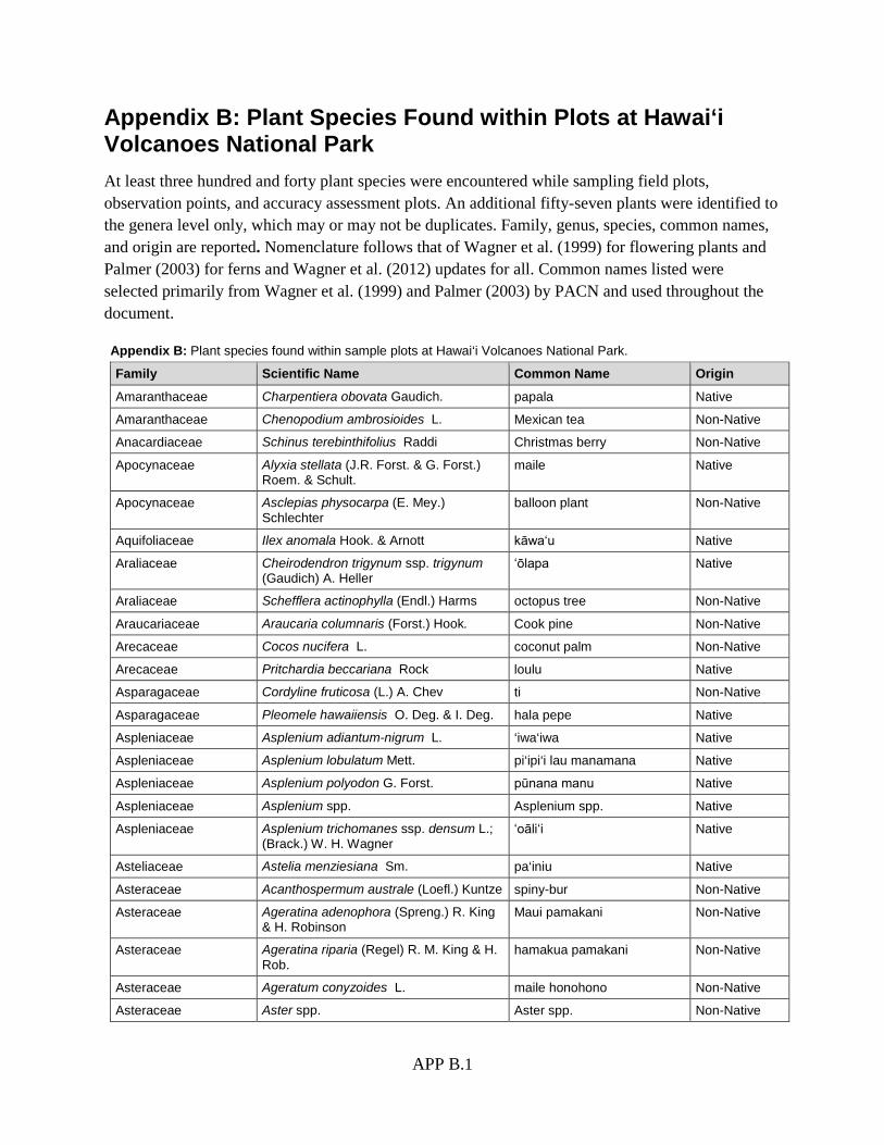
APP B.1
Appendix B: Plant Species Found within Plots at Hawai‘i Volcanoes National Park At least three hundred and forty plant species were encountered while sampling field plots, observation points, and accuracy assessment plots. An additional fifty-seven plants were identified to the genera level only, which may or may not be duplicates. Family, genus, species, common names, and origin are reported. Nomenclature follows that of Wagner et al. (1999) for flowering plants and Palmer (2003) for ferns and Wagner et al. (2012) updates for all. Common names listed were selected primarily from Wagner et al. (1999) and Palmer (2003) by PACN and used throughout the document.
Appendix B: Plant species found within sample plots at Hawai‘i Volcanoes National Park.
Family Scientific Name Common Name Origin
Amaranthaceae Charpentiera obovata Gaudich. papala Native
Amaranthaceae Chenopodium ambrosioides L. Mexican tea Non-Native
Anacardiaceae Schinus terebinthifolius Raddi Christmas berry Non-Native
Apocynaceae Alyxia stellata (J.R. Forst. & G. Forst.) Roem. & Schult.
maile Native
Apocynaceae Asclepias physocarpa (E. Mey.) Schlechter
balloon plant Non-Native
Aquifoliaceae Ilex anomala Hook. & Arnott kāwa‘u Native
Araliaceae Cheirodendron trigynum ssp. trigynum (Gaudich) A. Heller
‘ōlapa Native
Araliaceae Schefflera actinophylla (Endl.) Harms octopus tree Non-Native
Araucariaceae Araucaria columnaris (Forst.) Hook. Cook pine Non-Native
Arecaceae Cocos nucifera L. coconut palm Non-Native
Arecaceae Pritchardia beccariana Rock loulu Native
Asparagaceae Cordyline fruticosa (L.) A. Chev ti Non-Native
Asparagaceae Pleomele hawaiiensis O. Deg. & I. Deg. hala pepe Native
Aspleniaceae Asplenium adiantum-nigrum L. ‘iwa‘iwa Native
Aspleniaceae Asplenium lobulatum Mett. pi‘ipi‘i lau manamana Native
Aspleniaceae Asplenium polyodon G. Forst. pūnana manu Native
Aspleniaceae Asplenium spp. Asplenium spp. Native
Aspleniaceae Asplenium trichomanes ssp. densum L.; (Brack.) W. H. Wagner
‘oāli‘i Native
Asteliaceae Astelia menziesiana Sm. pa‘iniu Native
Asteraceae Acanthospermum australe (Loefl.) Kuntze spiny-bur Non-Native
Asteraceae Ageratina adenophora (Spreng.) R. King & H. Robinson
Maui pamakani Non-Native
Asteraceae Ageratina riparia (Regel) R. M. King & H. Rob.
hamakua pamakani Non-Native
Asteraceae Ageratum conyzoides L. maile honohono Non-Native
Asteraceae Aster spp. Aster spp. Non-Native

APP B.2
Appendix B: Plant species found within sample plots at Hawai‘i Volcanoes National Park.
Family Scientific Name Common Name Origin
Asteraceae Bidens pilosa L. Spanish needle Non-Native
Asteraceae Bidens spp. Non-Native
Asteraceae Cirsium vulgare (Savi) Ten. bull thistle Non-Native
Asteraceae Conyza bonariensis (L.) Cronq. hairy horseweed Non-Native
Asteraceae Conyza canadensis (L.) Cronq. horseweed Non-Native
Asteraceae Crassocephalum crepidioides (Benth.) S. Moore
redflower ragleaf Non-Native
Asteraceae Dubautia ciliolata ssp. ciliolata (DC.) D. D. Keck
na‘ena‘e Native
Asteraceae Dubautia scabra ssp. scabra (DC) D. D. Keck
na‘ena‘e Native
Asteraceae Dubautia spp. Gaudich. Dubautia spp. Native
Asteraceae Elephantopus mollis Kunth elephant`s foot Non-Native
Asteraceae Emilia fosbergii Nicolson Emilia fosbergii Non-Native
Asteraceae Erechtites valerianifolia (Wolf) DC. fireweed Non-Native
Asteraceae Euchiton sphaericus (Willd.) A. Anderb. cudweed Non-Native
Asteraceae Gamochaeta purpurea (L.) Cabrera purple cudweed Non-Native
Asteraceae Helichrysum foetidum (L.) Cass. stinking everlasting Non-Native
Asteraceae Hypochoeris glabra L. smooth cat's ear Non-Native
Asteraceae Hypochoeris radicata L. hairy cat's ear Non-Native
Asteraceae Pluchea carolinensis (Jacq.) G. Don sourbush Non-Native
Asteraceae Pluchea indica (L.) Less. Indian fleabane Non-Native
Asteraceae Pseudognaphalium sandwicensium (Gaudich.) A. Anderb.
‘ena‘ena Native
Asteraceae Senecio madagascariensis Poir. fireweed Non-Native
Asteraceae Senecio spp. grounsel Non-Native
Asteraceae Senecio sylvaticus L. wood groundsel Non-Native
Asteraceae Sonchus oleraceus L. pualele Non-Native
Asteraceae Tetramolopium humile ssp. humile (A. Gray) Hillebr.
Tetramolopium humile ssp. humile
Native
Asteraceae Tetramolopium spp. Tetramolopium spp. Native
Blechnaceae Sadleria cyatheoides Kaulf. ‘ama‘u Native
Blechnaceae Sadleria pallida Hook. & Arn. ‘ama‘u Native
Blechnaceae Sadleria spp. Sadleria spp. Native
Boraginaceae Tournefortia argentea L. f. tree heliotrope Non-Native
Brassicaceae Cardimine spp. bittercress Non-native
Brassicaceae Cardamine flexuosa With. bittercress Non-Native
Campanulaceae Clermontia clermontioides ssp. clermontioides (Gaudich.) A. Heller
‘ōha wai Native
Campanulaceae Clermontia hawaiiensis (Hillebr.) Rock ‘ōhā kēpau Native
Campanulaceae Clermontia parviflora Gaudich. ex A. Gray ‘ōhā wai Native

APP B.3
Appendix B: Plant species found within sample plots at Hawai‘i Volcanoes National Park.
Family Scientific Name Common Name Origin
Campanulaceae Clermontia spp. ‘ōha wai Native
Campanulaceae Cyanea floribunda E. Wimm. Cyanea floribunda Native
Campanulaceae Cyanea spp. Cyanea spp. Native
Campanulaceae Trematolobelia grandifolia (Rock) O. Deg.
Trematolobelia grandifolia Native
Caryophyllaceae Cerastium fontanum ssp. triviale Baumg., (Link) Jalas
common mouse-ear chickweed
Non-Native
Caryophyllaceae Polycarpon tetraphyllum (L.) L. fourleaf manyseed Non-Native
Caryophyllaceae Silene hawaiiensis Sherff Silene hawaiiensis Native
Cibotiaceae Cibotium chamissoi Kaulf. hāpu‘u Native
Cibotiaceae Cibotium glaucum (Sm.) Hook. & Arn. hāpu‘u pulu Native
Cibotiaceae Cibotium menziesii Hook. hāpu‘u i‘i Native
Cibotiaceae Cibotium spp. Cibotium spp. Native
Commelinaceae Commelina diffusa Burm. f. honohono Non-Native
Convolvulaceae Ipomoea indica (Burm.) Merr. koali ‘awa Native
Convolvulaceae Ipomoea pes-caprae ssp. brasiliensis (L.) Ooststr.
pōhuehue Native
Convolvulaceae Ipomoea spp. morning glory Unknown
Cyatheaceae Sphaeropteris cooperi (Hook. ex F. Muell.) R. M. Tryon
Australian tree fern Non-Native
Cyperaceae Bulbostylis capillaris (L.) C. B. Clarke Bulbostylis capillaris Non-Native
Cyperaceae Carex alligata Boott Carex alligata Native
Cyperaceae Carex meyenii Nees Carex meyenii Native
Cyperaceae Carex spp. Carex spp. Unknown
Cyperaceae Carex wahuensis ssp. wahuensis C.A.Mey.
Oahu sedge Native
Cyperaceae Cladium spp. Cladium spp. Native
Cyperaceae Cyperaceae spp. Cyperaceae spp. Unknown
Cyperaceae Cyperus hillebrandii var. hillebrandii Boeck.
Cyperus hillebrandii var. hillebrandii
Native
Cyperaceae Cyperus polystachyos Rottb. Cyperus polystachyos Native
Cyperaceae Cyperus sanguinolentus Vahl Cyperus sanguinolentus Non-Native
Cyperaceae Cyperus spp. L. umbrella sedge Non-native
Cyperaceae Cyperus trinervis R. Br. Australian flatsedge Non-Native
Cyperaceae Fimbristylis dichotoma (L.) Vahl Fimbristylis dichotoma Native
Cyperaceae Fimbristylis hawaiiensis Hillebr. Fimbristylis hawaiiensis Native
Cyperaceae Kyllinga brevifolia Rottb. Kyllinga brevifolia Non-Native
Cyperaceae Machaerina angustifolia (Gaudich) T. Koyama
‘uki Native
Cyperaceae Morelotia gahniiformis Gaudich. Morelotia gahniiformis Native
Cyperaceae Oreobolus furcatus H. Mann Oreobolus furcatus Native

APP B.4
Appendix B: Plant species found within sample plots at Hawai‘i Volcanoes National Park.
Family Scientific Name Common Name Origin
Cyperaceae Rhynchospora rugosa ssp. lavarum (Vahl) Gale; (Gaudich.) T. Koyama
pu‘uko‘a Native
Cyperaceae Rhynchospora spp. beak-rush Non-Native
Cyperaceae Uncinia uncinata (L. f.) Kük. Uncinia uncinata Native
Dennstaedtiaceae Microlepia strigosa (Thunb.) C. Presl palapalai Native
Dennstaedtiaceae Pteridium aquilinum ssp. decompositum (L.) Kuhn; (Gaudich) Lamoureux ex J. A. Thomson
kīlau Native
Dipentodontaceae Perrottetia sandwicensis A. Gray olomea Native
Dryopteridaceae Cyrtomium falcatum (L.f.) C. Presl Holly fern Non-Native
Dryopteridaceae Dryopteris fusco-atra var. fusco-atra (Hillebr.) W. J. Rob.
‘i‘i Native
Dryopteridaceae Dryopteris glabra (Brack.) Kuntze kīlau Native
Dryopteridaceae Dryopteris hawaiiensis (Hillebr.) W. J. Rob.
Dryopteris hawaiiensis Native
Dryopteridaceae Dryopteris rubiginosa (Brack.) Kuntze Dryopteris rubiginosa Native
Dryopteridaceae Dryopteris sandwicensis (Hook. & Arn.) C. Chr.
Dryopteris sandwicensis Native
Dryopteridaceae Dryopteris spp. Dryopteris spp. Native
Dryopteridaceae Dryopteris unidentata (Hook. & Arn.) C. Chr.
‘akole Native
Dryopteridaceae Dryopteris wallichiana (Spreng.) Hyl. ‘i‘o nui Native
Dryopteridaceae Elaphoglossum crassifolium (Gaudich.) W. R. Anderson & Crosby
hoe a Māui Native
Dryopteridaceae Elaphoglossum paleaceum (Hook. & Grev.)
māku‘e Native
Dryopteridaceae Elaphoglossum parvisquameum Skottsb. hoe a Māui Native
Dryopteridaceae Elaphoglossum spp. Māui's paddle Native
Dryopteridaceae Elaphoglossum wawrae (Luerss.) C. Chr. laukahi Native
Dryopteridaceae Polystichum hillebrandii Carruth. ka`upu Native
Dryopteridaceae Polystichum spp. Polystichum spp. Native
Ebenaceae Diospyros sandwicensis (A. DC.) Fosberg lama Native
Elaeagnaceae Elaeagnus spp. oleaster Non-Native
Ericaceae Leptecophylla tameiameiae (Cham. & Schltdl.) C. M. Weiller
pūkiawe Native
Ericaceae Vaccinium calycinum Sm. ‘ōhelo Native
Ericaceae Vaccinium reticulatum x calycinum ‘ōhelo Native
Ericaceae Vaccinium reticulatum Sm. ‘ōhelo Native
Ericaceae Vaccinium spp. ‘ōhelo Native
Euphorbiaceae Aleurites moluccana (L.) Willd. var. katoi O. Deg., I. Deeg. & B. C. Stone
kukui Non-Native
Euphorbiaceae Euphorbia peplus L. petty spurge Non-Native

APP B.5
Appendix B: Plant species found within sample plots at Hawai‘i Volcanoes National Park.
Family Scientific Name Common Name Origin
Fabaceae Acacia koa A. Gray koa Native
Fabaceae Acacia mearnsii De Wild. black wattle Non-Native
Fabaceae
Chamaecrista nictitans ssp. patellaria var. glabrata (L.) Moench; (DC. Ex Collad.) H. S. Irwin & Barneby; (Vogel) H. S. Irwin & Barneby
partridge pea Non-Native
Fabaceae Crotalaria lanceolata E. Mey rattlepod Non-Native
Fabaceae Crotalaria pallida Aiton smooth rattlepod Non-Native
Fabaceae Crotalaria spp. Crotalaria spp. Non-Native
Fabaceae Desmodium incanum DC. Spanish clover Non-Native
Fabaceae Desmodium sandwicense E. Mey. Spanish clover Non-Native
Fabaceae Desmodium spp. Desmodium spp. Non-Native
Fabaceae Desmodium tortuosum (Sw.) DC. Florida beggarweed Non-Native
Fabaceae Desmodium triflorum (L.) DC. Desmodium triflorum Non-Native
Fabaceae Erythrina sandwicensis O. Deg. wiliwili Native
Fabaceae Fabaceae spp. Fabaceae spp. Unknown
Fabaceae Indigofera spp. indigo Non-Native
Fabaceae Indigofera suffruticosa Mill. indigo Non-Native
Fabaceae Leucaena leucocephala (Lam.) de Wit koa haole Non-Native
Fabaceae Lotus spp. Lotus spp. Non-Native
Fabaceae Lotus subbiflorus Lag. hairy bird's-foot trefoil Non-Native
Fabaceae Lotus uliginosus Schkuhr Lotus uliginosus Non-Native
Fabaceae Macroptilium lathyroides (L.) Urb. wild bean Non-Native
Fabaceae Quercus suber L. cork oak Non-Native
Fabaceae Senna occidentalis (L.) Link coffee senna Non-Native
Fabaceae Senna spp. Senna spp. Non-Native
Fabaceae Sophora chrysophylla (Salisb.) Seem. māmane Native
Fabaceae Stylosanthes spp. Stylosanthes spp. Non-Native
Fabaceae Tephrosia purpurea var. purpurea (L.) Pers.
‘auhuhu Non-Native
Fabaceae Trifolium repens var. repens L. white clover Non-Native
Gentianaceae Centaurium erythraea ssp. erythraea Raf. bitter herb Non-Native
Geraniaceae Geranium cuneatum Hook. nohoanu Native
Geraniaceae Geranium homeanum Turcz. Australasian geranium Non-Native
Geraniaceae Geranium spp. L. geranium Non-Native
Gesneriaceae Cyrtandra lysiosepala X platyphylla (A. Gray) C. B. Clarke
Cyrtandra lysiosepala X platyphylla
Native
Gesneriaceae Cyrtandra lysiosepala (A. Gray) C. B. Clarke
Cyrtandra lysiosepala Native
Gesneriaceae Cyrtandra platyphylla A. Gray ‘ilihia Native
Gesneriaceae Cyrtandra spp. ha‘iwale Native

APP B.6
Appendix B: Plant species found within sample plots at Hawai‘i Volcanoes National Park.
Family Scientific Name Common Name Origin
Gleicheniaceae Dicranopteris linearis (Burm. f.) Underw. uluhe Native
Goodeniaceae Scaevola kilaueae O. Deg. naupaka kuahiwi Native
Goodeniaceae Scaevola taccada (Gaertn.) Roxb. naupaka kahakai Native
Hydrangeaceae Broussaisia arguta Gaudich. kanawao Native
Hymenophyllaceae Crepidomanes draytonianum (Brack.) Ebihara & K. Iwats.
limu kau la‘au Native
Hymenophyllaceae Hymenophyllum lanceolatum Hook. & Arn.
palai hinahina Native
Hymenophyllaceae Hymenophyllum recurvum Gaudich. ‘ōhi‘a kū Native
Hymenophyllaceae Vandenboschia cyrtotheca (Hillebr.) Copel.
filmy fern Native
Hymenophyllaceae Vandenboschia davallioides (Gaudich.) Copel.
palai hihi Native
Hymenophyllaceae Vandenboschia spp. filmy fern Native
Hypericaceae Hypericum mutilum ssp. mutilum L. dwarf St. John's wort Non-Native
Hypericaceae Hypericum parvulum Greene Hypericum parvulum Non-Native
Iridaceae Sisyrinchium acre E. P. Bicknell mau‘u lā‘ili Native
Iridaceae Sisyrinchium spp. blue-eyed grass Non-Native
Juncaceae Juncus effusus L. Japanese mat rush Non-Native
Juncaceae Juncus ensifolius Wikstr. Juncus ensifolius Non-Native
Juncaceae Juncus spp. L. Juncus spp. Non-Native
Juncaceae Juncus tenuis Willd. poverty rush Non-Native
Juncaceae Luzula hawaiiensis var. hawaiiensis Buchenau; Buchenau
Luzula hawaiiensis var. hawaiiensis
Native
Lamiaceae Marrubium vulgare L. Common horehound Non-Native
Lamiaceae Prunella vulgaris L. heal-all Non-Native
Lamiaceae Stenogyne calaminthoides A. Gray Stenogyne calaminthoides Native
Lamiaceae Stenogyne sessilis Benth. Stenogyne sessilis Native
Lamiaceae Stenogyne spp. Stenogyne spp. Native
Lindsaeaceae Sphenomeris chinensis (L.) Maxon pala‘ā Native
Loganiaceae Labordia hedyosmifolia Baill. kāmakahala Native
Lomariopsidaceae Nephrolepis brownii (Desv.) Hovenkamp & Miyam.
sword fern Non-Native
Lomariopsidaceae Nephrolepis cordifolia (L.) C. Presl kupukupu Native
Lomariopsidaceae Nephrolepis exaltata ssp. hawaiiensis (L.) Schott
kupukupu Native
Lomariopsidaceae Nephrolepis spp. swordfern Unknown
Lycopodiaceae Lycopodiella cernua (L.) Pic. Serm. wāwae‘iole Native
Lycopodiaceae Lycopodium spp. Lycopodium spp. Native
Lycopodiaceae Lycopodium venustulum Gaudich. Lycopodium venustulum Native
Lythraceae Cuphea carthagenensis (Jacq.) J. F. tarweed Non-Native

APP B.7
Appendix B: Plant species found within sample plots at Hawai‘i Volcanoes National Park.
Family Scientific Name Common Name Origin Macbr.
Lythraceae Lythrum maritimum Kunth pūkāmole Non-Native
Magnoliaceae Magnolia grandiflora southern magnolia Non-Native
Malvaceae Hibiscus spp. Hibiscus Unknown
Malvaceae Sida fallax Walp. ‘ilima Native
Malvaceae Sida rhombifolia L. arrowleaf sida Non-Native
Malvaceae Thespesia populnea (L.) Sol. ex Corrêa milo Native
Malvaceae Waltheria indica L. ‘uhaloa Native
Marattiaceae Marattia douglasii (C. presl) Baker pala Native
Melastomataceae Tibouchina herbacea (DC.) Cogn. cane tibouchina Non-Native
Menispermaceae Cocculus orbiculatus (L.) DC. huehue Native
Myoporaceae Myoporum sandwicense A. Gray naio Native
Myricaceae Morella faya (Aiton) Wilbur fire tree Non-Native
Myrsinaceae Embelia pacifica Hillebr. kilioe Native
Myrtaceae Eucalyptus globulus Labill. blue gum Non-Native
Myrtaceae Eucalyptus spp. Eucalyptus Non-Native
Myrtaceae Metrosideros polymorpha Gaudich. ‘ōhi‘a Native
Myrtaceae Psidium cattleianum Sabine strawberry guava Non-Native
Myrtaceae Psidium guajava L. common guava Non-Native
Myrtaceae Psidium spp. Psidium spp. Non-Native
Myrtaceae Syzygium cumini (L.) Skeels java plum Non-Native
Nyctaginaceae Pisonia brunoniana Endl. pāpala kēpau Native
Oleaceae Olea europaea ssp. cuspidata L.; (Wall. ex G. Don) Cif.
olive Non-Native
Onagraceae Epilobium billardierianum ssp. cinereum Ser.; (A. Rich.) P. H. Raven & Engelhorn
aboriginal willowherb Non-Native
Onagraceae Epilobium spp. L. willow herb Non-Native
Onagraceae Ludwigia palustris (L.) Elliot marsh purslane Non-Native
Ophioglossaceae Ophioglossum pendulum puapua moa Native
Orchidaceae Arundina graminifolia (D. Don) Hochr. bamboo orchid Non-Native
Orchidaceae Phaius tankervilleae (Banks ex L'Hér.) Blume
chinese ground orchid Non-Native
Orchidaceae Spathoglottis plicata Blume Philippine ground orchid Non-Native
Orobanchaceae Castilleja arvensis Cham. & Schltdl. Indian paintbrush Non-Native
Oxalidaceae Oxalis corniculata L. yellow wood sorrel Non-Native
Oxalidaceae Oxalis spp. wood sorrel Non-Native
Pandanaceae Freycinetia arborea Gaudich. ‘ie‘ie Native
Passifloraceae Passiflora edulis Sims passionfruit Non-Native
Passifloraceae Passiflora foetida L. love-in-a-mist Non-Native
Passifloraceae Passiflora ligularis Juss. sweet granadilla Non-Native

APP B.8
Appendix B: Plant species found within sample plots at Hawai‘i Volcanoes National Park.
Family Scientific Name Common Name Origin
Passifloraceae Passiflora spp. passion flower Non-Native
Passifloraceae Passiflora tarminiana Coppens & Barney banana poka Non-Native
Phyllanthaceae Phyllanthus tenellus Roxb. Mascarene Island leaf-flower Non-Native
Phytolaccaceae Phytolacca sandwicensis Endl. pōpolo kū mai Native
Pinaceae Pinus spp. pine Non-Native
Piperaceae Peperomia cookiana C. DC. ‘ala‘ala wai nui Native
Piperaceae Peperomia hypoleuca Miq. ‘ala‘ala wai nui Native
Piperaceae Peperomia macraeana C. DC. ‘ala‘ala wai nui Native
Piperaceae Peperomia spp. ‘ala‘ala wai nui Native
Pittosporaceae Pittosporum hawaiiense Hillebr. hō‘awa Native
Pittosporaceae Pittosporum hosmeri Rock hō‘awa Native
Pittosporaceae Pittosporum spp. hō‘awa Unknown
Pittosporaceae Pittosporum terminalioides Planch. ex A. Gray
hō‘awa Native
Plantaginaceae Plantago australis ssp. hirtella (Kunth) Rahn
Dwarf plantain Non-Native
Plantaginaceae Plantago lanceolata L. English plantain Non-Native
Plantaginaceae Plantago major L. broad-leaved plantain Non-Native
Plantaginaceae Veronica arvensis L. corn speedwell Non-Native
Plantaginaceae Veronica plebeia R. Br. common speedwell Non-Native
Plantaginaceae Veronica serpyllifolia L. thyme-leaved speedwell Non-Native
Plantaginaceae Veronica spp. L. speedwell Non-Native
Poaceae Agrostis sandwicensis Hillebr. Agrostis sandwicensis Native
Poaceae Agrostis spp. bentgrass Non-Native
Poaceae Andropogon glomeratus var. pumilus (Walter) Britton, Sterns & Poggenb.; (Vasey) L. H. Dewey
bushy bluestem Non-Native
Poaceae Andropogon virginicus L. broomsedge Non-Native
Poaceae Anthoxanthum odoratum L. sweet vernalgrass Non-Native
Poaceae Axonopus fissifolius (Raddi) Kuhlm. carpetgrass Non-Native
Poaceae Bothriochloa barbinodis (Lag.) Herter fuzzy top Non-Native
Poaceae Bromus spp. bromegrass Non-Native
Poaceae Cenchrus clandestinus (Hochst. ex Chiov.)
kikuyu grass Non-Native
Poaceae Cenchrus echinatus L. common sandbur Non-Native
Poaceae Cenchrus setaceus (Forssk.) Morrone fountain grass Non-Native
Poaceae Chrysopogon aciculatus (Retz.) Trin. mānienie Native
Poaceae Cymbopogon refractus (R. Br.) A. Camus barbwire grass Non-Native
Poaceae Cynodon dactylon (L.) Pers. Bermuda grass Non-Native
Poaceae Dactylis glomerata L. cocksfoot Non-Native

APP B.9
Appendix B: Plant species found within sample plots at Hawai‘i Volcanoes National Park.
Family Scientific Name Common Name Origin
Poaceae Deschampsia nubigena Hillebr. Deschampsia nubigena Native
Poaceae Digitaria ciliaris (Retz.) Koeler Henry's crabgrass Non-Native
Poaceae Digitaria eriantha Steud. pangolagrass Non-Native
Poaceae Digitaria setigera Roth kūkaepua‘a Native
Poaceae Digitaria spp. crabgrass Non-Native
Poaceae Digitaria violascens Link smooth crabgrass Non-Native
Poaceae Ehrharta stipoides Labill. meadow ricegrass Non-Native
Poaceae Eragrostis brownei (Kunth) Nees ex Steud.
sheepgrass Non-Native
Poaceae Eragrostis pectinacea (Michx.) Nees Carolina lovegrass Non-Native
Poaceae Eragrostis spp. lovegrass Non-Native
Poaceae Eragrostis variabilis (Gaudich.) Steud kāwelu Native
Poaceae Festuca bromoides L. brome fescue Non-Native
Poaceae Festuca myuros L. rat tail fescue Non-Native
Poaceae Heteropogon contortus (L.) P. Beauv ex Roem. & Schult.
pili Native
Poaceae Holcus lanatus L. common velvet grass Non-Native
Poaceae Hyparrhenia rufa (Nees) Stapf thatching grass Non-Native
Poaceae Isachne distichophylla Munro ex Hillebr. ‘ohe Native
Poaceae Lachnagrostis filiformis (G. Forst.) Trin. he‘upeuo Native
Poaceae Melinis minutiflora P. Beauv. molasses grass Non-Native
Poaceae Melinis repens (Willd.) Zizka natal redtop Non-Native
Poaceae Melinis spp. P. Beauv.
Poaceae Panicum spp. panic grass Non-Native
Poaceae Panicum tenuifolium Hook. & Arn. mountain pili Native
Poaceae Paspalum conjugatum P. J. Bergius Hilo grass Non-Native
Poaceae Paspalum dilatatum Poir. Dallis grass Non-Native
Poaceae Paspalum paniculatum L. panic grass Non-Native
Poaceae Paspalum scrobiculatum L. mau‘u laiki Native
Poaceae Paspalum spp. Paspalum spp. Unknown
Poaceae Paspalum urvillei Steud. vasey grass Non-Native
Poaceae Poa annua L. annual bluegrass Non-Native
Poaceae Poa pratensis L. Kentucky bluegrass Non-Native
Poaceae Poa spp. bluegrass Non-Native
Poaceae Sacciolepis indica (L.) Chase glenwood grass Non-Native
Poaceae Schizachyrium condensatum (Kunth) Nees
beardgrass Non-Native
Poaceae Setaria palmifolia (J. König) Stapf palmgrass Non-Native
Poaceae Setaria parviflora (Poir.) Kerguélen foxtail Non-Native
Poaceae Sporobolus africanus (Poir.) Robyns & rattail grass Non-Native

APP B.10
Appendix B: Plant species found within sample plots at Hawai‘i Volcanoes National Park.
Family Scientific Name Common Name Origin Tournay
Poaceae Sporobolus spp. dropseed Non-Native
Poaceae Trisetum glomeratum (Kunth) Trin. pili uka Native
Poaceae Urochloa maxima (Jacq.) R. D. Webster guinea grass Non-Native
Polygonaceae Persicaria capitata (Buch.-Ham. ex D. Don) Masam.
Persicaria capitata Non-Native
Polygonaceae Persicaria punctata (Elliott) Small water smartweed Non-Native
Polygonaceae Persicaria spp. knotweed Non-Native
Polygonaceae Rumex acetosella L. sheep sorrel Non-Native
Polygonaceae Rumex giganteus W. T. Aiton pāwale Native
Polygonaceae Rumex skottsbergii O. Deg. & I. Deg. pāwale Native
Polypodiaceae Adenophorus hymenophylloides (Kaulf.) Hook. & Grev.
pai Native
Polypodiaceae Adenophorus tamariscinus (Kaulf.) Hook. & Grev.
wahine noho mauna Native
Polypodiaceae Adenophorus tenellus (Kaulf.) Ranker kolokolo Native
Polypodiaceae Adenophorus tripinnatifidus Gaudich. Adenophorus tripinnatifidus Native
Polypodiaceae Grammitis hookeri (Brack.) Copel. māku‘e lau li‘i Native
Polypodiaceae Lepisorus thunbergianus (Kaulf.) Ching pākahakaha Native
Polypodiaceae Polypodium pellucidum var. vulcanicum Kaulf; Skottsb.
Polypodium pellucidum var. vulcanicum
Native
Polypodiaceae Polypodium pellucidum Kaulf. ‘ae Native
Polypodiaceae Stenogrammitis saffordii (Maxon) Labiak kihe Native
Portulacaceae Portulaca pilosa L. Portulaca pilosa Non-Native
Primulaceae Anagallis arvensis L. scarlet pimpernel Non-Native
Primulaceae Myrsine lanaiensis Hillebr. kōlea Native
Primulaceae Myrsine lessertiana A. DC. kōlea lau nui Native
Primulaceae Myrsine sandwicensis A. DC. kōlea lau li‘i Native
Primulaceae Myrsine spp. kōlea Native
Proteaceae Grevillea robusta A. Cunn. ex R. Br. silk oak Non-Native
Proteaceae Macadamia integrifolia Maiden & Betche macadamia nut Non-Native
Psilotaceae Psilotum complanatum X nudum W. H. Wagner
whisk fern Native
Psilotaceae Psilotum complanatum Sw. moa Native
Psilotaceae Psilotum nudum (L.) P. Beauv. moa Native
Pteridaceae Doryopteris decipiens (Hook.) J. Sm. kumuniu Native
Pteridaceae Pellaea ternifolia (Cav.) Link kalamoho lau li‘i Native
Pteridaceae Pityrogramma austroamericana Domin gold fern Non-Native
Pteridaceae Pteris cretica L. ‘ōali Native
Pteridaceae Pteris excelsa Gaudich. waimakanui Native
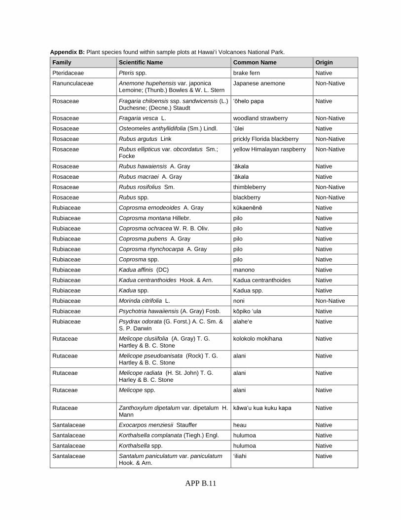
APP B.11
Appendix B: Plant species found within sample plots at Hawai‘i Volcanoes National Park.
Family Scientific Name Common Name Origin
Pteridaceae Pteris spp. brake fern Native
Ranunculaceae
Anemone hupehensis var. japonica Lemoine; (Thunb.) Bowles & W. L. Stern
Japanese anemone Non-Native
Rosaceae Fragaria chiloensis ssp. sandwicensis (L.) Duchesne; (Decne.) Staudt
‘ōhelo papa Native
Rosaceae Fragaria vesca L. woodland strawberry Non-Native
Rosaceae Osteomeles anthyllidifolia (Sm.) Lindl. ‘ūlei Native
Rosaceae Rubus argutus Link prickly Florida blackberry Non-Native
Rosaceae Rubus ellipticus var. obcordatus Sm.; Focke
yellow Himalayan raspberry Non-Native
Rosaceae Rubus hawaiensis A. Gray ‘ākala Native
Rosaceae Rubus macraei A. Gray ‘ākala Native
Rosaceae Rubus rosifolius Sm. thimbleberry Non-Native
Rosaceae Rubus spp. blackberry Non-Native
Rubiaceae Coprosma ernodeoides A. Gray kūkaenēnē Native
Rubiaceae Coprosma montana Hillebr. pilo Native
Rubiaceae Coprosma ochracea W. R. B. Oliv. pilo Native
Rubiaceae Coprosma pubens A. Gray pilo Native
Rubiaceae Coprosma rhynchocarpa A. Gray pilo Native
Rubiaceae Coprosma spp. pilo Native
Rubiaceae Kadua affinis (DC) manono Native
Rubiaceae Kadua centranthoides Hook. & Arn. Kadua centranthoides Native
Rubiaceae Kadua spp. Kadua spp. Native
Rubiaceae Morinda citrifolia L. noni Non-Native
Rubiaceae Psychotria hawaiiensis (A. Gray) Fosb. kōpiko ‘ula Native
Rubiaceae Psydrax odorata (G. Forst.) A. C. Sm. & S. P. Darwin
alahe‘e Native
Rutaceae Melicope clusiifolia (A. Gray) T. G. Hartley & B. C. Stone
kolokolo mokihana Native
Rutaceae Melicope pseudoanisata (Rock) T. G. Hartley & B. C. Stone
alani Native
Rutaceae Melicope radiata (H. St. John) T. G. Harley & B. C. Stone
alani Native
Rutaceae Melicope spp.
alani Native
Rutaceae Zanthoxylum dipetalum var. dipetalum H. Mann
kāwa‘u kua kuku kapa Native
Santalaceae Exocarpos menziesii Stauffer heau Native
Santalaceae Korthalsella complanata (Tiegh.) Engl. hulumoa Native
Santalaceae Korthalsella spp. hulumoa Native
Santalaceae Santalum paniculatum var. paniculatum Hook. & Arn.
‘iliahi Native

APP B.12
Appendix B: Plant species found within sample plots at Hawai‘i Volcanoes National Park.
Family Scientific Name Common Name Origin
Santalaceae
Santalum paniculatum var. pilgeri Hook. & Arn; (Rock) Stemmerm.
Pilger's sandalwood Native
Sapindaceae Dodonaea viscosa Jacq. a‘ali‘i Native
Sapindaceae Sapindus saponaria L. mānele Native
Scrophulariaceae Buddleja asiatica Lour. dog tail Non-Native
Scrophulariaceae Verbascum thapsus L. common mullein Non-Native
Smilacaceae Smilax melastomifolia Sm. hoi kuahiwi Native
Solanaceae Physalis peruviana L. poha Non-Native
Solanaceae Solanum americanum Mill. pōpolo Native
Solanaceae Solanum pseudocapsicum L. Jerusalem cherry Non-Native
Solanaceae Solanum spp. Solanum spp. Non-native
Thelypteridaceae Cyclosorus dentatus (Forssk.) Ching Cyclosorus dentatus Non-Native
Thelypteridaceae Cyclosorus parasiticus (L.) Farw. Cyclosorus parasiticus Non-Native
Thelypteridaceae Cyclosorus sandwicensis (Brack.) Copel. hō‘i‘o kula Native
Thelypteridaceae Pseudophegopteris keraudreniana (Gaudich.) Holttum
waimakanui Native
Thelypteridaceae Thelypteris globulifera (Brack.) C. F. Reed
palapalai a Kamapua‘a Native
Thymelaeaceae Wikstroemia phillyreifolia A. Gray ‘ākia Native
Thymelaeaceae Wikstroemia pulcherrima Skottsb. ‘ākia Native
Thymelaeaceae Wikstroemia spp. ‘ākia Native
Urticaceae Hesperocnide sandwicensis (Wedd.) Wedd.
Hesperocnide sandwicensis Native
Urticaceae Pipturus albidus (Hook. & Arnott) A. Gray māmaki Native
Urticaceae Urera glabra (Hook. & Arn.) Wedd. ōpuhe Native
Verbenaceae Lantana camara L. lantana Non-Native
Verbenaceae Stachytarpheta australis Moldenke Stachytarpheta australis Non-Native
Verbenaceae Stachytarpheta jamaicensis (L.) Vahl Jamaica vervain Non-Native
Verbenaceae Verbena litoralis Kunth ha‘uowi Non-Native
Woodsiaceae Athyrium microphyllum (Sm.) Alston ‘ākōlea Native
Woodsiaceae Deparia petersenii (Kunze) M. Kato false spleenwort Non-Native
Woodsiaceae Diplazium sandwichianum (C. Presl) Diels
hō‘i‘o Native
Xanthorrhoeaceae Dianella sandwicensis Hook. & Arn. ‘uki‘uki Native
Zingiberaceae Hedychium gardnerianum Ker- Gawler kahili ginger Non-Native

APP B.13
Literature Cited Palmer D. 2003. Hawaii’s ferns and fern allies. University of Hawaii Press, Honolulu, Hawaii. Wagner, W. L., D. R. Herbst, N. Kahn, and T. Flynn. 2012. Hawaiian vascular plant updates: A
supplement to the Manual of the flowering plants of Hawaii and Hawaii’s ferns and fern allies. University of Hawaii Press and Bishop Museum Press, Honolulu.126 pp. Available from http://botany.si.edu/pacificislandbiodiversity/hawaiianflora
Wagner, W. L., D. R. Herbst, and S. H. Sohmer. 1999. Manual of the flowering plants of Hawai‘i.
Revised edition. Volumes 1 and 2. University of Hawaii Press and Bishop Museum Press, Honolulu. 1919 pp.


APP C.1
Appendix C: Vegetation Association Key FIELD KEY TO THE VEGETATION TYPES OF
Hawaiʻi Volcanoes National Park, Hawaii
The vegetation of Hawaiʻi Volcanoes National Park (HAVO) was characterized using field data collected in 2008-2011 as a part of the National Park Service Vegetation Mapping Program. Additional legacy plot data were used in the classification collected from 1997- 2006. To assist in the accurate field identification of the 81 plant associations this dichotomous key has been developed from plot data. This key is structured to facilitate identification of vegetation types with one or a combination of “diagnostic species,” which are species or groups of species whose relative constancy or abundance differentiates one vegetation type from another. Most of these species are “dominant species,” meaning constant species with high percent cover in a vegetation type or a canopy layer, usually in the tallest (upper most) layer. Several species may co-dominate in some associations. Within the key, “differential species” refer to species with high constancy that because of fidelity are clearly associated with a particular vegetation type, and “indicator species” refer to species with known fidelity to certain habitat conditions such as soil moisture, soil nutrients, flooding regime, and disturbance history. During Accuracy Assessment (AA), crews may go to randomly selected points that fall within ecotones— boundary or transition zones between vegetation types where diagnostic species intermix, and may have difficulties determining a definitive type. Be aware that a map polygon may have small inclusions of other vegetation types. Following each association in the key, the final map codes were added in parenthesis. Special instructions for AA Crews
1. The key relies on the absolute percent cover of individual species. Stands with an “overwhelming dominance” (highest absolute cover is more than double any other species in that layer) of a single species are keyed by that dominant species.
2. At HAVO there are several ubiquitous species that define most associations and have broad ecological amplitudes. These associations are distinguished by their life zones based on elevation and moisture availability. We relied on species that occurred consistently in most or all stands classified as a single type (referred to as the “indicator” species) to justify the classification. We use the term “indicator” for species that may not have the highest absolute cover in the stand, but have a combination of high fidelity and constancy within a community and are therefore assumed to be a response to the environmental conditions of a community.
3. If a vegetation type does not key, assume it is a new type and collect as much data as possible. If possible, fill out a full plot form or, at minimum, an observation point form so that the data and field notes can be reviewed and the stand classified at a later date.

APP C.2
1. Land cover comprised of areas of intensive human use with much of the land area taken up by structures or transportation infrastructure. (This class takes precedence over others when the criteria for more than one class are met. For example, areas dominated by intensive human land use, but also with vegetative cover greater than 5% will be labeled as built up and not as vegetated)...................................................................................................................................................... Go To Built Up Key 1. Area not as above ...................................................................................................................................................................... 2 2. Canopy of vascular plant species exceeds 15% ........................................................................................................................ 3 2. Cover of vascular plant species less than 15% but greater than 5% ........................................... Go to Sparse Vegetation Key 3. Canopy cover of tree species regardless of their size class (i. e. T1, T2, T3, S1, S2, H.) is at least 10%. Note that early successional forests and woodlands with short trees key here and not in the shrubland key .... Go to Forest and Woodland Key 3. Tree species, regardless of their size class, constitute less than 10% tree canopy cover ........................................................... 4 4. Shrub species, regardless of size class, comprise at least 10% cover, individually or in the aggregate. If herbaceous cover exceeds 10%, than shrub cover exceeds 25%. Many shrub stands are heavily invaded by exotic grass species. If the stand has reduced total cover (< 25%), then the shrub component comprises at least 25% of the total vegetative cover .............................. .................................................................................................................................................................... Go to Shrubland Key 4. Shrub species comprise less than 10% canopy cover, and herbaceous species typically constitute more than 10% cover; if total vegetation cover is < 25%, the shrub component constitutes less than 25% of the total. If shrub cover exceeds 10%, than grass cover exceeds 25% ................................................................................................................................... Go to Herbaceous Key 5. Cover of vascular plant species less than 5% ......................................................................................................... Unvegetated 6. Water comprised greater than 80% of the polygon ........................................................................................................... Water
Forest and Woodland Key 1. Forests and woodlands with canopies dominated by Acacia koa or co-dominant with Acacia koa and Metrosideros polymorpha .................................................................................................................................................................................... 2 1. Forests and woodlands dominated by Metrosideros polymorpha or other tree species ........................................................... 12 2 (1). Forests and woodlands with canopies dominated or co-dominated by Acacia koa and Metrosideros polymorpha ............ 3 2. Forests and woodlands with canopies dominated by Acacia koa. Metrosideros polymorpha may be present, but not co-dominant ........................................................................................................................................................................................ 4 3(2). Dry site forests and woodlands................. Acacia koa / Metrosideros polymorpha Montane Dry Woodland (W_ACME) 3. Mesic site forests and woodlands. Understories dominated by Ehrharta stipoides ..................................................................... Acacia koa / (Metrosideros polymorpha) / Ehrharta stipoides Semi-natural Montane Mesic Woodland (W_ACMEEH_M) 4(2). Forests and woodlands with subcanopy dominated by Cibotium spp ...................................................................................... ...................................................................................................... Acacia koa / Cibotium spp. Montane Woodland (W_ACCI) 4. Forests and woodlands not as above .......................................................................................................................................... 5 5(4). Shrub species, regardless of size class, comprise at least 10% understory cover .................................................................. 6 5. Shrub species comprise less than 10% understory cover ........................................................................................................... 7 6(5). Understory dominated by Leptecophylla tameiameiae............................................................................................................ ..................................... Acacia koa / Leptecophylla tameiameiae - (Dodonaea viscosa) Montane Woodland1 (W_ACLEDO) 6. Understory dominated by Ipomoea indica and Pipturus albidus ................................................................................................. ......................................................... Acacia koa / Ipomoea indica - Pipturus albidus Woodland [Park Special] (W_ACIPPI) 7(5). Understory dominants include Ehrharta stipoides, Melinis minutiflora, Cenchus clandestinus or Setaria parviflora .......... 8 7. Forests and woodlands with understories dominated by Eragrostis variabilis or Microlepia strigose .................................... 11 8(7). Understories dominated by Ehrharta stipoides and or Pteridium acquilinum ......................................................................... ................................................................ Acacia koa / Ehrharta stipoides Semi-natural Montane Woodland (W_ACKONN) 8. Understories dominated by Melinis minutiflora, Cenchus clandestinus or Setaria parviflora ................................................... 9 9(8). Understories dominated by Melinis minutiflora ...................................................................................................................... ................................................................ Acacia koa / Melinis minutiflora Semi-natural Lowland Woodland (W_ACME_L)

APP C.3
9. Understories dominated by Cenchus clandestinus and Setaria parviflora ............................................................................... 10 10(9). Understories dominated by Cenchus clandestinus ................................................................................................................ ......................................................................... Acacia koa / Cenchrus clandestinus Semi-natural Woodland (W_ACKONN) 10. Understories dominated by Setaria parviflora ........................................................................................................................... ......................................... Acacia koa / Setaria parviflora Lowland Semi-natural Woodland [Park Special] (W_ACKONN) 11(7). Understories dominated by Eragrostis variabilis .................................................................................................................. ........................................................................................ Acacia koa / Eragrostis variabilis Montane Woodland (not mapped) 11. Understories dominated by Microlepia strigos .......................................................................................................................... ........................ Acacia koa – (Sapindus saponaria) / Microlepia strigosa Montane Woodland [Park Special] (W_ACSAMI) 12(1). Forests with greater than 75% of the canopy cover in Morella faya ..................................................................................... .................................................................................................... Morella faya Semi-natural Forest (F_MOME with modifier) 12. Forests without greater than 75% of the canopy cover in Morella faya ................................................................................. 13 13(12). Forests and woodlands dominated or co-dominated by Metrosideros polymorpha. Canopy associates may include Cheirodendron spp., Cibotium spp., Morella faya, Psidium spp., Schinus terebinthifolius, Ilex anomala, Sophora chrysophylla, or Myrsine lessertiana ........................................................................................................................................... 14 13. Forests and woodlands dominated or co-dominated by species other than Metrosideros polymorpha ................................. 34 14(13). Forests and woodlands with canopies or sub-canopies co-dominated by Cheirodendron trigynum ssp. trigynum and/or Cibotium spp. .............................................................................................................................................................................. 15 14. Forest and woodlands not as above ........................................................................................................................................ 16 15(14). Cheirodendron trigynum ssp. trigynum has >10% canopy cover ........................................................................................ ..................... Metrosideros polymorpha - Cheirodendron trigynum / (Cibotium spp.) Montane Wet Forest (F_MECHSPCI) 15. Cheirodendron trigynum ssp. trigynum is absent or has <10% canopy cover............................................................................ .............................................................................. Metrosideros polymorpha / Cibotium spp. Montane Wet Forest (F_MECI) 16(14). Canopies co-dominated by Morella faya, Ilex anomala, Psidium spp., or Schinus terebinthifolius (Morella faya must have at least 50% of the cover of Metrosideros polymorpha to be co-dominant) ........................................................................ 17 16. Canopies not as above ............................................................................................................................................................ 20 17(16). Canopies co-dominated by Morella faya (Morella faya must have at least 50% of the cover of Metrosideros polymorpha to be co-dominant) .......................... Morella faya - (Metrosideros polymorpha) Semi-natural Forest (F_MOME) 17. Canopies co-dominated by Ilex anomala, Psidium spp., or Schinus terebinthifolius ............................................................. 18 18(17). Ilex anomala is a co-dominant subcanopy tree. Myrsine lessertiana is typically present at low cover ............................... ........................................................... Metrosideros polymorpha - Ilex anomala - Myrsine lessertiana Woodland (W_MEPO) 18. Canopies not as above ............................................................................................................................................................ 19 19(18). Canopies co-dominated by Psidium cattleianum ................................................................................................................. .................. (Metrosideros polymorpha) - Psidium cattleianum - (Cheirodendron spp.) - Cibotium spp. Montane Wet Forest (F_MEPSCHCI_M) 19. Canopies not as above .... Metrosideros polymorpha - (Psidium spp., Schinus terebinthifolius) Woodland (W_MEPSSC) 20(16). Shrub species, regardless of size class, comprise at least 10% understory cover, individually or in the aggregate. If herbaceous cover exceeds 10%, than shrub cover exceeds 25%. If the stand has reduced total understory cover (< 25%) then the shrub component comprises at least 25% of the total understory cover. Only exception are stands where herbaceous Deschampsia nubigena may have equal cover as the shrub Leptecophylla tameiameiae ............................................................ 21 20. Shrub species comprise less than 10% canopy cover and herbaceous species typically constitute more than 10% cover. If total understory cover is < 25%, the shrub component constitutes less than 25% of the total. If shrub cover exceeds 10%, then grass cover exceeds 25% ..................................................................................................................................................25 21(20). Leptecophylla tameiameiae and/or Dodonaea viscosa are the dominant shrubs ............................................................. 22 21. Pipturus albidus is the dominant shrub ...................................................................................................................................... ...................................... Metrosideros polymorpha / Pipturus albidus Montane Mesic Forest [Park Special] (W_MPCC_W) 22(21). Shrub layer dominated by Leptecophylla tameiameiae with nearly equal cover of Deschampsia nubigena ....................... ......... Metrosideros polymorpha / Leptecophylla tameiameiae / Deschampsia nubigena - Morelotia gahniiformis Woodland1 (W_MELEDO_MW)

APP C.4
22. Shrub layer dominated by Leptecophylla tameiameiae or co-dominated by Dodonaea viscosa. Deschampsia nubigena absent or at trace cover ............................................................................................................................................................... 23 23(22). Metrosideros polymorpha is the dominant canopy species. Other canopy species may be present, but contribute <20% of the total canopy cover ................................................................................................................................................... 24 23. Canopy co-dominated by Metrosideros polymorpha and Sophora chrysophylla ....................................................................... ............. .Sophora chrysophylla - Metrosideros polymorpha / (Leptecophylla tameiameiae - Dodonaea viscosa) Lowland Dry Woodland1 (W_SOMELEDO) 24(23). Lowland forests and woodlands found typically below 1000 meters in elevation. Non-native grasses such as Andropogon virginicus and Schizachyrium condensatum are usually present ................................................................................. . Metrosideros polymorpha / Leptecophylla tameiameiae - (Dodonaea viscosa) Lowland Dry Woodland1 (W_MELEDO_L) 24. Montane forests and woodlands found typically above 1000 m in elevation. Deschampsia nubigena, Morelotia gahniiformis and Vaccinium reticulatum are usually present at low covers .................................................................................... ...... Metrosideros polymorpha / Leptecophylla tameiameiae - Dodonaea viscosa Montane Woodland1 (W_MELEDO_MW) 25(20). Understory dominated by fern species such as Dicranopteris linearis, Nephorolepis brownii, or Dryopteris wallichiana .................................................................................................................................................................................. 26 25. Understory dominated by grass species ................................................................................................................................. 29 26(25). Understory dominated by Dryopteris wallichiana ............................................................................................................... ...................................................... Metrosideros polymorpha / Dryopteris wallichiana Woodland [Park Special] (W_MEPO) 26. Understory dominated by Nephorolepis brownii or Dicranopteris linearis ........................................................................... 27 27(26). Understory dominated by Nephrolepis brownie .................................................................................................................. .......................................................... Metrosideros polymorpha / Nephrolepis brownii Semi-natural Woodland1 (W_MENE) 27. Understory dominated by Dicranopteris linearis................................................................................................................... 28 28(27). Montane forests and woodlands found typically above 1000 m in elevation. Machaerina angustifolia and Vaccinium calycinum are usually present at low covers .................................................................................................................................... ................................................... Metrosideros polymorpha / Dicranopteris linearis Montane Wet Woodland (W_MEDI_M) 28. Lowland forests and woodlands found typically below 1000 meters in elevation ..................................................................... .................................................. Metrosideros polymorpha / Dicranopteris linearis Lowland Mesic Woodland (W_MEDI_L) 29(25). Understories dominated by Ehrharta stipoides ................................................................................................................... .............................................................. Metrosideros polymorpha / Ehrharta stipoides Semi-natural Woodland (W_MEEH) 29. Understories dominated by grass species not as above .......................................................................................................... 30 30(29). Understories dominated by Melinis spp., Andropogon virginicus or both ........................................................................... ......................... Metrosideros polymorpha / Melinis spp. - Andropogon virginicus Semi-natural Woodland (W_MEMEAN) 30. Understories dominated by grass species not as above .......................................................................................................... 31 31(30). Understories dominated by Cenchrus clandestinus ............................................................................................................. ................................................ Metrosideros polymorpha / Cenchrus clandestinus Semi-natural Woodland1 (W_MPCC_W) 31. Understories dominated by grass species not as above .......................................................................................................... 32 32(31). Understory Understories dominated by Cymbopogon refractus .......................................................................................... .............................. Metrosideros polymorpha / Cymbopogon refractus Semi-natural Woodland [Park Special] (W_MECY) 32. Understories dominated by grass species not as above .......................................................................................................... 33 33(32). Understory dominated by other Alien grasses ..................................................................................................................... .......................................................................... Metrosideros polymorpha / Alien grass Semi-natural Woodland (W_MPAG) 33. Understory dominated by a mix of native trees ......................... Metrosideros polymorpha / Native Woodland (W_MEPO) 34(13). Forests and woodlands with canopies dominated by Sophora chrysophylla ................................................................... 35 34. Forests and woodlands not as above ...................................................................................................................................... 38 35(34). Understories shrub dominated by Leptecophylla tameiameiae and Dodonaea viscosa. Non-native grasses such as Andropogon virginicus and Melinis spp. are common and may reach as high as 70% cover ...................................................... 36 35. Understories graminoid dominated by either Ehrharta stipoides or Hyparrhenia rufa ......................................................... 37

APP C.5
36(35). Lowland forests and woodlands typically occurring below 1000 meters in elevation. Non-native grasses such as Andropogon virginicus and Melinis spp. commonly occur at substantial cover .............................................................................. ........ Sophora chrysophylla - (Leptecophylla tameiameiae - Dodonaea viscosa) Lowland Dry Woodland1 (W_SOLEDO_L) 36. Montane forests and woodlands typically occurring above 1000 meters in elevation ............................................................... .............. Sophora chrysophylla - (Leptecophylla tameiameiae - Dodonaea viscosa) Montane Woodland1 (W_SOLEDO_M) 37(35). Understories dominated by Ehrharta stipoides ................................................................................................................... .................................................... Sophora chrysophylla / Ehrharta stipoides subalpine Semi-natural Woodland (W_SOCH) 37. Understories dominated by Hyparrhenia rufa ........................................................................................................................... ........................................... .Sophora chrysophylla / Hyparrhenia rufa Semi-natural Woodland [Park Special] (not mapped) 38(34). Forests occurring in the remnant forests of the Holei Pali which are dominated by Diospyros sandwicensis or Aleurites moluccana .................................................................................................................................................................................... 39 38. Forests and woodlands not as above ...................................................................................................................................... 40 39(38). Canopies dominated by Aleurites moluccana ...............Aleurites moluccana Dry Forest [Park Special] (F_ALMO_D) 39. Canopies dominated by Disopyros sandwicensis ........................... Diospyros sandwicensis Lowland Dry Forest (F_DISA) 40(38). Canopies dominated by Cocos nucifera ................................................. Cocos nucifera Strand Woodland (W_CONU) 40. Forest and woodlands not as above ........................................................................................................................................ 41 41(40). Canopies dominated by Thespesia populnea ............ Thespesia populnea / Sparse Understory Woodland (W_THPR) 41. Forests and woodlands not as above ...................................................................................................................................... 42 42(41). Canopies dominated by Prosopis pallida .............. Prosopis pallida Coastal Dry Semi-natural Woodland (W_THPR) 42. Forest and woodlands not as above ........................................................................................................................................ 43 43(42). Canopies dominated by Morinda citrifolia .......................................................................................................................... ............................................. Morinda citrifolia / Pluchea carolinensis Semi-natural Woodland [Park Special] (not mapped) 43. Forests and woodlands not as above ...................................................................................................................................... 44 44(43). Canopies dominated by Grevillea robusta ............ Grevillea robusta Lowland Mesic Semi-natural Forest (F_GRRO) 44. Forests and woodlands not as above ...................................................................................................................................... 45 45(44). Former plantation areas dominated by Eucalyptus spp. with understories typically dominated by non-native grasses ....................................................... Eucalyptus spp. - Mixed Alien Semi-natural Forest/Plantation [Provisional] (F_EUMS) 45. Forests and woodlands not as above ...................................................................................................................................... 46 46(45). Canopies dominated by Cibotium glaucum ............................................ Cibotium glaucum Montane Forest (F_CIGL) 46 Forests and woodlands not as above ....................................................................................................................................... 47 47(46). Canopies dominated by Myoporum sandwicense ............... Myoporum sandwicense Subalpine Woodland (W_MYSA) 47. Forests and woodlands not as above ...................................................................................................................................... 48 48(47). Canopies dominated by Sapindus saponaria ....................................................................................................................... .......................................... Sapindus saponaria - Coprosma rhynchocarpa Montane Mesic Forest [Park Special] (F_SACO) 48. Forests and woodlands not as above ...................................................................................................................................... 49 49(48). Canopies dominated by Psidium cattlenium ....................... Psidium cattlenium Wet Semi-natural Forest (not mapped) 49 Forests and woodlands not as above ....................................................................................................................................... 50 50(49). Canopies dominated by Araucaria columnaris ................ Araucaria columnaris Semi-natural Woodland (W_ARCO) 50. Forests and woodlands not as above ...................................................................................................................................... 51 51(50). Forests and woodlands dominated by Fraxinus uhdei ......................................................................................................... ........................................................................ Fraxinus uhdei Semi-natural Lowland Woodland [Park Special] (W_FRUH) 51. Forests and woodlands not as above ...................................................................................................................................... 52 52(51). Canopies dominated by Schinus terebinthifolius ................................................................................................................. ..................................................................................... Schinus terebinthifolius Semi-natural Scrub Woodland (W_SCTE_S) 52. Forests and woodlands not as above …………………………………………Unclassified Forest and Woodland in HAVO

APP C.6
Key to Shrublands 1. Shrublands dominated by Coprosma ernodeoides, Lantana camara, Scaevola taccada, or Leucaena leucocephala ............... 2 1. Shrublands dominated by Dodonaea viscosa and/or Leptecophylla tameiameiae ..................................................................... 6 2(1). Shrublands characterized by open to dense mats of Coprosma ernodeoides........................................................................... ................................................................................................ Coprosma ernodeoides Shrubland [Park Special] (not mapped) 2. Shrublands not as above............................................................................................................................................................. 3 3(2). Shrublands dominated by Scaevola taccada .................................... Scaevola taccada Coastal Dry Shrubland (S_SCTA) 3. Shrublands not as above............................................................................................................................................................. 4 4(3). Shrublands dominated by Lantana camara. Understories of non-native grasses may be common ......................................... .......................................................................................... Lantana camara Semi-natural Shrubland [Provisional] (S_LACA) 4. Shrublands not as above............................................................................................................................................................ .5 5(4). Shrubland dominated by Leucaena leucocephala ................................................................................................................... .............................................................................. Leucaena leucocephala Lowland Dry Semi-natural Shrubland (S_LELE) 5. Shrublands comprised of a mix of coastal shrubs and grasses with no one species clearly dominant. Shrubs present may include Lantana camara, Osteomeles anthyllidifolia, Wikstroemia spp. among others .... Mixed Coastal Shrubland (S_MICO) 6(1). Shrublands dominated by Dodonaea viscosa or with Pluchea carolinensis co-dominating. Leptecophylla tameiameiae may be present at low cover, but never exceeds >20% of the total shrub cover ............................................................................ 7 6. Shrublands dominated by Leptecophylla tameiameiae or co-dominated by Leptecophylla tameiameiae and Dodonaea viscosa ......................................................................................................................................................................................... 10 7(6). Shrublands co-dominated by Dodonaea viscosa and Pluchea carolinensis ............................................................................ ................................................ Dodonaea viscosa - Pluchea carolinensis Semi-natural Shrubland [Park Special] (S_DOPL) 7. Shrublands not as above............................................................................................................................................................. 8 8(7). Lowland shrublands occurring typically below 1000 meters in elevation. Non-native grasses such as Melinis spp. and Andropogon virginicus are common and may reach as high as 80% cover ..................................................................................... .......................................................................................................... Dodonaea viscosa Lowland Dry Shrubland (S_DOVI_L) 8. Montane and subalpine shrublands ............................................................................................................................................ 9 9(8). Montane shrublands occurring between 1000 and 2000 meters in elevation. The non-native grass Schizachyrium condensatum may reach as high as 40% cover ....Dodonaea viscosa Montane Mesic Shrubland [Park Special] (S_DOVI_M) 9. Subalpine shrublands occurring at over 2000 meters in elevation. Although a suite of other species may occur, few attain cover exceeding 5% ....................................................................... Dodonaea viscosa Subalpine Dry Shrubland (not mapped) 10(6). Shrublands dominated by Leptecophylla tameiameiae. Dodonaea viscosa may be present, but does not exceed >20% of the total shrub cover. Deschampsia nubigena is typically the understory dominant ................................................................... .............................................................................................. Leptecophylla tameiameiae Montane Dry Shrubland1 (S_LETA) 10. Shrubland co-dominated by Leptecophylla tameiameiae and Dodonaea viscosa .................................................................. 11 11(10). Lowland shrublands occurring below 1000 meters in elevation .......................................................................................... ..................................................... Leptecophylla tameiameiae - Dodonaea viscosa Lowland Mesic Shrubland1 (S_LEDO_L) 11. Montane shrublands occurring above 1000 meters in elevation ................................................................................................ .............................................................. Leptecophylla tameiameiae - Dodonaea viscosa Montane Shrubland1 (S_LEDO_M)
Herbaceous Key 1. Herbaceous vegetation dominated by Ipomoea spp. or Hedychium coronarium, or the ferns Pteridium aquilinum ssp. decompositum, Dicranopteris linearis, or Nephrolepis brownii ................................................................................................... 2 1. Herbaceous vegetation dominated by graminoids ...................................................................................................................... 6 2(1). Herbaceous vegetation dominated by Pteridium aquilinum ssp. decompositum ..................................................................... .................................................. Pteridium aquilinum ssp. decompositum Herbaceous Vegetation [Park Special] (H_PTAQ)
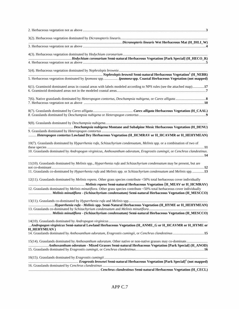
APP C.7
2. Herbaceous vegetation not as above .......................................................................................................................................... 3 3(2). Herbaceous vegetation dominated by Dicranopteris linearis.................................................................................................. ......................................................................................................... Dicranopteris linearis Wet Herbaceous Mat (H_DILI_W) 3. Herbaceous vegetation not as above .......................................................................................................................................... 4 4(3). Herbaceous vegetation dominated by Hedychium coronarium ............................................................................................... ................................................ Hedychium coronarium Semi-natural Herbaceous Vegetation [Park Special] (H_HECO_R) 4. Herbaceous vegetation not as above .......................................................................................................................................... 5 5(4). Herbaceous vegetation dominated by Nephrolepis brownie.................................................................................................... ................................................................................... Nephrolepis brownii Semi-natural Herbaceous Vegetation1 (H_NEBR) 5. Herbaceous vegetation dominated by Ipomoea spp. ............... Ipomoea spp. Coastal Herbaceous Vegetation (not mapped) 6(1). Graminoid dominated areas in coastal areas with labels modeled according to NPS rules (see the attached map) ............. 17 6. Graminoid dominated areas not in the modeled coastal areas .................................................................................................... 7 7(6). Native grasslands dominated by Heteropogon contortus, Deschampsia nubigena, or Carex alligata .................................. 8 7. Herbaceous vegetation not as above ....................................................................................................................................... 10 8(7). Grasslands dominated by Carex alligata ............................................. Carex alligata Herbaceous Vegetation (H_CAAL) 8. Grasslands dominated by Deschampsia nubigena or Heteropogon contortus ........................................................................... 9 9(8). Grasslands dominated by Deschampsia nubigena................................................................................................................... .................................................. Deschampsia nubigena Montane and Subalpine Mesic Herbaceous Vegetation (H_DENU) 9. Grasslands dominated by Heteropogon contortus ....................................................................................................................... ......... Heteropogon contortus Lowland Dry Herbaceous Vegetation (H_HCMRAV or H_HCAVMR or H_HEHYMEAN) 10(7). Grasslands dominated by Hyparrhenia rufa, Schizachyrium condensatum, Melinis spp. or a combination of two of these species ................................................................................................................................................................................ 11 10. Grasslands dominated by Andropogon virginicus, Anthoxanthum odoratum, Eragrostis cumingii, or Cenchrus clandestinus . ..................................................................................................................................................................................................... 14 11(10). Grasslands dominated by Melinis spp., Hyparrhenia rufa and Schizachyrium condensatum may be present, but are not co-dominant ........................................................................................................................................................................... 12 11. Grasslands co-dominated by Hyparrhenia rufa and Melinis spp. or Schizachyrium condensatum and Melinis spp. ............. 13 12(11). Grasslands dominated by Melinis repens. Other grass species contribute <50% total herbaceous cover individually ............................................................... Melinis repens Semi-natural Herbaceous Vegetation (H_MEAV or H_HCMRAV) 12. Grasslands dominated by Melinis minutiflora. Other grass species contribute <50% total herbaceous cover individually .......................... Melinis minutiflora - (Schizachyrium condensatum) Semi-natural Herbaceous Vegetation (H_MESCCO) 13(11). Grasslands co-dominated by Hyparrhenia rufa and Melinis spp. ........................................................................................ ............................. Hyparrhenia rufa - Melinis spp. Semi-Natural Herbaceous Vegetation (H_HYME or H_HEHYMEAN) 13. Grasslands co-dominated by Schizachyrium condensatum and Melinis minutiflora .................................................................. .......................... Melinis minutiflora - (Schizachyrium condensatum) Semi-natural Herbaceous Vegetation (H_MESCCO) 14(10). Grasslands dominated by Andropogon virginicus ............................................................................................................... ... Andropogon virginicus Semi-natural Lowland Herbaceous Vegetation (H_ANME_G or H_HCAVMR or H_HYME or H_HEHYMEAN ) 14. Grasslands dominated by Anthoxanthum odoratum, Eragrostis cumingii, or Cenchrus clandestinus ................................... 15 15(14). Grasslands dominated by Anthoxanthum odoratum. Other native or non-native grasses may co-dominate ........................ ...................... Anthoxanthum odoratum - Mixed Grasses Semi-natural Herbaceous Vegetation [Park Special] (H_ANOD) 15. Grasslands dominated by Eragrostis cumingii, or Cenchrus clandestinus ............................................................................. 16 16(15). Grasslands dominated by Eragrostis cumingii .................................................................................................................... ........................................................ Eragrostis brownei Semi-natural Herbaceous Vegetation [Park Special]1 (not mapped) 16. Grasslands dominated by Cenchrus clandestinus ...................................................................................................................... ................................................................................ Cenchrus clandestinus Semi-natural Herbaceous Vegetation (H_CECL)

APP C.8
17(6). Modeled coastland grass classes which include Andropogon virginicus - Melinis spp. Mixed Grassland, Heteropogon contortus - Andropogon virginicus Mixed Grassland, Heteropogon contortus - Hyparrhenia rufa - Melinis spp. Mixed Grassland, Hyparrhenia rufa - Melinis spp. - Andropogon virginicus Mixed Grassland, Melinis spp. - Andropogon virginicus Mixed Grassland, Melinis spp. - Schizachyrium condensatum Mixed Grassland. 17. Grasslands not as above ............................................................................... Unclassified Herbaceous Vegetation at HAVO
Sparse Vegetation Key 1. Species with the highest cover is Heteropogon contortus ............................................................................................................ ................................................... Heteropogon contortus Sparse Vegetation [Park Special] (H_HCAVMR or H_HCMRAV) 1. Species with the highest cover is woody .................................................................................................................................... 2 2(1). Dubautia scabra ssp. scabra has the highest cover ................................................................................................................. ................................................................................ Dubautia scabra ssp. scabra Montane Sparse Vegetation (SP_DUSC_M) 2. Metrosideros polymorpha, Leptecophylla tameiameiae, Dodonaea viscosa, Sophora chrysophylla or Vaccinium reticulatum has the highest cover ...................................................................................................................................................................... 3 3(2). Sophora chrysophylla or Vaccinium reticulatum have the highest cover .............................................................................. 4 3. Metrosideros polymorpha, Leptecophylla tameiameiae or Dodonaea viscosa has the highest cover ........................................ 5 4(3). Sophora chrysophylla has the highest cover ........................................................................................................................... ....................................................................... Sophora chrysophylla Montane Sparse Vegetation [Park Special] (SP_SOCH) 4. Vaccinium reticulatum has the highest cover ............................................................................................................................... ................................................................... Vaccinium reticulatum Montane Sparse Vegetation [Park Special] (not mapped) 5(3). Metrosideros polymorpha contributes equal to or more cover than Leptecophylla tameiameiae, Vaccinium reticulatum or Dodonaea viscosa .......................................................................................................................................................................... 6 5. Leptecophylla tameiameiae and Dodonaea viscosa or Leptecophylla tameiameiae and Vaccinium reticulatum contribute the most cover...................................................................................................................................................................................... 8 6(5)., Metrosideros polymorpha, Leptecophylla tameiameiae, and Vaccinium reticulatum contribute the most cover ................... Metrosideros polymorpha / Leptecophylla tameiameiae - Vaccinium reticulatum Montane and Subalpine Sparse Vegetation1 (SP_MELEVA) 6. Metrosideros polymorpha, Leptecophylla tameiameiae, and/or Dodonaea viscosa contribute the most cover ......................... 7 7(6). Sparse vegetation occurring below 1000 meters in elevation. Andropogon virginicus and Bulbostylis capillaris are frequent components ........ Metrosideros polymorpha / (Leptecophylla tameiameiae - Dodonaea viscosa) Lowland Sparse Vegetation1 (SP_MELEDO_L) 7. Sparse vegetation occurring above 1000 meters in elevation. Morelotia gahniiformis and Dianella sandwicensis are frequent components ........ Metrosideros polymorpha / (Leptecophylla tameiameiae - Dodonaea viscosa) Montane Sparse Vegetation1 (SP_MELEDO_M) 8(5). Leptecophylla tameiameiae and Dodonaea viscosa contribute the most cover ....................................................................... ................................................ Leptecophylla tameiameiae - Dodonaea viscosa Lowland Sparse Vegetation1 (SP_LEDO_M) 8. Leptecophylla tameiameiae and Vaccinium reticulatum contribute the most cover ....................................................................
................ Leptecophylla tameiameiae - Vaccinium reticulatum Montane and Subalpine Sparse Vegetation1 (SP_LEVA) .
Built Up Key 1. Built up structures, primarily buildings used for commercial and services ..... Built up Commercial and Services (B_COSE) 1. Built up structures, primarily infrastructure for transportation, communications, and utilities .................................................... .................................................................................. Built up Transportation, Communications, and Utilities (B_TRCOUT)
1NVC name modified based on Wagner et al. (1999) and Wagner et al. (2012).

APP D.1
Appendix D: Vegetation Association Descriptions
NATIONAL VEGETATION CLASSIFICATION
Vegetation Communities of Hawaiʻi Volcanoes National Park
15 March 2012
by
NatureServe
4600 North Fairfax Drive, 7th Floor Arlington, VA 22203
4001 Discovery, Suite 270 Boulder, CO 80303
This subset of the International Ecological Classification Standard covers vegetation communities of Hawaiʻi Volcanoes National Park. This classification has been developed in consultation with many individuals and agencies and incorporates information from a variety of publications and other classifications. Comments and suggestions regarding the contents of this subset should be directed to Mary J. Russo, Central Ecology Data Manager, [email protected], and/or Mark Hall, Vegetation Ecologist, Boulder, CO <[email protected]>.

APP D.2
Copyright © 2012 4600 North Fairfax Drive, 7th floor Arlington, VA 22203, U.S.A. All Rights Reserved.
Citations: The following citation should be used in any published materials which reference ecological system and/or
International Vegetation Classification (IVC hierarchy) and association data:
NatureServe. 2012. International Ecological Classification Standard: Terrestrial Ecological Classifications. NatureServe Central Databases. Arlington, VA. U.S.A. Data current as of 15 March 2012.
Restrictions on Use: Permission to use, copy and distribute these data is hereby granted under the following conditions: 1. The above copyright notice must appear in all documents and reports; 2. Any use must be for informational purposes only and in no instance for commercial purposes; 3. Some data may be altered in format for analytical purposes, however the data should still be referenced using
the citation above. Any rights not expressly granted herein are reserved by NatureServe. Except as expressly provided above, nothing contained herein shall be construed as conferring any license or right under any NatureServe copyright. Information Warranty Disclaimer: All data are provided as is without warranty as to the currentness, completeness, or accuracy of any specific data. The absence of data in any particular geographic area does not necessarily mean that species or ecological communities of concern are not present. NatureServe hereby disclaims all warranties and conditions with regard to these data, including but not limited to all implied warranties and conditions of merchantability, fitness for a particular purpose, and non-infringement. In no event shall NatureServe be liable for any special, indirect, incidental, consequential damages, or for damages of any kind arising out of or in connection with the use of these data. Because the data in the NatureServe Central Databases are continually being updated, it is advisable to refresh data at least once a year after receipt.
NatureServe 4600 North Fairfax Drive, 7th Floor
Arlington, VA 22203
_____________________________________________________________ These data are extracted from: NatureServe. 2012. International Ecological Classification Standard: Terrestrial Ecological Classifications. NatureServe Central Databases. Arlington, VA. U.S.A. Data current as of 15 March 2012. _____________________________________________________________ This document may be generally cited as follows: NatureServe1. 2012. International Ecological Classification Standard: Terrestrial Ecological Classifications. Vegetation Communities of Hawaiʻi Volcanoes National Park. NatureServe Central Databases. Arlington, VA. Data current as of 15 March 2012.

Vegetation of Hawaiʻi Volcanoes National Park
APP D.3
1 NatureServe is an international organization including NatureServe regional offices, a NatureServe central office, U.S. State Natural Heritage Programs, and Conservation Data Centres (CDC) in Canada and Latin America and the Caribbean. Ecologists from the following organizations have contributed the development of the ecological systems classification: United States Central NatureServe Office, Arlington, VA; Eastern Regional Office, Boston, MA; Midwestern Regional Office, Minneapolis, MN; Southeastern Regional Office, Durham, NC; Western Regional Office, Boulder, CO; Alabama Natural Heritage Program, Montgomery AL; Alaska Natural Heritage Program, Anchorage, AK; Arizona Heritage Data Management Center, Phoenix AZ; Arkansas Natural Heritage Commission Little Rock, AR; Blue Ridge Parkway, Asheville, NC; California Natural Heritage Program, Sacramento, CA; Colorado Natural Heritage Program, Fort Collins, CO; Connecticut Natural Diversity Database, Hartford, CT; Delaware Natural Heritage Program, Smyrna, DE; District of Columbia Natural Heritage Program/National Capital Region Conservation Data Center, Washington DC; Florida Natural Areas Inventory, Tallahassee, FL; Georgia Natural Heritage Program, Social Circle, GA; Great Smoky Mountains National Park, Gatlinburg, TN; Gulf Islands National Seashore, Gulf Breeze, FL; Hawaii Natural Heritage Program, Honolulu, Hawaii; Idaho Conservation Data Center, Boise, ID; Illinois Natural Heritage Division/Illinois Natural Heritage Database Program, Springfield, IL; Indiana Natural Heritage Data Center, Indianapolis, IN; Iowa Natural Areas Inventory, Des Moines, IA; Kansas Natural Heritage Inventory, Lawrence, KS; Kentucky Natural Heritage Program, Frankfort, KY; Louisiana Natural Heritage Program, Baton Rouge, LA; Maine Natural Areas Program, Augusta, ME; Mammoth Cave National Park, Mammoth Cave, KY; Maryland Wildlife & Heritage Division, Annapolis, MD; Massachusetts Natural Heritage & Endangered Species Program, Westborough, MA; Michigan Natural Features Inventory, Lansing, MI; Minnesota Natural Heritage & Nongame Research and Minnesota County Biological Survey, St. Paul, MN; Mississippi Natural Heritage Program, Jackson, MI; Missouri Natural Heritage Database, Jefferson City, MO; Montana Natural Heritage Program, Helena, MT; National Forest in North Carolina, Asheville, NC; National Forests in Florida, Tallahassee, FL; National Park Service, Southeastern Regional Office, Atlanta, GA; Navajo Natural Heritage Program, Window Rock, AZ; Nebraska Natural Heritage Program, Lincoln, NE; Nevada Natural Heritage Program, Carson City, NV; New Hampshire Natural Heritage Inventory, Concord, NH; New Jersey Natural Heritage Program, Trenton, NJ; New Mexico Natural Heritage Program, Albuquerque , NM; New York Natural Heritage Program, Latham, NY; North Carolina Natural Heritage Program, Raleigh, NC; North Dakota Natural Heritage Inventory, Bismarck, ND; Ohio Natural Heritage Database, Columbus, OH; Oklahoma Natural Heritage Inventory, Norman, OK; Oregon Natural Heritage Program, Portland, OR; Pennsylvania Natural Diversity Inventory, PA; Rhode Island Natural Heritage Program, Providence, RI; South Carolina Heritage Trust, Columbia, SC; South Dakota Natural Heritage Data Base, Pierre, SD; Tennessee Division of Natural Heritage, Nashville, TN; Tennessee Valley Authority Heritage Program, Norris, TN; Texas Conservation Data Center, San Antonio, TX; Utah Natural Heritage Program, Salt Lake City, UT; Vermont Nongame & Natural Heritage Program, Waterbury, VT; Virginia Division of Natural Heritage, Richmond, VA; Washington Natural Heritage Program, Olympia, WA; West Virginia Natural Heritage Program, Elkins, WV; Wisconsin Natural Heritage Program, Madison, WI; Wyoming Natural Diversity Database, Laramie, WY Canada Alberta Natural Heritage Information Centre, Edmonton, AB, Canada; Atlantic Canada Conservation Data Centre, Sackville, New Brunswick, Canada; British Columbia Conservation Data Centre, Victoria, BC, Canada; Manitoba Conservation Data Centre. Winnipeg, MB, Canada; Ontario Natural Heritage Information Centre, Peterborough, ON, Canada; Quebec Conservation Data Centre, Quebec, QC, Canada; Saskatchewan Conservation Data Centre, Regina, SK, Canada; Yukon Conservation Data Centre, Yukon, Canada Latin American and Caribbean Centro de Datos para la Conservacion de Bolivia, La Paz , Bolivia; Centro de Datos para la Conservacion de Colombia, Cali,Valle, Columbia; Centro de Datos para la Conservacion de Ecuador, Quito, Ecuador; Centro de Datos para la Conservacion de Guatemala, Ciudad de Guatemala , Guatemala; Centro de Datos para la Conservacion de Panama, Querry Heights , Panama; Centro de Datos para la Conservacion de Paraguay, San Lorenzo , Paraguay; Centro de Datos para la Conservacion de Peru, Lima, Peru; Centro de Datos para la Conservacion de Sonora, Hermosillo, Sonora , Mexico; Netherlands Antilles Natural Heritage Program, Curacao , Netherlands Antilles; Puerto Rico-Departmento De Recursos Naturales Y Ambientales, Puerto Rico; Virgin Islands Conservation Data Center, St. Thomas, Virgin Islands. NatureServe also has partnered with many International and United States Federal and State organizations, which have also contributed significantly to the development of the International Classification. Partners include the following The Nature Conservancy; Provincial Forest Ecosystem Classification Groups in Canada; Canadian Forest Service; Parks Canada; United States Forest Service; National GAP Analysis Program; United States National Park Service; United States Fish and Wildlife Service; United States Geological Survey; United States Department of Defense; Ecological Society of America; Environmental Protection Agency; Natural Resource Conservation Services; United States Department of Energy; and the Tennessee Valley Authority. Many individual state organizations and people from academic institutions have also contributed to the development of this classification.

Vegetation of Hawaiʻi Volcanoes National Park
APP D.4
TABLE OF CONTENTS
1. FOREST TO OPEN WOODLAND ............................................................................................................... D.8
1.A.1. Tropical Seasonally Dry Forest ............................................................................................................... D.8
1.A.1.Oc. Polynesian Dry Forest .......................................................................................................... D.8
M210. Hawaiian Dry Forest ................................................................................................................. D.8
G405. Hawaiian Lowland Dry Forest & Woodland .............................................................. D.8
Metrosideros polymorpha / Leptecophylla tameiameiae - (Dodonaea viscosa) Lowland Dry Woodland1 ............................................................................................................................. D.8
Sophora chrysophylla - (Leptecophylla tameiameiae - Dodonaea viscosa) Lowland Dry Woodland1 ............................................................................................................................. D.9
Sophora chrysophylla - Metrosideros polymorpha / (Leptecophylla tameiameiae - Dodonaea viscosa) Lowland Dry Woodland1 ....................................................................................... D.10
G406. Hawaiian Montane-Subalpine Dry Forest & Woodland ........................................... D.11
Metrosideros polymorpha / Dryopteris wallichiana Woodland [Park Special] ................... D.11
Metrosideros polymorpha / Leptecophylla tameiameiae - Dodonaea viscosa Montane Woodland1 ........................................................................................................................... D.12
Metrosideros polymorpha / Leptecophylla tameiameiae/ Deschampsia nubigena - Morelotia gahniiformis Woodland1 ...................................................................................................... D.13
Myoporum sandwicense Subalpine Woodland .................................................................... D.14
Sophora chrysophylla - (Leptecophylla tameiameiae - Dodonaea viscosa) Montane Woodland1 ........................................................................................................................... D.15
Sophora chrysophylla / Ehrharta stipoides Subalpine Semi-natural Woodland .................. D.16
1.A.2. Tropical Lowland Humid Forest............................................................................................................ D.17
1.A.2.Oa. Polynesian Lowland Rainforest ......................................................................................... D.17
M187. Hawaiian Lowland Rainforest ................................................................................................ D.17
G389. Hawaiian Lowland Rainforest ................................................................................... D.17
Acacia koa / Melinis minutiflora Semi-natural Lowland Woodland.................................... D.17
Metrosideros polymorpha/Cymbopogon refractus Semi-natural Woodland[Park Special] . D.18
1.A.3. Tropical Montane Humid Forest............................................................................................................ D.19
1.A.3.Oa. Polynesian Montane & Cloud Forest ................................................................................. D.19
M194. Hawaiian Montane & Cloud Forest ........................................................................................ D.19
G393. Hawaiian Montane Rainforest & Cloud Forest ......................................................... D.19

Vegetation of Hawaiʻi Volcanoes National Park
APP D.5
Acacia koa / Cibotium spp. Montane Woodland.................................................................. D.19
Cibotium glaucum Montane Forest ...................................................................................... D.20
Metrosideros polymorpha - Cheirodendron trigynum / (Cibotium spp.) Montane WF ....... D.21
Metrosideros polymorpha / Cibotium spp. Montane Wet Forest ......................................... D.22
Metrosideros polymorpha / Dicranopteris linearis Montane Wet Woodland ..................... D.23
Metrosideros polymorpha / Nephrolepis brownii Semi-natural Woodland1 ........................ D.24
Sapindus saponaria - Coprosma rhynchocarpa Montane Mesic Forest [Park Special] ...... D.25
G625. Hawaiian Montane-Subalpine Mesic Forest ............................................................. D.26
Acacia koa / Ehrharta stipoides Semi-natural Montane Woodland ..................................... D.26
Acacia koa / Metrosideros polymorpha / Ehrharta stipoides Montane Mesic Woodland ... D.26
Acacia koa–(Sapindus saponaria)/Microlepia strigosa Montane Woodland[Park Special] D.27
Acacia koa / Cenchrus clandestinus Semi-natural Woodland1 ............................................ D.28
Acacia koa / Leptecophylla tameiameiae - (Dodonaea viscosa) Montane Woodland1 ....... D.29
Metrosideros polymorpha - Ilex anomala - Myrsine lessertiana Woodland........................ D.30
Metrosideros polymorpha / Ehrharta stipoides Semi-natural Woodland ............................ D.31
Metrosideros polymorpha / Melinis spp.-Andropogon virginicus Semi-natural Woodland D.32
Metrosideros polymorpha / Cenchrus clandestinus Semi-natural Woodland2 .................... D.33
M197. Polynesian Semi-natural Montane Rainforest......................................................................... D.34
G626. Hawaiian Montane Semi-natural Forest & Woodland .............................................. D.34
Morella faya - (Metrosideros polymorpha) Semi-natural Forest ......................................... D.34
2. SHRUBLAND & GRASSLAND ................................................................................................................. D.35
2.A.1. Tropical Lowland Grassland, Savanna & Shrubland ............................................................................. D.35
2.A.1.Ol. Polynesian Lowland Shrubland, Grassland & Savanna ...................................................... D.35
M217. Hawaiian Lowland Shrubland, Grassland & Savanna ............................................................ D.35
G410. Hawaiian Lowland Dry Shrubland & Grassland..………………………………….D.35

Vegetation of Hawaiʻi Volcanoes National Park
APP D.6
Dodonaea viscosa Lowland Dry Shrubland ........................................................................ D.35
Heteropogon contortus Lowland Dry Herbaceous Vegetation ............................................ D.36
G411. Hawaiian Lowland Mesic-Wet Shrubland & Grassland ........................................... D.37
Leptecophylla tameiameiae - Dodonaea viscosa Lowland Mesic Shrubland1 ..................... D.37
M220. Polynesian Semi-natural Lowland Shrubland, Grassland & Savanna .................................... D.38
G413. Polynesian Semi-natural Lowland Shrubland, Grassland & Savanna ....................... D.38
Andropogon virginicus Semi-natural Lowland Herbaceous Vegetation .............................. D.38
Hyparrhenia rufa - Melinis spp. Semi-natural Herbaceous Vegetation ............................... D.39
Leucaena leucocephala Lowland Dry Semi-natural Shrubland ........................................... D.40
Melinis repens Semi-natural Herbaceous Vegetation .......................................................... D.41
Melinis minutiflora - (Schizachyrium condensatum) Semi-natural Herbaceous .................. D.42
Nephrolepis brownii Semi-natural Herbaceous Vegetation1 ................................................ D.43
Cenchrus clandestinus Semi-natural Herbaceous Vegetation1 ............................................ D.44
2.A.2. Tropical Montane Grassland, Savanna & Shrubland ............................................................................. D.45
2.A.2.Oh. Polynesian Montane Shrubland, Grassland & Savanna ..................................................... D.45
M224. Hawaiian Montane Shrubland, Grassland & Savanna ............................................................ D.45
G416. Hawaiian Montane-Subalpine Dry Shrubland & Grassland...................................... D.45
Dodonaea viscosa Subalpine Dry Shrubland ....................................................................... D.45
Leptecophylla tameiameiae - Dodonaea viscosa Montane Shrubland1 ............................... D.46
Leptecophylla tameiameiae Montane Dry Shrubland1 ......................................................... D.47
G417. Hawaiian Montane-Subalpine Mesic-Wet Shrubland & Grassland .......................... D.48
Deschampsia nubigena Montane and Subalpine Mesic Herbaceous Vegetation ................. D.48
Dodonaea viscosa Montane Mesic Shrubland [Park Special] ............................................. D.49
M227. Polynesian Semi-natural Montane Shrubland, Grassland & Savanna .................................... D.50
G418. Polynesian Semi-natural Subalpine-Montane Shrubland & Grassland .................... D.50
Anthoxanthum odoratum - Mixed Grasses Semi-natural Herbaceous Vegetation [Park Special] ............................................................................................................................................ D.50
6. ROCK VEGETATION ................................................................................................................................ D.51
6.A.1. Tropical Cliff, Scree & Rock Vegetation .............................................................................................. D.51
6.A.1.Oa. Polynesian Cliff, Scree & Rock Vegetation....................................................................... D.51

Vegetation of Hawaiʻi Volcanoes National Park
APP D.7
M265. Hawaiian Cliff, Scree & Rock Vegetation .............................................................................. D.51
G440. Hawaiian Dry-Site Lava Flow................................................................................... D.51
Dubautia scabra ssp. scabra Montane Sparse Vegetation................................................... D.51
Metrosideros polymorpha / (Leptecophylla tameiameiae - Dodonaea viscosa) Lowland Sparse Vegetation1........................................................................................................................... D.52
Metrosideros polymorpha / (Leptecophylla tameiameiae - Dodonaea viscosa) Montane Sparse Vegetation1........................................................................................................................... D.53
Metrosideros polymorpha / Leptecophylla tameiameiae - Vaccinium reticulatum Montane and Subalpine Sparse Vegetation1 .............................................................................................. D.54
Leptecophylla tameiameiae - Vaccinium reticulatum Montane and Subalpine Sparse Vegetation ............................................................................................................................ D.55
1USNVC name modified based on Wagner et al. (1999) and Wagner et al. (2012).
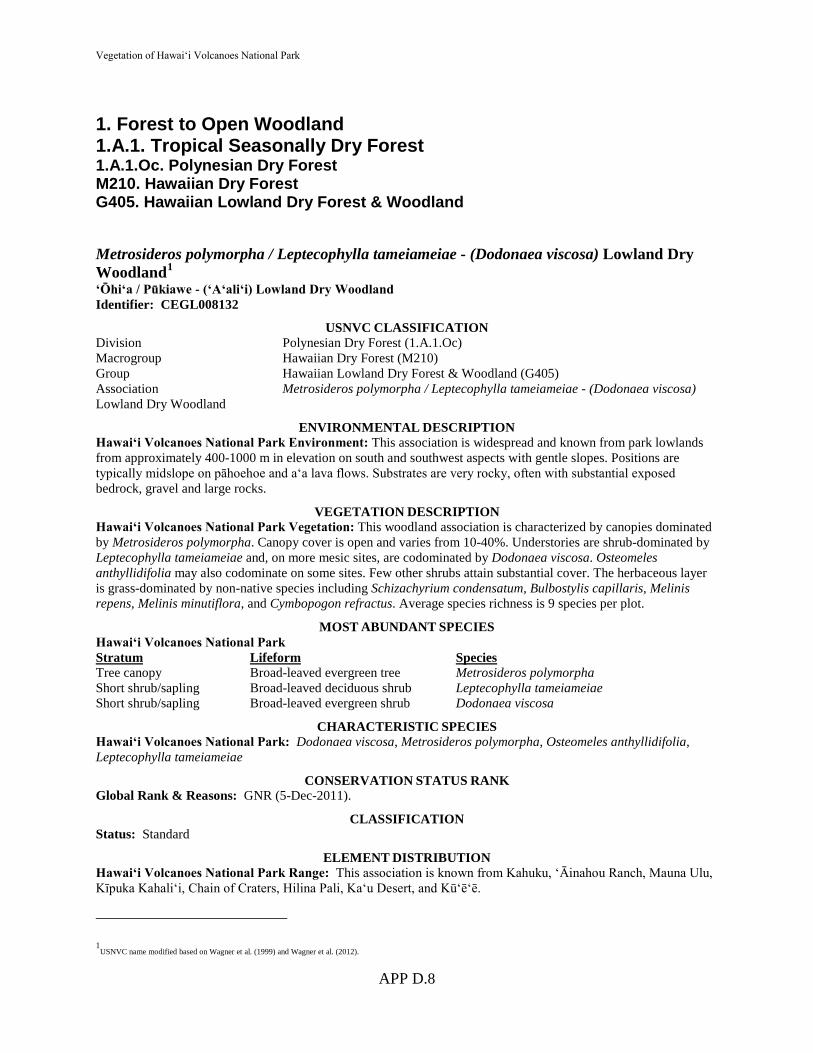
Vegetation of Hawaiʻi Volcanoes National Park
APP D.8
1. Forest to Open Woodland 1.A.1. Tropical Seasonally Dry Forest 1.A.1.Oc. Polynesian Dry Forest M210. Hawaiian Dry Forest G405. Hawaiian Lowland Dry Forest & Woodland
Metrosideros polymorpha / Leptecophylla tameiameiae - (Dodonaea viscosa) Lowland Dry Woodland1
ʻŌhiʻa / Pūkiawe - (ʻAʻaliʻi) Lowland Dry Woodland Identifier: CEGL008132
USNVC CLASSIFICATION Division Polynesian Dry Forest (1.A.1.Oc) Macrogroup Hawaiian Dry Forest (M210) Group Hawaiian Lowland Dry Forest & Woodland (G405) Association Metrosideros polymorpha / Leptecophylla tameiameiae - (Dodonaea viscosa) Lowland Dry Woodland
ENVIRONMENTAL DESCRIPTION Hawaiʻi Volcanoes National Park Environment: This association is widespread and known from park lowlands from approximately 400-1000 m in elevation on south and southwest aspects with gentle slopes. Positions are typically midslope on pāhoehoe and aʻa lava flows. Substrates are very rocky, often with substantial exposed bedrock, gravel and large rocks.
VEGETATION DESCRIPTION Hawaiʻi Volcanoes National Park Vegetation: This woodland association is characterized by canopies dominated by Metrosideros polymorpha. Canopy cover is open and varies from 10-40%. Understories are shrub-dominated by Leptecophylla tameiameiae and, on more mesic sites, are codominated by Dodonaea viscosa. Osteomeles anthyllidifolia may also codominate on some sites. Few other shrubs attain substantial cover. The herbaceous layer is grass-dominated by non-native species including Schizachyrium condensatum, Bulbostylis capillaris, Melinis repens, Melinis minutiflora, and Cymbopogon refractus. Average species richness is 9 species per plot.
MOST ABUNDANT SPECIES Hawaiʻi Volcanoes National Park Stratum Lifeform Species Tree canopy Broad-leaved evergreen tree Metrosideros polymorpha Short shrub/sapling Broad-leaved deciduous shrub Leptecophylla tameiameiae Short shrub/sapling Broad-leaved evergreen shrub Dodonaea viscosa
CHARACTERISTIC SPECIES Hawaiʻi Volcanoes National Park: Dodonaea viscosa, Metrosideros polymorpha, Osteomeles anthyllidifolia, Leptecophylla tameiameiae
CONSERVATION STATUS RANK Global Rank & Reasons: GNR (5-Dec-2011).
CLASSIFICATION Status: Standard
ELEMENT DISTRIBUTION Hawaiʻi Volcanoes National Park Range: This association is known from Kahuku, ʻĀinahou Ranch, Mauna Ulu, Kīpuka Kahaliʻi, Chain of Craters, Hilina Pali, Kaʻu Desert, and Kūʻēʻē.
1USNVC name modified based on Wagner et al. (1999) and Wagner et al. (2012).

Vegetation of Hawaiʻi Volcanoes National Park
APP D.9
Nations: US States/Provinces: HI Federal Lands: NPS (Hawaiʻi Volcanoes)
ELEMENT SOURCES Hawaiʻi Volcanoes National Park Plots: (45 Plots): HAVO.0004L, HAVO.0005L, HAVO.0008L, HAVO.0010L, HAVO.0014L, HAVO.0019L, HAVO.0036L, HAVO.0042L, HAVO.0112L, HAVO.0119L, HAVO.1005L, HAVO.1006L, HAVO.1007L, HAVO.1008L, HAVO.1035L, HAVO.1046L, HAVO.1049L, HAVO.113K, HAVO.114K, HAVO.115K, HAVO.117K, HAVO.121K, HAVO.122K, HAVO.157K, HAVO.171K, HAVO.172K, HAVO.2001, HAVO.2011, HAVO.2027, HAVO.2030, HAVO.2076, HAVO.2084, HAVO.2094, HAVO.2109, HAVO.2121, HAVO.2122, HAVO.2123, HAVO.2125, HAVO.2144, HAVO.2191, HAVO.2194, HAVO.2246, HAVO.2332, HAVO.9063, HAVO.9065 Local Description Authors: M. Hall References: Gagne and Cuddihy 1990, Western Ecology Working Group n.d.
Sophora chrysophylla - (Leptecophylla tameiameiae - Dodonaea viscosa) Lowland Dry Woodland1
Māmane - (Pūkiawe - ʻAʻaliʻi) Lowland Dry Woodland Identifier: CEGL008133
USNVC CLASSIFICATION Division Polynesian Dry Forest (1.A.1.Oc) Macrogroup Hawaiian Dry Forest (M210) Group Hawaiian Lowland Dry Forest & Woodland (G405) Association Sophora chrysophylla - (Leptecophylla tameiameiae - Dodonaea viscosa) Lowland Dry Woodland
ENVIRONMENTAL DESCRIPTION Hawaiʻi Volcanoes National Park Environment: This association is known from the Southwest Rift and Kapāpala areas of the park at elevations ranging from approximately 500-850 m. Substrates include aʻa, pāhoehoe, and cinder.
VEGETATION DESCRIPTION Hawaiʻi Volcanoes National Park Vegetation: This association is characterized by an open canopy dominated by Sophora chrysophylla ranging from 10-40% cover. Other canopy associates may include non-native Grevillea robusta and Schinus terebinthifolius. Understories are shrub-dominated by Dodonaea viscosa and/or Leptecophylla tameiameiae which may have as much as 50% combined cover. The herbaceous layer is strongly dominated by non-native species, including Andropogon virginicus, Melinis repens, and Pteridium aquilinum ssp. decompositum. Average species richness is 9 species per plot.
MOST ABUNDANT SPECIES Hawaiʻi Volcanoes National Park Stratum Lifeform Species Tree canopy Broad-leaved deciduous tree Sophora chrysophylla Tall shrub/sapling Broad-leaved deciduous shrub Leptecophylla tameiameiae Tall shrub/sapling Broad-leaved evergreen shrub Dodonaea viscosa Herb (field) Graminoid Andropogon virginicus, Melinis repens Herb (field) Fern or fern ally Pteridium aquilinum ssp. decompositum
CHARACTERISTIC SPECIES Hawaiʻi Volcanoes National Park: Dodonaea viscosa, Sophora chrysophylla, Leptecophylla tameiameiae
CONSERVATION STATUS RANK Global Rank & Reasons: GNR (5-Dec-2011).
1USNVC name modified based on Wagner et al. (1999) and Wagner et al. (2012).

Vegetation of Hawaiʻi Volcanoes National Park
APP D.10
CLASSIFICATION Status: Standard
ELEMENT DISTRIBUTION Hawaiʻi Volcanoes National Park Range: This association is known from the Southwest Rift and Kapāpala areas of the park. Nations: US States/Provinces: HI Federal Lands: NPS (Hawaiʻi Volcanoes)
ELEMENT SOURCES Hawaiʻi Volcanoes National Park Plots: (4 plots): HAVO.0011L, HAVO.0017L, HAVO.0051L, HAVO.0052L. Local Description Authors: M. Hall References: Western Ecology Working Group n.d.
Sophora chrysophylla - Metrosideros polymorpha / (Leptecophylla tameiameiae - Dodonaea viscosa) Lowland Dry Woodland1
Māmane - ʻŌhiʻa / (Pūkiawe, ʻAʻaliʻi) Lowland Dry Woodland Identifier: CEGL008139
USNVC CLASSIFICATION Division Polynesian Dry Forest (1.A.1.Oc) Macrogroup Hawaiian Dry Forest (M210) Group Hawaiian Lowland Dry Forest & Woodland (G405) Association Sophora chrysophylla - Metrosideros polymorpha / (Leptecophylla tameiameiae,
Dodonaea viscosa) Lowland Dry Woodland
ENVIRONMENTAL DESCRIPTION Hawaiʻi Volcanoes National Park Environment: This association is known from the Southwest Rift and Kapāpala areas of the park at elevations ranging from approximately 500-850 m. Substrates include aʻa, pāhoehoe, and cinder.
VEGETATION DESCRIPTION Hawaiʻi Volcanoes National Park Vegetation: This association is characterized by an open to nearly closed canopy dominated by Sophora chrysophylla and Metrosideros polymorpha ranging from 20-50% cover. Understories are shrub-dominated by Dodonaea viscosa and/or Leptecophylla tameiameiae which range from 10-30% total cover. The herbaceous layer is strongly dominated by native Pteridium aquilinum ssp. decompositum and non-native species, including Andropogon virginicus and Melinis spp.. Average species diversity is 9 species per plot.
MOST ABUNDANT SPECIES Hawaiʻi Volcanoes National Park Stratum Lifeform Species Tree canopy Broad-leaved deciduous tree Sophora chrysophylla Tree canopy Broad-leaved evergreen tree Metrosideros polymorpha Tall shrub/sapling Broad-leaved deciduous shrub Leptecophylla tameiameiae Tall shrub/sapling Broad-leaved evergreen shrub Dodonaea viscosa Herb (field) Graminoid Andropogon virginicus
CHARACTERISTIC SPECIES Hawaiʻi Volcanoes National Park: Dodonaea viscosa, Metrosideros polymorpha, Sophora chrysophylla, Leptecophylla tameiameiae
CONSERVATION STATUS RANK Global Rank & Reasons: GNR (5-Dec-2011).
CLASSIFICATION Status: Standard
Vegetation of Hawaiʻi Volcanoes National Park
APP D.11
ELEMENT DISTRIBUTION Hawaiʻi Volcanoes National Park Range: This association is known from the Southwest Rift and Kapāpala areas of the park. Nations: US States/Provinces: HI Federal Lands: NPS (Hawaiʻi Volcanoes)
ELEMENT SOURCES Hawaiʻi Volcanoes National Park Plots: (7 plots): HAVO.0015L, HAVO.0037L, HAVO.0045L, HAVO.0049L, HAVO.0050L, HAVO.0113L, HAVO.2199. Local Description Authors: M. Hall References: Western Ecology Working Group n.d.
G406. Hawaiian Montane-Subalpine Dry Forest & Woodland
Metrosideros polymorpha / Dryopteris wallichiana Woodland [Park Special] ʻŌhiʻa / ‘I‘o nui Woodland Identifier: CEPS009647
USNVC CLASSIFICATION Division Polynesian Dry Forest (1.A.1.Oc) Macrogroup Hawaiian Dry Forest (M210) Group Hawaiian Montane-Subalpine Dry Forest & Woodland (G406) Association Metrosideros polymorpha / Dryopteris wallichiana Woodland [Park Special]
ENVIRONMENTAL DESCRIPTION Hawaiʻi Volcanoes National Park Environment: This association is only known from the upper montane zone of Kahuku at elevations ranging from approximately 1940-1970 m. Positions are midslope with steep slopes and southeast aspects. Substrates are recent lava flows.
VEGETATION DESCRIPTION Hawaiʻi Volcanoes National Park Vegetation: This association is characterized by open to dense canopies dominated by Metrosideros polymorpha which has 40-80% cover. Cheirodendron trigynum ssp. trigynum, Ilex anomala, and Myrsine lessertiana may be present at <10% cover. Shrub cover is low, with Vaccinium calycinum sometimes present. The herbaceous layer is open to dense and dominated by Dryopteris wallichiana ranging from 10-80% cover. In some stands, Deschampsia nubigena and/or Diplazium sandwichianum may be important, but not dominant. No other herbaceous species were observed having more than trace cover. Average species richness is 17 species per plot.
MOST ABUNDANT SPECIES Hawaiʻi Volcanoes National Park Stratum Lifeform Species Tree canopy Broad-leaved evergreen tree Cheirodendron trigynum ssp. trigynum,
Metrosideros polymorpha Herb (field) Fern or fern ally Dryopteris wallichiana
CHARACTERISTIC SPECIES Hawaiʻi Volcanoes National Park: Dryopteris wallichiana, Metrosideros polymorpha
CONSERVATION STATUS RANK Global Rank & Reasons: GNR (5-Dec-2011).
CLASSIFICATION Status: Nonstandard
ELEMENT DISTRIBUTION Hawaiʻi Volcanoes National Park Range: This association is only known from the upper montane zone of Kahuku. Nations: US

Vegetation of Hawaiʻi Volcanoes National Park
APP D.12
States/Provinces: HI Federal Lands: NPS (Hawaiʻi Volcanoes)
ELEMENT SOURCES Hawaiʻi Volcanoes National Park Plots: (2 plots): HAVO.092K, HAVO.2255. Local Description Authors: M. Hall References: Western Ecology Working Group n.d.
Metrosideros polymorpha / Leptecophylla tameiameiae - Dodonaea viscosa Montane Woodland1
ʻŌhiʻa / Pūkiawe - ʻAʻaliʻi Montane Woodland Identifier: CEGL008135
USNVC CLASSIFICATION Division Polynesian Dry Forest (1.A.1.Oc) Macrogroup Hawaiian Dry Forest (M210) Group Hawaiian Montane-Subalpine Dry Forest & Woodland (G406) Association Metrosideros polymorpha / Leptecophylla tameiameiae- Dodonaea viscosa Montane Woodland
ENVIRONMENTAL DESCRIPTION Hawaiʻi Volcanoes National Park Environment: This woodland association is the most common community in the park and distributed throughout dry montane sites from approximately 1000-2400 m in elevation on south, west and southwest aspects. Positions include mid to high slopes often on relatively recent lava flows on gentle slopes. Substrates are variable and include pāhoehoe, aʻa, or cinder.
VEGETATION DESCRIPTION Hawaiʻi Volcanoes National Park Vegetation: This association is characterized by Metrosideros polymorpha-dominated canopies typically ranging from 20-50% cover, with ocassional cover greater than 80%. Canopy heights range from 5-10 m. Shrub cover ranges from sparse up to 50% and is dominated by Leptecophylla tameiameiae. Dodonaea viscosa has least 50% cover of that of Leptecophylla tameiameiaeand on sites where moisture availability is higher, may be dominant. Other common shrub associates include Broussaisia arguta, Coprosma ernodeoides, Coprosma montana, Coprosma ochracea, Myrsine sandwicensis, Vaccinium calycinum, and Vaccinium reticulatum. Herbaceous cover ranges from sparse to open, not typically exceeding 40%. The two most frequent herbaceous species are Deschampsia nubigena and Morelotia gahniiformis. Non-native grasses are common and may include Anthoxanthum odoratum, Sporobolus africanus, Eragrostis brownei, and Schizachyrium condensatum. Average species richness per plot is 13.
MOST ABUNDANT SPECIES Hawaiʻi Volcanoes National Park Stratum Lifeform Species Tree canopy Broad-leaved evergreen tree Metrosideros polymorpha Short shrub/sapling Broad-leaved deciduous shrub Leptecophylla tameiameiae Short shrub/sapling Broad-leaved evergreen shrub Dodonaea viscosa
CHARACTERISTIC SPECIES Hawaiʻi Volcanoes National Park: Deschampsia nubigena, Morelotia gahniiformis, Metrosideros polymorpha, Leptecophylla tameiameiae
CONSERVATION STATUS RANK Global Rank & Reasons: GNR (5-Dec-2011).
CLASSIFICATION Status: Standard
1USNVC name modified based on Wagner et al. (1999) and Wagner et al. (2012).

Vegetation of Hawaiʻi Volcanoes National Park
APP D.13
ELEMENT DISTRIBUTION Hawaiʻi Volcanoes National Park Range: This association is known from the vicinities of the ʻAlika lava flow, Hoʻōpūloa lava flow, Kīpuka Pahipa, Keāpōhina, Hiʻiaka Crater, and Kīlauea Crater. Nations: US States/Provinces: HI Federal Lands: NPS (Hawaiʻi Volcanoes)
ELEMENT SOURCES Hawaiʻi Volcanoes National Park Plots: (12 plots): HAVO.027K, HAVO.040K, HAVO.1001L, HAVO.103K, HAVO.134K, HAVO.135K, HAVO.141K, HAVO.143K, HAVO.144K, HAVO.159K, HAVO.2156, HAVO.2159. Local Description Authors: M. Hall References: Western Ecology Working Group n.d.
Metrosideros polymorpha / Leptecophylla tameiameiae/ Deschampsia nubigena - Morelotia gahniiformis Woodland1
ʻŌhiʻa / Pūkiawe / Deschampsia nubigena - Morelotia gahniiformis Identifier: CEGL008136
USNVC CLASSIFICATION Division Polynesian Dry Forest (1.A.1.Oc) Macrogroup Hawaiian Dry Forest (M210) Group Hawaiian Montane-Subalpine Dry Forest & Woodland (G406) Association Metrosideros polymorpha / Leptecophylla tameiameiae/ Deschampsia nubigena - Morelotia gahniiformis Woodland
ENVIRONMENTAL DESCRIPTION Hawaiʻi Volcanoes National Park Environment: This montane and subalpine association is the most common association in Kahuku and common on the Mauna Loa Strip at approximately 1150-2300 m in elevation on southern, southwestern and southeastern aspects.
VEGETATION DESCRIPTION Hawaiʻi Volcanoes National Park Vegetation: This woodland and forest association is characterized by open to closed canopies dominated by Metrosideros polymorpha ranging from 20-80% cover. Leptecophylla tameiameiae is dominant in the understory short-shrub layer and ranges from sparse to 40% cover. Vaccinium reticulatum may be codominant in some stands. Other common shrubs may include Coprosma ernodeoides, Coprosma ochracea, Dodonaea viscosa, Vaccinium calycinum, and Myrsine lessertiana. The herbaceous layer is composed of sparse to dense clumps of the native grass Deschampsia nubigena which may have as much as 80% cover. Few other herbaceous species attain high cover, although Morelotia gahniiformis and Luzula hawaiiensis var. hawaiiensis exhibit high constancy at low covers. Non-native grasses such as Anthoxanthum odoratum are often present. No forbs or ferns have high constancy. Average species diversity is 14 species per plot.
MOST ABUNDANT SPECIES Hawaiʻi Volcanoes National Park Stratum Lifeform Species Tree canopy Broad-leaved evergreen tree Metrosideros polymorpha Short shrub/sapling Broad-leaved deciduous shrub Leptecophylla tameiameiae Herb (field) Graminoid Deschampsia nubigena
CHARACTERISTIC SPECIES Hawaiʻi Volcanoes National Park: Coprosma ernodeoides, Deschampsia nubigena, Morelotia gahniiformis, Luzula hawaiiensis var. hawaiiensis, Metrosideros polymorpha, Leptecophylla tameiameiae
CONSERVATION STATUS RANK Global Rank & Reasons: GNR (5-Dec-2011).
1USNVC name modified based on Wagner et al. (1999) and Wagner et al. (2012).

Vegetation of Hawaiʻi Volcanoes National Park
APP D.14
CLASSIFICATION Status: Standard
ELEMENT DISTRIBUTION Hawaiʻi Volcanoes National Park Range: This association is known from Kahuku and the Mauna Loa Strip. Nations: US States/Provinces: HI Federal Lands: NPS (Hawaiʻi Volcanoes)
ELEMENT SOURCES Hawaiʻi Volcanoes National Park Plots: (57 plots): HAVO.001K, HAVO.002K, HAVO.004K, HAVO.005K, HAVO.006K, HAVO.007K, HAVO.008K, HAVO.009K, HAVO.010K, HAVO.016K, HAVO.017K, HAVO.018K, HAVO.019K, HAVO.031K, HAVO.032K, HAVO.036K, HAVO.038K, HAVO.039K, HAVO.041K, HAVO.044K, HAVO.045K, HAVO.047K, HAVO.051K, HAVO.055K, HAVO.058K, HAVO.059K, HAVO.061K, HAVO.063K, HAVO.066K, HAVO.069K, HAVO.070K, HAVO.071K, HAVO.072K, HAVO.074K, HAVO.075K, HAVO.082K, HAVO.083K, HAVO.093K, HAVO.094K, HAVO.096K, HAVO.097K, HAVO.098K, HAVO.100K, HAVO.101K, HAVO.102K, HAVO.109K, HAVO.133K, HAVO.2092, HAVO.2174, HAVO.2180, HAVO.2181, HAVO.2249, HAVO.2250, HAVO.2253, HAVO.2256, HAVO.2257, HAVO.2269. Local Description Authors: M. Hall References: Gagne and Cuddihy 1990, Western Ecology Working Group n.d.
Myoporum sandwicense Subalpine Woodland Naio Subalpine Woodland Identifier: CEGL008137
USNVC CLASSIFICATION Division Polynesian Dry Forest (1.A.1.Oc) Macrogroup Hawaiian Dry Forest (M210) Group Hawaiian Montane-Subalpine Dry Forest & Woodland (G406) Association Myoporum sandwicense Subalpine Woodland
ENVIRONMENTAL DESCRIPTION Hawaiʻi Volcanoes National Park Environment: This association is known from the subalpine zones of Mauna Loa at elevations ranging from approximately 2150-2400 m on west-facing slopes.
VEGETATION DESCRIPTION Hawaiʻi Volcanoes National Park Vegetation: This association is characterized by open woodland canopies dominated by Myoporum sandwicense with cover ranging from 10-40%. Sophora chrysophylla is a common canopy associate at low cover. The understory is largely dominated by the non-native grasses Ehrharta stipoides and Cenchrus clandestinus which range from 5-20% cover individually. Leptecophylla tameiameiae and Dodonaea viscosa may form a sparse shrub layer. Average species richness is 18 species per plot.
MOST ABUNDANT SPECIES Hawaiʻi Volcanoes National Park Stratum Lifeform Species Tree canopy Broad-leaved deciduous tree Myoporum sandwicense Herb (field) Graminoid Ehrharta stipoides, Cenchrus clandestinus
CHARACTERISTIC SPECIES Hawaiʻi Volcanoes National Park: Myoporum sandwicense
CONSERVATION STATUS RANK Global Rank & Reasons: GNR (5-Dec-2011).
CLASSIFICATION Status: Standard

Vegetation of Hawaiʻi Volcanoes National Park
APP D.15
ELEMENT DISTRIBUTION Hawaiʻi Volcanoes National Park Range: This association is only known from a small area on the southwest subalpine zone of Mauna Loa. Nations: US States/Provinces: HI Federal Lands: NPS (Hawaiʻi Volcanoes)
ELEMENT SOURCES Hawaiʻi Volcanoes National Park Plots: (4 plots): HAVO.139K, HAVO.150K, HAVO.151K, HAVO.2292. Local Description Authors: M. Hall References: Western Ecology Working Group n.d.
Sophora chrysophylla - (Leptecophylla tameiameiae - Dodonaea viscosa) Montane Woodland1
Māmane - (Pūkiawe - ʻAʻaliʻi) Montane Woodland Identifier: CEGL008138
USNVC CLASSIFICATION Division Polynesian Dry Forest (1.A.1.Oc) Macrogroup Hawaiian Dry Forest (M210) Group Hawaiian Montane-Subalpine Dry Forest & Woodland (G406) Association Sophora chrysophylla - (Leptecophylla tameiameiae - Dodonaea viscosa) Montane Woodland
ENVIRONMENTAL DESCRIPTION Hawaiʻi Volcanoes National Park Environment: This association is known from scattered upper montane and subalpine zones at elevations ranging from approximately 1400-2400 m. Positions are midslope with southeast and southwest aspects.
VEGETATION DESCRIPTION Hawaiʻi Volcanoes National Park Vegetation: This association is characterized by sparse to open canopies of Sophora chrysophylla. Myoporum sandwicense may be present at low cover. The understory is shrub-dominated by Leptecophylla tameiameiae and/or Dodonaea viscosa which have 5-50% total combined cover. The non-native grass Ehrharta stipoides is common at cover of 5% or less. Other non-native species have the highest constancy, but only at trace cover, including Verbascum thapsus, Rumex acetosella, and Cirsium vulgare. Average species richness is 11 species per plot.
MOST ABUNDANT SPECIES Hawaiʻi Volcanoes National Park Stratum Lifeform Species Tree canopy Broad-leaved deciduous tree Sophora chrysophylla Tall shrub/sapling Broad-leaved deciduous shrub Leptecophylla tameiameiae Tall shrub/sapling Broad-leaved evergreen shrub Dodonaea viscosa
CHARACTERISTIC SPECIES Hawaiʻi Volcanoes National Park: Dodonaea viscosa, Sophora chrysophylla, Leptecophylla tameiameiae
CONSERVATION STATUS RANK Global Rank & Reasons: GNR (5-Dec-2011).
CLASSIFICATION Status: Standard
ELEMENT DISTRIBUTION Hawaiʻi Volcanoes National Park Range: This association is known from the Mauna Loa Strip and the west side of Mauna Loa.
1USNVC name modified based on Wagner et al. (1999) and Wagner et al. (2012).

Vegetation of Hawaiʻi Volcanoes National Park
APP D.16
Nations: US States/Provinces: HI Federal Lands: NPS (Hawaiʻi Volcanoes)
ELEMENT SOURCES Hawaiʻi Volcanoes National Park Plots: (3 plots): HAVO.028K, HAVO.149K, HAVO.9064. Local Description Authors: M. Hall References: Western Ecology Working Group n.d.
Sophora chrysophylla / Ehrharta stipoides Subalpine Semi-natural Woodland Māmane / Meadow ricegrass Subalpine Semi-natural Woodland Identifier: CEGL008140
USNVC CLASSIFICATION Division Polynesian Dry Forest (1.A.1.Oc) Macrogroup Hawaiian Dry Forest (M210) Group Hawaiian Montane-Subalpine Dry Forest & Woodland (G406) Association Sophora chrysophylla / Ehrharta stipoides Subalpine Semi-natural Woodland
ENVIRONMENTAL DESCRIPTION Hawaiʻi Volcanoes National Park Environment: This association is known from a small area on the western subalpine zone of Mauna Loa. Elevations range from approximately 2200-2350 m.
VEGETATION DESCRIPTION Hawaiʻi Volcanoes National Park Vegetation: This association is characterized by open woodland canopies of Sophora chrysophylla ranging from 10-20% cover. Myoporum sandwicense may occasionally codominate. The understory is composed of mostly herbaceous vegetation dominated by the non-native Ehrharta stipoides, which ranges from 20-40% cover. No other species was observed to have high constancy or cover. Average species richness is 13 species per plot.
MOST ABUNDANT SPECIES Hawaiʻi Volcanoes National Park Stratum Lifeform Species Tree canopy Broad-leaved deciduous tree Myoporum sandwicense, Sophora chrysophylla Herb (field) Graminoid Ehrharta stipoides
CHARACTERISTIC SPECIES Hawaiʻi Volcanoes National Park: Ehrharta stipoides, Sophora chrysophylla
CONSERVATION STATUS RANK Global Rank & Reasons: GNA (semi-natural) (5-Dec-2011).
CLASSIFICATION Status: Standard
ELEMENT DISTRIBUTION Hawaiʻi Volcanoes National Park Range: This association is known only from a small area of Kahuku. Nations: US States/Provinces: HI Federal Lands: NPS (Hawaiʻi Volcanoes)
ELEMENT SOURCES Hawaiʻi Volcanoes National Park Plots: (4 plots): HAVO.029K, HAVO.030K, HAVO.147K, HAVO.154K. Local Description Authors: M. Hall References: Stone and Pratt 1994b, Western Ecology Working Group n.d.

Vegetation of Hawaiʻi Volcanoes National Park
APP D.17
1.A.2. Tropical Lowland Humid Forest 1.A.2.Oa. Polynesian Lowland Rainforest M187. Hawaiian Lowland Rainforest G389. Hawaiian Lowland Rainforest
Acacia koa / Melinis minutiflora Semi-natural Lowland Woodland Koa / Molasses Grass Semi-natural Lowland Woodland Identifier: CEGL008141
USNVC CLASSIFICATION Division Polynesian Lowland Rainforest (1.A.2.Oa) Macrogroup Hawaiian Lowland Rainforest (M187) Group Hawaiian Lowland Rainforest (G389) Association Acacia koa / Melinis minutiflora Semi-natural Lowland Woodland
ENVIRONMENTAL DESCRIPTION Hawaiʻi Volcanoes National Park Environment: This association is known from elevations ranging from approximately 740-750 m on midslopes.
VEGETATION DESCRIPTION Hawaiʻi Volcanoes National Park Vegetation: This association is characterized by open woodland canopies dominated by Acacia koa with cover ranging from 20-50%. The shrub layer is largely absent, though Dodonaea viscosa may be present at low cover. The herbaceous layer is strongly dominated by the non-native grass Melinis minutiflora with cover ranging from 50-80%. Cenchrus clandestinus may also be present at lower cover. Average species richness is 5 species per plot.
MOST ABUNDANT SPECIES Hawaiʻi Volcanoes National Park Stratum Lifeform Species Tree canopy Broad-leaved deciduous tree Acacia koa Tall shrub/sapling Broad-leaved evergreen shrub Dodonaea viscosa Herb (field) Graminoid Melinis minutiflora
CHARACTERISTIC SPECIES Hawaiʻi Volcanoes National Park: Acacia koa, Dodonaea viscosa
CONSERVATION STATUS RANK Global Rank & Reasons: GNR (5-Dec-2011).
CLASSIFICATION Status: Standard
ELEMENT DISTRIBUTION Hawaiʻi Volcanoes National Park Range: This association is known from Kapāpala. Nations: US States/Provinces: HI Federal Lands: NPS (Hawaiʻi Volcanoes)
ELEMENT SOURCES Hawaiʻi Volcanoes National Park Plots: (2 plots): HAVO.0020L, HAVO.2139. Local Description Authors: M. Hall References: Western Ecology Working Group n.d.

Vegetation of Hawaiʻi Volcanoes National Park
APP D.18
Metrosideros polymorpha / Cymbopogon refractus Semi-natural Woodland [Park Special] ʻŌhiʻa / Barbwire Grass Semi-natural Woodland Identifier: CEPS009649
USNVC CLASSIFICATION Division Polynesian Lowland Rainforest (1.A.2.Oa) Macrogroup Hawaiian Lowland Rainforest (M187) Group Hawaiian Lowland Rainforest (G389) Association Metrosideros polymorpha / Cymbopogon refractus Semi-natural Woodland [Park Special]
ENVIRONMENTAL DESCRIPTION Hawaiʻi Volcanoes National Park Environment: This association is known from an old pasture area at elevations ranging from approximately 600-700 m on a southwest aspect and is also noted from adjacent woodlands on less developed soils.
VEGETATION DESCRIPTION Hawaiʻi Volcanoes National Park Vegetation: This association is characterized by an open canopy dominated by Metrosideros polymorpha with about 40% cover. In one stand, Schinus terebinthifolius is codominant. Shrubs may be nearly absent or Dodonaea viscosa may form an open shrub layer. The herbaceous layer consists of an open to dense layer of the non-native grass Cymbopogon refractus which may have as much as 80% cover. No other herbaceous species were observed to have greater than trace cover. Average species richness is 10 species per plot.
MOST ABUNDANT SPECIES Hawaiʻi Volcanoes National Park Stratum Lifeform Species Tree canopy Broad-leaved evergreen tree Metrosideros polymorpha, Schinus
terebinthifolius Tall shrub/sapling Broad-leaved evergreen shrub Dodonaea viscosa Herb (field) Graminoid Cymbopogon refractus
CHARACTERISTIC SPECIES Hawaiʻi Volcanoes National Park: Cymbopogon refractus, Metrosideros polymorpha
CONSERVATION STATUS RANK Global Rank & Reasons: GNA (semi-natural) (5-Dec-2011).
CLASSIFICATION Status: Nonstandard
ELEMENT DISTRIBUTION Hawaiʻi Volcanoes National Park Range: This association is only known from a small area within the Kahuku Pasture system and woodlands extending westward. Nations: US States/Provinces: HI Federal Lands: NPS (Hawaiʻi Volcanoes)
ELEMENT SOURCES Hawaiʻi Volcanoes National Park Plots: (2 plots): HAVO.165K, HAVO.166K. Local Description Authors: M. Hall References: Western Ecology Working Group n.d.

Vegetation of Hawaiʻi Volcanoes National Park
APP D.19
1.A.3. Tropical Montane Humid Forest 1.A.3.Oa. Polynesian Montane & Cloud Forest M194. Hawaiian Montane & Cloud Forest G393. Hawaiian Montane Rainforest & Cloud Forest
Acacia koa / Cibotium spp. Montane Woodland Koa / Hapuʻu species Montane Woodland Identifier: CEGL008149
USNVC CLASSIFICATION Division Polynesian Montane & Cloud Forest (1.A.3.Oa) Macrogroup Hawaiian Montane & Cloud Forest (M194) Group Hawaiian Montane Rainforest & Cloud Forest (G393) Association Acacia koa / Cibotium spp. Montane Woodland
ENVIRONMENTAL DESCRIPTION Hawaiʻi Volcanoes National Park Environment: This association is known from ʻŌlaʻa at elevations ranging from approximately 1100-1150 m. Positions are midslope with nearly flat grades which are east- and south-facing. Substrates are moist to saturated with abundant bare soil and litter.
VEGETATION DESCRIPTION Hawaiʻi Volcanoes National Park Vegetation: This association is characterized by open, emergent canopies of Acacia koa which range from 15-50% cover. Cheirodendron trigynum ssp. trigynum, Ilex anomala, Perrottetia sandwicensis, and Metrosideros polymorpha are canopy associates; all but Metrosideros polymorpha may codominate. Total canopy cover ranges from 20-80%. The subcanopy consists of a dense layer of Cibotium glaucum, Cibotium menziesii, and Cibotium chamissoi in order of greatest to least cover. Combined, the three species range from 20-60% cover. The shrub layer is largely absent. No herbaceous species attain high cover, but the most constant are ferns Asplenium polyodon, Athyrium microphyllum, and others, as well as invasive herbs Hedychium gardnerianum and Setaria palmifolia. Average species richness is 21 species per plot.
MOST ABUNDANT SPECIES Hawaiʻi Volcanoes National Park Stratum Lifeform Species Tree canopy Broad-leaved deciduous tree Acacia koa Tree canopy Broad-leaved evergreen tree Cheirodendron trigynum ssp. trigynum Tree canopy Tree fern Cibotium glaucum, Cibotium menziesii
CHARACTERISTIC SPECIES Hawaiʻi Volcanoes National Park: Acacia koa, Cibotium glaucum, Perrottetia sandwicensis
CONSERVATION STATUS RANK Global Rank & Reasons: GNR (5-Dec-2011).
CLASSIFICATION Status: Standard
ELEMENT DISTRIBUTION Hawaiʻi Volcanoes National Park Range: This association is known only from a small area in ʻŌlaʻa koa unit. Nations: US States/Provinces: HI Federal Lands: NPS (Hawaiʻi Volcanoes)
ELEMENT SOURCES Hawaiʻi Volcanoes National Park Plots: (3 plots): HAVO.2215, HAVO.2216, HAVO.2234. Local Description Authors: M. Hall References: Western Ecology Working Group n.d.
Vegetation of Hawaiʻi Volcanoes National Park
APP D.20
Cibotium glaucum Montane Forest Hapuʻu Montane Forest Identifier: CEGL008151
USNVC CLASSIFICATION Division Polynesian Montane & Cloud Forest (1.A.3.Oa) Macrogroup Hawaiian Montane & Cloud Forest (M194) Group Hawaiian Montane Rainforest & Cloud Forest (G393) Association Cibotium glaucum Montane Forest
ENVIRONMENTAL DESCRIPTION Hawaiʻi Volcanoes National Park Environment: This association is distributed locally in the ʻŌlaʻa Rainforest at elevations ranging from 1150-1350 m. Positions are midslope on flat to gentle slopes with east and southeast aspects. Substrates are recent lava flows with well-developed leaf litter and moist to saturated soil moisture regimes.
VEGETATION DESCRIPTION Hawaiʻi Volcanoes National Park Vegetation: This diverse association is characterized by dense canopies of Cibotium glaucum with cover ranging from 50-75%. Cheirodendron trigynum ssp. trigynum, Metrosideros polymorpha, and Ilex anomala are all constant canopy components and form an emergent canopy with 10-20% total combined cover. Perrottetia sandwicensis, Broussaisia arguta, and Cibotium menziesii may be present as minor canopy components. The understory contains a variety of forbs, ferns and grasses of which the native fern Pneumatopteris sandwicensis is the most constant and dominant, with cover up to 10%. Other common herbaceous species include Hymenophyllum lanceolatum, Asplenium polyodon, Microlepia strigosa, and Uncinia uncinata. Average species richness is 23 species per plot.
MOST ABUNDANT SPECIES Hawaiʻi Volcanoes National Park Stratum Lifeform Species Tree canopy Broad-leaved deciduous tree Ilex anomala Tree canopy Broad-leaved evergreen tree Cheirodendron trigynum ssp. trigynum,
Metrosideros polymorpha Tree subcanopy Tree fern Cibotium glaucum Herb (field) Fern or fern ally Pneumatopteris sandwicensis
CHARACTERISTIC SPECIES Hawaiʻi Volcanoes National Park: Cheirodendron trigynum ssp. trigynum, Cibotium glaucum, Ilex anomala, Pneumatopteris sandwicensis
CONSERVATION STATUS RANK Global Rank & Reasons: GNR (5-Dec-2011).
CLASSIFICATION Status: Standard
ELEMENT DISTRIBUTION Hawaiʻi Volcanoes National Park Range: This association appears to be distributed locally in the ʻŌlaʻa Rainforest. Nations: US States/Provinces: HI Federal Lands: NPS (Hawaiʻi Volcanoes)
ELEMENT SOURCES Hawaiʻi Volcanoes National Park Plots: (9 plots): HAVO.2136, HAVO.2137, HAVO.2138, HAVO.2166, HAVO.2167, HAVO.2221, HAVO.2222, HAVO.2223, HAVO.9081. Local Description Authors: M. Hall References: Western Ecology Working Group n.d.

Vegetation of Hawaiʻi Volcanoes National Park
APP D.21
Metrosideros polymorpha - Cheirodendron trigynum / (Cibotium spp.) Montane Wet Forest ʻŌhiʻa - ʻŌlapalapa / (Hapuʻu species) Montane Wet Forest Identifier: CEGL008008
USNVC CLASSIFICATION Division Polynesian Montane & Cloud Forest (1.A.3.Oa) Macrogroup Hawaiian Montane & Cloud Forest (M194) Group Hawaiian Montane Rainforest & Cloud Forest (G393) Association Metrosideros polymorpha - Cheirodendron trigynum / (Cibotium spp.) Montane Wet Forest
ENVIRONMENTAL DESCRIPTION Hawaiʻi Volcanoes National Park Environment: This association is known only from a small area in former pasture and in ʻŌlaʻa at approximately 1030-1350 m in elevation. Positions are midslope and high level on a gentle slope with a southeast aspect. Soils are mesic and have substantial litter accumulation.
VEGETATION DESCRIPTION Hawaiʻi Volcanoes National Park Vegetation: This diverse forest association is characterized by a variable open to closed canopy which may be dominated or codominated by Metrosideros polymorpha and/or Cheirodendron trigynum ssp. trigynum with 25-70% total cover. The subcanopy is dominated by Cibotium glaucum with lesser amounts of Cibotium menziesii. Total subcanopy cover ranges from 20-60%. Other canopy associates may include Ilex anomala and Perrottetia sandwicensis.The shrub layer is essentially non-existent. The herbaceous layer is very diverse, but no species appear to be consistently dominant. Common herbs include Asplenium polyodon, Astelia menziesiana, Cuphea carthagenensis, Diplazium sandwichianum, Dryopteris wallichiana, Freycinetia arborea, Grammitis tenella, and Ludwigia palustris. Average species diversity is 22 species per plot.
MOST ABUNDANT SPECIES Hawaiʻi Volcanoes National Park Stratum Lifeform Species Tree canopy Broad-leaved evergreen tree Cheirodendron trigynum ssp. trigynum,
Metrosideros polymorpha Tree subcanopy Tree fern Cibotium glaucum
CHARACTERISTIC SPECIES Hawaiʻi Volcanoes National Park: Cheirodendron trigynum ssp. trigynum, Cibotium glaucum, Diplazium sandwichianum, Metrosideros polymorpha
CONSERVATION STATUS RANK Global Rank & Reasons: G3 (1-Dec-1997).
CLASSIFICATION Status: Standard Classification Confidence: 2 - Moderate
ELEMENT DISTRIBUTION Hawaiʻi Volcanoes National Park Range: This association is only known from a small area within the Kahuku Pasture and ʻŌlaʻa. Nations: US States/Provinces: HI:S3 Federal Lands: NPS (Hawaiʻi Volcanoes, Kalaupapa)
ELEMENT SOURCES Hawaiʻi Volcanoes National Park Plots: (9 plots): HAVO.053K, HAVO.169K, HAVO.2102, HAVO.2134, HAVO.2135, HAVO.2186, HAVO.2187, HAVO.2217, HAVO.2220. Local Description Authors: M. Hall References: Western Ecology Working Group n.d.

Vegetation of Hawaiʻi Volcanoes National Park
APP D.22
Metrosideros polymorpha / Cibotium spp. Montane Wet Forest ʻŌhiʻa / Hapuʻu species Montane Wet Forest Identifier: CEGL008009
USNVC CLASSIFICATION Division Polynesian Montane & Cloud Forest (1.A.3.Oa) Macrogroup Hawaiian Montane & Cloud Forest (M194) Group Hawaiian Montane Rainforest & Cloud Forest (G393) Association Metrosideros polymorpha / Cibotium spp. Montane Wet Forest
ENVIRONMENTAL DESCRIPTION Hawaiʻi Volcanoes National Park Environment: This forest association is common throughout the rainforest zones in the vicinity of the Puʻu Makaʻala, Kaʻu and ʻŌlaʻa Forest Reserves approximately 800-1700 m in elevation on all aspects. Positions are typically midslope often on recent lava flows. Substrates range from cinder and pāhoehoe lava to developed soils. Litter is the predominant non-vegetated ground cover.
VEGETATION DESCRIPTION Hawaiʻi Volcanoes National Park Vegetation: This association is characterized by open to closed-canopy forests and woodlands ranging from 40-80% cover of Metrosideros polymorpha which bear numerous epiphytic ferns, shrubs and bryophytes. Subcanopies are dominated by Cibotium glaucum ranging from 10-70% cover, with occasional Cibotium menziesii and/or Cibotium chamissoi. Cheirodendron trigynum ssp. trigynum, Ilex anomala, and Myrsine lessertiana are common subcanopy associates, but are never codominant. The shrub layer is diverse and variable, ranging from sparse to 70%. No shrub species are truly dominant and none exhibit high constancy, but common species include Broussaisia arguta, Rubus ellipticus var. obcordatus, Vaccinium calycinum, Freycinetia arborea, Pipturus albidus, Cyrtandra platyphylla, and Sadleria pallida. Herbaceous cover is sparse to dense ranging from 5-80% with a high diversity of graminoids, forbs and ferns, although no species exhibit high constancy. Herbaceous associates may include Anemone hupehensis var. japonica, Astelia menziesiana, Grammitis tenella, Hedychium gardnerianum, Isachne distichophylla, Machaerina angustifolia, Pneumatopteris sandwicensis, Hymenophyllum lanceolatum, and Uncinia uncinata. This community is more diverse than most with a mean species richness of 19 species per plot.
MOST ABUNDANT SPECIES Hawaiʻi Volcanoes National Park Stratum Lifeform Species Tree canopy Broad-leaved evergreen tree Metrosideros polymorpha Tree subcanopy Tree fern Cibotium glaucum
CHARACTERISTIC SPECIES Hawaiʻi Volcanoes National Park: Cheirodendron trigynum ssp. trigynum, Cibotium glaucum, Ilex anomala, Metrosideros polymorpha, Myrsine lessertiana
CONSERVATION STATUS RANK Global Rank & Reasons: G3 (1-Dec-1997).
CLASSIFICATION Status: Standard Classification Confidence: 2 - Moderate Global Related Concepts: ʻŌhiʻa / Hapuʻu (Metrosideros/Cibotium) Tree Fern Forest (Gagne and Cuddihy 1990) =
ELEMENT DISTRIBUTION Hawaiʻi Volcanoes National Park Range: This forest association is known from ʻŌlaʻa, Puʻu Puaʻi, the East Rift, Kīlauea Field Station, Thurston, Puʻu Oʻo, and Southeast Kakuhu. Nations: US States/Provinces: HI:S3 Federal Lands: NPS (Hawaiʻi Volcanoes)

Vegetation of Hawaiʻi Volcanoes National Park
APP D.23
ELEMENT SOURCES Hawaiʻi Volcanoes National Park Plots: (31 plots): HAVO.081K, HAVO.167K, HAVO.168K, HAVO.2028, HAVO.2050, HAVO.2051, HAVO.2052, HAVO.2056, HAVO.2057, HAVO.2060, HAVO.2061, HAVO.2074, HAVO.2075, HAVO.2112, HAVO.2114, HAVO.2179, HAVO.2233, HAVO.2238, HAVO.2239, HAVO.2248, HAVO.2258, HAVO.2259, HAVO.2260, HAVO.2283, HAVO.2284, HAVO.2294, HAVO.2295, HAVO.2341, HAVO.2342, HAVO.2343, HAVO.9054 Local Description Authors: M. Hall References: Gagne and Cuddihy 1990, Western Ecology Working Group n.d.
Metrosideros polymorpha / Dicranopteris linearis Montane Wet Woodland ʻŌhiʻa / Uluhe species Montane Wet Woodland Identifier: CEGL008041
USNVC CLASSIFICATION Division Polynesian Montane & Cloud Forest (1.A.3.Oa) Macrogroup Hawaiian Montane & Cloud Forest (M194) Group Hawaiian Montane Rainforest & Cloud Forest (G393) Association Metrosideros polymorpha / Dicranopteris linearis Montane Wet Woodland
ENVIRONMENTAL DESCRIPTION Hawaiʻi Volcanoes National Park Environment: This association is known from the East Rift area of the park at elevations ranging from approximately 900-1200 m. Positions are midslope with flat to gentle slopes. Although substrates are recent lava flows, litter accumulation is high with mesic soil conditions.
VEGETATION DESCRIPTION Hawaiʻi Volcanoes National Park Vegetation: This association is characterized by an open canopy dominated by Metrosideros polymorpha ranging from 15-50% cover. Occasionally, Cibotium glaucum may be present in the subcanopy. The understory is represented by a dense herbaceous layer dominated by Dicranopteris linearis. Species richness is generally low and few other species occur with >5% cover although the heath Vaccinium calycinum and the sedge Machaerina angustifolia are common indicators. Average species richness is 11 species per plot.
MOST ABUNDANT SPECIES Hawaiʻi Volcanoes National Park Stratum Lifeform Species Tree canopy Broad-leaved evergreen tree Metrosideros polymorpha Tree canopy Tree fern Cibotium glaucum Herb (field) Fern or fern ally Dicranopteris linearis
CHARACTERISTIC SPECIES Hawaiʻi Volcanoes National Park: Dicranopteris linearis, Metrosideros polymorpha
CONSERVATION STATUS RANK Global Rank & Reasons: G3 (1-Dec-1997).
CLASSIFICATION Status: Standard Classification Confidence: 1 - Strong Global Related Concepts: ʻŌhiʻa (Metrosideros) Montane Wet Forest (Gagne and Cuddihy 1990) =
ELEMENT DISTRIBUTION Hawaiʻi Volcanoes National Park Range: This association appears fairly restricted to the East Rift area of the park. Nations: US States/Provinces: HI:S3 Federal Lands: NPS (Hawaiʻi Volcanoes, Kalaupapa)

Vegetation of Hawaiʻi Volcanoes National Park
APP D.24
ELEMENT SOURCES Hawaiʻi Volcanoes National Park Plots: (7 plots): HAVO.2091, HAVO.2115, HAVO.2232, HAVO.2235, HAVO.9069, HAVO.9089, HAVO.9090. Local Description Authors: M. Hall References: Gagne and Cuddihy 1990, Western Ecology Working Group n.d.
Metrosideros polymorpha / Nephrolepis brownii Semi-natural Woodland1
ʻŌhiʻa / Swordfern Semi-natural Woodland Identifier: CEGL008153
USNVC CLASSIFICATION Division Polynesian Montane & Cloud Forest (1.A.3.Oa) Macrogroup Hawaiian Montane & Cloud Forest (M194) Group Hawaiian Montane Rainforest & Cloud Forest (G393) Association Metrosideros polymorpha / Nephrolepis brownii Semi-natural Woodland
ENVIRONMENTAL DESCRIPTION Hawaiʻi Volcanoes National Park Environment: This association is known from two scattered locations ranging from approximately 750-800 m in elevation. Positions are midslope on flat to gentle grades with south and southeast aspects.
VEGETATION DESCRIPTION Hawaiʻi Volcanoes National Park Vegetation: This association is characterized by open to closed canopies of Metrosideros polymorpha with cover ranging from 20-70%. Schinus terebinthifolius, a non-native tree, may be present at lower cover. The understory is dominated by the non-native fern Nephrolepis brownii with cover ranging from 15-70%. The non-native grass Andropogon glomeratus var. pumilus is nearly codominant in one stand. No other species has substantial cover or constancy. Average species richness is 13 species per plot.
MOST ABUNDANT SPECIES Hawaiʻi Volcanoes National Park Stratum Lifeform Species Tree canopy Broad-leaved evergreen tree Metrosideros polymorpha Herb (field) Graminoid Andropogon glomeratus var. pumilus Herb (field) Fern or fern ally Nephrolepis brownii
CHARACTERISTIC SPECIES Hawaiʻi Volcanoes National Park: Metrosideros polymorpha, Nephrolepis brownii
OTHER NOTEWORTHY SPECIES Hawaiʻi Volcanoes National Park: Invasive/Exotic: Andropogon glomeratus var. pumilus (non-native\exotic), Nephrolepis brownii (non-native\exotic)
CONSERVATION STATUS RANK Global Rank & Reasons: GNA (semi-natural) (5-Dec-2011).
CLASSIFICATION Status: Standard
ELEMENT DISTRIBUTION Hawaiʻi Volcanoes National Park Range: This association is known from the Kahuku Pasture and the East Rift. Nations: US States/Provinces: HI Federal Lands: NPS (Hawaiʻi Volcanoes)
ELEMENT SOURCES Hawaiʻi Volcanoes National Park Plots: (3 plots): HAVO.2108, HAVO.2120, HAVO.9050.
1USNVC name modified based on Wagner et al. (1999) and Wagner et al. (2012).
Vegetation of Hawaiʻi Volcanoes National Park
APP D.25
Local Description Authors: M. Hall References: Western Ecology Working Group n.d.
Sapindus saponaria - Coprosma rhynchocarpa Montane Mesic Forest [Park Special] Mānele - Pilo Montane Mesic Forest Identifier: CEPS009654
USNVC CLASSIFICATION Division Polynesian Montane & Cloud Forest (1.A.3.Oa) Macrogroup Hawaiian Montane & Cloud Forest (M194) Group Hawaiian Montane Rainforest & Cloud Forest (G393) Association Sapindus saponaria - Coprosma rhynchocarpa Montane Mesic Forest [Park Special]
ENVIRONMENTAL DESCRIPTION Hawaiʻi Volcanoes National Park Environment: This association is known from Kīpuka Puaulu and Kīpuka Ki at elevations ranging from approximately 1150-1400 m. Topographic positions are midslope on gentle grades on south and southwest aspects. Substrates are recent lava flows.
VEGETATION DESCRIPTION Hawaiʻi Volcanoes National Park Vegetation: This association is characterized by open canopies dominated by Sapindus saponaria with cover ranging from 30-40% cover. Acacia koa is a canopy associate with 10% or less cover. The understory is shrub-dominated by Coprosma rhynchocarpa which has 20-30% cover. Pisonia brunoniana is also present but at low cover. The non-native vine Commelina diffusa and native vine Ipomoea indica may be present in stands. The herbaceous layer varies from sparse to open with native Microlepia strigosa having as much as 30% cover in some stands. Average species richness is 17 species per plot.
MOST ABUNDANT SPECIES Hawaiʻi Volcanoes National Park Stratum Lifeform Species Tree canopy Broad-leaved deciduous tree Acacia koa Tree canopy Broad-leaved evergreen tree Sapindus saponaria Tall shrub/sapling Broad-leaved evergreen shrub Coprosma rhynchocarpa Herb (field) Fern or fern ally Microlepia strigosa
CHARACTERISTIC SPECIES Hawaiʻi Volcanoes National Park: Coprosma rhynchocarpa, Microlepia strigosa, Pisonia brunoniana, Sapindus saponaria
CONSERVATION STATUS RANK Global Rank & Reasons: GNR (5-Dec-2011).
CLASSIFICATION Status: Nonstandard
ELEMENT DISTRIBUTION Hawaiʻi Volcanoes National Park Range: This association appears localized in Kīpuka Puaulu and Kīpuka Ki on Mauna Loa Strip. Nations: US States/Provinces: HI Federal Lands: NPS (Hawaiʻi Volcanoes)
ELEMENT SOURCES Hawaiʻi Volcanoes National Park Plots: (2 plots): HAVO.2024, HAVO.2110. Local Description Authors: M. Hall References: Western Ecology Working Group n.d.

Vegetation of Hawaiʻi Volcanoes National Park
APP D.26
G625. Hawaiian Montane-Subalpine Mesic Forest
Acacia koa / Ehrharta stipoides Semi-natural Montane Woodland Koa / Meadow ricegrass Semi-natural Montane Woodland Identifier: CEGL008154
USNVC CLASSIFICATION Division Polynesian Montane & Cloud Forest (1.A.3.Oa) Macrogroup Hawaiian Montane & Cloud Forest (M194) Group Hawaiian Montane-Subalpine Mesic Forest (G625) Association Acacia koa / Ehrharta stipoides Semi-natural Montane Woodland
ENVIRONMENTAL DESCRIPTION Hawaiʻi Volcanoes National Park Environment: This association is known from Mauna Loa Strip at elevations ranging from approximately 1200-1800 m. Positions are midslope with east and southeast aspects on nearly flat to moderately recent lava flows.
VEGETATION DESCRIPTION Hawaiʻi Volcanoes National Park Vegetation: This semi-natural association is species-poor and characterized by woodland canopies clearly dominated by Acacia koa. Canopy cover varies from 25-60% cover. Shrub cover is absent to sparse and may occasionally have a sparse shrub layer of Leptecophylla tameiameiae and/or Dodonaea viscosa. Understories are strongly dominated by Ehrharta stipoides with cover ranging from 20-90%. In some stands, Pteridium aquilinum may codominate the herbaceous layer. Average species richness is 8 species per plot.
MOST ABUNDANT SPECIES Hawaiʻi Volcanoes National Park Stratum Lifeform Species Tree canopy Broad-leaved deciduous tree Acacia koa Herb (field) Graminoid Ehrharta stipoides Herb (field) Fern or fern ally Pteridium aquilinum
CHARACTERISTIC SPECIES Hawaiʻi Volcanoes National Park: Acacia koa, Ehrharta stipoides
CONSERVATION STATUS RANK Global Rank & Reasons: GNA (semi-natural) (5-Dec-2011).
CLASSIFICATION Status: Standard
ELEMENT DISTRIBUTION Hawaiʻi Volcanoes National Park Range: This association appears to be patchy and occurs in a small area of Mauna Loa Strip. Nations: US States/Provinces: HI Federal Lands: NPS (Hawaiʻi Volcanoes)
ELEMENT SOURCES Hawaiʻi Volcanoes National Park Plots: (8 plots): HAVO.2146, HAVO.2151, HAVO.2162, HAVO.2164, HAVO.2198, HAVO.2225, HAVO.2229, HAVO.9007. Local Description Authors: M. Hall References: Stone and Pratt 1994b, Western Ecology Working Group n.d.
Acacia koa / Metrosideros polymorpha / Ehrharta stipoides Montane Mesic Woodland Koa / ʻŌhiʻa / Meadow ricegrass Montane Mesic Woodland Identifier: CEGL008156
USNVC CLASSIFICATION Division Polynesian Montane & Cloud Forest (1.A.3.Oa)

Vegetation of Hawaiʻi Volcanoes National Park
APP D.27
Macrogroup Hawaiian Montane & Cloud Forest (M194) Group Hawaiian Montane-Subalpine Mesic Forest (G625) Association Acacia koa / Metrosideros polymorpha / Ehrharta stipoides Montane Mesic Woodland
ENVIRONMENTAL DESCRIPTION Hawaiʻi Volcanoes National Park Environment: This association is known from a small area within the ʻAlika lava flow area from approximately 1750-1800 m in elevation on a southwest-facing slope.
VEGETATION DESCRIPTION Hawaiʻi Volcanoes National Park Vegetation: This association is characterized by open woodlands dominated by Acacia koa and Metrosideros polymorpha. Canopy cover ranges from 10-40% total cover. The understory is strongly dominated by the non-native grass Ehrharta stipoides with as much as 80% cover. Dodonaea viscosa and Leptecophylla tameiameiae typically form a sparse shrub layer. Few other species occur at notable cover. Average species richness is 9 species per plot.
MOST ABUNDANT SPECIES Hawaiʻi Volcanoes National Park Stratum Lifeform Species Tree canopy Broad-leaved deciduous tree Acacia koa Tree canopy Broad-leaved evergreen tree Metrosideros polymorpha Herb (field) Graminoid Ehrharta stipoides
CHARACTERISTIC SPECIES Hawaiʻi Volcanoes National Park: Acacia koa, Metrosideros polymorpha
CONSERVATION STATUS RANK Global Rank & Reasons: GNR (5-Dec-2011).
CLASSIFICATION Status: Standard
ELEMENT DISTRIBUTION Hawaiʻi Volcanoes National Park Range: This association is known only from a small area within the ʻAlika lava flow. Nations: US States/Provinces: HI Federal Lands: NPS (Hawaiʻi Volcanoes)
ELEMENT SOURCES Hawaiʻi Volcanoes National Park Plots: (4 plots): HAVO.012K, HAVO.013K, HAVO.014K, HAVO.015K. Local Description Authors: M. Hall References: Stone and Pratt 1994b, Western Ecology Working Group n.d.
Acacia koa – (Sapindus saponaria) / Microlepia strigosa Montane Woodland [Park Special] Koa / Mānele / Palapalai Montane Woodland Identifier: CEPS009655
USNVC CLASSIFICATION Division Polynesian Montane & Cloud Forest (1.A.3.Oa) Macrogroup Hawaiian Montane & Cloud Forest (M194) Group Hawaiian Montane-Subalpine Mesic Forest (G625) Association Acacia koa – (Sapindus saponaria) / Microlepia strigosa Montane Woodland [Park Special]
ENVIRONMENTAL DESCRIPTION Hawaiʻi Volcanoes National Park Environment: This association is known only from the Mauna Loa Strip at elevations ranging from approximately 1300-1450 m. Positions are midslope with gentle grades on recent lava flows. Soils are moist with well-developed litter.
Vegetation of Hawaiʻi Volcanoes National Park
APP D.28
VEGETATION DESCRIPTION Hawaiʻi Volcanoes National Park Vegetation: This association is characterized by open woodland canopies dominated by Acacia koa with cover ranging from 20-30% cover. Sapindus saponaria, Coprosma rhynchocarpa, and Sophora chrysophylla may be present in the canopy at low cover (<5%). The understory is herb-dominated but with a sparse shrub layer. The overwhelmingly dominant herb is the native fern Microlepia strigosa with highly variable cover ranging from 10-70%. No other species was observed to have more than trace cover. Average species richness is 13 species per plot.
MOST ABUNDANT SPECIES Hawaiʻi Volcanoes National Park Stratum Lifeform Species Tree canopy Broad-leaved deciduous tree Acacia koa Tree canopy Broad-leaved evergreen tree Sapindus saponaria Herb (field) Fern or fern ally Microlepia strigosa
CHARACTERISTIC SPECIES Hawaiʻi Volcanoes National Park: Acacia koa, Microlepia strigosa
CONSERVATION STATUS RANK Global Rank & Reasons: GNR (5-Dec-2011).
CLASSIFICATION Status: Nonstandard
ELEMENT DISTRIBUTION Hawaiʻi Volcanoes National Park Range: This association is known from Mauna Loa Strip and Kahuku. Nations: US States/Provinces: HI Federal Lands: NPS (Hawaiʻi Volcanoes)
ELEMENT SOURCES Hawaiʻi Volcanoes National Park Plots: (2 plots): HAVO.2130, HAVO.2150. Local Description Authors: M. Hall References: Western Ecology Working Group n.d.
Acacia koa / Cenchrus clandestinus Semi-natural Woodland1
Koa / Kikuyu Grass Semi-natural Woodland Identifier: CEGL008157
USNVC CLASSIFICATION Division Polynesian Montane & Cloud Forest (1.A.3.Oa) Macrogroup Hawaiian Montane & Cloud Forest (M194) Group Hawaiian Montane-Subalpine Mesic Forest (G625) Association Acacia koa / Cenchrus clandestinus Semi-natural Woodland
ENVIRONMENTAL DESCRIPTION Hawaiʻi Volcanoes National Park Environment: This association occurs in the Mauna Loa Strip on former pasturelands at elevations ranging from approximately 1300-1400 m. Positions are midslope with nearly flat to moderate grades and southeast aspects.
VEGETATION DESCRIPTION Hawaiʻi Volcanoes National Park Vegetation: This association is characterized by open canopies dominated by Acacia koa with cover ranging from 15-35% cover. The shrub layer is largely absent. The understory is grass-dominated by the non-native Cenchrus clandestinus. The only other herbaceous species present in each stand is Pteridium aquilinum var. decompositum, but at very low cover. Average species richness is 6 species per plot.
1USNVC name modified based on Wagner et al. (1999) and Wagner et al. (2012).

Vegetation of Hawaiʻi Volcanoes National Park
APP D.29
MOST ABUNDANT SPECIES Hawaiʻi Volcanoes National Park Stratum Lifeform Species Tree canopy Broad-leaved deciduous tree Acacia koa Herb (field) Graminoid Cenchrus clandestinus
CHARACTERISTIC SPECIES Hawaiʻi Volcanoes National Park: Acacia koa, Cenchrus clandestinus
CONSERVATION STATUS RANK Global Rank & Reasons: GNA (semi-natural) (5-Dec-2011).
CLASSIFICATION Status: Standard
ELEMENT DISTRIBUTION Hawaiʻi Volcanoes National Park Range: This association is known from the Mauna Loa Strip. Nations: US States/Provinces: HI Federal Lands: NPS (Hawaiʻi Volcanoes)
ELEMENT SOURCES Hawaiʻi Volcanoes National Park Plots: (3 plots): HAVO.2131, HAVO.2227, HAVO.2228. Local Description Authors: M. Hall References: Gagne and Cuddihy 1990, Western Ecology Working Group n.d.
Acacia koa / Leptecophylla tameiameiae - (Dodonaea viscosa) Montane Woodland1
Koa / Pūkiawe – (ʻAʻaliʻi) Montane Woodland Identifier: CEGL008155
USNVC CLASSIFICATION Division Polynesian Montane & Cloud Forest (1.A.3.Oa) Macrogroup Hawaiian Montane & Cloud Forest (M194) Group Hawaiian Montane-Subalpine Mesic Forest (G625) Association Acacia koa / Leptecophylla tameiameiae- (Dodonaea viscosa) Montane Woodland
ENVIRONMENTAL DESCRIPTION Hawaiʻi Volcanoes National Park Environment: This is association occurs in the montane and subalpine zones on Mauna Loa Strip at elevations ranging from approximately 1350-2100 m. Positions are midslope with south and southwest aspects. Slopes are gentle. Substrates are recent lava flows on pāhoehoe with substantial litter development.
VEGETATION DESCRIPTION Hawaiʻi Volcanoes National Park Vegetation: This association is characterized by open to moderately closed canopies dominated by Acacia koa. Scattered individuals of Sophora chrysophylla may occur. Canopy cover ranges from 15-60%. The understory is largely shrub-dominated by Leptecophylla tameiameiae; Dodonaea viscosa may codominate some stands. Grasses such as native Deschampsia nubigena and non-native Ehrharta stipoides may form a fairly dense herbaceous layer. Other common herbs include Anthoxanthum odoratum, Carex wahuensis, Eragrostis variabilis, Holcus lanatus, Hypochaeris radicata, and Plantago lanceolata. Average species diversity is 10 species per plot.
MOST ABUNDANT SPECIES Hawaiʻi Volcanoes National Park Stratum Lifeform Species Tree canopy Broad-leaved deciduous tree Acacia koa
1USNVC name modified based on Wagner et al. (1999) and Wagner et al. (2012).

Vegetation of Hawaiʻi Volcanoes National Park
APP D.30
Tall shrub/sapling Broad-leaved deciduous shrub Leptecophylla tameiameiae Tall shrub/sapling Broad-leaved evergreen shrub Dodonaea viscosa Herb (field) Graminoid Deschampsia nubigena, Ehrharta stipoides
CHARACTERISTIC SPECIES Hawaiʻi Volcanoes National Park: Acacia koa, Deschampsia nubigena, Leptecophylla tameiameiae
CONSERVATION STATUS RANK Global Rank & Reasons: GNR (5-Dec-2011).
CLASSIFICATION Status: Standard
ELEMENT DISTRIBUTION Hawaiʻi Volcanoes National Park Range: This association is restricted to a small area in the Mauna Loa Strip. Nations: US States/Provinces: HI Federal Lands: NPS (Hawaiʻi Volcanoes)
ELEMENT SOURCES Hawaiʻi Volcanoes National Park Plots: (5 plots): HAVO.2021, HAVO.2149, HAVO.2160, HAVO.2161, HAVO.2197. Local Description Authors: M. Hall References: Western Ecology Working Group n.d.
Metrosideros polymorpha - Ilex anomala - Myrsine lessertiana Woodland ʻŌhiʻa - Kāwa‘u - Kōlea Lau Nui Woodland Identifier: CEGL008158
USNVC CLASSIFICATION Division Polynesian Montane & Cloud Forest (1.A.3.Oa) Macrogroup Hawaiian Montane & Cloud Forest (M194) Group Hawaiian Montane-Subalpine Mesic Forest (G625) Association Metrosideros polymorpha - Ilex anomala - Myrsine lessertiana Woodland
ENVIRONMENTAL DESCRIPTION Hawaiʻi Volcanoes National Park Environment: This association occurs on a narrow band on the upper mountain zones below Mauna Loa at elevations ranging from approximately 1750-1900 m. Positions are midslope with gentle to moderate inclines. Substrates may include thin soils or recent lava flows composed of pāhoehoe or aʻa and typically have substantial litter.
VEGETATION DESCRIPTION Hawaiʻi Volcanoes National Park Vegetation: This montane and subalpine association is characterized by an open to dense canopy dominated by Metrosideros polymorpha with a subcanopy with various combinations of Ilex anomala and Myrsine lessertiana. Cheirodendron trigynum ssp. trigynum may occasionally be important in the canopy, but does not codominate. Total canopy cover varies from open to nearly closed. A variety of herbaceous species may occur at low covers with the exception of Uncinia uncinata which is often the understory dominant ranging up to 40% cover. Other common herbaceous species include Deschampsia nubigena, Elaphoglossum paleaceum, Elaphoglossum wawrae, and Athyrium microphyllum. Average species richness is 19 species per plot.
MOST ABUNDANT SPECIES Hawaiʻi Volcanoes National Park Stratum Lifeform Species Tree canopy Broad-leaved evergreen tree Metrosideros polymorpha Tree subcanopy Broad-leaved deciduous tree Ilex anomala, Myrsine lessertiana Herb (field) Graminoid Uncinia uncinata

Vegetation of Hawaiʻi Volcanoes National Park
APP D.31
CHARACTERISTIC SPECIES Hawaiʻi Volcanoes National Park: Ilex anomala, Metrosideros polymorpha, Myrsine lessertiana, Uncinia uncinata
CONSERVATION STATUS RANK Global Rank & Reasons: GNR (5-Dec-2011).
CLASSIFICATION Status: Standard
ELEMENT DISTRIBUTION Hawaiʻi Volcanoes National Park Range: This association is known from the Kahuku area in the upper montane area below Mauna Loa. Nations: US States/Provinces: HI Federal Lands: NPS (Hawaiʻi Volcanoes)
ELEMENT SOURCES Hawaiʻi Volcanoes National Park Plots: (12 plots): HAVO.035K, HAVO.037K, HAVO.042K, HAVO.043K, HAVO.052K, HAVO.057K, HAVO.073K, HAVO.2171, HAVO.2176, HAVO.2177, HAVO.2252, HAVO.2281. Local Description Authors: M. Hall References: Western Ecology Working Group n.d.
Metrosideros polymorpha / Ehrharta stipoides Semi-natural Woodland ʻŌhiʻa / Meadow ricegrass Semi-natural Woodland Identifier: CEGL008159
USNVC CLASSIFICATION Division Polynesian Montane & Cloud Forest (1.A.3.Oa) Macrogroup Hawaiian Montane & Cloud Forest (M194) Group Hawaiian Montane-Subalpine Mesic Forest (G625) Association Metrosideros polymorpha / Ehrharta stipoides Semi-natural Woodland
ENVIRONMENTAL DESCRIPTION Hawaiʻi Volcanoes National Park Environment: This association is known from the upper montane zone at elevations ranging from approximately 1500-1800 m. Slopes are gentle with southeast and southwest aspects.
VEGETATION DESCRIPTION Hawaiʻi Volcanoes National Park Vegetation: This association is characterized by an open to closed canopy dominated by Metrosideros polymorpha ranging from 20-80% cover. Acacia koa is often present, but never codominant. The shrub layer is typically sparse, but Leptecophylla tameiameiae may occasionally range up to 20% cover. The understory is clearly dominated by the non-native forage species Ehrharta stipoides which ranges from 5-80% cover. No other species attain substantial cover, but may include Carex wahuensis, Deschampsia nubigena, Dryopteris wallichiana, Euchiton sphaericus, and Pteris cretica. Average species richness is 14 species per plot.
MOST ABUNDANT SPECIES Hawaiʻi Volcanoes National Park Stratum Lifeform Species Tree canopy Broad-leaved evergreen tree Metrosideros polymorpha Tall shrub/sapling Broad-leaved deciduous shrub Leptecophylla tameiameiae Herb (field) Graminoid Ehrharta stipoides
CHARACTERISTIC SPECIES Hawaiʻi Volcanoes National Park: Ehrharta stipoides, Metrosideros polymorpha
CONSERVATION STATUS RANK Global Rank & Reasons: GNA (semi-natural) (5-Dec-2011).
CLASSIFICATION Status: Standard

Vegetation of Hawaiʻi Volcanoes National Park
APP D.32
ELEMENT DISTRIBUTION Hawaiʻi Volcanoes National Park Range: This association is known from the upper montane zone on the southwest side of Mauna Loa. Nations: US States/Provinces: HI Federal Lands: NPS (Hawaiʻi Volcanoes)
ELEMENT SOURCES Hawaiʻi Volcanoes National Park Plots: (9 plots): HAVO.011K, HAVO.020K, HAVO.021K, HAVO.022K, HAVO.132K, HAVO.142K, HAVO.2172, HAVO.2178, HAVO.2270. Local Description Authors: M. Hall References: Stone and Pratt 1994b, Western Ecology Working Group n.d.
Metrosideros polymorpha / Melinis spp. - Andropogon virginicus Semi-natural Woodland ʻŌhiʻa / Melinis spp. - Broomsedge Semi-natural Woodland Identifier: CEGL008160
USNVC CLASSIFICATION Division Polynesian Montane & Cloud Forest (1.A.3.Oa) Macrogroup Hawaiian Montane & Cloud Forest (M194) Group Hawaiian Montane-Subalpine Mesic Forest (G625) Association Metrosideros polymorpha / Melinis spp. - Andropogon virginicus Semi-natural Woodland
ENVIRONMENTAL DESCRIPTION Hawaiʻi Volcanoes National Park Environment: This association is known from southeast lowlands of the park at elevations ranging from approximately 450-700 m. Topographic positions are mid to high slopes on nearly flat to very steep slopes with south to southwest aspects. Substrates are cinder, pāhoehoe and aʻa lava often with abundant exposed bedrock.
VEGETATION DESCRIPTION Hawaiʻi Volcanoes National Park Vegetation: This association is characterized by open canopies of Metrosideros polymorpha with cover ranging from 10-20%. Sophora chrysophylla and Lantana camara may be present in some canopies at lower cover. Dodonaea viscosa and Leptecophylla tameiameiae compose most of the shrub layer, but do not exceed 10% combined cover. The understory is dominated by the non-native grasses Andropogon virginicus, Melinis minutiflora, and Melinis repens which dominate in various combinations. Total combined cover ranges from 10-60%. Average species richness is 8 species per plot.
MOST ABUNDANT SPECIES Hawaiʻi Volcanoes National Park Stratum Lifeform Species Tree canopy Broad-leaved deciduous tree Metrosideros polymorpha Herb (field) Graminoid Andropogon virginicus, Melinis minutiflora,
Melinis repens
CHARACTERISTIC SPECIES Hawaiʻi Volcanoes National Park: Melinis minutiflora, Melinis repens, Metrosideros polymorpha
CONSERVATION STATUS RANK Global Rank & Reasons: GNA (semi-natural) (5-Dec-2011).
CLASSIFICATION Status: Standard
ELEMENT DISTRIBUTION Hawaiʻi Volcanoes National Park Range: This association is known from Hilina Pali and Southwest Kahuku. Nations: US States/Provinces: HI Federal Lands: NPS (Hawaiʻi Volcanoes)

Vegetation of Hawaiʻi Volcanoes National Park
APP D.33
ELEMENT SOURCES Hawaiʻi Volcanoes National Park Plots: (12 plots): HAVO.1023L, HAVO.1034L, HAVO.2147, HAVO.2188, HAVO.2189, HAVO.2193, HAVO.2264, HAVO.2266, HAVO.2274, HAVO.2275, HAVO.2278, HAVO.9085. Local Description Authors: M. Hall References: Western Ecology Working Group n.d.
Metrosideros polymorpha / Cenchrus clandestinus Semi-natural Woodland1
ʻŌhiʻa / Kikuyu Grass Semi-natural Woodland Identifier: CEGL008161
USNVC CLASSIFICATION Division Polynesian Montane & Cloud Forest (1.A.3.Oa) Macrogroup Hawaiian Montane & Cloud Forest (M194) Group Hawaiian Montane-Subalpine Mesic Forest (G625) Association Metrosideros polymorpha / Cenchrus clandestinus Semi-natural Woodland
ENVIRONMENTAL DESCRIPTION Hawaiʻi Volcanoes National Park Environment: This semi-natural woodland is widespread at elevations ranging from approximately 850-1500 m and is known from Kahuku mostly on former pasture area. Topographic positions are midslope and aspects are south to southwest.
VEGETATION DESCRIPTION Hawaiʻi Volcanoes National Park Vegetation: This woodland is characterized by an open canopy of Metrosideros polymorpha with an understory heavily dominated by the non-native grass Cenchrus clandestinus which was introduced as a forage and ornamental species and which now aggressively colonizes disturbed areas and openings in forest. Other non-native grasses are common and may include Anthoxanthum odoratum, Ehrharta stipoides, and Sporobolus africanus. Average species richness is 19 species per plot.
MOST ABUNDANT SPECIES Hawaiʻi Volcanoes National Park Stratum Lifeform Species Tree canopy Broad-leaved evergreen tree Metrosideros polymorpha Herb (field) Graminoid Anthoxanthum odoratum, Ehrharta stipoides,
Cenchrus clandestinus, Sporobolus indicus var. capensis
CHARACTERISTIC SPECIES Hawaiʻi Volcanoes National Park: Metrosideros polymorpha, Cenchrus clandestinus
CONSERVATION STATUS RANK Global Rank & Reasons: GNA (semi-natural) (5-Dec-2011).
CLASSIFICATION Status: Standard
ELEMENT DISTRIBUTION Hawaiʻi Volcanoes National Park Range: This association appears restricted to the former pasturelands at Kahuku. Nations: US States/Provinces: HI Federal Lands: NPS (Hawaiʻi Volcanoes)
ELEMENT SOURCES Hawaiʻi Volcanoes National Park Plots: (20 plots): HAVO.110K, HAVO.111K, HAVO.118K, HAVO.119K, HAVO.120K, HAVO.123K, HAVO.124K, HAVO.125K, HAVO.126K, HAVO.128K, HAVO.130K, HAVO.131K, HAVO.163K, HAVO.164K, HAVO.2100, HAVO.2101, HAVO.2126, HAVO.2267, HAVO.2268, HAVO.9058.
1USNVC name modified based on Wagner et al. (1999) and Wagner et al. (2012).
Vegetation of Hawaiʻi Volcanoes National Park
APP D.34
Local Description Authors: M. Hall References: Gagne and Cuddihy 1990, Western Ecology Working Group n.d.
M197. Polynesian Semi-natural Montane Rainforest G626. Hawaiian Montane Semi-natural Forest & Woodland
Morella faya - (Metrosideros polymorpha) Semi-natural Forest Firetree - (ʻŌhiʻa) Semi-natural Forest Identifier: CEGL008162
USNVC CLASSIFICATION Division Polynesian Montane & Cloud Forest (1.A.3.Oa) Macrogroup Polynesian Semi-natural Montane Rainforest (M197) Group Hawaiian Montane Semi-natural Forest & Woodland (G626) Association Morella faya - (Metrosideros polymorpha) Semi-natural Forest
ENVIRONMENTAL DESCRIPTION Hawaiʻi Volcanoes National Park Environment: This association is known from the East Rift and Chain of Craters areas from approximately 750-1200 m in elevation. Positions are midslope on gentle grades with variable aspects. Substrates are typically recent lava flows often with a dense accumulation of litter.
VEGETATION DESCRIPTION Hawaiʻi Volcanoes National Park Vegetation: This association represents areas which have been invaded by the stand-replacing non-native tree Morella faya. Canopies are open to dense and may be codominated by Metrosideros polymorpha. Understories are shrub- or herb-dominated. Dominant shrubs include Leptecophylla tameiameiae and/or Dodonaea viscosa. Non-native grasses are common and may be the dominant understory species. These grasses may include Schizachyrium condensatum, Andropogon virginicus, and Melinis minutiflora. Average species richness is 12 species per plot.
MOST ABUNDANT SPECIES Hawaiʻi Volcanoes National Park Stratum Lifeform Species Tree canopy Broad-leaved deciduous tree Morella faya Tree canopy Broad-leaved evergreen tree Metrosideros polymorpha Tall shrub/sapling Broad-leaved deciduous shrub Leptecophylla tameiameiae Tall shrub/sapling Broad-leaved evergreen shrub Dodonaea viscosa
CHARACTERISTIC SPECIES Hawaiʻi Volcanoes National Park: Metrosideros polymorpha, Morella faya
CONSERVATION STATUS RANK Global Rank & Reasons: GNA (semi-natural) (5-Dec-2011).
CLASSIFICATION Status: Standard
ELEMENT DISTRIBUTION Hawaiʻi Volcanoes National Park Range: This association is known from the East Rift and Chain of Craters areas. Nations: US States/Provinces: HI Federal Lands: NPS (Hawaiʻi Volcanoes)
ELEMENT SOURCES Hawaiʻi Volcanoes National Park Plots: (19 plots): HAVO.2008, HAVO.2009, HAVO.2010, HAVO.2014, HAVO.2015, HAVO.2053, HAVO.2054, HAVO.2055, HAVO.2079, HAVO.2093, HAVO.2148, HAVO.2154, HAVO.2155, HAVO.2157, HAVO.2200, HAVO.2204, HAVO.2206, HAVO.2219, HAVO.9088. Local Description Authors: M. Hall References: Stone and Pratt 1994b, Western Ecology Working Group n.d.

Vegetation of Hawaiʻi Volcanoes National Park
APP D.35
2. Shrubland & Grassland 2.A.1. Tropical Lowland Grassland, Savanna & Shrubland 2.A.1.Ol. Polynesian Lowland Shrubland, Grassland & Savanna M217. Hawaiian Lowland Shrubland, Grassland & Savanna G410. Hawaiian Lowland Dry Shrubland & Grassland
Dodonaea viscosa Lowland Dry Shrubland ʻAʻaliʻi Lowland Dry Shrubland Identifier: CEGL008059
USNVC CLASSIFICATION Division Polynesian Lowland Shrubland, Grassland & Savanna (2.A.1.Ol) Macrogroup Hawaiian Lowland Shrubland, Grassland & Savanna (M217) Group Hawaiian Lowland Dry Shrubland & Grassland (G410) Association Dodonaea viscosa Lowland Dry Shrubland
ENVIRONMENTAL DESCRIPTION Hawaiʻi Volcanoes National Park Environment: This association is known from the southeast lowlands at elevations ranging from approximately 700-850 m. Positions are step-in-slope and midslope with nearly flat or gentle grades with south aspects. Substrates are recent lava flows composed of pāhoehoe and aʻa lava.
VEGETATION DESCRIPTION Hawaiʻi Volcanoes National Park Vegetation: This association is characterized by nearly sparse to open shrublands dominated by Dodonaea viscosa with cover ranging from 10-30% cover. The understory is strongly dominated by the non-native grasses Andropogon virginicus and Melinis minutiflora which may have as much as 80% cover. Few other species have high constancy or cover. Average species richness is 8 species per plot. This association is distinguished from Leptecophylla tameiameiae - Dodonaea viscosa Lowland Mesic Shrubland (CEGL008164) by Leptecophylla tameiameiae being absent or being present with only trace cover and typically having a drier moisture regime.
MOST ABUNDANT SPECIES Hawaiʻi Volcanoes National Park Stratum Lifeform Species Tall shrub/sapling Broad-leaved evergreen shrub Dodonaea viscosa Herb (field) Graminoid Andropogon virginicus, Melinis minutiflora
CHARACTERISTIC SPECIES Hawaiʻi Volcanoes National Park: Dodonaea viscosa
CONSERVATION STATUS RANK Global Rank & Reasons: G4 (1-Dec-1997).
CLASSIFICATION Status: Standard Classification Confidence: 2 - Moderate Global Related Concepts: ʻAʻaliʻi (Dodonaea) Lowland Shrubland (Gagne and Cuddihy 1990) =
ELEMENT DISTRIBUTION Hawaiʻi Volcanoes National Park Range: This association is known from the Chain of Craters, Keauhou, and Hilina Pali. Nations: US States/Provinces: HI:S3 Federal Lands: NPS (Hawaiʻi Volcanoes)

Vegetation of Hawaiʻi Volcanoes National Park
APP D.36
ELEMENT SOURCES Hawaiʻi Volcanoes National Park Plots: (6 plots): HAVO.112K, HAVO.116K, HAVO.2077, HAVO.2141, HAVO.2142, HAVO.9086. Local Description Authors: M. Hall References: Gagne and Cuddihy 1990, Western Ecology Working Group n.d.
Heteropogon contortus Lowland Dry Herbaceous Vegetation Pili Lowland Dry Herbaceous Vegetation Identifier: CEGL008090
USNVC CLASSIFICATION Division Polynesian Lowland Shrubland, Grassland & Savanna (2.A.1.Ol) Macrogroup Hawaiian Lowland Shrubland, Grassland & Savanna (M217) Group Hawaiian Lowland Dry Shrubland & Grassland (G410) Association Heteropogon contortus Lowland Dry Herbaceous Vegetation
ELEMENT CONCEPT Global Summary: This lowland dry herbaceous vegetation is currently sampled from a single national historical park in Hawaii, and this description is based on occurrences there (planted area?). Additional global information will be added as it becomes available. This community is found on moderate slopes of recent a'a lava flows. The ground surface is mostly rocks with some litter. This dry grassland has an open herbaceous stratum composed almost entirely of Heteropogon contortus.
ENVIRONMENTAL DESCRIPTION Hawaiʻi Volcanoes National Park Environment: This association is restricted to the southeast lowlands ranging down to the coastal areas at elevations from approximately 5-350 m. It occurs on low level areas, low slopes and mid slopes with flat to gentle slopes. Aspects are variable. Substrates include pāhoehoe and aʻa lava often with abundant exposed bedrock.
VEGETATION DESCRIPTION Hawaiʻi Volcanoes National Park Vegetation: This association is characterized by graminoid herbaceous vegetation clearly dominated by the native grass Heteropogon contortus ranging from 10-40% cover. Scattered individuals of Waltheria indica and Metrosideros polymorpha are common. Few other species attain substantial cover, although some stands are being invaded by non-native species, especially Andropogon virginicus and Hyparrhenia rufa. Average species richness is 9 species per plot.
MOST ABUNDANT SPECIES Hawaiʻi Volcanoes National Park Stratum Lifeform Species Herb (field) Graminoid Heteropogon contortus
CHARACTERISTIC SPECIES Hawaiʻi Volcanoes National Park: Heteropogon contortus, Waltheria indica
CONSERVATION STATUS RANK Global Rank & Reasons: G4 (1-Dec-1997).
CLASSIFICATION Status: Standard Classification Confidence: 2 - Moderate Global Related Concepts: Pili (Heteropogon) Grassland (Gagne and Cuddihy 1990) >
ELEMENT DISTRIBUTION Hawaiʻi Volcanoes National Park Range: This association is known from the Southwest Rift, Kūʻēʻē Mauka, the Hilina Pali lowlands and Halapē. Global Range: This community is currently sampled from one national historical park in Hawaii; additional global distribution will be added as it becomes available. Nations: US

Vegetation of Hawaiʻi Volcanoes National Park
APP D.37
States/Provinces: HI:S3 Federal Lands: NPS (Hawaiʻi Volcanoes, Kaloko-Honokohau)
ELEMENT SOURCES Hawaiʻi Volcanoes National Park Plots: (10 plots): HAVO.1047L, HAVO.2071, HAVO.2083, HAVO.2116, HAVO.2118, HAVO.2288, HAVO.2289, HAVO.2291, HAVO.2335, HAVO.2336. Local Description Authors: M. Hall Global Description Authors: M.J. Russo References: Canfield 1990, Gagne and Cuddihy 1990, Western Ecology Working Group n.d.
G411. Hawaiian Lowland Mesic-Wet Shrubland & Grassland
Leptecophylla tameiameiae - Dodonaea viscosa Lowland Mesic Shrubland1
Pūkiawe - ʻAʻaliʻi Lowland Mesic Shrubland Identifier: CEGL008164
USNVC CLASSIFICATION Division Polynesian Lowland Shrubland, Grassland & Savanna (2.A.1.Ol) Macrogroup Hawaiian Lowland Shrubland, Grassland & Savanna (M217) Group Hawaiian Lowland Mesic-Wet Shrubland & Grassland (G411) Association Leptecophylla tameiameiae- Dodonaea viscosa Lowland Mesic Shrubland
ENVIRONMENTAL DESCRIPTION Hawaiʻi Volcanoes National Park Environment: This association is common throughout the southeastern mesic lowlands of the park at elevations ranging from approximately 100-1000 m mostly on south and southeast aspects. Positions are most often midslope on pāhoehoe, cinder and aʻa lava. Non-vegetated surface ranges from mostly small rocks and litter to predominantly exposed bedrock.
VEGETATION DESCRIPTION Hawaiʻi Volcanoes National Park Vegetation: This association is characterized by shrublands dominated by Leptecophylla tameiameiae, Dodonaea viscosa, or both. Scattered Metrosideros polymorpha may be present, but cover does not exceed 5%. No other shrub species have high constancy, but Osteomeles anthyllidifolia, Psidium guajava, Wikstroemia pulcherrima, and Wikstroemia phillyreifolia may be present at low cover. This association is distinguished from the analogous upland type in having understory dominance of non-native grasses such as Andropogon virginicus, Bulbostylis capillaris, Schizachyrium condensatum, Melinis minutiflora, and Melinis repens which may range up 50% total cover. Average species richness is 25 species per plot.
MOST ABUNDANT SPECIES Hawaiʻi Volcanoes National Park Stratum Lifeform Species Tall shrub/sapling Broad-leaved deciduous shrub Leptecophylla tameiameiae Tall shrub/sapling Broad-leaved evergreen shrub Dodonaea viscosa Herb (field) Graminoid Andropogon virginicus
CHARACTERISTIC SPECIES Hawaiʻi Volcanoes National Park: Dodonaea viscosa, Leptecophylla tameiameiae
CONSERVATION STATUS RANK Global Rank & Reasons: GNR (5-Dec-2011).
CLASSIFICATION Status: Standard
ELEMENT DISTRIBUTION Hawaiʻi Volcanoes National Park Range: This association is common throughout the southeast lowland mesic areas of the park.
1USNVC name modified based on Wagner et al. (1999) and Wagner et al. (2012).

Vegetation of Hawaiʻi Volcanoes National Park
APP D.38
Nations: US States/Provinces: HI Federal Lands: NPS (Hawaiʻi Volcanoes)
ELEMENT SOURCES Hawaiʻi Volcanoes National Park Plots: (27 plots): HAVO.0001L, HAVO.0007L, HAVO.0009L, HAVO.0012L, HAVO.0013L, HAVO.0016L, HAVO.0038L, HAVO.0111L, HAVO.1030L, HAVO.1039L, HAVO.2006, HAVO.2007, HAVO.2012, HAVO.2013, HAVO.2016, HAVO.2078, HAVO.2085, HAVO.2087, HAVO.2140, HAVO.2143, HAVO.2203, HAVO.2207, HAVO.2209, HAVO.2263, HAVO.2285, HAVO.2334, HAVO.2340. Local Description Authors: M. Hall References: Western Ecology Working Group n.d. M220. Polynesian Semi-natural Lowland Shrubland, Grassland & Savanna G413. Polynesian Semi-natural Lowland Shrubland, Grassland & Savanna
Andropogon virginicus Semi-natural Lowland Herbaceous Vegetation Broomsedge Semi-natural Lowland Herbaceous Vegetation Identifier: CEGL008166
USNVC CLASSIFICATION Division Polynesian Lowland Shrubland, Grassland & Savanna (2.A.1.Ol) Macrogroup Polynesian Semi-natural Lowland Shrubland, Grassland & Savanna (M220) Group Polynesian Semi-natural Lowland Shrubland, Grassland & Savanna (G413) Association Andropogon virginicus Semi-natural Lowland Herbaceous Vegetation
ENVIRONMENTAL DESCRIPTION Hawaiʻi Volcanoes National Park Environment: This semi-natural association is known from the southeastern lowlands of the park near the coast and inland at elevations ranging from approximately 50-1000 m. Positions are on flats, low and mid slopes with south and southwest aspects. Substrates are composed of pāhoehoe or aʻa lava.
VEGETATION DESCRIPTION Hawaiʻi Volcanoes National Park Vegetation: This association is characterized by herbaceous vegetation strongly dominated by the non-native grass Andropogon virginicus. Cover varies from nearly sparse up to about 60% cover. Other non-native grasses are common at low covers, including Melinis repens, Bulbostylis capillaris, Melinis minutiflora, and Schizachyrium condensatum. Woody species are largely absent. Average species richness is 9 species per plot.
MOST ABUNDANT SPECIES Hawaiʻi Volcanoes National Park Stratum Lifeform Species Herb (field) Graminoid Andropogon virginicus, Bulbostylis capillaris,
Melinis repens
CHARACTERISTIC SPECIES Hawaiʻi Volcanoes National Park: Andropogon virginicus, Melinis repens
CONSERVATION STATUS RANK Global Rank & Reasons: GNA (semi-natural) (5-Dec-2011).
CLASSIFICATION Status: Standard
ELEMENT DISTRIBUTION Hawaiʻi Volcanoes National Park Range: This association is known from Chain of Craters, Puhimau Hotspot, Southwest Rift, and Hilina Pali. Nations: US States/Provinces: HI

Vegetation of Hawaiʻi Volcanoes National Park
APP D.39
Federal Lands: NPS (Hawaiʻi Volcanoes)
ELEMENT SOURCES Hawaiʻi Volcanoes National Park Plots: (12 plots): HAVO.1041L, HAVO.2153, HAVO.2168, HAVO.2170, HAVO.2183, HAVO.2192, HAVO.2237, HAVO.2271, HAVO.2272, HAVO.2273, HAVO.2286, HAVO.9052. Local Description Authors: M. Hall References: Gagne and Cuddihy 1990, Western Ecology Working Group n.d.
Hyparrhenia rufa - Melinis spp. Semi-natural Herbaceous Vegetation Thatching Grass - Melinis spp. Semi-natural Herbaceous Vegetation Identifier: CEGL008168
USNVC CLASSIFICATION Division Polynesian Lowland Shrubland, Grassland & Savanna (2.A.1.Ol) Macrogroup Polynesian Semi-natural Lowland Shrubland, Grassland & Savanna (M220) Group Polynesian Semi-natural Lowland Shrubland, Grassland & Savanna (G413) Association Hyparrhenia rufa - Melinis spp. Semi-natural Herbaceous Vegetation
ENVIRONMENTAL DESCRIPTION Hawaiʻi Volcanoes National Park Environment: This semi-natural herbaceous association is known from lowlands of the southeastern section of the park from near-coastal areas up to approximately 700 m in elevation. Aspects are south and southwest with typically gentle slopes but in some cases ranging to very steep. Positions are typically low to mid slopes on substrates of pāhoehoe, aʻa and cinder.
VEGETATION DESCRIPTION Hawaiʻi Volcanoes National Park Vegetation: This herbaceous association is overwhelmingly dominated by the non-native grasses Hyparrhenia rufa, Melinis minutiflora, and Melinis repens. Herbaceous cover ranges from 20-80%. There is often a sparse shrub layer composed of Waltheria indica, but cover never exceeds 10%. Most of the remainder of the floristic composition is other non-native grasses such as Bulbostylis capillaris, Andropogon virginicus, Schizachyrium condensatum, Urochloa maxima, and Ehrharta stipoides as well as the native grasses Heteropogon contortus and Chrysopogon aciculatus. Average species richness is 7 species per plot.
MOST ABUNDANT SPECIES Hawaiʻi Volcanoes National Park Stratum Lifeform Species Herb (field) Graminoid Hyparrhenia rufa, Melinis minutiflora, Melinis
repens
CHARACTERISTIC SPECIES Hawaiʻi Volcanoes National Park: Chamaecrista nictitans var. glabrata, Hyparrhenia rufa, Melinis minutiflora, Melinis repens, Waltheria indica
CONSERVATION STATUS RANK Global Rank & Reasons: GNA (semi-natural) (5-Dec-2011).
CLASSIFICATION Status: Standard
ELEMENT DISTRIBUTION Hawaiʻi Volcanoes National Park Range: This association is known from Hilina Pali, Puʻu Kapukapu, Keauhou, Halapē Coast, Kuee, Puʻu Kaone, and Pepeiao. Nations: US States/Provinces: HI Federal Lands: NPS (Hawaiʻi Volcanoes)
ELEMENT SOURCES Hawaiʻi Volcanoes National Park Plots: (33 plots): HAVO.1011L, HAVO.1013L, HAVO.1015L, HAVO.1016L, HAVO.1017L, HAVO.1019L, HAVO.1028L, HAVO.1042L, HAVO.1043L, HAVO.1044L, HAVO.1048L, HAVO.2003, HAVO.2059, HAVO.2062, HAVO.2063, HAVO.2066, HAVO.2067, HAVO.2068, HAVO.2069,

Vegetation of Hawaiʻi Volcanoes National Park
APP D.40
HAVO.2070, HAVO.2072, HAVO.2073, HAVO.2080, HAVO.2081, HAVO.2082, HAVO.2088, HAVO.2089, HAVO.2276, HAVO.2277, HAVO.2279, HAVO.2280, HAVO.9077, HAVO.9095. Local Description Authors: M. Hall References: Western Ecology Working Group n.d.
Leucaena leucocephala Lowland Dry Semi-natural Shrubland Koa Haole Lowland Dry Semi-natural Shrubland Identifier: CEGL008114
USNVC CLASSIFICATION Division Polynesian Lowland Shrubland, Grassland & Savanna (2.A.1.Ol) Macrogroup Polynesian Semi-natural Lowland Shrubland, Grassland & Savanna (M220) Group Polynesian Semi-natural Lowland Shrubland, Grassland & Savanna (G413) Association Leucaena leucocephala Lowland Dry Semi-natural Shrubland
ELEMENT CONCEPT Global Summary: This shrubland community is found in dry to mesic settings, typically below 457 m (1500 feet) elevation and on leeward settings. It is a disclimax shrubland maintained by fire, but strongly dominant due to allelopathic litter. The vegetation is characterized by a moderately dense, closed-canopy tall-shrub layer (2-5 m tall) that is dominated by nearly monotypic Leucaena leucocephala. There is often a sparse low-shrub stratum, though no single taxon is dominant; shrubs include Sida cordifolia, Sida fallax, Waltheria indica, and Indigofera suffruticosa. The sparse herbaceous stratum is dominated by Talinum triangulare with some Urochloa maxima and scattered seedlings of canopy trees, Kalanchoe pinnata, Passiflora foetida, Catharanthus roseus, and Commelina benghalensis.
ENVIRONMENTAL DESCRIPTION Hawaiʻi Volcanoes National Park Environment: This semi-natural association mostly occurs on the coast or near coastline and occasionally inland at elevations ranging from approximately 0-300 m. Positions include flat to gently sloping low levels, low and mid slopes on southeast and southwest aspects. Substrates are recent lava flows composed of pāhoehoe and cinder. Global Environment: This shrubland is found in dry to mesic settings, typically below 457 m elevation and on leeward settings.
VEGETATION DESCRIPTION Hawaiʻi Volcanoes National Park Vegetation: This association is characterized by monospecific canopies of Leucaena leucocephala. Understories are largely dominated by non-native species, and no understory species show any constancy across stands. Common non-native species include Hyparrhenia rufa, Melinis minutiflora, Melinis repens, and Pluchea carolinensis. Average species richness is 6 species per plot. Global Vegetation: The vegetation is characterized by a moderately dense, closed-canopy tall-shrub layer (2-5 m tall) that is dominated by nearly monotypic Leucaena leucocephala. There is often a sparse low-shrub stratum, though no single taxon is dominant; shrubs may include Sida cordifolia, Sida fallax, Waltheria indica, and Indigofera suffruticosa. The sparse herbaceous stratum is dominated by Talinum triangulare with some Urochloa maxima and scattered seedlings of canopy trees, Kalanchoe pinnata, Passiflora foetida, Catharanthus roseus, and Commelina benghalensis.
MOST ABUNDANT SPECIES Hawaiʻi Volcanoes National Park Stratum Lifeform Species Tree canopy Broad-leaved evergreen tree Leucaena leucocephala Herb (field) Graminoid Hyparrhenia rufa, Melinis minutiflora, Melinis
repens
CHARACTERISTIC SPECIES Hawaiʻi Volcanoes National Park: Leucaena leucocephala
CONSERVATION STATUS RANK Global Rank & Reasons: GNA (invasive) (26-May-2006).

Vegetation of Hawaiʻi Volcanoes National Park
APP D.41
CLASSIFICATION Status: Standard Global Comments: In Hawaii, Leucaena leucocephala shrublands are marked by distinct understory grasses and herbs. This community is found in several Pacific parks. Many of the lower strata species, while typical at some parks, were not encountered at Hawaiʻi Volcanoes National Park. Global Similar Associations: Leucaena leucocephala Shrubland [Provisional] (CEGL004872) Global Related Concepts: Koa Haole (Leucaena) Shrubland (Gagne and Cuddihy 1990) >
ELEMENT DISTRIBUTION Hawaiʻi Volcanoes National Park Range: This association is known from Puʻu Kaone and Keauhou. Global Range: In Hawaii, this association covers large portions of leeward dry to mesic regions. Through introductions, it is now virtually pantropical. Nations: GU, MP, US States/Provinces: HI Federal Lands: NPS (American Memorial, Hawaiʻi Volcanoes, Kalaupapa, Pu'uhonua o Hōnaunau, War in the Pacific)
ELEMENT SOURCES Hawaiʻi Volcanoes National Park Plots: (7 plots): HAVO.2064, HAVO.2065, HAVO.9057, HAVO.9070, HAVO.9071, HAVO.9073, HAVO.9076. Local Description Authors: M. Hall Global Description Authors: S. Gon and L. Durand, mod. M.J. Russo References: Cogan et al. 2011c, Gagne and Cuddihy 1990, Wagner et al. 1999, Western Ecology Working Group n.d.
Melinis repens Semi-natural Herbaceous Vegetation Natal Redtop Semi-natural Herbaceous Vegetation Identifier: CEGL005405
USNVC CLASSIFICATION Division Polynesian Lowland Shrubland, Grassland & Savanna (2.A.1.Ol) Macrogroup Polynesian Semi-natural Lowland Shrubland, Grassland & Savanna (M220) Group Polynesian Semi-natural Lowland Shrubland, Grassland & Savanna (G413) Association Melinis repens Semi-natural Herbaceous Vegetation
ELEMENT CONCEPT Global Summary: This semi-natural herbaceous association is currently sampled from a single national historical park in Hawaii, and this description is based on occurrences there. Additional global information will be added as it becomes available. It is found near sea level on gentle slopes. The substrate is mostly bedrock or rocks. This community has a widely scattered or absent tree canopy over grasses. The herbaceous stratum is strongly dominated by Melinis repens. Leucaena leucocephala and Talinum triangulare are also found. The sparse tree canopy contains Morinda citrifolia, Passiflora foetida, and Cocos nucifera. There is also a sparse shrub canopy composed of Waltheria indica.
ENVIRONMENTAL DESCRIPTION Hawaiʻi Volcanoes National Park Environment: This semi-natural association is known from the southeast lowlands of the park from near the coast and inland at elevations ranging from sea level to approximately 1000 m. Positions are low level, low and mid slopes on gentle to steep grades. Substrates are typically recent lava flows composed of pāhoehoe and aʻa lava.
VEGETATION DESCRIPTION Hawaiʻi Volcanoes National Park Vegetation: This association is characterized by herbaceous vegetation dominated by the non-native grass Melinis repens which ranges from 10-30% cover. Other non-native grasses are

Vegetation of Hawaiʻi Volcanoes National Park
APP D.42
common at lower cover, including Andropogon virginicus and Melinis minutiflora. Average species richness is 10 species per plot. Talinum triangulare, Morinda citrifolia, and Cocos nucifera are not canopy components at this park.
MOST ABUNDANT SPECIES Hawaiʻi Volcanoes National Park Stratum Lifeform Species Herb (field) Graminoid Andropogon virginicus, Melinis minutiflora,
Melinis repens
CHARACTERISTIC SPECIES Hawaiʻi Volcanoes National Park: Andropogon virginicus, Melinis repens
CONSERVATION STATUS RANK Global Rank & Reasons: GNA (invasive) (2-Apr-2010).
CLASSIFICATION Status: Standard Global Related Concepts: Natal Redtop (Rhynchelytrum) Grassland (Gagne and Cuddihy 1990) >
ELEMENT DISTRIBUTION Hawaiʻi Volcanoes National Park Range: This association is known from Kūʻēʻē, Puʻu Loa Petroglyphs, Hilina Pali, and the coast east of Halapē. Global Range: This community is currently sampled from one national historical park in Hawaii; additional global distribution will be added as it becomes available. Nations: US States/Provinces: HI Federal Lands: NPS (Hawaiʻi Volcanoes, Pu'uhonua o Hōnaunau)
ELEMENT SOURCES Hawaiʻi Volcanoes National Park Plots: (7 plots): HAVO.1050L, HAVO.2005, HAVO.2169, HAVO.2218, HAVO.2337, HAVO.9072, HAVO.9096. Local Description Authors: M. Hall Global Description Authors: M.J. Russo References: Cogan et al. 2011c, Gagne and Cuddihy 1990, Western Ecology Working Group n.d.
Melinis minutiflora - (Schizachyrium condensatum) Semi-natural Herbaceous Vegetation Molasses Grass - (Beardgrass) Semi-natural Herbaceous Vegetation Identifier: CEGL008169
USNVC CLASSIFICATION Division Polynesian Lowland Shrubland, Grassland & Savanna (2.A.1.Ol) Macrogroup Polynesian Semi-natural Lowland Shrubland, Grassland & Savanna (M220) Group Polynesian Semi-natural Lowland Shrubland, Grassland & Savanna (G413) Association Melinis minutiflora - (Schizachyrium condensatum) Semi-natural Herbaceous Vegetation
ENVIRONMENTAL DESCRIPTION Hawaiʻi Volcanoes National Park Environment: This semi-natural association is known from the southwestern lowlands of the park at elevations ranging from approximately 450-950 m. Slopes vary from low to mid and gentle to moderately steep with south and southwest aspects. Substrates are composed of pāhoehoe and aʻa lava.
VEGETATION DESCRIPTION Hawaiʻi Volcanoes National Park Vegetation: This association is characterized by herbaceous vegetation strongly dominated by the non-native grasses Melinis minutiflora andor Schizachyrium condensatum. When Schizachyrium condensatum is dominant, Melinis minutiflora is always present at lower cover. Other non-native graminoids are prevalent at lower cover, including Bulbostylis capillaris, Andropogon virginicus, and Melinis repens. Total herbaceous cover ranges from 70-100%. Leptecophylla tameiameiae and Dodonaea viscosa are often

Vegetation of Hawaiʻi Volcanoes National Park
APP D.43
scattered throughout stands at covers not exceeding 10% individually. Average species richness is 10 species per plot.
MOST ABUNDANT SPECIES Hawaiʻi Volcanoes National Park Stratum Lifeform Species Herb (field) Graminoid Bulbostylis capillaris, Melinis minutiflora,
Melinis repens, Schizachyrium condensatum
CHARACTERISTIC SPECIES Hawaiʻi Volcanoes National Park: Melinis minutiflora, Melinis repens
CONSERVATION STATUS RANK Global Rank & Reasons: GNA (semi-natural) (5-Dec-2011).
CLASSIFICATION Status: Standard
ELEMENT DISTRIBUTION Hawaiʻi Volcanoes National Park Range: This association is known from Keauhou, Hilina Pali, Pepeiao, Kuee and Kīpuka Pepeiao. Nations: US States/Provinces: HI Federal Lands: NPS (Hawaiʻi Volcanoes, Kalaupapa)
ELEMENT SOURCES Hawaiʻi Volcanoes National Park Plots: (20 plots): HAVO.0002L, HAVO.0003L, HAVO.0006L, HAVO.2004, HAVO.2086, HAVO.2152, HAVO.2190, HAVO.2201, HAVO.2202, HAVO.2208, HAVO.2211, HAVO.2212, HAVO.2214, HAVO.2261, HAVO.2262, HAVO.2265, HAVO.9003, HAVO.9082, HAVO.9083, HAVO.9084. Local Description Authors: M. Hall References: Western Ecology Working Group n.d.
Nephrolepis brownii Semi-natural Herbaceous Vegetation1
Swordfern Semi-natural Herbaceous Vegetation Identifier: CEGL008165
USNVC CLASSIFICATION Division Polynesian Lowland Shrubland, Grassland & Savanna (2.A.1.Ol) Macrogroup Polynesian Semi-natural Lowland Shrubland, Grassland & Savanna (M220) Group Polynesian Semi-natural Lowland Shrubland, Grassland & Savanna (G413) Association Nephrolepis brownii Semi-natural Herbaceous Vegetation
ENVIRONMENTAL DESCRIPTION Hawaiʻi Volcanoes National Park Environment: This association is known from the East Rift area at elevations ranging from approximately 600-750 m. Positions are midslope on pāhoehoe and cinder. Slopes vary from flat to steep on southern aspects.
VEGETATION DESCRIPTION Hawaiʻi Volcanoes National Park Vegetation: This semi-natural association is characterized by herbaceous vegetation dominated by the non-native fern Nephrolepis brownii. Cover is variable and may be open to extremely dense (up to 90% cover). Small patches of woody vegetation are common and can include Metrosideros polymorpha, Pipturus albidus, and Dodonaea viscosa. Non-native grasses including Andropogon virginicus and Paspalum conjugatum are common at low cover. Average species richness is 7 species per plot.
1USNVC name modified based on Wagner et al. (1999) and Wagner et al. (2012).

Vegetation of Hawaiʻi Volcanoes National Park
APP D.44
MOST ABUNDANT SPECIES Hawaiʻi Volcanoes National Park Stratum Lifeform Species Herb (field) Graminoid Andropogon virginicus, Paspalum conjugatum Herb (field) Fern or fern ally Nephrolepis brownii
CHARACTERISTIC SPECIES Hawaiʻi Volcanoes National Park: Nephrolepis brownii
CONSERVATION STATUS RANK Global Rank & Reasons: GNA (semi-natural) (5-Dec-2011).
CLASSIFICATION Status: Standard
ELEMENT DISTRIBUTION Hawaiʻi Volcanoes National Park Range: This association is only known from the East Rift lowlands. Nations: US States/Provinces: HI Federal Lands: NPS (Hawaiʻi Volcanoes)
ELEMENT SOURCES Hawaiʻi Volcanoes National Park Plots: (5 plots): HAVO.2230, HAVO.2231, HAVO.2236, HAVO.2241, HAVO.2242. Local Description Authors: M. Hall References: Western Ecology Working Group n.d.
Cenchrus clandestinus Semi-natural Herbaceous Vegetation1
Kikuyu Grass Semi-natural Herbaceous Vegetation Identifier: CEGL005408
USNVC CLASSIFICATION Division Polynesian Lowland Shrubland, Grassland & Savanna (2.A.1.Ol) Macrogroup Polynesian Semi-natural Lowland Shrubland, Grassland & Savanna (M220) Group Polynesian Semi-natural Lowland Shrubland, Grassland & Savanna (G413) Association Cenchrus clandestinus Semi-natural Herbaceous Vegetation
ENVIRONMENTAL DESCRIPTION Hawaiʻi Volcanoes National Park Environment: This association is mostly restricted to the Kahuku pasture area at elevations from approximately 700-1200 m. Positions are midslope with southwest-facing aspects on nearly flat to gentle slopes.
VEGETATION DESCRIPTION Hawaiʻi Volcanoes National Park Vegetation: This semi-natural association is characterized by herbaceous vegetation strongly dominated by the non-native forage grass Cenchrus clandestinus and rarely codominated by Ehrharta stipoides. Graminoid cover is typically dense and >70% cover. Occasional sparser examples exist but are uncommon. Other common graminoids include Axonopus fissifolius, Cyperus polystachyos, Cyperus sanguinolentus, and Digitaria eriantha. Scattered individuals of Acacia koa and Metrosideros polymorpha are common, but woody species never exceed 10% cover. Average species richness is 10 species per plot.
MOST ABUNDANT SPECIES Hawaiʻi Volcanoes National Park Stratum Lifeform Species Herb (field) Graminoid Axonopus fissifolius, Cyperus polystachyos,
Cyperus sanguinolentus, Cenchrus clandestinus
1USNVC name modified based on Wagner et al. (1999) and Wagner et al. (2012).
Vegetation of Hawaiʻi Volcanoes National Park
APP D.45
CHARACTERISTIC SPECIES Hawaiʻi Volcanoes National Park: Cenchrus clandestinus
CONSERVATION STATUS RANK Global Rank & Reasons: GNA (invasive) (2-Apr-2010).
CLASSIFICATION Status: Standard
ELEMENT DISTRIBUTION Hawaiʻi Volcanoes National Park Range: This association is mostly restricted to the Kahuku pasture area. Nations: US States/Provinces: HI Federal Lands: NPS (Hawaiʻi Volcanoes)
ELEMENT SOURCES Hawaiʻi Volcanoes National Park Plots: (9 plots): HAVO.129K, HAVO.170K, HAVO.2103, HAVO.2104, HAVO.2105, HAVO.2106, HAVO.2107, HAVO.2124, HAVO.2293. Local Description Authors: M. Hall References: Gagne and Cuddihy 1990, Western Ecology Working Group n.d. 2.A.2. Tropical Montane Grassland, Savanna & Shrubland 2.A.2.Oh. Polynesian Montane Shrubland, Grassland & Savanna
M224. Hawaiian Montane Shrubland, Grassland & Savanna G416. Hawaiian Montane-Subalpine Dry Shrubland & Grassland
Dodonaea viscosa Subalpine Dry Shrubland ʻAʻaliʻi Subalpine Dry Shrubland Identifier: CEGL008060
USNVC CLASSIFICATION Division Polynesian Montane Shrubland, Grassland & Savanna (2.A.2.Oh) Macrogroup Hawaiian Montane Shrubland, Grassland & Savanna (M224) Group Hawaiian Montane-Subalpine Dry Shrubland & Grassland (G416) Association Dodonaea viscosa Subalpine Dry Shrubland
ENVIRONMENTAL DESCRIPTION Hawaiʻi Volcanoes National Park Environment: This association is known from one area of subalpine Mauna Loa at elevations approximately 1800-1900 m with southwest aspects.
VEGETATION DESCRIPTION Hawaiʻi Volcanoes National Park Vegetation: This association is characterized by mixed native and non-native shrub-herbaceous vegetation. The dominant shrub is Dodonaea viscosa which averages about 10% cover. Scattered individuals of Metrosideros polymorpha and Leptecophylla tameiameiae are common, but have <20% of the total woody vegetation cover. This association is distinguished from Dodonaea viscosa Montane Mesic Shrubland [Park Special] by not having an understory strongly dominated by non-native herbaceous species, including Schizachyrium condensatum and Andropogon virginicus, as well as the native Pteridium aquilinum ssp. decompositum. Average species richness is 13 species per plot.
MOST ABUNDANT SPECIES Hawaiʻi Volcanoes National Park Stratum Lifeform Species Tall shrub/sapling Broad-leaved evergreen shrub Dodonaea viscosa

Vegetation of Hawaiʻi Volcanoes National Park
APP D.46
Herb (field) Graminoid Andropogon virginicus, Schizachyrium condensatum
Herb (field) Fern or fern ally Pteridium aquilinum ssp. decompositum
CHARACTERISTIC SPECIES Hawaiʻi Volcanoes National Park: Dodonaea viscosa, Schizachyrium condensatum
CONSERVATION STATUS RANK Global Rank & Reasons: G3 (1-Dec-1997).
CLASSIFICATION Status: Standard Classification Confidence: 2 - Moderate Global Related Concepts: ʻAʻaliʻi/Ohelo/Pūkiawe (Dodonaea/Vaccinium/Styphelia) Shrubland (Gagne and Cuddihy 1990) =
ELEMENT DISTRIBUTION Hawaiʻi Volcanoes National Park Range: This association is known only from Kahuku. Nations: US States/Provinces: HI:S3 Federal Lands: NPS (Hawaiʻi Volcanoes)
ELEMENT SOURCES Hawaiʻi Volcanoes National Park Plots: (2 plots): HAVO.145K, HAVO.146K. Local Description Authors: M. Hall References: Gagne and Cuddihy 1990, Western Ecology Working Group n.d.
Leptecophylla tameiameiae - Dodonaea viscosa Montane Shrubland1
Pūkiawe - ʻAʻaliʻi Montane Shrubland Identifier: CEGL008172
USNVC CLASSIFICATION Division Polynesian Montane Shrubland, Grassland & Savanna (2.A.2.Oh) Macrogroup Hawaiian Montane Shrubland, Grassland & Savanna (M224) Group Hawaiian Montane-Subalpine Dry Shrubland & Grassland (G416) Association Leptecophylla tameiameiae - Dodonaea viscosa Montane Shrubland
ENVIRONMENTAL DESCRIPTION Hawaiʻi Volcanoes National Park Environment: This association is common from dry-mesic montane and subalpine zones on Mauna Loa Strip, Hilina Pali and near Kīlauea at elevations ranging from approximately 1000-2300 m on southwest and southeast aspects, and at upper elevations in East and West Kahuku. Positions include mid and high slopes typically on recent lava flows composed of pāhoehoe and aʻa lava. Substrates vary from having abundant exposed bedrock to being mostly covered by litter.
VEGETATION DESCRIPTION Hawaiʻi Volcanoes National Park Vegetation: This association is characterized by shrublands dominated by Leptecophylla tameiameiae and Dodonaea viscosa. Total shrub cover ranges from 10-70% and either nominal species must have at least 20% of the total shrub cover. Scattered Metrosideros polymorpha are common but do not exceed 5% cover. Vaccinium reticulatum is common at low cover, but may be absent entirely. Herbaceous cover may be sparse or range up to 40% cover. Common native species include Deschampsia nubigena, Morelotia gahniiformis, Pellaea ternifolia, Pteridium aquilinum ssp. decompositum, Euchiton sphaericus, Luzula hawaiiensis var. hawaiiensis, and Hypochaeris radicata. The non-native graminoids Schizachyrium condensatum and Andropogon virginicus may dominate on more mesic sites. Average species richness is 11 species per plot.
1USNVC name modified based on Wagner et al. (1999) and Wagner et al. (2012).

Vegetation of Hawaiʻi Volcanoes National Park
APP D.47
MOST ABUNDANT SPECIES Hawaiʻi Volcanoes National Park Stratum Lifeform Species Short shrub/sapling Broad-leaved deciduous shrub Leptecophylla tameiameiae Short shrub/sapling Broad-leaved evergreen shrub Dodonaea viscosa Herb (field) Graminoid Morelotia gahniiformis, Deschampsia nubigena,
Schizachyrium condensatum, Andropogon virginicus
CHARACTERISTIC SPECIES Hawaiʻi Volcanoes National Park: Deschampsia nubigena, Dodonaea viscosa, Morelotia gahniiformis, Leptecophylla tameiameiae, Vaccinium reticulatum
CONSERVATION STATUS RANK Global Rank & Reasons: GNR (5-Dec-2011).
CLASSIFICATION Status: Standard
ELEMENT DISTRIBUTION Hawaiʻi Volcanoes National Park Range: This association is known from dry-mesic montane and subalpine zones on Mauna Loa Strip, Hilina Pali and scattered northeast of Kīlauea. Nations: US States/Provinces: HI Federal Lands: NPS (Hawaiʻi Volcanoes)
ELEMENT SOURCES Hawaiʻi Volcanoes National Park Plots: (27 plots): HAVO.026K, HAVO.033K, HAVO.034K, HAVO.064K, HAVO.065K, HAVO.068K, HAVO.104K, HAVO.107K, HAVO.108K, HAVO.136K, HAVO.137K, HAVO.138K, HAVO.140K, HAVO.158K, HAVO.2002, HAVO.2017, HAVO.2096, HAVO.2099, HAVO.2127, HAVO.2129, HAVO.2145, HAVO.2165, HAVO.2195, HAVO.2224, HAVO.9006, HAVO.9062, HAVO.9067. Local Description Authors: M. Hall References: Western Ecology Working Group n.d.
Leptecophylla tameiameiae Montane Dry Shrubland1
Pūkiawe Montane Dry Shrubland Identifier: CEGL008173
USNVC CLASSIFICATION Division Polynesian Montane Shrubland, Grassland & Savanna (2.A.2.Oh) Macrogroup Hawaiian Montane Shrubland, Grassland & Savanna (M224) Group Hawaiian Montane-Subalpine Dry Shrubland & Grassland (G416) Association Leptecophylla tameiameiae Montane Dry Shrubland
ENVIRONMENTAL DESCRIPTION Hawaiʻi Volcanoes National Park Environment: This association is found in the dry upper montane and subalpine zones below Mauna Loa at elevations ranging from approximately 1500-2000 m. Slopes are flat to gentle on mid and upper positions. Substrates are composed of pāhoehoe or aʻa lava.
VEGETATION DESCRIPTION Hawaiʻi Volcanoes National Park Vegetation: This association is characterized by shrublands dominated by Leptecophylla tameiameiae. Scattered Metrosideros polymorpha and Dodonaea viscosa are common, but rarely exceed 5% cover. Total shrub cover ranges from 10-60%. In the understory, Deschampsia nubigena is always present and ranges from 10-40% cover. Non-native herbaceous species are common, but do not typically reach high
1USNVC name modified based on Wagner et al. (1999) and Wagner et al. (2012).

Vegetation of Hawaiʻi Volcanoes National Park
APP D.48
cover. Species include Hypochaeris radicata, Anthoxanthum odoratum, and Morelotia gahniiformis. Average species richness is 12 species per plot.
MOST ABUNDANT SPECIES Hawaiʻi Volcanoes National Park Stratum Lifeform Species Tall shrub/sapling Broad-leaved deciduous shrub Leptecophylla tameiameiae Herb (field) Graminoid Anthoxanthum odoratum, Deschampsia
nubigena, Morelotia gahniiformis, Hypochaeris radicata
CHARACTERISTIC SPECIES Hawaiʻi Volcanoes National Park: Deschampsia nubigena, Leptecophylla tameiameiae
CONSERVATION STATUS RANK Global Rank & Reasons: GNR (5-Dec-2011).
CLASSIFICATION Status: Standard
ELEMENT DISTRIBUTION Hawaiʻi Volcanoes National Park Range: This association is found mainly on Mauna Loa Strip. Nations: US States/Provinces: HI Federal Lands: NPS (Hawaiʻi Volcanoes)
ELEMENT SOURCES Hawaiʻi Volcanoes National Park Plots: (19 plots): HAVO.003K, HAVO.023K, HAVO.046K, HAVO.050K, HAVO.060K, HAVO.076K, HAVO.077K, HAVO.078K, HAVO.079K, HAVO.148K, HAVO.2019, HAVO.2020, HAVO.2022, HAVO.2023, HAVO.2025, HAVO.2113, HAVO.2132, HAVO.2173, HAVO.9008. Local Description Authors: M. Hall References: Western Ecology Working Group n.d.
G417. Hawaiian Montane-Subalpine Mesic-Wet Shrubland & Grassland
Deschampsia nubigena Montane and Subalpine Mesic Herbaceous Vegetation Deschampsia Montane and Subalpine Mesic Herbaceous Vegetation Identifier: CEGL008085
USNVC CLASSIFICATION Division Polynesian Montane Shrubland, Grassland & Savanna (2.A.2.Oh) Macrogroup Hawaiian Montane Shrubland, Grassland & Savanna (M224) Group Hawaiian Montane-Subalpine Wet Shrubland & Grassland (G417) Association Deschampsia nubigena Herbaceous Vegetation
ENVIRONMENTAL DESCRIPTION Hawaiʻi Volcanoes National Park Environment: This association is known from Mauna Loa Strip and Kahuku at elevations ranging from approximately 1500-1900 m. Positions are midslopes with gentle grades and southeast and southwest aspects. Substrates are recent lava flows composed of pāhoehoe and aʻa lava.
VEGETATION DESCRIPTION Hawaiʻi Volcanoes National Park Vegetation: This association is characterized by herbaceous vegetation dominated by Deschampsia nubigena. Scattered individuals of Leptecophylla tameiameiae and Metrosideros polymorpha are common, but not dominant. Non-native grasses are common associates and may include Anthoxanthum odoratum, Holcus lanatus, and Andropogon virginicus. Average species richness is 11 species per plot.

Vegetation of Hawaiʻi Volcanoes National Park
APP D.49
MOST ABUNDANT SPECIES Hawaiʻi Volcanoes National Park Stratum Lifeform Species Herb (field) Graminoid Andropogon virginicus, Anthoxanthum
odoratum, Deschampsia nubigena
CHARACTERISTIC SPECIES Hawaiʻi Volcanoes National Park: Deschampsia nubigena
CONSERVATION STATUS RANK Global Rank & Reasons: GNR (5-Dec-2011).
CLASSIFICATION Status: Standard
ELEMENT DISTRIBUTION Hawaiʻi Volcanoes National Park Range: This association is known from Mauna Loa Strip and Kahuku. Nations: US States/Provinces: HI Federal Lands: NPS (Hawaiʻi Volcanoes)
ELEMENT SOURCES Hawaiʻi Volcanoes National Park Plots: (5 plots): HAVO.024K, HAVO.025K, HAVO.2163, HAVO.2175, HAVO.2254. Local Description Authors: M. Hall References: Western Ecology Working Group n.d.
Dodonaea viscosa Montane Mesic Shrubland [Park Special] ʻAʻaliʻi Montane Mesic Shrubland Identifier: CEPS009668
USNVC CLASSIFICATION Division Polynesian Montane Shrubland, Grassland & Savanna (2.A.2.Oh) Macrogroup Hawaiian Montane Shrubland, Grassland & Savanna (M224) Group Hawaiian Montane-Subalpine Mesic-Wet Shrubland & Grassland (G417) Association Dodonaea viscosa Montane Mesic Shrubland [Park Special]
ENVIRONMENTAL DESCRIPTION Hawaiʻi Volcanoes National Park Environment: This association is known from one area of Mauna Loa Strip at elevations ranging from approximately 1200-1300 m. Positions are low and mid slopes with gentle grades and south and southeast aspect. Substrates are recent lava flows composed of pāhoehoe and aʻa.
VEGETATION DESCRIPTION Hawaiʻi Volcanoes National Park Vegetation: This association is characterized by mixed native and non-native shrub-herbaceous vegetation. The dominant shrub is Dodonaea viscosa which averages about 10% cover. Scattered individuals of Leptecophylla tameiameiae are common, but do not exceed 20% of the total shrub cover. The understory is strongly dominated by non-native herbaceous species, including Schizachyrium condensatum and Andropogon virginicus, and native fern Pteridium aquilinum ssp. decompositum which may have as much as 60% total combined cover. Average species richness is 13 species per plot.
MOST ABUNDANT SPECIES Hawaiʻi Volcanoes National Park Stratum Lifeform Species Tall shrub/sapling Broad-leaved evergreen shrub Dodonaea viscosa Herb (field) Graminoid Andropogon virginicus, Schizachyrium
condensatum Herb (field) Fern or fern ally Pteridium aquilinum ssp. decompositum

Vegetation of Hawaiʻi Volcanoes National Park
APP D.50
CHARACTERISTIC SPECIES Hawaiʻi Volcanoes National Park: Dodonaea viscosa, Schizachyrium condensatum
CONSERVATION STATUS RANK Global Rank & Reasons: GNR (5-Dec-2011).
CLASSIFICATION Status: Nonstandard
ELEMENT DISTRIBUTION Hawaiʻi Volcanoes National Park Range: This association is only known from a small area of Mauna Loa Strip. Nations: US States/Provinces: HI Federal Lands: NPS (Hawaiʻi Volcanoes)
ELEMENT SOURCES Hawaiʻi Volcanoes National Park Plots: (3 plots): HAVO.105K, HAVO.2018, HAVO.2226. Local Description Authors: M. Hall References: Western Ecology Working Group n.d. M227. Polynesian Semi-natural Montane Shrubland, Grassland & Savanna G418. Polynesian Semi-natural Subalpine-Montane Shrubland & Grassland
Anthoxanthum odoratum - Mixed Grasses Semi-natural Herbaceous Vegetation [Park Special] Sweet Vernal Grass - Mixed Grasses Semi-natural Herbaceous Vegetation Identifier: CEPS009662
USNVC CLASSIFICATION Division Polynesian Montane Shrubland, Grassland & Savanna (2.A.2.Oh) Macrogroup Polynesian Semi-natural Montane Shrubland, Grassland & Savanna (M227) Group Polynesian Semi-natural Subalpine-Montane Shrubland & Grassland (G418) Association Anthoxanthum odoratum - Mixed Grasses Semi-natural Herbaceous Vegetation [Park Special]
ENVIRONMENTAL DESCRIPTION Hawaiʻi Volcanoes National Park Environment: This association is known from two locations on former pasturelands at elevations ranging from approximately 1500-2100 m.
VEGETATION DESCRIPTION Hawaiʻi Volcanoes National Park Vegetation: This association is characterized by mixed native and non-native herbaceous vegetation dominated by Anthoxanthum odoratum which has between 30-40% cover. The native grass Deschampsia nubigena may have up to 20% cover. Other non-native graminoids include Eragrostis brownei, Juncus effusus, and Cenchrus clandestinus. Scattered individuals of Leptecophylla tameiameiae and Metrosideros polymorpha may be present. Average species richness is 16 species per plot.
MOST ABUNDANT SPECIES Hawaiʻi Volcanoes National Park Stratum Lifeform Species Herb (field) Graminoid Anthoxanthum odoratum, Deschampsia
nubigena, Eragrostis cumingii, Cenchrus clandestinus
CHARACTERISTIC SPECIES Hawaiʻi Volcanoes National Park: Anthoxanthum odoratum, Deschampsia nubigena

Vegetation of Hawaiʻi Volcanoes National Park
APP D.51
CONSERVATION STATUS RANK Global Rank & Reasons: GNA (invasive) (5-Dec-2011).
CLASSIFICATION Status: Nonstandard
ELEMENT DISTRIBUTION Hawaiʻi Volcanoes National Park Range: This association is known from two locations at Kahuku. Nations: US States/Provinces: HI Federal Lands: NPS (Hawaiʻi Volcanoes)
ELEMENT SOURCES Hawaiʻi Volcanoes National Park Plots: (2 plots): HAVO.095K, HAVO.2182. Local Description Authors: M. Hall References: Western Ecology Working Group n.d. 6. Rock Vegetation 6.A.1. Tropical Cliff, Scree & Rock Vegetation 6.A.1.Oa. Polynesian Cliff, Scree & Rock Vegetation M265. Hawaiian Cliff, Scree & Rock Vegetation G440. Hawaiian Dry-Site Lava Flow
Dubautia scabra ssp. scabra Montane Sparse Vegetation Na‘ena‘e Montane Sparse Vegetation Identifier: CEGL008176
USNVC CLASSIFICATION Division Polynesian Cliff, Scree & Rock Vegetation (6.A.1.Oa) Macrogroup Hawaiian Cliff, Scree & Rock Vegetation (M265) Group Hawaiian Dry-Site Lava Flow (G440) Association Dubautia scabra ssp. scabra Montane Sparse Vegetation
ENVIRONMENTAL DESCRIPTION Hawaiʻi Volcanoes National Park Environment: This association is known from the far southeast area of the park at elevations ranging from approximately 800-1100 m. Positions are midslope on recent lava flows composed of cinder, pāhoehoe or aʻa lava. Slopes are nearly flat or gentle with south and southeast aspects. Substrates are extremely sparse with abundant rocks and gravel.
VEGETATION DESCRIPTION Hawaiʻi Volcanoes National Park Vegetation: This association is characterized by sparse herbaceous vegetation where Dubautia scabra ssp. scabra is the principal species and has less than 5% cover. In some stands, Dubautia scabra ssp. scabra may be the only species present, and in other stands, a variety of woody and herbaceous species may be present at trace cover. Species may include Metrosideros polymorpha, Pipturus albidus, and Vaccinium reticulatum, non-native fern Nephrolepis brownii, and non-native annual Castilleja arvensis. Average species richness is 6 species per plot.
MOST ABUNDANT SPECIES Hawaiʻi Volcanoes National Park Stratum Lifeform Species Short shrub/sapling Broad-leaved deciduous shrub Vaccinium reticulatum Herb (field) Forb Dubautia scabra ssp. scabra
CHARACTERISTIC SPECIES Hawaiʻi Volcanoes National Park: Dubautia scabra ssp. scabra, Vaccinium reticulatum

Vegetation of Hawaiʻi Volcanoes National Park
APP D.52
CONSERVATION STATUS RANK Global Rank & Reasons: GNR (5-Dec-2011).
CLASSIFICATION Status: Standard
ELEMENT DISTRIBUTION Hawaiʻi Volcanoes National Park Range: This association is known from the East Rift and the Chain of Craters. Nations: US States/Provinces: HI Federal Lands: NPS (Hawaiʻi Volcanoes)
ELEMENT SOURCES Hawaiʻi Volcanoes National Park Plots: (3 plots): HAVO.9004, HAVO.9051, HAVO.9075. Local Description Authors: M. Hall References: Western Ecology Working Group n.d.
Metrosideros polymorpha / (Leptecophylla tameiameiae - Dodonaea viscosa) Lowland Sparse Vegetation1
ʻŌhiʻa / (Pūkiawe - ʻAʻaliʻi) Lowland Sparse Vegetation Identifier: CEGL008179
USNVC CLASSIFICATION Division Polynesian Cliff, Scree & Rock Vegetation (6.A.1.Oa) Macrogroup Hawaiian Cliff, Scree & Rock Vegetation (M265) Group Hawaiian Dry-Site Lava Flow (G440) Association Metrosideros polymorpha / (Leptecophylla tameiameiae, Dodonaea viscosa) Lowland Sparse Vegetation
ENVIRONMENTAL DESCRIPTION Hawaiʻi Volcanoes National Park Environment: This common sparsely vegetated association is mostly distributed in the southeast lowlands of the park at elevations ranging from approximately 250-1000 m primarily on south and southwest aspects. Positions are typically midslope on recent lava flows. The most common substrate is pāhoehoe; however, occurrences on aʻa and cinder are documented. Exposed bedrock accounts for the majority of unvegetated surface.
VEGETATION DESCRIPTION Hawaiʻi Volcanoes National Park Vegetation: This association is characterized by sparse vegetation where stunted Metrosideros polymorpha is the abundant species and does not exceed 10% cover. Scattered individuals of Dodonaea viscosa and/or Leptecophylla tameiameiae are always present at low cover. Although many woody or herbaceous species may occur, few attain more than trace cover. Floristically, this association is distinguished from the analogous montane type by presence of the non-native graminoids Andropogon virginicus, Bulbostylis capillaris, Schizachyrium condensatum, Melinis repens, and Melinis minutiflora. Average species richness is 8 species per plot.
MOST ABUNDANT SPECIES Hawaiʻi Volcanoes National Park Stratum Lifeform Species Tree canopy Broad-leaved evergreen tree Metrosideros polymorpha Short shrub/sapling Broad-leaved deciduous shrub Leptecophylla tameiameiae Short shrub/sapling Broad-leaved evergreen shrub Dodonaea viscosa
CHARACTERISTIC SPECIES Hawaiʻi Volcanoes National Park: Dodonaea viscosa, Metrosideros polymorpha, Leptecophylla tameiameiae
1USNVC name modified based on Wagner et al. (1999) and Wagner et al. (2012).

Vegetation of Hawaiʻi Volcanoes National Park
APP D.53
CONSERVATION STATUS RANK Global Rank & Reasons: GNR (5-Dec-2011).
CLASSIFICATION Status: Standard
ELEMENT DISTRIBUTION Hawaiʻi Volcanoes National Park Range: This association is known from Hilina Pali, Kūʻēʻē, the Southwest Rift, Kaʻu Desert, Chain of Craters, and Mauna Ulu. Nations: US States/Provinces: HI Federal Lands: NPS (Hawaiʻi Volcanoes)
ELEMENT SOURCES Hawaiʻi Volcanoes National Park Plots: (26 plots): HAVO.0039L HAVO.0040L HAVO.0041L HAVO.0043L HAVO.0044L HAVO.1020L HAVO.2058 HAVO.2184 HAVO.2185 HAVO.2210 HAVO.2290 HAVO.2333 HAVO.2338 HAVO.2339 HAVO.9001 HAVO.9002 HAVO.9053 HAVO.9078 HAVO.9079 HAVO.9080 HAVO.9087 HAVO.9091 HAVO.9093 HAVO.9094 HAVO.9097 HAVO.9134. Local Description Authors: M. Hall References: Western Ecology Working Group n.d.
Metrosideros polymorpha / (Leptecophylla tameiameiae - Dodonaea viscosa) Montane Sparse Vegetation1
ʻŌhiʻa / (Pūkiawe, ʻAʻaliʻi) Montane Sparse Vegetation Identifier: CEGL008180
USNVC CLASSIFICATION Division Polynesian Cliff, Scree & Rock Vegetation (6.A.1.Oa) Macrogroup Hawaiian Cliff, Scree & Rock Vegetation (M265) Group Hawaiian Dry-Site Lava Flow (G440) Association Metrosideros polymorpha / (Leptecophylla tameiameiae, Dodonaea viscosa) Montane Sparse Vegetation
ENVIRONMENTAL DESCRIPTION Hawaiʻi Volcanoes National Park Environment: This dry-site lava association is known from elevations ranging from approximately 900-1900 m in the vicinity of the Kīlauea Crater, and on lower Mauna Loa, on flat to gentle slopes. Aspects are variable and positions include midslopes, high slopes and high level areas. Substrates are extremely rocky with exposed bedrock composed of aʻa or pāhoehoe lava.
VEGETATION DESCRIPTION Hawaiʻi Volcanoes National Park Vegetation: This association is characterized by sparsely vegetated stands of short-statured Metrosideros polymorpha. Leptecophylla tameiameiae and Dodonaea viscosa are common shrub associates. Total vascular plant cover does not exceed 10%. No other species in sampled stands were observed to exceed 1% cover. Average species richness is 10 species per plot.
MOST ABUNDANT SPECIES Hawaiʻi Volcanoes National Park Stratum Lifeform Species Tree canopy Broad-leaved evergreen tree Metrosideros polymorpha Tall shrub/sapling Broad-leaved deciduous shrub Leptecophylla tameiameiae Tall shrub/sapling Broad-leaved evergreen shrub Dodonaea viscosa
CHARACTERISTIC SPECIES Hawaiʻi Volcanoes National Park: Dodonaea viscosa, Metrosideros polymorpha, Leptecophylla tameiameiae
1USNVC name modified based on Wagner et al. (1999) and Wagner et al. (2012).

Vegetation of Hawaiʻi Volcanoes National Park
APP D.54
CONSERVATION STATUS RANK Global Rank & Reasons: GNR (5-Dec-2011).
CLASSIFICATION Status: Standard
ELEMENT DISTRIBUTION Hawaiʻi Volcanoes National Park Range: This association is known from the vicinity of the Kīlauea Crater, Mauna Loa Strip, Kaʻu Desert, Keamoku lava flow and the East Rift. Nations: US States/Provinces: HI Federal Lands: NPS (Hawaiʻi Volcanoes)
ELEMENT SOURCES Hawaiʻi Volcanoes National Park Plots: (7 plots): HAVO.106K, HAVO.152K, HAVO.2095, HAVO.2097, HAVO.2196, HAVO.9056, HAVO.9066 Local Description Authors: M. Hall References: Gagne and Cuddihy 1990, Western Ecology Working Group n.d.
Metrosideros polymorpha / Leptecophylla tameiameiae - Vaccinium reticulatum Montane and Subalpine Sparse Vegetation1
ʻŌhiʻa / Pūkiawe - ʻŌhelo Montane and Subalpine Sparse Vegetation Identifier: CEGL008181
USNVC CLASSIFICATION Division Polynesian Cliff, Scree & Rock Vegetation (6.A.1.Oa) Macrogroup Hawaiian Cliff, Scree & Rock Vegetation (M265) Group Hawaiian Dry-Site Lava Flow (G440) Association Metrosideros polymorpha / Leptecophylla tameiameiae- Vaccinium reticulatum Montane-Subalpine Sparse Vegetation
ENVIRONMENTAL DESCRIPTION Hawaiʻi Volcanoes National Park Environment: This association is known from the upper montane and subalpine zones south of Mauna Loa at elevations ranging from approximately 1200-2500 m. Positions are exposed upper slopes on southeast, south and southwest aspects, typically on recent lava flows.
VEGETATION DESCRIPTION Hawaiʻi Volcanoes National Park Vegetation: This association is characterized by sparse vegetation with variable combinations of short-statured Vaccinium reticulatum, Metrosideros polymorpha, and Leptecophylla tameiameiae. Total vegetation cover does not exceed 10%, and none of the nominal species were observed to exceed 3% cover individually. Other scattered species may include Coprosma ernodeoides, Dubautia scabra ssp. scabra, Fragaria vesca, Morelotia gahniiformis, Polypodium pellucidum, and Tetramolopium humile ssp. humile. Average species richness is 10 species per plot.
MOST ABUNDANT SPECIES Hawaiʻi Volcanoes National Park Stratum Lifeform Species Tree canopy Broad-leaved evergreen tree Metrosideros polymorpha Tall shrub/sapling Broad-leaved deciduous shrub Leptecophylla tameiameiae Short shrub/sapling Broad-leaved deciduous shrub Vaccinium reticulatum
CHARACTERISTIC SPECIES Hawaiʻi Volcanoes National Park: Dubautia scabra ssp. scabra, Metrosideros polymorpha, Polypodium pellucidum, Leptecophylla tameiameiae, Vaccinium reticulatum
CONSERVATION STATUS RANK Global Rank & Reasons: GNR (5-Dec-2011).

Vegetation of Hawaiʻi Volcanoes National Park
APP D.55
CLASSIFICATION Status: Standard
ELEMENT DISTRIBUTION Hawaiʻi Volcanoes National Park Range: This association is known from the upper montane and subalpine zones south of Mauna Loa crater Mokuʻāweoweo. Nations: US States/Provinces: HI Federal Lands: NPS (Hawaiʻi Volcanoes)
ELEMENT SOURCES Hawaiʻi Volcanoes National Park Plots: (8 plots): HAVO.048K, HAVO.090K, HAVO.091K, HAVO.099K, HAVO.155K, HAVO.156K, HAVO.160K, HAVO.2205. Local Description Authors: M. Hall References: Gagne and Cuddihy 1990, Western Ecology Working Group n.d.
Leptecophylla tameiameiae - Vaccinium reticulatum Montane and Subalpine Sparse Vegetation Pūkiawe - ʻŌhelo Montane-Subalpine Sparse Vegetation1
Identifier: CEGL008178
USNVC CLASSIFICATION Division Polynesian Cliff, Scree & Rock Vegetation (6.A.1.Oa) Macrogroup Hawaiian Cliff, Scree & Rock Vegetation (M265) Group Hawaiian Dry-Site Lava Flow (G440) Association Leptecophylla tameiameiae - Vaccinium reticulatum Montane-Subalpine Sparse Vegetation
ENVIRONMENTAL DESCRIPTION Hawaiʻi Volcanoes National Park Environment: This association is known from the harsh subalpine zone of Mauna Loa at elevations ranging from approximately 1700-2900 m. Positions are high slopes with southwest, south and southeast aspects.
VEGETATION DESCRIPTION Hawaiʻi Volcanoes National Park Vegetation: This association is characterized by sparsely vegetated stands where Vaccinium reticulatum and Leptecophylla tameiameiae are the most common shrubs. Total vascular plant cover rarely exceeds 5%. Grasses, ferns and forbs are scattered and may include Coprosma ernodeoides, Dubautia scabra ssp. scabra, Hypochaeris radicata, Pellaea ternifolia, Polypodium pellucidum, Tetramolopium humile ssp. humile, and Trisetum glomeratum. Average species richness is 8 species per plot.
MOST ABUNDANT SPECIES Hawaiʻi Volcanoes National Park Stratum Lifeform Species Short shrub/sapling Broad-leaved deciduous shrub Leptecophylla tameiameiae, Vaccinium
reticulatum Herb (field) Forb Dubautia scabra ssp. scabra Herb (field) Fern or fern ally Pellaea ternifolia
CHARACTERISTIC SPECIES Hawaiʻi Volcanoes National Park: Pellaea ternifolia, Leptecophylla tameiameiae, Vaccinium reticulatum
CONSERVATION STATUS RANK Global Rank & Reasons: GNR (5-Dec-2011).
1USNVC name modified based on Wagner et al. (1999) and Wagner et al. (2012).
Vegetation of Hawaiʻi Volcanoes National Park
APP D.56
CLASSIFICATION Status: Standard
ELEMENT DISTRIBUTION Hawaiʻi Volcanoes National Park Range: This association is known from the subalpine zone of Mauna Loa. Nations: US States/Provinces: HI Federal Lands: NPS (Hawaiʻi Volcanoes)
ELEMENT SOURCES Hawaiʻi Volcanoes National Park Plots: (11 plots): HAVO.049K, HAVO.062K, HAVO.067K, HAVO.080K, HAVO.084K, HAVO.085K, HAVO.086K, HAVO.087K, HAVO.088K, HAVO.089K, HAVO.161K. Local Description Authors: M. Hall References: Western Ecology Working Group n.d.

Vegetation of Hawaiʻi Volcanoes National Park
APP D.57
Bibliography for Hawaiʻi Volcanoes National Park Canfield, J. E. 1990. Description and map of the plant communities of the Kaloko-Honokohau
National Cultural Park. University of Hawaii Cooperative National Park Resources Studies Unit Technical Report 73, Department of Botany, University of Hawaii, Honolulu. 29 pp.
Cogan, D., K. Schulz., D. Benitez, G. Kudray, and A. Ainsworth. 2011c. Vegetation inventory project: Pu'uhonua o Hōnaunau National Historical Park. NPS/2011/NRR--2011/461. National Park Service, Fort Collins, CO. 152 pp. [http://www.nature.nps.gov/publications/nrpm/]
Gagne, W. C., and L. W. Cuddihy. 1990. Vegetation. Pages 45-114 in: W. L. Wagner, D. R. Herbst, and S. H. Sohmer, editors. Manual of the Flowering Plants of Hawaii. 2 volumes. University of Hawaii Press, Honolulu.
Stone, C. P., and L. W. Pratt. 1994b. Hawaiʻi's plants and animals: Biological sketches of Hawaiʻi Volcanoes National Park. Second edition. Hawaiʻi Natural History Association, National Park Service and University of Hawai'i Cooperative National Park Resources Studies Unit. 408 pp. [reprinted in 2002]
Wagner, W. L., D. R. Herbst, and S. H. Sohmer. 1999. Manual of the flowering plants of Hawaii. Revised edition. Volumes 1 and 2. University of Hawaii Press and Bishop Museum Press, Honolulu. 1919 pp.
Western Ecology Working Group of NatureServe. No date. International Ecological Classification Standard: International Vegetation Classification. Terrestrial Vegetation. NatureServe, Boulder, CO.


APP E.1
Appendix E: Field Plot Crosswalk to National Vegetation Classification Standard Associations At Hawaiʻi Volcanoes National Park, 580 plots were assigned to U.S. National Vegetation Classification (USNVC) associations and park specials. Element codes are used by NatureServe and state Natural Heritage Programs to track nomenclature and status of rare plants, rare animals, and communities (“elements”). Nomenclature used by the USNVC follows Kartesz (1999), while nomenclature preferred by PACN follows Wagner et al. (1999) with updates from Wagner et al. (2012) and is referenced below. Differences in nomenclature between USNVC and PACN are indicated with footnotes. Appendix E: Field plot crosswalk to USNVC associations.
USNVC Association ELCODE Supporting Plots No. of Samples
Acacia koa – (Sapindus saponaria) / Microlepia strigosa Montane Woodland [Park Special]
CEPS009655 HAVO.2130 HAVO.2150 2
Acacia koa / Cibotium Spp. Montane Woodland CEGL008149 HAVO.2215 HAVO.2216 HAVO.2234 3
Acacia koa / Ehrharta stipoides Semi-natural Montane Woodland
CEGL008154 HAVO.2146 HAVO.2151 HAVO.2162 HAVO.2164 HAVO.2198 HAVO.2225 HAVO.2229 HAVO.9007
8
Acacia koa / Ipomoea indica - Pipturus albidus Woodland [Park Special]
CEPS009656 HAVO.9060 1
Acacia koa / Leptecophylla tameiameiae - (Dodonaea viscosa) Montane Woodland1
CEGL008155 HAVO.2021 HAVO.2149 HAVO.2160 HAVO.2161 HAVO.2197 5
Acacia koa / Melinis minutiflora Semi-natural Lowland Woodland
CEGL008141 HAVO.0020L HAVO.2139 2
Acacia koa / Melinis minutiflora Semi-natural Montane Woodland [Park Special]
CEPS009674 HAVO.0018L 1
Acacia koa / Metrosideros polymorpha / Ehrharta stipoides Montane Mesic Woodland
CEGL008156 HAVO.012K HAVO.013K HAVO.014K HAVO.015K 4
Acacia koa / Metrosideros polymorpha Montane Dry Woodland
CEGL008134 HAVO.2128 1
Acacia koa / Cenchrus clandestinus Semi-natural Woodland1
CEGL008157 HAVO.2131 HAVO.2227 HAVO.2228 3
Acacia koa / Setaria parviflora Lowland Semi-natural Woodland [Park Special]
CEPS009657 HAVO.2133 1
Andropogon virginicus Semi-natural Lowland Herbaceous Vegetation
CEGL008166
HAVO.1041L HAVO.2153 HAVO.2168 HAVO.2170 HAVO.2183 HAVO.2192 HAVO.2237 HAVO.2271 HAVO.2272 HAVO.2273 HAVO.2286 HAVO.9052
12

Vegetation of Hawaiʻi Volcanoes National Park
APP E.2
Appendix E: Field plot crosswalk to USNVC associations.
USNVC Association ELCODE Supporting Plots No. of Samples
Anthoxanthum odoratum - Mixed Grasses Semi-natural Herbaceous Vegetation [Park Special]
CEPS009662 HAVO.095K HAVO.2182 2
Cibotium glaucum Montane Forest CEGL008151
HAVO.2136 HAVO.2137 HAVO.2138 HAVO.2166 HAVO.2167 HAVO.2221 HAVO.2222 HAVO.2223 HAVO.9081
9
Coprosma ernodeoides Shrubland [Park Special] CEPS009660 HAVO.2244 1
Deschampsia nubigena Montane and Subalpine Mesic Herbaceous Vegetation
CEGL008085 HAVO.024K HAVO.025K HAVO.2163 HAVO.2175 HAVO.2254 5
Dicranopteris linearis Wet Herbaceous Mat CEGL008048 HAVO.2243 1
Dodonaea viscosa Lowland Dry Shrubland CEGL008059 HAVO.112K HAVO.116K HAVO.2077
HAVO.2141 HAVO.2142 HAVO.9086 6
Dodonaea viscosa Montane Mesic Shrubland [Park Special] CEPS009668 HAVO.105K HAVO.2018 HAVO.2226 3
Dodonaea viscosa Subalpine Dry Shrubland CEGL008060 HAVO.145K HAVO.146K 2
Dubautia scabra ssp. scabra Montane Sparse Vegetation CEGL008176 HAVO.9004 HAVO.9051 HAVO.9075 3
Eragrostis brownei Semi-natural Herbaceous Vegetation [Park Special]1
CEPS009663 HAVO.054K HAVO.056K 2
Eucalyptus spp. - Mixed Alien Semi-natural Forest/Plantation [Provisional]
CEGL008144 HAVO.9005 1
Grevillea robusta Lowland Mesic Semi-natural Forest CEGL008113 HAVO.0117L 1
Heteropogon contortus Lowland Dry Herbaceous Vegetation CEGL008090
HAVO.1047L HAVO.2071 HAVO.2083 HAVO.2116 HAVO.2118 HAVO.2288 HAVO.2289 HAVO.2291 HAVO.2335 HAVO.2336
10
Heteropogon contortus Sparse Vegetation [Park Special] CEPS009669 HAVO.2117 1
Hyparrhenia rufa - Melinis spp. Semi-Natural Herbaceous Vegetation
CEGL008168
HAVO.1011L HAVO.1013L HAVO.1015L HAVO.1016L HAVO.1017L HAVO.1019L HAVO.1028L HAVO.1042L HAVO.1043L HAVO.1044L HAVO.1048L HAVO.2003 HAVO.2059 HAVO.2062 HAVO.2063 HAVO.2066 HAVO.2067 HAVO.2068 HAVO.2069 HAVO.2070 HAVO.2072 HAVO.2073 HAVO.2080 HAVO.2081 HAVO.2082 HAVO.2088 HAVO.2089 HAVO.2276 HAVO.2277 HAVO.2279 HAVO.2280 HAVO.9077 HAVO.9095
33

Vegetation of Hawaiʻi Volcanoes National Park
APP E.3
Appendix E: Field plot crosswalk to USNVC associations.
USNVC Association ELCODE Supporting Plots No. of Samples
Lantana camara Semi-natural Shrubland [Provisional] CEGL008145 HAVO.2119 1
Leptecophylla tameiameiae - Dodonaea viscosa Lowland Mesic Shrubland1
CEGL008164
HAVO.0001L HAVO.0007L HAVO.0009L HAVO.0012L HAVO.0013L HAVO.0016L HAVO.0038L HAVO.0111L HAVO.1030L HAVO.1039L HAVO.2006 HAVO.2007 HAVO.2012 HAVO.2013 HAVO.2016 HAVO.2078 HAVO.2085 HAVO.2087 HAVO.2140 HAVO.2143 HAVO.2203 HAVO.2207 HAVO.2209 HAVO.2263 HAVO.2285 HAVO.2334 HAVO.2340
27
Leptecophylla tameiameiae - Dodonaea viscosa Lowland Sparse Vegetation1
CEGL008177 HAVO.9092 1
Leptecophylla tameiameiae - Dodonaea viscosa Montane Shrubland1
CEGL008172
HAVO.026K HAVO.033K HAVO.034K HAVO.064K HAVO.065K HAVO.068K HAVO.104K HAVO.107K HAVO.108K HAVO.136K HAVO.137K HAVO.138K HAVO.140K HAVO.158K HAVO.2002 HAVO.2017 HAVO.2096 HAVO.2099 HAVO.2127 HAVO.2129 HAVO.2145 HAVO.2165 HAVO.2195 HAVO.2224 HAVO.9006 HAVO.9062 HAVO.9067
27
Leptecophylla tameiameiae - Vaccinium reticulatum Montane and Subalpine Sparse Vegetation1
CEGL008178
HAVO.049K HAVO.062K HAVO.067K HAVO.080K HAVO.084K HAVO.085K HAVO.086K HAVO.087K HAVO.088K HAVO.089K HAVO.161K
11
Leptecophylla tameiameiae Montane Dry Shrubland1 CEGL008173
HAVO.003K HAVO.023K HAVO.046K HAVO.050K HAVO.060K HAVO.076K HAVO.077K HAVO.078K HAVO.079K HAVO.148K HAVO.2019 HAVO.2020 HAVO.2022 HAVO.2023 HAVO.2025 HAVO.2113 HAVO.2132 HAVO.2173 HAVO.9008
19
Leucaena leucocephala Lowland Dry Semi-natural Shrubland
CEGL008114 HAVO.2064 HAVO.2065 HAVO.9057 HAVO.9070 HAVO.9071 HAVO.9073 HAVO.9076
7
Melinis repens Semi-natural Herbaceous Vegetation
CEGL005405
HAVO.1050L HAVO.2005 HAVO.2169 HAVO.2218 HAVO.2337 HAVO.9072 HAVO.9096
7
Melinis minutiflora- (Schizachyrium condensatum) Semi-natural Herbaceous Vegetation
CEGL008169
HAVO.0002L HAVO.0003L HAVO.0006L HAVO.2004 HAVO.2086 HAVO.2152 HAVO.2190 HAVO.2201 HAVO.2202 HAVO.2208 HAVO.2211 HAVO.2212 HAVO.2214 HAVO.2261 HAVO.2262 HAVO.2265 HAVO.9003 HAVO.9082 HAVO.9083 HAVO.9084
20
Metrosideros polymorpha - (Psidium spp., Schinus terebinthifolius) Woodland
CEGL008142 HAVO.2158 1

Vegetation of Hawaiʻi Volcanoes National Park
APP E.4
Appendix E: Field plot crosswalk to USNVC associations.
USNVC Association ELCODE Supporting Plots No. of Samples
Metrosideros polymorpha - Ilex anomala - Myrsine lessertiana Woodland
CEGL008158
HAVO.035K HAVO.037K HAVO.042K HAVO.043K HAVO.052K HAVO.057K HAVO.073K HAVO.2171 HAVO.2176 HAVO.2177 HAVO.2252 HAVO.2281
12
Metrosideros polymorpha / (Leptecophylla tameiameiae - Dodonaea viscosa) Lowland Sparse Vegetation1
CEGL008179
HAVO.0039L HAVO.0040L HAVO.0041L HAVO.0043L HAVO.0044L HAVO.1020L HAVO.2058 HAVO.2184 HAVO.2185 HAVO.2210 HAVO.2290 HAVO.2333 HAVO.2338 HAVO.2339 HAVO.9001 HAVO.9002 HAVO.9053 HAVO.9078 HAVO.9079 HAVO.9080 HAVO.9087 HAVO.9091 HAVO.9093 HAVO.9094 HAVO.9097 HAVO.9134
26
Metrosideros polymorpha / (Leptecophylla tameiameiae - Dodonaea viscosa) Montane Sparse Vegetation1
CEGL008180 HAVO.106K HAVO.152K HAVO.2095 HAVO.2097 HAVO.2196 HAVO.9056 HAVO.9066
7
Metrosideros polymorpha - Cheirodendron trigynum / (Cibotium spp.) Montane Wet Forest
CEGL008008 HAVO.053K HAVO.169K HAVO.2102 HAVO.2134 HAVO.2135 HAVO.2186 HAVO.2187 HAVO.2217 HAVO.2220
9
Metrosideros polymorpha / Cibotium spp. Montane Wet Forest
CEGL008009
HAVO.081K HAVO.167K HAVO.168K HAVO.2028 HAVO.2050 HAVO.2051 HAVO.2052 HAVO.2056 HAVO.2057 HAVO.2060 HAVO.2061 HAVO.2074 HAVO.2075 HAVO.2112 HAVO.2114 HAVO.2179 HAVO.2233 HAVO.2238 HAVO.2239 HAVO.2248 HAVO.2258 HAVO.2259 HAVO.2260 HAVO.2283 HAVO.2284 HAVO.2294 HAVO.2295 HAVO.2341 HAVO.2342 HAVO.2343 HAVO.9054
31
Metrosideros polymorpha / Cymbopogon refractus Semi-natural Woodland [Park Special]
CEPS009649 HAVO.165K HAVO.166K 2
Metrosideros polymorpha / Dicranopteris linearis Lowland Mesic Woodland
CEGL008039 HAVO.9055 1
Metrosideros polymorpha / Dicranopteris linearis Montane Wet Woodland
CEGL008041 HAVO.2091 HAVO.2115 HAVO.2232 HAVO.2235 HAVO.9069 HAVO.9089 HAVO.9090
7
Metrosideros polymorpha / Dryopteris wallichiana Woodland [Park Special]
CEPS009647 HAVO.092K HAVO.2255 2
Metrosideros polymorpha / Ehrharta stipoides Semi-natural Woodland
CEGL008159 HAVO.011K HAVO.020K HAVO.021K HAVO.022K HAVO.132K HAVO.142K HAVO.2172 HAVO.2178 HAVO.2270
9

Vegetation of Hawaiʻi Volcanoes National Park
APP E.5
Appendix E: Field plot crosswalk to USNVC associations.
USNVC Association ELCODE Supporting Plots No. of Samples
Metrosideros polymorpha / Leptecophylla tameiameiae - (Dodonaea viscosa) Lowland Dry Woodland1
CEGL008132
HAVO.0004L HAVO.0005L HAVO.0008L HAVO.0010L HAVO.0014L HAVO.0019L HAVO.0036L HAVO.0042L HAVO.0112L HAVO.0119L HAVO.1005L HAVO.1006L HAVO.1007L HAVO.1008L HAVO.1035L HAVO.1046L HAVO.1049L HAVO.113K HAVO.114K HAVO.115K HAVO.117K HAVO.121K HAVO.122K HAVO.157K HAVO.171K HAVO.172K HAVO.2001 HAVO.2011 HAVO.2027 HAVO.2030 HAVO.2076 HAVO.2084 HAVO.2094 HAVO.2109 HAVO.2121 HAVO.2122 HAVO.2123 HAVO.2125 HAVO.2144 HAVO.2191 HAVO.2194 HAVO.2246 HAVO.2332 HAVO.9063 HAVO.9065
45
Metrosideros polymorpha / Leptecophylla tameiameiae - Dodonaea viscosa Montane Woodland1
CEGL008135
HAVO.027K HAVO.040K HAVO.1001L HAVO.103K HAVO.134K HAVO.135K HAVO.141K HAVO.143K HAVO.144K HAVO.159K HAVO.2156 HAVO.2159
12
Metrosideros polymorpha / Leptecophylla tameiameiae - Vaccinium reticulatum Montane and Subalpine Sparse Vegetation1
CEGL008181 HAVO.048K HAVO.090K HAVO.091K HAVO.099K HAVO.155K HAVO.156K HAVO.160K HAVO.2205
8
Metrosideros polymorpha / Leptecophylla tameiameiae / Deschampsia nubigena - Morelotia gahniiformis Woodland1
CEGL008136
HAVO.001K HAVO.002K HAVO.004K HAVO.005K HAVO.006K HAVO.007K HAVO.008K HAVO.009K HAVO.010K HAVO.016K HAVO.017K HAVO.018K HAVO.019K HAVO.031K HAVO.032K HAVO.036K HAVO.038K HAVO.039K HAVO.041K HAVO.044K HAVO.045K HAVO.047K HAVO.051K HAVO.055K HAVO.058K HAVO.059K HAVO.061K HAVO.063K HAVO.066K HAVO.069K HAVO.070K HAVO.071K HAVO.072K HAVO.074K HAVO.075K HAVO.082K HAVO.083K HAVO.093K HAVO.094K HAVO.096K HAVO.097K HAVO.098K HAVO.100K HAVO.101K HAVO.102K HAVO.109K HAVO.133K HAVO.2092 HAVO.2174 HAVO.2180 HAVO.2181 HAVO.2249 HAVO.2250 HAVO.2253 HAVO.2256 HAVO.2257 HAVO.2269
57
Metrosideros polymorpha / Melinis spp. - Andropogon virginicus Semi-natural Woodland
CEGL008160
HAVO.1023L HAVO.1034L HAVO.2147 HAVO.2188 HAVO.2189 HAVO.2193 HAVO.2264 HAVO.2266 HAVO.2274 HAVO.2275 HAVO.2278 HAVO.9085
12
Metrosideros polymorpha / Nephrolepis brownii Semi-natural Woodland1
CEGL008153 HAVO.2108 HAVO.2120 HAVO.9050 3

Vegetation of Hawaiʻi Volcanoes National Park
APP E.6
Appendix E: Field plot crosswalk to USNVC associations.
USNVC Association ELCODE Supporting Plots No. of Samples
Metrosideros polymorpha / Cenchrus clandestinus Semi-natural Woodland1
CEGL008161
HAVO.110K HAVO.111K HAVO.118K HAVO.119K HAVO.120K HAVO.123K HAVO.124K HAVO.125K HAVO.126K HAVO.128K HAVO.130K HAVO.131K HAVO.163K HAVO.164K HAVO.2100 HAVO.2101 HAVO.2126 HAVO.2267 HAVO.2268 HAVO.9058
20
Metrosideros polymorpha / Pipturus albidus Montane Mesic Forest [Park Special]
CEPS009658 HAVO.127K 1
Metrosideros polymorpha Lowland Dry Forest CEGL008029 HAVO.2240 HAVO.2247 2
Metrosideros polymorpha Mesic Montane Woodland CEGL008020 HAVO.2029 HAVO.2111 HAVO.2245
HAVO.2282 HAVO.9074 5
Metrosideros polymorpha Montane Dry Woodland CEGL008042 HAVO.2251 1
Morella faya - (Metrosideros polymorpha) Semi-natural Forest
CEGL008162
HAVO.2008 HAVO.2009 HAVO.2010 HAVO.2014 HAVO.2015 HAVO.2053 HAVO.2054 HAVO.2055 HAVO.2079 HAVO.2093 HAVO.2148 HAVO.2154 HAVO.2155 HAVO.2157 HAVO.2200 HAVO.2204 HAVO.2206 HAVO.2219 HAVO.9088
19
Morinda citrifolia / Pluchea carolinensis Semi-natural Woodland [Park Special]
CEPS009646 HAVO.9068 1
Myoporum sandwicense Subalpine Woodland CEGL008137 HAVO.139K HAVO.150K HAVO.151K
HAVO.2292 4
Nephrolepis brownii Semi-natural Herbaceous Vegetation1 CEGL008165 HAVO.2230 HAVO.2231 HAVO.2236
HAVO.2241 HAVO.2242 5
Cenchrus clandestinus Semi-natural Herbaceous Vegetation1 CEGL005408
HAVO.129K HAVO.170K HAVO.2103 HAVO.2104 HAVO.2105 HAVO.2106 HAVO.2107 HAVO.2124 HAVO.2293
9
Pteridium aquilinum ssp. decompositum Herbaceous Vegetation [Park Special]
CEPS009665 HAVO.9061 1
Sapindus saponaria - Coprosma rhynchocarpa Montane Mesic Forest [Park Special]
CEPS009654 HAVO.2024 HAVO.2110 2
Sophora chrysophylla - (Leptecophylla tameiameiae - Dodonaea viscosa) Lowland Dry Woodland1
CEGL008133 HAVO.0011L HAVO.0017L HAVO.0051L HAVO.0052L 4
Sophora chrysophylla - (Leptecophylla tameiameiae - Dodonaea viscosa) Montane Woodland1
CEGL008138 HAVO.028K HAVO.149K HAVO.9064 3

Vegetation of Hawaiʻi Volcanoes National Park
APP E.7
Appendix E: Field plot crosswalk to USNVC associations.
USNVC Association ELCODE Supporting Plots No. of Samples
Sophora chrysophylla - Metrosideros polymorpha / (Leptecophylla tameiameiae - Dodonaea viscosa) Lowland Dry Woodland1
CEGL008139 HAVO.0015L HAVO.0037L HAVO.0045L HAVO.0049L HAVO.0050L HAVO.0113L HAVO.2199
7
Sophora chrysophylla / Ehrharta stipoides Subalpine Semi-natural Woodland
CEGL008140 HAVO.029K HAVO.030K HAVO.147K HAVO.154K 4
Sophora chrysophylla / Hyparrhenia rufa Semi-natural Woodland [Park Special]
CEPS009648 HAVO.1033L 1
Sophora chrysophylla Montane Sparse Vegetation [Park Special]
CEPS009670 HAVO.153K 1
Vaccinium reticulatum Montane Sparse Vegetation [Park Special]
CEPS009671 HAVO.162K 1
1USNVC name modified based on Wagner et al. (1999) and Wagner et al. (2012). .


APP F.1
Appendix F: Accuracy Assessment Form

Vegetation of Hawaiʻi Volcanoes National Park
APP F.2

Vegetation of Hawaiʻi Volcanoes National Park
APP F.3


APP G.1
Appendix G: Map Classes with Post-Hoc Changes
The following map classes received post-hoc changes following accuracy assessment (AA) to improve the final map. These changes were proposed and agreed upon by KGA and PACN. The tables include map classes composed of multiple USNVC associations (Table G1), modified based on AA data (Table G2), new classes with no comparable USNVC associations (Table G3), classes of special park interest that were only mapped where field verified (Table G4), classes of special park interest that include smaller than 0.5 ha polygons (Table G5), classes that are largely mapped based on park management expertise (Table G6), and modeled coastal grassland map classes (Table G7).
Table G1. Composite map classes containing multiple USNVC associations. Note composite coastal grassland map classes are found in table G7.
Map Class USNVC Association Description
Metrosideros polymorpha Native Woodland
Metrosideros polymorpha / Dryopteris wallichiana Woodland [Park Special]
Adjacent Kahuku polygons with associations that differ only by dominant understory species which are indistinguishable in the imagery.
Metrosideros polymorpha - Ilex anomala - Myrsine lessertiana Woodland
Metrosideros polymorpha / Leptecophylla tameiameiae - Dodonaea viscosa Montane Woodland
Metrosideros polymorpha / Leptecophylla tameiameiae / Deschampsia nubigena - Morelotia gahniiformis Woodland
Collapsed the Deschampsia-Morelotia association into the more abundant Dodonaea association/map class. Largely adjacent Kahuku polygons that differ only by graminoid species which are indistinguishable in the imagery. AA data did not support separation.
Metrosideros polymorpha / Leptecophylla tameiameiae - Dodonaea viscosa Montane Woodland
Acacia koa / Non-native Grass Semi-natural Woodland
Acacia koa / Ehrharta stipoides Semi-natural Montane Woodland Three Acacia/grass associations
with indistinguishable understory grasses in the imagery. These three types were confused with one another, but not with any other types.
Acacia koa / Setaria parviflora Lowland Semi-natural Woodland [Park Special]
Acacia koa / Cenchrus clandestinus Semi-natural Woodland1
Acacia koa / (Metrosideros polymorpha) / Ehrharta stipoides Semi-natural Montane Mesic Woodland
Acacia koa / Ehrharta stipoides Semi-natural Montane Woodland Two intermixing associations near
Kīpuka Puaulu. Metrosideros, if present, co-dominates the canopy.
Acacia koa / Metrosideros polymorpha / Ehrharta stipoides Montane Mesic Woodland
Thespesia populnea – (Prosopis pallida) Woodland
Thespesia populnea / Sparse understory Woodland
Along the coast near Keauhou with Thespesia typically dominant and invasive Prosopis occassionally present.
Prosopis pallida Coastal Dry Semi-natural Woodland
Metrosideros polymorpha / Cenchrus clandestinus Semi-natural Woodland
Metrosideros polymorpha / Cenchrus clandestinus Semi-natural Woodland
Collapsed the rare Pipturus association into the more common Cenchrus association/map class where it is known to occur.
Metrosideros polymorpha / Pipturus albidus Montane Mesic Forest [Park Special]

APP G.2
Table G2. Map classes modified from USNVC associations based on AA data.
Map Class USNVC Association
Acacia koa – (Sapindus saponaria) / Microlepia strigosa Montane Woodland
Acacia koa – (Sapindus saponaria) / Microlepia strigosa Montane Woodland [Park Special]
Leptecophylla tameiameiae - (Vaccinium reticulatum) Subalpine Sparse Vegetation
Leptecophylla tameiameiae - Vaccinium reticulatum Montane and Subalpine Sparse Vegetation
Melinis spp. - (Schizachyrium condensatum) Mixed Grassland
Melinis minutiflora - (Schizachyrium condensatum) Semi-natural Herbaceous Vegetation
Metrosideros polymorpha - Cheirodendron spp. / (Cibotium spp.) Montane Wet Forest
Metrosideros polymorpha - Cheirodendron trigynum / (Cibotium spp.) Montane Wet Forest
Metrosideros polymorpha / Dicranopteris linearis Lowland Mesic Woodland
Metrosideros polymorpha / Dicranopteris linearis Lowland Mesic Woodland
Metrosideros polymorpha / Leptecophylla tameiameiae - Vaccinium reticulatum Subalpine Sparse Vegetation
Metrosideros polymorpha / Leptecophylla tameiameiae - Vaccinium reticulatum Montane and Subalpine Sparse Vegetation
Table G3. Map classes with no comparable USNVC association. Vegetation types that were missed during classification and are of interest to park management.
Map Class Description
(Metrosideros polymorpha) - Psidium cattleianum - (Cheirodendron spp.) - Cibotium spp. Montane Wet Forest
Stand replacing invasive Psidium population (87ha) found in the southeastern section of ʻŌlaʻa evident in the imagery and supported by AA data. Metrosideros, if present, co-dominates.
Carex alligata Herbaceous Vegetation
Endemic sedge that is an indicator of wet, bog-like environments. Class found in the ʻŌlaʻa Trench and mapped based on previous studies (Waite and Pratt 2007).
Diospyros sandwicensis Lowland Dry Forest Rare type found in kīpukas on Holei Pali that was included because of the management significance of the endemic tree Diospyros.
Metrosideros polymorpha - (Diospyros sandwicensis) / (Dodonaea viscosa) Lowland Dry Forest
Rare type found in kīpukas on Holei Pali that was included because of the management significance of the endemic tree Diospyros.
Metrosideros polymorpha / Non-native Grass Semi-natural Woodland
Found in the historically horticultural area of ʻᾹinahou. Map class developed during calibration field work.
Metrosideros polymorpha / Mixed Native Forest Species assemblage different from the adjacent wet forest. Class found in the ʻŌlaʻa Trench and mapped based on previous studies (Waite and Pratt 2007).
Mixed Non-native Disturbed Herbaceous Vegetation
Map class developed to capture non-native herbaceous vegetation based on field calls and imagery. Primary field calls were “unclassified” with notes that support the development of a new map class. Found on the remote coast near Halape, the historically horticultural area of ʻᾹinahou, and Western Kahuku. Each location has different non-native species assemblages.
Mixed Coastal Shrubland
This map class was developed to capture the native and non-native shrub vegetation based on field verification and imagery. Primary field calls were “unclassified” with notes that support the development of a new map class. Found along the coast south of Chain of Craters Road.

APP G.3
Table G4. Map classes of special park interest that were only mapped where field verified. The distribution of some of these classes may be incomplete as they may also occur in areas that were not field verified.
Map Class Description
Araucaria columnaris Semi-natural Woodland Non-native population (0.6ha) encountered during validation field work in lower Kahuku.
Cocos nucifera Coastal Strand Woodland Two culturally important populations (0.2ha) at the end of Chain of Craters Road and at ʻApua Point.
Fraxinus uhdei Semi-natural Lowland Woodland Non-native population (0.5ha) encountered during calibration field work in northern Kahuku.
Hedychium coronarium Semi-natural Herbaceous Vegetation
Non-native population (1ha) behind park research offices.
Juncus effusus - Holcus lanatus Herbaceous Vegetation
Non-native population found in eastern Kahuku near the Nēnē Cabin.
Metrosideros polymorpha / Non-native Grass Semi-natural Woodland
Found in the historically horticultural area of ʻᾹinahou including eight polygons (0.07-1.8ha).
Pteridium aquilinum ssp. decompositum Herbaceous Vegetation
Ecologically significant fern, found dominating nine polygons (0.04-0.5ha) along the Mauna Loa Strip Road.
Table G5. Map classes with polygons less than the MMU (0.5ha) retained because they were of special interest to park management and were either evident on the imagery or field verified. Importantly, mapped ranges may not adequately represent the full distribution of small (<MMU) populations for these classes.
Map Class
Minimum Polygon (ha) Description
Acacia koa / Ipomoea indica - Pipturus albidus Woodland 0.1 Field verified in detailed area of the map.
Acacia koa / Melinis minutiflora Semi-natural Lowland Woodland 0.01 Field verified in detailed area of the map.
Acacia koa / Metrosideros polymorpha Montane Dry Woodland 0.1 Acacia koa is very distinctive in imagery.
Aleurites moluccana Lowland Dry Forest 0.01 Polynesian introduced tree found in kīpukas on the pali near the hairpin turn on Chain of Craters Road.
Burned (2003) Morella faya – (Metrosideros polymorpha) Semi-natural Forest 0.1 Located in East Rift Special Ecological Area which
burned resulting from the 2002 and 2003 wildfires.
Carex alligata Herbaceous Vegetation 0.01 Endemic sedge that is an indicator of wet, bog-like environments.
Deschampsia nubigena Montane and Subalpine Mesic Herbaceous Vegetation 0.1 Ecologically important native grassland.
Diospyros sandwicensis Lowland Dry Forest 0.01 Endemic tree that is found in a kīpuka on the Holei Pali.
Dubautia scabra ssp. scabra Montane Sparse Vegetation 0.01 Rare vegetation type that occurs along Chain of
Craters Road.
Heteropogon contortus - Andropogon virginicus - (Melinis repens) Herbaceous Vegetation
0.01 Kept all polygons because this type sometimes exists as small kīpukas in an otherwise unvegetated area.

APP G.4
Table G5 (continued). Map classes with polygons less than the MMU (0.5ha) retained because they were of special interest to park management and were either evident on the imagery or field verified. Importantly, mapped ranges may not adequately represent the full distribution of small (<MMU) populations for these classes.
Map Class
Minimum Polygon (ha) Description
Heteropogon contortus - Hyparrhenia rufa - Melinis spp. - (Andropogon virginicus) Mixed Grassland
0.01 Used this modified MMU because this type sometimes exists as small kīpukas in an otherwise unvegetated area.
Heteropogon contortus - Melinis repens - (Andropogon virginicus) Herbaceous Vegetation
0.01 Used this modified MMU because this type sometimes exists as small kīpukas in an otherwise unvegetated area.
Leucaena leucocephala Lowland Dry Semi-natural Shrubland 0.01 Invasive shrub of management concern.
Metrosideros polymorpha - (Diospyros sandwicensis) / (Dodonaea viscosa) Lowland Dry Forest
0.01 Diospyros sandwicensis, an endemic tree, is found in a kīpuka on Holei Pali.
Mixed Non-native Disturbed Herbaceous Vegetation 0.01
Located in three different areas in the park all field verified. Historically horticultural area of ʻᾹinahou, coastal area near Halape, and West Kahuku.
Sapindus saponaria - Coprosma rhynchocarpa Montane Mesic Forest 0.01 Vegetation is field verified as correct in detailed
area of map.
Scaevola taccada Coastal Shrubland 0.01 Ecologically important native coastal shrub.
Schinus terebenthifolius Semi-natural Scrub Woodland 0.01 Invasive tree of management concern.
Sophora chrysophylla / Ehrharta stipoides Subalpine Semi-natural Woodland 0.3
Used this modified MMU because this type sometimes exists as small kīpukas in an otherwise unvegetated area.
Thespesia populnea – (Prosopis pallida) Woodland 0.1 Invasive tree Prosopis pallida, of management
concern.
Table G6. Map classes that were mapped largely based on HAVO resource management knowledge including wildfire boundaries and vegetation studies (Burned types) and invasive species mapping/control efforts (Grevillea).
Map Class USNVC Association Description
Burned (2003) Metrosideros polymorpha / Cibotium spp. Montane Wet Forest
Metrosideros polymorpha / Cibotium spp. Montane Wet Forest
East Rift. Developed from RM communication. No AA data.
Burned (2003) Metrosideros polymorpha / Nephrolepis brownii Semi-natural Woodland
Metrosideros polymorpha / Nephrolepis brownii Semi-natural Woodland
East Rift. Developed from RM communication and AA field data.
Burned (2003) Morella faya - (Metrosideros polymorpha) Semi-natural Forest
Morella faya - (Metrosideros polymorpha) Semi-natural Forest
East Rift. Developed from RM communication. No AA data.
Burned (2003) Metrosideros polymorpha / Dicranopteris linearis Wet Herbaceous Mat
Dicranopteris linearis Wet Herbaceous Mat
East Rift. Developed from RM communication and AA field data.
Grevillea robusta Lowland Mesic Semi-natural Forest
Grevillea robusta Lowland Mesic Semi-natural Forest [Provisional]
Wood Valley quad (Highway 11 - Kāʻu Desert Trail). No AA data.

APP G.5
Table G7. Coastal grassland map classes developed from expert opinion based models, USNVC associations, AA field data, and manual image interpretation. Many classes consist of multiple associations and some associations can be found in multiple map classes.
Map Class USNVC Association
Andropogon virginicus - Melinis spp. Mixed Grassland Andropogon virginicus Semi-natural Lowland Herbaceous Vegetation
Heteropogon contortus - Andropogon virginicus - (Melinis repens) Herbaceous Vegetation
Andropogon virginicus Semi-natural Lowland Herbaceous Vegetation
Heteropogon contortus Sparse Vegetation [Park Special]
Heteropogon contortus Lowland Dry Herbaceous Vegetation
Heteropogon contortus - Hyparrhenia rufa - Melinis spp. - (Andropogon virginicus) Mixed Grassland
Andropogon virginicus Semi-natural Lowland Herbaceous Vegetation
Heteropogon contortus Lowland Dry Herbaceous Vegetation
Hyparrhenia rufa - Melinis spp. Semi-Natural Herbaceous Vegetation
Heteropogon contortus - Melinis repens - (Andropogon virginicus) Herbaceous Vegetation
Heteropogon contortus Lowland Dry Herbaceous Vegetation
Heteropogon contortus Sparse Vegetation [Park Special]
Melinis repens Semi-natural Herbaceous Vegetation
Hyparrhenia rufa - Melinis spp. - (Andropogon virginicus) Mixed Grassland
Andropogon virginicus Semi-natural Lowland
Hyparrhenia rufa - Melinis spp. Semi-Natural Herbaceous Vegetation
Melinis spp. - (Andropogon virginicus) Mixed Grassland Melinis repens Semi-natural Herbaceous Vegetation
Melinis spp. - (Schizachyrium condensatum) Mixed Grassland
Melinis minutiflora - (Schizachyrium condensatum) Semi-natural Herbaceous Vegetation


APP H.1
Appendix H: Map Class Descriptions This appendix describes the vegetated map classes for Hawai‘i Volcanoes National Park. Unvegetated map classes are not described. The purpose of the descriptions is to provide the map user with a comprehensive portrayal of each map class. For each vegetated map class the following is provided:
• Latin name
• Common name
• Map code
• ELCODE
• A representative ground photograph of the map class. Photographs were selected from the classification, accuracy assessment (AA), calibration, and validation photos captured over the life of the vegetation inventory project.
• A representative portion of the Worldview-2 infrared imagery of the map class. The polygons of the map class are delineated in yellow and the map code label of the map class has been inserted into or points to a representative number of the map class polygons.
• The USNVC association(s) that comprise the map class.
• A description of the map class and how it was mapped. Where available and appropriate, NatureServe local vegetation association descriptions for HAVO were used as the map class description. When two associations comprise one map class, the NatureServe association descriptions are combined. NatureServe descriptions were sometimes edited for brevity to keep the map class descriptions to one page each. If a NatureServe description does not exist for the map class, the AA and/or classification data were used to create a simple map class description. The description also discusses the characteristics of the map class on infrared imagery and how AA sites were employed to correct draft map errors to produce the final map.
• The most abundant species found in the map class.
• A description of the map class’s distribution and location at HAVO.
• For each map class, a table is also provided which presents the final map class’s hectares, number of classification plots, draft map user’s accuracy, draft map producer’s accuracy, number of AA map samples, and number of AA reference samples. AA map samples are the total number of AA samples with the map label of the map class being described. AA reference samples are the total number of AA samples with the reference label of the map class. When the totals differ, it is because of either errors of omission (the map class was omitted from the map at the location of the sample) or commission (the map was erroneously labeled the map class at the location of the sample). Even when the sample numbers match, there can still be errors of commission or omission which offset each other. All errors of commission or omission revealed during AA were corrected in the final map.

APP H.2
The map classes at HAVO are based on the HAVO USNVC plant associations and additional vegetation types discovered during the calibration, validation, and AA field work. Some of the USNVC associations exist only in rare, below minimum mapping unit (MMU) areas, and, therefore, do not occur on the map and do not have map class descriptions. Other USNVC associations were combined into one map class because they were impossible to distinguish from one another using remote sensing methods and prioritized field reconnaissance. Several map classes were not sampled during the classification effort and do not have USNVC associations or have associations developed for other PACN parks. Table 8 of the main body of the report provides information about how map classes and USNVC associations relate to one another. Table 10 identify the user’s and producer’s accuracy for each map class.
The coastal grasslands map model, user’s accuracy, and map class descriptions follow the non-coastal descriptions below.

APP H.3
HAVO Map Classes (excluding coastal grasslands)
MAP CODE: F_MEPSCHCI_M ELCODE: NA
Map Class Name: (Metrosideros polymorpha) - Psidium cattleianum - (Cheirodendron spp.) - Cibotium spp. Montane Wet Forest
Common Name: (‘Ōhi‘a) - Strawberry Guava - (‘Ōlapa) - Hāpu‘u spp. Montane Wet Forest
Ground View Aerial View (Worldview-2 Infrared Imagery)
USNVC Association: None
Description: While this map class was not sampled during the classification efforts and has no NatureServe description, it was extensively sampled during AA (13 reference samples). It is represented by closed tree canopies comprised of a sparse emergent overstory of native Metrosideros polymorpha (3-12%), a dense understory of invasive Psidium cattleianum (45-77%) and a moderately dense understory of Cibotium spp. (14-45%). The shrub and herbaceous layers are mostly absent. This class was mapped using field reconnaisance, CART modeling, and manual image interpretation. It is distinguished from other forest types in ʻŌlaʻa by the deep red infrared signature of the Psidium cattleianum, which is dotted by individual, emergent, and almost black crowns of Metrosideros polymorpha.
Most Abundant Species: Cibotium spp., Psidium cattleianum
Distribution/Location: This map class occurs in one large polygon in the southeast corner of ʻŌlaʻa between 1000 and 1050m.
Classification Samples: 0 Hectares: 88.97 User’s Accuracy: 93% Producer’s Accuracy: 100% Accuracy Assessment Map Samples: 14 Accuracy Assessment Reference Samples: 13

APP H.4
MAP CODE: W_ACSAMI ELCODE: CEPS009655
Map Class Name: Acacia koa - (Sapindus saponaria) / Microlepia strigosa Montane Woodland
Common Name: Koa - (Mānele) / Palapalai Montane Woodland
Ground View Aerial View (Worldview-2 Infrared Imagery)
USNVC Association: Acacia koa – (Sapindus saponaria) / Microlepia strigosa Montane Woodland [Park Special]
Description: This map class is characterized by open woodland canopies dominated by Acacia koa with cover ranging from 20-70% cover. Sapindus saponaria, Coprosma rhynchocarpa, and Sophora chrysophylla may be present in the canopy at low cover (<5%). The understory is herb‑dominated with a sparse shrub layer. The overwhelmingly dominant herb is the native fern Microlepia strigosa with highly variable cover ranging from 8‑71%. This map class is indistinguishable from other Acacia koa types on the imagery, and was only mapped where found in the field during validation, calibriation, and AA efforts. Areas with errors of commission or omission discovered during AA were corrected in the final map.
Most Abundant Species: Acacia koa, Microlepia strigosa
Distribution/Location: This map class is only found in or close to Kīpuka Ki.
Classification Samples: 2 Hectares: 28.54 User’s Accuracy: 40% Producer’s Accuracy: 67% Accuracy Assessment Map Samples: 5 Accuracy Assessment Reference Samples: 3
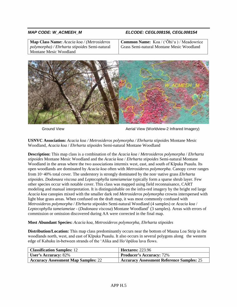
APP H.5
MAP CODE: W_ACMEEH_M ELCODE: CEGL008156, CEGL008154
Map Class Name: Acacia koa / (Metrosideros polymorpha) / Ehrharta stipoides Semi-natural Montane Mesic Woodland
Common Name: Koa / (‘Ōhi‘a ) / Meadowrice Grass Semi-natural Montane Mesic Woodland
Ground View Aerial View (Worldview-2 Infrared Imagery)
USNVC Association: Acacia koa / Metrosideros polymorpha / Ehrharta stipoides Montane Mesic Woodland, Acacia koa / Ehrharta stipoides Semi-natural Montane Woodland
Description: This map class is a combination of the Acacia koa / Metrosideros polymorpha / Ehrharta stipoides Montane Mesic Woodland and the Acacia koa / Ehrharta stipoides Semi-natural Montane Woodland in the areas where the two associations intermix west, east, and south of Kīpuka Puaulu. Its open woodlands are dominated by Acacia koa often with Metrosideros polymorpha. Canopy cover ranges from 10‑40% total cover. The understory is strongly dominated by the non‑native grass Ehrharta stipoides. Dodonaea viscosa and Leptecophylla tameiameiae typically form a sparse shrub layer. Few other species occur with notable cover. This class was mapped using field reconnaisance, CART modeling and manual interpretation. It is distinguishable on the infra-red imagery by the bright red large Acacia koa canopies mixed with the smaller dark red Metrosideros polymorpha crowns interspersed with light blue grass areas. When confused on the draft map, it was most commonly confused with Metrosideros polymorpha / Ehrharta stipoides Semi-natural Woodland (4 samples) or Acacia koa / Leptecophylla tameiameiae - (Dodonaea viscosa) Montane Woodland1 (3 samples). Areas with errors of commission or omission discovered during AA were corrected in the final map.
Most Abundant Species: Acacia koa, Metrosideros polymorpha, Ehrharta stipoides
Distribution/Location: This map class predominantly occurs near the bottom of Mauna Loa Strip in the woodlands north, west, and east of Kīpuka Puaulu. It also occurs in several polygons along the western edge of Kahuku in-between strands of the ‘Alika and Ho‘ōpūloa lava flows.
Classification Samples: 12 Hectares: 223.96 User’s Accuracy: 82% Producer’s Accuracy: 72% Accuracy Assessment Map Samples: 22 Accuracy Assessment Reference Samples: 25

APP H.6
MAP CODE: W_ACCI ELCODE: CEGL008149
Map Class Name: Acacia koa / Cibotium spp. Montane Woodland
Common Name: Koa / Hāpuʻu spp. Montane Woodland
Ground View Aerial View (Worldview-2 Infrared Imagery)
USNVC Association: Acacia koa / Cibotium spp. Montane Woodland
Description: This map class is characterized by an open, emergent canopy of Acacia koa which range from 15‑50% cover. Cheirodendron trigynum ssp. trigynum, Ilex anomala, Perrottetia sandwicensis, and Metrosideros polymorpha are canopy associates; all but Metrosideros polymorpha may codominate. Total canopy cover ranges from 20‑80%. The subcanopy consists of a dense layer of Cibotium glaucum, Cibotium menziesii, and/or Cibotium chamissoi with a combined cover ranging from 20‑60%. The shrub layer is largely absent. No herbaceous species attain high cover, but the most constant are ferns Asplenium polyodon, Athyrium microphyllum, and others, as well as invasive herbs Hedychium gardnerianum and Setaria palmifolia. This class was mapped using a combination of field reconnaisance, CART modeling and manual interpretation. It is distinguished from other forest types in ʻŌlaʻa by the large light grey (defoliated) and dark grey fluffy (foliated) crowns of the Acacia koa trees which stand above and are larger than the other tree species’ crowns.
Most Abundant Species: Acacia koa, Cheirodendron trigynum, Cibotium spp.
Distribution/Location: This map class occurs in ʻŌlaʻa and is confined entirely to a single polygon which is located half way along ʻŌlaʻa’s southeast edge, 1km towards the interior of the forest. This class occurs on nearly flat grades from 1100‑1150m.
Classification Samples: 3 Hectares: 113.82 User’s Accuracy: 100% Producer’s Accuracy: 100% Accuracy Assessment Map Samples: 20 Accuracy Assessment Reference Samples: 20

APP H.7
MAP CODE: W_ACIPPI ELCODE: CEPS009656
Map Class Name: Acacia koa / Ipomoea indica - Pipturus albidus Woodland
Common Name: Koa / Koali‘awa - Māmaki Woodland
Ground View Aerial View (Worldview-2 Infrared Imagery)
USNVC Association: Acacia koa / Ipomoea indica - Pipturus albidus Woodland [Park Special]
Description: While present in the NatureServe HAVO association key, this map class has only one classification plot and thus does not have a NatureServe description. It was sampled two times during AA which indicates that this class is characterized by a canopy dominated by Acacia koa from 45-55% with scattered Metrosideros polymorpha. While the one classification plot had 68% Ipomoea indica and 20% Pipturus albidus cover, neither AA site had any Ipomoea indica cover. One had 10% and the other no cover of Pipturus albidus as well as 35% Cenchrus clandestinus.This map class was mapped only were field verified and thus, errors of omission may exist on the map.
Most Abundant Species: Acacia koa
Distribution/Location: This map class is confined to a small area near the base of Mauna Loa Strip in Kīpuka Ki and Kīpuka Puaulu.
Classification Samples: 1 Hectares: 42.88 User’s Accuracy: 100% Producer’s Accuracy: 50% Accuracy Assessment Map Samples: 1 Accuracy Assessment Reference Samples: 2

APP H.8
MAP CODE: W_ACLEDO ELCODE: CEGL008155
Map Class Name: Acacia koa / Leptecophylla tameiameiae - (Dodonaea viscosa) Montane Woodland
Common Name: Koa / Pūkiawe - (‘A‘ali‘i) Montane Woodland
Ground View Aerial View (Worldview-2 Infrared Imagery)
USNVC Association: Acacia koa / Leptecophylla tameiameiae - (Dodonaea viscosa) Montane Woodland1
Description: This map class is characterized by open to partially closed canopies dominated by Acacia koa, often with scattered individuals of Sophora chrysophylla. The understory is largely shrub‑dominated by Leptecophylla tameiameiae; Dodonaea viscosa may codominate some stands. Deschampsia nubigena and Ehrharta stipoides may form a dense herbaceous layer. This class was mapped using a combination of field reconnaisance, CART modeling, and manual interpretation. Because of its variable canopy of Acacia koa, this map class was confused on the draft map with other Acacia koa map classes such as Acacia koa / Non-native grass (6 samples), Acacia koa / (Metrosideros polymorpha) / Ehrharta stipoides Semi-natural Montane Mesic Woodland (4 samples), and Acacia koa – (Sapindus saponaria) / Microlepia strigosa Montane Woodland (1 sample). Areas with errors of commission or omission discovered during AA were corrected in the final map.
Most Abundant Species: Acacia koa, Leptecophylla tameiameiae, Deschampsia nubigena, Ehrharta stipoides
Distribution/Location: This map class occurs in three distinct areas of HAVO. The largest is found on southwest facing slopes of Mauna Loa Strip in the montane and subalpine zones between 1350‑2100m where it is intermixed with polygons of Acacia koa / Non-native Grass Semi-natural Woodland and Leptecophylla tameiameiae - Dodonaea viscosa Montane Shrubland1. It also occurs Kīpuka Puaulu at 1200m. An isolated patch occurs in an area off of the Hilina Pali Road near Kīpuka Keanabihopa.
Classification Samples: 5 Hectares: 1061.97 User’s Accuracy: 83% Producer’s Accuracy: 60% Accuracy Assessment Map Samples: 18 Accuracy Assessment Reference Samples: 25
1USNVC name modified based on Wagner et al. (1999) and Wagner et al. 2012.

APP H.9
MAP CODE: W_ACME_L ELCODE: CEGL008141
Map Class Name: Acacia koa / Melinis minutiflora Semi-natural Lowland Woodland
Common Name: Koa / Molasses Grass Semi-natural Lowland Woodland
Ground View Aerial View (Worldview-2 Infrared Imagery)
USNVC Association: Acacia koa / Melinis minutiflora Semi-natural Lowland Woodland
Description: This map class is characterized by open woodland canopies dominated by Acacia koa with cover ranging from 20‑50%. The shrub layer is largely absent, though Dodonaea viscosa may be present at low cover. The herbaceous layer is strongly dominated by the non‑native grass Melinis minutiflora with cover ranging from 50‑80%. Cenchrus clandestinus may also be present at lower cover. The class was mapped using field reconnaissance and manual interpretation.
Most Abundant Species: Acacia koa, Dodnaea viscosa, Melinis minutiflora
Distribution/Location: This map class has a very limited distribution and occurs only in a small polygon at the Bird Park Picnic Area, in Kapapala, near the Hilina Pali Overlook, and in isolated polygons along the Hilina Pali Road.
Classification Samples: 2 Hectares: 5.02 User’s Accuracy: 100% Producer’s Accuracy: 100% Accuracy Assessment Map Samples: 2 Accuracy Assessment Reference Samples: 2

APP H.10
MAP CODE: W_ACME ELCODE: CEGL008134
Map Class Name: Acacia koa / Metrosideros polymorpha Montane Dry Woodland
Common Name: Koa / ‘Ōhi‘a Montane Dry Woodland
Ground View Aerial View (Worldview-2 Infrared Imagery)
USNVC Association: Acacia koa / Metrosideros polymorpha Montane Dry Woodland
Description: While present in the NatureServe HAVO association key, this map class has only one classification plot and thus does not have a NatureServe description. However, it is well represented by the AA samples (18 samples). The class is characterized by highly variable tree canopy densities (15-80%) with both Acacia koa and Metrosideros polymorpha present and codominant (8-50% and 9-45% cover, respectively). Understories have few shrubs and are dominated by the grasses Cenchrus clandestinus and/or Andropogon virginicus. This class was mapped using a combination of field reconnaisance, CART modeling and manual interpretation. On the imagery, this class is indistinguishable from Acacia koa / (Metrosideros polymorpha) / Ehrharta stipoides Montane Mesic Woodland and was mapped based primarily on its lower elevation. This class was rarely confused with any other class on the draft map except for four samples of Metrosideros polymorpha / Cenchrus clandestinus Semi-natural Woodland1, all of which contained low percentage cover of Acacia koa and were corrected in the final map.
Most Abundant Species: Acacia koa, Metrosideros polymorpha, Cenchrus clandestinus, Andropogon virginicus
Distribution/Location: This map class is found in several scattered places at HAVO: in the paddocks areas of Kahuku, in two polygons in West Kahuku, along Highway 11 near the Namakani Paio Campground, at the Kīlauea Military Camp, and north of Highway 11, near the Tree Molds. It is commonly found from 1000-1500m on gently sloping southern aspects.
Classification Samples: 1 Hectares: 341.25 User’s Accuracy: 73% Producer’s Accuracy: 89% Accuracy Assessment Map Samples: 22 Accuracy Assessment Reference Samples: 18

APP H.11
MAP CODE: W_ACKONN ELCODE: CEGL008154, CEGL008157, CEPS009657
Map Class Name: Acacia koa / Non-native Grass Semi-natural Woodland
Common Name: Koa / Non-native Grass
Ground View Aerial View (Worldview-2 Infrared Imagery)
USNVC Association: Acacia koa / Ehrharta stipoides Semi-natural Montane Woodland, Acacia koa / Cenchrus clandestinus Semi-natural Woodland1, Acacia koa / Setaria parviflora Lowland Semi-natural Woodland [Park Special]
Description: This map class is the combination of three indistinguishable Acacia koa over non-native grass associations: Acacia koa / Ehrharta stipoides Semi-natural Montane Woodland, Acacia koa / Cenchrus clandestinus Semi-natural Woodland1, and Acacia koa / Setaria parviflora Lowland Semi-natural Woodland [Park Special]. These three associations were indistinguishable from one another using the imagery because the often closed canopy of Acacia koa inhibited the identification of the grass species underneath. Additionally, because the grasses are geographically co-located, GIS data could not be used to distinguish the associations from one another. This semi‑natural map class has low diversity and is characterized by woodland canopies clearly dominated by Acacia koa ranging from 15-60% cover. Shrub cover is absent to sparse with the occasional layer of Leptecophylla tameiameiae and/or Dodonaea viscosa. Understories are strongly dominated by Ehrharta stipoides, Setaria parviflora, or Cenchrus clandestinus. This class was mapped using a combination of field reconnaisance, CART modeling and manual interpretation. It is distinguished on the imagery by its location and its typically dense canopy of Acacia koa which shades out most shrubs. Map classes confused with it on the draft map include Acacia koa / Leptecophylla tameiameiae - (Dodonaea viscosa) Montane Woodland1 (5 samples), Acacia koa / Metrosideros polymorpha Montane Dry Woodland (1 sample), and Sapindus saponaria - Coprosma rhynchocarpa Montane Mesic Forest (3 samples). All but one of the confused samples were edited to their correct label in the final map. One Sapindus saponaria - Coprosma rhynchocarpa Montane Mesic Forest map sample was not edited because, based on the imagery, it was believed that the reference label overestimated the cover of Acacia koa and underestimated the cover of Sapindus saponaria.
Most Abundant Species: Acacia koa, Cenchrus clandestinus, Ehrharta stipoides
Distribution/Location: This map class occurs in two distinct locations at HAVO. The most extensive is found on the gentle, southwest facing slopes of Mauna Loa Strip in the montane and subalpine zones between 1350‑2100m where it is intermixed with polygons of Acacia koa / Leptecophylla tameiameiae -

APP H.12
(Dodonaea viscosa) Montane Woodland1 and Leptecophylla tameiameiae - Dodonaea viscosa Montane Shrubland1. It is also found in isolated pockets in Kahuku.
Classification Samples: 12 Hectares: 444.64 User’s Accuracy: 84% Producer’s Accuracy: 88% Accuracy Assessment Map Samples: 45 Accuracy Assessment Reference Samples: 43
1USNVC name modified based on Wagner et al. (1999) and Wagner et al. 2012.

APP H.13
MAP CODE: F_ALMO_D ELCODE: CEPS009723
Map Class Name: Aleurites moluccana Dry Forest
Common Name: Kukui Dry Forest
Ground View Aerial View (Worldview-2 Infrared Imagery)
USNVC Association: Aleurites moluccana Dry Forest [Park Special]
Description: This map class was not sampled during the classification efforts and does not have a NatureServe description. Its two very dissimilar AA samples indicate dense canopy stands with 80-85% tree cover of which 15-58% is Aleurites moluccana. Other tree species include Diospyros sandwicensis and Metrosideros polymorpha (15% and 5%, respectively on one sample) and Olea europaea (70% on the other sample). Understories are sparse, with little shrub or herbaceous cover. This map class was mapped using field reconnaissance, manual interpretation informed by the 1992 map. With its bright, light pink infra-red spectral response and fluffy large crowns, Aleurites moluccana is one of the most spectrally significant tree species in the Hawaiian national parks.
Most Abundant Species: Aleurites moluccana
Distribution/Location: While this map class was not sampled during the classification work, it is a well-known vegetation type at HAVO because of its cultural significance and striking appearance in isolated pockets on the Hōlei Pali which can be identified from great distances. It also occurs in one isolated polygon on Poliokeawe Pali which is actually dominated by Olea europaea and only has 15% cover of Aleurites moluccana.
Classification Samples: 0 Hectares: 7.66 User’s Accuracy: 100% Producer’s Accuracy: 100% Accuracy Assessment Map Samples: 2 Accuracy Assessment Reference Samples: 2

APP H.14
MAP CODE: H_ANOD ELCODE: CEPS009662
Map Class Name: Anthoxanthum odoratum - Mixed Grasses Semi-natural Herbaceous Vegetation
Common Name: Sweet Vernal Grass - Mixed Grasses Semi-natural Herbaceous Vegetation
Ground View Aerial View (Worldview-2 Infrared Imagery)
USNVC Association: Anthoxanthum odoratum - Mixed Grasses Semi-natural Herbaceous Vegetation [Park Special]
Description: This map class is characterized by mixed native and non‑native herbaceous vegetation dominated by Anthoxanthum odoratum which has between 30‑40% cover. The native grass Deschampsia nubigena may have up to 20% cover. Other non‑native graminoids include Eragrostis brownei, Juncus effusus, and Cenchrus clandestinus. Scattered individuals of Leptecophylla tameiameiae and Metrosideros polymorpha may be present. This class was mapped from field reconnaissance only and, thus, may have errors of ommission. It is confused on the draft map with Metrosideros polymorpha / Non-native Grass Semi-natural Woodland and Leptecophylla tameiameiae Montane Dry Shrubland1. Areas with errors of commission or omission discovered during AA were corrected in the final map.
Most Abundant Species: Anthoxanthum odoratum, Deschampsia nubigena, Eragrostis brownei, Cenchrus clandestinus
Distribution/Location: This map class exists in scattered pockets in east Kahuku at elevations ranging from 1500‑2100m.
Classification Samples: 2 Hectares: 9.47 User’s Accuracy: 50% Producer’s Accuracy: 100% Accuracy Assessment Map Samples: 4 Accuracy Assessment Reference Samples: 2

APP H.15
MAP CODE: W_ARCO ELCODE: NA
Map Class Name: Araucaria columnaris Semi-natural Woodland
Common Name: Araucaria columnaris Semi-natural Woodland
Ground View Aerial View (Worldview-2 Infrared Imagery)
USNVC Association: None
Description: This map class was not sampled during the classification effort, and therefore, does not have a NatureServe description. It was encountered during the calibration field work and is represented by only one map polygon. Its one AA site has 30% cover of Araucaria columnaris with no shrubs and a high cover of mixed grasses. This class was mapped from field reconnaissance only and, thus, may have errors of ommission.
Most Abundant Species: Araucaria columnaris
Distribution/Location: This map class occurs in one polygon in Kahuku near a mining pit.
Classification Samples: 0 Hectares: 0.57 User’s Accuracy: 100% Producer’s Accuracy: 100% Accuracy Assessment Map Samples: 1 Accuracy Assessment Reference Samples: 1

APP H.16
MAP CODE: F_MECI_B ELCODE: CEGL008009
Map Class Name: Burned (2003) Metrosideros polymorpha / Cibotium spp. Montane Wet Forest
Common Name: Burned (2003) ‘Ōhi‘a / Hāpu‘u spp. Montane Wet Forest
Helicopter Oblique View Aerial View (Worldview-2 Infrared Imagery)
USNVC Association: Metrosideros polymorpha / Cibotium spp. Montane Wet Forest
Description: This map class was created following development of the draft map, specifically to characterize the forests of the recently burned areas of the East Rift zone. It is characterized by snags and down logs of Metrosideros polymorpha resulting from the 2002 and 2003 wildfires. It was mapped using manual interpretation and is apparent in the imagery from the white standing and down dead Metrosideros polymorpha trees (and their shadows) with bright pink, dense Cibotium spp. understory in the infrared imagery. There are no classification plots or AA samples of this map class.
Most Abundant Species: Metrosideros polymorpha, Cibotium spp.
Distribution/Location: This map class occurs only in the 2002-03 burned areas of the East Rift zone, from 730 – 800m in elevation.
Classification Samples: 0 Hectares: 632.19 User’s Accuracy: Not assessed Producer’s Accuracy: Not assessed Accuracy Assessment Map Samples: 0 Accuracy Assessment Reference Samples: 0

APP H.17
MAP CODE: W_MEDI_LB ELCODE: CEGL008039
Map Class Name: Burned (2003) Metrosideros polymorpha / Dicranopteris linearis Lowland Mesic Woodland
Common Name: Burned (2003) ‘Ōhi‘a / Uluhe Lowland Mesic Woodland
Ground View Aerial View (Worldview-2 Infrared Imagery)
USNVC Association: Metrosideros polymorpha / Dicranopteris linearis Lowland Mesic Woodland
Description: This map class was created following development of the draft map, specifically to characterize the forests of the recently burned areas of the East Rift zone. It is characterized by snags and down logs of Metrosideros polymorpha resulting from the 2002 and 2003 wildfires. Often the snags are ringed in young vigorous Metrosideros polymorpha basal sprouts (0-35% cover). It was mapped using manual interpretation, assisted by the AA sample data. AA samples from this class show that the understory is represented by a dense herbaceous layer dominated by native Dicranopteris linearis (11-72%), most often mixed with non-native Nephrolepis brownii (0-24%). Species richness is generally low and few other species occur, although Machaerina angustifolia can be present. This class and the Burned (2003) Metrosideros polymorpha / Nephrolepis brownii Montane Wet Woodland map class are apparent in the imagery because of the white standing and down dead Metrosideros polymorpha trees (and their shadows) with dull pink, dense fern understory in the infrared imagery. The Burned (2003) Metrosideros polymorpha / Dicranopteris linearis Montane Wet Woodland and the Burned (2003) Metrosideros polymorpha / Nephrolepis brownii Montane Wet Woodland are indistinguishable on the imagery. Their distributions on the final map are based on the AA samples and park knowledge of the area.
Most Abundant Species: Metrosideros polymorpha, Dicranopteris linearis, Nephrolepis brownii
Distribution/Location: This map class occurs only in the 2002-03 burned areas of the East Rift zone in several large polygons.
Classification Samples: 0 Hectares: 228.63 User’s Accuracy: 41% Producer’s Accuracy: 64% Accuracy Assessment Map Samples: 17 Accuracy Assessment Reference Samples: 11

APP H.18
MAP CODE: W_MENE_B ELCODE: CEGL008153
Map Class Name: Burned (2003) Metrosideros polymorpha / Nephrolepis brownii Semi-natural Woodland
Common Name: Burned (2003) ‘Ōhi‘a / Sword fern Semi-natural Woodland
Ground View Aerial View (Worldview-2 Infrared Imagery)
USNVC Association: Metrosideros polymorpha / Nephrolepis brownii Semi-natural Woodland
Description: This map class was created following development of the draft map, specifically to characterize the forests of the recently burned areas of the East Rift zone. It is characterized by snags and down logs of Metrosideros polymorpha resulting from the 2002 and 2003 wildfires. Often the snags are ringed in young vigorous Metrosideros polymorpha basal sprouts (0-40% cover). It was mapped using manual interpretation, assisted by the AA sample data. AA samples from this class show that the understory is represented by a dense herbaceous layer dominated by Nephrolepis brownii (22-90%), most often mixed with Dicranopteris linearis (0-28%). Species richness is generally low and few other species occur. This class is apparent in the imagery from the white standing and down dead Metrosideros polymorpha trees (and their shadows) with dull pink, dense fern understory in the infrared imagery. The Burned (2003) Metrosideros polymorpha / Dicranopteris linearis Montane Wet Woodland and the Burned (2003) Metrosideros polymorpha / Nephrolepis brownii Montane Wet Woodland are indistinguishable from one another on the imagery. Their distributions on the final map are based on the distribution of the AA samples and park knowledge of the area.
Most Abundant Species: Metrosideros polymorpha, Dicranopteris linearis, Nephrolepis brownii
Distribution/Location: This map class occurs only in the 2002-03 burned areas of the East Rift zone, generally from 520-730m in elevation. It forms a wide “U” shaped band along the central portions of the 2003-03 burn areas.
Classification Samples: 0 Hectares: 1066.92 User’s Accuracy: 81% Producer’s Accuracy: 61% Accuracy Assessment Map Samples: 21 Accuracy Assessment Reference Samples: 28

APP H.19
MAP CODE: F_MOME_B ELCODE: CEGL008162
Map Class Name: Burned (2003) Morella faya - (Metrosideros polymorpha) Semi-natural Forest
Common Name: Burned (2003) Firetree - (‘Ōhi‘a) Semi-natural Forest
Ground View Aerial View (Worldview-2 Infrared Imagery)
USNVC Association: Morella faya - (Metrosideros polymorpha) Semi-natural Forest
Description: This map class was created following development of the draft map, specifically to characterize the forests of the burned areas of the East Rift zone. It is characterized by snags and down logs of Metrosideros polymorpha resulting from the 2002 and 2003 wildfires. Often the snags are ringed in young vigorous Metrosideros polymorpha basal sprouts. It was mapped using manual interpretation and is apparent in the imagery from the white standing and down dead Metrosideros polymorpha trees (and their shadows) intermixed with dots of bright red Morella faya crowns in the infrared imagery. There are no classification plots or AA samples in this map class.
Most Abundant Species: Metrosideros polymorpha, Morella faya, Nephrolepis brownii
Distribution/Location: This map class occurs on the north eastern edge of the 2002-03 burned areas in the East Rift zone.
Classification Samples: 0 Hectares: 70.00 User’s Accuracy: Not assessed Producer’s Accuracy: Not assessed Accuracy Assessment Map Samples: 0 Accuracy Assessment Reference Samples: 0
No Photo Available

APP H.20
MAP CODE: H_CAAL ELCODE: NA
Map Class Name: Carex alligata Herbaceous Vegetation
Common Name: Carex alligata Herbaceous Vegetation
Ground View Aerial View (Worldview-2 Infrared Imagery)
USNVC Association: None
Description: This map class is based on research conducted in the ʻŌlaʻa trench by Waite and Pratt (2007) who characterize the flat areas of the trench’s three craters as dominated by, “almost monocultures of the native sedge Carex alligata except for large patches of non-native Paspalum urvillei edging the community. Stunted ʻōhiʻa trees grow within the bog of the main crater.” The class was mapped using manual interpretation. The bogs are uniquely shaped and distinct from their surroundings. Due to its remote location, this class was not assessed for accuracy.
Most Abundant Species: Carex alligata
Distribution/Location: This map class is found in the craters of the ʻŌlaʻ a Trench and in an additional crater to the southeast of the Trench
Classification Samples: 0 Hectares: 1.45 User’s Accuracy: Not assessed Producer’s Accuracy: Not assessed Accuracy Assessment Map Samples: 0 Accuracy Assessment Reference Samples: 0
No Photo Available

APP H.21
MAP CODE: H_CECL ELCODE: CEGL005408
Map Class Name: Cenchrus clandestinus Semi-natural Herbaceous Vegetation
Common Name: Kikuyu Grass Semi-natural Herbaceous Vegetation
Ground View Aerial View (Worldview-2 Infrared Imagery)
USNVC Association: Cenchrus clandestinus Semi-natural Grassland1
Description: This semi‑natural map class is characterized by herbaceous vegetation strongly dominated by the non‑native forage grass Cenchrus clandestinus and rarely codominated by Ehrharta stipoides. Graminoid cover is typically dense and >70% cover. Occasional sparser examples exist but are uncommon. Other common graminoids include Axonopus fissifolius, Cyperus polystachyos, Cyperus sanguinolentus, and Digitaria eriantha. Scattered individuals of Acacia koa and Metrosideros polymorpha are common, but woody species never exceed 10% cover. This class was mapped using field reconnaissance, CART modeling and manual interpretation. It is confused with Melinis minutiflora - (Schizachyrium condensatum) Semi-natural Herbaceous Vegetation (2 samples – all edited to their correct label in the final map) or Metrosideros polymorpha / Cenchrus clandestinus Semi-natural Woodland1 (3 samples – none edited because, based on the imagery, the reference data overestimated tree cover).
Most Abundant Species: Axonopus fissifolius, Cyperus polystachyos, Cyperus sanguinolentus, Cenchrus clandestinus
Distribution/Location: This map class is mostly restricted to the Kahuku pasture from 700‑1200m on southwest‑facing aspects with flat to gentle slopes. It also is seen in northwest Kahuku on the west facing slopes of Mauna Loa, near the base of Mauna Loa Strip, Namakani Paio campground, and in the grassy openings north of Tree Molds.
Classification Samples: 9 Hectares: 519.17 User’s Accuracy: 83% Producer’s Accuracy: 83% Accuracy Assessment Map Samples: 18 Accuracy Assessment Reference Samples: 18
1USNVC name modified based on Wagner et al. (1999) and Wagner et al. 2012.

APP H.22
MAP CODE: F_CIGL ELCODE: CEGL008151
Map Class Name: Cibotium glaucum Montane Forest
Common Name: Hāpuʻu pulu Montane Forest
Ground View Aerial View (Worldview-2 Infrared Imagery)
USNVC Association: Cibotium glaucum Montane Forest
Description: This map class is characterized by dense canopies of Cibotium glaucum with cover ranging from 50‑75%. Cheirodendron trigynum ssp. trigynum, Metrosideros polymorpha, and Ilex anomala are all constant canopy components and form an emergent canopy with less than 20% total combined cover. Perrottetia sandwicensis, Broussaisia arguta, and Cibotium menziesii may be present as minor canopy components. The understory contains a variety of forbs, ferns and grasses of which the native fern Cyclosorus sandwicensis is the most constant and dominant, with cover up to 10%.This map class was mapped through manual interpretation. It was not originally mapped in the draft map because of the persistent crowns of Metrosideros polymorpha throughout ʻŌlaʻa indicated that this class did not exist in areas larger than the MMU. The class’s accuracy is low due to the difficulty to assess the cover of scattered emergent trees through a dense canopy, which caused field crews to underestimate the cover of the emergent Metrosideros polymorpha leading to incorrect field calls. Users of the map should be aware of the tendency to underestimate emergent Metrosideros polymorpha while in the field. At the request of HAVO personnel, the final map was edited to include this class only when Metrosideros polymorpha cover was below 20%, as estimated from the imagery.
Most Abundant Species: Ilex anomala, Cheirodendron trigynum ssp. trigynum, Metrosideros polymorpha, Cibotium glaucum, Cyclosorus sandwicensis
Distribution/Location: This map class occurs in patchy locations on eastern portions of the ʻŌlaʻa Forest where it is surrounded mostly by Metrosideros polymorpha - Cheirodendron spp. / (Cibotium spp.) Montane Wet Forests
Classification Samples: 9 Hectares: 104.16 User’s Accuracy: 0% Producer’s Accuracy: 0% Accuracy Assessment Map Samples: 0 Accuracy Assessment Reference Samples: 15

APP H.23
MAP CODE: W_CONU ELCODE: CEGL005402
Map Class Name: Cocos nucifera Strand Woodland
Common Name: Coconut Palm Strand Woodland
Ground View Aerial View (Worldview-2 Infrared Imagery)
USNVC Association: Cocos nucifera Strand Woodland
Description: The Cocos nucifera Strand Woodland map class was discovered during the calibration field trip. Because it occurs in areas below the minimum mapping unit, it was not sampled for classification or accuracy and does not have a HAVO NatureServe description. However it was sampled at Kaloko-Honokōhau and Pu‘uhonua o Hōnaunau National Historical Parks where it was found to have an open tree canopy (20-30%) dominated by Cocos nucifera 5-10m tall. At those parks, trees found in the subcanopy may include Thespesia populnea, Tournefortia argentea, Pandanus tectorius, and Morinda citrifolia. At those parks, the shrub layer is absent to moderate and may include Scaevola taccada and Passiflora suberosa. The class was mapped using manual image interpretation. Despite its rarity and small size within HAVO, this class was retained in the map due to its cultural significance and because the distinctive crowns of the Cocos nucifera trees are easily identifiable in the imagery.
Most Abundant Species: Cocos nucifera
Distribution/Location: This map class occurs at two locations at HAVO on the coast: south of the Chain of Craters Road between the parking area and the end of the road near Ka Lae Apuki; and at ‘Ᾱpua Point.
Classification Samples: 0 Hectares: 0.43 User’s Accuracy: Not assessed Producer’s Accuracy: Not assessed Accuracy Assessment Map Samples: 0 Accuracy Assessment Reference Samples: 0

APP H.24
MAP CODE: H_DENU ELCODE: CEGL008085
Map Class Name: Deschampsia nubigena Montane and Subalpine Mesic Herbaceous Vegetation
Common Name: Deschampsia nubigena Montane and Subalpine Mesic Herbaceous Vegetation
Ground View Aerial View (Worldview-2 Infrared Imagery)
USNVC Association: Deschampsia nubigena Montane and Subalpine Mesic Herbaceous Vegetation
Description: This map class is characterized by herbaceous vegetation dominated by the native grass Deschampsia nubigena. Scattered individuals of Leptecophylla tameiameiae and Metrosideros polymorpha are common, but not dominant. Non‑native grasses are common associates and may include Anthoxanthum odoratum, Holcus lanatus, and Andropogon virginicus. This class was mapped using field reconnaissance, CART modeling, and manual interpretation. It is distinguished by its sinuous polygon shape, its distinctive blue-beige dry grass spectral signature and its location, where few other herbaceous map classes are found. It is most often confused with the Mixed Non-native Disturbed Herbaceous Vegetation map class (four samples). The Mixed Non-native Disturbed Herbaceous Vegetation was created following AA and did not exist in the draft map. It is also confused with Leptecophylla tameiameiae - Dodonaea viscosa Montane Shrubland1 (two samples) and Metrosideros polymorpha / Leptecophylla tameiameiae - Dodonaea viscosa Montane Woodland1 (two samples). Areas with errors of commission or omission discovered during AA were corrected in the final map.
Most Abundant Species: Andropogon virginicus, Anthoxanthum odoratum, Deschampsia nubigena
Distribution/Location: This map class occurs as irregularly shaped polygons in the montane and subalpine zones on the Mauna Loa Strip and in the south eastern portions of Kahuku, on southeast and southwest aspects at elevations from 1500‑1900m.
Classification Samples: 5 Hectares: 124.99 User’s Accuracy: 29% Producer’s Accuracy: 100% Accuracy Assessment Map Samples: 11 Accuracy Assessment Reference Samples: 2

APP H.25
MAP CODE: H_DILI_W ELCODE: CEGL008048
Map Class Name: Dicranopteris linearis Wet Herbaceous Mat
Common Name: Uluhe Wet Herbaceous Mat
Ground View Aerial View (Worldview-2 Infrared Imagery)
USNVC Association: Dicranopteris linearis Wet Herbaceous Mat
Description: While present in the NatureServe HAVO association key, this map class has only one classification plot and, thus, does not have a NatureServe description. It originally had three AA reference sites, but all three were in the East Rift zone 2002-03 burned area and were, therefore, relabeled Burned (2003) Metrosideros polymorpha / Dicranopteris linearis Lowland Mesic Woodland. It was mapped using field reconnaissance, CART modeling and manual interpretation. It is distinguishable on the imagery by its soft, smooth, light pink signiture in the infra-red imagery.
Most Abundant Species: Dicranopteris linearis
Distribution/Location: This map class is rare because it rarely exceeded the size of the mmu. It can be found primarily in small polygons on the eastern edge of the East Rift zone.
Classification Samples: 1 Hectares: 33.30 User’s Accuracy: Not Assessed Producer’s Accuracy: Not Assessed Accuracy Assessment Map Samples: 0 Accuracy Assessment Reference Samples: 0
No Photo Available

APP H.26
MAP CODE: F_DISA ELCODE: NA
Map Class Name: Diospyros sandwicensis Lowland Dry Forest
Common Name: Lama Lowland Dry Forest
Ground View Aerial View (Worldview-2 Infrared Imagery)
USNVC Association: None
Description: This map class was discovered during the calibration trip. It was not sampled during the classification effort and therefore does not have a NatureServe description. Its four AA reference samples show it to have from 15-55% cover of Diospyros sandwicensis usually with scattered Metrosideros polymorpha (0-15%). Understories are comprised of sparse Dodonaea viscosa often accompanied by Leptecophylla tameiameiae and Nephrolepis brownii. This class was mapped using field reconnaissance and manual interpretation assisted by the 1992 HAVO vegetation map. Crowns of Diospyros sandwicensis trees appear as shiny, light pink and fluffy circular blobs in the infra-red imagery. This class is confused with Lantana camara Semi-natural Shrubland [Provisional] (two samples – partially edited to this label in the final map, as part of each sample also contains Diospyros sandwicensis trees) and Metrosideros polymorpha / Leptecophylla tameiameiae - (Dodonaea viscosa) Lowland Dry Woodland1 (two samples – edited to correct label in the final map).
Most Abundant Species: Diospyros sandwicensis
Distribution/Location: This map class occurs on the Hōlei Pali in two large kīpukas near the hair pin curve of the Chain of Craters Road, and on several scattered kīpukas within the recent lava flows from Pu‘u ʻŌ‘ō.
Classification Samples: 0 Hectares: 27.02 User’s Accuracy: 50% Producer’s Accuracy: 100% Accuracy Assessment Map Samples: 10 Accuracy Assessment Reference Samples: 5

APP H.27
MAP CODE: S_DOPL ELCODE: CEPS009722
Map Class Name: Dodonaea viscosa - Pluchea carolinensis Semi-natural Shrubland
Common Name: ‘A‘ali‘i - Sourbush Semi-natural Shrubland
Ground View Aerial View (Worldview-2 Infrared Imagery)
USNVC Association: Dodonaea viscosa - Pluchea carolinensis Semi-natural Shrubland [Park Special]
Description: This map class was discovered during the validation trip and therefore has no classification plots or a NatureServe description. Its 14 AA samples show it to be dominated by a mixture of Dodonaea viscosa and Pluchea carolinensis. The herbaceous layer usually includes Nephrolepis brownii (0-55%) and Andropogon virginicus (0-35%). This class was mapped through field reconnaissance and manual interpretation by its location in the East Rift zone 2002-2003 burn area, and by the thick cover of Pluchea carolinensis which has a smooth redish magenta spectral signature in the infrared imagery.
Most Abundant Species: Dodonaea viscosa, Pluchea carolinensis, Nephrolepis brownii, Andropogon virginicus
Distribution/Location: This map class is comprised of one large and three small polygons, located entirely within the 2002-03 East Rift Zone burn perimeters, north of the hairpin curve of the Chain of Craters Road.
Classification Samples: 0 Hectares: 118.27 User’s Accuracy: 100% Producer’s Accuracy: 100% Accuracy Assessment Map Samples: 14 Accuracy Assessment Reference Samples: 14
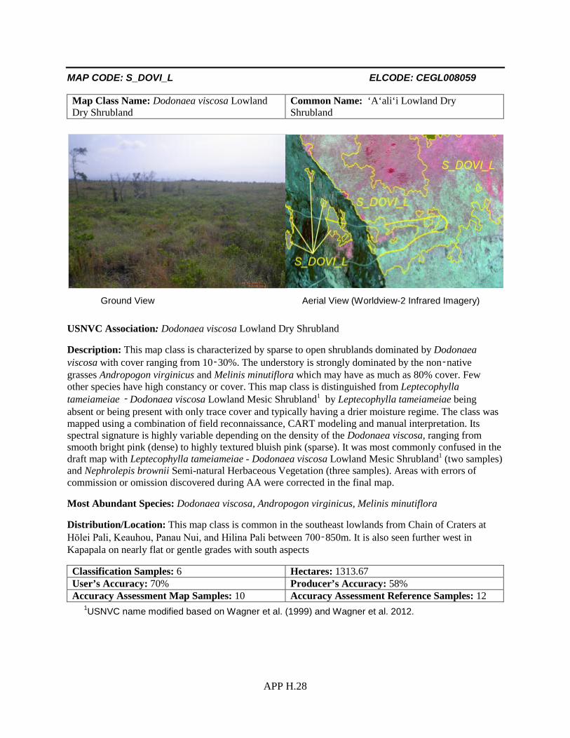
APP H.28
MAP CODE: S_DOVI_L ELCODE: CEGL008059
Map Class Name: Dodonaea viscosa Lowland Dry Shrubland
Common Name: ‘A‘ali‘i Lowland Dry Shrubland
Ground View Aerial View (Worldview-2 Infrared Imagery)
USNVC Association: Dodonaea viscosa Lowland Dry Shrubland
Description: This map class is characterized by sparse to open shrublands dominated by Dodonaea viscosa with cover ranging from 10‑30%. The understory is strongly dominated by the non‑native grasses Andropogon virginicus and Melinis minutiflora which may have as much as 80% cover. Few other species have high constancy or cover. This map class is distinguished from Leptecophylla tameiameiae ‑ Dodonaea viscosa Lowland Mesic Shrubland1 by Leptecophylla tameiameiae being absent or being present with only trace cover and typically having a drier moisture regime. The class was mapped using a combination of field reconnaissance, CART modeling and manual interpretation. Its spectral signature is highly variable depending on the density of the Dodonaea viscosa, ranging from smooth bright pink (dense) to highly textured bluish pink (sparse). It was most commonly confused in the draft map with Leptecophylla tameiameiae - Dodonaea viscosa Lowland Mesic Shrubland1 (two samples) and Nephrolepis brownii Semi-natural Herbaceous Vegetation (three samples). Areas with errors of commission or omission discovered during AA were corrected in the final map.
Most Abundant Species: Dodonaea viscosa, Andropogon virginicus, Melinis minutiflora
Distribution/Location: This map class is common in the southeast lowlands from Chain of Craters at Hōlei Pali, Keauhou, Panau Nui, and Hilina Pali between 700‑850m. It is also seen further west in Kapapala on nearly flat or gentle grades with south aspects
Classification Samples: 6 Hectares: 1313.67 User’s Accuracy: 70% Producer’s Accuracy: 58% Accuracy Assessment Map Samples: 10 Accuracy Assessment Reference Samples: 12
1USNVC name modified based on Wagner et al. (1999) and Wagner et al. 2012.

APP H.29
MAP CODE: S_DOVI_M ELCODE: CEPS009668
Map Class Name: Dodonaea viscosa Montane Mesic Shrubland
Common Name: ‘A‘ali‘i Montane Mesic Shrubland
Ground View Aerial View (Worldview-2 Infrared Imagery)
USNVC Association: Dodonaea viscosa Montane Mesic Shrubland [Park Special]
Description: This map class is characterized by mixed native and non-native shrub and herbaceous vegetation. The dominant shrub is Dodonaea viscosa which averages about 10% cover. Scattered individuals of Leptecophylla tameiameiae are common, but do not exceed 20% of the total shrub cover. The understory is strongly dominated by non‑native herbaceous species, including Schizachyrium condensatum and Andropogon virginicus, and native fern Pteridium aquilinum ssp. decompositum which may have as much as 60% total combined cover. The draft map user’s accuracy for this class is low because of the commitment of one large polygon (with 15 AA samples) of Leptecophylla tameiameiae - Dodonaea viscosa Montane Shrubland1 to Dodonaea viscosa Montane Mesic Shrubland in the draft map. This error has been corrected in the final map.
Most Abundant Species: Dodonaea viscosa, Andropogon virginicus, Schizachyrium condensatum, Pteridium aquilinum ssp. decompositum
Distribution/Location: This map class occurs in four isolated polygons near where the Mauna Loa Strip road ends at Highway 11.
Classification Samples: 3 Hectares: 5.16 User’s Accuracy: 5% Producer’s Accuracy: 100% Accuracy Assessment Map Samples: 19 Accuracy Assessment Reference Samples: 1
1USNVC name modified based on Wagner et al. (1999) and Wagner et al. 2012.

APP H.30
MAP CODE: SP_DUSC_M ELCODE: CEGL008176
Map Class Name: Dubautia scabra ssp. scabra Montane Sparse Vegetation
Common Name: Na‘ena‘e Montane Sparse Vegetation
Ground View Aerial View (Worldview-2 Infrared Imagery)
USNVC Association: Dubautia scabra ssp. scabra Montane Sparse Vegetation
Description: This map class is characterized by sparse herbaceous vegetation where Dubautia scabra ssp. scabra is the principal species and has less than 5% cover. In some stands, Dubautia scabra ssp. scabra may be the only species present, and in other stands, a variety of woody and herbaceous species may be present at trace cover. Species may include Metrosideros polymorpha, Pipturus albidus, and Vaccinium reticulatum, non-native fern Nephrolepis brownii, and non-native annual Castilleja arvensis. This class was mapped using field verified manual interpretation.
Most Abundant Species: Dubautia scabra ssp. scabra, Vaccinium reticulatum
Distribution/Location: This map class occurs in a cluster of four polygons in the southeast area of the park near the East Rift and the Chain of Craters Road from 800‑1100m on nearly flat to gentle slopes with south and southeast aspects.
Classification Samples: 3 Hectares: 29.07 User’s Accuracy: 100% Producer’s Accuracy: 100% Accuracy Assessment Map Samples: 2 Accuracy Assessment Reference Samples: 2

APP H.31
MAP CODE: F_EUMS ELCODE: CEGL008144
Map Class Name: Eucalyptus spp. - Mixed Alien Semi-natural Forest/Plantation
Common Name: Eucalyptus spp.- Mixed Alien Semi-natural Forest/Plantation
Ground View Aerial View (Worldview-2 Infrared Imagery)
USNVC Association: Eucalyptus spp. - Mixed Alien Semi-natural Forest/Plantation [Provisional]
Description: While present in the NatureServe HAVO association key, this map class has only one classification plot and thus does not have a NatureServe description. It is characterized by the dominance of Eucalyptus spp. (40-50%). Very few if any shrubs grow in these stands. Herbaceous cover is absent or dominated by Cenchrus clandestinus at 0-48% cover. This class was mapped using field verified manual interpretation. While Eucalyptus is spectrally unique with large bright red crowns, it was too rare in the park to map using CART modeling.
Most Abundant Species: Eucalyptus spp., Cenchrus clandestinus
Distribution/Location: This map class is found in three small polygons in the park. Two are in Kahuku near the mine pit. The third is in the Namakani Paio Campground off of Highway 11.
Classification Samples: 1 Hectares: 5.87 User’s Accuracy: 100% Producer’s Accuracy: 100% Accuracy Assessment Reference Samples: 3 Accuracy Assessment Reference Samples: 3
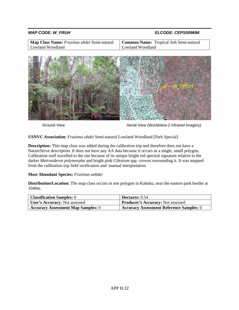
APP H.32
MAP CODE: W_FRUH ELCODE: CEPS009694
Map Class Name: Fraxinus uhdei Semi-natural Lowland Woodland
Common Name: Tropical Ash Semi-natural Lowland Woodland
Ground View Aerial View (Worldview-2 Infrared Imagery)
USNVC Association: Fraxinus uhdei Semi-natural Lowland Woodland [Park Special]
Description: This map class was added during the calibration trip and therefore does not have a NatureServe description. It does not have any AA data because it occurs as a single, small polygon. Calibration staff travelled to the site because of its unique bright red spectral signature relative to the darker Metrosideros polymorpha and bright pink Cibotium spp. crowns surrounding it. It was mapped from the calibration trip field verification and manual interpretation.
Most Abundant Species: Fraxinus unhdei
Distribution/Location: The map class occurs in one polygon in Kahuku, near the eastern park border at 1040m.
Classification Samples: 0 Hectares: 0.54 User’s Accuracy: Not assessed Producer’s Accuracy: Not assessed Accuracy Assessment Map Samples: 0 Accuracy Assessment Reference Samples: 0
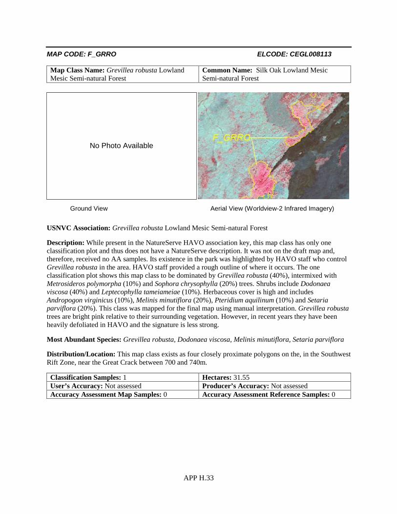
APP H.33
MAP CODE: F_GRRO ELCODE: CEGL008113
Map Class Name: Grevillea robusta Lowland Mesic Semi-natural Forest
Common Name: Silk Oak Lowland Mesic Semi-natural Forest
Ground View Aerial View (Worldview-2 Infrared Imagery)
USNVC Association: Grevillea robusta Lowland Mesic Semi-natural Forest
Description: While present in the NatureServe HAVO association key, this map class has only one classification plot and thus does not have a NatureServe description. It was not on the draft map and, therefore, received no AA samples. Its existence in the park was highlighted by HAVO staff who control Grevillea robusta in the area. HAVO staff provided a rough outline of where it occurs. The one classification plot shows this map class to be dominated by Grevillea robusta (40%), intermixed with Metrosideros polymorpha (10%) and Sophora chrysophylla (20%) trees. Shrubs include Dodonaea viscosa (40%) and Leptecophylla tameiameiae (10%). Herbaceous cover is high and includes Andropogon virginicus (10%), Melinis minutiflora (20%), Pteridium aquilinum (10%) and Setaria parviflora (20%). This class was mapped for the final map using manual interpretation. Grevillea robusta trees are bright pink relative to their surrounding vegetation. However, in recent years they have been heavily defoliated in HAVO and the signature is less strong.
Most Abundant Species: Grevillea robusta, Dodonaea viscosa, Melinis minutiflora, Setaria parviflora
Distribution/Location: This map class exists as four closely proximate polygons on the, in the Southwest Rift Zone, near the Great Crack between 700 and 740m.
Classification Samples: 1 Hectares: 31.55 User’s Accuracy: Not assessed Producer’s Accuracy: Not assessed Accuracy Assessment Map Samples: 0 Accuracy Assessment Reference Samples: 0
No Photo Available

APP H.34
MAP CODE: H_HECO_R ELCODE: CEPS009695
Map Class Name: Hedychium coronarium Semi-natural Herbaceous Vegetation
Common Name: White Ginger Semi-natural Herbaceous Vegetation
Ground View Aerial View (Worldview-2 Infrared Imagery)
USNVC Association: Hedychium coronarium Semi-natural Herbaceous Vegetation [Park Special]
Description: This map class was discovered during the calibration trip because of its smooth brilliant red spectral response relative to its surroundings. It has no classification data and no NatureServe description. The map class is characterized by overwhelming, dense cover of Hedychium coronarium. This class’s one AA site was slightly misregistered, and the data from it is not representative of the polygon.
Most Abundant Species: Hedychium coronarium
Distribution/Location: This class’s sole polygon exists near Park Headquarters.
Classification Samples: 0 Hectares: 1.02 User’s Accuracy: 100% Producer’s Accuracy: 100% Accuracy Assessment Map Samples: 1 Accuracy Assessment Reference Samples: 1
No Photo Available

APP H.35
MAP CODE: H_JEHL ELCODE: NA
Map Class Name: Juncus effusus - Holcus lanatus Herbaceous Vegetation
Common Name: Japanese Mat Rush - Common Velvet Grass Herbaceous Vegetation
Ground View Aerial View (Worldview-2 Infrared Imagery)
USNVC Association: None
Description: This map class was discovered during the calibration field work and thus it does not have a NatureServe description, or any classification data. There were no AA samples because it occurs in a small area below the minimum mapping unit, but it was retained due to ecological signifance for the park. It was mapped from only field reconnaisance during the calibration field work and, therefore, may have errors of ommission.
Most Abundant Species: Juncus effusus, Holcus lanatus
Distribution/Location: This class’s one polygon exists in Kahuku near the park border just south of Punalu‘u Kahawai.
Classification Samples: 0 Hectares: 0.41 User’s Accuracy: Not assessed Producer’s Accuracy: Not assessed Accuracy Assessment Map Samples: 0 Accuracy Assessment Reference Samples: 0

APP H.36
MAP CODE: S_LACA ELCODE: CEGL008145
Map Class Name: Lantana camara Semi-natural Shrubland
Common Name: Lantana camara Semi-natural Shrubland
Ground View Aerial View (Worldview-2 Infrared Imagery)
USNVC Association: Lantana camara Semi-natural Shrubland [Provisional]
Description: While present in the NatureServe HAVO association key, this map class has only one classification plot and thus does not have a NatureServe description. It was sampled more heavily during the AA and is characterized by an open to partially closed shrub canopy of Lantana camara from 8-35% cover. Other shrubs include Dodonaea viscosa with up to 5% cover. In one stand Leucaena leucocephala was present with 11% cover. The herbaceous stratum is often well developed and is typically comprised of Melinis minutiflora, Melinis repens, Andropogon virginicus, and Nephrolepis brownii with up to 65% total cover. This class was mapped using a combination of field reconnaissance, CART modeling and manual interpretation. Class accuracy is high and confusion on the draft map is minimal, primarily with Diospyros sandwicensis Lowland Dry Forest on the Hōlei Pali where the two map classes are intermixed.
Most Abundant Species: Lantana camara, Dodonaea viscosa, Melinis minutiflora, Melinis repens, Andropogon virginicus, Nephrolepis brownii
Distribution/Location: This map class occurs in the southern lowlands of the park from 200-1300m, primarily on Hōlei Pali. It is also seen further south and west from Pu‘ukaone, Pu‘ukapukapu, Pu‘u ‘eo Pali, Makahanu Pali, and Poliokeawe Pali.
Classification Samples: 1 Hectares: 154.34 User’s Accuracy: 100% Producer’s Accuracy: 71% Accuracy Assessment Map Samples: 12 Accuracy Assessment Reference Samples: 16
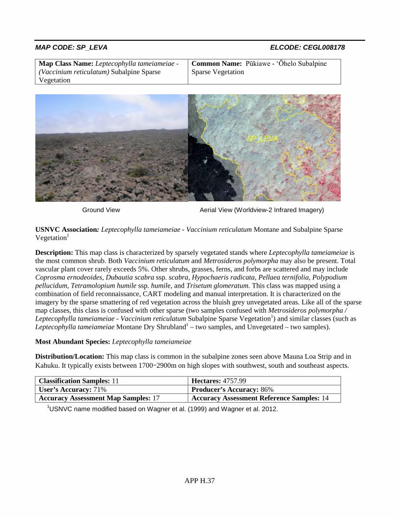
APP H.37
MAP CODE: SP_LEVA ELCODE: CEGL008178
Map Class Name: Leptecophylla tameiameiae - (Vaccinium reticulatum) Subalpine Sparse Vegetation
Common Name: Pūkiawe - ‘Ōhelo Subalpine Sparse Vegetation
Ground View Aerial View (Worldview-2 Infrared Imagery)
USNVC Association: Leptecophylla tameiameiae - Vaccinium reticulatum Montane and Subalpine Sparse Vegetation1
Description: This map class is characterized by sparsely vegetated stands where Leptecophylla tameiameiae is the most common shrub. Both Vaccinium reticulatum and Metrosideros polymorpha may also be present. Total vascular plant cover rarely exceeds 5%. Other shrubs, grasses, ferns, and forbs are scattered and may include Coprosma ernodeoides, Dubautia scabra ssp. scabra, Hypochaeris radicata, Pellaea ternifolia, Polypodium pellucidum, Tetramolopium humile ssp. humile, and Trisetum glomeratum. This class was mapped using a combination of field reconnaissance, CART modeling and manual interpretation. It is characterized on the imagery by the sparse smattering of red vegetation across the bluish grey unvegetated areas. Like all of the sparse map classes, this class is confused with other sparse (two samples confused with Metrosideros polymorpha / Leptecophylla tameiameiae - Vaccinium reticulatum Subalpine Sparse Vegetation1) and similar classes (such as Leptecophylla tameiameiae Montane Dry Shrubland1 – two samples, and Unvegetated – two samples).
Most Abundant Species: Leptecophylla tameiameiae
Distribution/Location: This map class is common in the subalpine zones seen above Mauna Loa Strip and in Kahuku. It typically exists between 1700-2900m on high slopes with southwest, south and southeast aspects.
Classification Samples: 11 Hectares: 4757.99 User’s Accuracy: 71% Producer’s Accuracy: 86% Accuracy Assessment Map Samples: 17 Accuracy Assessment Reference Samples: 14
1USNVC name modified based on Wagner et al. (1999) and Wagner et al. 2012.

APP H.38
MAP CODE: S_LEDO_L ELCODE: CEGL008164
Map Class Name: Leptecophylla tameiameiae - Dodonaea viscosa Lowland Mesic Shrubland
Common Name: Pūkiawe - ‘A‘ali‘i Lowland Mesic Shrubland
Ground View Aerial View (Worldview-2 Infrared Imagery)
USNVC Association: Leptecophylla tameiameiae - Dodonaea viscosa Lowland Mesic Shrubland1
Description: This map class is characterized by shrublands dominated by Leptecophylla tameiameiae, Dodonaea viscosa, or both. Scattered Metrosideros polymorpha may be present, but cover does not exceed 5%. No other shrub species have high constancy, but Osteomeles anthyllidifolia, Psidium guajava, Wikstroemia pulcherrima, and Wikstroemia phillyreifolia may be present at low cover. This map class is distinguished from the analogous upland type which occurs above 1000m. It was mapped using a combination of field reconnaissance, CART modeling and manual interpretation. In the draft map, this class is most commonly confused with Metrosideros polymorpha / Leptecophylla tameiameiae - (Dodonaea viscosa) Lowland Dry Woodland1 (six samples) in the Ka‘ū Desert where small variations in cover estimates can result in several different map classes. For the final map, areas of five of the six confused samples were edited to their reference label. The sixth sample was not edited because it was believed that the reference label is incorrect.
Most Abundant Species: Leptecophylla tameiameiae, Dodonaea viscosa, Andropogon virginicus
Distribution/Location: This map class is common throughout the mesic, southern lowlands of the park near Keauhou, Hilina Pali, Kapapala, the Southwest Rift, Keamoku Lava Flow, and Kahuku from 100-1000m on south and southeast aspects with notable non-vegetated surface of exposed bedrock.
Classification Samples: 27 Hectares: 1399.47 User’s Accuracy: 58% Producer’s Accuracy: 69% Accuracy Assessment Map Samples: 19 Accuracy Assessment Reference Samples: 16
1USNVC name modified based on Wagner et al. (1999) and Wagner et al. 2012.

APP H.39
MAP CODE: SP_LEDO_M ELCODE: CEGL008177
Map Class Name: Leptecophylla tameiameiae - Dodonaea viscosa Montane Sparse Vegetation
Common Name: Pūkiawe - ‘A‘ali‘i Montane Sparse Vegetation
Ground View Aerial View (Worldview-2 Infrared Imagery)
USNVC Association: Leptecophylla tameiameiae - Dodonaea viscosa Lowland Sparse Vegetation1
Description: While present in the NatureServe HAVO association key, this map class has only two classification plots and thus does not have a NatureServe description. It is characterized by a very sparse shrub canopy exceeding 5% and less than 15% total cover consisting of Leptecophylla tameiameiae and Dodonaea viscosa often with a scattering of Metrosideros polymorpha. The class was mapped using a combination of field reconnaissance, CART modeling, and manual interpretation. The class accuracy is low, but all four reference samples are similar montane (above 1000m) classes (Metrosideros polymorpha / (Leptecophylla tameiameiae - Dodonaea viscosa) Montane Sparse Vegetation1 – two samples), (Metrosideros polymorpha / Leptecophylla tameiameiae - Vaccinium reticulatum Subalpine Sparse Vegetation1 – one sample, and Leptecophylla tameiameiae - Dodonaea viscosa Montane Shrubland1- one sample). Confusion between the sparse types is common because slight differences in percent cover estimates can result in several map labels. None of these areas of confusion were edited in the final map.
Most Abundant Species: Leptecophylla tameiameiae, Dodonaea viscosa
Distribution/Location: This map class occurs in several polygons on the Mauna Loa strip.
Classification Samples: 1 Hectares: 155.63 User’s Accuracy: 0% Producer’s Accuracy: 0% Accuracy Assessment Map Samples: 0 Accuracy Assessment Reference Samples: 4
1USNVC name modified based on Wagner et al. (1999) and Wagner et al. 2012.

APP H.40
MAP CODE: S_LEDO_M ELCODE: CEGL008172
Map Class Name: Leptecophylla tameiameiae - Dodonaea viscosa Montane Shrubland
Common Name: Pūkiawe - ‘A‘ali‘i Montane Shrubland
Ground View Aerial View (Worldview-2 Infrared Imagery)
USNVC Association: Leptecophylla tameiameiae - Dodonaea viscosa Montane Shrubland1
Description: This map class total shrub cover ranges from 10-70% and either nominal species must have at least 20% of the total shrub cover. Scattered Metrosideros polymorpha are common but do not exceed 5% cover. Vaccinium reticulatum is common at low cover, but may be absent entirely. Herbaceous cover may be sparse or range up to 40% cover. Few herbaceous species attain high cover. Under more mesic site conditions, the understory varies from sparse to well-developed with non-native grasses Schizachyrium condensatum and Andropogon virginicus dominating. This class was mapped using a combination of field reconnaissance, CART modeling and manual interpretation. Elevation of 1000m distinguishes this class from the Leptecophylla tameiameiae - Dodonaea viscosa Lowland Mesic Shrubland1 map class. Draft map class user’s and producer’s accuracies are low because of one large polygon (with 15 samples) which was erronously committed to Dodonaea viscosa Montane Mesic Shrubland, and five samples that were committed to Metrosideros polymorpha / (Leptecophylla tameiameiae - Dodonaea viscosa) Montane Sparse Vegetation1. Areas with errors of commission or omission discovered during AA were corrected in the final map.
Most Abundant Species: Leptecophylla tameiameiae, Dodonaea viscosa, Andropogon virginicus, Schizachyrium condensatum, Morelotia gahniiformis
Distribution/Location: This map class is common in the montane and subalpine zones on Mauna Loa Strip, near Kīlauea , and in the upper elevations of east and west Kahuku between 1800-2300m, typically on southwest and southeast aspects. It also can be seen along the Hilina Pali Road in Keauhou.
Classification Samples: 27 Hectares: 4147.78 User’s Accuracy: 42% Producer’s Accuracy: 26% Accuracy Assessment Map Samples: 19 Accuracy Assessment Reference Samples: 31
1USNVC name modified based on Wagner et al. (1999) and Wagner et al. 2012.

APP H.41
MAP CODE: S_LETA ELCODE: CEGL008173
Map Class Name: Leptecophylla tameiameiae Montane Dry Shrubland
Common Name: Pūkiawe Montane Dry Shrubland
Ground View Aerial View (Worldview-2 Infrared Imagery)
USNVC Association: Leptecophylla tameiameiae Montane Dry Shrubland1
Description: This map class is characterized by shrublands dominated by Leptecophylla tameiameiae. Scattered Metrosideros polymorpha and Dodonaea viscosa are common, but rarely exceed 5% cover. Total shrub cover ranges from 15-60%. In the understory, Deschampsia nubigena is always present and ranges from 10-40% cover. Non-native herbaceous species are common, but do not typically reach high cover. This class was mapped using a combination of field reconnaissance, CART modeling and manual interpretation. In the draft map it was most commonly confused with other Leptecophylla tameiameiae map classes. Areas with errors of commission or omission discovered during AA were corrected in the final map.
Most Abundant Species: Leptecophylla tameiameiae, Anthoxanthum odoratum, Deschampsia nubigena, Morelotia gahniiformis, Hypochoeris radicata
Distribution/Location: This map class commonly occurs in the dry, upper montane and subalpine zones in Mauna Loa Strip and in Kahuku at elevations from 1500-2000m where slopes tend to be gentle.
Classification Samples: 19 Hectares: 1210.85 User’s Accuracy: 80% Producer’s Accuracy: 67% Accuracy Assessment Map Samples: 20 Accuracy Assessment Reference Samples: 24
1USNVC name modified based on Wagner et al. (1999) and Wagner et al. (2012).

APP H.42
MAP CODE: S_LELE ELCODE: CEGL008114
Map Class Name: Leucaena leucocephala Lowland Dry Semi-natural Shrubland
Common Name: Koa Haole Lowland Dry Semi-natural Shrubland
Ground View Aerial View (Worldview-2 Infrared Imagery)
USNVC Association: Leucaena leucocephala Lowland Dry Semi-natural Shrubland
Description: This map class is characterized by monospecific canopies of Leucaena leucocephala. Understories are largely dominated by non-native species, and no understory species show any constancy across stands. Common non-native species include Hyparrhenia rufa, Melinis minutiflora, Melinis repens, and Pluchea carolinensis. This class was mapped using field reconnaissance and manual interpretation informed by the 1992 vegetation map. Its spectral signature is a fuzzy reddish brown in the infrared imagery.
Most Abundant Species: Leucaena leucocephala
Distribution/Location: This semi-natural map class mostly occurs on or near the coast and occasionally inland from the Chain of Craters Road to Ka‘aha ranging at elevations from approximately 0-300m.
Classification Samples: 7 Hectares: 56.57 User’s Accuracy: 100% Producer’s Accuracy: 100% Accuracy Assessment Map Samples: 17 Accuracy Assessment Reference Samples: 17

APP H.43
MAP CODE: F_MEDIDO ELCODE: NA
Map Class Name: Metrosideros polymorpha - (Diospyros sandwicensis) / (Dodonaea viscosa) Lowland Dry Forest
Common Name: ‘Ōhi‘a -(Lama) / (‘A‘ali‘i) Lowland Dry Forest
Ground View Aerial View (Worldview-2 Infrared Imagery)
USNVC Association: None
Description: This map class was created following AA to account for this unique forest type on the Hōlei Pali. It was not sampled for classification and therefore has no NatureServe description. It is a low vegetation cover map class with scattered Diospyros sandwicensis (0-5%) and Metrosideros polymorpha trees (1-15%). Sparse Lantana camara (1-8%) shrubs are in the understory, often with Dodonaea viscosa (0-5%). The herbaceous layer may be absent or includes a smattering of Melinis spp. or Nephrolepis brownii. This class was mapped using manual interpretation informed by the AA sites and the 1992 vegetation map. The bright pink fluffy Diospyros sandwicensis crowns intermixed with the smaller dark red Metrosideros polymorpha crowns are readily identifiable on the infrared imagery. This class has 6 AA samples which all originally had the map label of Diospyros sandwicensis Lowland Dry Forest. Their map labels were changed to Metrosideros polymorpha - (Diospyros sandwicensis) / (Dodonaea viscosa) Lowland Dry Forest when this map class was created.
Most Abundant Species: Metrosideros polymorpha, Diospyros sandwicensis, Lantana camara
Distribution/Location: This map class occurs in several polygons on the Hōlei Pali, west of the Chain of Craters Road hairpin curve.
Classification Samples: 0 Hectares: 26.62 User’s Accuracy: 100% Producer’s Accuracy: 100% Accuracy Assessment Map Samples: 6 Accuracy Assessment Reference Samples: 6

APP H.44
MAP CODE: W_MEPSSC ELCODE: CEGL008142
Map Class Name: Metrosideros polymorpha - (Psidium spp., Schinus terebinthifolius) Woodland
Common Name: ‘Ōhi‘a - (Guava species, Christmas berry) Woodland
Ground View Aerial View (Worldview-2 Infrared Imagery)
USNVC Association: Metrosideros polymorpha - (Psidium spp., Schinus terebinthifolius) Woodland
Description: While present in the NatureServe HAVO association key, this map class has only one classification plot and thus does not have a NatureServe description. It received three reference samples and is characterized by an open to partially closed canopy of Metrosideros polymorpha from 20-55%. There is a tall understory of either Psidium cattlenium or Schinus terebinthifolius, both of which are stand replacing invasive, non-native species, from 15-35%. These two understory species are mutually exclusive and do not occur together at HAVO in this map class. This class was mapped using a combination of field reconnaissance, CART modeling and manual interpretation. It is readily identifiable from the bright red crowns of Psidium cattlenium or Schinus terebinthifolius mixed with the dark red crowns of Metrosideros polymorpha.
Most Abundant Species: Metrosideros polymorpha, Psidium cattlenium, Schinus terebinthifolius, Cenchrus clandestinus, Ehrharta stipoides
Distribution/Location: This map class occurs in large polygons in the lower portions of Kahuku and in two isolated polygons in the Ka‘ū Desert near Kīpuka Pepeiao where the tall understory component is comprised entirely of Schinus terebinthifolius. This map class is also seen in an isolated pocket near Chain of Craters where the tall understory component consists entirely of Psidium cattlenium.
Classification Samples: 1 Hectares: 178.81 User’s Accuracy: 60% Producer’s Accuracy: 100% Accuracy Assessment Map Samples: 5 Accuracy Assessment Reference Samples: 3

APP H.45
MAP CODE: F_MECHSPCI ELCODE: CEGL008008
Map Class Name: Metrosideros polymorpha - Cheirodendron spp. / (Cibotium spp.) Montane Wet Forest
Common Name: ‘Ōhi‘a - ‘Ōlapa / (Hāpuʻu species) Montane Wet Forest
Ground View Aerial View (Worldview-2 Infrared Imagery)
USNVC Association: Metrosideros polymorpha - Cheirodendron trigynum / (Cibotium spp.) Montane Wet Forest
Description: This forest map class is characterized by a variable, open to closed canopy which may be dominated or codominated by Metrosideros polymorpha and/or Cheirodendron spp.with 25-70% total cover. The subcanopy is dominated by Cibotium glaucum with lesser amounts of Cibotium menziesii. Total subcanopy cover ranges from 20-60%. Other canopy associates may include Ilex anomala and Perrottetia sandwicensis. The shrub layer is essentially non-existent. This class was mapped using a combination of field reconnaissance, CART modeling and manual interpretation. Its accuracy is low (showing confusion with Cibotium glaucum Montane Forest) because it is difficult to assess the Metrosideros polymorpha and Cheirodendron spp. canopies above dense Cibotium glaucum in the ʻŌlaʻ a Forest, and therefore AA estimates of the canopy species were low. At the request of HAVO staff, areas of the draft map labeled Metrosideros polymorpha - Cheirodendron spp. / (Cibotium spp.) Montane Wet Forest were not edited to Cibotium glaucum Montane Forest in the final map unless the canopy cover of Metrosideros polymorpha fell below 20% as estimated from the imagery.
Most Abundant Species: Cheirodendron trigynum ssp. trigynum, Metrosideros polymorpha, Cibotium glaucum
Distribution/Location: This map class occurs extensively in the east and southern portions of the ʻŌlaʻ a Rainforest and also in a small area along the eastern edge of the Kahuku Pasture bordering the Ka‘ū Forest Reserve.
Classification Samples: 9 Hectares: 1557.61 User’s Accuracy: 17% Producer’s Accuracy: 43% Accuracy Assessment Map Samples: 18 Accuracy Assessment Reference Samples: 7

APP H.46
MAP CODE: SP_MELEDO_L ELCODE: CEGL008179
Map Class Name: Metrosideros polymorpha / (Leptecophylla tameiameiae - Dodonaea viscosa) Lowland Sparse Vegetation
Common Name: ‘Ōhi‘a / (Pūkiawe - ‘A‘ali‘i ) Lowland Sparse Vegetation
Ground View Aerial View (Worldview-2 Infrared Imagery)
USNVC Association: Metrosideros polymorpha / (Leptecophylla tameiameiae - Dodonaea viscosa) Lowland Sparse Vegetation1
Description: This map class is characterized by sparse vegetation where stunted Metrosideros polymorpha is the abundant species and does not exceed 10% cover. Scattered individuals of Dodonaea viscosa and/or Leptecophylla tameiameiae are always present at low cover. Although many woody or herbaceous species may occur, few attain more than trace cover. This class was mapped using a combination of field reconnaissance, CART modeling, and manual interpretation. It is distinguished from Metrosideros polymorpha / (Leptecophylla tameiameiae - Dodonaea viscosa) Montane Sparse Vegetation1 at 1000m elevation. On the draft map, it was most commonly confused in the Ka‘ū Desert with Metrosideros polymorpha / Leptecophylla tameiameiae - (Dodonaea viscosa) Lowland Dry Woodland1 (six samples). These areas were not edited in the final map because most of the samples had a secondary label of Metrosideros polymorpha / (Leptecophylla tameiameiae - Dodonaea viscosa) Lowland Sparse Vegetation1 and all appear to be sparse in the imagery.
Most Abundant Species: Metrosideros polymorpha, Leptecophylla tameiameiae, Dodonaea viscosa
Distribution/Location: This map class is widespread from Hilina Pali, Kue‘e, the Southwest Rift, Ka‘ū Desert, Chain of Craters, Mauna Ulu, Poliokeawe Pali, and along the southern portions of Kahuku. This map class occurs primarily in the southern and central lowlands of the park at elevations ranging from approximately 250-1000m.
Classification Samples: 26 Hectares: 3774.35 User’s Accuracy: 53% Producer’s Accuracy: 73% Accuracy Assessment Map Samples: 15 Accuracy Assessment Reference Samples: 11
1USNVC name modified based on Wagner et al. (1999) and Wagner et al. (2012).

APP H.47
MAP CODE: SP_MELEDO_M ELCODE: CEGL008180
Map Class Name: Metrosideros polymorpha / (Leptecophylla tameiameiae - Dodonaea viscosa) Montane Sparse Vegetation
Common Name: ‘Ōhi‘a / (Pūkiawe - ‘A‘ali‘i) Montane Sparse Vegetation
Ground View Aerial View (Worldview-2 Infrared Imagery)
USNVC Association: Metrosideros polymorpha / (Leptecophylla tameiameiae - Dodonaea viscosa) Montane Sparse Vegetation1
Description: This map class is characterized by sparsely vegetated stands of short-statured Metrosideros polymorpha. Leptecophylla tameiameiae and Dodonaea viscosa are common shrub associates. Total vascular plant cover does not exceed 15%. No other species in sampled stands were observed to exceed 1% cover. This class was mapped using a combination of field reconnaissance, CART modeling, and manual interpretation. It is distinguished from Metrosideros polymorpha / (Leptecophylla tameiameiae - Dodonaea viscosa) Lowland Sparse Vegetation1 at elevation 1000m and from Metrosideros polymorpha / Leptecophylla tameiameiae – Vaccinium reticulatum Subalpine Sparse Vegetation1 at elevation 2000m. In the draft map, this class is confused with Metrosideros polymorpha / Leptecophylla tameiameiae - Dodonaea viscosa Montane Woodland1 (two samples), and Morella faya - (Metrosideros polymorpha) Semi-natural Forest (three samples). Areas with errors of commission or omission discovered during AA were corrected in the final map.
Most Abundant Species: Metrosideros polymorpha, Leptecophylla tameiameiae, Dodonaea viscosa
Distribution/Location: This map class occurs in the vicinity of the Kīlauea Crater, Mauna Loa Strip, Ka‘ū Desert, Keamoku lava flow, the East Rift and Kahuku. This class is seen at elevations ranging from 1000-2000m on variable aspects and geographic positions
Classification Samples: 7 Hectares: 1474.47 User’s Accuracy: 50% Producer’s Accuracy: 100% Accuracy Assessment Map Samples: 26 Accuracy Assessment Reference Samples: 13
1USNVC name modified based on Wagner et al. (1999) and Wagner et al. (2012).

APP H.48
MAP CODE: W_MPCC_W ELCODE: CEGL008161, CEPS009658
Map Class Name: Metrosideros polymorpha / Cenchrus clandestinus Semi-natural Woodland
Common Name: ‘Ōhi‘a / Kikuyu Grass Semi-natural Woodland
Ground View Aerial View (Worldview-2 Infrared Imagery)
USNVC Association: Metrosideros polymorpha / Cenchrus clandestinus Semi-natural Woodland, Metrosideros polymorpha / Pipturus albidus Montane Mesic Forest [Park Special]1
Description: This map class is characterized by an open canopy of Metrosideros polymorpha with an understory heavily dominated by the non-native grass Cenchrus clandestinus which was introduced as a forage and ornamental species and now aggressively colonizes disturbed areas and openings in the forest. Other non-native grasses are common and may include Anthoxanthum odoratum, Ehrharta stipoides, and Sporobolus africanus. This class was mapped using a combination of field reconnaissance, CART modeling, and manual interpretation. It is distinguishable on the infrared imagery by its location, mosaic of dark red Metrosideros polymorpha trees intermixed with a beige grass understory, and lack of Acacia koa crowns. Three reference samples of this class were given the label of Cenchrus clandestinus Semi-natural Grassland. None of them were edited because it was believed that the reference labels were incorrect.
Most Abundant Species: Metrosideros polymorpha, Anthoxanthum odoratum, Ehrharta stipoides, Cenchrus clandestinus, Sporobolus africanus
Distribution/Location: This map class is restricted to the former pasturelands at Kahuku.
Classification Samples: 21 Hectares: 2560.58 User’s Accuracy: 85% Producer’s Accuracy: 63% Accuracy Assessment Map Samples: 20 Accuracy Assessment Reference Samples: 27
1USNVC name modified based on Wagner et al. (1999) and Wagner et al. (2012).

APP H.49
MAP CODE: F_MECI ELCODE: CEGL008009
Map Class Name: Metrosideros polymorpha / Cibotium spp. Montane Wet Forest
Common Name: ‘Ōhi‘a / Hāpuʻu spp. Montane Wet Forest
Ground View Aerial View (Worldview-2 Infrared Imagery)
USNVC Association: Metrosideros polymorpha / Cibotium spp. Montane Wet Forest
Description: This forest map class is characterized by open to closed-canopies ranging from 40-80% cover of Metrosideros polymorpha with numerous epiphytic ferns, shrubs, and bryophytes. Subcanopies are dominated by Cibotium glaucum ranging from 10-70% cover, with occasional Cibotium menziesii and/or Cibotium chamissoi. Cheirodendron trigynum, Ilex anomala, and Myrsine lessertiana are common subcanopy associates, but are never codominant. The shrub layer is diverse and variable, ranging from sparse to 70%. Common shrub species include Broussaisia arguta, Rubus ellipticus var. obcordatus, Vaccinium calycinum, Freycinetia arborea, Pipturus albidus, Cyrtandra platyphylla, and Sadleria pallida. Herbaceous cover is sparse to dense ranging from 5-80% with a high diversity of graminoids, forbs and ferns. This map class was mapped using a combination of field reconnaissance, CART modeling and manual interpretation. It is distinguishable on the infrared imagery because the dark red Metrosideros polymorpha trees are denser and the bright red signature of the Cheirodendron trigynum is less apparent. In the draft map, in ʻŌlaʻa this map class was confused with Metrosideros polymorpha - Cheirodendron trigynum / (Cibotium spp.) Montane Wet Forest on three samples which were not edited because it was believed that the reference labels were incorrect.
Most Abundant Species: Metrosideros polymorpha, Cibotium glaucum
Distribution/Location: This map class occurs in ʻŌlaʻa, Pu‘u Pua‘i, the East Rift, Kīlauea Field Station, Thurston, Pu‘u ʻŌ‘ō, Kamoamoa, and eastern Kahuku. It is common throughout the rainforest zones from 800-1700m on all aspects typically at midslope.
Classification Samples: 31 Hectares: 3238.25 User’s Accuracy: 64% Producer’s Accuracy: 58% Accuracy Assessment Map Samples: 11 Accuracy Assessment Reference Samples: 12

APP H.50
MAP CODE: W_MECY ELCODE: CEPS009649
Map Class Name: Metrosideros polymorpha / Cymbopogon refractus Semi-natural Woodland
Common Name: ‘Ōhi‘a / Barbwire Grass Semi-natural Woodland
Ground View Aerial View (Worldview-2 Infrared Imagery)
USNVC Association: Metrosideros polymorpha / Cymbopogon refractus Semi-natural Woodland [Park Special]
Description: This map class is characterized by open canopies dominated by Metrosideros polymorpha (7-55%). Shrubs may be nearly absent or up to as high as 15% Dodonaea viscosa and 30% Leptecophylla tameiameiae. The herbaceous layer consists of an open to dense layer of the non-native grass Cymbopogon refractus which may have as much as 80% cover. No other herbaceous species were observed to have greater than trace cover. This class was mapped using a combination of field reconnaissance, CART modeling and manual interpretation. It is distinguished on the infrared imagery by its location, its sparse small Metrosideros polymorpha trees, and its beige-blue grass signature. On the draft map it was confused with three samples of Metrosideros polymorpha / Leptecophylla tameiameiae - (Dodonaea viscosa) Lowland Dry Woodland1 which were all edited to their correct label in the final map.
Most Abundant Species: Metrosideros polymorpha, Dodonaea viscosa, Cymbopogon refractus
Distribution/Location: This map class exists in a small area within the Kahuku Pasture system and woodlands extending westward. It occurs at elevations ranging from approximately 600-700m on southwest aspects.
Classification Samples: 2 Hectares: 87.78 User’s Accuracy: 84% Producer’s Accuracy: 84% Accuracy Assessment Map Samples: 19 Accuracy Assessment Reference Samples: 19

APP H.51
MAP CODE: W_MEDI_M ELCODE: CEGL008041
Map Class Name: Metrosideros polymorpha / Dicranopteris linearis Montane Wet Woodland
Common Name: ‘Ōhi‘a / Uluhe Montane Wet Woodland
Ground View Aerial View (Worldview-2 Infrared Imagery)
USNVC Association: Metrosideros polymorpha / Dicranopteris linearis Montane Wet Woodland
Description: This map class is characterized by open canopies dominated by Metrosideros polymorpha ranging from 15-50% cover. Occasionally, Cibotium glaucum is present in the subcanopy. The understory is represented by a dense herbaceous layer dominated by Dicranopteris linearis. This class was mapped using a combination of field reconnaissance, CART modeling, and manual interpretation. Its spectral signature is of the dark red Metrosideros polymorpha trees over a bright pink mat of Dicranopteris linearis. It is distinguished from Metrosideros polymorpha / Dicranopteris linearis Lowland Mesic Woodland at 1000m elevation. It is easily confused with Metrosideros polymorpha / Nephrolepis brownii Semi-natural Woodland.
Most Abundant Species: Metrosideros polymorpha, Cibotium glaucum, Dicranopteris linearis
Distribution/Location: This map class is relatively confined to the East Rift area of the park extending towards the Park Headquarters at elevations ranging from approximately 900-1000m. Positions tend to be midslope on flat or gentle terrain. It is also found on the side slopes of the ʻŌlaʻa Trench.
Classification Samples: 7 Hectares: 631.10 User’s Accuracy: 77% Producer’s Accuracy: 77% Accuracy Assessment Map Samples: 13 Accuracy Assessment Reference Samples: 13

APP H.52
MAP CODE: W_MEDI_L ELCODE: CEGL008039
Map Class Name: Metrosideros polymorpha / Dicranopteris linearis Lowland Mesic Woodland
Common Name: ‘Ōhi‘a / Uluhe Lowland Mesic Woodland
Ground View Aerial View (Worldview-2 Infrared Imagery)
USNVC Association: Metrosideros polymorpha / Dicranopteris linearis Lowland Mesic Woodland
Description: While present in the NatureServe HAVO association key, this map class has only one classification plot and thus does not have a NatureServe description. Its 13 AA reference samples indicate that it is characterized by moderately open stands of Metrosideros polymorpha (19-65%), often with a trace of Morella faya. The shrub layer is absent. The herbaceous layer is dominated by mats of Dicranopteris linearis, ranging from 8-75% cover. This class was mapped using a combination of field reconnaissance, CART modeling, and manual interpretation. Its spectral signature is of the dark red Metrosideros polymorpha trees over a bright pink mat of Dicranopteris linearis. It is distinguished from Metrosideros polymorpha / Dicranopteris linearis Montane Wet Woodland at 1000m elevation. It is confused with Metrosideros polymorpha / Nephrolepis brownii Semi-natural Woodland (four samples). Areas with errors of commission or omission discovered during AA were corrected in the final map.
Most Abundant Species: Metrosideros polymorpha, Dicranopteris linearis
Distribution/Location: This map class is found southeast of Park Headquarters and in northern portions of the East Rift Zone
Classification Samples: 1 Hectares: 593.28 User’s Accuracy: 89% Producer’s Accuracy: 62% Accuracy Assessment Map Samples: 9 Accuracy Assessment Reference Samples: 13

APP H.53
MAP CODE: W_MEEH ELCODE: CEGL008159
Map Class Name: Metrosideros polymorpha / Ehrharta stipoides Semi-natural Woodland
Common Name: ‘Ōhi‘a / Meadowrice Grass Semi-natural Woodland
Ground View Aerial View (Worldview-2 Infrared Imagery)
USNVC Association: Metrosideros polymorpha / Ehrharta stipoides Semi-natural Woodland
Description: This map class is characterized by open to closed canopies dominated by Metrosideros polymorpha ranging from 20-80% cover. Acacia koa is often present, but never codominant. The shrub layer is typically sparse, but Leptecophylla tameiameiae may occasionally range up to 20% cover. The understory is clearly dominated by the non-native grass species Ehrharta stipoides which ranges from 5-80% cover. No other species attain substantial cover, but may include Carex wahuensis, Deschampsia nubigena, Dryopteris wallichiana, Euchiton sphaericus, and Pteris cretica. This class was mapped using a combination of field reconnaissance, CART modeling, and manual interpretation. It is distinguished on the infrared imagery by its location, absence of bright red Acacia koa crowns, and open mosaic of dark red Metrosideros polymorpha trees with beige grass understory. On the draft map this class was confused with Acacia koa / (Metrosideros polymorpha) / Ehrharta stipoides Semi-natural Montane Mesic Woodland (three samples) and Metrosideros polymorpha / Leptecophylla tameiameiae - Dodonaea viscosa Montane Woodland1 (three samples). Areas with errors of commission or omission discovered during AA were corrected in the final map.
Most Abundant Species: Metrosideros polymorpha, Leptecophylla tameiameiae, Ehrharta stipoides
Distribution/Location: This map class occurs in Kahuku near the Southwest Rift Zone in the upper montane zone at elevations between 1500-1800m on southeast and southwest aspects.
Classification Samples: 9 Hectares: 123.34 User’s Accuracy: 62% Producer’s Accuracy: 87% Accuracy Assessment Map Samples: 21 Accuracy Assessment Reference Samples: 15

APP H.54
MAP CODE: SP_MELEVA ELCODE: CEGL008181
Map Class Name: Metrosideros polymorpha / Leptecophylla tameiameiae - Vaccinium reticulatum Subalpine Sparse Vegetation
Common Name: ‘Ōhi‘a / Pūkiawe - ‘Ōhelo Subalpine Sparse Vegetation
Ground View Aerial View (Worldview-2 Infrared Imagery)
USNVC Association: Metrosideros polymorpha / Leptecophylla tameiameiae - Vaccinium reticulatum Montane and Subalpine Sparse Vegetation1
Description: This map class is characterized by sparse vegetation with variable combinations of short-statured Vaccinium reticulatum, Metrosideros polymorpha, and Leptecophylla tameiameiae. Total vegetation cover does not exceed 15%, and none of the nominal species were observed to exceed 3% cover individually. Other scattered species may include Coprosma ernodeoides, Dubautia scabra ssp. scabra, Fragaria vesca, Morelotia gahniiformis, Polypodium pellucidum, and Tetramolopium humile ssp. humile. This class was mapped using a combination of field reconnaissance, CART modeling, and manual interpretation. It is distinguishable from other sparse classes by the appearance of small dark red Metrosideros polymorpha trees. Its location is restricted to areas above 2000m. On the draft map this class was confused with Leptecophylla tameiameiae – (Vaccinium reticulatum) Subalpine Sparse Vegetation1 (two samples) and Leptecophylla tameiameiae Montane Dry Shrubland1 (two samples). The areas of both samples were edited to their correct label in the final map.
Most Abundant Species: Metrosideros polymorpha, Leptecophylla tameiameiae, Vaccinium reticulatum
Distribution/Location: This map class occurs on the exposed upper slopes of Mauna Loa on recent lava flows with southeast, south and southwest aspects. It is seen in the upper montane and subalpine zones around the Mauna Loa trail stretching southwest to Kahuku from 2000-2600m.
Classification Samples: 8 Hectares: 3082.63 User’s Accuracy: 40% Producer’s Accuracy: 100% Accuracy Assessment Map Samples: 10 Accuracy Assessment Reference Samples: 4
1USNVC name modified based on Wagner et al. (1999) and Wagner et al. (2012).

APP H.55
MAP CODE: W_MELEDO_L ELCODE: CEGL008132
Map Class Name: Metrosideros polymorpha / Leptecophylla tameiameiae - (Dodonaea viscosa) Lowland Dry Woodland
Common Name: ‘Ōhi‘a / Pūkiawe - (‘A‘ali‘i ) Lowland Dry Woodland
Ground View Aerial View (Worldview-2 Infrared Imagery)
USNVC Association: Metrosideros polymorpha / Leptecophylla tameiameiae - (Dodonaea viscosa) Lowland Dry Woodland1
Description: This woodland map class is characterized by open to partially closed canopies dominated by Metrosideros polymorpha from 10-40%. Understories are shrub-dominated by Leptecophylla tameiameiae and, on more mesic sites, are codominated by Dodonaea viscosa. Osteomeles anthyllidifolia may also codominate on some sites. Few other shrubs attain substantial cover. The herbaceous layer is grass-dominated by non-native species including Schizachyrium condensatum, Bulbostylis capillaris, Melinis repens, Melinis minutiflora, and Cymbopogon refractus. This class was mapped using field reconnaissance, CART modeling, and manual interpretation. As can be seen in the imagery example, this class is highly variable in the infrared imagery because of its wide range of vegetative cover which results in confusion with other classes. It is distinguished from Metrosideros polymorpha / Leptecophylla tameiameiae - Dodonaea viscosa Montane Woodland1 at 1000m elevation. The class was heavily edited for the final map, especially in the Ka‘ū desert where it was commonly confused with Leptecophylla tameiameiae - Dodonaea viscosa Lowland Mesic and Montane Shrublands1 (11 samples). The class was also confused with Sophora chrysophylla - Metrosideros polymorpha / (Leptecophylla tameiameiae - Dodonaea viscosa) Lowland Dry Woodland1 (four samples), Metrosideros polymorpha / Cymbopogon refractus Semi-natural Woodland (three samples) and Metrosideros polymorpha / Melinis spp. - Andropogon virginicus Semi-natural Woodland (three samples). These errors were corrected in the final map. However, edits were not performed where this map class reference label was confused with Metrosideros polymorpha / (Leptecophylla tameiameiae - Dodonaea viscosa) Lowland Sparse Vegetation1 on the draft map (five samples) because it was believed that these reference labels overestimated total vegetative cover.
Most Abundant Species: Metrosideros polymorpha, Leptecophylla tameiameiae, Dodonaea viscosa
Distribution/Location: This map class is widespread and occurs in Kahuku, ʻᾹinahou Ranch, Mauna Ulu, Kīpuka Kahali‘i, Chain of Craters, East Rift Zone, Hilina Pali, Ka‘ū Desert, and Kue‘e. It is mapped throughout the park lowlands from 400-1000m on gentle slopes with south and southwest aspects
Classification Samples: 45 Hectares: 7766.42

APP H.56
User’s Accuracy: 67% Producer’s Accuracy: 30% Accuracy Assessment Map Samples: 21 Accuracy Assessment Reference Samples: 46
1USNVC name modified based on Wagner et al. (1999) and Wagner et al. (2012).

APP H.57
MAP CODE: W_MELEDO_MW ELCODE: CEGL008135, CEGL008136
Map Class Name: Metrosideros polymorpha / Leptecophylla tameiameiae - Dodonaea viscosa Montane Woodland
Common Name: ‘Ōhi‘a / Pūkiawe - ‘A‘ali‘i Montane Woodland
Ground View Aerial View (Worldview-2 Infrared Imagery)
USNVC Association: Metrosideros polymorpha / Leptecophylla tameiameiae - Dodonaea viscosa Montane Woodland1, Metrosideros polymorpha / Leptecophylla tameiameiae / Deschampsia nubigena - Morelotia gahniiformis Woodland1
Description: This map class is characterized by Metrosideros polymorpha dominated canopies typically ranging from 20-50% cover, with occasional cover greater than 80%. Shrub cover ranges from sparse up to 50% and is dominated by Leptecophylla tameiameiae and/or Dodonaea viscosa. Herbaceous cover ranges from sparse to open, with the two most frequent herbaceous species are Deschampsia nubigena and Morelotia gahniiformis. This class was mapped using a combination of field reconnaissance, CART modeling, and manual editing. It is highly variable in the infrared imagery because of its wide range of Metrosideros polymorpha cover, and distinguished from Metrosideros polymorpha / Leptecophylla tameiameiae – Dodonaea viscosa Montane Woodland1 at 1000m elevation. It is most commonly confused with Leptecophylla tameiameiae Montane Dry Shrubland1 (four samples), Metrosideros polymorpha / Ehrharta stipoides Semi-natural Woodland (three samples), and Metrosideros polymorpha Native Woodland (three samples). Errors identified in AA were corrected in the final map.
Most Abundant Species: Metrosideros polymorpha, Leptecophylla tameiameiae, Dodonaea viscosa
Distribution/Location: This map class is very common throughout the park on dry montane sites from 1000-2400m on south, west, southwest, and southeast aspects found at the Alika lava flow, Ho‘opuloa lava flow, Kīpuka Pahipa, Keapohina, Hiʻiaka Crater, Kīlauea Crater, Mauna Loa Strip, and Kahuku.
Classification Samples: 69 Hectares: 726.18 User’s Accuracy: 96% Producer’s Accuracy: 72% Accuracy Assessment Map Samples: 50 Accuracy Assessment Reference Samples: 67
1USNVC name modified based on Wagner et al. (1999) and Wagner et al. (2012).

APP H.58
MAP CODE: W_MEMEAN ELCODE: CEGL008160
Map Class Name: Metrosideros polymorpha / Melinis spp. - Andropogon virginicus Semi-natural Woodland
Common Name: ‘Ōhi‘a /Melinis spp- Broomsedge Semi-natural Woodland
Ground View Aerial View (Worldview-2 Infrared Imagery)
USNVC Association: Metrosideros polymorpha / Melinis spp. - Andropogon virginicus Semi-natural Woodland
Description: This map class is characterized by open canopies of Metrosideros polymorpha with cover ranging from 10-20%. Sophora chrysophylla and Lantana camara may be present in some canopies at lower cover. Dodonaea viscosa and Leptecophylla tameiameiae compose most of the shrub layer, but do not exceed 10% combined cover. The understory is dominated by the non-native grasses Andropogon virginicus, Melinis minutiflora, and Melinis repens which dominate in various combinations. Total combined cover ranges from 10-60%. This class was mapped using a combination of field reconnaissance, CART modeling and manual interpretation. In the draft map, this class was often confused with Metrosideros polymorpha / Leptecophylla tameiameiae - (Dodonaea viscosa) Lowland Dry Woodland1 (six samples) as the classes are very similar to one another, with one or the other class acceptable as a secondary label in two of the six samples. When not accepted as a secondary label, areas of confused were edited to the reference label in the final map.
Most Abundant Species: Metrosideros polymorpha, Andropogon virginicus, Melinis minutiflora, Melinis repens
Distribution/Location: This map class occurs in the southern lowlands of the park from Hilina Pali west towards the Southwest Rift and east towards Poliokeawe Pali and in a small area near Park Headquarters. It occurs between 450-700m on nearly flat to very steep mid and high slopes.
Classification Samples: 12 Hectares: 626.81 User’s Accuracy: 67% Producer’s Accuracy: 71% Accuracy Assessment Map Samples: 15 Accuracy Assessment Reference Samples: 14

APP H.59
MAP CODE: F_MEMI ELCODE: NA
Map Class Name: Metrosideros polymorpha / Mixed Native Forest
Common Name: ‘Ōhi‘a / Mixed Native Forest
Ground View Aerial View (Worldview-2 Infrared Imagery)
USNVC Association: None
Description: This map class was created for the forests at the bottom and on the upper slopes of the main crater of the ʻŌla‘a trench and for an isolated polygon of Metrosideros polymorpha forest in a trench atʻŌlaʻa. Waite and Pratt (2007) describe the ʻŌlaʻa trench forest as “open-canopy ʻōhiʻa forest with ground cover heavily damaged by pigs on flat to slightly sloping land; open canopy ʻōhiʻa forest with little pig damage and consequently more native understory vegetation on steeper slopes.” This class was mapped from manual interpretation. AA showed the ʻŌlaʻa trench forest to be Metrosideros polymorpha / Cibotium spp. Montane Wet Forest and it was edited to this label for the final map.
Most Abundant Species: Metrosideros polymorpha
Distribution/Location: This map class occurs only in the main crater of the ʻŌlaʻa Trench.
Classification Samples: 0 Hectares: 6.11 User’s Accuracy: 0 Producer’s Accuracy: 0 Accuracy Assessment Map Samples1 Accuracy Assessment Reference Samples: 0
No Photo Available

APP H.60
MAP CODE: W_MENE ELCODE: CEGL008153
Map Class Name: Metrosideros polymorpha / Nephrolepis brownii Semi-natural Woodland
Common Name: ‘Ōhi‘a / Sword fern Semi-natural Woodland
Ground View Aerial View (Worldview-2 Infrared Imagery)
USNVC Association: Metrosideros polymorpha / Nephrolepis brownii Semi-natural Woodland1
Description: This map class is characterized by open to closed canopies of Metrosideros polymorpha with cover ranging from 20-70%. Schinus terebinthifolius may be present at lower cover. The understory is dominated by the non-native fern Nephrolepis brownii with cover ranging from 15-70%. The non-native grass Andropogon glomeratus var. pumilus is nearly codominant in one stand. No other species has substantial cover or constancy. This class was mapped using field reconnaissance, CART modeling, and manual interpretation. On the infra-red imagery, the class is characterized by the soft magenta of the Nephrolepis brownii with dark red emergent crowns of Metrosideros polymorpha. The class is indistinguishable from Metrosideros polymorpha / Dicranopteris linearis Lowland Mesic Woodland. Areas with errors of commission or omission discovered during AA were corrected in the final map.
Most Abundant Species: Metrosideros polymorpha, Andropogon glomeratus var. pumilus, Nephrolepis brownii
Distribution/Location: This map class occurs in two scattered locations in Kahuku Pasture and in the East Rift zone where it mainly occurs in remant forests from the 2002-03 fires. Both areas are between 750-800m in elevation on flat to gentle grades with south and southeast aspects.
Classification Samples: 3 Hectares: 138.99 User’s Accuracy: 25% Producer’s Accuracy: 67% Accuracy Assessment Map Samples: 8 Accuracy Assessment Reference Samples: 3
1USNVC name modified based on Wagner et al. (1999) and Wagner et al. (2012).

APP H.61
MAP CODE: W_MPAG ELCODE: NA
Map Class Name: Metrosideros polymorpha / Non-native Grass Semi-natural Woodland
Common Name: ‘Ōhi‘a / Non-native Grass Semi-natural Woodland
Ground View Aerial View (Worldview-2 Infrared Imagery)
USNVC Association: None
Description: This map class was created after the calibration trip to accommodate the sparse Metrosideros polymorpha / Non-native grass near the house at ‘Ᾱinahou Ranch. There are no classification plots for this map class and therefore no NatureServe description. It was mapped from field reconnaissance during the calibration trip. However, two of the three samples mapped as this class received different reference labels (Metrosideros polymorpha / Leptecophylla tameiameiae - (Dodonaea viscosa) Lowland Dry Woodland1 and Morella faya - (Metrosideros polymorpha) Semi-natural Forest). Conversely a reference sample in Kahuku was labeled Metrosideros polymorpha / Non-native Grass Semi-natural Woodland. From the AA data, this class can be characterized as having open to dense cover of Metrosideros polymorpha (15-74%), sometimes mixed with exotic species. There is little shrub cover and a thick herbaceous layer of Anthoxanthum odoratum, Holcus lanatus, and other non-native grasses. Areas with errors of commission or omission discovered during AA were corrected in the final map.
Most Abundant Species: Metrosideros polymorpha, Anthoxanthum odoratum, Holcus lanatus
Distribution/Location: This rare map class occurs near the house at ‘Ᾱinahou Ranch.
Classification Samples: 0 Hectares: 5.52 User’s Accuracy: 50% Producer’s Accuracy: 33% Accuracy Assessment Map Samples: 2 Accuracy Assessment Reference Samples: 3
No Photo Available

APP H.62
MAP CODE: W_MEPO ELCODE: CEPS009647, CEGL008158
Map Class Name: Metrosideros polymorpha Native Woodland
Common Name: ‘Ōhi‘a Native Woodland
Ground View Aerial View (Worldview-2 Infrared Imagery)
USNVC Association: Metrosideros polymorpha / Dryopteris wallichiana Woodland [Park Special], Metrosideros polymorpha - Ilex anomala - Myrsine lessertiana Woodland
Description: This map class is the combination of Metrosideros polymorpha - Ilex anomala - Myrsine lessertiana Woodland and the Metrosideros polymorpha / Dryopteris wallichiana Woodland [Park Special] associations which were combined because the associations are geographically intermixed and their characteristically dense canopies of Metrosideros polymorpha precludes reliable distinction of their understories. This map class is characterized by dense canopies dominated by Metrosideros polymorpha, often with Cheirodendron trigynum ssp. trigynum, Ilex anomala, and Myrsine lessertiana present. Shrub cover is low, with Vaccinium calycinum sometimes present. The herbaceous layer is open to dense, often dominated by Dryopteris wallichiana ranging from 10-80% cover, or Uncinia uncinata ranging up to 40% cover. This class was mapped using a combination of field reconnaissance, CART modeling, and manual interpretation. It is distinguished in the infrared imagery by its location and its dense canopy of dark red Metrosideros polymorpha. On the draft map it is was confused with Metrosideros polymorpha / Leptecophylla tameiameiae - Dodonaea viscosa Montane Woodland1 (three samples -all three samples were edited to their correct label in the final map).
Most Abundant Species: Metrosideros polymorpha, Cheirodendron trigynum ssp. trigynum, Ilex anomala, Myrsine lessertiana, Dryopteris wallichiana, Uncinia uncinata
Distribution/Location: This map class extends along the southeastern park boundary of the montane area of Kahuku.
Classification Samples: 14 Hectares: 492.12 User’s Accuracy: 74% Producer’s Accuracy: 100% Accuracy Assessment Map Samples: 19 Accuracy Assessment Reference Samples: 14
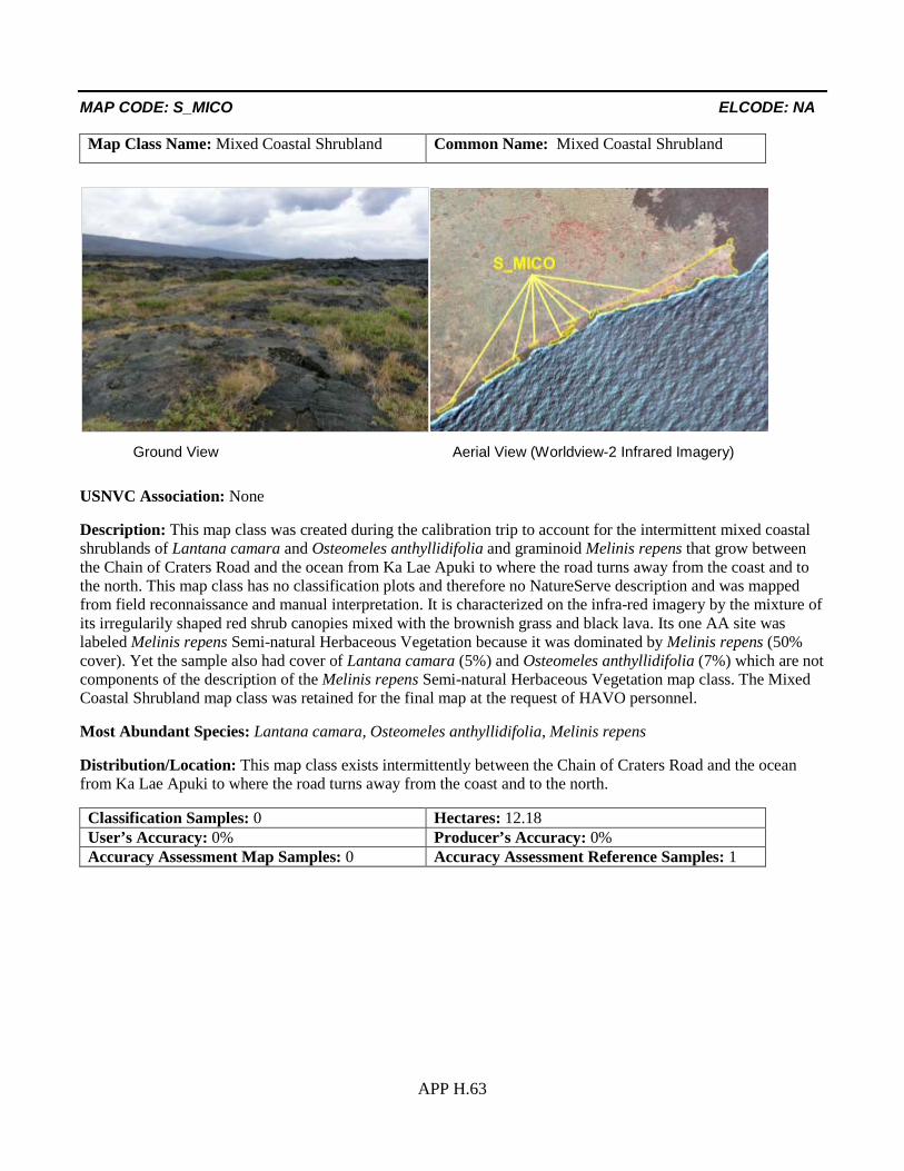
APP H.63
MAP CODE: S_MICO ELCODE: NA
Map Class Name: Mixed Coastal Shrubland Common Name: Mixed Coastal Shrubland
Ground View Aerial View (Worldview-2 Infrared Imagery)
USNVC Association: None
Description: This map class was created during the calibration trip to account for the intermittent mixed coastal shrublands of Lantana camara and Osteomeles anthyllidifolia and graminoid Melinis repens that grow between the Chain of Craters Road and the ocean from Ka Lae Apuki to where the road turns away from the coast and to the north. This map class has no classification plots and therefore no NatureServe description and was mapped from field reconnaissance and manual interpretation. It is characterized on the infra-red imagery by the mixture of its irregularily shaped red shrub canopies mixed with the brownish grass and black lava. Its one AA site was labeled Melinis repens Semi-natural Herbaceous Vegetation because it was dominated by Melinis repens (50% cover). Yet the sample also had cover of Lantana camara (5%) and Osteomeles anthyllidifolia (7%) which are not components of the description of the Melinis repens Semi-natural Herbaceous Vegetation map class. The Mixed Coastal Shrubland map class was retained for the final map at the request of HAVO personnel.
Most Abundant Species: Lantana camara, Osteomeles anthyllidifolia, Melinis repens
Distribution/Location: This map class exists intermittently between the Chain of Craters Road and the ocean from Ka Lae Apuki to where the road turns away from the coast and to the north.
Classification Samples: 0 Hectares: 12.18 User’s Accuracy: 0% Producer’s Accuracy: 0% Accuracy Assessment Map Samples: 0 Accuracy Assessment Reference Samples: 1

APP H.64
MAP CODE: H_MIDI ELCODE: NA
Map Class Name: Mixed Non-native Disturbed Herbaceous Vegetation
Common Name: Mixed Non-native Disturbed Herbaceous Vegetation
Ground View Aerial View (Worldview-2 Infrared Imagery)
USNVC Association: None
Description: This map class was created after AA field work indicated HAVO needed a map class which accounted for disturbed areas with non-native herbaceous vegetation. It has no classification samples and therefore no NatureServe description. The five AA samples show this class to be dominated by Senecio madagascariensis in Kahuku and by Passiflora foetida on the one sample on the coast. Other species present may include Melinis repens, Schizachyrium condensatum, Setaria parviflora, and Andropogon virginicus. The accuracy for this class is 0% because it did not exist at the time of AA and therefore did not exist on the map. The areas of all five samples were edited to Mixed Non-native Disturbed Herbaceous Vegetation.
Most Abundant Species: More diagnostic than the species occurance is that the areas of this map class have been disturbed by lava flows or anthropogenic landuse.
Distribution/Location: This map class exists in several polygons in Kahuku, on the coast, and at ‘Ᾱinahou Ranch. There is no specific species that occurs at all locations.
Classification Samples: 0 Hectares: 21.38 User’s Accuracy: 0% Producer’s Accuracy: 0% Accuracy Assessment Map Samples: 0 Accuracy Assessment Reference Samples: 5

APP H.65
MAP CODE: F_MOME ELCODE: CEGL008162
Map Class Name: Morella faya - (Metrosideros polymorpha) Semi-natural Forest
Common Name: Firetree - (‘Ōhi‘a) Semi-natural Forest
Ground View Aerial View (Worldview-2 Infrared Imagery)
USNVC Association: Morella faya - (Metrosideros polymorpha) Semi-natural Forest
Description: This map class represents areas which have been invaded by the stand-replacing non-native tree Morella faya. Canopies are sparse to dense and may be codominated by Metrosideros polymorpha. Understories are shrub or herb-dominated. Dominant shrubs include Leptecophylla tameiameiae and/or Dodonaea viscosa. Non-native grasses are common and may be the dominant understory species. These grasses may include Schizachyrium condensatum, Andropogon virginicus, and Melinis minutiflora. This class was mapped using field reconnaissance, CART modeling, and manual interpretation. It is distinguishable on the infrared imagery by the unique brilliant red signature of the Morella faya crowns which contrast greatly from any other tree species found at HAVO. Total vegetative cover for this map class varies from 14- 99%, which results in a highly variable appearance on the imagery, as exemplified in the imagery example. Because of the cover variability, this map class was committed to several other classes on the draft map, primarily in low vegetative cover areas. The class was extensively edited for the final map to correct errors of omission.
Most Abundant Species: Morella faya, Metrosideros polymorpha, Leptecophylla tameiameiae, Dodonaea viscosa
Distribution/Location: This map class extends from the north and eastern edge of Kīlauea Crater to just north of the Poliokeawe Pali and from the eastern edge of the Ka‘ū Desert into the East Rift Zone
Classification Samples: 19 Hectares: 4537.01 User’s Accuracy: 86% Producer’s Accuracy: 63% Accuracy Assessment Map Samples: 22 Accuracy Assessment Reference Samples: 30

APP H.66
MAP CODE: W_MYSA ELCODE: CEGL008137
Map Class Name: Myoporum sandwicense Subalpine Woodland
Common Name: Naio Subalpine Woodland
Ground View Aerial View (Worldview-2 Infrared Imagery)
USNVC Association: Myoporum sandwicense Subalpine Woodland
Description: This map class is characterized by open woodland canopies dominated by Myoporum sandwicense with cover ranging from 10-40%. Sophora chrysophylla is a common canopy associate at low cover. The understory is largely dominated by the non-native grasses Ehrharta stipoides and Cenchrus clandestinus which range from 5-20% cover individually. Leptecophylla tameiameiae and Dodonaea viscosa may form a sparse shrub layer. This class was mapped using manual interpretation. It is difficult to distinguish because the variable cover caused by the Myoporum sandwicense thrip. Two of its three reference samples were confused with other map classes. Areas with errors of commission or omission discovered during AA were corrected in the final map.
Most Abundant Species: Myoporum sandwicense, Ehrharta stipoides, Cenchrus clandestinus
Distribution/Location: This map class only exists in two small areas in Kahuku on the western slope of Mauna Loa.
Classification Samples: 4 Hectares: 69.02 User’s Accuracy: 25% Producer’s Accuracy: 33% Accuracy Assessment Map Samples: 4 Accuracy Assessment Reference Samples: 3

APP H.67
MAP CODE: H_NEBR ELCODE: CEGL008165
Map Class Name: Nephrolepis brownii Semi-natural Herbaceous Vegetation
Common Name: Sword fern Semi-natural Herbaceous Vegetation
Ground View Aerial View (Worldview-2 Infrared Imagery)
USNVC Association: Nephrolepis brownii Semi-natural Herbaceous Vegetation1
Description: This semi-natural map class is characterized by herbaceous vegetation dominated by the non-native fern Nephrolepis brownii. Cover is variable and may be open to extremely dense (up to 90% cover). Small patches of woody vegetation are common and can include Metrosideros polymorpha, Pipturus albidus, and Dodonaea viscosa. Non-native grasses including Andropogon virginicus and Paspalum conjugatum are common at low cover. This class was mapped using field reconnaissance, CART modeling and manual interpretation. It was highly confused on the draft map, especially with Dodonaea viscosa Lowland Dry Shrubland (three samples). Areas with errors of commission or omission discovered during AA were corrected in the final map.
Most Abundant Species: Nephrolepis brownii, Andropogon virginicus, Paspalum conjugatum
Distribution/Location: This map class occurs exclusively in the East Rift lowlands, Panau Nui, and near the Naulu trail from 600-750m on flat to steep slopes with southern aspects.
Classification Samples: 5 Hectares: 38.40 User’s Accuracy: 0% Producer’s Accuracy: 0% Accuracy Assessment Map Samples: 4 Accuracy Assessment Reference Samples: 0
1USNVC name modified based on Wagner et al. (1999) and Wagner et al. (2012).

APP H.68
MAP CODE: H_PTAQ ELCODE: CEPS009665
Map Class Name: Pteridium aquilinum ssp. decompositum Herbaceous Vegetation
Common Name: Kīlau Herbaceous Vegetation
Ground View Aerial View (Worldview-2 Infrared Imagery)
USNVC Association: Pteridium aquilinum ssp. decompositum Herbaceous Vegetation [Park Special]
Description: While present in the NatureServe HAVO association key, this map class has only one classification plot and thus does not have a NatureServe description. The class is characterized by an open to dense herbaceous stratum comprised nearly entirely of Pteridium aquilinum ssp. decompositum. Tree and shrub species are less abundant and do not contribute enough cover to comprise a stratum of their own. This class was mapped using field reconnaissance and is only mapped where found in the field during the calibration and validation field efforts. It was not assessed for accuracy because it only occurs in polygons below the MMU.
Most Abundant Species: Pteridium aquilinum ssp. decompositum
Distribution/Location: This map class occurs only in Mauna Loa Strip at and upslope of Kīpuka Puaulu on gentle to moderate slopes with south or southeast aspects from 1100-1500m
Classification Samples: 1 Hectares: 1.89 User’s Accuracy: Not Assessed Producer’s Accuracy: Not Assessed Accuracy Assessment Map Samples: 0 Accuracy Assessment Reference Samples: 0

APP H.69
MAP CODE: F_SACO ELCODE: CEPS009654
Map Class Name: Sapindus saponaria - Coprosma rhynchocarpa Montane Mesic Forest
Common Name: Mānele - Pilo Montane Mesic Forest
Ground View Aerial View (Worldview-2 Infrared Imagery)
USNVC Association: Sapindus saponaria - Coprosma rhynchocarpa Montane Mesic Forest [Park Special]
Description: This map class is characterized by open canopies dominated by Sapindus saponaria with cover ranging from 30-40% cover. Acacia koa is a canopy associate with 10% or less cover. The understory is shrub-dominated by Coprosma rhynchocarpa which has 20-30% cover. Pisonia brunoniana is also present but at low cover. The non-native vine Commelina diffusa and native vine Ipomoea indica may be present in stands. The herbaceous layer varies from sparse to open with native Microlepia strigosa having as much as 30% cover in some stands. This class was mapped from manual interpretation. Sapindus saponaria is distinguished on the infrared imagery by the large size of its crowns and their fluffy bright red spectral signature. This map class had several errors of commission which were corrected in the final map.
Most Abundant Species: Acacia koa, Sapindus saponaria, Coprosma rhynchocarpa, Microlepia strigosa
Distribution/Location: This map class is localized in Kīpuka Puaulu and Kīpuka Ki on Mauna Loa Strip at elevations ranging from approximately 1150-1400m. Such areas are gently sloping, recent lava flows with south and southwest aspects.
Classification Samples: 2 Hectares: 32.17 User’s Accuracy: 33% Producer’s Accuracy: 100% Accuracy Assessment Map Samples: 6 Accuracy Assessment Reference Samples: 2

APP H.70
MAP CODE: S_SCTA ELCODE: CEGL008054
Map Class Name: Scaevola taccada Coastal Dry Shrubland
Common Name: Naupaka Kahakai Coastal Dry Shrubland
Ground View Aerial View (Worldview-2 Infrared Imagery)
USNVC Association: Scaevola taccada Coastal Dry Shrubland1
Description: This map class was discovered during the calibration trip and therefore has no HAVO NatureServe description. However, it is a common map class in the PACN parks and received five AA samples at HAVO which indicate that it is characterized by open to dense canopy of Scaevola taccada (30-90%) often with scattered Tournefortia argentea (0-20%). Other shrubs may include Plucea carolinensis (0-20%). The herbaceous layer may include Melinis repens (2-30%) and Ipomoea spp. (0-25%). This class was mapped using manual interpretation. It is distinguished by its location along the coast and by its dull pink circular crowns in the infrared imagery.
Most Abundant Species: Scaevola taccada, Melinis repens
Distribution/Location: This map class is found within the coastal spray zone along the southern coast of HAVO from Ka Lae Apuki to Ka‘aha.
Classification Samples: 0 Hectares: 37.66 User’s Accuracy: 100% Producer’s Accuracy: 100% Accuracy Assessment Map Samples: 5 Accuracy Assessment Reference Samples: 5
1USNVC name modified based on Wagner et al. (1999) and Wagner et al. (2012).

APP H.71
MAP CODE: W_SCTE_S ELCODE: CEGL008148
Map Class Name: Schinus terebinthifolius Semi-natural Scrub Woodland
Common Name: Christmas Berry Semi-natural Scrub Woodland
Ground View Aerial View (Worldview-2 Infrared Imagery)
USNVC Association: Schinus terebinthifolius Semi-natural Scrub Woodland
Description: This map class received no classification plots and therefore does not have a NatureServe description at HAVO. It received 16 AA sites which show the class to be characterised by open to dense stands of Schinus terebinthifolius (8-65%) with little shrub cover. Herbaceous cover often includes Cymbopogon refractus (0-42%) or Melinis minutiflora (0-60%). This class was mapped using field reconnaissance, CART modeling, and manual interpretation. It is distinguished by its elevation range and, on the infrared imagery, by the large circular deep or bright red crowns of the Schinus terebinthifolius trees.
Most Abundant Species: Schinus terebinthifolius, Cymbopogon refractus, Melinis minutiflora
Distribution/Location: This map class is found in three locations at HAVO: in several polygons at the bottom of Kahuku, three polygons east of the Great Crack, and in several polygons in Kīpuka Pepeiao.
Classification Samples: 0 Hectares: 155.20 User’s Accuracy: 100% Producer’s Accuracy: 100% Accuracy Assessment Reference Samples: 16 Accuracy Assessment Reference Samples: 16

APP H.72
MAP CODE: W_SOLEDO_L ELCODE: CEGL008133
Map Class Name: Sophora chrysophylla - (Leptecophylla tameiameiae - Dodonaea viscosa) Lowland Dry Woodland
Common Name: Māmane - (Pūkiawe - ‘A‘ali‘i ) Lowland Dry Woodland
Ground View Aerial View (Worldview-2 Infrared Imagery)
USNVC Association: Sophora chrysophylla - (Leptecophylla tameiameiae - Dodonaea viscosa) Lowland Dry Woodland1
Description: This map class is characterized by open canopies dominated by Sophora chrysophylla ranging from 10-40% cover. Other canopy associates may include non-native Grevillea robusta and Schinus terebinthifolius. Understories are shrub-dominated by Dodonaea viscosa and/or Leptecophylla tameiameiae which may have as much as 50% combined cover. The herbaceous layer is strongly dominated by non-native species, including Andropogon virginicus, Melinis repens, and Pteridium aquilinum ssp. decompositum. This class was mapped using field reconnaissance and manual interpretation. It is difficult to map because of its variable species composition. The Sophora chrysophylla crowns typically have a smudgy brown appearance on the infrared imagery. On the draft map, the only class it was confused with was Sophora chrysophylla - Metrosideros polymorpha / (Leptecophylla tameiameiae - Dodonaea viscosa) Lowland Dry Woodland1 (two samples). The areas of both samples were corrected for the final map.
Most Abundant Species: Sophora chrysophylla, Leptecophylla tameiameiae, Dodonaea viscosa, Andropogon virginicus, Melinis repens, Pteridium aquilinum ssp. decompositum
Distribution/Location: This map class is seen in the Southwest Rift and Kapapala areas of the park at elevations ranging from approximately 500-850m.
Classification Samples: 4 Hectares: 11.14 User’s Accuracy: 60% Producer’s Accuracy: 100% Accuracy Assessment Map Samples: 5 Accuracy Assessment Reference Samples: 3
1USNVC name modified based on Wagner et al. (1999) and Wagner et al. (2012).

APP H.73
MAP CODE: W_SOLEDO_M ELCODE: CEGL008138
Map Class Name: Sophora chrysophylla - (Leptecophylla tameiameiae - Dodonaea viscosa) Montane Woodland
Common Name: Māmane - (Pūkiawe - ‘A‘ali‘i ) Montane Woodland
Ground View Aerial View (Worldview-2 Infrared Imagery)
USNVC Association: Sophora chrysophylla - (Leptecophylla tameiameiae - Dodonaea viscosa) Montane Woodland1
Description: This map class is characterized by sparse to open canopies of Sophora chrysophylla. Myoporum sandwicense may be present at low cover. The understory is shrub dominated by Leptecophylla tameiameiae and/or Dodonaea viscosa which have 5-50% total combined cover. The non-native grass Ehrharta stipoides is common at cover. This class was mapped using field reconnaissance, CART modeling and manual interpretation. Like Sophora chrysophylla - (Leptecophylla tameiameiae - Dodonaea viscosa) Lowland Dry Woodland1, this class is difficult to map because of its high species variability. It is distinguished on the imagery by its fine grained texture and its location often between kīpukas and younger lava flows. On the draft map it was confused with Sophora chrysophylla Montane Sparse Vegetation (five samples – all in Kahuku) and Sophora chrysophylla / Non-native grass Semi-natural Woodland (two samples). Areas with errors of commission or omission discovered during AA were corrected in the final map.
Most Abundant Species: Sophora chrysophylla, Leptecophylla tameiameiae, Dodonaea viscosa
Distribution/Location: This map class exists in the Mauna Loa Strip and the west side of Mauna Loa in the upper montane and subalpine zones of Kahuku from 1400-2400m. Areas tend to be midslope with southeast and southwest aspects.
Classification Samples: 3 Hectares: 199.89 User’s Accuracy: 33% Producer’s Accuracy: 83% Accuracy Assessment Map Samples: 15 Accuracy Assessment Reference Samples: 6
1USNVC name modified based on Wagner et al. (1999) and Wagner et al. (2012).

APP H.74
MAP CODE: W_SOMELEDO ELCODE: CEGL008139
Map Class Name: Sophora chrysophylla - Metrosideros polymorpha / (Leptecophylla tameiameiae - Dodonaea viscosa) Lowland Dry Woodland
Common Name: Māmane -‘Ōhi‘a / (Pūkiawe - ‘A‘ali‘i) Lowland Dry Woodland
Ground View Aerial View (Worldview-2 Infrared Imagery)
USNVC Association: Sophora chrysophylla - Metrosideros polymorpha / (Leptecophylla tameiameiae - Dodonaea viscosa) Lowland Dry Woodland1
Description: This map class is characterized by an open to nearly closed canopy dominated by Sophora chrysophylla and Metrosideros polymorpha ranging from 20-50% cover. Understories are shrub-dominated by Dodonaea viscosa and/or Leptecophylla tameiameiae which range from 10-30% total cover. The herbaceous layer is strongly dominated by native Pteridium aquilinum ssp. decompositum and non-native species, including Andropogon virginicus and Melinis spp.. This class was mapped using a combination of field reconnaissance, CART modeling, and manual interpretation. Because of its highly variable species composition it was very confused with Sophora chrysophylla - (Leptecophylla tameiameiae - Dodonaea viscosa) Lowland Dry Woodland1 and Metrosideros polymorpha / Leptecophylla tameiameiae - (Dodonaea viscosa) Lowland Dry Woodland1 in the draft map. Areas with errors of commission or omission discovered during AA were corrected in the final map.
Most Abundant Species: Sophora chrysophylla, Metrosideros polymorpha, Leptecophylla tameiameiae, Dodonaea viscosa, Andropogon virginicus
Distribution/Location: This map class occurs in isolated pockets in Southwest Rift, Kapapala, Kīpukanene, Kīpuka Keanabihopa, and ʻᾹinahou Ranch from 500-850m.
Classification Samples: 7 Hectares: 19.41 User’s Accuracy: 0% Producer’s Accuracy: 0% Accuracy Assessment Map Samples: 6 Accuracy Assessment Reference Samples: 3
1USNVC name modified based on Wagner et al. (1999) and Wagner et al. (2012).

APP H.75
MAP CODE: W_SOCH ELCODE: CEGL008140
Map Class Name: Sophora chrysophylla / Ehrharta stipoides Subalpine Semi-natural Woodland
Common Name: Māmane / Meadowrice Grass Subalpine Semi-natural Woodland
Ground View Aerial View (Worldview-2 Infrared Imagery)
USNVC Association: Sophora chrysophylla / Ehrhata stipoides Subalpine Semi-natural Woodland
Description: This map class is characterized by open woodland canopies of Sophora chrysophylla ranging from 10-20% cover. Myoporum sandwicense may occasionally codominate. The understory is composed of mostly herbaceous vegetation dominated by the non-native Ehrharta stipoides. This class was mapped using manual interpretation. It is distinguishable on the imagery because of its isolated location, and its mosaic of bright red Sophora chrysophylla crowns mixed with a thick beige grass understory.
Most Abundant Species: Myoporum sandwicense, Sophora chrysophylla, Ehrharta stipoides, Andropogon virginicus
Distribution/Location: This map class occurs only in a small area in northwest Kahuku in the subalpine zone of Mauna Loa from 2200-2350m.
Classification Samples: 4 Hectares: 132.81 User’s Accuracy: 83% Producer’s Accuracy: 79% Accuracy Assessment Map Samples: 18 Accuracy Assessment Reference Samples: 19

APP H.76
MAP CODE: SP_SOCH ELCODE: CEPS009670
Map Class Name: Sophora chrysophylla Montane Sparse Vegetation
Common Name: Māmane Montane Sparse Vegetation
Ground View Aerial View (Worldview-2 Infrared Imagery)
USNVC Association: Sophora chrysophylla Montane Sparse Vegetation [Park Special]
Description: While present in the NatureServe HAVO association key, this map class has only one classification plot and thus does not have a NatureServe description. It was sampled more heavily during the AA and is characterized by an open canopy of Sophora chrysophylla from 5-14%. Understories are poorly developed. The sparse shrub layer may include Leptecophylla tameiameiae while the sparse herbaceous layer typically includes Ehrharta stipoides, Cenchrus clandestinus, and Pteridium aquilinum ssp. decompositum. This class was mapped using manual interpretation. It is distinguishable on the imagery by its isolated location, and its mosaic of bright red Sophora chrysophylla crowns mixed with unvegetated lava and without a thick beige grass understory. On the draft map it was most often confused with Sophora chrysophylla - (Leptecophylla tameiameiae - Dodonaea viscosa) Montane Woodland1 – five samples, all corrected in the final map).
Most Abundant Species: Sophora chrysophylla
Distribution/Location: This map class occurs on the western slope of Mauna Loa in northwest Kahuku between 2000-2500m.
Classification Samples: 1 Hectares: 77.35 User’s Accuracy: 0% Producer’s Accuracy: 0% Accuracy Assessment Map Samples: 0 Accuracy Assessment Reference Samples: 6

APP H.77
MAP CODE: W_THPR ELCODE: CEGL005412, CEGL008118
Map Class Name: Thespesia populnea - (Prosopis pallida) Woodland
Common Name: Milo - (Kiawe) Woodland
Ground View Aerial View (Worldview-2 Infrared Imagery)
USNVC Association: Thespesia populnea / Sparse Understory Woodland, Prosopis pallida Coastal Dry Semi-natural Woodland
Description: This map class was not sampled for classification and therefore it has no HAVO NatureServe description and is not included in the table of NatureServe HAVO associations. However, its component associations were sampled and classified at HALA, KAHO, and HALE. It has one AA site which characterizes it as 94% vegetated. The class is dominated with Thespesia populnea (55%) with a shrub understory of Pluchea carolinensis (13%) and Morinda citrifolia (3%). The herbaceous layer includes Passiflora foetida (17%) and a Fabaceae spp.. This class was mapped using manual interpretation. It is distinguished by its location along the coast, and its taller, more continuous, and redder spectral signature than surrounding vegetation. Prosopis pallida may be present in canopy.
Most Abundant Species: Thespesia populnea
Distribution/Location: This class is found in only three polygons along the HAVO coast, near Keauhou.
Classification Samples: 0 Hectares: 1.12 User’s Accuracy: 100% Producer’s Accuracy: 100% Accuracy Assessment Map Samples: 1 Accuracy Assessment Reference Samples: 1

APP H.78
Coastal Grasslands The coastal vegetation was first mapped by lifeform (grassland, shrubland, forest and woodland, unvegetated) from the imagery and field reconnaissance. The grasslands were next modeled to their map class label based on a model jointly developed by HAVO, PACN, and KGA staff (Figure H.1). As a result, the map class labels have multiple USNVC associations.
Figure H.1. Coastal grasslands modeled map classes.
Table 11 is a comparison of the AA reference association labels with the coastal grassland map classes. It also includes reference labels of some non-coastal grassland map classes to reflect the minimal confusion between coastal and non-coastal map classes. Because a coastal grassland map class can be comprised of more than one association and one association can occur in more than one map class, AA of the coastal grassland map classes is problematic. Samples highlighted in yellow on Table 11 indicate agreement between the map class label and the association which comprise the map class. User’s accuracies are are calculated by dividing the sum of the yellow highlighted cells by the total number of samples in each row. Producer’s accuracies are calculated by dividing the sum of the yellow highlighted cells by the total number of samples in each column. Because a map class may be composed of several associations and an association may occur in more than one map class, the cells where the association matches the map class do not always fall on the diagonal.

APP H.79
MAP CODE: H_ANME_G ELCODE: CEGL008166
Map Class Name: Andropogon virginicus - Melinis spp. Mixed Grassland
Common Name: Broomsedge - Melinis spp. Mixed Grassland
Ground View Aerial View (Worldview-2 Infrared Imagery)
USNVC Association: Andropogon virginicus Semi-natural Lowland Herbaceous Vegetation
Description: This map class is represented by one association which is characterized by herbaceous vegetation strongly dominated by the non-native grass Andropogon virginicus. Cover varies from as low as 2% to over 60% cover. Trees are largely absent, but Metrosideros polymorpha trees may occur at low covers (0-7%). Dodonaea viscosa is common at 0-22% as is Melinis minutiflora (0-50%). Scattered Nephrolepis brownii may occur at low cover (0-4%). This class was mapped using field reconnaissance, image classification, and guidance from HAVO personnel on the map labels and creation of the model. In the draft map is was confused with Melinis minutiflora- (Schizachyrium condensatum) Semi-natural Herbaceous Vegetation (four samples - which were not edited for the final map because they all had secondary labels of Andropogon virginicus Semi-natural Lowland Herbaceous Vegetation).
Most Abundant Species: Andropogon virginicus, Dodonaea viscosa, Melinis minutiflora
Distribution/Location: This modeled map class occupies the northeast corner of HAVO’s coastal grasslands both within and east of the Chain of Crater’s Road’s hairpin curve. Much of it is within the 2002-03 burn areas of the East Rift zone.
Classification Samples: 12 Hectares: 307.41 User’s Accuracy: 65% Producer’s Accuracy: NA Accuracy Assessment Map Samples: 17 Accuracy Assessment Reference Samples: NA
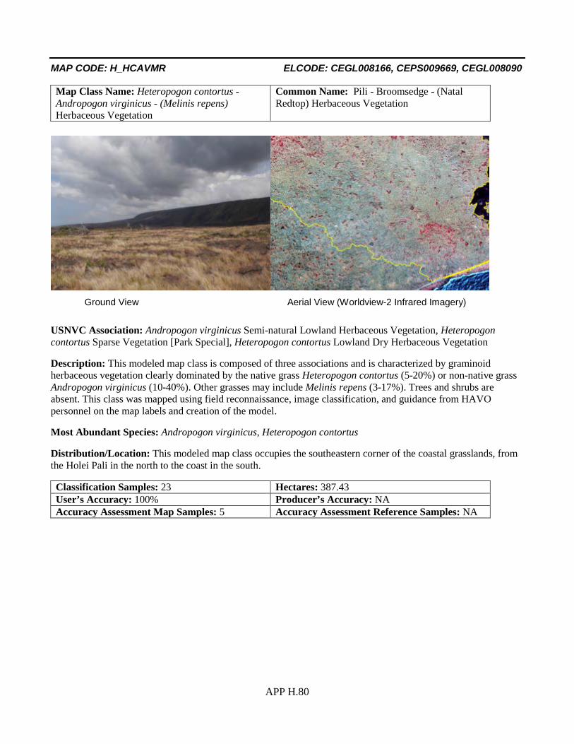
APP H.80
MAP CODE: H_HCAVMR ELCODE: CEGL008166, CEPS009669, CEGL008090
Map Class Name: Heteropogon contortus - Andropogon virginicus - (Melinis repens) Herbaceous Vegetation
Common Name: Pili - Broomsedge - (Natal Redtop) Herbaceous Vegetation
Ground View Aerial View (Worldview-2 Infrared Imagery)
USNVC Association: Andropogon virginicus Semi-natural Lowland Herbaceous Vegetation, Heteropogon contortus Sparse Vegetation [Park Special], Heteropogon contortus Lowland Dry Herbaceous Vegetation
Description: This modeled map class is composed of three associations and is characterized by graminoid herbaceous vegetation clearly dominated by the native grass Heteropogon contortus (5-20%) or non-native grass Andropogon virginicus (10-40%). Other grasses may include Melinis repens (3-17%). Trees and shrubs are absent. This class was mapped using field reconnaissance, image classification, and guidance from HAVO personnel on the map labels and creation of the model.
Most Abundant Species: Andropogon virginicus, Heteropogon contortus
Distribution/Location: This modeled map class occupies the southeastern corner of the coastal grasslands, from the Holei Pali in the north to the coast in the south.
Classification Samples: 23 Hectares: 387.43 User’s Accuracy: 100% Producer’s Accuracy: NA Accuracy Assessment Map Samples: 5 Accuracy Assessment Reference Samples: NA

APP H.81
MAP CODE: H_HEHYMEAN ELCODE: CEGL008090, CEGL008168, CEGL008166
Map Class Name: Heteropogon contortus - Hyparrhenia rufa - Melinis spp. - (Andropogon virginicus) Mixed Grassland
Common Name: Pili - Thatching Grass - Melinis spp. - (Broomsedge) Mixed Grassland
Ground View Aerial View (Worldview-2 Infrared Imagery)
USNVC Association: Heteropogon contortus Lowland Dry Herbaceous Vegetation, Hyparrhenia rufa - Melinis spp. Semi-Natural Herbaceous Vegetation, Andropogon virginicus Semi-natural Lowland Herbaceous Vegetation
Description: This map class is composed of three associations. It is a highly variable class and may contain Andropogon virginicus, Heteropogon contortus, Hyparrhenia rufa and/or Melinis spp. Total cover is low to sparse (9-45%). Trees and shrubs are absent. This class was mapped using field reconnaissance, image classification, and guidance from HAVO personnel on the map labels and creation of the model.
Most Abundant Species: Andropogon virginicus, Hyparrhenia rufa, Heteropogon contortus
Distribution/Location: This modeled map class occupies the southern of the coastal grass lands from just east of ʻOpihinehe to the western border of the park.
Classification Samples: 55 Hectares: 1364.29 User’s Accuracy: 80% Producer’s Accuracy: NA Accuracy Assessment Map Samples: 10 Accuracy Assessment Reference Samples: NA

APP H.82
MAP CODE: H_HCMRAV ELCODE: CEGL008090, CEPS009669, CEGL005405
Map Class Name: Heteropogon contortus - Melinis repens - (Andropogon virginicus) Herbaceous Vegetation
Common Name: Pili - Natal Redtop - (Broomsedge) Herbaceous Vegetation
Ground View Aerial View (Worldview-2 Infrared Imagery)
USNVC Association: Heteropogon contortus Lowland Dry Herbaceous Vegetation, Heteropogon contortus Sparse Vegetation [Park Special], Melinis repens Semi-natural Herbaceous Vegetation
Description: This map class is comprised of three associations. It is characterized by graminoid herbaceous vegetation which is a mixture of the native grass Heteropogon contortus (1-25%) with the non-native Melinis repens (0-65%). Woody species are rare. Few other species attain substantial cover, although some stands are being invaded by non-native species, especially Andropogon virginicus. Shrub and tree cover are mostly absent. This class was mapped using field reconnaissance, image classification, and guidance from HAVO personnel on the map labels and creation of the model.
Most Abundant Species: Heteropogon contortus, Melinis repens
Distribution/Location: This modeled map class is located in the central southeastern portion of the coastal grasslands. It is bordered on the south by the coast, on the north by Holei Pali.
Classification Samples: 18 Hectares: 1005.00 User’s Accuracy: 100% Producer’s Accuracy: NA Accuracy Assessment Map Samples: 16 Accuracy Assessment Reference Samples: NA

APP H.83
MAP CODE: H_HYME ELCODE: CEGL008168, CEGL008166
Map Class Name: Hyparrhenia rufa - Melinis spp. - (Andropogon virginicus) Mixed Grassland
Common Name: Thatching Grass - Melinis spp. - (Broomsedge) Mixed Grassland
Ground View Aerial View (Worldview-2 Infrared Imagery)
USNVC Association: Hyparrhenia rufa - Melinis spp. Semi-Natural Herbaceous Vegetation, Andropogon virginicus Semi-natural Lowland Herbaceous Vegetation
Description: This map class is composed of two associations and is overwhelmingly dominated by the non-native grasses Hyparrhenia rufa (7-69%) or Andropogon virginicus (0-40%), often mixed with Melinis minutiflora and/or Melinis repens. Most of the remainder of the floristic composition is the non-native Schizachyrium condensatum, as well as the native grass Heteropogon contortus. Woody species are mostly absent. This class was mapped using field reconnaissance, image classification, and guidance from HAVO personnel on the map labels and creation of the model. On the draft map it was confused with Heteropogon contortus Lowland Dry Herbaceous Vegetation (one sample), Melinis minutiflora- (Schizachyrium condensatum) Semi-natural Herbaceous Vegetation (two samples), and Melinis repens Semi-natural Herbaceous Vegetation (one sample).
Most Abundant Species: Hyparrhenia rufa, Andropogon virginicus, Melinis spp.
Distribution/Location: This very large coastal modeled herbaceous map class extends from Keauhou Landing on the southeast to Poliokeawe Pali on the northeast to the Southwest Rift Zone.
Classification Samples: 45 Hectares: 6645.41 User’s Accuracy: 86% Producer’s Accuracy: NA Accuracy Assessment Map Samples: 35 Accuracy Assessment Reference Samples: NA

APP H.84
MAP CODE: H_MEAV ELCODE: CEGL005405
Map Class Name: Melinis spp. - (Andropogon virginicus) Mixed Grassland
Common Name: Melinis spp. - (Broomsedge) Mixed Grassland
Ground View Aerial View (Worldview-2 Infrared Imagery)
USNVC Association: Melinis repens Semi-natural Herbaceous Vegetation
Description: This map class is comprised of one association and is characterized by herbaceous vegetation dominated by non-native Melinis spp. which ranges from 4-83% cover. Other non-native grasses may exist at lower cover, including Andropogon virginicus (0-2%) and Hyparrhenia rufa (0-8%). Tree and shrub cover is mostly absent. This class was mapped using field reconnaissance, image classification, and guidance from HAVO personnel on the map labels and the creation of the model. In the draft map, it was mostly confused with Hyparrhenia rufa - Melinis spp. Semi-Natural Herbaceous Vegetation (five samples), but also with one or two samples of every other grass association except Heteropogon contortus Lowland Dry Herbaceous Vegetation.
Most Abundant Species: Andropogon virginicus, Melinis minutiflora, Melinis repens
Distribution/Location: This modeled semi-natural coastal map class occurs in two areas of HAVO’s the coastal grasslands: in several kīpukas within the lava flows of the 1970’s and along the Hilina Pali. It appears in the southeast lowlands of the park from near the coast and inland at elevations ranging from sea level to approximately 500 m.
Classification Samples: 7 Hectares: 1014.51 User’s Accuracy: 59% Producer’s Accuracy: NA Accuracy Assessment Map Samples: 29 Accuracy Assessment Reference Samples: NA

APP H.85
MAP CODE: H_MESCCO ELCODE: CEGL008169
Map Class Name: Melinis spp. - (Schizachyrium condensatum) Mixed Grassland
Common Name: Melinis spp. - (Beardgrass) Mixed Grassland
Ground View Aerial View (Worldview-2 Infrared Imagery)
USNVC Association: Melinis minutiflora - (Schizachyrium condensatum) Semi-natural Herbaceous Vegetation
Description: This map class is represented by one association and is characterized by herbaceous vegetation strongly dominated by the non-native grasses Melinis minutiflora and/or Schizachyrium condensatum. When Schizachyrium condensatum is dominant, Melinis minutiflora is always present at lower cover. Other non-native graminoids are prevalent at lower cover, including Melinis repens (0-10%) and Hyparrhenia rufa. Leptecophylla tameiameiae, Lantana camara, and Dodonaea viscosa are often scattered in some stands at covers not exceeding 15% individually. This class was mapped using field reconnaissance, image classification, and guidance from HAVO personnel on the map labels and creation of the model. It is confused with Hyparrhenia rufa - Melinis spp. Semi-Natural Herbaceous Vegetation (four samples and Melinis repens Semi-natural Herbaceous Vegetation (two samples).
Most Abundant Species: Melinis minutiflora
Distribution/Location: This modeled map class can be found on the north central portion of HAVO’s coastal grasslands along the Hilina Pali, in Pu‘ukaone, and in a kīpuka above Kukalauula Pali.
Classification Samples: 20 Hectares: 646.57 User’s Accuracy: 68% Producer’s Accuracy: NA Accuracy Assessment Map Samples: 19 Accuracy Assessment Reference Samples: NA


The Department of the Interior protects and manages the nation’s natural resources and cultural heritage; provides scientific and other information about those resources; and honors its special responsibilities to American Indians, Alaska Natives, and affiliated Island Communities. NPS 124/128594, May 2015

National Park Service U.S. Department of the Interior
Natural Resource Stewardship and Science 1201 Oakridge Drive, Suite 150 Fort Collins, CO 80525 www.nature.nps.gov
EXPERIENCE YOUR AMERICA TM
Copyright © 2022 FDOKUMEN