volcanoes have a destructive power as well as potential benefit
RESEARCH ARTICLE
Growth and collapse of the Reunion Island volcanoes
Jean-François Oehler & Jean-François Lénat &Philippe Labazuy
Received: 3 January 2007 /Accepted: 7 June 2007 / Published online: 16 August 2007# Springer-Verlag 2007
Abstract This work presents the first exhaustive study ofthe entire surface of the Reunion Island volcanic system. Thefocus is on the submarine part, for which a compilation of allmultibeam data collected during the last 20 years has beenmade. Different types of submarine features have beenidentified: a coastal shelf, debris avalanches and sedimentarydeposits, erosion canyons, volcanic constructions near thecoast, and seamounts offshore. Criteria have been defined todifferentiate the types of surfaces and to establish theirrelative chronology where possible. Debris avalanchedeposits are by far the most extensive and voluminousformations in the submarine domain. They have built fourhuge Submarine Bulges to the east, north, west, and south ofthe island. They form fans 20–30 km wide at the coastlineand 100–150 km wide at their ends, 70–80 km offshore.They were built gradually by the superimposition and/orjuxtaposition of products moved during landslide episodes,involving up to several hundred cubic kilometers of material.About 50 individual events deposits can be recognized at thesurface. The landslides have recurrently dismantled Pitondes Neiges, Les Alizés, and Piton de La Fournaise volcanoessince 2 Ma. About one third are interpreted as secondarylandslides, affecting previously emplaced debris avalanchedeposits. On land, landslide deposits are observed in the
extensively eroded central area of Piton des Neiges and in itscoastal areas. Analysis of the present-day topography and ofgeology allows us to identify presumed faults and scars ofprevious large landslides. The Submarine Bulges aredissected and bound by canyons up to 200 m deep and40 km long, filled with coarse-grained sediments, andgenerally connected to streams onshore. A large zone ofsedimentary accumulation exists to the north–east of theisland. It covers a zone 20 km in width, extending up to15 km offshore. Volcanic constructions are observed near thecoast on both Piton des Neiges and Piton de la Fournaisevolcanoes and are continuations of subaerial structures.Individual seamounts are present on the submarine flanksand the surrounding ocean floor. A few seem to be youngvolcanoes, but the majority are probably old, erodedseamounts. This study suggests a larger scale and frequencyof mass-wasting events on Reunion Island compared tosimilar islands. The virtual absence of downward flexure ofthe lithosphere beneath the island probably contributes tothis feature. The increased number of known flank–failureevents has to be taken into consideration when assessinghazards from future landslides, in particular, the probabilityof landslide-generated tsunamis.
Keywords Reunion Island . Landslides .
Multi-beam bathymetry . Sonar backscatter .
Digital terrain model . Oceanic islands
Introduction
The building of a large volcano generally involves asuccession of phases of volcanic construction (accumulationof lava flows and pyroclastic products) and phases ofdestruction by mass-wasting processes. Flank landslides
Bull Volcanol (2008) 70:717–742DOI 10.1007/s00445-007-0163-0
Editorial responsibility: J. White
Electronic supplementary material The online version of this article(doi:10.1007/s00445-007-0163-0) contains supplementary material,which is available to authorized users.
J.-F. Oehler (*) : J.-F. Lénat : P. LabazuyLaboratoire Magmas et Volcans, UMR 6524 CNRS, OPGC,Université Blaise Pascal,5 rue Kessler,,63038 Clermont-Ferrand Cedex, Francee-mail: [email protected]
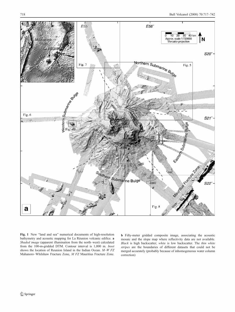
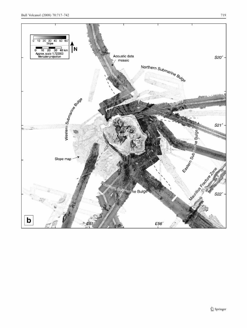
Fig. 1 New “land and sea” numerical documents of high-resolutionbathymetry and acoustic mapping for La Réunion volcanic edifice. aShaded image (apparent illumination from the north–west) calculatedfrom the 100-m-gridded DTM. Contour interval is 1,000 m. Insetshows the location of Reunion Island in the Indian Ocean. M–W FZMahanoro–Whilshaw Fracture Zone, M FZ Mauritius Fracture Zone.
b Fifty-meter gridded composite image, associating the acousticmosaic and the slope map where reflectivity data are not available.Black is high backscatter; white is low backscatter. The thin whitestripes are the boundaries of different datasets that could not bemerged accurately (probably because of inhomogeneous water columncorrection)
718 Bull Volcanol (2008) 70:717–742
Bull Volcanol (2008) 70:717–742 719
are recognized as the most important and efficient mass-wasting process on volcanoes. They contribute to the build-ing of the edifices by widening their base. They are observedon volcanoes in all geodynamical settings, from continentaland subduction strato-volcanoes to intraplate oceanic shieldvolcanoes that have gentler slopes.
In fact, the biggest landslides on Earth have been observedon volcanic oceanic islands, with some events involvingmore than 1,000 km3 of products. Single events are knownto have removed half the subaerial portion and 10 to 20% ofthe total volume of volcanoes (Holcomb and Searle 1991).The best-documented examples are those of the HawaiianRidge and of the Canary archipelago volcanoes. Sixty-eightmajor landslides, with the largest deposits attaining 200 kmin length and 5,000 km3 in volume, have been described in
the Hawaiian Islands (Moore et al. 1989, 1994), and 18,involving up to 1,000 km3 of material, in the Canary Islands(Ablay and Hürlimann 2000; Krastel et al. 2001a, b; Massonet al. 2002). In an oceanic context, the study of these phe-nomena requires extensive analysis of the submarine flankswhere most of the associated deposits are accumulated.These observations have to be linked to the sub-aerial andinternal structures to assess the source areas of the landslidesand the mechanisms leading to destabilization.
We have followed this approach in this study of ReunionIsland. It is based on the Ph.D. thesis of the first author (Oehler2005) where interested readers can find the details that couldnot be included in this paper (http://www.tel.archives-ouvertes.fr/index.php?halsid=7468eeeb21a717fe9f1334ac4d670bae&view_this_doc=tel-00010498&version=1). High-resolution
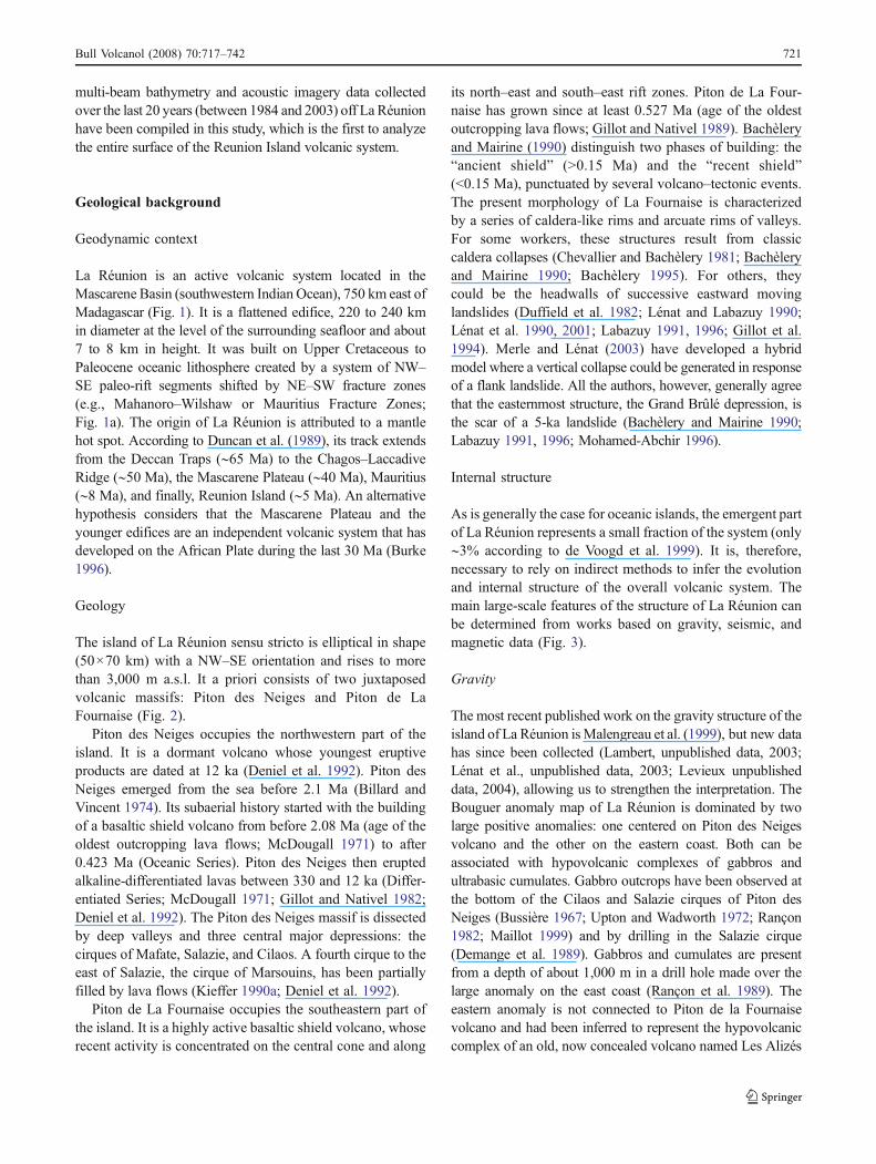
Fig. 3 Synthetic section across La Réunion. The internal structure ismostly based on geophysical works by Malengreau et al. (1999),Charvis et al. (1999), de Voogd et al. (1999), Gallart et al. (1999), andLénat et al. (2001). Les Alizés volcano has been destroyed and cannotbe observed on land; its inferred previous shape is shown. Piton desNeiges and Les Alizés volcanoes have large, dense hypovolcanic
complexes, whereas the young Piton de la Fournaise volcano has notyet developed a comparable complex. Most of the submarine flankshave been constructed by the accumulation of mass-wasting products.The lithosphere does not show a downward flexure beneath LaRéunion
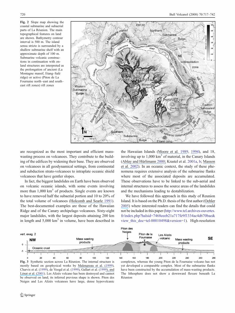
Fig. 2 Slope map showing thecoastal submarine and subaerialparts of La Réunion. The maintopographical features on landare shown. Bathymetry contourinterval is 500 m. The islandsensu stricto is surrounded by ashallow submarine shelf with anapproximate depth of 100 m.Submarine volcanic construc-tions in continuation with on-land structures are interpreted asthe prolongation of ancient (LaMontagne massif, Etang–Saléridge) or active (Piton de LaFournaise north–east and south–east rift zones) rift zones
720 Bull Volcanol (2008) 70:717–742
multi-beam bathymetry and acoustic imagery data collectedover the last 20 years (between 1984 and 2003) off La Réunionhave been compiled in this study, which is the first to analyzethe entire surface of the Reunion Island volcanic system.
Geological background
Geodynamic context
La Réunion is an active volcanic system located in theMascarene Basin (southwestern Indian Ocean), 750 km east ofMadagascar (Fig. 1). It is a flattened edifice, 220 to 240 kmin diameter at the level of the surrounding seafloor and about7 to 8 km in height. It was built on Upper Cretaceous toPaleocene oceanic lithosphere created by a system of NW–SE paleo-rift segments shifted by NE–SW fracture zones(e.g., Mahanoro–Wilshaw or Mauritius Fracture Zones;Fig. 1a). The origin of La Réunion is attributed to a mantlehot spot. According to Duncan et al. (1989), its track extendsfrom the Deccan Traps (∼65 Ma) to the Chagos–LaccadiveRidge (∼50 Ma), the Mascarene Plateau (∼40 Ma), Mauritius(∼8 Ma), and finally, Reunion Island (∼5 Ma). An alternativehypothesis considers that the Mascarene Plateau and theyounger edifices are an independent volcanic system that hasdeveloped on the African Plate during the last 30 Ma (Burke1996).
Geology
The island of La Réunion sensu stricto is elliptical in shape(50×70 km) with a NW–SE orientation and rises to morethan 3,000 m a.s.l. It a priori consists of two juxtaposedvolcanic massifs: Piton des Neiges and Piton de LaFournaise (Fig. 2).
Piton des Neiges occupies the northwestern part of theisland. It is a dormant volcano whose youngest eruptiveproducts are dated at 12 ka (Deniel et al. 1992). Piton desNeiges emerged from the sea before 2.1 Ma (Billard andVincent 1974). Its subaerial history started with the buildingof a basaltic shield volcano from before 2.08 Ma (age of theoldest outcropping lava flows; McDougall 1971) to after0.423 Ma (Oceanic Series). Piton des Neiges then eruptedalkaline-differentiated lavas between 330 and 12 ka (Differ-entiated Series; McDougall 1971; Gillot and Nativel 1982;Deniel et al. 1992). The Piton des Neiges massif is dissectedby deep valleys and three central major depressions: thecirques of Mafate, Salazie, and Cilaos. A fourth cirque to theeast of Salazie, the cirque of Marsouins, has been partiallyfilled by lava flows (Kieffer 1990a; Deniel et al. 1992).
Piton de La Fournaise occupies the southeastern part ofthe island. It is a highly active basaltic shield volcano, whoserecent activity is concentrated on the central cone and along
its north–east and south–east rift zones. Piton de La Four-naise has grown since at least 0.527 Ma (age of the oldestoutcropping lava flows; Gillot and Nativel 1989). Bachèleryand Mairine (1990) distinguish two phases of building: the“ancient shield” (>0.15 Ma) and the “recent shield”(<0.15 Ma), punctuated by several volcano–tectonic events.The present morphology of La Fournaise is characterizedby a series of caldera-like rims and arcuate rims of valleys.For some workers, these structures result from classiccaldera collapses (Chevallier and Bachèlery 1981; Bachèleryand Mairine 1990; Bachèlery 1995). For others, theycould be the headwalls of successive eastward movinglandslides (Duffield et al. 1982; Lénat and Labazuy 1990;Lénat et al. 1990, 2001; Labazuy 1991, 1996; Gillot et al.1994). Merle and Lénat (2003) have developed a hybridmodel where a vertical collapse could be generated in responseof a flank landslide. All the authors, however, generally agreethat the easternmost structure, the Grand Brûlé depression, isthe scar of a 5-ka landslide (Bachèlery and Mairine 1990;Labazuy 1991, 1996; Mohamed-Abchir 1996).
Internal structure
As is generally the case for oceanic islands, the emergent partof La Réunion represents a small fraction of the system (only∼3% according to de Voogd et al. 1999). It is, therefore,necessary to rely on indirect methods to infer the evolutionand internal structure of the overall volcanic system. Themain large-scale features of the structure of La Réunion canbe determined from works based on gravity, seismic, andmagnetic data (Fig. 3).
Gravity
The most recent published work on the gravity structure of theisland of La Réunion isMalengreau et al. (1999), but new datahas since been collected (Lambert, unpublished data, 2003;Lénat et al., unpublished data, 2003; Levieux unpublisheddata, 2004), allowing us to strengthen the interpretation. TheBouguer anomaly map of La Réunion is dominated by twolarge positive anomalies: one centered on Piton des Neigesvolcano and the other on the eastern coast. Both can beassociated with hypovolcanic complexes of gabbros andultrabasic cumulates. Gabbro outcrops have been observed atthe bottom of the Cilaos and Salazie cirques of Piton desNeiges (Bussière 1967; Upton and Wadworth 1972; Rançon1982; Maillot 1999) and by drilling in the Salazie cirque(Demange et al. 1989). Gabbros and cumulates are presentfrom a depth of about 1,000 m in a drill hole made over thelarge anomaly on the east coast (Rançon et al. 1989). Theeastern anomaly is not connected to Piton de la Fournaisevolcano and had been inferred to represent the hypovolcaniccomplex of an old, now concealed volcano named Les Alizés
Bull Volcanol (2008) 70:717–742 721
(Rançon et al. 1989; Malengreau et al. 1999; Lénat et al2001). The young Piton de la Fournaise volcano has not yetdeveloped a large, dense hypovolcanic complex, althoughdense rocks beneath the oldest part of the volcano aresuggested by gravity anomalies. The Piton de la Fournaisepositive anomaly coincides with the location of the volcaniccenter during the earliest stage of the volcano’s evolution(Bachèlery and Lénat 1993) and also with an area wherexenoliths of gabbro and ultrabasic rocks are frequently foundin tephra and lava flows. The modeling of the Bougueranomalies suggests (1) that the two main positive anomaliesof Piton des Neiges and Les Alizés volcanoes are created bydeeply rooted, large hypovolcanic complexes and (2) that asmaller, less deeply rooted hypovolcanic complex existsbeneath Piton de la Fournaise to the west of the presentcenter of activity.
Seismics
A general view of the seismic structure of La Réunion wasprovided by the 1993 project Reusis (Charvis et al. 1999; deVoogd et al. 1999; Gallart et al. 1999). The main character-istics may be summarized as follows: (1) The core of theisland is made of more massive rocks than the flanks; (2) wedo not observe a large flexure of the lithosphere as found onmost other oceanic islands; and (3) beneath the south-westpart of the island, a high velocity layer at the base of thecrust is interpreted as magmatic underplating.
Magnetics
The island of La Réunion has been studied using data fromairborne and shipborne magnetic surveys by Lénat et al.(2001). The subaerial volcanism of La Réunion spans thelast 2.1 Ma and, therefore, the Brunhes–Matuyama geo-magnetic reversal. This enables volcanic rocks older andyounger than 0.78 Ma to be distinguished by studying thepositive and negative magnetic anomalies. The lowersubmarine flanks appear as poorly magnetized, which isconsistent with their interpretation as being mostly landslidedeposits. Long wavelength anomalies are related to themagnetic anomalies of the oceanic crust. The core of theisland is composed of highly magnetized rocks. Piton desNeiges volcano is composed mainly of rocks older than0.78 Ma, and only its western flank and central area includethick piles of younger Brunhes rocks. Piton de la Fournaisevolcano is a strongly and normally magnetized edifice, butits northern and eastern flanks are underlain at shallow depthby reversely magnetized formations. The latter are regardedas remnants of Les Alizés volcano, associated with theGrand Brûlé hypovolcanic complex. Therefore, at theMatuyama–Brunhes transition, the island was composed oftwo main volcanoes: Piton des Neiges and Les Alizés.
Previous submarine studies
The first two detailed studies of the submarine flanks of LaRéunion focused on the offshore eastern continuation of theactive Piton de la Fournaise volcano. In 1984, “Fournaise 1”project provided the first multi-beam coverage of the area(Lénat et al. 1989, 1990). During “Fournaise 2” project in1988, a high definition sonar image of the area was acquiredusing the deep-tow sonar SAR (Cochonat et al. 1990; Lénatand Labazuy 1990; Labazuy 1991, 1996; Ollier et al. 1998).In addition, bottom pictures were taken at selected sites, androck samples were collected by dredging and coring. Thesedata provided an image of the nature and distribution of thesubmarine features to the east of the active volcano. Inparticular, they suggested that, with the exception of a fewfeatures near the coast, the material on the submarine flankwas entirely derived from mass wasting and sedimentationphenomena. The interpretative map of Labazuy (1991,1996) delineates slide events deposits emplaced either asdebris avalanches (forming a characteristic hummocky zoneof accumulation, the Ralé-Poussé), or as slumps (forming aprominent submarine plateau resulting from the accretion ofsuccessive slide blocks). Labazuy (1991, 1996), thus, statedthat at least 550 km3 of slide deposits are found off Piton dela Fournaise.
The bathymetry of the other flanks of La Réunion has longremained poorly known. A first general digital terrain model(DTM) of the edifice, with a resolution of about 1 km, wascompiled by Lénat and Labazuy (1990). The authors notedthat the submarine morphology of La Réunion departssignificantly from that of a regular volcanic cone by thepresence of four large bulges at the north–east, the east,the south–west, and the west. Because of similarities withthe well-studied eastern bulge, they suggested that the threeother bulges were also created by accumulation of masswasting products. Detailed bathymetry for a large area of thesouthern and southwestern submarine flanks of the islandwas acquired in 1993 using the Hydrosweep multi-beamecho-sounder (Fretzdorff et al. 1998). Hummocky top-ographies were observed in these areas, suggesting thatthey are covered with debris avalanche deposits. Also in1993, multichannel seismic reflection profiles, allowed deVoogd et al. (1999) to identify both superficial and deepslumps and debris avalanches to the south and the east of theisland. Some reflectors are interpreted as slide or décolle-ment surfaces, the deepest being the top of the oceanicsediments.
More recently, Oehler et al. (2004) undertook a detailedstudy of the northern flank of the island using SimradEM12D swath bathymetry and backscatter data collected in1995. Although the coverage was only partial, the quality ofthe data allowed them to carry out a detailed analysis of thefeatures of the area. They concluded that the flank was
722 Bull Volcanol (2008) 70:717–742
covered mostly with debris avalanche deposits and bysediments channeled within submarine valleys or canyons.At least 15 major flank landslides formed since 2 Ma wereidentified. Oehler et al. (2004) tried to link the submarinelandslide deposits with the volcano–tectonic evolution of thesubaerial part of the island.
Data compilation and processing
We present in this paper a new compilation of all high-resolution swath bathymetry and backscatter data collectedover the last 20 years around La Réunion. The databaseincludes the previously published data described above andunpublished multi-beam Simrad EM12D, Thomson TSM5265B, and Thales Sea Falcon 11 data collected since 2000(see Fig. 1 and ESM Fig. 1). The data have been processedusing Caraibes software (©Ifremer) to construct (1) a 100-mgridded DTM of the submarine flanks and of part of thesurrounding ocean seafloor (Fig. 1a) and (2) a corresponding50-m gridded sonar image (Fig. 1b). These grids have beenmerged with conventional detailed bathymetry of the sea-shore supplied by the “Service Hydrographique et Océan-ographique de la Marine” (SHOM) and with the subaerialtopography from the French “Institut Géographique National”(IGN). These maps are currently the best available for LaRéunion volcanic edifice, although they remain incompleteand heterogeneous.
General characteristics of the submarine featuresof La Réunion
We divide the submarine environment of La Réunion intothree main, concentric zones: (1) the coastal shelf (from sealevel) to a depth of about 100 m, (2) the island flanks atdepths of between 100 and 4,000 m, and (3) the surround-ing oceanic plate with an average depth of more than4,000 m.
The coastal shelf
The transition between the subaerial and submarineenvironments is characterized by a shallow submarineshelf, bounded at about −100 m by a marked break inslope (Fig. 2). This platform with a smooth surface is welldeveloped in the Piton des Neiges area, with an averagewidth of about 2–3 km and a maximum size of 7 km in thewestern part of the massif. In the Piton de la Fournaise area,it is generally much narrower, barely 0.5 to 1 km width onaverage to the north and south of the volcano. On theeastward facing Enclos Fouqué structure, the shelf ismissing entirely.
Coastal shelves are common features of volcanic islandsand can be found in various geodynamical settings, forinstance, around the Hawaiian Islands (Clague and Moore2002), the easternmost Canary Islands (Ablay andHürlimann 2000), or the Caribbean Islands (Le Friant et al.2004). They are generally explained by either subsidence oreustatic sea-level changes (Moore and Clague 1992;Carracedo 1999; Le Friant et al. 2004). In La Réunion, thedepth of the coastal shelf coincides well with sea level in thesouth-western part of the Indian Ocean during earlydeglaciation (Colonna 1994; Camoin et al. 2004). We,therefore, propose that the break in slope bounding the shelfcorresponds to a paleo-coastline, related to eustatic sea-levelvariations. Accordingly, the shelf cannot be used as anindicator of the subsidence of La Réunion as suggestedearlier by Lénat and Labazuy (1990).
The submarine flanks of the island
The surface morphology and the distribution of features onthe submarine flanks are complex. The bathymetric andacoustic data allow us to identify at least three main types ofterrains: (1) rough and chaotic terrains characterized by aspeckled acoustic pattern, (2) smooth terrains with high sonarbackscatter values, and (3) rugged steep formations withvariable acoustic signatures. They are identified as represent-ing landslide deposits, coarse sediments, and volcanic con-structions, respectively.
Landslide deposits
Rough and chaotic terrains are mainly found draping the fourlarge fan-shaped northern, eastern, southern and westernSubmarine Bulges (respectively NSB, ESB, SSB, and WSB;Fig. 1a and ESM Fig. 2a) off La Réunion (Lénat andLabazuy 1990; Oehler et al. 2004; Oehler 2005). Thesetopographic highs are 20 to 30 km wide at the coastline and100 to 150 km wide where they meet the seafloor, 70 to80 km offshore. Their surface generally presents low sonarbackscatter values, indicating a near-specular reflection ofsonar waves and, therefore, a smooth surface, probably dueto a coating of fine-grained sediments (Fig. 1a and ESMFig. 2b). However, spots of high sonar backscatter at theirsurface create a characteristic speckled acoustic patternindicating the presence of blocks protruding from a smoothersurface. The largest blocks, several hundreds of meters to1 km or so wide, are obvious features in the bathymetry(Fig. 1a and ESM Fig. 2a). The Submarine Bulges, thus,appear to be huge bodies of hummocky terrain, comparableto debris avalanche deposits described at the foot of otheroceanic islands such as Hawaii (Moore et al. 1994), Tenerife(Watts and Masson 1995), El Hierro (Urgeles et al. 1997), orLa Palma (Urgeles et al. 1999).
Bull Volcanol (2008) 70:717–742 723
Canyons and sedimentary accumulation zones
Channels of smoother terrain are observed in many placesbetween the rough and chaotic terrains described above(Fig. 1a and ESM Fig. 2a). They generally correspond toareas characterized by high sonar backscatter and can beinterpreted as surfaces covered by coarse-grained sedimentsat the scale of the sonar wavelength (around 10 cm; Fig. 1band ESM Fig. 2b). The Submarine Bulges, thus, appear tobe dissected and bordered by these channels, which are asmuch as 200 m deep and 40 km long. The channels follow
the steepest slopes and are generally connected to the coast.They are unambiguously erosion canyons, probably filledwith material derived from land erosion. According toKrastel et al. (2001a, b), they primarily form by downslope-eroding mass flows and become deepened by further erosionand failures of the canyon walls and/or floor. The remarkablysmooth north–east proximal flank of the island, also calledthe north–east sedimentation zone by Oehler et al. (2004),can be similarly regarded as a large zone of sedimentaryaccumulation (Figs. 1, 2, and ESM Fig. 2). It covers a zone20 km in width, extending up to 15 km offshore, with a
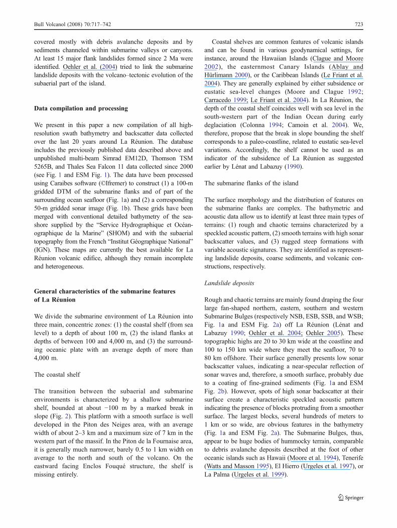
Fig. 4 a Morphology and to-pography of the Eliane cone andits neighbors to the south (seelocation on Fig. 5a). b Mor-phology and topography of theSonne cone
724 Bull Volcanol (2008) 70:717–742
surface area of about 300 km2. Around the island, severallarge alluvial deltas present at the mouths of subaerial riverscan be observed in bathymetry and sonar images.
Volcanic constructions
Some local features are clearly different from the types offeature described above. They are observed either near tothe coast, as a continuation of subaerial structures, or asisolated seamounts on the flanks of La Réunion edifice, oron the surrounding seafloor. They are interpreted asvolcanic constructions.
Submarine volcanic constructions in continuationwith land structures
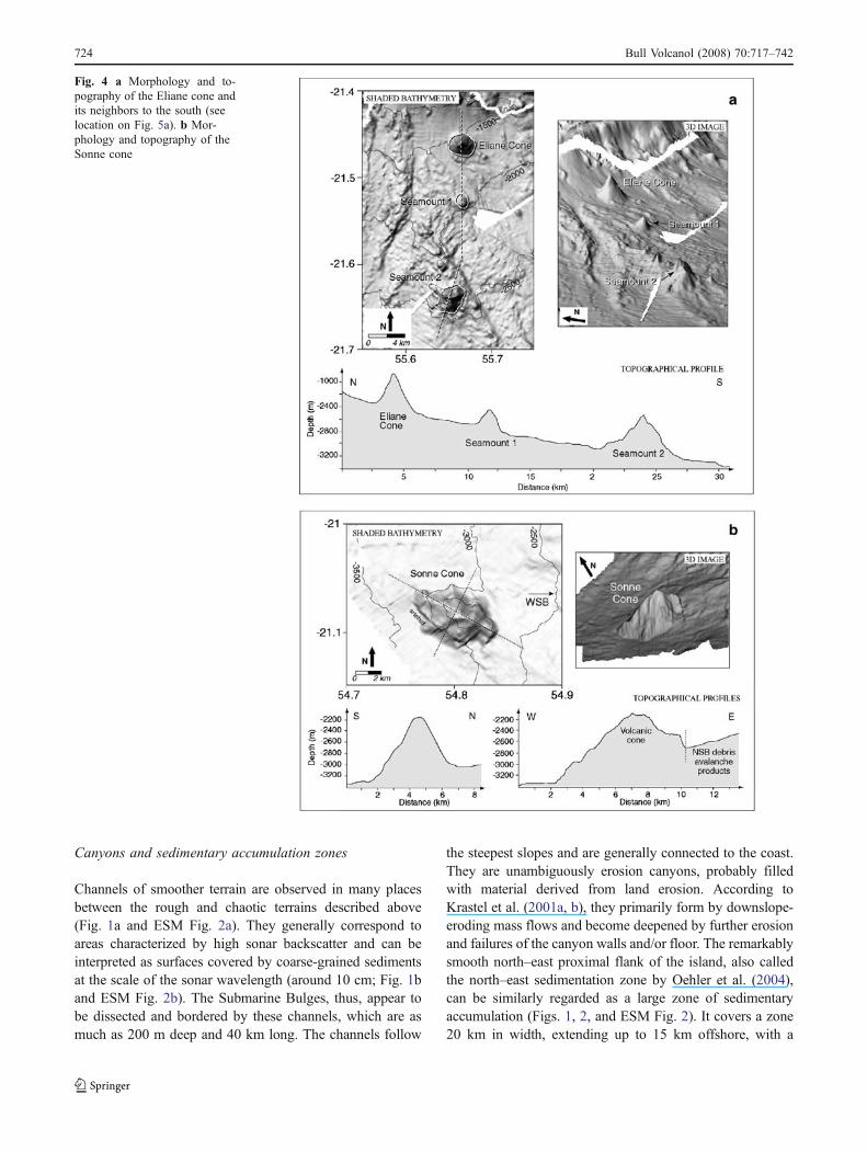
Around the coast of the island, four zones depart noticeably inmorphology from the other submarine terrains: the continu-ation of La Montagne massif (also named Cap Bernardstructure by Lénat and Labazuy 1990) to the north, those tothe east and to the south of Piton de la Fournaise, and aridge off Etang–Salé City to the west (Fig. 2). They haverugged topography and steep slopes. They are alsoassociated with negative magnetic anomalies (see Lénat etal. 2001, plate 1c) that are the most intense magnetic featureson the submarine slopes of La Réunion. Modeling (Lénat etal. 2001) shows that the anomalies are created by shallowbodies with a large reverse magnetization, indicating that thezones are made up mainly of rocks older than the Brunhes–Matuyama magnetic reversal. Therefore, the magnetic andmorphological properties of these four zones stronglysuggest that they are undisturbed volcanic constructions.
On land, La Montagne massif, a pile of lava flowsintersected by an abundance of dikes trending N20°W andinterpreted as an ancient rift zone by Chevallier and Vatin-Pérignon (1982) is the oldest emergent part of the island,with ages up to 2.08 Ma (McDougall 1971). Offshore,beyond the coastal shelf, a submarine promontory and ridgesmark the continuation of La Montagne massif (Fig. 2). Theon-land formations also have a reversed magnetization(Lénat et al. 2001) that fits with their age.
The presence of rocks older than the Brunhes–Matuyamareversal was judged improbable in the eastern part of the islandbecause the oldest rocks of Piton de la Fournaise volcano haveages of only 0.5 Ma (Gillot and Nativel 1989), but reversemagnetic anomalies have been identified and interpreted asindicating the presence of shallow reversely magnetizedrocks (Lénat et al. 2001). The anomalies coincide withbathymetric highs beneath the continuation of the present-day north–east and south–east rift zones of Piton de laFournaise (Fig. 2). From analysis of their detailed bathym-etry, we follow Labazuy (1991) and Lénat et al. (1989, 1990)in interpreting them as remnants of old volcanic construc-
tions, unrelated to the growth of the recent (<0.5 Ma) Pitonde la Fournaise. However, to the west of the south–east riftzone (i.e., near the south coast of the volcano; see alsoFig. 9b and ESM Fig. 3b), we identify some areas as youngervolcanic constructions. They have gentle slopes, small,kilometer-sized cones, bulges and ridges, and are, thus,similar to relatively young constructional features describedon the submarine rift zones in Hawaii (Smith et al. 2002) andin El Hierro (Gee et al. 2001). Accordingly, we propose thatthis zone was built by relatively recent volcanic activity.
The Etang–Salé submarine ridge (Lénat and Labazuy1990) is about 15 km long and a few kilometers wide(Fig. 2). Its detailed geology cannot be established withavailable information. Its elongate shape, radial to theisland and comparable with hawaiian rift zones such asthe Puna ridge (Smith et al. 2002), and the interpretationof the magnetic anomalies (Lénat et al. 2001), suggest,however, that it could be an ancient rift zone of Piton desNeiges, which has been partially eroded by mass wastingevents.
Isolated seamounts
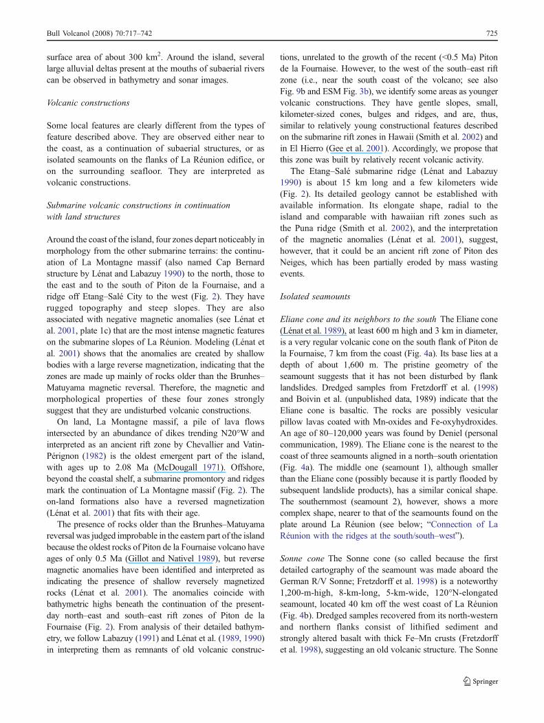
Eliane cone and its neighbors to the south The Eliane cone(Lénat et al. 1989), at least 600 m high and 3 km in diameter,is a very regular volcanic cone on the south flank of Piton dela Fournaise, 7 km from the coast (Fig. 4a). Its base lies at adepth of about 1,600 m. The pristine geometry of theseamount suggests that it has not been disturbed by flanklandslides. Dredged samples from Fretzdorff et al. (1998)and Boivin et al. (unpublished data, 1989) indicate that theEliane cone is basaltic. The rocks are possibly vesicularpillow lavas coated with Mn-oxides and Fe-oxyhydroxides.An age of 80–120,000 years was found by Deniel (personalcommunication, 1989). The Eliane cone is the nearest to thecoast of three seamounts aligned in a north–south orientation(Fig. 4a). The middle one (seamount 1), although smallerthan the Eliane cone (possibly because it is partly flooded bysubsequent landslide products), has a similar conical shape.The southernmost (seamount 2), however, shows a morecomplex shape, nearer to that of the seamounts found on theplate around La Réunion (see below; “Connection of LaRéunion with the ridges at the south/south–west”).
Sonne cone The Sonne cone (so called because the firstdetailed cartography of the seamount was made aboard theGerman R/V Sonne; Fretzdorff et al. 1998) is a noteworthy1,200-m-high, 8-km-long, 5-km-wide, 120°N-elongatedseamount, located 40 km off the west coast of La Réunion(Fig. 4b). Dredged samples recovered from its north-westernand northern flanks consist of lithified sediment andstrongly altered basalt with thick Fe–Mn crusts (Fretzdorffet al. 1998), suggesting an old volcanic structure. The Sonne
Bull Volcanol (2008) 70:717–742 725
cone seems to protrude from the flank formations of LaRéunion, and its shape suggests that it might be one of theseamounts present on the oceanic plate around the island(see below; “Connection of La Réunion with the ridges atthe south/south–west”).
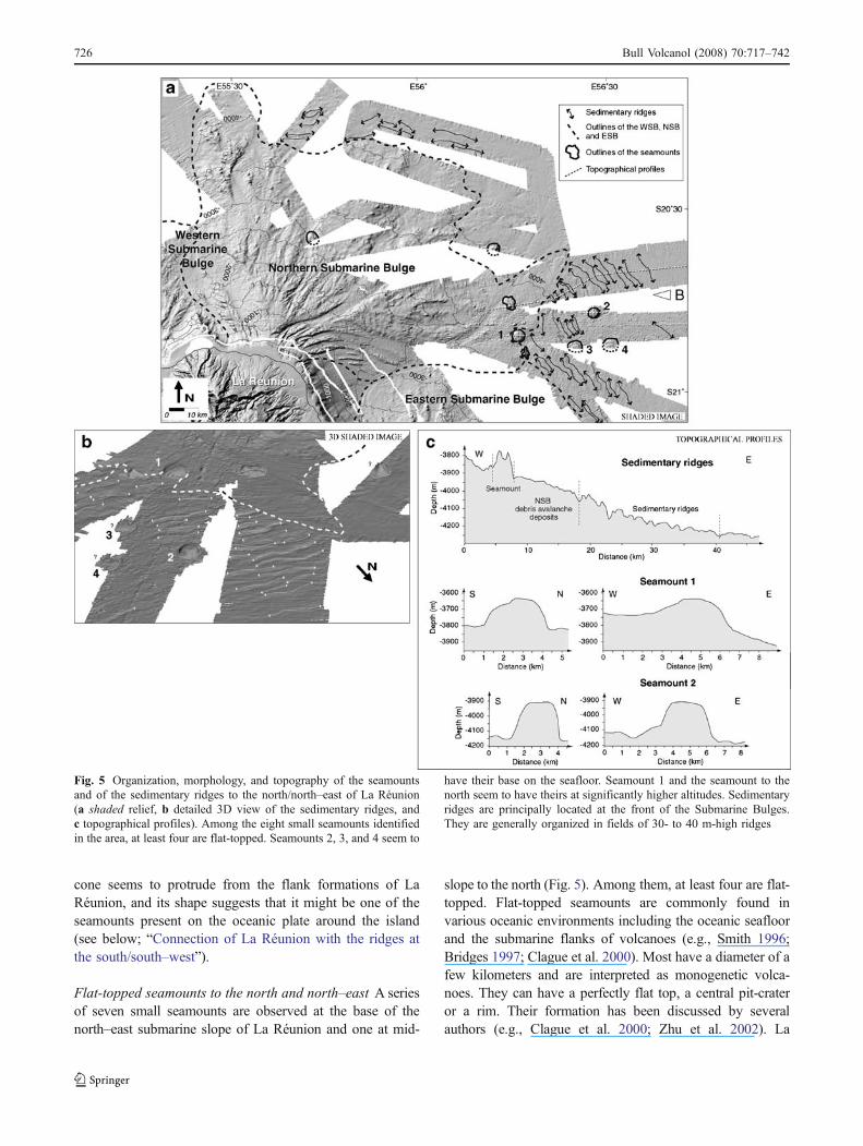
Flat-topped seamounts to the north and north–east A seriesof seven small seamounts are observed at the base of thenorth–east submarine slope of La Réunion and one at mid-
slope to the north (Fig. 5). Among them, at least four are flat-topped. Flat-topped seamounts are commonly found invarious oceanic environments including the oceanic seafloorand the submarine flanks of volcanoes (e.g., Smith 1996;Bridges 1997; Clague et al. 2000). Most have a diameter of afew kilometers and are interpreted as monogenetic volca-noes. They can have a perfectly flat top, a central pit-crateror a rim. Their formation has been discussed by severalauthors (e.g., Clague et al. 2000; Zhu et al. 2002). La
Fig. 5 Organization, morphology, and topography of the seamountsand of the sedimentary ridges to the north/north–east of La Réunion(a shaded relief, b detailed 3D view of the sedimentary ridges, andc topographical profiles). Among the eight small seamounts identifiedin the area, at least four are flat-topped. Seamounts 2, 3, and 4 seem to
have their base on the seafloor. Seamount 1 and the seamount to thenorth seem to have theirs at significantly higher altitudes. Sedimentaryridges are principally located at the front of the Submarine Bulges.They are generally organized in fields of 30- to 40 m-high ridges
726 Bull Volcanol (2008) 70:717–742
Réunion flat-topped seamounts have dimensions comparableto previously described flat-topped seamounts in otherplaces. Whereas seamounts 2, 3, and 4 on Fig. 5 seem tohave their base on the seafloor (around −4,100 m), seamount1 and the seamount to the north seem to have theirs atsignificantly shallower depths (ca. −3,800 and −2,750 m,respectively). If this is true, it would mean that these latterseamounts formed during the growth of La Réunion edificeand must be relatively young. The rather pristine shape ofthese flat-topped volcanoes also tends to indicate that theyare younger than the other seamounts of the zone.
The surrounding oceanic plate
Although the high-resolution coverage beyond the slopes ofLa Réunion is restricted, in some areas, we are able to observethe transition between the volcanic edifice and the oceanicstructures. Where no high-resolution data exists, the estimat-ed seafloor topography from Smith and Sandwell (1997) canbe used to visualize the main bathymetric features.
The surrounding ocean floor generally exhibits a low sonarbackscatter indicating a smooth surface covered by fine-grained materials, probably hemi-pelagic and turbidite sedi-
ments. This homogeneous signature is disrupted in some placesby (1) curvilinear lineaments of relatively higher backscatter,corresponding to small sedimentary ridges, and (2) significantbathymetric reliefs with generally high sonar response.
Sedimentary ridges
Sedimentary ridges identified on the proximal part of theseafloor off La Réunion are 30- to 40-m high structures,principally located in front of the Submarine Bulges (Fig. 5).They are generally organized in fields of ridges, eachstructure being parallel to the others with an averagewavelength of 2 km. These fields can cover large surfaces,as for example, to the east of the island where they areobserved over at least 400 km2. La Réunion sedimentaryridges are comparable to features observed along theHawaiian Ridge, but only on volcanoes west of Kauai andolder than 5 Ma (Moore et al. 1994), El Hierro (Masson et al.1998) or La Palma (Urgeles et al. 1999). They are interpretedas mud or sediment waves. For Moore et al. (1994), theabsence of these structures on the younger slides in Hawaiisuggests that they form slowly by subsequent slippage ofblocks following a sufficient accumulation of sediment on
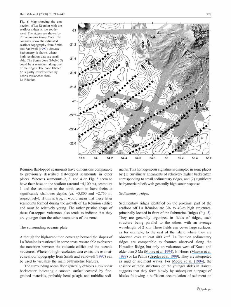
Fig. 6 Map showing the con-nection of La Réunion with theseafloor ridges at the south–west. The ridges are shown bydiscontinuous heavy lines. Thecontours show the estimatedseafloor topography from Smithand Sandwell (1997). Shadedbathymetry is shown wherehigh-resolution data are avail-able. The Sonne cone (labeled S)could be a seamount along oneof the ridges. The cone labeledM is partly overwhelmed bydebris avalanches fromLa Réunion
Bull Volcanol (2008) 70:717–742 727
the slope. According to Masson et al. (1998) and Urgeles etal. (1999), they consist of small scarps resulting fromdestabilization of the sedimentary pile during the depositionof debris avalanches. We propose a different interpretation.These structures clearly appear to be linked with mass-wasting events. They could correspond to the folding ofductile pelagic sediments in response to compressive strainscreated at the front of advancing debris avalanches. The foldsare, thus, perpendicular to the flow direction of the debrisavalanche, and they can be used to delimit the extension ofthe deposits and to estimate their direction of propagation.
Connection of La Réunion with the ridgesat the south/south–west
Using the Smith and Sandwell (1997) seafloor topography,50°N trending ridges are observed to the south of LaRéunion (Fretzdorff et al. 1998; Lénat and Merle, submit-ted). They are oblique to the Mauritius and Mahanoro–
Wilshaw transform faults (the transforms faults that boundthe La Réunion compartment in the Mascarene Basin), aswell as to most of the observed magnetic lineaments(Fretzdorff et al. 1998; Dyment 1991; Lénat and Merle,submitted). The ridges appear to be more or less continuousand are punctuated by seamounts of variable dimension andheight. Fretzdorff et al. (1998) suggest that they could be“cross-grain” ridges associated with magmatism along ten-sion cracks on the oceanic plate during the rifting, whereasLénat and Merle (submitted) propose that they could berelated to intrusion of hot spot plume material into thelithosphere.
Where detailed swath bathymetry exists (Fretzdorff et al.1998; Oehler et al. 2004; Oehler 2005), the Smith andSandwell (1997) seafloor topography agrees well with theobserved detailed topography (Fig. 6). Using the detaileddata, we observe individual seamounts with differentmorphology and orientation along the ridges of the generalbathymetry. They protrude from a flat seafloor covered by a
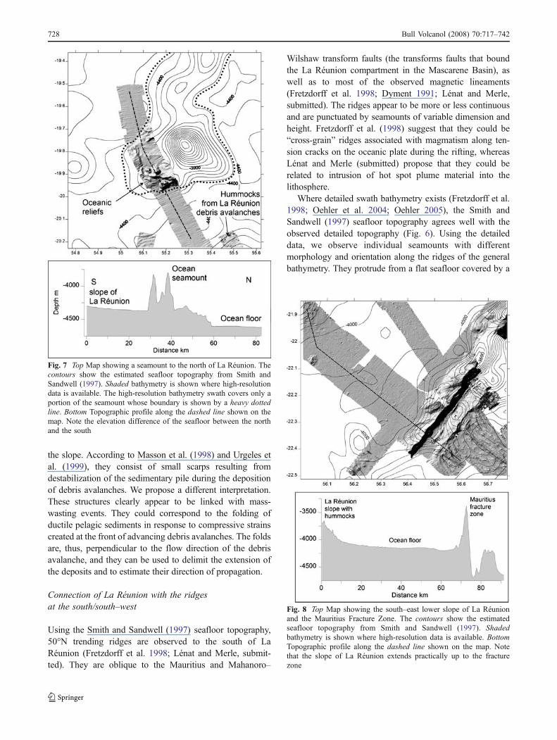
Fig. 7 Top Map showing a seamount to the north of La Réunion. Thecontours show the estimated seafloor topography from Smith andSandwell (1997). Shaded bathymetry is shown where high-resolutiondata is available. The high-resolution bathymetry swath covers only aportion of the seamount whose boundary is shown by a heavy dottedline. Bottom Topographic profile along the dashed line shown on themap. Note the elevation difference of the seafloor between the northand the south
Fig. 8 Top Map showing the south–east lower slope of La Réunionand the Mauritius Fracture Zone. The contours show the estimatedseafloor topography from Smith and Sandwell (1997). Shadedbathymetry is shown where high-resolution data is available. BottomTopographic profile along the dashed line shown on the map. Notethat the slope of La Réunion extends practically up to the fracturezone
728 Bull Volcanol (2008) 70:717–742
few hundred meters of sediments (Fretzdorff et al. 1998). Itis clear that at least some of the lineaments intersect theedifice of La Réunion. On Fig. 6, we can observe debrisavalanche products from La Réunion that have flowedamong the oceanic seamounts. These positive reliefs haveprobably acted as topographic barriers during the evolutionof the submarine slopes of La Réunion. Similarly, the Sonnecone (labeled S on Fig. 6) could be a seamount along one ofthe ridges.
Interference of La Réunion construction with a seamountat the north
To the north of La Réunion, a high resolution swath crossesan oceanic construction (Fig. 7). The Smith and Sandwell(1997) seafloor topography suggests that the high-resolu-tion swath is located on the edge of a large seamount. Thebathymetric profile shows a significant altitude differencebetween the southern and northern flanks of the seamount.This difference is probably due to the accumulation ofproducts deriving from La Réunion.
Transition between La Réunion slope and the Mauritiusfracture zone
The Mauritius transform fault (Fig. 8), characterized by acentral deep flanked by two topographic highs, has beendescribed by Fretzdorff et al. (1998). Although the slope ofLa Réunion virtually vanishes about 50 km from thetransform fault, we note that the bathymetry between thefoot of La Réunion and the transform fault is not flat butdecreases gently toward the fault. This suggests that de-posits from La Réunion extend down to this area, possiblyas fine sediments derived from landslides, for example, asturbidity current deposits.
Evidence of multiple landslide units off La Réunion
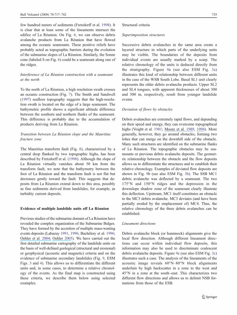
Previous studies of the submarine domain of La Réunion haverevealed the complex organization of the Submarine Bulges.They have formed by the accretion of multiple mass-wastingevents deposits (Labazuy 1991, 1996; Bachèlery et al. 1996;Oehler et al. 2004; Oehler 2005). We have carried out thefirst detailed submarine cartography of the landslide units onthe basis of well-defined geological (structural and erosional)or geophysical (acoustic and magnetic) criteria and on theevidence of submarine secondary landslides (Fig. 9, ESMFigs. 3 and 4). This allows us to differentiate the differentunits and, in some cases, to determine a relative chronol-ogy of the events. As the final map is constructed usingthese criteria, we describe them below using selectedexamples.
Structural criteria
Superimposition structures
Successive debris avalanches in the same area create alayered structure in which parts of the underlying unitsmay be visible. The boundaries of the deposits fromindividual events are usually marked by a scarp. Therelative chronology of the units is deduced directly fromthe stratigraphy. Figure 9a (see also ESM Fig. 3a)illustrates this kind of relationship between different unitsin the case of the WSB South Lobe. Basal SL1 unit clearlyrepresents the older debris avalanche products. Upper SL2and SL4 tongues, with apparent thicknesses of about 300and 500 m, respectively, result from younger landslideevents.
Deviation of flows by obstacles
Debris avalanches are extremely rapid flows, and dependingon their speed and energy, they can overcome topographicalhighs (Voight et al. 1981; Moore et al. 1989, 1994). Moregenerally, however, they go around obstacles, forming twolobes that can merge on the downhill side of the obstacle.Many such structures are identified on the submarine flanksof La Réunion. The topographic obstacles may be sea-mounts or previous debris avalanche deposits. The geomet-ric relationship between the obstacle and the flow depositsallows us to differentiate the structures and to establish theirrelative chronology. Examples of deviated flow deposits areshown in Fig. 9b (see also ESM Fig. 3b). The SSB MC1debris avalanche was deflected by a seamount. The two175°N and 150°N ridges and the depression in thedownslope shadow zone of the seamount clearly illustratethis deflection. Upstream, MC1 itself constitutes an obstacleto the MC3 debris avalanche. MC3 deviates (and have beenpartially eroded by the emplacement of) MC4. Thus, therelative chronology of the three debris avalanches can beestablished.
Lineament directions
Debris avalanche block (or hummock) alignments give thelocal flow direction. Although different lineament direc-tions can occur within individual flow deposits, thisinformation may also be used to discriminate coalescentdebris avalanche deposits. Figure 9c (see also ESM Fig. 3c)illustrates such a case. The analysis of the lineaments of theacoustic image reveals 60°N–80°N block alignmentsunderlain by high backscatter in a zone to the west and45°N in a zone at the south–east. This characterizes twodifferent flow directions and allows us to delimit NSB for-mations from those of the ESB.
Bull Volcanol (2008) 70:717–742 729
730 Bull Volcanol (2008) 70:717–742
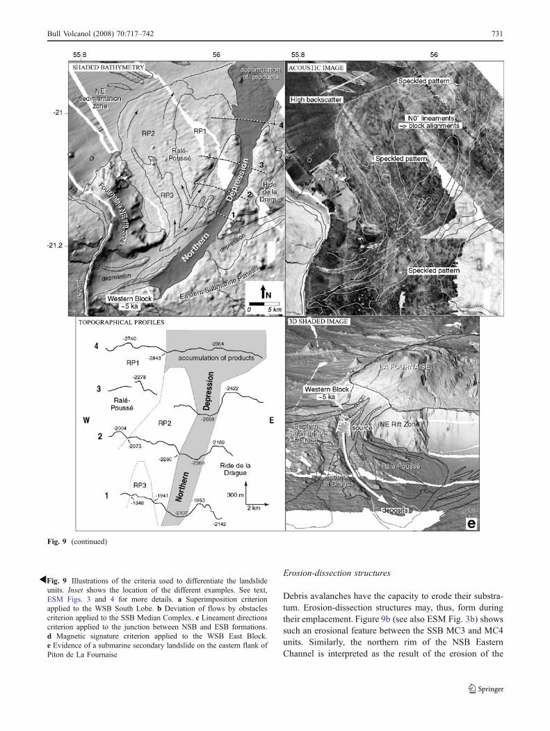
Erosion-dissection structures
Debris avalanches have the capacity to erode their substra-tum. Erosion-dissection structures may, thus, form duringtheir emplacement. Figure 9b (see also ESM Fig. 3b) showssuch an erosional feature between the SSB MC3 and MC4units. Similarly, the northern rim of the NSB EasternChannel is interpreted as the result of the erosion of the
Fig. 9 (continued)
RFig. 9 Illustrations of the criteria used to differentiate the landslideunits. Inset shows the location of the different examples. See text,ESM Figs. 3 and 4 for more details. a Superimposition criterionapplied to the WSB South Lobe. b Deviation of flows by obstaclescriterion applied to the SSB Median Complex. c Lineament directionscriterion applied to the junction between NSB and ESB formations.d Magnetic signature criterion applied to the WSB East Block.e Evidence of a submarine secondary landslide on the eastern flank ofPiton de La Fournaise
Bull Volcanol (2008) 70:717–742 731
median formations during the emplacement of unit EF2(see ESM Fig. 4a).
Erosional criteria
Erosion channels
According to Urgeles et al. (1999), erosion channels formalong topographical lows at the margins of debris avalanchelobes, and their presence can be used to delimit deposits ofsuccessive landslides. This criterion is applicable to someareas of our study. For instance, the Western and EasternChannels separate topographically distinct lobes (western,median, and eastern formations) of the NSB (see Oehler et
al. 2004, Fig. 2, and ESM Fig. 4a). These canyons areconnected to the coast, and their surface characteristics(smooth bathymetry and high backscatter) indicate that theyare possibly filled with coarse-grained sediments.
Relative degree of erosion
The degree of erosion of the flank formations may provide acriterion to differentiate formations of different ages. Forexample, Oehler et al. (2004) describe two superimposedunits with contrasting degrees of erosion within the WSBNorth Lobe (see Oehler et al. 2004 Fig. 2 and ESM Fig. 4b).The basal unit (NL1 on ESM Fig. 4b), characterized by aridge and furrow morphology, is carved by several small
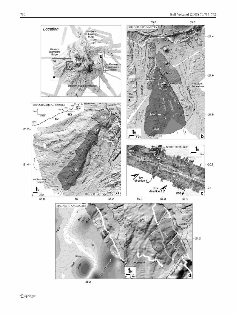
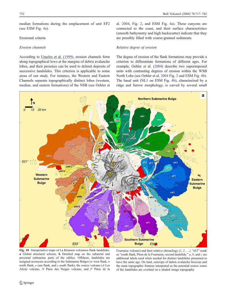
Fig. 10 Interpretative maps of La Réunion volcanoes flank landslides.a Global structural scheme. b Detailed map on the subaerial andproximal submarine parts of the edifice. Offshore, landslides areassigned acronyms according to the Submarine Bulges (w west flank, nnorth flank, e east flank, and s south flank), the source volcano (A LesAlizés volcano, N Piton des Neiges volcano, and F Piton de la
Fournaise volcano) and their relative chronology (1, 2, …). “sF2” readsas “south flank, Piton de la Fournaise, second landslide.” a, b, and c areadditional labels used when needed for distinct landslides presumed tohave the same age. On land, outcrops of debris avalanche breccias andthe main topographic features interpreted as the potential source zonesof the landslides are overlaid on a shaded image topography
732 Bull Volcanol (2008) 70:717–742

Fig. 10 (continued)
Bull Volcanol (2008) 70:717–742 733
channels filled with coarse-grained, high-backscatter materi-al. These channels do not connect to the coast but areinterrupted by the upper unit (NL2), which has a smoothersurface. Consequently, unit NL1 is older than unit NL2.
Geophysical criteria
Acoustic signature contrast
The acoustic signature of a formation depends upon itssurface acoustic properties and texture. Variations in acousticsignature can help delineate juxtaposed formations. Thiscriterion allows Oehler et al. (2004) to distinguish threedebris avalanche units within the NSB median formations(see Oehler et al. 2004, Fig. 2 and ESM Fig. 4a): Theupper, most recent formation (MF3 on ESM Fig. 4a)exhibits a relatively high reflectivity (in fact, a densespeckled pattern) corresponding to the presence of a largedensity of blocks at the surface. The lower oldest landslidedeposits of the zone (MF1 and MF2 formations) have lowerbackscatters interpretated as a dominant coating of fine-grained sediments. The degree of erosion of the formationsalso corroborates the stratigraphy established for this zone.The surface of MF1 is characterized by a ridge and furrowmorphology and is significantly rougher than that of MF2and MF3.
Magnetic signature
It has been noted by Lénat et al. (2001) that, except for a fewvolcanic constructions near the coast (see above; “Submarinevolcanic constructions in continuation with land structures”),the submarine flanks of La Réunion do not show magneticanomalies that would be created by contrasts in magnetiza-tion intensity or direction of volcanic rocks within theedifice. Accordingly, they proposed that this could beexplained if the submarine flanks are constructed by brecciasderived from mass-wasting events. In breccias, the usuallydominant remanent magnetization of the volcanic rocks isstatistically canceled by the random rotation of the blockswithin the breccia. Thus, the presence of a significantmagnetic anomaly will indicate that the underlying rockshave not been affected by landslides or have, at least,remained coherent, even if they have undergone rotation.
Figure 9d (see also ESM Fig. 3d) shows an example ofwhere the magnetic signature can be used to reinforce aninterpretation based on a morphological analysis. The WSBeast block (EB), 10 km long and 8 km wide, is a structurelocated to the north of the Etang–Salé Ridge. The EBsurface morphology does not correspond to the typicalhummocky one of debris avalanche deposits. On thecontrary, the EB appears to be a more massive unit,consisting of several more or less coherent blocks, some
of them forming shelves several kilometers wide. The factthat a magnetic anomaly is associated with the EB structureindicates that the EB rocks have remained coherent. Weconsequently interpret the EB as a slump structure wherethe coherence of the rocks have been preserved duringtranslation and, possibly rotation, of the blocks.
Evidence of submarine secondary landslides
Several submarine structures can be interpreted as landslidesdeveloped from submarine debris avalanche deposits. Forthis reason, we have designated these structures “secondarysubmarine landslides.” One example is a structure observedto the east of Piton de la Fournaise (Fig. 9e; see also ESMFig. 3e). The ESB Northern Depression (ND) is about30 km long, 2 km wide, 300 m deep, and has a difference inaltitude of 1,500 m between its head and foot. In contrast tothe erosion channels, the ND is not connected to the coast,but is bounded upstream by the ESB western block for-mations. Its surface exhibits a speckled acoustic signature,typical of debris avalanche deposits. Near its downhill ter-mination, topographical profiles suggest that 100 to 150 mof products are accumulated, and 0°N block alignments areobserved, in agreement with the depression axis direction.The source zone of this debris avalanche is obviouslylocated within previous mass-wasting deposits accumulatedwithin the ESB. The ESB western block formations areinterpreted as being derived from the more recent subaerialflank landslide of Piton de la Fournaise volcano. If, assuggested by some authors (Bachèlery and Mairine 1990;Labazuy 1991, 1996; Mohamed-Abchir 1996), this landslideformed at about 5 ka, then the ND secondary debrisavalanche is penecontemporaneous or younger. This, there-fore, draws our attention to the possibility that this secondaryslide, and possibly others, may be very young, and that suchfailure events may recur in the near future.
Synthesis
The above criteria have been applied in the analysis of thewhole of our dataset. The result is the map presented inFig. 10a. Because the data are heterogeneous (see above;“Data compilation and processing”) and the coverage isincomplete (see ESM Fig. 1), the construction of this mapclearly suffers from uncertainties: Some unit boundarieshave been extrapolated where data was lacking, thetermination of the more distant units may be impreciselydefined, and some small-scale features may have goneunnoticed. We are, however, confident that the mainsurface units have been correctly mapped and that thisdocument may, therefore, be used to discuss the evolutionof La Réunion volcanic edifice.
734 Bull Volcanol (2008) 70:717–742
Thirty-seven landslides, essentially debris avalanches,accumulated on the Submarine Bulges are recognized. Theyattest to the occurrence and recurrence of destructive mass-wasting events of different scales on La Réunion volcanoesduring their growth and evolution. The units generally havea triangular shape and radiate from the island. Thegeometry of most of them implies that their source area issubaerial. These may be qualified as primary mass-wastingevents that have affected the constructed part of thevolcanic edifice. In addition, purely submarine, as well ascoastal, secondary landslides (Fig. 10) have remobilized theproducts of previous landslides.
Geological and morphostructural study of ReunionIsland: landslide deposits, source zones, ages,and relationships with sea structures
As a large proportion of the submarine landslide depositshave their source on land, we have carried out a geologicaland morphostructural analysis of the island to find theevidence of landslide scars (products and faults). Wedescribe several significant examples for which informationon the age of the landslides is deduced from the availableabsolute radiometric dates.
Piton des Neiges debris avalanche breccias
Debris avalanche deposits identified on land in La Réunion(see Bachèlery et al. 1996 and 2003; Maillot 1999; Bret et al.2003; Fèvre et al. 2001, 2003, 2004; Arnaud et al. 2003,2004; Arnaud 2005; Oehler 2005) show the same generalcharacteristics as formations of similar origin on othervolcanoes, for example, Mont St. Helens (Lipman andMullineaux 1981), Mont Shasta (Crandell et al. 1984; Uiand Glicken 1986), Bezymianny (Gorshkov 1959; Siebert etal. 1987), Augustine (Siebert et al. 1995), and Cantal(Cantagrel 1995; Nehlig et al. 2001) volcanoes. They areessentially brecciated formations of bimodal composition,comprising a “block” with a “matrix facies.” The “blockfacies” corresponds to fragments of the dismantled volcaniccone, with block dimensions varying from a few meters toseveral hundred meters. Block texture and original stratifi-cation are often preserved, but the blocks are internallyfractured and deformed. Characteristic jigsaw cracks (Ui1983; Siebert 1984), identified on many scales in thedeposits, testify to the pulverization and the progressivedisintegration of the blocks within the avalanche duringtransport. They result from collisions between elementsand from internal flow vibrations phenomena (Ui et al.1986; Glicken 1996; Bachèlery et al. 2003). The “matrixfacies” derives from the blocks’ disintegration. It consistsof a non-classified, non-stratified mixture of centimeter- todecimeter-sized clasts and of fine, pulverized fragments,
generally with the same composition as the surroundingblocks.
Debris avalanche breccias are abundant and widespreadwithin the Piton des Neiges massif (Fig. 10b). In contrast,they are not observed at Piton de La Fournaise, where mostof the surface is covered by lava flows. The main outcropsare found (1) in the Piton des Neiges littoral zone, forexample, in Saint-Gilles (outcrop 1 in Fig. 10b; see Bret etal. 2003; Bachèlery et al. 1996, 2003); or in the Sainte-Suzanne sector (outcrop 13; see Bret et al. 2003; Oehler2005), where the deposits present a typical hummockymorphology; (2) at the mouths, or in the valleys, of the mainrivers, for example, Rivière des Galets or Rivière des Pluies(outcrops 2 and 3, respectively; see Fèvre et al. 2001, 2003,2004; Bret et al. 2003; Oehler 2005); and (3) within the threemajor inner depressions: the cirques of Mafate, Salazie, andCilaos (outcrops 7–12; see Maillot 1999; Bret et al. 2003;Arnaud et al. 2003, 2004; Arnaud 2005; Oehler 2005).
Most of the Piton des Neiges debris avalanche breccias canbe interpreted in terms of subaerial proximal deposits of thelandslide units mapped offshore. The most convincingexample is certainly the case of the Sainte-Suzanne breccias(outcrop 13) located upstream of the nN5 submarine debrisavalanche deposits (Fig. 10). These formations, therefore,probably constitute the “land and sea” evidence of a singlemass-wasting event at least older than 0.23 Ma (Oehler et al.2004). We also note that some on-land landslide brecciasassociated with small-size events do not continue offshore.For example, the Entre-Deux breccias (outcrop 4; see Oehler2005) could correspond to the deposits of a moderate-sized,strictly subaerial landslide younger than 0.155 Ma (the ageof overlying lava flows; Kieffer 1990b). Similarly, an eventyounger than 0.23 Ma (McDougall 1971) could beresponsible for part of the Rivière des Galets breccias(outcrop 2; Oehler 2005).
Identification of the landslide source zones
The source zone of a landslide is typically a horseshoe-shaped amphitheatre. In La Réunion, the headwalls of somesource areas should have an extension that can reach up toseveral tens of kilometers to be commensurate with the sizeof the largest submarine landslide units. However, thevestiges of ancient landslide scars are not obvious in thegeology and in the morphology. The ancient structures areoften filled and concealed by the products of subsequentvolcanic activity, or dismantled by erosion. One exceptionis the Grand Brûlé depression (GB on Fig. 10b), interpretedas being the result of the most recent destabilization of theeastern flank of Piton de La Fournaise volcano (Chevallierand Bachèlery1981; Lénat and Labazuy 1990; Lénat et al.1990; Bachèlery and Mairine 1990; Gillot et al. 1994;Bachèlery 1995; Labazuy 1991, 1996; Lénat et al. 2001;
Bull Volcanol (2008) 70:717–742 735
Merle and Lénat 2003). Therefore, the search for ancientlandslide scars relies on careful analysis of geologicalobservations and morphological studies of the topography.This approach leads us to propose several possible sourceareas for the observed landslides. We should stress,however, that our results are based on a limited amount ofgeological and structural observations. Therefore, this partof the work should be considered only as exploratory.
The identified structures are classified into three categories(Fig. 10b):
1. Arcuate coastal slope breaks or scarps, some on land, andsome submarine, are interpreted as headwall faults oflandslides draped by more recent products (class 1 onFig. 10b). The age of the overlying formations (if avail-able) allows the age of the landslides to be estimated. Theassociated deposits are often identified offshore in frontof the faults. For example, the Saint-Paul structure (StPon Fig. 10b; see also Oehler et al. 2004; Fig. 6) isinterpreted as the source of a secondary landslide olderthan the overlying 0.23 Ma lava flows draping thesecoastal cliffs. This structure is also younger than 0.34 Mabecause it truncates the Saint-Gilles upper breccias (out-crop 1 on Fig. 10b; see Bachèlery et al. 2003), themselves
older than this age. The associated landslide productsprobably form the WSB wN6 unit (Fig. 10).
2. Topographic features on land delineate the boundaries oflarge amphitheatres that generally intersect the centralzones of the volcanoes (class 2). They are interpreted as theremnants of old debris avalanche headwalls and areassociated with La Réunion’s most important mass-wasting events. Most of the traces of these faults havebeen disrupted or concealed by subsequent volcanic,volcano–tectonic and erosional phenomena. However,some portions are obvious, and separate terrains ofdifferent ages, giving a constraint on the age of thelandslides. For example, the northern flank of Piton desNeiges volcano is dissected by three interlocked class 2structures (namely Mafate, Salazie, and Marsouins struc-tures; Maf, Sa, and Mar on Fig. 10b, respectively; see alsoOehler et al. 2004; Fig. 6). The Marsouins and Mafatestructures cut the 2-Ma La Montagne massif and are filledby lava flows of about 1 Ma. These structures would,thus, correspond to the scar of two gigantic landslides thatoccurred between 1 and 2 Ma. Their deposits may betentatively associated with NSB nN1 and nN2a-c units,respectively (Fig. 10a). The Salazie structure is inter-preted as the scar of a more recent event, as it is filled by
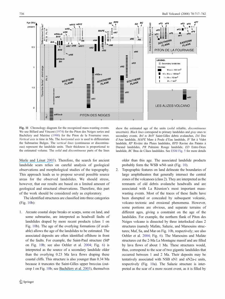
Fig. 11 Chronology diagram for the recognized mass-wasting events.We use Billard and Vincent (1974) for the Piton des Neiges series andBachèlery and Mairine (1990) for the Piton de la Fournaise ones.Vertical axis is time in Ma. The horizontal axis is used to differentiatethe Submarine Bulges. The vertical lines (continuous or discontinu-ous) represent the landslide units. Their thickness is proportional tothe estimated volume. The solid and discontinuous parts of the lines
show the estimated age of the units (solid reliable, discontinuousuncertain). Black lines correspond to primary landslides and gray ones tosecondary events. BrI to BrIV Saint-Gilles debris avalanches, DA Dosd’Ane landslide, MAPE Mare à Poule d’Eau landslide, IV Ilet à Vidotlandslide, RP Rivière des Pluies landslides, RPD Ravine des Patates àDurand landslides, PR Palmiste Rouge landslide, ED Entre-Deuxlandslide, BC Bras de Cilaos landslides. See ESM Fig. 5 for more details
736 Bull Volcanol (2008) 70:717–742
lava flows whose age is estimated to be about 0.43–0.6 Ma (Oehler 2005). The NSB nN3 formations mayconsist of the deposits of these mass-wasting events.
3. Smaller-sized perched depressions are interpreted as thesource zones of small, recent landslides on land,remodeled by erosion (class 3). The Entre-Deux orDos d’Ane plains are two examples of this kind ofstructure (ED and DA on Fig. 10b, respectively). Theymay correspond to the source zones of the small andrelatively recent landslides responsible for the Entre-Deux and part of Rivière des Galets breccias, respec-tively (see above, “Piton des Neiges debris avalanchebreccias”; Oehler 2005).
Discussion: a new “land and sea” model for repeateddestabilization of La Réunion volcanoes
A new image of La Réunion emerges from our study of thesubaerial and submarine surface of the entire edifice (Fig. 10;see also ESM Fig. 5). The amazing magnitude of mass-wasting events, foreseen in previous works, is now fullyrevealed. Although our synthesis has some uncertaintieslinked to the incomplete coverage, the results can be arrangedin a database to carry out analyses of specific aspects.
Number of identified landslides
The four Submarine Bulges comprise a succession oflandslide deposits, but only those which are exposed atthe surface can be counted when using the bathymetry andacoustic images. Therefore, the number of identified land-slides underestimates the total number formed during theevolution of the island. Even on land, the amplitude of thelandslides remains poorly known.
Forty-seven distinct mass-wasting events are recognized inthis study (Figs. 10 and 11; see also ESM Fig. 5). Amongthem, 10 are strictly subaerial and 37 have submarinedeposits. The majority of them (44 episodes out of 47)produced debris avalanches. Piton des Neiges’ northern,western, and southern flanks were destroyed about 34 times.Seven landslides have affected Piton de La Fournaise easternsector, and at least five took place on its southern flank. Atleast one major eastward-directed landslide is attributed toLes Alizés volcano.
Volume of landslides
It is not possible to calculate precisely the volume of theindividual landslides because (1) the surface areas ofthe deposits cannot always be correctly estimated whenthe deposits have been partially concealed by subsequentactivity; (2) the thickness of the deposits is even more
difficult to estimate, even where some seismic data areavailable, because it may be very variable spatially. Theonly thickness information used in this study is derivedfrom field observations on land (Fèvre et al. 2001, 2004;Arnaud et al. 2004; Arnaud 2005; Oehler 2005) and frombathymetric profile analysis.
It is, however, possible to derive a semi-quantitative andrelative volume estimate of the landslide units. We considerfour classes of volume (Fig. 11): (1) a V− class for landslidesless than 1 km3, (2) a V+ class for volumes ranging between1 and 10 km3, (3) a V++ class for those between 10 and100 km3, and (4) V+++ for events that exceed 100 km3.
Four V+++ mega-landslides are recognized on our map(Figs. 10 and 11; see also ESM Fig. 5). They could reach500 to 1,000 km3 in volume and, thus, would rank amongthe biggest mass-wasting events on Earth. They are at thebases of the four Submarine Bulges and would correspondto major destructions of the western (wN1a+b), northern(nN1), and southern (sN1) flanks of Piton des Neiges and ofthe eastern (eA1) sector of Les Alizés volcano. Sixteen V++major and 19 V+ moderate landslides have affected Pitondes Neiges and Piton de La Fournaise volcanoes. Thenorthern and western flanks of Piton des Neiges and theeastern and southern flanks of Piton de la Fournaise werethe most frequently affected. The 8 V− are mostly located inthe subaerial part of Piton des Neiges volcano. One episodeout of two is associated with cliff retreat processes.However, it should be stressed that the V− events aredifficult to detect in the submarine context owing to theresolution of the data. On land also, products of events ofthis size may be difficult to observe because of subsequentactivity and erosion.
Primary and secondary landslides
One third of the recognized events correspond to landslideswhose source areas are the products of previous debrisavalanches (17 episodes out of 47; Figs. 10 and 11; see alsoESM Fig. 5). They are mostly located in the submarine orsubaerial coastal domains and can involve large volumes ofmaterial. Five V++ and 9 V+ secondary landslides affectedthe ESB, WSB, and SSB. In some cases, a geneticrelationship may exist between the formation of channelsand other depressions and the secondary landslides. Theformation of submarine canyons may be initiated by thepresence of a landslide scar, as has been suggested for othervolcanic islands, for example, Stromboli (Kokelaar andRomagnoli 1995; Tibaldi 2001), Hawaii (Moore andChadwick 1995; McMurtry et al. 1999), and El Hierro(Gee et al. 2001). Conversely, the preexistence of erosionchannels, built on the border of debris avalanche lobes(Urgeles et al. 1999), may trigger secondary landslides andinfluence their trajectory.
Bull Volcanol (2008) 70:717–742 737
Relative chronology of landslides
The absolute ages of the landslides cannot usually bedetermined. On land, too few rock ages are available, andoffshore, only six measurements have been made on lavasamples dredged on the eastern flank of Piton de La Fournaise(Labazuy 1991). Some reasonable estimates of the age ofsome landslides can, however, be made using available agesand stratigraphic relationships. We, thus, propose a relativechronology of La Réunion volcanoes’ mass-wasting events(Fig. 11; see also ESM Fig. 5). It results from the exhaustivecompilation of all information deduced from the study of thedeposits and the source zones.
The three V+++ mega-landslides of Piton des Neigesvolcano are inferred to be older than 1.2Ma (debris avalanchebreccias in the cirque of Cilaos are older than 1.2 Ma; Maillot1999). The first, which is probably older than 2 Ma, partlydestroyed the western sector (wN1a+b on Figs. 10 and 11).The huge nN1 and sN1 debris avalanches on the northernand southern flanks may have formed between 1.2 and 2 Ma(Oehler et al. 2004). Some thirty V− to V++ recurrentlandslides have formed since about 1 Ma on the northern,southern, and western parts of the volcano. The volume ofmaterial involved in individual events appears to havedecreased with time. The secondary landslides constitute asizeable proportion of the most recent episodes. Half of alllandslides formed during the differentiated-lavas period ofthe volcano (<0.35 Ma) are secondary ones. The youngestlandslides are primary or secondary small V− eventsassociated with cliff-erosion processes. These local land-slides have to be considered as a potential hazard forinhabited zones located within the valleys and the cirques.
The eastern flank of Les Alizés volcano was destroyed bythe eA1 V+++ landslide younger than 1.8 Ma (Figs. 10 and11). The age is constrained by a dredge sample from ablock involved in the slide (Ride de la Drague, Fig. 9e; deVoogd et al. 1999; Oehler 2005) dated at 1.8 Ma (Gillot,personal communication, 1989). Reflection seismic datafrom de Voogd et al. (1999) show that other destabilizationphases of Les Alizés volcano have to be considered. Theirdata shows debris avalanche deposits beneath the subma-rine southern flank of Piton de La Fournaise, above theoceanic floor.
Twelve V+ to V++ landslides have formed on thesouthern and eastern flanks of Piton de La Fournaise since300 ka (the age of the first large volcano–tectonic eventidentified in the evolution of the volcano; Bachèlery andMairine (1990). Five are submarine secondary debrisavalanches. If the younger subaerial landslide of the eastflank, eF5, is about 5 ka, as suggested by Lénat andLabazuy (1990), Lénat et al. (1990), Bachèlery and Mairine(1990), Bachèlery (1995), Labazuy (1991, 1996) andMohamed-Abchir (1996), then three landslides are inferred
to have occurred during the last 5,000 years (Fig. 11).Landslides eF6 and eF7 are secondary ones. The larger,eF6, remobilized a hundred km3 of material. The eF6 andeF7 landslides could either be penecontemporaneous witheF5 or younger. If younger, this suggests that the landslidedeposits may become gravitationally unstable after theirdeposition. This obviously has consequences for theevaluation of hazards posed by future submarine secondarylandslides.
Relationship between landslides and the present daymorphology
The number and magnitude of the landslides identified in ourstudy implies that edifice failure has been one of the majorprocesses in the evolution of the island. Accordingly, thelandslides must have influenced the morphology of theisland. Until now, geological reconstructions have barelytaken into account the submarine features. We argue that thescars of the main landslide must have played a major roleduring constructional phases and in the distribution of thesubsequent volcanic products. It is, however, widely admittedthat the on-land geology is still insufficiently known,probably because of its complexity, the poor accessibility ofsome areas, and the limited number of rock ages. Theinterpretations that we suggest have, therefore, to be con-sidered with caution and as working hypotheses to be testedwith future work.
The existence of large subaerial landslides on Pitondes Neiges and Piton de La Fournaise is well constrainedby the geometry of the large landslide units observed onthe submarine flanks. It is, therefore, legitimate to inferthat the headwall faults of such large landslides haveleft their fingerprint on the present-day morphology. Thefaults that we define on Fig. 10b correlate with the mainscarps and valleys of the present topography. We cannotestablish whether or not these presumed faults are theactual landslide headscarps. We can, however, reasonablyassume that the filling of the depressions and the faultsassociated with the major landslides generated majorlithological discontinuities during the construction of thevolcano. The presence of such major discontinuities hasprobably influenced and guided the subsequent volcano–tectonic activity (caldera collapses, Chevallier 1979,Kieffer 1989 and 1990a, Merle and Lénat 2003; volcanospreading, van Wyk de Vries et al. 2001, Oehler et al.2005; flank landslides, Oehler et al. 2004, Oehler 2005)and erosion. We, therefore, suggest that the present-daymorphology of the Piton des Neiges and Piton de LaFournaise volcanoes owes much to the recurrent landslidesof their flanks.
The case of Les Alizés volcano is still more complexbecause we cannot observe its formations subaerially. The
738 Bull Volcanol (2008) 70:717–742
magnitude of the landslides attributed to this volcano to theeast (eA1; Figs. 10 and 11) and to the south (deep depositsimaged by reflection seismic data; de Voogd et al. 1999)suggests that it may have been almost completely destroyed.One possibility is that the young Piton de la Fournaisevolcano is the continuation of Les Alizés volcano. Thesignificant reduction in lithostatic pressure resulting frommass removal in landslides may have favored a displace-ment of the deep plumbing system in this area, giving rise toa new edifice whose center is offset a few kilometers to thewest of that of Les Alizés volcano.
Origin of landslides
The origin of the landslides affecting large portions ofvolcanic edifices is not fully understood, particularly in thecase of gently sloping oceanic shields such as Reunion Island.According to McGuire (2003), “a whole spectrum of factorsmay act, independently or in concert,” to cause volcanoinstability. These factors are varied and may be associatedwith (1) volcanic activity (for example, dyke or cryptodomeintrusions, slope overloading, phreatic eruptions, calderacollapses, seismicity), (2) the structure (low strength layersinside or beneath the edifice) of the volcano, and (3) theenvironment (gravitational spreading, eustatism, tectonicfault reactivation).
Using analogue modeling, Oehler et al. (2005) andOehler (2005) explored the consequences of low-strengthhorizons within and below shield-like volcanic islands.They proposed that flank landslides could occur passivelyin response to the gravitational deformation of low-strength layers (such as hyaloclastites, hydrothermallyaltered rocks, or volcaniclastic deltas) under the volcanoload or the layers’ own weight. According to their models,secondary submarine landslides could be triggered pas-sively by the deformation of debris avalanche accumula-tions under their own weight. Similarly, the load of lavaflows on debris avalanches deposits or on alluvial deltascould explain the coastal landslides. For the large-scalemass-wasting events that have affected La Réunionvolcanoes, their models suggested the dominant role ofductile deformation of volcaniclastic deltas interlayeredwithin the edifice. The latter could be essentially composedof old, altered debris avalanche lenses acting as décolle-ment planes. If a low-strength layer, such as a central,hydrothermally altered zone, exists, it will be involved inthe large-scale deformation, and the slump zone will theninclude the central area of the volcano. This mechanism,involving peripheral and central low-strength layers, mayhave been operational in the case of the larger landslideevents that truncated the central zone of the Reunionvolcanoes. This does not preclude additional roles for theother factors listed above.
Concluding remarks
This “land and sea” study of Reunion Island provides a newimage of the entire volcanic system and raises questionsabout its formation and evolution and, more generally, on thebuilding of volcanic oceanic islands. The most importantresult is the amplitude and frequency of mass-wasting events,particularly landslides and debris avalanches. The submarineflanks are almost entirely built of accumulations from debrisavalanches, and a significant proportion of the subaerial partof Piton des Neiges volcano is composed of mass-wastingproducts. The three volcanoes (Piton des Neiges, Les Alizés,and Piton de La Fournaise) have been cut by at least 47 mass-wasting events in the last 2 million years or so, with some ofthe largest events involving up to several hundred cubickilometers of material. To our knowledge, nowhere else onEarth have so many large mass-wasting events been revealed.By comparison, the island of Hawaii has been subjected toonly nine debris avalanches or slumps since 300 ka (Moore etal. 1989), although the flux of magma arriving at the surfaceis about ten times higher than on the island of La Réunion(Dzurisin et al. 1984; Lénat and Bachèlery 1988). The caseof La Réunion may have some peculiarities in comparisonto other volcanic islands. One of these may be the behaviorand structure of the lithosphere. Unlike the island of Hawaii(Hill and Zuca 1987; Watts and ten Brink 1989) or theCanary Islands (Watts et al. 1997), no significant downwardflexure is observed beneath La Réunion (Gallart et al. 1999).Moreover, a doming of the base of the edifice is suggestedby de Voogd et al. (1999). As subsidence (e.g., Moore et al.1996, for Hawaii) tends to slow down the oversteepening ofthe flanks, the lack of subsidence (or even the doming) at LaRéunion facilitates the spreading and collapse of the flanks.Other parameters, such as the mechanical characteristics ofthe layers, the presence of lithological discontinuities or ofaltered zones (Oehler et al. 2005; Oehler 2005) areimportant in the development of flank instabilities. Clearly,more studies are needed to understand the differencesbetween La Réunion and the other oceanic islands.
Discovery of the amplitude and frequency of flanklandslides in La Réunion also has implications for assessmentof the hazards posed by future landslides, in particular, theprobability of landslide-generated tsunamis. There is someevidence that the eastern flank of Piton de la Fournaise had amajor landslide at about 5 ka (Bachèlery and Mairine 1990;Labazuy 1991, 1996; Mohamed-Abchir 1996). Geodeticmonitoring shows that the eastern flank is currentlydeforming at a rate of several tens of centimeters a year(mostly in response to magma intrusions, e.g., Froger et al.2004; Fukushima et al. 2005). The accumulation of thedisplacements and stresses in this area may lead to a newflank collapse in the future. Preliminary simulations byGiachetti et al. (2006 and submitted) show that even modest
Bull Volcanol (2008) 70:717–742 739
landslides in this area would create potentially hazardoustsunamis. In addition, our study has highlighted theexistence of secondary submarine landslides developed indebris avalanche deposits. These are probably impossible topredict, in contrast to the ones originating on land whereprecursory deformation may be monitored. It is, therefore,very important to carry out detailed surveys of the submarinebulges to identify the areas that are potentially unstable.Finally, on land, cliff collapses (mainly those of the deepvalleys and the cirques) deserve to be closely studied becauseof the threat that they pose to the inhabitants.
Acknowledgment We thank the chief scientists who have kindlyallowed us to use the data acquired during numerous cruises: RolandSchlich (for Rodriguez I and II, 1984), Paul Beuzard (Hydroamsterdam,1984), Peter Stoffers (SO87, 1993), Marc Munschy (Djire, 1995),Daniel Sauter (Larjaka, 1995), Philippe Patriat (Gallieni, 1995), JérômeDyment and Christophe Hemond (Gimnaut, 2000), Louis Geli (Antaus,2000), Jean-Yves Royer (Deflo, 2000), Eric Humler (Swift, 2001),Nicolas Metzl and Catherine Pierre (Oiso6, 2001), andMathilde Cannat(Swir, 2003). We are grateful to IFREMER, IPEV, and EOST for havingsupplied us with the multi-beam data and thankful to Christine Deplusfor discussions. The purchase of the Caraibes software (©Ifremer) wasfunded by the Observatoire de Physique du Globe de Clermont-Ferrand(OPGC). The paper benefited from helpful reviews and comments byJames D. L. White, Neil C. Mitchell, and an anonymous reviewer.
References
Ablay G, Hürlimann M (2000) Evolution of the north flank ofTenerife by recurrent giant landslides. J Volcanol Geotherm Res103:135–159
Arnaud N (2005) Les processus de démantèlement des volcans, le casd’un volcan bouclier en milieu océanique: Le Piton des Neiges(Ile de La Réunion). Ph.D. thesis, University of La Réunion, LaRéunion, pp 407
ArnaudN, Bachèlery P, CruchetM (2003)Dismantling processes of basalticshield volcanoes. Origin of the Piton des Neiges breccias–ReunionIsland. EGS–AGU–EUG Joint Assembly, 6–11th April 2003, Nice
Arnaud N, Bachèlery P, Cruchet M (2004) Recurrence of large flankcollapses in a basaltic shield volcano: example of Piton des Neigesvolcano, Reunion Island. RST Joint Earth Sciences Meeting, 20–25th September 2004, Strasbourg
Bachèlery P (1995) Quelques réflexions à propos de concepts récentssur la structure du Piton de la Fournaise, Reunion. In: RapportQuadriennal 1991–1994, Comité National Français de Géodésieet de Géophysique, Paris, pp 107–112
Bachèlery P, Mairine P (1990) Evolution volcano–structurale du Pitonde la Fournaise depuis 0.53 Ma. In: Lénat JF (ed) Le volcanismede la Réunion, Monographie. Cent. Rech. Volcanol., Clermont-Ferrand, France, pp 213–242
Bachèlery P, Lénat JF (1993) Le Piton de la Fournaise. Mémoires dela Société Géologique de France, Nouvelle Série 163:221–229
Bachèlery P, Labazuy P, Lénat JF (1996) Avalanches de débris sous-marines et subaériennes à La Réunion. CR Acad Sci 323:475–482
Bachèlery P, Robineau B, Courteaud M, Savin C (2003) Avalanches dedébris sur le flanc occidental du volcan-bouclier Piton des Neiges(Reunion). Bull Soc Geol Fr 174(2):125–140
Billard G, Vincent PM (1974) Cartes géologiques de la France, LaReunion 1/50000 (4 feuilles) et notice. BRGM, Orléans, France
Bret L, Fèvre Y, Join JL, Robineau B, Bachèlery P (2003) Collapsedeposits on Piton des Neiges volcano (Reunion Island):overview and geological hazard. J Volcanol Geotherm Res123:25–41
Bridges NT (1997) Characteristics of seamounts near Hawaii asviewed by GLORIA. Mar Geol 138(3–4):273–301
Burke K (1996) The African Plate. S Afr J Geol 4(99):339–407Bussière P (1967) Carte géologique de La Réunion au 1/100000 et
notes explicatives. Service de la Carte Géologique de France,BRGM, Orléans, France
Camoin GF, Montaggioni LF, Braithwaite CJR (2004) Late glacial topost glacial sea levels in the Western Indian Ocean. Mar Geol206:119–146
Cantagrel JM (1995) Avalanches et coulées de débris dans un volcancomplexe intraplaque: vers un nouveau schéma volcano-struc-tural du massif du Cantal (Massif Central, France). Bull Soc GéolFr 166:285–293
Carracedo JC (1999) Growth, structure, instability and collapse ofCanarian volcanoes and comparisons with Hawaiian volcanoes. JVolcanol Geotherm Res 94:1–19
Charvis P, Laesanpura A, Gallart J, Hirn A, Lépine JC, de Voogd B,Minshul TA, Hello V, Pontoise B (1999) Spatial distribution ofhotspot material added to the lithosphere under La Reunion. JGeophys Res 104(B2):2875–2893
Chevallier L (1979) Structures et évolution du volcan Piton desNeiges, Ile de la Réunion. Leurs relations avec les structures duBassin des Mascareignes, Océan Indien occidental. Ph.D. thesis,University of Grenoble, France
Chevallier L, Bachèlery P (1981) Evolution structurale du volcan actifdu Piton de la Fournaise, Ile de la Réunion, Océan Indienoccidental. Bull Volcan 44:723–741
Chevallier L, Vatin-Pérignon N (1982) Volcano-structural evolution ofPiton des Neiges, Reunion Island, Indian Ocean. Bull Volcan 45(4):285–298
Clague DA, Moore JG (2002) The proximal part of the giantsubmarine Wailau landslide, Molokai, Hawaii. J Volcanol Geo-therm Res 113:259–287
Clague DA, Moore JG, Reynolds JR (2000) Formation ofsubmarine flat-topped volcanic cones in Hawaii. Bull Volcan62:214–233
Cochonat P, Lénat JF, Bachèlery P, Boivin P, Cornaglia B, Deniel C,Labazuy P, Le Drezen E, Lipman PW, Ollier G, Savoye B,Vincent PM, Voisset M (1990) Glissements et depots gravitairesen domaine volcano-sédimentaire sous-marin (volcan de laFournaise, île de la Réunion). CR Acad Sci 311:679–686
Colonna M (1994) Chronologie des variations du niveau marin aucours du dernier cycle climatique (0–140000 ans) dans la partiesud occidentale de l’Océan Indien. Ph.D. thesis, University ofProvence, Marseille, France
Crandell DR, Miller CD, Glicken H, Christiansen RL, Newhall CG(1984) Catastrophic debris avalanche from ancestral MountShasta volcano, California. Geology 12:143–146
Demange J, Chovelon P, Puvilland P (1989) Geothermal model of theSalazie Cirque (Reunion Island): volcanic and structural impli-cations. J Volcanol Geotherm Res 36:153–176
Deniel C, Kieffer G, Lecointre J (1992) New 230Th-238U and 14Cage determinations from Piton des Neiges volcano, Reunion: arevised chronology for the Differentiated Series. J VolcanolGeotherm Res 51:253–267
de Voogd B, Pou Palomé S, Hirn A, Charvis P, Gallart J, Rousset D,Danobeitia J, Perroud H (1999) Vertical movements and materialtransport during hotspot activity: seismic reflection profiling offshore La Reunion. J Geophys Res 104(B2):2855–2874
Duffield WA, Stieljes L, Varet J (1982) Huge landslide blocks in thegrowth of Piton de la Fournaise, La Réunion, and KilaueaVolcano, Hawaii. J Volcanol Geotherm Res 12:147–160
740 Bull Volcanol (2008) 70:717–742
Duncan RA, Backman J, Peterson L (1989) Reunion hotspot activitythrough tertiary time: initial results from the ocean drillingprogram, Leg 115. J Volcanol Geotherm Res 36:193–198
Dyment J (1991) Structure et évolution de la lithosphère océaniquedans l’Océan Indien: Apport des anomalies magnétiques. Ph.D.thesis, University of Strasbourg, France, p 374
Dzurisin D, Koyanagi RY, English TT (1984) Magma supply andstorage at Kilauea volcano, Hawaii, 1956–1983. J VolcanolGeotherm Res 21(3–4):177–206
Fèvre Y, Bret L, Robineau B, Join JL (2001) A newly discovereddebris avalanche deposit, Rivière des Pluies breccia, NorthernReunion Island. EUG XI, 8–12th April 2001, Strasbourg,France
Fèvre Y, Bret L, Arnaud N, Bachèlery P (2003) New insight on Mafate–Saint-Gilles debris avalanche deposits (westward Piton des Neigesvolcano-Reunion Island). EGS–AGU–EUG Joint Assembly, 6–11th April 2003, Nice, France
Fèvre Y, Saint-Ange F, Robineau B (2004) Assessment of the effectsof erosion and sediment transport during the rainy season in adeep shield volcano valley: Rivière des Pluies case in La RéunionIsland (Indian Ocean). RST Joint Earth Sciences Meeting, 20–25th September 2004, Strasbourg, France
Fretzdorff S, Stoffers P, Devey CW, Munschy M (1998) Structure andmorphology of submarine volcanism in the hotspot region aroundReunion Island, western Indian Ocean. Mar Geol 148:39–53
Froger JL, Fukushima Y, Briole P, Staudacher T, Souriot T, Villeneuve N(2004) The deformation field of the August 2003 eruption at Pitonde La Fournaise, Reunion Island, mapped by ASAR interferometry.Geophys Res Lett 31:L14601
Fukushima Y, Cayol V, Durand P (2005) Finding realistic dike modelsfrom interferometric synthetic aperture radar data: the February2000 eruption at Piton de La Fournaise. J Geophys Res 110:B03206
Gallart J, Driad L, Charvis P, Sapin M, Hirn A, Diaz J, de Voogd B,Sachpazi M (1999) Perturbation to the lithosphere along thehotspot track of La Reunion from an offshore-onshore seismictransect. J Geophys Res 104(B2):2895–2908
Gee MJR, Masson DG, Watts AB, Mitchell NC (2001) Offshorecontinuation of volcanic rift zones, El Hierro, Canary Islands. JVolcanol Geotherm Res 105:107–119
Giachetti T, Kelfoun K, Labazuy P (2006) Tsunami hazard in case offlank collapse of Piton de La Fournaise. Seminar on Reunion Islandfacing natural hazards: local governance and regional cooperation,18–19th September 2006, Saint-Denis, La Réunion
Gillot PY, Nativel PE (1982) K–Ar chronology of the ultimate activity ofPiton des Neiges volcano, Reunion. J Volcanol Geotherm Res13:131–146
Gillot PY, Nativel PE (1989) Eruptive history of Piton de la Fournaisevolcano, Reunion Island, Indian Ocean. J Volcanol Geotherm Res36:53–65
Gillot PY, Lefèvre JC, Nativel PE (1994) Model for the structural evolutionof the volcanoes of Reunion Island. Earth Planet Sci Lett 122:291–302
Glicken H (1996) Rockslide-debris avalanche of May 18, 1980,Mount St. Helens volcano, Washington. U.S. Department of theInterior, U.S. Geological Survey, Open-file report 96–677, p 90
Gorshkov GS (1959) Gigantic eruption of the Volcano Bezymianny.Bull Volcan 21:77–109
Hill DP, Zucca JJ (1987) Geophysical constraints on the structure ofKilauea and Mauna Loa volcanoes and some implications forseismomagmatic processes. U.S. Geol Surv Prof Pap 1350:903–917
Holcomb R, Searle R (1991) Large landslides from oceanic volcanoes.Mar Geotechnol 10:19–32
Kieffer G (1989) La formation des cirques du Piton des Neiges (LaRéunion). Bull Ass Géogr Fr 5:361–370
Kieffer G (1990a) Grands traits morphologiques de l’Ile de la Réunion.In: Lénat JF (ed) Le volcanisme de la Réunion, Monographie.Cent. Rech. Volcanol., Clermont-Ferrand, France, pp 75–114
Kieffer G (1990b) Evolution dynamique et structurale récente (“phaseIV”) du Piton des Neiges (Ile de La Réunion, Océan Indien). In:Lénat JF (ed) Le volcanisme de la Réunion, Monographie. Cent.Rech. Volcanol., Clermont-Ferrand, France, pp 163–185
Kokelaar P, Romagnoli C (1995) Sector collapse, sedimentation andclast population evolution at an active island-arc volcano:Stromboli, Italy. Bull Volcan 57:240–262
Krastel S, Schmincke HU, Jacobs CL (2001a) Formation of submarinecanyons on the flanks of the Canary Islands. Geo Mar Lett20:160–167
Krastel S, Schmincke HU, Jacobs CL, Rihm R, Le Bas TM, Alibés B(2001b) Submarine landslides around the Canary Islands. JGeophys Res 106(B3):3977–3997
Labazuy P (1991) Instabilités au cours de l’évolution d'un édificevolcanique en domaine intraplaque océanique: Le Piton de laFournaise (Ile de la Reunion). Ph.D. thesis, University ofClermont-Ferrand, France, 260 pp
Labazuy P (1996) Recurrent landslides events on the submarine flank ofPiton de la Fournaise volcano (Reunion Island). In: McGuire WJ,Jones AP, Neuberg J (eds) Volcano instability on the Earth and otherplanets. J Geol Soc (Lond) 110:295–306 (Special Publication)
Le Friant A, Harford C, Deplus C, Boudon G, Sparks S, Herd R,Komorowski JC (2004) Geomorphological evolution of Mont-serrat (West Indies): importance of flank collapse and erosionalprocesses. J Geol Soc (Lond) 161:147–160
Lénat JF, Bachèlery P (1988) Dynamics of magma transfers at Pitonde la Fournaise volcano (Réunion Island, Indian Ocean). In: Chi-Yu, Scarpa R (eds) Earth Evol Sci, Friedr. Vieweg and Sohn,Braunschweig/Wiesbaden, Germany, pp 57–72
Lénat JF, Labazuy P (1990) Morphologies et structures sous-marinesde la Reunion. In: Lénat JF (ed) Le volcanisme de la Réunion,Monographie. Cent. Rech. Volcanol., Clermont-Ferrand, France,pp 43–74
Lénat JF, Vincent P, Bachèlery P (1989) The off-shore continuationof an active basaltic volcano: Piton de la Fournaise (ReunionIsland, Indian Ocean): structural and geomorphological inter-pretation from Sea Beam mapping. J Volcanol Geotherm Res36:1–36
Lénat JF, Bachèlery P, Bonneville A, Galdéano A, Labazuy P, RoussetD, Vincent P (1990) Structure and morphology of the submarineflank of an active volcano: Piton de la Fournaise (Reunion Island,Indian Ocean). Oceanol Acta 10:211–223
Lénat JF, Gibert-Malengreau B, Galdéano A (2001) A new model forthe evolution of the volcanic island of Reunion (Indian Ocean). JGeophys Res 106(B5):8645–8663
Lipman PW, Mullineaux DR (1981) The 1980 eruptions of Mount StHelens. US Geol Surv Prof Pap 1250, US Geol Surv, Reston,Virginia, p 844
Maillot E (1999) Les systèmes intrusifs des volcans boucliersocéaniques: Ile de la Reunion (Océan Indien). Approchestructurale et expérimentale. Ph.D. thesis, University of LaRéunion, La Réunion, p 289
Malengreau B, Lénat JF, Froger JL (1999) Structure of Reunion Island(Indian Ocean) inferred from the interpretation of gravityanomalies. J Volcanol Geotherm Res 88:131–146
Masson DG, Canals M, Alonso B, Urgelès R, Huhnerbach V (1998)The Canary debris flow: source area morphology and failuremechanisms. Sedimentology 45:411–432
Masson DG, Watts AB, Gee MJR, Urgeles R, Mitchell NC, Le BasTP, Canals M (2002) Slope failures on the flanks of the westernCanary Islands. Earth Sci Rev 57:1–35
McDougall I (1971) The chronology and evolution of the youngvolcanic island of Reunion (Indian Ocean). Geochem Cosmo-chim Acta 35(3):261–288
McGuire WJ (2003) Volcano instability and lateral collapse. Revista1:33–45
Bull Volcanol (2008) 70:717–742 741
McMurtry GM, Herrero-Bervera E, Cremer MD, Smith JR, Resig J,Sherman C, Torresan ME (1999) Stratigraphic constraints on thetiming and emplacement of the Alika 2 giant Hawaiiansubmarine landslide. J Volcanol Geotherm Res 94:35–58
Merle O, Lénat JF (2003) Hybrid collapse mechanism at Piton de laFournaise volcano, Reunion Island, Indian Ocean. J Geophys Res108(B3):2166
Mohamed-Abchir MA (1996) Les Cendres de Bellecombe: Un événe-ment majeur dans le passé récent du Piton de la Fournaise, Ile de laRéunion. Ph.D. thesis, University of Paris VII, Paris, France
Moore JG, Clague DA (1992) Volcano growth and evolution of theisland of Hawaii. Geol Soc Am Bull 104:1471–1484
Moore JG, Chadwick WW (1995) Offshore geology of Mauna Loaand adjacent areas, Hawaïï. In: Rhodes JM, Lockwood JP (eds)Mauna Loa revealed: structure, composition, history and hazards.Am Geophys Union, Washington DC, Geophysical Monograph92:21–44
Moore JG, Clague DA, Holcomb RT, Lipman PW, Normark WR,Torresan ME (1989) Prodigious submarine landslides on theHawaiian Ridge. J Geophys Res 94(B12):17465–17484
Moore JG, Normark WR, Holcomb RT (1994) Giant Hawaiianlandslides. Annu Rev Earth Planet Sci 22:119–144
Moore JG, Ingram BL, Ludwig KR, Clague DA (1996) Coral agesand island subsidence, Hilo drill hole. J Geophys Res 101(B5):11599–11605
Nehlig P, Dardon A, Freour G, Huguet D, Leyrit H (2001) Les dépôtsd'avalanches de débris du Cantal (France): témoins de laconstruction du plus grand strato-volcan européen d’âge miocène.Géomorphologie 2:107–120
Oehler JF (2005) Les déstabilisations de flanc des volcans de l’Ile de LaReunion (Océan Indien): Mise en évidence, implications et origines.Ph.D. thesis, University of Clermont-Ferrand, France, 458 pp
Oehler J-F, Labazuy P, Lénat JF (2004) Recurrence of major flanklandslides during the last 2-Ma-history of Reunion Island. BullVolcan 66:585–598
Oehler JF, van Wyk de Vries B, Labazuy P (2005) Landslides andspreading of oceanic hot-spot and arc-shield volcanoes on lowstrength layers (LSLs): an analogue modeling approach. JVolcanol Geotherm Res 144:169–189
Ollier G, Cochonat P, Lénat JF, Labazuy P (1998) Deep-sea volcaniclasticsedimentary systems: an example from La Fournaise volcano,Reunion Island, Indian Ocean. Sedimentology 45:293–330
Rançon JP (1982)Contribution à l'étude des minéralisations hydrothermalesliées à un système géothermique récent dans l’île de la Réunion. Ph.D. thesis, University of Paris-Sud XI, Orsay, France, p 225
Rançon JP, Lerebour P, Auge T (1989). The Grand Brûléexploration drilling: new data on deep framework of the Pitonde la Fournaise volcano. Part 1: Lithostratigraphic units andvolcanostructural interpretation. J Volcano Geotherm Res36:113–127
Siebert L (1984) Large volcanic debris avalanches: characteristics ofsource areas, deposits and associated eruptions. J VolcanolGeotherm Res 22:163–197
Siebert L, Glicken H, Ui T (1987) Volcanic hazards from Bezy-mianny- and Bandaï-type eruptions. Bull Volcan 49:435–459
Siebert L, Begét JE, Glicken H (1995) The 1883 and late-prehistoriceruptions of Augustine volcano, Alaska. J Volcanol GeothermRes 66:367–395
Smith DK (1996) Comparison of the shapes and sizes of seafloorvolcanoes on Earth and “pancake” domes on Venus. J VolcanolGeotherm Res 73(1-2):47–64
Smith WHF, Sandwell DT (1997) Global seafloor topography fromsatellite altimetry and ship depth soundings. Science 277:1956–1962
Smith DK, Kong LSL, Johnson KTM, Reynolds JR (2002) Volcanicmorphology of the submarine Puna Ridge, Kilauea volcano. In:Takahashi E, Lipman PW, Garcia MO, Naka J, Aramaki S (eds)Hawaiian volcanoes: deep underwater perspectives. Am GeophysUnion, Geophys Monogr 128:125–142
Tibaldi A (2001) Multiple sector collapses at Stromboli volcano, Italy:how they work. Bull Volcan 63:112–125
Ui T (1983) Volcanic dry avalanche deposits. Identification andcomparison with nonvolcanic debris stream deposits. J VolcanolGeotherm Res 18:135–150
Ui T, Glicken H (1986) Internal structural variations in a debris-avalanche deposit from ancestral Mount Shasta, California, USA.Bull Volcan 48:189–194
Ui T, Kawachi S, Neall VE (1986) Fragmentation of debris avalanchematerial during flowage. Evidence from the Pungarehu forma-tion, Mount Egmont, New Zealand. J Volcanol Geotherm Res 27:255–264
Upton BGJ, Wadsworth WJ (1972) Peridotitic and Gabbroic Rocksassociated with the shield-forming lavas of Reunion. ContribMineral Petrol 35(2):139–158
Urgeles R, Canals M, Baraza J, Alonso B, Masson DG (1997) Themost recent megalandslides of the Canary Islands: the El Golfodebris avalanche and the Canary debris flow, west Hierro Island.J Geophys Res 102:20305–20323
Urgeles R, Masson DG, Canals M, Watts AB, Le Bas T (1999)Recurrent large-scale landsliding on the west flank of La Palma,Canary Islands. J Geophys Res 104:25331–25348
van Wyk de Vries B, Cecchi E, Robineau B, Merle O, Bachèlery P(2001) Factors governing the volcano–tectonic evolution of LaReunion Island: a morphological, structural and laboratory model-ling approach. EUG XI, 8–12th April 2001, Strasbourg, France
Voight B, Glicken H, Janda RJ, Douglass PM (1981) Catastrophicrockslide avalanche of May 18. In: Lipman PW, Mullineaux DR(eds) The 1980 eruptions of Mount St. Helens, Washington. USGeol Surv Prof Pap 1250:347–377
Watts AB, Masson DG (1995) A giant landslide on the north flank ofTenerife, Canary Islands. J Geophys Res 100:24487–24498
Watts AB, Peirce C, Collier J, Dalwood R, Canales JP, Henstock TJ(1997) A seismic study of lithospheric flexure in the vicinity ofTenerife, Canary Islands. Earth Planet Sci Lett 146:431–448
Watts AB, ten Brink US (1989) Crustal structure, flexure, andsubsidence history of the Hawaiian Islands. J Geophys Res94:10473–10500
Zhu W, Smith DK, Montesi LGJ (2002) Effects of regional slope onviscous flows; a preliminary study of lava terrace submarineemplacement at submarine volcanic rift zones. J VolcanolGeotherm Res 119:145–159
742 Bull Volcanol (2008) 70:717–742
Copyright © 2022 FDOKUMEN