Inferring the concentration of anthropogenic carbon in the ocean from tracers
Upload
independentCategory
view
0download
0
Hydrochemical tracers in the middle Rio Grande Basin, USA:1. Conceptualization of groundwater flow
L. Niel Plummer · Laura M. Bexfield ·Scott K. Anderholm · Ward E. Sanford ·Eurybiades Busenberg
Abstract Chemical and isotopic data for groundwaterfrom throughout the Middle Rio Grande Basin, centralNew Mexico, USA, were used to identify and mapgroundwater flow from 12 sources of water to the basin,evaluate radiocarbon ages, and refine the conceptualmodel of the Santa Fe Group aquifer system.
Hydrochemical zones, representing groundwater flowover thousands to tens of thousands of years, can betraced over large distances through the primarily silici-clastic aquifer system. The locations of the hydrochemicalzones mostly reflect the “modern” predevelopment hy-draulic-head distribution, but are inconsistent with atrough in predevelopment water levels in the west-centralpart of the basin, indicating that this trough is a transientrather than a long-term feature of the aquifer system.Radiocarbon ages adjusted for geochemical reactions,mixing, and evapotranspiration/dilution processes in theaquifer system were nearly identical to the unadjustedradiocarbon ages, and ranged from modern to more than30 ka. Age gradients from piezometer nests ranged from0.1 to 2 year cm–1 and indicate a recharge rate of about3 cm year–1 for recharge along the eastern mountain frontand infiltration from the Rio Grande near Albuquerque.There has been appreciably less recharge along the east-ern mountain front north and south of Albuquerque.
R�sum� Des donn�es sur les �l�ments chimiques et lesisotopes pr�sents dans l’eau souterraine pr�lev�e � diversendroits dans le bassin moyen du Rio Grande, au centredu Nouveau-Mexique (�-U), ont permis de d�terminerl’existence et l’�tendue de douze sources d’eau r�gionalesdans le bassin, d’�valuer les �ges radiocarbones et deraffiner le mod�le conceptuel du syst�me aquif�re du
groupe de Santa Fe. Des zones hydro-chimiques qui re-pr�sentent l’�coulement de l’eau souterraine depuis desdizaines de milliers d’ann�es peuvent Þtre suivies sur delongues distances � travers l’aquif�re principalement si-liclastique. La position des zones hydro-chimiques refl�teprincipalement la distribution moderne des charges hy-drauliques mais est incoh�rente avec une d�pression dansle niveau d’eau dans la partie centre-ouest du bassin, cequi indique que cette d�pression est un �l�ment transitoiredu syst�me aquif�re plut�t qu’un �l�ment � long terme.Les �ges radiocarbones ajust�s aux r�actions g�ochi-miques et aux processus de m�lange et d’�vapotranspi-ration/dilution qui ont lieu dans l’aquif�re sont presqueidentiques aux �ges non ajust�s et varient de la p�riodemoderne jusqu’� 30 ka. Les gradients d’�ge �tablis �partir des nids de pi�zom�tres s’�tendent de 0.1 � 2 a cm–1
et sugg�rent un taux de recharge d’environ 3 cm a–1 lelong du front des montagnes � l’est et pour l’infiltrationprovenant du Rio Grande pr�s d’Albuquerque. Il y a eusubstantiellement moins de recharge le long du front desmontagnes � l’est, au nord et au sud d’Albuquerque.
Resumen Se utilizaron datos qu�micos e isot�picos deagua subterrnea a lo largo de la cuenca central del r�oGrande, Nuevo M�xico, EEUU, para identificar y mapearel flujo de agua subterrnea de 12 fuentes de agua a lacuenca para evaluar edades por medio de radio carbon ypara refinar el modelo conceptual del sistema acu�fero delGrupo Santa F�.
Se puede establecer zonas hidrot�rmicas que repre-sentan el flujo de agua subterrnea a lo largo de miles amiles de decenas de aos en grandes distancias a trav�sdel sistema acu�fero principalmente siliclstico. Las ubi-caciones de las zonas hidroqu�micas mayormente reflejanla distribucion de la cabeza hidrulica pre-desarollo mo-derna pero son inconsistentes con una depresi�n en losniveles de agua pre-desarollo en la zona central oeste dela cuenca. Esto indica que esta depresi�n es un rasgotransitorio y no un rasgo de largo plazo del sistemaacu�fero. Las edades de radio carbon ajustadas para losprocesos de reaciones geoqu�micas, de mezclado y deevapotranspiraci�n-diluci�n son casi id�nticas a los eda-des de radio carbon no ajustadas oscilan en un rangodesde la modernidad a 30 mil aos. Las gradientes deedad de nidos de piezometros van de 0.1 a 2 aos cm–1 eindican un sitio de recarga de aproximadamente 3 cm/yr
Received: 29 November 2002 / Accepted: 7 January 2004Published online: 25 May 2004
� Springer-Verlag 2004
L. N. Plummer ()) · W. E. Sanford · E. BusenbergUS Geological Survey,432 National Center, Reston, VA 20192, USAe-mail: [email protected]
L. M. Bexfield · S. K. AnderholmUS Geological Survey,5338 Montgomery, NE, Suite 400, Albuquerque, NM 87109, USA
Hydrogeology Journal (2004) 12:359–388 DOI 10.1007/s10040-004-0324-6

para la recarga a lo largo del frente montaoso oriental einfiltraci�n del r�o Grande cerca de Albuquerque. Seaprecia una recarga menor a lo largo del frente oriental demontaas al norte y al sur de Albuquerque.
Keywords Arid regions · Hydrochemistry · NewMexico · Radiocarbon age · Stable isotopes
Introduction
Since the mid-1940s, groundwater withdrawals in thevicinity of Albuquerque, New Mexico (Fig. 1), have re-sulted in declines in water levels in excess of 36 m(Bexfield and Anderholm 2002). Hawley and Haase(1992) showed that the highly productive sediments of theSanta Fe Group aquifer system, from which the city ofAlbuquerque obtains its water supply, are much less ex-
Fig. 1 Selected features of theMiddle Rio Grande Basin
360
Hydrogeology Journal (2004) 12:359–388 DOI 10.1007/s10040-004-0324-6

tensive and thinner than previously thought (Bjorklundand Maxwell 1961; Reeder et al. 1967). A series of in-vestigations was conducted beginning in the early 1990sto improve understanding of the geohydrologic frame-work and hydrologic conditions in the aquifer system(Hawley and Haase 1992; Thorn et al. 1993; Hawley et al.1995; Kernodle et al. 1995; Thomas 1995; Constantzand Thomas 1996; Haneberg and Hawley 1996; Hawley1996a; McAda 1996; Anderholm 1997; Bexfield andAnderholm 1997, 2000, 2002; Connell et al. 1998; Stoneet al. 1998; Tiedeman et al. 1998; Grauch et al. 1999,2001; Bartolino and Niswonger 1999; Bexfield et al.1999; Anderholm 2001; Connell 2001; Sanford et al.2001; Bartolino and Cole 2002; McAda and Barroll 2002;Plummer et al. 2004; Sanford et al. 2004a, 2004b), and toincorporate the new information into improved versionsof groundwater-flow models for the basin (Kernodle et al.1987, 1995; Kernodle 1998; McAda and Barroll 2002;Sanford et al. 2004a, 2004b). Much of the recent hydro-geologic and geochemical work in the Middle Rio GrandeBasin (MRGB) was conducted by the US GeologicalSurvey (US Geol Surv), in cooperation with other Fed-eral, State, and local agencies, as part of a 6-year (1995–2001) investigation of the geology and hydrology of theMRGB (Bartolino and Cole 2002). This paper presentsresults from one part of the overall US Geol Surv inves-tigation, in which chemical and isotopic data fromgroundwater in the MRGB were used to identify and mapgroundwater flow of various sources of water to the basin,evaluate radiocarbon ages, and refine the conceptualmodel of the Santa Fe Group aquifer system. These dataare subsequently used to provide input to a groundwater-flow model (Sanford et al. 2004a, 2004b).
The data set collected for this study (Plummer et al.2004) is uniquely large and comprehensive. A wide vari-ety of constituents, including 30 major and minor ele-ments, were sampled at 288 wells and springs. Otherconstituents included stable isotopes of water (2H and18O), stable carbon isotopic composition (13C) of dis-solved inorganic carbon (DIC), stable sulfur isotopiccomposition (34S) of dissolved sulfate (SO4), radioactivecarbon isotopic composition (14C) of DIC, concentra-tions of dissolved nitrogen (N2), argon (Ar), helium (He),neon (Ne), sulfur hexafluoride (SF6), chlorofluorocarbons(CFCs), tritium (3H), and tritiogenic helium-3 (3Hetri) ingroundwater. All of the chemical and isotopic data aregiven in Plummer et al. (2004), where additional data onthe chemical and isotopic composition of surface wateralso are tabulated.
This study demonstrates some of the benefits of ob-taining a diverse and extensive chemical and isotopicdataset when characterizing hydrochemical processes ingroundwater systems and/or refining a conceptual modelof the groundwater-flow system. In the companion paper(Sanford et al. 2004b), the radiocarbon ages and con-ceptualization of groundwater flow from this investiga-tion are used in conjunction with other hydrogeologic datato refine a groundwater-flow model for the basin.
Description of the Study AreaThe MRGB covers about 7,900 km2 (Fig. 1) and containsbasin-fill deposits up to about 4.2 km thick (Thorn et al.1993) in the Rio Grande rift of central New Mexico. Thebasin is partly surrounded by mountain ranges, whichinclude the Jemez Mountains to the north; the Sandia,Manzanita, Manzano, and Los Pinos Mountains to theeast; and the Joyita Hills and Ladron Peak to the south(Fig. 1). The west side of the basin is bounded by theLucero and Nacimiento uplifts and the Rio Puerco faultzone.
The climate of the MRGB is semiarid, although partsof the surrounding mountainous areas are humid conti-nental (Thorn et al. 1993). Mean annual precipitation atAlbuquerque (altitude 1,618 m) averaged 21.8 cm be-tween 1914–2003, and 48.3 cm at Sandia Park (altitude2,139 m) in the Sandia Mountains above Albuquerque.For the same period of record, mean annual snowfallaveraged 25.1 cm at Albuquerque and 149 cm at SandiaPark.
The main surface drainage for the MRGB is the RioGrande, which extends the entire length of the basin(Fig. 1), with headwaters in the San Juan Mountains ofsouthwestern Colorado. The Rio Grande alternately gainsand loses as it flows through the MRGB. At the north endof the basin, groundwater inflow apparently adds to dis-charge in the river between Cochiti Dam and San Felipe.Several tributaries, including the Jemez River and RioPuerco, contribute substantial flow to the Rio Grande,and, potentially, can contribute substantial quantities ofrecharge to the underlying aquifer system. Numerous ar-royos and ephemeral channels also can carry substantialquantities of water to the Rio Grande during large stormevents and provide additional recharge to the aquifersystem. Other sources of water to the basin includemountain-front recharge, direct infiltration of precipita-tion to basin-fill deposits, infiltration of runoff in arroyosthat have headwaters in the alluvial basin, infiltration ofwater from perennial streams that cross the alluvial basin(Anderholm 2001), and subsurface inflow from adjacentbasins. Mountain-front recharge includes infiltration offlow from streams that have headwaters in the moun-tainous area adjacent to the basin, and groundwater inflowfrom the mountainous area (Anderholm 2001).
For background on the geologic setting of the MRGB,the reader is referred to Kelley (1977), Lozinsky (1988),Anderholm (1988), Russell and Snelson (1990), Heywood(1992), Hawley and Haase (1992), Thorn et al. (1993),Haneberg and Hawley (1996), Minor and Shock (1998),Grauch et al. (1999, 2001), and Connell (2001).
Santa Fe Group Aquifer SystemThe primary aquifer of the MRGB consists of the un-consolidated to moderately consolidated basin-fill sedi-ments of the Santa Fe Group. The Santa Fe Group aquifersystem includes the Oligocene to middle PleistoceneSanta Fe Group deposits, and the more recent flood-plain,
361
Hydrogeology Journal (2004) 12:359–388 DOI 10.1007/s10040-004-0324-6

channel, and basin-fill deposits of Pleistocene to Holo-cene age that are in hydraulic connection with the SantaFe Group deposits (Thorn et al. 1993). Hawley and Haase(1992) provide a detailed discussion of the hydrostrati-graphic and lithofacies units of the aquifer system in thevicinity of Albuquerque, where the largest body of in-formation is available.
Petrographic studies indicate a mineralogy consistingprimarily of quartz, feldspar, and rock fragments, withlesser amounts of biotite, muscovite, chlorite, and heavyminerals (Hawley and Haase 1992). Rock fragments arevolcanic, granitic/gneissic, sedimentary, and metamor-phic, with volcanic fragments most abundant. Fine-grainedsediments consist primarily of clay, with lesser amounts ofsand and silt, and occasional calcite cement. The principalclay minerals are smectite, illite, kaolinite, and interlay-ered illite/smectite. The bulk composition of well cuttingswas estimated to be approximately 60% granitic–meta-morphic detritus of Precambrian derivation, 30% volcanicdetritus of middle Tertiary derivation, and less than 10%sedimentary detritus of Paleozoic or Mesozoic derivation(Hawley and Haase 1992). Additional petrographic dataare given by Lozinsky (1988), Stone et al. (1998), andAnderholm (1985).
Cementation is primarily by calcite and affects thehydraulic conductivity of aquifer materials across parts ofthe basin. Calcite has been observed in Quaternary de-posits, such as those capping the mesa that separates thevalleys of the Rio Grande and Rio Puerco (Kelley 1977).Below the northeastern part of Albuquerque, Hawley andHaase (1992) observed that Santa Fe Group sedimentswere mostly unconsolidated or poorly cemented to adepth of about 400 m. However, they did find caliche-cemented sandstones in about the upper 60 m of strata.Cementation and induration were observed to be signifi-cant at depths of ~500–600 m. Calcite has also been notedas the primary cement in other parts of the basin(Lozinsky 1988; Mozley and Goodwin 1995; Mozley etal. 1995).
Predevelopment water levels (based on measurementsmade prior to 1961 in the vicinity of Albuquerque; Bex-field and Anderholm 2000) indicate that groundwatermovement through the central part of the basin histori-cally has been primarily oriented north to south (Fig. 2).Near the basin margins, groundwater flow historically hasbeen primarily oriented toward the central part of thebasin. There is a natural trough in the water-level surface(Bjorklund and Maxwell 1961; Titus 1961, 1963; Bex-field and Anderholm 2000) west of the Rio Grande, fromjust south of the Jemez River south to the area of LosLunas (Figs. 1 and 2).
Data CollectionThe data used in this investigation include new dataspecifically collected for this US Geol Surv MRGB studyand historical (as early as 1941) groundwater and surface-water data from the US Geol Surv National Water In-formation System (NWIS) database and the city of Al-
buquerque. More than 300 sets of samples were collectedat 288 groundwater sites (wells and springs) across thebasin (Fig. 3) between June 1996 and August 1998. Welldepths ranged from ~7–616 m, with a median of ~150 m.Screen lengths ranged from 1.5–387 m, with a median of6 m. Water levels ranged from 1 to 336 m below landsurface (b.l.s.), with a median water level of 55 m b.l.s. ina total of 263 measurements. The deepest unsaturatedzones are in the northwestern part of the basin (medianwater level of 148 m b.l.s.), the west-central part of thebasin (median water level of 100 m b.l.s.), and along theeastern basin margin (median water level of 110 m b.l.s.).In the Albuquerque vicinity, the groundwater data canrepresent conditions in about the upper 180–530 m of thesaturated zone, but in areas outside of the Albuquerquevicinity, where there are fewer deep wells, the chemicaland isotopic data generally are representative of condi-tions in the upper 60 m of the aquifer system. In any givenlocation, the data are most representative of conditionsin the part of the aquifer system used as the primarygroundwater resource. All chemical and isotopic data aretabulated in Plummer et al. (2004), where details onmethods of collection and analysis are given.
Chemical and Isotopic Composition of Groundwaterin the Middle Rio Grande Basin
Chemical and isotopic data for groundwater of the MRGBwere examined for relations and spatial patterns thatcould be useful in determining recharge sources, direc-tions of groundwater flow, and geochemical processes.Data from available piezometer nests (mostly from thevicinity of Albuquerque) indicate that chemical patternsthat can be mapped throughout the MRGB likely persistto depths of at least 200 m below the water table. How-ever, some samples may be influenced by localized up-ward leakage of saline water along faults.
Inorganic ChemistryContours of specific conductance in groundwater of theMRGB (Fig. 4) indicate that the largest values (greaterthan 2,000 mS cm–1) typically are near the western marginof the basin, where mineralized groundwater is thought toenter the basin from Paleozoic and Mesozoic rocks to thewest. Values greater than about 1,000 mS cm–1 also areobserved near the Hagan Embayment in the northeasternpart of the basin, near the Tijeras Fault Zone along theeastern margin (Fig. 1), and at the southern end of thebasin. The smallest values of specific conductance (lessthan 400 mS cm–1) are along parts of the northern andeastern mountain fronts, and in an area extending acrossRio Rancho and Albuquerque in the north-central part ofthe basin.
Most groundwater within the MRGB is slightly al-kaline. Dissolved-oxygen concentrations greater than2.0 mg L–1 are common in all parts of the basin exceptalong the Rio Grande and along part of the western
362
Hydrogeology Journal (2004) 12:359–388 DOI 10.1007/s10040-004-0324-6

margin, where concentrations typically are less than0.5 mg L–1. Water temperatures at the depths sampled inthe MRGB generally range between 15–30 �C, withtemperatures less than 20 �C along basin margins, alongthe Rio Grande, the Rio Puerco, Abo Arroyo, and acrossthe northernmost section of the basin.
The most common water type among the groundwatersamples analyzed is Ca-HCO3, followed by Na-HCO3 andmixed-cation-HCO3. Different water types tend to groupin distinct areas of the basin. With respect to cations, theNa-type generally dominates west of the Rio Grande(except near the northern end of the basin), whereas theCa-type generally dominates east of the Rio Grande.Mixed-cation samples are relatively common near the Rio
Puerco, in the southeastern part of the basin, and in someparts of Albuquerque. With respect to anions, the HCO3-type dominates across much of the eastern and northernparts of the basin. The SO4-type dominates in areas nearAbo Arroyo and the Hagan Embayment, and across muchof the western part of the basin; the mixed-anion type alsois relatively common west of the Rio Grande. The Cl-typewaters primarily are in the southwestern part of the basin.The major and minor element composition of ground-water was mapped throughout the basin (Plummer et al.2004).
Most values of total alkalinity (as HCO3) in watersfrom the center of the basin are less than 200 mg L–1, andare commonly less than 150 mg L–1. Larger values of
Fig. 2 Predevelopment waterlevels in the Middle Rio GrandeBasin. Contours in feet(1 foot=0.3048 m) based onoriginal source (Bexfield andAnderholm 2000)
363
Hydrogeology Journal (2004) 12:359–388 DOI 10.1007/s10040-004-0324-6

alkalinity are along much of the eastern mountain frontand near the western margin of the basin. Even in areas ofsmaller alkalinity values, calculations indicate that mostgroundwater samples are at or near saturation with respectto calcite. Approximately 250 measurements of d13Cof the DIC in groundwater from the MRGB average–7.9€2.0 per mil. Over large sections of the basin, fromapproximately the Jemez River to the southern extent ofthe basin, d13C values are nearly constant along thegenerally north-to-south direction of regional groundwa-ter flow. This indicates that geochemical reactions that
could affect the dissolved inorganic carbon are not ex-tensive.
Hydrogen-2 (d2H) and Oxygen-18 (d18O) Isotopesin Groundwater
Albuquerque vicinityApproximately 380 stable isotope measurements ofgroundwater in the vicinity of Albuquerque were obtainedas a part of this study. Most groundwater beneath the
Fig. 3 Locations of groundwa-ter and surface-water samplescollected for the Middle RioGrande Basin study area, andlocations of precipitation sam-ples collected in Sevilleta Na-tional Wildlife Refuge
364
Hydrogeology Journal (2004) 12:359–388 DOI 10.1007/s10040-004-0324-6

eastern-most one-third of Albuquerque and north of Ti-jeras Arroyo has d2H values of –80 to –85 per mil (Fig. 5).This water is similar in isotopic composition to mountain-front recharge along the western side of the Sandia Moun-tains at Albuquerque (Yapp 1985; Plummer et al. 2004).
South of Tijeras Arroyo, in the region beneath most ofKirtland Air Force Base, the stable isotopic compositionof groundwater is enriched in 2H typically by 10 per milor more relative to mountain-front recharge at Albu-querque. It is similar in isotopic composition to many ofthe surface-water samples from Tijeras Arroyo and waterassociated with the Tijeras Fault Zone southeast of Al-buquerque (Figs. 1 and 5).
To the west of the Tijeras Arroyo vicinity, and beneathapproximately the western two-thirds of the city of Al-buquerque, the stable isotopic composition of groundwater
becomes significantly depleted in 2H. The transition toisotopically depleted water occurs over a narrow zone,which has a width less than approximately 2 km and strikesapproximately north–south (Fig. 5). West of the transitionzone, the d2H values of water typically are more negativethan –90 per mil, in the range of –90 to –100 per mil. Somewaters, in an area south and southwest of Albuquerque, haved2H values as negative as –110 per mil at the mid-depths ofthe wells at sites S004 and S005 (Fig. 5). Waters in the rangeof –90 to –100 per mil are similar in isotopic compositionto that of the Rio Grande, as pointed out by Yapp (1985).
In sharp contrast to the relatively depleted waters ob-served throughout most of the vicinity of Albuquerque,some of the most enriched groundwater samples of theentire MRGB are at sites S103-S105, west of Corrales andnorthwest of Albuquerque, where d2H values of –56.6,
Fig. 4 Specific conductance ofgroundwater of the Middle RioGrande Basin
365
Hydrogeology Journal (2004) 12:359–388 DOI 10.1007/s10040-004-0324-6

–56.5, and –67.3 per mil were observed at the shallow,medium, and deep completions, respectively (Fig. 5). Theisotopically enriched 2H and 18O values in the samples donot appear evaporated, are observed over more than300 m of aquifer thickness, and, as seen in a later sectionof this report, probably were recharged at relatively lowaltitudes in the northern part of the basin. The radiocarbon
ages of the DIC in water from the shallow, medium, anddeep completions at sites S103-S105 (Fig. 5) are 9.8,15.0, and 15.9 ka, respectively.
Basin-wideApproximately 100 analyses were obtained of the stableisotopic composition of groundwater basin-wide outside
Fig. 5 Variations in d2H iso-topic composition, in per mil, ofgroundwater in the vicinity ofAlbuquerque. Circles and boxesidentify production well fields.The closely spaced contours onthe east side of Albuquerquemark the boundary between theeastern mountain front zone tothe east and the central zone (ofRio Grande origin) to the west
366
Hydrogeology Journal (2004) 12:359–388 DOI 10.1007/s10040-004-0324-6

the Albuquerque area, predominantly from the upper60 m of the aquifer system. Results from the few moni-toring wells outside the Albuquerque area, such as thewells at sites S217, S288, S283, and S253 (Fig. 3), indi-cate that in parts of the basin, the patterns established inthe upper 60 m of the aquifer system are representative ofwater to depths of at least 200 m below the water table, aswas observed in many of the monitoring wells in theAlbuquerque area. The lack of variation in stable isotopiccomposition with respect to depth suggests that the flowdirections determined from water-quality data in the rel-atively shallow wells (most wells sampled) may extendsome 450 m or more below the water table throughoutmuch of the MRGB. There are a few exceptions to thisobservation of nearly constant stable isotopic compositionwith depth, such as along the northern part of the basin. Inthis area, isotopically enriched water recharged at low-altitude along the northern margin of the basin forms theuppermost part of the aquifer system (<50 m) and overliesat least 200 m of isotopically depleted paleo-water thatcan be traced throughout the west-central part of the ba-sin, as discussed below.
The average d2H composition of water from the wellssampled outside the vicinity of Albuquerque is –82.1 permil, compared with waters sampled from the Albuquer-que vicinity, which average –92.4 per mil in d2H. Waterin the vicinity of Albuquerque is more depleted in com-parison to waters basin-wide because water from therelatively depleted Rio Grande contributes to a largernumber of wells in the Albuquerque area than basin-wide.The range of d2H values of all the water sampled outsidethe Albuquerque area is 65 per mil (–118.3 to –52.9 permil), compared with 38 per mil (–111.3 to –73.7 per mil)in the Albuquerque area, and was fitted to the lined2H=7.6d18O+2.5 (Fig. 6).
Like many of the major water-quality parameters, thestable isotopic composition of groundwater can be con-toured throughout most of the MRGB (Fig. 7). Importantfeatures of the stable isotope contour map are the fol-lowing. (1) Contours in stable isotope composition tend toalign north to south in the central part of the basin, par-allel to the direction of the general north-to-south flow ofgroundwater. (2) A zone of isotopically depleted waterextends over the west-central part of the northern two-thirds of the basin, and is beneath relatively enrichedwaters in the northern-most part of the basin. (3) An areaof isotopically enriched water extends along the westernand southwestern parts of the basin. (4) A zone of waterwith d2H values in the –90s per mil range extends north–south along both sides of the Rio Grande throughout mostof the basin. (5) Water with d2H values in the –70s and –80s per mil range is along the eastern and northern mar-gins of the basin (Fig. 7).
Based on stable isotope data, it appears that the“deuterium-depleted deep water”, first recognized byYapp (1985) in southwestern parts of Albuquerque inwaters with d2H values of approximately –102 per mil, ispart of a regional pattern in depleted stable isotopecomposition of water that extends through the west-cen-
tral part of the basin from the northernmost boundary (atdepth) south to an area in the vicinity of Belen. The“deuterium-depleted deep water” was observed in waterfrom two wells at Rio Rancho (sites S193 and S188;Fig. 3), approximately 32 km northwest of Albuquerque,and is in deep monitoring wells in the northern part of thebasin (sites S288, S283-S284, and S217-S219, Fig. 3) todepths of more than 300 m below the water table. The“deuterium-depleted deep water” is beneath a relativelythin zone of somewhat enriched water (d2H values in the–80s per mil range) along the northern margin of the basinat sites S288, S283-S284, and S217-S219. Along the RioGrande in the central part of the basin, the “deuterium-depleted deep water” is beneath water of Rio Grandecomposition (d2H values in the –90s per mil range) suchas at sites S004-S005 and sites S120-S121. The “deute-rium-depleted deep water” appears to merge with multi-ple sources of groundwater in the Rio Grande south ofAbo Arroyo, in the southern part of the basin (Fig. 7).
West of the central area of “deuterium-depleted deepwater”, the stable isotopic composition of groundwater isgreatly enriched by comparison. The enriched westernwaters parallel the Rio Puerco in the western and south-western parts of the basin. The isotopic composition ofthis groundwater is similar to values measured for waterfrom the Rio Puerco (Plummer et al. 2004), and it is likelythat infiltration from the Rio Puerco contributes part ofthe water observed in the western and southwestern partsof the basin.
Fig. 6 Values of d2H and d18O isotopic composition for all ground-water samples from the Middle Rio Grande Basin, New Mexico, inrelation to the global meteoric water line. The solid line shows aleast squares fit to the groundwater data. The circles locate medianstable isotopic composition of water from each hydrochemical zone(Tables 1 and 2)
367
Hydrogeology Journal (2004) 12:359–388 DOI 10.1007/s10040-004-0324-6

Water along the northern, eastern, and southwesternmargins of the basin tends to have values of d2H in therange of –80s per mil that are indicative of mountain-frontrecharge. The most enriched waters in the southwesternpart of the basin are in the vicinity of the Rio Puerco andarroyos along the southwestern basin margin.
The sharp boundary between mountain-front recharge(d2H values in the –80s per mil) and Rio Grande water(d2H values in the –90s per mil) observed at Albuquerque(Figs. 5 and 7) appears to extend north through SandiaPueblo to San Felipe Pueblo, where the depleted RioGrande stable isotope signal pinches out at the RioGrande. The stable isotope pattern is consistent with thesuggestion of Yapp (1985) that, north of San Felipe, theremay be net discharge of groundwater to the Rio Grande,
but further south from San Felipe, there is net loss of RioGrande water to the aquifer system. Based on stableisotope data, the zone of influence of infiltration from theRio Grande is more than ~16 km in width just north ofAlbuquerque, remains about 16 km wide through most ofAlbuquerque, and then narrows south of Albuquerqueparallel to the Rio Grande (Fig. 7). Waters with stableisotopic composition similar to the Rio Grande appear tomix with other western, northern, and eastern sources ofwater in the southernmost part of the basin.
Although stable isotopes can be extremely useful inrecognizing sources of water to the MRGB, it could bequite misleading to base such interpretation solely uponstable isotope data, without considering all availablechemical and isotopic data.
Fig. 7 Variations of d2H iso-topic composition of ground-water in per mil from the Mid-dle Rio Grande Basin
368
Hydrogeology Journal (2004) 12:359–388 DOI 10.1007/s10040-004-0324-6

Tracing Sources of Waterin the Middle Rio Grande Basin:Definition of Hydrochemical Zonesand Water Sources
Distinct spatial patterns in the chemical and isotopiccomposition of groundwater in the MRGB have beenrecognized and mapped in various parts of the basin (Yapp1985; Anderholm 1988; Logan 1990; Plummer et al. 2001,2004). The patterns in chemical and isotopic compositionof MRGB groundwater were used to define 13 hydro-chemical zones (Fig. 8), 12 of which represent separatesources of recharge to the basin (zones 1–12), and onezone of discharge (zone 13) (Plummer et al. 2001, 2004).
The hydrochemical zones were assigned geographicalnames (and hydrochemical zone numbers) based either onposition within the basin (Northeastern: zone 11; North-western: zone 2; Western Boundary: zone 4; West-Cen-tral: zone 3; Central: zone 12; Northern Mountain Front:zone 1; Eastern Mountain Front: zone 8; SouthwesternMountain Front: zone 6; and Discharge zone: zone 13) oron a major hydrologic or geologic feature of the area (RioPuerco: zone 5; Abo Arroyo: zone 7; Tijeras Arroyo: zone10; and Tijeras Fault Zone zone 9). The hydrochemicalzones defined in this study (Fig. 8) provide insight intolikely recharge sources, flow paths, and aquifer properties.
Each groundwater sample in the data set for the basinwas assigned to a particular hydrochemical zone based on
Fig. 8 Hydrochemical zonesdefined for the Middle RioGrande Basin. The dashed linesrepresent the possible extent ofthe West-Central zone at depthbeneath other zones
369
Hydrogeology Journal (2004) 12:359–388 DOI 10.1007/s10040-004-0324-6

location and chemical and isotopic composition (seeAppendix A of Plummer et al. 2004). Although Fig. 8provides a reasonable two-dimensional representation ofzone boundaries, the data show that zone boundaries arenot strictly vertical within the aquifer system. For exam-ple, as defined, the West-Central zone actually extends atdepth beneath essentially the entire Northwestern zoneand may extend beneath parts of the Northern MountainFront and Central zones. In some instances, samples fromdifferent depths within the same well nest were assignedto different zones. Therefore, in Fig. 8, a sample assignedto a particular zone can appear to be located in an adja-cent zone because of depth considerations. Finally, theboundaries shown between zones are not meant to indi-cate extremely sharp shifts in water chemistry, but ratherareas of greatest transition between two different watertypes.
Median values of selected parameters are summarizedin Table 1 for each hydrochemical zone. The Mann–Whitney statistical test (otherwise known as the Wilcoxonrank-sum test) was applied to selected chemical and iso-topic data from adjacent zones to determine whether thesamples actually could have come from separate popu-lations. The test calculates whether the median valuesfrom the two groups being compared are statisticallydifferent, or whether they could represent the medians oftwo groups drawn from the same population. The test isnon-parametric and so does not require the statisticaldistributions of the groups being compared to have thesame shape or variability (Helsel and Hirsch 1995). TheMann–Whitney test was used to compare only those hy-drochemical zones that contained at least ten samples formost constituents, which included every zone except theSouthwestern Mountain Front and Discharge zones. Se-lected parameters for which the test showed statisticallydifferent medians between zones at the 95% confidencelevel are listed in Table 2.
Waters from the Northern Mountain Front, North-western, Eastern Mountain Front, and SouthwesternMountain Front zones have compositions that are char-acteristic of mountain-front recharge. Waters in the West-Central zone are depleted in 2H, have generally low 14Cactivity, and appear to have been recharged along rela-tively high-altitude flanks of the Jemez Mountains duringthe last glacial period (Plummer et al. 2004). Severalzones appear to contain significant fractions of ground-water inflow from adjacent basins. The Western Bound-ary zone contains groundwater inflow from the Mesozoicand Paleozoic rocks west of the basin that have mixedwith local arroyo recharge. The Northeastern zone con-tains inflow from the Hagan Embayment that has mixedwith local arroyo recharge and mountain-front rechargesources.
Several zones are dominated by infiltration of surface-water sources. Water in the Central zone is predominantlyof Rio Grande origin, but zones dominated by rechargefrom Abo Arroyo, the Rio Puerco, and Tijeras Arroyo arenamed for their primary source of recharge. Potentialsources of recharge to the Tijeras Fault Zone zone include
mountain-front recharge along the Manzanita Mountainsand inflow of deep groundwater across the eastern basinmargin. Possible sources of water to the Discharge zone,in the southern tip of the basin (Fig. 8), include severalof the upgradient hydrochemical zones, including theSouthwestern, Western Boundary, Rio Puerco, Central,Eastern Mountain Front, and Abo Arroyo zones. Thesesources of water span a relatively large range in stableisotopic composition (Fig. 6); however, the relativelydepleted isotopic composition of water from the Dis-charge zone indicates that groundwater discharge fromthe basin is predominantly of depleted sources, such aswater from the Central and West-Central zones.Groundwater of the Discharge zone probably dischargesto the Rio Grande or to the Socorro Basin to the south.
Radiocarbon Data and Interpretationof Radiocarbon Age
Spatial Patterns in 14C ActivityThe measured 14C activities of DIC of groundwater from211 sites (excluding duplicate samples) in the MRGBrange from 0.62–123.1 pmC. A smooth continuum of 14Cactivity is apparent throughout the basin (Fig. 9). Most ofthe contours in 14C activity align in a north–south direc-tion that roughly parallels the water source. 14C activitiesare highest along the eastern mountain front, along thenorthern margin of the basin, along the southwesternmargin of the basin associated with recharge from LadronPeak (Fig. 1), and along the inner valley of the RioGrande, corresponding to areas of recharge during thepast 5–10 ka. Relatively high 14C activities also are nearareas where Abo Arroyo, the Rio Puerco, and the JemezRiver enter the basin (Fig. 9). Waters with low values of14C activity of DIC are along the western and south-western basin margins. A zone of low 14C activity extendsthrough nearly the entire length of the west-central part ofthe basin. The 14C activities generally indicate that watersin the MRGB have ages on a time scale of tens of thou-sands of years.
Initial 14C Activity of DIC, AoCalculation of radiocarbon age from the measured 14Cactivity requires estimation of the 14C activity in the re-charge areas, Ao, and evaluation of the effects of geo-chemical reactions along flow paths in the aquifer(Wigley et al. 1978; Plummer et al. 1994; Kalin 2000). Inthis study, actual measured values of 14C activity in DICfrom recharge areas permitted definition of Ao. Watersamples from recharge areas that contained 3H or CFCshad 14C activities in the range of 95-120 pmC, and wereconsistent with the assumption of open-system evolution.The 14C activity of DIC in two samples of water from theRio Grande at San Felipe and Alameda, north of Albu-querque, from 29 June 1996, were 96.05€0.69 and97.13€0.98 pmC, respectively. If the pre-1950s rechargewater formed under open-system conditions, Ao would be
370
Hydrogeology Journal (2004) 12:359–388 DOI 10.1007/s10040-004-0324-6

Tab
le1
Med
ian
valu
esof
sele
cted
wat
er-q
uali
typa
ram
eter
sby
hydr
oche
mic
alzo
ne.–
No
data
;mS/
cmm
icro
siem
ens
per
cent
imet
erat
25�C
;mg/
Lm
illi
gram
spe
rli
ter;
�g/L
mic
rogr
ams
per
lite
r;pm
Cpe
rcen
tm
oder
nca
rbon
371
Hydrogeology Journal (2004) 12:359–388 DOI 10.1007/s10040-004-0324-6

Tab
le2
Par
amet
ers
for
whi
chth
eM
ann–
Whi
tney
test
indi
cate
dst
atis
tica
lly
diff
eren
tm
edia
nsbe
twee
nad
jace
nthy
droc
hem
ical
zone
sat
the
95%
conf
iden
cele
vel.
Xin
dica
tes
that
med
ians
for
that
para
met
erw
ere
stat
isti
call
ydi
ffer
ent
for
the
zone
sli
sted
372
Hydrogeology Journal (2004) 12:359–388 DOI 10.1007/s10040-004-0324-6

expected to be near 102 pmC, assuming that the 14C ac-tivity of the unsaturated-zone CO2 was 100 pmC, and theequilibrium fractionation factor for 14C between CO2 gasand HCO3
– is twice the 13C equilibrium fractionationfactor. The distribution of 14C activities in mountain-front areas and in recent seepage from the Rio Grandesuggests that Ao is likely in the range of 95–102 pmC(Plummer et al. 2004). Throughout this report, a value ofAo equal to 100 pmC is assumed. The unadjusted ra-diocarbon ages of this report would be decreased by400 years if calculated using a value of Ao of 95 pmCinstead of 100 pmC.
Geochemical ReactionsPossible reactions that can affect the 14C activity of DICin the MRGB include dissolution of carbonate minerals(primary and secondary calcite, caliche), calcite precipi-tation, carbon isotopic exchange with calcite, and oxi-dation of organic matter. Cation-exchange reactions, inwhich Ca2+ is taken up on clay surfaces in exchange forNa+, will lower the calcite saturation state and permitadditional dissolution of calcite, if calcite is presentlocally in the aquifer mineralogy. Anderholm (1985)showed that calcium smectite and mixed-layer illite–smectite clays, both of which have large ion-exchangecapacities, are present in the Santa Fe Group aquifersystem. The dissolution of calcite accompanying ion ex-change dilutes the 14C activity of DIC in the groundwater,
Fig. 9 Variations of 14C activi-ty in percent modern carbon,pmC, for dissolved inorganiccarbon from groundwater sam-ples from the uppermost ap-proximately 60 m of the aquifersystem, Middle Rio GrandeBasin
373
Hydrogeology Journal (2004) 12:359–388 DOI 10.1007/s10040-004-0324-6

and if not accounted for in age interpretation, the radio-carbon age is biased old.
Weathering of primary silicates, such as plagioclasefeldspars, releases Ca2+ to groundwater and raises the pH,both of which can cause calcite to precipitate. Due toisotope fractionation, 14C is slightly enriched in calciteprecipitates relative to its isotopic abundance in the dis-solved phase. Not correcting for this causes calculatedradiocarbon ages to be biased old; however, the effect ofsilicate weathering and CaCO3 precipitation on radio-carbon ages generally is negligible compared to dissolu-tion of calcite.
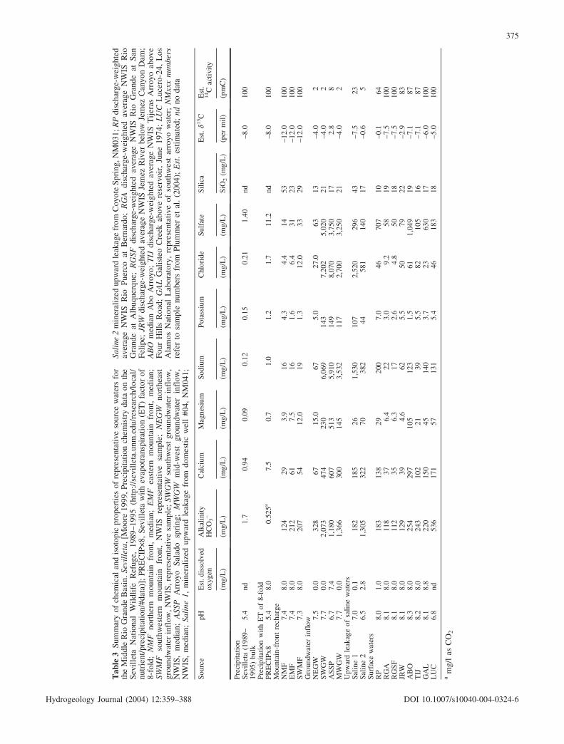
NETPATH ModelsThe geochemical mass-balance code, NETPATH (Plum-mer et al. 1994), was used to construct mass-balancemodels for the origin of waters in the basin and to in-vestigate the sensitivity of the unadjusted radiocarbonages to effects of possible geochemical reactions. NET-PATH uses equations of chemical mass balance, electronbalance, and isotope mass balance to define possible netgeochemical reactions between source waters and theobserved groundwater compositions along a flow path.Because pairs of samples generally cannot be identifiedalong a specific flow path in the MRGB, representativesource-water compositions were selected for each hy-drochemical zone (Table 3). The geochemical reactionswere constrained among reasonable reactant and productminerals and gases for the aquifer system, and to beconsistent with the observed mineralogy, chemical, andisotopic data. Each geochemical reaction model also wassolved as an isotope-evolution problem (Wigley et al.1978, 1979), accounting for various isotopic sources andisotope fractionation along the reaction path to predict theisotopic composition at the end point in the reaction, in-cluding adjustment of Ao for geochemical reactions.
Each groundwater sample in the MRGB was assumedto have evolved from a primary source-water compositionthat was subsequently altered to varying degrees by:
1. Evapotranspiration/dilution processes.2. Mixing with surface water(s).3. Mixing with saline upward leakage water(s).4. Mixing with groundwater inflow from adjacent basins.5. Water/rock reaction.
A primary source water was uniquely specified for eachhydrochemical zone. For example, groundwater from theEastern Mountain Front zone was assumed to haveevolved geochemically from the representative EasternMountain Front source water (Table 3). The compositionsof all source waters and other secondary source watersused in the geochemical models are listed in Table 3. Inmany cases, the chemical compositions of the sourcewaters represent averages of sample compositions fromthe US Geol Surv NWIS surface-water database. In thecases of source waters “ASSP”, “saline water 1” and“saline water 2” (Table 3), the compositions are those
of individual samples collected as a part of this investi-gation.
Phases considered in the geochemical models as pos-sible reactants and products included calcite, plagioclasefeldspar (AN38), carbon-dioxide gas, kaolinite, silica,gypsum, Ca/Na exchange, and, in areas undergoing redoxreactions, organic carbon (designated CH2O for carbon ofoxidation state zero). No important reactant or productminerals containing magnesium were recognized in theMRGB, and none of the models were constrained by themagnesium data. The compositions of phases used in themodels were selected to be representative of groups ofphases present in the MRGB. The models also includedthe possibility of conservative concentration or dilution ofsource-water solute content — the evapotranspiration/di-lution factor. A value of the evapotranspiration/dilutionfactor less than 1 indicates dilution of the source water(s),or paleo-source-water compositions that were more dilutethan the average compositions used here (Table 3). Sim-ilarly, values of the evapotranspiration/dilution factorgreater than 1 indicate concentration of the source watersolutes such as in evapotranspiration, or paleo-source-water compositions that had greater solute content thanthe average compositions used in the geochemical cal-culations (Table 3).
The initial 14C activity of source waters was assumedto be 100 pmC for DIC in mountain-front recharge (asdiscussed above), and was the measured value for surfacewaters and samples ASSP, saline water 1 and saline water2 (see Table 3). The 14C activity of DIC in groundwaterinflow was assumed to be very low (2 pmC). Only onemeasurement of 14C activity of DIC in Rio Puerco waterwas available (64 pmC). Additional calculations weremade in which the 14C activity of DIC in Rio Puercowater was assumed to be 100 pmC, to represent possibleconditions during times of high flow/runoff (see Plummeret al. 2004).
Values of d13C of DIC in source waters were assignedusing logic similar to that used to assign 14C activities.Consequently, d13C of DIC in mountain-front waters wasset to a value of –12 per mil, which is that observed inmodern mountain-front recharge. As discussed below,there may have been a higher abundance of C4 plants inrecharge areas of the MRGB in the past than today, re-sulting in d13C values of recharge waters more positivethan that observed today (d13C of recharge near –8 permil, historically). However, in all the geochemical modelsconstructed, a d13C value of –12 per mil was used (Ta-ble 3) that is consistent with modern observations. Be-cause the stable carbon isotopes were not used to con-strain the geochemical reactions, the modeled masstransfers do not depend on the assumed initial value ofd13C of DIC in recharge waters.
The possibility that many of the waters of the MRGBare mixtures of two or more source waters also wasconsidered. Saline waters and, in some cases, unusuallywarm saline waters were sampled in a few localities in thebasin; therefore, the potential for upward leakage of salinewater also was considered in the models. Ranges and
374
Hydrogeology Journal (2004) 12:359–388 DOI 10.1007/s10040-004-0324-6
Tab
le3
Sum
mar
yof
chem
ical
and
isot
opic
prop
erti
esof
repr
esen
tati
veso
urce
wat
ers
for
the
Mid
dle
Rio
Gra
nde
Bas
in.S
evil
leta
,[M
oore
1999
,Pre
cipi
tati
onch
emis
try
data
onth
eS
evil
leta
Nat
iona
lW
ildl
ife
Ref
uge,
1989
–199
5(h
ttp:
//se
vill
eta.
unm
.edu
/res
earc
h/lo
cal/
nutr
ient
/pre
cipi
tati
on/#
data
)];
PR
EC
IP
8,S
evil
leta
wit
hev
apot
rans
pira
tion
(ET
)fa
ctor
of8-
fold
;N
MF
nort
hern
mou
ntai
nfr
ont,
med
ian;
EM
Fea
ster
nm
ount
ain
fron
t,m
edia
n;SW
MF
sout
hwes
tern
mou
ntai
nfr
ont,
NW
ISre
pres
enta
tive
sam
ple;
NE
GW
nort
heas
tgr
ound
wat
erin
flow
,NW
IS,r
epre
sent
ativ
esa
mpl
e;SW
GW
sout
hwes
tgr
ound
wat
erin
flow
,N
WIS
,m
edia
n;A
SSP
Arr
oyo
Sal
ado
spri
ng;
MW
GW
mid
-wes
tgr
ound
wat
erin
flow
,N
WIS
,m
edia
n;Sa
line
1,m
iner
aliz
edup
war
dle
akag
efr
omdo
mes
tic
wel
l#0
4,N
M04
1;
Sali
ne2
min
eral
ized
upw
ard
leak
age
from
Coy
ote
Spr
ing,
NM
031;
RP
disc
harg
e-w
eigh
ted
aver
age
NW
ISR
ioP
uerc
oat
Ber
nard
o;R
GA
disc
harg
e-w
eigh
ted
aver
age
NW
ISR
ioG
rand
eat
Alb
uque
rque
;R
GSF
disc
harg
e-w
eigh
ted
aver
age
NW
ISR
ioG
rand
eat
San
Fel
ipe;
JRW
disc
harg
e-w
eigh
ted
aver
age
NW
ISJe
mez
Riv
erbe
low
Jem
ezC
anyo
nD
am;
AB
Om
edia
nA
boA
rroy
o;T
IJdi
scha
rge-
wei
ghte
dav
erag
eN
WIS
Tij
eras
Arr
oyo
abov
eF
our
Hil
lsR
oad;
GA
LG
alis
teo
Cre
ekab
ove
rese
rvoi
r,Ju
ne19
74;
LU
CL
ucer
o-24
,L
osA
lam
osN
atio
nal
Lab
orat
ory,
repr
esen
tati
veof
sout
hwes
tar
royo
wat
er;
NM
xxx
num
bers
refe
rto
sam
ple
num
bers
from
Plu
mm
eret
al.
(200
4);
Est
.es
tim
ated
;nd
noda
ta
Sou
rce
pHE
st.d
isso
lved
oxyg
enA
lkal
init
yH
CO
3–
Cal
cium
Mag
nesi
umS
odiu
mP
otas
sium
Chl
orid
eS
ulfa
teS
ilic
aE
st.d1
3C
Est
.14C
acti
vity
(mg/
L)
(mg/
L)
(mg/
L)
(mg/
L)
(mg/
L)
(mg/
L)
(mg/
L)
(mg/
L)
SiO
2(m
g/L
)(p
erm
il)
(pm
C)
Pre
cipi
tati
onS
evil
leta
(198
9–19
95)
bulk
5.4
nd1.
70.
940.
090.
120.
150.
211.
40nd
–8.0
100
Pre
cipi
tati
onw
ith
ET
of8-
fold
PR
EC
IPx8
5.4
8.0
0.52
5a7.
50.
71.
01.
21.
711
.2nd
–8.0
100
Mou
ntai
n-fr
ont
rech
arge
NM
F7.
48.
012
429
3.9
164.
34.
414
53–1
2.0
100
EM
F7.
48.
021
261
7.5
161.
66.
431
23–1
2.0
100
SW
MF
7.3
8.0
207
5412
.019
1.3
12.0
3329
–12.
010
0G
roun
dwat
erin
flow
NE
GW
7.5
0.0
328
6715
.067
5.0
27.0
6313
–4.0
2S
WG
W7.
70.
02,
073
474
230
6,06
914
37,
202
5,02
021
–4.0
2A
SS
P6.
77.
41,
180
607
513
5,91
014
98,
070
3,75
017
2.8
8M
WG
W7.
70.
01,
366
300
145
3,53
211
72,
700
3,25
021
–4.0
2U
pwar
dle
akag
eof
sali
new
ater
sS
alin
e1
7.0
0.1
182
185
261,
530
107
2,52
029
643
–7.5
23S
alin
e2
6.5
2.8
1,30
532
270
382
4458
114
017
–0.6
5S
urfa
cew
ater
sR
P8.
01.
018
313
829
200
7.0
4670
710
–0.1
64R
GA
8.1
8.0
118
376.
422
3.0
9.2
5819
–7.5
100
RG
SF
8.1
8.0
112
356.
317
2.6
4.8
5018
–7.5
100
JRW
8.1
8.0
129
394.
662
5.5
5079
22–2
.983
AB
O8.
38.
025
429
710
512
31.
561
1,04
919
–7.1
87T
IJ8.
28.
024
310
221
395.
582
105
16–7
.187
GA
L8.
18.
822
015
045
140
3.7
2363
017
–6.0
100
LU
C6.
8nd
536
171
5713
15.
446
183
18–5
.010
0
am
g/l
asC
O2
375
Hydrogeology Journal (2004) 12:359–388 DOI 10.1007/s10040-004-0324-6

averages of the percent contribution of each source waterto a mixture are summarized for each sample in Plummeret al. (2004) and averaged for each hydrochemical zone inTable 4. The geochemical models indicate that mostsamples in the Northern Mountain Front, Northwestern,West-Central, Southwestern Mountain Front, and EasternMountain Front zones contain typically 98.5–100%mountain-front source water that has mixed generallywith small fractions of saline upward leakage water. Thefractions of “saline water 1” were lowest in the North-western and Southwestern zones and averaged 1.5, 0.7,and 1.0% in the Northern Mountain Front, West-Central,and Eastern Mountain Front zones, respectively. Thesource of saline water is attributed to upward leakagealong faults.
The geochemical models indicate that water samplesfrom the Western Boundary and Rio Puerco zones containon average 7.8 and 7.4%, respectively, of saline ground-water inflow from sources along the western margin ofthe basin. Water samples in the Rio Puerco zone containan average of 92.6% Rio Puerco water. Water from theWestern Boundary zone averages about 92% water fromlocal arroyo recharge along the western boundary of thebasin. Water samples from the Abo Arroyo zone pre-dominantly were of eastern mountain front origin mixedwith an average of 28% Abo Arroyo water. Water fromthe Central zone was almost entirely of Rio Grande ori-gin, averaging 99.6% water of Rio Grande origin (range96.5–100%), which was mixed with “saline water 1”.Waters from the Tijeras Fault Zone and Tijeras Arroyozones were found to be fairly complex mixtures of easternmountain front water with varying fractions of TijerasArroyo water and “saline waters 1 and 2”. Waters inthe Northeastern zone apparently are complex mixtures ofeastern mountain front water, northeast groundwater in-flow, surface water from Galisteo Creek, and “salinewater 1” (Table 4). The geochemical mass-transfer cal-culations indicate that there is net evaporation (evapo-transpiration) throughout most of the MRGB, except inthe Western Boundary and Eastern Mountain Front zones,where overall dilution (modeled with pure water) is in-dicated (Table 5).
Average values of mineral mass transfer, in mmol kg–1
water, and the average calculated evaporation factor aresummarized in Table 5 for each hydrochemical zone. Thecalculated average mass transfers generally are quitesmall, yet there probably is some significance to the dif-ferences in values between hydrochemical zones. TheNETPATH models indicate that, on average, there is netprecipitation of small amounts of calcite through mostof the MRGB. The exception is the West-Central zone,where the calculations indicate that small amounts ofcalcite dissolve in association with small relative in-creases in Ca/Na cation exchange. The net calcite masstransfer is near zero in other parts of the basin (NorthernMountain Front, Northwestern, and Central zones). Smallamounts of plagioclase feldspar weathering were ob-served throughout the MRGB. Small masses of kaolinite,and probably other clay minerals, form throughout the ba- T
able
4S
umm
ary
ofpr
edom
inan
tgr
ound
wat
erso
urce
sby
hydr
oche
mic
alzo
ne.
NM
FN
orth
ern
mou
ntai
nfr
ont;
Sali
ne1
NM
041;
RP
disc
harg
e-w
eigh
ted
aver
age
NW
ISR
ioP
uerc
o;R
GA
disc
harg
e-w
eigh
ted
aver
age
NW
ISR
ioG
rand
eat
Alb
uque
rque
;M
WG
Wm
id-w
est
grou
nd-w
ater
infl
ow;
SWG
Wso
uthw
este
rngr
ound
-wat
erin
flow
;SW
MF
sout
h-
wes
tern
mou
ntai
nfr
ont,
NW
IS;
EM
Fea
ster
nm
ount
ain
fron
t,m
edia
n;A
BO
med
ian
Abo
Arr
oyo;
Sali
ne2
Coy
ote
Spr
ing,
NM
029;
TIJ
disc
harg
e-w
eigh
ted
aver
age
NW
IST
ijer
asA
rroy
o;N
EG
Wno
rthe
ast
grou
ndw
ater
infl
ow;
GA
LG
ales
teo
Cre
ekab
ove
rese
rvoi
r,us
edas
arro
yoso
urce
inhy
droc
hem
ical
zone
11
Zon
eno
.H
ydro
chem
ical
zone
Pri
mar
yw
ater
Per
cent
rang
eof
prim
ary
wat
er
Ave
rage
perc
ent
ofpr
imar
yw
ater
Sec
onda
ryw
ater
1P
erce
ntra
nge
ofse
cond
ary
wat
er1
Ave
rage
perc
ent
ofse
cond
ary
wat
er1
Sec
onda
ryw
ater
2P
erce
ntra
nge
ofse
cond
ary
wat
er2
Ave
rage
perc
ent
ofse
cond
ary
wat
er2
1N
orth
ern
Mou
ntai
nF
ront
NM
F92
.3–1
0098
.5S
alin
e1
0–7.
31.
52
Nor
thw
este
rnN
MF
97.1
–100
99.9
Sal
ine
10–
2.9
0.1
3W
est
Cen
tral
NM
F92
.5–1
0099
.3S
alin
e1
0–7.
50.
74
Wes
tern
Bou
ndar
yL
UC
84.0
–100
92.2
AS
SP
0–16
.07.
85
Rio
Pue
rco
RP
77.6
–100
92.6
MW
GS
orS
WG
W0–
22.4
7.4
6S
outh
wes
tern
Mou
ntai
nF
ront
SW
MF
100
100.
0S
alin
e1
00.
0
7A
boA
rroy
oE
MF
47.7
–100
72.1
AB
O0–
52.3
27.9
8E
aste
rnM
ount
ain
Fro
ntE
MF
89.5
–100
99.0
Sal
ine
10–
10.5
1.0
9T
ijer
asF
ault
Zon
eE
MF
61.2
–100
89.5
Sal
ine
1,2
0–38
.810
.510
Tij
eras
Arr
oyo
EM
F2.
9–92
.361
.6T
IJ9.
1–91
.637
.4S
alin
e2
0–6.
61.
611
Nor
thea
ster
nE
MF
14.2
–98.
966
.3N
EG
W,
GA
L1.
1–85
.833
.4S
alin
e1
0–2.
00.
312
Cen
tral
RG
A96
.5–1
0099
.6S
alin
e1
0–3.
50.
4
376
Hydrogeology Journal (2004) 12:359–388 DOI 10.1007/s10040-004-0324-6

sin as primary aluminosilicate minerals, such as plagio-clase feldspars dissolve.
Additional sources of carbon included CO2 gas andorganic matter (CH2O). The CO2 mass transfer is ex-pected to be small because most groundwater systems areclosed to gas exchange after recharge. Although thecalculated CO2 mass transfers are not zero, they are smalland reflect, in part, uncertainties in the DIC content ofpaleo-recharge waters, and small analytical errors thatNETPATH ultimately compensates for in the calculatedmasses of phases such as CO2 and CH2O, which are notformed by combining charged constituents. Cation ex-change appears to be relatively important in the North-western, West-Central, Western Boundary, and North-eastern zones. Gypsum abundance is low or zero through-out most of the MRGB sediment, except in parts of theWestern Boundary and Rio Puerco zones, where thecalculated mass of gypsum dissolution is higher than inother hydrochemical zones. The small differences ingypsum mass transfer outside of the Western Boundaryand Rio Puerco zones probably reflect, at least inpart, uncertainty in the calcium sulfate content of sourcewaters to the MRGB. Redox reactions were consideredonly in the Central zone, where there are anoxic condi-tions in the inner valley of the Rio Grande. Here, theNETPATH models found, on average, a net oxidation of0.28 mmol kg–1 of organic carbon. Calculations in whichcarbon-isotopes exchange between calcite and DIC leadto impossibly young (negative ages) radiocarbon ages inmany cases. Therefore, carbon isotope exchange likely isnot an important process in the predominantly silici-clastic sediment of the MRGB.
Radiocarbon AgesIn most cases, the adjusted radiocarbon age was nearlyidentical to the unadjusted radiocarbon age, indicating
that geochemical reactions do not appreciably affect thecalculated ages. For hydrochemical zones 1–12, respec-tively, the average differences in unadjusted and adjustedradiocarbon ages (both ages calculated using the Libbyhalf-life) are 0.5, 1.2, 1.0, 1.2, 4.9, -0.1, 0.2, 0.1, 3.7, 1.3,2.5, and 0.3 ka, respectively. The largest differences be-tween unadjusted and adjusted radiocarbon ages occur forsome waters from hydrochemical zones 5, 9, and 11, andresult from mixing with relatively large fractions of oldgroundwater with low 14C activity, rather than the resultof water-rock reaction. Most of the samples from hydro-chemical zones 1–4, 6–8, 10, and 12 have adjusted agesthat are nearly identical to the unadjusted age because thegeochemical mass transfers are small and the samplescontain relatively small fractions of old groundwaterinflow or old saline sources. Sensitivity calculations,in which compositions of clays, feldspars, and ion ex-changers were varied within reasonable limits, did notappreciably alter adjusted 14C ages. Details of the NET-PATH model results are given for each water sample fromthe MRGB in Plummer et al. (2004), and are summarizedfor each hydrochemical zone in Tables 4 and 5.
The evaluation using NETPATH is far from exhaus-tive, but shows that the extent of geochemical reactionsaffecting the chemical and isotopic composition of watersin the MRGB probably is small and generally has negli-gible effect on the initial 14C activity, Ao. Although thereaction modeling is non-unique, any other reactions thatmight affect the waters of the MRGB also are thought notto significantly affect the initial 14C activity. Therefore,the unadjusted radiocarbon age was adopted in the presentinvestigation.
Table 5 Summary of average mineral mass transfers and evapo-transpiration/dilution factor by hydrochemical zone. CH2O Organiccarbon; evapotranspiration/dilution factor >1 for evaporation, <1
for dilution; mineral mass transfer negative for precipitation (out-gassing), positive for dissolution
Zoneno.
Hydrochemical zone Average mass transfer (mmol kg–1 water) Evaporation/dilution factor
Calcite Plagioclase CO2 Kaolinite SiO2 Ca–Naexchange
Gypsum CH2O
1 Northern MountainFront
0.06 0.27 1.15 –0.19 –0.24 –0.16 0.14 nd 1.06
2 Northwestern 0.06 0.01 0.00 –0.01 0.00 0.84 0.27 nd 1.063 West Central 0.39 0.07 0.31 –0.05 –0.44 1.80 0.93 nd 1.154 Western Boundary –3.98 0.11 –0.18 –0.07 0.27 2.92 7.32 nd 0.675 Rio Puerco –1.96 0.18 1.43 –0.12 0.16 –3.19 1.19 nd 1.216 Southwestern Moun-
tain Front–0.97 0.07 –1.21 –0.05 –0.48 0.00 0.04 nd 2.19
7 Abo Arroyo –0.75 0.09 –0.62 –0.06 –0.10 –0.02 –0.36 nd 3.418 Eastern Mountain
Front–0.26 0.34 0.43 –0.23 –0.18 0.14 0.22 nd 0.86
9 Tijeras Fault Zone –0.83 0.59 –0.11 –0.41 –0.78 –0.28 0.59 nd 2.1310 Tijeras Arroyo –0.86 0.20 0.00 –0.14 –0.24 –0.09 0.70 nd 1.1311 Northeastern –1.23 0.60 –0.20 –0.41 –0.67 0.42 1.57 nd 1.5112 Central 0.00 0.18 0.12 –0.12 0.22 0.08 –0.10 0.28 1.34
377
Hydrogeology Journal (2004) 12:359–388 DOI 10.1007/s10040-004-0324-6

Carbon-13 Isotopic Compositionof Dissolved Inorganic CarbonThere is generally little variation in HCO3 concentrationor d13C composition of DIC within a particular hydro-chemical zone. Of the 195 values of d13C of DIC ingroundwater from the MRGB for which the radiocarbonage is greater than 200 years (Fig. 10), d13C of DIC av-erages –8.2€1.4 per mil. The lack of variation in d13C andHCO3 concentration within a hydrochemical zone indi-cates that geochemical reactions involving carbon areprobably limited in the aquifer system. This observationwas also supported by the NETPATH calculations thatindicated negligible effect of the geochemical reactionson the d13C of the primary source water. Apparently, d13Cof the DIC in recharge waters to the MRGB has beenremarkably constant for most of the past 25 ka (Fig. 10).
Although the data are limited, seven groundwatersamples from remote areas of the Northern and EasternMountain Front zones with radiocarbon ages less than200 years are depleted in 13C relative to most sampleswithin the basin, and average –11.9€2.0 per mil. Today,and in the very recent past (perhaps as recently as onlythe past 200 years), d13C of DIC in recharge watersalong the basin margins apparently has become depletedin 13C, by about 4 per mil, relative to a value of about–8.2 per mil that prevailed for the previous 25,000 years.No geochemical reactions were found using NETPATHthat would account for an increase of 4 per mil ind13C between post-bomb and pre-bomb waters alongthe basin margins. Young groundwater of Rio Grandeorigin (Fig. 10) also indicates a fairly recent decrease in
d13C of DIC, relative to older water of Rio Grande ori-gin.
Measurements of d13C of pedogenic carbonates insouthern Arizona indicate C4 plant dominance during thelast glacial period, followed by a decrease that has beenattributed to a replacement of C4 grasslands during theHolocene by C3/CAM desert shrubs and succulents (Liuet al. 1996). Liu et al. (1996) attributed the replacement toclimatic factors including an increase in temperature andreduction in summer precipitation at the end of the lastglacial period. The landscape in southern Arizona ap-parently was predominantly C4 grasslands for most of thepast 700 ka (Liu et al. 1996).
Eleven specimens of caliche from soils and drillcuttings from throughout the basin had d13C values of–4.3€0.9 per mil, which compares to an average d13C valueof –0.9€1.9 per mil for ten samples of Pennsylvanianlimestones that cap the Sandia and Manzano Mountainson the east side of the basin. Three of the eleven calichesamples were radiocarbon dated and had d13C val-ues of–2.9, –3.8, and –5.3 per mil, with Conventional Radio-carbon Ages of 27.4, 7.2, and 2.3 ka B.P., respectively. Theisotopic values for the three samples of caliche are con-sistent with a possible decrease in the proportion of C4plants in late Holocene ecosystems (Grover and Musick1990; Liu et al. 1996), but on a time-scale of perhaps 7 ka.
The d13C values from the MRGB (–8.2€1.4 per mil)are considerably more enriched in 13C than those reportedby Phillips et al. (1989) for waters in the San Juan Basin,in northwest New Mexico (average d13C of –14.1€3.4 permil). From studies of d13C of herbivore tooth enamel,Connin et al. (1998) found that during the last glacialperiod there was a significant increase in C4 plant abun-dance eastward across the southwestern United States,which may, in part account for the differences betweenthe d13C values of the San Juan Basin and MRGB. Usingmodern correlations between climate and C4 grass abun-dance, Connin et al. (1998) concluded that there wassignificant summer precipitation in parts of southern Ar-izona and New Mexico during the last glaciation.
The data presented here indicate that C4 plant domi-nance prevailed in the MRGB through the last glacialperiod and through most of the Holocene. The increase inC3 plant abundance in the MRGB may be a relativelyrecent phenomena, as has been observed in southern NewMexico (Grover and Musick 1990; Monger et al. 1998),parts of southeastern Arizona (McPherson et al. 1993),and along the Rio Grande Plains of southern Texas, wheremeasurements of d13C and 14C activity of soil organiccarbon indicate that a shift from C4 grassland to C3woodland occurred as recently as the past 50 to 100 years(Boutton et al. 1998).
Apparently, a number of factors including amount andseasonality of precipitation, temperature, soil texture, andatmospheric PCO2 can influence the relative abundances ofC3 and C4 plants (Epstein et al. 1997; Huang et al. 2001).Regardless of the processes responsible for determiningthe d13C of DIC recharged to the MRGB, the groundwaterchemistry provides evidence of recharge of DIC to the
Fig. 10 d13C isotopic composition of dissolved inorganic carbon asa function of radiocarbon age for waters from basin margins (hy-drochemical zones 1, 2, and 8), the West-Central zone (zone 3), andthe Central zone (zone 12)
378
Hydrogeology Journal (2004) 12:359–388 DOI 10.1007/s10040-004-0324-6

MRGB that has been relatively enriched in 13C throughoutmost of the past 25 ka, and has been mostly unaffected bygeochemical reactions in the aquifer system.
Radiocarbon CalibrationBecause the radiocarbon ages in the MRGB are mostlyinsensitive to the recharge and reaction processes that canoften obscure radiocarbon dating in carbonate aquifers, itwas concluded that the radiocarbon ages in the MRGBmay be accurate enough to warrant further conversion tocalendar years, taking advantage of recent compilationsand extensions of radiocarbon calibration data. Radio-carbon calibration scales are needed because the strengthof the Earth’s geomagnetic field has varied over time and,consequently, the 14C activity of atmospheric CO2 hasvaried in the past, and for the most part has been some-what greater than 100 pmC (Stuiver et al. 1986; Bard etal. 1990, 1993; Stuiver and Reimer 1993; Bartlein et al.1995). The conversion to calendar years is still a rela-tively small refinement for hydrologic systems, butprobably provides more accurate estimates of calendarages and travel times for use in calibration of a ground-water-flow model (Sanford et al. 2004a, 2004b).
Radiocarbon calibration data from various sources(Bard et al. 1998; Kitagawa and van der Plicht 1998a,1998b, 2000; Stuiver et al. 1998) gives the correction thatis added to the apparent unadjusted radiocarbon age(Libby half-life) to correct to calendar years (Plummer et
al. 2004; Fig. 11). Over the range of most of the unad-justed radiocarbon ages of the waters in the MRGB, thecalendar-year age differs from the unadjusted radiocarbonage between 0 and about 3 ka. Waters from the TijerasArroyo and Central zones have median unadjusted ra-diocarbon ages of approximately 5 ka and for these, theaverage calendar age is less than 1 ka greater than theunadjusted radiocarbon ages (Fig. 11). Water from theNorthern Mountain Front, Northwestern, Rio Puerco,Southwestern Mountain Front, Abo Arroyo, EasternMountain Front, and Tijeras Fault Zone zones has, onaverage, calendar-year ages that are about 1 ka greaterthan the apparent unadjusted radiocarbon age (Fig. 11).The oldest waters sampled in the MRGB, from the West-Central and Western Boundary zones, have unadjustedcalendar-year ages that are typically 3 ka older than theunadjusted radiocarbon ages (Fig. 11).
Regional Variations in Radiocarbon Age
Ages Near the Water TableThe unadjusted radiocarbon age of water in the upperapproximately 60 m of the Santa Fe Group aquifer systemthroughout the MRGB is shown in Fig. 12. The youngestwater (0–2 ka) is along the mountain-front basin margins(eastern edge of the Eastern Mountain Front zone, thenortheast, northwest, and southwest margins of the basin),and along parts of the Rio Grande and Rio Puerco. Waterwith DIC unadjusted radiocarbon age of 0–10 ka extendsalong nearly the entire reach of the Rio Grande, the RioPuerco, Galisteo Creek, Tijeras Arroyo, and Abo Arroyo,and is associated with relatively recent surface-water in-filtration. The oldest waters are at the water table throughthe West-Central zone, the Western Boundary zone, andparts of the Eastern Mountain Front zone, and throughoutthe Discharge zone (Fig. 12). The old age of water nearthe water table indicates that there has been little or nodirect infiltration of precipitation over large areas of theMRGB during at least the past 20–30 ka.
The median unadjusted radiocarbon age of DIC ingroundwater from 275 analyses throughout the MRGB,excluding samples contaminated with post-bomb 14C, is8.1 ka, with a range of ~0–>30 ka. In the mountain-fronthydrochemical zones, the median unadjusted radiocarbonage is, for the Northern Mountain Front, Northwestern,Southwestern, and Eastern Mountain Front zones, 8.8,8.8, 7.7, and 5.2 ka, respectively. Water in the West-Central, Western Boundary, and Discharge zones is rel-atively old, with median unadjusted radiocarbon ages of19.5 20.4, and 17.9 ka, respectively. Groundwater domi-nated by river/arroyo sources has median unadjusted ra-diocarbon ages of 8.1, 4.6, and 3.2 ka for the Rio Puerco,Central, and Tijeras Arroyo zones, respectively. Themedian unadjusted radiocarbon ages of DIC in water fromthe Abo Arroyo, Tijeras Fault Zone, and Northeasternzones are 9.4, 16.2, and 10.0 ka, respectively.
Fig. 11 Summary of radiocarbon calibration data from varioussources (see text). The curve shows the correction to be added tothe unadjusted radiocarbon age to correct to calendar years; how-ever, all radiocarbon ages reported in this study are the unadjustedradiocarbon age (Libby half-life). Hydrochemical zone numbers areidentified in Tables 4 and 5. For most waters of the MRGB, thecorrection is less than 1 ka. For waters from zones 3 and 4, thecalendar-year ages are, on average, about 3 ka greater than theunadjusted radiocarbon age
379
Hydrogeology Journal (2004) 12:359–388 DOI 10.1007/s10040-004-0324-6

Age GradientsAdditional data are available describing radiocarbon ageas a function of depth in various parts of the MRGB.Although water composition and stable isotopic compo-sition are relatively constant to depths of more than 200 min the MRGB, there can be appreciable variation ingroundwater age with depth. The most reliable age in-formation as a function of depth was obtained from thepiezometer nests that are open to relatively narrow in-tervals (typically 1.5–3 m) of the aquifer system (Fig. 13).The average age gradient, expressed as years per cm ofaquifer (year cm–1), was calculated between the upper-and bottom-most interval from the piezometer nests thatextend over 70 to more than 400 m of the aquifer system.
The average age gradient from this set of piezometer nestsis 0.6€0.4 year cm–1. The average age between the upperand lowest interval is 12.2€6.1 ka.
There are differences in the magnitude of age gradientsdepending on many factors, including location and aver-age age. Some of the smallest age gradients (equal torelatively large thicknesses of water of similar age) werecalculated between the upper- and bottom-most intervalalong the eastern mountain front (Eastern Mountain Frontzone), such as at well nest S114–S116 (0.23 year cm–1
with a mean age of 6.9 ka); along the west side of the RioGrande north of Albuquerque (Central zone), at nestS075–S078 (0.25 year cm–1, mean age of 6.7 ka); andbetween nests S004–S006 (mostly West-Central zone;0.22 year cm–1, mean age of 24.3 ka). Age gradients in the
Fig. 12 Regional variations inthe unadjusted radiocarbon ageof DIC in groundwater fromapproximately the uppermost60 m of the aquifer system,Middle Rio Grande Basin
380
Hydrogeology Journal (2004) 12:359–388 DOI 10.1007/s10040-004-0324-6

upper 250 m of the Central zone along the west side of theRio Grande are lower than on the east side of the RioGrande. However, below 250 m, age gradients in theCentral zone tend to be higher west of the Rio Grandethan observed east of the Rio Grande (Fig. 13A).
Most age gradients do not extrapolate to zero age at thewater table (Fig. 13), indicating that groundwater in thepiezometer nest likely has moved horizontally from the
point of recharge, and that following recharge and flow tothe present location, little or no additional water has beenadded to the water table for periods as long as 20 ka(S004, Fig. 13B). The piezometer nests from the EasternMountain Front zone (Fig. 13B) that extrapolate nearestto zero age at the water table (S212 and S114) are locatedadjacent to the eastern mountain front at Albuquerque.
More detailed age-depth information is found by cal-culating age gradients between each depth interval foreach piezometer nest. Typically, two values are calculatedfor each nest, between the deep and medium completionsand the medium and shallow completions. Several pi-ezometer nests have four completions, yielding threevalues of the age gradient at those locations. The resultingage gradients, calculated between each pair of open in-tervals, vary between about 0.1 and 2 year cm–1 (Fig. 14).During the past 15 ka, the piezometer nests indicate amaximum age gradient at about 10 ka and minimum be-tween about 12–16 ka. The age gradients (in year cm–1)tend to decrease from a maximum at 10 ka to relativelylow values during the past few thousand years (Fig. 14).Higher age gradients generally are found between thedeep and medium completions than between the mediumand shallow completions. The age gradients from twopiezometers in the youngest (and most shallow) watersalong the Eastern Mountain Front and the Central zoneare about 0.1 year cm–1 (Fig. 14). The implied modern
Fig. 13 A, B Profiles of radiocarbon age as a function of depthfrom piezometer nests from the Middle Rio Grande Basin. A Pi-ezometer nests penetrating waters of the Central hydrochemicalzone, either east or west or the Rio Grande. Symbols denote pi-ezometer nests where the deep completion is in the West-Centralzone or the shallow completion is in the Eastern Mountain Frontzone. B Piezometer nests in the Northwestern, West-Central andEastern Mountain Front zones. Water at the shallow completion ofthe piezometer nest in the Eastern Mountain Front zone at site S149is of Rio Grande origin (Central zone). The piezometer locationsare shown on Figs. 3 and 5
Fig. 14 Age gradients in years per centimeter (year cm–1) ofaquifer calculated between each pair of open intervals for eachpiezometer nest and plotted at the mean radiocarbon age of the twointervals. Age gradients vary from about 0.1 to 2 year cm–1 ofaquifer in the upper 600 m of aquifer and are quite variable forwaters older than about 10 ka. Relatively low age gradients arefound for waters recharged in the past 5 ka. (1) S115–S116 mid-shallow interval. Water-level measurements indicate that water atthe shallow depth of piezometer S116 is perched, resulting in likelyunder-estimation of the age gradient between the mid- and shallowdepths at this piezometer
381
Hydrogeology Journal (2004) 12:359–388 DOI 10.1007/s10040-004-0324-6

recharge rate near the eastern mountain front and RioGrande from these two piezometers is on the order of3 cm year–1, assuming an average porosity of 0.3, and iswithin the range of recharge rates reported for othersemiarid environments (see for example, Scanlon et al.2002; Flint et al. 2002; Zhu et al. 2003). Although there isan appearance of temporal variation in age gradients, itcan be ambiguous to examine age gradients out of contextfor the groundwater flow system. Furthermore, flow inrecharge areas is not vertical at any of the piezometernests, and some nests are near discharge areas. For ex-ample, in the period 15–25 ka, age gradients vary by afactor of nearly 20 (Fig. 14).
Along the eastern mountain front, there appear to betwo different age–depth relations. In the calculations ofFig. 15, radiocarbon ages for all samples from wells in theEastern Mountain Front zone (production, domestic, andmonitoring wells) were used and age was plotted at themid-depth of the open interval in meters below the watertable. Water from the Eastern Mountain Front zone foundnorth of Albuquerque, or south of Tijeras Arroyo, has arelatively high age gradient (~6.6 year cm–1) in relation towaters from the Eastern Mountain Front zone at Albu-querque (~0.4 year cm–1; Fig. 15). Apparently, over atleast the past 10 ka, there has been appreciably morerecharge along the eastern mountain front at Albuquerquethan either to the north or south of the Albuquerquevicinity. Factors that may contribute to this difference area greater thickness of ancestral Rio Grande sands at Al-
buquerque than elsewhere along the eastern mountainfront (Hawley and Haase 1992), the presence of theHubble Bench and Tijeras and Hubble Springs fault zonesto the south, which place low permeability rocks at shal-low depths, and higher precipitation rates along the San-dia Mountains at Albuquerque than along lower altitudeportions of the eastern mountain front.
Because of the relatively high density of wells andpiezometer nests in the vicinity of Albuquerque, it ispossible to construct cross sections through the upper600 m of the aquifer system showing age relations andstable isotope composition in relation to hydrochemicalzones. One such cross section (Hawley 1996b), con-structed approximately east–west and aligned along Me-naul Blvd. through central Albuquerque (Fig. 16), showsthe extent and age of water of Rio Grande origin beneathAlbuquerque in relation to waters from the West-Centraland Eastern Mountain Front zones. Isotopically depletedwater of radiocarbon age more than 20 ka is found at thewater table west of the Rio Grande and at depth beneathCentral zone waters under the inner valley of the RioGrande. Relatively young water of Rio-Grande-originflows south along the contact with paleo-water of theWest-Central zone (Fig. 16). There are relatively sharpboundaries between hydrochemical zones.
Although there is considerable age–depth informationavailable for the waters of the MRGB (Plummer et al.2004), computed inventories of water volumes of differ-ent ages were highly uncertain due to lack of informationon age gradients with depth over large parts of the basin.Attempts to estimate recharge rates from estimates ofwater volumes as a function of age were even more un-certain due to inability to account for volumes of waterthat have already discharged from the basin. It was con-cluded that the most reliable estimates of recharge ratethat can be derived using the radiocarbon ages from thisstudy are obtained when the radiocarbon ages are used inconjunction with the calibration of a basin-scale ground-water-flow model (Sanford et al. 2004a, 2004b).
Implications from Geochemical and Isotopic Datafor the Conceptual Model of the Groundwater System
Tracing Sources of Water Through the BasinIn most cases, groundwater that has separate rechargesources differed in major-/minor-element chemistry andisotopic composition. In other cases, the use of isotopicdata, particularly 2H and 14C, was essential to differ-entiating waters of separate origin. The study showsthat because the siliciclastic sediments of the Santa FeGroup aquifer system are relatively unreactive, the chem-ical composition of groundwater in the basin generallychanges little along a flow path, permitting source watersto be traced over long distances through the aquifer sys-tem.
Mountain-front recharge sources dominate over largeareas along the northern and eastern margins of the basin,and in the southwest corner, and can be distinguished
Fig. 15 Radiocarbon age as a function of the depth below the watertable of the mid-point of the open interval for all wells from theEastern Mountain Front zone. Two age depth relations are apparent.A relatively thick zone of recharge from the eastern mountain frontis observed at Albuquerque, but in areas north of Albuquerque andsouth of Tijeras Arroyo, there has been relatively less recharge ofcomparable age to the Eastern Mountain Front zone. Locations ofselected wells are shown on Figs. 3 and 5
382
Hydrogeology Journal (2004) 12:359–388 DOI 10.1007/s10040-004-0324-6

from waters of the West-Central zone on the basis ofchemical and isotopic composition (Tables 1 and 2). In-filtration from the Rio Grande, particularly in the area ofAlbuquerque, is another important source of recharge tothe aquifer system of the MRGB. This study has helped todefine the extent and age of water sourced at the RioGrande (Fig. 8). The study indicates that water has beenentering the aquifer system from the Rio Grande for tens
of thousands of years and historically has flowed pri-marily north to south under the Albuquerque area (Figs. 5,7, 8, and 16). Other sources of water to the basin aredelineated on Fig. 8.
Fig. 16 Schematic hydrogeo-logic cross section of the Mid-dle Rio Grande Basin, NewMexico, aligned with MenaulBoulevard, through central Al-buquerque (based on Hawley1996b), showing ranges of d2Hand radiocarbon age for groundwater in relation to position ofhydrochemical zone bound-aries. The location of the east–west cross section and well lo-cations are shown on the adja-cent map. The geologic bound-aries are defined in Plummer etal. 2004)
383
Hydrogeology Journal (2004) 12:359–388 DOI 10.1007/s10040-004-0324-6

Direction of Groundwater FlowConservative geochemical tracers and boundaries be-tween hydrochemical zones indicate that groundwaterflow in the MRGB historically has been directed pri-marily north–south through the center of the basin, with agreater east–west component near the basin margins.
Although predevelopment hydraulic-head maps for theMRGB (Bjorklund and Maxwell 1961; Titus 1961; Bex-field and Anderholm 2000; Fig. 2) are broadly consistentwith the primary direction of groundwater flow indicatedby geochemical data, there are some apparent inconsis-tencies. In particular, predevelopment hydraulic headsindicate greater east–west components of flow throughthe center of the basin than is suggested by the orientationof the hydrochemical zones. The differences in flow di-rection indicated by hydraulic heads compared to geo-chemical tracers likely are associated with the differenttime horizons and depths represented by the two types ofinformation.
Carbon-14 data from this study of the MRGB indi-cate that most groundwater resides in the aquifer systemfor thousands to tens of thousands of years. Therefore,the hydrochemical zones defined on the basis of cur-rent groundwater chemistry in the basin probably reflectaquifer system conditions (including groundwater-flowdirections) existing on the order of tens of thousands ofyears into the past, and may not yet reflect the “current”hydraulic-head distribution. In addition, predevelopmenthydraulic-head maps for the basin were based on condi-tions primarily in the shallow part of the aquifer system(to a depth of at most 60 m), whereas geochemical datainclude samples collected from wells reaching greaterdepths, where groundwater flow directions may differsomewhat.
Origin of the Groundwater TroughThe predevelopment hydraulic-head maps of Titus(1961), Bjorklund and Maxwell (1961), and Bexfield andAnderholm (2000) have all indicated the existence of agroundwater trough in the western part of the MRGB,extending from near the Jemez River on the north toBelen on the south, and from a series of major faults onthe west to near the Rio Grande on the east (Fig. 2). Waterlevels in the trough can be as much as 15 m lower than thelevel of the Rio Grande directly to the east. Geochemicaldata from this study show that groundwater flowing alongthe axis of the trough is within the West-Central hydro-chemical zone and originated in the area of the JemezMountains during the last glacial period. Although hy-draulic heads indicate that water sourced at the westernmargin of the basin and at the Rio Grande should beflowing into the center of the trough, the geochemicaldata indicate that the western margin and Rio Grandewaters have not yet reached the center of the trough. Thelack of evidence that these waters have reached the axis ofthe trough appears to contradict one conceptual modelthat the trough exists primarily as the result of a large
thickness of relatively permeable materials near its axisthat would cause the area to act as a sort of “drain” for thegroundwater system (Kernodle et al. 1995). Recent geo-hydrologic data for the area do not support this conclusion(Hawley 1996b).
One possible explanation for the existence of the troughthat would be consistent with the observed geochemicaldata is that the trough is a transient feature of the ground-water system in the MRGB. As mentioned above, changeswith time in the quantity and distribution of rechargearound the basin could result in a change in the distribu-tion of hydraulic head. If the trough is a relatively recent(perhaps from the beginning of the Holocene) feature ofthe aquifer system, water sourced at the western margin ofthe basin and at the Rio Grande may not yet have had timeto travel into the trough area. Radiocarbon ages of waterssourced from the western margin that are located today onthe west side of the trough, and Rio Grande waters locatedon the east side of the trough, are approximately 10 ka(Fig. 12), and are younger than 10 ka further to the westand east toward the Rio Puerco and Rio Grande sources,respectively. This suggests that water has been flowingtoward the trough from the Rio Puerco and Rio Grandesince the beginning of the Holocene. Using a groundwater-flow model for the MRGB, Sanford et al. (1998) foundthat the trough could be simulated merely by lowering thequantities of recharge from the basin margins.
Other factors that could contribute to the presence ofthe trough could be horizontal anisotropy and the exis-tence of features that limit groundwater flow into thetrough from the east and west. Such features could in-clude major faults that are relatively impermeable or low-conductivity geologic strata (McAda and Barroll 2002).Most major faults within the MRGB trend north to south;therefore, cementation of any of several major faultscould be consistent with the restriction of east–westgroundwater flow. Such restrictions would act only tolimit flow toward the trough and not to prevent it entirely.Therefore, even if flow restrictions are important, theabsence of water sourced from the Rio Grande and fromthe western margin near the axis of trough implies that thetrough is a transient rather than a long-term feature.
Groundwater Flow in Relation to FaultsIn the MRGB, a few boundaries between hydrochemicalzones appear to correspond fairly closely in places with“major” faults identified by Mark Hudson and Scott Mi-nor (US Geological Survey, written communication1999). Two examples are the boundary between the RioPuerco and West-Central zones and the boundary betweenthe Tijeras Fault Zone and Eastern Mountain Front zones.The general correspondence of differences in groundwa-ter chemistry with particular fault locations may indicatethat horizontal groundwater flow is limited across thosefaults (Fig. 2).
Whereas there are differences in groundwater chem-istry across sections of some “major” faults, differencesin chemistry are not evident in other areas where impor-
384
Hydrogeology Journal (2004) 12:359–388 DOI 10.1007/s10040-004-0324-6

tant — even basin-bounding — faults exist. For example,the water-level map of Bexfield and Anderholm (2000)indicates the existence of a hydraulic discontinuity alongthe Sandia Fault adjacent to the front of the SandiaMountains. However, the chemical and isotopic data in-dicate that the distinct chemical boundary between watersourced from the Rio Grande and water sourced along theeastern mountain front (Fig. 5) is approximately 3 kmwest of the Sandia Fault and apparently is unrelated to thelocation of the fault. The hydraulic discontinuity in thisarea (Fig. 2) probably is the result of the greater saturatedthickness of conductive materials on the west side of thefault, resulting in a flatter hydraulic gradient on that side.Therefore, not all “major” faults in the basin appear tohave characteristics that appreciably limit groundwaterflow across them. Similarly, there is little evidence fromeither chemistry or water levels indicating that “minor”faults with small offset of similar sediments substantiallylimit horizontal groundwater flow, at least on a regionalscale.
The geochemical data indicate that major faults actu-ally may enhance or cause vertical groundwater flow insome areas of the MRGB. Elevated water temperaturesand high Cl and As concentrations in particular often arein close proximity to “major” faults in the basin, espe-cially in the northern part of the basin, the northeasternpart of Albuquerque, and the southeastern part of thebasin. These elevated concentrations appear to be in-dicative of groundwater from a deep source that is mov-ing upward to mix with water at shallower depths in theaquifer system. The association of these elevated con-centrations with the locations of faults suggests that ver-tical movement of groundwater could be enhanced infault zones by increased vertical conductivity resultingfrom deformation. Elevated Cl and As concentrations alsoare common in the vicinity of the structural highs near thenorthern and southern extents of Albuquerque that sepa-rate the sub-basins within the MRGB, and near thestructural high/constriction that separates the MRGB fromthe Socorro Basin to the south (Plummer et al. 2004).Upward leakage in this area could account for the ele-vated Cl and As concentrations.
Summary
Measurements of the chemical and isotopic compositionof groundwater from 288 wells and springs in the MiddleRio Grande Basin of central New Mexico were used torefine the conceptual model of groundwater flow in theUpper Santa Fe aquifer system, and to improve under-standing of the area’s water resources. The extensive re-gional coverage, supplemented with data from the USGeol Surv NWIS and city of Albuquerque water-qualitydatabase, resulted in identification and mapping of thespatial extent of 12 regional sources of water to the basin,and estimation of radiocarbon ages.
The composition of most water in the basin changeslittle after recharge, and can be traced over large distances
through the primarily siliciclastic sediment of the aquifersystem. Radiocarbon ages adjusted for geochemical re-actions and mixing in the aquifer system are nearlyidentical to the unadjusted radiocarbon ages and rangedfrom modern to more than 30 ka.
Predominant sources of water to the basin include (1)recharge from mountains along the north, east andsouthwest (median age 5–9 ka); (2) seepage from the RioGrande and Rio Puerco (median age 4–8 ka), and fromAbo and Tijeras Arroyos (median age 3–9 ka); (3) inflowof saline water along the southwest basin margin (medianage 20.4 ka); and (4) inflow along the northern basinmargin (median age 19.9 ka), which probably representsrecharge from the Jemez Mountains during the last glacialperiod.
Piezometer nests provided critical information onvariations in chemical and isotopic composition, and ra-diocarbon age with depth to approximately 600 m belowthe water table in the vicinity of Albuquerque and severalother locations in the northern part of the basin. In somecases, the data from piezometers and other wells permit-ted characterization of the three-dimensional aspects ofwater composition, showing that paleo-water (approxi-mately 20 ka), present at the water table through the west-central part of the basin, extends beneath more recentmountain-front recharge in northern parts of the basin,and beneath water of Rio Grande origin under westernparts of Albuquerque. Age gradients from two piezometernests indicate “modern” (past few thousand years) re-charge rates of ~3 cm year–1 for infiltration from the RioGrande at Albuquerque and recharge along the easternmountain front at Albuquerque. Historically, there havebeen higher amounts of recharge to the Eastern MountainFront zone at Albuquerque than to vicinities north orsouth of Albuquerque along the eastern mountain front.
Measurements of the 2H and 18O isotopic compositionof source waters to the basin and mapping of the stableisotopic composition of groundwater helped to delineateflow directions and boundaries between hydrochemicalzones. The stable isotope data for groundwater in thevicinity of Albuquerque show a relatively sharp transitionbetween recharge from the Sandia Mountains to the eastand infiltration of paleo Rio Grande water.
The geochemical data show that groundwater flowingalong the axis of a groundwater trough in the west-centralpart of the MRGB originated in the area of the JemezMountains during the last glacial period. Although hy-draulic heads indicate that water sourced at the westernmargin of the basin and at the Rio Grande should beflowing into the trough, the geochemical data indicatethat, over the past ~10 ka, these waters have not yetreached the center of the trough. The absence of watersourced from the Rio Grande and from the western mar-gin near the axis of groundwater trough indicates that thetrough is a transient rather than a long-term feature of theaquifer system.
The d13C isotopic composition of dissolved inorganiccarbon in groundwater is remarkably constant throughoutmost of the basin, indicating a nearly constant historical
385
Hydrogeology Journal (2004) 12:359–388 DOI 10.1007/s10040-004-0324-6

predominance of C4 over C3 plants in recharge areas forthe aquifer system, and minimal water–rock reactionfollowing recharge. However, during the past 1 ka, orperhaps even more recently, the d13C isotopic composi-tion of dissolved inorganic carbon of water rechargedalong the basin margins has become depleted in 13C, andmay indicate a recent increase in C3 plant abundancerelative to C4 plants, as has been observed in other partsof the Southwest.
Extensive chemical and isotopic datasets, such as ob-tained for the MRGB, are uncommon in the hydrologicsciences. This study demonstrates some of the benefits ofobtaining a diverse and extensive chemical and isotopicdataset when characterizing hydrochemical processes ingroundwater systems, and when there is need to refine theconceptual model of the aquifer system. In the companionpapers (Sanford et al. 2004a, 2004b), the radiocarbon agesand delineation of the boundaries between hydrochemicalzones from this study are used to help calibrate a ground-water-flow model for the basin.
Acknowledgements The authors thank the numerous individuallandowners who provided access to their wells. We thank thegovernors and staff of the Pueblos of Cochiti, Isleta, Jemez, Sandia,San Felipe, Santa Ana, Santo Domingo, and Zia for permitting us tosample wells, and assisting in locating wells and records of wellconstruction. The authors also thank Bill White with the Bureauof Indian Affairs for his assistance in contacting the Pueblos andhis advice about the most appropriate wells for sampling. Watersamples from many of the windmills on Pueblo lands could nothave been obtained without the generous assistance of JohnSanchez and the windmill crew of the Southern Pueblos Agency.
Individuals from the US Forest Service, the Bureau of LandManagement, the US Fish and Wildlife Service, Kirtland Air ForceBase, Sandia National Laboratories, the New Mexico Office of theState Engineer, the New Mexico Environment Department, theUniversity of New Mexico, the city of Albuquerque, the city ofBelen, and the town of Los Lunas provided access to wells andassisted in locating the most appropriate wells for sampling. Wethank Doug Earp and others with the city of Albuquerque Envi-ronment Department for their assistance. The cooperation of RioRancho Utilities, Rio Grande Utilities, Sandia Peak Utility Com-pany, National Utilities, New Mexico Utilities, DRESCO, Intel,AT&T, King Brothers Ranch, and the Huning Ltd. Partnership inproviding access to wells is gratefully acknowledged.
We thank our colleagues with the US Geol Surv, Jerry Casile,Mike Doughten, Julian Wayland, Peggy Widman, Andrew Stack,Anne Burton, Brian C. Norton, David Jones, Ami Mitchell, DanielWebster, Tyler Coplen, Kinga Revesz, Robert L. Michel, FredGebhardt, R.K. DeWees, Jim Bartolino, Joe Sterling, CarolinaTrevizo, and Lori Shue for assistance in field sampling, laboratoryanalysis, assistance in locating wells, data processing, drafting ofillustrations, and manuscript preparation.
Finally, the authors would like to thank Doug McAda, MarkHudson, and Scott Minor of the US Geol Surv, Fred Phillips ofNew Mexico Institute of Mining and Technology, and John Hawleyand Sean Connell of the New Mexico Bureau of Geology andMineral Resources (NMBGMR) who shared their knowledge andadvice about the hydrology and geology of the basin. The manu-script was improved appreciably at several stages of preparation bythe constructive reviews of US Geol Surv colleagues Jim Bartolino,Don Thorstenson, Tom Reilly, Pierre Glynn, John Izbicki, and ananonymous reviewer. This work was supported by funds from theGround Water Resources Program and the National ResearchProgram of the US Geological Survey.
References
Anderholm SK (1985) Clay-size fraction and powdered whole-rockX-ray analyses of alluvial-basin deposits in central and southernNew Mexico. US Geol Surv Open-File Rep 85-173:18
Anderholm SK (1988) Ground-water geochemistry of the Albu-querque–Belen Basin, central New Mexico. US Geol SurvWater-Resources Investigations Rep 86-4094:110
Anderholm SK (1997) Water-quality assessment of the Rio Grandevalley, Colorado, New Mexico, and Texas — shallow ground-water quality and land use in the Albuquerque area, centralNew Mexico 1993. US Geol Surv Water-Resources Investiga-tions Rep 97-4067:73
Anderholm SK (2001) Mountain-front recharge along the east sideof the Albuquerque Basin, central New Mexico (revised). USGeol Surv Water-Resources Investigations Rep 00-4010:36
Bard E, Hamelin B, Fairbanks R, Zindler A (1990) Calibration ofthe 14C timescale over the past 30,000 yr using mass spectro-metric U–Th ages from Barbados corals. Nature 345:405–410
Bard E, Arnold M, Fairbanks RG, Hamelin B (1993) 230Th–234Uand 14C ages obtained by mass spectrometry on corals. Radio-carbon 35:191–199
Bard E, Arnold M, Hamelin B, Tisnerat-Laborde N, Cabioch G(1998) Radiocarbon calibration by means of mass spectrometric230Th/234U and 14C ages of corals: an updated database in-cluding samples from Barbados, Mururoa and Tahiti. Radio-carbon 40:1085–1092
Bartlein PJ, Edwards ME, Shafer SL, Barker ED Jr (1995) Cali-bration of radiocarbon ages and the interpretation of paleoen-vironmental records. Quaternary Res 44:417–424
Bartolino JR, Cole JC (2002) Ground-water resources of the MiddleRio Grande Basin, New Mexico. US Geol Surv, Circular1222:132
Bartolino JR, Niswonger RG, III (1999) Numerical simulation ofvertical ground-water flux of the Rio Grande from ground-water temperature profiles, central New Mexico. US Geol SurvWater-Resources Investigations Rep 99-4212:34
Bexfield LM, Anderholm SK (1997) Water-quality assessment ofthe Rio Grande Valley, New Mexico, and Texas — ground-water quality in the Rio Grande flood plain, Cochiti Lake,New Mexico, to El Paso, Texas 1995. US Geol Surv Water-Resources Investigations Rep 96-4249:93
Bexfield LM, Anderholm SK (2000) Predevelopment water-levelmap of the Santa Fe Group aquifer system in the Middle RioGrande Basin between Cochiti Lake and San Acacia, NewMexico. US Geol Surv Water-Resources Investigations Rep00-4249:1sheet
Bexfield LM, Anderholm SK (2002) Spatial patterns and temporalvariability in water quality from City of Albuquerque supplywells and piezometer nests, with implications for the ground-water flow system. US Geol Surv Water-Resources Investiga-tions Rep 01-4244:101
Bexfield LM, Lindberg WE, Anderholm SK (1999) Summary ofwater-quality data for City of Albuquerque drinking-watersupply wells 1988–97. US Geol Surv Open-File Rep 99-195:138
Bjorklund LJ, Maxwell BW (1961) Availability of ground water inthe Albuquerque area, Bernalillo and Sandoval Counties, NewMexico. New Mexico State Engineer Tech Rep 21:117
Boutton TW, Archer SR, Midwood AJ, Zitzer SF, Bol R (1998)d13C values of soil organic carbon and their use in documentingvegetation change in a subtropical savanna ecosystem. Geo-derma 82:5–41
Connell SD (2001) Stratigraphy of the Albuquerque Basin, RioGrande Rift, central New Mexico: a progress report. In: ConnellSD, Lucas SG, Love DW (eds) Stratigraphy and tectonic de-velopment of the Albuquerque Basin, central Rio Grande Rift.New Mexico Bureau of Mines and Mineral Resources Open-File Report 454B, Socorro, NM, pp A1-A27
Connell SD, Allen BD, Hawley JW (1998) Subsurface stratigraphyof the Santa Fe Group from borehole geophysical logs, Albu-querque area, New Mexico. New Mexico Geology 17:79–87
386
Hydrogeology Journal (2004) 12:359–388 DOI 10.1007/s10040-004-0324-6

Connin SL, Betancourt J, Quade J (1998) Late Pleistocene C4 plantdominance and summer rainfall in the southwestern UnitedStates from isotopic study of herbivore teeth. Quaternary Res50:179–193
Constantz J, Thomas CL (1996) The use of streambed temperatureprofiles to estimate the depth, duration, and rate of percolationbeneath arroyos. Water Resour Res 32:3597–3602
Epstein HE, Lauenroth WK, Burke IC, Coffin DP (1997) Produc-tivity patterns of C3 and C4 functional types in the US GreatPlains. Ecology 78:722–731
Flint AF, Flint LE, Kwicklis EM, Fabryka-Martin JT, BodvarssonGS (2002) Estimating recharge at Yucca Mountain, Nevada,USA: comparison of methods. Hydrogeol J 10:180–204
Grauch VJS, Gillespie CL, Keller GR (1999) Discussion of newgravity maps for the Albuquerque Basin area. In: Pazzaglia FJ,Lucas SG (eds) Albuquerque geology. New Mexico GeologicalSociety Fiftieth Annual Field Conference, 22–25 September1999. New Mexico Geological Society, pp 119–124
Grauch VJS, Sawyer DA, Keller GR, Gillespie CL (2001) Contri-butions of gravity and aeromagnetic studies to improving theunderstanding of subsurface hydrogeology, Middle Rio GrandeBasin, New Mexico. In: Cole JC (ed) US geological surveymiddle Rio Grande Basin study. Proceedings of the fourth an-nual workshop, Albuquerque, New Mexico, 15–16 February2000, US Geol Surv Open-File Rep 00-488:3–4
Grover HD, Musick HB (1990) Shrubland encroachment insouthern New Mexico, USA: an analysis of desertificationprocesses in the American southwest. Climatic Change 17:305–330
Haneberg WC, Hawley JW (eds) (1996) Characterization of hy-drogeologic units in the Northern Albuquerque Basin, NewMexico. In: Hawley JW, Haneberg WC, Whitworth TM(compilers) Hydrogeologic investigations in the AlbuquerqueBasin, central New Mexico 1992–1995. New Mexico Bureau ofMines and Mineral Resources Open-File Report 402, Socorro,NM, section 402C
Hawley JW (1996a) Hydrologic setting of the Albuquerque Basinarea. In: Hawley JW, Haneberg WC, Whitworth TM (compil-ers) Hydrogeologic investigations in the Albuquerque Basin,central New Mexico 1992–1995. New Mexico Bureau of Minesand Mineral Resources Open-File Report 402, Socorro, NM,section 402B
Hawley JW (1996b) Hydrogeologic framework of potential re-charge areas in the Albuquerque Basin, central ValenciaCounty, New Mexico. In: Hawley JW, Whitworth TM (eds)Hydrogeology of potential recharge areas for the basin- andvalley-fill aquifer systems, and hydrogeochemical modelling ofproposed artificial recharge of the upper Santa Fe aquifer,northern Albuquerque Basin, New Mexico. New Mexico Bu-reau of Geology and Mineral Resources Open-File Report 402-D, 608 pp
Hawley JW, Haase CS (1992) Hydrogeologic framework of thenorthern Albuquerque Basin. Open-File Report 387:74 NewMexico Bureau of Mines and Mineral Resources, Socorro, NM
Hawley JW, Haase CS, Lozinsky RP (1995) An underground viewof the Albuquerque Basin. In: Ortega-Klett CT (ed) The waterfuture of Albuquerque and the Middle Rio Grande Basin.Proceedings of the 29th Annual New Mexico Water Confer-ence, 3–4 November 1994. New Mexico Water ResourcesResearch Institute WRRI Report No 290, Las Cruces, NM,pp 34–55
Helsel DR, Hirsch RM (1995) Statistical methods in water re-sources. Elsevier Science BV, New York
Heywood CE (1992) Isostatic residual gravity anomalies of NewMexico. US Geol Surv Water-Resources Investigations Rep91-4065:27
Huang Y, Street-Perrott FA, Metcalf SE, Brenner M, Moreland M,Freeman KH (2001) Climate change as the dominant control onglacial–interglacial variations in C3 and C4 plant abundance.Science 293:1647–1651
Kalin RM (2000) Radiocarbon dating of groundwater systems. In:Cook PG, Herczeg AL (eds) Environmental tracers in subsur-face hydrology. Kluwer, Dordrecht, pp 111–144
Kelley VC (1977) Geology of Albuquerque Basin, New Mexico.New Mexico Bureau of Mines and Mineral Resources Memoir33, Socorro, NM
Kernodle JM (1998) Simulation of ground-water flow in theAlbuquerque Basin, central New Mexico, 1901–95, with pro-jections to 2020. US Geol Surv Open-File Rep 96-209:54
Kernodle JM, Miller RS, Scott WB (1987) Three-dimensionalmodel simulation of transient ground-water flow in the Albu-querque–Belen Basin, New Mexico. US Geol Surv Water-Resources Investigations Rep 86-4194:58
Kernodle JM, McAda DP, Thorn CR (1995) Simulation of ground-water flow in the Albuquerque Basin, central New Mexico1901–1994, with projections to 2020. US Geol Surv Water-Resources Investigations Rep 94-4251:114
Kitagawa H, van der Plicht J (1998a) Atmospheric radiocarboncalibration to 45,000 yr b.p.: Late glacial fluctuations andcosmogenic isotope production. Science 279:1187–1190
Kitagawa H, van der Plicht J (1998b) A 40,000-year varvechronology from Lake Suigetsu, Japan: extension of the 14Ccalibration curve. Radiocarbon 40:505–515
Kitagawa H, van der Plicht J (2000) Atmospheric radiocarboncalibration beyond 11,900 cal BP from Lake Suigetsu lami-nated sediments. Radiocarbon 42:369–380
Liu B, Phillips FM, Campbell AR (1996) Stable carbon and oxygenisotopes in pedogenic carbonates, Ajo Mountains, southernArizona: implications for paleoenvironmental change. Palaeo-geogr Palaeoclimatol Palaeoecol 124:233–246
Logan LM (1990) Geochemistry of the Albuquerque municipalarea, Albuquerque, New Mexico. MSc Thesis, New MexicoInstitute of Mining and Technology, Socorro, NM
Lozinsky RP (1988) Stratigraphy, sedimentology, and sand petrol-ogy of the Santa Fe Group and pre-Santa Fe Tertiary deposits inthe Albuquerque Basin, central New Mexico. New MexicoInstitute of Mining and Technology, PhD Thesis, Socorro, NM
McAda DP (1996) Plan of study to quantify the hydrologic rela-tions between the Rio Grande and the Santa Fe Group aquifersystem near Albuquerque, central New Mexico. US Geol SurvWater-Resources Investigations Rep 96-4006:58
McAda DP, Barroll P (2002) Simulation of ground-water flow inthe Middle Rio Grande Basin between Cochiti and San Acacia,New Mexico. US Geol Surv Water-Resources InvestigationsRep 02-4200:81
McPherson GR, Boutton TW, Midwood AJ (1993) Stable carbonisotope analysis of soil organic matter illustrates vegetationchange at the grassland/woodland boundary in southeasternArizona, USA. Oecologia 93:95–101
Minor SA, Shock NA (1998) Characterizing faults in the MiddleRio Grande Basin: results from the Cochiti and Santo DomingoPueblos. US Geol Surv Open-File Rep 98-337:22–23
Monger HC, Cole DR, Gish JW, Giordano TH (1998) Stable carbonand oxygen isotopes in Quaternary soil carbonates as indicatorsof ecogeomorphic changes in the northern Chihuahuan Desert,USA. Geoderma 82:137–172
Moore D (1999) Precipitation chemistry data on the SeviletaNational Wildlife Refuge, 1989–1995: Sevilleta LTER Data-base, accessed March 2, 1999, at http://sevilleta.unm.edu/research/local/nutrient/precipitation/#data
Mozley PS, Goodwin LB (1995) Patterns of cementation along aCenozoic normal fault — a record of paleoflow orientations.Geology 23:539–542
Mozley P, Beckner J, Whitworth TM (1995) Spatial distributionof calcite cement in the Santa Fe Group, Albuquerque Basin,NM — implications for ground-water resources. New MexicoGeol 17:88–93
Phillips FM, Tansey MK, Peeters LA (1989) An isotopic investi-gation of groundwater in the central San Juan Basin, NewMexico: carbon-14 dating as a basis for numerical flow mod-eling. Water Resour Res 25:2259–2273
387
Hydrogeology Journal (2004) 12:359–388 DOI 10.1007/s10040-004-0324-6

Plummer LN, Bexfield LM, Anderholm SK, Sanford WE (2001)Geochemical characterization of ground-water flow in theSanta Fe Group aquifer system, Middle Rio Grande Basin, NewMexico. In: Cole JC (ed) US Geological Survey Middle RioGrande Basin Study. Proceedings of the Fourth Annual Work-shop, Albuquerque, New Mexico, 15–16 February 2000. USGeol Surv Open-File Rep 00-488:7–10
Plummer LN, Bexfield LM, Anderholm SK, Sanford WE, Busen-berg E (2004) Geochemical characterization of ground-waterflow in the Santa Fe Group aquifer system, Middle Rio GrandeBasin, New Mexico. US Geol Surv Water-Resources Investi-gations Rep 03-4131:395 (in press)
Plummer LN, Prestemon EC, Parkhurst DL (1994) An interactivecode (NETPATH) for modeling NET geochemical reactionsalong a Flow PATH. Version 2.0. US Geol Surv Water-Resources Investigations Rep 94-4169:130
Reeder HO, Bjorklund LJ, Dinwiddie GA (1967) Quantitativeanalysis of water resources in the Albuquerque area, NewMexico? Computed effects on the Rio Grande of pumpage ofground water, 1960–2000. New Mexico State Engineer Tech-nical Report 33:34
Russell LR, Snelson S (1990) Structural style and tectonic evolu-tion of the Albuquerque Basin segment of the Rio Grande Rift.In: Pinet B, Bois C (eds) The potential of deep seismic profilingfor hydrocarbon exploration. Proc French Petroleum Inst ResConf, Editions Technip, Paris, pp 175–207
Sanford WE, Plummer LN, Bexfield LM (1998) Using environ-mental tracer data to improve the US Geological SurveyMODFLOW model of the Middle Rio Grande Basin. In: USGeological Survey Middle Rio Grande Basin Study: SecondAnnual Workshop, Albuquerque, New Mexico, Feb. 1998. USGeol Surv Open-File Rep 98-337:13–14
Sanford WE, Plummer LN, McAda DP, Bexfield LM, AnderholmSK (2001) Estimation of hydrologic parameters for the ground-water model of the Middle Rio Grande Basin using carbon-14and water-level data. In: Cole JC (ed) US Geological SurveyMiddle Rio Grande Basin Study. Proceedings of the FourthAnnual Workshop, Albuquerque, New Mexico, 15–16 February2000. US Geol Surv Open-File Rep 00-488:4–6
Sanford WE, Plummer LN, McAda DP, Bexfield LM, AnderholmSK (2004a) Use of environmental tracers to estimate parame-ters for a predevelopment-ground-water-flow model of theMiddle Rio Grande Basin, New Mexico. US Geol Surv Water-Resources Investigations Rep. 03-4286 (in press)
Sanford WE, Plummer LN, McAda DP, Bexfield LM, AnderholmSK (2004b) Hydrochemical tracers in the Middle Rio GrandeBasin, USA: 2. Calibration of a groundwater model. HydrogeolJ DOI: s10040-004-0326-4 (this volume)
Scanlon BR, Healy RW, Cook PG (2002) Choosing appropriatetechniques for quantifying groundwater recharge. Hydrogeol J10:18–39
Stone BD, Allen BD, Mikolas M, Hawley JW, Haneberg WC,Johnson PS, Allred B, Thorn CR (1998) Preliminary lithos-tratigraphy, interpreted geophysical logs, and hydrogeologiccharacteristics of the 98th Street core hole, Albuquerque, NewMexico. US Geol Surv Open-File Rep 98-210:82
Stuiver M, Reimer PJ (1993) Extended 14C data base and revisedCALIB 3.0 14C age calibration program. Radiocarbon 8:534–540
Stuiver M, Kromer B, Becker B, Ferguson CW (1986) Radiocar-bon age calibration back to 13,300 years b.p. and the 14Cage matching of the German oak and US bristlecone pinechronologies. Radiocarbon 28:980–021
Stuiver M, Reimer PJ, Bard E, Beck JW, Burr GS, Hughen KA,Kromer B, McCormac G, van der Plicht J, Spurk M (1998)INTCAL98 radiocarbon age calibration, 24,000–0 cal b.p.Radiocarbon 40:1041–1083
Thomas CL (1995) Infiltration and quality of water for two arroyochannels, Albuquerque, New Mexico 1988–92. US Geol SurvWater-Resources Investigations Rep 95-4070:63
Thorn CR, McAda DP, Kernodle JM (1993) Geohydrologicframework and hydrologic conditions in the Albuquerque Ba-sin, central New Mexico. US Geol Surv Water-ResourcesInvestigations Rep 93-4149:106
Tiedeman CR, Kernodle JM, McAda DP (1998) Application ofnonlinear-regression methods to a ground-water flow model ofthe Albuquerque Basin, New Mexico. US Geol Surv Water-Resources Investigations Rep 98-4172:90
Titus FB (1961) Ground-water geology of the Rio Grande trough innorth-central New Mexico, with sections on the Jemez Calderaand Lucero Uplift. In: Northrop SA (ed.) Guidebook of theAlbuquerque country. New Mexico Geological Society, 12thField Conference, pp 186–192
Titus FB (1963) Geology and ground-water conditions in easternValencia County, New Mexico. New Mexico Bureau of Minesand Mineral Resources Ground-Water Report 7, Socorro, NM
Wigley TML, Plummer LN, Pearson FJ Jr (1978) Mass transfer andcarbon isotope evolution in natural water systems. GeochimCosmochim Acta 42:1117–1139
Wigley TML, Plummer LN, Pearons FJ Jr (1979) Errata. GeochimCosmochim Acta 43:1395
Yapp CJ (1985) D/H variations of meteoric waters in Albuquerque,New Mexico, USA. J Hydrol 76:63–84
Zhu C, Winterle JR, Love EI (2003) Late Pleistocene and Holocenegroundwater recharge from the chloride mass balance methodand chlorine-36 data. Water Resour Res (39)7:1182, DOI:10.1029/2003WR001987
388
Hydrogeology Journal (2004) 12:359–388 DOI 10.1007/s10040-004-0324-6
Copyright © 2022 FDOKUMEN