Hydro 25-2007:Notices to Mariners - Australian Hydrographic ...
36
Australian Notices to Mariners are the authority for correcting Australian Charts and Publications AUSTRALIAN NOTICES TO MARINERS © Commonwealth of Australia 2007 - Copyright restrictions apply to Notices to Mariners Notices 1093 – 1148 The Hydrographer and Staff of the Australian Hydrographic Service wish all users of Australian Navigational Products a Merry Christmas, a Happy New Year and safe, successful voyages in 2008. Published fortnightly by the Australian Hydrographic Service Captain R Nairn RAN Hydrographer of Australia SECTIONS. I. Australian Notices to Mariners, including blocks and notes. II. Amendments to Admiralty List of Lights and Fog Signals, Vol K III. Navigational Warnings. IV. Hydrographic Reports. V. Amendments to Admiralty List of Radio Signals (NP 281(2), 282, 283(2), 285, 286(4)) VI. Amendments to Admiralty Sailing Directions (NP 9, 13, 14, 15, 33, 34, 35, 36, 39, 44, 51, 60, 61, 62, 100, 136) British Admiralty Notices to Mariners New Zealand Notices to Mariners The substance of these notices should be inserted on the charts affected. Bearings are referred to the true compass and are reckoned clockwise from North; those relating to lights are given as seen by an observer from seaward. Positions quoted in permanent notices relate to the horizontal datum for the chart(s). When preliminary or temporary notices affect multiple charts, positions will be provided in relation to only one horizontal datum and that datum will be specified. When the multiple charts do not have a common horizontal datum, mariners will be required to adjust the position(s) for those charts not on the specified datum. The range quoted for a light is its nominal range. Depths are with reference to the chart datum of each chart. Heights are above mean high water springs or mean higher high water, as appropriate. The capital letter (P) or (T) after the number of any notice denotes a preliminary or temporary notice respectively, which are contained separately at the end of the permanent notices. A star (*) adjacent to the number of a notice indicates that the notice is based on original information. Mariners are particularly requested to notify the AUSTRALIAN HYDROGRAPHIC SERVICE, Locked Bag 8801 Wollongong, NSW 2500 (Fax 02-4221 8599, e-mail [email protected] or, alternatively by filling in and submitting the Hydrographic Notes forms located on the web site – www.hydro.gov.au), immediately on the discovery of new dangers or suspected dangers to navigation. For changes or defects in aids to navigation notify AusSAR (Fax 02-6230 6868 or email [email protected]). Copies of these notices can be obtained from the AUSTRALIAN HYDROGRAPHIC OFFICE, 8 Station Street, Wollongong; Distributors for the sale of Australian Navigational Products; AHS website www.hydro.gov.au or register for eNotices at www.hydro.gov.au/enotices/enotices.htm. The Notices may be copied for the purpose of inserting their substance on official charts and other publications. However, any copies of the notices may not be sold for profit. IMPORTANT NOTICE This edition of Notices to Mariners includes all significant information affecting AHS products which the AHS has become aware of since the last edition. All reasonable efforts have been made to ensure the accuracy and completeness of the information, including third party information, on which these updates are based. The AHS regards third parties from which it receives information as reliable, however the AHS cannot verify all such information and errors may therefore exist. The AHS does not accept liability for errors in third party information. AHP18 Final for year 21 Dec 2007 Edition 25
-
Upload
khangminh22 -
Category
Documents
-
view
0 -
download
0
Transcript of Hydro 25-2007:Notices to Mariners - Australian Hydrographic ...
Australian Notices to Mariners are the authority for correcting Australian Charts and Publications
AUSTRALIAN NOTICES TO MARINERS
© Commonwealth of Australia 2007 - Copyright restrictions apply to Notices to Mariners
Notices 1093 – 1148
The Hydrographer and Staff of the Australian Hydrographic Service wish all users of Australian Navigational Products a Merry Christmas,
a Happy New Year and safe, successful voyages in 2008.
Published fortnightly by the Australian Hydrographic Service Captain R Nairn RAN Hydrographer of Australia
SECTIONS. I. Australian Notices to Mariners, including blocks and notes.
II. Amendments to Admiralty List of Lights and Fog Signals, Vol K III. Navigational Warnings. IV. Hydrographic Reports. V. Amendments to Admiralty List of Radio Signals (NP 281(2), 282, 283(2), 285, 286(4)) VI. Amendments to Admiralty Sailing Directions (NP 9, 13, 14, 15, 33, 34, 35, 36, 39, 44,
51, 60, 61, 62, 100, 136)
British Admiralty Notices to Mariners New Zealand Notices to Mariners
The substance of these notices should be inserted on the charts affected. Bearings are referred to the true compass and are reckoned clockwise from North; those relating to lights are given as seen by an observer from seaward. Positions quoted in permanent notices relate to the horizontal datum for the chart(s). When preliminary or temporary notices affect multiple charts, positions will be provided in relation to only one horizontal datum and that datum will be specified. When the multiple charts do not have a common horizontal datum, mariners will be required to adjust the position(s) for those charts not on the specified datum. The range quoted for a light is its nominal range. Depths are with reference to the chart datum of each chart. Heights are above mean high water springs or mean higher high water, as appropriate. The capital letter (P) or (T) after the number of any notice denotes a preliminary or temporary notice respectively, which are contained separately at the end of the permanent notices. A star (*) adjacent to the number of a notice indicates that the notice is based on original information. Mariners are particularly requested to notify the AUSTRALIAN HYDROGRAPHIC SERVICE, Locked Bag 8801 Wollongong, NSW 2500 (Fax 02-4221 8599, e-mail [email protected] or, alternatively by filling in and submitting the Hydrographic Notes forms located on the web site – www.hydro.gov.au), immediately on the discovery of new dangers or suspected dangers to navigation. For changes or defects in aids to navigation notify AusSAR (Fax 02-6230 6868 or email [email protected]). Copies of these notices can be obtained from the AUSTRALIAN HYDROGRAPHIC OFFICE, 8 Station Street, Wollongong; Distributors for the sale of Australian Navigational Products; AHS website www.hydro.gov.au or register for eNotices at www.hydro.gov.au/enotices/enotices.htm. The Notices may be copied for the purpose of inserting their substance on official charts and other publications. However, any copies of the notices may not be sold for profit.
IMPORTANT NOTICE This edition of Notices to Mariners includes all significant information affecting AHS products which the AHS has become aware of since the last edition. All reasonable efforts have been made to ensure the accuracy and completeness of the information, including third party information, on which these updates are based. The AHS regards third parties from which it receives information as reliable, however the AHS cannot verify all such information and errors may therefore exist. The AHS does not accept liability for errors in third party information. AHP18
Final for year 21 Dec 2007 Edition 25
sconeliu
Note
Text in blue (with the exception of the contents of Section V) contains links to relevant information. Click on the text to navigate to or execute linked information.

© Commonwealth of Australia 2007
This work is copyright. Apart from any use permitted under the Copyright Act 1968, no part may be reproduced by any process, adapted, communicated or commercially exploited without prior written permission from The Commonwealth represented by the Australian Hydrographic Service. Copyright in some of the material in this publication may be owned by another party and permission for the reproduction of that material must be obtained from the owner.
NUMERICAL INDEX OF CHARTS AFFECTED
Edition No 25 21 December 2007 Notices Aus Chart, INT Chart, ENC Cell, AHP 1093........................ Aus 137, 154, 379, 387, 546, 547, 651, AU5194P1, 5XX194, 5169P3, 435151 1094........................ Amendment to Australian Seafarers Handbook AHP20 1095........................ Amendments to Notice to Mariners No 2 1096........................ Aus 806 1097........................ Aus 808 1098........................ Aus 194 1099........................ Aus 194, 195 1100........................ Aus 195 1101........................ Aus 197, 808, 809 1102........................ Aus 199 1103........................ Aus 215 1104........................ Aus 813 1105........................ Aus 237 1106........................ Aus 623 1107........................ Aus 676 1108........................ Aus 676 1109........................ Aus 395, 545 1110........................ Aus 662 1111........................ Aus 4622, INT 622 1112........................ Aus 388, 4622, INT 622 1113........................ Aus 651 1114........................ Aus 296, 700 1115........................ Aus 15 1116........................ Aus 26, 28, AX 72026 1117........................ Aus 24, 28 1118........................ Aus 28, 722, 72722 1119........................ Aus 57, 59, 741, 742 1120........................ Aus 136 1121........................ Aus 125 1122........................ Aus 172 1123........................ Aus 168 1124........................ Aus 157 1125........................ Aus 154 1126........................ Aus 150 1127........................ Aus 801 1128(P) ................... Aus 197, 361 423, 424, 808, 809 1129(T) ................... Aus 207 1130(T) ................... Aus 813, 814 1131(T) ................... Aus 237 1132(T) ................... Aus 237, 238 1133(T) ................... Aus 235 236 1134(T) ................... Aus 235 1135(T) ................... Aus 247 1136(T) ................... Aus 249, 250, 251 1137(T) ................... Aus 262, 263, 264, 830, AX 63262 1138(P) ................... Aus 281, 834 1139(P) ................... Aus 292, 376 1140(T) ................... Aus 381, 567, 625, 629 1141(T) ................... Aus 666 1142(T) ................... Aus 320, 730 1143(T) ................... Aus 55, 56 1144(T) ................... Aus 776, 777 1145(T) ................... Aus 139, 780 1146(T) ................... Aus 137 1147(T) ................... Aus 143, 155 1148(T) ................... Aus 357A, 422, 487
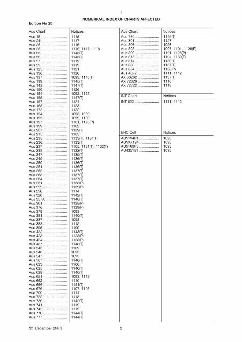
NUMERICAL INDEX OF CHARTS AFFECTEDEdition No 25
Aus Chart Notices Aus Chart NoticesAus 15.......................... 1115Aus 24.......................... 1117Aus 26.......................... 1116Aus 28.......................... 1116, 1117, 1118Aus 55.......................... 1143(T)Aus 56.......................... 1143(T)Aus 57.......................... 1119Aus 59.......................... 1119Aus 125........................ 1121Aus 136........................ 1120Aus 137........................ 1093, 1146(T)Aus 139........................ 1145(T)Aus 143........................ 1147(T)Aus 150........................ 1126Aus 154........................ 1093, 1125Aus 155........................ 1147(T)Aus 157........................ 1124Aus 168........................ 1123Aus 172........................ 1122Aus 194........................ 1098, 1099Aus 195........................ 1099, 1100Aus 197........................ 1101, 1128(P)Aus 199........................ 1102Aus 207........................ 1129(T)Aus 215........................ 1103Aus 235........................ 1133(T), 1134(T)Aus 236........................ 1133(T)Aus 237........................ 1105, 1131(T), 1132(T)Aus 238........................ 1132(T)Aus 247........................ 1135(T)Aus 249........................ 1136(T)Aus 250........................ 1136(T)Aus 251........................ 1136(T)Aus 262........................ 1137(T)Aus 263........................ 1137(T)Aus 264........................ 1137(T)Aus 281........................ 1138(P)Aus 292........................ 1139(P)Aus 296........................ 1114Aus 320........................ 1142(T)Aus 357A ..................... 1148(T)Aus 361........................ 1128(P)Aus 376........................ 1139(P)Aus 379........................ 1093Aus 381........................ 1140(T)Aus 387........................ 1093Aus 388........................ 1112Aus 395........................ 1109Aus 422........................ 1148(T)Aus 423........................ 1128(P)Aus 424........................ 1128(P)Aus 487........................ 1148(T)Aus 545........................ 1109Aus 546........................ 1093Aus 547........................ 1093Aus 567........................ 1140(T)Aus 623........................ 1106Aus 625........................ 1140(T)Aus 629........................ 1140(T)Aus 651........................ 1093, 1113Aus 662........................ 1110Aus 666........................ 1141(T)Aus 676........................ 1107, 1108Aus 700........................ 1114Aus 722........................ 1118Aus 730........................ 1142(T)Aus 741........................ 1119Aus 742........................ 1119Aus 776........................ 1144(T)Aus 777........................ 1144(T)
I
(21 December 2007) 2
Aus 780........................ 1145(T)Aus 801........................ 1127Aus 806........................ 1096Aus 808........................ 1097, 1101, 1128(P)Aus 809........................ 1101, 1128(P)Aus 813........................ 1104, 1130(T)Aus 814........................ 1130(T)Aus 830........................ 1137(T)Aus 834........................ 1138(P)Aus 4622...................... 1111, 1112AX 63262 ..................... 1137(T)AX 72026 ..................... 1116AX 72722 ..................... 1118
INT Chart Notices
INT 622 ........................ 1111, 1112
ENC Cell Notices
AU5194P1.................... 1093AU5XX194.................... 1093AU5169P3.................... 1093AU435151 .................... 1093

I
(21 December 2007) 3
1093 AUSTRALIA - ProductsAustralian Hydrographic Service
New ChartChart Published Title, limits and description of amendments Scale Folio Index Chart Price Aus 387 12/10/2007 Papua New Guinea - North Coast - Vitiaz 1:300 000 10 Aus 65000 $29.50
Strait to Karkar Island4° 36’ 00’’ S - 6° 23’ 01” S
145º 32’ 00” E - 148º 20’ 55” ENew chart with amended limits and generalupdating throughout
Aus 546 12/10/2007 Papua New Guinea - New Britain - North 1:150 000 10 Aus 65000 $29.50Coast -Cape Lambert to Bangula Bay
4º 04’ 58” S - 5º 29’ 42” S 150º 49’ 12” E - 151º 42’ 36” ENew chart providing improved coverage of thewest side of Gazzelle Peninsula and approaches toTavantangir Harbour
Aus 547 12/10/2007 Papua New Guinea - New Britain - North 1:150 000 10 Aus 65000 $29.50Coast - Bangula Bay to Eleonora Bay
4º 44’ 33” S - 5º 38’ 06” S 149º 35’ 48” E 151º 00’ 15” ENew chart with amended limits and generalupdating throughout
New Electronic Navigation Chart (Seafarer ENC)Cell Name Released Title AU5194P1 Dec 2007 New South Wales - Wollongong HarbourAU5XX194 Dec 2007 New South Wales - Port Kembla HarbourAU5169P3 Dec 2007 Tasmania - Coles BayAU435151 Dec 2007 Tasman Sea - Port Hacking
New Chart to be published shortlyExpected Expected Stock
Chart Title Scale Publication Date Availability Aus 379 Papua New Guinea - South Coast - Kerema 1:300 000 18 January 2008 29 February 2008
Bay to Port MoresbyAus 651 Papua New Guinea - North Coast - Approaches 1:75 000 18 January 2008 29 February 2008
to WewakPlans: Wewak Harbour 1:25 000Wewak Wharves 1:7 500
New Edition to be published shortlyExpected Expected Stock
Chart Title Scale Publication Date Availability Aus 137 Australia - South Coast - South Australia - 1 : 12 500 18 January 2008 29 February 2008
Port AdelaideAus 154 Australia - South Coast - Victoria - Port
Melbourne - Williamstown and River Yarra 1 : 7 500 18 January 2008 29 February 2008Plan:River Yarra 1 : 7 500
For further details refer to the AHS website at www.hydro.gov.au for new edition and new chart stock arrivalinformation.
When placing orders with a chart agent, mariners should advise whether their order pertains to the current editionor the new edition.
Chart permanently withdrawnChart On publication of new chart/edition Aus 387 Aus 387Aus 547 Aus 547
Amendment to Notices to Mariners Edition 24 of 2007Section 1 page 7 Notice 1054 Aus 824Position for light beacon deletion should read 20° 03′.85 S 148º 54′.22 EPosition for depth deletion should read 20° 03′.87 S 148º 54′.22 E

1094 AUSTRALIA - Amendment to Australian Seafarers Handbook AHP20Australian Hydrographic Service (AA284000, AA284001, AA284130)
Chapter 6, page 68Delete Australia Commonwealth Marine Protected Areas diagram and substitute accompanying block.
Insert accompanying block Commonwealth Marine Reserves in the South-east Region after the sectionDepiction of Australian Navigation Charts.
1095 AUSTRALIA - Amendments to Notice to Mariners No 2Australian Hydrographic Service (AA300067)
New contact details for Queensland chart agentAgnes Water2662 Roundhill Road. Angus Water 4677Email aw/[email protected]
1096* AUSTRALIA - NEW SOUTH WALES - Eden - Fish aggregation deviceFormer Notice - 135(T)/2006 is cancelledFisheries NSW (AA231218)
Aus 806 [426/2006]Insert special conical light buoy, Fl.Y.5s (Oct - Jun), with topmark 36º 58′.91 S 150º 15′.78 E
1097* AUSTRALIA - NEW SOUTH WALES - Beecroft Head to Wollongong - Fish aggregation deviceFisheries NSW (AA231218)
Aus 808 [1049/2007]Insert special conical light buoy, Fl.Y.5s (Oct - Jun), with topmark 34º 41′.00 S 150º 59′.50 E
Substitute legend (Oct - Jun) for legend FAD centred on 34º 58′.4 S 150º 57′.4 Elegend (Oct - Jun) for legend FAD centred on 34º 27′.4 S 151º 04′.3 E
1098* AUSTRALIA - NEW SOUTH WALES - Port Kembla to Wollongong - Magnetic variationUKHO (AA296978)
Aus 194 [1048/2007]Amend legend, to 12°40’E 2009 (0’), centred on 34º 27′.25 S 150º 54′.52 E
legend, to 12°40’E 2009 (0’), centred on 34º 28′.17 S 150º 56′.02 Elegend, to 12°40’E 2009 (0’), centred on 34º 27′.14 S 150º 56′.52 Elegend, to 12°40’E 2009 (0’), centred on 34º 28′.22 S 150º 53′.78 E
Aus 194 (plan, Wollongong Harbour)Amend legend, to 12°40’E 2009 (0’), centred on 34º 25′.41 S 150º 54′.26 E
1099* AUSTRALIA - NEW SOUTH WALES - Port Kembla - DepthUKHO (AA296978)
Aus 194 [1098/2007]Amend legend, to Obstruction (14), centred on 34º 26′.96 S 150º 54′.50 E
Aus 195 [1048/2007]Amend legend, to Obstn (14), centred on 34º 26′.96 S 150º 54′.51 E
1100* AUSTRALIA - NEW SOUTH WALES - Port Kembla - ZOC diagram and tidal panelAustralian Hydrographic Service (AA299925)
Aus 195 [1099/2007]Insert accompanying block 34º 24′.5 S 150º 52′.0 E
I
(21 December 2007) 4
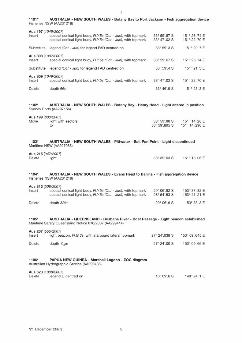
1101* AUSTRALIA - NEW SOUTH WALES - Botany Bay to Port Jackson - Fish aggregation deviceFisheries NSW (AA231218)
Aus 197 [1049/2007]Insert special conical light buoy, Fl.Y.5s (Oct - Jun), with topmark 33º 59′.67 S 151º 26′.74 E
special conical light buoy, Fl.Y.5s (Oct - Jun), with topmark 33º 47′.02 S 151º 22′.70 E
Substitute legend (Oct - Jun) for legend FAD centred on 33º 59′.3 S 151º 20′.7 E
Aus 808 [1097/2007]Insert special conical light buoy, Fl.Y.5s (Oct - Jun), with topmark 33º 59′.67 S 151º 26′.74 E
Substitute legend (Oct - Jun) for legend FAD centred on 33º 59′.4 S 151º 21′.3 E
Aus 809 [1049/2007]Insert special conical light buoy, Fl.Y.5s (Oct - Jun), with topmark 33º 47′.02 S 151º 22′.70 E
Delete depth 66m 33º 46′.9 S 151º 23′.3 E
1102* AUSTRALIA - NEW SOUTH WALES - Botany Bay - Henry Head - Light altered in positionSydney Ports (AA297156)
Aus 199 [803/2007]Move light with sectors 33º 59′.88 S 151º 14′.28 E
to 33º 59′.895 S 151º 14′.290 E
1103* AUSTRALIA - NEW SOUTH WALES - Pittwater - Salt Pan Point - Light discontinuedMaritime NSW (AA297088)
Aus 215 [947/2007]Delete light 33º 39′.03 S 151º 18′.06 E
1104* AUSTRALIA - NEW SOUTH WALES - Evans Head to Ballina - Fish aggregation deviceFisheries NSW (AA231218)
Aus 813 [508/2007]Insert special conical light buoy, Fl.Y.5s (Oct - Jun), with topmark 29º 06′.82 S 153º 37′.32 E
special conical light buoy, Fl.Y.5s (Oct - Jun), with topmark 28º 54′.53 S 153º 41′.21 E
Delete depth 32fm 29º 06′.6 S 153º 38′.3 E
1105* AUSTRALIA - QUEENSLAND - Brisbane River - Boat Passage - Light beacon establishedMaritime Safety Queensland Notice 816/2007 (AA299414)
Aus 237 [555/2007]Insert light beacon, Fl.G.3s, with starboard lateral topmark 27º 24′.038 S 153º 09′.645 E
Delete depth 03m 27º 24′.00 S 153º 09′.66 E
1106* PAPUA NEW GUINEA - Marshall Lagoon - ZOC diagramAustralian Hydrographic Service (AA299436)
Aus 623 [1008/2007]Delete legend C centred on 10º 09′.6 S 148º 24′.1 E
I
(21 December 2007) 5
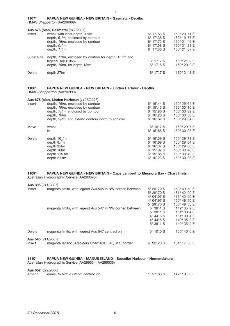
1107* PAPUA NEW GUINEA - NEW BRITAIN - Gasmata - DepthsHMAS Shepparton (AA296999)
Aus 676 (plan, Gasmata) [817/2007]Insert wreck with least depth, 17fm 6º 17′.63 S 150º 20′.71 E
depth, 61fm, enclosed by contour 6º 17′.38 S 150º 19′.77 Edepth, 15fm, enclosed by contour 6º 17′.72 S 150º 21′.45 Edepth, 04fm 6º 17′.58 S 150º 21′.28 Edepth, 11fm 6º 17′.36 S 150º 21′.57 E
Substitute depth, 11fm, enclosed by contour for depth, 15 fm and legend Rep (1966) 6º 17′.7 S 150º 21′.2 Edepth, 16fm, for depth 18fm 6º 17′.6 S 150º 20′.0 E
Delete depth 27fm 6º 17′.7 S 150º 21′.1 E
1108* PAPUA NEW GUINEA - NEW BRITAIN - Linden Harbour - DepthsHMAS Shepparton (AA296999)
Aus 676 (plan, Linden Harbour) [1107/2007]Insert depth, 19fm, enclosed by contour 6º 16′.44 S 150º 29′.64 E
depth, 19fm, enclosed by contour 6º 15′.43 S 150º 30′.10 Edepth, 75fm, enclosed by contour 6º 15′.86 S 150º 30′.39 Edepth, 16fm 6º 16′.20 S 150º 30′.88 Edepth, 52fm, and extend contour north to enclose 6º 16′.62 S 150º 29′.64 E
Move wreck 6º 16′.7 S 150º 29′.7 Eto 6º 16′.88 S 150º 30′.08 E
Delete depth 102fm 6º 16′.59 S 150º 29′.71 Edepth 84fm 6º 16′.69 S 150º 29′.64 Edepth 35fm 6º 16′.37 S 150º 29′.66 Edepth 16fm 6º 15′.92 S 150º 30′.40 Edepth 115 fm 6º 15′.85 S 150º 30′.49 Edepth 21 fm 6º 16′.23 S 150º 30′.88 E
1109* PAPUA NEW GUINEA - NEW BRITAIN - Cape Lambert to Eleonora Bay - Chart limitsAustralian Hydrographic Service (AA290376)
Aus 395 [911/2007]Insert magenta limits, with legend Aus 546 in NW corner, between 5º 29′.70 S 150º 49′.50 E
5º 29′.70 S 151º 42′.90 E4º 04′.97 S 151º 42′.90 E4º 04′.97 S 150º 49′.50 E5º 29′.70 S 150º 49′.50 E
magenta limits, with legend Aus 547 in NW corner, between 5º 38′.1 S 149º 35′.9 E5º 38′.1 S 151º 00′.4 E4º 44′.6 S 151º 00′.4 E4º 44′.6 S 149º 35′.9 E5º 38′.1 S 149º 35′.9 E
Delete magenta limits, with legend Aus 547 centred on 5º 10′.0 S 150º 40′.0 E
Aus 545 [911/2007]Insert magenta legend, Adjoining Chart Aus 546, in S border 4º 22′.20 S 151º 17′.50 E
1110* PAPUA NEW GUINEA - MANUS ISLAND - Seeadler Harbour - NomenclatureAustralian Hydrographic Service (AA299534, AA299535)
Aus 662 [629/2006]Amend name, to Ndrilo Island, centred on 1º 57′.86 S 147º 19′.58 E
I
(21 December 2007) 6

1111* PAPUA NEW GUINEA - Vitiaz Strait to Karkar Island - Chart limitsAustralian Hydrographic Service (AA290376)
Aus 4622 (INT 622) [912/2007]Insert magenta limits, with legend Aus 387 in NE corner, between 6º 23′.0 S 145º 32′.0 E
6º 23′.0 S 148º 21′.0 E4º 36′.0 S 148º 21′.0 E4º 36′.0 S 145º 32′.0 E6º 23′.0 S 145º 32′.0 E
Delete magenta limits, with legend Aus 387 centred on 5º 12′.0 S 146º 40′.0 E
1112* PAPUA NEW GUINEA - Cape Girgir - Light establishedPNG National Maritime Safety Authority Notice 130/2007 (AA299514, AA301032)
Aus 388 [601/2007]Insert light beacon, Fl.7·5s10M 3º 48′.46 S 144º 31′.52 E
Delete depth 45m 3º 48′.2 S 144º 31′.0 E
Aus 388 (plan, Entrance to Sepik River) [601/2007]Insert light beacon, Fl.7·5s 7m 10M 3º 48′.462 S 144º 31′.524 E
Delete depth 42m 3º 48′.5 S 144º 31′.4 E
Aus 4622 (INT 622) [1111/2007]Insert light, Fl.10M 3º 48′.5 S 144º 31′.5 E
1113* PAPUA NEW GUINEA - Wewak - Mooring buoy removedAustralian Hydrographic Service (AA297155)
Aus 651 [631/2006]Delete mooring buoy 3º 34′.6 S 143º 41′.0 E
Aus 651 (plan, Wewak Harbour) [631/2006]Delete mooring buoy 3º 34′.6 S 143º 41′.0 E
1114* AUSTRALIA - QUEENSLAND - Proudfoot Shoal - Light buoy and racon establishedFormer Notice - 1031(P)/2007 is cancelledAustralian Maritime Safety Authority (AA297503)
Aus 296 [860/2007]Insert south cardinal pillar light buoy, Q(6)+LFl.15s Racon (T),
with topmark 10º 32′.10 S 141º 27′.94 E
Aus 700 [860/2007]Insert south cardinal pillar light buoy, Q(6)+LFl.15s Racon (T),
with topmark 10º 32′.01 S 141º 28′.00 E
Delete underwater rock 10º 31′.7 S 141º 28′.0 E
1115* AUSTRALIA - NORTHERN TERRITORY - Gove - Navaids; infrastructureFormer Notice - 1169(T)/2006 is cancelledRio Tinto (AA296970)
Aus 15 (plan, Gove Harbour) [1186/2006]Insert accompanying block 12º 11′.8 S 136º 41′.2 E
Aus 15 (plan, Gove Inner Harbour)Insert accompanying block 12º 11′.8 S 136º 41′.3 E
I
(21 December 2007) 7
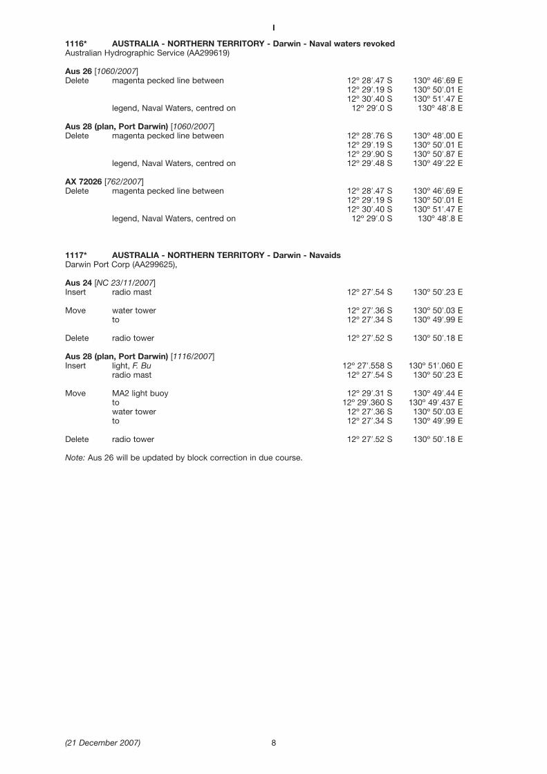
1116* AUSTRALIA - NORTHERN TERRITORY - Darwin - Naval waters revokedAustralian Hydrographic Service (AA299619)
Aus 26 [1060/2007]Delete magenta pecked line between 12º 28′.47 S 130º 46′.69 E
12º 29′.19 S 130º 50′.01 E12º 30′.40 S 130º 51′.47 E
legend, Naval Waters, centred on 12º 29′.0 S 130º 48′.8 E
Aus 28 (plan, Port Darwin) [1060/2007]Delete magenta pecked line between 12º 28′.76 S 130º 48′.00 E
12º 29′.19 S 130º 50′.01 E12º 29′.90 S 130º 50′.87 E
legend, Naval Waters, centred on 12º 29′.48 S 130º 49′.22 E
AX 72026 [762/2007]Delete magenta pecked line between 12º 28′.47 S 130º 46′.69 E
12º 29′.19 S 130º 50′.01 E12º 30′.40 S 130º 51′.47 E
legend, Naval Waters, centred on 12º 29′.0 S 130º 48′.8 E
1117* AUSTRALIA - NORTHERN TERRITORY - Darwin - NavaidsDarwin Port Corp (AA299625),
Aus 24 [NC 23/11/2007]Insert radio mast 12º 27′.54 S 130º 50′.23 E
Move water tower 12º 27′.36 S 130º 50′.03 Eto 12º 27′.34 S 130º 49′.99 E
Delete radio tower 12º 27′.52 S 130º 50′.18 E
Aus 28 (plan, Port Darwin) [1116/2007]Insert light, F. Bu 12º 27′.558 S 130º 51′.060 E
radio mast 12º 27′.54 S 130º 50′.23 E
Move MA2 light buoy 12º 29′.31 S 130º 49′.44 Eto 12º 29′.360 S 130º 49′.437 Ewater tower 12º 27′.36 S 130º 50′.03 Eto 12º 27′.34 S 130º 49′.99 E
Delete radio tower 12º 27′.52 S 130º 50′.18 E
Note: Aus 26 will be updated by block correction in due course.
I
(21 December 2007) 8
I
(21 December 2007) 9
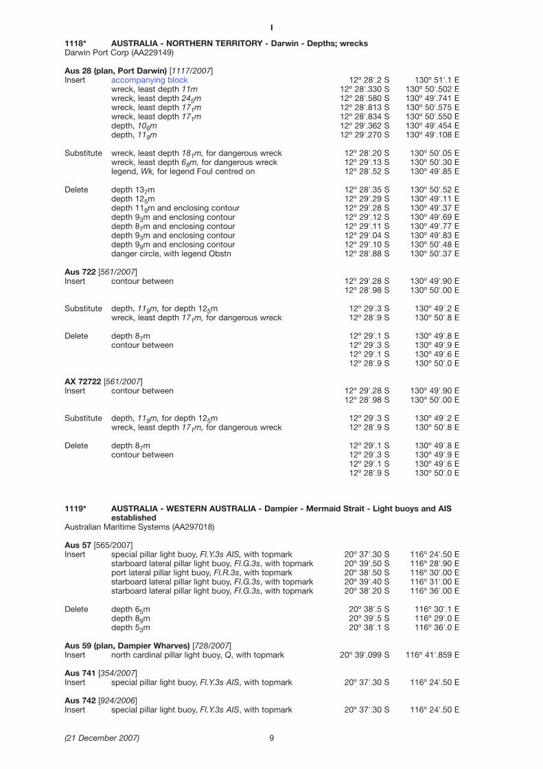
1118* AUSTRALIA - NORTHERN TERRITORY - Darwin - Depths; wrecksDarwin Port Corp (AA229149)
Aus 28 (plan, Port Darwin) [1117/2007]Insert accompanying block 12º 28′.2 S 130º 51′.1 E
wreck, least depth 11m 12º 28′.330 S 130º 50′.502 Ewreck, least depth 245m 12º 28′.580 S 130º 49′.741 Ewreck, least depth 171m 12º 28′.813 S 130º 50′.575 Ewreck, least depth 171m 12º 28′.834 S 130º 50′.550 Edepth, 106m 12º 29′.362 S 130º 49′.454 Edepth, 119m 12º 29′.270 S 130º 49′.108 E
Substitute wreck, least depth 181m, for dangerous wreck 12º 28′.20 S 130º 50′.05 Ewreck, least depth 68m, for dangerous wreck 12º 29′.13 S 130º 50′.30 Elegend, Wk, for legend Foul centred on 12º 28′.52 S 130º 49′.85 E
Delete depth 137m 12º 28′.35 S 130º 50′.52 Edepth 125m 12º 29′.29 S 130º 49′.11 Edepth 119m and enclosing contour 12º 29′.28 S 130º 49′.37 Edepth 93m and enclosing contour 12º 29′.12 S 130º 49′.69 Edepth 87m and enclosing contour 12º 29′.11 S 130º 49′.77 Edepth 93m and enclosing contour 12º 29′.04 S 130º 49′.83 Edepth 99m and enclosing contour 12º 29′.10 S 130º 50′.48 Edanger circle, with legend Obstn 12º 28′.88 S 130º 50′.37 E
Aus 722 [561/2007]Insert contour between 12º 29′.28 S 130º 49′.90 E
12º 28′.98 S 130º 50′.00 E
Substitute depth, 119m, for depth 125m 12º 29′.3 S 130º 49′.2 Ewreck, least depth 171m, for dangerous wreck 12º 28′.9 S 130º 50′.8 E
Delete depth 87m 12º 29′.1 S 130º 49′.8 Econtour between 12º 29′.3 S 130º 49′.9 E
12º 29′.1 S 130º 49′.6 E12º 28′.9 S 130º 50′.0 E
AX 72722 [561/2007]Insert contour between 12º 29′.28 S 130º 49′.90 E
12º 28′.98 S 130º 50′.00 E
Substitute depth, 119m, for depth 125m 12º 29′.3 S 130º 49′.2 Ewreck, least depth 171m, for dangerous wreck 12º 28′.9 S 130º 50′.8 E
Delete depth 87m 12º 29′.1 S 130º 49′.8 Econtour between 12º 29′.3 S 130º 49′.9 E
12º 29′.1 S 130º 49′.6 E12º 28′.9 S 130º 50′.0 E
1119* AUSTRALIA - WESTERN AUSTRALIA - Dampier - Mermaid Strait - Light buoys and AISestablished
Australian Maritime Systems (AA297018)
Aus 57 [565/2007]Insert special pillar light buoy, Fl.Y.3s AIS, with topmark 20º 37′.30 S 116º 24′.50 E
starboard lateral pillar light buoy, Fl.G.3s, with topmark 20º 39′.50 S 116º 28′.90 Eport lateral pillar light buoy, Fl.R.3s, with topmark 20º 38′.50 S 116º 30′.00 Estarboard lateral pillar light buoy, Fl.G.3s, with topmark 20º 39′.40 S 116º 31′.00 Estarboard lateral pillar light buoy, Fl.G.3s, with topmark 20º 38′.20 S 116º 36′.00 E
Delete depth 65m 20º 38′.5 S 116º 30′.1 Edepth 89m 20º 39′.5 S 116º 29′.0 Edepth 53m 20º 38′.1 S 116º 36′.0 E
Aus 59 (plan, Dampier Wharves) [728/2007]Insert north cardinal pillar light buoy, Q, with topmark 20º 39′.099 S 116º 41′.859 E
Aus 741 [354/2007]Insert special pillar light buoy, Fl.Y.3s AIS, with topmark 20º 37′.30 S 116º 24′.50 E
Aus 742 [924/2006]Insert special pillar light buoy, Fl.Y.3s AIS, with topmark 20º 37′.30 S 116º 24′.50 E

1120* AUSTRALIA - SOUTH AUSTRALIA - Whyalla to Port Pirie - ZOC diagramAHO (AA296260)
Aus 136 [874/2007]Delete island, centred on 32º 54′.3 S 138º 00′.7 E
island, centred on 32º 54′.1 S 138º 01′.2 Eisland, centred on 32º 53′.9 S 138º 01′.0 E
1121* AUSTRALIA - SOUTH AUSTRALIA - Holdfast Bay - DepthSA Government (AA296668)
Aus 125 (plan, Glenelg) [353/2006]Substitute depth, 26m, for depth 29m 34º 58′.58 S 138º 30′.53 E
1122* AUSTRALIA - TASMANIA - Hobart - Overhead cableTasports (AA299567)
Aus 172 [224/2007]Amend overhead clearance height to 42.2m 42º 49′.98 S 147º 19′.54 E
1123* AUSTRALIA - TASMANIA - Tamar River - Launceston - Overhead cableTasports (AA299567)
Aus 168 (plan, Launceston Wharves) [924/2007]Amend overhead clearance height to 26.7m 41º 25′.32 S 147º 07′.04 E
1124* AUSTRALIA - VICTORIA - Port Phillip - Corio Bay - NavaidsAustralian Hydrographic Service (AA299928)
Aus 157 [1024/2007]Insert accompanying block 38º 07′.5 S 144º 26′.0 E
1125* AUSTRALIA - VICTORIA - Port Phillip - Webb Dock - Light beacon establishedVictorian Notice 150/2007 (AA299419)
Aus 154 [1068/2007]Insert port lateral light beacon, Iso.R.3s No88 , with topmark 37º 50′.477 S 144º 54′.235 E
Delete beacon 37º 50′.49 S 144º 54′.24 E
I
(21 December 2007) 10
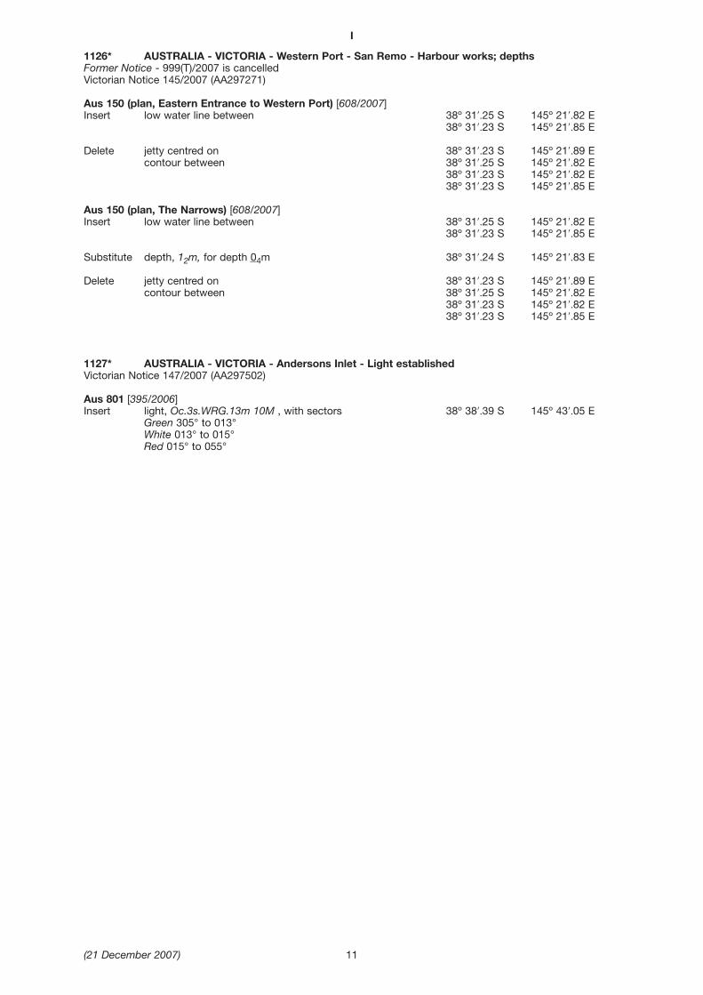
1126* AUSTRALIA - VICTORIA - Western Port - San Remo - Harbour works; depthsFormer Notice - 999(T)/2007 is cancelledVictorian Notice 145/2007 (AA297271)
Aus 150 (plan, Eastern Entrance to Western Port) [608/2007]Insert low water line between 38º 31′.25 S 145º 21′.82 E
38º 31′.23 S 145º 21′.85 E
Delete jetty centred on 38º 31′.23 S 145º 21′.89 Econtour between 38º 31′.25 S 145º 21′.82 E
38º 31′.23 S 145º 21′.82 E38º 31′.23 S 145º 21′.85 E
Aus 150 (plan, The Narrows) [608/2007]Insert low water line between 38º 31′.25 S 145º 21′.82 E
38º 31′.23 S 145º 21′.85 E
Substitute depth, 12m, for depth 04m 38º 31′.24 S 145º 21′.83 E
Delete jetty centred on 38º 31′.23 S 145º 21′.89 Econtour between 38º 31′.25 S 145º 21′.82 E
38º 31′.23 S 145º 21′.82 E38º 31′.23 S 145º 21′.85 E
1127* AUSTRALIA - VICTORIA - Andersons Inlet - Light establishedVictorian Notice 147/2007 (AA297502)
Aus 801 [395/2006]Insert light, Oc.3s.WRG.13m 10M , with sectors 38º 38′.39 S 145º 43′.05 E
Green 305° to 013° White 013° to 015° Red 015° to 055°
I
(21 December 2007) 11
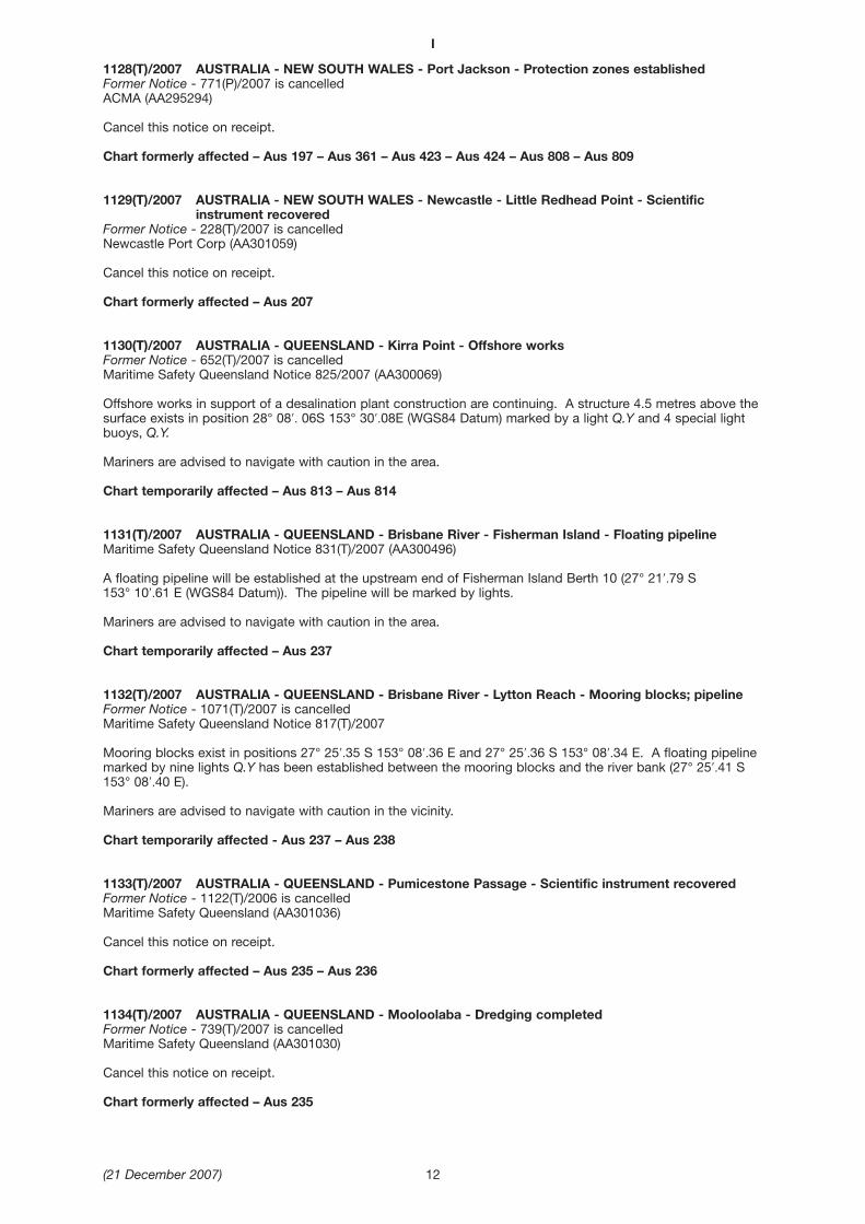
1128(T)/2007 AUSTRALIA - NEW SOUTH WALES - Port Jackson - Protection zones establishedFormer Notice - 771(P)/2007 is cancelledACMA (AA295294)
Cancel this notice on receipt.
Chart formerly affected – Aus 197 – Aus 361 – Aus 423 – Aus 424 – Aus 808 – Aus 809
1129(T)/2007 AUSTRALIA - NEW SOUTH WALES - Newcastle - Little Redhead Point - Scientificinstrument recovered
Former Notice - 228(T)/2007 is cancelledNewcastle Port Corp (AA301059)
Cancel this notice on receipt.
Chart formerly affected – Aus 207
1130(T)/2007 AUSTRALIA - QUEENSLAND - Kirra Point - Offshore worksFormer Notice - 652(T)/2007 is cancelledMaritime Safety Queensland Notice 825/2007 (AA300069)
Offshore works in support of a desalination plant construction are continuing. A structure 4.5 metres above thesurface exists in position 28° 08′. 06S 153° 30′.08E (WGS84 Datum) marked by a light Q.Y and 4 special lightbuoys, Q.Y.
Mariners are advised to navigate with caution in the area.
Chart temporarily affected – Aus 813 – Aus 814
1131(T)/2007 AUSTRALIA - QUEENSLAND - Brisbane River - Fisherman Island - Floating pipelineMaritime Safety Queensland Notice 831(T)/2007 (AA300496)
A floating pipeline will be established at the upstream end of Fisherman Island Berth 10 (27° 21′.79 S 153° 10′.61 E (WGS84 Datum)). The pipeline will be marked by lights.
Mariners are advised to navigate with caution in the area.
Chart temporarily affected – Aus 237
1132(T)/2007 AUSTRALIA - QUEENSLAND - Brisbane River - Lytton Reach - Mooring blocks; pipelineFormer Notice - 1071(T)/2007 is cancelledMaritime Safety Queensland Notice 817(T)/2007
Mooring blocks exist in positions 27° 25′.35 S 153° 08′.36 E and 27° 25′.36 S 153° 08′.34 E. A floating pipelinemarked by nine lights Q.Y has been established between the mooring blocks and the river bank (27° 25′.41 S153° 08′.40 E).
Mariners are advised to navigate with caution in the vicinity.
Chart temporarily affected - Aus 237 – Aus 238
1133(T)/2007 AUSTRALIA - QUEENSLAND - Pumicestone Passage - Scientific instrument recoveredFormer Notice - 1122(T)/2006 is cancelledMaritime Safety Queensland (AA301036)
Cancel this notice on receipt.
Chart formerly affected – Aus 235 – Aus 236
1134(T)/2007 AUSTRALIA - QUEENSLAND - Mooloolaba - Dredging completedFormer Notice - 739(T)/2007 is cancelledMaritime Safety Queensland (AA301030)
Cancel this notice on receipt.
Chart formerly affected – Aus 235
I
(21 December 2007) 12

1135(T)/2007 AUSTRALIA - QUEENSLAND - Lisa Jane Shoals - Scientific instrumentFormer Notice - 109(T)/2007 is cancelledMaritime Safety Queensland Notice 828(T)/2007 (AA300498)
A special light buoy, Fl(5)Y.20s, exists in position:Position (WGS 84 datum) Depth 23° 18′.46 S 151° 04′.37 E 18m
Mariners are not to use this buoy as a mooring.
Chart temporarily affected – Aus 247
1136(T)/2007 AUSTRALIA - QUEENSLAND - Hay Point to Bailey Islet - Scientific InstrumentsFormer Notice - 1078(T)/2007 is cancelledMaritime Safety Queensland Notice 828(T)/2007 (AA300498)
Special light buoys, Fl(5)Y.20s, exist in positions:Position Depth 21° 16′.42 S 149° 18′.63 E 10m21° 02′.39 S 149° 32′.80 E 10m
Mariners are not to use these buoys as moorings.
Chart temporarily affected – Aus 249 – Aus 250 – Aus 251
1137(T)/2007 AUSTRALIA - QUEENSLAND - Cairns - Depth informationFormer Notice - 467(T)/2006 is cancelledMaritime Safety Queensland Notice 821(T)/2007 (AA300057)
Available depths as at 19 November 2007:Metres Remarks
* Entrance Channel 8.4Crystal Swing Basin at:
360 metre diameter 6.8380 metre diameter 6.4
Swing Basin at:310 metre diameter 8.4320 metre diameter 7.8Marlin Marina 3.3
Berths:No 1 8.4No 2 8.5No 3 8.4No 4 8.4No 5 8.2No 6 8.1 between 500 metres and 550 metresNo 6 7.7 between 550 metres and 600 metresNo 7 9.9No 8 10.0No 10 9.3No 12 10.5Smiths Creek 1 4.9
* Indicates revised entry.
Chart temporarily affected – Aus 262 – Aus 263 – Aus 264 – Aus 830 – AX 63262
1138(P)/2007 AUSTRALIA - QUEENSLAND - LADS Passage - Light buoysDate - On or about 17 January 2008Australian Maritime Safety Authority (AA300075)
Light buoys will be altered in position as follows
Current position New position Rename 13° 17′. 05S 143° 51′. 16E 13° 19′. 01S 143° 52′. 25E Wideawake SE13° 19′. 00S 143° 52′. 25E 13° 17′. 05S 143° 51′. 16E Wideawake NE13° 17′. 49S 143° 50′. 65E 13° 19′. 65S 143° 51′. 22E Wideawake SW
Chart which will be affected - Aus 281 – Aus 834
I
(21 December 2007) 13

1139(P)/2007 AUSTRALIA - QUEENSLAND - Horn Island - OutfallDate - On or about 8 December 2008Maritime Safety Queensland Notice 820(T)/2007 (AA300058)
Construction of a sewerage outfall will be undertaken off the southwestern end of Horn Island. Constructionwill extend to 80 metres offshore into Boat Channel.
Mariners are advised to navigate with caution in the area.
Chart which will be affected – Aus 292 – Aus 376
1140(T)/2007 PAPUA NEW GUINEA - Isulailai Point - Light unlitPNG National Maritime Safety Authority Notice 131/2007 (AA301031)
Isulailai Point light K3452 (10° 33′.64 S 150° 41′.73 E) is unlit
Chart temporarily affected – Aus 381 – Aus 625 – Aus 629 – Aus 567
1141(T)/2007 PAPUA NEW GUINEA - NEW IRELAND - Vutte Island - Light unlitPNG National Maritime Safety Authority Notice 131/2007 (AA 301031)
Vutte Island light K3510.8 (2° 39′.45 S 150° 37′.68 E) is unlit
Chart temporarily affected – Aus 666
1142(T)/2007 AUSTRALIA - WESTERN AUSTRALIA - Bonaparte Archipelago - Prince Frederick Harbour- Scientific instruments recovered
Former Notice - 838(T)/2007 is cancelledHMAS Paluma (AA284286)
Cancel this notice on receipt.
Chart formerly affected – Aus 320 – Aus 730
1143(T)/2007 AUSTRALIA - WESTERN AUSTRALIA - Cape Lambert - Scientific instrument recoveredFormer Notice - 742(T)/2007 is cancelledMETOcean (AA299361)
Cancel this notice on receipt.
Chart formerly affected – Aus 55 – Aus 56
1144(T)/2007 AUSTRALIA - SOUTH AUSTRALIA - Point Pearce - Light buoy re-establishedFormer Notice - 500(T)/2007 is cancelledDTEI SA (AA300126)
Cancel this notice on receipt.
Chart formerly affected – Aus 776 – Aus 777
1145(T)/2007 AUSTRALIA - SOUTH AUSTRALIA - Sultana Point - Beacon re-establishedFormer Notice - 625(T)/2007 is cancelledDTEI SA (AA300126)
Cancel this notice on receipt.
Chart formerly affected – Aus 139 – Aus 780
1146(T)/2007 AUSTRALIA - SOUTH AUSTRALIA - Semaphore Anchorage - North Haven Marina -Shoaling removed
Former Notice - 70(T)/2007 is cancelledDTEI SA (AA300126)
Cancel this notice on receipt.
Chart formerly affected – Aus 137
I
(21 December 2007) 14
1147(T)/2007 AUSTRALIA - VICTORIA - Port Phillip - St Kilda - Harbour worksDate - Until 31 December 2007Victorian Notice 149(T)/2007 (AA300053)
Works are in progress to repair the slipway at Royal Melbourne Yacht Squadron (37° 51′. 84S 144° 58′. 20(WGS84 Datum )).
Hazards to navigation will be marked by special lights.
Mariners are advised to navigate with caution in the area.
Chart temporarily affected – Aus 143 – Aus 155
1148(T)/2007 AUSTRALIA - VICTORIA - Bass Strait - Drill rigAMSA (AA301080)
From 27 February to 12 March 2008 drill rig West Triton will be undertaking drilling operations in position 38° 42′.83 S 148° 18′.12 E (WGS84 datum), within the Separation Zone of the Traffic Separation Scheme closesouth of the Area To Be Avoided as shown on chart Aus 357A. The drill rig will be fitted with both Racon andAIS navigational aids.
Vessels must remain within the East or West bound lanes.
Chart temporarily affected – Aus 357A – Aus 422 – Aus 487
I
(21 December 2007) 15

AMENDMENTS TO ADMIRALTY LIST OF LIGHT AND FOG SIGNALS VOLUME K 2007/08 Edition No 25 dated 21 December 2007
Last Amendment: Edition No 24 dated 7 December 2007
K0922·2 Remove from list. Replaced by light buoy
K1243·2 - Oil Terminal. Asoka 6 50·64 S Lit . . . . Storage tanker Reported Sunk 2007Nosantara. FSU 112 56·88 E(I)
*
K4784·64 Remove from list
K4784·642 Remove from list
K4799·13 - Rade du Nord. Lts in line 22 20·49 S Iso W 4s . . . . ▲▲ on white beacon Private019·7°. Front 166 53·04 E(F)
* * * * * * * *
K4799·131 - Rade du Nord. Lts in line 22 20·37 S Iso W 4s . . . . ▼▼ on white beacon Private019·7°. Rear. 240m from front 166 53·09 E(F)
* * * * * * * *
K4970·5 - PORT D’UTUROA. Pointe 16 44·28 S Iso R 3s 5 4 Red ■■ on red beacon TE 2007Tonoi. SSE 151 26·05 W 6(F)
* *
K4971·33 - Pointe Ofaiputuputu. N 16 43·18 S Oc(2)Y 6s 3 5 Yellow ✕ on yellow Missing (T) 2007(F) 151 26·97 W beacon
9
* *
K4977·6 - Récif Moora. WNW 16 34·18 S Iso G 4s 4 3 Green ▲▲ on green TE 2007(F) 151 28·70 W beacon
6
* *
II
(21 December 2007) 16
NAVIGATION WARNINGS
The following radio messages have been received during the period to 7 December 2007. Signal copies of thesemessages may be destroyed. It is recommended that the reprint of Navigational Warnings should be kept in a file or abook divided into areas. Cancellation should be made on receipt of signals and reprints.
Rigs on location other than those listed in the latest Section III summary are the subject of Radio Navigational Warnings.Rigs in transit will not be the subject of Warnings.
AUSCOAST WARNING
321 Drill rig Jack Bates in position 19º 40′.47 S 114º 55′.29 E. 2.5M clearance requested.322 Cancelled.323 Cancelled.324 Special purpose vessel Mezen conducting seismic survey towing 4M cable in area 8º 24′.0 S to 9º 50′.0 S and
127º 40′.0 E to 129º 36′.0 E. 5M clearance requested.325 Special purpose vessel Mermaid Investigator conducting underwater operations in area 20º 14′.7 S to
20º 20′.1 S and 116º 10′.0 E to 116º 25′.0 E. Unlit buoys marking subsea equipment at various locationsalong north and south boundaries.
326 Cancelled.327 Cancelled.328 Special purpose vessel Pacific Explorer conducting seismic survey towing 6x4M cables in area 39º 21′.0 S to
39º 46′.0 S and 145º 22′.0 E to 146º 49′.0 E. 5M clearance requested.329 Drill rig Ocean Bounty in position 19º 31′.30 S 116º 35′.20 E. 2.5M clearance requested.330 Drill rig Sedco 703 in position 12º 57′.32 S 124º 26′.50 E. 2.5M clearance requested.331 Special purpose vessel Markab conducting underwater operations in position 38º 22′.0 S 141º 04′.0 E. 2.5M
clearance requested.
NAVAREA X WARNINGS
016 Special purpose vessel Ile de Re conducting underwater operations in area 26º 13′.1 S to 26º 50′.3 S and161º 55′.1 E to 163º 04′.5 E. 2M clearance requested.
Navigational warnings in force as at 070001UTC DEC 07.Auscoast235 280 281 282 311 316 317 320 321 324 325 328 329 330 331.
Navarea X
008 016.
Summary of mobile drilling rigs as at 070001UTC DEC 07.
Name PositionWest Atlas 10º 25′.20 S 128º 56′.30 ESonga Venus 12º 15′.30 S 124º 31′.20 EWilcraft 12º 21′.22 S 124º 17′.22 ESedco 703 12º 57′.32 S 124º 26′.50 EOcean Epoch 13º 47′.02 S 123º 24′.37 EAtwood Eagle 20º 32′.00 S 116º 40′.00 EOcean Bounty 19º 31′.30 S 116º 35′.20 EJack Bates 19º 40′.47 S 114º 55′.29 EEnsco 106 20º 33′.43 S 115º 02′.31 EStena Clyde 20º 07′.00 S 115º 01′.40 ESonga Venus 20º 58′.40 S 114º 52′.28 ENan Hai VI 21º 26′.40 S 114º 02′.80 EAtwood Eagle 21º 28′.50 S 113º 49′.50 E
NAVAREA XIV WARNINGS
Nil received.
Navarea XIV warnings in force as at 070001UTC DEC 07.010 026.
III
(21 December 2007) 17
IV
(21 December 2007) 18
Locality Report Ship/Authority Observer
HYDROGRAPHIC REPORTS
WA-Cape Preston
VIC-Bass Strait
SA-Port Adelaide
Printing error
Magnetic variation
Lights
G Wallace
G Rowe
P Hanson
AMENDMENTS TO ADMIRALTY LIST OF RADIO SIGNALS 2007
Edition No 25 dated 21 December 2007
VOLUME 1, PART 2, NP 281(2), 2007/08Published BA Wk 28/07
(Last Amendments: Edition No 23 dated 23 November 2007)
MARTIME RADIO STATIONS
Page 40, ARGENTINA, GENERAL NOTES.Delete and replace by:
Prefectura Naval Argentina Ad48/07
Page 41, ARGENTINA, BAHÍA BLANCA (L2N) (PREFECTURA NAVAL).Delete entry.
Prefectura Naval Argentina Ad48/07
V
(21 December 2007) 19
GENERAL NOTESPREFECTURA NAVAL ARGENTINA -- COAST RADIO STATIONS1. The Prefectura Naval Argentina (PNA) Coast Radio Stations operate the Servicio de Comunicaciones para la Seguridad de la Navegación (SECOSENA) or
Safety of Navigation Communication Service and maintain a continuous watch on international distress frequencies.2. Whenever possible vessels should maintain a permanent watch on VHF Ch 16 when within range of a SECOSENA station. If watch cannot be kept on VHF Ch 16, then
Ch 12 or 14 should be used after giving notice to the nearest SECOSENA station.3. Furthermore, this system is complemented by its sub--system CONTRASE (Control de Tráfico y Seguridad) or Safety and Traffic Control.4. The informationservicesofferedby theabovementionedcommunication systemsare freeof chargeandaremaintainedona24hourbasis.Reportingbyall ships,national
and foreign flag, is obligatory whilst sailing in national waters, although an exception is made regarding SECOSENA messages for vessels navigating the Paraná orParaguay Rivers, in these cases; messages are considered optional.
Further information on Ship Reporting can be found in ALRS Volume 6.
(Continued on next page)
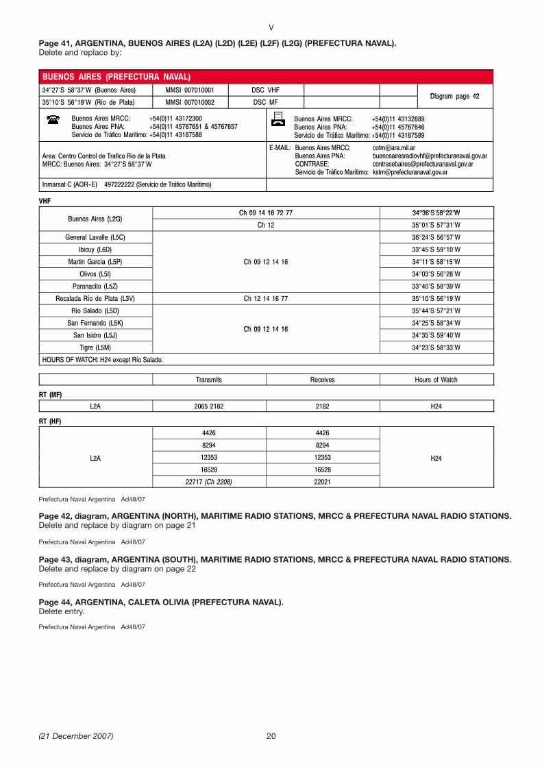
Page 41, ARGENTINA, BUENOS AIRES (L2A) (L2D) (L2E) (L2F) (L2G) (PREFECTURA NAVAL).Delete and replace by:
Prefectura Naval Argentina Ad48/07
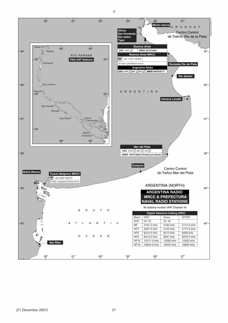
Page 42, diagram, ARGENTINA (NORTH), MARITIME RADIO STATIONS, MRCC & PREFECTURA NAVAL RADIO STATIONS.Delete and replace by diagram on page 21
Prefectura Naval Argentina Ad48/07
Page 43, diagram, ARGENTINA (SOUTH), MARITIME RADIO STATIONS, MRCC & PREFECTURA NAVAL RADIO STATIONS.Delete and replace by diagram on page 22
Prefectura Naval Argentina Ad48/07
Page 44, ARGENTINA, CALETA OLIVIA (PREFECTURA NAVAL).Delete entry.
Prefectura Naval Argentina Ad48/07
V
(21 December 2007) 20
BUENOS AIRES (PREFECTURA NAVAL)34 27 S 58 37 W (Buenos Aires) MMSI 007010001 DSC VHF
Diagram page 4235 10 S 56 19 W (Río de Plata) MMSI 007010002 DSC MF
Diagram page 42
Buenos Aires MRCC: +54(0)11 43172300Buenos Aires PNA: +54(0)11 45767651 & 45767657Servicio de Tráfico Marítimo: +54(0)11 43187588
Buenos Aires MRCC: +54(0)11 43132889Buenos Aires PNA: +54(0)11 45767646Servicio de Tráfico Marítimo: +54(0)11 43187589
Area: Centro Control de Trafico Rio de la PlataMRCC: Buenos Aires: 34 27 S 58 37 W
E-MAIL: Buenos Aires MRCC: [email protected] Aires PNA: [email protected]: [email protected] de Tráfico Marítimo: [email protected]
Inmarsat C (AOR--E) 497222222 (Servicio de Tráfico Marítimo)
VHF
Ch 09 14 16 72 77 34 36 S 58 22 WBuenos Aires (L2G)
Ch 09 14 16 72 77 34 36 S 58 22 WBuenos Aires (L2G)
Ch 12 35 01 S 57 31 W
General Lavalle (L5C) 36 24 S 56 57 W
Ibicuy (L6D) 33 45 S 59 10 W
Martin García (L5P) Ch 09 12 14 16 34 11 S 58 15 W
Olivos (L5I) 34 03 S 56 28 W
Paranacito (L5Z) 33 40 S 58 39 W
Recalada Río de Plata (L3V) Ch 12 14 16 77 35 10 S 56 19 W
Río Salado (L5D) 35 44 S 57 21 W
San Fernando (L5K)Ch 09 12 14 16
34 25 S 58 34 W
San Isidro (L5J)Ch 09 12 14 16
34 35 S 59 40 W
Tigre (L5M) 34 23 S 58 33 W
HOURS OF WATCH: H24 except Río Salado.
Transmits Receives Hours of Watch
RT (MF)
L2A 2065 2182 2182 H24
RT (HF)
4426 4426
8294 8294
L2A 12353 12353 H24L2A
16528 16528
H24
22717 (Ch 2208) 22021
V
(21 December 2007)
Santa Fé
Paraná
Diamante
Rosario
IbicuyParanacito
Ramallo
ZárateCampana
San Lorenzo
San Nicolás
San Pedro
R Í O PA R A N Á
PNA VHF Stations
60° 59°
60° 59°
32°
33°
34°
32°
33°
34°
ARGENTINA (NORTH)
ARGENTINA RADIO MRCC & PREFECTURA
NAVAL RADIO STATIONS
Buenos Aires MRCC
+54 1143 172300
E-mail: [email protected]
+54 2932 489737
E-mail: [email protected]
Mar del Plata
MMSI 007010003 (Prefectura Naval)
General Lavalle
Quequen
San Blas
Bahía Blanca
Martin García
OlivosSan FernandoSan IsidroTigre
Recalada Rio de Plata
Rio Salado
DSC VHF MF HF
Argentina RadioMMSI 007010111VHF MF HF DSC
Buenos AiresMMSI 007010001DSC VHF
S O U T H
A T L A N T I C
O C E A N
A R G E N T I N A
U R U G U A Y
All stations monitor VHF Channel 16
Digital Selective Calling (DSC)
Band DSC Voice SITOR
VHF Ch 70 Ch 16
MF 2187·5 kHz 2182 kHz 2174·5 kHz
HF4 4207·5 kHz 4125 kHz 4177·5 kHz
HF6 6312·0 kHz 6215 kHz 6268 kHz
HF8 8414·5 kHz 8291 kHz 8376·5 kHz
HF12 12577·0 kHz 12290 kHz 12520 kHz
HF16 16804·5 kHz 16420 kHz 16695 kHz
Puerto Belgrano MRCC
Centro Controlde Trafico Rio de la Plata
Centro Controlde Trafico Mar del Plata
40°
62° 61° 60° 59° 58° 57°
62° 61° 60° 59° 58° 57°
39°
38°
37°
36°
35°
40°
39°
38°
37°
36°
35°
V1(2)BU
ENO
SAIR
ES
21

V
(21 December 2007) 22
ARGENTINA (SOUTH)
MRCC & PREFECTURANAVAL RADIO STATIONS
Ushuaia (Prefectura Naval) MRCC Ushuaia
+54 2901 431098
E-mail: [email protected] [email protected] [email protected]
Puerto Deseado
San Julian
Rio Grande
Comodoro Rivadavia
DSC VHF MF HF MMSI 007010008
S O U T H
A T L A N T I C
O C E A N
A R G E N T I N A
Isla Grande de
Tierra Del Fuego
All stations monitor VHF Channel 16
Rio Gallegos
DSC VHF MF HF MMSI 007010010
DSC VHF MF MMSI 007010011
C a n a l B e a g l e
Estrecho de Magal lanes
Caleta Olivia
Caleta Córdoba
Santa Cruz
Punta Quilla
Cabo Virgenes
Digital Selective Calling (DSC)
Band DSC Voice SITOR
VHF Ch 70 Ch 16
MF 2187·5 kHz 2182 kHz 2174·5 kHz
HF4 4207·5 kHz 4125 kHz 4177·5 kHz
HF6 6312·0 kHz 6215 kHz 6268 kHz
HF8 8414·5 kHz 8291 kHz 8376·5 kHz
HF12 12577·0 kHz 12290 kHz 12520 kHz
HF16 16804·5 kHz 16420 kHz 16695 kHz
Centro Control de TraficoComodoro Rivadavia
Centro Control de Trafico Ushuaia
70° 71° 72°
71° 72°
46°
47°
48°
49°
50°
51°
52°
53°
54°
55°
46°
47°
48°
49°
50°
51°
52°
53°
54°
55°
69° 68° 67° 66° 65° 64° 63° 62°
70° 69° 68° 67° 66° 65° 64° 63° 62°
V1(2)USH
UA
IA

Page 44, ARGENTINA, COMODORO RIVADAVIA (L2V) (L2Y) (L2Z) (L3A) (L3B) (PREFECTURA NAVAL).Delete and replace by:
Prefectura Naval Argentina Ad48/07
Page 44, ARGENTINA, GENERAL LAVALLE (PREFECTURA NAVAL).Delete entry.
Prefectura Naval Argentina Ad48/07
Page 45, ARGENTINA, GENERAL PACHECO.Delete entry.
Alberto U Silva Ad48/07
V
(21 December 2007) 23
COMODORO RIVADAVIA (PREFECTURA NAVAL)45 51 S 67 25 W (Cmdr Rivadavia) MMSI 007010008
DSC VHF MF HF Diagram page 4351 37 S 69 03 W (Río Gallegos) MMSI 007010010
DSC VHF MF HF Diagram page 43
Puerto Belgrano MRCC: +54(0)2932 489737 & 487162Comodoro Rivadavia PNA: +54(0)297 4476800Puerto Deseado PNA: +54(0)297 4872136Río Gallegos PNA: +54(0)2966 435494 & 420375Río Grande PNA: +54(0)2964 422305San Julián PNA: +54(0)2962 452012
Puerto Belgrano MRCC: +54(0)2932 487163Comodoro Rivadavia PNA: +54(0)297 4473863Puerto Deseado PNA: +54(0)297 4872322Río Gallegos PNA: +54(0)2966 420103Río Grande PNA: +54(0)2964 424026San Julián PNA: +54(0)2962 452012
Area: Centro Control de Trafico Comodoro Rivadavia.MRCC: Puerto Belgrano: 38 55’S 62 03 W
E-MAIL: Puerto Belgrano MRCC: [email protected] Rivadavia PNA: [email protected]
VHF
Cabo Virgenes (L4I)Ch 09 12 14 16
52 12 S 68 22 W
Caleta Córdoba (L4P)Ch 09 12 14 16
45 44 S 67 25 W
Caleta Olivia (L4O) Ch 09 12 16 46 26 S 67 30 W
Comodoro Rivadavia (L3B) Ch 09 12 14 16 45 51 S 67 25 W
Puerto Deseado (L4N) Ch 09 12 14 16 77 47 46 S 56 54 W
Punta Quilla (L4K) 50 07 S 68 25 W
Río Gallegos (L3I)Ch 09 12 14 16
51 37 S 69 03 W
Río Grande (L4F)Ch 09 12 14 16
53 47 S 67 41 W
San Julián (L4M) 49 20 S 67 43 W
Santa Cruz (L4L) Ch 09 12 14 16 77 50 01 S 68 30 W
HOURS OF WATCH: H24 except Caleta Córdoba, Caleta Olivia and Punta Quilla.
Transmits Receives Hours of Watch
RT (MF)
L2V 2065 2182 2065 2182 H24
RT (HF)
4134 4134
L3A8710 8710
H24L3A13140 (Ch 1222) 12293
H24
16528 16528

Page 45, ARGENTINA, MAR DEL PLATA (L2O) (L2R) (L2T) (L2U) (PREFECTURA NAVAL).Delete and replace by:
Prefectura Naval Argentina Ad48/07
Page 46, ARGENTINA.Delete following entries:
PUERTO DESEADO (L4N) (PREFECTURA NAVAL).PUNTA COLORADA (PREFECTURA NAVAL).PUNTA QUILLA (PREFECTURA NAVAL).QUEQUEN (PREFECTURA NAVAL).RAWSON (PREFECTURA NAVAL).RECALADA RÍO DE PLATA (L3V) (PREFECTURA NAVAL).RÍO GALLEGOS (L3C) (L3I) (PREFECTURA NAVAL).
Prefectura Naval Argentina Ad48/07
Page 47, ARGENTINA.Delete following entries:
RÍO GRANDE (PREFECTURA NAVAL).SAN ANTONIO OESTE (PREFECTURA NAVAL).SAN BLAS (PREFECTURA NAVAL.SAN JULIÁN (PREFECTURA NAVAL).SANTA CRUZ (PREFECTURA NAVAL).
Prefectura Naval Argentina Ad48/07
V
(21 December 2007)
MAR DEL PLATA (PREFECTURA NAVAL)38 03 S 57 32 W (Mar del Plata) MMSI 007010003 DSC VHF MF HF
Diagram page 4240 33 S 62 14 W (San Blas) MMSI 007010006 DSC VHF MF
Diagram page 42
Puerto Belgrano MRCC: +54(0)2932 489737 & 487162Bahía Blanca PNA: +54(0)291 4571720 & 4573355Mar Del Plata PNA: +54(0)223 4800715 & 4803100Quequen PNA: +54(0)2262 451907
Puerto Belgrano MRCC: +54(0)2932 487163Bahía Blanca PNA: +54(0)291 4573355Mar Del Plata PNA: +54(0)223 4803006Quequen PNA: +54(0)2262 450514
Area: Centro Control de Trafico Mar del PlataMRCC: Puerto Belgrano: 38 55’S 62 03 W
E-MAIL: Puerto Belgrano MRCC: [email protected]ía Blanca PNA: [email protected] del Plata PNA: [email protected]
Inmarsat C (AOR--E) 497222227=ARAD X (Puerto Belgrano MRCC)
VHF
Bahía Blanca (L2N) Ch 09 12 14 16 77 38 55’S 62 04 W
Mar del Plata (L2U)Ch 09 12 14 16
38 03 S 57 32 W
Patagones (L4X)Ch 09 12 14 16
40 48 S 62 59 W
Puerto Madryn (L4S) Ch 09 12 14 16 77 42 46 S 65 02 W
Punta Colorada (L4T) 41 42 S 65 00 W
Quequen (L5B) 38 34 S 58 42 W
Rawson (L4R) Ch 09 12 14 16 43 20 S 65 03 W
San Antonio Oeste (L4W) 40 50 S 64 54 W
San Blas (L4Y) 40 33 S 62 14 W
HOURS OF WATCH: H24 except San Blas.
Transmits Receives Hours of Watch
RT (MF)
L2O 2065 2182 2065 2182 H24
RT (HF)
4354 4354
8713 8713
L2A 12353 12353 H24L2A
16528 16528
H24
22717 (Ch 2208) 22021
24
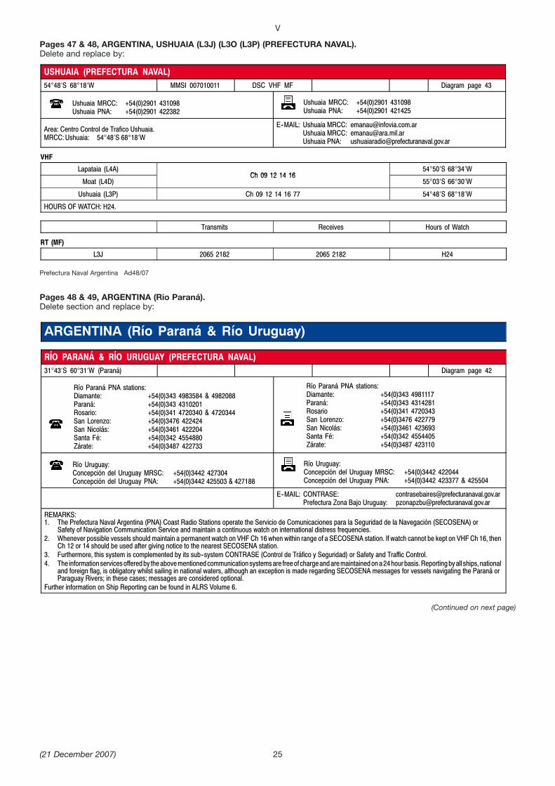
Pages 47 & 48, ARGENTINA, USHUAIA (L3J) (L3O (L3P) (PREFECTURA NAVAL).Delete and replace by:
Prefectura Naval Argentina Ad48/07
Pages 48 & 49, ARGENTINA (Rio Paraná).Delete section and replace by:
V
25
USHUAIA (PREFECTURA NAVAL)54 48 S 68 18 W MMSI 007010011 DSC VHF MF Diagram page 43
Ushuaia MRCC: +54(0)2901 431098Ushuaia PNA: +54(0)2901 422382
Ushuaia MRCC: +54(0)2901 431098Ushuaia PNA: +54(0)2901 421425
Area: Centro Control de Trafico Ushuaia.MRCC:Ushuaia: 54 48 S 68 18 W
E--MAIL: Ushuaia MRCC: [email protected] MRCC: [email protected] PNA: [email protected]
VHF
Lapataia (L4A)Ch 09 12 14 16
54 50 S 68 34 W
Moat (L4D)Ch 09 12 14 16
55 03 S 66 30 W
Ushuaia (L3P) Ch 09 12 14 16 77 54 48 S 68 18 W
HOURS OF WATCH: H24.
Transmits Receives Hours of Watch
RT (MF)
L3J 2065 2182 2065 2182 H24
ARGENTINA (Río Paraná & Río Uruguay)
RÍO PARANÁ & RÍO URUGUAY (PREFECTURA NAVAL)31 43 S 60 31 W (Paraná) Diagram page 42
Río Paraná PNA stations:Diamante: +54(0)343 4983584 & 4982088Paraná: +54(0)343 4310201Rosario: +54(0)341 4720340 & 4720344San Lorenzo: +54(0)3476 422424San Nicolás: +54(0)3461 422204Santa Fé: +54(0)342 4554880Zárate: +54(0)3487 422733
Río Paraná PNA stations:Diamante: +54(0)343 4981117Paraná: +54(0)343 4314281Rosario +54(0)341 4720343San Lorenzo: +54(0)3476 422779San Nicolás: +54(0)3461 423693Santa Fé: +54(0)342 4554405Zárate: +54(0)3487 423110
Río Uruguay:Concepción del Uruguay MRSC: +54(0)3442 427304Concepción del Uruguay PNA: +54(0)3442 425503 & 427188
Río Uruguay:Concepción del Uruguay MRSC: +54(0)3442 422044Concepción del Uruguay PNA: +54(0)3442 423377 & 425504
E--MAIL: CONTRASE: [email protected] Zona Bajo Uruguay: [email protected]
REMARKS:1. The Prefectura Naval Argentina (PNA) Coast Radio Stations operate the Servicio de Comunicaciones para la Seguridad de la Navegación (SECOSENA) or
Safety of Navigation Communication Service and maintain a continuous watch on international distress frequencies.2. Whenever possible vessels should maintain a permanent watch on VHF Ch 16 when within range of a SECOSENA station. If watch cannot be kept on VHF Ch 16, then
Ch 12 or 14 should be used after giving notice to the nearest SECOSENA station.3. Furthermore, this system is complemented by its sub--system CONTRASE (Control de Tráfico y Seguridad) or Safety and Traffic Control.4. The informationservicesofferedby theabovementionedcommunication systemsare freeof chargeandaremaintainedona24hourbasis.Reportingbyall ships,national
and foreign flag, is obligatory whilst sailing in national waters, although an exception is made regarding SECOSENA messages for vessels navigating the Paraná orParaguay Rivers; in these cases; messages are considered optional.
Further information on Ship Reporting can be found in ALRS Volume 6.
(21 December 2007)
(Continued on next page)
Prefectura Naval Argentina Ad48/07
VOLUME 2, NP 282, 2007/08Published BA Wk 13/07
(Last Amendments: Edition No 24 dated 7 December 2007)
RADAR BEACONS
LEGAL TIME
Page 218, Lord Howe I.Delete entry and replace by:
OAG Worldwide Ltd Ad48/07
UNIVERSAL TIME
Page 226, LEAP SECONDS, IMPLEMENTATION DATES, TABLE 2.Insert:
International Earth Rotation Service (ERS) Bulletin D 98 Ad49/07
V
(21 December 2007)
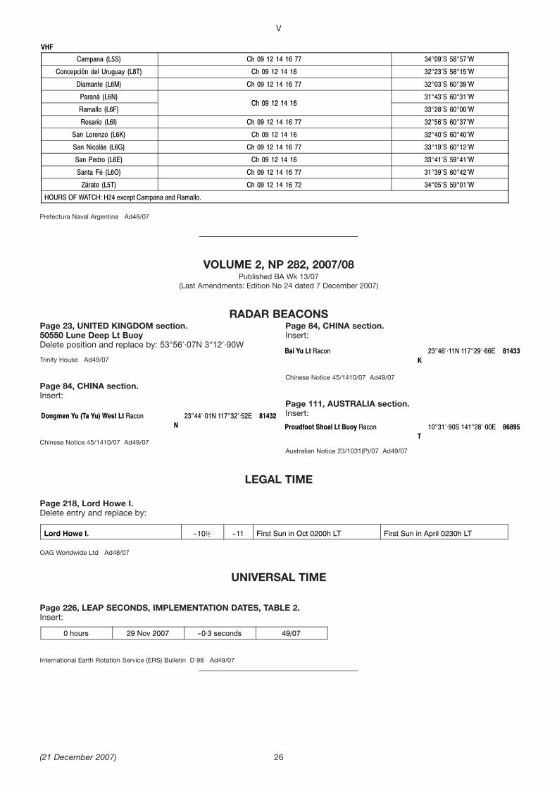
Dongmen Yu (Ta Yu) West Lt Racon 23 44 01N 117 32 52E 81432N
Bai Yu Lt Racon 23 46 11N 117 29 66E 81433K
Proudfoot Shoal Lt Buoy Racon 10 31 90S 141 28 00E 86895T
0 hours 29 Nov 2007 --0 3 seconds 49/07
26
VHF
Campana (L5S) Ch 09 12 14 16 77 34 09 S 58 57 W
Concepción del Uruguay (L8T) Ch 09 12 14 16 32 23 S 58 15 W
Diamante (L6M) Ch 09 12 14 16 77 32 03 S 60 39 W
Paraná (L6N)Ch 09 12 14 16
31 43 S 60 31 W
Ramallo (L6F)Ch 09 12 14 16
33 28 S 60 00 W
Rosario (L6I) Ch 09 12 14 16 77 32 56 S 60 37 W
San Lorenzo (L6K) Ch 09 12 14 16 32 40 S 60 40 W
San Nicolás (L6G) Ch 09 12 14 16 77 33 19 S 60 12 W
San Pedro (L6E) Ch 09 12 14 16 33 41 S 59 41 W
Santa Fé (L6O) Ch 09 12 14 16 77 31 39 S 60 42 W
Zárate (L5T) Ch 09 12 14 16 72 34 05 S 59 01 W
HOURS OF WATCH: H24 except Campana and Ramallo.
Page 23, UNITED KINGDOM section.50550 Lune Deep Lt BuoyDelete position and replace by: 53°56′·07N 3°12′·90W
Trinity House Ad49/07
Page 84, CHINA section.Insert:
Chinese Notice 45/1410/07 Ad49/07
Page 84, CHINA section.Insert:
Chinese Notice 45/1410/07 Ad49/07
Page 111, AUSTRALIA section.Insert:
Australian Notice 23/1031(P)/07 Ad49/07
Lord Howe I. --102 --11 First Sun in Oct 0200h LT First Sun in April 0230h LT

VOLUME 5, NP 285, 2007/08Published BA Wk 25/07
(Last Amendments: Edition No 23 dated 23 November 2007)
CHAPTER 16 DISTRESS, SEARCH AND RESCUE
Page 323, BRAZIL, contacts table, RCC East (Salvador)Delete and replace by:
MRCC Brazil Ad48/07
Page 325, CANADA, S.Lawrence RiverDelete entry and replace by:
MRSC Quebec Ad49/07
Pages 360 and 361, RUSSIADelete entry and replace by:
V
(21 December 2007)
RCC EAST (Salvador) 71 3320373071 33203711
71 3320372671 33203772
E--mail [email protected]
(Continued on next page)
27
RUSSIA See diagrams R2, R6, R15, R16 & R18
National SAR Agency: Ministry of Transport of the Russian FederationAddress: 1/1 U1,Rozhdestvenka Street Moscow, 109112, RussiaTel: +7 495 6261000Fax: +7 495 6269038 & 6269128E--mail: [email protected]
MRCC Moskow is responsible for co-ordinating Search and Rescue operations and liaising with Search and Rescue services ofneighbouring countries in accordance with intergovernmental agreements. A network of Coast Radio Stations maintains a continuouslistening watch on international distress frequencies.Northern SeasThe following frequencies are reserved for Distress Calls and are not to be used for general communication: 6211 kHz, 4138 kHz & 500kHz.In all areas except Beloye More and Barents Sea a three minute watch will be maintained on 500 kHz from 15 min past each hour andon 6211 kHz and 4138 kHz from 45 min past each hour.
State MRCC
Telephone +7 Fax +7 Others
SMRCC MOSKOW 495 6261052 495 6237476 Telex +64 411197 SMT RUE--mail [email protected] [email protected]
Arctic Coast
Telephone +7 Fax +7 Others
MRSC ARCHANGEL’SK 8182 6371008182 208921
8182 637460 Inmarsat C (IOR) 492509110E--mail [email protected]
MRCC MURMANSK 8152 428307 8152 423256 Telex +64 126178 MAPM RUInmarsat mini--M (AOR--E) 762137155 (Tel)Inmarsat mini--M (AOR--E) 762137157 (Fax)E--mail [email protected]
Baltic Coast
Telephone +7 Fax +7 Others
MRCC KALININGRAD 4012 6431994012 538470
4012 6431994012 538470
Telex +64 262193 MRCC RUInmarsat mini--M
(AOR--E or IOR) 762830387 (Tel)(AOR--E or IOR) 762830389 (Fax)(AOR--E or IOR) 762830390 (Data)
E--mail [email protected]
MRCC SAINT PETERSBURG 812 7188995812 3274147
812 3274146 Inmarsat C (AOR--E) 492509012Inmarsat mini--M (AOR--E) 761319893E--mail [email protected]
Telephone +1 Fax +1 Others
MRSC QUÉBEC 418 6483599 418 6483614 E-mail [email protected]

MRSC Kaliningrad Ad49/07
Page 372, UNITED ARAB EMIRATESDelete entry and replace by:
Dubai Police and Cospas-Sarsat A001 Ad49/07
V
(21 December 2007)
Caspian Sea Coast
Telephone +7 Fax +7 Others
MRCC ASTRAKHAN 8512 584808 8512 585981 Telex +64 254173 POMOR RUInmarsat C (AOR--E) 427310985E--mail [email protected]
Pacific Coast
Telephone +7 Fax +7 Others
MRSCPETROPAVLOVSK--KAMCHATSKIY
4152 412880 4152 412397 Telex +64 244138 RSCPK RUE--mail [email protected]
MRCC VLADIVOSTOK 4232 4955224232 227782
4232 495895 Telex +64 213115 MRF RUInmarsat C (POR) 492500379Inmarsat mini--M (POR) 761320633E--mail [email protected]
MRSC YUZHNO--SAKHALINSK 4242 785704 4242 722341 Telex: +64 152068 GMDSS RUInmarsat C (POR) 427311122E mail [email protected]
UNITED ARAB EMIRATES See diagram R11
National SAR Agency: Dubai Police G.H.Q.Address: General Department of Administration’s Affairs, Dubai Police HQ, Dubai. United Arab EmiratesTel: +971 4 6095040Fax:+971 4 2215158
Dubai Ports and Emirates (A6L) maintain a continuous listening watch on VHF DSC and Ch 16 for distress calls.
Telephone +971 Fax +971 Others
AB³ ¹ABT (Abu Dhabi) POLICE 4 6095555 (RescueDesk)4 6095040 ( DutyOfficer)4 999 ( Emergency)
4 2215158 E--mail [email protected]
RCC AB³ ¹AB— (Abu Dhabi)(Cospas--Sarsat SPOC)
2 40545902 5851323
2 4054587 AFTN OMAEYCYX
EMIRATES (A6L) 2 6911103 2 6668180
28
Black Sea Coast
Telephone +7 Fax +7 Others
MRCC NOVOROSSIYSK 8617 6764178617 6764188617 639037
8617 6764208617 619424
Inmarsat B (IOR) 327325510 (Tel)Inmarsat B (IOR) 327325515 (Fax)Inmarsat B (IOR) 327325518 (Telex)E--mail [email protected]

VOLUME 6, PART 4, NP 286(4), 2007/08Published BA Wk 35/07
(Last Amendments: Edition No 24 dated 7 December 2007)
V
(21 December 2007)
PROCEDURE:(1) Inward-bound vessels:
(a) Vessels approaching Corregidor Island from any direction intending to enter Manila and the port of Mariveles shall, when 20 n miles off Corregidor Island, report to the VTMS Control Centre on VHF Chs 16 or 19, stating the following information:(i) Vessel’s name, call sign or IMO No(ii) Position(iii) Last port of call(iv) Course and speed(v) Destination(vi) Description of dangerous cargo on board, if any(vii) Type of vessel(viii) Draught(ix) Number of crew and passengers
PAGES 348 and 349, PHILIPPINES, MANILA, Luzon.Delete Pilots section and replace by:
Pilots
CONTACT DETAILS:
Control CentreCall: VTMS ManilaVHF Frequency: Ch 16; 19Telephone: +63(0)47 2446461
South Harbour PilotsVHF Frequency: Ch 16; 13
Manila International Container Terminal (MICT) PilotsVHF Frequency: Ch 16; 80A
Harbour Centre PilotsVHF Frequency: Ch 16; 12
HOURS: H24
PROCEDURE:(1) Pilotage is compulsory.(2) Pilot boards in the following positions:
Vessel Traffi c Management System (VTMS)
AREA:The VTMS area comprises that sector in Manila Bay and its approaches that are visible to the radar monitor and are within 24 n miles radius from the radar stations located at:
DESCRIPTION:The Manila VTMS has the following objectives:
(1) To enhance vessel traffi c service of waterways(2) To ensure safety of navigation for vessels(3) To safeguard the security of vessels, facilities, individuals and their property(4) To protect the marine environment of surrounding waters(5) To provide users with timely information and necessary assistance within the VTMS area.
CONTACT DETAILS:Call: VTMS ManilaVHF Frequency: Ch 16; 19
HOURS: H24
(a) South Harbour: 14°33 ′.25N 120°56 ′.00E(b) Harbour Centre: 14°36 ′.21N 120°53 ′.18E(c) Manila International Container Terminal (MICT): 14°36 ′.25N 120°53 ′.82E(d) North Harbour: Entrance Lt buoy near the breakwater
(1) Corregidor Island (14°22′.78N 120°34′.60E)(2) VTMS Control Centre (14°35′.68N 120°56′.60E)(3) Manila International Container Terminal (MICT) (14°36′.38N 120°56′.92E)
Huizhou MSAVHF Frequency: Ch 16
OperatorsTelephone: +86(0)752 3686822 +86(0)752 3686823Fax: +86(0)752 3686872 +86(0)752 3686863Website: www.cnoocshell.com
HOURS: H24
PROCEDURE:(1) Pilotage is compulsory for the following:
(a) All foreign flag vessels(b) Domestic vessels calling at the Terminal for the first time(c) Domestic vessels over 2000 DWT carrying dangerous cargo(d) Other Domestic vessels whose Master is not approved by the CSPC Marine
team(2) Pilotage is not compulsory for the following:
(a) Vessels not carrying dangerous cargo(b) Vessels less than 2000 DWT(c) Vessels whose Master is approved by the CSPC Marine team
(3) Notice of ETA: Vessels should advise ETA via agent or owner 10 days, 7 days, 5 days, 72h, 48h and 24h prior to arrival at the pilot station.(4) Vessels should then advise CSPC Logistics and Huizhou MSA by VHF 2h prior to arrival at the pilot station.(5) If the steaming time from the last port is less than 24h, vessels should report ETA to CSPC Logistics immediately after departure from the last port.(6) The ETA message should contain the following information:
(a) Vessel’s name(b) Flag(c) Master’s name(d) ETA(e) Discharge/load rate(f) Cargo(g) LOA(h) DWT(i) Draught
(7) Pilot boards 22°39 ′.80N 114°41′.10E. noitisop ni
NOTE:Terminal is operated by CNOOC Shell.
29
Zheng Xiaoyang, CNOCC Huizhou Ad49/07
Page 102, CHINA, HUIZHOU, Pilots and Port, after NOTE section.Insert new entry:
OTHER TERMINAL IN THE HUIZHOU AREA:
22°45′N 114°36′E lanimreT nailgnoD
Pilots and Terminal
CONTACT DETAILS:
PilotsTelephone: +86(0)752 5555230Fax: +86(0)752 5572052
CSPC LogisticsCall: CSPC Donglian TerminalVHF Frequency: Ch 68
(Continued on next page)
Philippine Ports Authrity Ad48/07
V
(21 December 2007)(Continued on next page)
30
(b) Prior to entering or joining and/or leaving the TSS, vessels should report the following information:(i) Vessel’s name(ii) Time(iii) Position and speed
(c) 1h before arrival at the quarantine anchorage/pilot boarding area, vessels should report the following information:(i) Vessel’s name(ii) ETA
(d) Upon arrival at the quarantine anchorage/pilot boarding area, vessels should report the following information:(i) Vessel’s name(ii) Arrival draught(iii) Air draught(iv) Arrival/anchoring time(v) Anchored position
(2) Vessels moving within port:(a) Vessels moving from the quarantine anchorage/pilot boarding area to pier/
anchorage berth should report to the VTMS Control Centre on VHF Chs 16 or 19, stating the following information:(i) Vessel’s name(ii) Position(iii) Time(iv) Name of Harbour Pilot on board(v) Assigned berth
(b) After berthing, mooring or anchoring at the assigned berth, vessels should report the following information:(i) Vessel’s name(ii) Docking time (fi rst line made fast/anchored time)
(c) Whenever there is a shift of berth as authorised by the Port Authority, vessels (before departing from the present position and after docking, mooring or anchoring at the new berth) should report the following information:(i) Vessel’s name(ii) Time undocked (last line cast or anchor up) from previous position or
berth(iii) Time docked (fi rst line made fast/anchored time) to new position or berth(iv) Name of Harbour Pilot on board
(d) Vessels shall not move to another berth without authority from the VTMS Control Centre.
(3) Outward-bound vessels:(a) Vessels leaving berth should report to the VTMS Control Centre on VHF Ch 16
or 19, stating the following information:(i) Vessel’s name and call sign(ii) Name of Harbour Pilot on board(iii) Position(iv) Time of passing the pilot boarding area
(b) Vessels leaving the pilot boarding area should report the following information:(i) Vessel’s name(ii) Time(iii) Location
(c) When inside and outside the TSS, vessels should report the following information:(i) Vessel’s name(ii) Time(iii) Position(iv) Speed
(4) Vessels cruising or navigating only within Manila Bay:(a) When departing the port, vessels should report to the VTMS Control Centre on
VHF Ch 16 or 19, stating the following information:(i) Vessel’s name(ii) Time
(b) 30 mins after departure, vessels should report the following information:(i) Vessel’s name(ii) Time
(c) Upon anchoring or mooring at the next port of call, vessels should report the following information:(i) Vessel’s name(ii) Time
(5) Vessels passing through the VTMS area but not entering Manila Bay or calling at ports within Manila Bay are required to report to the VTMS Control Centre on VHF Ch 16 or 19, stating the following information:
(a) Vessel’s name and call sign(b) Destination
(6) Deep-draught vessels intending to lighten their cargoes:(a) Such vessels shall report to the VTMS Control Centre on VHF Ch 16 or 19
when 2 n miles from the anchorage berths for lightening deep-draught vessels, stating the following information:(i) Vessel’s name(ii) “Underway to anchorage to lighten cargoes”(iii) Time
(b) Before leaving the berth for lightening of cargoes, vessels shall inform the VTMS Control Centre.
(7) Emergency situations:(a) Vessels shall report to the VTMS Control Centre on VHF Ch 16 or 19 as soon
as possible:(i) Any emergency or unusual event such as fi re, collision, grounding,
pollution, suspicion of piracy and other similar incidents(ii) Any condition on the vessel that may impair its navigation, reduce its
capabilities or aff ect the safety of other vessels due to defective propulsion, defective steering, inoperative navigation running lights, unusual handling, impaired manoeuvrability, inoperative whistle or horn, navigation equipment and other similar conditions
(iii) Any towing vessel when unable to control or can control only with diffi culty
(iv) Any other unusual conditions which restrict or prohibit total compliance with the requirements of the VTMS
(v) Poor visibility(b) The vessel making a report of emergency situations in section (a) shall
advise:(i) Vessel’s name and call sign(ii) Name and position of person making the report
(c) Any vessel may deviate from the provisions of the regulations to the extent necessary to avoid endangering persons, property or the environment. When an emergency arises and it becomes necessary to deviate from the regulations for reasons of safety, vessels shall report or arrange to be reported this deviation to the VTMS Control Centre as soon as possible.
(8) Vessels should maintain a continuous listening watch on the VTMS VHF channels at all times.
NOTES:(1) All reports shall be made in either Filipino or English.(2) All times shall be in local time (LT).
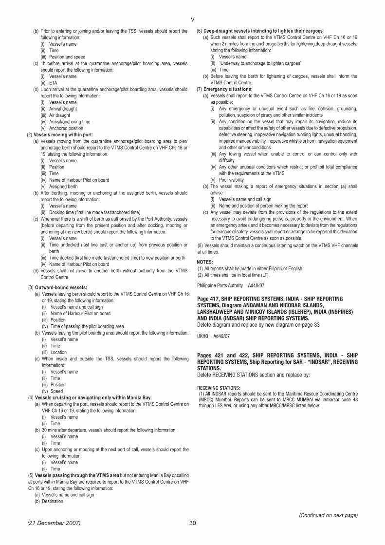
Page 417, SHIP REPORTING SYSTEMS, INDIA - SHIP REPORTINGSYSTEMS, Diagram ANDAMAN AND NICOBAR ISLANDS,LAKSHADWEEP AND MINICOY ISLANDS (ISLEREP), INDIA (INSPIRES)AND INDIA (INDSAR) SHIP REPORTING SYSTEMS.Delete diagram and replace by new diagram on page 33
UKHO Ad49/07
Pages 421 and 422, SHIP REPORTING SYSTEMS, INDIA - SHIPREPORTING SYSTEMS, Ship Reporting for SAR - “INDSAR”, RECEIVINGSTATIONS.Delete RECEIVING STATIONS section and replace by:
RECEIVING STATIONS:(1) All INDSAR reports should be sent to the Maritime Rescue Coordinating Centre(MRCC) Mumbai. Reports can be sent to MRCC MUMBAI via Inmarsat code 43through LES Arvi, or using any other MRCC/MRSC listed below:

UKHO Ad49/07
V
(21 December 2007) 31
Station Telephone Fax Inmarsat/E-mail
MRCC Mumbai (Bombay)
+91(0)22 24332554+91(0)22 24301455 +91(0)22 24376153+91(0)22 24388065
+91(0)22 24316558+91(0)22 24333727
Inmarsat C (IOR):441907210Inmarsat mini-M: (IOR) 762882349E-mail: [email protected] [email protected]
Western Region
MRSC Porbandar
+91(0)286 2214422
+91(0)286 2210559+91(0)286 2244056
Inmarsat C (IOR): 441908210Inmarsat M (IOR): 641900510E-mail:[email protected]
MRSC Goa +91(0)832 2521051
+91(0)832 2520584
Inmarsat C (IOR): 441907410Inmarsat M (IOR): 641901310E-mail:[email protected]
MRSC Okha +91(0)2892 263384
+91(0)2892 263421
Inmarsat C (IOR): 441900446Inmarsat mini M (IOR): 762484056E-mail:[email protected]
MRSC New Mangalore
+91(0)824 2405262+91(0)824 2405266
+91(0)824 2405267
Inmarsat C (IOR): 441908310E-mail:[email protected]_mangalore@redi mail.com
MRSC Kochi (Cochin)
+91(0)484 2217164+91(0)484 2218969
+91(0)484 2217164
Inmarsat C (IOR): 441907310Inmarsat M (IOR): 641901110E-mail:[email protected]
MRSC V d n r +91(0)2833 256579
+91(0)2833 256560
Inmarsat C (IOR): 441900448Inmarsat mini M (IOR): 762484114E-mail:[email protected]
Eastern Region (including Bay of Bengal)
MRCC Chennai (Madras)
+91(0)44 25395015+91(0)44 25395016+91(0)44 25395017
+91(0)44 25395015+91(0)44 25395018
Inmarsat C (IOR): 441907510Inmarsat M (IOR): 641901410E-mail:[email protected]@md3.vsnl.net.in
MRSC Haldia +91(0)3224 267755
+91(0)3224 263217
Inmarsat C (IOR): 441907110Inmarsat M (IOR): 641901210Inmarsat mini-M (IOR): 761887342Email:[email protected]
Station Telephone Fax Inmarsat/E-mail
MRSC P r dip +91(0)6722 220174
+91(0)6722 223359
Inmarsat C (IOR): 441907710Inmarsat M (IOR): 641901710E-mail:[email protected]
MRSC Vizag +91(0)891 2568879
+91(0)891 2568875+91(0)891 2568878
Inmarsat C (IOR): 441907010Inmarsat M (IOR): 641900410E-mail:[email protected]
MRSC Tuticorin +91(0)461 2353907
+91(0)461 2351999
Inmarsat C (IOR): 441900447Inmarsat mini-M (IOR): 762485086E-mail:[email protected]
MRSC Mandapam
+91(0)4573 241518+91(0)4573 241634
+91(0)4573 241518+91(0)4573 241519
Inmarsat C (IOR): 441907810Inmarsat M (IOR): 641901010E-mail:[email protected]
Andaman & Nicobar Region
MRCC Port Blair
+91(0)3192 245530+91(0)3192 242948
+91(0)3192 242948+91(0)3192 235612
Inmarsat C (IOR): 441908010Inmarsat M (IOR): 641900910Inmarsat mini-M (IOR): 762483765E-mail:[email protected]@sancharnet.in
MRSC Campbell Bay
+91(0)3193 264235
+91(0)3193 264205+91(0)3193 264215
Inmarsat C (IOR): 441907910Inmarsat mini-M (IOR): 762483771E-mail:[email protected]
MRSC Diglipur +91(0)3192 272259
+91(0)3192 272345
Inmarsat C (IOR): 441908110Inmarsat mini-M (IOR): 762483768E-mail:[email protected]
(2) Mariners are advised to strictly adhere to these procedures and if for any reason a Master is unable to send his PR or FR to one of the above stations he should attempt to pass a message through another vessel, or through a harbour or other shore authority as appropriate.(3) Reports to other reporting systems are not forwarded by MRCC Mumbai. Vessels are requested to send reports direct.
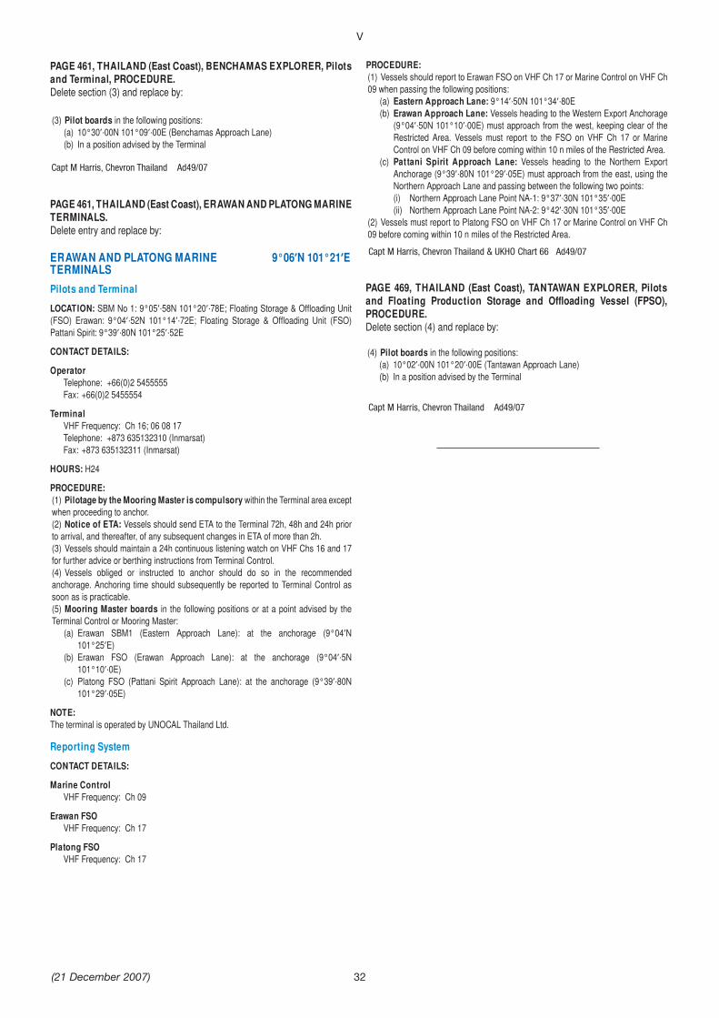
Capt M Harris, Chevron Thailand Ad49/07
Capt M Harris, Chevron Thailand & UKHO Chart 66 Ad49/07
Capt M Harris, Chevron Thailand Ad49/07
V
(21 December 2007)
PAGE 461, THAILAND (East Coast), BENCHAMAS EXPLORER, Pilots and Terminal, PROCEDURE.Delete section (3) and replace by:
(3) Pilot boards in the following positions:(a) 10°30 ·00N 101°09 ·00E (Benchamas Approach Lane)(b) In a position advised by the Terminal
PAGE 461, THAILAND (East Coast), ERAWAN AND PLATONG MARINE TERMINALS.Delete entry and replace by:
ERAWAN AND PLATONG MARINE 9°06 N 101°21 ETERMINALS Pilots and TerminalLOCATION: SBM No 1: 9°05 ·58N 101°20 ·78E; Floating Storage & O oading Unit (FSO) Erawan: 9°04 ·52N 101°14 ·72E; Floating Storage & O oading Unit (FSO) Pattani Spirit: 9°39 ·80N 101°25 ·52E
CONTACT DETAILS:
OperatorTelephone: +66(0)2 5455555Fax: +66(0)2 5455554
TerminalVHF Frequency: Ch 16; 06 08 17Telephone: +873 635132310 (Inmarsat)Fax: +873 635132311 (Inmarsat)
HOURS: H24
PROCEDURE:(1) Pilotage by the Mooring Master is compulsory within the Terminal area except when proceeding to anchor.(2) Notice of ETA: Vessels should send ETA to the Terminal 72h, 48h and 24h prior to arrival, and thereafter, of any subsequent changes in ETA of more than 2h.(3) Vessels should maintain a 24h continuous listening watch on VHF Chs 16 and 17 for further advice or berthing instructions from Terminal Control.(4) Vessels obliged or instructed to anchor should do so in the recommended anchorage. Anchoring time should subsequently be reported to Terminal Control as soon as is practicable.(5) Mooring Master boards in the following positions or at a point advised by the Terminal Control or Mooring Master:
(a) Erawan SBM1 (Eastern Approach Lane): at the anchorage (9°04 N 101°25 E)
(b) Erawan FSO (Erawan Approach Lane): at the anchorage (9°04 ·5N 101°10 ·0E)
(c) Platong FSO (Pattani Spirit Approach Lane): at the anchorage (9°39 ·80N 101°29 ·05E)
NOTE:The terminal is operated by UNOCAL Thailand Ltd.
Reporting SystemCONTACT DETAILS:
Marine ControlVHF Frequency: Ch 09
Erawan FSOVHF Frequency: Ch 17
Platong FSOVHF Frequency: Ch 17
32
PROCEDURE:(1) Vessels should report to Erawan FSO on VHF Ch 17 or Marine Control on VHF Ch 09 when passing the following positions:
(a) Eastern Approach Lane: 9°14 ·50N 101°34 ·80E(b) Erawan Approach Lane: Vessels heading to the Western Export Anchorage
(9°04 ·50N 101°10 ·00E) must approach from the west, keeping clear of the Restricted Area. Vessels must report to the FSO on VHF Ch 17 or Marine Control on VHF Ch 09 before coming within 10 n miles of the Restricted Area.
(c) Pattani Spirit Approach Lane: Vessels heading to the Northern Export Anchorage (9°39 ·80N 101°29 ·05E) must approach from the east, using the Northern Approach Lane and passing between the following two points:(i) Northern Approach Lane Point NA-1: 9°37 ·30N 101°35 ·00E(ii) Northern Approach Lane Point NA-2: 9°42 ·30N 101°35 ·00E
(2) Vessels must report to Platong FSO on VHF Ch 17 or Marine Control on VHF Ch 09 before coming within 10 n miles of the Restricted Area.
PAGE 469, THAILAND (East Coast), TANTAWAN EXPLORER, Pilots and Floating Production Storage and O oading Vessel (FPSO), PROCEDURE.Delete section (4) and replace by:
(4) Pilot boards in the following positions:(a) 10°02 ·00N 101°20 ·00E (Tantawan Approach Lane) (b) In a position advised by the Terminal
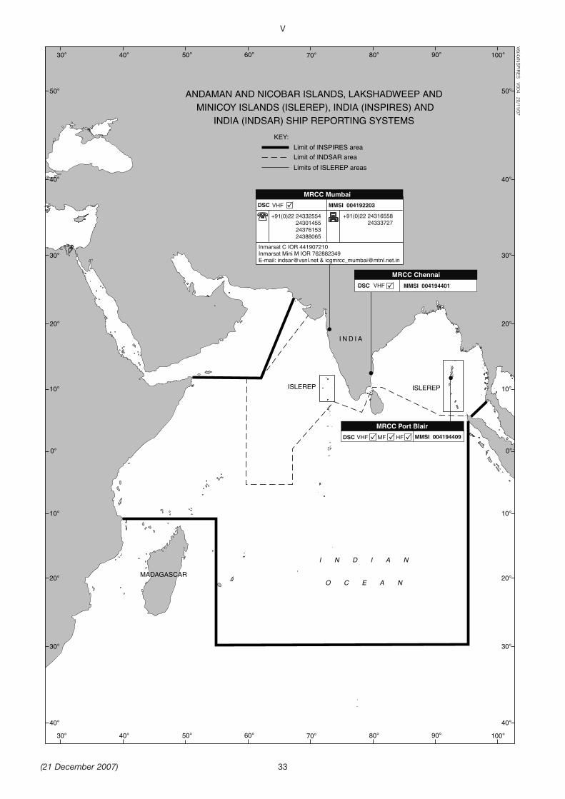
V
(21 December 2007)
Limit of INSPIRES area
Limit of INDSAR area
ANDAMAN AND NICOBAR ISLANDS, LAKSHADWEEP AND MINICOY ISLANDS (ISLEREP), INDIA (INSPIRES) AND
INDIA (INDSAR) SHIP REPORTING SYSTEMS
Limits of ISLEREP areas
V6(4)INSPIR
ES V004 20/11/07
KEY:
ISLEREPISLEREP
MADAGASCAR
I N D I A
I N D I A N
O C E A N
MRCC Mumbai
+91(0)22 24332554 24301455 24376153 24388065
+91(0)22 24316558 24333727
Inmarsat C IOR 441907210Inmarsat Mini M IOR 762882349E-mail: [email protected] & [email protected]
MMSI 004192203DSC VHF
MRCC Chennai
MMSI 004194401DSC VHF
MRCC Port Blair
MMSI 004194409DSC VHF MF HF
10°
10°
0°
30° 40° 50° 60° 70° 80° 90° 100°
30° 40° 50° 60° 70° 80° 90° 100°
30°
40°
50°
20°
20°
30°
40°
10°
10°
0°
30°
40°
50°
20°
20°
30°
40°
33
MAST Notice M95-07 [Ad 49/07]
Australian Hydrograhic Office [Ad 49/07]
Port Kembla Notice 022-07 [Ad 49/07]
Australian Notice 18/771(P)/07 [Ad 49/07]
Australian Notice 22/951/07 [Ad 48/07]
VI
(21 December 2007) 34
AMENDMENTS TO ADMIRALTY SAILING DIRECTIONS 2007
NP 14 Australia Pilot Volume II (2007 Edition)
Tasmania -- Great Oyster Bay — Marine farm
259After Paragraph 10.39 1 Add:
2 Caution. A marine farm, marked by light buoys(special), is situated 3 miles SE of Waterloo Point(10.40).
New South Wales -- Batemans Bay — Leadinglights
278Paragraph 11.75 1 lines 6--12 Replace by:
Front light (orange rectangle, white vertical stripe,9 m in height) (35 43 1S 150 11 8E).
Rear light (similar structure, 12 m in height) (35 mfrom front).
New South Wales -- Port Kembla — Boardinggrounds
293Paragraph 12.34 1 lines 5--11 Replace by:
Inner A: in position 34 25 2S 150 56 9E.Outer B: for vessels 226 m LOA or greater; in
position 34 24 2S 150 57 6E.Paragraph 12.34 2 lines 1--6 Delete
New South Wales — Submarine cable protectionzone
304Paragraph 12.109 Including heading Replace by:
Submarine cable protection zone12.109
1 A submarine cable protection zone extends fromBondi Bay (33 53 6S 151 16 6E) to the 2000 mdepth contour about 30 miles offshore, covering thesouthern branches of the Australia Japan Cable and theSouthern Cross Cable. The zone extends 1 mile eitherside of each cable and includes the area between thecables.
Underwater activities that could damage a cable,including anchoring and some fishing methods, areprohibited within the zone. For details seewww.acma.gov.au/subcables.
2
4
NP 15 Australia Pilot Volume III (2005 Edition)
Queensland -- Barwon Bank — Directions; lightbuoys
148Paragraph 5.41 1 lines 5--7 Replace by:
Clear of Barwon Bank (24 miles ESE), asrequired by draught and weather. Two fishaggregation devices, marked by light buoys(special) lie 9 miles W of the bank. Thence:

French Notice 07/44 S K10 2007 [Ad 49/07]
French Notice 07/44 S K10 2007 [Ad 49/07]
VI
(21 December 2007) 35
AMENDMENTS TO ADMIRALTY SAILING DIRECTIONS 2007
Nouvelle Calédonie -- Baie de Canala — Leadinglights
129Paragraph 4.100 3--5 Replace by:
3 Directions. From a position at the intersection ofthe recommended tracks leading 277 and 315 (4.92),the track leads SSE keeping to mid fairway of Baie deCanala, passing (with positions from Pic des Morts(21 30 0S 165 57 9E)):
4 WSW of the N entrance point (2½ miles N) toBaie d’Amata, thence:
ENE of the N entrance point (2¼ miles NNW) toBaie Ouango, thence:
WSW of the N entrance point (2 miles N) to PortMackau.
5 Thence to a position W of Les Trois Frères(1½ miles N), where the track leads 125 to theanchorage in Port d’Urville.
NP 61 Pacific Islands Pilot Volume II (2006Edition)
Nouvelle Calédonie -- Passe du Baron —Directions, buoyage
106Paragraph 3.131 3 lines 3--4 and line 8 Delete