SINGAPOREAN NOTICES TO MARINERS - Maritime and Port ...
26
1 ST OCTOBER 2011 Monthly Edition No. 10 Notices to Mariners 81 to 89 SINGAPOREAN NOTICES TO MARINERS SECTION CONTENT Page l Index of Charts & Publications 176 ll New Publications 179 Notices to Mariners and Chart Corrections 184 Temporary and Preliminary Notices 185 lll Navigational Information 188 Amendments to Publications 189 lV Reprint of Radio Navigational Warnings 190 V Reprint of Admiralty Notices to Mariners for Dual Badged Charts 191 The monthly Notices to Mariners contain corrective information affecting charts published by the Hydrographic Department, Maritime and Port Authority of Singapore. The information contained in these Notices should be updated on the charts affected. Notices under Section ll apply only to the particular Singaporean Chart(s) indicated. Mariners are requested to notify the Chief Hydrographer, Maritime and Port Authority of Singapore, immediately on the discovery of new dangers or suspected dangers to navigation and of changes or defects in aids to navigation. See Hydrographic Note on back page. The monthly Singaporean Notices to Mariners can be accessed directly from the MPA website: http://www.mpa.gov.sg/sites/port_and_shipping/circulars_and_notices/singapore_notices_to_mariners (ntm).page This service is offered free of charge. Hydrographic Department Maritime and Port Authority of Singapore 460 Alexandra Road PSA Building #20-00 Singapore 119963 Tel: (65) 6375 1227 Fax: (65) 6278 7646
-
Upload
khangminh22 -
Category
Documents
-
view
5 -
download
0
Transcript of SINGAPOREAN NOTICES TO MARINERS - Maritime and Port ...

1ST OCTOBER 2011
Monthly Edition No. 10 Notices to Mariners 81 to 89
SINGAPOREAN NOTICES TO MARINERS
SECTION CONTENT
Page
l Index of Charts & Publications 176 ll New Publications 179
Notices to Mariners and Chart Corrections 184 Temporary and Preliminary Notices 185
lll Navigational Information 188 Amendments to Publications 189
lV Reprint of Radio Navigational Warnings 190 V Reprint of Admiralty Notices to Mariners for
Dual Badged Charts 191
The monthly Notices to Mariners contain corrective information affecting charts published by the Hydrographic Department, Maritime and Port Authority of Singapore. The information contained in these Notices should be updated on the charts affected. Notices under Section ll apply only to the particular Singaporean Chart(s) indicated.
Mariners are requested to notify the Chief Hydrographer, Maritime and Port Authority of Singapore, immediately on the discovery of new dangers or suspected dangers to navigation and of changes or defects in aids to navigation. See Hydrographic Note on back page.
The monthly Singaporean Notices to Mariners can be accessed directly from the MPA website: http://www.mpa.gov.sg/sites/port_and_shipping/circulars_and_notices/singapore_notices_to_mariners (ntm).page This service is offered free of charge.
Hydrographic Department
Maritime and Port Authority of Singapore
460 Alexandra Road
PSA Building #20-00
Singapore 119963
Tel: (65) 6375 1227
Fax: (65) 6278 7646

(i)
EXPLANATION OF FORMAT
The elements of a typical chart correction are explained below.
502 4Ed 25/9/08 Last NM 98/2010 (Job No. 181N/2008) *NM 2/2011
Insert 5#+5#+5#+5#+ Obstn 1° 17·96’N 103° 56·19’E
Insert ¶ Dir F.WRG.15m13M(occas) 1° 12·59’N 103° 46·66’E Sectors at above light, as follows: R 19·3° - 17·6° (1·7°) W 17·6° - 16·5° (1·1°) G 16·5° - 15·5° (1·0°)
Notes: a) Notice to Mariners number followed by: T indicates a Temporary Notice (eg. *NM 3T/2011). P indicates a Preliminary Notice (eg. *NM 4P/2011). b) Bearings are true reckoned clockwise from 000° to 359° ; those relating to lights are from seaward. c) Heights and elevations are above Mean High Water Springs.
Edition Number Last Notice to Mariners Number
Source of Information
Information based on Singapore Source
Current Notice to Mariners Number
Position (WGS84 Datum)
Chart Number Edition Date
Corrective Action
Correction
Bearing
Elevation

Edition No. 10/2011
I INDEX OF CHARTS AND PUBLICATIONS
INDEX OF AFFECTED CHARTS
174
DESCRIPTION NOTICE NO.
PAGE NO.
Index of Singaporean Charts - 176 Index of Dual Badged Charts - 177 Index of Singapore Electronic Navigational - 178 Chart (ENC) New Edition Singaporean Charts - 179 New Edition Dual Badged Charts - 179, 180 Singapore Tide Tables 2012 - 181 to183 Singaporean Chart SP1/GSP1 *81, *82 184 Temporary and Preliminary Notices *83T, 84T, 85P, 86T 185 to 187 Port Marine Notices *87 188 Singaporean Print-On-Demand (POD) *88 188 Charts Amendments to Publications *89 189 Reprint of Radio Navigational Warnings - 190 Reprint of Admiralty Notices to Mariners - 191 to 194 for Dual Badged Charts Singapore Electronic Navigational Chart - 195 (ENC) Distributors Chart Agents for the Maritime and Port - 195 Authority of Singapore Nautical Charts and Publications
*Denotes information are based on Singaporean source.

Edition No. 10/2011
I INDEX OF CHARTS AND PUBLICATIONS
INDEX OF NOTICES
175
NOTICE NO. DESCRIPTION
PAGE NO.
- Index of Singaporean Charts 176 - Index of Dual Badged Charts 177 - Index of Singapore Electronic Navigational Chart 178 (ENC) - New Edition Singaporean Charts 179 - New Edition Dual Badged Charts 179, 180 - Singapore Tide Tables 2012 181 to 183
*81, *82 Singaporean Chart SP1/GSP1 184
*83T, 84T, 85P, 86T
Temporary and Preliminary Notices 185 to 187
*87 Port Marine Notices 188
*88 Singaporean Print-On-Demand (POD) Charts 188
*89 Amendments to Publications 189
- Reprint of Radio Navigational Warnings 190 - Reprint of Admiralty Notices to Mariners for 191 to 194 Dual Badged Charts - Singapore Electronic Navigational Chart (ENC) 195 Distributors - Chart Agents for the Maritime and Port Authority of 195 Singapore Nautical Charts and Publications
* Denotes information are based on Singaporean source.

Edition No. 10/2011
I INDEX OF CHARTS AND PUBLICATIONS
176
INDEX OF SINGAPOREAN CHARTS
Notes: Updated SINGAPOREAN Charts are available through our Print-On-Demand (POD) Chart Service. For more information, refer to Section III – Navigational Information and these charts can be purchased from our authorised Chart Agents: DPM (Singapore) Pte Ltd, E.W. Liner Charts & Publications Pte Ltd and Motion Smith.

Edition No. 10/2011
I INDEX OF CHARTS AND PUBLICATIONS
177
INDEX OF DUAL BADGED CHARTS

Edition No. 10/2011
I INDEX OF CHARTS AND PUBLICATIONS
178
INDEX OF SINGAPORE ELECTRONIC NAVIGATIONAL CHART (ENC)
COVERAGE OF SINGAPORE ELECTRONIC NAVIGATIONAL CHART (ENC)
ENC Name ENC Coverage ENC Edition (Release 2010.1)
SG5C4030 West Jurong Anchorages and
Temasek Fairway
4
th Edition (28/10/2010)
SG5C4031 Western Approaches to Jurong Island 4th Edition (28/10/2010)
SG5C4032 Sinki Fairway 6th Edition (27/04/2011)
SG5C4033 Tuas Bay, West Jurong Channel and Pesek Basin
4
th Edition (28/10/2010)
SG5C4034 East Jurong Channel, Pasir Panjang Terminal and West Keppel Fairway
9
th Edition (29/09/2011)
SG5C4035 Western Anchorages, Jong Fairway and Cruise Bay
10
th Edition (29/09/2011)
SG5C4036 Raffles Lighthouse to The Sisters 5th Edition (27/04/2011)
SG5C4037 Keppel Harbour, Tanjong Pagar Terminal and Approaches
5
th Edition (27/04/2011)
SG5C4038 Johor Strait – Western Part 4th Edition (28/10/2010)
SG5C4039 Western Approaches to Main Strait 4th Edition (11/08/2011)
SG5C4041 Pulau Sebarok to Changi 5th Edition (11/08/2011)
SG5C4043 Kuala Johor and Sungai Johor 6th Edition (28/07/2011)
SG5C4044 Johor Strait – Eastern Part 6th Edition (28/07/2011)

Edition No. 10/2011
II NEW PUBLICATIONS
179
NEW EDITION SINGAPOREAN CHARTS PUBLISHED ON 22
ND SEPTEMBER 2011
Chart Number : 200
Title : Malacca Strait – Port Klang To Tanjung Keling
Coverage : Lat 02°01·48’N 03°11·99’N Long 100°26·36’E 102°09·91’E
Scale : 1: 200 000
Date Published : 22nd
September 2011
Size of Chart : 960·0 x 650·0 mm
Remarks : This new edition includes 40 Ntm corrections, new submarine cables, contours and depths extracted from BA Chart 3946. The existing chart of the same number published on 30
th November
2005 is superseded.
Chart Number : 502
Title : Singapore Strait – Eastern Part
Coverage : Lat 01°07·00’N 01°24·61’N Long 103°51·43’E 104°17·31’E
Scale : 1: 50 000
Date Published : 22nd
September 2011
Size of Chart : 960·0 x 649·2 mm
Remarks : This new edition includes new submarine cables and data from latest surveys covering the following areas:
• Eastern Anchorages
• Eastern Special Purposes D Anchorage
• Changi General Purposes Anchorage
• Johor Shoal
• Eastern Fairway
• East Keppel Fairway
• South of Pulau Tekong
• Around west of Pulau Batam
• South of Batu Berhanti
: The existing chart of the same number published on 25th
September 2008 is superseded.
NEW EDITION DUAL BADGED CHARTS PUBLISHED ON 29
TH SEPTEMBER 2011
Chart Number : 4034
Title : Port of Singapore – East Jurong Channel, Pasir Panjang Terminal and West Keppel Fairway
Coverage : Lat 01°14·50’N 01°18·55’N Long 103°42·70’E 103°48·60’E
Scale : 1: 10 000
Date Published : 29th September 2011
Size of Chart : 1094·3 x 746·3 mm
Remarks : This new edition includes latest surveys covering the following areas:
• Pasir Panjang Basin
• Pasir Panjang Terminal
• East Jurong Channel – area around buoy W3
• Tanjong Penjuru – Chevron Jetties
• Portion of Sungei Pandan
: The existing chart of the same number published on 14th April 2011
is superseded.

Edition No. 10/2011
II NEW PUBLICATIONS
180
NEW EDITION DUAL BADGED CHARTS PUBLISHED ON 29
TH SEPTEMBER 2011
Chart Number : 4035
Title : Port of Singapore – Western Anchorages, Jong Fairway and Cruise Bay
Coverage : Lat 01°10·90’N 01°16·90’N Long 103°45·50’E 103°49·54’E
Scale : 1: 10 000
Date Published : 29th September 2011
Size of Chart : 749·4 x 1105·7 mm
Remarks : This new edition includes latest surveys covering the following areas:
• Shell SBM Area
• Area West of Pulau Sebarok
• East Jurong Channel – area around buoy W3
• Approaches to Berths P18 – P22 of Pasir Panjang Terminal
• Selat Chermin The existing chart of the same number published on 14
th April 2011
is superseded.

Edition No. 10/2011
II NEW PUBLICATIONS
181
PUBLICATION OF SINGAPORE TIDE TABLES YEAR 2012
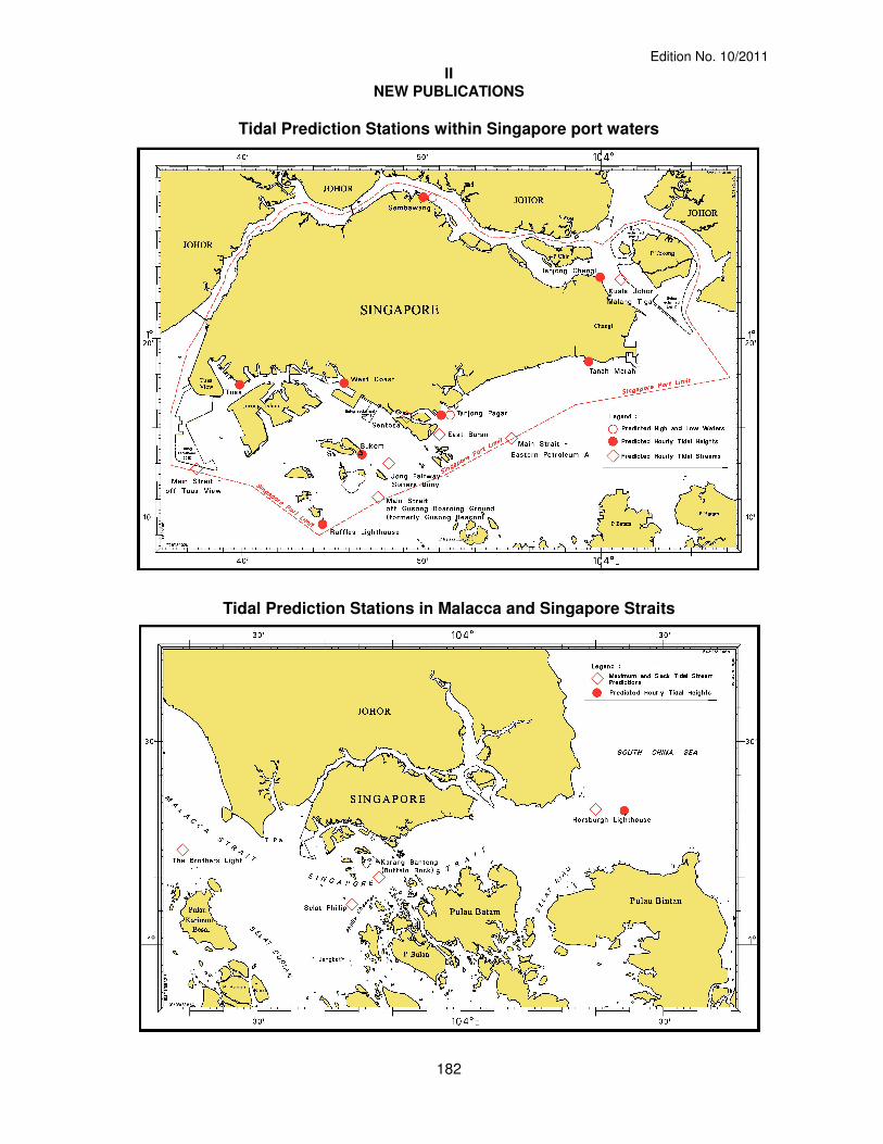
Summary of Publication This 251-page book contains Tidal Height and Tidal Stream Predictions covering stations in Singapore port waters and along the Malacca and Singapore Straits. A new Tidal Stream Predictions station (Main Strait – off Tuas View) is included in the publication. This publication consist of 5 main segments to facilitate easy reference.
1. High and Low Water Predictions at the following stations: a) Tanjong Pagar b) Sembawang
2. Hourly Tidal Height Predictions at the following stations: a) Tuas b) Raffles Lighthouse c) West Coast d) Bukom e) Tanjong Pagar f) Tanah Merah g) Tanjong Changi h) Sembawang i) Singapore Strait - Horsburgh Lighthouse
3. Hourly Tidal Stream Predictions at the following stations: a) Main Strait – off Tuas View b) Jong Fairway – Sisters Buoy c) Main Strait – off Gusong Boarding Ground (formerly Gusong Beacon) d) Sentosa e) East Buran f) Main Strait – Eastern Petroleum A g) Kuala Johor – off Malang Tiga
4. Maximum and Slack Tidal Stream Predictions at the following stations: a) Malacca Strait – Off The Brothers Light b) Singapore Strait – Selat Phillip c) Singapore Strait – Karang Banteng (Buffalo Rock) d) Singapore Strait - Horsburgh Lighthouse
5. Malacca Strait – High and Low Water Predictions at the following stations: a) Kedah Pier, Pulau Pinang b) Port Dickson c) Kual Batu Pahat
The locations of the above stations are shown in the chartlets below:
Edition No. 10/2011
II NEW PUBLICATIONS
182
Tidal Prediction Stations within Singapore port waters
Tidal Prediction Stations in Malacca and Singapore Straits

Edition No. 10/2011
II NEW PUBLICATIONS
183
Tidal Prediction Stations in Malacca Strait
This publication is available from the following Chart Agents: 1. DPM (Singapore) Pte Ltd 2. E.W. Liner Charts & Publications Pte Ltd 3. Motion Smith (Please refer Page 195 for details)

Edition No. 10/2011
II NOTICES TO MARINERS AND CHART CORRECTIONS
184
SP1/GSP1 6 Ed 27/1/11 Last NM 73/2011 (HD/HY/C00105211) *NM 81/2011
Insert ++++ Obstn 1°14·35’N 103°49·65’E (HD/HE025/74/11) *NM 82/2011
Insert RRRR 1°12·94’N 103°44·76’E

Edition No. 10/2011
II TEMPORARY AND PRELIMINARY NOTICES
185
(NM *83T/2011) INSTALLATION OF TEMPORARY BUOY AT SELAT PAUH Mariners are advised that a temporary yellow pillar light buoy has been installed at Selat Pauh. The details are as follows: 1. Name : DSO ‘B1’
2. Position : Lat 1°12·95’N Long 103°44·43’E
3. Light Characteristics : Fl.Y.4s
Remarks : The buoy was installed on 23rd August 2011 and the duration of its usage is for a period
of 4 months. Charts affected : GSP1/SP1, 202, 500, 501, 4032, 4036, 4039 and 4040. Source : HD/HE025/58/2011
(NM 84T/2011) REPLACEMENT OF BUOYS AT MV B OCEANIC WRECK Mariners are advised that an isolated danger mark light buoy has been replaced by a cardinal buoy on the MV B Oceanic wreck. The details are as follows : 1. Name : North Cardinal Mark
2. Position : Lat 1°24·95’N Long 103°08·01’E
3. Light Characteristic : Q.Fl
4. Name : East Cardinal Mark
5. Position : Lat 1°24·71’N Long 103°08·32’E
6. Light Characteristic : Q.Fl(3)10s
7. Name : West Cardinal Mark
8. Position : Lat 1°24·63’N Long 103°07·84’E
9. Light Characteristic : Q.Fl(9)15s
Remarks : As salvage work is being conducted in the area, Mariners are advised to navigate with caution when in the vicinity.
Charts affected : 201, 202 and 500.
Source : Marine Department Peninsular Malaysia Notice to Mariners No. 61T and 62T/2011.

Edition No. 10/2011
II TEMPORARY AND PRELIMINARY NOTICES
186
RPL No. (RPL Co-ordinates: WGS84) Remarks
Latitude (N) Longitude (E)
Point 1 1° 17·04’ 104° 02·85’ From Point 1 to Point 2 Point 2 1° 14·41’ 104° 05·51’ Point 2 to Point 3 Point 3 1° 16·09’ 104° 14·91’ Point 3 to Point 4 Point 4 1° 17·13’ 104° 18·97’ Point 4 to Point 5 Point 5 1° 18·75’ 104° 22·18’ Point 5 to Point 6 Point 6 1° 27·93’ 104° 33·18’ End at Point 6
(NM 85P/2011) WORKING AREA ESTABLISHED OFF THE COAST OF PENGERANG, JOHOR This is to notify that a working area has been established for dredging and reclamation works for the development of an Independent Deepwater Terminal off the coast of Pengerang, district of Kota Tinggi Johor, within the Pasir Gudang port limit and the details are as follows: Working Area
Latitude Longitude
1. 1° 20·61’N 104°09·07’E 2. 1° 18·50’N 104°08·83’E 3. 1° 18·91’N 104°11·35’E 4. 1° 20·76’N 104°11·57’E
Remarks : All vessels are required to keep clear of the working area and to navigate with caution when in the vicinity.
Charts affected : 202, 502, 4042 and 4043.
Source : Marine Department Malaysia, Southern Region, Port Circular No. 9 and 11/2011.
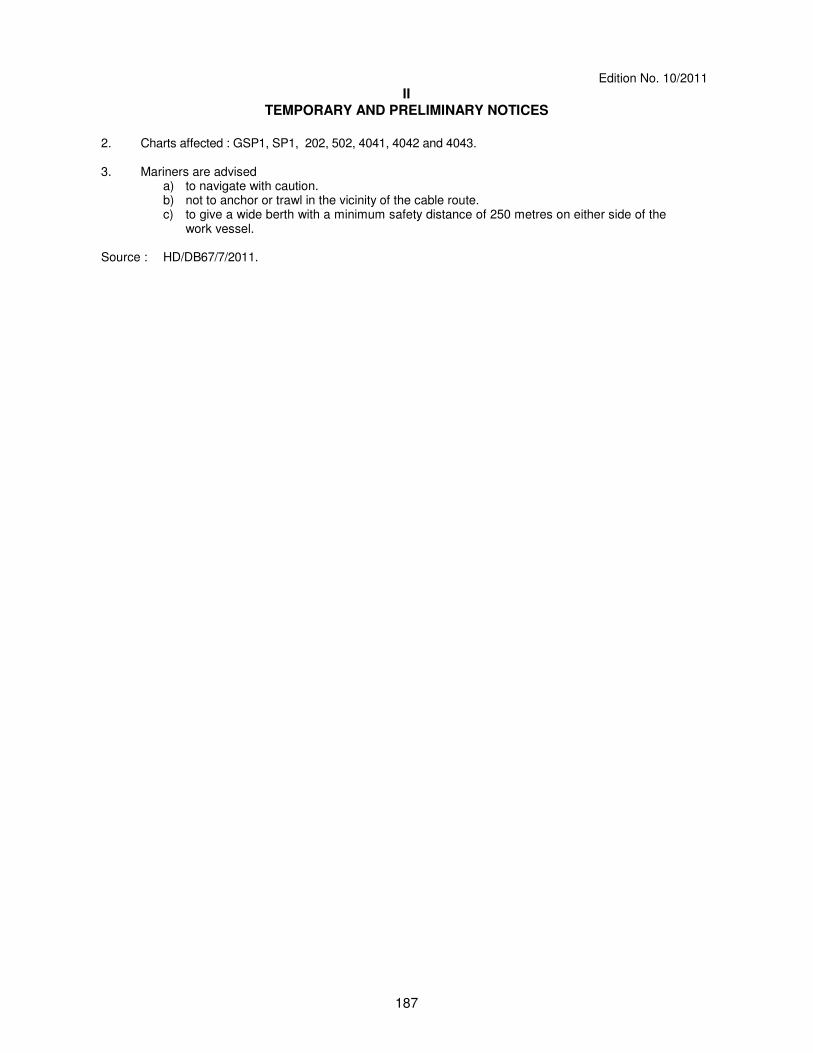
(NM 86T/2011) ASIA SUBMARINE CABLE EXPRESS (ASE) – Pre-Lay Grapnel Run & Route
Clearance (PLGR/RC) Remark : The PLGR/RC shall be executed at Sector 9, in way of the Precautionary Area, and
via the Eastbound Lane of the Traffic Separation Scheme (TSS), thence through the eastern entrance of the TSS, Singapore Strait.
Work Vessel : WAKASHIO MARU (Call Sign : 9V6594)
Date of Survey : With effect from 30th October to 8
th November 2011.
Operating hours : Daylight hours 0700 to 1900 only
1. The Pre-Lay Grapnel Run and Route Clearance (PLGR/RC) of the submarine cable routes are
listed as follows :
Edition No. 10/2011
II TEMPORARY AND PRELIMINARY NOTICES
187
2. Charts affected : GSP1, SP1, 202, 502, 4041, 4042 and 4043. 3. Mariners are advised a) to navigate with caution. b) not to anchor or trawl in the vicinity of the cable route. c) to give a wide berth with a minimum safety distance of 250 metres on either side of the
work vessel. Source : HD/DB67/7/2011.

Edition No. 10/2011
IIl NAVIGATIONAL INFORMATION
188
*(NM 87/2011) PORT MARINE NOTICES
The following PMNs have been shortlisted, as they would be of particular interest to
mariners. These notices can be accessed directly from MPA website: http://www.mpa.gov.sg/sites/port_and_shipping/circulars_and_notices/port_marine_
notices.page PMN No. Subject 107/2011 Construction of SLNG Terminal at Jurong Island. 108/2011 Underwater drilling and blasting works at Pasir Panjang Fairway, 111/2011 Construction works at Keppel Shipyard. 113/2011 Construction works at Shell, Pulau Bukom Wharf No. 9. 119/2011 Construction works at Sembawang Shipyard. 122/2011 Marine construction works off Marina Barrage. 123/2011 Dredging works off Cyrene Reefs and Jong Fairway. 125/2011 Construction works at Vopak Terminal, Jurong Island. 128/2011 Dredging works off Sembawang Wharves. 129/2011 Construction of wharf at Tuas South.
*(NM 88/2011) SINGAPOREAN PRINT-ON-DEMAND (POD) CHARTS Print-On-Demand (POD) Charts are the most up-to-date paper nautical charts printed
for navigational use. These nautical charts are produced in accordance with the International Hydrographic Organisation (IHO) charting specifications. These official nautical charts are continually updated to the latest Notices to Mariners before they are printed and sold to users.
These POD Charts include SP1/GSP1, 200, 201, 202, 500, 501, 502 and 503.
BENEFITS TO OUR CUSTOMERS Convenience Customers need not make numerous hand corrections to the nautical charts before use. In addition the updated POD Charts are more accurate and reliable than offset printed charts with hand corrections. Clarity Clarity in the presentation of updated information as compared to lithographic printed charts, where in some cases there are several overlapping corrections over existing information. Coverage The POD Charts cover the Malacca and Singapore Straits, from One Fathom Bank to Horsburgh Lighthouse.

Edition No. 10/2011
IIl AMENDMENTS TO PUBLICATIONS
189
*(NM 89/2011) UPDATING OF PUBLICATION “SINGAPORE PORT INFORMATION 2010/2011” 1. Page 96 DEPTHS OF NAVIGATIONAL CHANNELS AND FAIRWAYS Insert the following: LOCATIONS DEPTHS (m) REMARKS
Delete
Insert
Temasek Fairway 14.8 15.3
Source: Berth List dated 5
th September 2011
2. Page 151 WHARVES AND BERTHS JURONG ISLAND (PETROCHEMICAL CORPORATION OF SINGAPORE)(1°15·9’N, 103°43·0’E) Insert the following:
Berth Depth Alongside (Year Surveyed)
Delete Insert
No. 3 (Liquid) 7·7m (2006) 10·0m (2011)
Source: HD/HY Code E00102811 3. Page 159 – Item 44a Insert the following: JURONG ISLAND (STOLTHAVEN TERMINAL JETTY)( 1°16·6’N, 103°39·8’E)
Berth
Length of Berth
Depth Alongside (Year Surveyed)
Controlling Depth In Approaches
1 (OST1) 203.5m 35.5m -
Source: Berth List and HD/HY/H00101711

Edition No. 10/2011
IV REPRINT OF RADIO NAVIGATIONAL WARNINGS
190
The following Radio Navigational Warnings have been shortlisted, as they would be of particular interest to mariners. TT173 VESSELS IN EAST JOHOR STRAIT ARE ADVISED TO NAVIGATE WITH CAUTION WHEN NEAR THE PROJECT AREAS OFF PULAU TEKONG, CHANGI AND MALANG PAPAN AS SHALLOW WATER AREAS EXIST. VESSELS ARE ADVISED TO KEEP LOOKOUT FOR TUGS AND BARGES NAVIGATING NEAR THE PROJECT AREAS AND PASSENGER FERRIES CROSSING BETWEEN CHANGI AND PULAU TEKONG AND VICINITY OF PASIR GUDANG. TT619 DREDGER "ANDROMEDA V" IS CONDUCTING DREDGING OPERATIONS IN COORDINATES: 01°14·890' N 103°58·120' E 01°16·210' N 104°01·630' E 01°16·090' N 104°01·670' E 01°14·680' N 103°58·200' E VESSELS ARE TO KEEP CLEAR OF THE WORKING VESSEL. TT753 A SMALL WOODEN CARGO BOAT 10M IN LENGTH SUNK AT 01°15·73’N 103°32·10’E. TT884 SALVAGE OPERATIONS UNDERWAY IN 01°13·40’N 103°57·75’E. ALL SHIPS ARE REQUESTED TO GIVE A WIDE BERTH OF AT LEAST 5 CABLES WHEN PASSING THE AREA. TT908 DANGER TO NAVIGATION 2 TUGBOATS ARE REPORTED SUNK AT 01°19·63’N 104°19·28’E TT931 VESSELS NAVIGATING IN THE SINGAPORE STRAIT ARE REQUESTED NOT TO DIRECT THEIR HIGH INTENSITY SEARCHLIGHTS SKYWARD IN THE VICINITY OF CHANGI AIRPORT TO AVOID DISRUPTION TO AIR NAVIGATION. TT961 VESSELS INTENDING TO CROSS THE TRAFFIC SEPERATION SCHEME(TSS) OR PRECAUTIONARY AREAS IN THE SINGAPORE STRAIT DURING THE HOURS OF DARKNESS ARE RECOMMENDED TO DISPLAY THE NIGHT SIGNALS CONSISTING OF 3 ALL-ROUND GREEN LIGHTS IN A VERTICAL LINE WITH EFFECT FROM 1ST JULY 2011 AT 0000HRS UTC (0800HRS SINGAPORE LOCAL TIME) AS DETAILED IN MARITIME AND PORT AUTHORITY OF SINGAPORE'S PORT MARINE CIRCULAR, 02 OF 2011 DATED 30 MAY 2011. TT981 THREE CONTAINERS ARE REPORTED OVERBOARD AT APPROXIMATE POSITION 01°29·15N 104°29·37E. VESSELS IN THE VICINITY ARE ADVISED TO KEEP A SHARP LOOKOUT AND NAVIGATE WITH CAUTION. SR154 AN UNIDENTIFIED VESSEL REPORTED SUNK SOUTH WEST OF HORSBURGH AT 01°16·12’N 104°21·50’E. ISSUED BY SINGAPORE PORT OPERATIONS CONTROL CENTRE (as at 25
th September 2011)
Edition No.10/2011
V
REPRINT OF ADMIRALTY NOTICES TO MARINERS FOR DUAL BADGED CHARTS
191
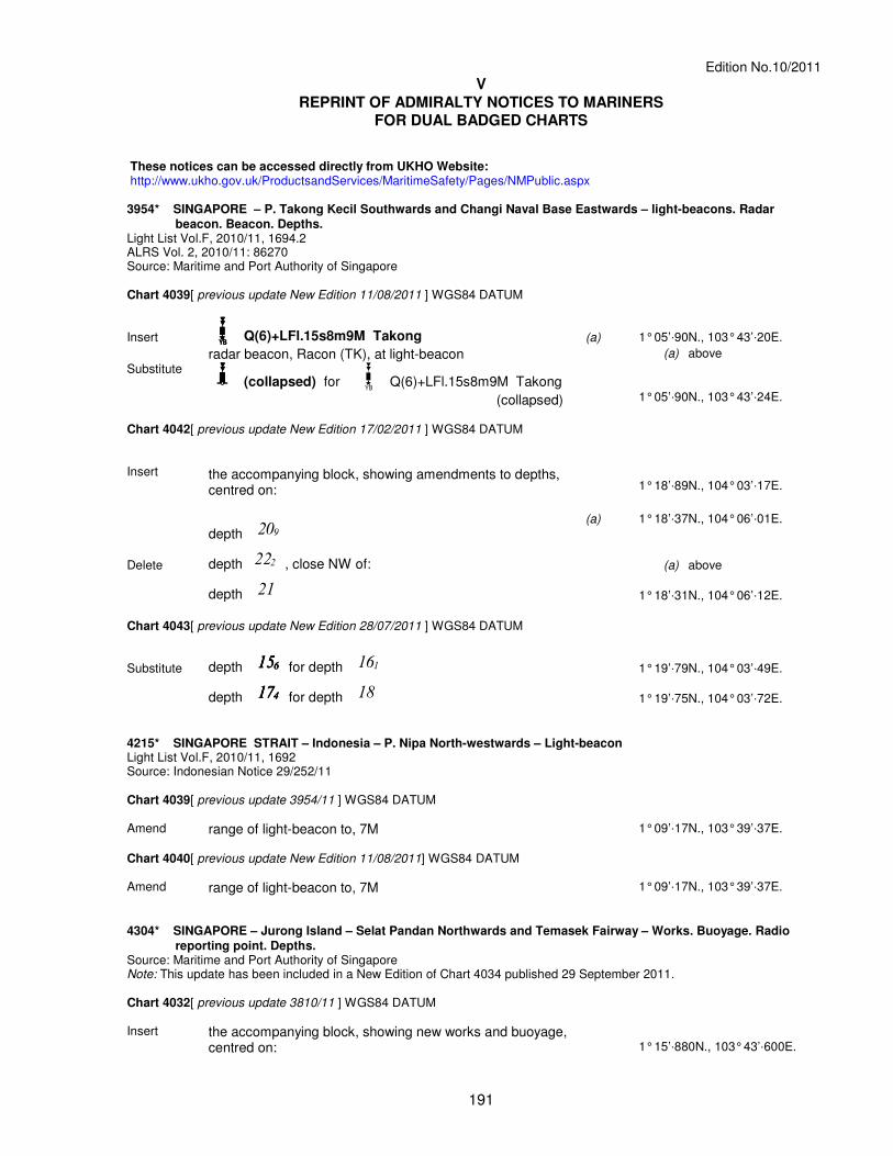
These notices can be accessed directly from UKHO Website: http://www.ukho.gov.uk/ProductsandServices/MaritimeSafety/Pages/NMPublic.aspx 3954* SINGAPORE – P. Takong Kecil Southwards and Changi Naval Base Eastwards – light-beacons. Radar
beacon. Beacon. Depths. Light List Vol.F, 2010/11, 1694.2 ALRS Vol. 2, 2010/11: 86270 Source: Maritime and Port Authority of Singapore Chart 4039[ previous update New Edition 11/08/2011 ] WGS84 DATUM Insert Tx=Tx=Tx=Tx= Q(6)+LFl.15s8m9M Takong
(a)
1° 05’ã90N., 103° 43’ã20E.
radar beacon, Racon (TK), at light-beacon (a) above
Substitute K=K=K=K= (collapsed) for Tx= Q(6)+LFl.15s8m9M Takong
(collapsed)
1° 05’ã90N., 103° 43’ã24E.
Chart 4042[ previous update New Edition 17/02/2011 ] WGS84 DATUM Insert
the accompanying block, showing amendments to depths, centred on:
1° 18’ã89N., 104° 03’ã17E.
depth 20) (a)
1° 18’ã37N., 104° 06’ã01E.
Delete depth 22" , close NW of:
(a) above
depth 21
1° 18’ã31N., 104° 06’ã12E.
Chart 4043[ previous update New Edition 28/07/2011 ] WGS84 DATUM Substitute depth 15&15&15&15& for depth 16!
1° 19’ã79N., 104° 03’ã49E.
depth 17$17$17$17$ for depth 18
1° 19’ã75N., 104° 03’ã72E.
4215* SINGAPORE STRAIT – Indonesia – P. Nipa North-westwards – Light-beacon Light List Vol.F, 2010/11, 1692 Source: Indonesian Notice 29/252/11 Chart 4039[ previous update 3954/11 ] WGS84 DATUM Amend range of light-beacon to, 7M 1° 09’ã17N., 103° 39’ã37E.
Chart 4040[ previous update New Edition 11/08/2011] WGS84 DATUM Amend range of light-beacon to, 7M 1° 09’ã17N., 103° 39’ã37E.
4304* SINGAPORE – Jurong Island – Selat Pandan Northwards and Temasek Fairway – Works. Buoyage. Radio
reporting point. Depths. Source: Maritime and Port Authority of Singapore Note: This update has been included in a New Edition of Chart 4034 published 29 September 2011. Chart 4032[ previous update 3810/11 ] WGS84 DATUM Insert the accompanying block, showing new works and buoyage,
centred on: 1° 15’ã880N., 103° 43’ã600E.

Edition No.9/2011
V
REPRINT OF ADMIRALTY NOTICES TO MARINERS FOR DUAL BADGED CHARTS
192
4304* SINGAPORE – Jurong Island – Selat Pandan Northwards and Temasek Fairway – Works. Buoyage. Radio reporting point. Depths. Contd. Chart 4040[ previous update 4215/11 ] WGS84 DATUM Insert the accompanying block, showing new works and buoyage
and reporting point, centred on: 1° 15’ã80N., 103° 43’ã75E.
depth 15&15&15&15&
(a) 1° 15’ã59N., 103° 38’ã75E.
Delete depth 14( enclosed by 15m contour, close E of:
(a) above
Updated to Admiralty Notices to Mariners Edition No. 39 of 2011 dated 29
th September 2011.

Edition No.9/2011
V
REPRINT OF ADMIRALTY NOTICES TO MARINERS FOR DUAL BADGED CHARTS
193

Edition No.9/2011
V
REPRINT OF ADMIRALTY NOTICES TO MARINERS FOR DUAL BADGED CHARTS
194

195
SINGAPORE ELECTRONIC NAVIGATIONAL CHART (ENC) DISTRIBUTORS Please approach any of the appointed distributors to purchase the Singapore ENC.
DISTRIBUTOR ADDRESS TELEPHONE/FAX NO./EMAIL/WEBSITE
DPM (Singapore) Pte Ltd
1 Maritime Square, #09-72 HarbourFront Centre, Singapore 099253
Tel. No.: +65 6270 4060 Fax No.: +65 6276 3858 Email: [email protected] Website:http://www.dpmsingapore.com.sg
MARIS Information Systems (MARIS)
52 Telok Blangah Road #01-06 Telok Blangah House Singapore 058809
Tel. No.: +65 6276 1472 Fax No.: +65 6276 1473 Email: [email protected] Website: http://www.maris.no
Maritime Information Systems AS (MARIS)
Danholmen 25, 3128 Notteroy, Norway
Tel. No.: +47 33 30 42 50 Fax No.: +47 33 30 42 51 Email: [email protected] Website: http://www.maris.no
Motion Smith
15 Jalan Kilang Barat #08-01/05 Frontech Centre Singapore 159357
Tel. No.: +65 6220 5098 Fax No.: +65 6225 4902 Email: [email protected] Website: http://www.motsmith.com
Transas Marine Pacific Pte Ltd
Cyber Centre 16 & 18 Jalan Kilang Barat Singapore 159358
Tel. No.: +65 6271 0200 Fax No.: +65 6271 7300 Email: [email protected] Website: http://www.transas.com.sg
Vector Services Pte Ltd
15 West Coast Highway, #02-14A Pasir Panjang Building Singapore 117861
Tel. No.: +65 6777 3602 Fax No.: +65 6777 9203 Email: [email protected]
ChartWorld GmbH
Ruhrstrasse 90, D-22761 Hamburg, Germany
Tel. No.: +49 40 853 58 6942 Fax No.: +49 40 853 58 6949 Email: [email protected] Website : http://www.chartworld.com
Japan Hydrographic Association Electronic Charts Division
Daiichi Sogo Bldg, 6F 1-6-6, Hanedakuko, Ota-ku, Tokyo 144-0041, Japan
Tel. No.: +81 3 5708 7093 Fax No.: +81 3 5708 7094 Email: [email protected] Website: http://www.jha.or.jp/en/jha/
Jeppesen Norway A/S
P.O Box 212 , N-4371 Egersund, Norway
Tel No.: +47 514 64 700 Fax No: +47 514 64 701 Email: [email protected] Website : http://www.jeppesen.com
PRIMAR STAVANGER
Lervigsveien 36, P.O Box 60, N-4001 Stavanger, Norway
Tel. No.: +47 51 93 9500 Fax No.: +47 51 93 9501 Email: [email protected] Website : http://www.primar.no
United Kingdom Hydrographic Office
Admiralty Way,Taunton, Somerset TA1 2DN United Kingdom
Tel. No.: +44 1823 337900 Fax No.: +44 1823 284077 Email: [email protected] Website: http://www.ukho.gov.uk
Chart Agents for the Maritime and Port Authority of Singapore Nautical Charts and Publications
Please approach any of the appointed chart agent to purchase the Singapore Nautical Charts and Publications.
CHART AGENT ADDRESS TELEPHONE/FAX NO./EMAIL/WEBSITE
DPM (Singapore) Pte Ltd
1 Maritime Square, #09-72 HarbourFront Centre, Singapore 099253
Tel. No.: +65 6270 4060 Fax No.: +65 6276 3858 Email: [email protected] Website: http://www.dpmsingapore.com.sg
E.W. Liner Charts & Publications Pte Ltd
102F, Pasir Panjang Road, #08-01, Citilink Warehouse Complex, Singapore 118530
Tel. No.: +65 6323 0773 Fax No.: +65 6323 0775 Email: [email protected] Website: http://www.ewliner.com
Motion Smith
15 Jalan Kilang Barat #08-01/05 Frontech Centre Singapore 159357
Tel. No.: +65 6220 5098 (After office hours:+65 8163 9993) Fax No.: +65 6225 4902 Email: [email protected] Website: http://www.motsmith.com

HYDROGRAPHIC NOTE - Instructions
1. Mariners are requested to notify the Chief Hydrographer, Maritime and Port Authority of Singapore, when new or suspected dangers to navigation are discovered, changes are observed in aids to navigation or where corrections to nautical publications may be necessary. Reports, which cannot be confirmed or are lacking in certain details should not be withheld. 2. Any ambiguities of time, positioning and depth should be stressed and any firm expectation of being able to check the information provided on a following voyage should be mentioned. 3. Mariners using satellite position fixing systems, eg. GPS, should provide details of equipment and datum used (where applicable). Where bearings (true or magnetic) are taken visually or by radar to fix a position, it should include more than two objects in order to provide a check on its accuracy. A position may also be defined by bearing and distance from a conspicuous object eg. beacon, lighthouse etc. 4. The note should include a tracing or a digital image of the chart used and the details should be clearly marked. 5. Echo sounders frequently register greater depths than the advertised maximum depth for the equipment, eg. a trace appearing at 50 metres may be in fact be 550 metres or even 1050 metres for equipment whose maximum depth is 500 metres. Erroneous depths caused by 2nd transmission error can usually be recognised by the following: (a) the tracing being weaker than normal for the depth registered, (b) the trace appearing to pass through the transmission line, (c) the feathery nature of the trace. 6. Upon receipt of a hydrographic note, a Notice to Mariners may be issued. The sender's vessel or name is quoted as the source unless the same information is also received in foreign Notices to Mariners. 7. Reports of shoals, uncharted dangers and defects in aids to navigation may also be made to
the appropriate Singapore Port Operations Control Centre on VHF Channels 10, 12, 14, 68 or 73.

HYDROGRAPHIC NOTE
To: Chief Hydrographer Maritime and Port Authority of Singapore 460 Alexandra Road PSA Building #20-00 Singapore 119963 Tel : (65) 6375 1227 Fax : (65) 6278 7646 Email : [email protected] Sender’s Contact Details : Date :
Name of Vessel :
Address of Sender :
Tel : Fax :
Email :
Nature of Observation : General Location :
Subject :
Position : Lat. Long.
Charts Used :
Date & Time of Observation :
Details :
Attachment :
Equipment Used : Type of Position Fixing : GPS / DGPS Others :
Type of Echo Sounder :
Name and Signature :
Ship’s/Company’s Stamp :