Spatiotemporal variation in wetland fish assemblages in the ...
Upload
khangminh22Category
view
0download
0
Transactions | Vol. 41, No. 1, 2019 | 69
Trans.Inst.Indian GeographersISSN 0970-9851
History of Reclaimed Kayals in Kuttanad Wetland and Associated Social Divide in Alappuzha District, Kerala
Sarath Chandran and Subrata Purkayastha Shillong, Meghalaya
AbstractKuttanad wetland in Kerala is the lowest point in India and lies below mean sea level; it covers three districts viz. Alappuzha, Kottayam and Pathanamthitta of the state. This wetland is famous for paddy cultivation where the paddy is cultivated in two types of polders viz, Padashekaram which are naturally formed polders due to deposition of sediments in this wetland, and Kayal Nilams which are reclaimed land by human effort from the Vembanad backwaters locally called Kayals, such Kayals are found below (0.2 to 2.6 metres) mean sea level. The locals use these Kayal Nilams and Padashekarams in an unique way for getting the maximum efficiency in production of paddy which has earned this region a name- “ rice bowl of Kerala” The objectives of the present paper is to map, assess the area of reclaimed Kayals, as well as examine the social divide, associated with Kayal reclamation in Kuttanad wetland falling within the jurisdiction of present Alappuzha district from the colonial period till recent times.Keywords: Kuttanad, Vembanad Backwaters, Kayal Nilams, Paddy cultivation, social divide.
Introduction The native kingdom of Travancore was one among the princely state of present day Kerala under the Indian republic. Kerala is one of the developed states of India, yet like other parts of India the society here too has been divided into caste lines, in spite of being a trading centre right from the ancient times, Kerala has been under the clutches of caste system that has its manifestation on the class system, where usually the upper caste own the means of production while the lower castes are marginalized selling their labour without having much access to the resources. Caste system was deep rooted in the society of the native state of Travancore in which the status of an individual as well the access to resources is decided by the caste one belongs to (Biju and Amirtha Jothi, 2012). A similar
scenario emerges in the history of Kayal reclamation in the Kuttanad wetland of Kerala which is highlighted in this paper, but before one discusses these issues it becomes important to define a wetland.
The Ramsar Convention takes a broad approach in determining the wetlands and according to them wetland refers to : “areas of marsh, fen, peatland or water, whether natural or artificial, permanent or temporary, with water that is static or flowing, fresh, brackish or salt, including areas of marine water, the depth of which at low tide does not exceed six metres”. Five major types of wetland are generally recognized:- marine, estuarine, lacustrine, riverine and palustrine. In addition to this, there are human-made wetlands such as fish and shrimp ponds, farm ponds, irrigated
70 | Transactions | Vol. 41, No. 1, 2019
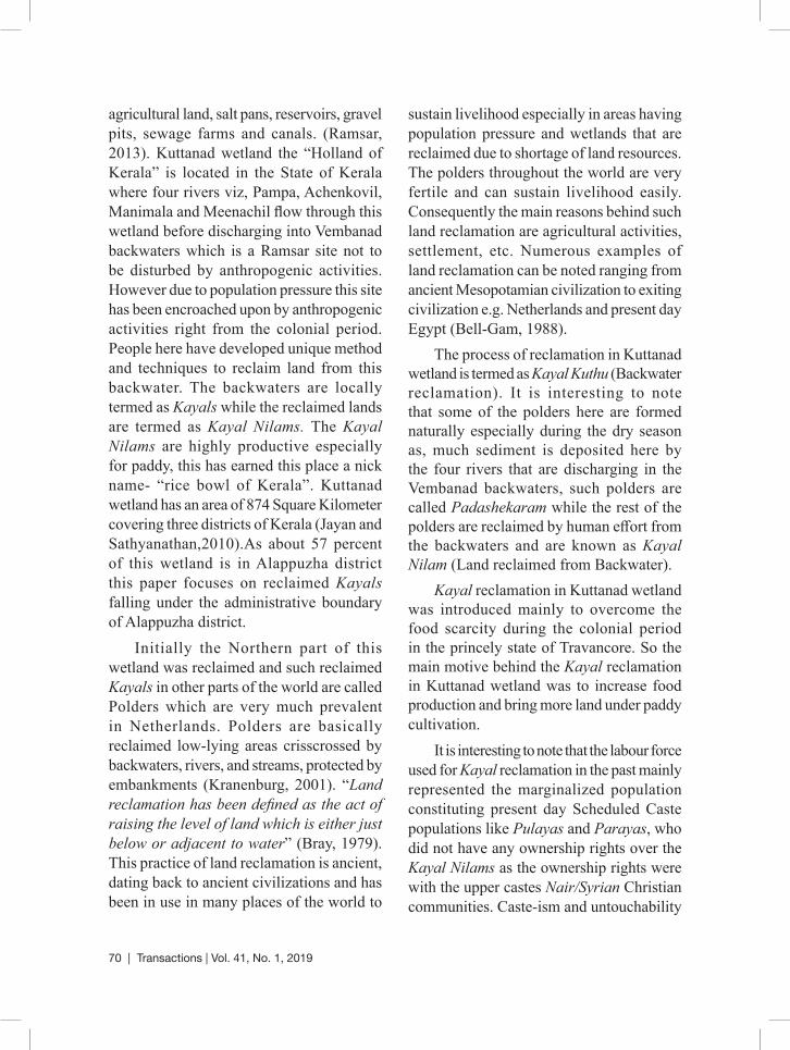
agricultural land, salt pans, reservoirs, gravel pits, sewage farms and canals. (Ramsar, 2013). Kuttanad wetland the “Holland of Kerala” is located in the State of Kerala where four rivers viz, Pampa, Achenkovil, Manimala and Meenachil flow through this wetland before discharging into Vembanad backwaters which is a Ramsar site not to be disturbed by anthropogenic activities. However due to population pressure this site has been encroached upon by anthropogenic activities right from the colonial period. People here have developed unique method and techniques to reclaim land from this backwater. The backwaters are locally termed as Kayals while the reclaimed lands are termed as Kayal Nilams. The Kayal Nilams are highly productive especially for paddy, this has earned this place a nick name- “rice bowl of Kerala”. Kuttanad wetland has an area of 874 Square Kilometer covering three districts of Kerala (Jayan and Sathyanathan,2010).As about 57 percent of this wetland is in Alappuzha district this paper focuses on reclaimed Kayals falling under the administrative boundary of Alappuzha district.
Initially the Northern part of this wetland was reclaimed and such reclaimed Kayals in other parts of the world are called Polders which are very much prevalent in Netherlands. Polders are basically reclaimed low-lying areas crisscrossed by backwaters, rivers, and streams, protected by embankments (Kranenburg, 2001). “Land reclamation has been defined as the act of raising the level of land which is either just below or adjacent to water” (Bray, 1979). This practice of land reclamation is ancient, dating back to ancient civilizations and has been in use in many places of the world to
sustain livelihood especially in areas having population pressure and wetlands that are reclaimed due to shortage of land resources. The polders throughout the world are very fertile and can sustain livelihood easily. Consequently the main reasons behind such land reclamation are agricultural activities, settlement, etc. Numerous examples of land reclamation can be noted ranging from ancient Mesopotamian civilization to exiting civilization e.g. Netherlands and present day Egypt (Bell-Gam, 1988).
The process of reclamation in Kuttanad wetland is termed as Kayal Kuthu (Backwater reclamation). It is interesting to note that some of the polders here are formed naturally especially during the dry season as, much sediment is deposited here by the four rivers that are discharging in the Vembanad backwaters, such polders are called Padashekaram while the rest of the polders are reclaimed by human effort from the backwaters and are known as Kayal Nilam (Land reclaimed from Backwater).
Kayal reclamation in Kuttanad wetland was introduced mainly to overcome the food scarcity during the colonial period in the princely state of Travancore. So the main motive behind the Kayal reclamation in Kuttanad wetland was to increase food production and bring more land under paddy cultivation.
It is interesting to note that the labour force used for Kayal reclamation in the past mainly represented the marginalized population constituting present day Scheduled Caste populations like Pulayas and Parayas, who did not have any ownership rights over the Kayal Nilams as the ownership rights were with the upper castes Nair/Syrian Christian communities. Caste-ism and untouchability
Transactions | Vol. 41, No. 1, 2019 | 71
was a major practice here, consequently human labour was exploited (Varghese, 1982). But even after Indian Independence, the trend still continues.
It is in this context the present paper highlights on mapping, estimating area under reclaimed Kayals and the social divide associated with such reclamation in Kuttanad wetland which falls under the administrative boundary of Alappuzha District of Kerala.
ObjectivesTo map, estimate the approximate area of reclaimed Kayals in Kuttanad wetland with a focus on the social divide associated with such reclamation.
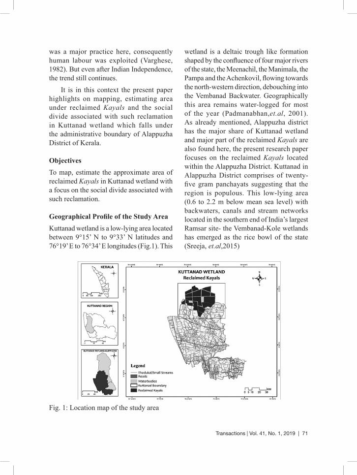
Geographical Profile of the Study AreaKuttanad wetland is a low-lying area located between 9°15’ N to 9°33’ N latitudes and 76°19’ E to 76°34’ E longitudes (Fig.1). This
wetland is a deltaic trough like formation shaped by the confluence of four major rivers of the state, the Meenachil, the Manimala, the Pampa and the Achenkovil, flowing towards the north-western direction, debouching into the Vembanad Backwater. Geographically this area remains water-logged for most of the year (Padmanabhan,et.al, 2001). As already mentioned, Alappuzha district has the major share of Kuttanad wetland and major part of the reclaimed Kayals are also found here, the present research paper focuses on the reclaimed Kayals located within the Alappuzha District. Kuttanad in Alappuzha District comprises of twenty-five gram panchayats suggesting that the region is populous. This low-lying area (0.6 to 2.2 m below mean sea level) with backwaters, canals and stream networks located in the southern end of India’s largest Ramsar site- the Vembanad-Kole wetlands has emerged as the rice bowl of the state (Sreeja, et.al,2015)
Fig. 1: Location map of the study area

72 | Transactions | Vol. 41, No. 1, 2019
Materials and MethodsThe present study is based on both primary and secondary data sources. Study area Map has been prepared with the help of Survey of India Toposheets. Maps of reclaimed Kayals from 1880 onwards has been prepared, with the help of US Army service toposheets surveyed in the year 1917 (NC-43/11 and NC-43/12) and Survey of India toposheet numbers 58C/6, 58C/7, 58C/11 and 58C/12 surveyed in 1968. The map of reclaimed Kayal divisions into smaller segments in 2000 has been prepared with help of Survey of India toposheets number C43Q6, C43Q7, C43Q10 and C43Q11 surveyed in the year 2005. The above mentioned toposheets has been georeferenced, digitized and mapped by the help of GIS software viz ArcGIS.
Data regarding the history of Kayal reclamation has been collected from various government offices and libraries which have been duly acknowledged. Area of total reclaimed Kayals has been collected from Krishibhavans. The approximate area under reclaimed Kayals has been computed through Arc GIS software. Present information pertaining to current ownership rights of reclaimed Kayals and the agriculture labour force working here has been collected through field investigation by interacting with the local population who are residing on the embankments of such reclaimed Kayals in Decenber and January of 2014-15. The respondents mainly include Agriculture labourers and Kayal Nilam owners.
Result and DiscussionKayal Reclamation its Genesis and ChronologyAs per records and mapping of the reclaimed Kayals it suggests that the Kayal reclamation
in Kuttanad can be divided into three distinct phases viz.
i) The first phase started around 1880 which continued till about 1888. It is interesting to note that reclamation in Kuttanad were initially started by the lower caste population like Pulayas and Parayas, as this marginalized section did not have access to land, thus they started reclaiming the Kayals which initially were used for settlements of this marginalized section, but as the reclaimed Kayals were productive, ideal for paddy cultivation, paddy was introduced here, this marked the first stage of Kayal reclamation, but data is scarce during this stage (Kuriakose,2014;Samuel Mateer,1883)
The first phase of Kayal reclamation is marked by a series of incentives which were made available to the tenant cultivators by the Travancore state. The purpose of the reclamation was mainly to increase the area under paddy cultivation so as to increase food production. Pattom Proclamation of 1865 granted ownership rights to the tenant cultivators for newly reclaimed Kayal lands. From the year 1886 on-wards the state of Travancore encouraged projects to assist reclamation activity in Kuttanad (Justin Paul, 2005). As reclamation of Kayal from deep backwaters for paddy cultivation requires huge investments, since some areas are more than 9 metres below sea level. Therefore the area of reclamation was very less during this first phase (Alex George, 1987).

Transactions | Vol. 41, No. 1, 2019 | 73
ii) The second phase of Kayal reclamation started around 1888 and continued till 1903 when reclamation of Kayal became more intensive as suggested by the mapping with the help of topographical maps as well as the secondary data. During this stage the upper castes like Nairs-Brahmins; Syrian Christians also adopted the Kayal reclamation methods of Pulayas and Parayas in large-scale and created polders from the Vembanad Kayal (Backwaters). But during this stage the lower castes were mainly used as the major labour force (Kuriakose, 2014). During this phase, the elite Land lords belonging to the upper castes acquired the consent from the Travancore King to reclaim the Kayals and they used agriculture labours belonging to the lower castes for this reclamation. The pioneers during this phase of Kayal reclamation w were Chalayil Eravi Kesava Panicker along with other local landlords. The reclaimed Kayals of this stage are Attumuttu Kayal, Rajaramapuram Kayal, Mangalam, Manikya mangalam Kayal, Sreemoolamangalam, Kannitta Kayal, Cherukali Kayal (Fig.2 and Table-1).The last Kayal reclaimed during this phase was ‘Mathi Kayal’ (Pillai and Panicker, 1965).
As already mentioned these reclaimed Kayals were the major economic assets, mainly owned by upper castes like Syrian Christians, Namboothiris and Nairs etc. While, the labour force used for such reclamation mainly constituted of the lower castes like Pulayas and Parayas who were landless agricultural labour force staying in the land of upper caste as hutment- dwellers (locally termed as Kudikidappukar) (Alexander,1975). Consequently the lower castes who were also untouchables were exploited, while the benefit of the highly productive reclaimed Kayals went to the landlords creating a further gap on the existing socio-economic divide between the upper caste elite landlords and the poor marginalized lower caste population.
Around 1903 to 1912 Kayal reclamation was stopped because of the apprehension of Presidency of Madras in the impact of Kayal reclamation in Kuttanad which may adversely affect the port of Cochin. So the Colonial Power stationed in Madras requested Travancore Government to stop the Kayal reclamation (Pillai and Panicker, 1965).
The total area of reclaimed Kayals during the first and second phase was about 1764.15 hectares. Among the reclaimed Kayals, Rajaramapuram Kayal was the largest one having an area of 538.21hectares. (Table-1)

74 | Transactions | Vol. 41, No. 1, 2019
Fig. 2: Reclaimed Kayals from 1880-1903
Table-1: Name of reclaimed Kayals, its area and share to total (in %) (1880-1903)
Sl.No Name of Reclaimed Kayals Area in HectaresShare in % to total reclaimed
areaRank
1 Mangalam Manikya mangalam Kayal 394.05 22.34 3
2 Rajaramapuram Kayal 538.21 30.51 13 Sreemoolamangalam 236 13.38 44 Kannitta Kayal 18 1.02 65 Cherukali Kayal 100 5.67 56 Mathi Kayal 477.9 27.09 2 Total Area 1764.16 100
Initiatives for better management of reclaimed KayalsThe large sized reclaimed Kayals which has already been mentioned were owned by
the upper castes. These large sized Kayals had management problems consequently it was realized that for better management and to increase the productivity of these

Transactions | Vol. 41, No. 1, 2019 | 75
large sized reclaimed Kayals, were broken up into smaller sizes, thus Mathi Kayal (Fig. 3) was divided in to seven divisions by constructing small Varambu (causeway) between them, accordingly the Mathi
Kayal got divided into - Thekke Mathi Kayal, Vadakke Mathi Kayal, Matha Kayal, Madathil Kayal Pokkam, Madathil Kayal Thazhcha, Puthanpura Kayal and Padinjare Venattukari. (Table-2)
Table -2: Breaking up of Mathi Kayal for better management.
Sl.No. Separated Mathi Kayal Area in sq.km Share in % to total reclaimed area
Rank
1 Padinjare Venattukari 43.6 9.12 42 Madathil Kayal Pokkam 43.2 9.04 53 Thekke Mathi Kayal 152.4 31.89 14 Madathil Kayal Thazhcha 38.5 8.06 65 Puthanpura Kayal 47.4 9.92 36 Matha Kayal 20.8 4.35 7 Vadakke mathi Kayal 132 27.62 2
Total Area 477.9 100
Fig. 3: Mathi Kayals after Separation
76 | Transactions | Vol. 41, No. 1, 2019
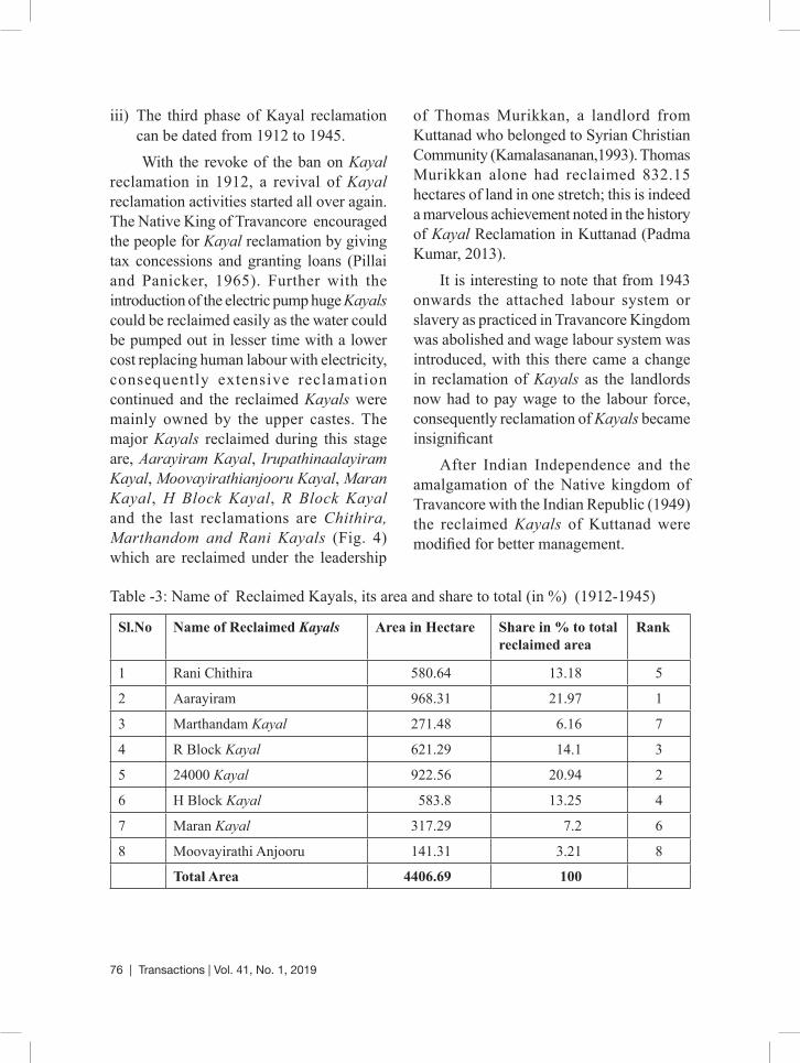
iii) The third phase of Kayal reclamation can be dated from 1912 to 1945. With the revoke of the ban on Kayal
reclamation in 1912, a revival of Kayal reclamation activities started all over again. The Native King of Travancore encouraged the people for Kayal reclamation by giving tax concessions and granting loans (Pillai and Panicker, 1965). Further with the introduction of the electric pump huge Kayals could be reclaimed easily as the water could be pumped out in lesser time with a lower cost replacing human labour with electricity, consequently extensive reclamation continued and the reclaimed Kayals were mainly owned by the upper castes. The major Kayals reclaimed during this stage are, Aarayiram Kayal, Irupathinaalayiram Kayal, Moovayirathianjooru Kayal, Maran Kayal, H Block Kayal, R Block Kayal and the last reclamations are Chithira, Marthandom and Rani Kayals (Fig. 4) which are reclaimed under the leadership
of Thomas Murikkan, a landlord from Kuttanad who belonged to Syrian Christian Community (Kamalasananan,1993). Thomas Murikkan alone had reclaimed 832.15 hectares of land in one stretch; this is indeed a marvelous achievement noted in the history of Kayal Reclamation in Kuttanad (Padma Kumar, 2013).
It is interesting to note that from 1943 onwards the attached labour system or slavery as practiced in Travancore Kingdom was abolished and wage labour system was introduced, with this there came a change in reclamation of Kayals as the landlords now had to pay wage to the labour force, consequently reclamation of Kayals became insignificant
After Indian Independence and the amalgamation of the Native kingdom of Travancore with the Indian Republic (1949) the reclaimed Kayals of Kuttanad were modified for better management.
Table -3: Name of Reclaimed Kayals, its area and share to total (in %) (1912-1945)
Sl.No Name of Reclaimed Kayals Area in Hectare Share in % to total reclaimed area
Rank
1 Rani Chithira 580.64 13.18 5
2 Aarayiram 968.31 21.97 1
3 Marthandam Kayal 271.48 6.16 7
4 R Block Kayal 621.29 14.1 3
5 24000 Kayal 922.56 20.94 2
6 H Block Kayal 583.8 13.25 4
7 Maran Kayal 317.29 7.2 6
8 Moovayirathi Anjooru 141.31 3.21 8
Total Area 4406.69 100
Transactions | Vol. 41, No. 1, 2019 | 77
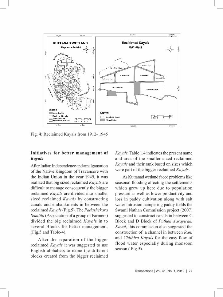
Initiatives for better management of KayalsAfter Indian Independence and amalgamation of the Native Kingdom of Travancore with the Indian Union in the year 1949, it was realized that big sized reclaimed Kayals are difficult to manage consequently the bigger reclaimed Kayals are divided into smaller sized reclaimed Kayals by constructing canals and embankments in between the reclaimed Kayals (Fig.5). The Padashekara Samithi (Association of a group of Farmers) divided the big reclaimed Kayals in to several Blocks for better management. (Fig.5 and Table-4).
After the separation of the bigger reclaimed Kayals it was suggested to use English alphabets to name the different blocks created from the bigger reclaimed
Kayals. Table 1.4 indicates the present name and area of the smaller sized reclaimed Kayals and their rank based on sizes which were part of the bigger reclaimed Kayals.
As Kuttanad wetland faced problems like seasonal flooding affecting the settlements which grew up here due to population pressure as well as lower productivity and loss in paddy cultivation along with salt water intrusion hampering paddy fields the Swami Nathan Commission project (2007) suggested to construct canals in between C Block and D Block of Puthen Aarayiram Kayal, this commission also suggested the construction of a channel in between Rani and Chithira Kayals for the easy flow of flood water especially during monsoon season ( Fig.5).
Fig. 4: Reclaimed Kayals from 1912- 1945
78 | Transactions | Vol. 41, No. 1, 2019
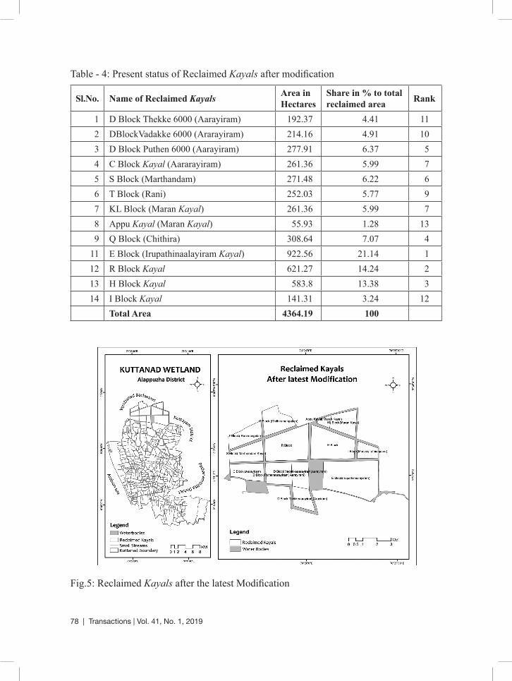
Table - 4: Present status of Reclaimed Kayals after modification
Sl.No. Name of Reclaimed Kayals Area in Hectares
Share in % to total reclaimed area Rank
1 D Block Thekke 6000 (Aarayiram) 192.37 4.41 112 DBlockVadakke 6000 (Ararayiram) 214.16 4.91 103 D Block Puthen 6000 (Aarayiram) 277.91 6.37 54 C Block Kayal (Aararayiram) 261.36 5.99 75 S Block (Marthandam) 271.48 6.22 66 T Block (Rani) 252.03 5.77 97 KL Block (Maran Kayal) 261.36 5.99 78 Appu Kayal (Maran Kayal) 55.93 1.28 139 Q Block (Chithira) 308.64 7.07 4
11 E Block (Irupathinaalayiram Kayal) 922.56 21.14 112 R Block Kayal 621.27 14.24 213 H Block Kayal 583.8 13.38 314 I Block Kayal 141.31 3.24 12
Total Area 4364.19 100
Fig.5: Reclaimed Kayals after the latest Modification

Transactions | Vol. 41, No. 1, 2019 | 79
It is observed that the total area of Kayal reclamation was only 1764.16 hectares during 1880 to 1903 and from 1912 to 1945 the area of reclamation increased to 4406.68 hectares suggesting a growth rate of 149.79% within a span of fifty five years and a gap of nine years in between when reclamation of Kayals was stopped by Madras Presidency during the Colonial phase. After Independence and amalgamation of the Travancore state with the Indian Republic the Indian government stressed on better management of such reclaimed Kayals, subsequently the large sized reclaimed Kayals were separated by canals and embankments, thus the area of the reclaimed Kayals reduced from 4406.68 hectares to 4364.19 hectares. Total area of Vembanad backwater in the reclaimed area has drastically reduced from 5445.64 hectares to 1072.97 hectares. After Independence due to population pressure settlements have sprung up in the embankments separating the reclaimed Kayals.
ConclusionAfter Indian Independence, the government of Kerala introduced Kerala Land Reforms (Amendment) Act, 1969, even though it was not totally successful in Kerala, nevertheless, this act put an end to the feudal system on 1 January 1970 (Mukundan Peruvattoor, 2012). Therefore some of the large landholders reclaimed Kayals were also seized under this land reforms Act and the seized reclaimed Kayals were taken by the government and distributed to the landless agriculture labour force who were in fact the creators of such reclaimed Kayals. However in spite of the
Government’s effort, field investigation carried in December- January 2014-15 suggests that the reclaimed Kayal owners are mainly belonging to the upper castes while the agriculture labour force are constituted from the lower castes. As already mentioned due to population pressure, settlements have sprung up in the embankments separating the reclaimed Kayals. Field investigation suggests that majority of the population living in these embankments are from the schedule caste population or the other backward caste population. Consequently it can be concluded that in spite of Kerala being a forward state the caste divide exists which gets manifested into the class divide, as stated by Nissim Mannathukkaren (2013) in his article mentioned that “caste and class segregation has not been addressed properly till date”.
References• Alex George.(1987): Social and Economic
Aspects of Attached Laborers in Kuttanad Agriculture, Economic and Political Weekly, pp.141-150.
• Alexander K.C.(1973): Emerging farmer-labour relations in Kuttanad. Economic and Political Weekly 8:1551–1560.
• Bell-Gam, W.I.(1988): Land reclamation and Environmental Management, Sterling Publishers and Private Limited, New Delhi.
• Biju, C.M. and Amirtha Jothi,C.(2012): Socio-Economic Life and Institutions in the Traditional Society of Kerala in 18th and 19th Centuries ,International Journal of Scientific & Engineering Research ,Volume 3, Issue 12, December-2012, ISSN 2229-5518.
• Bray R.N.(1979): Dredging, Edward Arnold.
80 | Transactions | Vol. 41, No. 1, 2019
• Jayan, P.R. and Nithya Sathyanathan.(2010): Overview of farming practices in the waterlogged areas of Kerala, India. International Journal of Agriculture & Biological Engineering, 3(4).
• Justin Paul, P. (2005):Travancore and Agrarian reforms 1800-1956, Ph,D Thesis,Department of History, Post Graduate and Research Centre Nesamony Memorial Christian college Marthandam.Tamil Nadu, http://shodhganga.inflibnet.ac.in/handle/10603/65734.
• Kamalasanan, N.K.(1993): Kuttanadaum Karshaka Thozhilali Prasthanavum.(Malayalam), Sahitya Pravarthaka, Co-operative Society, Ltd, National Book Stall, Kottayam.
• Kranenburg, R. (2001): Compact Geography of the Netherlands, Utrecht: KNAG.
• Mathew Kuriakose. (2014): The saga of the commons in Kuttanad: appropriations, contests, developments, Decision, Springer.
• Mukundan Peruvattoor.(2012): Kerala Bhooparikshkarana Niyam “Marxistukal” Thozhilali Vargathe Vanjicha Charithram (Malayalam),Bhahujan Sahithya Academy, Colour Books,Calicut.
• Nissim Mannathukkaren. (2013):The rise of the national-popular and its limits: communism and the cultural in Kerala, Inter-Asia Cultural Studies, 14:4, 494-518, DOI: 10.1080/14649373.2013.831160.
• Padmakumar, K.G. (2013):Kuttanad-Global Agricultural Heritage: Promoting Uniqueness. Proceedings of the Kerala Environment Congress.
• Padmanabhan, P.G, Narayanan, N. C. and Padmakumar, K.G.(2001):Economic Viability of an Integrated and Sustainable Resource Use Model for Kuttanad, Discussion Paper No. 33.
• Pillai, V.R. and Panikkar, G.K. (1965): Land reclamation in Kerala, Asia Publishing House, and New York.
• Kerala Research Programme on Local Level Development Centre for Development Studies Thiruvananthapuram.
• Ramsar Convention Secretariat.(2013):The Ramsar Convention Manual: a guide to the Convention on Wetlands (Ramsar, Iran, 1971), 6th ed. Ramsar Convention Secretariat, Gland, Switzerland.
• Samuel mateer, F. L. S.(1883):Native Life in Travancore H Allen and Company 13 Waterloo place pall-mall sw.
• Sreeja, K.G, Madhusoodhanan, C.G. and Eldho, T. I. (2015): Climate and Land use change impacts on sub-sea level rice farming in a tropical deltaic wetland, E-proceedings of the 36th IAHR World Congress 28 June – 3 July, 2015, The Hague, Netherlands.
• Swaminathan, M.S.(2007): Measures to Mitigate Agrarian Distress in Alappuzha and Kuttanad Wetland Ecosystem, A Study Report by M. S. Swaminathan Research Foundation.
• Varghese, K.E.(1982): Slow flows the pampa-Socio-Economic Changes in a Kuttanad Village in Kerala, Concept publishing Company, New Delhi, pp.79.
Sarath Chandran
Rajiv Gandhi National Fellow [email protected]
Dr. S. Purkayastha Assistant Professor
Department of Geography North Eastern Hill University Shillong, Meghalaya, India [email protected]
Copyright © 2022 FDOKUMEN