High Resolution Imaging Science Experiment (HiRISE) observations of glacial and periglacial...
20
High Resolution Imaging Science Experiment (HiRISE) observations of glacial and periglacial morphologies in the circum-Argyre Planitia highlands, Mars Maria E. Banks, 1 Alfred S. McEwen, 2 Jeffrey S. Kargel, 3 Victor R. Baker, 3 Robert G. Strom, 2 Michael T. Mellon, 4 Virginia C. Gulick, 5 Laszlo Keszthelyi, 6 Kenneth E. Herkenhoff, 6 Jon D. Pelletier, 1 and Windy L. Jaeger 6 Received 20 August 2007; revised 17 March 2008; accepted 7 July 2008; published 31 December 2008. [1] The landscape of the Argyre Planitia and adjoining Charitum and Nereidum Montes in the southern hemisphere of Mars has been heavily modified since formation of the Argyre impact basin. This study examines morphologies in the Argyre region revealed in images acquired by the High Resolution Imaging Science Experiment (HiRISE) camera and discusses the implications for glacial and periglacial processes. Distinctive features such as large grooves, semicircular embayments in high topography, and streamlined hills are interpreted as glacially eroded grooves, cirques, and whalebacks or roche moutonne ´e, respectively. Large boulders scattered across the floor of a valley may be ground moraine deposited by ice ablation. Glacial interpretations are supported by the association of these features with other landforms typical of glaciated landscapes such as broad valleys with parabolic cross sections and stepped longitudinal profiles, lobate debris aprons interpreted as remnant debris covered glaciers or rock glaciers, and possible hanging valleys. Aligned boulders observed on slopes may also indicate glacial processes such as fluting. Alternatively, boulders aligned on slopes and organized in clumps and polygonal patterns on flatter surfaces may indicate periglacial processes, perhaps postglaciation, that form patterned ground. At least portions of the Argyre region appear to have been modified by processes of ice accumulation, glacial flow, erosion, sediment deposition, ice stagnation and ablation, and perhaps subsequent periglacial processes. The type of bedrock erosion apparent in images suggests that glaciers were, at times, wet based. The number of superposed craters is consistent with geologically recent glacial activity, but may be due to subsequent modification. Citation: Banks, M. E., et al. (2008), High Resolution Imaging Science Experiment (HiRISE) observations of glacial and periglacial morphologies in the circum-Argyre Planitia highlands, Mars, J. Geophys. Res., 113, E12015, doi:10.1029/2007JE002994. 1. Introduction [2] The history of ice on Mars provides important infor- mation about Martian geologic and climatic history driven by variations in orbital parameters and insolation geometry, volatile mass balance, large impacts, volcanic eruptions, and solar luminosity. Evidence of glacial flow has been sug- gested in several areas on Mars including the Argyre Planitia [e.g., Hodges, 1980; Kargel and Strom,1990, 1992; Baker, 2001; Hiesinger and Head, 2002; Kargel, 2004], east and south of Hellas basin [e.g., Kargel and Strom, 1992; Kargel, 2004; Head et al., 2005], the northern fretted terrain [e.g., Moore and Davis, 1987; Kargel and Strom, 1992; Kargel, 2004; Head et al., 2006], the outflow channels [Lucchitta, 1982], and the Tharsis volcanoes [e.g., Head and Marchant, 2003; Head et al., 2005; Shean et al., 2007]. [3] The Argyre Planitia is a prominent Martian impact basin with a diameter in excess of 1500 km. The Argyre Planitia and adjoining mountainous ring ranges, Charitum Montes (on the basin’s southern side) and Nereidum Montes (on the basin’s northern side), are located in the southern hemisphere of Mars centered at 51°S and 317°E (Figure 1) [Tanaka et al., 1992]. This region appears to have been heavily modified by a combination of processes since the formation of the Argyre impact structure; processes that are JOURNAL OF GEOPHYSICAL RESEARCH, VOL. 113, E12015, doi:10.1029/2007JE002994, 2008 1 Department of Geosciences, University of Arizona, Tucson, Arizona, USA. 2 Lunar and Planetary Laboratory, University of Arizona, Tucson, Arizona, USA. 3 Department of Hydrology and Water Resources, University of Arizona, Tucson, Arizona, USA. 4 Laboratory for Atmospheric and Space Physics, University of Colorado, Boulder, Colorado, USA. 5 NASA Ames Research Center and SETI Institute, Moffett Field, California, USA. 6 Astrogeology Team, USGS, Flagstaff, Arizona, USA. Copyright 2008 by the American Geophysical Union. 0148-0227/08/2007JE002994 E12015 1 of 20
-
Upload
independent -
Category
Documents
-
view
2 -
download
0
Transcript of High Resolution Imaging Science Experiment (HiRISE) observations of glacial and periglacial...

High Resolution Imaging Science Experiment (HiRISE) observations
of glacial and periglacial morphologies in the circum-Argyre
Planitia highlands, Mars
Maria E. Banks,1 Alfred S. McEwen,2 Jeffrey S. Kargel,3 Victor R. Baker,3
Robert G. Strom,2 Michael T. Mellon,4 Virginia C. Gulick,5 Laszlo Keszthelyi,6
Kenneth E. Herkenhoff,6 Jon D. Pelletier,1 and Windy L. Jaeger6
Received 20 August 2007; revised 17 March 2008; accepted 7 July 2008; published 31 December 2008.
[1] The landscape of the Argyre Planitia and adjoining Charitum and NereidumMontes in the southern hemisphere of Mars has been heavily modified since formationof the Argyre impact basin. This study examines morphologies in the Argyre regionrevealed in images acquired by the High Resolution Imaging Science Experiment(HiRISE) camera and discusses the implications for glacial and periglacial processes.Distinctive features such as large grooves, semicircular embayments in hightopography, and streamlined hills are interpreted as glacially eroded grooves, cirques,and whalebacks or roche moutonnee, respectively. Large boulders scattered across thefloor of a valley may be ground moraine deposited by ice ablation. Glacialinterpretations are supported by the association of these features with other landformstypical of glaciated landscapes such as broad valleys with parabolic cross sections andstepped longitudinal profiles, lobate debris aprons interpreted as remnant debriscovered glaciers or rock glaciers, and possible hanging valleys. Aligned bouldersobserved on slopes may also indicate glacial processes such as fluting. Alternatively,boulders aligned on slopes and organized in clumps and polygonal patterns on flattersurfaces may indicate periglacial processes, perhaps postglaciation, that form patternedground. At least portions of the Argyre region appear to have been modified by processes ofice accumulation, glacial flow, erosion, sediment deposition, ice stagnation and ablation,and perhaps subsequent periglacial processes. The type of bedrock erosion apparent inimages suggests that glaciers were, at times, wet based. The number of superposed craters isconsistent with geologically recent glacial activity, but may be due to subsequentmodification.
Citation: Banks, M. E., et al. (2008), High Resolution Imaging Science Experiment (HiRISE) observations of glacial and periglacial
morphologies in the circum-Argyre Planitia highlands, Mars, J. Geophys. Res., 113, E12015, doi:10.1029/2007JE002994.
1. Introduction
[2] The history of ice on Mars provides important infor-mation about Martian geologic and climatic history drivenby variations in orbital parameters and insolation geometry,volatile mass balance, large impacts, volcanic eruptions, andsolar luminosity. Evidence of glacial flow has been sug-
gested in several areas on Mars including the ArgyrePlanitia [e.g., Hodges, 1980; Kargel and Strom,1990,1992; Baker, 2001; Hiesinger and Head, 2002; Kargel,2004], east and south of Hellas basin [e.g., Kargel andStrom, 1992; Kargel, 2004; Head et al., 2005], the northernfretted terrain [e.g., Moore and Davis, 1987; Kargel andStrom, 1992; Kargel, 2004; Head et al., 2006], the outflowchannels [Lucchitta, 1982], and the Tharsis volcanoes [e.g.,Head and Marchant, 2003; Head et al., 2005; Shean et al.,2007].[3] The Argyre Planitia is a prominent Martian impact
basin with a diameter in excess of 1500 km. The ArgyrePlanitia and adjoining mountainous ring ranges, CharitumMontes (on the basin’s southern side) and Nereidum Montes(on the basin’s northern side), are located in the southernhemisphere of Mars centered at 51�S and 317�E (Figure 1)[Tanaka et al., 1992]. This region appears to have beenheavily modified by a combination of processes since theformation of the Argyre impact structure; processes that are
JOURNAL OF GEOPHYSICAL RESEARCH, VOL. 113, E12015, doi:10.1029/2007JE002994, 2008
1Department of Geosciences, University of Arizona, Tucson, Arizona,USA.
2Lunar and Planetary Laboratory, University of Arizona, Tucson,Arizona, USA.
3Department of Hydrology and Water Resources, University of Arizona,Tucson, Arizona, USA.
4Laboratory for Atmospheric and Space Physics, University ofColorado, Boulder, Colorado, USA.
5NASA Ames Research Center and SETI Institute, Moffett Field,California, USA.
6Astrogeology Team, USGS, Flagstaff, Arizona, USA.
Copyright 2008 by the American Geophysical Union.0148-0227/08/2007JE002994
E12015 1 of 20
still not well understood. This has led to many differinginterpretations of the geologic history of the Argyre region.Hodges [1980] interpreted the Argyre basin as modifiedprimarily by large-scale erosion and deposition associatedwith eolian processes, with possible fluvial and glacialprocesses playing a minor role. In their geologic map ofthe Argyre region, Scott and Tanaka [1986] proposedsignificant volcanic activity and deep erosion from wind,periglacial, and fluvial processes. According to Jons [1987,1999], large portions of the Argyre Planitia have beenmodified by extensive mud deposits owing to melting ofthe south polar cap. Using Viking Orbiter and Mars OrbiterCamera (MOC) images, some previous studies have inter-preted major landforms in the Argyre Planitia and theCharitumMontes as consistent with a glacial suite of cirques,horns, moraines, drumlins, eskers, kettles, and outwashplains formed by glacial erosional and depositional processes[e.g., Kargel and Strom, 1992; Metzger, 1992; Baker, 2001;Hiesinger andHead, 2002;Kargel, 2004;Banks et al., 2008].Parker [1996a, 1996b] attributed the ‘‘fresh’’ appearance ofthe Argyre basin to erosional ‘‘enhancement’’ from masswasting, eolian, fluvial, and lacustrine processes, and sug-gested that much material in the Charitum and NereidumMontes has been removed, possibly by fluvial and lacustrineerosion. On the basis of interpretations of channels andvalleys cutting across the Charitum and Nereidum Montes,links have also been proposed between possible glacial ormeltwater inflows and outflows through the Argyre area andthe Dorsa Argentea region (near the south pole) and thenorthern hemisphere lowlands [e.g.,Kargel and Strom, 1992;Parker 1989, 1994; Parker et al., 2000, 2003; Head, 2000;Head and Pratt, 2001; Hiesinger and Head, 2002; Ghatanand Head, 2004; Kargel, 2004].
[4] Images with a pixel scale of up to 0.25 m pixel–1
from the HiRISE camera aboard the Mars ReconnaissanceOrbiter (MRO) are revealing previously undiscerned detailsof the Martian surface [McEwen et al., 2007]. In this studywe combine HiRISE imagery with topographic data setsfrom the Mars Orbiter Laser Altimeter (MOLA) [Smith etal., 2001] onboard Mars Global Surveyor to gain greaterinsight into the processes that have modified the ArgyrePlanitia and the surrounding Charitum and Nereidum Mon-tes. We provide preliminary interpretations of new mor-phologies, and new details revealed in previously observedmorphologies, from HiRISE images of the Argyre region(Figure 1) and discuss the implications for glacial andperiglacial processes on Mars. When viewed as a whole,the small-scale landforms revealed in HiRISE imagery andthe surrounding large-scale landforms form a suite ofmorphologies in the Argyre region that can be collectivelyinterpreted as the products of past glacial erosion anddeposition and possibly subsequent periglacial processes.The character of interpreted glacial effects on Martianlandscapes in different studies varies from one region toanother, suggesting differences in or evolution of glacierdynamics and the responsible climatic regimes. The natureof the bedrock erosion reported here indicates a period ofwet-based glaciation in at least portions of the Argyreregion.
2. Morphologies in the Argyre Planitia andInterpretations
2.1. Semicircular Embayments
[5] Semicircular embayments have previously been iden-tified in imagery from the Charitum Montes [e.g., Kargel
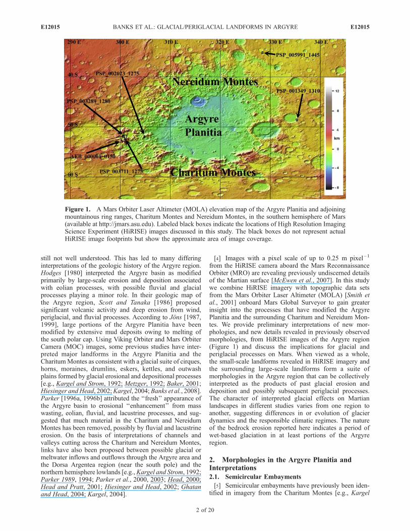
Figure 1. A Mars Orbiter Laser Altimeter (MOLA) elevation map of the Argyre Planitia and adjoiningmountainous ring ranges, Charitum Montes and Nereidum Montes, in the southern hemisphere of Mars(available at http://jmars.asu.edu). Labeled black boxes indicate the locations of High Resolution ImagingScience Experiment (HiRISE) images discussed in this study. The black boxes do not represent actualHiRISE image footprints but show the approximate area of image coverage.
E12015 BANKS ET AL.: GLACIAL/PERIGLACIAL LANDFORMS IN ARGYRE
2 of 20
E12015
and Strom, 1990, 1992; Kargel, 2004]. Here we take acloser look at these landforms using MOLA data and newdetails revealed in HiRISE imagery. A mesa in thesouthern portion of image AEB_000001_0150 is indented
by semicircular embayments that are bordered by ridges orcrests (Figures 2 and 3). Topographic data from MOLAPrecision Experiment Data Records (PEDRs) (available athttp://pds-geosciences.wustl.edu/missions/mgs/pedr.html)
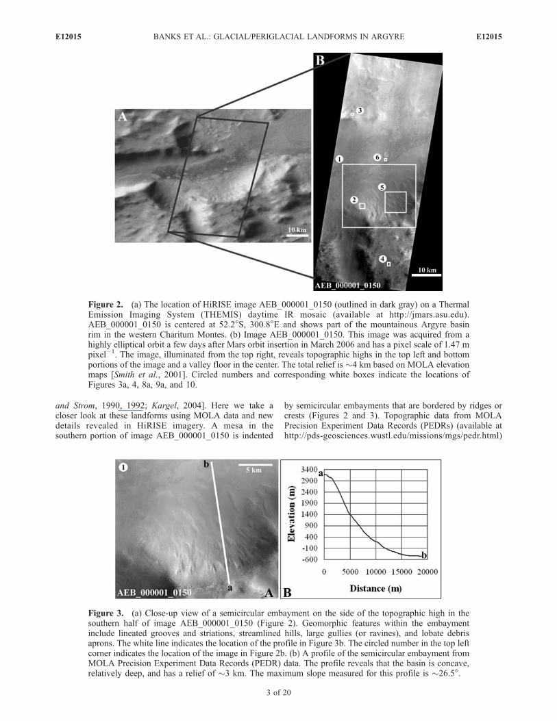
Figure 2. (a) The location of HiRISE image AEB_000001_0150 (outlined in dark gray) on a ThermalEmission Imaging System (THEMIS) daytime IR mosaic (available at http://jmars.asu.edu).AEB_000001_0150 is centered at 52.2�S, 300.8�E and shows part of the mountainous Argyre basinrim in the western Charitum Montes. (b) Image AEB_000001_0150. This image was acquired from ahighly elliptical orbit a few days after Mars orbit insertion in March 2006 and has a pixel scale of 1.47 mpixel–1. The image, illuminated from the top right, reveals topographic highs in the top left and bottomportions of the image and a valley floor in the center. The total relief is �4 km based on MOLA elevationmaps [Smith et al., 2001]. Circled numbers and corresponding white boxes indicate the locations ofFigures 3a, 4, 8a, 9a, and 10.
Figure 3. (a) Close-up view of a semicircular embayment on the side of the topographic high in thesouthern half of image AEB_000001_0150 (Figure 2). Geomorphic features within the embaymentinclude lineated grooves and striations, streamlined hills, large gullies (or ravines), and lobate debrisaprons. The white line indicates the location of the profile in Figure 3b. The circled number in the top leftcorner indicates the location of the image in Figure 2b. (b) A profile of the semicircular embayment fromMOLA Precision Experiment Data Records (PEDR) data. The profile reveals that the basin is concave,relatively deep, and has a relief of �3 km. The maximum slope measured for this profile is �26.5�.
E12015 BANKS ET AL.: GLACIAL/PERIGLACIAL LANDFORMS IN ARGYRE
3 of 20
E12015
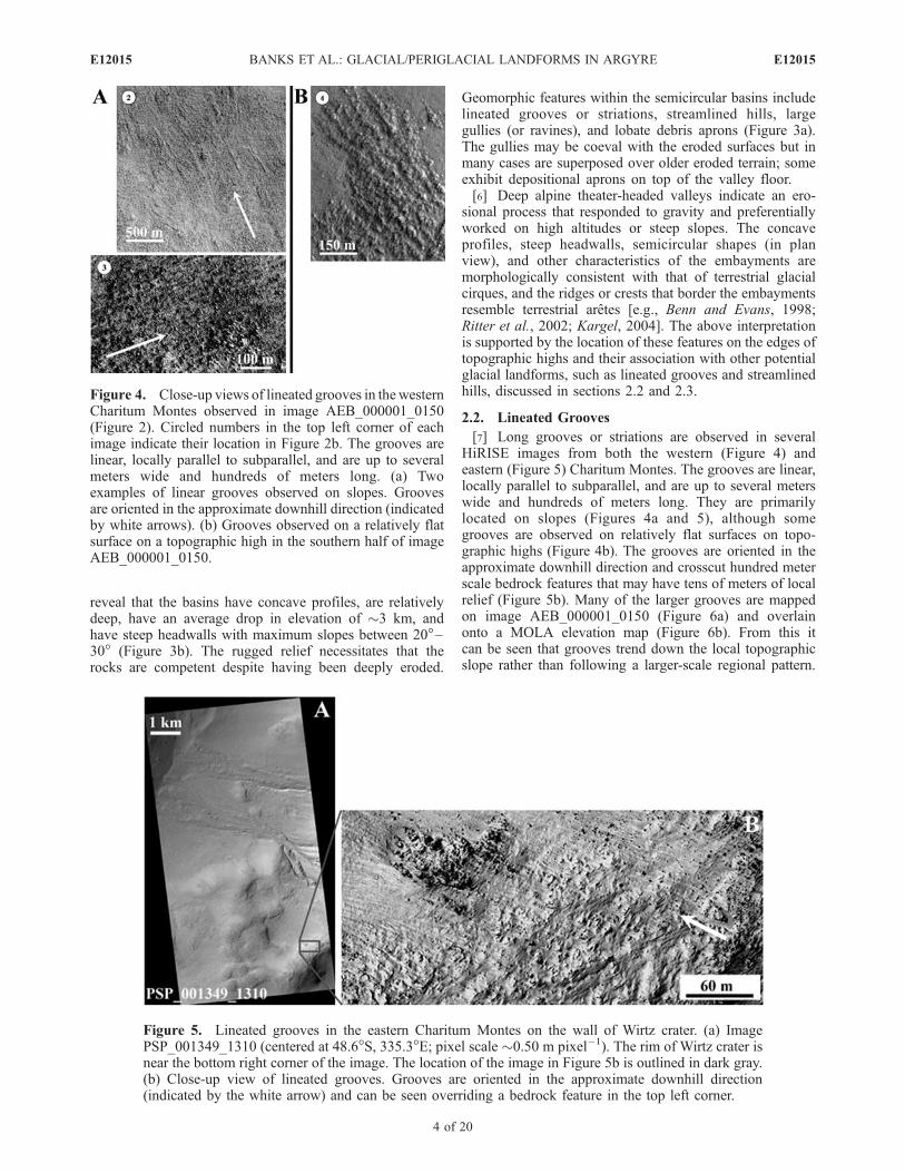
reveal that the basins have concave profiles, are relativelydeep, have an average drop in elevation of �3 km, andhave steep headwalls with maximum slopes between 20�–30� (Figure 3b). The rugged relief necessitates that therocks are competent despite having been deeply eroded.
Geomorphic features within the semicircular basins includelineated grooves or striations, streamlined hills, largegullies (or ravines), and lobate debris aprons (Figure 3a).The gullies may be coeval with the eroded surfaces but inmany cases are superposed over older eroded terrain; someexhibit depositional aprons on top of the valley floor.[6] Deep alpine theater-headed valleys indicate an ero-
sional process that responded to gravity and preferentiallyworked on high altitudes or steep slopes. The concaveprofiles, steep headwalls, semicircular shapes (in planview), and other characteristics of the embayments aremorphologically consistent with that of terrestrial glacialcirques, and the ridges or crests that border the embaymentsresemble terrestrial aretes [e.g., Benn and Evans, 1998;Ritter et al., 2002; Kargel, 2004]. The above interpretationis supported by the location of these features on the edges oftopographic highs and their association with other potentialglacial landforms, such as lineated grooves and streamlinedhills, discussed in sections 2.2 and 2.3.
2.2. Lineated Grooves
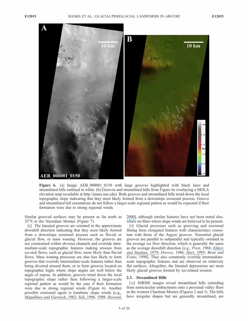
[7] Long grooves or striations are observed in severalHiRISE images from both the western (Figure 4) andeastern (Figure 5) Charitum Montes. The grooves are linear,locally parallel to subparallel, and are up to several meterswide and hundreds of meters long. They are primarilylocated on slopes (Figures 4a and 5), although somegrooves are observed on relatively flat surfaces on topo-graphic highs (Figure 4b). The grooves are oriented in theapproximate downhill direction and crosscut hundred meterscale bedrock features that may have tens of meters of localrelief (Figure 5b). Many of the larger grooves are mappedon image AEB_000001_0150 (Figure 6a) and overlainonto a MOLA elevation map (Figure 6b). From this itcan be seen that grooves trend down the local topographicslope rather than following a larger-scale regional pattern.
Figure 4. Close-up views of lineated grooves in thewesternCharitum Montes observed in image AEB_000001_0150(Figure 2). Circled numbers in the top left corner of eachimage indicate their location in Figure 2b. The grooves arelinear, locally parallel to subparallel, and are up to severalmeters wide and hundreds of meters long. (a) Twoexamples of linear grooves observed on slopes. Groovesare oriented in the approximate downhill direction (indicatedby white arrows). (b) Grooves observed on a relatively flatsurface on a topographic high in the southern half of imageAEB_000001_0150.
Figure 5. Lineated grooves in the eastern Charitum Montes on the wall of Wirtz crater. (a) ImagePSP_001349_1310 (centered at 48.6�S, 335.3�E; pixel scale �0.50 m pixel–1). The rim of Wirtz crater isnear the bottom right corner of the image. The location of the image in Figure 5b is outlined in dark gray.(b) Close-up view of lineated grooves. Grooves are oriented in the approximate downhill direction(indicated by the white arrow) and can be seen overriding a bedrock feature in the top left corner.
E12015 BANKS ET AL.: GLACIAL/PERIGLACIAL LANDFORMS IN ARGYRE
4 of 20
E12015
Similar grooved surfaces may be present as far north as35�S in the Nereidum Montes (Figure 7).[8] The lineated grooves are oriented in the approximate
downhill direction indicating that they most likely formedfrom a downslope erosional process such as fluvial orglacial flow, or mass wasting. However, the grooves arenot constrained within obvious channels and override inter-mediate-scale topographic features making erosion fromice-rich flows, such as glacial flow, more likely than fluvialflows. Mass wasting processes are also less likely to formgrooves that override intermediate-scale features rather thanbeing diverted around them, or to form grooves located ontopographic highs where slope angles are well below theangle of repose. In addition, grooves trend down the localtopographic slope rather than following a larger-scaleregional pattern as would be the case if their formationwere due to strong regional winds (Figure 6). Anotherpossible erosional agent is katabatic slope winds [e.g.,Magalhaes and Gierasch, 1982; Siili, 1996, 1998; Howard,
2000], although similar features have not been noted else-where on Mars where slope winds are believed to be present.[9] Glacial processes such as grooving and erosional
fluting form elongated features with characteristics consis-tent with those of the Argyre grooves. Terrestrial glacialgrooves are parallel to subparallel and typically oriented inthe average ice flow direction, which is generally the sameas the average downhill direction [e.g., Prest, 1968; Ehlersand Stephan, 1979; Drewry, 1986; Hart, 1995; Benn andEvans, 1998]. They also commonly override intermediate-scale topographic features and are observed on relativelyflat surfaces. Altogether, the lineated depressions are mostlikely glacial grooves formed by ice-related erosion.
2.3. Streamlined Hills
[10] HiRISE images reveal streamlined hills extendingfrom semicircular embayments onto a proximal valley floorin the western Charitum Montes (Figures 2 and 3). The hillshave irregular shapes but are generally streamlined, are
Figure 6. (a) Image AEB_000001_0150 with large grooves highlighted with black lines andstreamlined hills outlined in white. (b) Grooves and streamlined hills from Figure 6a overlaying a MOLAelevation map (available at http://jmars.asu.edu). Both grooves and streamlined hills trend down the localtopographic slope indicating that they most likely formed from a downslope erosional process. Grooveand streamlined hill orientations do not follow a larger-scale regional pattern as would be expected if theirformation were due to strong regional winds.
E12015 BANKS ET AL.: GLACIAL/PERIGLACIAL LANDFORMS IN ARGYRE
5 of 20
E12015

Figure 7. Grooved/lineated surface in the northern Argyre region. (a) Thewall of an unnamed crater in theNereidum Montes (image PSP_005991_1445; centered at 35.2�S, 328.4 �E; pixel scale�0.29 m pixel–1).The rim of the crater is located just above the center of the image. The location of the image in Figure 7b isoutlined in white. (b) Close-up view of the crater wall showing a surface with grooves similar to thoseobserved in the Charitum Montes (Figures 4 and 5). Grooves are oriented in the approximate downhilldirection (indicated by the white arrow). The grooves/lineations in Figure 7a and 7b are similar in form,scale, and organization to eolian erosional features and glacially scoured bedrock.
Figure 8. Streamlined hills in the western Charitum Montes. (a) Streamlined hills located in asemicircular embayment in image AEB_000001_0150 (Figure 2) have irregular shapes but are generallystreamlined and oriented in the approximate direction of maximum slope (indicated by the white arrow).The streamlined hills vary in dimensions with widths up to hundreds of meters and lengths of more than akilometer; several streamlined hills have wider uphill and more tapering downhill ends. The circlednumber in the top left corner indicates the location of the image in Figure 2b. The location of the image inFigure 8b is outlined in black. (b) A close-up view of a streamlined hill from Figure 8a with groovesapparent on portions of its surface (image PSP_003711_1275; centered at 52.3�S, 300.9�E; pixel scale�0.25 m pixel–1).
E12015 BANKS ET AL.: GLACIAL/PERIGLACIAL LANDFORMS IN ARGYRE
6 of 20
E12015
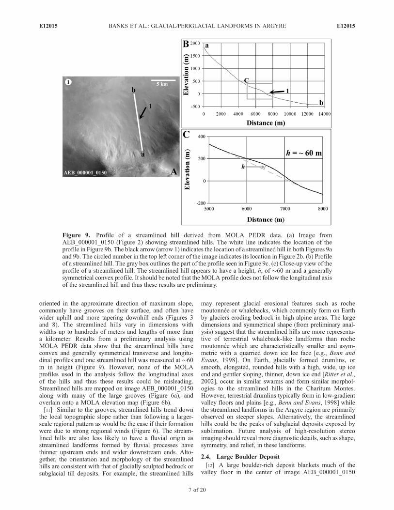
oriented in the approximate direction of maximum slope,commonly have grooves on their surface, and often havewider uphill and more tapering downhill ends (Figures 3and 8). The streamlined hills vary in dimensions withwidths up to hundreds of meters and lengths of more thana kilometer. Results from a preliminary analysis usingMOLA PEDR data show that the streamlined hills haveconvex and generally symmetrical transverse and longitu-dinal profiles and one streamlined hill was measured at �60m in height (Figure 9). However, none of the MOLAprofiles used in the analysis follow the longitudinal axesof the hills and thus these results could be misleading.Streamlined hills are mapped on image AEB_000001_0150along with many of the large grooves (Figure 6a), andoverlain onto a MOLA elevation map (Figure 6b).[11] Similar to the grooves, streamlined hills trend down
the local topographic slope rather than following a larger-scale regional pattern as would be the case if their formationwere due to strong regional winds (Figure 6). The stream-lined hills are also less likely to have a fluvial origin asstreamlined landforms formed by fluvial processes havethinner upstream ends and wider downstream ends. Alto-gether, the orientation and morphology of the streamlinedhills are consistent with that of glacially sculpted bedrock orsubglacial till deposits. For example, the streamlined hills
may represent glacial erosional features such as rochemoutonnee or whalebacks, which commonly form on Earthby glaciers eroding bedrock in high alpine areas. The largedimensions and symmetrical shape (from preliminary anal-ysis) suggest that the streamlined hills are more representa-tive of terrestrial whaleback-like landforms than rochemoutonnee which are characteristically smaller and asym-metric with a quarried down ice lee face [e.g., Benn andEvans, 1998]. On Earth, glacially formed drumlins, orsmooth, elongated, rounded hills with a high, wide, up iceend and gentler sloping, thinner, down ice end [Ritter et al.,2002], occur in similar swarms and form similar morphol-ogies to the streamlined hills in the Charitum Montes.However, terrestrial drumlins typically form in low-gradientvalley floors and plains [e.g., Benn and Evans, 1998] whilethe streamlined landforms in the Argyre region are primarilyobserved on steeper slopes. Alternatively, the streamlinedhills could be the peaks of subglacial deposits exposed bysublimation. Future analysis of high-resolution stereoimaging should reveal more diagnostic details, such as shape,symmetry, and relief, in these landforms.
2.4. Large Boulder Deposit
[12] A large boulder-rich deposit blankets much of thevalley floor in the center of image AEB_000001_0150
Figure 9. Profile of a streamlined hill derived from MOLA PEDR data. (a) Image fromAEB_000001_0150 (Figure 2) showing streamlined hills. The white line indicates the location of theprofile in Figure 9b. The black arrow (arrow 1) indicates the location of a streamlined hill in both Figures 9aand 9b. The circled number in the top left corner of the image indicates its location in Figure 2b. (b) Profileof a streamlined hill. The gray box outlines the part of the profile seen in Figure 9c. (c) Close-up view of theprofile of a streamlined hill. The streamlined hill appears to have a height, h, of �60 m and a generallysymmetrical convex profile. It should be noted that the MOLA profile does not follow the longitudinal axisof the streamlined hill and thus these results are preliminary.
E12015 BANKS ET AL.: GLACIAL/PERIGLACIAL LANDFORMS IN ARGYRE
7 of 20
E12015

(Figures 2 and 10). The deposit appears to be unsorted andincludes many large, angular boulders, some more than 10 min length. Significantly lower densities of boulders areobserved on the topographic highs and on slopes. Day andnight infrared (IR) images from the Mars Odyssey ThermalEmission Imaging System (THEMIS), indicate that thematerial on the valley floor is cooler during the day andwarmer during the night than the surrounding surfaces(Figure 11), consistent with a relatively high thermalinertia. Differences in thermal inertia are generally relatedto differences in composition, particle size, and/or pack-ing state/induration of surface material. The differences inthermal inertia observed here most likely indicate that thesurfaces surrounding the valley floor are covered withfiner unconsolidated material and that the materials on thevalley floor are relatively coarse grained, which is con-sistent with the observations of boulder abundances(Figure 10). The THEMIS images also indicate that thehigh thermal inertia boulder-rich deposit extends alongthe valley well beyond the borders of the HiRISE images.[13] The scattering of large boulders across the valley
floor may represent pervasively fractured bedrock materialor a deposit of boulder-rich material transported by debrisflows, high-velocity fluvial flows, or glacial flow. Smallmass wasting events could be responsible for accumulatinglarge boulders at the base of the slopes but are less likely toscatter boulders across a relatively wide valley. Large land-slides, such as those in Valles Marineris, may transportboulders many kilometers, [e.g., Lucchitta, 1979; McEwen,1989; Quantin et al., 2004] although the landslide outlineshould be visible unless it has been extensively modified. Afluvial flow of sufficient volume and velocity to transportlarge boulders in a valley that is tens of kilometers wide also
seems unlikely, and a source for such a flow is not apparent.The boulder-rich deposit, however, is consistent with accu-mulations of glacially transported and deposited debriscalled ground moraine. Terrestrial ground moraine formswhen glacial ice stagnates and drops till that is embedded inor on the ice as the ice melts or sublimates. The resultingdeposit is an unsorted mixture of boulders, sand, silt, andclay that forms gently rolling hills or plains [e.g., Ritter etal., 2002]. We interpret this boulder-rich deposit to beground moraine transported by a glacier and deposited asthe ice stagnated in a widespread ablation zone.
2.5. Lobate Debris Aprons
[14] Several examples of lobate debris aprons have pre-viously been observed in images from the Argyre region
Figure 10. A large boulder-rich deposit observed on thefloor of a valley in the western Charitum Montes (imagePSP_003711_1275; centered at 52.3�S, 300.9�E; pixel scale�0.25 m pixel–1). From a preliminary visual analysis, thedeposit appears to be unsorted and includes many largeboulders, some more than 10 m in length. Significantlylower concentrations of boulders are observed on topo-graphic highs and on slopes. The circled number in the topleft corner indicates the location of the image in Figure 2b.
Figure 11. Partially overlapping THEMIS (a) day(I07867004) and (b) night (I06987006) IR images show thatthe material on the valley floor is cooler during the day (dark)and warmer during the night (bright) than the surroundingsurfaces, consistent with a relatively high thermal inertia.This most likely indicates that the surfaces surrounding thevalley floor are covered with finer unconsolidated materialand that the dark materials on the valley floor are coarsegrained, which is consistent with observations of boulderabundances (Figure 10). The THEMIS images also show thatthe high thermal inertia boulder deposit extends for aconsiderable distance along the valley floor.
E12015 BANKS ET AL.: GLACIAL/PERIGLACIAL LANDFORMS IN ARGYRE
8 of 20
E12015

[e.g., Squyres, 1978; Kargel and Strom, 1990, 1992;Kargel, 2004]. Again, HiRISE imagery and MOLA dataenable a more detailed look at these landforms. Here, wediscuss HiRISE images from the Charitum Montes show-ing lobate debris aprons issuing from semicircular embay-ments (Figure 12) and from the wall of a crater (Figure 13).The lobate debris aprons are masses of material that extendfrom high relief slopes and terminate in lobate forms. MOLAdata reveal that the lobes can be more than 250 m thick(Figure 13c). In several locations, the edges of the lobes arebordered by ridges of material and in some cases, multipleparallel ridges or several generations of ridges are apparent(Figures 12b, 13c, and 13d). Where they are observed on thecrater wall, lobes often have pits and ridges on their surface(Figures 13b–13d), and several lobes appear to overlap(Figure 13b).[15] Martian lobate debris aprons were first defined and
mapped globally by Squyres and Carr [1986]. They aregenerally found flanking steep topography and have beenidentified in many locations on Mars poleward of 35� northand south latitude [e.g., Squyres and Carr, 1986; Sugden etal., 1995; Baker, 2001; Mangold and Allemand, 2001;Whalley and Azizi, 2003; Chuang and Crown, 2005;Mahaney et al., 2007]. Studies comparing measured pro-files of lobes with profiles calculated from rheological laws
have shown that these features may be formed by the solidstate deformation of ice [Mangold and Allemand, 2001] andhave interpreted the features to be dust/debris coveredglaciers or rock glaciers [e.g., Sugden et al., 1995; Baker,2001; Mangold and Allemand, 2001; Whalley and Azizi,2003; Mahaney et al., 2007]. Recent results from theSHAllow RADar (SHARAD) instrument on MRO, indicatethat lobate debris aprons in Deuteronilus Mensae, Martianmidnorthern latitudes, and in the eastern Hellas region,Martian midsouthern latitudes, are primarily composed ofice-rich material [e.g., Holt et al., 2008; Plaut et al., 2008].[16] Owing to their similarities to other lobate debris
aprons in the Martian midlatitudes, the lobate debris apronsobserved in the Charitum Montes may be interpreted asremnant dirty glacier ice covered with a protective soil lag[e.g., Kargel and Strom, 1990, 1992; Baker, 2001; Kargel,2004]. Several Martian lobate debris apron studies have alsointerpreted ridges of material bordering lobes, similar tothose observed in the Argyre region, to be moraine deposits(push, drop, and/or terminal moraines) that form whenforward flow of the ice transports and deposits debris atthe margin of a glacier. The presence of multiple ridges mayindicate different periods of advance and retreat of the icefront (Figures 12b, 13c, and 13d) [e.g., Head and Marchant,2003; Garvin et al., 2006]. The pits and ridges on lobe
Figure 12. (a) Lobate debris aprons issuing from semicircular embayments in the western CharitumMontes (image AEB_000001_0150). The location of the image in Figure 12b is outlined in dark gray.The white line indicates the location of the profile in Figure 12c. Black and light gray arrows, arrow 1and arrow 2, respectively, mark the edges of lobate features apparent in Figure 12a and in the profile inFigure 12c. (b) Close-up view of the edge of a lobate debris apron. The white arrow points to a ridgeof boulder-rich material that borders the lobe. (c) A profile from MOLA PEDR data of twooverlapping lobate debris aprons on the slope of a semicircular embayment. The edges of the lobes inthis particular profile do not appear to have a crisp lobate form indicating that they may have beeneroded or, if primarily composed of ice, have experienced considerable sublimation.
E12015 BANKS ET AL.: GLACIAL/PERIGLACIAL LANDFORMS IN ARGYRE
9 of 20
E12015
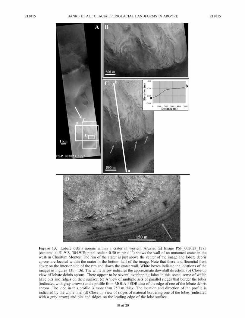
Figure 13. Lobate debris aprons within a crater in western Argyre. (a) Image PSP_002023_1275(centered at 51.9�S, 304.9�E; pixel scale �0.50 m pixel–1) shows the wall of an unnamed crater in thewestern Charitum Montes. The rim of the crater is just above the center of the image and lobate debrisaprons are located within the crater in the bottom half of the image. Note that there is differential frostcover on the interior side of the rim and down the crater wall. White boxes indicate the locations of theimages in Figures 13b–13d. The white arrow indicates the approximate downhill direction. (b) Close-upview of lobate debris aprons. There appear to be several overlapping lobes in this scene, some of whichhave pits and ridges on their surface. (c) A view of multiple sets of parallel ridges that border the lobes(indicated with gray arrows) and a profile from MOLA PEDR data of the edge of one of the lobate debrisaprons. The lobe in this profile is more than 250 m thick. The location and direction of the profile isindicated by the white line. (d) Close-up view of ridges of material bordering one of the lobes (indicatedwith a gray arrow) and pits and ridges on the leading edge of the lobe surface.
E12015 BANKS ET AL.: GLACIAL/PERIGLACIAL LANDFORMS IN ARGYRE
10 of 20
E12015

surfaces in Figure 13, particularly those on the leading edgeof the lobes, may be the result of sublimating ice. Ridges onthe lobes also potentially formed along crevasses or frac-tures in the lobe owing to tensile stresses within the ice ormay be crevasse-fill ridges in which subglacial till wassqueezed up into a crevasse at the base of the ice [Benn and
Evans, 1998]. Alternatively, prominent ridges on the lobescould be large dunes.[17] The lobate debris aprons could also be interpreted as
rock glaciers with a glacial origin in which the ice is derivedfrom glacial sources, or rock glaciers with a periglacialorigin that formed from permafrost in which slope-derived
Figure 14
E12015 BANKS ET AL.: GLACIAL/PERIGLACIAL LANDFORMS IN ARGYRE
11 of 20
E12015

debris is cemented by ground ice [e.g., Wahrhaftig and Cox,1959; Barsch, 1996; Baker, 2001; Whalley and Azizi, 2003].In many subpolar alpine mountain ranges on Earth, Holo-cene rock glaciers commonly represent reactivated massesof ice and rock (sometimes reactivated ice-cored glacialmoraines) produced on mountain sides and in cirqueseroded by formerly larger Pleistocene age glaciers. Howev-er, the topography of large, rapid landslides/rock ava-lanches, such as Sturzstroms, is similar to rock glacierforms as well [e.g., Lucchitta, 1979; Whalley and Azizi,2003] and the possibility that the lobate landforms in theCharitum Montes may be the result of mass wasting pro-cesses should also be investigated further. If the lobatelandforms in the Charitum Montes are indeed rock glaciersor debris covered glaciers, they provide further evidence forthe occurrence of glacial and/or periglacial processes thatmay have been responsible for the formation of otherlandforms discussed in this study [Baker, 2001; Whalleyand Azizi, 2003; Mahaney et al., 2007].
2.6. Valleys
[18] Where grooves and streamlined hills in the CharitumMontes are located on mesas or buttes (as opposed to craterwalls), they are also associated with U-shaped valleys withstepped longitudinal profiles. Figure 14 shows severalcross-sectional and longitudinal profiles from the mainvalley in image AEB_000001_0150 and several surround-ing smaller valleys. Cross-sectional profiles of the valleyshave a symmetrical, parabolic U shape (Figure 14b); qua-dratic (parabolic) and power law equations are fit to a cross-sectional profile from the main valley for comparison of thecross profile to a true parabola (Figure 14c, profile 2). Thelongitudinal profile for the main valley (Figure 14d, profile 4)exhibits a stepped decrease in elevation with a descendingseries of scalloped concave forms. Each concave curvesegment is separated from the next by a subtle pinnacle orridge or abrupt change in slope. The longitudinal profiles fornearby tributary valleys (Figure 14d, profiles d and e) alsoshow a stepped decrease in elevation along much of theirlength with a steep drop in elevation where they intersect withthe main valley.[19] Profiles of valleys in the CharitumMontes (Figure 14)
are consistent with those of typical terrestrial glaciatedvalleys; mature river valleys on Earth characteristically haveV-shaped cross-sectional profiles and smooth concave lon-
gitudinal profiles while formerly glaciated valleys and fjordsare parabolic in cross section and have stepped longitudinalprofiles (Figure 14) [Benn and Evans, 1998; Hiesinger andHead, 2002; Kargel, 2004]. U-shaped profiles are observedin almost any random transect across glaciated alpine land-scapes on Earth. In Figure 14c, the data for the southern sideslope of profile 2 have been fit to a power law equation of theform
y ¼ axb ð1Þ
where x and y are horizontal and vertical distances from thecenter of the valley floor [Harbor and Wheeler, 1992].Previous studies have shown that, for profiles drawn acrossvalleys orthogonal to the down valley direction, typicalterrestrial valleys with little or no glacial modification haveb values close to 1.0 while glaciated valley side slopes haveb values that range from 1.5 to 2.5 [Graf, 1970; Doornkampand King, 1971; King, 1974; Hirano and Aniya, 1988]. Theb value of �2.4 found for the side slope of the main valleyin AEB_000001_0150 (Figure 14c) is therefore consistentwith that of terrestrial glaciated valleys. Such landforms bythemselves are not diagnostic of glacial processes sinceimmature valleys formed from erosion by water or valleysformed by lava flow can have similar cross sections [Bennand Evans, 1998; Kargel, 2004]. However, channels formedby water and lava on Earth typically occur on much smallerscales. Catastrophic floods on Mars may form channels onthis scale [e.g., Irwin et al., 2002] although a source forsuch a flood in this area is not apparent. Steppedlongitudinal profiles are also characteristic of terrestrialglaciated valleys and are a product of zones of compres-sional and extensional flow within the glacier. However,stepped longitudinal profiles are also not diagnostic ofglacial processes since similar profiles can be formed byimmature rivers [Benn and Evans, 1998]. The steep drop-offin elevation observed in the longitudinal profiles of twotributary valleys (Figure 14d, profiles d and e) suggests thatthese may be hanging valleys. Hanging valleys are tributaryvalleys with a floor well above the main valley floor and asteep escarpment at the junction. They are commonlyformed when small glaciers flow into a glacier with a largervolume [Benn and Evans, 1998]. The slopes of the steepescarpments in profiles d and e (Figure 14d) match the
Figure 14. Cross-sectional and longitudinal profiles of the main valley in the center of image AEB_000001_0150 (Figure 2)(profiles with numbers) and several smaller surrounding valleys (profiles with letters). (a) Locations of profiles on a MOLAelevation map (available at http://marsoweb.nas.nasa.gov). (b) Cross-sectional profiles of the main valley and other nearbyvalleys show a symmetrical, parabolic U shape. The flat shape of the valley floor observed in a profile from a wide section ofthe main valley (profile 3) may be the result of infilling processes or the presence of a resistant bedrock layer on the valleyfloor. (c) Quadratic equation and power law function fits (black curves) for profile 2 (red curve) for comparison of the crossprofile to a true parabola. The power law function has been fit to the southern half of profile 2 and is consistent with power lawfunction fits for cross-sectional profiles of terrestrial glaciated valleys [Graf, 1970; Doornkamp and King, 1971; King, 1974;Hirano and Aniya, 1988]. Formulas for the black curves are indicated on the plots. (d) Longitudinal profile of the main valley(profile 4) and other nearby tributary valleys (profiles d and e). Profile 4 exhibits a stepped decrease in elevation with adescending series of scalloped concave forms, each separated from the next by a subtle ridge or abrupt change in slope ratherthan the smooth concave longitudinal profile of amature stream-eroded valley. Profiles d and e also show a stepped decrease inelevation alongmuch of their length. In addition, profiles d and e reveal a steep drop in elevation of the valley floor where thesesmaller valleys intersect with the main valley suggesting that they may be hanging valleys, landforms commonly found informerly glaciated terrain. Note that the vertical exaggeration differs for each plot.
E12015 BANKS ET AL.: GLACIAL/PERIGLACIAL LANDFORMS IN ARGYRE
12 of 20
E12015
average slope of the main valley sidewall which isconsistent with a large glacier in the main valley truncatingsmaller glaciers in the tributary valleys. While hangingvalleys can form from differential erosion and in over-steepened fluvial valleys, they are most commonly found informerly glaciated terrain and offer strong support for theglacial hypothesis.
2.7. Aligned Boulders
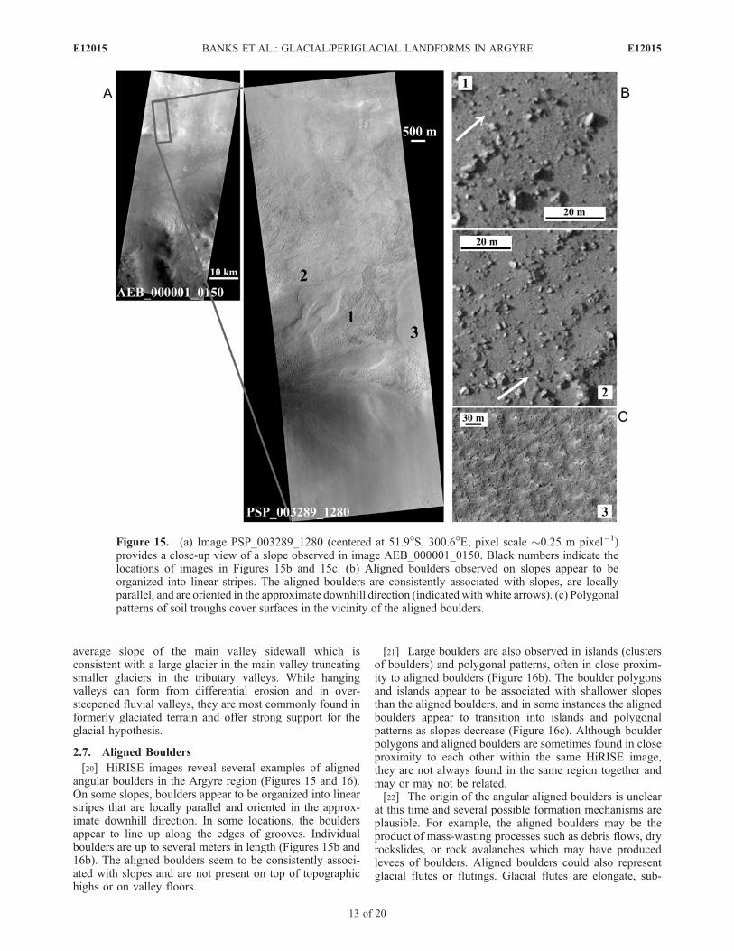
[20] HiRISE images reveal several examples of alignedangular boulders in the Argyre region (Figures 15 and 16).On some slopes, boulders appear to be organized into linearstripes that are locally parallel and oriented in the approx-imate downhill direction. In some locations, the bouldersappear to line up along the edges of grooves. Individualboulders are up to several meters in length (Figures 15b and16b). The aligned boulders seem to be consistently associ-ated with slopes and are not present on top of topographichighs or on valley floors.
[21] Large boulders are also observed in islands (clustersof boulders) and polygonal patterns, often in close proxim-ity to aligned boulders (Figure 16b). The boulder polygonsand islands appear to be associated with shallower slopesthan the aligned boulders, and in some instances the alignedboulders appear to transition into islands and polygonalpatterns as slopes decrease (Figure 16c). Although boulderpolygons and aligned boulders are sometimes found in closeproximity to each other within the same HiRISE image,they are not always found in the same region together andmay or may not be related.[22] The origin of the angular aligned boulders is unclear
at this time and several possible formation mechanisms areplausible. For example, the aligned boulders may be theproduct of mass-wasting processes such as debris flows, dryrockslides, or rock avalanches which may have producedlevees of boulders. Aligned boulders could also representglacial flutes or flutings. Glacial flutes are elongate, sub-
Figure 15. (a) Image PSP_003289_1280 (centered at 51.9�S, 300.6�E; pixel scale �0.25 m pixel–1)provides a close-up view of a slope observed in image AEB_000001_0150. Black numbers indicate thelocations of images in Figures 15b and 15c. (b) Aligned boulders observed on slopes appear to beorganized into linear stripes. The aligned boulders are consistently associated with slopes, are locallyparallel, and are oriented in the approximate downhill direction (indicated with white arrows). (c) Polygonalpatterns of soil troughs cover surfaces in the vicinity of the aligned boulders.
E12015 BANKS ET AL.: GLACIAL/PERIGLACIAL LANDFORMS IN ARGYRE
13 of 20
E12015

parallel ridges of sediments or subglacial till that aregenerally straight or gently curving and are oriented parallelto former glacial flow [e.g., Benn and Evans, 1998]. In eachlocation, the aligned boulders in the Argyre region areoriented approximately downhill which is the presumeddirection of former glacial flow. However, fluted boulderfields on Earth are typically found on relatively flat groundmoraine surfaces [e.g., Hoppe and Schytt, 1953] while theMartian examples appear to be associated with relativelysteep slopes. Bedrock fluting, on the other hand, is ahallmark of alpine glacial erosion. The grooves associatedwith some of the aligned boulders may be linear depressedsurfaces formed from the removal of finer sediments be-tween the boulders, perhaps by eolian processes. Alignedboulders could also represent a ‘‘boulder train’’ or ‘‘dis-persal train.’’ Terrestrial boulder trains are typically a line orseries of boulders that are transported and deposited by aglacier. They can extend up to several kilometers from a
distinct bedrock source in the direction of the glacier’smovement [e.g., Benn and Evans, 1998]. Alternatively, theymay develop in situ from erosional degradation of bedrockridges originally formed by glacial erosion.[23] Both aligned boulders and boulder polygons may
also be periglacial features called patterned ground. Pat-terned ground in the form of circular, labyrinthine, polyg-onal, and striped patterns of stones and soil is common inpolar and high alpine environments on Earth. When rocksare present in sufficient abundance, sorted stripes of largestones, similar to the aligned boulders observed in theHiRISE images, can form on hillslopes greater than 10�,while islands and polygonal patterns form on flatter surfaces[Kessler and Werner, 2003] (Figure 17). The patternedground hypothesis is further supported by the appearanceof polygons formed by networks of cracks similar in scale toterrestrial permafrost thermal contraction polygons, also atype of patterned ground, on surfaces surrounding both
Figure 16. (a) Image PSP_003711_1275 (centered at 52.3�S, 300.9�E; pixel scale �0.25 m pixel–1)provides a close-up view of part of a semicircular embayment observed in image AEB_000001_0150.The top of image PSP_003711_1275 shows the edge of the valley floor and the bottom shows the upperportion of the embayment. The slope of the surface is greatest at the bottom of the image (near the top ofthe embayment) and decreases rapidly near the top of the image (near the edge of the valley floor). (b)Boulders appear to be organized into linear stripes where the slope is steep (top) and in clumps andpolygonal patterns on shallower slopes at the edge of the valley floor (bottom). (c) Aligned bouldersappear to transition to clumped and polygonal patterns as the slope decreases. White arrows in Figures16b and 16c indicate the approximate downhill direction.
E12015 BANKS ET AL.: GLACIAL/PERIGLACIAL LANDFORMS IN ARGYRE
14 of 20
E12015
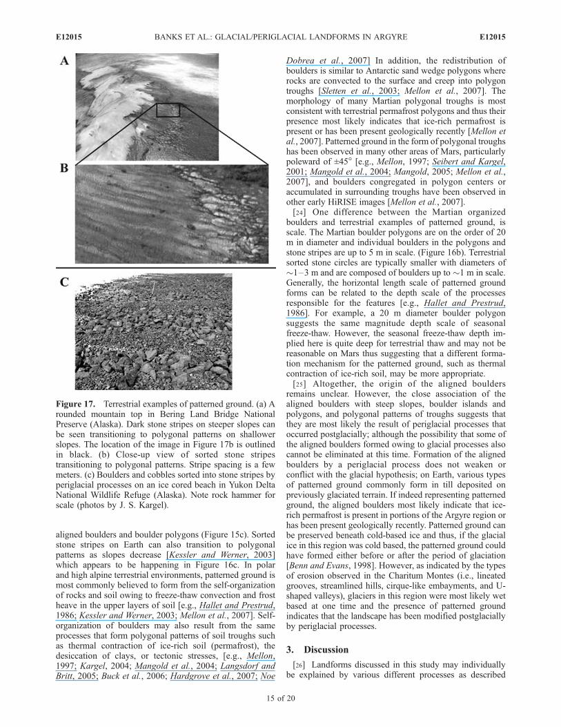
aligned boulders and boulder polygons (Figure 15c). Sortedstone stripes on Earth can also transition to polygonalpatterns as slopes decrease [Kessler and Werner, 2003]which appears to be happening in Figure 16c. In polarand high alpine terrestrial environments, patterned ground ismost commonly believed to form from the self-organizationof rocks and soil owing to freeze-thaw convection and frostheave in the upper layers of soil [e.g., Hallet and Prestrud,1986; Kessler and Werner, 2003; Mellon et al., 2007]. Self-organization of boulders may also result from the sameprocesses that form polygonal patterns of soil troughs suchas thermal contraction of ice-rich soil (permafrost), thedesiccation of clays, or tectonic stresses, [e.g., Mellon,1997; Kargel, 2004; Mangold et al., 2004; Langsdorf andBritt, 2005; Buck et al., 2006; Hardgrove et al., 2007; Noe
Dobrea et al., 2007] In addition, the redistribution ofboulders is similar to Antarctic sand wedge polygons whererocks are convected to the surface and creep into polygontroughs [Sletten et al., 2003; Mellon et al., 2007]. Themorphology of many Martian polygonal troughs is mostconsistent with terrestrial permafrost polygons and thus theirpresence most likely indicates that ice-rich permafrost ispresent or has been present geologically recently [Mellon etal., 2007]. Patterned ground in the form of polygonal troughshas been observed in many other areas of Mars, particularlypoleward of ±45� [e.g., Mellon, 1997; Seibert and Kargel,2001; Mangold et al., 2004; Mangold, 2005; Mellon et al.,2007], and boulders congregated in polygon centers oraccumulated in surrounding troughs have been observed inother early HiRISE images [Mellon et al., 2007].[24] One difference between the Martian organized
boulders and terrestrial examples of patterned ground, isscale. The Martian boulder polygons are on the order of 20m in diameter and individual boulders in the polygons andstone stripes are up to 5 m in scale. (Figure 16b). Terrestrialsorted stone circles are typically smaller with diameters of�1–3 m and are composed of boulders up to �1 m in scale.Generally, the horizontal length scale of patterned groundforms can be related to the depth scale of the processesresponsible for the features [e.g., Hallet and Prestrud,1986]. For example, a 20 m diameter boulder polygonsuggests the same magnitude depth scale of seasonalfreeze-thaw. However, the seasonal freeze-thaw depth im-plied here is quite deep for terrestrial thaw and may not bereasonable on Mars thus suggesting that a different forma-tion mechanism for the patterned ground, such as thermalcontraction of ice-rich soil, may be more appropriate.[25] Altogether, the origin of the aligned boulders
remains unclear. However, the close association of thealigned boulders with steep slopes, boulder islands andpolygons, and polygonal patterns of troughs suggests thatthey are most likely the result of periglacial processes thatoccurred postglacially; although the possibility that some ofthe aligned boulders formed owing to glacial processes alsocannot be eliminated at this time. Formation of the alignedboulders by a periglacial process does not weaken orconflict with the glacial hypothesis; on Earth, various typesof patterned ground commonly form in till deposited onpreviously glaciated terrain. If indeed representing patternedground, the aligned boulders most likely indicate that ice-rich permafrost is present in portions of the Argyre region orhas been present geologically recently. Patterned ground canbe preserved beneath cold-based ice and thus, if the glacialice in this region was cold based, the patterned ground couldhave formed either before or after the period of glaciation[Benn and Evans, 1998]. However, as indicated by the typesof erosion observed in the Charitum Montes (i.e., lineatedgrooves, streamlined hills, cirque-like embayments, and U-shaped valleys), glaciers in this region were most likely wetbased at one time and the presence of patterned groundindicates that the landscape has been modified postglaciallyby periglacial processes.
3. Discussion
[26] Landforms discussed in this study may individuallybe explained by various different processes as described
Figure 17. Terrestrial examples of patterned ground. (a) Arounded mountain top in Bering Land Bridge NationalPreserve (Alaska). Dark stone stripes on steeper slopes canbe seen transitioning to polygonal patterns on shallowerslopes. The location of the image in Figure 17b is outlinedin black. (b) Close-up view of sorted stone stripestransitioning to polygonal patterns. Stripe spacing is a fewmeters. (c) Boulders and cobbles sorted into stone stripes byperiglacial processes on an ice cored beach in Yukon DeltaNational Wildlife Refuge (Alaska). Note rock hammer forscale (photos by J. S. Kargel).
E12015 BANKS ET AL.: GLACIAL/PERIGLACIAL LANDFORMS IN ARGYRE
15 of 20
E12015

above, but can collectively be interpreted as the products ofpast glacial erosion and deposition and possibly subsequentperiglacial processes (Table 1). Few processes other thanglacial processes can generate similar large-scale U-shapedvalleys and deep semicircular embayments in the sides ofmountains [Kargel, 2004]. When considered as a whole, thesuite of morphologies observed in this region support thehypothesis that the Argyre basin has been extensivelymodified by glacial accumulation and flow. By combiningsmaller-scale details and morphologies revealed in HiRISE
imagery with larger surrounding landforms, we interpret theArgyre Planitia to be an ancient impact basin modified by aperiod of ice accumulation, glacial flow, erosion, andsediment deposition, ice stagnation and ablation, and per-haps subsequent periglacial processes. This interpretationis in general agreement with several previous studies ofthe Argyre region using lower-resolution data [e.g.,Hodges, 1980; Kargel and Strom, 1990, 1992; Kargel,2004; Hiesinger and Head, 2002]. Melting may be a keyaspect of the ablation process in some, but not necessarily
Table 1. Summary of Results
Argyre Landform CharacteristicsFluvial
ProcessesMass WastingProcesses
EolianProcesses
GlacialProcesses
PeriglacialProcesses Comments
Semicircularembayments
bordered by ridges, concaveprofiles, deep, steepheadwalls, contain groovesand streamlined landforms
No Maybe No Yes No No landslide outline is visible.Morphology is consistent withglacial cirques. Glacialinterpretation supported byassociation of embayments withother potential glacial features(i.e., grooves, streamlined hills).
Lineatedgrooves
linear, locally parallel tosubparallel, locatedprimarily on slopes but alsoobserved on relatively flatsurfaces, oriented inapproximate downhilldirection, crosscut bedrockfeatures
Maybe Maybe Maybe Yes No Fluvial and mass wasting processesless likely to form grooves thatoverride intermediate-scalebedrock features. Mass wastingless likely to form grooves onrelatively flat topographic highs.Grooves consistently trend downlocal slopes unlike a regionalwind direction. Grooves areconsistent with glacial processes(i.e., grooving, erosional fluting).
Streamlinedhills
streamlined, oriented inapproximate downhilldirection, several have wideruphill and thinner downhillends, convex profiles
Maybe No Maybe Yes No Consistently trend down localslopes unlike a regional winddirection. Wider uphill ends arenot consistent with fluvialstreamlined landforms. Streamlined hills are consistent withglacially sculpted bedrocklandforms.
Boulder deposit located on floor of large, wide,and U-shaped valley,unsorted, contains highdensity of large boulders,high thermal inertia
Maybe Maybe No Yes No Fluvial flow of sufficient size andvelocity to transport boulders in avalley of this size is unlikely;source for such a flow is notapparent. No landslide outline isvisible. Deposit is consistentwith glacial ground moraine.
Lobatedebris aprons
located on and at the base ofslopes, some bordered byparallel ridges, some havepits and ridges on theirsurface
No Yes No Yes Yes Previous studies have found similarlobate features consistent withdebris covered glaciers or rockglaciers; may represent remnantglacial ice or debris cemented byground ice. Formation bymass wasting processes needsfurther investigation.
Valleys U-shaped cross-sectionalprofiles, steppedlongitudinal profiles
Maybe No No Yes No River valleys are typicallyV-shaped with a smooth concavelongitudinal profile. Profiles areconsistent with those ofterrestrial glaciated valleys.
Aligned boulders linear, parallel, orientedapproximately downhill,located on slopes, transitionto clumped/polygonalpatterns as slopes decrease,surrounded by polygonalpatterns of soil troughs
No Maybe No Yes Yes Aligned boulders may be theproduct of debris flows or dryrockslides which may haveformed levees of boulders.Aligned boulders may indicateglacial processes such as flutingor may be glacier boulder trains.Characteristics of alignedboulders are also consistent withpatterned ground formed byperiglacial processes.
E12015 BANKS ET AL.: GLACIAL/PERIGLACIAL LANDFORMS IN ARGYRE
16 of 20
E12015
all areas. Evidence of grooving found in this studysuggests that the ice may have been present as far northas 35�S. Continued imaging by HiRISE will provide morecomprehensive constraints on the extent and distribution ofpast glacial processes.[27] The relatively small number of craters observed on
proposed glacially resurfaced areas within the CharitumMontes indicates that these surfaces were exposed ormodified geologically recently, most likely in the Ama-zonian epoch. Over the past 3.4 Ga, the number ofprimary craters �300 m km–2 Ma–1 is expected to be�3.5 � 10�5 via both the Hartmann and Neukumproduction functions [Hartmann, 1999; Hartmann andNeukum, 2001; Neukum et al., 2001]. From this, oneprimary crater �300 m is expected over the area coveredby image AEB_000001_0150 (�2250 km2) (Figure 2)every �15 Ma. Within the area of AEB_000001_0150,26 craters �300 m were measured indicating a crater reten-tion age of �400 Ma. Although this estimate does notnecessarily indicate the timing of actual glacial resurfacing,it does indicate that glacial resurfacing of exposed surfaceswas completed by �400 Ma and thus provides an approxi-mate minimum age. This approximation suggests somewhatolder glaciation or less active subsequent resurfacing than inother midlatitude Martian regions with crater retention agesof �1–300 Ma [e.g., Mangold, 2003].[28] The deep cirques and U-shaped valleys identified in
the CharitumMontes suggest a deeper level of glacial erosionover a longer time period than usually seen on Earth.Common glacial erosion rates on Earth are �10�3 m a�1
[Drewry, 1986], and typical terrestrial glacial valleys require�105 years of cumulative glacial erosion to form [Harbor etal., 1988]. With a depth of�3000 m in the broader portion ofthe valley in AEB_000001_0150 (Figure 14), this samevalley on Earth would take over a million years to formassuming that the glacier is wet based and sliding. However,Martian ice at approximately 50�S latitude was most likelycolder for much of the time, more viscous, and deformedmore slowly over longer time scales than typical ice on Earth.Ice has a strongly non-Newtonian rheology with an effectiveviscosity that is strongly dependent on applied differential orshear stress as well as temperature. Owing to the lowergravity, ice would flow slower on Mars for comparabletemperatures, slopes, and ice thickness; hence, the rate ofglacial erosion would be much lower and the time scale forthe formation of the deep cirques and valleys seen in theCharitum Montes would be considerably longer, probablymore than 10 Ma [Kargel, 2004]. This does not take intoaccount the amount of preglacial topography and severalfactors that may also influence the erosion rate such asbedrock properties, the availability and amount of meltwater,and weathering rates.[29] The significant amount of bedrock erosion, stream-
lined hills, grooving and potentially coeval gullies suggestthat the glaciation in the Argyre region was at one time wetbased. This was previously proposed by Kargel and Strom[1992] and Kargel [2004] and is further supported by newdetails observed in HiRISE imagery. Larger morphologiesobserved in the Argyre region, such as concave embay-ments and U-shaped valleys, are also associated withvigorous erosion from wet-based glaciers on Earth. Slidingis typically negligible below cold-based ice owing to the
high adhesive strength of ice and rock below the pressuremelting point, making abrasion an ineffective erosive mech-anism [Benn and Evans, 1998]. Abrasion marks, such asgrooves, that do form beneath terrestrial cold-based glaciersare typically variable in shape and size, unlike the relativelyuniform and parallel grooves found in this study and onterrestrial bedrock abraded by warm-based sliding ice [e.g.,Benn and Evans, 1998; Atkins et al., 2002]. AssumingMartian glaciation involves similar processes to glaciationon Earth, the features observed in the Argyre region indicatethat, at least at one time, liquid water was present at the baseof the ice.[30] Proposed ideas for forming meltwater at the base of
ice on Mars include shifts in climatic conditions due toobliquity changes and/or modification of the melting pointdue to impurities such as dust, salt, clathrates, or a propor-tion of carbon dioxide ice mixed with the water ice [e.g.,Greve et al., 2004; Greve and Mahajan, 2005]. In addition,basal melting could occur owing to warmer temperatures atthe base of the ice potentially resulting from the insulationprovided by a thick glacier, a general increase in geothermalflux, or a temporary heat source under the ice such as avolcanic eruption or a tectonothermal event [e.g., Fishbaughand Head, 2002; Greve et al., 2004; Greve and Mahajan,2005; Head et al., 2007]. An alternate idea is that a combi-nation of a low-conductivity surface layer and impermeablesubsurface layers allows liquid water to exist in the shallow(few hundred meter) subsurface [Mellon and Phillips, 2001].Thick glaciers that form on the surface layer could serve tomobilize this preexisting groundwater. The discovery offractured mounds, interpreted as pingos, concentrated at thesame latitudes as the midlatitude gullies supports the Mellonand Phillips model [Dundas et al., 2008].[31] Esker-like features, which on Earth are associated
with subglacial runoff from warm-based glacial flow, havebeen identified in the southern Argyre basin and provideadditional support for wet-based and highly erosive glaciers[e.g., Metzger, 1992; Kargel and Strom, 1992; Hiesingerand Head, 2002; Kargel, 2004]. However, similar esker-likefeatures or other glaciofluvial landforms have not beenidentified near many of the glacial features described here.Perhaps additional landforms diagnostic of wet-based gla-ciation have simply not yet been identified in availableMartian data sets. It is also possible that additional glacio-fluvial landforms have been erased by a later glacieradvance and subsequent transition to cold-based conditions.It is certainly plausible, and not uncommon in terrestrialglacial environments, that the Argyre region has experi-enced both wet and dry-based glaciation, perhaps evenspatially, as paleoconditions and climate have changedthrough time.[32] Other common glacial landforms missing from the
Argyre landscape are obvious terminal and/or lateral mor-aines. The huge eroded volumes implied by the size oflandforms interpreted as cirques and U channels, shouldhave formed sufficient amounts of till to result in morainedeposits. HiRISE imagery, however, is revealing landformsthat may be able to account for at least some of the glacialtill. For example, features on the main valley floor inAEB_000001_0150 may represent lateral moraines andridges at the edges of lobate debris aprons could be terminalor drop moraines. Much glacial till may also have been
E12015 BANKS ET AL.: GLACIAL/PERIGLACIAL LANDFORMS IN ARGYRE
17 of 20
E12015

deposited during a period in which ice was ablating fasterthan it was flowing forward scattering till over large areas inwidespread ablation zones rather than accumulating till intodistinct moraine ridges. An example of this may be the largeboulder-rich deposit, interpreted as ground moraine,observed on the floor of the valley in AEB_000001_0150(Figures 10 and 11). The thickness and volume of theproposed ground moraine is currently unclear, but depositssuch as these may account for significant amounts of till.Like potential glaciofluvial deposits, terminal and lateralmoraines may also have been destroyed, buried, or incor-porated into ground moraine deposited during a later glacialadvance and subsequent period of rapid ablation. Variousprocesses such as eolian, periglacial, and mass wastingprocesses could have eroded, buried, or modified morainessubsequent to deposition as well. Altogether, the currentHiRISE coverage of the Argyre region represents only asmall piece of what is presumably a much larger glaciallandscape. Although we have not conclusively identified avolume of deposits proportionate to the inferred erodedvolumes, we do indeed see moraine-like boulder fieldsand logically infer that additional deposits must existelsewhere. Presumably, additional erosional debris existsfarther in the basin where we could expect there to beboulders, sand, clay, and other ice-related clastics; glacio-fluvial deposits; and reworked eolian deposits. Future im-aging and analysis will hopefully reveal more insight intopotential locations of glacially eroded debris.[33] The inferred presence of glaciers in this region and the
hypothesized presence of ice in other midlatitude Martianregions during perhaps the same or a more recent time period[e.g.,Kargel and Strom, 1992;Mangold, 2003;Kargel, 2004;Head et al., 2005], suggests that significant amounts of icemay have been present on the surface of Mars geologicallyrecently and provides important climatic implications. Con-ditions in the geologic past appear to have favored accumu-lation of ice in the midlatitudes for a sustained period ofannual net mass balance in ice accumulation zones. Thisperiod was sustained long enough for sufficient ice accumu-lation to create flowing ice masses. The presence of enoughice to form extensive glaciers also indicates a much greatersupply of moisture in the Martian atmosphere than is avail-able today. This in turn implies that there was a substantialsource for the moisture and that appropriate climatic con-ditions existed in which the moisture could be released fromthe reservoir and, if necessary, transported to the midlatitudes[e.g., Baker et al., 1991]. As has been discussed, extensiveerosion and the nature of landforms observed in the Argyreregion also indicate that at some time, conditions wereconducive to the presence of liquid water at the base of theice. The current absence of the large surface ice masses overmuch of the proposed glaciated Argyre landscape indicatesthat the conditions for their formation do not currently existand that there was a transition to the present-day environ-ment. Continued research and analysis of relic landforms inthe Argyre region will help provide a better understanding ofthe history of water and climate on Mars.
4. Conclusions
[34] HiRISE images of the circum-Argyre Planitia high-lands reveal small and large-scale landforms that can be
collectively interpreted as the products of past glacialerosion and deposition and possibly subsequent periglacialprocesses. Large grooves, semicircular alpine embayments,and streamlined hills are interpreted as glacially erodedgrooves, cirques, and glacially streamlined bedrock featuressuch as whalebacks or roche moutonnee, respectively. Largeboulders scattered across the floor of a valley may beground moraine deposited by ice ablation and lobate debrisaprons issuing from alpine embayments and the wall of acrater are interpreted as remnant debris covered glaciers orrock glaciers. The glacial hypothesis is further supported bythe association of these features with other landformstypical of glaciated landscapes such as broad valleys withparabolic cross sections and stepped longitudinal profiles,and possible hanging valleys. Large aligned bouldersobserved on slopes may have formed from mass wastingprocesses or may also indicate glacial processes such asfluting. Alternatively, boulders aligned on slopes and orga-nized in clumps and polygonal patterns on flatter surfacesmay indicate periglacial processes, perhaps postglaciation,that form patterned ground.[35] The results of this study indicate that at least portions
of the Argyre region have been heavily modified byprocesses of ice accumulation, glacial flow, erosion, andsediment deposition, ice stagnation and ablation, and per-haps subsequent periglacial processes. Glacial resurfacingprobably occurred over a period of several million years.The number of superposed craters on resurfaced areas isconsistent with geologically recent glacial activity, but mayalso be due to subsequent modification from nonglacialprocesses. Evidence of grooving found in this study sug-gests that ice may have been present as far north as 35�S.Future work and continued imaging by HiRISE shouldprovide more comprehensive constraints on the extent anddistribution of the groove forming flows. The inferredpresence of large ice masses, if this inference is accurate,indicates that there was once a larger amount of moistureavailable in the atmosphere than today and that past climaticconditions were conducive to an annual net accumulation ofice in the midlatitudes for a sustained period of time. Thenature and significant amount of bedrock erosion apparentin images also suggests that the glaciers were, at times, wetbased. Future work will focus on testing the glacial hypoth-esis with further analysis of available imagery and proposedglacial landforms to provide additional insight into thenature of the processes that modified the Argyre landscape.
[36] Acknowledgments. We gratefully acknowledge the invaluableassistance of the entire HiRISE team, including the software developers, theuplink and downlink teams, and the science team. This paper also benefitedfrom detailed reviews by G. Komatsu and an anonymous reviewer. Thiswork was supported by the NASA Mars Reconnaissance Orbiter projectmanaged through the California Institute of Technology’s Jet PropulsionLaboratory.
ReferencesAtkins, C. B., P. J. Barrett, and S. R. Hicock (2002), Cold glaciers erode anddeposit: Evidence from Allan Hills, Antarctica, Geology, 30, 659–662,doi:10.1130/0091-7613(2002)030<0659:CGEADE>2.0.CO;2.
Baker, V. R. (2001), Water and the Martian landscape, Nature, 412,228–236, doi:10.1038/35084172.
Baker, V. R., R. G. Strom, V. C. Gulick, J. S. Kargel, G. Komatsu, and V. S.Kale (1991), Ancient oceans and ice sheets and the hydrological cycle onMars, Nature, 352, 589–594, doi:10.1038/352589a0.
E12015 BANKS ET AL.: GLACIAL/PERIGLACIAL LANDFORMS IN ARGYRE
18 of 20
E12015
Banks, M. E., N. P. Lang, J. S. Kargel, A. S. McEwen, V. R. Baker, R. G.Strom, J. A. Grant, J. D. Pelletier, and the HiRISE Team (2008), Analysisof sinuous ridges in the Argyre Planitia, Mars using HiRISE images andMOLA data, Lunar Planet. Sci. [CD-ROM], XXXIX, Abstract 2480.
Barsch, D. (1996), Rock Glaciers: Indicators for the Present and For-mer Geoecology in High Mountain Environments, 331 pp., Springer,New York.
Benn, D., and D. Evans (1998), Glaciers and Glaciation, 734 pp., Arnold,London.
Buck, B. J., J. Rech, M. Howell, J. Prellwitz, and A. L. Brock (2006), Anew formation process for patterned ground, Atacama Desert, Chile,Geol. Soc. Am. Abstr. Programs, 38(7), 522.
Chuang, F. C., and D. A. Crown (2005), Surface characteristics and degra-dational history of debris aprons in the Tempe Terra/Mareotis Fossaeregion, Mars, Icarus, 179, 24–42.
Doornkamp, J. C., and C. A. M. King (1971), Numerical Analysis inGeomorphology, 372 pp., Arnold, London.
Drewry, D. J. (1986),Glacial Geologic Processes, 276 pp., Arnold, London.Dundas, C. M., M. T. Mellon, A. S. McEwen, A. Lefort, L. P. Keszthelyi,and N. Thomas (2008), HiRISE observations of fractured mounds: Pos-sible Martian pingos, Geophys. Res. Lett., 35, L04201, doi:10.1029/2007GL031798.
Ehlers, J., and H. J. Stephan (1979), Forms at the base of till strata asindicators of ice movement, J. Glaciol., 22, 345–356.
Fishbaugh, K. E., and J. W. Head (2002), Chasma Boreale, Mars: Topo-graphic characterization from Mars Orbiter Laser Altimeter data andimplications for mechanisms of formation, J. Geophys. Res., 107(E3),5013, doi:10.1029/2000JE001351.
Garvin, J. B., J. W. Head, D. R. Marchant, and M. A. Kreslavsky (2006),High-latitude cold-based glacial deposits on Mars: Multiple superposeddrop moraines in a crater interior at 70�N latitude, Meteorit. Planet. Sci.,41, 1659–1674.
Ghatan, G. J., and J. W. Head (2004), Regional drainage of meltwaterbeneath a Hesperian-aged south circumpolar ice sheet on Mars, J. Geo-phys. Res., 109, E07006, doi:10.1029/2003JE002196.
Graf, W. L. (1970), The geomorphology of the glacial valley cross-section,Arct. Alp. Res., 2, 303–312, doi:10.2307/1550243.
Greve, R., and R. A. Mahajan (2005), Influence of ice rheology and dustcontent on the dynamics of the north-polar cap of Mars, Icarus, 174,475–485, doi:10.1016/j.icarus.2004.07.031.
Greve, R., R. A. Mahajan, J. Segschneider, and B. Grieger (2004), Evolu-tion of the north-polar cap of Mars: A modelling study, Planet. SpaceSci., 52, 775–787, doi:10.1016/j.pss.2004.03.007.
Hallet, B., and S. Prestrud (1986), Dynamics of periglacial sorted stonecircles in western Spitsbergen, Quat. Res., 26, 81 – 99, doi:10.1016/0033-5894(86)90085-2.
Harbor, J. M., and D. A. Wheeler (1992), On the mathematical descriptionof glaciated valley cross sections, Earth Surf. Processes Landforms, 17,477–485, doi:10.1002/esp.3290170507.
Harbor, J. M., B. Hallet, and C. F. Raymond (1988), A numerical model oflandform development by glacial erosion, Nature, 333, 347 – 349,doi:10.1038/333347a0.
Hardgrove, J. E., D. M. Moersch, and D. M. Drake (2007), Simulations ofrover based neutron remote sensing of periglacial features on Mars,Lunar Planet. Sci. [CD-ROM], XXXVIII, Abstract 1786.
Hart, J. K. (1995), Recent drumlins, flutes, and lineations at Vestari-Hagafellsjokull, Iceland, J. Glaciol., 41, 596–606.
Hartmann, W. (1999), Martian cratering VI: Crater count isochrones andevidence for recent volcanism from Mars Global Surveyor, Meteorit.Planet. Sci., 34, 167–177.
Hartmann, W., and G. Neukum (2001), Cratering chronology and theevolution of Mars, Space Sci. Rev., 96, 165 – 194, doi:10.1023/A:1011945222010.
Head, J. W., III (2000), Extensive south polar ice cap in middle Marshistory? Tests using MOLA data, Lunar and Planet. Sci. [CD-ROM],XXXI, Abstract 1119.
Head, J. W., III, and D. R. Marchant (2003), Cold-based mountain glacierson Mars, western Arsia Mons, Geology, 31, 641–644, doi:10.1130/0091-7613(2003)031<0641:CMGOMW>2.0.CO;2.
Head, J. W., III, and S. Pratt (2001), Extensive Hesperian-aged south polarice sheet on Mars: Evidence for massive melting and retreat, and lateralflow and ponding of meltwater, J. Geophys. Res., 106, 12,275–12,299,doi:10.1029/2000JE001359.
Head, J. W., III, et al. (2005), Tropical to mid-latitude snow and ice accu-mulation, flow and glaciation on Mars, Nature, 434, 346 – 351,doi:10.1038/nature03359.
Head, J. W., III, D. R. Marchant, M. C. Agnew, C. I. Fassett, and M. A.Kreslavsky (2006), Extensive valley glacier deposits in the northern mid-latitudes of Mars: Evidence for late Amazonian obliquity-driven climate
change, Earth Planet. Sci. Lett., 241, 663 – 671, doi:10.1016/j.epsl.2005.11.016.
Head, J. W., III, D. R. Marchant, and F. Forget (2007), Regional polarglaciation in the Hesperian period of the history of Mars: The southcircumpolar Dorsa Argentea formation as an ancient ice sheet remnant,Abstract 3115 presented at Seventh International Conference on Mars,Lunar Planet. Inst., Pasadena, Calif.
Hiesinger, H., and J. W. Head III (2002), Topography and morphology of theArgyre Basin, Mars: Implications for its geologic and hydrologic history,Planet. Space Sci., 50, 939–981, doi:10.1016/S0032-0633(02)00054-5.
Hirano, M., and M. Aniya (1988), A rational explanation of cross-profilemorphology for glacial valleys and of glacial valley development, EarthSurf. Processes Landforms, 13, 707–716, doi:10.1002/esp.3290130805.
Hodges, C. A. (1980), Geologic map of the Argyre quadrangle of Mars,U.S. Geol. Surv. Map, I-1181 (MC-26).
Holt, J. W., A. Safaeinili, J. J. Plaut, D. A. Young, J. W. Head, R. J. Phillips,B. A. Campbell, L. M. Carter, Y. Gim, R. Seu, and the SHARAD Team(2008), Radar sounding evidence for ice within lobate debris aprons nearHellas basin, mid-southern latitudes of Mars, Lunar and Planet. Sci.[CD-ROM], XXXIX, Abstract 2441.
Hoppe, G., and V. Schytt (1953), Some observations on fluted morainesurfaces, Geogr. Ann., 35(2), 105–115, doi:10.2307/520195.
Howard, A. (2000), The role of Eolian processes in forming surfacefeatures of the Martian polar layered deposits, Icarus, 144, 267–288,doi:10.1006/icar.1999.6305.
Irwin, R. P., III, T. A. Maxwell, A. D. Howard, R. A. Craddock, and D. W.Leverington (2002), A large paleolake basin at the head of Ma’adimVallis, Mars, Science, 296, 2209–2212, doi:10.1126/science.1071143.
Jons, H.-P. (1987), Large fossil mud lakes or giant mud sheet floods inSyrtis Major (Isidis Planitia) and Mare Australe, Lunar Planet. Sci.,XVIII, 470–471.
Jons, H.-P. (1999), What happened really in Argyre Planitia, Mars?, Geo-phys. Res. Abstr., 1(3), 703.
Kargel, J. S. (2004), Mars: A Warmer Wetter Planet, 550 pp., Springer,London.
Kargel, J. S., and R. G. Strom (1990), Ancient glaciation on Mars, LunarPlanet. Sci., 597–598.
Kargel, J. S., and R. G. Strom (1992), Ancient glaciation on Mars, Geology,20, 3–7, doi:10.1130/0091-7613(1992)020<0003:AGOM>2.3.CO;2.
Kessler, M. A., and B. T. Werner (2003), Self-organization of sorted pat-terned ground, Science, 299, 380–383, doi:10.1126/science.1077309.
King, C. A. M. (1974), Morphology in glacial geomorphology, in GlacialGeomorpholgy, edited by D. R. Coates, pp. 147–162, State Univ. of NewYork, Binghamton, N.Y.
Langsdorf, E. L., and D. T. Britt (2005), Classification and distribution ofpatterned ground in the southern hemisphere of Mars, Lunar Planet. Sci.[CD-ROM], XXXVI, Abstract 2140.
Lucchitta, B. K. (1979), Landslides in Valles Marineris, Mars, J. Geophys.Res., 84, 8097–8113, doi:10.1029/JB084iB14p08097.
Lucchitta, B. K. (1982), Ice sculpture in the Martian outflow channels,J. Geophys. Res., 87, 9951–9973, doi:10.1029/JB087iB12p09951.
Magalhaes, J., and P. Gierasch (1982), A model of Martian slope winds:Implications for eolian transport, J. Geophys. Res., 87, 9975–9984,doi:10.1029/JB087iB12p09975.
Mahaney, W. C., H. Miyamoto, J. M. Dohm, V. R. Baker, N. A. Cabrol, E. A.Grin, and D. C. Berman (2007), Rock glaciers on Mars: Earth-based cluesto Mars’ recent paleoclimatic history, Planet. Space Sci., 55, 181–192,doi:10.1016/j.pss.2006.04.016.
Mangold, N. (2003), Geomorphic analysis of lobate debris aprons on Marsat Mars Orbiter Camera scale: Evidence for ice sublimation initiated byfractures, J. Geophys. Res., 108(E4), 8021, doi:10.1029/2002JE001885.
Mangold, N. (2005), High latitude patterned grounds on Mars: Classifica-tion, distribution and climatic control, Icarus, 174, 336 – 359,doi:10.1016/j.icarus.2004.07.030.
Mangold, N., and P. Allemand (2001), Topographic analysis of featuresrelated to ice on Mars, Geophys. Res. Lett., 28, 407–410, doi:10.1029/2000GL008491.
Mangold, N., S. Maurice, W. C. Feldman, F. Costard, and F. Forget (2004),Spatial relationships between patterned ground and ground ice detectedby the Neutron Spectrometer on Mars, J. Geophys. Res., 109, E08001,doi:10.1029/2004JE002235.
McEwen, A. S. (1989), Mobility of large rock avalanches: Evidence fromValles Marineris, Mars, Geology, 17, 1111–1114, doi:10.1130/0091-7613(1989)017<1111:MOLRAE>2.3.CO;2.
McEwen, A. S., et al. (2007), Mars reconnaissance orbiter’s High Resolu-tion Imaging Science Experiment (HiRISE), J. Geophys. Res., 112,E05S02, doi:10.1029/2005JE002605.
Mellon, M. T. (1997), Small-scale polygonal features on Mars: Seasonalthermal contraction cracks in permafrost, J. Geophys. Res., 102, 617–628.
E12015 BANKS ET AL.: GLACIAL/PERIGLACIAL LANDFORMS IN ARGYRE
19 of 20
E12015

Mellon, M. T., and R. J. Phillips (2001), Recent gullies on Mars and thesource of liquid water, J. Geophys. Res., 106, 23,165–23,179.
Mellon, M. T., M. L. Searls, S. Martinez-Alonso, and the HiRISE Team(2007), HiRISE observations of patterned ground on Mars, Abstract 3285presented at Seventh International Conference on Mars, Lunar Planet.Inst., Pasadena, Calif.
Metzger, S. M. (1992), The eskers of New York state: Formation processimplications and esker-like features on the planet Mars, Lunar Planet.Sci., 901–902.
Moore, H. J., and P. A. Davis (1987), Ablation of Martian glaciers, inMECA Symposium on Mars: Evolution of its Climate and Atmosphere,edited by V. Baker, pp. 64–66, Lunar and Planet. Inst., Houston, Tex.
Neukum, G., B. A. Ivanov, and W. K. Hartmann (2001), Cratering recordsin the inner solar system in relation to the lunar reference system, SpaceSci. Rev., 96, 55–86, doi:10.1023/A:1011989004263.
Noe Dobrea, E. Z., E. Asphaug, J. A. Grant, M. A. Kessler, M. T. Mellon,and the HiRISE Team (2007), Patterned ground as an alternative expla-nation for the formation of brain coral textures in the mid latitudes ofMars: HiRISE observations of lineated valley fill textures, Abstract 3358presented at Seventh International Conference on Mars, Lunar Planet.Inst., Pasadena, Calif.
Parker, T. J. (1989), Channels and valley networks associated with ArgyrePlanitia, Mars, Lunar Planet. Sci., 826–827.
Parker, T. J. (1994), Martian paleolakes and oceans, Ph. D. dissertation, 200pp., Univ. of Southern Calif., Los Angeles.
Parker, T. J. (1996a), Highlights from 1:500K geologic mapping of centraland southern Argyre Planitia, Lunar Planet. Sci., 1003–1004.
Parker, T. J. (1996b), The rich geomorphic legacy of the Argyre basin: AMartian hydrologic saga, in Workshop on Evolution of Martian Volatiles,Tech. Rep. 96-01, part I, pp. 36–37, Lunar and Planet. Inst., Houston,Tex.
Parker, T. J., S. M. Clifford, and W. B. Banerdt (2000), Argyre Planitia andthe Mars global hydrologic cycle, Lunar Planet. Sci. [CD-ROM], XXXI,Abstract 2033.
Parker, T. J., J. A. Grant, F. S. Anderson, and W. B. Banerdt (2003), Fromthe south pole to the northern plains: The Argyre Planitia story, SixthInternational Conference on Mars, Abstract 3274, Jet Propul. Lab.,Pasadena, Calif.
Plaut, J. J., A. Safaeinili, J. W. Holt, R. J. Philliips, B. A. Campbell, L. M.Carter, C. Leuschen, Y. Gim, R. Seu, and the SHARAD Team (2008),Radar evidence for ice in lobate debris aprons in the mid-northern lati-tudes of Mars, Lunar Planet. Sci. [CD-ROM], XXXIX, Abstract 2290.
Prest, V. K. (1968), Nomenclature of moraines and ice-flow features asapplied to the glacial map of Canada, Pap. Geol. Surv. Can., 67–57,32 pp.
Quantin, C., P. Allemand, and C. Delacourt (2004), Morphology and geo-metry of Valles Marineris landslides, Planet. Space Sci., 52, 1011–1022,doi:10.1016/j.pss.2004.07.016.
Ritter, D. F., R. C. Kochel, and J. R. Miller (2002), Process Geomor-phology, 734 pp., Waveland Press, Long Grove, IL.
Scott, D. H., and K. L. Tanaka (1986), Geologic map of the western equa-torial region of Mars, U.S. Geol. Surv. Map, I-1802-A.
Seibert, N. M., and J. S. Kargel (2001), Small-scale Martian polygonalterrain: Implications for liquid surface water, Geophys. Res. Lett., 28,899–902, doi:10.1029/2000GL012093.
Shean, D. E., J. W. Head III, J. L. Fastook, and D. R. Marchant (2007),Recent glaciation at high elevations on Arsia Mons, Mars: Implicationsfor the formation and evolution of large tropical mountain glaciers,J. Geophys. Res., 112, E03004, doi:10.1029/2006JE002761.
Siili, T. (1996), Modeling of albedo and thermal inertia induced mesoscalecirculations in the midlatitude summertime Martian atmosphere, J. Geo-phys. Res., 101, 14,957–14,968, doi:10.1029/96JE01131.
Siili, T. (1998), Downslope windstorms in the Martian polar regions: Asensitivity study, in First International Conference on Mars PolarScience and Exploration, LPI Contrib., 953, 33–34.
Sletten, R. S., B. Hallet, and R. C. Fletcher (2003), Resurfacing time ofterrestrial surfaces by the formation and maturation of polygonal patternedground, J. Geophys. Res., 108(E4), 8044, doi:10.1029/2002JE001914.
Smith, D. E., et al. (2001), Mars Orbiter Laser Altimeter: Experimentsummary after the first year of global mapping of Mars, J. Geophys.Res., 106, 23,689–23,722, doi:10.1029/2000JE001364.
Squyres, S. (1978), Martia fretted terrain: Flow of erosional debris, Icarus,34, 600–613, doi:10.1016/0019-1035(78)90048-9.
Squyres, S., and M. Carr (1986), Geomorphic evidence for the distributionof ground ice on Mars, Science, 231, 249–252, doi:10.1126/science.231.4735.249.
Sugden, D. E., D. R. Marchant, N. Potter Jr., R. A. Souchez, G. H. Denton,C. C. Swisher, and J. L. Tison (1995), Preservation of Miocene glacier icein East Antarctica, Nature, 376, 412–414.
Tanaka, K. L., D. H. Scott, and R. Greeley (1992), Global stratigraphy, inMars, edited by H. H. Kieffer et al., pp. 345–382, Univ. of Ariz. Press,Tucson.
Wahrhaftig, C., and A. Cox (1959), Rock glaciers in the Alaska Range,Geol.Soc. Am. Bull., 70, 383–436, doi:10.1130/0016-7606(1959)70[383:RGITAR]2.0.CO;2.
Whalley, W. B., and F. Azizi (2003), Rock glaciers and protalus landforms:Analogous forms and ice sources on Earth and Mars, J. Geophys. Res.,108(E4), 8032, doi:10.1029/2002JE001864.
�����������������������V. R. Baker and J. S. Kargel, Department of Hydrology and Water
Resources, University of Arizona, 1133 E. James E. Rogers Way, Tucson,AZ 85721, USA.M. E. Banks and J. D. Pelletier, Department of Geosciences, University
of Arizona, 1040 E. 4th Street, Tucson, AZ 85721, USA. ([email protected])V. C. Gulick, NASA Ames Research Center and SETI Institute, MS 239-
20, Moffett Field, CA 94035, USA.K. E. Herkenhoff, W. L. Jaeger, and L. Keszthelyi, Astrogeology Team,
USGS, 2255 N. Gemini Drive, Flagstaff, AZ 86001, USA.A. S. McEwen and R. G. Strom, Lunar and Planetary Laboratory,
University of Arizona, 1629 E. University Boulevard, Tucson, AZ 85721,USA.M. T. Mellon, Laboratory for Atmospheric and Space Physics, University
of Colorado, 392 UCB, Boulder, CO 80309, USA.
E12015 BANKS ET AL.: GLACIAL/PERIGLACIAL LANDFORMS IN ARGYRE
20 of 20
E12015