
Hammond Final Thesis
169
May 2013 The University of Southern Mississippi SETTLEMENT, MOBILITY, AND THE ORGANIZATION OF TECHNOLOGY AT THE CLARK LAKE SITE (22SH535): A SMALL-SCALE WOODLAND SETTLEMENT by Michelle Renee Hammond A Thesis Submitted to the Graduate School of The University of Southern Mississippi in Partial Fulfillment of the Requirements for the Degree of Master of Arts Approved: ____________________________________ Director ____________________________________ ____________________________________ ____________________________________ Dean of the Graduate School
Transcript of Hammond Final Thesis

May 2013
The University of Southern Mississippi
SETTLEMENT, MOBILITY, AND THE ORGANIZATION OF
TECHNOLOGY AT THE CLARK LAKE SITE (22SH535):
A SMALL-SCALE WOODLAND SETTLEMENT
by
Michelle Renee Hammond
A Thesis Submitted to the Graduate School
of The University of Southern Mississippi in Partial Fulfillment of the Requirements
for the Degree of Master of Arts Approved: ____________________________________ Director ____________________________________ ____________________________________
____________________________________ Dean of the Graduate School
Randy & Michelle
Typewritten Text
Dr. H. Edwin Jackson
Randy & Michelle
Typewritten Text
Randy & Michelle
Typewritten Text
Dr. Amy Young
Randy & Michelle
Typewritten Text
Randy & Michelle
Typewritten Text
Dr. Jeffrey Kauffman
Randy & Michelle
Typewritten Text
Dr. Susan Siltanen
Randy & Michelle
Typewritten Text
ii
ABSTRACT
SETTLEMENT, MOBILITY, AND THE ORGANIZATION OF
TECHNOLOGY AT THE CLARK LAKE SITE (22SH535):
A SMALL-SCALE WOODLAND SETTLEMENT
by Michelle Renee Hammond
May 2013
Research conducted on the Woodland period in the Lower Mississippi Valley has
largely focused on ceramic analysis of assemblages from large-scale settlements. Very
little research has been conducted on lithic technology, particularly debitage from small
sites. The Clark Lake site in the Lower Yazoo Basin is a small-scale settlement with
components dating from the Tchula Phase to the Lake George I phase (circa 500 B.C.-
1500 A.D.). This thesis focuses on the lithic assemblage recovered from the Middle -
Late Woodland occupation of Clark Lake. Analysis of lithic debitage provides evidence
concerning site function at this small-scale Woodland settlement.
iii
ACKNOWLEDGMENTS
I am deeply indebted to my advisor, Dr. H. Edwin Jackson, who took on the
former historic and prehistorically challenged student. I will be forever grateful for your
guidance and seemingly unending patience. I still find it ironic that when you introduced
me at dinner at the very first Southeastern Archaeology Conference I ever attended you
stated, “This is Michelle Hammond, and she’ll never be my student.” I guess I have
learned two things since then. The first is never say never, and the second is that I really
do like prehistoric archaeology. In addition, I would like to thank my mentor, Dr. Marie
Danforth, for being there whenever I needed someone to talk to or a shoulder to cry on. I
wish to thank the USDA Forest Service for the internship that provided the basis for my
thesis. I would especially like to thank Mr. Sam Brookes. Without your taking a chance
on me and approving the ARPA permits, this thesis would not have been possible.
Furthermore, I would like to thank the members of my committee, Dr. Amy Young and
Dr. Jeffrey Kauffman, for agreeing to help guide me in this endeavor.
In addition, I owe thanks to Rita McCarty for her knowledge and help with lithic
analysis and to Diana Lovejoy for her knowledge, tutelage, and help with my flotation
samples. I also owe a deep debt of gratitude to both Stacy Scott and Barbara Hester,
without whose help with excavating my site, this thesis would not have been possible. I
must say, the memories from that excavation will not be long forgotten. Barbara, even
though I know you are no longer of this world, I want you to know that your positivity
and light will be sorely missed…and STP’s are round, not square. I also owe many
thanks to my cohorts at USM Anthropology, especially Lynn Funkhouser and Peter
VanDyke, for keeping it real and helping to keep me sane…I know I was a pain at times,

iv
and you will never truly know how much of what you did helped me in unimaginable
ways.
I also wish to thank my very best friend in the whole wide world, Dawn
Mildenstein. We have been best friends for thirteen years now, and you have been there
with me every step of the way through all of my trials and tribulations. I cannot imagine
having done this without you, and I cannot thank you enough. You will always and
forever be my best friend.
Last, but certainly not least, my deepest appreciation goes to my husband Randy
and my children, Lindsey, Adam, and Justin. Your unconditional love and unwavering
support continuously encourages me to push myself to do what I never thought was
possible. You are the lights of my life, and you helped to make my dreams come true. I
love you.
v
TABLE OF CONTENTS
ABSTRACT ....................................................................................................................... ii
ACKNOWLEDGMENTS ................................................................................................. iii
LIST OF TABLES ...............................................................................................................v
LIST OF ILLUSTRATIONS ............................................................................................. vi
CHAPTER
I. INTRODUCTION .......................................................................................1
Site Overview Background of Research Interest Research Goals Thesis Outline
II. THEORETICAL CONSIDERATIONS .......................................................8
Settlement and Mobility of Hunter-Gatherers Sedentism Organization of Stone Tool Technology Cultural Site Formation Processes Summary and Conclusions
III. GEOGRAPHIC AND ENVIRONMENTAL SETTING ...........................28
Environmental Setting Summary
IV. CULTURE HISTORY OF THE SOUTHEAST AND THE LOWER MISSISSIPPI VALLEY ............................................................................56
Cultural and Historical Framework Cultural Chronology
Major Historical Time Periods Adena and Hopewell Ceremonial Complexes Conclusion V. DATA COLLECTION, ANALYSIS METHODS AND EXPECTATIONS ......................................................................................87
Field Methods
vi
Laboratory Methods Lithic Analysis Methods Archaeological Implications and Expectations for Prehistoric Settlement Systems
VI. RESULTS ................................................................................................104
Chronological and Stratigraphic Analysis Summary
VII. DISCUSSION AND CONCLUSION .....................................................133
Discussion Settlement Organization and Mobility Strategies Methodology Conclusions Suggestions for Future Research
REFERENCES ................................................................................................................144
vii
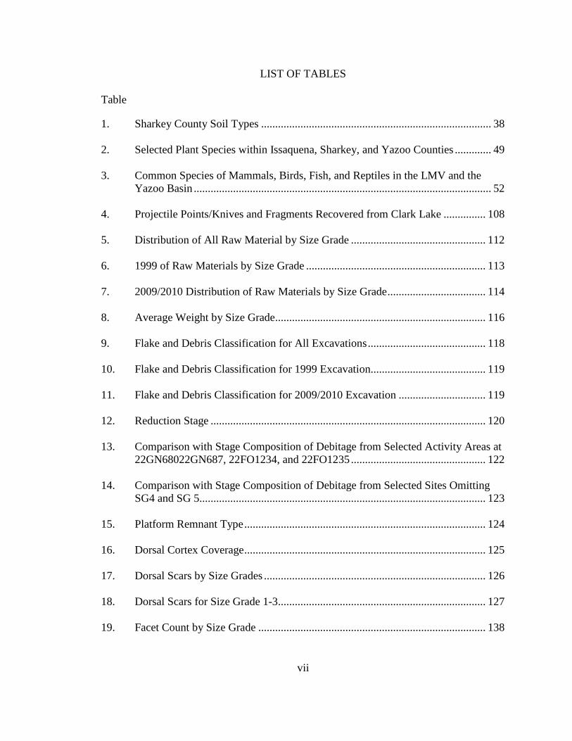
LIST OF TABLES
Table
1. Sharkey County Soil Types .................................................................................. 38
2. Selected Plant Species within Issaquena, Sharkey, and Yazoo Counties ............. 49
3. Common Species of Mammals, Birds, Fish, and Reptiles in the LMV and the Yazoo Basin .......................................................................................................... 52
4. Projectile Points/Knives and Fragments Recovered from Clark Lake ............... 108
5. Distribution of All Raw Material by Size Grade ................................................ 112
6. 1999 of Raw Materials by Size Grade ................................................................ 113
7. 2009/2010 Distribution of Raw Materials by Size Grade ................................... 114
8. Average Weight by Size Grade ........................................................................... 116
9. Flake and Debris Classification for All Excavations .......................................... 118
10. Flake and Debris Classification for 1999 Excavation......................................... 119
11. Flake and Debris Classification for 2009/2010 Excavation ............................... 119
12. Reduction Stage .................................................................................................. 120
13. Comparison with Stage Composition of Debitage from Selected Activity Areas at 22GN68022GN687, 22FO1234, and 22FO1235 ................................................ 122
14. Comparison with Stage Composition of Debitage from Selected Sites Omitting SG4 and SG 5...................................................................................................... 123 15. Platform Remnant Type ...................................................................................... 124
16. Dorsal Cortex Coverage ...................................................................................... 125
17. Dorsal Scars by Size Grades ............................................................................... 126
18. Dorsal Scars for Size Grade 1-3.......................................................................... 127
19. Facet Count by Size Grade ................................................................................. 138
1
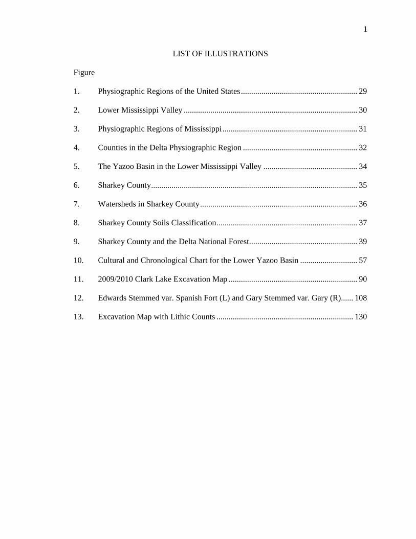
LIST OF ILLUSTRATIONS
Figure
1. Physiographic Regions of the United States ......................................................... 29
2. Lower Mississippi Valley ..................................................................................... 30
3. Physiographic Regions of Mississippi .................................................................. 31
4. Counties in the Delta Physiographic Region ........................................................ 32
5. The Yazoo Basin in the Lower Mississippi Valley .............................................. 34
6. Sharkey County ..................................................................................................... 35
7. Watersheds in Sharkey County ............................................................................. 36
8. Sharkey County Soils Classification ..................................................................... 37
9. Sharkey County and the Delta National Forest..................................................... 39
10. Cultural and Chronological Chart for the Lower Yazoo Basin ............................ 57
11. 2009/2010 Clark Lake Excavation Map ............................................................... 90
12. Edwards Stemmed var. Spanish Fort (L) and Gary Stemmed var. Gary (R)...... 108
13. Excavation Map with Lithic Counts ................................................................... 130
1
CHAPTER I
INTRODUCTION
Lithic debitage or debris left over from the manufacturing of stone tools is
arguably the most common artifact type found on archaeological sites worldwide, and it
is the least understood because of years of being neglected or ignored as prehistoric trash
or debris (Carr & Bradbury, 2001). Lithic debitage has gradually gained in importance as
an artifact class that can be used as an interpretive tool to make inferences about
subsistence practices, settlement patterns, procurement of raw materials, organization of
technology, and exchange in prehistoric cultures. Lithic analysis has grown tremendously
over the past three decades with the development of new methods and innovative theories
to make inferences about prehistoric behavior. Regrettably, most lithic studies in the
Southeastern United States do not reflect these advances and have several fundamental
problems, which have been outlined by Carr and Bradbury (2000).
This thesis presents an analysis of lithic debitage from the Clark Lake site using
methods developed by lithics researchers. This effort will add to our understanding of
settlement, mobility patterns, and the organization of technology at small-scale Woodland
settlements in the Southeast and, to be more specific, in Mississippi and the Mississippi
Delta.
Site Overview
Clark Lake is an archaeological site situated next to an oxbow lake in Sharkey
County within the Delta National Forest. It is a wooded lot, approximately 30 x 190
meters in size (roughly 1.41 acres), located approximately 300 meters northwest of Clark
Lake, from which the site gained its name, 1,000 meters south of the Big Sunflower River
2
and 2,500 meters north of the Yazoo River. It was first excavated during June of 1999, in
conjunction with the United States Department of Agriculture’s U.S. Forest Service, as
part of The University of Southern Mississippi’s field school. During this three-week
field school, a total of 50 shovel test pits were dug and nine square meters units were
excavated to evaluate the site boundaries. This excavation produced over 2,800
prehistoric artifacts, including 646 pieces of lithic debitage, of which 560 were found in
one unit, and two chipped-stone tools. In order to try and understand the nature and
extent of the lithic tool manufacturing taking place in the area where the 560 flakes were
collected, a second excavation, covering four and one-fourth square meters, was
conducted in December 2009 and January 2010. This excavation produced over 1,400
prehistoric artifacts, including over 1,000 pieces of ceramic, 197 pieces of lithic debitage,
133 pieces of micro-debitage, and one broken chipped-stone tool, along with a hearth
feature and several post molds.
Based upon the archaeological analysis of the ceramics recovered from the site,
Clark Lake has been determined to be a multi-component site that was repeatedly
occupied over approximately 2,000 years beginning within the Tchula phase starting
around 500 B.C. and continuing into the Lake George I phase, which began about 1,500
A.D. However, the lithics from the site have been associated with the Issaquena phase
based upon the ceramics.
Background of Research Interest
In the Mississippi Delta, the majority of research conducted has focused on the
study of ceramics as cultural and chronological markers, as well as ceremonial and
mortuary patterns. This is particularly true for the Middle Woodland period, which began
3
around 1 A.D. and continued to around 600 A.D. For years, lithic analysis has not been a
significant part of archaeology in the Mississippi Delta because the availability of raw
material suitable for chipped-stone tool manufacture is limited (Carr, 2008). This makes
lithic use strategies a particularly interesting area to study because it has “great potential
to provide significant information about the past and can serve as a critical line of
evidence when developing and testing hypotheses concerning prehistoric behavior” (Carr,
2008, p. 201). As Shott has argued, debitage can provide as much, if not more,
information than any formal or informal tools recovered from a site because they are
abundant and imperishable (Shott, 1994).
The examination of hunter-gatherer settlement and mobility patterns has received
increasing attention in anthropology over the years. Archaeologists have been and are
working to document the variability in settlement and mobility patterns of these
prehistoric peoples through time, space, and form, and several hypotheses have been
developed to explain settlement and mobility of prehistoric hunter-gatherers from the
Southeastern United States (Bradbury & Carr, 1995; Cable, 1996). The widest scope of
work on hunter-gatherer archaeology, however, has been influenced in large part by the
ethno-archaeological work of Lewis Binford (1978a, 1978b, 1979, 1980, 1983). Based on
fieldwork with the Nunamiut, Binford developed a number of important ideas about the
organizational strategies of hunter-gatherers, such as site formation processes related to
curated and expedient tool use, the relationship between mobility strategies and
differences in effective temperature, and the notion that hunter-gatherer mobility can be
understood as a result of different emphases on residential versus logistical forms of
mobility. These organizational, technological, and settlement mobility strategies are
4
ultimately part and parcel of an adaptive response to spatial and temporal variations in
resource structure that are embedded in hunter-gatherer subsistence practices.
These models continue to be used by archaeologists to interpret prehistoric
hunter-gatherer behaviors in general, but they have not been widely applied to sites dated
to the Woodland Period. Consequently, there is a historical lack of research interest in the
area of prehistoric settlement, mobility patterns, and the organization of technology
because most of the work in the Southeast is “often viewed through the lens of the
contact era ethnohistoric record” and “conditioned by what [is known] of Mississippi
period adaptation” (Kidder, 2002, p. 66).
Several studies of prehistoric hunter-gatherer settlement and mobility patterns are
based on the analysis of lithic assemblages using the organization of technology approach
(Andrefsky, 1994; Bamforth, 1986, 1991; Carr, 1994; Ingbar, 1994; Nelson, 1991; Parry
& Kelly, 1987). The organization of technology has been described by Nelson as, “the
selection and integration of strategies for making using, transporting, and discarding tools
and the materials needed for their manufacture and maintenance” (Nelson, 1991, p. 57).
Research in the areas of site function and settlement patterning are dependent on the
assumption that there is a direct relationship between settlement patterning and mobility
and the organization of technology with regard to tool manufacturing and maintenance.
With respect to lithic tool production, it is also assumed that this relationship should be
reflected by attributes of the lithic debitage assemblage found at a particular type of site.
An organization of technology approach is used in this study to examine Middle
Woodland settlement and mobility patterns at Clark Lake to “understand the relationships
between technology, economic and social strategies, and the environment” (Carr &
5
Bradbury, 2000, p. 122). At Clark Lake, few stone tools have been recovered from
excavations. However, in one area of the site, an abundance of lithic debitage was
collected. This debitage provides a basis for making inferences about settlement, mobility
and the organization of technology of prehistoric hunter-gatherers.
Research Goals
The research presented here is a thorough and detailed analysis of the flake debris
from the Middle Woodland component of a small-scale site at Clark Lake. This includes
raw material, flake attribute and mass analysis. “The availability of raw materials suitable
for chipped-stone tool manufacture is limited” [in the Mississippi Delta], which makes
lithic use strategies a particularly interesting area to study because “it has “great potential
to provide significant information about the past and can serve as a critical line of
evidence when developing and testing hypotheses concerning prehistoric behavior” (Carr,
2008, p. 201). The present research focuses on the reconstruction of the lithic
technological organization at the Clark Lake Site to gain a better understanding of
settlement, mobility patterns, and the organization of technology of prehistoric hunter-
gatherers in the Mississippi Delta at small-scale Middle Woodland settlements. This
research addresses two questions:
1. What type of lithic technological organization was used at Clark Lake?
2. What does the technological organization indicate about the settlement and
mobility patterns used by the occupants of Clark Lake?
In addition to the specific questions addressed in this study, the analysis and
reanalysis of existing collections of excavated materials is important to the advancement
of archaeological knowledge, as new methods and innovative theories about prehistoric
6
behavior are developed, and must be tested because “continued reliance on outdated and
demonstrably unreliable methods in the analysis of lithics is unacceptable, and inhibits
the growth of the discipline” (Carr, 2008, p. 209).
As shown by Carr and Bradbury (2000), lithic studies in the Southeastern United
States do not reflect the advances made and have several fundamental problems, some of
which include providing only general lithic data, failure to interpret lithic data in relation
to other artifact categories, lack of knowledge of recent literature, and failure to integrate
stone tool and debitage data. Oftentimes, in the original reporting and interpretation of an
archaeological assemblage, only general analyses are undertaken due to budgets and time
constraints, and certain artifacts are counted rather than examined in great detail. This has
been shown to be true with lithic assemblages in Mississippi and in the Mississippi Delta
(Carr 2008). “Archaeologists must explore every potential data source that is retrievable
from the archaeological record because of the difficulty of addressing questions of
prehistoric human behavior and behavior change” (Bradbury & Carr, 1995, p. 19). Each
artifact, when examined in relation to the other artifacts in the same assemblage, can
provide important information, which allows for inferences to be made based upon the
recent or current literature of the time and helps to solve unanswered questions and
clarify ambiguities.
Thesis Outline
Chapter II presents a synopsis of the various theories pertaining to the
development of prehistoric hunter-gatherer settlement and mobility patterns, the
organization of stone tool technology, and cultural site formation processes.
7
Chapter III outlines the various ecological aspects of the study area including
geomorphology, flora, fauna, and the availability of raw material.
Chapter IV provides a discussion of the culture history in the Lower Yazoo Basin
of the Lower Mississippi Valley.
Chapter V provides a description of the data collection, the analytical methods by
which this research was conducted, and expectations for the research. Particular attention
is paid to the different methods used in analyzing the assemblage and a detailed
explanation of definitions and usage is provided.
Chapter VI presents the results of the data collection and lithic analysis of the
Clark Lake assemblage based on the organization of technology utilized by its
inhabitants.
Chapter VII contains a discussion and interpretations of the results.
8
CHAPTER II
THEORETICAL CONSIDERATIONS
“Hunter-gatherers are problems in theory. Because that is so, the future of hunter-
gatherer research . . . rest[s] in large part on the extent to which it is grounded in a clear
and concise body of theory” because “the facts never speak for themselves” (Bettinger,
1991, p. 213). From these facts, theories are developed to help us understand who we are
studying, what they were doing, where they were doing it, why they were doing it, when
they were doing it, and how they were doing it. “Until the theory exists, the fact as a
scientific phenomenon does not”(Bettinger, 1991, p. 213), and in order that we may be
able to better understand the facts (artifacts), theory must form the basis of any
anthropological study.
Several of these theories are considered, for the purposes of this research that can
provide information about settlement practices and mobility patterns, as well as how
these theories relate to how prehistoric hunter-gatherers organized their technology
during the Middle Woodland period. This chapter provides an overview of those different
theories.
Settlement and Mobility of Hunter-Gatherers
The association of settlement and mobility with hunter-gatherers has a long
history. As early as 1651, Hobbes described the natural condition of mankind before
“society, government, and the invention of law” as being without culture condemned to
wander the land aimlessly living a “solitary, poor, nasty, brutish and short” life (Hobbes,
1651, p. 100). Eventually this model changed from one of aimless wandering to the
9
patterned movement of the seasonal rounds in which the Native Americans exploited
their environment to their own ends (Bettinger 1991).
With the advent of the “New Archaeology” and the development of Middle-
Range theories, archaeologists began to explain hunter-gatherer societies as functioning
adaptive and integrative systems in order to assign “meaning to empirical observations
about the archaeological record” (Bettinger, 1991, p. 62). Many people began to define
middle-range theory and research in different ways, but regardless of which definition is
correct, or how one views middle-range research, one thing is clear, “the underlying
framework for much of this research is found in Binford’s analytical classification of
hunter-gatherer systems” (Bettinger 1991, p. 64).
Residential and Logistical Mobility
Binford’s model of residential/logistical mobility is one in which the “availability
of natural resources is seen to dictate differing combinations of social, economic, and
settlement organization” to “describe a continuum of subsistence-settlement systems with
highly mobile foragers at one end and highly sedentary collectors at the other” (Bettinger,
1991, p. 64). Both forms of mobility are responses to the availability and distributional
structure of environmental resources, and each type of settlement and mobility pattern
manifests itself differently in the archaeological record in regards to site formation
processes (Binford, 1980).
With residential mobility, foragers are tethered to sequentially occupied
residential base camps. This creates a repetitive pattern of movement as the consumers
move their camps to resources. This strategy is characteristic of a relatively homogenous
environment where the resources are predictable and storage unnecessary. In contrast, a
heterogeneous environment, where resources are unpredictable, may require a different
10
type of settlement system that makes the storage of resources necessary to overcome
shortages. Thus, a collector adaptation of logistical mobility resolves the inconsistency,
be it through time (seasonal variation of temperature) or space, in the distribution of
resources across the landscape by sending out organized task groups, using logistical
forays, to move the resources to the consumers (Binford,1980; Bettinger, 1991).
Foragers and Collectors
The foraging adaptation produces two types of sites: residential camps and
locations. Residential base camps have the great potential for the buildup of
archaeological remains and they are more visible within the archaeological record. They
serve as a center point to which inhabitants of a site return after their daily foraging
activities. As the carrying capacity of the land within the catchment area of the camp
decreases, longer trips are needed to search for food to feed the members of their group.
Once resources within the catchment area have been depleted below the point at which
relocating makes economic sense, the entire group moves on to another area where the
resources are more abundant and the cycle begins again (Binford, 1980).
The second type of site produced by a foraging adaptation is a location. Locations
are places where specific tasks are performed, are only occupied for a short time, and do
not have the same potential for the buildup of archaeological remains. These types of
sites include lithic procurement sites, kill sites, butchering sites, etc. The waste material
produced at these sites varies depending on what activity took place at that particular site.
The tools used are task specific to the location: they produce very little debris in the way
of manufacturing and maintenance, which makes sites more difficult to recognize in the
archaeological record.
11
Along with the residential base camp and the location identified with the foragers,
collectors produce three other types of sites “by virtue of the logistical character of their
procurement strategies” (Binford, 1983, p. 346): field camp, station, and cache. The
buildup of archaeological remains at each of these types of sites forms a specific type of
patterning within the archeological record that is “differentiated according to the nature
of the target resources” (Binford, 1980).
The first type of site is a field camp. A field camp is a temporary operational
center where a task group eats and sleeps while away from their residential base camp. It
can be distinguished by the different nature of its specific tasks (i.e. fishing, hunting,
etc.). “Collectors, like foragers, actually procure and/or process raw materials at
locations” (Binford, 1983, p. 346). However, the difference as to whether the site is a
location or a field camp that was created by foragers or collectors lies in the amount of
debris, which can vary greatly, generated at the location. The second type of site is a
station. “Stations are sites where special-purpose task groups are localized when engaged
in information gathering” (Binford, 1983, p. 346), such as in the observation of game or
other humans, ambush locations, and hunting stands. Lastly, caches are where items, such
as raw materials, are stored in anticipation of future use.
Effective Temperature
Effective temperature, as explained by Binford, examines the relationship
between seasonal variation of temperature and the distribution of resources and mobility.
He argued that hunter-gatherers have no need to store or save resources in spatially and
temporally homogeneous environments where resources are abundant and conversely,
where there are seasonal shortages in resources, hunter-gatherers adapt their subsistence
and settlement practices to overcome these shortages and thus become increasingly more
12
complex. Binford established that where the effective temperature was greater than 15ºC
the degree of residential mobility was high, and the need for storage of surplus resources
was low. On the other hand, where the effective temperature was less than 15ºC,
logistical mobility was high and the necessity for the storage of surplus resources
increased. From these observations, he expected, where the temperature was greater than
15ºC a foraging subsistence-settlement system would be implemented, and where the
temperature was less than 15ºC a collector subsistence-settlement system would be
implemented (Binford, 1980; Bettinger, 1991).
Sedentism
An important topic in North American archaeology today is the origins of
sedentism among hunter-gatherers, as sedentism was thought to be in conflict with the
foraging way of life (Kelly, 1992). According to Rafferty (1985), the move towards a
sedentary way of life is an important development that must not be ignored in any study
of hunter-gatherer settlement patterning for three reasons: it either caused or allowed the
population to grow rapidly, it led to the development of higher levels of political
organization, and it led to the development of agriculture. “Sedentism,” in and of itself, is
an ambiguous term that has been widely interpreted with regards to settlement
permanence or settlement size, and encompasses various settlement forms, making
sedentism a relative condition whereby some see sedentism and its emergence as a
continuum along a scale of residential mobility (Kelly, 1992; Rafferty, 1985). However,
the term that will be adopted for this study is the one used by Rafferty (1985) and given
by Rice: “Sedentary settlement systems are those in which at least part of the population
remains at the same location throughout the entire year” (Rice, 1975, p. 97). This
13
definition is used because it encompasses all human patterns of movement (i.e.,
residential/logistical mobility), as well as all types of settlements (Rafferty, 1985).
In the case of mobility, sedentism must be looked at in terms of its economic
costs, as there are advantages and disadvantages to sending out smaller subsets of a
whole group of people living in one place to collect the resources needed to sustain the
entire group, as compared to moving whole groups of people. Among the advantages of
sedentism are those not involved in procuring the resources : the young, the old and the
infirm would not have to be transported to each new location, it is more energy efficient
in that it leads to greater organizational change within a group, and it increases personal
security (i.e., accumulation of possessions, comfort, development of hard to transport
technologies). One other advantage that begins as a substantial energy cost but over the
long-term leads to the conservation of energy is the construction of storage facilities and
more, permanent residential structures. Among the disadvantages are increases in the
contraction and spread of disease, possible reduction in the variety of diet, and increased
boredom and conflict between group members, all of which depend upon the size of the
residential unit to a greater or lesser extent (Rafferty, 1985).
Causes of Sedentism
Many archaeologists see sedentism as “emerging slowly along a continuum of
residential mobility;” however, others see it as “episodic rather than continuous” because
the makeup of the archaeological record cannot definitively show that sedentism
developed continuously over time (Kelly, 1992, p. 50). Kelly believes that “in all
likelihood, sites produced when people are less residentially mobile will be more visible
archaeologically; those produced by an intervening period of high residential mobility
will be less visible, and if undated may even be interpreted as special-purpose camps of

14
the sedentary system” (Kelly, 1992, p. 50). Nevertheless, the fact remains that
“reductions in residential mobility produce changes in mobility on different levels and
scales under different conditions” which, in turn, results in a great deal of variability in
what sedentism looks like in the archaeological record. Three basic hypotheses have been
developed to try to understand the causes of sedentism as seen in the archaeological
record: the “Pull,” the “Push,” and the social competition hypotheses (Kelly, 1992, pp.
51-54).
The “pull” hypothesis, in trying to explain hunter-gatherer sedentism, states that
the presence of abundant resources is necessary and sufficient for the appearance of
sedentism because sedentism is a more efficient form of resource procurement, and
moving children, the elderly, and the infirm is burdensome and undesirable. This
hypothesis is laden with pragmatic difficulties, such as the relationship between
sedentism and agriculture. Even though sedentism appears to exist, there may not be any
archaeological evidence of such sedentism since agricultural practices appeared before
groups became sedentary, and foragers wished to maintain a maximum foraging rate of
return by moving their residences, even though it was possible to stay in one place
(Kelly, 1992).
Alternatively, the “push” hypothesis, in trying to explain hunter-gather sedentism,
states that hunter-gatherers are pushed into sedentism by subsistence stress because
resources become scarce, forcing them to intensify subsistence practices because of what
Rafferty believes are the three “ultimate causes” (Rafferty, 1985, p. 122) for the
development of sedentariness: population growth, environmental deterioration, and
territorial restriction (Kelly, 1992; Rafferty, 1985). From these causes, Rafferty
15
developed a model of three different types of settlement patterns that come about because
of resource stress: non-sedentary settlements, nucleated sedentary settlements, and
dispersed sedentary settlements. Each of these will be discussed later.
In contrast to the previous two hypotheses is the social competition hypothesis. In
this hypothesis, it has been argued, “sedentism results from the perceived need of
intensification” because of social competition through feasting, long-distance trade or
other prestige seeking activities, rather than expending the effort to move from one place
to the next (Kelly, 1992, p. 54). Bender believes that the intensification of surplus food
was done to meet kinship and trade obligations and led to the building of storage
facilities, which in turn led to the selection of becoming more sedentary (Bender, 1978).
However, Rafferty discounts this theory as not being plausible, but rather believes that
sedentism led to the development of storage facilities causing the development of kinship
and trade obligations (Rafferty, 1994).
In order to understand sedentism, it is important to understand the relationship
between residential and logistical mobility. In economic terms, the decision to move to
another location or to stay in one place is often dependent upon the rate of return they
would receive from the abundance of local resources where they are or where they are
moving. This, in turn, can be affected by the cost of moving an entire group of people,
rather than one group staying in place and sending out logistical parties, population, and
the risk involved in obtaining the local resources. With this in mind, it becomes important
to consider how the change to sedentism is recognized in the archaeological record.
16
Organization of Stone Tool Technology
The models of logistical and residential mobility along with those of curation and
maintenance, which will be discussed later, are key to understanding lithic assemblage
formation as related to hunter-gatherer mobility and organization of technology. The
models of lithic assemblage composition that are generated under the different mobility
strategies rely on three interrelated sets of factors to determine the costs and benefits that
arise from the manufacture or maintenance of stone tools. The first factor is the quality of
resources exploited by a population to manufacture and maintain tools. The second factor
is raw material availability and how this affects the reduction strategies for manufacturing
tools. The last factor is the type of mobility being practiced. “The nature of the resources
exploited determines the need for efficiency in procurement” and technology can
improve efficiency by reducing the time, energy and risk involved in procurement of
suitable raw material needed for the manufacture and maintenance of stone tools (Lurie,
1989, p. 47)
A high degree of mobility affects stone tool technology in three ways: it should
place constraints on technology by imposing a carrying cost, it may restrict the time
invested in the manufacture of tools, and raw materials are more easily procured when
access is not restricted and procurement is embedded in basic subsistence practices
(Binford, 1979; Lurie, 1989; Shott, 1986). Thus, with residential mobility, there is an
increase in generalized tool types because the number and size of tools that can be carried
between residences is limited. Conversely, it stands that if with residential mobility or
high degree of mobility, technological diversity declines and the versatility of tools
increases, then with logistical mobility or a low degree of mobility, technological
17
diversity increases, and the versatility of the tools decreases because different logistic
moves are likely to have different purposes necessitating the need for more functionally
specific or specialized tools (Shott, 1986).
Nelson states, “. . .the concept of technology as strategy to understand variation
across assemblages according to different uses of places and different plans” has been in
use since Binford first posited the idea (Nelson, 1991, p. 58). Strategies are sets of human
behaviors used to solve problems in response to environmental conditions across time
and space. These strategies help humans to adapt to the changing environment in order to
overcome stresses; however, this does “not account for all technological behavior or all
formal variation in tools, weapons, and facilities” (Nelson, 1991, p. 59). The organization
of technology is a conditional response to environmental stresses such as resource
predictability, resource distribution, resource reproduction, amount of resources
available, size and patchiness of resource areas and potential risks involved (Binford,
1978a, 1980; Nelson, 1991). These impediments are problems to be solved, using
sensible strategies, to achieve the maximum returns on investments of time and energy so
that carrying costs and risk may be reduced (Bamforth, 1986; Binford, 1978a, 1978b;
Bleed, 1986; Kelly, 1992; Nelson, 1991; Torrence, 1989).
For many years archaeologists have measured the size of prehistoric foraging
areas and varying degrees of mobility through the distribution of stone tools relative to
the area of raw material procurement (Kelly, 1992). However, more recently,
archaeologists have tried to reconstruct mobility by examining the organization of stone
tool technologies through the use of flake attribute analysis and mass analysis to
18
“understand the relationships between technology, economic and social strategies, and
the environment” (Carr & Bradbury, 2000, p. 122).
Characteristics of Stone Tool Technology
Diverse site types result from the different technological organizations of the
various modes of settlement-subsistence systems. The different mobility strategies of
hunter-gatherers produce a wide range of physical characteristics distinctive in stone tool
technology. From this, inferences about the settlement and mobility patterns of hunter
and gatherers can be made from the analysis of debitage produced by different end goals
of stone tool manufacturing.
According to Binford (1979), tool assemblages exhibit various characteristics
based upon procurement, manufacture, maintenance, and use. His observations of
Nunamiut technology characterized a “well developed storage and caching strategy” for
active and passive gear, “such that at any one time some of the [technology-organized]
gear” is either being actively used during the present time, or passively stored until
needed, usually the next season, or to insure its use in the future at a specific site
(Binford, 1979, p. 256). This caching helps to modify the environment by distributing
necessary resources in anticipation of future needs.
In anticipating future needs of necessary resources, an embedded form of
procurement is practiced because hunter and gatherers seldom make special trips to
gather raw material. They would rather combine the gathering of raw material with
subsistence activities such as hunting, fishing, or foraging in the area where the raw
material is present in order to reduce the amount of time and energy expended on
collecting the raw material (Binford, 1979).
19
From the technological organizational perspective of the Nunamiut, Binford
distinguished three types of field gear used in their planned execution of subsistence
strategies: personal gear, site furniture, and situational gear. Personal gear includes tools
that are anticipatory in nature, selected in terms of what the goals of an expedition are for,
hunger and warmth, and potential mishaps. These tools are highly curated and are
represented in the archaeological record as worked cores, knives, projectile points, and
hammerstones (Binford, 1979). Site furniture consists of items that are left at a particular
site because their utility is specific to that location. They are anticipatory in nature, as
well, since they vary in function depending upon the needs of the site’s occupants. They
can be either curated or expedient and remain at the site or be moved to another site to be
utilized there (Binford, 1979). The last classification type is situational gear. Situational
gear are tools that are “gathered, produced, or ‘drafted into use’ for purposes of carrying
out a specific activity” in response to certain conditions rather than in anticipation of
events or situations (Binford, 1979, p. 264). These types of tools are expedient in nature
and are represented in the archaeological record most often as utilized flakes.
Curated and Expedient Tools
An important aspect of the technological organization, according to Binford
(1978a, 1978b, 1979), and one that is used extensively as a way to explain site formation
processes and settlement adaptations is the relative frequencies of curated and expedient
tools. Curated tools are tools that are manufactured in anticipation of use, maintained to
extend usage, transported from place to place for use, and recycled for another type of
use when no longer needed for their primary purpose (Bamforth, 1986; Binford, 1978a,
1978b, 1979; Odell, 1996).
20
Hunter-gatherers have two problems, time stress and raw materials, which,
according to Carr (1994), can be alleviated by curated tools because the tools are
manufactured before they are needed in anticipation of their future need. Curated tools,
according to Binford (1978a), are linked to logistical mobility and a collector adaptation
due to the planned nature of logistical activities and should reflect the planned
expectations of future task-specific goals associated with logistically organized efforts.
Curation ensures that tools will be available when needed which solves the problem of
the lack of raw material or limited time frame at the location where they are to be used
(Carr, 1994).
On the other hand, expedient tools are tools that are manufactured, used, and then
discarded according to the needs of the moment, and very little time is invested in their
manufacture (Bamforth, 1986; Binford, 1978a, 1978b, 1979). The tools are manufactured
at the time and place of need for use. The example used by Nelson to explain this is the
stockpiling or transporting of prepared cores in order to make tools as they are needed.
The change in form of the objects is the difference between tools being either curated or
expediently used (Nelson, 1991).
Expedient tools have been linked to a foraging adaptation, as well as sedentism.
Ethnographic accounts of expedient core technology share three characteristics: flaking
technique does not control the shape or form of flake, no distinction is made between
tools or waste, and the tools are seldom modified (Parry & Kelly, 1987). However,
according to Nelson (1991), there is a fine line between expedient and curated tools, as
expedient tools can often become curated instead of being abandoned. Expedient tool
technology or situational tool organization is often associated with a forager adaptation
21
with relatively high residential mobility (McCarty-Fields, 2001). Expedient tool
technology, which is often linked to residentially mobile hunter-gatherers, is also
employed by logistically mobile hunter-gatherers and is dependent upon the availability
of raw material and tool needs (Carr, 1994; Parry & Kelly, 1987) “in response to
conditions, rather than put together in anticipation of events or situations” (Binford, 1979,
p. 266).
According to William Andrefsky (1994), the availability of raw material must
first be considered when linking stone-tool production with prehistoric settlement
configurations and mobility because the availability and quality of the raw material
determine the types of tools being manufactured. Informal tools tend to be manufactured
from poor quality raw material. Formal tools tend to be manufactured from high quality
raw material in low abundance and both formal and informal tools are manufactured
when high quality material occurs in high abundance. “Several [other] variables must
[also] be considered when looking at raw material and its implications. They include, but
are not restricted to, the degree of mobility, procurement tactics, environmental changes,
and social interactions among various groups” (McCarty-Fields, 2001, p. 32).
As Parry and Kelly (1987) suggest, mobility plays an important role in the
manufacturing of stone tools since it dictates the tool needs and access to raw materials.
The composition of raw material represented in an assemblage can be considered an
indication of the type of procurement strategy used and the degree of mobility. If an
assemblage is heterogeneous in nature, consisting of an abundance of non-local material,
it is suggestive of a more mobile population. If an assemblage is homogeneous in nature,
consisting of an abundance of local raw material and little non-local material, it is
22
suggestive of a more sedentary population. The dominance of local material in stable,
sedentary settlements maybe moderated by exotic material acquired through trade
networks established among neighboring groups.
A shift toward sedentism, according to Parry and Kelly (1987), affects the
organization of stone tool manufacturing by causing the technology to become more
expedient. They based this conclusion on studies that reflect a shift from standardized
core technology used to create flat, prepared cores with well-shaped platforms to an
unstandardized core technology used to create expedient flakes from amorphous cores
(Parry & Kelly, 1987). This shift, however, did not cause one technology to be replaced
by another, nor did it come about because of local conditions such as climate, topography
or vegetation, technological innovations, or the introduction of agriculture, but because of
changing settlement patterns and the first occupation of permanent villages. It could have
also come about as a result related to the environmental location of a particular group
given the availability of raw material within the usable foraging area. If raw material is
available within the usable foraging area of the residence, there is no need for tools to be
formally shaped in anticipation of what will be needed in the future. A result of the
restricted mobility range is that sedentary groups should be expected to rely on more
informal, expedient types of tools rather than formal, curated tools (Parry & Kelly, 1987).
Despite the fact that models of hunter-gatherer mobility predict an emphasis on
expedient tool technology, there are situations where the distribution would promote a
greater reliance on curated tools. Kelly (1988) states, “as raw material becomes more
scarce, or of poorer quality, foragers must put more effort into the production of tools
designed to overcome the spatial differences between raw material and activity locations”
23
(Kelly, 1988, p. 719). With this in mind, Kelly concluded, under these conditions,
residentially mobile foragers should produce large bifaces that would serve as tools, as
well as cores that would be used to manufacture other tools, thus reducing the carrying
cost if high quality raw material was located a considerable distance from their site.
Alternatively, sedentary groups should extensively depend on un-retouched, expedient
flake tools because formal, curated tools are more useful in a residentially mobile
settlement system.
Mobility, Trade, and Exchange
Trade and exchange is defined as the reciprocal movement of goods between
individuals or groups of people. Within the archaeological record, however, it is only the
movement of goods that can be discerned from the artifacts recovered. Finding the source
of these artifacts is but one factor, among many, to consider when trying to make
inferences about mobility from what is represented in the archaeological record. Other
factors include procurement, transport, manufacture, use, recycling, and disposal. While
this description may make the understanding of trade seem simplistic, it is actually quite
complex and many different models and theories have been developed in order to
understand this phenomenon. Nevertheless, while explanations of prehistoric trade
systems and conditions may change, determining the source of trade items will always
demonstrate indirect contact existed between individuals and places.
Within Southeastern studies, there is not “a [clearly] unified theory of trade” or
exchange (Johnson, 2010, p. 116). Early trade models emphasize redistribution and social
organization and the spatial implications of redistribution. Later models look at trade as a
way of maintaining social ties and interactions, as a way of transmitting information
between neighboring hunting-gathering groups, and as a way of maintaining the status
24
hierarchy (Johnson, 2010). From these models, one central idea can be inferred: the
ultimate goal is to ascertain a cultural account for these goods beginning with the
procurement of raw materials and ending with their disposal. Included in this
consideration is the distribution of raw materials and how distribution affects the nature
of technology concerning mobility and access to trade, as each will produce a different
outcome within the archeological record.
The implications of trade versus mobility are critical to understanding the
archaeological settlement patterning of prehistoric hunter-gatherers. As stated previously,
the availability and use of raw material is an important factor to consider when looking at
settlement and mobility, and the degree of mobility is an important variable in this. An
increase in sedentism causes a reduction in mobility range; the causes, which were
discussed beforehand, may be due to the increase in the population levels of certain
groups living in the resource area of a particular raw material. In order to adapt to this
restriction, long distance trade networks and exchange systems may have been
developed.
Cultural Site Formation Processes
For a great many years, site structure has been a topic of interest for
archaeologists, as artifacts and features are never randomly scattered throughout a site.
The frequency and density of artifacts can dramatically vary from one area to the next,
which can be attributed to the archaeological patterning of segregated activities of the
inhabitants of a site (Metcalf & Heath, 1990).
While this interpretation can be used to explain a primary refuse deposit of
material discarded at the location of manufacture or use, it cannot be used to interpret
25
secondary refuse deposits of material discarded at a place completely different from
where it was manufactured or used. The distinction between primary and secondary
refuse, first noted by Michael Schiffer (1972), was the beginning of ethno-archaeological
research into the factors of refuse disposal at a site.
The spatial structures of artifact distribution is useful for delineating possible
activity areas in cases of primary refuse deposit at the location of manufacture or use, but
an interpretation can be confounded by deposits of secondary refuse discarded at a place
completely different from where it was manufactured or used. A number of factors affect
the likelihood of secondary refuse disposal including the size of refuse, as well as the
length of site occupation. Small-sized items are more likely to be primary refuse, whereas
larger items are more likely to become secondary refuse. This pattern is affected by the
duration of site occupation. A temporary stay at an overnight camp would be more likely
to produce primary refuse that would otherwise be cleaned up at an extended stay camp
or village. To relate these generalizations to the distribution of debitage in a site, lithic
activity areas can best be identified by the macro-and micro-debitage found. If only
micro-debitage is found in an area, it is considered primary or defacto refuse, whereas
areas with large amounts of macro-debitage and no micro-debitage are considered
secondary refuse lithic disposal areas (Hull, 1987). This model’s predictions are
obviously affected by non-cultural factors such as wind and erosion.
Although flakes are considered small items, the manufacturing of stone tools can
produce a large aggregation of small flakes, which would increase the likelihood of
discard in secondary locations. Investigations of these large aggregations of flakes would
be useful in examining the refuse disposal techniques of prehistoric inhabitants of small-
26
scale Middle Woodland settlements because refuse disposal is “an important activity for
structuring the distribution of . . . artifacts at a site” (Metcalf & Heath, 1990, p. 783).
Useful to these investigations would be the ability to predict the types of cleaning
activities that took place at a site to effectively assess the size sorting effect found in the
various contexts of the site. In contemporary ethnographic studies “it has been
demonstrated that among modern hunter-gatherers and in simple agricultural/pastoral
societies a wide variety of cleaning techniques are employed, ranging from scooping out
the contents of hearths, to sweeping, raking and manually tossing items of refuse from
activity areas” (Metcalfe & Heath, 1990, p. 783). “Placing, unlike dropping or tossing,
concentrates refuse in a small area in the immediate activity” area and tends to generate
clustered primary refuse deposits which are more likely to be thrown into a more
permanent refuse deposit (Tani, 1995, p. 236). Secondary refuse deposits are created by a
range of dumping and area maintenance activities and range in size from what Binford
identifies as “door dumps” to extremely large modern landfills. These small door dumps,
which represent waste that is generated inside structures, are formed just outside its
entrance, and are common among people who are more sedentary (Binford, 1983, p. 165,
Tani, 1995, p. 237).
Summary and Conclusions
Bettinger states, “the theories of anthropology have been shaped in fundamental
ways by hunter-gatherers” and that the field of anthropology arose “primarily in response
to direct encounters with primitive peoples” (Bettinger, 1991, p. 2). It is through these
attempts that the basis of ethnographic studies was formed, and from these ethnographic
studies, many different theories have been developed (Bettinger, 1991). In the study of
27
prehistoric hunter-gatherers, archaeologists, in one way or another, have always relied on
the ethnographic record to develop different theories in an attempt to understand hunter-
gatherer lifeways. However, it has been argued that “archaeologists must not project
patterns of behavior derived from ethnographies into the past but rather must explore the
variability of prehistoric hunter-gatherer behavior” (Bradbury & Carr, 1995, p. 100)
through the investigation of settlement and mobility patterns, as well as the organization
of technology, to construct theoretical models and develop the framework necessary in
order to answer the questions that are being asked by archaeologists about hunter-
gatherer lifeways.
28
CHAPTER III
GEOGRAPHIC AND ENVIRONMENTAL SETTING
This chapter gives an overview of the distinctive environmental characteristics, as
well as the natural environmental structure of the area under study, that helped to
influence the adaptive strategies and behaviors of the prehistoric Native Americans living
at Clark Lake in the Mississippi Delta.
Environmental Setting
Physiography and Geography
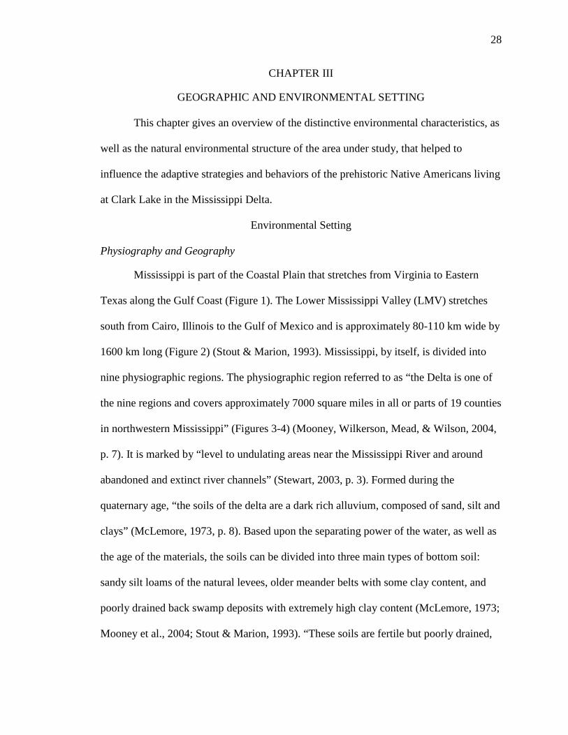
Mississippi is part of the Coastal Plain that stretches from Virginia to Eastern
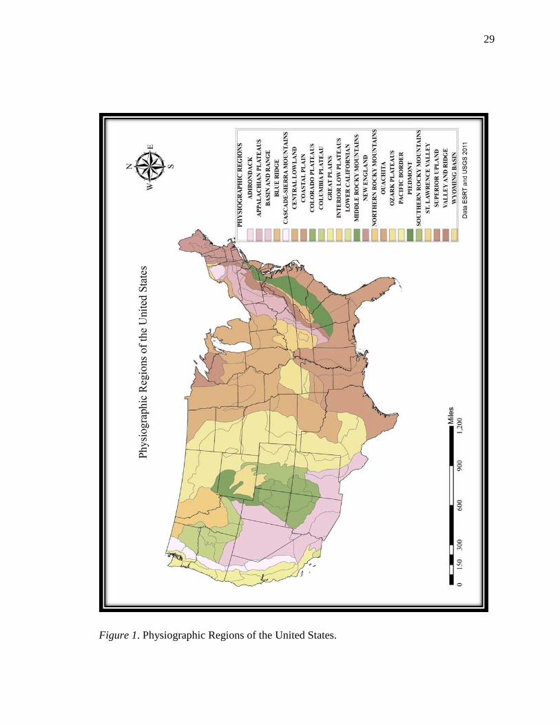
Texas along the Gulf Coast (Figure 1). The Lower Mississippi Valley (LMV) stretches
south from Cairo, Illinois to the Gulf of Mexico and is approximately 80-110 km wide by
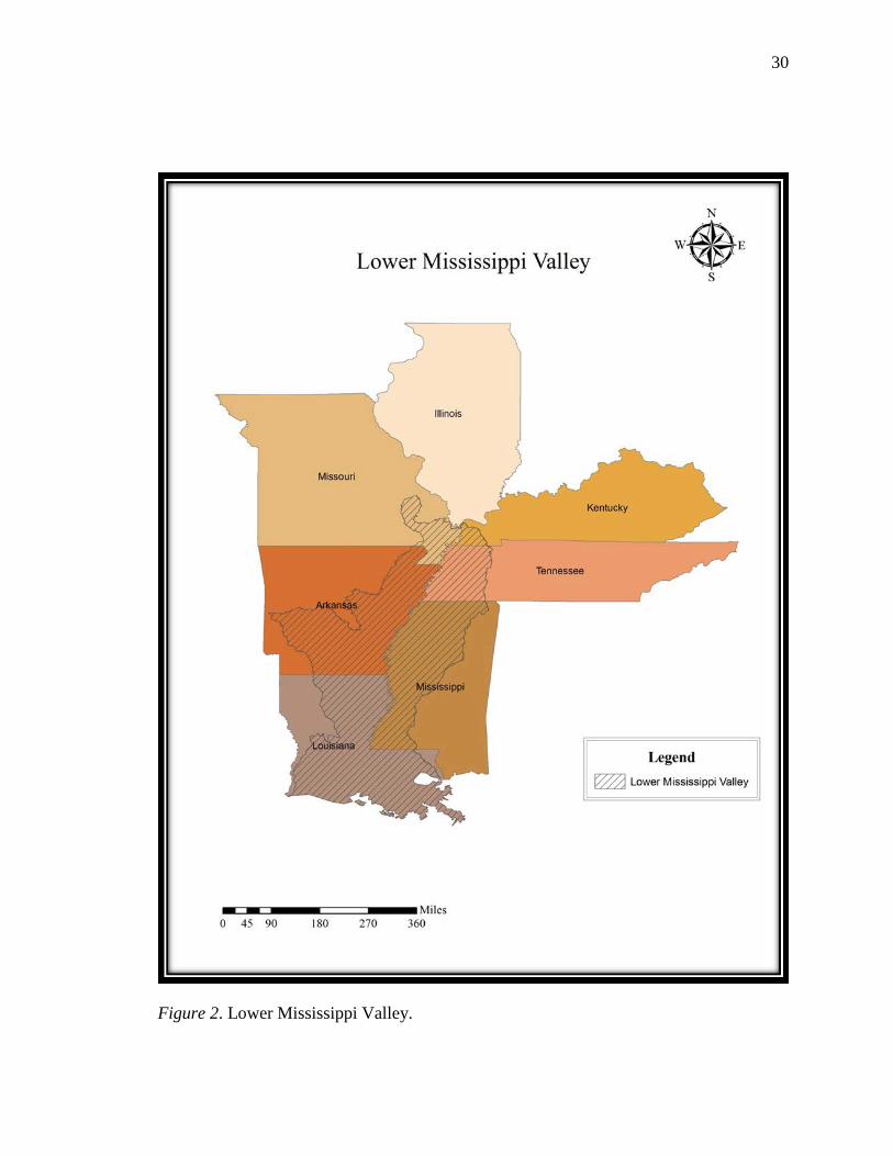
1600 km long (Figure 2) (Stout & Marion, 1993). Mississippi, by itself, is divided into
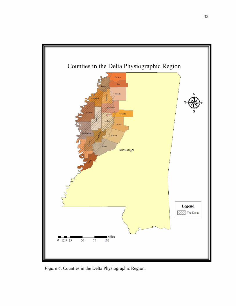
nine physiographic regions. The physiographic region referred to as “the Delta is one of
the nine regions and covers approximately 7000 square miles in all or parts of 19 counties
in northwestern Mississippi” (Figures 3-4) (Mooney, Wilkerson, Mead, & Wilson, 2004,
p. 7). It is marked by “level to undulating areas near the Mississippi River and around
abandoned and extinct river channels” (Stewart, 2003, p. 3). Formed during the
quaternary age, “the soils of the delta are a dark rich alluvium, composed of sand, silt and
clays” (McLemore, 1973, p. 8). Based upon the separating power of the water, as well as
the age of the materials, the soils can be divided into three main types of bottom soil:
sandy silt loams of the natural levees, older meander belts with some clay content, and
poorly drained back swamp deposits with extremely high clay content (McLemore, 1973;
Mooney et al., 2004; Stout & Marion, 1993). “These soils are fertile but poorly drained,
29
Figure 1. Physiographic Regions of the United States.
30
Figure 2. Lower Mississippi Valley.
31
Figure 3. Physiographic Regions of Mississippi.
32
Figure 4. Counties in the Delta Physiographic Region.
33
and in dry weather become granular” (McLemore, 1973, p. 8). This granularity of the dry
soil is why the soil has been referred to as buckshot.
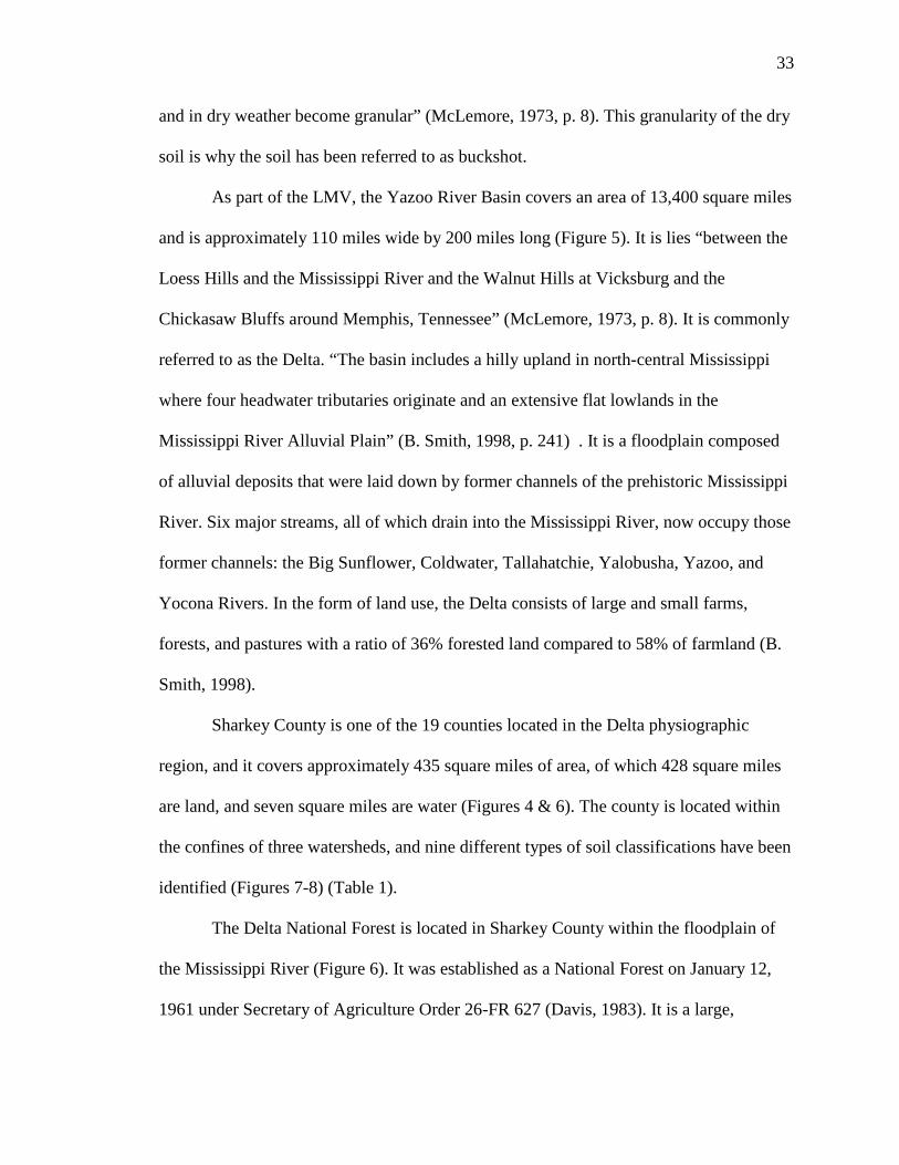
As part of the LMV, the Yazoo River Basin covers an area of 13,400 square miles
and is approximately 110 miles wide by 200 miles long (Figure 5). It is lies “between the
Loess Hills and the Mississippi River and the Walnut Hills at Vicksburg and the
Chickasaw Bluffs around Memphis, Tennessee” (McLemore, 1973, p. 8). It is commonly
referred to as the Delta. “The basin includes a hilly upland in north-central Mississippi
where four headwater tributaries originate and an extensive flat lowlands in the
Mississippi River Alluvial Plain” (B. Smith, 1998, p. 241) . It is a floodplain composed
of alluvial deposits that were laid down by former channels of the prehistoric Mississippi
River. Six major streams, all of which drain into the Mississippi River, now occupy those
former channels: the Big Sunflower, Coldwater, Tallahatchie, Yalobusha, Yazoo, and
Yocona Rivers. In the form of land use, the Delta consists of large and small farms,
forests, and pastures with a ratio of 36% forested land compared to 58% of farmland (B.
Smith, 1998).
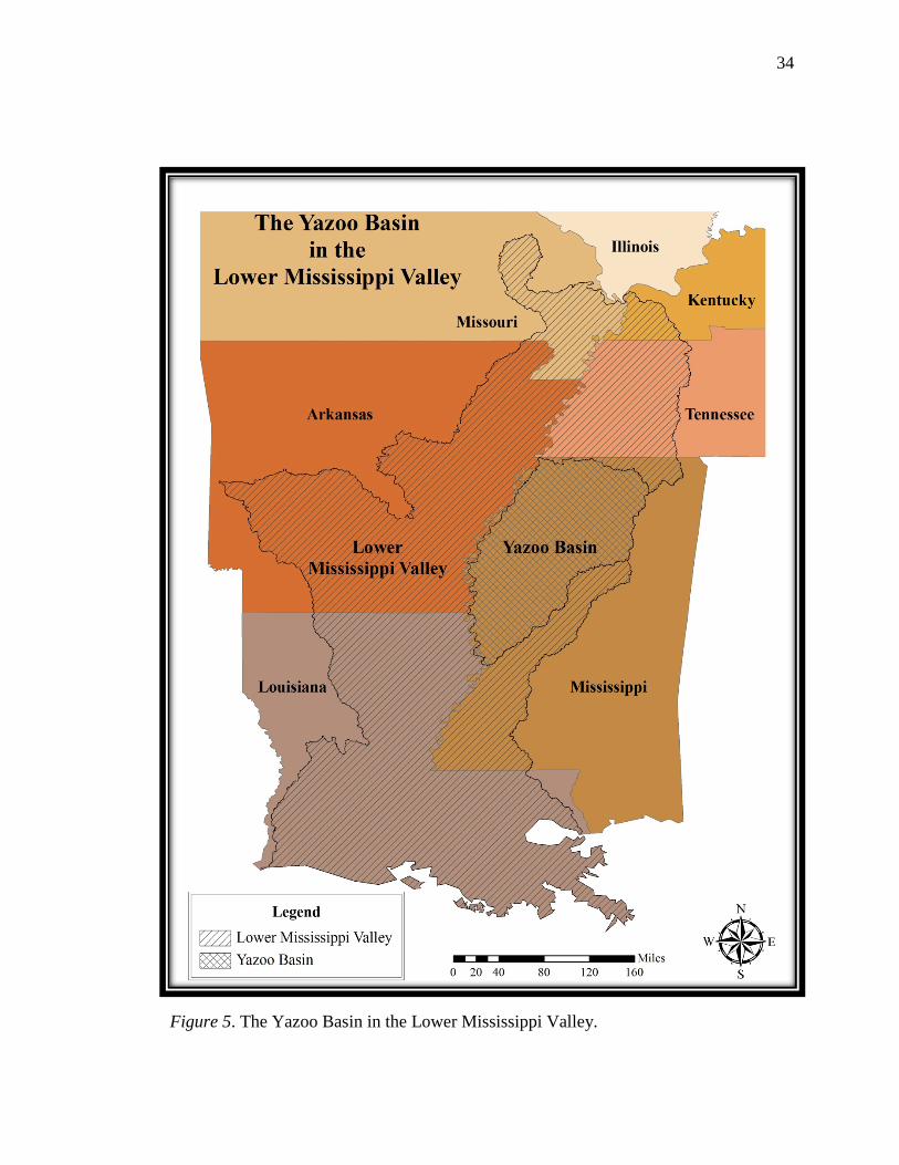
Sharkey County is one of the 19 counties located in the Delta physiographic
region, and it covers approximately 435 square miles of area, of which 428 square miles
are land, and seven square miles are water (Figures 4 & 6). The county is located within
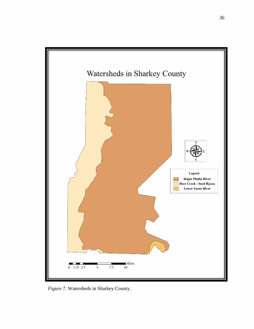
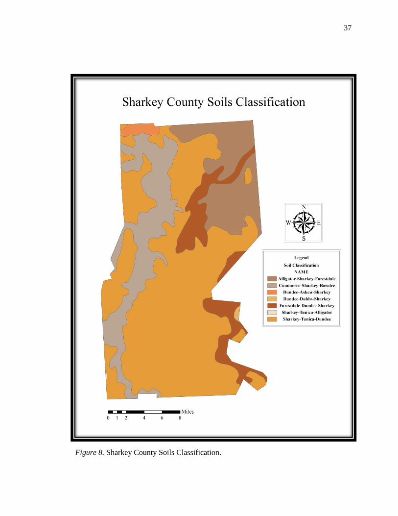
the confines of three watersheds, and nine different types of soil classifications have been
identified (Figures 7-8) (Table 1).
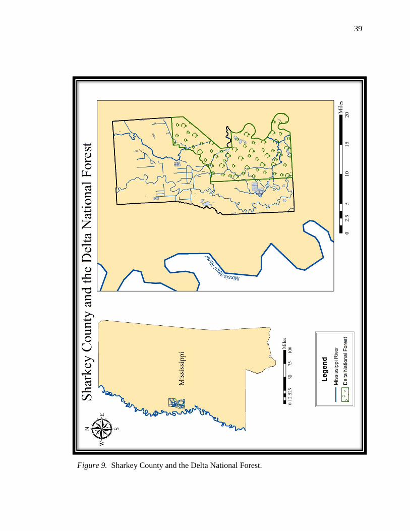
The Delta National Forest is located in Sharkey County within the floodplain of
the Mississippi River (Figure 6). It was established as a National Forest on January 12,
1961 under Secretary of Agriculture Order 26-FR 627 (Davis, 1983). It is a large,
34
Figure 5. The Yazoo Basin in the Lower Mississippi Valley.
35
Figure 6. Sharkey County.
36
Figure 7. Watersheds in Sharkey County.
37
Figure 8. Sharkey County Soils Classification.
38
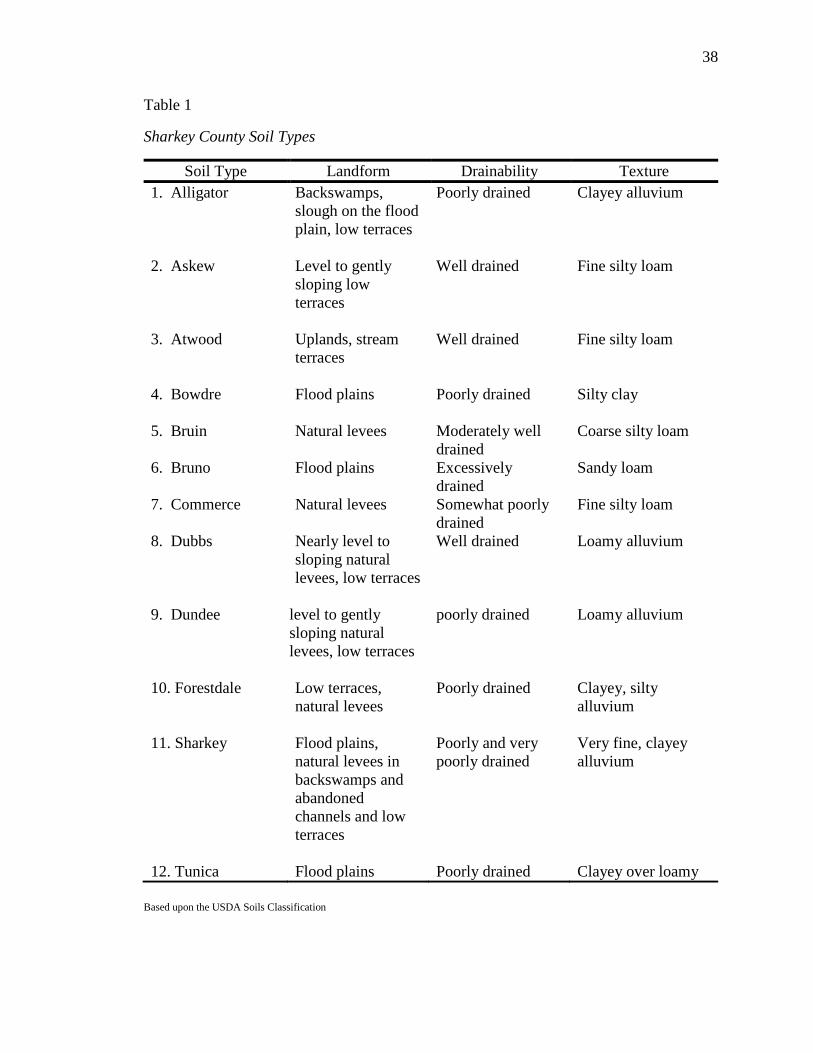
Table 1
Sharkey County Soil Types
Based upon the USDA Soils Classification
Soil Type Landform Drainability Texture 1. Alligator Backswamps,
slough on the flood plain, low terraces
Poorly drained Clayey alluvium
2. Askew Level to gently sloping low terraces
Well drained Fine silty loam
3. Atwood Uplands, stream terraces
Well drained Fine silty loam
4. Bowdre Flood plains
Poorly drained Silty clay
5. Bruin Natural levees Moderately well drained
Coarse silty loam
6. Bruno Flood plains Excessively drained
Sandy loam
7. Commerce Natural levees Somewhat poorly drained
Fine silty loam
8. Dubbs Nearly level to sloping natural levees, low terraces
Well drained Loamy alluvium
9. Dundee level to gently sloping natural levees, low terraces
poorly drained Loamy alluvium
10. Forestdale Low terraces, natural levees
Poorly drained Clayey, silty alluvium
11. Sharkey Flood plains, natural levees in backswamps and abandoned channels and low terraces
Poorly and very poorly drained
Very fine, clayey alluvium
12. Tunica Flood plains Poorly drained Clayey over loamy
39
Figure 9. Sharkey County and the Delta National Forest.
40
contiguous block of bottomland hardwood forest, seasonally flooded timber, and small
sloughs [that drain] into the Big and Little Sunflower Rivers in the Yazoo Basin of the
Mississippi River. “It is one of the few hardwood forests remaining in the Mississippi
Delta and the only bottomland hardwood national forest in the United States”
(http://www.fs.usda.gov/mississippi/).
Climate
Climate is generally composed of several different types of phenomena set by the
prevailing weather conditions of a specific region. These phenomena include but are not
limited to temperature, humidity, precipitation, sunshine, and winds throughout the year
and averaged over a number of years. The climate in the southeast is noted for its hot
summers, high humidity, and long growing seasons because of its location between the
Rocky Mountains in the west and the Appalachian Mountains in the east. Characteristics
such as these helped to contribute to the high diversity of the native flora and fauna and
the continued existence of exotic species within the region. As for seasonal variability in
the southeast, the climate in Atlantic and Gulf Coastal Plain is affected by “the maritime
climatic conditions that develop offshore” (Martin & Boyce, 1993, p. 16). Three different
air masses influence the temperature in the Southeast. The first is from the Gulf of
Mexico which it is warm and moist. This air mass controls summertime weather patterns,
and it reduces the impact of cold air from Canada during the winter. The second is “the
Gulf Stream that affects the entire Atlantic Coast and westward to the southern
Appalachians” (Martin & Boyce, 1993, p.16), and the third is the air masses that flow
down from Canada during the winter (Martin & Boyce, 1993; Ward, 1925).
During the spring through the fall in the Southeast, temperatures can often reach
highs of 90-100º F, or more, for short periods of time. Winters are mild with short periods
41
of freezing temperatures that can often reach lows of 20-30º F. The growing season
begins around mid-March and continues until around mid-November; however, this can
be split into two seasons due to the limiting factor of high heat during the summer
(http://www.garden.org/). In Mississippi, the temperature ranges from 42º F with some
freezing days that dip below 32º during the winter and reaches temperatures to over 100º
F in the summer (Foster, 1869; Martin & Boyce, 1993; Ward, 1925). The state’s growing
season “ranges from 200 frost-free days in the extreme Northeast . . . to 270 days along
the Gulf Coast from March through October” (McLemore, 1973, p. 10).
Precipitation in the Southeast is well distributed with some exceptional years that
resulted in either droughts or remarkable rainfall, especially during the summer months.
Precipitation averages from 40 inches in the upper Southeast to amounts in excess of 100
in. around the Gulf States (McLemore, 1973; Ward, 1923). The Southeast is noted for its
fairly frequent and intense rainstorms with high winds, as well as some thunderstorms. In
Mississippi, precipitation averages 56 inches per year (United States Geological Survey,
1994).
Lithic Resources
Prehistoric hunter-gatherers used stone tools for a variety of purposes from
hunting and preparing food to butchering animals and building. They learned early on
that different types of rocks were better than others for the manufacturing of stone tools.
“These turned out to be high-silica rocks that broke with a conchoidal fracture” since they
“are not easily weathered away, nor mechanically decomposed during erosion” (Rapp,
2009, p. 70). Many prehistoric groups gathered both ground-stone and chipped-stone raw
materials from riverbeds, secondary deposits of boulders, or even from petrified wood.
42
Ground-stone tools are made by grinding stone into the preferred shape, first by
slowly pecking or flaking the surface of the stone, then by rubbing it on a slab of gritty
rock such as sandstone, and finally by polishing the surface by rubbing it with a finer-
grained rock such as fine, loose sand. It is a slow and laborious process; however, the
tools are usually strong. Ground-stone tools are usually made from granite, basalt,
rhyolite, andesite or other types of igneous rock. These types of rocks are ideal for
grinding other materials because of their course grain structure and silica content. The
types of tools made from these types of rocks typically consist of mortar and pestles or
manos and metates, adzes, celts, axes, hammerstones and boatstones (Andrefsky, 2005;
Peregrine, 2001; Rapp, 2009).
Chipped-stone tools are made by removing flakes of stone from a core or preform
through hard hammer or soft hammer percussion or pressure flaking. Chipped stone tools
are usually made from cryptocrystalline or microcrystalline materials such as chert, flint,
quartz, chalcedony, novaculite, quartzite, felsite, or obsidian. The types of tools made
from these types of rocks typically consist of projectile points, knives, drills, burins,
scrapers, or blades.
In Mississippi, “gravel aggregate and sand are the most naturally occurring
building material” (Russell, 1987, p. 1). This gravel aggregate underlies much of the
state; however, some regions do not have access to these resources locally. These regions
are located near Jackson, the Gulf Coast, and “a north-south belt between the loess belt
and the Tombigbee River” (Russell, 1987, p. 1). Today, gravel is mined in northeastern
Mississippi, “a narrow belt beneath the Loess Hills that extends from Memphis,
Tennessee, to south of Natchez, Mississippi, and a wide east-west belt in southern
43
Mississippi” (Russell, 1987, p. 1). It is most likely from these areas that prehistoric
Native Americans acquired their lithic resources, as well.
According to Stallings, “the Citronelle geologic formation was an important lithic
raw material source for prehistoric Native Americans” (Stallings, 1989, p. 35). It is a
band of pebbles and cobbles that have been deposited secondarily along the rim of the
Lower Mississippi Valley. This band of rocks extends west to east from Texas and
Louisiana to Mississippi and Alabama, and south from southern Illinois to the Gulf
Coast. Along with Stallings, in light of debate about whether the gravel deposit that
underlies the loess is actually a part of the Citronelle formation, the material in this study
thought to be from sub-loess deposits will be referred to as Citronelle (Stallings, 1989).
Lithologically, there is little distinction between these gravels and those more securely a
part of the Citronelle formation.
In the western part of Mississippi, the gravel deposits are found in the Loess Hills
physiographic region. Pebbles and cobbles of chert, quartzite, and sandstone range in size
from a few millimeters to several centimeters and can be found in gravel bars,
streambeds, and exposed ridge tops that were formed during the Pliocene and Pleistocene
eras. It is thought that these gravels were carried downstream by the heavy currents of the
fast flowing prehistoric Mississippi, Ohio-Cumberland, and/or Tennessee Rivers, and the
large boulders were transported by ice rafting (Stallings, 1989).
In the study area, a wide variety of raw materials have been recovered from
archaeological sites and identified. These materials include Citronelle gravel chert,
Tallahatta quartzite, and various types of quartz including milky, smoky, and rose-
44
colored, sandstone, Coastal Plain agate, Coastal Plain chert, Burlington chert, andesite,
basalt, and petrified wood.
Citronelle gravel chert. Chert is the most common raw material used in the lithic
technology of prehistoric Native Americans. It is a “cryptocrystalline or microcrystalline
quartz of roughly equal dimensional crystals” (Rapp, 2009, p. 76) and “can be almost any
color and accommodate a wide variety of impurities that affects its workability in lithic
manufacture” (Rapp, 2009, p. 78). The most common colors are white, green, bluish,
brown, gray, yellow, honey-colored, and black, but can also range from a light pinkish
color to a deep, dark red, which is a result of slowly heating and cooling the material in
sand. Heat treatment causes “marked improvements in knapping properties” as the
compressive strength is increased and point tensile strength is decreased “allow[ing] for
more effective control of fracture for flaking (Rapp, 2009, p. 77). Citronelle gravel chert
(CG) is the most abundant type of rock recovered from Clark Lake and it is procured
locally in the form of cobbles and pebbles from nearby streambeds, gravel bars and
remnant ridge top deposits from the Loess Hills (Fields & Rochester, 2003; Mooney et
al., 2004; Rapp, 2009).
Tallahatta Quartzite. There are two types of quartzite: Orthoquartzite and
Metaquartzite. This distinction is based upon how it was created. Both types are formed
through the conversion of sandstone by the chemical precipitation of silica from
interstitial waters; however, orthoquartzite is formed at shallow depths and by low
pressure beneath the earth’s surface, and metaquartzite is formed by the recrystallization
of quartz under high pressure and high temperature beneath the earth’s surface. Tallahatta
Quartzite (TQ) is of the orthoquartzite type. The term porcellanite has been used to
45
describe TQ because it has a dull aspect that resembles unglazed porcelain. This is due to
its fine to medium sized pore spaces and its mixture with silty clay and opaline silica. It
fractures conchoidally across the quartz grains rather than around them, which makes it a
good candidate for the manufacturing of lithic tools. “Colors range from medium grey
and white to almost translucent with a speckled-pepper like appearance, [from the
inclusions of feldspar and glauconite], throughout the material” (Fields, 2001, p. 8).
Tallahatta Quartzite is procured from the Tallahatta Formation. This formation occurs in
a thin band or arc that runs southwest from Memphis, Tennessee, passing through
Mississippi just south of Meridian into Alabama just north of Mobile and extends into
Georgia (Fields & Rochester, 2003; Mooney et al., 2004; Rapp, 2009).
Quartz. Quartz is a fine-grained siliceous rock and is usually a very hard,
compact material that fractures conchoidally. It is formed in thin veins of metamorphic
rock formations of the Alabama piedmont and in the Lime Hills of southwestern
Alabama as large cobbles in streambeds (Jeter & Futato, 1990). It comes in a variety of
colors; however, pure quartz is transparent and colorless. The different colors come from
the impurities that are included within the crystal. Milky or white quartz “owes its color
to the light scattered by the large number of tiny cavities or flaws in the crystals” (Rapp,
2009, p. 37). Smoky quartz varies in color from transparent to nearly opaque and almost
black to pale smoky-brown. Rose quartz varies in color from pale pink to a deep rose-red
(Fields & Rochester, 2003; Mooney et al., 2004; Rapp, 2009).
Sandstone. Sandstone is a sedimentary rock formed by interlocking grains of fine
to coarse-grained sand cemented together by silica, calcite, or iron oxide (Rapp, 2009).
Colors range from white to a silvery grey and deep purple to black depending upon the
46
type of cementation. It is often made from a conglomerate of chert, quartz and sand.
Knappable sandstone is found throughout Southeast Mississippi and Southwest Alabama
as inclusions in gravel bars and non-ferruginous or low quality deposits (Fields &
Rochester, 2003; Mooney et al., 2004; Rapp, 2009).
Coastal Plain chert. Coastal Plain chert is a beige to cream-colored lightweight
opaline silica rock. It is formed as silicified seams within limestone formations. It is
commonly heat-treated to increase the knappability of the material. Heat-treating also
causes a change in color. Coastal Plain chert is found in the southern Coastal Plain of
Alabama (Fields & Rochester, 2003; Mooney et al., 2004; Rapp, 2009).
Burlington Chert. Burlington chert is a highly fossiliferous fine to course-grained
crinoidal limestone rock. It has a waxy type luster that comes in a variety of colors from
white, tan, cream, or light gray but it weathers to buff and reddish brown. Some banding
or mottling of white or gray does occur. When heated, its base color changes to a pure
white or a light pink, with some darker areas becoming orange to red due to the iron
oxide deposits associated with fossil voids or fractures in the rock. It is found in the
Burlington-Keokuk Limestone formation of Missouri and Illinois. It is considered to be
an exotic resource (Fields & Rochester, 2003; Mooney et al., 2004; Rapp, 2009).
Andesite. Andesite is a fine-grained volcanic rock composed of plagioclase or
pyroxene feldspar, and one or more minerals such as biotite and hornblende. It comes in a
variety of colors from white and yellow to reddish-gray, as well as from green to blue and
black. Andesites are found in abundance along active continental margins. In the
Southeast, Andesite can be found within the Blue Ridge and Piedmont areas that extend
from southwest along the Appalachian Mountains and the Brevard Fault Zone (which is
47
located at the intersection of the Blue Ridge and Piedmont provinces) from Virginia
through Tennessee, North and South Carolina, Georgia, and ending in mid-east Alabama
(Figure 1). Andesite can be frequently mistaken for greenstone, which is a widely
distributed, low-grade, basic mafic or ultramafic metamorphic igneous rock. Greenstone
is used commonly as a generic term to describe the many different types of green rocks
and minerals (Rapp, 2009).
Basalt. Basalt is similar to Andesite in both composition and locality. It, too, is a
fine-grained, igneous rock composed of plagioclase, pyroxene, magnetite, and frequently,
olivine; however, it can be medium-grained or even glassy. It ranges in color from dark
grey to blue and black (Rapp, 2009).
Both Andesite and Basalt were utilized by prehistoric Native Americans for
implements such as grindstones or mortars and pestles to grind nuts, seeds, and grains
because of their ability to maintain a rough, hard surface, which, in turn, lessens the
amount of rock grit in the prepared food items. They are also used for the manufacturing
of axes, adzes, bannerstones, and hammerstones.
Petrified Wood. Petrified wood is the result of the fossilization or petrification of
wood via the process of permineralization. Permineralization is the process by which
minerals, such as silica, quartz calcite, or iron, from the soil, rivers or lakes impregnate
the pores of plant materials and either dissolves or replaces the wood fibers and cellulose,
thus taking the shape of the original material. Petrification takes place when the organic
matter is completely replaced by the minerals and turned to stone. Petrified wood cobbles
are found within the Citronelle formation and are oftentimes extremely difficult to
distinguish macroscopically from actual (Citronelle gravel) rock (Keith, 1998). In
48
Mississippi, petrified wood can be found in the Petrified Forest in Flora, Mississippi
approximately 39 km or 24 miles from Clark Lake.
Flora and Fauna
In the period before contact with Europeans, Native Americans had “achieved an
efficient relationship with a wide variety of plant and animal resources” where they lived
within the different types of biotic communities (Usner, 1983, p. 433). The biotic
community to which the forests of west-central Mississippi belong is considered a
southern floodplain forest. These forests include both “bottomland hardwood forests and
deep-water alluvial swamps that occur in the riparian zones of southeastern rivers or
streams” (Sharitz & Mitsch, 1993, p. 311). Studies have revealed that this type of biotic
community provides an almost yearlong abundance of game, fruits, seeds, and nuts,
which could have been used for subsistence, medicinal, and ceremonial purposes (Usner,
1983). A list of common plant species found within Sharkey, Issaquena, and Yazoo
counties and their possible Native American use is included in Table 2.
Typically, the canopies of bottomland hardwood forests are thick and closed, with
the exception of some areas due to the nature of soil conditions, such as texture or
drainage, rather than physiographic or climatic factors. The trees in this type of forest
consist of dense, medium-tall to tall broadleaf deciduous and evergreen trees and shrubs,
and needleleaf deciduous trees. The different species of trees include several varieties of
oak, pecan, red maple, hickory, gum, sweetgum, cottonwood, cypress, water tupelo,
green ash, black willow, alder, birch, cedar, holly, and southern pine (Delcourt, Delcourt,
Brister, & Lackey, 1980; Sharitz & Mitsch, 1993). The native understory of the region
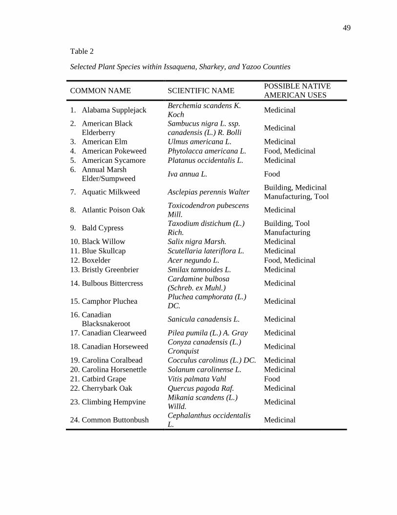
49
Table 2
Selected Plant Species within Issaquena, Sharkey, and Yazoo Counties
COMMON NAME SCIENTIFIC NAME POSSIBLE NATIVE AMERICAN USES
1. Alabama Supplejack Berchemia scandens K. Koch Medicinal
2. American Black Elderberry
Sambucus nigra L. ssp. canadensis (L.) R. Bolli Medicinal
3. American Elm Ulmus americana L. Medicinal 4. American Pokeweed Phytolacca americana L. Food, Medicinal 5. American Sycamore Platanus occidentalis L. Medicinal 6. Annual Marsh
Elder/Sumpweed Iva annua L. Food
7. Aquatic Milkweed Asclepias perennis Walter Building, Medicinal Manufacturing, Tool
8. Atlantic Poison Oak Toxicodendron pubescens Mill. Medicinal
9. Bald Cypress Taxodium distichum (L.) Rich.
Building, Tool Manufacturing
10. Black Willow Salix nigra Marsh. Medicinal 11. Blue Skullcap Scutellaria lateriflora L. Medicinal 12. Boxelder Acer negundo L. Food, Medicinal 13. Bristly Greenbrier Smilax tamnoides L. Medicinal
14. Bulbous Bittercress Cardamine bulbosa (Schreb. ex Muhl.) Medicinal
15. Camphor Pluchea Pluchea camphorata (L.) DC. Medicinal
16. Canadian Blacksnakeroot Sanicula canadensis L. Medicinal
17. Canadian Clearweed Pilea pumila (L.) A. Gray Medicinal
18. Canadian Horseweed Conyza canadensis (L.) Cronquist Medicinal
19. Carolina Coralbead Cocculus carolinus (L.) DC. Medicinal 20. Carolina Horsenettle Solanum carolinense L. Medicinal 21. Catbird Grape Vitis palmata Vahl Food 22. Cherrybark Oak Quercus pagoda Raf. Medicinal
23. Climbing Hempvine Mikania scandens (L.) Willd. Medicinal
24. Common Buttonbush Cephalanthus occidentalis L. Medicinal
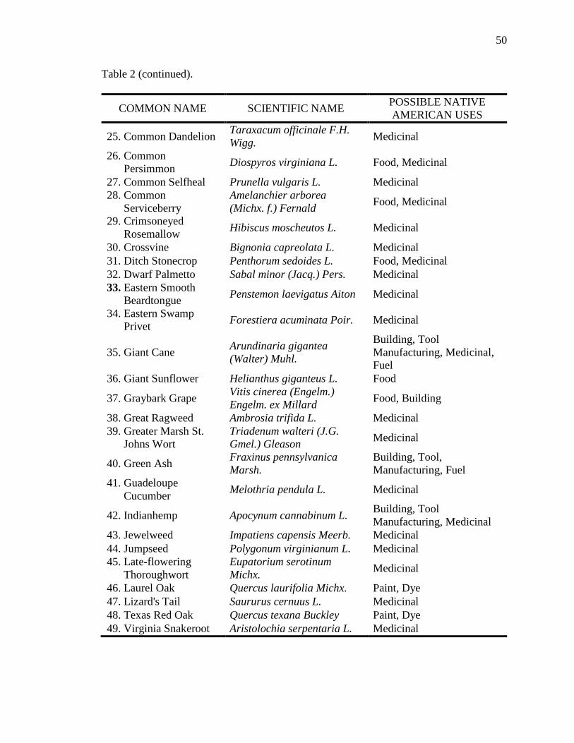
50
Table 2 (continued).
COMMON NAME SCIENTIFIC NAME POSSIBLE NATIVE AMERICAN USES
25. Common Dandelion Taraxacum officinale F.H. Wigg. Medicinal
26. Common Persimmon Diospyros virginiana L. Food, Medicinal
27. Common Selfheal Prunella vulgaris L. Medicinal 28. Common
Serviceberry Amelanchier arborea (Michx. f.) Fernald Food, Medicinal
29. Crimsoneyed Rosemallow Hibiscus moscheutos L. Medicinal
30. Crossvine Bignonia capreolata L. Medicinal 31. Ditch Stonecrop Penthorum sedoides L. Food, Medicinal 32. Dwarf Palmetto Sabal minor (Jacq.) Pers. Medicinal 33. Eastern Smooth
Beardtongue Penstemon laevigatus Aiton Medicinal
34. Eastern Swamp Privet Forestiera acuminata Poir. Medicinal
35. Giant Cane Arundinaria gigantea (Walter) Muhl.
Building, Tool Manufacturing, Medicinal, Fuel
36. Giant Sunflower Helianthus giganteus L. Food
37. Graybark Grape Vitis cinerea (Engelm.) Engelm. ex Millard Food, Building
38. Great Ragweed Ambrosia trifida L. Medicinal 39. Greater Marsh St.
Johns Wort Triadenum walteri (J.G. Gmel.) Gleason Medicinal
40. Green Ash Fraxinus pennsylvanica Marsh.
Building, Tool, Manufacturing, Fuel
41. Guadeloupe Cucumber Melothria pendula L. Medicinal
42. Indianhemp Apocynum cannabinum L. Building, Tool Manufacturing, Medicinal
43. Jewelweed Impatiens capensis Meerb. Medicinal 44. Jumpseed Polygonum virginianum L. Medicinal 45. Late-flowering
Thoroughwort Eupatorium serotinum Michx. Medicinal
46. Laurel Oak Quercus laurifolia Michx. Paint, Dye 47. Lizard's Tail Saururus cernuus L. Medicinal 48. Texas Red Oak Quercus texana Buckley Paint, Dye 49. Virginia Snakeroot Aristolochia serpentaria L. Medicinal
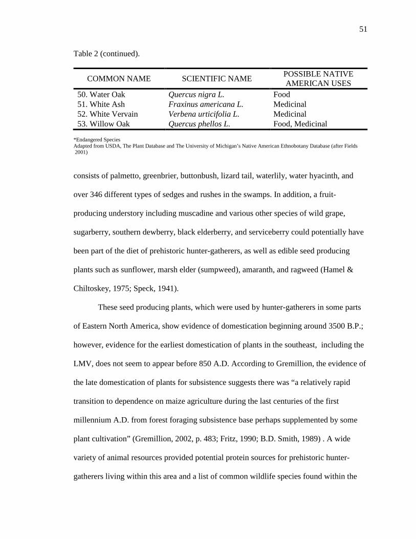
51
Table 2 (continued).
COMMON NAME SCIENTIFIC NAME POSSIBLE NATIVE AMERICAN USES
50. Water Oak Quercus nigra L. Food 51. White Ash Fraxinus americana L. Medicinal 52. White Vervain Verbena urticifolia L. Medicinal 53. Willow Oak Quercus phellos L. Food, Medicinal
*Endangered Species Adapted from USDA, The Plant Database and The University of Michigan’s Native American Ethnobotany Database (after Fields 2001)
consists of palmetto, greenbrier, buttonbush, lizard tail, waterlily, water hyacinth, and
over 346 different types of sedges and rushes in the swamps. In addition, a fruit-
producing understory including muscadine and various other species of wild grape,
sugarberry, southern dewberry, black elderberry, and serviceberry could potentially have
been part of the diet of prehistoric hunter-gatherers, as well as edible seed producing
plants such as sunflower, marsh elder (sumpweed), amaranth, and ragweed (Hamel &
Chiltoskey, 1975; Speck, 1941).
These seed producing plants, which were used by hunter-gatherers in some parts
of Eastern North America, show evidence of domestication beginning around 3500 B.P.;
however, evidence for the earliest domestication of plants in the southeast, including the
LMV, does not seem to appear before 850 A.D. According to Gremillion, the evidence of
the late domestication of plants for subsistence suggests there was “a relatively rapid
transition to dependence on maize agriculture during the last centuries of the first
millennium A.D. from forest foraging subsistence base perhaps supplemented by some
plant cultivation” (Gremillion, 2002, p. 483; Fritz, 1990; B.D. Smith, 1989) . A wide
variety of animal resources provided potential protein sources for prehistoric hunter-
gatherers living within this area and a list of common wildlife species found within the
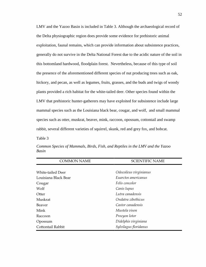
52
LMV and the Yazoo Basin is included in Table 3. Although the archaeological record of
the Delta physiographic region does provide some evidence for prehistoric animal
exploitation, faunal remains, which can provide information about subsistence practices,
generally do not survive in the Delta National Forest due to the acidic nature of the soil in
this bottomland hardwood, floodplain forest. Nevertheless, because of this type of soil
the presence of the aforementioned different species of nut producing trees such as oak,
hickory, and pecan, as well as legumes, fruits, grasses, and the buds and twigs of woody
plants provided a rich habitat for the white-tailed deer. Other species found within the
LMV that prehistoric hunter-gatherers may have exploited for subsistence include large
mammal species such as the Louisiana black bear, cougar, and wolf, and small mammal
species such as otter, muskrat, beaver, mink, raccoon, opossum, cottontail and swamp
rabbit, several different varieties of squirrel, skunk, red and grey fox, and bobcat.
Table 3
Common Species of Mammals, Birds, Fish, and Reptiles in the LMV and the Yazoo Basin
COMMON NAME SCIENTIFIC NAME
White-tailed Deer Odocoileus virginianus
Louisiana Black Bear Euarctos americanus Cougar Felis concolor Wolf Canis lupus Otter Lutra canadensis Muskrat Ondatra zibethicus Beaver Castor canadensis Mink Mustela vison Raccoon Procyon lotor Opossum Didelphis virginiana Cottontail Rabbit Sylvilagus floridanus
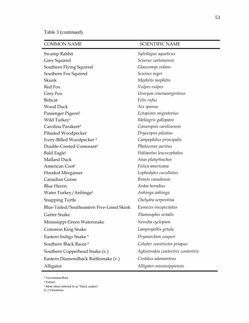
53
Table 3 (continued).
COMMON NAME SCIENTIFIC NAME
Swamp Rabbit Sylvilagus aquaticus Grey Squirrel Sciurus carloinensis Southern Flying Squirrel Glaucomys volans Southern Fox Squirrel Scurius niger Skunk Mephitis mephitis Red Fox Vulpes vulpes Grey Fox Urocyon cineraoargenteus Bobcat Felis rufus Wood Duck Aix sponsa Passenger Pigeon² Ectopistes migratorius Wild Turkey¹ Meleagris gallopavo Carolina Parakeet² Conuropsis carolinensis Pileated Woodpecker Dryocopus pileatus Ivory-Billed Woodpecker ² Campephilus principalis Double-Crested Comorant¹ Phalocorax auritus Bald Eagle¹ Haliaeetus leucocephalus Mallard Duck Anas platyrhnchos American Coot¹ Fulica americana Hooded Merganser Lophodytes cucullatus Canadian Goose Brants canadensis Blue Heron Ardea herodius Water Turkey/Anhinga¹ Anhinga anhinga Snapping Turtle Chelydra serpentina Blue-Tailed/Southeastern Five-Lined Skink Eumeces inexpectatus Garter Snake Thamnophis sirtalis Mississippi Green Watersnake Nerodia cyclopion Common King Snake Lampropeltis getula Eastern Indigo Snake ³ Drymarchon couperi Southern Black Racer ³ Coluber constrictor priapus Southern Copperhead Snake (v.) Agkistrodon contortrix contortrix Eastern Diamondback Rattlesnake (v.) Crotalus adamanteus Alligator Alligator mississippiensis ¹ Uncommon/Rare ² Extinct ³ Most often referred to as “black snakes” (v.) Venomous
54
In addition, a wide variety of birds might have provided other potential protein
sources for prehistoric hunter-gatherers that inhabited the area. Bird species include but
are not limited to wood duck, passenger pigeon, wild turkey, Carolina parakeet, pileated
woodpecker, ivory-billed woodpecker, double crested cormorant, water turkey, and the
bald eagle, some of which were once common but are now uncommon/rare or extinct
(see Table 3). Other abundantly present bird species include mallard ducks, coot, hooded
mergansers, Canadian goose, and blue heron.
Bottomland forests are associated with major rivers, streams, oxbow lakes,
bayous and backwater swamps, and there is potential for the high seasonal harvesting of
fish and shellfish, as well as different types of reptiles, which were important components
in the diet of prehistoric hunter-gatherers. Fish species available for consumption would
have included shovel bill, channel, yellow and mud catfish, buffalo, suckers, minnows,
shad, perch, large-mouth bass, little pickerel, speck, carp, and gar. Fresh water mollusks,
shrimp, and crawfish were abundant on the sandy flats near the Mississippi River.
Common species of reptiles include several different varieties of turtles, toads, frogs,
lizards, and snakes, as well as alligators.
Summary
Prehistoric people inhabiting the Lower Mississippi Valley lived in a
heterogeneous environment that was capable of sustaining them through hunting and
gathering. Raw materials for the manufacturing of tools included the locally available
Citronelle gravel chert as well as other non-local varieties including different types of
quartz, Coastal Plain chert, Coastal Plain agate, Tallahatta quartzite, basalt, andesite, and
others. The heterogeneous environment that these prehistoric peoples inhabited is

55
important in understanding the nature of human settlement in the Lower Mississippi
Valley and at Clark Lake, to be more specific. Different kinds of strategies and schedules
were necessary for prehistoric hunter-gatherers to exploit this heterogeneous
environment.
56
CHAPTER IV
CULTURE HISTORY OF THE SOUTHEAST AND
THE LOWER MISSISSIPPI VALLEY
This chapter gives an overview of the cultural history of the Southeast and the
Lower Mississippi Valley, and it discusses the evolution and continuity of the different
characteristics specific to the Woodland Period.
Cultural and Historical Framework
The prehistoric occupation in the southeastern United States is divided into six
major stages: Paleo-Indian, Archaic, Gulf Formational, Woodland, Mississippian, and
Proto-historic. However, the discussion of occupational periods is limited to only the Late
Gulf Formational Stage and the Early, Middle, and Late Woodland Stages because, based
upon the analysis of the ceramics recovered from the site, the lithics from Clark Lake
belong to the Middle Woodland. Nevertheless, it has been determined that Clark Lake is
a multi-component site that was repeatedly occupied from the Tchula period around 500
B.C. into the Mississippian period around A.D. 1400. The Gulf Formational Stage is
divided into three sub-stages: the Early Gulf Formational (2500-1200 B.C), Middle Gulf
Formational (1200-500 B.C.), and the Late Gulf Formational periods (500-100 B.C.). The
Woodland Stage is also divided into three sub-stages: Early Woodland (500-100 B.C.),
Middle Woodland (100 B.C – 400 A.D.), and Late Woodland (400 A.D – 1000 A.D.).
Figure 10 shows the cultural and chronological chart for the Lower Yazoo Basin. Each
sub-stage is divided into cultural periods, and each cultural period is further divided into
phases. General cultural trends of each of these periods, as well as settlement adaptations

57
and lithic technology, will be discussed for each of these periods of occupation. In
addition, these trends will be associated with the Lower Mississippi Valley.
Yazoo (phases)
Lower Mississippi (cultural periods)
Lower Mississippi (cultures)
Griffin, 1966 (stages)
Russell
Mississippi
Wasp Lake Lake George Winterville
Crippen Point
Coles Creek Kings Crossing
Aden
Bayland Baytown
Deasonville
Issaquena
Marksville Anderson Landing
Tuscola Tchula
Figure 10. Cultural and Chronological Chart for the Lower Yazoo Basin (Modeled after Phillips 1979 and Brain 1989 and modified accordingly).
The following cultural chronology is based on a combination of a number of
cultural chronologies and archaeological concepts proposed over the years by such
individuals as William McKern, Philip Phillips, James A. Ford, James B. Griffin, Gordon
Willey, Stephen Williams, Jeffrey P. Brain, Robert E. Greengo, Ned J. Jenkins, John A.
Tche
func
te
Mississippi
Late
Middle
Early Woodland
Nat
chez
an
Mis
sissip
pian
Pl
aque
min
e C
oles
Cre
ek
Bay
tow
n H
opew
ellia
n
Lake
Com
oran
t
A.D. 1800 1600 1400 1200 1000 900 800 700 600 400 200 0 200 400
58
Walthall, and Marvin D. Jeter. Over the ensuing years, their various viewpoints and
concepts have evolved into a complicated understanding of, what Willey and Phillips
(1958) consider basic archaeological units (p. 21). These units are often referred to as
components, phases and sub-phases, eras, horizons, traditions, periods, stages, etc. For
the purposes of this research, the basic archaeological units I will be utilizing are “stage,”
“period,” and “phase". Nevertheless, the objective is to summarize the cultural
chronology of the Lower Mississippi Valley as it pertains to the Clark Lake site. The
discussion for each historical time frame will begin with the larger general regional
stages and then continue with the periods specific to the Yazoo Basin.
Major Historical Time Periods
Gulf Formational Stage (2500 B.C. – 100 B.C.)
The transitional period from the Archaic to Woodland lifeways has been
designated by Walthall and Jenkins (1976) as the Gulf Formational Stage. “This period
retained vestiges of earlier Archaic material culture, including stemmed projectile points
and other chipped stone tools, but new additions include fiber tempered ceramics”
(Bartlett, 2010, pp. G-4). According to Walthall and Jenkins, during the latter half of the
Late Archaic period, as originally defined for eastern North America, pottery tempered
with fibers or sand first appeared throughout the Southeast. Initially used as a way to
differentiate the timing of the introduction of ceramics and different types of ceramic
production between the Northeast and the Southeast portions of the United States, the
Gulf Formational Stage is defined primarily on the basis of these distinctive pottery types
with a geographical distribution that is restricted to the Southeast. Specifically, the Gulf
Formational Stage extends across the Coastal Plain from South Carolina, through
Georgia, Alabama, and Mississippi into Louisiana. In these areas, this stage incorporates
59
the terminal Late Archaic and the early Woodland Period. Given this limited distribution
and little evidence of culture change throughout the region, this time construct is poorly
understood and, as a result, has not been wholly accepted by many archaeologists
working in the Southeast, many of whom use the traditional Late Archaic or Early
Woodland timeframes (Prentice, 2000).
Like other cultural stages, the Gulf Formational Stage is divided into three sub-
stages: Early, Middle, and Late. As previously noted, since habitation of the Clark Lake
site appears to begin around 400 B.C., the Early and the Middle Gulf Formational Stages
will not be discussed.
Late Gulf Formational/Early Woodland (500 B.C. – 100/200 A.D.)
By the close of the Middle Gulf Formational and the beginning of the Late Gulf
Formational/Early Woodland, fiber-tempered ceramics appeared sporadically throughout
Mississippi, Louisiana, and Tennessee. It is these fiber-tempered ceramics, known as
Wheeler Fiber tempered, that serve as the basis for assigning sites to this stage. Still,
during the Late Gulf Formational/Early Woodland, the manufacturing of ceramics
became widespread throughout the Southeast, which led to the demise of fiber-tempered
ceramics. These fiber-tempered ceramics were replaced by sand- and clay-tempered
ceramics such as Alexander and Tchefuncte pottery types. Contrary to this idea, Gibson
and Melancon believe that clay-tempered Tchefuncte wares “appear in preceding or
coeval contexts with earlier fiber-tempered materials” (Gibson & Melancon, 2004, p.
169). Nevertheless, these types were widely adopted by the Native American groups that
inhabited the Louisiana and Mississippi coastal plain and exhibit a variety of decorative
60
techniques, vessel shapes, paste and temper characteristics (Saunders, Hays, & Society
for American Archaeology, 2004; Walling & Roemer, 1993).
Tchula Period (Late Gulf Formational 500 B.C – 1 A.D). In the Yazoo Basin, the
Tchula period is synonymous with the Late Gulf Formational, It encompasses the
division of time referred to as Early Woodland in other chronological frameworks (e.g.,
Anderson & Mainfort, 2002). This period is represented by the Tchefuncte culture in the
southern portion of the valley, while in the northern portion of the valley is represented
by the Lake Comorant culture. The Tchula period is a modified, less elaborate version of
the Poverty Point/Middle Gulf Formational culture in that it lacks the elaborate long-
distance trade network, large mound complexes, and lapidary or exotic stone industries
(Toth, 1988). It is also regarded to be approximately correspondent in time to some part
of the Adena culture in the north (Griffin, 1967).
Tchefuncte people were relatively sedentary hunters, fishers, and gatherers who
lived nearly year round in relatively autonomous and isolated camps, small hamlets, or
villages. A band level of social organization is inferred for the Tchula period. Tchefuncte
sites are typically located in floodplain “slackwater” (Toth, 1988, p. 20) environments
with access to upland locations during time of flooding. They are rarely found along the
Mississippi River or its more active rivers and outlet streams and are usually grouped
around a ceremonial mound site.
Diagnostic artifacts from the Tchula period are predominantly ceramic and
include two distinctive ceramic series: Tchefuncte and Alexander. Other artifacts from
this period include plain and decorated tubular pipes, bone tools possibly made from
unusual or exotic animal species that are typically geared toward hunting and fishing
61
technologies, shell tools, pendants and baked clay Poverty Point objects (PPOs). Lithic
artifacts include projectile point types such as Ponchartrain, Ellis, Kent, Macon, and
Gary. Along with these points, ground-stone tools such as plummets, bannerstones, bar
weights, mortars, and soapstone bowls, as well as debitage, burins, notched pieces, and
denticulates (Hays & Weinstein, 2010).
Subsistence data indicate a strong dependence on a wide range of floodplain
resources. Specifically, these resources include mammalian taxa (deer, otter, wolf, bear,
fox, cougar, and raccoon), reptilian taxa (alligator, snake, and turtle), avian taxa (duck,
goose, eagle, swan, and crane), fish (sheepshead, gar, shark, drum, catfish, alligator gar,
and bowfin) and shellfish (oyster, clam, and river mussels) (Byrd, 1974; Hays &
Weinstein, 2010; Lewis, 1997). At some sites, such as Morton Shell Mound on the
Louisiana coast, simple horticulture may have been practiced as several kinds of plant
cultigens (squash and bottle gourd), as well as other native wild resources (greenbrier,
persimmon, knotweed, wild plum, grape, and haws) have been found (Hays & Weinstein,
2010).
Within the Yazoo Basin, the Tchula period is subdivided into three phases:
Tuscola, Norman, and Turkey Ridge. Each of these phases is culture and region specific.
The Tuscola phase, also known as the southern Tchula in the 1951 Lower Mississippi
Valley Survey by Phillips, Ford, and Griffin, is solely defined by the presence of
Tchefuncte pottery. The Norman and Turkey Ridge phases, also known as the northern
Tchula, have been attributed to the Lake Comorant culture, and are distinguished by the
distinctive Lake Cormorant ceramics recovered from the various sites. Another phase, the
Boyd phase, has been suggested by Connaway and McGahey (1971) on the basis of the
62
differences in the ceramic inventory found at the Boyd site, even though the type site for
the Turkey Ridge phase was located approximately 20 miles away; however, Toth
includes the site in the Turkey Ridge phase (J. Ford, 1990, p. 105; Toth, 1988).
What the Boyd site is noted for, however, is that it is the first site where evidence
of mound construction for the Lake Comorant culture was found (J. A. Ford & Willey,
1941). This evidence can also be linked to other contemporary mound sites located in the
area, which include Tidwell, McCarter, Tyson, Clear Creek, and Little Spring Creek (J.
Ford, 1990). Nevertheless, while these sites are “unquestionable elements of the Lake
Cormorant culture in northwest Mississippi,” “the question of whether Tchefuncte people
constructed mound of any type is somewhat contentious” and “has long been a topic of
discussion and moderate skepticism” (Hays & Weinstein, 2010, p. 107). Gibson and
Shenkel argue that mound construction “rivaled and perhaps exceeded later Marksville
structures” (Gibson & Shenkel, 1988, p. 9). In contrast to this assertion, Griffin earlier
had argued that mounds were not constructed during this time frame (Griffin, 1979).
Perhaps the most prominent examples of Tchula Period mounds is the Batesville Mound
group, which is located in Panola County, Mississippi and the Lafayette Mounds, which
are located in Lafayette Parish, Louisiana (Brown, 1973; J. A. Ford & Quimby, 1945;
Rafferty, 2002).
Typically, mounds constructed during this time period are conically shaped and
usually come in groups of two to three; however, they also come singly. Charnel houses,
where the remains of the dead are placed prior to their final disposition, are also built
during this time frame (Prentice, 2000).
63
Mortuary data for the Tchula Period shows that the dead were typically buried in
shallow, unadorned graves in midden deposits, and their bodies were flexed, with the leg
bones broken in some cases. Secondary burials, where the bones are sometimes scattered
throughout the midden, are also found. Little to no grave goods accompany the remains
(J. A. Ford & Quimby, 1945; Hays & Weinstein, 2010).
Woodland Stage (500 B.C. – 850 A.D)
In the chronological framework employed here, the Woodland Stage begins what
has been traditionally labeled as Middle Woodland. The Middle Woodland began around
100 B.C and ended around A.D. 500 and the Late Woodland began around A.D. 500 and
ended around A.D. 1000. Each sub-stage is divided into cultural periods and each
cultural period is further divided into phases. As previously noted, since the discussion of
the Gulf Formational Stage incorporated the Early Woodland, the Early Woodland
cultural succession will not be discussed in the Woodland Stage.
Middle Woodland (200 B.C. – 400 A.D.)
The Middle Woodland period is evidenced by the diffusion of the Hopewell
ceremonial complex across the Southeast. This diffusion is demonstrated by the
construction of burial mounds, common artifacts and iconography, and a shared ideology
that seems to indicate that Middle Woodland groups extensively interacted with each
other through a far-reaching trade and exchange network, as well as through ritual and
ceremonial activities. According to Anderson and Mainfort (2002), it is viewed as a
period of pan regional communality among many diverse cultures within the Hopewell
interaction sphere in the Southeast (Anderson & Mainfort, 2002; Bense, 1994).
The Woodland Stage in the Yazoo Basin is synonymous with the period that
points to influences from the North and Mid-Atlantic when their traditions began to take
64
a hold (Griffin, 1967). This is particularly evident with the Marksville period and its
Hopewellian influences.
Marksville Period. The Middle Woodland period in the Lower Mississippi Valley
encompasses the Marksville period and its incorporated phases. According to Toth,
“archaeologically, the cultural shift is marked by the abrupt appearance of conical burial
mounds and a distinctive set of ceramic decorations some of which closely parallel
certain Hopewellian pottery of the Illinois Valley” (Toth, 1979, p. 9).
Marksville people continued to hunt, fish, and gather as did their Tchula
predecessors, and it seems as though they settled in villages for “relatively permanent for
extended periods of time” (Toth, 1979, p. 194). In contrast to the Tchefuncte pattern of
distribution of sites in slackwater environments, Marksville sites seem to be oriented
toward alluvial areas in upland zones adjacent to the floodplain along active channels of
the Mississippi river and secondary streams. Woodland sites appear to be widespread;
however, Marksville sites appear to cluster in specific areas along the Mississippi River
from as far north as Memphis, TN to as far south as Baton Rouge, LA, but this may just
be a result of bias in survey practices (Kidder, 2002; Toth, 1979, 1988).
Three different types of Marksville sites have been have been identified: conical
burial mounds, villages, and villages with conical burial mounds (Toth 1979). However,
there is little evidence of a hierarchical structure of social organization (McGimsey,
2010). Favored sites were occupied and reoccupied for a number of years, only
uninhabited when “flooding forced a short-term withdrawal to higher ground” (Toth,
1979, p. 197). Toth has even suggested “if the settlement pattern for the Dorr phase . . .
holds for the entire Lower Valley, villages were positioned lineally at short intervals
65
(perhaps 3 to 5km) along natural levees or other features paralleling water bodies” (Toth,
1979, p. 197).
Diagnostic artifacts from the Marksville period are predominantly ceramic as
well. These ceramics have distinctive attributes that draw striking parallels to the Havana
Hopewell pottery in the Illinois Valley. These attributes include crosshatched rims,
raptorial bird designs, broad ∩-shaped incising, zoned dentate-rocker stamping, and cord-
wrapped stick impressions (Toth, 1979, p. 1988). Aside from pottery, artifacts from this
period include copper panpipes, earspools and beads, decorated and undecorated platform
pipes and ceramic figurines, exotic raw materials such as galena, mica, and greenstone,
marine shells and freshwater pearls, and large carnivore canines (Toth, 1979).
Although there is not a distinctive lithic assemblage, common projectile points
during the Marksville period include lanceolate, stemmed dart points such as Kent, and
Gary types. Boat-shaped atlatl weights, small chipped celts, and bipointed drills are also
included, and there is some indication there was a strong blade-core industry that
produced prismatic blades that closely resemble those found in the Illinois valley. Stone
tools were manufactured with the locally available gravel cherts and, according to
McGimsey, “there is virtually no evidence for a systematic flake-tool industry, although
some larger flakes exhibit minor use-wear, reflecting opportunistic use of available
pieces” (McGimsey, 2010, p. 127).
Subsistence data indicates a continuing trend from the Tchula period through the
Coles Creek period of hunting and gathering of the locally available food resources,
making the Marksville period virtually indistinguishable from earlier or later periods
(Fritz & Kidder, 1993; Jackson & Scott, 2002; McGimsey, 2010). Faunal data shows
66
there is considerable variability indicating a strong reliance on locally available
resources. Nevertheless, according to McGimsey, “subsistence practices remain one of
the least-documented aspects of the archaeological record of the Marksville period,”
which “reflects, in part, a lack of emphasis on subsistence data during earlier excavations,
but . . . also indicates the paucity of sites excavated in recent years with . . . good faunal
or botanical perseveration” (McGimsey, 2010, p. 130).
Although there is evidence for the construction of conical burial mounds during
the Tchula period, one of the horizon markers for the Marksville period is that of conical
mounds. While the practice of mound burial is parallel to Hopewell mortuary customs, it
has been shown there is “considerable deviation in Marksville from Hopewellian burial
procedures and no great uniformity in burial practices” (Toth, 1979, p. 195). One
exception is Helena Crossing in Arkansas near the confluence of the Arkansas and
Mississippi rivers, where Ford found elaborate log-lined tombs containing a small
number of extended burials with status-related grave goods, indicative of direct
Hopewellian influence. Elsewhere, the vast majority of burials indicate “everyone
received more or less the same level of ceremony in mortuary treatment,” suggesting that
Marksville societies were “largely egalitarian with little class differentiation between
individuals” (McGimsey, 2010, pp. 128-129). Another interesting fact is that Marksville
burial mounds are often found adjacent to or near associated villages (Toth, 1979).
Earthen embankments were also constructed during this time frame. Three large,
semicircular earthen enclosures are located in the Lower Yazoo Basin. Known as the
three sisters, Spanish Fort, Little Spanish Fort, and Liest were examined by the Lower
Mississippi Survey and were shown, in subsequent examinations, to share the same
67
general configuration and share a striking resemblance to the sacred enclosures of the
Adena that were recorded by Squier and Davis (Jackson, 1998; Toth, 1979).
The Marksville period in the basin has been temporally subdivided into the Early
Marksville and Late Marksville period based predominantly upon ceramic evidence and
the association of Hopewell artifacts, mainly in the earlier half of the period (Toth, 1979;
1988). Toth (1979) makes two basic distinctions to separate one from the other. The first
distinction is the difference in paste, and the second is the distinct changes in the
decorative treatment and motif. Along with the ceramic evidence, this divide is also
based upon cultural evidence as well. Early Marksville begins with the rise of the
Hopewellian influence within the LMV and ends with its demise around 200 A.D. Late
Marksville encompasses the time when the Marksville culture continued to develop after
contact with the Hopewell ended (Toth, 1988). Within the basin, the Early Marksville
period is represented by five geographically separable phases: Anderson Landing in the
south, Kirk in the central section, Dorr in the north, Twin Lakes in the east, and Helena in
the west (Morgan, 2010). The Late Marksville period is represented by four
geographically separable phases: Issaquena is prevalent throughout the basin, Paxton in
the northeastern part of the basin, Porter Bayou in the central section, and Prairie in the
upper Sunflower region.
Anderson Landing phase. The Anderson Landing phase was formulated by
Phillips on the basis of it being a “logical necessity” rather than archaeological evidence
and that it was “an outgrowth of findings of the 1954-1955 excavations by Robert
Greengo and [himself]” (Phillips, 1970, p. 534). The chronological placement of this
phase in time is dependent upon the Havana Hopewell-like decorative treatments on the
68
ceramics recovered from excavations at the Manny, Thornton, Mabin and Anderson
Landing sites. Nevertheless, it is thought that this phase was nothing more than “a
convenient pigeonhole in which to put any component that looks sufficiently
Hopewellian and early” (Phillips, 1970, p. 11; Toth, 1988, p. 145).
Kirk phase. The Kirk phase was formulated by Phillips on the basis that it “might
represent an undefined phase on an early Marksville period level – earlier than Issaquena
I, but not so early as Anderson Landing because of the lack of Marksville Stamped, var.
Mabin” (Phillips, 1970, p. 894). Kirk phase ceramics seem to be predominately cord
marked or of the Marksville Stamped type. Still, according to Toth, “the Kirk phase
seems to be a legitimate cultural unit with adequate geographical and ceramic uniformity
to separate it from contiguous cultural manifestations” (Toth, 1988, p. 138).
Twin Lakes phase. To accommodate sites with Early Marksville diagnostic
ceramics, the Twin Lakes phase was formulated by Phillips “solely as a frame of
reference” (Phillips, 1970, p. 891). However, that the Twin Lakes phase is even a phase
has been greatly debated (Connaway & McGahey, 1971; Johnson, 2001). According to
Johnson (2001), it is perhaps better considered part of the Tidwell phase of Lake
Cormorant culture.
Dorr phase. The Dorr phase, named for the Dorr site, is where the first discovery
of Hopewellian material in the LMV was made (Phillips, 1970). The ceramics, along with
the distinctive mortuary practices, are what set this off as a separate phase.
Helena phase. The Helena phase is important in that the Helena Crossing site is
used to fill the gap between the Illinois Hopewell in the north and the Marksville in the
south because the site itself is located almost in the center between the two and because it
69
“provided specific Hopewellian artifacts hitherto unreported from the area” (Phillips,
1970, p. 17).
Issaquena phase. The Issaquena phase is the phase that is most well known in the
LMV and it is “one of our better-developed constructs” (Williams & Brain, 1983, p. 360).
“The fundamental criteria upon which this phase is postulated are a number of ceramic
types that appear as an integrated complex,” and while “there are several other cultural
features associated with the phase, . . . these are not as well-known as the ceramics”
(Greengo, 1964, p. 16).
Settlement patterning during the Issaquena phase indicates sites were widely
dispersed and situated in the flood plain and in the higher alluvial remnants along the
lower Yazoo River and the Mississippi River, as well as the Sunflower River and the
Bogue Phalia Drainage. These sites are considered to be “small, with midden
concentrations not over 100m. apart, indicating small communities with social groupings
perhaps the size of a lineage or two” (Greengo, 1964, p. 109). At several Issaquena sites,
both conical and rectangular mounds have been discovered, but the dating of these is
unsure.
Diagnostic ceramic artifacts include Alligator Incised, Churupa Punctated,
Evansville Punctated, Marksville Incised, Marksville Stamped, and Indian Bay Stamped.
However, a large majority of ceramics are of the undecorated type of Baytown Plain.
Non-ceramic diagnostic artifacts associated with this phase include platform and elbow
pipes, and clay effigies. Lithic artifacts include Gary Stemmed var. Maybon and Ellis
projectile points, blades, boatstones, and plummets. Worked bone artifacts include deer
70
antler used for flaking and hafting handles, deer ulna awls, fishhooks, and projectile
points (Greengo, 1964, pp. 77-86).
Subsistence data for this period is limited because there is a “lack of adequate
flotation-retrieved paleoethnobotanical data for interpreting subsistence change and
monitoring agricultural development in the Lower Mississippi Valley” (Fritz & Kidder
1993, p. 2). However, Fowkes recovered a ceramic pot with remnants of “corn, squash,
and perhaps other forms of food” from Mound 4 at the Marksville site, and there was
some seeds (chenopod, amaranth, and gourd) recovered from the “fire level” at the
Troyville site (Fowkes, 1928, pp. 411-412). At best, the floral remains from these two
sites are considered to be “unauthenticated,” “suspect,” and “of limited usefulness” to
understanding subsistence practices during this time period (Fritz & Kidder 1993: 7).
Other research, however, indicates that acorn, pecan, grape, persimmon, and palmetto
were gathered rather intensely harvested. Nevertheless, there has been some research
completed which looks at subsistence practices for the later Coles Creek and
Mississippian periods in the Lower Mississippi Valley (Flosenzier, 2010; Fritz, 2008;
Fritz & Kidder, 1993; Jackson, 2008; Kidder & Fritz, 1993). On the other hand, faunal
remains recovered from sites such as Rock Levee (22BO637) and the Welcome Center
(22CO573/773) indicate a reliance on deer and fish, as well as reptiles, birds and small
mammals (Jackson, 2008).
Paxton phase. The Paxton phase was established by Phillips on the basis of a
unique “pottery complex that combines Issaquena and non-Issaquena elements” (Phillips,
1970, p. 545) (Deasonville material even though there is not a Deasonville component at
71
the Paxton site). Nonetheless, this phase is considered tentative at best by Phillips and by
Williams, and Brain (Phillips, 1970; Williams & Brain, 1983).
Porter Bayou and Prairie phases. Porter Bayou is another tentative phase that
was established by Phillips. This phase was built upon the surface collected ceramics
found at a handful of sites that exhibit a Late Marksville, non-Issaquena like character.
Finally, the Prairie phase was established by Sam Brookes to accommodate the growing
body of material and fill a gap in the archaeology of the upper Sunflower region of the
basin (Brookes, 1980).
Late Woodland Period (300-400 A.D. – 850 A.D.)
According to Nassaney and Cobb (1991), the Late Woodland period has been
characterized as a time of decline because of its lack of so-called climax cultures, such as
either the Hopewell or the Mississippian cultural expressions (Nassaney & Cobb, 1991).
One reason for this is the lack of elaborate earthworks and mound building, as wells as
decorative artifacts for which the preceding and succeeding cultures are known. The
other is related to the end of the Hopewell ceremonial complex during the early part of
the Late Woodland; nonetheless, the Late Woodland, in fact, was a time of considerable
variation and appreciable cultural change in the Southeast, and it has been described by
Bruce Smith as one of the most intriguing and important periods in Southeastern
prehistory. Dramatic and abrupt changes took place in subsistence (e.g., intensification of
maize agriculture), technology (e.g. adoption of the bow and arrow), settlement patterns
(e.g., establishment of site hierarchies), social organization (e.g. social ranking), and
long-distance trade and exchange networks for which the Middle Woodland was noted
during this time (Nassaney & Cobb, 1991; B. D. Smith, 1986).
72
Chronologically, the Late Woodland can be divided between the Baytown Period
and the Coles Creek Period, and their incorporated phases can be separated out
geographically.
Baytown Period. The Baytown period is defined by Phillips as “the interval
between the decline of Hopewellian culture and the consolidation of Coles Creek culture
in the southern half of the Lower Mississippi Valley” (Phillips, 1970, p. 901). During this
time frame, there was a quantitative and qualitative decline in decorated wares, as well as
other artifactual materials, and the majority of ceramics is dominated by plain wares.
Nonetheless, there seems to be an increase in cord marking and red filming as a
decorative treatment, but neither originated during this period in time.
As with the previous Tchula and Marksville phases, subsistence continues to be
characterized by hunting, gathering, and fishing, and by the end of this period, it is
generally thought that horticulture of locally available seeds and grasses and/or the
development of the agriculture of maize appeared for the first time. It has also been
inferred that settlement patterning consisted of dispersed villages and hamlets that do not
appear to be associated with any major social or religious centers. It was also during this
time frame that the bow and arrow was introduced (Blitz, 1988; Brain, 1971).
Archaeologically, for this time frame, the Yazoo Basin can be divided into
subareas: the Southern subarea and the Northern subarea. The Southern subarea has
received the most attention, which can be attributed to the works of Philip Phillips with
his Yazoo Basin Survey and Stephen Williams and Jeffery P. Brain and their work at
Lake George. The cultural chronology for this area is strong and fairly well understood.
73
In comparison, however, the archaeological research conducted in the northern
portion of the Yazoo Basin has been minimal. Consequently, as a result, the cultural
chronology in this area is poorly understood. During the Baytown period, in the Yazoo
Basin, the Southern subarea is represented by the Deasonville and the Bayland phases,
and the Northern subarea is represented by the Coahoma and the Baytown phases. During
the Coles Creek period in the Yazoo Basin, the Southern subarea is represented by the
Aden, Kings Crossing and Crippen Point phases, and the Northern subarea is represented
by the Peabody and the Walnut Bend phases. In favor of the overall general trends of the
Coles Creek period, the individual phases of the Coles Creek period will be discussed
only insofar as there are differences.
Deasonville phase. The Deasonville phase, according to Williams and Brain, is
considered to be “an archaeological phoenix” because of its reemergence, and the
resurrection of Ford’s original concept, as a cultural unit by Phillips (Williams & Brain
1983, p. 364). According to Phillips, it is considered to be “one of the strongest units in
[the] Yazoo sequence” (Phillips, 1970, p. 546). Its placement in the cultural chronology
of the Yazoo Basin is strictly based upon the material cultural remains recovered from the
Manny site; however, it should be noted that these remains were not in an isolated
context and were often mixed with material remains from the preceding Issaquena phase.
The ambiguous nature of the Deasonville deposits is further corroborated with the
excavations conducted at the Lake George site, where this phase actually marks the first
distinguishable archaeological context at the site (Williams & Brain, 1983).
Settlement patterning during the Deasonville phase indicates sites were
concentrated along the Yazoo and Deer Creek meander belt ridges and, to a lesser extent,
74
along the Sunflower River. Most Deasonville settlements are associated with shell
middens “often disposed in a circular arrangement of individual middens . . . referred to
as the Tchula Lake pattern” that “represent individual households in a camp circle”
(Phillips, 1970, p. 549). There also seems to be “an intensive Deasonville occupation
along the Bogue Phalia;” however, these sites lack the characteristic shell middens
because of the different ecological environment of the area (Phillips, 1970, p. 365). This
area has been “grouped into a loosely defined ‘Western Deasonville Phase’” (Phillips,
1970, p. 366). Some Deasonville sites have been associated with conical shaped mounds
but this is not definitive as it is possible these mounds were built during an earlier period.
The vast majority of sites do not have mounds of any kind (Phillips, 1970).
The Deasonville phase is defined by Phillips by the different ceramic types and
varieties. Diagnostic ceramics from this period include Baytown Plain, Mulberry Creek
Cordmarked, Larto Red, Alligator Incised, Coles Creek Incised, Evansville Punctated,
Hollyknowe Ridge Pinched, French Forks Incised, Quafalorma Red and White, Landon
Red on Buff, and Woodville Zoned Red. The last three are considered the most important
markers for the Early Baytown period because of their exotic nature (Williams & Brain,
1983). Non-ceramic diagnostic artifacts include choppers also known as Mound C
scrapers, Clairborne and Edwards type projectile points, and platform pipes, as well as
the shell middens previously discussed.
Subsistence data during the Deasonville phase indicates that hunting and
gathering was the main practice and the Deasonville peoples exploited a wide range of
available resources that includes berries, nuts and seeds, fish, and especially shellfish,
which is indicated by the large amount of shells recovered from the many different
75
Deasonville sites. It was also during this time frame that the bow and arrow was
introduced. This is a further indication of the practice of hunting and their exploitation of
terrestrial resources. Faunal remains recovered from sites such as Rock Levee (22BO637)
include large mammals such as deer, small mammals such as rabbit and squirrel, birds,
reptiles, amphibians, and fish (Jackson, 2008).
At issue during this time frame is that of agriculture because, it is thought,
incipient agriculture or, at the very least, rudimentary horticulture was practiced;
however, there is no direct evidence of this. There is some indication, however, that
maize was grown during this time frame. This is evidenced by the recovery of fragments
from four Late Woodland components but verification of the dates through direct AMS
dating is needed. This is further confounded by the context in which it was found because
the recovered botanical remains were often unearthed with artifacts from earlier and later
stages (Fritz, 2008, p. 334).
Another issue that seems to be unresolved during this phase is that of whether or
not mounds were constructed. According to Phillips (1970), many Deasonville sites are
associated with conical mounds, but he wants a more solid base of evidence that these
mounds were constructed during this time frame. Nevertheless, it has been inferred that
the sparseness of mounds found during this time frame indicates that mound building
declined somewhat.
Bayland phase. According to Phillips (1970), the Bayland phase was defined on
the basis of the stratigraphically recovered artifacts from Mound C at the Lake George
site. He considered this phase to be either “Baytown, Coles Creek, or transitional between
them,” but according to Williams and Brain, this could not be any further from the truth
76
(Philips, 1970, p. 12; Williams & Brain, 1983, pp. 366-367). In many respects, the
Bayland phase is similar to that of the Deasonville phase with regards to the ceramics and
stone tools.
Settlement patterning during the Bayland phase indicates that Bayland peoples
lived in small residential hamlets and that there was a renewed interest in “constructional
activities” (Williams & Brain, 1983, pp. 367-368). However, according to Williams and
Brain, nothing further is known about regional site plans during this time, but according
to Philips (1970), this too is a carry-over from the Deasonville phase. Another
characteristic of Bayland settlement patterns is that Bayland sites were oriented along the
Mississippi and the Yazoo rivers of the region and distributed coincident with former
Deasonville occupations (Williams & Brain, 1983, pp. 368-369).
As with the Deasonville phase, the Bayland phase is also defined along the basis
of its different ceramic types and varieties. Diagnostic ceramics from this time period
include Larto Red var. Silver Creek, Mulberry Creek Cordmarked var. Smith Creek,
Coles Creek Incised vars. Stoner, Wade, and Chase, and French Fork Incised var.
Wilzone (Williams & Brain, 1983, p. 315). Non-ceramic diagnostic artifacts include
Mound C scrapers (which are also indicative of the Deasonville phase), Clairborne,
Collins, Enola, and, possibly, Gary projectile points and fishhooks.
Subsistence data indicates that Bayland peoples continued to exploit the broad
resource base, including the continuation of the exploitation of aquatic resources, with the
exception of shellfish. This is a point of contention between Phillips (1970) and Williams
and Brain (1983), with the latter arguing that, although shellfish was exploited as a
dietary resource, it was not exploited to the extent as in the earlier Deasonville phase.
77
Although it appears that the construction of mounds decreased during the
previous Deasonville phase, it just so happens that the construction of mounds increased
during the Bayland phase as is evidenced by the construction of the platform Mound C at
Lake George. The construction of this mound is, perhaps, indicative of a change in
cultural practices and non-subsistence activities from that of burial practices to
ceremonial practices. Phillips felt that the transition from the previous conical shaped
burial mounds to the platform mounds represented “the end of the tradition so far as the
Yazoo region is concerned” (Phillips, 1970, p. 551).
Coahoma phase. The Coahoma phase is the contemporaneous phase of
Deasonville in the northern subarea of the Yazoo Basin. It was originally described by
Williams in his paper on settlement patterns in the LMV, followed by Belmont, and then
ultimately reworked by Phillips (Belmont, 1961; Phillips, 1970; Williams, 1956). The
dating of this phase is based upon stratigraphic evidence originally recovered from the
Oliver site (22CO503) and further established by Sam Brookes at the Boyd site
(22TU531).
Settlement pattern distribution suggests that Coahoma sites widely dispersed
throughout the northern subarea throughout what Phillips has labeled Tiers 13-19 in the
“Upper Sunflower” region (Philips, 1970, pp. 864, 906). Shell middens, which are
distinctive for the Deasonville phase, only occur infrequently throughout the Coahoma
phase.
Diagnostic artifacts from this time frame continue to be primarily ceramic in
nature. The type of ceramics include Mulberry Creek Cordmarked, Withers Fabric
Marked, Larto Red, Alligator Incised, Mazique Incised, and Indian Bay Stamped (Philips,
78
1970, p. 906). Non-ceramic artifacts, which are limited to the Acree site (22BO551),
include shell hoes, and bone and antler tools (Connaway, 1981). Other work is being
conducted at present for the artifacts recovered from the Shady Grove site (22QU525).
Knowledge of mound building during this phase is limited at best, with the Shady
Grove site potentially being the only one with a Coahoma phase mound. If so, it appears
that what mound building did take place produced conically shaped edifices, and it is
generally assumed that these were associated with mortuary practices. Nevertheless, there
is no definitive data available as of yet (Phillips, 1970, p. 907).
Baytown phase. It was not until the discovery of the Baytown site that the
Baytown culture was defined, but the culture, in and of itself, should not be confused
with the phase. This phase, according to Phillips, is rather ill-defined both in its large area
and in extensive distribution, and survey data for this phase is incomplete (Phillips, 1970,
p. 903).
Settlement patterning indicates that Baytown phase sites are located in the Lower
St. Francis Basin, the Lower White River Basin, and the Arkansas River Lowland.
However, there is some indication that sites (Lake Cormorant [22DS501] and Withers
[22DS515]) are located in the upper Yazoo Basin, as well, but these have been excluded
based upon contextual evidence of earlier and later components (Phillips, 1970, p. 904).
Most Baytown sites are comprised of groups of small mounds “strung out in lines along
the crest of sand ridges” (Phillips, 1970, p.904) which clearly stand out in contrast to
Marksville period burial mounds.
Baytown phase diagnostic ceramics include both Baytown Plain and Mulberry
Creek Cordmarked. Although the ceramics, in and of themselves, are not really
79
diagnostic, it is the ratio between the two that is. The ratio of Baytown Plain to Mulberry
Creek Cordmarked should approximate three or four to one, with some exceptions where
they are equal and sometimes outnumber Mulberry Creek Cordmarked (Philips, 1970, p.
904).
Troyville culture. While the Baytown culture is typically associated with sites
“found in the northern LMV from the Yazoo Basin northward, . . . Baytown Period sites
to the south and west in present day Louisiana are generally associated with Troyville
Culture” (Lee, 2010, p. 135). While Ford conceived Troyville to be a distinct cultural-
historical construct that tied together the Marksville period to the Coles Creek period,
others, such as Belmont (although he later reconsidered this position), thought Troyville
was part of the Black River and the Fort Adams phase of the Louisiana Baytown culture,
rather than being distinct in its own right (Belmont, 1982, p. 79). “Still others, i.e.
Neuman (1984), do not distinguish between Troyville and the succeeding Coles Creek
culture,” but this is mainly a problem in South Louisiana, not in the Mississippi Delta
(Fullen, 2005, p. 32). Nevertheless, Troyville represents a transitional culture “with
related socioeconomic and political developments that provided a foundation for the
development of [the] more complex Coles Creek societies” (Lee, 2010, p. 135). Sites
associated with the Troyville culture that demonstrate this cultural continuity include the
Greenhouse site (16AV2), where the Troyville concept was first envisaged by Ford and
Willey, the Lac St. Agnes site (16AV26), Mount Nebo (16MA18), Fredericks (16NA2),
McGuffee (16CT17), Gold Mine (16RI13), and Troyville (16CT7) (Jeter, Rose,
Williams, & Harmon, 1989; Lee, 2010).
80
Settlement patterning of Troyville sites suggests these sites are usually located
along rivers, terraces, streams, and natural levees and range in size from hunting camps
and small habitation sites to mortuary and large multi-mound centers, which Belmont
suggests existed in a type of site-hierarchy (Belmont, 1982; Jeter et al., 1989; Lee, 2010).
Mounds at these sites are usually arranged in an oval pattern around a plaza (Jeter et al.
1989).
Diagnostic artifacts of the Troyville culture consist of several types of ceramics
that “attest to a strong continuity from Issaquena through Troyville to Coles Creek”
(Belmont, 1982, p. 92). Early Troyville ceramic assemblages include late varieties of
Marksville Incised and Marksville Stamped var. Troyville (formerly Troyville Stamped),
which are characterized by broad ∩-shaped incised zoning. Later Troyville ceramic
assemblages include Churupa Punctated, where the broad ∩-shape becomes sharper and
the punctated line is introduced. Cord-marking with Mulberry Creek Cordmarked, red
slipping with Larto Red Filmed, and red-white-black polychrome painting are also
introduced. Other ceramic artifacts found at Troyville sites include human effigy and
slipped effigy vessels. Non-ceramic artifacts found at Troyville sites include small-
stemmed projectile points (e.g., Gary or Maybon), which are indicative of the widespread
use of the bow and arrow during this time.
Coles Creek period. The Coles Creek culture is a culture (an “in situ
phenomenon”) that emerged out of the Baytown period and the Troyville culture and,
according to Williams and Brain, “is the most important prehistoric expression in the
Lower Valley” (Williams & Brain, 1983, p. 369). As a cultural period, it was devised by
Ford based upon the ceramics recovered from the original Coles Creek site, now known
81
as the Gordon site (22JE501). It is defined, according to Philips, as “beginning with the
emergence of Coles Creek in the southern part of the lower Mississippi Valley and
ending with the establishment of full-blown Mississippian culture in the northern part”
(Philips, 1970, p. 18).
Settlement patterns of Coles Creek sites suggests they were located in the lower
Red River, Tensas and lower Yazoo regions, and is considered to be “most impressive”
for its “all-pervasive culture” due to its relative homogeneity throughout time and space
(Philips, 1970, p. 369). Sites, it seems, are located in the most arable portions of the
alluvial bottoms along the Mississippi and Yazoo rivers, as well as Deer Creek, and
consisted of small sub-structural mounds arranged around an open area or plaza in what
has been referred to as “a ‘classic’ mound triad” (Williams & Brain, 1983, pp. 369-371).
These sites are thought to be local, non-residential ceremonial centers. Not all sites,
however, have mounds and typically consist of small sites with a few dispersed houses.
(Williams & Brain, 1983, p. 370). Settlement data, however, for the northern and eastern
portions is lacking.
Diagnostic artifacts from this time frame continue to be ceramics and are
characterized by distinctive pottery sets to include Reed 2, Sharfit, Valley Park,
Vicksburg, Addis 1, Addis 2, Powell, Coker, and Yazoo 1. The type variety ceramics
included in these pottery sets are Avoyelles Punctated, Chevalier Stamped, Coles Creek
Incised, Chevalier Cord Impressed, French Fork Incised, Larto Red, Mulberry Creek
Cordmarked, Mazique Incised, Carter Engraved, Beldeau Incised, Evansville Punctated,
Harrison Bayou Incised, Hollyknowe Pinched, Anna Incised, and Carter Engraved. Non-
ceramic artifacts include grooved plummets indicating use of ground-stone tools, Collins

82
and Edwards points, scrapers, choppers, and abraders. Nevertheless, there seems to be a
narrow variety in the lithic tool kit.
Subsistence practices during this time frame indicate, since sites are located in the
previously mentioned alluvial bottoms, that some agriculture was taking place. While
maize has been found at sites such as Rock Levee and Plum Bayou, it was not a major
source of food until the very end of the Coles Creek period (Fritz, 1995; Fritz & Kidder,
1993; Roe & Schilling, 2010). Nevertheless, it seems that Coles Creek peoples
intensively managed wild resources such as maygrass, chenopod, knotweed, acorn, fruits,
fish, turtles and deer, tubers and seeds (Fritz, 1995; Roe & Schilling, 2010). Analysis of
faunal remains from Lake George notes this and indicates the shift from generalized
hunting and gathering.
During the Coles Creek period, mound construction, according to Williams and
Brain, seems to be “one of the truly intriguing features of the Coles Creek culture . . .
especially the type of mounds constructed and their arrangement” (Williams & Brain,
1983, p. 370). These mounds, which are considered sub-structural mounds, are modest in
size, pyramidal in nature and presumed to be ceremonial in type. These mounds are
thought to have been arranged around an open area or plaza, with structures built atop
their summits them. It was thought that this type of arrangement burgeoned during the
Coles Creek period. Mound centers became larger during this time, and this is thought to
reflect “increasing status differentiation and, possibly, consolidation of authority and
responsibility of individual leaders” (Fritz, 1995, p. 10). Mortuary data seems to indicate
burials were in cemeteries, with little to no status differentiation or burial inclusion, as
well as in the mounds themselves. Some of this data comes from the excavations of

83
burials from Mound C at Lake George, but this data is limited to “a sample population
count, burial-type description, estimations of age and sex distributions, morphological
and metrical descriptions of the adult individuals and a discussion of the pathology
exhibited and the general condition of the dental remains” (Egnatz, 1983, p. 421).
Aden phase. The earliest evidence for Coles Creek culture is revealed in the Aden
phase at the Aden (22IS509) and the Lake George site (22YZ557). Although Aden is the
type site for this phase, the initial dating of the site, although difficult to isolate due to
minimal artifact representation, comes from Mound C at Lake George where the “first
major constructional mantle” of the mound was dated to the beginning of the Aden phase
around 800-900 A.D (Williams & Brain, 1983, p. 346). According to Williams and Brain,
this phase “demonstrates direct continuity from the Bayland phase in the distribution of
[its] components” (Williams & Brain, 1983, p. 370). The ceramics are the distinctive
feature of this period.
Kings Crossing phase. The Kings Crossing phase is thought to be an intermediate
or “ ‘middle phase’ of an extraordinarily strong cultural continuity, it intergrades
imperceptibly in both temporal directions, i.e., from the Aden phase on the one hand, and
into the Crippen Point phase on the other” (Williams & Brain, 1983, p. 372). Ceramics
continue to delineate the differences between the different phases.
Crippen Point phase. This phase, which was originally placed within the
parameters of the Mississippian Period, was moved to the Coles Creek period and, as a
result, became the terminal phase of the Cole Creek and the beginning of the emergent
Mississippian period. Ceramic artifacts continue to demonstrate a direct cultural
continuity; however, there seems to be a decline in the quality and technique of
84
manufacture. As for the distributions of sites, there seems to be a shift in their distribution
from the northeastern segment of the region in favor of an increase along the lower Deer
Creek, which “served to strengthen the lower Yazoo-Mississippi axis . . . and may have
been occasioned by the final stabilization of Deer Creek as it became less a raw
distributary and more a typical tributary” (Williams & Brain, 1983, p. 374).
Peabody and Walnut Bend phases. Aside from presence of the distinctive ceramic
assemblages, very little is known of these phases. It appears in the north that the Baytown
culture continued, in spite of the fact that the Coles Creek culture was firmly established
in the southern subarea. With regard to the distinctive ceramic assemblage, the Peabody
phase is largely delineated by three ceramic types: Coles Creek Incised var. Barner,
Shellwood Cord Impressed var. Big Creek, and French Forks Incised. Sam Brookes also
considers Officer Punctate and Keo Incised to be diagnostic of this phase as well
(Brookes, 1980). The Walnut Bend phase is defined on the basis of only one type,
Wheeler Check Stamped (Philips, 1970, p. 914). Settlement patterns during the Peabody
phase indicate sites are situated upon old natural levees away from the active Mississippi
River channel (Brookes, 1980).
Adena and Hopewell Ceremonial Complexes
No discussion of the Woodland Period would be complete without mentioning the
Adena and Hopewell ceremonial complexes. The Adena and the Hopewell Ceremonial
complexes are particularly noted for their complex burial mounds and large earthworks.
However, while Adena is perhaps best understood as a ceremonial and mortuary complex
rather than a culture, the Hopewell are particularly noted for their complex cultural
85
system. It goes without saying that these complexes affected the sociopolitical
development of Woodland societies throughout much of the Southeast.
During the Woodland Period, these complexes, which were centered in the Ohio
and Illinois River valleys, were the center of cultural development in eastern North
America. The Middle Woodland Period in the Midwest and the Southeast, particularly in
the Lower Mississippi Valley (LMV), is characterized by the advent of what is generally
referred to as the Hopewellian Interaction Sphere. The Hopewell tradition, at its greatest
extent, influenced prehistoric peoples that inhabited the entire Eastern Woodlands region
from the Southeastern United States, including the LMV (Bense, 1994).
The Adena culture is important to understanding the Early Woodland period and
the Marksville culture of the Lower Mississippi Valley, as it laid the foundation for the
succeeding Hopewell culture. It has been argued by J. A. Ford and Quimby that the
Adena Culture and the Tchefuncte culture, which preceded the Marksville culture, share
“a typological similarity which suggests [there is] a cultural relationship between the two
cultures” (J. A. Ford & Quimby, 1945, p. 92). Others have argued that the Adena-
Tchefuncte connection lies with Poverty Point as “recession-driven Adena people
themselves transferred from the Poverty Point nucleus up the age-old Mississippi trade-
route to Ohio” (Covey, 2000, p. 67).
The Hopewell Interaction Sphere was widespread throughout the Southeast, and it
has long been clear the Hopewell peoples left an indelible mark on its sociopolitical
development and organization, particularly in the LMV (e.g., the transformation from
Marksville culture to the Issaquena and Troyville cultures (Greengo, 1964; Mainfort &
Walling, 1996). The (re)discovery of numerous burial mounds and their subsequent
86
opening during the late nineteenth and early twentieth century, led to the unearthing and
recovery of a distinctive set of mortuary items that displayed a marked uniformity
wherever it was found. These assemblages included such things as copper earspools,
copper beads, copper and silver panpipes, cut mica, galena, plain and zoomorphic effigy
pipes and bowls, shell beads, freshwater pearls, worked animal bone, large carnivore
incisors, greenstone celts, and most notably, a distinctive type of ceramics, which are
clearly identified by ∩-shaped incised lines, curvilinear and rectilinear patterns of
concentric loops, circles, and squares, and cross-hatched rims and zoomorphic designs
(Phillips, 1939; Toth, 1988).
Conclusion
Archaeologically, the Yazoo Basin is the best known of all the physiographic
regions in Mississippi. Its long and storied history is reflected in the many assemblages
that have been recovered throughout the past decades and millennia but, as Phillips
stated, “this record is a pale reflection of past reality, for this is of necessity almost
entirely an archaeological record and so is subject to the usual limitations when the
interpretation of cultural dynamics is attempted. Nevertheless, [as has been shown]
certain patterns and events . . . had a major cultural impact” (Phillips, 1970, p. 386). It is
necessary to understand where and how the Yazoo Basin fits within the prehistory of the
Lower Mississippi Valley in that it virtually sits within its center. Because of where it is
physically located, it influences and is influenced by the culture both in the north and the
south and allows for contextual interpretations of cultural interactions on a large scale.
87
CHAPTER V
DATA COLLECTION, ANALYSIS METHODS, AND EXPECTATIONS
The archaeological investigation of Clark Lake took place in two different phases
separated by several years. The first phase began in June 1999 when, as was previously
explained, Dr. H. Edwin Jackson and his students excavated the site. The artifacts
recovered from this excavation were analyzed in the lab; however, the results obtained
from this analysis were never written up, and the data was lost when a former graduate
student who was studying the ceramics from the site left the program. The next phase
began in 2009 when I was given the site to reanalyze during my tenure as an intern for
the Forestry Service. It is this reanalysis from whence this research project grew. This
chapter outlines the field and laboratory data collection methods used to analyze the
lithics from both excavations and specific emphasis is given to the lithic analysis
methods, which is the primary focus of this research.
Field Methods
1999 Excavations
The archaeological investigation of Clark Lake took place during the month of
June in 1999. A control grid using meters as the unit of measurement was established,
and the site datum was located along a north-south baseline, which paralleled the trail. An
arbitrary datum point was placed and originally designated N100 E100. From this
arbitrary point, shovel test pits were laid out in a manner to best accommodate the
landforms at 5-meter (m) intervals along transects spaced 5 m apart and mapped. The
depth of each test pit varied between 30-50 centimeters below the surface (cmbs). In
areas where the shovel test pits proved productive, additional shovel test pits were added
88
at 5 m intervals in-between the original shovel test pits, essentially creating an alternating
interval of every 2-3 m between each shovel test pit. Fifty-five shovel tests were
excavated, and the matrix from each shovel test unit was dry screened through one-fourth
inch hardware cloth.
Based on initial shovel test data, the limits of the site were greatly expanded
particularly to the south, necessitating a redefinition of the datum point as N1000 E1000
and the subsequent renaming of excavations with this grid. Test units were laid out in
areas of high artifact density, and the units were excavated in 10 cm arbitrary levels; the
matrix was dry screened through one-fourth inch hardware cloth, as well. Excavation of a
given unit ended after one or two sterile levels were completed, and it was carried out
using shovels and trowels. Artifacts were bagged separately according to the level from
which they were recovered and assigned a permanent catalog number. During the
excavation of each level, the matrix was constantly examined for in situ diagnostic
artifacts, as well as for anomalies such as soil discolorations. When an in situ diagnostic
artifact was located, it was piece plotted by determining the horizontal and vertical
dimensions, and then bagged separately.
Upon reaching the end of a level, the excavators completed level forms and any
sub-surface anomalies were drawn in plan-view. Level forms were used to record
conditions such as color and texture, the presence/absence of anomalies, class and density
of recovered artifacts, as well as any other pertinent data. Each anomaly was monitored
and examined in order to determine its origin and source of development and then
mapped on grid-paper. When an anomaly was determined to have been due to a natural
process, such as bioturbation, no further inspection was done. If it was determined to
89
have been due to cultural origins, it was designated as a feature, and examined further.
Features were hand-troweled and the matrix was screened separately. A detailed feature
form was completed for each feature. Feature inspections typically involved determining
its horizontal and vertical dimensions, mapping, recording, and photographing the
feature, as well as collecting samples for carbon dating and/or flotation. Flotation samples
were taken from each 10 cm level.
2009/2010 Excavations
In December 2009 and January 2010, further archaeological investigations were
conducted in order to try to understand the nature and extent of the cultural processes that
took place in the area that surrounded unit N1003 E1105. The original site datum set in
1999 could not be found, but its location was estimated and placed based upon the
original notes. One 1 x 1 meter (m) unit and thirteen 50 x 50 centimeter (cm) units were
placed surrounding the original unit (Figure 11).
Units were excavated in 5 cm arbitrary levels, and the matrix was dry screened
through one-eighth inch hardware cloth. Excavation of a given unit ended after one sterile
level was completed, and it was carried out using shovels and trowels. Artifacts were
bagged separately according to the level from which they were recovered and assigned a
permanent catalog number. During the excavation of each level, the matrix was
constantly examined for in situ diagnostic artifacts, as well as for anomalies such as soil
discolorations. When an in situ diagnostic artifact was located, it was piece plotted by
determining the horizontal and vertical dimensions and then bagged separately.
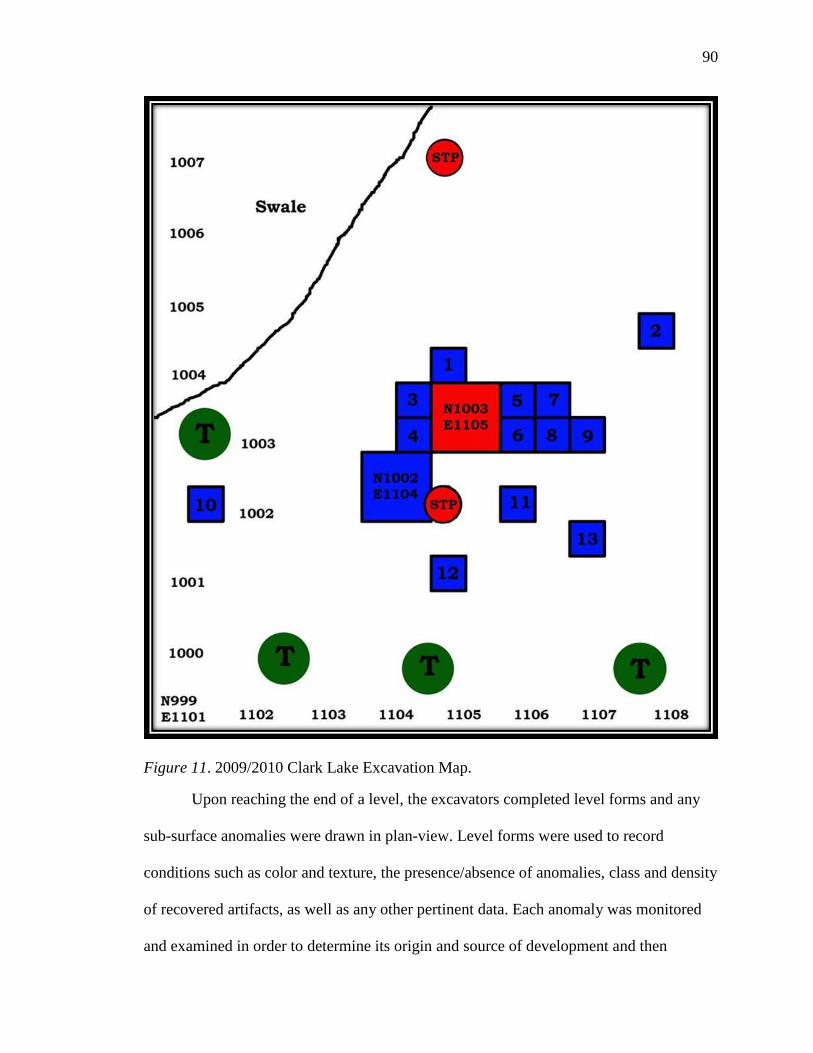
90
Figure 11. 2009/2010 Clark Lake Excavation Map.
Upon reaching the end of a level, the excavators completed level forms and any
sub-surface anomalies were drawn in plan-view. Level forms were used to record
conditions such as color and texture, the presence/absence of anomalies, class and density
of recovered artifacts, as well as any other pertinent data. Each anomaly was monitored
and examined in order to determine its origin and source of development and then
91
mapped on grid-paper. When an anomaly was determined to have been due to a natural
process, such as bioturbation, no further inspection was done. If it was determined to
have been due to cultural origins, it was designated as a feature, and examined further.
Features were hand-troweled and the matrix was screened separately. A detailed feature
form was completed for each feature. Feature inspections typically involved determining
its horizontal and vertical dimensions, mapping, recording, and photographing the
feature, as well as collecting samples for carbon dating and/or flotation. Flotation samples
were taken from each 5 cm level.
Laboratory Methods
Once in the lab, each artifact was subjected to specific laboratory and analysis
methods designed to handle each artifact class in the most pragmatic way. Artifacts were
first washed by hand and allowed to dry. Once dry, each artifact was then inventoried and
accessioned. Samples collected for flotation were water screened through 1/16- inch
window screen, as well as polyester fabric (e.g., georgette). The bags were allowed to air
dry, and after drying, they were sorted through U.S. Bureau of Standards mesh sizes #5,
#10, #35, and #60, which are equivalent to 4mm, 2mm, .5mm, and .25 mm, respectively.
Each screen was sorted through, and each artifact category was bagged separately
according to their respective size.
The ceramics were used to provide arbitrary dates for each of the levels according
to Williams and Brain’s (1983) ceramic typology. This typology, which is based upon
their excavations at the nearby Lake George site, was used to identify what period each of
the decorated pieces of ceramics belonged to (Williams and Brain 1983). The type of
temper, the presence or absence of decoration, type of decoration, if present, thickness,
92
and the portion of the vessel represented (e.g., rim, body, base) were recorded for sherds
that had a recognizable interior and exterior surface. The type and variety of each sherd
was recorded when possible. Fragmentary ceramics were labeled as sherdlets, and all
obtainable data was recorded.
Lithic Analysis Methods
Lithic analysis involved the separation and identification of all flakes, as well as
other modified stone. Generally, lithic artifacts were categorized as tools, reduced non-
tools, or debitage.
Tools
Several different types of tools were identified during analysis on the basis of the
following descriptions.
Projectile point. A projectile point is a bifacially worked finished stone tool with
a pointed tip, which can be hafted onto a handle for use as a cutting tool, or onto a shaft
for use as a projectile. Points were placed into diagnostic categories based on
morphological characteristics such as size, shape, and production techniques. Diagnostic
artifacts may provide information concerning periods of occupation, site function, and
organization of technology.
Sandstone abrader. An abrader is used as a grinding stone or for softening hide.
Burnishing stone. A burnishing stone is used to smooth or polish ceramics.
Uniface. A uniface is defined as a tool flaked only on one side as a result of
retouch for the purpose of producing knives, scrapers, and gravers.
93
Reduced Stone (Non-tools)
Reduced stone refers to artifacts that did not function as tools, so to speak;
however, they do represent the remains of tool manufacturing activities. Artifacts that fall
into this category include cores, flaked cobbles, split cobbles, and/or tested cobbles.
These characteristics are arbitrary because they can overlap to a certain degree (i.e. a
chert cobble with some flakes removed could be classified in each one of these
categories).
Core. A core is a piece of material from which flakes or blades are struck to be
used as tools. Cores can be either standardized (i.e., formal, prepared) or unstandardized
(i.e. informal, amorphous, and unprepared). Standardized cores show a symmetrically
patterned removal of flakes; unstandardized cores reveal a random reduction sequence
that does not follow a predetermined pattern. This type of core technology is expedient in
nature in response to immediate events that take shape.
Tested cobble. A tested cobble is a cobble with less than three flakes removed
from the surface. The removal of the flakes is done to test the quality of the raw material.
In spite of this, it is feasible that a tested cobble might have possibly functioned as a core
that may have been lost or discarded after only a couple of flakes have been removed.
Split cobble. This is a cobble that has been broken as a result of percussion from
knapping and it may be broken along any axis or split. It may have been broken on
purpose to serve as a core. This type of cobble indicates the use of bipolar reduction
techniques.
Lithic Debitage
The ultimate goal of the analysis of the lithic debitage from Clark Lake was to
determine the lithic organization of the inhabitants who lived at Clark Lake by
94
chronologically comparing the different types of tool technologies in order to
characterize the settlement adaptation employed at this site. This study followed the
procedure presented by Bradbury and Carr (1995) and originally set forth by Magne
(1985). This methodology presented a distinct set of attributes that, when recorded and
compared, revealed patterns that were useful in determining site function. Key attributes,
such as size grade, weight, raw material, portion, striking platform, platform facet counts,
cortex, dorsal scars, heat alteration, modification, and reduction stage were used because
they provided the most accurate and reliable information pertaining to prehistoric
behavior patterns relating to the organization of lithic technology.
Each individual flake was passed through size-graded sieves, and analyzed with
the aid of a 40-x microscope to observe the attributes. The attributes recorded for each
piece of debitage is listed, along with the options within each variable.
Size Grade. Size grade was used to make inferences about the range of reduction
activities, such as reduction stage, production/reduction activities, and organization
(Ahler, 1989; Shott, 1994) that took place at Clark Lake. A relatively homogeneous
assemblage (predominantly one-fourth inch or less) indicates a narrow range of knapping
activities, while a relatively heterogeneous assemblage (e.g., flakes of all size grades)
implies a much more diverse and broad range of knapping activities, such as tool
manufacture and maintenance. It was determined by nesting screens of various sizes and
shaking the flakes through the screen until all of the flakes are completely separated into
one of the five screen sizes. Categories for size grades include:
• Size Grade 1: > 2.5cm (1 inch)
• Size Grade 2: 1.27cm to 2.5 cm (1/2 - 1 inch)
95
• Size Grade 3: .64 cm to 1.27 cm (1/2 - 1/4 inch)
• Size Grade 4: .32 cm to .64 cm (1/8 – ¼ inch)
• Size Grade 5: < .32 cm
Weight. Weight of each flake was recorded to a hundredth of a gram. As with size
grade, weight is an important indicator of the range of reduction activities, such as
reduction stage and the manufacture and maintenance of tools, taking place within the
site, as well as the initial size of the nodules and cobbles prior to reduction activities. A
relatively homogenous assemblage (e.g., debris weighing .5 grams or less) may indicate a
fairly restricted range of knapping behaviors, such as tool maintenance or primary
reduction, while a heterogeneous assemblage (e.g., a variety of individual debris weights)
may indicate a wide range of tool manufacturing and maintenance behaviors.
Raw Material. Raw material type was used to make inferences about procurement
strategies, mobility of prehistoric populations, and trade of non-local material, as well as
the range of reduction activities taking place within the site. Homogeneous assemblages
reflect a more restricted range of reduction activities, while a heterogeneous assemblage
may reflect a more diverse range of stone tool manufacture and maintenance. Seasonality
of occupation was also considered as a factor in the exploitation and quantities of specific
materials, since materials may have been procured during off-site seasonal rounds and
activities and hauled back to the site in question when it was reoccupied. Among the
different types of raw material recovered from the site are Citronelle gravel chert,
Tallahatta Quartzite, White and Clear Quartz, Silicified Sandstone, Coastal Plain chert
and Burlington chert. The use of the comparative collection curated at The University of
Southern Mississippi was used to aid in material identification.
96
Portion. When the flakes were analyzed, portion, or how much of the flake was
present, was used based upon the following categories: whether the flake was whole or
complete, proximal with the platform, medial, distal, or non-orientable debris or shatter.
Medial flakes were classified on the basis of neither having a bulb of percussion nor a
feather termination due to breakage. Distal flakes were classified on the basis of whether
the flake exhibited a feather termination and lacked a bulb of percussion. Non-orientable
debris or shatter includes blocky shatter or chunks that lack flake characteristics such as a
dorsal or ventral side.
Platform. A striking platform is the area on which force is applied to detach a
piece of material. Platform types include crushed, flat, cortical, lipped, cortical-lipped and
eroded, and they are used to reveal information concerning the different reduction stages
and how the lithics are manufactured. Platforms that consist of the outer layer or cortex of
a stone are assumed to be from the early stage of reduction as opposed to non-cortical or
lipped platforms that are indicative of late stage reduction. Hard hammer percussion
usually results in crushed platforms due to the heavy force of the blow, and lipped
platforms are usually associated with soft hammer percussion. Flat platforms are usually
indicative of manufacturing non-bifacial tools from amorphous cores.
Platform facet count. Platform facets usually provide reduction stage information
as well. The higher platform facet count is indicative of late stage reduction, while the
smaller facet count usually indicates an early stage of reduction. This is mediated by
flake size. Early stage reduction is assigned if 0-1 facets are present. Middle stage
reduction is assigned if two facets are present, and late stage reduction is assigned if three
or more facets are present.
97
Dorsal scar count. Dorsal scars are the impressions found on the dorsal surface of
a flake and are caused by the removal of previous flakes. Dorsal scar counts estimate the
number of flakes previously removed from a core or biface and can also determine the
different reduction stages. It, too, is mediated by flake size and has been determined to be
the single best attribute for non-platform bearing flakes. A low number of dorsal scars are
supposed to represent the early stages of reduction, whereas a higher number is generally
thought to represent the latter stages of reduction. Early stage reduction is assigned if 0-1
dorsal scars are present. Middle stage reduction is assigned if two dorsal scars are present
and late stage reduction is assigned if three or more dorsal scars are present.
Cortex. The cortex or the outer layer of the cobble or pebble left on the flake is
correlated with the reduction stage and manufacture of stone tools. Four categories are
assigned on the basis of how much cortex is shown on the dorsal side of the flake:
• 0 = no cortex showing
• 1 = 1-49% cortex showing
• 2 = 50-99% cortex showing
• 3 = 100% or complete cortex coverage.
The more cortex left on the flake represents the early stages of reduction and little to no
cortex is believed to be the latter stages of reduction. Raw material and size must be
taken into account when considering cortex as a reduction stage indicator.
Heat alteration. The presence or absence of heat alteration was recorded for each
flake based upon a color change, a waxy vitreous luster, or damage to the flake as a result
of intentional or unintentional exposure to fire. The following categories were assigned:
• 0 = no heat alteration
98
• 1 = heat alteration
• 2 = heat damage
Modification. Categories for modification are retouch and utilization. All flakes
were analyzed under a microscope for evidence of microflake removals or altered edges.
Information about site function and the organization of technology can be inferred from
the modification of flakes. Utilized flakes include those struck from an amorphous core
and are, in general, associated with expedient tool technology. Retouched flakes are
flakes that are purposely flaked to increase use life or modify the edge angle and shape. A
high degree of modification may indicate the presence of long-term residential activities
(Parry & Kelly, 1987). Modification of flakes is related to the availability of raw
material, mobility and settlement adaptation (Binford, 1979).
Reduction stage. Reduction stages are assigned on the basis of the combination of
a number of different attributes such as dorsal scars, platform facets, and cortical
coverage as outlined above. Reduction stage categories include Early Stage, Middle
Stage, and Late Stage flakes, as well as biface thinning flakes, angular shatter, and eroded
or indiscernible specimens. Even though reduction stages should be considered as a
continuum rather than as discrete stages, the assignment of stages to the flakes helped to
determine what the different type of activities taking place at the site were, as well as
what types of tools were being manufactured and maintained. Early stage reduction is
generally associated with the initial stages of biface reduction and core reduction. This
stage was assigned if zero to one platform facets were present on complete and proximal
flakes. Middle stage reduction is associated with the refining of bifacial tools. This stage
was assigned if two platform facets were present. Late stage reduction is associated with
99
the final steps of tool manufacturing and maintenance. This stage was assigned if three or
more platform facets were present. For medial or distal flakes the assignment of stages
was based upon the number of dorsal scars present. Zero to one dorsal scars indicated
Early stage reduction, two dorsal scars indicated Middle stage reduction, and three or
more dorsal scars indicated Late stage reduction. Biface thinning flakes, which are
indicative of Late stage manufacturing, have distinctive attributes that make them
distinguishable from interior flakes. They are normally thin and twice as long as they are
wide, exhibit a feathered distal end and retain the platform on the proximal end. As a rule
of thumb, anything less than one-fourth inch was not considered to be a biface thinning
flake, but rather considered to be remnants of edge trimming and maintenance. Angular
shatter included blocky pieces and other debris pieces that lacked flake characteristics
such as an identifiable dorsal or ventral side. These were interpreted as byproducts of
core reduction.
Archaeological Implications and Expectations
for Prehistoric Settlement Systems
Previous studies of prehistoric settlement systems have provided a basis for
making predictions or inferences concerning site formation processes and lithic
assemblages. As previously discussed in Chapter II, the residential/logistical model as
described by Binford (1979) produces different types of sites and assemblages and
varying technological organizations in relation to the environment in which people live.
By analyzing the organization of the lithic assemblage, a connection can be made
between the type of site and the types of tools being manufactured at the site in order to
identify prehistoric settlement patterns.
100
As previously discussed, foragers/collectors produce different site types, such as
residential base camps and locations, to which its inhabitants are tethered. Each site type
produces varying archaeological tool assemblages and should reflect either a curated or
expedient tool technology, depending on the different prehistoric settlement patterns.
Differences in these assemblages may reflect a shift in the mobility of hunter-
gatherers through time and space to a more sedentary settlement pattern. This shift in
settlement and mobility is believed to have taken place during the Middle Woodland
period in the Southeast and is thought to have occurred as a result of the increase in
population levels and the regional variation of the environmental structure (Johnson,
1993). This also caused a shift in the organization of technology. These changes can often
be seen in the archaeological record as a result of site formation processes and stone tool
technologies.
Expectations for Residentially Mobile Forager Adaptations
According to Kelly (1988), a low amount of personal curated tools and a high
amount of expedient flake tools are expected to be found in the archaeological
assemblages of residential base camps inhabited by highly mobile foragers. Curated tools
should be manufactured from high quality, non-local raw materials because the type of
material used lengthens the use-life of a particular tool. This is significant for a forager
adaptation due to the randomness of raw material sources. To prolong the use-life of a
particular tool, a bifacial tool technology may be used to conserve the high-quality
material and reduce carrying costs. Large bifaces can be used as supply material for other
curated tools to be manufactured from, as well as be used as functional tools. Expedient
tools may be manufactured from the local chert sources in and around the general
101
foraging area, and as curated tools are worn down and replaced, may be used to
manufacture new, curated tools.
The manufacture, repair, and discard of tools at a residential base camp should
produce a high diversity of evenly distributed tool types since the camp is where the
center of activities takes place within a hunter-gatherer system. Lithic debitage
representing all stages of manufacture and maintenance should be found throughout the
habitation site in moderate to high frequencies. A large amount of middle- to late-stage
reduction debitage from non-local raw material sources may reflect higher than expected
middle to late stage debris due to the functional shape and initial trimming of cores. A
large amount of early- to middle-stage reduction debitage from local raw material sources
should reflect the use of expedient tools. Also included in the assemblage, should be a
moderate to high degree of site furniture to include hearthstones, grinding stones, cooking
stones, and anvils (Binford, 1979; Chatters, 1987; Nelson, 1991).
On the other hand, locations created by a foraging adaptation should produce
primarily expedient tools manufactured from local raw material, and the debitage should
be represented by early stage flakes from the reduction of cores. Again, high quality raw
material should be used for the manufacture and maintenance of specialized tools. There
should be very little, if any, non-local debitage present from the manufacture of tools.
There should also be a low frequency of specialized tools and broken or damaged
personal gear.
Expectations for Logistically Organized Collector Adaptations
Curated tools designed for reliability or for specific tasks are expected to be found
in the archaeological assemblages of residential base camps inhabited by logistically
102
organized collectors. Tool assemblages should be diverse, reflecting the multi-functional
nature of a residential site. The curated tools, including bifacial cores, are manufactured
from either low or high quality raw material, and are considered “high-energy
investments” because they can be used as cores, long use-life tools, and as a by-product
of the shaping process (Kelly, 1988, p. 718). They would be represented in the
archaeological record as biface-reduction flakes and as discarded, exhausted bifacial
tools.
On the other hand, expedient tools are made from local raw material sources and
represent a core reduction technology. This type of technology results in a large amount
of early stage and shatter debris found in an archaeological assemblage (Carr, 1994).
A reduction in mobility and territorial ranges affects the use of local versus non-
local material in the production of stone tools. Hunter-gatherers may have increased their
reliance on local raw material sources, thus producing a wide range of flakes from all
reduction stages and increasing the manufacture of curated tools. The multi-functional
nature of a residential base camp should be reflected in the diverse nature of the
archaeological assemblage.
The acquisition of raw material, as explained by Binford (1979), is embedded in
the subsistence practices of hunter-gatherers. If high quality raw material is available
locally, the material will be obtained as a result of normal procurement activities. They
do not go out for the expressed and exclusive purpose of obtaining raw material for tools
unless something has gone wrong (Binford, 1979).
Collector locations are typically task specific, and the assemblages found usually
reflect their task specific nature and are characterized by a curated tool technology
103
manufactured from high quality raw material. Tools should be manufactured and repaired
prior to a logistical foray. These location camps should produce debitage from the late
stages of reduction resulting from resharpening and maintenance or repair of tools, with a
larger amount of early stage flakes from the manufacture of expedient tools. Broken tools
may be part of the assemblage.
Debitage from the manufacture and maintenance of task specific tools should be
reflected in the assemblage recovered from collector camps. Flakes should reflect the
middle to late stages of reduction. There should be a low frequency of personal curated
tools to include preforms, rejects, as well as a moderate frequency of failures.
Expectations for Cultural Behavior
A second part of the analysis is consideration of the logistical distribution of
debitage in the excavation of the units to assess site formation processes represented by
the non-random scattering of artifacts in relation to features,, and post molds throughout
the site. The frequency and density of artifacts, as well as features, can dramatically vary
from one area to the next, which can be attributed to the archaeological patterning of
segregated activities of the inhabitants of a site (Metcalf & Heath, 1990). High
concentrations of flakes from areas with low to no concentrations of flakes can be
representative of specific types of cultural behavior (such as sweeping up of debris,
cleaning of a hearths, etc.) of the inhabitants of a site and that these behaviors could be
reflective of their mobile or sedentary nature. Since activities and site functions vary, this
variability should be detectable in the archaeological record through a discrete clustering
of materials. From this clustering of materials, similar patterns regarding activities should
emerge. This pattern can also be affected by the relative amount of time a site has been

104
occupied. By looking at the spatial patterning of artifacts at a site, these patterns can
emerge.
105
CHAPTER VI
RESULTS
In this chapter, a discussion of the recovered artifact inventory is presented. This
is followed by the results of the technological analysis of the Clark Lake lithic
assemblage. This includes an examination of all lithic artifacts, including formal stone
tools, reduced stone tool implements, ground stone implements, and lithic debitage
recovered from both the 1999 and 2009/2010 investigations.
Chronological and Stratigraphic Analysis
The archaeological record of the Clark Lake site contains artifacts that indicate
this site was repeatedly occupied beginning during the Tchula period, which began
around 500 B.C., during the Early to Middle Woodland period, and continued to be
repeatedly occupied until the Lake George phase, which ended around 1500 A.D during
the Mississippian period, around the time of contact with Europeans. Archaeological
deposits range from the surface up to a maximum depth of 50 centimeters below the
surface (cmbs).
In order to understand stratigraphic integrity at Clark Lake, this discussion must
be divided into two separate discussions based upon the different excavation episodes
because the units were excavated using different integrity level controls. In 1999, units
were excavated in arbitrary 10-centimeter levels, and in 2009/2010, units were excavated
in in 5-centimeter levels below the first 10 centimeters. With regard to the 1999
excavations, based upon the spatial relationships among the temporally diagnostic
ceramics, it is unclear whether the deposits are chronologically well stratified, and it
appears as if some mixing from natural processes such as bioturbation from flora and
106
fauna, alluvial, colluvial or eolian processes, or cultural processes, such as plowing,
digging, and deforestation, has taken place. However, this may not be the case because
of the shallow excavation depths of the units, as well as the wide temporal span of the
ceramics that were found in one 10-centimeter level.
Based upon this evidence, in order to get a better handle on the temporal span of
the site, a decision was made to excavate units in arbitrary 5-centimeter levels during the
2009/2010 excavations. From these excavations, it appears that these deposits are
chronologically well stratified and have suffered minimal disturbance from natural or
cultural processes.
Nevertheless, the exact nature of the depositional and post-depositional processes
that took place at Clark Lake is not fully understood. Perhaps, the most important factor
that helped to contribute to the site’s depositional processes is the site’s
geomorphological features. Clark Lake is located in a floodplain forest, and, as such, is
subjected to continual erosional and depositional processes. A floodplain develops a
complex array of geomorphological features such as meandering river channels that
transport, erode and deposit alluvial sediments, natural levees, point bars, ridges and
swales, oxbow lakes, sloughs, backwater deposits, and terraces. Of these
geomorphological features, one is clearly significant to Clark Lake: the oxbow lake.
Clark Lake, for which the site is named, is an oxbow lake. An oxbow lake forms as a
result from the cutoff of river channel meanders, and from this cutoff, deepwater alluvial
swamps often develop. These deepwater alluvial swamps are typically influenced by
seasonal river flooding from nearby rivers such as the Sunflower and the Yazoo Rivers,
which surrounds Clark Lake on three sides. One unique characteristic of deepwater
107
alluvial swamps is that, because of the seasonal flooding and isolation from the river for
most of the year, they have relatively high levels of ions, such as magnesium, which
tends to attach itself to artifacts and form concretions around them, and sometimes, even
replacing the organic material. Many of these types of concretions were found in areas of
high artifact density throughout all levels of excavation. Alluvial and eolian processes
may also be responsible for the accumulation of cultural remains at Clark Lake; however,
to what extent is unknown (Sharitz & Mitsch, 1993).
Diagnostic Artifacts and Chronology of Clark Lake
Over 5,653 prehistoric artifacts were recovered from Clark Lake from both
excavations. This total includes 3,369 pieces of decorated and undecorated ceramics
representing the Tchula, the Early, Middle, and Late Woodland, Emergent Mississippian
and Mississippian periods, as well as 667 pieces of bone or bone fragments, over 554
botanical remains, 48 pieces of baked clay (one of these with a forefinger and thumbprint
impression), and 998 pieces of lithic debitage. Chipped-stone tool diagnostics recovered
from Clark Lake include two projectile points that represent the Issaquena phase of the
Middle Woodland period and the Deasonville phase of the Late Woodland. Other lithic
artifacts include two sandstone abraders, a burnishing rock, an attempted core, and two
broken PP/K fragments, as well as 144 pieces of andesite and basalt ground stone tool
microdebitage. Informal expediently manufactured flake tools recovered from the site
include two expediently manufactured flake tools.
Ceramic Analysis
The Clark Lake ceramic assemblage consists of a total of 6,192 pieces of
ceramics. This count includes both decorated and undecorated ceramic rims, bodies,
bases, and sherdlets. At 72.8% of the assemblage, the ceramic assemblage consisted
108
mostly of Middle to Late Woodland phase ceramics. Of this 72.8%, 92.5% of the
assemblage is clearly affiliated with the Issaquena phase of the Marksville period. This
ceramic affiliation includes Baytown Plain, Marksville Incised, Marksville Stamped,
Churupa and Evansville Punctated, as well as Hollyknowe Ridge Pinched and Indian Bay
Stamped ceramics. The other 27.2% of the decorated ceramics is associated with the Late
Woodland and Mississippian periods. These later ceramics include Anna Incised,
Baytown Plain var. Addis, Carter Engraved, Coles Creek Incised, Evansville Punctated,
French Fork Incised, Harrison Bayou Incised, Leland Incised, Mazique Incised, and
Parkin Punctated.
Beyond assessing cultural affiliation, the percentage of decorated to undecorated
ceramics helps to assess site function. Since decorated sherds comprise only 2.77% of the
entire ceramic assemblage, this indicates vessel decoration was rare. It has been argued
that the ratio of decorated to undecorated ceramics at sites reflects ceramic function, with
decorated ceramics being reserved for ceremonial purposes and plain ceramics for
everyday usage. The ratio of decorated to undecorated ceramics is 1:36 indicating that
Clark Lake was not used for ceremonial purposes, but was instead a residential camp.
From this context, it is inferred that the ceramics recovered from the site were used for
storage or cooking.
Formal Stone Tool Analysis
A total of two projectile points (Figure 12) and two PP/K fragments were
recovered from excavation units. One of the projectile points was manufactured from
Burlington chert and the other from Citronelle gravel chert. Projectile point classification
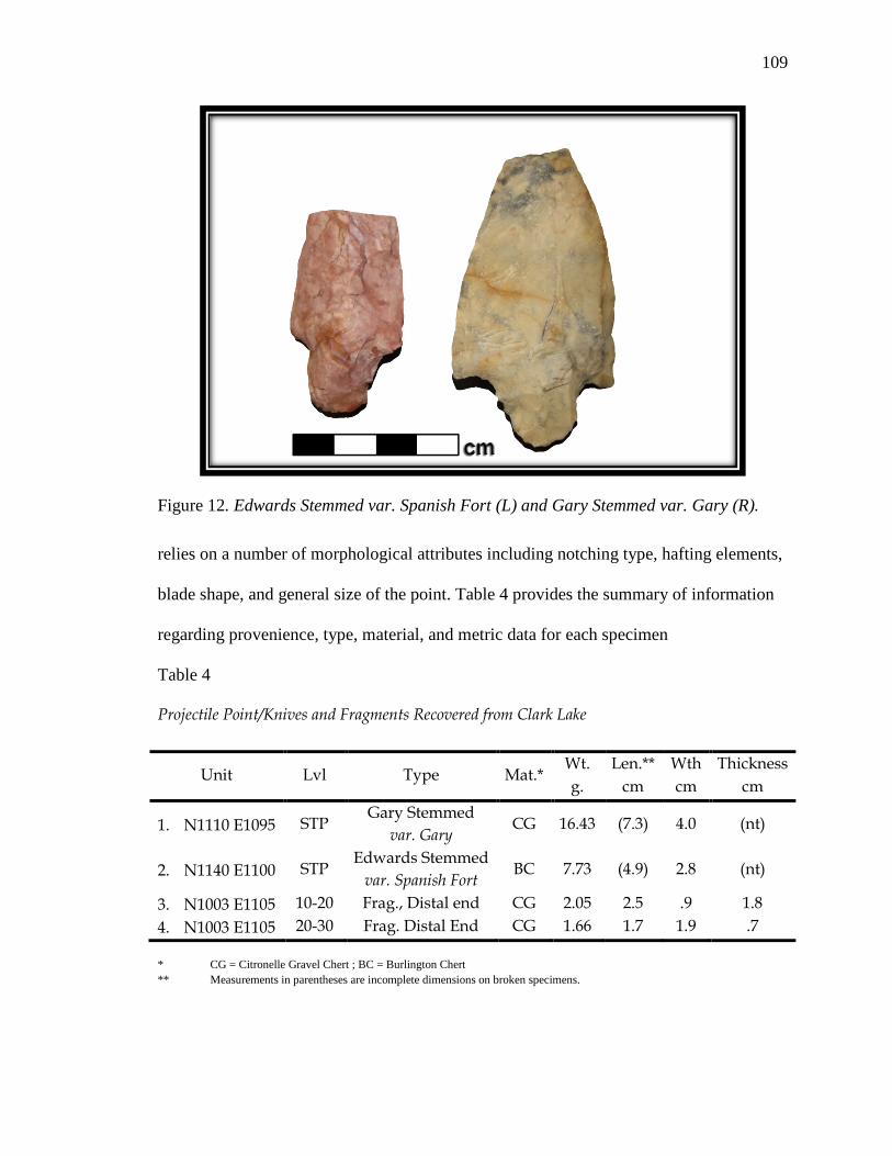
109
relies on a number of morphological attributes including notching type, hafting elements,
blade shape, and general size of the point. Table 4 provides the summary of information
regarding provenience, type, material, and metric data for each specimen
Table 4
Projectile Point/Knives and Fragments Recovered from Clark Lake
Unit Lvl Type Mat.* Wt. g.
Len.** cm
Wth cm
Thickness cm
1. N1110 E1095 STP Gary Stemmed
var. Gary CG 16.43 (7.3) 4.0 (nt)
2. N1140 E1100 STP Edwards Stemmed
var. Spanish Fort BC 7.73 (4.9) 2.8 (nt)
3. N1003 E1105 10-20 Frag., Distal end CG 2.05 2.5 .9 1.8 4. N1003 E1105 20-30 Frag. Distal End CG 1.66 1.7 1.9 .7 * CG = Citronelle Gravel Chert ; BC = Burlington Chert ** Measurements in parentheses are incomplete dimensions on broken specimens.
Figure 12. Edwards Stemmed var. Spanish Fort (L) and Gary Stemmed var. Gary (R).
110
Middle to Late Woodland. One PP/K has been classified as Gary Stemmed var.
Gary, and one PP/K has been classified as Edwards Stemmed var. Spanish Fort (Figure
12). The Gary point is diagnostic of the Issaquena phase, and the Edwards point is
diagnostic of the Deasonville phase, both of which are clearly representative of the
Middle to Late Woodland periods (Greengo, 1964; Phillips, 1970; Williams & Brain,
1983). The Edwards point is manufactured from Burlington chert and the Gary point is
manufactured from Citronelle gravel chert. Both exhibit some erosion and weathering, as
well as showing considerable wear. Both specimens are missing the distal end, suggesting
breakage in use or resharpening. The level at which these two points were found is
unknown since they were recovered from a shovel test pit (STP).
Gary Stemmed var. Gary points are typically 6 to 8 cm long and 2.8 to 3.8 cm
wide at the shoulders. The stems are contracting, the shoulders are well defined and the
bases are rounded. The materials for this point tend to be exotic: pink-tan-grey-banded
chert (possibly Coastal Plain chert), gray-white-mottled quartzite, red-and-brown
speckled novaculite, and gray and pink novaculites (Williams & Brain, 1983).
Edwards Stemmed var. Spanish Fort points are typically 4.4 cm to 6 cm in length
and 1.5 to 2.5 cm in width at the shoulders. The thickness is usually from .5 cm to 1 cm.
It has been characterized by Phillips as having a “broad rectangular stem” (Phillips, 1970,
p. 311). Ususally the materials for this point type are locally available, heat-treated chert.
PP/K fragments. Two fragments were identified during the lithic analysis. Both
were manufactured from Citronelle gravel chert. One of the fragments appears to have
been broken during initial manufacturing since it appears to be incomplete because one
side has not been flaked and exhibits a cortical face. The other fragment appears to have
111
been broken from a lateral snap during resharpening at the point of an imperfection in the
stone. The partially complete PP/K was recovered in the 10-20 cmbs level. The other was
recovered in the 20-30 cmbs level. The cultural affiliation of each specimen is unknown.
Other Chipped, Reduced, and Ground-stone Tool Analysis
In addition to the aforementioned diagnostic stone tools, a small number of other
stone tools and implements were recovered at Clark Lake. These tools include two
sandstone abraders, a hafted end scraper, a burnishing rock, one core, and a tested cobble.
Sharpener/Abrader. One bone tool sharpener and one abrader were identified
during the lithic analysis. Stone abraders serve as a file, hone, or whetstone in sharpening
bone tools, shaping wood, or working other stones. They are usually made of an abrasive
granular type of stone, such as sandstone. They are not typically purposefully or specially
shaped or prepared. Usually they are small enough so that it is convenient to hold in the
hand. Some of these abraders exhibit extensive usuage wear in the form of grooves or
worn surfaces. The sandstone abraders found at Clark Lake display these characteristics.
One abrader exhibits a circular type of notch in the upper corner and the other is worn
completely flat on one side. The level at which these two abraders were found is
unknown since they were recovered from a STP.
Burnishing stone. Smoothing, burnishing or polishing of ceramic surfaces is often
done to conceal irregularities on the vessel surface or to alter the vessel’s appearance.This
is often accomplished by using a hard tool, such as a stone, to rub the surface of a partly
dried vessel. One small stone with a highly polished surface one one side was recovered
from the 25-30 cmbs level of Unit N1002 E1101.5.
Unifacial scraper. One hafted end scraper was recovered from Clark Lake;
however, it was not included in the lithic analysis since its was found out of context on
112
the surface alongside the trail that is frequently used by hikers, hunters, and ATV users to
reach Clark Lake.
Cores. Two cores were recovered, both of which are Citronelle gravel. One
specimen (16.1g) is classified as amorphous, and the other (47.73g) is classified as a
tested cobble. It, too, is amorphous. The first specimen was not included in the lithic
analysis because it was recovered from alongside the trail with the hafted end scraper.
The second specimen was recovered from Unit N1003 E1105, where the large amount of
lithic debitage, which will be discussed later, was found.
Lithic Debitage Analysis
Raw materials and size grade. A total of 998 pieces of lithic debitage reprsented
by an array of raw materials was analyzed for this lithic analysis (Table 5). The majority
(80.3%) of the lithic debris resulted from knapping Citronelle gravel chert (N = 801). In
addition to Citronelle gravel chert, andesite (10.8%) and basalt (3.6%) were the next
highest contributions to the assemblage. Other materials were represented in the
assemblage; however, these contributions were relatively small. These materials included
white quartz (1.4%), Burlington chert (1.3%), clear quartz (1%), Tallahatta Quartzite
(.5%), Coastal Plain chert (.5%), other types of quartz to include pink and smokey (.4%),
a pink type of rock with veins (.1%), and petrified wood (.1%).
All size grade categories are represented in the lithic assemblage (Table 5). The
majority (45%) of debitage (N = 447) measured between 12 mm (one half inch) and 6.4
mm (one-fourth inch). The next largest size category (28%) of debitage (N = 276)
measured less than 3.2 mm (one-eighth inch), followed by debitage (25%) that measured
between 6.4 mm and 3.2 mm (N = 245), and only 29 (3%) pieces of debitage measured
between 12 mm and 24 mm (one half – one inch). Of these, 27 were Citronelle Gravel
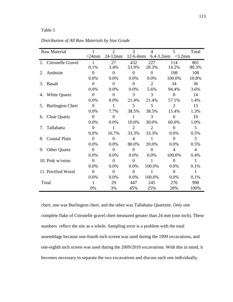
113
Table 5
Distribution of All Raw Materials by Size Grade
Raw Material 1 2 3 4 5 Total
>24mm 24-12mm 12-6.4mm 6.4-3.2mm <3.2mm
1. Citronelle Gravel 1 27 432 227 114 801 0.1% 3.4% 53.9% 28.3% 14.2% 80.3%
2. Andesite
0 0 0 0 108 108 0.0% 0.0% 0.0% 0.0% 100.0% 10.8%
3. Basalt
0 0 0 2 34 36 0.0% 0.0% 0.0% 5.6% 94.4% 3.6%
4. White Quartz
0 0 3 3 8 14 0.0% 0.0% 21.4% 21.4% 57.1% 1.4%
5. Burlington Chert
0 1 5 5 2 13 0.0% 7.7% 38.5% 38.5% 15.4% 1.3%
6. Clear Quartz
0 0 1 3 6 10 0.0% 0.0% 10.0% 30.0% 60.0% 1.0%
7. Tallahatta
0 1 2 2 0 5 0.0% 16.7% 33.3% 33.3% 0.0% 0.5%
8. Coastal Plain
0 0 4 1 0 5 0.0% 0.0% 80.0% 20.0% 0.0% 0.5%
9. Other Quartz
0 0 0 0 4 4 0.0% 0.0% 0.0% 0.0% 100.0% 0.4%
10. Pink w/veins
0 0 0 1 0 1 0.0% 0.0% 0.0% 100.0% 0.0% 0.1%
11. Petrified Wood
0 0 0 1 0 1 0.0% 0.0% 0.0% 100.0% 0.0% 0.1%
Total
1 29 447 245 276 998 0% 3% 45% 25% 28% 100%
chert, one was Burlington chert, and the other was Tallahatta Quartzite. Only one
complete flake of Citronelle gravel chert measured greater than 24 mm (one inch). These
numbers reflect the site as a whole. Sampling error is a problem with the total
assemblage because one-fourth inch screen was used during the 1999 excavations, and
one-eighth inch screen was used during the 2009/2010 excavations. With this in mind, it
becomes necessary to separate the two excavations and discuss each one individually.
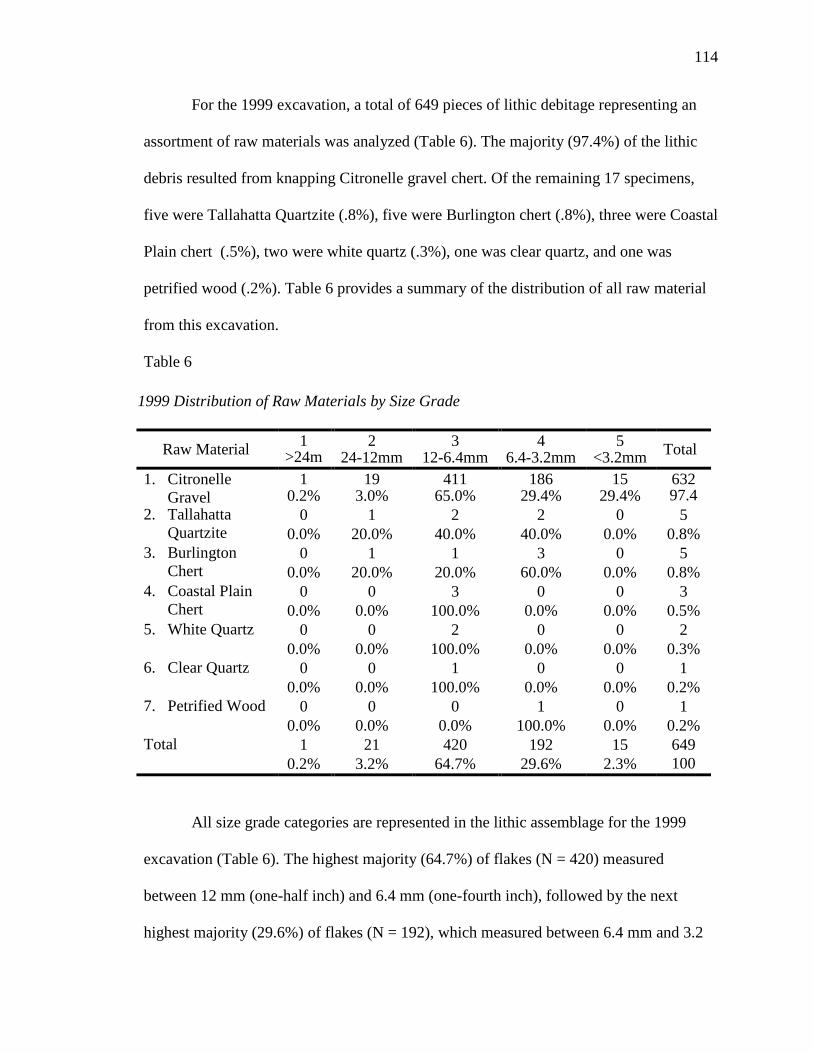
114
For the 1999 excavation, a total of 649 pieces of lithic debitage representing an
assortment of raw materials was analyzed (Table 6). The majority (97.4%) of the lithic
debris resulted from knapping Citronelle gravel chert. Of the remaining 17 specimens,
five were Tallahatta Quartzite (.8%), five were Burlington chert (.8%), three were Coastal
Plain chert (.5%), two were white quartz (.3%), one was clear quartz, and one was
petrified wood (.2%). Table 6 provides a summary of the distribution of all raw material
from this excavation.
Table 6
1999 Distribution of Raw Materials by Size Grade
Raw Material 1 2 3 4 5 Total >24m
24-12mm 12-6.4mm 6.4-3.2mm <3.2mm 1. Citronelle
Gravel 1 19 411 186 15 632
0.2% 3.0% 65.0% 29.4% 29.4% 97.4 2. Tallahatta
Quartzite 0 1 2 2 0 5
0.0% 20.0% 40.0% 40.0% 0.0% 0.8% 3. Burlington
Chert 0 1 1 3 0 5
0.0% 20.0% 20.0% 60.0% 0.0% 0.8% 4. Coastal Plain
Chert 0 0 3 0 0 3
0.0% 0.0% 100.0% 0.0% 0.0% 0.5% 5. White Quartz 0 0 2 0 0 2
0.0% 0.0% 100.0% 0.0% 0.0% 0.3% 6. Clear Quartz 0 0 1 0 0 1
0.0% 0.0% 100.0% 0.0% 0.0% 0.2% 7. Petrified Wood 0 0 0 1 0 1
0.0% 0.0% 0.0% 100.0% 0.0% 0.2% Total 1 21 420 192 15 649
0.2% 3.2% 64.7% 29.6% 2.3% 100
All size grade categories are represented in the lithic assemblage for the 1999
excavation (Table 6). The highest majority (64.7%) of flakes (N = 420) measured
between 12 mm (one-half inch) and 6.4 mm (one-fourth inch), followed by the next
highest majority (29.6%) of flakes (N = 192), which measured between 6.4 mm and 3.2
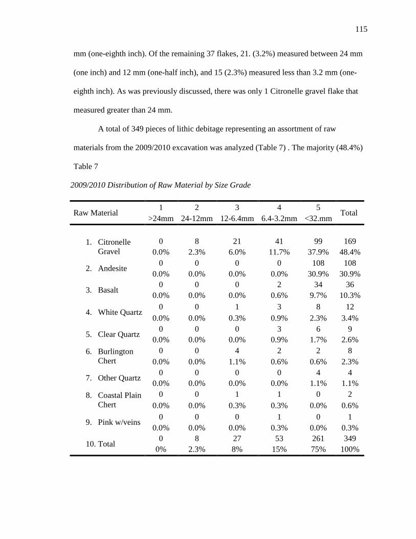
115
mm (one-eighth inch). Of the remaining 37 flakes, 21. (3.2%) measured between 24 mm
(one inch) and 12 mm (one-half inch), and 15 (2.3%) measured less than 3.2 mm (one-
eighth inch). As was previously discussed, there was only 1 Citronelle gravel flake that
measured greater than 24 mm.
A total of 349 pieces of lithic debitage representing an assortment of raw
materials from the 2009/2010 excavation was analyzed (Table 7) . The majority (48.4%)
Table 7
2009/2010 Distribution of Raw Material by Size Grade
Raw Material 1 2 3 4 5
Total >24mm 24-12mm 12-6.4mm 6.4-3.2mm <32.mm
1. Citronelle
Gravel 0 8 21 41 99 169
0.0% 2.3% 6.0% 11.7% 37.9% 48.4%
2. Andesite 0 0 0 0 108 108 0.0% 0.0% 0.0% 0.0% 30.9% 30.9%
3. Basalt 0 0 0 2 34 36
0.0% 0.0% 0.0% 0.6% 9.7% 10.3%
4. White Quartz 0 0 1 3 8 12
0.0% 0.0% 0.3% 0.9% 2.3% 3.4%
5. Clear Quartz 0 0 0 3 6 9 0.0% 0.0% 0.0% 0.9% 1.7% 2.6%
6. Burlington Chert
0 0 4 2 2 8 0.0% 0.0% 1.1% 0.6% 0.6% 2.3%
7. Other Quartz 0 0 0 0 4 4 0.0% 0.0% 0.0% 0.0% 1.1% 1.1%
8. Coastal Plain Chert
0 0 1 1 0 2 0.0% 0.0% 0.3% 0.3% 0.0% 0.6%
9. Pink w/veins 0 0 0 1 0 1 0.0% 0.0% 0.0% 0.3% 0.0% 0.3%
10. Total 0 8 27 53 261 349
0% 2.3% 8% 15% 75% 100%
116
of the lithic debris resulted from knapping Citronelle gravel chert, followed by 108 (31%)
blocky fragments of Andesite, and 36 (10%) pieces of Basalt (the identification of which
was aided by The University of Southern Mississippi’s Department of Geography and
Geology). Other raw materials included in this assemblage, but in rather small amounts
are white quartz (3.4%), Burlington chert (2.3%), clear quartz (2.6%), Coastal Plain chert
(.6%), pink and smokey quartz (1.1%), and a pink type of rock with veins (.3%). These
small amounts of exotic material indicate that some form of long distance trade was
taking place.
For the 2009/2010 excavation, only size grades 2 through 5 are represented in this
lithic assemblage (Table 7). The majority (75%) of debitage in this assemblage measured
less than 3.2 mm. The next highest proportion (15%) measured between 6.4 mm and 3.2
mm, followed by size grade 3, which measured between 12 mm and 6.4 mm, and, finally,
size grade 2, which measured between 24 mm and 12 mm. The large amount of debitage
recovered from size grade 4 and size grade 5 indicates that the use of one-fourth inch
screen during the screening process shows that some important data may be lost or
sacraficed for ease and expediency in excavations, and sampling errors may occur. It
should also be noted that 238 of the 261 of the blocky fragments, which includes
Andesite and Basalt, were recovered from flotation samples rather than through the
normal one-eighth inch screening process, further indicating that taking flotation samples
is important to archaeological excavations because what is not recovered during the
screening process may be recovered during flotation, which may serve to lessen or limit
sampling errors.
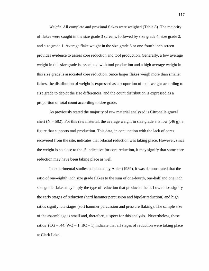
117
Weight. All complete and proximal flakes were weighed (Table 8). The majority
of flakes were caught in the size grade 3 screens, followed by size grade 4, size grade 2,
and size grade 1. Average flake weight in the size grade 3 or one-fourth inch screen
provides evidence to assess core reduction and tool production. Generally, a low average
weight in this size grade is associated with tool production and a high average weight in
this size grade is associated core reduction. Since larger flakes weigh more than smaller
flakes, the distribution of weight is expressed as a proportion of total weight according to
size grade to depict the size differences, and the count distribution is expressed as a
proportion of total count according to size grade.
As previously stated the majority of raw material analyzed is Citronelle gravel
chert (N = 582). For this raw material, the average weight in size grade 3 is low (.46 g), a
figure that supports tool production. This data, in conjunction with the lack of cores
recovered from the site, indicates that bifacial reduction was taking place. However, since
the weight is so close to the .5 indicative for core reduction, it may signify that some core
reduction may have been taking place as well.
In experimental studies conducted by Ahler (1989), it was demonstrated that the
ratio of one-eighth inch size grade flakes to the sum of one-fourth, one-half and one inch
size grade flakes may imply the type of reduction that produced them. Low ratios signify
the early stages of reduction (hard hammer percussion and bipolar reduction) and high
ratios signify late stages (soft hammer percussion and pressure flaking). The sample size
of the assemblage is small and, therefore, suspect for this analysis. Nevertheless, these
ratios (CG – .44, WQ – 1, BC – 1) indicate that all stages of reduction were taking place
at Clark Lake.
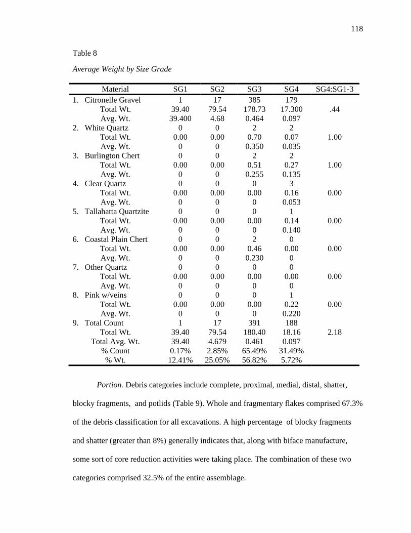
118
Table 8
Average Weight by Size Grade
Material SG1 SG2 SG3 SG4 SG4:SG1-3 1. Citronelle Gravel 1 17 385 179
.44 Total Wt. 39.40 79.54 178.73 17.300 Avg. Wt. 39.400 4.68 0.464 0.097
2. White Quartz 0 0 2 2 1.00 Total Wt. 0.00 0.00 0.70 0.07
Avg. Wt. 0 0 0.350 0.035 3. Burlington Chert 0 0 2 2
1.00 Total Wt. 0.00 0.00 0.51 0.27 Avg. Wt. 0 0 0.255 0.135
4. Clear Quartz 0 0 0 3 0.00 Total Wt. 0.00 0.00 0.00 0.16
Avg. Wt. 0 0 0 0.053 5. Tallahatta Quartzite 0 0 0 1
0.00 Total Wt. 0.00 0.00 0.00 0.14 Avg. Wt. 0 0 0 0.140
6. Coastal Plain Chert 0 0 2 0 0.00 Total Wt. 0.00 0.00 0.46 0.00
Avg. Wt. 0 0 0.230 0 7. Other Quartz 0 0 0 0
0.00 Total Wt. 0.00 0.00 0.00 0.00 Avg. Wt. 0 0 0 0
8. Pink w/veins 0 0 0 1 0.00 Total Wt. 0.00 0.00 0.00 0.22
Avg. Wt. 0 0 0 0.220 9. Total Count 1 17 391 188
2.18 Total Wt. 39.40 79.54 180.40 18.16 Total Avg. Wt. 39.40 4.679 0.461 0.097
% Count 0.17% 2.85% 65.49% 31.49% % Wt. 12.41% 25.05% 56.82% 5.72%
Portion. Debris categories include complete, proximal, medial, distal, shatter,
blocky fragments, and potlids (Table 9). Whole and fragmentary flakes comprised 67.3%
of the debris classification for all excavations. A high percentage of blocky fragments
and shatter (greater than 8%) generally indicates that, along with biface manufacture,
some sort of core reduction activities were taking place. The combination of these two
categories comprised 32.5% of the entire assemblage.

119
Table 9
Although Andesite and Basalt are included in the total count for all excavations,
they are not included in the total count for the separate excavations because it is more
likely that these microartifacts represent the use of ground-stone tool technology at Clark
Lake.
For the 1999 excavation, whole and fragmentary flakes comprised 88% of the
debris classification, and shatter and blocky fragments comprised 11%, suggesting that
some core reduction and biface manufacturing was taking place (Table 10).
Flake and Debris Classification for All Excavations
Material Complete Proximal Medial Distal Shatter Blocky
Pot
Total 1. Citronelle
559 49 10 30 153 0 0 801 2. White
6 1 0 0 7 0 0 14 3. Andesite 0 0 0 0 0 108 0 108 4. Basalt 0 0 0 0 0 34 2 36
5. Burlington Chert
6 0 1 0 6 0 0 13
6. Clear
3 0 0 0 7 0 0 10
7. Tallahatta Quartzite
1 0 0 0 4 0 0 5
8. Coastal Plain Chert
2 0 0 0 3 0 0 5
9. Other
2 0 1 0 1 0 0 4 10. Pink
1 0 0 0 0 0 0 1 11. Petrified
0 0 0 0 0 1 0 1 Total 580 50 12 30 181 143 2 998
58.1% 5.0% 1.2% 3.0% 18.1%
14.3% .2% 67.3% 32.7%
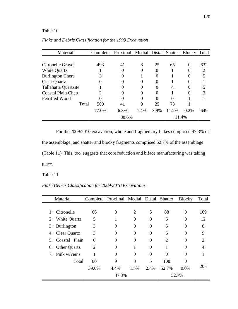
120
Table 10
Flake and Debris Classification for the 1999 Excavation
Material Complete Proximal Medial Distal Shatter Blocky Total Citronelle Gravel 493 41 8 25 65 0 632 White Quartz 1 0 0 0 1 0 2 Burlington Chert 3 0 1 0 1 0 5 Clear Quartz 0 0 0 0 1 0 1 Tallahatta Quartzite 1 0 0 0 4 0 5 Coastal Plain Chert 2 0 0 0 1 0 3 Petrified Wood 0 0 0 0 0 1 1
Total 500 41 9 25 73 1 649 77.0% 6.3% 1.4% 3.9% 11.2% 0.2%
88.6% 11.4%
For the 2009/2010 excavation, whole and fragmentary flakes comprised 47.3% of
the assemblage, and shatter and blocky fragments comprised 52.7% of the assemblage
(Table 11). This, too, suggests that core reduction and biface manufacturing was taking
place.
Table 11
Flake Debris Classification for 2009/2010 Excavations
Material Complete Proximal Medial Distal Shatter Blocky Total
1. Citronelle
66 8 2 5 88 0 169 2. White Quartz 5 1 0 0 6 0 12 3. Burlington
3 0 0 0 5 0 8 4. Clear Quartz 3 0 0 0 6 0 9 5. Coastal Plain
0 0 0 0 2 0 2 6. Other Quartz 2 0 1 0 1 0 4 7. Pink w/veins 1 0 0 0 0 0 1
Total 80 9 3 5 108 0 205 39.0% 4.4% 1.5% 2.4% 52.7% 0.0%
47.3% 52.7%
121
Heat Alteration. Heat alteration is another attribute that can provide insite into
lithic technological strategies. Thermal alteration or damage may be caused by
unintentional exposure to heat, such as flakes found in and around a hearth, or intentional
exposure to heat, such as many types of chert intentionally heated to improve flaking
quality. Nearly all of the flakes (81.4%) recovered from Clark Lake suffered some degree
of heat alteration, whereas only 18% of the flakes were not altered by heat. Heat damage
was observered in only .06% of the of the flakes. Of the materials that experienced
thermal alteration, 97.5% were Citronelle gravel chert, 1.6% was Burlington Chert, and
.06% was Coastal Plain chert. The high percentage of flakes with heat alteration is not
unexpected since Citronelle gravel chert is the most frequent type of raw material found
at the site. The consistent heat treatment of Citronelle gravel chert implies that this was
part of the lithic technological strategies used at Clark Lake
Reduction stage. All flakes, regardless of size were assigned to a reduction stage
(Table 12). As noted in Chapter V, early stage flakes are primarily the result of core
reduction, middle stage flakes are primarily the result of the initial trimming of bifacial
tool production, and late stage reduction is primarily the result of thinning, preparation of
edges, and the shaping of hafting components. Flakes produced as a likely result of biface
thinning were included in the late stage category and are counted as such.
While the criteria that was originally proposed by Magne (1985) and further
outlined by Bradbury and Carr (1995) were utilized to characterize flake attributes, two
limitations of Bradbury and Carr’s study must be noted. First, they used only large
tabular nodules of Fort Payne Chert and, second, they only considered flakes larger than
.64 cm (1/4 inch). Nevertheless, there have been some excavations, most notably in the
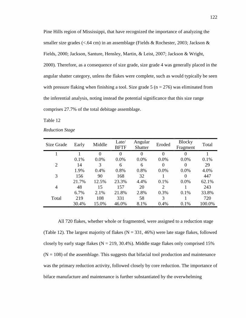
122
Pine Hills region of Mississippi, that have recognized the importance of analyzing the
smaller size grades (<.64 cm) in an assemblage (Fields & Rochester, 2003; Jackson &
Fields, 2000; Jackson, Santure, Hensley, Martin, & Leist, 2007; Jackson & Wright,
2000). Therefore, as a consequence of size grade, size grade 4 was generally placed in the
angular shatter category, unless the flakes were complete, such as would typically be seen
with pressure flaking when finishing a tool. Size grade 5 (n = 276) was eliminated from
the inferential analysis, noting instead the potential significance that this size range
comprises 27.7% of the total debitage assemblage.
Table 12
Reduction Stage
Size Grade Early Middle Late/ BFTF
Angular Shatter Eroded Blocky
Fragment Total
1 1 0 0 0 0 0 1 0.1% 0.0% 0.0% 0.0% 0.0% 0.0% 0.1% 2 14 3 6 6 0 0 29 1.9% 0.4% 0.8% 0.8% 0.0% 0.0% 4.0% 3 156 90 168 32 1 0 447 21.7% 12.5% 23.3% 4.4% 0.1% 0.0% 62.1% 4 48 15 157 20 2 1 243 6.7% 2.1% 21.8% 2.8% 0.3% 0.1% 33.8%
Total 219 108 331 58 3 1 720 30.4% 15.0% 46.0% 8.1% 0.4% 0.1% 100.0%
All 720 flakes, whether whole or fragmented, were assigned to a reduction stage
(Table 12). The largest majority of flakes (N = 331, 46%) were late stage flakes, followed
closely by early stage flakes (N = 219, 30.4%). Middle stage flakes only comprised 15%
(N = 108) of the assemblage. This suggests that bifacial tool production and maintenance
was the primary reduction activity, followed closely by core reduction. The importance of
biface manufacture and maintenance is further substantiated by the overwhelming
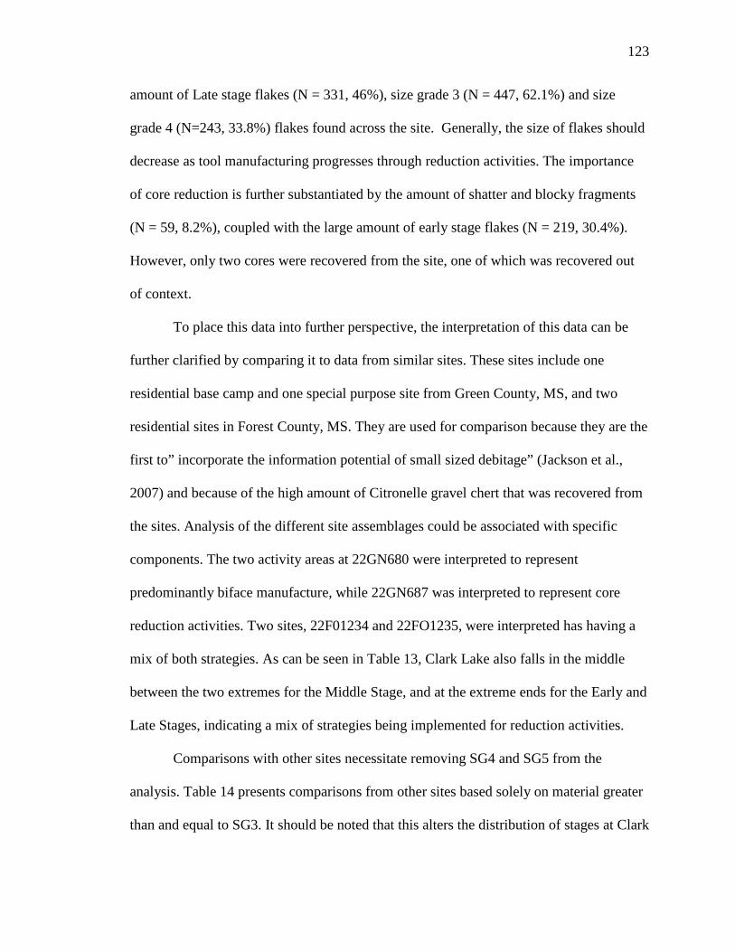
123
amount of Late stage flakes (N = 331, 46%), size grade 3 (N = 447, 62.1%) and size
grade 4 (N=243, 33.8%) flakes found across the site. Generally, the size of flakes should
decrease as tool manufacturing progresses through reduction activities. The importance
of core reduction is further substantiated by the amount of shatter and blocky fragments
(N = 59, 8.2%), coupled with the large amount of early stage flakes (N = 219, 30.4%).
However, only two cores were recovered from the site, one of which was recovered out
of context.
To place this data into further perspective, the interpretation of this data can be
further clarified by comparing it to data from similar sites. These sites include one
residential base camp and one special purpose site from Green County, MS, and two
residential sites in Forest County, MS. They are used for comparison because they are the
first to” incorporate the information potential of small sized debitage” (Jackson et al.,
2007) and because of the high amount of Citronelle gravel chert that was recovered from
the sites. Analysis of the different site assemblages could be associated with specific
components. The two activity areas at 22GN680 were interpreted to represent
predominantly biface manufacture, while 22GN687 was interpreted to represent core
reduction activities. Two sites, 22F01234 and 22FO1235, were interpreted has having a
mix of both strategies. As can be seen in Table 13, Clark Lake also falls in the middle
between the two extremes for the Middle Stage, and at the extreme ends for the Early and
Late Stages, indicating a mix of strategies being implemented for reduction activities.
Comparisons with other sites necessitate removing SG4 and SG5 from the
analysis. Table 14 presents comparisons from other sites based solely on material greater
than and equal to SG3. It should be noted that this alters the distribution of stages at Clark
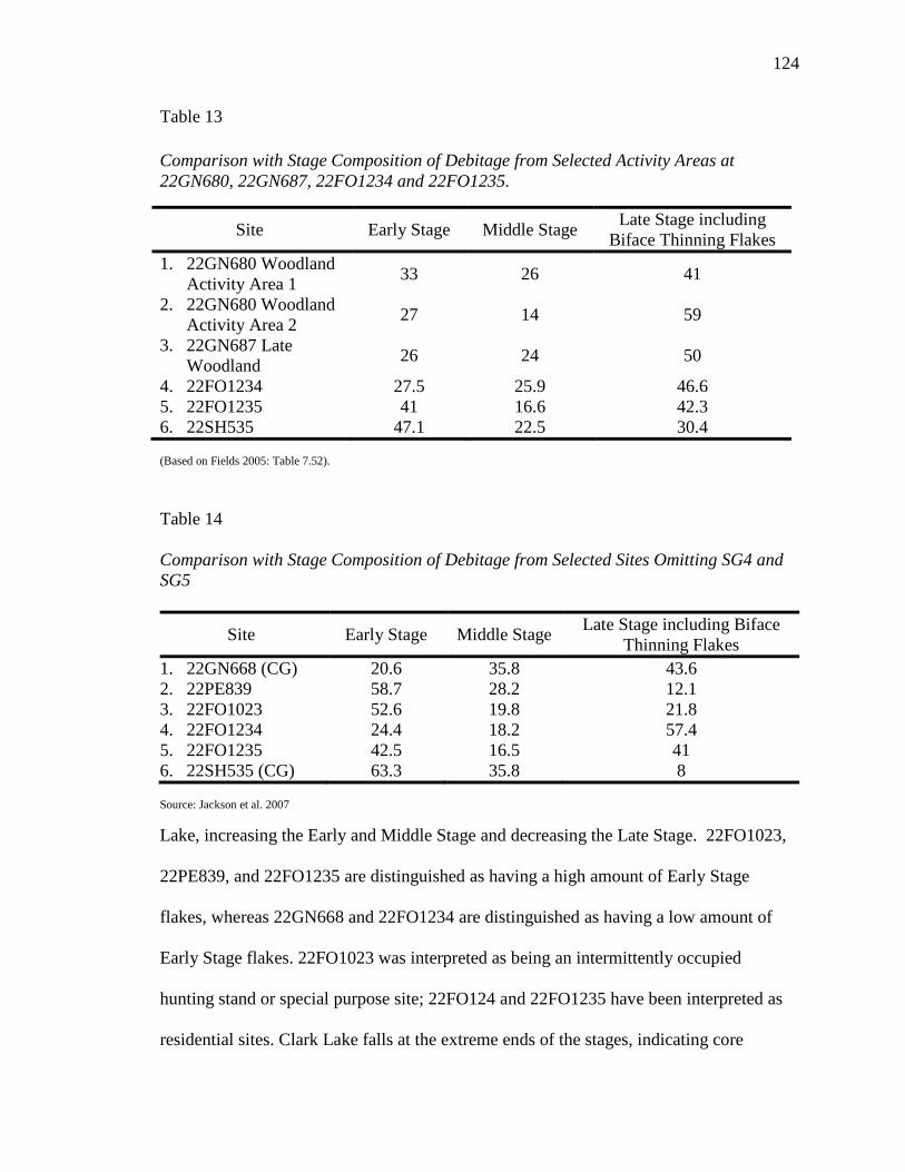
124
Table 13 Comparison with Stage Composition of Debitage from Selected Activity Areas at 22GN680, 22GN687, 22FO1234 and 22FO1235.
Site Early Stage Middle Stage Late Stage including Biface Thinning Flakes
1. 22GN680 Woodland Activity Area 1 33 26 41
2. 22GN680 Woodland Activity Area 2 27 14 59
3. 22GN687 Late Woodland 26 24 50
4. 22FO1234 27.5 25.9 46.6 5. 22FO1235 41 16.6 42.3 6. 22SH535 47.1 22.5 30.4 (Based on Fields 2005: Table 7.52).
Table 14
Comparison with Stage Composition of Debitage from Selected Sites Omitting SG4 and SG5
Site Early Stage Middle Stage Late Stage including Biface Thinning Flakes
1. 22GN668 (CG) 20.6 35.8 43.6 2. 22PE839 58.7 28.2 12.1 3. 22FO1023 52.6 19.8 21.8 4. 22FO1234 24.4 18.2 57.4 5. 22FO1235 42.5 16.5 41 6. 22SH535 (CG) 63.3 35.8 8 Source: Jackson et al. 2007
Lake, increasing the Early and Middle Stage and decreasing the Late Stage. 22FO1023,
22PE839, and 22FO1235 are distinguished as having a high amount of Early Stage
flakes, whereas 22GN668 and 22FO1234 are distinguished as having a low amount of
Early Stage flakes. 22FO1023 was interpreted as being an intermittently occupied
hunting stand or special purpose site; 22FO124 and 22FO1235 have been interpreted as
residential sites. Clark Lake falls at the extreme ends of the stages, indicating core
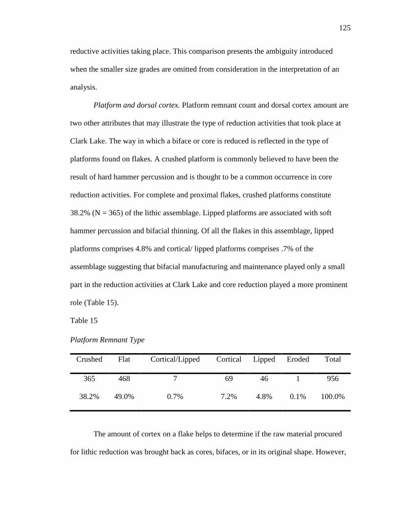
125
reductive activities taking place. This comparison presents the ambiguity introduced
when the smaller size grades are omitted from consideration in the interpretation of an
analysis.
Platform and dorsal cortex. Platform remnant count and dorsal cortex amount are
two other attributes that may illustrate the type of reduction activities that took place at
Clark Lake. The way in which a biface or core is reduced is reflected in the type of
platforms found on flakes. A crushed platform is commonly believed to have been the
result of hard hammer percussion and is thought to be a common occurrence in core
reduction activities. For complete and proximal flakes, crushed platforms constitute
38.2% (N = 365) of the lithic assemblage. Lipped platforms are associated with soft
hammer percussion and bifacial thinning. Of all the flakes in this assemblage, lipped
platforms comprises 4.8% and cortical/ lipped platforms comprises .7% of the
assemblage suggesting that bifacial manufacturing and maintenance played only a small
part in the reduction activities at Clark Lake and core reduction played a more prominent
role (Table 15).
Table 15 Platform Remnant Type
Crushed Flat Cortical/Lipped Cortical Lipped Eroded Total
365 468 7 69 46 1 956
38.2% 49.0% 0.7% 7.2% 4.8% 0.1% 100.0%
The amount of cortex on a flake helps to determine if the raw material procured
for lithic reduction was brought back as cores, bifaces, or in its original shape. However,
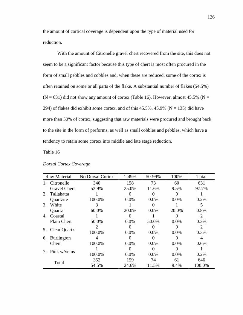
126
the amount of cortical coverage is dependent upon the type of material used for
reduction.
With the amount of Citronelle gravel chert recovered from the site, this does not
seem to be a significant factor because this type of chert is most often procured in the
form of small pebbles and cobbles and, when these are reduced, some of the cortex is
often retained on some or all parts of the flake. A substantial number of flakes (54.5%)
(N = 631) did not show any amount of cortex (Table 16). However, almost 45.5% (N =
294) of flakes did exhibit some cortex, and of this 45.5%, 45.9% (N = 135) did have
more than 50% of cortex, suggesting that raw materials were procured and brought back
to the site in the form of preforms, as well as small cobbles and pebbles, which have a
tendency to retain some cortex into middle and late stage reduction.
Table 16 Dorsal Cortex Coverage
Raw Material No Dorsal Cortex 1-49% 50-99% 100% Total 1. Citronelle
Gravel Chert 340 158 73 60 631
53.9% 25.0% 11.6% 9.5% 97.7% 2. Tallahatta
Quartzite 1 0 0 0 1
100.0% 0.0% 0.0% 0.0% 0.2% 3. White
Quartz 3 1 0 1 5
60.0% 20.0% 0.0% 20.0% 0.8% 4. Coastal
Plain Chert 1 0 1 0 2
50.0% 0.0% 50.0% 0.0% 0.3%
5. Clear Quartz 2 0 0 0 2 100.0% 0.0% 0.0% 0.0% 0.3%
6. Burlington Chert
4 0 0 0 4 100.0% 0.0% 0.0% 0.0% 0.6%
7. Pink w/veins 1 0 0 0 1 100.0% 0.0% 0.0% 0.0% 0.2%
Total 352 159 74 61 646 54.5% 24.6% 11.5% 9.4% 100.0%
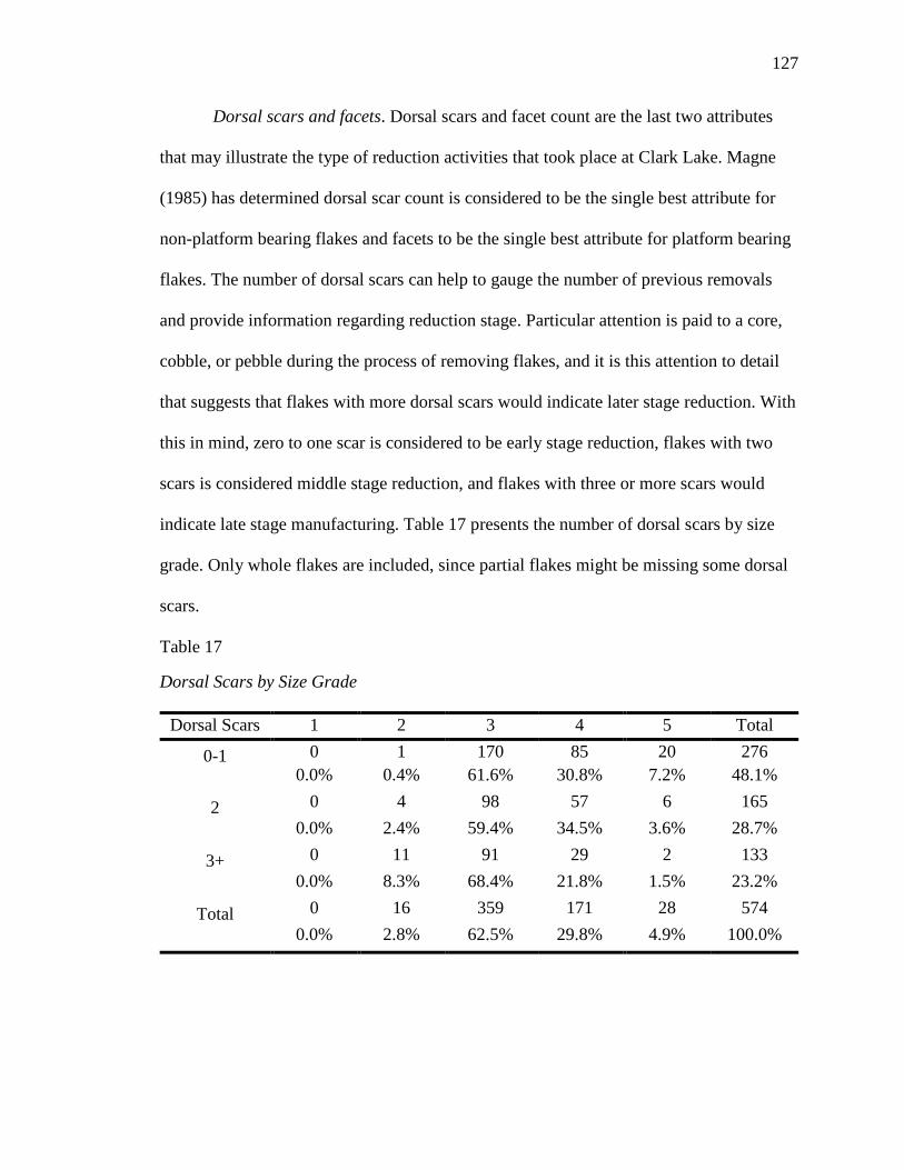
127
Dorsal scars and facets. Dorsal scars and facet count are the last two attributes
that may illustrate the type of reduction activities that took place at Clark Lake. Magne
(1985) has determined dorsal scar count is considered to be the single best attribute for
non-platform bearing flakes and facets to be the single best attribute for platform bearing
flakes. The number of dorsal scars can help to gauge the number of previous removals
and provide information regarding reduction stage. Particular attention is paid to a core,
cobble, or pebble during the process of removing flakes, and it is this attention to detail
that suggests that flakes with more dorsal scars would indicate later stage reduction. With
this in mind, zero to one scar is considered to be early stage reduction, flakes with two
scars is considered middle stage reduction, and flakes with three or more scars would
indicate late stage manufacturing. Table 17 presents the number of dorsal scars by size
grade. Only whole flakes are included, since partial flakes might be missing some dorsal
scars.
Table 17
Dorsal Scars by Size Grade
Dorsal Scars 1 2 3 4 5 Total
0-1 0 1 170 85 20 276 0.0% 0.4% 61.6% 30.8% 7.2% 48.1%
2 0 4 98 57 6 165 0.0% 2.4% 59.4% 34.5% 3.6% 28.7%
3+ 0 11 91 29 2 133 0.0% 8.3% 68.4% 21.8% 1.5% 23.2%
Total 0 16 359 171 28 574 0.0% 2.8% 62.5% 29.8% 4.9% 100.0%
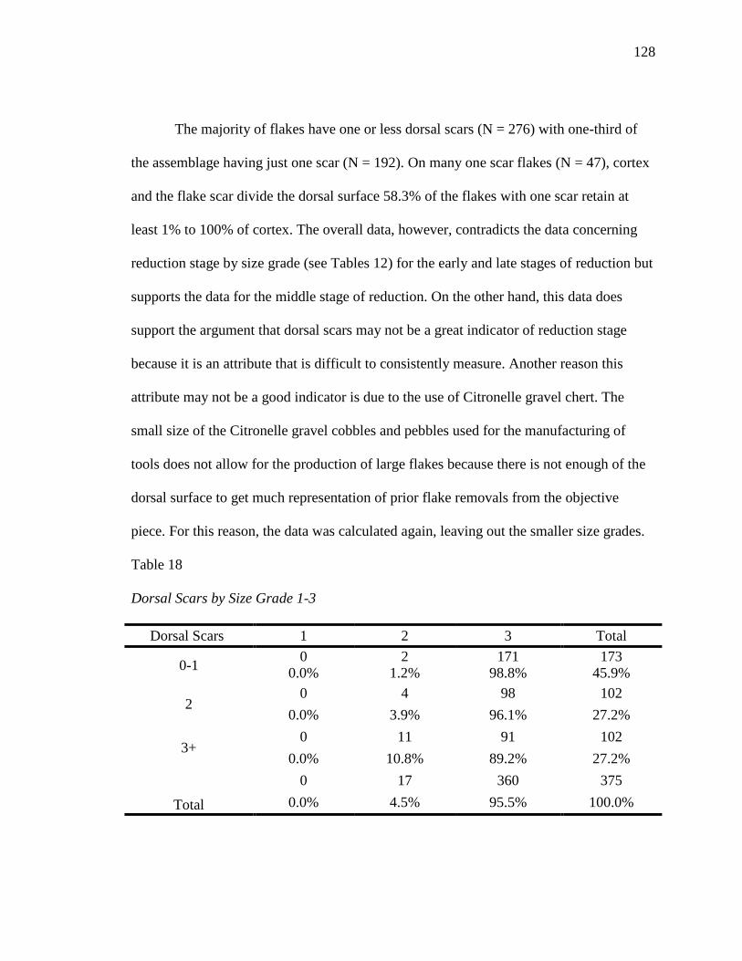
128
The majority of flakes have one or less dorsal scars (N = 276) with one-third of
the assemblage having just one scar (N = 192). On many one scar flakes (N = 47), cortex
and the flake scar divide the dorsal surface 58.3% of the flakes with one scar retain at
least 1% to 100% of cortex. The overall data, however, contradicts the data concerning
reduction stage by size grade (see Tables 12) for the early and late stages of reduction but
supports the data for the middle stage of reduction. On the other hand, this data does
support the argument that dorsal scars may not be a great indicator of reduction stage
because it is an attribute that is difficult to consistently measure. Another reason this
attribute may not be a good indicator is due to the use of Citronelle gravel chert. The
small size of the Citronelle gravel cobbles and pebbles used for the manufacturing of
tools does not allow for the production of large flakes because there is not enough of the
dorsal surface to get much representation of prior flake removals from the objective
piece. For this reason, the data was calculated again, leaving out the smaller size grades.
Table 18
Dorsal Scars by Size Grade 1-3
Dorsal Scars 1 2 3 Total
0-1 0 2 171 173 0.0% 1.2% 98.8% 45.9%
2 0 4 98 102
0.0% 3.9% 96.1% 27.2%
3+ 0 11 91 102
0.0% 10.8% 89.2% 27.2%
Total
0 17 360 375 0.0% 4.5% 95.5% 100.0%
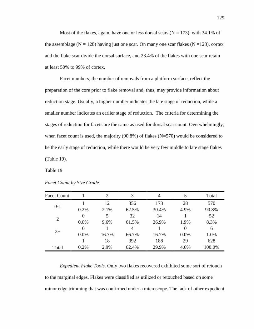
129
Most of the flakes, again, have one or less dorsal scars (N = 173), with 34.1% of
the assemblage (N = 128) having just one scar. On many one scar flakes (N =128), cortex
and the flake scar divide the dorsal surface, and 23.4% of the flakes with one scar retain
at least 50% to 99% of cortex.
Facet numbers, the number of removals from a platform surface, reflect the
preparation of the core prior to flake removal and, thus, may provide information about
reduction stage. Usually, a higher number indicates the late stage of reduction, while a
smaller number indicates an earlier stage of reduction. The criteria for determining the
stages of reduction for facets are the same as used for dorsal scar count. Overwhelmingly,
when facet count is used, the majority (90.8%) of flakes (N=570) would be considered to
be the early stage of reduction, while there would be very few middle to late stage flakes
(Table 19).
Table 19 Facet Count by Size Grade Facet Count 1 2 3 4 5 Total
0-1 1 12 356 173 28 570 0.2% 2.1% 62.5% 30.4% 4.9% 90.8%
2 0 5 32 14 1 52 0.0% 9.6% 61.5% 26.9% 1.9% 8.3%
3+ 0 1 4 1 0 6 0.0% 16.7% 66.7% 16.7% 0.0% 1.0%
Total 1 18 392 188 29 628
0.2% 2.9% 62.4% 29.9% 4.6% 100.0%
Expedient Flake Tools. Only two flakes recovered exhibited some sort of retouch
to the marginal edges. Flakes were classified as utilized or retouched based on some
minor edge trimming that was confirmed under a microscope. The lack of other expedient
130
flake tools seems to suggest that formal tools were more than likely favored over
informal, expedient tools; the large amount of early stage flakes and shatter debris made
from the locally available Citronelle gravel chert found in the assemblage indicates that a
biface strategy was being utilized and that expedient tools were being manufactured.
Spatial Patterning of Lithic Debitage
One of the unique features of this site is the sizeable amount of debitage found in
Unit N1003 E1105 (N = 559). In an attempt to understand why there was so much
debitage, the area around this unit was excavated to understand the activities that took
place and to understand site function. Site functions and activities vary, and this
variability should be detectable in the archaeological record through discrete clustering of
materials.
The frequency and density of artifacts can dramatically vary from one area to the
next, which can be attributed to the archaeological patterning of segregated activities of
the inhabitants of the site (Metcalf & Heath, 1990). From this clustering of materials,
similar patterns regarding activities should emerge. This pattern is affected by the relative
amount of time a site is used. As Binford (1980) suggests, “a residential base camp is the
hub of subsistence activities,” and “it is where most processing, manufacturing, and
maintenance activities take place” (Binford, 1980, p. 7). Therefore, it becomes necessary
to look at the spatial patterning surrounding the original unit (Figure 13).
In total, within this area of excavation, 937 pieces of debitage were recovered,
compared to the 67 pieces of debitage found throughout the rest of the site. Debitage was
found in all of the test units with the exception of the northwest quadrant of N1002
E1104. The majority of the lithics (N = 826) were recovered between 10 and 30 cmbs,
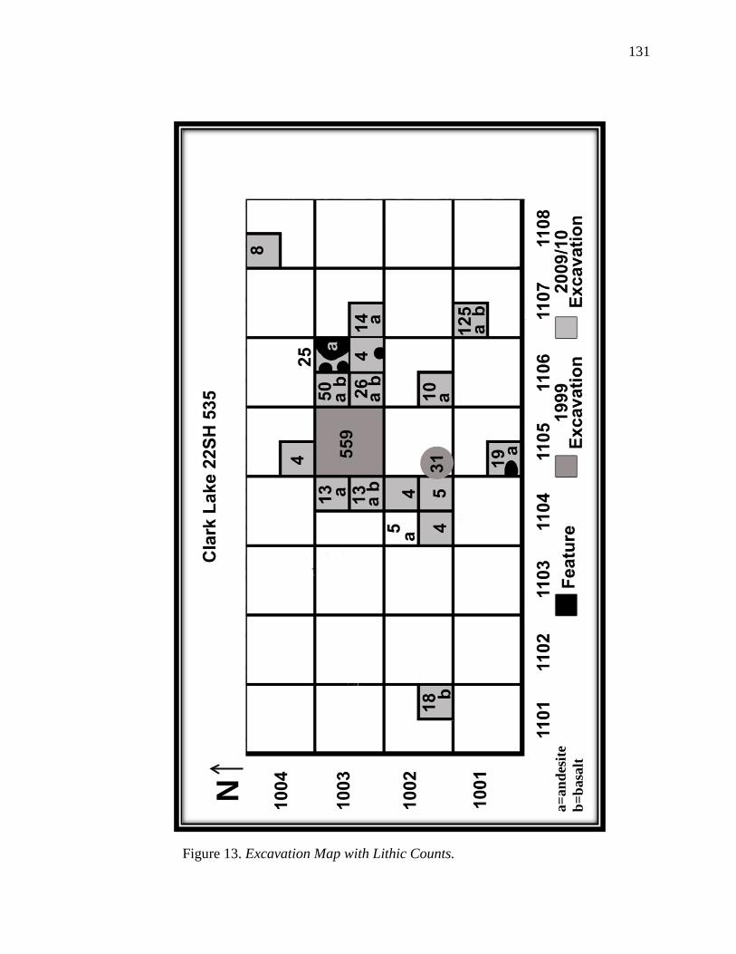
131
N
a=an
desi
te
b=ba
salt
Figure 13. Excavation Map with Lithic Counts.
132
with level 2 containing the most lithics (N = 619). This corresponds well with the
amounts of decorated ceramic assemblage (N = 78) found in these units, all of which date
to the Issaquena phase (N = 74) with the exception of four, which date to the Winterville
phase. Between 10 and 30 cmbs a total of 54 pieces of decorated ceramics were
recovered.
During excavation four post molds and one possible pit feature were encountered.
Whether this pit feature is really a feature is unclear; however, it is evident within this
area, there is a virtual void of artifacts, as only ten small ceramic sherdlets, seven small
grog sherds (3.63 g), and one tiny bone fragment (.01 g) were recovered. This void
appears to fall within the boundaries of a structure; this is supported by the evidence of a
paired set of post molds found in combination with another post mold that lines up with
the others almost perfectly. Within the post mold features, 44 small bone fragments (.02
g) and 22 grog sherdlets (19.8 g) were recovered, as well as 20 small fragments of burned
wood (.04 g). Outside the structure is where the tremendous amount of lithic debitage
was recovered. This appears to be what Binford describes as a door dump which is
generated inside structures and form just outside its entrance (Binford, 1983). Included in
this idea of cleaning, Binford argues that winter residences are cleaner and have “greater
within-assemblage diversity” (Binford, 1983, p. 18). No other features were encountered
during the course of the excavation.
One other pattern emerged, but this became evident only during the analysis of
the flotation samples. Within eight of the test units, microdebitage of andesite and basalt
were recovered. Four of these units were immediately adjacent to N1003 E1105.
Andesite, which can also be known as greenstone, and Basalt, are typical raw materials
133
used in the manufacturing of ground-stone tools such as mortars, pestles, and nutting
stones, which are used in the processing of food, or as hammerstones. This evidence is
further corroborated with the addition of possible charred acorn nut found in the same
levels (10-30 cmbs).
Summary
Diagnostic artifacts at Clark Lake indicate the site was occupied as early as the
Tchula period around 400 B.C., during the Middle Woodland period, and continued to be
repeatedly occupied over the next 2,000 years into the Mississippian phase around the
time of contact with Europeans. In addition to the temporally diagnostic artifacts, several
stone tools were recovered over the course of two excavations. These tools include
bifaces, hafted end scrapers, cores, biface fragments, and ground-stone tool
microdebitage. The debitage analysis indicated that a wide range of production activities
such as core reduction and biface manufacturing and maintenance took place at Clark
Lake, and that Citronelle gravel chert is the preferred raw material for the manufacturing
of stone tools.
These results are comparable to the results from the Mossy Ridge site located in
Green County, Mississippi with one exception: shatter. In the Green County report,
Fields and Rochester (2003) found that biface manufacturing and maintenance were the
dominant activities utilizing Citronelle gravel chert because 40% of the assemblage was
classified as Late Stage, followed by 26% of the assemblage for Early Stage, and 10% for
Middle Stage. At Clark Lake, 39.5% of the assemblage was classified as Late Stage,
followed by 26.9% of the assemblage for Early Stage, and 12.6% was Middle Stage.
However, in the Mossy Ridge assemblage, only 4% of the assemblage was identified as
134
shatter. This indicates that core reduction activities did not significantly contribute to the
activities taking place at the site, whereas at Clark Lake shatter comprised 18.7% of the
assemblage. This indicates that core reduction activities did significantly contribute to the
activities taking place at the site. The lack of expedient tools seems to suggest formal
tools were preferred over informal tools; however, the large amount of early stage flakes
coupled with the high amount of shatter indicates expedient tools were being
manufactured, which suggests a preference for residential mobility.
Spatial patterning suggests Clark Lake was a residential base camp. This is made
evident by the lithic debitage recovered and indicates that a wide range of activities took
place that included processing, manufacturing, and maintenance activities.
135
CHAPTER VII
CHAPTER II DISCUSSION AND CONCLUSION
The goals of this thesis project centered on presenting an analysis of the lithic
debitage recovered over the course of two excavations from Clark Lake (22SH 535)
using methods developed by lithics researchers in order to understand settlement,
mobility patterns, and the organization of technology of a small-scale Middle to Late
Woodland settlement. It was also an opportunity to contribute data for an area of research
in which the data is sorely lacking. Current models of prehistoric cultures indicate the
Lower Mississippi Valley was influenced by a number of regional cultures, such as
Poverty Point, Tchefuncte, Hopewell, Baytown, Coles Creek, and Mississippian, but
these cultures were either antecedents or predecessors to what took place at Clark Lake.
The questions, then, are what is the function of this small scale Middle Woodland
settlement, what is the settlement organizational pattern of the prehistoric hunter-
gatherers that occupied the site, and how does it fit in to the larger picture of what came
before it and what came after it?
Discussion
As previously discussed in Chapter VI, site functions and activities vary, and this
variability should be detectable in the archaeological record. Hypothetical models with
certain expectations and implications were proposed for the different types of artifact
assemblages in order to try to understand specific site functions, settlement patterns,
mobility, and the organization of technology. The different characteristics of the stone
tool assemblage are used to make inferences about settlement, mobility, and the
organization of technology in which the prehistoric occupants of Clark Lake engaged.
136
Settlement Organization and Mobility Strategies
The assemblage of artifacts from the Clark Lake site is a coarse-grained
assemblage when it is viewed in its entirety. The ceramics recovered from the site range
from possible fiber-tempered ceramics and Tchefuncte Plain, which are chronologically
assigned to the Tchula Period or before, to Parkin Punctated, which is assigned
chronologically to the Lake George phase in the Late Mississippian period. However,
when the ceramic assemblage was broken down and plotted according to the units in
which they were found, one can see that Clark Lake becomes a fine-grained assemblage
with respect to the artifacts’ chronological placement in time and space. This is
distinguished from other areas relative to the site’s occupational period. Throughout the
site, the artifacts are ubiquitously scattered in their distribution and chronology. A
change in the artifacts across the landscape through time and space is seen from one end
of the site to the other. The observed change follows a path that parallels the edge of the
lake, which is located less than 100 meters away from the site. From this change, it can
be inferred that Clark Lake was repeatedly occupied over time, and indicates that the
occupants of Clark Lake were mobile.
Residential Site or Special Purpose Logistical Site?
Taking the aforementioned repeated occupation of the site and the mobility of its
occupants into account, Clark Lake can be differentiated into a residential site.
According to Binford,
foragers found in environmental settings with very different incidences
and distributions of critical resources. In settings with very different
patterns of residential mobility may be tethered around a series of very
restricted locations such as water holes, increasing the year to year
137
redundancy in the use of particular locations as residential camps. The
greater the redundancy, the greater the potential buildup of archaeological
remains, and hence the greater the archaeological visibility. (Binford,
1980, p. 9)
Thus, the site, being located near a “water hole” increases the possibility of it being a
residential site, as well as the redundancy in the buildup of archaeological remains. Other
evidence that points to Clark Lake being a residential site include the stone tool
trajectory, the decorated to undecorated ceramic ratio, post molds, and the differentiation
between different activity areas.
According to Ahler (1989), one can expect flaking debris to be a diverse mixture
of byproducts from early and late stage core reduction and bifacial tool manufacturing, as
well as an abundance of debris from tool finishing and maintenance at long-term
sedentary or semi-sedentary residential sites (Ahler, 1989, p. 106). The Clark Lake lithic
assemblage is dominated by late stage flakes (37%), which represent the manufacture and
maintenance of bifacial tools, followed closely by early stage flakes (36%), which
represents core reduction was taking place. Twenty percent of the flake assemblage
represents the Middle Stage of flakes. This indicates that tools were being manufactured
for a wide range of functional needs. Stone tools recovered from the site include PP/Ks
broken during initial manufacturing, during resharpening activities, while completing
multi-functional tasks, or from further thinning during the later stages of manufacture.
Other stone tools, such as the cores, the hafted end scraper (although found out of
context), the sandstone abraders, and the burnishing stone were found, as well, indicating
138
loss through discard, abandonment, or replacement. Such an all-encompassing range of
tool requirements and behaviors are characteristics of residential base camps.
In addition, the 1:36 ratio of decorated to undecorated ceramics seems to indicate
the vessels recovered from the site were used for storage or cooking. Such items,
ordinarily, would not be necessary at a special purpose or task specific locations that
would only be inhabited for a short duration. According to Binford (1983), if a site was a
special purpose or task specific site, even though there is an accumulation of artifacts
across a site that may make it appear as if it were a residential site, one would only see
activity areas related to that special purpose or specific task, rather than a general
dispersal of artifacts in no particular order concentrated in one specific area. As
previously discussed, the Clark Lake assemblage is generally concentrated in specific
areas scattered throughout the site relative to their chronological placement and to the
types of artifacts recovered from the site. The lithic assemblage, in particular, is found in
one specific area. This differentiation of activity areas indicates that more than one kind
of activity was taking place at Clark Lake, and the different types of activities taking
place are characteristic of residential sites.
As previously indicated, other evidence used to support the fact that Clark Lake is
a residential site are the post mold features uncovered approximately 30 cmbs. In modern
ethnographic studies, it has been shown that there are no known cases among hunter-
gatherers where shelter is not fabricated in residential sites, regardless of the duration of
occupation. Only in rare occurrences are sites produced where no shelter is provided for
the occupants. Additionally, if a structure were expediently constructed, only hearths and
lithic scatters would be seen within the archaeological record (Binford, 1990). The post
139
molds indicate the house site was prepared for construction, rather than simply built on
the surface. Labor was invested in digging out the ground to place posts to frame and
support the structure. Hunter-gatherers would not invest this much time or effort if this
was a special purpose or task-specific site that would only be occupied for a short
duration of time.
As previously discussed in Chapter II, the spatial structures of artifact distribution
are useful for delineating possible activity areas in cases of primary refuse deposit at the
location of manufacture or use, or discard in secondary locations. The presence of post
molds appear to separate areas of high flake density and those with lower density, which
suggests the high concentration of flakes in unit N1003 E1105 may be due to sweeping
up the debitage within a structure and dumping it in a pile outside. This type of behavior
is expected in a residential site that was occupied for some duration, and indicates the
structure was extensively used.
Site Patterning and Mobility
Since both foragers and collectors can produce residential sites, it becomes
necessary to understand site patterning and mobility. Site patterning arises from “the
interaction between economic zonation, which”, according to Binford, “is always relative
to specific places, and tactical mobility, which is the accommodation of a system to its
broader environmental geography” (Binford, 1982, p. 6). With hunter-gatherers, there
“tends to be a regular pattern of land use centered on a residential location” (Binford,
1982, p. 6). From this centralized residential location, hunter-gatherers establish different
zones to meet their subsistence needs. Zones immediately surrounding the camp may
quickly be overexploited and, consequently, may provide very little in the way of food,
140
except for areas located near the residential site where the resources are highly
aggregated and easily renewed, such as would be seen with the Clark Lake site.
According to Binford (1980), “residential placement in a logistical system is a
compromise strategy relative to already known resource distributions” and “the
variability in the contents of residential sites will generally reflect the different seasonal
scheduling of activities” (Binford, 1980, p. 9). That Clark Lake is located on what is now
an oxbow lake shows perhaps this type of compromise was unnecessary since the area
surrounding the site was rich in renewable resources such as fish, game, and wild plants.
It appears as though Clark Lake was logistically organized in a zone perfectly situated to
meet most of the occupants’ subsistence needs; however, there is very little identifiable
floral or faunal archaeological evidence to support this statement because the acidic
nature of the soil precludes their recovery. The very little evidence that was recovered
includes possible acorn and possible persimmon seeds, but further testing of the botanical
remains is necessary to make a definitive determination.
Even though Clark Lake is characterized by a relatively homogeneous
environment and the resources were predictable, the occupants of the site still practiced
residential mobility within a logistically organized system. Every spring, when the lake or
rivers would overflow, the occupants would move to another site and then return when
the conditions allowed. Logistical forays were still necessary for collecting the raw
materials necessary for the manufacturing of stone tools or for whatever else the
occupants of Clark Lake might have needed for subsistence. This reoccupation of the site
is evidenced by the ceramics that were disbursed throughout the site, which covered a
time-span of approximately 2,000 years.
141
Another indication that the residents of Clark Lake were residentially mobile in a
logistical system was the recovery of Citronelle gravel chert flakes, as well as the
recovery of two expediently manufactured flakes. According to Parry and Kelly (1987),
mobility plays a large part in determining the how prehistoric hunter-gatherers organize
their technology because it dictates the access to raw material; as well as the types of
tools needed. Given that the Citronelle gravel chert is located less than 8 km from the
site, logistical forays would have been necessary to obtain the raw material necessary for
the manufacturing of tools. This would have been embedded in the subsistence practices
of the occupants of Clark Lake because hunter-gatherers would not have set out just to
solely procure raw material.
Since mobility can dictate the types of tools that are needed, relatively sedentary
people who do not move long distances residentially or logistically, and who have access
to locally available raw material do not need to manufacture portable lithic tools.
According to Parry and Kelly they only need expediently manufactured tools “to fulfill a
specific short-term task” (1987, p. 300). The recovery of only two expediently
manufactured tools may quite possibly indicate, what Parry and Kelly suggests is, “a
strategic decision [by the inhabitants of Clark Lake] to reduce the effort invested in
creating and maintaining the stone tool kit, in a context of changing needs and changing
allocation of resources” (Parry & Kelly, 1987, p. 304). In light of the changing needs and
changing allocation of resources at Clark Lake, expediently produced tools could be
considered “disposable byproducts in the context of [their] use” (Binford, 1983, p. 262)
and, in a sense, would be considered personal gear that were prepared in anticipation of
their use for a specific activity (i.e., the scaling and processing of fish) and then disposed
142
of at their place of use. Expediently manufactured tools used in this fashion most likely
would not be found in any archaeological context at the site because they would have
been produced to increase efficiency at the residential camp or location or both.
A correlate to the use of an expedient core technology appears to be a shift in
settlement patterns. This shift occurred about the same time villages began to be
permanently occupied and suggests, at the very least, a reduction in residential mobility
took place and hunter-gatherers became more sedentary. It has been noted that there is a
strong correlation between mobility patterns and house plans, and it has been shown that
semi-sedentary and sedentary hunter-gatherers prefer to construct houses with a
rectangular plan followed by semi-circular and elliptical plans (Binford, 1990). The set of
paired post molds in the northeast quadrant of unit N1003 E1106, coupled with the one
other post mold in the southeast quadrant appear to be formed in a semi-circular or
elliptical pattern, but without further excavation it would impossible to determine the
exact structural pattern. The fact alone that post molds were found at Clark Lake
indicates that at the very least the occupants of Clark Lake were building somewhat
permanent structures, which would be indicative of decreasing residential mobility and
increasing sedentism. What could have prompted this shift for the residents of Clark Lake
is beyond the scope of this work; however, it is an area in which further study and
research is necessary and sorely lacking for the Delta.
Mobility, Trade, and Exchange
A main characteristic of the Middle Woodland period is the increase of local and
interregional trade and exchange of exotic materials. The dominance of local material in
the assemblage suggests the residents of Clark Lake were becoming sedentary and the
presence, however little (5%), of high quality raw material flakes in the Clark Lake
143
assemblage indicates, at the very least, that some form of reciprocal movement of goods
between individuals or groups of individuals took place.
Methodology
One important aspect of doing archaeology is the methodology employed when
excavating a site. Important to planning a good research design is determining what
questions you are trying to answer with your research problem. Inherent to this includes
what kind of data is appropriate and necessary to solve the research problem and how the
data will be collected. Oftentimes one must amend his or her research design to include
unexpected results from the data that has been recovered. Sometimes this may be done
during the course of the original excavation, and other times additional excavations may
be needed to collect the additional data necessary to answer further questions that may
arise. Such was the case for the Clark Lake excavation. Since the first excavation
produced an enormous amount of flakes from one unit on the very last day of excavation,
there was no time to investigate the anomaly completely.
In the original research design, the field methodology included excavating in
arbitrary 10 cm levels, screening the fill dirt with one-fourth inch hardware cloth and
taking flotation samples, which were split into heavy and light fraction. The amended
research design field methodology for the second excavation included excavating in
arbitrary 5 cm levels after the first 10 cm, screening the fill dirt with one-eighth inch
hardwire cloth and taking floatation samples, which were floated and then screened to
down to a .25mm sample. The differences between the two excavations is one of degree
and not kind, and distinguishes the potential information that could be lost given a
particular research design. The use of specific screen size in the recovery of
144
archaeological materials is a widely debated topic both in zooarchaeological and in lithic
contexts. Some researchers maintain that the use of finer screen size does not yield any
more significant results than the standard screen size. Within this particular study, it was
shown that 83% of the lithic materials recovered from the 2009/2010 excavation were
from size grades 4 and 5. These small size grades indicate tools were being maintained at
the site, a point which would have been lost if a larger screen size was used. The use of a
smaller screen size can also aid in the recovery of smaller sized zooarchaeological and
botanical remains, which would help analysts to understand local, as well as regional,
subsistence practices of a particular culture or cultures.
Conclusions
From this it can be concluded that Clark Lake was a residential base camp located
within a logistically mobile system that encompassed a time span of an almost continuous
occupation of approximately 2,000 years. The inhabitants of the site participated in a
wide range of production activities that includes, but is not limited to, the processing,
manufacturing, and maintenance of lithic stone tools, as well as the possibility of
processing and manufacturing of ceramics. This is supported by the diversity of the
ceramic assemblage, the analysis of the lithic stone tool assemblage and debitage (both
macro and micro), as well as spatial patterns of activity and patterns of disposal.
Suggestions for Future Research
To further confirm the findings of this study, there is a need that exists for
settlement pattern studies of the Tchula and Woodland periods. A need also exists for a
more extensive investigation of the social, political, economic, subsistence, and religious
subsystems of these periods, as very little is currently known. The lack of knowledge,

145
apart from the ceramic assemblages, is apparent. An intensive survey of known sites, as
well as locating new sites, would contribute important information in determining the
cultural practices of the people who inhabited the Yazoo Basin. Other avenues of
research should include the study of gender and the possibility that women may have
been the primary knappers, as opposed to men at residential sites, as well as looking at a
lithic assemblage in terms of the level of experience of knappers. How archaeological
assemblages are perceived would change in light of these different avenues. Another
important avenue to consider is a reevaluation of lithic assemblages that were conducted
before the development of attribute analysis. By reevaluating these assemblages, new
light may be shed on the classification of the different site types and new patterns may
emerge, which would provide for an even more complete picture of how prehistoric
peoples utilized resources, moved across the landscape, and organized their technology.
146
REFERENCES
Ahler, S. A. (1989). Mass Analysis of Flaking Debris: Studying the Forest Rather Than
the Tree. Archeological Papers of the American Anthropological Association,
1(1), 85-118. doi: 10.1525/ap3a.1989.1.1.85
Anderson, D. G., & Mainfort, R. C. (2002). The Woodland Southeast. Tuscaloosa, AL:
The University of Alabama Press.
Andrefsky, W. (1994). Raw Material Availability and the Organization of Technology.
American Antiquity, 59, 21-35.
Andrefsky, W. (2005). Lithics: Macroscopic Approaches to Analysis. New York, NY:
Cambridge University Press.
Bamforth, D. B. (1986). Technological Efficiency and Tool Curation. American
Antiquity, 51(1), 38-50.
Bamforth, D. B. (1991). Technological Organization and Hunter-Gatherer Land Use: A
California Example. American Antiquity, 56(2), 216-234.
Bartlett, M. D. (2010). Draft Environmental Impact Statement. (FHWA-AL-EIS-10-01-
D).
Belmont, J. S. (1961). The Peabody Excavations, Coahoma County, Mississippi, 1901-
1902. (Unpublished bachelors honors thesis), Harvard University, Cambridge,
MA.
Belmont, J. S. (1982). The Troyville Concept and the Gold Mine Site. Louisiana
Archaeology, 9, 65-98.
Bender, B. (1978). Gatherer-Hunter to Farmer: A Social Perspective. World Archaeology,
10(2), 204-222.
147
Bense, J. A. (1994). Archaeology of the Southeastern United States: Paleoindian to
World War I. Salt Lake City, UT: Academic Press.
Bettinger, R. L. (1991). Hunter-gatherers: archaeological and evolutionary theory. New
York, NY: Plenum Press.
Binford, L. R. (1978a). Dimensional Analysis of Behavior and Site Structure: Learning
from an Eskimo Hunting Stand. American Antiquity, 43(3), 330-361.
Binford, L. R. (1978b). Nunamiut ethnoarchaeology. New York, NY: Academic Press.
Binford, L. R. (1979). Organization and Formation Processes: Looking at Curated
Technologies. Journal of Anthropological Research, 35(3), 255-273.
Binford, L. R. (1980). Willow Smoke and Dogs' Tails: Hunter-Gatherer Settlement
Systems and Archaeological Site Formation. American Antiquity, 45(1), 4-20.
Binford, L. R. (1982). The Archaeology of Place. Journal of Anthropological
Archaeology, 1(1), 5-31. doi: 10.1016/0278-4165(82)90006-x
Binford, L. R. (1983). Working at archaeology. New York, NY: Academic Press.
Binford, L. R. (1990). Mobility, Housing, and Environment: A Comparative Study.
Journal of Anthropological Research, 46(2), 119-152.
Bleed, P. (1986). The Optimal Design of Hunting Weapons: Maintainability or
Reliability. American Antiquity, 51(4), 737-747.
Blitz, J. H. (1988). Adoption of the Bow in Prehistoric North America. North American
Archaeologist, 9(2), 123-145.
Bradbury, A. P., & Carr, P. J. (1995). Flake Typologies and Alternative Approaches: An
Experimental Assessment. Lithic Technology, 20(2), 100-115.
148
Brain, J. P. (1971). The Lower Mississippi Valley in North American Prehistory.
Fayetteville, AR: Arkansas Archaeological Survey.
Brookes, S. O. (1980). The Prairie Phase: Late Marksville in the Upper Sunflower
Region. Mississippi Archaeology, 15(1), 30-37.
Brown, C. S. (1973). Archeology of Mississippi. Cambridge, MA: Peabody Museum of
Archaeology and Ethnology, Harvard University.
Byrd, K. M. (1974). Tchefuncte Subsistence Patterns: Morton Shell Mound, Iberia
Parish, Louisiana. (Unpublished master's thesis), Louisiana State University,
Baton Rouge, LA.
Cable, J. S. (1996). Haw river Revisited: Implication for Modeling Terminal Late Glacial
and Early Holocene Hunter-Gatherer Settlement Systems in the Southeast. In D.
G. Anderson & K. E. Sassaman (Eds.), The Paleoindian and Early Archaic
Southeast. Tuscaloosa, AL: University of Alabama Press.
Carr, P. J. (1994). The Organization of North American Prehistoric Chipped Stone Tool
Technologies. Ann Arbor, MI: International Monograpns in Prehistory.
Carr, P. J. (2008). Through the Lens of the Lithic Analyst: The Organization of
Mississippi Delta Chipped-Stone Technologies. In J. Rafferty & E. Peacock
(Eds.), Times River: Archaeological Syntheses in the Yazoo Basin and Lower
Mississippi River Valley (pp. 201-222). Tuscaloosa, AL: University of Alabama
Press.
Carr, P. J., & Bradbury, A. P. (2000). Contemporary Lithic Analysis and Southeastern
Archaeology. Southeastern Archaeology, 19, 120-134.
149
Carr, P. J., & Bradbury, A. P. (2001). Flake Debris Analysis, Levels of Production, and
the Organization of Technology. In J. Andrefsky, William (Ed.), Lithic Debitage
Analysis: Studies in Context, Form, and Meaning. Salt Lake City, UT: University
of Utah Press.
Chatters, J. C. (1987). Hunter-Gatherer Adaptations and Assemblage Structure. Journal
of Anthropological Archaeology, 6(4), 336-375.
Connaway, J. M. (1981). Archaeological Investigations in Mississippi, 1969-1977
Archaeological Report No. 6. Jackson, MS: Mississippi Department of Archives
and History.
Connaway, J. M., & McGahey, S. O. (1971). Archaeological excavation at the Boyd Site,
Tunica County, Mississippi. Jackson, MS: Mississippi Dept. of Archives and
History.
Covey, C. (2000). Ohio Valley Crucible. Migration and Diffusion, 1(2), 63-89.
Davis, M. B. (1983). Quaternary History of Deciduous Forests of Eastern North America
and Europe. Annals of the Missouri Botanical Garden, 70(3), 550-563. doi:
10.2307/2992086
Delcourt, P. A., Delcourt, H. R., Brister, R. C., & Lackey, L. E. (1980). Quaternary
Wegetation History of the Mississippi Embayment. Quaternary Research, 13(1),
111-132. doi: 10.1016/0033-5894(80)90086-1
Egnatz, D. G. (1983). Appendix A: Analysis of Human Skeletal Materals from Mound C.
In S. W. a. J. Brain (Ed.), Excavations at the Lake George Site Yazoo County,
Mississippi 1958-1960. Cambridge, MA: Harvard University Press.
150
Fields, R. D. (2001). Settlement Organization, Site Variability and the Organization of
Technology in the Pine Hills: An Intersite Study of the Oo-Oo-Lation Site
(22GN668) and Tanya's Knoll (22WA642). (Unpublished master's thesis), The
University of Southern Mississippi, Hattiesburg, MS.
Fields, R. D., & Rochester, S. B. (2003). Phase II Testing of Sites 22GN687, 22GN680
and 22GN685, Greene County, Mississippi. A Report Prepared for the Mississippi
Department of Transportation. Report prepared for the Mississippi Department of
Transportation. Jackson, MI: PBS&J.
Flosenzier, D. (2010). Mississippian Feasting in the Lower Mississippi Valley:
Archaeobotanical Analysis of Tow Features from Winterville Mounds (22WS500).
(Unpublished master's thesis), University of Southern Mississippi, Hattiesburg.
Ford, J. (1990). The Tchula Connection: Early Woodland Culture and Burial Mounds in
North Mississippi. Southeastern Archaeology, 9(2), 103-115.
Ford, J. A., & Quimby, G. I., Jr. (1945). The Tchefuncte Culture, an Early Occupation of
the Lower Mississippi Valley. Memoirs of the Society for American Archaeology
(2), iii-113.
Ford, J. A., & Willey, G. R. (1941). Crooks Mound, A Marksville Period Burial Site in
LaSalle Parish, Louisiana. Louisiana Department of Conservation,
Anthropological Study (3).
Foster, J. W. (1869). The Mississippi Valley: Its Physical Geography. Chicago, IL: S.C.
Griggs and Company.
Fowkes, G. (1928). Archaeological investigations II. Washington: U.S. G.P.O.
151
Fritz, G. J. (1990). Multiple Pathways to Farming in Precontact Eastern North America.
Journal of World Prehistory, 4(4), 387-435.
Fritz, G. J. (1995). New Dates and Data on Early Agriculture: The Legacy of Complex
Hunter- Gatherers. Annals of the Missouri Botanical Garden, 82(1), 3-15.
Fritz, G. J. (2008). Paleoethnobotanical Information and Issues Relevant to the I-69
Overview Process, Northwest Mississippi. In J. Rafferty & E. Peacock (Eds.),
Time's River: Archaeological Syntheses from the Lower Mississippi River Valley.
Tuscaloosa, AL: University of Alabama Press.
Fritz, G. J., & Kidder, T. R. (1993). Recent Investigations into Prehistoric Agriculture in
the Lower Mississippi Valley. Southeastern Archaeology, 12(1), 1-14.
Fullen, S. R. (2005). Temporal Trends in Tchula Period Pottery in Louisiana.
(Unpublished master's thesis), Louisiana State University, Baton Rouge.
Gibson, J. L., & Melancon, M. A. (2004). In the Beginning: Social contexts of First
Pottery in the Lower Mississippi Valley. In R. Saunders & C. T. Hays (Eds.),
Early Pottery: Technology, Function, Style, and Interaction in the Lower
Southeast. Tuscaloosa, AL: University of Alabama Press.
Gibson, J. L., & Shenkel, R. (1988). Louisiana Earthworks: Middle Woodland and
Predecessors. In R. C. Mainfort (Ed.), Middle Woodland settlement and
ceremonialism in the mid-south and lower Mississippi Valley : proceedings of the
1984 Mid-South Archaeological Conference, Pinson Mounds, Tennessee, June
1984 (pp. 7-18). Jackson, MS: Mississippi Dept. of Archives and History.
152
Greengo, R. E. (1964). Issaquena: An Archaeological Phase in the Yazoo Basin of the
Lower Mississippi Valley. Salt Lake City, UT: Society for American
Archaeology.
Gremillion, K. J. (2002). The Development and Dispersal of Agricultural Systems in the
Woodland Period Southeast. In D. G. Anderson & R. C. Mainfort (Eds.), The
Woodland Southeast (pp. 483-501). Tuscaloosa, AL: University of Alabama
Press.
Griffin, J. B. (1967). Eastern North American Archaeology: A Summary. Science,
156(3772), 175-191.
Griffin, J. B. (1979). An Overview of the Chillicothe Hopewell Conference. In D. S.
Brose & N. Greber (Eds.), Hopewell Archaeology: The Chillicothe Conference
(pp. 266-286). Kent, OH: Kent State University.
Hamel, P. B., & Chiltoskey, M. U. (1975). Cheroke Plants and Their Uses - A 400 year
History. Sylva, NC: Herald.
Hays, C. T., & Weinstein, R. A. (2010). Tchefuncte and Early Woodland. In M. A. Rees
(Ed.), Archaeology of Louisiana. Baton Rouge, LA: Louisiana State University
Press.
Hobbes, T. (1651). Leviathan, or the Matter, forme, and power of a common-wealth,
ecclesiasticall and civill, by Thomas Hobbes. London, UK: A. Crooke.
Hull, K. L. (1987). Identification of Cultural Site Formation Processes through
Microdebitage Analysis. American Antiquity, 52(4), 772-783.
153
Ingbar, E. E. (1994). Lithic Material Selection and Technological Organization. In P. J.
Carr (Ed.), The Organization of North American Prehistoric Chipped Stone Tool
Technologies. Ann Arbor, MI: International Monographs in Prehistory.
Jackson, H. E. (1998). Little Spanish Fort: An Early Middle Woodland Enclosure in the
Lower Yazoo Basin, Mississippi. Midcontinental Journal of Archaeology, 23(2),
199-220.
Jackson, H. E. (2008). Faunal Research in the Yazoo Basin and Lower Mississippi
Valley: Setting Parameters for Future Research in the I-69 Corridor, Mississippi.
In J. Rafferty & E. Peacock (Eds.), Time's River: Archaeological Syntheses from
the Lower Mississippi River Valley (pp. 274-298). Tuscaloosa, AL: University of
Alabama Press.
Jackson, H. E., & Fields, R. D. (2000). Phase II Testing of 22GN668, Greene County,
Mississippi. Report prepared for the Mississippi Department of Transportation,
Jackson. Department of Anthropology and Sociology, University of Southern
Mississippi. Hattiesburg, MS.
Jackson, H. E., Santure, A. K., Hensley, T. D., Martin, D. L., & Leist, J. N. (2007). Phase
II Archaeological Investigations at the Heartland Site (22fo1234) and Dogwood
Ridge (22fo1235). Final Report. Mississippi Military Department and Camp
Shelby Joint Forces Training Center. Hattiesburg.
Jackson, H. E., & Scott, S. L. (2002). Woodland Faunal Exploitation in the Midsouth. In
D. G. Anderson & R. C. Mainfort (Eds.), The Woodland Southeast (pp. 228-248).
Tuscaloosa, AL: University of Alabama Press.
154
Jackson, H. E., & Wright, K. E. (2000). Phase II Testing of the Chief Cato Site
(22FO1023), Forrest County, Mississippi. Report prepared for the Mississippi
Department of Transportation, Jackson. Department of Anthropology and
Sociology, University of Southern Mississippi. Hattiesburg, MS.
Jeter, M. D., & Futato, E. M. (1990). Notes on Some Alabama Lithic Materials and the
Poverty Point Exchange System(s). Exchange in the Lower Mississippi Valley
and Contiguous Areas in 1100 B.C. Louisiana Archaeology, 17, 57-91.
Jeter, M. D., Rose, J. C., Williams, I., & Harmon, A. M. (1989). Archaeology and
Bioarchaeology of the Lower Mississippi Valley and the Trans-Mississippi South
in Arkansas and Louisiana Arkansas Archaeological Survey Research Series No.
37.
Johnson, J. K. (1993). The Development of Southeastern Archaeology. Tuscaloosa, AL:
Univ. of Alabama Press.
Johnson, J. K. (2001). An Obituary. Mississippi Archaeology, 36(1), 17-36.
Johnson, J. K. (2010). Prehistoric Exchange in the Southeast. In T. G. Baugh & J. E.
Ericson (Eds.), Prehistoric Exchange Systems in North America. New York, NY:
Plenum Press.
Keith, S. (1998). Settlement and Lithic Organization from the Paleoindian through the
Late Woodland at the Sandhill Site (22-Wa-676), Southeast Mississippi.
(Unpublished master's thesis), University of Southern Mississippi, Hattiesburg.
Kelly, R. L. (1988). The three sides of a biface. American Antiquity, 717-734.
Kelly, R. L. (1992). Mobility/Sedentism: Concepts, Archaeological Measures, and
Effects. Annual Review of Anthropology, 21, 43-66.
155
Kidder, T. R. (2002). Woodland Period Archaeology of the Lower Mississippi Valley. In
D. G. Anderson & R. C. Mainfort (Eds.), The Woodland Southeast. Tuscaloosa,
AL: University of Alabama Press.
Kidder, T. R., & Fritz, G. J. (1993). Subsistence and Social Change in the Lower
Mississippi Valley: The Reno Brake and Osceola Sites, Louisiana. Journal of
Field Archaeology, 20(3), 281-297. doi: 10.2307/530054
Lee, A. L. (2010). Troyville and the Baytown Period. In M. A. Rees (Ed.), Archaeology
of Louisiana (pp. 135-171). Baton Rouge, LA: Louisiana State University Press.
Lewis, B. L. (1997). Tchefuncte Use of Animal Bone with Inferences for Tchefuncte
Culture, Ritual, and Animal Cosmologies. Louisiana Archaeology, 22(1995), 31-
70.
Lurie, R. (1989). Lithic technology and mobility strategies: the Koster Site Middle
Archaic. In R. Torrence (Ed.), Time, Energy and Stone Tools (pp. 46-56).
Cambridge, UK: Cambridge University Press.
Magne, M. P. R. (1985). Lithics and Livelihood: Stone Tool Technologies of Central and
Southern Interior British Columbia. (Doctor of Philosophy Ph. D. Dissertation),
University of British Columbia, British Columbia, Canada.
Mainfort, R. C., & Walling, R. (1996). Mounds, embankments, and ceremonialism in the
Midsouth. Fayetteville, AR: Arkansas Archeological Survey.
Martin, W. H., & Boyce, S. G. (1993). Introduction: The Southeastern Setting. In W. H.
Martin, S. G. Boyce & A. C. Echternacht (Eds.), Biodiversity of the Southeastern
United States: Lowland Terrestrial Communities (pp. 1-43). New York, NY: John
Wiley.
156
McCarty-Fields, R. D. (2001). Settlement Patterns, Site Variability and the Organizatio
of Technology in the Pine Hills: An Intersite Study of the OO-OO-Lation Site
(22GN668) and Tanya's Knoll (22WA642). (Unpublished master's thesis
proposal), University of Southern Mississippi, Hattiesburg.
McGimsey, C. R. (2010). Marksville and Middle Woodland. In M. A. Rees (Ed.),
Archaeology of Louisiana (pp. 120-134). Baton Rouge, LA: Louisiana State
University Press.
McLemore, R. A. (1973). A History of Mississippi. Jackson, MS: University and College
Press of Mississippi.
Metcalf, D., & Heath, K. M. (1990). Microrefuse and Site Structure: The Hearths and
Floors of the Heartbreak Hotel. American Antiquity, 55, 781-796.
Mooney, J. P., Wilkerson, S. K., Mead, T., & Wilson, J. P. (2004). Cultural Resource
Phase III Mitigation of Sites 22Co573/773 and 22Co778 for the Construction of
the Coahoma Welcome Center at the Interchange of U.S. Highway 49 and U.S.
Highway 61, Coahoma County, Mississippi. Jackson, MS: Mississippi
Department of Transportation.
Morgan, D. (2010). Post-Archaic Period. Mississippi Department of Archives and
History. Jackson, MS.
Nassaney, M. S., & Cobb, C. R. (1991). Stability, Transformation, and Variation: The
Late Woodland Southeast. New York, NY: Plenun Press.
National Gardening Association. (2011). Gardening in the South Retrieved July 07,
2011, from www.garden.org
157
Nelson, M. C. (1991). The Study of Technological Organization. Archaeological Method
and Theory, 3, 57-100.
Odell, G. H. (1996). Stone tools: theoretical insights into human prehistory. New York,
NY: Plenum Press.
Parry, W. J., & Kelly, R. L. (1987). Expedient Core Technology and Sedentism. In J. K.
Johnson & C. A. Morrow (Eds.), Organization of Core Technology. Boulder, CO:
Westview Press.
Peregrine, P. N. (2001). Outline of archaeological traditions. Washington, D.C.: HRAF.
Phillips, P. (1939). Introduction to the Archaeology of the Mississippi Valley. (Ph. D.
dissertation), Harvard University, Cambridge, MA.
Phillips, P. (1970). Archaeological Survey in the Lower Yazoo Basin, Mississippi, 1949-
1955. Cambridge, Mass.: Peabody Museum.
Prentice, G. (2000). Ancient Indian Architecture of the Lower Mississippi Delta Region:
A Study of Earthworks (Second ed.). Tallahassee, FL: Southeast Archaeological
Center, National Park Service.
Rafferty, J. E. (1985). The Archaeological Record on Sedentariness: Recognition,
Development, and Implications. Advances in Archaeological Method and Theory,
8, 113-156.
Rafferty, J. E. (1994). Gradual or step-wise change: the development of sedentary
settlement patterns in northeast Mississippi. American Antiquity, 405-425.
Rafferty, J. E. (2002). Woodland Period Settlement Patterning in the Northern Coastal
Plain of Alabama, Mississippi, and Tennessee. In D. G. Anderson & R. C.
158
Mainfort (Eds.), The Woodland Southeast (pp. 332-362). Tuscaloosa, AL:
University of Alabama Press.
Rapp, G. R. (2009). Archaeomineralogy. London, UK: Springer.
Rice, G. E. (1975). A Systematic Explanation of a Change in Mogollon Settlement
Patterns. (Ph.D. dissertation), University of Washington, Ann Arbor, MI.
Roe, L. M., & Schilling, T. M. (2010). Coles Creek. Archaeology of Louisiana, 157.
Russell, E. E. (1987). Gravel Aggregate in Mississippi - Its Origin and Distribution.
Mississippi Geology, 7(3).
Saunders, R., Hays, C. T., & Society for American Archaeology. (2004). Early Pottery:
Technology, Function, Style, and Interaction in the Lower Southeast. Tuscaloosa,
AL: University of Alabama Press.
Schiffer, M. B. (1972). Archaeological Context and Systemic Context. American
Antiquity, 37, 156-165.
Sharitz, R. R., & Mitsch, W. H. (1993). Southern floodplain forests. In W. H. Martin, S.
G. Boyce & A. C. Echternacht (Eds.), Biodiversity of the Southeastern United
States: Lowland Terrestrial Communities (pp. 311-372). New York, NY: John
Wiley & Sons.
Shott, M. J. (1986). Technological Organization and Settlement Mobility: An
Ethnographic Examiniation. Journal of Anthropological Research, 42, 1-15.
Shott, M. J. (1994). Size and Form in the Analysis of Flake Debris: Review and Recent
Approaches. Journal of Archaeological Method and Theory, 1(1), 69-110.
Smith, B. (1998). State of Mississippi Water Quality Assessment. Jackson, MS:
Mississippi Department of Environmental Quality Office of Pollution Control.
159
Smith, B. D. (1986). The Archaeology of the Southeastern United States: From Dalton to
Desoto (10,500 B.P. 500 B.P.). . In F. Wendorf & A. Close (Eds.), Advances in
World Archaeology (pp. 1-92). Orlando, FL: Academic Press.
Smith, B. D. (1989). Origins of Agriculture in Eastern North America. Science, 246,
1566-1571.
Speck, F. G. (1941). A List of Plant Curatives Obtained from the Houma Indians of
Louisiana. Primitive Man, 14(4), 49-73.
Stallings, R. (1989). Factors in Interpreting the Prehistoric use of the Citronelle Gravels
in Mississippi. Mississippi Archaeology, 24, 34-58.
Stewart, R. A. (2003). Physiographic Regions of Mississippi (pp. 6). Cleveland, MS:
Department of Biological Sciences, Delta State University.
Stout, I. J., & Marion, W. R. (1993). Pine Flatwoods and Xeric Pine Forests of the
Southern (Lower) Coastal Plain. In W. H. Martin, S. G. Boyce & A. C.
Echternacht (Eds.), Biodiversity of the Southeaster United States: Lowland
Terrestrial Communities (pp. 373-446). New York, NY: John Wiley and Sons.
Tani, M. (1995). Beyond the Identification of Formation Processes: Behavioral Inference
Based on Traces Left by Cultural Formation Processes. Journal of Archaeological
Method and Theory, 2(3), 231-252.
Torrence, R. (1989). Time, Energy and Stone Tools. Cambridge, UK: Cambridge
University Press.
Toth, E. A. (1979). The Marksville Connection. In D. S. Brose & N. Greber (Eds.),
Hopewell Archaeology: The Chillicothe Conference (pp. 188-199). Kent, OH:
Kent State University Press.
160
Toth, E. A. (1988). Early Marksville Phases in the Lower Mississippi Valley: A Study of
Culture Contact Dynamics. Jackson, MS: Mississippi Dept. of Archives and
History.
United States Department of Agriculture. (2011). National Forests in Mississippi. United
States Department of Agriculture Retrieved July 7, 2011, from
http://www.fs.usda.gov/mississippi/
United States Geological Survey. (1994). National Water Summary 1988-89, Hydrologic
Events and Floods and Droughts, U.S. Geological Survey, Water-Supply Paper
2375. Washington, D.C.: U.S. Department of the Interior.
Usner, D. H. (1983). A Cycle of Lowland Forest Efficiency: The Late Archaic-Woodland
Economy of the Lower Mississippi Valley. Journal of Anthropological Research,
39(4), 433-444.
Walling, R., & Roemer, E. (1993). A Cultural Resources Inventory Survey of Portions of
the Big and Little Sunflower Rivers, Issaquena, Sharkey, and Yazoo Counties,
Mississippi Report Submitted to U.S. Army Corps of Engineers, Vicksburg
District by Panamerican Consultants, Inc. (Vol. I). Memphis, TN: U.S. Army
Corps of Engineers.
Walthall, J. A., & Jenkins, N. J. (1976). The Gulf Formational State in Southeastern
Prehistory. Southeastern Archaeological Conference, Bulletin, 19, 43-49.
Ward, R. D. (1925). The Climates of the United States. Boston, MA: Ginn and Company.
Willey, G. R., & Phillips, P. (1958). Method and Theory in American Archaeology.
Chicago, IL: University of Chicago Press.
161
Williams, S. (1956). Settlement patterns in the Lower Mississippi Valley. In G. R. Willey
(Ed.), Prehistoric Settlement Patterns In the New World (pp. 52-62). New York,
NY: Wenner-Gren Foundation for Anthropological Research.
Williams, S., & Brain, J. P. (1983). Excavations at the Lake George site, Yazoo County,
Mississippi, 1958-1960. Cambridge, MA: Peabody Museum of Archaeology and
Ethnology, Harvard University.