
Suitability of Paper-Based Substrates for Printed Electronics
Upload
khangminh22Category
view
2download
0
Asian Primates Journal 7(1), 201814
HABITAT SUITABILITY MODEL FOR THE MONTANE SLENDER LORIS IN THE HAKGALA STRICT NATURE RESERVE, SRI LANKAChamara J. Hettiarachchi1, Saman N. Gamage2, Faiz M. M.T Marikar3*, Chaminda A. Mahanayakage4, Udaha KGK Padmalal5 and Sarath W. Kotagama2
1 Institute of Human Resource Advancement, University of Colombo, Sri Lanka.2 Department of Zoology, University of Colombo, Sri Lanka.3 General Sir John Kotelawala Defence University, Ratmalana, Sri Lanka.4 Faculty of Graduate Studies, University of Colombo, Sri Lanka.5 Department of Zoology, Open University of Sri Lanka, Nawala, Nugegoda, Sri Lanka.* Corresponding author
ABSTRACT Geographic Information Systems (GIS) and remote sensing are powerful analysis and decision-making tools used in a spectrum of applications in many different fields. The Montane Slender Loris Loris tardigradus nycticeboides is an Endangered primate subspecies, found only in the mountain rainforest region of Sri Lanka. This study attempts to validate the applicability of the ‘habitat suitability model’ on the Montane Slender Loris located in the Hakgala Strict Nature Reserve (HSNR), in the central highlands of Sri Lanka, using GIS and remote sensing techniques. The main objectives are to map the habitat suitability factors, along with related topographic data through GIS, and to reveal the possibility of using spatial and geographical features for effective analysis to identify suitable habitats of the Montane Slender Loris in the HSNR. The study reveals available habitat for the species is critically small, accounting for only 4.3% of the protected land area, suggesting improved management may be needed to ensure the future survival of the loris in the HSNR.
Keywords: Conservation, Geographic Information Systems, Habitat suitability, Montane Slender Loris
INTRODUCTIONIt is widely recognized that the main threats to species
persistence include habitat loss and fragmentation. Conservationists must take into account the species’ living patterns to make educated conservation plans for them. Ecological Niche Modelling (ENM) has been developed to include suitable habitat and species range estimates for consideration in conservation (Chefaoui et al., 2005; Gaubert et al., 2006; Guisan et al., 2006). This technique can provide information for protected-area prioritization and protected-area network design (Margules & Austin, 1994; Rondinini et al., 2005; Sánchez-Cordero et al., 2005) and identify the effects of habitat disturbance on species distribution (Banks et al., 2005; Sánchez-Cordero et al., 2005; Rhodes et al., 2006). Interpretation involves understanding the analysis method, types, mechanisms and effects of biotic interactions that affect a species’ distribution (Kearny, 2006; Soberón, 2007). The ecological niche is a set of environmental variables which favours a species’ distribution and maintains a viable population
(Grinnell, 1917). The biogeographic distribution of a species is based on abiotic and biotic conditions as well as geographical accessibility (Soberón & Peterson, 2005). ENM-based predictions of suitable living areas for a species (Guisa & Thuiller, 2005; Peterson & Kluza, 2003) can help guide conservation priorities (Loiselle et al., 2003). Ecological studies in Sri Lanka have produced a body of knowledge about the habitat requirements and threats of the Montane Slender Loris Loris tardigradus nycticeboides (Hill, 1942; Mahanayakage, 2013; Gamage et al., 2015). Methods and channels capable of bringing this knowledge into the field of practical forestry and nature conservation are needed.
The Montane Slender Loris, classified by the IUCN Red List as Endangered (Nekaris, 2008), is a primate inhabiting the mountain region of central Sri Lanka (Gamage et al., 2015). Gamage et al. (2015) highlighted that the Montane Slender Loris is an extreme habitat specialist found only in the montane evergreen forests in the Nuwara-Eliya area (Fig. 1). Furthermore, their

Asian Primates Journal 7(1), 201815
occupancy modelling study revealed that Montane Slender Loris occupancy was closely associated with altitude, canopy height and canopy connectivity: the best habitat being taller-canopy (height >4m) montane evergreen forests between 1,600 and 2,100 m above sea level (asl) with good canopy connectivity (Gamage et al., 2015). The study confirmed that Montane Slender Loris is an extremely rare and critically threatened species in Sri Lanka, and identification of suitable habitats is one of the key aspects of Montane Slender Loris conservation (Gamage et al., 2015).
Several species distribution modelling tools, with broad ecological applications, have been used in the past (Peterson, 2003). These models were developed based on biophysical and environmental factors to predict the distribution of a species according to a predetermined set of ecological conditions found to be preferred by that species. These methods are very sensitive to species sample size and habitat distribution patterns (Wisz et al., 2008). Using the above-mentioned tools, the objective of this study was to predict and locate potential new Montane Slender Loris habitats in Hakgala Strict Nature Reserve (HSNR), which could potentially contain viable populations of lorises that should be protected.
METHODS Study area
This study was conducted in the HSNR in Sri Lanka, a potentially-important habitat for Montane Slender Loris in a mountainous region. This site is situated in the Nuwara Eliya and Badulla districts, and is one of the three Strict Nature Reserves in Sri Lanka, all under the Department of Wildlife Conservation’s jurisdiction, and is the only such reserve in the wet zone, where our study was based. Areas with eucalyptus/pine plantations and encroachments were omitted from this study. The HSNR covers an area of 11.42 km2, ranging in an altitude between 1,650 m to 2,178 m asl (Fig. 1).
Data collection
This survey was conducted in March 2015. Information was collected as point data. The representativeness of a sample obtained by simple random sampling makes it reasonable to make generalisations from the results of the sample back to the population (Kearny, 2006). Hence, we made 100 random sampling points in the study area where suitability factors were measured. With this technique, each point of the population has an equal chance of being selected. ARC GIS 10 Random Point Generator
Fig. 1. Random Sampling Points in the Hakgala Strict Nature Reserve.

Asian Primates Journal 7(1), 201816
was used to generate random points in the selected study area as shown in Fig. 1.
Generated data points were imported to Google Earth. According to a terrain profile of the area, a track was created connecting approximately 10 nearby points. Walking along each track was attempted during the visit, but on some days this was not possible due to difficulties in manoeuvring through the fallen trees. The search was conducted by walking along navigational tracks created for sampling data points, as presented in Fig. 2. Randomly created data points were imported to GPS. A Trimble Juno SB GPS helped to navigate the random points. Canopy height of each point was measured using a laser Range Finder (TruPulse 200L, Lasertech, Colorado, USA), and the canopy connectivity was measured using photographs of each random point, captured using a digital camera (Sony COOLPIX P 900) at 1 m height from the ground. Initially, a captured image was converted into a grey-scale image using Adobe Photoshop. The canopy cover percentage was calculated using black and white pixels in each picture. Since there were more than 100 photographs taken, manual calculation of black and white pixels was a time-consuming process. Therefore, the canopy connection percentage of each image was calculated using a self-developed software
application in the NET platform. Canopy connectivity was measured as a percentage where the dark area was considered as the where the light is not passing and calculated it as the area of canopy.
Modelling procedure
We used loris species occurrence records in which frequent sightings of 25-30 loris were observed. The locations were marked with GIS, categorised by environmental (bioclimatic) factors, and analysed using the maximum entropy distribution modelling approach (Peterson, 2003) to identify areas of potential occurrence of Montane Slender Loris in HSNR. In the current predictions generation, we used the free-ware MaxEnt, version 3.3.3 (Phillips et al., 2004). Using ArcGIS, we generated the estimates of species presence probability, varying from 0 (lowest) to 1 (highest). MaxEnt uses the values of user defined points selected randomly from 10,000 points and constructs an index of habitat suitability falling between 0 and 1. Our sample points totalled 10 (Phillips et al., 2004). Even though sample size was small, the variables could be tested by examining cross-correlations (Pearson correlation coefficient, r > 7) among them, based on 100 localities of species occurrence records randomly generated from the area (following Fielding & Bell, 1997). Furthermore, the difference between high,
Fig. 2. The navigational tracks for sampling points.
Asian Primates Journal 7(1), 201817
medium, and low potential was defined as subsets of a species potential presence in the predicted area variable space corresponding to geographic locations defined by actual or potential habitat preferences of the species (Gromley et al., 2011).
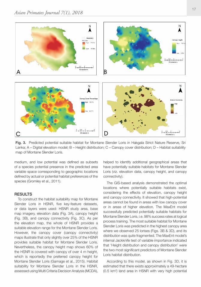
RESULTS To construct the habitat suitability map for Montane
Slender Loris in HSNR, five key-feature datasets, or data layers were used: HSNR study area, base map imagery, elevation data (Fig. 3A), canopy height (Fig. 3B), and canopy connectivity (Fig. 3C). As per the elevation map, the whole of HSNR provides a suitable elevation range for the Montane Slender Loris. However, the canopy cover (canopy connectivity) maps illustrate that only slightly over 25% of the HSNR provides suitable habitat for Montane Slender Loris. Nevertheless, the canopy height map shows 60% of the HSNR is covered with canopy of over 4 m height, which is reportedly the preferred canopy height for Montane Slender Loris (Gamage et al., 2015). Habitat suitability for Montane Slender Loris in the HSNR, assessed using Multi Criteria Decision Analysis (MCDA),
helped to identify additional geographical areas that have potentially suitable habitats for Montane Slender Loris (viz. elevation data, canopy height, and canopy connectivity).
The GIS-based analysis demonstrated the optimal locations where potentially suitable habitats exist, considering the effects of elevation, canopy height and canopy connectivity. It showed that high-potential areas cannot be found in areas with low canopy cover or in areas of higher elevation. The MaxEnt model successfully predicted potentially suitable habitats for Montane Slender Loris, i.e. 98% success rates at logical process training. The most suitable habitat for Montane Slender Loris was predicted in the highest canopy area where we observed 25 lorises (Figs. 3B & 3D), and its distribution was quite fragmented. The MaxEnt model’s internal Jackknife test of variable importance indicated that ‘Height distribution and canopy distribution’ were the two most significant predictors of Montane Slender Loris habitat distribution.
According to this model, as shown in Fig. 3D, it is estimated that there exists approximately a 49-hectare (0.5 km2) land area in HSNR with very high potential
Fig. 3. Predicted potential suitable habitat for Montane Slender Loris in Hakgala Strict Nature Reserve, Sri Lanka; A – Digital elevation model; B – Height distribution; C – Canopy cover distribution; D – Habitat suitability map of Montane Slender Loris.

Asian Primates Journal 7(1), 201818
habitat suitability for Montane Slender Loris, followed by an 848-hectare (8.5 km2) with medium potential habitat suitability, and a 60-hectare (0.6 km2) with low potential habitat suitability. Furthermore, the model clearly highlighted that Montane Slender Loris habitats in the HSNR are highly fragmented.
DISCUSSION These results provide information for future species
management planning and will help to locate new habitat locations and determine the extent of those areas. This study revealed that the habitat distribution patterns for threatened and endangered species such as the Montane Slender Loris can be modelled with MaxEnt, using a small number of occurrence records and environmental variables, like previous studies (Hoffman et al., 2008). This method has been proven to perform better than other modelling approaches (Ortega-Huerta & Townsend, 2008). MaxEnt estimates the probability distribution of a species’ presence data, based on environmental variables, even using small sample sizes of up to six specified localities. The potential habitat distribution map for Montane Slender Loris can aid in planning land use management around its existing populations, discover new populations, identify top-priority survey sites, and set priorities to restore its natural habitat for more effective conservation. More research is needed to determine whether the existing protected areas adequately cover suitable habitats for Montane Slender Loris.
ACKNOWLEDGEMENTSWe thank the Director General of the Department
of Wildlife Conservation (DWC) and the Research Committee, the Deputy Director of Research, and DWC staff for their support. Also, we extend our thanks to the Conservator General of Forests, the Conservator of Forests (Research and Education), and the Forest Department staff for their support. We would like to acknowledge Prof. Michael Huffman and the editors for improving the manuscript. We give a special acknowledgment to the dedicated and professional Slender Loris Conservation Programme field team: G.D.C. Pushpa Kumara, V. Sumanasekara, G. Rathnayake, D.R. Vidanapathirana, S. Ariyarathna, V. Rathnayake, D. Samarasinghe, D. De Silva, L. Rathnayake, S. Jayalath, P. Yahanpath, M.A. Chanuka, and Maheshani Kumari. The programme was funded through the EDGE of Existence Programme of the Zoological Society of London, Synchronicity Foundation, and BBC Wildlife Fund, and we are
grateful for their support. We also extend our thanks to the Institute of Human Resource Advancement, University of Colombo.
REFERENCES Banks, S.C., Finlayson, G.R., Lawson, S.J.,
Lindenmayer, D.B., Paetkau, D., Ward, S.J. and Taylor, A.C. 2005. The effects of habitat fragmentation due to forestry plantation establishment on the demography and genetic variation of a marsupial carnivore, Antechinus agilis. Biological Conservation 122: 581–597.
Chefaoui, R.M., Hortal, J. and Lobo, J.M. 2005. Potential distribution modelling, niche characterization and conservation status assessment using GIS tools: a case study of Iberian Copris species. Biological Conservation 122: 327–338.
Fielding, A. and Bell, J. 1997. A review of methods for the assessment of prediction errors in conservation presence/absence models. Environmental Conservation 24: 38–49.
Gamage, S.N., Hettiarachchi, C.J., Mahanayakage, C.A., Padmalal, U.K.G.K. and Kotagama, S.W. 2015. Factors influencing site occupancy of montane slender loris (Loris tardigradus nycticeboides) in Sri Lanka. Wildlanka 3: 67–73.
Gaubert, P., Papes, M. and Peterson, A.T. 2006. Natural history collections and the conservation of poorly known taxa: ecological niche modeling in central African rainforest genets (Genetta spp.). Biological Conservation 130: 106–117.
Gormley, A., Forsyth, D., Griffioen, P., Lindeman, M., Ramsey, D., Scroggie, M. and Woodford, L. 2011. Using presence-only and presence-absence data to estimate the current and potential distributions of established invasive species. Journal of Applied Ecology 48: 25–34.
Grinnell, J. 1917. Field tests of theories concerning distributional control. American Naturalist 51: 115–128.
Guisan, A., Broennimann, O., Engler, R., Vust, M., Yoccoz, N.G., Lehmann, A. and Zimmermann, N.E. 2006. Using niche-based models to improve the sampling of rare species. Conservation Biology 20: 501–511.
Guisan, A. and Thuiller, W. 2005. Predicting species distribution: offering more than simple habitat
Asian Primates Journal 7(1), 201819
models. Ecology Letters 8: 993–1009.
Haseler, W. 1976. Parthenium hysterophorus L. in Australia. International Journal of Pest Management 22: 515–517.
Hoffman, J.D., Narumalani, S., Mishra, D.R., Merani, P. and Wilson, R.G. 2008. Predicting potential occurrence and spread of invasive plant species along the North Platte River, Nebraska. Invasive Plant Science and Management 1: 359–367.
Kearny, M. 2006. Habitat, environment and niche: what are we modelling? Oikos 115: 186–191.
Loiselle, B.A., Howell, C.A., Graham, C.H., Goerck, J.M., Brooks, T.M., Smith, K.G. and Williams, P.H. 2003. Avoiding pitfalls of using species distribution models in conservation planning. Conservation Biology 17: 1591–1600.
Mahanayakage, C.A. 2013. Anthropogenic Threats to Montane Slender Loris. Dissertation for Diploma in Environment Management, Faculty of Graduate Studies, University of Colombo, Sri Lanka.
Margules, C.R. and Austin, M.P. 1994. Biological models for monitoring species decline: the construction and use of data bases. Philosophical Transactions of the Royal Society of London. Series B, Biological Sciences 344: 69–75.
Monty, M., Lorens, F. and Baider, C. 2013. Invasive alien plants elicit reduced production of flowers and fruits in various native forest species on the tropical island of Mauritius (Mascarenes, Indian Ocean). Tropical Conservation Science 6: 35–49.
Mooney, H. 2005. Invasive Alien Species: A New Synthesis. Island Press, Washington, DC., USA.
Nekaris, A. 2008. Loris tardigradus ssp. nycticeboides. The IUCN Red List of Threatened Species 2008: e.T39756A10262765. http://dx.doi.org/10.2305/IUCN.UK.2008.RLTS.T39756A10262765.en. Downloaded on 16 August 2017.
Ortega-Huerta, M. and Townsend, P. 2008. Modelling ecological niches and predicting geographic distributions: a test of six presence-only methods. Revista Mexicana de Biodiversidad 70: 205–216.
Peterson, A.T. 2003. Predicting the geography of species’ invasions via ecological niche modeling. The Quarterly Review of Biology 78: 419–433.
Peterson, A.T. and Kluza, D.A. 2003. New distributional
modeling approaches for Gap Analysis. Animal Conservation 6: 47–54.
Phillips, S.J., Dudik, M. and Schapire, R.E. 2004. A maximum entropy approach to species distribution modeling. In: Proceedings of the 21st International Conference on Machine Learning, Banff, Canada, pp.655-662. AMC Press, New York, USA.
Rhodes, J.R., Wiegand, T., McAlpine, C.A., Callaghan, J., Lunney, D., Bowen, M. and Possingham, H.P. 2006. Modeling species’ distributions to improve conservation in semi-urban landscapes: koala case study. Conservation Biology 20: 449–459.
Rondinini, C., Stuart, S. and Boitani, L. 2005. Habitat suitability models and the shortfall in conservation planning for African vertebrates. Conservation Biology 19: 1488–1497.
Sánchez-Cordero, V., Cirelli, V., Munguia, M. and Sarkar, S. 2005. Place prioritization for biodiversity representation using species’ ecological niche modeling. Biodiversity Informatics 2: 11–23.
Sánchez-Cordero, V., Illoldi-Rangel, P., Linaje, M., Sarkar, S. and Peterson, A.T. 2005. Deforestation and extant distributions of Mexican endemic mammals. Biological Conservation 126: 465–473.
Simberloff, D. 2001. Invasion of Introduced Species. eLS. Wiley Online Library. doi/10.1002/9780470015902 .a0020472.
Soberón, J. 2007. Grinnellian and Eltonian niches and geographic distributions of species. Ecology Letters 10: 1115–1123.
Soberón, J. and Peterson, A.T. 2005. Interpretation of models of fundamental ecological niches and species’ distributional areas. Biodiversity informatics 2: 1–10.
Tefera, T. 2002. Allelopathic effects of Parthenium hysterophorus extracts on seed germination and seedling growth of Eragrostistef. Journal of Agronomy and Crop Science 188: 306–310.
Wisz, M.S., Hijmans, R.J., Li, J., Peterson, A.T., Graham, C.H., Guisan, A. and NCEAS Predicting Species Distributions Working Group. 2008. Effects of sample size on the performance of species distribution models. Diversity and Distributions 14: 763–773.
Copyright © 2022 FDOKUMEN