Guide to the geology of the Harrisburg area, Saline County, Illinois
82
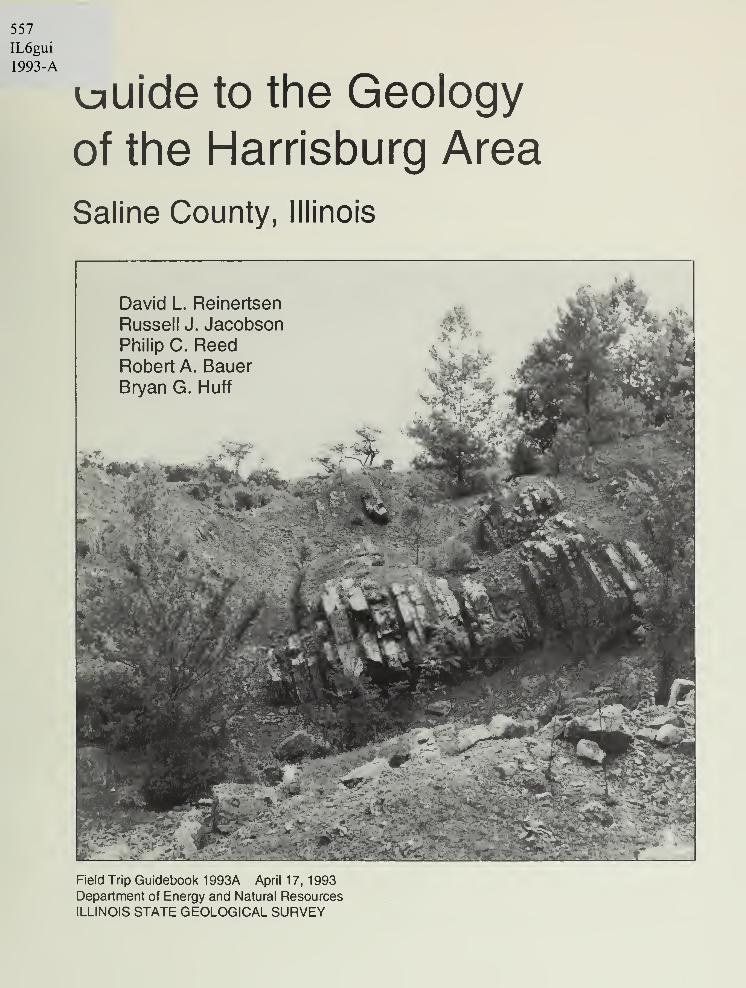
557 IL6gui 1993-A uuide to the Geology of the Harrisburg Area Saline County, Illinois Field Trip Guidebook 1 993A April 1 7, 1 993 Department of Energy and Natural Resources ILLINOIS STATE GEOLOGICAL SURVEY
Transcript of Guide to the geology of the Harrisburg area, Saline County, Illinois
557
IL6gui
1993-A
uuide to the Geology
of the Harrisburg Area
Saline County, Illinois
Field Trip Guidebook 1 993A April 1 7, 1 993Department of Energy and Natural Resources
ILLINOIS STATE GEOLOGICAL SURVEY
Cover photo Upturned Mississippian rocks in the abandoned Horseshoe Quarry.
Geological Science Field Trips The Educational Extension Unit of the Illinois State Geological
Survey conducts four free tours each year to acquaint the public with the rocks, mineral resources,
and landscapes of various regions of the state and the geological processes that led to their origin.
Each field trip is an all-day excursion through one or more Illinois counties. Frequent stops are
made to explore interesting phenomena, explain processes that shape our environment, discuss
principles of earth science, and collect rocks and fossils. People of all ages and interests are wel-
come. The trips are especially helpful to teachers preparing earth science units. Grade school stu-
dents are welcome, but each must be accompanied by a parent or guardian. High school science
classes should be supervised by at least one adult for each ten students.
Field trip guide booklets are available for planning class tours and private outings. For a list, con-
tact the Educational Extension Unit, Illinois State Geological Survey, Natural Resources Building,
615 East Peabody Drive. Champaign, IL 61820-6964. Call (217) 333-4747 or 333-7372.
prlnlad on racycM papar
Printed by authority of the State of Illinois / 1993/500
Guide to the Geology
of the Harrisburg Area
Saline County, Illinois
David L. Reinertsen
Russell J. JacobsonPhilip C. ReedRobert A. BauerBryan G. Huff
Field Trip Guidebook 1 993A April 1 7, 1 993
ILLINOIS STATE GEOLOGICAL SURVEYMorris W. Leighton, Chief
Natural Resources Building
615 East Peabody Drive
Champaign, Illinois 61820-6964
OI(J olofio I ijce.

CONTENTS
HARRISBURG AREA 1
GEOLOGIC HISTORY 1
Precambrian Era 1
Paleozoic Era 2
The geologic column 3
Geologic framework of the field trip area 4
Mesozoic and Cenozoic Eras 5
Quaternary geology 5
GEOMORPHOLOGY 9
Physiography 9
Drainage 1
1
Relief 1
1
MINERAL RESOURCES 11
Groundwater 1
1
Mineral Production 12
GUIDE TO THE ROUTE—STOPS 14
1 Oilfield 16
2 Surface facilities at Kerr-McGee's Galatia Mine 19
3 Ground subsidence above a longwall mine 24
4 Glacial lake beds 25
5 Lunch at the Tom and Ruth Patton Pavilion 28
6 Upper Tradewater Formation, Curlew Limestone 30
7 Horseshoe Quarry 32
8 Abandoned strip mine of the J. W. Coal Company 34
9 Abandoned quarry exposure of lower Mississippian Kinkaid Limestone 37
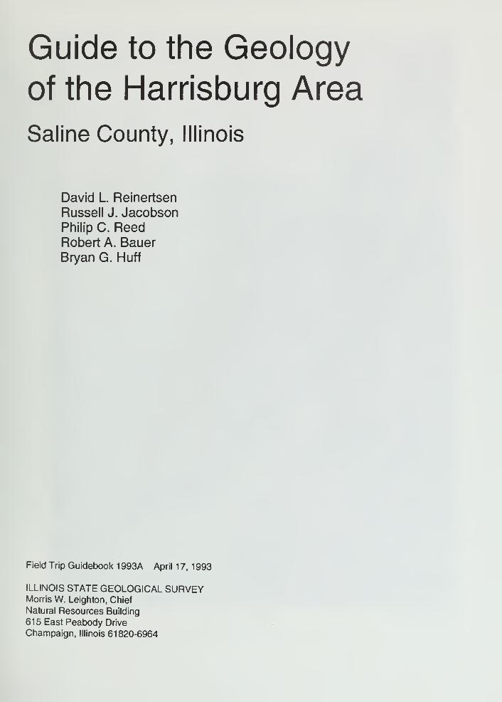
10 Old Stone Face 38
BIBLIOGRAPHY 40
GLOSSARY 42
FIGURES
Old Stone Face ii
Generalized geologic column showing succession of rocks in Illinois iv
1 Location of some major structures in the Illinois region 2
2 Generalized geologic column of southern Illinois 3
3 Stylized north-south cross section shows stmcture of the Illinois Basin 4
4 Bedrock geology beneath surficial deposits in Illinois 6
5 Structural features in Illinois 7
6 Generalized map of glacial deposits in Illinois 8
7 Physiographic divisions of Illinois 10
8 Annual crude oil production in Illinois 13
9 Oil fields of the Illinois Basin 18
10 Places where oil is found in Illinois 19
1
1
Schematic diagram of a common type of oil production unit in Illinois 2012 Generalized columnar section showing Quaternary and upper Pennsylvanian
strata in the Harrisburg area 21
13a Typical plan of a portion of a room and pillar mine in southern Illinois 2313b Plan of longwall panels in Mine No. 6, Kerr-McGee Corporation, Galatia Mine 2314 Shawneetown Fault Zone and its effect on the bedrock strata 33
EraPeriod or System
and Thickness
\ Holocene^ 10,000
Pennsylvonian
0-3.000'
CCoal Measures')
Mississipptan
0-3,500'
Devonian
0-1.500'
Silurian
0-1,000'
Ordovicion
500-2,000'
Cambrian
1,500-3,000'
ARCHEOZOIC and
PROTEROZOIC
Age
(years ago)
320 m.
360 m.
408 m.
438 m
505 m
570 m -
General Types of Rocks
Recent— alluvium In river valleys
Qocial till, glaciol outwasti, gravel, sand, silt,
lake deposits of clay and silt, loess and
sand dunes ; covers nearly oil of state
eKcept norttiwest corner ond soutliern tip
Ctiert gravel, present in nortttern, souttiern,ond western Illinois
nnosny micaceous sand witti some silt and cloy,
present only in soutt^ern Illinois
Mostly cloy, little sond;present only in soutt\ernIllinois
Mostly sand, some tliin beds of clay and, locally,
aroveli present only in southern Illinois
Largely shale and sandstone with beds of coal,
limestone, and cloy
Black and gray shole at bose; middle zone of
thick limestone that grodes to siltstone,
chert, and shale; upper zone of interbedded
sandstone, shale, ond limestone
Thick limestone, minor sandstones and shales;
largely chert ond cherty limestone in southern
Illinois; black shole ot top
Principally dolomite and limestone
Largely dolomite and limestone but contain^
sandstone, shole, and siltstone formations
Chiefly sandstones with some dolomite and shole,
exposed only m smell oreos in north-centrol
Illinois
Igneous and metomorphic rocks, known in
Illinois only from deep wells
z:Ez
/ ^ /
major unconformity
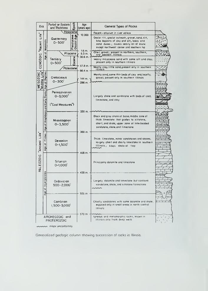
Generalized geologic column showing succession of rocks in Illinois.
HARRISBURG AREA
The route of the Harrisburg Geological Science Field Trip starts in the southernnnost part of the
Mount Vernon Hill Country, a relatively level to slightly rolling surface of thin, lllinoian glaciat de-
posits formed perhaps 250,000 years ago, and extends to the northeastern part of the ShawneeHills. The southeastern part of the trip crosses the scenic, upturned rim of the Eagle Valley Syn-
cline in the Shawnee Hills, just beyond the southernmost boundary of the lllinoian glacier.
Fossilferous limestones of Mississippian age are exposed beneath the thin Quaternary-age loess
(rhymes with bus) deposits covering the tilted, upturned strata along the Shawneetown-Rough
Creek Faulted Complex in the southeastern part of the field trip area. Nearby mines in the Penn-
sylvanian-age Herrin (No. 6), Springfield (No. 5),and older, deeper coals of the Carbondale For-
mation have made the Harrisburg area an important coal-producing center for many years.
The Harrisburg field trip area lies approximately 330 miles south-southwest of downtown Chicago
and about 185 miles southeast of Springfield. The route for the field trip will take us through
about one-third of Saline County.
GEOLOGIC HISTORY
Precambrian Era
The Harrisburg area, like most of the midcontinent, has undergone many changes through the
thousands of millions of years of geologic time. The oldest rocks beneath us along the route of
the field trip belong to the ancient Precambrian (Archeozoic and Proterozoic) basement complex
(see generalized geologic column on facing page). We know relatively little about these rocks
from direct observation in Illinois because they are not exposed at Earth's surface anywhere in
the state. Surface exposures of Precambrian rocks occur, however, in southeastern Missouri and
central Wisconsin. About 30 drill holes in Illinois have penetrated deep enough for geologists to
collect samples of Precambrian rocks. Recorded depths to the top of the basement complex
range from 1 ,995 feet in northwestern Illinois (Stephenson County) to 12,967 feet in southeastern
Illinois (Hamilton County), some 20 miles north of Harrisburg. From these samples, and from
similar drill hole samples and surface exposures of Precambrian rocks in adjacent states, weknow that these ancient rocks consist mostly of igneous and metamorphic crystalline rocks of
granite-rhyolite composition and, rarely, some basaltic rock types. The rocks formed about 1 .5 to
1 .0 billion years ago when molten materials slowly solidified deep within the earth. By about 0.6
billion years ago, deep weathering and erosion had exposed the ancient rocks at the surface,
probably forming a landscape rather similar to part of the present Missouri Ozarks. We have no
rock record in Illinois for the long interval of weathering and erosion that lasted from the time Pre-
cambrian rocks were formed until Cambrian sediments were deposited across the older land sur-
face. We know, however, that the interval was longer than the span of geologic time from the
Cambrian to the present.
Because geologists have only seen the Precambrian rocks in Illinois as cuttings from drill holes,
they have had to determine some characteristics of the basement complex by using various indi-
rect techniques such as measurements of Earth's gravitational and magnetic fields, and seismic
tests. This evidence indicates that rift valleys similar to those in east Africa began to form in what
is now southernmost Illinois during the late Precambrian Era. These midcontinent /-//if structures,
known as the Rough Creek Graben and the Reelfoot Rift (fig. 1 ), formed when plate tectonic
movements (slow global scale deformation) began to rip apart an ancient Precambrian superconti-
nent. The slow fragmentation of this Precambrian supercontinent eventually isolated a new land-
mass called Laurasia, which included much of what is now the North American continent.
Words in italics are defined in the glossary in the back of the guidebook.
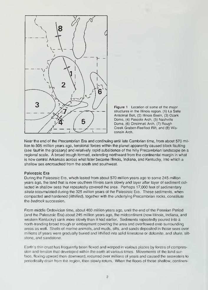
Figure 1 Location of some of the major
structures in the Illinois region. (1) La Salle
Anticlinal Belt, (2) Illinois Basin, (3) Ozark
Dome, (4) Pascola Arch, (5) Nashville
Dome, (6) Cincinnati Arch, (7) RoughCreek Graben-Reelfoot Rift, and (8) Wis-
consin Arch.
Near the end of the Precambrian Era and continuing until late Cambrian time, from about 570 mil-
lion to 505 million years ago, tensional forces within the planet apparently caused block faulting
(see fault \n the glossary) and relatively rapid subsidence of the hilly Precambrian landscape on a
regional scale. A broad trough formed, extending northward from the continental margin in what
is now central Arkansas across what later became Illinois, Indiana, and Kentucky, into which a
shallow sea encroached from the south and southwest.
Paleozoic Era
During the Paleozoic Era, which lasted from about 570 million years ago to some 245 million
years ago, the land that is now southern Illinois sank slowly and layer after layer of sediment col-
lected in shallow seas that repeatedly covered the area. Perhaps 17,000 feet of sedimentary
strata accumulated during the 325 million years of the Paleozoic Era. These sediments, whencompacted and hardened {lithified), together with the underlying Precambrian rocks, constitute
the toedroc/f succession.
From middle Ordovician time, about 460 million years ago, until the end of the Permian Period
(and the Paleozoic Era) about 245 million years ago, the midcontinent (now Illinois. Indiana, and
western Kentucky) sank more slowly than it had earlier. Sediments repeatedly poured into a
north-trending broad trough or embayment covering the area and overflowed onto surrounding
areas as well. Shells of marine animals, and muds, silts, and sands deposited in those seas over
millions of years were gradually buried and lithified into solid limestone or dolomite, and shale, silt-
stone, and sandstone.
Earth's thin crust has frequently been flexed and warped in various places by forces of compres-
sion and tension that developed within the earth at various times. Movements of the land sur-
face, flexing upward then downward, recurred over millions of years and caused the seawaters to
periodically drain from the region, then slowly return. When the floors of these shallow, continen-
THICKNESS ABOur 2000 FT
1 r I I
m
i a
CARBONDALEIncludes Anvil
Rock, Cube,
U Dudley,
DyltstrQ, Joke Cr
,
Jomeslown,
Pleasontview,
I SI or U S-qqins
SPOONIncI Belloir 500,
Bridgeport,
Browning, Cloy-
pool, L.Dudley,
Isobel, Kickopoo,
Peiro, Robinson,
2nd or L.Siggins,
Wilson
ABBOTTIncI Belloir BOO,
Burtschi, Casey,
Mansfield, Daqley
Portlow,
3rd,4tn Siggins
CASEYVILLEicludes Biehl,
Bucbonon,
Jordon,
Pottsyille,
Ridgley
THICKNESS. ABOUT 1300 FT
^^ GROVE CHURCH
)• OEGONIA
—-^^ \» PALESTINE
WALTERSBURG
VIENNA
« TAR SPRINGS
GLEN DEAN
HARDINSBURG
_-^^.
HANEY(Golconda lime)
FRAILEYSlGol-Sh)Big Clifty, Jackson
BEECH CREEK(Borlow, basolGol )
CYPRESSWeiler, Kirkwood,
Corlyle, Belloir 900,
Lmdley
RIDENHOWER(U P C 1
Somple (P Cr. Sd, E III )
BETHEL(Point Cr Sd ,WIII 1
DOWNEYS BLUFF(L.PC, U.Ren.)
• YANKEETOWNBenoisl
RENAULT ( L.Ren.)
AUX VASESSTE GENEVIEVE
lUx Vases lime
Ohoro
Spar Mountain
(Rosiclore)
^ McClosky c
lOblong) ^• L. McClosky ^
THICKNESS: ABOUT 4000 FT
ST LOUIS
Westtield
Mortinsville
SALEM
ULLIN
FT PAYNE
BORDEN (Osoge)
• Cole, Sonora
Corper
~r ~I I
IT"— CHOUTEAU
—-^ NEW ALBANY
Hordin
LINGLE• Hibbord
)_•_ Hoing
GRAND TOWER_ Geneva
^# Dutcti Creek
CLEAR CREEK
:>>-_l < tJrXi^
nrr:
BACKBONEGRASSY KNOB
BAILEY
MOCCASIN SPRINGSilurian,Niogoran
(reef and nonreef
)
ST CLAIR
KANKAKEE/SEXTONEDGEWOOD CREEK
MAOUOKETA
GALENAimmswick, Trenton
PLATTEVILLE
DUTCHTOWN
ST. PETER
THICKNESS: ABOUT 8000 FT
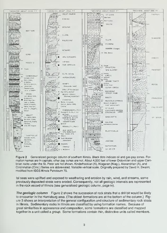
Figure 2 Generalized geologic column of southern Illinois. Black dots indicate oil and gas pay zones. For-
mation names are in capitals; other pay zones are not. About 4,000 feet of lower Ordovician and upper Cam-brian rocks under the St. Peter are not shown. Kinderhookian (K), Niagaran (Niag.), Alexandrian (A), and
Cincinnatian (Cine.) Series are abbreviated. Variable vertical scale. Originally prepared by David H. Swann;
modified from ISGS Illinois Petroleum 75.
tal seas were uplifted and exposed to weathering and erosion by rain, wind, and streams, somepreviously deposited strata were eroded. Consequently, not all geologic intervals are represented
in the rock record of Illinois (see generalized geologic column, page iv).
The geologic column Figure 2 shows the succession of rock strata that a drill bit would be likely
to encounter in the Harrisburg area. (The oldest formations are at the bottom of the column.) Fig-
ure 3 shows an interpretation of the general configuration and structure of sedimentary rock strata
in Illinois. Sedimentary rocks in Illinois are classified by using formation names. Because of
great similarities in appearance and composition, some formations are classified and mappedtogether in a unit called a group. Some formations contain thin, distinctive units called members.

Chicago
Rockford
Figure 3 Stylized north-south cross section shows the structure of the Illinois Basin. In order to show de-
tail, the thickness of the sedimentary rocks has been greatly exaggerated and the younger, unconsolidated
surface deposits have been eliminated. The oldest rocks are Precambrian (Pre-C) granites. They form a de-
pression that is filled with layers of sedimentary rocks of various ages: Cambrian (C), Ordovician (O), Silurian
(S), Devonian (D), Mississippian (M), Pennsylvanian (P), Cretaceous (K), and Tertiary (T). The scale is ap-
proximate.
Many of the formations in groups have conformable contacts, which means that no significant
interruptions tool< place between deposition of the sediments of one formation and the sediments
of another (fig. 2). In some cases, the composition and appearance of the rocks change signifi-
cantly at the contact between two formations, even though the fossils in the rocks and the relation-
ships between the rocks indicate that deposition was essentially continuous. This type of contact
is called a disconformity. In other cases, the lower formation was subjected to weathering that
partly eroded it before sediments of the overlying formation were deposited. When this happens,
fossils and other evidence in the formations indicate the existence of a significant gap between
the time when the lower unit was deposited and the time when the overlying unit was laid down.
This type of contact is called an unconformity. If the lower strata were tilted and eroded before
the overlying strata were deposited, the contact is called an angular unconformity. (Unconformi-
ties are shown as undulating lines across the rock unit column in many geologic columns.)
Geologic framework of the field trip area In Saline County, the field trip area is underlain by
some 13,400 feet of Paleozoic sedimentary rocks in the northwest to nearly 14.000 feet in the
east-central part of the county. These strata range in age from deeply buried rocks of the late
Cambrian (about 523 million years old) to surface exposures of middle Pennsylvanian age (about
312 million years old). The oldest Paleozoic rocks exposed in the area are Devonian in age.
They formed from sediments that accumulated from about 385 up to 360 million years ago.
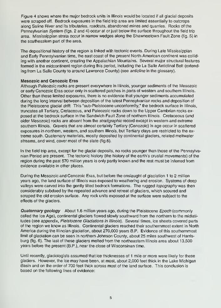
Figure 4 shows where the major bedrock units in Illinois would be located if all glacial deposits
were scraped off. Bedrock exposures in the field trip area are limited essentially to outcrops
along Saline River and its tributaries, readouts, abandoned mines and quarries. Rocks of the
Pennsylvanian System (figs. 2 and 4) occur at or just t>elow the surface throughout the field trip
area. Mississippian strata occur in narrow wedges along the Shawneetown Fault Zone (fig. 5) in
the southeastern part of the area.
The depositional history of the region is linked with tectonic events. During Late Mississippian
and Early Pennsylvanian time, the east coast of the present North American continent was collid-
ing with another continent, creating the Appalachian Mountains. Several major structural features
fomried in the midcontinent region during this period, including the La Salle Anticlinal Belt (extend-
ing from La Salle County to around Lawrence County) (see anticline in the glossary).
Mesozoic and Cenozoic Eras
Although Paleozoic rocks are present everywhere in Illinois, younger sediments of the Mesozoic
or early Cenozoic Eras occur only in scattered patches in parts of western and southern Illinois.
Other than these limited exposures, there is no evidence that younger sediments accumulated
during the long interval between deposition of the latest Pennsylvanian rocks and deposition of
the Pleistocene glacial drift. This "sub-Pleistocene unconformity," the bedrock surface in Illinois,
truncates all Tertiary, Cretaceous, and Paleozoic rocks down to the Upper Cambrian rocks ex-
posed at the bedrock surface in the Sandwich Fault Zone of northern Illinois. Cretaceous (and
older Mesozoic) rocks are absent from the stratigraphic record except in western and extreme
southern Illinois. Gravels that are almost certainly Tertiary (Cenozoic) in age occur in scattered
exposures in northern, western, and southern Illinois, but Tertiary clays are restricted to the ex-
treme south. Quaternary materials, mostly deposited by continental glaciers, related meltwater
streams, and wind, cover most of the state (fig.6).
In the field trip area, except for the glacial deposits, no rocks younger than those of the Pennsylva-
nian Period are present. The tectonic history (the history of the earth's crustal movements) of the
region during the past 570 million years is only partly known and the rest must be inferred from
evidence available in other places.
During the Mesozoic and Cenozoic Eras, but before the onslaught of glaciation 1 to 2 million
years ago, the land surface of Illinois was exposed to weathering and erosion. Systems of deepvalleys were carved into the gently tilted bedrock formations. The rugged topography ^Nas then
considerably subdued by the repeated advance and retreat of glaciers, which scoured andscraped the old erosion surface. Any rock units exposed at the surface were subject to the
effects of the glaciers.
Quaternary geology About 1 .6 million years ago, during the Pleistocene Epocli (commonlycalled the Ice Age), continental glaciers flowed slowly southward from the northern to the midlati-
tudes (see appendix, Pleistocene Glaciations in Illinois). Several times, ice sheets covered parts
of the region we know as Illinois. Continental glaciers reached their southernmost extent in North
America during the lllinoian glaciation, about 270,000 years B.P. Evidence of this southernmost
limit of glaciation can be seen in northern Johnson County, about 25 miles southwest of Harris-
burg (fig. 6). The last of these glaciers melted from the northeastern Illinois area about 13,500
years before the present (B.P.), near the close of Wisconsinan time.
Until recently, glaciologists assumed that ice thicknesses of 1 mile or more were likely for these
glaciers. However, the ice may have been, at most, about 2,000 feet thick in the Lake Michigan
Basin and on the order of 700 feet thick across most of the land surface. This conclusion is
based on the following lines of evidence:

Pleistocene andPliocene not shown
7^-j('/JxTERITIARY
[>-I>j CRETACEOUS
PENNSYLVANIANBond and Mattoon Fornnations
Includes narrow bells of
older tormations along
LaSalle Anticline
PENNSYLVANIANCarbondale and Modesto Formations
PENNSYLVANIANCaseyviile, Abbott, and SpoonFormations
MISSISSIPPIANIncludes Devonian in
Hardin County
DEVONIANIncludes Silunan in Douglas.
Champaign, and western
Rock Island Counties
SILURIANIncludes Ordovician and Devonian in Calhoun.
Greene, and Jersey Counties
p*:'.VJ ORDOVICIAN
WKM CAMBRIAN
^ nns Plaines Disturbance Ordovician to Pennsylvaman
^-— \ rlUll
Figure 4 Bedrock geology beneath surlicial deposits in Illinois.

Fault, downthrown
side indicated
t Anticline
I Syncline
—z— Monocline
40 mi
50 km
Figure 5 Structural features of Illinois.

EXPLANATION
HOLOCENE AND WISCONSINAN"
[;•:;:> Alluvium, sand dunes.v'::--:..: -A and gravel terraces
WISCONSINAN
=1 Lake deposits
WOODFORDIAN
ft \ Moraine
^—' Front ot morainic system
Groundmoraine
ALTON IAN
pliP] Till plain
ILLINOIAN
:::::::: Moraine and ridged drift
Groundmoraine
PRE-ILLINOIAN
1^^^^^^ Till plain
DRIFTLESS
Figure 6 Generalized map of glacial deposits in Illinois (modified from Willman and Frye 1970).
1 inferences about the geometry, configuration, and rates of flow of tlie ancient ice massesdeveloped from data on the strength and other characteristics of present ice sheets and ice
caps, such as those in Greenland and Antarctica,
2 estimates of the thickness of ice masses based on the heights of moraines and the flow
directions of the ice,
3 observations about the degree of compaction and consolidation of the drift materials that
must have been under the continental glaciers and thus give indications about the weight
(and by inference, the thickness) of ice necessary to cause the compaction.
Finally, some workers have suggested that the small amount of rebound of the land surface that
apparently has occurred in the Lake Michigan basin area since the ice melted away can only be
explained if the weight of the ice in the area did not exceed that of an ice thickness of 2,000 feet.
However, the exact amount of postglacial rebound of the region remains controversial.
Ice of various glaciations was active and thick enough to scour and remove part of the bedrock
surface. Much of the evidence for pre-lllinoian and early lllinoian glaciations is missing from the
northern part of our state. It was removed by the effects of the subsequent Wisconsinan glacia-
tion, the last major glacial advance that began about 25,000 to 22,000 years B.P.
In the northern part of the field trip area, the thickness of material deposited by the glaciers (gla-
cial drift) ranges from a few feet to somewhat more than 25 feet. Thicknesses of glacial deposits
of slightly more than 50 feet can be found where the preglacial drainages of Saline River and its
tributaries are present.
The landscape in the northern part of the Harrisburg field trip area developed on bedrock that is
covered by relatively thin lllinoian glacial deposits eroded during and after glaciation. The land-
scape in the south and east is formed on bedrock that is bare or only thinly covered by glacial
lake sediments and loess. Thickness of the loess ranges from about 3 feet in the northwest to
somewhat more than 6 feet in the southeast. Although younger Wisconsinan glaciers of the
Woodfordian Substage only reached as far south as the Shelbyville area, about 115 miles north-
northwest of Harrisburg, outwash materials from the waning ice front were transported seaward
by meltwater rivers rushing past this area.
GEOMORPHOLOGY
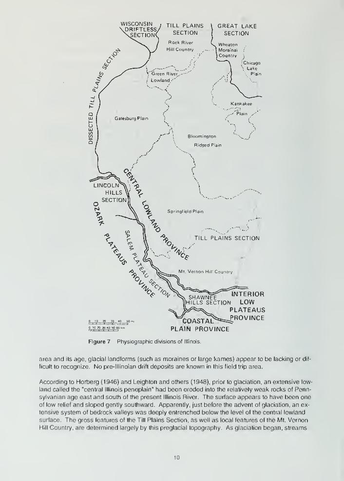
Physiography
The physiographic contrasts between various parts of Illinois are due to several factors, including
the resistance to erosion of formations exposed at the bedrock surface and the topography of the
bedrock surface, the extent of the various glaciations, differences in the thickness of the glacial
deposits, differences in age of the uppermost glacial drift, and the effects of erosion on bedrock
and surface deposits.
The Harrisburg field trip area embraces part of the southeastern margin of the Illinois part of the
Mt. Vernon Hill Country. This is a subdivision of the Till Plains Section, a division of the Central
Lowland Physiographic Province (fig. 7). This province embraces about four-fifths of Illinois. Tothe south the boundary between the Mt. Vernon Hill Country and the Shawnee Hills Section (a
division of the Interior Low Plateaus Province) is marked approximately by the topographic bound-
ary between the edge of the glacial deposits and the underlying Pennsylvanian cuesta. The Till
Plains Section is characterized by broad till plains that are relatively uneroded (a youthful stage of
erosion), in contrast with the maturely eroded Dissected Till Plains on older drift sheets in Iowa.
Harrisburg is located in the southeastern part of the Mt. Vernon Hill County, which Leighton andothers (1948) describe as a region of mature topography with low relief and limited upland prai-
ries and broad alluviated valleys along the larger streams. Because of the thinness of drift in this
WISCONSIN , TILL PLAINS.DRtFTLESs/
g^^^.^N
Rock River
Hill Country
GREAT LAKESECTION
WheatonMoreinal
I
Country
: Chicago'"•, Lake
\ Plain
Bloomington
Ridged Plain
TILL PLAINS SECTION
SHAWNEE iMTERIORHILLS SECTION LOW
PLATEAUS
COASTAL^^^-4^0^"^^^PLAIN PROVINCE
Rgure 7 Physiographic divisions of Illinois.
area and its age, glacial landforms (such as moraines or large kames) appear to be lacking or dif-
ficult to recognize. No pre-lllinoian drift deposits are known in this field trip area.
According to Horberg (1946) and Leighton and others (1948). prior to glaciation, an extensive low-
land called the "central Illinois peneplain" had been eroded into the relatively weak rocks of Penn-
sylvanian age east and south of the present Illinois River. The surface appears to have been one
of low relief and sloped gently southward. Apparently, just before the advent of glaciation, an ex-
tensive system of bedrock valleys was deeply entrenched below the level of the central lowland
surface. The gross features of the Till Plains Section, as well as local features of the Mt. Vernon
Hill Country, are determined largely by this preglacial topography. As glaciation began, streams
10
probably stopped eroding and began to aggrade, that is, the streams began to build up and fill
in their channels because they did not have sufficient volumes of water to carry and move the
increased quantities of sediments. There is no evidence to date to indicate that the early fills in
these preglacial valleys ever were completely flushed out of their channels by succeeding melt-
water torrents during deglaciation.
In the northern part of the Shawnee Hills, erosion left scattered low hills dotting the Pennsylva-
nian cuesta. To the south the topography is much rougher because of the very resistant lower
Pennsylvanian sandstones exposed there.
Drainage
Because the lllinoian drift and Wisconsinan loess are relatively thin throughout much of the Harris-
burg field trip area, modem drainage closely follows the alluviated preglacial bedrock valleys.
Saline River and its branches form the primary drainageways eastward to the Ohio River, several
miles south of Shawneetown. Most modern streams in the Harrisburg area have low gradients
(bottom slopes) so that downcutting of their channels is minimal. They widen their courses by
meandering back and forth across the low-lying ancient lake beds until channelization projects
are initiated to straighten them for better drainage. The uplands generally have fairly good natu-
ral drainage.
Relief
The highest surface elevation along the Harrisburg field trip route is slightly more than 780 feet
msl (mean sea level) at the crest of the west wall of Eagle Valley (mileage 49.35+). The lowest
elevation is less than 340 feet msl, the water surface of Saline River below the bridge at Equality.
Therefore, the maximum relief along the field trip route, calculated as the difference between the
highest and lowest surface elevations, is more than 440 feet within a horizontal distance of about
6V2 miles. The maximum local relief is about 540 feet from the ridge top 1/2 mile southeast of
Old Stone Face to the access road to the latter, about 1/3 mile to the north-northwest. Generally,
surface relief is low, ranging from about 45 to 65 feet in the northern and western parts of the
area. To the south and southeast, relief increases dramatically as one approaches the dip slope
of the Pennsylvanian escarpment and the upthrown side of the Shawneetown-Rough Creek
Fault Zone, where several hundred feet of relief are common, as noted previously.
MINERAL RESOURCES
GroundwaterA mineral resource frequently overlooked in assessinq an area's natural resource potential is
groundwater. Its availability can be essential for orderly economic and community development.
Groundwater is the water supply for more than 5 million people who live in 88% of the state. Con-sequently, studies of groundwater resources are an integral part of the research and service pro-
grams at the Illinois State Geological Survey (ISGS).
Groundwater resources are obtained from underground formations called aquifers. Aquifer mate-
rials (sand and gravel, sandstones, fractured rocks) are water-saturated and permeable enoughto transmit usable quantities of water to wells or springs. The source of groundwater is precipita-
tion—rainwater or melting snow—that enters and infiltrates through the soil. Soil moisture that is
not evaporated or used by plants percolates or seeps downward (because of gravity) and replen-
ishes the groundwater supply. This process is called recharge. Recharge for most shallow wells
occurs within a few miles of the well.
The water-yielding capacity of an aquifer is evaluated by constructing wells into it. Test wells are
pumped and water samples collected to determine the quality and quantity of the water supply.
11
Pryor (1956) reported that the upland in Saline County contains thin glacial deposits that are gen-
erally unfavorable for developing drilled wells in sand and gravel. Wells are constructed, how-
ever, in the thin, discontinuous deposits of sand and gravel found in the valley fill of the Saline
River. Because the unconsolidated materials overlying bedrock are recharged by local precipita-
tion, they are susceptible to surface contamination.
Most domestic wells in the area are constructed in water-yielding sandstones of Pennsylvanian
age that occur at depths below 100 feet north of Harrisburg and more than 300 feet south of
town. Because these bedrock strata are also recharged by local precipitation, the only filtering of
recharge water is through clay that is present in the overlying glacial deposits. Where the glacial
units are thin or absent and the bedrock is exposed at the surface, recharge enters directly into
the rock units and there is little, if any, filtering of contaminants.
Most municipal water supplies for Saline County residents come from four Saline County Water
District wells situated northeast of the village of Junction in Sections 2 and 17, T9S, R9E, Gallatin
County. The average pumpage from the four wells, whose total depths range from 135 to 143
feet, is 2.1 mgd (million gallons per day). This water is distributed to some 25,000 people via
pipelines to the Eldorado Water Company, Harrisburg, the Illinois Youth Center, Junction, the
Liberty-Bedford Public Water District, Muddy, and the Raleigh Water District. Other Saline
County towns outside of the field trip area receive water from other water districts.
During the late 1970s and 1980s, much emphasis was placed on the development of water dis-
tricts to augment and replace existing community water systems in Illinois. ISGS scientists were
instrumental in geophysical exploration, test drilling, and development of the Saline County Water
District well field in the large flat area covered by sediments deposited in Glacial Lake Saline.
Work at the well field was completed in 1980 by members of the ISGS Hydrogeology and Ground-
water Protection Section, in cooperation with other governmental agencies and active citizens in
those counties. The preliminary location for the well field was originally established through field
and subsurface mapping by then ISGS Chief John C. Frye and others (1972).
Mineral Production
Of the 102 counties in Illinois, 97 reported mineral production during 1990, the last year for which
totals are available. The total value of all minerals extracted, processed, and manufactured in Illi-
nois was $2.9 billion (Samson 1992).
In 1990, Illinois ranked fifth in the nation in coal production. The value of the 61 .7 million tons of
coal mined was $1 ,709.8 million. Although this was a 2.5% increase in tonnage over the pre-
vious year, only 19 counties reported coal production, as compared with 21 counties that reported
previously. Perry, Saline, Franklin, and Randolph Counties together accounted for 51 .8% of the
state's total coal production (Samson 1992).
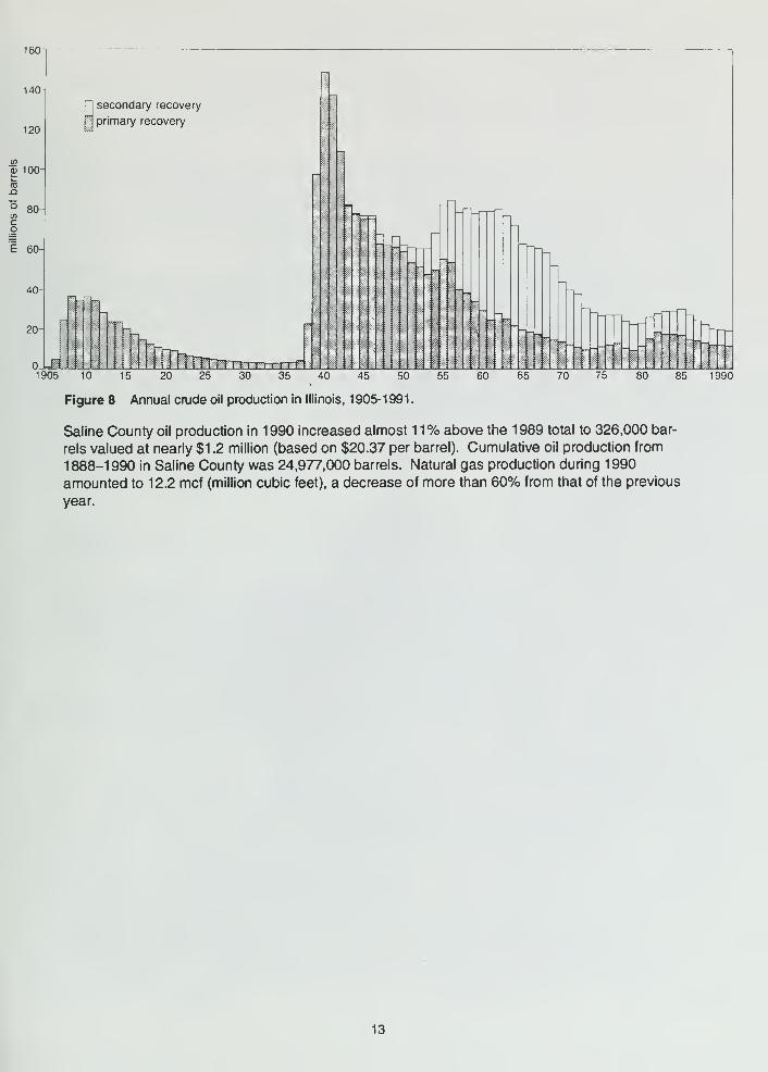
Crude oil production in Illinois decreased for the fifth straight year during 1990. Nearly 20 million
barrels of crude oil, valued at $406.5 million, was produced during 1990—a total that placed the
state 13th nationally (fig. 8). Less than 0.7 million cubic feet of natural gas, valued at neariy $1 .5
million, was produced in the state during 1990.
Saline County ranked third among Illinois counties reporting mineral production during 1990.
Coal, crude oil, and natural gas were the primary minerals extracted. The total value of minerals
produced amounted to about $202.2 million. In 1990, five mines produced more than 7 million
tons of coal valued at more than $201 .0 million (based on $27.73 per ton). This tonnage, which
was neariy 21% more than that produced during 1989, ranked the county second in coal produc-
tion in Illinois. Underground mines extracted 6,087,431 tons ol coal and suriace mines produced
1,161,874 tons. Coal production for Saline County from 1833-1990 totaled 201,023.228 tons.
12
160
140-
120
"55 100-
80-
E 60-
40-
20-
secondary recovery
primary recovery
Lm1905 10 15 20 25 30 35 40 45 50
Figure 8 Annual crude oil production in Illinois, 1905-1991.
55 60 65 70 75 80 85 1990
Saline County oil production in 1990 increased almost 11% above the 1989 total to 326,000 bar-
rels valued at nearly $1 .2 million (based on $20.37 per barrel). Cumulative oil production from
1888-1990 in Saline County was 24,977,000 barrels. Natural gas production during 1990
amounted to 12.2 mcf (million cubic feet), a decrease of more than 60% from that of the previous
year.
13
GUIDE TO THE ROUTE
Assemble in the parking area on the south side of Harrisburg High School in the south part of Har-
risburg (SV2 SE NW NE, Sec. 21 , T9S, R6E, 3rd P.M., Saline County; Harrisburg 7.5-Minute
Quadrangle [37088F5]*). Mileage calculations will begin at the northeast entrance to the parking
lot at Granger Street.
You must travel in the caravan. Do not drive ahead of the caravan! Please keep your head-
lights on while in the caravan. Drive safely but stay as close as you can to the car in front of you.
Please obey all traffic signs. If the road crossing is protected by an emergency vehicle with flash-
ing lights and flags, then obey the signals of the ISGS staff directing traffic. When we stop, park
as close as possible to the car in front of you and turn off your lights.
Some stops on the field trip are on private property. The owners have graciously given us permis-
sion to visit on the day of the field trip only. Please conduct yourselves as guests and obey all in-
structions from the trip leaders. So that we may be welcome to return on future field trips, please
do not litter or climb on fences. Leave all gates as you found them. These simple rules of cour-
tesy also apply to public property.
You may use this booklet for a field trip with your students, youth group, or family some time in
the future. Because of trespass laws and liat)ility constraints, you must get permission from prop-
erty owners or ttieir agents before entering private property.
Miles Miles
to next from
point start
0.0 0.0 EXIT from northeast entrance to parking lot. TURN LEFT (north) on Granger
Street.
0.05+ 0.05+ STOP: 4-way at West College Street. CONTINUE AHEAD (north).
0.15+ 0.25 STOP: 4-way at Sloan Street. CONTINUE AHEAD (north). NOTICE the large
cracks in the bricks in the building to the right on the northeast corner of the
intersection. Settling of the structure because of inadequate footings has
caused cracks to extend from the ground towards the roofline.
0.45+ 0.7+ STOP:2-wayatWestPoplarStreet. and State Route (SR) 13. TURN RIGHT (east)
onSR 13.
0.2+ 0.95 Prepare to turn left ahead.
0.05 1 .0 CAUTION: TRAFFIC LIGHT at Main Street (Junction of SR 1 3 and 34).
TURN LEFT (north) on SR 34. The Saline County Courthouse is on the
northeast corner of the intersection.
1 .0+ 2.0+ Leave Harrisburg's north city limits through the floodgate in the levee.
* The number in brackets [37088F51 after the topographic map name is the code assigned to that map as
part of the National Mapping Program. The state is divided into 1" blocks of latitude and longitude. The first
two numbers refer to tfie latitude of the soutfieast corner of tfie block; the next three numbers designate the
longitude The blocks are divided into sixty-four 7.5-minule quadrangles, the letter refers to the east-west
row from the bottom and the last digit refers to the north-south column from the right.
14
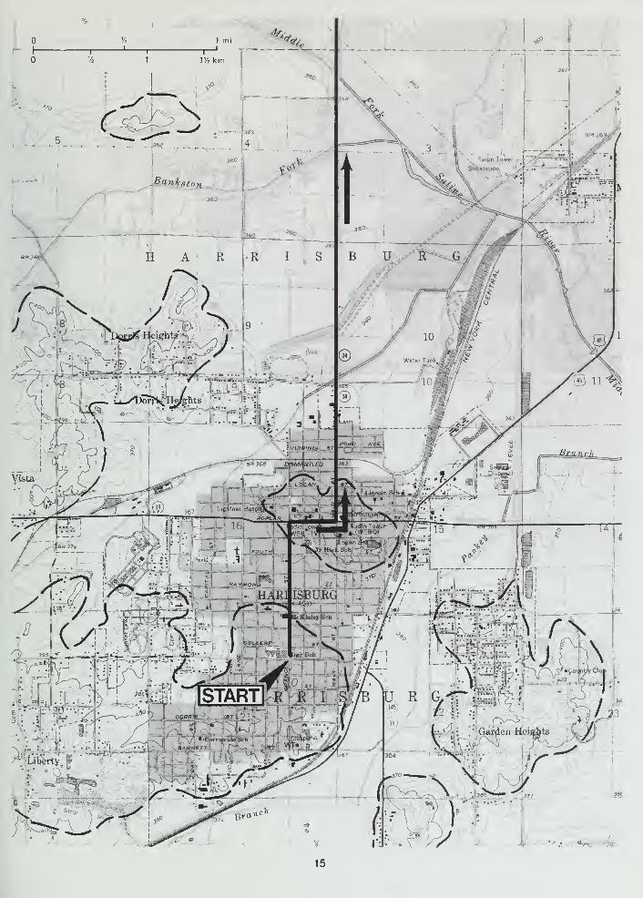
1 mi
—\—r/2 km
/^ ->"%
:;>:~yt
!=»==»?
«0^
-^ —Mf-
k
A\^
Vista
y4SH|eight^-<i I
9 '
1' ^1 ^ "t iSOUT./
Substation
^^s
360
B U E ~ G
:.iE....r"
10
-— , 10
«j
r /^r AV^
«^) 1 1 -^
IT
•i/V
--t --/^
\
15
0.25+ 3.05
0.35 3.4+
2.0 5.4+
0.15 5.55
0.1 + 5.7
0.1 + 5.8+
0.75 2.75+ Drainage ditches have been installed to drain the low-lying, flat, poorly drained
areas on both sides of the highway.
Cross Bankston Fork.
Cross Middle Fork Saline River.
Prepare to turn right.
5.55+ TURN RIGHT (east) on Union Grove Road (1400N) from SR 34 (900E).
CAUTION: narrow concrete culvert.
5.8+ TURN LEFT (north) on Hale Rd. (925E). To the north, notice the oil well
pumpjacks and the tank batteries.
0.4+ 6.25 PARK along the roadside as far off on the shoulder as you can safely.
WATCH for traffic and don't block the road.
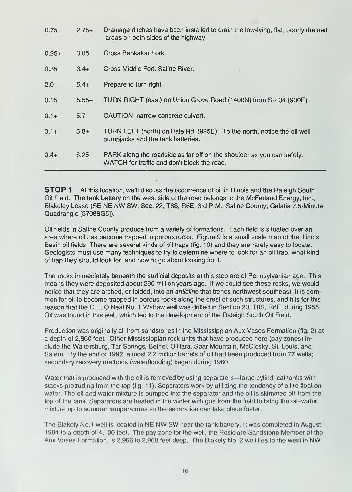
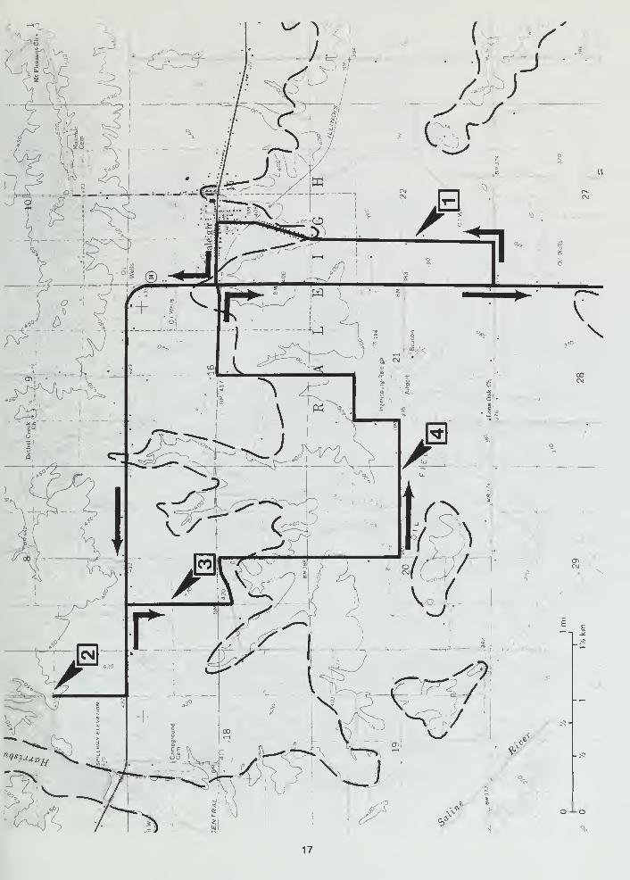
STOP 1 At this location, we'll discuss the occun^ence of oil in Illinois and the Raleigh South
Oil Field. The tank battery on the west side of the road belongs to the McFarland Energy, Inc.,
Blakeley Lease (SE NE NW SW, Sec. 22, T8S, R6E, 3rd P.M., Saline County; Galatia 7.5-Minute
Quadrangle [37088G5]).
Oil fields in Saline County produce from a variety of formations. Each field is situated over an
area where oil has become trapped in porous rocks. Figure 9 is a small scale map of the Illinois
Basin oil fields. There are several kinds of oil traps (fig. 10) and they are rarely easy to locate.
Geologists must use many techniques to try to determine where to look for an oil trap, what kind
of trap they should look for, and how to go about looking for it.
The rocks immediately beneath the surficial deposits at this stop are of Pennsylvanian age. This
means they were deposited about 290 million years ago. If we could see these rocks, we would
notice that they are arched, or folded, into an anticline that trends northwest-southeast. It is com-
mon for oil to become trapped in porous rocks along the crest of such structures, and It is for this
reason that the C.E. O'Neal No. 1 Wattaw well was drilled in Section 20, T8S, R6E, during 1 955.
Oil was found in this well, which led to the development of the Raleigh South Oil Field.
Production was originally all from sandstones in the Mississippian Aux Vases Formation (fig. 2) at
a depth of 2,860 feet. Other Mississippian rock units that have produced here (pay zones) in-
clude the Waltersburg, Tar Springs, Bethel, O'Hara, Spar Mountain, McClosky, St. Louis, and
Salem. By the end of 1992, almost 2.2 million barrels of oil had been produced from 77 wells;
secondary recovery methods (waterflooding) began during 1960.
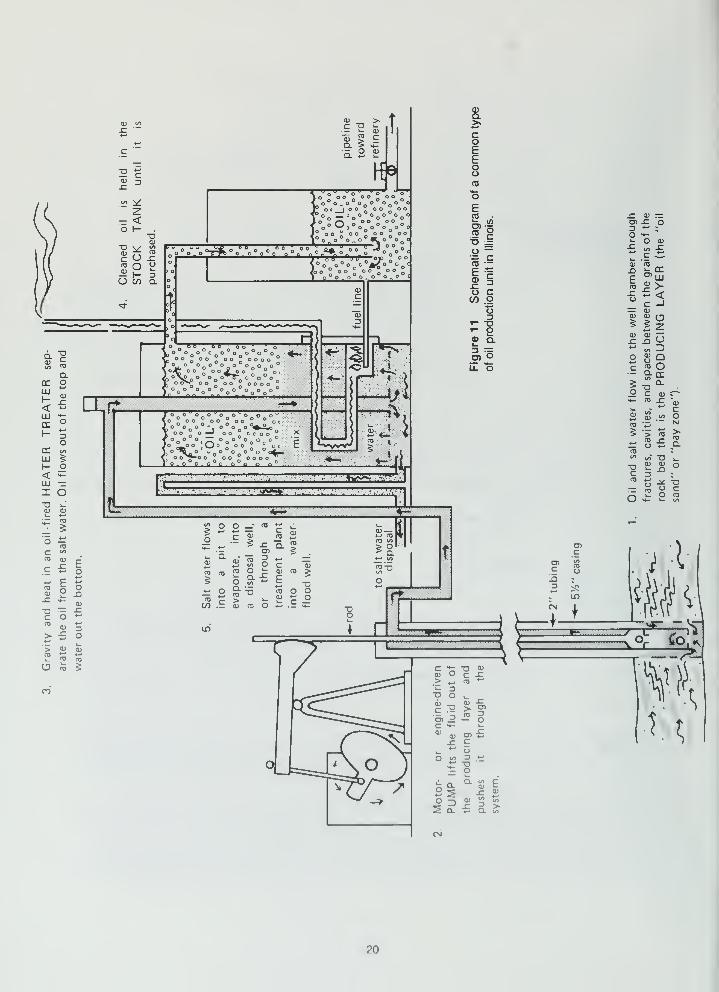
Water that is produced with the oil is removed by using separators—large cylindrical tanks with
stacks protruding from the top (fig. 11). Separators work by utilizing the tendency of oil to float on
water. The oil and water mixture is pumped into the separator and the oil is skimmed off from the
top of the tank. Separators are heated in the winter with gas from the field to bring the oil-water
mixture up to summer temperatures so the separation can take place faster.
The Blakely No.1 well is located in NE NW SW near the tank battery. It was completed in August
1984 to a depth of 4,100 feet. The pay zone for the well, the Rosiclare Sandstone Member of the
Aux Vases Formation, is 2,966 to 2.968 feet deep. The Blakely No. 2 well lies to the west in NW
16
17

Figure 9 Oil fields of the Illinois Basin
NW SW. It was connpleted in December 1984 to a depth of 4,302 feet. Pay zones in this well in-
clude the Tar Springs Sandstone at depths of 2,165 to 2,170 and 2,184 to 2,188 feet, and the St.
Louis Limestone at depths of 3.273 to 3.279 and 3.862 to 3,868 feet.
0.0 6.25 Leave stop 1 and CONTINUE AHEAD (north). Several tank batteries and a
number of pumpjacks are on both sides of the road as we go northward.
0.6+ 6.85+ CAUTION: enter village of Raleigh on Main Street.
18

'. o /» Glociol drift
Shole
Sandstone
Limestone
Dolomite
Gas saturated zone
Oil saturated zone
Water saturated zone
Figure 10 Places where oil is found in Illinois: (a) coral reefs, (b) anticlines, (c) pinchouts, and (d) channel
sandstones.
0.3+ 7.15+ CAUTION: single unguarded Illinois Central (IC) railroad track.
0.2 7.35+ STOP: 2-way. TURN LEFT (west) on Church Street and Raleigh Road (1 550N).
0.35 7.7+ STOP: 2-way at intersection with SR 34 (900E). TURN RIGHT (north) on SR 34.
0.65 8.35+ Texas Eastern Transmission Corporation pipeline crossing. CONTINUEAHEAD (west).
1.85 10.2+ Prepare to turn right.
0.2+ 10.45 TURN RIGHT (north) onto Harrisburg Lake Road, 1600N\675E.
0.2+ 1 0.65+ The entrance to the Galatia Mine owned and operated by the Kerr-McGeeCoal Corporation lies to the left. CONTINUE AHEAD (north).
0.15+ 10.85+ TURN AROUND and head south at the end of the blacktop. PARK along the
roadside. Do NOT block the road.
STOP 2 We'll view some of the surface facilities of the Kerr-McGee's Galatia Mine. (SE NENW SE, Sec. 7, T8S, R6E, 3rd P.M., Saline County; Galatia 7.5-Minute Quadrangle [37088G5]).
During the late 1960s, Kerr-A/lcGee Coal Corporation began acquiring coal rights in the Illinois
Basin. Construction of the Galatia Mine began in mid-1981 and the first coal was shipped by unit
train 2V2 years later. Conceived as a two seam operation in the Herrin (No. 6) and Springfield
(No. 5) Coal Members of the Pennsylvanian Carbondale Formation, the first to be developed wasthe deeper Springfield Coal because of its higher quality (fig. 12). (Locally, the Springfield Coal is
still referred to by its former name, Harrisburg Coal.) Coal was produced from the No. 6 Mine in
19
r<u -I^en 5ii
2— <O l- d
0)
^ CO
r U ^nj o o
1- -JU co a
din
c
Q.nr OUJ
-*
1— 3O
DC lyi
UJ ^H o< »+-
111 :
—
X oD ^<u (U
< "J= Oj?
c CO
CTJ O)Ero
bo
*->
ox: ^
0)
T) r:^ ^C O ^^
0) T> x: o
> <u 0)m +-'
<D
O <D 5
Ir
/"tTT^' ° °
<°o o°o^c°^o<>o„c/oo°oojoo°oo
oo^oooooooo
o tf^ oo oo oooc
O O " O O
o o " c
o o^^o o o
Q.
coEEooOS
E(0
O) •=(0 g
o —
IIo cCO o
o
'- 2« Q.
3 =O) oil o
V)
_o
O o ' roC
Q.
^
*-
_c
05
+-*
CD
5(D
u.oT
CO
3o C a)
TO
Ooa>
Oa J=
0)
ECO
CO
O
5
Oc n
0)c O
£ 0) —D5 j: o3o ^4-
O Q)^ CO -C^^ C ^CI) CO
ECO
^ir>- <c -1^ OJ
cu
B 2So./. 3
OCO Orhi- DC
g Tl"-o C (U c^*4- CO
4̂-» r03
OJ « oCO 4_,
5 > COCO
a.*-' S:£CO «CO
co' "D V-
D cu cu ot- 3 -
CO
11•D
r>CCD
20

FORMATION
AND
MEMBER
LITHOLOGY
^2!2
^ <y o
o
THICK-
NESS
IN FEET
Cahokia Alluvium
and
Equality Formation
....••••••.•.'
Loess WK
B<3 .
S E
CO
West Franklin Ls. Mbr.
Gimlet Ss. Mbr.
I I I
J T T T 0-8
Danville (No.7)
Coal Mbr. yAllenby Coal Mbr.^
Anvil Rock Ss. Mbr.
Brereton Ls. Mbr.Herrin (No. 6)
Coal Mbr.
TTTT"in
T\.
TH If
M I J r
Briar Hill (No. 5A) |:_—':_— '.^-
•
Coal Mbr.
St. David Ls. Mbr.
Turner Mine Sh. Mbr
Springfield (No.5)
Coal Mbr.
Houchin Creek (No.4)
Coal Mbr.
SurvantCoal Mbr.
Colchester (No.2)
Coal Mbr. ~^^
Paizo Ss. Mbr.
Dekoven Coal Mbr.
Davis Coal Mbr.
M M II
I-l-»-T-»
--TTTTT
Stonefort Ls. Mbr. V T y » T
0-36
0-30
28-76
18-36
52-66
12-18
6-30
0-18
30-42
36-52
6-12
0-150
0-20
0-150
400-490
Figure 1 2 Generalized columnar section showing the Quaternary
and the upper portion of the Pennsylvanian strata known from drill holes
and exposures in the field trip area (after Nelson and Lumm 1986).
21
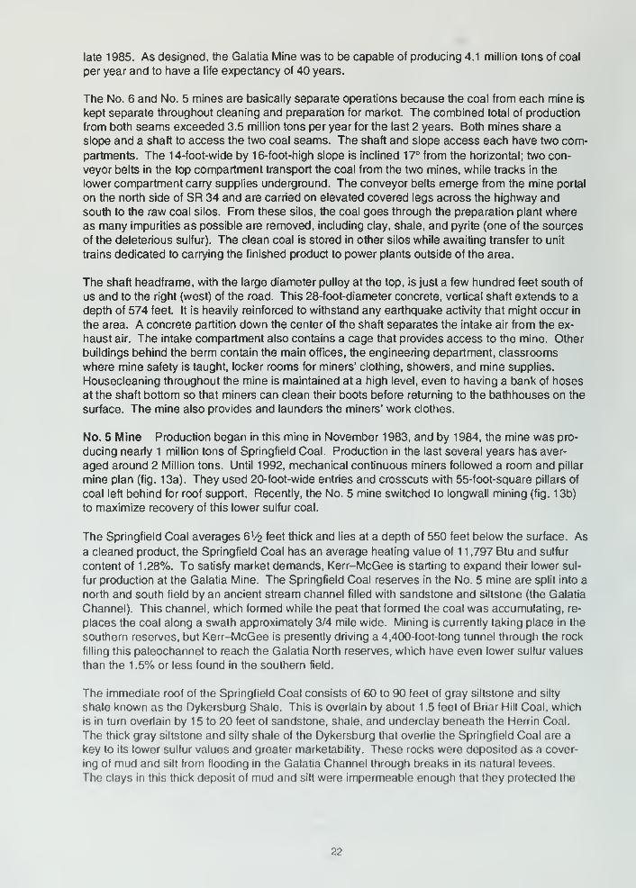
late 1985. As designed, the Galatia Mine was to be capable of producing 4.1 million tons of coal
per year and to have a life expectancy of 40 years.
The No. 6 and No. 5 mines are basically separate operations because the coal from each mine is
kept separate throughout cleaning and preparation for market. The combined total of production
from both seams exceeded 3.5 million tons per year for the last 2 years. Both mines share a
slope and a shaft to access the two coal seams. The shaft and slope access each have two com-
partments. The 14-foot-wide by 16-foot-high slope is inclined 17° from the horizontal; two con-
veyor belts in the top compartment transport the coal from the two mines, while tracks in the
lower compartment carry supplies underground. The conveyor belts emerge from the mine portal
on the north side of SR 34 and are carried on elevated covered legs across the highway and
south to the raw coal silos. From these silos, the coal goes through the preparation plant where
as many impurities as possible are removed, including clay, shale, and pyrite (one of the sources
of the deleterious sulfur). The clean coal is stored in other silos while awaiting transfer to unit
trains dedicated to carrying the finished product to power plants outside of the area.
The shaft headframe, with the large diameter pulley at the top, is just a few hundred feet south of
us and to the right (west) of the road. This 28-foot-diameter concrete, vertical shaft extends to a
depth of 574 feet. It is heavily reinforced to withstand any earthquake activity that might occur In
the area. A concrete partition down the center of the shaft separates the intake air from the ex-
haust air. The intake compartment also contains a cage that provides access to the mine. Other
buildings behind the berm contain the main offices, the engineering department, classrooms
where mine safety is taught, locker rooms for miners' clothing, showers, and mine supplies.
Housecleaning throughout the mine is maintained at a high level, even to having a bank of hoses
at the shaft bottom so that miners can clean their boots before returning to the bathhouses on the
surface. The mine also provides and launders the miners' work clothes.
No. 5 Mine Production began in this mine in November 1983, and by 1984, the mine was pro-
ducing nearly 1 million tons of Springfield Coal. Production in the last several years has aver-
aged around 2 Million tons. Until 1992, mechanical continuous miners followed a room and pillar
mine plan (fig. 13a). They used 20-foot-wide entries and crosscuts with 55-foot-square pillars of
coal left behind for roof support. Recently, the No. 5 mine switched to longwall mining (fig. 13b)
to maximize recovery of this lower sulfur coal.
The Springfield Coal averages 6V2 feet thick and lies at a depth of 550 feet below the surface. As
a cleaned product, the Springfield Coal has an average heating value of 1 1 ,797 Btu and sulfur
content of 1 .28%. To satisfy market demands, Kerr-McGee is starting to expand their lower sul-
fur production at the Galatia Mine. The Springfield Coal reserves in the No. 5 mine are split into a
north and south field by an ancient stream channel filled with sandstone and siltstone (the Galatia
Channel). This channel, which formed while the peat that formed the coal was accumulating, re-
places the coal along a swath approximately 3/4 mile wide. Mining is currently taking place in the
southern reserves, but Kerr-McGee is presently driving a 4,400-foot-long tunnel through the rock
filling this paleochannel to reach the Galatia North reserves, which have even lower sulfur values
than the 1 .5% or less found in the southern field.
The immediate roof of the Springfield Coal consists of 60 to 90 feet of gray siltstone and silty
shale known as the Dykersburg Shale. This is overlain by about 1 .5 feet of Briar Hill Coal, which
is in turn overlain by 15 to 20 feet of sandstone, shale, and underclay beneath the Herrin Coal.
The thick gray siltstone and silty shale of the Dykersburg that overlie the Springfield Coal are a
key to its lower sulfur values and greater marketability. These rocks were deposited as a cover-
ing of mud and silt from flooding in the Galatia Channel through breaks in its natural levees.
The clays in this thick deposit of mud and silt were impermeable enough that they protected the
22
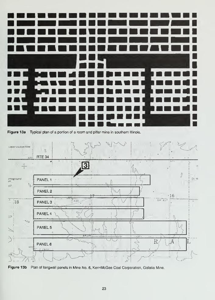
Figure 13a Typical plan of a portion of a room and pillar mine in southern Illinois.
^<l
Figure 13b Plan of longwall panels in Mine No. 6, Kerr-McGee Coal Corporation, Galatia Mine.
23
underlying "Springfield" peat from being contaminated by the sulfur from seawaters that eventu-
ally covered the Springfield (and many other coals such as the Herrin).
No. 6 Mine The No. 6 mine started production in September of 1985. The No. 6 mine has used
both longwall and room and pillar operations. Room and pillar mining is used in both mines wher-
ever conditions require that subsidence of the roof be prevented. Room and pillar mining leaves
about 50% of the available coal resource in the ground, and therefore, is less cost effective than
longwall mining. The longwall panels in the No. 6 Mine are 640 by 8,000 feet. Three-foot-deep
cuts are taken by the longwall mechanical shearer, and the mining in the panels is done by re-
treating from the coal face of the initial cut.
The Herrin (No. 6) Coal averages 6 feet thick and is about 450 feet deep, the depth increasing
toward the north. The Herrin Coal is a typical high-sulfur Illinois coal (2.4% or more). (The No. 6
coal here is much higher in sulfur content than the No. 5 coal.) Clean coal (as rated by the mine)
has a heating value of 1 1 ,659 Btu/lb with an average sulfur value of 2.42%. Production from the
No. 6 mine averaged 1 .5 million tons for the last 3 years.
The immediate roof of the coal consists of black Anna Shale that is 0.5 to 3 feet thick and may be
locally underlain by gray Energy Shale, 2 to 10 feet thick. The Brereton Limestone, 4 to 5 feet or
more thick, overlies the Anna Shale wherever the Energy Shale is absent. The Brereton Lime-
stone is in turn overlain by the Anvil Rock Sandstone, which is 30 to 40 feet thick. Shales, silt-
stones, sandstones, and thin coals and limestones make up the remainder of overlying rock up to
the surface.
The Anvil Rock Sandstone carries mineralized water, which causes a number of problems for the
mining operation, including weakening of the soft underclay floor of the No. 6 mine and the need
to pump the water out of the mine. In addition, the dissolved sodium chloride (NaCI) in the water
is quite corrosive. In the Herrin Coal, the mine has encountered large limestone inclusions called
coal balls. In some places the entire seam is taken up so completely by the coal balls that the
mine was forced to leave blocks of coal unmined.
0.0 10.85+ Leave Stop 2 and return to SR 34.
0.4+ 1 1 .25+ STOP: 1 -way at SR 34. TURN LEFT (east).
0.4 1 1 .7 Prepare to turn right.
0.1 + 11 .8+ TURN RIGHT (south) at T-intersection (1 600N\725E) on Lone Oak Road.
0.25 12.05+ PARK along the roadside. Do NOT block the road.
STOP 3 Ground subsidence above a longwall coal mine will be our topic of discussion. (West
side of the road. SE SE NW NW, Sec. 17. T8S. R6E, 3rd P.M.. Saline County; Galatia 7.5-Minute
Quadrangle [37088G5]).
The ISGS, under the Illinois Mine Subsidence Research Program (IMSRP), has been monitoring
bedrock fracturing and changes in hydrogeology associated with longwall coal mining and sub-
sequent planned subsidence over three panels of the No. 6 Mine of the Kerr-McGee Coal Cor-
poration Galatia Mine (fig. 13b panels 1-3). IMSRP staff have installed core holes and wells for
24
testing and monitoring. The various monitoring wells, located several feet east of the road, were
drilled into the bedrock or the glacial materials so that water levels could be monitored on a con-
tinuing basis. Surveying monuments were also installed so that changes in elevation of the
ground surface both during and after subsidence could be recorded.
The Galatia Mine longwall panels are operating in the Herrin No. 6 Coal seam at a depth of 350
to 400 feet. The longwall equipment removes all the coal from panels that are 660 to 940 feet
wide by 2 miles long. The machinery sweeps back and forth across the width of the panels. With
each pass, it removes a block of coal 3 feet wide by 6 feet high. Where the mining machinery is
operating, the mine roof is temporarily supported by moveable shields, providing a safe working
area for miners and equipment. When the shields are moved, the roof is intentionally allowed to
cave behind the working area. The resulting subsidence of the ground surface is 4.5 to 5 feet at
the center of the panel and 1 foot over the pillars left between the longwall panels. Under law, the
coal companies are responsible for mitigating problems resulting from subsidence at the ground
surface.
Here we are located about on the center line of Panel 1 (fig. 13b). The swales in the surface, to
the east and south, were there before mining. The releveled road and enhanced drainage along
the roadway are the most visible indicators of surface subsidence in this area.
0.0 12.05+ Leave Stop 3 and CONTINUE AHEAD (south).
0.25+ 12.3+ CAUTION: unguarded single track (IC) railroad crossing. CONTINUEAHEAD (south).
0.05+ 12.35+ T-road intersection (1550N\725E). TURN LEFT (northeast) on Lone Oak Road.
0.75+ 13.15 CAUTION: narrow culvert with unguarded sides.
0.05 1 3. 1 5+ Texas Eastern Transmission Corporation pipeline crossing.
0.45+ 13.65 T-road intersection (1450N\750E). TURN LEFT (east) on Strawberry Lane.
0.2+ 13.85+ Cross drainage ditch.
0.25+ 14.1+ PARK along the roadside. Do NOT block the road.
STOP 4 Glacial lake beds and some topographic features will be discussed at this site. (SESE SE NE, Sec. 20, T8S, R6E, 3rd P.M., Saline County; Galatia 7.5-Minute Quadrangle
[37088G5]).
As noted in the introduction, lllinoian glaciers apparently reached only the northern part of the
field trip area. Here we are along the glacial border. Prior to lllinoian glaciation, nearly 300,000years ago, the Saline River evidently flowed eastward along the north side of the ShawneetownHills before joining the Ohio River about 16 miles north and east of its present confluence. TheSaline River was much deeper then than it is now. The old valley was partly filled with outwashmaterials from the melting lllinoian glacier, but the river was unable to remove all of that debris.
Still later, Wisconsinan glaciers extended southward into Illinois and Indiana to about 115 miles
north of here. Tremendous volumes of meltwater coursed down the Wabash River valley from
the melting of both the Lake Michigan and Lake Erie glacial lobes, especially the latter. Fidlar
25
(1948) estimated that the Wabash River must have been at least 5 miles wide and 15 to 20 feet
deep throughout part of its course during the summers when melting was at a maximum.
During early Wisconsinan time, meltwater from the glacial lobes in Lakes Erie and Michigan car-
ried large quantities of outwash material down various drainageways. Deposition of these sedi-
ments farther downstream caused many of the tributary streams of the large drainageways to
pond and form extensive slackwater lakes. A large slackwater lake, Lake Saline, covered parts
of five counties in this region (see map of Quaternary Deposits of Illinois in the appendix. Pleisto-
cene Glaciations of Illinois). These lakes fluctuated in size throughout Wisconsinan time. Studies
of faint terraces along what must have been the Lake Saline shoreline suggest that the highest
lake level, nearly 400 feet, was attained during early Woodfordian time (about 20,000 radiocarbon
years B.P.). Although the lake held at this level for no more than 1 ,000 years, the sediment-
choked streams flowing into the lake supplied as much as 150 feet of sediment. The lake persist-
ed for 3,000 to 4,000 years. The high-level phase of Lake Saline ended during mid-Woodfordian
time when the major streams incised channels through the thick outwash fills, removing the barri-
ers that had produced the slackwater lakes. New drainage across the lake plain was established,
including the lower part of Saline River that now passes through the narrow area between Gold
Hill and Wildcat Hills.
Although subsequent outwash deposition caused lakes to form again, they never reached the
high levels of early Woodfordian time. Glacial Lake Maumee, the precursor to modern Lake Erie,
drained westward down the Wabash Valley about 14,000 years B.P. These flood waters eroded
a surface called the Maumee Terrace as they passed on both the east and west sides of the
Shawneetown Hills several miles east of here.
The former lake bed in the Saline River Valley still floods with Ohio River backwater from time to
time with the result that the Pleistocene lake sediments are veneered with thin alluvium of Holo-
cene age. The flood of 1937 is believed to have formed a lake approximately the size of the Wis-
consinan glacial lake that existed during the time of the Maumee Torrent.
The tall tower to the south is on the hill at Harrisburg, about 5 miles away. The shorelines of gla-
cial Lake Saline, as denoted on field maps by the late John C. Frye and Harold B. Willman, are
shown on the route maps. Here we are standing on the old lake bottom. The large hill barely vis-
ible in the distance to the left at about 30 minutes past 10 o'clock is Cave Hill; we will cross the
ridge on the south side of Cave Hill this afternoon.
0.0 14.1+ Leave Stop 4 and CONTINUE AHEAD (east).
0.25+ 14.35+ VIEW to the right is across the flat, low-lying glacial lake plain beyond the tank
batteries in the distance.
1 .25+ 15.65+ CAUTION: unguarded single track (IC) railroad crossing. T-intersection just
beyond tracks (1550N\850E). TURN RIGHT (east) on Strawberry Lane.
0.45+ 16.15+ STOP: 2-way at intersection (1550N\900E). TURN RIGHT (south) on SR 34.
0.05 16.2+ CAUTION: guarded single (IC) railroad track. CONTINUE AHEAD (south).
0.5 16.7+ VIEW to the left of some of the tank batteries and pumpjacks in the Raleigh
South oil field. To the left at about 30 minutes past 10 o'clock is the location
of Stop 1
.
26
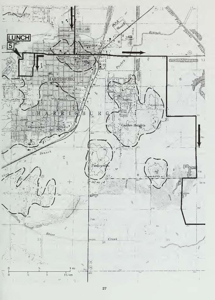
-XlBoi'H^H^ights "'•
'-
27
3.15+ 19.85+ Cross Middle Fork Saline River.
0.35+ 20.25 Cross Bankston Fork.
1 .0+ 21 .25+ CAUTION: enter Harrisburg through the levee gate.
1 .0+ 22.3 CAUTION: TRAFFIC LIGHT at Poplar Street. TURN RIGHT (west) on SR 13
(Poplar Street).
0.65+ 22.95+ T-intersection from left. TURN LEFT on South Capital Street.
0.4 23.35 TURN LEFT (west) on West Raymond Street.
0.1 23.45 CAUTION: entering Harrisburg Township District Park.
0.1+ 23.55+ STOP: 4-way. TURN RIGHT (north).
0.25+ 23.85 T-intersection. TURN RIGHT (east).
0.05+ 23.9+ CAUTION: intersection with South Herbert Street. CROSS street and PARKin designated areas at the Tom and Ruth Patton Pavilion. Do NOT block the
park roads. Mileage figures resume from this entrance.
STOP 5 Lunch.
0.0 23.9+ Leave Stop 5 and TURN RIGHT (north) on South Herbert Street.
0.1+ 24.0+ STOP: 1-way intersection with West Poplar Street (SR 13). TURN RIGHT (east).
0.85 24.85+ CAUTION: TRAFFIC LIGHT at Main Street. CONTINUE AHEAD (east) on SR 13.
0.4+ 25.25+ CAUTION: TRAFFIC LIGHT at Commercial Street (US 45). CONTINUE AHEAD(east) on SR 13.
0.1 25.35+ To the left is the site of O'Gara Coal Company Mine No. 2. This shaft mine
was 245 feet deep and recovered the Springfield Coal, which averaged some5 feet thick. The mine operated from 1904 to 1910.
0.45 25.8+ Cross over the top of the Harrisburg levee.
0.4 26.2+ Prepare to turn right.
0.1+ 26.35+ TURN RIGHT (south) at T-intersection of Shawnee Hills Road (950N\1050E).
0,4 26.75+ VIEW to left (east-southeast) of Cave Hill that we noted previously.
0.45+ 27.2+ T-road from right. CONTINUE AHEAD (south) on Waterhole Road. Just
ahead to the left, notice the flatness of the old lake bottom.
1 .35 28.55+ The area to the right is a long abandoned coal strip mine.
28

1 1%km
29
0.25 28.8+ STOP: 1 -way at Ingram Hill Road T-lntersection (750N\1 100E). TURN RIGHT(west).
0.2+ 29.05+ TURN LEFT (south) at Brier Creek Road T-lntersection (750N\1075E). This
area has been strip-mined and at least partially reclaimed.
1 .1 5+ 30.2+ CAUTION: narrow concrete culvert and just beyond is South Fork RoadT-intersection (675N\1 125E). CONTINUE AHEAD (south).
0.7+ 30.95+ CAUTION: unguarded T-intersection with Whitesville Road (600N\1 125E).
The stop sign appears to have been torn down on the southwest corner. TURNLEFT (east).
1 .75+ 32.7+ Cross South Fork Saline River. This stream was partially straightened a
number of years ago.
0.3+ 33.05+ Horseshoe Road T-intersection from left (565N\1 31 OE). CONTINUE AHEAD(southeast) on Whitesville Road through an adandoned strip-mined area.
0.45+ 33.7+ Saline County Landfill to the right. The landfill is in the abandoned SomersetCoal Mine, Saxton Coal Company. Two coals were exposed in the highwall
west of the road. The upper coal was the Dekoven and the lower one was the
Davis. Because these two coals are so remarkably persistent in Saline and
Gallatin Counties, they were strip-mined wherever they were close to the
surface. To the east and north, these coals thin rapidly and become almost
unrecognizable.
In this area, the Dekoven occurs, on average, about 250 feet deeper than the
Springfield Coal. The Dekoven and Davis are brought close to the surface
here because of folding and faulting of strata along the Shawneetown-RoughCreek Fault Zone. About 5 miles north of this locality, the Dekoven is about
560 feet below the surface.
0.65 34.15+ T-intersection with Stoneface Road (450N\1325E). TURN RIGHT (west).
0.7+ 34.9+ CAUTION: TURN RIGHT and cross drainage ditch.
1.0 35.9+ STOP: 1 -way at crossroad (350N\1250E). TURN LEFT (east) on De Neal Road.
1.1+ 37.05 PARK along the roadside. CAUTION: there is very little shoulder to park on.
Watch out for FAST TRAFFIC. Do NOT block the road. NOTE: do NOTcross fences!
STOP 6 We'll examine the upper Tradewater Formation Curlew Limestone (Pennsylvanian).
(NE NE SE NW, Sec. 17. T10S, R7E, 3rd P.M., Saline County; Rudement 7.5-Minute Ouadrangle
(37088F4]).
The Curlew Limestone is exposed on both sides of the road here. Much of this marine limestone
has been dissolved away, and a chert residuum has been left behind in this area. The pieces of
cherl commonly contain excellent molds of fossils, especially brachiopods. bryozoan fragments,
and crinoid columnals. Less common are corals, pelecypods. and sponges. (Note the fossil
plates in the appendix, Deposilional History of the Pennsylvanian Rocks.)
30

31

0.0 37.05
0.05 37.05+
0.75 37.8+
0.95+ 38.8
Leave stop 6 and CONTINUE AHEAD (north).
CAUTION: T-lntersection from right of Somerset and DeNeal Roads(375N\1350E). CONTINUE AHEAD (north).
CAUTION: T-intersection with Stoneface Road (450N\1350E).
Stoneface Lane to the right (450N\1 450E). CONTINUE AHEAD (east andthen north).
1.4+ 40.25+ Eagle Mountain T-intersection to the right (565N\1 51 OE). CONTINUE AHEAD(northeast).
0.15 40.4+ The area to the left is a reclaimed strip mine.
0.1 5+ 40.55+ STOP: 1 -way at Horseshoe Road (600N\1 51 5E). BEAR RIGHT (northeast).
0.4 40.95+ R-intersection with Rocky Branch Road (635N\1 540E). CONTINUE AHEAD(northeast) on Horseshoe Road.
0.05+ 41.05+ Entrance to Sulphur Springs Baptist Church lies to the right. A cave in the
Mississippian Kinkaid Limestone is located in the bluff about 1/2 mile behind
the church.
0.85 41.9+ CAUTION: narrow wooden bridge.
0.3+ 42.25 Mississippian Chesterian sandstone (quartzite) exposed in a readout.
1 .1 5+ 43.45 TURN LEFT (north) into the parking area and PARK. Walk north and east
following the lane across the creek and around the east end of the small hill;
the abandoned quarry is on the north side. CAUTION: luxuriant poison ivy!
STOP 7 Lower Mississippian Fort Payne Formation and Upper Devonian New Albany Shale
Group strata are exposed here in the Horseshoe Quarry. The Devonian strata are the oldest
rocks exposed on the field trip. (WV2 NW NE, Sec. 36, T9S, R7E, 3rd P.M., Saline County; Rude-
ment 7.5-Minute Ouadrangle [37088F4]).
About 200 feet of the Mississippian Fort Payne Formation is exposed in this quarry in a fault
block within the Shawneetown Fault Zone (fig. 14). Below the Fort Payne, several feet of the Up-
per Devonian New Albany Shale Group is exposed along the north side of the quarry.
The Fort Payne, as exposed here, consists of highly shattered, siliceous shale and limestone that
were quarried here for use as road stone. At depth, however, the Fort Payne consists of calcare-
ous siltstone and limestone. Apparently weathering has resulted in slliclflcation (replacement by
silica) of these rocks at the surface. The New Albany, which consists of thin bedded black shale,
has also been silicified.
The greatest known amount of displacement along the Shawneetown Fault has occurred at this
locality. The Now Albany Shale occurs at a depth of about 3,700 feet below the surface on the
north side of the fault. This block was pushed up during a great thrusting movement along the
32
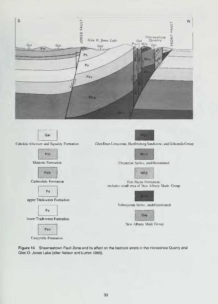
N3<
O Glen 0. Jones Lake
3<
Horseshoe 2Qai Quarry o
Pcvl M.ts Qa,
Qal
Cahokia Alluvium and Equality Formation
Pnn
Modesto Formation
Pcb
Carbondale Formation
Ps
upper Tradewater Formation
Pa
lower Tradewater Formation
Pcv
Glen Dean Limestone. Hardinsburg Sandstone, and Golconda Group
Chesterian Series, undifferentiated
1Fort Payne Formation;
includes small area of New Albany Shale Group
Valmeyeran Series, undifferentiated
Dna
New Albany Shale Group
Caseyville Formation
Figure 14 Shawneetown Fault Zone and its effect on the bedrock strata in the Horseshoe Quarry and
Glen O. Jones Lake (after Nelson and Lumm 1986).
33

fault and tilted backward at the same time. The strata here dip at about 75°. The rocks are
highly crushed and fractured as a result of the faulting.
0.0 43.45 Leave Stop 7 and CONTINUE AHEAD (east).
0.3+ 43.75+ STOP: 1 -way at T-intersection with Forest Road (670N\1 790E). TURN RIGHT(west and then south) towards Glen O. Jones Lake.
0.4+ 44.15+ Pennsylvanian Murray Bluff Sandstone exposed in the readout to right. Thesandstone dips 10° south Into the Eagle Valley Syncline.
0.05 44.2 TURN RIGHT (west-southwest) at T-intersection with Eagle Creek Road(630N\1785E) toward Glen O. Jones Lake.
0.05 44.25 To the right is the entrance (625N\1 780E) to the Saline County State Fish andWildlife area, Glen O. Jones Lake. CONTINUE AHEAD (south) on Eagle
Creek Road.
0.05+ 44.3+ CAUTION: narrow concrete culvert.
1 ,1 45.45+ We're crossing the approximate position of the axis of the Eagle Valley Syncline.
0.95 46.4+ The area on both sides of the road has been strip-mined for the Springfield andHerrin Coals.
0.1+ 46.55 T-intersection to right, Jones Cemetery Road (450N\1700E). The church to
the right on the northwest corner of this intersection is the Social Brethren
Church. This is the starting congregation for that denomination. CONTINUEAHEAD (south).
0.5 47.05 T-intersection with Highline Road (400N\1700E). TURN RIGHT (west) on
Highline Road. CAUTION: the rough road ahead is slick when wet and maywell be impassable.
NOTE: In the event that weather conditions have made Highline Roadimpassable, turn to the end of this itinerary for an alternate routing.
0.75+ 47.8+ PARK along the primitive roadside. CAUTION: do NOT get stuck. Stay AWAYfrom the water, it is deep. DO NOT THROW rocks!
STOP 8 Highwall exposure shows the Dekoven Coal and overlying Colchester Coal in the
abandoned strip mine of the J. W. Coal Company. (WV2 NE NW. Sec. 14, TIGS, R7E. 3rd P.M..
Saline County; Rudement 7.5-Minute Ouadrangle [37088F4]).
J. W. Coal Company operated a strip mine in this area from 1959 to 1965 and left this highwall ex-
posure in their final cut. The mine recovered the Davis and Dekoven Coal Members of the Car-
bondale Formation. In the highwall, strata from just above the Colchester Coal to just below the
Dekoven Coal are exposed. The Davis Coal is somewhere below water level in the flooded pit
here.
34

v-^ *
Btue
^fiL<
/
W.
wm
e«^
- -J
^
VAO
Jm.^/v...
^y^-
O,
Eagle'
^
VyO RiE S T
^^i^J >.-\V
y. imi .l!:^^^i^\ *(
mitMu,u
h
t^<Co %> Cam
>" Co!b*t
'/21 r/jkm
t/;
35
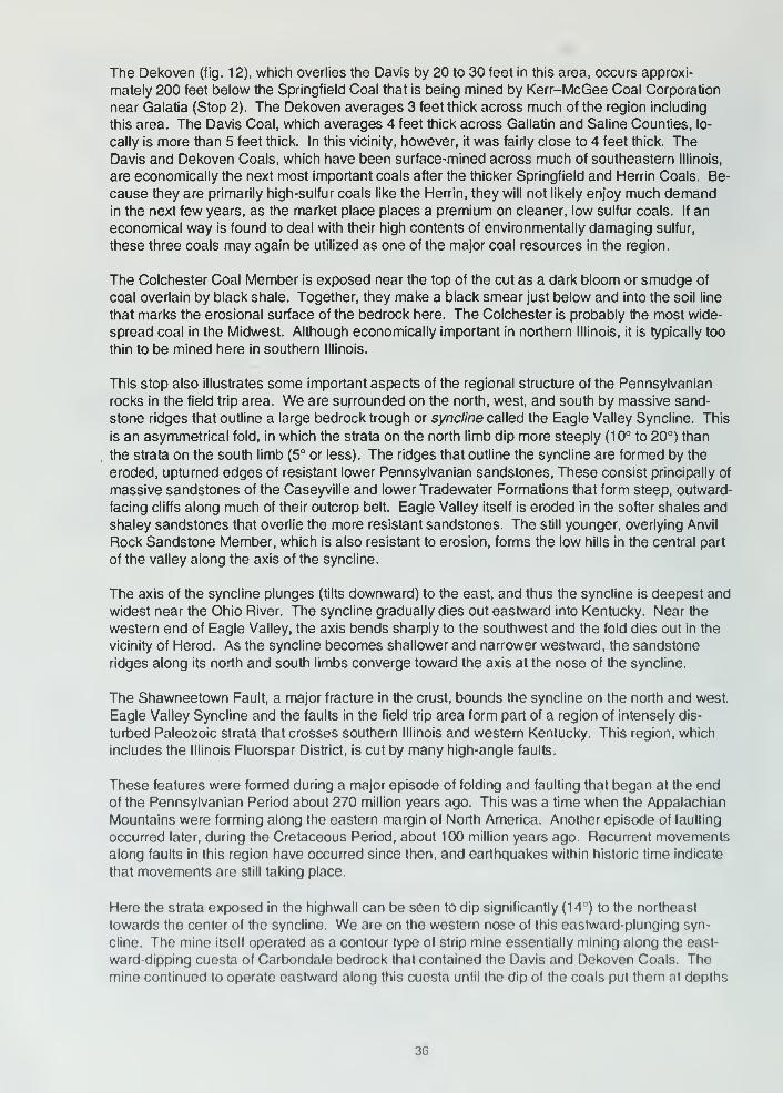
The Dekoven (fig. 12), which overlies the Davis by 20 to 30 feet in this area, occurs approxi-
mately 200 feet below the Springfield Coal that is being mined by Kerr-McGee Coal Corporation
near Galatia (Stop 2). The Dekoven averages 3 feet thick across much of the region including
this area. The Davis Coal, which averages 4 feet thick across Gallatin and Saline Counties, lo-
cally is more than 5 feet thick. In this vicinity, however, it was fairly close to 4 feet thick. TheDavis and Dekoven Coals, which have been surface-mined across much of southeastern Illinois,
are economically the next most important coals after the thicker Springfield and Herrin Coals. Be-
cause they are primarily high-sulfur coals like the Herrin, they will not likely enjoy much demandin the next few years, as the market place places a premium on cleaner, low sulfur coals. If an
economical way is found to deal with their high contents of environmentally damaging sulfur,
these three coals may again be utilized as one of the major coal resources in the region.
The Colchester Coal Member is exposed near the top of the cut as a dark bloom or smudge of
coal overlain by black shale. Together, they make a black smear just below and into the soil line
that marks the erosional surface of the bedrock here. The Colchester is probably the most wide-
spread coal in the Midwest. Although economically important in northern Illinois, it is typically too
thin to be mined here in southern Illinois.
This stop also illustrates some important aspects of the regional structure of the Pennsylvanian
rocks in the field trip area. We are surrounded on the north, west, and south by massive sand-
stone ridges that outline a large bedrock trough or syncline called the Eagle Valley Syncline. This
is an asymmetrical fold, in which the strata on the north limb dip more steeply (10° to 20°) than
the strata on the south limb (5° or less). The ridges that outline the syncline are formed by the
eroded, upturned edges of resistant lower Pennsylvanian sandstones. These consist principally of
massive sandstones of the Caseyville and lower Tradewater Formations that form steep, outward-
facing cliffs along much of their outcrop belt. Eagle Valley itself is eroded in the softer shales and
shaley sandstones that overlie the more resistant sandstones. The still younger, overlying Anvil
Rock Sandstone Member, which is also resistant to erosion, forms the low hills in the central part
of the valley along the axis of the syncline.
The axis of the syncline plunges (tilts downward) to the east, and thus the syncline is deepest and
widest near the Ohio River. The syncline gradually dies out eastward into Kentucky. Near the
western end of Eagle Valley, the axis bends sharply to the southwest and the fold dies out in the
vicinity of Herod. As the syncline becomes shallower and narrower westward, the sandstone
ridges along its north and south limbs converge toward the axis at the nose of the syncline.
The Shawneetown Fault, a major fracture in the crust, bounds the syncline on the north and west.
Eagle Valley Syncline and the faults in the field trip area form part of a region of intensely dis-
turbed Paleozoic strata that crosses southern Illinois and western Kentucky. This region, which
includes the Illinois Fluorspar District, is cut by many high-angle faults.
These features were formed during a major episode of folding and faulting that began at the endof the Pennsylvanian Period about 270 million years ago. This was a time when the Appalachian
Mountains were forming along the eastern margin of North America. Another episode of faulting
occurred later, during the Cretaceous Period, about 100 million years ago. Recurrent movementsalong faults in this region have occurred since then, and earthquakes within historic time indicate
that movements are still taking place.
Here the strata exposed in the highwall can be seen to dip significantly (14") to the northeast
towards the center of the syncline. We are on the western nose of this eastward-plunging syn-
cline. The mine itself operated as a contour type of strip mine essentially mining along the east-
ward-dipping cuesta of Carbondale bedrock that contained the Davis and Dekoven Coals. The
mine continued to operate eastward along this cuesta until the dip ol the coals put them at depths
36
that were not economical for recovery. The mining of the Davis and Del<oven has been under-
taken all along this cuesta, both to the north and south of here for several miles and then east-
ward as the cuesta curves to an east-west strike along the south flank of the syncline. Just south
of here across Rose Creek, J. J. Track Mining Company operated the Brown Brothers Mine No. 3
from 1985 to 1988 along a portion of the north-south-striking cuesta that J. W. Coal Company had
not mined. The dragline from this latter operation can still be seen to the east. South and east of
this location, up until 1990, Jader Fuel Company had been mining the Davis and Dekoven in sur-
face operations along the east-striking cuesta of Carbondale strata.
0.0 47.8+ Leave Stop 8 and CONTINUE AHEAD (west). CAUTION: when wet the road
can be muddy and slick with deep ruts.
0.2+ 48.05 CAUTION: ford tributary to Rose Creek.
0.05+ 48.1+ T-intersection with Eagle Mountain Road (385N\1600E). TURN RIGHT (north).
0.1 + 48.2+ Cross creek and prepare to ascend the Pennsylvanian cuesta.
1 .1 5 49.35+ Cross the crest of the cuesta. This is the highest elevation on the field trip
route, 780+ feet msl. There are several vantage points along the route ahead
where you can get a panoramic view to the left (west). CAUTION: the road is
rough from rock ledges and erosion. The roadstone is coarse and loose.
1 .1 5 50.5 PARK along the roadside. Do NOT block the road.
STOP 9 An abandoned quarry exposure of the upper Mississippian (Chesterian) Kinkaid Lime-
stone Formation appears at this site. (SV2 NE SW NW and SE SW NW, Sec. 3, T10S, R7E, 3rd
P.M., Saline County; Rudement 7.5-Minute Quadrangle [37088F4]).
About 20 feet of the Negli Creek Limestone Member, the lowermost member of the Kinkaid Lime-
stone, is exposed in this abandoned quarry. The exposure is in still another upthrown fault block
along the front of Cave Hill. The block is tilted eastward at about 15°. The Negli Creek is gray,
fine to coarse grained, dense, thick bedded to massive, and fossiliferous. It is somewhat argil-
laceous with shaly partings along bedding planes. The upper 3 feet of the ledge is coarsely crys-
talline and very fossiliferous.
The shale above the bench is the Cave Hill Shale Member of the Kinkaid Limestone. The lower 3
feet of the shale contains thin limestone beds that are about 6 inches thick and extremely fossilif-
erous. Excellent specimens of brachiopods (Composita), bryozoans {Archimedes, Rhombopora,
and Fenestrellina), and crinoid stems can be collected from the shale. A plate illustrating sometypical Mississippian fossils is provided in the back of this guidebook.
0.0 50.5+ Leave Stop 9 and CONTINUE AHEAD (west) downhill with CAUTION!
0.3 50.8+ STOP: 1-way, even though not posted, at T-intersection with Stoneface Road(565N\1510E). CAUTION: poor visibility and fast traffic. TURN LEFT (south)
on Stoneface Road.
37
1 .45+ 52.25+ T-intersection with Stoneface Lane to left (450N\1 450E). TURN LEFT (south).
CAUTION: narrow road.
0.35+ 52.65 PARK in the parking area or along the roadside. Do NOT block the road.
You cannot see Old Stone Face from the parking area.
• Leave footprints only.
• Follow the path to the left to the top of the bluff and Old Stone Face.
• Follow the path to the right for a view of Old Stone Face from below if you
cannot climb to the top.
DO NOT try to scale the cliff, stand too close to the edge of the cliff, or throw
anything over the edge of the cliff!!
STOP 1 We'll view Old Stone Face and the surrounding countryside from the top of the cliff.
(Parking area, NW SW SE, Sec. 9, T10S, R7E, 3rd P.M., Saline County; Rudement 7.5-Minute
Quadrangle [37088F4]).
Old Stone Face, one of the best known natural wonders of southern Illinois, is located on the
southwestern edge of Cave Hill about 730 feet msl. The cliff affords a magnificent view to the
north and west overlooking low-lying areas about 350 feet below.
The sheer cliff into which Old Stone Face has been carved by weathering consists of the mas-
sive, crossbedded Pounds Sandstone Member of the Caseyville Formation (Pennsylvanian) (fig.
2). It consists of fairly pure, slightly micaceous, quartz sandstone containing numerous white
rounded quartz pebbles. The sandstone is about 100 feet thick in the field trip area.
The sandstones of the Caseyville are very resistant to erosion, and wherever they are exposed,
they are cliff-formers. The sandstones are river channel sands laid down by an ancient Pennsyl-
vanian river system that crossed this part of Illinois from northeast to southwest. Structures
formed by the river currents, including wedge-shaped crossbedding and ripple marks, are well de-
veloped in the Pounds here and may be easily studied along the pathways. The purity and
coarseness of the sandstones indicate that the currents were swift.
Cave Hill forms an erosional fault scarp at the west end of Eagle Valley. In this locality, the strati-
graphic displacement on the Shawneetown Fault is more than 700 feet. The Pounds Sandstone
lies 500 feet below the lowlands west of Cave Hill.
End of the field trip to the Harrisburg area.
Join us on future trips!
NOTE The following is an alternate route for Stop 8, starting at Highline
Road, in case of inclement weather.
0.0 0.0 New mileage figure at the T-intersection of Eagle Creek and Highline Roads(400N\1700E). CONTINUE AHEAD (south) on Eagle Creek Road. To the
right at about 2 o'clock is a dragline sitting in a large area spoil piles. That
area was surface-mined for the Davis and Dekoven Coals.
36
0.4 0.4
0.15+ 0.55+
0.85+ 1.45+
0.05+ 1.5+
0.15+ 1.65+
0.45 2.1 +
0.2 2.3+
0.55 2.85+
CAUTION: narrow culvert. Cross Rose Creek.
CAUTION: cross Eagle Creek.
Y-intersection. BEAR RIGHT (south) down the hill.
STOP: 1-way at Gape Hollow Road even though not posted. CAUTION:limited visibility. Watch for fast, large coal haulers bearing down from your left.
BEAR RIGHT (south) onto blacktop.
CURVE RIGHT (west) on the blacktop at the intersection (250N\1725E).
Colbert Cemetery to the right.
CURVE RIGHT (west) at intersection (210N\1700E).
CAUTION: unmarked culvert across Eagle Creek. Enter an area just beyond
the culvert that has been stripped for Davis and Dekoven Coals.
0.15 3.05+ CAUTION: pull off, the road and up the ramp to PARK (IF YOU HAVEPERMISSION) at Jader Fuel Company 4, Permit 140. This will be Alternate
Stop 8. The elements present here are much the same as at Stop 8 except
for the dipping strata.
Leave Alternate Stop 8 and CONTINUE AHEAD (southwest).
Y-intersection on a curve (175N\1600E). BEAR RIGHT (west and then north)
on Eagle Mountain Road. NOTE: the road ahead is narrow with narrow,
dangerous "shoulders."
CAUTION: unmarked culvert.
CAUTION: unmarked culvert.
CAUTION: unmarked culvert.
CAUTION: unmarked culvert.
CAUTION: unmarked culvert.
CAUTION: unmarked culvert.
CAUTION: ford creek (a ti-ibutary to Rose Creek).
CAUTION: ford creek (another Rose Creek tributary).
T-road intersection from right (385N\1600E) at Highline Road.
End of alternate route
0.0 3.05+
0.4 3.45+
1.15 4.6+
0.15 4.75+
0.15+ 4.9+
0.2+ 5.15+
0.1 5.25+
0.05+ 5.3+
0.05+ 5.4+
0.05+ 5.45+
0.3 5.75+
39
BIBLIOGRAPHY
Bhagwat, S. B., 1987, The Future of Illinois Coal: 1994 and Beyond: Illinois State Geological Sur-
vey, Illinois Mineral Notes 97, 25 p.
Bonnell, Clarence, 1946, The Illinois Ozarks: (privately published), 156 p.
Cady, G. H., 1952, Minable Coal Resources of Illinois: Illinois State Geological Survey, Bulletin
78, 138 p.
Cote, W. E., D. L. Reinertsen, and M. M. Killey, 1969, Equality Area: Illinois State Geological Sur-
vey, Geological Science Field Trip Guide Leaflet 1969A and F, 31 p.
Bamberger, H. H., et al., 1984, Coal Industry in Illinois: Illinois State Geological Survey Map,
scale 1 :500,000, size 30'50 inches, color.
Fidlar, M. M., 1948, Physiography of the Lower Wabash Valley: Indiana Geological Survey, Bulle-
tin 2, 112 p.
Frye, J. C, and H. B. Willman, 1970, Pleistocene Stratigraphy of Illinois: Illinois State Geological
Survey, Bulletin 94, 204 p.
Frye, J. C, A. B. Leonard, H. B. Willman, and H. D. Glass, 1972, Geology and Paleontology of
Late Pleistocene Lake Saline, Southeastern Illinois: Illinois State Geological Survey, Circular
471 , 44 p.
Green, P., 1985, Kerr-McGee Mines twin seams: Coal Age, v. 90, no. 2, February, p. 82-85.
Harris, S. E., Jr., C. W. Horrell, and D. Irwin, 1977, Exploring the Land and Rocks of Southern Illi-
nois: Southern Illinois University Press, Carbondale and Edwardsville, 240 p.
Horberg, C. L., 1946, Preglacial erosion surfaces in Illinois: Journal of Geology, v. 54, no. 3, p.
179-192.
Horberg, C. L., 1950, Bedrock Topography of Illinois: Illinois State Geological Survey, Bulletin 73,
111 p.
Howard, R. H., 1967, Oil and Gas Pay Maps of Illinois: Illinois State Geological Survey, Illinois Pe-
troleum 84, 64 p.
Jacobson, R. J., 1992, Geology of the Goreville Quadrangle, Johnson and Williamson Counties,
Illinois: Illinois State Geological Survey, Bulletin 97, 32 p.
Leighton, M. M., G. E. Ekblaw, and C. L. Horberg, 1948, Physiographic Divisions of Illinois: Illinois
State Geological Survey, Report of Investigations 129, 19 p.
Leighton, M. W., D. R. Kolata, D. F. Oltz, and J. J. Eidel (eds), 1991, Interior Cratonic Basins:
American Association of Petroleum Geologists, Tulsa, Oklahoma, Memoir 51 , 819 p.
Lineback, J. A., and others, 1979, Quaternary Deposits of Illinois: Illinois State Geological Survey
Map, scale 1:500,000, size 40x60 inches, color.
Nelson, W. J., and D. K. Lumm, 1986, Geologic Map of the Equality Quadrangle, Gallatin and Sa-
line Counties, Illinois: Illinois State Geological Survey, Illinois Geologic Quadrangle 2, scale
1 :24.000.
Nelson, W. J., and D. K. Lumm, 1986, Geologic Map of the Rudement Quadrangle, Saline
County, Illinois: Illinois State Geological Survey, Illinois Geologic Quadrangle 3, scale
1 :24,000.
Nelson, W. J., and D. K. Lumm, 1987, Structural Geology of Southeastern Illinois and Vicinity: Illi-
nois State Geological Survey, Circular 538, 70 p.
MacClintock, P., 1929, 1. Physiographic Divisions of the Area Covered by the lllinoian Drift Sheet
in Southern Illinois: II. Recent Discoveries of Pre-lllinoian Drift in Southern Illinois: Illinois
State Geological Survey, Report of Investigations 19. 57 p.
Odom, I. E., and G. Dow, 1960, Harrisburg Area: Illinois State Geological Survey, Geological Sci-
ence Field Trip Guide Leaflet 1960F, 12 p. plus attachments.
Piskin. K., ahd R. E. Bergstrom, 1975, Glacial Drift in Illinois: Thickness and Character: Illinois
State Geological Survey, Circular 490, 35 p.
Pryor, W. A., 1956, Groundwater Geology in Southern Illinois: A Preliminary Geologic Report: Illi-
nois State Geological Survey, Circular 212. 25 p.
Raasch. G. O., 1951 . Harrisburg Area: Illinois State Geological Survey. Geological Science Field
Trip Guide Leaflet 1951 A. 13 p. plus attachments.
40
Raasch, G. O., 1952, Eldorado Area: Illinois State Geological Survey, Geological Science Field
Trip Guide Leaflet 1952A, 15 p. plus attachments.
Reinertsen, D. L., 1980, A Guide to the Geology of the Equality Area: Illinois State Geological Sur-
vey, Geological Science Field Trip Guide Leaflet 1980A, 32 p. plus attachments.
Reinertsen, D. L., 1988, A Guide to the Geology of the Shawneetown Area, Gallatin County: Illi-
nois State Geological Survey, Geological Science Field Trip Leaflet 1988A, 35 p. plus attach-
ments.
Samson, I. E., 1992, Illinois Mineral Industry in 1990 and Review of Preliminary Mineral Produc-
tion Data for 1991 : Illinois State Geological Survey, Illinois Minerals 1 10, 43 p.
Smith, W. H., 1957, Strippable Coal Reserves of Illinois: Part 1—Gallatin, Hardin, Johnson, Pope,
Saline and Williamson Counties: Illinois State Geological Survey, Circular 228, 39 p.
Swann, D. H., 1964, Late Mississippian Rhythmic Sediments of Mississippi Valley: American As-
sociation of Petroleum Geologists Bulletin, v. 48, no. 5, May, p. 637-658.
Treworgy, C. G., L. E. Bengal, and A. G. Dingwell, 1978, Reserves and Resources of Surface-
Minable Coal in Illinois: Illinois State Geological Survey, Circular 504, 44 p.
Treworgy, C. G., and M. H. Bargh, 1982, Deep-Minable Coal Resources of Illinois: Illinois State
Geological Survey Circular 527, 65 p.
Treworgy, J. D., 1981, Structural Features in Illinois: A Compendium: Illinois State Geological Sur-
vey, Circular 519, 22 p.
Treworgy, J. D., and M. H. Bargh, 1984, Coal Resources of Illinois: Springfield (No. 5) Coal: Illi-
nois State Geological Survey Map, scale 1 :500,000, size 30x50 inches, color.
Treworgy, J. D., and M. H. Bargh, 1984, Coal Resources of Illinois: Herrin (No. 6) Coal: Illinois
State Geological Survey Map, scale 1 :500,000, size 30x50 inches, color.
Treworgy, J. D., and M. H. Bargh, 1984, Coal Resources of Illinois: Davis, Murphysboro, and See-
lyville, with Assumption, Bell, Houchin Creek—Formerly Summum (No. 4), Litchfield, Coals
near Makanda, Mt. Rorah, New Burnside, Reynoldsburg, Rock Island (No. 1), "Seahorne,"
Servant—Formerly Shawneetown, Wiley, Willis, and Wise Ridge Coals: Illinois State Geologi-
cal Survey Map, scale 1 :500,000, size 30x50 inches, color.
Wayne, W. J., 1952, Pleistocene evolution of the Ohio and Wabash Valleys: Journal of Geology,
V. 60, no. 6, November, p. 575-585.
Willman, H. B., and others, 1967, Geologic Map of Illinois: Illinois State Geological Survey Map,
scale 1 :500,000, size 40x56 inches, color.
Willman, H. B., J. A. Simon, B. M. Lynch, and V. A. Langenheim, 1968, Bibliography and Index of
Illinois Geology through 1965: Illinois State Geological Survey, Bulletin 92, 373 p.
Willman, H. B., E. Atherton. T. C. Buschbach, C. W. Collinson, J. C. Frye, M. E. Hopkins, J. A.
Lineback, and J. A. Simon, 1975, Handbook of Illinois Stratigraphy: Illinois State Geological
Survey, Bulletin 95, 261 p.
Willman, H.B., and J.C. Frye, 1980, The Glacial Boundary in Southern Illinois: Illinois State Geo-logical Survey, Circular 51 1 , 23 p.
Wright, A., 1985, A $50-million washing machine on-line at Galatia: Coal Age, v. 90, no. 2, Febru-
ary, p. 85-92.
41
GLOSSARY
Several sources were used for the definitions, but the main reference is the Glossary of Geology,
edited by Robert L. Bates and Julie A. Jackson (American Geological Institute, 1987).
Age — An interval of geologic time; a division of an epoch.
Alluviated valley— One that has been at least partly filled with sand, silt, and mud by flowing
water.
Alluvium — A general term for clay, silt, sand, gravel, or similar unconsolidated detrital material
deposited during comparatively recent time by a stream or other body of running water as a
sorted or semisorted sediment in the bed of a stream or on its floodplain or delta.
Anticline— A convex upward rock fold in which strata have been bent into an arch; the strata on
each side of the core of the arch are inclined in opposite directions away from the axis or
crest; the core contains rocks older than those on the perimeter of the structure.
Aquifer— A geologic formation that is water-bearing and transmits water from one point to an-
other.
Argillaceous— Largely composed of clay-sized particles or clay minerals.
Bed— A naturally occurring layer of earth material of relatively greater horizontal than vertical ex-
tent; it is characterized by a change in physical properties from overlying and underlying mate-
rials. It also is the ground upon which any body of water rests or has rested; the land covered
by the waters of a stream, lake, or ocean; or the bottom of a watercourse or stream channel.
Bedrock— The solid rock underlying the unconsolidated (non-indurated) surface materials such
as soil, sand, gravel, and glacial till.
Bedrock valley— A drainageway eroded into the solid bedrock beneath the surface materials. It
may be completely filled with unconsolidated (non-indurated) materials and hidden from view.
Braided stream— A low gradient, low volume stream flowing through an intricate network of inter-
lacing shallow channels that repeatedly merge and divide, and are separated from each other
by branch islands or channel bars. Such a stream may be incapable of carrying all of its load.
Calcarenite — Limestone composed of sand-sized grains consisting of more or less worn shell
fragments or pieces of older limestone; a clastic limestone.
Calcareous — Containing calcium carbonate (CaCOs); limy.
Calcite— A common rock-forming mineral consisting of CaCOa; it may be white, colorless, or
pale shades of gray, yellow, and blue; it has perfect rhombohedral cleavage, appears vitre-
ous, and has a hardness of 3 on the Mohs' scale; it effervesces (fizzes) readily in cold dilute
hydrochloric acid. It is the principal constituent of limestone.
Chert— Silicon dioxide (Si02); a compact, massive rock composed of minute particles of quartz
and/or chalcedony; it is similar to flint but lighter in color.
Clastic— Fragmental rock composed of detritus, including broken organic hard parts as well as
rock substances of any sort.
Closure — The difference in altitude between the crest of a dome or anticline and the lowest con-
tour that completely surrounds it.
Concretion — A hard, compact, commonly rounded (but also disk-shaped or irregular in form)
mass or aggregate of mineral matter; usually of a composition widely different from that of the
rock in which it is found.
Crystalline — Said of a rock consisting wholly of crystals or fragments of crystals; esp. said of an
igneous rock developed through cooling from a molten state and containing no glass, or of a
metamorphic rock that has undergone recrystallization.
Cuesta — An asymmetrical hill or ridge with a long, gentle (back or dip) slope conforming with the
resistant bed(s) that form it on one side, and a steep (scarp) slope or cliff on the other;
formed by the outcrop of the resistant bed(s).
Delia — A low, nearly flat, alluvial land deposited at or near the mouth of a river where it enters a
body of standing water; commonly a triangular or fan-shaped plain sometimes extending be-
yond the general trend of the coastline.
Detritus — Material produced by mechanical disintegration.
42
Diamictite— A comprehensive, nongenetic term.. .for a nonsorted or poorly sorted, noncal-
careous, terrigenous sedimentary rock that contains a wide range of particle sizes, such as a
rock with sand and/or larger particles in a muddy matrix; e.g. a tillite or a pebbly mudstone.
Diamicton— A general term. ..for the nonlithified equivalent of a diamictite; e.g. a till.
Disconfonriity— An unconfonvity marked by a distinct erosion-produced, irregular, uneven sur-
face of appreciable relief between parallel strata below and above the break; sometimes rep-
resents a considerable interval of nondeposition.
Dolomite — A mineral, calcium-magnesium carbonate (CaMg(C03)2; applied to those sedimen-
tary rocks that are composed largely of the mineral dolomite; it is also precipitated directly
from seawater. It is white, colorless, or tinged yellow, brown, pink, or gray, and has perfect
rhombohedral cleavage; it appears pearly to vitreous, and effervesces feebly in cold dilute hy-
drochloric acid.
Drift— All rock material transported by a glacier and deposited either directly by the ice or re-
worked and deposited by meltwater streams and/or the wind.
End moraine — A ridge-like or series of ridge-like accumulations of drift that develop along the
margin of an actively flowing glacier at any given time; a moraine that has been deposited at
the lower or outer end of a glacier.
Eon — The largest division of geologic time; it consists of two or more eras.
Epocli— An interval of geologic time; a division of a period.
Era— A unit of geologic time that is next in magnitude beneath an eon; consists of two or more
periods.
Fault— A fracture surface or zone in earth materials along which there has been vertical and/or
horizontal displacement or movement of the strata on both sides relative to one another.
Ferruginous— Pertaining to or containing iron, e.g., a sandstone that is cemented with iron oxide.
Floodplain— The surface or strip of relatively smooth land that lies adjacent to a stream channel
and has been produced by stream erosion and deposition; the area covered with water whenthe stream overflows its banks at times of high water; it is built of alluvium carried by the
stream during floods and deposited in the sluggish water beyond the influence of the swiftest
current.
Fluvial— Of or pertaining to a river or rivers.
Fluviolacustrine— Pertains to sedimentation partly in lake water and partly in streams, or to sedi-
ments deposited under alternating or overlapping lacustrine and fluvial conditions.
Formation— The basic rock unit distinctive enough to be readily recognizable in the field and
widespread and thick enough to be plotted on a map. It describes the strata, such as lime-
stone, sandstone, shale, or combinations of these and other rock types; formations have for-
mal names, such as Joliet Formation or St. Louis Limestone (Formation), which are usually
derived from geographic localities.
Geologic column— a chart that shows the subdivisions of part or all of geologic time or the se-
quence of stratigraphic units (oldest at the bottom and youngest at the top) of a given place
or region.
Geophysics— Study of the earth by quantitative physical methods.
Glacier— A large, slow-moving mass of ice at least in part on land.
Graben —An elongate, relatively depressed crustal unit or block that is bounded by faults on its
long sides. It is a structural form that may or may not be geomorphologically expressed as a
rift valley.
Gradient— A part of a surface feature of the earth that slopes upward or downward; a slope, as
of a stream channel or of a land surface.
Ground mora/ne —A sheet-like accumulation of glacial drift, principally till, deposited beneath a
glacier to form an extensive area of low relief devoid of transverse linear features.
Groundwater— Water that is present below the ground surface in the soil and rocks of the
earth's outer crust.
Group— A geologic rock unit consisting of two or more formations.
Hydrogeology— The science that deals with subsurface waters and related geologic aspects of
surface waters.
43

Ice sheet— A glacier of considerable thickness and more than 50,000 square kilometers in area,
forming a continuous cover of ice and snow over a land surface...and not confined by the un-
derlying topography; a continental glacier.
Igneous — Said of a rock or mineral that solidified from molten or partly molten material, i.e., from
magma.Indurated— A compact rock or soil hardened by the action of pressure, cementation, and espe-
cially heat.
Joint— A fracture or crack in rocks along which there has been no movement of the opposing
sides.
Lacustrine— Produced by or belonging to a lake.
Laurasia— A combination of Laurentia, a paleogeographic term for the Canadian Shield and its
surroundings, and Eurasia. It is the protocontinent of the Northern Hemisphere, correspond-
ing to Gondwana in the Southern Hemisphere, from which the present continents of the North-
ern Hemisphere have been derived by separation and continental displacement. Thehypothetical supercontinent from which both were derived is Pangea. The protocontinent in-
cluded most of North America, Greenland, and most of Eurasia, excluding India. The main
zone of separation was in the North Atlantic, with a branch in Hudson Bay; geologic features
on opposite sides of these zones are very similar.
Limestone— A sedimentary rock consisting primarily of calcium carbonate (the mineral, calcite).
Lithify— To change to stone, or to petrify; esp. to consolidate from a loose sediment to a solid
rock.
Lithology— The description of rocks on the basis of color, structures, mineral composition, and
grain size; the physical character of a rock.
Local relief— The vertical difference in elevation between the highest and lowest points of a land
surface within a specified horizontal distance or in a limited area.
Loess — A homogeneous, unstratified deposit of silt deposited by the wind.
Member— A rock-stratigraphic unit of subordinate rank, comprising some specially developed
part of a varied formation (e.g., a subdivision of local extent only, or a unit with the samecolor, hardness, composition, and other rock properties that distinguish it from adjacent units
in the formation). It may be formally defined and named, informally named, or unnamed; it is
not necessarily mappable.
Metamorphic rock— Any rock derived from preexisting rocks by mineralogical, chemical, and
structural changes, essentially in the solid state, in response to marked changes in tempera-
ture, pressure, shearing stress, and chemical environment at depth in the earth's crust
(gneisses, schists, marbles, quartzites, etc.).
Moraine— A mound, ridge, or other distinct accumulation of...glacial drift, predominantly till, de-
posited. ..in a variety of topographic landforms that are independent of control by the surface
on which the drift lies.
Outwash — Stratified drift (clay, silt, sand, gravel) deposited by meltwater streams in channels,
deltas, and glacial lakes, and on outwash plains and floodplains.
Outwash plain — The surface of a broad body of outwash formed in front of a glacier.
Overburden— The upper part of a sedimentary deposit, compressing and consolidating the mate-
rial below; or barren rock material overlying a mineral deposit.
Pangea — A hypothetical supercontinent supposed by many geologists to have existed very
early in the geologic past, and to have combined all the continental cnjst from which the pre-
sent continents were derived by fragmentation and movement away from each other by
means of some form of continental displacement. During an intermediate stage of the frag-
mentation, between the existence of Pangea and that of the present, widely separated conti-
nents, Pangea was supposed to have split into two large fragments, Laurasia on the north
and Gondwana on the south. The proto-ocean around Pangea has been termed Pantha-
lassa. Other geologists, while accepting the former existence of Laurasia and Gondwana, are
reluctant to concede the existence of an original Pangea; in fact, the early (Paleozoic or
older) history of continental displacement remains largely undeciphered.
44
Period— An interval of geologic time; a division of an era.
Physiography— The study and classification of the surface features of Earth on the basis of simi-
larities in geologic structure and the history of geologic changes.
Physiographic province (or division)— (a) A region, all parts of which are similar in geologic struc-
ture and climate and which has consequently had a unified geologic history; (b) a region
whose pattern of relief features or landforms differs significantly from that of adjacent regions.
Ranl<— A coal classification based on degree of metamorphism.
Relief— (a) A term used loosely for the actual physical shape, configuration, or general uneve-
ness of a part of the earth's surface, considered with reference to variations of height and
slope or to irregularities of the land surface; the elevations or differences in elevation, consid-
ered collectively, of a land surface (frequently confused with topography), (b) The vertical dif-
ference in elevation between the hilltops or mountain summits and the lowlands or valleys of
a given region: "high relief" has great variation; "low relief" has little variation.
Sediment— Solid fragmental material, either inorganic or organic, that originates from weather-
ing of rocks and is transported by, suspended in, or deposited by air, water, or ice, or that is
accumulated by other natural agents, such as chemical precipitation from solution or secre-
tion from organisms, and that forms in layers on the earth's surface at ordinary temperatures
in a loose, unconsolidated form; e.g, sand, gravel, silt, mud, till, loess, alluvium.
Sedimentary rocl<— A rock resulting from the consolidation of loose sediment that has accumu-
lated in layers.
Series— A geologic time-stratigraphic unit; the strata deposited during an epoch; a division of a
system.
Sluiceway— An overflow channel.
Stage, substage— Geologic time-stratigraphic units; the strata formed during an age or subage,
respectively.
Stratigraphy— the study, definition, and description of major and minor natural divisions of rocks,
especially the study of the form, arrangement, geographic distribution, chronologic succes-
sion, classification, correlation, and mutual relationships of rock strata.
Stratigraphic unit— A stratum or body of strata recognized as a unit in the classification of the
rocks of the earth's crust with respect to any specific rock character, property, or attribute or
for any purpose such as description, mapping, and correlation.
Stratum, plural strata— A tabular or sheet-like mass, or a single and distinct layer, of homogene-
ous or gradational sedimentary material of any thickness, visually separable from other layers
above and below by a discrete change in character of the material deposited or by a sharp
physical break in deposition, or by both; a sedimentary bed.
Stylolite— A surface or contact, usually occurring in homogeneous carbonate rocks... that is
marked by an irregular and interlocking penetration of the two sides; the columns, pits, and
teeth-like projections on one side fit into their counterparts on the other. As usually seen in
cross section, it resembles a suture or the tracing of a stylus. The seam is characterized by a
concentraion of insoluble constituents of the rock— and is commonly parallel to the bedding.
System— the largest, fundamental geologic time-stratigraphic unit; the strata of a system were
deposited during a period of geologic time.
Tectonic— pertaining to the global forces involved in, or the resulting structures or features of the
earth's movements.
Till— Unconsolidated, nonsorted, unstratified drift deposited by and underneath a glacier andconsisting of a heterogenous mixture of different sizes and kinds of rock fragments.
Till plain— The wavey surface of low relief in the area underlain by ground moraine.
Topography— The natural or physical surface features of a region, considered collectively as to
form; the features revealed by the contour lines of a map.Unconformity— A surface of erosion or nondeposition that separates younger strata from older
strata; most unconformities indicate intervals of time when former areas of the sea bottom
were temporarily raised above sea level.
Valley trains— The accumulations of outwash deposited by rivers in the valleys downstreamfrom a glacier.
45

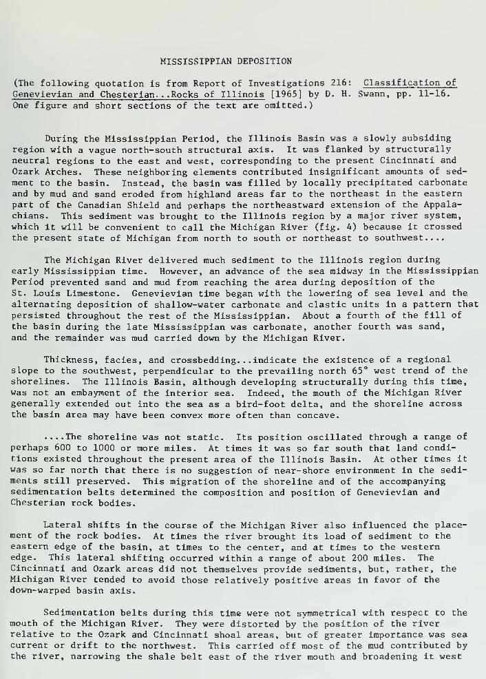
MISSISSIPPIAN DEPOSITION
(The following quotation is from Report of Investigations 216: Classification of
Genevievian and Chesterian. . .Rocks of Illinois [1965] by D. H. Swann, pp. 11-16.
One figure and short sections of the text are omitted.)
During the Mississippian Period, the Illinois Basin was a slowly subsidingregion with a vague north-south structural axis. It was flanked by structurallyneutral regions to the east and west, corresponding to the present Cincinnati andOzark Arches. These neighboring elements contributed insignificant amounts of sed-
ment to the basin. Instead, the basin was filled by locally precipitated carbonateand by mud and sand eroded from highland areas far to the northeast in the easternpart of the Canadian Shield and perhaps the northeastward extension of the Appala-chians. This sediment was brought to the Illinois region by a major river system,which it will be convenient to call the Michigan River (fig. 4) because it crossedthe present state of Michigan from north to south or northeast to southwest....
The Michigan River delivered much sediment to the Illinois region duringearly Mississippian time. However, an advance of the sea midway in the MississippianPeriod prevented sand and mud from reaching the area during deposition of the
St. Louis Limestone. Genevievian time began v/ith the lowering of sea level and the
alternating deposition of shallow-water carbonate and clastic units in a pattern thatpersisted throughout the rest of the Mississippian. About a fourth of the fill of
the basin during the late Mississippian was carbonate, another fourth was sand,and the remainder was mud carried down by the Michigan River.
Thickness, facies, and crossbedding. .. indicate the existence of a regionalslope to the southwest, perpendicular to the prevailing north 65° west trend of theshorelines. The Illinois Basin, although developing structurally during this time,was not an embayment of the interior sea. Indeed, the mouth of the Michigan Rivergenerally extended out into the sea as a bird-foot delta, and the shoreline acrossthe basin area may have been convex more often than concave.
....The shoreline was not static. Its position oscillated through a range ofperhaps 600 to 1000 or more miles. At times it was so far south that land condi-tions existed throughout the present area of the Illinois Basin. At other times itwas so far north that there is no suggestion of near-shore environment in the sedi-ments still preserved. This migration of the shoreline and of the accompanyingsedimentation belts determined the composition and position of Genevievian andChesterian rock bodies.
Lateral shifts in the course of the Michigan River also influenced the place-ment of the rock bodies. At times the river brought its load of sediment to theeastern edge of the basin, at times to the center, and at times to the westernedge. This lateral shifting occurred within a range of about 200 miles. TheCincinnati and Ozark areas did not themselves provide sediments, but, rather, theMichigan River tended to avoid those relatively positive areas in favor of thedown-warped basin axis.
Sedimentation belts during this time were not symmetrical with respect to themouth of the Michigan River. They were distorted by the position of the riverrelative to the Ozark and Cincinnati shoal areas, but of greater importance was seacurrent or drift to the northwest. This carried off most of the mud contributed bythe river, narrowing the shale belt east of the river mouth and broadening it west
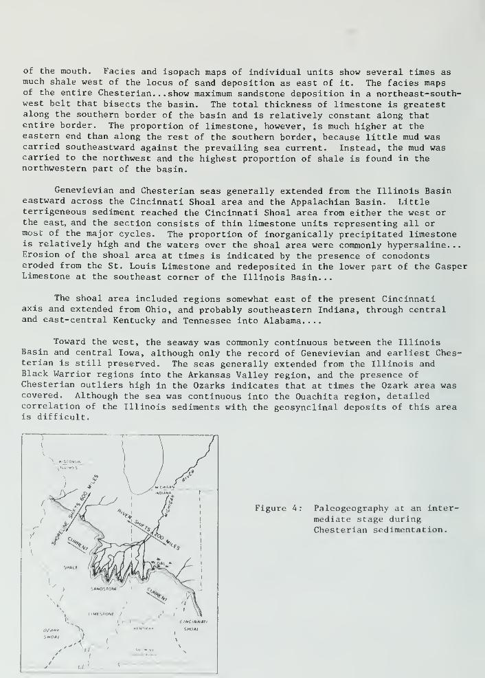
of the mouth. Fades and isopach maps of Individual units show several times asmuch shale west of the locus of sand deposition as east of it. The facies mapsof the entire Chesterian. . . show maximum sandstone deposition in a northeast-south-west belt that bisects the basin. The total thickness of limestone is greatestalong the southern border of the basin and is relatively constant along thatentire border. The proportion of limestone, however, is much higher at theeastern end than along the rest of the southern border, because little mud wascarried southeastward against the prevailing sea current. Instead, the mud wascarried to the northwest and the highest proportion of shale is found in thenorthwestern part of the basin.
Genevievian and Chesterian seas generally extended from the Illinois Basineastward across the Cincinnati Shoal area and the Appalachian Basin. Littleterrigeneous sediment reached the Cincinnati Shoal area from either the west orthe east, and the section consists of thin limestone units representing all ormost of the major cycles. The proportion of inorganically precipitated limestoneis relatively high and the waters over the shoal area were commonly hypersaline. .
.
Erosion of the shoal area at times is indicated by the presence of conodontseroded from the St. Louis Limestone and redeposited in the lower part of the GasperLimestone at the southeast corner of the Illinois Basin...
The shoal area included regions somewhat east of the present Cincinnatiaxis and extended from Ohio, and probably southeastern Indiana, through centraland east-central Kentucky and Tennessee into Alabama....
Toward the west, the seaway was commonly continuous between the IllinoisBasin and central Iowa, although only the record of Genevievian and earliest Ches-terian is still preserved. The seas generally extended from the Illinois andBlack Warrior regions into the Arkansas Valley region, and the presence ofChesterian outliers high in the Ozarks indicates that at times the Ozark area wascovered. Although the sea was continuous into the Ouachita region, detailedcorrelation of the Illinois sediments with the geosynclinal deposits of this areais difficult.
Figure 4: Paleogeography at an inter-
mediate stage duringChesterian sedimentation.
BRYOZOANS TRILOBITE CRINOIDS BLASTOIDS
Rhombopora 1 x
Phillipsia I f-
Archimedes Ix
BRACHIOPODSPlatycrinus \ x
Pentremites 2 x
Pentremites 2/^ x
CORALS
Brochythyris I x Pugnoides I xGirtyella I x
/*'
Coninia 2/^ ^
,/C^^IT
IP
Orthotetes I xSchuchertello I x Echinoconchus Ix

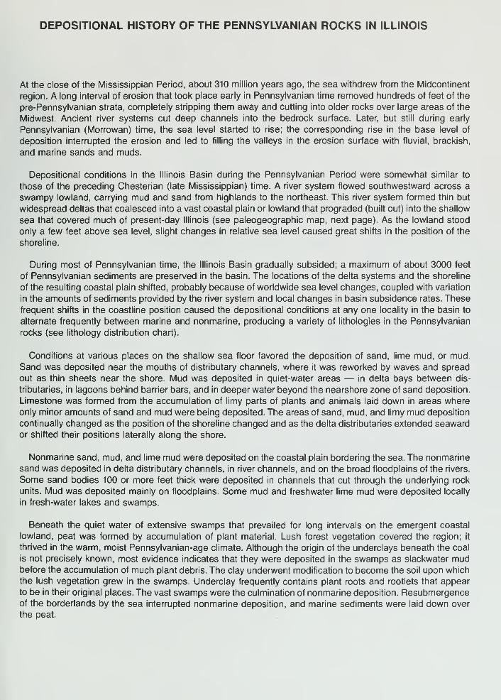
DEPOSITIONAL HISTORY OF THE PENNSYLVANIAN ROCKS IN ILLINOIS
At the close of the Mississippian Period, about 310 million years ago, the sea withdrew from the Midcontinent
region. A long interval of erosion that took place early in Pennsylvanian time removed hundreds of feet of the
pre-Pennsylvanian strata, completely stripping them away and cutting into older rocks over large areas of the
Midwest. Ancient river systems cut deep channels into the bedrock surface. Later, but still during early
Pennsylvanian (Morrowan) time, the sea level started to rise; the corresponding rise in the base level of
deposition interrupted the erosion and led to filling the valleys in the erosion surface with fluvial, brackish,
and marine sands and muds.
Depositional conditions in the Illinois Basin during the Pennsylvanian Period were somewhat similar to
those of the preceding Chesterian (late Mississippian) time. A river system flowed southwestward across a
swampy lowland, carrying mud and sand from highlands to the northeast. This river system formed thin but
widespread deltas that coalesced into a vast coastal plain or lowland that prograded (built out) into the shallow
sea that covered much of present-day Illinois (see paleogeographic map, next page). As the lowland stood
only a few feet above sea level, slight changes in relative sea level caused great shifts in the position of the
shoreline.
During most of Pennsylvanian time, the Illinois Basin gradually subsided; a maximum of about 3000 feet
of Pennsylvanian sediments are preserved in the basin. The locations of the delta systems and the shoreline
of the resulting coastal plain shifted, probably because of worldwide sea level changes, coupled with variation
in the amounts of sediments provided by the river system and local changes in basin subsidence rates. These
frequent shifts in the coastline position caused the depositional conditions at any one locality in the basin to
alternate frequently between marine and nonmarine, producing a vahety of lithologies in the Pennsylvanian
rocks (see lithology distribution chart).
Conditions at various places on the shallow sea floor favored the deposition of sand, lime mud, or mud.
Sand was deposited near the mouths of distributary channels, where it was reworked by waves and spread
out as thin sheets near the shore. Mud was deposited in quiet-water areas — in delta bays between dis-
tributaries, in lagoons behind barrier bars, and in deeper water beyond the nearshore zone of sand deposition.
Limestone was formed from the accumulation of limy parts of plants and animals laid down in areas where
only minor amounts of sand and mud were being deposited. The areas of sand, mud, and limy mud deposition
continually changed as the position of the shoreline changed and as the delta distributaries extended seaward
or shifted their positions laterally along the shore.
Nonmarine sand, mud, and lime mud were deposited on the coastal plain bordering the sea. The nonmarine
sand was deposited in delta distributary channels, in river channels, and on the broad floodplains of the rivers.
Some sand bodies 100 or more feet thick were deposited in channels that cut through the underlying rock
units. Mud was deposited mainly on floodplains. Some mud and freshwater lime mud were deposited locally
in fresh-water lakes and swamps.
Beneath the quiet water of extensive swamps that prevailed for long intervals on the emergent coastal
lowland, peat was formed by accumulation of plant material. Lush forest vegetation covered the region; it
thrived in the warm, moist Pennsylvanian-age climate. Although the origin of the underclays beneath the coal
is not precisely known, most evidence indicates that they were deposited in the swamps as slackwater mudbefore the accumulation of much plant debris. The clay underwent modification to become the soil upon which
the lush vegetation grew in the swamps. Underclay frequently contains plant roots and rootlets that appear
to be in their original places. The vast swamps were the culmination of nonmarine deposition. Resubmergenceof the borderlands by the sea interrupted nonmarine deposition, and marine sediments were laid down over
the peat.

30 60 mi
H s
/.::: Illinois Basiir • • • • A 50 100 km
jX>^-:-rN^-:::::>:';x;-:-- s,^_____^<'-..•.-...•.•.•.•.•...;.;.;.
y^s^I,^ \ V- y '£•
J..•.•.•.•.•.•.•.•. r ..•...•..-•.•.•. •
:•:•:•::•'.•:•:•:/::•:•:•::;;•;•:•:•
:-:":":-:':-:-*^i:-:-:-:-:-:-:-:-:-:-:-:'
'//.'.'.'/.^i'////////////.
s<>:->>:-:J':-:-:-:':-:-:-:':":-:-:-:'muQ N^.-.-.-.-.- .•.•.-.•.•. ^^v^^ -.^r^
> COASTAL • y^A•'••••"••••"•'
•
; \jjf\ ^ ^ ^ i
•'• ^'•••••••Shallow sea y^'^t^*>^--^^
•plain:-:-N^:-:':-:-:-:-:-:-:-:-:-:-:-:y i • • • -V
/^delta: /;v^:l^Q^^\^^p^S^^JS(^ :
:• >rx\ • :
: :
•
I y^fW] v/iy ^Sr^-:-:-:-:-:-:-:sand mi
and
silt
shallow sea
VOZARK '-^
SHOAL ^(
IL
IN
KYf CINCINNATI
MO
r-
Paleogeography of Illinois-Indiana region dunng Pennsylvanian time. The diagram shows a
Pennsylvanian river delta and the position of the shoreline and the sea at an instant of time during
the Pennsylvanian Period.
Pennsylvanian Cyclothems
The Pennsylvanian strata exhibit extraordinary variations in thickness and composition both laterally and
vertically because of the extremely vahed environmental conditions under which they formed. Individual
sedimentary units are often only a few inches thick and rarely exceed 30 feet thick. Sandstones and shales
commonly grade laterally into each other, and shales sometimes interfinger and grade into limestones and
coals. The underclays, coals, black shales, and some limestones, however, display remarkable lateral continuity
for such thin units. Coal seams have been traced in mines, outcrops, and subsurface drill records over areas
compnsing several states.

FU-
coo
o2
Q.
3Occ
ooroCDcn Fz u.<UJ_J
coo m^
Fu.
oinO)T3o5
FLl.
Ol
oCL "O
c_) oo
oCD obJUJZ<$ b
LlUJit: c
ooa.en
FLl
^_
n o
ox>-Q
trCI
it:
o^or bo Ll.
o <uo5 '>
><O)inO<_>
Q. o Sa> t-> to
o
D o
OJ
3
S 6
UJ2O
I °
Ul s
Ceg
'c
I>.(0cca>Q.
0)V
oo
COQ.
uD
D
D
DTT
E'_! 1_
2
o o
<u £ o9 tJ »
0>
c
O
III
5-°
If)
CM

Shale, gray, sandy at top: contains marinefossils and ironstone concretions, especially
in lower part.
Limestone; contains marine fossils.
Sfiale, black, hard, fissile, "slaty"; contains
large black spheroidal concretions andmarine fossils
Limestone; contains manne fossils.
Shale, gray; pyritic nodules and ironstone
concretions common at base; plant fossils
locally common at base; marine fossils rare.
Coal ; locally contains clay or shale partings.
Underclay, mostly medium to light gray ex-
cept dark gray at top; upper part noncalcare-
ous. lower part calcareous.
Limestone, argillaceous; occurs in nodules
or discontinuous beds; usually nonfossilifer-
ous
Shale, gray, sandy.
Sandstone, fine-grained, micaceous, andsiltstone, argillaceous; variable from massiveto thin-bedded; usually with an uneven lower
surface
The idealized cyclothem at left (after Willman and Payne, 1942) Infers continuous, widespread distribution of individual cyclothem units,
at right the model of a typical cyclothem (after Baird and Shabica, 1980) shows the discontinuous nature of many units in a cyclothem.
The rapid and frequent changes in depositional environments during Pennsylvanian time produced regular
or cyclical alternations of sandstone, shale, limestone, and coal in response to the shifting shoreline. Each
series of alternations, called a cyclothem, consists of several marine and nonmarine rock units that record a
complete cycle of marine invasion and retreat. Geologists have determined, after extensive studies of the
Pennsylvanian strata in the Midwest, that an "ideally" complete cyclothem consists of ten sedimentary units
(see illustration above contrasting the model of an "ideal" cyclothem with a model showing the dynamic
relationships between the various members of a typical cyclothem).
Approximately 50 cyclothems have been described in the Illinois Basin but only a few contain all ten units
at any given location. Usually one or more are missing because conditions of deposition were more varied
than indicated by the "ideal" cyclothem. However, the order of units in each cyclothem is almost always the
same: a typical cyclothem includes a basal sandstone overlain by an underclay, coal, black sheety shale,
marine limestone, and gray marine shale. In general, the sandstone-underclay-coal-gray shale portion (the
lower six units) of each cyclothem is nonmarine: it was deposited as part of the coastal lowlands from which
the sea had withdrawn. However, some of the sandstones are entirely or partly manne. The units above the
coal and gray shale are marine sediments deposited when the sea advanced over the coastal plain.
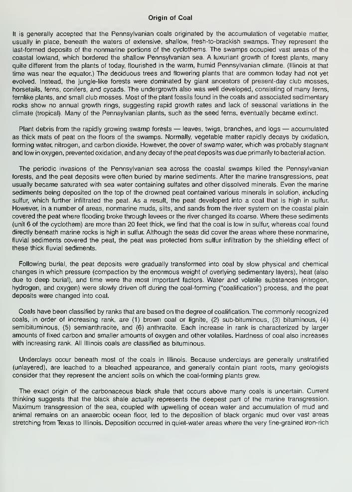
Origin of Coal
It is generally accepted that the Pennsylvanian coals originated by the accumulation of vegetable matter,
usually in place, beneath the waters of extensive, shallow, fresh-to-brackish swamps. They represent the
last-formed deposits of the nonmarine portions of the cyclothems. The swamps occupied vast areas of the
coastal lowland, which bordered the shallow Pennsylvanian sea. A luxuriant growth of forest plants, manyquite different from the plants of today, flourished in the warm, humid Pennsylvanian climate. (Illinois at that
time was near the equator.) The deciduous trees and flowering plants that are common today had not yet
evolved. Instead, the jungle-like forests were dominated by giant ancestors of present-day club mosses,
horsetails, ferns, conifers, and cycads. The undergrowth also was well developed, consisting of many ferns,
fernlike plants, and small club mosses. Most of the plant fossils found in the coals and associated sedimentary
rocks show no annual growth rings, suggesting rapid growth rates and lack of seasonal variations in the
climate (tropical). Many of the Pennsylvanian plants, such as the seed ferns, eventually became extinct.
Plant debris from the rapidly growing swamp forests — leaves, twigs, branches, and logs — accumulated
as thick mats of peat on the floors of the swamps. Normally, vegetable matter rapidly decays by oxidation,
forming water, nitrogen, and carbon dioxide. However, the cover of swamp water, which was probably stagnant
and low in oxygen, prevented oxidation, and any decay of the peat deposits was due primarily to bacterial action.
The periodic invasions of the Pennsylvanian sea across the coastal swamps killed the Pennsylvanian
forests, and the peat deposits were often buried by marine sediments. After the marine transgressions, peat
usually became saturated with sea water containing sulfates and other dissolved minerals. Even the marine
sediments being deposited on the top of the drowned peat contained various minerals in solution, including
sulfur, which further infiltrated the peat. As a result, the peat developed into a coal that is high in sulfur.
However, in a number of areas, nonmarine muds, silts, and sands from the river system on the coastal plain
covered the peat where flooding broke through levees or the river changed its coarse. Where these sediments
(unit 6 of the cyclothem) are more than 20 feet thick, we find that the coal is low in sulfur, whereas coal found
directly beneath marine rocks is high in sulfur Although the seas did cover the areas where these nonmarine,
fluvial sediments covered the peat, the peat was protected from sulfur infiltration by the shielding effect of
these thick fluvial sediments.
Following burial, the peat deposits were gradually transformed into coal by slow physical and chemical
changes in which pressure (compaction by the enormous weight of overlying sedimentary layers), heat (also
due to deep burial), and time were the most important factors. Water and volatile substances (nitrogen,
hydrogen, and oxygen) were slowly driven off during the coal-forming ("coalification") process, and the peat
deposits were changed into coal.
Coals have been classified by ranks that are based on the degree of coalification. The commonly recognized
coals, in order of increasing rank, are (1) brown coal or lignite, (2) sub-bituminous, (3) bituminous, (4)
semibituminous, (5) semianthracite, and (6) anthracite. Each increase in rank is characterized by larger
amounts of fixed carbon and smaller amounts of oxygen and other volatiles. Hardness of coal also increases
with increasing rank. All Illinois coals are classified as bituminous.
Underclays occur beneath most of the coals in Illinois. Because underclays are generally unstratified
(unlayered), are leached to a bleached appearance, and generally contain plant roots, many geologists
consider that they represent the ancient soils on which the coal-forming plants grew.
The exact origin of the carbonaceous black shale that occurs above many coals is uncertain. Current
thinking suggests that the black shale actually represents the deepest part of the marine transgression.
Maximum transgression of the sea, coupled with upwelling of ocean water and accumulation of mud and
animal remains on an anaerobic ocean floor, led to the deposition of black organic mud over vast areas
stretching from Texas to Illinois. Deposition occurred in quiet-water areas where the very fine-grained iron-rich

sUJ (/) c1- UJ Q.
o(/)>• UJ
32 E
tfi (0 CD £
z<-1
occ c
o>
2o
oShumway Limestone Member
unnamed coal member
z< w
ccc
CO "~~Millersville Limestone Member
3 _lo o •o
c5
(A CO
s
oIn
E
Carthage Limestone Member
Trivoli Sandstone Member
z<z Danville Coal Member
< z>l < *
>- (ACOT3
enz
UJz
C
zUJ
oc
<0
O
Q. UJCO
$
c
CO
Colchester Coal Member
Murray Bluff Sandstone Memberz< c^ Eo nH <<
oE—
Pounds Sandstone Member
Z<
oOo
^ 2 0)
O 1,CC <u
cc
o O2
MISSISSIPPIAN TO ORDOVICIAN SYSTEMS
Generalized stratlgraphic column of the Pennsylvanlan in Illinois (1 Inch approximately 250 feet)

mud and finely divided plant debris were washed in from the land. Most of the fossils found in black shale
represent planktonic (floating) and nektonic (swimming) forms — not benthonic (bottom-dwelling) forms. The
depauperate (dwarf) fossil forms sometimes found in black shale formerly were thought to have been forms
that were stunted by toxic conditions in the sulfide-rich, oxygen-deficient water of the lagoons. However, study
has shown that the "depauperate" fauna consists mostly of normal-size individuals of species that never grew
any larger
References
Baird, G. C, and C. W. Shabica, 1980, The Mazon Creek depositional event; examination of Francis Creek
and analogous fades in the Midcontinent region: in Middle and late Pennsylvanian strata on margin of
Illinois Basin, Vermilion County, Illinois, Vermilion and Parke counties, Indiana (R. L. Langenheim, editor).
Annual Field Conference— Society of Economic Paleontologists and Mineralogists. Great Lakes Section,
No. 10, p. 79-92.
Meckel, P. H., 1977, Origin of phosphatic black shale facies in Pennsylvanian cyclothems of mid-continent
North America: American Association of Petroleum Geologist Bulletin, v. 61, p. 1045-1068.
Kosanke, R. M., J. A. Simon, H. R. Wanless, and H. B. Willman, 1960, Classification of the Pennsylvanian
strata of Illinois: Illinois State Geological Survey Report of Investigation 214, 84 p.
Simon, J. A., and M. E. Hopkins, 1973, Geology of Coal: Illinois State Geological Survey Reprint 1973-H, 28 p.
Willman, H. B., and J. N. Payne, 1942, Geology and mineral resources of the Marseilles, Ottawa, and Streator
Quadrangles: Illinois State Geological Survey Bulletin 66, 388 p.
Willman, H. B., et al., 1967, Geologic Map of Illinois: Illinois State Geological Survey map; scale, 1:500,000
(about 8 miles per inch).
Willman, H. B., E. Atherton, T. C. Buschbach, C. W Collinson, J. C. Frye, M. E. Hopkins, J. A. Lineback, and
J. A. Simon, 1975, Handbook of Illinois Stratigraphy: Illinois State Geological Survey Bulletin 95, 261 p.
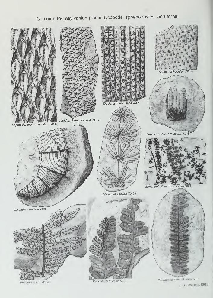
Common Pennsylvanian plants: lycopods, sphenophytes, and ferns
Pecopterls sp xo 32 P0COI>tl'll-.PBCoptBhs hemilelioidos X1
J R Jennings. ISGS
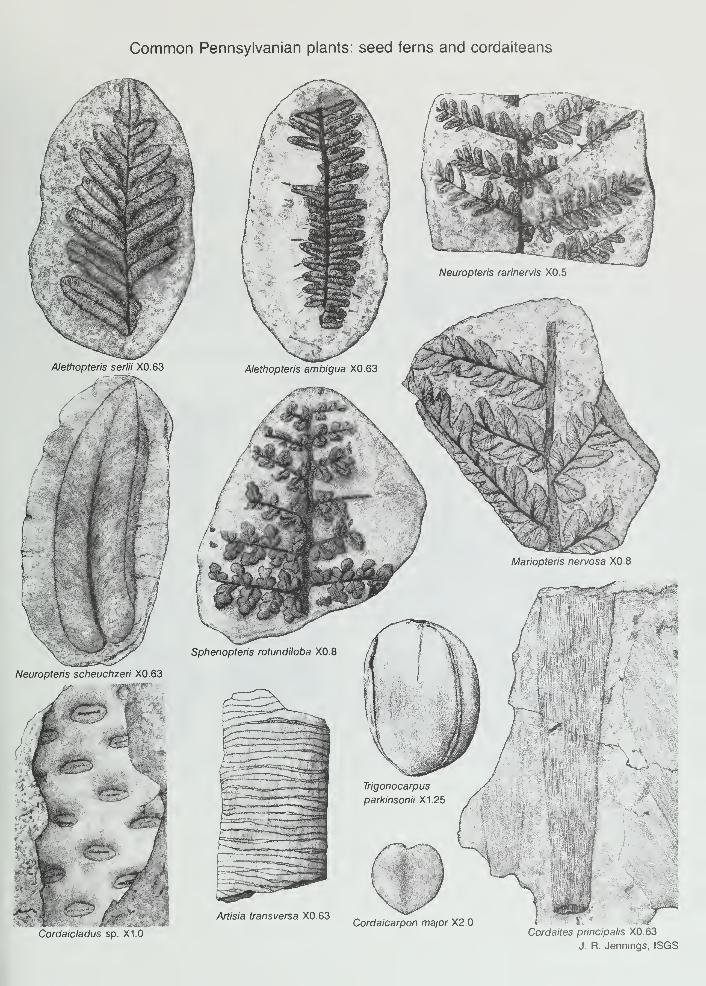
Common Pennsylvanian plants: seed ferns and cordaiteans
Cordaicladus sp. X1.0
Cordaicarpon major X2.0Cordaites principalis X0.63
J. R. Jennings, ISGS

TRILOBITES CORALSFUSULINIDS
M*tococ»ros cornutum I '/g « Prismopora tnangulata 12
«
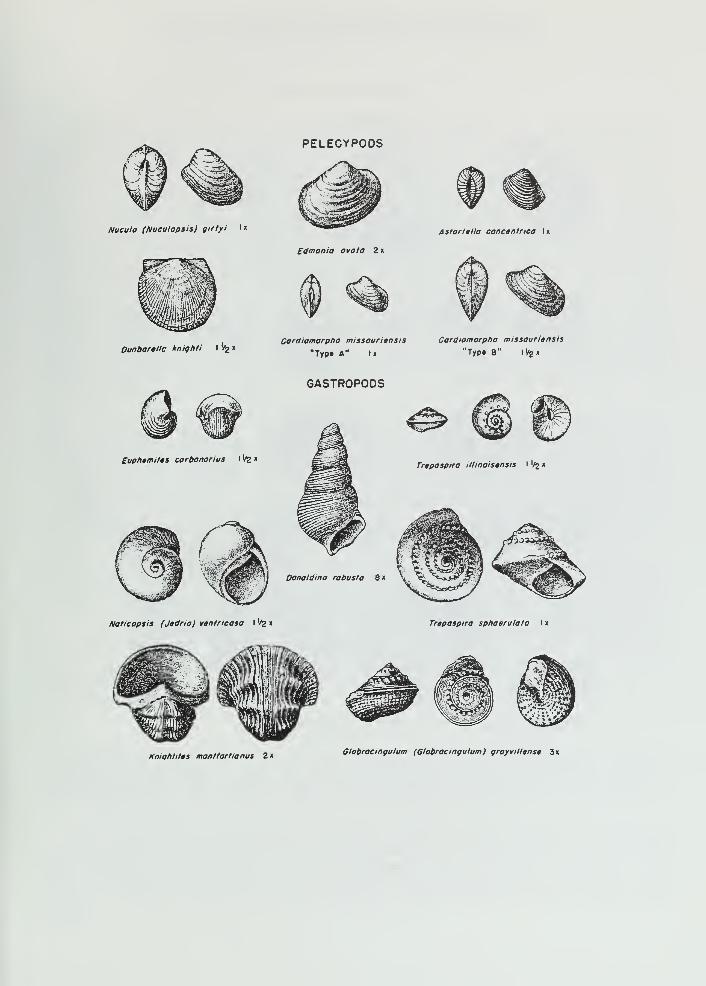
Nueulo (Nueulopsis) girtyi Ix
Dunbartlle kniqhti I '/j x
PELECYPODS
Edmonia ovata Z x
Cardiomorpho missouriansis
"Typ» A" I
>
Astarttlla concentrica Ix
Cardiomorpho missouriensis
"Type 8" ll/2X
GASTROPODS
Euphtmitts carbonorius I '^ x
Donoldina robusta 8 x
Trapospira illinoisgnsts \ '^ x
Naticopsis (J«dria) vtntricosa i '/z x Trepospira sphoeruloto Ix
KniQtitltts montfortianus 2x Globroeingulum (Globroeingulum) groyvillense 3x
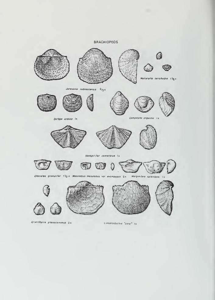
BRACHIOPODS
Wellerella tetrohedra I Vs «
Jurasanio nebroscensis 2/_,
Derb/o crossa Ix Composito argantia I x
Naospinfar comarotus Ix
Chonatas granulifar lI/2 « Masolobus mesolobus var. tvompygus 2 « Morgimfero splandens I x
Cruritfiyris plonoconvaxa 2 x Linoproductus "cora' U
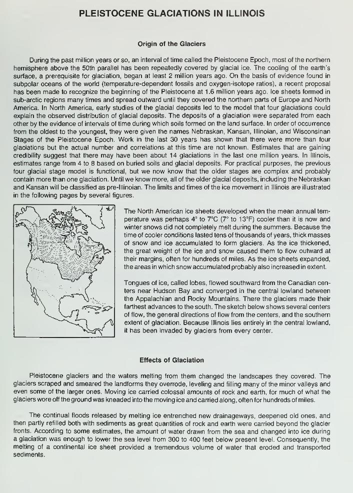
PLEISTOCENE GLACIATIONS IN ILLINOIS
Origin of the Glaciers
During the past million years or so, an interval of time called the Pleistocene Epoch, most of the northern
hemisphere above the 50th parallel has been repeatedly covered by glacial ice. The cooling of the earth's
surface, a prerequisite for glaciation, began at least 2 million years ago. On the basis of evidence found in
subpolar oceans of the world (temperature-dependent fossils and oxygen-isotope ratios), a recent proposal
has been made to recognize the beginning of the Pleistocene at 1.6 million years ago. Ice sheets formed in
sub-arctic regions many times and spread outward until they covered the northern parts of Europe and North
America. In North America, early studies of the glacial deposits led to the model that four glaciations could
explain the observed distribution of glacial deposits. The deposits of a glaciation were separated from each
other by the evidence of intervals of time during which soils formed on the land surface. In order of occurrence
from the oldest to the youngest, they were given the names Nebraskan, Kansan, lllinoian, and Wisconsinan
Stages of the Pleistocene Epoch. Work in the last 30 years has shown that there were more than four
glaciations but the actual number and correlations at this time are not known. Estimates that are gaining
credibility suggest that there may have been about 14 glaciations in the last one million years. In Illinois,
estimates range from 4 to 8 based on buried soils and glacial deposits. For practical purposes, the previous
four glacial stage model is functional, but we now know that the older stages are complex and probably
contain more than one glaciation. Until we know more, all of the older glacial deposits, including the Nebraskan
and Kansan will be classified as pre-lllinoian. The limits and times of the ice movement in Illinois are illustrated
in the following pages by several figures.
The North American ice sheets developed when the mean annual tem-
perature was perhaps 4° to 7°C (7° to 13°F) cooler than it is now and
winter snows did not completely melt during the summers. Because the
time of cooler conditions lasted tens of thousands of years, thick massesof snow and ice accumulated to form glaciers. As the ice thickened,
the great weight of the ice and snow caused them to flow outward at
their margins, often for hundreds of miles. As the ice sheets expanded,
the areas in which snow accumulated probably also increased in extent.
Tongues of ice, called lobes, flowed southward from the Canadian cen-
ters near Hudson Bay and converged in the central lowland between
the Appalachian and Rocky Mountains. There the glaciers made their
farthest advances to the south. The sketch below shows several centers
of flow, the general directions of flow from the centers, and the southern
extent of glaciation. Because Illinois lies entirely in the central lowland,
it has been invaded by glaciers from every center.
Effects of Glaciation
Pleistocene glaciers and the waters melting from them changed the landscapes they covered. Theglaciers scraped and smeared the landforms they overrode, leveling and filling many of the minor valleys andeven some of the larger ones. Moving ice carried colossal amounts of rock and earth, for much of what the
glaciers wore off the ground was kneaded into the moving ice and carried along, often for hundreds of miles.
The continual floods released by melting ice entrenched new drainageways, deepened old ones, andthen partly refilled both with sediments as great quantities of rock and earth were carried beyond the glacier
fronts. According to some estimates, the amount of water drawn from the sea and changed into ice during
a glaciation was enough to lower the sea level from 300 to 400 feet below present level. Consequently, the
melting of a continental ice sheet provided a tremendous volume of water that eroded and transported
sediments.
In most of Illinois, then, glacial and meltwater deposits buried the old rock-ribbed, low, hill-and-valley
terrain and created the flatter landforms of our prairies. The mantle of soil material and the buried deposits
of gravel, sand, and clay left by the glaciers over about 90 percent of the state have been of incalculable
value to Illinois residents.
Glacial Deposits
The deposits of earth and rock materials moved by a glacier and deposited in the area once covered
by the glacier are collectively called drift. Drift that is ice-laid is called till. Water-laid drift is called outwash.
Till is deposited when a glacier melts and the rock material it carhes is dropped. Because this sediment
is not moved much by water, a till is unsorted, containing particles of different sizes and compositions. It is
also stratified (unlayered). A till may contain materials ranging in size from microscopic clay particles to large
boulders. Most tills in Illinois are pebbly clays with only a few boulders. For descriptive purposes, a mixture
of clay, silt, sand and boulders is called diamicton. This is a term used to describe a deposit that could be
interpreted as till or a mass wasting product.
Tills may be deposited as end moraines, the arc-shaped ridges that pile up along the glacier edges
where the flowing ice is melting as fast as it moves fonward. Till also may be deposited as ground moraines,
or till plains, which are gently undulating sheets deposited when the ice front melts back, or retreats. Deposits
of till identify areas once covered by glaciers. Northeastern Illinois has many alternating ridges and plains,
which are the succession of end moraines and till plains deposited by the Wisconsinan glacier.
Sorted and stratified sediment deposited by water melting from the glacier is called outwash. Outwashis bedded, or layered, because the flow of water that deposited it varied in gradient, volume, velocity, anddirection. As a meltwater stream washes the rock materials along, it sorts them by size—the fine sands, silts,
and clays are carried farther downstream than the coarser gravels and cobbles. Typical Pleistocene outwashin Illinois is in multilayered beds of clays, silts, sands, and gravels that look much like modern stream deposits
in some places. In general, outwash tends to be coarser and less weathered, and alluvium is most often finer
than medium sand and contains variable amounts of weathered material.
Outwash deposits are found not only in the area covered by the ice field but sometimes far beyond it.
Meltwater streams ran off the top of the glacier, in crevices in the ice, and under the ice. In some places, the
cobble-gravel-sand filling of the bed of a stream that flowed in the ice is preserved as a sinuous ridge called
an esker. Some eskers in Illinois are made up of sandy to silty deposits and contain mass wasted diamicton
material. Cone-shaped mounds of coarse outwash, called kames, were formed where meltwater plunged
through crevasses in the ice or into ponds on the glacier.
The finest outwash sediments, the clays and silts, formed bedded deposits in the ponds and lakes that
filled glacier-dammed stream valleys, the sags of the till plains, and some low, moraine-diked till plains.
Meltwater streams that entered a lake rapidly lost speed and also quickly dropped the sands and gravels
they carried, forming deltas at the edge of the lake. Very fine sand and silts were commonly redistributed onthe lake bottom by wind-generated currents, and the clays, which stayed in suspension longest, slowly settled
out and accumulated with them.
Along the ice front, meltwater ran off in innumerable shifting and short-lived streams that laid down a
broad, flat blanket of outwash that formed an outwash plain. Outwash was also carried away from the glacier
in valleys cut by floods of meltwater. The Mississippi, Illinois, and Ohio Rivers occupy valleys that were major
channels for meltwaters and were greatly widened and deepened during times of the greatest meltwater
floods. When the floods waned, these valleys were partly filled with outwash far beyond the ice margins.
Such outwash deposits, largely sand and gravel, are known as valley trains Valley train deposits may beboth extensive and thick. For instance, the long valley train of the Mississippi Valley is locally as much as
200 feet thick.
Loess, Eolian Sand and Soils
One of the most widespread sediments resulting from glaciation was carried not by ice or water but by
wind. Loess is the name given to windblown deposits dominated by silt. Most of the silt was derived from
wind erosion of the valley trains. Wind action also sorted out eolian sand which commonly formed sanddunes on the valley trains or on the adjacent uplands. In places, sand dunes have migrated up to 10 miles
away from the principle source of sand. Flat areas between dunes are generally underlain by eolian sheetsand that is commonly reworked by water action. On uplands along the major valley trains, loess and eolian
sand are commonly interbedded. With increasing distance from the valleys, the eolian sand pinches out, often
within one mile.
Eolian deposition occurred when certain climatic conditions were met, probably in a seasonal pattern.
Deposition could have occurred in the fall, winter or spring season when low precipitation rates and low
temperatures caused meltwater floods to abate, exposing the surfaces of the valley trains and permitting
them to dry out. During Pleistocene time, as now, west winds prevailed, and the loess deposits are thickest
on the east sides of the source valleys. The loess thins rapidly away from the valleys but extends over almost
all the state.
Each Pleistocene glaciation was followed by an interglacial stage that began when the climate warmedenough to melt the glaciers and their snowfields. During these warmer intervals, when the climate was similar
to that of today, drift and loess surfaces were exposed to weather and the activities of living things. Con-sequently, over most of the glaciated terrain, soils developed on the Pleistocene deposits and altered their
composition, color, and texture. Such soils were generally destroyed by later glacial advances, but somewere burled. Those that survive serve as "key beds," or stratigraphic markers, and are evidence of the passageof a long interval of time.
Glaciation in a Small Illinois Region
The following diagrams show how a continental ice sheet might have looked at various stages as it
moved across a small region in Illinois. They illustrate how it could change the old terrain and create alandscape like the one we live on. To visualize how these glaciers looked, geologists study the landforms
and materials left in the glaciated regions and also the present-day mountain glaciers and polar ice caps.
The block of land in the diagrams is several miles wide and about 10 miles long. The vertical scale is
exaggerated—layers of material are drawn thicker and landforms higher than they ought to be so that they
can be easily seen.

B R,-r7-T-7^,
I
,
L,
1
, b=i=j=ci.' 1'
I i-J-i- '
.
.'
.-
.
I
' T-T-TT-r^^r^rr^:^^^
1 . The Region Before Glaciation — Like most of Illinois, the region illustrated is underlain by almost flat-lying beds of
sedimentary rocks—layers of sandstone (::.: ), limestone ( '
i' ). and shale ( ==r-==. ). Millions of years of erosion
have planed down the bedrock (BR), creating a terrain of low uplands and shallow valleys. A residual soil weathered
from local rock debris covers the area but is too thin to be shown in the drawing. The streams illustrated here flow
westward and the one on the right flows into the other at a point beyond the diagram.
SCr .5<0=F
;=>c D 1 I I I •"" -F=^^
2. The Glacier Advances Southward — As the Glacier (G) spreads out from its ice snowfield accumulation center, it
scours (SC) the soil and rock surface and quarries (Q)—pushes and plucks up—chunks of bedrock. The materials are
mixed into the ice and make up the glacier's "load. " Where roughnesses in the terrain slow or stop flow (F), the ice
"current" slides up over the blocked ice on innumerable shear planes (S). Shearing mixes the load very thoroughly. As
the glacier spreads, long cracks called "crevasses" (C) open parallel to the direction of ice flow. The glacier melts as it
flows forward, and its meltwater erodes the terrain in front of the ice, deepening (D) some old valleys before ice covers
them. Meltwater washes away some of the load freed by melting and deposits it on the outwash plain (OP). The advancing
glacier overrides its outwash and in places scours much of it up again The glacier may be 5000 or so feet thick, and
tapers to the margin, which was probably in the range of several hundred feet above the old terrain The ice front advances
perhaps as much as a third of a mile per year.
3. The Glacier Deposits an End IVIoraine — After the glacier advances across the area, the climate warms and the
ice begins to melt as fast as it advances. The ice front (IF) is now stationary, or fluctuating in a narrow area, and the
glacier is depositing an end moraine.
As the top of the glacier melts, some of the sediment that is mixed in the ice accumulates on top of the glacier.
Some is carried by meltwater onto the sloping ice front (IF) and out onto the plain beyond. Some of the debris slips down
the ice front in a mudflow (FL). Meltwater runs through the ice in a crevasse (C). A supraglacial stream (SS) drains the
top of the ice, forming an outwash fan (OF). Moving ice has overridden an immobile part of the front on a shear plane
(S). All but the top of a block of ice (B) is buried by outwash (O).
Sediment from the melted ice of the previous advance (figure 2) remains as a till layer (T), part of which forms the
till plain (TP). A shallow, marshy lake (L) fills a low place in the plain. Although largely filled with drift, the valley (V)
remains a low spot in the terrain. As soon as the ice cover melts, meltwater drains down the valley, cutting it deeper.
Later, outwash partly refills the valley: the outwash deposit is called a valley train (VT). Wind blows dust (DT) off the dry
floodplain. The dust will form a loess deposit when it settles. Sand dunes (D) form on the south and east sides of streams.
J. , I , d1-' T-'
I ' T-'-fl
I. I t.l.. '.'..'TTT
4. The Region after Glaciation — As the climate warms further, the whole ice sheet melts, and glaciation ends. Theend moraine (EM) is a low, broad ridge between the outwash plain (OP) and till plains (TP). Run-off from rains cuts
stream valleys into its slopes. A stream goes through the end moraine along the channel cut by the meltwater that ran
out of the crevasse in the glacier.
Slopewash and vegetation are filling the shallow lake. The collapse of outwash into the cavity left by the ice block's
melting has made a kettle (K). The outwash that filled a tunnel draining under the glacier is preserved in an esker (E).
The hill of outwash left where meltwater dumped sand and gravel into a crevasse or other depression in the glacier or
at its edge is a kame (KM). A few feet of loess covers the entire area but cannot be shown at this scale.

TIME TABLE OF PLEISTOCENE GLACIATION
STAGE SUBSTAGE NATURE OF DEPOSITS SPECIAL FEATURES
cr
<
a:
O
HOLOCENE(interglacial)
Years
Before Present
WISCONSINAN ra
(glacial)
SANGAMONIAN(interglacial)
ILLINOIAN(glacial)
YARMOUTHIAN(interglacial)
KANSAN*(glacial)
AFTONIAN*(interglacial)
NEBRASKAN-(glacial)
10,000 -
Valderan
- 1 1 ,000 -
Twocreekan
- 12,500 —
Woodfordian
- 25,000
Farmdalian
- 28,000 -
Altonian
75,000
125,000
Jubileean
Monican
Liman
300,000?
500,000?
700,000''
900,000?
1 ,600,000 or more
Soil, youthful profile
of weathering, lake
and river deposits,
dunes, peat
Outwash, lake deposits
Peat and alluvium
Drift, loess, dunes,
lake deposits
Soil, silt, and peat
Drift, loess
Soil, mature profile
of weathering
Drift, loess, outwash
Drift, loess, outwash
Drift, loess, outwash
Soil, mature profile
of weathering
Drift, loess
Soil, mature profile
of weathering
Drift (little known)
Outwash along
Mississippi Valley
Ice withdrawal, erosion
Glaciation; building of
many moraines as far
south as Shelbyville;
extensive valley trains,
outwash plains, and lakes
Ice withdrawal, weathering,
and erosion
Glaciation in Great Lakesarea, valley trains
along major rivers
Important stratigraphic marker
Glaciers from northeast
at maximum reached
Mississippi River andnearly to southern tip
of Illinois
Important stratigraphic marker
Glaciers from northeast
and northwest covered
much of state
(hypothetical)
Glaciers from northwest
invaded western Illinois
"Old oversimplified concepts, now known to reprnsoni a series of glacial cycles.
(Illinois State Geological Survey, 1973
SEQUENCE OF GLACIATIONS AND INTERGLACIALDRAINAGE IN ILLINOIS
PRE-PLEISTOCENE PRE-ILLINOIAN YARMOUTHIANmajor drainage Inferred glacial limits major drainage
LIMAN MONICANglacial advance glacial advance
JUBILEEAN SANGAMONIANglacial advance major drainage
ALTONIAN WOODFORDIAN WOODFORDIAN VALDERANglacial advance glacial advance Valparaiso ice and drainage
Kankakee Flood
(Modified from Willlman and Frye, "Pleistocene Stratigraphy of Illinois," ISGS Bull. 94, fig. 5, 1970.)

jiSJEPMENSON
; ; :i: wJnS^<;o .Z^: BOONE.!
ILLINOIS STATE GEOLOGICAL SURVEYJohn C Trye, Chief Urbona, Illinois 61601
GLACIAL MAP OF ILLINOIS
H.B. WILLMAN and JOHN C. FRYEf::)*
1970
Modified from mops by Leverell (1899). ^A_: '.'.'.'.'.'.'. < '.''*?L\'. '.O^ ^'["f'^fX ^ UXl/-EKblow (1959), Leighlon ond Bfophy (1961), F-.'.rT^iiShfiJ"^ ' Zp ' -i-A' ,' ' ' N?^ ^fWi-Willmon et ol.(l96A Ond others /:V/ ;! :
'.
i'. '.c/. '. 'Mr! .'.'.'.'... -A y'^
peorja;
EXPLANATION
HOLOCENE AND WISCONSINAN
Alluvium, sand dunes,and grovel terraces
WISCONSINAN
Lake deposits
WOOOFOROIAN
ALTONIAN
Till plain
ILLINOIAN
Moraine and ridged drift
GroundfTtoroine
KANSAN
Till ploin
ORIFTLESS
Modified from Bull 94 -pi 2
Moraine
Front of morainic system
Groundmoraine
QUATERNARY DEPOSITS OF ILLINOIS viv.
Jerry A. Lineback
1981
Modified from Quaternary Deposits
of Illinois (1979) by Jerry A. LinekiackJ^^^
"v ^K* L'.'.*.'
40 mi rjr'fy.'f:1 1 1 1 1 *"/• J*.*.*.'.'
50 km Mmm-.c 1—1 1—1 1
^-i^yA-y.-yy.
A-y.
m^
^^
1
iii
AGE
Holocene' andVisconsinan
/Visconsinan• • • <
» • • •• • • 4
V3^
UNIT H-7*
Cahokia Alluvium,Parkland Sand, andHenry Formationcombined; alluvium,
windblown sand, andsand and gravel outwash.
Peoria Loess and Roxana Silt combined; 1:'
windblown silt more yJj-J«.«Vthan 6 meters (20 ft) thick.
Equality Formation; silt, clay, andsand in glacial and slack-water lakes
: :•:-i-iVv, "'y
^^llyi*y :
.•t > !••••.WjlJiJjSiTf,W\P^^fff^^>'****f^^^'^^'^'T^
WiS^l;^^
-"•^
Moraine
Groundmoraine
m>^,
/Visconsinan
andlllinoian
lilinoian
Ve- lllinoian^
Wedron and Trafalgar
Formations combined;glacial till with some ^sand, gravel, and silt. '
~-
Winnebago and Glasford Formations ^*r-
combined; glacial till with some sand,gravel, and silt; age assignments of someunits is uncertain.
Glasford Formation; glacial tilt with some sand,gravel, and silt.
Teneriffe Silt, Pearl Formation, and Hagarstown Member <
of the Glasford Formation combined; lake silt and clay, V?outwash sand, gravel, and silt.
Wolf Creek Formation; glacial till with gravel, sand,and silt.
Bedrock.
ISGS 1981

ILLINOIS STATE GEOLOGICAL SURVEY GEOGRAM 5
Urbana, Illinois 61801 October 1975
ANCIENT DUST STORMS IN ILLINOIS
Myma M. Killey
Fierce dust storms whirled across Illinois long before human beings werehere to record them. Where did all the dust come from? Geologists have carefullyput together clues from the earth itself to get the story. As the glaciers of theGreat Ice Age scraped and scoured their way southward across the landscape fromCanada, they moved colossal amounts of rock and earth. Much of the rock groundfrom the surface was kneaded into the ice and carried along, often for hundredsof miles. The glaciers acted as giant grist mills, grinding much of the rock andearth to "flour"—very fine dust-sized particles.
During the warm seasons, water from the melting ice poured from the gla-cier front, laden with this rock flour, called silt. In the cold months the melt-water stopped flowing and the silt was left along the channels the water had fol-
lowed, where it dried out and became dust. Strong winds picked up the dust, sweptit from the floodplains, and carried it to adjacent uplands. There the forestsalong the river valleys trapped the dust, which became part of the moist forestsoil. With each storm more material accumulated until the high bluffs adjacent to
major rivers were formed. The dust deposits are thicker along the eastern sidesof the valleys than they are on the western sides, a fact from which geologistsdeduce that the prevailing winds of that time blew from west to east, the samedirection as those of today. From such clues geologists conclude that the geo-logic processes of the past were much like those of today.
The deposits of windblown silt are called loess (rhymes with "bus").Loess is found not only in the areas once covered by the glaciers but has beenblown into the nonglaciated areas. The glaciers, therefore, influenced the pres-ent land surface well beyond the line of their farthest advance.
Loess has several interesting characteristics. Its texture is so fineand uniform that it can easily be identified in roadcuts—and because it blanketssuch a vast area many roads are cut through it. Even more noticeable is its ten-dency to stand in vertical walls. These steep walls develop as the loess drainsand becomes tough, compact, and massive, much like a rock. Sometimes cracks de-velop in the loess, just as they do in massive limestones and sandstones. Loessmakes good highway banks if it is cut vertically. A vertical cut permits maximumdrainage because little surface is exposed to rain, and rainwater tends to drainstraight down through it to the rock underneath. If the bank is cut at an anglemore water soaks in, which causes the loess to slump down. Along Illinois roadsthe difference between a loess roadcut and one in ordinary glacial till is obvi-ous. The loess has a very uniform texture, while the till is composed of a ran-dom mixture of rock debris, from clay and silt through cobbles and boulders.
Many loess deposits are worth a close look. Through a 10-power handlens separate grains can be seen, among them many clear, glassy, quartz grains.Some loess deposits contain numerous rounded, lumpy stones called concretions.Their formation began when water percolating through the loess dissolved tiny

I.OESS THICKNESS IN ILLINOIS
i«HIfil^ ifgSKftS;:^
;; f (:::-:::>:"h ,
? JSa '
More than 300 inches
160 . 300 inches
limestone grains. Some of the dissolvedminerals later became solid again,gathering around a tiny nucleus oralong roots to form the lumpy masses. Afew such concretions are shaped roughlylike small dolls and, from this resem-blance, are called "loess kindchen," a
German term meaning "loess children."They may be partly hollow and containsmaller lumps that make them rattlewhen shaken.
Fossil snails can be found in some
loess deposits. The snails lived on the
river bluffs while the loess was being
deposited and were buried by the dust.
When they are abundant, they are used
to determine how old the loess is. The
age is found by measuring the amount of
radioactive carbon in the calcium car-
bonate of their shells.
W0^i 50 150 inches
C;:".".'"! Up 10 50 inches
I I
Liitle Of no loess
^-''"^^ Boundary of last glacial advance in Illinois
Some of the early loess depositswere covered by new layers of loessfollowing later glacial invasions. Manythousands of years passed bet\i?een the
major glacial periods, during whichtime the climate was as warm as that of
today. During the warm intervals, the
surface of the loess and other glacialdeposits was exposed to weather. Soilsdeveloped on most of the terrain, al-
tering the composition, color, and tex-
During later advances of the ice, some of thesesoils were destroyed, but in many places they are preserved under the youngersediments. Such ancient buried soils can be used to determine when the materialsabove and below them were laid down by the ice and what changes in climate tookplace.
ture of the glacial material.
The blanket of loess deposited by the ancient dust storms forms the par-ent material of the rich, deep soils that today are basic to the state's agricul-ture. A soil made of loess crumbles easily and has great moisture-holding capaci-ty. It also is free from rocks that might complicate cultivation. Those greatdust storms that swirled over the land many thousands of years ago thus endowedIllinois with one of its greatest resources, its highly productive soil.


SHAWMfE^ q\ 'WATIONikl\^. ?[ALT8