Spring sports in full swing Gallatin Valley gives big to ...
557
IL6gui
2001-A,B
Guide to the Geology of Garden of the Gods Area,
Gallatin, Hardin, Pope, and Saline Counties, Illinois
Wayne T. Frankie and Russell J. Jacobson
Field Trip Guidebook 2001
A
Field Trip Guidebook 2001
B
George H. Ryan, Governor
April 14, 2001
May 12, 2001
Department of Natural Resources
Brent Manning, Director
ILLINOIS STATE GEOLOGICAL SURVEYWilliam W.Shilts, Chief

Digitized by the Internet Archive
in 2012 with funding from
University of Illinois Urbana-Champaign
http://archive.org/details/guidetogeology01fran
Guide to the Geology of Garden of the Gods Area,
Gallatin, Hardin, Pope, and Saline Counties, Illinois
Wayne T. Frankie and Russell J. Jacobson
Field Trip Guidebook 2001
A
April 1 4, 2001
Field Trip Guidebook 2001
B
May 1 2, 2001
George H. Ryan, Governor
Department of Natural Resources
Brent Manning, Director
ILLINOIS STATE GEOLOGICAL SURVEYWilliam W.Shilts, Chief
Natural Resources Building
615 E.Peabody Drive
Champaign, IL 61 820-6964
Home page: http://www.isgs.uiuc.edu/
Cover photo: Camel Rock, Garden of the Gods Recreation Area (Photo by W. T. Frankie)
Geological Science Field Trips The Geoscience Education and Outreach Unit of the Illinois
State Geological Survey (ISGS) conducts four free tours each year to acquaint the public with the
rocks, mineral resources, and landscapes of various regions of the state and the geological pro-
cesses that have led to their origin. Each trip is an all-day excursion through one or more Illinois
counties. Frequent stops are made to explore interesting phenomena, explain the processes that
shape our environment, discuss principles of earth science, and collect rocks and fossils. People of
all ages and interests are welcome. The trips are especially helpful to teachers who prepare earth
science units. Grade school students are welcome, but each must be accompanied by a parent or
guardian. High school science classes should be supervised by at least one adult for each ten
students.
A list of guidebooks of earlier field trips for planning class tours and private outings may be
obtained by contacting the Geoscience Education and Outreach Unit, Illinois State Geological
Survey, Natural Resources Building, 615 East Peabody Drive, Champaign, IL 61820-6964. (Tele-
phone: (217) 244-2427 or 333-4747). This information is on the ISGS home page: http://
www.isgs.uiuc.edu
Editorial Board
Jonathan H. Goodwin, Chair
Michael L. Barnhardt David R. Larson
B. Brandon Curry John H. McBride
Anne L. Erdmann DonaldG Mikulic
William R. Roy
© Printed with soybean ink on recycled paper
printed by authority of the state of Illinois/2000/ 1,000
CONTENTSGARDEN OF THE GODS AREA 1
GEOLOGIC FRAMEWORK 1
Precambrian Era 1
Paleozoic Era 1
DEPOSITIONAL HISTORY 2
Paleozoic Era 2
Mesozoic Era 5
STRUCTURAL SETTING 7
Shawneetown Fault Zone 7
Horseshoe Upheaval 1
1
Eagle Valley Syncline 1
1
GLACIAL HISTORY OF ILLINOIS 13
Cenozoic Era 13
GEOMORPHOLOGY 18
Physiography 1
8
NATURAL DIVISIONS AND GEOLOGY 20Natural Divisions 20
NATURAL RESOURCES 22
Mineral Production 22
Fluorspar 22Groundwater 23
GUIDE TO THE ROUTE 24
STOP DESCRIPTIONS 46
1 Garden of the Gods Recreation Area 46
Geological History 46
Liesegang Banding in Sandstones 48
2 Lee Mine 5
1
Ore Deposits 52
Vein Deposits 52
Mineralogy 53
Origin of the Faults 53
3 Lunch, Rim Rock Recreation Area and the Pounds Escarpment 54
Stepping Stones Through Time 55
Trails 55
The Geology of Pounds Hollow—From the Observation Platform 55
4A (Optional): Jader Coal Company Surface Mine 56
4B (Optional): Black Beauty Coal Company Wildcat Mine 58
5 Horseshoe Upheaval 58
6 Old Stone Face 60
REFERENCES 63RELATED READINGS 63
GLOSSARY 66
SUPPLEMENTARY MATERIALS
EraPeriod or Systemand Thickness
Age(years ago) General Types of Rocks
\ Holocene
Quaternary0-500'
CD CD
F o>CD <f<-> _2 <D
cfl (j
'CD i2CLO
Pliocene
Tertiary
0-500'
Paleocene
Pennsylvanian0-3,000'
("Coal Measures")
Mississippian
0-3,500'
Devonian0-1,500'
Silurian
0-1,000'
Ordovician
500-2,000'
Cambrian1,500-3,000'
Precambrian
10,000
1.6 mr 5.3 m-|L 36.6m J
57.8 m
66.4 m
144 m-
286 m-
320 m
360 m
408 m
438 m
505 m
570 m
Recent- alluvium in river valleys
Glacial till, glacial outwash, gravel, sand, silt,
lake deposits of clay and silt, loess and sanddunes; covers nearly all of state except north-
west corner and southern tip
Chert gravel, present in northern, southern, andwestern Illinois
Mostly micaceous sand with some silt and clay;
presently only in southern Illinois
Mostly clay, little sand; present only in southern
Illinois
Mostly sand, some thin beds of clay, and, locally,
gravel, present only in southern Illinois
Largely shale and sandstone with beds of coal,
limestone, and clay
Black and gray shale at base, middle zone of
thick limestone that grades to siltstone
chert, and shale; upper zone of interbedded
sandstone, shale, and limestone
Thick limestone, minor sandstones and shales;
largely chert and cherty limestone in southern
Illinois; black shale at top
Principally dolomite and limestone
Largely dolomite and limestone but contains
sandstone, shale, and siltstone formations
Chiefly sandstones with some dolomite and shale;
exposed only in small areas in north-central
Illinois
Igneous and metamorphic rocks; known in
Illinois only from deep wells
i.
i
'
; i-fT
i
1
i
1
i
1
i|
/ /.
/ //
,/
,
/,
I l.l
/. v.' /;
"ZTZfZ?
Generalized geologic column showing succession of rocks in Illinois.
GARDEN OF THE GODS AREAThe Garden of the Gods Area, located in the part of southern Illinois never reached by continental
glaciers, is one of the state's most scenic and geologically complex areas. This geological science
field trip will acquaint you with the geology, 1 landscape, and mineral resources of parts of Gallatin,
Hardin, Pope, and Saline Counties, Illinois. Harrisburg, the largest city within the field trip area, is
approximately 332 miles south ofChicago, 1 87 miles southeast of Springfield, 1 29 miles southeast
of East St. Louis, and 81 miles northeast of Cairo.
GEOLOGIC FRAMEWORKPrecambrian Era
Through several billion years of geologic time, the area surrounding the Garden of the Gods Rec-
reation Area has undergone many changes (see the rock succession column, facing page). The
oldest rocks beneath the field trip area belong to the ancient Precambrian basement complex. Weknow relatively little about these rocks from direct observations because they are not exposed at
the surface anywhere in Illinois. Only about 35 drill holes have reached deeply enough for geolo-
gists to collect samples from Precambrian rocks of Illinois. From these samples, however, weknow that these ancient rocks consist mostly of granitic and rhyolitic igneous, and possibly meta-
morphie, crystalline rocks formed about 1 .5 to 1 .0 billion years ago. From about 1 billion to about
0.6 billion years ago, these Precambrian rocks were exposed at the surface. During this long pe-
riod, the rocks were deeply weathered and eroded and formed a barren landscape that was prob-
ably quite similar to the topography of the present Missouri Ozarks. We have no rock record in
Illinois for the long interval of weathering and erosion that lasted from the formation of the Pre-
cambrian rocks until the first Cambrian age sediments accumulated, but that interval is almost as
long as the time from the beginning of the Cambrian Period to the present.
Because geologists cannot see the Precambrian basement rocks in Illinois except as cuttings and
cores from boreholes, various other techniques must be used, such as measurements of Earth's
gravitational and magnetic fields, and seismic exploration, to map out the regional characteristics
of the basement complex. The evidence collected with these techniques indicates that in southern-
most Illinois, near what is now the historic Kentucky-Illinois fluorspar mining district, rift valleys
similar to those in east Africa formed as movement of crustal plates (plate tectonics) began to rip
apart the Precambrian continent that became North America. These rift valleys in the midcontinent re-
gion are referred to as the Rough Creek Graben and the Reelfoot Rift (fig. 1).
Paleozoic Era
After the beginning of the Paleozoic Era, about 520 million years ago in the late Cambrian Period,
the rifting stopped, and the hilly Precambrian landscape began to sink slowly on a broad regional
scale, allowing the invasion of a shallow sea from the south and southwest. During the 280 million
years of the Paleozoic Era, the area that is now called the Illinois Basin continued to accumulate
sediments that were deposited in the shallow seas that repeatedly covered this subsiding basin.
The region continued to sink until at least 20,000 feet of sedimentary strata were deposited in the
deepest part of the basin, located in the Rough Creek Graben area of southeastern Illinois and
western Kentucky. At various times during this era, the seas withdrew and deposits were weath-
ered and eroded. As a result, there are gaps in the sedimentary record in Illinois.
i Words in italics are defined in the glossary at the back of the guidebook. Also please note that, although
all present localities have only recently appeared within the geologic time frame, we use the present
names of places and geologic features because they provide clear reference points for describing the
ancient landscape.
1
In the field trip area, bedrock strata range in age from more than 520 million years old (the Cam-
brian Period) to less than 320 million years old (the Pennsylvanian Period). Figure 2 shows the
succession of rock strata a drill bit would penetrate in this area if the rock record were complete
and all the formations were present. The oldest Paleozoic rocks exposed in the area are Devo-
nian in age. They formed from sediments that accumulated from about 385 million years ago up to
360 million years ago.
Within the field trip area, the depth to the Precambrian basement rocks is significantly offset by
the Shawneetown Fault. North of the Shawneetown Fault Zone, where the fault crosses between
Gallatin and Saline Counties, the elevation of the top of the Precambrian basement rocks is a little
more than 14,000 feet below sea level, and the Paleozoic sedimentary strata deposited on top of
the Precambrian total at least 15,000 feet in thickness. Nearby, on the south side of the
Shawneetown Fault Zone, the elevation of the top of the Precambrian basement rocks is more
than 18,000 feet below sea level, and the Paleozoic sedimentary strata deposited on top of the
Precambrian basement are at least 19,000 feet thick.
DEPOSITIONAL HISTORYAs noted previously, the Rough Creek Graben
and the Reelfoot Rift (figs. 1 and 3) were
formed by tectonic activity that began in the
latter part of the Precambrian Era and contin-
ued until the Late Cambrian. Toward the end
of the Cambrian, rifting ended, and the whole
region began to subside, allowing shallow seas
to cover the land.
Paleozoic Era
From the Late Cambrian to the end of the Pa-
leozoic Era, sediments continued to accumu-
late in the shallow seas that repeatedly cov-
ered Illinois and adjacent states. These inland
seas connected with the open ocean to the
south during much of the Paleozoic, and the
area that is now southern Illinois was similar
to an embayment. The southern part of Illinois
and adjacent parts of Indiana and Kentucky
sank more rapidly than the areas to the north,
allowing thicker sediment accumulations. Dur-
ing the Paleozoic and Mesozoic, the Earth's
thin crust was periodically flexed and warped
in places as stresses built up in response to
the tectonic forces associated with the colli-
sion of continental and oceanic plates and
mountain building. These movements caused
repeated invasions and withdrawals of the
seas across the region. The former sea floors
were thus periodically exposed to erosion,
which removed some sediments from the rock
record.
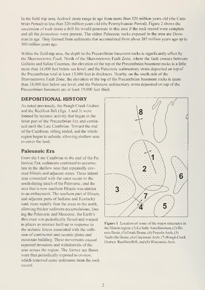
Figure 1 Location of some of the major structures in
the Illinois region. ( 1 ) La Salle Anticlinorium, (2) Illi-
nois Basin, (3) Ozark Dome, (4) Pascola Arch, (5)
Nashville Dome, (6) Cincinnati Arch, (7) Rough Creek
Graben Reelfoot Rift, and (8) Wisconsin Arch.
THICKNESS: ABOUT 2.000 FT THICKNESS ABOUT 3,000 FT THICKNESS: ABOUT 4.000 FT THICKNESS: ABOUT 8,000 FT
MATTOON
i ii Q
X-
BOND
CARBONDALEIncludes Anvil
Rock. Cuba,
U. Dudley.
Dykstra. Jake Cr
,
Jamestown,Pleasantview,
1st or U. Siggins
TRADEWATERInd. Bellair 500,
Bridgeport,
Browning, Clay-
pool, L Dudley.
Isabel, Kickapoo,
Petro, Robinson,
2nd or L Siggins,
Wilson
Incl. Bellair 800.
Burtschi. Casey,Mansfield. Dagley,
Partlow,
3rd, 4th, Siggins
CASEYVILLEIncludes Beiehl,
Buchanan,Jordan,
Pottsville,
Ridgley
GROVE CHURCH
KINKAID
• DEGONIA
• CLORE
•" PALESTINE
-OfF} MENARD
VIENNA
« TAR SPRINGS
GLEN DEAN
HARDINSBURG
HANEY(Golconda lime)
FRAILEYS (Gol. sh.)
Big Clifty, Jackson
BEECH CREEK(Barlow, basal Gol
)
CYPRESS -4—Weiler, Kirkwood,
Carlyle. Bellair 900,
Lindley
RIDENHOWER(U PC)
Sample (P. Cr Sd , E. III.)
BETHEL(PaintCr Sd.. W. III.)
3 DOWNEYS BLUFFTJ_ (LPC . U Ren
)
• YANKEETOWNBenoist
RENAULT (L Ren)
• AUX VASESSTE GENEVIEVE
g? ^Aux Vases lime
• Ohara
ft Spar Mountain
(Rosiclare)
IMcClosky
(Oblong)
L McClosky
rrrr
ST LOUIS
Martinsville
SALEM
ULLIN
^ FT. PAYNE •*—
BORDEN (Osage)
• Cole. Sonora
Carper
CHOUTEAUNEW ALBANY <—
Hardin
LINGLEHibbardHoing
GRAND TOWERGenevaDutch Creek
CLEAR CREEK
BACKBONE• GRASSY KNOB
BAILEY
T MOCCASIN SPRINGSSilurian, Niagaran(reef and nonreef)
ST. CLAIR• KANKAKEE/SEXTON_• EDGEWOOD CREEK
MAQUOKETA
• GALENAKimmswick, Trenton
PLATTEVILLE
JOACHIM
DUTCHTOWN
ST PETER
EVERTON
SHAKOPEE
//////»/./^7r?r2^S//////zz z ONEOTA
/,*/.* //,-> / - /.^3-/ ; /,/,y / -ATT7Slz:/\/" y\/^^.////,
/ ./. .- / y\aw • /ZZ/, /.
/ / //. /. /
/. /.
's's/'/ '
POTOSI
FRANCONIA
^J=Y EAU CLAIRE
MT. SIMON
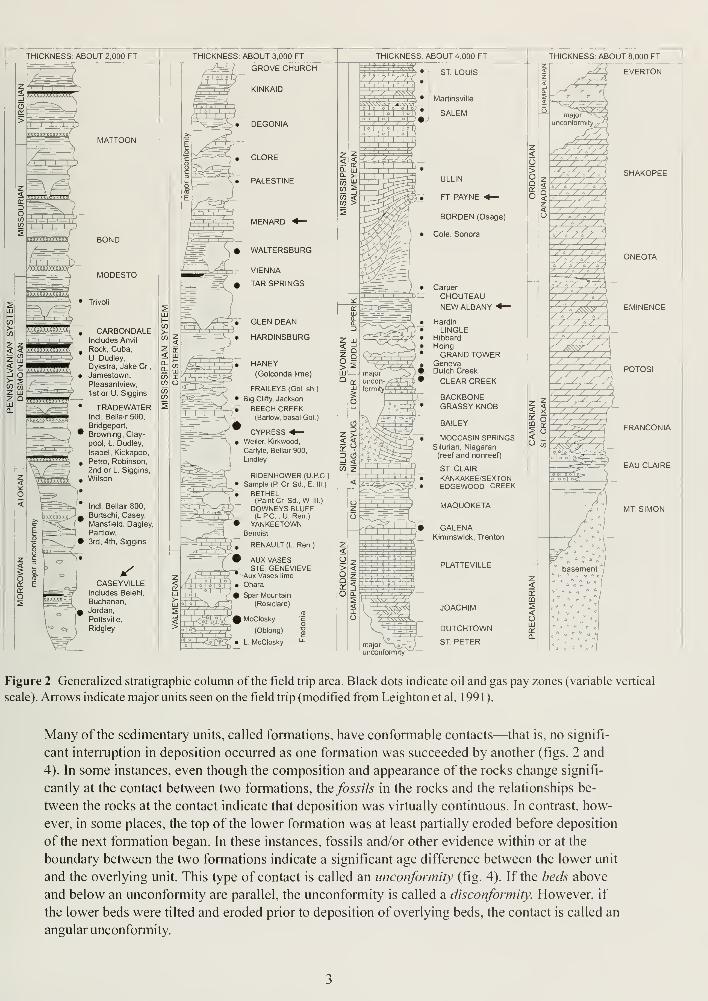
Figure 2 Generalized stratigraphic column of the field trip area. Black dots indicate oil and gas pay zones (variable vertical
scale). Arrows indicate major units seen on the field trip (modified from Leighton et al. 1 99 1 ).
Many of the sedimentary units, called formations, have conformable contacts—that is, no signifi-
cant interruption in deposition occurred as one formation was succeeded by another (figs. 2 and
4). In some instances, even though the composition and appearance of the rocks change signifi-
cantly at the contact between two formations, the fossils in the rocks and the relationships be-
tween the rocks at the contact indicate that deposition was virtually continuous. In contrast, how-
ever, in some places, the top of the lower formation was at least partially eroded before deposition
of the next formation began. In these instances, fossils and/or other evidence within or at the
boundary between the two formations indicate a significant age difference between the lower unit
and the overlying unit. This type of contact is called an unconformity (fig. 4). If the beds above
and below an unconformity are parallel, the unconformity is called a disconformity. However, if
the lower beds were tilted and eroded prior to deposition of overlying beds, the contact is called an
angular unconformity.
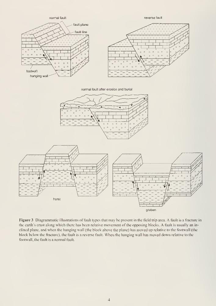
normal fault reverse fault
fault plane
fault line
footwall
hanging wall
normal fault after erosion and burial
— pi;
. p o 0///
V' /
. / // /.
// ',
i,
i,
r
T~~^o o
horst
I.I, r—~r
graben
Figure 3 Diagrammatic illustrations of fault types that may be present in the field trip area. A fault is a fracture in
the earth's crust along which there has been relative movement of the opposing blocks. A fault is usually an in-
clined plane, and when the hanging wall (the block above the plane) has moved up relative to the footwall (the
block below the fracture), the fault is a reverse fault. When the hanging wall has moved down relative to the
footwall, the fault is a normal fault.
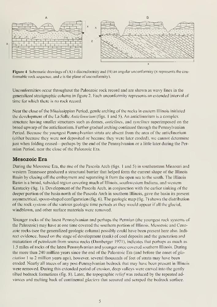
Figure 4 Schematic drawings of (A) a disconformity and (B) an angular unconformity (x represents the con-
formable rock sequence, and z is the plane of unconformity).
Unconformities occur throughout the Paleozoic rock record and are shown as wavy lines in the
generalized stratigraphic column in figure 2. Each unconformity represents an extended interval of
time for which there is no rock record.
Near the close of the Mississippian Period, gentle arching of the rocks in eastern Illinois initiated
the development of the La Salle Anticlinorium (figs. 1 and 5). An anticlinorium is a complex
structure having smaller structures such as domes, anticlines, and synclines superimposed on the
broad upwarp of the anticlinorium. Further gradual arching continued through the Pennsylvanian
Period. Because the youngest Pennsylvanian strata are absent from the area of the anticlinorium
(either because they were not deposited or because they were later eroded), we cannot determine
just when folding ceased—perhaps by the end of the Pennsylvanian or a little later during the Per-
mian Period, near the close of the Paleozoic Era.
Mesozoic Era
During the Mesozoic Era, the rise of the Pascola Arch (figs. 1 and 5) in southeastern Missouri and
western Tennessee produced a structural barrier that helped form the current shape of the Illinois
Basin by closing off the embayment and separating it from the open sea to the south. The Illinois
Basin is a broad, subsided region covering much of Illinois, southwestern Indiana, and western
Kentucky (fig. 1 ). Development of the Pascola Arch, in conjunction with the earlier sinking of the
deeper portion of the basin north of the Pascola Arch in southern Illinois, gave the basin its present
asymmetrical, spoon-shaped configuration (fig. 6). The geologic map (fig. 7) shows the distribution
of the rock systems of the various geologic time periods as they would appear if all the glacial,
windblown, and other surface materials were removed.
Younger rocks of the latest Pennsylvanian and perhaps the Permian (the youngest rock systems of
the Paleozoic) may have at one time covered the southern portion of Illinois. Mesozoic and Ceno-
zoic rocks (see the generalized geologic column) possibly could have been present here also. Indi-
rect evidence, based on the stage of development (rank) of coal deposits and the generation and
maturation of petroleum from source rocks (Damberger 1971 ), indicates that perhaps as much as
1.5 miles of rocks of the latest Pennsylvanian and younger once covered southern Illinois. During
the more than 240 million years since the end of the Paleozoic Era (and before the onset ofgla-
ciation 1 to 2 million years ago), however, several thousands of feet of strata may have been
eroded. Nearly all traces of any post-Pennsylvanian bedrock that may have been present in Illinois
were removed. During this extended period of erosion, deep valleys were carved into the gently
tilted bedrock formations (fig. 8). Later, the topographic relief'was reduced by the repeated ad-
vances and melting back of continental glaciers that scoured and scraped the bedrock surface.
p\um RWFault Zone %%£—De*s Plainest
;—- Anticline
_i— Syncline
x— Monocline
Fault, ticks ondownthrown side
-rt- Crypto-explosive or
impact structure
F.C. Fault Complex
F.F. Faulted Flexure
F.S. Fault System
F.Z. Fault Zone
Figure 5 Structural features of Illinois (modified from Buschbach and Kolata 1991 ).
Chicago
Rockford
100 mi
Figure 6 Stylized north-south cross section shows the structure of the Illinois Basin. To show detail, the
thickness of the sedimentary rocks has been greatly exaggerated and younger, unconsolidated surface de-
posits have been eliminated. The oldest rocks are Precambrian (Pre€) granites. They form a depression
filled with layers of sedimentary rocks of various ages: Cambrian (C), Ordovician (O), Silurian (S), Devonian
(D), Mississippian(M), Pennsylvanian(P), Cretaceous (K), and Tertiary (T). Scale is approximate.
This glacial erosion and deposition affected all the formations exposed at the bedrock surface in Il-
linois. The final melting of the glaciers left behind the non-lithified deposits in which our modern
soil has developed.
STRUCTURAL SETTINGThe Garden of the Gods field trip area is located in the southeast corner of the Illinois Basin, in
southeast Saline, southwest Gallatin, northeast Pope, and northwest Hardin Counties. The Illinois
Basin is the major structural depression between the Ozark Dome and the Cincinnati Arch (fig. 1).
Shawneetown Fault ZoneThe Rough Creek-Shawneetown Fault System is located in northeastern Pope, southeastern Sa-
line, and southern Gallatin Counties (see fig. 5). The name Shawneetown Fault Zone is applied to
the portion of the Rough Creek-Shawneetown Fault System that is in Illinois (fig. 9). The follow-
ing description of the Shawneetown Fault Zone is modified from that ofNelson (1995).
The Shawneetown Fault Zone enters Illinois just south of Old Shawneetown in Gallatin County
and trends westward for about 15 miles. In southeastern Saline County, the fault zone curves
sharply to the south-southwest and continues about 12 more miles to Section 25, Tl IS, R6E, in
Pope County, where it intersects the Lusk Creek Fault Zone (fig. 9). Along most of its length, the
Shawneetown Fault Zone is well expressed topographically by a range of hills of resistant lower
Pleistocene andPliocene not shown
TERTIARYclay andsand, gravel
CRETACEOUSsand, silt,
clay, gravel
J PENNSYLVANIANshale, sandstone,limestone, coal
MISSISSIPPIANlimestone, siltstone, shale,
sandstone
DEVONIANshale at the top; remainderlimestone, dolomite, chert
SILURIANdolomite, limestone, siltstone,
shale
222 ORDOVICIANshale at the top; limestone,dolomite, sandstone
I CAMBRIANsandstone and dolomite
— major fault systems
-i r~
50 km
Figure 7 Bedrock geology beneath surficial deposits in Illinois.
Figure 8 Major bedrock valleys of Illinois.
3
~' B
2-d, ZV
O o 75
\ \ 1<H4
S' £ 7£ OJ9 o ^ 01
^ SS <D —.2 °> 3! ra
c ,u o> cI » o S
o o ®
n OD Q 00 ™
? y « E —3 - P »M O S R —
-> O- C >Son"*t C to c T3"±-005
a. »- w COa
c<3
CJ
2
ON
1- ° C/> I- £ 0) I- £ <0
10
Pennsylvanian Caseyville Formation south and southeast of the fault zone. These include several
ofthe highest points in southern Illinois: Williams Hill (elevation 1 ,064 feet), Horton Hill (elevation,
1,000 feet), Wamble Mountain (elevation, 940 feet), Cave Hill (elevation, 923 feet), and Bald Knob
(820 feet). The fault zone itself tends to form a strike valley and is concealed by alluvium or
glacio-lacustrine deposits in many places.
The fault zone ranges in width from a few yards to as much as 8,000 feet. The largest fault in the
zone is near the north edge of the east-west-trending part of the zone and exhibits as much as
3,500 feet of vertical separation. This large fault is referred to as the Front Fault, and seismic data
indicate that it continues the full length of the Rough Creek-Shawneetown Fault System in Ken-
tucky (fig. 6). Data from wells drilled in this area show this to be a high-angle reverse fault dipping
about 70°, to the south (see fig. 3).
Other faults in the Shawneetown Fault Zone strike subparallel to the Front Fault and have throws
measured in hundreds of feet. Some of these join the Front Fault at one or both ends and probably
connect with it at depth, but other faults appear to be isolated. In places, the fault zone assumes a
braided pattern with interconnected faults outlining a series of polygonal or lens-shaped slices.
Most of the smaller faults in the Shawneetown Fault Zone probably are normal faults.
Horseshoe Upheaval
Large displacements in the Shawneetown Fault Zone are the result of sharp tilting and upthrow of
slices adjacent to the Front Fault. The most extreme case is at the Horseshoe Upheaval in Section
36, T9S, R7E (Stop 5), just west of the Saline-Gallatin county line (fig. 9). At this point, a slice of
nearly vertical Mississippian Fort Payne Formation and Upper Devonian New Albany Group south
of the Front Fault is juxtaposed with middle Pennsylvanian strata north of the fault (fig. 10). An oil
test hole 0.75 mile west of the Horseshoe Upheaval penetrated the Front Fault and passed from
Lower Devonian chert in the upper block into younger Pennsylvanian strata in the lower block
(see figs. 2 and 3). The vertical separation is approximately 3,500 feet, which is the largest known
offset on any near-surface fault in Illinois. At numerous other places, tilted blocks of Mississippian
strata are upthrown between Pennsylvanian rocks along the fault zone.
Rocks north and northwest of the Shawneetown Fault Zone are mostly horizontal or dip gently to
the north or northwest. In the fault slices and immediately south or southeast of the fault zone, the
rocks generally dip steeply south or southeast and strike parallel with the faults. These dips rapidly
diminish away from the fault zone.
The presence of the upthrown slices and the steep tilting of strata along the fault zone imply that
two periods of movement took place after Pennsylvanian sedimentation. The first movement was
reverse with the south or southeast side upthrown; the second movement involved normal faulting
with the south or southeast side downdropped (figs. 3 and 10).
No oil production has been achieved in or south of the Shawneetown Fault Zone, although numer-
ous fields have been developed in and south of the Rough Creek Shawneetown Fault System in
adjacent parts of Kentucky. Small-scale mining and prospecting for fluorite and associated miner-
als have taken place along the southwest-trending portion of the Shawneetown Fault Zone.
Eagle Valley Syncline
The Eagle Valley Syncline is the narrow western extension of the Moorman Syncline in Illinois
(fig. 5). The Eagle Valley Syncline is located south of the Shawneetown Fault Zone in southeast-
ern Saline and southern Gallatin Counties (fig. 9). The following description of the Eagle Valley
Syncline is modified from Nelson (1995).
11
Horseshoe =^
Quarry <
Qal J Cahokia Alluvium and Equality Formation
Pm Modesto Formation
Pcb Carbondale Formation
:
::Ps::::: upper Tradewater Formation
Pa lower Tradewater Formation
:::: Pcv:-:] Caseyville Formation
^Mts^ Tar Springs Sandstone
Mgh Glen Dean Limestone, Hardinsburg Sandstone, and Golconda Group
Mcu Chesterian Series, undifferentiated
Mfp Fort Payne Formation: includes small area of New Albany Shale Group
•' Mvu-' Valmeyeran Series, undifferentiated
^Dna^; New Albany Shale Group
Figure 10 Shawneetown Fault Zone and its effect on the bedrock strata in the Horseshoe Upheaval (modi-
fied from Nelson and Lumm 1 986).
12
The Eagle Valley Syncline lies immediately south ofand trends approximately parallel with the
east-west part of the Shawneetown Fault Zone. As defined, the Eagle Valley Syncline is about 15
miles in length, and its width increases from about 6 miles near the west end to about 9 miles at
the Ohio River. It is abruptly closed off at the west end, where the Shawneetown Fault Zone turns
to the southwest. The flanks are marked by rugged hills of resistant lower Pennsylvanian sand-
stone, whereas the central area is a lowland underlain by easily eroded and younger Pennsylva-
nian strata of the Carbondale Formation (fig. 1 1 ).
Although displacements on individual faults are large, the net offset across the Shawneetown Fault
Zone is small. Pennsylvanian coal beds in the Eagle Valley Syncline south of the fault zone lie at
the same or slightly lower elevation as the same beds north of the fault zone. However, detailed
structural mapping, as measured on the Springfield (No. 5) Coal Member, reveals more than 2,000
feet of relief within the syncline. The axis is sinuous and contains several enclosed depressions.
The south limb dips rather uniformly at 5° to 10°; dips on the north limb are much more variable,
from less than 10° to 60° (locally steeper).
The north limb of the Eagle Valley Syncline was produced by displacement along the Rough
Creek-Shawneetown Fault System. The south flank of the syncline merges with the north flank of
Hicks Dome and the northeast flank of the Tolu Arch (fig. 9).
GLACIAL HISTORY OF ILLINOIS
Cenozoic Era
A brief general history of glaciation in North America and a description of the deposits commonly
left by glaciers are given in Quaternary Glaciations in Illinois at the back of the guidebook.
As already stated, the erosion that took place long before the glaciers advanced across the state
left a network of deep valleys carved into the bedrock surface (fig. 8). The present topography of
Illinois is significantly different from the topography of the preglacial bedrock surface. The topog-
raphy of the bedrock surface throughout much of Illinois is largely hidden from view by glacial de-
posits except along the major streams and in the driftless areas of northwestern, western, and
southern Illinois (fig. 12). In many areas, the glacial drift is thick enough to completely mask the
underlying bedrock surface. Studies of mine shafts, water-well logs, and other drill-hole informa-
tion, in addition to scattered bedrock exposures in some stream valleys and roadcuts, show that the
present land surface of the glaciated areas of Illinois does not reflect the underlying bedrock sur-
face. The topography of the preglacial bedrock surface has been significantly modified by glacial
erosion and is subdued by glacial deposits.
In the past 1 .6 million to 2 million years—during the Pleistocene Epoch of the Quaternary Pe-
riod—much of northern North America was repeatedly covered by huge glaciers (see Quater-
nary Glaciations in the back of the guidebook). These continent-size masses of ice formed in
eastern and central Canada as a result of climate cooling. Glacial advances into the central low-
land of the United States altered the landscape across much of the Midwest.
During an early part of the Pleistocene Epoch, glaciers advanced out of centers of ice accumula-
tion both east and west of the Hudson Bay area in Canada. These centers are referred to in this
guidebook as northeastern and northwestern source areas because Illinois lies to the south of and
between these centers of accumulation. Glaciers flowing out of these centers into Illinois carried
along rock debris incorporated into the ice as they advanced; this material was dropped out as the
ice melted. The number and timing of these early episodes of glaciation are uncertain at present
and are therefore unnamed, but, because they precede the first named episode of glaciation (the
13
03 aoaiH SH3SHVX
ifasafl S90H V,'
Mioj saavzzaa
Jfsaao si3ea amTCSIBOO USAOJlSd-SJABa
WTToi^ J0 3UBrd
CJ -.
9uoo,spires 3100H TTAUV
t!
2
o
OUu
cuT3Inre
aIh03<ucu-o
5
o
C3
reo
uc
oc>,</)
>><u
re
>t>
60re
tU
J2Ml3Ojd
couu -o
'J
re
oIh
u00
O bU
T3UN
re
^3 >.re
Uc
reuIhu hi)
O (l)
Ih— Whh (/)
v Cl
3~
DD "On
u. re
14
Hudson and Wisconsin! Episodes
Mason Group; andi Cahokia Fm
Cahokia and Henry Fms; sort'
sediment including waterlain
river sediment and windblownand beach sand
Equality Fm; fine grained
sediment deposited in lakes
—-5 Thickness of Peoria andRoxana SiS; silt deposited
as loess (5-<£ontour interval)
Wedron Group (§kilwa, Lemont, andWadsworth Fms) ariflrafalgar Fm;diamicton deposited as till andice margin sediment
End moraine
Ground moraine
Illinois Episode
WinnebagoDFm;DdiamictonGdepositedDasDtillandDicenmargin 71 sediment
Glasford- Fm; Jdiamicton deposited as till _ andice D margin D sediment
TeneriffeGSiltDandGPearlDFm.njncludingCHagerstowMbr;nsortednsedimesffi including nrivernandnlakedeposits and iwindi iblowm sand
Pre-lllinois' Episodes
Wolfr Creek Fm; predominantly diamictondeposited as till and ice margin sediment
Paloezoic, Mesozoic, and! Cenozoic
Mostly Paleozoic shale, limestone, dolomite,
or sandstone; exposed or covered by loess
and/or residuum
Figure 12 Generalized map of glacial deposits in Illinois (modified from Willman and Frye 1970).
15
Illinois Episode; Hansel and Johnson 1996), they are called simply pre-Illinois glacial episodes (see
number 1 on fig. 13). The pre-Illinois glacial episodes ended about 425,000 years ago.
A long interglacial episode, called the Yarmouth (see number 2 on fig. 13), followed the last of the
pre-Illinois glacial advances. The Yarmouth interglacial episode is estimated to have lasted ap-
proximately 1 25,000 years, and deep soil formation took place during that long interval (Yarmouth
Geosol). On the parts of the landscape that were generally poorly drained, fine silts and clays
slowly accumulated (accreted) in shallow, wet depressions and formed what are called accretion
gleys, which are characterized by dark gray to black, massive, and dense clay deposits.
The Illinois Episode of glaciation began approximately 300,000 years ago and lasted for about
175,000 years (see number 3 on fig. 13). During this interval, ice advanced three times out of the
northeastern center of accumulation. During the Illinois Episode, the continental glaciers in North
America reached their southernmost position, approximately 25 miles southwest of Harrisburg in
the northern part of Johnson County (fig. 12). Locally, the glacier stopped 5 miles north of Harris-
burg. During the first of these advances, ice of this episode reached westward across Illinois and
into Iowa.
Another long interglacial episode, called the Sangamon (number 4 on fig. 13), followed the Illinois
Episode and lasted about 50,000 years. Although shorter than the Yarmouth interglacial episode,
this interval's length was sufficient for another major soil, the Sangamon Geosol, to develop. The
Sangamon Geosol exhibits both well-drained and poorly drained soil profiles. Although accretion
gleys in the Sangamon are not as widespread as they are in the Yarmouth Geosol, they are fairly
common and are easily identified by the same characteristics as the Yarmouth accretion gleys.
About 75,000 years ago, the Wisconsin Episode of glaciation began. Ice from the early and middle
parts of this episode (number 5 on fig. 1 3) did not reach into Illinois. Although late Wisconsin Epi-
sode ice (number 6 on fig. 13) did advance across northeastern Illinois beginning about 25,000
years ago, it did not reach southern or western Illinois (fig. 12). The effects of the late Wisconsin
glaciation in the field trip area are represented by backwater glacial lake sediments of the Equality
Formation (see fig. 12) and the windblown silts (loess—pronouced "luss") that blanket the land-
scape and compose the parent materials for modern soils. The maximum thickness of the ice in
the late Wisconsin Episode glaciers was about 2,000 feet in the Lake Michigan Basin, but only
about 700 feet over most of the Illinois land surface (Clark et al. 1988). The last of these glaciers
melted from northeastern Illinois about 13,500 years B.P. (before the present).
Wisconsin Episode moraines were deposited in Illinois from approximately 25,000 to 1 3,500 years
ago. Although Illinois Episode glaciers probably built morainic ridges similar to those of the later
Wisconsin Episode glaciers, the Illinois Episode moraines apparently were not as numerous and
have been exposed to weathering and erosion for approximately 280,000 years longer than their
younger Wisconsin Episode counterparts. For these reasons, Illinois Episode glacial features gen-
erally are not as conspicuous as the younger Wisconsin Episode features.
In general, glacial deposits consist primarily of ( 1 ) till—pebbly clay, silt, and sand, deposited di-
rectly from melting glaciers; (2) outwash—mostly sand and gravel, deposited by the rapidly flow-
ing meltwater rivers; (3) lacustrine deposits—silt and clay that settled out in quiet-water lakes
and ponds; and (4) loess—windblown sand and silt.
Within the vicinity of the field trip area, north of Harrisburg, glacial drift generally ranges from a
few feet to somewhat more than 25 feet thick. Glacial deposits slightly more than 50 feet thick
can be found along the preglacial bedrock valley of the Saline River and its tributaries. However,
16

Years
before
present
Time-distance diagram
Interglacial andglacial episodes Sediment record
Dominant climate conditions
Dominant land forming and soil
forming events
22
10,000-
o(/)
o
^ 25,000c
interglacial
episode
WISCONSIN(late)
glacial
episode1
^ glacial
ice
75,000 -
125,000-
WISCONSIN(early and middle)
glacial margin
north of Illinois
SANGAMONinterglacial
episode
300,000 -
425,000 -
PRE-ILLINOISglacial
1,600,000-
and older
interglacial
episodes
River, lake, wind, andslope deposits.
Warm; stable landscape conditions.
Formation of modern soil; running wa-ter, lake, wind, and slope processes.
Till and ice-marginal
deposits; outwash andglacial lake deposits;
loess.
Cold; unstable landscape conditions.
Glacial deposition, erosion, andlandforming processes (e.g., formation
of end moraines, outwash plains, valley
trains, proglacial lakes, kettles), plus
running water, lake, wind, and slope
processes.
Loess; river, lake, andslope deposits.
Cool; stable.
Weathering, soil formation (Farmdale
Soil and minor soils); wind and running
water processes.
River, lake, wind, andslope deposits.
Warm; stable.
Weathering, soil formation (SangamonGeosol); running water, lake, wind, andslope processes.
Till and ice-marginal
deposits; outwash andglacial lake deposits;
loess.
Cold; unstable.
Glacial deposition, erosion, and land-
forming processes, plus proglacial
running water, lake, wind, and slope
processes; possible minor soil
formation.
River, lake, wind, andslope deposits.
Warm; stable.
Long weathering interval with deep soil
formation (Yarmouth Geosol); running
water, lake, wind, and slope processes.
Till and ice-marginal
deposits; outwash andglacial lake deposits;
loess plus nonglacial
river, lake, wind, andslope deposits.
Alternating stable and unstable inter-
vals of uncertain duration.
Glacial deposition, erosion, and land-
forming processes, plus proglacial
and interglacial running water, lake,
wind, and slope processes; interglacial
weathering and soil formation.
Figure 13 Timetable illustrating the glacial and interglacial events, sediment record, and dominant climate
conditions of the Ice Age in Illinois (modified from Killey 1998).
17
in several localities, bedrock is exposed, and the glacial deposits have been completely removed by
erosion.
The sediments that formed the flat topography immediately north of the Shawnee Hills, from Har-
risburg east to the Ohio River, are lacustrine deposits of the Equality Formation (fig. 12). These
flatlands of the Saline River Valley represent the bottom of an old glacial lake (Lake Saline) that
once covered this area. In this vicinity, the sediments that accumulated in the lake consist of more
than 100 feet of clay, silt, sand, and gravel. Some of these lake sediments probably date from the
Illinois glaciation about 200,000 years ago, but most of the sediments were deposited during the
melting of the late Wisconsin glaciers from about 20,000 to 10,000 years ago.
Flooding of the lowland areas in southern Illinois and adjacent parts of Indiana and Kentucky was
especially extensive during the melting of the large ice mass at the end of the Wisconsin glaciation.
Vast amounts of meltwater poured from the ice front and caused extensive flooding in the Missis-
sippi, Illinois, Wabash, and Ohio River valleys. In this area, a great lake was formed as these
floodwaters backed up the Saline River Valley and its tributaries. Low areas in the Eagle Valley
Syncline to the south were also flooded. At its greatest extent, this lake probably reached an el-
evation of about 400 feet above sea level.
The former lake bed in the Saline River valley still floods from time to time when the Ohio River
rises high enough, and the Pleistocene lake sediments are veneered with sediment of Recent Epoch.
The flood of 1937 is thought to have formed a lake approximately the size of the Wisconsin glacial
Lake Saline that existed 13,000 years ago.
The loess that mantles the bedrock and glacial drift throughout the field trip area was laid down by
the wind during all of the glacial episodes, from the earliest pre-Illinois glacial episode (approxi-
mately 1 .6 million years ago) to the last glacial episode, the Wisconsin Episode. This yellowish
brown silt occurs on the uplands and mantles the glacial drift throughout the field trip area. The
loess is generally between 4 and 8 feet thick, but erosion has completely removed it in scattered
areas in the Shawnee Hills area of the field trip. The thickness of the loess generally increases to
the west and east toward the Mississippi and Illinois Rivers. The loess, which covers most of Illi-
nois, is up to 15 feet thick along the Illinois River valley and is more than 50 feet thick along the
east edge of the Mississippi River valley.
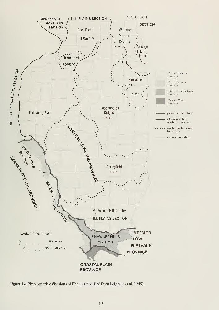
GEOMORPHOLOGYPhysiography
Physiography is a general term used for describing landforms; a physiographic province is a region
in which the relief or landforms differ markedly from those in adjacent regions. The field trip area
is located in two distinctly different physiographic provinces. North of the escarpment formed by
the uplifted Pennsylvanian rocks of the Shawnee Hills is the Mt. Vernon Hill Country—a physio-
graphic division within the Till Plains Section of the Central Lowland Physiographic Province (fig. 14).
The Till Plains Section is divided into seven distinct divisions in Illinois. The present gross topo-
graphic features of the Till Plains Section are largely determined by the underlying preglacial to-
pography. The Central Lowland Province is bordered on the south and west by uplands contain-
ing extensive remnants of an older erosional surface. Prior to glaciation, the lowland surface was
incised by a drainage system consisting of many deep bedrock valleys. The area south of the
Pennsylvanian Escarpment is defined as the Shawnee Hills Section of the Interior Low Plateaus
Province (fig. 14).
WISCONSIN / TILL PLAINS SECTION
DRIFTLESSSECTION .
Rock River
GREAT LAKE
SECTIONf
Morainal
Country
.'"Chicago
J".Lake
.•j ' *• Plain]
INTERIOR
LOW
PLATEAUS
PROVINCE
COASTAL PLAIN
PROVINCE
Figure 14 Physiographic divisions of Illinois (modified from Leightonetal. 1948).
Central LowlandProvince
Ozark Plateaus
Province
Interior Low Plateaus
Province
Coastal Plain
Province
province boundary
physiographicsection boundary
section subdivision
boundary
county boundary
19
Mt. Vernon Hill Country comprises the southern portion of the area covered by the drift sheet
left by the Illinois Glacial Episode and the area covered by the Wisconsin Glacial Episode deposits
of the Equality Formation. The Mt. Vernon Hill Country is characterized by mature topography of
low relief with restricted upland prairies and broad alluviated valleys along the larger streams. The
covering of glacial sediments is thin, and glacial landforms are essentially absent. The present land
surface is primarily a bedrock surface of low relief only slightly modified and subdued by the
mantle of glacially deposited material. According to Leighton et al. (1948), an extensive lowland
called the "central Illinois peneplain" (a low, nearly featureless, gently undulating land surface)
was eroded prior to glaciation into the relatively weak rocks of Pennsylvanian age east and south
of the present-day Illinois River. Apparently, just before the advent of glaciation, an extensive sys-
tem of bedrock valleys was deeply entrenched below the central lowland surface level. As glacia-
tion began, streams probably changed from erosion to aggradation; that is, their channels began to
build up and fill in with sediment because the streams did not have sufficient volumes of water to
carry and move the increased volumes of sediment. To date, no evidence indicates that the early
fills in these preglacial valleys were ever completely flushed out of their channels by succeeding
deglaciation meltwater torrents.
Shawnee Hills Section includes a complex dissected upland underlain by Mississippian and
Pennsylvanian bedrock of varied lithology (see figs. 7, 12, and 14). It is located along the southern
rim of the Illinois Basin, with a cuesta (a ridge with a gentle slope on one side and a steep slope
on the other) of lower Pennsylvanian rocks generally forming its northern margin and its southern
part comprising a dissected plateau underlain largely by Mississippian rocks. In the Shawnee Hills
Section, erosional remnants of a preglacial land surface called the Ozark Plateaus are extensive
along the Pennsylvanian escarpment. Locally higher summits and some lower surfaces on Missis-
sippian rocks indicate a complex erosional history that continued during all of the glacial episodes.
NATURAL DIVISIONS AND GEOLOGYGlacial history has played an important role in shaping Illinois topography by eroding the preglacial
landscape and depositing glacial sediments. Topography influences the diversity of plants and ani-
mals (biota) of Illinois by strongly influencing the diversity of habitats. Geological processes form,
shape, and create the topography on all of the Earth's surface. Specifically, geological processes
not only determine the composition of the parent material of soils, but also the formation of soils
through the weathering of parent materials. Thus, the geology of a region is the foundation of its
habitats.
Natural Divisions
The state has been divided into 14 different natural divisions. These divisions are distinguished by
differences in topography, glacial history, bedrock geology, soils, aquatic habitats, and distribution
of native plants and animals (flora and fauna). A strong relationship exists between the physio-
graphic divisions of Illinois and the natural divisions of Illinois because the geologic factors used to
determine the physiographic divisions were important elements used to define the boundaries of
the natural divisions. Of the 14 natural divisions in Illinois, the field trip area is located along the
boundary between the Southern Till Plain Division (northern part of the field trip area) and the
Shawnee Hills Division (southern part of the field trip area). The geographic area of the Southern
Till Plain Division is roughly equivalent to the Mt. Vernon Hill Country physiographic division, and
the Shawnee Hills Division is equivalent to the Shawnee Hills Section. The following descriptions
of the natural divisions are modified from Schwegman (1973).
20

The Southern Till Plain Division encompasses most of the area of dissected Illinois Glacial
Episode till plain south of the Shelbyville Moraine (Wisconsin Glacial Episode terminal moraine)
and the Sangamon River and Macoupin Creek watersheds. Both forest and prairie were present
at the time of settlement. The soils are relatively poor because of their high clay content and the
occurrence of a claypan subsoil in many places. Post oak flatwood forest is characteristic of the
division. The two sections are distinguished because of topographic differences.
• Bedrock The bedrock of the Southern Till Plain Division consists of sandstone, limestone,
coal, and shale, which commonly crop out in the eastern and southeastern parts of the divi-
sion. Bedrock lies near the surface in the Mt. Vernon Hill Country Section.
• Glacial History The Illinoian stage of Pleistocene glaciation reached the southernmost
limit of continental glaciation in North America just beyond the limits of this division. The
Southern Till Plain Division is entirely covered by Illinoian till. Glacial landforms are commononly in the northwestern part of the division.
• Topography The glacial till of the Southern Till Plain Division becomes thinner from north
to south. The bedrock of the Mt. Vernon Hill Country Section is near the surface, accounting
for the hilly and rolling topography. The Effingham Plain Section is a nearly level to dissected
till plain. There are broad floodplains along the major streams, and there are ravines in the
bluffs along the stream valleys.
• Soils The soils on the uplands are light colored and strongly developed, with poor internal
drainage. They have developed from thin loess and till under both forest and prairie vegeta-
tion. Fragipan and claypan layers are characteristic of the upland soils. Some of the prairie
soils have a high sodium content and are known locally as "alkaline slicks."
The Shawnee Hills Division extends across the southern tip of Illinois from Fountain Bluff on
the Mississippi River to the Shawneetown Hills near the mouth of the Wabash River. This
unglaciated hill country is characterized by a high east-west escarpment of sandstone cliffs form-
ing the Greater Shawnee Hills and a series of lower hills underlain by limestone and sandstone
known as the Lesser Shawnee Hills. Originally this division was mostly forested, and considerable
forest remains to the present time. A number of distinctive plant species are restricted to this divi-
sion of Illinois.
• Bedrock The Greater Shawnee Hills form a band along the northern edge of the division
and consist of massive Pennsylvanian sandstone strata that dip northward toward the Illinois
Basin. The Greater Shawnee Hills are 10 miles wide on average and border the Lesser
Shawnee Hills to the south. The Lesser Shawnee Hills are underlain by Mississippian lime-
stone and sandstone, and sinkholes and caves are locally common features. Mineralized
faults containing fluorspar and zinc, silver, and other metals exist in the eastern part of the
Shawnee Hills Division. Iron deposits are found in Hardin County. There is a dome contain-
ing an igneous rock core in western Hardin County, and outcrops of igneous rock occur in the
Lesser Shawnee Hills Section.
• Topography The topography of the Shawnee Hills Division is very rugged, with many
bluffs and ravines. The north slopes of the Greater Shawnee Hills Section are relatively
gentle, but the south slopes consist of many escarpments, cliffs, and overhanging bluffs.
Streams have eroded canyons in the sandstone. The Lesser Shawnee Hills are about 200
feet lower, on average, than the Greater Shawnee Hills. The Lesser Shawnee Hills have lo-
cal areas of sinkhole topography.
21

• Soils The soils are derived mainly from loess. Narrow bands of moderately developed deep
loess soils occur along the Mississippi River in Jackson County and along the Ohio River in
eastern Hardin County; however, most of the soils are derived from thinner loess and are
strongly developed. Claypan and fragipan layers are frequent.
NATURAL RESOURCESMineral Production
The total value of all minerals extracted, processed, and manufactured in Illinois during 1995 was
$2,202,300,000. Minerals extracted accounted for 87.6% of this total. Coal continued to be the
leading commodity, followed by industrial and construction materials, oil, metals, peat, and gem-
stones. Illinois ranked 5th among coal-producing states, 1 3th among the 3 1 oil-producing states,
and 16th among the 50 states in total production of nonfuel minerals. Illinois continues to lead all
other states in production of industrial sand and tripoli.
Fluorspar
Fluorspar is the state mineral of Illinois, and Illinois was long the principal fluorspar producer in the
country. The first recorded fluorspar mining in Illinois was in 1842 when a small operation was
started in Hardin County in southern Illinois. Production continued to be centered there. Produc-
tion rose from 104.7 thousand tons in 1940 to 198.7 thousand tons in 1943. In 1940, about 48% of
the nation's fluorspar demand was met by the shipments from Illinois. The state's share increased
to 51% in 1943, but declined to zero thereafter. In the early days, fluorspar output came from nu-
merous mines ranging from those producing only a few hundred tons per year to those producing
tens of thousands of tons annually. The extremely competitive conditions and high production costs
forced most of the producers out of business over time.
By 1995, Ozark-Mahoning Co., a subsidiary of the Pennsylvania-based Elf Atochem North
America Inc., was the nation's only fluorspar producer. In 1995, total fluorspar shipments from
this company were 48,000 tons, which accounted for 8.5% of the nation's fluorspar requirements.
On January 31,1 996, Elf Atochem North America closed its two mines and a flotation plant in
Hardin County, because of depletion of reserves at active mines and competition from China.
Ozark-Mahoning, which had been in operation since 1938, was the last active fluorspar mining
company in the country. With the closure of Ozark-Mahoning's operations, the United States
ended 158 years of fluorspar mining. Hastie Mining and Trucking Co., a local quarry company,
leased Ozark-Mahoning's mineral drying and bagging facilities to process fluorspar purchased
from the national defense stockpile. The company will probably service some of the former cus-
tomers of Ozark-Mahoning by making a calcined product.
Barite, copper, lead, silver, and zinc (sphalerite) concentrates were recovered as co-products of
fluorspar processing in Illinois. Fluosilicic acid, a by-product, was also recovered from fluorspar
processing. It was used primarily in the aluminum industry for making aluminum fluoride and in
water fluoridation, either directly or after processing to sodium silicofluoride.
Acid-grade fluorspar, containing greater than 97% calcium fluoride, is used primarily as a feed-
stock in the manufacture of hydrogen fluoride and to produce aluminum fluoride. Ceramic-grade
fluorspar (85% to 95% CaFj is used for the production of glass and enamel, to make welding rod
coatings, and as a flux (a substance used to remove impurities from steel) in the steel industry.
Metallurgical-grade fluorspar (65% to 85% CaFJ is used primarily as a fluxing agent in the steel
industry.
22

The reported domestic consumption by the hydrogen fluoride industry increased by nearly 4% in
1996. The reported consumption by the non-hydrogen fluoride industries decreased by 19% from
its level in 1995 (USGS, Mineral Industry Surx'eys, Fluorspar 1997 Annual Review). In the ce-
ramic industry, fluorspar was used as a flux and as an opacifier in the production of flint glass,
white or opal glass, and enamels.
GroundwaterGroundwater is a resource frequently overlooked in assessments of an area's natural resource po-
tential. The availability of this resource is essential for orderly economic and community develop-
ment. More than 35% of the state's 1 1.5 million citizens and 97% of those who live in rural areas
depend on groundwater for their water supply. Groundwater is derived from underground forma-
tions called aquifers. The water-yielding capacity of an aquifer can only be evaluated by con-
structing wells into it. After construction, the wells are pumped to determine the quality and quan-
tity of groundwater available for use.
23
GUIDE TO THE ROUTEWe will start the trip at the Shawnee National Forest Headquarters in Harrisburg, Illinois (SE, SW,
NW, Sec. 22, T9S, R6E, 3 rd P.M., Harrisburg 7.5-minute Quadrangle, Saline County). Mileage will
start at the exit of the parking lot.
You must travel in the caravan. Please drive with headlights on while in the caravan. Drive
safely but stay as close as you can to the car in front of you. Please obey all traffic signs. If the
road crossing is protected by an Illinois State Geological Survey (ISGS) vehicle with flashing lights
and flags, please obey the signals of the ISGS staff directing traffic. When we stop, park as close
as possible to the car in front of you and turn off your lights.
Respect private property. Some stops on the field trip are on private property. The owners
have graciously given us permission to visit on the day of the field trip only. Please conduct your-
selves as guests and obey all instructions from the trip leaders. So that we may be welcome to re-
turn on future field trips, follow these simple rules of courtesy:
• Do not litter the area.
• Do not climb on fences.
• Leave all gates as you found them.
• Treat public property as if you were the owner—which you are!
• Stay off of all mining equipment.
• Parents must closely supervise their children at all times.
When using this booklet for another field trip with your students, a youth group, or family, remem-
ber that you must get permission from property owners or their agents before entering pri-
vate property. No trespassing, please.
Five U.S. Geological Survey (USGS) 7.5-minute quadrangle maps (Equality, Harrisburg, Herod,
Karbers Ridge, and Rudement) provide coverage for this field trip area.
Miles Miles
to next from
point start
0.0 0.0 Set your odometers to 0.0 at the exit of the parking lot. Exit parking lot and
TURN RIGHT onto Illinois.Route 145/34.
0.4 0.4 Road begins slight ascent as you enter the community of Pankeyville.
This rise in elevation coincides with one of the several small bedrock hills that
occur south of Harrisburg. These bedrock hills are part of the Carbondale
Formation of the Pennsylvanian age sediments. A number of abandoned sur-
face coal mines are located along the southern flanks of most of these bed-
24
rock highs. From 1947 to 1949, the Bankston Creek Colliery Company oper-
ated a strip mine immediately south of Pankeyville. The company was mining
the Springfield (No. 5) Coal, which is locally known as the Harrisburg coal
seam. In addition to the surface mines, the Springfield/Harrisburg seam has
been extensively underground-mined in a large area that completely surrounds
Harrisburg.
0.8 1 .2 Road begins descent off of the bedrock high on south edge of the community
of Pankeyville. The view of the hills to the southeast and straight ahead is the
Pennsylvanian Escarpment, which forms the northern limit of the Shawnee
Hills.
0.7 1.9 Note the flat topography in this area.
The flatlands of the Saline River valley represent the bottom of an old glacial
slack-water lake (Lake Saline) that once covered this area during the Wis-
consin Glacial Episode. In this vicinity, the sediments that accumulated in the
lake consist of clay, silt, sand, and some gravel. These deposits are part of the
Carmi Member of the Equality Formation.
2.5 4.4 Cross the Saline River. Notice the straight channelized section of the Saline
River to your left.
0.2 4.6 Cross the old abandoned course of the Saline River. Notice the meanders to
your left.
0.2 4.8 Entering the community of Mitchellsville.
0.7 5.5 Prepare to turn left and follow Illinois Route 34. Pass the sign indicating Gar-
den of the Gods 16 miles to the left and Lake Glendale 20 miles straight
ahead.
0.
1
5.6 T-intersection from the left (Illinois Route 34/285N and Illinois Route 145/
950E). TURN LEFT. We are following Shawnee Hills and the Ohio motor
route along this part of the field trip route.
0.8 6.4 Notice the nice view of the Shawnee Hills directly ahead of us.
0.1 6.5 Cross Blackman Creek
1 .2 7.7 Cross Spring Valley Creek and enter the community of Rudement.
0.7 8.4 Cross unnamed creek. T-intersection from the left, just past the bridge
(DeNeal Road/1210E and Illinois Route 34/250N). CONTINUE AHEAD.The road to your left leads to Old Stoneface. Notice that the road begins to
rise in elevation. You are leaving the flat topography of the Equality Formation
and entering into the northern boundary of the Pennsylvanian Escarpment.
1 .8 10.2 Road follows valley cut by Gibbons Creek.
25
1.0 11.2 Enter Pope County.
1 .4 1 2.6 Enter the community of Herod.
0.1 12.7 Outcrop of cross-bedded sandstone, Pennsylvanian, Battery Rock Member of
the Caseyville Formation on the right with a small cave "rock shelter" at the
base of the sandstone bluff.
0.2 1 2.9 T-intersection from the right. CONTINUE AHEAD. The road to the right
leads to Williams Hill with an elevation of 1,064 feet above sea level.
0.
1
1 3.0 Cross Gibbons Creek and a T-intersection from the left, just past the bridge.
CONTINUE AHEAD. NOTE: The River to River Trail crosses the road at
this location.
1.6 14.6 Enter Hardin County.
0.1 14.7 Cross Rose Creek and prepare to turn left onto Karbers Ridge Road.
0.2 14.9 T-intersection from the left (Illinois Route 34/025E and Karbers Ridge Road/
1065N). TURN LEFT onto Karbers Ridge Road. CAUTION: Large coal-
hauling trucks use this road.
0.9 15.8 Great view of the Shawnee Hills to your left. Notice the large sandstone out-
crops, along the top of the hills, which form the bluffs at the Garden of the
Gods Recreation Area.
1.8 17.6 Prepare to turn left.
1.9 17.7 Crossroad intersection (Garden of the Gods Road/250E and Karbers Ridge
Road/1 180N). TURN LEFT.
0.6 18.3 Cross Rose Creek.
0.5 18.8 Outcrop on the right side of the road. Pennsylvanian age Lower Caseyville
Formation, Lusk Creek Member shales and siltstones that grade upward into
the Battery Rock Sandstone can be seen.
0.1 18.9 Outcrop of Battery Rock Sandstone on the right side of the road. Prepare to
turn left.
0.
1
19.0 T-intersection from the left (Garden of the Gods Road). TURN LEFT. En-
trance to Garden of the Gods Recreation Area.
0.8 19.8 Battery Rock Sandstone outcrop on the right side.
0.05 19.85 Small pull-over parking lot on the left. A rock shelter cave is in the Pounds
Sandstone bluff on the right.
26
0.0 20.3
0.2 20.5
0.3 20.8
1.0 21.8
0.05 19.9 Backpackers' parking lot on the left. CONTINUE AHEAD. Pass the sign in-
dicating observation trail; picnic and camping straight ahead.
0.2 20.1 River to River Trail crosses the road.
0.2 20.3 Y-intersection (Picnic Road/050N and Garden of the Gods Road/1750E).
BEAR LEFT. Sign indicating observation trail is to the left, and picnic ground
and campground are to the right. Enter the lower portion of the parking lot
and park your vehicles.
STOP 1: Garden of the Gods Recreation Area, Shawnee National Forest (SW, NW,SE, Sec. 36, T10S, R7E, 3rd P.M., Herod 7.5-minute Quadrangle, Saline County). On the day of
the field trip, assemble near the trail head sign, which is near the middle of the upper parking lot.
Leave Stop 1 and retrace your route back to the Y-intersection.
YIELD: Y-intersection (Picnic Road/050N and Garden of the Gods Road/
1 750E). TURN RIGHT onto the Garden of the Gods Road.
Pass backpackers' parking area on the right. CONTINUE AHEAD.
STOP at T-intersection (Garden of the Gods Road and County Highways 17
and 10). RESET ODOMETER.
0.0 0.0 TURN RIGHT. Heading toward Karbers Ridge Road. CAUTION: Fast-
moving traffic from the left. Road is used by large coal haulage trucks.
NOTE: County Hwy. 17 is in Gallatin County to the left, and County Hwy. 10
is in Hardin County to the right.
1.2 1.2 Prepare to stop.
0.1 1.3 STOP. Crossroad intersection (Karbers Ridge Road/1 180N and Garden of the
Gods Road/250E). TURN LEFT.
0.5 1 .8 T-intersection from the right. CONTINUE AHEAD. The road to the right
leads to Hicks Dome.
1 .0 2.8 T-intersection from the right (400E and Karbers Ridge Road/1 1 75N). CON-TINUE AHEAD. The road to the right leads to Iron Furnace (seven miles).
0.2 3.0 T-intersection from the left (425E). CONTINUE AHEAD. The road to the
left leads to High Knob, 929 feet above sea level (two miles).
0.5 3.5 T-intersection from the right (475E). CONTINUE AHEAD.
0.3 3.8 Karbers Ridge School on the left. CONTINUE AHEAD.
27
0.45 5.4
0.2 5.6
0.2 5.8
0.5 4.3 Prepare to make a right turn.
0.
1
4.4 T-intersection from the right (Cadiz Road/550E and Karbers Ridge Road/
1150N). TURN RIGHT.
0.4 4.8 Cross Big Creek.
0.15 4.95 Unimproved forest road on the right (Forest Road 1793). Pull over to the far
right side of the road and park.
STOP 2: Lee Mine, an abandoned fluorspar mine, Shawnee National Forest (NW. NW. NW,Sec. 14, Tl IS, R8E, 3rd P.M., Karbers Ridge 7.5-minute Quadrangle, Hardin County). On the day
of the field trip, we will hike along the forest road, approximately 3.000 feet, to the Lee Mine.
0.0 4.95 Leave STOP 2. CONTINUE AHEAD.
Pass Waters Cemetery on the right.
Pass Philadelphia Church of Christ on the right.
T-intersection from the left (Sparks Hill Road/690E and Cadiz Road/1 125N).
TURN LEFT. After making the turn, Matthews Cemetery is on the left.
CAUTION: This is a narrow gravel road.
0.5 6.3 CAUTION: Ford crossing of Big Creek.
0.3 6.6 Enter the abandoned community of Sparks Hill.
0.3 6.9 T-intersection from the right. CONTINUE AHEAD. Road leads to
McPherson-Love Cemetery.
0.1 7.0 STOP (one-way). T-intersection (Sparks Hill Road and Karbers Ridge Road).
TURN RIGHT. CAUTION: Blind spot in the road to the left.
0.1 7.1 To the left is a water tower operated by the Hardin County Water Company.
0.7 7.8 Prepare to turn left. Leave Hardin County and enter Gallatin County. NOTE:Karbers Ridge Road is called Pounds Hollow Road in Gallatin County.
0.
1
7.9 T-intersection from the left (Forest Road 121). TURN LEFT. Entrance to
Rim Rock Recreation Area and the Pounds Escarpment. Hill Cemetery is
opposite the entrance.
0.
1
8.0 Enter the parking loop of Rim Rock Recreation Area and park your vehicles.
This is Stop 3 and lunch. We will eat lunch in the Indian Wall picnic ground.
28
STOP 3: LUNCH Rim Rock Recreation Area and the Pounds Escarpment, Shawnee
National Forest (NE, SW, SW, Sec. 36, T10S, R8E, 3rd P.M., Karbers Ridge 7.5-minute Quad-
rangle, Gallatin County)
0.0 8.0 Leave Stop 3 and retrace your route back to Pounds Hollow/Karbers Ridge
Road.
0.3 8.3 STOP. T-intersection (Pounds Hollow Road). TURN RIGHT. NOTE: Pounds
Hollow is two miles to your left.
0.6 8.9 Pass Hardin County Water Company tower on the right.
0.8 9.7 Pass Russell Cemetery on the right.
0.9 10.6 T-intersection from the left (Cadiz Road/550 E and Karbers Ridge Road/
1150N). CONTINUE AHEAD.
0.6 11.2 Pass Karbers Ridge School on the right.
0.2 1 1 .4 T-intersection from the left (475E). CONTINUE AHEAD. NOTE: This road
will take you to Elizabethtown, where the Shawnee National Forest
Elizabethtown Ranger Station is located.
0.5 1 1 .9 T-intersection from the right (425E). CONTINUE AHEAD. Road leads to
High Knob.
0.3 12.2 T-intersection from the left (400E). CONTINUE AHEAD. Road leads to the
Iron Furnace (seven miles).
0.5 12.7 CAUTION: large trucks possibly entering the road from the right.
0.5 13.2 T-intersection from the left (300E). CONTINUE AHEAD.
0.4 13.6 Prepare to turn right.
0.
1
13.7 Crossroad intersection (Garden of the Gods Road/250E and Karbers Ridge
Road/1 180N). TURN RIGHT.
1 .4 15. 1 Entrance to the Garden of the Gods Recreation Area. CONTINUE AHEAD.
0.
1
15.2 CAUTION: Just past the Garden of the Gods entrance the road winds like a
snake slithering through the Shawnee Hills.
0.7 15.9 CAUTION: Steep grade ahead.
0.9 16.8 River to River Trail crosses the road.
29
0.4 17.2 Entering very steep grade in the road. You are traversing down the southern
flank of the Eagle Valley Syncline. NOTE: The road is now called Forest
Road, also locally know as the County Line Road. Saline County is to the left,
and Gallatin County is to the right.
0.7 17.9 Cross Little Eagle Creek at the base of the bluffs.
0.4 18.3 STOP (four-way). Crossroad intersection (Eagle Creek Road/275N and For-
est Road/1800E). CONTINUE AHEAD. The right half of this intersection is
marked as Barnett Cemetery Road/4750N and Forest Road/ IE. The numer-
ous names for this intersection are because Gallatin County is to the right and
Saline County is to the left.
STOP 4A (Optional): Jader Coal Company is to the left. Depending upon the current mining
conditions and the location of the active surface mine pits, we will make a decision on the day of
the field trip to visit either Jader Coal Company or Black Beauty Coal Company.
0.
1
1 8.4 Just north of the intersection is an outcrop of Pennsylvanian age sandstones
of the Carbondale Formation on the right side of the road. These rocks dip
1 1 E to the north and form the southern edge of the Eagle Valley Syncline.
0.4 18.8 Pass a reclamation project of the Department of Natural Resources on the
left side of the road. This area has been extensively surface- and under-
ground-mined for coal.
0.6 19.4 Cross Eagle Creek. Notice the outcrop of the Herrin (No.6) Coal Member of
the Carbondale Formation on the right side of the road just past the bridge.
0.4 19.8 Outcrop of Pennsylvanian age Gimlett Sandstone Member of the Shelburn
Formation on the left side of the road.
0.8 20.6 T-intersection from the right (Kedron Road/700N). CONTINUE AHEAD.
STOP 4B (Optional): Black Beauty Coal Company Wildcat Mine operations, is to the
right. Depending upon the current mining conditions and the location of the active surface mine
pits, we will make a decision on the day of the field trip to visit either Jader Coal Company or
Black Beauty Coal Company.
1.0 21.6 Cross Sandy Branch Creek.
0.3 21.9 Cross Horseshoe Creek. T-intersection to the left, immediately past the bridge
(Eagle Creek Road/630N and Forest Road/1 785E). CONTINUE AHEAD.The road to the left leads to the Saline County State Fish and Wildlife Area
and Glen O. Jones Lake.
30
0.1 22.0 Outcrop of Pennsylvanian age sandstones of the Tradewater Formation on
the left side of the road. These rocks dip to the south and mark the northern
edge of the Eagle Valley Syncline.
0.4 22.4 T-intersection from the left (Horseshoe Road/670N and Forest Road/1790E).
TURN LEFT
0.
1
22.5 Trout Pond parking lot to the right. CONTINUE AHEAD.
0.
1
22.6 To the left is the ghost town of Horseshoe. The following is from a historic
marker at this site:
Now a ghost town, this early Saline County community was located on
the Old Golconda Road, which connected Pope County communities to
the Salines in the early 1 800s. A U.S. Post Office operated here between
1906 and 1914.
Saline County, established in 1 847 from Gallatin County, derived its name
from the salt springs that abound in the area. The "Salines" is in refer-
ence to the Saline River. Several natural salt springs occur near the river
in this area. One of the most famous is Negro Spring, located southeast
of Equality where Illinois Route 1 crosses the Saline River. The spring is
on the west side of Illinois Route 1. Follow the gravel road immediately
south of the bridge over the Saline River
The United States Salines
The following is from the Illinois State Historical Society:
Two salt springs in Gallatin County produced brine for one of the earli-
est salt works west of the Alleghenies. One spring is just southeast of
Equality and the other is a short distance west of this site. The Indians
made salt here long before the first settlers appeared. In 1 803 the Indi-
ans ceded their "great salt spring" to the United States by treaty. Con-
gress refused to sell the salt lands in the public domain but it did autho-
rize the Secretary of the Treasury to lease the lands to individuals at a
royalty. The leases required the holder to produce a certain quantity of
salt each year or pay a penalty.
Although the Northwest Ordinance prohibited slavery in this area, spe-
cial territorial laws and constitutional provisions permitted exceptions at
these salines. The lessees brought in Negroes as slaves or indentured
servants and used them extensively in manufacturing salt. The census
of 1 820 for Gallatin County listed 239 slaves and servants.
In 1 8 1 8, as part of the process of making a new state, Congress gave the
salines to Illinois but forbade the sale of the land. The state continued
to lease the springs and used the revenue to finance part of its operat-
ing expenses. Eventually Congress allowed the outright sale of the land.
The commercial production of salt continued here until about 1837 when
the low price for salt made the expense of extracting it from the brine
prohibitive.
31
0.
1
22.7 Pull over to the right side of the road and park your vehicles.
STOP 5: Horseshoe Upheaval (SW, NW, NE, Sec. 36, T9S, R7E, 3rd P.M., Rudement 7.5-
minute Quadrangle, Saline County).
On the day of the field trip we will hike along the gravel access road, approximately 500 feet, to
the north side of the Horseshoe Upheaval, which contains the best exposure. On future visits with
smaller groups, you can turn right into the small parking lot.
0.0 22.7 Leave Stop 5. CONTINUE AHEAD.
NOTE: The road that we are traveling on parallels the Shawneetown Fault
Zone, which forms the northern boundary of the Shawnee Hills immediately
to the left (south). The tree line to the right marks the position of the Saline
River, and the small hills in the distance on the right (north) are bedrock highs.
These bedrock highs are the result of a slight upward structural flexure of the
rocks between the Shawneetown Fault Zone and the Cottage Grove Fault
Zone.
1 .2 23.9 Outcrop of Mississippian age Cypress Sandstone on the right and left sides of
the road.
0.3 24.2 Cross unnamed creek. Immediately to your right, through the dense vegeta-
tion, is the Saline River.
0.7 24.9 Road curves 90E to the left.
0.
1
25.0 Road curves 90E to the right.
0.
1
25.1 T-intersection from the left. CONTINUE AHEAD. The road to the left leads
to Sulphur Springs Church, which is now abandoned. A cave in the Mississip-
pian age Kinkaid Limestone is located in the bluff about one-half mile behind
the church.
0.
1
25.2 T-intersection from the right (Rocky Branch Road/1 540E and Horseshoe
Road/635N. CONTINUE AHEAD. NOTE: Rocky Branch Road crosses the
Saline River and leads to Illinois Route 1 3.
0.5 25.7 Y-intersection (Horseshoe Road/600N and Stoneface Road/1 5 15E). BEARLEFT onto Stoneface Road/15 15E. Stoneface is two miles. The road to the
right leads to Illinois 34/145 ahead six miles.
0.3 26.0 Angled intersection from the left (Eagle Mountain Road/15 10E and Stoneface
Road/065N). CONTINUE AHEAD.
1.3 27.3 Road curves to the right.
32
0.
1
27.4 T-intersection from the left (Stoneface Lane/1450E and Stoneface Road/
450N). TURN LEFT.
0.3 27.7 Enter the loop road and parking lot. Pull over to the right side of the road and
park your vehicles.
STOP 6: Old Stone Face (NW, SW, SE, Sec. 9, T10S, R7E, 3rd P.M., Rudement 7.5-minute
Quadrangle, Saline County).
0.0 27.7 Leave Stop 6 and retrace your route back to the intersection of Stoneface
Lane/1450E and Stoneface Road/450N.
0.5 28.2 STOP. T-intersection (Stoneface Lane/1450E and Stoneface Road/450N).
RESET ODOMETER.
0.0 0.0 The following road log will take you from Stoneface back to Illinois Route 34.
TURN LEFT at the intersection, now heading west on Stoneface Road.
0.4 0.4 T-intersection from the left (Shawnee Road/1400E and Stoneface Road/
450N). CONTINUE AHEAD.
0.5 0.9 T-intersection from the left (Stoneface Road/450N and De Neal Road/
1350E). TURN LEFT onto De Neal Road. Big Saline United Baptist Church,
organized in 1 854, is located on the southeast corner of the T-intersection.
0.1 1.0 Coffee Cemetery on the left.
0.3 1.3 Note the view of the large sandstone bluffs to your left with an apparent dip
to the south.
0.1 1.4 T-intersection from the left (Agin Grove Lane and De Neal Road/1350E).
CONTINUE AHEAD.
0.2 1.6 Angled intersection from the left (De Neal Road/1350E and Somerset Road/
375N). CONTINUE AHEAD. Road curves to the right just past the intersec-
tion.
The following is from a historical sign at this intersection:
Somerset was probably the first community established in Saline
County. Settlers first appeared here about 1814 though the post office
was not established until 1852. A stock powered grist mill operated by
the Aydelott family during this era was located about a quarter mile to
the northeast. The only silver mine ever in the county was located
about half a mile to the east and operated prior to 1 870.
0.3 1.9 Road curves 90° to the left.
33

0.1 2.0 Road curves 90° to the right.
0.2 2.2 Cross unnamed creek.
0.6 2.8 Crossroad intersection (one-way stop) from the right (De Neal Road/350N
and Stoneface Road/1 250E). TURN LEFT.
0.7 3.5 Road curves 90° to the right.
0.2 3.7 Cross De Neal Branch, CAUTION: narrow bridge.
0.5 4.2 STOP: T-intersection (Illinois Route 34/250 N and De Neal Road/1 2 10E).
TURN RIGHT onto Illinois Route 34 to return to Harrisburg. This will take
you to the intersection of Illinois Routes 34 and 145.
34
363. . .
-.
9 •'
,450 000 FEETHH
is:
Heights '*' :' v
.
"* * ....;:•-
385
i
rofin:>
'
—r i.. ».n
(f :
L?
"•"• ^•
Ifcihs. t, r M
:f;% , L 7= ; -Iff-':-,•_• W:
.. uiut s ?/' Y, J ;
' •'''
i
—17 I 22 •:
.7 ' i~&&£i-
W -ST „ <^r-.... I ; i 
•
Yj*
4
%**
PC R>d|*
J
21
11
I
13
23•24
1
2 1 mi
I I
v2I
1 11
2 km j
\ •
36
U66
IIS
*'-62\
5
5E
SAUtfif. COPOP
WHI&ms Hill
20
M
1 mi
11 2km
37

£ -
-s
o - - o >
o
ro -cm ,
CN
38
%k
hssa
c5f
r~-— ---i
II
«0//OH 53JB
1
^-l31
- N ho flow
39
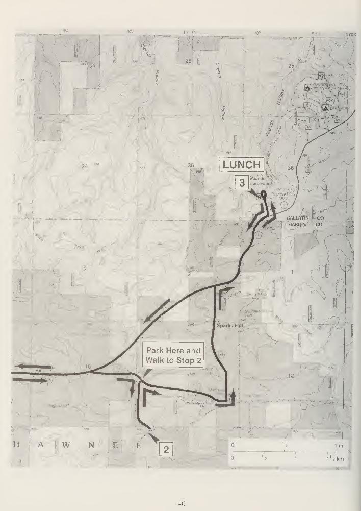
25
b20
-'-M-
•
A.
LUNCH
40
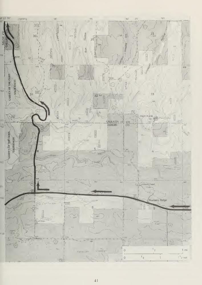
#""22 30 3yQ
SO',
"81 '82 20
5-2
5 29-
i i
-i
or
^83
28 *1
4P-
.
1
2 1 mi .
i
1
2 1
i
11 2km
: i/ if I
41
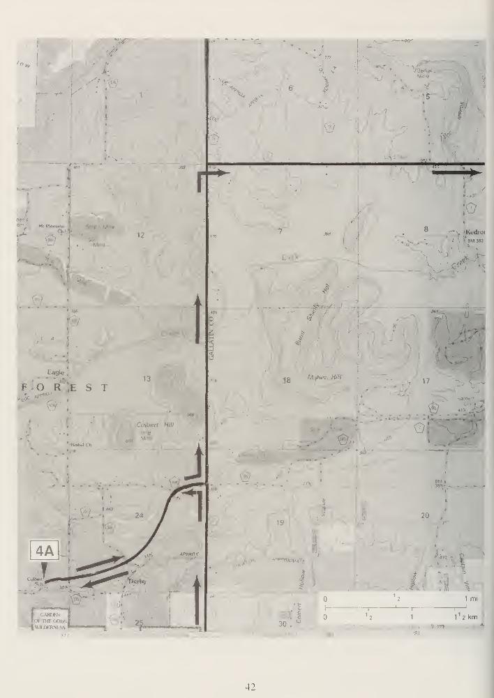
'I
:
i
F O R ;e s t
I
13
Colbert Hill
\yM i>i
9
<$
W ,T. W
19
*"PHf>
30
Kedroi
BM 333
,
17
20
a3
i,
T3
1
1 mi
i
11 2km
42

£
CO
07
ac
iCSifj£ E
J"
\ H• <
-i. (K^-
^
(xJ
CO) co
•V
1
t
jnol .asinvs J
CO
U4
w
'
f E E
rCM
CN
#O - - O
<
z
Q
<
z
^s<
43
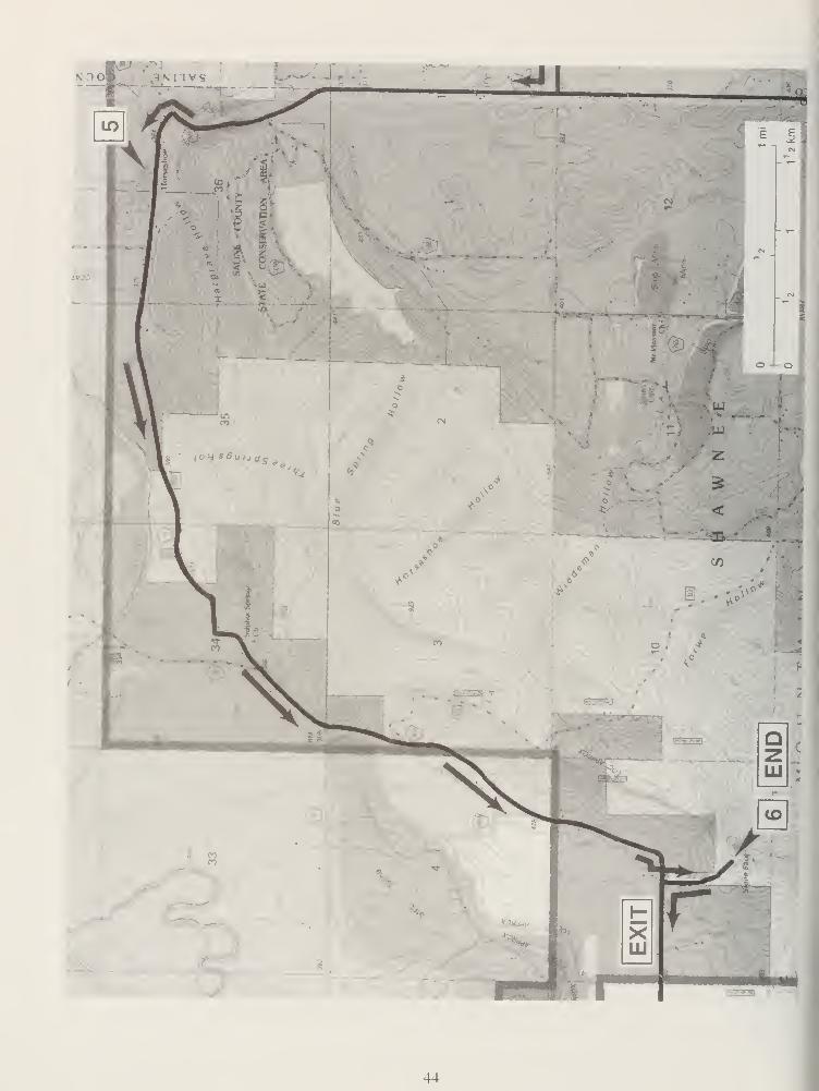
44
v-%j/yi)
S.lllsw V ilia -
1 I
571 27 30'
45
STOP DESCRIPTIONS
STOP 1: Garden of the Gods Recreation Area, Shawnee National Forest (SW, NW, SE,
Sec. 36, T10S, R7E, 3rd P.M., Herod 7.5-minute Quadrangle, Saline County). (See cover photo.)
On the day of the field trip, assemble near south (left) entrance to the Observation Trail located
near the middle of the upper parking lot.
We will examine the Pennsylvanian age Pounds Sandstone Member of the Caseyville Formation
and discuss the structural history of the region and development of the Eagle Valley Syncline.
The Garden of the Gods Recreation Area is located in the Shawnee National Forest in southern Il-
linois. This area is bounded on three sides by the Garden of the Gods Wilderness Area, which was
established by an act of Congress in 1990. No motorized vehicles or mechanized equipment is
permitted in the 3,300-acre Garden of the Gods Wilderness Area, a relatively undisturbed wilder-
ness area. Visitors are encouraged to "leave no trace" of their visit.
The Garden of the Gods Observation Trail is a one-fourth mile long interpretive trail. It is made of
natural flagstone and leads to areas near the bluffs where there are outstanding views of the
Shawnee Hills and the Garden of the Gods Wilderness Area. Starting at the south (left) entrance
to the Observation Trail you will pass by many interesting rock formations, given names such as
Table Rock, Camel Rock, Devil's Smokestack, and Honeycomb Rock. The Observation Trail has
some short, steep grades and a few steps, but as a whole, is not tiring. Caution should be used be-
cause there are high cliffs in the area.
GEOLOGY TIP: Glaciation stopped about 15 miles north of the Shawnee Hills. As a result, you
can notice a distinct change in topography between the area near Harrisburg to the north and this
area. The landscapes in the southern tip of the state are very hilly; hence, their name.
From the Garden of the Gods Recreation Area you can access the River to River and the Garden
of the Gods Wilderness trail systems. Users are encouraged to obtain more detailed maps before
entering the back country. Overnight parking is available at the backpackers' parking lot.
Geological History
The Shawnee Hills took millions of years to form. The rock formations and cliffs at Garden of the
Gods are made of Pennsylvanian age Pounds Sandstone and are about 320 million years old. Long
ago, most of Illinois, western Indiana, and western Kentucky were covered by a giant inland sea.
For millions of years, great rivers carried sand and mud to the sea where it settled along the shore-
line. Over time, the weight of the accumulating sediments, and chemical reactions between the
sediments and fluids in them, turned them into layers of rock, thousands of feet thick
At Garden of the Gods, the sediment layers now exposed were originally buried about one mile
deep (fig. 15). Beneath the Garden of the Gods there is still some 20,000 feet of sediments piled
on top of the crystalline basement. Eventually an uplift occurred, raising the land well above sea
level. The uplift also fractured the bedrock, exposing it to nature's erosive forces. Since that time,
windblown sand, rain, and freezing and thawing actions have worn down the layers of sediment,
creating the beautiful rock formations at Garden of the Gods. To find out more, read the signs
along the observation trail.
46
Garden of the Gods, located on the south
limb of the Eagle Valley Syncline, is one of
the most scenic areas of Illinois. The rock
layers exposed at the Garden of the Gods
are part of the Pounds Sandstone Memberof the Caseyville Formation. Long-contin-
ued erosion of the uplifted southern limb of
the syncline has resulted in deeply disected
northward facing dip slopes (dip is about
10° to the north) and high knobs and ridges
that consist of strongly weather-resistant
sandstone.
The Pounds Sandstone is a fairly pure,
slightly micaceous, quartz sandstone with
numerous white rounded quartz pebbles.
About 100 feet of sandstone is present in
this member throughout much of the area.
The sandstones of the Caseyville are very
resistent to erosion, and where exposed,
they are cliff-formers. The sandstones are
river channel sands laid down by an ancient
Pennsylvanian river system that crossed
this part of Illinois from northeast to south-
west. A number of sedimentary structures,
typically formed by river currents within a
delta system building out into and along a
shallow continental sea, are well developed
in the Pounds Sandstone. These sedimentary structures include wedge-shaped crossbedding and
ripple marks. The purity and coarseness of the sandstone indicate that the currents along the shal-
low seashore (both river and nearshore currents) were swift and that much of the fine material
and softer non-quartz materials were sorted out before deposition. Other noteworthy sedimentary
features of the sandstone at this stop include graded bedding, bimodal sorting of the medium to
coarse-grained sandstone containing white quartz pebbles, and Liesegang banding.
The unusual concentric and parallel Liesegang banding of iron oxide-rich layers in sandstone,
which is so common in outcrops of the Caseyville, is well-displayed along the observation trail (fig.
16). Geologists generally attribute this banding to the so-called "Liesegang Phenomenon." For this
phenomenon to occur, a fluid containing a salt must be introduced into a colloidal suspension within
a porous medium (such as this coarse sandstone). During mixing of the fluid and the colloid, when
the dissolved salt reaches a supersaturated level, precipitation occurs at regular intervals, resulting
in the banding just described.
5LUt-
>if)
0.
z>oa:o
5 COLUMN
<
<
>-COz2UJCl
VScO
OEoOo5
£5<x>
COk.1-
€: Vergennes Sandstone Member
/Murphysboro Cool Member
^/c-co-:
'>
>.
oO
° 9'-'
'.•-#
•o
.
Pounds Sandstone Member
VfiFV^--" Drury Shale Member
Battery Rock SandstoneMember
^r^"-----'
Wayside Sandstone Member- -^=»*^-^
2<aQ.
COCO
COCO
5
in
V
a>
1 1 1 1 1
Kinkaid Limestone1TTTrilli i i i
CO
co
V
0)JCu
Degonia Sandstone
—^-.^-L_^!-
Gore Formation111!MMFigure 15 Generalized stratigraphic section of Missis-
sippian and Pennsylvanian stratigraphy in the field trip
area.
47
Figure 16 Stop 1 : Liesengang banding in Pounds Sandstone, Garden of the Gods Recreation Area (photo
by W.T. Frankie).
Liesegang Banding in Sandstones
The highly convoluted, dark-colored bands that stick out of the surface of some outcrops of sandstone in the
Caseyville and Tradewater Formations are apparently a near-surface weathering phenomenon. The rings and
banding are not observed in fresh samples of these rocks brought up in drill cores.
When these sandstones are exposed on the face of a cliff, groundwater can seep through the rock to the outer
surface, carrying dissolved minerals in it. At the surface, as the water evaporates, the concentration of the
minerals in the water increases, ultimately causing the minerals to precipitate out of the solution, like salt
from seawater. The convoluted banding that we observe results from the interaction of this groundwater with
a colloidal suspension that is already present in the pores of the rock. The bands are zones where the grains in
the rock are more strongly cemented together, and weathering removes the more weakly cemented parts of the
rock, leaving the strongly cemented bands standing out from the rock surface.
A colloid is a form of matter in which very fine particles are held suspended in a liquid. (Ordinary gelatin is
probably the colloid that is most familiar to us.) Ferric iron (iron in its +2 or more reduced oxidation state) in
solution readily forms a colloidal gel as iron hydroxide when the solution is subjected to the right chemical
conditions. If the conditions that formed the colloid are then changed by the addition of a new chemical to the
solution that surrounds the colloid, the tiny particles suspended in the colloid will start to clump together and
form a solid. For reasons that chemists do not yet fully understand, the clumping together of the colloidal
particles (called "flocculation") occurs in bands or rings in the gel. rather than uniformly. The banding
apparently forms because slow and non-uniform diffusion of the added chemical into the gelatinous colloidal
suspension causes a series of gradients to develop in the concentrations of the flocculating particles. The
bands of color commonly observed in agate probably result from similar interactions between colloidal silica
and ions dissolved in solutions that interact with the coloid. These phenomena in colloids were first studied
and described by a German chemist named Liesegang.
-Jonathan H. Goodwin
Senior Geologist
Based on Krauskopf. Konrad B., 1967. Introduction to Geochemistry, McGraw-Hill. Inc., New York. p. 151-166.
48
From the high sandstone pinnacles here at Garden of the Gods, the western part of the Eagle Val-
ley Syncline can be seen. Toward the northwest, areas of disturbed land can be seen where the
Springfield, Herrin, Davis, and Dekoven Coals (Carbondale Formation, Pennsylvanian) were sur-
face-mined (fig. 17). The distinct high ridge that is visible to the north and northwest is the north-
ern limb of the Eagle Valley Syncline.
A syncline is a fold in which the bedrock layers have been bent downward by compressive forces
acting within the earth's crust. The strata on both sides or limbs of a syncline dip (tilt) inward to-
ward the axis or lowest part of the fold. Along the axis or central part of an eroded syncline, the
youngest folded rocks are exposed. The opposite of a syncline is an anticline, in which the strata
are bent upward into an arch.
The Eagle Valley Syncline (fig. 1 1) is an asymmetrical fold, so called because the strata in the
north limb dip more steeply (10° to 25°) than the strata on the south limb (from less than 5° to
10°). The ridges that outline the syncline are formed by the eroded, upturned edges of resistant
lower Pennsylvanian sandstones. These consist principally of massive sandstones of the
Caseyville and Lower Tradewater Formations, which form steep, outward-facing cliffs along their
outcrop belt. The top of this erosional escarpment is capped by the Grindstaff Sandstone of the
Tradewater Formation. Eagle Valley itself is eroded in the softer shales and shaley sandstones of
the upper Tradewater to Carbondale Formations, which overlie the more resistant sandstones. The
still younger Anvil Rock Sandstone Member of the Carbondale Formation (which occurs above
the Herrin Coal) is also resistant to erosion and forms the low hills in the central part of the valley
along the axis of the syncline.
The axis of the syncline plunges (tilts downward) to the east, and thus the syncline is deepest and
widest near the Ohio River. The syncline gradually dies out eastward into Kentucky. Near the
western end of Eagle Valley, the axis bends sharply to the southwest, and the fold dies out in the
vicinity of Herod. As the syncline becomes shallower and narrower westward, the sandstone
ridges along its north and south limbs converge toward the axis at the nose of the syncline.
The Shawneetown Fault, a major fracture in the crust, bounds the syncline on the north and west,
and faults also border the syncline to the east in Kentucky (figs. 5 and 9). These faults have large
vertical displacements ranging from 500 to more than 3,500 feet. The Eagle Valley Syncline and
the faults in the field trip area are part of a region of intensely disturbed Paleozoic strata that cross
southern Illinois and western Kentucky (fig. 5). This region includes the Illinois fluorspar district, cut by
many high-angle faults, such as the one we will observe at the abandoned Lee Mine at Stop 2.
These features were formed during a major episode of folding and faulting that began at the end
of the Pennsylvanian Period about 270 million years ago. This was the time when the Appalachian
Mountains were forming along the eastern margin of North America. Another episode of faulting
occurred later, during the Cretaceous Period, about 100 million years ago. Recurrent movements
along faults in this region have occurred since then, and earthquakes within historic time indicate
that movements are still taking place.
49
FORMATION
AND
MEMBER
LITHOLOGY
5
Z -I O* < 2oo -x<-> z
THICK-
NESS
IN FEET
Cahokia Alluvium
and
Equality Formation
•• • •
Loess
U
S<3 .
S E
as
IBPatoka Fm.
West Franklin Ls. Mbr. I I I
T T T T
Gimlet Ss. Mbr.
Danville (No. 7)
Coal Mbr.Allenby Coal Mbr.
Anvil Rock Ss. Mbr.
Brereton Ls. Mbr.
0-8
II IT
/
0-36
0-30
Herrin (No. 6)
Coal Mbr.
Briar Hill (No. 5A)Coal Mbr.
St. David Ls. Mbr.
Turner Mine Sh. Mbr
Springfield (No. 5)Coal Mbr
Houchm Creek (No. 4)
Coal Mbr.
SurvantCoal Mbr.
Colchester (No.2)Coal Mbr. ^.
Palzo Ss. Mbr.
Dekoven Coal Mbr.
Davis Coal Mbr.
^nn ii n
M i ni
T— f— f— t— T -
- y-MJ-H
Stonefort Ls. Mbr.
28-76
18-36
52-66
12-18
6-30
0-18
30-42
36-52
6-12
0-150
0-20
0-10
0-150
400-490
Figure 17 Generalized stratigraphic section of Pennsylvanian stratig-
raphy in Eagle Valley Syncline (modified from Nelson and Lumm1986).
50
RIPE
Figure 18 Principal fluorspar mining districts in southeastern Illinois
STOP 2: Lee Mine, an abandoned fluorspar mine, Shawnee National Forest (NW, NW, NW,Sec. 14, T11S, R8E, 3rd P.M., Karbers Ridge 7.5-minute Quadrangle, Hardin County).
On the day of the field trip we will hike along the forest road, approximately 3,000 feet, to Lee Mine.
We will visit the abandoned Lee Mine located along the northern edge of the Illinois fluorspar dis-
trict (fig. 18 ). Small samples of fluorite can be found in the old mine refuse piles.
Lee Mine was operated by Hillside Fluor Spar Mines. The company extracted ore from a vein
along the Lee Fault. A generalized diagram of a fluorspar vein along a fault is shown in Figure 19.
Geological mapping in this area has traced the fault 3 miles to the southwest and 5 miles to the
northeast of the mine. The fault can be traced on the surface for about 1 ,000 feet at the mine. Al-
though mapped as a simple fault, Lee Fault consists of several more or less parallel, closely spaced
faults. At the mine this fault has a displacement of 450 feet, downthrown on the southeast side.
The Cypress Sandstone forms the northwest wall, and the Menard Limestone forms the southeast
wall (fig. 2). Fluorspar mineralization occurred for more than 1.5 miles along the course of the
fault or fault zone.
The mine was closed in 1938 and has not been worked since then. The U.S. Bureau of Mines did
exploratory drilling in the mid- 1940s, but that was the extent of activites until the early 1990s when
the Illinois Department of Mines and Minerals sealed the three shafts for this mine. The depths of
the three shafts, depending upon their distance from the fault, ranged from 35 to 150 feet.
The ore along the fault zone occurred generally at depths of around 100 feet in the Menard Lime-
stone, which apparently is much higher stratigraphically than is common in the fluorspar district.
51
Most of the fluorspar ore zones in the dis-
trict are associated with the thick lime-
stones of the St. Louis and Ste. Genevieve
Formations (fig. 2). According to mine
notes at the ISGS, the Lee vein was up to 6
feet wide but averaged under 4 feet, with
about one-third of the vein made up of fluo-
rite. The fault along the vein/ore body had a
strike of N47 ° to 58 °E and a dip of about
75° to 85° to the southeast. The fluorite
was of high quality, and no other minerals
were present in abundance, except perhaps
calcite, and only minor amounts of galena
and sphalerite.
Lee Mine is located in the northern edge of
the Illinois-Kentucky fluorspar district. This
region is a complexly faulted area lying be-
tween the Illinois Basin on the north and the
Mississippi Embayment to the south. The Il-
linois portion of the district, with a history of
fluorspar mining that dates from 1 842, still
has important deposits of minable fluorspar
and related minerals.
.•'•.'•.•.''sandstone
••••••• ' iii limestone~7T/ : j
' i _i i i ^ i
'.-. ::i _ZF — shale =r~ -=r~
.
'•.'•:• sandstone;!;"/;'///.
fluorspar vein
along fault
Figure 19 Diagramatic cross section of fluorspar vein
along a fault. The strata on the left side of the fault
have moved downward with reference to those on the
right.
Fluorspar from Illinois was in demand be-
cause of its high purity and the absence of
the toxic trace elements often found in im-
ported ore. Fluorite (calcium fluoride, or
CaFj. was designated as the Illinois state mineral by the 74th General Assembly in July 1965 (see
Geobit 4. Fluorite—Illinois ' State Mineral, in the back of the guidebook).
Illinois fluorspar occurs almost exclusively in Pope and Hardin Counties (fig. 18). The main pro-
duction has come from the Rosiclare vein system in the Rosiclare District and from bedded re-
placement deposits north of the Cave-in-Rock area. Less significant amounts of fluorspar have
been mined from several areas outside these main areas.
Ore Deposits
Ore bodies in the Illinois-Kentucky fluorspar mining district are of three general types: ( 1 ) bedded
deposits formed by selective replacement of limestone strata, (2) fissure-filling or vein deposits
along faults and fractures, and (3) residual deposits derived from one of the other types.
Vein Deposits
The mineralization at the Lee Mine is a vein-type deposit. The primary controlling factor determin-
ing the location and extent of mineralization of vein deposits is faulting. Vein deposits occur in
steeply inclined, sheet-like deposits as fissure fillings along faults (fig. 1 9). The width and continu-
ity of the vein deposits depend on the size of openings between the fault surfaces in which they
were formed. Fault planes (surfaces) are rarely perfectly parallel. The rock surfaces on either
side of a fault are generally wavy and irregular, preventing a good fit where one side of the fault
52
plane rests against the other. These irregularities caused the opposite walls of the fault planes to
be pushed apart, producing the openings in which the fluorspar veins were deposited by mineraliz-
ing solutions. As a result, the veins pinch and swell both vertically and laterally. The veins range in
width from a feather edge to as much as 30 feet. Major deposits have been found in northeast-
trending faults of moderate displacement (25 to 500 feet). These faults evidently provided avenues
for the movement of mineralizing solutions and open fissures for mineral deposition. Faults of
lesser displacement apparently failed to develop sufficient open space along fault planes, and those
of greater displacement had excessive development of gouge and other heavily fractured rock that
decreased the amount of available open space. Vein deposits in the Rosiclare area have been
mined at depths greater than 800 feet.
Vein deposits are best developed in the stronger, more competent limestones and well-cemented
sandstones in which adequate open spaces could be maintained along the faults. Weaker rocks,
such as shales, sandstones, or shaley limestones, became crushed during faulting and generally
filled rather than created openings. The best vein deposits are found in the relatively pure, compe-
tent Ste. Genevieve and St. Louis Limestones. Mineable vein deposits also occur in competent
younger rocks of the overlying Chesterian Series, but these ore bodies are limited in size and oc-
currence because shale beds associated with these strata generally plugged the faults.
Mineralogy
Fluorspar (CaFJ and calcite (CaCO\) are the two chief minerals present in the vein deposits. Mi-
nor amounts of galena (PbS) sphalerite (ZnS), and barite (BaS04) also occur in some vein depos-
its. In the bedded deposits, fluorite is the principal ore mineral, but galena and sphalerite occur lo-
cally. Bedded ores commonly consist of alternating bands of coarse- and fine-grained fluorspar.
Some banded ores also consist of alternating dark, fine-grained layers of fluorite and whole layers
of calcite, forming the "coontail spar." Rare or small amounts of strontianite, witherite, dolomite,
pyrite, ankerite, chalcopyrite, malachite, marcasite, smithsonite, limonite, gypsum, aragonite,
melanterite, stibnite, and sulfur have also been identified in the fluorspar deposits.
Origin of the Faults
The exact cause of the complex faulting is not known. At the end of Pennsylvanian time or during
early Permian time (about 260 million years ago), the Paleozoic strata of the present Illinois-Ken-
tucky fluorspar district may have been arched into a northwest-trending, elongate dome by an
enormous rising body of magma (molten rock) generated at great depth. Tensional fractures were
formed parallel to the long axis of the dome because of the stretching of the sedimentary strata.
Some magma was squeezed into these fractures to form the dikes of dark igneous rock now ex-
posed at the surface and in some coal mines in southeastern Illinois and western Kentucky.
After the magma had begun to cool ("crystallize") and ceased to push upward, the area was bro-
ken by a second set of fractures oriented northeast-southwest, probably by forces related to those
that were forming the Appalachian Mountains along the eastern margin of the continent. Relax-
ation of these forces, plus shrinkage of the body of magma as it continued to cool, caused the
domed area to collapse into a series of blocks bounded by the northeast-trending fractures. The
resulting normal faults trended northeast-southwest and became the channelways for the fluo-
rine-bearing solutions that were probably derived from the underlying magma body. These same
faults also served as deposition sites for the fluorite vein deposits. Most of the faults are normal,
with fault planes inclined at high angles (70° to 80°), but some are reverse faults (fig. 3). Move-
ment along the faults was largely vertical, but, in some places, there was also horizontal (side-
ways) movement. The Shawneetown Fault Zone, a large faulted structure in Gallatin and Saline
53
Counties just north of the fluorspar district, shows evidence of reverse movement of as much as
3,500 feet. The compressive forces that caused this thrusting were probably also responsible for
the northeast-southwest-trending fractures along which the block faulting took place.
Faulting has occurred repeatedly throughout the region since Permian time, although these later
movements may be unrelated to the earlier period of faulting. Cretaceous and Tertiary strata in
extreme southern Illinois and in Kentucky are also cut by faults, and earthquakes within recorded
history suggest that movements are still taking place. The most recent major earthquakes occurred
in southeastern Missouri along the New Madrid Fault in the winter of 181 1-1812. Smaller earth-
quakes have occurred up to the present in several places.
STOP 3: LUNCH, Rim Rock Recreation Area and the Pounds Escarpment, Shawnee
National Forest (NW, SW, Sec. 36, T10S, R8E, 3rd P.M., Karbers Ridge 7.5-minute Quadrangle,
Gallatin County).
Following lunch, we will hike a portion of the trail to examine the flora and geology and to discuss
their unique interconnection at the Pounds Escarpment.
The Rim Rock Recreation Area and the Pounds Hollow Recreation Area complex contains the
Rim Rock National Recreation Trail and a Shawnee National Forest Ecological Area. The Rim
Rock National Recreation Trail was constructed in 1962 and 1963, using funds contributed by the
Illinois Federation of Women's Clubs. In the early 1980s, the Young Adult Conservation Corps
crews replaced the original gravel path with a flagstone walkway. In 1980, the trail was desig-
nated as a National Recreation Trail. Rim Rock Trail is within a Shawnee National Forest Ecologi-
cal Area, an ecosystem relatively unchanged by man. Evident along the trail are sandstone glades,
relict plant associations, and interesting geological formations. Interpretive signs highlight the natu-
ral features. Rim Rock is the upper extension of Pounds Hollow, which includes about 230 acres
of a designated natural area. This area is managed to protect and preserve archeological features
and rare plant communities. Help us protect the plant life and other fragile resources by
staying on the trail.
The 0.8-mile upper Rim Rock Trail meanders among native hardwoods and a cedar plantation,
past the remains of the Old Indian Wall, and along the edge of the Rim Rock Escarpment made up
of the Pounds Sandstone Member of the Casey ville Formation (fig. 15) that we also saw at Stop
1 . The upper trail takes about one hour to walk and contains steps and some incline slopes.
Wheelchair access to the observation deck is possible on the upper trail, with assistance, by going
to the left on the upper trail. Steps and slopes of ±8% are encountered along the right portion of
the upper trail and along the lower trail. The trail winds around the bluff top and in some places
lies close to the edge. Take extreme caution in rainy weather—the trail and deck surfaces
may be slippery.
The trail will take you across the Old Indian Wall, past a scenic view of Pounds Hollow Lake, and
to an observation platform with a breathtaking view of the valley some 70 feet below. A stairway
to the valley leads to the "Ox-Lot Cave," which is a large rock shelter in the bluff formed of
Pounds Sandstone (fig. 20). Near this stairwell is "Fat Man's Misery." a narrow passage that goes
through the massive sandstone bluffs and boulders.
54
Stepping Stones Through TimeTo early settlers this formation was known as
"the Pounds," an old English term meaning
"some sort of enclosure." Throughout time,
this natural escarpment and the lush valley be-
low attracted human settlement. For prehis-
toric Indians, these rock formations provided
protection from their neighbors, and the lush
valley offered plentiful sources of food and
water. After the removal of Native Americans
in the 1 830s, settlers spread into the interior
wilderness. The forest provided an abundant
source of wild game, nuts, and acorns for food
and large trees to build log cabins and provide
firewood for warmth on cold nights. By the
late 1890s, the Pounds Hollow area was pur-
chased by eastern land companies as part of a
thriving logging enterprise, after which the
land was sold to farmers. By the late 1920s,
logging and farming had created an unproduc-
tive landscape. In 1936, the Shawnee National
Forest acquired this land in an effort to restore
the soil and forest. Today's recreationists en-
joy the natural beauty of the area, and scien-
tists study its unique features.
Figure 20 Stop 3: Ox-Lot Cave at Rim Rock Recre-
ation Area (photo by W.T. Frankie).Trails
Beaver Trail is on the east side of the Pounds
Escarpment (to the right), and Lower Pounds
Trail is on the west side of the Pounds Escarpment. The upper trail is a loop trail with a branch
veering off to the left, which follows along the edge of the bluffs, and a branch that is straight
ahead, which leads up through the Old Indian Wall. Crumbled blocks of sandstone are evident on
either side of the path. The following is from a sign near the stone wall:
Why a defense? Look in front of you. . . . Can you find the remains of the ancient stone wall built
by prehistoric Indians about 1,500 years ago? Archeologists believe the inhabitants, members of
the Late Woodland culture, used these escarpments as a defense location. They built the wall to
block the only accessible route to the top of the bluff. The wall extends almost 150 feet across the
bluff top. The height of the wall is unknown, since through time, this wall has crumbled. However,
early travelers reported that the walls were 6 feet in height. The stones were gathered from below
the bluff, which required considerable effort. Will we be able to reconstruct the story behind the an-
cient wall? Archeological work has just begun on this significant site. The research will attempt to
demonstrate why late woodland people were defending themselves.
The Geology of Pounds Hollow—From the Observation Platform
The Pounds Sandstone forms these spectacular bluffs. The younger Tradewater Formation under-
lies the gentler slopes above the sheer cliffs across the valley. These majestic sandstone bluffs be-
gan to form as sand and mud were deposited at the shoreline of the shallow sea that covered this
area about 320 million years ago. Rivers originating from the north and northwest Appalachians
carried the sediments down to the sea. The land was slowly sinking, and more sand and mud were
55

deposited on top. With time and continued burial, the sand became sandstone, mud became shale,
and the peat in the swamps turned to coal.
About 280 million years ago, the land began to rise slowly, and the sea gradually retreated to its
present location in the Gulf of Mexico. As this uplift began, geological forces fractured the rocks,
creating channels for rainwater runoff. Since then, hundreds of feet of rocks have eroded away,
and nature has gradually uncovered these geologic units, carved out Pounds Hollow (the valley be-
low) and its tributary creeks, and sculpted the scenery now exposed at the observation platform.
A stairway at the observation platform leads to the valley floor and "Ox-Lot Cave," which is a
large rock shelter in the Pounds Sandstone (fig. 20). Near this stairwell is "Fat Man's Misery," a
narrow passageway between the massive sandstone bluffs. The observation platform is located on
top of a large block of Pounds Sandstone that has moved westward toward the valley. Fat Man's
Misery follows a curvilinear joint/fracture in sandstone trending N35°E.
Ox-Lot Cave provided shelter to many hunters and explorers who passed this way. It was not until
loggers entered the hollow that the natural overhang received extensive use. A fence was built
around the area to form a corral to keep the oxen, mules, and horses; hence, the name Ox-Lot
Cave. The boxed-in spring, along with the shelter wall, provided a watering hole for the animals.
A narrow-gauge railroad was built within the hollow to haul cut timber in the area. Oxen dragged
the heavy logs to the flat bed cars. The logs were moved to the Saline River and spiked together
before being floated down on the Ohio River. Logging companies operating in the valley were
profitable for a short period from 1902 to 1906. Soon thereafter, the railroad was removed.
Why is there a spring at the base of the Ox-Lot Cave? The Pounds Sandstone acts as an aquifer;
rainwater percolates down through the sandstone and along fractures to the base of the bluffs.
The Drury Shale Memer underlies the Pounds Sandstone, and, when water encounters this unit, it
begins to flow horizontally along the contact between the underlying shale and overlying sand-
stone. Joints/fractures concentrate the flow of groundwater. A joint trending S70°E is located near
the spring. Can you find other joints in the bluff?
STOP 4A (Optional): Jader Coal Company Surface Mine, Davis and Dekoven Coal (W 1/2,
NE. NW Sec. 14, T10S, R7E, 3rd P.M., Rudement 7.5-minute Quadrangle, Saline County) (fig. 21 ).
We will examine the mining operations of the Jader Coal Company and discuss the geology of the
coals within the Eagle Valley Syncline.
The pit we will examine was opened by Jader Coal Company early this year. The company began
its operations in an area that was surface-mined from 1959 to 1965 by J.W. Coal Company in the
Davis and Dekoven Coal Members near the base of the Middle Pennsylvanian Carbondale For-
mation (fig. 17). These operations are recovering the same seams, which are separated by an in-
terval of 20 to 30 feet. The Davis and Dekoven Coals lie roughly 200 feet below the Springfield
Coal (fig. 17 ) that is also being mined at the Sugar Camp Mine by Black Beauty Coal. The Davis
Coal is the thicker of the two seams, averaging 4 feet in thickness in most of the area, but locally
up to 5 feet thick. The Dekoven Coal averages 3 feet in thickness across much of the area.
56
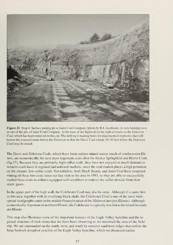
Figure 21 Stop 4: Surface mining pit at Jader Coal Company (photo by R.J. Jacobson). A view looking west
in one of the pits of Jader Coal Company. At the base of the highwall to the right of trucks is the Dekoven
Coal, which has been removed in this cut. The drill rig is making holes for placement of explosive that will
loosen the exposed strata below the Dekoven so that the Davis Coal (about 20-30 feet below the Dekoven
Coal) may be mined.
The Davis and Dekoven Coals, which have been surface-mined across much of southeastern Illi-
nois, are economically the next most important coals after the thicker Springfield and Herrin Coals
(fig. 17). Because they are primarily high-sulfur coals, they have not enjoyed as much demand as
western coals have in regional and national markets, since the coal market places a high premium
on the cleaner, low-sulfur coals. Nevertheless, both Black Beauty and Jader Coal have reopened
mining of these two coals since our last visit to the area in 1993, so they are able to successfully
market these coals to utilities equipped with scrubbers to remove the sulfur dioxide from their
stack gases.
In the upper part of the high wall, the Colchester Coal may also be seen. Although it is quite thin
in this area, together with its overlying black shale, the Colchester Coal is one of the most wide-
spread stratigraphic units in the middle Pennsylvanian of the Midwest (not just Illinois). Although
economically important in northern Illinois, the Colchester is typically too thin to be mined in south-
ern Illinois.
This stop also illustrates some of the important features of the Eagle Valley Syncline and the re-
gional structure of rock strata that we have been observing as we traversed the area of the field
trip. We are surrounded on the north, west, and south by massive sandstone ridges that outline the
large bedrock trough or syncline of the Eagle Valley Syncline, which we discussed earlier.
57
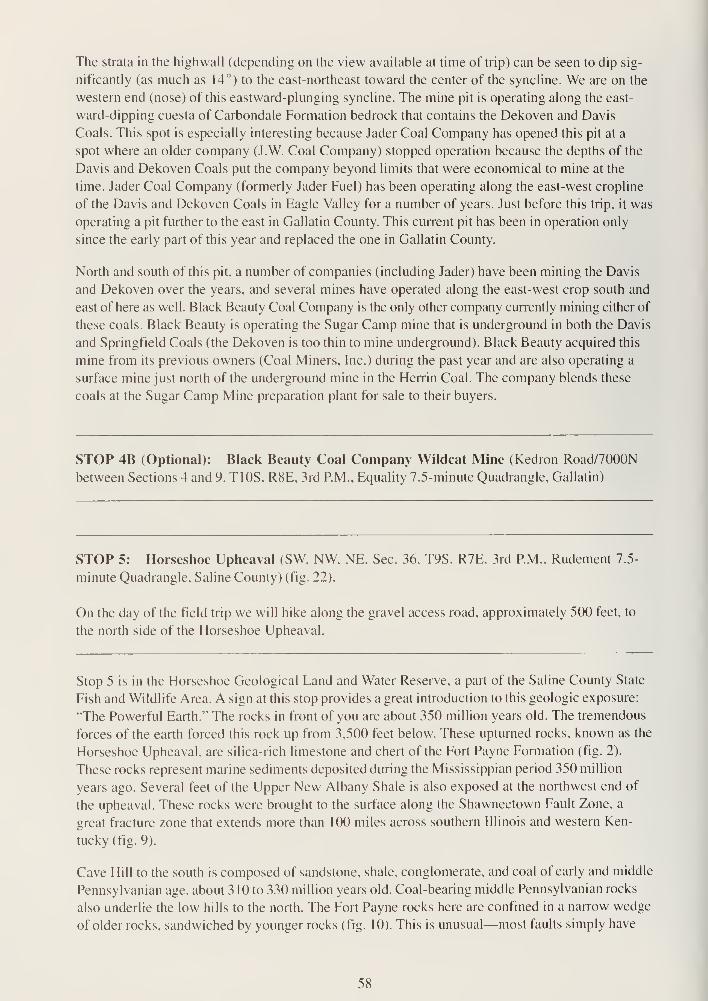
The strata in the highwall (depending on the view available at time of trip) can be seen to dip sig-
nificantly (as much as 14°) to the east-northeast toward the center of the syncline. We are on the
western end (nose) of this eastward-plunging syncline. The mine pit is operating along the east-
ward-dipping cuesta of Carbondale Formation bedrock that contains the Dekoven and Davis
Coals. This spot is especially interesting because Jader Coal Company has opened this pit at a
spot where an older company (J.W. Coal Company) stopped operation because the depths of the
Davis and Dekoven Coals put the company beyond limits that were economical to mine at the
time. Jader Coal Company (formerly Jader Fuel) has been operating along the east-west cropline
of the Davis and Dekoven Coals in Eagle Valley for a number of years. Just before this trip, it was
operating a pit further to the east in Gallatin County. This current pit has been in operation only
since the early part of this year and replaced the one in Gallatin County.
North and south of this pit, a number of companies (including Jader) have been mining the Davis
and Dekoven over the years, and several mines have operated along the east-west crop south and
east of here as well. Black Beauty Coal Company is the only other company currently mining either of
these coals. Black Beauty is operating the Sugar Camp mine that is underground in both the Davis
and Springfield Coals (the Dekoven is too thin to mine underground). Black Beauty acquired this
mine from its previous owners (Coal Miners, Inc.) during the past year and are also operating a
surface mine just north of the underground mine in the Herrin Coal. The company blends these
coals at the Sugar Camp Mine preparation plant for sale to their buyers.
STOP 4B (Optional): Black Beauty Coal Company Wildcat Mine (Kedron Road/7000N
between Sections 4 and 9, T10S, R8E, 3rd P.M., Equality 7.5-minute Quadrangle, Gallatin)
STOP 5: Horseshoe Upheaval (SW, NW, NE, Sec. 36, T9S, R7E. 3rd P.M.. Rudement 7.5-
minute Quadrangle, Saline County) (fig. 22).
On the day of the field trip we will hike along the gravel access road, approximately 500 feet, to
the north side of the Horseshoe Upheaval.
Stop 5 is in the Horseshoe Geological Land and Water Reserve, a part of the Saline County State
Fish and Wildlife Area. A sign at this stop provides a great introduction to this geologic exposure:
"The Powerful Earth." The rocks in front of you are about 350 million years old. The tremendous
forces of the earth forced this rock up from 3,500 feet below. These upturned rocks, known as the
Horseshoe Upheaval, are silica-rich limestone and chert of the Fort Payne Formation (fig. 2).
These rocks represent marine sediments deposited during the Mississippian period 350 million
years ago. Several feet of the Upper New Albany Shale is also exposed at the northwest end of
the upheaval. These rocks were brought to the surface along the Shawneetown Fault Zone, a
great fracture zone that extends more than 100 miles across southern Illinois and western Ken-
tucky (fig. 9).
Cave Hill to the south is composed of sandstone, shale, conglomerate, and coal of early and middle
Pennsylvanian age, about 3 10 to 330 million years old. Coal-bearing middle Pennsylvanian rocks
also underlie the low hills to the north. The Fort Payne rocks here are confined in a narrow wedge
of older rocks, sandwiched by younger rocks (fig. 10). This is unusual—most faults simply have
58
Figure 22 Stop 5: Upturned rocks of the Fort Payne Formation at Horseshoe Upheaval (photo by W.T.
Frankie).
older rocks on one side and younger rocks on the other. The Horseshoe Upheaval suggests that
the Shawneetown Fault Zone underwent two episodes of movement in opposite directions. First,
the rocks south of the fault zone were uplifted, bringing Fort Payne rocks to the surface, and then
the southern block dropped back down. The wedge of Fort Payne rocks was sheared off and
jammed in place within the fault zone. The tremendous forces involved are evident in the shattered
and contorted rock layers before you.
The average strike of the strata is about N80°W, and dip is toward the south at about 60°. The
rock strata seen here are part of the north limb of the Eagle Valley Syncline near a point where
the syncline turns southwestward and terminates. This area is part of a large fault slice that is
bounded on the north by a high-angle reverse fault with vertical displacement of at least 3,500
feet.
In an abandoned quarry, located on the northeast corner of the Horseshoe Upheaval, the Fort
Payne was extracted for use as roadstone. The area covered by the abandoned quarry is about
250 feet wide and 850 feet long, a total area of about five acres. More than 200 feet of the Fort
Payne Formation of the Valmeyeran Series (middle Mississippian) is exposed at the quarry site.
The Fort Payne consists of highly shattered, partly silicious and calcareous shale and siltstones,
and limestone. At depth, the Fort Payne consists of calcareous siltstone and limestone, but weath-
ering has resulted in silicification (replacement by silica) of these rocks at the surface. The NewAlbany Shale, which consists of thin-bedded, black to dark gray carbonaceous shale that contains
numerous partly phosphatic siltstone and claystone nodules, has also been intensely fractured and
silicified. Calcite-filled fractures occur in the calcareous shale and siltstone of the Fort Payne For-
mation.
59

The Fort Payne Formation was deposited as
an irregular tongue-shaped body in southern
Illinois that partially filled a deep-water basin.
The rocks of the Fort Payne Formation are
intertongued with the rocks of the Borden Silt-
stone delta to the north and west. The Ullin
Limestone, which overlies the Fort Payne
Formation, is not exposed here. Uppermost
units of the New Albany Group (Mississippian,
Devonian) are exposed in the extreme north-
western part of the quarry site. The New Al-
bany Shale occurs at a depth of about 3,500
feet below the surface on the north side of the
fault.
Intense fracturing is present in all units ex-
posed at the quarry site. The most intensely
deformed units are present near the eastern
end of the quarry and about 100 feet south of
the access road located on the north side of
the upheaval. These crumpled and complexly
deformed units consist of soft, somewhat
brittle shale, which failed under shearing
stresses. These soft shale units lie between
siliceous siltstone and shale of the upper part
of the Fort Payne Formation and thick units of
the New Albany Group, which deformed com-
petently.
Figure 23 Stop 6: Old Stone Face. Pounds Sandstone
(photo by W.T. Frankie).
STOP 6: Old Stone Face (NW. SW. SE. Sec. 9, T10S. R7E. 3rd P.M., Rudement 7.5-Minute
Quadrangle, Saline County) (fig. 23).
We will partake in the breathtaking view of the landscape to the west and northwest of the Eagle
Valley Syncline from the top of Old Stone Face.
DO NOT GET TOO CLOSE TO THE CLIFF EDGE WHEN ON TOP.
Do not throw anything (especially the field trip leaders) over the edge.
Old Stone Face, one of the best known natural wonders of southern Illinois, is located on the
southwestern edge of Cave Hill Ridge at an elevation of about 730 feet above sea level. The cliff
affords a magnificent view to the north and west overlooking the low-lying Saline River Valley
about 350 feet below.
The sheer cliff into which Old Stone Face has been carved by weathering and natural erosion
consists of the massive, cross-bedded Pounds Sandstone Member of the Pennsylvanian age
Caseyville Formation (fig. 17), which we first examined at Stops 1 and 3. The Pounds Sandstone
60
consists of fairly pure, slightly micaceous, quartz sandstone containing numerous white rounded
quartz pebbles. The sandstone is about 100 feet thick in the field trip area.
The Caseyville sandstones are very resistant to erosion, and wherever they are exposed, they are
cliff-formers. The sandstones are river-channel sands laid down by an ancient Pennsylvanian river
system that crossed this part of Illinois from northeast to southwest. Current structures, including
wedge-shaped cross-bedding and ripple marks, are well developed in the sandstones. The purity
and coarseness of the sandstones indicate that the currents were swift.
Cave Hill Ridge forms an erosional fault scarp at the west end of Eagle Valley Syncline. In this lo-
cality, the stratigraphic displacement on the Shawneetown Fault is about 1,000 feet. The Pounds
Sandstone lies 500 feet below the Saline River Valley west of Cave Hill and north of the
Shawneetown Fault Zone.
End of field trip.
Drive carefully on your way home.
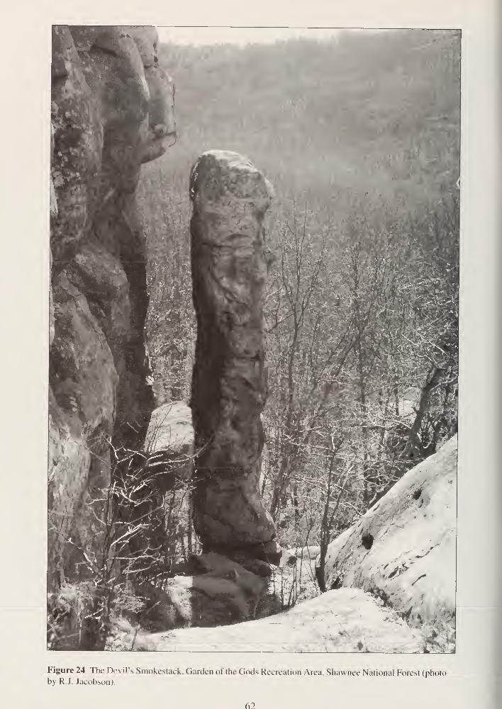
Figure 24 The Devil's Smokestack, Garden of the Gods Recreation Area, Shawnee National Forest (photoby R.J. Jacobson).
62
REFERENCESBuschbach, T.C., and D.R. Kolata, 1991, Regional setting of the Illinois Basin, in M.W. Leighton,
D.R. Kolata, D.F. Oltz, and J.J. Eidel, eds., Interior Cratonic Basins: American Association of
Petroleum Geologists, Memoir 5 1 , p. 29-55.
Clark, P.U., MR. Greek, and M.J. Schneider, 1988, Surface morphology of the southern margin of
the Laurentide Ice Sheet from Illinois to Montana (Abs.), in Program and Abstracts of the
Tenth Biennial Meeting, American Quaternary Association: Amherst, University of Massachu-
setts, p. 60.
Cote, W.E., D.L. Reinertsen, and M.M. Killey, 1969, Equality area: Illinois State Geological
Survey, Geological Science Field Trip Guide Leaflet 1969 A & F, 27 p. plus attachments.
Damberger, H.H., 1971, Coalification pattern of the Illinois Basin: Economic Geology, v. 66, no .3,
p. 488^94.
Killey, M.M., 1998, Illinois' Ice Age legacy: Illinois State Geological Survey, GeoScience Education
Series 14, 66 p.
Leighton, M.M., G.E. Ekblaw, and C.L. Horberg, 1948, Physiographic divisions of Illinois: Illinois
State Geological Survey, Report of Investigations 129, 19 p.
Leighton, M.W., D.R. Kolata, D.F. Oltz, and J.J. Eidel, eds., 1991, Interior cratonic basins: Ameri-
can Association of Petroleum Geologists, Memoir 5 1
.
Nelson, J.W., 1995, Structural features in Illinois: Illinois State Geological Survey, Bulletin 100, 144 p.
Schwegman, J.E., 1973, Comprehensive plan for the Illinois Nature Preserve System, Part 2
—
Natural divisions of Illinois: Springfield, Illinois Nature Preserves Commission, 32 p.
U.S. Geological Survey, 1997, Mineral Industry Surveys, Fluorspar 1996 and 1997 annual review:
Washington, D.C., U.S. Department of the Interior.
Willman, H.B., and J.C. Frye, 1970, Pleistocene stratigraphy of Illinois: Illinois State Geological
Survey, Bulletin 94, 204 p.
RELATED READINGSBaxter, J.W., and G.A. Desborough, 1965, Areal geology of the Illinois fluorspar district, part 2
—
Karbers Ridge and Rosiclare Quadrangles: Illinois State Geological Survey. Circular 385, 40 p.
plus plates.
Bradbury, J.C, G.C. Finger, and R.L. Major, 1968, Fluorspar in Illinois: Illinois State Geological
Survey, Circular 420, 64 p.
Harris, S. E. Jr., C. W. Horrell, and D. Irwin, 1997, Exploring the land and rocks of southern
Illinois—A geological guide: Carbondale, Southern Illinois University Press, p. 240.
63
Herzog, B.L., B.J. Stiff, C.A Chenoweth, K.L. Warner, J.B. Sieverling, and C. Avery, 1994,
Buried bedrock surface of Illinois: Illinois State Geological Survey, Illinois Map 5; 1 :500,000
scale; 33.25 inches x 60.75 inches.
Horberg, C.L., 1950. Bedrock topography of Illinois: Illinois State Geological Survey. Bulletin 73,
111 p.
Illinois Coal Mines Maps and Directories, Directory of Coal Mines in Illinois, Saline County, 1996:
Illinois State Geological Survey, Open File Series XXXX. [Cant find as OFS.]
Jacobson, R.J., 1993. Coal resources of the Dekoven and Davis Members (Carbondale Forma-
tion) in Gallatin and Saline Counties, southeastern Illinois: Illinois State Geological Survey,
Circular 551.41 p. plus plates.
Lineback, J.A., et al.. 1 979, Quaternary deposits of Illinois: Illinois State Geological Survey Map;
1 :500,000 scale: 40 inches x 60 inches: color.
Nance. R.B., and C.G. Treworgy, 1981, Strippable coal resources of Illinois. Part 8: Central and
southeastern counties: Illinois State Geological Survey. Circular 515,32 p.
Nelson, W.J., and D.K. Lumm, 1986a, Geologic map of the Rudement Quadrangle. Saline County,
Illinois: Illinois State Geological Survey Map IGQ-3; 1 :24,000 scale.
Nelson. W.J.. and D.K. Lumm. 1986b, Geologic map of the Equality Quadrangle, Gallatin and
Saline Counties, Illinois: Illinois State Geological Survey Map IGQ-3; scale 1 :24,000.
Nelson, W.J., and D. K. Lumm, 1987. Structural geologoy of southeastern Illinois and vicinity:
Illinois State Geological Survey, Circular 538. 70 p. plus plates.
Palmer, J.E., and R.R. Dutcher, eds., 1979, Depositional and structural history of the Pennsylva-
nian System of the Illinois Basin, Part 1—Road log and descriptions of stops. Field Trip 9,
Ninth International Congress of Carboniferous Stratigraphy and Geology: Illinois State Geo-
logical Survey, Guidebook 1 5b, 1 1 6 p.
Piskin, K.. and R.E. Bergstrom. 1 975, Glacial drift in Illinois: Illinois State Geological Survey,
Circular 490, 35 p.
Reinertsen, D. L., W. T. Frankie, C. P. Weibel, and E. Livingston, 1994, Golconda Area: Illinois
State Geological Survey, Geological Science Field Trip Guide Leaflet 1994A, 52 p. plus
attachments.
Reinertsen, D. L., R.R. Jacobson, PC. Reed, R.A. Bauer, and B.G. Huff, 1993. Harrisburg area:
Illinois State Geological Survey, Geological Science Field Trip Guide Leaflet 1993A, 45 p. plus
attachments.
Weibel. C. P., and W. J. Nelson. 1993, Geologic map of the Lick Creek Quadrangle, Johnson,
Union, and Williamson Counties, Illinois: Illinois State Geological Survey Map IGQ- 1 2;
1:24,000 scale.
64
Weller, J.M., R.M. Grogan, and F.E. Tippie, 1952, Geology of the fluorspar deposits of Illinois:
Illinois State Geological Survey, Bulletin 76, 147 p. plus plates.
Willman, H.B., E. Atherton, T.C. Buschbach, C. Collinson, J.C. Frye, M.E. Hopkins, J.A.
Lineback, and J.A. Simon, 1 975, Handbook of Illinois stratigraphy: Illinois State Geological
Survey, Bulletin 95, 261 p.
Willman, H.B., et al., 1967, Geologic map of Illinois: Illinois State Geological Survey Map;
1 :500,000 scale; 40 inches x 56 inches; color.
Willman, H.B., J.A. Simon, B.M. Lynch, and V.A. Langenheim, 1968, Bibliography and Index of
Illinois geology through 1965: Illinois State Geological Survey, Bulletin 92, 373 p.
65
Glossary
The following definitions are adapted in total or in part from several sources. The principal source
is R.L. Bates and J.A Jackson, eds., 1987, Glossary of Geology, 3rd ed.: Alexandria, Virginia,
American Geological Institute, 788 p.
ablation Separation and removal of rock material and formation of deposits, especially by wind
action or the washing away of loose and soluble materials.
age An interval of geologic time; a division of an epoch.
aggrading stream A stream that is actively depositing sediment in its channel or floodplain
because it is being supplied with more load than it can transport.
alluviated valley One that has been at least partially filled with sand, silt, and mud by flowing
water.
alluvium A general term for clay, silt, sand, gravel, or similar unconsolidated sorted or semisorted
sediment deposited during comparatively recent time by a stream or other body of running
water.
anticline A convex-upward rock fold in which strata have been bent into an arch; the strata on
either side of the core of the arch are inclined in opposite directions away from the axis or
crest; the core contains older rocks than does the perimeter of the structure.
anticlinorium A complex structure having smaller structures, such as domes, anticlines, and
synclines superimposed on its broad upwarp.
aquifer A geologic formation that is water-bearing and that transmits water from one point to
another.
argillaceous Said of rock or sediment that contains, or is composed of. clay-sized particles or clay
minerals.
arenite A relatively clean quartz sandstone that is well sorted and contains less than 10% argilla-
ceous material.
base level Lower limit of erosion of the land's surface by running water. Controlled locally and
temporarily by the water level of stream mouths emptying into lakes, or more generally and
semipermanently by the level of the ocean (mean sea level).
basement complex The suite of mostly crystalline igneous and/or metamorphic rocks that
generally underlies the sedimentary rock sequence.
basin A topographic or structural low area that generally receives thicker deposits of sediments
than adjacent areas; the low areas tend to sink more readily, partly because of the weight of
the thicker sediments; the term also denotes an area of relatively deep water adjacent to
shallow-water shelf areas.
bed A naturally occurring layer of earth material of relatively greater horizontal than vertical
extent that is characterized by physical properties different from those of overlying and
underlying materials. It also is the ground upon which any body of water rests or has rested,
or the land covered by the waters of a stream, lake, or ocean; the bottom of a stream channel.
bedrock The solid rock (sedimentary, igneous, or metamorphic) that underlies the unconsolidated
(non-indurated) surface materials (for example, soil, sand, gravel, glacial till, etc.).
bedrock valley A drainageway eroded into the solid bedrock beneath the surface materials. It
may be completely filled with unconsolidated (non-indurated) materials and hidden from view.
66
braided stream A low-gradient, low-volume stream flowing through an intricate network of
interlacing shallow channels that repeatedly merge and divide and are separated from each
other by branch islands or channel bars. Such a stream may be incapable of carrying all of its
load. Most streams that receive more sediment load than they can carry become braided.
calcarenite Describes a limestone composed of more or less worn fragments of shells or pieces
of older limestone. The particles are generally sand-sized.
calcareous Said of a rock containing some calcium carbonate (CaC03), but composed mostly of
something else (synonym: limey).
calcining The heating of calcite or limestone to its temperature of dissociation so that it loses its
carbon dioxide; also applied to the heating of gypsum to drive off its water of crystallization to
make plaster of Paris.
calcite A common rock-forming mineral consisting of CaC03; it may be white, colorless, or pale
shades of gray, yellow, and blue; it has perfect rhombohedral cleavage, appears vitreous, and
has a hardness of 3 on the Mohs scale; it effervesces (fizzes) readily in cold dilute hydrochlo-
ric acid. It is the principal constituent of limestone.
chert Silicon dioxide (Si02); a compact, massive rock composed of minute particles of quartz
and/or chalcedony; it is similar to flint, but lighter in color.
clastic Said of rocks composed of particles of other rocks or minerals, including broken organic
hard parts as well as rock substances of any sort, transported and deposited by wind, water,
ice, or gravity.
claypan (soil) A heavy, dense subsurface soil layer that owes its hardness and relative impervi-
ousness to higher clay content than that of the overlying material.
closure The difference in altitude between the crest of a dome or anticline and the lowest
structural or elevation contour that completely surrounds it.
columnar section A graphic representation, in the form of one or more vertical column(s), of the
vertical succession and stratigraphic relations of rock units in a region.
conformable Said of strata deposited one upon another without interruption in accumulation of
sediment; beds parallel.
cuesta A ridge with a gentle slope on one side and a steep slope on the other.
delta A low, nearly flat, alluvial land form deposited at or near the mouth of a river where it enters
a body of standing water; commonly a triangular or fan-shaped plain extending beyond the
general trend of a coastline.
detritus Loose rock and mineral material produced by mechanical disintegration and removed
from its place of origin by wind, water, gravity, or ice; also, fine particles of organic matter,
such as plant debris.
disconformity An unconformity marked by a distinct erosion-produced irregular, uneven surface
of appreciable relief between parallel strata below and above the break; sometimes represents
a considerable time interval of nondeposition.
dolomite A mineral, calcium-magnesium carbonate (Ca,Mg[C03]2); also the name applied to
sedimentary rocks composed largely of the mineral. It is white, colorless, or tinged yellow,
brown, pink, or gray; has perfect rhombohedral cleavage; appears pearly to vitreous; and
effervesces feebly in cold dilute hydrochloric acid.
drift All rock material transported by a glacier and deposited either directly by the ice or reworked
and deposited by meltwater streams and/or the wind.
67
driftless area A 10,000-square mile area in northeastern Iowa, southwestern Wisconsin, and
northwestern Illinois where the absence of glacial drift suggests that the area may not have
been glaciated.
earthquake Ground displacement associated with the sudden release of slowly accumulated
stress in the lithosphere.
end moraine A ridge or series of ridges formed by accumulations of drift built up along the outer
margin of an actively flowing glacier at any given time; a moraine that has been deposited at
the lower or outer end of a glacier.
epoch An interval of geologic time; a division of a period (for example, Pleistocene Epoch).
era The unit of geologic time that is next in magnitude beneath an eon; it consists of two or more
periods (for example. Paleozoic Era).
escarpment A long, more or less continuous cliff or steep slope facing in one general direction; it
generally marks the outcrop of a resistant layer of rocks or the exposed plane of a fault that
has moved recently.
fault A fracture surface or zone of fractures in Earth materials along which there has been
vertical and/or horizontal displacement or movement of the strata on opposite sides relative to
one another.
flaggy Said of rock that tends to split into layers of suitable thickness for use as flagstone.
floodplain The surface or strip of relatively smooth land adjacent to a stream channel produced
by the stream's erosion and deposition actions: the area covered with water when the stream
overflows its banks at times of high water; it is built of alluvium carried by the stream during
floods and deposited in the sluggish water beyond the influence of the swiftest current.
fluvial Of or pertaining to a river or rivers.
flux A substance used to remove impurities from steel. Flux combines with the impurities in the
steel to form a compound that has a lower melting point and density than steel. This compound
tends to float to the top and can be easily poured off and separated from the molten steel.
formation The basic rock unit, one distinctive enough to be readily recognizable in the field and
widespread and thick enough to be plotted on a map. It describes the strata, such as limestone,
sandstone, shale, or combinations of these and other rock types. Formations have formal
names, such as Joliet Formation or St. Louis Limestone (Formation), generally derived from
the geographic localities where the unit was first recognized and described.
fossil Any remains or traces of a once-living plant or animal preserved in rocks (arbitrarily
excludes recent remains); any evidence of ancient life. Also used to refer to any object that
existed in the geologic past and for which evidence remains (for example, a fossil waterfall)
fragipan A dense subsurface layer of soil whose hardness and relatively slow permeability to
water are chiefly due to extreme compactness rather than to high clay content (as in
claypan)or cementation (as in hardpan).
friable Said of a rock or mineral that crumbles naturally or is easily broken, pulverized, or reduced
to powder, such as a soft and poorly cemented sandstone.
geology The study of the planet Earth that is concerned with its origin, composition, and form, its
evolution and history, and the processes that acted (and act) upon the Earth to control its
historic and present forms.
geophysics Study of the Earth with quantitative physical methods. Application of the principles of
physics to the study of the earth, especially its interior.
glaciation A collective term for the geologic processes of glacial activity, including erosion and
deposition, and the resulting effects of such action on the Earth's surface.
68
glacier A large, slow-moving mass of ice formed on land by the compaction and recrystallization
of snow.
graben An elongate, relatively depressed crustal unit or block that is bounded by faults on its long
sides.
gradient A part of a surface feature of the Earth that slopes upward or downward; the angle of
slope, as of a stream channel or of a land surface, generally expressed by a ratio of height
versus distance, a percentage or an angular measure from the horizontal.
gypsum A widely distributed mineral consisting of hydrous calcium sulfate (CaS04-2H,0).
Gypsum is soft (hardness of 2 on the Mohs scale); white or colorless when pure but com-
monly has tints of gray, red, yellow, blue or brown. Gypsum is used as a retarder in portland
cement and in making plaster of Paris.
horst An elongate, relatively uplifted crustal unit or block that is bounded by faults on its long
sides.
igneous Said of a rock or mineral that solidified from molten or partly molten material (that is,
from magma).
indurated Said of compact rock or soil hardened by the action of pressure, cementation, and,
especially, heat.
joint A fracture or crack in rocks along which there has been no movement of the opposing sides
(see also fault).
karst Collective term for the land forms and subterranean features found in areas with relatively
thin soils underlain by limestone or other soluble rocks; characterized by many sinkholes
separated by steep ridges or irregular hills. Tunnels and caves formed by dissolution of the
bedrock by groundwater honeycomb the subsurface. Named for the region around Karst in
the Dinaric Alps of Croatia where such features were first recognized and described.
lacustrine Produced by or belonging to a lake.
Laurasia A protocontinent of the northern hemisphere, corresponding to Gondwana in the south-
ern hemisphere, from which the present continents of the Northern Hemisphere have been
derived by separation and continental displacement. The supercontinent from which both were
derived is Pangea. Laurasia included most of North America, Greenland, and most of Eurasia,
excluding India. The main zone of separation was in the North Atlantic, with a branch in
Hudson Bay; geologic features on opposite sides of these zones are very similar.
lava Molten, fluid rock that is extruded onto the surface of the Earth through a volcano or fissure.
Also the solid rock formed when the lava has cooled.
limestone A sedimentary rock consisting primarily of calcium carbonate (the mineral, calcite).
Limestone is generally formed by accumulation, mostly in place or with only short transport, of
the shells of marine animals, but it may also form by direct chemical precipitation from solution
in hot springs or caves and, in some instances, in the ocean.
lithify To change to stone, or to petrify; especially to consolidate from a loose sediment to a solid
rock.
lithology The description of rocks on the basis of their color, structure, mineral composition, and
grain size; the physical character of a rock.
local relief The vertical difference in elevation between the highest and lowest points of a land
surface within a specified horizontal distance or in a limited area.
loess A homogeneous, unstratified accumulation of silt-sized material deposited by the wind.
69
magma Naturally occurring molten rock material generated within Earth and capable of intrusion
into surrounding rocks or extrusion onto the Earth's surface. When extruded on the surface it
is called lava. The material from which igneous rocks form through cooling, crystallization, and
related processes.
meander One of a series of somewhat regular, sharp, sinuous curves, bends, loops, or turns
produced by a stream, particularly in its lower course where it swings from side to side across
its valley bottom.
meander scars Crescent-shaped swales and gentle ridges along a river's flood plain that mark
the positions of abandoned parts of a meandering river's channel. They are generally filled in
with sediments and vegetation and are most easily seen in aerial photographs.
metamorphic rock Any rock derived from pre-existing rocks by mineralogical, chemical, and
structural changes, essentially in the solid state, in response to marked changes in temperature,
pressure, shearing stress, and chemical environment at depth in Earth's crust (examples:
gneisses, schists, marbles, and quartzites)
mineral A naturally formed chemical element or compound having a definite chemical composi-
tion, an ordered internal arrangement of its atoms, and characteristic crystal form and physical
properties.
monolith (a) A piece of unfractured bedrock, generally more than a few meters across, (b) Alarge upstanding mass of rock.
moraine A mound, ridge, or other distinct accumulation of glacial drift, predominantly till, depos-
ited in a variety of topographic land forms that are independent of control by the surface on
which the drift lies (see also end moraine).
morphology The scientific study of form and of the structures and development that influence
form; term used in most sciences.
natural gamma log One of several kinds of measurements of rock characteristics taken by
lowering instruments into cased or uncased, air- or water-filled boreholes. Elevated natural
gamma radiation levels in a rock generally indicate the presence of clay minerals.
nickpoint A place with an abrupt inflection in a stream profile, generally formed by the presence
of a rock layer resistant to erosion; also, a sharp angle cut by currents at base of a cliff.
nonconformity An unconformity resulting from deposition of sedimentary strata on massive
crystalline rock.
non lit hitled Said of unconsolidated materials.
normal fault A fault in which the hanging wall appears to have moved downward relative to the
footwall.
outwash Stratified glacially derived sediment (clay, silt, sand, and gravel) deposited by meltwater
streams in channels, deltas, outwash plains, glacial lakes, and on flood plains.
outwash plain The surface of a broad body of outwash formed in front of a glacier.
oxbow lake A crescent-shaped lake in an abandoned bend of a river channel. A precursor of a
meander scar.
Pangea The supercontinent that existed from 300 to 200 million years ago. It combined most of
the continental crust of the Earth, from which the present continents were derived by frag-
mentation and movement away from each other by means of plate tectonics. During an
intermediate stage of the fragmentation, between the existence of Pangea and that of the
present widely separated continents, Pangea was split into two large fragments, Laurasia on
the north and Gondwana in the southern hemisphere.
70
ped Any naturally formed unit of soil structure (examples: granule, block, crumb, or aggregate).
peneplain A land surface of regional scope worn down by erosion to a nearly flat or broadly
undulating plain.
period An interval of geologic time; a division of an era (examples: Cambrian, Jurassic, and
Tertiary).
physiography The study and classification of the surface features of Earth on the basis of
similarities in geologic structure and the history of geologic changes.
physiographic province (or division) (a) A region, all parts of which are similar in geologic
structure and climate and which has consequently had a unified geologic history, (b) A region
whose pattern of relief features or landforms differs significantly from that of adjacent
regions.
point bar A low arcuate ridge of sand and gravel developed on the inside of a stream meander by
accumulation of sediment as the stream channel migrates toward the outer bank.
radioactivity logs Any of several types of geophysical measurements taken in bore holes using
either the natural radioactivity in the rocks, or the effects of radiation on the rocks to deter-
mine the lithology or other characteristics of the rocks in the walls of the borehole (examples:
natural gamma radiation log; neutron density log).
relief (a) A term used loosely for the actual physical shape, configuration, or general uneveness of
a part of Earth's surface, considered with reference to variations of height and slope or to
irregularities of the land surface; the elevations or differences in elevation, considered collec-
tively, of a land surface (frequently confused with topography), (b) The vertical difference in
elevation between the hilltops or mountain summits and the lowlands or valleys of a given
regional extent. Formed in places where the forces of plate tectonics are beginning to split a
continent (for example, East African Rift Valley).
rift (a) A narrow cleft, fissure, or other opening in rock made by cracking or splitting; (b) a long,
narrow continental trough that is bounded by normal faults—a graben of regional extent.
sediment Solid fragmental matter, either inorganic or organic, that originates from weathering of
rocks and is transported and deposited by air, water, or ice or that is accumulated by other
natural agents, such as chemical precipitation from solution or secretion from organisms.
When deposited, sediment generally forms layers of loose, unconsolidated material (examples:
sand, gravel, silt, mud, till, loess, and alluvium).
sedimentary rock A rock resulting from the consolidation of loose sediment that has accumu-
lated in layers (examples: sandstone, siltstone, mudstone, and limestone).
shoaling Said of an ocean or lake bottom that becomes progressively shallower as a shoreline is
approached. The shoaling of the ocean bottom causes waves to rise in height and break as
they approach the shore.
silt A rock fragment or detrital particle smaller than a very fine sand grain and larger than coarse
clay, having a diameter in the range of 4 to 62 microns; the upper size limit is approximately
the smallest size that can be distinguished with the unaided eye.
sinkhole Any closed depression in the land surface formed as a result of the collapse of the
underlying soil or bedrock into a cavity. Sinkholes are common in areas where bedrock is near
the surface and susceptible to dissolution by infiltrating surface water. Sinkhole is synonymous
with "doline," a term used extensively in Europe. The essential component of a hydrologically
active sinkhole is a drain that allows any water that flows into the sinkhole to flow out the
bottom into an underground conduit.
slip-off slope Long, low, gentle slope on the inside of a stream meander. The slope on which the
sand that forms point bars is deposited.
71
stage, substage Geologic time-rock units; the strata formed during an age or subage, respec-
tively. Generally applied to glacial episodes (for example, Woodfordian Substage of the
Wisconsinan Stage.
stratigraphic unit A stratum or body of strata recognized as a unit in the classification of the
rocks of Earth's crust with respect to any specific rock character, property, or attribute or for
any purpose such as description, mapping, and correlation.
stratigraphy The study, definition, and description of major and minor natural divisions of rocks,
particularly the study of their form, arrangement, geographic distribution, chronologic succes-
sion, naming or classification, correlation, and mutual relationships of rock strata.
stratum A tabular or sheet-like mass, or a single, distinct layer of material of any thickness,
separable from other layers above and below by a discrete change in character of the mate-
rial, a sharp physical break, or both. The term is generally applied to sedimentary rocks but
could be applied to any tabular body of rock (see also bed).
subage A small interval of geologic time; a division of an age.
syncline A convex-downward fold in which the strata have been bent to form a trough; the strata
on either side of the core of the trough are inclined in opposite directions toward the axis of
the fold; the core area of the fold contains the youngest rocks (see also anticline).
system A fundamental geologic time-rock unit of worldwide significance; the strata of a system
are those deposited during a period of geologic time (for example, rocks formed during the
Pennsylvanian Period are included in the Pennsylvanian System).
tectonic Pertaining to the global forces that cause folding and faulting of the Earth's crust;also
used to classify or describe features or structures formed by the action of those forces.
tectonics The branch of geology dealing with the broad architecture of the upper (outer) part of
Earth; that is, the major structural or deformational features, their origins, historical evolution,
and relations to each other. It is similar to structural geology, but generally deals with larger
features such as whole mountain ranges or continents.
temperature-resistance log A borehole log, run only in water-filled boreholes, that measures the
water temperature and the quality of groundwater in the well.
terrace An abandoned floodplain formed when a stream flowed at a level above the level of its
present channel and floodplain.
till Nonlithified, nonsorted, unstratified drift deposited by and underneath a glacier and consisting
of a heterogenous mixture of different sizes and kinds of rock fragments.
till plain The undulating surface of low relief in an area underlain by ground moraine.
topography The natural or physical surface features of a region, considered collectively as to
form; the features revealed by the contour lines of a map.
unconformable Said of strata that do not succeed the underlying rocks in immediate order of age
or in parallel position. A general term applied to any strata deposited directly upon older rocks
after an interruption in sedimentation, with or without any deformation and/or erosion of the
older rocks.
valley trains The accumulations of outwash deposited by rivers in their valleys downstream from
a glacier.
water table The point in a well or opening in the Earth where groundwater begins. It generally
marks the top of the zone where the pores in the surrounding rocks are fully saturated with
water.
weathering The group of processes, both chemical and physical, whereby rocks on exposure to
the weather change in character, decay, and finally crumble into soil.
72
THE NATURAL AND HUMAN HISTORY OFTHE SHAWNEE NATIONAL FOREST
Presettlement Forests
One popular myth is that, prior to European contact, America was dominated by impenetrable,
relatively uniform, ancient forests that cloaked the landscape in a static, long-term ecological bal-
ance with the environment. The reality was quite the contrary. Presettlement forests were dy-
namically shaped by a myriad of natural and human influences, disturbances, and catastrophic
events. These events profoundly affected the age, plant species, and wildlife of the forest environ-
ment. Presettlement forests in both the East and West were a diverse mosaic of forest stands,
widely varying in age, tree species, and wildlife and reflecting historical disturbances.
The area that is now the Shawnee National Forest has a rich history. Before European settlement,
the Shawnee was positioned at the western edge of the great forest that blanketed eastern North
America. The Shawnee was on the eastern and southern fringe of the vast American tall grass
prairie that stretched for hundreds of miles beyond the Mississippi. Thus, the area was in a dy-
namic transition zone between forest and prairie.
Presettlement forests in Illinois included oak savannahs and grasslands and open, park-like stands
of upland oak woodland carpeted with grass and wildflowers. The oak woodland itself was inter-
spersed with prairie openings and glades.
These presettlement forests were not pristine in the sense of being uninfluenced by humans. The
forests were strongly influenced by the Native Americans who lived in fixed villages within them.
Domesticated crops accounted for two-thirds or more of these Native Americans' diet, which de-
pended on maize-based agriculture. A relatively recent development in eastern North America,
having come into widespread use only about 800-1,000 A.D., maize-based agriculture resulted in
Native American population densities that were at least five times that of the nomadic, hunter/
gatherer societies to the north and west.
In the forests of the present-day Midwest, thousands of acres were cleared for fields while thou-
sands more were burned frequently to improve game habitat, facilitate travel, reduce insect pests,
remove cover for potential enemies, enhance conditions for berries, and drive game. Agricultural
areas shifted frequently: fields and villages were abandoned when their natural fertility ran out,
new forests were cleared, and abandoned lands quickly reverted back to forest.
The abundant wildlife that was reported to have existed in the area also gives an indication of the
frequency of disturbance! Deer, wild turkeys, and a variety of game birds abounded; all of those
species are associated with forest edge habitats.
Yet, perhaps the most important influence shaping the forest landscape was wildfires. Frequent
wildfires, started both naturally by lightning or set intentionally or inadvertently by Native Ameri-
cans, was a dominant force in shaping the open, park-like, woodland and prairie landscapes as
well as the plant and animal communities that were associated with them. Fire-created prairies ex-
tended well into Ohio. Evidence of the dominant role fire played in these forests is demonstrated
by the fact that, when farms finally began to move out on to the prairies, cutting off prairie fires,
millions of acres of open oak savannahs and even treeless prairies to the east of these farms be-
came dense forests within two decades.
73
As we in the present day see rising concern over the need to protect some of our forests in their
"natural" condition, the complex natural and presettlement human history of these forests raises
equally complex technical and policy questions over whether and how to allow wildfire to assume
its natural role in these areas as well as whether to seek to replicate presettlement human influ-
ences. We know that it is virtually impossible to separate natural from human influences in
presettlement forests. North American forests have been both occupied and influenced by humans
from the time these forests advanced north before the retreating continental glaciers 8,000 years
ago.
Forests After European Settlement
There is no doubt that the era of European settlement vastly increased the impact of humans on
the forests in the area that is now the Shawnee National Forest. After 1800, settlers by the thou-
sands poured into the Ohio and Mississippi River valleys. Between 1810 and 1 820, the population
of Ohio doubled, that of Indiana increased six times, from less than 25.000 to almost 150,000.
Hardwood forests, which at the time were thought to occupy the best farm land, were particularly
sought after. The wave of settlers first sought the rich land next to rivers and major streams, but
soon moved up the slopes into the hills between the river valleys. The forests fell rapidly under this
onslaught.
Forests were cleared not only because they occupied productive farm land, but also because they
provided fuel for domestic heating and cooking as well as providing fencing and building materials
for barns, homes, outbuildings, and myriad other products needed in the development of the area.
Forests also provided the fuel for steamboats and railroads that linked midwestern farms to the
growing cities of the East. Until 1850, most U.S. iron was produced using wood charcoal. There
were a number of iron furnaces in the area of the Shawnee.
Sawmills were introduced into the area, accompanying the rapid increase in towns and villages.
The common practice, known as "high grading," was to cut only the desired high-value species.
This practice resulted in residual stands of trees that were defective, misshapen, and generally of
low value. Unfortunately, this logging practice has been continued to modern times—under the
guise of "selection management"—by some logging operations, which take commercially useful
trees only, leaving behind inferior trees.
The Nature of Present-Day Forests of Illinois
Present-day forests in Illinois reflect their natural and human history. Stands that were logged in
the late 1 800s for fuel wood and other uses regenerated to a mixture of tree species that are es-
sentially even-age. Because the slower growing, understory-tolerant species may take 40 years
longer—or more—to mature than do the intolerant species, these early cuttings produced stands
that were not only a mixture of species but also a mixture of sizes. Such stands are often mistaken
for all-aged, even though they are even-aged.
Harvest in Illinois forest lands increased until the turn of the century, but then declined steadily be-
cause of the earlier harvesting. Commercial forest lands in Illinois have continued to undergo
changes. Between 1962 and 1985, more than half of the state's bottom land hardwood types had
been eliminated, either through disease or conversion to other land uses. During this same period,
due primarily to the exclusion of fire from the forest, the upland oak-hickory type decreased by
12%, and the maple-beech increased by over 1,100%. Using the 1985 forest inventory of Illinois,
the forest cover types of the Shawnee can be placed into four major type groups: upland oak-
hickory (69.6%). pine (18.0%), bottom land hardwoods (7.6%). and maple-beech (4.8%).
74
The Shawnee National Forest
In the late 1800s, there began a growing tide of land abandonment and reversion to forest, particu-
larly of marginal farm land east of the Mississippi. Marginal agricultural land in the area of the
present-day Shawnee began to be abandoned as its productivity was depleted and more produc-
tive farm lands opened up elsewhere. This process was accelerated by the Great Depression.
Under the Resettlement Act, a New Deal program, thousands of farmers on marginal farm lands
in the East and South were relocated to more productive land. Between 1925 and 1945, almost 20
million acres of their abandoned farms were incorporated into the eastern national forests under
the Weeks Act. Millions of additional acres became state parks and forests.
In 1939, the Shawnee National Forest was established as part of this program. Soon after acquisi-
tion, feral cattle, dogs, and goats were eliminated, and the land was rehabilitated. Rehabilitation
was accelerated by CCC (Civilian Conservation Corps) crews who planted fast-growing southern
pine trees on worn-out and eroding croplands and pastures.
Today, these rehabilitated lands support productive forests that provide superb habitat for rich
populations of many wildlife species, some of which had not existed on these lands for a century
or more. Because of its settlement history, the forests of the Shawnee are relatively young. Only
13% of the forest has stands that are over 100 years old. There are no old growth or "ancient"
forests of the kind that exist on the Pacific Coast. In fact, even the presettlement forests that ex-
isted in the area of the Shawnee were open-grown, one-storied, park-like stands, interspersed with
prairies. These forests were far different—both visually and ecologically—from the closed-cano-
pied, multi-storied, old-growth forests of the coastal temperate rainforests.
Acknowledgments
This history was provided by Shawnee National Forest.
Reference Sources
Clawson, M., 1979, Forests in the long sweep of American history: Science, v. 204, p. 1168-1 174.
Cronon, W., 1985, Changes in the land: Indians, colonists, and the ecology of New England: NewYork, Hill and Wang.
Den Uyl, Daniel, 1962, The central region, in Barrett, John W., ed.. Regional silviculture of the
United States, New York: Ronald Press Co., 610 p.
Fedkiw, J., 1989, The evolving use and management of the nation's forests, grasslands, croplands,
and related resources: USDA-Forest Service, General Technical Report RM-175, September
1989.
Frederick, K.D., and R.A. Sedjo, eds., 1991, America's renewable resources: Historical trends
and current challenges: Resources for the Future, Washington, D.C.
Gibbs, C.B., 1963, Tree diameter—A poor indicator of age in West Virginia hardwoods. Research
Paper NE-li: Upper Darby, Pennsylvania, U.S. Department of Agriculture, Forest Service,
Northeast Experiment Station, 4 p.
75

Hahn, J.T.J 987, Illinois forest statistics, 1985, Resource Bulletin NC-103: St. Paul, Minnesota.
U.S. Department of Agriculture, Forest Service, North Central Experiment Station, 101 p.
Horwitz, E.C.J. , 1974, Clearcutting—A view from the top: Washington, D.C., Acropolis Books,
179 p.
Marquis, D. A., R.L. Ernst, and S.L. Stout, 1984, Prescribing silvicultural treatments in hardwood
stands of the Alleghenies, Gen. Tech. Report NE-96: Broomall, Pennsylvania, U.S. Depart-
ment of Agriculture, Forest Service, Northeastern Station, 90 p.
Marquis. D. A., and R.L. Johnson, 1989, Silviculture of eastern hardwoods, in The scientific basis for
silvicultural and management decisions in the national forest system, Agricultural General Technical
Report WO-55: Washington. D.C., U.S. Department of Agriculture, Forest Service, 180 p.
Roach. B.A.. and S.F. Gingrich, 1968, Even-aged silviculture for upland central hardwoods,
Agriculture Handbook 355: Washington. D.C., U.S. Department of Agriculture. Forest
Service. 39 p.
Rolfe, G.L., chairman. 1 990. A long range plan for Illinois forest resources: Urbana, Illinois. Illinois
Council on Forestry Development, 56 p.
Steen, H.K., 1976, The U.S. Forest Service—A history: Seattle, Washington, University of
Washington Press.
Trefethen, J.B., 1975, An American crusade for wildlife: New York, Winchester Press and the
Boone and Crockett Club.
U.S. Bureau of the Census. 1975. Historical statistics of the United States from colonial times to
1970, Bicentennial edition, part 1 : Washington. D.C., U.S. Department of Commerce.
Westveld, R.H., 1949, Applied silviculture in the United States: New York, John Wiley & Sons, 590 p.
Williams, M., 1989, Americans and their forests—An historical geography: New York, Cambridge
University Press.
76
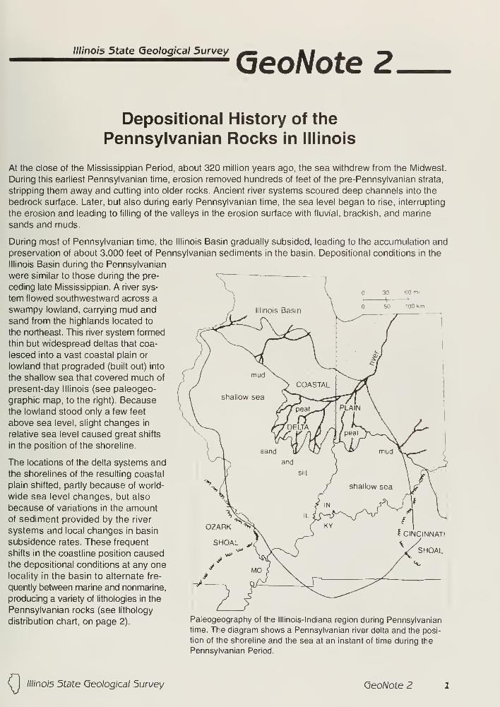
Illinois State Geological Survey
(oeoNote Z
Depositional History of the
Pennsylvanian Rocks in Illinois
At the close of the Mississippian Period, about 320 million years ago, the sea withdrew from the Midwest.
During this earliest Pennsylvanian time, erosion removed hundreds of feet of the pre-Pennsylvanian strata,
stripping them away and cutting into older rocks. Ancient river systems scoured deep channels into the
bedrock surface. Later, but also during early Pennsylvanian time, the sea level began to rise, interrupting
the erosion and leading to filling of the valleys in the erosion surface with fluvial, brackish, and marine
sands and muds.
During most of Pennsylvanian time, the Illinois Basin gradually subsided, leading to the accumulation and
preservation of about 3,000 feet of Pennsylvanian sediments in the basin. Depositional conditions in the
Illinois Basin during the Pennsylvanian
were similar to those during the pre-
ceding late Mississippian. A river sys-
tem flowed southwestward across a
swampy lowland, carrying mud and
sand from the highlands located to
the northeast. This river system formed
thin but widespread deltas that coa-
lesced into a vast coastal plain or
lowland that prograded (built out) into
the shallow sea that covered much of
present-day Illinois (see paleogeo-
graphic map, to the right). Becausethe lowland stood only a few feet
above sea level, slight changes in
relative sea level caused great shifts
in the position of the shoreline.
The locations of the delta systems and
the shorelines of the resulting coastal
plain shifted, partly because of world-
wide sea level changes, but also
because of variations in the amountof sediment provided by the river
systems and local changes in basin
subsidence rates. These frequent
shifts in the coastline position causedthe depositional conditions at any onelocality in the basin to alternate fre-
quently between marine and nonmarine,
producing a variety of lithologies in the
Pennsylvanian rocks (see lithology
distribution chart, on page 2).Paleogeography of the Illinois-Indiana region during Pennsylvanian
time. The diagram shows a Pennsylvanian river delta and the posi-
tion of the shoreline and the sea at an instant of time during the
Pennsylvanian Period.
( I ////no/5 5tate Geological 5urwey OeoNote Z

ELL
cooco
SQ.Z>
oor
ooa:
oGOco Fz. LL<LU
"Oc
_J oO2 CO
CO.*oto
CL
c3.O(1)
-Cc/)
ELL
03
CO73Co.Oi_CO
O
En LL
3 CD
o COcr =?
t'j CD
*:T3CO
LULU
1-
LTOzoof 1
o<LT
ELL
>>.CDCOCO
o
LU
COQ<CO
a> =is: >• 0>
Ȥ S-S2 <"T3 "O >.5 a> _ro
ro en fe
LU—I<XCO
o
m 01
<u
x <u
<1) til
o _5§=I
Eg«/)
o
LU
COLU
1-8
o -o
u
D
D
D
DTT
COCOLUzX.O -r
Ih-
LU
<crLU
D°
I II
25% 25% 5% 5%
o3TOk-
"co
cCO
'cco>>>coccQ)
0.
CO
oo
COQ.Oc
3.Q
CO
T3
0)Ccu
O
Geo/Vote Z ////'no/5 5tate Geological Survey
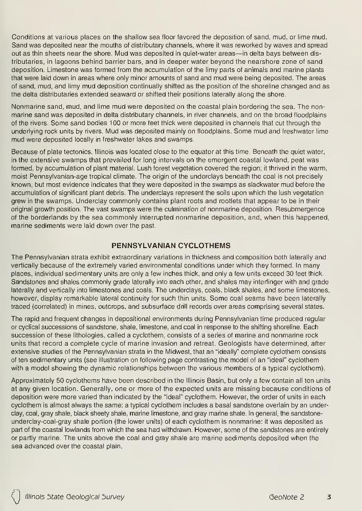
Conditions at various places on the shallow sea floor favored the deposition of sand, mud, or lime mud.
Sand was deposited near the mouths of distributary channels, where it was reworked by waves and spread
out as thin sheets near the shore. Mud was deposited in quiet-water areas—in delta bays between dis-
tributaries, in lagoons behind barrier bars, and in deeper water beyond the nearshore zone of sand
deposition. Limestone was formed from the accumulation of the limy parts of animals and marine plants
that were laid down in areas where only minor amounts of sand and mud were being deposited. The areas
of sand, mud, and limy mud deposition continually shifted as the position of the shoreline changed and as
the delta distributaries extended seaward or shifted their positions laterally along the shore.
Nonmarine sand, mud, and lime mud were deposited on the coastal plain bordering the sea. The non-
marine sand was deposited in delta distributary channels, in river channels, and on the broad floodplains
of the rivers. Some sand bodies 100 or more feet thick were deposited in channels that cut through the
underlying rock units by rivers. Mud was deposited mainly on floodplains. Some mud and freshwater lime
mud were deposited locally in freshwater lakes and swamps.
Because of plate tectonics, Illinois was located close to the equator at this time. Beneath the quiet water,
in the extensive swamps that prevailed for long intervals on the emergent coastal lowland, peat wasformed, by accumulation of plant material. Lush forest vegetation covered the region; it thrived in the warm,
moist Pennsylvanian-age tropical climate. The origin of the underclays beneath the coal is not precisely
known, but most evidence indicates that they were deposited in the swamps as slackwater mud before the
accumulation of significant plant debris. The underclays represent the soils upon which the lush vegetation
grew in the swamps. Underclay commonly contains plant roots and rootlets that appear to be in their
original growth position. The vast swamps were the culmination of nonmarine deposition. Resubmergence
of the borderlands by the sea commonly interrupted nonmarine deposition, and, when this happened,
marine sediments were laid down over the past.
PENNSYLVANIAN CYCLOTHEMSThe Pennsylvanian strata exhibit extraordinary variations in thickness and composition both laterally and
vertically because of the extremely varied environmental conditions under which they formed. In manyplaces, individual sedimentary units are only a few inches thick, and only a few units exceed 30 feet thick.
Sandstones and shales commonly grade laterally into each other, and shales may interfinger with and grade
laterally and vertically into limestones and coals. The underclays, coals, black shales, and some limestones,
however, display remarkable lateral continuity for such thin units. Some coal seams have been laterally
traced (correlated) in mines, outcrops, and subsurface drill records over areas comprising several states.
The rapid and frequent changes in depositional environments during Pennsylvanian time produced regular
or cyclical successions of sandstone, shale, limestone, and coal in response to the shifting shoreline. Each
succession of these lithologies, called a cyclothem, consists of a series of marine and nonmarine rock
units that record a complete cycle of marine invasion and retreat. Geologists have determined, after
extensive studies of the Pennsylvanian strata in the Midwest, that an "ideally" complete cyclothem consists
of ten sedimentary units (see illustration on following page contrasting the model of an "ideal" cyclothem
with a model showing the dynamic relationships between the various members of a typical cyclothem).
Approximately 50 cyclothems have been described in the Illinois Basin, but only a few contain all ten units
at any given location. Generally, one or more of the expected units are missing because conditions of
deposition were more varied than indicated by the "ideal" cyclothem. However, the order of units in each
cyclothem is almost always the same: a typical cyclothem includes a basal sandstone overlain by an under-
clay, coal, gray shale, black sheety shale, marine limestone, and gray marine shale. In general, the sandstone-
underclay-coal-gray shale portion (the lower units) of each cyclothem is nonmarine: it was deposited as
part of the coastal lowlands from which the sea had withdrawn. However, some of the sandstones are entirely
or partly marine. The units above the coal and gray shale are marine sediments deposited when the
sea advanced over the coastal plain.
Illinois 5tdte Geological 5urvey (oeoNote Z
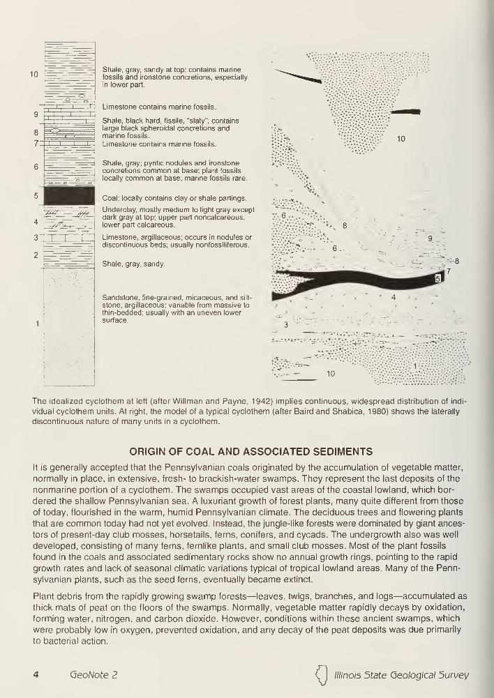
;i i
~i—
r
Shale, gray, sandy at top; contains marinefossils and ironstone concretions, especially
in lower part.
Limestone contains marine fossils.
Shale, black hard, fissile, "slaty"; containslarge black spheroidal concretions andmarine fossils.
Limestone contains marine fossils.
Shale, gray; pyritic nodules and ironstone
concretions common at base; plant fossils
locally common at base; marine fossils rare.
Coal; locally contains clay or shale partings.
Underclay, mostly medium to light gray exceptdark gray at top; upper part noncalcareous,lower part calcareous.
Limestone, argillaceous; occurs in nodules or
discontinuous beds; usually nonfossiliferous.
10
Shale, gray, sandy.
Sandstone, fine-grained, micaceous, and silt-
stone, argillaceous; variable from massive to
thin-bedded; usually with an uneven lowersurface. - 3 "
'
••?.-
10
The idealized cyclothem at left (after Willman and Payne, 1942) implies continuous, widespread distribution of indi-
vidual cyclothem units. At right, the model of a typical cyclothem (after Baird and Shabica, 1980) shows the laterally
discontinuous nature of many units in a cyclothem.
ORIGIN OF COAL AND ASSOCIATED SEDIMENTS
It is generally accepted that the Pennsylvanian coals originated by the accumulation of vegetable matter,
normally in place, in extensive, fresh- to brackish-water swamps. They represent the last deposits of the
nonmarine portion of a cyclothem. The swamps occupied vast areas of the coastal lowland, which bor-
dered the shallow Pennsylvanian sea. A luxuriant growth of forest plants, many quite different from those
of today, flourished in the warm, humid Pennsylvanian climate. The deciduous trees and flowering plants
that are common today had not yet evolved. Instead, the jungle-like forests were dominated by giant ances-
tors of present-day club mosses, horsetails, ferns, conifers, and cycads. The undergrowth also was well
developed, consisting of many ferns, fernlike plants, and small club mosses. Most of the plant fossils
found in the coals and associated sedimentary rocks show no annual growth rings, pointing to the rapid
growth rates and lack of seasonal climatic variations typical of tropical lowland areas. Many of the Penn-
sylvanian plants, such as the seed ferns, eventually became extinct.
Plant debris from the rapidly growing swamp forests—leaves, twigs, branches, and logs—accumulated as
thick mats of peat on the floors of the swamps. Normally, vegetable matter rapidly decays by oxidation,
forming water, nitrogen, and carbon dioxide. However, conditions within these ancient swamps, which
were probably low in oxygen, prevented oxidation, and any decay of the peat deposits was due primarily
to bacterial action.
QeoNote Z Illinois 5tate Geological 5urvey
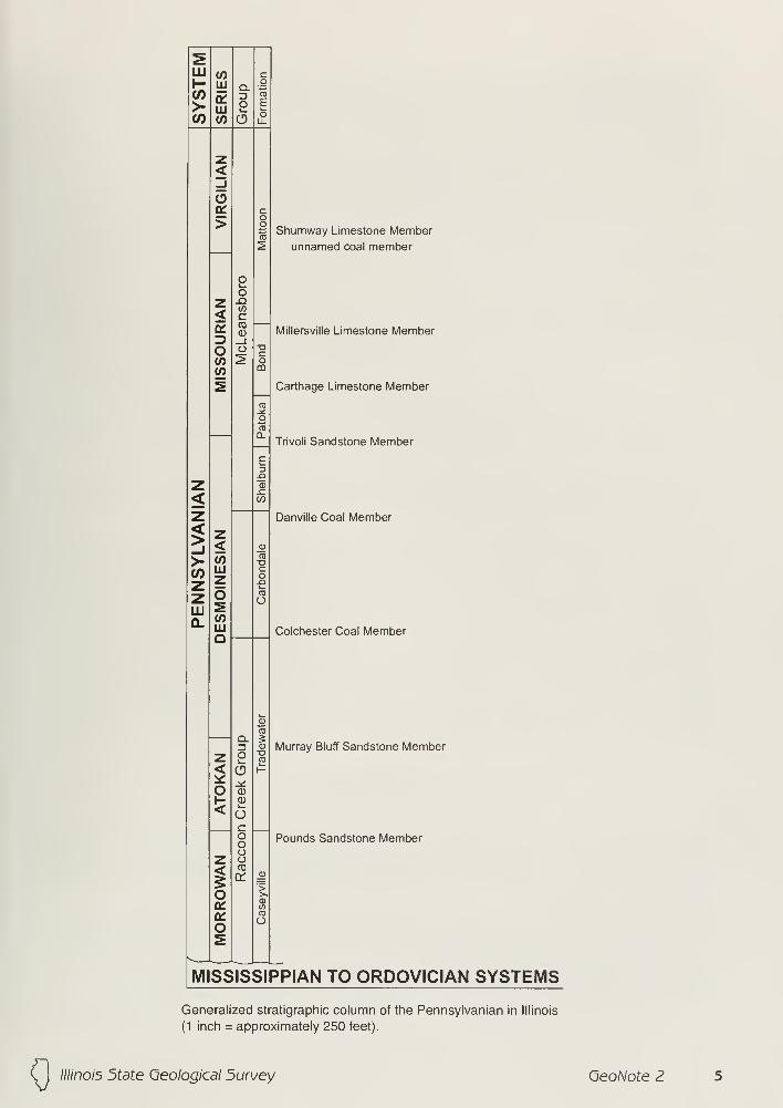
sHI <o cH LU Q_ g
>- LUo
CO
E
(/) CO o oLL
z<_l
Ooi C
o>
oo
oTo
2Shumway Limestone Member
unnamed coal member
z JZ>
< cq:
CDCD Millersville Limestone Member3 _l
o O oc
CO ^ oCO CD
2TO
Oro
Q.
c3
Carthage Limestone Member
Trivoli Sandstone Member
z CD
< 00
z Danville Coal Member
!z< 0)
>- CO03
zLUz
CO-Q
z o CD
OHI 2Q. CO
LUQ Colchester Coal Member
sCO
zQ_
O3
aCO
Murray Bluff Sandstone Member
2k
O1- CD
< ocooo
Pounds Sandstone Member
z o
ICO
or 0)
>o >.
q: 10
onro
oos
MISS IS 51 PPIAN TO ORDOVICIAN SYSTEMS
Generalized stratigraphic column of the Pennsylvanian in Illinois
(1 inch = approximately 250 feet).
////no/5 5tate Geo/og/'ca/ 5urvey (jeoNote Z
Periodic invasions of the Pennsylvanian sea across the coastal swamps killed the forests, and the coals
were commonly buried by marine sediments. During and after the marine transgressions, the peat gener-
ally became saturated with sea water containing sulfates and other dissolved minerals. The marine sediments
deposited on top of the drowned peat also were saturated with sea water, which further infiltrated the peat.
As a result, wherever the peat was buried by marine sediments, the coal that eventually formed from it is
high in sulfur. However, in a number of areas, nonmarine muds, silts, and sands from the river system on
the coastal plain were deposited on the peat where flooding broke through natural levees or the river changed
its course. Where these sediments (unit 6 of the cyclothem) directly overlie the coal and are more than
20 feet thick, we find that the coal is low in sulfur. Although the seas eventually covered the areas wherethese nonmarine, fluvial sediments overlay the peat, the peat was protected from most sulfur infiltration by
these thick fluvial sediments.
As the basin continued to subside and more and more layers of sediment accumulated, the peat deposits
were gradually transformed into coal by slow physical and chemical changes in which pressure (compac-
tion by the enormous weight of overlying sedimentary layers), heat (also due to deep burial), and time were
the most important factors. Water and volatile substances (nitrogen, hydrogen, and oxygen) were slowly
driven off during the coal-forming ("coalification") process, and the peat deposits were changed into coal.
Coals have been classified by ranks that are based on the degree of coalification. The commonly recog-
nized coals, in order of increasing rank, are (1) brown coal or lignite, (2) subbituminous, (3) bituminous,
and (4) anthracite. Each increase in rank is characterized by larger amounts of fixed carbon and smaller
amounts of oxygen and other volatiles in the coal. The hardness of coal also increases with increasing
rank. All Illinois coals are classified as bituminous.
Underclays occur beneath most of the coals in Illinois. Because underclays are generally unstratified
(unlayered), are leached to a bleached appearance, and generally contain plant roots, many geologists
consider that they represent the ancient soils on which the coal-forming plants grew.
The exact origin of the carbonaceous black shale that occurs above many coals is uncertain. Under current
thinking, the black shale is interpreted to represent the deepest part of the marine transgression. Maximumtransgression of the sea was coupled with upwelling of nutrient-rich ocean water near the edge of the conti-
nental shelf and the accumulation of mud and animal remains on an ocean floor that became depleted of oxy-
gen by the decay of the organic matter. This led to the deposition of black organic mud over vast areas
stretching from Texas to Illinois. Deposition occurred in quiet-water areas where very fine-grained, iron-rich
mud and finely disseminated plant debris were washed in from the land. Most of the fossils found in the
black shale represent planktonic (floating) and nektonic (swimming) forms—not benthonic (bottom-dwelling)
forms. The depauperate (dwarf) fossil forms previously reported in black shale in some places were thought
to have been forms that were stunted by toxic conditions in the sulfide-rich, oxygen-deficient water of the
lagoons. However, recent study has shown that this "depauperate" fauna actually consists mostly of normal-
size individuals of species that never grew any larger.
REFERENCES
Baird, G.C., and C.W. Shabica, 1980, The Mazon Creek depositional event; examination of Francis Creek
and analogous facies in the Midcontinent region: in Middle and Late Pennsylvanian Strata on Margin
of Illinois Basin, Vermilion County, Illinois, Vermillion and Parke Counties, Indiana (R. L. Langenheim,
editor). Annual Field Conference—Society of Economic Paleontologists and Mineralogists. Great lakes
Section, No. 10, p. 79-92.
Cobb, J.C., and C.B. Cecil, eds., 1993, Modern and Ancient Coal-Forming Environments: Geological
Society of America Special Paper 286, 198 p.
Heckel, P.H., 1977, Origin of phosphatic black shale facies in Pennsylvanian cyclothems of mid-continent
North America: American Association of Petroleum Geologist Bulletin, v. 61, p. 1045-1068.
6 QeoNote Z (j
////no/5 5tate Geological 5urwey

Kosanke, R.M., J. A. Simon, H.R. Wanless, and H.B. Willman, 1960, Classification of the Pennsylvanian
Strata of Illinois: Illinois State Geological Survey Report of Investigation 214, 84 p.
Simon, J.A., and M.E. Hopkins, 1973, Geology of Coal: Illinois State Geological Survey Reprint 1973-H, 28 p.
Willman, H.B., and J. N. Payne, 1942, Geology and Mineral Resources of the Marseilles, Ottawa, and
Streator Quadrangles: Illinois State Geological Survey Bulletin 66, 388 p.
Willman, H.B., et al., 1967, Geologic Map of Illinois: Illinois State Geological Survey map; scale, 1:500,000
(about 8 miles per inch).
Willman, H.B., E. Atherton, T.C. Buschbach, C.W. Collinson, J.C. Frey, M.E. Hopkins, J. A. Lineback, and
J. A. Simon, 1975, Handbook of Illinois Stratigraphy: Illinois State Geological Survey Bulletin 95, 261 p.
Illinois State Geological Survey, Coal Section
Revised by Russell J. Jacobson, 2000
ILLINOIS STATE GEOLOGICAL SURVEY615 East Peabody Drive
Champaign, IL 61820-6964
2 1 7/333-4747 FAX 2 1 7/244-0802
Printed by authority of the State of Illinois/2000/1 500
© printed using soybean ink on recycled paper
ii_i_irv]cr>is
DEPARTMENT OF
RESOURCES
////no/5 5tate Geological 5urvey Geo/Vote Z

Illinois State Geological Survey
GeoNote 3Quaternary Glaciations in Illinois
ORIGIN OF THE GLACIERS
Over the past 1 .6 million years, known as the Quaternary (kwa-TURN-ah-ree) Period of geologic time,
most of the northern hemisphere above the 50th parallel was repeatedly covered by glacial ice. The cool-
ing of the earth's surface began at least 2 million years ago, and with that cooling, ice sheets eventually
formed in sub-arctic regions and spread outward until they covered the northern parts of North America. With
ongoing climatic change during this period, these ice sheets would form and reform many times.
Early studies of the glaciated landscape concluded that four separate glacial episodes had occurred
in North America. The deposits from each episode were separated from each other by buried soils, which
formed on the land during warmer intervals between glaciations. More recent studies have shown that
there were more than four glaciations, but the actual number is not yet known. These studies, based on
buried soils and glacial deposits, estimate 4 to 8 episodes of ice advance and melting over Illinois. Wenow know that the older glacial sediments are more complex than originally thought and probably repre-
sent more than one episode. Until we know more, all of the glacial deposits before the Illinois Episode
(from 300,000 to 125,000 years ago) are classified as pre-lllinoian deposits.
The North American ice sheets developed when the mean annual
temperature was perhaps 4° to 7°C (7° to 13°F) cooler than it is
now and winter snows did not completely melt during the summers.
Because this time of cooler conditions lasted tens of thousands of
years, thick masses of snow and ice accumulated to form glaciers.
As the ice thickened, the great weight of the ice and snow caused the
glaciers to flow outward at their margins, in several instances for hun-
dreds of miles. As the ice sheets expanded, the areas in which snowaccumulated probably also increased in extent.
Several times, huge tongues of ice, called lobes, flowed southward
from two different centers, one east and one west of present-day
Hudson Bay, and converged in the central lowland between the
Appalachian and Rocky Mountains. There the glaciers made their
farthest advances to the south. The sketch at right shows the centers
of flow, the general directions of flow from the centers, and the south-
ern extent of glaciation. Because Illinois lies entirely in the central
lowland, it was invaded by lobes from both accumulation centers.
EFFECTS OF GLACIATION
Quaternary glaciers and the waters melting from them changed the landscapes they covered. The glaciers
scraped and smeared the landforms they overrode, leveling and filling many of the minor valleys and
even some of the larger ones. Moving ice carried colossal amounts of rock and earth, commonly for
hundreds of miles; the glaciers scoured the land surface and kneaded much of the rock debris into the
moving ice.
The continual floods of glacial meltwaters entrenched new drainageways and deepened old ones, and
partly refilled them with the great quantities of rock and earth carried by the glaciers. According to someestimates, the amount of water that was drawn from the sea and changed into ice during a glacial episode
lowered the sea level by 300 to 400 feet below its present level. When these continental ice sheets melted,
tremendous volumes of water eroded and transported sediments.
Illinois 5tate Geological 5urvey (oeoNote 5
In most of Illinois, glacial and meltwater deposits buried the previous rocky, low, hill-and-valley terrain and
created the flatter landforms that became our prairies. The glaciers deposited across roughly 90% of the
state a mantle of ground-up rock debris, gravel, sand, and clay that at points reaches thicknesses of 400 to
500 feet. These deposits are of incalculable value to Illinois residents because they are the parent material of
our rich soils, the source of drinking water for much of the state, and provide large amounts of sand andgravel for construction.
GLACIAL DEPOSITS
Drift is the term for all the deposits of earth and rock materials moved by glacial activity. Till is the type of
drift deposited directly by glacial ice. Because till was not moved much by water, this sediment is unsorted,
containing particles of many different sizes and compositions. It is also unstratified (unlayered). A till maycontain materials ranging in size from microscopic clay particles to large boulders. Most tills in Illinois are
pebbly clays with only a few boulders. For descriptive purposes, a mixture of clay, silt, sand, and boulders
is called diamicton. This term describes a deposit that could be interpreted as till or as a product of a differ-
ent process called mass wasting, which includes such things as rockslides or other similar gravity-propelled
earth movements.
End moraines are the arc-shaped ridges that formed when till piled up along a glacier's leading edge whenthe ice was melting at roughly the same rate as the flowing ice moved forward. Till also formed groundmoraines, or till plains, which have gently undulating surfaces formed as the ice front melted back. Deposits
of till identify areas once covered by glaciers. The many alternating ridges and plains in northeastern
Illinois are the successive end moraines and till plains formed by the retreating Wisconsin Episode glaciers
(about 25,000 to 13,500 years ago).
Outwash is the sorted and stratified sediments deposited by meltwater flowing away from the glacier.
Outwash deposits are layered in beds because the flow of water that moved the material varied in gradient,
volume, velocity, and direction. As a meltwater stream carried the rock materials along, it sorted them by
size. As stream velocity decreased, heavier gravels and cobbles were deposited before fine sands, silts,
and clays, which were deposited farther downstream. Typical Quaternary outwash in Illinois consists of
multilayered beds of sands and gravels and some silts. These beds look much like modern stream deposits
in some places. Outwash tends to be coarser and less weathered than stream sediment (alluvium), which
is generally finer than medium sand and contains variable amounts of weathered rock debris.
Meltwater deposits are found not only in the area once covered by the glaciers but also in areas far beyond
it. Meltwater streams ran off the top of the glacier, in crevices within the ice, and under the ice. In someplaces, the cobble-gravel-sand filling of the bed of a stream that flowed within or under the ice is preserved
as a sinuous ridge called an esker. Some eskers in Illinois are made up of sandy, silty, gravelly deposits
and contain mass-wasted diamicton material. Cone-shaped mounds of coarse outwash, called kames,
were formed where meltwater plunged through crevasses in the ice.
The finest outwash sediments, the silts and clays, formed bedded deposits in the ponds and lakes that filled
glacier-dammed stream valleys, the low-lying areas on till plains, and some low till plains where meltwaters
were diked behind end moraines. Meltwater streams that entered a lake rapidly lost velocity and dropped
the sands and gravels they carried, forming deltas at the edge of the lake. Very fine sands and silts were
commonly redistributed on the lake bottom by wind-generated currents, and the clays, which stayed in
suspension longest, slowly settled out and accumulated with them.
Along the ice front, meltwater ran off in innumerable shifting, cross-cutting, and short-lived streams (called
braided streams), which laid down an outwash plain, a broad, flat blanket of outwash. Outwash was also
carried away from the glaciers in valleys cut by floods of meltwater. The Mississippi, Illinois, and Ohio Rivers
occupy valleys that were major channels for meltwaters and that were greatly widened and deepened
during the greatest meltwater floods. When the floods waned, these valleys were partly filled with outwash
far beyond the ice margins. Such outwash deposits, largely sand and gravel, are known as valley trains.
Valley train deposits may be both extensive and thick. For instance, the long valley train of the Mississippi
River Valley is up to 200 feet thick in places.
2 GeoNote 3 (J
////no/5 5tate Geological 5urwey
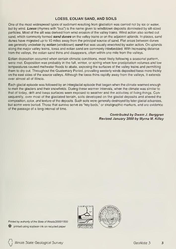
LOESS, EOLIAN SAND, AND SOILS
One of the most widespread types of sediment resulting from glaciation was carried not by ice or water,
but by wind. Loess (rhymes with "bus") is the name given to windblown deposits dominated by silt-sized
particles. Most of the silt was derived from wind erosion of the valley trains. Wind action also sorted out
sand, which commonly formed sand dunes on the valley trains or on the adjacent uplands. In places, sand
dunes have migrated up to 10 miles away from the principal source of sand. Flat areas between dunes
are generally underlain by eolian (windblown) sand that was usually reworked by water action. On uplands
along the major valley trains, loess and eolian sand are commonly interbedded. With increasing distance
from the valleys, the eolian sand thins and disappears, often within one mile from the valleys.
Eolian deposition occurred when certain climatic conditions, most likely following a seasonal pattern,
were met. Deposition was probably in the fall, winter, or spring when low precipitation volumes and low
temperatures caused meltwater floods to abate, exposing the surfaces of the valley trains and permitting
them to dry out. Throughout the Quaternary Period, prevailing westerly winds deposited loess more thickly
on the east sides of the source valleys. Although the loess thins rapidly away from the valleys, it extends
over almost all of Illinois.
Each glacial episode was followed by an interglacial episode that began when the climate warmed enough
to melt the glaciers and their snowfields. During these warmer intervals, when the climate was similar to
that of today, drift and loess surfaces were exposed to weather and the activities of living things. Con-
sequently, over most of the glaciated terrain, soils developed on the glacial deposits and altered the
composition, color, and texture of the deposits. Such soils were generally destroyed by later glacial advances,
but some were buried. Those that survive serve as "key beds," or stratigraphic markers, and are evidence
of the passage of a long interval of time.
Contributed by Dwain J. Berggren
Revised January 2000 by Myrna M. Killey
Printed by authority of the State of Illinois/2000/1500
@ printed using soybean ink on recycled paper NATURALRESOURCES
(j
////no/5 5tate Geological 5urvey QeoNote 3
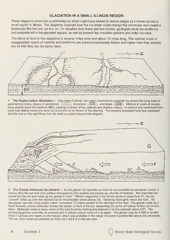
GLACIATION IN A SMALL ILLINOIS REGION
These diagrams show how a continental ice sheet might have looked at various stages as it moved across a
small region in Illinois. The diagrams illustrate how the ice sheet could change the old terrain and create alandscape like the one we live on. To visualize how these glaciers looked, geologists study the landforms
and materials left in the glaciated regions, as well as present-day mountain glaciers and polar ice caps.
The block of land in the diagrams is several miles wide and about 10 miles long. The vertical scale is
exaggerated; layers of material and landforms are drawn proportionally thicker and higher than they actually
are so that they can be easily seen.
1 The Region before Glaciation — Like most of Illinois, the region illustrated is u nderla in by almost flat-lying beds of
sedimentary rocks—layers of sandstone ('••'•••). limestone (iEcE), and shale(==~=^
) Millions of years of erosion
have planed down the bedrock (BR), creating a terrain of low uplands and shallow valleys. A residual soil weathered fromlocal rock debris covers the area but is too thin to be shown in the drawing. The streams illustrated here flow westwardand the one on the right flows into the other at a point beyond the diagram.
2 The Glacier Advances Southward — As the glacier (G) spreads out from its ice snowfield accumulation center, it
scours (SC) the soil and rock surface and quarries (Q)—pushes and plucks up—chunks of bedrock. The materials are
mixed into the ice and make up the glacier's "load." Where roughness in the terrain slows or stops flow (F), the ice
"current" slides up over the blocked ice on innumerable shear planes (S). Shearing thoroughly mixes the load. Asthe glacier spreads, long cracks called "crevasses" (C) open parallel to the direction of ice flow. The glacier melts as it
flows forward, and its meltwater erodes the terrain in front of the ice, deepening (D) some old valleys before ice covers
them. Meltwater washes away some of the load freed by melting and deposits it on the outwash plane (OP). Theadvancing glacier overrides its outwash and in places scours much of it up again. The glacier may be 5,000 or so feet
thick in Canada and tapers to the margin, which was probably in the range of several hundred feet above the old terrain.
The ice front advances perhaps as much as a third of a mile per year.
QeoNote 3 Illinois 5tate Geological 5urvey
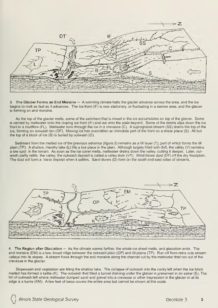
7TT ' ..}. .!..' ', A^~~^~~T^T~-..-V l
..
'"^rT~T -'. ..iTvr.'
..' .
'.14^=3=
3 The Glacier Forms an End Moraine — A warming climate halts the glacier advance across the area, and the ice
begins to melt as fast as it advances. The ice front (IF) is now stationary, or fluctuating in a narrow area, and the glacier
is forming an end moraine.
As the top of the glacier melts, some of the sediment that is mixed in the ice accumulates on top of the glacier. Someis carried by meltwater onto the sloping ice front (IF) and out onto the plain beyond. Some of the debris slips down the ice
front in a mudflow (FL). Meltwater runs through the ice in a crevasse (C). A supraglacial stream (SS) drains the top of the
ice, forming an outwash fan (OF). Moving ice has overridden an immobile part of the front on a shear plane (S). All but
the top of a block of ice (B) is buried by outwash (O).
Sediment from the melted ice of the previous advance (figure 2) remains as a fill layer (T), part of which forms the till
plain (TP). A shallow, marshy lake (L) fills a low place in the plain. Although largely filled with drift, the valley (V) remains
a low spot in the terrain. As soon as the ice cover melts, meltwater drains down the valley, cutting it deeper. Later, out-
wash partly refills the valley: the outwash deposit is called a valley train (VT). Wind blows dust (DT) off the dry floodplain.
The dust will form a loess deposit when it settles. Sand dunes (D) form on the south and east sides of streams.
4 The Region after Glaciation — As the climate warms further, the whole ice sheet melts, and glaciation ends. Theend moraine (EM) is a low, broad ridge between the outwash plain (OP) and till plains (TP). Run-off from rains cuts stream
valleys into its slopes. A stream flows through the end moraine along the channel cut by the meltwater that ran out of the
crevasse in the glacier.
Slopewash and vegetation are filling the shallow lake. The collapse of outwash into the cavity left when the ice block
melted has formed a kettle (K). The outwash that filled a tunnel draining under the glacier is preserved in an esker (E). Thehill of outwash left where meltwater dumped sand and gravel into a crevasse or other depression in the glacier or at its
edge is a kame (KM). A few feet of loess covers the entire area but cannot be shown at this scale.
(j
////no/5 5tate Geological Survey (jeoNote 5
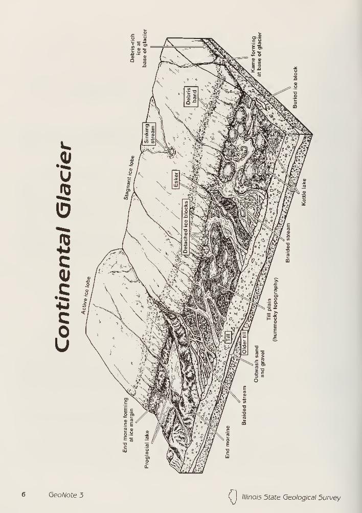
u
ID
5
f m.'1'
/ •r -*' re
/•""SaT"^ <u
&*/W m*
£re0)
in
a0)
are
0."IE"!
>£* : »v a
re
O)r o
*/R?i^ re oI Itr 1 a"cjbij _ >N
= -*<°/Am 1- «/j*i oXv.v E
E™ 3*• £oD ao c _
re a>i/> >^= '
^5j </) O)re
£?3 re
O
Geo/Vote 5 (J
////no/5 State Qeologicdl 5urwey
TIMETABLE OF EVENTS IN THE ICE AGE IN ILLINOIS
Years
before
present
Time-distance diagram
Interglacial andglacial episodes Sediment record
Dominant climate conditions
Dominant land forming and soil
forming events
interglacial
episode
10,000-
75,000 -
125,000-
WISCONSIN(late)
glacial
episode'
WISCONSIN(early and middle)
glacial margin
north of Illinois
SANGAMONinterglacial
episode
300,000 -
425,000 -
ILLINOIS
glacial
episode
YARMOUTHinterglacial
episode
PRE-ILLINOISglacial
1,600,000-
and older
interglacial
episodes
River, lake, wind, andslope deposits.
Warm; stable landscape conditions.
Formation of modern soil; running wa-ter, lake, wind, and slope processes.
Till and ice-marginal
deposits; outwash andglacial lake deposits;
loess.
Cold; unstable landscape conditions.
Glacial deposition, erosion, andlandforming processes (e.g., formation
of end moraines, outwash plains, valley
trains, proglacial lakes, kettles), plus
running water, lake, wind, and slope
processes.
Loess; river, lake, andslope deposits.
Cool; stable.
Weathering, soil formation (FarmdaleSoil and minor soils); wind and running
water processes.
River, lake, wind, andslope deposits.
Warm; stable.
Weathering, soil formation (Sangamon(Soil); running water, lake, wind, andslope processes.
Till and ice-marginal
deposits; outwash andglacial lake deposits;
loess.
Cold; unstable.
Glacial deposition, erosion, and land-
forming processes, plus proglacial
running water, lake, wind, and slope
processes; possible minor soil
formation.
River, lake, wind, andslope deposits.
Warm; stable.
Long weathering interval with deep soil
formation (Yarmouth Soil); running
water, lake, wind, and slope processes.
Till and ice-marginal
deposits; outwash andglacial lake deposits;
loess plus nonglacial
river, lake, wind, andslope deposits.
Alternating stable and unstable inter-
vals of uncertain duration.
Glacial deposition, erosion, and land-
forming processes, plus proglacial
and interglacial running water, lake,
wind, and slope processes; interglacial
weathering and soil formation.
////no/5 State Geological 5urvey (jeoNote 3
SEQUENCE OF GLACIATIONS AND INTERGLACIALDRAINAGE IN ILLINOIS
AncientIowa R.
AncientOhio R.
AncientTennessee R.
PRE-PLEISTOCENE PRE-ILLINOISmajor drainage inferred glacial limits
YARMOUTHmajor drainage
ILLINOIS
extent of three glacial advances
Ancient
Ohio R.
AncientTennessee R.
SANGAMONmajor drainage
WISCONSIN(early and middle)
glacial margin
north of Illinois
maximumglacial advance
WISCONSIN (late)
ice andKankakee Flood
drainage
glacial lakes
QeoNote 5 ( 1 ////'no/5 5tate Geological Survey
Quaternary Deposits of Illinois
Hudson and Wisconsin Episodes
Mason Group and Cahokia Fm
Cahokia and Henry Fms; sorted
sediment including waterlain
river sediment and windblownand beach sand
Equality Fm; fine grainedsediment deposited in lakes
Wedron Group (Tiskilwa, Lemont, andWadsworth Fms) and Trafalgar Fm;diamicton deposited as till andice-marginal sediment
End moraine
Ground moraine
linois Episode
Winnebago Fm; diamicton deposited as till
and ice-marginal sediment
Glasford Fm; diamicton deposited as till andice-marginal sediment
Teneriffe Silt and Pearl Fm, including HagerstownMbr; sorted sediments including river and lake
deposits and wind blown sand
Pre-lllinois Episodes
Wolf Creek Fm; predominantly diamictondeposited as till and ice-marginal sediment
Paleozoic, Mesozoic, and Cenozoic
Mostly Paleozoic shale, limestone, dolomite,
or sandstone; exposed or covered by loess
and/or residuum
50 kmI I I
( I Illinois 5tate Geological Survey (jeoNote 5
c VALPARAISO
END MORAINESof the
WISCONSIN GLACIAL EPISODE
Wisconsin Episode moraines arc across northeastern Illinois
and indicate position of temporary stationary ice fronts asthe ice retreated.
10 QeoNote 5 (J
////no/5 5tate Geological Survey
Illinois State Geological Survey
Geobit 4Fluorite—Illinois' State Mineral
Deep purple, amethyst, sky blue,
sea green, sunny yellow, and crystal
clear—the mineral fluorite comesin all colors. Many types of fluo-
rite even glow under ultraviolet
light. Theyre "fluorescent."
Pure fluorite (CaF2 ), madeof the elements calcium (Ca)
and fluorine (F), is colorless.
The various colors result
from tiny amounts of other ele-
ments substituting for the cal-
cium in the crystalline structure.
Transparent to translucent, this
glass-like mineral may be found as
irregular masses filling veins that cut
through rocks, or in flat-lying bands or
layers parallel with the bedding planes
of sedimentary rocks. As the photos show,
fluorite also forms as clusters of beautiful
cubic crystals.
Light reflects strongly from fluorite's crystal
faces and cleavage surfaces, which can be polished to a high luster. As lovely as a gemstone, fluorite is brittle
and relatively soft (4 on Moh's hardness scale), so it's unsuitable for ring settings. Brooches and pendants mustbe handled carefully to avoid scratching or fracturing the mineral specimens in these settings.
Just for display, miners chipped octahedrons out of coarse crystals of the mineral known to the mining
industry as fluorspar. They called the eight-sided crystals "diamonds."
How did Illinois' fluorite deposits form?Hot water containing fluorine and other dissolved chemicals rose from deep in the earth during the Jurassic
Period, about 150 to 200 million years ago. The water flowed through northeast-trending faults and fractures in
limestones laid down earlier in the Mississippian Period, about 330 million years ago.
When the hot brines reached the calcium-rich Mississippian rocks, the temperature and other conditions
were just right for crystallizing fluorite along the walls of the faults and in flat-lying layers parallel to the bedsof limestone. These host rocks dissolved and were replaced with the fluorite.
Country's leading producer offluorsparSince the early 1800s, fluorite has been mined in southeastern Illinois. The fluorspar-rich region, which reaches
from southeastern Illinois into parts of Kentucky, was called the Illinois-Kentucky Fluorspar Mining District.
In Illinois, fluorite was mined almost exclusively in Hardin and Pope Counties. The main production camefrom fissure-vein deposits in the Rosiclare district, and stratiform (bedding plane) deposits in the Cave in Rockdistrict (map, p. 2). Other areas in the two counties yielded smaller amounts of the mineral.
Most mining was underground, as much as 1,300 feet deep. But open-pit mines operated where fluorite
deposits intersected land surface.
Illinois displaced Kentucky as the country's leading producer of fluorite in 1942. For many years, Illinois
accounted for more than 50% of total U.S. fluorspar production. But by 1990, more than 90% of the fluorite
used in the U.S. was imported. Illinois was the only remaining domestic producer.
Competition from foreign producers coupled with high costs of underground operations made Illinois'
fluorspar mining unprofitable. The last fluorspar mine in Illinois closed in December 1995. Fluorspar is nolonger mined anywhere in the United States.
Illinois' State Mineral The General
Assembly made fluorite the State
Mineral in 1965, when fluorspar min-
ing was a multimillion-dollar-per-year
industry in Illinois. Over the years,
much more fluorite has been minedin Illinois than in any other state.
The many uses for fluoriteNative Americans carved fluorspar to makeartifacts, but the first recorded use of Illinois'
fluorite was in 1823, when fluorspar minednear Shawneetown in Gallatin County wasused to manufacture hydrofluoric acid.
The mineral, fluorite, is vital to the nation's
economy. Its uses:
R6E
Principal mining areas in the southeastern Illinois part of the
Illinois-Kentucky Fluorspar Mining District.
Mineral «._____^^^^^^^^^^^^^_^^^^^^_^^^^^^_^__• smelting iron, aluminum, and other metal alloys,
• manufacturing glass, enamel glazes, ceramics, portland cement,and many chemical compounds.
Hydrofluoric acid ^^^^^^^^___^^_^^_• refining aluminum,
• refining uranium fuel for nuclear reactors,
• making rocket fuel and metal plating.
Inorganic fluoride chemicals
toothpastes, special fluxes for welding rods, optical lenses, andconcrete hardeners.
Organic fluoride chemicals ^^^^^_^^^^_^^^^_^^^^^^^^^• Plastics, refrigerants, nonstick coatings, lubricants, stain repellents,
dyes, herbicides, medicines and anesthetics, cleaning solvents,
degreasing agents and foaming agents.
One of the most widely used organic fluoride compounds, the refrigerant Freon 12®, is no longer produced in
the United States. The chlorine in the compound is thought to damage the protective ozone layer that
shields the earth from ultraviolet radiation.Contributed by D.L. Reinertsen and J.M. Masters
ILLINOIS STATE GEOLOGICAL SURVEY615 East Peabody Drive
Champaign, IL 61820-69642 1 7/333-4747 FAX 2 1 7/244-7004
LLINOIS
Printed by authority ofthe State ofIllinois/1997/1000
0/ printed using soybean ink on recycled paper

? 3St sj
r 4n x- *
SJo S5 3
O Q)i
^
Copyright © 2022 FDOKUMEN