Research of Ground-Penetrating Radar for Detection of Mines ...

© 2012 European Association of Geoscientists & Engineers 35
Near Surface Geophysics, 2012, 10, 35-45 doi:10.3997/1873-0604.2011034
Ground-penetrating radar survey at the Roman town of Mariana (Corsica), complemented with fluxgate gradiometer data and old and recent excavation results
Lieven Verdonck1*, Frank Vermeulen1, Cristina Corsi2 and Roald Docter1
1 Department of Archaeology, Ghent University, Sint-Pietersnieuwstraat 35, 9000 Ghent, Belgium2 Dipartimento di Filologia e Storia, University of Cassino, Via Zamosch 43, 03043 Cassino, Italy
Received October 2010, revision accepted July 2011
ABSTRACTThis paper presents the results of a GPR survey carried out at the Roman town of Mariana (Corsica, France). Excavations (1959–1965 and 2000–2007) yielded a Roman street with houses and shops, an early mediaeval cathedral and a mediaeval bishop’s palace. When compared with the hypotheti-cal town limits derived from aerial photography, old cadastral maps and the location of two cemeter-ies, the excavations are in an eccentric position. The principal aim of the geophysical survey was to shed more light on the Early Imperial town centre (1st–2nd century AD), which was to be found further north. The results from a fluxgate gradiometer survey demonstrated the presence of build-ings with an orientation corresponding to the excavated street. In the GPR data, an orthogonal street system became noticeable and most of the buildings can be identified as private dwellings. In sev-eral parts of the town, there are indications for more than one occupation phase. For example, in the north-western insula of the main survey area, the GPR results show a large building complex with deep foundations, as well as shallow walls of poor construction quality in the courtyard of this building. A trial excavation confirmed this dichotomy: it revealed solid walls with brick facings originating in the 1st or 2nd century AD, as opposed to alignments of loose boulders, not older than the 3rd century. On the basis of the GPR results, two small excavation trenches from the 1930s, one of which contained the remains of a bathhouse, can now be located exactly.
tury BC. Shortly after 100 BC, Alalia was rebuilt and renamed Aleria and became the economic capital with a monumental city infrastructure and an important naval base. At the same time, another city, Mariana, was built at the mouth of the river Golo. Together with the capital this town became the driving force behind the integration of the island and its inhabitants into the Roman civilization (Vismara 2005). Although Corsica would become a place of exile for political opponents in Rome and some exports of silver and iron are known, the island remained a relatively isolated region of the western Roman Empire until the invasion by the Vandals in AD 436. Its rugged landscape was not well suited to major agricultural pursuits and a major part of its indigenous inhab-itants were relatively closed to the outside world (Pergola 2004).
Nevertheless, current archaeological research in and around the city of Mariana demonstrates the important imprint of the Roman society on the island between the 1st century BC and the 5th century AD. Thanks to Seneca, who was exiled in Corsica, we know that Mariana was a colonia civium Romanorum, a col-ony of Roman citizens (Seneca, De Consolatione ad Helviam Matrem, VIII, 8) and that it took its name from the founder, Gaius Marius. Although archaeological proof for the first dec-
INTRODUCTIONIn the last decades, ground-penetrating radar (GPR) has become one of the most valuable methods for the non-invasive archaeological investigation of complex urban sites (see e.g., Leckebusch and Sütterlin 2007; Neubauer et al. 2009; Linford et al. 2010; Trinks et al. 2010). This paper presents the results of a GPR survey at the Roman colonia of Mariana, situated near the river Golo in the municipality of Lucciana, some 20 km south of Bastia (north-eastern Corsica, France; Fig. 1).
The study of the romanization in Corsica is still at its beginning. So far, the best information about the incorporation of this western Mediterranean island into the Roman world comes from ancient written sources and from older excavations on one of its major archaeological sites, Aleria (Fig. 1; Jehasse and Jehasse 1988; Mertens 1992; Bouet 1998). Soon after the beginning of the First Punic War (264–241 BC) the Romans took the ancient Graeco-Etruscan coastal town Alalia from the Carthaginians (259 BC) and began their conquest of Corsica. However, the interior of the island was not fully pacified until the beginning of the 1st cen-

L. Verdonck et al.36
© 2012 European Association of Geoscientists & Engineers, Near Surface Geophysics, 2012, 10, 35-45
ing ruins along the river (houses, churches, streets, parts of the town wall, bridges, an aqueduct, harbour structures), although they contain no precise information regarding the location of the remains or the perimeter of the town. Today, the site essentially consists of farmland and has remained reasonably undisturbed by modern development. The only large ancient standing build-ing is the church of La Canonica, a Romanesque former cathe-dral inaugurated in AD 1119 (Fig. 2, A).
As a consequence, little was known about Mariana until a series of trial excavations in 1936–1937 by L. Leschi and
ades of this presence of Roman colonists is still meagre, new investigations are elucidating the importance of the Roman urban centre established here. Especially its development throughout the first centuries of our era is becoming visible, demonstrating the strong impact of Roman urban models.
ARCHAEOLOGICAL INVESTIGATIONS AT MARIANAExcavationsLiterary sources and historical maps (Cervoni 1989) from the 16th century onwards mention the existence of substantial stand-
FIGURE 1
Map of Mariana. A1–A3: 1936–
1937 excavations, B–D: cemeter-
ies, E: funeral church of San
Parteo, F: excavations south of
the Canonica church, G: Golo
river, H: northern town wall,
I: northern town wall (hypotheti-
cal), J: 2007 GPR survey area,
K: 2008 GPR survey area,
L–M: 2009 GPR survey area,
N: planned section of road D107,
O: pre-Roman road axis, P: hypo-
thetical extent of the town. The
numbers refer to the parcels fig-
uring on the cadastral map of the
municipality of Lucciana.
FIGURE 2
Excavations south of the
Canonica church (1959–1965 and
2000–2007), adapted from:
Leandri F. and Thernot R. 1994.
Plan général des vestiges romains,
paléochrétiens et médiévaux.
Commune de Lucciana.
A: Canonica, B: domus, C: porti-
co, D: shop, E: Late Republican
wall, F: small market, G: narthex
of an Early Christian cathedral,
H: Early Christian cathedral,
I: baptistry, J: late antique build-
ing, K: bishop’s palace, L: street,
M: GPR survey grids, N: road
D107, O: parcel 81 (partially sur-
veyed with GPR).

GPR survey at the Roman town of Mariana (Corsica) 37
© 2012 European Association of Geoscientists & Engineers, Near Surface Geophysics, 2012, 10, 35-45
(Fig. 1, G) and will be discussed later in this paper. The fields north of the Canonica are to a large extent devoid of aboveground struc-tures but a few indications are of importance. A stone built struc-ture, preserved as part of a modern house with the meaningful toponym ‘Imperiale’ (Fig. 1, A3), resembles part of a temple podium or other monumental ancient building. It is also visible on photographs from the 1930s (Fig. 3) and might give an indication for the location of the forum and the city centre. Furthermore, a few wall remnants observed along a country track, in a bad state of preservation and partially hidden by the vegetation, may represent parts of the northern Roman town wall (Fig. 1, H–I).
On the basis of this limited archaeological evidence above surface, the data from the 1936–1937 and 1959–1965 excava-tions, the proximity of the river Golo in antiquity and the analysis of historical aerial images and 18th and 19th century cadastral maps, a first model for the delimitation of the inhabited urban space has been reconstructed (Corsi et al. 2009). It was hypoth-esized that the city walls, with a rectangular or trapezoidal plan, enclosed a surface of more or less 30 hectares (Fig. 1, P).
Given the proposed model, the eccentricity of the excavations near the Canonica church (Fig. 1, F) is obvious. Therefore prob-ably the Early Imperial town centre is situated further north. To clarify this, as well as the location of the town perimeter, the road network and the excavation trenches from the 1930s, geophysical surveys started in 2006.
A fluxgate gradiometer survey was conducted in 2006 and 2007 with a Geoscan Research FM256. The in-line sampling interval was 25 cm and the transect spacing 50 cm. Data processing included the application of a zero mean grid, the de-sloping of a few 20 by 20 m grids and a low-pass filter to eliminate high-frequency noise and make extended, weak analies better visible (Aspinall et al. 2008). The archaeological struc-tures show as negative linear anomalies (mostly around –5 to –10 nT from the mean) against the geological background (river
A. Chauvel (Leschi and Chauvel 1936, 1937; Nucci 2001) revealed a number of structures scattered over the fields north and east of the Canonica. From the concise reports, the precise location of the trenches cannot be deduced but the analysis of traces visible on aerial photographs taken by the excavators has allowed locating them approximately (Fig. 1, A1–A3; Corsi and Vermeulen 2007). As will be described below, further clarifying the location of the 1936–1937 excavations was one of the aims of the GPR survey.
More extensive excavations were conducted under the direc-tion of G. Moracchini-Mazel from 1959–1965. The rescue exca-vations of two cemeteries, Palazzetto-Murotondo at the west and I Ponti at the east (Fig. 1, B–D; Moracchini-Mazel 1971, 1974) give us a rough idea of the maximal east-west extent of the town, as Roman urban cemeteries were normally situated outside the inhabited area. Furthermore, soundings were carried out in the funerary church of San Parteo, situated south-west of Mariana (Fig. 1, E) and a large sector immediately south of the mediaeval cathedral was excavated (Fig. 1, F). There an Early Christian basilica with a baptistery, a portion of a Roman road with porti-coes, shops, houses and a small market were discovered (Fig. 2).
Since 2000, archaeological research in Mariana has been reactivated under the direction of Ph. Pergola (C.N.R.S., Aix-en-Provence) and until 2007 yearly excavation campaigns were organized in the area south of the Canonica. These revealed – among others – a vast Roman house underneath the Early Christian basilica (Di Renzo 2007a,b).
The Roman constructions mainly belong to the 1st–4th cen-tury AD. As mentioned before, archaeological evidence for the early colonial or Late Republican phase (i.e., 1st century BC) is still limited: only a few sherds of black glazed pottery have been recorded in the excavations and only one wall in room E (Fig. 2; Comiti 2008) has been attributed to the pre-Augustan phase (i.e., before 30 BC). Around the 6th century AD, an Early Christian complex was built on top of the former Roman living area. This part of the site was occupied continuously until the 13th century.
Archaeological prospection and geomorphologic soundingsSince 2004 a team from the Universities of Ghent and Cassino, in collaboration with the University of Paris X (Nanterre), has taken up the study of the ancient topography of the city as a whole, to extend the results of the excavations south of the Canonica. The principal aims are: defining the internal urban layout and street network, identifying public and private spaces, delineating the town perimeter and defensive system and indi-vidualizing the harbours and landings along the coast and the river Golo. This study is based on aerial photography, historical cartography, field survey, geomorphologic investigations, geo-physical prospections and trial excavations.
The geomorphologic soundings by A. Roblin-Jouve have pro-vided more information on the relationship between the town and the river Golo (Corsi et al. 2009), which today flows a few hun-dreds of metres south of the excavation area near the Canonica
FIGURE 3
Podium of Roman origin under a modern house named ‘Imperiale’, now
partially overgrown (photograph taken in 1936 by L. Leschi and
A. Chauvel).

L. Verdonck et al.38
© 2012 European Association of Geoscientists & Engineers, Near Surface Geophysics, 2012, 10, 35-45
The surveys were carried out using a pulseEKKO PRO GPR system with a 500 MHz antenna. The data were recorded in ‘zigzag’ mode, in east-west orientation (except for area M, where the orientation was north-south), with a sampling interval along the lines of 5 cm and a transect spacing of 25 cm. The time window was 60 ns and the stack was 8. The transects were marked on the ground by guide ropes. A digital elevation model of the relatively flat survey areas was created with a total station, with a maximum distance between the measurement points of 2 m in the in-line and cross-line directions, depending on the surface topography.
A standard processing sequence was applied. After dewow and the alignment of the zero crossings following the onset of the air-wave, a uniform gain function, based on the inverse average amplitude envelope, was applied in order to enhance later arrivals. Further steps involved the application of a band-pass filter (100 MHz–1 GHz) and background removal. Strong ringing was caused by small metal objects in the topsoil (Fig. 6a). This ringing masks all deeper reflections and produces a large artefact when migrated using the normal wave velocity of the subsoil. Fortunately, the amplitude spectrum of the affected traces is often characterized by a peak with a narrow bandwidth, which can be removed by a band-reject filter (Fig. 6b,d). Since
deposits consisting of cobbles in a compact sandy loam matrix, Corsi et al. 2009). This contrast is overshadowed by numerous strong anomalies, often exceeding 100 nT, caused by near-sur-face ferrous debris (see Figs 4a and 5a). Given this noisy back-ground, large clipping ranges proved optimal for data display. Nevertheless, the survey revealed a number of walls with the same orientation as the excavated structures south of the Canonica. Given the dimensions of the prospected area (c. 150 by 200 m), streets dividing the area were to be expected. However, only one relatively clear east-west axis was revealed.
GPR DATA ACQUISITION AND PROCESSINGInitial GPR tests in 2007 (Fig. 1, J) were promising. Subsequently, three different areas of the town were prospected. The northern part of parcel 81 north of the Canonica (c. 5000 m²), now used for sheep grazing, was surveyed in September 2008 (Fig. 1, K; Verdonck and Vermeulen 2009). The November 2009 survey comprised three smaller areas in fields 2 and 76 (c. 2700 m² in total) where the construction of the site museum is scheduled (Fig. 1, L). During the same campaign, the prospection of two rectangular grids south of the excavated part of the site (Fig. 1, M) intended to explore the area where a new section of the D107 road is planned (Fig. 1, N).
FIGURE 4
Combined fluxgate gradiometer
and GPR data near a possible
oven structure/metal workshop.
A: gradiometer data, from –15 nT
(white) to +15 nT (black).
1: strong magnetic anomaly,
suggesting an oven, a burning
event or metalworking, B: hori-
zontal GPR slice at 80–85 cm
depth, C: interpretation of the
GPR data overlying the gradiom-
eter data.

GPR survey at the Roman town of Mariana (Corsica) 39
© 2012 European Association of Geoscientists & Engineers, Near Surface Geophysics, 2012, 10, 35-45
FIGURE 5
Fluxgate gradiometer and GPR
data gathered over a large
(public?) building complex with
courtyard and possible later
Roman constructions (see text).
A: gradiometer data, from –15 nT
(white) to +15 nT (black), B: hor-
izontal GPR slice at 80–85 cm
depth, C: interpretation. 1: porti-
co, 2 and 4: corridor, 3: apsidal
room, 5–7: structures uncovered
during the 1936–1937 excava-
tions; 8: structure probably
belonging to the building com-
plex, 9: internal divisions within
courtyard.
FIGURE 6
A: Profile with wall reflection (at
in-line position 8.5 m) and with
ringing from a near-surface metal
object (at 16 m), B: amplitude
spectrum of a trace affected by
the ringing, C: profile after
removal of ringing, D: amplitude
spectrum after application of
band-reject filter.

L. Verdonck et al.40
© 2012 European Association of Geoscientists & Engineers, Near Surface Geophysics, 2012, 10, 35-45
variations around the average velocity of 0.08 m/ns were detect-ed in the data from November 2009, collected in slightly wetter soil conditions. After the application of a two-dimensional migration algorithm, these velocity profiles were used for the time-to-depth conversion. Depth slices were created from the square root of the average energy in a 5 cm depth range.
the removed frequency also contains useful information, only the affected traces were replaced with the filtered ones (Fig. 6c).
Subsurface velocities were estimated using constant velocity migration tests. In September 2008 these yielded a high velocity (up to 0.115 m/ns) for the very dry topsoil, decreasing to approximately 0.08 m/ns at a depth of 1.2 m. Only minor
FIGURE 7
Horizontal GPR slices from the
main survey area (parcel 81).
A: depth 40–45 cm, B: depth
55–60 cm, C: depth 80–85 cm,
D: depth 105–110 cm.
FIGURE 8
Archaeological interpretation of
the GPR data in Fig. 7.
A–B: houses, C: oven/metal
workshop, D: recent drain (?),
E: structure cut by feature D,
F: building with courtyard and
portico (later built up), G: trial
excavation 2006–2007, H: walls
suggesting structural alterations
or different phases, I: portico.

GPR survey at the Roman town of Mariana (Corsica) 41
© 2012 European Association of Geoscientists & Engineers, Near Surface Geophysics, 2012, 10, 35-45
may represent another drain (Figs 7 and 8, D), although this might also be a recent disturbance as it is relatively shallow and cuts structure E (Fig. 8).
Building complex F in the north-western insulaIn several buildings, structural alterations are visible. Often, the distance between the walls is very small so that they cannot be contemporary (see e.g., Fig. 8, H). Moreover, deep foundations, built exactly according to the orientation of the town layout and causing strong GPR-reflections, are in contrast with shallower, less sturdy walls, often slightly deviating from the main orientation. An example is building F (Fig. 8), where the deepest reflections belong to a 29 m wide building with a courtyard surrounded by a portico (Fig. 5c, 1). On the western side of the building, a wall runs parallel to the exterior portico wall, forming a 5 m wide corridor (Fig. 5c, 2). South of the courtyard are three rooms of approximately 10 by 9 m. The middle one appears to have a semicircular apse at its northern end (Fig. 5c, 3). The building might be interpreted as a public building, perhaps as a gymnasium (sports complex) or baths. It continues northwards into the adjacent parcel 76. Since the very
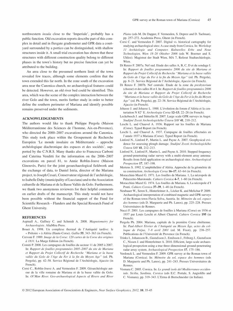
GPR RESULTS AND ARCHAEOLOGICAL INTERPRETATIONThe 2007–2008 surveysGeneral remarksFigure 7 shows horizontal slices at different depths from parcel 81 and in Fig. 8 the archaeological interpretation is displayed. The shallowest structures appear at a depth of approximately 35 cm. On the shallow horizontal slices, down to an approximate depth of 40–45 cm, a large amount of loose debris is visible compared to the deeper slices. This seems to indicate that there is considerable plough damage (Linford et al. 2007). The field was ploughed until c. 2000, before it was purchased by the municipality of Lucciana and converted into grasslands. The deepest foundations reach a depth of 1.4 m.
The orthogonal street system is immediately noticeable, with two streets dividing the prospected area in four insulae and with the same orientation as the excavated colonnaded street, Fig. 2, L (approximately N78°W). For the first time, the assumption that this excavated street corresponds to a right-angled street system can now be confirmed. Its orientation probably originates in a pre-existing axis of communication, linking the mountain range (to the west) with the mouth of the river Golo (to the east; Fig. 1, O). The street running east-west shows a strong reflection (Fig. 7). Presumably it was metalled, as opposed to the north-south street. In its westernmost part, on both sides of the street a series of small reflections with a separa-tion of c. 3 m can be identified as the remains of pillars or col-umns supporting porticoes. The northern part of the north-south street is much narrower (c. 5 m) than the other streets (c. 8.5 m).
Some of the structures within the insulae can clearly be inter-preted as houses. In house A (Fig. 8), the atrium (central hall) is clearly visible, with the impluvium (a basin where the rain water was collected under an opening in the roof) and a drain running underneath the fauces (entrance) towards the street. A reflection in one of the rooms at a depth of c. 70–80 cm can be interpreted as a floor. In the rest of the data set few floors can be distin-guished. House B (Fig. 8) probably also had its entrance at the east-west street. Here too, an inner courtyard can be recognized and the walls adjacent to both streets show small buttresses. A high positive magnetic anomaly in one of the rooms, combined with a deep reflection in the GPR data (75–145 cm) might represent a hypocaustum (underground heating system).
Although their lay-out is less clear, most other buildings also seem private dwellings rather than monumental public buildings. In the fluxgate gradiometer data, strong magnetic anomalies (c. ±100 nT) in a building of the southwestern insula point to an oven or perhaps a metal workshop (Figs 4a, 1 and 8, C). The magnetic data were also useful for the identification of a drain running under the east-west street, beyond the GPR survey area: a series of small positive magnetic anomalies indicates that it may consist of ceramic pipes or bricks. It seems to continue towards building C (Fig. 8; Fig. 4a,c) but is invisible on the GPR slices (Fig. 4b). A long and straight reflection in the GPR data
FIGURE 9
Trial excavation (12 by 2 m), viewed from the east, showing walls in
opus testaceum and cobble alignments. For its location, see Fig. 8, G.

L. Verdonck et al.42
© 2012 European Association of Geoscientists & Engineers, Near Surface Geophysics, 2012, 10, 35-45
nal divisions are present within the courtyard of building F (Fig. 5c, 9). At least some indicate a different occupation phase because of the manifest differences in the construction. A small excavation in 2006–2007 (12 by 2 m; Figs 8, G, 5c and 9) gave an opportunity to further investigate these differences. It was observed that two walls causing strong GPR signals were approximately 55 cm wide and made of opus testaceum, consist-ing of large river cobbles in cement with brick facings. The top of the walls was at a depth of c. 55 cm, their height approxi-mately 35 cm. The foundations, consisting of cobbles in cement without brick facings, were 50 cm deep (the total depth of 1.4 m is consistent with the GPR signal). On the basis of the building technique, these walls can be dated in Early Imperial times (1st–2nd century AD) but the absence of datable finds from the foun-dation trenches prevents us to propose a more precise chronology for their construction.
The opus testaceum walls were demolished down to their current depth of 55 cm below walking level, not later than the
uneven surface with abundant boulders precluded good ground coupling of the GPR antenna, only a magnetometer survey was carried out there (Fig. 5a). The continuation of the exterior portico wall and the wall parallel to it are identifiable in the gradiometer data, although not very clearly (Fig. 5c, 4).
The combination of the GPR data on parcel 81, the fluxgate gradiometer results on parcel 76 and the mapping of a few wall foundations still visible aboveground allowed locating one of the trenches (trench C) from 1936–1937 (Fig. 5c, 5–7). In their report, the excavators described a room of approximately 8 by 11 m with an apse at its western side and with fragments of mar-ble wall covering a few smaller rooms (6) and a 26 m long east-west running wall (7), all visible in the gradiometer data. They assume that the remains are part of a larger building complex with a public character (Leschi and Chauvel 1937). Several other structures, like building 8 (Fig. 5c) and portico I (Fig. 8) may have belonged to this complex.
In the shallower GPR slices (from a depth of c. 35 cm) inter-
FIGURE 10
GPR survey south of the Canonica
excavation area. A: horizontal
GPR slice at 190–195 cm below
the arbitrary level zero in
Fig. 11(a), B: 230–235 cm,
C: 255–260 cm, D: 275–280 cm,
E: interpretation of the archaeo-
logical structures, which were the
object of one of the 1936–1937
excavations (bathhouse). 1: mod-
ern pipes, 2–6: ancient river
channel(s) and deposits, 7: posi-
tion of the profile displayed in
Fig. 11(a).

GPR survey at the Roman town of Mariana (Corsica) 43
© 2012 European Association of Geoscientists & Engineers, Near Surface Geophysics, 2012, 10, 35-45
results agree with a 1936 excavation plan, showing a building, c. 8.5 m long and 7.5 m wide (Fig. 10e), described by the excava-tors as the caldarium (hot room) of a bath complex with a hypo-caustum and foundations reaching a depth of almost 3 m. No strong reflections were observed inside the building. At the time of the excavation, a number of pilae (small pillars that allowed the hot air to circulate underneath the floor) were still intact and others had been replaced by brick walls but these structures were removed by the excavators (Leschi and Chauvel 1936).
Apart from a little structure to the west of the caldarium, nothing was revealed in the surroundings by the GPR. As the excavation was limited to the interior, no comparative excavation data are available for the area outside the building. In the western grid, only a few small archaeological features were detected, close to the fence.
This scarcity of archaeological features corresponds with the results of the geomorphologic investigations carried out since 2000 (Corsi et al. 2009). These have clarified the relationship between Mariana and the Golo. Part of the town was built in a river bed older than the 1st century AD. The water level remained low until the 6th century, although inundations occurred sporadically. However, in the mediaeval period (probably between the 10th–12th century), the Golo destroyed parts of the
end of the third century AD, as is suggested by pottery sherds from the overlying layer that sealed the walls. An alignment of loose cobbles (Fig. 9), only one or two layers thick, running approximately in the east-west direction, was found on top. As a consequence, it seems likely that at least some of the shallow GPR reflections inside the courtyard belong to a different phase. Further excavations are necessary to provide chronological infor-mation on similar cases elsewhere in the GPR data set.
The 2009 surveysWhereas the 2007–2008 surveys aimed at providing information on the Imperial town centre and the street network, the prospection south of the Canonica excavation zone (Fig. 1, M) addressed the question whether the southernmost excavated remains (Roman market and Early Christian cathedral with baptistery: Fig. 2, F–I) were built at the border of the ancient town or, on the contrary, the city continued towards the south.
On the horizontal slices from the two grids, only a few anomalies belong to the ancient town and all are close to the fence surrounding the excavations. The most important ones are located in the eastern grid and can be interpreted as the outer walls of a small rectangular building (Fig. 10a–d). These
FIGURE 11
A: GPR profile (from south to
north) from a survey south of the
Canonica excavations, showing
one or more ancient beds of the
Golo river at approximately
25–40 m (for the position of the
profile, see Fig. 10a, 7). 1: mod-
ern pipes, 2–5 ancient river
channel(s) and deposits. B: From
historical maps, a south-eastward
shift of the Golo can be recon-
structed (adapted from Corsi et
al. 2009). 1: hypothetical extent
of Mariana, 2: course of the Golo
in 1785, 3: situation in 1900,
4: present situation, 5: position of
the river bed on the aerial photo-
graph in Fig. 11(c).

L. Verdonck et al.44
© 2012 European Association of Geoscientists & Engineers, Near Surface Geophysics, 2012, 10, 35-45
wide, visible over nearly 7.5 m, with the same orientation as the structures in parcel 81 and in the Canonica excavations (Fig. 12c, 1). Probably the foundations in this area are in a poor state of preservation and ploughing damage is more severe than on parcel 81. Parcel 76 was used as an arable field until 2008 and its surface is littered with boulders and fragments of tegulae (roof tiles) and pottery, so that only the northern part was available for the GPR survey (Fig. 12d). It is possible that a large amount of debris in the topsoil, visible as countless point reflectors (Fig. 12a,b), has to a certain degree masked the deeper archaeology.
CONCLUSIONThis paper has stressed the role of GPR in reconstructing the layout of the Roman town of Mariana. At present, the main ques-tions (location of the Imperial town centre and town perimeter, characterization of the street network) can be answered as fol-lows. The presence of two orthogonal streets in the GPR data now confirms the hypothesis that an excavated east-west axis belongs to a right-angled street system, as is known in many Roman cities. Since most buildings can be interpreted as private houses, the monumental centre of Early Imperial Mariana has presumably not been discovered yet. It may be situated more to the (north-)west, as can be expected from the presence of a large concrete podium preserved under a modern house with the topo-nym ‘Imperiale’. However, at least one building complex, in the
town, which originally extended further to the south. Its course has been recorded in geomorphologic soundings and in the archaeological excavations (e.g., near the baptistery, Fig. 2, I). The river deposited an enormous volume of loamy sediments, under which some of the remains may have been preserved and completely filled up the bed existing in the Roman period. Subsequently, it gradually moved south-eastwards, towards its current position (Fig. 1, G), although little is known in detail until the end of the 18th century, when the Golo appears on the first maps (Fig. 11b, 2–4).
The GPR data collected in 2009 illustrate this complex evolution: in profiles collected in the western grid M (Fig. 1), different superimposed layers slope down towards a point at approximately 25 m and can probably be interpreted as deposits by the river Golo (Fig. 11a, nos 2 and 5; see also Fig. 10, nos 2 and 5). Although less clear, another small channel is visible on the profile around 38 m (Fig. 11a, 4) and on the horizontal slices (Fig. 10d, 4). Presumably, the whole area between 25–40 m, including reflection no. 3 (Figs 10c and 11a) represents one or more stages in the shift of the river bed, which has also been recorded on aerial photographs (Fig. 11c). Also in the eastern grid, traces can be noticed (e.g., Fig. 10d, 6).
The prospection in area L (Fig. 1), close to the presumed north-ern limit of the town, has revealed few traces attributable to ancient Mariana. The clearest element is a wall, approximately 50 cm
FIGURE 12
A: Horizontal GPR slice
(depth: 35–40 cm) from the
northern survey area, B: slice at
65–70 cm depth, C: interpretation
of the results. 1: clearest wall
feature, respecting the dominant
orientation of the ancient town,
D: photograph of parcel 76, cov-
ered with boulders (the arrow in
Fig. 12c, no. 2 indicates the posi-
tion of the camera).
GPR survey at the Roman town of Mariana (Corsica) 45
© 2012 European Association of Geoscientists & Engineers, Near Surface Geophysics, 2012, 10, 35-45
Plains (eds M. De Dapper, F. Vermeulen, S. Deprez and D. Taelman), pp. 257–272. Academia Press, Ghent (in French).
Corsi C. and Vermeulen F. 2007. Digital vs. historical cartography for studying archaeological sites: A case study from Corsica. In: Workshop 11 Archäologie und Computer. Kulturelles Erbe und Neue Technologien, Wien 18–20 Oktober 2006 (eds W. Boerner and S. Uhlirz). Magistrat der Stadt Wien, MA 7, Referat Stadtarchäologie, Wien.
Di Renzo F. 2007a. Nef sud. Etude des salles A, B, C, D et du sondage I. In: Rapport de fouilles programmées 2006 du site de Mariana et Rapport du Projet Collectif de Recherche “Mariana et la basse vallée du Golo de l’Age du Fer à la fin du Moyen Age” (ed. Ph. Pergola), pp. 8–21. Service Régional de l’Archéologie, Ajaccio (in French).
Di Renzo F. 2007b. Nef centrale. Etude de la zone du presbyterium (choeur) et des salles H et I. In: Rapport de fouilles programmées 2006 du site de Mariana et Rapport du Projet Collectif de Recherche “Mariana et la basse vallée du Golo de l’Age du Fer à la fin du Moyen Age” (ed. Ph. Pergola), pp. 22–38. Service Régional de l’Archéologie, Ajaccio (in French).
Jehasse J. and Jehasse L. 1988. L’évolution du forum d’Aléria et la cen-turiation N 82° E. Archeologia Corsa 12–13, 22–28 (in French).
Leckebusch J. and Sütterlin H. 2007. Large scale GPR surveys in Augst. Studijné Zvesti Archeologického Ústavu SAV 41, 210–212.
Leschi L. and Chauvel A. 1936. Rapport sur les fouilles de Mariana (Corse). Typed Report (in French).
Leschi L. and Chauvel A. 1937. Campagne de fouilles effectuées en l’année 1937 à Mariana (Corse). Typed Report (in French).
Linford N., Linford P., Martin L. and Payne A. 2007. Geophysical evi-dence for assessing plough damage. Studijné Zvesti Archeologického Ústavu SAV 41, 212–213.
Linford N., Linford P., Martin L. and Payne A. 2010. Stepped frequency ground-penetrating radar survey with a multi-element array antenna: Results from field application on archaeological sites. Archaeological Prospection 17, 187–198.
Mertens S. 1992. L’amphithéâtre d’Aléria. Approche de la géométrie de sa construction. Archeologia Corsa 16–17, 63–64 (in French).
Moracchini-Mazel G. 1971. Les fouilles de Mariana. 1, La nécropole de Palazzetto-Murotondo. Cahiers Corsica 4–7, 1–60 (in French).
Moracchini-Mazel G. 1974. Les fouilles de Mariana. 6, La nécropole d’I Ponti. Cahiers Corsica 37–39, 1–48 (in French).
Neubauer W., Seren S., Hinterleitner A., Löcker K. and Melichar P. 2009. Archaeological interpretation of combined magnetic and GPR surveys of the Roman town Flavia Solva, Austria. In: Mémoire du sol, espace des hommes (eds D. Marguerie and Ph. Lanos), pp. 225–228. Presses Universitaires de Rennes.
Nucci F. 2001. Les campagnes de fouilles à Mariana (Corse) en 1936 et 1937 par Louis Leschi et Albert Chauvel. Cahiers Corsica 195 (in French).
Pergola Ph. 2004. Mariana, capitale de la première Corse chrétienne. In: Paul-Albert Février de l’Antiquité au Moyen Âge, actes du col-loque de Fréjus, 7–8 avril 2001 (ed. M. Fixot), pp. 238–257. Publications de l’Université de Provence (in French).
Trinks I., Johansson B., Gustafsson J., Emilsson J., Friborg J., Gustafsson C., Nissen J. and Hinterleitner A. 2010. Efficient, large-scale archaeo-logical prospection using a true three-dimensional ground-penetrating radar array system. Archaeological Prospection 17, 175–186.
Verdonck L. and Vermeulen F. 2009. GPR survey at the Roman town of Mariana (Corsica). In: Mémoire du sol, espace des hommes (eds D. Marguerie and Ph. Lanos), pp. 241–243. Presses Universitaires de Rennes.
Vismara C. 2005. Corsica. In: Le grandi isole del Mediterraneo occiden-tale. Sicilia, Sardinia, Corsica (eds E.C. Portale, S. Angiolillo and C. Vismara), pp. 319–343. L’Erma di Bretschneider (in Italian).
northwestern insula close to the ‘Imperiale’, probably has a public function. Old excavation reports describe part of this com-plex in detail and in fluxgate gradiometer and GPR data a court-yard surrounded by a portico can be distinguished, with shallow structures inside it. A small trial excavation has shown that these structures with different construction quality belong to different phases in the town’s history but no precise function can yet be attributed to the building.
An area close to the presumed northern limit of the town revealed few traces, although some elements confirm that the town extended this far north. In the zone south of the excavation area near the Canonica church, no archaeological features could be detected. However, an old river bed could be identified. This area, which was the scene of the complex interaction between the river Golo and the town, merits further study in order to better define the southern perimeter of Mariana and identify possible remains preserved under the sediments.
ACKNOWLEDGEMENTSThe authors would like to thank Philippe Pergola (Maison Méditerranéenne des Sciences de l’homme, Aix-en-Provence), who directed the 2000–2007 excavations around the Canonica. This study took place within the Groupement de Recherche Européen ‘Le monde insulaire en Méditerranée – approche archéologique diachronique des espaces et des sociétés’, sup-ported by the C.N.R.S. Many thanks also to Francesca Carboni and Caterina Venditti for the information on the 2006–2007 excavations on parcel 81, to Annie Roblin-Jouve (Maison Ginouvès, Paris) for the joint geoarchaeological fieldwork and the exchange of data, to Daniel Istria, director of the Mariana project, to Joseph Cesari, Conservateur régional de l’archéologie, to Isabelle Dahy (municipality of Lucciana) and to the Association culturelle de Mariana et de la Basse Vallée du Golo. Furthermore, we thank two anonymous reviewers for their helpful comments on earlier drafts of the manuscript. This study would not have been possible without the financial support of the Fund for Scientific Research – Flanders and the Special Research Fund of Ghent University.
REFERENCESAspinall A., Gaffney C. and Schmidt A. 2008. Magnetometry for
Archaeologists. AltaMira Press. Bouet A. 1998. Un complexe thermal de l’Antiquité tardive: le
« Prétoire » à Aléria (Haute-Corse). Gallia 55, 343–363 (in French).Cervoni F. 1989. Image de la Corse: 120 cartes de la Corse des origines
à 1831. La Marge Edition (in French).Comiti P. 2008. Les campagnes de fouilles du secteur 11 de 2005 à 2007.
In: Rapport de fouilles programmées 2005–2007 du site de Mariana et Rapport du Projet Collectif de Recherche “Mariana et la basse vallée du Golo de l’Age du Fer à la fin du Moyen Age” (ed. Ph. Pergola), pp. 42–58. Service Régional de l’Archéologie, Ajaccio (in French).
Corsi C., Roblin-Jouve A. and Vermeulen F. 2009. Géoarchéologie aut-our de la ville romaine de Mariana et de la basse vallée du Golo. In: Ol’Man River. Geo-archaeological Aspects of Rivers and River

EXPLORATION SEISMOGRAPHS
3D BOREHOLE GEOPHONES
DATA INVERSION SOFTWARE FOR EARTH SCIENCES
BOREHOLE TV CAMERAS - WATER LEVEL INDICATORS
ELECTRICAL IMAGING IN AC & CC - EARTH RESISTIVITY METERS
www.p
asigeop
hysics.
com
DESIGN & TECHNOLOGY MADE IN ITALY
www.p
asigeop
hysics.
com
sales@p
asisrl.it
NSG 170X115 mm.indd 1 06/09/11 18:52CC01453-MA009 PASI.indd 1 07-09-11 10:52
26-27 March 2012 – Edinburgh, UK
Understanding the Behaviour of CO2in Geologic Storage Reservoirs
Geological storage of CO2 in the deep subsurface is probably the part of CCS which attracts the most attention from regulators as well as the public.
There is some concern that especially in deep, saline aquifers CO2 injection may cause undue pressure build-up and problems with displacement of saline formation water. In order to properly monitor and predict the movement of a CO2 plume, it is important to understand the behaviour of CO2 at all scale-levels – from regional to pore scale and at different time scales from day-to-day operations through everal decades of operations to centuries or millennia of required storage residence time.
In this workshop we plan to discuss all aspects of understanding the behaviour of CO2 in the subsurface, including monitoring, modelling, mapping, and predictions.
For more information about this event, check our website (www.eage.org).
Third EAGE CO2 Geological Storage Workshop
www.eage.org Register now!
CGS12-V3H.indd 1 10-01-12 16:27
Copyright © 2022 FDOKUMEN