Geophysical modeling and structure of Ushuaia Pluton, Fuegian Andes, Argentina

(2006) 1–17www.elsevier.com/locate/tecto
Tectonophysics 424
Geology and paleomagnetism of El Potrero pluton, Baja California:Understanding criteria for timing of deformation and evidence of
pluton tilt during batholith growth
Gabriel Chávez Cabello a, Roberto Molina Garza a,⁎, Luis Delgado Argote b,Rubén Contreras Flores c, Elisa Ramírez b, Amabel Ortega Rivera a,
Harald Böhnel a, James Lee d
a Centro de Geociencias, Universidad Nacional Autónoma de México, Campus Juriquilla, Querétaro, 76230, Mexicob Departamento de Geología, CICESE, Ensenada, Baja California, Mexico
c CICATA–IPN, Querétaro, Querétaro, Mexicod Department of Geology, Queen's University, Canada
Received 19 April 2005; received in revised form 13 March 2006; accepted 27 March 2006Available online 24 July 2006
Abstract
The 102 Ma El Potrero pluton, in the western foothills of Sierra San Pedro Mártir, in north-central Baja California, wasemplaced during a long period of contractional deformation bracketed between 132 and 85 Ma that affected this segment of thePeninsular Ranges Batholith. The pluton records regional and emplacement related deformation manifested by: (1) a solid-statefabric developed on its eastern contact, which is produced by eastward lateral pluton expansion; (2) cleavage triple point zones inthe host-rock NW and SE of the pluton; (3) subhorizontal ductile shear zones indicative of top-to-the-east transport; (4) magmaticand tectonic foliations parallel to regional structural trends and regional shear zones; (5) variable axial ratios of microgranitoidenclaves close to pluton–wall rock contacts; (6) evidence of brittle-emplacement mechanisms in the western border of the pluton,which contrast with features indicating mainly ductile mechanisms toward the east; and, (7) markedly discordant paleomagneticdirections that suggest emplacement in an active tectonic setting. The overall mean for 9 accepted paleomagnetic sites isDec=34.6°, I=25.7° (k=88.3, α95=5.5°), and is deviated ∼35° with respect to the reference cratonic direction. This magnetizationis interpreted to indicate a combination of tilt due to initial drag during vertical diapiric ascent (or westward lateral-obliqueexpansion) of the adjacent San Pedro Mártir pluton and later rotation (∼15°) by Rosarito Fault activity in the southwest; thisrotation may have occurred as eastward contraction acted to fill the space emptied by the ascending San Pedro Mártir pluton. TheRosarito fault may have tilted several plutons in the area (Sierra San Pedro Mártir, El Potrero, San José, and Encinosa). Magneticsusceptibility fabrics for 13 sites reflect mostly emplacement-related stress and regional stress. Paleomagnetic data and structuralobservations lead us to interpret the El Potrero pluton as a syntectonic pluton, emplaced within a regional shear zone delimited bythe Main Mártir Thrust and the younger Rosarito Fault.© 2006 Elsevier B.V. All rights reserved.
Keywords: Paleomagnetism; Magnetic fabric; Batholith; Peninsular Ranges; Baja California; Emplacement mechanisms
⁎ Corresponding author.E-mail address: [email protected] (R. Molina Garza).
0040-1951/$ - see front matter © 2006 Elsevier B.V. All rights reserved.doi:10.1016/j.tecto.2006.03.018

2 G. Chávez Cabello et al. / Tectonophysics 424 (2006) 1–17
1. Introduction
In an orogenic setting, pluton fabrics and geochro-nology are commonly used in the interpretation of tem-poral relations between deformation and magmatism.These interpretations are based on the relationships bet-ween structural features in the pluton (its interior and itsmargins) and structural features in the host rock (Brunand Pons, 1981; Paterson and Tobisch, 1988; Paterson etal., 1991; Vernon and Paterson, 1993; Paterson andVernon, 1995; Paterson et al., 1998; Johnson et al.,1999a; Johnson et al., 2003; Vernon et al., 2004). Plutonscan thus be interpreted as pre-, syn-, or post-tectonic. Inthe Peninsular Ranges Batholith (PRB) of Baja Cali-fornia these observations have been used to suggest thatcollision of the Alisitos arc with continental rocks ofNorth American affinity took place ca. 110 Ma (Johnsonet al., 1999b, 2003). The inferred suture zone between aneastern arc developed on continental crust (NorthAmerica) and a western oceanic arc terrane (Alisitos)was located between Sierra San Pedro Mártir (SSPM)pluton and the smaller El Potrero and San José plutons
Fig. 1. Plain view of plutons— simplified geologic map of a segment of SieJosé pluton; CC = Cerro Costilla pluton; E = Encinosa pluton; PP: El Potrerescarpment. The dashed line shows the transition zone between the westernposition of the cross section illustrated in Fig. 8. Thin arrows indicate assumedRanges batholith, showing location of the study area. The dashed line separ
(Fig. 1), along the Main Mártir thrust (MMT) of Johnsonet al. (1999b). These authors suggested that the nonterminal suture is thus stitched by 100–110 Ma tonaliticplutons, but shortening in the continental margin wasapparently continuous from about 132 Ma to about85 Ma (Schmidt and Paterson, 2002).
Because of the complex interaction between magmaemplacement and regional tectonic stress, fabric inter-pretations in plutons may be ambiguous (Paterson andTobisch, 1988; Vernon and Flood, 1988; Vernon et al.,1988; Paterson et al., 1991). Here we propose that paleo-magnetic data, magnetic fabrics, and geochronologicaldata may provide independent tools to assess interpreta-tions of pluton–host rock relations, and better definetiming criteria for regional deformation events. Theambiguity of pluton fabrics and inferred reorientation oftectonic fabrics in the host rock by pluton emplacementis evident, for instance, in and around the Encinosapluton (Fig. 1). The Encinosa pluton, immediately westof El Potrero in the western foothills of Sierra San PedroMártir (SSPM), is apparently syntectonic with charac-teristics of either a pre- or post-tectonic pluton. This is ca.
rra San Pedro Mártir. SSPMP = Sierra San Pedro Mártir pluton; SJ Sano pluton; RF = Rosarito fault; MMT = Main Mártir thrust; GE = Gulfand eastern sectors of the PRB. A solid line shows the approximatedirections of pluton expansion. Inset: simplified map of the Peninsular
ates the eastern and western sectors of the PRB.

3G. Chávez Cabello et al. / Tectonophysics 424 (2006) 1–17
110 Ma mafic pluton was emplaced during the peak ofcontractional deformation, yet it fails to record signifi-cant deformation fabric. Also, contacts of the Encinosapluton show a highly discordant relation to structuralfeatures in the host rock — a characteristic typical post-tectonic plutons (Paterson and Tobisch, 1988).
In this work we show that the El Potrero pluton(Fig. 1), between Encinosa and SSPM plutons, experi-enced a large magnitude rotation (∼35°). We proposethat rotation occurred during terrane accretion, and isrelated to batholith growth. Rotation occurred through aNNW–SSE subhorizontal axis, and we suggest that thisoccurred by a combination of drag during verticaldiapiric ascent or westward lateral-oblique expansion ofthe SSPM pluton (∼15–20°) and fault rotation duringactivity of the Rosarito fault (∼15–20°) between ∼100and 85 Ma. We review relevant structural observationsand timing of deformation criteria, and conclude that theEl Potrero pluton is better viewed as a syntectonicintrusion. We reject that tilting of the El Potrero plutoncould be due solely to Tertiary extensional or transten-sive/transpressive tectonics, because major Tertiary nor-mal faults do not occur near the pluton, nor has significantlateral displacement been proposed for major structuresin the study area. Furthermore, no large tilting has beenrecorded in older plutons located west from the Rosaritofault zone (i.e. San Telmo, Zarza and Burro plutons;Böhnel and Delgado Argote, 2000; Molina-Garza et al.,2003). We propose that the Rosarito fault together withthe MMT define a wide shear zone where tilted plutonsoccur (Molina-Garza et al., 2003), and we propose thatthese faults alternate their activity between 115 and85 Ma.
2. Geological setting
Mesozoic rocks in Baja California record magmatismand sedimentation along a convergentmargin that faced alarge ocean basin (Busby et al., 1998). Volcanic, vol-caniclastic and sedimentary rocks of the arc are repre-sented by theAlisitos Formation. Plutonic rocks includedin the Peninsular Ranges Batholith intrude the AlisitosFormation as well as pre-Alisitos Paleozoic and lowerMesozoic rocks of the North American margin, andrepresent deeper crustal levels of the Alisitos arc. ThePRB is traditionally divided into an older western sectorof isotopically more primitive subvolcanic plutons andan eastern sector of larger, more evolved plutons. Thedistinction is evident in the geochemistry, structuralhistory, host-rock and level of crustal exposure (Todd andShaw, 1985; Silver and Chappell, 1988; Todd et al.,1988; Walawender et al., 1991; Gastil, 1993; Thompson
and Girty, 1994; Ichinose et al., 1996; Johnson et al.,1999b; Tate and Johnson, 2000; Schmidt and Paterson,2002). The transition zone between the eastern andwestern PRB sectors is several kilometers wide andincludes the study area (Fig. 1, inset).
Most interpretations consider the boundary betweenthe eastern andwestern belts of pre-batholith rocks to be asuture between the North American craton and a fringingarc, possibly separated by a back-arc basin (Rangin,1978; Gastil et al., 1978, 1981; Phillips, 1993; Busby etal., 1998). Alternatively, the batholith may have formedin-situ across a poorly understood, pre-Triassic suturebetween oceanic and continental crust (Walawender etal., 1991; Thompson and Girty, 1994). Johnson et al.(1999b) described a major ductile thrust (Main MártirThrust, MMT), which they interpreted as part of a broadsuture. This thrust is coincident, in the area, with theboundary between the eastern andwestern PRBproposedby Gastil et al. (1975). Johnson et al. (1999b) suggestedthat an island arc (Alisitos arc) collided with the NorthAmerican margin approximately 110 Ma. In their model,this collision caused substantial crustal thickening nearthe boundary between the two crustal blocks, and thisthickened zone was stitched by tonalite plutons such asSan José, Cerro de Costilla, and El Potrero plutons; all ofthem emplaced at ca. 110–100 Ma (Johnson et al.,1999b). This model has been supported by other workers(Wetmore et al., 2003).
The Rosarito fault juxtaposes sedimentary units of theAlisitos Formation with the western volcanic-richdomain of the same unit. It is a steep to moderately NEdipping fault zone active as late as 85 Ma (Schmidt andPaterson, 2002). The fault zone is characterized by steep,NE dipping, spaced to locally penetrative cleavage, shearbands and discrete chloritized faults with predominantlyNE over SW shear sense. In the study area, theMMTandthe Rosarito fault define the transition between thewestern and eastern sectors of the PRB (Fig. 1).
3. Methodology and sampling
The present work is based on photo-interpretation andmapping (1:20,000) of an area of∼140 km2 that includesthe El Potrero, Encinosa, Santa Cruz, and parts of SanJosé and Sierra San PedroMártir plutons (Fig. 1; Chávez-Cabello, 1998). It also includes petrographic analysis of∼30 samples from El Potrero and Encinosa plutons, fromwhich modal compositions were determined (van derPlas and Tobi, 1965). Samples were also collected formicro-structural analysis, from both El Potrero plutonand its host rock, with a few additional samples fromnearby plutons. Four oriented samples of lithic tuffs from

4 G. Chávez Cabello et al. / Tectonophysics 424 (2006) 1–17
host-rock of the El Potrero were used for finite de-formation analysis. Themethodology for characterizationof deformation in the host-rock involved undeformed anddeformed samples. At about 200 stations in the El Potreropluton and its surrounding area, foliation orientationswere determined. In the case of the stations used forfinite-deformation analysis, samples were prepared withfaces parallel to the direction of maximum particle elo-ngation, and perpendicular to it. Counting, orientation,and size were estimated for lithic particles in lithic-richtuffs.We used standard imaging and analysis programs toestimate ellipticity and other fabric parameters. Samplesfor finite deformation analysis come from the cleavagetriple point zone northwest of the pluton, from the west-ern and eastern sides of the pluton (∼50 m from thepluton–wall rock contact), and from a fewmeters west ofthe MMT located between El Potrero and SSPM plutons(Fig. 2).
For paleomagnetic and magnetic fabric analysis wecollected samples from 13 sites; 10 sites are along theroad that crosses the pluton from north to south, twoadditional sites near its western contact, and a singlesite located in the east-central segment of the pluton.Samples for 40Ar–39Ar dating were collected at everyother paleomagnetic site (Fig. 2), but the results of theseanalyses will be published elsewhere. Five to eightpaleomagnetic samples were collected from each siteusing a portable gas powered drill, and oriented in-situusing magnetic and solar compasses. The samples werecut as standard cylinders 2.1 cm in height, and weresubjected to alternating field (AF) and thermal demag-netization up to 200 mT and 500 °C, respectively. Weused a JR-5 spinner magnetometer for measurements ofthe natural remanence; a TSD-25 thermal demagnetizerand a custom high voltage AF demagnetizer were usedduring the demagnetization process. Susceptibility wasmonitored during thermal demagnetization in order torecognize mineralogical changes, which were unimpor-tant. For the identification and characterization ofmagnetic minerals we imparted an isothermal remanence(IRM) and estimated hysteresis parameters, using a pulsemagnetizer and a vibrating samplemagnetometer, respec-tively. Magnetic fabric was determined using a KLY-3Kappabridge susceptibilimeter on specimens not sub-jected to demagnetization. At each station we collectedstructural, petrological, and other relevant data; addition-al hand samples were obtained for geobarometry andgeochronology. Equilibrium emplacement pressureswere determined using Schmidt's Al in hornblende geo-barometer (Schmidt, 1992). Per-formula total Al wasdetermined on polished sections using a Cameca micro-probe at the Instituto de Geofísica (Mexico City).
Geochronological data were obtained from biotiteand hornblende separates of a sample in the central partof the pluton, because U–Pb data are already availablefor this area (Johnson et al., 1999b). These minerals wereconcentrated and cleaned by standard techniques andlater selected by careful handpicking under a binocularmicroscope to ensure the purity of the samples. Samplefractions ranged in size from 40 to 80 mesh, and wereobtained at the mineral separation laboratory of theCentro de Geociencias (Querétaro, Mexico). Mineralseparates were loaded into Al-foil packets and irradiatedtogether withMac-83 biotite as a neutron-flux monitor atthe McMaster Nuclear Reactor (Hamilton, Ontario).40Ar–39Ar analyses were performed by standard laserstep-heating techniques, described in detail by Clark etal. (1998), at the 40Ar–39Ar Geochronology ResearchLaboratory of Queen's University, Kingston, Ontario,Canada. The data are given in Table 1and plotted in Fig.3. Data have been corrected for blanks, mass discrim-ination, and neutron-induced interferences. For thepurposes of this paper, a plateau age is obtained whenthe apparent ages of at least three consecutive steps,comprising a minimum of 55% of the 39Ar released,agree within 2σ error with the integrated age of theplateau segment. Errors shown in Table 1 and on the agespectrum and isotope-correlation diagrams represent theanalytical precision at ±2σ.
4. Geology and structural features of El Potreropluton
The El Potrero pluton intrudes volaniclastic rocks ofthe Alisitos Formation (Fig. 1) in the transition zonebetween the eastern and western sectors of the PRB. Themost abundant lithologies in the Alisitos Formation arephyllites and low-grade metavolcanic rocks. Volcanicrocks include pyroclastic rocks, lithic tuffs, andporphyritic lavas. Limestone, sandstone, shale, brecciaand agglomerate are locally present. The El Potreropluton is an oval shaped pluton elongated in a north–south direction, with a crystallization age of about102.5 Ma (U–Pb zircon, Johnson et al., 1999b). Thepluton borders are much more regular compared to theadjacent Encinosa pluton (Fig. 2). Compositionally, theEl Potrero pluton is very homogenous, but petrographicobservations indicate that it consists of a hornblende–biotite tonalite in the northeast half of the pluton and abiotite–hornblende tonalite in the southwest half(Chávez-Cabello, 1998). The mineral assemblage forboth units is plagioclase+quartz+hornblende+biotite.
Dikeswithin the El Potrero pluton are scarce; they varyfrommafic to aplitic, and are concentrated in the northeast

Fig. 2. (a) Generalized trend lines of foliation at El Potrero and vicinity. (b–e) Contoured density plots of foliation data for host rock (b–d) and magmatic foliation (e). Magmatic is only discordant tofoliations in deformation shadows such as the triple point area northwest of the pluton. We also show paleomagnetic sampling sites (open circles) and locations of samples used for finite strain analysis(hexagons).
5G.Chávez
Cabello
etal.
/Tectonophysics
424(2006)
1–17
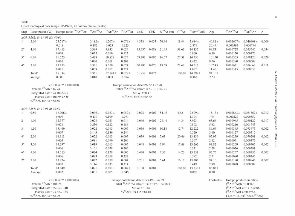
Table 1Geochronological data sample IV-19-01, El Potrero pluton (center)
Step Laser power (W) Isotope ratios 40Ar/39Ar 38Ar/39Ar 37Ar/39Ar 36Ar/39Ar Ca/K Cl/K %40Ar atm f 39Ar 40Ar⁎/39ArK Age 36Ar/40Ar 39Ar/40Ar r
AOR-R262: IV-19-01 Hb 40/601 2.00 23.717±
0.0190.182±0.185
1.207±0.023
0.076±0.123
4.338 0.033 76.94 11.44 5.684±2.879
40.81±20.44
0.002607±0.000393
0.040408±0.000794
0.009
2⁎ 4.00 17.4130.008
0.3990.025
9.9350.010
0.0240.122
35.637 0.088 21.45 38.63 14.1350.900
99.836.19
0.0007280.000170
0.0555460.000476
0.034
3⁎ 6.00 16.5250.010
0.4280.030
10.8280.011
0.0230.202
39.201 0.095 16.57 27.31 14.3501.422
101.309.76
0.0005630.000280
0.0581200.000608
0.020
4⁎ 7.00 17.1530.011
0.3210.038
8.3500.012
0.0240.224
30.203 0.070 18.58 22.62 14.5171.662
102.4511.40
0.0006310.000315
0.0560630.000657
0.011
Total/average
18.334±0.003
0.361±0.010
17.144±0.003
0.022±0.054
31.758 0.072 100.00 14.299±0.362
94.10±2.51
J=0.004025±0.000028 Isotope correlation date=97.55±97.78Volume 39ArK=16.74 Initial 40Ar/36Ar ratio=347.91±1704.13Integrated date=94.10±5.03 MSWD=0.47
Plateau date=100.95±5.03 %39ArK for CA=88.56%39ArK for PA=88.56
AOR-R261: IV-19-01 Bt 40/601 0.50 16.006±
0.0090.036±0.137
0.033±0.109
0.052±0.071
0.098 0.002 84.45 4.62 2.509±1.104
18.13±7.94
0.002863±0.000229
0.061367±0.000557
0.012
2 1.00 12.3770.021
0.0280.230
0.0210.122
0.0140.186
0.066 0.002 28.44 14.34 8.9230.802
63.665.62
0.0009650.000210
0.0801270.001743
0.017
3 1.50 13.4690.007
0.0220.143
0.0130.139
0.0070.244
0.036 0.001 10.18 12.74 12.2220.520
86.643.60
0.0003450.000127
0.0734730.000517
0.002
4⁎ 2.50 14.1130.005
0.0220.081
0.0130.090
0.0050.200
0.039 0.001 7.63 20.46 13.1390.307
92.972.12
0.0002590.000071
0.0702910.000375
0.002
5⁎ 3.50 14.2970.006
0.0190.101
0.0150.078
0.0050.206
0.048 0.001 7.94 17.48 13.2620.331
93.822.28
0.0002690.000076
0.0694050.000391
0.002
6⁎ 5.00 14.2150.006
0.0240.093
0.1280.018
0.0060.232
0.440 0.002 7.57 14.23 13.2510.392
93.752.71
0.0002570.000090
0.0697360.000447
0.002
7⁎ 7.00 13.9740.007
0.0220.116
0.0590.035
0.0040.314
0.201 0.001 5.61 16.12 13.3030.419
94.102.89
0.0001900.000098
0.0709470.000502
0.002
Total/Average
14.049±0.002
0.021±0.031
0.071±0.005
0.007±0.045
0.130 0.001 100.00 13.233±0.095
85.03±0.70
J=0.004025±0.000024 Isotope correlation date=193.49±196.89 Footnotes: Isotope production ratiosVolume 39ArK=106.26 Initial 40Ar/36Ar ratio=−3787.39±−5778.31 (40Ar/39Ar)K=0.0302Integrated date=85.03±1.40 MSWD=1.14 (37Ar/39Ar)Ca=1416.4306
Plateau date=93.62±1.35 %39ArK for CA=81.04 (36Ar/39Ar)Ca=0.3952%39ArK for PA=68.29 Ca/K=1.83×(37ArCa/39ArK)
6G.Chávez
Cabello
etal.
/Tectonophysics
424(2006)
1–17
Fig. 3. 40Ar–39Ar data for El Potrero pluton. Figure includes Ar release spectra for hornblende and biotite, as well as sample location.
7G. Chávez Cabello et al. / Tectonophysics 424 (2006) 1–17
border. Nearly all the mafic and some intermediate dikes inthe pluton strike perpendicular to foliation planes; apliticand some intermediate dikes are principally parallel instrike to foliation, but dip perpendicular to foliation planes.Mafic dikes locally show evidence of plastic deformation.Mafic microgranitoid enclaves (following Vernon, 2005)within the pluton are of two types: porphyric enclaves (withhornblende and plagioclase phenocrysts) and equigranularenclaves. The later occur throughout the pluton, but theporphyric enclaves are larger (5 cm up to 2 m). Xenoliths(stopped blocks of the country-rocks) were recognizedonly in the southern part of the pluton in the biotite–hornblende tonalite, where discordant relationships withthe wall rocks of the Alisitos Formation are accentuated.
The regional orientation of tight reclined folds (axialplane 345°/65° E) changes around El Potrero to a 300°/65° E orientation in the north and 15°/ 75° in thesoutheast (Fig. 2). These structures and zones of clea-vage triple point developed northwest and southeast ofthe pluton are the most distinctive structures in the hostrock. Another evident feature is the variation in themagnitude of shortening recorded by the host rockaround the pluton. On the western margin, folds are opento tight, between Encinosa and El Potrero plutons, butalong the eastern margin folds are very tight to isoclinal,close to the MMT and the SSPM pluton (Fig. 4c and d).
El Potrero pluton is characterized by a well-developed magmatic foliation. Magmatic foliation isdefined by the orientation of hornblende and biotitecrystals and cross-cuts the petrographic contact betweenthe hornblende–biotite and biotite–hornblende tonalitesin the pluton (Fig. 2). Foliation follows closely the shapeof the pluton, and decreases in intensity from both theeastern and western borders towards the interior where itnearly disappears (Fig. 2a). At both the eastern andwestern margins, magmatic foliations strike nearly pa-rallel. Foliations dip to the east at angles of 75° in theeast and in the 55° in the west (Fig. 2e). Crystal-plasticdeformation occurs only in the eastern and northernborders of the pluton and is defined by recrystallizationof quartz and, to a lesser extent, feldspar (Fig. 4a). Thisfabric extends about 250 m into the pluton interior. To alarge degree, magmatic and solid-state fabrics maintainthe orientation of the regional host rock foliation and thepluton major axis (NW–SE to NNW–SSE).
The pluton is also intensely fractured and containsenclaves with highly variable axial ratios. Micrograni-toid enclaves are generally elongated parallel to themagmatic foliation. Both, porphyric and non-porphyrit-ic enclaves show variations in frequency and amount offlattening from the interior to the pluton margins. In thewestern margin of the pluton axial relations of enclaves

Fig. 4. Field photographs and photomicrographs illustrating: (a) crystal-plastic deformation in the solid state carapace on the northeast margin of ElPotrero (field of view is about 4 mm); (b) mica-fish structure in the east-central part of El Potrero (field of view is about 4 mm, and the structureindicates top-to-the east shear sense). (c) and (d) Outcrop and meso-scale folds in the host rock east and northeast of El Potrero; (e) microgranitoidenclave near the eastern margin of the pluton.
8 G. Chávez Cabello et al. / Tectonophysics 424 (2006) 1–17
vary from 2:1, to 3:1 (Fig. 2), in the center are nearlyequal (up to 1.5:1), and in the eastern margin they showextreme axial ratios of up 15:1, averaging 8:1 — all inplan view. A large number of enclaves occur within thesolid-state carapace on the pluton's eastern border.
Variable axial ratios in plutons can be related tomagma chamber flow, but they can be used also as strainmarker indicators when crystal plastic deformation canbe documented (Vernon et al., 1988; Paterson et al.,2004). Although microgranitoid enclaves show extreme
axial ratios in the area of solid-state deformation of thetonalite in the eastern parts of the pluton, we cannotdemonstrate whether this is related to deformationduring or after emplacement. A microstructural analysisin the microgranitoid enclaves was not carried-out.Certainly, the extreme axial ratios in the zone of crystal-plastic deformation may be caused by melt-assistedsliding, but it seems to us that the asymmetry of enclaveshape when the east and west sides of the pluton arecompared, and the coincidence of more elongated

9G. Chávez Cabello et al. / Tectonophysics 424 (2006) 1–17
enclaves with the zone of plastic-deformation in thetonalite, suggests that part of the elongation may berelated to post emplacement deformation. The degree ofelongation is thus a reflection of fabric intensity, and aqualitative indicator of the shape of the strain ellipsoid.This observation is consistent with this being the area ofgreatest deformation, and where rotation of regionalstructural features in the host rock occurred. This issimilar to what is observed in the northern sector of SanJosé pluton (Johnson et al., 2003).
The El Potrero pluton contains three types offractures: (a) curvilinear fractures, generally parallel tomagmatic foliation; (b) planar fractures that intersect thecurved fractures associated with foliation (forming a nearreticular drainage pattern); (c) NE trending fractures thatcut both the pluton and the host rock. Because NEfractures cross the pluton and the host rock, it appearsthat the fracture pattern is not solely related to cooling,and it could be associated with post-magmatic regionaltensile stress. Alternatively, the NE–SW fractures couldalso be related to contractional deformation, as they areparallel to the direction of Late Cretaceous maximumshortening. On the other hand, small subhorizontal duc-tile shear zones with top to the east sense of shear wereobserved locally affecting mafic dikes (Fig. 4b).
There are clear geometrical distinctions between thewestern and eastern contacts of the El Potrero with itshost-rock. The contact is discordant in the west, butbecomes gradually concordant along the east border. Tothe south and southwest, the relations are strongly dis-cordant with older structures, abruptly cut by the pluton.The south and southwestern areas of El Potrero alsocontain clear evidence of stopping, as stratified blocks ofthe host-rocks occur within the tonalite. To the northwestand southeast of the pluton the angle between foliation ofthe host-rock and the pluton border is small or nearlyparallel. Zones of cleavage triple point are evident in thehost-rock in areas northwest and southeast of the pluton(Fig. 2). Furthermore, isoclinal folds in the host-rockbecome parallel to the pluton margins in the east andsoutheast. Cleavage triple-point zones and reorientedisoclinal folds define a transition zone between areaswhere the pluton–host rock contacts are concordant andareas where they are discordant (Fig. 2). The areas ofconcordant relations correspond to areas of greateststrain. In these areas it is even possible to see stronglydeformed magma injections within the host-rock andboudins of minor bodies of magma and host rock strata.The region most deformed by shortening in the host-rockoccurs NE of the pluton, between the Sierra San PedroMártir and El Potrero plutons; this zone contains theMMT. However, where major rotation of the regional
foliation occurs is in the cleavage triple-point zones;here, the foliation was transposed to a NE–SW strikeperpendicular to the regional strike. This may suggestthat the pluton behaved as a rigid unit, analogous to alarge-scale porphyroblast, within the deforming AlisitosFormation. However, cleavage triple points are com-monly used as evidence of syntectonic or post-tectonicballooning (Paterson and Tobisch, 1988).
5. Paleomagnetism
Natural remanent magnetization (NRM) of El Potrerosamples is of relatively high intensity, of order about102 mA/m, and demagnetization behaviour is relativelystraightforward. The characteristicmagnetization (ChRM)is a northeast-directed and moderately shallow remanenceof high coercivity (N100 mT) and high unblockingtemperature (N550 °C), thatmost likely resides in hematite(Fig. 5). The ChRM is locally overprinted by a softoverprint, of random orientation that can be easilyremoved with inductions of about 20 mT (Fig. 5a). Maxi-mum unblocking temperatures could not be determinedbecause samples regularly exploded in the furnace whenheated above 500 °C, but in most samples no significantchange in direction nor intensity was observed uponheating to that temperature, which is interpreted as a stableend-point direction (Fig. 5b and c). ChRMdirections werecalculated from stable end points reached after AF orthermal demagnetization anchored to the origin. Althoughlinear trends to the origin were not observed beforesamples were destroyed during demagnetization, we areconfident that the magnetization isolated is free of signi-ficant secondary overprints.
Site means are well-defined with precision parametervalues typically greater than 100 and small confidenceintervals (b8°). Between-site dispersion is also low, butthe site mean distribution is slightly streaked along a NEtrending axis (Fig. 5d). The magnetization is of uniformnormal polarity as expected for the age of the pluton.The overall mean is of Dec=34.6°, I=25.7° (k=88.3,α95=5.5°; N=9 sites).
IRM acquisition curves are characterized by steep initialslopes, typical of multi-domain magnetite, but samples failto saturate with maximum inductions of 2 T. Between 20%and 50% of the IRM is induced above 0.2 T, indicating thata high coercivity phase contributed significantly to the IRMacquisition curve. This observation and the high coercivityof the NRM suggest the hematite contributes significantlyto the natural remanence. Microscope observations ofpolished sections confirm the presence of large hematitegrains with ilmenite lamellae and a third phase formingsigmoidal lenses interpreted as pseudobrookite.

Fig. 5. (a–c) Orthogonal demagnetization plots of selected samples, after Zijderveld (1967). Solid (open) symbols are projections on the horizontal(vertical) plane; (d) stereographic plot of site mean directions with confidence intervals (small circles), the overall mean (square), and the expectedCretaceous direction (star). Solid symbols in the stereoplot are lower hemisphere projections.
10 G. Chávez Cabello et al. / Tectonophysics 424 (2006) 1–17
The mean obtained for the El Potrero pluton (Fig. 6;Table 2) is compared with the PRB mean reported byHagstrum et al. (1985) calculated for a locality at
Fig. 6. Summary of paleomagnetic data for the Peninsular RangesBatholith. Data summarized include the San Telmo pluton (ST, Böhneland Delgado Argote, 2000), the combined Testerazo pluton and SanMarcos dikes (T-SM, Böhnel et al., 2002), and the result for La Posta(LP) pluton after Symons et al. (2003). Solid symbols are projectionsin the lower hemisphere.
30.5°N–115°W, and with the mean direction reported byBöhnel and Delgado Argote (2000) for San Telmopluton, located about 40 km west of the Rosarito faultzone. We also plot recalculated directions for the polesobtained for the Testerazo pluton and San Marcos dikes,in northern Baja California (Böhnel et al., 2002), and fora subset of the PRB sites reported by Hagstrum et al.(1985) that only includes sites collected south of the US–Mexico border, in the same general sector of the PRB asthe El Potrero. Those sites are in the vicinity of Cataviña,about 100 km south of El Potrero. All directions are alsocompared with the expected direction, calculated from
Table 2Paleomagnetic data and statistical parameters for El Potrero pluton
Site n/nd dec (°) inc (°) k α95 (°) R
bc12 3/3 36.2 17.9 538.5 5.3 2.996bc13 1/5bc14 4/4 34.4 12.0 418.0 4.5 3.993bc15 8/8 33.7 23.7 251.4 3.5 7.972bc16 5/5 34.0 41.5 175.6 5.8 4.977bc17 8/8 39.2 28.6 154.2 4.5 7.955bc18 4/4 37.8 29.1 227.0 6.1 3.987bc19 5/7 29.7 24.2 104.4 7.5 4.962bc20 4/5 32.7 30.1 93.5 9.6 3.968bc21 8/8 23.7 29.5 33.1 9.8 7.788Mean 9/10 34.6 25.7 88.3 5.5 8.909
Here, n (nd) is the number of samples used (samples demagnetized) inthe calculation of the site mean; dec and inc are the declination andinclination, whereas k and α95 are the precision parameter of the Fisherdistribution and the confidence interval.

11G. Chávez Cabello et al. / Tectonophysics 424 (2006) 1–17
the mid-Cretaceous cratonic reference pole located at72.7°N–191.1°E. The San Telmomean is relatively closeto the expected direction, whereas all other results arerotated clockwise up to 14° with respect to the referencedirection. Inclinations are 2° to 5° more shallow thanexpected. In contrast, the El Potrero gives a markedlydiscordant mean direction (Fig. 6). The significance ofthis discordance is discussed below.
In relation to the controversy over proposed north-ward displacement of Baja peninsula since Cretaceoustime new paleomagnetic data for the El Potrero plutondemonstrates that a single paleopole for the entire PRBas inferred by Hagstrum et al. (1985) is of little tectonicsignificance. This is because the batholith has beensubjected to internal deformation. Whether or notsegments of the batholith are uniformly tilted westward,as suggested by Böhnel et al. (2002), can only bedetermined with more detailed sampling of individualplutons. San José pluton, north of El Potrero, also recordsstatistically significant tilt in the same direction as ElPotrero (Molina-Garza et al., 2003).
6. Magnetic fabric
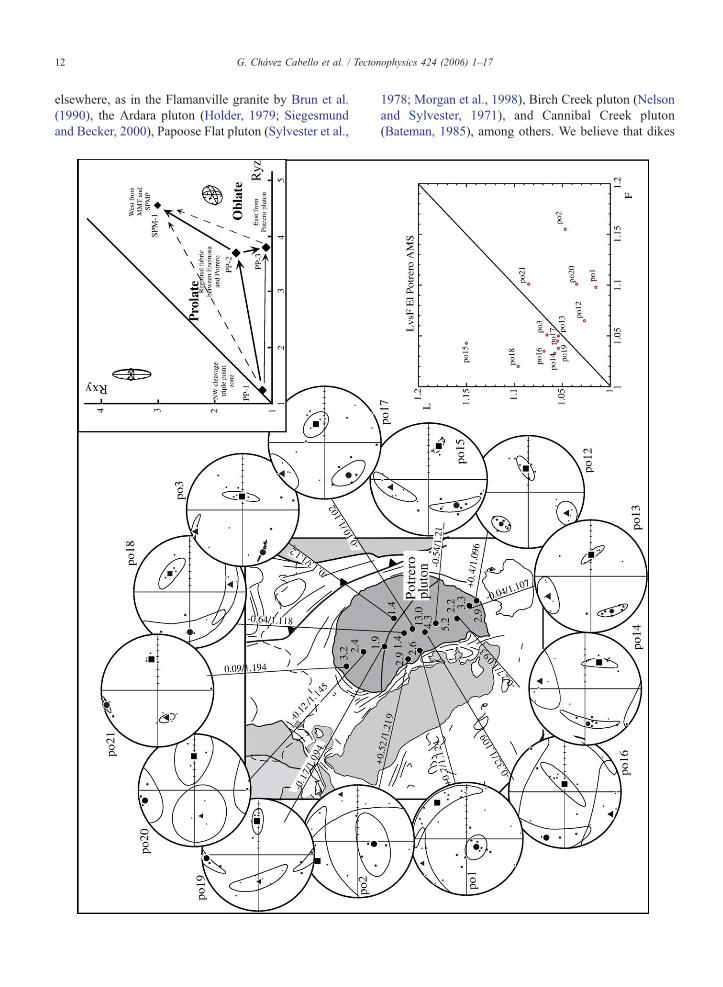
Samples of the El Potrero pluton have weaklydeveloped but well-defined magnetic fabrics. Anisotropyof magnetic susceptibility is low, with percent anisotropyvalues (P) around 1.15. Lineations (susceptibility maxi-mum axes) are tightly grouped, particularly in sites thatrecord prolate fabrics. Most of the sites along the north–south transect record this type of fabric with T valuesranging between weakly prolate −0.038 and stronglyprolate −0.639 (Fig. 7). Magnetic foliations are generallyparallel to regional structural trends (striking NNW–SSEto NS), and lineations dip at moderately high to steepangles east–southeast to northeast. Oblate fabrics areobserved at four sites, all near a pluton margin. At thenorthernmost and southernmost sites (21 and 12,respectively), foliations are steep and parallel to the plutonborder, but at the westernmost sites (1 and 2) they dip atshallow angles and strike at oblique angles to the contact.
We interpret fabrics in the pluton interior to recordprimarily steep magma ascent, expansion of the pluton tothe east, and regional eastward directed compression.Fabrics near the northern and southern pluton margins areparallel to contacts and thus record deformation that resultedfrom magma–wall rock interaction. We interpret oblatefabrics observed in sites along the western pluton border toreflect deformation imposed by the magma chamber roof.This is supported by the greater abundance of low angle(decompression?) fractures in this area, which in turnsupports the notion that shallower facies of the pluton are
exposed along its western margin. This conclusion wasindependently reached by evidence of stopping, by thepresence of large host-rock xenoliths on the southwestsector, and by the rather irregular contour of the westerncontact.
7. Discussion
The El Potrero pluton is a good example of a plutonwith both post- and syntectonic features. Featurescommon but not limited to syntectonic plutons include:(1) the pluton is foliated and it also contains a solid-statefabric, (2) these fabrics are parallel to regional cleavage,(3) the host-rock contains cleavage triple points, (4) thepluton presents minor shear zones, and, (5) the pluton'slong axis is parallel to major regional structure. Thesefeatures can be interpreted to indicate post-tectonicintrusion and deformation by expansion. Also, the CerroCostilla, a pluton of nearly the same age as El Potrero,cross-cuts the MMT (Johnson et al., 1999b).
The discordance of the paleomagnetic direction inthe El Potrero pluton is interpreted to indicate pluton tiltsynchronous with deformation of the Alisitos Forma-tion. The pluton's close spatial relation with the SSPMpluton suggests that an important drag along the easternmargin of El Potrero, associated with diapiric ascent orby westward lateral-oblique expansion of the largeSSPM pluton, may have provided a mechanism to tilt alarge crustal segment delimited by the MMT in the eastand the Rosarito fault in the west. We must point out thatmagnetic fabrics in SSPM pluton suggest westwardasymmetrical expansion owing to an oblate fabric in thewest and a non-oriented fabric in the eastern zone(Molina-Garza et al., 2003). This could suggest that adiapiric emplacement model could fail; however, weargue that an asymmetrical westward expansion couldaccount for tilting of El Potrero pluton. Additionally,tilting could be achieved by activity and rotation of theRosarito fault to the west. Rotation of the Rosarito faultmay explain proposed 15° of tilt of SSPM pluton(Ortega-Rivera et al., 1997).
We suggest that eastward asymmetric (non-concen-tric) lateral expansion of the El Potrero pluton wascontrolled by a rheological contrast between the dioriticEncinosa pluton and the tuffs and pelitic rocks of theAlisitos Formation close to the MMT, west and east,respectively, of the initial area of emplacement. Murray(1978) and Johnson et al. (2003) also suggested lateralasymmetric expansion of San Jose pluton, northwest ofEl Potrero. Lineation magnetic fabrics also provide goodevidence of eastward expansion of the magma chamber.This emplacement mechanism has been described
12 G. Chávez Cabello et al. / Tectonophysics 424 (2006) 1–17
elsewhere, as in the Flamanville granite by Brun et al.(1990), the Ardara pluton (Holder, 1979; Siegesmundand Becker, 2000), Papoose Flat pluton (Sylvester et al.,
1978; Morgan et al., 1998), Birch Creek pluton (Nelsonand Sylvester, 1971), and Cannibal Creek pluton(Bateman, 1985), among others. We believe that dikes

13G. Chávez Cabello et al. / Tectonophysics 424 (2006) 1–17
were the principal mechanism of magma ascent, becausein the western sector of the pluton highly discordantrelationships with the host predominate. Also xenolithsof the host rocks are present, and few tonalitic dikesintrude into Encinosa. Within El Potrero pluton, we didnot observe annular synclines or vertical shear zones;prolate deformation is not present around the pluton inthe host, which could indicate diapirism.
In order to define the temporal relationship of a plutonwith respect to structural features developed by regionaldeformation, certain structural characteristics must bepresent both in the borders and within the pluton. Yet,much controversy exists about what these characteristicsmust be, because the development of specific structuralfeatures depends on such factors as: the rheology of thehost rock, the composition of the pluton, the velocity ofemplacement, and the duration and intensity of thedeformation event (Paterson and Tobisch, 1988). Someof the features observed in the borders and within the ElPotrero pluton can be similar to those of plutonsemplaced forcefully after a deformation event (Patersonand Tobisch, 1988). We notice, however that there arevarious examples throughout the world of plutons wherethe relative importance of emplacement-related versusdeformation-related features has been misinterpreted.This is particularly the case of plutons that had beenpreviously considered post tectonic and forcefullyemplaced. Recently reinterpreted examples include:Cannibal Creek, Papoose Flat and Ardara plutons(Paterson, 1988; Paterson et al., 1991; Vernon andPaterson, 1993; respectively). The new interpretationsare supported by more strict criteria such as thekinematics of porphyroblasts in contact aureoles aswell as comparison of metamorphic mineral ages outsidethe aureole with crystallization ages in the intrusive.These two observations are considered key to definingtemporal relations between deformation and emplace-ment (Paterson and Tobisch, 1988). We believe thatpaleomagnetic evidence is, in this case, a similarlydiagnostic criteria.
Porphyroblasts are poorly developed at the El Potreroplutonmargins, and any interpretation derived from themwould be ambiguous. We note, however, that crystalli-zation (U/Pb: 102.5±1.6 Ma; Johnson et al., 1999b) andcooling ages (40Ar–39Ar hornblende age— ca. 101Ma;40Ar–39Ar biotite age— ca. 93.4 Ma; Fig. 3, this study)for the pluton fall within the interval of regional
Fig. 7. Stereographic projection of magnetic fabric data and results of finitetriangles and circles are the directions of maximum, intermediate and minimtheir 95% confidence interval. Shape parameter (T) and percent anisotropystereoplot to the site. Principal susceptibility axes are plotted in the lower hemshown in the lower right hand corner.
deformation (132–85 Ma). The ages imply rapid initialcooling rates after emplacement, and somewhat slowercooling rates before reaching biotite closure temperatures(∼300 °C). Cooling ages are also close to minimummetamorphism ages (Late Cretaceous) determined forbiotite schist in SSPM area, and to the east in San Felipe(Iriondo et al., 2003). This suggests that pluton coolingand metamorphism to the east are contemporaneous.Cooling rates for the El Potrero appear somewhat slowerthan for the much large SSPM pluton (Ortega-Rivera etal., 1997). This may reflect a faster uplift rate for theSSPM pluton than for El Potrero. Alternatively, the ca.94 Ma dates for biotites at El Potrero may reflect thermalresetting by SSPM pluton. On the other hand, a keyobservation is provided by the paleomagneticallydetermined ∼35° rotation of El Potrero pluton along asubhorizontal axis oriented NNW–SSE. This, combinedwith structural observations, provides strong support tothe hypothesis of a syntectonic relation of El Potrero withrespect to deformation observed in the zone between theRosarito fault and the MMT (Fig. 8).
It is known that downward flow of aureole rocks mayfill space below an ascending pluton (e.g., Saleeby, 1990;Stein and Paterson, 1996; Johnson et al., 1999a). Thisoccurs in an apparently simple process controlled bydensity contrasts between ascending magma and hostrocks. Another mechanism that may occupy spaceemptied by an ascending diapir is tectonic shortening.For the study area we consider that the relatively fastcooling rate determined for SSPM pluton (40 °C/Ma;Ortega-Rivera et al., 1997) between 97 and 88 Ma isevidence of fast magma ascent which in turn produceddrag and rotation of ∼20° of the El Potrero pluton (Fig.8b). We also believe that diapiric ascent may have beenaccelerated by contraction. This result corroborates theproposal of Ortega-Rivera et al. (1997), who suggestedthat tilt of SSPM pluton postdates closure of the biotite Arsystem in samples on the east side of SSPM (ca. 88 Ma).Nonetheless, our new data suggest that the 15° tilt pro-posed for SSPM occurred by ∼85 Ma, and also affectedthe crustal block containing the El Potrero pluton. Thus,rotation of SSPM contributes to the approximately 35° ofrotation observed paleomagnetically in the El Potreropluton. Shortening and rotation of the Rosarito fault,southwest of the plutons, provides a simple mechanism to“fill” the space left by the ascending SSPM pluton andaccommodate rotation of a large crustal block (Fig. 8c).
deformation analysis in lithic tuffs of the host rock (inset). Squares,um susceptibility. Mean directions are plotted as large symbols within(P′) for each of the sites are also shown along the line the links theisphere projection. A plot of magnetic lineation vs. magnetic foliation is

Fig. 8. Model of deformation of the region between the Rosarito Faultand the Main Mártir Thrust and its relation with pluton emplacement.First frame: (a) event 115–102.5 Ma; emplacement of Encinosa (2),emplacement of San José, and emplacement of El Potrero (3). Activityceases at MMT by 103 Ma (1). Rotation or deformation at Encinosa isnot known. Second frame: (b) event 97–88 Ma; emplacement of SierraSan Pedro Mártir pluton, rotation of about 20° of El Potrero (and hostrock) by drag during vertical diapiric ascent of SSPM or by lateralexpansion. (4) Level of emplacement ca. 97 Ma, before tilt of SSPMpluton. (5) Level of emplacement by 88 Ma (biotite ages on the eastside of SSPM pluton). (c) Event 88–85 Ma; ∼15° rotation of SSPMand the block containing El Potrero, by activity of Rosarito Fault (7).Rotation of Rosarito fault and Encinosa pluton is inferred. RF rotatesto fill spaced emptied by ascending SSPM pluton.
14 G. Chávez Cabello et al. / Tectonophysics 424 (2006) 1–17
Post-tectonic plutons rarely record large-magnituderotations; such rotations are limited to areas affected byintense extensional deformation, or transtensional/trans-
pressional tectonics. There are observations of normaland strike-slip faulting in the Sierra San Pedro Mártirregion (Delgado-Argote et al., 2003). The dominantorientation is consistent with structures related toNeogene opening of the Gulf of California. This styleof deformation in the Sierra San Pedro Mártir area ismore intense towards the east. In the San José and ElPotrero regions we do not find evidence that transpres-sion or transtension might have affected the plutons.Demonstrating the syntectonic nature of the El Potrerobased solely on field and petrographic observations isdifficult, but as mentioned earlier emplacement andcooling ages fall within the span of regional deforma-tion. Besides, the ∼35° tilt of the pluton cannot beexplained by post-tectonic extension and is consistentwith the dip of the main regional shear zones within thissector of the PRB.
We note that the estimated tilt angle of El Potrero isclose to the difference that exists between magmaticfoliation and the vertical, or the angle between localtectonic foliation in the pluton and regional foliation inthe host rock, and the vertical. This in turn suggests thatthe tilt developed during activity of the regional shearzones (Rosarito fault andMMT). The observed structuralrelations could be produced if the pluton had beenemplaced post-tectonically by forceful emplacement,within a pre-existing weakness zone, although the largemagnitude of tilt could not develop in such a setting.
Additional observations for the El Potrero pluton thatsupport tectonically controlled fabrics, and lateralexpansion of the magma chamber towards the eastbefore complete crystallization, are the asymmetricdistribution of the degree of flattening in microgranitoidenclaves, as well as the asymmetry in the development ofthe intensity of magmatic foliation and solid-state fabric.Additional evidence is the existence of greater shorten-ing in the host rocks in the eastern border of the pluton.
The observation of different emplacement mechan-isms and exposure of different metamorphic facies of thehost rocks were thus possibly controlled by regionalshear zones (Rosarito fault andMMT), which control theregional uplift of progressively higher-grade faciestoward the east. Higher temperatures and emplacementof more voluminous plutons towards the east appearscontrolled by the shear zones as well. Emplacementlevels change systematically, from relatively shallowdepths west of Rosarito Fault ca. 2.3±0.6 kbar in theZarza intrusive complex (Johnson et al., 1999a), to ca.4.0±0.6 kbar in the El Potrero pluton (average of fourdeterminations from this study), and ca. 5.0±0.5 kbar inthe Sierra San Pedro Mártir pluton west of the MMT(Ortega-Rivera et al., 1997). The Rosarito and MMT
15G. Chávez Cabello et al. / Tectonophysics 424 (2006) 1–17
faults delimit crustal blocks that expose deeper crustallevels towards the east. Similarly, emplacement mechan-isms vary from primarily brittle (stopping and faultingthat produce discordant relations to host rock, both southand west of the San José and El Potrero plutons), toprimarily ductile in the east (showing ductile shorteningof the host rock, folding, and rotation of regionalstructures). Plutons in the vicinity of the MMTexpandedlaterally or oblique towards this structure (El Potrero,San José and San Pedro Mártir, Fig. 1). The contactrelationships for the San José and El Potrero plutons arediscordant towards the west and south, areas more dis-tant to the MMT, but are concordant on the bordersnearer the MMT.
We thus suggest that emplacement of the El Potreropluton and expansion towards the east was facilitated bythe presence of a “heated” shear zone, the MMT ofJohnson et al. (1999b). Even more, in the study areaaccretion of the Alisitos arc (Griffith and Hoobs, 1993;Phillips, 1993) is fully documented, as is the develop-ment of a Cretaceous continental arc that migratedlandward (Gastil et al., 1975; Silver and Chappell, 1988).Although timing of arc accretion (ca. 103±4Ma; Griffithand Hoobs, 1993) and development of specific shearzones (ca. 115–108 Ma; MMT de Johnson et al., 1999b)differ slightly, these ages are all contained within thespan of regional shortening that affected the regionbetween 85 and 132 Ma (Schmidt and Paterson, 2002).
8. Conclusions
We interpret that eastward asymmetric lateral expan-sion of the El Potrero pluton was controlled byrheological contrast between the dioritic Encinosa plutonand the tuff and pelitic rocks of the Alisitos Formation,west and east, respectively, of the initial area ofemplacement. On the other hand, fold axes in the AlisitosFormation are deviated by the El Potrero, the westerncontact is highly discordant to regional deformationfeatures, and no clear conclusions can be drawn fromaureole porphyroblasts. The El Potrero pluton experi-enced a rotation of ∼35° with respect to the referencedirection and it is interpreted to indicate a combination ofinitial drag during vertical diapiric emplacement orwestward lateral-oblique expansion of the adjacent SanPedro Mártir pluton (∼20°) and later rotation (∼15°) byRosarito Fault activity in the southwest, affecting severalplutons in the area (SSPM, El Potrero and Encinosa).Magnetic susceptibility fabrics reflect mostly emplace-ment-related stress and regional stress. Pluton fabrics andstructures and their relationship to the host-rock, as wellas regional observations, suggest that the El Potrero
pluton is best interpreted as a syntectonic plutonemplaced inside of a regional shear zone delimited bythe Main Mártir Thrust and the younger Rosarito fault.
Acknowledgments
This research was supported by CONACYT grant33-100-T. We also thank C. Linares-López and A.M.Reyes-Salas for the assistance in the microprobe andpaleomagnetic lab, respectively. Analytical work wasalso supported by an NSERC Discovery grant to J.K.W.Lee. We also thank D.M. Martínez and J.T. Vásquezwho provided valuable help in sample preparation atCGEO–UNAM. The reviews of Scott Johnson and ananonymous reviewer improved this manuscript.
References
Bateman, R., 1985. Aureole deformation by flattening around a diapirduring in-situ ballooning: the Cannibal Creek granite. Journal ofGeology 93, 293–310.
Böhnel, H., Delgado Argote, L., 2000. Paleomagnetic data fromnorthern Baja California (Mexico): results from the Cretaceous SanTelmo batholith. GSA Special Paper 334, 157–165.
Böhnel, H., Delgado-Argote, L., Kimbrough, D., 2002. Discordantpaleomagnetic data for middle-Cretaceous intrusive rocks fromnorthern Baja California: latitude displacement, tilt, or vertical axisrotation? Tectonics 21 (10). doi:10.1029/2001TC001298.
Brun, J.P., Pons, J., 1981. Strain patterns of pluton emplacement incrust undergoing non-coaxial deformation, Sierra Morena, south-ern Spain. Journal of Structural Geology 3, 219–230.
Brun, J.P., Gapais, D., Cogne, J.P., Ledru, D., Vigneresse, J.L., 1990. TheFlamanville granite (NW France): an unequivocal example of asyntectonically expanding pluton. Journal of Geology 25, 271–286.
Busby, C., Smith, D., Morris, W., Fackler-Adams, B., 1998. Evolu-tionary model for convergent margins facing large ocean basins:Mesozoic Baja California, México. Geology 26, 227–230.
Chávez-Cabello, G., 1998. Mecanismos de ascenso, emplazamiento yevolución magmática de varios plutones al oeste de la Sierra SanPedro Mártir, Baja California, México. Unpublished MSc Thesis,CICESE, Ensenada, México, 165 pp.
Clark, A.H., Archibald, D.A., Lee,A.W., Farrar, E., Hodgson, C.J., 1998.Laser probe 40Ar–39Ar ages of early- and late-stage alteration as-semblages, Rosario porphyry copper–molybdenum deposit, Colla-huasi District, I Region, Chile. Economic Geology 93, 326–337.
Delgado-Argote, L.A., Frías-Camacho, V.A., Hinojosa-Corona, A.,2003. Reconocimiento estructural de los plutones localizados entrela costa Pacífica y San Pedro Mártir, Baja California. Geos 22,170–171.
Gastil, R.G., 1993. Pre-batholithic history of Peninsular California. In:Gastil, R.G., Miller, R.H. (Eds.), The Prebatholithic Stratigraphyof Peninsular CaliforniaSpecial Paper Geological Society ofAmerica, vol. 279, pp. 145–156.
Gastil, R.G., Phillips, R.P., Allison, E.C., 1975. Reconnaissancegeology of the State of Baja California. Geological Society ofAmerica Memoir 140, 170.
Gastil, R.G., Morgan, G.J., Krummenacher, D., 1978. Mesozoichistory of peninsular California and related areas east of the Gulf of

16 G. Chávez Cabello et al. / Tectonophysics 424 (2006) 1–17
California. In: Howellm, D.G., McDougall, K.A. (Eds.), MesozoicPaleogeography of the Western United States. Pacific Section,Society of Economic Paleontologists and MineralogistsPacificCoast Paleogeography Symposium, vol. 2, pp. 107–115.
Gastil, R.G., Morgan, G.J., Krummenacher, D., 1981. The tectonichistory of peninsular California and adjacent Mexico. TheGeotectonicDevelopment of California, Rubey, vol. I, pp. 284–306.
Griffith, R., Hoobs, J., 1993. Geology of the southern Sierra Calamajue,Baja California Norte,Mexico. In: Gastil, R.G., Miller, R.H. (Eds.),The prebatholithic stratigraphy of peninsular California, SpecialPaper — Geological Society of America, vol. 279, pp. 43–60.
Hagstrum, J.T., McWilliams, M.M., Howell, D.G., Grommé, S., 1985.Mesozoic paleomagnetism and northward translation of the BajaCalifornia Peninsula. Geological Society of America Bulletin 96,1077–1090.
Holder, M.T., 1979. An emplacement mechanism for post-tectonicgranites and its implications for their geochemical features. In:Atherton, M.P., Tarney, J. (Eds.), Origin of Granite Batholiths,Geochemical Evidence, Shiva, Orpington, Kent, UK, pp. 116–128.
Ichinose, G., Day, S.M., Magistrale, H., Prush, T., Vernon, F.L.,Edelman, A., 1996. Crustal thickness variation beneath thePeninsular Ranges, southern California. Geophysical ResearchLetters 23, 3095–3098.
Iriondo, A., Kunk, M.J., Winick, J.A., CRM, 2003. 40Ar/39Ar DatingStudies of Minerals and Rocks in various areas in Mexico: USGS/CRM Scientific Collaboration (Part I). U.S. Geological SurveyOpen-File Report 03-020 On-line edition, 79 pp.
Johnson, S.E., Paterson, S.R., Tate, M.C., 1999a. Structure andemplacement history of a multiple-center, cone-sheet-bearing ringcomplex: the Zarza Intrusive Complex, Baja California, México.Geological Society of America Bulletin 111, 607–619.
Johnson, S.E., Tate, M.C., Fanning, C.M., 1999b. New geologicmapping and SHRIMP U–Pb zircon data in the Peninsular Rangebatholith, Baja California, México: evidence for a suture? Geology27, 743–746.
Johnson, S.E., Fletcher, J.M., Fanning, C.M., Vernon, R.H., Paterson,S.R., Tate, M.C., 2003. Structure, emplacement and lateralexpansion of the San José tonalite pluton, Peninsular Rangebatholith, Baja California, México. Journal of Structural Geology25, 1933–1957.
Molina-Garza, R.S., Böhnel, H., Delgado-Argote, L., 2003. MagneticFabric and Paleomagnetism of the Peninsular Ranges Batholith,Sierra San Pedro Mártir, Baja California. AGU — Fall Meeting,San Francisco, EOS Transactions.
Morgan, S.S., Law, R.D., Nyman, M.W., 1998. Laccolith-likeemplacement model for the Papoose Flat pluton based onporphyroblast-matrix analysis. Geological Society of AmericaBulletin 110, 96–110.
Murray, J.D., 1978. The structure and petrology of the San José pluton,northern Baja California, México. Unpublished Ph.D. thesis.Pasadena, California Institute of Technology, 709 pp.
Nelson, C.A., Sylvester, A.G., 1971. Wallrock decarbonation andforcible emplacement of Birch Creek pluton, southern WhiteMountains, California. Geological Society of America Bulletin 82,2891–2904.
Ortega-Rivera, M.A., Farrar, E., Hanes, J.A., Archibald, D.A., Gastil,R.G., Kimbrough, D.L., Zentilli, M., López-Martínez, M.,Féraud, G., Ruffet, G., 1997. Chronological constraints on thethermal and tilting history of the Sierra San Pedro Mártir pluton,Baja California, México, from U/Pb, 40Ar/39Ar, and fission-trackgeochronology. Geological Society of America Bulletin 109 (6),728–745.
Paterson, S.R., 1988. Cannibal Creek granite: post-tectonic “balloon-ing” pluton or Pre-tectonic piercement diapir? Journal of Geology15, 191–206.
Paterson, S.R., Tobisch, O.T., 1988. Using pluton ages to date regionaldeformations: problems with commonly used criteria. Geology 16,1108–1111.
Paterson, S.R., Vernon, R.H., 1995. Bursting the bubble of ballooningplutons: a return to nested diapirs emplaced by multiple processes.Geological Society of America Bulletin 107, 1356–1380.
Paterson, S.R., Brudos, T., Fowler Jr., T.K., Carlson, C., Bishop, K.,Vernon, R.H., 1991. Papoose Flat pluton: forceful expansion orpost-emplacement deformation? Geology 19, 324–327.
Paterson, S.R., Fowler Jr., T.K., Schmidt, K.L., Yoshinobu, A.S., Yuan,E.S., Miller, R.B., 1998. Interpreting magmatic fabric patterns inplutons. In: Clemens, J.D., Hutton, D.H. (Eds.), Generation of Grani-tic Rocks and Deep Crustal Processes Lithos, vol. 44, pp. 53–82.
Paterson, S.R., Pignotta, G.S., Vernon, R.H., 2004. The significance ofmicrogranitoid enclave shapes and orientations. Journal ofStructural Geology 26, 1465–1481.
Phillips, J.R., 1993. Stratigraphy and structural setting of the mid-Cretaceous Olvidada Formation, Baja California Norte, México.In: Gastil, R.G., Miller, R.H. (Eds.), The Prebatholithic Stratigra-phy of Peninsular California Geological Society of AmericaSpecial Paper, vol. 279, pp. 97–106.
Rangin, C., 1978. Speculative model of Mesozoic geodynamics,central Baja California to northeastern Sonora (México). In:Howell, D.G., McDougall, K.A. (Eds.), Mesozoic Paleogeographyof the Western United States. Pacific Section, Society of EconomicPaleontologists and Mineralogists Pacific Coast PaleogeographySymposium, vol. 2, pp. 85–106.
Saleeby, J.B., 1990. Progress in tectonic and petrogenetic studies in anexposed cross-section of young (∼100 Ma) continental crust,southern Sierra Nevada, California. In: Salisbury, M.H., Fountain,D.M. (Eds.), Exposed Cross-sections of the Continental Crust.NATO Advanced Studies Institute/Kluwer Academic, Dordrecht,pp. 137–158.
Schmidt, M.W., 1992. Amphibole composition in tonalite as a functionof pressure: an experimental calibration of the Al-in-hornblendebarometer. Contributions to Mineralogy and Petrology 110,304–310.
Schmidt, K.L., Paterson, S.R., 2002. A doubly vergent fan structure inthe Peninsular Range batholith: transpression or local complexflow around a continental margin buttress? Tectonics 21, 141–149.
Siegesmund, S., Becker, J.K., 2000. Emplacement of the Ardarapluton (Ireland): new constraints from magnetic fabrics, rockfabrics and age dating. International Journal of Earth Sciences 89,307–327.
Silver, L.T., Chappell, B.W., 1988. The Peninsular Ranges batholith:an insight into the evolution of the Cordilleran batholiths ofsouthwestern North America. Royal Society of EdinburghTransactions 79, 105–121.
Stein, E., Paterson, S.R., 1996. Country rock displacement duringemplacement of the Joshua Flat pluton, White Inyo Mountains,California. In: Oncked, O., Janssen, C. (Eds.), Basement Tectonics,vol. 11, pp. 35–49.
Sylvester, A.G., Oertel, G., Nelson, C.A., Christie, J.M., 1978. PapooseFlat pluton: a granitic blister in the Inyo Mountains, California.Geological Society of America Bulletin 89, 1205–1219.
Symons, D.T.A., Walawender, M.J., Smith, T.E., Molnar, S.E., Harris,M.J., Balckburn, W.H., 2003. Paleomagnetism and geobarometryof the La Posta pluton, California. In: Johnson, S.E., Paerson, S.R.,Fletcher, J.M., Girty, G.H., Kimborough, D.L., Martín-Barajas, A.

17G. Chávez Cabello et al. / Tectonophysics 424 (2006) 1–17
(Eds.), Tectonic Evolution of Northwestern Mexico and theSouthwestern USAGeological Society of America, SpecialPaper, vol. 374, pp. 135–155.
Tate, M.C., Johnson, S.E., 2000. Subvolcanic and deep-crustal tonalitegenesis beneath the Mexican Peninsular Ranges. Journal ofGeology 108, 721–728.
Thompson, C.N., Girty, G.H., 1994. Early Cretaceous intra-arc ductilestrain in Triassic–Jurassic and Cretaceous continental margin arcrocks, Peninsular Ranges California. Tectonics 13, 1108–1119.
Todd, V.R., Shaw, S.E., 1985. S-type granitoids and an I–S line in thePeninsular Ranges batholith, southern California. Geology 13,231–233.
Todd, V.R., Erskine, B.G., Morton, D.M., 1988. Metamorphic andtectonic evolution of the northern Peninsular Ranges Batholith,southern California. In: Ernst, W.G. (Ed.), Metamorphism andcrustal evolution of the Western United States. Rubey, vol. VII.Prentice-Hall, Englewood Cliffs, New Jersey, pp. 894–937.
van der Plas, L., Tobi, A.C., 1965. A chart for judging the reliability ofpoint counting results. Series/Source: American Journal of Science263 (1), 87–90.
Vernon, R.H., 2005. A practical guide to rock microstructures.Cambridge Univ. Press, London, UK. 606 pp.
Vernon, R.H., Flood, R.H., 1988. Contrasting deformation of S- and I-type granitoids in the Lachland fold belt, eastern Australia.Tectonophysics 147, 127–143.
Vernon, R.H., Paterson, S.R., 1993. The Ardara granite, Ireland:deflating an expanded intrusion. Lithos 31, 17–31.
Vernon, R.H., Etheridge, M.A., Wall, V.J., 1988. Shape andmicrostructure of microgranitoid enclaves: indicators of magmamingling and flow. Lithos 22, 1–11.
Vernon, R.H., Johnson, S.E., Melis, E.A., 2004. Emplacement-relatedmicrostructures in the margin of a deformed pluton: the San Josetonalite, Baja California, Mexico. Journal of Structural Geology26, 1867–1884.
Walawender, M.J., Girty, G.H., Lombardi, M.R., Kimbrough, D.L.,Girty, M.S., Anderson, C., 1991. A synthesis of recent work in thePeninsular Ranges batholith. In: Walawender, M.J., Hanan, B.B.(Eds.), Geological Excursion in Southern California and México.Department of Geological Sciences, San Diego State University,San Diego, California, pp. 297–312.
Wetmore, P.H., Herzig, C., Alslebe, H., Sutherland, M., Schidt, K.L.,Schultz, P.W., Paterson, S.R., 2003. Mesozoic tectonic evolution ofthe Peninsular Ranges of southern and Baja California. In:Johnson, S.E., Paerson, S.R., Fletcher, J.M., Girty, G.H.,Kimborough, D.L., Martín-Barajas, A. (Eds.), Tectonic Evolutionof Northwestern Mexico and the Southwestern USAGeologicalSociety of America, Special Paper, vol. 374, pp. 93–116.
Zijderveld, J.D.A., 1967. A. c. demagnetization of rocks—analysis ofresults, in: Methods in palaeomagnetism—NATO advanced studyinst. on palaeomagnetic methods, Univ. Newcastle upon Tyne,1964, proc., 254–286.
Copyright © 2022 FDOKUMEN