Paleomagnetism of the Joban Seamount Chain: Its origin and tectonic implications for the Pacific...
11
JOURNAL OF GEOPHYSICAL RESEARCH, VOL. 102, NO. B3, PAGES 5145-5155, MARCH 10, 1997 Paleomagnetism of the Joban Seamount Chain: Its origin and tectonic implications for the Pacific plate Desiderius C. P. Masalu and Kensaku Tamaki Ocean Research Institute,Universityof Tokyo, Tokyo, Japan William W. Sager Department of Oceanography, Texas A&M University,College Station Abstract. The paleomagnetism of 10 seamounts from the Joban Seamount Chain (northwestern Pacific) were studied using a method that calculates mean magnetization parameters by an inversion of magnetic anomaly and edifice bathymetry. Of the 10 seamounts, eight gave results consistent with otherpaleomagnetic studies of Pacificseamounts. Joban seamounts appear to have formedat two different meanpaleolatitudes, contrary to what would be expected for a single hotspot origin. Furthermore, six of the consistent poles plot alongthe 129 to 82 Ma portionof the Pacific plate apparent polar wander path (APWP), implyingthe seamounts formed mainly duringthe mid- to Late Cretaceous. Two otherpoles,from Iwaki and Hitachi seamounts, are located northwest of the olderend of the established PacificAPWP, possibly indicating Early Cretaceous ages. Because Iwaki and Hitachi seamounts are located in the middle of the chain,agedoes not progress alongthe chain,arguing against a single-hotspot origin. Perhaps the chainformed by recurrent volcanism alonga line of weakness or by another mechanism. Iwaki and Hitachi seamounts displaysmaller northward drift compared to the others, consistent with the Pacificplate drifting southward from Late Jurassic or Early Cretaceous to mid-Cretaceous time. Introduction Paleomagnetic dataare an important source of information on the motion of plates relative to theEarth's spinaxis.Traditionally, such data have been obtained from fully orientedsamples, but obtaining samples from oceanic plates, such as the Pacificplate, is difficult.This problem hasled investigators to seek alternative methods of obtaining paleomagnetic data, suchas inversion of seamount magneticanomalies [Francheteau et al., 1970] and seafloor-spreading anomalies [Schouten and Cande, 1976] or determination of paleolatitudes from azimuthally unoriented cores [Cox and Gordon, 1984]. Inversion of magnetic anomalies over seamounts [Vacquier, 1962; Parker et al., 1987] is most commonly applied to thePacific platebecause thisplatecontains plentiful seamounts. Since many of theseseamounts have not been dated, paleomagnetic results from these inversions havebeen used to study volcanism in individual chains as well as over the entire plate[Sager and Keating,1984;Sager and Pringle, 1987; Sager,1992; Sageret al., 1993]. In 1990and 1992we conducted a systematic geophysical survey of the Joban Seamount Chain (JSC) andnearby Daigo-Kashima (D5) seamount (FiguresI and 2) in the northwestern Pacific [Kobayashi, 1991, 1993]. Because our data includeextensive coverage of the JSC, they provide us theopportunity to study this chain in greater detail than usual and to compare with results fromother western Pacific seamounts. We have performedpaleomagnetic inversions and examined the implications of the seamounts' paleomagnetic directions for the origin of the JSC and the tectonics of the Pacific plate. Background SeamountPaleomagnetism Seamount paleomagnetism is a technique for estimating the mean magnetization vector of a seamount by inverting the magnetic anomaly with a model of bathymetry [Vacquier,1962; Talwani, 1965; Plouff, 1976; Parker et al., 1987]. Seamount basalts are magnetized in the direction of the ambient geomagnetic field as they erupt and cool through the Curie temperature. Assumingthe average geomagnetic field was a geocentric axial dipole at the time of formation and that the magnetization induced by the present ambient geomagnetic field is small,the average uniformmagnetization vectorindicates the latitude and orientation of the lithospheric plate beneaththe seamount when the seamount formed. Seamount anomalies are inverted typicallyusingone of two methods: leastsquares or seminorm minimizationinversion. The formerassumes the seamount magnetization is uniform,whereas the latter considers themagnetization to be composed of uniform andnonuniform parts andmaximizes the uniform part. Owing to its simplicity andits earlydevelopment, the least squares method has been used to calculate many Pacific seamount paleopoles (see compilation by Sager [1992]). The more complex seminorm minimization method hasbeenusedin recent studies [Hildebrand and Parker, 1987; Sager, 1992; Sager et al., 1993] because it relaxes the uniformity assumption and because it includes an estimate of the error in pole location[Parker, 1988]. Copyright 1997 by the AmericanGeophysical Union. Paper number96JB03624. 0148-0227/97/96JB-03624509.00 Pacific Apparent Polar Wander Path (APWP) The APWP for the Pacific plate is largely constrained by seamount paleomagnetic data.Pacific seamount polescluster in 5145
Transcript of Paleomagnetism of the Joban Seamount Chain: Its origin and tectonic implications for the Pacific...

JOURNAL OF GEOPHYSICAL RESEARCH, VOL. 102, NO. B3, PAGES 5145-5155, MARCH 10, 1997
Paleomagnetism of the Joban Seamount Chain: Its origin and tectonic implications for the Pacific plate
Desiderius C. P. Masalu and Kensaku Tamaki
Ocean Research Institute, University of Tokyo, Tokyo, Japan
William W. Sager Department of Oceanography, Texas A&M University, College Station
Abstract. The paleomagnetism of 10 seamounts from the Joban Seamount Chain (northwestern Pacific) were studied using a method that calculates mean magnetization parameters by an inversion of magnetic anomaly and edifice bathymetry. Of the 10 seamounts, eight gave results consistent with other paleomagnetic studies of Pacific seamounts. Joban seamounts appear to have formed at two different mean paleolatitudes, contrary to what would be expected for a single hotspot origin. Furthermore, six of the consistent poles plot along the 129 to 82 Ma portion of the Pacific plate apparent polar wander path (APWP), implying the seamounts formed mainly during the mid- to Late Cretaceous. Two other poles, from Iwaki and Hitachi seamounts, are located northwest of the older end of the established Pacific APWP, possibly indicating Early Cretaceous ages. Because Iwaki and Hitachi seamounts are located in the middle of the chain, age does not progress along the chain, arguing against a single-hotspot origin. Perhaps the chain formed by recurrent volcanism along a line of weakness or by another mechanism. Iwaki and Hitachi seamounts display smaller northward drift compared to the others, consistent with the Pacific plate drifting southward from Late Jurassic or Early Cretaceous to mid-Cretaceous time.
.
Introduction
Paleomagnetic data are an important source of information on the motion of plates relative to the Earth's spin axis. Traditionally, such data have been obtained from fully oriented samples, but obtaining samples from oceanic plates, such as the Pacific plate, is difficult. This problem has led investigators to seek alternative methods of obtaining paleomagnetic data, such as inversion of seamount magnetic anomalies [Francheteau et al., 1970] and seafloor-spreading anomalies [Schouten and Cande, 1976] or determination of paleolatitudes from azimuthally unoriented cores [Cox and Gordon, 1984]. Inversion of magnetic anomalies over seamounts [Vacquier, 1962; Parker et al., 1987] is most commonly applied to the Pacific plate because this plate contains plentiful seamounts. Since many of these seamounts have not been dated, paleomagnetic results from these inversions have been used to study volcanism in individual chains as well as over the entire plate [Sager and Keating, 1984; Sager and Pringle, 1987; Sager, 1992; Sager et al., 1993]. In 1990 and 1992 we conducted a systematic geophysical survey of the Joban Seamount Chain (JSC) and nearby Daigo-Kashima (D5) seamount (Figures I and 2) in the northwestern Pacific [Kobayashi, 1991, 1993]. Because our data include extensive coverage of the JSC, they provide us the opportunity to study this chain in greater detail than usual and to compare with results from other western Pacific seamounts. We have performed paleomagnetic inversions and examined the implications of the seamounts' paleomagnetic directions for the origin of the JSC and the tectonics of the Pacific plate.
Background
Seamount Paleomagnetism
Seamount paleomagnetism is a technique for estimating the mean magnetization vector of a seamount by inverting the magnetic anomaly with a model of bathymetry [Vacquier, 1962; Talwani, 1965; Plouff, 1976; Parker et al., 1987]. Seamount basalts are magnetized in the direction of the ambient geomagnetic field as they erupt and cool through the Curie temperature. Assuming the average geomagnetic field was a geocentric axial dipole at the time of formation and that the magnetization induced by the present ambient geomagnetic field is small, the average uniform magnetization vector indicates the latitude and orientation of the lithospheric plate beneath the seamount when the seamount formed.
Seamount anomalies are inverted typically using one of two methods: least squares or seminorm minimization inversion. The former assumes the seamount magnetization is uniform, whereas the latter considers the magnetization to be composed of uniform and nonuniform parts and maximizes the uniform part. Owing to its simplicity and its early development, the least squares method has been used to calculate many Pacific seamount paleopoles (see compilation by Sager [1992]). The more complex seminorm minimization method has been used in recent studies [Hildebrand and Parker, 1987; Sager, 1992; Sager et al., 1993] because it relaxes the uniformity assumption and because it includes an estimate of the error in pole location [Parker, 1988].
Copyright 1997 by the American Geophysical Union.
Paper number 96JB03624. 0148-0227/97/96JB-03624509.00
Pacific Apparent Polar Wander Path (APWP)
The APWP for the Pacific plate is largely constrained by seamount paleomagnetic data. Pacific seamount poles cluster in
5145

5146 MASALU ET AL.: PALEOMAGNETISM OF THE JOBAN SEAMOUNT CHAIN
38 ø
36 ø
135 ø 150 ø
•© D1
45 ø
30 ø
• SM
-• ........ M12
ß ..;.::::•:•i•!ii !':-"•i:F::'"" ' ..... :::::::.-.:. ....
ß ....::::::::.:.-.- -
.-..:.•:•':'" '• .... • MZ ........ •:•i:i•:: M13
ß IW ......... .:..!i!•!i•i:• ......... ß -.-.-:-:i•i!!B:::':'"' '
..... ::::::::::::::::::::: ß .......::::!:!.:...!!!ii!i:i::-':'-' .....
::::::::::::::::::::::::::: ....
•) ß ....:.:::•:•i!i.::'."-". :•i•i!-"'"i'"i•i•!':'"•i•i:i:'"::":':' .... D 4 ........ ::,•!i.½•i:ii:::":!i:ii½•'"'!:• .......... .... ....::::::::::.:.....
ß D3 ....... ,,?,• ...........
ß D5
I ' I
142 ø 144 ø 146 ø
Figure 1. Index map showing the Joban Seamount Chain and other seamounts mentioned in the text and their location (shaded box in the inset on the top left comer). Solid diamonds show seamounts whose magnetic data were inverted in this study. Solid circles show seamounts that were not studied in the present study but are mentioned in the text. Stippled thick lines show magnetic lineations [Nakanishi et al., 1989]. Bathymetry is from ETOPO5 data. Seamount identification symbols: D l, Daiichi-Kashima; KT, Katori; D2, Daini-Kashima; D3, Daisan-Kashima; D4, Daiyon-Kashima; D5, Daigo-Kashima; HT, Hitachi; IW, Iwaki; FT, Futaba; MZ, Mizunagidori; SM, Soma; RF, Ryofu.
the North Atlantic Ocean along the Greenwich Meridian from about 80øN to 50øN and westward to about 300øE between 50øN
and 60øN [Sager and Pringle, 1988; Sager et al., 1993]. Sager and Pringle [1988] used the distribution of the clusters of dated Pacific seamount poles to constrain the Pacific APWP with four poles with ages of 39, 72, 82, and 88 Ma. The three younger poles are aligned north-south near the Greenwich Meridian, and the 88 Ma pole lies to the west. Recently, poles of about 129 - 120 Ma have been calculated from basalts and seamount data
[Gordon, 1990; Tarduno and Sager, 1995] and magnetic lineation skewness [Petronotis et al., 1992]. These 129 - 120 poles are statistically indistinguishable and lie southwest of the 88 Ma pole. The older part of the Pacific APWP remains elusive due to the scarcity and questionable reliability of Pacific seamount dates and paleomagnetic data older than about 120 Ma [Gordon, 1990; Larson and Sager, 1992; Sager, 1992; Sager et al., 1993]. Despite this, the sparse data suggest that the older Pacific APWP "hooks"
northward [Larson and Lowrie, 1975; Jarrard and Sasajima,. 1980; Gordon, 1983; Cox and Gordon, 1984; Sager and Pringle, 1988], suggesting that the Pacific plate was moving southward during that period.
Seamounts in the Western Pacific
The western Pacific has an abundance of seamounts, more than any other region of the world's oceans. Many are guyots, some of which are capped with drowned reefs indicating they grew to sea level [van Waasbergen and Winterer, 1993; Winterer et al., 1993; Lincoln et al., 1993]. Although many western Pacific seamounts apparently align in chains, it is unclear how they formed. Investigations of western Pacific seamounts have yielded two notable results. First, lithospheric flexure studies [Watts et al., 1980; Watts and Ribe, 1984], age data from dredge samples, and paleomagnetic data [Sager, 1992] indicate that many western

MASALU ET AL.: PALEOMAGNETISM OF THE JOBAN SEAMOUNT CHAIN 5147
38 ø
37 ø
36 ø
144 ø 145 ø 146 ø
Figure 2. Bathymetric map of the Joban Seamount Chain and nearby seamounts based on data collected by cruises KH90-1 and KH92-3. Map in Mercator projection. Contour interval is 200 m.
Pacific seamounts are significantly younger than the ocean floor upon which they reside. Second, most fossil dates, inferred ages, and the few available reliable radiometric dates [Ozima et al., 1983] for western Pacific seamounts are from the mid-Cretaceous. These two observations have greatly influenced the type of models that have been proposed for their origin.
Most models call upon some kind of intrap!ate volcanism and can be divided into two major hypotheses [Sager, 1992; Sager et al., 1993]: unusual widespread volcanic pulses and formation at one or more hotspots. The former includes the "Darwin Rise" hypothesis, which is based on the observation that many of the western Pacific guyots have similar summit depths [Menard, 1964, 1984]. Similarly, volcanic deposits from Pacific Deep Sea Drilling Project cores indicate at least two widespread Cretaceous volcanic events, Aptian to Cenomanian (~115 - 95 Ma) and Campanian to Maestrichtian (~80 - 65 Ma) [Winterer, 1976; Schlanger et al., 1981; Rea and Vallier, 1983; Tarduno et al., 1991]. The latter hypothesis presumes that the widespread mid-Cretaceous volcanism in the western Pacific is a result of the
activity of many hotspots. Current plate motion models for the Pacific plate relative to hotspots indicate that most of the western Pacific seamounts were formed as the Pacific plate drifted over a congregation of hotspots presently located in the region of French Polynesia in the southeast Pacific [Crough, 1979; Duncan and Clague, 1985; McNutt and Fischer, 1987; Fleitout and Moriceau, 1992]. This region has been dubbed the "superswell" [McNutt and Fischer, 1987; McNutt et al., 1990; Wolfe and McNutt, 1991 ]. The two hypotheses are distinguishable: Volcanic pulses should be synchronous over a large area, whereas hotspot tracks should display age progression.
Previous Work and Geological Setting of the Joban Seamount Chain
Several seamounts in the JSC have been the subjects of earlier studies: Mizunagidori (MZ) and Iwaki (IW), Ryofu (RF) and Daiichi-Kashima (D1), and Katori (KT) seamounts were found to have weak and/or complex magnetization [Tomoda, 1974; Masalu

5148 MASALU ET AL.: PALEOMAGNETISM OF THE JOBAN SEAMOUNT CHAIN
et al., 1993], weakly or completely nonmagnetized tops [Uyeda and Richards, 1966; Ueda, 1985], and different magnetization components in the top and bottom pans [Ueda, 1985], respectively.
Also, a few radiometric dates are available. D I seamount has been dated by the 4øAr-39Ar method at 120 Ma [Takigami et al., 1989]. Daini-Kashima (D2) and RF seamounts have been dated by the K-Ar method at 81 Ma and 72 to 70 Ma, respectively [Ozirna et al., 1970; Kaneoka, 1971], but the reliability of these dates is unclear owing to the propensity of seawater alteration tending to bias K-Ar dates to younger ages.
The JSC is situated to the east of the southern end of the Japan Trench between 35ø45'N and 38ø00'N (Figures I and 2), extending N53øE about 394 km. Linear magnetic anomalies associated with seafloor spreading in the vicinity strike N68øE (Figur• 1) and range from anomalies M II to M I 4 [Nakanishi et al., 1989] (135 to 140 Ma by the Harland et al., [1989]
timescale). Because the chain is neither parallel nor perpendicular to the magnetic lineations, a spreading ridge related origin seems unlikely. By the same token, the chain is not parallel to models of Late Jurassic to Cretaceous motion of the Pacific plate relative to the hotspots [Duncan and Clague, 1985], so the chain may not have formed over a hotspot either; although, the drift of the Pacific plate for this period is poorly known.
Spatial gaps between Hitachi (HT) and Daiyon-Kashima (D4), and between MZ and Soma (SM) seamounts divide the JSC into three topographic groups (Figure 2). The middle group includes IW and HT seamounts which are guyots, whereas other seamounts in this study are peaked. IW is the largest seamount in the JSC and has sharply sloping crestal bathymetry on the northeastern side (Figure 2), which may be indicative of a well- developed barrier reef [Kobayashi, 1991 ]. D 1 (Figure 1) has been found by deep-sea submersible surveys to have evidence of limestone material on its top [Kobayashi et al., 1987; Pautot et
38 ø
37 ø
36 ø
144 ø 145 ø 146 ø
Figure 3. Magnetic anomaly of the Joban Seamount Chain based on data collected by cruises KH90-l and KH92-3. Contour interval is 100 nT. Solid diamonds are bathymetry peak positions of seamounts in the Joban Seamount Chain corresponding to Figure 2. Thin solid lines are ship tracks. Map in Mercator projection.

MASALU ET AL.: PALEOMAGNETISM OF THE JOBAN SEAMOUNT CHAIN 5149
al., 1987], which suggests that other JSC seamounts may have limestone caps.
Data and Method of Analysis
Geomagnetic total force and Sea Beam swath bathymetry data used in this study were collected during cruises KH90-1 and KH92-3 of the R/V Hakuho-maru which marked the first
extensive geophysical survey of the JSC [Kobayashi, 1991]. Cruises KH90-1 and KH92-3 [Kobayashi, 1991, 1993] collected data from the JSC, and data from D5 seamount were collected by cruise KH92-3. The ship tracks during the two cruises were positioned using Global Positioning System (GPS) navigation.
Geomagnetic total force data were reduced to anomaly values (Figure 3) by subtracting the International Geomagnetic Reference Field (IGRF 1985 [International Association of Geomagnetism and Aeronomy Division 1 Working Group 1, 1985]). We selected data collected directly above each seamount to be used in magnetic inversion. If data density from the top of a given seamount was high, we decimated the data so as not to unduly bias the inversion. For Sea Beam bathymetric data we prepared detailed 100 rn contour maps for each seamount and digitized selected contours at intervals varying from 100 to 600 m, depending on spacing, to produce the bathymetry models. We applied the seminorm minimization method [Parker et al., 1987] to derive a magnetization model of each seamount. Initial models assumed that seamount bottoms correspond to the regional ocean floor. Subsequent models extended the bottoms downward by 100 to 500 m, following the shape and distribution of their observed near-bottom depth contours. These bottom extensions can be accounted for by sediments burying the flanks [Harrison et al., 1975; Ludwig and Houtz, 1979].
Because the seminorm minimization technique assumes that the magnetization consists of both uniform and nonuniform pans, it can fit the observed anomaly arbitrarily closely depending on the rms-misfit used. Thus a choice must be made as to how close
the fit between observed and calculated anomalies will be. We
used an rms-misfit value of about 30 nT, which is thought to be typical of the accuracy of many seamount magnetic surveys [Hildebrand and Parker, 1987]. In some cases we could not bring the rms-misfit to 30 nT (Table 1). For these we selected the model producing the best fit if the pole did not change by more than a few degrees [Sager et al., 1993]. An important consideration in magnetic inversion is the effect of background crustal fields. The presence of large background fields can cause significant errors in the pole location [Yamazaki, 1988]. In such situations, modeling of the background field should be considered. In this study, all seamounts, except for MZ, have relatively simple and large magnetic anomalies, and no background corrections were made. Masalu et al. [1993] modeled the background field for MZ but obtained poor results using the Talwani [1965] inverse method, implying the smaller, complex magnetic anomaly over MZ (Figure 3) may be due to complex magnetization of the seamount itselfi Depending on degree of complexity, this problem should be treated by the seminorm inverse method.
Results
The results of the inversions performed in this study are shown in Table 1. In addition to fitting best models during inversion, an important check for the reliability of paleomagnetic results is the consistency of the obtained pole with other poles. Poles located a significant distance from the APWP are probably erroneous.
o

5150 MASALU ET AL.: PALEOMAGNETISM OF THE JOBAN SEAMOUNT CHAIN
Paleopoles
Figure 4 shows the poles of all seamounts whose data were inverted in this study. With a few exceptions, most poles fall close to Pacific APWP. Four seamounts IW, HT, Futaba (FF),
and D4, gave outlier poles. Poles for IW and HT seamounts are northwest of the older end of the Pacific APWP. Pole D4 is
southeast of the Pacific APWP, and pole FF is south of the older end of the Pacific APWP.
Paleolatitude
Seamounts in this study appear to have formed at paleolatitudes between 3.8øS and 13. IøN and fall into two groups that formed at different mean paleolatitudes (Figure 5). The first group includes D2, HT, and IW seamounts and formed north of
the equator between 8.3øN and 13.1øN (average 9.8øN + 2.2 ø, this and other latitude error limits are given as standard deviations). The second group includes seamounts Daisan- Kashima (D3), D4, D5, MZ, SM, and RF and formed nearer the equator between 3.8øS and 2.5øN (average 0. løS + 2.6ø; D4 was not used in computing this average for reason to be clear later in the text). FF paleolatitude is located far to the south of the two groups.
Magnetization Intensities
All seamounts in this study are normally magnetized, except MZ and FF seamounts which are reversely magnetized. Seamounts in this study appear to have varying magnetization intensities (Table 1). The uniform component of magnetization (F,) for these seamounts varies from 3.7 to 13.3 A m '• and
o o
240 ø
90 ø
D5
•O o
•O o RF
• D4
Figure 4. Pacific apparent polar wander path and seamount paleopoles from this study. Poles for the Pacific APWP are indicated by pluses and joined by a solid black line. Circles with numbers around them are 95% confidence ellipses, and the numbers are mean pole ages. NP, north pole. The 39, 72, 82, and 88 Ma poles are from Sager and Pringle [1988], and the 129 Ma pole is from Tarduno and Sager [1995]. Solid diamonds are poles for seamounts modeled in this study (see Figure I caption for label definitions). Ellipses around them are 95% confidence regions (Table 1).

MASALU ET AL.' PALEOMAGNETISM OF THE JOBAN SEAMOUNT CHAIN 5151
average 8.6 A m 'i. This average value is higher than the median value of 5.8 A m -i for other Pacific seamounts [Sager et al., 1993]. Most seamounts in the JSC have large components of uniform magnetization like the Japanese (Geisha) guyots [Sager et al., 1993]. The ratio of uniform to nonuniform magnetization intensity varies from 0.8:1 to 8.4:1 and averages 3.8:1 for the studied seamounts. The high average ratio indicates that most seamounts have relatively uniform magnetizations which may account for their mostly consistent results.
Discussion
For interpretation of paleomagnetic poles, age data are desirable. The lack of reliable dates in this study makes pans of this discussion speculative until additional age constraints are available.
Joban Paleopoles and the Pacific APWP
Two main sources of error, the effect of induced magnetization or normal polarity overprint and inaccurate inversion, may affect or bias pole locations and lead to misleading interpretation. When considering seamounts presently located in the northern hemisphere, induced magnetization or normal polarity overprint will bias the calculated pole northward or southward of its true location if the seamount is normally or reversely polarized, respectively. Inaccurate inversion may result from complex magnetization of a seamount, inaccuracies in the survey, or influence of background fields. Poles that are inconsistent with the known APWP are usually considered to be a result of one of these reasons.
Most poles obtained in this study fall close to the Pacific APWP, implying consistency and mid- and Late Cretaceous formation (Figure 4). Four poles for seamounts D4, FT, IW, and HT are clearly outliers. The poles for IW and HT seamounts are northwest of the old end of the known Pacific APWP. These
poles are consistent with other Pacific seamount poles considered to be Late Jurassic to Early Cretaceous in age [Jarrard and Sasajima, 1980; Hildebrand and Parker, 1987] and the inferred location of the Pacific APWP for that period [Cox and Gordon, 1984; Sager, 1992; Larson and Sager, 1992]. Seamount D5 also has a pole to the northwest of the old end of the APWP, so together with IW and HT, they may be Early Cretaceous in age. FF seamount is reversely polarized (Table 1), and the southerly location of its pole with respect to the known Pacific APWP is consistent with a significant induced magnetization or normal polarity overprint. The pole for D4, however, has a location significantly far southeast of the known Pacific APWP, suggesting poor inversion results.
D2 and D3 are close together and close to the younger part of the APWP, whereas RF, MZ, and SM cluster and have poles farther along the APWP. Based on the distribution of obtained poles we can distinguish three possible age groups in the JSC: the northern intermediate age group comprised of RF, SM, and MZ seamounts, the central old age group consisting of IW and HT, and the southern young age group consisting of D2 and D3 seamounts (Figures 2 and 4). Thus there appears to be no age progression along the chain, suggesting that the JSC was not formed by a single hotspot.
Joban Paleolatitudes
Paleolatitude deferences is another useful way to examine paleomagnetic information. Our results (Table 1 and Figure 5)
2O
16
12
-12
-16 -
140
HT
Paleoequator
145 150
Longitude (Degree E)
Figure 5. Paleolatitudes of seamounts studied in this work. Seamount identification as in Figure 1. Error bars show latitudinal extent of 95% confidence ellipse based on seminorm results.
show that seamounts in this study formed at two different mean paleolatitudes: IW, HT, and D2 seamounts formed significantly north of the paleoequator at a paleolatitude averaging 9.8øN + 2.2ø; in contrast, D3, D5, MZ, SM, and RF seamounts formed
nearer the paleoequator at paleolatitude averaging 0.1øS + 2.6 ø. Additionally, the paleolatitude for FF is located further to the south, inconsistent with any of the two groups, which may indicate poor results for this seamount as we discussed in the previous section. The observed dichotomy suggests the following two conclusions. First, the JSC was not created by a single stationary hotspot, which would have formed all the seamounts at a consistent paleolatitude. This result is consistent with the paleopole results which indicate lack of a simple age progression along the chain. Second, the alignment of seamounts in the JSC may be simply fortuitous, or due to some factor, such as a weak zone in the lithosphere through which magma ascended to the surface.
Northward Drift of Joban Seamounts
The Pacific plate has drifted northward about 32 ø since the Late Cretaceous [Sager and Pringle, 1988]. Seamounts in this study show northward drift (ND) ranging from 24 ø to 42 ø (Table 1 and Figure 6). Amounts of net ND may differ due to dissimilar ages (i.e., unequal periods of drift), differences in the distance from the Euler pole describing plate motion, and paleomagnetic errors.
Net ND for seamounts in this study (Figure 6) cluster into two different mean groups; one group consisting of HT, IW, and D2 seamounts, with net ND averaging 26.8 ø + 2.0 ø, and a group consisting of D3, D5, MZ, SM, and RF seamounts, with net ND averaging 37.1 ø + 3.5 ø. The two groups correspond to the northern and southern paleolatitude groups (Figure 5), respectively, and can be interpreted as representative of two different episodes of volcanism with different ages. Based on their
5152 MASALU ET AL.: PALEOMAGNETISM OF THE JOBAN SEAMOUNT CHAIN
16
28
32-
36
40
44
48 ,
140
HT
D3 ß'1' ua I
145 150
Longitude (Degree E)
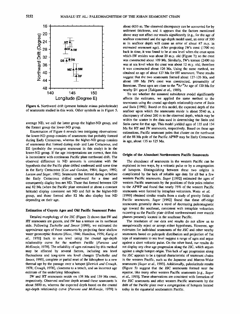
Figure 6. Northward drift (present latitude minus paleolatitude) of seamounts studied in this work. Other symbols as in Figure 5.
average ND, we call the latter group the higher-ND group, and the former group the 1ower-ND group.
Examination of Figure 6 reveals two intriguing observations: the 1ower-ND group consists of seamounts that probably formed during Early Cretaceous, whereas the higher-ND group consists of seamounts that formed during mid- and Late Cretaceous, and D2 (probably the youngest seamount in this study) is in the lower-ND group. If the age interpretations are correct, then this is inconsistent with continuous Pacific plate northward drift. The observed difference in ND amounts is consistent with the
hypothesis that the Pacific plate drifted southward until some time in the Early Cretaceous [Cox and Gordon, 1984; Sager, 1992; Larson and Sager, 1992]. Seamounts that formed during or before the Early Cretaceous drifted southward for a time and consequently display less net ND. Those that formed between 129 and 82 Ma (when the Pacific plate remained at about a constant latitude) display consistent net ND and fall in the higher-ND group, and those formed after 82 Ma also display less ND depending on their age.
Estimation of Guyots Ages and Old Pacific Seamount Poles
Detailed morphology of the JSC (Figure 2) shows that IW and HT seamounts are guyots, and IW has a terrace on its northeast side. Following Tucholke and Smoot [1990], we estimated the approximate ages of these seamounts by projecting these shallow water geomorphic features [Hess, 1946; Hamilton, 1956; Karig et al., 1970] back to sea level using the crustal age-depth relationship curve for the northern Pacific [Parsons and McKenzie, 1978]. The reliability of ages estimated by this method may be affected by several factors, including sea level fluctuations and long-term sea level changes [Tucholke and Smoot, 1990], complete or partial reset of the lithosphere to a new thermal age by the passage over a hotspot [Detrick and Crough, 1978; Crough, 1978], closeness to a trench, and an incorrect age estimate of the underlying lithosphere.
IW and HT seamounts reside on 138 Ma and 139 Ma crust, respectively. Observed seafloor depth around these seamounts is about 5800 m, whereas the expected depth based on the crustal age-depth relationship curve [Parsons and McKenzie, 1978] is
about 6055 m. The observed discrepancy can be accounted for by sediment thickness, and it appears that the factors mentioned above may not affect our results significantly (e.g., for the age of seafloor concerned and the age-depth model used, an error of 300 m in seafloor depth will cause an error of about +7 m.y. in estimated seamount age). After projecting IW's crest (1700 m) back in time, it was found to be at sea level when the crust upon which IW resides was about 29 m.y. old (Figure 7); so the crest was constructed about 109 Ma. Similarly, IW's terrace (2400 m) was at sea level when the crust was about 12 m.y. old; therefore it was constructed about 126 Ma. Using the same method, we obtained an age of about 127 Ma for HT seamount. These results suggest that the two seamounts formed about 127-126 Ma, and about 109 Ma IW's crest was constructed, presumably of limestone. These ages are close to the 4øAr'39Ar age of 120 Ma for nearby D1 guyot [Takigami et al., 1989].
To see whether the assumed subsidence model significantly affects the estimates, we applied the same method to the seamounts using the crustal age-depth relationship curve of Stein and Stein [1992]. Based on this model, the expected depth of the seafloor upon which the seamounts reside is about 5540 m, a discrepancy of about 260 m to the observed depth, which may be within the scatter in the data used in determining the Stein and Stein curve for that age. This model yielded ages of 135 and 134 Ma for HT and IW seamounts, respectively. Based on these age estimations, Pacific seamount poles that cluster on the northwest of the 88 Ma pole of the Pacific APWP may be Early Cretaceous in age, about 135 to 125 Ma.
Origin of the Abundant Northwestern Pacific Seamounts
The abundance of seamounts in the western Pacific can be
explained in two ways, by a volcanic pulse or by a congregation of hotspots. Distinguishing between these two origins is complicated by the lack of reliable age data for all but a few western Pacific seamounts. Sager [ 1992] estimated the ages of western Pacific seamounts by the positions of their poles relative to the APWP and found that nearly 75% of the western Pacific seamounts were formed by intraplate volcanism. Watts et al. [1980] obtained similar results from a study of gravity fields of Pacific seamounts. Sager [1992] found that these off-ridge seamounts generally show a trend of decreasing paleomagnetic age toward the southeast, consistent with intraplate volcanism occurring as the Pacific plate drifted northwestward over mantle plumes presently located in the southeast Pacific.
The resolution of our data and results do not allow us to
unequivocally reject or accept either hypotheses. However, age estimates for individual seamounts of the JSC and other nearby seamounts based on paleopole distribution and projection of flat tops of seamounts to sea level suggest a range of ages and argue against a short volcanic pulse. On the other hand, our results do not display any clear age progression along the JSC, which argues against a single hotspot origin. This lack of age progression along the JSC appears to be a typical characteristic of seamount chains in the western Pacific, such as the Japanese and Marcus-Wake seamounts [Sager et al., 1993]. Additionally, paleolatitude results (Figure 5) suggest that the JSC seamounts formed near the equator, like many other western Pacific seamounts [e.g., Sager et al., 1993]. These observations are consistent with formation of
the JSC seamounts and other western Pacific seamounts by the drift of the Pacific plate over a congregation of hotspots located today in the equatorial southeastern Pacific.

MASALU ET AL.: PALEOMAGNETISM OF THE JOBAN SEAMOUNT CHAIN 5153
1000
I I
2ooo t 3000 -
4000-
5000
6000 -
7000 0
CREST ß
1700 m
TERRACE
ß 2400 m
' NORMAL
,•CRUST
6055 m
I I I ! I I I I
2 3 4 5 6 7 8 9 10 11 11.75 Square root of age in million years
Figure 7. Estimation of guyot seamounts ages. Crestal depth and terrace of IW seamount are backtracked to sea level along the crustal age-depth relationship curve to drive their approximate ages. See text for details.
Conclusions
We analyzed the paleomagnetism of 10 seamounts in the JSC using the seminorm inversion method. The principal results of this study are summarized below.
1. All reliable poles except for IW and HT plot along the 129 to 82 Ma portion of the Pacific APWP, implying the seamounts formed mainly in the mid- to Late Cretaceous period. IW and HT seamounts gave poles located farther to the northwest of the known old end of the APWP, which may indicate Early Cretaceous ages for these seamounts.
2. Seamounts in the JSC appear to have been formed at two different mean paleolatitudes. Furthermore, IW and HT seamounts, located in the middle of the JSC, appear to be older than other seamounts in the chain. Both observations argue against a single hotspot origin.
3. The JSC is segmented into three sections which show that, generally speaking, the central section appears to be the oldest and the southern section the youngest.
4. Pacific seamounts considered to be Early Cretaceous in age appear to display less net ND than mid- to Late Cretaceous seamounts, which can be explained by southward drift of the Pacific plate during the Early Cretaceous.
5. Seamounts in this study appear to have formed near the equator, similar to other western Pacific seamounts. This suggests that the abundant western Pacific seamounts formed when the
Pacific plate drifted over multiple hotspots now located in the equatorial southeastern Pacific.
Acknowledgments. We would like to thank the captain, staff, crew and the scientific party onboard cruises KH90-l and KH92-3 of the R/V Hakuho-maru (Ocean Research Institute/University of Tokyo) for their assistance during the data collection. Our special thanks to Kazuo Kobayashi who was Chief Scientist of both cruises. We gratefully acknowledge the constructive review comments by an associate editor, Richard J. B!akely, Toshitsugu Yamazaki, and an anonymous reviewer who have greatly helped us improve this manuscript. This work has been partly supported by the Japan Society for the Promotion of Science (JSPS) through fellowship and research grant to DCPM. GMT-SYSTEM [Wessel and Smith, 1991] was used in preparing most of the figures in this manuscript.
References
Cox, A., and R. G. Gordon, Paleolatitudes determined from paleomagnetic data from vertical cores, Rev. Geophys., 22, 47-72, 1984.
Crough, S. T., Thermal origin of mid-plate hotspot swells, Geophys. J. R. Astron. Soc., 55, 451-469, 1978.
Crough, S. T., Hotspot epierogeny, Tectonophysics, 61, 321-333, 1979. Detrick, R. S., and S. T. Crough, Island subsidence, hotspots, and
lithospheric thinning, J. Geophys. Res., 83, 1236-1244, 1978. Duncan, R. A., and D. A. Clague, Pacific plate motion recorded by linear
volcanic chains, in The Ocean Basins and Margins, vol. 7A, edited by

5154 MASALU ET AL.: PALEOMAGNETISM OF THE JOBAN SEAMOUNT CHAIN
A. E. M. Nairn, F. G. Stehli, and S. Uyeda, pp. 89-121, Plenum, New York, 1985.
Fleitout, L., and C. Moriceau, Short-wavelength geoid, bathymetry and the convective pattern beneath the Pacific Ocean, Geophys. J. Int., 110, 6-28, 1992.
Francheteau, J., G. G. A. Harrison, J. G. Sclater, and M. L. Richards, Magnetization of Pacific Seamounts: A preliminary polar curve for the northeastern Pacific, J. Geophys., Res., 75, 2035-2061, 1970.
Gordon, R. G., Late Cretaceous apparent polar wander path of the Pacific plate: Evidence of a rapid shift of the Pacific hotspots with respect to the paleomagnetic axis, Geophys. Res. Lett., 10, 709-712, 1983.
Gordon, R. G., Test for bias in paleomagnetically determined paleolatitudes from Pacific plate Deep Sea Drilling Project sediments, J. Geophys. Res., 95, 8397- 8404, 1990.
Hamilton, E. L., Sunken Islands of the mid-Pacific mountains, Mere. Geol. Soc. Am., 64, 1-97, 1956.
Harland, W. B., R. L. Armstrong, A. V. Cox, L. E. Craig, A. G. Smith, and D. G. Smith, A Geologic Time Scale 1989, 263 pp., Cambridge Univ. Press, New York, 1989.
Harrison, C. G. A., R. D. Jarrard, V. Vacquier, and R. L. Larson, Paleomagnetism of Cretaceous Pacific seamounts, Geophys. J. R. Astron. $oc., 42, 859-882, 1975.
Hess, H. H., Drowned ancient islands of the Pacific Basin, Am. J. Sci., 244, 772-791, 1946.
Hildebrand, J. A., and R. L. Parker, Paleomagnetism of Cretaceous Pacific seamounts revisited, J. Geophys. Res., 92, 12695-12712, 1987.
International Association of Geomagnetism and Aeronomy Division 1 Working Group 1, International Geomagnetic Reference Field 1985, J. Geomagn. Geoelectr., 37, 1157-1163, 1985.
Jarrard, R. D., and S. Sasajima, Paleomagnetic synthesis for southeast Asia: Constraints on plate motions, in The Tectonic and Geologic Evolution of Southeast Asian Seas and Islands, Geophys. Monogr. Ser., vol. 23, edited by D. E. Hayes, pp. 293-317, AGU, Washington, D.C., 1980.
Kaneoka, l., K - Ar ages of seamounts along the Japan trench and the effect of acid leaching on the K - Ar age of a dredge submarine rock, Geochem. J., 5, 113-120, 1971.
Karig, D. E., M. N. A. Peterson, and G. C. Shor, Sediment capped guyots in the Mid Pacific mountains, Deep Sea Res., 17, 373-378, 1970.
Kobayashi, K., Preliminary report of the Hakuho Maru Cruise KH90-1, 174 pp., Ocean Res. Inst., Univ. of Tokyo, 1991.
Kobayashi, K., Preliminary report of the Hakuho Maru Cruise KH92-3, 137 pp., Ocean Res. Inst., Univ. of Tokyo, 1993.
Kobayashi, K., et al., Normal faulting of the Daiichi-Kashima Seamount in the Japan Trench revealed by the Kaiko I cruise, Leg 3, Earth Planet. Sci. Lett., 83, 257-266, 1987.
Larson, R. L., and W. Lowrie, Paleomagnetic evidence for motion of the Pacific plate from Leg 32 basalts and magnetic anomalies, Initial Rep. Deep Sea Drill. Proj., 32, 571-577, 1975.
Larson, R. L., and W. W. Sager, Skewness of magnetic anomalies M0 to M29 in the northwestern Pacific, Proc. Ocean Drill. Program Sci. Results, 129, 471-48 l, 1992.
Lincoln, J. M., M. S. Pringle, and I. Premoli-Silva, Early and late Cretaceous volcanism and reef-building in the Marshall Islands, in The Mesozoic Pacific: Geology, Tectonics, and Volcanism, Geophys. Monogr. Ser., vol. 77, edited by M. S. Pringle et al., pp. 279-305, AGU, Washington, D.C., 1993.
Ludwig, W. J., and R. E. Houtz, Isopach map of sediments in the Pacific ocean basin and marginal sea basins, scale: l: 13,999,369, Am. Assoc. of Pet. Geol., Tulsa, Okla., 1979.
Masalu, D.C. P., K. Tamaki, and K. Kobayashi, Paleomagnetism of the Joban seamount chain, northwestern Pacific, J. Geomagn. Geoelectr., 45, 503-534, 1993.
McNutt, M. K., and K. M. Fischer, The South Pacific superswell, in Seamounts, Islands and Atolls, Geophys. Monogr. Ser., vol. 43, edited by B. H. Keating et al., pp. 25-34, AGU, W•shington, D.C., 1987.
McNutt, M. K., E. I. Winterer, W. W. Sager, J. H. Natland, and G. Ito, The Darwin Rise: A Cretaceous superswell?, Geophys. Res. Lett., 17, 1101-1104, 1990.
Menard, H. W., Marine Geology of the Pacific, 271 pp., McGraw-Hill, New York, 1964.
Menard, H. W., Darwin reprise, J. Geophys. Res., 89, 9960-9968, 1984. Nakanishi, M., K. Tamaki, and K. Kobayashi, Mesozoic magnetic
anomaly lineations and seafloor spreading history of the northwestern Pacific, J. Geophys. Res., 94, 15437-15462, 1989.
Ozima, M., I. Kaneoka, and S. Aramaki, K - Ar ages of submarine basalts dredged from seamounts in the western Pacific area and discussion of oceanic crust, Earth Planet. Sci. Lett., 8, 237-249, 1970.
Ozima, M., I. Kaneoka, K. $aito, M. Honda, M. Yanagisawa, and Y. Takigami, Summary of geochronological studies of submarine rocks from the western Pacific Ocean, in Geodynamics of the Western Pacific4ndonesian Region, Geodyn. Ser., vol. 11, edited by T. W. C. Hilde and S. Uyeda, pp. 137-142, AGU, Washington, D.C., 1983.
Parker, R. L., A statistical theory of seamount magnetism, J. Geophys. Res., 93, 3105-3115, 1988.
Parker, R. L., L. Shure, and J. A. Hildebrand, The application inverse theory to seamount magnetism, Rev. Geophys., 25, 17-40, 1987.
Parsons, B., and D. McKenzie, Mantle convection and the thermal
structure of the plates, J. Geophys. Res., 83, 4485-4496, 1978. Pautot, G., et al., Deep-sea submersible survey in the Suruga, Sagami and
Japan Trenches: Preliminary results of the 1985 KAIKO cruise, Leg 2, Earth Planet. Sci. Lett., 83, 300-312, 1987.
Petronotis, K. E., R. G. Gordon, and G. D. Acton, Determining palaeomagnetic poles and anomalous skewness from marine magnetic anomaly skewness data from a single plate, Geophys. J. Int., 109, 209-224, 1992.
Plouff, D., Gravity and magnetic fields of polygonal prisms and applications to magnetic terrain corrections, Geophysics, 41,727-741, 1976.
Rea, D. K., and T. L. Vallier, Two Cretaceous volcanic episodes in the western Pacific Ocean, Geol. Soc. Am. Bull., 94, 1430-1437, 1983.
Sager, W. W., Seamount age estimates from paleomagnetism and their implications for the history of volcanism on the Pacific plate, in Geology and Oj•hore Mineral Resources of the Central Pacific Basin, Earth Sci. $er., vol. 14, edited by B. H. Keating and B. Bolton, pp. 21-37, Circum-Pacific Counc. for Energy and Miner. Resour., New York, Springer-Verlag, 1992.
Sager, W. W., and B. H. Keating, Paleomagnetism of Line Islands seamounts: Evidence for late Cretaceous and early tertiary volcanism, J. Geophys. Res., 89, 11135-11151, 1984.
Sager, W. W., and M. S. Pringle, Paleomagnetic constraints on the origin and evolution of the Musicians and South Hawaii seamounts, Central
Pacific Ocean, in Seamounts, Islands and Atolls, Geophys. Monogr. $er., vol. 43, edited by B. H. Keating et al., pp. 133-162, AGU, Washington, D.C., 1987.
Sager, W. W., and M. S. Pringle, Mid-Cretaceous to early Tertiary apparent polar wander path of the Pacific plate, J. Geophys. Res., 93, ii753-11771, 1988.
Sager, W. W., R. A. Duncan, and D. W. Handschumacher, Paleomagnetism of the Japanese and Marcus-Wake Seamounts, Western Pacific Ocean, in The Mesozoic Pacific: Geology, Tectonics, and Volcanism, Geophys. Monogr. $er., vol. 77, edited by M. S. Pringle et al., pp. 401-435, AGU, Washington, D.C., 1993.
Schlanger, S. O., H. C. Jenkyns, and I. Premoli-Silva, Volcanism and vertical tectonics in the Pacific basin related to global Cretaceous transgressions, Earth Planet. $ci. Lett., 52, 435-449, 1981.
Schouten, H., and S. C. Cande, Palaeomagnetic poles from marine magnetic anomalies, Geophys. J. R. Astron. $oc., 44, 567-575, 1976.
Stein, C. A., and S. Stein, A model for the global variation in oceanic depth and heat flow with lithospheric age, Nature, 359, 123-129, 1992.
Takigami, Y., I. Kaneoka, T. Ishii, and Y. Nakamura, 4øAr - 39Ar ages of igneous rocks recovered from Diichi-Kashima and Erimo seamounts during the KAIKO project, Palaeogeogr. Palaeoclimatol. Palaeoecol., 71, 71-81, 1989.
Talwani, M., Computation with the help of a digital computer of magnetic anomalies caused by bodies of arbitrary shape, Geophysics, 30, 797-817, 1965.
Tarduno, J. A., and W. W. Sager, Polar standstill of the Mid-Cretaceous

MASALU ET AL.: PALEOMAGNETISM OF THE JOBAN SEAMOUNT CHAIN 5155
Pacific plate and its geodynamic implications, Science, 269, 956-959, 1995.
Tarduno, J. A., W. V. Sliter, L. Kroenke, M. Leckie, H. Mayer, J. J. Mahoney, R. Musgrave, M. Storey, and E. L. Winterer, Rapid formation of Ontong Java Plateau by Aptian mantle plume volcanism, Science, 254, 399-403, 1991.
Tomoda, Y., Rejbrence Book for Gravity, Magnetic and Bathymetric Data of the Pacific Ocean and Adjacent Seas, 1963 - 71, 158 pp., Univ. of Tokyo Press, 1974.
Tucholke, B., and N. C. Smoot, Evidence for age and evolution of Corner seamounts and Great Meteor Seamount Chain from multibeam
bathymetry, J. Geophys. Res., 95, 17555-17569, 1990. Ueda, Y., Geomagnetic study on seamounts Daiiti-Kashima and Katori
with special reference to a subduction process of Daiiti-Kashima, J. Geornagn. Geoelectr., 37, 601-625, 1985.
Uyeda, S., and M. L. Richards, Magnetization of four Pacific seamounts near the Japanese Islands, Bull. Earthquake Res. Inst. Univ. Tokyo, 44, 179-213, 1966.
Vacquier, V., A machine method for computing the magnetization of a uniformly magnetized body from its shape and a magnetic survey, in Benedum Earth Magnetism Symposium, pp. 123-137, Univ. of Pittsburgh Press, Pittsburgh, Pa., 1962.
van Waasbergen, R. J., and E. L. Winterer, Summit geomorphology of western Pacific guyots, in The Mesozoic Pacific: Geology, Tectonics, and Volcanism, Geophys. Monogr. Ser., vol. 77, edited by M. S. Pringle et al., pp. 335-366, AGU, Washington, D.C., 1993.
Watts, A. B., and N.M. Ribe, On geoid heights and the flexure of the lithosphere at seamounts, J. Geophys. Res., 89, 11152-11170, 1984.
Watts, A. B, J. H. Bodine, and N.M. Ribe, Observations of flexure and
the geological evolution of the Pacific Ocean basin, Nature, 283, 532-537, 1980.
Wessel, P., and W. H. F. Smith, Free software helps map and display data, Eos Trans. AGU, 72, 445-446, 1991.
Winterer, E. L., Anomalies in the tectonic evolution of the Pacific, in The
Geophysics of the Pacific Ocean Basin and Its Margin: A Volume in Honor of George P. Wollard, Geophys. Monogr. Ser., vol. 19, edited by G. H. Sutton, M. H. Manghnani, and R. Moberly, pp. 269-278, AGU, Washington, D.C., 1976.
Winterer, E. L., J. H. Natland, R. J. van Waasbergen, R. A. Duncan, M. K. McNutt, C. J. Wolfe, I. Premoli-Silva, W. W. Sager, and W. V. Sliter, Cretaceous guyots in the northwest Pacific: An overview of their geology and geophysics, in The Mesozoic Pacific: Geology, Tectonics, and Volcanism, Geophys. Monogr. Ser., vol. 77, edited by M. S. Pringle et al., AGU, Washington, D.C., 1993.
Wolfe, C. J., and M. K. McNutt, Compensation of Cretaceous seamounts of the Darwin Rise, northwest Pacific Ocean, J. Geophys. Res., 96, 2363-2374, 1991.
Yamazaki, T., Magnetization of Erimo seamount, J. Geomagn. Geoelectr., 40, 715-728, 1988.
D.C. P. Masalu and K. Tamaki, Ocean Research Institute, University of Tokyo, 1-15-1 Minamidai, Nakano-ku, Tokyo 164, Japan. (e-mail: [email protected]; [email protected])
W. W. Sager, Department of Oceanography, Texas A&M University, College Station, TX 77843-3146. (e-mail: sager•ocean.tamu.edu)
(Received August 12, 1996; revised November 11, 1996; accepted November 19, 1996.)