GEOLOGY AND PERMIAN PALEOMAGNETISM OF THE ...
57
A1ededelingen van het A1ineralogisch-Geologisch Instituut der Rijksuniversiteit te Utrecht GEOLOGY AND PERMIAN PALEOMAGNETISM OF THE MERANO REGION PROVINCE QF BOLZANO, N. ITALY
-
Upload
khangminh22 -
Category
Documents
-
view
2 -
download
0
Transcript of GEOLOGY AND PERMIAN PALEOMAGNETISM OF THE ...

A1ededelingen vanhet A1ineralogisch-Geologisch Instituut der Rijksuniversiteit
te Utrecht
GEOLOGY AND PERMIANPALEOMAGNETISM OF THE MERANO REGION
PROVINCE QF BOLZANO, N. ITALY

No; 1 Boer, J. C. den, 1957: Etude geologique et paleomag-n6tiqJle-des Moniagnes du Coiron, Ardeche, France f 7.5_0
No.2 Landewijk, J. E. J. M. van, 1957: Npmograms for geolo-gical problems (with portfolio of plates) . f 10.-
No. 3 Palm, Q. A., 195R: Les roches cristallines des Cevennesmedianes a hauteur de Largentiere, Ardeche, France f 12.50
No.4 Dietzel, G. F. L., 1960: Geology and permian paleomag-netism of the Merano Region, province of Bolzano,N.Italy f 10.-
. No. 5 Hilten, D. van, 1960: Geology and permian paleomagne-tism of the Val-di-Non Area, W. Dolomites, N. Italy(in press)

"Geologica Ultraiectina" is een ongeregelde serie, hoofdzakelijk bestemd voor het opnemen van dissertaties afkomstig uit het Mineralogisch-Geologisch Instituut der Rijksuniversiteit te Utrecht. "Geologica Ultraiectina" is een voortzetting der "Geologisch-Geografische Mededelingen: Geologische Reeks", welker uitgave in 1947 gestopt is. "Geologica Ultraiectina" wordt toegezonden aan aIle instellingen die ruilverkeer onderhouden met het Utrechtse instituut. Losse nummers zijn - voor zover de voorraad strekt - verkrijgbaar bij de administratie van het instituut, Oude Gracht 320, Utrecht.
"Geologica Ultraiectina" is an odd series with the main purpose of publishing D. Sc. theses from the "Mineralogisch-Geologisch lnstituut" of the Utrecht State University. "Geologica Ultraiectina" is a continuation of the "Geologisch-Geografische Mededelingen: Geologische Reeks", which came to an end in 1947. "Geologica Ultraiectina" is sent to all departments which exchange publications with the Utrecht institute. Separate copies - when available - may be obtained from the administrator of the institute, Oude Gracht 320, Utrecht.
"Geologica Ultraiectina" est une serie irreguliere de memoires qui vise essentiellement a publier des theses de doctorat en Sciences presentees au "MineralogischGeologisch Instituut" de l'Universite d'Etat d'Utrecht. "Geologica Ultraiectina" continue la serie des "Geologisch-Geografische Mededelingen: Geologische Reeks", achevee en 1947. Tout laboratoire faisant des echanges de publications avec l'institut d'Utrecht recevra "Geologica Ultraiectina". Les exemplaires disponibles sont deposes chez l'administrateur de l'institut, Oude Gracht 320, Utrecht.

PROMOTOR: PROF. DR. IR. W. VAN BEMMELEN
GEOLOGICA ULTRAIECTINA
Mededelingen van het Mineralogisch-Geologisch Instituut der Rijksuniversiteit
te Utrecht
No.4
GEOLOGY AND PERMIAN
PALEOMAGNETISM OF THE MERANO REGION
PROVINCE OF BOLZANO, N. ITALY
G. F. L. DIETZEL
1960
DRUK: UlTGEVERSMAATSCHAPPlJ NEERLANDlA - UTRECHT

Voorwoord
Bij de voltooiing van mijn academische studie wil ik mijn leermeesters van de Utrechtse Universiteit danken voor de wetenschappelijke vorming welke ik heb mogen ontvangen. Allen, die er toe hebben bijgedragen dat mijn studietijd een onvergetelijke zal blijven, betuig ik op deze plaats mijn dank.
Hooggeleerde van Bemmelen, dat U mijn promotor hebt willen zijn, beschouw ik als een groot voorrecht. Ik ben U zeer dankbaar voor de grote aandacht die U aan dit proefschrift heeft geschonken. Het vertrouwen dat U in mij stelde en de vrijheid welke U mij gaf tijdens de voorbereiding van dit proefschrift, heb ik ten zeerste gewaardeerd. De wijze, waarop U tot mijn persoonlijke ontwikkeling hebt bijgedragen, is voor mij van onschatbare waarde geweest. De uren doorgebracht bij U en Uw vrouw, zullen steeds tot mijn beste herinneringen behoren.
Hooggeleerde Rutten, van Uw zorgvuldig geformuleerde voordrachten in de AIgemene Geologie heb ik veel geleerd. Voor de faciliteiten, welke mij door U op het Mineralogisch-Geologisch Instituut zijn verleend, ben ik U zeer erkentelijk.
U, Hooggeleerde Nieuwenkamp, dank ik voor Uw inspirerend onderricht in de Petrologie.
Hooggeleerde von Koenigswald, voor Uw onderwijs in de Stratigrafie en de Paleontologie, ben ik U dankbaar.
Hooggeleerde Vening Meinesz, ik beschouw het als een groot voorrecht, van U onderricht in de Algemene Geofysica te hebben mogen ontvangen. Het prettige contact met U, zal ik blijven waarderen.
Hooggeleerde Scholte, het was een genoegen Uw boeiende voordrachten over de Algemene Geofysica te horen.
Hooggeleerde Veldkamp, voor de door U verleende gastvrijheid en faciliteiten op de afdeling Geofysica van het K.N.M.I. te de Bilt, ben ik U zeer erkentelijk. Uw belangstelling en opbouwende kritiek betreffende het paleomagnetische gedeelte van dit proefschrift, zijn voor mij van grote waarde geweest.
Weledelgestrenge Warners, U opende voor mij de deuren van het K.N.M.I. te de Bilt. Hiervoor ben ik U dankbaar.
Waarde As, Geleerde Zijderveld, U beiden dank ik voor de prettige wijze, waarop U mij vertrouwd hebt gemaakt met de uitvoering van magnetisatiemetingen. Uw hulp en interesse voor mijn werk waren voor mij een grote steun.
Zeergeleerde Palm, Uw hulp bij het petrografische gedeelte van dit proefschrift heb ik zeer gewaardeerd.
Weledelgestrenge van Lanschot, Zeergeleerde van de Velde, Uw hulpvaardige adviezen zijn voor mij onmisbaar geweest. U kunt overtuigd zijn van mijn blijvende dankbaarheid.
Waarde Paap, van Moort en Schuyff, het is mijn oprechte wens, dat onze vriendschapsbanden ook in de toekomst zullen blijven bestaan.
7

Voor de verzorging van de tekeningen in dit proefschrift ben ik de Heren de Lang en Peek veel dank verschuldigd.
Geachte Mevrouw Eykelboom, U hebt de verzorging der italiaanse vertaling van de samenvatting van dit proefschrift op U willen nemen. Ik dank U hartelijk voor deze waardevolle hulp.
Geachte Mejuffrouw van as, Mejuffrouw Wories, waarde van Dijk en van Toorenenbergen, op vele wijzen ontving ik Uw hulp. Ook U kunt overtuigd zijn van mijn erkentelijkheid.
De geldelijke steun van het Rijk stelde mij in staat, dit proefschrift voor te bereiden. Dit stemt mij tot grote dankbaarheid.
De Stichting Molengraaff-Fonds ben ik erkentelijk voor de financieIe steun, welke het mij mogelijk maakte in 1959 de excursie van de Deutsche Geologische Vereinigung naar Noord-Italie mee te maken.
8

Aan mijn vrouw

Contents
SAMENVATTING 11 2. Judicaria fault, southwest of Merano 28
3. Judicaria fault, northeast of Merano 29RIASSUNTO 12 4. Foiana fault, southwest of Merano . 29
SUMMARY 13 5. Minor tectonic structures southeast of the Foiana fault . 30INTRODUCTION 14
6. Nova fault, northeast of Merano . 31 CHAPTER I Stratigraphy and petrography
7. Minor faults in the tonalite massif A. Introduction 16 of Ivigna . 31
8. Transcurrent faults of Merano . 32B. Metamorphic basement complex 16 9. Minor low-angle thrust faults of Merano 34
1. Crystalline gneisses, schists, and 10. Oblique-slip faults of Riobianco . 35quartzites . 16 11. Marginal fault of the Permian 2. Sericite-chlorite schists of the town of
Volcanic Series . 35Merano 17 12. Ribs and minor fold-axes (b-axes) in 3. Mylonites. 17
the metamorphic rocks northwest of the 4. Quartz-phyllite Series northwest of the Judicaria fault 36
Monte Croce tonalite . 18 13. Ribs (b-axes) in the western marginal
5. Crystalline schists of the Schneeberg part of the Quartz-phyllite Series of Zone 18 Bressanone 36
6. Western marginal part of the Quartz 14. Tertiary alpine fold trend in the Permophyllite Series of Bressanone . 18 Triassic Series 37
C. Permian 19 B. Discussion of the character of the Judicaria fault . 391. Basal Series 19
2. Volcanic Series 20 CHAPTER III Structural evolution 3. Gardena Formation 22
A. Introduction 40 D. Lower Triassic (Werfenian) 23
B. Genetical sections 40 E. Tertiary tonalite massifs. 23
1. Subphase a 40 1. Monte Croce tonalite 23 2. Subphase b 42 2. Dykes of the Monte Croce massif 24 3. Subphase c 42 3. Contact metamorphic rocks of the
Monte Croce massif. 24 CHAPTER IV Permian Paleomagnetism
4. Tonalitic gneiss . 24 1. Introduction 43 5. Ivigna tonalite 25 2. Results of the primary measurements 43 6. Dykes southeast of the Ivigna massif 26 3. The influence of progressive demagne7. Contact metamorphic rocks of the tization on the remanent magnetization 45
Ivigna massif . 26 4. Results of the measurements after 8. The age of the Monte Croce and Ivigna partial demagnetization combined with
tonalite massifs 26 tectonic correction . 47
5. The distribution of the direction of F. Quaternary . 27 magnetization in a vertical section . 50
CHAPTER II Structure 6. The position of the permian magnetic pole 51
A. Tectonic elements 28
1. General tectonic situation . 28 LITERATURE REFERENCES 55
9
Samenvatting
Geologie.
De facies van de Permo-Trias nabij Merano komt
overeen met die van de Zuidelijke Dolomieten. Structureel beschouwd, behoort de omgeving van Me
rano tot de zuidvleugel van de oostalpiene geanticli
naal. De zuidflank van deze geanticlinaal wordt hij
Merano doorsneden door een belangrijke, ongeveer
140 km lange breuk met een ZW-NO strekking, welke de Judicarienbreuk genoemd wordt (fig. 2, p. 15).
In vroegere syntheses van de structuur van de Oost
Alpen werd de Judicarienbreuk over het algemeen beschouwd als een linksdraaiende horizontale transversaalverschuiving. Deze dwarsverschuiving zou de
grenslijn tussen de noordelijke of alpiene starn sensu
stricto en de zuidelijke of dinarische starn van het alpiene gebergtesysteem (sensu largo) verplaatst heb
ben. Het bedrag van de verplaatsing der Insubrischeof Tonalelijn ten westen van de Judicarienbreuk naar
haar voortzetting in de Pusteria-Draulijn ten oosten
er van zou 80 km bedragen.
Deze opvatting wordt echter niet bevestigd door de geologische bouw en de kleintektonische structuren
van het gebied rondom Merano. De Judicarienbreuk treedt aan de dag als een steile opschuiving met een
noordwest gerichte helling (fig. 27, profielen I, II,
VI, VII en IX, p. 38). De tektonische verschijnselen
nabij de Judicarienbreuk wijzen er echter op, dat de
ze breuk oorspronkelijk een afschuiving was met een
zuidoost gerichte helling van het breukvlak (fig. 28, subfase b, p. 41). Het verticaal bedrag van de ver
plaatsing bedroeg in orde van grootte 5-9 km. Het ontstaan vande breuk vergemakkelijkte de diapirische opstijging van tonalietisch magma, hetgeen
resulteerde in de vorming van de Monte Croce-, Ivig
na- en Bressanonemassieven (fig. 28, subfase c). Deze plutonische massieven behoren tot de periadriatische tonalietintrusies, welke gedurende de midden-tertiaire
of insubrische fase van de alpiene gebergtevorming
langs de bovengenoemde Alpen-Dinaridengrenslijn
omhoog gedrongen zijn. Waarschijnlijk als gevolg van een magma-tektonisch massacircuit verkreeg het bo
venste deel van de Judicarienbreuk gedurende de in
trusie van de tonalietlichamen een noordwest gerichte
helling (fig. 28, subfase c).
De geologische verschijnselen van de omgeving van
Merano zijn te verklaren met van Bemmelen's opvattingen betreffende de structurele evolutie der Oost
Alpen (van Bemmelen, 1957, 1960-b, 1960-c).
Paleomagnetisme
De paleomagnetische eigenschappen van de permi
sche kwartsporfieren welke de noordwestelijke rand vormen van de vu1canische provincie van Bolzano,
werden onderzocht.
Progressieve demagnetisatieexperimenten met geo
rienteerde gesteentemonsters, uitgevoerd met behulp van magnetische wisselvelden, wijzen er op dat de re
manente magnetisatie van de kwartsporfieren samengesteld is uit twee componenten, nl. een relatief onstabiele en een stabiele component. De stabiele com
ponent vertegenwoordigt waarschijnlijk de oorspronkelijke permische magnetisatie, welke verkregen werd
gedurende de afkoeling van de eruptieprodukten. De onstabiele component was waarschijnlijk het gevolg van inductie van het post-permische magnetische
veld. Deze secundaire componenten kan men verwijderen door de gesteentemonsters te onderwer
pen aan een magnetisch wisselveld. De oorspronke
lijke spreiding van de magnetisatierichtingen werd
door deze magnetische "reiniging" aanzienlijk gereduceerd. Uit de gemiddelde magnetisatierichting (dec1inatie
1640 en inclinatie - 7,5°) werd de permische magne
tische zuidpoolpositie bepaald (146° westerlengte
en 45° noorderbreedte). Ofschoon de geografische breedte van deze poolpositie in overeenstemming is met die van de polen welke bepaaJd zijn door metin
gen in andere permische gesteenten afkomstig van het europese continent, verschilt de lengte er aanzienlijk
van, nl. ongeveer 40° (fig. 42, p. 53).
Voor de oorzaak van de bovengenoemde afwijking
kunnen de volgende beide mogelijkheden worden ge
noemd:
De afwijking van de noorditaliaanse permische magnetische pool kan het resultaat zijn van een seculaire variatie; ook is een geotektonische oorzaak mogeIijk,
zoals b.v. een tegen de wijzers van de klok in gerichte rotatie van het gebied Merano om een verticale as.
11

Riassunto
Geologia
Stratograficamente, Ie facies dei depositi permo-triassici della regione di Merano e strettamente connessa a quella delle Dolomiti Meridionali.
Strutturalmente, la regione di Merano appartiene ai fianchi meridionali della geanticlinale alpini orientali.
La parte sud della geanticlinale alpina e tagliata nella regione di Merano da una dislocazione maggiore con
una direzione sudovest-nordest, chiamata linia della Judicaria (fig. 2, p. 15).
Nelle sintesi anteriori della struttura delle Alpi Orientali, la linea della Judicaria fu generalmento considerata quale una faglia con prevalente movimento horizontale sinistro. Questa dislocazione trasversale avrebbe spostato il limite (i.e. il confine alpino-dinarico) fra iJ ramo nordico 0 alpino in senso stricto e il ramo meridionale 0 dinarico del Sistema Montano Alpino
in senso largo. L'ammontare di spostamento fra l'In
subric 0 linea del Tonale nell'ovest e la linea Pusteria-Drau all'est, sarebbe di circa 80 km. Ad ogni modo, la struttura e l'analisi dei fenomeni tettonici miniori nella regione di Merano non confer
rna questa concetto. A cause dell'emergenza della faglia della Judicaria, il suo carattere attuale e quella di una faglia inverso ripidamente inclinata con una inclinazione nordovest (fig. 27, profili I, II, VI, VII, e IX, p. 38). Ad ogni modo, secondo i fenomeni tet
tonici incontrati vicino alIa linea della Judicaria, questa dislocazione era una faglia originalmente normale con una inclinazione sudest (fig. 28, subfase b, p. 41). II componente verticale della spostamento
della dislocazione ammonta a 5-9 km vicino alla citta di Merano. La formazione della dislocazione facilito la salita diazpirica della magma tonalitica, causando la formazione dei massicci di Monte Croce, lvigna, e Bressanone (fig. 28, subfase c). Queste masse plutoniche appartengono alIa serie di tonalite periadriatiche, che ha intruso durante il medio-terziario 0 fase insubrica dell'orogenesi alpino. Durante l'intrusione dei corpi tonalitici la parte superiore della faglia della Judicaria assunse una ripida
inclinazione nordovest, probabilmente perche da un
massa-circuiti magma-tettonica (fig. 28, subfase c). La data geologica dell'area di Merano combacia nel
concetto di van Bemmelen dell'evoluzione strutturale alpina dell 'est (van Bemmelen, 1957, 1960-b, 1960-c).
Paleomagnetismo
Le proprieta paleomagnetica dei porfidi quarziferi
permiani che si trovano al margine nordovest della provincia vulcanica di Bolzano, venne studiata. Esperimenti progressivi di parziale demagnetizazione su campioni di orientazione, col mezzo dell'altemare
campi magnetici indicano che la magnetizazione rimanente dei porfidi quarziferi e composta di due componenti, e cioe, un componente relativamente instabile, ed un componente stabile. II componente stabile probabilmente rappresenta la magnetizazione permiana acquistata nel raffreddamento dei prodotti vulcanici. II componente instabile probabilmente risulta dalla induzione dei campi magnetici post-per
miani. Questi componenti secondari possono venir tolti coll'esporre i campioni a campi magnetici alternanti. Questa procedura di "pulizia" magnetica riduce grandemente la dispersione delle direzioni primarie della magnetizazione. La posizione del polo sud-magnetico permiano dedotto dalla media direzione di magnetizazione (declinazione 164°, inclinazione - 7,5°) e 146° We 45° N.
Malgrado attraverso la lattitudine di questa posizione del polo viene convenuto con i poli di altre roccie permiane del continente europeo, la sua longitudine devia considerevolmente dalle posizioni polari mediane europee, e cioe circa 40° (fig. 42, p. 53).
Le due seguenti possibilita per la stessa causa della sunominata deviazione puo venir suggerita: Le divergenze del polo magnetico permiano del Nord Italia potrebbero essere i risultati di variazoni seco
lari; rna anche una ragione geotettonica potrebbe essere possibile, per esempio una rotazione contraria all'orologio della regione di Merano attomo all'asse
verticale.
12

Summary
Geology
Stratigraphically, the facies of the permo-triassic de
posits of the Merano area is closely connected with that of the Southern Dolomites. Structurally, the Merano region belongs to the south
ern flank of the east-alpine geanticline. The southern
part of the alpine geanticline is cut in the Merano region by a major fault with a southwest-northeast trend, called Judicaria fault (fig. 2, p. 15).
In former syntheses of the structure of the Eastern Alps, the Judicaria fault has generally been conside
red as a sinistral transcurrent or wrench fault. This transcurrent fault was assumed to have displaced the suture line between the northern or alpine branch sensu stricto and the southern or dinaric branch of the Alpine Mountain System (sensu largo). The net slip between the Insubric or Tonale line in the west and the Pusteria-Drau line in the east would then be
about 80 km. However, the structure and the analysis of the minor tectonic features in the Merano area do not confirm
this concept. On account of the outcrop of the Judicaria fault its present character is that of a steep upthrust with a northwestern dip (fig. 27, sections I,ll, VI, VII and IX, p. 38). However, according to the
tectonic features encountered close to the Judicaria fault, this fault was originally a normal fault with a southeastern dip (fig. 28, subphase b, p. 41). The ver
tical component of the displacement of the fault amounts to 5-9 km near the town of Merano. The formation of the fault facilitated the diapiric ascent of tonalitic magma, causing the emplacement of the massifs of Monte Croce, Ivigna, and Bressanone (fig. 28, subphase c). These plutonic masses belong to the peri-adriatic series of tonalites, which most probably, intruded during the mid-tertiary or insu
bric phase of the alpine orogenesis. During the intrusion of the tonalitic bodies the upper part of the Judicaria fault assumed a steep northwestern dip, probably because of a magma-tectonic mass-circuit (fig.
28, subphase c).
The geological data of the Merano area fit in with van Bemmelen's concept of the east-alpine structural evolution (van Bemmelen, 1957, 1960-b, 1960-c).
Paleomagnetism
A study was made of the paleomagnetic properties of the permian quartz-porphyries occurring at the north
western margin of the Bolzano volcanic province. Progressive partial demagnetization experiments on orientated samples, by means of alternating magnetic
fields indicate that the remanent magnetization of the quartz-porphyries is composed of two components, namely a relatively unstable component, and a stable component. The stable component probably repre
sents the original permian magnetization acquired upon cooling of the volcanics. The unstable compo
nent probably resulted from the induction of postpermian magnetic fields. These secondary components can be removed by exposing the samples to alternating magnetic fields. This procedure of magnetic "cleaning" greatly reduces the scatter of the primary directions of magnetization. The permian magnetic south pole position deduced from the average direction of magnetization (declination 164°, inclination -7,5°) is 146 0 Wand 45° N.
Though the latitude of this pole position is in agreement with that of the poles inferred from other permian rocks from the european continent, its longitude deviates appreciably from that of the average european permian pole position, namely about 40° (fig. 42, p. 53). The following two possibilities for the cause of the above mentioned deviation may be suggested: The divergence of the north italian permian magnetic pole might be the result of secular variation; but also a geotectonic cause might be possible, for instance a counter-clockwise rotation of the Merano region a
round a vertical axis.
13

Introduction
The reported history of the previous geological investigations in Northern Italy reaches back as far as 1558 (von Klebelsberg, 1935, p. 1). Von Klebelsberg gives a detailed outline of the history of the geological research in this region during the period 1558-1935 (1935, p. 1-33). The first detailed geological map (scale 1 : 37.500) of the Merano region appeared in 1875 (Fuchs, 1875). The geological survey of the region of the tonalite massif of Ivigna was carried on by Teller (1878, 1881). Important petrographical data of the tonalite
47·
massifs of Monte Croce and Ivigna and their metamorphic aureoles were reported by Grubenmann (1896-a) and Kiinzli (1899). The complex of metamorphic rocks situated northwest of the M.Croce massif was studied both structurally and petrographically by Hammer (1904). Thereafter, Sander (1906) did geological work in the region of the Bressanone massif (including its southwestern extension into the Ivigna tonalite). More recently, detailed petrographical data of the M.Croce tonalite and its contact metamorphic aureole have been supplied by Andreatta
54' N. Lat
o Zurich
Switzerland
~-\, '-,
'-'
-. ,,
'-' /
Innsbruck o
Austria
y
Germany
, -~
.... -'
at
-' / ,, ,, ,
\ ' \...,1'
,, , '-,
Padua o
,,
o Mi lano
50
(XI 0
w 0
I'l
r •C\I
0 :::J
IG
I i
o 25 75 100 km 0
Bologna
44° 22' N. La t Fig. 1. Location of the geological maps (I and II) of the Merano region.
14

Bressanone
,
N. Lal . .' . : . : . :.: ere" nero ....
46° 15' N. Lal.
o o
o all
o--illl w
. . . . Dolomites·
-..... -- ,. Predazzo ...... ~
" - ."..., - "".
\ -" .... , . i i i i
o 10 1S 20 2Skm 5 6
Fig. 2. Geological sketch-map of the Adige-lsarco region. The location of this sketch-map is given by fig. 1. 1. Meso-katametamorphic rocks. 2. Epi-mesometamorphic rocks. 3. Permian Volcanic Series. 4. Post-permian alpine formations. 5. Tertiary tonalite massifs of Monte Croce (C), lvigna (1), and Bressanone (B). 6. Quaternary.
1+++1
(1937) and Karl (1959). Finally, the geological investigations done by Dal Piaz (1942) in the Merano region have to be mentioned. The geological data (including an inventory of the minor tectonic features) presented in this thesis were collected during the summers of 1957 and 1958. The surveyed region is shown by the geological maps I and II. The position of these maps is seen in fig. 1.
Geologically, the wider regional setting of the Merano area is shown by fig. 2. In order to investigate the paleomagnetic properties of the permian quartz-porphyries of the northwestern part of the Balzano volcanic province, 51 orientated samples from these volcanic rocks were taken during the summers of 1958 and 1959.
15

CHAPTER I
Stratigraphy and Petrography
A. INTRODUCTION
A general outline of the stratigraphy of the Merano Tahle I, Schematic outline of the stratigraphy of the region is given in table 1. Merano region
The upper permian marine Bellerophon Horizon, jurassic, cretaceous, and tertiary sediments are not to be Quaternary Moraines and alluvial deposits
found in the Merano area. In this area, the Tertiary is represented by the tonalite intrusions of M.Croce
T ' \ Mid-tertiary orogenic phaseter lary. . T I" , fMC d I ' I ona Ite mtruslOns 0 ,roce an vigna
and Ivigna. Cretaceous*) Mid-cretaceous orogenic phase We did not make a close study of the middle triassic Jurassic*) Anisian and Ladinian occurring at the southern \ Upper Triassicx) margin of the geological map (sheet I). Triassic. . ALa~i?ian? , . (Middle Triassic) Of the pre-middle triassic formations a short litholo J mSlan S
( Werfenian. . (Lower Triassic) gical description is given in the following pages.
lBellerophon Horizon (Upper Permian)*) Gardena Formation
Permian. . Volcanic Series Basal Series Hercynian orogenic phase
Metamorphic() Quartz-phyllite Series basement \ C II' h' d .J rysta me sc IStS an gneisses
complex \
*) Not present in the Merano region
B. METAMORPHIC BASEMENT COMPLEX
1. Crystalline gneisses, schists, and quartzites (oligoclase) - biotite - muscovite schist about 2 km north of the Ivigna summit (2.552 m).
These rocks occur northwest of the M.Croce and We observed three layers of amphibolites (table 2), Ivigna tonalites (sheet I and II). also mentioned by Andreatta (1937, p. 318). AccesThe mineralogical composition of these rocks (in sory minerals in these rocks are opaque minerals, tenths of volume units) is given in table 2. apatite, calcite, and titanite. Some sillimanite has been found in a plagioclase Approximately 100 m northwest of the Ivigna tonalite
Table 2. Mineralogical composition of the crystalline rocks northwest of the M.Croce and Ivigna tonalites
Rocks Minerals
Gneisses Schists Quartzites Amphibolites
Quartz , Oligoclase (15-30 % an,)
2 6
2 R
3 7
2 8
3 7
5 3
5 3
4 3
6 2
5 4
9 9 1
8 1
8 10 1 4
Microcline Muscovite Chlorite. Biotite 2 2 2 3 2 Amphibole 7 5 5 Epidote , 3 3
Accessory minerals: opaque minerals, apatite, epidote, garnet, calcite, and titanite =, less than 5%
16

this complex of siliceous crystalline rocks contains bands of marble. Calcite is the principal constituent in these rocks; accessory minerals are quartz, muscovite, and pyrite. Near to the northwestern boundaries of the M.Croce and Ivigna tonalites the crystalline rocks are mylonitized. In these rocks, the quartz generally occurs in crushed crystals and it shows a pronounced wavy extinction. In many cases, the micas are bent. Andreatta (1937, p. 316, 317) reports in the crystalline rocks northwest of the M.Croce tonalite garnet, staurolite, kyanite, tourmaline, and sometimes sillimanite. According to Andreatta (1937, p. 316), the plagioclase constituent in the crystalline rocks northwest of the M.Croce tonalite massif contains 25-30% anorthite, which points to oligoclase. Andreatta's measurements of the percentage of anorthite in the plagioclase is in agreement with our data (table 2). The crystalline gneisses, schists, and quartzites, which occur northwest of the M.Croce and Ivigna tonalites" may be considered as a complex of meso-katazonal regional metamorphism.
2. Sericite-chlorite schists of the town of Merano
In the town of Merano, between the San Zeno Castle at the Passirio Valley and the Pulver Tower at the Tappeiner Promenade, we found a zone of sericitechlorite schists between the most western exposure of the lvigna tonalite and a band of tonalitic gneiss (fig. 3). The main constituents of these sericite-chlorite schists are sericite and chlorite, which form together 80 to 90 % of the rock. Subordinate constituents are quartz, biotite, muscovite, and plagioclase (oligoclase). Accessory minerals are opaque minerals, apatite, amphibole, garnet and andalusite. Chlorite occurs in patches containing ore inclusions, which are often arranged paraHel to the cleavage. Biotite, in some samples bleached, occurs in crystals with irregular margins which contain ore inclusions, mostly arranged parallel to the cleavage. are grains form very often a rim around biotite. Biotite may also contain chlorite, occurring in spots and along the cleavage; sometimes chlorite forms a rim around the biotite crystals. We observed remnants of biotite in patches of chlorite. Apparently the chlorite in these rocks represents an alteration product of the biotite, formed under conditions of retrograde metamorphism. Often the quartz is broken and it is shows marked undulatory extinction. Andalusite forms hypidiomorphic prismatic crystals. Sericite occurs in spots along the cleavage planes of andalusite. We observed fragments of an andalusite crystal in a paste of sericite; moreover, sericite invades andalusite forming embayments in the latter mi
neral. The occurrence of andalusite in the sericitechlorite schists at the town of Merano is also mentioned by Grubenmann (1896-a, p. 350) and Kunzli (1899, p. 438).
Fig. 3. Geological scetch-map of the town of Merano. 1. Crystalline schists, quartzites, and gneisses. 2. Sericitechlorite schists. 3. Tonalitic gneiss. 4. lvigna tonalite. 5. Alluvial deposits. P = Pulver Tower. Z = San Zeno Castle.
As the andalusite was found near the Ivigna massif and as this mineral generally is a product of contact metamorphism, we can ascribe its formation in our rocks to the intrusion of the Ivigna tonalite. In the light of the described transformations by which high-grade minerals are transformed into lowgrade ones, we can conclude that the sericite-chlorite schists are formed by retrograde metamorphism (diaphthoresis) of mesozonal or even katazonal rocks.
3. Mylonites
Mylonites occur in the crystalline rocks along the northwestern boundary of the M.Croce tonalite massif. Of about 1 km northeast of the village of San Pancrazio d'Ultimo in the Valsura Valley (Val d'Ultimo) the mylonites have a thickness of about 250 m. Between a band of tonalitic gneiss and the northwestern boundary of the M. Croce tonalite mylonites occur, which have a thickness of approximately 25 m. The principal constituent of the mylonites is quartz, which is crushed and which shows distinct wavy extinction. This marked undulatory extinction we ob
17

served only in the crushed and mylonitized metamorphic rocks near the northwestern boundaries of the M. Croce and Ivigna tonalites, and in the sericitechlorite schists bordering the Ivigna tonalite in the northwest in the town of Merano (parapraph 2, and fig. 3). Minor constituents are sericite, chlorite, and calcite. Calcite occurs in patches and veinlets. Occasionally there is some plagioclase (oligoclase). The texture of these mylonites is c:ataclastic; crushed quartz grains with undulatory extinction and deformed plagioclase occur in a finely-grained mass composed by quartz, sericite, chlorite, and calcite. In the mylonites, which occur 1 km northeast of San Pancrazio d'Ultimo we observed layers of schists and gneisses, which most probably belong to the meso- or katazonal metamorphic rocks, northwest of the M.Croce tonalite. The biotite in these layers, which shows the same features as the biotite in the band of sericite-chlorite schists in Merano, is strongly altered into chlorite and opaque minerals.
4. Quartz-phyllite Series northwest of the Monte Croce tonalite
Quartz-phyllites occur on the higher ridges northwest of the M.Croce tonalite massif. These quartz-phyllites are indicated as epi-mesometamorphic rocks in fig. 2 (p. 15). We did not make a close study of these rocks, but as their occurrence is of interest for the evaluation of the throw of the Judicaria fault (chapter II, paragraph A-2), it is necessary to describe their petrographical features. Here, Hammer's (1904) and Andreatta's (1937 and 1953) descriptions of these rocks may be followed. According to Hammer (1904, p. 549-553), the principal constituents of these rocks are quartz, muscovite, and chlorite. Feldspar occurs as an accessory mineral. He often found garnet. The quartz-phyllites contain the following intercalations: quartzites, muscovite-rich marbles, and amphibole-rich schists. According to Andreatta (1953, p. 95), the quartzphyllites conformably overlie mesometamorphic schists and gneisses. Andreatta states that sometimes the quartz-phyllites alternate with these rocks. In the quartz-phyllites, Andreatta (1937, p. 318-319) mentions the same principal constituents as Hammer; however, according to Andreatta, sericite is abundant in these rocks. Regularly, garnet (this garnet is often altered into sericite) and tourmaline are present. Often the quartz-phyllites are mylonitized. Andreatta mentions garnet-mica amphibolites and mica quarzite intercalations, in addition to the other rock types already described by Hammer. We agree with Andreatta (1953, p. 95) that these epimetamorphic quartz-phyllites may be considered
as the result of the diaphthoresis of originally mesometamorphic rock types.
5. Crystalline schists of the Schneeberg Zone
The crystalline schists of the Schneeberg Zone occur northwest of the Ivigna tonalite (fig. 2). Because of the reasons stated in the preceding paragraph, mention is made of the petrographical features of these schists. According to Schmidegg (1933, p. 88), the Schneeberg Zone consists of garnet bearing mica schists, which contain tremolite, biotite and albite. In these schists, marble, amphibolite, and quartzite intercalations occur. The schists of the Schneeberg Zone overlie a complex of gneisses and schists, containing garnet, staurolite and kyanite (Schmidegg, 1933, p. 91). On account of its petrographical features, the schists of the Schneeberg Zone may be classified as mesometamorphic rocks, which overlie a katametamorphic crystalline complex.
6. Western marginal part of the Quartz-phyllite Series of Bressanone
The quartz-phyllites are exposed in the Nova Valley (left upper corner of sheet II), and southeast of the Ivigna tonalite massif. These quartz-phyllites belong to the Quartz-phyllite Formation of Bressanone, which occurs between the Bressanone-lvigna tonalite massif in the north and the Permo-Triassic of the Southern Dolomites in the south (fig. 2). The Bressanone quartz-phyllites are the deepest exposed stratigraphical unit of the Southern Dolomites. The quartz-phyllites of the Nova Valley are mica quartzites with quartz lenses (see left part of table 3, which presents the mineralogical composition of these rocks in tenths of volume units). The quartz-phyllites, occurring southeast of the Ivigna tonalite can be subdivided petrographically into albite schists, albite quartzites, and mica quartzites, containing quartz lenses (table 3). We found a layer of alibitite approximately 1,5 km northnortheast of the village of Sonvigo (right part of sheet II and table 3). In these rocks the chlorite occurs in flakes free from ore inclusions. Since these inclusions are generally present in chlorites pseudomorphous after biotite, this permits us to conclude that the chlorite is a primary constituent of the Quartz-phyllite Series. The biotite bearing quartz-phyllites (mentioned in the right hand side of table 3), occur in a strip of about 600 m width, which borders the Ivigna tonalite massif to the southeast. On acount of our scarce data we do not know whether this biotite is the product of a
18
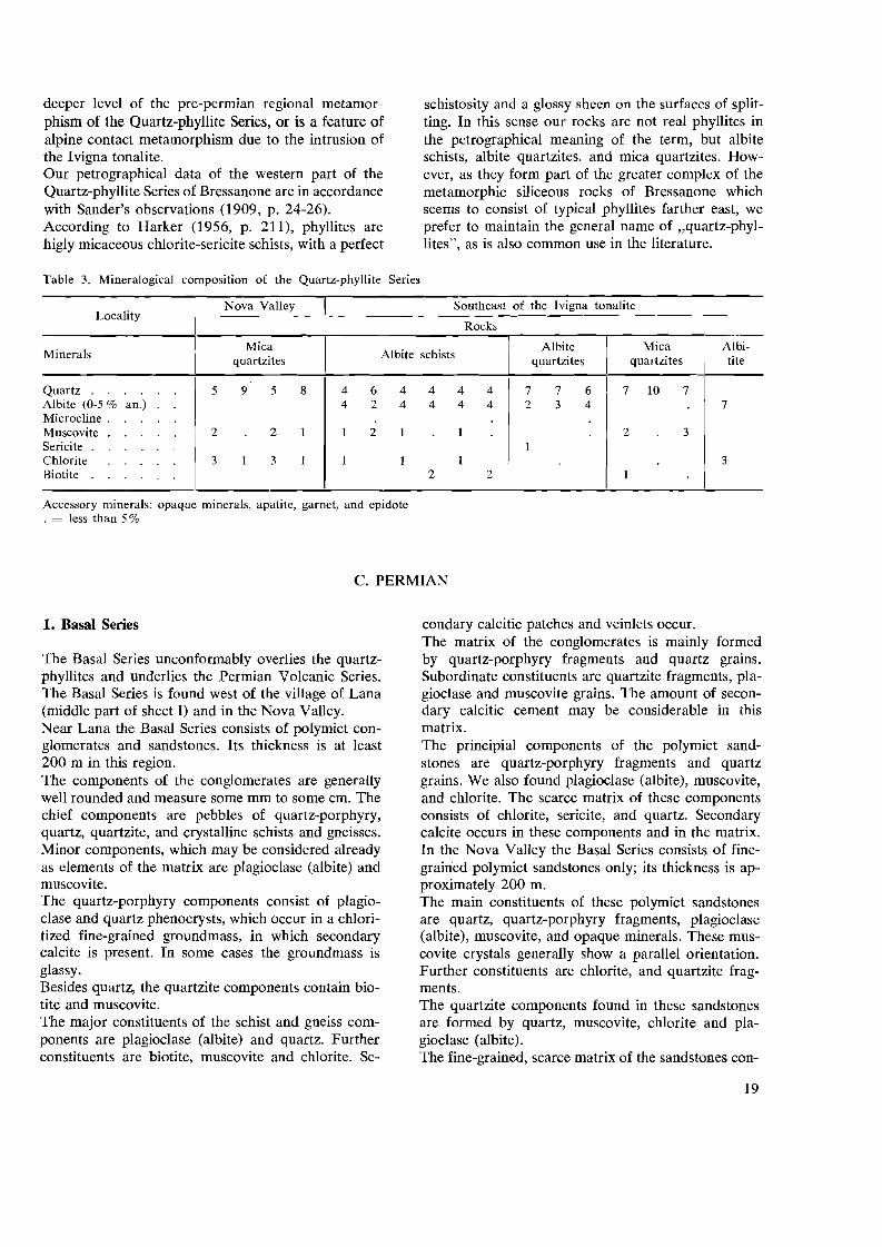
deeper level of the pre-permian regional metamorphism of the Quartz-phyllite Series, or is a feature of alpine contact metamorphism due to the intrusion of the Ivigna tonalite. Our petrographical data of the western part of the Quartz-phyllite Series of Bressanone are in accordance with Sander's observations (1909, p. 24-26). According to Harker (1956, p. 211), phyllites are higly micaceous chlorite-sericite schists, with a perfect
Table 3. Mineralogical composition of the Quartz-phyllite
schistosity and a glossy sheen on the surfaces of splitting. In this sense our rocks are not real phyllites in the petrographical meaning of the term, but albite schists, albite quartzites, and mica quartzites. How-ever, as they form part of the greater complex of the metamorphic siliceous rocks of Bressanone which seems to consist of typical phyllites farther east, we prefer to maintain the general name of "quartz-phyllites", as is also common use in the literature.
Series
Nova Valley Southeast of the lvigna tonalite Locality
Rocks
I Mica I Albite MicaMinerals Albite schists quartzites quartzites quartzites
I I II
Quartz 5 9 5 8 4 6 4 4 4 4 7 Albite (0-5 % an.) 4 2 4 4 4 4 2 Microcline . I
IMuscovite 2 2 1 1 2 1 1 Sericite I
\Chlorite 3 1 3 1 1 1 1 Biotite 2 2
I
Accessory minerals: opaque minerals, apatite, garnet, and epidote . = less than 5%
C. PERMIAN
7 6 7 10 7 3 4
2 3
1
Albitite
7
3
1. Basal Series
The Basal Series unconformably overlies the quartzphyllites and underlies the Permian Volcanic Series. The Basal Series is found west of the village of Lana (middle part of sheet I) and in the Nova Valley. Near Lana the Basal Series consists of polymict conglomerates and sandstones. Its thickness is at least 200 m in this region. The components of the conglomerates are generally well rounded and measure some mm to some cm. The chief components are pebbles of quartz-porphyry, quartz, quartzite, and crystalline schists and gneisses. Minor components, which may be considered already as elements of the matrix are plagioclase (albite) and muscovite. The quartz-porphyry components consist of plagioclase and quartz phenocrysts, which occur in a chloritized fine-grained groundmass, in which secondary calcite is present. In some cases the groundmass is glassy. Besides quartz, the quartzite components contain biotite and muscovite. The major constituents of the schist and gneiss components are plagioclase (albite) and quartz. Further constituents are biotite, muscovite and chlorite. Se
condary calcitic patches and veinlets occur. The matrix of the conglomerates is mainly formed by quartz-porphyry fragments and quartz grains. Subordinate constituents are quartzite fragments, plagioclase and muscovite grains. The amount of secondary calcitic cement may be considerable in this matrix. The principial components of the polymict sandstones are quartz-porphyry fragments and quartz grains. We also found plagioclase (albite), muscovite, and chlorite. The scarce matrix of these components consists of chlorite, sericite, and quartz. Secondary calcite occurs in these components and in the matrix. In the Nova Valley the Basal Series consists of finegrained polymict sandstones only; its thickness is approximately 200 m. The main constituents of these polymict sandstones are quartz, quartz-porphyry fragments, plagioclase (albite), muscovite, and opaque minerals. These muscovite crystals generally show a parallel orientation. Further constituents are chlorite, and quartzite fragments. The quartzite components found in these sandstones are formed by quartz, muscovite, chlorite and plagioclase (albite). The fine-grained, scarce matrix of the sandstones con
19

tains sericite, muscovite, chlorite, quartz, and ores. Secondary calcitic cement is always present in these rocks. Apparently the Basal Series is a mixture of erosion products from the crystalline basement complex and reworked products of the initial eruptions of the permian volcanism. Fuchs (1875, p. 834) mentions plant remains and possible imprints of algae in the polymict sandstones of the Nova Valley, which do not allow an age determination. Kuhn (Heritsch and Kuhn, 1951, p. 246) calls the Basal Series "Waidbrucker Konglomerat", after the exposures near the Waidbruck Castle north of the town of Bolzano. In 1830 Savi introduced the term Verrucano for the red conglomerates which are exposed below the Castle Verruca near the town of Pisa (Heim, 1921, p. 268). Since then this term has been used for different stratigraphical formations, as has been pointed out by Schaffer (1934), for the conglomerates which occur at the base as well as those on the top of the Permian Volcanic Series. We therefore use the neutral, descriptive name Basal Series for the polymict sandstones and conglomerates which underlie the volcanic Permian of the Southern Dolomites.
2. Volcanic Series
The Permian Volcanic or Quartz-porphyry Series occurs between the underlying Basal Series and the overlying Gardena Formation. The Volcanic Series exposed in the Merano region belongs to the northwestern margin of the Permian Trentino-Alto Adige or Bolzano volcanic province (fig. 2), which covers an area of roughly 3.5004.000 sq.km. In the Merano region these volcanic rocks are exposed along the steep, about 300-1.000 m high flanks, of the Adige Valley (sheet I), and in the plateau region southeast of the Ivigna tonalite (sheet II). The thickness of the quartz-porphyries in the Foiana region is of about 1.100 m (lower part of sheet I). The thickness attains also approximately 1.100 m in the Nova Valley, whilst it decreases to about 600 m along the northeastern margin of the Quartz-porphyry Series. The minimum thickness is approximately 900 m near Bolzano, whereas it reaches at least 950 m south of the town of Sarentino in the Sarentino Valley. The minimum thicknesses of the Quartz-porphyry Series of the eastern flank of the Adige Valley between Merano and Bolzano, and of the Sarentino Valley are indicated in table 8, column 6 (p. 48). The Volcanic Series consists mainly of extrusive rocks, which are called quartz-porphyries in the literature. Intercalated in these quartz-porphyries layers of ag
glomerates and agglomeratic tuffs occur, for instance in the Nova Valley (section VI, fig. 27, p. 38) and in the Grava region (sections VII and X, fig. 27). The quartz-porphyries show a porphyritic texture and contain quartz, feldspar and biotite phenocrysts. Under the microscope, the phenocrysts show the following features: Plagioclase (albite, 0-10% an.) occurs in idiomorphic crystals and in angular fragments. Sometimes, this plagioclase is rounded; embayments of the groundmass are rare. In these crystals, which are partly altered into sericite, calcite patches are often present. Quartz occurs in clear, rounded crystals, and in angular fragments, in which the groundmass forms embayments. Idiomorphic quartz crystals are very rare. Biotite forms hypidiomorphic crystals often altered into chlorite and opaque minerals. Regularly biotite contains calcite spots. Opaque minerals occur in idiomorphic crystals and in grains. Alkali feldspar is rare and may occur in perthitic phenocrysts. In the fine-grained to cryptocrystalline groundmass feldspar, quartz and ores could be determined. In this groundmass calcite spots, sericite, and chlorite patches often occur. Occasionally, the groundmass consists of parallel orientated streaks and lenses of reddish-brown glass, which alternate with fine-grained to cryptocrystalline bands. The thickness of these glass lenses may be 1 mm, and the lenght 0,5 em. These streaks bend around the phenocrysts thus giving the appearance of a flow structure, which is also visible with the unaided eye. In the field the strike and dip of this flow structure was measured, and is indicated on the maps. The agglomerates and agglomeratic tuffs consist of rounded components in a granular, fine-grained tuffaceous matrix. Often these components attain headsize; their diameter may reach 0,5 m. Microscopically the components of these agglomerates show a porphyritic texture due to the presence of the same phenocrysts as those described for the quartzporphyries. Their groundmass is fil}e-grained to cryptocrystalline and sometimes glassy. The tuffaceous matrix of the agglomerates contains besides chloritized quartz-porphyry fragments quartz, plagioclase (albite), ores, biotite, cWorite, sericite and secondary calcite. The contact of the massive quartz-porphyries with underlying agglomeratic tuffs is exposed in the Nova Valley at observation point 194 (upper left corner of sheet II and photographs I-a and I-b). The base of the quartz-porphyries here consists of ellipsoidal pillows, which have a maximum diameter of about 60 em. Microscopically these pillows show a porphyritic texture. They present the same phenocrysts as the
20

quartz-porphyries. Their groundmass is glassy and has a reddish-brown colour. The pillow structure is probably bound to the filling up of small ponds or lakes by the quartz-porphyries.
Photograph I-a. Pillows at the base of massive quartz-porphyries and on top of agglomeratic tuffs. Observation point 194, Nova Valley. The rectangle refers to photograph I-b.
Photograph I-b. Detail of photograph I-a.
The base of the Quartz-porphyry Series is exposed along the Palade road near Lana, appproximately 50 m southeast of observation point 69 (fig. 4). In this exposure, the quartz-porphyries partly rest upon the undulating, eroded surface of the Basal Series, partly it is a fault-contact. Summarizing the following can be said about the quartz-porphyries in the Merano region:
SE 5m
1. They have a very great areal distribution (the Bolzano volcanic province covers at least 3.5004.000 sq.km).
2. A considerable total thickness (up to 1.100 m).
3. They consist of unstratified units, which are up to some hundreds of metres thick. Locally a kind of flow structure occurs.
4. A very massive appearance.
5. Locally, glass may be present in the quartz-porphyries, and might be welded and flattened.
Mittempergher (1958), following up Marshall's terminology of 1935, called the quartz-porphyries of the Ponte Gardena-Castelrotto region (near the northern margin of the Quartz-porphyry Series in the Isarco Valley, fig. 2) ignimbrites, because of their considerable thickness and extension, horizontality, petrographical features, and acid (quartz-Iatitic to rhyolitic) composition. The present author agrees with this opinion also for the quartz-porphyries of the Merano region, on account of the combination of the following features:
1. The very great areal distribution and horizontality of the quartz-porphyries in the TrentinoAlto Adige volcanic district.
2. The considerable thickness of the unlayered single quartz-porphyry units in the Merano area.
3. The acid composition of the quartz-porphyries (Mittempergher, 1958; Andreatta, 1959, p. 107, table 5).
These quartz-porphyries are probably ignimbrites, in other words, they are deposits, resulting from fissure eruptions of fluidized two-phase systems, containing gas with suspended tuffaceous particles. The importance of the industrial process of fluidization as an intrusive and as a volcanic process was emphasized by Reynolds (1954). Pichler (1959, p. 127) is of opinion that the north italian quartz-porphyries are not ignimbrites, but lava flows. However, if these rather acid rocks extruded as silicate melts they would have had a high viscosity,
NW
Fig. 4. Base of Quartz-porphyry Series. About 50 m southeast of observation point 69, Palade road near Lana.
21

forming steep sided protrusions with brecciated mantles. These features have not been observed and Pichler does not provide conclusive reasons for his opinion. On account of the foregoing reasons 1 - 3 we do not agree with Pichler's view (1959, p. 128, 130), that these rocks extruded as real lava flows. Only the ignimbritic eruption mechanism provides a reasonable explanation for their mode of occurrence. Ignimbrite is here used in the genetic meaning of the term, as was proposed by van Bemmelen and Rittmann during the excursion of the Deutsche Geologische Vereinigung in May 1959, to the permian quartzporphyries of the Trentino-Alto Adige district in Northern Italy (personal communication), This meaning of the term ignimbrite was also stressed by Rutten in a recent paper (Rutten, 1959, p. 398). The term ignimbrite indicates the extrusion mechanism, without implicating certain mineralogical and chemical features of the products of these eruptions. It is a genetic concept, like lava or ash. The quartz-porphyries were sampled for paleomagnetic investigation. The results of the study of. the remanent magnetization of these rocks are discussed in chapter IV.
3. Gardena Formation
The Gardena Formation overlies the permian volcanic rocks and underlies the werfenian (lower triassic) strata. Southwest of Foiana, the Gardena Formation is conformable with the Permian Volcanic Series (section IV-V, fig. 27). Its thickness is approximately 200 m in the Foiana region. The Gardena Formation consists of thicklayered (the thickness of the layers may be about 1 m), generally coarse-grained arkoses south and southwest of Foiana. Occasionally, the thickness of the layers is about 1 cm only. The arkoses alternate with mica bearing, sandy shales. Criss-cross structures and ripple marks occur in the arkoses and sandy shales. The arkoses consist of quartz and plagioclase (albiteoligoclase) grains, cemented by some scarce calcite. Mica occurs as a subordinate constituent. Approximately 600 m west of Foiana, the calcite cement locally increases to 80 % of the rock volume. In this rock, calcite occurs in spots, veinlets, and embayments in the quartz and plagioclase grains. In the Grava region (sheet II), the Gardena Formation overlies southeast of the Ivigna summit (2.552 m) quartz-porphyries and agglomeratic tuffs with a small angular unconformity (section VII, fig. 27). The angle of the unconformity is approximately 7-14 0
•
The thickness of the Gardena Formation, which occurs on the plateau between the Adige and the Sarentino Valleys is 100-150 m (Giannotti, 1958, p. 307). In the Grava region, the components of the Gardena
Formation are quartz, quartzite (occasionally, in this quartzite albite and some microcline occur), plagioclase (albite-oligoclase), and quartz-porphyry fragments in a calcite cement, which occupies 60-70 % of the rock volume. Calcite is met with in patches, veinlets, and embayments in the above described crystals and rock fragments. On account of its features, the calcite in the Gardena Formation might have a secondary origin. Secondary calcite in the matrix of the Gardena Formation is also mentioned by Tedesco (1958, p. 274). According to this author the occurrence of this secondary calcite is due to circulating groundwaters, which derived carbonatic matter from the overlying triassic limestones. According to Tedesco (1958, table II, p. 256), the principal constituents of the Gardena Formation are quartz, feldspar, and fragments of volcanic rocks and of quartz-phyllites. These components occur in a matrix, which is principally argillaceous or quartzose, and with secondary calcite in minor quantities (Tedesco, 1958, p. 272, 274,283). Tedesco (1958, p. 279) classifies most of the rocks of the Gardena Formation as feldspatic sandstones. Besides plant remains in the Gardena sandstones, Giannotti (1958, p. 305, 306) and Tedesco (1958, p. 243, 244) mention the imprints of amphibians and reptiles. The above mentioned data lead to the conclusion that the Gardena sandstones are the result of the disintegration of volcanic rocks (the Permian Volcanic Series) and metamorphic rocks (the Quartz-phyllite Series), and the fluviatile transport and sedimentation of the erosion products under continental conditions (Giannotti, 1958, p. 308; Tedesco, 1958, p. 244, 284, 287). According to Mittempergher (written communication 12-11-1959), the age determinations of the uranium mineralizations in the Gardena Formation all gave an age of approximately 220.10 6 years. As Mittempergher is of opinion that these mineralizations are epigenetic formations, we may suppose that the Gardena sandstones themselves are older. This age determination would place these mineralizations in the Middle Triassic, according to the absolute geological time-scale from Mayne, Lambert, and York (1959, p.213). According to Kulp's geological time-scale (1959, p. 76 A), which is shorter than that of the above mentioned authors, but 15 % longer than that of Holmes (1947, p. 145, fig. 5), the beginning of the Triassic is approximately 220.10 6 years ago. Using Kulp's time-scale the Gardena Formation could also have an upper permian age, which is in agreement with current views in the literature, excepting Giannotti's (1958).
22

D. LOWER TRIASSIC (WERFENIAN)
This formation is found in the lower part of sheet I. Southeast of the M.Croce summit (1.508 m), the thickness of this formation is approximately 500 m. The sandy Gardena Formation grades upward into the lower triassic werfenian strata by means of an increase of clayey constituents and a decrease or disappearance of the coarser sediments. Moreover, the Werfenian contains more carbonatic matter. The Werfenian consists of yellow to orange and redcoloured, mostly thin-layered limestones (the thickness of the layers is some mm to some cm), which alternate with similarly coloured sandy, muscovite bearing shales and marls. In addition to calcite, the limestones may contain some quartz grains, musco
vite flakes and glauconite. Glauconite occurs in grains, which are parallel to the bedding planes. Lumachellen horizons, sandstone and oolitic limestone intercalations occur. The principal constituent of these sandstone intercalations is quartz; muscovite is a subordinate constituent. These grains are cemented by some scarce calcite. The oolites of the oolitic limestone intercalations are visible with the naked eye (1 mm diameter), and they have an oval form. These oolites consist of calcite crystals, which form a mosaic pattern, and are cemented by calcite.
E. TERTIARY TONALITE MASSIFS
1. Monte Croce tonalite
Northwest of the M.Croce tonalite meso-katazonal metamorphic rocks are found. In the southwest it is bordered by the Quartz-phyllite Series, whilst in the southeast permo-triassic formations occur. In the northeast, the exposure of the tonalite massif disappears under the Quaternary of the Adige Valley. The M. Croce massif consists of tonalites or quartzdiorites (Johannsen, 1958, v.n, p. 378), and quartztonalites or quartz-rich quartz-diorites (Johannsen, 1958, v.n, p. 43). The constituents of these coarsegrained, holocrystalline, plutonic rocks are presented in table 4.
Table 4. Mineralogical composition of the M.Croce massif
Rocks
QuartzMinerals Tonalites
tonalites
Andesine (40% an.) . 7 6 6 3 4 Quartz . . . . 3 3 4 6 6 Biotite . . . . 1 1 Potassium feldspar Amphibole. . .
Accessory minerals: ores, apatite, and epidote . = less than 5%
Plagioclase (andesine) forms hypidiomorphic-xenomorphic crystals, which are more or less altered into sericite. Sericite occurs as tiny spots in plagioclase. According to Andreatta (1937, p. 323, 324), the rims of the zoned plagioclase crystals contain 8-33 % anorthite (albite-andesine), and the cores 40-56 %
anorthite (andesine-labradorite). The non-zoned plagioclase crystals contain 32-50 % anorthite (andesine). The plagioclase contains 40 % anorthite on the average (andesine). Quartz forms xenomorphic patches. Biotite and amphibole occur in hypidiomorphic-xenomorphic crystals. Potassium feldspar is always perthitic, and is found in clear xenomorphic crystals. The plagioclase in these perthitic crystals is albite (Andreatta, 1937, p. 321). Along their northwestern and southeastern margins, the tonalites are crushed. In these crushed rocks, the constituating minerals show the following features: Quartz is crushed and shows distinct wavy extinction. Plagioclase (andesine) is almost completely altered into sericite; relics of one and the same plagioclase crystal, which have the same optical orientation, occur in a matrix of sericite. Biotite is often bent. Chlorite and ore grains in parallel arrangement are observed generally along the cleavage planes of the biotite. Apparently biotite is altered into chlorite and opaque minerals. In the field these crushed marginal parts of tonalite have sometimes a gneissic appearance. Under the microscope there is a certain segregation: bands consisting of sheared quartz crystals alternate with sericite-rich bands, which contain remnants of plagioclase (andesine), strongly altered and bent biotites, and calcitic spots. The M.Croce tonalite is described in detail by Grubenmann (1896-a, p. 340, 348), Andreatta (1937, p. 320-341), and Dal Piaz (1942, p. 50-54). For its petrographical features we may also refer to a recent paper from Karl (1959, p. 147-156).
23

2. Dykes of the Monte Croce massif
Dykes are seen in the M.Croce tonalite massif itself, in the meso-katazonal crystalline rocks near the northwestern boundary of the massif, and in the Quartzphyllite Series near the southwestern margin of the tonalite. For the petrography of these dykes, we refer to Grubenmann (1896-b, p. 185-188; 193-194), Kunzli (1899), Andreatta (1937, p. 361-392), and Dal Piaz (1942, p. 58-64). We did not observe dykes in the permo-triassic formations which border the M.Croce tonalite in the southeast. Dykes which are not situated inside the tonalites, may belong either to the tertiary phase of intrusion of these plutonic masses, or they may be considerably older, e.g. they might belong to the permian phase of volcanic activity in this region. We have as yet no data that enable us to distinguish between these possibilities.
3. Contact metamorphic rocks of the Monte Croce massif
Near the northwestern boundary of the M.Croce tonalite, in this tonalite massif we see an inclusion which consists of sericite-chlorite schists, gneisses, and quartzites. This inclusion shows sharp contacts with the tonalite, which are not fault-contacts. It has a length of about 750 m and a maximum thickness of about 175m. The mineralogical composition of these rocks is given in table 5. In these rocks, biotite and chlorite show the same features as in the sericite-chlorite schists occurring along the northwestern boundary of the Ivigna tonalite in the town of Merano (paragraph B-2). Chlorite may be considered as an alteration product of biotite, due to conditions of retrograde metamorphism.
Table 5. Mineralogical composition of the contact metamorphic rocks, occurring in an inclusion in the M.Croce tonalite
Rocks
Sericite-Minerals Quart-chlorite I Gn"," I zitesschists
Quartz 4 2 9 9 Oligoclase Sericite + Chlorite. 9 6
7
Muscovite Biotite Andalusite
Accessory minerals: ores, and epidote . = less than 5 %
24
We observed andalusite only in the mica-rich rocks (the sericite-chlorite schists). This mineral is found in fairly large, hypidiomorphic, prismatic crystals. Fragments of the same andalusite crystal lie in a matrix, consisting of sericite; moreover, this sericite matrix forms embayments in andalusite. Andalusite contains sericite along cracks and along the cleavage planes. The described inclusion of contact metamorphic rocks is also mentioned by Kunzli (1899, p. 421, 422). According to Grubenmann (1896-a, p. 350), Kunzli (1899), Andreatta (1937, p. 392-395), and Dal Piaz (1942, p. 66-78), the crystalline rocks along the northwestern boundary of the M.Croce tonalite contain mylonitized andalusite bearing layers. In our slides we did nod find any andalusite, which probably is a matter of chance in sampling. The occurrence of the contact metamorphic phenomena near the northwestern margin of the M.Croce tonalite is restricted to the schists and gneisses, which are located between the tonalitic gneiss and the M. Croce tonalite; contact metamorphic rocks have not been encountered northwest of the tonalitic gneiss (Kunzli, 1899, p. 440). Along the southwestern boundary of the tonalite, Andreatta (1937, p. 395-397) describes a contact metamorphic aureole in the Quartz-phyllite Series. We did not make a close study of these contact metamorphic quartz-phyllites. No contact metamorphic features have ever been reported southeast of the M.Croce massif, which is in accordance with our observations. As andalusite is found in a zone along the northwestern margin of the M.Croce tonalite and in an inclusion, we may conclude that this mineral is due to thermal metamorphism caused by the intrusion of the tonalite.
4. Tonalitic gneiss
Tonaliticgneiss occurs in some localities near the northwestern boundary of the M.Croce and Ivigna tonalites. About 25 m northwest of the M.Croce tonalite massif, the tonalitic gneiss is seen as a band, separated from this tonalite by mylonites. This band has a length of about 500 m and a maximum thickness of about 50m. In the town of Merano, from the Pulver Tower to the San Zeno Castle, a band of tonalitic gneiss is located, which is separated from the Ivigna tonalite by sericite-chlorite schists (fig. 3, p. 17). At this place the maximum thickness of the tonalitic gneiss is approximately 25 m. The tonalitic gneiss is often mylonitized. According to Sander (1906, p. 716), often, schists and gneisses are met with between the tonalitic gneiss

which is located northeast of Merano near the northwestern margin of the Ivigna tonalite, and the tonalite massif itself. East of Merano, the thickness of the tonalitic gneiss attains 400 m; however, it is a discontinuous gneiss zone in which this gneiss is absent in many places (Sander, 1906, p. 727). Sander observed schist intercalations in the tonalitic gneiss. In the field, this rock is a coarse-grained gneiss. Its constituents are given in table 6.
Table 6. Mineralogical composition of the tonalitic gneiss
Labradorite (55 % an.) 7 7 769 8 5 6 Amphibole 2 1 J 1 1 1 Biotite 1 1 1 1 Quartz 1 1 4 4 2
Accessory minerals: ores, epidote, and chlorite . = less than 5%
According to Andreatta (1937, p. 342) the non-zoned plagioclase crystals contain 42-64 % anorthite (andesine-labradorite). The rims of the zoned plagioclase crystals contain 39-41 % anorthite (andesine). The plagioclase might contain 55 % anorthite on the average (labradorite). The tonalitic gneiss has a quartz-gabbroic composition (Johannsen, 1958,v.n,p. 409). According to this composition and since in the tonalitic gneiss potassium feldspar is lacking, and as it contains more amphibole and a more basic plagioclase than the M. Croce and Ivigna tonalites, this gneiss is more basic than the latter. According to Andreatta (1937, p. 349) the gneissic appearance of the tonalitic gneiss is due to a primary flow structure; the tonalitic gneiss would represent a marginal differentiation of the main tonalite massif. Because of the following reasons we do not agree with this view:
1. The tonalitic gneiss occurs only near the northwestern margins of the M.Croce and Ivigna tonalites. Tonalitic gneiss is found neither along their southeastern margins, nor along the normal southwestern contact of the M.Croce tonalite.
2. Mylonites and mylonitic crystalline schists and gneisses occur between the tonalitic gneiss and the tonalite massifs.
3. No contact metamorphic phenomena have ever been reported northwest of the tonalitic gneiss. It seems therefore improbable that originally the tonalitic gneiss ever represented the northwestern margins of the tonalites.
Sander (1906, p. 728-729) and Dal Piaz (1942, p. 56, 160) consider the tonalitic gneiss as a separate syn
tectonic tertiary intrusion, which occurred before the emplacement of the M.Croce and Ivigna tonalite massifs; in other words, the tonalitic gneiss would represent a more basic precursor of the main intrusion. The present author is of opinion that this view might be correct.
5. Ivigna tonalite
The Ivigna tonalite massif forms the southwestern extension of the Bressanone tonalite massif (fig. 2). In the northwest it is bordered by meso-katametamorphic crystalline rocks. Along the southeastern boundary of the Ivigna tonalite there are quartzphyllites and permian formations. The westernmost exposure of the tonalite is located in the town of Merano itself (fig. 3). In Merano town its outcrop disappears beneath the Quaternary of the Passirio and Adige Valleys. Like the M.Croce tonalite, the Ivigna tonalite massif consists of tonalites and quartz-tonalites, the mineralogical composition of which is given in table 7.
Table 7. Mineralogical composition of the Ivigna massif
Rocks
Minerals Tonalites Quartztonalites
Andesine. 6 6 5 3 4 Quartz 3 3 3 6 6 Biotite. . 1 2 1 Potassium feldspar Amphibole . . .
Accessory minerals: ores, apatite, and epidote . = less than 5%
For the microscopical features of the constituting minerals, we refer to paragraph 1. The northwestern and southeastern margins of the Ivigna tonalite are crushed and mylonitized. Under the microscope these crushed rocks reveal the same features as found in the margins of the M.Croce tonalite (paragraph 1). The petrography of the Ivigna tonalite has been discussed in detail by Grubenmann (1896-a, p. 340348).
6. Dykes southeast of the Ivigna massif
For the discussion of the dykes, which occur in the Ivigna tonalite, we may also refer to Grubenmann (1896-b, p. 195-196). A roughly north-south directed swarm of dykes is encountered in the Quartz-phyllite Series between the Grava Summit (2.078 m) and the village of Sonvigo in the Sarentino Valley.
25

Under the microscope these dykes show a porphyritic texture, and they contain the following phenocrysts in a fine-grained to cryptocrystalline groundmass: The plagioclase (albite, 0-10% an.) phenocrysts are hypidiomorphic-idiomorphic. Often, they are strongly altered into sericite. Calcite is found in spots and along the cleavage planes of the plagioclase. Sometimes, ore grains are arranged parallel to the cleavage of the plagioclase, and occur along the margins of these phenocrysts. Quartz is met with in rounded phenocrysts, in which the groundmass forms embayments. The chlorite phenocrysts contain ore grains and calcite along its cleavage and its margins. Probably, the chlorite is pseudomorphous after biotite. In the groundmass, we could determine plagioclase and quartz. Moreover, sericite, some ore grains, calcite, and chlorite patches occur. For the detailed petrography of these dykes we refer to Sander (1909). These dykes might be feeders of the permian quartzporphyries. We sampled them for paleomagnetic measurements, which might settle the question of their age, i.e. whether they have a permian or a tertiary pole position. However, their remanent magnetization appeared to be too weak, so that this investigation led to no positive results.
7. Contact metamorphic rocks of the Ivigna massif
Andalusite bearing sericite-chlorite schists are seen in a band along the northwestern boundary of the Ivigna tonalite in the town of Merano. These rocks are described in paragraph B-2. Besides this locality, Kiinzli (1899, p. 437, 438) mentions andalusite bearing rocks along the northwestern margin of the Ivigna tonalite. Grubenmann (1896-a, p. 350) found andalusite in the quartz-phyllites of the Nova Valley. This occurrence of andalusite seems to be exceptional as no other contact metamorphic phenomena have ever been reported along the southeastern side of the Ivigna tonalite (Kiinzli, 1899, p. 135). As the presence of andalusite is restricted to rocks which occur along the margins of the Ivigna tonalite, we consider andalusite as a contact metamorphic mineral, due to the intrusion of the Ivigna tonalite.
8. The age of the M.Croce and lvigna tonalite massifs
The M.Croce and Ivigna tonalites occur in the middle section of an important series of intrusions of mainly tonalitic composition, which extend along the southern flank of the Alps, from Biella in the west to Eisenkappel in the east, that is a distance of approxi
mately 600 km. In the literature these intrusions are usually called the peri-adriatic tonalite massifs. Generally, these massifs have an oblong form, and they occur near or along the so-called alpine-dinaric suture line, which is called Insubric or Tonale fault in the west, and Judicaria and Pusteria-Drau fault in the east. The principal peri-adriatic massifs near the Insubric fault are from the west to the east: The Biella and Traversella syenites, north of Torino; the Bergell granites, tonalites, and diorites, northeast of Lugano; the Adamello tonalite, north of the lake of Garda. Along and near the Judicaria fault we have from the southwest to the northeast: The Adamello tonalite; the M. Croce and Ivigna tonalites, near Merano. Along and near the Pusteria fault occur: The Bressanone tonalite, north of Bressanone; the Rieserferner swarm of tonalite lenses, north of Brunico. Along the Drau fault occur: The Eisenkappel granites and tonalites, province of Carinthia, Austria.
The Bergell massif
According to Cornelius (1928, p. 556), the contact metamorphic aureole of the Bergell massif reaches the Liassic. Pebbles of the intrusive rocks of the Bergell are found in the miocene Nagelfluh conglomerates of the Molasse near Como (Cornelius, 1928, p. 557; Staub, 1949, p.375). The age of the Bergell massif will be post-middle jurassic, but pre-miocene.
The Adamello massif
Its contact metamorphism attains triassic strata (Salomon, 1898, p. 120, 124, 163); hence, the age of the Adamello massif is post-triassic. Referring to the Bergell and the Adamello massifs, de Sitter (1956-a, p. 178) remarked: "They were intruded, to all appearances, after the dislocation (the Insubric line) came into existence, and they do not cross it".
The M.Croce massif
The doming action of this massif on the permo-triassic strata resulted in the formation of the so-called Monte Luco horst (fig. 2) at its southwestern side. Dal Piaz (1926) discovered minor tonalite lenses which occur along the Judicaria fault between the Adamello and M. Croce tonalites. These tonalite lenses might be witness of a connection between the
26

post-triassic Adamello massif and the M.Croce tonalite. On account of the above mentioned features, the M. Croce tonalite most probably, is also of a post-triassic age.
The lvigna-Bressanone massif
As the M.Croce tonalite probably forms the southwestern extension of the Ivigna-Bressanone massif, the latter may as well be of a post-triassic age.
It has to be remarked that no pebbles or fragments derived from the peri-adriatic tonalites have ever been reported in the conglomeratic permian Basal Series, nor in the clastic permian Gardena Formation. This indicates that it is less probable that these plutonic masses have a pre-alpine (that is hercynian) age.
On account of their form, petrographical and chemical similarity (Karl, 1957, 1959), and the fact that the peri-adriatic massifs never cross the alpine-dinaric fault zone, we may conclude that this fault zone has provided a way of ascent to the tonalitic magma, as is also the opinion of, for instance, Salomon (1898, p. 242, 243, 283), Steinmann (1913, p. 224), Reritsch and Kuhn (1951, p. 295, 296), de Sitter (1956, p. 178), and van Bemmelen (1957, p. 197). Assuming that the peri-adriatic tonalites intruded more or less synchronously, the age of the M.Croce and Ivigna massifs must be post-liassic, but pre-miocene. These intrusions could have a mid-terti~ry age, as is the current view in the literature.
F.QUATERNARY
In the Merano region, the Quaternary is represented by moraines and alluvial deposits.
27

CHAPTER II
Structure
A. TECTONIC ELEMENTS
1. General tectonic situation
The area discussed in this thesis belongs to the southern flank of the alpine geanticline where it is cut by a major fault with a southwest-northeast trend, known in the literature by the name of Judicaria fault (fig. 2, p. 15). At its southwestern end the Judicaria fault is bordered to the northwest by the tertiary Adamello tonalitic mass, and in the Merano area the tonalite massifs of Monte Croce and Ivigna occur at its southeastern side. These tonalite massifs of M.Croce and Ivigna are comprised between two more or less parallel faults, the Judicaria fault to the northwest and the FoianaNova faults to the southeast. The tectonic and minor tectonic features of the Judicaria fault are described in the paragraphs 2 and 3, those of the Foiana fault in the paragraphs 4 and 5, and those of the Nova fault in the paragraphs 6 and 7. The quaternary filling of the Adige Valley near Merano interrupts the outcrops of these faults. The above mentioned faults southwest and northeast of the Adige Valley are not their continuation in a straight line, as appears from fig. 2. Moreover, the minor tectonic structures near Merano indicate the presence of a sinistral wrench fault, which will be discussed in paragraph 8. Another sinistral fault, also cutting and offsetting the Judicaria fault but of smaller importance, was observed near Riobianco (fig. 2), and will be treated in paragraph 10. Our observations indicate that the northern margin of the permian volcanic rocks occurring between the Adige and Sarentino Valleys is not a primary stratigraphical contact, but a normal fault; it is discussed in paragraph 11. The pre-permian and the tertiary fold trends in the Merano region will be discussed in the paragraphs 13 and 14 respectively.
2. Judicaria fault, southwest of Merano
The Judicaria fault southwest of Merano (sheet I) forms the northwestern boundary of the tonalite massif of M.Croce. It can be traced from the southwest (San Pancrazio d'Ultimo in the Valsura Valley) in a mean N 35° E direction to Cermes in the northeast,
where its outcrop disappears under the Quaternary of the Adige Valley. This part of the Judicaria fault has an average inclination of 75° to the northwest. The northwestern rim of the M.Croce massif, close to the Judicaria fault is crushed; and under the microscope it shows cataclastic textures (chapter I, paragraph E-1). At the northwestern side of the Judicaria fault, the metamorphic rocks are generally heavily mylonitized, as is, for instance, indicated in section I (fig. 27, p. 38), where the mylonite belt (chapter I, parapraph B-3) has a thickness of about 250 m. The strike of the schistosity of these metamorphic rocks is more or less parallel to the trend of the Judicaria fault. The metamorphic rocks northwest of the fault contain a mylonitized tonalitic gneiss band about 50 m thick parallel to the general trend of the fault. This tonalitic gneiss is separated from the Judicaria fault by quartz-mylonites (section II, fig. 27). The M.Croce tonalite contains, close to the Judicaria fault, an intercalation, maximum 175 m thick, of retrograde metamorphic and contact metamorphic rocks in this section (chapter I, paragraph E-3). These contact metamorphic rocks have about the same northwestern dip as the Judicaria fault. In order to estimate the throw of the Judicaria fault southwest of Merano, a schematic section was constructed across the M.Croce massif (fig. 5, section a,
and fig. 2). The structure of the left part of section a
k~ NW •§
i.. • :
SE
o Section «. ' t:":=-::J 1=-=-=1 1:4:_::~1 I!"?~",~..':!I '·;.;.;.;.;.1 '1£:NI c=J 1 I' 3 ... 6 7
Fig. 5. Schematic section across the tonalite massif of M. Croce. 1. Crystalline schists, quartzites, and gneisses. 2. Quartz-phyllites. 3. Permian Basal Series. 4. Permian Quartz-porphyry Series. 5. Permian Gardena Formation. 6. Tonalite. 7. Quaternary.
28

is inferred from Hammer's sections (Hammer, 1904, p.568). For the evaluation of the amount of vertical displacement of the Judicaria fault, the base of the quartzphyllites occurring northwest of the M.Croce massif (chapter I, paragraph B-4) was extrapolated towards the southeast. There seem to be two extreme possibilities for this way of extrapolation, indicated as a and b in section lr.
Since the thickness of the phyllites southeast of the Judicaria fault can be estimated to be at least 1,5 km*), the minimum throw of this fault in the M. Croce section is 5 - 9 km. Fallot (1950, p. 188) estimates the relative subsidence of the block southeast of the Judicaria fault (that
rocks (andalusite bearing sericite-chlorite schists, chapter I, paragraph E-7), a band of tonalitic gneiss, and crystalline schists and gneisses. The local situation in Merano indicates that the WSW-ENE course of the Judicaria fault in the western part of the Ivigna section curves from N 70° E southwards, assuming a N 35° E trend (fig. 3). This flexure in the general course of the Judicaria fault is connected to the presence of a sinistral wrench fault, cutting and offsetting the Judicaria fault; it will be discussed in paragraph 10. Moreover, near the village of Riobianco (right hand part of sheet II), another sinistral fault displaces the Judicaria fault. This fault will be dealt with in paragraph 10.
k~ NW
4
3 Schnee berg Zbne
. o 0: :;;
SE
o >
Fig. 6. Schematic section across the tonalite massif of Ivigna. 1. Crystalline schists, quartzites, and gneisses. 2. Northwest of the Judicaria fault: crystalline schists of the Schneeberg Zone; southeast of the Judicaria fault: Quartz-phyllite Series of Bressanone. 3. Permian Quartz-porphyry Series. 4. Tonalite.
is the region of the Southern Dolomites) to be in the order of some km, which is in agreement with our results.
3. Judicaria fault, northeast of Merano
In the town of Merano, and to the northeast of this town, the Judicaria fault forms the northwestern boundary of the Ivigna tonalite massif (upper right corner of sheet I, sheet II, and sections VI, VII, and IX, fig. 27). In this section the fault extends from Merano in the southwest to the village of Riobianco in the northeast, and has a mean trend of N 55° E. This direction is roughly parallel to the strike of the schistosity of the schists and gneisses, which are situated northwest of the Judicaria fault. In this area the dip of the fault is 60° to the northwest on the average. The Ivigna tonalites are also crushed near the Judicaria fault. In the town of Merano itself, between the San Zeno Castle at the Passirio Valley and the Pulver Tower at the Tappeiner Promenade, we found from the southeast to the northwest successively (fig. 3, p. 17): The most western exposure of the Ivigna tonalite, retrograde metamorphic and contact metamorphic
In order to estimate the throw of the Judicaria fault northeast of Merano, a schematic section across the Ivigna tonalite was constructed (fig. 6, section ~,
and fig. 2). However, since the southern contact of the schists of the Schneeberg Zone (chapter I, paragraph B-5) is parallel to the Judicaria fault, this section is not suitable for the establishing of the throw of this fault. But it can be said that this section does not contradict our estimate of 5-9 km vertical throw which has been made for section a in the preceding paragraph.
4. Foiana fault, southwest of Merano
The Foiana fault forms the southeastern boundary of the M.Croce tonalite massif (sheet I and sections I and II, fig. 27). This fault extends from Lana in the Adige Valley in a mean S 20° W direction to
*) The minimum thickness of the western marginal part of the Quartzphyllite Series of Bressanone is the difference in height between the highest summits (M. Catino, 2.422 m) and the level of the Sarentino Valley near Sarentino (about 1.000 m). Since phyllites are exposed along the slopes of the Sarentino Valley and as the summit of M. Catino is a free erosion level, a minimum thickness of the flat-lying phyllitic complex of 1,5 km can be safely assumed.
29

the SSW. Its average dip is about 50° to the northwest. The fault plane is excellently exposed 350 m south of the Runstiner farm, along the path running from this farm to Foiana (observation point 99, about 1,5 km north of Foiana, indicated on sheet I). Here, crushed tonalites are divided from mylonitized quartz-porphyries by a fault plane, which has aN 15° E strike and dipping 55° to the northwest (photograph 2).
Photograph 2. Foiana fault (strike N 15° E, dip 55° northwest) at observation point 99 northwest of the village of Foiana (sheet I). Gray-coloured, crushed tonalites resting on dark-coloured, mylonitized quartz-porphyries.
Near the southern margin of the geological map the Foiana fault is bordered to the west by contact metamorphic quartz-phyllites (section III, fig. 27), and to the east by middle triassic limestones. Northward, the M.Croce tonalites are exposed to the west of the fault, whereas to the east of it permo-triassic formations are found. These permo-triassic beds have a generally southward dip and show gentle undulations (section IV-V, fig. 27). The fold-axes of these undulations (indicated on sheet I) have a mean azimuth of about 240 0 and they plunge 8° to the southwest. In the north, where the Adige Valley is reached, the deepest exposed layers are formed by the Basal Series. At the southern margin of sheet I, the thickness of the stratigraphical column from the Basal Series to the Middle Triassic is about 3 km. Therefore, the unconformity existing between the Basal Series and the underlying quartz-phyllites occurs in this area at a depth of about - 1,5 km. West of the Foiana fault, the northward extrapolation of the unconformity between the Basal Series of the Monte Luco horst (fig. 2) and the quartz-phyllites (Dal Piaz, 1942, p. 37-39, and section on p. 139) reaches an height of about +
1,5 km, so that here the throw of the Foiana fault amounts to about 3 km. Since the Nova fault has the character of a thrust fault (paragraph 6), forming most probably the northeastern extension of the Foiana fault, the latter is also a thrust fault.
5. Minor tectonic structures southeast of the Foiana fault
About 1.300 m southwest of Foiana, and 50 m southeast of the Foiana fault (observation point 104, sheet I), a minor graben in the werfenian beds occurs (fig. 7). Moreover, there are two normal faults in this section dipping to the northwest. This structure suggests a collapse and a transport of the werfenian strata towards the northwest.
N
not expos.ed
5
5m
Fig. 7. Minor graben in werfenian limestones southeast of the Foiana fault (observation point 104, sheet I).
It was observed that also slabs of werfenian limestone glided to the northwest, this phenomenon being promoted by the lubrificative action of a shale intercalation (fig. 8).
WNW ESE
O-l---------'==----.-----------.....,..---J2m
Fig. 8. Gliding planes in werfenian limestones and shales southeast of the Foiana fault (observation point 104, sheet I).
30

Since the Foiana fault is a thrust fault, overturned or dragged up strata should be expected southeast of the fault, instead of these slump features. Drag features are actually found southeast of the Nova thrust (paragraph 6). However, the extensional structures discussed in this paragraph are probably not associated with the Foiana thrust. Their occurrence near this fault and their origin will be discussed in section B of this chapter and in chapter III.
6. Nova fault, northeast of Merano
The Nova fault forms the southeastern boundary of the lvigna tonalite massif (sheet II, and sections VI, VII, VIII, IX, fig. 27), and is most probably the northeastern continuation of the Foiana fault. This fault extends from the Passirio Valley near Merano to Riobianco in the Valley of the Talvera (Val Sarentino). The average strike of this fault is N 55° E, whilst its dip is the smallest of all major faults belonging to the Judicaria system in the Merano region, namely only 40° northwest on the average. Approaching the Nova fault from the southeast, the Basal Series assumes a steeper southeastward dip in the Nova Valley. Apparently, these strata are dragged up near the Nova fault. The fault is excellently exposed on the western slope of the Nova Pass (2.030 m), where gray tonalites are resting on the red Gardena Formation (observation point 113, sheet II, and section VII, fig 27). At this place the dip of the Nova fault is about 30° to the northwest. The Gardena sandstones are here overturned along the southeastern side of the Nova fault (section VII, fig. 27). At the source of the Sinigo river, that is about 1,5 km east of the Ivigna summit (2.552 m) the extreme northeastern end of the quartz-porphyry complex lies pinched in a steep syncline of quartz-phyllites, which have been dragged up along the Nova fault (section VIII, fig. 27). At this place the Nova fault is also exposed, its dip being 55 0 to the northwest.
w E
O'------------.:-------==---------==--:-:I so 10~
Fig. 9. Nova fault east of the Ivigna summit (observation point 266, sheet II).
Northeast of section VIII, the Nova fault is to be seen in a western tributary of the Sega river (observation point 266, indicated on sheet II and fig. 9). The rim of the Ivigna tonalite here consists of tonalitic sandy mylonite, whereas the dip of the Nova fault is 35 0 to the northwest. Along the southeastern margin of the Ivigna tonalite, the strike of the schistosity of the quartz-phyllites is more or less parallel to the trend of the Nova fault, whilst its dip is to the northwest or to the southeast. However, the regional position of the schistosity of the quartz-phyllites is a horizontal to subhorizontal undulating plane southeast of the Ivigna tonalite, so that the phyllites might be turned up along the southeastern side of the Nova fault. Since the strata are dragged up along the southeastern side of the Nova fault, this fault has the character of a thrust fault.
7. Minor faults in the tonalite massif of Ivigna
Minor faults which could be measured in the Ivigna tonalite, are presented in the diagram of fig. 10. The faults are plotted in the lower hemisphere of Lambert's equal area projection or Schmidt-net*). Near the minor fault planes the tonalite is crushed; unfortunately, no striations are observed that could give information on the nature of these faults.
Fig. 10. 72 faults in the tonalite massif of Ivigna. x = pole of fault plane.
According to fig. 10, the mean of the minor fault planes in the Ivigna tonalite (strike 224°, dip 40 0
northwest) nearly coincides with the average Nova fault plane (strike 235 0, dip 40° northwest). On account of this relation it seems very probable that these post-tonalitic minor faults are auxiliary elements associated with the Nova thrust movements, so that they themselves are, most probably, also thrust faults.
*) The Schmidt-net was also used for the representation of the minor tectonic features in the following paragraphs. The percentages of the contours, which indicate the distribution in space are given in the diagrams.
31

8. Transcurrent faults of Merano
Minor sinistral transcurrent faults together with the striae on the fault surfaces were measured along the western slopes of the Adige Valley between Foiana in the south and Merano in the north, the southwestern and northeastern slopes of this valley between Merano and Lagundo, and in the Passirio Valley near Merano. In the following diagrams only those minor faults are presented of which the analysis of the striations gives positive information about the (latest) movements occurring along these fault planes. A division was made between the minor faults encountered in the crystalline schists and gneisses of the above mentioned area, and the faults which are observed in the Permo-Triassic Series and in the tonalites.
Fig. II. 88 sinistral transcurrent faults in the metamorphic rocks northwest of the Judicaria fault near Merano. x = pole of fault plane.
Fig. 12. 88 striae on the fault planes of fig. II. 6. = striation.
Two sets of minor faults occur in the metamorphic rocks. The first set comprises generally steep southwest-northeast striking faults (fig. 11) with mostly horizontal to subhorizontal striae (fig. 12). According to the analysis of these striae these faults are sinistral transcurrent or wrench faults. The sigmoidal deformations of the schistosity plane of the metamorphic rocks (for instance observation point 314 near the northern margin of sheet I, fig. 13) point
also to a sinistral character of these transcurrent faults.
Fig. 13. Sigmoidal deformations of the schistosity plane connected with minor sinistral transcurrent faults in mica schist, containing quartz lenses (observation point 314, sheet I; horizontal plane, natural size).
180/80
3.5 em
The second set will be discussed at the end of this paragraph. The mean of the sinistral transcurrent faults has a strike of 205 0, and a dip of 80° to the northwest (fig. 11).
Fig. 14. 35 sinistral transcurrent faults in the Permo-Triassic Series and in the tonalites of M. Croce and Ivigna near Merano. x = pole of fault plane. 6. = striation.
The above mentioned set of sinistral wrench faults also occurs in the Permo-Triassic Series of the Foiana region, the most eastern exposures of the M.Croce tonalite, as well as in the most western outcrops of the Ivigna tonalite (fig. 14). From this we may conclude that these faults are a structurally coherent set of post-tonalitic age, and that they represent, together with the faults of the preceding paragraph, the youngest faults perceptible in the Merano area. In this connection two major tectonic elements of the Merano region have to be mentioned.
1. The Judicaria fault southwest of Merano is not situated on the straight extension of the Judicaria fault northeast of the town. It appears from the geological map (sheet I) that the general trend of the Judicaria fault southwest of Merano is N 35° E, whereas the fault northeast of this town, on the average, trends N 55° E (sheet II). Moreover, the western end of the northeastern section of the Judicaria fault assumes a N 70° E direction and then curves southwestward in a N 35° E trend (fig. 3, p. 17) in the town of Merano near the San Zeno
32

Castle. This N 35° E trend is the mean direction of the southwestern section of the fault. However, the Merano part of the Judicaria fault does not link on to the M.Croce section of this fault, but it shows an offset in the Adige Valley of about 650 m, as has already been noticed by Spitz (l919-a, p. 63). This offset is measured as the shortest horizontal distance between the northeastern extension of the N 35° E trend of the Judicaria fault in the M.Croce section and the southwestern prolongation of the N 35° E course of the fault in Merano town.
2. A major flexure occurs in the strike of the metamorphic rocks northwest of Merano (sheet II).
This flexure and the offset of the Judicaria fault between Cermes and Merano indicate the presence of a sinistral transcurrent fault or flexure in the course of the Judicaria fault, which occurs beneath the alluvial deposits of the Adige Valley. Since the set of minor sinistral transcurrent faults (figs. 11, 14) is restricted to the neighbourhood ofthis sinistral wrench fault, these minor faults are considered as auxiliary faults of the transcurrent deformation. This wrench fault might be parallel to the mean of the associated minor transcurrent faults, thus cutting the strike of the Judicaria fault at small angle (i.e. 10°) and causing a net slip of 3,5 km. However, on account of this small difference in strike between the Judicaria fault and the mean of the minor faults, instead of a wrench fault a flexure in the strike of the fault might also be possible. Since the tonalite may be regarded as a relatively competent rock, the main deformation of the tonalite was probably concentrated in one single fault plane. On account of the mentioned offset of 650 m, and accepting the presence of a transcurrent fault, there ought to be a difference in strike between this fault and the Judicaria fault. The small difference of about 10° in trend of both faults, though small, might thus have a real structural meaning. We did not find a northeastern prolongation of the transcurrent fault in the metamorphic rocks near Merano. Apparently, the transcurrent deformation in the schists and gneisses resulted only in the formation of a set of minor wrench faults and sigmoidal contortions of the plane of schistosity, and not in the manifestation of one single wrench fault. Neither was a southwestern extension of the fault observed. Only minor transcurrent faults are present south and southwest of Cermes. The actual fault plane seems to be restricted to the Cermes-Merano section of the Adige Valley, and it quickly fades out towards the northeast and the southwest. It is a striking feature that the breadth of the outcrop of the Ivigna tonalite massif decreases to about 700
m in the section of the Passirio Valley near Merano. This minimum breadth at the western end of the Ivigna tonalite might be the cause of the location of a wrench fault at this place.
Fig. 15. 32 dextral transcurrent faults in the metamorphic rocks northwest of the Judicaria fault "'.11,,-or near Merano. x = pole of fault plane.
Fig. 16. 32 striae on the fault planes of fig. 15. /':;. = striation.
A second set of minor faults including mostly WNWESE striking, vertical to subvertical faults (fig. 15) occurs in the metamorphic rocks exposed along the southern and northern slopes of the Adige Valley between Merano and the village of Te1. The more or less horizontal and subhorizontal striae on these fault planes (fig. 16) and the sigmoidal deformations of the schistosity plane indicate a set of dextral transcurrent faults, the mean of which has a strike of 100°, and a dip of 90°. The means of the sinistral and dextral wrench faults enclose an angle of 105°.
Fig. 17. 19 dextral transcurrent faults t' , in the Permo-Trias- , + x
sic Series and in the tonalites of M. r Croce and Ivigna near Merano. x = pole of fault plane. '"'" /':;. = striation.
33

Dextral faults do also occur in the Permo-Triassic Series of the Foiana area and in the tonalites of M. Croce and Ivigna (fig. 17). On account of the scarce and rather dispersed data, the diagram of fig. 17 is not very conclusive, but as the faults are dextral and their striations generally have a low dip, we may suppose that these faults, together with the dextral faults occurring in the metamorphic rocks (fig. 15), belong to one and the same coherent set. A consequence of this supposition would be that the dextral wrench faults found in the metamorphic rocks are also post-tonalitic in age. The dextral set is not associated to any major flexures or wrench faults in this area. Moreover, the observed number of these dextral faults (i.e. 51) forms only 29% of the observed total number (i.e. 174) of transcurrent faults. There is a remarkable change in direction of the Adige Valley near Merano (sheet I and fig. 2). To the west of this town the Adige Valley has a WSW-ENE direction and is subsequent, whilst south of Merano its direction is NNW-SSE, the valley is consequent. The presence of both described sets of wrench faults might have facilitated this change in the course of the Adige river. Summing up, the sinistral set of wrench faults was the principal deformation, leading to perceptible disrupture of the preexisting major structural pattern, namely the formation of the Merano flexure and the Merano-Cermes sinistral transcurrent fault.
9. Minor low-angle thrust faults of Merano
The steep transcurrent faults which have been described in the preceding paragraph are characterized by more or less horizontal striae and sigmoidal deformations of the plane of schistosity near the faults. These sigmoidal deformations are best seen in a horizontal plane, where they affect the strike of the schistosity. Sigmoidal deformations or minor flexures related to minor faults are also observed in vertical sections (photograph 3). These flexures mainly influenced the dip of the schistosity. Faults which are related to minor flexures in vertical sections are mostly found near Merano town (fig. 18). In the diagram of fig. 18 30 faults are presented. The sigmoidal deformations indicate the presence of 22 low-angle thrust or reverse faults which are well exposed at the Tappeiner Promenade at Merano town (fig. 3, and photograph 3), and 8 steeply dipping normal faults. Though the data are scarce, the reverse faults form a distinct maximum. The mean of the thrust faults has a strike of 240 0 and a dip of 18 0
to the northwest.
Photograph 3. Set of low-angle thrust faults combined with sigmoidal deformation of the schistosity plane. Exposure at the Tappeiner Promenade (fig. 3) in the town of Merano.
Fig. 18. 22 low-angle thrust faults and 8 normal faults in the metamorphic rocks northwest of the Judicaria fault at the town of Merano. x = pole of thrust fault. 0 = pole of normal fault.
Since low-angle thrusts and wrench faults often occur in association (Anderson, 1951, p. 20), the minor thrusts near Merano might be more or less related to both sets of sinistral and dextral transcurrent faults. This implies that also the low-angle thrusts are of post-tonalitic age. These thrusts probably also belong to the youngest perceptible deformations of the country rocks. Consequently they will have deformed the original escarpment of the Judicaria fault (See also van Hilten, 1960).
34

10. Oblique-slip faults of Riobianco
A sinistral and a dextral set of minor faults occur in the metamorphic rocks to the northwest of the village of Riobianco in the Sarentino Valley (sheet II). The latter set will be discussed at the end of this paragraph. The sinistral set comprises more or less subhorizontal sinistral faults with mostly subhorizontal striae; they are represented by the diagram of fig. 19. The mean of these faults has a strike of 120° and a dip of 15° to the southwest. The major structural pattern in the Riobianco region shows the following two features:
Fig. 19. 17 sinistral oblique-slip faults in the metamorphic rocks northwest of the Judicaria fault near Riobianco. x = pole of fault plane. D. = striation.
1. An offset in the course of the Judicaria fault, as appears also from Sander's map (1906, table XXI).
2. A major flexure in the strike of the metamorphic rocks northwest of Riobianco.
These structural features in combination with the described set of sinistral oblique-slip faults indicate the presence of a sinistral fault buried beneath the alluvial deposits near Riobianco. This fault might be parallel to the mean of the minor sinistral faults. The fault caused a perceptible horizontal displacement of about 250 m in the trend of the Judicaria fault, thus being of post-tonalitic age. However, it is quite possible that the net slip also has a relatively small vertical component, which in this case could not be established.
Fig. 20. 26 dextral oblique-slip faults in the metamorphic rocks northwest of -the Judicaria fault near Riobianco. x = pole of fault plane. ~ = striation.
The dextral set of oblique-slip faults comprises subvertical faults with northwest-southeast strikes (fig. 20). The mean of these faults which strikes 305 0
and dips 75 0 to the northeast, is normal to the mean of the sinistral faults. The striae on the fault surfaces have an average inclination of about 40° to the southeast. This dextral system did not influence the major structural lines of the Riobianco area. No sigmoidal deformations of the plane of schistosity are found near the sinistral and the dextral faults. It is remarkable that the width of the tonalite outcrop is a minimum near Riobianco (700 m). It decreases gradually northeastward from the Ivigna summit (maximum width 2,5 km) and southwestward from Bressanone, where its maximum breadth is 10 km. The presence of a sinistral fault in this region may be explained in the following way. According to Sander (1906, p. 730-733) a contact metamorphic aureole occurs in the quartz-phyllites at the southern margin of the Bressanone massif. Sander's sections (1906, p. 741) indicate that the primary contact plane of this massif is vertical or inclined to the south (about 50 0 S). However, the southeastern contact plane of the Ivigna tonalite has a secondary character, being a thrust fault (the Nova fault). This thrust fault implies southeastward directed movements of the Ivigna massif relative to the rocks southeast of the fault. The Ivigna tonalite could be expected to shear off from the Bressanone massif at the narrowest and therefore weakest part of their connection. This resulted in the formation of a sinistral fault near Riobianco. During these post-tonalitic movements the Bressanone tonalite might have been a more or less stationary mass relative to the phyllites. In the light of the foregoing, it seems reasonable to suppose that also the sinistral transcurrent fault of Merano is connected to the southeastward thrust movements along the Foiana-Nova faults. In analogy to the direction of the movement along the sinistral fault of Riobianco the actual slip along the sinistral wrench fault of Merano probably was directed towards the southsouthwest; in other words, the M.Croce tonalite was sheared off from the Ivigna massif. However, we have only evidence for relative sinistral transcurrent movements near Merano town, so that the direction of the actual movement can not be ascertained. Whatever the actual direction of the transcurrent movements may have been near Merano, the two sinistral faults of Merano and Riobianco caused an echelon arrangement of the M.Croce, Ivigna, and Bressanone massifs.
11. Marginal fault of the Permian Volcanic Series
Our observations indicate that the northeastern mar
35

gin of the quartz-porphyries to the west of the Sarentino Valley is not a normal stratigraphical contact, but a fault (sheet II, and fig. 2). At observation point 207 the contact between the volcanic rocks and the phyllites indicate the presence of a normal fault with a dip of about 40° to the southwest (fig. 21). At this place the phyllites contain blocks of crushed quartz-porphyries.
s N
Fig. 21. Marginal fault of the Permian Volcanic Series (observation point 207 near M. Grava, southeast of the Ivigna summit, sheet II).
Near this normal fault the more or less horizontally undulating phyllites assume a strike which is roughly parallel to the trend of the fault and also the dip goes southwest (fig. 30, p. 44, fig. 21, and section X, fig. 27). Apparently, the phyllites are dragged down along the northeastern side of the fault which also indicates its normal character. The vertical component of the displacement of this fault is at least 550 m (section X). This section also shows that the base of the Gardena Formation is displaced as well, which indicates a maximum, late-permian, age of the fault.
12. Ribs and minor fold-axes (b-axes) in the metamorphic rocks northwest of the Judicaria fault
Ribs and minor fold-axes were measured in the metamorphic rocks northwest of the Judicaria fault. The ribs are the most frequently occurring b-axes. Most of the ribs are found in the crystalline rocks near the town of Merano, where the schistosity strikes westeast to westsouthwest-eastnortheast and dips to the north and northwest. The ribs and the minor fold-axes are plotted in the diagram of fig. 22. The maximum on this diagram shows that most ribs are subhorizontal and that they have an east-west direction. Schmidegg (1936, p. 119) reports that the ribs and fold-axes occurring in a belt between the Adamello and M.Croce massifs and northwest of the Judicaria fault, are generally orientated WSW-ENE to W-E. This result is confirmed by the above mentioned data.
.. : ...
Fig. 22. 124 ribs ..' ev (.and minor fold-axes
IdA~
...
. '.
,.~\ in the metamorphic
·:" . .' .. '.. ' .'(1
rocks northwest of ~ 3~ the Judicaria fault. . I i .~
13. Ribs (b-axes) in the western marginal part of the Quartz-phyllite Series of Bressanone
Ribs were measured in the phyllites which occur between the Ivigna tonalite and the Sarentino Valley. Ribs with a width of some mm are the most frequent. The ribs occur in the plane of schistosity or s-plane of the phyllites. These ribs are collected in the diagram of fig. 23. This diagram shows a strong scatter of the generally horizontal to subhorizontal ribs; two maxima occur in the southwestern quadrangle. The southsouthwest-northnortheast orientated ribs show the most distinct maximum.
Fig. 23. 197 ribs in the western marginal part of the Quartz-phyllite Series of Bressanone.
These results are in general agreement with Skall's data, who reports that the mean orientation of the baxes is S 12 DE with a dip of 10° to the south in the Eastern Sarntal Alps (Skall, 1960). According to Skall the dip of the ribs is 60° southsouthwest near the southern margin of the Bressanone massif. This feature, together with the above mentioned data of this author indicate that the fold-axes are dragged up near the southern normal contact of the Bressanone tonalite. This marginal tilt of the b-axes implies their pre-tonalitic age. Since ribs occur in the phyllitic components which are found in the permian Basal Series,
36

this proves their pre-permian age. They might have are supplied by the diagram of fig. 25. These subhobeen formed during the hercynian orogenesis. rizontal b-axes are orientated roughly WSW-ENE.
Fig. 24. 125 ribs in the quartz-phyllites along the southeastern margin of the tonalite massif of Ivigna.
Ribs are measured in a strip of 500 m width, bordering the Ivigna massif in the southeast, in order to investigate a possible influence of the Ivigna tonalite on the spatial distribution of the ribs. These data are given by a seperate diagram (fig. 24). It appears that there are no essential differences between this diagram and that of fig. 23. The trend of the Nova fault is more or less parallel to the westsouthwest-eastnortheast running, mostly horizontal and subhorizontal, ribs (fig. 24). These ribs are marked by a maximum which is also present - though somewhat less pronounced - in the diagram of fig. 23. On account of the parallelism existing between the Nova thrust fault and the ribs occurring in its vicinity, and since this fault mainly affected the dip of the schistosity, a perceptible tilt of these pre-tonalitic fold-axes (as could be established at the southern margin of the Bressanone massif) should not be expected. Presumably, the trend of the tertiary intrusions of the tonalitic magma was influenced by the direction of the pre-existing, probably hercynian, fold trend in the Ivigna section.
14. Tertiary alpine fold trend in the Permo-Triassic Series
We observed 6 minor folds in the werfenian strata southeast of the Foiana fault, the fold-axes of which
Fig. 25. 6 fold-axes in the Werfenian southeast of the Foiana fault. . = fold-axis.
+
..
Fig. 26. 106 bedding planes of the Permo-Triassic Series southeast of the M.Croce and Ivigna tonalites. x = pole of bedding plane or s-po1e. B = mean tertiary fold-axis.
In order to obtain a better estimate of the mean tertiary alpine fold trend, the bedding planes (s-planes) of the Permo-Triassic Series southeast of the FoianaNova faults are collected in the diagram of fig. 26. According to this diagram, the poles of these splanes form part of an average s-zone which is geometrically the projection of a great circle of the sphere. Since the fold-axis is the axis of rotation of the strata, the mean b-axis is normal to the average szone, and can be found as its pole-axis. The azimuth of this mean tertiary fold-axis in the permo-triassic formations is 220 0
, and its inclination 10° to the southwest. According to the maps of Leonardi (1943) and Fallot (1950, p. 192-193, fig. 1), the tertiary fold trend in the Merano area corresponds to the WSW-ENE foldaxes in the Southern Dolomites.
37

18~ 'E 1600
'000
000
400
OOO-'---,------,--------"T-------,------~---..J
"8 NNW SSE z • e: 2300z • " m ~:0"
2200
400 2100
200
2000
1900
1800
4 kmn
::::l~~!2000 /)
;, . 1800 r'r' +
C • 1600
'''00 J'---;,X;o-----, _
SW HE 230g
'000
~oo
2100
1900
VI
g$A] Qua rtz-porphyry seriul___I Crystalline schists, TonaliteQuaternary z __ with intercalated tuffs _-_-_ quartzites and 1+++++10 + + +(Permi an) g neisse.
Werfenian Basal Series (Permian) Mylonaes Tonalitic gneiss~ (L ower Triassic) Ib·6·~~f ~-- ~ .... Gardena Formation Qua rtx phyll i te-Series Contact metamorphic
(Permian) - - W=+~1 rocks0 ~
Fig. 27. Sections across and near the M. Croce and Ivigna tonalites (compare sheet I and II).
38

B. DISCUSSION OF THE CHARACTER OF THE JUDICARIA FAULT
The Judicaria fault is generally interpreted as a sinistral transcurrent fault, for instance by Heritsch (1915, p. 54, 62), Spitz (1919-b, p. 205), von Seidlitz (1931, p. 551, 558), von Bubnoff (1932, p. 299), Trevisan (1939, p. 89, 90), Staub (1949, p. 309), and de Sitter (1956-a, p. 168, 178,391; 1956-b, p. 71, 73). According to this opinion, the Judicaria fault would have displaced the Insubric line (chapter I, paragraph E-8) to the northeast. The eastward extension of this Insubric or Tonale line would then be represented by the Pusteria line (fig. 2), which is found approximately 80 km northeast of the Tonale line. The displacement along the Judicaria line would be demonstrated by the present position of the Adamello tonalite on the southwestern side, and the M. Croce-Ivigna-Bressanone massifs on the northeastern side, which implies a net slip of about 80 km (Staub, 1949, p. 376; de Sitter, 1956-b, p. 73). In other words, the transcurrent movements should have sheared off and shifted the eastern extension of the Adamello massif to the northeast, where it now forms the massifs of M. Croce, Ivigna, and Bressanone. On account of the following arguments, we do not agree with this view.
1. Contact metamorphic rocks were found along the northwestern margins of the M.Croce and Ivigna tonalites (chapter I, paragraphs E-3 and 7). This indicates an autochthonous position (in horizontal sense) of these massifs with respect to the crystalline rocks which border the tonalites in the northwest.
2. The post-tonalitic sinistral transcurrent faults in the Merano region, causing a net slip of about 3,5 km in the trend of the Judicaria line near Merano (paragraph A-8 and a displacement of about 250 m near Riobianco (paragraph A-lO) are characterized by numerous auxiliary minor wrench faults. However, no such minor transcurrent faults have ever been encountered along the Judicaria fault. Whereas, if this fault had been a wrench fault causing a net slip of approximately 80 km, many associated transcurrent faults should be expected near the outcrop of the main fault.
3. The Foiana-Nova fault, being regarded by the above mentioned authors as an associated fault of the Judicaria line, is not a wrench fault but has the character of a thrust fault directed southeastward (paragraphs A-4 and 6). Also in the Val-di-Non area south of the Merano region (fig. 2) this fault appears to be a thrust fault which gradually
changes into a flexure at its southern end (van Hilten, 1960).
On account of the foregoing we may conclude that the structure of the Merano region does not indicate a transcurrent character of the Judicaria fault. Also Dal Piaz (1942) and Vecchia (1957-b) are of this opinion. Neither did Suess, as early as 1921 (p.309357), make any mention of a wrench fault origin to the Judicaria line. Moreover, the interpretation of this fault should provide an explanation for the extensional features which are met with near the Foiana fault (paragraph A-5). Similar phenomena of extension are still more prominent in the Val-di-Non area, where upper cretaceous and lower eocene beds (which belong to the formations youngest exposed in this area) are found in a narrow strip along the Judicaria fault (Spitz, 1919-b, p. 219; van Hilten, 1960). These cretaceous and eocene strata form a tectonical wedge, bordered to the northwest by the Judicaria fault, whereas at its southeastern side triassic formations occur. The occurence of these wedge-like structures pinched between older strata along the Judicaria fault, can not be explained by the present character of the fault, the outcrop of which indicates a steep upthrust. According to this thrust character, the oldest formations of the lower block should be expected along the southeastern side of the fault, because of the upward drag of the thrusting movements. Instead, the youngest strata of the Val-di-Non area are found here. Therefore, the above mentioned structures probably indicate that the present position of the fault is a secondary feature. In other words, the original character of the Judicaria fault was probably that of a normal fault, dipping to the southeast as was suggested by van Bemmelen (1957, p. 197). Aftertheformation of this normal fault, antithetic normal step-faults could form at its southeastern side, which resulted in the formation of a so-called y-fault (fig. 28, subphase b). The mechanism of such a y-fault was explained by de Sitter (1956-a, p. 153-155). According to de Sitter, large normal faults are often accompanied by antithetic normal faults, which dip towards the main fault (1956-a, p. 153). These normal antithetic movements caused a belt of subsiding wedges, in which the younger strata are preserved. Thereafter these wedges were compressed and pinched between the older strata on account of the secondary transformation of the normal fault into an upthrust. These successive stages of deformation, which occurred in combination with the intrusions of the tonalitic bodies, will be described in the next chapter.
39

CHAPTER III
Structural Evolution
A. INTRODUCTION
An attempt will be made to arrange the foregoing data concerning the present structure into a spacetime pattern. It is evident that such an interpretation can not be based on the field evidence of a restricted area only. It is necessary to fit this local picture into a wider regional setting and to choose a general conception of structural evolution as a guide. For the Merano area the wider regional setting is evidently the east-alpine range. There are two chief conceptions about the evolution of this part of the Eastern Alps which might be followed, the main exponents of which are de Sitter and van Bemmelen respectively. The conception to be chosen should be the one in which the observed facts fit best. The first author considers the Judicaria fault as a sinistral transcurrent fault, which causes an offset of the alpine-dinaric suture, called Tonale or Insubric line in the west and Pusteria line in the east (de Sitter, 1956-a, 1956-b). From the facts stated in chapter II it appears that along the J udicaria and its associated faults nowhere transcurrent movements were observed. Therefore, this interpretation does not fit in with the field data. The second picture is given by van Bemmelen in a series of papers. He distinguishes between differential vertical movements of the crust, called primary tectogenesis, and secondary reactions of gravitational character, called secondary tectogenesis. As our field data fit in with van Bemmelen's general conception of the alpine structural evolution we have chosen it as a guide for the construction of three hypothetical sections, which illustrate three subphases in the mid-tertiary evolution of this part of the Alps (fig. 28).
These three subphases distinguish the following structural events:
a. Arching up of the east-alpine geanticline and simultaneous erosional and tectonical denudation.
b. Rifting along a fracture line, presumably an old line of weakness, which cuts obliquely through the southern flank of the geanticline. According to Vecchia (l957-a, 1957-b) this fracture line originated already in permian times.
c. Diapirical intrusion and extrusion of tonalite magma along the judicarian zone of weakness which was accompanied by a rotational movement of the upper part of the Judicaria fault plane, changing its aspect from a steep normal fault into a steep upthrust.
The author is fully aware of the fact that these sections contain some hypothetical elements. They should be considered as tentative interpretations of the interdependance of the data, a prognosis in the sense of van Bemmelen (l960-a). This prognosis should be tested and if necessary altered by further diagnostic observations. This prognosis-diagnosis method promotes progress in natural science in general and geology in particular, as has been expounded by van Bemmelen (l960-a). For the sake of clearness, the complex magma-tectonic movements in the Merano area are divided into three substages. However, it is quite possible that they occurred partly simultaneously, or that they overlapped one another in time, or that recurrent successions of the various processes may have taken place.
B. GENETICAL SECTIONS
1. Subphase a
Arching up of the alpine geanticline in mid-tertiary time. In the core of the geantidinal vault, probably migmatic matter occurred, which passed into palingenic magma of a tonalitic composition. This migmatic and magmatic asthenolith underneath acted as a low-density root which pushed upward the overlying crust. According to van Bemmelen (l960-b,
1960-c) it can be held responsible for the arching up of the geanticline. During its rise, the maximum height of the rising geanticline was lowered by erosional and tectonical denudation (decollement) of the sedimentary epiderm. Also the derm or basement complex was subjected to a stress field because of the potential energy resulting from the uplift. These stresses in the geanticlinal vault led to the faulting in the next subphase.
40
SE ------- --
NW
1 0 Sub phose 0 50 100
SEk~ NW
NW SE
150 km
Fig. 28. Genetical sections across the southern flank of the east-alpine geanticline in the Merano region. I = Molasse 2 = Alpine sedimentary epiderm 3 = Epi-mesometamorphic upper part of the basement complex (upper derm) 4 = Meso-katametamorphic lower part of the basement complex (lower derm) 5 = Asthenolith of migma and palingenic magma with a tonalitic mean composition (bathyderm) 6 = Diapiric intrusion and extrusion of tonalitic magma 7 = Consolidated migmatites and plutonites.
41

2. Subphase b
The differential vertical movements, due to the uplift of the alpine range and the concomittant subsidence of the adjacent molasse belts, caused a major normal fault, presumably along an ancient fracture (the Judicaria fault). The vertical throw of this fault amounted in the Merano area to at least 5 kilometres, and might be as much as 9 km (chapter II, paragraph A-2). Along this fault antithetic rifting movements occurred, so that wedges of the alpine sedimentary epiderm subsided along the downthrown side of the fault, as was described in section B of the preceding chapter.
3. Subphase c
The general stress field,-€reated by the upward archimedean pressure of the asthenolithic mountain root and the downward pressure of the geanticlinal vault, now found along the Judicaria fault a zone of least resistance. The mobilized matter of the asthenolith was squeezed out along this fracture zone, producing the elongated intrusions of M.Croce and Ivigna. These intrusions grew by addition from below and they pushed diapirically outwards the contents of the marginal trenches along the southeastern side of the fault. The outer mantles of brecciated and partly contact metamorphically altered rocks were rapidly removed by erosion. Volcanic and subvolcanic features may have had a
transient existence, but no traces of them are left. At present only the consolidated holocrystalline plutonic rocks of these diapiric intrusions of tonalitic magma are exposed by erosion. These intrusions and extrusions were partly compensated by a withdrawal of mobilized matter from the base of the basement complex northwest of the Judicaria fault. This may have caused a rotational subsidence of this part, as indicated by the arrow. Because of this rotation, the outcrop of the Judicaria fault, which had originally a steep southeastern dip, now assumed a steep northwestern dip. Therefore, instead of a normal fault, its present position suggests a steep upthrust. It appears from the foregoing analysis, however, that this is not its primary mechanical meaning. The Judicaria fault was originally a normal fault, the upper part of which assumed later on in the M.Croce and Ivigna sections a tilted position due to local magma-tectonic mass-circuits. Thereafter, the top part of the asthenolith, as well as its lateral off-shoots, were subjected to cooling, consolidation, and crystallization into migmatites, tonalites and a late magmatic suite of dykes. In this third phase the top part of the consolidated massifs of M.Croce and Ivigna overpushed their southeastern contact metamorphic aureoles, which resulted in the formation of the Foiana-Nova thrusts. Indeed, faint contact metamorphic phenomena have been reported only from the deeper stratigraphical levels southeast of the tonalites (i.e. the quartz-phyllites, chapter I, paragraph E-7).
42

CHAPTER IV
Permian Paleomagnetism
1. Introduction
No investigations of the paleomagnetic properties of the permian volcanic rocks of the Bolzano province have as yet been made. The permian volcanics of the Merano region were selected for paleomagnetic research in connection with the program of paleomagnetic studies, undertaken by the Mineralogical-Geological Institute of the Utrecht State University (As and Zijderveld, 1958; van Everdingen and Zijderveld, 1959; van Everdingen, 1960; Nijenhuis, 1960). We collected in total 51 orientated samples of quartz-porphyries (chapter I, paragraph C-2) mainly from the steep flanks of the Adige Valley between Merano and Bolzano, and along the canyon of the Talvera river (Sarentino Valley, fig. 2, and fig. 30). In most cases, two rock specimens were taken from each of the numbered exposures marked in fig. 30. The method of taking orientated rock samples has been described in detail by van Everdingen (1960). The magnetic properties of the samples were measured at the Geophysical Department of the Royal Netherlands Meteorological Institute in De Bilt under the supervision of Professor Dr. J. Veldkamp, Director. In order to make the specimens suitable for measurements, they were enclosed in orientated position in gypsum in cubes with edges of 10 cm (As and Zijderveld, 1958). The measurements were carried out by means of an astatic magnetometer, which has been developed by Mr. J. A. As of the Royal Netherlands Meteorological Institute (for the technical details of this magnetometer we refer to As and Zijderveld, 1958). Van Everdingen (1960) gives an outline of the procedure of the measurements.
2. Results of the primary measurements
The results of the primary magnetic measurements, in terms of declination and inclination of the direction of magnetization in the rock specimens are listed in column 7 of table 8 (p. 48). The directions of magnetization are plotted in the stereographic projection of fig. 30. Most directions show a positive inclination, i.e. the north-seeking pole of the magnetization vector points downwards. Accor
ding to fig. 30, the directions show an arrangement in a kind of belt, containing the present geomagnetic axial dipole field in Merano.
o 0 00
o 0
o <P +0 (f'
+ 0 00
o ~(Pc8
o 0 T + '0
0
o +
Fig. 29. Directions of magnetization before partial demagnetization and tectonic correction. o Positive inclinations. + Negative inclinations. * Direction of the present axial dipole field in Merano
(positive inclination). N Geographic north.
Paleomagnetic observations in late tertiary, quaternary, and historical times (Hospers, 1953, 1954) indicate that the mean geomagnetic field is that of a geocentric dipole orientated along the earth's axis of rotation. The angles of declination D and of inclination I of such a dipole field at a geographical latitude cp is determined as follows: D ~ 0 and tan I ~ 2 tan cp. In our case the latitude of Merano can be used, it is 46° 40' north. Accordingly the inclination I of the present axial dipole field in Merano is 64° 45' and this direction is indicated by an asterisk in fig. 29. The above described phenomenon has already been reported by several investigators of paleomagnetic fields (e.g. Creer, 1957; As and Zijderveld 1958; van Everdingen, 1960). The above mentioned belt-like arrangement of the directions of magnetization was explained by the supposition that also the present geomagnetic field induced a magnetization in the rocks. In some of our samples, this hypothesis could be proved (paragraph 3).
43

• •
• •
•
•
• • • • • • • • •
•
• • • • • • • • •
• • • • • • • • •
• • • • •
• • • • •
. 337
• • •
338
"<341
• 339
6
331
o c
c....o
'"
o >
Fig. 30. Position of the exposures in the permian quartz-porphyries of the Merano-Bolzano area, from which orientated samples were collected for paleomagnetic measurements.
The location of this map is marked on fig. 1 (p. 14). 1. Quartz-phyllite Series northeast of the permian quartz-porphyries. 2. Basal Series below the permian quartz-porphyries. 3. Permian quartz-porphyries. 4. Permo-Triassic, younger than 3. 5. Formations northwest of the permian quartz-porphyries (sheet I and II). 6. Quaternary.
44
3. The influence of progressive demagnetization on the remanent magnetization
Introduction
In order to investigate the meaning of the belt-like arrangement of the directions of magnetization of rock samples, progressive demagnetization experiments have been carried out at the Royal Netherlands Meteorological Institute in de Bilt. These experiments resulted in several papers (As and Zijderveld, 1958; Veldkamp, 1958; van Everdingen and Zijderveld, 1959) and in a doctoral thesis (van Everdingen, 1960). The demagnetization apparatus was described by As and Zijderveld (1958). The o
in a graph and in stereographic projection (as was done by van Everdingen, 1960). The graph shows curves for a,c and b,c for each step of the demagnetization. In the stereographic projection only the change in direction of the magnetization vector is seen during partial demagnetization.
Results of the demagnetization experiments Sample 122-1
Fig. 31 a. Graph for the compo-0 nents a,c and b,c of the total
I 900 0 remanent magnetization during the
US.~o'"'-·--- 1progressive demagnetization of sam
I ple 122-1. III
The successive points indicate the result after each increase of the alternating magnetic field (given in
a ..cresults of the stepwise demagnetization experiments presented in the above mentioned papers indicate
Ithat the magnetization vector of a rock sample is I oersted). Scale-unit = 10-4 c.g.s.I
composed of two components, i.e. a relatively stable units/cm3.I one, and an unstable one. The stable component ooo!
Ihas been interpreted as a primary or thermoremanent magnetization which is acquired during the formation of the rocks. The unstable component could be a secondary, isothermic component, resulting from induction by the magnetic field in postpermian times. Stepwise demagnetization experiments were carried out with 5 of our samples in order to investigate the importance of the secondary magnetic components in the permian quartz-porphyries of the Merano
I../:.",\
/
area. o
bIt may be expected that if we subject a rock sam 4
00 250-,1..
ple to an alternating magnetic field of increasing strength, the unstable component of the remanent magnetization diminishes gradually and even may vanish entirely, whilst the stable component is left almost unaffected. Consequently, during this first part of the demagnetization not only the intensity of the resulting remanent magnetization, but also its direction changes. After applying still stronger alternating fields, the secondary component is removed completely; accordingly, only the intensity of the remaining magnetization vector during further demagnetization diminishes, which means that its direction no longer rotates. In this way, the secondary component of the remanent magnetization can be eliminated, whilst its stable part, which is supposed to be the original thermoremanent magnetization, is left. For each sample and after each step of the demagnetization, the magnitude of three perpendicular components of the remanent magnetization is measured with the magnetometer, namely the vertical or a-component, the north-south or b-component, and the west-east or c-component. The change of the magnetization vector is shown
Fig. 31 b. Change of the direction of magnetization during the progressive demagnetization of sample 122-1. o = Positive inclinations. + Negative inclinations. * = Present axial dipole field in Merano (positive incli
nation). N = Geographic north. ~F ,@ = Directions of magnetization (negative and positive
inclinations respectively) after treatment with an alternating magnetic field of 900 oersted and corrected for geological dip.
D. = Eliminated component. The numbers refer to the strength of the applied alternating magnetic field in oersted.
Sample 122-1 was collected from exposure no. 122 located in the quartz-porphyries close to the village of Lana (fig. 30). The influence of an alternating magnetic field (of up to 900 oersted peak value) on sample 122-1 is shown by the graph of fig. 3 1 a and the stereographic projection of fig. 31 b. According to fig. 31a the points of the graphs a, c and b,c follow paths which show a definite change of direction after application of an alternating magnetic field of 225 oersted. Between 0 and 225
45

oersted the magnitudes of both of the components a and b diminished, whilst the c-component was not affected. After subjecting this sample to a field stronger than 225 oersted, also the c-component decreased. Thereupon the points a,c and b,c are more or less situated on a straight line through the origin O. In other words, after 225 oersted only the intensity of the measured magnetization decreased, which means that its direction no longer rotates. Apparently, the secondary component of the remanent magnetization was destroyed in the demagnetization step from 0 - 225 oersted. After 225 oersted only the primary component remained, which is assumed to be the original permian magnetization of the specimen. The decrease of both of the components a and b in the first part of the demagnetization - whilst the magnitude of the c-component did not change - indicates that the secondary component is relatively unstable with respect to the primary component. This result is in agreement with the earlier work done on the subject and is mentioned in the introduction of this paragraph. The eliminated secondary component which is the result of the vectorial subtraction of the magnetization vectors at 0 and 225 oersted respectively, is indicated in fig. 31 b.
Sample 328-2
Fig. 32a. Graph for the components a,c and b,c of the total remanent magnetization during the progressive
o "- demagnetization of sample 328-2.\ "-,, Scale-unit= 1,5.10-4 c.g.s. units/cm3 •\ "-'-.~
\\o.c \ \""" b~\ I
\ ,-;0 b,c t\ Ii \ 'c~ ------1--------1\ . I900'" II
,--\.. 8~s,so1' ~iII~~012S
/ 03'25 037!>
\ oSOO 0625o,c I
0700 0900
Fig. 32b. Change of the direction of magnetization during the progressive demagnetization of sample 328-2. The arrow points in the direction of increasing strength of the alternating magnetic field. For the explanation of the other symbols see fig. 31b.
This specimen was collected from the Sarentino Valley near the town of Bolzano (fig. 30). The graphs of a,c and b,c of fig. 32a show that
·46
after 500 oersted also the primary component was affected by the demagnetizing magnetic field. According to fig. 32a, at 900 oersted the secondary component was not entirely removed. Accordingly, a directed rotation of the measured magnetization was still observable during the last step of the demagnetization (fig. 32 b). However, on account of the course of the graphs a, c and b,c between 500 and 900 oersted we may suppose that after 900 oersted the paths of the points a,c and b,c will not differ appreciably from the interrupted straight line of fig. 32a. This sample will be almost completely magnetically cleaned at about 900 oersted. The direction of the removed component, resulting from the vectorial subtraction of the magnetization vectors at 0 and 500 oersted respectively, nearly coincides with the direction of the present axial dipole field in Merano (fig. 32 b).
Sample 336
Fig. 33a. Graph for the components a,c and b,c of the total remanent magnetization during the progressive0\ 900 demagnetization of sample 336. ,
·200 Scale-unit = 10-7 c.g.s. units/cm3 •
\ \ \ \ \ \
60: /'900 o,c
Fig. 33b. Change of the direction of magnetization during the progressive demagnetization of sample 336. 1~~'>OO For the explanation of the symbols see fig. 31b.
o·
b
This sample was taken from the eastern flank of the Adige Valley near Merano (fig. 30). Most probably, this specimen was cleaned magnetically at 600 oersted. The vector of magnetization determined at 900 oersted was not very reliable, since at 900 oersted the remaining intensity of the remanent magnetization was in the order of only 10-7 c.g.s. units/cm 3 , whilst the sensitivity of the

7
Table 8. Geological and paleomagnetic data of 51 ori
Stratigraphic distance Total thickness of
Position Between sample IBetween sample the porphyries atNumbers of
the single
exposures*)
73
75
82
101
121
122
197
210 229 322
323
324
325
326
327
328
329
330
331
332
333
334
335
336 337 338 339 341
Sample
numbers
2
73 -1 73-2 75-1 75-2 82-1 82-2
101-1 101- 2 121-1 121-2 122-1 122-2 197-2 197-3 210 229 322-1 322-2 323 -1 323-2 324-1 324-2 325-1 325 -2 326-1 326-2 326-3 327-1 327-2 327-3 328-1 328-2 329-1 329-2 330-1 330-2 331-1 331-2 332-1 332-2 333 -1 333-2 334-1 334-2 335 -1 335-2 336 337 338 339 341
of flow structure**) and the base of
th' pm-phyri~ Iin metres
Strike Dip (m. =minimum) ,
3 4
35 30 35 30
160 31 160 31 55 35 55 35 95 15 95 15 91 31
115 25 185 37 205 20 135 28 135 28 185 35 130 22 25 27 25 27 45 13 45 13 20 40 30 20 35 7 35 7
0 0 0
90 7 90 7 90 7
? ? ? ? ? ? ? ? ? ? ? ? ? ? ? ? 0 6 0 6 ? ? ? ?
0 0
? ? ? ?
25(?) 27(?) 25(?) 27(?) 30(?) 15(?) 30(?) 15(?) 60 7
and the top of
the porphyries
in metres
5
sample locality in
metres
(m.=minimum)
6
Before demagm
and tectonic COl
(fig. 29)
Decl. ]
500 600 1100 500 600 1100 950 150 1100 950 150 1100 850 250 1100 850 250 1100 250 850 1100 250 850 1100 350 750 1100 350 750 1100 250 850 1100 250 850 1100
m.250 100 m.350 m.250 100 m.350 m.100 200 m.300
? ? ? 250 850 1100 250 850 1100
? 800 m.800 ? 800 m.800 ? 750 m.750 ? 750 m.750 ? 900 m.900 ? 900 m.900 ? 900 m.900 ? 900 m.900 ? 900 m.900 ? 900 m.900 ? 900 m.900 ? 900 m.900 ? 550 m.550 ? 550 m.550 ? 500 m.500 ? 500 m.500 ? 600 m.600 ? 600 m.600 ? 650 m.650 ? 650 m.650 ? 800 m.800 ? 800 m.800 ? 750 m.750 ? 750 m.750 ? 950 m.950 ? 950 m.950 ? 950 m.950 ? 950 m.950
300 800 1100 450 650 1100
1050 50 1100 900 200 1100
1050 50 1100
I
160 160 171,5 177,5 172 158,5 184 182,5 185,5 187 189,5 196,5 158,5 164 165 161 156,5 158,5 143,5 135,5 1l1,5
16 228 233,5
62,5 110 125 132 126
88 139 145 148,5 127 71 96
146 172 146 145 160 163 142 137 125 145 180 172 153,5 162 156,5
I
All the data are corrected for the magnetic declination, which is 2° W in the Merano region *) The numbers of the exposures from which the samples were collected, are also marked in fig 30
**) Also marked in fig. 30 ***) A positive inclination refers to a downward directed magnetization. A negative inclination refers to an upward directed magm

--
8 13
les of permian quartz-porphyries in the Merano area
Directions of magnetization Mean directions of magnetization
determined in the single exposures
(fig. 41)
Decl. Incl.
I Magnetic intensity in
c.g.s. units/cm3
Before demag- After demag
netization netization
. demagnetization ) oe) and before tonic correction
(fig. 36) Inc!.
Before demagnetization and after tectonic
correction (fig. 37)
Dec!. Incl.
I
After demagnetization (900oe) and after tectonic correction
(fig. 38) Decl. Incl.
i
i )
i ;
;
;
; )
)
)
5 5
5
5
5 5
5
5
+ + + ---+ + + +
8 1,5
14 8 5,5 1,5 6,5 1 8 1,5 0
-15,5 - 7 -21
- 6 --40
- 2
+ 6 -14 - 9 + 33 + 38,5 -16,5
- 2
+72 + + + + + + +
+ + +
+ --+
78,5 70 19 17 44,5 22 10,5 6
11 52,5 48
6 5 8,5 1
-15,5 -18,5
- 6,5 - 5,5 - 7 - 2,5
0 + 40 -21,5 - 7 -21
9
159 161 177 178,5 177,5 161,5 184 182 186 185 192,5 196,5 160
! 155,5 164,5 142,5 156 157 144,5 135,5 110 49,5
229,5 233
62,5 110 125 145 139,5 140 139 145 148,5 127 71 96
146 172 145 142.5 160 163 142 137 125 145 165 158,5 158 164 157
I
- 9,5 -15
7+ - 3 -32,5 -34 -10 -12 -25,5 -23,5
2,5+ 0,5
- 2 -25
+
6 -45
- 8,5 - 5 -19 -10
+
+ 27 + 58 -13,5 + 10 + 81 +72 + 70 + 67 + 66 + 81 + 47,5 + 57 + 28.5 + 47 + 81 + 56 + 49 + 50,5 + 16,5 + 31 + 33,5 + 21 + 33 + 34,5 + 29,5 + 28 + 26 + 24 -24 -16 -27,5
10
161,5 159 176,5 175,5 179,5 170,5 181 181 185 197 187 186 165
i 153,5 163 141,5 163 163 151 139 161 81
226 235,5 72
182 250 159,5 153 250 154,5 159 173 142 161,5 113 178,5 159 159 158 173 169,5 158,5 152 154,5 147 173,5 152,5 158,5 164 167,5
-16 -24
7 -17,5 -35,5 --34 - 9 -14 -23 -24
- 1,5
- 9,5 -21 -34
+
+ 10 -49 -17 -13 -26,5 -22 + 12 + 24 -15,5
0,5+ +72 + 78,5 + 70 + 12,5 + 10 + 39 + 22 + 10,5 - 6 +11 + 52,5 + 48
+ 6 - 5 -10,5 - 1 -15,5 -18,5 - 6,5 - 5,5
- 7 - 2,5 -15 + 21 -34 -18,5 -27
11
160 -20
176 - 5
175 -34
181 -11
191 -23
187 - 5
159,5 -28 163 +10 I 141,5 -49
163 -15
145 -- 25 161 + 12
156 + 12
157 + 16
157 3+
169 + 1
159 - 6
171 -17
155 - 6
151 - 5 173,5 -15 152,5 + 21 158,5 -34 164 -18,5 167,5 -27
12
5,6.10-5
8,8.10-5
1,6.10-4
1,7.10-4
3,3.10-4
3,5.10-4
2,4.10-4
1,4.10-4
1,2.10-4
1,1.10-4
3,6.10-4
1,1.10-4
5,1.10-5
7,0.10-5
4,7.10-4
6,9.10-5
5,6.10-4
1,1.10-4
2,7.10-4
2,7.10-4
1,0.10-5
1,3.10-4
1,0.10-4
1,5.10-4
6,7.10-4
4,1.10-5
1,2.10-4
1,3.10-4
1,5.10-4
1,4.10-4
3,4.10-4
4,1.10-4
2,0.10-4 1,9.10-4
1,4.10-4
6,1.10-5
1,5.10-4
1,1.10-4
5,0.10-4
4,3.10-4
2,7.10-4
2,8.10-4
3,1.1 0-4 3,5.10-4
2,8.10-4
3,6.10-4
2,2.10-6
7,4.10-6
2.6.10-4
1.8.10-4
1,9.10-4
1,3.10-5
2,1.10-5
5,9.10-5
6,9.10-5
2,5.10-4
5,4.10-4
2,8.10-5
3,5.10-5
1,5.10-5
1,1.10-5
1,4.10-4
5,0.10-5
2,7.10-5
4,2.10-5
5,1.10-4
5,0.10-6
4,4.10-4
1,3.10-5
1,1.10-4
6,0.10-5
2,0.10-5
3,2.10-5
3,1.10-5
5,2.10-5
6,8.10-5
7,9.10-6
9.9.10-6
2,3.10-5
1,8.10-5
2,1.10-5
2,2.10-4
2,4.10-4
1,4.10-4
4,4.10-5
3,7.10-5
1,2.10-5
8,5.10-5
7,8.10-5
3,6.10-4
3,5.10-4
2,0.10-· 2,2.10-4
1,8.10-4
1,6.10-4
3,0.10-4
2,2.10-4
5,1.10-7
1,0.10-6
2,0.10-4
1,4.10-4
1,3.10-4

The influence of the correction for the dip of the flow-structure (column 3, table 8) of the quartzporphyries on the primary directions of magnetization (column 7, table 8 and fig. 29) is to be seen in column 9 of table 8 and in fig. 37. Since the present position of the permian quartz-porphyries is most probably the result of later alpine tectonics, the correction for the geological dip of these rocks is a correct procedure. Finally, the directions of magnetization of the demagnetized samples (fig. 36) were also corrected for the geological dip of the quartz-porphyries. The result is presented by fig 38. The data of these magnetically cleaned and geologically corrected directions are listed in column 10 of table 8. Most samples (Le.42) show directions of magnetization which lie closely together. From these 42 directions, 32 appeared to have negative inclinations whereas 10 cases show positive inclinations. So far, no satisfactory explanation can be offered for the occurrence of the seemingly haphazard, mostly downward directed directions of magnetization (9 cases) situated in a southwest-northeast directed belt. They have not been used for the determination of the mean direction of magnetization (paragraph 6). The intensity of the remanent magnetization (in C.g.s. units per emS) before and after partial demagnetization is supplied by the columns 12 and 13 of table 8 respectively.
5. The distribution of the direction of magnetization in a vertical section
Samples were taken, the positions of which are representative for a roughly vertical section in the
*I
..-+ olJ o+ 0+
-to A++ + ~+ 0
+
Fig. 36. Directions of magnetization after partial demagnetization and before tectonic correction. For the explanation of the symbols see fig. 29. ..
000 o
Q)
o 0
o~
~ • 00
0:+ TOt 0
r+ ++ +:
0+
Fig. 37. Directions of magnetization before partial demagnetization and after tectonic correction. For the explanation of the symbols see fig. 29.
quartz-porphyries. These samples could give information about the distribution of the direction of magnetization in a vertical section. For this purpose, specimens were collected from the quartz-porphyries which occur to the southwest of the village of Lana and southeast of Merano town (fig. 30). The directions of magnetization of the samples of the two mentioned areas are presented by the figs. 39 and 40 respectively. If we should connect the projections of the directions of magnetization in both of the stereographic projections, a zig-zag line would be the result.
+ 82(850)
+121350) +73(500)
101(250)
t2~ + 75(950)
Fig. 39. The distribution of the direction of magnetization in a vertical section of the quartz-porphyries southwest of Lana. The numbers between brackets refer to the stratigraphic distance between the sample and the base of the quartzporphyries in metres. o = Mean direction of magnetization determined from
the presented directions. For the explanation of the other symbols see fig. 29.
/ o +
+ +
Fig. 38. Directions of magnetization after partial demagnetization and after tectonic correction. For the explanation of the symbols see fig. 29.
50

+3J8{1050)
341{1 O}+ 0337(450)
+339 (900) 335(3 0)+ 1b 322 (250)
Fig. 40. The distribution of the direction of magnetization in a vertical section of the quartz-porphyries southeast of Merano.
The numbers between brackets refer to the stratigraphic distance between the sample and the base of the quartzporphyries in metres.
[] = Mean direction of magnetization determined from the :presented directions.
For the explanation of the other symbols see fig. 29.
The suggested oscillating movement of the direction of magnetization during permian times, could be explained by assuming a long term or secular variation. However, since samples collected from the same exposure may show differences in direction of magnetization which are of the same order as those stated in the figs. 39 and 40, the differences shown by these figures might also be due to normal scatter or measuring errors. Even cubes, cut from one and the same rock specimen can show differences between their directions of magnetization of up to 24° (van Everdingen, 1960, table II). Concluding, the differences in direction of magnetization observed in a vertical section of the quartzporphyries, might be the result of a secular variation; but this can not be proved by our data. Further remarks about the possible influence of the secular variation are made in the following paragraph. The average directions of magnetization were computed for the directions supplied by the figs. 39 and 40 respectively. These mean directions, together with their corresponding pole positions are given by table 9.
Table 9. Average directions of magnetization with corresponding pole positions of vertical sections in the quartz-porphyries
Locality Mean direction
of magnetization Decl. IncI.
Angle of the cone of confidence for
a probability of 95%*)
Pole position Long. Lat.
Numbers marked
on fig. 42
Lana 178Y -17,5° I 18° 166° W 52° N 13-a Merano 163° _14° 10° 143 0 W 47° N 13-b
I
*) There is a probability of 95% that the actual direction of dence (calculated with the formula of Fisher, 1953),
6. The position of the permian magnetic pole
In order to compute the mean direction of magnetization of all the samples, the average direction of magnetization was first determined for each single exposure from which orientated samples were taken. The declination and inclination of these mean directions are supplied by column 11 of table 8 (see also fig. 41). Thereupon, the vectorial addition of these mean directions (each direction is regarded as a unit vector) gives the resultant or average direction of magnetization representative for the quartz-porphyries of the Merano region. This mean direction has a declination of 164° and an inclination of _7,5 0
•
Its angle of the cone of confidence is 8 0 for a probability of 95%. The position of the permian magnetic south-pole deduced from this average direction of magnetiza
magnetization is situated within the calculated cone of confi
i
o»' ,'~oo, 0 ..0 >'000'
,,~ 60:'''0\>'O""~:"':::';""~7\ +0""0' +"'000'
+;. '0' 0'" ."',."','" .,,'000
"'~~."::~=4 ':0 4•o:;.~;,~ m,••o
,~,,;::·:·~,:::~:~tlf('
Fig. 41. Mean directions of magnetization determined in the single exposures (compare fig. 30). The numbers between brackets refer to the stratigraphic distance between the sample and the top of the quartzporphyries in metres.
o = Average direction of magnetization determined from the presented directions.
For the explanation of the other symbols see fig. 29.
51

tion appeared to be 146° W, 45° N (table 10, and fig. 42, pole number 13-c). Table 10 states the permian pole positions which have so far been published in the literature. According to fig. 42, the latitude of the magnetic pole of the permian quartz-porphyries of the Merano area agrees fairly well with the latitudes of the pole positions, inferred from permian rock samples collected elsewhere on the european continent. However, its longitude differs considerably from the average of the other european permian poles, namely about 40°. Since our pole position is based upon magnetically cleaned samples which are also corrected for the geological dip, the above mentioned deviation must be a natural one. As the quartz-porphyries of the Merano area show only 2 intercalations of tuff beds east of Merano town, they may have been deposited by only a few paroxysmal ignimbritic eruptions. Such eruptions might have taken place in a very short time, which might be much shorter than the period of secular variation of the then existing magn~tic
field. Consequently, we can not exclude the possibility that the deviating permian pole of the Merano
Table 10. Permian magnetic pole positions
area is the result of a short-lived divergence of the permian magnetic field. Only if more areas in th~ Alps or at the southern side of the Alpine Mountain System would appear to have a similar deviation of their pole position would this be a strong argument in favour of geotectonic causes of the above mentioned difference. For instance, the above mentioned deviation can be explained by a counter-clockwise rotation of the Merano region around a vertical axis. However, no independent geological evidence can as yet be offered in support of this hypothesis. Summarizing, we find that the periman magnetic poles of the european continent form a cluster, the mean position of which is about 170° E and 40° N, from which the longtitude of the permian magnetic pole of the Merano area deviates significantly by some 40°. Evidently, this divergence can not be explained by an eastward drift of the north italian block inside the european frame, but it might be the result of a counter-clockwise rotation of this block inside this frame. In this connection it can be said that the westward
Country
Norway
(Northwest) Russia Scotland
England France
Germany
Italy
U.S.A. (Arizona)
Australia (New South Wales)
Africa (Kenya)
Pole positions
r r I NumberFormation Age 0 ~ (fig. 42) i:l '!" ~ I
Lower Permian 1 and ignimbrites
?
Oslo-Graben lavas 157 E 47
2 Mauchline lavas
Upper Permian 178 E 45 Lower Permian 175 E 3
Mauchline sandstones 36
Lower Permian 4 Ayrshire intrusives
163 E 37 5
Exeter Traps Permian 174 E 32
6 Nideck porphyries
Lower Permian 164 E I 43 7
Montcenis sandstones Saxonian (?) 168 E 43
8 Esterel rhyolites
Saxonian 38162 E 47*)Permian 144 E*) 9
St. Wendel sandstones Autunian 45 10 Nahe quartz-porphyrites
175 W Lower Permian 11174 E 42
Nahe tholeiites Saxonian 165 E 12 Bolzano Quartz-porphyry
43 Permian 146 W I 45 13-c
Series Supai sandstones Lower Permian 14 Supai sandstones
119 E 26 Lower Permian 15
Supai sandstones 115 E 39
Lower Permian 16 Lower Marine Series
117 E 41 Lower Permian 6W 17
Upper Marine Series 38
Middle Permian 27 18 Basalt lava
llW Permian 50 E 30 19
Majiya chumvi Upper Permian 150 E 20 Taru Grit
4 Lower Permian 087 E 21
Author
van Everdingen (1960)
Khramov (1958) Du Bois (1957) Du Bois (1957) Armstrong (1957) Creer, Irving, and Runcorn (1957) Nairn (1957) Nairn (1957) As and Zijderveld (1958) Nairn (1957) Schmucker (1959) Nijenhuis (1960) Dietzel (1960)
Runcorn (1956-a) Doell (1955) Graham (1955) Irving and Green (1958) Irving and Green (1958) Runcorn (1955) Irving (1959-a) Irving (1959-a)
*) Preliminary result
52

180·
Fig. 42. Positions of permian magnetic poles on the northern hemisphere. The numbers of the poles refer to those given by table 10 (the meaning of the numbers 13-a and 13-b is seen in table 9).
• Inferred from european rocks.
• Inferred from american rocks. • Inferred from australian rocks.
• Inferred from african rocks.
deviation of the longitude of the american permian poles does not yet conclusively prove a westward drift of this continent. More data with a wider geographical spread are needed from this continent before such far-reaching geotectonic hypotheses can
be drawn from paleomagnetic results. At any rate, the foregoing study of the permian paleomagnetic field of the Merano area indicates that this line of research may provide interesting geotectonic deductions in the near future.
53

Literature References
Accordi, B. (1955) - Le dislocazioni delle Cime (Gipfelfaltungen) delle Dolomite. Ann. Univ. Ferrara, Sez. IX, Sc. Geol. Pal., v. II, no. 2, 65-186.
Agterberg, F. P. (1959) - On the measuring of strongly dispersed minor folds. Geol. & Mijnb., no. 5, p. 133-137.
Anderson, E. M. (1951) - The dynamics of faulting and dyke formation with application to Britain. 2nd. ed., Oliver & Boyd, Edinburgh and London.
Andreatta, C. (1937) - Studio petrografico del complesso eruttivo di Monte Croce in Alto Adige. Periodico di Mineralogia, Roma, no. 3, p. 311-446.
--, (1953) - Syntektonische und posttektonische magmatische Erscheinungen der Ortlergruppe in Beziehung zum alpinen Magmatismus. Tscherm. Min. Petr. Mitt., Bd. 3, Heft 2, p. 93-114.
--, (1959) - Aufeinanderfolge der magmatischen Tatigkeiten im gr6ssten permisch - vulkanischen Schild der Alpen. Geol. Rundsch., Bd. 48, p. 99-111.
Angenheister, G. (1957) - Der gegenwartige Stand der palaomagnetischen Forschung. Geol. Rundsch., Bd. 46, Heft 1, p. 87-99.
Armstrong, D. (1957) - Dating of some minor intrusions of Ayrshire. Nature, v. 180, p. 1277.
As, J. A. and Zijderveld, J. D. A. (1958) - Magnetic cleaning of rocks in palaeomagnetic research. Geoph. J. Roy. Astr. Soc., v. 1, no. 4, p. 308-319.
Balk, R. (1923) - Zur Tektonik der Granitmasse von Baveno und Orta in Oberitalien. Geol. Rundsch., Bd. 15, p. 110-122.
Bemmelen, R. W. van (1931) - The bicausality of diastrophism (undation and gliding). Natuurk. Tijdschr. v. Ned. Indie, v. 91, p. 363-412.
--, (1949) - The geology of Indonesia, v. I A. Government Printing Office, The Hague. 732 p.
--, (1952) - Gravity field and orogenesis in the WestMediterranean Region. Geol. & Mijnb., no. 8, p. 306-313.
--, (1953-a) - Gedanken zur alpinen Gebirgsbildung. Erd6lzeitung, Wien, Bd. 69, 6, p. 75-77. (1953-b) - Problemen van alpiene gebergtevorming. Geol. & Mijnb., no. 4, p. 99-102.
--, (1954) - Mountain building. Martinus Nijhoff, The Hague. 177 p.
--, (1955) - Tectogenese par gravite. Bull. Soc. BeIge de Geol., Pal. et Hydr., v. 64, fasc. 1, p. 95-123.
--, and Rutten, M. G. (1955) - Tablemountains of northern Iceland and related geological notes. Brill, Leiden 217 p.
--, (1956) - The geochemical control of tectonic activity. Geol. & Mijnb., no. 4, p. 131-145.
--, (1957) - Beitrag zur Geologie der westlichen Gailtaler Alpen (Karnten, Osterreich), Erster Teil. Jahrb. Geol. Bundesanst., Bd. 100, Heft 2, p. 179-212.
--, (1958) - Stromingsstelsels in de silicaatmantel. Geol& Mijnb., no. 1, p. 1-18.
--, (1960-a) - Die Methode in der Geologie. Mitt. Geol. Ges. Wien (in press).
--, (1960-b) - Zur Mechanik der ostalpinen Deckenbildung. 50th. Ann. meeting Geol. Ver., Wiirzburg, March 1960. Geol. Rundsch. (in press).
--, (1960-c) - New views on east-alpine orogenesis. Proc. 21th. Int. Geol Congr., Copenhagen (in press).
Bois, P. M. du (1957) - Comparison of palaeomagnetic results for selected rocks of Great Britain and North America. Adv. in Phys., v. VI, p. 177-186.
Bott, M. H. P. (1959) - On the mechanics of oblique slip faulting. Geol. Mag., v. XCVI, no. 2, p. 109-117. _
Bubnoff, S. von (1932) - Ueber Paraphoren. Ein Beitrag Zllm Bewegungsbild der Erdrinde. Scientia, v. LII, p. 287302.
Cadisch, J. (1953) - Geologie der Schweizer Alpen. Wepf & Co., Basel. 480 p.
Cloos, E. (1946) - Lineation. Geol. Soc. Am., Mem. 18, p. 1-122.
Cook, E. F. (1955) - Nomenclature and recognition of ignimbrites. Abstr. Geol. Soc. Am., Nov. meeting, New Orleans. In: Bull. Geol. Soc. Am., v. 66, p. 1544.
Cornelius, H. P. (1915) - Geologische Beobachtungen in den italienischen Teilen des Albigna-Disgraziamassivs. Geol. Rundsch., Bd. 6, p. 166-178.
--, (1925) - Zur Vorgeschichte der Alpenfaltllng. Geol. Rllndsch., Bd. 16, p. 350-377.
--, (1928) - Zur Altersbestimmung der Adamello und Bergeller Intrusion. Sitz. Ak. Wiss. Wien, Abt. 1, Bd. 137, p. 541-563. und Cornelius-Furlani, M. (1931) - Die Insubrische Linie Yom Tessin bis zum Tonalepass. Denkschr. Ak. Wiss. Wien, Bd. 102, p. 207-297.
(1949 - Gibt es eine alpin-dinarische Grenze? Mitt. Geol. Ges. Wien, p. 231-244.
Creer, K. M. (1957) - The remanent magnetization of unstable Keuper marls. Phil. Trans. Roy. Soc. A., v. 250, no. 974, p. 130-143.
--, Irving, E., and Runcorn, S. K. (1957) - Palaeomagnetic investigations in Great Britain (VI, Geophysical interpretation of palaeomagnetic directions from Great Britain). Phil. Trans. Roy. Soc. A., v. 250, no. 974, p. 144-156. (1958) - Symposium on palaeomagnetism and secular variation. Geoph. J., v. 1, no. 1, p. 99-105.
Dal Piaz, G. (1926) - II confine alpino-dinarico dall'Adamel10 al massiccio di Monte Croce nell'Alto Adige. Atti Acc. Sc. Veneto-Trentino-Istriana, Padova, v. XVII, ser. III, p. 3-7.
--, Gb. (1942) - Geologia della bassa valle d'Ultimo e del massiccio granitico di Monte Croce. Mem. del Museo di Storia Nat. della Venezia Tridentina, v. 5, fasc. 2. 186 p.
Doell, R. R. (1955) - Palaeomagnetic study of rocks from the Grand Canyon of the Colorado River. Nature, v. 176, p. 1167.
Dozy, J. J. (1935) - Dber das Perm der Siidalpen. Leidsche Geol. Med., v. VII, p. 41-61.
Drescher, F. K. und Storz, M. (1929) - Zur Tektonik und Genese des Bergeller Massivs. Centralbl. Min. etc., Abt. A, no. 7, p. 239-251.
Everdingen, R. O. van and Zijderveld, J. D. A. (1959) - Palaomagnetismus in den Rhombenporphyren von Oslo und in den Rhyolithen, Doleriten und Sedimenten des Esterel. Geol. Rundsch., Bd. 48, p. 195-205.
55

--, (1960) - Palaeomagnetic analysis of Permian extrusiyes in the Oslo Region, Norway (Doctoral thesis, Utrecht, 1959). In: "Studies on the Igneous Rock Complex of the Oslo Region", Skrifter utgitt av Det Norske Videnskaps Akademi, Oslo, I. Mat. -Nat. Kl.
Exner, Ch. (1956) - Aufnahmen im Eruptivgebiet von Eisenkappel (Blatt 213). Verh. Geol. Bundesanst., Hefte 1-3, p. 18-24.
Fairbairn, H. W. (1949) - Structural petrology of deformed rocks. Addison-Westley Publ. Cy, Inc., Cambridge, Mass., U.S.A.
Fallot, P. (1950) - Remarques sur la tectonique de couverture dans les Alpes Bergamasques et les Dolomites. Bull. Soc. Geol. France, t. XX, p. 183-195.
Fisher, R. A. (1953) - Dispersion on a sphere. Proc. Roy. Soc. London, A., v. 217, p. 295-305.
Fuchs, C. W. C. (1875) - Die Umgebung von Meran. Neues Jahrb. f. Min., Geol. und Pal., p. 812-848.
Furlani, M. (1919) - Studien tiber die Triaszonen im Hochpustertal, Eisack- und Pensertal im Tirol. Denkschr. Ak. Wiss. Wien, math.-naturw. Klasse, Bd. 97, p. 1-22.
Geze, B. (1957) - Reflexion sur les ignimbrites et les laves acides. C. R. Soc. Geol. France, no. 15, p. 348-350.
Giannotti, G. P. (1958) - La serie permo-carbonifera delle Alpi centro-orientali. Studi eRic. dela Div. Geom. del C.N.R.N., Roma, v. I, p. 291-325.
Gidon, P. (1957) - L'ordre de succession des phenomenes orogeniques et ses consequences. Bull. Soc. Geol. France, t. 7, p. 125-136.
Graber, H. V. (1929) - Neue Beitrage zur Petrographie und Tektonik des Kristallins von Eisenkappel in Stidkarnten. Mitt. Geol. Ges. Wien, Bd. XXII, p. 25-65. (1933) - Neubegehungen im Gebiete der krystallinischen Schiefer- und Massengesteine von Eisenkappel in Stidkarnten. Anz. Ak. Wiss. Wien, p. 48.
Graham, J. W. (1954) - Rock magnetism and the earth's magnetic field during palaeozoic time. J. Geoph. Res., v. 59, no. 2, p. 215-222.
--, (1955) - Evidence of polar shift since triassic time. J. Geoph. Res., v. 60, no. 3, p. 329-348.
--, (1956) - Palaeomagnetism and magnetostriction. 1. Geoph. Res., v. 61, no. 4, p. 735-739.
Grubenmann, U. (1896-a) - Dber den Tonalitkern des Iffinger bei Meran. Vierteljahrschr. Naturf. Ges. Ztirich, v. XLI, p. 340-353.
(1896-b) - lJeber einige Ganggesteine aus der Gefolgschaft der Tonalite. Tscherm. Min Petr. Mitt. Wien, Bd. XVI, p. lE5-196.
Haarmann, E. (1930) - Die Oszillationstheorie. Enke, Stuttgart. 260 p.
Hafner, W. (1951) - Stress distributions and faulting. Bull. Geol. Soc. Am., v. 62, p. 373-398.
Hammer, W. (1904) - Die kristallinen Alpen des Ultentales. II. Das Gebirge nordIich der Faltschauer. Jahrb. K.-K. Geol. Reichsanst., Bd. 54, p. 541-576.
Harker, A. (1956) - Metamorphism. Methuen & Co. Ltd., London. 362 p.
Heim, A. (1921) - Geologie der Schweiz. Bd. II: Die Schweizer Alpen (Erste Halfte). Tauchnitz, Leipzig. 476 p.
Heritsch, F. (1915) - Die Bauformel der Ostalpen. N. Jahrb. Min., Geol. und Pal. Wien, Bd. I, p. 47-67.
--, (1939) - Karbon und Perm in den Stidalpen und in Stidosteuropa. Geol. Rundsch., Bd. 30, p. 530-588.
--, und Ktihn, O. (1951) - Die Siidalpen, p. 233-301 in Geologie von Osterreich, herausgegeben von F. X. Schaffer, Deuticke, Wien.
Hilten, D. van (1960) - Geology and permian paleomagnetism of the Val-di-Non Area (W. Dolomites, N. Italy). Doct. thesis, Utrecht. Geologica Ultraiectina, no. 5 (in press).
Hoeppener, R. (1956) - Zum Problem der Bruchbildung, Schieferung und Faltung. Geol. Rundsch., Bd. 45, Heft 2, p. 247-283.
Holmes, A. (1947) - The construction of a geological timescale. Trans. Geol. Soc. Glasgow, v. XXI, Part I, p. 117-152.
Hospers, J. (1953) - Reversals of the main geomagnetic field. I, II and III. Proc. Kon. Ned. Ak. Wet., 1953, ser. B,v. 56, no. 5, p. 467-491, and 1954iv.57, no. 1, p. 112-121.
--, (1954) - De natuurlijke magnetisatie van I1slandse gesteenten. Geol. & Mijnb., no. 2, p. 48-51.
Hubbert, M. K. (1951) - Mechanical basis for certain familiar geologic structures. Bull. Geol. Soc. Am., v. 62, p. 355-372.
and Rubey, W. W. (1959) - Role of fluid pressure in mechanics of overthrust faulting. Bull. Geol. Soc. Am., v. 70, no. 2, p. 115-206.
Irving, E. and Green, R. (1958) - Polar movement relative to Australia. Geoph. J., v. 1, no. 1, p. 64-72.
--, (1959-a) - Palaeomagnetic pole positions: a survey and analysis. Geoph. J., v. 2, no. 1, p. 51-79.
--, (1959-b) - Magnetic "cleaning". Geoph. J., v. 2, no. 2, p. 140-141.
Jager, E. and Faul, H. (1959) - Age measurements on some granites and gneisses from the Alps. Bull. Geol. Soc. Am., v. 70, no. 12, p. 1553-1558.
Jeffreys, H. (1942) - On the mechanics of faulting. Geol. Mag., v. 79, p. 291-295.
Johannsen, A. - A descriptive petrography of the igneous rocks. v. I (1955), II (1958), III (1957). The University of Chicago Press, Chicago. Illinois, U.S.A.
Josse1in de Jong, G. de (1959) - Statics and kinematics in the failable zone of a granular material (doct. thesis Technological University, Delft). Waltman, Delft.
Karl, F. (1954) - Der derzeitige Stand B-achsialer Gefiigeanalysen in den Ostalpen. Jahrb. Geol. Bundesanst., Wien, p. 133-152.
--, (1957) - Vorlaufiger Bericht tiber petrographische Vergleichsuntersuchungen zwischen Tauern-Tonalit graniten (vom Typus Venediger Granit) und periadriatrischen Tonaliten. Anz. math.-naturw. KI. Osterr. Ak. Wiss., no. 11, p. 219-223.
--, (1959) - Vergleichende petrographische Studien an den Tonalitgraniten der Hohen Tauern und den Tonalit-Graniten einiger periadriatischer Intrusivmassive. Jahrb. Geol. Bundesanst., Bd. 102, Heft 1, p. 1-192.
Khramov, A. M. (1958) Palaeomagnetism and stratigraphic correlation, 187.
Klebelsberg, R. von (1923) - Zur Geologie der Porphyrplatte zwischen Eisack und Sarntal. erh. Geol. Bundesanst. Wien, p. 49-59.
--, (1935) - Geologie von Tirol. Borntrager, Berlin. 872 p.
Kulp, 1.L. (1959) - Geological time-scale. Abstr. Geol. Soc. Am., Progr. 1959 annual meetings, Pitts.burgh, p. 76-A.
56
Kiinzli, E. (1899) - Die Contactzone urn die U1ten - Iffingermasse bei Meran. Tscherm. Min. Petro Mitt., Bd. XVII, p. 412-443.
Leonardi, P. (1943) - Schema tettonico della regione dolomitica veneto-tridentina. Societa Cooperativa Tipografica, Padova.
Marshall, P. (1935) - Acid rocks of the Taupo-Rotorua volcanic district. Trans. Roy. Soc. New Zealand, v. 64, p. 323-366.
Mayne, K. I., Lambert, R. St. 1. and York, D. (1959) - The geological time-scale. Nature, v. 183, no. 4656, p. 212-214.
Mittempergher, M. (1958) - La serie effusiva paleozoica del Trentino-Alto Adige. Studi e Ric. della Div. Geom. del C.N.R.N., Roma, v. 1, p. 61-145.
Nairn, A. E. M. (1957) - Observations paIeomagnetiques en France: roches permiennes. Bull. Soc. Geol. France, t. 7, p. 721-727.
Nijenhuis, G. H. W. (1960) - A palaeomagnetic study of the Permian Volcanics in the Nahe region (S.W. Germany). Geol. & Mijnb. (in print).
Novarese, V. (1943) - II sistema eruttivo Traversella-Biella. Mem. descr. della carta geol. d'Italia, Roma, v. XXVIII.
Petrascheck, W. (1904) - Ober Gesteine der Brixener Masse und ihrer Randbildungen. Jahrb. K.-K. Geol. Reichsanst., Bd. 54, Heft 1, p. 47-74.
Pichler, H. (1959) - Neue Ergebnisse zur Gliederung der unterpermischen Eruptivfolge der Bozener Porphyr Platte. Geol. Rundsch., Bd. 48, p. 112-131.
Pincus, H. J. (1951) - Statistical methods applied to the study of rock fractures. Bull. GtOl. Soc. Am., v. 62, p. 81130.
Price, N. 1. (1959) - Mechanics of jointing in rocks. Geol. Mag., v. XCVI, no. 2, p. 149-167.
Raguin, E. (1957) - Geologie du granite. Masson et Cie, Paris. 275 p.
Reynolds, D. L. (1954) - Fluidization as a geological process and its bearing on the problem of intrusive granites. Am. lourn. Sci., v. 252, p. 577-614.
Rittmann, A. (1958) - Cenni sulle colate di ignimbriti. Boll. Ace. Gioenia Sc. Nat. Catania, ser. IV, v. IV, fasc. 10, p. 524-533.
Runcorn, S. K. (1955) - Polar wandering. Nature, v. 176, no. 4479, p. 422-426.
--, (1956-a) - Paleomagnetic survey in Arizona and Utah: preliminary results. Bull. Geol. Soc. Am., v. 67, p. 301-316.
--, (1956-b) - Palaeomagnetism, polar wandering and continental drift. Geol. & Mijnb., no. 8, p. 253-256.
--, (1956-c) - The present status of theories of the main geomagnetic field. Geol. & Mijnb., no. 11, p. 347-349.
Rutten, M. G., Everdingen, R.O. van, and Zijderveld, J. D.A. (1957) - Palaeomagnetism in the Permian of the Oslo Graben (Norway) and of the Estt~rel (France). Geol. & Mijnb., no. 6, p. 193-195.
--, (1959) - Ignimbrites or fluidized tuff flows on some Mid-Italian volcanoes. Geol. & Mijnb., no. 11, p. 396-399.
Salomon, W. (1898) - Ueber Alter, Lagerungsform und Entstehungsart der periadriatischen granitisch-kornigen Massen. Tscherm. Min. Petro Mitt., Bd. XVII, Heft 2/3, p. 1-176.
--, (1905) - Die alpino-dinarische Grenze. Verh. K.-K. Geol. Reichsanst. p. 341-343.
--, (1908) - Die Adamello Gruppe. Abh. K.-K. Geol. Reichsanst. Wien, Bd. XXI.
Sander, B. (1906) - Geologische Beschreibung der Brixner Granits. ahrb. Geol. Reichsanst. Wien, Bd. 56, p. 707-744.
--, (1909) - Porphyrite aus den Sarntaler Alpen. Zeitschr. des Ferdinandeums f. Tirol und Voralberg, Innsbruck, Heft 53, p. 1-29.
--, (1916) - Zur Geologie der Zentralalpen. I. Alpino-dinarische Grenze in Tirol. Verh. K.-K. GeoI. Reichsanst., p. 206-215.
--, and Hammer, W. (1926) - Note illustrative della carta geologica delle Tre Venezie. Foglio Merano. Uff. Idrogr. d. R. Mag. aile Acque, sez. geol., Padova, p. 1-72.
--, (1948) - Einfiihrung in die Gefiigekunde der geologischen KOrper. I. Springer Verlag, Berlin. 215 p.
Sanford, A. R. (1959) - Analytical and experimental study of simple geologic structures. Bull. Geol. Soc. Am., v. 70, no. 1, p. 14-52.
Schaffer, F. X. (1934) - Verrucano ist kein stratigraphischer Begriff. Zbl. Mineral. etc., Abt. B, p. 56-61.
Schmidegg, O. (1933) - Neue Ergebnisse in den siidlichen btztaler Alpen. Verh. Geol. Bundesanst. Wien, no. 5/6, p. 83-95.
--, (1936) - Steilachsige Tektonik und Schlingenbau auf der Siidseite der Tiroler Zentralalpen. Jahrb. Geol. Bundesanst., Bd. 86, Heft 1/2, p. 115-149.
Schmucker, U. (1959) - Gesteinsmagnetische Untersuchungen an permischen Nahe-Eruptiven. Geol. Rundsch., Bd. 48, p. 184-195.
Schwinner, R. (1915) - Zur Tektonik des nordlichen Etschbuchtgebirges. Verh. K.-K. Geol. Reichsanst., no. 7, p. 135-138.
--, (1915) - Dinariden und Alpen. Geol. Rundsch., Bd. VI, p. 1-23.
Seidlitz, W. von (1931) - Diskordanz und Orogenese der Gebirge am Mittelmeer. Borntraeger, Berlin. 651 p.
Sitter, L. U. de (1947) - Antithesis Alps-Dinarides. Geol. & Mijnb., no. 1, p. 1-13.
--, and de Sitter-Koomans, C. M. (1949) - The geology of the Bergamasc Alps, Lombardy, Italy. Leidsche Geol. Med., v. XIV B, p. 1-257.
--, (1949) - I.e style structural nord-pyreneen dans les Alpes bergamasques. Bull. Soc. Geol. France, t. XIX, no. 5, p. 617-621.
(1956-a) - Structural Geology. Me. Graw Hill. 552 p.
--, (1956-b) - A comparison between the Lombardy Alps and the Dolomites. Geol. & Mijnb., no. 3, p. 70-77.
Skall, H. (1960) - Petrographisch-tektonische Studien an den Gesteinen der ostIichen Sarntaler Alpen. (lnauguralDiss., Innsbruck, 1959) Verh. Geol. Bundesanst., Wien.
Spitz, A. (1919-a) - Eine Querstorung bei Meran. Verh. Geol. Reichsanst., p. 62-66.
--, (1919-b) - Die Nonsberger Storungsbiindel. Jahrb. Geol. Reichsanst. Wien, Bd. LXIX, Heft 3-4, p. 205220.
Staub, R. (1918) - Geologische Beobachtungen am Bergeller Massiv. Viertelj. Naturf. Ges., Ziirich, Bd. 63, p. 1-18.
57

--, (1921) - Ober den Bau des Monte della Disgrazia. Viertelj. Naturf. Ges., Ztirich, Bd. LXVI, p. 108-111.
--, (1949) - Betrachtungen tiber den Bau der Siidalpen. Eel. Geol. Helv., t. 42, no. 2, p. 215-407.
Steinmann, G. (1913) - Die Bedeutung der jiingeren Granite in den Alpen. Geol. Rundsch., Bd. IV, p. 220-224.
Suess, E. (1921) - La face de la terre (Das Antlitz der Erde). I. Colin, Paris. 835 p.
Tedesco, C. (1958) - Studio petrografico comparativo delle differenti facies di arenarie permiane delle Alpi Orientali. Studi en Ric. della Div. Geom. del C.N.R.N., Rorna, v. I, p. 239-288.
Teller, F. (1878) - Ueber die Aufnahmen im unteren Vintschgau und im Iffingergebiete bei Meran. Verh. K-K Geol. Reichsanst. Wien, p. 392-396.
--, (1881) Zur Tektonik der Brixener Granitmasse und ihrer nordlichen Umrandung. Verh. K-K. Geol. Reichsanst. Wien, p. 69-74.
Trener, G. B. (1912) - Die sechsfache Eruptionsfolge des Adamello. Das postrhatische Alter der Tonalitzwillingsmasse. Verh. Geol. Reichsanst., p. 98-112.
Trevisan, L. (1939) - II Gruppo di Brenta. Mem. 1st. Geol. Univ. Padova, v. XIII, p. 1-118.
Triimpy, R. (1958) - Remarks on the pre-orogenic history of the Alps. Geol. & Mijnb., no. 10, p. 340-352.
Turner, F. J. and Verhoogen, J. (1951) - Igneous and metamorphic petrology. Me. Graw Hill. 602 p.
Vecchia, O. (1957-a) - Aspects geologiques et geophysiques des failles lithospneriques. Geol. Rundsch., Bd. 46, Heft 1, p. 50-69.
--, (1957-b) - Significato del fascio tettonico GiudicarioAtesino. Dal Benaco a Merano: un problema geologico. Boll. Soc. Geol. Italiana, v. LXXVI, p. 1-57.
Veldkamp, J. (1958) - Paleomagnetische metingen. Geol. & Mijnb., no. II, p. 372-375.
Volin, A. V. (1959) - Gravitational tectogenesis and flowage tectonics. Sovjetskaja Geologiia, no. 8, p. 46-60.
Waard, D. de (1955) - The inventory of minor structures in a simple fold. Geol. & Mijnb., v. 17, no. 1, p. 1-11.
Weiss, L. E. (1959) - Geometry of superposed folding. Bull. Geol. Soc. Am., v. 70, no. 1, p. 91·106.
Wiebols, J. (1938) - Geologie der Brentagruppe. Jahrb. Geol. Bundesanst. Wien, Bd. 88, Heft 3, 4.
58