Multi-Destination Trips: A Survey on Incoming Zourism in Sicily
Upload
independentCategory
view
0download
0
Frequent failure of the continental slope: The Gela Basin (Sicily
Channel)
D. Minisini1 and F. Trincardi2
Received 4 April 2008; revised 9 April 2009; accepted 8 May 2009; published 26 August 2009.
[1] Evaluating the recurrence of sediment failure on continental margins is important tobetter understand the evolution of margins and to assess the geologic risk of slope failureand, possibly, tsunami hazard. This paper proposes an integrated morphological andstratigraphic reconstruction of slope failures to evaluate their timing, frequency, andresponsible mechanisms. Data from seismic stratigraphy, sediment cores, and seafloorgeomorphology document multiple slide scars as well as buried and exposed masstransport deposits that originated during the Quaternary period on the continental slope ofthe Gela Basin in the Sicily Channel (central Mediterranean). The very high resolutiondata provide clues to recognize (1) successive phases of failure that have impacted on thesame location, (2) main geological factors conducive to recurrent sediment failure inthe area, including, in particular, specific stratigraphic surfaces acting as glide planes andhigh pore pressure gradients likely generated by high sediment accumulation rates atopmass transport complexes, and (3) a set of failed sediments that have been deposited sincethe Last Glacial Maximum defining a return interval on the order of 3–4 ka.
Citation: Minisini, D., and F. Trincardi (2009), Frequent failure of the continental slope: The Gela Basin (Sicily Channel),
J. Geophys. Res., 114, F03014, doi:10.1029/2008JF001037.
1. Introduction
[2] Evaluating the recurrence of sediment failure oncontinental margins is key to assessing geologic risk.Because most slides likely occur in a succession of multipleevents [e.g., Mulder and Cochonat, 1996; Hampton et al.,1996; Lee, 2005], the recognition of individual phases offailure is often difficult. This is the case when (1) in aparticular slide area, multiple failure events occur veryclosely spaced in time, (2) the progressive broadening ofthe head region through retrogressive failure obliterates thehead scarps from previous phases, (3) younger slide depos-its remobilize and incorporate mass transport depositsgenerated by the previous phases of failure, and (4) eachsuccessive slide has a small volume (0.01–0.1 km3), posinga practical resolution problem in their identification andcorrelation [e.g., McAdoo et al., 2000]. In all these cases,morphologic and stratigraphic reconstructions are comple-mentary keys to understanding the crosscutting relationshipamong successive head scarps and the stratal relationshipsamong overlapping failed masses, respectively.[3] We present a detailed investigation of late Quaternary
slope failures along the flanks of the foredeep Gela Basin inthe Sicily Channel, Italy (Figure 1). Our study integratesmultibeam bathymetry, chirp sonar subbottom profiles, andsediment core analysis. The study area shows evidence ofstacked, acoustically transparent, or chaotic deposits char-
acterized by irregular upper surfaces interpreted to haveresulted from mass transport events. In addition, the seafloordisplays evidence of recent, exposed, multievent slides. TheGela Basin represents, therefore, an ideal site to investigateindividual phases of failures and to shed light on theirtiming and frequency.[4] On the basis of an integrated morphological and
stratigraphic reconstruction, the objectives of the paper areto report the evidence of repeated slope failure from themargin of Gela Basin, to provide the best estimate of thefailure frequency of over the past 104 years, and to evaluatethe possible mechanisms responsible for repeated slopefailures from this margin sector.
2. General Setting
[5] The Gela Basin is the most recent (Plio-Quaternary)foredeep of the Maghrebian fold-and-thrust belt. Northwestof the Gela Basin, the Gela nappe (Figure 1) is an accre-tionary melange that represents the southernmost compres-sive element of the fold-and-thrust belt [Argnani, 1990].The Gela Basin, within the Sicily Channel, lies north of arift zone characterized by relatively deep basins [Finetti,1984]. This extensional area began to form in the lateMiocene to early Pliocene and continued through theQuaternary [Grasso, 1993].[6] The mainland region northeast of the study area
underwent uplift during the mid-Pliocene to Quaternary,together with the entire southern rim of the Hyblean Plateauon the mainland [Gardiner et al., 1993]. Enhanced erosiontriggered by this uplift nourished the westward dippingQuaternary progradational wedge on the flank of the Malta
JOURNAL OF GEOPHYSICAL RESEARCH, VOL. 114, F03014, doi:10.1029/2008JF001037, 2009ClickHere
for
FullArticle
1Exploration & Production, Eni, San Donato Milanese, Italy.2ISMAR, CNR, Bologna, Italy.
Copyright 2009 by the American Geophysical Union.0148-0227/09/2008JF001037$09.00
F03014 1 of 17

Figure 1. (top) Location of the Gela Basin in the Sicily Channel, central Mediterranean (bathymetriccontour intervals are every 100 m, from GEBCO database; onland image from SRTM database). Circlesdenote earthquakes recorded since 1970 (USGS database): increasing diameter of open circles representsfour ranges of magnitude (up to 2.8, 3.2, 4.2, and 5.3); solid circles represent earthquakes of unknownmagnitude. Crosses are locations where seismic documentation dates back to 1542 A.D. (see Figure 12).The study area is the shaded gray sector offshore. (bottom) Multibeam swath bathymetry with overlaidshaded relief (artificial Sun angle from NW, red is 180 m, dark blue is 1000 m). Central sector shows twoslides exposed at the seafloor (Twin Slides). The inset indicates the location of the chirp sonar profilesshown in Figures 2–4, 6–8, 10, and 11; the thin black line is the location of the conventional seismicprofile shown in Figure 2.
F03014 MINISINI AND TRINCARDI: FREQUENT FAILURE OF THE CONTINENTAL SLOPE
2 of 17
F03014

Plateau, which is the seaward counterpart of the HybleanPlateau [Gardiner et al., 1993]. The Gela Basin exhibitssubvertical faults that also affect shallow deposits [Gardineret al., 1993; Max et al., 1993]. The eastern margin of theGela Basin corresponds to the southwestward dippingdepositional ramp of Mesozoic carbonate platforms exposedon the Hyblean Plateau and buried at shallow depthsbeneath the Malta Plateau (Figure 2). Above this ramp,locally affected by normal faults, the Messinian unconfor-mity defines the base of the Plio-Quaternary succession.The progradational sequences of the Plio-Quaternary suc-cession become gradually steeper and show evidence ofincreasing slope instability as progradation proceeds(Figure 2). An extensive and thick (250–300 ms) masstransport complex occurs at the base of the progradationalunits (Figure 2). This may correlate to the giant Gela Slidedocumented farther west and mobilized on a basal surface at
comparable stratigraphic depth [Trincardi and Argnani,1990].[7] Evidence of recent and exposed slide deposits also
comes from seismic data from surveys along the northernand eastern margin [Gardiner et al., 1993; Max et al., 1993;Minisini et al., 2007]. The Gela Basin also shows evidenceof gas-charged sediment, small-scale mud volcanoes[Holland et al., 2003], pockmarks at the seafloor, and fluidescape features affecting shallowly buried deposits [Max etal., 1993; Minisini et al., 2007]. On the upper slope,contourite drift deposits and associated moats [Verdicchioand Trincardi, 2008] are similar in location and internalgeometry to bottom current deposits observed in otherMediterranean regions, where sediment accumulation ratesare greater than 1800 mm/ka [Verdicchio et al., 2007]. Thegrowth of contourite deposits on the slope of Gela Basin is
Figure 2. Conventional seismic profile along the NE margin of the Gela Basin showing, from bottom totop, faulted carbonatic Mesozoic platform, Messinian unconformity, Plio-Quaternary succession withmass transport complexes, and progradational sequences with increasing steepness toward the basin: m,first seafloor multiple. Location shown in Figure 1.
Figure 3. Chirp sonar profile showing two regional erosional surfaces (ES1 and ES2) and the base ofthe lowstand progradational wedge (SB1). Marine Oxygen Isotope Stages (MOIS) derive from coreanalyses shown in Figure 5. Note the lenticular progradational unit resembling an outer shelf ridge.
F03014 MINISINI AND TRINCARDI: FREQUENT FAILURE OF THE CONTINENTAL SLOPE
3 of 17
F03014
consistent with the occurrence of a subsurface cyclonic gyrethat flows along slope [Lermusiaux and Robinson, 2001].
3. Methods
[8] The data for this study were collected by the Istitutodi Scienze Marine, Consiglio Nazionale delle Ricerche(ISMAR CNR) (Bologna), during three cruises on boardR/V Odin Finder (2000) and R/V Urania (2004 and 2005).The chirp sonar profiles use a 2–7 kHz sweep-modulatedbandwidth, equivalent to a 3.5 kHz profiler, with a record-ing length up to 1500 ms, depending on water depth. High-resolution multibeam bathymetry was collected using aKongsberg-Simrad EM300 echo sounder (30 kHz with anangular coverage sector of 135 beams per ping at 1�) and aRESON 8160 sounder (50 kHz, 126 beams of 0.5�, andtotal coverage of 150�). Sediment cores discussed byMinisini et al. [2007] were collected using a piston corerwith barrel lengths of 5 to 20 m. Track line positioning wasbased on differential GPS navigation, assuring a positionaccuracy of �10 m.
4. Observations
4.1. Seafloor Morphology
[9] The continental slope of Gela Basin has a generalgradient of 3� and shows exposed mass transport depositsand slide head scarps that are up to 27� steep. Two recentslide complexes (termed Twin Slides) show subroundedscars on the upper slope and are defined by bathymetricbulges on the basin floor (Figure 1). In places, slightly olderand shallowly buried slides maintain a subdued morpho-logical expression (Figure 1). The upper slope between theTwin Slides exhibits a broad, crescent-shaped step inheritedfrom a larger buried slide (termed Father Slide by Minisiniet al. [2007]; Figure 1). The eastern slope shows a set ofgullies and larger incisions that gradually disappear down-slope as the seafloor gradient decreases and mass transportdeposits accumulate. The eastern margin is characterizedalso by sediment drifts and associated slope-parallel moats,located along the 200 m contour (Figure 1).
4.2. Stratigraphy
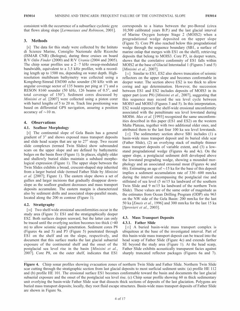
[10] Two shelf-wide erosional unconformities occur in thestudy area (Figure 3): ES1 and the stratigraphically deeperES2. Both surfaces deepen seaward, but the latter can onlybe traced until the overlying section becomes too thick (>40m) to allow seismic signal penetration. Sediment cores P8(Figures 4a and 5) and P3 (Figure 5) penetrated throughES1 on the shelf and on the slope, respectively, anddocument that this surface marks the last glacial subaerialexposure of the continental shelf and the onset of thepostglacial sea level rise in the basin [Minisini et al.,2007]. Core P8, on the outer shelf, indicates that ES1
corresponds to a hiatus between the pre-Boreal (circa10,500 calibrated years B.P.) and the last glacial intervalof Marine Oxygen Isotope Stage 2 (MOIS2) when aprogradational wedge deposited on the upper slope(Figure 5). Core P8 also reached below this progradationalwedge through the sequence boundary (SB1, a surface ofmarine onlap that merges with ES1 on the shelf), retrievingdeposits that belong to MOIS3. Core P3, in deeper waters,shows that the correlative conformity of ES1 falls withinMOIS2 at the base of Glacial Interstadial 1 (Figures 3 and 5)[Minisini et al., 2007].[11] Similar to ES1, ES2 also shows truncation of seismic
reflectors on the upper slope and becomes conformable indeeper water. The section above ES2 is too thick to allowcoring and age determination. However, the successionbetween ES1 and ES2 includes deposits of MOIS3 in itsupper part (core P8) [Minisini et al., 2007], suggesting thatthis sequence may record the sea level cycle betweenMOIS5 and MOIS3 (Figures 3 and 5). In this interpretation,ES2 would represent the shelf-wide erosional unconformityassociated with the penultimate sea level lowstand duringMOIS6. Max et al. [1993] recognized the same unconform-ities described in this paper (ES1 and ES2) on the westernMalta Plateau, together with two additional older ones, andattributed them to the last four 100 ka sea level lowstands.[12] The sedimentary section above SB1 includes (1) a
basin-wide mass transport deposit and its buried slide scar(Father Slide), (2) an overlying stack of multiple thinnermass transport deposits of variable extent, and (3) a low-stand progradational wedge (Figures 4a and 4c). On theupper slope, a postglacial sediment drift developed abovethe lowstand prograding wedge, showing a mounded mor-phology and an associated erosional moat (Figures 4c and6b). Estimating an age of �15 ka for the base of this depositimplies a sediment accumulation rate of 330–600 mm/kaduring the interval encompassing the postglacial rise andstillstand of sea level (5 m/15 ka landward of the southernTwin Slide and 9 m/15 ka landward of the northern TwinSlide). These values are of the same order of magnitude asthe estimates from Ocean Drilling Program (ODP) site 963on the NW side of the Gela Basin: 200 mm/ka for the last50 ka [Emeis et al., 1996] and 300 mm/ka for the last 15 ka[Sprovieri et al., 2003].
4.3. Mass Transport Deposits
4.3.1. Father Slide[13] A buried basin-wide mass transport complex is
ubiquitous at the base of the investigated interval. Part ofthis basin-wide mass transport deposit can be traced into thehead scarp of Father Slide (Figure 4c) and extends fartherSE beyond the study area (Figure 1). At the head scarp,Father Slide exhibits acoustically transparent facies againstsharply truncated reflector packages (Figures 6a and 7).
Figure 4. Chirp sonar profiles showing evacuation zones of northern Twin Slide and Father Slide. Northern Twin Slidescar cutting through the stratigraphic section from last glacial deposits to most surficial sediment units: (a) profile HE 112and (b) profile HE 101. The erosional surface ES1 becomes conformable toward the basin and documents the last glacialsubaerial exposure and the onset of the postglacial sea level rise. (c) Chirp sonar profile showing 60 m thick sedimentaryunit overlying the basin-wide Father Slide scar that dissects thick sections of deposits of the last glaciation. Polygons areburied mass transport deposits; locally, they root fluid escape structures. Basin-wide mass transport deposits of Father Slideare shown in Figure 9a.
F03014 MINISINI AND TRINCARDI: FREQUENT FAILURE OF THE CONTINENTAL SLOPE
4 of 17
F03014

Figure 4
F03014 MINISINI AND TRINCARDI: FREQUENT FAILURE OF THE CONTINENTAL SLOPE
5 of 17
F03014

Figure 5
6 of 17
F03014 MINISINI AND TRINCARDI: FREQUENT FAILURE OF THE CONTINENTAL SLOPE F03014
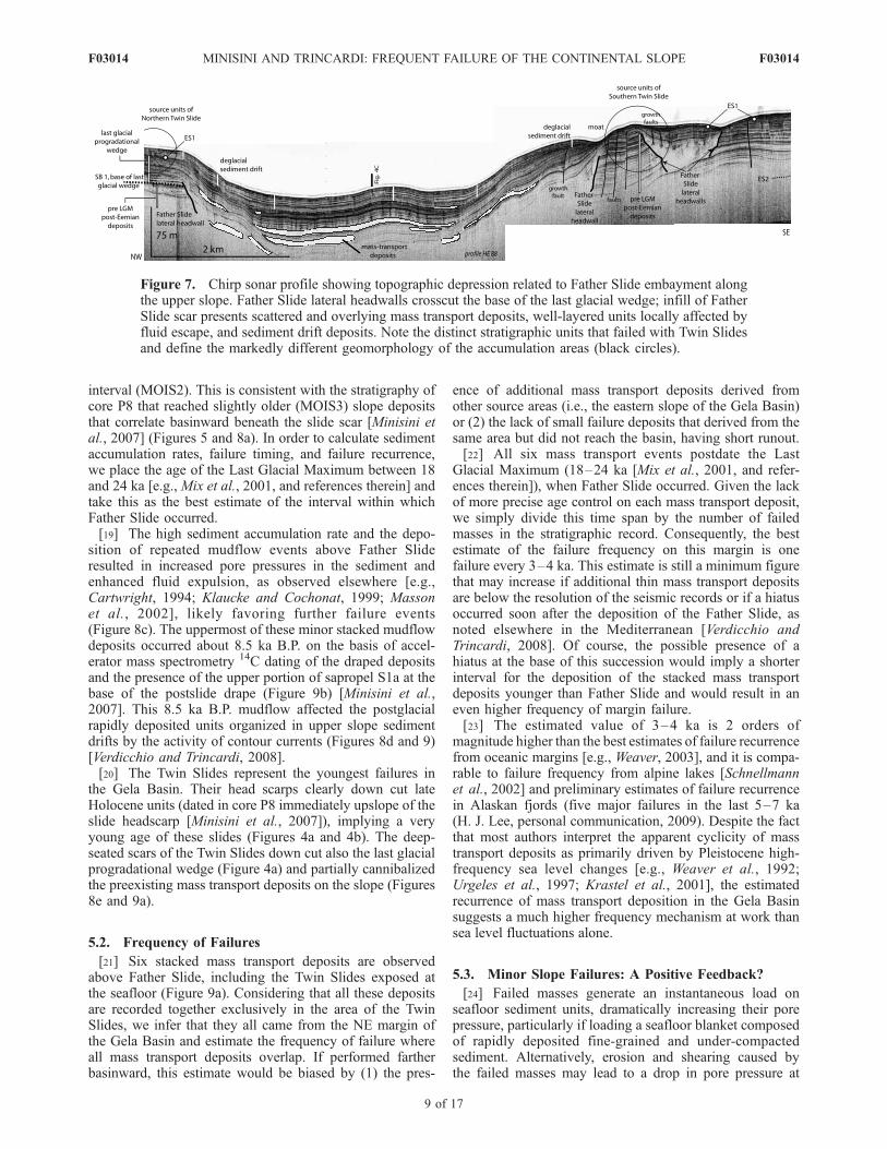
Father Slide affects units above ES2 and crosscuts the baseof the progradational lowstand wedge SB1 (Figures 5 and 7).
4.3.2. Minor Failures[14] Above this basin-wide mass transport complex, a
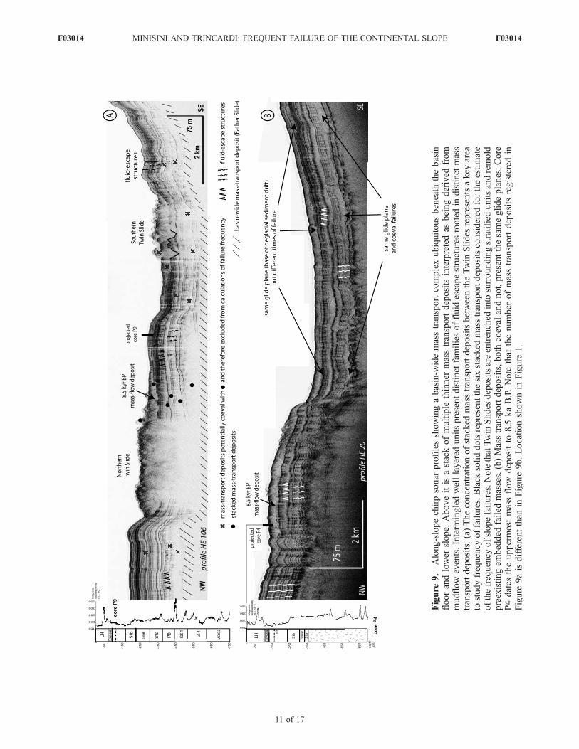
stack of multiple but thinner mass transport deposits showsacoustically transparent facies, flat tops, and a tendency toinfill and smooth out preexisting seafloor irregularities(Figures 8, 9a, and 9b). Given the resolution of the chirpsonar profiler utilized, up to six stacked mass transportdeposits can be counted (Figure 9a). Altogether, thesegeometric features and the good penetration of the acousticsignal suggest that these deposits likely originated as mud-flows, as reported for several geometrically similar exam-ples [e.g., Hampton et al., 1996]. In addition, the lack ofclear-cut head scarps suggests that these minor failuresoccurred through disintegration rather than rupture alongwell-defined shear planes [e.g., Mulder and Cochonat,1996]. Core P4 penetrated the most recent and shallowlyburied of these acoustically transparent units (Figure 9b)and recovered rip-up mud clasts and plant remains overlainby silty layers, suggesting a mudflow deposit overlain bythin turbidites [Minisini et al., 2007]. The well-layeredunits, interstratified with the acoustically transparent units,exhibit closely spaced subvertical wipeouts with uniformspacing, width, and geometry (Figure 9a). These featuresrepresent variable scattering and absorption of the acousticsignal probably caused by a dense distribution of fracturesthat channelized fluids, as documented elsewhere by Gay etal. [2003] and Riedel et al. [2006]. In the study area, thesefluid escape structures typically root into preexisting buriedmass transport deposits, and locally, where they reach theseafloor, the topography appears hummocky with sub-rounded depressions (Figure 1). In particular, a field ofpockmarks, with a typical spacing of �100 m and depths ofup to 10 m, occurs atop a distal mass transport deposit andthrough the overlying drape [Minisini et al., 2007].
4.3.3. Twin Slides[15] Two exposed slide deposits have internal structure,
external morphology, and runout distance indicating areduced movement with respect to the underlying massflow deposits [Minisini et al., 2007] (Figures 2 and 9a).The southern Twin Slide consists of a debris avalanchedeposit (in the sense of Lee et al. [2007]) because it showsbroken blocks and presents erosional features at its base(reaching a depth up to 15 m) that compare in scale andstratigraphic position to the scours ploughed by down-slope-gliding blocks interpreted from 3-D seismic imagery[Posamentier and Kolla, 2003; Gee et al., 2005;Moscardelliet al., 2006]. The northern Twin Slide represents a debrisavalanche deposit overridden by a slump deposit (in thesense of Lee et al. [2007]) as suggested by a rotated failedmass derived from a concave scar and the preexistence ofbroken blocks derived from a previous failure preserved
along the sides of the slump deposit. The slump produced anisolated oval slide mass 1 km wide resting at the main dropin slope (in 510 m water depth) between the concaveevacuation area and the gentler irregular accumulation zone(Figure 10). This slumped mass (>0.1 km3) displays a shaperemarkably similar to the pronounced indentation visible inthe composite slide scar, suggesting that it kept its integritywhile moving downslope. Similar slumped blocks are de-scribed by Hasegawa and Kanamori [1987], Schwab et al.[1993], and Duperret et al. [1995]. An acoustically stratifiedunit up to 3.5 m thick is observed in the upper part of theslumped block (core P7). Biostratigraphic analyses indicatethat this unit remained in its original stratigraphic order withrespect to the underlying block because the foraminiferalassemblages in this unit differ from other cores in comparablewater depth outside the slide deposit. In particular, somebenthic foraminifera species typical of much shallower shelfenvironments (e.g.,Melonis and Valvulineria) are very abun-dant [Minisini et al., 2007]. Basinward of the slumped block,compressional structures formed a thrust system with pres-sure ridges at the seafloor (Figure 10).[16] The relationship between total fall height and runout
distance of the Twin Slides (0.041, northern Twin Slide;0.052, southern Twin Slide [Minisini et al., 2007]) matchesvalues typical of subaerial landslides, which have reduceddownslope mobility. Marine slides with this character aresupposed to involve masses that are relatively dense[Lipman et al., 1988; Lee et al., 1991; Legros, 2002]. Inour study area this interpretation is consistent with theevidence of (1) steep (up to 27�) head scarps down cuttingthick sections of older compacted units and (2) minimaldisintegration of the failed mass during transport.[17] Both Twin Slides deposits have relatively short
runout distances, particularly when compared to docu-mented examples where hydroplaning is hypothesized[e.g., Iverson et al., 1997; Mohrig et al., 1998; Elverhoiet al., 2005]. In this view, the failed material of the TwinSlides decelerated rapidly and stopped downslope with no,or limited, hydroplaning. This interpretation is supportedalso by (1) the limited fan-shaped spreading of the failedmasses, as observed elsewhere by Posamentier and Kolla[2003], (2) the limited evidence of stretching of the materialwithin the accumulation zone [Elverhoi et al., 2000], and(3) the erosional base of the deposits, indicating scouringand remolding [Prior et al., 1982; Trincardi and Normark,1989; Gee et al., 2006].
5. Discussion
5.1. Failure Phases and Timing
[18] Father Slide scar crosscuts surface SB1, the base ofthe last glacial progradational wedge, and therefore indi-cates that failure occurred during the Last Glacial Maximum
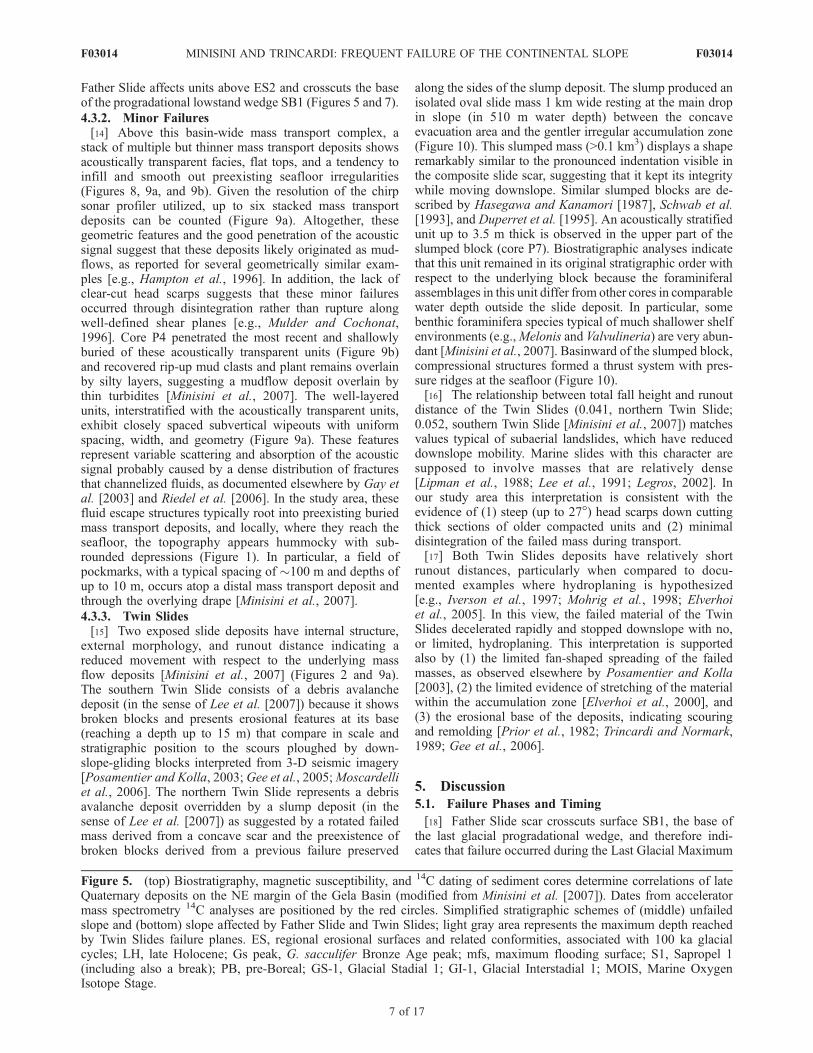
Figure 5. (top) Biostratigraphy, magnetic susceptibility, and 14C dating of sediment cores determine correlations of lateQuaternary deposits on the NE margin of the Gela Basin (modified from Minisini et al. [2007]). Dates from acceleratormass spectrometry 14C analyses are positioned by the red circles. Simplified stratigraphic schemes of (middle) unfailedslope and (bottom) slope affected by Father Slide and Twin Slides; light gray area represents the maximum depth reachedby Twin Slides failure planes. ES, regional erosional surfaces and related conformities, associated with 100 ka glacialcycles; LH, late Holocene; Gs peak, G. sacculifer Bronze Age peak; mfs, maximum flooding surface; S1, Sapropel 1(including also a break); PB, pre-Boreal; GS-1, Glacial Stadial 1; GI-1, Glacial Interstadial 1; MOIS, Marine OxygenIsotope Stage.
7 of 17
F03014 MINISINI AND TRINCARDI: FREQUENT FAILURE OF THE CONTINENTAL SLOPE F03014

Figure
6.
Chirpsonar
profilescrosscuttingeach
other
andshowingdeglacial
driftdepositsandoutershelfdeposits(both
atopES1):(a)profile
HE89and(b)profile
HE87.Thesedepositsshow
seismic-stratigraphic
correlationin
Figure
6abut
notin
Figure
6b.Figure
6apresentsalso
thelandwardapex
ofFather
Slidescar,whereacoustically
transparentfacies
are
interpretedas
insitu
deform
edblocks;thesedeform
edunitsareconstrained
amongfaultsrootedbeyondtheacousticsignal
penetration.
F03014 MINISINI AND TRINCARDI: FREQUENT FAILURE OF THE CONTINENTAL SLOPE
8 of 17
F03014
interval (MOIS2). This is consistent with the stratigraphy ofcore P8 that reached slightly older (MOIS3) slope depositsthat correlate basinward beneath the slide scar [Minisini etal., 2007] (Figures 5 and 8a). In order to calculate sedimentaccumulation rates, failure timing, and failure recurrence,we place the age of the Last Glacial Maximum between 18and 24 ka [e.g., Mix et al., 2001, and references therein] andtake this as the best estimate of the interval within whichFather Slide occurred.[19] The high sediment accumulation rate and the depo-
sition of repeated mudflow events above Father Slideresulted in increased pore pressures in the sediment andenhanced fluid expulsion, as observed elsewhere [e.g.,Cartwright, 1994; Klaucke and Cochonat, 1999; Massonet al., 2002], likely favoring further failure events(Figure 8c). The uppermost of these minor stacked mudflowdeposits occurred about 8.5 ka B.P. on the basis of accel-erator mass spectrometry 14C dating of the draped depositsand the presence of the upper portion of sapropel S1a at thebase of the postslide drape (Figure 9b) [Minisini et al.,2007]. This 8.5 ka B.P. mudflow affected the postglacialrapidly deposited units organized in upper slope sedimentdrifts by the activity of contour currents (Figures 8d and 9)[Verdicchio and Trincardi, 2008].[20] The Twin Slides represent the youngest failures in
the Gela Basin. Their head scarps clearly down cut lateHolocene units (dated in core P8 immediately upslope of theslide headscarp [Minisini et al., 2007]), implying a veryyoung age of these slides (Figures 4a and 4b). The deep-seated scars of the Twin Slides down cut also the last glacialprogradational wedge (Figure 4a) and partially cannibalizedthe preexisting mass transport deposits on the slope (Figures8e and 9a).
5.2. Frequency of Failures
[21] Six stacked mass transport deposits are observedabove Father Slide, including the Twin Slides exposed atthe seafloor (Figure 9a). Considering that all these depositsare recorded together exclusively in the area of the TwinSlides, we infer that they all came from the NE margin ofthe Gela Basin and estimate the frequency of failure whereall mass transport deposits overlap. If performed fartherbasinward, this estimate would be biased by (1) the pres-
ence of additional mass transport deposits derived fromother source areas (i.e., the eastern slope of the Gela Basin)or (2) the lack of small failure deposits that derived from thesame area but did not reach the basin, having short runout.[22] All six mass transport events postdate the Last
Glacial Maximum (18–24 ka [Mix et al., 2001, and refer-ences therein]), when Father Slide occurred. Given the lackof more precise age control on each mass transport deposit,we simply divide this time span by the number of failedmasses in the stratigraphic record. Consequently, the bestestimate of the failure frequency on this margin is onefailure every 3–4 ka. This estimate is still a minimum figurethat may increase if additional thin mass transport depositsare below the resolution of the seismic records or if a hiatusoccurred soon after the deposition of the Father Slide, asnoted elsewhere in the Mediterranean [Verdicchio andTrincardi, 2008]. Of course, the possible presence of ahiatus at the base of this succession would imply a shorterinterval for the deposition of the stacked mass transportdeposits younger than Father Slide and would result in aneven higher frequency of margin failure.[23] The estimated value of 3–4 ka is 2 orders of
magnitude higher than the best estimates of failure recurrencefrom oceanic margins [e.g., Weaver, 2003], and it is compa-rable to failure frequency from alpine lakes [Schnellmannet al., 2002] and preliminary estimates of failure recurrencein Alaskan fjords (five major failures in the last 5–7 ka(H. J. Lee, personal communication, 2009). Despite the factthat most authors interpret the apparent cyclicity of masstransport deposits as primarily driven by Pleistocene high-frequency sea level changes [e.g., Weaver et al., 1992;Urgeles et al., 1997; Krastel et al., 2001], the estimatedrecurrence of mass transport deposition in the Gela Basinsuggests a much higher frequency mechanism at work thansea level fluctuations alone.
5.3. Minor Slope Failures: A Positive Feedback?
[24] Failed masses generate an instantaneous load onseafloor sediment units, dramatically increasing their porepressure, particularly if loading a seafloor blanket composedof rapidly deposited fine-grained and under-compactedsediment. Alternatively, erosion and shearing caused bythe failed masses may lead to a drop in pore pressure at
Figure 7. Chirp sonar profile showing topographic depression related to Father Slide embayment alongthe upper slope. Father Slide lateral headwalls crosscut the base of the last glacial wedge; infill of FatherSlide scar presents scattered and overlying mass transport deposits, well-layered units locally affected byfluid escape, and sediment drift deposits. Note the distinct stratigraphic units that failed with Twin Slidesand define the markedly different geomorphology of the accumulation areas (black circles).
F03014 MINISINI AND TRINCARDI: FREQUENT FAILURE OF THE CONTINENTAL SLOPE
9 of 17
F03014
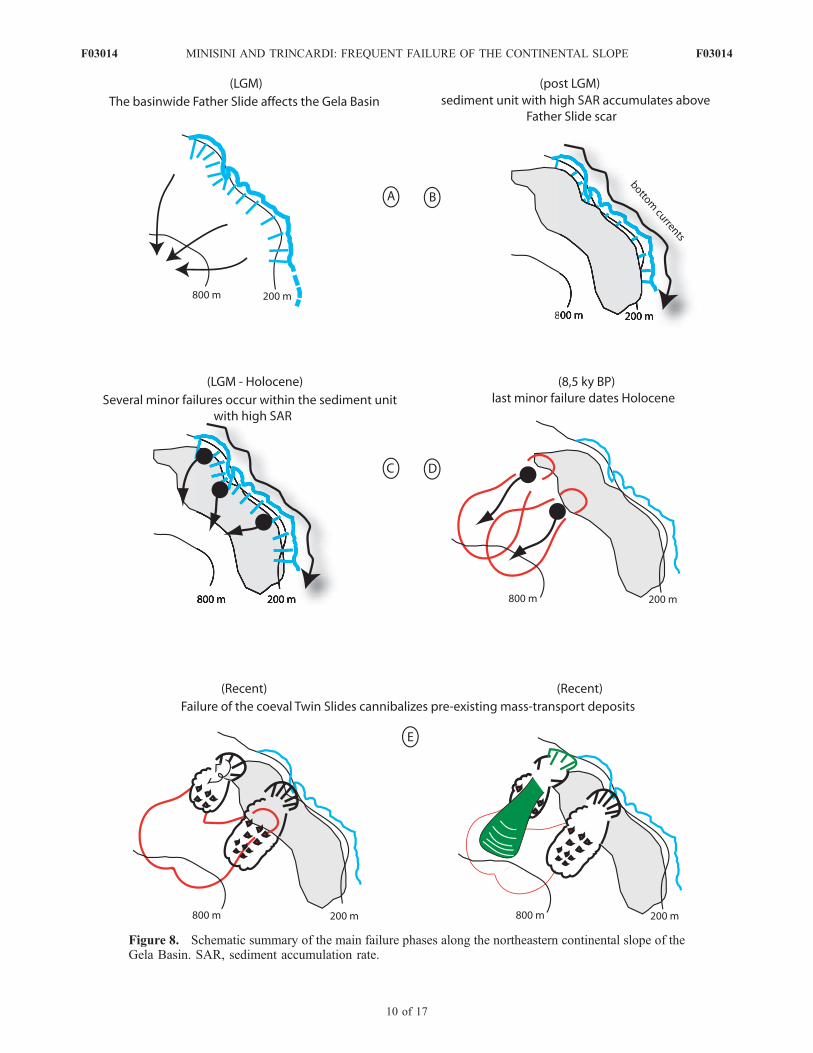
Figure 8. Schematic summary of the main failure phases along the northeastern continental slope of theGela Basin. SAR, sediment accumulation rate.
F03014 MINISINI AND TRINCARDI: FREQUENT FAILURE OF THE CONTINENTAL SLOPE
10 of 17
F03014
.
.
Figure
9.
Along-slopechirpsonar
profilesshowingabasin-w
idemasstransportcomplexubiquitousbeneath
thebasin
floorandlower
slope.
Aboveitis
astackofmultiple
thinner
masstransportdeposits
interpretedas
beingderived
from
mudflow
events.Interm
ingledwell-layered
unitspresentdistinct
familiesoffluid
escapestructuresrootedin
distinct
mass
transportdeposits.(a)Theconcentrationofstacked
masstransportdepositsbetweentheTwin
Slides
representsakey
area
tostudyfrequency
offailures.Black
soliddotsrepresentthesixstacked
masstransportdepositsconsidered
fortheestimate
ofthefrequency
ofslopefailures.NotethatTwin
Slides
depositsareentrenched
into
surroundingstratified
unitsandremold
preexistingem
bedded
failed
masses.(b)Masstransportdeposits,both
coevalandnot,presentthesameglideplanes.Core
P4dates
theuppermost
massflow
depositto
8.5
kaB.P.Note
that
thenumber
ofmasstransportdeposits
registeredin
Figure
9aisdifferentthan
inFigure
9b.Locationshownin
Figure
1.
F03014 MINISINI AND TRINCARDI: FREQUENT FAILURE OF THE CONTINENTAL SLOPE
11 of 17
F03014

the base of mass transport deposits if the underlying unitsare overcompacted (Figure 11). Both cases drive pore fluidsto move toward, and to accumulate into, the overlying masstransport deposit, increasing its overpressure [e.g., Massonet al., 2002]. In addition, upward migration of pore fluidsoccurs where the failed mass is rapidly buried by fine-
grained units [e.g., Trincardi et al., 2004]. In the study area,chirp sonar profiles show vertical structures, suggesting thateach time a failed mass covered the basin a new path offluid escape reached the seafloor (Figure 9). The sectionabove Father Slide represents the case in which rapidlydeposited units accumulated on the slope above failed
Figure 10. (a) Line drawing and relief of multibeam swath bathymetry. Illumination from the northshows the slumped mass in the proximal accumulation zone of northern Twin Slide and its peculiar shapesimilar to the indentation marked in the composite scar. (b) Chirp sonar profile along the northern TwinSlide deposit showing, from right to left, distal part of slumped mass, thrust system, appearance of glideplane, and tip of mass transport deposit. Projected core P7 indicates that the upper sediment of theslumped mass maintained its original stratigraphy.
F03014 MINISINI AND TRINCARDI: FREQUENT FAILURE OF THE CONTINENTAL SLOPE
12 of 17
F03014
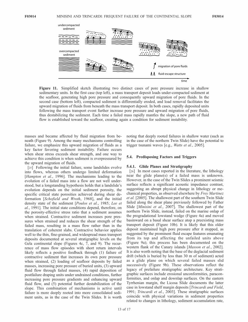
masses and became affected by fluid migration from be-neath (Figure 9). Among the many mechanisms controllingfailure, we emphasize this upward migration of fluids as akey factor favoring sediment instability. Failure occurswhen shear stress exceeds shear strength, and one way toachieve this condition is when sediment is overpressured bythe upward migration of fluids.[25] Following the initial failure, some landslides evolve
into flows, whereas others undergo limited deformation[Hampton et al., 1996]. The mechanisms leading to theevolution of a failed mass into a flow are not well under-stood, but a longstanding hypothesis holds that a landslide’sevolution depends on the initial sediment porosity, thespecific critical state porosities achieved during shear de-formation [Schofield and Wroth, 1968], and the initialdensity state of the sediment [Poulos et al., 1985; Lee etal., 1991]. The initial state conditions depend, therefore, onthe porosity-effective stress ratio that a sediment assumeswhen strained. Contractive sediment increases pore pres-sures when strained and reduces the shear strength of thefailed mass, resulting in a mass flow rather than in thetranslation of coherent slabs. Contractive behavior applieswell to the thin, fine-grained, and widespread mass transportdeposits documented at several stratigraphic levels on theGela continental slope (Figures 4c, 7, and 9). The recur-rence of mass flow episodes with short return intervalslikely reflects a positive feedback through (1) failure ofcontractive sediment that increases its own pore pressurewhen strained, (2) loading of seafloor deposits by failedmasses, increasing pore pressure of buried units, (3) upwardfluid flow through failed masses, (4) rapid deposition ofpostfailure draping units under undrained conditions, furtherincreasing pore pressure gradients and enhancing upwardfluid flow, and (5) potential further destabilization of theslope. This combination of mechanisms is active untilfailure is more deeply rooted into more consolidated sedi-ment units, as in the case of the Twin Slides. It is worth
noting that deeply rooted failures in shallow water (such asin the case of the northern Twin Slide) have the potential totrigger tsunami waves [e.g., Watts et al., 2005].
5.4. Predisposing Factors and Triggers
5.4.1. Glide Planes and Stratigraphy[26] In most cases reported in the literature, the lithology
near the glide plane(s) of a failed mass is unknown.However, in the case of the Twin Slides a prominent seismicsurface reflects a significant acoustic impedance contrast,suggesting an abrupt physical change in lithology or me-chanical properties, as observed elsewhere by Frey Martinezet al. [2005]. The shallowest part of the southern Twin Slidefailed along the shear plane previously followed by FatherSlide [Minisini et al., 2007]. The shallowest part of thenorthern Twin Slide, instead, failed on the marine onlap ofthe progradational lowstand wedge (Figure 4a) and movedbasinward on a basal shear surface atop a preexisting masstransport deposit (Figure 10b). It is likely that this olderdeposit maintained high pore pressure after it stopped, assuggested by the prominent fluid escape features emanatingfrom its top and affecting the unfailed units above(Figure 9a); this process has been documented on thewestern flank of the Canary islands [Masson et al., 2002].It is also worth noting that the base of the deglacial sedimentdrift (which is buried by less than 30 m of sediment) actedas a glide plane on which several failed masses slidsuccessively (Figure 9b). These observations reflect thelegacy of prefailure stratigraphic architecture. Key strati-graphic surfaces include erosional unconformities, paracon-formities, and onlap and downlap surfaces. On the easternTyrrhenian margin, the Licosa Slide documents the lattercase in lowstand shelf margin deposits [Trincardi and Field,1991; Trincardi et al., 2003]. These stratigraphic surfacescoincide with physical variations in sediment propertiesrelated to changes in lithology, sediment accumulation rate,
Figure 11. Simplified sketch illustrating two distinct cases of pore pressure increase in shallowsedimentary units. In the first case (top left), a mass transport deposit loads under-compacted sediment atthe seafloor, generating high pore pressure and consequently upward migration of pore fluids. In thesecond case (bottom left), compacted sediment is differentially eroded, and load removal facilitates theupward migration of fluids from beneath the mass transport deposit. In both cases, rapidly deposited unitsfollowing the mass transport event further increase pore pressure and upward migration of pore fluids,thus destabilizing the sediment. Each time a failed mass rapidly mantles the slope, a new path of fluidflow is established toward the seafloor, creating again a condition for sediment instability.
F03014 MINISINI AND TRINCARDI: FREQUENT FAILURE OF THE CONTINENTAL SLOPE
13 of 17
F03014

compaction, and cementation, thus predisposing preferentialplanes of rupture when shallowly buried.
5.4.2. Proto–Shear Surfaces[27] According to Petley et al. [2005], repeated seismic
shocks induce proto–shear surfaces and initial creep. Ulti-mately, the shear stress and strain increase to the point thatcatastrophic failure occurs. Instrumental and historical datadocument small but recurrent seismic shocks in the studyarea [Minisini et al., 2007] (Figures 1 and 12). Consequent-ly, shear strain may have concentrated on subvertical faultsand on bedding parallel layers (later bases of mass transportcomplexes; Figure 7), resulting in proto–shear surfaces.The resulting breakdown of these discontinuities couldgenerate a reduction of shear strength where failure waskinematically admissible. A predisposing factor for deep-seated slides may be the combination of these subverticalshear zones and subhorizontal weak layers that facilitate themobilization of slope deposits up to the shelf edge.
5.4.3. Sediment Accumulation Rate[28] The upper slope in the study area shows that the infill
of Father Slide scar is up to 60 m thick, implying extremelyhigh sediment accumulation rates since the Last GlacialMaximum at 18–24 ka B.P. (2500–3300 mm/ka; Figure 4c).Hence, during this interval the infill of Father Slide scarregisters sediment accumulation rates larger than the aver-age rates, estimated from ODP site 963 (200–300 mm/ka[Emeis et al., 1996]), from cores collected on the outer shelfin the study area (up to 450 mm/ka [Minisini et al., 2007]),and from rates derived from the thickness of the postglacialcontourite deposits along the margin (330–600 mm/ka). Itis worth noting that this thick sediment pile includes severalstacked failed masses, yielding an apparently higher sedi-ment accumulation rate. However, other Mediterraneancontinental margins that are also swept by along-slope
bottom currents can reach sediment accumulation ratescomparable to those estimated for the upper slope of theGela Basin [Roveri, 2002; Verdicchio et al., 2007].[29] In summary, the main factors conducive to recurrent
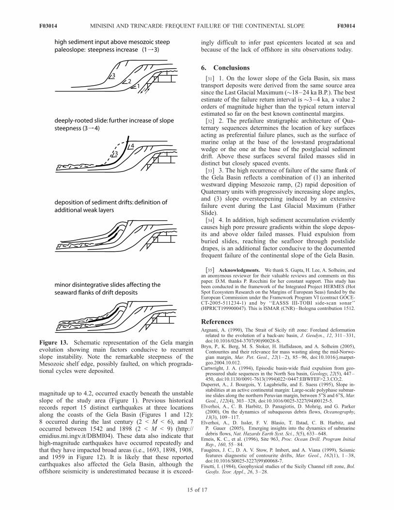
slope instability in the Gela Basin include (Figure 13) (1)the presence of thick deposits on an oversteepened slopethat reflect increased sediment flux and instability duringthe Quaternary (Figure 2), (2) the steepness of Father Slidescar and its thick, rapidly deposited infill (Figure 4c), (3) theoccurrence of two main discontinuities at the shelf margin(ES1 and ES2; Figure 3) locally acting as detachmentsurfaces, and (4) the presence of rapidly deposited contour-ite drift deposits on the upper slope that are prone to failure,as documented elsewhere by Faugeres et al. [1999], Bryn etal. [2005], and Verdicchio and Trincardi [2008] (Figure 6a).In addition, the presence of faults, either sealed or reachingthe seafloor (Figure 7), and fluid escape features (Figure 9)may have favored the generation of proto–shear surfacesthat facilitated the failure of the slope deposits.
5.4.4. Triggers[30] The evidence of multiple sets of mass transport
deposits separated by draped units suggests the recurrentachievement of failure conditions, which implies a recurrenttrigger. Seismicity is the most plausible recurrent triggermechanism [e.g., Syvitski and Schafer, 1996; Schnellmannet al., 2002]. It is reasonable that the multiple phases offailures reflect repeated seismic shocks affecting the upperslope and outer shelf of the Gela margin. Instrumental andhistorical records indicate that the seismicity of the area issmall compared to other Mediterranean areas (http://neic.usgs.gov/neis/epic/epic.html and Figure 1). However, thewell-developed instrumental registration of offshore epi-centers documents several tens of earthquakes in the GelaBasin and mainland region since 1970. Six of them, having
Figure 12. Seismic documentation along the coasts of the Gela Basin dating back to 1542 A.D.Locations are shown in Figure 1. Is: intensity recorded at the site using the Mercalli-Cancani-Siebergscale.
F03014 MINISINI AND TRINCARDI: FREQUENT FAILURE OF THE CONTINENTAL SLOPE
14 of 17
F03014
magnitude up to 4.2, occurred exactly beneath the unstableslope of the study area (Figure 1). Previous historicalrecords report 15 distinct earthquakes at three locationsalong the coasts of the Gela Basin (Figures 1 and 12):8 occurred during the last century (2 < M < 6), and 7occurred between 1542 and 1898 (2 < M < 9) (http://emidius.mi.ingv.it/DBMI04). These data also indicate thathigh-magnitude earthquakes have occurred repeatedly andthat they have impacted broad areas (i.e., 1693, 1898, 1908,and 1959 in Figure 12). It is likely that these reportedearthquakes also affected the Gela Basin, although theoffshore seismicity is underestimated because it is exceed-
ingly difficult to infer past epicenters located at sea andbecause of the lack of offshore in situ observations today.
6. Conclusions
[31] 1. On the lower slope of the Gela Basin, six masstransport deposits were derived from the same source areasince the Last Glacial Maximum (�18–24 ka B.P.). The bestestimate of the failure return interval is �3–4 ka, a value 2orders of magnitude higher than the typical return intervalestimated so far on the best known continental margins.[32] 2. The prefailure stratigraphic architecture of Qua-
ternary sequences determines the location of key surfacesacting as preferential failure planes, such as the surface ofmarine onlap at the base of the lowstand progradationalwedge or the one at the base of the postglacial sedimentdrift. Above these surfaces several failed masses slid indistinct but closely spaced events.[33] 3. The high recurrence of failure of the same flank of
the Gela Basin reflects a combination of (1) an inheritedwestward dipping Mesozoic ramp, (2) rapid deposition ofQuaternary units with progressively increasing slope angles,and (3) slope oversteepening induced by an extensivefailure event during the Last Glacial Maximum (FatherSlide).[34] 4. In addition, high sediment accumulation evidently
causes high pore pressure gradients within the slope depos-its and above older failed masses. Fluid expulsion fromburied slides, reaching the seafloor through postslidedrapes, is an additional factor conducive to the documentedfrequent failure of the continental slope of the Gela Basin.
[35] Acknowledgments. We thank S. Gupta, H. Lee, A. Solheim, andan anonymous reviewer for their valuable reviews and comments on thispaper. D.M. thanks P. Rocchini for her constant support. This study hasbeen conducted in the framework of the Integrated Project HERMES (HotSpot Ecosystem Research on the Margins of European Seas) funded by theEuropean Commission under the Framework Program VI (contract GOCE-CT-2005-511234-1) and by ‘‘EASSS III-TOBI side-scan sonar’’(HPRICT199900047). This is ISMAR (CNR)–Bologna contribution 1512.
ReferencesArgnani, A. (1990), The Strait of Sicily rift zone: Foreland deformationrelated to the evolution of a back-arc basin, J. Geodyn., 12, 311–331,doi:10.1016/0264-3707(90)90028-S.
Bryn, P., K. Berg, M. S. Stoker, H. Haflidason, and A. Solheim (2005),Contourites and their relevance for mass wasting along the mid-Norwe-gian margin, Mar. Pet. Geol., 22(1–2), 85–96, doi:10.1016/j.marpet-geo.2004.10.012.
Cartwright, J. A. (1994), Episodic basin-wide fluid expulsion from geo-pressured shale sequences in the North Sea basin, Geology, 22(5), 447–450, doi:10.1130/0091-7613(1994)022<0447:EBWFEF>2.3.CO;2.
Duperret, A., J. Bourgois, Y. Lagabrielle, and E. Suess (1995), Slope in-stabilities at an active continental margin: Large-scale polyphase submar-ine slides along the northern Peruvian margin, between 5�S and 6�S,Mar.Geol., 122(4), 303–328, doi:10.1016/0025-3227(94)00125-5.
Elverhoi, A., C. B. Harbitz, D. Panagiotis, D. Mohrig, and G. Parker(2000), On the dynamics of subaqueous debris flows, Oceanography,13(3), 109–117.
Elverhoi, A., D. Issler, F. V. Blasio, T. Ilstad, C. B. Harbitz, andP. Gauer (2005), Emerging insights into the dynamics of submarinedebris flows, Nat. Hazards Earth Syst. Sci., 5(5), 633–648.
Emeis, K. C., et al. (1996), Site 963, Proc. Ocean Drill. Program InitialRep., 160, 55–84.
Faugeres, J. C., D. A. V. Stow, P. Imbert, and A. Viana (1999), Seismicfeatures diagnostic of contourite drifts, Mar. Geol., 162(1), 1 – 38,doi:10.1016/S0025-3227(99)00068-7.
Finetti, I. (1984), Geophysical studies of the Sicily Channel rift zone, Bol.Geofis. Teor. Appl., 26, 3–28.
Figure 13. Schematic representation of the Gela marginevolution showing main factors conducive to recurrentslope instability. Note the remarkable steepness of theMesozoic shelf edge, possibly faulted, on which prograda-tional cycles were deposited.
F03014 MINISINI AND TRINCARDI: FREQUENT FAILURE OF THE CONTINENTAL SLOPE
15 of 17
F03014
Frey Martinez, J., J. Cartwright, and B. Hall (2005), 3D seismic interpreta-tion of slump complexes: Examples from the continental margin of Israel,Basin Res., 17, 83–108, doi:10.1111/j.1365-2117.2005.00255.x.
Gardiner, W., M. Grasso, and D. Sedgeley (1993), Plio-Pleistocene stra-tigraphy and fault movement of the Malta Platform, in GeologicalDevelopment of the Sicilian-Tunusian Platform, edited by M. D. Maxand P. Colantoni, UNESCO Tech. Rep. Mar. Sci., 58, 111–116.
Gay, A. M., P. Lopez, N. Cochonat, E. Sultan Cauquil, and F. Brigaud(2003), Sinuous pockmark belt as indicator of a shallow buried turbiditicchannel on the lower slope of the Congo Basin, West African Margin, inSubsurface Sediment Mobilization, edited by P. Van Rensbergen et al.,Geol. Soc. Spec. Publ., 216, 173–189.
Gee, M. J. R., R. L. Gawthorpe, and J. S. Friedmann (2005), Giant stria-tions at the base of a submarine landslide, Mar. Geol., 214(1–3), 287–294, doi:10.1016/j.margeo.2004.09.003.
Gee, M. J. R., R. L. Gawthorpe, and S. J. Friedmann (2006), Triggering andevolution of a giant submarine landslide, offshore Angola, revealed by3D seismic stratigraphy and geomorphology, J. Sediment. Res., 76(1), 9–19, doi:10.2110/jsr.2006.02.
Grasso, M. (1993), Pleistocene structures along the Ionian side of theHyblean Plateau (SE Sicily): Implications for the tectonic evolutionof the Malta Escarpment, in Geological Development of the Sicilian-Tunusian Platform, edited by M. D. Max and P. Colantoni, UNESCOTech. Rep. Mar. Sci., 58, 49–55.
Hampton, M. A., H. J. Lee, and J. Locat (1996), Submarine landslides, Rev.Geophys., 34, 33–59, doi:10.1029/95RG03287.
Hasegawa, H. S., and H. Kanamori (1987), Source mechanism of the mag-nitude 7.2 Grand Banks earthquake of November 18, 1929: Double-couple or submarine landslide?, Bull. Seismol. Soc. Am., 77, 1984–2004.
Holland, C. W., G. Etiope, A. V. Milkov, E. Michelozzi, and P. Favali(2003), Mud volcanoes discovered offshore Sicily, Mar. Geol., 199(1–2), 1–6, doi:10.1016/S0025-3227(03)00125-7.
Iverson, R. M., M. E. Reid, and R. G. LaHusen (1997), Debris-flow mobi-lization from landslides, Annu. Rev. Earth Planet. Sci., 25, 85– 138,doi:10.1146/annurev.earth.25.1.85.
Klaucke, I., and P. Cochonat (1999), Analysis of past seafloor failures onthe continental slope off Nice (SE France), Geo Mar. Lett., 19(4), 245–253, doi:10.1007/s003670050115.
Krastel, S., H. U. Schmincke, C. L. Jacobs, R. Rihm, T. P. Le Bas, andB. Alibes (2001), Submarine landslides around the Canary Islands,J. Geophys. Res., 106, 3977–3997, doi:10.1029/2000JB900413.
Lee, H. J. (2005), Undersea landslides: Extent and significance in thePacific Ocean, an update, Nat. Hazards Earth Syst. Sci., 5(6), 877–892.
Lee, H. J., W. C. Schwab, B. D. Edwards, and R. E. Kayen (1991), Quan-titative controls on submarine slope failure morphology, Mar. Geotech-nol., 10, 143–158, doi:10.1080/10641199109379887.
Lee, H. J., J. Locat, P. Desgagnes, J. D. Parsons, B. G. McAdoo, D. L.Orange, P. Puig, F. L. Wong, P. Dartnell, and E. Boulanger (2007), Sub-marine mass movements on continental margins, in Continental-MarginSedimentation: From Sediment Transport to Sequence Stratigraphy, IASSpec. Publ., vol. 37, edited by C. A. Nittrouer et al., pp. 213–274,Blackwell, Oxford, U.K.
Legros, F. (2002), The mobility of long-runout landslides, Eng. Geol. Am-sterdam, 63(3–4), 301–331, doi:10.1016/S0013-7952(01)00090-4.
Lermusiaux, P. F. J., and A. R. Robinson (2001), Features of dominantmesoscale variability, circulation patterns and dynamics in the Strait ofSicily, Deep Sea Res., Part I, 48(9), 1953–1997, doi:10.1016/S0967-0637(00)00114-X.
Lipman, P. W., W. R. Normark, J. G. Moore, J. B. Wilson, and C. E.Gutmacher (1988), The giant submarine Alika debris slide, MaunaLoa, Hawaii, J. Geophys. Res., 93, 4279 – 4299, doi:10.1029/JB093iB05p04279.
Masson, D. G., A. B. Watts, M. J. R. Gee, R. Urgeles, N. C. Mitchell, T. P.Le Bas, and M. Canals (2002), Slope failures on the flanks of the westernCanary Islands, Earth Sci. Rev., 57, 1 – 35, doi:10.1016/S0012-8252(01)00069-1.
Max, M. D., A. Kristensen, and E. Michelozzi (1993), Small-scalePlio-Quaternary sequence stratigraphy and shallow geology of thewest-central Malta Plateau, in Geological Development of the Sicilian-Tunusian Platform, edited by M. D. Max and P. Colantoni, UNESCOTech. Rep. Mar. Sci., 58, 117–122.
McAdoo, B. G., L. F. Pratson, and D. L. Orange (2000), Submarine land-slide morphology, US continental slope, Mar. Geol., 169(1–2), 103–136, doi:10.1016/S0025-3227(00)00050-5.
Minisini, D., F. Trincardi, A. Asioli, M. Canu, and F. Foglini (2007),Morphologic variability of exposed mass-transport deposits on the east-ern slope of Gela Basin (Sicily Channel), Basin Res., 19, 217–240,doi:10.1111/j.1365-2117.2007.00324.x.
Mix, A. C., E. Bard, and R. Schneider (2001), Environmental processes ofthe ice age: Land, oceans, glaciers (EPILOG), Quat. Sci. Rev., 20, 627–657, doi:10.1016/S0277-3791(00)00145-1.
Mohrig, D., K. X. Whipple, M. Hondzo, C. Ellis, and G. Parker (1998),Hydroplaning subaqueous debris flows, Geol. Soc. Am. Bull., 110(3),387–394, doi:10.1130/0016-7606(1998)110<0387:HOSDF>2.3.CO;2.
Moscardelli, L., L. Wood, and P. Mann (2006), Mass-transport complexesand associated processes in the offshore area of Trinidad and Venezuela,AAPG Bull., 90(7), 1059–1088, doi:10.1306/02210605052.
Mulder, T., and P. Cochonat (1996), Classification of offshore mass move-ments, J. Sediment. Res., 66(1), 43–57.
Petley, D. N., T. Higuchi, D. J. Petley, M. H. Bulmer, and J. Carey (2005),Development of progressive landslide failure in cohesive materials, Geol-ogy, 33(3), 201–204, doi:10.1130/G21147.1.
Posamentier, H. W., and V. Kolla (2003), Seismic geomorphology andstratigraphy of depositional elements in deep-water settings, J. Sediment.Res., 73(3), 367–388, doi:10.1306/111302730367.
Poulos, S. G., G. Castro, and J. W. France (1985), Liquefaction evaluationprocedure, J. Geotech. Eng., 111, 772–791.
Prior, D. B., B. D. Bornhold, J. M. Coleman, and W. R. Bryant (1982),Morphology of a submarine slide, Kitimat Arm, British Columbia, Geol-ogy, 10(11), 588 – 592, doi:10.1130/0091-7613(1982)10<588:MOASSK>2.0.CO;2.
Riedel, M., I. Novosel, G. D. Spence, R. D. Hyndman, R. N. Chapman,R. C. Solem, and T. Lewis (2006), Geophysical and geochemical signa-tures associated with gas hydrate-related venting in the northern Cascadiamargin, Geol. Soc. Am. Bull., 118(1–2), 23–38, doi:10.1130/B25720.1.
Roveri, M. (2002), Sediment drifts of the Corsica Channel, northern Tyrre-nian Sea, in Deep-Water Contourite Systems: Modern Drift and AncientSeries, Seismic and Sedimentary Characteristics, Geol. Soc. Mem., vol.22, edited by D. A. V. Stow et al., pp. 191–208, Geol. Soc., London.
Schnellmann, M., F. S. Anselmetti, D. Giardini, J. A. McKenzie, and S. N.Ward (2002), Prehistoric earthquake history revealed by lacustrine slumpdeposi ts , Geology, 30 (12) , 1131 – 1134, doi :10.1130/0091-7613(2002)030<1131:PEHRBL>2.0.CO;2.
Schofield, A. N., and C. P. Wroth (Eds.) (1968), Critical State Soil Me-chanics, McGraw-Hill, New York.
Schwab, W. C., H. J. Lee, and D. C. Twichell (Eds.) (1993), SubmarineLandslides: Selected Studies in the U.S. Exclusive Economic Zone, U.S.Geol. Surv. Bull., B-2002, 204 pp.
Sprovieri, R., E. Di Stefano, A. Incarbona, and M. E. Gargano (2003), Ahigh resolution record of the last deglaciation in the Sicily Channel basedon foraminifera and calcareous nannafossil quantitative distribution, Pa-laeogeogr. Palaeoclimatol. Palaeoecol., 202, 119–142, doi:10.1016/S0031-0182(03)00632-1.
Syvitski, J. P. M., and C. T. Schafer (1996), Evidence for an earthquake-triggered basin collapse in Saguenay Fjord, Canada, Sediment. Geol.,104(1–4), 127–153, doi:10.1016/0037-0738(95)00125-5.
Trincardi, F., and A. Argnani (1990), Gela submarine slide: A major basin-wide event in the Plio-Quaternary foredeep of Sicily, Geo Mar. Lett.,10(1), 13–21, doi:10.1007/BF02431017.
Trincardi, F., and M. E. Field (1991), Collapse and flow of lowstand shelf-margin deposits: An example from the eastern Tyrrhenian Sea, Italy, Mar.Geol., 105(1–4), 77–94, doi:10.1016/0025-3227(92)90183-I.
Trincardi, F., and W. Normark (1989), Suvero Pleistocene slide, Paolabasin, southern Italy, Mar. Pet. Geol., 6, 324–335, doi:10.1016/0264-8172(89)90029-9.
Trincardi, F., A. Cattaneo, A. Correggiari, S. Mongardi, A. Breda, andA. Asioli (2003), Submarine slides during sea level rise: Two exam-ples from the eastern Tyrrhenian margin, in Submarine Mass Move-ments and Their Consequences, edited by J. Locat and J. Mienert, pp.469–478, Kluwer Acad., Dordrecht, Netherlands.
Trincardi, F., A. Cattaneo, A. Correggiari, and D. Ridente (2004), Evidenceof soft sediment deformation, fluid escape, sediment failure and regionalweak layers within the late Quaternary mud deposits of the Adriatic Sea,Mar. Geol., 213(1–4), 91–120, doi:10.1016/j.margeo.2004.10.003.
Urgeles, R., M. Canals, J. Baraza, B. Alonso, and D. Masson (1997), Themost recent megalandslides of the Canary Islands: El Golfo debris ava-lanche and Canary debris flow, west El Hierro Island, J. Geophys. Res.,102, 20,305–20,323, doi:10.1029/97JB00649.
Verdicchio, G., and F. Trincardi (2008), Mediterranean shelf-edge muddycontourites: Example from Gela and South Adriatic basins, Geo Mar.Lett., 28(3), 137–151, doi:10.1007/s00367-007-0096-9.
Verdicchio, G., F. Trincardi, and A. Asioli (2007), Mediterranean bottom-current deposits: An example from the southwestern Adriatic Margin, inEconomic and Palaeoceanographic Importance of Contourite, edited byA. R. Viana and M. Rebesco, Geol. Soc. Spec. Publ., 276, 199–224.
Watts, P., S. T. Grilli, D. R. Tappin, and G. J. Fryer (2005), Tsunamigeneration by submarine mass failure: II. Predictive equations and case
F03014 MINISINI AND TRINCARDI: FREQUENT FAILURE OF THE CONTINENTAL SLOPE
16 of 17
F03014
studies, J. Waterw. Port Coastal Ocean Eng., 131(6), 298 – 310,doi:10.1061/(ASCE)0733-950X(2005)131:6(298).
Weaver, P. P. E. (2003), Northwest African continental margin: History ofsediment accumulation, landslide deposits, and hiatuses as revealed bydrilling the Madeira Abyssal Plain, Paleoceanography, 18(1), 1009,doi:10.1029/2002PA000758.
Weaver, P. P. E., R. G. Rothwell, J. Ebbing, D. Gunn, and P. M. Hunter(1992), Correlation, frequency of emplacement and source directions ofmegaturbidites on the Madeira Abyssal Plain, Mar. Geol., 109(1–2), 1–20, doi:10.1016/0025-3227(92)90218-7.
�����������������������D. Minisini, Exploration & Production, Eni, Via Emilia 1, I-20097 San
Donato Milanese, Italy. ([email protected])F. Trincardi, ISMAR, CNR, Via Gobetti 101, I-40129 Bologna, Italy.
F03014 MINISINI AND TRINCARDI: FREQUENT FAILURE OF THE CONTINENTAL SLOPE
17 of 17
F03014
Copyright © 2022 FDOKUMEN