Explaining Geographic Gradients in Winter Selection of Landscapes by Boreal Caribou with...
10
Explaining Geographic Gradients in Winter Selection of Landscapes by Boreal Caribou with Implications under Global Changes in Eastern Canada Julien Beguin 1* , Eliot J. B. McIntire 1,2 , Daniel Fortin 3 , Steven G. Cumming 1 , Frédéric Raulier 1 , Pierre Racine 1 , Claude Dussault 4 1 Département des sciences du bois et de la forêt and Centre d'étude de la forêt, Université Laval, Québec, Québec, Canada, 2 Pacific Forestry Centre, Canadian Forest Service, Natural Resources Canada, Victoria, British Coloumbia, Canada, 3 Département de biologie and Centre d'étude de la forêt, Université Laval, Québec, Québec, Canada, 4 Direction de l’expertise Énergie-Faune-Forêts-Mines-Territoire du Saguenay–Lac-Saint-Jean, Ministère des Ressources naturelles et de la faune, Joncquière, Québec, Canada Abstract Many animal species exhibit broad-scale latitudinal or longitudinal gradients in their response to biotic and abiotic components of their habitat. Although knowing the underlying mechanism of these patterns can be critical to the development of sound measures for the preservation or recovery of endangered species, few studies have yet identified which processes drive the existence of geographical gradients in habitat selection. Using extensive spatial data of broad latitudinal and longitudinal extent, we tested three hypotheses that could explain the presence of geographical gradients in landscape selection of the endangered boreal woodland caribou (Rangifer tarandus caribou) during winter in Eastern Canadian boreal forests: 1) climate-driven selection, which postulates that geographic gradients are surrogates for climatic gradients; 2) road-driven selection, which proposes that boreal caribou adjust their selection for certain habitat classes as a function of proximity to roads; and 3) an additive effect of both roads and climate. Our data strongly supported road-driven selection over climate influences. Thus, direct human alteration of landscapes drives boreal caribou distribution and should likely remain so until the climate changes sufficiently from present conditions. Boreal caribou avoided logged areas two-fold more strongly than burnt areas. Limiting the spread of road networks and accounting for the uneven impact of logging compared to wildfire should therefore be integral parts of any habitat management plan and conservation measures within the range of the endangered boreal caribou. The use of hierarchical spatial models allowed us to explore the distribution of spatially-structured errors in our models, which in turn provided valuable insights for generating alternative hypotheses about processes responsible for boreal caribou distribution. Citation: Beguin J, McIntire EJB, Fortin D, Cumming SG, Raulier F, et al. (2013) Explaining Geographic Gradients in Winter Selection of Landscapes by Boreal Caribou with Implications under Global Changes in Eastern Canada. PLoS ONE 8(10): e78510. doi:10.1371/journal.pone.0078510 Editor: Mark S. Boyce, University of Alberta, Canada Received December 20, 2012; Accepted September 13, 2013; Published October 23, 2013 Copyright: © 2013 Beguin et al. This is an open-access article distributed under the terms of the Creative Commons Attribution License, which permits unrestricted use, distribution, and reproduction in any medium, provided the original author and source are credited. Funding: Funding for this research was provided by an NSERC (Natural Sciences and Engineering Research Council of Canada) scholarship to J.B. The funders had no role in study design, data collection and analysis, decision to publish, or preparation of the manuscript. Competing interests: The authors have declared that no competing interests exist. * E-mail: [email protected] Introduction The actual magnitude of global change that can be attributed to climate change and human-induced alterations of landscapes raises concerns about the adaptive abilities of many species to persist in this fast-changing world [1]. This view is supported by high current extinction rates for amphibians, birds, and mammals that are comparable to the rates prevailing during the last Big Five mass-extinction events, which have occurred over the past 443 million years [2]. Global warming and increasing anthropogenic disturbance are thought to be the two most important causes of current global change and the main causes of declines in biodiversity [3]. While both of these threats are anthropogenic [4], the ways of addressing species losses that are attributable to these two alternatives are quite different. Knowing which mechanism is most important in particular instances is vital if we are interested in putting into practice sound conservation measures for endangered species. In free-ranging animals, habitat selection is a fundamental behavioural process that structures their spatial distribution and influences population dynamics [5]. Fortin et al. [6] recently showed that the strength of selection (i.e., the relative probability of occurrence) for certain habitats varies along broad geographic gradients such as latitude and longitude, suggesting that large-scale processes may modulate the way PLOS ONE | www.plosone.org 1 October 2013 | Volume 8 | Issue 10 | e78510
Transcript of Explaining Geographic Gradients in Winter Selection of Landscapes by Boreal Caribou with...
Explaining Geographic Gradients in Winter Selection ofLandscapes by Boreal Caribou with Implications underGlobal Changes in Eastern CanadaJulien Beguin1*, Eliot J. B. McIntire1,2, Daniel Fortin3, Steven G. Cumming1, Frédéric Raulier1, PierreRacine1, Claude Dussault4
1 Département des sciences du bois et de la forêt and Centre d'étude de la forêt, Université Laval, Québec, Québec, Canada, 2 Pacific Forestry Centre,Canadian Forest Service, Natural Resources Canada, Victoria, British Coloumbia, Canada, 3 Département de biologie and Centre d'étude de la forêt, UniversitéLaval, Québec, Québec, Canada, 4 Direction de l’expertise Énergie-Faune-Forêts-Mines-Territoire du Saguenay–Lac-Saint-Jean, Ministère des Ressourcesnaturelles et de la faune, Joncquière, Québec, Canada
Abstract
Many animal species exhibit broad-scale latitudinal or longitudinal gradients in their response to biotic and abioticcomponents of their habitat. Although knowing the underlying mechanism of these patterns can be critical to thedevelopment of sound measures for the preservation or recovery of endangered species, few studies have yetidentified which processes drive the existence of geographical gradients in habitat selection. Using extensive spatialdata of broad latitudinal and longitudinal extent, we tested three hypotheses that could explain the presence ofgeographical gradients in landscape selection of the endangered boreal woodland caribou (Rangifer taranduscaribou) during winter in Eastern Canadian boreal forests: 1) climate-driven selection, which postulates thatgeographic gradients are surrogates for climatic gradients; 2) road-driven selection, which proposes that borealcaribou adjust their selection for certain habitat classes as a function of proximity to roads; and 3) an additive effect ofboth roads and climate. Our data strongly supported road-driven selection over climate influences. Thus, directhuman alteration of landscapes drives boreal caribou distribution and should likely remain so until the climatechanges sufficiently from present conditions. Boreal caribou avoided logged areas two-fold more strongly than burntareas. Limiting the spread of road networks and accounting for the uneven impact of logging compared to wildfireshould therefore be integral parts of any habitat management plan and conservation measures within the range ofthe endangered boreal caribou. The use of hierarchical spatial models allowed us to explore the distribution ofspatially-structured errors in our models, which in turn provided valuable insights for generating alternativehypotheses about processes responsible for boreal caribou distribution.
Citation: Beguin J, McIntire EJB, Fortin D, Cumming SG, Raulier F, et al. (2013) Explaining Geographic Gradients in Winter Selection of Landscapes byBoreal Caribou with Implications under Global Changes in Eastern Canada. PLoS ONE 8(10): e78510. doi:10.1371/journal.pone.0078510
Editor: Mark S. Boyce, University of Alberta, Canada
Received December 20, 2012; Accepted September 13, 2013; Published October 23, 2013
Copyright: © 2013 Beguin et al. This is an open-access article distributed under the terms of the Creative Commons Attribution License, which permitsunrestricted use, distribution, and reproduction in any medium, provided the original author and source are credited.
Funding: Funding for this research was provided by an NSERC (Natural Sciences and Engineering Research Council of Canada) scholarship to J.B. Thefunders had no role in study design, data collection and analysis, decision to publish, or preparation of the manuscript.
Competing interests: The authors have declared that no competing interests exist.
* E-mail: [email protected]
Introduction
The actual magnitude of global change that can be attributedto climate change and human-induced alterations oflandscapes raises concerns about the adaptive abilities ofmany species to persist in this fast-changing world [1]. Thisview is supported by high current extinction rates foramphibians, birds, and mammals that are comparable to therates prevailing during the last Big Five mass-extinction events,which have occurred over the past 443 million years [2]. Globalwarming and increasing anthropogenic disturbance are thoughtto be the two most important causes of current global changeand the main causes of declines in biodiversity [3]. While both
of these threats are anthropogenic [4], the ways of addressingspecies losses that are attributable to these two alternativesare quite different. Knowing which mechanism is mostimportant in particular instances is vital if we are interested inputting into practice sound conservation measures forendangered species.
In free-ranging animals, habitat selection is a fundamentalbehavioural process that structures their spatial distribution andinfluences population dynamics [5]. Fortin et al. [6] recentlyshowed that the strength of selection (i.e., the relativeprobability of occurrence) for certain habitats varies alongbroad geographic gradients such as latitude and longitude,suggesting that large-scale processes may modulate the way
PLOS ONE | www.plosone.org 1 October 2013 | Volume 8 | Issue 10 | e78510

in which animals respond locally to their environment. Thisresult adds to previous findings that many mammal speciesexhibit broad-scale gradients in their responses to theenvironment, for example, through increasing body mass withlatitude as predicted by Bergmann’s rule [7,8] or throughchanges in the strength of density-dependence relationshipsalong latitude and longitude [9]. Change in habitat selectionpatterns along broad geographical gradients has boththeoretical and practical implications. On one hand, it leads oneto ask which ecological processes are responsible for thispattern; on the other hand, it stresses the need formanagement and conservation strategies that account forregional specificities in species responses to their environment.Despite their relevance in the context of global change, fewattempts have been made to clarify possible causes oflatitudinal and longitudinal gradients in habitat selection bymoving organisms [10]. Latitude and longitude could be proxyvariables for key drivers of global change such as climateconditions (e.g., temperature and precipitation) or human-induced alterations of landscapes. Thus, understanding thebiological basis for such broad geographical trends would allowus to effectively determine species management priorities.
We considered forest-dwelling or boreal woodland caribou(Rangifer tarandus caribou), hereafter boreal caribou, as acase study because it is a wide-ranging endangered ecotype[11] for which broad geographical gradients in landscapeselection have been previously reported [6]. Our study focusedon the Canadian eastern boreal forest within the southern partof the continuous range of boreal caribou. The sensitivity ofboreal caribou to human-induced disturbances (e.g., logging[12]; roads [13]; petroleum and natural-gas infrastructures [14])is well-documented throughout its distributional range inCanada. Further, these disturbances are thought to be themain causes of range recession in eastern North America[15–18]. Consequently, current conservation efforts are mainlyoriented towards lowering human pressure on boreallandscapes [17]. Contrary to the situation in the westernprovinces of Canada where several boreal caribou populationsare geographically isolated and the rate of anthropogenicdisturbances is high within population ranges [19], the easternboreal forest of Québec still contains large tracts of intactboreal forest, especially further north. In the context of loweringthe human footprint, it is possible that climate plays animportant role in the spatial distribution of boreal caribou.However, the role of climate in determining the large-scaledistribution of, and landscape selection by boreal caribou hasnot been established. Climate can influence caribou through itsdirect and indirect effects on snow conditions, on forageaccessibility and abundance, on levels of insect harassment,and on competition and predator-prey interactions [20]. Climateis known to influence the seasonal spatial distribution ofbarren-ground migratory caribou (R. t. groenlandicus) [21]. Asthe winter ranges of these two neighbouring ecotypes partiallyoverlap in eastern Canada [22], boreal caribou also mayrespond to climatic gradients. The relative effects of climateand disturbance, or their additive effects on boreal cariboudistribution have yet to be quantified. Disentangling theunderlying processes from observed spatial patterns [23,24]
can be challenging when spatial patterns originate from severalprocesses that act in concert or when multiple causalprocesses have confounding spatial signatures at a givenobservational scale [25]. These issues are recurrent inmacroecology and global change biology where, for example,the spatial distribution of climatic variables at low resolutionoften correlates with gradients in landscape alterations [26],making it unclear if climate alone, land-use patterns alone, ortheir additive effects drive species distributions at a broadspatial scale. Fortin et al. [6] reported residual spatial andgeographic gradients, but it was not clear whether thesegradients resulted from broad-scale effects of roads or theyemerged from spatial variation in climate.
Our study objectives were thus threefold. First, we testedthree alternative a priori hypotheses regarding the possiblecauses of geographic gradients on caribou habitat selection:climate-driven selection, road-driven selection, and selectionthat is driven by an additive effect of climate and roads. Thehypothesis of climate-driven selection assumes that previouslyknown geographic gradients are a surrogate for climaticgradients in temperature and precipitation and that selection ofcertain habitats varies along climatic zones. The road-drivenselection hypothesis reflects a trade-off between security andnutrition in which the boreal caribou adjusts its selection ofcertain habitat classes as a function of distance to roads[13,27]. The additive hypothesis considers that bothmechanisms act in concert. Second, we offer a comparativeevaluation of the impacts of logging and wildfire on borealcaribou spatial distribution to inform future conservation andecosystem-based management strategies in the eastern borealforest. Last, in exploring spatially structured errors in ourmodels, we provide further testable hypotheses regardingalternative ecological processes involved in the broad-scalespatial distribution of boreal caribou.
Materials and Methods
Ethics StatementThis study is restricted to visual observations of snow track
networks of boreal caribou and, therefore, excludes any animalhandling or invasive experiments. The study thus adheres tothe “Canada guidelines for the Use of Animals in Research,”and to the legal requirements of Canada (http://www.ccac.ca/).All observations and surveys were conducted on public landsunder the supervision of the Ministère des RessourcesNaturelles et de la Faune du Québec (MRNFQ). Allpermissions were obtained from both legal authorities andpublic land managers.
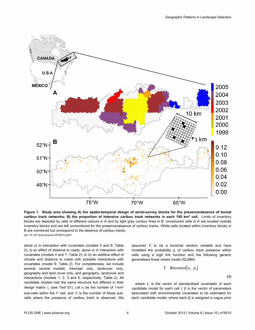
Study areaThe study region (~237 500 km2) was located in the
coniferous boreal forest of eastern Canada (Figure 1), withinthe southern range of forest-dwelling caribou in the Province ofQuébec. The study area covered a wide geographic extent,ranging from 1300 km in longitude to 450 km in latitude. Thearea exhibited a high degree of variation in mean annualtemperature (-4.0°C to 2.3°C), which is fairly representative ofthe mean annual temperatures observed across the natural
Geographic Patterns in Landscape Selection
PLOS ONE | www.plosone.org 2 October 2013 | Volume 8 | Issue 10 | e78510

range of boreal caribou (-7.1°C to 3.9°C, [28]). The percentageof the landscape that has been affected by anthropogenicdisturbance in our study region (from 12 to 51 %) wascomparable to that observed in many regions of Ontario (1 - 36%) and Manitoba (3 - 26 %), but much lower than what hasbeen witnessed in the western provinces of Alberta (21 - 95 %)and British Columbia (57 - 86 %) [19]. The area also exhibitedhigh variability in road density from north to south (0 to 5.1km/km2; Table 1). Vegetation was dominated by coniferousstands in which black spruce (Picea mariana (Miller) BSP),balsam fir (Abies balsamea (L.) Miller), and jack pine (Pinusbanksiana Lambert) are the most frequently encounteredcanopy species (Table 1). White or paper birch (Betulapapyrifera Marshall) and trembling aspen (Populus tremuloidesMichaux) are found as companion species or in pure standsfollowing recent disturbance. Open water bodies, wetlands, andbare land covered 11%, 10%, and 7% of the study area,respectively. Elevations ranged from 50 to 1000 m a.s.l., withplains and gentle hills (100-450 m) west of longitude 75°, andmore rugged hills (300-1000 m) in the east. Wildfire andlogging activities were the main disturbances throughout theregion. The fire regime varies along a west-east gradient, witha shorter mean fire return interval in the west [29,30]. Extensivelogging started in the early 1970’s in the southern part of theregion and has since extended northwards, together with theroad network. Contrary to barren-ground migratory caribou, theboreal caribou is sedentary and its spatial distribution rangeswithin the geographical limits of the Canadian boreal forest[18], from the eastern province of Newfoundland to the westernprovince of British Columbia. In winter, boreal caribou live insmall scattered and mobile groups of a few individuals. Caribourely essentially on lichen in winter across its distribution range[12,31], but lichen is not limiting in some landscapes in Québec[12]. Boreal caribou has “vulnerable species” status in Québec.
Caribou and environmental dataOur observational units were presences and absences of
intensive caribou snow-track networks that had been observedduring the winter season. A caribou snow-track network(hereinafter called caribou tracks) delineates an area that isused briefly and intensively in winter by a small group ofcaribou for foraging or shelter. These caribou tracks are thusclosely related to the biological needs of boreal caribou inwinter, a critical season for temperate ungulates (see 6 andreferences therein]). Caribou tracks were sampled fromintensive fixed-wing aerial surveys, which were backed byhelicopter spot-checks, conducted in the winters of 1999through 2005 (for details, see 6,32). The surveys wereconducted along transects within 11 spatial-temporal surveyblocks (Figure 1). The probability of caribou track detectiongiven presence was high (≥ 90 %), due to strong contrastsbetween caribou track and adjacent undisturbed snow surfaces[32]. Given the high detectability of caribou tracks and theintensity of sampling efforts, false positives and false negativeswere ignored in this analysis.
We related the probability of occurrence of winter cariboutracks to environmental conditions using 18 covariatesbelonging to four different classes of variables: habitats,
disturbances, roads, and climate (Table 1). Theseenvironmental covariates were obtained from up-to-date digitalforest inventories [33] and interpolated monthly climate data[34]. Forest inventory data allowed us to distinguish betweenforested and non-forested polygons. Forested polygons wereclassified according to species composition, density, and height(Table 1). Non-forested polygons distinguished various land-types such as disturbances, wetlands and water bodies. Fortesting the role of climate surfaces in explaining geographicalgradients in habitat selection, we used 30-year averages ofmean temperature and precipitation calibrated from 1970 to1999 (hereafter called normals). The rationale for this choice isas follows: 1) these variables are the main climatic inputs forglobal climate models (GCMs), making their use potentiallyrelevant to assessing future direct impacts of climate change, ifany, on boreal caribou distribution; 2) prediction errors that areassociated with these primary variables are low [34]. Incontrast, the prediction error of snow depth data in our studywas high, so that variable was not included in our models. 3)Temperature and precipitation data serve as main inputs forcalculating derived climatic indices, making correlationsbetween climate indices and these primary variables verylikely. Seasonal and annual climatic variables were highlycorrelated (r > 0.8) and we found no difference in the resultswhen climate variables were measured annually or over wintermonths. Therefore, we only retained 30-year annual normals,which were more likely to interact with vegetation attributesthan just the winter climatic variables. Given the size of thedata set (> 5 GB), all spatial data were processed using theopen-source spatial database system PostGis (http://postgis.refractions.net/). Spatial resolution of covariates variedfrom 8 ha for forest inventory attributes to ~100 km2 for climatedata. All attributes were calculated as total areas or averagesover a common 100 km2 grid, which was defined by the climatedata (see Table 1). Hereafter, each elementary unit of this gridis referred to as a “cell" (see Figure 1). Each covariate wasthen normalised by subtracting the mean and dividing by thestandard deviation. We calculated 14 land cover covariatesfrom the forest inventory data as proportional areas of varioustypes of forested and non-forested habitats. Of these, sixvariables referred to various types of coniferous forest (Table1). To avoid multicollinearity, we performed principalcomponent analysis (PCA) with a covariance matrix based onthese 6 variables and retained sample scores of the two mostsignificant orthogonal axes as model covariates (see TableS1). Variance inflation factors in the reduced data set were < 3for all covariates, indicating that multicollinearity amongst thepredictors was not an issue [35]. Caribou presence/absencedata were calculated for a 1-km2 resolution sub-grid (seeFigure 1). This resolution was roughly twice the mean ofcaribou track area (0.53 km2, SE ± 0.06 km2: see 32) and wellbelow the size of the winter home range, which typically variesfrom about 100 to 700 km2 [36,37].
Statistical analysesWe built our candidate models upon alternative a priori
hypotheses where the presence of geographical gradients inlandscape selection was a surrogate for: i) an effect of climate,
Geographic Patterns in Landscape Selection
PLOS ONE | www.plosone.org 3 October 2013 | Volume 8 | Issue 10 | e78510
alone or in interaction with covariates (models 5 and 8; Table2); ii) an effect of distance to roads, alone or in interaction withcovariates (models 4 and 7; Table 2); or iii) an additive effect ofclimate and distance to roads with possible interactions withcovariates (model 9; Table 2). For completeness, we includeseveral neutral models: intercept only, landcover only,geography and land cover only, and geography, landcover andinteractions (models 1, 2, 3 and 6, respectively; Table 2). Allcandidate models had the same structure but differed in theirdesign matrix xi
' (see Text S1). Let ni be the number of 1-km2
sub-cells within the ith cell, and Yi is the number of these sub-cells where the presence of caribou track is observed. We
assumed Yi to be a binomial random variable and havemodelled the probability pi of caribou track presence withincells using a logit link function and the following genericgeneralised linear mixed model (GLMM):
Y~ Binomial ni, pi ,
(1)
where x′i is the vector of standardised covariates of each
candidate model for each cell i; β is the vector of parametersassociated with environmental covariates to be estimated foreach candidate model, where each βj is assigned a vague prior
Figure 1. Study area showing A) the spatio-temporal design of aerial-survey blocks for the presence/absence of borealcaribou track networks; B) the proportion of intensive caribou track networks in each 100 km2 cell. Limits of inventoryblocks are depicted by cells of different colours in A and by light grey contour lines in B. Uncoloured cells in A are located outsideinventory blocks and are left unmonitored for the presence/absence of caribou tracks. White cells located within inventory blocks inB are monitored but correspond to the absence of caribou tracks.doi: 10.1371/journal.pone.0078510.g001
Geographic Patterns in Landscape Selection
PLOS ONE | www.plosone.org 4 October 2013 | Volume 8 | Issue 10 | e78510

such asβ j ~iid
N mean = 0; precision = 0.001 ; αk is a randomintercept of the kth inventory block (k = 1,…, 11; see Figure 1)that accounts for a block-specific value for interceptα, where
αk ~iid
N mean = 0; precision = τ and the hyperparameter τ isassigned a vague prior such asτ~ Gamma(shape = 1; scale = 5e−05) . We verified thatresidual spatial autocorrelation (RSA) did not affect the modelselection procedure (see Text S2 and Figure S1). In addition tomodel selection and hypothesis tests, we were also interestedin making inferences on parameters, especially in comparingthe impact of fire vs logging on boreal caribou space use.Indeed, disentangling these effects is of particular concern froma conservation and ecosystem-based managementperspective. Inference on model parameters, however, isparticularly sensitive to RSA (e.g., increasing type-I error) sowe explicitly modelled spatial associations amongst cells byadding a spatial random effect, with a Matérn correlationfunction, to the simplest and top-ranked model that had beenpreviously selected (see Text S3 and Figure S2). The additionof a spatial random effect to Equation 1 also allowed usexploring the spatial structure in model errors which can, in
turn, inform us about important ecological processes notaccounted for in our models.
All models were fit in R v2.14.2 [38], using integrated nestedLaplace approximation (INLA) within the R-INLA package [39],which is freely available at www.r-inla.org.
Results
As expected, distance to roads was positively correlated withlatitude, whereas the mean temperature gradient wasnegatively correlated with latitude. Precipitation was positivelycorrelated with longitude (Table 3). Based on non-spatialGLMMs with 100% of the data, the ΔDIC between model 6(DIC = 1769) and models 2 and 3 (DICs ≥ 1800) was greaterthan 30 (Table 2), indicating that the existence of geographicaltrends in caribou selection of lichen woodland, logging areasand water bodies better explained the data than did thehypothesis of homogeneous selection of these habitats acrossthe study region. We failed to detect any top-down climaticcontrol on these geographical gradients, as the models withclimate variables alone or in interaction with land cover (models5 and 8; Table 2) had less support than did model 6, whichcontained only geographical gradients (ΔDIC > 30; Table 2). Inaddition, climate variables only marginally explained extra
Table 1. Environmental variables that were used as predictors in our study.
Group of variablesVariables Description MinimumMean Maximum
Habitat black spruce - jack pine (km2) §coniferous stands with basal area dominated by black spruce, followed byjack pine, or the converse
0 3.2 41.2
black spruce (km2) § coniferous stands with basal area dominated by black spruce 0 23.0 74.1
black spruce- balsam fir (km2) §coniferous stands with basal area dominated by black spruce, followed bybalsam fir, or the converse
0 12.6 73.2
balsam fir (km2) § coniferous stands with basal area dominated by balsam fir 0 1.5 29.5
jack pine (km2) § coniferous stands with basal area dominated by jack pine 0 0.8 26.9
mixed resinous (km2) §mixed stands with basal area dominated by coniferous species, followed bydeciduous species
0 2.5 30.8
lichen woodland (km2) coniferous stands of low density with abundant ground lichen 0 1.6 29.6
deciduous (km2)stands with basal area dominated by deciduous species (mainly birch andaspen)
0 1.4 39.0
mixed deciduous (km2)mixed stands with basal area dominated by deciduous species, followed byconiferous species
0 2.6 52.2
bare land dominated with lichen (km2) open dry sites with abundant ground lichen 0 2.9 42.1 water bodies (km2) lakes and rivers 0.1 11.2 93.1 wetlands (km2) bogs and fens 0 10.0 83.1Road road density (km/km2) total road length by area unit 0 0.5 5.1 mean distance to road (km) average distance to all types of roads 0 10.3 105.5Disturbance logging (km2) areas recently logged, with actual maximum tree height < 7 m 0 13.5 82.5 wildfire (km2) areas recently burned, with actual maximum tree height < 7 m 0 5.5 80.2Climate Normal annual mean temperature (°C) ¶ interpolated mean annual temperature (1970-1999) -4.0 -0.8 2.3
Normal annual total precipitation (mm) ¶ interpolated total annual precipitation (1970-1999) 740.9 976.1 1214.8
§. To avoid multicollinearity, all types of coniferous stands were reduced using principal component analysis: see Table S1.¶. We also used winter normals of temperature and precipitation but no difference was observed, so we only retained annual variables.Minimum, mean and maximum values of each explanatory variable, at the scale of 100 km2 grid cells, are presented for the entire region. Only variables that are shown inbold type were retained in the analysis of model comparisons (i.e., the variable “road density” was discarded because of its high correlation with the variable “logging,” i.e., r= 0.85).doi: 10.1371/journal.pone.0078510.t001
Geographic Patterns in Landscape Selection
PLOS ONE | www.plosone.org 5 October 2013 | Volume 8 | Issue 10 | e78510

information that was not already explained by land cover anddisturbance variables (ΔDIC ≤ 2 between models 5 and 2;Table 2). Overall, models that included distance to roads, aloneor in interactions with other landcover types (models 4, 7, 9),and the model that included interactions between latitude andlandcover types (model 6) were the most supported amongstall of the candidate models. Model 6 indicated geographicaltrends in caribou selection, but we do not discuss it furtherbecause of its lack of mechanistic explanation. Model 9, whichincluded interaction terms between climate and landcovertypes, had lower support than models 4 and 7, both withoutclimatic variables (ΔDIC ≥ 3; Table 2), which indicates thataddition of climate variables did not improve the fit of models 4
Table 2. Model comparisons for the different a priorihypotheses tested in this study.
IDmodel Hypothesis Variables pD REP DIC
4distance to road (=distroad)
land cover + distroad 20 85 1766
7 distroad x covarland cover + distroad +distroad:logging + distroad:woodlichen + distroad:water
23 74 1766
6 geog x covarland cover + X + Y + Y:logging +Y:lichen woodland + Y:water ¶
24 71 1769
9distroad x covar +climate x covar
land cover + distroad + meanprec+ meantemp + meantemp:logging+ meantemp: lichen woodland +meantemp:water + distroad: lichenwoodland + distroad:logging +distroad:water
28 61 1769
8 climate x covar
land cover + meanprec +meantemp + meantemp: logging +meantemp: lichen woodland +meantemp:water
24 71 1795
3Geographic(= geog)
X + Y + land cover ¶ 21 80 1800
5 climateland cover + meanprec +meantemp
21 81 1801
2 land cover only land cover § 19 89 18031 intercept only intercept 9 201 2094
§ land cover = intercept + wildfire + logging + lichen woodland + bare landdominated by lichen +water + wetlands + coniferous stands PC1 + coniferous stands PC2 + deciduous +mixed deciduous (see Table 1 for a definition of variables)¶. X and Y represent the geographic coordinates of centroids for each 100 km2
cell.Geographic-driven selection is represented by model IDs 3 and 6, climate-drivenselection by model IDs 5 and 8, and selection that is driven by distance to roads isrepresented by model IDs 4 and 7. Interaction effects between two variables areindicated by a colon (:). The hypothesis of an additive effect of climate anddistance to roads is represented by model ID 9. Variable names: pD = the numberof effective parameters; REP = the mean number of data points for each effectiveparameter; and DIC = Deviance Information Criteria. See Table 1 for a descriptionof variables.doi: 10.1371/journal.pone.0078510.t002
and 7. The low contribution of climate, alone or in interactionwith land cover, to the model fit is further seen in the lowsupport of models 5 and 8 (Table 2). The model with a singleeffect of the mean distance to road (model 4) and model 7, withan interaction between distance to road and landcover types,were thus the best supported candidate models. This showsthat the large-distance effect of roads, rather than climate,plays an important role in boreal caribou habitat selection andprovides a mechanistic explanation for geographical trends thatwas observed in habitat selection patterns. We could notdistinguish, however, whether model 4 or 7 had the better fit(ΔDIC ≤ 2; Table 2). For inference, we adopted a pragmaticview and retained a spatial version of model 4, as it was thesimplest top-ranked model. Boreal caribou positively selectedwater bodies and areas that were located far from roads,whereas they avoided deciduous stands and disturbances thathad been caused by fire and logging (Table 4). Logged areaswere avoided twice as strongly as burnt areas, showing thatboreal caribou did not respond to these two disturbances in thesame manner (Table 4). Boreal caribou tended to selectpositively lichen woodland, but the parameter estimate for thisvariable also exhibited a greater sensitivity to specification ofthe spatial random effect (Figure S2). No selection pattern wasdetected for coniferous and mixed stands, wetland, or openhabitat with lichen ground cover (Table 4).
Mapping spatial random effects revealed strong latent spatialpatterns at multiple scales (Figure 2A). At a coarse scale,favourable areas for boreal caribou are mainly concentrated ina large band that is centred on 70°W longitude and whichextends from 48° to 52°N latitude. At an intermediate scale,suitable sub-regions emerged in the northern part of the studyarea, whereas unfavourable sub-regions appeared mainly inthe central and southern parts of the study region. Within thesesub-regions, finer-scale local variation was present. This multi-scale spatial pattern showed very low sensitivity to priorspecification of the spatial random effect, as it was consistentfor a wide range of values for the precision hyperparameter τ.
Table 3. Pearson product-moment correlations (r) amongstvalues of geographical UTM coordinates of cell centroids (Xfor longitude and Y for latitude), annual climatic normals oftotal precipitation and mean temperature, and meandistance to roads
X (km) Y (km)
Totalprecipitation(mm)
Meantemperature(°C)
Distance toroads (km)
X (km) 1 Y (km) 0.24 1 Total precipitation(mm)
0.84 -0.19 1
Mean temperature(°C)
-0.22 -0.81 -0.01 1
Distance to roads(km)
0.26 0.60 0.01 -0.69 1
Values in bold highlight |r| values > 0.5.doi: 10.1371/journal.pone.0078510.t003
Geographic Patterns in Landscape Selection
PLOS ONE | www.plosone.org 6 October 2013 | Volume 8 | Issue 10 | e78510

Table 4. Posterior medians of parameter estimates (with95% credible intervals) for a spatially explicit version of thesimplest and top-ranked model
Variables 2.5% 50% 97.5%Logging -1.17 -0.76 -0.39Wildfire -0.61 -0.37 -0.14Coniferous stands (PC 1) -0.32 -0.06 0.21Coniferous stands (PC 2) -0.24 -0.05 0.14Lichen woodland -0.03 0.10 0.23Deciduous -1.18 -0.70 -0.10Mixed deciduous -0.32 0.04 0.34Bare land dominated by lichen -0.29 -0.13 0.03Water 0.11 0.30 0.48Wetlands -0.25 -0.01 0.23Mean distance to road 0.07 0.29 0.46
Variable descriptions are presented in Table 1.doi: 10.1371/journal.pone.0078510.t004
As expected, uncertainty in the spatial random effect increasedwith increasing distance from the points at which data hadbeen collected (Figure 2B).
Discussion
We rejected both the hypothesis of climate-driven winterselection of landscapes and the hypothesis of an additive effectof climate and distance to roads. Indeed, temperature andprecipitation normals, which are the main inputs that are usedin climate change scenarios, did not explain latitudinal trendsobserved in the winter selection of certain habitat classes byboreal caribou. Moreover, we failed to detect any effect oftemperature and precipitation variables alone on the winterdistribution of boreal caribou, once land cover and disturbancetypes were taken into account. These results contrast withevidence that temperature and precipitation play an importantrole in the winter distribution of the largest herd of migratorycaribou in Québec [21], indicating that both ecotypes may notrespond to the same environmental filters. From this difference,it can be anticipated that climate changes - specificallychanges in mean temperature and total precipitation - shouldhave more short-term direct impacts in winter on migratory
Figure 2. Map of the posterior mean (A) and posterior standard deviation (B) of the spatial random effect. doi: 10.1371/journal.pone.0078510.g002
Geographic Patterns in Landscape Selection
PLOS ONE | www.plosone.org 7 October 2013 | Volume 8 | Issue 10 | e78510

caribou than on boreal caribou. The mechanisms for theapparent climate sensitivity of the migratory ecotype remainunknown but could be related to summer food limitation [40] –a rare or non-existent circumstance for the boreal ecotype.Although snow depth can influence fine-scale habitat selectionof boreal caribou [41], the lack of precision of snow depthestimates at broad spatial scale prevented us to test reliably forthe effect of snow depth on boreal caribou winter distributionand the possible relationship between snow depth and climaticvariables. Further studies are needed to document the possibleinterrelationships amongst temperature, precipitation, snowconditions and the spatial distribution of boreal caribou. It isalso important to assess if climate changes affect landscapeselection by boreal caribou during the snow-free season. Ourfailure to detect any direct influence of seasonal or annualtrends in mean temperature and total precipitation, however,does not imply that climate change will have no indirect effectson boreal caribou during winter. For example, climate changeis expected to change the amount and spatial distribution of thearea that is burned in the boreal forest of North America [42]. Inturn, burnt areas will influence winter habitat selection, asshown in our study and by several others [43,44]. A fullassessment of indirect effects of climate change on caribouspatial distribution will require further development of adynamic multivariate simulation model that would explicitlymodel interdependencies over space and time amongst climatevariables, disturbance regimes, vegetation types, and predator-prey interactions.
The hypothesis of road-driven selection was well-supportedby our data. Our findings were consistent with previous studiesshowing that the boreal caribou avoids roads [13,45]. We foundan equivalent support for both hypotheses of dependence(model 7) and independence (model 4) in the selection oflichen woodland, water bodies, and logging areas with distanceto roads. Our failure to discriminate these two alternativescould be related to the spatial resolution of our models, whichmight be too low for matching the finer spatial scale at whichroad distance-based selection might occur. MacArthur [46]hypothesised that in the northern hemisphere, speciesdistributions are more likely to be limited by biotic interactionsat the southern margin of their range and by abiotic factors atthe northern edge. In this study, which occurs at the currentsouthern range limits of boreal caribou, roads likely act as asurrogate for higher densities of alternate prey (e.g., moose)and predators (e.g., wolves) – the prevailing hypothesis for thedecline of forest-dwelling caribou [18]. The predominance ofhuman-induced disturbances over climate-induced effects inexplaining distributional patterns of boreal caribou is inaccordance with expectation. This is also consistent with abroad-scale niche analysis of this ecotype ([17], section 6.4).Hence, this study reinforces previous recommendations[15–17] that habitat conservation measures for boreal cariboushould concentrate on minimising road density and loggingareas at the landscape-level but also on reducing broad-scaleexpansion of road networks into the current ranges of borealcaribou.
The management of boreal forest in the Province of Québec,including coniferous forests that are located within the southern
range of boreal caribou, has recently changed paradigms fromsustained yield towards the principles of ecosystem-basedmanagement [47,48]. One key principle of ecosystem-basedforest management is to limit the rate of anthropogenicdisturbances to conform to the historical ranges of ecosystemnatural variability in ecosystem properties [49], such as speciescomposition and age-class structure. In addition to these newguidelines, permanent and temporary forest blocks (hereafternamed protection blocks) have been set aside from logging toimprove the conservation of boreal caribou habitat within itsactual range [50,51]. Logging activities are therefore permittedin the forest matrix that is located outside protection blocks buttheir rate, intensity, and spatial distribution are to be informedby historical patterns of natural disturbance regimes (e.g., fireand insect outbreaks). With this management strategy, it isassumed that the substitution of natural for anthropogenicdisturbances of the same intensity and rate will maintainspecies diversity, together with the main ecological functions ofecosystems [52]. This assumes that logged and burnt areasare effectively equivalent. Our results show that they are not.Boreal caribou avoided logging areas twice as strongly as burntareas, even after accounting for many other sources ofvariation. It follows that logging, at least as it is practised todate, is not equivalent to fire in terms of its effect on borealcaribou. A possible explanation for the uneven effect of loggingand burnt areas on boreal caribou could originate from anincrease of road densities that is associated with forestoperations, which in turn increases predation risk becauseroads facilitate the displacement and search efficiency ofpredators [53,54]. Thus, substituting burnt areas withequivalent logging areas outside of protection blocks accordingto current ecosystem-based management guidelines is notlikely to maintain the historical suitability of landscapes forboreal caribou. More importantly, wildfires are just as likely tooccur within protection blocks as outside them, stressing theneed for managing the forest matrix as a whole, including thoseforest areas that are not targeted for conservation, rather thanfocusing solely on isolated protection blocks. This study couldnot address how changes in landscape suitability will affectcaribou population dynamics. However, a lower probability ofoccurrence often translates into decreases in populationdensity [55], with evidence showing that logging, more thanfire, negatively affects recruitment rate, a key demographicparameter of population rate-of-growth in caribou [17].Ecosystem-based management of coniferous boreal forest,therefore, should account for the uneven effect of loggingactivities compared to that of burnt areas on wildlife species.This point is particularly sensitive given that the co-occurrenceand cumulative effects of both disturbance types are expectedto persist in the future, despite the delineation of protectedareas, since fire control strategies are not one hundred percentefficient, especially in the far north. Further efforts are urgentlyneeded to characterise the sensitivity of key species to varioustypes of disturbances. Only then will a clearer picture helpmanagers to develop efficient ecosystem-based managementguidelines for the boreal forest that properly matchconservation planning efforts for boreal caribou.
Geographic Patterns in Landscape Selection
PLOS ONE | www.plosone.org 8 October 2013 | Volume 8 | Issue 10 | e78510

The strong residual spatial pattern found in the best modelreveals some phenomenon or process that we did not includein our models. There is a growing recognition amongstecologists that the presence of residual spatial autocorrelationis not simply a statistical nuisance (e.g., increasing type-Ierror). Rather, it may also be an ecological opportunity [24], asit points to an important ecological process(es) that is (are)misspecified or lacking in the given hypothesis or model. Whilethe accounting for spatial autocorrelation improved the validityof parameter inferences, it should be noted that our results arederived from observational data and, thus, are conditional tothe alternative hypotheses that we tested. We argue thatidentifying patterns of spatial autocorrelation and uncoveringtheir underlying causes are two important steps inunderstanding which unknown ecological driver(s) structuresthe spatial distribution of living organisms. The use of an aposteriori approach, where spatial dependency is modelleddirectly from the data, allows the structure of spatialautocorrelation patterns to be explored and provides strongdirection for further hypotheses about the underlying causes ofspecies distributions. The distribution of spatial random effectsfor boreal caribou distinguishes a zone of high connectivity witha high potential conservation value along 70° of longitude.Causes of this pattern are unknown, but our study allowed usto discount habitat variables and climate normals as possibledrivers, since these covariates were already included in ourmodel. We propose two hypotheses to explain this spatialpattern: behaviour-driven and history-driven hypotheses. Thebehaviour-driven hypothesis considers that the actual latentpattern reflects the meta-population structure of the differentboreal caribou herds in the region and may depict zones ofintensive exchanges amongst populations. The history-drivenhypothesis postulates that historical factors associated withrange fidelity have shaped the spatial distribution of borealcaribou populations over time and that the actual latent spatialpattern is a relic of this evolution. These two hypotheses couldbe separated based on their expected spatial patterns,according to the approach advocated by [24]. Our studyprovides a starting point, but further studies will be needed tovalidate or refute these hypotheses.
Supporting Information
Figure S1. Bar plot showing the frequency of top-rankedmodels selected over the 1000 random subsamples (20%of the data each). Red number at the top of each bar
represents the rank order of the best model with 100% of thedata (see Table 2).(DOCX)
Figure S2. Sensitivity analyses regarding the effect ofvarious shape parameters on coefficients of regression(median ± 95% credible interval). Increasing the value of theshape parameter leads to decreasing smoothness of thespatial random effect. When the shape parameter > 29.56,spatial models (white dots) become equivalent to non-spatialmodels (black dots). Note that the scale of y-axis differs amongplots and that the scale of x-axis is interrupted above 29.(DOCX)
Table S1. Loadings of explanatory variables related toconifer stands on the first two dimensions of a PrincipalComponent analysis with covariance matrix across thestudy area in Québec, Canada.(DOCX)
Text S1. Additional information on statistical models.(DOCX)
Text S2. Model selection and spatial autocorrelation.(DOCX)
Text S3. Inference and residual spatial autocorrelation.(DOCX)
Acknowledgements
We thank the Ministère des Ressources Naturelles et de laFaune du Québec (MRNFQ) for providing access to forestdigital inventory maps and caribou data. We are grateful to DanMcKenney and Pia Papadopol of the Canadian Forest Service,Natural Resources Canada, for providing climate data for thestudy region. We sincerely thank W.F.J. Parsons for Englishrevisions and three anonymous reviewers for improving aprevious version of the manuscript.
Author Contributions
Conceived and designed the experiments: JB DF SC.Performed the experiments: JB EM DF FR PR CD. Analyzedthe data: JB EM. Wrote the manuscript: JB EM DF SC PR FRCD.
References
1. Thuiller W (2007) Biodiversity: Climate change and the ecologist.Nature 448: 550-552. doi:10.1038/448550a. PubMed: 17671497.
2. Barnosky AD, Matzke N, Tomiya S, Wogan GOU, Swartz B et al.(2011) Has the Earth's sixth mass extinction already arrived? Nature471: 51-57. doi:10.1038/nature09678. PubMed: 21368823.
3. Pereira HM, Leadley PW, Proença V, Alkemade R, Scharlemann JPWet al. (2010) Scenarios for global biodiversity in the 21st century.Science 330: 1496-1501. doi:10.1126/science.1196624. PubMed:20978282.
4. Panel Intergovernmentalon Climate Change - IPCC (2007) Climate.Change: Synthesis Report Core Writing TeamRK PachauriA Reisinger,IPCC, 104 pp.
5. Morris DW (2003) Toward an ecological synthesis: a case for habitatselection. Oecologia 136: 1-13. doi:10.1007/s00442-003-1241-4.PubMed: 12690550.
6. Fortin D, Courtois R, Etcheverry P, Dussault C, Gingras A (2008)Winter selection of landscapes by woodland caribou: behaviouralresponse to geographical gradients in habitat attributes. J Appl Ecol 45:1392-1400. doi:10.1111/j.1365-2664.2008.01542.x.
7. Ashton KG, Tracy MC, Queiroz AD (2000) Is Bergmann’s Rule valid formammals? Am Nat 156: 390-415. doi:10.1086/303400.
8. Herfindal I, Solberg EJ, Sæther B-E, Høgda KA, Andersen R (2006)Environmental phenology and geographical gradients in moose body
Geographic Patterns in Landscape Selection
PLOS ONE | www.plosone.org 9 October 2013 | Volume 8 | Issue 10 | e78510
mass. Oecologia 150: 213-224. doi:10.1007/s00442-006-0519-8.PubMed: 16944246.
9. Post E (2005) Large-scale spatial gradients in herbivore populationdynamics. Ecology 86: 2320-2328. doi:10.1890/04-0823.
10. Oliver TH, Hill JK, Thomas CD, Brereton T, Roy DB (2009) Changes inhabitat specificity of species at their climatic range boundaries. EcolLett 12: 1091–1102. doi:10.1111/j.1461-0248.2009.01367.x. PubMed:19747182.
11. COSEWIC (2002) COSEWIC assessment and update status Report onthe woodland caribou Rangifer tarandus caribou in Canada Committeeon the Status of Endangered Wildlife in Canada (COSEWIC), Ottawa.Canada
12. Courtois R, Gingras A, Fortin D, Sebbane A, Rochette B et al. (2008)Demographic and behavioural response of woodland caribou to forestharvesting. Can J Forest Res 38: 2837-2849. doi:10.1139/X08-119.
13. Wasser SK, Keim JL, Taper ML, Lele SR (2011) The influences of wolfpredation, habitat loss, and human activity on caribou and moose in theAlberta oil sands. Front Ecol Environ 9: 546-551. doi:10.1890/100071.
14. Dyer SJ, O'Neill JP, Wasel SM, Boutin S (2001) Avoidance of industrialdevelopment by woodland caribou. J Wildl Manag 65: 531-542. doi:10.2307/3803106.
15. Schaefer JA (2003) Long-term range recession and the persistence ofcaribou in the taiga. Conserv Biol 17: 1435-1439. doi:10.1046/j.1523-1739.2003.02288.x.
16. Vors LS, Schaefer JA, Pond BA, Rodgers AR, Patterson BR (2007)Woodland caribou extirpation and anthropogenic landscapedisturbance in Ontario. J Wildl Manag 71: 1249-1256. doi:10.2193/2006-263.
17. Environment Canada (2008) Scientific review for the identification ofcritical habitat for woodland caribou (Rangifer tarandus caribou), borealpopulation, in Canada. Ottawa, Canada: Environment Canada.
18. Festa-Bianchet M, Ray JC, Boutin S, Côté SD, Gunn A (2011)Conservation of caribou (Rangifer tarandus) in Canada: an uncertainfuture. Can J Zool 89: 419-434. doi:10.1139/z11-025.
19. Environment Canada (2012) Recovery Strategy for the WoodlandCaribou (Rangifer tarandus caribou), Boreal population, in Canada.Species at Risk Act Recovery Strategy Series. Ottawa Canada:Environment Canada. p. 138pp +
20. Vors LS, Boyce MS (2009) Global declines of caribou and reindeer.Glob Change Biol 15: 2626-2633. doi:10.1111/j.1365-2486.2009.01974.x.
21. Sharma S, Couturier S, Côté SD (2009) Impacts of climate change onthe seasonal distribution of migratory caribou. Glob Change Biol 15:2549-2562. doi:10.1111/j.1365-2486.2009.01945.x.
22. Boulet M, Couturier S, Côté SD, Otto RD, Bernatchez L (2007)Integrative use of spatial, genetic, and demographic analyses forinvestigating genetic connectivity between migratory, montane, andsedentary caribou herds. Mol Ecol 16: 4223-4240. doi:10.1111/j.1365-294X.2007.03476.x. PubMed: 17784914.
23. Fortin M-J, Dale MRT (2005) Spatial Analysis: A Guide for Ecologists.Cambridge, UK: Cambridge University Press.
24. McIntire EJB, Fajardo A (2009) Beyond description: the active andeffective way to infer processes from spatial patterns. Ecology 90:46-56. doi:10.1890/07-2096.1. PubMed: 19294912.
25. Levin SA (1992) The problem of pattern and scale in ecology: TheRobert H MacArthur Award Lecture. Ecology 73: 1943-1967. doi:10.2307/1941447.
26. Thuiller W, Araújo MB, Lavorel S (2004) Do we need land-cover data tomodel species distributions in Europe? J Biogeogr 31: 353-361. doi:10.1046/j.0305-0270.2003.00991.x.
27. Dussault C, Pinard V, Ouellet J-P, Courtois C, Fortin D (2012)Avoidance of roads and selection for recent cutovers by threatenedcaribou: fitness-rewarding or maladaptive behaviour? Proc R Soc LondB Biol Sci 279: 4481-4488. doi:10.1098/rspb.2012.1700.
28. Environment Canada (2011) National Climate Data and InformationArchive. Government of Canada website. Available: http://climate.weatheroffice.gc.ca/. Accessed 2012 June 4.
29. Bergeron Y, Gauthier S, Flannigan M, Kafka V (2004) Fire regimes atthe transition between mixedwood and coniferous boreal forest innorthwestern Québec. Ecology 85: 1916-1932. doi:10.1890/02-0716.
30. Bouchard M, Pothier D, Gauthier S (2008) Fire return intervals and treespecies succession in the North Shore region of eastern Quebec. CanJ Forest Res 38: 1621-1633. doi:10.1139/X07-201.
31. Thomas DC, Edmonds EJ, Brown WK (2011) The diet of woodlandcaribou populations in west-central Alberta. Rangifer 16: 337-342.
32. Courtois R, Gingras A, Dussault C, Breton L, Ouellet J-P (2003) Anaerial survey technique for the forest-dwelling ecotype of woodlandcaribou, Rangifer tarandus caribou. Can Field Nat 117: 546-554.
33. Ministère des ressources naturelles et; de la Faune du Québec (2003)Normes de cartographie écoforestière du troisième inventaireécoforestier. Forêt Québec. Direction des inventaires forestiers ISBN2-551-xxxxx-x. p. 109. [in French].
34. McKenney DW, Pedlar JH, Papadopol P, Hutchinson MF (2006) Thedevelopment of 1901–2000 historical monthly climate models forCanada and the United States. Agric Forest Meteorol 138: 69-81. doi:10.1016/j.agrformet.2006.03.012.
35. Zuur AF, Ieno EN, Walker N, Saveliev AA, Smith GM (2009) MixedEffects Models and Extensions in Ecology with R Springer. New York,USA: Science and Publishing House.
36. Faille G, Dussault C, Ouellet J-P, Fortin D, Courtois R et al. (2010)Range fidelity: The missing link between caribou decline and habitatalteration? Biol Conserv 143: 2840-2850. doi:10.1016/j.biocon.2010.08.001.
37. Bastille-Rousseau G, Dussault C, Couturier S, Fortin D, St-Laurent M-Het al. (2012) Sélection d’habitat du caribou forestier en forêt boréalequébécoise, Québec, ministère du Développement durable, del’Environnement, de la Faune et des Parcs, Direction générale del’expertise sur la faune et ses habitats, 66 p.
38. R Development Core Team (2011) R: A Language and Environment forStatistical Computing. Vienna, Austria: R Foundation for StatisticalComputing.
39. Rue H, Martino S, Chopin N (2009) Approximate Bayesian inference forlatent Gaussian models by using integrated nested Laplaceapproximations. J R Stat Soc B Stat Methodol 71: 319-392.
40. Couturier S, Otto RD, Côté SD, Luther G, Mahoney SP (2010) Bodysize variations in caribou ecotypes and relationships with demography.J Wildl Manag 74: 395-404. doi:10.2193/2008-384.
41. Courbin N, Fortin D, Dussault C, Courtois R (2009) Landscapemanagement for woodland caribou: the protection of forest blocksinfluences wolf-caribou co-occurrence. Landscape Ecol 24: 1375-1388.doi:10.1007/s10980-009-9389-x.
42. Balshi MS, McGuire AD, Duffy P, Flannigan M, Walsh J et al. (2009)Assessing the response of area burned to changing climate in westernboreal North America using a Multivariate Adaptive Regression Splines(MARS) approach. Glob Change Biol 15: 578-600. doi:10.1111/j.1365-2486.2008.01679.x.
43. Schaefer JA, Pruitt WO (1991) Fire and woodland caribou insoutheastern Manitoba. Wildl Monogr 116: 1–39.
44. Rettie WJ, Messier F (2000) Hierarchical habitat selection by woodlandcaribou: its relationship to limiting factors. Ecography 23: 466–478. doi:10.1111/j.1600-0587.2000.tb00303.x.
45. Fortin D, Buono P-L, Fortin A, Courbin N, Gingras CT et al. (2013)Movement responses of caribou to human-induced habitat edges leadto their aggregation near anthropogenic features. Am Nat 181:827-836. doi:10.1086/670243. PubMed: 23669544.
46. MacArthur RH (1972) Geographical Ecology. New York, New York,USA: Harper & Row.
47. Gauthier S, Vaillancourt M-A, Leduc A, De Grandpré L, Kneeshaw D etal. (2009) Ecosystem management in the boreal forest. Québec, QC,Canada: Presses de l'Université du Québec.
48. Government of Québec (2010) Loi sur l’aménagement durable duterritoire forestier. Éditeur officiel du Québec. Gouvernement duQuébec.
49. Cyr D, Gauthier S, Bergeron Y, Carcaillet C (2009) Forest managementis driving the eastern North American boreal forest outside its naturalrange of variability. Front Ecol Environ 7: 519-524. doi:10.1890/080088.
50. Courtois R, Ouellet J-P, Dussault C, Gingras A (2004) Forestmanagement guidelines for forest-dwelling caribou in Québec. ForestryChron 80: 598-607.
51. Équipe de rétablissement du caribou forestier du Québec (2008) Plande rétablissement du caribou forestier (Rangifer tarandus) au Québec -2005-2012. Ministère des Ressources naturelles et de la Faune, FauneQuébec, Direction de l’expertise sur la faune et des habitats, Canada.[In French].
52. Hunter ML Jr (1993) Natural fire regimes as spatial models formanaging boreal forests. Biol Conserv 65: 115-120. doi:10.1016/0006-3207(93)90440-C.
53. Houle M, Fortin D, Dussault C, Courtois R, Ouellet JP (2010)Cumulative effects of forestry on habitat use by gray wolf (Canis lupus)in the boreal forest. Landscape Ecol 25: 419-433. doi:10.1007/s10980-009-9420-2.
54. DeCesare NJ (2012) Separating spatial search and efficiency rates ascomponents of predation risk. Proc R Soc Lond B Biol Sci 279:4626-4633. doi:10.1098/rspb.2012.1698. PubMed: 22977145.
55. Oliver TH, Gillings S, Girardello M, Rapacciuolo G, Brereton TM et al.(2012) Population density but not stability can be predicted fromspecies distribution models. J Appl Ecol 49: 581-590.
Geographic Patterns in Landscape Selection
PLOS ONE | www.plosone.org 10 October 2013 | Volume 8 | Issue 10 | e78510