Impacts of climate change on the seasonal distribution of migratory caribou

Memoirs of the Museum of AnthropologyUniversity of Michigan
Number 57
Caribou Hunting in the Upper Great Lakes
edited by
Elizabeth Sonnenburg
Ashley K. Lemke
John M. O’Shea
Ann Arbor, Michigan2015
Archaeological, Ethnographic, and Paleoenvironmental Perspectives
COPYRIGHTED MATERIAL
COPYRIGHTED MATERIAL

©2015 by the Regents of the University of MichiganThe Museum of AnthropologyAll rights reserved
Printed in the United States of AmericaISBN 978-0-915703-85-2 Cover design by Katherine Clahassey
The Museum currently publishes two monograph series: Anthropological Papers and Memoirs. For permissions, questions, or catalogs, contact Museum publications at1109 Geddes Avenue, Ann Arbor, Michigan 48109-1079; [email protected]; www.lsa.umich.edu/ummaa/publications
Library of Congress Cataloging-in-Publication Data
Caribou hunting in the upper Great Lakes : archaeological, ethnographic, and paleoenvironmental perspectives / edited by Elizabeth Sonnenburg, Ashley K. Lemke, John M. O’Shea. pages cm. -- (Memoirs of the Museum of Anthropology, University of Michigan ; number 57) Includes bibliographical references. ISBN 978-0-915703-85-2 (alk. paper) 1. Indians of North America--Hunting--Huron, Lake Region (Mich. and Ont.) 2. Indians of North America--Huron, Lake Region (Mich. and Ont.)--Antiquities. 3. Indians of North America--Great Lakes Region (North America)--Antiquities. 4. Hunting, Prehistoric--Huron, Lake Region (Mich. and Ont.) 5. Hunting, Prehistoric--Great Lakes Region (North America) 6. Caribou hunting--Huron, Lake Region (Mich. and Ont.)--History. 7. Caribou hunting--Great Lakes Region (North America)--History. 8. Underwater archaeology--Huron, Lake (Mich. and Ont.) 9. Huron, Lake Region (Mich. and Ont.)--Antiquities. 10. Great Lakes Region (North America)--Antiquities. I. Sonnenburg, Elizabeth, 1974- editor, author. II. Lemke, Ashley K., 1985- editor, author. III. O’Shea, John M., editor, author. E98.H8C37 2015 977.004’97--dc23 2014044938
The paper used in this publication meets the requirements of the ANSI Standard Z39.48-1984 (Permanence of Paper).
COPYRIGHTED MATERIAL
COPYRIGHTED MATERIAL

iii
Contents
List of Illustrations viList of Tables xForeword: Below the Waves of Time, by Henry T. Wright xiAcknowledgments xiv
1 Introduction to Lake Stanley Archaeology in the Lake Huron Basin 1John M. O’Shea and Elizabeth Sonnenburg
PART I: Past Environments of the Upper Great Lakes
2 Potential for Deeply Buried Archaeological Sites in Ontario Based on Glacial History 5Peter J. Barnett
3 Paleoenvironmental Context for Early Holocene Caribou Migration on the Alpena-Amberley Ridge 13
Francine M. G. McCarthy, John H. McAndrews, and Elli Papangelakis
4 Serious Game Modeling of Caribou Behavior across Lake Huron Using Cultural Algorithms and Influence Maps 31
James Fogarty, Robert G. Reynolds, Areej Salaymeh, and Thomas Palazzolo
PART II: Cultural Background and Archaeological Context of the Alpena-Amberley Ridge
5 Archaeology of the Late Paleoindian/Early Archaic in the Lake Huron Region, with New Data from the Sheguiandah Site 53
Patrick J. Julig and Gregory Beaton
6 Chert Sources and Utilization in the Southern Huron Basin during the Early Holocene 67
William A. Fox, D. Brian Deller, and Christopher J. Ellis
COPYRIGHTED MATERIAL
COPYRIGHTED MATERIAL

iv
7 Comparing Global Ungulate Hunting Strategies and Structures: General Patterns and Archaeological Expectations 73
Ashley K. Lemke
8 Searching for Archaeological Evidence on the Alpena-Amberley Ridge— Is the Arctic Record Informative? 81
Andrew M. Stewart
PART III: Hunting Ancient Caribou Hunters—Archaeological Finds on the Alpena-Amberley Ridge
9 Strategies and Techniques for the Discovery of Submerged Sites on the Alpena-Amberley Ridge 105
John M. O’Shea
10 Constructed Features on the Alpena-Amberley Ridge 115John M. O’Shea
11 Lithic Artifacts from Submerged Archaeological Sites on the Alpena-Amberley Ridge 139
Ashley K. Lemke
12 Paleoenvironmental Reconstruction of the Alpena-Amberley Ridge Submerged Landscape during the Lake Stanley Lowstand (ca. 8.4–9 ka cal BP), Lake Huron 147
Elizabeth Sonnenburg
PART IV: Conclusions
13 Paleoenvironments of the Upper Great Lakes: What We Know, and What We Need to Know 165
Elizabeth Sonnenburg
14 Hunters and Hunting on the Alpena-Amberley Ridge during the Late Paleoindian and Early Archaic Periods 169
Ashley K. Lemke and John M. O’Shea
Bibliography 177Color Plates 195
COPYRIGHTED MATERIAL
COPYRIGHTED MATERIAL

v
Contributors
Peter J. BarnettDepartment of Earth SciencesLaurentian University, Sudbury, Ontario
Gregory BeatonArchaeological Survey of Laurentian UniversityLaurentian University, Sudbury, Ontario
D. Brian DellerDepartment of AnthropologyUniversity of Western Ontario, London
Christopher J. EllisDepartment of AnthropologyUniversity of Western Ontario, London
James FogartyDepartment of Computer ScienceWayne State University, Detroit, Michigan
William A. FoxArchaeological ServicesParks Canada and Trent University Archaeological Research Center, Peterborough, Ontario
Patrick J. JuligDepartment of AnthropologyLaurentian University, Sudbury, Ontario
Ashley K. LemkeMuseum of Anthropological ArchaeologyUniversity of Michigan, Ann Arbor
John H. McAndrewsDepartment of Earth SciencesUniversity of Toronto, Ontario
Francine M. G. McCarthyDepartment of Earth SciencesBrock University, St. Catharines, Ontario
John M. O’SheaMuseum of Anthropological ArchaeologyUniversity of Michigan, Ann Arbor
Thomas PalazzoloDepartment of Computer ScienceWayne State University, Detroit, Michigan
Elli PapangelakisDepartment of GeographyUniversity of British Columbia, Vancouver
Robert G. ReynoldsDepartment of Computer ScienceWayne State University, Detroit, Michigan
Areej SalaymehDepartment of Computer ScienceWayne State University, Detroit, Michigan
Elizabeth SonnenburgMuseum of Anthropological ArchaeologyUniversity of Michigan, Ann Arbor
Andrew M. StewartStrata Consulting, Inc.Toronto, Ontario
COPYRIGHTED MATERIAL
COPYRIGHTED MATERIAL

vi
Illustrations
cover Diving on the Dragon Blind features in Lake Huron. Photo courtesy of Tane Casserley, National Oceanic and Atmospheric Administration, Thunder Bay National Marine Sanctuary.
2.1. Digital elevation model of the Thunder Bay, Ontario, area, 82.2. Digital surface model of the Lake Huron and Georgian Bay area, 11
3.1. Lake levels and pollen zones, 143.2. The Lake Huron drainage basin, 163.3. Reconstruction of vegetation based on pollen, Shouldice Lake, 173.4. Reconstruction of vegetation based on pollen, Edward Lake, 183.5. Reconstruction of vegetation based on pollen, Pike Lake, 193.6. Reconstruction of vegetation based on pollen, Wylde Lake, 203.7. Calibrated ages of pollen zones of McAndrews, 213.8. Reconstructed annual precipitation of four lakes, 223.9. Map of hydrologically closed lakes in Huron basin, 243.10. Schematic of paleo water budget for Manitoulin and Goderich basins, 263.11. Portage Lake, Minnesota, vegetation, 273.12. Mean modern values of climate parameters in Great Lakes region, 28
4.1. Design of cultural algorithms, 324.2. Alpena-Amberley bridge across Lake Huron, 334.3. Rigidpath-findingnodes,334.4. Caribou movement over the land bridge, 354.5. Alpena-Amberley Ridge, 354.6. Heightmap generation process, 364.7. Data driven and smoothed heightmaps for simulation, 374.8. Image showing technical details, 384.9. Schematic showing xy orientation of billboarding, 384.10. Thegrowthofaninfluencemap,394.11. Cultural algorithm pseudocode, 404.12. Microsoft’s XNA content pipeline, 414.13. Convertinganinfluencemapfromvaluestoimage,424.14. SampleA*path-findingroute,434.15. Terrain generated for testing, 464.16. Tree map, 464.17. Scrub map, 464.18. Direction and location of simulation, 474.19. The comparison between learning curves for the runs, 474.20. Caribou grazing, 484.21. Caribou movement, 484.22. Path nodes at the start, 494.23. Path nodes at the end, 49
COPYRIGHTED MATERIAL
COPYRIGHTED MATERIAL

vii
5.1. Great Lakes water levels circa 9000 BP, 555.2. Sheguiandah site area, 585.3. Stratigraphy from Swamp 4, Sheguiandah site, 605.4. View of test pit location from Swamp 4, 605.5. Quartzite scrapers, 615.6. Quartzite blades and scrapers, 625.7. Quartzite blades and cutting tools, 63
6.1. Southern Huron basin chert sources, 686.2. Collingwood chert Archaic period bifaces, 706.3. Deavitt lanceolates from the Heaman site and vicinity, 716.4. Hi-Lo bifaces from southwestern Ontario, 716.5. Mercer chert biface from Hanover vicinity, 716.6. Kettle Point chert serrated biface from Grey County, Ontario, 72
8.1. Forest-tundra transition environment in Canada’s Northwest Territories, 828.2. Alpena-Amberley Ridge and barrenground caribou range west of Hudson Bay, 838.3. Peter Avalek butchering a caribou at Bathurst Lake, 848.4. Area of Beverly and Qamanirjuaq caribou herd range and land use, 858.5. Standing stones, 878.6. Discontinuous rock rings, 888.7. Boulder cluster/clearings 898.8. Inuit hearths, 908.9. Walled ring or arc features, 918.10. Boulderfielddepressionfeatures,938.11. Continuous rock ring or arc features, 948.12. Twinned boulder lines, 958.13. Rectangular structures or enclosures, 968.14. Tower enclosures, 978.15. Cobble clusters, 988.16. Boulderfieldplatforms,998.17. Small structures, alignments, 100
9.1. Location of principal research areas overlain on nautical chart, Lake Huron, 1079.2. Location of principal research areas overlain on exposed landform, 1089.3. Side scan mosaic of Area 1, 1099.4. Side scan mosaic of Area 3, 1099.5. Multibeam sonar image of Area 1 and adjacent bottom area, 1109.6. Multibeam sonar coverage and principal research areas, 1109.7. Schematic representation of Alpena-Amberley Ridge research design, 1119.8. Remotely operated vehicle, 1129.9. Scanning sonar unit, 1129.10. Diver manually collecting a sediment core, 113
COPYRIGHTED MATERIAL
COPYRIGHTED MATERIAL

viii
10.1. Contour map of potential stone structures in Area 1, 11610.2. Contour map of potential stone structures in Area 3, 11710.3. V structure from the Gap locality, Area 3, 11910.4. V structure from AshGap portion of Gap locality, Area 3, 12010.5. Overlook Blind, Area 3, 12010.6. Dragon Blind, Area 1, 12110.7. T-V Blind, Area 3, 12210.8. West V Blind, Area 3, 12210.9. Dragon Drive Lane, Area 1, 12310.10. Linear rock line of the Dragon Drive Lane, 12410.11. New Gap Lane in the Gap locality of Area 3, 12410.12. Upright stone features from Lake Huron and the Falls River area in Ontario, 12710.13. Funnel Drive, Area 1, 12810.14. The main blind of the Funnel Drive, 12910.15. View of convergence of main blind and stone line at Funnel Drive, 12910.16. Line of spaced bounders, Funnel Drive, 13010.17. Drop 45 Drive Lane, Overlook locality, Area 3, 13010.18. Overlook locality, Area 3, 13210.19. Gap locality, Area 3, showing locations of features, 13310.20. Overlook locality, Area 3, showing locations of structures, 13410.21. Crossing locality, Area 1, showing location of features, 13510.22. Dragon locality, Area 1, showing location of features, 136
11.1. Primary research areas on the United States portion of Alpena-Amberley Ridge, 14111.2. DE-1aflakefromtheCrossinglocality,Area1,14211.3. Vial1aflakefromtheCrossinglocality,Area1,14211.4. Map of the Crossing locality, Area 1, 14211.5. DA-1-1a and DA-1-1b lithic artifacts from the Gap locality, Area 3, 14211.6. Map of Gap locality, Area 3, 14311.7. Flakes and debitage from the Drop 45 site, 14411.8. Thumbnail scraper on Bayport chert from the Drop 45 site, 14411.9. Plan map of the Drop 45 site, 145
12.1. Great Lakes, showing lowstand shorelines, Alpena-Amberley Ridge, study areas, 14812.2. Detailed topography and sample locations of Areas 1 and 3, 14912.3. Organic materials recovered from the Alpena-Amberley Ridge, 15012.4. Testate amoebae recovered from ridge samples, 15112.5. Characterizations of sediments by material type and particle shape, 15412.6. R-mode cluster analysis of testate amoebae from Areas 1 and 3, 15612.7. Q-mode cluster analysis of testate amoebae from Areas 1 and 3, 15712.8. Paleogeographic reconstruction of Areas 1 and 3, 160
14.1. Seasonal occupations on the Alpena-Amberley Ridge, 17514.2. Model of the seasonal round of Alpena-Amberley Ridge hunters and hunting, 176
COPYRIGHTED MATERIAL
COPYRIGHTED MATERIAL

ix
Color Plates
1. Serious game modeling of caribou behavior (Chapter 4)2. Sheguiandah site (Chapter 5)3. Southern Huron basin (Chapter 6)4. Lower Kazan River Boulder features (Chapter 8)5. Constructed features on the Alpena-Amberley Ridge (Chapters 9 and 10)6. Constructed features on the Alpena-Amberley Ridge (Chapter 10)7. Constructed features on the Alpena-Amberley Ridge (Chapter 10)8. Constructed features on the Alpena-Amberley Ridge (Chapter 10)9. Constructed features on the Alpena-Amberley Ridge (Chapter 10)10. Constructed features on the Alpena-Amberley Ridge (Chapter 10)11. Constructed features on the Alpena-Amberley Ridge (Chapter 10)12. Constructed features on the Alpena-Amberley Ridge (Chapter 10)13. Constructed features on the Alpena-Amberley Ridge (Chapter 10)14. Lithic artifacts from the Alpena-Amberley Ridge (Chapter 11)15. Lithic artifacts from the Alpena-Amberley Ridge (Chapter 11)16. Lithic artifacts (Chapter 11); hunters and hunting on the ridge (Chapter 14)
COPYRIGHTED MATERIAL
COPYRIGHTED MATERIAL

x
Tables
2.1. Summary of glacial advance events, 62.2. History of outlet use of glacial Lake Agassiz, 8
3.1. Reconstruction of precipitation during early Holocene drought range, 233.2. ModernmeandischargedataofstreamsflowingintomainbasinofLakeHuron,233.3. StreamflowinputdataforManitoulinandGoderichsubbasins,233.4. Evaporation rates for Manitoulin and Goderich basins, 253.5. Key pollen taxa in early Holocene sediments from Shouldice Lake, 263.6. Precipitation and temperature means at modern analog sites, 26
4.1. Initialization values, 354.2. Initialization values, 454.3. Transition values based on success, 454.4. Starting values for test runs, 464.5. Resultsofbestherdforfinalgenerationforeachrun,46
5.1. Artifact counts, 61
9.1. Research areas, 108
10.1. Frequency of different stone structure types by search area, 13210.2. Distribution of major structure types by research area, 137
11.1. Lithic artifacts from submerged archaeological sites on the ridge, 140
12.1a. Particle size averages, 15212.1b. Distribution, skewness, and sorting, 15212.1c. Sedimentclassification,15212.2. Loss on ignition data, 15312.3. Microfossil assemblages based on Q-mode cluster analysis, 15512.4. Radiocarbon ages from the Alpena-Amberley Ridge, 159
13.1. Summary of pollen zones, environment, and archaeological context, 166
14.1. Distribution of major structure types by research area, 170
COPYRIGHTED MATERIAL
COPYRIGHTED MATERIAL

xi
Foreword: Below the Waves of Time
by Henry T. Wright
When archaeologists, during the period between the two World Wars, first recognized the distinctive technologies of Late Glacial hunters on the Great Plains of North America,
there seemed little relation with the flaked stone technologies of later Native American peoples. During the 1950s, research gave archaeologists some understanding of cultural developments from late Paleoindian to earlier Archaic technologies. In the southeast, Joffre Coe (1960, 1964) provided the first evidence of a transition from Late Paleoindian Dalton points to Early Archaic Kirk points. Subsequent research showed parallel technological developments from the Florida Peninsula to the Mississippi Valley. To the north, however, progress has been much slower. In the central Great Lakes region, Late Paleoindian industries were documented by the exemplary work at the Holcombe sites (Fitting, DeVisscher, and Wahla 1966); a few tiny calcined bones from a single feature were identified as Rangifer, indicating that seasonal caribou hunting was practiced by Holcombe hunters (Cleland 1965). It was, however, a quarter of a century before an Early Archaic assemblage in the region was retrieved and fully described (Ellis, Wortner, and Fox 1991), although this excellent study produced no direct evidence of the date or subsistence pursuits of the Early Archaic people. Where could well-preserved evidence of the transition from Paleoindian to Early Archaic lifeways in the Great Lakes region be found? As demonstrated by this volume, the answer lies under the waters of the Great Lakes.
It was little more than a year after Michigan geologist George M. Stanley published the first evidence of postglacial low-water stages in the central Great Lakes (1936) that he visited the George Lake area with Emerson Greenman (Stanley 1937; Greenman and Stanley 1940) and realized that early Native American foragers would have lived along the shores of these lower lakes. It was, however, only when Illinois geologist Jack L. Hough recognized and dated the deeply submerged traces of Lake Chippewa in the Lake Michigan basin (1955) and deduced the implications of this discovery for an even lower lake in the Huron basin—one that he termed “Lake Stanley” (Hough 1958)—that the scope of the possibilities became evident. Hough’s redating of pro-glacial Lake Algonquin (Hough 1963) indicated that perhaps five millennia of lakeside and river mouth sites were hidden below modern Lakes Michigan and Huron, a deduction that was soon noted by archaeologists (Fitting 1970:57). Fifty years ago, however, it seemed likely that archaeologists would have evidence available only from peripheral sites in the headwaters of rivers from this long period.
In fact, the solution to this problem was at hand. Scuba gear (Ellis et al. 1979) and submers-ibles (Somers, Tetzloff, and Anderson 1968) had been used on the Great Lakes by researchers and avocational divers since the1960s. If these endeavours had any archaeological intent, it was to examine the many well-preserved shipwrecks, most from the past two centuries (Halsey and Lusardi 2008; O’Shea 2004). However, this work prepared Great Lakes scientists to undertake the innovative research extensively presented for the first time in this volume. John O’Shea has melded his long-standing interests in complex hunter-gatherers and intensive food gathering economies in general, and in early Great Lakes peoples in particular, with skills in remote sens-ing, underwater diving technologies, and the integration of diverse digital data sets. However, beyond the fusing of a theoretical anthropological toolbox with cutting edge technology, O’Shea was able to bring together a very diverse group of experts and infuse them with a vision of a lost
COPYRIGHTED MATERIAL
COPYRIGHTED MATERIAL

xii
world of ancient hunters, the traces of which must be preserved below the waters of modern-day Lake Huron. For this, he merits the thanks of all concerned.
This book is an interim report on the research to date on the archaeology, geology, and paleoecology of the Lake Huron basin with a special focus on the Alpena-Amberley Ridge. This cuesta of dolomite, exposed and sculpted by moving glacial ice, connected the northern lower peninsula of Michigan to southern Ontario in times of lowered lake level. The volume is not simply the product of a single research symposium. Rather, it is a series of studies based on many smaller meetings, site visits, collegial discussions, and workshops, with many different funding sources, all duly acknowledged in the individual papers.
Part I begins with the general geological background of the Great Lakes, focusing on evidence for changing advances and retreat of the Laurentide ice mass, the depression and rebound of the earth’s surface in response to the weight of the ice, and the exposure and closing of differ-entpassagesthroughwhichwatercouldflowoutofthedifferentlakebasins.ThecontributorsarelargelyCanadian,reflectingthefactthatmostrecentresearchhasbeendoneinCanada.They do not cite interesting discussions by U.S. geologists (Larsen 1987, 1999), but they do synthesize very important recent Canadian research (Barnett and Delorme 2007; McAndrews 1994; McCarthy et al. 2012; Karrow 2004) of which most U.S. scholars—and certainly most U.S. archaeologists—are unaware. Their contributions are most welcome. This part ends with something quite different, rarely seen in archaeological studies, but certain to be of increasing utility in future studies of foraging societies, particularly those of Pleistocene hunters. This is the presentation by Robert Reynolds’ team from Wayne State University of an agent-based simulation model of prey behavior (in this case, caribou) upon a detailed digital representation of parts of the actual landscape of the Alpena-Amberley Ridge. This simulation, built on an successful pioneering model of plant gathering (Reynolds 1986), is only an initial presentation. The covering of larger areas, improved knowledge of the vegetation, and incorporation of other types of agents such as wolves and people, with more adaptive learning among all agents, will makethisamorepowerfultool,bothfordefiningtheresearchproblemandforcreatingcon-textsfortestingpropositionsabouthuntingusingthearchaeologicaldatafromthelakefloor.Nonetheless,thisfirstapproximationisindeedpromising.
Part II presents important background cultural studies, without which the archaeological workunderLakeHuronwouldbedifficult.Thelimitedpriorknowledgeoftheforagerculturesof the ninth millennium BCE (primarily that gleaned from terrestrial sites on beaches of some of the low-stage lakes in Canada on the north and west of the Huron basin) gives archaeologists an idea of what kind of stone tool industries might have been used on the ridge, and is summarized by Canadian archaeologists Patrick Julig and Gregory Beaton, who themselves have made many key contributions (Julig 1994, 2002). The raw material used for such in Late Glacial and early Post-glacial times are detailed by William Fox, Brian Deller, and Christopher Ellis, Canadian researchers who have spent decades studying the issue (Deller 1989; Ellis 1989; Ellis, Wortner, and Fox 1991). The work of anthropologists and archaeologists on the use of structures by hunt-
COPYRIGHTED MATERIAL
COPYRIGHTED MATERIAL

xiii
ers to guide herbivores into traps in many parts of the world is presented by Ashley Lemke, amemberoftheAnnArborteam.Theuseofsuchstructuresspecificallyfortakingcaribouin northern Canada, an extant environment similar to that more than ten millennia ago in the Huron basin, backed up with spectacular photographic images and interviews with the actual hunters, is presented by Andrew Stewart, who has done both archaeology and ethnography in these high latitudes (Stewart et al. 2000; Stewart, Keith, and Scottie 2004).
Part III presents overviews of the actual research on the Alpena-Amberley Ridge by the team’s principal archaeologists and geologist, who were based in Ann Arbor through much of this research. It starts with a useful account by John O’Shea of lessons learned as the project developed, with an emphasis on the successes and limitations of different equipment and techniques. This is followed by his detailed description accompanied by copious images of apparent constructed features found in the three different intensive survey areas on the ridge using both sonar and direct study by divers. Lemke discusses the cultural nature of thesefeaturesthatisverifiedbythedistributionofsmallstoneflakesfromtheretouchingoftools, some of raw materials known to have been used by eighth-millennium BCE foragers on terrestrial sites around the central Great Lakes. Ending this part is Sonnenburg’s detailed presentation of the present state of paleoecological knowledge of each studied locality of the Alpena-Amberley Ridge.
In Part IV, the Ann Arbor team summarizes the work, in places moving beyond the avail-able evidence to propose ideas about paleoenvironment, seasonality, and social organization. These conjectures stand as provocative proposals to be tested in future research. If the proj-ect’sspecificaccomplishmentsareimpressiveandconvincing,thevolumeprovides a broader model for how prehistoric archaeology underwater can be conducted. It moves beyond the studyof chancefinds, to placeunderwater archaeologyfirmly in the same frameworkofresearchdesign,excavationandrecovery,andanalysistoevaluatethepropositionsdefinedin the research design that is found in the best of terrestrial archaeology. The development of such an integrated approach in the context of the Great Lakes will help equip archaeologists to face the challenges posed by global sea level change.
The volume also clearly demonstrates that much remains to be done in the Great Lakes and that the team is on the verge of further exciting results. Though they have evidence of features,flakedstonetoolsanddebris,datedwoodenobjects,andmicro-remainssuchaspollenanddiatoms,thereis—thankstotheravagesofthezebramussels—onlyonedefinitemacro-fragmentofacervid,notdefinitelyRangifer, the likely principal prey. More evidence of the prey of early hunters, as well as the actual ninth-millennium vegetation of the ridge, must be sought. They will be found, perhaps in the sediments of one of the small ponds on the ridge, located but not yet tested, if the funds and courageous researchers can be brought together to continuethisdifficultanddangerouswork.
COPYRIGHTED MATERIAL
COPYRIGHTED MATERIAL

xiv
Acknowledgments
This monograph is dedicated to the memory of Gerald Larson, who was instrumental in creat-ing the initial computer simulation modeling for the Alpena-Amberley Ridge.
This monograph would not be possible without the excellent discussion and presentations from the original symposium held in Ann Arbor, Michigan, in February of 2013. We would like to thank the many people involved in the data collection and analyses of material from the Alpena-Amberley Ridge, especially Guy Meadows, Lee Newsom, Eduard Reinhardt, Elizabeth Callison, Luke Toebler, and Jessica Tangert. We especially thank the ProCom dive team members Tyler Schultz, Michael Courvoisier, Annie Davidson, Chris Gula, Derek King, and Betsy Campbell. We would also like to thank the Great Lakes Shipwreck Festival for inviting us to share our research over the past few years. Institutionally, we would also acknowledge the support of the Museum of Anthropological Archaeology, University of Michigan; the Department of Computer Science, Wayne State University; and the Thunder Bay National Marine Sanctuary. This research was supported in part by grants from the National Science Foundation, award numbers BCS0829324 and BCS0964424, and by NOAA’s Ocean Exploration–Marine Archaeology program award number NA10OAR0110187. We would also like to thank Katherine Clahassey for her work on the cover and many of the interior illustrations and images. Finally, a very large thank you to Jill Rheinheimer, whose editorial skills ensured this book became a reality.
COPYRIGHTED MATERIAL
COPYRIGHTED MATERIAL

1
The renewed archaeological interest in the Lake Stanley-era lakes of the Lake Huron basin, which was the impetus for this volume, has grown out of the convergence of recent new bathy-metric mapping in the Great Lakes, new environmental data including the discovery of preserved ancient trees in the Lake Huron near shore, and accumulating ethnographic and historic literature on the hunting and herding of caribou.
Since the first recognition of the existence of one or more low-water stands in the Great Lakes, the possibility that archaeologi-cal sites representing the Late Paleoindian and earlier Archaic periods might be preserved has tantalized archaeologists (Lovis et al. 1994; Jackson et al. 2000). It has become commonplace to associate and date early sites in the Great Lakes region with the relict shores of the high-water stands, such as Lake Algonquin and Lake Nipissing, although it is now recognized that these preserved lakeshores may represent much more complex pro-cesses than originally thought (Jackson 2004; Karrow 2004). Since these relict shores are now on dry land, they are directly accessible to geologists and figure prominently in models for the gradual evolution of the modern Great Lakes. The low-water stand represented by the Lake Stanley stage is less well known and our knowledge of it is derived from cores of presumed contemporary features on dry land, or from deep lake deposits (Lewis and Anderson 2012; Dryzyga, Shortridge, and Schaetzl 2012). As such, the sequence of formation and disappearance, the actual elevations maintained, and the dating are not as well established as the transgressive events of glacial Lake Algonquin (GLA) and Nipissing.
What is not speculative is the immense impact the lower lake level would have had on resident human communities and their environment. Using a plausible mean average of 140 meters above sea level (masl), an incredible 250,000 hectares of land—prime habitat for hunters and gatherers—would have been available and then lost to occupation within the Lake Huron basin (Lewis, Blasco, and Gareau 2005). The shape and extent of the Lake Stanley lakes within the modern Lake Huron basin have varied over time (see Chapters 2, 3, 12) and may, at various times, have been composed of as many as three distinct lakes. The most marked features of these ancient lakes would have been the radically altered shorelines in which Saginaw Bay and the North Channel would have been entirely dry, and two arching landforms—one the extension of the Bruce Peninsula/Manitoulin Island, and the second a high rocky ridge, in the center of the Lake Huron basin, extending from Presque Isle in Michigan to the Point Clark area of southwestern Ontario. On nautical charts, this latter feature is designated Six Fathom Shoal, due to its shallow depth. In the most recent bathymetric mapping of Lake Huron, the feature is termed the Alpena-Amberley Ridge.
The Alpena-Amberley Ridge (AAR) is formed from the resistant limestones and dolomites of the Traverse/Onondaga formation, and it divided the Lake Huron basin into two distinct Stanley-era lakes: a deep cold lake to the east, and a shallower, brackish lake to the west (see Chapter 3). The feature was well known but what the new bathymetric mapping revealed was that it was continuous, and it would have formed an unbroken link across the lake basin. This has major implications for its
Introduction to Lake Stanley Archaeology in the Lake Huron Basinby John M. O’Shea and Elizabeth Sonnenburg1
COPYRIGHTED MATERIAL
COPYRIGHTED MATERIAL

Introduction2
potential role as a migration route for caribou and as a focus for human hunting.
The idea that the submerged lakeshores of the Lake Stanley stage might preserve evidence of early human occupation has been around since the 1960s (Quimby 1963). Between 1993 and 1995, the Ontario Marine Heritage Committee, the Geological Survey of Canada, and Parks Canada conducted surveys of the submerged gaps in the Bruce Peninsula-Manitoulin Island fea-tures, which revealed rooted trees and other features associated with the low-water stand. This work also began to circumscribe the actual levels of lake waters associated with the Lake Stanley stage, and suggested the possible isolation of Georgian Bay from the rest of the Lake Huron basin during a portion of the low-water stand (Janusas et al. 2004).
Preserved trees, some rooted, were also discovered in 18 m of water offshore from the “thumb” of Michigan (Hunter et al. 2006). This preserved forest yielded radiocarbon dates in the range of 7180 to 7920 cal BP, suggesting that it was inundated by the rising water after the end of the Lake Stanley stage. Preserved wood of a similar date has subsequently been discovered in 6 m of water within the Thunder Bay National Marine Sanctuary at Alpena, Michigan.
Archaeologists have long been aware that sites of the relatively poorly known Early and Middle Archaic age might be concentrat-ed beneath the modern Great Lakes (cf. Shott and Wright 1999). There was relatively little effort, however, directed at locating and investigating such sites. One approach was to test deeply buried sites in alluvial environments that might be associated with the low-water stands in the Grand River and Saginaw River valleys. There were also tentative efforts to identify possible settlements near the mouth of Saginaw Bay, with the idea that the exposed chert at locations such as Charity Island might have attracted Archaic-era hunters (cf. Monaghan and Lovis 2005).
The new bathymetry showed that the AAR could have provided a dry land corridor between northern Michigan and southwest Ontario. The questions that remained were: (1) what might attract human occupation on the AAR, and (2) assuming there was human use of this feature, how would archaeologists be able to discover and recognize the sites?
The key to answering the first question is to understand the general character of the environment during the Lake Stanley phase, and more specifically to document in detail the local condi-tions, such as climate, vegetation cover, and hydrology. The first step in this process is determining the timing and character of ma-jor changes in the Lake Stanley water levels. Such environmental documentation would, in turn, allow the resource potentials of the AAR for hunter-gatherer exploitation to be modeled and simulated. To approach the second question, we turn to the rich historical and ethnographic record of recent caribou hunters in more northerly regions, and an equally rich archaeological record of global caribou exploitation, and to later Paleoindian and earlier Archaic occupations of the Great Lakes region.
The desire to answer these questions and to understand the early Holocene Great Lakes region brought the contributors to this volume together, and, consequently, Part 1 considers the
character and modeling of the past environment, Part 2 describes the multiple lines of cultural evidence, and Part 3 provides a pre-liminary description of the initial results from new archaeological research on the AAR. Unless otherwise stated, all dates will be reported as either uncalibrated radiocarbon years BP, and/or as calibrated dates reported as cal BP.
The monograph begins with Peter Barnett’s discussion of the geological processes that show how areas like the Alpena-Amberley Ridge have been submerged and preserved, and where other potential sites from this time period may be located. Francine McCarthy and her colleagues provide an overview of the paleoenvironmental context of Lake Huron during the Lake Stanley lowstand phase. Finally, James Fogarty and his colleagues describe the use of cultural algorithms to build a simulation model of caribou behavior, and, using data from the ridge, provide a window on how caribou may have migrated through the landscape.
Part 2, which describes cultural evidence, opens with Pat Julig and Gregory Beaton’s discussion of the terrestrial ar-chaeological record of Late Paleoindian and Early Archaic sites in the upper Great Lakes. Bill Fox and his colleagues provide an overview of chert sources that would have been utilized by Late Paleoindian/Early Archaic peoples in the up-per Great Lakes. Ashley Lemke introduces the different types of ungulate hunting structures that are found archaeologically worldwide in order to create an understanding of how the structures found on the AAR may have been utilized, and the kind of additional archaeological sites and artifacts that may (or may not) be found. Finally, Andrew Stewart looks at caribou hunting structures in the Arctic and considers how these can be compared to structures that may have been utilized in Ontario during the Paleoindian period.
Part 3 focuses on finds specific to the Alpena-Amberley Ridge. John O’Shea first outlines the research strategy employed to lo-cate hunting structures on the ridge, and subsequently provides detailed analysis of the currently known hunting structures on the ridge and how they may have been utilized. Ashley Lemke then describes and analyzes the lithic artifacts recovered near submerged archaeological sites. Lastly, Elizabeth Sonnenburg de-scribes the AAR paleoenvironment during this time period and the potential for preservation of additional archaeological materials.
In the final conclusive discussion (Part 4), Sonnenburg, Lemke, and O’Shea summarize the findings of the Alpena-Am-berley Ridge, creating a picture of the landscape and how ancient peoples would have utilized it during the Lake Stanley lowstand.
Informed by these various lines of investigation, the results of current archaeological research on the AAR can be evaluated and compared. While the conduct of archaeological research beneath 18–40 m of water and 80 km offshore presents techni-cal and practical challenges, the potential payoff of such work is considerable. It could be argued that the AAR provides the only opportunity for archaeologists working outside the Arctic North to recover an entire ancient human landscape intact, with minimal disturbance from subsequent occupation or development.
COPYRIGHTED MATERIAL
COPYRIGHTED MATERIAL
See all our titles at www.lsa.umich.edu/ummaa/publications
(Media Mail, continental US only; contact us for other shipping options and rates)
TO ORDER: By phone (734.998.6921), fax (734.998.0732), or mail (University of Michigan, Museum of Anthropological Archaeology, UMMA Publications, 4013 Museums Bldg, 1109 Geddes Avenue, Ann Arbor, MI 48109-1079)QUESTIONS? Contact us by e-mail ([email protected]) or phone (734.998.6921)
The University of Michigan Museum of Anthropology Publications
Museum of Anthropological Archaeology 4013 Museums Bldg, Ann Arbor, MI 48109-1079
Ph: 734.998.6921 • Fax: 734.998.0732 • Email: [email protected]
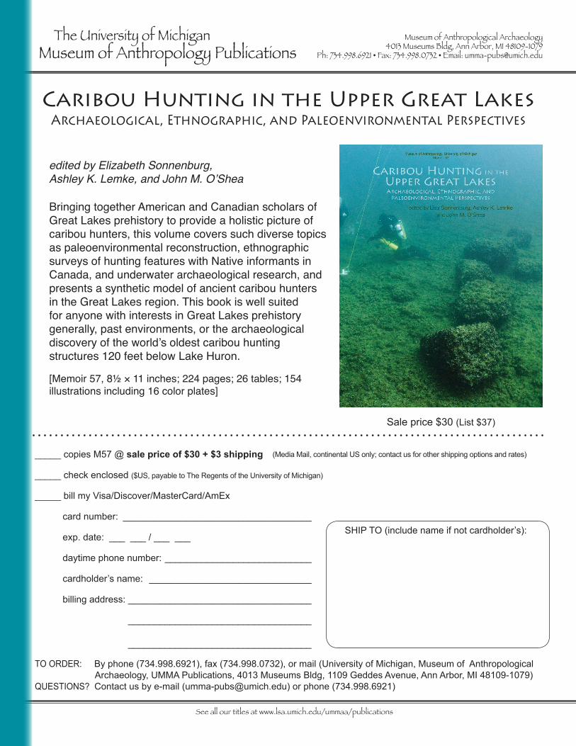
Sale price $30 (List $37)
_____ copies M57 @ sale price of $30 + $3 shipping
_____ check enclosed ($US, payable to The Regents of the University of Michigan)
_____ bill my Visa/Discover/MasterCard/AmEx card number: ____________________________________
exp. date: ___ ___ / ___ ___
daytime phone number: ____________________________
cardholder’s name: _______________________________
billing address: ___________________________________
___________________________________
___________________________________
SHIP TO (include name if not cardholder’s):
Bringing together American and Canadian scholars of Great Lakes prehistory to provide a holistic picture of caribou hunters, this volume covers such diverse topics as paleoenvironmental reconstruction, ethnographic surveys of hunting features with Native informants in Canada, and underwater archaeological research, and presents a synthetic model of ancient caribou hunters in the Great Lakes region. This book is well suited for anyone with interests in Great Lakes prehistory generally, past environments, or the archaeological discovery of the world’s oldest caribou hunting structures 120 feet below Lake Huron.
[Memoir 57, 8½ × 11 inches; 224 pages; 26 tables; 154 illustrations including 16 color plates]
edited by Elizabeth Sonnenburg, Ashley K. Lemke, and John M. O’Shea
Caribou Hunting in the Upper Great LakesArchaeological, Ethnographic, and Paleoenvironmental Perspectives
Copyright © 2022 FDOKUMEN