Exh¡b¡t 3 - Granicus
84
Mirada Petroleum Oil and Gas Project, Agnew Lease Case No. PL13-0158 Exhibit 3 Response to Public Comments Received at October 27, 2015 Planning Director Hearing The Planning Director hearing for the application of Mirada Petroleum Company to modify its Conditional Use Permit (CUP) that authorizes oil and gas operations on the Agnew Lease (Case No. PL13-0158) was held on October 27, 2015. The purpose of the hearing was to allow members of the public to provide comments on the proposed CUP application for the consideration by the Planning Director in making a decision on the proposed project. Table No. 1 below summarizes the oral testimony presented at the Planning Director hearing. Table No. 2 below summarizes the written comments provided in letters submitted at the Planning Director hearing. A County response to each comment is provided. Testimony presented at the October 27, 2015 Planning Director Hearing Listed below are the members of the public that provided testimony at the October 27, 2015 Planning Director Hearing. iReference# Commenter Representing T-1 Scott Price Mirada Petroleum T-2 Jane Farkas Mirada Petroleum T-3 Maryanne Ratcliff Koenigstein Road area Resident T-4 Carol Holly Citizens for Responsible Oil and Gas (CFROG) T-5 John Davis Koenigstein Road Resident T-6 Annalisa Anderle CFROG T-7 Natalie Greenberg Koenigstein Road Resident T-8 John Brooks CFROG T-9 Danny Everett Koenigstein Road Resident T-10 Steve Offerman Supervisor Steve Bennett's Office T-11 Ebony J. McGee Planning Division staff T-12 Kit Stoltz Koenigstein Road Resident Table 1 below summarizes the testimony of each individual who spoke at the October 27, 2015 hearing along with a staff response to the comments on the proposed project included in that testimony. County of Ventura Planning Commission Hearing PL13-0158 Exhibit 3 — Public Comments received after the October 27, 2015 Planning Director Hearing and County Responses to Comment Mirada Petroleum Oil and Gas Project, Agnew Lease Case No. PL13-0158 Exh¡b¡t 3 Response to Public Gomments Received at October 27, 2015 Planning Director Hearing The Planning Director hearing for the application of Mirada Petroleum Company to modify its Conditional Use Permit (CUP) that authorizes oil and gas operations on the Agnew Lease (Case No. PL1 3-0158) was held on October 27 ,2015. The purpose of the hearing was to allow members of the public to provide comments on the proposed CUP application for the consideration by the Planning Director in making a decision on the proposed project. Table No. 1 below summarizes the oral testimony presented at the Planning Director hearing. Table No. 2 below summarizes the written comments provided in letters submitted at the Planning Director hearing. A County response to each comment is provided. t the October 27 2015 Plannin Director Hearin Listed below are the members of the public that provided testimony at the October 27, 2015 Planning Director Hearing. Table 1 below summarizes the testimony of each individual who spoke at the October 27,2015 hearing along with a staff response to the comments on the proposed project included in that testimony. County of Ventura Planning Commission Hearing PL1 3-01 58 Exhibit 3 - Public Gomments received after the October 27 ' 2015 Planning Director Hear¡ng and County Responses to Comment Scott Price Mirada Petroleum T-1 T-2 Jane Farkas Mirada Petroleum Koeniqstein Road area Resident T-3 Maryanne Ratcliff Citizens for Responsible Oil and Gas (CFROG) T-4 Carol Holly T-5 John Davis Koeniqstein Road Resident T-6 Annalisa Anderle CFROG Koeniqstein Road Resident T-7 Natalie Greenberg T-8 John Brooks CFROG T-9 Danny Everett Koeniqstein Road Resident Supervisor Steve Bennett's Office T-10 Steve Offerman T-11 Ebonv J. McGee Planninq Division staff T-12 Kit Stoltz Koenigstein Road Resident 1
-
Upload
khangminh22 -
Category
Documents
-
view
0 -
download
0
Transcript of Exh¡b¡t 3 - Granicus

Mirada Petroleum Oil and Gas Project, Agnew Lease Case No. PL13-0158
Exhibit 3
Response to Public Comments Received at October 27, 2015 Planning Director Hearing
The Planning Director hearing for the application of Mirada Petroleum Company to modify its Conditional Use Permit (CUP) that authorizes oil and gas operations on the Agnew Lease (Case No. PL13-0158) was held on October 27, 2015. The purpose of the hearing was to allow members of the public to provide comments on the proposed CUP application for the consideration by the Planning Director in making a decision on the proposed project. Table No. 1 below summarizes the oral testimony presented at the Planning Director hearing. Table No. 2 below summarizes the written comments provided in letters submitted at the Planning Director hearing. A County response to each comment is provided.
Testimony presented at the October 27, 2015 Planning Director Hearing
Listed below are the members of the public that provided testimony at the October 27, 2015 Planning Director Hearing.
iReference# Commenter Representing T-1 Scott Price Mirada Petroleum T-2 Jane Farkas Mirada Petroleum T-3 Maryanne Ratcliff Koenigstein Road area Resident T-4 Carol Holly Citizens for Responsible Oil and Gas
(CFROG) T-5 John Davis Koenigstein Road Resident T-6 Annalisa Anderle CFROG T-7 Natalie Greenberg Koenigstein Road Resident T-8 John Brooks CFROG T-9 Danny Everett Koenigstein Road Resident T-10 Steve Offerman Supervisor Steve Bennett's Office T-11 Ebony J. McGee Planning Division staff T-12 Kit Stoltz Koenigstein Road Resident
Table 1 below summarizes the testimony of each individual who spoke at the October 27, 2015 hearing along with a staff response to the comments on the proposed project included in that testimony.
County of Ventura Planning Commission Hearing
PL13-0158 Exhibit 3 — Public Comments
received after the October 27, 2015 Planning Director Hearing and County
Responses to Comment
Mirada Petroleum Oil and Gas Project, Agnew LeaseCase No. PL13-0158
Exh¡b¡t 3
Response to Public Gomments Received at October 27, 2015Planning Director Hearing
The Planning Director hearing for the application of Mirada Petroleum Company tomodify its Conditional Use Permit (CUP) that authorizes oil and gas operations on theAgnew Lease (Case No. PL1 3-0158) was held on October 27 ,2015. The purpose of thehearing was to allow members of the public to provide comments on the proposed CUPapplication for the consideration by the Planning Director in making a decision on theproposed project. Table No. 1 below summarizes the oral testimony presented at thePlanning Director hearing. Table No. 2 below summarizes the written commentsprovided in letters submitted at the Planning Director hearing. A County response to eachcomment is provided.
t the October 27 2015 Plannin Director Hearin
Listed below are the members of the public that provided testimony at the October 27,2015 Planning Director Hearing.
Table 1 below summarizes the testimony of each individual who spoke at the October27,2015 hearing along with a staff response to the comments on the proposed projectincluded in that testimony.
County of VenturaPlanning Commission Hearing
PL1 3-01 58Exhibit 3 - Public Gomments
received after the October 27 ' 2015Planning Director Hear¡ng and County
Responses to Comment
Scott Price Mirada PetroleumT-1T-2 Jane Farkas Mirada Petroleum
Koeniqstein Road area ResidentT-3 Maryanne RatcliffCitizens for Responsible Oil and Gas(CFROG)
T-4 Carol Holly
T-5 John Davis Koeniqstein Road ResidentT-6 Annalisa Anderle CFROG
Koeniqstein Road ResidentT-7 Natalie GreenbergT-8 John Brooks CFROGT-9 Danny Everett Koeniqstein Road Resident
Supervisor Steve Bennett's OfficeT-10 Steve OffermanT-11 Ebonv J. McGee Planninq Division staffT-12 Kit Stoltz Koenigstein Road Resident
1

Public Comments received at the 10-27-15 Planning Director Hearing and County Response to Comments Mirada Petroleum (Agnew Lease) CUP Modification, Case No. PL13-0158
Page 2 of 56
Table 1- Testimony provided at the Planning Director Hearing
Ref. Commenter Testimony County Response
T-la Scott Price
T-lb Scott Price
The project includes the use of Koenigstein Road. The old road through the Ojai Oil property was completely destroyed. Mirada has no plans to drill on the Nesbitt Lease. We only drilled one well up there and it only proved to us that there wasn't anything up there. The Nesbitt wells make a couple of barrels per day. I have two federal wells up there that are not subject to a CUP. My brother and Mrs. Nesbitt live on the property and they enjoy a little income from these wells. There was never a deal with the County about giving those up for the right to get a CUP on the Harth Lease. There was a road disagreement at the time. We decided to push that off to the side.
No issues raised. No response is required.
The comments presented here do not raise any new issues regarding environmental impacts or consistency of the proposed project with applicable regulations. Thus, no response is required.
I have 20 acres and at some point am planning on planting avocados on my property. And now I'm kind of concerned about the big trucks because avocado trucks are big trucks too, at least as big as a tanker truck because they are a bobtail and trailer as well. I hope that's not going to be a problem although running into an avocado truck is not as much of a problem as a tanker truck.
Drilling of a new oil well uses about 168,000 gallons. One acre of avocados would use 2 to 4 acre-feet per year, about 800,000
Public Comments received at the 10-27-15 Planning Director Hearing and County Response to Comments MiradaPetroleum (Agnew Lease) CUP Modification, Case No. PL13-0158
Page 2 of 56
Table 1- Testimony provided at the Planning Director Hearing
Ref#
Testimony County ResponseCommenter
T-1a Scott Price The project includes the use ofKoenigstein Road. The old roadthrough the Ojai Oil property wascompletelv destroyed.
No issues raisedrequired.
No response is
Mirada has no plans to drill on theNesbitt Lease. We only drilledone well up there and it onlyproved to us that there wasn'tanything up there. The Nesbittwells make a couple of barrelsper day. I have two federal wellsup there that are not subject to aCUP. My brother and Mrs. Nesbittlive on the property and theyenjoy a little income from thesewells. There was never a dealwith the County about givingthose up for the right to get a CUPon the Hadh Lease. There was aroad disagreement at the time.We decided to push that off to theside.
I have 20 acres and at some pointam planning on plantingavocados on my property. Andnow I'm kind of concerned aboutthe big trucks because avocadotrucks are big trucks too, at leastas big as a tanker truck becausethey are a bobtail and trailer aswell. I hope that's not going to bea problem although running intoan avocado truck is not as muchof a problem as a tanker truck.
Drilling of a new oil well usesabout 168,000 gallons. One acreof avocados would use 2 to 4acre-feet per vear, about 800,000
The comments presented here donot raise any new issues regardingenvironmental impacts orconsistency of the proposedproject with applicable regulations.Thus, no response is required.
T-1b Scott Price
2

Public Comments received at the 10-27-15 Planning Director Hearing and County Response to Comments Mirada Petroleum (Agnew Lease) CUP Modification, Case No. PL13-0158
Page 3 of 56
gallons per year. Times 10 would equal 8,000,000 gallons per year.
T-2 They just want to continue the existing operation. They want to re-drill one well. If it goes well, they would drill three additional wells. They are asking for the use of a public road which was analyzed in the EIR. I feel that the County did a good job and the project should be approved. I have concerns about traffic, water, archaeology, air, proper noticing, underground aquifers. Later I'll have some responses, just statements of alleged facts.
The comments presented here do not raise any new issues regarding environmental impacts or consistency of the proposed project with applicable regulations. Thus, no response is required.
The commenter does not specifically indicate what concerns she has regarding each of the issue areas. No evidence is provided of a new potentially significant impact of the project or of an inconsistency of the project with County ordinance or policy. Therefore, a specific response to these comments is not required or possible.
T-3a
Jane Farkas
Maryanne Ratcliff
T-3b Maryanne Ratcliff
1993 is the date that the Ojai Oil road was allegedly not able to be utilized. It is stated on several occasions that the road is not usable and there have been conjecture about why it is not usable. However, there has been no investigation and no determination by an independent body that that is true. And in fact, I have learned that quite recently Ojai Oil Company has utilized that crossing for its operations. I insist that there be an independent objective review of the claim that the road is not usable. And there cannot be any kind of excuse or made-up reason why you do not get an independent objective review that the road is "not usable." There's also a statement of fact made in the report that there have been
This issue of the condition of the former access road is addressed in the Executive Summary, Section 1.2, 2.5, 4.2.2 and 6.4 of the Subsequent Environmental Impact Report (SEIR) prepared for the proposed project. Refer also to Responses to Comment B-5 and M-2 in Appendix J of the SEIR.
In addition to the discussion presented in the SEIR, it should be noted that the proposed use of Koenigstein Road is not dependent on the absence, or infeasibility of reconstruction, of the previous access road. Koenigstein Road is a public road that can be used by any citizen provided such use is in conformance with legal standards and does not create a substantial safety hazard. No significant effects on traffic safety or
Public Comments received at the 10-27-15 Planning Director Hearing and County Response to Comments MiradaPetroleum (Agnew Lease) CUP Modification, Case No. PL13-0158
Page 3 of 56
gallons per year. Times 10 wouldequal 8,000,000 gallons per year.
T-2 Jane Farkas They just want to continue theexisting operation. They want tore-drill one well. lf it goes well,they would drill three additionalwells. They are ask¡ng for the useof a public road which wasanalyzed in the ElR. I feel that theCounty did a good job and theproiect should be approved.
The comments presented here donot raise any new issues regardingenvironmental impacts orconsistency of the proposedproject with applicable regulations.Thus, no response is required.
T-3a MaryanneRatcliff
I have concerns about traffic,water, archaeology, air, propernoticing, underground aquifers.Later l'll have some responses,just statements of alleged facts.
The commenter does notspecifically indicate what concernsshe has regarding each of theissue areas. No evidence isprovided of a new potentiallysignificant impact of the project orof an inconsistency of the projectwith County ordinance or policy.Therefore, a specific response tothese comments is not required orpossible.
T-3b MaryanneRatcliff
1993 is the date that the Ojai Oilroad was allegedly not able to beutilized. lt is stated on severaloccasions that the road is notusable and there have beenconjecture about why it is notusable. However, there has beenno investigation and nodetermination by an independentbody that that is true. And in fact,I have learned that quite recentlyOjai Oil Company has utilizedthat crossing for its operations. I
insist that there be anindependent objective review ofthe claim that the road is notusable. And there cannot be anykind of excuse or made-upreason why you do not get anindependent objective review thatthe road is "not usable." There'salso a statement of fact made in
the report that there have been
This issue of the condition of theformer access road is addressed inthe Executive Summary, Section1.2, 2.5, 4.2.2 and 6.4 of theSubsequent Environmental lmpactRepod (SEIR) prepared for theproposed project. Refer also toResponses to Comment B-5 andM-2 in Appendix J of the SEIR.
ln addition to the discussionpresented in the SEIR, it should benoted that the proposed use ofKoenigstein Road is not dependenton the absence, or infeasibility ofreconstruction, of the previousaccess road. Koenigstein Road isa public road that can be used byany citizen provided such use is inconformance with legal standardsand does not create a substantialsafety hazard. No significanteffects on traffic safetv or
3

Public Comments received at the 10-27-15 Planning Director Hearing and County Response to Comments Mirada Petroleum (Agnew Lease) CUP Modification, Case No. PL13-0158
Page 4 of 56
no accidents by oil traffic at the intersection of Highway 150 and Koenigstein Road. That is absolutely not true as is revealed in your own records where Mr. Whitman has described at least two and possibly more. I do not have my own time to go over every aspect of this issue as your staff is paid to do, however I have seen myself at least two instances where there have been oil traffic truck problems and traffic has been stopped at that intersection in your own records. I have not seen a proper response to CALTRANS issues regarding Highway 150. There are updated issues with that site regarding archaeological issues. That has to be done by an archaeological study that is independent and objective.
I want to state for the record that I had further comments that I was not allowed to present due to the time constraints.
circulation have been identified that would result from the proposed use of Koenigstein Road for project-related truck access to State Highway 150.
As indicated in the SEIR, no evidence has been identified or presented that an accident involving and oil tanker truck has occurred at the intersection of Koenigstein Road and State Highway 150 since 1995. The report of an accident included in the September 14, 1977 letter of John Whitman pre-dates the 1995-2015 period. Mr. Whitman reported that an "oil truck" crashed into the bridge at Koenigstein Road in May 1976. This resulted in Konigstein Road being blocked off for "an hour and a half." An hour and a half of delay in a 39-year period does not constitute substantial evidence of a significant traffic safety hazard.
Refer to response to comment C-27 in Appendix J of the SEIR regarding the issue of "independent objective review" of the condition of the previous access road.
Refer to responses to comment Ml, M-2, M-3, and M-4 in Appendix J of the SEIR regarding the issues raised by CALTRANS. The Ventura County Planning Division, in coordination with the County Transportation Department, provided a September 25, 2015 letter to CALTRANS that summarizes the SEIR findings regarding the use of Koenigtein Road to access State Highway
Public Comments received atthe 10-27-15 Planning Director Hearing and County Response to Comments MiradaPetroleum (Agnew Lease) CUP Modification, Case No. PL13-0158
Page 4 of 56
no accidents by oil traffic at theintersection of Highway 150 andKoenigstein Road. That isabsolutely not true as is revealedin your own records where Mr.Whitman has described at leasttwo and possibly more. I do nothave my own time to go overevery aspect of this issue as yourstaff is paid to do, however I haveseen myself at least twoinstances where there have beenoil traffic truck problems andtraffic has been stopped at thatintersection in your own records.I have not seen a properresponse to CALTRANS issuesregarding Highway 150. Thereare updated issues with that siteregarding archaeological issues.That has to be done by anarchaeological study that isindependent and objective.
I want to state for the record thatI had further comments that I wasnot allowed to present due to thetime constraints.
circulation have been identified thatwould result from the proposed useof Koenigstein Road for project-related truck access to StateHighway 150.
As indicated in the SEIR, noevidence has been identified orpresented that an accidentinvolving and oil tanker truck hasoccurred at the intersection ofKoenigstein Road and StateHighway 150 since 1995. Therepoft of an accident included inthe September 14, 1977 letter ofJohn Whitman pre-dates the 1995-2015 period. Mr. Whitman reportedthat an "oil truck" crashed into thebridge at Koenigstein Road in May1976. This resulted in KonigsteinRoad being blocked off for "an hourand a half." An hour and a half ofdelay in a 39-year period does notconstitute substantial evidence of asignificant traffic safety hazard.
Refer to response to comment C-27 in Appendix J of the SEIRregarding the issue of"independent objective review" ofthe condition of the previousaccess road.
Refer to responses to commentM'1, M-2, M-3, and M-4 in AppendixJ of the SEIR regarding the issuesraised by CALTRANS. TheVentura County Planning Division,in coordination with the CountyTranspoftation Depadment,provided a September 25, 2015letter to CALTRANS thatsummarizes the SEIR findingsregarding the use of KoenigteinRoad to access State Highway
4

Public Comments received at the 10-27-15 Planning Director Hearing and County Response to Comments Mirada Petroleum (Agnew Lease) CUP Modification, Case No. PL13-0158
Page 5 of 56
150. CALTRANS has not subsequently expressed any objection or disagreement with the conclusion expressed in the SEIR that the use of Koenigstein Road to access State Highway 150 does not constitute a significant safety hazard.
T-4a Carol Holly Why was the City of Ojai not notified?
The 1983 FEIR found that the site is excellent habitat. Yet the only mitigation that was included in that FEIR was for a task force to study the wildlife; the impacts of cumulative effects on the wildlife. That mitigation was never done. By 2015, 88 oil wells have been added to that area. The FEIR was done at a maximum yield of 46 oil wells. So the impacts on wildlife need to be studied in a complete and comprehensive ISBA including the number of sensitive
The commenter states that there are "updated issues" regarding archaeology but does not explain the nature of those issues. This comment does not provide any substantial evidence of an impact on archaeological resources. Archaeological issues are addressed in the FSEIR (Section 4.7) and the 1983 FEIR. In the November 15, 1977 Board of Supervisors agenda letter (attached to the 1983 FEIR), it is reported that "Mr. Robert Lopez, Ventura County Archaeologist, visited the subject property during grading operations and did not find any archaeological sites." Public notice of the availability of the SEIR and the date, time and location of the Planning Director public hearing was legally noticed in conformance with the requirements of the Non-Coastal Zoning Ordinance. The City of Ojai did not receive a mailed notice because the proposed project is located outside of the City Sphere of Influence and Area of Interest. In addition to mailed notices to nearby landowners and interested parties, notice of County processing of the PL13-0158 application was provided to all County residents and political entities, including the City of Ojai,
Public Comments received atthe 10-27-15 Planning Director Hearing and County Response to Comments MiradaPetroleum (Agnew Lease) CUP Modification, Case No. PL13-0158
Page 5 of 56
150. CALTRANS has notsubsequently expressed anyobjection or disagreement with theconclusion expressed in the SEIRthat the use of Koenigstein Road toaccess State Highway 150 doesnot constitute a significant safetyhazard.
The commenter states that thereare "updated issues" regardingarchaeology but does not explainthe nature of those issues. Thiscomment does not provide anysubstantial evidence of an impacton archaeological resources.Archaeological issues areaddressed in the FSEIR (Section4.7) and the 1983 FEIR. ln theNovember 15, 1977 Board ofSupervisors agenda letter(attached to the 1983 FEIR), it isreported that "Mr. Robert Lopez,Ventura County Archaeologist,visited the subject property duringgrading operations and did not findany archaeological sites."
T-4a Carol Holly Why was the City of Ojai notnotified?
The 1983 FEIR found that the siteis excellent habitat. Yet the onlymitigation that was included inthat FEIR was for a task force tostudy the wildlife; the impacts ofcumulative effects on the wildlife.That mitigation was never done.By 2015, 88 oil wells have beenadded to that area. The FEIR wasdone at a maximum yield of 46 oilwells. So the impacts on wildlifeneed to be studied in a completeand comprehensive ISBAincluding the number of sensitive
Public notice of the availability ofthe SEIR and the date, time andlocation of the Planning Directorpublic hearing was legally noticedin conformance with therequirements of the Non-CoastalZoning Ordinance. The City of Ojaidid not receive a mailed noticebecause the proposed project islocated outside of the City Sphereof lnfluence and Area of lnterest.ln addition to mailed notices tonearby landowners and interestedparties, notice of Countyprocessing of the PL13-0158application was provided to allCounty residents and politicalentities, including the City of Oiai,
5

Public Comments received at the 10-27-15 Planning Director Hearing and County Response to Comments Mirada Petroleum (Agnew Lease) CUP Modification, Case No. PL13-0158
Page 6 of 56
animals and plants that are on through an advertisement that site. published in the local newspaper. Here are pictures of a raccoon killed on Saturday night; the fox The issue of the task force to study was killed on Saturday morning. biological impacts recommended in Do we have wildlife in crisis? the 1983 FEIR is addressed in
Section 1.1, Table 2 of the SEIR. Refer also to Responses to Comment C-2, C-21 and C-24 in Appendix J of the SEIR.
An EIR is an informational document that serves to disclose future impacts (project-specific and cumulative) of a proposed project. Pursuant to CEQA, the baseline setting for the analysis of environmental impacts presented in the SEIR for all issue areas are the environmental conditions present at the time the Notice of Preparation (NOP) was released for public review, February 19, 2015.
Projects are evaluated to determine if they could make a future considerable contribution to a cumulatively significant environmental effect. The existence of numerous wells in the Ojai Oil Field is not a new circumstance and the effects of wells previously permitted and in operation are part of the current existing setting and not an impact under CEQA. The FEIR on Page 33 states that "considering all approved, proposed, and probable oil developments, a high find would result in the development of 83 wells on 42 sites." Thus, the FEIR estimate is reasonably consistent with the commenter's figure of 88 wells.
Public Comments received atthe'10-27-15 Planning Director Hearing and County Response to Comments MiradaPetroleum (Agnew Lease) CUP Modification, Case No. PL13-0158
Page 6 of 56
animals and plants that are onthat site.Here are pictures of a raccoonkilled on Saturday night; the foxwas killed on Saturday morn¡ng.Do we have wildlife in crisis?
through an advertisementpublished in the local newspaper.
The issue of the task force to studybiological impacts recommended in
the 1983 FEIR is addressed inSection 1.1, Table 2 of the SEIR.Refer also to Responses toComment C-2, C-21 and C-24 inAppendix J of the SEIR.
An EIR is an informationaldocument that serves to disclosefuture impacts (project-specific andcumulative) of a proposed project.Pursuant to CEQA, the baselinesetting for the analysis ofenvironmental impacts presentedin the SEIR for all issue areas arethe environmental conditionspresent at the time the Notice ofPreparation (NOP) was releasedfor public review, February 19,2015.
Projects are evaluated todetermine if they could make afuture considerable contribution toa cumulatively significantenvironmental effect. Theexistence of numerous wells in theOjai Oil Field is not a newcircumstance and the effects ofwells previously permitted and in
operation are part of the currentexisting setting and not an impactunder CEQA. The FEIR on Page33 states that "considering allapproved, proposed, and probableoil developments, a high find wouldresult in the development of 83wells on 42 sifes." Thus, the FEIRestimate is reasonably consistentwith the commenter's figure of 88wells.
6

Public Comments received at the 10-27-15 Planning Director Hearing and County Response to Comments Mirada Petroleum (Agnew Lease) CUP Modification, Case No. PL13-0158
Page 7 of 56
Also, the commenter appears to equate the existence of an oil well with significant environmental impacts. Similar to the current proposal, many of the wells drilled in the past 30 years were likely drilled on existing drilling pads and resulted in no significant impacts.
The proposed project does not involve any new disturbance of native habitat or change in land use. No significant effect on biological resources has been identified that would result from the addition of three wells on the existing drilling pad. The minimal level of daytime truck traffic associated with the proposed project does not have the potential for a significant effect on wildlife movement which occurs largely at night. No contribution to the cumulative loss of habitat due to the oil operations in the Ojai Oil Field would result from the proposed project. In summary, the evaluation of potential project effects on biological resources presented in Section 4.3 of the SEIR is adequate. No further analysis is required.
The photographs of road kill presented by the applicant were anecdotal and don't provide substantial evidence of any potential new effect that would result from the proposed project. As stated by the commenter, the incidents occurred on Saturday night and Sunday morning. Project-related trucking will not be allowed either at night or on Sundays.
Public Comments received at the 10-27-15 Planning Director Hearing and County Response to Comments MiradaPetroleum (Agnew Lease) CUP Modification, Case No. PL13-0158
Page 7 of 56
Also, the commenter appears toequate the existence of an oil wellwith significant environmentalimpacts. Similar to the currentproposal, many of the wells drilledin the past 30 years were likelydrilled on existing drilling pads andresulted in no significant impacts.
The proposed project does notinvolve any new disturbance ofnative habitat or change in landuse. No significant effect onbiological resources has beenidentified that would result from theaddition of three wells on theexisting drilling pad. The minimallevel of daytime truck trafficassociated with the proposedproject does not have the potentialfor a significant effect on wildlifemovement which occurs largely atnight. No contribution to thecumulative loss of habitat due tothe oil operations in the Ojai OilField would result from theproposed project. ln summary, theevaluation of potential projecteffects on biological resourcespresented in Section 4.3 of theSEIR is adequate. No furtheranalysis is required.
The photographs of road killpresented by the applicant wereanecdotal and don't providesubstantial evidence of anypotential new effect that wouldresult from the proposed project.As stated by the commenter, theincidents occurred on Saturdaynight and Sunday morning. Project-related trucking will not be allowedeither at niqht or on Sundavs.
7

Public Comments received at the 10-27-15 Planning Director Hearing and County Response to Comments Mirada Petroleum (Agnew Lease) CUP Modification, Case No. PL13-0158
Page 8 of 56
Wildlife movement primarily occurs at night when oil trucking will not be authorized.
T-4b Carol Holly State Highway 150 is under the jurisdiction of CALTRANS. CALTRANS has written you a letter saying that the use of large trucks turning onto Koenigstein Road would create a risk to public health. And they have to swing out into the oncoming lane and there's poor visibility. So, it seems to me that it is a non-issue. CALTRANS says it's dangerous. I'd like to comment on a paragraph in the EIR:
"No recently approved or reasonably foreseeable projects exist within the vicinity of the project that either were not analyzed in the FEIR or would result in the reconfigured project having a potentially significant contribution to a cumulative impact that was not analyzed in the FEIR. The project site and surrounding area do not exhibit any previously unknown resources that need to be analyzed as part of the proposed project."
The high yield scenario for new wells in the FEIR was 46. There have been 88 new wells either drilled or permitted since that time that were not evaluated in the FEIR, could not have been evaluated in the FEIR and need to be evaluated in terms of the incremental increase that has not been considered, particularly in light of the fact that this CUP is
Refer to responses to comment M-1, M-2, M-3, and M-4 in Appendix J of the SEIR regarding the issues raised by CALTRANS. The Ventura County Planning Division, in coordination with the County Transportation Department, provided a September 24, 2015 letter to CALTRANS that summarizes the SEIR findings regarding the use of Koenigtein Road to access State Highway 150. CALTRANS has not subsequently expressed any objection or disagreement with the conclusion reported in the SEIR that the use of Koenigstein Road to access State Highway 150 does not. constitute a significant safety hazard.
The existence of numerous wells in the Ojai Oil Field is not a new circumstance and the effects of wells previously permitted and in operation are part of the current existing setting and not an impact under CEQA. The FEIR on Page 33 states that "considering all approved, proposed, and probable oil developments, a high find would result in the development of 83 wells on 42 sites." Thus, the FEIR estimate is substantially equivalent to the commenter's figure of 88 wells (83 = 94% of 88).
Public Comments received at the '10-27-15 Planning Director Hearing and County Response to Comments MiradaPetroleum (Agnew Lease) CUP Modification, Case No. PL13-0158
Page I of 56
Wildlife movement primarily occursat night when oil trucking will not beauthorized.
Refer to responses to comment M-1,1\A-2, M-3, and M-4 in Appendix J
of the SEIR regarding the issuesraised by CALTRANS. TheVentura County Planning Division,in coordination with the CountyTransportation Depaftment,provided a September 24, 2015letter to CALTRANS thatsummarizes the SEIR findingsregarding the use of KoenigteinRoad to access State Highway150. CALTRANS has notsubsequently expressed anyobjection or disagreement with theconclusion reported in the SEIRthat the use of Koenigstein Road toaccess State Highway 150 doesnot. constitute a significant safetyhazard.
The existence of numerous wells inthe Ojai Oil Field is not a newcircumstance and the effects ofwells previously permitted and inoperation are pad of the currentexisting setting and not an impactunder CEQA. The FEIR on Page33 states that "considering allapproved, proposed, and probableoil developments, a high find wouldresult in the development of 83wells on 42 sifes." Thus, the FEIRestimate is substantially equivalentto the commenter's figure of 88wells (83 = 94% of 8B).
T-4b Carol Holly State Highway 150 is under thejurisdiction of CALTRANS.CALTRANS has written you aletter saying that the use of largetrucks turning onto KoenigsteinRoad would create a risk to publichealth. And they have to swingout into the oncoming lane andthere's poor visibility. So, itseems to me that it is a non-issue. CALTRANS says it'sdangerous.l'd like to comment on aparagraph in the EIR:
"No recently approved orreasonably foreseeable projectsexist within the vicinity of theproject that either were notanalyzed in the FEIR or wouldresult in the reconfigured projecthaving a potentially significantcontribution to a cumulativeimpact that was not analyzed inthe FEIR. The project site andsurrounding area do not exhibitany previously unknownresources that need to beanalyzed as part of the proposedproject."
The high yield scenario for newwells in the FEIR was 46. Therehave been 88 new wells eitherdrilled or permitted since that timethat were not evaluated in theFEIR, could not have beenevaluated in the FEIR and needto be evaluated in terms of theincremental increase that has notbeen considered, particularly inlisht of the fact that this CUP is
8

Public Comments received at the 10-27-15 Planning Director Hearing and County Response to Comments Mirada Petroleum (Agnew Lease) CUP Modification, Case No. PL13-0158
Page 9 of 56
T-5a John Davis
surrounded by two of the largest CUPs in Ventura County that you consider antiquated and have, therefore, no goals, no limits, no timeframes, no limit on the number of wells to be drilled, etc. If you don't look at the impacts where there is an SEIR being done, when will it ever be done? My issue is traffic on Koenigstein, specifically oil tankers on Koenigstein. I have CUP modification 3543-5 of 1987. At that time in 1987, and in 1983, truck traffic was found to be a significant traffic impact due to the movement of large vehicles at the intersection of State Highway 150 and Koenigstein Road creating unsafe conditions. The mitigation was the use of a road through the Ojai Oil Company. The oil company was allowed to use Koenigstein for six months in 1987 but continued to use it for 17 years in violation of the permit. The CUP states that if significant traffic problems, oil and gas products shall be transported offsite by pipeline. Need sanctions to be imposed on the violator.
The issue of traffic on Koenigstein Road and State Highway 150 is addressed in Section 4.2 and Appendix C through F of the SEIR. Refer also to responses to comment A-1, B-1, B-4, B-5, C-4, C-6, C-8, C-10, C-11, C-12, C-14, C-15, C-17, D-2, D-5, E-1, 1-2, 1-3, L-7, M-1, M-2, M-3, and M-4 in Appendix J of the SEIR.
The issue of the use of pipelines to transport oil is addressed in Section 6.6.1 of the SEIR. Refer also to the response to the comments of Steve Offerman provided below.
T-5b John Davis The applicant has, more or less, admitted that these wells are not particularly productive wells. So, you wonder why the applicant is going though the time and trouble to do this. This is essentially a Trojan horse for the use of Koenigstein which will be triggered in the exploration in the Nesbitt Lease and beyond in the Sespe. That actually goes to Natalie Greenberg's concern. In the current CUP under review,
The comment regarding a "Trojan horse" is speculative and does not constitute substantial evidence of a potentially significant environmental impact or an inconsistency of the proposed project with County policies or ordinance requirements.
The existing production and drilling site is not visible from Koenigstein Road or prominently visible from nearby residences or State
Public Comments received at the 10-27-15 Planning Director Hearing and County Response to Comments MiradaPetroleum (Agnew Lease) CUP Modification, Case No. PL13-0158
Page 9 of 56
surrounded by two of the largestCUPs in Ventura County that youconsider antiquated and have,therefore, no goals, no limits, notimeframes, no limit on thenumber of wells to be drilled, etc.lf you don't look at the impactswhere there is an SEIR beingdone, when will it ever be done?
T-5a John Davis My issue is traffic on Koenigstein,specifically oil tankers onKoenigstein. I have CUPmodification 3543-5 of 1987. Atthat time in 1987, and in 1983,truck traffic was found to be asignificant traffic impact due tothe movement of large vehicles atthe intersection of State Highway150 and Koenigstein Roadcreating unsafe conditions. Themitigation was the use of a roadthrough the Ojai Oil Company.The oil company was allowed touse Koenigstein for six months in1987 but continued to use itfor 17years in violation of the permit.The CUP states that if significanttraffic problems, oil and gasproducts shall be transpodedoffsite by pipeline. Needsanctions to be imposed on theviolator.
The issue of traffic on KoenigsteinRoad and State Highway 150 isaddressed in Section 4.2 andAppendix C through F of the SEIR.Refer also to responses tocomment A-1, B-1 , B-4, B-5, C-4,c-6, c-9, c-10, c-11, c-12, c-14,c-15, C-17, D-2, D-5, E-1, l-2, l-3,L-7, M-1, l\A-2, M-3, and M-4 inAppendix J of the SEIR.
The issue of the use of pipelines totransport oil is addressed inSection 6.6.1 of the SEIR. Referalso to the response to thecomments of Steve Offermanprovided below.
T-5b John Davis The applicant has, more or less,admitted that these wells are notparticularly productive wells. So,you wonder why the applicant isgoing though the time and troubleto do this. This is essentially aTrojan horse for the use ofKoenigstein which will betriggered in the exploration in theNesbitt Lease and beyond in theSespe. That actually goes toNatalie Greenberg's concern. lnthe current CUP under review,
The comment regarding a "Trojanhorse" is speculative and does notconstitute substantial evidence of apotentially significantenvironmental impact or aninconsistency of the proposedproject with County policies orord inance requirements.
The existing production and drillingsite is not visible from KoenigsteinRoad or prominently visible fromnearby residences or State
9

Public Comments received at the 10-27-15 Planning Director Hearing and County Response to Comments Mirada Petroleum (Agnew Lease) CUP Modification, Case No. PL13-0158
Page 10 of 56
trucks could not go by your avocado ranch. Clearly, the plan is, the use of Koenigstein is being pioneered for the use in the other leases that the applicant has. We are talking about the entire length of Koenigstein and beyond.
The other issue I want to raise (from the 1987 modification of the 1983 documents), the site shall be landscaped so as to screen production equipment from view of Koenigstein Road, Highway 150, and nearby residences in a manner consistent with the natural character of the area. The dominant vegetation that the applicant has introduced are Peruvian peppers and Australian eucalyptus. Neither of which are consistent with the natural character of the area. So, I would require that a condition be imposed on the applicant to fulfill the original condition. If there is going to be screening vegetation, that it be native California chaparral species. Comments about the lease. Well records indicate only 3 wells: Agnew 1, 2 and 4 drilled from 1978 to 1982. Two of the wells were fracture-treated using lease crude. If any more wells were drilled, they would not economically produce unless they were fracture treated. Drilling with diesel or lease crude may be against EPA rules now. It may well not be possible to drill another productive well. These wells are barely economic, if not uneconomic. Total production of
Highway 150. The facility in its current condition is not visible from Koenigstein Road and not prominently visible from State Highway 150. While the vegetation at the site includes eucalyptus and pepper trees, no adverse effect on the surrounding habitat has been identified. It would be counterproductive to remove the existing vegetation and plant slow-growing native species. The requirement for the site to be screened will remain and require that any new vegetation planted in the future be comprised of native species.
The testimony presented here does not relate to an environmental issue. It does relate to feasibility of connecting this facility to a new petroleum pipeline. Refer to Response to Comment T-10 and the attached evaluation of project compliance with Section 8107-5.5 et. Seq. of the Non-Coastal Zoning Ordinance.
The comments regarding "catastrophic failure" of the existing tanks on the project site is speculative. No substantial evidence has been presented that
T-6a Annalisa Anderle
Public Comments received at the 10-27-15 Planning Director Hearing and County Response to Comments MiradaPetroleum (Agnew Lease) CUP Modification, Case No. PL'13-0158
Page 10 of56
trucks could not go by youravocado ranch. Clearly, the planis, the use of Koenigstein is beingpioneered for the use in the otherleases that the applicant has. Weare talking about the entire lengthof Koenigstein and beyond.
The other issue I want to raise(from the 1987 modification of the1983 documents), the site shallbe landscaped so as to screenproduction equipment from viewof Koenigstein Road, Highway150, and nearby residences in amanner consistent with thenatural character of the area. Thedominant vegetation that theapplicant has introduced arePeruvian peppers and Australianeucalyptus. Neither of which areconsistent with the naturalcharacter of the area. So, I wouldrequire that a condition beimposed on the applicant to fulfillthe original condition. lf there isgoing to be screening vegetation,that it be native Californiachaparral species.
Highway 150. The facility in itscurrent condition is not visible fromKoenigstein Road and notprominently visible from StateHighway 150. While the vegetationat the site includes eucalyptus andpepper trees, no adverse effect onthe surrounding habitat has beenidentified. lt would becounterproductive to remove theexisting vegetation and plant slow-growing native species. Therequirement for the site to bescreened will remain and requirethat any new vegetation planted inthe future be comprised of nativespecies.
T-6a AnnalisaAnderle
Comments about the lease. Wellrecords indicate only 3 wells:Agnew 1, 2 and 4 drilled from1978 to 1982. Two of the wellswere fracture-treated using leasecrude. lf any more wells weredrilled, they would noteconomically produce unlessthey were fracture treated.Drilling with diesel or lease crudemay be against EPA rules now. ltmay well not be possible to drillanother productive well. Thesewells are barely economic, if notuneconomic. Total production of
The testimony presented heredoes not relate to an environmentalissue. lt does relate to feasibility ofconnecting this facility to a newpetroleum pipeline. Refer toResponse to Comment T-10 andthe attached evaluation of projectcompliance with Section 8107-5.5et. Seq. of the Non-Coastal ZoningOrdinance.
The comments regarding"catastrophic failure" of the existingtanks on the project site isspeculative. No substantialevidence has been presented that
10

Public Comments received at the 10-27-15 Planning Director Hearing and County Response to Comments Mirada Petroleum (Agnew Lease) CUP Modification, Case No. PL13-0158
Page 11 of 56
T-6b Annalisa Anderle
all three wells is only 5 barrels per day.
I think it would be possible to tie into the Hamp facility where dehydration, metering and testing can be done in conjunction with CRC. I think a product line going from the Agnew Lease, maybe also picking up the Nesbitt wells and other Mirada Production. That would mean all tankage be removed which would eliminate the possibility of catastrophic failure if a tank bottom happened to corrode and spill. I suggest limiting the term to 5 years rather than 25 years. All oil field reservoirs are finite. These wells and some of the other leases are at the end of their useful life, their economic life. That's how oil companies calculate when you go uneconomic you shut the wells in. I think I saw that the Koenigstein bridge has been getting an awful lot more use than it normally would. There was something like a 20,000 pound per axle load limit. That's normal for an 18-wheeler with 5 axles, with 4 of them carrying a load. That's quite a lot of beating over the last 20 years that will continue if Koenigstein is the transport mode for all of the production, water and oil, out of those leases. The Nesbitt Lease is shut-in now but that is not going to remain the case. They too will be trucked, all the production from that lease. The one good thing is because the production is so low, its nowhere near 8 truckloads per
the tanks are subject to failure or that the required DOGGR inspections of such facilities are inadequate. There is no record of an oil spill at the subject facility in the 37 years of operation. Refer to the Response to Comment T-10 below regarding the issue of a pipeline connection to the CRC Hamp facilities.
The County Transportation Department has determined that the use of the Koenigstein Road/State Highway 150 intersection by oil tanker trucks would not create a substantial safety hazard. As stated in a September 28, 2015 letter regarding a similar Mirada Petroleum Project (the re-activation of the Nesbitt Lease facilities) that would involve the use of Koenigstein Road to access State Highway 150: "Caltrans does not expect project approval to result in a direct adverse impact to existing State transportation facilities." The type of truck that currently services the existing production facilities would continue to be used and constitutes a legal load that can be driven without restriction on County roadways. The County Transportation Department has also found that the two bridges on Koenigstein Road
Public Comments received allhe 10-27-15 Planning Director Hearing and County Response to Comments MiradaPetroleum (Agnew Lease) CUP Modification, Case No. PL'13-0'158
Page 11 of56
the tanks are subject to failure orthat the required DOGGRinspections of such facilities areinadequate. There is no record ofan oil spill at the subject facility inthe 37 years of operation. Refer tothe Response to Comment T-10below regarding the issue of apipeline connection to the CRCHamp facilities.
allthree wells is only 5 barrels perday.
I think it would be possible to tieinto the Hamp facility wheredehydration, metering and testingcan be done in conjunction withCRC. I think a product line goingfrom the Agnew Lease, maybealso picking up the Nesbitt wellsand other Mirada Production.That would mean all tankage beremoved which would eliminatethe possibility of catastrophicfailure if a tank bottom happenedto corrode and spill. I suggestlimiting the term to 5 years ratherthan 25 years.
AnnalisaAnderle
All oil field reservoirs are finite.These wells and some of theother leases are at the end oftheir useful life, their economiclife. That's how oil companiescalculate when you gouneconomic you shut the wells in.I think I saw that the Koenigsteinbridge has been getting an awfullot more use than it normallywould. There was something likea 20,000 pound per axle loadlimit. That's normal for an '18-
wheeler with 5 axles, with 4 ofthem carrying a load. That's quitea lot of beating over the last 20years that will continue ifKoenigstein is the transport modefor all of the production, waterand oil, out of those leases. TheNesbitt Lease is shut-in now butthat is not going to remain thecase. They too will be trucked, allthe production from that lease.The one good thing is becausethe production is so low, itsnowhere near 8 truckloads per
The County TransportationDepartment has determined thatthe use of the KoenigsteinRoad/State Highway 150intersection by oil tanker truckswould not create a substantialsafety hazard. As stated in aSeptember 28, 2015 letterregarding a similar MiradaPetroleum Project (the re-activation of the Nesbitt Leasefacilities) that would involve the useof Koenigstein Road to accessState Highway 150: "Caltrans doesnot expect project approval toresult in a direct adverse impact toexisting State transpodationfacilities." The type of truck thatcurrently services the existingproduction facilities would continueto be used and constitutes a legalload that can be driven withoutrestriction on County roadways.The County TransportationDepartment has also found that thetwo bridges on Koenigstein Road
T-6b
11

Public Comments received at the 10-27-15 Planning Director Hearing and County Response to Comments Mirada Petroleum (Agnew Lease) CUP Modification, Case No. PL13-0158
Page 12 of 56
week, it's more like 2 or 3 a month. That's just the one Agnew Lease but if you add the other ones, it's just that many more traffic trips, coming and going.
Part of the regulations Mr. Bennett's representative brought up, to consolidate facilities as much as possible. That would be a good idea here. You don't need as much tankage as you used to when the wells were highly productive in oil and water. If you combine facilities, the oil companies make out because they have less maintenance and less facilities to worry about and there's less potential damage from those facilities.
are adequate for use by the tanker trucks.
With regard to the issue of facility consolidation, refer to the Response to Comment T-10 presented below.
T-7 Natalie Greenberg
Afraid about the trucks running in front of the ranch to the oil wells. Main concern is that the trucks will destroy our trees.
No evidence has been presented that the operation of trucks or other vehicles on the public Koenigstein Road has had or will have a harmful effect on trees.
T-8a John Brooks Mr. Brooks read into the record the letter of comment (Letter E below) that he submitted at the public hearing.
Refer to the Responses to Comment provided for Letter E below.
T-8b John Brooks Can you confirm if anyone in your department has made any attempt to contact CEQA [CALTRANS] branch chief Dianna Watson or her project coordinator Elmer Alvarez to discuss possible mitigations on this project?
I would like to re-iterate Maryanne Ratcliff's position on the rebuilding of the access road. It's stated throughout this document that the rebuilding of the access road is not feasible. Yet nowhere is there provided
The Ventura County Planning Division, in coordination with the County Transportation Department, provided a September 25, 2015 letter to CALTRANS that summarizes the SEIR findings regarding the use of Koenigtein Road to access State Highway 150. As stated in a September 28, 2015 State letter regarding a similar Mirada Petroleum Project (the re-activation of the Nesbitt Lease facilities) that would involve the use of Koenigstein Road to access State Highway 150: "Caltrans does not expect project
Public Comments received at the '10-27-15 Planning Director Hearing and County Response to Comments MiradaPetroleum (Agnew Lease) CUP Modification, Case No PL13-0'158
Page 12 of 56
week, it's more like 2 or 3 amonth. That's just the one AgnewLease but if you add the otherones, it's just that many moretraffic trips, coming and going.
Part of the regulations Mr.Bennett's representative broughtup, to consolidate facilities asmuch as possible. That would bea good idea here. You don't needas much tankage as you used towhen the wells were highlyproductive in oil and water. lf youcombine facilities, the oilcompanies make out becausethey have less maintenance andless facilities to worry about andthere's less potential damagefrom those facilities.
are adequate for use by the tankertrucks.
With regard to the issue of facilityconsolidation, refer to theResponse to Comment T-10presented below.
No evidence has been presentedthat the operation of trucks or othervehicles on the public KoenigsteinRoad has had or will have aharmful effect on trees.
T-7 NatalieGreenberg
Afraid about the trucks running infront of the ranch to the oil wells.Main concern is that the truckswill destroy our trees.
John Brooks Mr. Brooks read into the recordthe letter of comment (Letter Ebelow) that he submitted at thepublic hearinq.
Refer to the Responses toComment provided for Letter E
below.
T-8a
T-8b John Brooks Can you confirm if anyone in yourdepartment has made anyattempt to contact CEQAICALTRANSI branch chiefDianna Watson or her projectcoordinator Elmer Alvarez todiscuss possible mitigations onthis project?
I would like to re-iterateMaryanne Ratcliff's position onthe rebuilding of the access road.It's stated throughout thisdocument that the rebuilding ofthe access road is not feasible.Yet nowhere is there provided
The Ventura County PlanningDivision, in coordination with theCounty TransportationDepartment, provided a September25,2015 letter to CALTRANS thatsummarizes the SEIR findingsregarding the use of KoenigteinRoad to access State Highway150. As stated in a September 28,2015 State letter regarding asimilar Mirada Petroleum Project(the re-activation of the NesbittLease facilities) that would involvethe use of Koenigstein Road toaccess State Highway 150:"Caltrans does not expect proiect
12
Public Comments received at the 10-27-15 Planning Director Hearing and County Response to Comments Mirada Petroleum (Agnew Lease) CUP Modification, Case No. PL13-0158
Page 13 of 56
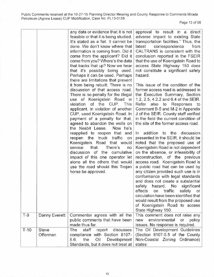
any data or evidence that it is not feasible or that it is being studied. It's stated as a fiat. It cannot be done. We don't know where that information is coming from. Did it come from the applicant? Did it come from you? Where's the data that backs that up? Now we hear that it's possibly being used. Perhaps it can be used. Perhaps there are limitations that prevent it from being rebuilt. There is no discussion of that access road. There is no penalty for the illegal use of Koenigstein Road in violation of the CUP. This applicant, in violation of another
approval to result in a direct adverse impact to existing State transportation facilities." Thus, the latest correspondence from CALTRANS is consistent with the conclusion reported in the FSEIR that the use of Koenigstein Road to access State Highway 150 does not constitute a significant safety hazard.
This issue of the condition of the former access road is addressed in the Executive Summary, Section 1.2, 2.5, 4.2.2 and 6.4 of the SEIR. Refer also to Responses to Comment B-5 and M-2 in Appendix
CUP, used Koenigstein Road. In payment of a penalty for that, agreed to abandon the wells on the Nesbit Lease. Now he's reapplied to reopen that and reopen the truck traffic on Koenigstein Road that would service that. There's no discussion of the cumulative impact of this one operator let alone all the others that would use the road should this Trojan horse be approved.
J of the SEIR. County staff verified in the field the current condition of the site of the former access road.
In addition to the discussion presented in the SEIR, it should be noted that the proposed use of Koenigstein Road is not dependent on the absence, or infeasibility of reconstruction, of the previous access road. Koenigstein Road is a public road that can be used by any citizen provided such use is in conformance with legal standards and does not create a substantial safety hazard. No significant effects on traffic safety or circulation have been identified that would result from the proposed use of Koenigstein Road to access State Highway 150.
T-9 Danny Everett Commenter agrees with all the public comments that have been made thus far.
This comment does not raise any new environmental or policy issues. No response is required.
T-10 Steve The staff report discusses The Oil Development Guidelines Offerman compliance with Section 8107- (Section 8107-5.5 of the County
5.6, the Oil Development Standards, but it does not treat at
Non-Coastal Zoning Ordinance) states:
Public Comments received atlhe 10-27-15 Planning Director Hearing and County Response to Comments MiradaPetroleum (Agnew Lease) CUP Modification, Case No. PL13-0158
Page 13 of56
any data or evidence that it is notfeasible or that it is being studied.It's stated as a fiat. lt cannot bedone. We don't know where thatinformation is coming from. Did ¡tcome from the applicant? Did itcome from you? Where's the datathat backs that up? Now we hearthat it's possibly being used.Perhaps it can be used. Perhapsthere are limitations that preventit from being rebuilt. There is nodiscussion of that access road.There is no penalty for the illegaluse of Koenigstein Road inviolation of the CUP. Thisapplicant, in violation of anotherCUP, used Koenigstein Road. lnpayment of a penalty for that,agreed to abandon the wells onthe Nesbit Lease. Now he'sreapplied to reopen that andreopen the truck traffic onKoenigstein Road that wouldservice that. There's nodiscussion of the cumulativeimpact of this one operator letalone all the others that woulduse the road should this Trojanhorse be approved.
approval to result in a directadverse impact to existing Statetranspoftation facilities." Thus, thelatest correspondence fromCALTRANS is consistent with theconclusion reported in the FSEIRthat the use of Koenigstein Road toaccess State Highway 150 doesnot constitute a significant safetyhazard.
This issue of the condition of theformer access road is addressed inthe Executive Summary, Section1 .2, 2.5, 4.2.2 and 6.4 of the SEIR.Refer also to Responses toComment B-5 and M-2 in AppendixJ of the SEIR. County staff verifiedin the field the current condition ofthe site of the former access road.
ln addition to the discussionpresented in the SEIR, it should benoted that the proposed use ofKoenigstein Road is not dependenton the absence, or infeasibility ofreconstruction, of the previousaccess road. Koenigstein Road isa public road that can be used byany citizen provided such use is inconformance with legal standardsand does not create a substantialsafety hazard. No significanteffects on traffic safety orcirculation have been identified thatwould result from the proposed useof Koenigstein Road to accessState Highway 150.
Commenter agrees with all thepublic comments that have beenmade thus far.
This comment does not raise anynew environmental or policyissues. No response is required.
T-9 Danny Everett
T-10 SteveOfferman
The staff report discussescompliance with Section 8107-5.6, the Oil DevelopmentStandards, but it does not treat at
The Oil Development Guidelines(Section 8107-5.5 of the CountyNon-Coastal Zoning Ordinance)states:
13

Public Comments received at the 10-27-15 Planning Director Hearing and County Response to Comments Mirada Petroleum (Agnew Lease) CUP Modification, Case No. PL13-0158
Page 14 of 56
all Section 8107-5.5, the Oil Development Guidelines. Both of these sections comprise the standards in the zoning ordinance for oil and gas production. The ordinance states that unless otherwise indicated herein, the purposes and provisions of Section 8107-5 et. seq. shall be, and are hereby automatically imposed on, and made a part of any permit for oil and gas development issued by the County. Such provisions shall be imposed in the form of permit conditions when permits are issued. The guidelines that follow shall be used in the development of conditions that will help ensure that oil development projects generate minimum negative impacts on the environment. Among those are Section 5.5.a: pipelines should be used to transport petroleum products offsite to promote traffic safety and air quality. Section 8107-5.5.7: gas from wells should be piped to centralized collection and processing facilities rather than being flared to preserve energy resources and air quality and to reduce fire hazards and light sources. Oil should also be piped to centralized collection and processing facilities to minimize land use conflicts and environmental degradation and visual quality. The entirety of 8107-5.5 was not addressed in the staff report. It raises the question of how the findings of consistency with the zoning ordinance can be made. Did hear from a retired DOGGR engineer
"The general guidelines that follow shall be used in the development of conditions which will help insure that oil development projects generate minimal negative impacts on the environment. The guidelines shall be applied whenever physically and economically feasible and practicable, unless the strict application of a particular guideline(s) would otherwise defeat the intent of other guidelines." [emphasis added]
Section 8107-5.5.5.a states that "pipelines should be used to transport petroleum products offsite to promote traffic safety and air quality." The requirement that pipelines be used is only applicable where it is "physically and economically feasible and practicable" as stated above.
The suggestion that the existing facility be connected by pipeline to the California Resources Corporation (CRC) Hamp facility (or any other facility owned by another private company) is not feasible. The County cannot mandate that a separate private oil company (such as CRC) make its facilities available to some other private oil company. Furthermore, such an arrangement would convert the CRC Hamp injection well (Hamp #72) into a commercial waste disposal facility that would require a new and separate conditional use permit in accordance with Section 8105-4 of the Non-Coastal Zoning Ordinance (NCZO). It cannot be assured that
Public Comments received at the '10-27-15 Planning Director Hearing and County Response to Comments MiradaPetroleum (Agnew Lease) CUP Modification, Case No. PL13-0158
Page 14 of 56
all Section 8107-5.5, the OilDevelopment Guidelines. Both ofthese sections comprise thestandards in the zoningordinance for oil and gasproduction. The ordinance statesthat unless otherwise indicatedherein, the purposes andprovisions of Section 8'107-5 et.seq. shall be, and are herebyautomatically imposed oî, andmade a part of any permit for oiland gas development issued bythe County. Such provisions shallbe imposed in the form of permitconditions when permits areissued. The guidelines that followshall be used in the developmentof conditions that will help ensurethat oil development projectsgenerate minimum negativeimpacts on the environment.Among those are Section 5.5.a:pipelines should be used totransport petroleum productsoffsite to promote traffic safetyand air quality. Section 8107-5.5.7: gas from wells should bepiped to centralized collectionand processing facilities ratherthan being flared to preserveenergy resources and air qualityand to reduce fire hazards andlight sources. Oil should also bepiped to centralized collectionand processing facilities tominimize land use conflicts andenvironmental degradation andvisual quality. The entirety of8107-5.5 was not addressed inthe staff report. lt raises thequestion of how the findings ofconsistency with the zoningordinance can be made. Did hearfrom a retired DOGGR enqineer
"The general guidelines that followshall be used in the development ofconditions which will help insurethat oil development projectsgenerate minimal negative impactson the environment. The guidelinesshall be applied wheneverphysically and economicallyfeasible and practicable, unlessthe strict application of a particularguideline(s) would otherwisedefeat the intent of otherguidelines. " [emphasis added]
Section 8107-5.5.5.a states that"pipelines should be used totransport petroleum productsoffsite to promote traffic safety andair quality." The requirement thatpipelines be used is only applicablewhere it is "physically andeconomically feasible andpracticable" as stated above.
The suggestion that the existingfacility be connected by pipeline tothe California ResourcesCorporation (CRC) Hamp facility(or any other facility owned byanother private company) is notfeasible. The County cannotmandate that a separate private oilcompany (such as CRC) make itsfacilities available to some otherprivate oil company. Fufthermore,such an arrangement wouldconved the CRC Hamp injectionwell (Hamp #72) into a commercialwaste disposal facility that wouldrequire a new and separateconditional use permit inaccordance with Section 8'105-4 ofthe Non-Coastal Zoning Ordinance(NCZO). lt cannot be assured that
14

Public Comments received at the 10-27-15 Planning Director Hearing and County Response to Comments Mirada Petroleum (Agnew Lease) CUP Modification, Case No. PL13-0158
Page 15 of 56
that it appears feasible to pipeline the product to the Hamp facility. Exhibit 2 shows the applicant's property physically borders public Koenigstein Road so that it could be piped directly to the public road. The project site is 2,000 feet from State Highway 150. There are oil transmission pipelines in the Highway 150 corridor. In either direction, there would appear to be feasible options to piping the oil and gas product as contemplated by the County zoning ordinance, more or less mandated by the County zoning ordinance.
such a discretionary permit would be granted in the future by the County decision-makers. Finally, Mirada Petroleum may not hold easement rights to construct a pipeline to the Hamp facility which is located more than 2,000 feet from the nearest public road.
As noted by the commenter (in reference to the comments of Ms. Anderle), the existing wells are "barely economic, if not uneconomic." As stated by the operator, any new wells are expected to initially produce only 20 barrels of oil per day and decline rapidly thereafter. Thus, the level of production would not likely generate sufficient revenues to pay for the construction of several thousand feet of pipeline.
No significant environmental impacts on traffic safety or air quality have been identified that would result from the proposed project. The County Transportation Department has determined that the use of the Koenigstein Road/State Highway 150 intersection by oil tanker trucks would not create a substantial safety hazard. The type of truck that currently services the existing production facilities would continue to be used and constitutes a legal load that can be driven without restriction on County roadways. The existing production facilities (including the flare) will continue to operate under permit issued by the Ventura County Air Pollution Control District (APCD). Under the adopted Air Quality Assessment
Public Comments received atthe 10-27-15 Planning Director Hearing and County Response to Comments MiradaPetroleum (Agnew Lease) CUP Modification, Case No. PL13-0'158
Page 15 of56
that it appears feasible to pipelinethe product to the Hamp facility.Exhibit 2 shows the applicant'sproperty physically borders publicKoenigstein Road so that it couldbe piped directly to the publicroad. The project site is 2,000feet from State Highway 150.There are oil transmissionpipelines in the Highway 150corridor. ln either direction, therewould appear to be feasibleoptions to piping the oil and gasproduct as contemplated by theCounty zoning ordinance, moreor less mandated by the Countyzoning ordinance.
such a discretionary permit wouldbe granted in the future by theCounty decision-makers. Finally,Mirada Petroleum may not holdeasement rights to construct apipeline to the Hamp facility whichis located more than 2,000 feetfrom the nearest public road.
As noted by the commenter (inreference to the comments of Ms.Anderle), the existing wells are"barely economic, if notuneconomic." As stated by theoperator, any new wells areexpected to initially produce only20 barrels of oil per day and declinerapidly thereafter. Thus, the level ofproduction would not likelygenerate sufficient revenues to payfor the construction of severalthousand feet of pipeline.
No significant environmentalimpacts on traffic safety or airquality have been identified thatwould result from the proposedproject. The County TransportationDepartment has determined thatthe use of the KoenigsteinRoad/State Highway 150intersection by oil tanker truckswould not create a substantialsafety hazard. The type of truckthat currently services the existingproduction facilities would continueto be used and constitutes a legalload that can be driven withoutrestriction on County roadways.The existing production facilities(including the flare) will continue tooperate under permit issued by theVentura County Air PollutionControl District (APCD). Under theadopted Air Qualitv Assessment
15

Public Comments received at the 10-27-15 Planning Director Hearing and County Response to Comments Mirada Petroleum (Agnew Lease) CUP Modification, Case No. PL13-0158
Page 16 of 56
Guidelines, such APCD-permitted facilities do not have the potential to result in a significant effect on air quality. Thus, there is no traffic hazard or air quality impact that warrants the requirement to build a pipeline. Refer also to Section 6.6.1 of the SEIR.
Given the evidence of limited production that is "barely economic" (refer to the attached 1977-2014 Agnew Lease production record), the inability of the County to mandate that pipelines and other facilities owned by other private entities be made available to Mirada Petroleum, the lack of significant effects on traffic safety or air quality and the potential lack of easements necessary to construct a pipeline, it is not "physically and economically feasible and practicable" to require the construction of a pipeline to serve the existing and proposed oil production facilities on the Mirada Agnew Lease.
Attached below (pages 48 to 54) is a memorandum that documents the conformance of the proposed project with the Oil Development Guidelines set forth in Section 8107-5.5 of the NCZO.
T-11 Ebony McGee Staff did evaluate the Oil Development Guidelines. There are provisions that allow the conditions to be modified at the discretion of the Planning
This comment does not raise any new environmental or policy issues. No response is required.
Director. T-12a Kit Stoltz Would like to verify what Mr. The issue of traffic on Koenigstein
Brooks said. It is an unsafe intersection for big trucks. No provision has been made for the
Road and State Highway 150 is addressed in Section 4.2 and Appendix C through F of the SEIR.
Public Comments received atthe 10-27-'15 Planning Director Hearing and County Response to Comments MiradaPetroleum (Agnew Lease) CUP Modification, Case No. PL13-0158
Page 16 of 56
Guidelines, such APCD-permittedfacilities do not have the potentialto result in a significant effect on airquality. Thus, there is no traffichazard or air quality impact thatwarrants the requirement to build apipeline. Refer also to Section6.6.1 of the SEIR.
Given the evidence of limitedproduction that is "barelyeconomic" (refer to the attached1977-2014 Agnew Leaseproduction record), the inability ofthe County to mandate thatpipelines and other facilities ownedby other private entities be madeavailable to Mirada Petroleum, thelack of significant effects on trafficsafety or air quality and thepotential lack of easementsnecessary to construct a pipeline, itis not "physically and economicallyfeasible and practicable" to requirethe construction of a pipeline toserve the existing and proposed oilproduction facilities on the MiradaAgnew Lease.
Attached below (pages 48 to 54) isa memorandum that documentsthe conformance of the proposedproject with the Oil DevelopmentGuidelines set forth in Section8107-5.5 of the NCZO.
r-11 Ebony McGee Staff d¡d evaluate the OilDevelopment Guidelines. Thereare provisions that allow theconditions to be modified at thediscretion of the PlanningDirector.
This comment does not raise anynew environmental or policyissues. No response is required.
T-12a Kit Stoltz Would like to verify what Mr.Brooks said. lt is an unsafeintersection for big trucks. Noprovision has been made for the
The issue of traffic on KoenigsteinRoad and State Highway 150 isaddressed in Section 4.2 andAppendix C throuqh F of the SEIR.
16

fact that these trucks have to swing wide. They have to swing wide across Koenigstein and the highway. It is undeniable. The expertise you have heard is self-evident and I hope the County pays attention to it.
Refer also to responses to comment A-1, B-1, B-4, B-5, C-4, C-6, C-8, C-10, C-11, C-12, C-14, C-15, C-17, D-2, D-5, E-1, 1-2, 1-3, L-7, M-1, M-2, M-3, and M-4 in Appendix J of the SEIR.
I have seen a fatal accident at that corner. I can't tell you exactly what it was, it was a motorcyclist, I can't verify that an oil truck was involved. But it is a really dangerous intersection.
No significant traffic safety hazard has been identified that would result from the proposed project. The County Transportation Department has determined that the use of the Koenigstein Road/State Highway 150 intersection by oil tanker trucks would not create a substantial safety hazard. The type of truck that currently services the existing production facilities would continue to be used and constitutes a legal load that can be driven without restriction on County roadways. As indicated in the SEIR, no evidence has been identified or presented that an accident involving and oil tanker truck has occurred at the intersection of Koenigstein Road and State Highway 150 since 1995. This comment does not provide any evidence of a traffic safety hazard related to oil transport.
T-12b Kit Stoltz
Public Comments received at the 10-27-15 Planning Director Hearing and County Response to Comments Mirada Petroleum (Agnew Lease) CUP Modification, Case No. PL13-0158
Page 17 of 56
Letters of Comment Received at the October 27, 2015 Planning Director Hearing
Listed below are letters of comment received at the October 27, 2015 Planning Director Hearing.
Reference #
Date Author
A 10-7-15 Andrew Whitman B 10-26-15 CFROG (submitted by Carol Holly) C 10-26-15 CFROG (submitted by Carol Holly) D 10-27-15 Todd Shuman (CFROG) E 10-27-15 John Brooks (CFROG)
Public Comments received at the 10-27-15 Planning Director Hearing and County Response to Comments MiradaPetroleum (Agnew Lease) CUP Modification, Case No. PL13-0158
Page '17 of 56
c nt Received at the October 27 2015 Plannin Director Hearin
Listed below are letters of comment received at the October 27,2015 Planning DirectorHearing.
Date AuthorReference#A 10-7-15 Andrew WhitmanB 10-26-15 CFROG (submitted by Carol Holly)C 10-26-15 CFROG (submitted by Carol Holly)D 10-27-15 Todd Shuman (CFROG)E 10-27-15 John Brooks (CFROG)
fact that these trucks have toswing wide. They have to swingwide across Koenigstein and thehighway. lt is undeniable. Theexpertise you have heard is self-evident and I hope the Countypays attention to it.
Refer also to responses tocomment A-1, B-1 , B-4, B-5, C-4,c-6, c-8, c-10, c-|1, c-12, C-14,c-15, C-17, D-2, D-5, E-1, l-2, l-3,L-7, M-1, l\A-2, M-3, and M-4 inAppendix J of the SEIR.
No significant traffic safety hazardhas been identified that wouldresult from the proposed project.The County TransportationDepartment has determined thatthe use of the KoenigsteinRoad/State Highway 150intersection by oil tanker truckswould not create a substantialsafety hazard. The type of truckthat currently services the existingproduction facilities would continueto be used and constitutes a legalload that can be driven withoutrestriction on County roadways.
T-12b Kit Stoltz I have seen a fatal accident atthat corner. I can't tell you exactlywhat it was, it was a motorcyclist,I can't verify that an oil truck wasinvolved. But it is a reallydangerous intersection.
As indicated in the SEIR, noevidence has been identified orpresented that an accidentinvolving and oil tanker truck hasoccurred at the intersection ofKoenigstein Road and StateHighway 150 since 1995. Thiscomment does not provide anyevidence of a traffic safety hazardrelated to oil transporl.
17

The Whitman's are opposed to the permit because staff plans to reverse a County of Board of Supervisors decision to protect public safety by prohibiting large truck traffic on the Koenigstein Road Bridge. We are also opposed because the County should require a new environmental impact report to study not only traffic safety but the cumulative impacts of increased oil production activity on air quality and water quality.
The cumulative effects of oil and gas wells in Upper Ojai Valley have been studied within the last 40 years, including in the certified FEIR and EIR Addendum for CRC Ferndale Project (Case No. PL13-0150) and the SEIR prepared for the proposed Mirada Petroleum project.
The existing approximately 500 wells in the Ojai Oil Field are part of the existing environmental setting under which project impacts are evaluated. The environmental areas in which the effects of a single oil and gas project are not site-specific and could combine with those of other oil and gas facilities are generally limited to air quality, traffic, biological resources and visual resources. In each of these areas, the proposed project does not have the potential to make a considerable contribution to a cumulative impact for the following reasons:
A-1
Air Quality: All oil and gas facilities in the Ojai Oil Field operate under ministerial permits issued by the Ventura County Air Pollution Control District (VCAPCD). Under the County-adopted Initial Study Assessment Guidelines, such
County Response Comment Comment
A. Letter by Andrew Whitman
Public Comments received at the 10-27-15 Planning Director Hearing and County Response to Comments Mirada Petroleum (Agnew Lease) CUP Modification, Case No. PL13-0158
Page 18 of 56
F
10-27-15 CFROG (submitted by Carol Holly)
Table 2 below summarizes the written comments provided in the letters submitted at the October 27, 2015 hearing along with a staff response to the each of the comments therein.
Table 2- Written Comments Received at the Planning Director Hearing
Public Comments received atlhe 10-27-15 Planning Director Hearing and County Response to Comments MiradaPetroleum (Agnew Lease) CUP Modification, Case No. PL13-0158
Page '18 of 56
F 10-27-15 CFROG (submitted by Carol Holly)
Table 2 below summarizes the written comments provided in the letters submitted atthe Octobet 27,2015 hearing along with a staff response to the each of the commentstherein.
Table 2- Written Comments Received at the Planning DirectorHearing
Comment#
Comment County Response
A. Letter by Andrew Wh¡tmanA-1 The Whitman's are opposed to the
permit because staff plans to reversea County of Board of Supervisorsdecision to protect public safety byprohibiting large truck traffic on theKoenigstein Road Bridge. We arealso opposed because the Countyshould require a new environmentalimpact report to study not only trafficsafety but the cumulative impacts ofincreased oil production activity on airquality and water quality.
The cumulative effects of oil and gaswells in Upper OjaiValley have beenstudied within the last 40 years,including in the ceftified FEIR andEIR Addendum for CRC FerndaleProject (Case No. PL13-0150) andthe SEIR prepared for the proposedMirada Petroleum project.
The existing approximately 500wells in the Ojai Oil Field are pad ofthe existing environmental settingunder which project impacts areevaluated. The environmental areasin which the effects of a single oiland gas project are not site-specificand could combine with those ofother oil and gas facilities aregenerally limited to air quality, traffic,biological resources and visualresources. ln each of these areas,the proposed project does not havethe potential to make a considerablecontribution to a cumulative impactfor the following reasons.
Air Quality: All oil and gas facilitiesin the Ojai Oil Field operate underministerial permits issued by theVentura County Air Pollution ControlDistrict (VCAPCD). Under theCounty-adopted lnitial StudyAssessment Guidelines, such
18

Public Comments received at the 10-27-15 Planning Director Hearing and County Response to Comments Mirada Petroleum (Agnew Lease) CUP Modification, Case No. PL13-0158
Page 19 of 56
VCAPCD-permitted facilities do not have the potential for a significant impact on air quality. This is because of the emission control requirements, including the requirement for emissions offsets, imposed as a result of VCAPCD's permitting process.
Traffic: The proposed project would potentially result in 2.3 new truck trips per day on Koenigstein Road to transport produced fluids (oil and wastewater) from the project site. As stated in Sections 4.2.3 to 4.2.4 of the FSEIR, the use of the Koenigstein Road / Highway 150 intersection by large trucks associated with oil and gas operations would not create a new significant impact on traffic circulation or safety. As stated in the FSEIR, there is no evidence that a truck-related accident has occurred at the intersection of Highway 150 and Koenigstein Road in the 20-year period from 1994 to 2014. CALTRANS accident records available for the 12-year period from 2002-2013 do not list any truck-related accidents as having occurred at this intersection. The FSEIR includes information and analysis of the cumulative truck traffic attributable to all oil and gas operations accessed from Koenigstein Road over the past 38 years. Refer to Section 4.2 and Appendix D of the FSEIR.
Biological Resources: The current proposal involves the use of existing drilling pads and does not involve any new disturbance of native habitat. Thus, the total area
Public Comments received althe 10-27-15 Planning Director Hearing and County Response to Comments MiradaPetroleum (Agnew Lease) CUP Modification, Case No. PL13-0158
Page 19 of 56
VCAPCD-permitted facilities do nothave the potential for a significantimpact on air quality. This isbecause of the emission controlrequirements, including therequirement for emissions offsets,imposed as a result of VCAPCD'spermitting process.
Traffic: The proposed project wouldpotentially result in 2.3 new trucktrips per day on Koenigstein Road totransport produced fluids (oil andwastewater) from the project site. Asstated in Sections 4.2.3 to 4.2.4 ofthe FSEIR, the use of theKoenigstein Road / Highway 150intersection by large trucksassociated with oil and gasoperations would not create a newsignificant impact on trafficcirculation or safety. As stated in theFSEIR, there is no evidence that atruck-related accident has occurredat the intersection of Highway 150and Koenigstein Road in the 2}-yearperiod from 1994 to 2014.CALTRANS accident recordsavailable for the 12-year period from2002-2013 do not list any truck-related accidents as havingoccurred at this intersection. TheFSEIR includes information andanalysis of the cumulative trucktraffic attributable to all oil and gasoperations accessed fromKoenigstein Road over the past 38years. Refer to Section 4.2 andAppendix D of the FSEIR.
Biological Resources: The currentproposal involves the use of existingdrilling pads and does not involveany new disturbance of nativehabitat. Thus, the total area
19

Public Comments received at the 10-27-15 Planning Director Hearing and County Response to Comments Mirada Petroleum (Agnew Lease) CUP Modification, Case No. PL13-0158
Page 20 of 56
disturbed by oil and gas activities in the Ojai Oil Field will not increase as a result of the proposed project. The addition of more pumping units to existing drill sites where pumping units are already in operation will also not have any substantial new adverse effect on biological resources.
Visual Resources: The 3 new wells included in the proposed project would be added to an existing drill site and represent less than a one percent increase in the total number of wells in the Ojai Oil Field. The project also does not involve the creation of any new drill sites or require the installation of major facilities. There will be no substantial change in the effect of oil and gas facilities on the visual character of the Upper Ojai Valley area.
There will be no increase in the long-term demand for water as a result of the proposed project. As stated in Section 4.5.1 of the FSEIR, the operation of the oil and gas facility does not involve a long-term demand for water. Water will be consumed as part of the drilling process. It is estimated that approximately 3,500 barrels (147,000 gallons) of water will be consumed in the drilling of each new or modified well. In addition, about 20,000 gallons of water will be temporarily stored onsite for fire suppression purposes during drilling operations. Thus, a total of 14,000 barrels (588,000 gallons or 1.8 Acre-foot) of water will be consumed during well installation. Averaged over the 25-year life of the proposed
Public Comments received atthe 10-27-15 Planning Director Hearing and County Response to Comments MiradaPetroleum (Agnew Lease) CUP Modification, Case No. PL13-0'158
Page 20 of 56
disturbed by oil and gas activities inthe Ojai Oil Field will not increase asa result of the proposed project. Theaddition of more pumping units toexisting drill sites where pumpingunits are already in operation willalso not have any substantial newadverse effect on biologicalresources.
Visual Resources: The 3 new wellsincluded in the proposed projectwould be added to an existing drillsite and represent less than a onepercent increase in the total numberof wells in the Ojai Oil Field. Theproject also does not involve thecreation of any new drill sites orrequire the installation of majorfacilities. There will be no substantialchange in the effect of oil and gasfacilities on the visual character ofthe Upper OjaiValley area.
There will be no increase in the long-term demand for water as a result ofthe proposed project. As stated inSection 4.5.1 of the FSEIR, theoperation of the oil and gas facilitydoes not involve a long-termdemand for water. Water will beconsumed as part of the drillingprocess. lt is estimated thatapproximately 3,500 barrels(147,000 gallons) of water will beconsumed in the drilling of each newor modified well. ln addition, about20,000 gallons of water will betemporarily stored onsite for firesuppression purposes during drillingoperations. Thus, a total of 14,000barrels (588,000 gallons or 1.8 Acre-foot) of water will be consumedduring well installation. Averagedover the 25-vear life of the proposed
20

project, the short-term water use would be equivalent to 0.07 Acre-Feet per year of water demand. This is below the 1.0 acre foot thresholds as identified in the Ventura County Initial Study Assessment Guidelines. No potentially significant effect on water quality has been identified as discussed in Section 4.5.2 of the FSEIR.
A considerable contribution by the current project to any cumulatively significant impact has not been identified.
It is patently improper that the planning director would reverse a factual determination made by the Board of Supervisors. The Board of Supervisors has already determined that the intersection of Highway 150 and Koenigstein Road is unsafe for a large oil truck making a turn at the intersection. Importantly, the approach from either direction on Highway 150 is around a blind corner. Furthermore, the bridge that must be negotiated when making the turn either onto or exiting Koenigstein Road is narrow and cannot be negotiated by large truck without taking up both lanes of traffic on Highway 150. These physical conditions have not changed since the Board of Supervisors concluded that the condition was unsafe and prohibited trucks from turning from Highway 150 onto Koenigstein Rd (and vice versa). The Board of Supervisors made it a condition that access to oil activities be made via oil roads accessed near the summit of Highway 150 (approximately 1 mile east of Koenigstein). The staff report reassess what has already been
The issue of traffic safety on Koenigstein Road and State Highway 150 is addressed in Section 4.2 and Appendix C through F of the SEIR. Refer also to responses to comment A-1, B-1, B-4, B-5, C-4, C-6, C-8, C-10, C-11, C-12, C-14, C-15, C-17, D-2, D-5, E-1, 1-2, 1-3, L-7, M-1, M-2, M-3, and M-4 in Appendix J of the SEIR.
The determination made by the County decision-makers in 1983 was based on the information available at that time. In the following 30 years, new information has become available. This information includes the 20-year accident-free use of Koenigstein Road to access State Highway 150 by oil tanker trucks. In any case, the County decision-makers (including the Planning Director) in considering a current discretionary permit application are not bound by past County land use actions.
A-2
Public Comments received at the 10-27-15 Planning Director Hearing and County Response to Comments Mirada Petroleum (Agnew Lease) CUP Modification, Case No. PL13-0158
Page 21 of 56
PublicComments received allhe10-27-15 Planning Director Hearing and County Response to Comments MiradaPetroleum (Agnew Lease) CUP Modification, Case No. PL13-0158
Page 2'1 of 56
project, the short-term water usewould be equivalent to 0.07 Acre-Feet per year of water demand. Thisis below the 1.0 acre foot thresholdsas identified in the Ventura Countylnitial Study Assessment Guidelines.No potentially significant effect onwater quality has been identified asdiscussed in Section 4.5.2 of theFSEIR.
A considerable contribution by thecurrent project to any cumulativelysignificant impact has not beenidentified.
A-2 It is patently improper that theplanning director would reverse afactual determination made by theBoard of Supervisors. The Board ofSupervisors has already determinedthat the intersection of Highway 150and Koenigstein Road is unsafe for alarge oil truck making a turn at theintersection. lmportantly, theapproach from either direction onHighway 150 is around a blindcorner. Furthermore, the bridge thatmust be negotiated when making theturn either onto or exiting KoenigsteinRoad is narrow and cannot benegotiated by large truck withouttaking up both lanes of traffic onHighway 150. These physicalconditions have not changed since theBoard of Supervisors concluded thatthe condition was unsafe andprohibited trucks from turning fromHighway 150 onto Koenigstein Rd(and vice versa). The Board ofSupervisors made it a condition thataccess to oil activities be made via oilroads accessed near the summit ofHighway 150 (approximately 1 mileeast of Koenigstein). The staff reportreassess what has already been
The issue of traffic safety onKoenigstein Road and StateHighway 150 is addressed inSection 4.2 and Appendix C throughF of the SEIR. Refer also toresponses to comment A-1, B-1, B-4,B-5, C-4, C-6, C-8, C-10, C-11, C-12,C-14, C-15, C-17, D-2, D-5, E-1,l-2,1-3, L-7, M-1 ,lVl-2, M-3, and M-4in Appendix J of the SEIR.
The determination made by theCounty decision-makers in 1983was based on the informationavailable at that time. ln thefollowing 30 years, new informationhas become available. Thisinformation includes the 2}-yearaccident-free use of KoenigsteinRoad to access State Highway 150by oil tanker trucks. ln any case, theCounty decision-makers (includingthe Planning Director) in consideringa current discretionary permitapplication are not bound by pastCounty land use actions.
21

decided by the Board of Supervisors and concludes it is safe. Putting aside that fallacy, the Planning Director does not have legal authority to reverse, reconsider, or disagree with what the Board of Supervisors has already decided. As stated above, the physical conditions have not changed at the intersection of Highway 150 and Koenigstein Road. What has changed since the original EIR and the original conditions imposed by the Board of Supervisors is that the amount of traffic (number of trips by commuters, local traffic and oil industry trucks) and speed of traffic on Highway 150 has increased significantly. Therefore, it can only be concluded that the egress and ingress of large trucks has become less safe. Staff's recommendation to remove conditions concerning access to Koenigstein Road from Highway 150 are without any factual support and untenable.
The issue of traffic safety on Koenigstein Road and State Highway 150 is addressed in Section 4.2 and Appendix C through F of the SEIR. Refer also to responses to comment A-1, B-1, B-4, B-5, C-4, C-6, C-8, C-10, C-11, C-12, C-14, C-15, C-17, D-2, D-5, E-1, 1-2, 1-3, L-7, M-1, M-2, M-3, and M-4 in Appendix J of the SEIR.
Refer to response to comment C-11 in Appendix J of the SEIR regarding the changes in traffic volume on State Highway 150 since 1983. As evidenced by records maintained by CALTRANS, traffic volume has not substantially increased on State Highway 150 in the project area since 1983.
A-3
The staff report states that the oil roads previously permitted as the sole access to Koenigstein Road oil activities have not been maintained sufficiently to allow access to Koenigstein at the current time. The report fails to address why the oil companies didn't bother to maintain their access. The current lack of access is therefore a self-inflicted injury. The staff report makes no effort to explain or discuss the cost to the oil company to repair and maintain the oil road as a basis for access to Koenigstein. The report is therefore incomplete and inadequate. Whatever the cost may be it is not too large of a cost when
This issue of the condition of the former access road is addressed in the Executive Summary, Section 1.2, 2.5, 4.2.2 and 6.4 of the SEIR. Refer also to Responses to Comment B-5 and M-2 in Appendix J of the SEIR.
In addition to the discussion presented in the SEIR, it should be noted that the proposed use of Koenigstein Road is not dependent on the absence, or infeasibility of reconstruction, of the previous access road. Koenigstein Road is a public road that can be used by any citizen provided such use is in conformance with legal standards
A-4
Public Comments received at the 10-27-15 Planning Director Hearing and County Response to Comments Mirada Petroleum (Agnew Lease) CUP Modification, Case No. PL13-0158
Page 22 of 56
Public Comments received atthe 10-27-15 Planning Director Hearing and County Response to Comments MiradaPetroleum (Agnew Lease) CUP Modification, Case No. PL13-0158
Page 22 of 56
decided by the Board of Supervisorsand concludes it is safe. Putting asidethat fallacy, the Planning Director doesnot have legal authority to reverse,reconsider, or disagree with what theBoard of Supervisors has alreadydecided.
A-3 As stated above, the physicalconditions have not changed at theintersection of Highway 150 andKoenigstein Road. What haschanged since the original EIR and theoriginal conditions imposed by theBoard of Supervisors is that theamount of traffic (number of trips bycommuters, local traffic and oilindustry trucks) and speed of traffic onHighway 150 has increasedsignificantly. Therefore, it can only beconcluded that the egress and ingressof large trucks has become lesssafe. Staff's recommendation toremove conditions concerning accessto Koenigstein Road from Highway150 are without any factual supportand untenable.
The issue of traffic safety onKoenigstein Road and StateHighway 150 is addressed in
Section 4.2 and Appendix C throughF of the SEIR. Refer also toresponses to comment A-1, B-1, B-4, B-5, C-4, C-6, C-9, C-10, C-1 1 , C-12, C-14, C-'15, C-17 , D-2, D-5, E-1,l-2,1-3, L-7,1\A-1,1\A-2, M-3, and M-4in Appendix J of the SEIR.
Refer to response to comment C-11in Appendix J of the SEIR regardingthe changes in traffic volume onState Highway 150 since 1983. Asevidenced by records maintained byCALTRANS, traffic volume has notsubstantially increased on StateHighway 150 in the project areasince 1983.
A-4 The staff report states that the oilroads previously permitted as the soleaccess to Koenigstein Road oilactivities have not been maintainedsufficiently to allow access toKoenigstein at the current time. Therepoft fails to address why the oilcompanies didn't bother to maintaintheir access. The current lack ofaccess is therefore a self-inflictedinjury. The staff report makes no effortto explain or discuss the cost to the oilcompany to repair and maintain the oilroad as a basis for access toKoenigstein. The report is thereforeincomplete andinadequate. Whatever the cost maybe it is not too larqe of a cost when
This issue of the condition of theformer access road is addressed inthe Executive Summary, Section1.2, 2.5, 4.2.2 and 6.4 of the SEIR.Refer also to Responses toComment B-5 and M-2 in AppendixJ of the SEIR.
ln addition to the discussionpresented in the SEIR, it should benoted that the proposed use ofKoenigstein Road is not dependenton the absence, or infeasibility ofreconstruction, of the previousaccess road. Koenigstein Road is apublic road that can be used by anycitizen provided such use is in
conformance with leqal standards
22

measured against the lives of county motorist using Highway 150. The oil company failure to incur the cost of road repair and maintenance is also concerning when considering the potential for future oil activity accidents. Planning should expect that this company will not incur the costs of cleaning spills when they occur given the failure/refusal to incur the cost of repairing and maintaining the easement to their oil activities. This would improperly shift the cost of clean up to the county and county tax payers. The report also concedes that the applicant stopped complying with the condition of their permit that access for large oil trucks only occur from the summit and not at the Koenigstein Road Bridge. According to the report, the applicant has failed to comply with that condition for a period of years and has only now sought to have the condition modified. The knowing refusal to comply with the conditions of a CUP is a basis for revoking the CUP. It is not a basis for granting a modification. This is even more true when the specific condition is one that went to a full evidentiary hearing of the Board of Supervisors and the Board decided that the imposition of the condition was necessary to the public safety.
and does not create a substantial safety hazard. No significant effects on traffic safety or circulation have been identified that would result from the proposed use of Koenigstein Road by oil tanker trucks to access State Highway 150.
The comments regarding accidents and oil spills are speculative and do not constitute substantial evidence of an environmental impact or inconsistency with applicable regulations. Refer to Appendix H regarding the potential for oil spills. Refer to Response to Comment B-4 in Appendix J of the FSEIR regarding the unauthorized use of Koenigstein Road after 1995. Refer also to responses to comment A-2 and A-4 above.
A-5
The admitted failure to comply with the condition also should raise consideration as to whether this applicant will comply with conditions necessary to preserve water quality, air quality, natural resource preservation and other conditions that are intended to mitigate the environmental impacts of the proposed oil activities. The entire
It is acknowledged that the applicant (and previous operators) used Koenigstein Road since 1995 for tanker truck access to State Highway 150 in violation of the conditions of approval of CUP 3543. The requested CUP would abate this violation. No other violations have been identified. Refer to
A-6
Public Comments received at the 10-27-15 Planning Director Hearing and County Response to Comments Mirada Petroleum (Agnew Lease) CUP Modification, Case No. PL13-0158
Page 23 of 56
Public Comments received atthe 10-27-15 Planning Director Hearing and County Response to Comments MiradaPetroleum (Agnew Lease) CUP Modification, Case No. PL13-0158
Page 23 of 56
measured against the lives of countymotorist using Highway 150. The oilcompany failure to incur the cost ofroad repair and maintenance is alsoconcerning when considering thepotential for future oil activityaccidents. Planning should expectthat this company will not incur thecosts of cleaning spills when theyoccur given the failure/refusal to incurthe cost of repairing and maintainingthe easement to their oilactivities. This would improperly shiftthe cost of clean up to the county andcounty tax payers.
and does not create a substantialsafety hazard. No significant effectson traffic safety or circulation havebeen identified that would resultfrom the proposed use ofKoenigstein Road by oil tankertrucks to access State Highway 150.
The comments regarding accidentsand oil spills are speculative and donot constitute substantial evidenceof an environmental impact orinconsistency with applicableregulations. Refer to Appendix Hregarding the potentialfor oil spills.
A-5 The report also concedes that theapplicant stopped complying with thecondition of their permit that access forlarge oil trucks only occur from thesummit and not at the KoenigsteinRoad Bridge. According to the report,the applicant has failed to comply withthat condition for a period of years andhas only now sought to have thecondition modified. The knowingrefusalto comply with the conditions ofa CUP is a basis for revoking the CUP.It is not a basis for granting amodification. This is even more truewhen the specific condition is one thatwent to a full evidentiary hearing of theBoard of Supervisors and the Boarddecided that the imposition of thecondition was necessary to the publicsafety.
Refer to Response to Comment B-4in Appendix J of the FSEIRregarding the unauthorized use ofKoenigstein Road after 1995. Referalso to responses to comment A-2and A-4 above.
A-6 The admitted failure to comply with thecondition also should raiseconsideration as to whether thisapplicant will comply with conditionsnecessary to preserve water quality,air quality, natural resourcepreservation and other conditions thatare intended to mitigate theenvironmental impacts of theproposed oil activities. The entire
It is acknowledged that the applicant(and previous operators) usedKoenigstein Road since 1995 fortanker truck access to StateHighway 150 in violation of theconditions of approval of CUP 3543.The requested CUP would abatethis violation. No other violationshave been identified. Refer to
23

premise for applying conditions as a means of mitigating impacts loses any persuasiveness if the applicant has fully demonstrated a lack of respect for the conditions under which it is permitted to engage in an activity that would not be allowed without a CUP. Furthermore, granting a permit under the circumstances undermines the integrity of the entire planning department and the issuance of the conditional permits. Should all recipients of CUP's issued by the County now understand that there are no ramifications resulting from the failure to comply with conditions of the permit. In the past, the planning commission has acted harshly in response to transgressions against CUP conditions. The public can and should expect that they will be treated similarly with respect to enforcement of conditions imposed upon a conditional use. The policy that best supports the goal of government to promote the health, safety and welfare of its citizens is a policy that requires strict compliance with conditions. The applicant has failed in this regard and this alone should be the basis for denying their application for modification of the CUP.
response to comment B-4 in Appendix J of the FSEIR.
Oil facilities are subject to periodic inspections by the State Division of Oil and Gas and Geothermal Resources (DOGGR), the Ventura County Air Pollution Control District and the County Planning Division. The purpose of these inspections are to monitor compliance with conditions of approval of the CUP and other applicable regulations. With regard to truck traffic volume, it can be monitored through the review of monthly production reports published by DOGGR.
The staff report also fails to address cumulative impacts of the impacts of this project in conjunction with all of the other permitted oil activities and non-oil activities which impact air and water quality. There is insufficient discussion of the near catastrophic drought that is impacting water availability in Upper Ojai. There is no discussion of cumulative contributions to greenhouse gases. Green House gas emissions are not a local issue. It is a global issue. There is no
Refer to Response to Comment A-1 above with regard to the analysis of cumulative impacts and impacts on water resources.
Section 4.4 of the FSEIR address the potential impact of project-related greenhouse gas (GHG) generation on Climate Change. The FSEIR concludes that 397 metric tons of GHG emissions per year (MTCO2e/year) would result from the operation of the proposed three
A-7
Public Comments received at the 10-27-15 Planning Director Hearing and County Response to Comments Mirada Petroleum (Agnew Lease) CUP Modification, Case No. PL13-0158
Page 24 of 56
Public Comments received atthe l0-27-15 Planning Director Hearing and County Response to Comments MiradaPetroleum (Agnew Lease) CUP Modification, Case No. PL13-0158
Page 24 of 56
premise for applying conditions as ameans of mitigating impacts loses anypersuasiveness if the appl¡cant hasfully demonstrated a lack of respect forthe conditions under which it ispermitted to engage in an activity thatwould not be allowed without a
CUP. Furthermore, granting a permitunder the circumstances underminesthe integrity of the entire planningdepartment and the issuance of theconditional permits. Should allrecipients of CUP's issued by theCounty now understand that there areno ramifications resulting from thefailure to comply with conditions of thepermit. ln the past, the planningcommission has acted harshly inresponse to transgressions againstCUP conditions. The public can andshould expect that they will be treatedsimilarly with respect to enforcementof conditions imposed upon aconditional use. The policy that bestsupports the goal of government topromote the health, safety and welfareof its citizens is a policy that requiresstrict compliance with conditions. Theapplicant has failed in this regard andthis alone should be the basis fordenying their application formodification of the CUP.
response to comment B-4Appendix J of the FSEIR.
tn
Oil facilities are subject to periodicinspections by the State Division ofO¡l and Gas and GeothermalResources (DOGGR), the VenturaCounty Air Pollution Control Districtand the County Planning Division.The purpose of these inspectionsare to monitor compliance withconditions of approval of the CUPand other applicable regulations.With regard to truck traffic volume, itcan be monitored through the reviewof monthly production reportspublished by DOGGR.
A-7 The staff report also fails to addresscumulative impacts of the impacts ofthis project in conjunction with all ofthe other permitted oil activities andnon-oil activities which impact air andwater quality. There is insufficientdiscussion of the near catastrophicdrought that is impacting wateravailability in Upper Ojai. There is nodiscussion of cumulative contributionsto greenhouse gases. Green Housegas emissions are not a local issue. ltis a global issue. There is no
Refer to Response to Comment A-1above with regard to the analysis ofcumulative impacts and impacts onwater resources.
Section 4.4 of the FSEIR addressthe potential impact of project-related greenhouse gas (GHG)generation on Climate Change. TheFSEIR concludes that 397 metrictons of GHG emissions per year(MTCO2elyear) would result fromthe operation of the proposed three
24
discussion of the emissions associated with this project in the context of global emissions. Any meaningful approach would allocate permissible emission levels in conjunction with global emissions and assess acceptable emission levels within the jurisdiction. No allocation is made in the staff report and no assessment of the cumulative impacts are described. The report dismisses the relevance of the impacts of fracking practices on air and water stating that it is not a part of the application. However, it is a certainty that fracking is contemplated. Oil production in the area is not viable without the use of fracking practices. Therefore, an adequate EIR requires full consideration of the impacts of fracking.
new wells and one re-drill well, and 630 metric tons of GHG emissions per year for all six wells at the facility. Thus, the proposed expanded facility would not generate GHGs, either directly or indirectly, in excess of the 10,000 metric tons per day threshold of significance utilized by the Ventura County Air Pollution (VCAPCD) Control District. Thus, the proposed project would not result in a considerable contribution to a cumulatively significant climate change impact. [Note: Section 4.4 of the FSEIR was updated in October 2015.]
Hydraulic fracturing, acid well stimulation and other "well stimulation treatments", as defined in Public Resources Code Section 3157, are not included in the proposed project. Should the applicant request to conduct hydraulic fracturing in the future, a modified permit, additional environmental review, and a new public hearing would be required. Refer to comment T 6a above in which Annalisa Anderle reports that only two of the three wells on the site were fracture treated. The discovery well, Agnew #1 was fracture treated. After the fracture treatment of Agnew #2 did not result in substantial oil production, Agnew #3 was not fracture treated. Thus, it is not a certainty that the new wells will be subject to hydraulic fracturing.
B. Letter by CFROG (submitted by Carol Holly) Since the FEIR June 18, 1980, at least 88 new oil wells have been drilled or permitted in the immediate area surrounding this CUP. Thus, there have changes to the circumstances
The existence of numerous wells in the Ojai Oil Field is not a new circumstance and the effects of wells previously permitted and in operation are part of the current
B-1
Public Comments received at the 10-27-15 Planning Director Hearing and County Response to Comments Mirada Petroleum (Agnew Lease) CUP Modification, Case No. PL13-0158
Page 25 of 56
Public Comments received atthe 10-27-15 Planning Director Hearing and County Response to Comments MiradaPetroleum (Agnew Lease) CUP Modification, Case No. PL13-0158
Page 25 of 56
discussion of the emissionsassociated with this project in thecontext of global emissions. Anymeaningful approach would allocatepermissible emission levels in
conjunction with global emissions andassess acceptable emission levelswithin the jurisdiction. No allocation ismade in the staff report and noassessment of the cumulative impactsare described. The report dismissesthe relevance of the impacts offracking practices on air and waterstating that it is not a paft of theapplication. However, it is a certaintythat fracking is contemplated. Oilproduction in the area is not viablewithout the use of frackingpractices. Therefore, an adequateEIR requires full consideration of theimpacts of fracking.
new wells and one re-drill well, and630 metric tons of GHG emissionsper year for all six wells at the facility.Thus, the proposed expandedfacility would not generate GHGs,either directly or indirectly, in excessof the 10,000 metric tons per daythreshold of significance utilized bythe Ventura County Air Pollution(VCAPCD) Control District. Thus,the proposed project would notresult in a considerable contributionto a cumulatively significant climatechange impact. [Note: Section 4.4of the FSE/R was updated inOctober 2015.1
Hydraulic fracturing, acid wellstimulation and other "wellstimulation treatments", as definedin Public Resources Code Section3157, are not included in theproposed project. Should theapplicant request to conducthydraulic fracturing in the future, amodified permit, additionalenvironmental review, and a newpublic hearing would be required.Refer to comment T 6a above inwhich Annalisa Anderle reports thatonly two of the three wells on the sitewere fracture treated. The discoverywell, Agnew #1 was fracture treated.After the fracture treatment ofAgnew #2 did not result insubstantial oil production, Agnew #3was not fracture treated. Thus, it isnot a ceÍainty that the new wells willbe subiect to hvdraulic fracturinq.
B. Letter by CFROG (submitted by Garol Holly)B-1 Since the FEIR June'18, 1980, at least
88 new oil wells have been drilled orpermitted in the immediate areasurrounding this CUP. Thus, therehave changes to the circumstances
The existence of numerous wells inthe Ojai Oil Field is not a newcircumstance and the effects ofwells previously permitted and in
operation are part of the current
25

Public Comments received at the 10-27-15 Planning Director Hearing and County Response to Comments Mirada Petroleum (Agnew Lease) CUP Modification, Case No. PL13-0158
Page 26 of 56
under which substantial changes to the environment have occurred.
existing setting and not an impact under CEQA. The FEIR on Page 33 states that "considering all approved, proposed, and probable oil developments, a high find would result in the development of 83 wells on 42 sites." Thus, the FEIR estimate is substantially equivalent to the commenter's figure of 88 wells (83 = 94% of 88).
B-2 "No recently approved or reasonably foreseeable projects exist within the vicinity of the project site that either were not analyzed in the FEIR or would result in the reconfigured project having a potentially significant contribution to a cumulative impact that was not analyzed in the FEIR."
This finding is inaccurate. There have been 88 new oil wells drilled or permitted since the FEIR was completed in 1980 (see attached spreadsheet). Most of those wells were drilled on "antiquated" or unregulated CUP's because the CUP's were issued prior to CEQA in 1970. However, that does not mean they are exempted from cumulative impact studies. They are part of the incrementally increasing impacts on the environment that must be evaluated for their impacts to water quality, air quality, and the flora and fauna of the area.
Refer to Responses to Comment A-1 and B-1 above regarding the number of new oil wells since 1983 and the analysis of cumulative impacts.
An El R is an informational document that serves to disclose future impacts (project-specific and cumulative) of a proposed project. It is not a document that evaluates the impacts of projects permitted in the past and existing. Pursuant to CEQA, the baseline setting for the analysis of environmental impacts presented in the SEIR for all issue areas are the environmental conditions present at the time the Notice of Preparation (NOP) was released for public review, February 19, 2015.
Projects are evaluated to determine if they could make a future considerable contribution to a cumulatively significant environmental effect. The existence of numerous wells in the Ojai Oil Field is not a new circumstance and the effects of wells previously permitted and in operation are part of the current existing setting and not an impact under CEQA. The FEIR on Page 33 states that "considering all approved, proposed,
Public Comments received at the '10-27-15 Planning Director Hearing and County Response to Comments MiradaPetroleum (Agnew Lease) CUP Modification, Case No. PL13-0158
Page 26 of 56
under which substantial changes tothe environment have occurred.
existing setting and not an impactunder CEQA. The FEIR on Page 33states that "considering allapproved, proposed, and probableoil developments, a high find wouldresult in the development of 83 wellson 42 sifes." Thus, the FEIRestimate is substantially equivalentto the commenter's figure of 88 wells(83 = 94% of 88).
B-2 "No recently approved or reasonablyforeseeable projects exist within thevicinity of the project site that eitherwere not analyzed in the FEIR orwould result in the reconfiguredproject having a potentially significantcontribution to a cumulative impactthat was not analyzed in the FElR."
This finding is inaccurate. There havebeen 88 new oil wells drilled orpermitted since the FEIR wascompleted in 1980 (see attachedspreadsheet). Most of those wellswere drilled on "antiquated" orunregulated CUP's because theCUP's were issued prior to CEQA in1970. However, that does not meanthey are exempted from cumulativeimpact studies. They are part of theincrementally increasing impacts onthe environment that must beevaluated for their impacts to waterquality, air quality, and the flora andfauna of the area.
Refer to Responses to Comment A-1 and B-1 above regarding thenumber of new oil wells since 1983and the analysis of cumulativeimpacts.
An EIR is an informationaldocumentthat serves to disclose futureimpacts (project-specific andcumulative) of a proposed project. ltis not a document that evaluates theimpacts of projects permitted in thepast and existing. Pursuant toCEQA, the baseline setting for theanalysis of environmental impactspresented in the SEIR for all issueareas are the environmentalconditions present at the time theNotice of Preparation (NOP) wasreleased for public review, February19,2015.
Projects are evaluated to determineif they could make a futureconsiderable contribution to acumulatively significantenvironmental effect. The existenceof numerous wells in the Ojai OilField is not a new circumstance andthe effects of wells previouslypermitted and in operation are paftof the current existing setting andnot an impact under CEQA. TheFEIR on Page 33 states that" co n side ri nq a ll a p p roved, proposed,
26

The County has made no attempt to evaluate the growing number of oil wells in the Upper Ojai area. Nor has it made any attempt to contact the many oil companies operating in the immediate area to ascertain their proposed plans for future growth.
The incremental increase of four new wells and this very operator's current application for three new wells on a different CUP accessed from Koenigstein Road must be evaluated in light of the rapidly growing number of oil wells in this small valley.
Table 4: Related Projects includes the permitted, but undrillled wells in the area, but omits the 57 new oil wells drilled since 1980 in the same general area and on the adjacent CUP. The
and probable oil developments, a high find would result in the development of 83 wells on 42 sites." Thus, the FEIR estimate is substantially equivalent to the commenter's figure of 88 wells (83 = 94% of 88). Refer to Responses to Comment A-1, B-1 and B-2 above regarding the number of new oil wells since 1983 and the analysis of cumulative impacts.
It is not a County responsibility to investigate the potential future business plans of private oil companies. Refer to Response to Comments A-1 and B-2 above. Refer also to Response to Comment C-4 in Appendix J of the FSEIR.
The application for a modified CUP submitted by the applicant (Mirada Petroleum) to authorize the re-activation three existing idle wells on the Nesbitt Lease was filed after the February 19, 2015 publication of the Notice of Preparation of the FSEIR. Thus, that application is not required to be considered in the FSEIR. In any case, the total of six new or re-activated wells on the Mirada Agnew and Nesbitt Leases is a small fraction (about one percent) of the 500+ wells in the Ojai Oil Field. These wells do not have the potential to result in a considerable contribution to a cumulative impact related to oil operations. Refer to Responses to Comment A-1 and B-2 above.
It should be noted that the potential for substantial oil production at the
B-5
B-4
B-3
Public Comments received at the 10-27-15 Planning Director Hearing and County Response to Comments Mirada Petroleum (Agnew Lease) CUP Modification, Case No. PL13-0158
Page 27 of 56
Public Comments received at the 10-27-15 Planning Director Hearing and County Response to Comments MiradaPetroleum (Agnew Lease) CUP Modification, Case No. PL13-0'158
Page27 of56
and probable oil developments, ahigh find would result in thedevelopment of 83 wells on 42sifes." Thus, the FEIR estimate issubstantially equivalent to thecommenter's figure of BB wells (83 =94% of BB).
B-3 The County has made no attempt toevaluate the growing number of oilwells in the Upper Ojai area. Nor hasit made any attempt to contact themany oil companies operating in theimmediate atea to ascertain theirproposed plans for future growth.
Refer to Responses to Comment A-1, B-1 and B-2 above regarding thenumber of new oil wells since 1983and the analysis of cumulativeimpacts.
It is not a County responsibility toinvestigate the potential futurebusiness plans of private oilcompanies.
The incremental increase of four newwells and this very operator's currentapplication for three new wells on adifferent CUP accessed fromKoenigstein Road must be evaluatedin light of the rapidly growing numberof oil wells in this small valley.
Refer to Response to Comments A-1 and B-2 above. Refer also toResponse to Comment C-4 inAppendix J of the FSEIR.
The application for a modified CUPsubmitted by the applicant (MiradaPetroleum) to authorize the re-activation three existing idle wells onthe Nesbitt Lease was filed after theFebruary 19,2015 publication of theNotice of Preparation of the FSEIR.Thus, that application is not requiredto be considered in the FSEIR. lnany case, the total of six new or re-activated wells on the Mirada Agnewand Nesbitt Leases is a smallfraction (about one percent) of the500+ wells in the Ojai Oil Field.These wells do not have thepotential to result in a considerablecontribution to a cumulative impactrelated to oil operations.
B-4
B-5 Table 4: Related Projects includes thepermitted, but undrillled wells in thearea, but omits the 57 new oil wellsdrilled since 1980 in the same generalarea and on the adiacent CUP. The
Refer to Responses to Comment A-1 and B-2 above.
It should be noted that the potentialfor substantial oil production at the
27

Public Comments received at the 10-27-15 Planning Director Hearing and County Response to Comments Mirada Petroleum (Agnew Lease) CUP Modification, Case No. PL13-0158
Page 28 of 56
FEIR included a study of projected oil well growth in both a medium and high yield scenario. There have been at least 88 new oil wells permitted in the immediate area of PL13-0158. This number of wells far exceeds, doubles, the high find projections in the cumulative impacts FEIR of 46 new oil wells. Table E-5 of the FEIR begins with the year 1977. The 4th year in the table is 1980. At that time there were 46 "probable" new oil wells because it was thought that the "The number of sites and wells will remain the same, but oil production will decrease by approximately 20%. Page E-5 further describes the assumptions made to reach the high yield probable numbers. "By assuming half of the wells would be producing within the first year, the "high find" production for the pending permits would be shown in Table E-3" ( FEIR 1980.)
Agnew Lease was anticipated in 1983 with the granting of CUP 3543 by the County. This permit includes a condition that requires the installation of a pipeline to transport oil in the event oil production reaches 350 barrels per day. This level of production has never been approached as the combined production (oil and water) of all wells accessed by Koenigstein Road (See Appendix I of the FSEIR) has averaged only 69 barrels per day over the past 38 years. The "high yield" scenario was never realized.
B-6 The assumptions that the FEIR used to predict probable numbers (46) of new wells were grossly understated. Actual drilling since June, 1980 has produced 57 new oil wells and 31 pending in the baseline year of 2015. Since the FEIR did not consider this amount of growth in oil wells, it is a new circumstance that must be studied in the SEIR.
Refer to Responses to Comment A-1, B-2 and B-5 above.
C. Letter by CFROG (submitted by Carol Holly) C-1 The current permit defines the project
site as follows: "6. Project Site Size, Location, and Parcel Number: The subject 19.83 acre property is located in a mountainous region north of the City of Santa Paula and about two miles west of St. Thomas Aquinas College, 2,000 feet north of Highway 150 and adjacent to Koenigstein Road."
The proposed project does not involve any new disturbance of native habitat or change in land use. No significant effect on biological resources has been identified that would result from the addition of three wells on the existing drilling pad. The minimal level of daytime truck traffic associated with the proposed project does not have the potential for a significant effect on
Public Comments received at the 10-27-15 Planning Director Hearing and County Response to Comments MiradaPetroleum (Agnew Lease) CUP Modification, Case No. PL13-0158
Page 28 of 56
Agnew Lease was anticipated in
1983 with the granting of CUP 3543by the County. This permit includesa condition that requires theinstallation of a pipeline to transportoil in the event oil productionreaches 350 barrels per day. Thislevel of production has never beenapproached as the combinedproduction (oil and water) of all wellsaccessed by Koenigstein Road (SeeAppendix I of the FSEIR) hasaveraged only 69 barrels per dayover the past 38 years. The "highyield" scenario was never realized.
FEIR included a study of projected oilwell growth in both a medium and highyield scenario. There have been atleast 88 new oil wells permitted in theimmediate area of PL13-0158. Thisnumber of wells far exceeds, doubles,the high find projections in thecumulative impacts FEIR of 46 new oilwells. Table E-5 of the FEIR beginswith the year 1977. The 4th year in thetable is 1980. At that time there were46 "probable" new oil wells because itwas thought that the "The number ofsites and wells will remain the same,but oil production will decrease byapproximately 20%. Page E-5 furtherdescribes the assumptions made toreach the high yield probablenumbers. "By assuming half of thewells would be producing within thefirst year, the "high find" production forthe pending permits would be shownin Table E-3" ( FEIR 1980.)The assumptions that the FEIR usedto predict probable numbers (46) ofnew wells were grossly understated.Actual drilling since June, 1980 hasproduced 57 new oil wells and 31pending in the baseline year of 2015.Since the FEIR did not consider thisamount of growth in oil wells, it is anew circumstance that must bestudied in the SEIR.
Refer to Responses to Comment A-1 , B-2 and B-5 above.
B-6
C. Letter by GFROG (submitted by Carol Holly)The proposed project does notinvolve any new disturbance ofnative habitat or change in land use.No significant effect on biologicalresources has been identified thatwould result from the addition ofthree wells on the existing drillingpad. The minimal level of daytimetruck traffic associated with theproposed project does not have thepotential for a significant effect on
c-1 The current permit defines the projectsite as follows:"6. Project Site Size, Location, andParcel Number: The subject 19.83acre property is located in amountainous region north of the Cityof Santa Paula and about two mileswest of St. Thomas Aquinas College,2,000 feet north of Highway 150 andadjacent to Koenigstein Road."
28

The 1980 FEIR states in the legal description of the project: "the site contains 1.5 acres and is designated as a portion of Assessor's Parcel 40-01-522 (144.5 acres)." The applicant defines the 1976 CUP project site in this way, "the project will affect plant life to the extent of the clearing necessary for the well site area (200' x 200') and the access road." The current project site is APN number 040-0-220-165. The boundaries of the CUP necessarily changed and were never reviewed under CEQA nor was the CUP modified to determine the current acreage. Now that the applicant/owner has requested a renewal of his CUP and a permit to drill three new oil wells and one redrill, the boundaries of the CUP must be clearly understood and if the applicant chooses to include 19.1 acres in the project area, then this significant physical change to the project area must be environmentally reviewed.
"The applicant is seeking Conditional Use Permit No. CUP-3543 in order to drill one exploratory well on 1.5 acres." The project site is 200' x 200'. The current existing site characteristics define this way, "The existing oil and gas facility occupies a single graded pad that encompasses approximately 2 acres."
If the project site is 2 acres, then over an acre has not been authorized for use for oil and gas facilities.
Has the applicant filed change of ownership notices as required by condition 10 of Mod #4? If the CUP
wildlife movement which occurs largely at night. No contribution to the cumulative loss of habitat due to the oil operations in the Ojai Oil Field would result from the proposed project. In summary, the evaluation of potential project effects on biological resources presented in Section 4.3 of the SEIR is adequate. No further analysis is required.
The legal lot that is included in the CUP boundary encompasses 19.83 acres. Within this property, the grading and disturbance of one area for production equipment and wells is authorized. This existing and authorized graded area is not proposed to be altered. The current extent (about 2 acres) and configuration of the production and drilling facility is consistent with Exhibit A (Plot Plan) as approved by the Ventura County Planning Commission on November 17, 1983 with the granting of CUP 3543, Modification #4. No additional disturbance of biological resources beyond that considered and approved by the County has occurred.
Refer to Sections 4.3.1 to 4.3.3 and Appendix J (County Responses to Comment C-2, C-6, C-21 and C-24) of the FSEIR regarding impacts on biological resources.
The County does not have a record that the required notice of an ownership change was filed with the County at the time the current operator purchased the facility. However, this situation has been remedied through the filing and
Public Comments received at the 10-27-15 Planning Director Hearing and County Response to Comments Mirada Petroleum (Agnew Lease) CUP Modification, Case No. PL13-0158
Page 29 of 56
Public Comments received at the 10-27-15 Planning Director Hearing and County Response to Comments MiradaPetroleum (Agnew Lease) CUP Modification, Case No. PL13-0158
Page 29 of 56
The 1980 FEIR states in the legaldescription of the project: "the sitecontains 1.5 acres and is designatedas a portion of Assessor's Parcel 40-01-522 (144.5 acres)." The applicantdefines the 1976 CUP project site inthis way, "the project will affect plantlife to the extent of the clearingnecessary for the well site area (200'x 200') and the access road." Thecurrent project site is APN number040-0-220-165. The boundaries ofthe CUP necessarily changed andwere never reviewed under CEQAnor was the CUP modified todetermine the current acreage. Nowthat the applicant/owner hasrequested a renewal of his CUP anda permit to drill three new oil wellsand one redrill, the boundaries of theCUP must be clearly understood andif the applicant chooses to include19.1 acres in the project area, thenthis significant physical change tothe project area must beenvironmentally reviewed.
"The applicant is seeking ConditionalUse Permit No. CUP-3543 in order todrill one exploratory well on 1.5acres." The project site is 200'x 200'.The current existing sitecharacteristics define this way, "Theexisting oil and gas facility occupiesa single graded pad thatencompasses approximately 2acres."
lf the project site is 2 acres, then overan acre has not been authorized foruse for oil and gas facilities.
Has the applicant filed change ofownership notices as required bycondition 10 of Mod #4? lf the CUP
wildlife movement which occurslargely at night. No contribution tothe cumulative loss of habitat due tothe oiloperations in the Ojai Oil Fieldwould result from the proposedproject. ln summary, the evaluationof potential project effects onbiological resources presented inSection 4.3 of the SEIR is adequate.No fufther analysis is required.
The legal lot that is included in theCUP boundary encompasses 19.83acres. Within this property, thegrading and disturbance of one areafor production equipment and wellsis authorized. This existing andauthorized graded area is notproposed to be altered. The currentextent (about 2 acres) andconfiguration of the production anddrilling facility is consistent withExhibit A (Plot Plan) as approved bythe Ventura County PlanningCommission on November 17, 1983with the granting of CUP 3543,Modification #4. No additionaldisturbance of biological resourcesbeyond that considered andapproved by the County hasoccurred.
Refer to Sections 4.3.1 to 4.3.3 andAppendix J (County Responses toComment C-2, C-6, C-21 and C-24)of the FSEIR regarding impacts onbiological resources.
The County does not have a recordthat the required notice of anownership change was filed with theCounty at the time the currentoperator purchased the facility.However, this situation has beenremedied throuqh the filinq and
29

was larger than the environmentally reviewed area of 1.5 acres as one may might indicate, what happened to the rest of the CUP? When was it modified to limit size or ownership?
processing of the current application (PL13-0158) for a modified conditional use permit. In any case, the applicant filed a "Report of Property and Well Transfer" with the State Division of Oil and Gas and Geothermal Resources on August 5, 2003.
"If the well is successful, production equipment, 2 storage tanks and 1 wash (dehydration) tank would be placed on the site."
Modification #4 permits a total of six wells on the site. The project site of 19.83 acres described in PL13-0158 has never been the subject of a CEQA review. All past discretionary permits for this CUP have been granted for one drill site on 1.5 acres. Since the current application includes a property that is 19.83 acres, an EIR for the remaining un-reviewed area must be undertaken.
Nothing in Mod #2, 3, or 4 increased the size of the permitted oil and gas facility area from 200' x 200'.
The statements about tanks and the number of wells do not raise any issues regarding environmental impacts or consistency with applicable regulations. Thus, no response is required.
The legal lot that is included in the CUP boundary encompasses 19.83 acres. Within this property, the grading and disturbance of one area for production equipment and wells is authorized. This existing and authorized graded area is not proposed to be altered. The current extent (about 2 acres) and configuration of the production and drilling facility is consistent with Exhibit A (Plot Plan) as approved by the Ventura County Planning Commission on November 17, 1983 with the granting of CUP 3543, Modification #4. No additional disturbance of biological resources beyond that considered and approved by the County has occurred.
C-2
D. Letter by Todd Shuman (CFROG) Please consider the limitations of VCAPCD ROC and GHG analyses as previously delineated by Dr. Steve Colome in his PowerPoint presentation to the VC Planning Commission concerning PL 13-0150 — CRC in June 2015. Also consider
The Ventura County Air Pollution Control District (VCAPCD) has reviewed the SEIR analysis of non-GHG emissions and agrees with the conclusion that air quality impacts from non-GHG emissions will have a
D-1
Public Comments received at the 10-27-15 Planning Director Hearing and County Response to Comments Mirada Petroleum (Agnew Lease) CUP Modification, Case No. PL13-0158
Page 30 of 56
Public Comments received at the '10-27-15 Planning Director Hearing and County Response to Comments MiradaPetroleum (Agnew Lease) CUP Modification, Case No. PL13-0158
Page 30 of 56
was larger than the environmentallyreviewed area of 1.5 acres as onemay might indicate, what happenedto the rest of the CUP? When was itmodified to limit size or ownersh¡p?
processing of the current application(P113-0158) for a modifiedconditional use permit. ln any case,the applicant filed a "Report ofProperty and Well Transfer" with theState Division of Oil and Gas andGeothermal Resources on August 5,2003.
c-2 "lf the well is successful, productionequipment, 2 storage tanks and 1
wash (dehydration) tank would beplaced on the site."
Modification #4 permits a total of sixwells on the site.The project site of 19.83 acresdescribed in PL13-0158 has neverbeen the subject of a CEQA review. Allpast discretionary permits for this CUPhave been granted for one drill site on1.5 acres. Since the currentapplication includes a property that is19.83 acres, an EIR for the remainingun-reviewed area must beundertaken.
Nothing in Mod #2,3, or 4 increasedthe size of the permitted oil and gasfacility area from 200'x 200'.
The statements about tanks and thenumber of wells do not raise anyissues regarding environmentalimpacts or consistency withapplicable regulations. Thus, noresponse is required.
The legal lot that is included in theCUP boundary encompasses 19.83acres. Within this property, thegrading and disturbance of one areafor production equipment and wellsis authorized. This existing andauthorized graded area is notproposed to be altered. The currentextent (about 2 acres) andconfiguration of the production anddrilling facility is consistent withExhibit A (Plot Plan) as approved bythe Ventura County PlanningCommission on November 17, 1983with the granting of CUP 3543,Modification #4. No additionaldisturbance of biological resourcesbeyond that considered andapproved by the County hasoccurred.
D. Letter by Todd Shuman (CFROG)D-1 Please consider the limitations of
VCAPCD ROC and GHG analyses aspreviously delineated by Dr. SteveColome in his PowerPointpresentation to the VC PlanningCommission concerning PL 13-0150
- CRC in June 2015. Also consider
The Ventura County Air PollutionControl District (VCAPCD) hasreviewed the SEIR analysis of non-GHG emissions and agrees with theconclusion that air quality impactsfrom non-GHG emissions will have a
30

his written submission to the VC Board of Supervisors on October 19, 2015 concerning the limitations of VCPD and VCAPCD ROC and GHG analyses. His comments were specifically written to address the October 20, 2015 De Novo Appeal Hearing of the Planning Director's February 17, 2015 approval of minor modification of CUP 3344 (Case No.PL 13-0150).
less than significant impact on air quality.
Section 4.4 of the SEIR address the potential impact of project-related greenhouse gas (GHG) generation on Climate Change. The SEIR concludes that 397 metric tons of GHG emissions per year (MTCO2e/year) would result from the operation of the proposed three new wells and one re-drill well, and 630 metric tons of GHG emissions per year for all six wells at the facility. Thus, the proposed expanded facility would not generate GHGs, either directly or indirectly, in excess of the 10,000 metric tons per day threshold of significance utilized by the VCAPCD. Thus, the proposed project would not result in a considerable contribution to a cumulatively significant climate change impact.
Section 4.4 of the FSEIR for the Mirada Petroleum Project (PL13-0158) was updated to reflect the revised greenhouse gas (GHG) analysis presented to the Board of Supervisors in two October 19, 2015 memoranda prepared by the VCAPCD. These memoranda specifically address the GHG issues raised by Mr. Colome and others at the October 20, 2015 hearing on the CRC Oil and Gas Project (PL13-0150). The VCAPCD memoranda are incorporated into the FSEIR as Appendix K. The analysis presented in these memoranda use the most up-to-date factors and confirm the previous conclusion reported in the SEIR that impacts on climate change due to project-related GHG
Public Comments received at the 10-27-15 Planning Director Hearing and County Response to Comments Mirada Petroleum (Agnew Lease) CUP Modification, Case No. PL13-0158
Page 31 of 56
Public Comments received atthe 10-27-15 Planning Director Hearing and County Response to Comments MiradaPetroleum (Agnew Lease) CUP Modification, Case No. PL13-0158
Page 31 of 56
his written submission to the VC Boardof Supervisors on October 19, 2015concerning the limitations of VCPDand VCAPCD ROC and GHGanalyses. His comments werespecifically written to address theOctober 20, 2015 De Novo AppealHearing of the Planning Director'sFebruary 17, 2015 approval of minormodification of CUP 3344 (CaseNo.PL 1 3-0150).
less than significant impact on airquality.
Section 4.4 of the SEIR address thepotential impact of project-relatedgreenhouse gas (GHG) generationon Climate Change. The SEIRconcludes that 397 metric tons ofGHG emissions per year(MTCO2elyear) would result fromthe operation of the proposed threenew wells and one re-drill well, and630 metric tons of GHG emissionsper year for all six wells at the facility.Thus, the proposed expandedfacility would not generate GHGs,either directly or indirectly, in excessof the 10,000 metric tons per daythreshold of significance utilized bythe VCAPCD. Thus, the proposedproject would not result in aconsiderable contribution to acumulatively significant climatechange impact.
Section 4.4 of the FSEIR for theMirada Petroleum Project (PL13-0158) was updated to reflect therevised greenhouse gas (GHG)analysis presented to the Board ofSupervisors in two October 19,2015memoranda prepared by theVCAPCD. These memorandaspecifically address the GHG issuesraised by Mr. Colome and others atthe October 20,2015 hearing on theCRC Oil and Gas Project (P113-0150). The VCAPCD memorandaare incorporated into the FSEIR asAppendix K. The analysis presentedin these memoranda use the mostup-to-date factors and confirm theprevious conclusion reported in theSEIR that impacts on climatechange due to proiect-related GHG
31

Public Comments received at the 10-27-15 Planning Director Hearing and County Response to Comments Mirada Petroleum (Agnew Lease) CUP Modification, Case No. PL13-0158
Page 32 of 56
emissions will be less than significant.
D-2 Use applicants more detailed and site specific information concerning gas composition of oilfield emissions
Refer to Response to Comment D-1 above.
D-3 Use site specific data concerning methane specific emissions.
Refer to Response to Comment D-1 above.
D-4 In the VC PD GHG analysis, present the range of methane emissions converted into CO2 equivalents using methane GWP constants based upon not just the 2007 IPCC (4th) 100 year interval methane constant [25, which Cal EPA and CAARB have been formally using over the last year] but also the 2007 IPCC 20 year constant [72] and the 2013 IPCC (5th) methane constants for the 100 year [28 and 34] and 20 year [84 and 86] intervals. VC PD should start using a methane GWP > 21 for its GHG analysis calculations.
Refer to Response to Comment D-1 above. The County and the VCAPCD are not required to prepare calculations using the factors suggested by the commenter. The factors related to the Threshold of Significance employed by the VCAPCD have been used.
D-5 The VC PD should evaluate the project concerning its contribution to, or detraction from, the emission reduction goals of the State of California. Recent Executive Order B3015 needs to be factored into any such analysis, along with the CA ARB's ongoing evaluation of GHG emissions from oil and gas operations in this evaluation. VC PD should consider the findings of the California legislature (AB 1496) and the actions of the CA ARB as reflected in its September 30, 2015 Draft Short-lived Climate Pollutants Reduction Strategy when determining which methane GWP constant to ultimately use to determine the CO2 equivalents that will be emitted by this project. (See below concerning AB 1496 and the CA ARB SLCP Draft Reduction Strategy.)
Refer to Responses to Comment D-1 and D-4 above.
D-6 In the VC PD GHG analysis, consider the following factor: the degree to
Refer to Responses to Comment D-1 and D-4 above.
Public Comments received althe 10-27-15 Planning Director Hearing and County Response to Comments MiradaPetroleum (Agnew Lease) CUP Modification, Case No. PL13-0158
Page 32 of 56
emissions will be less thansignificant.
D-2 Use applicants more detailed and sitespecific information concerning gascomposition of oilfield emissions
Refer to Response to Comment D-1above.
D-3 Use site specific data concerningmethane specific emissions.
Refer to Response to Comment D-1above.
D-4 ln the VC PD GHG analysis, presentthe range of methane emissionsconverted into CO2 equivalents usingmethane GWP constants based uponnot just the 2007 IPCC (4th) 100 yearinterval methane constant [25, whichCal EPA and CAARB have beenformally using over the last yearl butalso the 2007 IPCC 20 year constantl72land the 2013lPCC (5th) methaneconstants for the 100 year [28 and 34]and 20 year [84 and 86] intervals. VCPD should start using a methane GWP> 21 for its GHG analvsis calculations.
Refer to Response to Comment D-1above. The County and theVCAPCD are not required toprepare calculations using thefactors suggested by thecommenter. The factors related tothe Threshold of Significanceemployed by the VCAPCD havebeen used.
D-5 The VC PD should evaluate theproject concerning its contribution to,or detraction from, the emissionreduction goals of the State ofCalifornia. Recent Executive Order83015 needs to be factored into anysuch analysis, along with the CAARB's ongoing evaluation of GHGemissions from oil and gas operationsin this evaluation. VC PD shouldconsider the findings of the Californialegislature (AB 1496) and the actionsof the CA ARB as reflected in itsSeptember 30, 2015 Draft Short-livedClimate Pollutants Reduction Strategywhen determining which methaneGWP constant to ultimately use todetermine the CO2 equivalents thatwill be emitted by this project. (Seebelow concerning AB 1496 and the CAARB SLCP Draft Reduction Strateqv.)
Refer to Responses to Comment D-1 and D-4 above.
D-6 ln the VC PD GHG analysis, considerthe following factor: the degree to
Refer to Responses to Comment D-1 and D-4 above.
32

Public Comments received at the 10-27-15 Planning Director Hearing and County Response to Comments Mirada Petroleum (Agnew Lease) CUP Modification, Case No. PL13-0158
Page 33 of 56
which climate change impacts may be rapidly occurring.
D-7
The lead agency (VC PD) should Refer to Responses to Comment D- make a good faith effort to describe, 1 and D-4 above. calculate, or estimate GHG emissions from this project.
D-8
Specifying feasible means of Refer to Responses to Comment D- mitigating GHG emission effects is the 1 and D-4 above. The GHG responsibility of the lead agency (VC emissions of the project have been PD). found to be less than significant.
Thus, no mitigation is required. D-9 The best agency (VC PD) practice will Refer to Responses to Comment D-
be to compare project emissions with 1 and D-4 above. The comments baseline emissions and consistency presented here are not relevant to with California GHG goals. Appendix: the analysis of environmental 1): Assembly Bill No. 1496 CHAPTER impacts of the , proposed project 604 Methane Emissions An act to add required pursuant to CEQA. Section 39731 to the Health and Safety Code, relating to greenhouse gases. [Approved by Governor October 08, 2015. Filed with Secretary of State October 08, 2015. 1 LEGISLATIVE COUNSEL'S DIGEST AB 1496, Thurmond. Methane emissions]. The California Global Warming Solutions Act of 2006 establishes the State Air Resources Board as the state agency responsible for monitoring and regulating sources emitting greenhouse gases. Existing law requires the state board to complete a comprehensive strategy to reduce emissions of short-lived climate pollutants, as defined, in the state. This bill would require the state board to take specified actions and conduct specified analyses with respect to methane emissions. Bill Text: The people of the State of California do enact as follows: SECTION 1. The Legislature finds and declares all of the following: (a) Methane is a gas that is emitted from both natural and human sources. Its
Public Comments received at the 10-27-15 Planning Director Hearing and County Response to Comments MiradaPetroleum (Agnew Lease) CUP Modification, Case No. PL13-0158
Page 33 of 56
which climate change impacts may berapidlV occurrinq.
D-7 The lead agency (VC PD) shouldmake a good faith effort to describe,calculate, or estimate GHG emissionsfromthis proiect.
Refer to Responses to Comment D-1 and D-4 above.
D-8 Specifying feasible means ofmitigating GHG emission effects is theresponsibility of the lead agency (VCPD)
Refer to Responses to Comment D-1 and D-4 above. The GHGemissions of the project have beenfound to be less than significant.Thus, no mitigation is required.
D-9 The best agency (VC PD) practice willbe to compare project emissions withbaseline emissions and consistencywith California GHG goals. Appendix:1): Assembly Bill No. 1496 CHAPTER604 Methane Emissions An act to addSection 39731 to the Health andSafety Code, relating to greenhousegases. [Approved by GovernorOctober 08, 2015. Filed with Secretaryof State October 08, 2015. 1
LEGISLATIVE COUNSEL'S DIGESTAB 1496, Thurmond. Methaneemissionsl. The California GlobalWarming Solutions Act of 2006establishes the State Air ResourcesBoard as the state agency responsiblefor monitoring and regulating sourcesemitting greenhouse gases. Existinglaw requires the state board tocomplete a comprehensive strategy toreduce emissions of short-livedclimate pollutants, as defined, in thestate. This bill would require the stateboard to take specified actions andconduct specified analyses withrespect to methane emissions. BillText: The people of the State ofCalifornia do enact as follows:SECTION 1. The Legislature finds anddeclares all of the following: (a)Methane is a gas that is emitted fromboth natural and human sources. lts
Refer to Responses to Comment D-1 and D-4 above. The commentspresented here are not relevant tothe analysis of environmentalimpacts of the proposed projectrequired pursuant to CEQA.
33

Public Comments received at the 10-27-15 Planning Director Hearing and County Response to Comments Mirada Petroleum (Agnew Lease) CUP Modification, Case No. PL13-0158
Page 34 of 56
concentration in the global atmosphere has more than doubled since the beginning of the industrial revolution. Methane is a short-lived climate pollutant with a lifetime of only about 12 years when released into the atmosphere. It is an extremely potent greenhouse gas, with 20 to 30 times the warming power of carbon dioxide over a 100year period and more than 80 times over a 20year period. http://leg info. leg islatu re. ca.gov/faces/ billCompareClient.xhtml?bill_id=2015 20160AB1496 2): Draft Short-lived Climate Pollutant Reduction Strategy September 30, 2015, Cal EPA/ARB, Page ES6. The goals and proposed measures included in this Draft Strategy will reduce SLCP emissions to levels in line with these targets. The proposed targets are summarized in Table 1. Table 1. California SLCP Emissions and Proposed Target Emission Levels (MMTCO2e)1 2030 Pollutant 2013 BAU2 Draft Strategy Black carbon (non-forest) Methane 118 117 71 F gases 40 65 24 1 Using 20year GWPs from the 4th Assessment report of the IPCC for methane and F gases, and 5th Assessment report for black carbon. 2. "Climate change is no longer a problem to be defined simply in terms of a legacy we leave to our grandchildren or impacts in the year 2100. It is affecting us now, and will only accelerate in our lifetime. Due to the urgency of the issue, and the need to recognize the costs and benefits of addressing it immediately, we use 20year GWPs in this report to quantify emissions of SLCPs." http ://www.arb . ca. gov/cc/shortlived/shortlived. Htm
Public Comments received atthe 10-27-15 Planning Director Hearing and County Response to Comments MiradaPetroleum (Agnew Lease) CUP Modification, Case No. PL13-0158
Page 34 of 56
concentration in the globalatmosphere has more than doubledsince the beginning of the industrialrevolution. Methane is a short-livedclimate pollutant with a lifetime of onlyabout 12years when released into theatmosphere. lt is an extremely potentgreenhouse gas, with 20 to 30 timesthe warming power of carbon dioxideover a 1OOyear period and more than80 times over a 2)year period.http ://leg info. leg islatu re. ca. gov/facesib i I I C om pa reC I ient. xhtm I ? b i I l_id =20 1 520160A81496 2): Draft Short-livedClimate Pollutant Reduction StrategySeptember 30, 2015, Cal EPA/ARB,Page ES6. The goals and proposedmeasures included in this DraftStrategy will reduce SLCP emissionsto levels in line with these targets. Theproposed targets are summarized inTable 1. Table 1. California SLCPEmissions and Proposed TargetEmission Levels (MMTCO2e)1 2030Pollutant 2013 BAU2 Draft StrategyBlack carbon (non-forest) Methane118 117 71 F gases 40 65 24 1 Using2}year GWPs from the 4thAssessment repoÍ of the IPCC formethane and F gases, and sthAssessment report for black carbon. 2."Climate change is no longer aproblem to be defined simply in termsof a legacy we leave to ourgrandchildren or impacts in the year2100. lt is affecting us now, and willonly accelerate in our lifetime. Due tothe urgency of the issue, and the needto recognize the costs and benefits ofaddressing it immediately, we use2Ùyear GWPs in this report to quantifyemissions of SLCPs." http ://www.arb. ca. gov/cc/shorllivedishortlived. Htm
34

E. Letter by John Brooks (CFROG) In 1983 Ventura County Supervisors decided that the intersection of Koenigstein Road and Highway 150 was unsafe for large tankers to use because when they turn there they completely block both lanes of traffic exposing the public to an undue risk.
Your staff statement claims the board deemed the intersection POTENTIALLY unsafe. While technically true, it reflects what I perceive to be an attempt by planning staff to find a means to approve this project rather than provide an objective analysis that puts public safety first.
If you had started this review from the official position that the intersection is unsafe, you would not have begun the search for loopholes to drive a tanker through, but would have listened to the public and other agencies.
CALTRANS CEQA bureau Chief Dianna Watson in June of this year correctly said in her letter that the movement of large trucks could create unsafe conditions for those of us who drive that road and she proposed extensive mitigations involving flashing
The issue of traffic safety on Koenigstein Road and State Highway 150 is addressed in Section 4.2 and Appendix C through F of the FSEIR. Refer also to responses to comment A-1, B-1, B-4, B-5, C-4, C-6, C-8, C-10, C-11, C-12, C-14, C-15, C-17, D-2, D-5, E-1, 1-2, 1-3, L-7, M-1, M-2, M-3, and M-4 in Appendix J of the FSEIR.
The determination made by the County decision-makers in 1983 was based on the information available at that time. In the following 30 years, new information has become available. This information includes the 20-year accident-free use of Koenigstein Road to access State Highway 150 by oil tanker trucks. In any case, the County decision-makers (including the Planning Director) in considering a current discretionary permit application are not bound by past County land use actions.
"Objective analysis" does not begin with a pre-determined result. It begins with the compilation of data from which conclusions can be reached based on the evidence. The data (evidence) and the conclusions based on that data are presented in the FSEIR. Refer to Response to Comment C-27 in Appendix J of the FSEIR. Refer to Response to Comment A-2 above.
Refer to responses to comment M-1, M-2, M-3, and M-4 in Appendix J of the SEIR regarding the issues raised by CALTRANS.
E-1
E-2
Public Comments received at the 10-27-15 Planning Director Hearing and County Response to Comments Mirada Petroleum (Agnew Lease) CUP Modification, Case No. PL13-0158
Page 35 of 56
Public Comments received atlhe 10-27-'15 Planning Director Hearing and County Response to Comments MiradaPetroleum (Agnew Lease) CUP Modification, Case No. PL13-0158
Page 35 of 56
E. Letter by John Brooks (CFROG)E-1 ln 1983 Ventura County Supervisors
decided that the intersection ofKoenigstein Road and Highway 150was unsafe for large tankers to usebecause when they turn there theycompletely block both lanes of trafficexposing the public to an undue risk.
Your staff statement claims the boarddeemed the intersectionPOTENTIALLY unsafe. Whiletechnically true, it reflects what I
perceive to be an attempt by planningstaff to find a means to approve thisproject rather than provide anobjective analysis that puts publicsafety first.
lf you had staded this review from theofficial position that the intersection isunsafe, you would not have begun thesearch for loopholes to drive a tankerthrough, but would have listened to thepublic and other agencies.
The issue of traffic safety onKoenigstein Road and StateHighway 150 is addressed inSection 4.2 and Appendix C throughF of the FSEIR. Refer also toresponses to comment A-1, B-1, B-4, B-5, C-4, C-6, C-8, C-10, C-11, C-12, C-|4, C-15, C-17, D-2, D-5, E-1,l-2,1-3, L-7,l\A-1, \A-2, M-3, and M-4in Appendix J of the FSEIR.
The determination made by theCounty decision-makers in 1983was based on the informationavailable at that time. ln thefollowing 30 years, new informationhas become available. Thisinformation includes the 2}-yearaccident-free use of KoenigsteinRoad to access State Highway 150by oil tanker trucks. ln any case, theCounty decision-makers (includingthe Planning Director) in consideringa current discretionary permitapplication are not bound by pastCounty land use actions.
"Objective analysis" does not beginwith a pre-determined result. ltbegins with the compilation of datafrom which conclusions can bereached based on the evidence.The data (evidence) and theconclusions based on that data arepresented in the FSEIR. Refer toResponse to CommentC-27 inAppendix J of the FSEIR.
E-2 CALTRANS CEQA bureau ChiefDianna Watson in June of this yearcorrectly said in her letter that themovement of large trucks could createunsafe conditions for those of us whodrive that road and she proposedextensive mitiqations involvinq flashinq
Refer to Response to Comment A-2above.
Refer to responses to comment M-1 ,
M-2, M-3, and M-4 in Appendix J ofthe SEIR regarding the issues raisedby CALTRANS.
35

warnings lights and rebuilding the bridge as minimum steps to reduce the danger.
Did you respond immediately to the state's request for discussions?
It would appear you did not and still have not and instead redoubled your work trying to poke holes in the reasonable position that has been in effect for more than 20 years that tankers blocking the intersection are dangerous.
The Ventura County Planning Division, in coordination with the County Transportation Department, provided a September 24, 2015 letter (attached) to CALTRANS that summarizes the SEIR findings regarding the use of Koenigstein Road to access State Highway 150. As stated in a September 28, 2015 State letter regarding a similar Mirada Petroleum Project (the re-activation of the Nesbitt Lease facilities) that would involve the use of Koenigstein Road to access State Highway 150: "Caltrans does not expect project approval to result in a direct adverse impact to existing State transportation facilities." Thus, the latest correspondence from CALTRANS is consistent with the conclusion reported in the FSEIR that the use of Koenigstein Road to access State Highway 150 does not constitute a significant safety hazard.
As acknowledged in the June 12, 2015 letter, Koenigstein Road has been used for tanker truck access to and from State Highway 150 for the past 20 years without the occurrence of a single truck-related accident. During this period, tanker trucks have made several thousand turns at the Koenigstein Road/State Highway 150 intersection without incident. As indicated in the SEIR, the project involves only 2 to 3 truck trips per day. The geometry of the intersection, and the adjacent bridge over Sisar Creek, were reviewed and found to meet County and AASHTO standards. The site distance was measured in the field
Public Comments received at the 10-27-15 Planning Director Hearing and County Response to Comments Mirada Petroleum (Agnew Lease) CUP Modification, Case No. PL13-0158
Page 36 of 56
Public Comments received atfhe 10-27-15 Planning Director Hearing and County Response to Comments MiradaPetroleum (Agnew Lease) CUP Modification, Case No. PL13-0'158
Page 36 of 56
warnings lights and rebuilding the bridgeas minimum steps to reduce the danger.
Did you respond immediately to thestate's request for discussions?
It would appear you did not and stillhave not and instead redoubled yourwork trying to poke holes in thereasonable position that has been ineffect for more than 20 years thattankers blocking the intersection aredangerous.
The Ventura County PlanningDivision, in coordination with theCounty Transportation Department,provided a September 24, 2015letter (attached) to CALTRANS thatsummarizes the SEIR findingsregarding the use of KoenigsteinRoad to access State Highway 150.As stated in a September 28,2015State letter regarding a similarMirada Petroleum Project (the re-activation of the Nesbitt Leasefacilities) that would involve the useof Koenigstein Road to access StateHighway 150: "Caltrans does notexpect project approval to result in adirect adverse impact to existingState transportation facilities." Thus,the latest correspondence fromCALTRANS is consistent with theconclusion repofted in the FSEIRthat the use of Koenigstein Road toaccess State Highway 150 does notconstitute a significant safetyhazard.
As acknowledged in the June 12,2015 letter, Koenigstein Road hasbeen used for tanker truck access toand from State Highway 150 for thepast 20 years without theoccurrence of a single truck-relatedaccident. During this period, tankertrucks have made several thousandturns at the Koenigstein Road/StateHighway 150 intersection withoutincident. As indicated in the SEIR,the project involves only 2 to 3 trucktrips per day. The geometry of theintersection, and the adjacent bridgeover Sisar Creek, were reviewedand found to meet County andAASHTO standards. The sitedistance was measured in the field
36

by staff and management of the County Transportation Department and found to be adequate at the posted speed limit for this section of State Highway 150.
Given these factors, the impact of the proposed project on traffic safety was determined to be less than significant in the FSEIR. Thus, the County did not identify a nexus to impose any road improvement requirements on the project, such as those suggested in the June 12, 2015 letter.
The claim that the absence of accidents is proof of an absence of risk would be laughable if it were not so threatening to the public safety.
I submit the operator is damn lucky to have not killed anyone and the county by failing to enforce the conditions of the CUP could have been equally liable. I have heard statements that the number of vehicles each day has dropped slightly from its peak in the first years of this century but by simple observation one can tell that there are still thousands of vehicles coming through each day and there has been no discussion of the increase in motorcycle traffic and while Sunday is a bigger day for the two wheelers, the proposed permit would allow tanker obstacles at that blind intersection on Saturdays when motorcycle speeds are very high. Where is the proof that the reconstruction of the alternate access road is not feasible? What data was that conclusion based upon and who made it?
The staff continues to allow segmentation to avoid CEQA
Refer to Responses to Comment A-2, E-1 and E-2 above.
The applicant is not proposing to operate tanker trucks on Sunday. In addition, the recommended conditions of approval will limit tanker truck operations to daylight hours Monday through Saturday, between 7:30 am and 6:30 pm.
Refer to Response to Comment E-1 in Appendix J of the FSEIR regarding the issue of motorists operating vehicles at a speed in excess of the posted speed limit.
This issue of the condition of the former access road is addressed in the Executive Summary, Section 1.2, 2.5, 4.2.2 and 6.4 of the SEIR. Refer also to Responses to Comment A-2, B-2, B-5 and M-2 in Appendix J of the SEIR. County staff verified in the field the current
E-3
E-4
Public Comments received at the 10-27-15 Planning Director Hearing and County Response to Comments Mirada Petroleum (Agnew Lease) CUP Modification, Case No. PL13-0158
Page 37 of 56
Public Comments received atthe 10-27-15 Planning Director Hearing and County Response to Comments MiradaPetroleum (Agnew Lease) CUP Modification, Case No. PL'13-0158
Page 37 of 56
by staff and management of theCounty Transportation Departmentand found to be adequate at theposted speed limit for this section ofState Highway 150.
Given these factors, the impact ofthe proposed project on traffic safetywas determined to be less thansignificant in the FSEIR. Thus, theCounty did not identify a nexus toimpose any road improvementrequirements on the project, such asthose suggested in the June 12,2015letter.
E-3 The claim that the absence ofaccidents is proof of an absence ofrisk would be laughable if it were notso threatening to the public safety.
I submit the operator is damn lucky tohave not killed anyone and the county byfailing to enforce the conditions of theCUP could have been equally liable. I
have heard statements that the numberof vehicles each day has droppedslightly from its peak in the first years ofthis century but by simple observationone can tellthat there are stillthousandsof vehicles coming through each dayand there has been no discussion of theincrease in motorcycle traffìc and whileSunday is a bigger day for the twowheelers, the proposed permit wouldallow tanker obstacles at that blindintersection on Saturdays whenmotorcycle speeds are very high.
Refer to Responses to Comment A-2, E-1 and E-2 above.
The applicant is not proposing tooperate tanker trucks on Sunday. lnaddition, the recommendedconditions of approval will limittanker truck operations to daylighthours Monday through Saturday,between 7:30 am and 6:30 pm.
Refer to Response to Comment E-1in Appendix J of the FSEIRregarding the issue of motoristsoperating vehicles at a speed inexcess of the posted speed limit.
E-4 Where is the proof that thereconstruction of the alternate accessroad is not feasible? What data wasthat conclusion based upon and whomade it?
The staff continues tosegmentation to avoid
allowCEQA
This issue of the condition of theformer access road is addressed inthe Executive Summary, Section1.2, 2.5, 4.2.2 and 6.4 of the SEIR.Refer also to Responses toComment A-2, B-2, B-5 and M-2 inAppendix J of the SEIR. County staffverified in the field the current
37

requirements. The report states that this project will result in a reduction of maximum tanker truck traffic and will increase total traffic but fails to analyze the cumulative effect of additional tanker traffic should the intersection be approved...in fact the same applicant has applied to reactivate several wells that would further increase the risk.
condition of the site of the former access road.
In addition to the discussion presented in the SEIR, it should be noted that the proposed use of Koenigstein Road is not dependent on the absence, or infeasibility of reconstruction, of the previous access road. Koenigstein Road is a public road that can be used by any citizen provided such use is in conformance with legal standards and does not create a substantial safety hazard. No significant effects on traffic safety or circulation have been identified that would result from the proposed use of Koenigstein Road by oil tanker trucks to access State Highway 150.
Refer to Responses to Comment A-1, B-1 and B-2 above regarding the analysis of cumulative impacts. Refer also to Response to Comment C-4 in Appendix J of the FSEIR.
The application for a modified CUP (PL15-0060) submitted by the applicant (Mirada Petroleum) to authorize the re-activation three existing idle wells on the Nesbitt Lease was filed after the February 19, 2015 publication of the Notice of Preparation of the FSEIR. Thus, that application is not required to be considered in the FSEIR. In any case, the historic level of truck traffic from this lease is disclosed and considered in the evaluation of cumulative traffic impacts in the FSEIR (Sections 4.2.2 and 4.2.3, and Appendix D). The total of six new or re-activated wells on the
Public Comments received at the 10-27-15 Planning Director Hearing and County Response to Comments Mirada Petroleum (Agnew Lease) CUP Modification, Case No. PL13-0158
Page 38 of 56
Public Comments received at the '10-27-15 Planning Director Hearing and County Response to Comments MiradaPetroleum (Agnew Lease) CUP Modification, Case No. PL'13-0158
Page 38 of 56
requirements. The report states thatthis project will result in a reduction ofmaximum tanker truck traffic and willincrease total traffic but fails toanalyze the cumulative effect ofadditional tanker traffic should theintersection be approved...in fact thesame applicant has applied toreactivate several wells that wouldfudher increase the risk.
condition of the site of the formeraccess road.
ln addition to the discussionpresented in the SEIR, it should benoted that the proposed use ofKoenigstein Road is not dependenton the absence, or infeasibility ofreconstruction, of the previousaccess road. Koenigstein Road is apublic road that can be used by anycitizen provided such use is inconformance with legal standardsand does not create a substantialsafety hazard. No significant effectson traffic safety or circulation havebeen identified that would resultfrom the proposed use ofKoenigstein Road by oil tankertrucks to access State Highway 150.
Refer to Responses to Comment A-1, B-1 and B-2 above regarding theanalysis of cumulative impacts.Refer also to Response toComment C-4 in Appendix J of theFSEIR.
The application for a modified CUP(P115-0060) submitted by theapplicant (Mirada Petroleum) toauthorize the re-activation threeexisting idle wells on the NesbittLease was filed after the February19,2015 publication of the Notice ofPreparation of the FSEIR. Thus,that application is not required to beconsidered in the FSEIR. ln anycase, the historic level of truck trafficfrom this lease is disclosed andconsidered in the evaluation ofcumulative traffic impacts in theFSEIR (Sections 4.2.2 and 4.2.3,and Appendix D). The total of sixnew or re-activated wells on the
38

Mirada Agnew and Nesbitt leases is a small fraction (about one percent) of the 500+ wells in the Ojai Oil Field. These wells do not have the potential to result in a considerable contribution to a cumulative impact related to oil operations.
F. Le tter by CFROG (submitted by Ca rol Holly) From the record in the EIR. County of Ventura Environmental Inventory page 4 (1976). Environmental Impact submitted by the Applicant, Phoenix Oil "2. Describe the plant and animal life, their habitat and food source, and nesting places presently existing on the site and indicate how and to what extent it will be affected by the project. To our knowledge, there are no nesting places, nor food sources on the immediate site area. The area in general is a habitat for deer, mountain lion, coyotes, skunk, gophers and squirrels. Plant life consists of native grass and scrub oak. The project will affect plant life to the extent of the clearing necessary for the well site area (200' x 200') and the access road."
The current permit PL13-0158 defines the project area as approximately 2 acres.
Public Works Agency of Ventura County Date: Sept. 29, 1975 G. J. Nowak, Staff Conservationist, pages 105-106 Reads in pertinent part: "The site lies near the edge of the Los Padres National Forest and as such is part of a much larger wildlife habitat." "A significant riparian plant community (Bear Canyon) exists approximately 500' east of the site. This community contains Sycamore, Willow, White Alder, Cat Tail, and Mule Fat. This
The issue of the task force to study biological impacts recommended in the 1983 FEIR is addressed in Section 1.1, Table 2 of the FSEIR. Refer also to Responses to Comment C-2, C-21 and C-24 in Appendix J of the FSEIR.
The proposed project does not involve any new disturbance of native habitat or change in land use. No significant effect on biological resources has been identified that would result from the addition of three oil wells on the existing drilling pad. The minimal level of daytime truck traffic associated with the proposed project does not have the potential for a significant effect on wildlife movement which occurs largely at night. No contribution to the cumulative loss of habitat due to the oil operations in the Ojai Oil Field would result from the proposed project. In summary, the evaluation of potential project effects on biological resources presented in Section 4.3 of the SEIR is adequate. No further analysis is required.
F-1
Public Comments received at the 10-27-15 Planning Director Hearing and County Response to Comments Mirada Petroleum (Agnew Lease) CUP Modification, Case No. PL13-0158
Page 39 of 56
Public Comments received althe 10-27-'15 Planning Director Hearing and County Response to Comments MiradaPetroleum (Agnew Lease) CUP Modification, Case No. PLl3-0158
Page 39 of 56
Mirada Agnew and Nesbitt leases isa small fraction (about one percent)of the 500+ wells in the Ojai OilField. These wells do not have thepotential to result in a considerablecontribution to a cumulative impactrelated to oil operations.
F. Letter by CFROG (submitted by Carol Hollv)F-1 From the record in the ElR. County of
Ventura Environmental lnventorypage 4 (1976). Environmental lmpactsubmitted by the Applicant, PhoenixOil "2. Describe the plant and animallife, their habitat and food source, andnesting places presently existing onthe site and indicate how and to whatextent it will be affected by the project.To our knowledge, there are nonesting places, nor food sources onthe immediate site area. The area ingeneral is a habitat for deer, mountainlion, coyotes, skunk, gophers andsquirrels. Plant life consists of nativegrass and scrub oak. The project willaffect plant life to the extent of theclearing necessary for the well sitearea (200' x 200') and the accessroad."
The current permit PL'l3-0158 definesthe project area as approximately 2acres.
Public Works Agency of VenturaCounty Date: Sept. 29, 1975 G. J.Nowak, Staff Conservationist, pages105-106 Reads in pedinent part: "Thesite lies near the edge of the LosPadres National Forest and as such ispart of a much larger wildlife habitat.""A significant riparian plant community(Bear Canyon) exists approximately500' east of the site. This communitycontains Sycamore, Willow, WhiteAlder, Cat Tail, and Mule Fat. This
The issue of the task force to studybiological impacts recommended inthe 1983 FEIR is addressed inSection 1.1, Table 2 of the FSEIR.Refer also to Responses toComment C-2, C-21 and C-24 inAppendix J of the FSEIR.
The proposed project does notinvolve any new disturbance ofnative habitat or change in land use.No significant effect on biologicalresources has been identified thatwould result from the addition ofthree oilwells on the existing drillingpad. The minimal level of daytimetruck traffic associated with theproposed project does not have thepotential for a significant effect onwildlife movement which occurslargely at night. No contribution tothe cumulative loss of habitat due tothe oil operations in the Ojai Oil Fieldwould result from the proposedproject. ln summary, the evaluationof potential project effects onbiological resources presented inSection 4.3 of the SEIR is adequate.No fufther analysis is required.
39

Public Comments received at the 10-27-15 Planning Director Hearing and County Response to Comments Mirada Petroleum (Agnew Lease) CUP Modification, Case No. PL13-0158
Page 40 of 56
community and the presence of water there enhances the significance of the site as a wildlife habitat." "The project site is an excellent wildlife habitat. The significance of the site as a wildlife habitat is enhanced by the sites association with the live stream, riparian habitat of Bear Canyon and its association with the Los Padres National Forest to the north. The site's isolation and dense vegetation also contribute to its significance as a wildlife habitat." "The total number of wildlife species actually observed was low. This was mostly due to the air temperature which exceeded 100 degrees during the field research. The following species were identified by observation or physical evidence, (ie.; scat, tracts); deer, coyote, scrub, jay, titmouse, bushtit, wren-tit, yellow bellied sapsucker and the black headed grosbeak." "The total number of species actually using or residing at the site is undoubtedly very large. The site is like,ly visited or residence for large mammals such as black bear, mountain lion, gray fox, raccoon, bob cat, and the long-tailed weasel. Small mammals likely found here would be bats, chipmunk, rabbits, gophers, mice, and skunk." "The site is a suitable habitat for approximately 50 bird species including those observed. The site is a suitable habitat for approximately 13 species of snakes and lizards. The site is a suitable habitat for a great number of invertebrate species. (2)"
"Conclusions 1. Removal of the vegetation for the proposed drill site will have a substantial adverse impact on wildlife. This impact will extend beyond the actual drill site due to the
Public Comments received atlhe 10-27-15 Planning Director Hearing and County Response to Comments MiradaPetroleum (Agnew Lease) CUP Modification, Case No. PL13-0158
Page 40 of 56
community and the presence of waterthere enhances the significance of thesite as a wildlife habitat." "The projectsite is an excellent wildlife habitat. Thesignificance of the site as a wildlifehabitat is enhanced by the sitesassociation with the live stream,riparian habitat of Bear Canyon and itsassociation with the Los PadresNational Forest to the north. The site'sisolation and dense vegetation alsocontribute to its significance as awildlife habitat." "The total number ofwildlife species actually observed waslow. This was mostly due to the airtemperature which exceeded 100degrees during the field research. Thefollowing species were identified byobservation or physical evidence, (ie.;scat, tracts); deer, coyote, scrub, jay,titmouse, bushtit, wren-tit, yellowbellied sapsucker and the blackheaded grosbeak." "The total numberof species actually using or residing atthe site is undoubtedly very large. Thesite is likqly visited or residence forlarge mammals such as black bear,mountain lion, gray fox, raccoon, bobcat, and the long-tailed weasel. Smallmammals likely found here would bebats, chipmunk, rabbits, gophers,mice, and skunk." "The site is asuitable habitat for approximately 50bird species including those observed.The site is a suitable habitat forapproximately 13 species of snakesand lizards. The site is a suitablehabitat for a great number ofinvertebrate species. (2)"
"Conclusions 1. Removal of thevegetation for the proposed drill sitewill have a substantial adverse impacton wildlife. This impact will extendbeyond the actual drill site due to the
40

Public Comments received at the 10-27-15 Planning Director Hearing and County Response to Comments Mirada Petroleum (Agnew Lease) CUP Modification, Case No. PL13-0158
Page 41 of 56
increase noise levels and the presence of man." This environmental report on flora and fauna was done in 1975. In 1976, John Whitman and several others appealed the EIR to the Planning Commission. The following is from that transcript: "EIR flora and fauna Appeal by John Whitman, January 13, 1976 Appeal point e. Plant and Wildlife Assessment. According to the Public Works Agency, the proposed EIR is sufficient relative to Flora and Fauna for the project, a single exploratory well. A revision would be necessary only if additional wells are to be drilled. There are no additional County permits in the project area."
In 1980 the FEIR was completed as a result of a lawsuit that was eventually won by Mr. Whitman in the California Court of Appeal. The FEIR was specifically focused on cumulative impacts and found the following was a necessary mitigation measure: "Cumulative Mitigation Measures: As a measure to counteract the cumulative impact of oil operations in the Sisar Creek/Bear Creek habitat, it is recommended that a task force be created to recommend to the Board of Supervisors means of minimizing the impact of present and future oil operations in the habitat. The task force would recognize both the need for oil resources and the unique wildlife resources of the Sisar Creek/Bear Creek areas. The task force would be comprised of a representation of the oil industry, the planning department, Public Works, State Fish and Game, and the County Parks Department. The task force
Public Comments received at the '10-27-15 Planning Director Hearing and County Response to Comments MiradaPetroleum (Agnew Lease) CUP Modification, Case No. PL'13-0'158
Page 41 of 56
increase noise levels and thepresence of man." This environmentalreport on flora and fauna was done In1975. ln 1976, John Whitman andseveral others appealed the EIR to thePlanning Commission. The followingis from that transcript: "ElR flora andfauna Appeal by John Whitman,January 13, 1976 Appeal point e.Plant and Wildlife Assessment.According to the Public WorksAgency, the proposed EIR is sufficientrelative to Flora and Fauna for theproject, a single exploratory well. Arevision would be necessary only ifadditionalwells are to be drilled. Thereare no additional County permits in theproject area."
ln 1980 the FEIR was completed as aresult of a lawsuit that was eventuallywon by Mr. Whitman in the CaliforniaCourt of Appeal. The FEIR wasspecifically focused on cumulativeimpacts and found the following was anecessary mitigation measure:"Cumulative Mitigation Measures. Asa measure to counteract thecumulative impact of oil operations inthe Sisar Creek/Bear Creek habitat, itis recommended that a task force becreated to recommend to the Board ofSupervisors means of minimizing theimpact of present and future oiloperations in the habitat. The taskforce would recognize both the needfor oil resources and the uniquewildlife resources of the SisarCreek/Bear Creek areas. The taskforce would be comprised of arepresentation of the oil industry, theplanning depadment, Public Works,State Fish and Game, and the CountyParks Department. The task force
41

would be chaired by the Planning Department." Cumulative EffectS — Not Adequately Addressed The EIR notes, on page 6, those related projects which have recently been approved and/or are pending County approval. Both projects are over 3 miles from the project area and generally would not have a cumulative impact on the Upper Ojai Valley. Although new oil drilling may be pending in the area, many existing permits allow unlimited drilling in the permit area without additional County approval. There is no feasible basis for estimating future drilling activity which is unrelated to the County permit process. In addition, the projection of possible projects would be based on speculation. The State EIR Guidelines state (Sec. 15142), "Specific reference to related projects , both public and private, both existent and planned, in the region should also be included, for purposes of ... " The rest of the document quote is not legible in the transmittal in the record.
Refer to Responses to Comment A-1, B-1, B-2, B-3, B-4 and B-5 above regarding the evaluation of cumulative impacts. Refer also to the certified FEIR (Appendix B of the FSEIR) and Sections 4.2.2, 4.2.3, 4.3.3 and 4.7 of the FSEIR regarding the analysis of cumulative impacts.
F-2
This reasoning was overturned by the court and sent back for a cumulative effects analysis of the many oil and gas facilities and new wells both present and future in the area.
The FEIR contains a table of wells that might be drilled under both medium find and high find scenarios. The high find scenario, based upon data gathered from oil operators in the Upper Ojai area, determined that there might be, at the most, 46 new oil wells.
CFROG has attached a spreadsheet of API numbers of oil wells that have
Public Comments received at the 10-27-15 Planning Director Hearing and County Response to Comments Mirada Petroleum (Agnew Lease) CUP Modification, Case No. PL13-0158
Page 42 of 56
Public Comments received atthe 10-27-15 Planning Director Hearing and County Response to Comments MiradaPetroleum (Agnew Lease) CUP Modification, Case No PL13-0158
Page 42 of 56
would be chairedDepartment."
by the Planning
F-2 Cumulative Effecté - Not AdequatelyAddressedThe EIR notes, on page 6, thoserelated projects which have recentlybeen approved and/or are pendingCounty approval. Both projects areover 3 miles from the project area andgenerally would not have a cumulativeimpact on the Upper Ojai Valley.Although new oil drilling may bepending in the atea, many existingpermits allow unlimited drilling in thepermit area without additional Countyapproval. There is no feasible basis forestimating future drilling activity whichis unrelated to the County permitprocess. ln addition, the projection ofpossible projects would be based onspeculation. The State EIR Guidelinesstate (Sec. 15142), "Specificreference to related projects , bothpublic and private, both existent andplanned, in the region should also beincluded, for purposes of ... " The restof the document quote is not legible inthe transmittal in the record.
This reasoning was overturned by thecourt and sent back for a cumulativeeffects analysis of the many oil andgas facilities and new wells bothpresent and future in the area.
The FEIR contains a table of wells thatmight be drilled under both mediumfind and high find scenarios. The highfind scenario, based upon datagathered from oil operators in theUpper Ojai area, determined that theremight be, at the most, 46 new oilwells.
CFROG has attached a spreadsheetof API numbers of oil wells that have
Refer to Responses to Comment A-1, B-1 , B-2, B-3, B-4 and B-5 aboveregarding the evaluation ofcumulative impacts. Refer also tothe ceftified FEIR (Appendix B of theFSEIR) and Sections 4.2.2, 4.2.3,4.3.3 and 4.7 of the FSEIR regardingthe analysis of cumulative impacts.
42

Public Comments received at the 10-27-15 Planning Director Hearing and County Response to Comments Mirada Petroleum (Agnew Lease) CUP Modification, Case No. PL13-0158
Page 43 of 56
been drilled since 1980. The number is 57. That exceeds the high find scenario by 25%. In addition, not counting this permit, 28 wells have been permitted within the past two years in this immediate area. That puts the entitlement permits and the already drilled wells at 88, nearly double the number of wells in the high find scenario.
The FEIR reviewed the biological impacts of a potential build-out of new wells at 46. Since the FEIR, the build-out has far exceeded the 46. In fact, the build-out is now 85 oil wells, therefore, the fact that the number of wells far exceeds the number of wells reviewed for potential environmental impacts is a change in circumstances not considered in the earlier EIR that requires further environmental review. The SEIR states in a broad unsubstantiated conclusion that since the current project is on an existing drill pad it will have no impacts on the environment.
CEQA law is interpreted differently when discussing cumulative impacts: "The purpose of the requirement is obvious: consideration of the effects of a project or projects as if no others existed would encourage the piecemeal approval of several projects that, taken together, could overwhelm the natural environment and disastrously overburden the man-made infrastructure and vital community services. This would effectively defeat CEQA's mandate to review the actual effect of the projects on the environment." Las Virgenes Homeowners Federation, Inc. vs.
Public Comments received at the 10-27-15 Planning Director Hearing and County Response to Comments MiradaPetroleum (Agnew Lease) CUP Modification, Case No. PLl3-0158
Page 43 of 56
been drilled since 1980. The numberis 57. That exceeds the high findscenario by 25%. ln addition, notcounting this permit, 28 wells havebeen permitted within the past twoyears in this immediate area. Thatputs the entitlement permits and thealready drilled wells at 88, nearlydouble the number of wells in the highfind scenario.
The FEIR reviewed the biologicalimpacts of a potential build-out of newwells at 46. Since the FEIR, the build-out has far exceeded the 46. ln fact,the build-out is now 85 oil wells,therefore, the fact that the number ofwells far exceeds the number of wellsreviewed for potential environmentalimpacts is a change in circumstancesnot considered in the earlier EIR thatrequires further environmental review.The SEIR states in a broadunsubstantiated conclusion that sincethe current project is on an existingdrill pad it will have no impacts on theenvironment.
CEQA law is interpreted differentlywhen discussing cumulative impacts:"The purpose of the requirement isobvious: consideration of the effects ofa project or projects as if no othersexisted would encourage thepiecemeal approval of several projectsthat, taken together, could overwhelmthe natural environment anddisastrously overburden the man-made infrastructure and vitalcommunity services. This wouldeffectively defeat CEQA's mandate toreview the actual effect of the projectson the environment." Las VirgenesHomeowners Federation, lnc. vs.
43

County of Los Angeles (2nd Dist. 1986).
CFROG has provided substantial evidence of significant growth, nearly twice the value of 46 wells in a high yield scenario, in the number of new oil and gas wells in this small valley of Upper Ojai. The natural environment may be at the brink of being overwhelmed and disastrously overburdened. The attached tables list the special status plant and wildlife species in this area in 2015. The list has increased significantly in size since the 1980 FEIR that listed only one species as endangered, the California Condor. Incredibly, the current SEIR, ignores the reality of the cumulative impacts of oil and gas growth and the existence of more than one species that merits study. All of this occurs against the backdrop of the one mitigation measure that was included in the FEIR calling for a task force to examine the potential impact to the flora and fauna which was never done. The SEIR is inadequate in its conclusion regarding biological resources. The EIR of 1976 contains this statement in the response to public comments section: "the proposed EIR is sufficient relative to Flora and Fauna for the project, a single exploratory well. A revision would be necessary only if additional wells are to be drilled. There are no additional County permits in the project area." Even though the only biologist to walk on this CUP to date has found that vegetation removal would have a "substantial adverse impact on wildlife", the only mitigation measure for this CUP that was ever
The issue of the task force to study biological impacts recommended in the 1983 FEIR is addressed in Section 1.1, Table 2 of the FSEIR. Refer also to Responses to Comment C-2, C-21 and C-24 in Appendix J of the FSEIR.
An EIR is an informational document that serves to disclose future impacts (project-specific and cumulative) of a proposed project. It is not a document that evaluates the impacts of projects permitted in the past and existing. Pursuant to CEQA, the baseline setting for the analysis of environmental impacts
F-3
Public Comments received at the 10-27-15 Planning Director Hearing and County Response to Comments Mirada Petroleum (Agnew Lease) CUP Modification, Case No. PL13-0158
Page 44 of 56
Public Comments received atthe 10-27-15 Planning Director Hearing and County Response to Comments MiradaPetroleum (Agnew Lease) CUP Modification, Case No. PL'13-0158
Page 44 of 56
County of Los Angeles (2nd Dist.1e86).
CFROG has provided substantialevidence of significant growth, nearlytwice the value of 46 wells in a highyield scenario, in the number of newoil and gas wells in this small valley ofUpper Ojai. The natural environmentmay be at the brink of beingoverwhelmed and disastrouslyoverburdened. The attached tables listthe special status plant and wildlifespecies in this area in 2015. The listhas increased significantly in sizesince the 1980 FEIR that listed onlyone species as endangered, theCalifornia Condor. lncredibly, thecurrent SEIR, ignores the reality of thecumulative impacts of oil and gasgrowth and the existence of more thanone species that merits study. All ofthis occurs against the backdrop of theone mitigation measure that wasincluded in the FEIR calling for a taskforce to examine the potential impactto the flora and fauna which was neverdone.
F-3 The SEIR is inadequate in itsconclusion regarding biologicalresources. The EIR of 1976 containsthis statement in the response topublic comments section: "theproposed EIR is sufficient relative toFlora and Fauna for the project, asingle exploratory well. A revisionwould be necessary only if additionalwells are to be drilled. There are noadditional County permits in theproject area." Even though the onlybiologist to walk on this CUP to datehas found that vegetation removalwould have a "substantial adverseimpact on wildlife", the only mitigationmeasure for this CUP that was ever
The issue of the task force to studybiological impacts recommended inthe 1983 FEIR is addressed inSection 1.1, Table 2 of the FSEIR.Refer also to Responses toComment C-2, C-21 and C-24 inAppendix J of the FSEIR.
An EIR is an informational documentthat serves to disclose futureimpacts (project-specific andcumulative) of a proposed project. ltis not a document that evaluates theimpacts of projects permitted in thepast and existing. Pursuant toCEQA, the baseline setting for theanalysis of environmental impacts
44

written for biological resources was for this task force to study cumulative impacts to flora and fauna; and it was never done. There has never been a study of the cumulative impacts to flora and fauna on this CUP. The study done by the staff conservationist in 1975 was written based on the current project at that time, one exploratory well. As stated in the FEIR, a revision would be necessary only if additional wells are to be drilled. Three additional wells are to be drilled as stated in this project application. And as stated in the original EIR, a revision is necessary. The SEIR has determined that since the applicant is using the same drill pad (larger than the original one exploratory well drill pad of 200' x 200' as evidenced by the applicant's map), there will be no impact to biological resources. This finding is inadequate in light of the record, the staff conservationist report, and the mitigation measure calling for a task force to study the cumulative effects on flora and fauna included as a mitigation measure.
This permit will have a greater impact on the wildlife not only because of the incremental impacts of additional oil wells, but also because it will allow at least 25 more years of human presence and increased traffic on the narrow, rural Highway 150. The attached photos were taken within the past week of a dead fox and a dead raccoon. Both animals in the photos are lying on the side of Highway 150 within 2 blocks of the intersection of Koenigstein Road, hit by a vehicle while crossing the road.
presented in the SEIR for all issue areas are the environmental conditions present at the time the Notice of Preparation (NOP) was released for public review, February 19, 2015.
Projects are evaluated to determine if they could make a future considerable contribution to a cumulatively significant environmental effect. The existence of numerous wells in the Ojai Oil Field is not a new circumstance and the effects of wells previously permitted and in operation are part of the current existing setting and not an impact under CEQA. The FEIR on Page 33 states that "considering all approved, proposed, and probable oil developments, a high find would result in the development of 83 wells on 42 sites." Thus, the FEIR estimate is substantially equivalent to the commenter's figure of 88 wells (83 = 94% of 88).
The proposed project does not involve any new disturbance of native habitat or change in land use. No significant effect on biological resources has been identified that would result from the addition of three wells on the existing drilling pad. The minimal level of daytime truck traffic associated with the proposed project does not have the potential for a significant effect on wildlife movement which occurs largely at night. No contribution to the cumulative loss of habitat due to the oil operations in the Ojai Oil Field would result from the proposed project. In summary, the evaluation
Public Comments received at the 10-27-15 Planning Director Hearing and County Response to Comments Mirada Petroleum (Agnew Lease) CUP Modification, Case No. PL13-0158
Page 45 of 56
Public Comments received atthe 10-27-15 Planning Director Hearing and County Response to Comments MiradaPetroleum (Agnew Lease) CUP Modification, Case No. PL13-0158
Page 45 of 56
written for biological resources was forthis task force to study cumulativeimpacts to flora and fauna; and it wasnever done. There has never been astudy of the cumulative impacts toflora and fauna on this CUP. The studydone by the staff conservationist in1975 was written based on the currentproject at that time, one exploratorywell. As stated in the FEIR, a revisionwould be necessary only if additionalwells are to be drilled. Three additionalwells are to be drilled as stated in thisproject application. And as stated inthe original ElR, a revision isnecessary. The SEIR has determinedthat since the applicant is using thesame drill pad (larger than the originalone exploratory well drill pad of 200'x200' as evidenced by the applicant'smap), there will be no impact tobiological resources. This finding isinadequate in light of the record, thestaff conservationist report, and themitigation measure calling for a taskforce to study the cumulative effectson flora and fauna included as amitigation measure.
This permit will have a greater impacton the wildlife not only because of theincremental impacts of additional oilwells, but also because it will allow atleast 25 more years of humanpresence and increased traffic on thenarrow, rural Highway 150. Theattached photos were taken within thepast week of a dead fox and a deadraccoon. Both animals in the photosare lying on the side of Highway 150within 2 blocks of the intersection ofKoenigstein Road, hit by a vehiclewhile crossing the road.
presented in the SEIR for all issueareas are the environmentalconditions present at the time theNotice of Preparation (NOP) wasreleased for public review, February19,2015.
Projects are evaluated to determine¡f they could make a futureconsiderable contribution to acumulatively significantenvironmental effect. The existenceof numerous wells in the Ojai OilField is not a new circumstance andthe effects of wells previouslypermitted and in operation are partof the current existing setting andnot an impact under CEQA. TheFEIR on Page 33 states that" considering all approved, proposed,and probable oil developments, ahigh find would result in thedevelopment of 83 wells on 42sifes." Thus, the FEIR estimate issubstantially equivalent to thecommenter's figure of 88 wells (83 =94% of 88).
The proposed project does notinvolve any new disturbance ofnative habitat or change in land use.No significant effect on biologicalresources has been identified thatwould result from the addition ofthree wells on the existing drillingpad. The minimal level of daytimetruck traffic associated with theproposed project does not have thepotential for a significant effect onwildlife movement which occurslargely at night. No contribution tothe cumulative loss of habitat due tothe oil operations in the Ojai Oil Fieldwould result from the proposedpro¡ect. ln summarv, the evaluation
45

Public Comments received at the 10-27-15 Planning Director Hearing and County Response to Comments Mirada Petroleum (Agnew Lease) CUP Modification, Case No. PL13-0158
Page 46 of 56
The largest impact of this project, however, may be the extension of the operational time period for another 25 years. There is no enforceable time limit on when the wells will be drilled. What the applicant proposes to do in reference to drilling periods is irrelevant. Thus the applicant could drill the wells in 24 years and effectively extend the time limit of this permit for 50 years. That would mean that the effects of this project beyond one exploratory well (now 9) would not have been studied for 80 years! The wildlife in this community are decreasing in number and the number of road kills has increased significantly per observations of Carol Holly, local resident since 1998. Increasing human presence and decreasing areas of native, undisturbed vegetation are taking their toll.
of potential project effects on biological resources presented in Section 4.3 of the SEIR is adequate. No further analysis is required.
The legal lot that is within the CUP boundary encompasses 19.83 acres. Within this property, the grading and disturbance of one area for production equipment and wells is authorized. This existing and authorized graded area is not proposed to be altered. The current extent (about 2 acres) and configuration of the production and drilling facility is consistent with Exhibit A (Plot Plan) as approved by the Ventura County Planning Commission on November 17, 1983 with the granting of CUP 3543, Modification #4. No additional disturbance of biological resources beyond that considered and approved by the County has occurred.
The concept that the operator could drill a well in 24 years from now and self-extend the permit 25 years into the future from that time is incorrect. The requested modified CUP will have an expiration date established that is 25 years from the date of approval (e.g. in the Year 2040). Should the Permittee wish to continue oil operations after that point, a modified CUP would be required.
As noted by the commenter, oil and gas wells can be drilled under the authority of conditional use permits granted prior to the passage of the California Environmental Quality Act (CEQA) in 1970. The oil companies
The SEIR does not present any evidence that there has been a reasonable attempt to access the impacts of this project on wildlife or plants in the area. The SEIR does not present any evidence that the addition of a cumulative 85 new oil and gas wells since 1980 in the immediate area has been studied as part of a impact study. Thus, CFROG is calling for a long overdue ISBA on this project next to the Los Padres Forest, in "excellent wildlife habitat" and "part of a much larger wildlife habitat." (1983 EIR) This study should include the cumulative impacts of both oil wells on CUP's subject to CEQA review in the area and CUP's not subject to CEQA review (the larger number of new oil and gas wells drilled since 1980 fall into this latter category). There is no
Public Comments received aILhe 10-27-15 Planning Director Hearing and County Response to Comments MiradaPetroleum (Agnew Lease) CUP Modification, Case No. PL13-0158
Page 46 of 56
The largest impact of this project,however, may be the extension of theoperational time period for another 25years. There is no enforceable timelimit on when the wells will be drilled.What the applicant proposes to do inreference to drilling periods isirrelevant. Thus the applicant coulddrill the wells in 24 years andeffectively extend the time limit of thispermit for 50 years. That would meanthat the effects of this project beyondone exploratory well (now 9) would nothave been studied for B0 yearsl Thewildlife in this community aredecreasing in number and the numberof road kills has increased significantlyper observations of Carol Holly, localresident since 1998. lncreasinghuman presence and decreasingareas of native, undisturbedvegetation are taking their toll.
larger wildlife habitat." (1983 EIR) Thisstudy should include the cumulativeimpacts of both oil wells on CUP'ssubject to CEQA review in the areaand CUP's not subject to CEQAreview (the larger number of new oiland gas wells drilled since 1980 fallinto this latter cateqory). There is no
The SEIR does not present anyevidence that there has been areasonable attempt to access theimpacts of this project on wildlife orplants in the area. The SEIR does notpresent any evidence that the additionof a cumulative 85 new oil and gaswells since 1980 in the immediatearea has been studied as part of aimpact study.Thus, CFROG is calling for a longoverdue ISBA on this project next tothe Los Padres Forest, in "excellentwildlife habitat" and "part of a much
of potential project effects onbiological resources presented inSection 4.3 of the SEIR is adequate.No fufther analysis is required.
The legal lot that is within the CUPboundary encompasses 19.83acres. Within this property, thegrading and disturbance of one areafor production equipment and wellsis authorized. This existing andauthorized graded atea is notproposed to be altered. The currentextent (about 2 acres) andconfiguration of the production anddrilling facility is consistent withExhibit A (Plot Plan) as approved bythe Ventura County PlanningCommission on November 17, 1983with the granting of CUP 3543,Modification #4. No additionaldisturbance of biological resourcesbeyond that considered andapproved by the County hasoccurred.
The concept that the operator coulddrill a well in 24 years from now andself-extend the permit 25 years intothe future from that time is incorrect.The requested modified CUP willhave an expiration date establishedthat is 25 years from the date ofapproval (e.g. in the Year 2040).Should the Permittee wish tocontinue oil operations after thatpoint, a modified CUP would berequired.
As noted by the commenter, oil andgas wells can be drilled under theauthority of conditional use permitsgranted prior to the passage of theCalifornia Environmental Quality Act(CEOA) in 1970. The oil companies
46

Public Comments received at the 10-27-15 Planning Director Hearing and County Response to Comments Mirada Petroleum (Agnew Lease) CUP Modification, Case No. PL13-0158
Page 47 of 56
entitlement on these non-reviewed that hold these "antiquated" permits CUP's that prevents them from being have "vested rights" to continue to part of a larger cumulative effects operate in accordance with the review. limited terms of these permits. Oil
wells drilled pursuant to such Since Ventura County has an arguably permits require only ministerial overly-broad and non-CEQA Zoning Clearance certifications from compliant policy that any CUP, regardless of its size, lack of permit
the County and do not require additional discretionary review.
conditions, or limitless permissions to Thus, these wells do not involve drill and do anything any operator environmental impacts under CEQA within the CUP desires, there is no as CEQA only applies to way to gain an environmental handle discretionary projects. Oil facilities on this incremental growth and the that operate under the authority of significant impacts it may have on the "antiquated" permits are part of the natural environment if we don't take this opportunity to evaluate cumulative impacts in Upper Ojai. Unfortunately the majority of land use permits in
existing setting under CEQA.
Upper Ojai are held on non-CEQA reviewed oil and gas CUP's
Attachments:
1. Evaluation of compliance of the proposed project with NCZO Section 8107-5.5 (Oil Development Guidelines)
2. Mirada Petroleum Agnew Lease production (1977-2014)
3. September 24, 2015 Letter to Caltrans from County of Ventura Planning Division
Public Comments received atthe 10-27-15 Planning Director Hearing and County Response to Comments MiradaPetroleum (Agnew Lease) CUP Modification, Case No. PL13-0158
Page 47 of 56
entitlement on these non-reviewedCUP's that prevents them from beingpart of a larger cumulative effectsreview.
Since Ventura County has an arguablyoverly-broad and non-CEQAcompliant policy that any CUP,regardless of its size, lack of permitconditions, or limitless permissions todrill and do anything any operatorwithin the CUP desires, there is noway to gain an environmental handleon this incremental growth and thesignificant impacts it may have on thenatural environment if we don't takethis opportunity to evaluate cumulativeimpacts in Upper Ojai. Unfortunatelythe majority of land use permits inUpper Ojai are held on non-CEQAreviewed oil and gas CUP's
that hold these "antiquated" permitshave "vested rights" to continue tooperate in accordance with thelimited terms of these permits. Oilwells drilled pursuant to suchpermits require only ministerialZoning Clearance certifications fromthe County and do not requireadditional discretionary revíew.Thus, these wells do not involveenvironmental impacts under CEQAas CEQA only applies todiscretionary projects. Oil facilitiesthat operate under the authority of"antiquated" permits are part of theexisting setting under CEQA.
Attachments
1 . Evaluation of compliance of the proposed project with NCZO Section 8107-5.5(Oil Development Guidelines)
2. Mirada Petroleum Agnew Lease production (1977-2014)
3. September 24,2015 Letter to Caltrans from County of Ventura Planning Division
47

Public Comments received at the 10-27-15 Planning Director Hearing and County Response to Comments Mirada Petroleum (Agnew Lease) CUP Modification, Case No. PL13-0158
Page 48 of 56
Mirada Petroleum Oil and Gas Project Case No. PL13-0158
Evaluation of compliance with Section 8107-5.5 of the Non-Coastal Zoning Ordinance
Section 8107-5.5 et.seq. of the Non-Coastal Zoning Ordinance (NCZO) provide general guidelines for the development of conditions of approval for oil development projects. The preamble to Section 8107-5.5 reads as follows:
Sec. 8107-5.5 - Oil Development Guidelines The general guidelines that follow shall be used in the development of conditions which will help ensure that oil development projects generate minimal negative impacts on the environment. The guidelines shall be applied whenever physically and economically feasible and practicable, unless the strict application of a particular guideline(s) would otherwise defeat the intent of other guidelines. An applicant should use the guidelines in the design of the project and anticipate their use as permit conditions, unless the applicant can demonstrate that they are not feasible or practicable. [emphasis added]
As indicated above, the application of the Oil Development Guidelines is limited to situations where it is "physically and economically feasible and practicable." The Oil Development Guidelines are listed in the following table along with the analysis of the conformance of the proposed project with each guideline prepared by Planning Division staff.
Conformance with NCZO Section 8107-5.5 et. seq.
r NCZO Section
# Ordinance
requirement
Project In conformance?
(Yes/No) Staff Analysis
8107- 5.5.1
Permit areas and drill sites should generally coincide and should only be as large as necessary to accommodate typical drilling and production equipment.
Yes The proposed project involves the use of an existing permitted drill site that is designed to accommodate the existing and proposed wells. The project does not involve the expansion of this existing site or the development of a new site. The drill site is only as large as needed to accommodate the existing production equipment and the new wells.
Public Comments received at the 10-27-15 Planning Director Hearing and County Response to Comments MiradaPetroleum (Agnew Lease) CUP Modification, Case No. PL13-0158
Page 48 of 56
Mirada Petroleum O¡l and Gas ProjectCase No. PL13-0158
Evaluation of compl¡ance with Section 8107-5.5of the Non-Goastal Zoning Ordinance
Section 8107-5.5 et.seq. of the Non-Coastal Zoning Ordinance (NCZO) providegeneral guidelines for the development of conditions of approval for oil developmentprojects. The preamble to Section 8107-5.5 reads as follows:
Sec.8107-5.5 - Oil Development GuidelinesThe general guidelines that follow shall be used in the development ofconditions which will help ensure that oil development projects generate minimalnegative impacts on the environment. The guidelines shall be applied wheneverphysically and economically feasible and practicable, unless the strictapplication of a particular guideline(s) would othenuise defeat the intent of otherguidelines. An applicant should use the guidelines in the design of the projectand anticipate their use as permit conditions, unless the applicant candemonstrate that they are not feasible or practicable. [emphasis added]
As indicated above, the application of the Oil Development Guidelines is limited tosituations where it is "physically and economically feasible and practicable." The OilDevelopment Guidelines are listed in the following table along with the analysis of theconformance of the proposed project with each guideline prepared by PlanningDivision staff.
Conformance with NCZO Section 8107-5.5 et. seq.
NCZOSection
#Ordinance
requirement
Project lnconformance?
(Yes/No)Staff Analysis
8107-5.5.1
Permit areas and drill sitesshould generally coincideand should only be as largeas necessary toaccommodate typicaldrilling and productionequipment.
Yes The proposed project involvesthe use of an existing permitteddrill site that is designed toaccommodate the existing andproposed wells. The project doesnot involve the expansion of thisexisting site or the developmentof a new site. The drill site is onlyas large as needed toaccommodate the existingproduction equipment and thenew wells.
48

Public Comments received at the 10-27-15 Planning Director Hearing and County Response to Comments Mirada Petroleum (Agnew Lease) CUP Modification, Case No. PL13-0158
Page 49 of 56
8107- 5.5.2
The number of drill sites in an area should be minimized by using centralized drill sites, directional drilling and other techniques.
Yes The existing oil and gas facility operates from a single site. Thus, the number of drill sites has been minimized.
8107- 5.5.3
Drill sites and production facilities should be located so that they are not readily seen.
Yes The single drill site at the existing facility cannot be readily seen from public viewing places. The facility is not visible from Koenigstein Road and not prominently visible from State Highway 150.
8107- 5.5.4
Permittees and operators should share facilities such as, but not limited to, permit areas, drill sites, access roads, storage, production and processing facilities and pipelines.
Yes The oil production facility is in an isolated area and not located adjacent to other oil and gas facilities operated by other oil companies. Furthermore, the County cannot mandate that a separate private oil company make its facilities available to some other private company. In the case of the proposed project, this guideline is physically and economically infeasible.
8107- 5.5.5
The following guidelines shall apply to the installation and use of oil and gas pipelines:
a. Pipelines should be used to transport petroleum products off-site to promote traffic safety and air quality.
b. The use of a pipeline for transporting crude oil may be a condition of approval for expansion of existing processing facilities or construction of new processing facilities.
c. New pipeline corridors should be consolidated with existing pipeline or electrical transmission corridors where feasible, unless there are overriding technical constraints or significant social, aesthetic,
Yes The guideline that pipelines should be used is only applicable where it is "physically and economically feasible and practicable" as stated in Section 8107-5.5 of the NCZO.
The suggestion made in public comments presented at the October 27, 2015 Planning Director hearing that the existing facility be connected by pipeline to another facility owned by a different private company (such as the CRC Hamp facility) is not feasible. The County cannot mandate that a separate private oil company (such as California Resources Corporation) make its facilities available to some other private oil company. The oil
Public Comments received atthe 10-27-15 Planning Director Hearing and County Response to Comments MiradaPetroleum (Agnew Lease) CUP Modification, Case No. PL13-0158
Page 49 of 56
8107-5.5.2
The number of drill sites inan area should beminimized by usingcentralized drill sites,directional drilling and othertechniques.
Yes The existing oil and gas facilityoperates from a single site. Thus,the number of drill sites has beenminimized.
8107-5.5.3
Drill sites and productionfacilities should be locatedso that they are not readilyseen.
Yes The single drill site at the existingfacility cannot be readily seenfrom public viewing places. Thefacility is not visible fromKoenigstein Road and notprominently visible from StateHighway 150.
8107-5.5.4
Permittees and operatorsshould share facilities suchas, but not limited to, permitareas, drill sites, accessroads, storage, productionand processing facilitiesand pipelines.
Yes The oil production facility is in anisolated area and not locatedadjacent to other oil and gasfacilities operated by other oilcompanies. Fudhermore, theCounty cannot mandate that aseparate private oil companymake its facilities available tosome other private company. lnthe case of the proposed project,this guideline is physically andeconomicallv infeasible.
8107-5.5.5
The following guidelinesshall apply to theinstallation and use of oiland gas pipelines:
a. Pipelines should be usedto transport petroleumproducts off-site to promotetraffic safety and air quality.
b. The use of a pipeline fortransporting crude oil maybe a condition of approvalfor expansion of existingprocessing facilities orconstruction of newprocessing facilities.
c. New pipeline corridorsshould be consolidated withexisting pipeline orelectrical transmissioncorridors where feasible,unless there are overridingtechnical constraints orsiqnificant social, aesthetic,
Yes The guideline that pipelinesshould be used is only applicablewhere it is "physically andeconomically feasible andpracticable" as stated in Section8107-5.5 of the NCZO.
The suggestion made in publiccomments presented at theOctober 27, 2015 PlanningDirector hearing that the existingfacility be connected by pipelineto another facility owned by adifferent private company (suchas the CRC Hamp facility) is notfeasible. The County cannotmandate that a separate privateoil company (such as CaliforniaResources Corporation) make itsfacilities available to some otherprivate oil company. The oil
49

company would likely decline in any event to become a "common carrier" and subject to additional regulations. Furthermore, in the case of the CRC Hamp facility, such an arrangement would convert the Hamp #72 injection well into a commercial waste disposal facility that would require a new and separate conditional use permit in accordance with Section 8105-4 of the Non-Coastal Zoning Ordinance (NCZO). It cannot be assured that such a discretionary permit would be granted in the future by the County decision-makers. If an injection well were not used, then the trucking of wastewater would merely be transferred to another location. Finally, Mirada Petroleum may not hold easement rights to construct a pipeline to other production processing or transport facilities owned by other companies.
As noted in public testimony (A. Anderle) given at the October 27, 2015 public hearing on the PL13-0158 application and evidenced by the attached 1977-2014 Agnew Lease production record, the existing wells are "barely economic, if not uneconomic." As stated by the operator, any new wells are expected to initially produce only 20 barrels of oil per day and decline rapidly thereafter. The most likely production scenario for the four proposed wells would be the production obtained from Agnew wells #2 and #3. These wells
environmental or economic reasons not to do so.
d. When feasible, pipelines shall be routed to avoid important resource areas, such as recreation, sensitive habitat, geological hazard and archaeological areas. Unavoidable routing through such areas shall be done in a manner that minimizes the impacts of potential spills by considering spill volumes, durations, and projected paths. New pipeline segments shall be equipped with automatic shutoff valves, or suitable alternatives approved by the Planning Director, so that each segment will be isolated in the event of a break.
e. Upon completion of pipeline construction, the site shall be restored to the approximate previous grade and condition. All sites previously covered with native vegetation shall be reseeded with the same or recovered with the previously removed vegetative materials, and shall include other measures as deemed necessary to prevent erosion until the vegetation can become established, and to promote visual and environmental quality.
Public Comments received at the 10-27-15 Planning Director Hearing and County Response to Comments Mirada Petroleum (Agnew Lease) CUP Modification, Case No. PL13-0158
Page 50 of 56
Public Comments received at the 10-27-15 Planning Director Hearing and County Response to Comments MiradaPetroleum (Agnew Lease) CUP Modification, Case No. PL13-0'158
Page 50 of 56
environmental or economicreasons not to do so.
d. When feasible, pipelinesshall be routed to avoidimportant resource areas,such as recreation,sensitive habitat, geologicalhazard and archaeologicalareas. Unavoidable routingthrough such areas shall bedone in a manner thatminimizes the impacts ofpotential spills byconsidering spill volumes,durations, and projectedpaths. New pipelinesegments shall beequipped with automaticshutoff valves, or suitablealternatives approved bythe Planning Director, sothat each segment will beisolated in the event of abreak.
e. Upon cor¡pletion ofpipeline construction, thesite shall be restored to theapproximate previousgrade and condition. Allsites previously coveredwith native vegetation shallbe reseeded with the sameor recovered with thepreviously removedvegetative materials, andshall include othermeasures as deemednecessary to preventerosion until the vegetationcan become established,and to promote visual andenvironmental quality.
company would likely decline inany event to become a "commoncarrier" and subject to additionalregulations. Furthermore, in thecase of the CRC Hamp facility,such an arrangement wouldconved the Hamp #72 injectionwell into a commercial wastedisposal facility that wouldrequire a new and separateconditional use perm¡t in
accordance w¡th Section 8105-4of the Non-Coastal ZoningOrdinance (NCZO). lt cannot beassured that such a discretionarypermit would be granted in thefuture by the County decision-makers. lf an injection well werenot used, then the trucking ofwastewater would merely betransferred to another location.Finally, Mirada Petroleum maynot hold easement rights toconstruct a pipeline to otherproduction processing ortransporl facilities owned byother companies.
As noted in public testimony (4.Anderle) given at the October 27,2015 public hearing on the PL13-0158 application and evidencedby the attached 1977-2014Agnew Lease production record,the existing wells are "barelyeconomic, if not uneconomic." Asstated by the operator, any newwells are expected to initiallyproduce only 20 barrels of oil perday and decline rapidlythereafter. The most likelyproduction scenario for the fourproposed wells would be theproduction obtained from Agnewwells #2 and #3. These wells
50

Public Comments received at the 10-27-15 Planning Director Hearing and County Response to Comments Mirada Petroleum (Agnew Lease) CUP Modification, Case No. PL13-0158
Page 51 of 56
(similar to the proposed wells) were drilled after the initial discovery well, Agnew #1. From 1982 to 2014, the combined production of these wells averaged 3.9 Barrels of oil per day (BOPD). At the current oil price of $45.00/barrel, gross annual oil revenues that could reasonably be expected to be generated from the three oil wells would be approximately $64,057.00. The highest combined annual gas production of these two wells reported in the DOGGR records was 2,993 thousand cubic feet (Mcf) in 1983. At the 2012 wellhead price of $2.66 per Mcf reported by the U.S. Energy Information Administration, this level of gas production would provide an additional $7,961.00 in gross annual revenues. Thus, annual gross revenue from the Agnew #2 and #3 wells would have averaged (at current prices) an estimated $72,018.00. For the three proposed additional wells, the gross revenues would be $108,027.00. From this gross revenue, several costs would have to be deducted to determine the net revenue available for profit or pipeline construction. These costs include the amortized price of drilling the three wells, the cost of operation (salaries) and equipment maintenance, permit fees, property taxes, income taxes, and mineral rights holder royalty. Based on these minimal revenues, the level of production would not likely generate
Public Comments received at the 10-27-15 Planning Director Hearing and County Response to Comments MiradaPetroleum (Agnew Lease) CUP Modification, Case No. PLl3-0158
Page 51 of 56
(similar to the proposed wells)were drilled after the initialdiscovery well, Agnew #1. From1982 to 2014, the combinedproduction of these wellsaveraged 3.9 Barrels of oil perday (BOPD). At the current oilprice of $45.00/barrel, grossannual oil revenues that couldreasonably be expected to begenerated from the three oilwellswould be approximately$64,057.00. The highestcombined annual gas productionof these two wells reported in theDOGGR records was 2,993thousand cubic feet (Mcfl in1983. At the 2012 wellhead priceof $2.66 per Mcf reported by theU.S. Energy lnformationAdministration, this level of gasproduction would provide anadditional $7,961.00 in grossannual revenues. Thus, annualgross revenue from the Agnew#2 and #3 wells would haveaveraged (at current prices) anestimated $72,018.00. For thethree proposed additional wells,the gross revenues would be$108,027.00. From this grossrevenue, several costs wouldhave to be deducted todetermine the net revenueavailable for profit or pipelineconstruction. These costsinclude the amortized p¡ice ofdrilling the three wells, the cost ofoperation (salaries) andequipment maintenance, permitfees, propefty taxes, incometaxes, and mineral rights holderroyalty. Based on these minimalrevenues, the level of productionwould not likelv qenerate
51

Public Comments received at the 10-27-15 Planning Director Hearing and County Response to Comments Mirada Petroleum (Agnew Lease) CUP Modification, Case No. PL13-0158
Page 52 of 56
sufficient revenues to fund the construction of several thousand feet of oil and gas pipeline.
No significant environmental impacts on traffic safety or air quality have been identified that would result from the proposed project. The County Transportation Department has determined that the use of the Koenigstein Road/State Highway 150 intersection by oil tanker trucks would not create a substantial safety hazard. The type of truck that currently services the existing production facilities would continue to be used and constitutes a legal load that can be driven without restriction on County roadways. The existing production facilities (including the flare) will continue to operate under permit issued by the Ventura County Air Pollution Control District (APCD). Under the adopted Air Quality Assessment Guidelines, such APCD-permitted facilities do not have the potential to result in a significant effect on air quality. Thus, there is no traffic hazard or air quality impact that warrants the requirement to build a pipeline. Refer also to Section 6.6.1 of the FSEIR prepared for the proposed project.
Given the evidence of limited production that is "barely economic", the inability of the County to mandate that pipelines and other facilities owned by other private entities be made available to Mirada Petroleum,
Public Comments received atthe 10-27-15 Planning Director Hearing and County Response to Comments MiradaPetroleum (Agnew Lease) CUP Modification, Case No. PL'13-0158
Page 52 of 56
sufficient revenues to fund theconstruction of several thousandfeet of oil and gas pipeline.
No significant env¡ronmentalimpacts on traffic safety or airquality have been identified thatwould result from the proposedproject. The CountyTransportation Department hasdetermined that the use of theKoenigstein Road/StateHighway 150 intersection by oiltanker trucks would not create asubstantial safety hazard. Thetype of truck that currentlyservices the existing productionfacilities would continue to beused and constitutes a legal loadthat can be driven withoutrestriction on County roadways.The existing production facilities(including the flare) will continueto operate under permit issuedby the Ventura County AirPollution Control District (APCD).Under the adopted Air QualityAssessment Guidelines, suchAPCD-permitted facilities do nothave the potential to result in asignificant effect on air quality.Thus, there is no traffic hazard orair quality impact that warrantsthe requirement to build apipeline. Refer also to Section6.6.1 of the FSEIR prepared forthe proposed project.
Given the evidence of limitedproduction that is "barelyeconomic", the inability of theCounty to mandate that pipelinesand other facilities owned byother private entities be madeavailable to Mirada Petroleum,
52

Public Comments received at the 10-27-15 Planning Director Hearing and County Response to Comments Mirada Petroleum (Agnew Lease) CUP Modification, Case No. PL13-0158
Page 53 of 56
the lack of significant effects on traffic safety or air quality and the potential lack of easements necessary to construct a pipeline, it is not "physically and economically feasible and practicable" to require the construction of a pipeline to serve the existing and proposed oil production facilities on the Mirada Agnew Lease.
8107- 5.5.6
Cuts or fills associated with access roads and drill sites should be kept to a minimum to avoid erosion and visual impacts. They should be located in inconspicuous areas, and generally not exceed ten vertical feet. Cuts or fills should be restored to their original grade once the use has been discontinued.
Yes The proposed project does not involve any new grading. The existing graded pad will not be expanded for the installation of the proposed three new oil wells.
8107- 5.5.7
Gas from wells should be piped to centralized collection and processing facilities, rather than being flared, to preserve energy resources and air quality, and to reduce fire hazards and light sources. Oil should also be piped to centralized collection and processing facilities, in order to minimize land use conflicts and environmental degradation, and to promote visual quality.
Yes The gas produced at this facility is flared under permit issued by the VCAPCD. The volume of gas produced by the marginally- productive existing wells is insufficient to economically justify the construction of a pipeline. This condition is not expected to change with the drilling of the proposed three new wells. Note that the existing permit does not require construction of a pipeline until oil production reaches 350 barrels per day. Gas production is proportional to oil production. The facility currently produces about 5 barrels of oil per day. Even with three additional wells, the facility is very unlikely to ever produce enough oil and gas to economically justify the construction of a pipeline.
Public Comments received atthe 10-27-15 Planning Director Hearing and County Response to Comments MiradaPetroleum (Agnew Lease) CUP Modification, Case No. PL13-0158
Page 53 of 56
the lack of significant effects ontraffic safety or air quality and thepotential lack of easementsnecessary to construct apipeline, it is not "physically andeconomically feasible andpract¡cable" to require theconstruction of a pipeline toserve the existing and proposedoil production facilities on theMirada Agnew Lease.
8107-5.5.6
Cuts or fills associated withaccess roads and drill sitesshould be kept to aminimum to avoid erosionand visual impacts. Theyshould be located ininconspicuous areas, andgenerally not exceed tenvertical feet. Cuts or fillsshould be restored to theiroriginal grade once the usehas been discontinued.
Yes The proposed project does notinvolve any new grading. Theexisting graded pad will not beexpanded for the installation ofthe proposed three new oil wells.
8107-5.5.7
Gas from wells should bepiped to centralizedcollection and processingfacilities, rather than beingflared, to preserve energyresources and air quality,and to reduce fire hazardsand light sources. Oilshould also be piped tocentralized collection andprocessing facilities, inorder to minimize land useconflicts and environmentaldegradation, and topromote visual quality.
Yes The gas produced at this facilityis flared under permit issued bythe VCAPCD. The volume of gasproduced by the marginally-productive existing wells isinsufficient to economicallyjustify the construction of apipeline. This condition is notexpected to change with thedrilling of the proposed three newwells. Note that the existingpermit does not requireconstruction of a pipeline until oilproduction reaches 350 barrelsper day. Gas production isproportional to oil production.The facility currently producesabout 5 barrels of oil per day.Even with three additional wells,the facility is very unlikely to everproduce enough oil and gas toeconomically justify theconstruction of a pipeline.
53

Public Comments received at the 10-27-15 Planning Director Hearing and County Response to Comments Mirada Petroleum (Agnew Lease) CUP Modification, Case No. PL13-0158
Page 54 of 56
8107- 5.5.8
Wells should be located a minimum of 800 feet from occupied sensitive uses. Private access roads to drill sites should be located a minimum of 300 feet from occupied sensitive uses, unless this requirement is waived by the occupant.
Yes As reported in the June 20, 2013 Noise Study prepared by Sespe Consultants (Appendix E of the FSEIR), the nearest occupied sensitive use is located 885 feet from the drill site. The nearest sensitive occupied use is also located at least 300 feet from the access road to the site.
8107- 5.5.9
Oversized vehicles should be preceded by lead vehicles, where necessary for traffic safety.
Yes The type of oil tanker truck that currently services the subject oil facilities will not be changed as part of the project. This type of truck has been reviewed by the County Transportation Department and found to constitute a legal load that can use County roadways without restriction. No lead vehicle is required for this type of truck.
8107- 5.5.10
Lighting should be kept to a minimum to approximate normal nighttime light levels.
Yes No new lighting is proposed as part of the proposed project. The current lighting at the facility is the minimum required for security.
8107- 5.5.11
In the design of new or modified oil and gas production facilities, best accepted practices in drilling and production methods should be utilized, if capable of reducing factors of nuisance and annoyance.
Yes The best accepted practices for drilling and production will be employed at the subject facility. These practices are regulated and mandated by the California Division of Oil and Gas and Geothermal Resources. The Permittee will be required to demonstrate compliance with all applicable drilling and production requirements prior to obtaining a permit to drill a new well.
Public Comments received at the 10-27-15 Planning Director Hearing and County Response to Comments MiradaPetroleum (Agnew Lease) CUP Modification, Case No. PL'13-0'158
Page 54 of 56
8107-5.5.8
Wells should be located aminimum of 800 feet fromoccupied sensitive uses.Private access roads to drillsites should be located aminimum of 300 feet fromoccupied sensitive uses,unless this requirement iswaived by the occupant.
Yes As reported in the June 20, 2013Noise Study prepared by SespeConsultants (Appendix E of theFSEIR), the nearest occupiedsensitive use is located 885 feetfrom the drill site. The nearestsensitive occupied use is alsolocated at least 300 feet from theaccess road to the site.
8107-5.5.9
Oversized vehicles shouldbe preceded by leadvehicles, where necessaryfor traffic safety.
Yes The type of oil tanker truck thatcurrently services the subject oilfacilities will not be changed aspart of the project. This type oftruck has been reviewed by theCounty TransporlationDepaÍment and found toconstitute a legal load that canuse County roadways withoutrestriction. No lead vehicle isrequired for this type of truck.
8107-5.5.1 0
Lighting should be kept to aminimum to approximatenormal nighttime lightlevels.
Yes No new lighting is proposed aspart of the proposed project. Thecurrent lighting at the facility isthe minimum required forsecurity.
8107-5.5.11
ln the design of new ormodified oil and gasproduction facilities, bestaccepted practices indrilling and productionmethods should be utilized,if capable of reducingfactors of nuisance andannoyance.
Yes The best accepted practices fordrilling and production will beemployed at the subject facility.These pract¡ces are regulatedand mandated by the CaliforniaDivision of Oil and Gas andGeothermal Resources. ThePermittee will be required todemonstrate compliance with allapplicable drilling and productionrequirements prior to obtaining apermit to drill a new well.
54

Public Comments received at the 10-27-15 Planning Director Hearing and County Response to Comments Mirada Petroleum (Agnew Lease) CUP Modification, Case No. PL13-0158
Page 55 of 56
Mirada Petroleum Agnew Lease production 1977-2014 Information provided by the
California Division of Oil and Gas and Geothermal Resources
Year
Well
Oil (bbls)
#1 Well
#2 Well #3 Annual total BOPD
BOPD (365- day avg)
MCF Days Oil
(bbls)
BOPD (365- day avg)
MCF Days Oil
(bbls)
BOPD (365- day avg)
MCF Days
Annual total BOPD (All wells)
Annual total BOPD (wells 2 and 3)
1733 1977 22822 62.5 6 314 NA NA NA NA NA NA NA NA 62.5 NA
1978 NR 1 NR NR NR NA NA NA NA NA NA NA NA NR NA
1979 10774 29.5 6527 321 1918 5.3 3090 352 NA NA NA NA 34.8 5.3
1980 7240 19.8 4341 353 1232 3.4 1982 324 NA NA NA NA 23.2 3.4
1981 5240 14.4 3038 321 894 2.4 1294 317 NA NA NA NA 16.8 2.4 1243
1982 9310 25.5 5 307 1267 3.5 1816 269 196 0.5 0 42 29.5 4.0
1983 7391 20.2 8077 348 2367 6.5 1866 329 1102 3.0 1127 191 29.8 9.5
1984 4131 11.3 3815 348 2075 5.7 1115 328 1059 2.9 477 211 19.9 8.6
1985 7062 19.3 9381 333 2048 5.6 1674 335 552 1.5 322 190 26.5 7.1
1986 3622 9.9 3346 266 1662 4.6 1353 273 203 0.6 68 68 15.0 5.1
1987 2211 6.1 1981 336 1789 4.9 1278 362 0 0.0 0 0 11.0 4.9
1988 0 0.0 2 2 1744 4.8 827 337 0 0.0 0 0 4.8 4.8
1989 757 2.1 221 67 1742 4.8 528 364 12 0.0 0 116 6.9 4.8
1990 335 0.9 0 53 1451 4.0 533 353 97 0.3 0 188 5.2
rs!
c-sJ O
l-r)
0 M
LID
m
M M
M
0
c1
M M
rs1
1991 0 0.0 0 0 1524 4.2 489 365 0 0.0 0 0 4.2
1992 0 0.0 0 0 1410 3.9 304 362 35 0.1 0 17 4.0
1993 0 0.0 0 0 1153 3.2 0 345 118 0.3 0 38 3.5
1994 0 0.0 0 0 0 0.0 0 0 0 0.0 0 0 0.0
1995 0 0.0 0 0 624 1.7 0 111 84 0.2 0 46 1.9
1996 0 0.0 0 0 999 2.7 0 291 303 0.8 0 300 3.6
1997 105 0.3 0 31 928 2.5 0 310 290 0.8 0 279 3.6
1998 0 0.0 0 0 394 1.1 0 125 97 0.3 0 97 1.3
1999 41 0.1 0 18 697 1.9 0 174 136 0.4 0 18 2.4
Public Comments received atthe 10-27-15 Planning Director Hearing and County Response to Comments MiradaPetroleum (Agnew Lease) CUP Modification, Case No. PL'13-0158
Page 55 of 56
MiradaPetroleumAgnew Lease productionL977-2014lnformation provided by theCalifornia Division of Oil and Gas and Geothermal Resources
Well #'1
Well#2 Well #3
Annualtotal BOPD
Yearoil
(bbls)
BOPD
(36s-dayavg)
MCF Daysoil
(bbls)
BOPD
(36s-dayavg)
MCF Daysoil
(bbls)
BOPD
(36s-
dayavg)
MCF Days
Annualtota I
BOPD(Ail
wells)
AnnualtotalBOPD
(wells2 and
3)
1977
1978
1979
17336 62.5
NR
34.8
1 980
1 981
1982
1 983
1 984
1 985
1 986
1987
1 988
1 989
7240
5240
931 0
7391
4131
7062
3622
2211
0
757
19.8
14.4
25.5
20.2
11.3
19.3
oo
61
0.0
2.1
4341
30381243
5
8077
381 5
9381
3346
1 981
2
221
353
321
307
348
348
333
266
336
2
67
1232
894
1267
2367
2075
2048
1662
1789
1744
1742
3.4
2.4
3.5
6.5
5.7
5.6
4.6
4.9
4.8
4.8
1982
1294
1816
1 866
11 15
1674
1 353
1278
827
528
324
317
269
329
328
335
273
362
337
364
NA NA
NA NA
0421127 191
477 211
322 190
68 68
00000 116
'196
1102
1 059
552
203
U
0
12
0.5
3.0
2.9
1.5
06
0.0
0.0
0.0
23.2
16.8
29.5
29.8
19.9
26.5
15.0
tt.o4.8
6.9
3.4
2,4
4.0
9.5
8.6
7.1.
5.1
4.9
4.8
4.8
1 990
1 991
1992
1 993
1994
1 995
1 996
1997
1 998
1 999
335
o
0
n
0
0
0
105
0
41
0.9
000.0
000.0
0.0
0.0
0.3
0.0
0.1
0
0
0
0
0
0
0
0
n
0
53
0
0
0
0
0
0
31
0
1B
1451
1524
1410
1153
0
624
999
928
394
697
4.0
4.2
3.9
3.2
0.0
1.7
2.7
2.5
1.1
1.9
533
489
304
353
365
362
345
0
111
291
310
125
174
0
0
0
0
0
0
0
97
0
35
1 '18
U
84
303
290
97
136
0.3
0.0
0.1
0.3
0.0
0.2
0.8
0.8
0.3
0.4
0
0
U
0
tt
0
0
0
0
0
'188
0
17
38
0
46
300
279
97
18
5.2
4.2
4.0
3.5
0.0
1.9
3.6
3.6
1.3
2.4
4.2
4.2
4.0
3.5
0.0
1.9
3.6
3.3
1.3
2.3
55

Public Comments received at the 10-27-15 Planning Director Hearing and County Response to Comments Mirada Petroleum (Agnew Lease) CUP Modification, Case No. PL13-0158
Page 56 of 56
2000 0 0.0 0 0 1198 3.3 0 366 0 0.0 0 0 3.3 3.3
0 0.0 0 0 1156 3.2 0 365 0 0.0 0 0 3.2 3.2
0 0.0 0 0 1160 3.2 0 360 0 0.0 0 0 3.2 3.2
0 0.0 0 0 521 1.4 0 150 207 0.6 0 61 2.0 2.0
841 2.3 17 366 547 1.5 0 366 1135 3.1 0 366 6.9 4.6
574 1.6 0 366 369 1.0 0 365 762 2.1 0 365 4.7 3.1
435 1.2 0 365 285 0.8 0 245 592 1.6 0 245 3.6 2.4
571 1.6 0 337 374 1.0 0 337 772 2.1 0 337 4.7 3.1
632 1.7 0 365 413 1.1 0 365 854 2.3 0 365 5.2 3.5
555 1.5 0 335 358 1.0 0 335 751 2.1 0 335 4.6 3.0
2001
2002
2003
2004
2005
2006
2007
2008
2009
2013
2014
2010
2011
2012
3.3
2.8
3.6
2.3
4.4
558 1.5 0 352
489 1.3 0 365
285 0.8 0 306
178 0.5 0 242
346 0.9 0 365
396 1.1 0 365
345 0.9 69 365
430 1.2 0 306
271 0.7 0 242
521 1.4 0 365
816 2.2 0 365 4.8
691 1.9 137 365 4.2
887 2.4 0 306 4.4
557 1.5 0 242 2.8
1077 3.0 0 365 5.3
Public Comments received at the '10-27-15 Planning Director Hearing and County Response to Comments MiradaPetroleum (Agnew Lease) CUP Modification, Case No. PL13-0158
Page 56 of 56
2000 0
0
0
0
841
574
435
571
632
555
0.0
0.0
0.0
0.0
2.3
1.6
1.2
1.6
1.7
1.5
1 198
1 156
1 160
521
547
369
285
374
413
358
3.3
3.2
3.2
1.4
1.5
1.0
0.8
1.0
1.1
1.0
366
365
360
150
366
365
245
337
365
335
0.0
0.0
0.0
0.6
3.1
2.1
1.6
2.1
2.3
2.1
0
0
0
0
17
0
0
0
0
0
0
0
0
0
366
366
365
337
365
335
0
0
0
0
0
0
0
0
0
0
0
0
0
0
0
0
0
0
0
0
0
0
0
207
1 '135
762
592
772
854
751
0
0
0
61
366
365
245
337
365
335
3.3
3.2
3.2
2.0
6.9
4.7
3.6
4.7
5.2
4.6
3.3
3,2
3.2
2.0
4.6
3.1.
2.4
3.1
3.5
3.0
2001
2002
2003
2004
2005
2006
2007
2008
2009
2010
2011
2012
2013
2014
558
489
285
178
346
1.5
1.3
0.8
0.5
0.9
0
0
0
0
0
352
365
306
242
365
396
345
430
271
521
1.1
0.9
1.2
0.7
1.4
0 365
69 365
0 306
0
0
242
365
816
691
887
557
1077
2.2
'1.9
2.4
1.5
3.0
0
137
0
0
0
365
365
306
242
365
4.8
4.2
4.4
2.8
5.3
3.3
2.8
3.6
2.3
4.4
56

Boero, Kristina
From: Andrew Whitman <[email protected]>
Sent: Wednesday, October 07, 2015 1:57 AM
To: Boero, Kristina Subject: Mirada Petroleum Oil and Gas Project (Agnew Lease) Case No. PL13-0158
Kristina Boero,
CO\iyA01 Case Planner
Commercial & Industrial Permits Section
Ventura County Planning Division
Re: Mirada Petroleum Oil and Gas Project (Agnew Lease) Case No. PL13-0158
I am unable to attend the October 8, 2015 hearing. This letter is intended to make a record of my objection to proposed approval of the applicant's permit application. My mother, Nancy Whitman, owns and resides on property at 12615 Koenigstein Rd. She has authorized that 1 make the below objections on her behalf.
The Whitman are opposed to the permit because staff plans to reverse a County of Board of Supervisors decision to protect public safety by prohibiting large truck traffic on the Koenigstcin Road Bridge. We are also opposed because the County should require a new environmental impact report to study not only traffic safety hut the cumulative impacts of increased oil production activity on air quality and water quality,
It is patently improper that the planning director would reverse a factual determination made by the Board of Supervisors. The Board of Supervisors has already determined that the intersection of Highway I50 and Koenig:nein Road is unsafe for a large oil truck making a turn at the intersection. Importantly. the approach from either direction on Highway 150 is around a blind corner. Furthermore, the bridge that must be negotiated when making the turn either onto or exiting Koenigstein Road is narrow and cannot he negotiated by large truck without taking up both lanes of traffic. on Highway 150. These physical conditions have not changed since the Board of Supervisors concluded that the condition was unsafe and prohibited trucks from turning from Highway 150 onto Koenigstcin Rd (and vice versa). The Board of Supervisors made it a condition that access to oil activities he made via oil roads accessed near the summit of Highway 150 (approximately l mile east of Koenigstein). The staff report reassess what has already been decided by the Board of Supervisors and concludes it is safe. Putting aside that fallacy, the Planning Director does not have legal authority to reverse, reconsider, or disagree with what the Board of Supervisors has already decided.
As stated above, the physical conditions have not changed at the intersection of Highway 150 and Koenigstein Road. What has changed since the original EIR and the original conditions imposed by the Board of Supervisors is that the amount of traffic (number or trips by commuters. local traffic and oil industry trucks) and speed of traffic on Highway 150 has increased significantly. Therefore, it can only be concluded that the egress and ingress or large trucks has become less safe. Stuffs recommendation to remove conditions concerning access to Koenigstein Road from Highway 150 are without any factual support and untenable.
The staff report states that the oil roads previously permitted as the sole access to Koenigstein Road oil activities have not been maintained sufficiently to allow access to Koenigstein at the current time. The report fails to address why the oil companies didn't bother to maintain their access. The current lack of access is therefore a self-inflicted injury. The staff report makes no effort to explain or discuss the cost to the oil
s
Boero, Kristina
Flom:Sent:To:Subject:
Andrew Whítrnan <andyw82l@gmail com>Weclnesday, October O7,2OI5 1:57 AM
Boero, KristinaMiradaPetroleurnoilandGasProject(AgnewLease)Ca.seNo.PL]-3-0158
Covnnr e-ru1 l+Ifuistina Bocro.
Casc Planner
Clonrmercial & Industrial Permits Section
Ventura County Planning Division
Re: Mirada Petroleurn oil and Gas Project (Agnew Lease) case No. PL13-0158
I arr-r unabls to attcnd the october ¡ì, 2015 hearing. I'his letter is intended tt-¡ tnakc a reoord of my objection toproposecl approval of the applicant's permit application, My mo.tlrer, Nancy Whitman' owns and resides onproperty at 12615 rcoe.rigsiåin Rd. SÈc has auihorircd that I make the below objections on her behalf'
'l r' )'II
Koenigstein). The stafï repoft rea beconcludes it is safe. Putting asicle ngreconsicfer, or disagree with what rs
The staff report states that the oil roads previously paclivities have not becn maintained sufficiently to allow acc
fails tcr address why the oil companies clicin't bother to maintheretbre a selÊintlicted injury. The staff report makes no e
57

company to repair and maintain the oil road as a basis for access to Koenigstein. The report is therefore incomplete and inadequate. Whatever the cost may be it is not too large of a cost when measured against the lives of county motorist using Highway 150. The oil company failure to incur the cost of road repair and maintenance is also concerning when considering the potential for future oil activity accidents. Planning should expect that this company will not incur the costs of cleaning spills when they occur given the failure/refusal to incur the cost of repairing and maintaining the easement to their oil activities. This would improperly shift the cost of clean up to the county and county tax payers.
The report also concedes that the applicant stopped complying with the condition of their permit that access for large oil trucks only occur from the summit and not at the Koenigstein Road Bridge. According to the report, the applicant has failed to comply with that condition for a period of years and has only now sought to have the condition modified. The knowing refusal to comply with the conditions of a CUP is a basis for revoking the CUP. It is not a basis for granting a modification. This is even more true when the specific condition is one that went to a full evidentiary hearing of the Board of Supervisors and the Board decided that the imposition of the condition was necessary to the public safety.
The admitted failure to comply with the condition also should raise consideration as to whether this applicant will comply with conditions necessary to preserve water quality, air quality, natural resource preservation and other conditions that are intended to mitigate the environmental impacts of the proposed oil activities. The entire premise for applying conditions as a means of mitigating impacts loses any persuasiveness if the applicant has fully demonstrated a lack of respect for the conditions under which it is permitted to engage in an activity that would not he allowed without a CUP. Furthermore, granting a permit under the circumstances undermines the integrity of the entire planning department and the issuance of the conditional permits. Should all recipients of CUP's issued by the County now understand that there are no ramifications resulting from the failure to comply with conditions of the permit. In the past, the planning commission has acted harshly in response to transgressions against CUP conditions. The public can and should expect that they will be treated similarly with respect to enforcement. of conditions imposed upon a conditional use. The policy that best supports the goal of government to promote the health, safety and welfare of its citizens is a policy that requires strict compliance with conditions. The applicant has failed in this regard and this alone should be the basis for denying their application for modification of the CUP.
The stuff report also fails to address cumulative impacts of the impacts of this project in conjunction with all of the other permitted oil activities and non-oil activities which impact air and water quality. There is insufficient discussion of the near catastrophic drought that is impacting water availability in Upper Ojai. There is no discussion of cumulative contributions to green house gases. Green House gas emissions are not a local issue. It is a global issue. There is no discussion of the emissions associated with this project in the context of global emissions. Any meaningful approach would allocate permissible emission levels in conjunction with global emissions and assess acceptable emission levels within the jurisdiction. No allocation is made in the muff report and no assessment or the cumulative impacts are described. The report dismisses the relevance of the impacts of frocking practices on air and water stating that it is not a part of the application. However, it is a certainty that frocking is contemplated. Oil production in the area is not viable without the use of fracking practices. Therefore, an adequate EIR requires full consideration of the impacts of fracking.
Respectfully submitted.
Andrew K Whitman, Individually
and on behalf of Nancy Whitman
2
corìpany to |epair and maintain the oil road as a basis f'or access to Koenigi.complete anà inadequatc. 'Whatever the cost tnay 5c it is not too large oflivcs oicounty moton,st using Ilighway 150' Thc oil colnpally tailure tomaintcuance is al,so concerniug *tten considering the potcntial f'or futureexpect that this company will ilot incur thc costs of cieanilrg spills r'vhen
inËur the cost oIrepairi,rg ancl rnaintaining the easemeut to their oil activiticost of clean up b the county and county tax payers'
conrplying with the condition of thcir permìt thænot àt the Koenigstein Road Bridge' According to
onclition t'or a period of years and has only now sought:o comply with the sonditions of a CUP is a basis for
revoking thc CUP. [t is not a basis tbr granting a rno<lification' This is even nt-rte true when the specificconditir¡n is one that werÌt to a full evidentìary hearing c f the Board of supervisors and the lloard decided thatthe imposition ol the condition was n€cessary to the publio safèty'
Thc admitteci tailure to comply with the condition also should raise consi<leration as to rvhether thisapplicalt will comply with conclitions necessary to prcservc wirter atural resourcepresurvation and other contlitic¡ns that are iûtendecl io mitigate the ts of the pr<tposed oilactivities. The entire prcmise for applyirlg conditions as a means t-¡ oses any peLsuasivenessif the appticant has fuìly dem<¡nstraied a lack of t'espect e
in an aitlvity that rvould not be allo',vecl rvithout a CUP'circumstauces uudcrmines the integrity of the entìre pla
vontlilions irnposed upon a conclitional use' The policyhealth, safety and welfàre of its citizens is a policy thathas failed in this rcgard and tlris alone should be the
e CUP.
The statf report also friils to acldress cumuhtive inrpacts of the impacts trf this projectin coniunctiorrwith all of the othet permitted oil activities and non-oil activitics rvltich impaot air and water quality' There is
insutlioient cliscussiorr of the near catastrophic tlrought that is
û -Ll
i\,b
È-l
ß.(,
Respectfully submitted'
¡\mh'ew K \\'ftitman, lndividuallY
and on behalf of NancY Whitman
2
58

Comments on PL13-0158 October 26, 2015 CFROG
C yr 6°- ‘; Cumulative Effects of new Oil wells not addressed in the SEIR
Since the FEIR June 18, 1980, at least 88 new oil wells have been drilled or permitted in the immediate area surrounding this CUP. Thus, there have changes to the circumstances under which substantial changes to the environment have occurred.
"No recently approved or reasonably foreseeable projects exist within the vicinity of the project site that either were not analyzed in the FEIR or would result in the reconfigured project having a potentially significant contribution to a cumulative impact that was not analyzed in the FEM."
This finding is inaccurate. There have been 88 new oil wells drilled or permitted since the FEIR was completed in 1980 (see attached spreadsheet). Most of those wells were drilled on "antiquated" or unregulated CUP's because the CUP's were issued prior to CEQA in 1970. However, that does not mean they are exempted from cumulative impact studies. They are part of the incrementally increasing impacts on the environment that must be evaluated for their impacts to water quality, air quality, and the flora and fauna of the area.
The County has made no attempt to evaluate the growing number of oil wells in the Upper Ojai area. Nor has it made any attempt to contact the many oil companies operating in the immediate area to ascertain their proposed plans for future growth.
The incremental increase of four new wells and this very operator's current application for three new wells on a different CUP accessed from Koenigstein Road must be evaluated in light of the rapidly growing number of oil wells in this small valley.
Table 4: Related Projects includes the permitted, but undrillled wells in the area, but omits the 57 new oil wells drilled since 1980 in the same general area and on the adjacent CUP. The FEIR included a study of projected oil well growth in both a medium and high yield scenario. There have been at
Comments on PL13-0158October 26,2015CFROG
Cur, rfl¿nt Y
CumulativeEt.lèctsofnewoilwellsnotaddressedintheSEIR
Since the FEIR June 18, 1980, at least 88 new otl wells have been drilled orp",mitt".tintheirnmediateareasulToundingthisCUP'.Thus,therehavethur,g", to the circumstances under which surbstantial changes to theenvironment have occun'ed'
"No recently approved or ts exist within thevioinity of tire þroject site in the FEIR or wouldresult in the recont'igured gnificantcontribution to a cuäulative impact th ed in the IÌþllR'"
This finding is inaccurate
f..ti ,"A sînce the FEIR et)'Most of those wells werebecause the CUP's w'ere issued prior ¡ oes
not rnean they are exempted from cumulative impact studies' They are partof the incrementally incieasing irnpacts on the environment that must beevaltntecl for their
-impacts to water quality, air quality' and the flora and
tbuna of the area.
aluate the growing ntmber of oilit made anY attemPt to contact the
mediate area to asceftain their
The incremental increase of four new wells and this vety operator's ctln'entapplication for three new wells on a ditTerent CUP accessed lromKoenigstein Road must be evaluated in light of the rapidly growing numberof oil wells in this small valleY'
Table 4: Related Projects includes the permitted, but^undritlled wclls in thearea, but omits the 5i new oil wells drilled since 1980 in the same generalarea ancl on the adjacent cup. The FEIR included a study of projected oilwell growth in boih a medium and high yield scenario. There have been at
(t)
E-L
ß-L
ß-'3
B-1
t¿. - c.\))
59

least 88 new oil wells permitted in the immediate area of PL13-0158. This number of wells far exceeds, doubles, the high find projections in the cumulative impacts FEIR of 46 new oil wells. Table E-5 of the FEIR begins with the year 1977. The 4th year in the table is 1980. At that time there were 46 "probable" new oil wells because it was thought that the "The number of sites and wells will remain the same, but oil production will decrease by approximately 20%. Page E-5 further describes the assumptions made to reach the high yield probable numbers. "By assuming half of the wells would be producing within the first year, the "high find" production for the pending permits would be shown in Table E-3" ( FEIR 1980.)
The assumptions that the FEIR used to predict probable numbers (46) of new wells were grossly understated. Actual drilling since June, 1980 has produced 57 new oil wells and 31 pending in the baseline year of 2015.
Since the FEIR did not consider this amount of growth in oil wells, it is a new circumstance that must be studied in the SEIR.
least 88 new oil wells permitted inthe immediate area of PLl3-0t58' Thisnumber of wells far exteeds, doubles, t¡e high tind projections in thecumulative impacts FEIR of 46 new oil wells. Table E-5 of the FEIR beginswith the y"u, i977. The 4th year in the table is 1980. At that time therewere 4ó ;probable" new oil wells because it was thought that the "'l'henumber oi sites and wells will remain the same, but oil production willdecrease by approximately 20%o. Page E-5 ñlrther ctescribes the assurnptionsmade to ,"ã"h fur* nign yietd probable numbers. "By assuming half ofthewells would be prodicing wiihin the first year,lhe "!1gJr-flncl" productionfor the pe[dingþermits would be shown in Tabte E-3" ( FEIR 1980')
The assumptions that the FEIR used to predict probable nutubers (46) ofnerv wells were grossly understated. Actual drilling since June, 1980 hasproducecl 57 rrcw oil wells ancl 3 1 penrJing in the baseline year of 20 1 5 '
Since the FEIR did not consider this amount of growth in oil wells' it is anew circumstance that must be studied in the SEIR'
ß-t
b-v
Q)
60

CFROG comments on SEIR PL13-0158 October 26, 2015
The current permit defines the project site as follows:
"6. Project Site Size, Location, and Parcel Number: The subject 19.83 acre property is located in a mountainous region north of the City of Santa Paula and about two miles west of St. Thomas Aquinas College, 2,000 feet north of Highway 150 and adjacent to Koenigstein Road."
The 1980 FEIR states in the legal description of the project:
"the site contains 1.5 acres and is designated as a portion of Assessor's Parcel 40-01-522 (144.5 acres)." The applicant defines the 1976 CUP project site in this way, "the project will affect plant life to the extent of the clearing necessary for the well site area (200' x 200') and the access road." The current project site is APN number 040-0-220-165. The boundaries of the CUP necessarily changed and were never reviewed under CEQA nor was the CUP modified to determine the current acreage. Now that the applicant/owner has requested a renewal of his CUP and a permit to drill three new oil wells and one redrill, the boundaries of the CUP must be clearly understood and if the applicant chooses to include 19.1 acres in the project area, then this significant physical change to the project area must be environmentally reviewed.
" Hie applicant is seeking Conditional Use Permit No. CUP-3543 in order to drill one exploratory well on 1.5 acres." The project site is 200' x 200'. The current existing site characteristics define this way, "The existing oil and gas facility occupies a single graded pad that encompasses approximately 2 acres."
If the project site is 2 acres, then over an acre has not been authorized for use for oil and gas facilities.
Has the applicant filed change of ownership notices as required by condition 10 of Mod #4? if the CUP was larger than the environmentally reviewed area of 1.5 acres as one may might indicate, what happened to the rest of the CUP? When was it modified to limit size or ownership?
.l- 'tCO rn¡m o r\u (-'
CFROG comtnents on SEIR PL13-0158October 26,2015
"the site contains [.5 acres and is desi
never reviewed under CEQA nor wastheCUPmodifiedtodeterminethecurrentacreage'NowthattheapplicanVown"r ha, requested.a ryngwal
of his CUP and a permit to drillth¡ee new oil wells and^one redrill, the boundaries of the cuP must be
applicant chooses to include 19'1 acres in thecant physi"al change to the project area must be
Use Permi¡ |r{1r. CU P-3543 in order to' 'Ihe project site is 2OO' x200'- 'Ihe
ne this way, "The existing oil and gasat encompasses approximatelY 2
The current permit delines the project site as f'ollorvs:
..6.ProjectSitesize,Location,andParcelNumber:T[resubjectl9.83acrep;"p;;y is locatecl in a mountainous region norrh lf ll" city of santa Paulaancl about two miles west of St. Thornas Aqr.rinas college, 2,000 feet northof Highrvay 150 and adjacent to Koenigstein Road'"
The 1980 FEIR statcs in the legal description of the proiect:
acrgs."
Iftheprojectsiteis2actes,thenoveranz¿cÍehasnotbeenauthotizedfbrusefor oil and gas facilities.
Has the applicant filed change of ownership notices as required by conditionl0 of Mocl #4? If the cup was larger than the environmentaily reviewedarea of 1.5 acres "r^;;
may miglrt-indicate, what happened to the rest of theCUP?
'When was it modifiãd tulimit size or owncrship?
C,L
61

"If the well is successful, production equipment, 2 storage tanks and 1 wash (dehydration) tank would be placed on the site."
Modification #4 permits a total of six wells on the site.
The project site of 19.83 acres described in PL13-0158 has never been the subject of a CEQA review. All past discretionary permits for this CUP have been granted for one drill site on 1.5 acres. Since the current application includes a property that is 19.83 acres, an EIR for the remaining un-reviewed area must be undertaken.
Nothing in Mod #2, 3, or 4 increased the size of the permitted oil and gas facility area from 200' x 200'.
,,[f the well is successful, production equipment, 2 storage tanks and t wash(dehydration) tank would be placed on the site'"
Moditìcati on#4 permits a total of six wells on the site.
The project site of 19,83 acres described in PL13-0158 has never been thesubjåctãf u CeqA review. All past discretionary permits for this CUP havebeen gfanted for one drill site on 1.5 acres. Since the current applicationincludes a property that is 19.83 acres, an EIR for the remaining un-reviewed area must be undertaken'
Nothing in Mod #2,3, or 4 increased the size of the permitted oil and gastbcility area from 200' x 200'.
L-L
C)
62
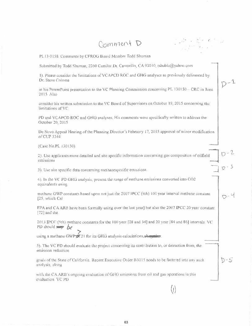
Coo) oleo k
PL13-0158 Comments by CFROG Board Member Todd Shuman
Submitted by Todd Shuman, 2260 Camilar Dr. Camarillo, CA 93010, tshublu@yahoo coin
I). Please consider the limitations of VCAPCD ROC and GHG analyses as previously delineated by Dr. Steve Colome
in his PowerPoint presentation to the VC Planning Commission concerning PL 130150 — CRC in June 2015 Also
consider his written submission to the VC Board of Supervisors on October 19, 2015 concerning the limitations of VC
PD and VCAPCD ROC and GHG analyses. His comments were specifically written to address the October 20, 2015
De Novo Appeal Hearing of the Planning Director's February 17, 2015 approval of minor modification of CUP 3344
(Case No.PL 130150)
2). Use applicants more detailed and site specific information concerning gas composition of oilfield emissions
3). Use site specific data concerning methanespecific emissions. J
4). In the VC PD GHG analysis, present the range of methane emissions converted into CO2 —7
equivalents using
methane GWP constants based upon not just the 2007 IPCC (4th) 100 year interval methane constant [25, which Cal
EPA and CA ARB have been formally using over the last year] but also the 2007 IPCC 20 year constant [72] and the
2013 LPCC (5th) methane constants for the 100 year [28 and 34] and 20 year [84 and 86] intervals, VC PD should Aisir
using a methane GWPOlf21 for its GHG analysis calculations,aluagoar.
5). The VC PD should evaluate the project concerning its contribution to, or detraction from, the emission reduction
goals of the State of California. Recent Executive Order 133015 needs to be factored into any such analysis, along
with the CA A.RB's ongoing evaluation of GHG emissions from oil and gas operations in this evaluation. VC PD
(I)
Cortl ÍÌ'l¿t\ \ D
PLl3-0158 Clomments by CFROGBoald MeruberTodd Shuman
Sr¡bmitred by Todd Shumm, 2260 Camilar Dr. Camarillo, CA 930 t0' tshublu@Vahoo com
l). please consi¿er. the linritatiorls of VCAPCD ROCI and GHG analyses as previously delineated byDr, Sleve Colome
in hìs PowerPoint presentation to the VC Planning Cotnmission cotrcerning PL 130150 - CRC in Jr'rnc
2015 Also
consider lris wr.itten submission to the VC Boa¡d of Supervisors on October 19, 2015 co[cenring thclimitations of VC
PD and vcAPcD ROC and GHG alralyses. His comments were specit'ically writlen to address theOctober' 20.2015
DeNcrvoAppeal HearingofrhePlanningDirector'sFebruary 11 ,2015 approval of mirlormodificationof CLIF 1344
(CaseNo.PL l-r0150)
2). LIse applicarrts more detailed and site specific informati'n corrcemi^g gas composition of oilfiel;]etnissions
i oelaltco ärlu slLç ùPçuurv rrrrvr¡rr'lrrl'rr '
-.J
o.L
3). Use site specilìc clata concerning methanespeciäc etnissions.
4). In the VC PD GHG analysis, pfesent the range of methane emisslolrs converted into CO2
r)
ecluivalents using
methane Grùy'p constants based upotÌ nor just the 2007 lPt-C (4th) 100 year inten'al methane constant[25, which Cal
EpA and CA ARB have been formally using over the last year] but also the 2007 IPCC 20 year constant[?2] and the
201 i IPCC (-5th) methane constants for the I 00 year [28 and 34] and 20 year [84 and 86] intervals vcPD shoutd A b(
using a merhane CVr¡1âZt for its GHG analysis calculatio.s.dr.Fþ'
5). The VC PD should evaluate the project concemi[g its contribution to, or detraction fron\ theemission reduction
goals of the State olcatìfornia. Recent Executive order Bl0l5 nceds to be f,actored into any such D-sanalysis, along
witir the C A ARB's ongoing evaluation of GHG emissions frorn oil and gas operations in thisevaluation. \'C PD
al
D -,1
9- "{
(r)
63

should consider the findings of the California legislature (AB 1496) and the actions of the CA ARB as reflected in its
September 30, 2015 Draft Shortlived Climate Pollutants Reduction Strategy when determining which methane GWP
constant to ultimately use to determine the CO2 equivalents that will be emitted by this project (See below concerning
AB 1496 and the CA ARB SLCP Draft Reduction Strategy )
6). In the VC PD GHG analysis, consider the following factor: the degree to which climate change impacts may be
rapidly occurring.
7). The lead agency (VC PD) should make a good faith effort to describe, calculate, or estimate GHG emissions from
this project.
8). Specifying feasible means of mitigating GHG emission effects is the responsibility of the lead agency (VC PD).
9). The best agency (VC PD) practice will be to compare project emissions with baseline emissions and consistency
with California GHG goals.
Appendix
1): Assembly Bill No. 1496 CHAPTER 604 Methane Emissions
An act to add Section 39731 to the Health and Safety Code, relating to greenhouse gases.
[ Approved by Governor October 08, 2015. Filed with Secretary of State October 08, 2015. ]
LEGISLATIVE COUNSEL'S DIGEST AB 1496, Thurmond. Methane emissions.
The California Global Warming Solutions Act of 2006 establishes the State Air Resources Board as the state agency
responsible for monitoring and regulating sources emitting greenhouse gases. Existing law requires the state board to
complete a comprehensive strategy to reduce emissions of shortlived climate pollutants, as defined, in the state.
This bill would require the state board to take specified actions and conduct specified analyses with
(2)
shot¡ld considel the f,rndings of the Calilornìa legislature (AB 1496) and the actions crf ¡he CA ARB as
reflected in its
september 30, 2015 Draft Shonlivecl clirnate Pollutants Reduction Strategy when dcterrnining which D-5methane GWP
constant to ultimatelv use tcr detennine the co2 equivalents tl.rat will be cmitted by this project (Seebelow concerning
AB 1496 and the CA ARB SLCP Dralì Reduction Strategy )
6). Irr the VC PD GFIG analysis. cousi{er the following factor: the degree to which climate changeimpacts rnay bc
rapidly occurring.
D -lo
7). The lead agency (vc PD) should make a good faith ef[ort to describe, calculate' or estinÌate
D- ?emissiotls from
this project.
8) Specifying feasible means of mitigating GHG emission effects is the responsibilìty of- che lead l p- Eagency (VC PD).
9). The best agetrcy (VC P. D) plactice will be to cornpare project elnissions with baselirre enissions andconsistencY
with Calilbrnia GHG goals.
Appenclix'
l); Assembly Bill No. 1496 CH,{PTER 604 Mc'thane Emissions
An act to add Section3913l to the Health arrd Safety code, relating to greenhouse gases'
I Approved by Govemc)l'october 08, 2015. Fited with secretary of state october 08' 2015' ]
LEGISL,{TIVE COUNSEL'S DIGE,ST AB 1496, ThUTMONd. MCIhATTE EMiSSiONS'
The californìa Global waflning solutions Act of 200ó establishes the State Air Resources Board as thestate agency
responsible for rnouit¡ring ancl regulating sources emitting greenhouse gases' Existing law requires thestate boar d to
completc a comprehensive strategy to recluce emissiorrs of shortlived climate pollutants' as defrned' inthe state.
p-q
rhe state board to take specified actions and conduct specifTed attalyscs with
ï
This bili would require
e)
64

respect to methane
emissions. Bill Text:
The people of the State of California do enact as follows:
SECTION 1 The Legislature finds and declares all orthe following:
(a) Methane is a gas that is emitted from both natural and human sources. Its concentration in the
global atmosphere has more than doubled since the beginning of the industrial revolution. Methane
is a shortlived climate pollutant with a lifetime of only about 12 years when released into the
atmosphere It is an extremely potent greenhouse gas, with 20 to 30 times the warming power of
carbon dioxide over a 100year period and more than 80 times over a 20year period.
littp://leginfo legislature.ca.gov/faces/billCompareClientxhtinl?bill_id=201520160AB1496
2): Draft ShortLived Climate Pollutant Reduction Strategy September 30, 2015, Cal EPA/ARB,
Page ES6
The goals and proposed measures included in this Draft Strategy will reduce SLCP emissions to levels inline with
these targets The proposed targets are summarized in Table 1.
Table 1, California SLCP Emissions and Proposed Target Emission Levels
(MMTCO2e)1 2030
Pollutant 2013 BAU2 Draft Strategy
Black carbon (non-forest)
Methane 118 117 71
Fgases 40 65 24
1 Using 20year GWPs from the 4th Assessment report of the IPCC For methane and Fgases, and 5th
Assessment report for black carbon
2
Business As Usual forecasted inventory includes reductions from implementation of current regulations
(3)
l'espêct to methane
enissions. Bill Text;
The people of the State of California do enact as follows:
SECTIONlTheLegislaturefindsattddecla¡esallolthefollorving:
(a) Methane is a gas that is ernitted from both natural and human sources lts concentration in the
global atmosphere has more than doubled since the beginning of the industrial revolution' Methane
is a shortlived climate pollutant with a litbtime of only about l2 years when released into the
atmosphere It is an extremely polent greerltouse gas, with 20 to 30 times the warming power of
ca¡bon dioxide over a lOOyear periocl and more than 80 times over a2Ûyeat period'
lrttp://legirrfo legisJ.ature,ca.gov/facesibillCìornpareClient.xhtr¡l?bill-id:20l5201ó0481496
2):Drafr"shortlived climate Pollutant Reduction strategy September 30. 2015, Cal EPA/ARB'
Page ESó
The goals and proposed measgres included in this Drafl Strategy will reduce SLCP emissions to levelsinline with
these targets The proposed ttrgets are summarized in Table l '
Table L california SLCP Emissions and Proposed Target Emissiolt l,eveìs
(MIr{TCO2e)l 2030
Pollutant 2013 BAU2 Draft StrategY
Black carbon (non-forest)
Methane lI8 ll7 7t
Fgases 40 65 24
1 Usirrg 2\yearGWPs from the 4th Assessrnent repoft of the IPCC fof methane and Fgases' and 5th
Assessment report for black carbon
2
Business As Usual forecasted inventory includes reductions fi'om implementatiott of current regulations
(Ð
p-'1
65

"Climate change is no longer a problem to be defined simply in terms of a legacy we leave to our
grandchildren or impacts in the year 2100. It is affecting us now, and will only accelerate in our
lifetime. Due to the urgency of the issue, and the need to recognize the costs and benefits of
addressing it immediately, we use 20year GWPs in this report to quantify emissions of SLCPs "
http .//www.arb . ca. gov/cc/shortlived/shortlived. htm
',Climate change is no longer a problem to be deFlned simply in terms of a legacy we leave to our
grandchildren or inpacts in the year 2100. It is affecting us now and will only accelerate in our
lifetime. Due to the urgerrcy ofthe issue, and the need to recognize the costs and benefits of
addressing it immediately, we use 2oyear GwPs in this report to quantis ernissions of SLCPs "
http. //www. arb. ca. gov/cclshortlived/shortlived htm
D-1
(ql
66

- Statement or CFROG President John Brooks onPL13-0158 hdps //inail.google.cotnimailM/0/?ui=24i1c=e5864396708tview—pt&se
mi I John Brooks <[email protected]>
Statement of CFROG President John Brooks on PL13-0158 1 message
John Brooks <[email protected]> Tue, Oct 27, 2015 at 10:26
AM
4111.1111.6141"41"9"660=110.111111.11611 111
44111111.11111.11101.1".. COMM E
10-27-15
In 1983 Ventura County Supervisors decided that the intersection of Koenigstein Road and Highway 150 was unsafe for large tankers to use because when they turn there they completely block both lanes of traffic exposing the public to an undue risk. Your staff statement claims the board deemed the intersection POTENTIALLY unsafe.. While technically true it it reflects what I perceive to be an attempt by planning staff to find a means to approve this project rather than provide an objective analysis that puts public safety first. If you had started this review from the official position that the intersection is unsafe, you would not have begun the search for loopholes to drive a tanker through, but would have listened to the public and other agencies. Cal Trans CEQA bureau Chief Dianna Watson in June of this year correctly said
in her letter that the movement of large trucks could create unsafe conditions for those of us who drive that road and she proposed extensive mitigations involving flashing warnings lights and rebuilding the bridge as minimum steps to reduce the danger. Did you respond immediately to the state's request for discussions? It would appear you did not and still have not and instead redoubled your work trying to poke holes in the reasonable position that has been in effect for more than 20 years that tankers blocking the intersection are dangerous. The claim that the absence of accidents is proof of an absence of risk would be" laughable if it were not so threatening to the public safety. I submit the operator is damn lucky to have not killed anyone and the county by failing to enforce the conditions of the CUP could have been equally liable. I have heard statements that the number of vehicles each day has dropped slightly from its peak in the first years of this century but by simple observation one can tell that there are still thousands of vehicles coming through each day and there has been no discussion of the increase in motorcycle traffic and while
3
(1)
rftril - Stârerrcrr oICFROG president JofurBrooks onPLl3-0158 trtps://rnail.google .cordnail/rr/0i?ui=2dak=5$6439670&viewlt&sc ,
CrYl Joh n Brooks <iohnbrooks69@gm ail.com>
Statement of CFROG President John Brooks on PLî3-01581 message
John Brooks <johnbrooks69@gmail'com>Tue, Oct 27 ,2015 at 10:26
AM
ysa
CornYn{t\n{- Ë10-27-15
ln 1983 Ventura County Supervisors decided that the intersection of KoenigsteinRoad and Highway 150 was unsafe for large tankers to use because when theyturn there they completely block both lanes of trafiic exposing the public to anundue risk.Your staff statement claims the board deemed the intersection POTENTIALLYunsafe., While technically true it it reflects what I perceive to be an attempt byplanning stafi to find a means to approve this project rather than provide anobjective analysis that puts public safety first'lf you had started this review from the official position that the intersection isunsafe, you would not have begun the search for loopholes to drive a tankerthrough, but would have listened to the public and other agencies.Cal Trans CEQA bureau Chief Dianna Watson in June of this year
k would be"
in her letter that the movement of large trucks could create unsafe conditions forthose of us who drive that road and she proposed extensive mitigations involvingflashing warnings lights and rebuilding the bridge as minimurn steps to reduce thedanger.Did you respond immediately to the state's request for discussions?It would appear you did not and still have not and instead redoubled your worktrying to poke holes in the reasonable position that has been in effect for morethan 20 years that tankers blocking the intersection are dangerous-The claim that the absence of accidents is proof of an absence of rislaughable if it were not so threatening to the public safety.I submit the operator is damn lucky to have not killed anyone and the county byfailing to enforce the conditions of the CUP could have been equally liable.I have heard statements that the number of vehicles each day has droppedslightly from its peak in the first yeers of this century but by simple observationonà can tell that there are still thousands of vehicles coming through each dayand there has been no discussion of the increase in motorcycle trafiic and while
ú-L
E-)-
r,-3
(r)
67

mil - Siatentti of CFROG President John Brooks on PL13-0158 hitps://mil.google.coin/rmil/u/0/?ui=28c.ik—e5864396708z.view=pt&se
Sunday is a bigger day for the two wheelers, the proposed permit would allow tanker obstacles at that blind intersection on Saturdays when motorcycle speeds are very high. Where is the proof that the reconstruction of the alternate access road is not feasible? What data was that conclusion based upon and who made it? The staff continues to allow segmentation to avoid ceqa requirements. The report states that this project will result in a reduction of maximum tanker truck traffic and will increase total traffic but fails to analyze the cumulative effect of additional tanker traffic should the intersection be approved...in fact the same applicant has applied to reactivate several wells that would further increase the risk.
(z)
¡pìil - stârerrErtr or cFRoG president Jotm B¡ook on pLl3-0158 hrtps://nuil.google.com/nvril/r-r/0/?rú:2&ik=es86439ti?O&r'icrr'=pt&se ' '
are very highWhere is the Proof that the reconstruction of the alternate access road is nfeasible? What datawasthatconclusionbaseduponandwhomadeit?The staff continues to allow segmentation to avoíd ceqa requirements' The report l-tfstates that this project will result ín a reduction of maximum tanker truck trafiicand will increase total trafiic but fails to analyze the cumulative effect of additionaltanker traffic should the intersection be approved in fact the same aPPlicant hasapplied to reactivate several wel s that would further increase the risk
Sunday is a bigger day for the two wheelers, the proposed permit would allowtanker obstacles at that blind intersection on Saturdeys when motorcycle speeds E-3
Q)
68

Biological Resources
CFROG COMMENTS on SEIR PL13-0158
October 27, 2015
m m e F From the record in the EIR
County of Ventura Environmental Inventory page 4 (1976)
Environmental Impact submitted by the Applicant, Phoenix Oil "2. Describe the plant and animal life, their habitat and food source, and nesting
places presently existing on the site and indicate how and to what extent it will be
affected by the project. To our knowledge, there are no nesting places, nor food sources on the immediate
site area. The area in general is a habitat for deer, mountain lion, coyotes, skunk, gophers and squirrels. Plant life consists of native grass and scrub oak. The
project will affect plant life to the extent of the clearing necessary for the well site
area (200' x 200') and the access road."
The current permit PL13-0158 defines the project area as approximately 2 acres.
Public Works Agency of Ventura County
Date: Sept. 29, 1975 G. J. Nowak, Staff Conservationist, pages 105-106
Reads in pertinent part:
"The site lies near the edge of the Los Padres National Forest and as such is
part of a much larger wildlife habitat/'
"A significant riparian plant community (Bear Canyon) exists approximately
500' east of the site. This community contains Sycamore, Willow, White
Alder, Cat Tail, and Mule Fat. This community and the presence of water
there enhances the significance of the site as a wildlife habitat."
"The project site is an excellent wildlife habitat. The significance of the site as
a wildlife habitat is enhanced by the sites association with the live stream,
riparian habitat of Bear Canyon and its association with the Los Padres
National Forest to the north. The site's isolation and dense vegetation also
contribute to its significance as a wildlife habitat."
"The total number of wildlife species actually observed was low. This was
mostly due to the air temperature which exceeded 100 degrees during the
field research. The following species were identified by observation or
physical evidence, (ie.; scat, tracts); deer, coyote, scrub, jay, titmouse, bushtit,
wrentit, yellow bellied sapsucker and the black headed grosbeack."
"The total number of species actually using or residing at the site is
undoubtedly very large. The site is likely visited or residence for large
mammals such as black bear, mountain lion, gray fox, raccoon, bob cat, and
Biological Resources
CFROG COMMENTS on SEIR PLL3-0158October 27,20L5
C-o n" rYr e ÀirFrom the record in the EIR
County of Ventura Environmental Inventorv page 4 (1976)
Environmental lmpact submitted by the Applicant, Phoenix Oil
"2. Describe the plant and animal life, their habitat and food source' and nestingplaces presently existing on the site and indicate how and to what extent it will beaffected by the Project'Toourknowledge,therearenonestingplaces,norfoodsourcesontheimmediatesite area, The area in general is a habitat for deer, rnountain lion, coyotes, skunk,gophersandsquirrels.Plantlifeconsistsofnativegrassandscruboak.Theóroject will affect plant life to the extent of the clearing necessary for the well sitearea (200'x 200') and the access road'"
The current permit pLj.3-015g defines the project erea as approximately 2 acres,
Public Works Agency of Ventura County
Date: Sept. 29, Lg75 G. J. Nowak, Staff Conservationist' pages 105-106Reads in pertinent Part:
,,The site lies near the edge of the Los Padres National Forest and as such is
part of a much larger wildlife habitat'";'A significant riparian plant community (Bear Canyon) exists approximately500'east of the site. This community contains Sycamore, Willow, WhíteAlder, Cat Tail, and Mule Fat' This community and the presence of waterthere enhances the significance of the site as a wildlife habitat.,,,,The project site is an excellent wildlife habitat. The sígnificance of the site as
a wildlife habitat is enhanced by the sites association with the live stream,riparianhabitatofBearCanyonanditsassociationwiththeLosPadresNational Forest to the north, The site's isolation and dense vegetation alsocontribute to its significance as a wildlife habitat'",,The total number of wildlife species actually observed was low. This wasmostlyduetotheairtemperaturewhichexceededl00degreesduringthefield research' The following species were identifled bV observation orphysical evidence, (ie'; scat, tracts); deer, coyote' scrub' jay' titmouse' bushtit'wrentit,yellowbelliedsapsuckerandtheblackheadedgrosbeack.,,.,Thetotalnumberofspeciesactuallyusingorresidingatthesiteisundoubtedly very large. The site is likely visited or residence for large
mammalssuChasblackbear,mountainlion,grayfox,raccoon,bobcat'and
t)
It
7-L
69

the long-tailed weasel. Small mammals likely found here would be bats,
chipmunk, rabbits, gophers, mice, and skunk."
"The site is a suitable habitat for approximately 50 bird species including
those observed. The site is a suitable habitat for approximately 13 species of
snakes and lizards. The site is a suitable habitat for a great number of
invertebrate species. (2)"
"Conclusions 1. Removal of the vegetation for the proposed drill site will have a
substantial adverse impact on wildlife. This impact will extend
beyond the actual drill site due to the increase noise levels and the
presence of man."
This environmental report on flora and fauna was done in 1975. In 1976, John
Whitman and several others appealed the EIR to the Planning Commission. The
following is from that transcript:
"EIR flora and fauna Appeal by John Whitman, January 13, 1976
Appeal point e. Plant and Wildlife Assessment According to the Public Works Agency, the proposed EIR is sufficient
relative to Flora and Fauna for the project, a single exploratory well. A
revision would be necessary only if additional wells are to be drilled.
There are no additional County permits in the project area."
In 1980 the FEIR was completed as a result of a lawsuit that was eventually won by
Mr. Whitman in the California Court of Appeal. The FEIR was specifically focused
on cumulative impacts and found the following was a necessary mitigation
measure:
"Cumulative Mitigation Measures: As a measure to counteract the
cumulative impact of oil operations in the Sisar Creek/Bear Creek
habitat, it is recommended that a task force be created to recommend
to the Board of Supervisors means of minimizing the impact of present
and future oil operations in the habitat. The task force would recognize
both the need for oil resources and the unique wildlife resources of the
Sisar Creek/Bear Creek areas. The task force would be comprised of a
representation of the oil industry, the planning department, Public
Works, State Fish and Game, and the County Parks Department. The
task force would be chaired by the Planning Department."
(z)
the long-tailed weasel. Small mammals likely found here would be bats'chipmunk, rabbits, gophers, mice, and skunk'",,The site is a suitable habitat for approximately 50 bird species includingthose observed, The site is a suitatle habitat for approximately 13 species ofsnakes and lizards. The site is a suitable habitat for a great number ofinvertebrate sPecies. (2)"
"Conclusions1, Removal of the vegetation for the proposed drill site will have a
substantial adverse iÃpact on wildlife' This impact will extendbeyond the actual drillsite due to the increase noise levels and thepresence of man."
Thísenvironmentalreportonfloraandfaunawasdonein].975.1n1976,JohnWhitmanandseveralothersappealedtheElRtothePlanningComrnission'Thefollowing is from that transcriPt:"ElR flora and fauna Appeal by john Whitman' January t,l' L976Appeal point e. Plant and Wildlife Assessment
According to the Public Works Agency' the proposed EIR is sufficientrelative to Flora and Fauna for the project' a single exploratory well' Arevlsionwou|dbenecessaryontyifadditionalwellsaretobedrilled.There are no additional county perm¡ts in the project erea'"
ln Lgg0 the FEIR was completed as a result of a lawsuit that was eventually won by
Mr.Whitmaninthecaliforniacourtof Appeal. TheFElRwasspecificallyfocusedoncumulativeimpactsandfoundthefollow¡ngWaSanecessarymitigationmeasure:
"Curnulative Mitigation Measures: As a measure to counteractthecumulative impact of oil operations in the Sisar Creek/Bear Creek
habitat, ¡t ¡s recommended that a task force be created to recommendtotheBoardofSupervisorsmeansofminimizingtheimpactofpresentand future oil opeiations in the habitat. The task force would recognizeboth the need for oil resources and the unique wildlife resources of theSisarCreek/BearCreekareas'Thetaskforcewouldbecomprisedofarepresentation of the oil industry' the planning department' Public
works,stateFishandGame,andthecountyParksDepartment'ThetaskforcewouldbechairedbythePlanningDepartment.,,
c)
V1.
70

Cumulative Effects — Not Adequately Addressed
The EIR notes, on page 6, those related projects which have recently been
approved and/or are pending County approval. Both projects are over 3 miles
from the project area and generally would not have a cumulative impact on the
Upper Ojai Valley. Although new oil drilling may be pending in the area, many existing permits allow unlimited drilling in the permit area without additional
County approval. There is no feasible basis for estimating future drilling activity
which is unrelated to the County permit process. In addition, the projection of
possible projects would be based on speculation. The State EIR Guidelines state
(Sec. 15142), "Specific reference to related projects , both public and private, both existent and planned, in the region should also be included, for purposes of ... "
The rest of the document quote is not legible in the transmittal in the record.
This reasoning was overturned by the court and sent back for a cumulative effects
analysis of the many oil and gas facilities and new wells both present and future in
the area.
The FEIR contains a table of wells that might be drilled under both medium find
and high find scenarios. The high find scenario, based upon data gathered from oil
operators in the Upper Ojai area, determined that there might be, at the most, 46
new oil wells.
CFROG has attached a spreadsheet of API numbers of oil wells that have been
drilled since 1980. The number is 57. That exceeds the high find scenario by 25%.
In addition, not counnting this permit, 28 wells have been permitted within the
past two years in this immediate area. That puts the entitlement permits and the
already drilled wells at 88, nearly double the number of wells in the high find
scenario.
The FEIR reviewed the biological impacts of a potential build-out of new wells at
46. Since the FEIR, the build-out has far exceeded the 46. In fact, the build-out is
now 85 oil wells, therefore, the fact that the number of wells far exceeds the
number of wells reviewed for potential environmental impacts is a change in
circumstances not considered in the earlier EIR that requires further
environmental review.
The SEIR states in a broad unsubstantiated conclusion that since the current
project is on an existing drill pad it will have no impacts on the environment.
CEQA law is interpreted differently when discussing cumulative impacts:
(3)
Cumulative Effects - Not Adequately Addressed
TheElRnotes,onpage6,thoserelatedprojectswhichhaverecentlybeenapproved and/or are pending County approval' Both projects are over 3 miles
from the project area and generally would not have a cumulative impact on theUpper Ojai Valley. Although new oil drilling may be pending in the area' manyexisting perm¡ts allow unlimíted drilling in the permit area without additionalCountfapproval. There is no feasible basis for estimating future drilling activitywhich is unrelated to the County permit process' ln addition, the projection ofpossibleprojectswouldbebasedonspeculation.TheStateElRGuidelinesstateiSec. 15L42), "specific reference to related projects , both public and private' bothexistent and planned, in the region should also be included, for purposes of ..' "The rest of the document quote is not legible in the transmittal in the record'
This reasoning was overturned by the court and sent back for a cumulative effectsanalysis of the many oil and gas facilities and new wells both present and future in
the area,
The FEIR contains a table of wells that might be drilled under both medium findand high find scenarios. The hich find scenario, based upon data gathered from oiloperators in the upper ojai area, determined that there might be, at the most, 46new oil wells.
cFROG has attached a spreadsheet of API numbers of oil wells that have beendrilled since l-980. The number is 57, That exceeds the high find scenario by 25%'ln addition, not counnting this permit, 28 wells have been permitted withín thepast two years in this immediate area. That puts the entitlement perrnits and thealready drilled wells at 88, nearly double the number of wells in the high findscenario.
The FEIR reviewed the biological impacts of a potential build-out of new wells at46 Since the FEIR, the build-out has far exceeded the 46. ln fact, the build-out is
now 85 oil wells, therefore, the fact that the number of wells far exceeds thenumber of wells reviewed for potential environmental impacts is a change incircumstances not considered in the earlier EIR that requires ft¡rtherenvironmental review,
The SEIR states in a broad unsubstantiated conclusion that since the currentproject is on an existing drill pad it will have no impacts on the environment'
cEQA law is interpreted differently when discussing cumulative impacts:
r -)-,
GI
71

"The purpose of the requirement is obvious: consideration of the
effects of a project or projects as if no others existed would encourage
the piecemeal approval of several projects that, taken together, could
overwhelm the natural environment and disastrously overburden the
man-made infrastructure and vital community services. This would
effectively defeat CEQA's mandate to review the actual effect of the
projects on the environment," Las Virgenes Homeowners Federation,
Inc. vs. County of Los Angeles (2nd Dist. 1986).
CFROG has provided substantial evidence of significant growth, nearly twice the
value of 46 wells in a high yield scenario, in the number of new oil and gas wells in
this small valley of Upper Ojai. The natural environment may be at the brink of being overwhelmed and disastrously overburdened. The attached tables list the
special status plant and wildlife species in this area in 2015. The list has increased
significantly in size since the 1980 FEIR that listed only one species as endangered,
the California Condor. Incredibly, the current SEIR, ignores the reality of the
cumulative impacts of oil and gas growth and the existence of more than one
species that merits study. All of this occurs against the backdrop of the one mitigation measure that was included in the FEIR calling for a task force to
examine the potential impact to the flora and fauna which was never done.
The SEIR is inadequate in its conclusion regarding biological resources.
The EIR of 1976 contains this statement in the response to public comments
section: "the proposed EIR is sufficient relative to Flora and Fauna for the project,
a single exploratory well. A revision would be necessary only if additional wells are
to be drilled. There are no additional County permits in the project area."
Even though the only biologist to walk on this CUP to date has found that
vegetation removal would have a "substantial adverse impact on wildlife", the only
mitigation measure for this CUP that was ever written for biological resources was
for this task force to study cumulative impacts to flora and fauna; and it was never done.
There has never been a study of the cumulative impacts to flora and fauna on this
CUP.
The study done by the staff conservationist in 1975 was written based on the
current project at that time, one exploratory well. As stated in the FEIR, a revision
would be necessary only if additional wells are to be drilled.
Three additional wells are to be drilled as stated in this project application. And as
stated in the original EIR, a revision is necessary. The SEIR has determined that
,,The purpose of the requirement is obvious: consideration of theeffects of a project or projects as if no others existed would encouragethepiecemealapprovalofseveralprojectsthat,takentogether'couldoverwhelm the natural environment and disastrously overburden theman-made infrastructure and vital communíty services' This wouldeffectively defeat cEQA's mandate to review the actual effect of theprojects on the environment," Las Virgenes Homeowners Federation'in.. ur. county of Los Angeles (znd Dist' 1986)'
cFROG has provided substantial evidence of significant growth, nearly twice thevalueof46wellsinahighyíeldscenarío,inthenumberofnewoilandgaswellsinthis small valley of Upper Oiai. The natural environment may be at the brink ofbeing overwhelrned and disastrously overburdened. The attached tables list the,p".i.lstatus plant and wildlife species in this area in 2015. The list has increasedsignificantly in siee since the 1980 FEIR that listed only one species as endangered,the California Condor. lncredibly, the current SEIR, ignores the reality of thecumulative impacts of oil and gas growth and the existence of more than onespecies that merits study. Allof this occurs againstthe backdrop of the onemitigation measure that was included in the FEIR calling for a task force to
"*.Ãin" the potential impact to the flora and fauna which was never done.
the SEIR is inadequate in its conclusion regarding biological fesources.
The EIR of LgTicontains this statement in the response to public commentssection: ,,the proposed EIR is sufficient relative to Flora and Fauna forthe project,a single exploratory well. A revision would be nece.ssary only if additional wells areto be drilled. There are no additional County permits in the project area'"
Even though the only biologist to walk on this cuP to date has found thatvegetation removal would have a "substantial adverse impact on wildlife", the onlymiiigation measure for this cuP that was ever written for biological resources wasfor this task force to study cumulative impacts to flora and fauna; and it was neverdone.
There has never been a study of the cumulat¡ve impactsto flora and fauna on thisCUP.
The study done by the staff conservationist in 1975 was written based on thecuffent project at that time, one exploratory well. As stated in the FEIR, a revisionwould be necessary only if additional wells are to be drilled.
Three additional wells are to be drilled as stated in this project application. And as
stated in the original ElR, a revision is necessary, The sElR has determined that
tq)
aL-'
72

since the applicant is using the same drill pad (larger than the original one
exploratory well drill pad of 200' x 200' as evidenced by the applicant's map),
there will be no impact to biological resources. This finding is inadequate in light
of the record, the staff conservationist report, and the mitigation measure calling
for a task force to study the cumulative effects on flora and fauna included as a
mitigation measure.
This permit will have a greater impact on the wildlife not only because of the
incremental impacts of additional oil wells, but also because it will allow at least 25
more years of human presence and increased traffic on the narrow, rural Highway
150. The attached photos were taken within the past week of a dead fox and a dead raccoon. Both animals in the photos are lying on the side of Highway 150 within 2 blocks of the intersection of Koenigstein Road, hit by a vehicle while crossing the road.
The largest impact of this project, however, may be the extension of the
operational time period for another 25 years. There is no enforceable time limit
on when the wells will be drilled. What the applicant proposes to do in reference
to drilling periods is irrelevant. Thus the applicant could drill the wells in 24 years
and effectively extend the time limit of this permit for 50 years. That would mean
that the effects of this project beyond one exploratory well (now 9) would not
have been studied for 80 years! The wildlife in this community are decreasing in
number and the number of road kills has increased significantly per observations
of Carol Holly, local resident since 1998. Increasing human presence and
decreasing areas of native, undisturbed vegetation are taking their toll.
The SEIR does not present any evidence that there has been a reasonable attempt
to access the impacts of this project on wildlife or plants in the area. The SEIR
does not present any evidence that the addition of a cumulative 85 new oil and
gas wells since 1980 in the immediate area has been studied as part of a impact
study.
Thus, CFROG is calling for a long overdue ISBA on this project next to the Los
Padres Forest, in "excellent wildlife habitat" and "part of a much larger wildlife
habitat." (1983 EIR) This study should include the cumulative impacts of both oil
wells on CUP's subject to CEQA review in the area and CUP's not subject to CEQA
review (the larger number of new oil and and gas wells drilled since 1980 fall into
this latter category). There is no entitlement on these non-reviewed CUP's that
prevents them from being part of a larger cumulative effects review.
Since Ventura County has an arguably overly-broad and non-CEQA compliant
policy that any CUP, regardless of its size, lack of permit conditions, or limitless
permissions to drill and do anything any operator within the CUP desires, there is
no way to gain an environmental handle on this incremental growth and the
0
since the applicant is using the same drill pad (larger than the original one
exploratory well drill paa át 2oo' x2oo,as evidenced by the applicant's map),
there will be no impact to biological resources. This finding is inadequate in l¡ghtof the record, the staff conservationist report, and the mitigation measure callingfor a task force to study the cumulative effects on flora and fauna included as a
mitigation measure.
This permit will have a greater impact on the wildlife not only because of theincremental impacts of .ddition.l oil wells, but also because it will allow at least 25more years of human presence and increased traffic on the narrow, rural HighwayL50. The attached piotos were taken within the past week of a dead fox and adead raccoon. Both animals in the photos are lying on the side of Highway 15owithin 2 blocks of the intersection of Koenigstein Road, h¡t bY a vehicle whilecrossing the road.
The largest impact of this project, however, may be the extension of theoperatùnal tirne period for another 25 years. There is no enforceable time limiton when the wells will be drilled. what the applicant proposes to do in referenceto drilling periods is irrelevant. Thus the applicant could drillthe wells in 24 yearsand effectively extend the time limit of this permit for 50 years, That would meanthat the effects of this project beyond one exploratory well (now 9) would nothave been studied for BO years I The wildlife in this community are decreasing in
number and the number of road kills has increased significantly per observationsof CarolHolly, local resident since 1998' lncreasing human presence and
decreasing areas of native, undisturbed vegetation are taking their toll'
The SEIR does not present any evidence thatthere has been a reasonable attemptto access the impacts of this project on wildlife or plants in the area. The sElR
does not present any evidence that the addition of a cumulative 85 new oil andgas wells since 1980 in the immediate area has been studied as part of a impactstudy.
Thus,CFRoGiscallingforalongoverduelsBAonthisprojectnexttotheLosPadres Forest, in "excellent wildlife habitat" and "part of a much larger wildlifehabitat.,, (1-983 EIR) This study should include the cumulative impacts of both oilwells on cuP's subject to CEQA review in the area and cuP's not subject to CEQA
review (the larger number of new oil and and gas wells drilled since L980 fall intothis latter category). There is no entitlement on these non-reviewed cuP's thatprevents them from being part of a larger cumulative effects review.
since Ventura county has an arguably overly-broad and non-cEQA compliantpolicy that any cuP, regardless of its size, lack of perm¡t conditions, or limitless
þermirsions to drill and do anything any operator within the CUP desires, there is
no way to gain an environmental handle on this incremental growth and the
r
L5)
73

significant impacts it may have on the natural environment if we don't take this opportunity to evaluate cumulative impacts in Upper Ojai. Unfortunately the majority of land use permits in Upper Ojai are held on non-CEQA reviewed oil and gas CUP's
signifìcant impacts it may have on the natural environment if we don't take thisoõportunity to evaluate cumulative irnpacts in Upper Ojai' Unfortunately themajorityoflandusepermitsinUpperojaiareheldonnôn-CEQAreviewedoilandgas CUP's
?'3
@
74

Table 1. Special-status plant and wildlife species documented to occur within the Ojai and Santa Paula Peak 7.5 minute topographic c tiadran les.
Scientific Name Common Name Listing Plants Acanthoscyphus parishii var. abrainsii
Abrams' oxytheca 1B.2
Astragalus dicymocarpus var, miles ianus
Miles' milk-vetch 1B.2
Atriplex serenana var. davidsonii
Davidson's saltscale 1B.2
,_ Calochortus fimbriatus J late-flowered mariposa-lily 1B.2 Calochortus plummerae Plummer's mariposa-lily 4.2 Delphinium umbraculorum umbrella larkspur 1 B.3 Fritillaria ojaiensis Ojai fritillary 1B.2 Horkelia cuneata var. puberula mesa horkelia 1B.1 Lepidium virginicum var. robinsonii
Robinson's pepper-grass 4.3
Monardella hypoleuca ssp. hypoleuca
white-veined monardella 1B .3
Navarretia ojaiensis Ojai navarretia 1B.1 Fish t Catos torn US sankzcznae Santa Ana sucker FT Gila orcuttii arroyo chub SSC Oncorhynchus nu/kiss irideus steelhead - southern California
DPS FE, SSC
Amphibians Rana boylli foothill yellow-legged frog SSC Reptiles Emys marmorata western pond turtle SSC Birds Gymnogyps califarnianus California condor FE!, S E 3
SFP
Chczetodipus califbrnicus femoralis
Dulzura pocket mouse SSC
Federal Status: State Status: FE Federally Listed Endangered SE State listed as endangered FT Federally Listed Threatened S] State Listed Threatened
Table l. Special-status plant and wildlife species docurnented to occur within the
o ancJ Santa Paula Peak 7.5 minr¡te es.
ListinqCommon NameScientific NamePlønls
lB.2Abrams' o,rythecaAcanthosc-'¿ph'us purishiiabrafttsíi
vdr
18.2Miles' milk-vetchA,snagalus diclymocarpusrnilesianu.,s
var
tB.2Davidson's saltscale
rB.2lilylatc-flowered mari4.2lilyPlummer's mar
Atriplexdaviclsonii
VC¿Tssrenanq
riatusmerqe
CalochorhnCalochortus
lR.3umbrella larkspur18.2Oiai fì'itillary
iniun¿ z¿atbraculorumFritillaria IENSß
mesa horkeliaHorkelia cuneqfa var. puberttla lB.l4"3Robinson's pepper-grassLepidium virginicunt
robinsoniivat'
I8.3white-veined monardellaMona.rdella hypoleucaht,polet¿c,s
s5'p.
1B,lnavarretiaN av a.rr e t í a oi a i en,s i,s
FishFTSanta Aua sttckerSSCarroyo ehubFE,SSC
steelheacl - southetn CalitbrniaDPS
Catostomus sanlottnqe
Oncor hync hus nt),ki s s it" ícleus
Am ng
Gila orcuttii
SSCfoothill ye llorv-legged frogRana hctyliiReptiles
SSCturtlewesternEmys marmot'ãtaBirds
FE.,SF,,SFP
California condorGynt ru; gv p s c ct I i.fb r n i a nus
Chaetotlipusfemorali,r
caly''onúcus
Fecler:al Status: Slate SlatltsI'-E lìedc:rally Listed Endangerecl SE
f 'T t]eclerally Listed Thleatenect S1'
f)ulzura pocket mouse
State listed as cnclangeredState [.isted Thrcatenccl
SSC
(?)
75

SSC Species of special concern — CDFW SFP State Fully-Protected species
California Rare Plant Rank (CRPR): I B Rare or Endangered in California and elsewhere 2 Rare or Endangered in California, more common elsewhere 4 Plants of limited distribution — Watch list .1 Seriously endangered in California .2 Fairly endangered in California .3 Not very endangered in Californ
California Rare Plant Rank (CRPR):I B R*" - Endangered in Calitbrnia and elsewhere2 Rare or Endanlered in Califomia, rnore common elsewhere4 Plants of limited distribution - Watch list.1 Seriously endangered in Calilornia.2 Fairly endangered in Calif'ornia,3 Not verY endangered in Califom
SSC Species of special concerl - CDFWSFP State Fu[ly-Protectecl species
Qi)
76

Table 2. Special-status plant and wildlife species documented to occur within the Ojai, Matilija, Wheeler Springs, Lion Canyon, Topatopa Mountains, and Santa Paula Peak 7.5 minute topographic quadrangles.
Scientific Name Common Name Listing, Plants Acanthoscyphus parishii var. abrarnsii
Abrams' oxytheca 1B .2
FE, SSC
Anaxvrus cahrbrnicus arroyo toad
Astragalus didymocarpus var. milesianus
Miles' milk-vetch 1 B.2
Atriplex serenana var. davidsonii Davidson's saltscale I B,2 Calochortus fim br -tutus late-flowered mariposa-lily 1B.2 Calochortus palmeri var. palmeri Palmer's mariposa-lily 1B.2 Calochortus phtmrnerae Plummer's mariposa-lily 4.2 Caulanthus leturnonii Lemmon's jewel flower 1B .2 Delphinium umbraculorlin/ umbrella larkspur 1B.3 Fr it illar ia ojaiensis Ojai fritillary 1B.2 Horkelia cuneata var. puberula mesa horkelia 1.B.1 Imperata brev(folia California satintail 2B.1 &via heterotrichci pale-yellow layia 1B. 1 Lepidium virsinicum var. robinsonii Robinson's pepper-grass 4.3 Malac othamnus daviclsonii Davidson's bush-mallow 1B.2 Monardella hypolettca ssp. hypokuca
white-veined monardella I B.3
Navarretict ojaiensis Ojai navarretia 1B.1 Nolina cismontana chaparral nolina 1B.2 Orobanche vanda ssp. valida Rock Creek broomrape 1 B .2 Sagittaria sanfordii S an ford' s arrowhead 1 B .2 Sidalcea neomexicana Salt Spring checkerbloom 2B.2 Fish .
Catostomus santaanae Santa Ana sucker FT, SSC
Gila oreuttii arroyo chub SSC Oncorhynchus mykiss irideus. - steelhead southern
California DPS FE, SSC
Amphibians SSC Rana boyhi foothill_ ellow-legged frog
(3)
Table 2. Specia.l-stalus plant and wildlit'e species c{ocumen[ecl to occur within theOjai, Matiii.¡u, Wh."ler Springs, L'ion Canyon' '['opatopa lVloLrntains' and SantaPáula Pcak i.5 minute topographic quadrangles'
Scientific Name Cornmon Name ListiPlanß
Abrams'oxYthecaAcanthoscyphusabramsii
paríshii var 1ts.2
FE,SSC]
I8.2Miles' milk- vetch
an'oyo toadA na -tJt nt s c ul ifo r ni c tts
Astra.gaLu.s dídYructcc;n"P'tts var.rnile.s ittn'us
tB"2Davidson 's saltscalerB.2Calctchortus
dsontiIvar cl<tvnanLTseretrA
rB.2sa-li Ilate-tlowered marl
a-lmanStner'Pal4.2TR.2
Plummer's mali tiLentmon's ewelflowerumbtella lar
Caulanthus Ienmttnii
I.
Cttktclnrtus Llmmer4e
vürCalocltr,¡rtus
umbraculortmt lB.3tB.2ai frititFritil.laria ,s
I8.1mesa horkelia2H^.lCalit'ornia satintail
H o r k elia c t'tne at a v a'r herulaa
lB,1ow la aheterotrichct4.3tB.2IU,3
1B,lnavarretia
Davidsou 's bush-mallowrvhite-veined mon¿udella
Robinson'sthamnus da.,-iclsoniiIu[alctco
onl.b tllsI'Ovarvum
lv[ttnardella h¡,¡t<tleuca s,fp
euccl
Navarretictar:ral nolinaclt[olinc¿ cismontana lB.2
tB.2Rock Creek broovaliclaOrcthanc he valida ss
18.2Ifbrd S arrowheadSaníttarìa I
28.2checkerbloomSalt SSidalcea 'neornexrcand
hFT,SSC
Santa Ana suckerC at o s t o nttt.s,ç a nt ctanae
SSCF[,],
SSC]
SSC]
southern
1ow-t'oothill tro
Cali lbmia DPS
chubanosteelheaclOnc:nr hy n c hus mYkü^ s ír i
G ila arcnútii
ansAmRana
deus
st)
77

Rana draytonii
Reptiles Emys inamorata Phrynosorna blainvillii
hammondii Birds Gymnogyps ealifornianus
Vireo be7111 pusillus Mammals
California red-legged frog FT, SSC
western pond turtle _
SSC coast horned lizard two-striped garter snake
California condor
least Bell's vireo
SSC SSC
FE, SE SEP FE, SE
californicus Amnon-ills Dulzura pocket mouse SSC'
Federal Statti;. Fv.,,c1.1111, Listed Endangered
FT 1elit.I.111} Listed Threatened
Mate Stratus: SE State listed as endangered ST Slate Listed threatened SSC Species of special concern — COFW
SFP State Folly-Protected species
California Kate Plant Ralik icil(PIty IP Rare or hid:Ingo-a in California and elsewhere 2 Rar,; ni Inchnncrc.,t I I t, uliiornin, more common elsewhere 4 Plants oflimiled distribution Watch list I Seriously endangered in California 2 Fairly endangered in California
.3 Not very endangered in California
FT,SSC
Califomia recl- legged tlog
SSC
Rana draytonii
western pond turtleEn¿ marmorataSSCcoast homed lizatd'a blainvilliiSSCtwo-striped snakehammondii
BlrdsFE. SESFP
Gymno gtps c a|ifo r nianus
SEVireo bellii pusillus
Califomia condor
least Bell's vireoM¡mmals
SSC'Dulzurir Pocket mouset:ulifornicu,;
F f-.1
fTSE
s'fsst:SFP
Listcrl I'hreotened
lilr¡rnra nnd clservherelilbrnrR, nrttre conlmon elsewhere
4 Plünts ul'linritcd dtstrrbutton Watch list, L Seriously entlangered in ilalitìrmi¿.2 Fuirlv rndangered il Calilornia.-1 Not very end¡lnBe¡ed in Californiu
ì-rsted Endangered Sta(ù listed as cndangeredStü(e Listed I hrontcn¿dSpecics ofs¡ecial cùIltern - CDFWStillc I rìly-Pr(ìtcÇtcd sPæies
(,")
78

Table 3, All Federally- and state-listed as threatened, endangered, proposed, or candidate plant and wildlife species, and Forest Service Sensitive species that may occur LPNF (in Santa Barbara and Ventura Counties)), with their potential to occur and be affected by the m sed action
Common Nam. Scleitilfic NNW Plants _ Acantho9e_y_plitis ptirishii var. abramsii Abrams' -flower) rawitirchrtict :!Hour: lot:',.11.: vat. dokevi kit. Pinos onion _ ilreosrophylal it/ugivaftala Reftigin manzanita
Cal r le bm.ttis datums var_ din:taus club-haired mariposa-lily Ca/oc:hortus flmbrforats late-flowering mariposa-lily Corochortus paleners ‘ar • painhori Painter's noiriposO illy
Cuutani ,lia ampluxicaults vat- harlt,troe &inta Burabara jewel-110%10w
c'arritrnth:o raitiprioteus. Calitbmia jewtokilover Cciiilaniilwe 10(1,1,00711 Leininon'sjewel-llower . Otriphroli tun liaritif s.sp pagturcum Mt. iiitios tarkspur Delphintimi gailbnicillorzirn umbrella larkSmir Eriuganum katiroodiol var. tilpirPttlig Southern alpine F.nickwhent. f•itttliarirt .nrasertzot Ojai fritillary Hart& 1w .2:erg•dfil vsl prilwriela mesa horkelia l'iroti,Eut yruhat: Santa Lucia horkelia
Imperaids breviftilia California satintail
hinclia h?L'iCJI5ii Santa facia dwarf rush
la* ht•trotricliu pale-yellow luyiu i'o.isli _I..wet:howl Ross' paelier sage
Lunn:era vaitvii.ara var tuba-pp:am. Santa !turban honeysuckle .Wilaeothrix ,raxattlis se. r. ti.xichnimun Camel Valley malocothrix
%/tairit'tb diii linotdes <11 ,tblittlga) Tehachapi monnrdella ___ _ Yal,(7??1,./i0 fgari7asti Ojai tiavarretia
Vuvarretar prinavalkorta Bald navarretia Nontociadus 4ierionthflooltx Robbins nemactadus
Often:us Anima Nulbas scrub oak
Sidcrit.ert ni,;crneinii 5.1p, parighli Parish's checkerbloom
Stratinatirrorvrorrevou stialicru je+Aelflower I ire(dvpirra pubcrirta ‘ ar. sonoreaoo Sonoma maiden Nat
lhowoopvig ittneroplivIla Santa Y nez rub,: lilpine Invertebrates B anclziiwcto Ct.eu. rl,in:C, -sAinwrv_tiley billy shrimp Branchtneeto totilu vernal pool fairy .shrunp /)urrafrspletipprfr monarch butterfly bib Gila orexrti arroyo chub ( atostomus saniaanap Santa Ana sucker
ararphirtares triden toll la Pacific lamprey Amplitbfitos Hop ctrl. bast fa arroyo toad
Rattrr drayfitnii Catiforni3 roc!-lei4vd lit 44
Rana &win foothill yellow-legged frog Reptiles .4y!, • 'itlipidelint California legless lizard ffiadechis puereirems modest err San Bernadine ringneek snake _ huys Ma 1 MOr I I:. I IN CNian Wild turtle
thanenophis I J On! f 1 i ttn,:1 , two-striped garter snake
birds I lalsuoviux teneue philitty Bald Eagle
Ftnrnclonax trail!, i evimits southervveslern Willow Flycatcher
Plqnt¡Àbrlr¡s'v ilf nbra ntsi i
t, Pinos ouionvt,l I lt tu¡tmanzanita
tic lrrtr-h¡rifnaf Ilalc-
Palnrer's
ta Barabala
¿ ld1:al it,l v ¿tç - c lL lY u ltt'r
t,¡t' htt'b¿rerc
YAr
C,¿lochttrlt*(- ¿¡l p¡ !y-t rt r ß
('aliiìrmia(L,ortrtnrltl-s0nil(.'ault¿rtli¡
vlf. l nos
unrbrellasorr Ihenrvar
! t tltllnriuIilesavât
Sanlri L,ucia hork¿litrifornia satíntail
Sartta ,L¡cia dwarf',It!ltctttl¿rotichu
Ross'tav ¿tI
malocothrixC'attnel Vù[iltt¿oíhri.x sa:<rl¡li it !iirlint¡i,J¿s
t¡avarreliânar,¿rrcliii
Itob Lrins' nemacl¿dusì'ienntktdus
\,iuviLrt ¿lu t
sc'.rL¡b o¡rkN¿lt¿t¿osa
Parish's uhcckerbloorrt\irh:1,'¿t.t iti, int o:¡ii
Sonrrr:iu tnaidert*\:tntu Ynez
\ J.f i¿)l1rl'¿rLr ¿)
üatfôDhilt0
shriuB rLrnt jt¡tlc(tùvcrrrirlm<lna¡ch
0rí: tûti
Sarrla ¿\tr¿ sttckeru,\ sílnl(rà)1ílt1(
lr¡¿\.nt.tl¿tJ
Î-tl:.td
t.al
'cllow-lccßcd lßtgillRonu
Calitbmia lcel,Jss lizard
San llcrnar'dino Liugnecl< snake
turtlùm0¿ n10t
norl¿s! tttf
sniìki.r
southclvleslcrn W i LIorv l'11'catcltorI,'mptdotrct: tr¡tílh i cr!tm¿ts'
Tnblc 3, All FetlerallY- and state-listed as tlìt'eatened, endangcrecl, propo.sed. or candid¿te pìant ancl
\\,itdlit-e species. alld Forcst Ser.vice Sensiiive spocies thal rììav ùccur LPNF'(in Sllnta Barbara ¿ìtìd VenttLrtlCounti witfì lheir' nl trt rrccur ancl be rrffected the actlollCommon
fù
79

Common Name Scientific Name SniA inciderowlis Llrfidetrirelis
l'elleentO nt,ettlentahN
California Spotted Owl Rnwen Oelicnn
Vireo beilii iisslitr% least Bell's Vireo
Mammals 1 ,rn, nrs prrllnlrrs pollid bat 'urwritrhinus rimirlserubr Towttientr,i big-earedbat
Alvotis eittormodes nnotis Nonarniar spe4.70.041 CaffipephiS Mount Pinos elliEntunk Peer maims alrientuA inexpecionts) lchuchu i r •lekei mouse
Nrmc
(,'al ifonrirr SPotted Owlì'So r.t
le¡rst 'sltireo h¿ilií
bat
tvlount Pinosmouse
80

c.
/by- ) A ''1 ri _ Active j;.,ikql 1985 11121273 ---O,jai Field
2 1983 11121240
3 1985 11121351
4 1983 11121219
5 Jul-80 11120883
6 Sep-80 11121000
7 1982 11121192 Silverthread
8 1982 11121188
9 1982 11121134 10 1982 11121124 11 1982 11121207
12 1987 11121090
13 Sep-80 11120872 14 Jul-80 11120873
15 1987 11121462
16 1984 11121272
17 1984 11121284 Hamp
18 1984 11121267
19 1982 11121163
20 1981 11121066 Ferndale
21 1990 11121569 22 1990 11121563
23 1982 11121178
24 1982 11121180
25 1982 11121206
26 1980 11120929 Ojai Field
27 1985 11121318
28 1981 11121060
29 1984 11121264
30 1980 11101056
31 1988 11121525
32 1982 11121055
33 1982 11121197 34 2010 11122060
35 1984 11100980
36 1983 11121259
37 1987 11121119 N. Sulphur Mt.
38 Aug-80 11120972
39 1982 11121144
40 1982 11121142 41 2010 11122074
42 1981 11121111
43 1982 11121112
44 1982 11121113
Idle Wells
1 1980 11120991
c13 )
Actz
3
45
6
7
8
ILØ
L1,
t¿l_3
T4
15
L6
L7
1_8
t92Ø
z12223
24
2526
2728
?9
3Ø
31-
32333435363738394Ø
+T+243
44
tve
(.
lp tir' t/ j;,ll¿{1983L9851983
Lt>1 L985
LttzLz4ØILLZLS5L
THLTLZTZ73
J uL -8ØSep-8Ø1982L982t98ZL982L98219875ep-8ØJ ul -8ØL987L984L9841984198¿1_981
L99Ø
L99Ø
1982]-9821982L98Ø1985198119841-98Ø
1988t982t98ZZØLø
1984L983L987Au9-8Øt982L982¿ØLØ
1981-
198ZL982
TTL2L2T9rrrzØ883LTIZLØøØILLZL|9ZL1_121L88L1L2LI34LLLZLLZ4LTLZLZø7ILLZLØgØLLLZØï72LLtzØ$73TLLLI46?ILT?TZ72LLLZIZ$4TLL2I267LLT¿LI63LIL2LØ66LLLzIs69rLLZLs63L112Lt78LLLZTLSØLLI2L2Ø6LTLZØ929LLL2I3L8LLIZLØ6ØLLLZIZ64LTLØ1Ø56L7L2l5?5r7L2tØ55ILLZILgTL\LZZØ6ØLILØØq8ØLLLZLZ59TLI2L7I9LTLZØg72ILLZLL44LIIZLL Z
7LL22Ø74LL],ZLLILLLTZILIZLLL¿ILL3
Silverthreod
Homp
Fe rnda 1e
0 jo i- Field
N. SulPhur Mt.
Idle l/rletlsL L98Ø
(ts)
TILZØq9L
81

2 1982 11121198
3 1984 11121269
4 1988 11121532
5 1983 11121235
6 1985 11121345 7 1985 11121350
8 1981 11121013 9 1982 11121186 10 1987 11121459 11 1984 11121261
12 1987 11121461 13 1990 11121492
TOTAL OIL WELLS DRILLED SINCE 1980 57
Permitted but as yet undrilled:
19 Ferndale
9 Mirada
3 This current project
TOTAL PERMITTED OIL WELLS: 31
At least two very large unlimited CUP's in the immediate area
in the immediate area will add some
additional wells. A projection might be based upon the past record.
CFROG has no data on the number of oil wells still undrilled on existing CUP's
with limits on the number of wells that can be drilled.
"Thus, a conservative figure on the total number of drilled and permitted oil
wells since 1980 in the Upper Ojai area is 88."
since 1980 in the Upper Ojai is 88.
)3
L9821984
1988L9831985L985L98LL982L987L984L987r99Ø
1.r12rL981-L12L269
45
6
7
8
9Lø
11"
121_3
rrntS3ZtrLzr7351112L34s[p135øTILZLØL31.LL7LL861TL?L459LLL?I?6LTLI7T46IIrL21-492
TOTAL OIL I¡JELLS DRILLED SINCE 198ø 57
Permitted but os Yet undrilled:l-9 Ferndole9 Mi. rodo3 This current Project
T0TAL PERMITTED OIL WELLS I 3L
At teost two very lorge unlimited CUP's in the i'mmediote oreoin the ímmedtote oreo wi'll odd some
odditionat wells' A projection mi'ght be bosed upon the pcst record
cFRoG hos no doto on the number of oit wells still undrilled on existing cuP's
with limits on the number of wells thot con be drilled','ThuS, o conservotive fi.gure on the totol number of drilled ond permi.tted oilwells since 198Ø in the Upper Ojoi oreo is 88.''
since 198Ø in the UPPer 0joi is 88'
0q)
82

83

.1
84