
Switchable Fresnel lens using polymer-stabilized liquid crystals
Upload
independentCategory
view
5download
0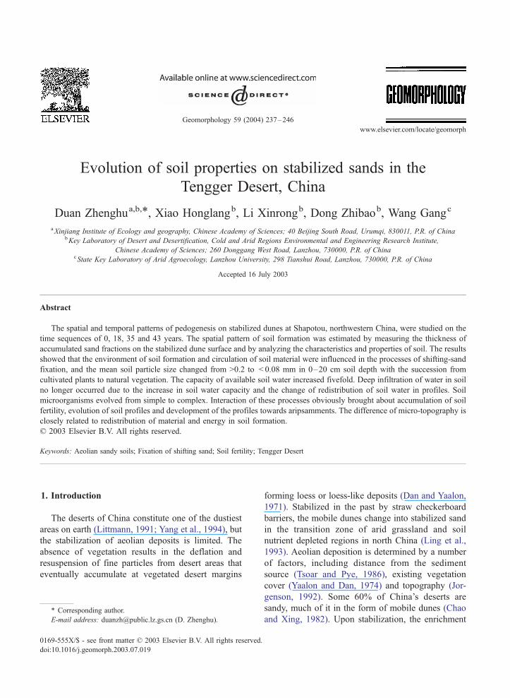
www.elsevier.com/locate/geomorph
Geomorphology 59 (2004) 237–246
Evolution of soil properties on stabilized sands in the
Tengger Desert, China
Duan Zhenghua,b,*, Xiao Honglangb, Li Xinrongb, Dong Zhibaob, Wang Gangc
aXinjiang Institute of Ecology and geography, Chinese Academy of Sciences; 40 Beijing South Road, Urumqi, 830011, P.R. of ChinabKey Laboratory of Desert and Desertification, Cold and Arid Regions Environmental and Engineering Research Institute,
Chinese Academy of Sciences; 260 Donggang West Road, Lanzhou, 730000, P.R. of ChinacState Key Laboratory of Arid Agroecology, Lanzhou University, 298 Tianshui Road, Lanzhou, 730000, P.R. of China
Accepted 16 July 2003
Abstract
The spatial and temporal patterns of pedogenesis on stabilized dunes at Shapotou, northwestern China, were studied on the
time sequences of 0, 18, 35 and 43 years. The spatial pattern of soil formation was estimated by measuring the thickness of
accumulated sand fractions on the stabilized dune surface and by analyzing the characteristics and properties of soil. The results
showed that the environment of soil formation and circulation of soil material were influenced in the processes of shifting-sand
fixation, and the mean soil particle size changed from >0.2 to < 0.08 mm in 0–20 cm soil depth with the succession from
cultivated plants to natural vegetation. The capacity of available soil water increased fivefold. Deep infiltration of water in soil
no longer occurred due to the increase in soil water capacity and the change of redistribution of soil water in profiles. Soil
microorganisms evolved from simple to complex. Interaction of these processes obviously brought about accumulation of soil
fertility, evolution of soil profiles and development of the profiles towards aripsamments. The difference of micro-topography is
closely related to redistribution of material and energy in soil formation.
D 2003 Elsevier B.V. All rights reserved.
Keywords: Aeolian sandy soils; Fixation of shifting sand; Soil fertility; Tengger Desert
1. Introduction forming loess or loess-like deposits (Dan and Yaalon,
The deserts of China constitute one of the dustiest
areas on earth (Littmann, 1991; Yang et al., 1994), but
the stabilization of aeolian deposits is limited. The
absence of vegetation results in the deflation and
resuspension of fine particles from desert areas that
eventually accumulate at vegetated desert margins
0169-555X/$ - see front matter D 2003 Elsevier B.V. All rights reserved.
doi:10.1016/j.geomorph.2003.07.019
* Corresponding author.
E-mail address: [email protected] (D. Zhenghu).
1971). Stabilized in the past by straw checkerboard
barriers, the mobile dunes change into stabilized sand
in the transition zone of arid grassland and soil
nutrient depleted regions in north China (Ling et al.,
1993). Aeolian deposition is determined by a number
of factors, including distance from the sediment
source (Tsoar and Pye, 1986), existing vegetation
cover (Yaalon and Dan, 1974) and topography (Jor-
genson, 1992). Some 60% of China’s deserts are
sandy, much of it in the form of mobile dunes (Chao
and Xing, 1982). Upon stabilization, the enrichment
D. Zhenghu et al. / Geomorphology 59 (2004) 237–246238
of dune surfaces through aeolian deposition of fine
particles becomes an important geomorphological
process (Danin, 1978). For example, in the Shapotou
area, after decades of stabilization, the succession of
cultivated plants on shifting sand gradually evolved
naturally towards a natural vegetation. Vegetation
cover varied between 20% and 40%, and yearly litter
yield reached 43.6 g m� 2 (Shi and Liu, 1995).
Furthermore, soils evolved towards aripsamments
and the surface morphology of aeolian-sand soil
profile also changed (Zhen, 1987), sometimes even
towards a macrobiotic crust (Duan et al., 2003). In the
meantime, numerous microbes, mosses and herbs
appeared in the surface soil layer (Shi et al., 1996;
Li et al., 2002). As a result, the structure and function
of desert ecosystem became better (Harper and Mar-
Fig. 1. Geographical situations of the major deserts (sandy lands) and lo
Taklimakan Desert; (3) Kumtag Desert; (4) Qaidam Basin Desert; (5) Bada
Desert; (9) Mu Us Desert; (10) Otindag Desert; (11) Horqin Sandy Land;
ble, 1998). With the development of a surface crust,
substantial changes in soil properties such as erodibil-
ity, texture, structure, nutrient content and moisture
content have occurred when compared with the orig-
inal aeolian sand. The study on the evolution of soil
properties in the processes of shifting-sand fixation is
very significant for the desert rehabilitation and eco-
environmental improvement.
2. Materials and methods
The study area lies at the southern edge of the
Tengger Desert at Shapotou, northwestern China
(105j00VE, 37j40VN) (Fig. 1). Site elevation is
1300–1350 m. Mean annual precipitation is around
cation of the Shapotou in China. (1) Kurban Tunggut Desert; (2)
in Jaran Desert; (6) Tengger Desert; (7) Ulan Buh Desert; (8) Qubqi
(12) Nenjiang Sandy Land; (13) Huang-Huai-Hai Plain Sandy Land.
D. Zhenghu et al. / Geomorphology 59 (2004) 237–246 239
180 mm, falling predominantly during the months
between May and September (Zhao, 1988). Precipi-
tation is highly variable, dependent on the strength
and extent of the summer monsoonal system. Temper-
atures average 24.3 jC in July and � 6.9 jC in
January. Mean annual pan potential evaporation is
2508 mm. The highest wind speed occurs in the late
spring (April–May), with an average wind velocity of
3.5 m s� 1, and the wind direction is predominantly
northwesterly (Li, 1988).
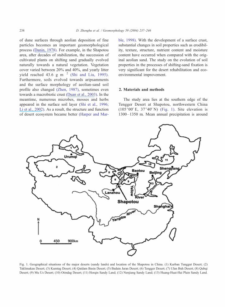
The Shapotou Desert Research Station was estab-
lished in 1956 to investigate methods of stabilizing
shifting dunes, which threatened the Baotou–Lanz-
hou railway line as it crossed the Tengger Desert. The
stabilization method was a combination of wind-
breaks, straw checkerboard barriers and planted xero-
phytic shrubs (Fig. 2). Awillow branch fence was first
constructed at the edge of the stabilized area, greatly
reducing the entry of blowing sand (Lin et al., 1984).
The straw checkerboard barriers were made of wheat
and rice straw embedded in the sand roughly in a
1�1 m grid, with the straw protruding 10–15 cm
above the surface. Xerophytic shrub seedlings, such as
Artemisia ordosica, Krasch., Hedysarum scoparium,
Fisch. and C.A. Mey, Caragana korshinskii, Kom.
Fig. 2. Plan of different-year stabilized site in Shapotou. The characters in
and Calligonum mongolicum, Turc’z were planted
within the checkerboards (Fearnehough et al., 1998).
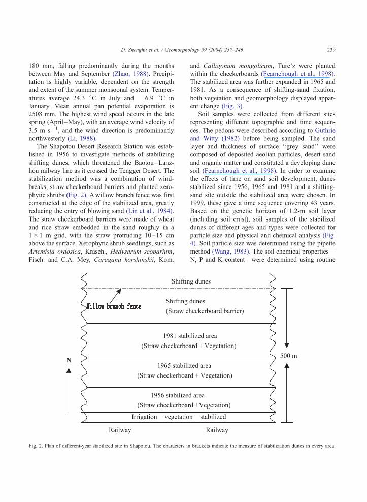
The stabilized area was further expanded in 1965 and
1981. As a consequence of shifting-sand fixation,
both vegetation and geomorphology displayed appar-
ent change (Fig. 3).
Soil samples were collected from different sites
representing different topographic and time sequen-
ces. The pedons were described according to Guthrie
and Witty (1982) before being sampled. The sand
layer and thickness of surface ‘‘grey sand’’ were
composed of deposited aeolian particles, desert sand
and organic matter and constituted a developing dune
soil (Fearnehough et al., 1998). In order to examine
the effects of time on sand soil development, dunes
stabilized since 1956, 1965 and 1981 and a shifting-
sand site outside the stabilized area were chosen. In
1999, these gave a time sequence covering 43 years.
Based on the genetic horizon of 1.2-m soil layer
(including soil crust), soil samples of the stabilized
dunes of different ages and types were collected for
particle size and physical and chemical analysis (Fig.
4). Soil particle size was determined using the pipette
method (Wang, 1983). The soil chemical properties—
N, P and K content—were determined using routine
brackets indicate the measure of stabilization dunes in every area.
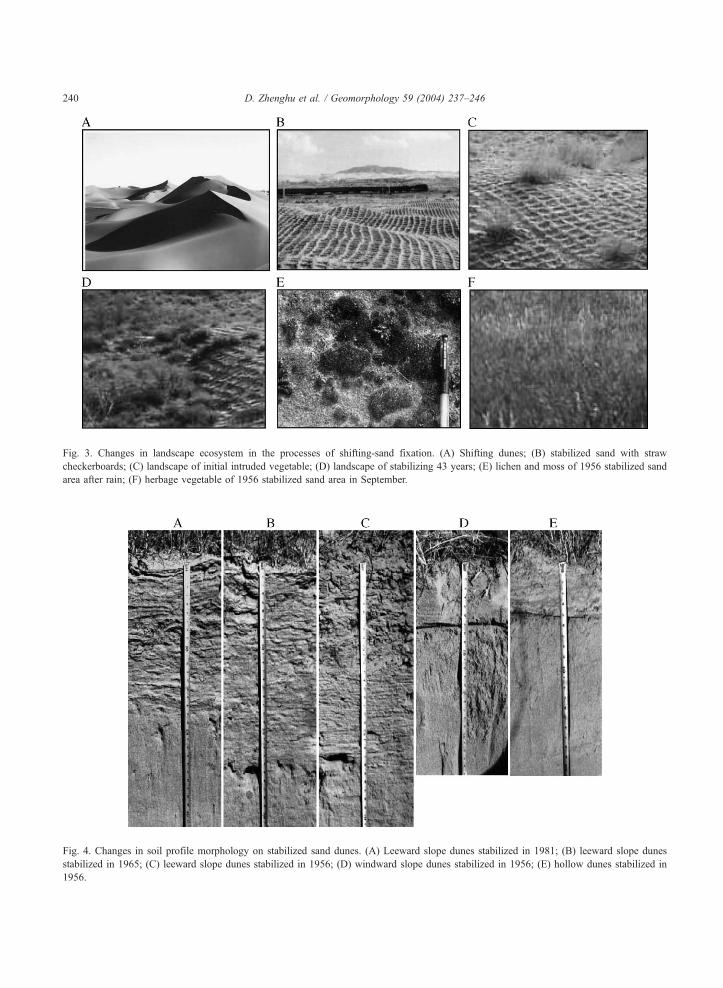
Fig. 3. Changes in landscape ecosystem in the processes of shifting-sand fixation. (A) Shifting dunes; (B) stabilized sand with straw
checkerboards; (C) landscape of initial intruded vegetable; (D) landscape of stabilizing 43 years; (E) lichen and moss of 1956 stabilized sand
area after rain; (F) herbage vegetable of 1956 stabilized sand area in September.
Fig. 4. Changes in soil profile morphology on stabilized sand dunes. (A) Leeward slope dunes stabilized in 1981; (B) leeward slope dunes
stabilized in 1965; (C) leeward slope dunes stabilized in 1956; (D) windward slope dunes stabilized in 1956; (E) hollow dunes stabilized in
1956.
D. Zhenghu et al. / Geomorphology 59 (2004) 237–246240
D. Zhenghu et al. / Geomorphology 59 (2004) 237–246 241
methods (Nanjing Institute of Soil Sciences, Chinese
Academy of Sciences, 1978). The soil bulk density
was determined using the cutting ring method. The
number of bacteria, fungi and actinomyces was deter-
mined using the flat panel smear methods (Xu and
Zheng, 1986). At the same time, the field survey and
the analyses of crust and dust particle sizes were
conducted. The amount of aeolian deposition was
studied using a transect of dust traps that consisted
of metal cylinders 350 mm high and 250 mm in
diameter, sediment being collected through a funnel
at the base of the cylinder. Measurements of aeolian
deposition have been made at Shapotou since August
1990 (Zhang et al., 1993). Traps were placed away
from shrubby vegetation at different topographic
positions and remained in the field for 3 years from
1994 to 1996. Trapped sediment was dried and
weighed monthly.
In order to examine changes in surface morphology
after sand dunes stabilized, the topography of the
region of the artificial stabilized sand dunes was
measured using a Theodolite and compared to 1964
measured results. Because the existing topography
reduced from northwest to southeast in the stabilized
area, we calculated relative height and undulation
degree at all points using the regional inclination as a
base level. Statistical analysis (ANOVAwith LSD and
regression analysis) was carried out by using SPSS
10.0 for Windows at a pV 0.05 significance level.
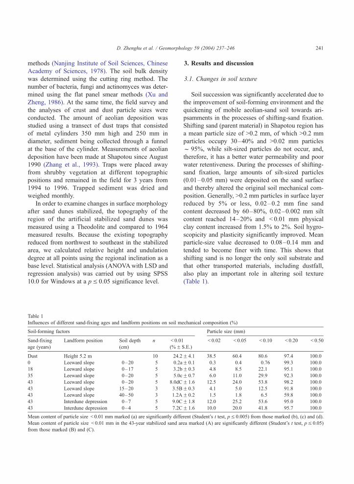
Table 1
Influences of different sand-fixing ages and landform positions on soil m
Soil-forming factors
Sand-fixing
age (years)
Landform position Soil depth
(cm)
n < 0.01
(%F
Dust Height 5.2 m 10 24.2
0 Leeward slope 0–20 5 0.2a
18 Leeward slope 0–17 5 3.2b
35 Leeward slope 0–20 5 5.0c
43 Leeward slope 0–20 5 8.0dC
43 Leeward slope 15–20 3 3.5B
43 Leeward slope 40–50 3 1.2A
43 Interdune depression 0–7 5 9.0C
43 Interdune depression 0–4 5 7.2C
Mean content of particle size < 0.01 mm marked (a) are significantly diffe
Mean content of particle size < 0.01 mm in the 43-year stabilized sand ar
from those marked (B) and (C).
3. Results and discussion
3.1. Changes in soil texture
Soil succession was significantly accelerated due to
the improvement of soil-forming environment and the
quickening of mobile aeolian-sand soil towards ari-
psamments in the processes of shifting-sand fixation.
Shifting sand (parent material) in Shapotou region has
a mean particle size of >0.2 mm, of which >0.2 mm
particles occupy 30–40% and >0.02 mm particles
f 95%, while silt-sized particles do not occur, and,
therefore, it has a better water permeability and poor
water retentiveness. During the processes of shifting-
sand fixation, large amounts of silt-sized particles
(0.01–0.05 mm) were deposited on the sand surface
and thereby altered the original soil mechanical com-
position. Generally, >0.2 mm particles in surface layer
reduced by 5% or less, 0.02–0.2 mm fine sand
content decreased by 60–80%, 0.02–0.002 mm silt
content reached 14–20% and < 0.01 mm physical
clay content increased from 1.5% to 2%. Soil hygro-
scopicity and plasticity significantly improved. Mean
particle-size value decreased to 0.08–0.14 mm and
tended to become finer with time. This shows that
shifting sand is no longer the only soil substrate and
that other transported materials, including dustfall,
also play an important role in altering soil texture
(Table 1).
echanical composition (%)
Particle size (mm)
S.E.)
< 0.02 < 0.05 < 0.10 < 0.20 < 0.50
F 4.1 38.5 60.4 80.6 97.4 100.0
F 0.1 0.3 0.4 0.76 99.3 100.0
F 0.3 4.8 8.5 22.1 95.1 100.0
F 0.7 6.0 11.0 29.9 92.3 100.0
F 1.6 12.5 24.0 53.8 98.2 100.0
F 0.3 4.1 5.0 12.5 91.8 100.0
F 0.2 1.5 1.8 6.5 59.8 100.0
F 1.8 12.0 25.2 53.6 95.0 100.0
F 1.6 10.0 20.0 41.8 95.7 100.0
rent (Student’s t test, pV 0.005) from those marked (b), (c) and (d).
ea marked (A) are significantly different (Student’s t test, pV 0.05)
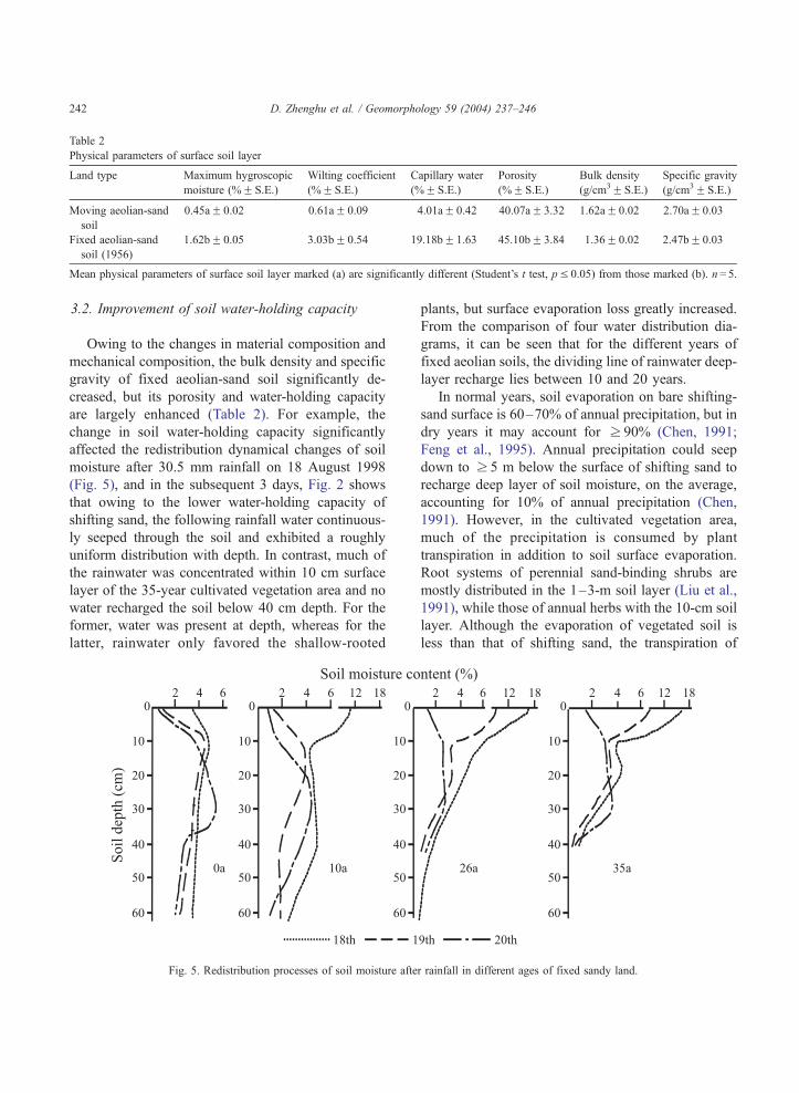
Table 2
Physical parameters of surface soil layer
Land type Maximum hygroscopic
moisture (%F S.E.)
Wilting coefficient
(%F S.E.)
Capillary water
(%F S.E.)
Porosity
(%F S.E.)
Bulk density
(g/cm3F S.E.)
Specific gravity
(g/cm3F S.E.)
Moving aeolian-sand
soil
0.45aF 0.02 0.61aF 0.09 4.01aF 0.42 40.07aF 3.32 1.62aF 0.02 2.70aF 0.03
Fixed aeolian-sand
soil (1956)
1.62bF 0.05 3.03bF 0.54 19.18bF 1.63 45.10bF 3.84 1.36F 0.02 2.47bF 0.03
icantly different (Student’s t test, pV 0.05) from those marked (b). n= 5.
D. Zhenghu et al. / Geomorphology 59 (2004) 237–246242
3.2. Improvement of soil water-holding capacity
Owing to the changes in material composition and
mechanical composition, the bulk density and specific
gravity of fixed aeolian-sand soil significantly de-
creased, but its porosity and water-holding capacity
are largely enhanced (Table 2). For example, the
change in soil water-holding capacity significantly
affected the redistribution dynamical changes of soil
moisture after 30.5 mm rainfall on 18 August 1998
(Fig. 5), and in the subsequent 3 days, Fig. 2 shows
that owing to the lower water-holding capacity of
shifting sand, the following rainfall water continuous-
ly seeped through the soil and exhibited a roughly
uniform distribution with depth. In contrast, much of
the rainwater was concentrated within 10 cm surface
layer of the 35-year cultivated vegetation area and no
water recharged the soil below 40 cm depth. For the
former, water was present at depth, whereas for the
latter, rainwater only favored the shallow-rooted
Mean physical parameters of surface soil layer marked (a) are signif
Fig. 5. Redistribution processes of soil moisture afte
plants, but surface evaporation loss greatly increased.
From the comparison of four water distribution dia-
grams, it can be seen that for the different years of
fixed aeolian soils, the dividing line of rainwater deep-
layer recharge lies between 10 and 20 years.
In normal years, soil evaporation on bare shifting-
sand surface is 60–70% of annual precipitation, but in
dry years it may account for z 90% (Chen, 1991;
Feng et al., 1995). Annual precipitation could seep
down to z 5 m below the surface of shifting sand to
recharge deep layer of soil moisture, on the average,
accounting for 10% of annual precipitation (Chen,
1991). However, in the cultivated vegetation area,
much of the precipitation is consumed by plant
transpiration in addition to soil surface evaporation.
Root systems of perennial sand-binding shrubs are
mostly distributed in the 1–3-m soil layer (Liu et al.,
1991), while those of annual herbs with the 10-cm soil
layer. Although the evaporation of vegetated soil is
less than that of shifting sand, the transpiration of
r rainfall in different ages of fixed sandy land.
D. Zhenghu et al. / Geomorphology 59 (2004) 237–246 243
plants is large, accounting for 20–40% of annual
precipitation (Chen, 1991; Feng et al., 1995), and
thus affecting deep infiltration of soil moisture.
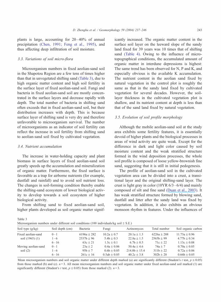
3.3. Variations of soil micro-flora
Microorganism numbers in fixed aeolian-sand soil
in the Shapotou Region are a few tens of times higher
than that in unvegetated shifting sand (Table 3), due to
high organic matter content and high soil fertility in
the surface layer of fixed aeolian-sand soil. Fungi and
bacteria in fixed aeolian-sand soil are mostly concen-
trated in the surface layers and decrease rapidly with
depth. The total number of bacteria in shifting sand
often exceeds that in fixed aeolian-sand soil, but their
distribution increases with depth. This is because
surface layer of shifting sand is very dry and therefore
unfavorable to microorganism survival. The number
of microorganisms as an indicator of soil fertility can
reflect the increase in soil fertility from shifting sand
to aeolian-sand soil fixed by cultivated vegetation.
3.4. Nutrient accumulation
The increase in water-holding capacity and plant
biomass in surface layers of fixed aeolian-sand soil
greatly speeds up the accumulation and mineralization
of organic matter. Furthermore, the fixed surface is
favorable as a trap for airborne nutrients (for example,
dustfall and rainfall) and to avoid soil nutrient loss.
The changes in soil-forming condition thereby enable
the shifting-sand ecosystem of lower biological activ-
ity to develop towards a soil ecosystem of higher
biological activity.
From shifting sand to fixed aeolian-sand soil,
higher plants developed as soil organic matter signif-
Table 3
Microorganism numbers under different soil conditions (100 individuals/k
Soil type (g/kg) Soil depth (cm) Bacteria Fungi
Fixed aeolian-sand 0–1 6196aF 282 10.2aFsoil (1965) (1) 1–6 2537bF 96 5.4bF
6–16 63cF 21 1.5cFMoving aeolian-sand 0–1 23aF 2 0.4aF
soil (2) 1–6 95bF 7 0.6bF6–16 261cF 16 0.5abF
Mean microorganism numbers and soil organic matter under different dep
from those marked (b) and (c). n= 3. All mean microorganism numbers a
significantly different (Student’s t test, pV 0.05) from those marked (2). n
icantly increased. The organic matter content in the
surface soil layer on the leeward slope of the sandy
land fixed for 39 years was 10 times that of shifting
sand (Table 4). Owing to the influence of micro-
topographical conditions, the accumulated amount of
organic matter in interdune depressions is highest:
The same trend has been observed for N, P and K, and
especially obvious is the available K accumulation.
The nutrient content in the aeolian sand fixed by
natural vegetation in the control plot is roughly the
same as that in the sandy land fixed by cultivated
vegetation for several decades. However, the soil-
layer thickness in the cultivated vegetation plot is
shallow, and its nutrient content at depth is less than
that of the sand land fixed by natural vegetation.
3.5. Evolution of soil profile morphology
Although the mobile aeolian-sand soil at the study
area exhibits some fertility features, it is essentially
devoid of higher plants and the biological processes in
areas of wind activity are quite weak. Except for the
difference in dark and light color caused by soil
moisture content and the weak stratified structure
formed in the wind deposition processes, the whole
soil profile is composed of loose yellow-brownish fine
sand, suggesting that it is still in initial pedogenesis.
The profile of aeolian-sand soil in the cultivated
vegetation area can be divided into a crust, a transi-
tional layer and the original shifting-sand layer. The
crust is light gray in color (10YR 6/3–6/4) and mainly
composed of silt and fine sand (Duan et al., 2003). It
has weak stratified structure formed by blowing sand,
dustfall and litter after the sandy land was fixed by
vegetation. In addition, it also exhibits an obvious
monsoon rhythm in features. Under the influences of
g soilF S.E.)
Actinomyces Total number Soil organic carbon
0.7 20.1aF 1.3 6226aF 288 11.73aF 0.96
0.3 22.8aF 1.5 2565bF 99 4.77bF 0.34
0.1 6.7bF 0.5 71cF 22 1.13cF 0.08
0.06 50.4aF 4.6 74aF 7 0.70aF 0.05
0.05 214.8bF 15.4 311bF 22 0.72aF 0.06
0.05 40.2cF 3.8 302bF 20 0.66bF 0.05
th marked (a) are significantly different (Student’s t test, pV 0.05)
nd soil organic matter under fixed aeolian-sand soil marked (1) are
= 3.
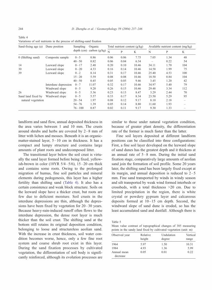
Table 4
Variations of soil nutrients in the process of shifting-sand fixation
Sand-fixing age (a) Dune position Sampling Organic Total nutrient content (g/kg) Available nutrient content (mg/kg)
depth (cm) carbon (g/kg)N P K N P K
0 (Shifting sand) Composite sample 0–5 0.86 0.06 0.06 7.75 7.05 1.34 48
40–50 0.82 0.06 0.04 6.34 – 0.22 54
14 Leeward slope 0–17 2.48 0.20 0.10 10.46 34.11 1.70 104
30 Leeward slope 0–20 4.33 0.16 0.14 10.46 14.58 1.99 75
39 Leeward slope 0–2 8.14 0.31 0.17 10.46 25.40 4.53 100
15–20 5.59 0.08 0.08 10.46 18.50 0.84 104
40–50 0.45 0.05 0.05 9.46 3.45 1.20 42
Interdune depression 0–7 11.07 0.32 0.17 10.46 34.97 5.40 79
Windward slope 0–5 9.20 0.26 0.15 10.46 29.48 3.34 112
26 Windward slope 0–5 5.36 0.23 0.13 8.47 3.29 2.44 70
Sand land fixed by Windward slope 0–5 5.57 0.33 0.17 8.34 23.50 5.29 95
natural vegetation 20–54 1.97 0.08 0.12 9.17 8.10 2.18 –
54–76 1.39 0.05 0.14 8.80 11.60 1.93 –
76–100 0.87 0.02 0.11 9.17 9.30 1.33 –
Table 5
Mean value contrast of topographical changes of 385 measuring
points in the sandy land fixed by cultivated vegetation (unit: m)
Observed year Relative
height
Undulation
degree
Vertical
range
1964 5.97 1.50 10.31
1984 4.93 1.36 5.99
Annual mean
decrease
0.05 0.01 0.22
D. Zhenghu et al. / Geomorphology 59 (2004) 237–246244
landform and sand flow, annual deposited thickness in
the area varies between 1 and 10 mm. The crusts
around shrubs and herbs are covered by 2–8 mm of
litter with lichen and mosses. Beneath it is an organic-
matter-stained layer, 5–10 cm in thickness. It has a
compact and lumpy structure and contains large
amounts of plant roots and undecomposed litter.
The transitional layer below the soil crust is virtu-
ally the sand layer formed before being fixed, yellow-
ish-brown in color (10YR 5/4–5/6), 15–20 cm thick
and contains some roots. Owing to the prolonged
migration of humus, fine soil particles and mineral
elements during pedogenesis, this layer has a higher
fertility than shifting sand (Table 4). It also has a
certain consistence and weak block structure. Soils on
the leeward slope have a thicker crust, but roots are
few due to deficient moisture. Soil crusts in the
interdune depressions are thin, although the depres-
sions have been fixed by vegetation for 20–30 years.
Because heavy-rain-induced runoff often flows to the
interdune depression, the dense root layer is much
thicker than the soil crust. The shifting sand at the
bottom still retains its original deposition condition,
belonging to loose and structureless aeolian sand.
With the increase in crust thickness, soil water con-
dition becomes worse, hence, only a few fine root
system and coarse shrub root exist in this layer.
During the sand fixation processes by cultivated
vegetation, the differentiation of soil body is signifi-
cantly reinforced, although its evolution processes are
similar to those under natural vegetation condition,
because of greater plant density, the differentiation
rate of the former is much faster than the latter.
Fine soil layers deposited at different landform
positions can be classified into three configurations:
First, a fine soil layer developed on the leeward slope
of sand dunes has the greatest depth and it thickens at
an annual rate of 5–8 mm. During the initial sand
fixation stage, comparatively large amounts of aeolian
sand join the formation of soil profile. Some 20 years
later, the shifting sand has been largely fixed except at
its margin, and annual deposition is reduced to 2–5
mm. Fine sand transported by winds in windy season
and silt transported by weak wind formed interbeds or
crossbeds, with a total thickness >20 cm. Due to
limited precipitation in the region, there is white
crystal or powdery gypsum layer and calcareous
deposits formed at 10–15 cm depth. Second, the
windward slope of sand dune is eroded, so has the
least accumulated sand and dustfall. Although there is
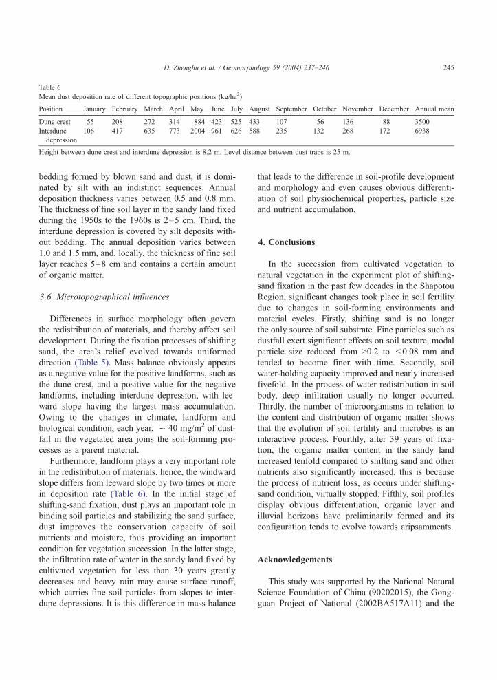
Table 6
Mean dust deposition rate of different topographic positions (kg/ha2)
Position January February March April May June July August September October November December Annual mean
Dune crest 55 208 272 314 884 423 525 433 107 56 136 88 3500
Interdune
depression
106 417 635 773 2004 961 626 588 235 132 268 172 6938
Height between dune crest and interdune depression is 8.2 m. Level distance between dust traps is 25 m.
D. Zhenghu et al. / Geomorphology 59 (2004) 237–246 245
bedding formed by blown sand and dust, it is domi-
nated by silt with an indistinct sequences. Annual
deposition thickness varies between 0.5 and 0.8 mm.
The thickness of fine soil layer in the sandy land fixed
during the 1950s to the 1960s is 2–5 cm. Third, the
interdune depression is covered by silt deposits with-
out bedding. The annual deposition varies between
1.0 and 1.5 mm, and, locally, the thickness of fine soil
layer reaches 5–8 cm and contains a certain amount
of organic matter.
3.6. Microtopographical influences
Differences in surface morphology often govern
the redistribution of materials, and thereby affect soil
development. During the fixation processes of shifting
sand, the area’s relief evolved towards uniformed
direction (Table 5). Mass balance obviously appears
as a negative value for the positive landforms, such as
the dune crest, and a positive value for the negative
landforms, including interdune depression, with lee-
ward slope having the largest mass accumulation.
Owing to the changes in climate, landform and
biological condition, each year, f 40 mg/m2 of dust-
fall in the vegetated area joins the soil-forming pro-
cesses as a parent material.
Furthermore, landform plays a very important role
in the redistribution of materials, hence, the windward
slope differs from leeward slope by two times or more
in deposition rate (Table 6). In the initial stage of
shifting-sand fixation, dust plays an important role in
binding soil particles and stabilizing the sand surface,
dust improves the conservation capacity of soil
nutrients and moisture, thus providing an important
condition for vegetation succession. In the latter stage,
the infiltration rate of water in the sandy land fixed by
cultivated vegetation for less than 30 years greatly
decreases and heavy rain may cause surface runoff,
which carries fine soil particles from slopes to inter-
dune depressions. It is this difference in mass balance
that leads to the difference in soil-profile development
and morphology and even causes obvious differenti-
ation of soil physiochemical properties, particle size
and nutrient accumulation.
4. Conclusions
In the succession from cultivated vegetation to
natural vegetation in the experiment plot of shifting-
sand fixation in the past few decades in the Shapotou
Region, significant changes took place in soil fertility
due to changes in soil-forming environments and
material cycles. Firstly, shifting sand is no longer
the only source of soil substrate. Fine particles such as
dustfall exert significant effects on soil texture, modal
particle size reduced from >0.2 to < 0.08 mm and
tended to become finer with time. Secondly, soil
water-holding capacity improved and nearly increased
fivefold. In the process of water redistribution in soil
body, deep infiltration usually no longer occurred.
Thirdly, the number of microorganisms in relation to
the content and distribution of organic matter shows
that the evolution of soil fertility and microbes is an
interactive process. Fourthly, after 39 years of fixa-
tion, the organic matter content in the sandy land
increased tenfold compared to shifting sand and other
nutrients also significantly increased, this is because
the process of nutrient loss, as occurs under shifting-
sand condition, virtually stopped. Fifthly, soil profiles
display obvious differentiation, organic layer and
illuvial horizons have preliminarily formed and its
configuration tends to evolve towards aripsamments.
Acknowledgements
This study was supported by the National Natural
Science Foundation of China (90202015), the Gong-
guan Project of National (2002BA517A11) and the
D. Zhenghu et al. / Geomorphology 59 (2004) 237–246246
Innovation Project of Chinese Academy of Sciences
(KZCX3-SW-324). The authors thank Dr. Ian Living-
stone, Dr. Mike Fullen and Dr. Richard Harper for
their critical review of the manuscript.
References
Chao, S., Xing, J., 1982. Origin and development of the Shamo
(sandy deserts) and the Gobi (stony deserts) of China. In: Smi-
ley, T.S. (Ed.), The Geological Story of the World’s Deserts.
Striae, vol. 17. Uppsala University Press, Uppsala, pp. 79–91.
Chen, W., 1991. Water balance in 29-year cultivated vegetation
plots on both sides of Baolan railway in Shapotou region. Study
Shifting Sand Control. (2), 66–75 (in Chinese).
Dan, J., Yaalon, D.H., 1971. On the origin and nature of paleopedo-
logical formations in the coastal fringe areas of Israel. In: Yaalon,
D.H. (Ed.), Paleopedology—Origin, Nature and Dating of Pale-
osols. Israel Univ. Press, Jerusalem, pp. 245–260.
Danin, A., 1978. Plant species diversity and plant succession in a
sandy area in the Northern Negev. Flora 167, 409–422.
Duan, Z., Wang, G., Xiao, H., Dong, Z., 2003. Abiotic soil crust
formation on dunes in an extremely arid environment: a 43-year
sequential study. Arid Land Res. Manag. 17, 43–54.
Fearnehough, W., Fullen, M.A., Mitchell, D.J., Trueman, I.C.,
Zhang, J., 1998. Aeolian deposition and its effect on soil and
vegetation changes on stabilized desert dunes in northern China.
Geomorphology 23, 171–182.
Feng, J., Chen, H., Liu, Y., 1995. Water consuming features and
water balance of cultivated vegetation on sandy land. Study
Desert Ecosyst. (1), 143–148 (in Chinese).
Guthrie, R.L., Witty, J.E., 1982. New designations for soil horizons
and layers and the new soil survey manual. Soil Sci. Soc. Am. J.
46, 443–444.
Harper, K.T., Marble, J.R., 1998. A role for non-vascular plants in
management of arid and semi-arid rangelands. In: Tueller, P.T.
(Ed.), Application of Plant Sciences to Rangeland Management.
Martinus Nijhoft Publishers/Junk, Amsterdam, pp. 135–169.
Jorgenson, D.W., 1992. Use of soils to differentiate dune age and
to document spatial variation in aeolian activity, northeast
Colorado, USA. J. Arid Environ. 23, 19–34.
Li, J., 1988. Wind regime and shifting sand movement in Shapotou
area. J. Desert Res. 8 (3), 41–52 (in Chinese with English
abstract).
Li, X., Wang, X., Li, T., Zhang, J., 2002. Microbiotic soil crust and
its effect on vegetation and habitat on artificially stabilized des-
ert dunes in Tengger Desert, North China. Biol. Fertil. Soils 35,
147–154.
Lin, Y., Jin, J., Zou, B., Cong, Z., Wen, X., Tu, X., Ye, J., Zhang,
B., Wang, H., 1984. Effect of fence techniques in leveling sand
accumulation around sandbreaks—case study in Shapotou Dis-
trict. J. Desert Res. 4 (3), 16–26 (in Chinese with English
abstract).
Ling, Y., Qu, J., Hu, M., 1993. Formation of sand surface crust and
micro-environmental changes. J. Appl. Ecol. 4 (4), 393–398 (in
Chinese with English abstract).
Littmann, T., 1991. Dust storm frequency in Asia: climatic control
and variability. Int. J. Climatol. 11, 393–412.
Liu, Y., Li, Y., Yang, X., 1991. Root systems of psammophytes.
Study Shifting Sand Control (2), 185–209 (in Chinese).
Nanjing Institute of Soil Sciences, Chinese Academy of Sciences,
1978. Analysis of Soil Physical and Chemical Properties. Shang-
hai Science and Technology Press, Shanghai, pp. 66–208. In
Chinese.
Shi, Q., Liu, J., 1995. Dynamics of natural vegetation in cultivated
vegetation plots on both sides of Baolan rainway in Shapotou
Region. Study Desert Ecosyst. (1), 105–115 (in Chinese with
English abstract).
Shi, Q., Liu, J., Li, Y., 1996. Transmutation and renovation mea-
sures of artificial vegetation on both sides of Shapotou railway
section. J. Desert Res. 16 (Suppl. 1), 25–29 (in Chinese with
English abstract).
Tsoar, H., Pye, K., 1986. Dust transport and the question of desert
loess formation. Sedimentology 34, 139–153.
Wang, R., 1983. Soil particle analysis. In: Li, Y.K. (Ed.), Soil and
Agricultural Chemistry Routine Analysis. Chinese Science
Press, Beijing, pp. 23–54. In Chinese.
Xu, G., Zheng, H., 1986. Soil Microorganism Analysis Methods
Manual. Chinese Agriculture Press, Beijing, pp. 102–136. In
Chinese.
Yaalon, D.H., Dan, J., 1974. Accumulation and distribution of lo-
ess-derived deposits in the semi-desert and desert fringe areas of
Israel. Z. Geomorphol. Suppl.bd 20, 91–105.
Yang G., Huang, Z., Zhao, X., Hu, M., Ling, Y., 1994. A study on
several problems concerning dust storms in Northwest China.
Lanzhou Institute of Desert Research, Academia Sinica, Deser-
tification and Its Control in China. IUGG/CAS Summer Train-
ing School for Combating Desertification. August 15 – 25.
Lanzhou, pp. 163–183.
Zhang, J., Di, X., Wang, S., 1993. Character of regional ecological
changes during the establishment of preventive system, Shapo-
tou. Institute of Desert Research. Academia Sinica, Lanzhou.
Gansu Scientific Technology Publishing House, Lanzhou. In
Chinese.
Zhao, X., 1988. Problems of revegetation on sand dunes in Shapo-
tou area. Shapotou Scientific Experimental Station, Lanzhou
Institute of Desert Research. Academia Sinica. Studies of Dune
Control in Shapotou Area, Tengger Desert (2), Ningxia People’s
Publishing House, pp. 27–58.
Zhen, J., 1987. Changes in surface morphology of shifting sand
land after being fixed in Shapotou area at southeastern fringe
of Tengger Desert. J. Desert Res. 7 (1), 9–17 (in Chinese with
English abstract).
Copyright © 2022 FDOKUMEN