Vertical sediment fluxes and wave-induced sediment resuspension in a shallow-water coastal lagoon
Upload
khangminh22Category
view
1download
0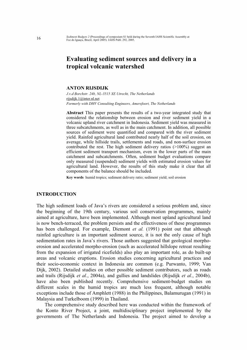
Sediment Budgets 2 (Proceedings of symposium S1 held during the Seventh IAHS Scientific Assembly at Foz do Iguaçu, Brazil, April 2005). IAHS Publ. 292, 2005.
16
Evaluating sediment sources and delivery in a tropical volcanic watershed ANTON RIJSDIJK J.v.d Borchstr. 24b, NL-3515 XE Utrecht, The Netherlands [email protected] Formerly with DHV Consulting Engineers, Amersfoort, The Netherlands Abstract This paper presents the results of a two-year integrated study that considered the relationship between erosion and river sediment yield in a volcanic upland river catchment in Indonesia. Sediment yield was measured in three subcatchments, as well as in the main catchment. In addition, all possible sources of sediment were quantified and compared with the river sediment yield. Rainfed agricultural land contributed nearly half of the soil erosion, on average, while hillside trails, settlements and roads, and non-surface erosion contributed the rest. The high sediment delivery ratios (>100%) suggest an efficient sediment transport mechanism, even in the lower parts of the main catchment and subcatchments. Often, sediment budget evaluations compare only measured (suspended) sediment yields with estimated erosion values for agricultural land. However, the results of this study make it clear that all components of the balance should be included. Key words humid tropics; sediment delivery ratio; sediment yield; soil erosion
INTRODUCTION The high sediment loads of Java’s rivers are considered a serious problem and, since the beginning of the 19th century, various soil conservation programmes, mainly aimed at agriculture, have been implemented. Although most upland agricultural land is now bench-terraced, the problem persists and the effectiveness of these programmes has been challenged. For example, Diemont et al. (1991) point out that although rainfed agriculture is an important sediment source, it is not the only cause of high sedimentation rates in Java’s rivers. Those authors suggested that geological morpho-erosion and accelerated morpho-erosion (such as accelerated hillslope retreat resulting from the expansion of irrigated ricefields) also play an important role, as do built-up areas and volcanic eruptions. Erosion studies concerning agricultural practices and their socio-economic context in Indonesia are common (e.g. Purwanto, 1999; Van Dijk, 2002). Detailed studies on other possible sediment contributors, such as roads and trails (Rijsdijk et al., 2004a), and gullies and landslides (Rijsdijk et al., 2004b), have also been published recently. Comprehensive sediment-budget studies on different scales in the humid tropics are much less frequent, although notable exceptions include those of Amphlett (1988) in the Philippines, Balamurugan (1991) in Malaysia and Turkelboom (1999) in Thailand. The comprehensive study described here was conducted within the framework of the Konto River Project, a joint, multidisciplinary project implemented by the governments of The Netherlands and Indonesia. The project aimed to develop a

Evaluating sediment sources and delivery in a tropical volcanic watershed
17
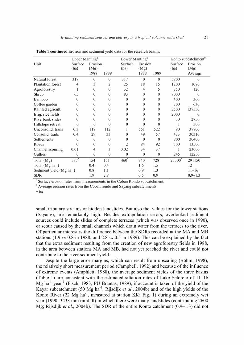
Fig. 1 Location and general geomorphology of the upper Konto catchment, East Java (after Nuffic-Unibraw, 1984), with locations of study sites added.
planning procedure to establish a management model for Java’s densely populated watersheds (Anon., 1989). The main erosion research activities were carried out from 1987 until the end of the project in 1990. Presented here is an extrapolation, to catchment scale, of data on individual sediment sources measured within the project (vegetated surfaces, trails, gullies, landslides, ricefield-terrace collapse, accelerated hillslope retreat and riverbank erosion), and a comparison of these data with river sediment yields. DESCRIPTION OF THE STUDY CATCHMENTS Indonesia’s upper Konto River catchment (part of the large Brantas River system) is about 25 km northwest of the East Javan town of Malang. The Konto drains a young volcanic watershed (233 km2; Fig. 1) and flows into an artificial lake (Lake Selorejo). The catchment comprises intervolcanic plains and plateaux (25%), alluvial and lahar valleys (5%), hilly areas (50%) and volcanic mountain complexes (20%). Within the upper Konto catchment, three subcatchments were studied in detail: Coban Rondo (2162 ha), Manting (460 ha) and Sayang (1234 ha), together accounting for 17% of the total catchment area (Fig. 1). The soils in the upper Konto area are classified (FAO, 1990) as Andosols (on mountainous landforms), Cambisols (on lower slopes and
Anton Rijsdijk
18
foothills), and Luvisols (on lower plains where irrigated rice cultivation is practised) (NUFFIC-UNIBRAW, 1984). The climate is typical of higher elevations in a tropical monsoon climate, with quite pronounced wet and dry seasons (Oldeman, 1975). Long-term rainfall averages range from 2700 mm in the southwest to 2125 mm in the northeast (PU Brantas, 2001). In 1988, 1989 and 1990 the mean areal rainfall was 2162, 2618 and 3443 mm, respectively (Rijsdijk & Bruijnzeel, 1990). The steep area above 1400 m is covered with (degraded) natural forest, mature tree plantations, shrubland and, at altitudes of 1200–1400 m, “agroforestry” (intercropping of food crops and young timber trees) is found. The main land uses in the lowest parts of the catchment are: intensive rainfed agriculture (maize and cassava, on well-maintained forward-sloping terraces); irrigated rice cultivation; bamboo plantations; homegardens containing coffee under shade trees; and settlements (houses and yards, village roads, and stables) (RIN, 1985). Settlements are connected by cobblestone or dirt roads in various states of repair: around 50% can be classified as well-maintained and 50% as poorly maintained. All vegetated areas are intersected by numerous small trails, both consolidated and unconsolidated. In each land-use type, the percentage of the total land area accounted for by consolidated and unconsolidated trails respectively, was estimated during field surveys to be 0.75 and 0.75% in forest; 1 and 0.25% in plantation forest; 0.5 and 0.25% in shrubland; 0 and 3% in agroforestry; 1 and 1% in rainfed agriculture; 1.5 and 1.5% in bamboo; and 2.5 and 0.5% in coffee and mixed gardens. Gullies and landslides are relatively rare in the Konto upper watershed, except in the Kayar basin (Rijsdijk et al., 2004b) and along the road from Pujon to Ngangtang (Rijsdijk et al., 2004a; Fig. 1). MEASUREMENT PROCEDURES In 1988 and 1989, the daily sediment yields of the main vegetated areas were measured in the Coban Rondo and Sayang subcatchments using Wischmeier type erosion plots (Wischmeier & Smith, 1978). The sediment yields of trails and country roads were measured in the Coban Rondo and the Sayang subcatchments in 1989, and converted to annual values (presented below) using a regression-based procedure (Rijsdijk et al., 2004a). The same method was used to estimate sediment production by gullies in the Coban Rondo subcatchment (Rijsdijk et al., 2004b). In 1990, the volumes of landslides along the main road through the Konto upper watershed were monitored (Rijsdijk et al., 2004a), and in 2001 estimates were made of the volume of sediment produced by the collapse of the lowest irrigated rice terraces in the Sayang and Coban Rondo subcatchments. Also in 2001, the accelerated hillslope retreat caused by farmers enlarging the area of their ricefields was quantified (Rijsdijk et al., 2004b). In 1989 the rate of denudation of riverbanks was quantified by: (a) measuring bank retreat using erosion pins, and (b) comparing the grain size distribution of the bed load with that of the riverbank material (Rijsdijk, unpublished study). During 1988 and 1989, river sediment load (suspended load and bed load) was measured at two locations within each of the Coban Rondo, Manting and Sayang subcatchments: the upper (“A”) gauging stations (CA, MA and SA) were located just below the (relatively) undisturbed parts of the subcatchments; the lower (“B”) stations
Evaluating sediment sources and delivery in a tropical volcanic watershed
19
(CB, MB and SB) were located at the outflow of each subcatchment (Fig. 1). Suspended sediment load was determined daily, using the event based method (EBM; Guy & Norman, 1970). The EBM (which is considered a more accurate method) could give results which are one-third higher than those obtained using the conventional sediment rating curve–flow duration method (SRC–FDM) (Rijsdijk & Bruijnzeel, 1990). The suspended sediment yield of the Konto River, at the Kambal station (KK, Fig. 1) itself was measured in 1990 using the SRC–FDM. Bed load was measured using large slot traps in the river bed at all stations except in the Konto River (where it was estimated) (Rijsdijk & Bruijnzeel, 1990). All sediment sources quantified were then used to calculate sediment delivery ratios (SDRs; off-site sediment yield/on-site erosion) for all subcatchments and the entire Konto catchment. RESULTS In 1988 and 1989, respectively, sediment yields (Mg ha-1 year-1) were 0.14 and 0.17 for agroforestry (in Coban Rondo); 0.71 and 0.60 for coffee gardens in Coban Rondo, and 1.1 and 1.0 for coffee gardens in Sayang; 25 and 52 for rainfed agriculture in Coban Rondo and 9.4 and 41 for rainfed agriculture in Sayang. However, the very low value obtained for rainfed agriculture in Sayang in 1988 was not considered representative, and was thus replaced by the value for Coban Rondo (Rijsdijk & Bruijnzeel, 1990). In both years, the sediment production of (disturbed) natural forest and shrubland was negligible. The sediment yields of plantation forest and bamboo were assumed to be similar to those of coffee gardens, as total biomass, understorey vegetation and litter cover were similar for each of these land-cover types. Stable, consolidated trails with overgrown shoulders or risers produced 65 and 75 Mg ha-1 of sediment annually in 1988 and 1989, respectively. By contrast, unconsolidated trails, with much loose soil, yielded 433 and 411 Mg ha-1 (Rijsdijk et al., 2004a). In the same years, in Coban Rondo, a poorly maintained cobblestone road yielded 65 and 73 Mg ha-1, respectively, and a well-maintained road 18 and 20 Mg ha-1. The sediment yield of settlements was estimated to be 35 and 40 Mg ha-1 for 1988 and 1989, respectively, using measurements made of roads and trails inside villages (Rijsdijk et al., 2004a). In 2001, the annual contribution of terrace and bank collapse along the Coban Rondo and Sayang rivers was estimated to be 109 and 566 Mg, respectively. A comparison of rainfall totals for the respective years (~2400 mm in 2001 vs ~2162 mm in 1988 and 2618 mm in 1989) suggests that the 2001 estimates are comparable with those of 1988 and 1989. Gully erosion as measured in the Coban Rondo catchment yielded 22 Mg ha-1 in 1989 (Rijsdijk et al., 2004b). Accelerated hillside retreat amounted to 150 Mg year-1 in the Sayang subcatchment (Rijsdijk, personal obs-ervation). Sediment output (suspended load and bed load) for 1988 and 1989 at all the river gauging stations are presented in Table 1. The same table also presents the relative contribution of all the above sediment sources in the three selected sub-catchments and the entire Konto catchment (see also Figs 2 and 3), along with the SDRs calculated for each area.
Anton Rijsdijk
20
Table 1 Erosion and sediment yield data for the research basins.
Upper Sayang Lower Sayang Upper Coban Rondo Lower Coban Rondo Unit Surface
(ha) Erosion (Mg)
Surface(ha)
Erosion (Mg)
Surface(ha)
Erosion (Mg)
Surface (Ha)
Erosion (Mg)
1988 1989 1988 1989 1988 1989 1988 1989 Natural forest 203 0 0 401 0 0 1031 0 0 1036 0 0 Plantation forest 57 63 57 148 164 149 3 2 2 135 96 81 Agroforestry 10 1 2 12 2 2 0 0 0 85 12 14 Shrub 62 0 0 278 0 0 133 0 0 144 0 0 Bamboo 0 0 0 7 8 7 0 0 0 50 36 30 Coffee garden 1 1 1 52 57 52 0 0 0 9 6 5 Rainfed agricult. 4 100 164 95 2375 3895 0 0 0 310 7750 16120 Irrig. rice fields 0 0 0 138 0 0 0 0 0 164 0 0 Riverbank slides 0 0 0 4 566 566 0 0 0 4 109 109 Hillslope retreat 0 0 0 1 150 150 0 0 0 0 0 0 Unconsolid. trails 1.0 415 393 3.2 1380 1310 1 277 263 8 3322 3153 Consolid. trails 1.6 105 121 14.2 924 1066 1 64 74 37 2382 2748 Settlements 0 0 0 30 1050 1200 0 0 0 138 4830 5520 Roads 0 0 0 25 1050 1175 0 0 0 20 840 940 Channel scouring
0.05 495 436 4 2590 2738 2 32 14 3 3502 5052
Gullies 0 0 0 22 440 440 0 0 0 20 440 440 Total (Mg) 340 1180 1175 1234 10756 12750 1170 375 353 2162 23325 34214 Total (Mg ha-1) 3.5 3.5 8.7 10.4 0.3 0.3 10.8 15.8 Sediment yield (Mg ha-1) 3.9 3.8 12.1 11.2 0.2 0.5 5.8 14.1 SDR 1.1 1.1 1.4 1.1 1.5 0.8 0.5 0.9
DISCUSSION AND CONCLUSIONS The results (summarized in Table 1) show that, although rainfed agriculture is an important source of sediment, non-vegetated surfaces such as channels, trails, roads and settlements are equally important. Ricefields may be an insignificant sediment contributor; but they can cause many small-scale landslides along the river channels. Although the sediment yields of agroforestry fields are actually rather low, the current trend of converting shrubland to agroforestry is likely to increase sediment yields overall, because the number of unconsolidated trails through these fields will increase. Increased population pressure may also increase sediment yields, as the density of trails and roads (which are more vulnerable to erosion) would increase. In addition, more impermeable surfaces would increase quickflow in rivers (Rijsdijk et al., 2004b) which could result in greater channel scouring. However, more settlements would not mean higher sediment yields, as settlements do not have higher erosion rates than agricultural land. The high SDRs indicate efficient removal of sediment. This is plausible in view of the deeply incised channels of the Konto catchment, which lack the space required for deposition. The highest SDRs were found in the relatively undisturbed, steep head-water areas, where there is even less space for sediment to be deposited. Since the sediment production of the densely vegetated forests and shrubland in the upper catchments is virtually zero, all river sediment not accounted for must originate from
Evaluating sediment sources and delivery in a tropical volcanic watershed
21
Table 1 continued Erosion and sediment yield data for the research basins.
Upper Mantinga Lower Mantinga Konto subcatchmentb Unit Surface
(ha) Erosion (Mg)
Surface (ha)
Erosion (Mg)
Surface (ha)
Erosion (Mg)
1988 1989 1988 1989 Average Natural forest 317 0 0 317 0 0 5800 0 Plantation forest 4 3 2 25 18 15 1200 1080 Agroforestry 1 0 0 32 4 5 750 120 Shrub 65 0 0 83 0 0 7000 0 Bamboo 0 0 0 0 0 0 400 360 Coffee garden 0 0 0 0 0 0 700 630 Rainfed agricult. 0 0 0 0 0 0 3500 137550 Irrig. rice fields 0 0 0 0 0 0 2000 0 Riverbank slides 0 0 0 0 0 0 30 2750 Hillslope retreat 0 0 0 0 0 0 1 300 Unconsolid. trails 0.3 118 112 1 551 522 90 37800 Consolid. trails 0.4 29 33 0 49 57 433 30310 Settlements 0 0 0 0 0 0 800 30400 Roads 0 0 0 2 84 92 300 13500 Channel scouring 0.01 4 3 0.02 34 37 1 23000 Gullies 0 0 0 0 0 0 245 12250 Total (Mg) 387* 154 151 460* 740 728 23300* 291150 Total (Mg ha-1) 0.4 0.4 1.6 1.5 12 Sediment yield (Mg ha-1) 0.8 1.1 0.9 1.3 11–16 SDR 1.9 2.8 0.5 0.9 0.9–1.3
a Surface erosion rates from measurements in the Coban Rondo subcatchment. b Average erosion rates from the Coban rondo and Sayang subcatchments. * ha small tributary streams or hidden landslides. But also the values for the lower stations (Sayang), are remarkably high. Besides extrapolation errors, overlooked sediment sources could include slides of complete terraces (which was observed once in 1990), or scour caused by the small channels which drain water from the terraces to the river. Of particular interest is the difference between the SDRs recorded at the MA and MB stations (1.9 vs 0.8 in 1988, and 2.8 vs 0.5 in 1989). This can be explained by the fact that the extra sediment resulting from the creation of new agroforestry fields in 1988, in the area between stations MA and MB, had not yet reached the river and could not contribute to the river sediment yield. Despite the large error margins, which can result from upscaling (Böhm, 1998), the relatively short measurement period (Campbell, 1992) and because of the influence of extreme events (Amphlett, 1988), the average sediment yields of the three basins (Table 1) are consistent with the estimated siltation rates of Lake Selorejo of 11–16 Mg ha-1 year-1 (Fisch, 1983; PU Brantas, 1989), if account is taken of the yield of the Kayar subcatchment (50 Mg ha-1; Rijsdijk et al., 2004b) and of the high yields of the Konto River (22 Mg ha-1, measured at station KK; Fig. 1) during an extremely wet year (1990: 3433 mm rainfall) in which there were many landslides (contributing 2600 Mg; Rijsdijk et al., 2004b). The SDR of the entire Konto catchment (0.9–1.3) did not
Anton Rijsdijk
22
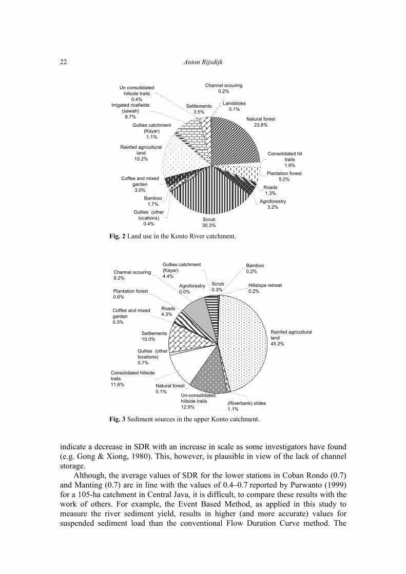
Natural forest23.8%
Plantation forest5.2%
Roads1.3%
Gullies (other locations)
0.4%
Bamboo1.7%
Coffee and mixed garden3.0%
Rainfed agricultural land
15.2%
Settlements3.5%
Consolidated hiltrails1.9%
Landslides0.1%
Gullies catchment (Kayar)1.1%
Irrigated ricefields (sawah)
8.7%
Channel scouring 0.2%
Agroforestry3.2%
Scrub30.3%
Un consolidated hillside trails
0.4%
Fig. 2 Land use in the Konto River catchment.
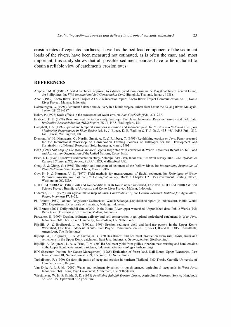
Scrub0.3%
Gullies (other locations)0.7%
Settlements10.0%
Roads4.3%
Agroforestry0.0%
Natural forest0.1%
Gullies catchment (Kayar)4.4%
Channel scouring 8.2%
Plantation forest0.6%
Coffee and mixed garden0.3%
Bamboo0.2%
Un-consolidated hillside trails12.9%
Rainfed agricultural land45.2%
(Riverbank) slides1.1%
Hillslope retreat 0.2%
Consolidated hillside trails11.6%
Fig. 3 Sediment sources in the upper Konto catchment.
indicate a decrease in SDR with an increase in scale as some investigators have found (e.g. Gong & Xiong, 1980). This, however, is plausible in view of the lack of channel storage. Although, the average values of SDR for the lower stations in Coban Rondo (0.7) and Manting (0.7) are in line with the values of 0.4–0.7 reported by Purwanto (1999) for a 105-ha catchment in Central Java, it is difficult, to compare these results with the work of others. For example, the Event Based Method, as applied in this study to measure the river sediment yield, results in higher (and more accurate) values for suspended sediment load than the conventional Flow Duration Curve method. The
Evaluating sediment sources and delivery in a tropical volcanic watershed
23
erosion rates of vegetated surfaces, as well as the bed load component of the sediment loads of the rivers, have been measured not estimated, as is often the case, and, most important, this study shows that all possible sediment sources have to be included to obtain a reliable view of catchments erosion rates. REFERENCES Amphlett, M. B. (1988) A nested catchment approach to sediment yield monitoring in the Magat catchment, central Luzon,
the Philippines. In: Fifth International Soil Conservation Conf. (Bangkok, Thailand, January 1988). Anon. (1989) Konto River Basin Project ATA 206 inception report. Konto River Project Communication no. 1, Konto
River Project, Malang, Indonesia. Balamurugan, G. (1991) Sediment balance and delivery in a humid tropical urban river basin: the Kelang River, Malaysia.
Catena 18, 271–287. Böhm, P. (1998) Scale effects in the assessment of water erosion. Adv. GeoEcology 31, 271–277. Brabben, T. E. (1979) Reservoir sedimentation study, Selorejo, East Java, Indonesia. Reservoir survey and field data.
Hydraulics Research Station (HRS) Report OD 15. HRS, Wallingford, UK. Campbell, I. A. (1992) Spatial and temporal variations in erosion and sediment yield. In: Erosion and Sediment Transport
Monitoring Programmes in River Basins (ed. by J. Bogen, D. E. Walling & T. J. Day), 455–465. IAHS Publ. 210. IAHS Press, Wallingford, UK.
Diemont, W. H., Mannaerts, C., Nurdin, Smiet, A. C. & Rijnberg, T. (1991) Re-thinking erosion on Java. Paper prepared for the International Workshop on Conservation Farming Policies of Hillslopes for the Development and Sustainability of Natural Resources. Solo, Indonesia, March, 1991.
FAO (1990) Soil Map of The World: Revised Legend (reprinted with corrections). World Resources Report no. 60. Food and Agriculture Organization of the United Nations, Rome, Italy.
Fisch, I. L. (1983) Reservoir sedimentation study, Selorejo, East Java, Indonesia, Reservoir survey June 1982. Hydraulics Research Station (HRS) Report, OD 51. HRS, Wallingford, UK.
Gong, S. & Xiong, G. (1980) The origin and transport of sediment of the Yellow River. In: International Symposium of River Sedimentation (Beijing, China, March 1980).
Guy, H. P. & Norman, V. N. (1970) Field methods for measurements of fluvial sediment. In: Techniques of Water Resources Investigations of the US Geological Survey, Book 3 Chapter C2. US Government Printing Office, Washington DC, USA.
NUFFIC-UNIBRAW (1984) Soils and soil conditions. Kali Konto upper watershed, East Java. NUFFIC-UNIBRAW Soil Science Project, Brawijaya University and Konto River Project, Malang, Indonesia.
Oldeman, L. R. (1975) An agro-climatic map of Java. Contributions of the Central Research Institute for Agriculture, Bogor, Indonesia 17, 1–22.
PU Brantas (1989) Laboran Pengukuran Sedimentasi Waduk Selorejo. Unpublished report (in Indonesian). Public Works (PU) Department, Directorate of Irrigation, Malang, Indonesia.
PU Brantas (2001) Daily rainfall data of 2001 in the Konto River upper watershed. Unpublished data, Public Works (PU) Department, Directorate of Irrigation, Malang, Indonesia.
Purwanto, E. (1999) Erosion, sediment delivery and soil conservation in an upland agricultural catchment in West Java, Indonesia. PhD Thesis, Free University, Amsterdam, The Netherlands.
Rijsdijk, A. & Bruijnzeel, L. A. (1990a,b, 1991) Erosion sediment yield and land-use pattern in the Upper Konto Watershed, East Java, Indonesia. Konto River Project Communication no. 18, vols I, II and III. DHV Consultants, Amersfoort, The Netherlands.
Rijsdijk, A., Bruijnzeel, L. A. & Sutoto, K. C. (2004a) Runoff and sediment production from rural roads, trails and settlements in the Upper Konto catchment, East Java, Indonesia. Geomorphology (forthcoming).
Rijsdijk, A. Bruijnzeel, L. A. & Prins, T. M. (2004b) Sediment yield from gullies, riparian mass wasting and bank erosion in the Upper Konto catchment, East Java, Indonesia. Geomorphology (forthcoming).
RIN (Research Institute for Nature Management) (1985) Evaluation of forest land. Kali Konto Upper Watershed, East Java. Volume III, Natural Forest. RIN, Leersum, The Netherlands.
Turkelboom, F. (1999) On-farm diagnosis of steepland erosion in northern Thailand. PhD Thesis, Catholic University of Leuven, Leuven, Belgium.
Van Dijk, A. I. J. M. (2002) Water and sediment dynamics in bench-terraced agricultural steeplands in West Java, Indonesia. PhD Thesis, Vrije Universiteit, Amsterdam, The Netherlands.
Wischmeier, W. H. & Smith, D. D. (1978) Predicting Rainfall Erosion Losses. Agricultural Research Service Handbook no. 282, US Department of Agriculture.
Copyright © 2022 FDOKUMEN