Environmental Geological Maps of San Fruttuoso Bay (Portofino Park, Italy
13
Journal of Maps, 2008, 431-443 Environmental Geological Maps of San Fruttuoso Bay (Portofino Park, Italy) FRANCESCO FACCINI 1 , MAURO PICCAZZO 2 and ANDREA ROBBIANO 3 1 University of Genoa, DISAM (Environmental-Geography Science Section), Via Balbi 2, 16126 Genoa, Italy; [email protected] 2 University of Genoa, DIPTERIS, Corso Europa 32, 16132 Genoa, Italy; 3 Geological consultant, Via Capolungo 46, 16167 Genoa, Italy; (Received 16 th March 2008; Revised 11 th September 2008; Accepted 20 th October 2008) Abstract: This paper presents environmental geological maps (applied geomorphology, morpho-sedimentology, ecological set-up, geomorphological hazard geothemes) of San Fruttuoso Bay (Portofino Park, Italy). The hamlet of San Fruttuoso is the most popular attraction of Portofino Natural Park and is internationally known. This charming village is located at the mouths of two steep and tiny valleys, which have headwaters at about 600 m a.s.l.; their catchments are developed entirely on conglomerate rocks. The value of the landscape and cultural heritage of this area are immense, but they are at risk from geo-hazards. The geomorphological hazards fall into three categories: landslides, debris flows and coastal erosion. Our detailed maps are based on geological, geomorphological and ecological data collected according to the following methods: a) analysis of aerial photographs at 1:13,000 scale; b) geological field survey; c) observation and comparison of historical images and maps; d) granulometric analysis of soil samples; and e) underwater survey. We believe that such geo-maps are important tools in land management studies, especially in areas threatened by natural hazards. In the case of San Fruttuoso Bay, this kind of study is even more important, given the need to preserve a world-class natural heritage site. ISSN 1744-5647 http://www.journalofmaps.com 431
Transcript of Environmental Geological Maps of San Fruttuoso Bay (Portofino Park, Italy

Journal of Maps, 2008, 431-443
Environmental Geological Maps of San
Fruttuoso Bay (Portofino Park, Italy)
FRANCESCO FACCINI1, MAURO PICCAZZO2 and ANDREAROBBIANO3
1University of Genoa, DISAM (Environmental-Geography Science Section), Via Balbi 2, 16126 Genoa,Italy; [email protected]
2University of Genoa, DIPTERIS, Corso Europa 32, 16132 Genoa, Italy;
3Geological consultant, Via Capolungo 46, 16167 Genoa, Italy;
(Received 16th March 2008; Revised 11th September 2008; Accepted 20th October 2008)
Abstract: This paper presents environmental geological maps (applied geomorphology,morpho-sedimentology, ecological set-up, geomorphological hazard geothemes) of SanFruttuoso Bay (Portofino Park, Italy). The hamlet of San Fruttuoso is the most popularattraction of Portofino Natural Park and is internationally known. This charming villageis located at the mouths of two steep and tiny valleys, which have headwaters at about600 m a.s.l.; their catchments are developed entirely on conglomerate rocks. The value ofthe landscape and cultural heritage of this area are immense, but they are at risk fromgeo-hazards. The geomorphological hazards fall into three categories: landslides, debrisflows and coastal erosion.
Our detailed maps are based on geological, geomorphological and ecological datacollected according to the following methods: a) analysis of aerial photographs at1:13,000 scale; b) geological field survey; c) observation and comparison of historicalimages and maps; d) granulometric analysis of soil samples; and e) underwater survey.We believe that such geo-maps are important tools in land management studies,especially in areas threatened by natural hazards. In the case of San Fruttuoso Bay, thiskind of study is even more important, given the need to preserve a world-class naturalheritage site.
ISSN 1744-5647http://www.journalofmaps.com
431

Journal of Maps, 2008, 431-443 Faccini, F., Piccazzo, M. et al
1. Introduction
San Fruttuoso village is located in the middle of the Portofino Promontoryand can be reached by sea or by foot along hiking trails. It represents themost typical and charming site of the Portofino Park Area since it combinesboth high historical-architectural quality with valued natural environments,both on-land and underwater (Figure 1).
Figure 1. Panoramic view of San Fruttuoso Bay (Photo A. Girani).
Coastal areas are crossed by well-known hiking trails starting fromCamogli, Portofino and San Rocco (Brandolini et al., 2006; Faccini et al.,2007). San Fruttuoso village belongs to the Italian Environmental Fund(Fondo Ambiente Italiano), and procedures have recently been started torecognise this hamlet as a UNESCO World Heritage site. The bay watersare a significant tourist attraction. They offer visitors the possibility ofviewing by boat a highly venerated underwater statue of Christ (Cristodegli Abissi), as well as the entire bay from a distance. In the bay, it is alsopossible to observe important ecological-environmental areas because of thegeological-structural and geomorphological setting of the Promontory(Limoncelli and Marini, 1969; Terranova, 1995).
This paper identifies the geomorphological features of the slopes behind San
432

Journal of Maps, 2008, 431-443 Faccini, F., Piccazzo, M. et al
Fruttuoso village, as well as the morpho-sedimentological features of theseabed to a depth of 60 m. The ecological aspects of the seabed aredescribed, together with their relationship to the geography of the area.Finally, the geomorphological hazard map was produced by overlaying thesedata sets.
2. Geological and Climatic Settings
The Portofino Promontory covers 18 km2 and has a coastline 13 km long; itpresents a landscape of high ecological and environmental value. ThePortofino Mount on land was officially declared a protected area in 1935(Law n◦1251/1935). It is included in a Regional Park whose boundarieswere defined in 2001 (Regional Law n◦29/2001). Subsequently, the“Portofino Protected Marine Area” was created by an EnvironmentMinistry Decree in 1999 (Law n◦979/1982).
The San Fruttuoso river catchment is developed on the Conglomerate ofPortofino (Oligocene); the conglomeratic rocks consist of thick layersranging from 0.5 to 7 m thick with an average cobble size of 5 to 50 cmalternating with thinner (up to 1 m thick) layers of muddy and sandy rocks(Figure 2). These dip to the SE at roughly 15◦ (Giammarino et al., 1969).The conglomeratic rocks are cut by many tectonic lineations that influencethe geomorphological landforms, such as the drainage network, the positionand form of the ridge and the coastline (De Stefanis et al., 1984).
The climate is typically Mediterranean, with hot summers, mild wintersand long periods of insolation. At the local scale, however, factors such asaltitude, exposure, air humidity and vegetation cover create differentmicroclimates (Girani and Olivari, 1986). The maximum rainfall isrecorded in autumn and the minimum in summer. Faccini et al. (2005)analysed a variety of meteorological data and note an annual meanprecipitation varying from 1100 to over 1500 mm, while annual meantemperature ranges from 13 to 15◦C (data for the period 1922-1995).
A number of springs have been recognized, both at the base of the slopeand at altitudes of 300 to 500 m a.s.l. in the San Fruttuoso catchment;those at altitude show fairly good flows (more than 2 l/min). It has beensuggested that the spring water in the conglomeratic rocks originates from
433
Journal of Maps, 2008, 431-443 Faccini, F., Piccazzo, M. et al
(a)
1. 2.
S. Fruttuoso
0
100
200
300
400
500
m a.s.l.
(b)
Figure 2. (a) An example of conglomerate outcrop, (b) longitudinal profile of Fontanini streamwith geological features: 1) conglomeratic rock; 2) fault or tectonic lineation.
434

Journal of Maps, 2008, 431-443 Faccini, F., Piccazzo, M. et al
condensation of vapour in the air mass moving from the south along thecliff of the Promontory (Faccini et al., 2005). The consequent airtemperature decrease causes condensation of water in rock discontinuities.The springs’ perennial flows are such that they have been exploited for along time and continue to be exploited by tourists.
3. Methods
Initial work involved bibliographic research, including both scientific notesand archive records, with specific attention to village historical photographsand maps. Photointerpretation was then undertaken using 1:13,000 images(acquired from the Ligurian Region) to map the main structural geologicalfeatures of the Portofino Promontory. Field surveys were carried out onland, with specific attention to mapping geological features and hillslopelandforms. The underwater survey focused upon mapping sedimentologicaland ecological aspects. Several seabed samples were taken using an onboardmanual dredge, and a granulometric analysis was carried out in thelaboratory.
A digital elevation model (DEM) was generated from contour linesproduced from the 1:5,000 technical regional map. For the underwater areawe used an original survey produced using a boat mounted depth finder.The DEM was used to generate a slope angle map of the bay.
The geomorphological hazard map takes into account factors related toboth land and underwater processes and landforms: seven hazard classeswere qualitatively defined on the basis of geomorphological data,morphosedimentological data and slope angle using a geographicinformation system (GIS).
4. Geomorphology, morpho-sedimentology
and ecological set up
San Fruttuoso Bay is roughly triangular in shape, and lies between PuntaTorretta and Punta Carega, which are about 1 km apart. The village of
435

Journal of Maps, 2008, 431-443 Faccini, F., Piccazzo, M. et al
San Fruttuoso is located on a 45◦ slope, crossed by 2nd order streams, theFontanini and San Fruttuoso streams, which have their headwaters at Mt.Portofino (608 m a.s.l.) and Mt. delle Rocche (505 m a.s.l.).
At about 25 m a.s.l., at the foot of the interfluve that separates the twovalleys, lies a 16th century Tower. The main settlement is located at theend of Fontanini stream, where a 10th century Benedictine Abbey stands. Asmaller settlement lies further east, at the end of the San Fruttuoso stream(Pellati, 1934).
Slopes mainly show the outcropping conglomerate, often over large areas,sometimes covered by shrubs and rock vegetation and less frequently bypines and holm-oaks. The surface processes that dominate the area aredriven by gravity, water run-off and wave action: some concave areas showdebris cover and colluvial deposits, usually transformed into anthropogenicterraces supported by containment dry stone walls where olive trees areplanted (Brandolini et al., 2005).
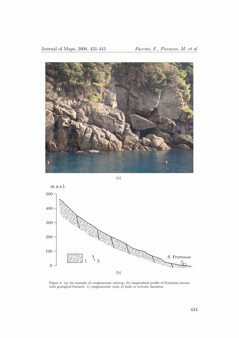
Events such as debris flows have occurred due to the very steep river bedsand the presence of coarse sediments. Historical records note that a debrisflow occurred here on the 25th September 1915 (Faccini et al., In press), inwhich the Abbey complex was damaged and a beach formed over a 24 hourperiod (Figure 3). The debris flow originated on the upper slopes and waschannelled down Vallone dei Fontanini. Debris was mobilized by heavyrainfall, with historical archives recording over 400 mm of rainfall between7:30 a.m. and 11:00 a.m. The grain size of deposits, estimated from originalphotos, is mainly made up of sand and gravel with some metric boulders.The contemporary channel shows no evidence of former levees.
Currently, the pocket beaches, which are effected by the rough sea blown bythe main south-westerly winds, are stable, although artificial accretionworks have been scheduled. Active cliffs can be observed along the coastmarking the boundaries (both east and west) of the San Fruttuoso Bay:this coastline is linked with sets of normal faults or tectonic lineations(Cevasco et al., 2004). Rock falls and topples occur along the cliffs due towave and gravity actions.
Two planation surfaces at about 30 m a.s.l. can be observed behind thevillage: one located at the base of the Tower and the other on the heliportstand. These are probably terraced landforms, according to recent work onthe marine terraces of Liguria (Biagioni et al., 2007). A cave, named Grotta
436
Journal of Maps, 2008, 431-443 Faccini, F., Piccazzo, M. et al
Figure 3. The San Fruttuoso Abbey: San Fruttuoso Bay in 1908, from the actual heliport(top right); the partially destroyed church after the event of 25 September 1915, with a thickaccumulation of debris cover (bottom right); front of Abbey in 1933, after the restoration worksby the State (left) (Source: Archivio F.A.I. San Fruttuoso).
del Cristo degli Abissi, can be observed on the eastern side of the bay. Itsentry is located at sea level and the cave formation is due to tectonic andmarine processes (Figure 4). Another cave can be recognized in theunderwater cliff, about 20 m deep. Tides have limited extent (20-30 cm), sothey do not influence the coastal evolution as much as the hydrodynamicsdue to wave action.
This area shows reduced man-made landforms, at least compared withother sectors of the Ligurian coast: beside a few buildings, including theDoria family complex, only the artificial berthing pier can be seen.
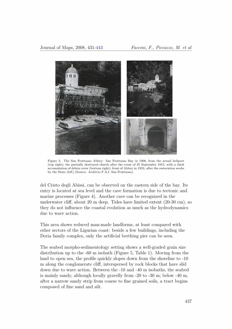
The seabed morpho-sedimentology setting shows a well-graded grain sizedistribution up to the -60 m isobath (Figure 5, Table 1). Moving from theland to open sea, the profile quickly slopes down from the shoreline to -10m along the conglomerate cliff, interspersed by rock blocks that have sliddown due to wave action. Between the -10 and -40 m isobaths, the seabedis mainly sandy, although locally gravelly from -20 to -30 m; below -40 m,after a narrow sandy strip from coarse to fine grained soils, a tract beginscomposed of fine sand and silt.
437

Journal of Maps, 2008, 431-443 Faccini, F., Piccazzo, M. et al
Plan
Longitudinal profile
0 5 10 15 m
Figure 4. Grotta Cristo degli Abissi: plan and longitudinal profile of the cave (Surveyors: F.Mariani and G. Repetto; redrawn from Gruppo Speleologico C.A.I. Bolzaneto, 2006).
The ecological set-up is strictly related to the morpho-sedimentologicalasset: the Posidonia Oceanica seagrass meadows or scattered spot zonesbetween -10 m and -30 m contribute to increased sediment retention and,therefore, reduced seabed erosion in the bay.
The surface water temperature varies between 13-15◦C from January untilApril and between 20-24◦C from June until September; deep waters have aconstant temperature never below 12-13◦C and underwater visibility inopen waters can reach 30-40 m (Faccini et al., In press).
438
Journal of Maps, 2008, 431-443 Faccini, F., Piccazzo, M. et al
0 100 m 200 m 300 m
0-20
-40
-60
-20
-10
-30
-50
-70
-40
-60
125
100
75
50
25
25
50 7
5
12
5
100
SAN FRUTTUOSO
Figure 5. Location map of soil samples.
5. Geomorphological hazards
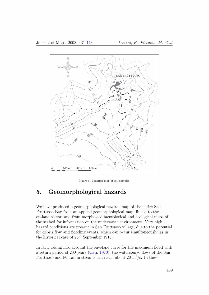
We have produced a geomorphological hazards map of the entire SanFruttuoso Bay from an applied geomorphological map, linked to theon-land sector, and from morpho-sedimentological and ecological maps ofthe seabed for information on the underwater environment. Very highhazard conditions are present in San Fruttuoso village, due to the potentialfor debris flow and flooding events, which can occur simultaneously, as inthe historical case of 25th September 1915.
In fact, taking into account the envelope curve for the maximum flood witha return period of 200 years (Cati, 1970), the watercourse flows of the SanFruttuoso and Fontanini streams can reach about 20 m3/s. In these
439

Journal of Maps, 2008, 431-443 Faccini, F., Piccazzo, M. et al
Sample Depth (m) Gravel (%) Sand (%) Silt (%)
1 +1 100 - -2 +1 92 8 -3 -2 87 13 -4 -4,5 87 13 -5 -5 72 28 -6 -7 100 - -7 -24 98 2 -8 -38 56 42 19 -51 10 75 15
Table 1. Grain-size distribution of samples (see Figure 5).
conditions, fast events like debris flows can be triggered due to the steeplongitudinal profiles and availability of riverbed debris.
Both the eastern and the western sectors of San Fruttuoso Bay are affectedby very high geomorphological hazards due to wave action. These have todo with both the cliff and the rocky seabed below. It is evident that thereare risk conditions resulting in high tourist vulnerability. On the slope overthe cliff edge, we identify hazard situations ranging from high to fairly high:several edges of degradational and/or landslide scarps together with thestrongly fractured rock conditions can trigger rock falls and topples. Theremaining underwater area is characterized by a geomorphological hazardranging from moderate to very low.
6. Conclusions
The surveys carried out at San Fruttuoso Bay show severalgeomorphological hazards posing clear risks not only to buildings andinfrastructure but also to tourists visiting this area. San Fruttuoso Baydisplays all the factors that can trigger debris flows: slope and water coursesteepness, debris on the riverbed, and heavy rainfall. These events can becompared to those typical of the alpine environment in terms of theirgeometries, magnitudes, and sedimentological features (Figure 6).Landslides and sea storms are the other natural hazards that can occur inthe bay.
In conclusion, the San Fruttuoso catchment can be considered a naturallaboratory where geological issues (present and potential) can be studied by
440

Journal of Maps, 2008, 431-443 Faccini, F., Piccazzo, M. et al
Figure 6. DEM of San Fruttuoso Bay.
following a multi-scalar and multi-hazard approach. This approach isessential to identifying critical sectors and planning risk reduction workwhile enhancing the value of the village: this cannot be done withoutensuring safe conditions for its users.
Software
The software CorelDRAW 11 was used to draw thegeological-environmental maps. The DEM was produced using contour linesdrawn on the technical regional map, processed with Surfer 8 (GoldenSoftware Inc.). Intergraph’s GeoMedia was used for all GIS processing.
441

Journal of Maps, 2008, 431-443 Faccini, F., Piccazzo, M. et al
References
BIAGIONI, F., FEDERICI, P. R. and PAPPALARDO, M. (2007)Contributo alla conoscenza dei terrazzi marini della Liguria fra GenovaNervi e Camogli, Bollettino della Societa Geologica Italiana (ItalianJournal of Geoscience), 126, 3, 581–586.
BRANDOLINI, P., FACCINI, F. and PICCAZZO, M. (2006)Geomorphological hazard and tourist vulnerability along Portofino Parktrails (Italy), Natural Hazard and Earth System Sciences, 6, 563–571.
BRANDOLINI, P., FACCINI, F., PICCAZZO, M., ROBBIANO,A., OLIVARI, F. and CANEPA, G. (2005) Un esempio di cartografiageomorfologico-ambientale nel Parco di Portofino (Liguria), In RiassuntiConvegno Nazionale AIGeo “Montagne e Pianure”, Dipartimento diGeografia, Universita di Padova, pp. 51–53.
CATI, L. (1970) L’evento alluvionale del 7-8 ottobre 1970 sui bacini deiTorrenti Leiro, Polcevera e Bisagno, In Annali Ideologici del MinisteroLavori Pubblici, pp. 53–124.
CEVASCO, A., FACCINI, F., NOSENGO, S., OLIVARI, F. andROBBIANO, A. (2004) Valutazioni sull’uso delle classificazionigeomeccaniche nell’analisi della stabilita dei versanti rocciosi: il caso delPromontorio di Portofino (Provincia di Genova), Georisorse e Ambiente,111, 31–38.
DE STEFANIS, A., MARINI, M. and TERRANOVA, R. (1984)Geomorfologia di aree campione della Liguria. C.N.R. “Progettofinalizzato alla conservazione del suolo”, Edizione S.EL.CA., Firenze.
FACCINI, F., BONINO, E., BRANDOLINI, P., PICCAZZO, M.,OLIVARI, F. and ROBBIANO, A. (2005) Phenomenes decondensation et sources perennes dans le Promontoire de Portofino(Italie), In Actes du colloque “Climat Urbain, Ville et Architecture”,Genes 7-11 September 2005, pp. 205–208.
FACCINI, F., BRANDOLINI, P., PICCAZZO, M. and ROBBIANO,A. (2007) Valutazione del rischio geomorfologico lungo un percorso digrande valenza geoturistica: la “Via dei Tubi nel Parco di Portofino, InPiccazzo, M., Brandolini, P. and Pelfini, M., (eds.) Clima erischio geomorfologico in aree turistiche, Patron Ed., Bologna, pp. 47–64.
442

Journal of Maps, 2008, 431-443 Faccini, F., Piccazzo, M. et al
FACCINI, F., PICCAZZO, M. and ROBBIANO, A. (In press)Valutazione della pericolosita geomorfologica da colate detritiche nelbacino idrografico di San Fruttuoso di Camogli (Parco di Portofino,Italia), Bollettino della Societa Geologica Italiana (Italian Journal ofGeoscience).
GIAMMARINO, S., NOSENGO and VANNUCCI, G. (1969)Risultanze geologiche-paleontologiche sul Conglomerato di Portofino(Liguria Orientale), Atti Istituto di Geologia Universita di Genova, 7,305–363.
GIRANI, A. and OLIVARI, S. (1986) Guida al Monte di Portofino,Sagep Ed., Recco, 160 pp.
GRUPPO SPELEOLOGICO C.A.I. BOLZANETO (2006)Rilevamento e studio delle cavita naturali del Monte di Portofino -Relazione conclusiva sull’attivita svolta, Rapporto tecnico preparato perl’Ente Parco di Portofino.
LIMONCELLI, B. and MARINI, M. (1969) Indagine sulle risorsepaesaggistiche e sulle aree verdi della fascia costiera ligure, Ricercageomorfologica, Istituto di Architettura e Tecnica Urbanistica dellUniversita di Genova, Consiglio Nazionale delle Ricerche.
PELLATI, A. (1934) La Penisola di Portofino, note geomorfologiche,Rivista di Scienze Naturali “Natura”, XXV, ed. F.lli Fusi Pavia, 13–34.
TERRANOVA, R. (1995) Guida all’escursione geografica in mare daGenova a Portofino, a Chiavari e a San Salvatore dei Fieschi, In Atti delConvegno in onore di D. Rocco, Genova, Loffredo Ed., Napoli, pp.107–158.
443