Environmental Baseline Survey - Asian Development Bank
185
Initial Environmental Examination Project number: 41076-048 July 2021 Philippines: Improving Growth Corridors in Mindanao Road Sector Project TAWI-TAWI BRIDGES – Malassa-Pula Lupa (Tawi-Tawi Bridge No. 3) Prepared by the Department of Public Works and Highways (DPWH) for the Asian Development Bank.
-
Upload
khangminh22 -
Category
Documents
-
view
6 -
download
0
Transcript of Environmental Baseline Survey - Asian Development Bank

Initial Environmental Examination
Project number: 41076-048 July 2021
Philippines: Improving Growth Corridors in Mindanao Road Sector Project
TAWI-TAWI BRIDGES – Malassa-Pula Lupa (Tawi-Tawi Bridge No. 3)
Prepared by the Department of Public Works and Highways (DPWH) for the Asian Development
Bank.

i
ABBREVIATIONS
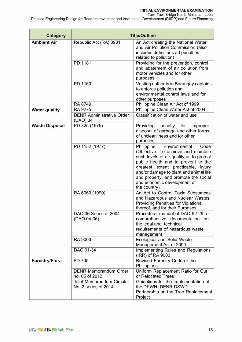
AASHTO - American Association of State Highways and Officials
ADB - Asian Development Bank
A&D - Alienable and Disposable
BIMP-EAGA - Brunei Darussalam-Indonesia-Malaysia East Asean Growth Area
CENRO - Community Environment and Natural Resources Office
CNC - Certificate of Non-coverage
CO2 - Carbon Dioxide
CR - Critically Endangered
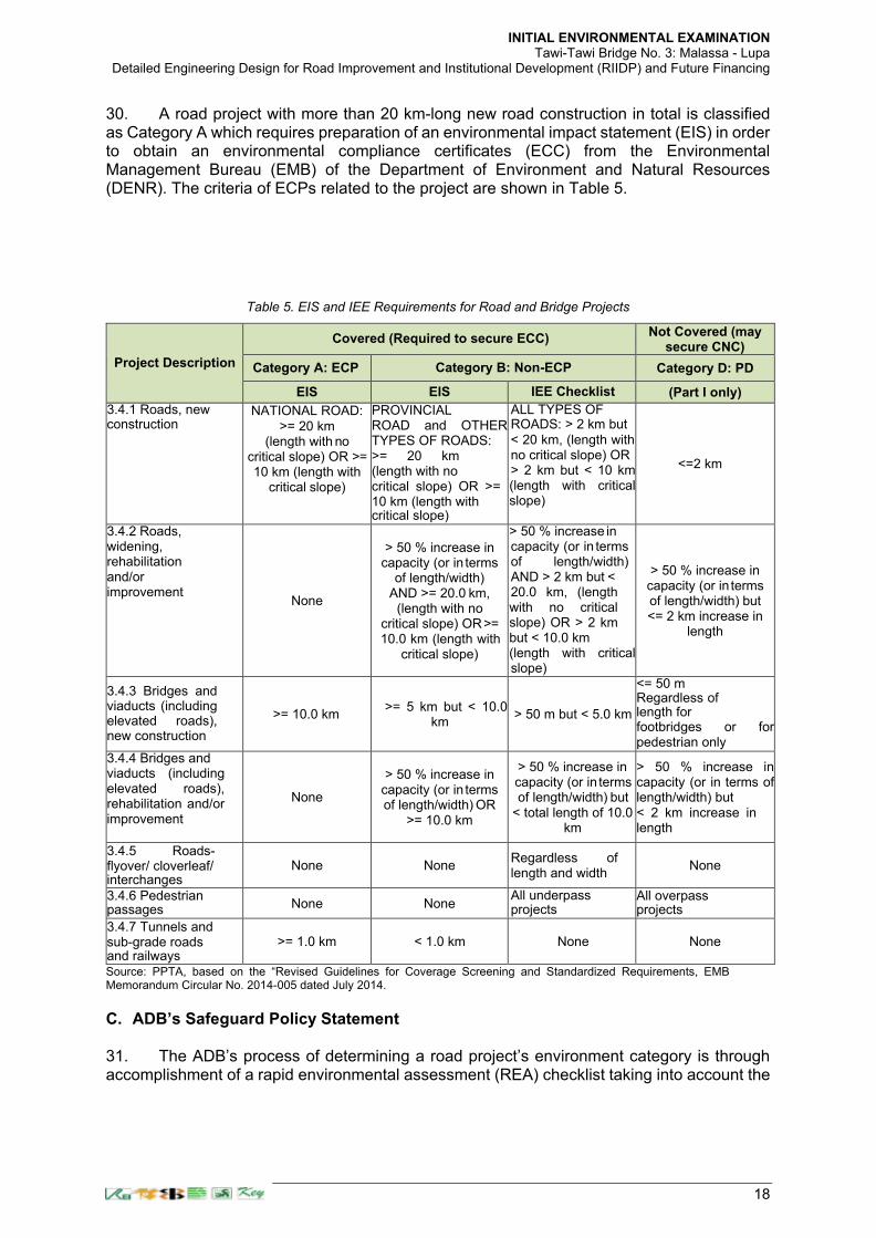
CSC - Construction Supervision Consultant
DAO - Department Administrative Order
DBH - Diameter at Breast Height
DENR - Department of Environment and Natural Resources
DED - Detailed Engineering Design Consultant
DEO - District Engineering Office
DOH - Department of Health
DPWH - Department of Public Works and Highways
ECA - Environmentally Critical Area
ECC - Environmental Compliance Certificate
ECP - Environmentally Critical Project
EHS - Environmental, Health and Safety
EIA - Environmental Impact Assessment
EIS - Environmental Impact Statement
EMB - Environmental Management Bureau
EMP - Environmental Management Plan
EO - Executive Order
EPRMP - Environmental Performance Report and Management Plan
ESSD - Environment and Social Safeguards Department of DPWH
FGD - Focus Group Discussion
GHG - Greenhouse Gases
GOP - Government of the Philippines
GRC - Grievance Redress Committee
GRM - Grievance Redress Mechanism
IEC - Information, Education and Communication
IFC - International Finance Corporation
IEE - Initial Environmental Examination
IEER - Initial Environmental Examination Report
IUCN - International Union for Conservation of Nature
LGU - Local Government Unit
Ncm - Normal Cubic Meter
NO2 - Nitrogen Dioxide
PAGASA - Philippine Atmospheric Geophysical and Astronomical Services
Administration
PCCP
PCDG
- Portland Cement Concrete Pavement
- Prestressed Concrete Deck Girder
PD - Presidential Decree
PEISS - Philippine Environmental Impact Statement System
PM - Particulate Matter
PPTA - Project Preparatory Technical Assistance
PR - Project Road
RA - Republic Act
RCBC - Reinforced Concrete Box Culvert
RCDG - Reinforced Concrete Deck Girder
RCPC - Reinforced Concrete Pipe Culvert
REA - Rapid Environmental Assessment
RF - Relative Frequency
RMC II - Roads Management Cluster II

ii
ROW - Right of Way
SPS - ADB Safeguard Policy Statement of 2009
TA - Technical Assistance
TSP - Total Suspended Particulate
TSS - Total Suspended Solids
UPMO - Unified Project Management Office
VU - Vulnerable
WHO - World Health Organization
This initial environmental examination is a document of the borrower. The views expressed herein do not necessarily represent those of ADB's Board of Directors, Management, or staff, and may be preliminary in nature. Your attention is directed to the “terms of use” section of ADB's website.
In preparing any country program or strategy, financing any project, or by making any designation of or reference to a particular territory or geographic area in this document, the Asian Development Bank does not intend to make any judgments as to the legal or other status of any territory or area.

iii
Table of Contents
ABBREVIATIONS ............................................................................................................................................ I
TABLE OF CONTENTS ................................................................................................................................... III
LIST OF TABLES ............................................................................................................................................ VI
LIST OF FIGURES ........................................................................................................................................ VIII
EXECUTIVE SUMMARY ................................................................................................................................ IX
I. POLICY, LEGAL AND ADMINISTRATIVE FRAMEWORK .......................................................................... 14
A. ENVIRONMENTAL LAWS, REGULATIONS AND GUIDELINES IN THE PHILIPPINES ........................................................... 14
B. EIA SYSTEM IN THE PHILIPPINES ...................................................................................................................... 16
C. ADB’S SAFEGUARD POLICY STATEMENT ........................................................................................................... 18
II. DESCRIPTION OF THE PROJECT ........................................................................................................... 20
A. OVERVIEW .................................................................................................................................................. 20
B. LOCATION ................................................................................................................................................... 21
C. PROPOSED BRIDGE CONSTRUCTION WORKS ...................................................................................................... 22
D. BASIC DESIGN OF THE PROJECT BRIDGE ............................................................................................................. 22
a. Selection of Design Elements ............................................................................................................... 22
b. Climate Change Adaptation ................................................................................................................ 23
E. ROAD SAFETY .............................................................................................................................................. 24
F. CONSTRUCTION METHODOLOGY ............................................................................................................ 25
III. DESCRIPTION OF THE ENVIRONMENT ................................................................................................. 27
A. LAND ENVIRONMENT .................................................................................................................................... 27
a. Topography and Slope ......................................................................................................................... 27
b. Land Classification ............................................................................................................................... 27
c. Existing General Land Use ................................................................................................................... 28
d. Geology ............................................................................................................................................... 28
e. Soils ..................................................................................................................................................... 29
B. CLIMATE AND METEOROLOGY ......................................................................................................................... 30
C. FRESH WATER RESOURCES ............................................................................................................................. 31
D. AIR QUALITY AND NOISE ................................................................................................................................ 31
E. MARINE ECOLOGY ........................................................................................................................................ 32
a. Secondary Information ........................................................................................................................ 32
b. Baseline Survey for Marine Ecological Assessment ............................................................................. 36
c. Coral Reefs .......................................................................................................................................... 37
d. Reef Fish Community ........................................................................................................................... 39
e. Seagrass/Seaweeds ............................................................................................................................. 41
a. Seagrass species .................................................................................................................................. 42
b. Seaweeds farming ............................................................................................................................... 43
c. Mangrove Community Structure ......................................................................................................... 43
d. Plankton Community ........................................................................................................................... 44
e. Benthos Community ............................................................................................................................ 45
f. Water Parameters ............................................................................................................................... 46
g. Water Current and Circulation ............................................................................................................ 48
h. Conclusion and Recommendation ....................................................................................................... 50
F. SOCIOECONOMIC RESOURCES ......................................................................................................................... 51
a. Population ........................................................................................................................................... 51
b. Age and Sex Structure ......................................................................................................................... 53
c. Age Dependency Ratio ........................................................................................................................ 54
d. Migration ............................................................................................................................................ 55
e. Mother Tongue .................................................................................................................................... 55
f. Religious Affiliation ............................................................................................................................. 56

iv
g. Education ............................................................................................................................................ 56
h. Educational Institutions and School Facilities by Level ........................................................................ 57
i. Teachers and Student Population ....................................................................................................... 59
j. School Population and Children out of School ..................................................................................... 60
k. Housing ............................................................................................................................................... 62
l. Health .................................................................................................................................................. 64
m. Social Welfare ..................................................................................................................................... 65
n. Sports and Recreation ..................................................................................................................... 66
o. Public Order and Safety ....................................................................................................................... 66
p. Agriculture ........................................................................................................................................... 67
q. Fisheries and Aquatic Resources ......................................................................................................... 68
r. Trade and Commerce ...................................................................................................................... 69
s. Tourism ................................................................................................................................................ 70
G. LGU ENVIRONMENT MANAGEMENT ................................................................................................................ 70
a. Solid Waste Disposal ........................................................................................................................... 70
b. Sanitary Toilet Facilities ...................................................................................................................... 70
c. Areas for Conservation / Protection .................................................................................................... 71
d. Water and Watershed: Present and Future Water Demand ............................................................... 72
H. THE INFRASTRUCTURE SECTOR ........................................................................................................................ 73
IV. ANTICIPATED IMPACTS AND MITIGATION MEASURES .................................................................... 76
A. PRE-CONSTRUCTION...................................................................................................................................... 77
a. Encroachment on Environmentally Sensitive Areas ............................................................................ 77
b. Impacts and Risks to Biodiversity Conservation .................................................................................. 77
B. CONSTRUCTION ............................................................................................................................................ 78
a. Inadequate Disclosure of Project Information and GRM ..................................................................... 78
b. Local Air Pollution ................................................................................................................................ 78
c. Noise .................................................................................................................................................... 79
d. Impacts due to Spoils Disposal ............................................................................................................ 81
e. Impacts from Operation of Borrow Areas and Quarries ...................................................................... 81
f. Erosion and Unstable Slopes ............................................................................................................... 81
g. Impacts to Marine Water Quality and Ecology ................................................................................... 82
h. Loss of Vegetation ............................................................................................................................... 83
i. Occupational Health and Safety Hazards ............................................................................................ 84
j. Public Health and Safety Hazards ....................................................................................................... 84
k. Traffic Obstruction .............................................................................................................................. 85
l. Accidental Discovery of Artefacts ........................................................................................................ 85
m. Damage to Properties ......................................................................................................................... 86
n. Impacts to Livelihood .......................................................................................................................... 86
o. Unanticipated Environmental Impacts ................................................................................................ 86
C. OPERATION PHASE ....................................................................................................................................... 86
a. Air Quality ........................................................................................................................................... 86
b. Noise .................................................................................................................................................... 87
c. Induced Impacts .................................................................................................................................. 87
V. INFORMATION DISCLOSURE, CONSULTATION AND PARTICIPATION .................................................... 88
VI. GRIEVANCE REDRESS MECHANISM ................................................................................................ 90
VII. ENVIRONMENTAL MANAGEMENT PLAN ......................................................................................... 92
VIII. CONCLUSION ................................................................................................................................. 71
IX. APPENDICES ...................................................................................................................................... 73
APPENDIX 1. MARINE ECOLOGICAL ASSESSMENT ....................................................................................... 74
APPENDIX 2. GRIEVANCE INTAKE FORM .................................................................................................... 122
APPENDIX 3. PROJECT SEMI-ANNUAL ENVIRONMENTAL MONITORING REPORT OUTLINE .......................... 124

v
APPENDIX 4. ATTENDANCE SHEET ............................................................................................................. 126
APPENDIX 5. APPROVED ENVIRONMENTAL CATEGORIZATION FORM AND RAPID ENVIRONMENTAL
ASSESSMENT (REA) CHECKLIST. ................................................................................................................. 127

vi
List of Tables
Table 1. Major Environmental Laws in the Philippines ......................................................... 14
Table 2. Environmental Laws and Decrees in the Philippines .............................................. 14
Table 3. Philippine Environmental Agreements to the International Treaty .......................... 16
Table 4. Laws and Regulations regarding EIA in the Philippines ......................................... 16
Table 5. EIS and IEE Requirements for Road and Bridge Projects ...................................... 18
Table 6. Category Classifications on the Environment based on SPS 2009 ........................ 19
Table 7. Subproject Scope and Coverage ............................................................................ 22
Table 8. Summary Road Safety Measures ........................................................................... 24
Table 9. Land Classification of Bongao, Tawi-Tawi .............................................................. 28
Table 10. Existing Land Use ................................................................................................. 28
Table 11. Land Area distribution by barangays in Bongao, Tawi-Tawi ................................. 30
Table 12. Monthly temperature and rainfall based on historical weather data ...................... 30
Table 13. Mangrove Cover and Condition by Barangay ....................................................... 32
Table 14. Coral Cover and Condition by Barangay, Bongao, Tawi-Tawi .............................. 34
Table 15. Seagrass Cover, Condition and Species Composition by Barangay .................... 35
Table 16. Percentage cover of the main benthic groups in the proposed Malassa-Lupa Pula .............................................................................................................................................. 38
Table 17. Composition and biomass ((mt/km2) of fish species found in the proposed Malassa-Lupa Pula bridge. .................................................................................................................. 40
Table 18. Categories of sites according to species richness as adapted from Hilomen et al.
(2000). ................................................................................................................................... 40
Table 19. Categories of sites according to fish abundance as adapted from Hilomen et al. (2000). ................................................................................................................................... 41
Table 20. Categories of sites according to fish biomass as adapted from Nañola et al. (2006) .............................................................................................................................................. 41
Table 21. GPS coordinates of seagrass/seaweeds sampling stations in the Proposed Malassa-Lupa Pula bridge .................................................................................................... 42
Table 22. Percentage cover (%/m2) of seagrass in the proposed Malassa-Lupa Pula bridge .............................................................................................................................................. 42
Table 23. GPS coordinates of mangrove sampling stations in the proposed Malassa-Lupa Pula bridge ............................................................................................................................ 43
Table 24. Mangrove species in the proposed Malassa-Lupa Pula bridge ............................ 44
Table 25. Seedlings and sapling in the proposed Malassa-Lupa Pula bridge. ..................... 44
Table 26. Cell density of plankton in the proposed Malassa-Lupa Pula bridge .................... 45
Table 27. Average water parameters in the Malassa side .................................................... 46
Table 28. Average water parameters in Lupa Pula side. ...................................................... 47
Table 30. Sampling points of water current in the proposed Malassa-Lupa Pula bridge. ..... 49
Table 31. The population of Bongao, Tawi-tawi by barangay and by census year, 1980- 2015 .............................................................................................................................................. 51
Table 32. Population Density per barangay and location by major island group .................. 52
Table 33. The distribution of population by age group and by sex, 2015 ............................. 53
Table 34. Household Population by Mother Tongue, Year 2010 .......................................... 55
Table 35. Elementary Schools in Bongao, Tawi-Tawi .......................................................... 58
Table 36. Names & Nos. of Pre-Schools, Both Government & Private, Bongao, Tawi-Tawi 59
Table 37. Number of Teachers per Public Secondary School in Bongao, 2014 ................... 60
Table 38. Total Enrollment of Bongao Public Elementary Schools per District, 2013- 2014 60
Table 39. Total Enrollment of Public Secondary Schools, Department of Education ARMM Bongao, Tawi-Tawi ............................................................................................................... 61
Table 40. Proportion of individuals of schooling age and their attendance to school, 2015 . 61
Table 41. Out of School Children and Youth by Barangay and by Rank .............................. 61
Table 42. Housing Projects in Bongao as of March 2017. .................................................... 62
Table 43. The Leading Causes of Mortality in Bongao, Tawi-Tawi for 2015......................... 64
Table 44. Weight of children in Bongao below 5 years old, CY 2015. .................................. 64

vii
Table 45. The programs and services provided by the MSWDO, 2016 ................................ 65
Table 46. Crimes and other offenses in Bongao, 2016 ......................................................... 67
Table 47. Agricultural Croplands and Crop Production in Bongao, Tawi-tawi, 2015 ............ 68
Table 46. Approximate Distances of Ecologically Sensitive or Protected Areas from the Bridge Sites ...................................................................................................................................... 72
Table 48. List of Roads by Classification and Length, Bongao, Tawi- Tawi ......................... 73
Table 49. Summary of Environmental Impacts Screening for Tawi-Tawi Bridge No. 3 ........ 76
Table 50. Construction Noise / Distance Relationship .......................................................... 79
Table 51. Construction Machinery Noise .............................................................................. 80
Table 52. Summary Matrix of Public Consultation ................................................................ 88
Table 53. Summary Matrix of Public Consultation ................................................................ 89
Table 54. Impact Mitigation Plan ........................................................................................... 93
Table 55. Environmental Monitoring Activities during Construction .................................... 115
Table 56. Responsibilities for EMP Implementation ........................................................... 117
Table 53. Cost for EMP Implementation ............................................................................. 119

viii
List of Figures
Figure 1. Flow of EIA Process .............................................................................................. 17
Figure 2. Location of the Proposed Malassa – Pulang Lupa Bridge in the Province of Tawi-Tawi ...................................................................................................................................... 22
Figure 3. Topographic Map of Bongao, Tawi-Tawi ............................................................... 27
Figure 4. Geologic Map of Bongao, Tawi-tawi ...................................................................... 29
Figure 5. Precipitation / Rainfall by month in Bongao ........................................................... 31
Figure 6. Map showing the different sampling stations in the proposed Malassa-Lupa Pula bridge .................................................................................................................................... 37
Figure 7. Percentage cover of the main benthic groups in the proposed Malassa-Lupa Pula bridge. ................................................................................................................................... 39
Figure 8. Population by Age Group, CY 2014 ....................................................................... 54
Figure 9. Ethno-linguistic groupings in Bongao, 2015 .......................................................... 56
Figure 10. Religious affiliation of the population in Bongao, 2010 ........................................ 56
Figure 11. The literacy rate in Bongao, Tawi-Tawi, 2010 ..................................................... 57
Figure 12. The location of school facilities in Bongao, Tawi-Tawi, 2015 .............................. 58
Figure 13. The location of informal settler areas in Bongao, Tawi-tawi, 2017 ...................... 64
Figure 14. Geographical Locations and Distribution of Ecologically Sensitive or protected areas ..................................................................................................................................... 72
Figure 15. Projected Water Requirement per Day, 2017-2026 ............................................. 74

ix
EXECUTIVE SUMMARY 1. The Government of the Philippines has approached the Asian Development Bank (ADB) for financial and technical support for the Improving Growth Corridors in Mindanao Road Sector Project (IGCMRSP). 2. Transportation is a key sector in the Philippine economy with roads being the dominant subsector. The national road network comprises 29,630 kilometers (km), or 14% of the total road network and includes the main trunk roads, the national primary arterial roads, and national secondary roads. An efficient road subsector is crucial for the Philippines’ economic growth and poverty reduction. Despite its importance to the national economy, the road subsector has not received adequate funding. Expansion or improvement of the network has been limited in recent years, and many roads deteriorate prematurely due to inadequate maintenance. Government funding for the road network has been increasing in recent years; however, about 23% of the national road network is in poor condition and in need of rehabilitation. This contributes to the rising number of road accidents in the Philippines. The increasing impact of climate change, particularly flooding, is having a negative effect on the road network. The road network in Mindanao is less developed than the national network. While 82% and 89% of the national roads in Luzon and the Visayas are paved, only 70% of the national roads in Mindanao are paved. 3. The project supports the Government of the Philippines’ priorities for improvement of the country’s road network and development of Mindanao.1 It also supports the key objective of ADB’s strategy for the Philippines of helping the country achieve high, inclusive, and sustainable growth.2 The project is consistent with ADB’s Strategy 2020 through its focus on improving the delivery of infrastructure services as well as investing in physical assets.3 The project supports regional cooperation and integration by contributing to the implementation of the ASEAN Highway and BIMP-EAGA (Brunei Darussalam-Indonesia-Malaysia-Philippines East Asean Growth Area) Priority Infrastructure Projects. It supports ADB’s Sustainable
Transport Initiative4 by addressing climate change and road safety, and it is included in ADB’s Philippines Transport Sector Assessment, Strategy, and Road Map.4 4. Use of the sector loan will enable the government to achieve inclusive economic development by concentrating road improvement subprojects in Mindanao and will provide flexibility in determining the most appropriate location for subprojects given changing political and security conditions in Mindanao. The project meets all the requirements for a sector loan:5
(i) the government has a sector development plan and the institutional capacity to implement it, (ii) its policies applicable to the sector are appropriate, and (iii) DPWH has demonstrated capacity. 5. The project is considered Category B for environment based on ADB's Safeguard Policy Statement (SPS 2009). The project will improve an estimated 300 km of national primary, secondary, and tertiary roads in Mindanao. The improvements will include paving earth roads, replacing damaged road sections, widening existing roads, adding surface overlays, and replacing and strengthening bridges. The project roads will be designed with features to strengthen resilience to climate change. Among the structural and non-structural features included are elevated pavement levels, enhanced slope protection, and improved maintenance of drainage structures. Road safety on these roads will be improved through road safety community awareness campaigns.
1 National Economic and Development Authority. 2011. Philippine Development Plan, 2011–2016. Manila. 2 ADB. 2011. Country Partnership Strategy: Philippines, 2011–2016. Manila. 3 ADB. 2008. Strategy 2020: The Long-Term Strategic Framework of the Asian Development Bank, 2008–2020. Manila. 4 ADB. 2010. Sustainable Transport Initiative: Operational Plan. Manila. 5 ADB. 2003. Sector Lending. Operations Manual. OM D3/BP. Manila.

x
6. This initial environmental examination (IEE) was prepared in accordance with SPS 2009 for the proposed Malassa – Lupa Pula Bridge (Tawi-Tawi Bridge No. 3) bridge in the Province of Tawi-Tawi. 7. This is one of three (3) proposed bridges6 in Tawi-tawi that are aimed at decongesting Bongao Island (the capital of Tawi-Tawi) by bringing the development in the mainland through improved connectivity between the islands/municipalities of the province. The three (3) proposed bridges aim to provide a direct route between the existing major growth center (Bongao) and future growth center in Panglina Sugala and Papahag Island. Papahag Island is proposed for development for large scale seaweeds processing plant which is the top raw material produced in Tawi-Tawi, and housing site project for the local population according to the local government of Tawi-Tawi. 8. In addition, the first ecozone for Tawi-Tawi was approved in May 2017 according to the Philippine Economic Zone Authority (PEZA) will be located in Kulape in the town of Panglima Sugala. The first approved private economic zone in the island of Tawi-Tawi will consist of 218.9 hectares. There is also a proposed port development, the Malassa International Port, to address the economic potential of the island province because it is in the path of international shipping containers. Similarly, the construction of the bridges will open up potentials in the tourism and fishing industry. The strengthening of local and regional market connectivity therefore in this corridor can encourage more investors to come in and do business in the country. The development of these industries could spur the economic activities that would boost the mediocre economy of the province and further enhance the quality of life of its people. 9. There are four major existing bridges in the Municipality of Bongao. These are the concrete bridge connecting Bongao Island and Sanga-Sanga Island; the steel bridge at Suwangkagang, Pasiagan, and the two bridges in Barangay Lapid-Lapid. The proposed Bridge No. 3 will connect Barangay Malassa in Sanga-Sanga Island to Barangay Lapid-Lapid over the Manalik Channel in the main island of Tawi-Tawi through existing unpaved municipal roads (for the most part) in the two barangays being connected. It is a major bridge serving as an alternate shortest access directly connecting the economic activities of Sanga-Sanga Island to the main island of Tawi-Tawi. The two bridges in Barangay Lapid-Lapid will not meet the bridge design requirements and connectivity objectives for the anticipated development of an international port in Malassa. 10. The IEE was undertaken to:
(i) Provide project information and relevant environmental baseline data for the project;
(ii) Assess potential environmental impacts of the project; (iii) Identify mitigation measures to minimize negative impacts; (iv) Provide information on the consultations undertaken and the framework
for a project level grievance redress mechanism (GRM); and (v) Develop a robust environmental management plan (EMP) which
specifies mitigation and monitoring measures, institutional responsibilities and reporting requirements.
11. An environmental assessment and review framework (EARF) was prepared to serve as a guide to ensure compliance of subprojects with the environmental assessment requirements under ADB’s Safeguards Policy Statement, 2009 (SPS) and the Philippine Environmental Impact Statement System (PEISS).
6 The other two (2) bridges are the following: Tongsinah-Paniogan Bridge (Tawi-Tawi Bridge No. 2); and Nalil-Sikkiat Bridge (Tawi-Tawi-Bridge No. 1)
xi
Project Description. Tawi-Tawi Bridge No. 3 – Malassa - Lupa Pula Bridge has a bridge span of 480.80 m over the Manalik Channel connecting to the mainland Tawi-Tawi Island. It has a gross length of 680.60m including its proposed approach roads at both ends starting from Malassa (Sanga-Sanga Island) at Km 0+174.65 through the main bridge ending at Lupa Pula (Tawi-Tawi) at Km 0+855.25. The road that connects the main bridge is classified as National Secondary Road with a required carriageway with of 6.70 meters for new construction. According to the DPWH, this unpaved existing road connecting to the proposed bridge will be improved at the same time as the bridge. This new bridge construction will be a Pre-stressed Concrete Deck Girder (PCDG) structure, AASHTO Type IV-B and Type VI Modified) with fourteen spans. The bridge approach roads are 200-m in length and are included to be constructed in this contract package. 12. Existing Environmental Conditions. Areas along the bridge approaches do not traverse or is near ecologically sensitive and/or protected areas. Five (5) areas (refer to Table 46 and Figure 15) that had been identified7 by the local government unit are located from three (3) kilometers (nearest is the Lapid-Lapid Mangrove Eco-Park) to more than ten (10) kilometers away (Pasiagan Marine Protected Area). The bridge approach roads are 200m in length and are generally characterized as having terrain located in the level to gently sloping areas with 0-8% slope gradient. Since bridge alignment is located in an underdeveloped rural setting, there are no major local sources of anthropogenic emissions. The lack of industrial development suggests that air pollution and noise sources which would normally elevate background levels are not present in the area. Due to the current unpaved condition of the existing roads, where the bridge approach roads will be connected, dust will be continually generated and resuspended during dry construction days leading to occasional visible level of suspended particulates. During the rainy season, water quality will be affected by siltation and mud carried into the Manalik channel.
13. A baseline survey was undertaken for marine ecological assessment of coral reefs, coral reef fishes, seagrass/seaweeds, mangroves, phytoplankton, benthos, water quality, water current and circulation. Various methodologies were used for each marine survey which are discussed in the Chapter V of the Marine Ecological Survey (Appendix 1. Marine Ecological Assessment). Two (2) sampling stations for coral reefs reef fishes, six (6) sampling stations for seagrass/seaweeds and twelve sampling stations (12) for mangroves community structure. The sampling stations for coral reefs, reef fishes, seagrass/seaweeds, benthos, plankton and water parameters were located nearest the area where the proposed bridge piers will be established based on the maps and coordinates that was provided by DPWH. The mangroves sampling stations were also located adjacent to the proposed bridge approaches that will be directly affected by the construction activities.
14. The following observations were made: (1) poor species diversity of coral reefs (8% hard coral cover, Gomez, et.al., 1981 and Licuanan, et. al., 2017)8; (2) very poor coral reef fishes (22.6 species per 1000m2 , Hilomen, et. al., 2000 and biomass of only 2.91mt/km2 , Nanola, et. al., 2006); (3) minimal species of seagrass and seaweeds (mean of 11.02%/m2 in Malassa to 5.45%/m2 in Lupa Pula, Saito and Atobe, 1970; English et. al. 1997, and Fortes, 1986); (4) minimal species of mangrove stand (4 in the Barangay Malassa side and only 2 in
7 Kindly refer to the detailed discussion under the Environment Sector (paragraph 184, item G(s) of this document. 8 The major coral genera in the proposed bridge location are branching Acropora, Caulastrea, Echinopora, Favites, Galaxea,
Goniastrea, Goniopora, Lobophyllia, and Montastrea. Most of the coral general are weedy and stress tolerant except for Lobophyllia. Lobophyllia genus sometimes called Lobe Brain Corals are very popular stony coral for aquarium due to its wide variety of colors and textures. It also includes one species, the Lobophyllia serratus, which is on the IUCN Red List of Endangered Species. This coral species is found in Lupa Pula side with a very nil population of 0.07% cover of the total 8% total coral cover in the area. It is recommended that further investigation should be done prior to construction in consultation with marine experts from the Mindanao State University-Tawi-Tawi College of Technology and Oceanography (MSU-TCTO) to determine if this species is among the Lobophyllia corals found during the survey. This will enable the project to implement appropriate mitigation measures with expert guidance. Protection of this genus is the same with the other corals.

xii
the Barangay Lupa Pula side, Arroyo 1977; Fernando and Pancho, 1980) and cutting of mangrove observed; (5) water parameters are within the tolerable limits for the recruitment, growth, survival and development of marine organisms (details in the Marine Ecological Assessment Report); (6) plankton (1,036 cell density of phytoplankton, 98 cell density of zooplankton, English et. al. 1997) and benthos population are very minimal; (7) water current is 0.085m/sec; and (8) water around the proposed bridge location is relatively calm all year round. The Malassa-Lupa Pula bridge is located in low gradient channel where there is large supply of sediment to create a landform when the discharge is low and the river is forced to take the route of less resistance by means of flowing in locations of lowest elevation. Prior to construction, it is proposed that further validation of the results shall be made with marine experts from the Mindanao State University-Tawi-Tawi College of Technology and Oceanography (MSU-TCTO) so that appropriate mitigation measures can be further enhanced, if necessary. 15. Anticipated Impacts and Environmental Management Plan. The project will involve bridge construction with multiple bored piles to be driven into the channel waters. As discussed above, findings from the baseline marine assessment shall be undertaken in consultation with experts from the MSU-TCTO so that appropriate mitigation measures can be further enhanced, if necessary to address adverse environmental impacts discussed in the Environmental Management Plan (EMP). Between 10 to 20 mangrove trees will be removed to make way for the embankment for the road approaches. These shall be offset through replanting within the immediate vicinity of the bridge site location. The cutting and replacement planting of mangrove trees shall be coordinated by the Department of Public Works and Highways (DPWH) through its implementing agency (the UPMO) and its Contractor with the Ministry of Environment, Natural Resources and Energy (MENRE) through its Environmental Management Services (EMS).
16. Other potential environmental impacts related to construction activities are: (i) impacts to the Manalik channel waters through the potential release of bored wall stabilization materials (or maybe polymers or bentonite); sedimentation at and near pier construction sites, (ii) construction noise, (iii) localized air pollution due to construction activities, (iv) oil and other hazardous materials releases, (v) vehicular traffic congestion and public access disruption, (vi) hazards to the public due to construction activities, (vii) pollution and health risks arising from workers camps, and (viii) occupational health and safety at work sites. 17. Mitigation measures have been developed for the negative environmental impacts related to construction activities for inclusion in the works specifications to ensure their implementation. To mitigate negative impacts arising from the Project, an environmental management plan detailing mitigation measures and monitoring activities. Cost estimates and responsibilities for implementation has been prepared as part of the EMP. DPWH will include the EMP in the bid and tender documents for civil works to ensure that the Project will be carried out consistent with the EMP requirements. During construction, DPWH will be assisted by a construction supervision consultant who will also undertake monitoring of the environmental performance and compliance of contractors. Contractors are required to prepare a contractor’s environmental management plan (CEMP) aligned with the project EMP to be approved by DPWH and CSC prior to start of construction and ADB will be provided a copy. 18. Information Disclosure and Consultation. Public consultations were conducted in the barangays in December 2019 and March 2021, in which COVID-19 health protocols imposed by the LGU are followed. These were attended by local government officials and the affected residents of Barangay Malassa in the bridgeproject location. Continuous consultation and information disclosure with the stakeholders will be conducted during subproject implementation, as needed. 19. Grievance Redress Mechanism. A project-specific grievance redress mechanism

xiii
(GRM) will be established9 to receive, evaluate and facilitate the complaints/grievances of affected persons on the sub-project’s environmental performance. This mechanism will be disclosed to the host communities prior to commencement of site works. A framework is presented in the IEE with additional details to be provided and documented in the CEMP prior to the commencement of the construction activities. 20. Conclusion. Based on the screening and assessment for potential environmental impacts and results of the marine ecological survey and assessment, the project is not anticipated to have significant negative environmental impacts. The project can be implemented in an environmentally acceptable manner provided that the EMP is enforced. Site visit was very limited during the preparation of the IEE due to travel restrictions imposed by the government to curb the spread of COVID-19. Recommendations are included in this IEE for some activities to be pursued prior to start of construction, to strengthen environmental management.
21. A baseline survey was undertaken for marine ecological assessment of coral reefs, coral reef fishes, seagrass/seaweeds, mangroves, phytoplankton, benthos, water quality, water current and circulation. Findings have been presented in the report. Further investigation of critical marine ecological resources identified in the baseline survey that might possibly be affected by construction, particularly the Lobophyllia corals, is recommended prior to start of construction to ensure impacts are properly managed and mitigated. Should there be significant changes in the project design or the scope of work during construction and the location, the IEE, environmental assessment and EMP will be updated or a new IEE and EMP will be prepared to assess the potential impacts, evaluate the alternatives, and outline mitigation measures and resources to address those impacts. The updated or newly prepared documents will be submitted to ADB for review, clearance and public disclosure.
9 At any appropriate DPWH Office that maybe established because there are no DPWH Offices under the BARMM area in the
meantime.

INITIAL ENVIRONMENTAL EXAMINATION Tawi-Tawi Bridge No. 3: Malassa - Lupa
Detailed Engineering Design for Road Improvement and Institutional Development (RIIDP) and Future Financing
14
I. POLICY, LEGAL AND ADMINISTRATIVE FRAMEWORK
A. Environmental Laws, Regulations and Guidelines in the Philippines 22. Major laws regarding the environment in the Philippines are shown in Table 1. These environmental-related laws were formulated under the Presidential Decree (PD) No.1151 as an environmental policy and PD No. 1152 as an environmental regulation in relation. Since the project is within the Bangsamoro Autonomous Region in Muslim Mindanao (BARMM), applicable environmental guidelines from the Ministry of Environment, Natural Resources, and Energy (MENRE) shall be followed in the application of Environmental Compliance Certificate (ECC). 23.
Table 1. Major Environmental Laws in the Philippines
Title Contents
Presidential Decree (PD)No.1151 Philippine Environmental policy
Presidential Decree (PD)No. 1152 Philippine Environmental Code10
Presidential Decree 1586 Establishing an Environmental Impact Statement System including other environmental management related measures and for other purposes.
Presidential Proclamation No. 2146 (1981) and No. 803 (1996)
Proclaiming certain areas and types of projects as environmentally critical and within the scope of the Environmental Impact Statement System established under PD 1586.
EMB Memorandum Circular 2014-005 Guidelines of coverage screening and standardized requirements under the PEISS amending relevant portions of Environmental Management Bureau (EMB MC 2007-002.
Source: Environmental Management Bureau (EMB: https://emb.gov.ph/laws-and-policies-environmental-impact-assessment/)
24. Major environmental laws are set out for natural resources, protection of wildlife and biodiversity, forest resources, mining, coastal and marine, ambient air, water quality, waste and disposal, land use and resettlement, conservation of historical and cultural assets, environmental assessment, and national integrated protected area system. The laws and decrees applicable to the Project are summarized in Table 2.
Table 2. Environmental Laws and Decrees in the Philippines
Category Title/Outline
Natural Resources
Presidential Decree (PD) 1198
Requiring all individuals, partnerships or corporations engaged in the exploration, development and exploitation of natural resources or in the construction of infrastructure projects to restore or rehabilitate areas subject thereof or affected thereby to their original condition
10 https://lawphil.net/statutes/presdecs/pd1977/pd_1152_1977.html
INITIAL ENVIRONMENTAL EXAMINATION Tawi-Tawi Bridge No. 3: Malassa - Lupa
Detailed Engineering Design for Road Improvement and Institutional Development (RIIDP) and Future Financing
15
Category Title/Outline
Ambient Air Republic Act (RA) 3931 An Act creating the National Water and Air Pollution Commission (also includes definitions ad penalties related to pollution)
PD 1181 Providing for the prevention, control and abatement of air pollution from motor vehicles and for other purposes
PD 1160 Vesting authority in Barangay captains to enforce pollution and environmental control laws and for other purposes
RA 8749 Philippine Clean Air Act of 1999
Water quality RA 9275 Philippine Clean Water Act of 2004
DENR Administrative Order (DAO) 34
Classification of water and use
Waste Disposal PD 825 (1975) Providing penalty for improper disposal of garbage and other forms of uncleanliness and for other purposes
PD 1152 (1977) Philippine Environmental Code (Objective: To achieve and maintain such levels of air quality as to protect public health and to prevent to the greatest extent practicable, injury and/or damage to plant and animal life and property, and promote the social and economic development of the country)
RA 6969 (1990) An Act to Control Toxic Substances and Hazardous and Nuclear Wastes, Providing Penalties for Violations thereof, and for their Purposes
DAO 36 Series of 2004 (DAO 04-36)
Procedural manual of DAO 92-29, a comprehensive documentation on the legal and technical requirements of hazardous waste management
RA 9003 Ecological and Solid Waste Management Act of 2000
DAO 01-34 Implementing Rules and Regulations (IRR) of RA 9003
Forestry/Flora PD 705 Revised Forestry Code of the Philippines
DENR Memorandum Order no. 05 of 2012
Uniform Replacement Ratio for Cut or Relocated Trees
Joint Memorandum Circular No. 2 series of 2014
Guidelines for the Implementation of the DPWH- DENR-DSWD Partnership on the Tree Replacement Project

INITIAL ENVIRONMENTAL EXAMINATION Tawi-Tawi Bridge No. 3: Malassa - Lupa
Detailed Engineering Design for Road Improvement and Institutional Development (RIIDP) and Future Financing
16
Category Title/Outline
Environmental Assessment
PD 1586 (1978) Establishing an environmental impact statement system including other environmental management related measures and for other purposes
Presidential Proclamation 2146
Proclaiming certain areas and types of projects as environmentally critical and within the scope of the environmental impact statement system established under PD 1586
Source: Environmental Management Bureau (EMB: https://emb.gov.ph/laws-and-policies-environmental-impact-assessment/).
25. The Government of the Philippines (GoP) has ratified international treaties, agreements, and protocols in relation to environmental social considerations which are listed in Table 3.
Table 3. Philippine Environmental Agreements to the International Treaty
Title Year Washington Treaty Convention on the international trade in endangered species of wild (1981)
flora and fauna
Convention on biological diversity (1993)
Framework convention on climate change (1994) Source: Environmental Management Bureau (EMB: https://emb.gov.ph/laws-and-policies-environmental-impact-assessment/).
B. EIA System in the Philippines 26. In the Philippines, all private or public projects or activities which are envisaged to potentially have a negative impact on the environment are subject to an Environmental Impact Assessment (EIA) by the Philippine Environmental Impact Statement System (PEISS). EIA is the preliminary analysis of the potential impacts of the project on the environment. Aware of the possible negative effects of the implementation of industrial and other activities, the GoP has instituted measures to encourage the use of EIA as a planning and decision-making tool.
27. PEISS is a set of laws, regulations, administrative orders and guidelines concerned
with the EIA. Table 4 shows some of the important laws and guidelines.
Table 4. Laws and Regulations regarding EIA in the Philippines
Title Outline
Philippine Environmental Impact Statement System (EISS), Presidential Decree No. 1586 (1978)
An act establishing and centralizing the Environmental Impact Statement (EIS) System under the National Environmental Protection Council (NEPC), which merged with the National Pollution Control Commission (NPCC) in June 1987 to become the Environmental Management Bureau (EMB).
Presidential Proclamation No. 2146 (1981) and No. 803 (1996)
It proclaims Environmentally Critical Projects (ECPs) to have significant impact on the quality of environment and Environmentally Critical Areas (ECAs) as environmentally fragile areas within the scope of the EIS System.
DAO 96-37 (revised to become DAO 92-21)
Devolved responsibility for EIS to the EMB-Regional Office and further strengthened the Philippine EIS System (PEISS). Placed emphasis on promoting maximum public participation in EIA process to validate the social acceptability of the Project.
DENR Administrative Order No. 30 Series of 2003 (DAO 03-30)
Revised Procedural Manual (2007): Provides for implementation of rules and regulations of Presidential Decree No. 1586, establishing PEISS. Also, provided detailed definitions of technical terms and detailed information regarding procedures, related laws and regulations

INITIAL ENVIRONMENTAL EXAMINATION Tawi-Tawi Bridge No. 3: Malassa - Lupa
Detailed Engineering Design for Road Improvement and Institutional Development (RIIDP) and Future Financing
17
Title Outline
EMB Memorandum Circular 2014-005
Guidelines for Coverage Screening and Standardized Requirements under the Philippine Environmental Impact Statement System (PEISS) amending relevant portions of MC 2007-002
DAO 2017-15 Guidelines on Public Participation under the PEISS
Source: Environmental Management Bureau (EMB: https://emb.gov.ph/laws-and-policies-environmental-impact-assessment/).
28. The procedures of EIA process are shown in Figure 1. The process stages are categorized as: i) pre-study stage (screening and scoping); ii) EIA study stage; and iii) post- study stage (review, decision-making and monitoring).
29. According to PD 1586 (1978), the EIA process covers projects which are considered environmentally critical projects (ECPs) or projects in environmentally critical areas (ECAs) presumed to have significant impacts on the environment.
Source: Revised Procedural Manual for DENR Administrative Order No. 30 Series of 2003 (DAO 03-30)
Figure 1. Flow of EIA Process
INITIAL ENVIRONMENTAL EXAMINATION Tawi-Tawi Bridge No. 3: Malassa - Lupa
Detailed Engineering Design for Road Improvement and Institutional Development (RIIDP) and Future Financing
18
30. A road project with more than 20 km-long new road construction in total is classified as Category A which requires preparation of an environmental impact statement (EIS) in order to obtain an environmental compliance certificates (ECC) from the Environmental Management Bureau (EMB) of the Department of Environment and Natural Resources (DENR). The criteria of ECPs related to the project are shown in Table 5.
Table 5. EIS and IEE Requirements for Road and Bridge Projects
Project Description
Covered (Required to secure ECC) Not Covered (may
secure CNC)
Category A: ECP Category B: Non-ECP Category D: PD
EIS EIS IEE Checklist (Part I only) 3.4.1 Roads, new construction
NATIONAL ROAD:
>= 20 km (length with no
critical slope) OR >= 10 km (length with
critical slope)
PROVINCIAL ROAD and OTHER TYPES OF ROADS: >= 20 km (length with no critical slope) OR >= 10 km (length with critical slope)
ALL TYPES OF ROADS: > 2 km but
< 20 km, (length with no critical slope) OR > 2 km but < 10 km (length with critical slope)
<=2 km
3.4.2 Roads, widening, rehabilitation and/or improvement
None
> 50 % increase in capacity (or in terms
of length/width) AND >= 20.0 km,
(length with no critical slope) OR >= 10.0 km (length with
critical slope)
> 50 % increase in capacity (or in terms of length/width) AND > 2 km but < 20.0 km, (length with no critical slope) OR > 2 km but < 10.0 km (length with critical slope)
> 50 % increase in
capacity (or in terms of length/width) but <= 2 km increase in
length
3.4.3 Bridges and viaducts (including elevated roads), new construction
>= 10.0 km
>= 5 km but < 10.0
km
> 50 m but < 5.0 km
<= 50 m Regardless of length for footbridges or for pedestrian only
3.4.4 Bridges and viaducts (including elevated roads), rehabilitation and/or improvement
None
> 50 % increase in capacity (or in terms of length/width) OR
>= 10.0 km
> 50 % increase in capacity (or in terms of length/width) but
< total length of 10.0 km
> 50 % increase in capacity (or in terms of length/width) but < 2 km increase in length
3.4.5 Roads- flyover/ cloverleaf/ interchanges
None
None Regardless of length and width
None
3.4.6 Pedestrian passages None None
All underpass projects
All overpass projects
3.4.7 Tunnels and sub-grade roads and railways
>= 1.0 km
< 1.0 km
None
None
Source: PPTA, based on the “Revised Guidelines for Coverage Screening and Standardized Requirements, EMB Memorandum Circular No. 2014-005 dated July 2014.
C. ADB’s Safeguard Policy Statement 31. The ADB’s process of determining a road project’s environment category is through accomplishment of a rapid environmental assessment (REA) checklist taking into account the

INITIAL ENVIRONMENTAL EXAMINATION Tawi-Tawi Bridge No. 3: Malassa - Lupa
Detailed Engineering Design for Road Improvement and Institutional Development (RIIDP) and Future Financing
19
type, size, and location of the proposed project. Based on SPS 200911, a project could be classified under one of the four environmental categories (A, B, C or FI) as shown in Table 6. Tawi-Tawi Bridge No. 3 is considered Category B. 32. The Safeguard Policy Statement (SPS) builds upon the three previous safeguard policies on the environment, involuntary resettlement and indigenous peoples, and brings them into one single policy that enhances consistency and coherence, and more comprehensively addresses environmental and social impacts and risks. The SPS aims to promote sustainability of project outcomes by protecting the environment and people from projects' potential adverse impacts by avoiding adverse impacts of projects on the environment and affected people, where possible; minimizing, mitigating, and/or compensating for adverse project impacts on the environment and affected people when avoidance is not possible; and helping borrowers/clients to strengthen their safeguard systems and develop the capacity to manage environmental and social risks.
Table 6. Category Classifications on the Environment based on SPS 2009
Category Application
A Projects with potential for significant adverse environmental impacts that is irreversible, diverse or unprecedented. These impacts may affect an area larger than the sites or facilities subject to physical works. An environmental impact assessment (EIA) is required
B
Projects judged to have some adverse environmental impacts, but of lesser degree and/or significance than those for category A projects. Impacts are site-specific, few if any of them are irreversible, and in most cases mitigation measures can be designed more readily than for Category A projects. An initial environmental examination (IEE) is required.
C Projects likely to have minimal or no adverse environmental impacts. No environmental assessment is required although environmental implications are still reviewed.
F1
Projects are classified as category FI if they involve investment of funds to or through a financial intermediary. Where the FI’s investment have minimal or no adverse environmental risks. The FI project will be treated as category C. All other FI’s must establish and maintain an environmental and social management standard must comply with the environmental safeguard requirements specified in SPS 2009 if the FI’s subprojects have the potential for significant adverse environmental impacts.
Source: ADB Safeguard Policy Statement (June 2009)
11 ADB Safeguard Policy Statement (SPS) 2009. https://www.adb.org/documents/safeguard-policy-statement

INITIAL ENVIRONMENTAL EXAMINATION Tawi-Tawi Bridge No. 3: Malassa - Lupa
Detailed Engineering Design for Road Improvement and Institutional Development (RIIDP) and Future Financing
20
II. DESCRIPTION OF THE PROJECT
A. Overview
33. The Government of the Republic of the Philippines requested the Asian Development Bank (ADB) to provide Technical Assistance (TA) to prepare the Improving Growth Corridors in Mindanao Road Sector Project. This project supports the Government of the Philippines’ priorities for improvement of the country’s road network and development of Mindanao, including the government’s agenda for Mindanao in the Philippines Development Plan (PDP) 2011-2016. This project extends ADB’s long standing assistance in Mindanao with a recent focus on the road sector including institutional development and now improving national roads for inclusive growth. 34. Mindanao is the second largest island in the Philippines, with a population of nearly 25 million people. Despite being rich in natural resources, Mindanao has the highest poverty incidence of the Philippines’ three island groups (Luzon, Visayas, and Mindanao), with a rate of 39%,12 due in large part to civil conflict and low economic growth. Although significant development has occurred in recent years, a number of infrastructure targets in the government’s Mindanao 2000 plan have not been achieved, due to the lack of coherent plans, inadequate government financial resources, and underinvestment, especially by the private sector.13
35. The road network in Mindanao is less developed than the national network. While 82% and 89% of the national roads in Luzon and the Visayas are paved, only 70% of the national roads in Mindanao are paved14. This is compounded by a wider set of issues such as constrained growth of regional economic corridors through Mindanao and reduced support to regional cooperation and integration, as well as the lack of the necessary physical, institutional and governance capacity to support the full delivery of a quality national road network. 36. The impact of the project will be improved mobility, connecting accessibility and safety, and reduced poverty in the project area. The outcome will be reduced transport cost and improved accessibility. Transport on and investment in the national road network will become more efficient. The increased efficiency will be measured by reductions in travel time, vehicle operating costs, and road accident rates; improvements in the road surface condition; and improvements in governance in the transport sector and in DPWH's assessment, communications and administration capabilities. The Project's impact will be an accessible, affordable and safe road network in the project area. 37. These three (3) proposed bridges15 in Tawi-tawi are aimed at decongesting Bongao Island (the capital of Tawi-Tawi) by bringing the development in the mainland through improved connectivity between the islands/municipalities of the province. The three (3) proposed bridges aim to provide a direct route between the existing major growth center (Bongao) and future growth center in Panglima Sugala and Papahag Island. Papahag Island is proposed for development for large scale seaweeds processing plant which is the top raw material produced in Tawi-Tawi, and housing site project for the local population according to the local government of Tawi-Tawi. 38. In addition, the first ecozone for Tawi-Tawi was approved in May 2017 according to
12 ADB. 2010. Making a Difference in Mindanao. Manila. 13 MinDA. 2011. Mindanao 2020 Peace and Development Framework Plan 2011-2030. 14 ADB. 2010. Making a Difference in Mindanao. Manila 15 The other two (2) bridges are the following: Tongsinah-Paniogan Bridge (Tawi-Tawi Bridge No. 2); and Nalil-Sikkiat Bridge
(Tawi-Tawi-Bridge No. 1).

INITIAL ENVIRONMENTAL EXAMINATION Tawi-Tawi Bridge No. 3: Malassa - Lupa
Detailed Engineering Design for Road Improvement and Institutional Development (RIIDP) and Future Financing
21
the Philippine Economic Zone Authority (PEZA) will be located in Kulape in the town of Panglima Sugala. The first approved private economic zone in the island of Tawi-Tawi will consist of 218.9 hectares. There is also a proposed port development, the Malassa International Port, to address the economic potential of the island province because it is in the path of international shipping containers. Similarly, the construction of the bridges will open up potentials in the tourism and fishing industry. The strengthening of local and regional market connectivity therefore in this corridor can encourage more investors to come in and do business in the country. The development of these industries could spur the economic activities that would boost the mediocre economy of the province and further enhance the quality of life of its people. 39. This initial environmental examination (IEE) was prepared in accordance with SPS 2009 for the proposed Tawi-Tawi Bridge No. 3 – Malassa-Lupa Pula Bridge in the Province of Tawi-tawi. B. Location 40. The proposed Tawi-Tawi Bridge No. 3 is located in the Province of Tawi-Tawi as
shown in Figure 2. Source: Detailed Engineering Design (TA-8574 PHI: Improving National Roads for Inclusive Growth in Mindanao Project (41076-045)
41. Tawi-Tawi Bridge No. 3 – Malassa - Lupa Pula Bridge that has a span of 480.60 m over the Manalik Channel connecting to the mainland Tawi-Tawi Island from its first approach road starting from Malassa (Sanga-Sanga) at Km 0+174.65 to the second approach through the main bridge ending at Lupa Pula (Tawi-Tawi) at Km 0+855.25 with a gross length of 680.60m. The road that connects the main bridge is classified as National Secondary Road with a required carriageway with of 6.70 meters for new construction. This new bridge construction will be a Pre-stressed Concrete Deck Girder (PCDG) structure, AASHTO Type

INITIAL ENVIRONMENTAL EXAMINATION Tawi-Tawi Bridge No. 3: Malassa - Lupa
Detailed Engineering Design for Road Improvement and Institutional Development (RIIDP) and Future Financing
22
IV-B and Type VI Modified) with fourteen spans.
Source: Detailed Engineering Design (TA-8574 PHI: Improving National Roads for Inclusive Growth in Mindanao Project (41076-045)
C. Proposed Bridge Construction Works
42. The bridgeworks to be undertaken are as summarized below.
Table 7. Subproject Scope and Coverage
Road Project Province Municipality (Barangay)
Total Length
(km) Project Scope
Tawi-Tawi Bridge No. 3 – Malassa - Lupa Pula Bridge
Tawi-Tawi Malassa and Lupang Pula,
Municipality of Bongao 680.60 m
a) Construction of approach road with a total length of 200m;
b) Construction of the bridge structure itself that is 480.60 lineal meters;
c) Installation of guard rails, warning signs, regulatory signs, informatory signs, pavement markings, slope protection work (rubble concrete).
D. Basic Design of the Project Bridge
a. Selection of Design Elements 43. One of the chief best practice set of design standards practiced worldwide is the “Policy on Geometric Design of Highways and Streets, 2001, AASHTO”. This set of standards is also recommended to adopt as design standards for Philippine national highways by “Highway Safety Design Standards Manual – Part 1: Road Safety Design Manual, 2012, DPWH”.
Figure 2. Location of the Proposed Malassa – Pulang Lupa Bridge in the Province of Tawi-Tawi

INITIAL ENVIRONMENTAL EXAMINATION Tawi-Tawi Bridge No. 3: Malassa - Lupa
Detailed Engineering Design for Road Improvement and Institutional Development (RIIDP) and Future Financing
23
44. The design elements for the Tawi-Tawi Bridge No. 3 and approach roads are summarized below:
1. Hydraulic Conditions – 3.270m MHHW and 3.780m (HWL) 2. Vertical Clearance (VC) – 13.790 m 3. Vessel Hight (HV) - 9.000m 4. High Water Level (HWL) – 3.790 m 5. Freeboard K(m) – 1.000 6. Bridge Type – PCDG (AASHTO Type IV-B and Type VI Modified) Fourteen Spans 7. Design average daily traffic: 1000-2000 8. Topographic condition: Level to gently sloping 9. Design speed: 60 km/hr 10. Classification of road for design: national secondary
Minimum radius: 130 m Maximum grade 6%
11. Lanes: 2 x 3.35 m/6.7 m 12. Shoulders: 1.5 m (each side) 13. Right-of-way: 20 m
b. Climate Change Adaptation
45. It is most effective to design and construct a climate resilient bride and approach roads than retrofitting at a later stage when problems appear. Using climate projections based from the results of the PRECIS model run in 2010 by PAGASA16 to evaluate future requirements instead of basing on historic climate patterns is significantly more cost effective. The DPWH requires incorporation of the following criteria to upgrade design standards as adaptation to climate change. The following adaptation measures have been included in the project design, as appropriate, to make the project road more resilient to climate change impacts:
• Bridges: review design storm return periods, raise bridge if freeboard is inadequate, reinforce bridge piers and abutments at risk from scouring.
• Road pavement: improvement of road surface and subsurface drainage systems and raise pavement levels
• Road drainage: increase size of side drains, consider alternative drain section, increase water retention capacity of drains, use of water capture and storage retention ponds
• Culverts and cross drainage pipes: increase capacity of hydraulic structures, increase the number of cross drains, use apron rather than catch pit at pipe entrance to avoid clogging by debris, downstream protection of outlets to reduce scouring
46. A 10% increase17 in the design of road structures had been adopted to meet the requirements specified in the Design Guidelines, Criteria and Standards. Other adaptation measures to be implemented for the project are described below: 47. Regularly clear out debris from cross drainage pipes, culverts, and riverbeds under
16 Source: PPTA, February 2016 from PAGASA, February 2011: Climate Change in the Philippines. Downscaling to a grid
resolution of 25km x 25km allowed detailed Regional profiles to be prepared for each region. Climate data over the period 1971- 2000 was used as the baseline data and formed the control run to establish the model’s bias. Climate change projections Zamboanga Sibugay: 1) baseline for seasonal temperature increase in degrees C is DJF – 27.1, MAM – 27.9, JJASON – 27.5; seasonal rainfall change in % is DJF – 284.1, MAM – 290.5, JJA – 597.2, SON – 674.1; 2) Change 2020 (2006-2035) for seasonal temperature increase in degrees C is December to November - 1; seasonal rainfall change in % is DJF – 9.9, MAM – 6.6, JJA – 6.5, SON – 14.8; 3) Change 2050 (.2036-2065) for seasonal temperature increase in degrees C is DJFMAM – 2, JJA – 1.9; and SON – 2.0; seasonal rainfall change in % is DJF – 4.8, MAM – 10.3, JJA – 22.0, SON – 8.9. 17 Information provided by Detailed Engineering Design Consultants, Detailed Engineering Design and Tendering of Asset
Preservation (AP) and Road Improvement (RI) Projects of the Road Improvement and Institutional Development Project (RIIDP) and Future Financing, 2018.

INITIAL ENVIRONMENTAL EXAMINATION Tawi-Tawi Bridge No. 3: Malassa - Lupa
Detailed Engineering Design for Road Improvement and Institutional Development (RIIDP) and Future Financing
24
bridges. Although this was stated for bridges over rivers, this applies as well to bridges under sea channels and are very effective if regularly undertaken during periods of heavy rain. This will become part of the regular bridge maintenance budget of the district DPWH. 48. Establish mangrove and sea grasses and encourage seaweed farming along coastlines after construction to reduce storm surge impacts. This will require collaboration with DENR under their Mangrove and Beach Forest Development and Management Program. Vegetative materials sourced from approved nurseries. These are effective when fully established in reducing coastal wave action and storm surge impacts. 49. Raise embankments where road passes close to the shoreline. Consider 82 cm sea level rise coupled with a projected maximum storm surge height and 30cm freeboard. There may be portions of the bridge approach roads that would be subject to this. This would require provision of suitable subbase materials, machinery and labor and are effective to ensure coastal road unaffected by storm surges. E. Road Safety 50. During the PPTA, a review was carried out on selected project bridges and road safety measures in Western Mindanao were incorporated accordingly into the design including bridge approach roads. These measures were aimed to identify potential road safety hazards and to incorporate measures in the detailed design to improve safety aspects of the project. The same measures were applied in the design considerations for this bridge project. The road safety audit followed the key criteria of the ADB Road Safety Audit for Road Projects (2003). 51. The PPTA Road Safety team discussed these findings to determine the potential safety risks and found that most of defects are observed across Western Mindanao. A series of suggested measures were identified for consideration to help avoid or mitigate safety issues. Problems related to geometric design will be solved by following DPWH design standards. Measures considered in the detailed design are shown in Table 8.
Table 8. Summary Road Safety Measures
No. Problem Design Measure 1 Road signs and
pavement markings Setting up warning and guide signs, arrow marks and providing delineation lines clearly along every road.
2 No light signal Providing traffic signals at key intersections
3 Poor pavement without delineation
Improvement of the quality of pavement and provide delineation or pavement markings.
4 Stalls and residential houses beside the road
Removal of stalls to help reduce obstructions and encroachment
5 Small vertical crest with poor sight distance
Improving vertical curves to suit safe design criteria/requirement
6 Sharp curve and insufficient chevron signs
Installation of chevron signs where required and speed limit signs. Improvement of the vertical alignment to provide sight distance requirement
7 Dangerous side ditches close to road
Setting up guardrails between the road and ditches
8 Parking along the carriageway
Prohibiting of the use of carriageway as parking to ensure safe, efficient and smooth vehicular flow
9 No warning sign in construction sites
Installation of advance warning signs on construction sites so the drivers can get advance information beforehand
10 Slope-slide prone zone
Planting of grass and installing the necessary slope protection facilities. Conduct of geotechnical investigation to determine the most appropriate slope protection structures

INITIAL ENVIRONMENTAL EXAMINATION Tawi-Tawi Bridge No. 3: Malassa - Lupa
Detailed Engineering Design for Road Improvement and Institutional Development (RIIDP) and Future Financing
25
No. Problem Design Measure 11 No guard rails at high
embankments and steep side slope
Installation of guard rails on all locations with embankment height exceeding 2.0m
12 Block-type guard- walls stones
Changing to guard rails, which function to guide a deviating vehicle back to the lane.
13 Y-type intersection Changing a crossing angle of 2 roads at merging section to more than 70 degrees. Improve intersection layout; provide proper “channelization”
14 Shortage of sight distance
Moving hazards: trees, fences, poles etc. Improve the horizontal and vertical alignment.
Source: PPTA. NB: In the PPTA workshop held on 29 April 2015, participants of a road safety discussion group suggested to add a few more recommendations in addition to the above: first, road safety education for students and local residents, and second, widening of shoulder of 1.5m (minimum) for emergency, provision of turn-outs/lay-bys
F. CONSTRUCTION METHODOLOGY
52. The contractor has the freedom to use his own construction methodology as evaluated in his bid documents. During pre-construction activity, the contractor may clarify some issues that maybe deem necessary prior to actual execution of the works in the contract.
53. Clearing of the location of abutments and approaches. Affected structures will be cleared along the alignment of the bridge prior to the issuance of the notice to proceed (NTP) to the contractor. Likewise, the permit to cut trees should have been issued, taking into account that mangroves will only be cut if they cannot be avoided on the footprints of the bridge. Next, is to clear all stumps of the roots of the trees and taking out all the unsuitable materials to the designated disposal sites approved by the Engineer.
54. Installation of Casing of the Bored Piles. The first option of the contractor is to use two barges to carry out the construction activities. They will install the casing of the bored piles prior to installation of the bored piles as the piers of the bridge. The casing will be installed at the location of the piers, after which sea water inside the casing will be pumped out. After all the water has been pumped out, the bentonite slurry is placed onto the soil from a hose onto container. Bentonite slurry used during bridge construction during bored piling will be collected and processed in a closed system using a system of tanks/containers connected by hoses to the drilling location. Bentonite slurry used during bridge construction will be collected and processed in a closed system and discharge into watercourses will be prohibited. The contractor will return the container to the supplier, in exchange of incentives. In compliance with RA 6969, the Contractor(s) shall be required to submit a Method Statement describing the process for its use for approval by the CSC prior to the use of the material and system set-up. Discharge into watercourses will be prohibited. The Contractor(s) shall identify final disposal locations as part of its waste disposal management plan and shall be reflected in the CEMP.
55. The soils that will be collected inside the casing will be pumped out to the standby container on the barges. The contractor will make sure that spillage unto the water will be avoided because these soils are already contaminated that may have a significant impact on the sea water.
56. Installation of Bored Piles. The bored piles are pre-casted at the depot of the contractor. The contractor will install all the bored piles in the designated location of the piers of the bridge.
57. Capping the bored piles. After the bored piles are erected, the contractor will now proceed in the capping of the bored piles based on the specifications/design plans.

INITIAL ENVIRONMENTAL EXAMINATION Tawi-Tawi Bridge No. 3: Malassa - Lupa
Detailed Engineering Design for Road Improvement and Institutional Development (RIIDP) and Future Financing
26
58. Girders. The girders of the bridge will be pre-casted at the depot of the contractor. After capping has been completed, the contractor will now proceed with the launching of the girders of the bridge.
59. Flooring of the Bridges. After satisfying all the provisions in the design plan and specifications, the Engineer on site will give the approval for the next step. The contractor may use steel casting and proceed with the rebars on the flooring of the bridge.
60. Pouring of the concrete cement. Prior to the pouring of the cement on the flooring of the pavement of the bridge, the contractor will request a pouring request from the Engineer. The contractor will see to it that no spillage of the concrete cement into the sea water. The construction methodology shall be approved by the Engineer on site. 61. Accessories of the bridge. The construction/installation of all other accessories of the bridge will be in the contractor’s methodology and these may be pre-casted at their depot or casted on site. If casted on site, excess materials shall not be thrown into the channel and no thrash shall be left on site. Spillage of concrete cement shall be avoided to prevent contamination of the sea water. 62. Approaches of the bridge. The approaches of the bridge will connect to the newly connecting roads at both ends of the the bridge approaches. The approaches of the bridge will be new embankments of soil materials from approved quarry and borrow sources. Excess materials will be brought to the designated disposal sites approved by the Engineer.
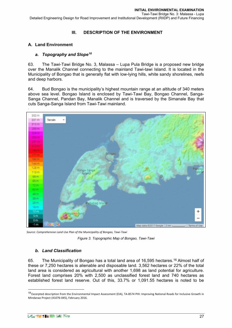
INITIAL ENVIRONMENTAL EXAMINATION Tawi-Tawi Bridge No. 3: Malassa - Lupa
Detailed Engineering Design for Road Improvement and Institutional Development (RIIDP) and Future Financing
27
III. DESCRIPTION OF THE ENVIRONMENT
A. Land Environment
a. Topography and Slope18
63. The Tawi-Tawi Bridge No. 3, Malassa – Lupa Pula Bridge is a proposed new bridge over the Manalik Channel connecting to the mainland Tawi-tawi Island. It is located in the Municipality of Bongao that is generally flat with low-lying hills, white sandy shorelines, reefs and deep harbors. 64. Bud Bongao is the municipality’s highest mountain range at an altitude of 340 meters above sea level. Bongao Island is enclosed by Tawi-Tawi Bay, Bongao Channel, Sanga-Sanga Channel, Pandan Bay, Manalik Channel and is traversed by the Simanale Bay that cuts Sanga-Sanga Island from Tawi-Tawi mainland. .
b. Land Classification
65. The Municipality of Bongao has a total land area of 16,595 hectares.16 Almost half of these or 7,250 hectares is alienable and disposable land. 3,562 hectares or 22% of the total land area is considered as agricultural with another 1,698 as land potential for agriculture. Forest land comprises 20% with 2,500 as unclassified forest land and 740 hectares as established forest land reserve. Out of this, 33.7% or 1,091.55 hectares is noted to be
18 Excerpted description from the Environmental Impact Assessment (EIA), TA-8574 PHI: Improving National Roads for Inclusive Growth in
Mindanao Project (41076-045), February 2016.
Source: Comprehensive Land Use Plan of the Municipality of Bongao, Tawi-Tawi
Figure 3. Topographic Map of Bongao, Tawi-Tawi

INITIAL ENVIRONMENTAL EXAMINATION Tawi-Tawi Bridge No. 3: Malassa - Lupa
Detailed Engineering Design for Road Improvement and Institutional Development (RIIDP) and Future Financing
28
mangrove forests or areas. Bongao still has 855 hectares of unclassified land. Possibly, these are due to either accretion or changes in sea levels that led new lands to appear. These will be properly classified once the cadastral survey is finished and the municipal boundaries are finalized
Table 9. Land Classification of Bongao, Tawi-Tawi
Classification Land Area
(in has)
Alienable and Disposable Land 7,250
Unclassified Forest Land 2,500
Established Forest Land Reserve 740
Agricultural Land 3,652
Potential Agricultural Area 1,598
Other unclassified land 855
TOTAL 16,595 Source: Comprehensive Land Use Plan, Bongao, Tawi-Tawi (2017-2026).
c. Existing General Land Use
66. Of the total land area, only 24% is utilized. Agricultural area accounts for the largest share with 3,652 hectares. Residential area follows with 253 hectares. This does not include around 76.28 hectares of the sea occupied by the Sama Dilaut (or Badjaos), an indigenous group of people known for being sea settlers. Commercial areas rank third with 43 hectares. These are mostly located in Bongao Island. Areas devoted for government institutions and military reservations also account for 34 hectares and 26 hectares, respectively. Cemeteries and dumpsite have the least share with 2.5 hectares and 0.5 hectares each.
67. There are no industrial lands in Bongao as seaweeds culture and fish drying are the only main industries. Fish drying is generally household-based industry. Those involved in this industry would just utilize open spaces in the neighborhood particularly in the beaches or in their yards. The products are then delivered to a consolidator who has a stall in the municipal market or has access to the markets in Zambonga City, Cebu or Manila. The areas devoted to seaweeds culture is presented in the Water Use subsection below.
d. Geology 68. Rock Formation. The municipality has two (2) geological characteristics. Almost all of
Existing Land Use Area (in hectares)
Residential Area 253.0
Commercial Area 43.0
Agricultural Area 3,652.0
Institutional Area 34.0
Military Reservation Area 26.0
Cemeteries 2.5
Dumpsite 0.5
Total 4011.0 Source: Comprehensive Land Use Plan, Bongao, Tawi-Tawi (2017-2026).
Table 10. Existing Land Use

INITIAL ENVIRONMENTAL EXAMINATION Tawi-Tawi Bridge No. 3: Malassa - Lupa
Detailed Engineering Design for Road Improvement and Institutional Development (RIIDP) and Future Financing
29
Bongao’s land territory is made up of Late Miocene to Pliocene Clastic Rocks. These are formed between 7.6 million to 2.6 million years ago. The upper portion of the municipal territory is made up of Recent Alluvium composed of beach deposits, sand, gravel and clay. Recent alluvium covers the northern to northwestern of Sumangat, Luuk Tulay, Mandulan, Lakit-lakit, Tubig-Basag and Sanga-Sanga.
Source: Comprehensive Land Use Plan, Municipality of Bongao, Tawi-Tawi
e. Soils 69. The Municipality of Bongao has clay and loam soils that are the dominant soil types in the Municipality of Bongao. However, its coastal areas have sandy soil type. Table 11 below shows that the barangays with wide areas with clay and loam soils suitable for planting. Other barangays, especially those situated along the shorelines have sandy type of soil. 70. The roads, bridges and ports are also accounted in the land uses. There is a total 120.4 kilometers of roads in Bongao; a 2-kilometer airport; and, a 1.25 kilometer municipal government-operated sea port. The barangay with the biggest land area is Lapid-Lapid covering 1,411 hectares. This is followed by Tarawakan with 1,321; and, Mandulan with 1,304. Lapid-Lapid and Tarawakan are both located in the mainland Tawi-tawi while Mandulan is in the Sanga-Sanga Island. The smallest barangay in terms of land area is Tongsinah with 15 hectares followed by Tubig Mampallam and Lamion with 24 hectares and 26 hectares,
Figure 4. Geologic Map of Bongao, Tawi-tawi

INITIAL ENVIRONMENTAL EXAMINATION Tawi-Tawi Bridge No. 3: Malassa - Lupa
Detailed Engineering Design for Road Improvement and Institutional Development (RIIDP) and Future Financing
30
respectively. Tongsinah is located in the Pababag Island while the other two are located in Bongao Island. The proposed bridge is located in Barangays Malassa and Lupang-Pula (Masantong).
Table 11. Land Area distribution by barangays in Bongao, Tawi-Tawi
Rank
Barangay Land
Area (in
hectares)
Rank
Barangay Land
Area (in
hectares)
1 Lapid-Lapid 1,411 19 Pahut 220
2 Tarawakan 1,321 20 Ungus-Ungus 167
3 Mandulan 1,304 21 Pababag 165
4 Luuk Pangdan 974 22 Sanga-Sanga 152
5 Silubbog 847 23 Tubig Boh 119
6 Pagatpat 797 24 Ipil 117
7 Kamagong 778 25 Paniongan 109
8 Luuk Tulay 667 26 Lato-Lato 99
9 Lakit-Lakit 529 27 Pagasinan 92
10 Karungdong 523 28 Simandagit 63
11 Sumangat 490 29 Lagasan 47
12 Masantong 469 30 Pag-asa 45
13 Malassa 372 31 Tubig Tanah 34
14 Muntay-Muntay 343 32 Poblacion 34
15 Tubig Basag 282 33 Lamion 26
16 Pasiagan 273 34 Tubig Mampallam 24
17 Nalil 256 35 Tongsinah 15
18 Pakias 248
Source: Comprehensive Land Use Plan, Bongao, Tawi-Tawi (2017-2026).
B. Climate and Meteorology 71. Bongao's climate is classified as tropical. Based on the Köppen-Geiger system, Bongao can be classified as “Af” or a “wet equatorial climate” characterized by “a consistently high temperatures (around 30 °C [86 °F]), with plentiful precipitation (150–1,000 cm [59–394 inches]), heavy cloud cover, and high humidity, with very little annual temperature variation” 72. Atmosphere Temperature. The average temperature in Bongao ranges from 22.6º to 31.3º centigrade with hottest months from April to October while the cold months are from November to March.
Table 12. Monthly temperature and rainfall based on historical weather data
Janua ry
Februa ry
Marc h
Apr il
Ma y
Jun e
Jul y
Augu st
Septem ber
Octob er
Novemb er
Decem ber
Avg. Temperature (°C) 26.1 26.1 26.4 26. 7
27. 2
26. 8
26. 7
26.9 26.8 26.7 26.5 26.3
Min.
Temperat ure (°C)
22. 6
22. 6
22. 6
22. 6
22. 9
22. 6
22.4
22.6
22.4
22.5
22.6
22.6
Max. Temperat ure (°C)
29. 6
29. 6
30. 2
30. 9
31. 5
31. 1
31.1
31.3
31.3
31
30.5
30
Source: https://en.climate-data.org/location/21228/#climate-graph

INITIAL ENVIRONMENTAL EXAMINATION Tawi-Tawi Bridge No. 3: Malassa - Lupa
Detailed Engineering Design for Road Improvement and Institutional Development (RIIDP) and Future Financing
31
73. Relative Humidity. The humidity rate prevailing in the municipality is 75% during clear sky and 85% during cloudy sky vary by 1.1 °C.
Source: https://en.climate-data.org/location/21228/#climate-graph 74. Cloudiness. The Municipality of Bongao, being part of a small island province in the southernmost part of the country, has no major industries that produce air pollution. Hence, most of the times especially during good weather, the area has clear horizons. 75. Rainfall. Rainfall in Bongao is evenly distributed throughout the year at an average of 18.04 mm. Between the driest and wettest months, the difference in precipitation is 78 mm.. 76. Wind Direction. Prevailing winds is in easterly direction with a speed of 2 knots. C. Fresh Water Resources
77. Surface Run-off. Bongao, being made up of small islands has minimal problems on significant floods. Surface run-off easily flows down to the sea during downpours. 78. Groundwater Resources. The main water supply in the Municipality of Bongao comes from underground sources. Bongao Water District has developed several deep wells in Sanga-Sanga Island that supply 12 of the 35 barangays with piped water. Almost all barangays in the municipality have dug wells that serve as water source, though, most of them dry up during dry seasons. D. Air Quality and Noise There were no available secondary data for air quality and noise in the project area. During the detailed engineering design, primary data collection/field sampling was not undertaken due to inability to secure reasonable logistical quote from third party service providers. This baselining activity shall be pursued instead during the pre-construction stage as part of the CEMP preparation albeit the bridge area is generally vegetated with no adjacent residential, commercial or industrial developments (with the exception of the structures of 3 severely affected households at the immediate vicinity of the bridge in Barangay Malassa).
Figure 5. Precipitation / Rainfall by month in Bongao

INITIAL ENVIRONMENTAL EXAMINATION Tawi-Tawi Bridge No. 3: Malassa - Lupa
Detailed Engineering Design for Road Improvement and Institutional Development (RIIDP) and Future Financing
32
79. Both sides of the project road are predominantly croplands mainly of coconuts, and the remaining areas are made up of sparsely distributed settlements and grassland/shrub/open lands. Further, the lack of industrial development suggests that air pollution and noise sources which would normally elevate background levels are not present in the area. As such, it is
expected that the average ground level concentrations of sulfur dioxide (SO2), nitrogen dioxide
(NO2), and particulate matter (PM10) will not exceed under the Philippines’ National Ambient Air Quality Guideline Values19 which are 180 µg/NCM, 150 µg/NCM, and 150 µg/NCM, respectively over the short term. Baseline measurements to be collected by the Contractor for air and noise however is recommended prior to the start of the construction period. The results will be included in the Contractor’s Environmental Management Plan (CEMP). 80. To minimize dust generation and resuspension during the bridge construction period, speed limit of up to at least 20 kph in populated areas along the alignment shall be informed to all motorists and contractor vehicle and equipment operators through signages prior to approaching each way of the sensitive receptors. In addition, regular watering at least every 4 hours shall be undertaken by the Contractor during dry construction days in these areas.
E. Marine Ecology
a. Secondary Information20 81. Coastline. Bongao, being surrounded by waters, has a long coastline and seawaters rich in natural resources. The length of coastline for the three major islands and the barangays situated in Tawi-tawi mainland is 116.76 kilometers. The coastlines facing the Sulu Sea are generally sandy beaches, while those facing the southern portion, particularly the bay areas and the channels that cut the islands, are mangrove areas. 82. Mangrove Forests. Mangroves play a significant role in coastal stabilization by trapping sediments thereby promoting land accretion and preventing erosion and excessive shifting of coastlines. Mangroves also provide habitat for marine species such as fish, crabs, shellfish, prawns and edible snakes and worms. The mangrove cover in the municipality is as shown in the table below.
Table 13. Mangrove Cover and Condition by Barangay
Barangay Mangrove Cover (in
%) Condition
Species Composition
Dominant Specie
Common Name
Bongao Island Lamion no habitat
Nalil 34.00 fair 6 Rhizophora Apiculata Bakhaw Lalaki
Pag-asa 15.00 poor 3 Rhizophora Apiculata Bakhaw Lalaki
Pahut 37.00 fair 11 Rhizophora Apiculata Bakhaw Lalaki
Pasiagan 47.00 fair 8 Rhizophora Apiculata Bakhaw Lalaki
Poblacion negligible
Simandagit 25.00 poor 1 Sonneratia Alba Pagatpat
Tubig Mampallam
no habitat
Tubig Tanah 25.00 poor 3 Rhizophora Stylosa Bakhaw Bakaun
Pababag Island Lagasan 31.00 fair 8 Rhizophora Apiculata Bakhaw Lalaki
Pababag 39.00 fair 12 Rhizophora Apiculata Bakhaw Lalaki
Tongsinah 25.00 poor 7 Avicennia Officinalis Apiapi
19 DENR Administrative Order No. 2000-81 Series of 2000, Subject: Implementing Rules and Regulations for Republic Act 8749,
otherwise known as the “Philippine Clean Air Act of 1999”. 20 Comprehensive Land Use Plan of Bongao, Tawi-Tawi, 2017-2026.

INITIAL ENVIRONMENTAL EXAMINATION Tawi-Tawi Bridge No. 3: Malassa - Lupa
Detailed Engineering Design for Road Improvement and Institutional Development (RIIDP) and Future Financing
33
Barangay Mangrove Cover (in
%) Condition
Species Composition
Dominant Specie
Common Name
Sanga-Sanga Island Karunddong 42.00 fair 11 Rhizophora Apiculata Bakhaw Lalaki
Lakit-Lakit 59.00 good 3 Brugeira Farviflora Langarai
Lato-Lato 25.00 poor 9 Rhizophora Apiculata Bakhaw Lalaki
Luuk Pangdan 30.00 fair 8 Rhizophora Apiculata Bakhaw Lalaki
Malassa 29.00 fair 7 Rhizophora Apiculata Bakhaw Lalaki
Mandulan 66.00 good 8 Rhizophora Apiculata Bakhaw Lalaki
Pagasinan negligible
Pakias 20.00 poor 5 Rhizophora Apiculata Bakhaw Lalaki
Paniongan negligible
Sanga-Sanga 23.00 poor 7 Sonneratia Caseolaris Pedada
Tubig Basag 24.00 poor 1 Exoecaria Agallocha Buta-Buta
Main Island of Tawi-Tawi Ipil 57.00 good 12 Rhizophora Apiculata Bakhaw Lalaki
Lapid-Lapid 91.00 excellent 4 Rhizophora Apiculata Bakhaw Lalaki
Luuk Tulay 69.00 good 9 Rhizophora Stylosa Bakhaw Babae
Masantong 16.00 poor 6 Brugeira Gymporrhiza Busain
Muntay-Muntay 75.00 good 9 Rhizophora Apiculata Bakhaw Lalaki
Pagatpat 51.00 good 11 Rhizophora Apiculata Bakhaw Lalaki
Silubbog 47.00 fair 10 Rhizophora Apiculata Bakhaw Lalaki
Sumangat 74.00 good 8 Sonneratia Alba Pagatpat
Tarawakan 23.00 poor 9 Rhizophora Apiculata Bakhaw Lalaki
Ungus-Ungus 66.00 good 8 Rhizophora Apiculata Bakhaw Lalaki
Source: Comprehensive Land Use Plan, Bongao, Tawi-Tawi (2017-2026).
83. Approximately 1,091.55 hectares in Bongao are mangrove areas and these are scattered in 28 coastal barangays. The only coastal barangays with no mangrove areas are: Lamion, Tubig Mampallam, Poblacion, Pagasinan and Paniongan. Overall, the average mangrove crown cover is 40% and generally classified as being in “fair” condition. Barangay Lapid-Lapid, though, showed having excellent crown cover with 91%. Barangay Malassa and Lupa-Pula (Barangay Masantong) has only 29% and 16% covers, respectively.
84. Coral Ecosystem. Coral reefs are among the most biologically diverse and economically valuable ecosystems. They provide habitats, spawning and nursery grounds for economically important fish and other marine species; generate jobs and income to local economies dependent on fishing, marine recreation and tourism; protect coastlines from storms and erosion; a source of new medicines; and, are hotspots of marine biodiversity. 85. Bongao has a rich coral ecosystem. Based on a study conducted by the Fisheries Improved for Sustainable Harvest or FISH Project in 2006, the average coral cover in the municipality of Bongao is 46.3%, which is classified as being in “Fair condition. There are 42 species of coral found in Bongao waters belonging to 32 genera, 14 families and 5 orders. There are no municipal-wide accessible current information to compare changes that had occurred over time. The information provided here relied on secondary information available in the Municipality’ Comprehensive Land Use Plan (CLUP). 86. Thirty-three (33) of the thirty-five (35) barangays of Bongao are coastal areas. Of the coastal barangays, seventeen (17) or more than half have good coral cover condition – that is, with more than 50% coral cover. The areas with the highest covers are Sanga-Sanga, Muntay-Muntay, Lagasan, and Silubbog. A presence of butterfly fishes21 was observed in
21 The butterfly fish is one of the most common types of coral reef fish in the world. It is very well adapted to life in the narrow
confines of vast coral reef systems, though a few species also inhabit seagrass beds, lagoons, and mudflats… The IUCN Red List has classified most species as least concern. This means the butterfly fish is in excellent health and requires no specific conservation efforts to survive. However, the butterfly fish is so well adapted to its habitat that the die-off of coral reefs from climate change may threaten many species. The butterfly fish is preyed up by sharks, eels, snappers, and other large fish…...( https://a-z-animals.com/animals/butterfly-fish/#single-animal-text).

INITIAL ENVIRONMENTAL EXAMINATION Tawi-Tawi Bridge No. 3: Malassa - Lupa
Detailed Engineering Design for Road Improvement and Institutional Development (RIIDP) and Future Financing
34
some of these areas indicating relatively healthy coral reefs. 87. Fourteen (14) barangays are considered as having a fair coral condition while only two – Pag-asa and Tubig Mampallam – are in poor condition. The coral covers in Barangays Malassa and Masantong (Lupa-Pula) are all generally in good condition.
Table 14. Coral Cover and Condition by Barangay, Bongao, Tawi-Tawi
Barangay Coral Cover (in %) Condition Species composition
Sanga-Sanga 69 Good 26
Muntay-Muntay 68 Good 18
Lagasan 66 Good 19
Silubbog 65 Good 26
Luuk Tulay 63 Good 18
Pagasinan 62 Good 11
Pagatpat 60 Good 19
Tubig Tanah 59 Good 15
Malassa 59 Good 12
Sumangat 59 Good 12
Lakit-Lakit 56 Good 18
Pababag 55 Good 19
Nalil 54 Good 10
Karungdong 54 Good 9
Tongsinah 51 Good 12
Lato-Lato 51 Good 17
Masantong 51 Good 19
Ipil 49 Fair 18
Pahut 48 Fair 15
Mandulan 47 Fair 19
Luuk Pangdan 47 Fair 12
Ungus-Ungus 47 Fair 25
Tubig Basag 42 Fair 14
Pasiagan 39 Fair 23
Simandagit 37 Fair 24
Paniongan 36 Fair 11
Tarawakan 36 Fair 23
Lapid-Lapid 33 Fair 14
Poblacion 31 Fair 13
Lamion 24 Fair 17
Pakias 10 Fair 11
Pag-asa 0 Poor
Tubig Mampallam 0 Poor
Source: Comprehensive Land Use Plan, Bongao, Tawi-Tawi (2017-2026).
88. Seagrass Communities. Sea grasses are flowering plants that have adapted to living in shallow marine waters, such as bays and lagoons. Like coral reefs, they also indicate the health of the marine ecosystem, and provide food, habitat, and nursery areas for marine organisms, stabilize the sea bottom, maintain water quality, and support local economy. 89. Of the 33 barangays in Bongao, only two have pristine sea grass communities and

INITIAL ENVIRONMENTAL EXAMINATION Tawi-Tawi Bridge No. 3: Malassa - Lupa
Detailed Engineering Design for Road Improvement and Institutional Development (RIIDP) and Future Financing
35
these are Silubbog and Sumangat with 84% and 77.2% sea grass cover, respectively. Dominant species in these areas are Thallasia Hemprichii. Ten barangays have altered sea grass communities and these are the coastal areas facing the Bongao and Sanga-Sanga Islands, and Tawi-tawi mainland. In addition to Thallasia Hemprichii, the dominant species in these areas are Enhalus Acoroides and Cymodocea Rotondata. 90. Seventeen (17) of the thirty-three (33) coastal barangays have disturbed sea grass communities. Most of these are in the Sanga-sanga Island and Tawi-tawi Mainland. The dominant sea grass specie is Thallasia Hemprichii. Three barangays are considered to have “Emergent” sea grasses. These are Poblacion and Tubig Mampallam both in Bongao Island; and, Luuk Pangdan in Sanga-Sanga Island. 91%, and eight more others, located mostly in the Tawi-tawi mainland, as having good crown cover. The rest are classified as either “Fair” or “Poor”. Barangays Malassa have seagrass cover of Enhalus Acoroides at 33.5% while Lupa-Pula have a sea cover of Cymodocea Rotondata with 6 percent.
Table 15. Seagrass Cover, Condition and Species Composition by Barangay
Barangay Seagrass
cover (in%) Description
Species Composition
Dominant Species
Silubbog 84 Pristine 4 Thallasia Hemprichii
Sumangat 77.2 Pristine 4 Thallasia Hemprichii
Pag-asa 30.2 Altered 3 Enhalus Acoroides
Nalil 10 Altered 3 Enhalus Acoroides
Tubig Tanah 56 Altered 4 Thallasia Hemprichii
Lamion 23.3 Altered 5 Enhalus Acoroides
Pakias 27 Altered 2 Enhalus Acoroides
Karungdong 22 Altered 3 Enhalus Acoroides
Paniongan 23 Altered 4 Enhalus Acoroides
Tarawakan 35 Altered 1 Thallasia Hemprichii
Masantong 6 Altered 2 Cymodocea Rotondata
Muntay-Muntay 34.2 Altered 3 Enhalus Acoroides
Pahut 50 Disturbed 5 Thallasia Hemprichii
Pasiagan 48.3 Disturbed 5 Thallasia Hemprichii
Simandagit 60 Disturbed 5 Thallasia Hemprichii
Tongsinah 38 Disturbed 4 Enhalus Acoroides
Lagasan 34 Disturbed 6 Thallasia Hemprichii
Pababag 59 Disturbed 4 Thallasia Hemprichii
Malassa 33.5 Disturbed 5 Enhalus Acoroides
Mandulan 85 Disturbed 6 Thallasia Hemprichii
Lakit-Lakit 53.5 Disturbed 4 Thallasia Hemprichii
Tubig Basag 53.7 Disturbed 3 Syringodium Isoetifolium
Sanga-Sanga 54 Disturbed 4 Cymodocea Rotondata
Pagasinan 50 Disturbed 6 Thallasia Hemprichii
Lato-Lato 40.2 Disturbed 5 Thallasia Hemprichii
Luuk Tulay 70.3 Disturbed 5 Thallasia Hemprichii
Pagatpat 32 Disturbed 5 Thallasia Hemprichii
Ungus-Ungus 43.5 Disturbed 6 Cymodocea Rotondata

INITIAL ENVIRONMENTAL EXAMINATION Tawi-Tawi Bridge No. 3: Malassa - Lupa
Detailed Engineering Design for Road Improvement and Institutional Development (RIIDP) and Future Financing
36
Barangay Seagrass
cover (in%) Description
Species Composition
Dominant Species
Ipil 39 Disturbed 6 Enhalus Acoroides
Tubig Mampallam Emergent
Poblacion Emergent
Luuk Pangdan 15.6 Emergent 1 Enhalus Acoroides
Source: Source: Comprehensive Land Use Plan, Bongao, Tawi-Tawi (2017-2026) from the Analysis of satellite image from Google Earth and validated with data from http://www.globalforestwatch.org/
b. Baseline Survey for Marine Ecological Assessment
91. A baseline survey was conducted for the proposed bridge site by a Team of twelve (12) researchers on November 7 to 9, 2020 notwithstanding the constraints posed by the COVID-19 pandemic. The following were surveyed: 1) coral reefs; 2) coral reef fishes; 3) seagrass/seaweeds; 4) mangroves; 5) phytoplankton; 6) benthos; 7) water quality; and 8) water current and circulation. Two (2) sampling stations for coral reefs and reef fishes; six (6) sampling stations for seagrass beds; and twelve (12) sampling stations for mangroves community structure are shown in Figure 7 below. Seagrass beds are not present in the bridge alignment area. Details of the marine ecological assessment can be found in Appendix 1 of this report.

INITIAL ENVIRONMENTAL EXAMINATION Tawi-Tawi Bridge No. 3: Malassa - Lupa
Detailed Engineering Design for Road Improvement and Institutional Development (RIIDP) and Future Financing
37
92. The full report of the baseline survey is presented in more detail in Appendix 1.
c. Coral Reefs 93. Two sampling stations (N 5.06568 E 119.82074 and N 5.06597 E 119.82234) with three (3) replicates were established in the proposed Malassa-Lupa Pula bridge (Figure 2). The sampling stations were located both sides of the proposed bridge and absence of coral formation was observed in the middle of the channel. 94. Using the detailed survey result, the average living hard coral cover is 8% as shown in the table below. The 8% hard coral cover is considered in poor condition using the Gomez, et.al., 1981 and Licuanan, et.al., 2017 scales and thresholds for evaluating status of reefs in the Philippines. A reef is in “poor” condition if it has an hard coral cover of 0-22%, “fair” if hard
Figure 6. Map showing the different sampling stations in the proposed Malassa-Lupa Pula bridge

INITIAL ENVIRONMENTAL EXAMINATION Tawi-Tawi Bridge No. 3: Malassa - Lupa
Detailed Engineering Design for Road Improvement and Institutional Development (RIIDP) and Future Financing
38
coral cover is >22-33%, “good” if hard coral cover is >33-44%, and “excellent” if hard coral is >44% (Licuanan et al., 2017). The coral reefs in the proposed Malassa-Lupa Pula bridge experienced by heavy sedimentation and siltation as evidence by the accumulation of silt on the substrate and on top of the living corals 95. The major coral genera in the proposed bridge location are branching Acropora, Caulastrea, Echinopora, Favites, Galaxea, Goniastrea, Goniopora, Lobophyllia, and Montastrea. Most of the coral general are weedy and stress tolerant except for Lobophyllia. Lobophyllia genus sometimes called Lobe Brain Corals are very popular stony coral for aquarium due to its wide variety of colors and textures. It also includes one species, the Lobophyllia serratus, which is on the IUCN Red List of Endangered Species. This coral species is found in Lupa Pula side with a very nil population of 0.07% cover of the total 8% total coral cover in the area. It is recommended that further investigation should be done prior to construction in consultation with marine experts from the Mindanao State University-Tawi-Tawi College of Technology and Oceanography (MSU-TCTO) to determine if this species is among the Lobophyllia corals found during the survey. This will enable the project to implement appropriate mitigation measures with expert guidance. Protection of this genus is the same with the other corals. Sediment traps and fine nets shall be deployed over the area to prevent these from smothered by construction debris and silt resulting from the construction activities. The bridge construction will not present a serious threat to this species because mitigation measures (i.e. silt traps or fine mesh nets shall be provided in the affected area, minimizing or avoiding silt from escaping the cofferdams of the bridge pier, etc.) shall be required to be set in place by the contractor prior to the construction activities following its Contractor Environmental Management Plan (CEMP). Contractors shall be made aware on the presence of these corals and additional mitigating measures shall be applied including but not limited to its unauthorized removal. Should transplantation be necessary, this activity shall be the supervision of experts preferably from the MSU Tawi-Tawi Campus. The other biotic and abiotic components are located also in Table 16 and Figure 8. 96. The poor category of hard coral could be attributed by the substrate and water quality of the area. Patches of coral formation was observed in the Lupa Pula side while absence coral formation was observed in Malassa side. The proposed bridge experienced sedimentation and siltation coming from the various human activities like erection of houses along the coastline or in the water, garbage and waste disposal, boat mooring, and anchoring resulting to the accumulation of sediment, silt and rubbles. Yap and Gomez (1985) stressed that the most important single cause of reef losses and degradation is sedimentation. These includes unsound exploitation of mangroves, earth-moving for construction and discharge of effluents and pollutants from the community. Increased turbidity and sedimentation also smoothers living coral, and silt hinder the settling of coral larvae (Johannes 1975). Coastal activities result in erosion, and runoff containing the excess sediment can block the light zooxanthellae need by the corals. Complete sediment coverage can kill corals but Edmondson (1928) and Mayer (1918) demonstrated that many species can live for more than a day when completely covered by the number of centimeters of sediment. Lack of light and excessive sediment deposition rates are factors limiting coral reef development (Roy and Smith 1971).
Table 16. Percentage cover of the main benthic groups in the proposed Malassa-Lupa Pula
Category Mean STD. DEV. STD ERROR
Hard coral 7.87 0.99 0.57
Algae 16.53 10.80 6.24
Abiotic 46.53 15.50 8.95
Macroalgae 2.87 3.76 2.17
Soft coral 26.20 11.63 6.71

INITIAL ENVIRONMENTAL EXAMINATION Tawi-Tawi Bridge No. 3: Malassa - Lupa
Detailed Engineering Design for Road Improvement and Institutional Development (RIIDP) and Future Financing
39
d. Reef Fish Community
97. The baseline survey identified 22.6 species/100m2 belonging to 13 fish families, 30 individuals per 100m2 and with a total biomass of 2.91mt/km² recorded in the proposed Malassa-Lupah Pula bridge. Only one indicator fish species, Chaetodon kleinii and three target fish families, Nemipteridae, Scaridae, and Serranidae were observed in the area (Table 17).
8%
16%
47%
3%
26%
Hard coral Algae Abiotic Macroalgae Soft coral
Figure 7. Percentage cover of the main benthic groups in the proposed Malassa-Lupa Pula bridge.
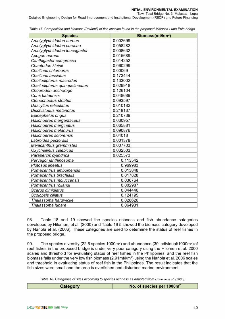
INITIAL ENVIRONMENTAL EXAMINATION Tawi-Tawi Bridge No. 3: Malassa - Lupa
Detailed Engineering Design for Road Improvement and Institutional Development (RIIDP) and Future Financing
40
Table 17. Composition and biomass ((mt/km2) of fish species found in the proposed Malassa-Lupa Pula bridge.
Species Biomass(mt/km2)
Amblyglyphidodon aureus 0.002699
Amblyglyphidodon curacao 0.058282
Amblyglyphidodon leucogaster 0.008632
Apogon aureus 0.015689
Canthigaster compressa 0.014252
Chaetodon kleinii 0.060299
Cheilinus chlorourus 0.00069
Cheilinus fasciatus 0.173444
Cheilodipterus macrodon 0.133002
Cheilodipterus quinquelineatus 0.029918
Choerodon anchorago 0.126104
Coris batuensis 0.048689
Ctenochaetus striatus 0.093597
Dascyllus reticulatus 0.010182
Dischistodus melanotus 0.218137
Epinephelus ongus 0.210739
Halichoeres margaritaceus 0.030957
Halichoeres marginatus 0.065881
Halichoeres melanurus 0.090876
Halichoeres solorensis 0.04018
Labroides pectoralis 0.001378
Meiacanthus grammistes 0.007703
Oxycheilinus celebicus 0.032503
Parapercis cylindrica 0.025573
Pervagor janthinosoma 0.113542
Plotosus lineatus 0.969983
Pomacentrus amboinensis 0.013848
Pomacentrus brachialis 0.017828
Pomacentrus moluccensis 0.036764
Pomacentrus rollandi 0.002987
Scarus dimidiatus 0.044446
Scolopsis ciliatus 0.124195
Thalassoma hardwicke 0.028626
Thalassoma lunare 0.064931
98. Table 18 and 19 showed the species richness and fish abundance categories developed by Hilomen, et al. (2000) and Table 19 5 showed the biomass category developed by Nañola et al. (2006). These categories are used to determine the status of reef fishes in the proposed bridge. 99. The species diversity (22.6 species 1000m2) and abundance (30 individual/1000m2) of reef fishes in the proposed bridge is under very poor category using the Hilomen et al. 2000 scales and threshold for evaluating status of reef fishes in the Philippines, and the reef fish biomass falls under the very low fish biomass (2.91mt/km²) using the Nañola et al. 2006 scales and threshold in evaluating status of reef fish in the Philippines. The result indicates that the fish sizes were small and the area is overfished and disturbed marine environment.
Table 18. Categories of sites according to species richness as adapted from Hilomen et al. (2000).
Category No. of species per 1000m2
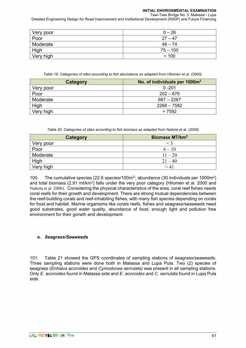
INITIAL ENVIRONMENTAL EXAMINATION Tawi-Tawi Bridge No. 3: Malassa - Lupa
Detailed Engineering Design for Road Improvement and Institutional Development (RIIDP) and Future Financing
41
Very poor 0 – 26
Poor 27 – 47
Moderate 48 – 74
High 75 – 100
Very high > 100
Table 19. Categories of sites according to fish abundance as adapted from Hilomen et al. (2000).
Category No. of individuals per 1000m2
Very poor 0 -201
Poor 202 – 676
Moderate 667 – 2267
High 2268 – 7582
Very high > 7592
Table 20. Categories of sites according to fish biomass as adapted from Nañola et al. (2006)
Category Biomass MT/km2
Very poor < 5
Poor 6 – 10
Moderate 11 – 20
High 21 – 40
Very high > 41 100. The cumulative species (22.6 species/100m2), abundance (30 individuals per 1000m2) and total biomass (2.91 mt/km2) falls under the very poor category (Hilomen et al. 2000 and Nañola et al. 2006). Considering the physical characteristics of the area, coral reef fishes needs coral reefs for their growth and development. There are strong mutual dependencies between the reef-building corals and reef-inhabiting fishes, with many fish species depending on corals for food and habitat. Marine organisms like corals reefs, fishes and seagrass/seaweeds need good substrates, good water quality, abundance of food, enough light and pollution free environment for their gorwth and development.
e. Seagrass/Seaweeds
101. Table 21 showed the GPS coordinates of sampling stations of seagrass/seaweeds. Three sampling stations were done both in Malassa and Lupa Pula. Two (2) species of seagrass (Enhalus acoroides and Cymodocea serrulata) was present in all sampling stations. Only E. acoroides found in Malassa side and E. acoroides and C. serrulata found in Lupa Pula side.

INITIAL ENVIRONMENTAL EXAMINATION Tawi-Tawi Bridge No. 3: Malassa - Lupa
Detailed Engineering Design for Road Improvement and Institutional Development (RIIDP) and Future Financing
42
Table 21. GPS coordinates of seagrass/seaweeds sampling stations in the Proposed Malassa-Lupa Pula bridge
Stations Sites Coordinates
1 Malassa Lat. 5 03 56.6 N Long. 119 49 11.2 E
2 Malassa Lat. 5 03 55.1 N Long. 119 49 11.5 E
3 Malassa Lat. 5 03 91.4 N Long. 119 49 18.9 E
1 Lupa Pula Lat. 5 03 94. 5 N Long. 119 49 39.6 E
2 Lupa Pula Lat. 5 03 96.3 N Long. 119 49 38.4 E
3 Lupa Pula Lat. 5 03 96.3 N Long. 119 49 38.3 E
a. Seagrass species 102. The average percentage cover of seagrass in the proposed Malassa-Lupa Pula bridge recorded 8.2 %/m2 (Table 22.) The percentage cover (11.02%/m2) of E. acoroides in Malassa is higher compared in Lupa Pula side (5.45%/m2) while C. serrulata recorded 0.12%/m2 and it is found only in one quadrat.
Table 22. Percentage cover (%/m2) of seagrass in the proposed Malassa-Lupa Pula bridge
103. The development of Enhalaus acoroides is favorable in sandy-muddy and sandy-silted substrates and this species is not greatly affected by turbidity and low light intensity due to the long leaves that extended to the surface of the water. Enhalus acoroides is the biggest tropical seagrass and can tolerate low light and highly turbid conditions (Bach et al., 1998) such as the waters of Malassa-Lupa Pula bridge. However, the development of seagrass in the area is affected by sedimentation, siltation, pollution, influx of fresh water and deposition of physico-chemical substances. 104. The category of seagrass in the Malassa-Lupa Pula bridge is disturbed and emergent (Fortes 1994) wherein the area is characterized by low species diversity, largely controlled by extreme fluctuations of physico-chemical conditions. Low species diversity of seagrass and seaweeds in the proposed Malassa-Lupa Pula bridge was affected primarily by the substrate characteristics, turbidity brought by sedimentation and siltation and influx of water from the river. This observation conforms to the findings of Fortes (1994) that the lowest number of seagrass species occur at highly turbid water, silted sites where patchy monospecific stand of seagrass, a highly degraded habitat and areas highly protected from waves with muddy substrate. The distribution and species abundance of seagrass is directly affected by the levels of siltation (Agawin et al. 1997, Terrados et al. 1998; Vermaat et al. 1995, 1997) and the reduced underwater light availability can lead to seagrass mortality and reduce biomass (Duarte, 1991).
Site Cover (%/m2) Malassa
Transect 1 1.09
Transect 2 11.63
Transect 3 20.36
Average 11.02
Lupa Pula Cover (%/m2)
Transect 1 13.09
Transect 2 0
Transect 3 3.27
Average 5.45
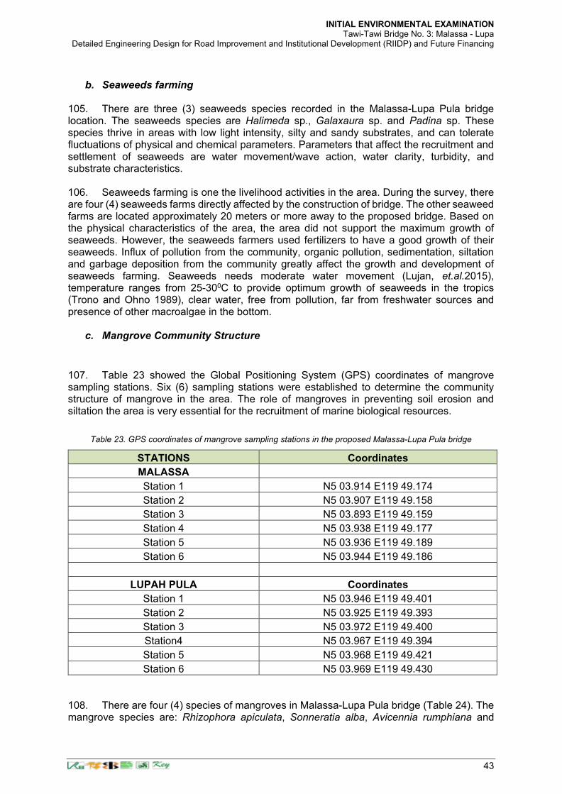
INITIAL ENVIRONMENTAL EXAMINATION Tawi-Tawi Bridge No. 3: Malassa - Lupa
Detailed Engineering Design for Road Improvement and Institutional Development (RIIDP) and Future Financing
43
b. Seaweeds farming
105. There are three (3) seaweeds species recorded in the Malassa-Lupa Pula bridge location. The seaweeds species are Halimeda sp., Galaxaura sp. and Padina sp. These species thrive in areas with low light intensity, silty and sandy substrates, and can tolerate fluctuations of physical and chemical parameters. Parameters that affect the recruitment and settlement of seaweeds are water movement/wave action, water clarity, turbidity, and substrate characteristics. 106. Seaweeds farming is one the livelihood activities in the area. During the survey, there are four (4) seaweeds farms directly affected by the construction of bridge. The other seaweed farms are located approximately 20 meters or more away to the proposed bridge. Based on the physical characteristics of the area, the area did not support the maximum growth of seaweeds. However, the seaweeds farmers used fertilizers to have a good growth of their seaweeds. Influx of pollution from the community, organic pollution, sedimentation, siltation and garbage deposition from the community greatly affect the growth and development of seaweeds farming. Seaweeds needs moderate water movement (Lujan, et.al.2015), temperature ranges from 25-300C to provide optimum growth of seaweeds in the tropics (Trono and Ohno 1989), clear water, free from pollution, far from freshwater sources and presence of other macroalgae in the bottom.
c. Mangrove Community Structure
107. Table 23 showed the Global Positioning System (GPS) coordinates of mangrove sampling stations. Six (6) sampling stations were established to determine the community structure of mangrove in the area. The role of mangroves in preventing soil erosion and siltation the area is very essential for the recruitment of marine biological resources.
Table 23. GPS coordinates of mangrove sampling stations in the proposed Malassa-Lupa Pula bridge
STATIONS Coordinates
MALASSA
Station 1 N5 03.914 E119 49.174
Station 2 N5 03.907 E119 49.158
Station 3 N5 03.893 E119 49.159
Station 4 N5 03.938 E119 49.177
Station 5 N5 03.936 E119 49.189
Station 6 N5 03.944 E119 49.186
LUPAH PULA Coordinates
Station 1 N5 03.946 E119 49.401
Station 2 N5 03.925 E119 49.393
Station 3 N5 03.972 E119 49.400
Station4 N5 03.967 E119 49.394
Station 5 N5 03.968 E119 49.421
Station 6 N5 03.969 E119 49.430
108. There are four (4) species of mangroves in Malassa-Lupa Pula bridge (Table 24). The mangrove species are: Rhizophora apiculata, Sonneratia alba, Avicennia rumphiana and

INITIAL ENVIRONMENTAL EXAMINATION Tawi-Tawi Bridge No. 3: Malassa - Lupa
Detailed Engineering Design for Road Improvement and Institutional Development (RIIDP) and Future Financing
44
Ceriops tagal. Four species of mangroves found in Malassa (Rhizophora apiculata, Sonneratia alba, Avicennia rumphiana and Ceriops tagal) while two (2) species recorded in Lupa Pula (Rhizophora apiculata and Sonneratia alba). R. apiculata recorded the most abundant and dominant in the area.
Table 24. Mangrove species in the proposed Malassa-Lupa Pula bridge
Malassa Lupa Pula
Rhizophora apiculata, Rhizophora apiculata
Sonneratia alba Sonneratia alba
Avicennia rumphiana
Ceriops tagal
Total 4 Total 2 109. There are fifty-five (55) seedlings and sixty-seven (67) saplings found in Malassa-Lupa side. Rhizophora apiculata recorded 46 seedlings and 61 saplings while Sonneratia alba recorded nine (9) seedling and six (6) saplings. Higher seedlings and sapling count recorded in Lupa Pula side as compared in Malassa side (Table 25).
Table 25. Seedlings and sapling in the proposed Malassa-Lupa Pula bridge.
Malassa Seedlings Sapling
Rhizophora apiculata 17 23
Sonneratia alba 6 4
Total 23 27
Lupa Pula
Rhizophora apiculata 29 38
Sonneratia alba 3 2
Total 32 40
Grand total 55 67
110. In Malassa side, Rhizophora apiculata recorded the most dominant mangrove species in the area followed by Sonneratia alba. R. apiculata recorded 733.33 stand per hectare followed by S. alba, 380 mangrove stands per hectare and A. rhumpiana and C. tagal 33.33 mangrove stand per hectare, respectively. In Lupa Pula side, R. apiculata found the most dominant species (766.67 mangrove stand per hectare) while S. alba recorded 166.67 mangrove stand per hectare. 111. Based on the survey, there are 10 to 20 mangrove stands will be affected by bridge construction and this will not significantly affect the population density of mangroves in the area. There will be no direct significant impact on the mangrove resources as there are many mangroves remaining in the nearby area where the proposed coastal development will be done. The mangroves are previously cut by the people to make way for the construction of stilt houses and seaweed drying platforms. If there are additional mangrove stands that will be affected by the bridge construction, these must be replaced following DENR regulations.
d. Plankton Community 112. The GPS coordinates of plankton sampling stations in the proposed Malassa-Lupa Pula bridge is the same with the sampling stations of coral reefs. Two (2) stations with three (3) replicates were established for the collection of water sample for plankton identification. The first station was located in the Malassa side, second station was located in the Lupa Pula

INITIAL ENVIRONMENTAL EXAMINATION Tawi-Tawi Bridge No. 3: Malassa - Lupa
Detailed Engineering Design for Road Improvement and Institutional Development (RIIDP) and Future Financing
45
side. 113. There are 1,036 cell density of phytoplankton recorded in the area while zooplankton recorded 98 cell density (Table 26). Malassa side recorded 540 cell density and 496 recorded in Lupa Pula side. There are 18 genera of phytoplankton recorded in the area and the most dominant is Skeletonema followed by Coscinodiscus, Ceratium and Lauderia. Zooplankton is higher in Lupa Pula side with 52 cell density while 46 cell density in Malassa side.
Table 26. Cell density of plankton in the proposed Malassa-Lupa Pula bridge
114. The phytoplankton and zooplankton abundance in the area is low due to the physical characteristics of the area. However, based on the result of the conducted marine ecological assessment study, the living organisms like fishes are very minimal, so, the abiotic factors considered as the causes of zooplankton population variation. This conforms to the findings of Ayad (2002) and Dejen et.al., (2004) that salinity, and turbidity, has been identified as critical factors in the development of zooplankton.
e. Benthos Community 115. Sampling stations for benthos community is the same with the sampling stations of seagrass/seaweeds community structure. Results revealed that there is no infauna species (buried into the bottom) recorded while four (4) epifauna species (live on the surface of the bottom sediment) found in all sampling stations. The epifauna species are tubeworms (5 pcs), starfishes (2 pcs), sponges (2 pcs) and holothurians (2 pcs). Clam shells and seashells were also found in the sediment. This indicate that the area is not suitable for the development of clams and shells. 116. Benthos population in the area is very minimal due to the physical and chemical
Genus Composition Sampling Stations Malassa Lupa Pula
Cell density Cell density
Phytoplankton Eucampia 0 12
Asterolampra 11 6
Gambierdiscus 17 5
Rhyzosolenia 43 22
Coscinodiscus 56 53
Thalassionema 53 37
Pleurosigma 25 41
Protoperidinium 22 34
Ceratium 54 29
Skeletonema 75 85
Chaetoceros 24 29
Guinardia 10 32
Tintinopsis 35 27
Lauderia 37 32
Prorocentrum 28 17
Cylindrotheca 12 7
Gonyaulax 17 8
Basteriastrum 21 20
Total 540 496
Zooplankton 46 52

INITIAL ENVIRONMENTAL EXAMINATION Tawi-Tawi Bridge No. 3: Malassa - Lupa
Detailed Engineering Design for Road Improvement and Institutional Development (RIIDP) and Future Financing
46
characteristics of the water, substrate structure, influx of fresh water, siltation, and domestic pollution. The substrates characteristics directly affect the benthic populations in the proposed Malassa-Lupa Pula bridge. Sedimentation and water turbidity limit the adaptability, settlement, recruitment, growth and development of benthos organisms. Berry et al. 2003 stated that suspended sediment directly influenced on invertebrates include: direct impacts due to abrasion, interference with respiration and ingestion by clogging of filtration mechanisms, and in extreme cases mortality from smothering and burial. The distribution of infauna and epibenthic species is impacted indirectly through light attenuation affecting feeding efficiency, behavior (avoidance and drift), and habitat alteration occurring from changes in the composition of substrate (Donahue and Irvine 2003; Waters 1995; Zweig and Rabeni 2001; Berry et al. 2003). Increases in suspended sediments resulted in increased drift and significantly altering the distribution of benthic invertebrates in streams (Herbert and Merkens 1961; Berry et al. 2003).
f. Water Parameters 117. The sampling stations for the water quality is the same with the sampling stations of coral reefs. Two sampling stations with ten replicates established in the area to measure the water parameters in the proposed bridge. More replicates established in order to get accurate data. Table 27 presents the water parameters in the proposed Malassa side. The readings of water parameters between the surface and middle of the water are almost identical (Table 27). The identified physico-chemical parameters was selected because these parameters are the major limiting factors for the recruitment, survival and development of marine organisms. These physico-chemical parameters affect the species composition, their abundance and productivity22. 118. The average surface water temperature is 31.90 0C while 31.50 0C in the middle, the pH at the surface water and middle water column were 8.77 and 8.60, respectively. The water salinity at the surface water and middle water column were 32.20 and 33.00, dissolve oxygen is 7.5 in the surface and 6.5 in the middle. The Total Dissolved Solid (TDS) (g/L) at the surface water and middle water column were 38,730 and 38700, respectively. The Secchi disk was visible down to a depth of 3.95 m in Malassa side and 4.63 m in Lupa Pula side.
Table 27. Average water parameters in the Malassa side
Parameters Surface Middle
Temperature (°C) 31.90 31.50
pH 8.77 8.60
Salinity (ppt) 32.20 33.00
DO (mg/l) 7.5 6.5
Total Dissolved Solid (mg/L) 38,730 38,700 Note: Refer to Footnote 17 for the WQG parameters to be measured.
119. Table 28 showed the average water parameters in Lupa Pula side. The surface water and middle water column has an average temperature of 32.20 °C and 31.25 °C, the pH values at the surface water is 8.78 and 8.69 in mid water column; water salinity reading at the surface is 32.40 and 32.10 in the mid water column, dissolve oxygen measurement is 7.5 mg/l in the surface and 6.0 mg/l in the mid water column and total dissolve solid measurement is 41, 100 mg/l and 41,900 mg/l in the mid water column. The water parameters are within the tolerable
22 A separate water quality sampling activity to meet the DENR Water Quality Guidelines shall be conducted following approval
by the DPWH of the request by the DED Consultant. This shall address the requirements during the construction and operation phases from which possible pollutant discharges shall be monitored. The sampling parameters for the marine assessment was limited only to the capability of the handheld instruments used during the sampling activities and only for those deemed necessary to determine the limiting factors for the purpose mentioned above.

INITIAL ENVIRONMENTAL EXAMINATION Tawi-Tawi Bridge No. 3: Malassa - Lupa
Detailed Engineering Design for Road Improvement and Institutional Development (RIIDP) and Future Financing
47
limit for marine organisms. The Secchi disk was visible down to a depth of 4.63 m in the Lupa Pula side of the bridge. Table 29 presents the water parameters in the Malassa side. The readings of water parameters between the surface and middle of the water are almost identical (Table 9). The average surface water temperature is 31.90 0C while 31.50 0C in the middle, the pH at the surface water and middle water column were 8.77 and 8.60, respectively. The water salinity at the surface water and middle water column were 32.20 and 33.00, dissolve oxygen is 7.5 in the surface and 6.5 in the middle. The Total Dissolved Solid (TDS) (g/L) at the surface water and middle water column were 38,730 and 38700, respectively. The water parameters are within the tolerable limit for marine organisms. The Secchi disk was visible down to a depth of 3.95 m in Malassa side of the bridge.
Table 28. Average water parameters in Lupa Pula side.
Parameters Surface Middle
Temperature (°C) 32.20 31.25
pH 8.78 8.69
Salinity (ppt) 32.40 32.10
DO (mg/l) 7.5 6.0
Total dissolved solid (mg/L) 41,100 41,900 Note: Refer to Footnote 17 for the WQG parameters to be measured.
Table 29. Average water parameters in the Malassa side.
Parameters Surface Middle
Temperature (°C) 31.90 31.50
pH 8.77 8.60
Salinity (ppt) 32.20 33.00
DO (mg/l) 7.5 6.5
Total Dissolved Solid (mg/L) 38,730 38,700
Site Malassa Lupa Pula
Turbidity 3.95 m 4.63 m Note: Refer to Footnote 17 for the WQG parameters to be measured.
120. The ranges of water parameters for marine organisms in the tropics are presented in Table 29. Marine organisms have different ranges of water parameters since each species has ability to adopt changes in the environment. Sudden changes on the level of water parameters affect the reproductive biology, feeding habit, growth and development of fish and other invertebrates.
121. Temperature. The water quality parameters recorded in the proposed Malassa-Lupa Pula bridge are within the tolerable and optimum limit for marine organisms. Water temperature ranges from 31.25 to 32.20C was recorded and the normal range of surface temperature varies between 24°C and 32°C (75°F to 89°F). The water temperature is favorable for marine organisms for their growth and development. It is noted that changes in water temperature affect the environments where fish, shellfish, and other marine species live. As climate change causes the oceans to become warmer year-round, populations of some

INITIAL ENVIRONMENTAL EXAMINATION Tawi-Tawi Bridge No. 3: Malassa - Lupa
Detailed Engineering Design for Road Improvement and Institutional Development (RIIDP) and Future Financing
48
species may adapt by shifting toward cooler areas. Each species has a specific range of temperature in which it can live, the warmer the water gets the faster the reactions and the cooler the water the slower the reactions. Some marine organisms are cold blooded (or poikilothermic) or warm blooded (homeothermic) depending on their ability to control their internal body temperature and any species moved out of its temperature tolerance range it may die in a short period of time (Anderson 2003). 122. Salinity. The salinity of the water recorded ranges from 32.10 to 33.0 parts per thousand. The normal range of ocean salinity ranges from 33 to 37 parts per thousand (NWS, Jetstream/Seawater), with an average of 35 parts per thousand. The salinity level of the water in the proposed Malassa-Lupa bridge is lower than the normal ranges of salinity in the open ocean. This is because of the influx of fresh water from the river. However, some marine organisms tolerate lower salinity and most aquatic species can adopt different salinity levels like some reef-building corals require very saline water ranging from 32 to 42 ppt.
123. pH or hydrogen ion concentration. Hydrogen ion concentration (pH) and measurement of acidity in seawater. The average pH level recorded in the proposed Malassa-Lupa Pula bridge ranges from 8.69 to 8.78. This data is within the optimum pH level of seawater. The normal ph level of seawater is from 7.5 to 8.5 for marine organisms (Table 29). Majority of aquatic creatures prefer a pH range of 6.5-9.0, though some species live in water with pH levels outside of this range. As pH levels move up or down from this range, it reduced survival rates of hatchings. Higher pH outside of the optimum pH range value is, the higher the mortality rates. In addition to biological effects, extreme pH levels usually increase the solubility of elements and compounds, making toxic chemicals more mobile and increasing the risk of absorption by aquatic life (Fondriest Environmental, Inc. 2013). 124. Dissolve Oxygen. The dissolve oxygen content of the water in the proposed bridge recorded ranges from 6 to 7.5 mg/l. The result is within the normal ranges of dissolve oxygen in other areas. The dissolve oxygen needed by the marine organisms living in the bottom or substrate is ranges from 1-6 mg/l while 4-15 mg/l dissolve oxygen level needed by marine organisms living in the shallow portion of the sea. If the dissolved oxygen levels of seawater drop below 5.0 mg/l, aquatic life is under stress. The lower the concentration of dissolve oxygen, the greater the stress and if dissolve oxygen levels drop to 1-2 mg/l for a few hours, it resulted to large fish kills (Lenntech BV).
125. Total dissolve solid (TDS). The total dissolve solid recorded in the proposed Malassa-Lupa Pula bridge is in the optimum level of concentration from 38,700 mg/l to 41,700 mg/l. The normal total dissolve solid of marine water is more than 35,000 mg/l.
g. Water Current and Circulation
126. Water current was measured in forty (40) points around the proposed bridges (Table 15). The average velocity of the water current during the sampling period is 0.085 m/sec. The velocity of water currents primarily influenced by the volume or amount of water flowing in the area and it is expected to increase during windy and rainy season. The water current is driven primarily by gravity, wind, rise and fall of tide and influx of water from the river. 127. The flow of water varies spatially as well as temporally within the area, dependent upon the volume of water, stream gradient and channel geometry. Further study and monitoring on the velocity of the water current in the area must be done in daily, monthly or seasonal basis. Weather condition directly influence the water velocity in the area.

INITIAL ENVIRONMENTAL EXAMINATION Tawi-Tawi Bridge No. 3: Malassa - Lupa
Detailed Engineering Design for Road Improvement and Institutional Development (RIIDP) and Future Financing
49
Table 29. Sampling points of water current in the proposed Malassa-Lupa Pula bridge.
No. of Replicates
Rate (m/sec) Coordinates
starting point endpoint
1 0.032 N5 03.952 E119 49.222 359⁰ N
2 0.024 N5 03.952 E119 49.222 359⁰ N
3 0.020 N5 03.954 E119 49.222 358⁰ N
4 0.040 N5 03.955 E119 49.222 181⁰ S
5 0.054 N5 03.954 E119 49.221 181⁰ S
6 0.040 N5 03.954 E119 49.223 181⁰ S
7 0.048 N5 03.953 E119 49.223 177⁰ S
8 0.047 N5 03.951 E119 49.222 190⁰ S
9 0.061 N5 03.950 E119 49.222 190⁰ S
10 0.091 N5 03.941 E119 49.234 184⁰ S
11 0.125 N5 03.941 E119 49.233 166⁰ S
12 0.143 N5 03.940 E119 49.233 166⁰ S
13 0.286 N5 03.925 E119 49.246 156⁰ S
14 0.143 N5 03.926 E119 49.246 155⁰ S
15 0.250 N5 03.925 E119 49.244 201⁰ S
16 0.250 N5 03.924 E119 49.244 185⁰ S
17 0.286 N5 03.919 E119 49.249 179⁰ S
18 0.200 N5 03.920 E119 49.250 195⁰ S
19 0.200 N5 03.919 E119 49.250 134⁰ SE
20 0.500 N5 03.918 E119 49.249 179⁰ S
21 0.200 N5 03.922 E119 49.250 153⁰ SE
22 0.182 N5 03.920 E119 49.252 164⁰ S
23 0.286 N5 03.928 E119 49.264 148⁰ SE
24 0.333 N5 03.928 E119 49.262 182⁰ S
25 0.286 N5 03.928 E119 49.264 175⁰ S
26 0.080 N5 03.925 E119 49.349 159⁰ SE
27 0.111 N5 03.926 E119 49.349 183⁰ S
28 0.091 N5 03.927 E119 49.351 171⁰ S
29 0.100 N5 03.927 E119 49.349 170⁰ S
30 0.083 N5 03.929 E119 49.350 170⁰ S
31 0.333 N5 03.950 E119 49.347 181⁰S
32 0.286 N5 03.950 E119 49.348 169⁰S
33 0.167 N5 03.949 E119 49.348 167⁰ S
34 0.286 N5 03.949 E119 49.348 160⁰ SE
35 0.200 N5 03.950 E119 49.346 168⁰ S

INITIAL ENVIRONMENTAL EXAMINATION Tawi-Tawi Bridge No. 3: Malassa - Lupa
Detailed Engineering Design for Road Improvement and Institutional Development (RIIDP) and Future Financing
50
No. of Replicates
Rate (m/sec) Coordinates
starting point endpoint
36 0.222 N5 03.957 E119 49.346 169⁰ S
37 0.167 N5 03.955 E119 49.345 169⁰ S
38 0.200 N5 03.956 E119 49.349 169⁰ S
39 0.133 N5 03.957 E119 49.349 169⁰ S
40 0.111 N5 03.959 E119 49.348 169⁰ S
128. Water circulation. The Malassa-Lupa Pula bridge is located in low gradient channel where there is large supply of sediment to create a landforms when the discharge is low and the river is forced to take the route of less resistance by means of flowing in locations of lowest elevation. The water around the proposed Malassa-Lupah Pula bridge is relatively calm all year round. The channel served as passage of boats when they travel from the mainland to Bongao. The channel is relatively protected by the big mainland Tawi-Tawi and Sanga-Sanga Island.
h. Conclusion and Recommendation 129. The present state of the biological resources in the proposed Malassa-Lupa Pula bridge illustrates the imperiled status of the ecosystem. The ecosystem is disturbed and altered, and few species of marine organisms live. The marine biological component is characterized by low species diversity due to the physical characteristics of the substrate and water quality. The substrates and water quality are strongly influence by sedimentation /siltation and other anthropogenic activities and the deposition of organic and inorganic substances. Negative impact on sedimentation includes: loss of important or sensitive aquatic habitats, decrease in fishery resources, loss of recreation attributes, loss of coral reef and reef fish communities, changes in fish migration, increases in erosion, circulation changes, increases in turbidity, prevent marine organism recruitment, settlement and development, loss of submerged vegetation, and coastline alteration. Sedimentation/siltation is detrimental to bottom-dwelling organisms through burial effect. The minimal population of benthic organisms like coral reef23, fishes, marine plants, benthos and plankton is mainly attributed by the deposition of suspended sediments resulting to the alteration of habitat and low light penetration. Marine organisms like corals reefs, fishes and seagrass/seaweeds need good substrates, good water quality, abundance of food, enough light and pollution free environment for their growth and development. 130. Seaweed farming is one sources of living among the coastal communities in Bongao. The seaweed farms observed are approximately 500 meters away from the bridge site. Based on the result of the study, the area did not support the maximum growth of seaweeds due to the following observations: (1) poor water quality, (2) heavy siltation resulting to decrease of nutrient level in the water and (3) the deposition of sediment that leads to the variability of physical and chemical properties of seawater. However, seaweeds farming are hoping to produce and harvest seaweeds for their daily needs. 131. It is strongly suggested that a mangrove rehabilitation program complement the coastal development to replace the 10 to 20 mangrove stands that will be affected by the bridge construction. This will also help stabilize the bridge structures (e.g. abutments) and the roots
23 Due to the sparse and scattered presence of Lobophyllia coral species during the survey, it is recommended that further
investigation be done prior to construction in consultation with marine experts from the Mindanao State University-Tawi-Tawi College of Technology and Oceanography (MSU-TCTO) to determine if the Lobophyllia serratus species is among the Lobophyllia corals found during the survey. This will enable the project to implement appropriate mitigation measures with expert guidance.

INITIAL ENVIRONMENTAL EXAMINATION Tawi-Tawi Bridge No. 3: Malassa - Lupa
Detailed Engineering Design for Road Improvement and Institutional Development (RIIDP) and Future Financing
51
are effectively reduced wave action and prevent soil erosion. However, replanting programs should use the right mangrove species to increase their survival and maintain biodiversity. The fast-growing Rhizophora apiculata, which obviously can be easily sourced in the area can be used in reforestation programs but can be mixed with other suitable mangrove species present in the area such as Sonneratia and Ceriops to maintain biodiversity and prevent insect pest infestation associated with monospecific mangrove plantations. 132. Patches of seagrass will be affected during the construction of bridge in the area. It is strongly recommended that seagrass transplantation must be done in to increase the density, thereby, increase the biological function such as stabilizing the sea bottom, trapping fine sediment, provide food for marine organisms, habitat and nursery areas for numerous vertebrate and invertebrates species. Considering the physical characteristics of the area, Enhalus acroides is the best seagrass species to be transplanted and this coming from the nearby seagrass bed areas. F. Socioeconomic Resources
a. Population 133. The Municipality of Bongao accounts for 25.7% of the total provincial population. The municipal population is characterized as a young and ethno-linguistically diverse population. Based on the 2015 census, the municipal population is 100,527 from at least nine Philippine ethno-linguistic groups in addition to the Chinese, Malaysians and Indonesians who settled in the area. This diversity is due to Bongao’s strategic location as a door to countries in Southeast Asia particularly its proximity to the rich state of Sabah in Malaysia.
134. Bongao has six urban barangays – Poblacion, Tubig Boh, Lamion, Pag-asa, Tubig Tanah, and Tubig Mampallam. All of these are in Bongao Island. These barangays were considered as urban barangays because they meet any of the following criteria:
• Each of them has a population size of 5,000 or more;
• Each has at least one establishment with a minimum of 100 employees; or • Each has five or more establishments with 10 to 99 employees, and five or more
facilities within the two-kilometer radius from the barangay hall.
Table 30. The population of Bongao, Tawi-tawi by barangay and by census year, 1980- 2015
Barangay
Population by Census Year
1980 1990 1995 2000 2010 2015
Bongao Poblacion 6,565 6,419 7,139 7,193 11,158 12,503
Ipil 537 554 602 820 1,100 1,165
Kamagong 1,124 1,209 1,277 931 985
Karungdong 755 540 979 1,094 1,720 1,819
Lagasan 751 1,028 1,026 1,277 1,444
Lakit-lakit 843 949 1,052 723 1,102 1,121
Lamion 3,412 2,532 4,639 4,882 6,409 7,090
Lapid-lapid 2,377 1,745 1,382 1,587 1,709 1,810
Lato-lato 389 642 700 620 574 833
Luuk Pandan 1,345 1,785 1,788 2,014 2,376 2,652
Luuk Tulay 1,857 1,002 788 817 1,056 1,088
Malassa 378 552 678 632 1,045 1,118

INITIAL ENVIRONMENTAL EXAMINATION Tawi-Tawi Bridge No. 3: Malassa - Lupa
Detailed Engineering Design for Road Improvement and Institutional Development (RIIDP) and Future Financing
52
Barangay
Population by Census Year
1980 1990 1995 2000 2010 2015
Mandulan 589 494 764 808 1,870 1,991
Masantong 633 672 720 847 938
Montay-montay 914 815 1,101 1,268 1,410
Nalili 962 986 1,361 3,154 4,637
Pababag 484 704 783 1,193 1,505 1,639
Pag-asa 1,464 1,628 4,398 5,648 6,835
Pag-asinan 622 738 903 1,207 1,662
Pagatpat 406 587 699 749 958
Pahut 1,290 387 705 1,042 1,145 1,649
Pakias 242 442 624 1,299 1,450
Paniogan 416 94 314 533 692 906
Pasiagan 718 678 816 1,390 1,639 3,310
Sanga-sanga 1,520 1,580 1,878 2,550 2,961 3,755
Silubog 980 854 832 902 1,393 1,514
Simandagit 233 644 716 1,612 2,008 8,584
Sumangat 912 757 933 1,050 1,120
Tarawakan 720 1,553 1,590 1,673 2,319 2,630
Tongsinah 1,244 594 737 761 982 1,015
Tubig-basag 371 619 663 855 1,231 1,418
Tubig-tanah 1,133 2,354 4,121 5,090 5,742
Tubig-Boh 1,477 1,643 1,844 4,988 7,440
Tubig-mampalam 2,084 3,799 4,817 5,074 5,295
Ungus-ungus 861 287 469 649 786 1,001 Source: Comprehensive Land Use Plan, Bongao, Tawi-Tawi (2017-2026).
135. These barangays are also the high population density areas with Poblacion having 36,991 population per square kilometer; Tubig Boh with 31,130, Lamion with 27,588; Tubig Mampallam with 15,574; Pag-asa with 15,122; and, Tubig Tanah with 4,825. Other barangays with high population density, though not considered as urban, are Simandagit (13,712), Nalil (1,811) and Pasiagan (1,212) all in Bongao Island; Tongsinah (6,678) and Lagasan (3,046) both of Pababag Island; and Sanga-Sanga (2,470) and Pagasinan (1,801) both of Sanga-Sanga Island. The rest of the barangays have population densities below 1,000 per square kilometers. The sparsely populated areas are Pagatpat with 120, Kamagong with 127 and Lapid-Lapid with 128. All of these are in the Tawi-tawi mainland.
Table 31. Population Density per barangay and location by major island group
Classification Barangay
Name Location
Population Density
(per sq. km.)
Urban
Bongao Poblacion Bongao Island 36,991
Tubig-Boh Bongao Island 31,130
Lamion Bongao Island 27,588
Tubig-Mampallam Bongao Island 15,574
Pag-asa Bongao Island 15,122
Tubig Tanah Bongao Island 4,825

INITIAL ENVIRONMENTAL EXAMINATION Tawi-Tawi Bridge No. 3: Malassa - Lupa
Detailed Engineering Design for Road Improvement and Institutional Development (RIIDP) and Future Financing
53
Classification Barangay
Name Location
Population Density
(per sq. km.)
Rural
Simandagit Bongao Island 13,712
Tongsinah Pababag Island 6,678
Lagasan Pababag Island 3,046
Sanga-sanga Sanga-Sanga Island 2,470
Nalil Bongao Island 1,811
Pagasinan Sanga-Sanga Island 1,801
Pasiagan Bongao Island 1,212
Ipil Tawi-tawi Island 996
Pababag Pababag Island 993
Lato Lato Sanga-Sanga Island 841
Paniongan Sanga-Sanga Island 831
Pahut Bongao Island 750
Ungus-ungus Tawi-tawi Island 599
Pakias Sanga-Sanga Island 585
Tubig Basag Sanga-Sanga Island 503
Montay Montay Tawi-tawi Island 411
Karungdong Sanga-Sanga Island 348
Malassa Sanga-Sanga Island 301
Luuk Pandan Sanga-Sanga Island 272
Sumangat Tawi-tawi Island 229
Lakit Lakit Sanga-Sanga Island 212
Masantong Tawi-tawi Island 200
Tarawakan Tawi-tawi Island 199
Silubog Tawi-tawi Island 179
Luuk Tulay Tawi-tawi Island 163
Mandulan Sanga-Sanga Island 153
Lapid Lapid Tawi-tawi Island 128
Kamagong Tawi-tawi Island 127
Pagatpat Tawi-tawi Island 120
Source: Comprehensive Land Use Plan, Bongao, Tawi-Tawi (2017-2026).
b. Age and Sex Structure
136. More than half or 50,982 of the municipal population is female. The proportion of females is very high in the age ranges 15-29, and 70-74. The percentage of females in those age ranges is between 53% and 54%.
Table 32. The distribution of population by age group and by sex, 2015
Age Group Population by Sex
Both Sexes Male Female
All Ages 100,527 49,545 50,982
Under 1 2,170 1,131 1,039

INITIAL ENVIRONMENTAL EXAMINATION Tawi-Tawi Bridge No. 3: Malassa - Lupa
Detailed Engineering Design for Road Improvement and Institutional Development (RIIDP) and Future Financing
54
1-4 12,126 6,100 6,026
5-9 14,604 7,377 7,226
10-14 13,333 6,556 6,777
15-19 12,322 5,756 6,567
20-24 9,375 4,419 4,955
25-29 8,555 4,039 4,516
30-34 6,033 2,949 3,084
35-39 6,238 3,024 3,215
40-44 4,773 2,480 2,293
45-49 3,735 1,906 1,829
50-54 2,602 1,377 1,225
55-59 1,752 964 788
60-64 1,236 670 566
65-69 755 393 362
70-74 493 227 266
75-79 193 92 100
80 and over
231 98 133
Source: Comprehensive Land Use Plan, Bongao, Tawi-Tawi (2017-2026).
137. Bongao’s population is generally young. Those aging 29 years old and below accounts for 72% or 72,485 of the total population. Those aging between 5 to 9 years old accounts for 14.53% of the total population followed by the 10-14 age group with 13.26%, and the 15-19 age group with 12.26%. The age groups with the least numbers are the 75-79 and 80 and above with 0.19% and 0.23%, respectively.
Source: Comprehensive Land Use Plan, Bongao, Tawi-Tawi (2017-2026)
Figure 8. Population by Age Group, CY 2014
c. Age Dependency Ratio
138. Given the age structure of the municipal population, age dependency ratio is 1:1. Age

INITIAL ENVIRONMENTAL EXAMINATION Tawi-Tawi Bridge No. 3: Malassa - Lupa
Detailed Engineering Design for Road Improvement and Institutional Development (RIIDP) and Future Financing
55
dependency, which accounts for the population aging 17 years old and below is 49,671 or 49.4% of the total population. The population aging 18 years old and above (or majority age population) is 50,856 or 50.6% of the total population.
d. Migration 139. The rapid growth of population at the rate of 4.84% in Bongao may not only be attributed to the natural growth but also migration as crude birth rate is only 195 per month based on 2015 data. Bongao, as the urban growth center of the Province of Tawi-Tawi enjoys the presence of almost all socio-economic amenities not found in other island municipalities. These include the facilities for health, education, business and commerce, transportation and the like. The municipality is also an economic gateway and an environment tourism area. Add the relatively stable peace and order situation of the municipality that people not only from other island municipalities of Tawi-tawi but also from other provinces want to live in Bongao.
e. Mother Tongue 140. The population of Bongao comes from diverse ethno-linguistic backgrounds. Based on the 2010. Census of Population, 71.82% of the population is Tausug followed by 15.35% Sama. The figure in 2015 changed with the conduct of the Rapid Community-Based Monitoring System. It appears that the Tausug ethno-linguistic population declined while that of the Sama population increased. This can be explained by the migration of the Tausugs to the Malaysian State of Sabah and the movement of the Sama from the restive province of Sulu. The values, however, may still increase as 21% of the population did not make a response.
Table 33. Household Population by Mother Tongue, Year 2010
Mother Tongue Household No. % of Total Household
Tausug 10,117 71.82
Sama 2,162 15.35
Cebuano 582 4.13
Tagalog 310 2.2
Ilocano 225 1.6
Batangueno 211 1.5
Ilonggo/Hiligaynon 183 1.3
Bicolano 169 1.2
Waray 127 0.9
Total 14,087 100

INITIAL ENVIRONMENTAL EXAMINATION Tawi-Tawi Bridge No. 3: Malassa - Lupa
Detailed Engineering Design for Road Improvement and Institutional Development (RIIDP) and Future Financing
56
f. Religious Affiliation 141. 86.84% of the population belongs to Islam while Catholics account for 9.30% of the population. The high percentage of Muslims can be traced to the historical background of Bongao. As presented in Section 2, Bongao was a cradle of Islam, and that it is among the few areas that were never colonized by the Spaniards.
g. Education 142. Educational Attainment and Literacy Rate. The Municipality of Bongao has an increasing literacy rate due to the increasing number of educators and facilities being made available to the population. From 60.3% in 1980, literacy rate increased to 79.84% in 2010. Literacy rate is higher among females (51%) than males (49%). The difference is due to the
Catholics, 9.3
Islam, 86.84
Jehovas
Witness, 0.4
Christian
Alliance ,
1.36
Iglesia ni
Kristo, 1.8
Others, 0.3
Tausug
56% Sama
20%
No Response
21%
3%
Figure 9. Ethno-linguistic groupings in Bongao, 2015
Figure 10. Religious affiliation of the population in Bongao, 2010

INITIAL ENVIRONMENTAL EXAMINATION Tawi-Tawi Bridge No. 3: Malassa - Lupa
Detailed Engineering Design for Road Improvement and Institutional Development (RIIDP) and Future Financing
57
fact that the males, even at a younger age, are already focused on income- generating activities such as fishing hence making education a secondary priority.
h. Educational Institutions and School Facilities by Level 143. Bongao is the center of education facilities in the province. Located in the municipality are the five (5) tertiary institutions, twelve (12) secondary schools, forty-three (43) elementary/primary schools, and seventy-six (76) pre-schools. 144. Tertiary Institutions. Of the five tertiary institutions in Bongao, three are private colleges/institutes, one is a state university and another is a state college. The government institutions are the Mindanao State University-Tawi-Tawi College of Technology and Oceanography (MSU-TCTO) located at Barangay Sanga-Sanga, and the Tawi-Tawi Regional Agricultural College (TRAC) at Barangay Nalil. The privately owned tertiary institutions are: the Mahardika Institute of Technology at Barangay Lamion; the Abubakar Computer Learning Center located at Barangay Simandagit; and, the Tawi-Tawi School of Midwifery at Barangay Tubig Boh.
145. Secondary Schools. The twelve (12) secondary schools in the municipality are composed of eight government-run schools and four privately owned institutions. Of the eight government-run schools three are managed by the state university/college. These are the MSU Science High School and the MSU Preparatory High School both at Barangay Tubig Mampallam; and the TRAC High School Department at Barangay Nalil. The other five are under the Department of Education and these are Tawi-Tawi School of Arts & Trade at Barangay Poblacion; the Tawi-Tawi School of Fisheries also at Barangay Poblacion; the Boloboc Science and Technology National High School; the Pagasinan National High School at Barangay Pagasinan; and the Sanga-Sanga National High School at Barangay Pahut. 146. The privately owned high schools are the Abubakar Computer Learning Center at
Figure 5-1. The literacy rate in Bongao, Tawi-
tawi, 2010
18.61
19%
Literate
79.84
81%
Figure 11. The literacy rate in Bongao, Tawi-Tawi, 2010

INITIAL ENVIRONMENTAL EXAMINATION Tawi-Tawi Bridge No. 3: Malassa - Lupa
Detailed Engineering Design for Road Improvement and Institutional Development (RIIDP) and Future Financing
58
Barangay Simandagit, the Mahardika Institute of Technology High School Department at Barangay Lamion, and, the Bongao Advent Academy at Barangay Tubig Boh.
Source: Comprehensive Land Use Plan, Bongao, Tawi-Tawi (2017-2026).
147. Primary/Elementary Schools. Of the 43 primary and elementary schools in Bongao, 36 are under the Department of Education, two are under the state universities, and the rest are privately managed. Almost all of these are concentrated in the Bongao Island. The municipality has been subdivided into four school districts, namely: Bongao Central District, District I, District II and District II. Bongao Central District oversees eight primary/elementary schools; Districts I and District III both have seven primary/elementary schools each; and, District II has 14. 148. The state university-managed elementary schools in the municipality are the MSU-TCTO Child Development Center-Laboratory Elementary School located at Barangay Tubig Mampallam, Notre Dame of Bongao Elementary Department at Barangay Poblacion. The privately owned primary and elementary schools, meanwhile, are the Notre Dame of Bongao Elementary Department at Barangay Poblacion, Bongao Discovery Learning Center.
Table 34. Elementary Schools in Bongao, Tawi-Tawi
Elementary Schools Number of Schools Operator/Manager
Bongao Central District schools 7 DepEd Tawi-Tawi
Bongao District I schools 8 Dep Ed Tawi-Tawi
Bongao District II schools 14 Dep Ed Tawi-Tawi
Bongao District III schools 7 Dep Ed Tawi-Tawi
MSU-TCTO Child Development Center- Laboratory Elem School
1 State university (MSU-TCTO )
Notre Dame of Bongao Elementary
Department
1 State university (Notre Dame of Bongao )
Figure 12. The location of school facilities in Bongao, Tawi-Tawi, 2015

INITIAL ENVIRONMENTAL EXAMINATION Tawi-Tawi Bridge No. 3: Malassa - Lupa
Detailed Engineering Design for Road Improvement and Institutional Development (RIIDP) and Future Financing
59
Bongao Discovery Learning Center 1 Private
Bongao Adventist Elementary School 1 Private
Bongao Advent Academy 1 Private
Mahardika Institute of Technology Elementary Department
1 Private
Abubakar Learning Center Elementary department.
1 Private
T o t a l 43
Source: Comprehensive Land Use Plan, Bongao, Tawi-Tawi (2017-2026).
149. Pre-school. There are 76 pre-schools existing in Bongao most of which are attached to elementary schools. The 36 elementary schools of the Department Education have their component pre-schools or kindergarten schools. MSU-TCTO CDC-LES, Notre Dame of Bongao elementary department, Seventh-Day Adventist Kinder School, Bongao Alliance Kindergarten, Bongao Discovery Learning Center and Mahardika Institute of Technology Elementary Department have also their respective pre-schools. The rest of the pre-schools are operated by the Department of Social Welfare and Development through its Day Care Centers. Most schools are located in Bongao Poblacion and neighboring barangays.
Table 35. Names & Nos. of Pre-Schools, Both Government & Private, Bongao, Tawi-Tawi
Elementary Schools
Number
of Schools
Operator
Bongao Central District 7 Dep Ed Tawi-Tawi
Bongao District I 8 Dep Ed Tawi-Tawi
Bongao District II 14 Dep Ed Tawi-Tawi
Bongao District III 7 Dep Ed Tawi-Tawi
MSU-TCTO Child Development Center- Laboratory Elem School
1 state university
Day-Care Centers 34 DSWD/public
Notre Dame of Bongao Elementary Department 1 private
Bongao Discovery Learning Center 1 private
Bongao Adventist Elementary School 1 private
Bongao Advent Academy 1 private
Mahardika Institute of Technology Elementary Department
1 private
T o t a l 76
Source: Comprehensive Land Use Plan, Bongao, Tawi-Tawi (2017-2026).
150. Other Schools. The Department of Education Tawi-Tawi has also established the Alternative Learning System (ALS). The ALS is a parallel learning system that provides a practical option to the existing formal instruction particularly to those who does not have or cannot access formal education in schools.11 It includes both the non-formal and informal sources of knowledge and skills. In Bongao, the ALS caters to out-of-school youth, rebel returnees, victims of calamities and adult illiterates.
i. Teachers and Student Population 151. Bongao Central District has a total of 243 teachers in its eight (8) component elementary schools based on its record in 2014. Other school districts have no data available. There are also 102 public secondary teachers in Bongao in the five secondary schools being operated by the DepEd. The highest number is in the Tawi-Tawi School of Art and Trade with 42 teachers of various specialization followed by the Tawi-Tawi School of Fisheries with 30

INITIAL ENVIRONMENTAL EXAMINATION Tawi-Tawi Bridge No. 3: Malassa - Lupa
Detailed Engineering Design for Road Improvement and Institutional Development (RIIDP) and Future Financing
60
teachers. Boloboc Science and Technology National High School has the lowest number of teachers with 7.at Barangay Poblacion, Bongao Adventist Elementary School at Barangay Tubig Boh, Bongao Advent Academy at Barangay Tubig Boh, Mahardika Institute of Technology Elementary Department, and, Abubakar Learning Center Elementary department.
Table 36. Number of Teachers per Public Secondary School in Bongao, 2014
Public Secondary Schools Total Number of
Teachers
Boloboc Science and Technology National High School 7
Pag-asinan National High School 12
Tawi-Tawi School of Art and Trade 42
Tawi-Tawi School of Fisheries 30
Sanga-Sanga National High School 11 Source: DepEd ARMM Bongao, Tawi-Tawi 2014
j. School Population and Children out of School 152. For the School Year 2013-2014, Bongao has a total of 18,606 enrollees. 3,376 of these are in kindergarten and 15,230 are in Grades 1 to 6. Almost one-third of the enrollees for kindergarten is in Bongao District 1 while most of the enrollees for Grades 1 to 6 are in Bongao Central. Female enrollees are higher in number compared with the male enrollees in all the public kindergarten and elementary schools in Bongao. the highest is in Bongao District II where gender parity index is 1.16. Gender Parity Index is calculated as the quotient of the number of females by the number of males enrolled in a given stage of education is used by international organizations particularly the United Nations Educational, Scientific and Cultural Organization (UNESCO). The index describes attempts to eliminate gender disparities in primary and secondary education and emphasizes the plight of girls in unequal access in third world countries.12
Table 37. Total Enrollment of Bongao Public Elementary Schools per District, 2013- 2014
District
Number of Pre-schools/
Kindergarten
Schools
Kindergarten Enrollment
Number of Elementary
Schools
Grade 1-6 Enrollment
Parity Index
(Kindergarten and
Elementary)
Bongao
Central
7 583 7 4,375 1
.
0
1
Bongao
District I
8 1,033 8 3,999 1
.
0
3
Bongao
District II
14 783 14 3,690 1.16
Bongao
District III
7 977 7 3,166 1
.
0
6

INITIAL ENVIRONMENTAL EXAMINATION Tawi-Tawi Bridge No. 3: Malassa - Lupa
Detailed Engineering Design for Road Improvement and Institutional Development (RIIDP) and Future Financing
61
Total 3376 15,230
Source: DepEd ARMM Bongao, Tawi-Tawi 2014
153. In the public secondary schools, enrollees in 2013-2014 is 3,454. Almost all of these came from the Tawi-Tawi School of Art and Trade, and the Tawi-Tawi School of Fisheries.
Table 38. Total Enrollment of Public Secondary Schools, Department of Education ARMM Bongao, Tawi-Tawi
Public Secondary Schools Total Number of Enrollment
Boloboc Science and Technology National High School 172
Pag-asinan National High School 380
Tawi-Tawi School of Art and Trade 1,506
Tawi-Tawi School of Fisheries 1,236
Sanga-Sanga National High School 160 Source: DepEd ARMM Bongao, Tawi-Tawi 2014
154. Out of School Children and Youth. Despite the number of schools, 19.87% of children aging 6-12 years old and youth aging 13-16 years old are out of school. This is equivalent 19.87% of the children population who are not attending elementary school and 28.21% of the teenage population who are not attending high school.
Table 39. Proportion of individuals of schooling age and their attendance to school, 2015
Category 6-12 Years Old 13-16 Years Old
In-School 80.13 71.79
Out-of-School 19.87 28.21
Source: RCBMS 2015
155. In 2015, Barangay Lamion ranks first in Bongao with 705 children aging 6-12 years old who are out of school. Tubig Tanah follows with 408; Simandagit with 382, Pag-Asa with 310, and Poblacion with 255. Lamion, likewise, ranks first with 1,041 youth aging 13-16 years old who are not attending high school. This is followed by Tubig Tanah with 403, Poblacion with 668, Simandagit with 577, and Nalil with 494. Only Luuk Tulay shows 100% compliance in ensuring that its children and young people aging 6-12 years old and 13-16 years old to be in school.
Table 40. Out of School Children and Youth by Barangay and by Rank
Area Out-of-school
children (6-12 y.o.) Rank
Out-of-school youth (13-16 y.o.)
Rank
Bongao Poblacion 255 5 668 3
Ipil 61 17 51 32
Kamagong 45 22 70 28
Karungdong 86 13 206 12
Lagasan 31 27 96 25
Lakit 38 25 170 14
Lamion 705 1 1041 1

INITIAL ENVIRONMENTAL EXAMINATION Tawi-Tawi Bridge No. 3: Malassa - Lupa
Detailed Engineering Design for Road Improvement and Institutional Development (RIIDP) and Future Financing
62
Area Out-of-school
children (6-12 y.o.) Rank
Out-of-school youth (13-16 y.o.)
Rank
Lapid Lapid 68 14 113 19
Lato Lato 24 30 45 33
Luuk Pandan 134 7 113 19
Luuk Tulay 0 35 0 35
Malassa 100 11 94 26
Mandulan 49 21 110 21
Masantong 38 25 101 23
Montay Montay 28 29 58 31
Nalil 127 9 494 5
Pababag 68 14 64 30
Pag-asa 310 4 445 6
Pagasinan 94 12 233 9
Pagatpat 127 9 99 24
Pahut 8 34 168 15
Pakias 131 8 210 10
Paniongan 19 33 34 34
Pasiagan 62 16 185 13
Sanga-sanga 21 31 157 16
Silubog 57 19 123 17
Simandagit 382 3 577 4
Sumangat 54 20 209 11
Tarawakan 30 28 65 29
Tongsinah 41 23 119 18
Tubig Basag 39 24 263 8
Tubig Tanah 408 2 903 2
Tubig-Boh 61 17 102 22
Tubig-Mampallam 171 6 410 7
Ungus-ungus 21 31 72 27
Source: RCBMS 2015, Source: Comprehensive Land Use Plan, Bongao, Tawi-Tawi (2017-2026).
k. Housing
156. Based on the 2015 Census of Population and Housing, Bongao has a total of 17,636 households. Of this number, 97.41% have their own houses with only 2.59% as renters. The high percentage of house ownership is due to the housing projects of the local government unit in partnership with the national government agencies. As of 2015, Bongao has fifteen housing projects nine of which are made up of concrete materials, and six are made of light materials.
Table 41. Housing Projects in Bongao as of March 2017.
Housing Projects with Concrete Materials Housing Projects with Light Materials

INITIAL ENVIRONMENTAL EXAMINATION Tawi-Tawi Bridge No. 3: Malassa - Lupa
Detailed Engineering Design for Road Improvement and Institutional Development (RIIDP) and Future Financing
63
1. Old Housing Project in Barangay Tubig Boh
2. New Housing Project in Barangay Tubig Boh
3. Daira in Barangay Tubig Boh
4. GNA in Barangay Lamion
5. ACS in Barangay Simandagit
6. NDB Housing in Barangay Nalil 7. Sea Orchid in Barangay Nalil
8. Triple R in Barangay Nalil
9. Barangays Nalil and Pasiagan housing project
1. Barangay Sanga-Sanga 2. Barangay Pahut 3. Barangay Pakias 4. Barangay Simandagit 5. Badjao Village Barangay Pag-asa 6. Kasulutan.
Source: Comprehensive Land Use Plan, Bongao, Tawi-Tawi (2017-2026).
157. Not all of the housing units, however, are made of durable materials. Based on Rapid CBMS data, 9.14% of the houses in 2015 are makeshift houses with materials that can be easily destroyed by strong winds or heavy rains. Most of these houses can be found in Barangays Pag-asa, Simandagit, Tubig Tanah, Poblacion and Tubig Mampallam. 46% of those considered as makeshift houses are owned by informal settlers. Informal settlers are those who occupy the land that is not theirs without the landowner’s permission or government properties and prohibited areas such as the danger zones, waterways, seashores and even the seas. 158. Informal settlers in Bongao would likely occupy the seas primarily because it is a tradition of one of the major indigenous group of people in the municipality – the Sama popularly known as the Badjaos. These informal settlers occupy 76.28 hectares of the sea based on 2017 pixel analysis of satellite maps from Google Earth. These are generally located around the Bongao Island (except the western portion); the southern portion of Sanga-Sanga Island; the Mandulan area also of Sanga-sanga Island; and some areas in the foreshore of Barangays Tarawakan and Sillubog.

INITIAL ENVIRONMENTAL EXAMINATION Tawi-Tawi Bridge No. 3: Malassa - Lupa
Detailed Engineering Design for Road Improvement and Institutional Development (RIIDP) and Future Financing
64
Source: Comprehensive Land Use Plan, Bongao, Tawi-Tawi (2017-2026).
159. 2.59% also of the total households are renters. Most of the renters are in the Bongao Island and this is because of the commercial activities and educational facilities in the area. The renters are highly concentrated in the barangays of Tubig-Mampallam, Poblacion, Pag-asa, and Lamion. There are also renters in Barangays Sanga-Sanga and this could be due to the presence of airport as well as the MSU.
l. Health 160. The leading causes of mortality for 2015, meanwhile, is as follows:
Table 42. The Leading Causes of Mortality in Bongao, Tawi-Tawi for 2015
No. Causes of Mortality 1 Septic shock
2 Cardio Pulmonary Disease
3 Pneumonia
4 Sepsis Neonaturum
5 Dengue Fever
6 Respiratory Arrest
7 Pulmonary Tuberculosis
8 Acute Infection
9 Acute Kidney Failure
10 Bacterial Meningitis
Source: Bongao RHU, Source: Comprehensive Land Use Plan, Bongao, Tawi-Tawi (2017-2026).
161. Rate of Malnutrition. In 2015, a total of 13,538 children below five (5) years of age participated in Operation Timbang program. Of this number, 98.28% or 13,306 were found to be in normal weight for their age while the rest are either underweight or overweight. 162. 191 or 1.41% is considered as underweight. Of this number only 46 are considered to be severe underweight. 41 are also considered as overweight and this constitutes 0.30% of the total number of children.
Table 43. Weight of children in Bongao below 5 years old, CY 2015.
Age (in months)
Severe Underweight Underweight Normal Overweight
Male Female Total Male Female Total Male Female Total Male Female Total
0-5 0 2 2 2 2 4 507 493 1000 0 2 2
6-11 4 2 6 8 16 24 609 684 1293 2 1 3
12-23 3 6 9 19 5 24 1,084 1,013 2097 3 4 7
24-35 4 6 10 9 10 19 1,000 1,054 2054 7 6 13
36-47 4 5 9 8 12 20 1,127 999 2126 5 4 9
48-59 4 5 9 14 14 28 1,277 1,193 2470 2 2 4
60-71 0 1 1 17 9 26 1,197 1,069 2266 2 1 3
Total 19 27 46 77 68 145 6,801 6,505 13306 21 20 41
Source: Comprehensive Land Use Plan, Bongao, Tawi-Tawi (2017-2026).
163. In terms of distribution by sex, there are more underweight females than males. More
Figure 13. The location of informal settler areas in Bongao, Tawi-tawi, 2017
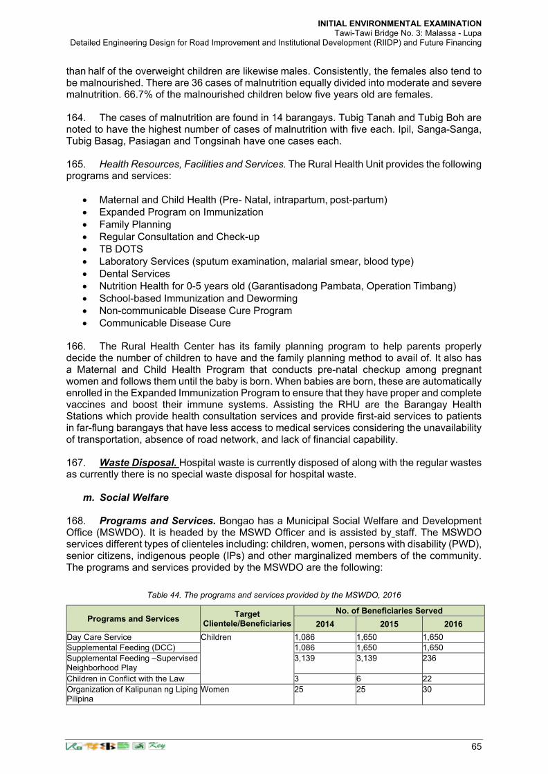
INITIAL ENVIRONMENTAL EXAMINATION Tawi-Tawi Bridge No. 3: Malassa - Lupa
Detailed Engineering Design for Road Improvement and Institutional Development (RIIDP) and Future Financing
65
than half of the overweight children are likewise males. Consistently, the females also tend to be malnourished. There are 36 cases of malnutrition equally divided into moderate and severe malnutrition. 66.7% of the malnourished children below five years old are females. 164. The cases of malnutrition are found in 14 barangays. Tubig Tanah and Tubig Boh are noted to have the highest number of cases of malnutrition with five each. Ipil, Sanga-Sanga, Tubig Basag, Pasiagan and Tongsinah have one cases each. 165. Health Resources, Facilities and Services. The Rural Health Unit provides the following programs and services:
• Maternal and Child Health (Pre- Natal, intrapartum, post-partum)
• Expanded Program on Immunization
• Family Planning
• Regular Consultation and Check-up
• TB DOTS
• Laboratory Services (sputum examination, malarial smear, blood type)
• Dental Services
• Nutrition Health for 0-5 years old (Garantisadong Pambata, Operation Timbang)
• School-based Immunization and Deworming
• Non-communicable Disease Cure Program
• Communicable Disease Cure 166. The Rural Health Center has its family planning program to help parents properly decide the number of children to have and the family planning method to avail of. It also has a Maternal and Child Health Program that conducts pre-natal checkup among pregnant women and follows them until the baby is born. When babies are born, these are automatically enrolled in the Expanded Immunization Program to ensure that they have proper and complete vaccines and boost their immune systems. Assisting the RHU are the Barangay Health Stations which provide health consultation services and provide first-aid services to patients in far-flung barangays that have less access to medical services considering the unavailability of transportation, absence of road network, and lack of financial capability. 167. Waste Disposal. Hospital waste is currently disposed of along with the regular wastes as currently there is no special waste disposal for hospital waste.
m. Social Welfare 168. Programs and Services. Bongao has a Municipal Social Welfare and Development Office (MSWDO). It is headed by the MSWD Officer and is assisted by staff. The MSWDO services different types of clienteles including: children, women, persons with disability (PWD), senior citizens, indigenous people (IPs) and other marginalized members of the community. The programs and services provided by the MSWDO are the following:
Table 44. The programs and services provided by the MSWDO, 2016
Programs and Services Target
Clientele/Beneficiaries
No. of Beneficiaries Served
2014 2015 2016
Day Care Service Children 1,086 1,650 1,650
Supplemental Feeding (DCC) 1,086 1,650 1,650
Supplemental Feeding –Supervised Neighborhood Play
3,139 3,139 236
Children in Conflict with the Law 3 6 22
Organization of Kalipunan ng Liping Pilipina
Women 25 25 30

INITIAL ENVIRONMENTAL EXAMINATION Tawi-Tawi Bridge No. 3: Malassa - Lupa
Detailed Engineering Design for Road Improvement and Institutional Development (RIIDP) and Future Financing
66
Programs and Services Target
Clientele/Beneficiaries
No. of Beneficiaries Served
2014 2015 2016
Violence Against Woman and Children (VAWC)
4 20 12
Solo Parent 100 150 167
Pre-Marriage Counseling (PMC) for Couples
11 20 27
Out-of-School Youth (OSY) Youth 30 38 47
Person with Disability (PWD) 50 102 74
Organization of Senior Citizens (no. of members)
Senior Citizens 1,040 1,203 1,397
Social Pension for Indigent Senior Citizens
269 475 675
Emergency Relief Assistance Displaced Families 190 210 300
Trafficked In-Person 516 490 369
Deportees 1,000 675 377
Pantawid Pamilya Program Indigents 5,300 5,289 5,328
Modified Conditional Fund Transfer Indigenous People 1,080 2,765 3,829
Payapa at Masaganang Pamayanan (PAMANA)
Cooperatives 4 w/ 235 members
8 w/ 410 MNLF members
2
Sustainable Livelihood Program Women - - 28 groups w/700 members
Source: Comprehensive Land Use Plan, Bongao, Tawi-Tawi (2017-2026).
169. Social Welfare Organizations. There are three accredited organizations in Bongao that assists the MSWDO. These are the Tawi-tawi Family Life Foundation, Inc., (TFLF) that provides family life education, counseling; the Local Organization of Senior Citizens that provides access to financial assistance to elderly and physical fitness activities to keep the elderly strong and healthy; and, the Badjao Village Learning Center that provides the Badjao children the opportunity to have formal education. TFLF is located in the Poblacion while the Local Organization of Senior Citizens and the Badjao Village Learning Center are both located at Barangay Pag-asa.
n. Sports and Recreation 170. The municipality has several recreation and sports facilities. These are either owned or operated by the barangays or by the schools. 171. Type, number and location of sports and recreational facilities. Just like any typical Filipino community, the people of Bongao also love basketball and thus, each barangay maintain a basketball court. Some of these are covered while the rest are not. The courts, though sometimes not in conformity to standard sizes, are considered as necessary not only for the sports activities but also of social activities of the barangay residents. The barangays with covered courts are: Tubig Boh, Pag-asa, Poblacion, Tubig Tanah, and Simandagit. 172. There is also a convention center in Tubig Mampallam, the Datu Amilbahar Convention Center within the MSU-TCTO Preparatory High School campus; a gymnasium in Barangay Nalil inside the Tawi-Tawi Regional Agricultural School campus; and, a gymnasium in Sanga-Sanga in the MSU TCTO campus. All facilities are owned by the academe but are also being used by the communities surrounding it for sports and recreation.
o. Public Order and Safety 173. Bongao is considered one of the most peaceful municipalities in the Bangsamoro Autonomous Region in Muslim Mindanao (BARMM). To sustain these and ensure proper coordination of different peace- enforcement agencies, the municipal government organized

INITIAL ENVIRONMENTAL EXAMINATION Tawi-Tawi Bridge No. 3: Malassa - Lupa
Detailed Engineering Design for Road Improvement and Institutional Development (RIIDP) and Future Financing
67
the Municipal Peace and Order Council (MPOC). The MPOC is composed of the local government unit of Bongao, the Philippine National Police (PNP), the Armed Forces of the Philippines, and other interested stakeholders. The MPOC convenes from time to time to assess the situation and recommend policies for common understanding and guidance of the stakeholders concerned. 174. Total Number of Police personnel and facilities. Bongao Police Station has a total of 59 PNP personnel that are assigned in the PNP station at Barangay Pag-asa, in the market, and some strategic areas in the municipality in order to have police visibility. The PNP station has 1 Mahindra Mobile Patrol and 3 handheld ICOM Radio as their communication facility. 175. Types and volume of crime in the LGU. Bongao is a peaceful place and this is manifested by the report of PNP Bongao which was able to record only 87 crime incidents in the first three quarters of 2016. Based on the report, traffic related crime and physical injury topped in the list of crime incidents. There are also reported cases of robbery, motornapping, murder and comprehensive dangerous drug violations.
Table 45. Crimes and other offenses in Bongao, 2016
Classification Offense Number of Cases
Crime Murder 8
Homicide 4
Physical Injury 15
Rape 2
Robbery 10
Motornapping 10
Non-Index Crime Traffic Incidence 18
Special Laws Anti-Trafficking in Person 1
Child Abuse 2
Comprehensive Dangerous Drugs 13
Comprehensive Law on Fire-arms and Ammunition
4
T O T A L 87 Source: Comprehensive Land Use Plan, Bongao, Tawi-Tawi (2017-2026).
176. Fire-fighting personnel and facilities. Bureau of Fire Protection in Bongao has only seven (7) personnel. It has only 1 fire truck available to combat fire incidents. 177. Occurrence of fire and response time. In 2014, there were 8 fire incidents that occurred in the municipality. In 2015, 15 fire incidents were recorded and in the first three quarters of 2016, there were already 5 fire incidents that happened. 178. Number and Location of Existing Security and Detective Agencies. Business establishments, big or small, need security services to safeguard the owners and the business from bad elements. That is why there are 3 Security Agencies that are operating in the municipality and their offices are located at Barangays Sanga-Sanga and Poblacion. These security agencies are: Black Arrow, SSS, and RIBUSA.
p. Agriculture 179. Bongao has 4,651.626 hectares of land devoted to agriculture. These are located in Sanga- Sanga Island and Tawi-Tawi mainland. The agricultural lands are planted with cassava, rice, corn, banana, variety of fruits and vegetables.

INITIAL ENVIRONMENTAL EXAMINATION Tawi-Tawi Bridge No. 3: Malassa - Lupa
Detailed Engineering Design for Road Improvement and Institutional Development (RIIDP) and Future Financing
68
180. Agricultural Croplands and Crop Production. The biggest portion of the agricultural land is devoted to cassava being the staple food of the people. It occupies a total of 2,769 hectares with another 1,200 hectares as potential cassava plantations.13 The major areas for cassava plantations are in Barangays Lapid-Lapid, Sumangat, and Luuk Pangdan. As of 2014, there are 406 cassava farmers in the municipality. 181. Banana and mango plantations rank next with 300 and 200 hectares, respectively. Both banana and mango farms can be found all over Bongao, though the latter are more notable in Barangays Tubig Basag, Nalil and Pahut. Sweet potatoes and fruit trees like lanzones, durian, jackfruit and marang occupy two hectares each and these are scattered in the different barangays of the municipality. Cassava also has the highest volume of yield which averages 9 metric tons per hectare. This is followed by banana and calamansi with 5 and 4 metric tons per hectare, respectively. The least in terms of yield are upland rice and corn with 2 metric tons per hectare.
Table 46. Agricultural Croplands and Crop Production in Bongao, Tawi-tawi, 2015
Commodity
No. of Hectares Volume of
Yield per ha. (mt)
Average Yield per
Hectare (MT) Barangays Covered
Service Area
Potential area
Irrigated Rice 8 5 23.2 2.9 Lapid-Lapid
Lowland Rain fed Rice
13
20.4
20.4
2.4
Montay-Montay, Luuk Pangdan, Sumangat, Silubbog
Upland Rice 2 20 20 2 Luuk Pangdan, Sumangat
Corn 30 10 60 2 sporadic
Cassava
2,769
-
24,786
9
Lapid-Lapid, Sumangat, Luuk Pangdan & other barangays
Banana 300 30 1,815 5 sporadic
Calamansi 10 15 40 4 sporadic
Rubber 10 15 18 1.8 Lapid-Lapid, Sumangat
Mango 200 70 729 2.7 Lupah Pula, Tubig Basag, Nalil, Pahut & other barangays
Lanzones 2 3 35 7 sporadic
Durian 2 3 19 3.8 sporadic
Jackfruit 2 3 25 5 sporadic
Marang 2 3 11.5 2.3 sporadic
Sweet Potato 2 2 28 4 sporadic
Vegetables 28 10 64.4 2.3 Tubig Basag, Luuk Pangdan, Sumangat & other barangays
Source: MAO Bongao, Tawi-Tawi, PAO Tawi-tawi, Source: Comprehensive Land Use Plan, Bongao, Tawi-Tawi (2017-2026).
182. Number and Volume of Production by type of livestock & poultry. Almost half of the livestock produced in Bongao are goats with 1,580 heads. The because goats are easy to take care and sell especially during Muslim special occasions where offerings are made during prayer or duwa’a. Following goats are cattle and dogs with 868 and 795 heads, respectively. The least number of livestock animals is carabao with only 100 heads. There are no records of swine production because the municipality is predominantly a Muslim population. 77% of the poultry animals in the municipality are chicken. Ducks and turkey are also grown but only in minimal number.
q. Fisheries and Aquatic Resources 183. The municipal waters of Bongao not only provide rich fishing grounds for the local fishermen but also for the culture of seaweeds. Fishing is a major income-generating industry in Bongao. There are 9,501 registered fishermen in Bongao and 86 registered boats. A greater number is unregistered most of whom are occasional fishermen and/or those who have other seasonal jobs.

INITIAL ENVIRONMENTAL EXAMINATION Tawi-Tawi Bridge No. 3: Malassa - Lupa
Detailed Engineering Design for Road Improvement and Institutional Development (RIIDP) and Future Financing
69
184. The portion of the Manalik Channel where the proposed Bridge No. 3 will be located serves as a major crossing point to the neighboring island of Sanga-Sanga on account of its short distance. There are no major fishing and aquaculture activities in this area because fishing takes place in the open sea. Navigation which is the most beneficial use in this part of the channel, will allow vessel passage through this area unhampered both during construction and operation since navigation height of the bridge had been adequately provided in the bridge design. During bridge construction, mitigating measures will be provided (i.e. keeping navigation lanes open all the time following the Contractor’ Method Statement in the erection of bridge piers) as in Table 53: Impact Mitigation Plan.
r. Trade and Commerce 185. Financial Institutions and Insurance. Bongao is the financial center of Tawi-tawi. There are three banking institutions operating in Bongao and serving the banking needs of the people of Tawi-Tawi. These banks, all located at Barangay Poblacion, are: Land Bank of the Philippines, Philippine National Bank/Allied Banking Corporation, and, Metrobank. In addition to the banks, there are also companies that accept money transfers. These include the ML Lhuillier with four branches, LBC with two branches, Cebuana Lhuillier, and, Palawan Pawnshop. There are also pawnshops that operate in the municipality by providing loans to the people. Lastly, there are also insurance companies with offices also in Bongao and these are the PNB Beneficial Insurance System and Social Security Service.
186. Trading. Wholesaling is practiced by some department stores and groceries especially to those buyers from the island-municipalities. However, there are also a number of small- scale retailers in the different barangays serving the basic needs of the population. The stores sell goods from Zamboanga and other parts of the country, and from Malaysia, Indonesia and other neighboring countries. Most prominent products are: rice, canned goods, sugar, cooking oil, noodles flour and biscuits. 187. Transportation. Bongao is likewise the communication and transportation hub of the province. There is one regular daily flight from Zamboanga to Bongao through the Sanga- Sanga Airport. The number of flights doubles during peak season. Commercial boats also ply Zamboanga and Bongao every Tuesday, Thursday and Saturday. A number of cargo boats passing through Jolo and Siasi also operate in Bongao, along with a number of sea vessels for rent. There are also motor launches ferry passengers and cargoes from the island-municipalities to Bongao and vice versa. The frequency of trips, however, varies depending on the weather, distance and number of passengers. Motor launches from neighboring municipalities of Panglima Sugala and Simunul come to Bongao every day except Friday. Land transportation is also common in Bongao and these are through tricycles and jeepneys. Lately, private cars also ply the municipal and provincial roads. Only the tricycles, however, are regulated by the municipal government as the jeepneys and cars are regulated by the Land Transportation Office. 188. Communication. Bongao is home for the Provincial Post Office, and the mail and cargo delivery companies – LBC and JRS Express. Mobile companies like PLDT, GLOBE and SMART also operate in the municipality. In addition, a local telephone company also serves Bongao – the Bongao Nationwide Telephone Service Company. There are also two radio stations in Bongao – the Radio Ng Bayan and DXGD are the two radio stations operating in the municipality. 189. Personal Service Shops. Bongao also has establishments that cater to the personal needs of the people like the beauty parlors and barbershops, dress and tailoring shops for casual, formal and native attires. Some of them are not really in shops but working in their

INITIAL ENVIRONMENTAL EXAMINATION Tawi-Tawi Bridge No. 3: Malassa - Lupa
Detailed Engineering Design for Road Improvement and Institutional Development (RIIDP) and Future Financing
70
private homes and cater to neighbors, friends and relatives. Bongao has no funeral parlors because the Muslims who are majority of the constituents bury their dead loved ones immediately within 24 hours after death. Christian families, on the other hand, usually bring the body of the dead at their respective residences where families and friends come to pay a visit until burial schedule. 190. Community and Security Services. There are 3 Security Agencies that offer security services to government and private offices and establishments. These are the Black Arrow, SSS, and RIBUSA. These agencies have offices in Barangays Sanga-Sanga and Poblacion.
s. Tourism 191. Tourism is a new industry in Bongao and the prospective tourist areas are still being developed. The private sector is also trying to cope up and have started to establish the support industries like the hotel and restaurant businesses. 192. Tourist Areas. There are at least four existing tourism destinations in Bongao. These are the Bud Bongao – a local conservation area being a monkey sanctuary and a sacred mountain for the natives both Muslims and Christians; the Baloboc Cave and Rock Shelter, an anthropological and archaeological site in Barangay Lakit-Lakit that is currently attracting historians and other enthusiasts; the Lapid-Lapid Mangrove Eco-Park, a mangrove forest conservation area; and the Tango Island, an islet surrounded by white sandy shorelines and rich marine habitat making it an excellent site for snorkeling and scuba diving. There are also a number of white sandy beaches which includes Kasulutan Beach, Pasiagan Beach, Sanga-Sanga Beach, and Pababag Beach. Likewise, the five marine sanctuaries namely the Lagasan-Pababag MPA, the Ungus-Ungus Fish Sanctuary, Pasiagan Fish Sanctuary, Ipil Fish Sanctuary, and the Lakit-Lakit MPA/Fish Sanctuary can also serve as a marine tourism destination particularly for those interested not only in the marine environment per se but also in marine ecology management. G. LGU Environment Management
a. Solid Waste Disposal 193. The general practice is for each family to dispose of its own garbage. Others maintain compost pits, there are those who resort to burning, and a significant number, particularly the members of an indigenous population, would just throw all their wastes to the sea. In all those practices, no waste segregation is observed. 194. Eventually, barangays were enjoined to develop communal compost pits. These, though, did not improve the situation so the Municipal Government of Bongao, under the leadership of Mayor Jimuel Que, has started institutionalizing proper waste disposal system thru its Solid Waste Management Program (SWMP). A Solid Waste Management Committee has been created for the purpose though a Solid Waste Management Plan has yet to be enacted. 195. The SWMP is still on its initial stage and currently services eleven barangays. The local government under Mayor Jimuel S. Que, has just acquired four solid waste management equipment to be used exclusively for the program, and has entered into a lease contract agreement for the establishment of a new controlled-dumping site. The site is currently being developed albeit delays are being experienced due to the peace and order situation affecting Mindanao.
b. Sanitary Toilet Facilities

INITIAL ENVIRONMENTAL EXAMINATION Tawi-Tawi Bridge No. 3: Malassa - Lupa
Detailed Engineering Design for Road Improvement and Institutional Development (RIIDP) and Future Financing
71
196. Because most of the houses in the municipality are built along the coastal areas, many have no sanitary toilet facilities. For those who have toilets, most have no septic tanks. Human wastes are directly thrown to the sea. Of the 17, 636 total number of households, only 6,877 households or 38.99% have sanitary toilets.
c. Areas for Conservation / Protection 197. There are no protected areas that can be found within the area albeit Tawi-Tawi is a Key Biodiversity Area (KBA) with an estimated 293 species of terrestrial and marine fauna of various taxonomic group being listed in the IUCN Red List within a 50 km of the area of interest24. In general, the municipal government wants to conserve and protect all its land and water resources particularly its marine environment being the source of livelihood of a significant number of the population. But given the limited manpower and fiscal resources, the following have been raised as the priority conservation areas:
• The Bongao Peak or Bud Bongao which had been declared as Local Conservation Area. It is a monkey sanctuary, and various species of flora and fauna that are unique and could never be found in other mountains. It is also considered sacred by the natives, and a pilgrimage site of both Christians and Muslims. This is about 10.0 kilometers (more or less) in the other island of Bongao. This will not be directly affected by any negative impacts associated with the bridge construction.
• The Baloboc Cave and Rock Shelter at Barangay Lakit-lakit which is considered as a pre-historic site in the southern frontier of the Philippines. Archaeological excavations undertaken in the Balobok Rock Shelter led to the discovery of ancient artifacts such as polished shell tools made from the valves of a huge clam, red- slipped earthenware shards, animal remains dated by C-14 to be about 8,810-5,190 years ago. These artifacts provide evidence of one of the earliest habitation in the region. This is about 7.0 kilometers (more or less) in the other island of Sanga-Sanga. This will not be directly affected by any negative impacts associated with the bridge construction.
• Lapid-Lapid Mangrove Eco-Park at Barangay Lapid-lapid which is a vast area of mangrove forest densely vegetated with several species of mangroves that grow in the wilds along the coastal area of the barangay. Its thick vegetation can be attributed to the excellent protection being provided by the community people for decades now. Crocodiles and several kinds of birds can also be found in the area. This is about 3.0 kilometers (more or less) in the other island of Ungos-ungos. This will not be directly affected by any negative impacts associated with the bridge construction.
• The Tango Island at Barangay Ungus-ungus. This is an islet surrounded by white sandy shorelines that is excellent for snorkeling and scuba diving because of the existence of giant clams and corals. This is about 3.3 kilometers away from the bridge location. This will not be directly affected by any negative impacts associated with the bridge construction.
• Fish Sanctuaries and/or Marine Protected Areas. Bongao is being considered as a marine tourism destination for the local government’s efforts to preserve its ecology. At present, the LGU has designated five fish sanctuaries/MPAs and these are the Lagasan-Pababag MPA, the Ungus-Ungus Fish Sanctuary, Pasiagan Fish Sanctuary, Ipil Fish Sanctuary, and the Lakit-Lakit MPA/Fish Sanctuary. These areas can be considered as tourist destinations particularly for those interested not only in the
24 IBAT Proximity Report. Generated under licence 951-16851 from the Integrated Biodiversity Assessment Tool on 31 May
2021 (GMT). www.ibat-alliance.org (Proximity Report generated courtesy of Edwin Lara, Senior Safeguards Officer (Environment), Philippines Country Office, ADB).

INITIAL ENVIRONMENTAL EXAMINATION Tawi-Tawi Bridge No. 3: Malassa - Lupa
Detailed Engineering Design for Road Improvement and Institutional Development (RIIDP) and Future Financing
72
marine environment per se but also in marine ecology management. The approximate geographical locations and distribution of these areas are as shown in Table _ below.
Table 47. Approximate Distances of Ecologically Sensitive or Protected Areas from the Bridge Sites
Ecologically Sensitive or Protected Areas
Distance (km.)
Bridge 1 : Nalil-Sikkiat
Bridge 2 : Paniongan-Tongsinah
Bridge 3 : Malassa - Lupa Pula
a. Bud Bongao or Bongao Peak 2.30 4.70 9.70
b. Boloboc Cave 7.00 6.50 6.60
c. Lapid-Lapid Mangrove Eco-Park 9.60 7.20 3.00
d. Tango Island 8.70 5.90 3.30
e. Fish Sanctuaries
e.1. Lagasan-Pababag MPA 3.30 1.00 5.60
e.2. Ungus Ungus MPA 14.30 11.20 6.70
e.3. Pasiagan MPA 3.40 5.40 10.30
e.4. Ipil MPA 12.50 9.20 5.00
e.5. Lakit Lakit MPA 4.00 5.50 7.80
198. The geographical locations and distribution of these ecologically sensitive or protected areas are as shown in Figure 15 below.
Figure 14. Geographical Locations and Distribution of Ecologically Sensitive or protected areas
d. Water and Watershed: Present and Future Water Demand
Bongao Tangao
Fish Sanctuary and/or Marine Protected Areas Pasiagan Fish Sanctuary
Pabagbag Island Marine Protected Area Ungus-Ungus Fish Sanctuary Ipil Fish Sanctuary Lakit-Lakit Fish Sanctuary/MPA
Baloboc Lapid-Lapid Mangrove
Eco-Park Bridge Location
Legend:
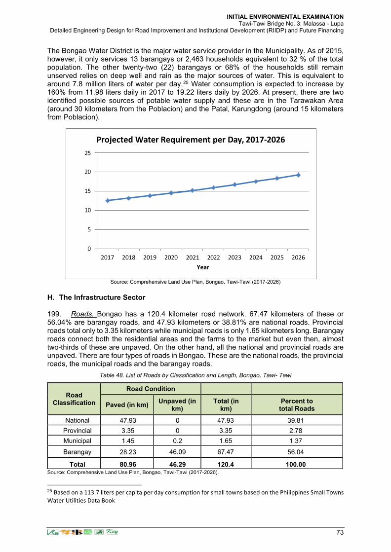
INITIAL ENVIRONMENTAL EXAMINATION Tawi-Tawi Bridge No. 3: Malassa - Lupa
Detailed Engineering Design for Road Improvement and Institutional Development (RIIDP) and Future Financing
73
The Bongao Water District is the major water service provider in the Municipality. As of 2015, however, it only services 13 barangays or 2,463 households equivalent to 32 % of the total population. The other twenty-two (22) barangays or 68% of the households still remain unserved relies on deep well and rain as the major sources of water. This is equivalent to around 7.8 million liters of water per day.25 Water consumption is expected to increase by 160% from 11.98 liters daily in 2017 to 19.22 liters daily by 2026. At present, there are two identified possible sources of potable water supply and these are in the Tarawakan Area (around 30 kilometers from the Poblacion) and the Patal, Karungdong (around 15 kilometers from Poblacion).
Source: Comprehensive Land Use Plan, Bongao, Tawi-Tawi (2017-2026)
H. The Infrastructure Sector 199. Roads. Bongao has a 120.4 kilometer road network. 67.47 kilometers of these or 56.04% are barangay roads, and 47.93 kilometers or 38.81% are national roads. Provincial roads total only to 3.35 kilometers while municipal roads is only 1.65 kilometers long. Barangay roads connect both the residential areas and the farms to the market but even then, almost two-thirds of these are unpaved. On the other hand, all the national and provincial roads are unpaved. There are four types of roads in Bongao. These are the national roads, the provincial roads, the municipal roads and the barangay roads.
Table 48. List of Roads by Classification and Length, Bongao, Tawi- Tawi
Road Classification
Road Condition
Paved (in km) Unpaved (in
km) Total (in
km) Percent to total Roads
National 47.93 0 47.93 39.81
Provincial 3.35 0 3.35 2.78
Municipal 1.45 0.2 1.65 1.37
Barangay 28.23 46.09 67.47 56.04
Total 80.96 46.29 120.4 100.00 Source: Comprehensive Land Use Plan, Bongao, Tawi-Tawi (2017-2026).
25 Based on a 113.7 liters per capita per day consumption for small towns based on the Philippines Small Towns
Water Utilities Data Book
2023 2024 2025 2026 2021 2022
Year
2017 2018 2019 2020
Projected Water Requirement per Day, 2017-2026

INITIAL ENVIRONMENTAL EXAMINATION Tawi-Tawi Bridge No. 3: Malassa - Lupa
Detailed Engineering Design for Road Improvement and Institutional Development (RIIDP) and Future Financing
74
200. Bridges There are four major existing major bridges in Bongao. These are the concrete bridge connecting Bongao Island and Sanga-Sanga Island; the steel bridge at Suwangkagang, Pasiagan, and the two bridges in Barangay Lapid-Lapid. The existing concrete bridge is along the coast that is continually exposed to winds from the open sea with an actuall channel width that is narrow resulting in drift sand being accumulated at the mouth of the channel rendering the depth becoming shallow. Besides, this concrete bridge has a very low navigation height. The bridge in Barangay Pasiagan does not provide any opportunity to directly connect the two islands of Bongao and Sanga-Sanga because this is located at the other side of the Bongao Island. The two bridges in Barangay Lapi-Lapid will not meet the bridge design requirements and connectivity objectives for the anticipated development of an international port in Malassa. 201. Coastal communities also have wooden footbridges that connect houses and serve as access to the municipality’s road network.
Source: Road Network Base Map from Bongao CLUP. Classification of road reconstructed according to the Bongao CLUP and the Comprehensive Capacity Development Project for Bangsamoro Development Plan for the Bangsamoro Final Report Sector Report 2: Infrastructure of JICA (https://openjicareport.jica.go.jp/pdf/12253654_01.pdf).
202. Flood Control and Drainage Facilities. Drainage canals have been constructed along the roads of Barangays Tubig Boh, Pag-asa, Nalil, Pahut and Poblacion. There are still many areas that need drainage system for flood control especially during the rainy season. 203. Domestic Water Supply. The municipality is being served by the Bongao Water District which provides water to 13 barangays. The water district relies mainly on underground water system. The rest of the barangays still rely on deep wells and rain as sources of freshwater. 204. Electric Water Supply. The National Power Corporation through the Tawi-Tawi Electric Cooperative Inc. is the major supplier of electric power in Bongao giving access to 13 out of 35 barangays. To date, the NPC provides a total capacity of 7.2 megawatts from its 4-unit generator. It operates 24 hours a day with a peak demand of 2.2 megawatts.
Figure 15. Projected Water Requirement per Day, 2017-2026

INITIAL ENVIRONMENTAL EXAMINATION Tawi-Tawi Bridge No. 3: Malassa - Lupa
Detailed Engineering Design for Road Improvement and Institutional Development (RIIDP) and Future Financing
75
205. Transport Facilities. For air transportation, Bongao has an airport in Sanga-Sanga Island with a daily flight during lean season and a twice daily flights during peak season. Bongao also has a municipal port, a wharf, and five fish landing sites that cater to cargoes, passengers, and fishermen. For cargo and passenger vessels, there are regular trips to and for Bongao from other municipalities and barangays, and from Zamboanga City. Barangays also have their respective barangay ports. The municipal road network also serves motorcycles, tricycles, jeepneys and even private cars. 206. Communication Facilities. The municipality has one landline telephone service provider, and is covered by the country’s major telecommunications network such as PLDT, Globe and Smart. ICOM is also available to connect to island-municipalities and nearby areas. Aside from the Philippine Postal Corporation, the municipality is also being serviced by LBC and JRS mail and cargo delivery companies. 207. Waste Disposal System. The Municipal Government of Bongao has started institutionalizing proper waste disposal system thru its Solid Waste Management Program. Proper waste management is being advocated at the local level and the use of sanitary toilets is being encouraged at the household level. With the new Solid Waste Management Program of the municipal government, a controlled dumpsite has been established and regular garbage collection has been set in place. 208. Municipal Cemetery. There are three municipal cemeteries established as a place for human remains. There is a cemetery at Barangay Pasiagan for the Muslims; and, one cemetery each at Pag-Asa and Tubig-Basag for the Christians. 209. Slaughterhouse. There is also one municipal slaughterhouse at Barangay Simandagit. But since the staple viand of the population is fish, the slaughterhouse is rarely used. 210. Public Market. Bongao also has one public market which is located in Bongao Island in the boundary of Barangays Poblacion and Tubig Mampallam. The market is composed of
three (3) buildings, two (2) of which are 2-storey buildings for stalls selling dry goods; and a one- storey building or wet goods such as fishes and other marine products.

INITIAL ENVIRONMENTAL EXAMINATION Tawi-Tawi Bridge No. 3: Malassa - Lupa
Detailed Engineering Design for Road Improvement and Institutional Development (RIIDP) and Future Financing
76
IV. ANTICIPATED IMPACTS AND MITIGATION MEASURES
211. Since the Project is considered environment Category B, significant negative environmental impacts are not anticipated. The impact assessment was conducted for pre- construction, construction and operation phases. Results of the environmental impacts screening are summarized in Table 34. impact types and magnitudes are indicated for both impacts without the mitigating measures and the resulting situations when mitigating measures will be implemented. The direct impact areas are Barangays Lupa and Malassa that share the bridge length across the Manalik channel and host the approaches during their construction. The indirect areas are those coastal barangays that will be traversed by barging traffic due to materials deliveries during construction and may include Barangays Ungos-Ungos, Pababag Island and rest of the coastal barangays in Bongao Island at the southwestern location from the bridge location. 212. The screening table uses the symbols “+” for positive impacts and “− “for negative impacts. Symbols for impact magnitudes are “∆” for minor and “” for moderate. The symbol for a minor negative impact is “∆ −”, while a moderate negative impact is “ −“. The second column of the table indicates the type and magnitudes of the impacts without any mitigating measures being applied. The last column of the table indicates the expected impact magnitude after applying the mitigating measures. Hence, a moderate negative impact ( −) will become minor (∆) after applying the mitigating measures. The discussions of each identified issue and corresponding mitigation measures are presented in the succeeding sections.
Table 49. Summary of Environmental Impacts Screening for Tawi-Tawi Bridge No. 3
Environmental Impacts and Risks Without
Mitigation With
Mitigation PRE-CONSTRUCTION PHASE (Design)
¯ Encroachment on environmentally sensitive areas n/a n/a
¯ Impacts and risks to biodiversity conservation n/a n/a CONSTRUCTION PHASE
¯ Impacts to endangered and/or critically Endangered species
∆ − ∆
¯
Potential damage to archaeological and cultural assets
∆ − ∆
¯
Mangrove vegetation loss and sedimentation within and in the vicinity of bridge pile construction sites
− ∆
¯
Noise from construction equipment − ∆ ¯ Local air pollution due to construction activities − ∆
¯ Oil and other hazardous materials releases − ∆
¯ Vehicular traffic congestion and public access − ∆
¯ Hazards to public due to construction activities − ∆
¯ Pollution and health risks due to workers camp − ∆
¯ Occupational health and safety risks at work sites − ∆
¯ Increased employment opportunity in work sites + +
- Disruption to channel navigation ∆ − ∆ −
Direct impacts to the Manalik Channel ∆ - Turbidity due to bored piling activities and
approach road construction ∆
- Removal of between 10 to 20 mangrove stands ∆ - Livelihood displacement ∆ - Fishing and seaweed farming ∆ - Damage to corals ∆
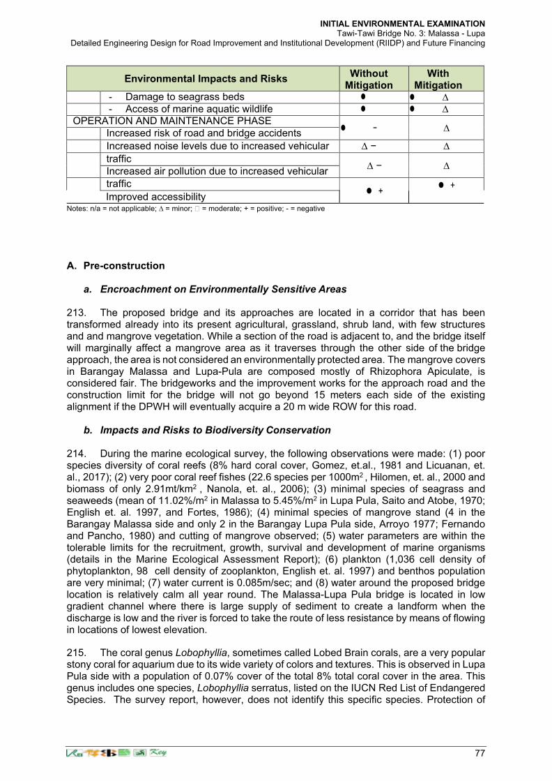
INITIAL ENVIRONMENTAL EXAMINATION Tawi-Tawi Bridge No. 3: Malassa - Lupa
Detailed Engineering Design for Road Improvement and Institutional Development (RIIDP) and Future Financing
77
Environmental Impacts and Risks Without
Mitigation With
Mitigation - Damage to seagrass beds ∆ - Access of marine aquatic wildlife ∆
OPERATION AND MAINTENANCE PHASE − ∆
Increased risk of road and bridge accidents
Increased noise levels due to increased vehicular ∆ − ∆
traffic ∆ − ∆ Increased air pollution due to increased vehicular
traffic +
+ Improved accessibility
Notes: n/a = not applicable; ∆ = minor; = moderate; + = positive; - = negative
A. Pre-construction
a. Encroachment on Environmentally Sensitive Areas 213. The proposed bridge and its approaches are located in a corridor that has been transformed already into its present agricultural, grassland, shrub land, with few structures and and mangrove vegetation. While a section of the road is adjacent to, and the bridge itself will marginally affect a mangrove area as it traverses through the other side of the bridge approach, the area is not considered an environmentally protected area. The mangrove covers in Barangay Malassa and Lupa-Pula are composed mostly of Rhizophora Apiculate, is considered fair. The bridgeworks and the improvement works for the approach road and the construction limit for the bridge will not go beyond 15 meters each side of the existing alignment if the DPWH will eventually acquire a 20 m wide ROW for this road.
b. Impacts and Risks to Biodiversity Conservation 214. During the marine ecological survey, the following observations were made: (1) poor species diversity of coral reefs (8% hard coral cover, Gomez, et.al., 1981 and Licuanan, et. al., 2017); (2) very poor coral reef fishes (22.6 species per 1000m2 , Hilomen, et. al., 2000 and biomass of only 2.91mt/km2 , Nanola, et. al., 2006); (3) minimal species of seagrass and seaweeds (mean of 11.02%/m2 in Malassa to 5.45%/m2 in Lupa Pula, Saito and Atobe, 1970; English et. al. 1997, and Fortes, 1986); (4) minimal species of mangrove stand (4 in the Barangay Malassa side and only 2 in the Barangay Lupa Pula side, Arroyo 1977; Fernando and Pancho, 1980) and cutting of mangrove observed; (5) water parameters are within the tolerable limits for the recruitment, growth, survival and development of marine organisms (details in the Marine Ecological Assessment Report); (6) plankton (1,036 cell density of phytoplankton, 98 cell density of zooplankton, English et. al. 1997) and benthos population are very minimal; (7) water current is 0.085m/sec; and (8) water around the proposed bridge location is relatively calm all year round. The Malassa-Lupa Pula bridge is located in low gradient channel where there is large supply of sediment to create a landform when the discharge is low and the river is forced to take the route of less resistance by means of flowing in locations of lowest elevation.
215. The coral genus Lobophyllia, sometimes called Lobed Brain corals, are a very popular stony coral for aquarium due to its wide variety of colors and textures. This is observed in Lupa Pula side with a population of 0.07% cover of the total 8% total coral cover in the area. This genus includes one species, Lobophyllia serratus, listed on the IUCN Red List of Endangered Species. The survey report, however, does not identify this specific species. Protection of

INITIAL ENVIRONMENTAL EXAMINATION Tawi-Tawi Bridge No. 3: Malassa - Lupa
Detailed Engineering Design for Road Improvement and Institutional Development (RIIDP) and Future Financing
78
Lobophyllia is the same with the other hard corals. The Contractor shall be made aware of its specific location and shall implement appropriate mitigation measures that will ensure this will not be smothered by construction debris and silt resulting from construction activities. Sediment traps or fine nets shall be provided in the vicinity of the coral cover to minimize sedimentation from bored piling works. Collection and removal of these corals shall be likewise prohibited. This shall be committed by the Contractor in its Contractor’ Environmental Management Plan (CEMP). B. Construction
a. Inadequate Disclosure of Project Information and GRM 216. To ensure that host communities of Barangays Malassa and Lupa-Pula are aware of the grievance redress mechanism and project implementation schedule and activities, these aspects will be communicated by the DPWH with LGU representatives, directly affected persons, and residents of the host communities prior to construction. During that time, stakeholders that will be attending the consultations shall observe the COVID-19 health and safety protocols imposed by the Inter-agency Task Force (IATF) for the Management of Emerging Infectious Diseases, as well as those of the local government unit. In particular, such communication will be carried out by the Environmental Officer (EO) of the Office of the District Engineer with the support of the CSC through consultations with the municipal and barangay officials in advance of activities, when and where noise, dust and other nuisances that may be expected, etc. and how affected persons can access the GRM for environmental concerns related to the project. 217. The consultation for all interested stakeholders, will be conducted by the EO and CSC prior to commencement of site clearing and quarterly thereafter or as agreed with the stakeholders. The EO and CSC should ensure that stakeholders are properly informed and encouraged to attend the consultation.
b. Local Air Pollution 218. Air emissions during construction mainly arise from the operation of construction vehicles and clearing of the approach roadway of base and sub-base materials and operation of quarry pits and hauling of materials. Emissions from rock crushing operations, aggregate drying, concrete batching plants and hot mix plants which will be required for the works may also degrade air quality. Movement of haul trucks during spoil transport will also generate dust and has the potential to affect communities located along the route towards the spoil disposal area. No spoils shall be disposed into the immediate vicinity of the site or anywhere along the Bongao and Manalik Channels. To minimize dust and gaseous emissions during construction phase, the contractor will ensure that:
a) Regular water spraying/dampening dust emissions from disturbed soil, approach road construction surfaces and haul roads shall be undertaken wherever there are sensitive receptors along the materials haul route. Spraying will be done twice daily or at such frequency as is needed to suppress dust emission to acceptable levels.
b) Regular removal of debris and spoil piles and clean-up after completion of the works. c) Rock crushing, concrete batching plant, aggregate drying and surface treatment
preparation operations (whether bituminous asphalt or spray seal mixes) will be located a sufficient distance (at least 500 m) from habitations and community environments including other sensitive receptors (churches, schools, medical facilities, etc.) to assure that there will be no community impacts from such activities. It is due to fine particles or offensive odor which such facilities generate often reach a point within 500m from the source under certain conditions (e.g. wind strength/direction). Establishment and operation of these facilities must be approved by the relevant

INITIAL ENVIRONMENTAL EXAMINATION Tawi-Tawi Bridge No. 3: Malassa - Lupa
Detailed Engineering Design for Road Improvement and Institutional Development (RIIDP) and Future Financing
79
authorities (e.g., EMB-DENR, LGUs). d) All equipment, machinery and vehicles used for the project must be well maintained to
ensure proper functioning thereby minimizing contribution to air pollution. e) For storage areas of construction materials such as sand, gravel, cement, etc.,
provisions will be made to prevent materials from being blown away towards sensitive receptors.
f) Although the mode of construction materials will be by barging along the Bongao Channel to the construction site in the Manalik Channel, roads may still be used for the hauling some materials. These roads will be regularly cleaned to remove tracked mud, cement, etc.
g) Stockpiling of spoils near sensitive receptors and in the immediate vicinity of the bridge site along the Manalik Channel will be prohibited.
h) Asphalt plants, concrete batching plants and crushing plants will be equipped with dust suppression devices such as water sprays, dust collectors, covered conveyor, etc.
i) Speed limits (at least 25 kilometers/hour) will be imposed on construction vehicles to minimize dust emission along areas where sensitive receptors are located.
j) Burning of all types of wastes generated at the construction sites, work camps and other project-related activities will be strictly prohibited.
k) Stockpiles of sand and aggregate greater than 20 m3 for use in concrete mixing will be enclosed on three sides, with walls extending above the pile and two meters beyond the front of the piles.
l) Water sprays will be used during the delivery and handling of all raw sand and aggregates, and other similar materials, when dust is likely to be created and to dampen such stored materials during dry and windy weather to avoid impacts to sensitive receptors.
m) Cement and other such fine-grained materials delivered in bulk will be stored in closed containers.
c. Noise 219. Noise impacts will originate from the operation of heavy construction equipment. The range of typical noise levels in relation to distance from a construction site is shown in Table 35. Sensitive receptors within 100 m from the the bridge project may be adversely affected by construction26 noise. Noise levels due to construction activities should not exceed 55 dB(A) near residential areas during daytime and 45 dB(A) for nighttime based on World Health Organization recommendations.
Table 50. Construction Noise / Distance Relationship
Distance from Construction Site (m)
Range of Typical Noise Levels (dBA)
8 82 – 102
15 75 – 95
30 69 – 89
61 63 – 83
91 59 – 79
122 57 – 77
152 55 – 75
305 49 – 69
Source: Dept. of Transportation (USA) from the Environmental Impact Assessment, TA-8574 PHI: Improving National Roads for Inclusive Growth in Mindanao Project (41076-045), February 2016
220. Construction noise levels are expected to exceed WHO guidelines and would
26 For example, when a construction machine with 110 dBA of acoustic power level such as a concrete breaker operates, noise
level of 70 dBA is expected to reach at 90 m far from the source, based on an authorized theoretical formulation

INITIAL ENVIRONMENTAL EXAMINATION Tawi-Tawi Bridge No. 3: Malassa - Lupa
Detailed Engineering Design for Road Improvement and Institutional Development (RIIDP) and Future Financing
80
temporarily affect residential areas most especially the adjacent structures of 3 households that will be affected by the construction activities) close to the construction zone. Table 36 indicates noise levels for common construction machinery.
Table 51. Construction Machinery Noise27
Noise Emission Level (dBA) at Distances (m) from Equipment
Equipment 5 10 15 20 40 60 80 100 150 200 300 1 Bulldozer 86 80 74 68 64.5 62 60 56.5 54 50.5 2 Excavator 84 78 72 66 62.5 60 58 54.5 52 48.8 3 Loader 90 84 78 72 68.5 66 64 60.5 58 54.5 4 Land scraper 90 84 78 72 68.5 66 64 60.5 58 54.5
5 Mixing Equipment 87 81
75 69 65.5 63 61 57.5 55 51.5
6 Roller 87 81 75 69 65.5 63 61 57.5 55 51.5
7 Vibrator road roller
86 80
74 68 64.5 62 60 56.5 54 50.5
8 Backhoe 81
9 Compactor 82
10 Concrete mixer 85
11 Crane (mobile) 83
12 Generator 81
13 Jack hammer 88
14 Paver 89
15 Pneumatic tool 85
16 Pump 76
17 Shovel 82
18 Truck 88
Source for Equipment 1-7: Initial Environmental Examination (IEE) of the Proposed Logistics development Project. Government of Mongolia. 2011. Source for Equipment 8-18: Based on Figure 1 – Construction Equipment Noise Ranges. Noise from Construction Equipment and operations, Building Equipment and Home Appliances. US-EPA. 31 December 1971. A blank field indicates no data available. 221. Noise impacts are unavoidable consequence of construction that will be mitigated through implementation of the following measures:
a) Limit the duration of noisy construction activities to daylight hours, whenever possible, in the vicinity of sensitive receptors.
b) In areas near houses or noise-sensitive sites, noisy equipment will not be operated during nighttime to early morning (19:00H – 06:00H).
c) Workers exposed to high noise levels will be provided with ear plugs. d) The contractors will provide prior notification to the community on the schedule of
construction activities. e) Whenever possible, noisy equipment will be completely enclosed which can
significantly reduce noise levels. f) Any stationary equipment that produce high noise levels (e.g., portable diesel
generators, compressors, etc.) will be positioned as far as is practical from sensitive receptors.
g) Construction traffic routes will be defined in cooperation with local communities and traffic police to minimize noise and nuisance.
h) Vehicle speeds will be reduced around sensitive receptors. i) Concrete batching plants will be located at least 500 m away from sensitive receptors. j) Temporary noise barriers will be installed along the edge of the road, as necessary, in
front of sensitive receptors facing heavy construction activities.
27 Source: TA-8574 PHI: Improving National Roads for Inclusive Growth in Mindanao Project (41076-045), prepared by the DPWH
for the ADB, February 2016 taken from various sources
INITIAL ENVIRONMENTAL EXAMINATION Tawi-Tawi Bridge No. 3: Malassa - Lupa
Detailed Engineering Design for Road Improvement and Institutional Development (RIIDP) and Future Financing
81
k) Prior to undertaking noisy activities, the contractor will consult with village leaders and representatives from the religious sites and schools along the project road regarding construction schedule so as to minimize disturbance to important events such as ceremonies, examination period and the like.
d. Impacts due to Spoils Disposal
222. The Project will generate spoils from the road approach and bridge construction during the bored piling works. To ensure proper handling and disposal of such materials, prior to excavation, contractors will submit a spoils disposal plan to concerned authorities such as LGUs and DPWH for approval. A copy of the approved plan will be submitted to ADB. The plan will show the location of proposed excavation sites, cut locations, fill and/or disposal sites for excess cut. This plan shall form part of the CEMP. 223. The plan will include photographs of the sites and will also indicate the existing land use and capacity of the disposal site. The contractor will ensure that spoils disposal will not take place along the Manalik Channel, will not cause sedimentation or obstruction of channel flow and not cause damage to agricultural land, properties and other productive sites.
e. Impacts from Operation of Borrow Areas and Quarries 224. The approach road of the bridge will require embankment fill and construction materials that will be sourced from borrow pits and quarries. For commercial borrow pits and quarries, the contractor will ensure that only facilities with necessary environmental permits will be used for the project. For project-specific facilities, i.e., those that will be established and solely operated for the project, the contractor will ensure that these are covered by necessary environmental permits. Copies of the permits shall be provided and included in the CEMP. 225. Prior to operation of these facilities, the contractor will submit to the LGU and DPWH a plan showing the location/s of borrow pits and quarries to be used, as well as timeframe and mitigation measures to be implemented to rehabilitate project-specific borrow pits and quarries. The contractor will also ensure that topsoil will be properly removed, stockpiled and preserved for later use during restoration of the borrow pit. Vegetation cover will also be provided during rehabilitation of the site. Upon completion of extraction activities, quarries and borrow pits will be dewatered, signages and fences installed, as appropriate, to minimize health and safety risks.
f. Erosion and Unstable Slopes Soil erosion and unstable side slopes susceptible to landslides are not anticipated along the alignment of the bridge approaches where raising of embankment is required. However, impacts due to soil erosion and unstable side slopes may include: i) increased run off and sedimentation of the Bongao Channel were corals and seagrass beds maybe affected; ii) loss of topsoil that could affect vegetation; (iii) deposition of sediments that will have adverse impacts to the water quality of the Bongao Channel and aquatic organisms; iv) damage to vegetation by burying or gulling; and v) development of unsightly cuts and fills that have been riddled by uncontrolled erosion and gulling. The above impacts will be addressed through:
a) Planting of native species of trees and landscaping along the short approach roads and embankment slopes, as appropriate.
b) Construction activities will be carried out intensively during dry season. However, as the area is not generally typhoon-prone, construction work during wet season is likely feasible.
c) Slope protection measures (e.g., sodding) will be implemented to avoid impacts to agricultural land and adjacent properties. Areas to be cleared of vegetation for construction will be restricted to the minimum required for immediate works.

INITIAL ENVIRONMENTAL EXAMINATION Tawi-Tawi Bridge No. 3: Malassa - Lupa
Detailed Engineering Design for Road Improvement and Institutional Development (RIIDP) and Future Financing
82
g. Impacts to Marine Water Quality and Ecology
226. The potential sources of water pollution associated with different construction activities include excavation and filing, bore piling and pier construction for the bridge works, concrete mixing, refueling facilities, and equipment maintenance. Water from concrete batching plants and casting yards is expected to be alkaline with high concentration of total suspended solids (TSS). All these are anticipated impacts on the Manalik Channel that will be crossed by the bridge. Measures to minimize impacts to marine water quality are as follows:
a) Control of siltation during bored piling and approach road construction will be achieved through limiting the exposure of areas prone to erosion, as well as providing silt traps or fine mesh nets to especially protect coral species identified during the marine ecological survey. The appropriateness of contractor’ mitigation measure for this impact shall be informed by experts’ advice from the MSU Campus of Tawi-Tawi during the pre-construction stage of the project. Continuous consultation with marine experts is also encouraged.
b) Observing proper management of spoils during bored piling works and approach roads embankment by stockpiling away from the work areas and providing bunds while waiting to be properly disposed in locations to be approved by the CSC.
c) Transporting spoils immediately to final disposal sites as much as possible to minimize materials carried by surface runoff during rainy days.
d) Avoid prolonged stockpiling unless necessary (i.e. topsoils necessary for agricultural re-use where sodding maybe necessary to keep from being washed away during rainy days).
e) Bentonite slurry or polymers that maybe finally be decided to be used during bridge construction will be collected and processed in a system of leak-free tank storages. Discharges into the Manalik Channel will be prohibited and compliance closely monitored by the CSC.
f) Spillage of bentonite or polymers in adjacent lands will be cleaned up immediately to prevent caking and hardening, or contaminating the marine water brought about by surface runoff during rainy days.
g) Prior to establishment and operation of concrete batching plants and casting yards, the contractor will obtain the necessary environmental permits to ensure proper siting away from the Manalik Channel.
h) Retention ponds with sufficient specifications/capacity will be constructed for treatment of wastewater (e.g., from washing of equipment such as mixer drums, trucks and chute, contact storm water, etc.) and shall be operated and maintained to ensure that effluent quality will meet applicable standards.
i) Equipment service and maintenance yards will be sited away from the Bongao Channel and provided with impermeable flooring and collection sump.
j) Watertight receptacles will be provided in all the equipment maintenance shops for waste oil, oily rags, spent oil filters, solvents and oily containers to prevent leaked materials from being washed to the channel during rainy days.
k) Disposal of wastes contaminated with hydrocarbons shall not be done in the channel, and will be done only through authorized waste handlers and recyclers.
l) Refueling and servicing of equipment will only be carried out in areas away from the channel and adequately equipped to collect leaks and spills.
m) Fuel and other hydrocarbons will be stored in a roofed area that has an impervious floor and bund around it.
n) Fuel storage area will be located away from watercourses, flood-prone areas and workers camps that may eventually carry materials to the channel during rainy days.
o) Spill clean-up materials (e.g., absorbent pads, etc.) specifically designed for petroleum products and other hazardous substances where such materials are being stored and used shall be available to ensure leaked residues are not carried away by surface

INITIAL ENVIRONMENTAL EXAMINATION Tawi-Tawi Bridge No. 3: Malassa - Lupa
Detailed Engineering Design for Road Improvement and Institutional Development (RIIDP) and Future Financing
83
runoff during rainy days. p) Relevant construction personnel will be trained in handling of fuels/hazardous
substances and spill control procedures. q) All storage containers of hazardous materials and wastes will be properly labeled and
maintained in good condition. r) Restoration of temporary work sites will include removal and treatment or proper
disposal of oil contaminated soils.
h. Loss of Vegetation
227. The project will require removal of a small number of between 10-20 mangrove trees and other vegetation (shrubs, grass, agricultural crops, etc.) to give way to bridge approaches. A tree inventory shall be further conducted based on actual ground staking of the construction limits for both the bridge piers and embankments for the approach roads. This activity shall be. conducted by the Contractor to be used in the application of tree cutting with the equivalent BARMM DENR CENRO which shall verify the number of the trees prior to the issuance of a tree cutting/earthballing permit. This activity shall be conducted prior to the tree-cutting activity during the pre-construction phase of the project as part of the tree-cutting permitting requirement. 228. Since none of these areas are within legally protected areas (as previously discussed elsewhere in this report) or are critical habitats/high biodiversity areas which support survival of critically endangered species, ecological impacts are not considered significant. 229. No compensation for all affected mangrove stands will be paid to affected persons. However, to compensate for the loss of these mangrove stands, the following will be implemented:
a) DPWH will obtain a tree cutting permit in compliance with PD 705 (Revised Forestry Code of the Philippines). No tree cutting will be undertaken without the necessary permit to be issued by the Community Environmental and Natural Resources Office (CENRO) of the DENR.
b) The tree cutting program, which will be undertaken by DPWH through a contractor, will be based on the Tree Chart to be prepared by the CENRO. The said chart will be generated through a tree inventory to be conducted by the Contractor detailing the species, diameter at breast height and global positioning system (GPS) reading of each tree. The Tree Chart will also include a site development plan/bridge and approach road alignment plan indicating the location of each mangrove stands to be cut.
c) Marking of each mangrove stands (where practicable) will be carried out by the Contractor to be verified by the CENRO staff. Tree cutting can only be undertaken under close supervision of CENRO staff who will be present at the site throughout the duration of cutting activities. Cut trees will be turned over to the CENRO or disposed elsewhere as maybe provided in the tree cutting permit.
d) DPWH will undertake replacement of cut trees in compliance with DENR Memorandum Order no. 05 of 2012: Uniform Replacement Ratio for Cut or Relocated Trees which mandates that "For planted trees in private and forest lands not covered under item 2.1 (i.e., private lands and forest lands exclusively established for tree plantations/timber production purposes) tree replacement shall be 1:50 while naturally growing trees on the same areas, including those affected by development projects shall have 1:100 ratio in support of the National Greening Program (NGP) and climate change initiatives of the Government". Such tree replacement is further mandated in a Joint Memorandum Circular No. 2, series of 2014: Guidelines for the Implementation of the DPWH-DENR-DSWD Partnership on the Tree Replacement Project co-signed

INITIAL ENVIRONMENTAL EXAMINATION Tawi-Tawi Bridge No. 3: Malassa - Lupa
Detailed Engineering Design for Road Improvement and Institutional Development (RIIDP) and Future Financing
84
e) by the Secretaries of the DPWH, DENR and Department of Social Welfare and Development (DSWD).
f) DPWH will ensure that one of their Environment Specialists and/or that of the Supervision Consultant will closely monitor the tree cutting activities to ensure that these will comply with the provisions of the Tree Cutting Permit and corresponding Tree Chart. As part of the semi-annual environmental monitoring report to be submitted to ADB, DPWH will report on the status of tree cutting, any issues/concerns, corresponding actions and other relevant matters.
g) To avoid unnecessary impacts to vegetation, the contractor will prohibit cutting of mangrove trees for firewood and for other uses in the Project and will ensure that tree cutting is limited to areas as approved by the CENRO.
h) Seagrass beds that will be affected by the construction of the bridge piers shall be relocated to the nearby areas prior to the erection of cofferdams to naturally regrow and revegetate sparsely populated seagrass habitats. Seagrass relocation activities shall be under the supervision of experts preferably from the MSU Campus of Tawi-Tawi to properly guide the contractor of the relocation/revegetation activities.
i. Occupational Health and Safety Hazards
230. Workers will be exposed to safety hazards due to operation of heavy and highly specialized bridge construction equipment, working at heights, performance of other construction activities, etc. as well as health hazards associated with inadequate sanitation facilities and other accommodation amenities, etc. The following measures will be implemented by the contractor to minimize adverse impacts:
a) Use of personal protective equipment (PPE) such as safety shoes, safety hat, goggles, safety belt, ear protection or other garments or equipment designed to protect the wearer's body from injury will be strictly observed during construction.
b) Provision of personal flotation devices (PFDs) to all workers working on the bridge to help reduce the risk of drowning when falling into the Bongao Channel.
c) Preparation and implementation of a COVID-19 Risk Management Plan following existing guidance from the DPWH, as well as the ADB Guidance on Managing Risk from COVID-19 on Construction Sites and in Workers’ Housing (June 2020).
d) Conduct orientation for construction workers regarding health and safety measures, emergency response in case of accidents, fire, etc., and prevention of HIV/AIDS and other related diseases.
e) Installation of adequate drainage in workers camps to avoid water logging/accumulation of stagnant water and formation of breeding sites for mosquitoes.
f) Provision of separate clean housing with sufficient ventilation and separate hygienic sanitation facilities for male and female workers
g) Provision of reliable supply of water for drinking, cooking and washing purposes at the workers’ camps.
h) Proper collection and disposal of solid wastes within the workers’/construction camps consistent with local regulations.
i) Provision of fire-fighting equipment at the work areas, as appropriate, and at workers camps.
j) Treatment of wastewater emanating from workers camps, construction camps and other project-related activities and facilities consistent with national regulations.
k) Use of reversing signals on all construction vehicles.
j. Public Health and Safety Hazards 231. Health and safety hazards may also be experienced by adjoining communities due to activities that will generate elevated noise levels and excessive dust, unsafe construction practices, etc. To protect the health and safety of host communities, the following measures

INITIAL ENVIRONMENTAL EXAMINATION Tawi-Tawi Bridge No. 3: Malassa - Lupa
Detailed Engineering Design for Road Improvement and Institutional Development (RIIDP) and Future Financing
85
will be implemented by the contractor:
a) Installation of sturdy fencing or barriers/barricades such as G.I. sheets, phenolic boards/plywood, wood fences derived from cut trees along the worked areas, filled up used fuel drums with soil or gravel in drainage excavations, concrete jersey barriers or water-filled plastic jersey barriers, bamboo fencing, or barbed wire fencing depending on the extent of excavation works) around excavation areas and construction sites.
b) Provision of proper signage and lighting at night at the periphery of the construction site to warn and direct traffic and pedestrians.
c) Deployment of security personnel in hazardous areas to restrict public access. d) Imposition of speed limits for construction vehicles along residential areas and where
there are other sensitive receptors. e) Orientation of drivers on safe driving practices to minimize accidents and to prevent
spill of hazardous substances and other construction materials during transport. f) If necessary, provide safe passageways for pedestrians crossing the construction site. g) At construction areas, provide safe access to farmland and other properties.
k. Traffic Obstruction
232. The project will not generally affect land access in a number of ways during the construction stage since the bulk of civil works will be undertaken on bridge works along the Manalik Channel. While hauling of construction materials through the main thoroughfares will be necessary and add to the present volume of traffic, materials transport may be scheduled to also be made along the Bongao Channel on way to the Manalik Channel through barging. Sea vessel traffic are not anticipated to be affected during construction by making sea lanes in between the bridge piers open following the contractor’ method of construction. The contractor shall be required to prepare and submit a traffic management plan considering both road and sea vessel traffic to ensure potential congestion and access obstruction are avoided. Construction activities will require partial road closure which can cause traffic delays and unsafe conditions for vehicles and pedestrians. The contractor will implement the following to minimize impacts:
a) Prepare and implement an alternate plan to divert some materials delivery using the Bongao Channel and Manalik Channel following coordination with the LGU and the Philippine Coast Guard where possible.
b) Provide signs advising road users that construction is in progress, particularly in areas where vehicles hauling of materials crosses existing roads and where construction related- facilities are located.
c) Employ flag persons to control traffic when construction equipment is entering or leaving the work area.
d) Post traffic advisory signs (to minimize traffic build-up) in coordination with local authorities.
l. Accidental Discovery of Artefacts
233. In the event of unanticipated discoveries of cultural or historic artefacts (movable or immovable) in the course of the work, the contractor will take all necessary measures to protect the chance finds. Procedures to be followed in case of discovery of artefacts are:
a) Contractor to immediately cease operations at the site of discovery b) Contractor to inform the CSC and Environment Officer of the Office of the District
Engineer c) CSC to relay information to DPWH, d) DPWH to notify the National Historical Commission of the Philippines (NHCP) and/or
other concerned government agencies for the next steps

INITIAL ENVIRONMENTAL EXAMINATION Tawi-Tawi Bridge No. 3: Malassa - Lupa
Detailed Engineering Design for Road Improvement and Institutional Development (RIIDP) and Future Financing
86
e) Recommence work only after NHCP has provided official notification accordingly
m. Damage to Properties 234. Local roads will be likely used to transport equipment, construction materials and spoils. Since local roads are usually unpaved and has low load bearing capacities, use of these roads by the project may result to deterioration of the roads which can cause inconvenience to the local communities. Damage to properties such as houses, other structures, agricultural land, water supply facilities, etc. may also occur due to operation of vehicles and equipment, and construction-related activities. The contractor will implement the following measures to address such impact:
a) The contractor will immediately repair and/or compensate for any damage that it causes to properties (houses, farmlands, aquaculture ponds, irrigation canals, etc.), community facilities such as water supply, power supply, communication facilities and the like.
b) Access roads used for transport of construction materials and other construction- related activities will be maintained by the Contractor in at least in their pre- project condition for the duration of construction.
n. Impacts to Livelihood
235. The bridge construction activities along the Manalik Channel will not hamper or displace any livelihood activities of the population of the barangays. There are no ferries and boats that cross from Barangay Malassa to Barangay Masantong. There are no seaweed farms that are in the immediate vicinity of the bridge alignment. This may even enhance opportunities for employment of skilled or unskilled labor for the project to augment income derived from fishing and seaweed farming and also reduce dependency on fishing, at least for the duration of construction. The Contractor is encouraged to hire local labor from the direct impact areas of Barangays Malassa and Lupa Pula (Masantong), as well as qualified skilled and unskilled laborers from the indirect areas.
o. Unanticipated Environmental Impacts 236. If any unanticipated impacts become apparent during project implementation, the DPWH will update the environmental assessment and EMP or prepare a new environmental assessment and EMP to assess the potential impacts, evaluate the alternatives, and outline mitigation measures and resources to address those impacts. The updated or newly prepared documents will be submitted to ADB for review, clearance and public disclosure. 237. During the construction phase, and prior to the erection of the piers of the bridges, the contractor shall see to it that damages to the marine biodiversity i.e. identified endangered corals in the vicinity of the bridge location mentioned above are avoided, minimized or mitigated. The Contractor shall incorporate the required sound mitigation hierarchy in its CEMP prior to construction following staking, site inspections and acquiring further information from experts from the academe in the MSU Campus in Tawi-Tawi. C. Operation Phase
a. Air Quality 238. The impact on air quality during operation stage depends upon traffic volume, traffic fleet including fuel type and prevailing atmospheric conditions. An unstable atmospheric condition disperses pollutants more and results into low pollutant concentrations while stable atmospheric conditions build-up the pollution level. To assess the likely impacts on the

INITIAL ENVIRONMENTAL EXAMINATION Tawi-Tawi Bridge No. 3: Malassa - Lupa
Detailed Engineering Design for Road Improvement and Institutional Development (RIIDP) and Future Financing
87
ambient air quality due to the proposed road project, the prediction of nitrogen dioxide (NO2) and particulate matter (PM) concentrations will have to be carried out using line source dispersion modeling approach, based on Gaussian equation.
b. Noise 239. During operations, noise emissions from road vehicles may disturb community life and the living environment. Noise impacts from vehicles travelling along these roads are not expected to be significant due to the light traffic loads and the improved road surfaces for smooth driving. 240. Speed bumps may be provided in areas where there are sensitive receptors so as to further reduce noise levels from passing vehicles. In addition, regular maintenance of pavement and traffic management especially near receptors would also further contribute to lower ambient noise levels.
c. Induced Impacts 241. The bridge project will connect to an existing unpaved road and there is not likely to be any significant or abrupt change to the current pattern of movements caused by the bridge and approach road construction activities. There could be land use change over time involving land conversions from agricultural to residential and commercial development brought about by increased accessibility and economic activities. The project’s induced impacts will be mainly positive. These benefits include improved and shortened access and connectivity between the two barangays (and the two islands in general) to social services and improved economic development opportunities in the Municipality of Bongao.

INITIAL ENVIRONMENTAL EXAMINATION Tawi-Tawi Bridge No. 3: Malassa - Lupa
Detailed Engineering Design for Road Improvement and Institutional Development (RIIDP) and Future Financing
88
V. INFORMATION DISCLOSURE, CONSULTATION AND PARTICIPATION
242. Public consultations are needed to generate awareness, informed opinions/views, and suggestions/approaches. It is important that misconceptions are clarified and stakeholders are fully aware and informed about the project to eventually stimulate dynamic participation and support in the implementation of the development activities in the locality. It is important that the IEC be produced in local dialect to ensure effective understanding of the target populace. The components of the IEC are the following:
• Dissemination of the outputs of the impact assessment Information on the project design
• Information on project implementation and monitoring 243. The proposed project has been presented to stakeholders on 17-20 December 2019 during the preparation of the Project and the detailed engineering phase in connection with the preparation of the resettlement and indigenous people’ plan (RIPP). The information included the following:
• Brief project description showing the bridge location and its approach roads.
• Potential environmental and socioeconomic issues/impacts per project phase
• Recommended mitigation and enhancement measures addressing both negative and positive impacts of the project
• Commitments/agreements and guarantees made by the proponent to comply with all the proposed measures and recommendations
• Participation of the stakeholders in project implementation 244. In compliance with the requirements of ADB’s Safeguard Policy Statement (SPS) (2009 and DAO 2003-30, a public consultation was carried out for this bridge project to primarily inform the community about the proposed project and to provide opportunity to the community to participate and make clarifications on pertinent matters related to the project. These were attended by representatives of different sectors and organizations that will be affected by the project implementation. No significant environmental issues were brought up during the consultation besides the issue on resettlement. The issues and concerns raised in the other areas are similar, centering on the issue of resettlement.
Table 52. Summary Matrix of Public Consultation
DATE NAME OF BRIDGE
VENUE GENDER TOTAL
PARTICIPANTS Agenda
Male Female
12/18/2019
Bridge No. 2: Tongsinah-Paniongan Bridge
Barangay Hall, Barangay Paniongan
15 1 16
Presentation of project background, scope, objectives, benefits,
updates, basic resettlement policies (GOP and ADB), cut-
off-date and announcement of
succeeding resettlement activities.
Bridge No. 1: Nalil-Sikkiat Bridge
Barangay Hall, Barangay Nalil
6 19 25
Barangay Hall, Barangay Pakias
0 4 4

INITIAL ENVIRONMENTAL EXAMINATION Tawi-Tawi Bridge No. 3: Malassa - Lupa
Detailed Engineering Design for Road Improvement and Institutional Development (RIIDP) and Future Financing
89
12/19/2019 Bridge No. 3: Malassa-Lupa Pula Bridge
Barangay Malassa Bridge Site
4 2 6
Source: Public Consultation, December 2019.
245. During the public consultation, the summary matrix of issues and concerns is as follows:
Table 53. Summary Matrix of Public Consultation
QUESTIONS AND ISSUES RAISED BY RESPONSE BY DPWH AND CONSULTANTS
1
Date of project implementation and relocation sites for PAPs
No definite reply provided in the documentation (during the bridge site visit on 19 December 2019, there were no structures in Lupa-Pula (Barangay Masantong. In Barangay Malassa, 3 households will be severely affected and all had expressed willingness to self-relocate utilizing compensation and their inconvenience allowance. They will self-relocate in the same lot with preference for skills development, job placement and micro-financing among others).
Source: Draft Resettlement and Indigenous Peoples Plan, March 2021 (Public Consultation conducted on 12/19/2019 for Bridge No. 3).
246. Public consultation and information disclosure to stakeholders will continue, when necessary, during project implementation.

INITIAL ENVIRONMENTAL EXAMINATION Tawi-Tawi Bridge No. 3: Malassa - Lupa
Detailed Engineering Design for Road Improvement and Institutional Development (RIIDP) and Future Financing
90
VI. GRIEVANCE REDRESS MECHANISM
247. There is no DPWH-DEO in Tawi-Tawi Province. In the case of Tawi-Tawi Bidges, project related environmental complaints will be monitored by UPMO RMC II and DPWH Region IX. Prior to the commencement of the civil works UPMO-RMC II will closely coordinate with the LGUs of the Tawi-Tawi Province to establish the grievance redress mechanism to manage complaints/grievances of affected persons on the sub-project’s environmental performance. This mechanism will be disclosed to the host communities prior to commencement of site works and it will be posted in the tarpaulin for the information of the host community. 248. A Grievance Redress Committee (GRC), chaired by the UPMO-RMC II Project Engineer as a representative of the UPMO-Project Director, will be tasked to resolve any complaint on the project. Members will include the following: (i) the contractor’s highest official at the site such as the Construction Manager or the Construction Superintendent; (ii) Barangay Chairperson; (iii) Environment Specialist of the Construction Supervision Consultant and (iv) the contractor’s environment officer. For the quick filing of complaints, the GRC will use the attached grievance intake form (Appendix 1). The Project Engineer will be responsible for the registration of grievances and communication with the aggrieved party. To facilitate addressing complaints, the project billboards shall include contact details/hotlines of the contact person/s that will receive the complaints located in the campsite offices and in project billboards that will be erected at the starting point of the project. 249. The steps to be followed in filing complaints and the procedures for redress are the following:
(i) complainant will provide the background and file the complaint directly either verbally or in writing to the on-site contractor representative(s), barangay officials and/or the Project Engineer for immediate corrective action;
(ii) As the representative of the mplementing office, the Project Engineer then required to act immediately on valid complaints and record such complaints in a complaints registry that must be maintained on site;
(iii) complaints that cannot be immediately attended to by the Contractor shall be filed either verbally or writing to the GRC, who will assist the complainant in filling-up the grievance intake form;
(iv) within 2 working days, the Project Engineer and the contractor’s Environment Officer, contractor’s representative, and thw complainant will discuss if the complaint can be resolved without calling for a GRC meeting;
(v) within 3 days of lodging the complaint, the Project Engineer will provide the complainant a written feedback on the process, steps and timeframe for resolving the complaint.
(vi) if the complaint cannot be resolved, a GRC meeting with the complainant will be called within 5 working days;
(vii) the GRC will have 15 days to resolve the complaint; (viii) the complainant will receive feedback from the Project Engineer within 5 working days
after the various steps of the GRM are completed. (ix) if unsatisfied with the decision, the existence of the GRC will not impede the
complainant's access to the Government's judicial, administrative remedies
or through concerned government agencies (e.g., Community Environment
and Natural Resources Office and Provincial Environment and Natural
Resources Office of DENR, Regional offices of the Environmental
Management Bureau, etc.)
250. The GRC will receive, follow-up and prepare monthly reports regarding all complaints, disputes or questions received about the Project and corresponding actions taken to resolve

INITIAL ENVIRONMENTAL EXAMINATION Tawi-Tawi Bridge No. 3: Malassa - Lupa
Detailed Engineering Design for Road Improvement and Institutional Development (RIIDP) and Future Financing
91
the issues. These reports will be included in the semi-annual environmental monitoring reports to be submitted by DPWH to ADB.

INITIAL ENVIRONMENTAL EXAMINATION Tawi-Tawi Bridge No. 3: Malassa - Lupa
Detailed Engineering Design for Road Improvement and Institutional Development (RIIDP) and Future Financing
92
VII. ENVIRONMENTAL MANAGEMENT PLAN
251. The Environmental Management Plan (EMP) is the synthesis of all proposed mitigation and monitoring actions, set to a time frame with specific responsibility assigned and follow-up actions defined. It contains all the information for the proponent, the contractor and the regulatory agencies to implement the project within a specified time frame 252. This EMP consists of a set of mitigation, monitoring and institutional measures to be taken for the project to avoid, minimize and mitigate adverse environmental impacts and enhance positive impacts. The plan identifies responsibilities and cost estimates needed for the implementation of these measures, reporting requirements, and capacity building activities, where necessary. The major components of the EMP are:
(i) Mitigation of potentially adverse impacts; (ii) Monitoring of EMP implementation during project implementation and
operation; and (iii) Institutional arrangements to implement the EMP.
253. The main objectives of this EMP are:
(iv) To ensure compliance with ADB’s applicable safeguard policies, and regulatory requirements of the Government of the ilippines;
(v) To formulate avoidance, mitigation and compensation measures for anticipated adverse environmental impacts during construction and operation, and ensure that environmentally sound, sustainable and good practices are adopted;
(vi) To stipulate monitoring and institutional requirements for ensuring safeguard compliance; and
(vii) The bridge projects and their respective approach roads and related facilities shall be environmentally sustainable.
254. The identified environmental issues and corresponding mitigation measures and monitoring are provided in Table 55 and Table 56. The responsibilities for implementing the EMP are presented in Table 57. An Approved/Signed Rapid Environmental Assessment and Environmental Categorization is attached in Appendix 4. 255. The Contractor will prepare and submit a contractor’ environmental management plan (CEMP) consistent with this EMP, prior to start of construction. The CEMP should provide details of activities and location of facilities specific to the contract package such as batching plant and construction camp. It should be cleared by DPWH and CSC before any physical activity is started on the site. The CEMP should clearly state that the project will comply with relevant Philippine laws and the ADB Safeguard Policy Statement (SPS) 2009 and the contractor will be responsible for CEMP compliance of the subcontractors. 256. Reporting Requirements. The Environmental Officer of each contractor will provide inputs/data to the CS Consultant, Environmental Officer, monthly for consolidation for the preparation of the Semi-annual Environmental Monitoring Report (SEMR) and subsequently submission of DPWH for disclosure to ADB website. (Appendix 3. Project Semi-Annual Environmental Monitoring Report Outline).
257. The EMP will be updated, when necessary, to include additional mitigation measures or corrective actions to manage and address unanticipated impacts.
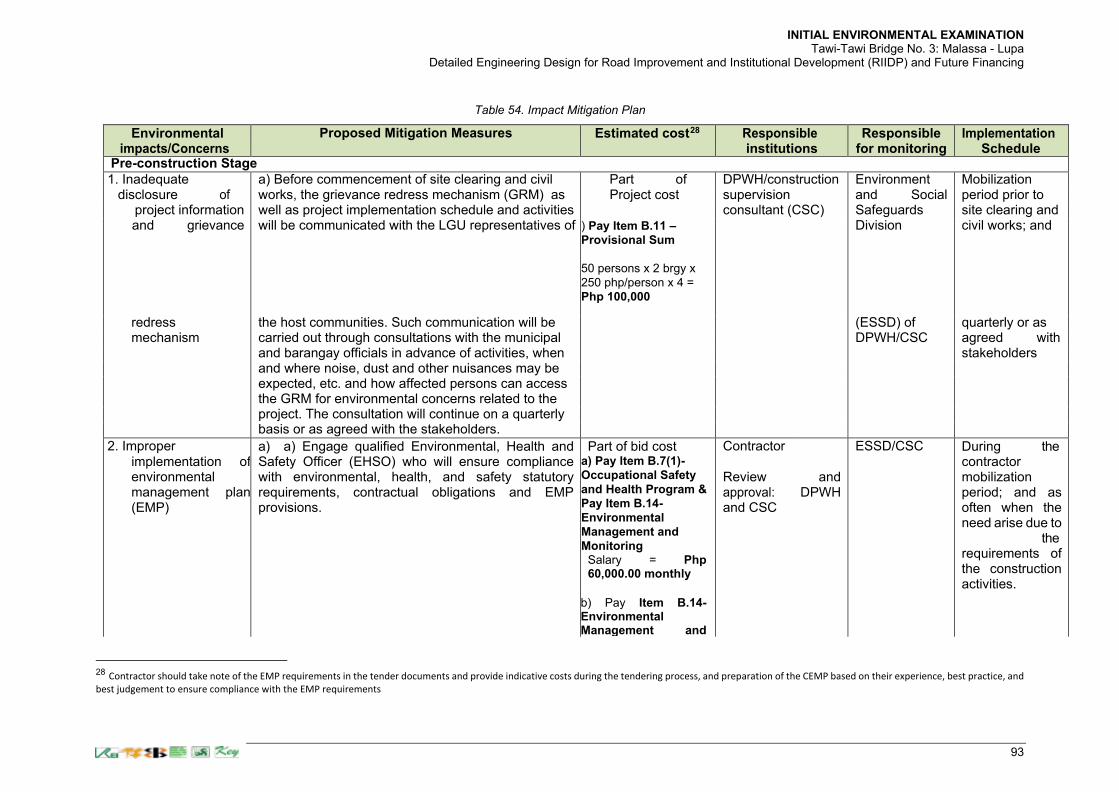
INITIAL ENVIRONMENTAL EXAMINATION Tawi-Tawi Bridge No. 3: Malassa - Lupa
Detailed Engineering Design for Road Improvement and Institutional Development (RIIDP) and Future Financing
93
Table 54. Impact Mitigation Plan
Environmental impacts/Concerns
Proposed Mitigation Measures Estimated cost28 Responsible
institutions Responsible
for monitoring Implementation
Schedule Pre-construction Stage
1. Inadequate a) Before commencement of site clearing and civil Part of DPWH/construction Environment Mobilization disclosure of works, the grievance redress mechanism (GRM) as Project cost supervision and Social period prior to
project information well as project implementation schedule and activities consultant (CSC) Safeguards site clearing and and grievance will be communicated with the LGU representatives of ) Pay Item B.11 –
Provisional Sum
50 persons x 2 brgy x
250 php/person x 4 =
Php 100,000
Division civil works; and
redress the host communities. Such communication will be (ESSD) of quarterly or as mechanism carried out through consultations with the municipal DPWH/CSC agreed with
and barangay officials in advance of activities, when stakeholders and where noise, dust and other nuisances may be
expected, etc. and how affected persons can access
the GRM for environmental concerns related to the
project. The consultation will continue on a quarterly
basis or as agreed with the stakeholders.
2. Improper implementation of environmental management plan (EMP)
a) a) Engage qualified Environmental, Health and Safety Officer (EHSO) who will ensure compliance with environmental, health, and safety statutory requirements, contractual obligations and EMP provisions.
Part of bid cost a) Pay Item B.7(1)-
Occupational Safety
and Health Program &
Pay Item B.14-
Environmental
Management and
Monitoring Salary = Php 60,000.00 monthly
b) Pay Item B.14- Environmental Management and
Contractor Review approval: and CSC
and DPWH
ESSD/CSC During the contractor mobilization period; and as often when the need arise due to the requirements of the construction activities.
28 Contractor should take note of the EMP requirements in the tender documents and provide indicative costs during the tendering process, and preparation of the CEMP based on their experience, best practice, and
best judgement to ensure compliance with the EMP requirements

INITIAL ENVIRONMENTAL EXAMINATION Tawi-Tawi Bridge No. 3: Malassa - Lupa
Detailed Engineering Design for Road Improvement and Institutional Development (RIIDP) and Future Financing
94
Environmental impacts/Concerns
Proposed Mitigation Measures Estimated cost28 Responsible
institutions Responsible
for monitoring Implementation
Schedule
b) Secure relevant Government Permits such as but not limited to Environmental Compliance Certificate (ECC); tree-cutting/earthballing permit; water extraction permit; quarry permit; ECC for temporary facilities; water discharge permit; permit to operate generators (Air Pollution Source Installation); building permit; excavation permit; fencing permit; and other permits that the LGU may require. c) Conduct baseline environmental quality measurements for marine water quality to supplement the findings of the marine ecological survey prior to construction following inclusion of this requirement in the tender document for the following: Water Quality: Turbidity, pH, Heavy metals, BOD5, COD, DO, Oil and grease, TSS, Fecal Coliform, Total coliform
During the pre-construction phase of the project, specific items to be addressed by that time includes but not necessarily limited to the following:
1) for purposes of marine water quality monitoring, the parameters following the Water Quality Guidelines shall be conducted by the Contractor during the pre-construction stage;
Monitoring Permits Cost = Php 5,055.00 per ECC Application
c) Pay Item B.14- Environmental Management and Monitoring & Pay Item B.11 – Provisional Sum Lump Sum for Water Quality Tests = Php 332,000.00
Php 4,000.00 per sampling station excluding mobilization and manpower
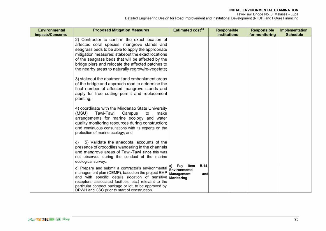
INITIAL ENVIRONMENTAL EXAMINATION Tawi-Tawi Bridge No. 3: Malassa - Lupa
Detailed Engineering Design for Road Improvement and Institutional Development (RIIDP) and Future Financing
95
Environmental impacts/Concerns
Proposed Mitigation Measures Estimated cost28 Responsible
institutions Responsible
for monitoring Implementation
Schedule
2) Contractor to confirm the exact location of affected coral species, mangrove stands and seagrass beds to be able to apply the appropriate mitigation measures; stakeout the exact locations of the seagrass beds that will be affected by the bridge piers and relocate the affected patches to the nearby areas to naturally regrow/re-vegetate; 3) stakeout the abutment and embankment areas of the bridge and approach road to determine the final number of affected mangrove stands and apply for tree cutting permit and replacement planting; 4) coordinate with the Mindanao State University (MSU) Tawi-Tawi Campus to make arrangements for marine ecology and water quality monitoring resources during construction; and continuous consultations with its experts on the
protection of marine ecology; and d) 5) Validate the anecdotal accounts of the presence of crocodiles wandering in the channels and mangrove areas of Tawi-Tawi since this was
not observed during the conduct of the marine
ecological survey..
c) Prepare and submit a contractor’s environmental management plan (CEMP), based on the project EMP and with specific details (location of sensitive receptors, associated facilities, etc.) relevant to the particular contract package or lot, to be approved by DPWH and CSC prior to start of construction.
c) Pay Item B.14- Environmental Management and Monitoring

INITIAL ENVIRONMENTAL EXAMINATION Tawi-Tawi Bridge No. 3: Malassa - Lupa
Detailed Engineering Design for Road Improvement and Institutional Development (RIIDP) and Future Financing
96
Environmental impacts/Concerns
Proposed Mitigation Measures Estimated cost28 Responsible
institutions Responsible
for monitoring Implementation
Schedule d) The CEMP shall include but not necessarily limited
to the following presentation of the following: a) Natural Environment Preservation - Soil Management Plan; Waste Management Plan; Surface water, groundwater (if applicable nearest the bridge location) and marine water quality management plan; Mangrove Replanting Plan (even if the number currently is only small); b) Pollution Prevention and Control – Air Quality, Dust, Smoke and Airborne Pollution Management; Noise Management; Environmental Risk Management; c) Social Environment Management and Mitigation – Traffic Management Plan; Disabled and Gender Plan; Occupational Health and Safety Management; IEC Program; Chance Finds Procedure; d) Environmental Impacts Monitoring – Environmental Management Monitoring Reports in compliance with EMB and ADB requirements.
d) Pay Item B.14- Environmental Management and Monitoring
Construction Stage
3. Local air pollution a) Provide signages informing public and contractor staff to observe speed limit of at least 25 kph in populated areas (sensitive receptors) of the community.
Pay Item
B.14-
Environment
al
Management
and
Monitoring
Preparation: Contractor
Review approval: and CSC
and DPWH
ESSD/CSC During the contractor mobilization period; and as often when the need arises due to the requirements of the construction activities.

INITIAL ENVIRONMENTAL EXAMINATION Tawi-Tawi Bridge No. 3: Malassa - Lupa
Detailed Engineering Design for Road Improvement and Institutional Development (RIIDP) and Future Financing
97
Environmental impacts/Concerns
Proposed Mitigation Measures Estimated cost28 Responsible
institutions Responsible
for monitoring Implementation
Schedule
b) Regular water spraying/dampening dust emissions from disturbed soil, approach road construction surfaces and haul roads wherever there are sensitive receptors (such as houses, churches, businesses, schools, medical facilities) nearby is undertaken. Spraying will be done twice daily or at such frequency as is needed to suppress dust emission to acceptable levels
Pay Item B.14-
Environmental
Management and
Monitoring
Contractor ESSD/CSC During dry construction days.
c) Regular removal of debris and spoil piles and clean-up after completion of a section.
Contractor ESSD/CSC As often when construction activities require.
d) All vehicles transporting dusty materials will be tightly covered to prevent release of fugitive dust.
Contractor ESSD/CSC During each hauling activities.
e) Rock crushing, concrete batching plant, aggregate drying and surface treatment preparation operations (whether bituminous asphalt or spray seal mixes) will be located a sufficient distance (at least 500 m) from habitations and community environments including other sensitive receptors (churches, schools, medical facilities, etc.) to assure that there will be no community impacts from such activities
Contractor ESSD/CSC During the contractor mobilization period following locational guidelines; and during facility operation.
f) Establishment and operation of rock crushing, concrete batching plant, aggregate drying and surface treatment preparation operations (whether bituminous asphalt or spray seal mixes) must be approved by the relevant authorities (e.g., EMB- DENR, LGUs).
Contractor ESSD/CSC During the contractor mobilization period following locational guidelines; and during facility operation.

INITIAL ENVIRONMENTAL EXAMINATION Tawi-Tawi Bridge No. 3: Malassa - Lupa
Detailed Engineering Design for Road Improvement and Institutional Development (RIIDP) and Future Financing
98
Environmental impacts/Concerns
Proposed Mitigation Measures Estimated cost28 Responsible
institutions Responsible
for monitoring Implementation
Schedule
g) All equipment, machinery and vehicles used for the project must be well maintained to ensure proper functioning thereby minimizing contribution to air pollution.
Contractor ESSD/CSC During the contractor mobilization period; and throughout the construction period until complete demobilization.
h) For storage areas of construction materials such as sand, gravel, cement, etc., provisions will be made to prevent materials from being blown away towards sensitive receptors.
Contractor ESSD/CSC During the contractor mobilization period; and throughout the construction period until complete demobilization.
i) Roads will be regularly cleaned to remove tracked mud, cement, etc.
Contractor ESSD/CSC During every rainy days; and every after concrete pouring activities in the work site.
j) Stockpiling of spoils near sensitive receptors will be prohibited.
Contractor ESSD/CSC During hauling and stockpiling activities; locational guidance provided during the CEMP preparation.

INITIAL ENVIRONMENTAL EXAMINATION Tawi-Tawi Bridge No. 3: Malassa - Lupa
Detailed Engineering Design for Road Improvement and Institutional Development (RIIDP) and Future Financing
99
Environmental impacts/Concerns
Proposed Mitigation Measures Estimated cost28 Responsible
institutions Responsible
for monitoring Implementation
Schedule
k) Asphalt plants, concrete batching plants and crushing plants will be equipped with dust suppression devices such as water sprays, dust collectors, covered conveyor.
Contractor ESSD/CSC During the contractor mobilization period; and throughout the construction period until complete demobilization.
l) Speed limits will be imposed on construction vehicles to minimize dust emission along areas where sensitive receptors are located.
Pay Item B.8(1)- Traffic Management
Contractor ESSD/CSC Throughout the construction period until complete demobilization.
m) Burning of all types of wastes generated at the construction sites, work camps and other project- related activities will be strictly prohibited.
Pay Item B.14-
Environmental
Management and
Monitoring
Contractor ESSD/CSC Throughout the construction period until complete demobilization.
n) Stockpiles of sand and aggregate greater than 20 m3 for use in concrete mixing will be enclosed on three sides, with walls extending above the pile and two meters beyond the front of the piles.
Contractor ESSD/CSC During hauling and stockpiling activities and throughout the construction period until complete demobilization.
o) Water sprays will be used during the delivery and handling of all raw sand and aggregates, and other similar materials, when dust is likely to be created and to dampen such stored materials during dry and windy weather to avoid impacts to sensitive receptors.
Contractor ESSD/CSC During materials delivery activities and throughout the construction period until complete demobilization.

INITIAL ENVIRONMENTAL EXAMINATION Tawi-Tawi Bridge No. 3: Malassa - Lupa
Detailed Engineering Design for Road Improvement and Institutional Development (RIIDP) and Future Financing
100
Environmental impacts/Concerns
Proposed Mitigation Measures Estimated cost28 Responsible
institutions Responsible
for monitoring Implementation
Schedule
p) Cement and other such fine-grained materials delivered in bulk will be stored in closed containers.
Contractor ESSD/CSC During cement delivery activities and throughout the construction period until complete demobilization.
4. Noise a) Limit the duration of noisy construction activities to daylight hours, whenever possible, in the vicinity of sensitive receptors.
Contractor ESSD/CSC Throughout the construction period until complete demobilization.
b) In areas near houses or noise-sensitive sites, noisy equipment will not be operated during nighttime to early morning (19:00H –06:00H).
Contractor ESSD/CSC Throughout the construction period until complete demobilization.
c) Workers exposed to high noise levels will be provided with ear plugs.
Pay Item B.7(1)- Occupational Safety and Health Program
Contractor ESSD/CSC Throughout the construction period until complete demobilization.
d) The contractors will provide prior notification to the community on the schedule of construction activities.
Contractor ESSD/CSC Throughout the construction period until complete demobilization.
e) Whenever possible, noisy equipment will be completely enclosed which can significantly reduce noise levels.
Pay Item B.7(1)- Occupational Safety and Health Program
Contractor ESSD/CSC Throughout the construction period until complete demobilization.

INITIAL ENVIRONMENTAL EXAMINATION Tawi-Tawi Bridge No. 3: Malassa - Lupa
Detailed Engineering Design for Road Improvement and Institutional Development (RIIDP) and Future Financing
101
Environmental impacts/Concerns
Proposed Mitigation Measures Estimated cost28 Responsible
institutions Responsible
for monitoring Implementation
Schedule
f) Any stationary equipment that produce high noise levels (e.g., portable diesel generators, compressors, etc.) will be positioned as far as is practical from sensitive receptors.
Contractor ESSD/CSC During equipment mobilization following locational guidelines.
g) Construction traffic routes will be defined in cooperation with local communities and traffic police to minimize noise and nuisance.
Contractor ESSD/CSC Prior to the commencement of the construction activities anticipated in the locality.
h) Vehicle speeds will be reduced around sensitive receptors.
Contractor ESSD/CSC Throughout the construction period until complete demobilization.
i) Concrete batching plants will be located at least 500 m away from sensitive receptors.
Contractor ESSD/CSC Prior to plant mobilization following locational guidelines.
j) Temporary noise barriers will be installed along the edge of the road, as necessary, in front of sensitive receptors facing heavy construction activities.
Pay Item B.7(1)- Occupational Safety and Health Program
Contractor ESSD/CSC Prior to the commencement of the activities.
k) Prior to undertaking noisy activities, the contractor will consult with village leaders and representatives from the religious sites and schools along the project road regarding construction schedule so as to minimize disturbance to important events such as ceremonies, examination period and the like.
Contractor ESSD/CSC Prior to the commencement of the activities.

INITIAL ENVIRONMENTAL EXAMINATION Tawi-Tawi Bridge No. 3: Malassa - Lupa
Detailed Engineering Design for Road Improvement and Institutional Development (RIIDP) and Future Financing
102
Environmental impacts/Concerns
Proposed Mitigation Measures Estimated cost28 Responsible
institutions Responsible
for monitoring Implementation
Schedule
5. Spoils disposal a) Prior to excavation, contractors will submit a spoils
disposal plan to concerned authorities such as LGUs and DPWH for approval. The plan will show the location of proposed excavation sites, cut locations, fill and/or disposal sites for excess cut and, and disposal sites for bridge approach road construction spoils. The quantities shall be determined and monitored during actual construction and these could be significant from bridge pier piling works as well as approach road excavation works, The plan will include photographs of the sites and will also indicate the existing land use and capacity of the disposal site. A copy of the approved plan forming part of the CEMP will be submitted to ADB.
Pay Item B.14-
Environmental
Management and
Monitoring
Preparation: Contractor
Review approval: DPWH and
and
CSC
ESSD/CSC Prior to the commencement of the activities; guided by the CEMP.
b) The contractor will ensure that spoils disposal will not encroach on surface water courses, will not cause sedimentation or obstruction of stream/river flow and will not cause damage to agricultural land, irrigation, densely vegetated areas, forests, properties and other productive sites.
c) Where local residents and villages requests to use spoils as fill materials in their lots and properties, the contractor shall secure a written request and agreement for proper disposal. The Contractor shall ensure that the filling activities shall not cause pollution or sedimentation and/or water ponding by technically assisting property owners in the establishment of adequate bunding and drainage.
Contractor ESSD/CSC Prior to the commencement of the activities; and throughout the duration of the activities.
6. Impacts from operation of borrow areas and quarries
a) For commercial borrow pits and quarries, the contractor will ensure that only facilities with necessary environmental permits will be used for the project.
Contractor ESSD/CSC Prior to the commencement of the activities; guided by the CEMP.

INITIAL ENVIRONMENTAL EXAMINATION Tawi-Tawi Bridge No. 3: Malassa - Lupa
Detailed Engineering Design for Road Improvement and Institutional Development (RIIDP) and Future Financing
103
Environmental impacts/Concerns
Proposed Mitigation Measures Estimated cost28 Responsible
institutions Responsible
for monitoring Implementation
Schedule
b) For project-specific facilities, i.e., those that will be established and solely operated for the project, the contractor will ensure that these are covered by necessary environmental permits.
Contractor ESSD/CSC Prior to the commencement of the activities;
c) Prior to operation of borrow pits and quarries, the contractor will submit to the LGU and DPWH a plan showing the location/s of such facilities to be used, as well as timeframe and mitigation measures to be implemented to rehabilitate project-specific borrow pits and quarries.
Preparation: Contractor
Review approval: DPWH and CS
and
ESSD/CSC Prior to the commencement of the activities.
d) The contractor will also ensure that topsoil will be properly removed, stockpiled and preserved for later use during restoration of the borrow pit.
Contractor ESSD/CSC Throughout duration of activities.
the
e) Vegetation cover will be provided during rehabilitation of the site.
Pay Item
622(3)b-
Vegetation,
Vetiver
Grass
System
Contractor ESSD/CSC Following completion of the civil works activities.
f) Upon completion of extraction activities, quarries and borrow pits will be dewatered, signages and fences installed, as appropriate, to minimize health and safety risks.
Pay Item
B.14-
Environmen
tal
Managemen
t and
Monitoring
Contractor ESSD/CSC Upon completion extraction activities.
of
7. Erosion and unstable slopes
a) Undertake planting of native species of trees and landscaping along the roads and embankment slopes, as appropriate.
Contractor ESSD/CSC Following completion of the civil works activities.
b) Construction activities in hilly areas will be carried out intensively during dry season. However, as the area is not generally typhoon-prone, construction work during wet season is likely feasible.
Contractor ESSD/CSC During the dry season and as weather permits.

INITIAL ENVIRONMENTAL EXAMINATION Tawi-Tawi Bridge No. 3: Malassa - Lupa
Detailed Engineering Design for Road Improvement and Institutional Development (RIIDP) and Future Financing
104
Environmental impacts/Concerns
Proposed Mitigation Measures Estimated cost28 Responsible
institutions Responsible
for monitoring Implementation
Schedule
c) Slope protection measures (e.g., sodding) will be implemented to avoid impacts to agricultural land and adjacent properties. Areas to be cleared of vegetation for construction will be restricted to the minimum required for immediate works.
Pay Item
622(3)b-
Vegetation,
Vetiver
Grass
System
Contractor ESSD/CSC Prior to the commencement of slope protection works and following
8. Deterioration of marine water quality and ecology
a) Limit the exposure of areas prone to erosion so this will not be carried into the channel during rainy days as well as providing silt traps or fine mesh nets to especially protect coral species and seagrass beds identified during the marine ecological survey. Continuous consultation with marine experts is also encouraged..
Pay Item B.14-
Environmental
Management and
Monitoring
Contractor ESSD/CSC During earthworks, and throughout the duration of the activities.
b) Observe proper management of spoils during bored piling works and approach roads embankment by stockpiling away from the work areas and providing bunds while waiting to be properly disposed in locations to be approved by the CSC.
Contractor ESSD/CSC During earthworks, and throughout the duration of the activities.
c) Transport spoils immediately to final disposal sites as much as possible to minimize materials carried by surface runoff during rainy days.
Pay Item B.14-
Environmental
Management and
Monitoring
Contractor ESSD/CSC During earthworks, and throughout the duration of the activities.
d) Avoid prolonged stockpiling unless necessary (i.e. topsoils necessary for agricultural re-use where sodding maybe necessary to keep from being washed away during rainy days).
Contractor ESSD/CSC During earthworks, and throughout the duration of the activities.
e) Bentonite slurry or polymers that maybe finally be decided to be used during bridge construction will be collected and processed in a system of leak-free tank storages. Discharges into the Manalik Channel will be prohibited and compliance closely monitored by the CSC.
Contractor ESSD/CSC During bridgeworks, and throughout the duration of the activities.

INITIAL ENVIRONMENTAL EXAMINATION Tawi-Tawi Bridge No. 3: Malassa - Lupa
Detailed Engineering Design for Road Improvement and Institutional Development (RIIDP) and Future Financing
105
Environmental impacts/Concerns
Proposed Mitigation Measures Estimated cost28 Responsible
institutions Responsible
for monitoring Implementation
Schedule
f) Spillage of bentonite or polymers in adjacent lands will be cleaned up immediately to prevent caking and hardening, or contaminating the marine water brought about by surface runoff during rainy days.
Contractor ESSD/CSC During earthworks, and throughout the duration of the activities.
g) Prior to establishment and operation of concrete batching plants and casting yards, the contractor will obtain the necessary environmental permits to ensure proper siting away from the Manalik Channel.
Contractor ESSD/CSC Prior to facility mobilization.
h) Retention ponds with sufficient specifications/capacity will be constructed for treatment of wastewater (e.g., from washing of equipment such as mixer drums, trucks and chute, contact storm water, etc.) and shall be operated and maintained to ensure that effluent quality will meet applicable standards.
Contractor ESSD/CSC Prior to commencement of pond works; and throughout the construction period until demobilization.
j) Equipment service and maintenance yards will be sited away from the Manalik Channel and provided with impermeable flooring and collection sump.
Pay Item B.14-
Environmental
Management and
Monitoring
Contractor ESSD/CSC During the establishment of the facility.
k) Watertight receptacles will be provided in all the equipment maintenance shops for waste oil, oily rags, spent oil filters, solvents and oily containers to prevent leaked materials from being washed to the channel during rainy days.
Contractor ESSD/CSC Throughout the operation of the maintenance shops until demobilization.
l) Disposal of wastes contaminated with hydrocarbons shall not be done in the channel, and will be done only through authorized waste handlers and recyclers.
Contractor ESSD/CSC During wastes disposal activities.
m) Refueling and servicing of equipment will only be carried out in areas away from the channel and adequately equipped to collect leaks and spills.
Contractor ESSD/CSC Throughout the operation of the maintenance shops until demobilization.

INITIAL ENVIRONMENTAL EXAMINATION Tawi-Tawi Bridge No. 3: Malassa - Lupa
Detailed Engineering Design for Road Improvement and Institutional Development (RIIDP) and Future Financing
106
Environmental impacts/Concerns
Proposed Mitigation Measures Estimated cost28 Responsible
institutions Responsible
for monitoring Implementation
Schedule
n) impervious floor and bunded around and will be located away from watercourses, flood-prone areas and workers camps that may eventually carry hazardous materials to the channel during rainy days.
Contractor ESSD/CSC Throughout the operation of the campsite until demobilization.
o) Fuel storage area will be located at least 100 meters away from watercourses, flood-prone areas and workers camps.
Contractor ESSD/CSC Prior to the establishment of the fuel storage area.
Hazardous materials and wastes
a) Spill clean-up materials (e.g., absorbent pads, etc.) specifically designed for petroleum products and other hazardous substances where such materials are being stored and used shall be available to ensure leaked residues are not carried away by surface runoff during rainy days.
Contractor ESSD/CSC Throughout the operation of the campsite until demobilization.
b) Relevant construction personnel will be trained in handling of fuels/hazardous substances and spill control procedures.
Contractor ESSD/CSC Prior to handling of hazardous materials, etc.
c) All storage containers of hazardous materials and wastes will be properly labeled and maintained in good condition.
Pay Item B.14-
Environmental
Management and
Monitoring
Contractor ESSD/CSC Throughout the operation of the campsite until demobilization.
d) Restoration of temporary work sites will include removal and treatment or proper disposal of oil contaminated soils that maybe potentially carried to the channel during rainy days.
Contractor ESSD/CSC Prior to demobilization.
9. Loss of mangrove vegetation and affected trees along the approach road alignment
a) DPWH will obtain a tree cutting permit in compliance with PD 705 (Revised Forestry Code of the Philippines). No tree cutting will be undertaken without the necessary permit to be issued by the Community Environmental and Natural Resources Office (CENRO) of the DENR
Pay Item 100 (3) – Individual Removal of Trees (150mm-750mm dia.) Part of Project cost
DPWH ESSD/CSC Prior to tree cutting activities.
b) Tree cutting can only be undertaken under close supervision of CENRO, DPWH and CSC staff who will be present at the site throughout the duration of cutting activities.
Contractor ESSD/CSC During tree cutting activities.

INITIAL ENVIRONMENTAL EXAMINATION Tawi-Tawi Bridge No. 3: Malassa - Lupa
Detailed Engineering Design for Road Improvement and Institutional Development (RIIDP) and Future Financing
107
Environmental impacts/Concerns
Proposed Mitigation Measures Estimated cost28 Responsible
institutions Responsible
for monitoring Implementation
Schedule
c) Only trees marked based on the Tree Chart prepared by the CENRO will be cut.
Contractor ESSD/CSC During tree cutting activities.
d) Cut trees will be turned over to the CENRO or local community for disposal
Contractor ESSD/CSC During and/or after tree cutting activities.
e) In compliance with DENR Memorandum Order no. 05 of 2012: Uniform Replacement Ratio for Cut or Relocated Trees, and turn over to the CENRO.
Pay Item 611 – Refurnishing of Trees
DPWH ESSD/CSC During and/or after tree cutting activities.
f) Ensure that one of their environment specialists and/or that of the supervision consultant will closely monitor the tree cutting activities to ensure that these will comply with the provisions of the Tree Cutting Permit and corresponding Tree Chart.
Pay Item B.14-
Environmental
Management and
Monitoring
DPWH/CSC ESSD/CSC During tree cutting activities.
g) As part of the semi-annual environmental monitoring report to be submitted to ADB, DPWH will report on the status of tree cutting, tree relocation or replacement any issues/concerns, corresponding actions and other relevant matters.
DPWH/CSC ESSD/CSC Semi-annual during SEMR preparation and submission to ADB.
h) To avoid unnecessary impacts to vegetation, the contractor will prohibit cutting of trees for firewood and for other uses in the Project and will ensure that tree cutting is limited to areas as approved by the CENRO.
Contractor ESSD/CSC During tree cutting activities.
10. Impacts on fauna a) Prohibit workers from hunting wild animals including crocodiles, that based on anecdotal accounts of some residents are present in the channel during the cold months.
Contractor ESSD/CSC Duration of the construction period.
b) As much as possible, bridge works will be scheduled in dry season to minimize adverse impacts to fishery, river water quality and other aquatic resources.
Contractor ESSD/CSC During the dry season.

INITIAL ENVIRONMENTAL EXAMINATION Tawi-Tawi Bridge No. 3: Malassa - Lupa
Detailed Engineering Design for Road Improvement and Institutional Development (RIIDP) and Future Financing
108
Environmental impacts/Concerns
Proposed Mitigation Measures Estimated cost28 Responsible
institutions Responsible
for monitoring Implementation
Schedule
11. Occupational health and safety hazards
a) Use of personal protective equipment (PPE) such as safety shoes, safety hat, goggles, safety belt, ear protection or other garments or equipment designed to protect the wearer's body from injury will be strictly observed during construction.
Pay Item B.7(1)- Occupational Safety and Health Program
Contractor ESSD/CSC Throughout the construction duration.
b) Prepare and implement a COVID-19 Risk Management Plan guided by DPWH’ and ADB’ Guidance on Managing Risk from COVID-19 on Construction Sites and in Workers’ Housing.
c) Provision of personal flotation devices (PFDs) to all workers working on the bridge to help reduce the risk of drowning when falling into the Manalik Channel.
d) Provision of first aid kits that are readily available to workers as well as access to or availability of a health worker to attend to any immediate health needs of workers and in case of untoward incidents.
Pay Item B.11 – Provisional Sum Pay Item B.7(1)- Occupational Safety and Health Program
Contractor ESSD/CSC Throughout the construction duration.
c) Conduct orientation for construction workers regarding health and safety measures, emergency response in case of accidents, fire, etc., and prevention of HIV/AIDS, COVID-19 and other related diseases.
Contractor ESSD/CSC Prior to work deployment; as often as necessary.
d) Installation of adequate drainage in workers camps to avoid water logging/accumulation of stagnant water and formation of breeding sites for mosquitoes.
Contractor ESSD/CSC During campsite establishment.
e) Provision of separate clean housing with sufficient ventilation and separate hygienic sanitation facilities for male and female workers.
Contractor ESSD/CSC During campsite establishment.
f) Provision of reliable supply of water for drinking, cooking and washing purposes at the workers’ camps.
Contractor ESSD/CSC During campsite establishment.
g) Proper collection and disposal of solid wastes within the workers’/construction camps consistent with local regulations.
Contractor ESSD/CSC During campsite operation until demobilization.
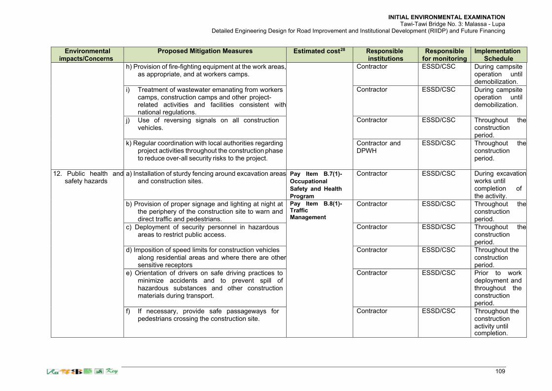
INITIAL ENVIRONMENTAL EXAMINATION Tawi-Tawi Bridge No. 3: Malassa - Lupa
Detailed Engineering Design for Road Improvement and Institutional Development (RIIDP) and Future Financing
109
Environmental impacts/Concerns
Proposed Mitigation Measures Estimated cost28 Responsible
institutions Responsible
for monitoring Implementation
Schedule
h) Provision of fire-fighting equipment at the work areas, as appropriate, and at workers camps.
Contractor ESSD/CSC During campsite operation until demobilization.
i) Treatment of wastewater emanating from workers camps, construction camps and other project- related activities and facilities consistent with national regulations.
Contractor ESSD/CSC During campsite operation until demobilization.
j) Use of reversing signals on all construction vehicles.
Contractor ESSD/CSC Throughout the construction period.
k) Regular coordination with local authorities regarding project activities throughout the construction phase to reduce over-all security risks to the project.
Contractor and DPWH
ESSD/CSC Throughout the construction period.
12. Public health and safety hazards
a) Installation of sturdy fencing around excavation areas and construction sites.
Pay Item B.7(1)-
Occupational
Safety and Health
Program
Contractor ESSD/CSC During excavation works until completion of the activity.
b) Provision of proper signage and lighting at night at the periphery of the construction site to warn and direct traffic and pedestrians.
Pay Item B.8(1)- Traffic Management
Contractor ESSD/CSC Throughout the construction period.
c) Deployment of security personnel in hazardous areas to restrict public access.
Contractor ESSD/CSC Throughout the construction period.
d) Imposition of speed limits for construction vehicles along residential areas and where there are other sensitive receptors
Contractor ESSD/CSC Throughout the construction period.
e) Orientation of drivers on safe driving practices to minimize accidents and to prevent spill of hazardous substances and other construction materials during transport.
Contractor ESSD/CSC Prior to work deployment and throughout the construction period.
f) If necessary, provide safe passageways for pedestrians crossing the construction site.
Contractor ESSD/CSC Throughout the construction activity until completion.

INITIAL ENVIRONMENTAL EXAMINATION Tawi-Tawi Bridge No. 3: Malassa - Lupa
Detailed Engineering Design for Road Improvement and Institutional Development (RIIDP) and Future Financing
110
Environmental impacts/Concerns
Proposed Mitigation Measures Estimated cost28 Responsible
institutions Responsible
for monitoring Implementation
Schedule
g) At construction areas, provide safe access to farmland and other properties.
Contractor ESSD/CSC Throughout the construction activity until completion.
13. Road/sea vessel Traffic obstruction
a) Provide signs advising road users that construction is in progress, particularly in areas where the project alignment crosses existing roads and where construction related-facilities are located (i.e. bridge approaches, etc.)..
Pay Item B.8(1)- Traffic Management Part of bid cost Part of bid cost
Contractor ESSD/CSC Throughout the construction activity until completion.
b) Employ flag persons to control traffic when construction equipment is entering or leaving the work area.
Contractor ESSD/CSC Throughout the construction activity until completion.
c) Post traffic advisory signs (to minimize traffic build- up) in coordination with local authorities.
Contractor ESSD/CSC Throughout the construction
d) Vessel passage are not anticipated to be affected by construction. Navigation lanes shall be made available for passing sea vessels all the time by making bridge piers open in between following the contractor’ method of construction.
activity until completion.
e) The Contractor shall prepare and submit a traffic management plan addressing both road and sea vessel traffic most especially if barging of construction materials are also anticipated to be significant during construction.
14. Accidental discovery of artefacts
a) Contractor to immediately cease operations at the site of discovery.
Pay Item B.14-
Environmental
Management and
Monitoring
Contractor ESSD/CSC Immediately upon discovery of artefacts.
b) Contractor to inform the CSC and Environment Officer of the Office of the District Engineer.
Contractor ESSD/CSC Immediately upon discovery of artefacts.
c) CSC to relay information to DPWH CSC ESSD/CSC Immediately upon discovery of artefacts.

INITIAL ENVIRONMENTAL EXAMINATION Tawi-Tawi Bridge No. 3: Malassa - Lupa
Detailed Engineering Design for Road Improvement and Institutional Development (RIIDP) and Future Financing
111
Environmental impacts/Concerns
Proposed Mitigation Measures Estimated cost28 Responsible
institutions Responsible
for monitoring Implementation
Schedule
d) DPWH to notify the National Historical Commission of the Philippines (NHCP) and/or other concerned government agencies for the next steps.
DPWH ESSD/CSC Immediately upon discovery of artefacts.
e) Recommence work only after NHCP has provided official notification accordingly.
Contractor ESSD/CSC Immediately upon NHCP notification.
15. Damage to properties
a) The contractor will immediately repair and/or compensate for any damage that it causes to properties (houses, farmlands, aquaculture ponds, irrigation canals, etc.), community facilities such as water supply, power supply, communication facilities and the like.
Pay Item B.14-
Environmental
Management and
Monitoring Part of Project cost
Contractor ESSD/CSC Immediately upon completion of damage assessment.
b) Access roads used for transport of construction materials and other construction-related activities will be maintained by the Contractor in at least in their pre-project condition for the duration of construction.
Contractor ESSD/CSC Throughout the construction period.
16. Unanticipated environmental impacts
a) If any unanticipated impacts become apparent during project implementation, the DPWH will update the environmental assessment and EMP or prepare a new environmental assessment and EMP to assess the potential impacts, evaluate the alternatives, and outline mitigation measures and resources to address those impacts. The updated or newly prepared documents will be submitted to ADB for review, clearance and public disclosure.
Contractor, CSC, ESSD
DPWH Immediately upon occurrence of impact.
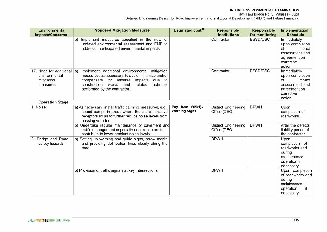
INITIAL ENVIRONMENTAL EXAMINATION Tawi-Tawi Bridge No. 3: Malassa - Lupa
Detailed Engineering Design for Road Improvement and Institutional Development (RIIDP) and Future Financing
112
Environmental impacts/Concerns
Proposed Mitigation Measures Estimated cost28 Responsible
institutions Responsible
for monitoring Implementation
Schedule
b) Implement measures specified in the new or updated environmental assessment and EMP to address unanticipated environmental impacts.
Contractor ESSD/CSC Immediately upon completion of impact assessment and agreement on corrective action.
17. Need for additional environmental mitigation measures
a) Implement additional environmental mitigation measures, as necessary, to avoid, minimize and/or compensate for adverse impacts due to construction works and related activities performed by the contractor.
Contractor ESSD/CSC Immediately upon completion of impact assessment and agreement on corrective action.
Operation Stage
1. Noise a) As necessary, install traffic calming measures, e.g., speed bumps in areas where there are sensitive receptors so as to further reduce noise levels from passing vehicles.
Pay Item 605(1)-Warning Signs
District Engineering Office (DEO)
DPWH Upon completion of roadworks.
b) Undertake regular maintenance of pavement and traffic management especially near receptors to contribute to lower ambient noise levels.
District Engineering Office (DEO)
DPWH After the defects liability period of the contractor.
2. Bridge and Road safety hazards
a) Setting up warning and guide signs, arrow marks and providing delineation lines clearly along the road.
DPWH Upon completion of roadworks and during maintenance operation if necessary.
b) Provision of traffic signals at key intersections. DPWH Upon completion of roadworks and during maintenance operation if necessary.

INITIAL ENVIRONMENTAL EXAMINATION Tawi-Tawi Bridge No. 3: Malassa - Lupa
Detailed Engineering Design for Road Improvement and Institutional Development (RIIDP) and Future Financing
113
Environmental impacts/Concerns
Proposed Mitigation Measures Estimated cost28 Responsible
institutions Responsible
for monitoring Implementation
Schedule
c) Approach roads will have vertical curves that suit safe design criteria/requirement.
DPWH During detailed design and construction.
d) Installation of chevron signs where required and speed limit signs.
Pay Item 603(3)- Metal Guardrail
DPWH Upon completion of roadworks and during maintenance operation if necessary.
e) Approach roads will have improved vertical alignment to suit sight distance requirement.
DPWH During detailed design and construction.
f) Installation of guardrails between the road and ditches.
Pay Item 603(3)- Metal Guardrail
DPWH Upon completion of roadworks and during maintenance operation if necessary.
g) Prohibit the use of carriageway as parking to ensure safe, efficient and smooth vehicular flow; coordinate with LGU(s) concerned to improve enforcement.
DPWH Upon completion of roadworks and during maintenance operation if necessary.
h) Provision of pedestrian crossing. Pay Item 612- Reflectorized Thermoplastic Pavement Markings
DPWH Upon completion of roadworks and during maintenance
operation if necessary.

INITIAL ENVIRONMENTAL EXAMINATION Tawi-Tawi Bridge No. 3: Malassa - Lupa
Detailed Engineering Design for Road Improvement and Institutional Development (RIIDP) and Future Financing
114
Environmental impacts/Concerns
Proposed Mitigation Measures Estimated cost28 Responsible
institutions Responsible
for monitoring Implementation
Schedule
i) Provision of sidewalks and bicycle lanes where appropriate
Part of Project cost DPWH During construction works as specified in the detailed design.
3. Solid waste build- up and shortage of health/sanitary facilities due to influx of migrants
Implementation of related mandates with regard to provision of solid waste management, health and sanitary facilities.
LGU Upon project completion.
4. Increase in resource use (e.g., tree cutting)
Implementation of related mandates to prevent or minimize illegal mangrove tree cutting and other resource extractive activities (e.g. through close monitoring).
DENR Upon project completion.

INITIAL ENVIRONMENTAL EXAMINATION Tawi-Tawi Bridge No. 3: Malassa - Lupa
Detailed Engineering Design for Road Improvement and Institutional Development (RIIDP) and Future Financing
115
Table 55. Environmental Monitoring Activities during Construction
Aspect Means of Monitoring Frequency of Monitoring Responsible for Monitoring
1. Close supervision of the contractor’s implementation of mitigation measures to minimize or avoid impacts to air quality (particularly dust emission), noise, siltation of surface water and other impacts.
As part of day-to-day project supervision
On-going throughout the construction phase
DPWH/ESSD/CSC
2. Contractor’s environmental performance and implementation of construction phase environmental mitigation measures specified in the IEE/ EMP
Site visit, ocular inspections, interviews with local residents, coordination with concerned barangay/s
Monthly DPWH/ESSD/CSC
3. Dust Visual observation, interviews with local residents, coordination with concerned barangay/s
Monthly DPWH/ESSD/CSC
4. Noise Site observation, interviews with local residents, coordination with concerned barangay/s
Monthly DPWH/ESSD/CSC
5. Marine water quality Visual observation, interviews with local residents, coordination with concerned barangay/s
Monthly DPWH/ESSD/CSC
6. Air quality, noise, water quality Field sampling To be undertaken to validate complaints and/or during pollution events that are potentially caused by the
Contractor under supervision of ESSD and CSC
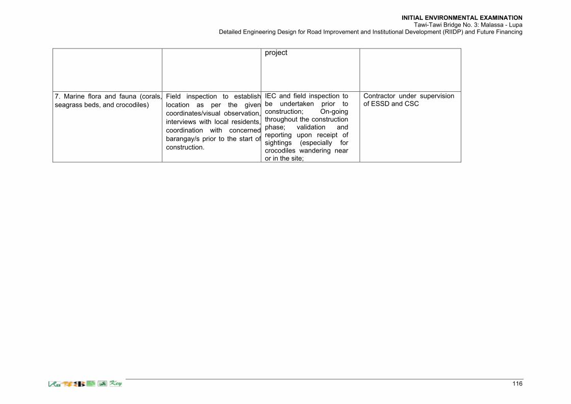
INITIAL ENVIRONMENTAL EXAMINATION Tawi-Tawi Bridge No. 3: Malassa - Lupa
Detailed Engineering Design for Road Improvement and Institutional Development (RIIDP) and Future Financing
116
project
7. Marine flora and fauna (corals,
seagrass beds, and crocodiles) Field inspection to establish
location as per the given
coordinates/visual observation,
interviews with local residents,
coordination with concerned
barangay/s prior to the start of
construction.
IEC and field inspection to be undertaken prior to construction; On-going throughout the construction phase; validation and reporting upon receipt of sightings (especially for crocodiles wandering near or in the site;
Contractor under supervision of ESSD and CSC

INITIAL ENVIRONMENTAL EXAMINATION Tawi-Tawi Bridge No. 3: Malassa – Lupa Pula
Detailed Engineering Design for Road Improvement and Institutional Development (RIIDP) and Future Financing
117
Table 56. Responsibilities for EMP Implementation
Agency Responsibility
Department of Public Works and Highways (DPWH) of the BARMM
• Executing agency with overall responsibility for project construction and operation
• Ensure that sufficient funds are available to properly implement the EMP;
• Ensure that Project implementation complies with Government environmental policies and regulations;
• Ensure that the Project, regardless of financing source, complies with the provisions of the EMP and ADB Safeguard Policy Statement 2009 (SPS);
• Obtain necessary environmental approval(s) from the Environmental Management Bureau and/or other concerned government agencies prior to commencement of civil works;
• Ensure that tender and contract documents for design, supervision and civil works include the relevant EMP requirements;
• Establish information on an environmental grievance redress mechanism, as described in the IEE, to receive and facilitate resolution of affected peoples' concerns; and
• Submit semi-annual monitoring reports on EMP implementation to ADB.
DPWH-Unified Project Management Office (UPMO), Roads Management Cluster II (RMC-II)
• Project management office with direct responsibility for the implementation of civil works, engineering designs and project coordination;
• Ensure that EMP design measures are incorporated in the detailed design;
• Ensure that EMP provisions are strictly implemented and monitored during various project phases (design/pre- construction, construction and operation) to mitigate environmental impacts to acceptable levels;
• Ensure compliance with environmental permits; and
• Include relevant provisions of the EMP in the bid and contract documents for design, civil works and supervision.
• Coordinate with DENR-EMB, Local Government Units (LGU), and other concerned agencies related to environmental aspects for maintaining project`s compliance with environmental permits.
Environmental and Social Safeguards Department (ESSD) of DPWH
• Assist the UPMO-RMC II and CSC in undertaking their environment-related tasks.
Detailed Engineering Design (DED) Consultant
• Incorporate into the project design the environmental protection and mitigation measures identified in the EMP for the design/pre-construction stage; and
• Assist PMO to ensure that all relevant mitigation and monitoring measures from the EMP are incorporated in the bidding and contract documents for project supervision and civil works.
Construction Supervision Consultant (CSC)
• Prior to establishment of contractor’s facilities and commencement of civil works, undertake review of specific environmental management plans (e.g., Consultant (CSC) spoils disposal plan, facilities development plan, etc.) to be

INITIAL ENVIRONMENTAL EXAMINATION Tawi-Tawi Bridge No. 3: Malassa – Lupa Pula
Detailed Engineering Design for Road Improvement and Institutional Development (RIIDP) and Future Financing
118
Agency Responsibility
prepared by contractors to ensure that such plans are consistent with the provisions of the EMP.
• Engage environment specialists who will undertake supervision and monitoring of EMP implementation and contractor’s environmental performance;
• As part of day-to-day project supervision, closely supervise the contractor’s implementation of mitigation measures specified in the EMP;
• Undertake monthly monitoring of contractor’s environmental performance and over-all implementation of the EMP;
• Prepare semi-annual environmental monitoring reports (Appendix 3) on status of EMP implementation for submission to ADB;
• Based on the results of EMP monitoring, identify environmental corrective actions and prepare a corrective action plan, as necessary, for submission to ADB
Contractors • Recruit qualified environmental and safety officer to ensure compliance with environmental statutory requirements, contractual obligations and EMP provisions;
• Provide sufficient funding and human resources for proper and timely implementation of required mitigation and monitoring measures in the EMP; and
• Implement additional environmental mitigation measures, as necessary, to avoid, minimize and/or compensate for adverse impacts due to construction works and related activities performed by the contractor.
Environmental Management Bureau (EMB) of the Department of Environment and Natural Resources (DENR), BARMM
• Review and approve environmental assessment reports required by the Government; and
• Undertake monitoring of the project’s environmental performance based on their mandate.
Asian Development Bank (ADB)
• Conduct periodic site visits to assess status of EMP implementation and over-all environmental performance of the Project;
• Review environmental monitoring reports submitted by the executing agency to ensure that adverse impacts and risks are properly addressed; and
• Publicly disclose through posting on ADB’s website environmental monitoring reports, corrective action plans, prepared by the executing agency during project implementation.

INITIAL ENVIRONMENTAL EXAMINATION Tawi-Tawi Bridge No. 1: Nalil-Sikkiat
Detailed Engineering Design for Road Improvement and Institutional Development (RIIDP) and Future Financing
119
Table 57. Cost for EMP Implementation
Component Description Number/
Frequency Cost per
Unit (Php) Cost (Php)
Source of Funds
PRE-CONSTRUCTION PHASE
Clearances and permits
Securing ECC from EMB-RO
1 ECC 5,055/EC13053953.0C
5,055 for ECC
DPWH
Public consultations and information disclosure
Information disclosure and consultations during preconstruction and construction phase, including public awareness campaign through media
As per requirement
Lump sum 21,000 (for 3 Brgys)
DPWH
Grievance Redress Mechanism (GRM)
Communication will be carried out through consultations with the municipal and barangay officials in advance of activities, when and where noise, dust and other nuisances may be expected, etc. and how affected persons can access the GRM for environmental concerns related to the project. The consultation will continue on a quarterly basis or as agreed with the stakeholders.
Quarterly basis
50 persons x 2
brgy x 250
php/person x 4
= Php 100,000
Php 100,000 (for 4 consultations)
Part of
Project cost in
a) Pay Item
B.11 –
Provisional
Sum
Capacity building (part of the TOR of the CS Consultant)
Orientation workshop of officials and staff involved in the project implementation on ADB SPS (2009), applicable laws, rules and regulations on environment. Workshops/ Writeshops will be conducted by the CS Consultant Team with the supervision of DPWH Team (i.e. Preparation of CEMP, Monitoring procedures on EIA compliance, etc.)
One
Meals and
venue
50,000x
250/pax x 10
pax/project
Php 52,500 per project
Part of the loan package

INITIAL ENVIRONMENTAL EXAMINATION Tawi-Tawi Bridge No. 1: Nalil-Sikkiat
Detailed Engineering Design for Road Improvement and Institutional Development (RIIDP) and Future Financing
120
Component Description Number/
Frequency Cost per
Unit (Php) Cost (Php)
Source of Funds
Baseline ambient noise level survey (24 hr)
Assessment of air quality and noise level along receptors
To be determined
Contractor’s liability (approx. 4,000/ sampling station excluding mobilization and manpower cost)
Depends on the number of designated sampling stations
Covered under construction contract (CEMP)
Conduct of Water Quality Test
Turbidity, pH, Heavy metals, BOD5, COD, DO, Oil and grease, TSS, Fecal Coliform, Total coliform.
Lump sum
Lump Sum for Water Quality Tests = Php 332,000.00
Water Quality Tests = Php 332,000.00
Pay Item B.11 – Provisional Sum
CONSTRUCTION PHASE
Noise and dust suppression at work sites
Application of noise and dust suppression measures
As required
Php 313,584,96 per mo. x 36 mo.
Php 12,543,398.30 (Incase the cost are not sufficient, there is a standby budget of Php 50 million form the contingency in the contract).
Covered under construction contract
Traffic management
Safety signboards, temporary diversions, barricades, etc.
Wherever required throughout the project corridor
Covered under construction contract
Noise level monitoring
Compliance with the IFC-EHS Guidelines
Everyday along nearest receptors
Covered under construction contract
Hazard to workers
Implementation of occupational health and safety measures
Throughout the construction period
Covered under construction contract
Any unanticipated impact due to project implementation
Mitigation of any unanticipated impact arising and defect liability period
Lump sum Php 1,254,339.83
Covered under construction cost – contractor’s insurance
Summary of environmental cost
Environmental cost include in construction contrac plus mitigation for unanticipated impacts
13,053,953.30
Additional environmental management cost not included in construction contract
440,500
Total environmental cost 13,494,453.30

INITIAL ENVIRONMENTAL EXAMINATION Tawi-Tawi Bridge No. 3: Malassa – Lupa Pula
Detailed Engineering Design for Road Improvement and Institutional Development (RIIDP) and Future Financing
71
VIII. CONCLUSION
258. Results of the initial environmental examination show that the project will not cause significant environmental impacts. Adverse impacts that will be experienced during site works are mainly due to dust and noise emissions as well as potential occupational and community health and safety risks. Bridge pier installation for the structure of the chosen alignment will entail mangrove tree cutting and this will be compensated through replanting elsewhere within the immediate vicinity of the bridge location. 259. The bridge alignment does not pass through legally protected areas, critical habitats or biodiversity sites. A marine ecological assessment was conducted to determine the status of the marine resources before the construction of the bridge connecting Barangays Malassa and Lupah Pula. The baseline marine ecological assessment adjacent to the bridge location indicated the following observations results: 260. The average living hard coral cover is only 8%. This percentage of hard coral cover is considered in poor condition using the Gomez, et.al., 1981 and Licuanan, et.al.; ii) the coral reefs in the proposed Malassa-Lupa Pula Bridge experienced by heavy sedimentation and siltation as evidence by the accumulation of silt on the substrate and on top of the living corals; iii) the major coral genera in the proposed bridge location are branching Acropora, Caulastrea, Echinopora, Favites, Galaxea, Goniastrea, Goniopora, Lobophyllia, and Montastrea. Most of the coral general are weedy and stress tolerant except for Lobophyllia. Lobophyllia sometimes called Lobe Brain Corals are very popular stony coral for aquarium due to its wide variety of colors and textures. This genus however, includes one endangered species, the Lobophyllia serratus. This is proposed to be investigated further prior to start of construction with marine experts from the Mindanao State University-Tawi-Tawi College of Technology and Oceanography (MSU-TCTO) so that mitigation measures can be further enhanced, if necessary. This coral species is found in Lupa Pula side with a very nil population of 0.07% cover of the total 8% total coral cover in the area. 261. In addition, there is very poor coral reef fishes (22.6 species per 1000m2 , Hilomen, et. al., 2000 and biomass of only 2.91mt/km2, Nanola, et. al., 2006); minimal species of seagrass and seaweeds (mean of 11.02%/m2 in Malassa to 5.45%/m2 in Lupa Pula, Saito and Atobe, 1970; English et. al. 1997, and Fortes, 1986); minimal species of mangrove stand (4 in the Barangay Malassa side and only 2 in the Barangay Lupa Pula side) and cutting of mangrove observed; water parameters are within the tolerable limits for the recruitment, growth, survival and development of marine organisms (details in the Marine Ecological Assessment Report); plankton (1,036 cell density of phytoplankton, 98 cell density of zooplankton, English et. al. 1997) and benthos population are very minimal; water current is 0.085m/sec; and water around the proposed bridge location is relatively calm all year round. 262. The Malassa-Lupa Pula bridge is located in low gradient channel where there is large supply of sediment to create a landform when the discharge is low and the water is forced to take the route of less resistance by means of flowing in locations of lowest elevation. Prior to construction, it is proposed that further validation of the results shall be made with marine experts from the Mindanao State University-Tawi-Tawi College of Technology and Oceanography (MSU-TCTO) so that appropriate mitigation measures can be further enhanced, if necessary. 263. Adverse ecological impacts to the marine waters including marine-based livelihood activities are conservatively anticipated from nil to low because the vicinity of the bridge site is not used for fishing and aquaculture-seaweed farming. Anticipated impacts can be mitigated with available bridge engineering technologies and construction methods. To effectively

INITIAL ENVIRONMENTAL EXAMINATION Tawi-Tawi Bridge No. 3: Malassa – Lupa Pula
Detailed Engineering Design for Road Improvement and Institutional Development (RIIDP) and Future Financing
72
mitigate negative impacts arising from the Project, an environmental management plan detailing mitigation measures, monitoring activities and responsibilities for implementation has been prepared as part of the IEE. During the marine ecological assessment surveys, the work had been wholly done by experts stationed in the Mindanao State University (MSU) Tawi-Tawi Campus and coordinated by the Metro Manila-based Team Leader who relied on the expert’ integrity in data collection. Validation of site results was hampered due to the travel restriction imposed for the COVID-19 pandemic. 264. During the pre-construction phase of the project, specific items to be addressed by that time includes but not necessarily limited to the following: 1) for purposes of marine water quality monitoring, the parameters following the Water Quality Guidelines shall be conducted by the Contractor during the pre-construction stage; 2) Contractor to confirm the exact location of the Lobophyllia coral species to be able to apply the appropriate mitigation measures; stakeout the exact locations of the seagrass beds that will be affected by the bridge piers and relocate the affected patches to the nearby areas to naturally regrow; 3) stakeout the abutment and embankment areas of the bridge and approach road to determine the final number of affected mangrove stands and apply for tree cutting permit and replacement planting; 4) coordinate with the Mindanao State University (MSU) Tawi-Tawi Campus to make arrangements for marine ecology and water quality monitoring resources during construction; and 5) Validate the anecdotal accounts of the presence of crocodiles wandering in the channels and mangrove areas of Tawi-Tawi. The results shall form part of the CEMP submission indicating the required mitigation measures. The Contractor shall be required to prepare and submit a Contractor’ Environmental Management Plan (CEMP) prior to the commencement of construction work and shall comply with all applicable government and ADB SPS 2009 requirements. The work of the consultant was not validated by DPWH because of travel restrictions imposed by the LGU and validation activities are proposed prior to construction. 265. Public consultations involving affected people and local officials have been conducted during the preparation of the IEE/RIPP in compliance with ADB’s information disclosure and consultation requirements. There were no major issues that came out during the consultation. But it is important to continue engagement with the affected persons in regard to the schedule of implementation and compensation requirements. DPWH will include the EMP in the bid and tender documents for civil works to ensure that the Project will be carried out consistent with the EMP requirements. During construction, DPWH will be assisted by a construction supervision consultant who will also undertake monitoring of the environmental performance of contractors. 266. Should there be significant changes in the project design or the scope of work during construction, the IEE, environmental assessment and EMP will be updated or a new IEE and EMP will be prepared to assess the potential impacts, evaluate the alternatives, and outline mitigation measures and resources to address those impacts. The updated or newly prepared documents will be submitted to ADB for review, clearance and public disclosure.

INITIAL ENVIRONMENTAL EXAMINATION Tawi-Tawi Bridge No. 3: Malassa – Lupa Pula
Detailed Engineering Design for Road Improvement and Institutional Development (RIIDP) and Future Financing
73
IX. APPENDICES
APPENDIX 1. MARINE ECOLOGICAL ASSESSMENT
APPENDIX 2. GRIEVANCE INTAKE FORM
APPENDIX 3. PROJECT SEMI-ANNUAL ENVIRONMENTAL MONITORING REPORT OUTLINE
APPENDIX 4. ATTENDANCE SHEET
APPENDIX 5. APPROVED ENVIRONMENTAL CATEGORIZATION FORM AND RAPID
ENVIRONMENTAL ASSESSMENT (REA) CHECKLIST.

Appendix 1 Marine Ecological Assessment
Tawi-Tawi Bridge No. 3: Malassa-Lupa Pula
74
Appendix 1. Marine Ecological Assessment
75
FINAL REPORT
Environmental Baseline Survey
Marine Ecological Assessment in the Malassa-Lupa Pula Bridge, Sanga-Sanga Island, Bongao, Tawi-Tawi
ROGER S. SAVELLA Environmental Expert
May 2021

76
TABLE OF CONTENTS
Contents Pages Table of contents i Lists of Tables ii Lists of Figures ii I. SUMMARY 1 II. INTRODUCTION 2 III. DESCRIPTION OF THE PROPOSED MALASSA-LUPA
PULA BRIDGE 2 IV. OBJECTIVES OF THE BASELINE STUDY 5 V. METHODOLOGY 5
A. Coral Reefs 5 B. Reef Fish Community 5 C. Seagrass/seaweeds 6 D. Mangroves Community Structure 6 E. Plankton Community 6 F. Benthos Community 7 G. Water Parameters 7 H. Water Current and circulation 7
VI. RESULTS AND DISCUSSIONS 8 A. Coral Reefs 8 B. Reef Fish 11 C. Seagrass/seaweeds 14 D. Mangroves Community 16 E. Plankton Community 21 F. Benthos Community 22
G. Water Parameters 23 H. Water Current 25 I. Water Circulation 26
VII. CONCLUSION 28 VIII. RECOMMENDATIONS 28 IX. MATRIX OF COMPLIANCE 29 X. REFERENCES 32 XI. PHOTO DOCUMENTATION 37
77
LISTS OF TABLES
Number Title Pages
1 Percentage cover of the main benthic groups in the proposed Malassa-Lupa Pula Bridge 8
2 Composition and biomass ((mt/km2) of fish species found in the proposed Malassa-Lupa Pula bridge 11
3 Categories of sites according to species richness as adapted from Hilomen et al. (2000) 12
4 Categories of sites according to fish abundance as adapted from Hilomen et al. (2000) 12
5 Categories of sites according to fish biomass as adapted from Nañola et al. (2006) 12
6 GPS coordinates of seagrass/seaweeds sampling stations in the proposed Malassa-Lupa Pula Bridge 14
7 Percentage cover (%/m2) of seagrass in the proposed Malassa-Lupa Pula Bridge 15
8 GPS coordinates of mangrove sampling stations in the proposed Malassa-Lupa Pula Bridge 17
9 Mangrove species in the proposed Malassa- Lupa Pula Bridge 17
10 Seedlings and sapling in the proposed Malassa-Lupa Pula Bridge 17
11 Cell density of plankton in the proposed Malassa-Lupa Pula Bridge 20
12 Average water parameters in the Malassa-Lupa side 23 13 Average water parameters in the Lupa Pula side 23 14 Range of water parameters for marine organisms
in the tropics 24 15 Sampling points of water current in the proposed
Malassa-Lupa Pula Bridge 26 16 Matrix of compliance of the baseline survey 29
LISTS OF FIGURES
Number Title Pages
1 Map showing the proposed Malassa-Lupa Pula Bridge 3
2 Sampling stations established in the proposed Malassa-Lupa Pula Bridge 4
3 Percentage cover of the main benthic groups in the proposed Malassa-Lupa Pula Bridge 9
4 Average mangroves stand per hectare in Malassa side 18 5 Average mangroves stand per hectare in Lupa Pula side 19 6 Average height (meters) of mangroves in Malassa side 19 7 Average height (meters) of mangroves in Lupa Pula side 20

78
Environmental Baseline Survey
Marine Ecological Assessment in the Malassa-Lupa Pula Bridge, Sanga-Sanga Island, Bongao, Tawi-Tawi
1. SUMMARY
1. The Government of the Republic of the Philippines requested the Asian Development Bank (ADB) to provide Technical Assistance (TA) for the preparation in Improving Growth Corridors in Mindanao Road Sector Project. This project supports the Government of the Philippines’ priorities for improvement of the country’s road network and development of Tawi-tawi, including the government’s agenda for Tawi-tawi in the Philippines Development Plan (PDP) 2011-2016. This project extends ADB’s longstanding assistance in Tawi-tawi with a recent focus on the road sector including institutional development and now improving national roads for inclusive economic growth.
2. Part of the activities of the project is the conduct environmental impact assessments, which requires primary and baseline data gathering for the marine environment. The objective of the marine environmental baseline survey/study is to establish the baseline condition of the project area where the Sub-projects are located, and which may be impacted by the activities.
3. Twelve researchers conducted field activities on November 7 to 9, 2020 in the proposed Malassa-Lupa Pula bridge to conduct baseline survey for marine ecological assessment of coral reefs, coral reef fishes, seagrass/seaweeds, mangroves, phytoplankton, benthos, water quality, water current and circulation. The status of marine resources provides a clear understanding on the different resources that will be affected by coastal development and proper management strategies will be formulated for the affected marine resources.
4. Results showed that the marine biodiversity in the proposed Malassa-Lupa Pula bridge is very minimal. The following observations were made: (1) very poor species diversity of coral reefs and coral fishes, (2) two species of seagrass and three species of seaweeds recorded, (3) minimal number and species of mangrove trees, (4) plankton and benthos population very minimal, (5) water parameters are within the ranges for growth and survival for marine organisms. However, sedimentation, siltation, water pollution, and substrate characteristics found to be the limiting factors for larvae settlement, recruitment, growth and development of marine organisms in the proposed bridge.
5. Cutting of mangrove stand used as stilts, firewood, posts and fence was observed in the area. Mangrove forest significantly reduced sedimentation and siltation if it is properly managed. Mangrove reforestation is highly recommended to prevent coastal erosion and minimized sediment loading into the water.

79
II. INTRODUCTION
6. This report was prepared to present the findings of baseline survey for marine ecological assessment conducted in the Malassa-Lupa Pula Bridge, Sanga-Sanga Island, Bongao, Tawi-tawi as part of an environmental impact assessment. The following coastal resources were surveyed: (1) coral reefs, (2) reef fishes, (3) seagrass/seaweeds, (3) mangroves, (5) plankton, (6) benthos, (7) water quality and (8) water current and circulation. This was conducted in preparation for the proposed bridge construction that connected between Sanga-sanga Island and mainland Bongao, Tawi-tawi.
7. Baseline information on coastal resources and other environmental parameters is essential for the establishment of reference points for key indicators on the state of ecological health of the ecosystem. It provides qualitative and quantitative information on the current status of the marine environment before any development project has been implemented. Similarly, baseline information is crucial since it facilitates better understanding on the nature of the fisheries dynamics, biological interactions and state of utilization of the resources. Lastly, baseline study served as reference material to determine the degree and quality of change during and after the implementation of the activity; provides minimum information required to assess the quality of the activity implementation and measure the development results.
8. The result of the study are critical to good project decision making, and for biodiversity management in particular, because they: (1) help identify and prioritize the most important biodiversity elements present within the area of influence of the project (2) provide information that allows for a rigorous and transparent impact assessment process; (3) provide information that allows for early implementation of the mitigation hierarchy; and (4) provide the data for establishing long-term monitoring, evaluation and assessment programs. Above all, baseline information is necessary in the planning and implementation of a biodiversity/marine restoration and management programs for those resources affected by development activities.
9. Twelve (12) researchers conducted field activities on November 9, 2002 to conduct baseline study on the status of marine/coastal resources like coral reefs, coral reef fishes, seagrass/seaweeds, mangroves, plankton, benthos, water quality and water current and circulation. Observations and people interviews were also conducted to gather community insights regarding the status of the marine resources and seaweeds farming in the area.
III. DESCRIPTION OF THE PROPOSED MALASSA-LUPA PULA
BRIDGE
10. The proposed bridge is about 480.60 lineal meters length that connected the Sanga-Sanga Island and the mainland Bongao, Tawi-tawi (Figure 1). It is situated in the Manalik Channel characterized by muddy and silty substrates resulted to the poor water visibility. The area is altered environment where fishermen houses located in the shoreline and

80
seaweeds farming is one of the livelihood activities of the community. Human activities like discharge of wastes, wastewaters, and garbage are among the anthropogenic stressors that greatly affect the water quality and marine organisms in the area.
11. Solid and liquid pollution from the community was also observed in the area. This was evident by the presence of floating garbage and oil in the water from the houses or structures along the shoreline and the absence of sanitation facilities. Boats travelled in the area are also source of pollutants, wherein excess oil and lubricants directly dumped into the water. According to the residents, the area acts like a highway for saltwater crocodiles, they are seen leaving and entering the area during the early morning and late afternoon. Sometimes, there were also a group of monkey present in the mangrove area.
Figure 1. Map showing the proposed Malassa-Lupa Pula Bridge.

81
12. Figure 2 showed the different sampling stations for coral and fishes, seagrass and mangroves. Two (2) sampling stations for coral reefs and fishes, six (6) sampling stations for seagrass/seaweeds and twelve sampling stations (12) for mangroves community structure. The sampling stations for corals, fish, seagrass/seaweeds, plankton, benthos and water parameters were located nearest to the area where the proposed piers will be established based on the map and coordinates provided by the DPWH. The mangrove sampling sites were also located to the proposed bridge approaches that will be directly affected by the construction activities.
Figure 2. Sampling stations established in the proposed Malassa-Lupa Pula Bridge.

82
IV. OBJECTIVES OF THE BASELINE STUDY
13. The main objective of the study is to establish a baseline data on the status of biological resources in the proposed Malassa-Lupa Pula Bridge. The specific objectives are as follows:
(1) Determine the biological resources in the proposed Malassa-Lupa Pula Bridge and to assess the possible impact of bridge construction and operation and proposed mitigation measures to address these potential impacts,
(2) Determine the status, species composition, abundance and biomass of coral reefs and reef fishes,
(3) Determine the community structure of seagrass/seaweed species, and mangrove,
(4) Determine the water quality, phytoplankton and benthos diversity, abundance and composition, and
(5) Determine the water current and circulation in the area.
V. METHODOLOGY
A. Coral Reefs
14. Line Intercept Transect (LIT) method (English et al, 1997) was used in estimating the relative abundance of living things and non-living things particularly the hard corals, soft corals, dead corals, algae, and various reef substrates, which may reflect the health of the reef observed along the transect line. The transect lines were laid parallel to the shore following reef contour or formation at a constant depth. Starting at one end (mark zero), the SCUBA diver observes over the transect line and records the fraction of the length of the line that is intercepted by that lifeform (Figure 3). At each dive site surveyed, two (2) 50 m transect lines were laid using fiberglass measuring tapes. Other site variables were also noted, such as the depth range, visibility, currents, general reef profile and water circulation. The position and location of each station surveyed was taken using a GPS (Global Positioning System).
Percent cover was computed using the following equation:
Total number of points per life form Percent cover (%) =-------------------------------------------------- x
100% Total number of points per transects
15. Reef health has been assessed using the quartile index established by Gomez et al., 1981 and Licuanan, et.al. 2017 wherein the proportion of living hard corals were compared relative to other benthic components (e.g., dead coral, soft coral, algae, rubble, etc.). Coral reefs were classified as poor having 0-24.9% live hard coral cover; fair (25-49.9% cover), good (50-74.9% cover) and excellent (75-100% cover).
B. Reef Fish Community

83
16. The Fish Visual Census (FVC) techniques (English et al. 1997) used to determine the fish species diversity, abundance and biomass in the proposed Malassa-Lupa Pula Bridge. Fish visual census (FVC) was conducted on the same transect lines surveyed for benthic community. In the survey protocol, observers waited for about 5-10 minutes after the line has been laid, before the actual census was performed to allow for the disturbed fish community to return to their normal activity. Starting at one end of the line, all fishes within a 5m x 10m imaginary quadrat were identified up to species level (if possible) and their numbers and estimated sizes recorded. The observer swam and stopped at every 5 meters mark along the line until the end of the transect lie. The faster moving fishes were counted first before the slower ones. Each transect covers an area of 500m2 (50m long x 10m width). The sizes of all fishes encountered within transect line were estimated to the nearest centimeter using the total length (TL). Fish density and biomass were then computed using ReefSum (Uychiaoco 2000). Fish biomass is based from the relationship, W=aLb, where W is the weight in grams; a and b are the growth coefficient values taken from published length-weight data; and L is the length of the fish in cm (English et al. 1997). All fishes were grouped into target, coral indicator, and major species. Target species are the commercially important fishes, coral indicator species are coral-associated, and major species are those that belong to non-commercially important species.
C. Seagrass/seaweeds
17. Data on seagrass and associated seaweeds were gathered inside the 50 x 50 cm quadrats placed at regular intervals along the transect line. The transect line were placed perpendicular to the shore, representing prevailing gradients in water depth, substrate, and exposure to wind and waves. The structure of the plant communities was assessed in terms of their composition, abundance and status in relation to prevailing habitat conditions. The species composition and percentage cover of seagrass/seaweeds was estimated at 10 meters intervals along the transect line using the methods of English et al. (1997). The quadrat was placed on the substratum, and the estimated cover of seagrass/seaweeds in each of the 25 squares was scored using the classes developed by Saito and Atobe (1970). The classification of seagrass/seaweeds bed was determined based on the degree and nature of alteration and their general response to specific habitat conditions using the criteria of Fortes (1990).
D. Mangrove Community Structure
18. The mangrove community structure technique of English et al., (1994) was used to determine the species diversity, abundance, and dominance of mangroves in the proposed bridge. A 10 meters x 10 meters quadrat was established to gather information on the species diversity, frequency and dominance of mangroves in the site. Parameters measured in the community structure of mangroves include species composition and distribution, tree density, and diameter at breast height (GBH). Girth at breast height (GBH) of each tree was recorded by measuring the trees’ circumference 1.3 m above the ground. Saplings (girth less than 4 centimeters and height greater than 1 meter) and seedlings (less than 1 meter in height) are identified and the number of

84
individuals by species is determined by actual count. If the density of sapling and seedlings is very high and uniform, smaller subplots can be used (5 meters x 5 meters) would be the minimum size.
E. Plankton Community
19. A plankton net measuring one (1) meter length with 60 cm diameter mouth opening and 20 microns mesh size was used to collect plankton samples. The net consists of a cone shaped gauze bag equipped with a metal ring on the mouth and closed in the narrow end by detachable plankton collecting vessel. The mouth of the plankton net is attached to the towing line by three rope bridles and a weight is attached to the end of the towing cable.
20. Before deployment, the plankton net was rinsed with the sample water and the code end is completely closed by turning the valve into vertical position. The plankton net is slowly lowered horizontal to the water surface and slowly towed horizontally by a low-speed motorboat. The plankton sample is collected by opening the cod end by turning the valve horizontally and put it into sampling bottle. Upon arrival to the laboratory, the samples were analyzed using a light microscope to identify the type of phytoplankton and zooplankton, and cell count to determine the plankton cell density.
F. Benthos Community
21. A sediment core sampler made of acrylic tube, measuring 50 centimeters long and 5 centimeters wide was used to collect sediments for benthos sample. The sediment core was manually pushed into the substrate approximately 30 centimeters of the tube to gather sediment samples. Sampling in hard or coarse substrates was done by gentle rotation of the tube while pushing in order to facilitate greater penetration and decrease core compaction. The top of the tube is capped to provide suction and reduce the chance of losing the sediment. The collected sediment was transferred in 500ml plastic bottles labeled with station name, date and site and the top of the plastic bottle is completely wrapped up with duct tape to prevent leakage.
22. The wet sieving method was employed to separate the benthic infauna from the sediment. The sediment was transferred into a sieving pan measuring one micron (1.00 𝜇𝜇). The sieving pan is fitted onto a basin filled with water and then swirled repeatedly to separate the fines, sand particles, detritus and fauna present in the sediment. Benthic organisms were picked out from the sieving pan, classified, counted and identified down to the species level (English, et.al., 1997).
G. Water Parameters
23. The physico-chemical parameters (temperature, dissolved oxygen, salinity, hydrogen ion concentration, total dissolve solid and water transparency) are selected because these parameters are the major limiting factors for the recruitment, growth, survival and development of marine organisms. These physico-chemical parameters affect the species composition, abundance and productivity. The physical and chemical parameters of the water were analyzed in-situ with the used of

85
Extech DO700. Prior to the actual measurement, the device (Extech DO700) was pre- calibrated to reduce errors on reading of various water parameters. The physical and chemical water parameters measured are temperature (0C), salinity (parts per thousand), dissolved oxygen (DO), pH (referring to amount of hydrogen in the substance) and total dissolve solid (TDS). The physico-chemical parameters were determined at the surface and in the mid water level with three (3) replicates. This was done to compare the water parameters in surface and in the mid-level of the water. Probes and electrodes are rinse thoroughly with distilled water in every reading conducted to avoid contamination and errors of the results.
H. Water current and circulation
24. Mapping of surface currents will be determine using the 600 KHZ TRDI Acoustic Doppler Current Profiler (ADCP) and time-series current measurements using Nortek ADCP. Water circulation will determine using the DELFT modelling. VI. RESULT AND DISCUSSION
A. Coral Reefs 1. Result 25. Two sampling stations (N 5.06568 E 119.82074 and N 5.06597 E 119.82234) with three (3) replicates were established in the proposed Malassa-Lupa Pula Bridge (Figure 2). The sampling stations were located both sides of the proposed bridge and absence of coral formation was observed in the middle of the channel. 26. Using the detailed survey result, the average living hard coral cover is 8% (Table 1 and Figure 3). The 8% hard coral cover is considered in poor condition using the Gomez, et.al., 1981 and Licuanan, et.al., 2017 scales and thresholds for evaluating status of reefs in the Philippines. A reef is in “poor” condition if it has an hard coral cover of 0-22%, “fair” if hard coral cover is >22-33%, “good” if hard coral cover is >33-44%, and “excellent” if hard coral is >44% (Licuanan et al., 2017). The coral reefs in the proposed Malassa-Lupa Pula Bridge experienced by heavy sedimentation and siltation as evidence by the accumulation of silt on the substrate and on top of the living corals 27. The major coral genera in the proposed bridge location are branching Acropora, Caulastrea, Echinopora, Favites, Galaxea, Goniastrea, Goniopora, Lobophyllia, and Montastrea. Most of the coral general are weedy and stress tolerant except for Lobophyllia which is endangered and is only found in the Sulu bioregion (Licuanan et al., 2019). Lobophyllia sometimes called Lobe Brain Corals are very popular stony coral for aquarium due to its wide variety of colors and textures. This coral species is found in Lupa Pula side with a very nil population of 0.07% cover of the total 8% total coral cover in the area. This genus is in included in the IUCN Red List of Endangered Species. Protection of this genus is the same with the other corals. Sediment traps and fine nets shall be deployed over the area to prevent these from smothered by construction debris and silt

86
resulting from the construction activities. The bridge construction will not present a serious threat to this species because mitigation measures (i.e. silt traps or fine mesh nets shall be provided in the affected area, minimizing or avoiding silt from escaping the cofferdams of the bridge pier, etc.) shall be required to be set in place by the contractor prior to the construction activities following its Contractor Environmental Management Plan (CEMP). Contractors shall be made aware on the presence of theses coral and additional mitigating measures shall be applied including but not limited to its unauthorized removal. Should transplantation be necessary, this activity shall be the supervision of experts preferably from the MSU Tawi-Tawi Campus. The other biotic and abiotic components are located also in Table 1 and Figure 3. Table 1. Percentage cover of the main benthic groups in the proposed Malassa-Lupa Pula Bridge.
Category Mean STD DEV. STD ERROR
Hard coral 7.87 0.99 0.57
Algae 16.53 10.80 6.24
Abiotic 46.53 15.50 8.95
Macroalgae 2.87 3.76 2.17
Soft coral 26.20 11.63 6.71

87
Figure 3. Percentage cover of the main benthic groups in the proposed Malassa-Lupa Pula Bridge. 2. Discussion
28. The poor category of hard coral could be attributed by the substrate and water quality of the area. Patches of coral formation was observed in the Lupa Pula side while absence coral formation was observed in Malassa side. The proposed bridge experienced sedimentation and siltation coming from the various human activities like erection of houses along the coastline or in the water, garbage and waste disposal, boat mooring, and anchoring resulting to the accumulation of sediment, silt and rubbles. Yap and Gomez (1985) stressed that the most important single cause of reef losses and degradation is sedimentation. These includes unsound exploitation of mangroves, earth-moving for construction and discharge of effluents and pollutants from the community. Increased turbidity and sedimentation also smoothers living coral, and silt hinder the settling of coral larvae (Johannes 1975). Coastal activities result in erosion, and runoff containing the excess sediment can block the light zooxanthellae need by the corals. Complete sediment coverage can kill corals but Edmondson (1928) and Mayer (1918) demonstrated that many species can live for more than a day when completely covered by the number of centimeters of sediment. Lack of light and excessive sediment deposition rates are factors limiting coral reef development (Roy and Smith 1971).
8%
16%
47%
3%
26%
Hard coral Algae Abiotic Macroalgae Soft coral

88
29. The development and survival of corals in the area needs hard substrate for settlement, low sedimentation and good water quality. This observation conforms to the statement of Goreau, et.al. (1979) & Nybakken (1982), that coral reefs need good conditions favoring the growth and development include water temperature above 18 0C; water depth shallower than 50 meters; constant salinity greater than 30 parts per thousand; low sedimentation rates; sufficient circulation of pollution free water; and preexisting hard substrate. 30. Substrate type is an important factor influencing coral larvae settlement and a determinant of coral community structure. Substrates, such as live coral, sediment, macroalgae, encrusting sponges, and loose, unconsolidated substrate are unsuitable for coral recruit settlement. Suitable recruitment habitat includes stable bottom type, limited sedimentation in water column, and absence of large macroalgae. The presence of chemical properties in crustose coralline algae (CCA) and other substrates, such as dead coral, have been shown to encourage coral larvae settlement. Silted substrates prohibit the recruitment, settlement, growth and development of coral polyps. Coral polyps are tiny, soft-bodied organisms related to sea anemones and jellyfish. At their base is a hard, protective limestone skeleton called a calicle, which forms the structure of coral reefs. Reefs begin when a polyp attaches itself to a rock on the sea floor, then divides, or buds, into thousands of clones. The proposed bridge exhibited coral rubbles and silted substrate. Studies have shown that silt-sized and nutrient-rich sediments can stress corals after short exposure and threaten coral reefs (Pandolfi et al., 2003; Weber et al., 2006). Nutrient-rich silts can cause anoxia/hypoxia because of increased bacterial activity and production of hydrogen sulfide which is toxic to corals (Weber et al., 2007).
31. The proposed bridge is considered as a stressed coastal zone/channel. Impacts of human disturbances like land-based sources of pollution such as sedimentation, eutrophication, chemical pollution, oil and grease pollution, habitation as well as construction in the coastal area. Marine pollution is the most serious, persistent and fast-growing threat to the marine environment. A wide variety of contaminants, including sediments, sewage, oil and synthetic organic chemicals adversely affect marine species, populations, and ecosystems (Pullen & Hurst, 1993). Waste waters from the community, excess oil and lubricants from the boats and fertilizers used by the seaweeds farmers to their seaweed farms are additional contaminants that affect the water quality and marine organisms in the area.
32. The marine water in the area is classified as turbid, which is detrimental to most shallow-water corals because they need sunlight to aide their symbiotic algae (called zooxanthellae) in providing essential nutrition. Water clarity or transparency is a key factor for marine organisms, affecting the resource supply for photosynthetic organisms and filter feeders. Coral reefs are built by photosynthetic organisms and are therefore highly sensitive to changes in water clarity. The findings conform with result of the study several scientists. Reduced water clarity leads to reduced coral biodiversity and increased macroalgal cover (De’ath and Fabricius, 2010), shifts in communities towards heterotrophic filter feeders (Birkeland, 1988), and a proliferation of filter-feeding macro-

89
bio reordering organisms that weaken the structural integrity of coral reefs (LeGrand and Fabriccius, 2011). Prolonged shading from reduced water clarity also limits the depth distribution of coral reefs, with an apparent threshold at ∼6–8% of surface irradiance as absolute minimum for reef development (Cooper et al., 2007).
B. Reef fishes 1. Result
33. There are 22.6 species/100m2 belonging to 13 fish families, 30 individuals per 100m2 and with a total biomass of 2.91mt/km² recorded in the proposed Malassa-Lupah Pula bridge. Only one indicator fish species, Chaetodon kleinii and three target fish families, Nemipteridae, Scaridae, and Serranidae were observed in the area (Table 2).
Table 2. Composition and biomass ((mt/km2) of fish species found in the proposed Malassa-Lupa Pula Bridge.
Species Biomass(mt
/km2)
Amblyglyphidodon aureus 0.002699
Amblyglyphidodon curacao 0.058282
Amblyglyphidodon
leucogaster 0.008632
Apogon aureus 0.015689
Canthigaster compressa 0.014252
Chaetodon kleinii 0.060299
Cheilinus chlorourus 0.00069
Cheilinus fasciatus 0.173444
Cheilodipterus macrodon 0.133002
Cheilodipterus
quinquelineatus 0.029918
Choerodon anchorago 0.126104
Coris batuensis 0.048689
Ctenochaetus striatus 0.093597
Dascyllus reticulatus 0.010182
Dischistodus melanotus 0.218137
Epinephelus ongus 0.210739
Halichoeres margaritaceus 0.030957
Halichoeres marginatus 0.065881
Halichoeres melanurus 0.090876
Halichoeres solorensis 0.04018
Labroides pectoralis 0.001378
Meiacanthus grammistes 0.007703
Oxycheilinus celebicus 0.032503
Parapercis cylindrica 0.025573
Pervagor janthinosoma
0.113542

90
Plotosus lineatus
0.969983
Pomacentrus amboinensis
0.013848
Pomacentrus brachialis
0.017828
Pomacentrus moluccensis
0.036764
Pomacentrus rollandi
0.002987
Scarus dimidiatus
0.044446
Scolopsis ciliates
0.124195
Thalassoma Hardwicke
0.028626
Thalassoma lunare
0.064931
2. Discussion
34. Table 3 and 4 showed the species richness and fish abundance categories developed by Hilomen,et al. (2000) and Table 5 showed the biomass category developed by Nañola et al. (2006). These categories used to determine the status of reef fishes in the proposed bridge. The species diversity (22.6 species 1000m2) and abundance (30 individual/1000m2) of reef fishes in the proposed bridge is under very poor category using the Hilomen et al. 2000 scales and threshold for evaluating status of reef fishes in the Philippines, and the reef fish biomass falls under the very low fish biomass (2.91mt/km²) using the Nañola et al. 2006 scales and threshold in evaluating status of reef fish in the Philippines.

91
Table 3. Categories of sites according to species richness as adapted from Hilomen et al. (2000).
Table 4. Categories of sites according to fish abundance as adapted from Hilomen et al. (2000).
Table 5. Categories of sites according to fish biomass as adapted from Nañola et al. (2006).
35. The cumulative species (22.6 species/100m2), abundance (30 individuals per 1000m2) and total biomass (2.91 mt/km2) falls under the very poor category (Hilomen et al. 2000 and Nañola et al. 2006). Considering the physical characteristics of the area, coral reef fishes needs coral reefs for their growth and development. There are strong mutual dependencies between the reef-building corals and reef-inhabiting fishes, with many fish species depending on corals for food and habitat. Marine organisms like corals reefs, fishes and seagrass/seaweeds need good substrates, good water quality, abundance of food, enough light and pollution free environment for their gorwth and development. 36. The physical characteristics of the substrate influence the recruitment, settlement, growth and survival of marine organisms. Several studies supported these findings, that the complex structural of coral reefs offers shelter to an extremely diverse fauna (Connell, 1978). In most studies, the physical complexity of substratum is positively correlated with the
Category No. of species per 1000m2
Very poor 0 – 26
Poor 27 – 47
Moderate 48 – 74
High 75 – 100
Very high > 100
Category No. of individuals per 1000m2
Very poor 0 -201
Poor 202 – 676
Moderate 667 – 2267
High 2268 – 7582
Very high > 7592
Category Biomass MT/km2
Very poor < 5
Poor 6 – 10
Moderate 11 – 20
High 21 – 40
Very high > 41
92
diverse of fish community but not with the fish abundance (Luckhurst and Luckhurst 1978; Talbot et al. 1978; Roberts and Ormond 1987). While in other studies, the fish characteristics were positively correlated with the live coral cover (Carpenter et al. 1981; Sano et al. 1984, 1987; Bell and Galzin, 1984). The variability in the relationship between fish and coral communities maybe attributed to some ecological and methodological factors. 37. Water turbidity also affects the reef fish population in the area. The turbidity in the Malassa side recorded 3.95 meters while 4.63 meters in the Lupa Pula side with an average of 4.29 meters. The water in Lupa Pula side is clearer than in the Malssa side. The lower the turbidity the more turbid of the water. Lloyd et. al., (1987) showed that the productivity of aquatic systems could be reduced by turbid conditions. Increases in turbidity reduced light penetration which led to decreased quantities of plant material and hence reduced primary production, decreased abundance of fish food organisms (secondary production) and decreased production and abundance of fish. 38. According to Hazelton and Grossman (2009), stream fishes can be harmed by fine sediments through several mechanisms including: (1) decreased prey availability, (2) direct physical harm (Berkman and Rabeni 1987), (3) the risk of increased predation (Miner and Stein 1996), and (4) lowered breeding success (Burkhead and Jelks 2001; Sutherland 2007). Biotic responses to suspended sediment as a stressor are complex because they are dependent on: (1) both direct and indirect ecological effects, (2) species life histories, (3) species traits and differential tolerances, and (4) availability of habitat patch refugia (Schwartz et al. 2011), with refugia area being affected by suspended sediment itself. Reef fish needs coral reefs or hard substrates for their growth and development. Reef fishes used coral reefs as their breeding ground, nursery ground and protection from predators. Coral reefs served as home of several reef fishes and served as protection from predators. The relationship of coral reefs and reef fishes is widely proven by various ecological scientists.
3. Relationship between coral reefs and coral reef fishes
39. In the proposed Malassa-Lupa Pula Bridge, the diversity of coral reefs is positively correlated with the fish community and seagrass and or seaweeds communities. This is maybe due to the physical characteristics of the area like the substratum is composed mostly of silty and muddy substrate, turbid water, influx of waste water and organic pollutants from the river and the community. Several studies supported these findings, that the complex structural of coral reefs offers shelter to an extremely diverse fauna (Connell, 1978). In most studies, the physical complexity of substratum is positively correlated with the diverse of fish community but not with the fish abundance (Luckhurst and Luckhurst 1978; Talbot et al. 1978; Roberts and Ormond 1987). The coral species richness and live coral cover had no influence on the diversity and abundance of fish communities in some studies (Luckhurst and Luckhurst 1978; Mc Manus et al. 1981; Roberts and Ormond 1987). While in other studies, these fish characteristics were positively correlated with the live coral cover (Carpenter et al. 1981; Sano et al. 1984, 1987; Bell and Galzin, 1984 & 1988). The variability in the relationship between fish and coral

93
communities maybe attributed to some ecological and methodological factors. 40. Fish population can be used as an indicator if coral reef is healthy but there were cases that even if the areas do not have good coral cover, high species fish diversity is still present. Fish abundance and biodiversity may vary through water quality and present of food source in a certain area.
C. Seagrass/seaweeds 1. Result
41. Table 6 showed the GPS coordinates of sampling stations of seagrass/seaweeds. Three sampling stations were done both in Malassa and Lupa Pula. Two (2) species of seagrass (Enhalus acoroides and Cymodocea serrulata) was present in all sampling stations. Only E. acoroides found in Malassa side and E. acoroides and C. serrulata found in Lupa Pula side.
Table 6. GPS coordinates of seagrass/seaweeds sampling stations in
the Proposed Malassa-Lupa Pula Bridge.
Stations Sites Coordinates
1 Malassa Lat. 03 56.6 N Long. 119 49 11.2 E
2 Malassa Lat. 03 55.1 N Long. 119 49 11.5 E
3 Malassa Lat. 03 91.4 N Long. 119 49 18.9 E
1 Lupa Pula Lat. 03 94. 5 N Long. 119 49 39.6 E
2 Lupa Pula Lat. 03 96.3 N Long. 119 49 38.4 E
3 Lupa Pula Lat. 03 96.9 N Long. 119 49 43.0 E
42. The average percentage cover of seagrass in the proposed Malassa-Lupa Pula Bridge recorded 8.2 %/m2 (Table 7.) The percentage cover (11.02%/m2) of E. acoroides in Malassa is higher compared in Lupa Pula side (5.45%/m2) while C. serrulata recorded 0.12%/m2 and it is found only in one quadrat.
Table 7. Percentage cover (%/m2) of seagrass in the proposed Malassa-Lupa Pula Bridge.
Site Cover (%/m2)
Malassa
Transect 1 1.09
Transect 2 11.63
Transect 3 20.36
Average 11.02
Lupah Pula Cover (%/m2)
Transect 1 13.09

94
2. Seaweeds species
43. There are three (3) seaweeds species recorded in the Malassa-Lupa Pula Bridge. The seaweeds species are Halimeda sp., Galaxaura sp. and Padina sp. These species thrive in areas with low light intensity, silty and sandy substrates, and can tolerate fluctuations of physical and chemical parameters. Parameters that affect the recruitment and settlement of seaweeds are water movement/wave action, water clarity, turbidity, and substrate characteristics.
3. Discussion
44. The development of Enhalaus acoroides is favorable in sandy-muddy and sandy-silted substrates and this species is not greatly affected by turbidity and low light intensity due to the long leaves that extended to the surface of the water. Enhalus acoroides is the biggest tropical seagrass and can tolerate low light and highly turbid conditions (Bach et al., 1998) such as the waters of Malassa-Lupa Pula bridge. However, the development of seagrass in the area is affected by sedimentation, siltation, pollution, influx of fresh water and deposition of physico-chemical substances. 45. The category of seagrass in the Malassa-Lupa Pula Bridge is disturbed and emergent (Fortes 1994) wherein the area is characterized by low species diversity, largely controlled by extreme fluctuations of physico-chemical conditions. Low species diversity of seagrass and seaweeds in the proposed Malassa-Lupa Pula bridge was affected primarily by the substrate characteristics, turbidity brought by sedimentation, siltation and influx of wastewater from the community. This observation conforms to the findings of Fortes (1994) that the lowest number of seagrass species occur at highly turbid water, silted sites where patchy monospecific stand of seagrass, a highly degraded habitat and areas highly protected from waves with muddy substrate. The distribution and species abundance of seagrass is directly affected by the levels of siltation (Agawin et al. 1997, Terrados et al. 1998; Vermaat et al. 1995, 1997) and the reduced underwater light availability can lead to seagrass mortality and reduce biomass (Duarte, 1991). 46. The expansion of seagrass in the deeper part of the proposed bridge is very nill due to the influence by sedimentation and low light intensity. This observation attest to the findings of Duarte et al., (1997) that increased in the sedimentation load of the water effectively decreases light penetration, resulting in the eradication of much of the seagrass beds from deeper areas. Savella, R. (2014) also found out that the seagrass bed with low species diversity located in areas protected from waves, and higher concentration of sediment loading with muddy substrate. 47. Increased siltation from human activities has been identified as the cause of seagrass losses in several coastal areas (Krikman and Walker,
Transect 2 0
Transect 3 3.27
Average 5.45
95
1989), and is expected to be the primary cause of deterioration of SE Asian seagrass ecosystem (Fortes 1988, 1995). Increased sediment deposition can lead to seagrass loss due to burial effects (Duarte et al., 1997). The presence of E. acoroides and the absence of other seagrass species in the area is the result of excessive sedimentation. This finding is consistent with prediction based on seagrass architecture (Vermaat et.al. 1997), and with the observed ranking of resistance of these species to experiment burial (Duarte et al., 1997).
48. The importance of seagrass in the marine environment is well described by Orth and Hech (1980). Seagrass/seaweeds provide a physical structure that enhances species diversity, provides shelter from predators, and provide important ecosystem functions. However, due to their proximity to shore, the seagrass communities are vulnerable to changes to both land and sea uses (Orth et al., 2006). Anthropogenic activities like result from direct marine-based activities (e.g. dredging, coastal and marine development, fishing disturbance, mooring, anchoring, and aquaculture) as well as indirect land-based activities (e.g. nutrient and sediment loading from terrestrial urbanization, agriculture development, deforestation) causes seagrass/seaweeds loss (Short and Wyllie- Echeverria, 1996). The seagrass and seaweeds community in the proposed bridge is near vanished. Continued position of sediment, silt and other pollutants to the channel is detrimental to marine plants.
4. Seaweeds farming 49. Seaweeds farming is one the livelihood activities in the area. During the survey, there are four (4) seaweeds farms directly affected by the construction of bridge. The other seaweed farms are located approximately 20 meters or more away to the proposed bridge. Based on the physical characteristics of the area, the area did not support the maximum growth of seaweeds. However, the seaweeds farmers used fertilizers to have a good growth of their seaweeds. Influx of pollution from the community, organic pollution, sedimentation, siltation and garbage deposition from the community greatly affect the growth and development of seaweeds farming. Seaweeds needs moderate water movement (Lujan, et.al.2015), temperature ranges from 25-300C to provide optimum growth of seaweeds in the tropics (Trono and Ohno 1989), clear water, free from pollution, far from freshwater sources and presence of other macroalgae in the bottom.
D. Mangrove Community 1. Result 50. Table 8 showed the Global Positioning System (GPS) coordinates of mangrove sampling stations. Six (6) sampling stations were established to determine the community structure of mangrove in the area. The role of mangroves in preventing soil erosion and siltation the area is very essential for the recruitment of marine biological resources.

96
Table 8. GPS coordinates of mangrove sampling stations in the proposed Malassa-Lupa Pula Bridge.
51. There are four (4) species of mangroves in Malassa-Lupa Pula Bridge (Table 9). The mangrove species are: Rhizophora apiculata, Sonneratia alba, Avicennia rumphiana and Ceriops tagal. Four species of mangroves found in Malassa (Rhizophora apiculata, Sonneratia alba, Avicennia rumphiana and Ceriops tagal) while two (2) species recorded in Lupa Pula (Rhizophora apiculata and Sonneratia alba). R. apiculata recorded the most abundant and dominant in the area.
Table 9. Mangrove species in the proposed Malassa-Lupa Pula bridge.
Malassa Lupa Pula
Rhizophora apiculata Rhizophora apiculata
Sonneratia alba Sonneratia alba
Avicennia rumphiana
Ceriops tagal
Total 4 Total 2
52. There are fifty-five (55) seedlings and sixty-seven (67) saplings found in Malassa-Lupa side. Rhizophora apiculata recorded 46 seedlings and 61 saplings while Sonneratia alba recorded nine (9) seedling and six (6) saplings. Higher seedlings and sapling count recorded in Lupa Pula side
MALASSA Coordinates
Station 1 N5 03.914 E119 49.174
Station 2 N5 03.907 E119 49.158
Station 3 N5 03.893 E119 49.159
Station 4 N5 03.938 E119 49.177
Station 5 N5 03.936 E119 49.189
Station 6 N5 03.944 E119 49.186
LUPAH PULA Coordinates
Station 1 N5 03.946 E119 49.401
Station 2 N5 03.925 E119 49.393
Station 3 N5 03.972 E119 49.400
Station4 N5 03.967 E119 49.394
Station 5 N5 03.968 E119 49.421
Station 6 N5 03.969 E119 49.430

97
as compared in Malassa side (Table 10).
Table 10. Seedlings and sapling in the proposed Malassa-Lupa Pula Bridge.
Malassa Seedings Sapling
Rhizophora apiculate 17 23
Sonneratia alba 6 4
Total 23 27
Lupa Pula
Rhizophora apiculate 29 38
Sonneratia alba 3 2
Total 32 40
Grand total 55 67
53. In Malassa side, Rhizophora apiculata recorded the most dominant
mangrove species in the area followed by Sonneratia alba (Figure 4). R. apiculata recorded 733.33 stand per hectare followed by S. alba, 380 mangrove stands per hectare and A. rhumpiana and C. tagal 33.33 mangrove stand per hectare, respectively. In Lupa Pula side, R. apiculata found the most dominant species (766.67 mangrove stand per hectare) while S. alba recorded 166.67 mangrove stand per hectare (Figure 5).
Figure 4. Average mangroves stand per hectare in Malassa side.
733.33
380
33.33 33.33
0
100
200
300
400
500
600
700
800
900
1000
R. apiculata S. alba A. rumphiana C. tagal
no
. o
f m
an
gro
ve
s/h
a
Species

98
Figure 5. Average mangrove stand in Lupa Pula side
53. In Malassa side, Sonneratia alba found the tallest of all mangrove species in the area with an average height of 3.6 meters followed by Ceriops tagal (3.2 meters), A. rumphiana (3 meters) and R. apiculata (2.8 meters) (Figure 6). In Lupa Pula, S. alba recorded the tallest mangrove with an average height of 4.9 meters while R. apiculata is 4.1 meters (Figure 7).
Figure 6. Average height (meters) of mangroves in Malassa side
A B
766.67
166.67
0
200
400
600
800
1000
1200
1400
R. apiculata S. alba
no
. o
f m
an
gro
ve
s/h
a
Species
2.8
3.6
33.2
0
0.5
1
1.5
2
2.5
3
3.5
4
4.5
R. apiculata S. alba A. rumphiana C. tagal
me
ters
Species

99
Figure 7. Average height (meters) of mangroves in Lupa Pula side
Discussion
54. Rhizophora apiculata appearing in both sites, the most dominant species, and the highest count of saplings and seedlings in the area. This is because the natural population was easily propagated and develop through propagules. The propagules were falls in the substrate and grow independently and this is usually used for reforestation projects.
55. The types of mangroves used for reforestation are: Rhizophora spp. (bakawan babae, lalake, and bato) since the propagules (planting material) of these species are easy to collect, plant and monitor. For this reason, most reforestation programs exclusively use these species for their wide scale coastal reforestation activities. However, there are several technical issues involved in such replanting activities that can lead to heavy mortalities: (i) propagules are planted in open waters (instead of upper intertidal areas, behind pagatpat and bungalon) and are easily toppled by wave action or floating debris; (ii) mono-specific plantations can be attacked easily by diseases and pests; (iii) propagules are planted directly on seagrass beds or the wrong substrates lead to mortalities. Observed the zonation pattern of mangroves before planting and when using mangrove propagules (fruits), be sure that the propagules are matured enough to ensure higher survival rate. It is highly recommended that mangrove seedling is the best planting material for reforestation. 56. Based on the survey, there are 10 to 20 mangrove stands will be affected by bridge construction and this will not significantly affect the population density of mangroves in the area. There will be no direct significant impact on the mangrove resources as there are many mangroves remaining in the nearby area where the proposed coastal development will be done. The mangroves are previously cut by the people to make way for the construction of stilt houses and seaweed drying platforms. If there are mangrove stand that will be affected by any
4.1
4.9
0
1
2
3
4
5
6
7
R. apiculata S. alba
me
ters
Species

100
coastal development, this must be replaced with more reforestation activities. Usually, ten thousand seedlings will be planted in one hectare, but it can be more if the purpose is for protection. Mangrove reforestation does need any permit. However, the LGUs must be informed before planting activities conducted. The more mangrove reforestation, the more ecological benefits will be expected in the future.
E. Plankton Community
1. Result
57. The GPS coordinates of plankton sampling stations in the proposed Malassa-Lupa Pula bridge is the same with the sampling stations of coral reefs. Two (2) stations with three (3) replicates were established for the collection of water sample for plankton identification. The first station was located in the Malassa side, second station was located in the Lupa Pula side. 58. There are 1,036 cell density of phytoplankton recorded in the area while zooplankton recorded 98 cell density (Table 11). Malassa side recorded 540 cell density and 496 recorded in Lupa Pula side. There are 18 genera of phytoplankton re3corded in the area and the most dominant is Skeletonema followed by Coscinodiscus, Ceratium and Lauderia. Zooplankton is higher in Lupa Pula side with 52 cell density while 46 cell density in Malassa side.
Table 11. Cell density of plankton in the proposed Malassa-Lupa Pula Bridge
Genus Composition
Sampling Stations Malassa Lupa Pula
Cell density Cell density
Eucampia 0 12
Asterolampra 11 6
Gambierdiscus 17 5
Rhyzosolenia 43 22
Coscinodiscus 56 53
Thalassionema 53 37
Pleurosigma 25 41
Protoperidinium 22 34
Ceratium 54 29
Skeletonema 75 85
Chaetoceros 24 29
Guinardia 10 32
Tintinopsis 35 27
Lauderia 37 32
Prorocentrum 28 17
Cylindrotheca 12 7
Gonyaulax 17 8
Basteriastrum 21 20
Total 540 496

101
2. Discussion
59. The biological importance of plankton is not considered in the area due to the minimal population of demersal and pelagic fish populations. Planktons are the food for fish, which in turn eaten by other sea creatures such as seabirds, sharks, and seals, and ultimately eaten by larger predators. Zooplanktons are the initial prey item for almost all fish larvae as they switch from their yolk sacs for external feeding. The biological importance of plankton in the food wed is well studied and documented. They represent few levels of a food chain that supports commercially important fisheries, plankton ecosystems play a big role in the biogeochemical cycles of many important chemical elements, including the ocean's carbon cycle (Falkowski 1994). Natural factors (e.g., current variations) and man-made factors (coastal developments) strongly affect plankton population, which in turn strongly limit the larval survival, and therefore breeding success. This finding attests the statement of Zeitzschel (1978) that the production of plankton in the sea is mainly dependent on light and nutrients.
60. The phytoplankton and zooplankton abundance in the area is low due to the physical characteristics of the area. However, based on the result of the study, the living organisms like fishes are very minimal, so, the abiotic factors considered as the causes of zooplankton population variation. This conforms to the findings of Ayad (2002) and Dejen et.al., (2004) that salinity, and turbidity, has been identified as critical factors in the development of zooplankton. The main deleterious effect of suspended sediment to the population of zooplankton appear to reduce intake of nutritious particles due to the proportionately higher ingestion of abiogenic seston (Tester and Turner, 1989) or phytoplankton food uptake limitation (Gasparini et al., 1999). The zooplankton is mainly dependent to phytoplankton for their food. The abundance of phytoplankton is not directly related to the population of zooplankton in the area. The effect of abiotic factors and the introduction of waste water from the community might affect the population of zooplankton. However, further study must be undertaken to validate the findings.
F. Benthos community 1. Result
61. Sampling stations for benthos community is the same with the sampling stations of seagrass/seaweeds community structure. Results revealed that there is no infauna species (buried into the bottom) recorded while four (4) epifauna species (live on the surface of the bottom sediment) found in all sampling stations. The epifauna species are tubeworms (5 pcs), starfishes (2 pcs), sponges (2 pcs) and holothurians (2 pcs). Clam shells and seashells were also found in the sediment. This
indicate that the area is not suitable for the development of clams and shells.
2. Discussion
Zooplankton 46 52
102
62. Benthos is the community of aquatic organism that lives in above or near the bottom of lake, sea, river streams or any other aquatic environment. Benthos plays a big role in the ecosystem like decomposition, nutrition, remineralization, food source and increased oxygen in the bottom. They constitute a vital link in the food chain and energy flow, serve as food for other higher organisms such as fish and play a vital role in the circulation of nutrients (Oben et al., 2003).
63. Benthos population in the area is very minimal due to the physical and chemical characteristics of the water, substrate structure, influx of fresh water, siltation, and domestic pollution. The substrates characteristics directly affect the benthic populations in the proposed Malassa-Lupa Pula Bridge. Sedimentation and water turbidity limit the adaptability, settlement, recruitment, growth and development of benthos organisms. Berry et al. 2003 stated that suspended sediment directly influenced on invertebrates include: direct impacts due to abrasion, interference with respiration and ingestion by clogging of filtration mechanisms, and in extreme cases mortality from smothering and burial. The distribution of infauna and epibenthic species is impacted indirectly through light attenuation affecting feeding efficiency, behavior (avoidance and drift), and habitat alteration occurring from changes in the composition of substrate (Donahue and Irvine 2003; Waters 1995; Zweig and Rabeni 2001; Berry et al. 2003). Increases in suspended sediments resulted in increased drift and significantly altering the distribution of benthic invertebrates in streams (Herbert and Merkens 1961; Berry et al. 2003).
64. Birtwell (2000) also stated that invertebrate’s populations (secondary production) depend upon primary production, and the elevated levels of sediment adversely affect the growth and development of invertebrates. Certain benthic invertebrates are grazers and depend on periphyton for food, while others may be filter feeders, which could have their feeding structures clogged by sediment thereby reducing feeding efficiency and reducing growth rates. Some direct effects of sediment on aquatic invertebrates include: (a) physical habitat change due to the scouring of stream-beds and the dislodgment of individuals, (b) smothering of benthic communities, (c) clogging of the interstices between substrate components which affects microhabitat, and (d) abrasion of respiratory surfaces and interference of food uptake for filter feeders.
65. Deposition of particles into the bottom changes the physical nature of substratum for benthic organisms. Hard substrates coated with fine particles are generally not as attractive to benthic organisms as clean surfaces and changes in community structure occurred. Accumulation of organic and in organic particles into the bottom makes the substrate not suitable for benthic organisms. The biodegradation of the organic particles exerts an oxygen demand in the sediment reducing available oxygen to infauna populations and changing some chemical processes within the substrate. In extreme cases, the deposition of organic and inorganic particles resulted in the eradication of the benthic fauna (UK Marine Science Areas of Conservation, Non-toxic substance profile -Turbidity). G. Water Parameters

103
1. Result
66. The sampling stations for the water quality is the same with the sampling stations of coral reefs. Two sampling stations with ten replicates established in the area to measure the water parameters in the proposed bridge. More replicates established in order to get accurate data. 67. Table 12 presented the water parameters in the Malassa side. The readings of water parameters between the surface and middle of the water are almost identical (Table 9). The average surface water temperature is 31.90 0C while 31.50 0C in the middle, the pH at the surface water and middle water column were 8.77 and 8.60, respectively. The water salinity at the surface water and middle water column were 32.20 and 33.00, dissolve oxygen is 7.5 in the surface and 6.5 in the middle. The Total Dissolved Solid (TDS) (g/L) at the surface water and middle water column were 38,730 and 38700, respectively. The water parameters are within the tolerable limit for marine organisms. The Secchi disk was visible down to a depth of 3.95 m in Malassa side and 4.63 m in Lupa Pula side.
Table 12. Average water parameters in the Malassa side.
Parameters Surface Middle
Temperature (°C) 31.90 31.50
pH 8.77 8.60
Salinity (ppt) 32.20 33.00
DO (mg/l) 7.5 6.5
Total Dissolved Solid (mg/L) 38,730 38,700
Site Malassa Lupa Pula
Turbidity 3.95 m 4.63 m
68. Table 13 showed the average water parameters in the Lupa Pula side. The surface water and middle water column has an average temperature of 32.20 °C and 31.25 °C, the pH values at the surface water is 8.78 and 8.69 in mid water column; water salinity reading at the surface is 32.40 and 32.10 in the mid water column, dissolve oxygen measurement is 7.5 mg/l in the surface and 6.0 mg/l in the mid water column and total dissolve solid measurement is 41, 100 mg/l and 41,900 mg/l in the mid water column.
Table 13. Average water parameters in Lupa Pula side.
Parameters Surface Middle
Temperature (°C) 32.20 31.25

104
pH 8.78 8.69
Salinity (ppt) 32.40 32.10
DO (mg/l) 7.5 6.0
Total dissolved solid (mg/L) 41,100 41,900
Table 14. Range of water parameters for marine organisms in the tropics
69. The ranges of water parameters for marine organisms in the tropics are presented in Table 14. Marine organisms have different ranges of water parameters since each species has the ability to adopt changes in the environment. Sudden changes on the level of water parameters affect the reproductive biology, feeding habit, growth and development of fish and other invertebrates.
2. Discussion
70. The water quality parameters in the proposed bridge are within the ranges for the recruitment, growth, survival and development for marine organisms. However, sedimentation, siltation, water pollution and steady increased in the deposition of pollutants affect the water quality and growth and development of marine organisms in the area
1. Temperature
71. The water quality parameters recorded in the proposed Malassa-Lupa Pula Bridge are within the tolerable and optimum limit for marine organisms. Water temperature ranges from 31.25 to 32.20C was recorded
Water parameters Ranges
Temperature 24-32 0C
Salinity 33-37 ppt.
pH 7.5-8.5
Dissolved oxygen 5-20 mg/l
Total dissolve solid 30,000-40,000mg/l

105
and the normal range of surface temperature varies between 24°C and 32°C (75°F to 89°F). The water temperature is favorable for marine organisms for their growth and development. It is noted that changes in water temperature affect the environments where fish, shellfish, and other marine species live. As climate change causes the oceans to become warmer year-round, populations of some species may adapt by shifting toward cooler areas. Each species has a specific range of temperature in which it can live, the warmer the water gets the faster the reactions and the cooler the water the slower the reactions. Some marine organisms are cold blooded (or poikilothermic) or warm blooded (homeothermic) depending on their ability to control their internal body temperature and any species moved out of its temperature tolerance range it may die in a short period of time (Anderson 2003).
2. Salinity
72. The salinity of the water recorded ranges from 32.10 to 33.0 parts per thousand. The normal range of ocean salinity ranges from 33 to 37 parts per thousand (NWS, Jetstream/Seawater), with an average of 35 parts per thousand. The salinity level of the water in the proposed Malassa-Lupa Bridge is lower than the normal ranges of salinity in the open ocean. This is because of the influx of fresh water from the river. However, some marine organisms tolerate lower salinity and most aquatic species can adopt different salinity levels like some reef-building corals require very saline water ranging from 32 to 42 ppt.
3. pH or hydrogen ion concentration 73. Hydrogen ion concentration (pH) and measurement of acidity in seawater. The average pH level recorded in the proposed Malassa-Lupa Pula Bridge ranges from 8.69 to 8.78. This data is within the optimum pH level of seawater. The normal ph level of seawater is from 7.5 to 8.5 for marine organisms (Table 11). Majority of aquatic creatures prefer a pH range of 6.5-9.0, though some species live in water with pH levels outside of this range. As pH levels move up or down from this range, it reduced survival rates of hatchings. Higher pH outside of the optimum pH range value is, the higher the mortality rates. In addition to biological effects, extreme pH levels usually increase the solubility of elements and compounds, making toxic chemicals more mobile and increasing the risk of absorption by aquatic life (Fondriest Environmental, Inc. 2013).
4. Dissolve Oxygen 74. The dissolve oxygen content of the water in the proposed bridge recorded ranges from 6 to 7.5 mg/l. The result is within the normal ranges of dissolve oxygen in other areas. The dissolve oxygen needed by the marine organisms living in the bottom or substrate is ranges from 1-6 mg/l while 4-15 mg/l dissolve oxygen level needed by marine organisms living in the shallow portion of the sea. If the dissolved oxygen levels of seawater drop below 5.0 mg/l, aquatic life is under stress. The lower the concentration of dissolve oxygen, the greater the stress and if dissolve oxygen levels drop to 1-2 mg/l for a few hours, it resulted to large fish kills (Lenntech BV).
5. Total dissolve solid (TDS)

106
75. The total dissolve solid recorded in the proposed Malassa-Lupa Pula Bridge is in the optimum level of concentration from 38,700 mg/l to 41,700 mg/l. The normal total dissolve solid of marine water is more than 35,000 mg/l. According to the Texas Water Development Board, the high concentration of total dissolve solid is due to soil erosion resulting to sedimentation, siltation, debris of solid particles from commercial and residential areas, waste-water system and rotting animals and plants.
76. According to Lehigh Environmental Initiatives EnviroSci Inquiry (2000-2011), some dissolved solids come from organic sources such as leaves, silt, plankton, and industrial waste and sewage. Changes in the amounts of dissolved solids can be harmful because the density of total dissolved solids determines the flow of water in and out of an organism’s cells. Concentration of total dissolved solids that are too high or too low may limit the growth and may lead to the death of many aquatic organisms. High concentrations of total dissolved solids also reduce water clarity, which contributes to a decrease in photosynthesis and lead to an increase in water temperature. 6. Water turbidity
77. The turbidity in the Malassa side is 3.95 meters and 4.63 meters in Lupa Pula side with an average of 4.25 meters. Higher concentration of dissolve materilas in the Malassa side as compared to the Lupa Pula side. The turbidity of the water is primarily influenced by the deposition of suspended or dissolve materials in the water. The suspended or dissolve materials in the water are also coming from the community along the river.
H. Water Current 78. Water current was measured in forty (40) points around the proposed bridge (Table 15). The average velocity of the water current during the sampling period is 0.085 m/sec. The velocity of water currents primarily influenced by the volume or amount of water flowing in the area and it is expected to increase during windy and rainy season. The water current is driven primarily by gravity, wind, rise and fall of tide and influx of water from the river.
79. The flow of water varies spatially as well as temporally within the area, dependent upon the volume of water, stream gradient and channel geometry. Further study and monitoring on the velocity of the water current in the area must be done in daily, monthly or seasonal basis. Weather condition directly influence the water velocity in the area. Table 15. Sampling points of water current in the proposed Malassa-Lupa Pula Bridge.
No. of Replicates
Coordinates
endpoint Rate (m/sec) starting point
1 0.032 N5 03.952 E119 49.222 359⁰ N
2 0.024 N5 03.952 E119 49.222 359⁰ N

107
3 0.020 N5 03.954 E119 49.222 358⁰ N
4 0.040 N5 03.955 E119 49.222 181⁰ S
5 0.054 N5 03.954 E119 49.221 181⁰ S
6 0.040 N5 03.954 E119 49.223 181⁰ S
7 0.048 N5 03.953 E119 49.223 177⁰ S
8 0.047 N5 03.951 E119 49.222 190⁰ S
9 0.061 N5 03.950 E119 49.222 190⁰ S
10 0.091 N5 03.941 E119 49.234 184⁰ S
11 0.125 N5 03.941 E119 49.233 166⁰ S
12 0.143 N5 03.940 E119 49.233 166⁰ S
13 0.286 N5 03.925 E119 49.246 156⁰ S
14 0.143 N5 03.926 E119 49.246 155⁰ S
15 0.250 N5 03.925 E119 49.244 201⁰ S
16 0.250 N5 03.924 E119 49.244 185⁰ S
17 0.286 N5 03.919 E119 49.249 179⁰ S
18 0.200 N5 03.920 E119 49.250 195⁰ S
19 0.200 N5 03.919 E119 49.250 134⁰ SE
20 0.500 N5 03.918 E119 49.249 179⁰ S
21 0.200 N5 03.922 E119 49.250 153⁰ SE
22 0.182 N5 03.920 E119 49.252 164⁰ S
23 0.286 N5 03.928 E119 49.264 148⁰ SE
24 0.333 N5 03.928 E119 49.262 182⁰ S
25 0.286 N5 03.928 E119 49.264 175⁰ S
26 0.080 N5 03.925 E119 49.349 159⁰ SE
27 0.111 N5 03.926 E119 49.349 183⁰ S
28 0.091 N5 03.927 E119 49.351 171⁰ S
29 0.100 N5 03.927 E119 49.349 170⁰ S
30 0.083 N5 03.929 E119 49.350 170⁰ S
31 0.333 N5 03.950 E119 49.347 181⁰S
32 0.286 N5 03.950 E119 49.348 169⁰S
33 0.167 N5 03.949 E119 49.348 167⁰ S
34 0.286 N5 03.949 E119 49.348 160⁰ SE
35 0.200 N5 03.950 E119 49.346 168⁰ S
36 0.222 N5 03.957 E119 49.346 169⁰ S
37 0.167 N5 03.955 E119 49.345 169⁰ S
38 0.200 N5 03.956 E119 49.349 169⁰ S
39 0.133 N5 03.957 E119 49.349 169⁰ S

108
40 0.111 N5 03.959 E119 49.348 169⁰ S
I. Water Circulation
80. The Malassa-Lupa Pula Bridge is located in low gradient channel where there is large supply of sediment when the discharge is low and the river is forced to take the route of less resistance by means of flowing in locations of lowest elevation. The water around the proposed Malassa-Lupa Pula Bridge is relatively calm all year round. The channel served as passage of boats when they travel from the mainland to Bongao. The channel is relatively protected by the big mainland Tawi-Tawi and Sanga-Sanga Island.
VII. Conclusion 81. The present state of the biological resources in the proposed Malassa-Lupa Pula Bridge illustrates the imperiled status of the ecosystem. However, Lobophyllia species of coral is present in the area with a very minimal population. The ecosystem is disturbed and altered, and few species of marine organisms live. The marine biological component is characterized by low species diversity due to the physical characteristics of the substrate and water quality. The substrates and water quality are strongly influence by sedimentation /siltation and other anthropogenic activities and the deposition of organic and inorganic substances. Negative impact on sedimentation includes: loss of important or sensitive aquatic habitats, decrease in fishery resources, loss of recreation attributes, loss of coral reef and reef fish communities, changes in fish migration, increases in erosion, circulation changes, increases in turbidity, prevent marine organism recruitment, settlement and development, loss of submerged vegetation, and coastline alteration. Sedimentation/siltation is detrimental to bottom-dwelling organisms through burial effect. The minimal population of benthic organisms like coral reef, fishes, marine plants, benthos and plankton is mainly attributed by the deposition of suspended sediments resulting to the alteration of habitat and low light penetration. Marine organisms like corals reefs, fishes and seagrass/seaweeds need good substrates, good water quality, abundance of food, enough light and pollution free environment for their growth and development
82. Seaweed farming is one sources of living among the coastal communities in the area. Based on the result of the study, the area did not support the maximum growth of seaweeds due to the following observations: (1) poor water quality, (2) heavy siltation resulting to decrease of nutrient level in the water and (3) the deposition of sediment that leads to the variability of physical and chemical properties of seawater. However, seaweeds farming still established in the area and the farmers used fertilizers in order to have a good harvest for their daily needs.

109
VIII. RECOMMENDATIONS
83. It is strongly suggested that a mangrove rehabilitation program to replace the mangroves that will be affected by the construction of bridge. This will also help stabilize the bridge structures (e.g., abutments) and the roots are effectively reduced wave action and prevent soil erosion. However, replanting programs should use the right mangrove species to increase their survival and maintain biodiversity. The fast-growing Rhizophora apiculata, which obviously can be easily sourced in the area can be used in reforestation programs but can be mixed with other suitable mangrove species present in the area such as Sonneratia and Ceriops to maintain biodiversity and prevent insect pest infestation associated with monospecific mangrove plantations.
84. Mangrove reforestation must be done in the areas where mangroves will be affected by the bridge construction and in other areas where reforestation is feasible to prevent soil erosion, prevent the discharge of garbage in the water, and to increase the mangrove stands in the area. Mangrove seedlings must be used in mangrove reforestation in order to have a higher survival rate. However, mangrove propagules will also be used in the absence of mangrove seedlings but lower survival rate. Trainings on mangrove nursery establishment will be done to produce the number of seedlings for mangrove enrichment or mangrove reforestation activities. A community-based training on solid waste management and environmental laws is recommended along with a stricter enforcement of ordinances as there are obvious infractions related to mangrove cutting and dumping of domestic wastes in the area. Utmost care must be observed so that possible harmful effluents/chemicals from the construction are handled safely and effectively and are not carried by wave action to these mangrove habitats.
85. Patches of seagrass will be affected during the construction of bridge in the area. It is strongly recommended that seagrass transplantation must be done in to increase the density, thereby, increase the biological function such as stabilizing the sea bottom, trapping fine sediment, provide food for marine organisms, habitat and nursery areas for numerous vertebrate and invertebrates species. Considering the physical characteristics of the area, Enhalus acroides is the best seagrass species to be transplanted and this coming from the nearby seagrass bed areas. The estimated cost for this activity is Php 300,000 per 100 square meters. Seaweed farms directly affected by the construction of the bridge will be relocated of at least 50 meters away from the construction site.
86. The issue of impact and risk in biodiversity conservation is not problem in the construction of bridge in the proposed Malassa-Lupa Pula Bridge. Minimal number of marine resources and this will be complemented by several management activities as explained above. Seaweeds farming will be adjusted to about 50 meters backward from the present position to avoid the effect of sedimentation the during the construction phase. The potential sources of water pollution associated with different construction activities include excavation and filling, bore piling and pier construction for bridge works, concrete mixing, refueling facilities, and equipment maintenance will be done in the land-based areas to avoid seawater contamination of other chemicals. Control of

110
siltation during construction will be achieved through limiting the exposure of areas prone to erosion. Sediment-trapping materials will be installed during the construction stage to prevent the deposition of sediments into the water. Equipment service and maintenance yards will be provided with impermeable flooring and collection area. Avoid fuel or any impermeable liquid spills to the seawater, as this will affect the growth and survival of seaweeds and other marine organisms. Lastly, since the Channel is not classified as protected area or as critical high biodiversity areas, which support survival of critically endangered species, ecological impacts are not considered significant.
IX. MATRIX OF COMPLIANCE
Table 16. Matrix of compliance of the baseline survey
Baseline Marine environmental survey
Observation/Results Recommendations
Coral reefs Two sampling stations established in the area. 8% coral reefs cover observe in the area. Substrates not favorable for the settlement, growth and development of corals
Establish sanitation facilities of every household. Put up an area for garbage disposal. Educate the community on solid waste management No erection of houses in the water
Reef fishes Two sampling stations established in the area. Minimal number of reef fishes observed in the transect line. Sedimentation, turbidity, water movement greatly affects the recruitment, growth and development of reef fishes
Establish sanitation facilities of every household. Put up a area for garbage disposal. Educate the community on solid waste management No erection of houses in the water
Seagrass/seaweeds
Six sampling stations established in the area. Two species of seagrass and three species of seaweeds present. Sedimentation greatly affects the occurrence of other seagrass and seaweeds species
Seagrass transplantation should be done in bare areas and in the vicinity of the proposed bridge. Seagrass for transplantation will be collected in the nearby seagrass beds.
Mangroves Twelve sampling stations established in the area. Four species of mangroves recorded in the area and cutting of mangroves appears to be main cause of mangrove degradation.
Mangrove reforestation and enrichment using mangrove seedlings must be applied. In planting mangroves, the distance of seedlings must be 1 x 1 meter or ten thousand seedlings in one hectare . Educate the community

111
the importance of mangrove
Plankton Two sampling stations with ten replicates established in the area. Plankton population is low especially the zooplankton. Sedimentation resulting to turbidity affects the population of plankton
Establish sanitation facilities of every household. Put up an area for garbage disposal. Educate the community on solid waste management No erection of houses in the water
Benthos Six sampling stations established in the area. Only 4 species of epifauna are present in the area. Substrates not suitable for benthos due to burial effects.
Establish sanitation facilities of every household. Put up an area for garbage disposal. Educate the community on solid waste management No erection of houses in the water
Water Quality Two sampling stations with ten replicates established in the area. Water parameters are within the tolerable range except the total dissolved solid, which is very high concentration in the water.
Management measures will be applied to reduce sedimentation. Reduce anthropogenic stressors like dumping of wastes and wastewaters, erection of houses, digging in the coastal area, anchoring and mooring. Boating also triggered sedimentation, water and noise pollution, sediment disruption and alteration of habitat especially in the shallow area.
Water current Forty sampling points established in the area. Water velocity is 0.085 m/sec. The water velocity was influenced by the recent rain in the area.
Further observations and monitoring on the water current will be done on daily, monthly and seasonal basis. Monitoring will be done by the MSU Tawi-Tawi Campus with special arrangement
Water circulation Relatively calm all year round
Favorable for coastal development

112
X. REFERENCES A. Coral Reefs
Birkeland, C. 1988. Geographic comparison of coral-reef community processes. In the Proceedings of the 6th International Coral Reef Symposium, Australia, 1988, Vol. 1.
Cooper, et.al., 2007. Gradients in water column nutrients, sediment parameters, irradiance and coral reef development in the Whitsunday Region, central Great Barrier Reef. Estuarine Coastal and Shelf Science.
De’ath, G. and K. Fabricius. 2010. Water quality as a regional driver of coral biodiversity and macroalgae on the Great Barrier Reef. Ecological Applications. 20(3):840-50
Edmondson, C. H. 1928. The ecology of a Hawaiian coral reef. Bulletin of the Bernice P. Bishop Museum, no. 45, 64 pp.
English S., Wilkinson C. and Baker, V. (eds). 1997. Survey manual for tropical marine resources – Second edition. Australian Institute of Marine Science, ASEAN-Australia Marine Science Project, 390 pp.
Gomez, E.D., Alcala, A.C., San Diego, A.C., 1981. Status of Philippine coral reefs, Proceedings of the Fourth International Coral Reef Symposium, Manila, pp. 275-282.
Goreau, T.F., N.I. Goreau and T.J. Goreau. 1979. Corals and coral reefs. Sci. A. 241(2): 124-136.
Johannes, R.E. 1975. Pollution and degradation of coral reef communities, p.13-20. In E.J. Ferguson-Wood and R. Johannes (eds.) tropical marine pollution. Elsevier Scientific Publishing co., Amsterdam.
LeGrand, H.M. and K. Fabricius. 2011. Relationship of internal macrobioeroder densities in living massive Porites to turbidity and chlorophyll on the Australian Great Barrier Reef. Coral reefs. 30(1):97-107.
Licuanan, A.M., Reyes, M.Z., Luzon, K.S., Chan, M.A.A., Licuanan, W.Y., 2017. Initial Findings of the Nationwide Assessment of Philippine Coral Reefs. Philippine Journal of Science 146, 177-185.
Mayer, A. G. 1918. Ecology of the Murray Island coral reef. Carnegie Institution of Washington, publication 213, vol. 9, pp. 3- 48.
Nybakken, J.W. 1982. Marine biology: an ecological approach. Harper and Row, Publishers, New York.
Pandoli, J.M. et.al., 2003. Global Trajectories of the Long-Term Decline of Coral Reef Ecosystems. Science. 301(5635):955-8
Pullen, S. & P. Hurst (1993). Marine pollution prevention. WWF International background report.
Roy, K.J. and V. Smith. 1971. Sedimentation and Coral Reef development in Turbid Water: Fanning Lagoon. Pacific Science, Vol. 25, April 1971. PP 234-248.
Weber, M., et.al., 2007. Corrigendum to “Sedimentation stress in a scleractinian coral exposed to terrestrial and marine sediments with contrasting physical, organic and geochemical properties”. In, Journal of Experimental marine Biology and Ecology. 336(1):18-32

113
Yap, H.T. and E.D. Gomez.1985. Coral reef degradation and pollution in the East Asian Seas region. Environment and resources in the Pacific. UNEP Regional Seas Reports and Studies No. 69.
B. Reef fish
Bell, J.D. & Galzin, R. 1988. Influence of live coral cover on coral reef fish
communities. In Marine Ecology Progress Series 15(3):265-274 Bell, J.D. & Galzin, R. 1988. Distribution of coral and fish in the lagoon at
Mataiva: potential for increase through mining. Proc. 6th Int. Coral reef Symp. 2:347-352.
Berkman, H.E., & Rabeni, C.F. 1987. Effect of siltation on stream fish communities. Environ. Biol. Fish. 18:285–294
Burkhead, N.N., & Jelks, H.L. 2001. Effects of suspended sediment on the reproductive success of the tricolor shiner, a crevice-spawning minnow. Trans. Am. Fish. Soc. 130:959–968
Carpenter, K.E, Miclat, R. I., Albaladejo, V.D., & Corpuz VT. 1981. The influence of substrate structure on the local abundance and diversity of Philippine fishes. Proc. 4th Int. Coral Reef Symp. 2:497-502.113:357–361
Castro, J., & F. Reckendorf. 1995. Effects of sediment on the aquatic environment: potential NRCS actions to improve aquatic habitat. Working Paper No. 6. Natural Resources Conservation Service, Oregon State University, pp 24
Connell J.H. 1978. Diversity in rain tropical rainforest and coral reefs. Science. 199:1302-1310
English S., Wilkinson C. and Baker, V. (eds). 1997. Survey manual for tropical marine resources – Second edition. Australian Institute of Marine Science, ASEAN-Australia Marine Science Project, 390 pp.
Hazelton, P.D., & Grossman, G.D. 2009. Turbidity, velocity and inter- specific interactions affect foraging behavior of rosyside dace (Clinostomus funduloides) and yellowfin shiners (Notropis lutippinis). Ecol. Freshw. Fish. 18:427–436
Hilomen, V.V., Nañola Jr, C.L. and Dantis, A.L. 2000. Status of Philippine reef fish communities. Gomez (eds.). Philippine Coral Reefs, Reef Fishes, and Associated Fisheries: Status and Recommendations to Improve their Management. Global Coral Reef Monitoring Network (GCRMN).
Luckhurst, B., & Luckhurst, K. 1978. Analysis of the influence of substrates variables on coral reefs communities. Mar. Biol. 49:317-323.
Lloyd, D. S.; Koenings, J. P.; LaPerriere, J. D. 1987: Effects of turbidity in fresh waters of Alaska. North American journal of fisheries management 7: 18-33
Miner, J.G., & Stein, R.A. 1996. Detection of predators and habitat choice by small bluegills: effects of turbidity and alternative prey. Trans. Am. Fish. Soc. 125:97–103
Muck, J. 2010. Biological effects of sediment on bull trout and their habitat—guidance for evaluating effects. Fish and Wildlife Service, Lacey, p 57
Newcombe, C.P., & MacDonald, D.D. 1991. Effects of suspended sediment on aquatic ecosystems. N. Am. J. Fish. Manag. 11:72–82
Roberts, C. M., & Ormond, R.F. 1987. Habitat complexity and coral reef diversity and abundance on Red Sea fringing reefs. Mar. Ecol.

114
Prog. Ser. 41:1-8. Sano, M., Shimizu, M., & Nose, Y. 1984. Changes in the structure of coral
reef fish communities by destruction of hermatypic corals: observation and experimental views. Pac.Sci. 38 (1):51-79.
Sano, M., Shmizu. M., & Nose, Y. 1987. Long-term effects of destruction of hermatypic corals by Acanthaster planci infestation on reef fish communities at Iriomote Island, Japan. Mar. Ecol.Prog. Ser. 37:191-199
Talbot, F, H., Russel, B.C., & Anderson, G.R. 1978. Coral reef fishes communities: unstable high-diversity systems” Eco. Monogr: 425-440.
Wood, P.J., Toone, J., Greenwood, M.T., Armitage, P.D. 2005. The response of four lotic macroinvertebrate taxa to burial by sediments. Arch. Hydrobiol. 163:145–162
C. Seagrass/Seaweeds Agawin N. S. R., M.D. Fortes, S. S. Bach and W.J. Kenworthy.1997.
Response of a mixed Philippine seagrass meadow to experimental burial. Mar.Ecol.Prog.Ser., 147:285-294.
Bach, S.S., Borum, J., Fortes, M.D., Duarte, C.M., 1998. Species composition and plant performance of mixed seagrass beds along a siltation gradient at Cape Bolinao, The Philippines. Marine Ecology-Progress Series 174, 247-256.
Duarte, C. M., 1991. Seagrass depth limits. Aquatic Botany 40: 363–377. Duarte, C. M., J. Terrados, S. R. Agawin-Nona, M. D. Fortes, S. Bach &
W. J. Kenworthy, 1997. Response of a mixed Philippine seagrass meadow to experimental burial. Marine Ecology Progress Series 147: 285–294.
English S., Wilkinson C. and Baker, V. (eds). 1997. Survey manual for tropical marine resources – Second edition. Australian Institute of Marine Science, ASEAN-Australia Marine Science Project, 390 pp123- 161.
Fortes, M.D. 1988. Mangrove and Seagrass Beds of East Asia: habitats under stress. Ambio 17, 207-213
Fortes, D. M. 1994. Philippine Seagrasses: Status and Perspectives. In, Proceedings, Third Asean Australia Symposium on Living Coastal Resources. Eds. Clive R. Wilkinson, S. Sudara and C. L. Ming. Vol. 1 Status Reviews.
Fortes, M.D. 1995. Seagrasses of East Asia: Environmental and Management Perspectives. RCU/EAS Technical Report Series No. 6. United Nations Environment programme, Bangkok.
Kirkman, H. and Walker D. I. 1989. Regional Studies-Western Australian Seagrasses. In Biology of seagrasses (Larkum, A. W. D., MacComb, A.J. & Sheperd S. A. eds). Elsevier. Amsterdam pp.157-181.
Orth, R., Heck, K. 1980. Structural components of eelgrass (Zostera marina) meadows in the lower Chesapeake Bay—fishes. Estuaries 3 (4), 289–295.
Orth, R., Carruthers, T., Dennison, W.C., Duarte, C.M., Fourqurean, J.W., Heck, K.L., Hughes, A.R., Kendrik, G.A., Kenworth, W.J., Olyarnik, S., Short, F.T., Waycott, M., & Williams, S.L., 2006. A global crisis

115
for seagrass ecosystems. Bioscience 56 (12), 987–996. Saito, Y. and S. Atobe 1970. Phytosociological study of intertidal marine
algae. I, Usujiri Benten-Jima, Hokkaido, Bulletin of the Faculty of Fisheries, Hokkaido University, 21:37-69.
Savella, R. S. 2014. Assessment of Seagrass communities in Dumanquillas Bay. Paper presented to Protected Area Management Board, Zamboanga del Sur. Unpublished.
Short, F. T. & E. S. Wyllie, 1996. Natural and human- induced disturbance of seagrasses. Environmental Conservation 3: 17–27.
Terrados, J., Duarte, C.M., Fortes, M.D., Borum, J., Agawin, N.S.R., Bach, S., Vermaat, J., 1998. Changes in community structure and biomass of seagrass communities along gradients of siltation in SE Asia. Estuar. Coast. Shelf Sci. 46 (5), 757–768.
Vermaat J. E., N. S. R. Agawin, C. M. Duarte, M. D. Fortes, N. Marba, J. S. Uri and W. van Viersen. 1997. The capacity of seagrass to survive increased turbidity and siltation: the significance of growth from light use. Ambio. 26:499-504.
D. Plankton Dejen, E., Vijverberg. J., Nagelkerke. L.A., & Sibbing, F.A. 2004.
Temporal and spatial distribution of microcrustacean zooplankton in relation to turbidity and other environmental factors in a large tropical lake (L. Tana, Ethiopia), Hydrobiology, 513: 39–49.
Falkowski, Paul G. 1994. The role of phytoplankton photosynthesis in global biogeochemical cycles.. Minireview. Photosynthesis research 39: 235-258.1994.
Gasparini, S., Castel, J. and Irigoien, X. 1999. Impact of suspended particulate matter on egg production of the estuarine copepod, Eurytemora affinis. J. Mar. Sys., 22, 195–205.
Tester, P. A. and Turner, J. T. 1989. Zooplankton feeding ecology: feeding rates of the copepods Acartia tonsa, Centropages velificatus and Eucalanus pileatus in relation to the suspended sediments in the plume of the Mississippi River (Northern Gulf of Mexico continental shelf). Scient. Mar., 53, 231–237.
Zeitzschel, B. 1974. Oceanographic factors influencing the distribution of plankton in space and time. Paper presented at the 3rd Planktonic conference. Kiel, West Germany. September 1974. Pp. 139-159.
E. Benthos Berry W, Rubinstein, N., Melzian, B., & Hill, B. 2003. The biological effects
of suspended and bedded sediment (SABS) in aquatic systems: a review. US Environment Protection Agency, National Health and Environmental Health Effects Laboratory, Rhode Island, USA, pp. 58
Birtwell, I.K. 2000. The effects of sediment on fish and their habitat. DFO Can. Pacific Science Advice and Review Committee Habitat Subcommittee Res. Doc. Canadian
Donahue,I. and K. Irvine. 2003. Effects of sediment particle size composition on survivorship of benthic invertebrates from Lake Tanganyika, Africa. Arch. Hydrobiol. 157. pp 131-144.
Herbert, W. M. & Merkens, J. C. 1961. The effect of suspended mineral solids on the survival of trout. Int. J. Air. Wat. Poll. 5: 46 – 55.
Oben, B.O; Oben, P.M; Ugwumba, A.O; Okorie, T.G. & Pleysier, J. 2003.

116
Trace metal dynamics in Water, Sediments and Shellfish of a Constructed Freshwater Wetland.
Waters, T.F. 1995. Sediment in streams: sources, biological effects, and control. American Fisheries Society Monograph 7, Bethesda, p 251
UK Marine Science Areas of Conservation. Non-toxic substance profile -Turbidity. www.marinesac.org.uk
Zweig, L.D. and C. F. Rabeni. 2001. Biomonitoring for deposited sediment using benthic invertebrates: A test on 4 Missouri streams. Journal of the North American Benthological Society. Vol. 20.
F. Water parameters Anderson. G. 2003. Seawater composition-Marine Bio.net.
https:www.marinebio.net /marinescience/02ocean/swcoposition.html
Eutrophication I Soil Science Society of America. Soil Sustain Life. https:www.soils.org /discover-soils-in-the-city/…/eutrophication
Fondriest Environmental, Inc. (2013). “pH of Water.” Fundamentals of Environmental Measurements. 19 Nov. 2013. Fondriest Environmental Learning Center. Web. https://www.fondriest.com/environmental-measurements/parameters/water-quality/ph/
Fondriest Environmental, Inc. 2013.“Conductivity, Salinity and Total Dissolved Solids.” Fundamentals of Environmental Measurements. 3 Mar 2014. Web.<https://www.fondriest.com/environmentalmeasurements/parameters/water-quality/conductivity-salinity-tds/ >.
Lehigh Environmental Initiative's Envirosci Inquiry 2000-2011. EnviroSci Inquiry. Lehigh Watershed Explorations. http://www.ei.lehigh.edu /envirosci/watershed/ wq/wqbackground/tdsbg.html
Lenntech BV. Why dissolve oxygen is important. http://www.lennthec.com /why_the_oxygen_dissolve_is_important.htm.
National Weather Service. JetStream-Seawater. US Department of Commerce. National Oceanic and Atmospheric administration
Texas Water Development Board. www.twdb.Texas.gov/innovativewater /desal/faqseawater.asp.

117
XI. PHOTO DOCUMENTATIONS
A B
Plate 3. Transect line stretched on the hardcoral colonies (A) and soft

118

119

120

121
Appendix 2 Grievance Intake Form
Tawi-Tawi Bridge No. 3: Malassa-Lupa Pula
122
Appendix 2. Grievance Intake Form

Appendix 2 Grievance Intake Form
Tawi-Tawi Bridge No. 3: Malassa-Lupa Pula
123

Appendix 3 Project Semi-Annual Environmental Monitoring Report Outline
Tawi-Tawi Bridge No. 3: Malassa-Lupa Pula
124
Appendix 3. Project Semi-Annual Environmental Monitoring Report Outline

Appendix 3 Project Semi-Annual Environmental Monitoring Report Outline
Tawi-Tawi Bridge No. 3: Malassa-Lupa Pula
125
Sample Outline of Semi-annual Environmental Monitoring Report The borrower/client is required to prepare monitoring reports every six months that describe progress of EMP implementation, compliance issues and corrective actions. Below is a sample outline which can be modified, as necessary. Please note that this is not the same as the Environmental Compliance Report which may be required by DENR-EMB, although they may have similarities.
I. Introduction – brief description of project and its components; list each civil work
contract package and the scope of work for each, and the starting date of each
package.
a. Report Purpose – one or two sentences
b. Project Implementation Progress – physical progress of each package,
focusing on activities during the reporting period; continuing until project
completion.
II. Contractors’ Compliance with government requirements – Status of ECC (for each
project facility), tree cutting permit, LGU permits; status of compliance with ECC
conditions.
III. Summary of Environmental Monitoring – presented per contract package.
a. Compliance with EMP/CEMP, particularly implementation of mitigation
measures related to air quality, water quality, noise quality, pollution
prevention, spoils and wastes disposal, biodiversity and natural resources,
health and safety, physical cultural resources, capacity building, traffic
management, and other EMP/CEMP items.
b. Compliance Inspections – highlights of contractors’ reports and PIC validation
activities; indicate date when inspection was conducted. A filled out
environmental monitoring checklist based on the EMP/CEMP in the appendix
would be helpful.
c. Mitigation Effectiveness – assess effectivity of mitigation measures.
IV. Ambient Monitoring Program (if required) – air quality, noise, water quality.
a. Summary of Monitoring
b. Results and Assessment
V. Key Environmental Issues
a. Key Issues Identified
b. Action Taken (Corrective Action)
c. Update on outstanding issues from previous monitoring period
d. Additional Action Required (if necessary), with implementation deadline.
VI. GRM update – complaints filed and status.
VII. IEC activities conducted during the reporting period.
VIII. Conclusion
a. Overall Progress of Implementation of Environmental Management Measures
b. Problems Identified and Actions Recommended with implementation
deadline.
Appendices A. Site Inspection / Monitoring Reports/ EMP Monitoring Checklist
B. Ambient Monitoring Results (if applicable), copies of original laboratory results
C. Photographs (timestamped/geotagged)
D. Others including copies of applicable permits.

Appendix 4 Attendance Sheet
Tawi-Tawi Bridge No. 3: Malassa-Lupa Pula
126
Appendix 4. Attendance Sheet

Appendix 4 Attendance Sheet
Tawi-Tawi Bridge No. 3: Malassa-Lupa Pula
127
Appendix 5. Approved Environmental Categorization Form and Rapid Environmental Assessment (REA) Checklist.

Appendix 4 Attendance Sheet
Tawi-Tawi Bridge No. 3: Malassa-Lupa Pula
128

Appendix 4 Attendance Sheet
Tawi-Tawi Bridge No. 3: Malassa-Lupa Pula
129

Appendix 4 Attendance Sheet
Tawi-Tawi Bridge No. 3: Malassa-Lupa Pula
130

Appendix 4 Attendance Sheet
Tawi-Tawi Bridge No. 3: Malassa-Lupa Pula
131

Appendix 4 Attendance Sheet
Tawi-Tawi Bridge No. 3: Malassa-Lupa Pula
132

Appendix 4 Attendance Sheet
Tawi-Tawi Bridge No. 3: Malassa-Lupa Pula
133
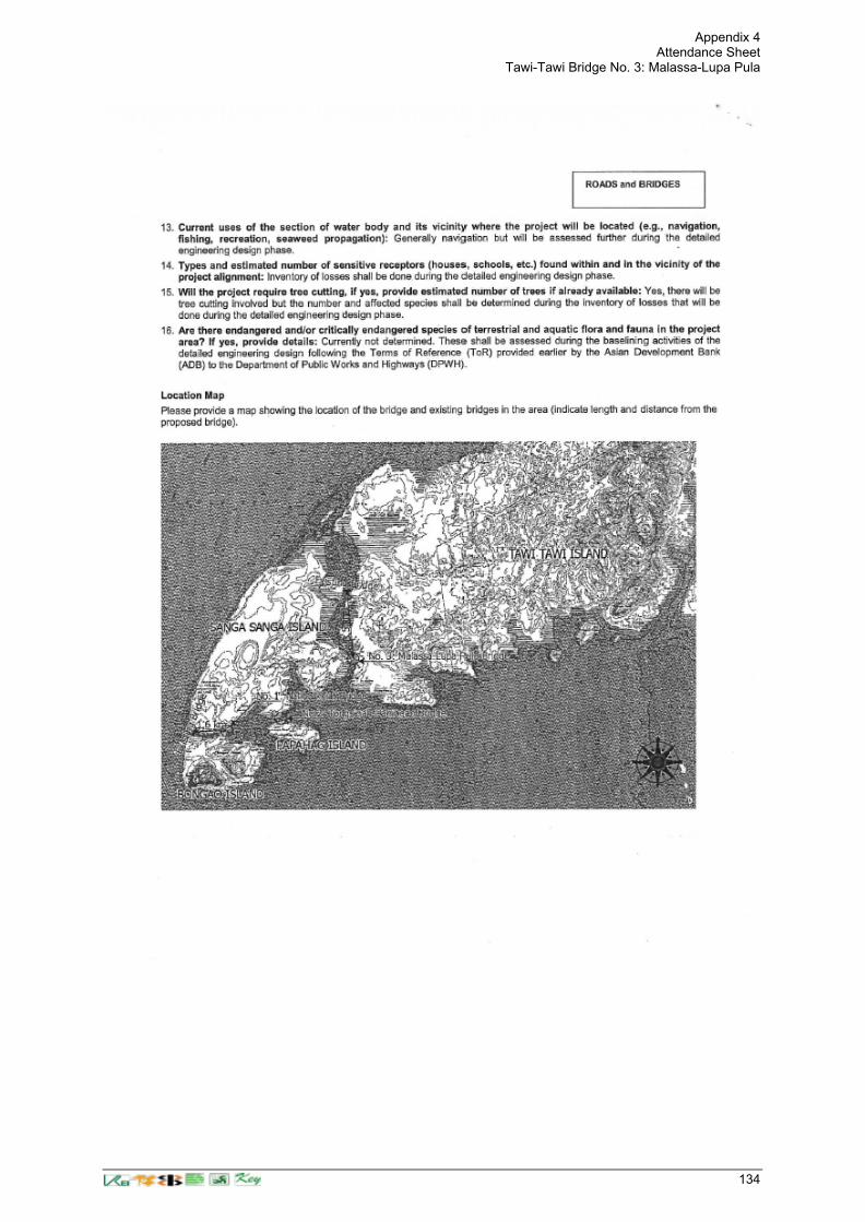
Appendix 4 Attendance Sheet
Tawi-Tawi Bridge No. 3: Malassa-Lupa Pula
134