Effectiveness of Isolated Pipeline Crossing Techniques to Mitigate Sediment Impacts on Brook Trout...
16
Water Qual. Res. J. Canada, 2002 Volume 37, No. 2, 473–488 Copyright © 2002, CAWQ * Corresponding author; [email protected] Effectiveness of Isolated Pipeline Crossing Techniques to Mitigate Sediment Impacts on Brook Trout Streams SCOTT M. REID, 1 * SCOTT STOKLOSAR, 1 SERGE METIKOSH 1 AND JIM EVANS 2 1 Golder Associates Ltd., Calgary, Alberta T2P 3T1 2 Gas Research Institute, Chicago, Illinois Stream populations of brook trout (Salvelinus fontinalis) are sensitive to sedi- ment-caused changes to habitat, i.e., increased embeddedness of bed material. The use of watercourse crossing techniques (dam and pump, and flume meth- ods) that isolate the construction site by diverting flow around the crossing has often been promoted as a means of controlling the amount of sediment released, particularly for those watercourses with sensitive fish species or habi- tats. However, few case studies have evaluated the effectiveness of isolated crossing construction techniques to mitigate the effects of instream construc- tion activities. We measured suspended sediment concentrations during six iso- lated pipeline crossings of brook trout streams in Minnesota, Nova Scotia and Ontario. In addition, sediment deposition rates, riffle habitats and fish abun- dance were monitored upstream and downstream of four of the crossings. Results of our monitoring studies indicate that isolated techniques can be very effective at: (1) minimizing increases to downstream suspended sediment con- centrations during instream construction; and, (2) preventing sediment-induced effects on habitat and fish abundance downstream of pipeline water crossings. For sensitive watercourses, isolated crossing techniques are an effective alter- native to trenchless crossing techniques (e.g., horizontal directional drilling). Key words: sediment, pipeline construction, mitigation, trout, streams Introduction The construction of linear facilities such as natural gas pipelines can often require the crossing of watercourses. Construction in and around watercourses can disturb aquatic systems and cause changes to the phys- ical and biological components of aquatic ecosystems. The majority of aquatic effects associated with pipeline construction are attributed to sed- iment released during instream construction. Sediment load increases during construction have been reported to directly and/or indirectly affect fish through modification of their habitats (e.g., increased embed- dedness of substrates or infilling of pools). Generally, these effects are temporary with full recovery to pre-disturbance conditions within 1 to 2 years (Reid and Anderson 1999).
-
Upload
independent -
Category
Documents
-
view
2 -
download
0
Transcript of Effectiveness of Isolated Pipeline Crossing Techniques to Mitigate Sediment Impacts on Brook Trout...
Water Qual. Res. J. Canada, 2002Volume 37, No. 2, 473–488Copyright © 2002, CAWQ
* Corresponding author; [email protected]
Effectiveness of Isolated Pipeline CrossingTechniques to Mitigate Sediment Impacts
on Brook Trout Streams
SCOTT M. REID,1* SCOTT STOKLOSAR,1 SERGE METIKOSH1 AND JIM EVANS2
1Golder Associates Ltd., Calgary, Alberta T2P 3T12Gas Research Institute, Chicago, Illinois
Stream populations of brook trout (Salvelinus fontinalis) are sensitive to sedi-ment-caused changes to habitat, i.e., increased embeddedness of bed material.The use of watercourse crossing techniques (dam and pump, and flume meth-ods) that isolate the construction site by diverting flow around the crossing hasoften been promoted as a means of controlling the amount of sedimentreleased, particularly for those watercourses with sensitive fish species or habi-tats. However, few case studies have evaluated the effectiveness of isolatedcrossing construction techniques to mitigate the effects of instream construc-tion activities. We measured suspended sediment concentrations during six iso-lated pipeline crossings of brook trout streams in Minnesota, Nova Scotia andOntario. In addition, sediment deposition rates, riffle habitats and fish abun-dance were monitored upstream and downstream of four of the crossings.Results of our monitoring studies indicate that isolated techniques can be veryeffective at: (1) minimizing increases to downstream suspended sediment con-centrations during instream construction; and, (2) preventing sediment-inducedeffects on habitat and fish abundance downstream of pipeline water crossings.For sensitive watercourses, isolated crossing techniques are an effective alter-native to trenchless crossing techniques (e.g., horizontal directional drilling).
Key words: sediment, pipeline construction, mitigation, trout, streams
Introduction
The construction of linear facilities such as natural gas pipelines canoften require the crossing of watercourses. Construction in and aroundwatercourses can disturb aquatic systems and cause changes to the phys-ical and biological components of aquatic ecosystems. The majority ofaquatic effects associated with pipeline construction are attributed to sed-iment released during instream construction. Sediment load increasesduring construction have been reported to directly and/or indirectlyaffect fish through modification of their habitats (e.g., increased embed-dedness of substrates or infilling of pools). Generally, these effects aretemporary with full recovery to pre-disturbance conditions within 1 to2 years (Reid and Anderson 1999).
474 REID ET AL.
Isolated crossing methods (e.g., dam and pump or flume crossingmethods) have been developed to limit the amount of sediment releasedduring crossing construction. These methods isolate the instream workarea with dams and divert water around the work area through either aflume and/or pumps. The approach allows for trench excavation andbackfilling to occur under dry conditions thereby reducing the amount ofsediment released into the watercourse. However, a lack of suspendedsediment monitoring and associated biological effect studies of isolatedwater crossings has prevented defensible statements regarding theireffectiveness (Mutrie and Scott 1982; Reid and Anderson 1999). Given thelarge distances of new pipeline constructed each year (True 1997, 1998)and that trenchless crossing methods (e.g., horizontal directionaldrilling) are not always feasible, the documentation of the effectivenessof isolated crossing methods is important to ensure the desired level ofenvironmental protection.
Pipeline construction across six watercourses supporting brook trout(Salvelinus fontinalis) populations provided an opportunity to evaluate theeffectiveness of isolated crossing methods in limiting the amount of sedi-ment released during instream construction and associated effects ondownstream fish and fish habitat. Brook trout streams are excellent studysystems to evaluate isolated crossing methods. Brook trout are a wide-spread and valued sportfish and the vulnerability of brook trout to sedi-ment-induced habitat alteration is well documented (Saunders and Smith1965; Anderson et al. 1998). In this paper, we evaluate the effectiveness ofisolated pipeline crossing techniques by monitoring downstream sus-pended sediment concentrations, sediment deposition rates, surficial bedmaterial, and fish communities. Effects on resident fish and their habitatsat the crossing site due to the clearing of the riparian vegetation and/orthe direct physical disturbance of construction were not investigated.
Methods
Two isolated crossing methods were evaluated during this study: thedam and pump, and the flume method. Dam and pump methods wereapplied to install natural gas pipelines underneath four watercourses inNova Scotia and Ontario: East and West branches of McDonald Brook, atributary of Bear Creek and a tributary of Cold Creek. The flume crossingmethod was applied during pipeline installation across two locations,250 metres apart along Otter Creek, Minnesota. Watercourses were smallwith wetted channel widths and flow levels less than nine metres and0.28 m3/s, respectively (Table 1). Construction across these watercourseswas completed during the summers of 1998 and 1999.
Total suspended sediment concentrations (TSS) were measuredupstream and downstream of all six crossings. Sediment deposition rates,habitat condition and fish communities were also monitored upstreamand downstream of the four crossings of Otter Creek and McDonaldBrook. The methods are described in greater detail in the following text.
PIPELINE CROSSING TECHNIQUES TO MITIGATE IMPACTS 475
Suspended Sediment
To test the effectiveness of isolated crossing methods to limit sedimentrelease during construction, we measured suspended sediment concentra-tions (mg/L) upstream and downstream of isolated crossings. Grab watersamples (0.5 L) were taken at mid-water column from mid-channel loca-tions. Given the small channel widths and observed degree of mixing with-in a short distance downstream of construction, mid-channel grab watersamples characterized downstream suspended sediment concentrations.The first downstream sampling stations were between 13 and 30 m down-stream. The locations of all sampling stations are provided in Table 2. Thefrequency of sampling at each station varied depending on the instreamconstruction activities being conducted. During periods of increased sedi-ment loading, TSS sampling occurred approximately every 30 minutes.Sampling was less frequent during periods of no instream construction.Sampling after the completion of construction continued until downstreamturbidity levels returned to background (typically less than 2.5 hours).
For both Otter Creek crossings and the Cold Creek tributary crossing,site-specific TSS-turbidity relationships were developed from field tur-bidity (NTU) measurements and subsamples of water samples (50 and35 samples, respectively) representing a range of turbidities that wereanalyzed for TSS concentration in the laboratory. TSS concentrations werepredicted from turbidity measurements taken in the field using site spe-cific TSS-turbidity relationships. Correlation indices (r2 values: 0.85 to0.98) from the regression analyses indicate that field NTU measurementsprovide a good estimate for TSS. For the other three crossings (Bear Creekand MacDonald Brook), TSS concentrations of water samples collectedwere measured in the laboratory.
As the time intervals between grab water samples were not alwaysequal, time-weighted average TSS concentrations were calculated for eachtransect and construction activity (except the upstream control)
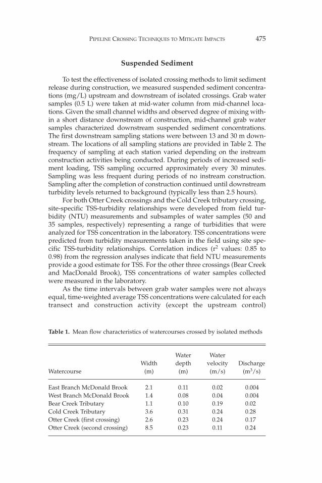
Table 1. Mean flow characteristics of watercourses crossed by isolated methods
Water Water Width depth velocity Discharge
Watercourse (m) (m) (m/s) (m3/s)
East Branch McDonald Brook 2.1 0.11 0.02 0.004West Branch McDonald Brook 1.4 0.08 0.04 0.004Bear Creek Tributary 1.1 0.10 0.19 0.02 Cold Creek Tributary 3.6 0.31 0.24 0.28Otter Creek (first crossing) 2.6 0.23 0.24 0.17Otter Creek (second crossing) 8.5 0.23 0.11 0.24
476 REID ET AL.
(Anderson et al. 1996). Many of the TSS concentrations were below thelaboratory detection limits (<2 mg/L). Where TSS concentrations for spe-cific construction activities were <2 mg/L, a value of 1 mg/L was assignedfor the calculation of time-weighted averages.
In addition to water sampling, a time-referenced construction log-book was kept to relate TSS concentrations to specific construction activ-ities. Discharge during construction at each watercourse was measuredusing a tagline, water velocity meter and a top-setting wading rod andfollowing the methods outlined in Terzi (1981).
Sediment Deposition and Habitat Alteration
The magnitude and extent of downstream sediment deposition andassociated habitat alteration were measured at Otter Creek and the Eastand West branches of McDonald Brook. The locations of upstream anddownstream sediment deposition and habitat alteration monitoring sitesare provided in Table 2.
Eight modified Whitlock-Vibert boxes filled with washed 25-mmdiameter gravel were buried flush with the creek bed before constructionto collect sediment deposited during construction (Clark and Scruton
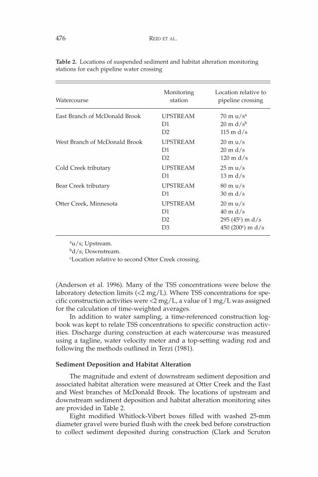
Table 2. Locations of suspended sediment and habitat alteration monitoring stations for each pipeline water crossing
Monitoring Location relative to Watercourse station pipeline crossing
East Branch of McDonald Brook UPSTREAM 70 m u/sa
D1 20 m d/sb
D2 115 m d/s
West Branch of McDonald Brook UPSTREAM 20 m u/sD1 20 m d/sD2 120 m d/s
Cold Creek tributary UPSTREAM 25 m u/sD1 13 m d/s
Bear Creek tributary UPSTREAM 80 m u/sD1 30 m d/s
Otter Creek, Minnesota UPSTREAM 20 m u/sD1 40 m d/sD2 295 (45c) m d/sD3 450 (200c) m d/s
au/s; Upstream.bd/s; Downstream. cLocation relative to second Otter Creek crossing.
PIPELINE CROSSING TECHNIQUES TO MITIGATE IMPACTS 477
1997). All sediment traps were removed after the completion of construc-tion and sent to a geotechnical laboratory for dry weight and particle sizeanalysis. Habitat alteration due to sediment deposition was evaluatedusing the pebble count method (Kondolf 1997). The pebble count methodprovides a measure of the composition of surficial bed material. Pebblecounts were conducted at riffle or turbulent run habitats with clean coarsesubstrates composed of a similar range of particle sizes (e.g., dominatedby gravel and cobble versus dominated by sand and gravel). Along bothOtter Creek and McDonald Brook, surficial bed material was sampledbefore and immediately after construction. Surficial bed material was alsosampled one month and one year after the completion of the McDonaldBrook crossings. Five point measurements of water velocity and depthwere taken at each monitoring site.
Differences between upstream and downstream sediment depositionrates were tested using ANOVA and Tukey HSD tests (Zar 1984). Post-construction changes to surficial bed conditions were assessed throughthe calculation of D16, D50, D84 (sediment particle diameter at which 16, 50and 84% of the sample is finer) and the percentage of particles less than4 mm in diameter from pebble count data.
Fish Community
Changes to fish communities as a result of instream constructionwere evaluated through pre- and post-construction electrofishing surveysupstream and downstream of the Otter Creek and both McDonald Brookcrossings. The sampling reach was isolated with upstream and down-stream blocknets (mesh size: 5 mm) and three electrofishing passes weremade with a backpack electrofisher. All fish netted were measured forforklength (mm), identified to species, and released.
Along Otter Creek, 50 metre long reaches were sampled beginning20 metres upstream, 100 metres downstream and 270 metres downstreamof the first crossing. The last reach began 20 metres downstream of thesecond crossing. Reaches sampled along the East and West branches ofMcDonald Brook were 30 metres long. Along the East Branch, reacheswere sampled beginning 70 metres upstream, 20 metres downstream and115 metres downstream of the crossing. Along the West Branch, reacheswere sampled beginning 20 metres upstream, 20 metres downstream and70 metres downstream of the crossing. At each crossing, fish samplingoccurred immediately before and after construction. Reaches alongMcDonald Brook were also sampled one month and one year after con-struction. During electrofishing surveys of the East and West branches ofMcDonald Brook one year after construction, the locations where juvenilebrook trout (<60 mm FL) were captured were marked. Water velocity,depth and bed material were measured at each of these locations to doc-ument habitat associations.
Three-pass depletion estimates of fish abundance within each reachwere calculated using methods described in Zippen (1957). The similarityof pre- and post-construction fish assemblages at each transect along
478 REID ET AL.
Otter Creek was evaluated by calculating the relative abundance of indi-vidual species and a Proportional Similarity Index (PSI) (Schoener 1968).PSI values greater than 0.7 have been interpreted to indicate similar fishassemblages (Paller 1997). Due to the low number of species, PSI valueswere not calculated for McDonald Brook.
Results
Instream Construction
The flume method was used to install a 942-mm (36-inch) diametergas pipeline underneath two locations approximately 250 metres apartalong Otter Creek, Minnesota. The first crossing was isolated with sand-bag dams and plastic sheeting. On the second Otter Creek crossing, con-crete jersey barriers were used to construct the upstream dam. Flow wasconveyed through the workspace through a flume. During this period,water was pumped from the isolated workspace to either upland dis-charge locations or sumps. Construction of the first crossing required51 hours of instream work over 5 days. The second flumed crossing wascompleted in 4 days, requiring 23 hours of instream construction.
The dam and pump method was used to install gas pipelines under-neath tributaries of Cold and Bear creeks, Ontario, and the East and Westbranches of McDonald Brook, Nova Scotia. Pipelines were between508 mm (20 inch) and 942 mm (36 inch) in diameter. Sandbag and plasticisolation dams were used to isolate the crossing areas while bypasspumps diverted flow around the workspace. Upstream and downstreamdams were constructed at the Cold and Bear creek tributary crossings.Alternatively, only upstream dams were installed at both McDonaldBrook crossings. Pipeline installation underneath the tributaries of Coldand Bear creeks required less than 16 hours of instream activity over 1 or2 days. The McDonald Brook crossings required between 26 and 41 hoursof instream work over 5 or 6 days. Excavation of the pipe trench up steepapproach slopes to both branches of McDonald Brook before pipe instal-lation extended the duration of construction.
Suspended Sediment
The first flume crossing of Otter Creek was effective at minimizingsediment release during construction. Until dam and flume removal, TSSconcentrations 40 metres downstream of the crossing were equivalent tobackground. Removal of isolation dams and the flume resulted in increas-es to downstream TSS concentration of up to 58 mg/L. Once instreamactivity was complete, downstream TSS concentrations returned to back-ground levels within one hour. The entire crossing increased the meandownstream TSS concentration by less than 4 mg/L above background.
The second flume crossing of Otter Creek was not as effective at lim-iting sediment release. Over the 23 hours of instream activity, the averageTSS concentration 45 metres downstream of the crossing was 80 mg/Labove background. During trench excavation, the upland sump reached
PIPELINE CROSSING TECHNIQUES TO MITIGATE IMPACTS 479
its capacity and turbid water was then pumped to an upland location.However, the hose and hose clamps leaked and turbid water flowed backinto the creek increasing suspended sediment concentrations duringtrenching, pipe installation and backfilling. The peak TSS concentrationwas measured during dam and flume removal (1487 mg/L). During peri-ods of peak sediment loading, suspended sediment concentrations 200and 340 metres downstream of the crossing were between 43 and 81%lower than 45 metres downstream of the crossing. Downstream TSS con-centrations did decrease substantially once construction was complete.However, it was not until 10 hours after construction that downstreamconcentrations returned to background levels.
The four dam and pump water crossings increased mean down-stream (<30 metres downstream of the crossing) suspended sediment con-centration by less than 20 mg/L above background. Except for shortpeaks during trench excavation across the East and West branches ofMcDonald Brook, large increases to downstream suspended sedimentconcentrations were generally limited to dam and pump installation andremoval. Peak suspended sediment concentrations during these construc-tion activities ranged between 61 and 1032 mg/L.
Sediment Deposition and Habitat Alteration
Mean sediment deposition rates ranged from 0.055 kg/m2/dupstream of the Otter Creek crossings to 0.16 kg/m2/d immediatelydownstream of the second crossing. Compared to the other monitoringsites, a significantly greater amount of sediment was deposited 45 metresdownstream of the second crossing (ANOVA: p < 0.001; Tukey HSD:p < 0.05). Sediment deposition rates at other locations downstream werenot significantly greater than upstream. However, there was a greaterpercentage of silt and clay (<0.062-mm diameter) in downstream sedi-ment traps compared to upstream traps (44.5–64.7% versus 29.9%).
The surficial bed material at monitoring stations along Otter Creekwas characterized as gravel and cobble with little sand, silt or clay. Beforeconstruction, percent surficial fines (<4 mm) ranged from 0 to 21% alongOtter Creek monitoring stations. Mean water velocities ranged between0.27 and 0.39 m/s with mean depths between 0.13 and 0.16 m. Increaseddeposition of sediment 45 metres downstream of the second crossingcoincided with a small increase in the percentage of fine sediment(<4 mm) from 0 to 8%. For three days after construction, a thin veneer ofclay or silt (<1 mm in depth) was visible up to 340 metres downstream ofthe second crossing. The amount of surficial fine sediment decreased by 2to 9% at the other monitoring sites.
Mean sediment deposition rates ranged from 0.024 kg/m2/dupstream of the East Branch crossing to 0.11 kg/m2/d, 41 metres down-stream. A significantly greater amount of silt and clay was depositedimmediately downstream of the East Branch crossing than upstreamand farther downstream (ANOVA: p < 0.001; Tukey HSD: p < 0.001).The amount of silt and clay deposited at the first downstream area
480 REID ET AL.
(41 metres downstream) was 2.4 and 3.1 times greater than 126 mdownstream or upstream, respectively. However, there were no statisti-cal differences in the total amount of sediment or sand fraction(0.062–2.0 mm diameter) collected in traps. There were also no statisti-cal differences between sediment deposition rates along the WestBranch of McDonald Brook. Sediment deposition rates ranged between0.024 and 0.041 kg/m2/d. Most of the sediment collected in sedimenttraps downstream of both crossings was sand. Less than 26% of thedeposited sediment was silt or clay.
The surficial bed material along both the East and West branches wascharacterized as cobble and boulder with little sand, silts and clay(Table 4). Mean water velocities at monitoring sites ranged between 0.06and 0.14 m/s with mean depths between 0.05 and 0.11 m. The percentageof fine sediment (<4 mm diameter) in the surficial bed material remainedlow for the duration of the study.
Fish Community
Otter CreekEleven fish species were collected from Otter Creek. The most fre-
quently captured species were brook trout, creek chub (Semotilus atromac-ulatus) and blacknose dace (Rhinichthys atratulus). The greatest density ofbrook trout was found immediately downstream of the second crossing.Other species included brook stickleback (Culaea inconstans), central mud-minnow (Umbra limi), Johnny darter (Etheostoma nigrum), longnose dace(Rhinichthys cataractae), redbelly dace (Phoxinus eos), mottled sculpin(Cottus bairdi), common shiner (Luxilus cornutus), and white sucker(Catostomus commersoni).
Before construction, fish abundance estimates along Otter Creekranged from 5.7 to 6.4 fish per metre. The greatest abundance of fish wasimmediately downstream of the second Otter Creek crossing. During thefirst crossing, schools of unidentified small-bodied fish were observed tocongregate and feed at the downstream outlet of the flume. However,after construction 100 metres downstream, the number of fish decreasedfrom 5.7 to 4.2 fish per metre of stream. Alternatively, there was littlechange in fish abundance immediately downstream of the second cross-ing. After construction, the estimated number of fish upstream increasedfrom 6.1 to 9.7 fish per metre. Post-construction fish assemblages alongOtter Creek were similar to those sampled before construction. PSI valuescalculated ranged between 0.77 and 0.81. Changes in the relative abun-dance of individual species were less than 18%.
East and West branches of McDonald BrookFour fish species were collected from McDonald Brook: brook trout,
Atlantic salmon (Salmo salar), lake chub (Couesius plumbeus) and whitesucker. Along the East Branch, lake chub and white sucker constitutedonly 3% of all fish collected. Brook trout was the only species collectedfrom the West Branch.
PIPELINE CROSSING TECHNIQUES TO MITIGATE IMPACTS 481
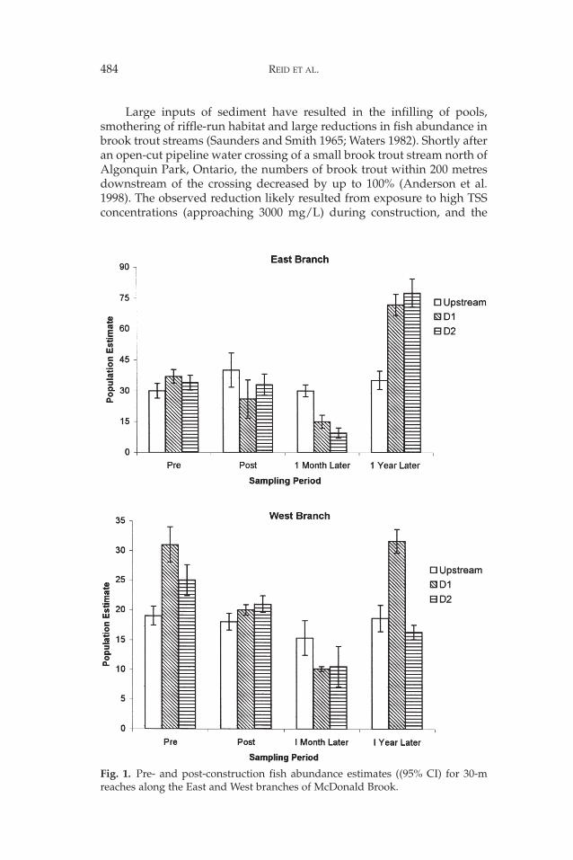
After the installation of the East and West Branch pipeline crossings,only 66 and 70% of the pre-construction number of fish were recapturedimmediately downstream (20–50 metres downstream), respectively(Fig. 1). However, 95% confidence intervals suggest that differences down-stream of the West Branch crossing were not statistically significant. Nocomparable reductions were observed either upstream or at the seconddownstream sampling reach. The reduction measured downstream of theWest Branch crossing was primarily due to fewer juvenile brook trout. Onemonth after construction, the number of fish captured at downstreamreaches of each branch was 27 and 42% of its pre-construction abundance.Downstream of the East Branch crossing, reductions in the abundance ofboth juvenile brook trout and Atlantic salmon parr (<130 mm FL)occurred. Fish abundance upstream of both crossings was unchanged. Oneyear after construction, the number of fish captured at the first down-stream sampling reaches was either equivalent or substantially higherthan pre-construction estimates (Fig. 1). Along the West Branch, most ofthe increase was due to higher numbers of juvenile trout being collected.
Discussion
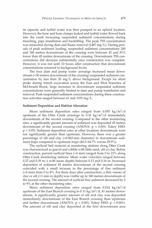
Compared to open-cut pipeline crossings of other similar-sizedwatercourses, increases to mean downstream TSS concentrations duringdam and pump or flume crossings were at least seven times lower (Table 3,Reid and Anderson 1999). Except for the second flume crossing of OtterCreek, mean TSS concentrations averaged only 3 to 20 mg/L above back-ground levels. Alternatively, mean TSS concentrations measured down-stream of open-cut crossings were between 600 and 1300 mg/L abovebackground. Peak TSS concentrations measured downstream of isolatedcrossings were also lower than open-cut crossings and were generallyrestricted to the installation and removal of isolation and diversion struc-tures. While mean TSS concentrations were lower during the six isolatedcrossings, the average duration of instream construction was up to seventimes that of open-cut crossings (Table 3; Reid and Anderson 1999).
Several construction-related factors can limit the effectiveness of iso-lated crossing methods to reduce sediment entrainment during instreamconstruction (CPWCC 1999, this study). These include: (1) leakage aroundor underneath the isolation dams; (2) dam failures; (3) flume failures; (4)insufficient sump storage volume; (5) insufficient pump capacity; and, (6)inadequate maintenance of sediment control measures. During the latterhalf of the second Otter Creek crossing, insufficient sump storage volumeand poor containment of turbid water pumped from the isolated work-space, resulted in high downstream TSS concentrations. The absence ofisolation dams downstream of the McDonald Brook crossings allowedditch water to periodically flow downstream during trench excavation.Concrete jersey barriers and sandbags were effectively used to de-waterand isolate the crossing area during the second Otter Creek crossing.However, these materials are not well suited for crossings of watercours-es with higher flows and easily eroded bed material (Reid et al. In press).
482 REID ET AL.
Tab
le 3
.C
ompa
riso
n of
dur
atio
n of
inst
ream
wor
k, a
nd T
SS c
once
ntra
tion
s m
easu
red
wit
hin
50 m
dow
nstr
eam
of
isol
ated
and
ope
n-cu
tpi
pelin
e cr
ossi
ngs
of s
mal
l wat
erco
urse
s (<
8 m
wid
e)
Cro
ssin
g D
urat
ion
Bac
kgro
und
M
ean
TSS
Pe
ak T
SS
Wat
erco
urse
met
hod
(h)
TSS
(m
g/L
)(m
g/L
)(m
g/L
)R
efer
ence
Hod
gson
Cre
ek, N
.W.T
.O
pen-
cut
181
609
3524
McK
inno
n an
d H
nytk
a 19
88C
oxes
Cre
ek, P
a.O
pen-
cut
1224
781
2411
S. R
eid
, unp
ublis
hed
dat
aJu
dic
ial D
itch
1A
, Min
n.O
pen-
cut
826
1337
4258
S. R
eid
, unp
ublis
hed
dat
aSo
uth
Bra
nch
Rus
h R
iver
, Min
n.O
pen-
cut
747
1103
2870
S. R
eid
, unp
ublis
hed
dat
aO
tter
Cre
ek, M
inn.
Ope
n-cu
t11
4112
7420
55S.
Rei
d, u
npub
lishe
d d
ata
Bea
r C
reek
trib
utar
y, O
nt.
Dam
and
pum
p15
323
61T
his
stud
yC
old
Cre
ek tr
ibut
ary,
Ont
.D
am a
nd p
ump
94
810
32T
his
stud
yO
tter
Cre
ek 1
, Min
n.Fl
umed
514
858
Thi
s st
udy
Ott
er C
reek
2, M
inn.
Flum
ed23
486
1487
Thi
s st
udy
Eas
t Bra
nch
McD
onal
d B
rook
, N.S
.D
am a
nd p
ump
41<
216
237
Thi
s st
udy
Wes
t Bra
nch
McD
onal
d B
rook
, N.S
.D
am a
nd p
ump
264
1225
0T
his
stud
y

PIPELINE CROSSING TECHNIQUES TO MITIGATE IMPACTS 483
Tab
le 4
.Pr
e- a
nd p
ost-
cons
truc
tion
ass
essm
ents
of
surf
icia
l bed
mat
eria
l alo
ng th
e E
ast a
nd W
est b
ranc
hes
of M
cDon
ald
Bro
ok
Eas
t Bra
nch
Wes
t Bra
nch
D16
D50
D84
% F
ines
D16
D50
D84
% F
ines
Dat
eTr
anse
ct(m
m)
(mm
)(m
m)
(<4
mm
)(m
m)
(mm
)(m
m)
(<4
mm
)
July
199
9aU
pstr
eam
6011
8>
256
128
76>
256
1D
138
124
>25
60
3794
>25
60
D2
3410
1>
256
142
125
>25
60
July
199
9bU
pstr
eam
2610
822
84
3688
204
2D
135
152
>25
63
2968
>25
61
D2
2580
223
241
93>
256
1A
ugus
t 199
9bU
pstr
eam
5011
5>
256
142
125
>25
61
D1
5813
4>
256
150
112
>25
60
D2
4314
4>
256
251
131
>25
60
Aug
ust 2
000b
Ups
trea
m14
72>
256
326
8423
00
D1
3210
0>
256
068
121
256
1D
225
91>
256
225
104
256
1
a Pre
-con
stru
ctio
n.b P
ost-
cons
truc
tion
.
484 REID ET AL.
Large inputs of sediment have resulted in the infilling of pools,smothering of riffle-run habitat and large reductions in fish abundance inbrook trout streams (Saunders and Smith 1965; Waters 1982). Shortly afteran open-cut pipeline water crossing of a small brook trout stream north ofAlgonquin Park, Ontario, the numbers of brook trout within 200 metresdownstream of the crossing decreased by up to 100% (Anderson et al.1998). The observed reduction likely resulted from exposure to high TSSconcentrations (approaching 3000 mg/L) during construction, and the
Fig. 1. Pre- and post-construction fish abundance estimates ((95% CI) for 30-mreaches along the East and West branches of McDonald Brook.
PIPELINE CROSSING TECHNIQUES TO MITIGATE IMPACTS 485
alteration of habitat conditions by deposited sand. Recovery of down-stream habitats, and benthic invertebrate and fish communities to pre-construction levels was measured within a year after construction(Anderson et al. 1998).
Increased sediment deposition was measured immediately down-stream of the second Otter Creek and the East Branch of McDonald Brookcrossings. However, pebble count data indicated that surficial bed mater-ial downstream of all the crossings was generally unaffected by pipelinewater crossing construction. The thin veneer of fine sediment depositeddownstream of the second Otter Creek crossing was temporary (<3 days)as it was quickly resuspended by creek flows.
Despite a lack of prolonged exposure to high suspended sedimentconcentrations or sediment deposition-caused habitat alteration, post-construction reductions in fish abundance were measured downstream ofthe first Otter Creek and both McDonald Brook crossings. The large post-construction increase in upstream fish numbers suggests that the decreasein fish abundance immediately downstream of the first Otter Creek cross-ing may be better explained by natural variation in capture success.Reductions in fish abundance downstream of the McDonald Brook cross-ings measured immediately after construction may have resulted fromshort-term reductions in water level during construction. When bypasshoses were moved, or pumps temporarily turned off, water levelsdropped up to 10 cm along the first 40 to 50 metres downstream of thecrossings. The decrease in available habitat or activities in the vicinitymay have motivated fish immediately downstream of crossing to movefarther downstream.
Considering the lack of sediment-related habitat alteration, it isunlikely that the decrease in brook trout abundance downstream of theMcDonald Brook crossings, one month after construction, can be attrib-uted to construction-related activities. Instead, it is more likely that lowtrout abundance resulted from higher flows in August 1999. Flow levelsmeasured nearby in the watershed were three times greater on August 24,1999, than on July 20, 1999 (0.422 m3/s versus 0.142 m3/s, Middle RiverPictou, Water Survey of Canada data). Increased flows reduced the avail-ability of preferred juvenile brook trout habitat and potentially affectedelectrofishing efficiency.
Juvenile brook trout prefer habitat areas with slow water velocities(0–0.15 m/s), shallow water depths (0.1–0.15 m) and coarse substrates(Griffith 1972; Richardson et al. 1992). Mean water depths and velocities(n = 88) utilized by juvenile brook trout captured in McDonald Brook(August 2000) were 0.16 m and 0.05 m/s, respectively. At the time of con-struction, water velocities and depths downstream of the crossingsranged between 0.06 and 0.13 m/s, and 0.05 and 0.11 m, respectively.Alternatively, the small pool or glide habitats (where most juvenile brooktrout were captured) that were abundant downstream of the crossingsduring construction in July were replaced by fast-moving turbulentrun/riffle habitat in August. Greater numbers of downstream fish oneyear after construction coincided with flow levels and habitat conditions
486 REID ET AL.
equivalent to that measured before construction (August 13, 2000: EastBranch: 0.004 m3/s; West Branch: 0.006 m3/s). No water velocity or depthdata is available for August 1999.
No post-construction reductions in brook trout abundance weremeasured upstream of the crossings. Upstream of both crossings, thechannel gradient was shallower than downstream (<0.018 versus0.03 m/m). Subsequently, the higher flow volume one month after con-struction increased the volume of suitable juvenile brook trout habitat.
Reduced electrofishing efficiency during higher flows in August 1999may be an alternate explanation or contributing factor to the decrease infish capture one month after construction. As water levels increase,increased water velocities, decreased visibility and greater fish dispersionhave been previously linked to lower capture success during electrofish-ing surveys (Reynolds 1996). It is not known why so many juvenile brooktrout were captured along the West Branch in August 2000. Natural year-to-year variation in the number of spawning trout and/or the survival ofincubating eggs and fry could be factors. However, since no long-termdata is available or was collected during this study, these hypotheses can-not be addressed.
Conventional water-crossing methods requiring trench excavation inthe active stream flow can release substantial quantities of sediment intothe water column as a result of instream construction. Regulatory agen-cies have responded to sediment pollution concerns by legislating strin-gent environmental regulations (e.g., instream timing restrictions thatavoid spawning periods) and by simplifying permitting approval forcrossing methods that minimize instream construction. There is a definitebias towards crossing applications proposing horizontal directionaldrilling (HDD) or other trenchless technologies. Although HDD installa-tions do not usually generate major sediment discharges and avoid dis-turbance of riparian vegetation, the potential for environmental damagedue to unexpected releases of drilling muds still exists. Recent evaluationsof the frequency of mud releases during HDD installations suggest thattheir occurrence is relatively common (Reid and Anderson 1998).Secondly, construction-related factors such as pipe diameter, wall thick-ness and radius of curvature, valley geometry, and subsurface geologycan prevent the application of this technique at certain crossing locations.
The results of this study indicate that the dam and pump, andflumed crossing methods were highly effective at limiting sedimentrelease during pipeline construction across brook trout streams and there-fore, associated risks to fish and fish habitat. These methods should beconsidered as alternatives to trenchless crossing methods, especiallywhen the risk of unexpected mud releases or construction failure is high.Secondly, four of the six isolated crossings were multiple crossings ofwatercourses. The low level of sediment release also indicates that appli-cation of these crossing methods can reduce the potential for cumulativeeffects to result from multiple sediment loading events during pipelineconstruction across watersheds.
PIPELINE CROSSING TECHNIQUES TO MITIGATE IMPACTS 487
Acknowledgments
We acknowledge the financial support, direction and review of thisstudy by the Gas Research Institute (Chicago) and the members of the GRITechnical Advisory Group. We also acknowledge the Department ofFisheries and Oceans (Canada) who provided invaluable logistical sup-port for the McDonald Brook studies.
References
Anderson PG, Taylor BR, Balch GC. 1996. Quantifying the effects of sedimentrelease on fish and their habitats. Canadian Manuscript Report of Fisheriesand Aquatic Sciences No. 2346.
Anderson PG, Fraikin CGJ, Chandler TJ. 1998. Natural gas pipeline crossing ofa coldwater stream: impacts and recovery. Proceedings of the InternationalPipeline Conference. Vol. 2. American Society of Mechanical Engineers, June7–11, 1998, Calgary, Alberta. p. 1013–1020.
Canadian Pipeline Water Crossing Committee. 1999. Water crossings (2nd edi-tion). Prepared by TERA Environmental Consultants (Alta.) Ltd. and SalmoConsulting Inc., Calgary, Alberta.
Clark KD, Scruton DA. 1997. Use of the Wesche method to evaluate fine-sedi-ment dynamics in small boreal forest headwater streams. N. Amer. J. Fish.Manage. 17:188–193.
Griffith JS. 1972. Comparative behaviour and habitat utilization of brook trout(Salvelinus fontinalis) and cutthroat trout (Salmo clarki) in small streams innorthern Idaho. J. Fish. Res. Board Canada. 29:265–273.
Kondolf GM. 1997. Application of the pebble count: notes on purpose, method,and variants. J. Am. Water Resour. Assoc. 33:79–87.
McKinnon GA, Hnytka FN. 1988. The effect of winter pipeline construction onthe fishes and fish habitat of Hodgson Creek, NWT. Canadian TechnicalReport of Fisheries and Aquatic Sciences No. 1598.
Mutrie DF, Scott IFH. 1982. Environmental evaluation of water crossing tech-niques for pipeline construction in Canada. In Third InternationalSymposium on Environmental Concerns in Rights of Way Management,February 15–18, 1982. San Diego, California. Mississippi State UniversityPress, 1984.
Pallar MH. 1997. Recovery of a reservoir fish community from drawdown relatedimpacts. N. Amer. J. Fish. Manage. 17:726–733.
Reid SM, Anderson PG. 1998. HDD not the answer for all sensitive water cross-ings. Environmental effects of mud releases need further study to improvecrossing method selection and best management practices. Pipeline and GasIndustry, July 1998.
Reid SM, Anderson PG. 1999. Effects of sediment released during open-cutpipeline water crossings. CWRJ 24:23–39.
Reid SM, Stoklosar S, Metikosh S, Huffman T, Evans J. Effects of natural gaspipeline water crossing replacement on the benthic invertebrates and fishcommunities of Big Darby Creek, Ohio. In 7th International Symposium onEnvironmental Concerns in Rights-of-Way Management. Calgary, Alberta,Canada, In press.

488 REID ET AL.
Reynolds JB. 1996. Electrofishing. In Murphy BR, Willis DW (ed.), Fisheries tech-niques (Second Edition). American Fisheries Society, Bethesda, Maryland.732 p.
Saunders JW, Smith MW. 1965. Changes in a stream population of trout associat-ed with increased silt. J. Fish. Res. Board Canada 22:396–404.
Terzi RA. 1981. Hydrometric field manual measurement of streamflow.Environment Canada, Inland Waters Directorate, Water Resources Branch,Ottawa. 37 p.
True WR. 1997. World pipeline construction looks to remain robust to century’sturn. Oil Gas J. February 10, 1997:34–41.
True WR. 1998. Robust pipeline construction plans threatened by spreading Asiancrisis. Oil Gas J. February 9, 1998:37–43.
Waters TF. 1982. Annual production by a stream brook charr population and byits principal invertebrate food. Environ. Biol. Fish. 7:165–170.
Zar JH. 1984. Biostatistical Analysis. 2nd ed. Prentice Hall, London.Zippen C. 1958. The removal method of population estimation. J. Wild. Manage.
22:82–90.