Dracaena-MAP-Egypt project Dracaena ombet-MAP-Egypt Project -Final survey report 2 Content
84
Dracaena-MAP-Egypt project Dracaena ombet status survey and conservation action plan final report Submitted to Conservation Leadership Program October 2008
-
Upload
independent -
Category
Documents
-
view
0 -
download
0
Transcript of Dracaena-MAP-Egypt project Dracaena ombet-MAP-Egypt Project -Final survey report 2 Content

Dracaena-MAP-Egypt project
Dracaena ombet status survey and conservation
action plan final report
Submitted to Conservation Leadership Program October 2008

Dracaena ombet-MAP-Egypt Project - Final survey report
2
Content
1. D.ombet populations Survey Methodologies and
Field work Protocols:
1.1. Methodology standardization and filed logistics:
1.2. Pre-filed work protocols
1.2.1. Participatory eco-geographical D.ombet
distribution mapping and analysis
1.2.2. Para-professional training and ‘’ Researches
Action Participation Protocols’’
1.3. Field survey protocols:
1.4. Data management and analysis
1.4.1. Meta data
1.4.2. Data analysis
2. Filed survey and monitoring results:
2.1. Participatory eco-geographical D.ombet
distribution mapping
2.2. Populations survey and short term monitoring
results
2.2.1. Main observations:
2.2.2. Populations size and distribution:
2.2.3. Populations trend
2.2.4. Populations Healthy Status:
2.2.4.1. Survival status of ombet tree
2.2.4.2. Healthy status classes:
……………………….......
……………………….......
……………………….......
……………………….......
……………………….......
……………………….......
……………………….......
……………………….......
……………………….......
……………………….......
……………………….......
……………………….......
……………………….......
……………………….......
……………………….......
……………………….......
……………………….......
……………………….......
4
4
4
4
4
5
7
7
7
8
8
9
9
12
13
14
14
16
Dracaena ombet-MAP-Egypt Project - Final survey report
3
2.2.4.3. Healthy status indices:
2.2.5. Population boundaries and coverage:
2.2.5.1. D. ombet’s Extent of Occurrence (EOO)
2.2.5.2. D.ombet Area of Occupancy (AOO)
2.2.6. D.ombet Population age structure and
classification
2.2.6.1. D.ombet Population age structure
2.2.6.2. Dracaena ombet age classification scheme:
Dracaena ombet age classes:
D.ombet size classes attributes:
2.2.7. Altitudinal patterns of the ombet tree in GE:
2.2.8. Ombet population's Hotspot in GEPA:
- Populations ranking and origin of the species
distribution
- On the origin of the presence and distribution of the
Tombet in GEPA:
- Tombet Populations' hotspots shrinking, fragmenting
and Alt-up-ward movement phenomena under effect of
the climate change:
- Alt-up-ward movement phenomena under effect of
the climate change:
2.2.9. Threats: Causes for the deterioration of
Dracaena ombet in GE:
- Insects, disease and rainfall:
……………………….......
……………………….......
……………………….......
……………………….......
……………………….......
……………………….......
……………………….......
……………………….......
……………………….......
……………………….......
……………………….......
……………………….......
……………………….......
……………………….......
……………………….......
……………………….......
……………………….......
17
19
19
20
25
25
27
27
28
30
31
31
33
33
34
35
36

Dracaena ombet-MAP-Egypt Project - Final survey report
4
- Parasites
- Human exploitation & animal grazing:
- Drought and climate change
- Climate change and correlated changes of the local
communities' livelihood and Dracaena ecosystems.
2.2.10. THE USES and importance OF DRACAENA
OMBET
- Rope-making
- Camel fodder
- Medicine uses
2.2.11. SIGNS OF NATURAL REGENERATION
2.2.12. Tree ecology:
2.2.13. Reproduction:
2.2.14. Dracaena ombet morphology description
2.2.15. Associated plants communities:
2.2.16. Ombet population's Eco-geography and the
suitable habitats in GE
- Tombet Habitats Suitability Index
- Tombet population's eco-geographical zones
variables:
3- Dracaena ombet conservation action plan
Appendices
……………………….......
……………………….......
……………………….......
……………………….......
……………………….......
……………………….......
……………………….......
……………………….......
……………………….......
……………………….......
……………………….......
……………………….......
……………………….......
……………………….......
……………………….......
……………………….......
……………………….......
……………………….......
36
36
37
39
42
42
42
42
43
45
47
47
48
50
50
53
56
Dracaena ombet-MAP-Egypt Project - Final survey report
5
First part: Dracaena ombet's populations Survey status
1. Survey and monitoring Methodology and Field work Protocols:
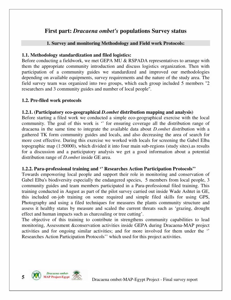
1.1. Methodology standardization and filed logistics:
Before conducting a fieldwork, we met GEPA MU & RSPADA representatives to arrange with
them the appropriate community introduction and discuss logistics organization. Then with
participation of a community guides we standardized and improved our methodologies
depending on available equipments, survey requirements and the nature of the study area. The
field survey team was organized into two groups, which each group included 5 members ''2
researchers and 3 community guides and number of local people''.
1.2. Pre-filed work protocols
1.2.1. (Participatory eco-geographical D.ombet distribution mapping and analysis) Before starting a filed work we conducted a simple eco-geographical exercise with the local
community. The goal of this work is ‘’ for ensuring coverage all the distribution range of
dracaena in the same time to integrate the available data about D.ombet distribution with a
gathered TK form community guides and locals, and also decreasing the area of search for
more cost effective. During this exercise we worked with locals for screening the Gabel Elba
topographic map (1:50000), which divided it into four main sub-regions (study sites).as results
for a discussion and a participatory analysis we get a good information about a potential
distribution range of D.ombet inside GE area.
1.2.2. Para-professional training and ‘’ Researches Action Participation Protocols’’
Towards empowering local people and support their role in monitoring and conservation of
Gabel Elba's biodiversity especially the endangered species, 5 members from local people, 3
community guides and team members participated in a Para-professional filed training. This
training conducted in August as part of the pilot survey carried out inside Wade Ashtet in GE,
this included on-job training on some required and simple filed skills for using GPS,
Photography and using a filed techniques for measures the plants community structure and
assess it healthy status by measure and scaled the current threats such as ‘grazing, drought
effect and human impacts such as charcoaling or tree cutting’.
The objective of this training to contribute in strengthens community capabilities to lead
monitoring, Assessment &conservation activities inside GEPA during Dracaena-MAP project
activities and for ongoing similar activities; and for more involved for them under the ‘’
Researches Action Participation Protocols’’ which used for this project activities.
Dracaena ombet-MAP-Egypt Project - Final survey report
6
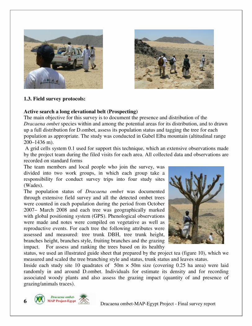
1.3. Field survey protocols:
Active search a long elevational belt (Prospecting) The main objective for this survey is to document the presence and distribution of the
Dracaena ombet species within and among the potential areas for its distribution, and to drawn
up a full distribution for D.ombet, assess its population status and tagging the tree for each
population as appropriate. The study was conducted in Gabel Elba mountain (altitudinal range
200–1436 m).
A grid cells system 0.1 used for support this technique, which an extensive observations made
by the project team during the filed visits for each area. All collected data and observations are
recorded on standard forms
The team members and local people who join the survey, was
divided into two work groups, in which each group take a
responsibility for conduct survey trips into four study sites
(Wades).
The population status of Dracaena ombet was documented
through extensive field survey and all the detected ombet trees
were counted in each population during the period from October
2007– March 2008 and each tree was geographically marked
with global positioning system (GPS). Phenological observations
were made and notes were compiled on vegetative as well as
reproductive events. For each tree the following attributes were
assessed and measured: tree trunk DBH, tree trunk height,
branches height, branches style, fruiting branches and the grazing
impact. For assess and ranking the trees based on its healthy
status, we used an illustrated guide sheet that prepared by the project tea (figure 10), which we
measured and scaled the tree branching style and status, trunk status and leaves status.
Inside each study site 10 quadrates of 50m × 50m size (covering 0.25 ha area) were laid
randomly in and around D.ombet. Individuals for estimate its density and for recording
associated woody plants and also assess the grazing impact (quantity of and presence of
grazing/animals traces).

Dracaena ombet-MAP-Egypt Project - Final survey report
7
In order to understand the regeneration status, population size of seedlings, saplings, trees, and
sprout/coppice shoots were ascertained. Seed dispersal and seedling survival in relation to
distance from the mother plant was ascertained by counting the number of seedlings and
saplings with respect to the increase in the radial diameter from the mother plant.
For lack of seeds, five freshly collected young shoots were tested for a vegetative germination
in polythene bags filled with collected soil from the filed and kept in a greenhouse and kept
under regular watering. Germination was defined as the emergence of primary roots from the
shoot.
Tree branches status sheet

Dracaena ombet-MAP-Egypt Project - Final survey report
8
1.4. Data management and analysis
1.4.1. Meta data For ensure the quality control and effectiveness
of our collected data, and for well organization
for these data to be avialbe as long term
information for other ongoing actions. We
designed ACCESS database (DMAP DB) for
the project monitoring program results, all data
included (trees GPS point, trees attributes, site
information, quadrates, climatic data and also
images of each tree and sites) inputted directly
in computer, arranged into related and well labeled files and linked folders.
Simple Metadata guide was prepared for standardization, better arrangement, stored and
accessibility for the information and the sustaining availability of well referenced data on long
term.
This figure shows example for labeling of
one of the project survey's image file, which
from the file name we can get a full
information about the image type, location,
time of photography, who is taken it and a
proximately GPS location using a 10 second
GIS Grid as shown in map 5. Each grid has
a horizontal defined number and a
perpendicular defined article, when GRIDS
read and recorded as H5, C14 as example.
1.4.2. Data analysis For analysis and understanding a collected
data, we used and matched some programs and software for getting best analysis for results.
Arc MAP 9.1 GIS software used for located our results on maps and inputted data on GIS
database, the GIS spatial analysis tools used for assess the trees spatial distribution,
hotspots/areas analysis and for ranking and analysis the population protection priority index.
GIS Data analysis fully occurred in GEPA MU, using the project equipments and as part of
established a special GIS unit for D-MAP Project for conservation D.ombet endangered tree.
Multivariate analysis software, MVSP 3.1, has been used for analysis the habitats results for
the gradients zones collected data, also DIVA GIS software has been used for extracting and
organized a climatic data for GE area and grids maps preparation. Microsoft Excel 2003 used
for arrange and analysis data and produce the result's graphs and charts.

Dracaena ombet-MAP-Egypt Project - Final survey report
9
2. Filed survey and monitoring results:
2.1. Participatory eco-geographical D.ombet distribution mapping: The gathered information form this exercise inputted into the project GIS data base, as map 2
shown a potential distribution range for D.ombet linked to a GIS-GE elevation map. Based on
the gathered TK, locals indicated that in general D.ombet among these areas can be found
inside Two mountains missives (Elba Mountain and Shendeib Mountain). Which its
distribution range restricted on mountainous slopes within 6 main regions: (Yahmbe-Akwamtei
zone, Wade Aedie-Aedieb hills, Wade Tawela, wade Akaw-Darwina, Ashtet-Aretri and
Shendieb Area zone)
For more understanding for local people perspectives about D.ombet and its distribution, we
conducted many in-depth sessions, related for this exercise, which includes discussions about
the degree of distribution or a populations size and the approximately tree numbers for each
population inside each wade or region.
These results guided us as first step for understanding the dracaena distribution and also for
arrange a good suitable filed logistics and methodology. Map 4 shows a 10 seconds grids-

Dracaena ombet-MAP-Egypt Project - Final survey report
10
divided map, as results for analyses these data using GIS techniques. This map shown results
of D.ombet distribution/populations size index inside GE area; we ranked D.ombet population
depending on its primary population size as it’s gathered from local people knowledge, rank
values form 1 to 10, which 1 equal for a greater tree numbers for a minor grid (10 sec), 10 refer
for zero tree number. We trying as soon as to prepare a proximately distribution but the main
objective for these exercise to learn together ‘’How’’ we can and ‘’what’’ the benefit of
involved and integrated the local community traditional knowledge into our consideration and
matched it with GIS techniques.
2.2. Populations survey and short term monitoring results
2.2.1. Main observations:
The DMAP has completed the D.ombet survey and populations assessment, the results of this
phase has been indicated that:
• This flagship species has a fragmented distribution with different subpopulations
showing varying degrees of vigor. Survey results for the first time found anew locations
for the Dracaena ombet distribution in the granite Elba mountains, which Dracaena
ombet detected within 13 localities, which 9 locations/population have been completely
surveyed and the other 4 regions have been explored for more further survey work ,
these areas included:-
Region Name Region
Reference
Code
Region Name Region Reference
Code
Wade Aedeib ADBK W. Ghway GWY
W. Aretri ART W. Naheeb NHB
W. Marafay MFY Outliers hills of W. Kansi-Srob KSR
W. Ashtet SHT Outliers hills of W. Aedieb ADBH
W. Akaw AKW Shendeib Mountains SHN
W. Tawella TWL Camerba mountains CAM
W. Darwina-
Tewoeit
DRW

Dracaena ombet-MAP-Egypt Project - Final survey report
11
Distribution map of Dracaena ombet in Gabel Elba, Egypt
Spatial distribution patterns/Regions of Dracaena ombet in Gabel Elba

Dracaena ombet-MAP-Egypt Project - Final survey report
12
• D.ombet's Populations grow at elevation range from 450 to 1250 m.
• In general all the D.ombet tree sub-populations marked by a bad age structure inside its
distribution range on Elba Mountain, which there is no sign for regeneration and there is
no new generation or seedlings observed during the filed survey, most of the trees
considers as mature old trees with trunk more than 70 cm in diameter and 2 m height,
only one seedling detected in Camerba it seem that its age less than 5 years and few
seedlings more than 35 cm in DBH was observed into Wade Ghway
• The best Dracaena woodland was
detected on Camerba mountain, which
has a good abundance (more than 500
trees), followed with area of Marafay –
Artri granite massive which include
about (200) tree. It seems that the 2
regions have link together, which these
populations lined run from behind W.
Akmatri over Camerba mountain area
down to the drainage of wade Marafay
then completely this population touch the other populations of wade Ashtete and Aretrai
in the northern Eastern part of GE.
• In the northern part of GE, the project team discovered for the first time, the best
Dracaena woodland in this side in GE, which include more than 150 tree in Wade
Tawella. But there are strong evidences that this woodland suffer from extreme drought
and unsuitable climatic condition that more than 60% of these population has
completely vanished, and most of this woodland trees found in unhealthy conditions.
• The other population in wade Aedieb-Kosheit, Akaw, Darwina, Aedieb outlier-hills
found there as relict populations or as isolated individuals ranging from (1-12 trees).
• its recognized that most of population abundance with best trees condition occur in
areas where the terrain consist of solid rock pavement with extensive cracks, in the
eastern northern side, down which water and soil flows after rains, providing moisture
and nourishment for the roots of the trees. Also in front of the cloud and wind on the
western part of the red sea coast.
• All the D.ombet trees woodlands and regenerations took place at the Eastern and
Northern eastern parts of the Elba and Shendeib mountains, which in northern parts the
Northeast dominance wind can blow and summer rain fall. No trees found or historical
known in at the western or the southern slopes of Elba Mountain, where the climate is
different from the eastern parts. Which the climate of western parts of the mountains
considers as part of Sahara climate ( hot and less exposures for rain or moisture)
• The field survey results indicated that that the ombet seeds seems to have a long
dormancy period and high viability period, which enable the seed to stay underground
for longer periods and only grow when there are favorable climatic conditions.
Dracaena ombet-MAP-Egypt Project - Final survey report
13
• As all the omebt grows at high altitudes at hard slopes, it also seems that the seeds in
usual are not the kind that can be transmitted by animal, like acacia as example that
have a high rate of germination as after transmitting by camels in this area.. This can
indicate that may be the omebt seeds transmission happened by some kind of residents
wild birds in this area or/and, water and wind. In most of the areas of ombet woodland
the Raven birds (Fan-Tailed Raven) observed fly and stay of top of the ombet trees, and
local community stated that these birds like the ombet seeds and it observed eat its seeds
at the fruiting seasons in the past. This can lead that may be there is possibilities that
these birds acts as a main transmitting agent for the ombet seeds.
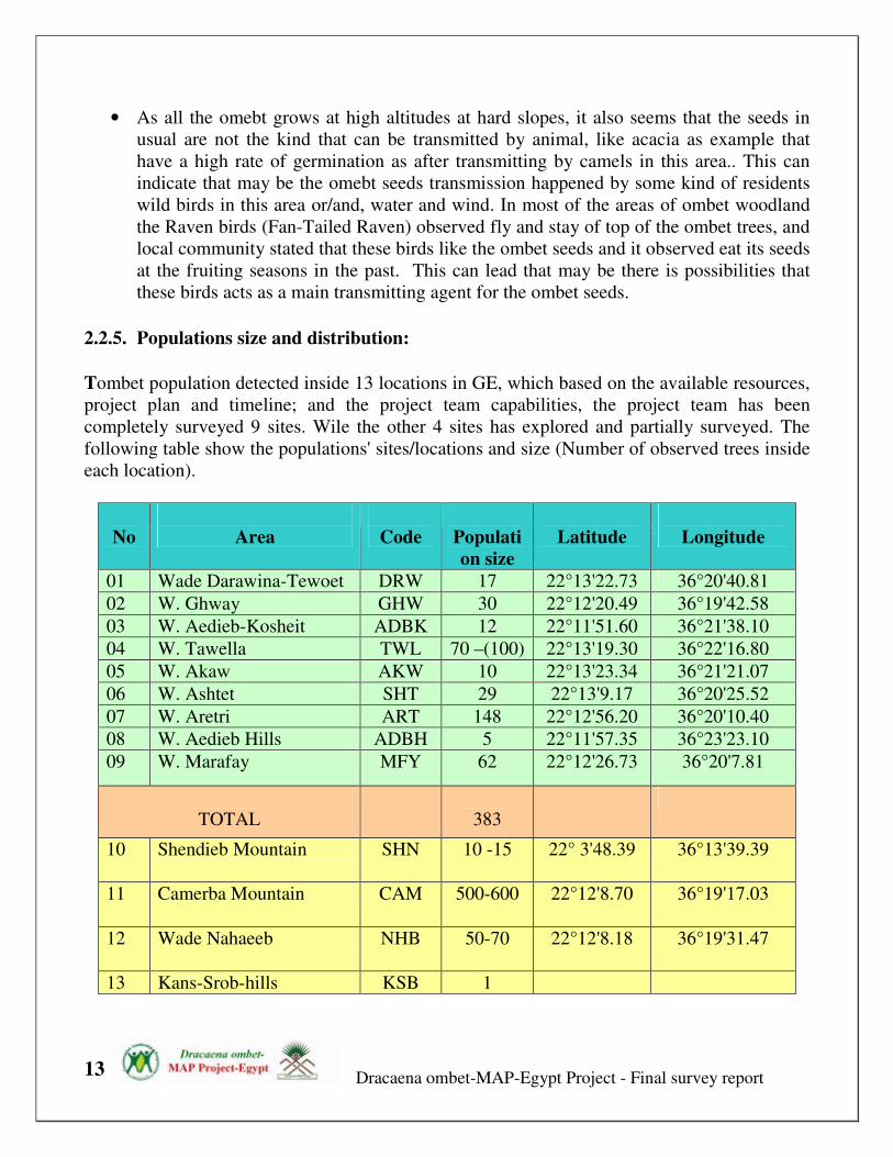
2.2.5. Populations size and distribution:
Tombet population detected inside 13 locations in GE, which based on the available resources,
project plan and timeline; and the project team capabilities, the project team has been
completely surveyed 9 sites. Wile the other 4 sites has explored and partially surveyed. The
following table show the populations' sites/locations and size (Number of observed trees inside
each location).
No
Area
Code
Populati
on size
Latitude
Longitude
01 Wade Darawina-Tewoet DRW 17 22°13'22.73 36°20'40.81
02 W. Ghway GHW 30 22°12'20.49 36°19'42.58
03 W. Aedieb-Kosheit ADBK 12 22°11'51.60 36°21'38.10
04 W. Tawella TWL 70 –(100) 22°13'19.30 36°22'16.80
05 W. Akaw AKW 10 22°13'23.34 36°21'21.07
06 W. Ashtet SHT 29 22°13'9.17 36°20'25.52
07 W. Aretri ART 148 22°12'56.20 36°20'10.40
08 W. Aedieb Hills ADBH 5 22°11'57.35 36°23'23.10
09 W. Marafay MFY 62 22°12'26.73 36°20'7.81
TOTAL
383
10 Shendieb Mountain
SHN 10 -15 22° 3'48.39 36°13'39.39
11 Camerba Mountain CAM 500-600 22°12'8.70 36°19'17.03
12 Wade Nahaeeb
NHB 50-70 22°12'8.18 36°19'31.47
13 Kans-Srob-hills KSB 1

Dracaena ombet-MAP-Egypt Project - Final survey report
14
This indicate that the current Tombet population size within 9 sites of total 13 ( about 70%
within the area of the survey, we found that the tree distribution equal about 383 trees,
while the estimated total ombet tree population size within Gabel Elba could be 1000+/-
100 tree (it may be ranging from 950- 1050 tree).
From the records we estimated the Mean density of Tombet for whole GE to be equal about
= 55 tree/sq km
Table. Tree densities for locations:
Wade name ART MFY SHT DRW AKW TWL ADBK ADBH
Density/100 m2 5.13 16.50 6.25 3.75 2.50 6.43 2.25 1.00
Density/1000 m2
51.25 165.00 62.50 37.50 25.00 64.29 22.50 10.00
2.2.6. Populations trend:
Population status Survey Status
? FS PS EP
Stable Decline Rapid/sharp
decline
Unknown Fully
Surveyed
Partially
surveyed
Explored
Population status
No
Area
Populati
on size Survived
tree %
Decline %
Trend Survey
status
01 Wade Darawina 17 41.18
58.82
Rapid
decline FS
02 W. Ghway
30 68.3 31.7 Decline FS
03 W. Aedieb-
Kosheit
12 25 75 Rapid
decline FS
04 W. Tawella 70 32.86 67.14
Rapid
decline PS
05 W. Akaw
10 80 20 Decline FS

Dracaena ombet-MAP-Egypt Project - Final survey report
15
06 W. Ashtet
29 51.72 48.28 Rapid
decline FS
07 W. Aretri
148 39.86
60.14
Rapid
decline FS
08 W. Aedieb Hills
5 80 100 Decline FS
09 W. Marafay 62 70.97
29.03
Decline FS
TOTAL 383 45.54 54.46 Rapid
decline
10 Shendieb
Mountain
10 -15 ? ? ? EP
11 Camerba
Mountain
500-600 ? ? Decline EP
12 Wade Nahaeeb 50-70 ? ? ? EP
13 Kansi-Srob 1 1 ? ? EP
2.2.7. Populations Healthy Status:
2.2.7.1. Survival status of ombet tree:
• From total 353 tree recorded and completely assessed, about 163 tree observed survived
against 190 dead tree. That represents about 46.1% survival percent from that total
detected population size.
• The following Figures show the percentage of the survived and dead tree within each
population in GE.

Dracaena ombet-MAP-Egypt Project - Final survey report
16
Healthy status map of dracaena
0
10
20
30
40
50
60
70
80
90
100
Taw
ella
DRW
SHT
ART
AKW A
DB
MRF
ADH
GW
Y
Survived trees
Dead Trees
Healthy status of dracaena

Dracaena ombet-MAP-Egypt Project - Final survey report
17
2.2.7.2. Healthy status classes:
• Based on the survey methods and results, we divided the ombet trees healthy status into
4 classes/grades based on the tree vigor status: Healthy (70-100), moderate (35-70),
server (1-35%), Dead trees (= 0).
• From total 353 tree recorded and completely assessed, about 97 trees observed survived/
Healthy that represents about 27.47% of that total population size;
• 38 tree recorded as survived/moderate that represents about 10.76 % of that total
population size;
• 28 tree recorded as survived/server that represents about 7.93 % of that total population
size; and
• 190 trees recorded as Dead trees that represent about 53.82 % of that total population
size.
Ombet survival status map

Dracaena ombet-MAP-Egypt Project - Final survey report
18
Ombet Healthy Status
0
10
20
30
40
50
60
70
80
90
100
ADBH ADBK AKW ART DRW MFY SHT TWL
location name
Tre
e n
um
be
r
Survived-Healthy
Survived-Moderate
Survived-Server
Dead
Number and status of populations (survived vs. dead tree)
This figure show the number of survived and dead tree for each Tombet population in GE,
which as shown there is a sharp decline in number of trees and population size. About 60% of
the detected trees have been recorded as dead tree which most of these dead trees concentrated
inside W.Tawella and W.Artri.
Generally the populations severe a rapidly, high decline and mortality rate among all its
populations. It seem that W.Marfay and W.shtet still save a good population healthy status that
still there is balance between the dead and healthy trees.
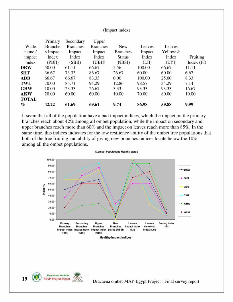
2.2.4.3. Healthy status indices:
In general as the previous results show that the survived-healthy tree equal only about 27.47 %
of that total population size; this low percentage return for the bad status for most of the trees
in GE. Which the effect of drought and other factors impacted most of these trees. This impact
affected the main, secondary and upper branches; leaves, and also affect the fruiting ability of
the trees. The following table and figure show the degree of impact on the tree's parts within
each wade
Dracaena ombet-MAP-Egypt Project - Final survey report
19
(Impact index)
Wade
name /
impact
index
Primary
Branche
s Impact
Index
(PBII)
Secondary
Branches
Impact
Index
(SBII)
Upper
Branches
Impact
Index
(UBII)
New
Branches
Status
(NBSI)
Leaves
Impact
Index
(LII)
Leaves
Yellowish
Index
(LYI)
Fruiting
Index (FI)
DRW 50.00 61.11 66.67 5.56 100.00 66.67 11.11
SHT 36.67 73.33 86.67 26.67 60.00 60.00 6.67
ADB 66.67 66.67 83.33 0.00 100.00 25.00 8.33
TWL 70.00 85.71 94.29 12.86 98.57 34.29 7.14
GHW 10.00 23.33 26.67 3.33 93.33 93.33 16.67
AKW 20.00 60.00 60.00 10.00 70.00 80.00 10.00
TOTAL
% 42.22 61.69 69.61 9.74 86.98 59.88 9.99
It seem that all of the population have a bad impact indices, which the impact on the primary
branches reach about 42% among all ombet population, while the impact on secondary and
upper branches reach more than 60% and the impact on leaves reach more than 85%. In the
same time, this indices indicates for the low resilience ability of the ombet tree populations that
both of the tree fruiting and ability of giving new branches indices locate below the 10%
among all the ombet populations.
D.ombet Populations Healthy status
0.00
10.00
20.00
30.00
40.00
50.00
60.00
70.00
80.00
90.00
100.00
Primary
Branches
Impact Index
(PBII)
Secondary
Branches
Impact Index
(SBII)
Upper
Branches
Impact Index
(UBII)
New
Branches
Status (NBSI)
Leaves
Impact Index
(LII)
Leaves
Yellowish
Index (LYI)
Fruting Index
(FI)
Healthy-Impact Indices
Ind
ex %
DRW
SHT
ADB
TWL
GHW
AKW

Dracaena ombet-MAP-Egypt Project - Final survey report
20
2.2.5. Population boundaries and coverage:
2.2.5.1. D. ombet’s Extent of Occurrence (EOO) in Egypt:
Depending on the IUCN (IUCN 2001), Extent of occurrence is defined as the area contained
within the shortest continuous imaginary boundary which can be drawn to encompass all the
known, inferred or projected sites of present occurrence of a taxon, excluding cases of
vagrancy. Extent of occurrence can often be measured by a minimum convex polygon (the
smallest polygon in which no internal angle exceeds 180 degrees and which contains all the
sites of occurrence).
Depending on the results of the population’s survey and mapping activities, we measured the
current EOO for the Dracaena ombet’s sub-populations in GE, which we estimated this area in
two stages
• In case of excluding the cases of vagrancy populations, this mean we including all the
closed populations, but only excluded Shendieb mountain’s population which is far
more than 20 km from the whole other populations, while all the other population very
close to each other (less than 3 km). Maps 4 show, the EOO for D.ombet’s populations,
which is equal and came among 23.8 sq km that represents about 15. 87% of the whole
Gabel Elba mountain massive area (= 150 sq km), and 0.066% of the total area of Elba
Protected Area (= 36000 sq km).
• In case of including all the cases of vagrancy and the closest populations, this including
Shendieb mountain’s population. For that and as maps 5 show, the EOO for D.ombet’s
populations is equal and came among 116.2 sq km, which represents about 23.24% of

Dracaena ombet-MAP-Egypt Project - Final survey report
21
the whole Gabel Elba massive total area (= 500 sq km), and 0.32% of the total area of
Elba Protected Area (= 36000 sq km).
2.2.5.2. D.ombet Area of Occupancy (AOO)
Area of occupancy is defined as the area within its 'extent of occurrence' (see above) which is
occupied by a taxon, excluding cases of vagrancy. The measure reflects the fact that a taxon
will not usually occur throughout the area of its extent of occurrence, which may contain
unsuitable or unoccupied habitats (IUCN 2001).
The size of the area of occupancy will be a function of the scale at which it is measured, which
here for accurate AOO estimation, we need more accurate mapping scale, which should be at a
scale appropriate to relevant biological aspects of the species, the nature of threats and the
comprehensiveness of the available data. Thus to avoid bias and to estimate a relevant AOO,
we need to estimating area of occupancy at different scales.
For that in case of D. ombet populations’ available data, and based on the produced ombet
trees distribution map, that included a GPS record for each tree based on its geographical
location, we measured the AOO using a Grid technique, which the distribution map for the
species divided into equal grids depending on the used scale. For this we used 5 different scale
Grids system: at 1 Degree, 0.5 Degree, 0.25 D, 0.1 D, which equal areas = 1, 0.5, 0.25, 0.05,
0.01 sq km respectively for each grid.
As the table below shown, there is a different estimated AOO for the same population at the
different scales; this return for the used Grid/scale which at small grid/scale reveals more areas
in which the taxon is unrecorded. Conversely, coarse-scale mapping/large grid reveals fewer
unoccupied areas, resulting in over-estimation that is more likely to be or accept.

Dracaena ombet-MAP-Egypt Project - Final survey report
22
Which here at using a 1 km grid, we can found as example, W.Darwina's populations which
equal 12 tree occupied large area (2 grids = 2 sq km), equla for W.Artri which have more than
164 tree and ocuupied 2 grid also.
While at fine scale, 0.25 km grid, we can found that W.Darwina population occupied only 5
grids/0.16 sq km, comparing with W.Artri that occupied 11 grids = 0.35 sq km.
As we used finer scale (smaller grid area) as we can get results reflects the facts on ground, and
can used for assessment the status of the threatened species.
These results indicate that:
1- In case of the current recorded populations (Included areas that occupied by the
dead and survived trees):
At 0.25 D grid scale, D.ombet populations occupied about 1.673 sq km, which this represents
about 0.034% of the total GE habitats estimated area (=5000 sq km) and about 1.116% of total
GE mountain massive area (= 150 sq km) ; and 7.91% of the suitable GE’s habitats for
D.ombet (=21.5 sq km).
While at 0.1 D or 10 Minutes grid scale, 0.01 sq km grid, D.ombet populations occupied about
0.787 sq km, which this represents about 0.0157% of the total GE habitats estimated area and
about 0.524% of total GE mountain massive area; and 3.72% of the suitable GE’s habitats for
D.ombet .
2- In case of the current recorded populations (Included areas that occupied only by survived
trees):
At 0.25 D grid scale, D.ombet populations occupied about 1.351 sq km, which this represents
about 0.027% of the total GE habitats estimated area, and about 0.9 % of total GE mountain
massive area; and 6.4% of the suitable GE’s habitats for D.ombet.
While at 0.1 D or 10 Minutes grid scale, 0.01 sq km grid, D.ombet populations occupied about
0.5 sq km, which this represents about 0.01% of the total GE habitats estimated area and about
0.333% of total GE mountain massive area; and 2.37% of the suitable GE’s habitats for
D.ombet .
This indicate that the total AOO loss in areas that Dracaena ombet tree occupied in GE = 36.36
% decline in 2007, and by using the same estimation base, we can doing the same estimation
for assess the future AOO of the ombet population (by 2017) for that we adopted a new case:
In case of the current recorded populations (including only areas that occupied by survived
healthy trees and excluding the survived server and moderate trees) this indicate that the total
AOO loss /decline in areas that Dracaena ombet tree occupied in GE = 60 % loss by 2017.

Dracaena ombet-MAP-Egypt Project - Final survey report
23
AOO in case of whole population (dead and survived trees)
Grid 1 Grid 2 Grid 3 Grid 4 Grid 5
Wade
Name
Gri
ds
No
Area
Sq
Km
Grids
No
Area
Sq
Km
Grids
No
Area
Sq Km
Grids
No
Area
Sq Km
Grids
No
Area
Sq
Km
ADB
H 1 3.200 1 0.800 1 0.1978 2
0.06435
2
0.015
898
ADB
K 1 3.200 1 0.800 1 0.1978 3 0.09653 5
0.039
744
TWL 2 6.401 3 2.401 5 0.989 11 0.35395 21
0.166
9248
MFY 2 6.401 3 2.401 3 0.5934 11 0.35395 24
0.190
7712
ART 2 6.401 3 2.401 5 0.989 11 0.35395 23
0.182
8224
SHT 1 3.200 1 0.800 1 0.1978 4 0.12871 10
0.079
488
AKW 1 3.200 2 1.600 2 0.3956 5 0.16089 7
0.055
6416
DRW 2 6.401 3 2.401 3 0.5934 5 0.16089 7
0.055
6416
TOT
AL 12 38.40 17
13.60
68 21 4.1538 52
1.67325
99
0.786
931
Total
exclu-
ding
overl-
apped
Grids
8
25.604
13
10.405
2
20
3.956
51
1.67325
6
98
0.7869
31

Dracaena ombet-MAP-Egypt Project - Final survey report
24
AOO in case of survived population (survived trees only)
Grid 1 Grid 2 Grid 3 Grid 4 0 Grid 5
Wde Name
Grids
No
Area
Sq Km
Grids
No
Area
Sq Km
Grids
No
Area
Sq Km
Grids
No
Area
Sq
Km
Grids
No
Area Sq
Km
ADB H 1 3.2005 1 0.8004 1 0.1978 2 0.064 2 0.0159
ADB K 1 3.2005 1 0.8004 1 0.1978 2 0.064 2 0.0159
TWL 2 6.401 2 1.6008 4 0.7912 8 0.257 10 0.0795
MFY 2 6.401 3 2.4012 3 0.5934 9 0.29 16 0.1272
ART 2 6.401 3 2.4012 5 0.989 11 0.354 17 0.1351
SHT 1 3.2005 1 0.8004 1 0.1978 3 0.097 6 0.0477
AKW 1 3.2005 1 0.8004 1 0.1978 4 0.129 6 0.0477
DRW 2 6.401 2 1.6008 2 0.3956 3 0.097 4 0.0318
TOTAL 12 38.406 14 11.206 18 3.5604 42 1.351 63 0.5008
Total
excluding
the
overlapped
Grids 8 25.604 12 9.6048 17 3.3626 42 1.351 63 0.5008
Lost/decline in area
of the Whole
Populations ( %)
0%
7.69%
15%
19.25%
36.36%
Table: Decline rate for each location
Wade Name
Decline in area of Each
Population (%) In 2007
Decline In area of each
Population (%) By 2017
Lost/decline difference
(2007-2017)
ADB H
0
50
50
ADB K
60.00
80 20
TWL
52.38
71.42 19.04
MFY
33.33
58.33 25
ART
26.1
65.21 39.11
SHT
40.00
50 10
AKW
14.28
28.56
14.28
DRW
42.86
57.14
14.28
Total 36.36 60% 23.64%

Dracaena ombet-MAP-Egypt Project - Final survey report
25

Dracaena ombet-MAP-Egypt Project - Final
survey report
26
2.2.6. D.ombet Population age structure and classification
2.2.6.1. D.ombet Population age structure The analysis results of age structure and growth of D. ombet in GE ‘‘with 90% of
confidence'' showed that:
• Most of D.ombet population's occurs in the stage of intensive disintegration
within 30–100 years.
• D. ombet populations have a high structural homogeneity since about 90% of
the sampled individuals belong to the last 3 size classes (fourth 'V', fifth 'VI'
and sixth 'VII' classes) with a diameter at breast height between 65 and 190
cm., and about 60 % of the samples individuals belong to the class (VI) with
a diameter at breast height between 75 and 125 cm.
• Dracaena ombet populations in GE has a bad age structure, which there is
very few regeneration signs, only a small numbers of young trees have
detected. The second size class 'II', ( 5-10 years old) only represents less than
1% of the whole populations with a diameter at breast height less than 35
cm.
• Among the samples individuals there is no observation for the first size class
'I' which represents the Dracaena ombet seedling (3-5 years old), but only
one seedling observed in Camerba Mountain during the exploration phase for
this area.
This may be return and indicate to:
- the effect of current drought from more than 15 years in GE
- the high mortality portion for the old tree more than 120 in DBH
- The age structure curve may be refer to a rapidly decline for the populations
in GE.
- The ombet only able to regenerate extensively with adequate rainfall
conditions after prolonged droughts.

Dracaena ombet-MAP-Egypt Project - Final
survey report
27
SIZE CLASSES
0
2
4
6
8
10
12
14
16
18
20
25
60
70
74
80
82
85
88
95
10
0
10
2
11
0
11
5
12
0
12
5
13
5
14
6
16
1
DBH
Siz
e c
las
s
Figure 3, 4 show the general age structure for the Dracaena ombet trees in GE
as results for the current survey, as this figure shown there is a bad age structure
for all the Dracaena ombet populations in GE, and most of the population
allocated at the middle part of this chart which this indicates for:
0
20
40
60
80
100
120
Tre
e N
um
bers
No
size class
DBH Size Classes
1-20cm
21-40
41-60
61-80
81-100
101-120
121-140
141-160
161-180
181-200

Dracaena ombet-MAP-Egypt Project - Final
survey report
28
SIZE CLASSES RANGE
0
10
20
30
40
50
60
25 50 75 100 125 150 175
size classes
tre
es
No
SIZE CLASSES RANGE
2.2.6.2. Dracaena ombet age classification scheme: Although there us no defined way for determined the approximately age for the
Dracaena ombet tree, however that there is some references was discussed the
possibility of estimation of the age of the ''Dracaena Drago'' based on its branching
numbers and level. Therefore in our case we tried to prepare a scheme or guide that
can help not in estimate a net age for the tree but for estimate their age/size class
then can estimate their age based on its size class age range.
The following figures illustrate and figure the ombet size classes and its attributes
based on the observation inside GE. A well defined six classes has been defined as
following:
Dracaena ombet age classes: 1: plant with a single rosette and without a trunk.
2: plant with one rosette and a small and young trunk (less than 1m in height).
3: plant with one rosette and a trunk (more than 1 m in height).
4: plant with 2 main branches, more than one rosette and a crown with a diameter
smaller than 2 m.
5: plant with more than 2 main branches, few numbers of upper branches, more than
one rosette and with a crown larger than 2 m.

Dracaena ombet-MAP-Egypt Project - Final
survey report
29
6: plant with more than 2 main branches, many upper branches, more than one
rosette and with a crown larger than 2.5-3 m.
D.ombet size classes attributes:
Class Trunk Rosette Main
branches
Upper
branches
Crown Estimated
age
(Years)
DBH
(cm)
Class 1
None Single None None none 3- 5 0
Class 2 Less
than 1 m
One None None None 5 -10 ≤ 35
Class 3 More
than 1 m
One Small
branching
None None 15-20 >35-
64
Class 4 More
than 1 m
More
than one
Two-big Yes Diameter
Less than
2m
25-30 65-
74
Class 5 More
than 1 m
More
than one
Three -
Four
Yes , 2-3
levels
Diameter
more than
2m
40-50 75-
120
Class 6 More More Four- or Yes, more Diameter 70- more >
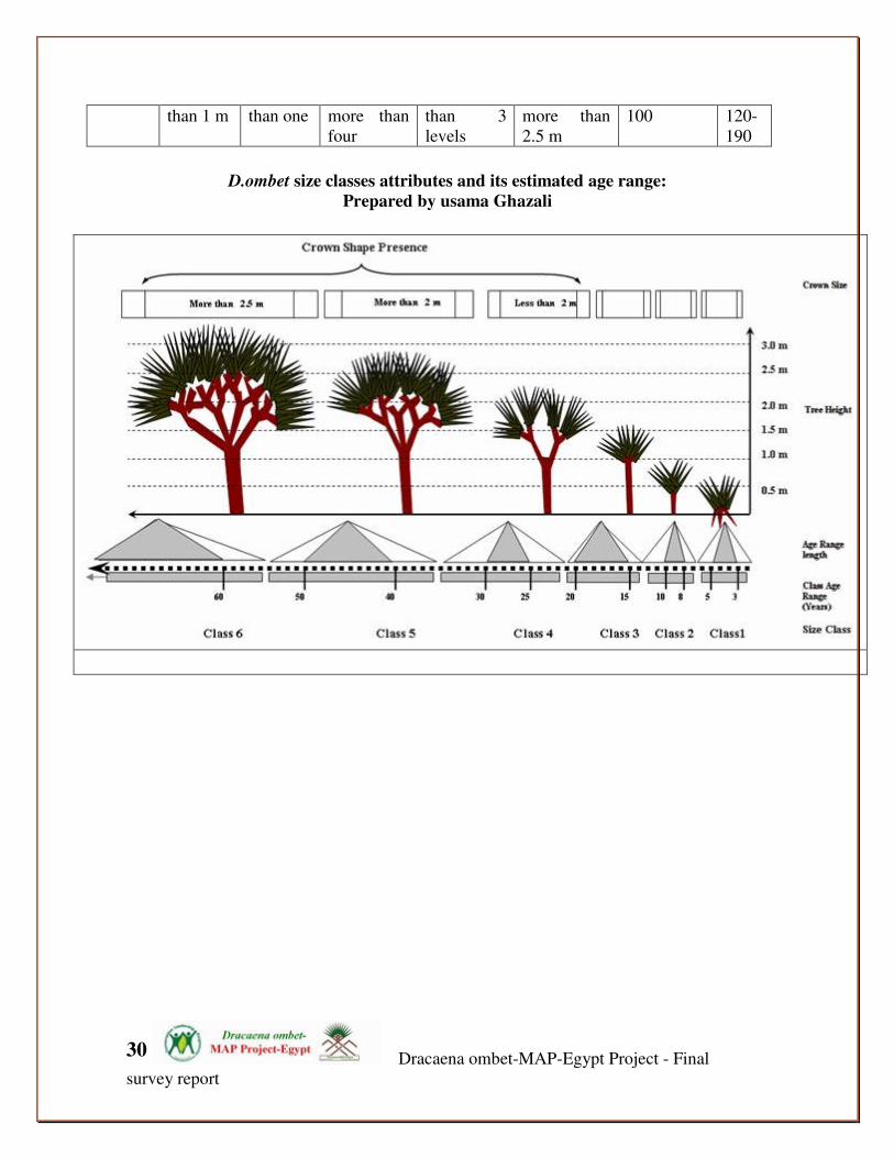
Dracaena ombet-MAP-Egypt Project - Final
survey report
30
than 1 m than one more than
four
than 3
levels
more than
2.5 m
100 120-
190
D.ombet size classes attributes and its estimated age range:
Prepared by usama Ghazali

Dracaena ombet-MAP-Egypt Project - Final
survey report
31
Ombet tree Size Classes representation among the populations
0.0 0.8
9.3
15.0
0.0 1.2
59.2
15.6
9.9
59.3
18.5
11.1
0.0
10.0
20.0
30.0
40.0
50.0
60.0
70.0
0 0-35 cm 36-64 cm 65-74 cm 75-120 cm 121-190 cm
1 2 3 4 5 6
Size Class / DBH
Pre
cen
t %
Past Precent
Current Precent
Decline Rate within the ombet size classes
9.315.6
59.2
15.0
0.0 0.80.0 0.6
5.18.5
27.2
4.5
0.0
10.0
20.0
30.0
40.0
50.0
60.0
70.0
0 0-35 36-64 65-74 75-120 121-190
1 2 3 4 5 6
Size class/DBH
Pre
ce
nta
ge
Past Precent
Current Precent
This chart shows the fluctuation of the ombet generation in GE, and the status of the
regeneration. Which it seems that there is slight increasing in representation of the
youngest generations (size classes 2, 3 and 4). No changes among the size class 5
(dominant class/generation), while there is a notable decreasing in the last / older
Dracaena ombet-MAP-Egypt Project - Final
survey report
32
size class 6. This can help in understanding that the ombet population have a stable
mid generation, with a sharply decline for the oldest generation about 75% of this
generation was vanished. While the other generation it seem have an equal decline
rate about 50-55%.
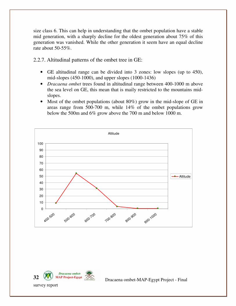
2.2.7. Altitudinal patterns of the ombet tree in GE:
• GE altitudinal range can be divided into 3 zones: low slopes (up to 450),
mid-slopes (450-1000), and upper slopes (1000-1436)
• Dracaena ombet trees found in altitudinal range between 400-1000 m above
the sea level on GE, this mean that is maily restricted to the mountains mid-
slopes.
• Most of the ombet populations (about 80%) grow in the mid-slope of GE in
areas range from 500-700 m, while 14% of the ombet populations grow
below the 500m and 6% grow above the 700 m and below 1000 m.
Altitude
0
10
20
30
40
50
60
70
80
90
100
400-500
500-600
600-700
700-800
800-900
900-1000
Altitude
Dracaena ombet-MAP-Egypt Project - Final
survey report
33
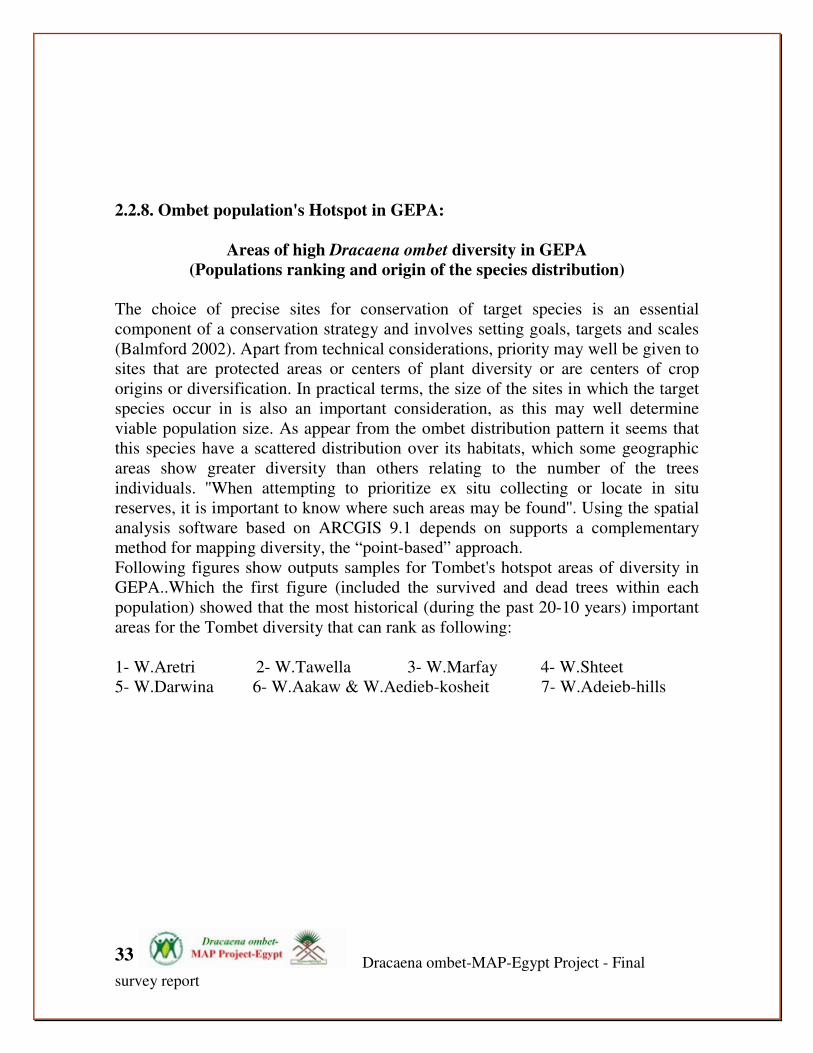
2.2.8. Ombet population's Hotspot in GEPA:
Areas of high Dracaena ombet diversity in GEPA
(Populations ranking and origin of the species distribution)
The choice of precise sites for conservation of target species is an essential
component of a conservation strategy and involves setting goals, targets and scales
(Balmford 2002). Apart from technical considerations, priority may well be given to
sites that are protected areas or centers of plant diversity or are centers of crop
origins or diversification. In practical terms, the size of the sites in which the target
species occur in is also an important consideration, as this may well determine
viable population size. As appear from the ombet distribution pattern it seems that
this species have a scattered distribution over its habitats, which some geographic
areas show greater diversity than others relating to the number of the trees
individuals. ''When attempting to prioritize ex situ collecting or locate in situ
reserves, it is important to know where such areas may be found''. Using the spatial
analysis software based on ARCGIS 9.1 depends on supports a complementary
method for mapping diversity, the “point-based” approach.
Following figures show outputs samples for Tombet's hotspot areas of diversity in
GEPA..Which the first figure (included the survived and dead trees within each
population) showed that the most historical (during the past 20-10 years) important
areas for the Tombet diversity that can rank as following:
1- W.Aretri 2- W.Tawella 3- W.Marfay 4- W.Shteet
5- W.Darwina 6- W.Aakaw & W.Aedieb-kosheit 7- W.Adeieb-hills
Dracaena ombet-MAP-Egypt Project - Final
survey report
34
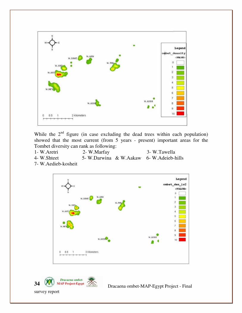
While the 2
nd figure (in case excluding the dead trees within each population)
showed that the most current (from 5 years - present) important areas for the
Tombet diversity can rank as following:
1- W.Aretri 2- W.Marfay 3- W.Tawella
4- W.Shteet 5- W.Darwina & W.Aakaw 6- W.Adeieb-hills
7- W.Aedieb-kosheit

Dracaena ombet-MAP-Egypt Project - Final
survey report
35
The 3rd
figure (in case including only the healthy trees and excluding all the
survived-modetae, survived-server and dead trees within each population) showed
that the most potential/future (for next 15–20 years) important areas for the Tombet
diversity can rank as following:
1- W.Aretri 2- W.Shteet & W.Marfay 3- W.Tawella & W.Darwina
4- W.Aakaw & W.Adeieb-hills 5 - W.Aedieb-kosheit
On the origin of the presence and distribution of th Tombet in GEPA:
The following figure show the areas of high diversity of ombet tree in GEPA based
on the tree DBH. This factor could be used as indictor for the tree age, her we
attempting to understand the main areas of distribution and the oldest areas for
Tombet distribution in GEPA, which can ranging from the oldest to the youngest
area as following:
1- W.Aretri
2- W.Tawella
3- W.Shteet
4- W.Marfay
5- W.Darwina W.Aedieb-kosheit
6- W.Aakaw & W.Adeieb-hills

Dracaena ombet-MAP-Egypt Project - Final
survey report
36
Tombet Populations' hotspots shrinking, fragmenting and Alt-up-ward
movement phenomena under effect of the climate change:
Through analysis the population distribution, the following figures show the
complementary distribution for the high areas of ombet trees diversity (hotspots),
which figure 15 show the past situation while figure 16 show the current situation.
It appears that the ombet populations face an accelerated fragmentation under the
climatic effect and/or other factors.
As maps show there is shrinking in the areas of ombet distribution correlated with
fragmentation or separation between the closest populations. These leads for
importance for establish and conserve bio-corridor among the Tombet populations,
particularly in the region that reach W.Tawella and W.Akaw. This to facilities the
dispersal among all populations, to support the internal-populations regenerations
compensation on along term, and to decrease impact of the ''edge effect'' on the
Tombet populations.

Dracaena ombet-MAP-Egypt Project - Final
survey report
37
past populations situation Current situation
Alt-up-ward movement phenomena under effect of the climate change:
It has been reported that the globally endangered tree, the Dracaena ombet of the
Elba Mountains of Egypt is exhibiting widespread decline especially during the last
10 years. The survey’s results show that this decline is occurring and has
accelerated at the lower and middle elevations of the Dracaena ombet range, with
unhealthy trees, no sign of any new generation, pathogens affecting the trees and
widespread tree death between 450-850 m. At higher altitudes, the Dracaena
woodland in general is healthy, maybe due to a scattered distribution pattern for this
tree at these elevations, rather than a grove-distribution as at the mid elevation, or
maybe for other reasons. This altitudinal pattern of Dracaena woodland conditions
in the GEPA is very similar to that documented for the Dracaena ombet population
of the Erkowit Mountain in north east Sudan from about 50 years ago. We detected
the effects of pathogens among most of the population of trees, but these do not
appear to be responsible for the observed decline. It seems likely that the main
cause of the decline in extent and quality of Dracaena woodland is the gradual
drying up of the area of southern Egypt. There is no direct historical data available
from the GEPA about the distribution or status of Dracaena ombet, but there is
strong circumstantial evidence that this area has been drying up over the last few
hundred years. When comparing and matching available data about the extreme
drought especially in the last 10 years with the available data about the distribution
and status of Dracaena ombet in the GEPA during the last six years, it appears that
probably this drought has had a great impact on the current populations inside the
GEPA. As it is known, Dracaena ombet occurs only at a highelevation between 450
to 1,450 m in this area, which is affected by mists and cloud which come from the
east, from the Red Sea coast towards the GE summit. Local people, traditional
reports and the old explorers in this area have described the extent of this cloud/mist
coverage diminishing over the years.

Dracaena ombet-MAP-Egypt Project - Final
survey report
38
The following figure show the differences between the past (upper map) and current
(lower map) areas of high diversity of Tomet inside W.Aretri and Marfay. It
appears that there is shrinking towards up-ward in the areas of and the high
diversity regions of Dracaena ombet on GEPA. As appear the center of the hotspot
of the Tombet trees has moved-up-ward (this movement estimated about 0.25 km
up-ward)
2.2.9. Threats: Causes for the deterioration of Dracaena ombet in GE:
It seems likely that a major cause of the decline in extent and quality of Dracaena
woodland is the very gradual drying of the area of south Egypt. Although there is
No direct history data is available from GEPA about the distribution or status of
dracaena ombet, however, there is strong circumstantial evidence that this area have
been drying over the last few hundred years, and especially with comparing and
matching the available data about the extreme drought especially the last 10 years
and the available data about distribution and status of Dracaena ombet in GEPA
along the last 6 years, depending in that it is appear that probably this drought have

Dracaena ombet-MAP-Egypt Project - Final
survey report
39
a greater impact on the current populations decline in GEPA. As is known,
Dracaena ombet occurring only in a high elevation between 450 to 1450 m in this
areas affected by the mists and cloud which came from the east, across the red sea
coast towards GE submit. Local people and the old explorer's reports in this area
reported that the extent of this cloud/mist coverage diminished over the years and
the area subject for many years ago for more than continues 2-3 months of rains and
clouds.
- Insects, disease and rainfall: The project team found evidence of presence of harmful insects inside and on the
tree barks, most of the insects observation found on and at the top of ombet trees
just before their deterioration. Also local people in GE mentioned that insects has
bee observed during the last period paralleled with the drought conditions. It seem
that insects causes and accelerate the trees deterioration that may be happened under
the extreme drought and fluctuation of rainfall, which also in north Sudan the same
observation mentioned by local people of Erkwit mountain areas (SOS report).
- Parasites the project team observed some new cases for presences and distribution of plants
parasites on the Tombet trees, in wade camerba, Marafay and Tawella, the coculus
pendeduls as a most common parasite species in GE, this species observed climbing
on the tree crown, and it seem that have effect on the tree growth and survival.
- Human exploitation & animal grazing:

Dracaena ombet-MAP-Egypt Project - Final
survey report
40
The project team doesn’t observed any direct human impact on the ombet trees, also
based on some local people, the local women was used to cut and use the ombet
tree leaves to make ropes, which the ombet leaves remarked by a strong and flexible
fibers. In concern with grazing there is no observed or detected evidence for any
grazing sign for domestic's animals such as goats or sheep on ombet trees. This may
be return for the morphological characteristics of the ombet tree, with long trunk,
umbrella-shape crown; Leaves in dense terminal linear from wide ovate base,
gradually narrowed to an acute apex. But locals mentioned that goats can only feed
on the young seedling especially the young leave which very rich with protein. Also
they used to collect some leaves from the ombet trees to feed their camels especially
in the drought seasons. in general the community do not believe that human
exploitation and animal grazing are critical factor in the deterioration of ombet tree.
But in a general view for effect of over-grazing on the Tombet ecosystem, the
project team observed a high degree of over-grazing within the habitats of dracaena
ombet, particularly on mid- and high slopes and especially within wadies of Aedieb,
Marfay and Camerba mountains. This also can indicate for the challenges of
feeding the animals of any ombet seedlings so that could effect the regenerations
balance of the Tomebt populations.
Grazing inside the dracaena mobet populations and habitats
Drought and climate change (The complex issue): Based on the protective evidences in this area and with full agree with local people
it seem that the current drought and poor rainfall that affect all the area from more
than 20 years and in general since 1950 has had an effect on all tree species,
livestock and human life and the whole ecosystem. The project team observed that

Dracaena ombet-MAP-Egypt Project - Final
survey report
41
the existing tree regeneration and the historical habitat of ombet is found to be on
top of the hills far from the ground water, and that suggests the tree is mainly
dependent on rains and mist irrigation. Which have both fluctuated over the last 50
years that before the dry period, the area was more populated and had a rich and
vigor vegetation; GE vegetation had dense woodland which support a good
livelihood for the locals and their livestock. But the human interference in the area
has been accelerated after 1986 which with the natural resources reduction, and the
area and quantity of pasture, overgrazing and other human activities such as
charcoal production has been an ecological disaster for the areas. Lack of vegetation
in the lowland and wades, resulting in increased the overgrazing on high lands,
resulting in the removal of and affect the vegetation cover in these habitats
Knut Krzywinski (2001) is confident that the environmental factors, which are
broadly responsible for the decline of the Dracaena ombet, also underlie the
environmental degradation of the Red Sea cultural landscape and the African dry
land crises in general. He stated that; “Already in the sixties there were reports
about how the unique environment of Arkowit and the Dracaena ombet as a species
were in danger. The desertification of the Sahara borderland was threatening not
just single species, but an entire land ecosystem as well. The underlying factors are
complex, and to some extent the complexity relates to the intimate relationship
between the landscape itself, its vegetation, and the population surviving on its
resources and the culture they developed in the desert environment.”
It could be stated as the Sudanese team in monitoring of D.ombet in Erkowit area in
Sudan reported that ''it is too early to judge now on whether the acquired
information and data on climate is enough to prove any longer-lasting change. A
series of global climate changes are taking effect and influencing temperature,
precipitation, wind storms, and have consequences and side effects for the lives of
all creation in the World. But, it is not yet known whether these changes such as in
rainfall are part of a steady, sporadic or cyclical process''. The reason behind this
gist is the most likely observed change of trend in favor of a promising natural
restocking of the threatened Dracaena ombet.
It is most likely that the main reasons for the deterioration of the Dracaena ombet in
GEPA and in general at the Red Sea Hills are return for effect of the climatic
factors, which the period of deterioration is matched with the waves of drought that
faces the area along the last 50 years, especially in the decades 60s to the 80s of this
century (SOS report 2003). In addition also there is a cumulative other factors are
still considered such as effect of pests and diseases that affect plants that already
suffered from the drought.
Dracaena ombet-MAP-Egypt Project - Final
survey report
42
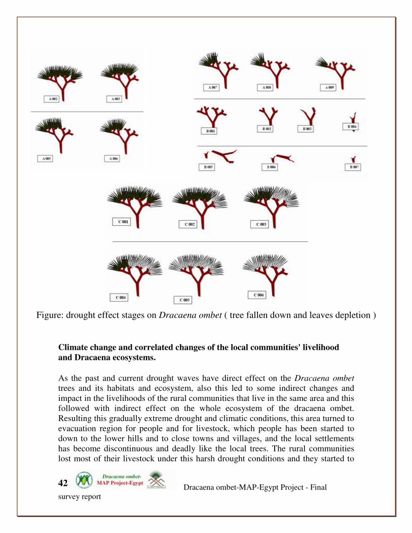
Figure: drought effect stages on Dracaena ombet ( tree fallen down and leaves depletion )
Climate change and correlated changes of the local communities' livelihood
and Dracaena ecosystems.
As the past and current drought waves have direct effect on the Dracaena ombet
trees and its habitats and ecosystem, also this led to some indirect changes and
impact in the livelihoods of the rural communities that live in the same area and this
followed with indirect effect on the whole ecosystem of the dracaena ombet.
Resulting this gradually extreme drought and climatic conditions, this area turned to
evacuation region for people and for livestock, which people has been started to
down to the lower hills and to close towns and villages, and the local settlements
has become discontinuous and deadly like the local trees. The rural communities
lost most of their livestock under this harsh drought conditions and they started to
Dracaena ombet-MAP-Egypt Project - Final
survey report
43
be more dependence in other activities such as charcoal making especially from
acacia trees that could help the communities to earn more income in these harsh
environment and low natural resources. Also under these conditions, we did not
report any use for the ombet trees parts in commercials activities or charcoal
production.
But there is a notable over-exploitation of acacia woods in GE, which this accused a
new and potential threats to Dracaena ombet populations especially on the long-
term survival. Local communities used for long years to make a traditional charcoal
as traditional fuel source on the local manners and little demand among these tribes.
But as described above this traditional uses developed and rapidly accelerated into a
commercial use, followed with over-collecting and exploitation not only for the
dead initiated anew source for a resin obtained from the bark of the tree. At present
there tree, but also for the green acacia trees, which the urgent need or income
broken-down in his way all the shapes of the practiced traditional laws in GEPA.
Now we can assured that there many acacia woodlands areas along the costal plains,
wades and also the low and mid slopes in GE has been eradication, and respectively
the ecosystem has been depleted and override, especially a very sensitive ecosystem
on Elba mountains which the closely related Dracaena ombet occur.
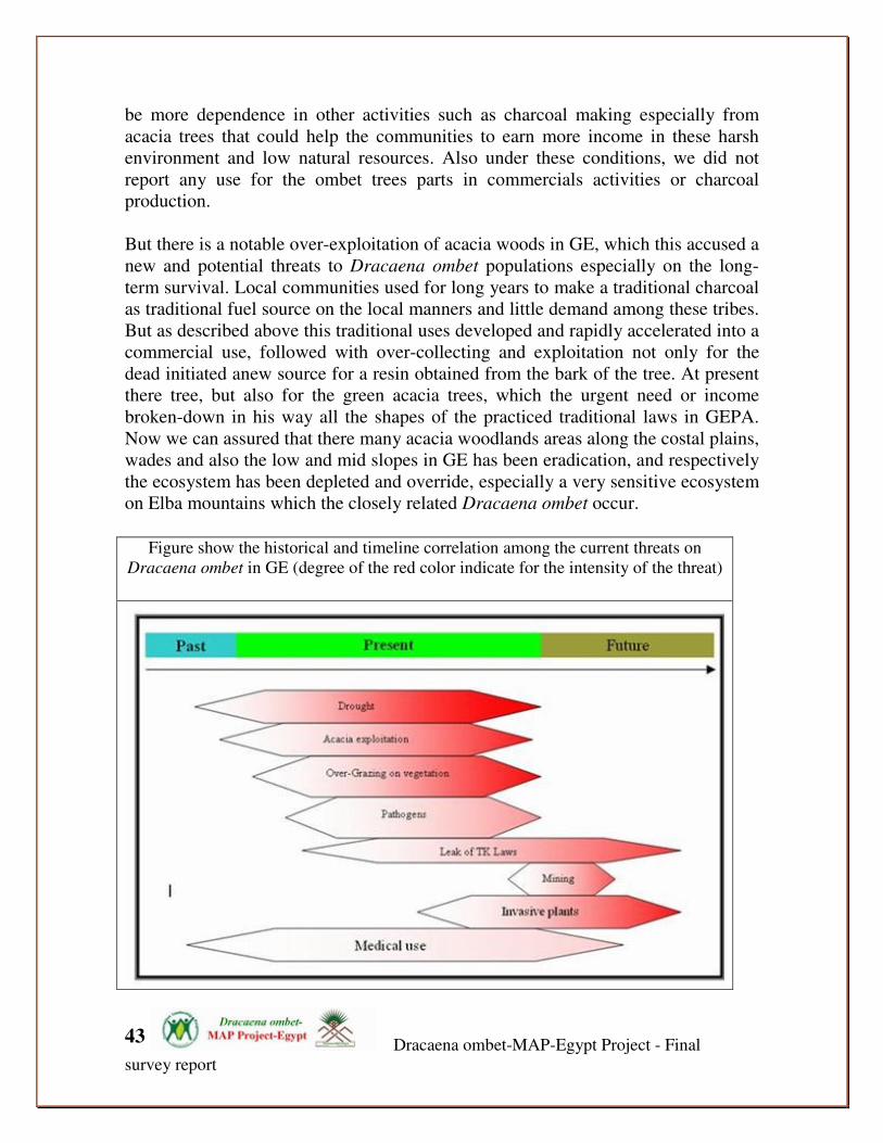
Figure show the historical and timeline correlation among the current threats on
Dracaena ombet in GE (degree of the red color indicate for the intensity of the threat)

Dracaena ombet-MAP-Egypt Project - Final
survey report
44
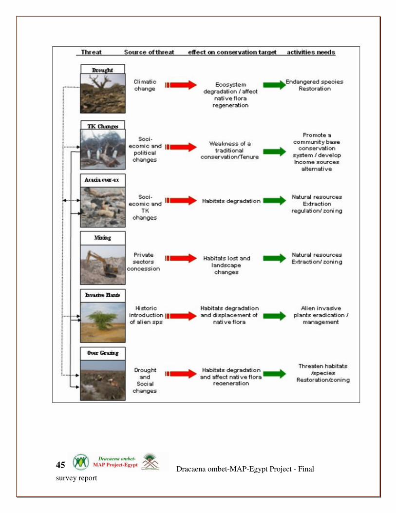
Figure show the main threats on Dracaena ombet habitats, source of threats and the mitigations
measures needed
Dracaena ombet-MAP-Egypt Project - Final
survey report
45

Dracaena ombet-MAP-Egypt Project - Final
survey report
46
2.2.10. THE USES and importance OF DRACAENA OMBET
Rope-making: • Women was used the ombet tree leaves to make ropes. They usually cut the young
soft leaves to make good ropes. Based on mohammed Gomaa, one of our
community guides, may be the community has bee used to used the plastics ones
which is very easy found it in the close urban areas in Abo Ramad, but to date still
there is may people have a skills to fabrics this traditional ropes from the dracaena
tree leaves. In Sudan some studies indicated that in areas close to Erkwoit
mountain, their are some ropes making recently by women at Gebeit Bogaleinai,
which the ropes in the women’s possession were not so strong, but were very
smooth and flexible. The leaves are used differently from the Dom leaves where
they put them under ground for one day to rot and then they use the pure fiber
inside the leave for making ropes (SOS Report).
Camel fodder: • In GEPA the men used to collect the Tombet tree raw fruits/seeds for their camels.
They mentioned that its edible fruits veru rich and give then energy, this mean that
its fruits have a high protein content and it is reported that its provide a good food
source for local community during the fruiting seasons and for some wild animals
such as hyrax and Nubian ibex. And also raw seeds are very healthy for camels,
especially it have a good water content. In Sudan it reported that the camels that eat
the Tombet seeds never get thirsty, because of its high water contents (SOS 2003).
But the raw Tombet seeds are very dangerous for sheep and goats, and may lead to
mortality immediately. Goat and sheep only can eat the Tombet flowers and dry
seeds (SOS 2003).
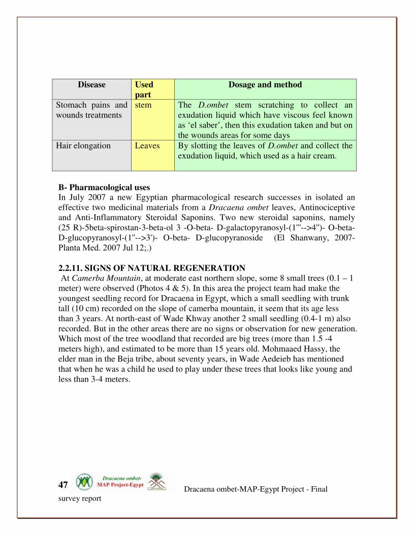
Medicine:
A- Local uses In GEPA, Dracaena is of considerable economic plant, GEPA local community
during the past. In Yemen, the hollow boles of Dracaena ombet are used in made
the Bee hives in Bura region (need refernce).
In GEPA, the interviews with local community indicated that there is a traditional
medicinal use for the Dracaena ombet as medicine plant in GE, which depending
on Mohammed Hassay (the healer of GE) the Tombet stems uses for stomach pains
and wounds treatments, and its leaves parts uses for Hair elongation. Table below
explain the methods and the dosage for these treatment.
Dracaena ombet-MAP-Egypt Project - Final
survey report
47
Disease Used
part
Dosage and method
Stomach pains and
wounds treatments
stem
The D.ombet stem scratching to collect an
exudation liquid which have viscous feel known
as ‘el saber’, then this exudation taken and but on
the wounds areas for some days
Hair elongation
Leaves By slotting the leaves of D.ombet and collect the
exudation liquid, which used as a hair cream.
B- Pharmacological uses In July 2007 a new Egyptian pharmacological research successes in isolated an
effective two medicinal materials from a Dracaena ombet leaves, Antinociceptive
and Anti-Inflammatory Steroidal Saponins. Two new steroidal saponins, namely
(25 R)-5beta-spirostan-3-beta-ol 3 -O-beta- D-galactopyranosyl-(1'''-->4'')- O-beta-
D-glucopyranosyl-(1''-->3')- O-beta- D-glucopyranoside (El Shanwany, 2007-
Planta Med. 2007 Jul 12;.)
2.2.11. SIGNS OF NATURAL REGENERATION At Camerba Mountain, at moderate east northern slope, some 8 small trees (0.1 – 1
meter) were observed (Photos 4 & 5). In this area the project team had make the
youngest seedling record for Dracaena in Egypt, which a small seedling with trunk
tall (10 cm) recorded on the slope of camerba mountain, it seem that its age less
than 3 years. At north-east of Wade Khway another 2 small seedling (0.4-1 m) also
recorded. But in the other areas there are no signs or observation for new generation.
Which most of the tree woodland that recorded are big trees (more than 1.5 -4
meters high), and estimated to be more than 15 years old. Mohmaaed Hassy, the
elder man in the Beja tribe, about seventy years, in Wade Aedeieb has mentioned
that when he was a child he used to play under these trees that looks like young and
less than 3-4 meters.

Dracaena ombet-MAP-Egypt Project - Final
survey report
48
ombet seedling in Camerba mountain Sign for regeneration in W.Ghway
Local community's member beside a young
dead ombet seedling
Good Signs for regeneration in
Camerba mountain
Also Mohammed Hassay indicates that he before tried to propagate the ombet by
cutting a one of the top part of the young branch and tried to propagate it on the
wade soil to germinate roots, but unfortunately the seedling died. This indicate the
local community willingness to contribute to the regeneration of the ombet as they
have a good traditional knowledge and aware of its value in their livelihood and the
traditional methods for agriculture and plants propagations. Based on Marwan the
Ghazouni, an Egyptian succulent plant specialist there are some natural signs of
regeneration of the “ombet” were observed at Shendeib Mountain in 2003. The
local communities stated that they have not observed any more seedling or new
generation in other areas during the last 5-7 years inside the areas we surveyed or at
any other un-accessible sites from what had been visited and surveyed.
Dracaena ombet-MAP-Egypt Project - Final
survey report
49
But on level of regeneration outside the natural habitats, that considers as try for ex-
situ conservation, some of the Egyptian succulents specialists, Marwan El Ghazouni
and Sheriff Abu Basha, has been successes in propagate about 40 new dracaena
seedling from the collected seed that they collect from Shendeib Mountain during
their visit for this area in 2003. These seedling conserved inside a private garden in
Cairo belong for them. In Elba the observation for the new seedling indicated that
most of these seedlings grow away from the big trees, outside the trees canopy,
where the seeds are expected to fall. Only one seedling more than 1.5 m detected in
Wade Tawella grow under the tree (its not completely ensured if this tree grown
from a seed germination or a vegetative part), but in general this observations can
leads for hypotheses about seed disbursement, germination requirements, seed
viability, dormancy, storage and optimum season and stage of seed collection
(which further studies and research are needed to fill this knowledge gap).
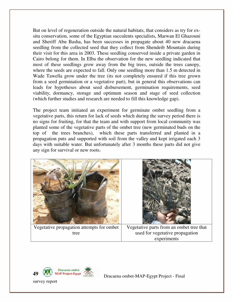
The project team initiated an experiment for germinate ombet seedling from a
vegetative parts, this return for lack of seeds which during the survey period there is
no signs for fruiting, for that the team and with support from local community was
planted some of the vegetative parts of the ombet tree (new germinated buds on the
top of the trees branches), which these parts transferred and planted in a
propagation puts and supported with soil from the valley and kept irrigated each 3
days with suitable water. But unfortunately after 3 months these parts did not give
any sign for survival or new roots.
Vegetative propagation attempts for ombet
tree
Vegetative parts from an ombet tree that
used for vegetative propagation
experiments

Dracaena ombet-MAP-Egypt Project - Final
survey report
50
Local community care with and carry out propagation experiment for Dracaena ombet
in a community nursery in GE
2.2.12. Tree ecology:
The project team observed that the existing tree regeneration and the historical
habitat of ombet is found to be on top of the hills on latitude range from 400-1100
m, far from the ground water, and that suggests the tree is mainly dependent on
rains and mist irrigation.
The Dracaena ombet tree morphology and physiology is designed by nature to
tolerate drought. The tree stem, branches and roots are composed of fibers that store
water, the leaves lanceulated shape, thick, smooth at lower and upper surface, and
erect in position so as to reduce transpiration and hence resist desiccation. The inner
part of the tree branches as well as the roots consist of fiber, this is a strong
indicator that this tree can reserve a considerable amount of water to resist drought,
and it probably depends on mist and rain fall rather than ground water. In almost in
all cases, the Dracaena ombet is found to grow and establish at the cracks between
rocks and shallow soil where no permanent ground water. That suggests the tree
totally relies on rainwater and mist supported by its ability to absorb and reserve
water for the dry season.
All the Dracaena ombet trees woodlands and regeneration took place at the Eastern
and northern eastern parts of the Elba and Shendeib mountains, which in northern
parts the Northeast dominance wind can blow and summer rain fall. No trees found
or historical known in at the western or the southern slopes of Elba Mountains,
where the climate is different from the eastern parts. Which the climate to the
western parts of the mountains is a considers as part of the Sahara climate (hot and
less exposures for rain or moisture).

Dracaena ombet-MAP-Egypt Project - Final
survey report
51
The project field survey results indicated that that the ombet seeds seems to have a
long dormancy period and high viability period, which enable the seed to stay
underground for longer periods and only grow when there are favorable climatic
conditions.
'Fan-Tailed Raven' colonies inside the
ombet woodland on GE high slopes
'Fan-Tailed Raven' bird stay of ombet tree
in Wade Marafay in GE
In general omebt grow at high altitudes at hard slopes, it also seems that the seeds in
usual are not the kind that can be transmitted by animal, like acacia as example that
have a high rate of germination after transmitting by camels in this area. This could
indicate that may be the omebt seeds transmission happen by some kind of residents
wild birds in this area or/and, water and wind. The Crow 'Fan-Tailed Raven' was
observed extensively by the project team in most of the areas of ombet woodland,
which it has a huge colonies on the top of GE Elba at the mid and high stony slopes
in areas very close for the ombet population distribution. These birds observed fly
and stay of top of the ombet trees, also local community stated that these birds like
ombet seeds and it observed eat its seeds at the fruiting seasons in the past. This
can lead that may be there is possibilities that the wild raven birds acts as a main
transmitting agent for the ombet seeds.
Also on a global scale it's very reliable to indicate that the global distribution of this
bird 'Fan-Tailed Raven' cover south east Egypt 'GE', North East Sudan, Eritrea,
Djibouti, north east Ethiopia, north Somalia and Arabia, which it’s the same areas
for the ombet distributions.(intensive study about the relation with between the
ombet and this bird is needed for more assessment for the ecology of ombet tree)
2.2.13. Reproduction: The Dracaena ombet fruits or berry 1-1.2 cm diameter, which each fruit have one
seed very small in size ( 5-6 mm diameter), and this refer that they are disbursed by
wind, water or carried by birds for that places far from the mother trees. This fact

Dracaena ombet-MAP-Egypt Project - Final
survey report
52
may help in explain the presence of new seedlings away from mother trees. In GE
and during the survey times there is no observation for any signs of fruiting or
seeds, only old fruiting branches founded on the top of some trees. Although some
of local community stated that they observed and collected some seeds during the
last 2 years, but there is no sign for seeds or new fruits. May be as the Dracaena
ombet considers as a Monocotyledons species, which it is this division of the plant
kingdom in most cases likely to have males and females at separate trees
(dioeciously). For that the ombet have a male and female types this will affect the
quantity and quality of the fruits which in case of un-pollination methods will be
there un-pollinated flowers that are not usually the same quality as the pollinated
ones, and this may also affect the viability of the population in GE under the current
climate change and also explain the limitation of presence of fruits in the areas of
the surveys.
2.2.14. Dracaena ombet morphology description Tree 2-4 m; Trunk 20-40 cm diameter, repeatedly forked; Branches forming an
umbrella-shape crown; Bark brownish ;Leaves in dense terminal rosttes 40-60x 2-3
cm linear from s wide ovate base, gradually narrowed to an acute apex. Thicj, rigid,
the margins smooth ;Panicle 50cm, much-branched, glabrous; Bracts minute,
lancolate; Pedicels 2-4 mm, articulate at middle; Perianth-segemnts 4-6 x 1.5-2.5
mm, connate at the base for 0.5 mm ;Stamens 3-4 mm; Filaments flattened; Ovary
oblong; Stigma shallowly 3-lobbed; Fruits or Berry 1-1.2 cm diameter, 1-seeded
;Seed 5-6 mm diameter, globose; Pollen is monosulcate (elliptical with a length-
wise slit), pollen surface is fossulate.

Dracaena ombet-MAP-Egypt Project - Final
survey report
53
Tree and a drawing for Leave and Panicle
2.2.15. Associated plants communities:
230 plant species were recorded during the Tombet survey phase (See annex 1), all
these plants recorded on the middle and upper slopes of GE where the habitats of

Dracaena ombet-MAP-Egypt Project - Final
survey report
54
the ombet occurs, these plants recorded associated with the Dracaena ombet and/or
within its micro habitats (including: middle and upper slopes, Mountainous
Drainages and mist oases; and the mountainous springs).
37 plant species recorded as closely correlated and associated species with the
D.ombet populations (these plants recorded inside the Tombet Quadrates), which
this mean that about 16% of the recorded plants very associated with the ombet
microhabitats.
Table 2: main associated indigenous plants where Dracaena ombet occurs (within three
representative habitats).
No Habitats/species name
MD -
MMO MUS MWS
4 Acacia asak (Forssk.) Willd. 0 1 0
5 Acacia etbaica 0 1 0
8 Acacia tortilis (Forssk.) Hayne subsp. Tortilis 1 1 0
17 Amaranthus graecizansL. subsp. Graecizans 1 1 0
25 Balanites aegyptiaca (L.) Del. 1 1 0
36 Calligonum polygonoidesL. subsp. Comosum 0 1 0
41 Cenchrus setigerusVahl 0 1 0
44 Chrozophora oblongifolia (Delile) Spreng. 1 0 0
46 Cocculus pendulus(J.R. & G.Forst.) Diels 1 0 0
48 Commelina benghalensisL. 1 0 0
49 Commelina forsskaleiVahl 1 0 0
73 Dodonaea viscosa Jacq 0 1 0
78 Echinopus spinosus 0 1 0
80 Ephedra cilliata 1 1 0
88 Euclea racemosa Murray subsp. schimperi 1 1 1
90 Euphorbia consobrina N.E.Br. 1 1 0
91 Euphorbia cuneata Vahl 0 1 0
96 Ficus salicifolia Vahl 1 0 0
115 Hibiscus vitifolius L. 1 0 0
120 Ipomoea obscura(L.) Ker-Gawl. 1 1 0
121 Jasminum fluminense Vell. 1 0 0
122 Jasminum grandiforum 1 0 0
139 Lycium shawiiRoem. & Schult. 1 1 0
149 Ocimum forsskaoliiBenth. 1 1 0
150 Ocimum menthaefolium Hochst. staminosum Sims 1 1 0
151 Olea europaea L. 1 0 0
152 Onychium divaricatum(Poir.) Alston 0 1 0
156 Oxalis anthelmintica 1 1 0
158 Pancratium sickenbergeri 1 0 0
159 Pancratium tortuosumHerb. 1 0 0
180 Rhus abyssinica Hochst. 1 0 0
181 Rhus abyssinica Hochst. ex Oliver etbaica Engl. 1 0 0
190 Rumex simpliciflorusMurb. 1 0 0
192 Salvadora persica 0 1 0
204 Sisymbrium erysimoidesDesf. 1 0 0
Dracaena ombet-MAP-Egypt Project - Final
survey report
55
205 Solanum incanum 0 1 0
212 Solanum villosum Mill. subsp. villosum 1 1 0 Table key: MD-MO: mountainous drainage and mist oases ; MUS: mountainous upper slopes; MWS: mountainous water
springs; 0: absent; 1: presence
2.2.16. Ombet population's Eco-geography and the suitable habitats in GE
Tombet Habitats Suitability Index:
What are the main factors determining the ecological state of ombet tree habitats?. A
habitat suitability index for D.ombet is developed to provide the answer for this question
and to measure the future status of the ombet habitats and their effects and affects on the
ecological situation in GE. The following environmental variables are chosen as
determining parameters for habitat suitability, which included: climatc, geomorphologic
and biological factors. Collected semi-quantitative and qualitative knowledge about the
impact of those variables on suitability of a site for D.ombet is formalized using a fuzzy
set approach. The resulting index is implemented in GIS and applied to a test and measure
the available suitable habitats status in GE for D.ombet. The results are compared to the
actual distribution of ombet in the year 2007 to check their plausibility and status. This
approach could use as a simple evaluation of the habitat suitability for ombet in a spatial
scale and also as simulation tool, also the OHSI could support the any ecological impact
assessment processes that can guide towards mitigate any potential impact on the
important areas for Tombet distributions.
The finding of the O-HIS could conclude as following:
• Total Tombet suitable habitats in GE = 21.5 sq km
• Total Elba Mountain massive = 150 sq km
• Percentage of Tombet suitable habitats for the whole GE massive = 14.33%
• Suitable habitats index's parameters:
This table concludes the limiting factors/parameters that control the distribution of the
ombet population and shapes its habitats; based on these parameters we can divide the
ombet population's occurrence into different 6 eco-geographical zones, and could be
defined as following:
Zone 1: (included the Tombet populations of W. Artri's low slope)
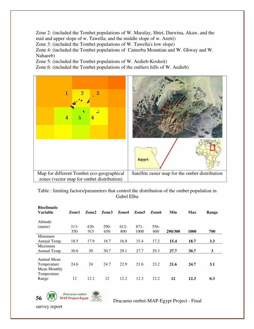
Dracaena ombet-MAP-Egypt Project - Final
survey report
56
Zone 2: (included the Tombet populations of W. Marafay, Shtet, Darwina, Akaw, and the
mid and upper slope of w. Tawella; and the middle slope of w. Aretri)
Zone 3: (included the Tombet populations of W. Tawella's low slope)
Zone 4: (included the Tombet populations of Camerba Mountian and W. Ghway and W.
Nahaeeb)
Zone 5: (included the Tombet populations of W. Aedieb-Kosheit)
Zone 6: (included the Tombet populations of the outliers hills of W. Aedieb)
Map for different Tombet eco-geographical
zones (vector map for ombet distribution)
Satellite raster map for the ombet distribution
Table : limiting factors/parameters that control the distribution of the ombet population in
Gabel Elba
Bioclimatic
Variable Zone1 Zone2 Zone3 Zone4 Zone5 Zone6 Min Max Range
Altitude
(meter)
313-
550
420-
915
290-
650
612-
800
871-
1000
556-
600 290/300 1000 700
Minimum
Annual Temp. 18.5 17.9 18.7 16.8 15.4 17.2 15.4 18.7 3.3
Maximum
Annual Temp 30.6 30 30.7 29.1 27.7 29.3 27.7 30.7 3
Annual Mean
Temperature 24.6 24 24.7 22.9 21.6 23.2 21.6 24.7 3.1
Mean Monthly
Temperature
Range 12 12.1 12 12.2 12.3 12.2 12 12.3 0.3

Dracaena ombet-MAP-Egypt Project - Final
survey report
57
Isothermality
(2/7) (* 100) 52.8 53.1 53 52.9 53 53.1 52.8 53.1 0.3
Temperature
Seasonality
(STD * 100) 413.4 414.8 410.9 420.7 427.1 417.9 411 427.1 16.2 Max
Temperature of
Warmest
Month 36.1 35.5 36.1 34.6 33.3 34.8 33.3 36.1 2.8
Min
Temperature of
Coldest Month 13.3 12.7 13.5 11.5 10 11.9 10 13.5 3.5
Temperature
Annual Range 22.8 22.8 22.6 23.1 23.3 22.9 22.6 23.3 0.7 Mean
Temperature of
Wettest
Quarter 23.3 22.6 23.4 21.5 20.1 21.9 20.1 23.4 3.3
Mean
Temperature of
Driest Quarter 19.6 19 19.7 17.9 16.4 18.2 16.4 19.7 3.3 Mean
Temperature of
Warmest
Quarter 29.4 28.8 29.5 27.9 26.5 28.1 26.5 29.5 3
Mean
Temperature of
Coldest
Quarter 19.4 18.8 19.6 17.7 16.3 18.1 16.3 19.6 3.3
Annual
Precipitation 28 32 29 37 46 36 28 46 18
Precipitation of
Wettest Month 17 17 18 17 18 18 17 18 1
Precipitation of
Driest Month 0 0 0 0 0 0 0 0 0 Precipitation
Seasonality
(CV) 205.4 178.3 209.9 149.9 124.8 165.8 125 209.9 85.1
Precipitation of
Wettest
Quarter 24 25 25 25 28 27 24 28 4
Precipitation of
Driest Quarter 0 1 0 2 3 1 0 3 3
Precipitation of
Warmest
Quarter 2 3 2 6 9 5 2 9 7 Precipitation of
Coldest
Quarter 3 4 3 4 6 5 3 6 3
Alt – Slope
(Degree) 89-90 89-90 89-90 89-90 89-90 89-90 89 90 1

Dracaena ombet-MAP-Egypt Project - Final
survey report
58
Aspect values for the ombet populations:
North: 13.31% of the ombet population's trees facing N
East: 2.27% of the ombet population's trees facing E
North East: 18.70% of the ombet population's trees facing NE
North West: 65.72% of the ombet population's trees facing NW
Tombet population's eco-geographical zones variables:
Z1 Z2 Z3

Dracaena ombet-MAP-Egypt Project - Final
survey report
59
Z4 Z5 Z6
Dracaena ombet-MAP-Egypt Project - Final
survey report
60
Second part: Dracaena ombet conservation action plan
1. Introduction:
This Dracaena ombet Conservation Action Plan (DCAP) has been produced for the
Dracaena ombet tree populations in GEPA, and it should be regarded as a National Action
Plan. It is intended that this DCAP should complement and fit within the context of the
national biodiversity action plan (BAP) and the GEPA management plan. The DCAP has
prepared as a key commitment to conservation action in the region, this to contribute to
Biodiversity conservation of the Park and how the various agencies, NGOs and local
people interact to maintain this situation. Through the GEPA and NCS’s activities in
conjunction with its partners this plan should not be seen as distinct or isolated from other
important documents and guidance which have appeared over the years on the local or
national level. Equally it should be recognized as part of the long term plan for the area. It
should be understood that this plan has prepared to fills a gap in the strategic plans within
the GEPA which preparation this plan considers as a significant contributor to the national
Biodiversity targets. Ultimately action and implementation will be guided by this plan, for
nothing can be gained by words without action. Implementation can work by integrated the
plan’s activities and recommendation in consideration during implementation the GEPA
management plan in two main direction, either by conservation of habitat, or by measures
aimed at species.
1.1. Why Dracaena ombet Action Plan? Dracaena ombet is listed as endangered plant (EN) in the IUCN Red List, is one of the few
species that can survive the extensive periods of drought in all parts of its range and is
likely to therefore be an important part of the desert ecosystem Dracaena ombet, grows on
Gabel Elba in Egypt and also in Sudan, Djibouti, Ethiopia, Saudi Arabia and Somalia. This
plant recorded in the highest zones of slope of Gabel Elba, which the occurrence of
Dracaena in Gabel Elba is its most northern limit within the red sea costal mountains and
all its distribution range in the world. Is in rapid decline due to Overgrazing, over-cutting,
droughts and possibly attack by parasitic pests or disease have contributed to the decline.
In northern Sudan it appears that the populations of D. ombet have completely vanished
from Erkowit. There is no enough up to date information about population or ecology of
D.ombet in Egypt. Dracaena populations occur in a remote areas which not easily
accessible for researchers.
This project has been conducting inside GEPA, this park is Egypt’s most important
Protectorate, is a “biodiversity hotspot” in Egypt, many afro-tropical elements have their
northern limits at Gabel Elba. Some 458 plant species are known from GE, representing
almost 25% of Egypt flora. GEPA contain twenty globally threatened species, also has the
potential to be a UNESCO World Heritage Site Also GE is a “biodiversity hotspot” in
Egypt and represents a northern limit of Eastern Afromontane as globally biodiversity
hotspot.
This strategic action plan and its recommended actions will improve monitoring and
conservation effectiveness of D.ombet tree in Egypt, The action plan promotes focused

Dracaena ombet-MAP-Egypt Project - Final
survey report
61
leadership and increased collaboration and education to sustain healthy population and to
support long term monitoring program and ensure the ongoing species conservation actions
by promote a community participation and set priorities, and fully utilize all available and
appropriate program tools.
In April 2008, DMAP’s Team finished the first pioneer intensive monitoring and
assessment phase for the Dracaena ombet in GEPA, this phase results leads to setting the
priority for species conservation and supported the project team which developed a Long
Term Monitoring Program for D.ombet. Based on LTMP and the species conservation
priority an action plan prepared for improve monitoring and conservation effectiveness of
D.ombet tree in Egypt and ensuring the ongoing activities for D.ombet conservation in
Egypt.
The following four strategic immediate goals and included an unabridged list of current
and Possible future actions under five specific objectives to address those goals, which are
to:
• Improve knowledge about D.ombet
• Reduce the current decline rate in its population to 20% by 2009 and stabilized the
population status.
• Prepared and implanted community-based long term monitoring
• Increase communication and awareness about the species, threats, importance and
the conservation activates needs.
In summary there are five main reasons for the production of a DCAP based upon making
best use of resources, time and energy by:
► Identifying species population priorities for local action
► Focusing limited resources for species conservation
► Identifying key partners and mechanisms to deliver action
► Informing policy makers
► Identify a role model for other species conservation action in Egypt
1.2. For whom this report: This action plan is prepared and submitted mainly for the management team of the CLP
and its partners. This report also contains information which may be useful for many
general interests; this report it focuses specifically on assessment the current status of
endangered tree Dracaena ombet in Egypt, with some depth literature review and
organization for the D.ombet distribution and status in the global level. The report address
specifically the research and survey results for D.ombet, but also describe the related
activities which carried parallel with the research activities under the project such as public
awareness; capacity building and training; GIS work; traditional knowledge documentation
and a community work.

Dracaena ombet-MAP-Egypt Project - Final
survey report
62
1.3. Action plan scope: This action plan and the include data and results related only for the Gable Elba area
between latitude 22 to 22.30 and longitude 35 to 37. we want to as soon as to give a
detailed results, but as it shown in this report, it represents a preliminary report for the first
project phase, thus lead that there is many information will be gathered at end of the
project which will included and contribute in the final update for the final project report
and a compound ecological, socio-economic and the species populations studies.
2. Species description and status
2.1. Species Taxonomy and morphology
Kingdom: Plantae
Phylum: Tracheophyta
Class: Liliopsida
Order :Liliales
Family : Dracaenaceae
Genus : Dracaena
Species:Ombet
Species authority: Kotschy & peyr
Tree 2-4 m; Trunk 20-40 cm diameter, repeatedly forked; Branches forming an umbrella-
shape crown; Bark brownish ;Leaves in dense terminal rosttes 40-60x 2-3 cm linear from s
wide ovate base, gradually narrowed to an acute apex. Thicj, rigid, the margins smooth
;Panicle 50cm, much-branched, glabrous; Bracts minute, lancolate; Pedicels 2-4 mm,
articulate at middle; Perianth-segemnts 4-6 x 1.5-2.5 mm, connate at the base for 0.5 mm
;Stamens 3-4 mm; Filaments flattened; Ovary oblong; Stigma shallowly 3-lobbed; Fruits or
Berry 1-1.2 cm diameter, 1-seeded ;Seed 5-6 mm diameter, globose; Pollen is monosulcate
(elliptical with a length-wise slit), pollen surface is fossulate.
2.2. Species global assessment information
2.2.1. IUCN red list status
Red List Category & Criteria:
EN A1cd ver 2.3 (1994)
Year Assessed:
1998
Assessor/s: World Conservation Monitoring Centre
History: 1978- Vulnerable/Endangered (Lucas and Synge 1978) 1997- Vulnerable (Walter and Gillett 1998)

Dracaena ombet-MAP-Egypt Project - Final
survey report
63
Action programs
This includes the vision, aim, immediate objectives, specific objectives and projects
and activities of the action plan. The vision, aim, immediate objectives and specific
objectives are indicated in Table 5. After identifying the threats of the species
across its range, there is need for appropriate interventions or solutions to mitigate
those threats. The solutions in this action plan have been packaged as vision, aim,
objectives and projects and activities.
Vision The strategic action plan and its recommended actions is to ‘improve and ensure
monitoring an conservation effectiveness of D.ombet tree in Egypt and to sustaining,
healthy population of Dracaena ombet across the entire range and habitats in GE’.
The Action Plan will not achieve this vision during its five-year lifetime, but will
contribute towards it.
Aim Within five years, this action plan aims to ‘Have the initiative implemented to
address the threats necessary to stabilise the current threats and contribute in
increase D.omebt populations in GE’.
Objectives Stabilizing and increasing the populations of the Lappet-faced Vulture within five
years will be achieved through the implementation of three strategic immediate and
nine specific objectives shown in Table 3. The indicators are for the vision, aim and
the priority specific objectives.
Vision Indicator Ensure a sustaining, healthy
population of Dracaena ombet across
the entire range and habitats in GE’
D.omebt no longer endangered species on the national level
Aim Within five years, this action plan
aims to ‘Have the initiative
implemented to address the threats
necessary to stabilize the current
threats and contribute in increase
D.omebt populations in GE’.
Population of D.omebt across 90% of range states known by end of 2008 Initiatives to conserve the population in place by 2010.
Immediate Objectives A. Improve knowledge about D.ombet
The Dracaena ombet ecology, biology and population distribution knowledge gathered

Dracaena ombet-MAP-Egypt Project - Final
survey report
64
by 2010 B. Reduce the current decline rate in its population to 20% by 2009 and stabilized the population status.
80% of the ombet populations conserved
C. Prepared and implanted community-based long term monitoring
Community based monitoring program in place
D. Increase communication and awareness about the species, threats, importance and the conservation activates needs.
Environmental education, awareness and communication programs in place
Specific objectives: 1. Improve knowledge about D.omebt’s population distribution, traditional knowledge, threats and population dynamics.
Up-to-date distribution map available by 2008
Population of D.ombet in all the range states
known by 2008
traditional knowledge documents by 2009
2. Prepared and implanted a long term monitoring program
- Population dynamics information available by 2009 - Dracaena ombet’s Monitoring filed station establishes by 2008 in GE. - long term monitoring set up based on string involving for local community of GE
3. Restored and rehabilitated the populations
- restoration and rehabilitation of 50% of the population areas by 2010
4. Increase public awareness about the species among local community and at the national level.
- Public awareness and education plan for D.omebt prepared and implemented by 2009.
5. Increase publicity, networking and communication at the international level with other interested parties.
- Increase number of involved stakeholders on the national level in implemented the conservation action plan. - Increase the national publicity about the species. - establish and support international dragon partnership
6. Increase capacity building of the stakeholders
Increase number of trained locals in filed of endangered species mananagment Increase capacity of the local NGO and GEPA

Dracaena ombet-MAP-Egypt Project - Final
survey report
65
7 Reduced the habitats’ degradation, loss and distribution for Dracaena ombet distribution.
- Protect at least 70% of GE's critical habitats for D.ombet - Restore at least 50% of D.ombet habitats - Prepare the Ombet's critical habitats conservation action plan
Action Activities needed Action activities are what need to be done to achieve the different objectives. They
are numbered according to the corresponding specific objectives which are also
numbered according to the corresponding immediate objective.
� Improve knowledge about D.omebt’s population distribution,
traditional knowledge, threats and population dynamics.
1.1. Monitoring activities for Assess population size, occurrence and
distribution 1.2. Long term monitoring for its population dynamics and habitats
requirements 1.3. Monitoring for assessing the productivity, new generation, mortality
and survival rate and trend for produce a good ageing scheme and decline
rate. Using trees tagging methods.
1.4. Research and assessment for the current TK about the species among the local community of GE.
1.5. Training in Endangered species monitoring and conservation for local
community and GE staff.
1.6. Asses the Dracaena ombet against the IUCN regional assessment
guidelines.
1.7. Prepare a suitability habitats GIS based map for Dracaena ombet in GE
� Prepared and implanted a long term monitoring program
2.1. Establishing the Dracaena ombet’s Monitoring filed station
establishes by 2008 in GE. 2.2. Establishing an NGO, as community foundation for conservation
endangered species in GE 2.3. Reduced the current habitats disturbance due to the human
activities e.g charcoaling and mining 2.4. Encourage research on Dracaena ombet in GE among the
researchers and scientific institutions
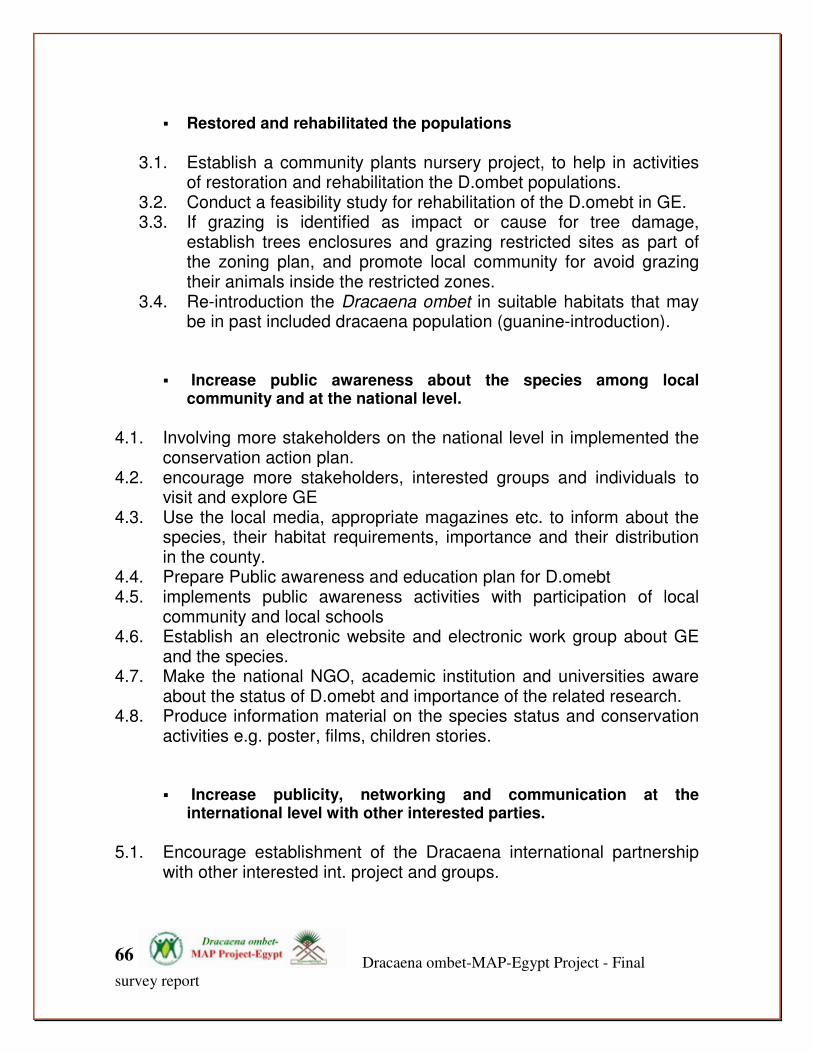
Dracaena ombet-MAP-Egypt Project - Final
survey report
66
� Restored and rehabilitated the populations
3.1. Establish a community plants nursery project, to help in activities
of restoration and rehabilitation the D.ombet populations. 3.2. Conduct a feasibility study for rehabilitation of the D.omebt in GE. 3.3. If grazing is identified as impact or cause for tree damage,
establish trees enclosures and grazing restricted sites as part of the zoning plan, and promote local community for avoid grazing their animals inside the restricted zones.
3.4. Re-introduction the Dracaena ombet in suitable habitats that may be in past included dracaena population (guanine-introduction).
� Increase public awareness about the species among local community and at the national level.
4.1. Involving more stakeholders on the national level in implemented the
conservation action plan. 4.2. encourage more stakeholders, interested groups and individuals to
visit and explore GE 4.3. Use the local media, appropriate magazines etc. to inform about the
species, their habitat requirements, importance and their distribution in the county.
4.4. Prepare Public awareness and education plan for D.omebt 4.5. implements public awareness activities with participation of local
community and local schools 4.6. Establish an electronic website and electronic work group about GE
and the species. 4.7. Make the national NGO, academic institution and universities aware
about the status of D.omebt and importance of the related research. 4.8. Produce information material on the species status and conservation
activities e.g. poster, films, children stories.
� Increase publicity, networking and communication at the international level with other interested parties.
5.1. Encourage establishment of the Dracaena international partnership
with other interested int. project and groups.

Dracaena ombet-MAP-Egypt Project - Final
survey report
67
5.2. To gather baseline information about the distribution, status and conservation of D.omebt in its global range ( North East Africa and West Arabia)
5.3. Improve coordination and fundraising for D.ombet in Egypt. 5.4. Improve coordination and collaboration with other agencies in Africa
for more knowledge improvement about global status of D.OMBET
� Increase capacity building of the stakeholders
6.1. Training in Endangered species monitoring and conservation for local
community and GE staff. 6.2. Involving the stakeholders in implementation the Dracaena ombet
long term monitoring program 6.3. involving RSPADA as local NGO in the international Dracaena
Partnership 6.4. Support RSPADA and GEPA’s rangers with effective national and
international training
� Reduced degradation and loss of suitable habitats for Dracaena
ombet and a whole GE ecosystem.
7.1. Through awareness and promote implanting legislation change the negative human impact on the suitable habitats in GE. Such a charcoaling activities and acacia tree cut.
7.2. Through promote implementing the legislation and ensure that the appropriate Environmental Impact Assessment process is followed for all developments or mining activities in GE, and that the possible impact on the D.ombet distribution and suitable habitats range.
7.3. Gathering data and information about the climate status and change in GE and its long term effect on the D.ombet in GE.
7.4. Through awareness, collaborative agreements and promotion law enforcement control the over-exploitation of acacia trees for charcoaling and fuel wood production.

Dracaena ombet-MAP-Egypt Project - Final
survey report
68
Dracean ombet conservation and
action plan
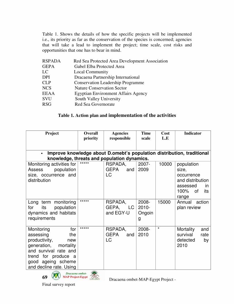
Dracaena ombet-MAP-Egypt Project -
Final survey report
69
Table 1. Shows the details of how the specific projects will be implemented
i.e., its priority as far as the conservation of the species is concerned; agencies
that will take a lead to implement the project; time scale, cost risks and
opportunities that one has to bear in mind.
RSPADA Red Sea Protected Area Development Association
GEPA Gabel Elba Protected Area
LC Local Community
DPI Dracaena Partnership International
CLP Conservation Leadership Programme
NCS Nature Conservation Sector
EEAA Egyptian Environment Affairs Agency
SVU South Valley University
RSG Red Sea Governorate
Table 1. Action plan and implementation of the activities
Project Overall
priority
Agencies
responsible
Time
scale
Cost
L.E
Indicator
� Improve knowledge about D.omebt’s population distribution, traditional knowledge, threats and population dynamics.
Monitoring activities for Assess population size, occurrence and distribution
***** RSPADA, GEPA and LC
2007-2009
10000 population size, occurrence and distribution assessed in 100% of its range
Long term monitoring for its population dynamics and habitats requirements
***** RSPADA, GEPA, LC and EGY-U
2008-2010-Ongoing
15000 Annual action plan review
Monitoring for assessing the productivity, new generation, mortality and survival rate and trend for produce a good ageing scheme and decline rate. Using
***** RSPADA, GEPA and LC
2008-2010
* Mortality and survival rate detected by 2010

Dracaena ombet-MAP-Egypt Project -
Final survey report
70
trees tagging methods. Research and assessment for the current TK about the species among the local community of GE.
**** RSPADA, GEPA and LC
2008-2008
2000 TK documented by 2008
Training in Endangered species monitoring and conservation for local community and GE staff.
***** RSPADA, GEPA and LC
2008-2009
3000 Number of GEPA Staff and local people trained
Prepare a suitability habitats GIS based map for Dracaena ombet in GE.
***** RSPADA, GEPA and LC
2008-2009
2000 a suitability habitats GIS based map prepared by 2008
Assess the Dracaena ombet against the IUCN regional assessment guidelines.
**** GEPA 2008 * Regional assessment prepared and reviewed by the iucn
� Prepared and implanted a long term monitoring program
Establish a Dracaena ombet’s Monitoring filed station establishes by 2008 in GE.
***** RSPADA, GEPA and LC, RSG
2008 50000 Dracaena ombet’s Monitoring filed station establishes by 2008 in GE prepared and operated .
Establish an NGO, as community foundation for conservation endangered species in GE
**** RSPADA, GEPA and LC
2008/09
1000 NGO, as community foundation established and participated in D.ombet conservation.

Dracaena ombet-MAP-Egypt Project -
Final survey report
71
Reduced the current habitats disturbance due to the human activities e.g charcoaling and mining
**** RSPADA, GEPA and LC
2008-2009
* Habitats action plans
Encourage research on Dracaena ombet in GE among the researchers and scientific institutions
*** GEPA, EGY-U, NCS
2008-2010
* Number of researchers in reference to D.ombet
� Restored and rehabilitated the populations
Establish a community plants nursery project, to help in activities of restoration and rehabilitation the D.ombet populations.
***** RSPADA, GEPA and LC
2008 10000 Community based plants nursery established and oriented for the activities support.
Conduct a feasibility study for rehabilitation of the D.omebt in GE.
***** RSPADA, GEPA and LC
2009 3000 Feasibility study for rehabilitation of the D.omebt prepared and supported the restoration activities.
If grazing is identified as impact or cause for tree damage, establish trees enclosures and grazing restricted sites as part of the zoning plan, and promote local community for avoid grazing their animals inside the restricted zones.
*** RSPADA, GEPA and LC
2008-09
4000 Number of enclosures established
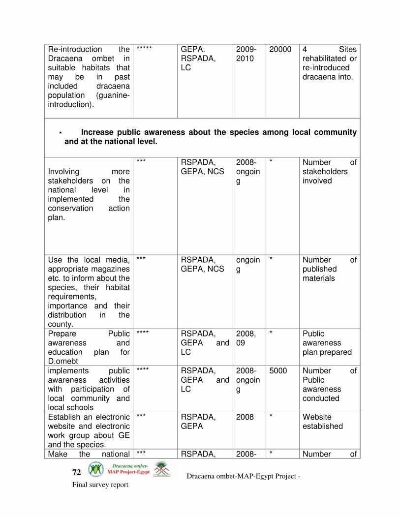
Dracaena ombet-MAP-Egypt Project -
Final survey report
72
Re-introduction the Dracaena ombet in suitable habitats that may be in past included dracaena population (guanine-introduction).
***** GEPA. RSPADA, LC
2009-2010
20000 4 Sites rehabilitated or re-introduced dracaena into.
� Increase public awareness about the species among local community
and at the national level.
Involving more stakeholders on the national level in implemented the conservation action plan.
*** RSPADA, GEPA, NCS
2008-ongoing
* Number of stakeholders involved
Use the local media, appropriate magazines etc. to inform about the species, their habitat requirements, importance and their distribution in the county.
*** RSPADA, GEPA, NCS
ongoing
* Number of published materials
Prepare Public awareness and education plan for D.omebt
**** RSPADA, GEPA and LC
2008, 09
* Public awareness plan prepared
implements public awareness activities with participation of local community and local schools
**** RSPADA, GEPA and LC
2008-ongoing
5000 Number of Public awareness conducted
Establish an electronic website and electronic work group about GE and the species.
*** RSPADA, GEPA
2008 * Website established
Make the national *** RSPADA, 2008- * Number of
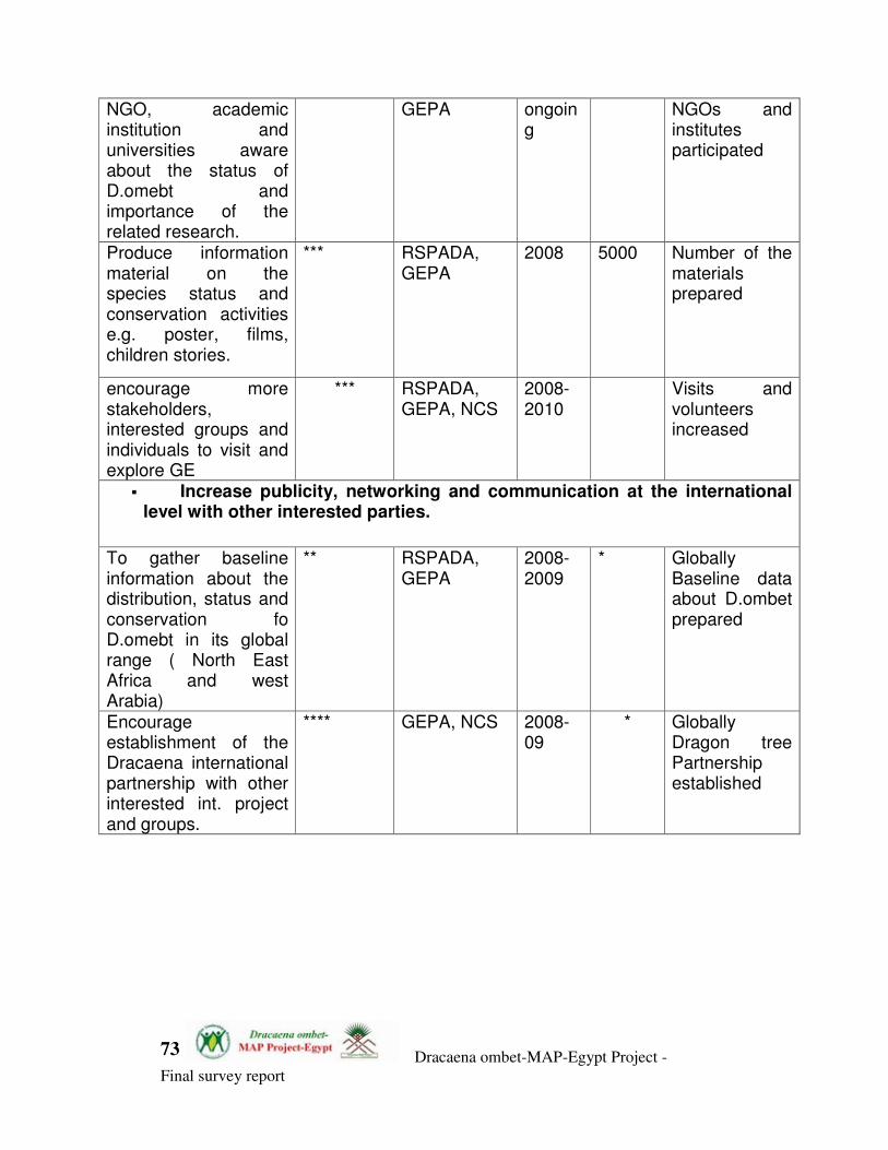
Dracaena ombet-MAP-Egypt Project -
Final survey report
73
NGO, academic institution and universities aware about the status of D.omebt and importance of the related research.
GEPA ongoing
NGOs and institutes participated
Produce information material on the species status and conservation activities e.g. poster, films, children stories.
*** RSPADA, GEPA
2008 5000 Number of the materials prepared
encourage more stakeholders, interested groups and individuals to visit and explore GE
*** RSPADA, GEPA, NCS
2008-2010
Visits and volunteers increased
� Increase publicity, networking and communication at the international level with other interested parties.
To gather baseline information about the distribution, status and conservation fo D.omebt in its global range ( North East Africa and west Arabia)
** RSPADA, GEPA
2008-2009
* Globally Baseline data about D.ombet prepared
Encourage establishment of the Dracaena international partnership with other interested int. project and groups.
**** GEPA, NCS 2008-09
* Globally Dragon tree Partnership established

Dracaena ombet-MAP-Egypt Project -
Final survey report
74
Improve coordination and fundraising for D.ombet in Egypt. Improve coordination and collaboration with other agencies in Africa for more knowledge improvement about global status of D.OMBET
*** RSPADA, GEPA
Ongoing
* Small project proposal prepared and submitted for funding agencies Building the Dracaena ombet Int. partnership
� Increase capacity building of the stakeholders
Training in Endangered species monitoring and conservation for local community and GE staff.
***** RSPADA, GEPA and LC
2008-2009
3000 Number of GEPA Staff and local people trained
Involving the stakeholders in implementation the D.ombet entation the Dracaena ombet long term monitoring program
**** RSPADA, GEPA, NCS
2008-2010
1000 Numbers of new stakeholders involved
involving RSPADA as local NGO in the international Dracaena Partnership
**** RSPADA, GEPA, NCS
2008-2009
1500 RSPADA involved in the DPI
Support RSPADA and GEPA’s rangers with effective national and
**** NCS, GEPA 2009-2010
Numbers of RSPADA and GEPA staff

Dracaena ombet-MAP-Egypt Project -
Final survey report
75
international training
received training
� Reduced degradation and loss of suitable habitats for Dracaena ombet
and a whole GE ecosystem.
Through awareness and promote implanting legislation change the negative human impact on the suitable habitats in GE. Such a charcoaling activities and acacia tree cut.
**** RSPADA, GEPA and LC
ongoing
2500 Special legislation for protecting ombet prepared and adopted locally Human exploitation for the ombet habitats resources reduced
Through promote implementing the legislation and ensure that the appropriate Environmental Impact Assessment process is followed for all developments or mining activities in GE, and that the possible impact on the D.ombet distribution and suitable habitats range.
*** RSPADA, GEPA and LC
2008-ongoing
2000 Special legislation for protecting ombet prepared and adopted locally Ombet habitats importance included in the national EIA
Gather data and information about the climate status and change in GE and its long term effect on the D.ombet in GE.
**** RSPADA, GEPA and LC
2008-ongoing
30000 Weather stations settled and operated Monitoring Filed station established and operated

Dracaena ombet-MAP-Egypt Project -
Final survey report
76
Appendices:
Appendix 1: Tombet population's eco-geographical zones variables maps:
Suitable Tombet Aspect Map
Suitable Tombet Altitude Map

Dracaena ombet-MAP-Egypt Project -
Final survey report
77
PREC_ANNUAL
MIN TEMP
MAX TEMP
PREC_WARM MONTH
PREC-SEASON
MEAN TEMP

Dracaena ombet-MAP-Egypt Project -
Final survey report
78
Annex 2:
Associated indigenous plants within the Dracaena ombet's habitats in Gabel
Elba Protected Area.
No Habitats/species name
MD -
MMO MS MS
1 Abutilon bidentatumA.Rich. 0 1 0
2 Abutilon fruticosum 1 0 0
3 Abutilon pannosum(G.Forst.) Schltdl. 0 1 0
4 Acacia asak (Forssk.) Willd. 0 1 0
5 Acacia etbaica 0 1 0
6 Acacia laeta 1 0 0
7 Acacia mellifera (Vahl) Benth. 1 0 0
8 Acacia tortilis (Forssk.) Hayne subsp. tortilis 1 1 0
9 Achyranthes aspera 1 1 0
10 Actiniopteris australis 0 0 1
11 Adiantum capillus-veneris 0 0 1
12 Aerva javanica (Burm.f.) Juss. ex Schult. var. javanica 1 0 0
13 Aerva lanata (L.) Juss. ex Schult. 1 0 0
14 Allium spathaceum Steud. ex A. Rich 1 0 0
15 Allium spathaceum Steud. ex A. Rich 0 1 0
16 Amaranthus graecizansL. subsp. graecizans 1 0 0
17 Amaranthus graecizansL. subsp. graecizans 1 1 0
18 Ammi majusL. 1 0 0
19 Anagallis arvensis L. var. caeruleaGouan 1 0 0
20 Anagallis arvensis L. var. caeruleaGouan 0 1 0
21 Aneilema tacazzeanumHochst. ex C.B.Cl. 1 1 0
22 Aristida meccana 1 0 0
23 Arnebia hispidissima(Lehm.) DC. 1 0 0
24 Asphodelus fistulosus L. var. tenuifoliusCav. 1 0 0
25 Balanites aegyptiaca (L.) Del. 1 1 0
26 Belpharis ciliaris (L.) B.L. Burtt. 0 1 0
27 Beorhavia repens 1 0 0
28 Bidens bipinnata L. 1 0 0
29 Bidens pilosa L 1 0 0
30 Bidens schimperi Sch.Bip. 1 0 0
31 Biscutella elbensis J. Chrtek 1 1 0
32 Blainvilla acmella (L.) Philipson 1 0 0
33 Calendula arvensis L. 1 0 0
34 Calendula tripterocarpa Rupr. 1 0 0
35 Calligonum polygonoidesL. subsp. comosum 1 0 0
36 Calligonum polygonoidesL. subsp. comosum 0 1 0
37 Caralluma retrospiciens (Ehrenb.) N.E. Br. 1 0 0
38 Caralluma retrospiciens (Ehrenb.) N.E. Br. 1 0 0
39 Carthamus nitidus Boiss. 1 0 0
40 Caylusea hexagyna (Forssk.) M.L.Green 1 0 0
Dracaena ombet-MAP-Egypt Project -
Final survey report
79
41 Cenchrus setigerusVahl 0 1 0
42 Centaurea aegyptiaca L. 1 0 0
43 Cheilanthes catanensis 0 0 1
44 Chrozophora oblongifolia (Delile) Spreng. 1 0 0
45 Coccinia grandis (L.) Voigt 1 0 0
46 Cocculus pendulus(J.R. & G.Forst.) Diels 1 0 0
47 Cometes abyssinicaR.Br. ex Wall 1 0 0
48 Commelina benghalensisL. 1 0 0
49 Commelina forsskaleiVahl 1 0 0
50 Commicarpus boissieri(Heimerl) Cufod. 1 0 0
51 Commicarpus helenae (Schult.) Meikle 1 0 0
52 Commiphora opobalsamum (L.) Engl. 0 1 0
53 Convolvulus hystrix Vahl 1 1 0
54 Convolvulus rhyniospermus Choisy 1 0 0
55 Convolvulus siculus L. subsp. agrestis (Hochst. ex Schweinf.) Verdc. 1 0 0
56 Conyza aegyptiaca (L.) Dryand. in Ait. 1 0 0
57 Conyza aegyptiaca (L.) Dryand. in Ait. 1 1 0
58 Corchorus trilocularis L. 0 1 0
59 Corchorus trilocularis L. 0 1 0
60 Crotalaria impressaNees ex Walp. 1 0 0
61 Crotalaria microphyllaVahl 1 0 0
62 Crotalaria senegalensis (Pers.) DC. 1 0 0
63 Cucumis prophetarumJuss. subsp. prophetarum 1 0 0
64 Cuscuta chinensisLam. 1 0 0
65 Cuscuta pedicellataLedeb. 1 0 0
66 Cyperus bulbosusVahl 1 0 0
67 Dactyloctenium scindicum Boiss. 1 1 0
68 Delonix elata(L.) Gamble 0 1 0
69 Diceratella elliptica (DC.) Jonsell 1 1 0
70 Dichanthium foveolatum (Delile) Roberty 1 1 0
71 Dieeratella elliptica (DC.) Jonsell.A36 1 1 0
72 Diplotaxis erucoides (L.) DC. 1 0 0
73 Dodonaea viscosa Jacq 0 1 0
74 Dracaena ombetKy & Peyr. 1 1 0
75 Ecbolium viride 0 1 0
76 ecbolium viride 0 1 0
77 Echinops hussonii Boiss. 0 1 0
78 Echinopus spinosus 0 1 0
79 Echium horridum Batt. 1 0 0
80 Ephedra cilliata 1 1 0
81 Eragrostis aegyptiaca (Willd.) Delile 1 0 0
82 Eragrostis cilianensis (All.) F.T. Hubb. 1 0 0
83 Eragrostis ciliaris (L.) R.Br. 1 0 0
84 Eragrostis tenella (L.) P.Beauv. ex Roem. & Sch. 1 0 0
85 Erodium laciniatum(Cav.) Willd. subsp. laciniatum 1 0 0
86 Erodium neuradifoliumDel. ex Godron 1 0 0
87 Euclea racemosa Murray subsp. schimperi (A.DC.) F.White 1 0 0
88 Euclea racemosa Murray subsp. schimperi (A.DC.) F.White 1 1 1
89 Euphorbia arabicaT.Anderson 0 1 0
90 Euphorbia consobrina N.E.Br. 1 1 0
91 Euphorbia cuneata Vahl 0 1 0
92 Euphorbia grossheimii (Prokh.) Prokh. 1 0 0
93 Euphorbia scordifolia 1 0 0

Dracaena ombet-MAP-Egypt Project -
Final survey report
80
94 Farsetia longisiliqua Decne 1 1 0
95 Ficus palmata Forssk. 1 0 0
96 Ficus salicifolia Vahl 1 0 0
97 Filago prolifera Pomel 1 0 0
98 Forsskalea tenacissima L. 1 1 0
99 Forsskalea viridis 1 0 0
100 Funaria mediterranea 0 0 1
101 Funaria pallescens 0 0 1
102 Funaria pulchella 0 0 1
103 Galium setaceumLam.hb 1 0 0
104 Galium spurium L. tenerum Gr. et Godr. 1 1 0
105 Geranium biuncinatum Kokwaro 1 0 0
106 Gisekia pharnaceoides L. var. pharnaceoides 1 0 0
107 Glossonema boveanum subsp nubicum (Decne.) 1 0 0
108 Gnaphalium luteo- album L. 1 1 0
109 Grewia tenax(Forssk.) Fiori 1 0 0
110 Gynandropsis gynandra(L.) Briq 1 0 0
111 Haplophyllum tubeculatum ( Forssk.) Adr. Juss. 1 0 0
112 Helichrysum glumaceumDC 1 0 0
113 Heliotropium aegyptiacumLehm 1 0 0
114 Heliotropium arbainense Fres. 1 0 0
115 Hibiscus vitifolius L. 1 0 0
116 Hippocrepis constricta 1 0 0
117 Hyophila laxitexta 0 0 1
118 Hyperrhenia hirta (L.) Stapf 1 0 0
119 Ifloga spicata (Forssk.) Sch. Bip. subsp. Elbaensis 1 0 0
120 Ipomoea obscura(L.) Ker-Gawl. 1 1 0
121 Jasminum fluminense Vell. 1 0 0
122 Jasminum grandiforum 1 0 0
123 Juncus rigidusC.A.Mey. 0 0 1
124 Justicia heterocarpaT. Anderson subsp. heterocarpa 0 1 0
125 Kickxia hastata (R. Br. ex Benth.) Dandy 1 0 0
126 Kickxia heterophylla(Schousb.) Dandy 1 0 0
127 kickxia peudoscoparia 1 1 0
128 Lantana viburnoides ( Forssk.) Vahl 1 1 0
129 Launaea capitata (Spreng.) Dandy 1 0 0
130 Launaea massauensis (Fresen.) Sch.Bip. ex Kuntze 1 0 0
131 Launaea nudicaulis (L.) Hook.f. 1 0 0
132 Launaea procumbens(Roxb.) Lack 1 0 0
133 Lavandula coronopifolia Poir. 1 0 0
134 Lavandula multifida L. 1 0 0
135 Leptothrium senegalensis(Kunth) Clayton 1 1 0
136 Lindenbergia indica (L.) Vatke 1 0 0
137 Lindenbergia indica (L.) Vatke 0 1 0
138 Lindenbergia sinaica (Decne.) Benth. 1 1 0
139 Lycium shawiiRoem. & Schult. 1 1 0
140 Matthiola elliptica R. Br. ex DC. 0 1 0
141 Matthiola elliptica R. Br. ex DC. 1 1 0
142 Maytenus senegalensis (Lam.) Exell 1 0 0
143 Melanoloma pullatumCass 1 0 0
144 Micromeria biflora Benth. 1 0 0
145 Misopates orontium(L.) Rafin. 1 0 0
146 Moringa peregrina ( Forssk.) Fiori 0 1 0

Dracaena ombet-MAP-Egypt Project -
Final survey report
81
147 Neurada procumbensL. 1 0 0
148 Notholaena vellea 0 0 1
149 Ocimum forsskaoliiBenth. 1 1 0
150 Ocimum menthaefolium Hochst. staminosum Sims 1 1 0
151 Olea europaea L. 1 0 0
152 Onychium divaricatum(Poir.) Alston 0 1 0
153 Onychium melanolepis 1 0 1
154 Ophioglossum polyphyllumA.Br. 1 0 0
155 Osteospermum vaillantii (Decne) T.Norl. 1 1 0
156 Oxalis anthelmintica 1 1
157 Oxygonum sinuatum(Meisn.) Dammer 1 0 0
158 Pancratium sickenbergeri 1 0 0
159 Pancratium tortuosumHerb. 1 0 0
160 parietaria debilis 1 0 0
161 Paronychia argenteaLam. 1 0 0
162 Pennisetum setaceum(Forssk.) Chiov 1 0 0
163 Pennisetum setaceum(Forssk.) Chiov 1 0 0
164 Pergularia daemia (Forssk.) Chiov 1 0 0
165 Peristrophe paniculata (Forssk.) Brummitt 0 1 0
166 Phyllanthus rotundifolius Willd. 1 0 0
167 Pimpinella etbaica Schweinf. 1 1 0
168 Pistacia khinjuk 1 0 0
169 Plagiochasma rupestre 0 0 1
170 Plantago afra L. 1 1 0
171 Plantago amplexicaulis 1 0 0
172 Polycarpaea repens 1 0 0
173 Polycarpaea robbairea(Kuntze) Greuter & Burdet 1 0 0
174 Polygala erioptera DC. 1 0 0
175 Portulaca oleracea L. subsp. oleracea 1 0 0
176 Pupalia lappacea (L.) Juss. 1 0 0
177 Reichardia picroides (L.) Roth 1 1 0
178 Reichardia tingitana (L.) Roth 1 1 0
179 Reseda pruinosa Del. 1 0 0
180 Rhus abyssinica Hochst. 1 0 0
181 Rhus abyssinica Hochst. ex Oliver etbaica Engl. 1 0 0
182 Rhus flexicaulisBaker 1 0 0
183 Rhus. tripartita (Ucria) Grande 1 0 0
184 Rhynchosia pulverulentaStocks 1 0 0
185 Riccia aegyptiaca 0 0 1
186 Riccia atromarginata 0 0 1
187 Riccia crystallina 0 0 1
188 Ruellia patula 0 0 1
189 Rumex simpliciflorusMurb. 1 1 0
190 Rumex simpliciflorusMurb. 1 0 0
191 Rumex vesicarius L. 1 0 0
192 Salvadora persica 0 1 0
193 Sclerocephalus arabicus Boiss. 1 0 0
194 Sclerocephalus linearisDecne. 1 0 0
195 Scrophularia arguta Sol 0 1 0
196 Scrophularia arguta Sol. 1 0 0
197 Seddera arabica (Forrsk.) Choisy 1 0 0
198 Seddera latifolia Hochst. et Steudel 1 0 0
199 Senecio flavus (Decne.) Sch. 1 0 0

Dracaena ombet-MAP-Egypt Project -
Final survey report
82
200 Senna italica Mill. 1 0 0
201 Seraria viridis (L.) Beauv. 1 0 0
202 Setaria verticillata (L.) P.Beauv. 1 0 0
203 Sida ovata Forssk. 1 0 0
204 Sisymbrium erysimoidesDesf. 1 0 0
205 Solanum incanum 0 1 0
206 Solanum dubium Fres. 1 0 0
207 Solanum forsskaoliiDunal 1 0 0
208 Solanum incanumL. 0 1 0
209 Solanum nigrumL. var. elbaensisT?ckh. & Boulos 1 0 0
210 Solanum schimperianumHochst. ex A.Rich. 1 1 0
211 Solanum unguiculatum A. Rich. 1 1 0
212 Solanum villosum Mill. subsp. villosum 1 1 0
213 Sorghum halepense (L.) Pers. 1 0 0
214 Spergula diandra (Guss.) Boiss. 1 0 0
215 Spergula fallax(Lowe) E.H.L.Krause 1 0 0
216 Stipa capensis Thunb. 1 0 0
217 Stipagrostis raddiana (Savi) de Winter 1 0 0
218 Tephrosia purpurea(L.) Pers. subsp. apollinea 1 1 0
219 Timmiella barbula 0 0 1
220 Tragus berteronianus 1 0 0
221 Tribulus bimucronatusViv. 1 0 0
222 Tribulus terrestris L. 1 0 0
223 Trichodesma africana 1 0 0
224 Trichodesma ehrenbergii Schweinf. 1 0 0
225 Triumfetta flavescens 1 0 0
226 Umbilicus botryoides Hochst. ex A. Rich 0 0 1
227 Veronica cinerascens Sch. Bip. Or other species 1 0 0
228 Veronica inslensis Gamal-Eldin or V.beccabunga 0 0 1
229 Withanica obtusifolia Taeckh. 0 1 0
230 Ziziphus spina-christi (L.) Willd. 1 0 0
Annex 3. Tombet population's eco-geographical zones variables:
x:36.31310 y:22.22557 alt:313
Tmin Tmax Rain
-----------------------------------
Jan 13.3 24.3 0
Feb 13.3 25 0
Mar 14.7 26.7 0
Apr 16.9 29.9 1
May 20.2 32.9 1
Jun 21.3 35.1 0
Jul 23.3 36.1 0
Aug 23.7 36 1
Sep 22.4 34.8 1
Oct 20.2 31.9 4
Nov 18 28.7 17
Dec 15.2 25.5 3
x:36.34699 y:22.23485 alt:420
Tmin Tmax Rain
-----------------------------------
Jan 12.7 23.7 1
Feb 12.7 24.4 0
Mar 14.1 26.2 0
Apr 16.3 29.3 2
May 19.6 32.4 1
Jun 20.7 34.6 0
Jul 22.7 35.5 0
Aug 23.1 35.5 2
Sep 21.8 34.3 1
Oct 19.5 31.4 5
Nov 17.3 28.1 17
Dec 14.6 24.9 3
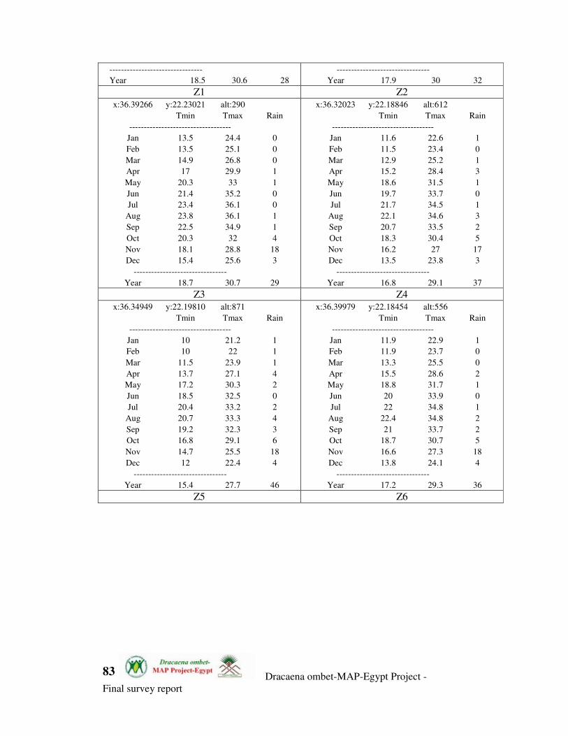
Dracaena ombet-MAP-Egypt Project -
Final survey report
83
--------------------------------
Year 18.5 30.6 28
--------------------------------
Year 17.9 30 32 Z1 Z2
x:36.39266 y:22.23021 alt:290
Tmin Tmax Rain
-----------------------------------
Jan 13.5 24.4 0
Feb 13.5 25.1 0
Mar 14.9 26.8 0
Apr 17 29.9 1
May 20.3 33 1
Jun 21.4 35.2 0
Jul 23.4 36.1 0
Aug 23.8 36.1 1
Sep 22.5 34.9 1
Oct 20.3 32 4
Nov 18.1 28.8 18
Dec 15.4 25.6 3
--------------------------------
Year 18.7 30.7 29
x:36.32023 y:22.18846 alt:612
Tmin Tmax Rain
-----------------------------------
Jan 11.6 22.6 1
Feb 11.5 23.4 0
Mar 12.9 25.2 1
Apr 15.2 28.4 3
May 18.6 31.5 1
Jun 19.7 33.7 0
Jul 21.7 34.5 1
Aug 22.1 34.6 3
Sep 20.7 33.5 2
Oct 18.3 30.4 5
Nov 16.2 27 17
Dec 13.5 23.8 3
--------------------------------
Year 16.8 29.1 37 Z3 Z4
x:36.34949 y:22.19810 alt:871
Tmin Tmax Rain
-----------------------------------
Jan 10 21.2 1
Feb 10 22 1
Mar 11.5 23.9 1
Apr 13.7 27.1 4
May 17.2 30.3 2
Jun 18.5 32.5 0
Jul 20.4 33.2 2
Aug 20.7 33.3 4
Sep 19.2 32.3 3
Oct 16.8 29.1 6
Nov 14.7 25.5 18
Dec 12 22.4 4
--------------------------------
Year 15.4 27.7 46
x:36.39979 y:22.18454 alt:556
Tmin Tmax Rain
-----------------------------------
Jan 11.9 22.9 1
Feb 11.9 23.7 0
Mar 13.3 25.5 0
Apr 15.5 28.6 2
May 18.8 31.7 1
Jun 20 33.9 0
Jul 22 34.8 1
Aug 22.4 34.8 2
Sep 21 33.7 2
Oct 18.7 30.7 5
Nov 16.6 27.3 18
Dec 13.8 24.1 4
--------------------------------
Year 17.2 29.3 36 Z5 Z6

Dracaena ombet-MAP-Egypt Project -
Final survey report
84