Map Features - OpenStreetMap Wiki
74
Map Features Help Available languages • ا ﻟ ﻌ ﺮ ﺑ ﻴ ﺔ• azərbaycanca • български • bosanski • català • česky • dansk • Deutsch • eesti • English • español • ﻓ ﺎ ر ﺳ ﯽ• français • • hrvatski • Bahasa Indonesia • íslenska • italiano • ע ב ר י ת• ქართული • latviešu • lietuvių • magyar • македонски • Nederlands • • norsk bokmål • polski • português • português do Brasil • română • русский • shqip • slovenčina • slovenščina • српски / srpski • suomi • svenska • • Türkçe • українська • Tiếng Việt • • OpenStreetMap represents physical features on the ground (e.g., roads or buildings) using tags attached to its basic data structures (its nodes, ways, and relations). Each tag describes a geographic attribute of the feature being shown by that specific node, way or relation. OpenStreetMap's free tagging system allows the map to include an unlimited number of attributes describing each feature. The community agrees on certain key and value combinations for the most commonly used tags, which act as informal standards. However, users can create new tags to improve the style of the map or to support analyses that rely on previously unmapped attributes of the features. Short descriptions of tags that relate to particular topics or interests can be found using the feature pages. Most features can be described using only a small number of tags, such as a path with a classification tag such as highway=footway, and perhaps also a name using name=*. But, since this is a worldwide, inclusive map, there can be many different feature types in OpenStreetMap, almost all of them described by tags. For details of more tags and proposed changes to existing tags see Proposed features and Deprecated features. If you do not find a suitable tag in this list then feel free to make something suitable up as long as the tag values will be verifiable. Over time, you may find that the tag name is changed to fit with some wider consensus, however many good tags were used first and documented later. Information about OSM tags is available as a machine-readable semantic network. Other languages — Help us translating this wiki show Page Discussion Read View source Search Main Page The map Map Features Contributors Help Blogs Shop Donations Recent changes Tools What links here Related changes Special pages Printable version Permanent link Page information Cite this page English Create account Log in
-
Upload
khangminh22 -
Category
Documents
-
view
1 -
download
0
Transcript of Map Features - OpenStreetMap Wiki

Map FeaturesHelpAvailable languages
ةيبرعلا • • azərbaycanca • български • bosanski • català • česky • dansk • Deutsch • eesti • English • español • یسراف • français • ��� • hrvatski• Bahasa Indonesia • íslenska • italiano • תירבע • ქართული • latviešu • lietuvių • magyar • македонски • Nederlands • ��� • norsk bokmål • polski• português • português do Brasil • română • русский • shqip • slovenčina • slovenščina • српски / srpski • suomi • svenska • • Türkçe• українська • Tiếng Việt • ������ • ������
OpenStreetMap represents physical features on the ground (e.g., roads or buildings) using tags attached to its basic data structures (itsnodes, ways, and relations). Each tag describes a geographic attribute of the feature being shown by that specific node, way or relation.
OpenStreetMap's free tagging system allows the map to include an unlimited number of attributes describing each feature. Thecommunity agrees on certain key and value combinations for the most commonly used tags, which act as informal standards. However,users can create new tags to improve the style of the map or to support analyses that rely on previously unmapped attributes of thefeatures. Short descriptions of tags that relate to particular topics or interests can be found using the feature pages.
Most features can be described using only a small number of tags, such as a path with a classification tag such as highway=footway,and perhaps also a name using name=*. But, since this is a worldwide, inclusive map, there can be many different feature types inOpenStreetMap, almost all of them described by tags.
For details of more tags and proposed changes to existing tags see Proposed features and Deprecated features. If you do not find asuitable tag in this list then feel free to make something suitable up as long as the tag values will be verifiable. Over time, you may findthat the tag name is changed to fit with some wider consensus, however many good tags were used first and documented later.Information about OSM tags is available as a machine-readable semantic network.
Other languages — Help us translating this wiki show
Page Discussion Read View source Search
Main Page
The map
Map Features
Contributors
Help
Blogs
Shop
Donations
Recent changes
Tools
What links here
Related changes
Special pages
Printable version
Permanent link
Page information
Cite this page
English Create account Log in

Contents [hide]
1 Primary features1.1 Aerialway
1.2 Aeroway
1.3 Amenity1.3.1 Sustenance
1.3.2 Education
1.3.3 Transportation
1.3.4 Financial
1.3.5 Healthcare
1.3.6 Entertainment, Arts & Culture
1.3.7 Others
1.4 Barrier1.4.1 Linear Barriers
1.4.2 Access Control on Highways
1.5 Boundary1.5.1 Attributes
1.6 Building1.6.1 Accommodation
1.6.2 Commercial
1.6.3 Civic/Amenity
1.6.4 Other Buildings
1.6.5 Additional Attributes
1.7 Craft
1.8 Emergency
1.9 Geological
1.10 Highway1.10.1 Roads
1.10.2 Link roads
1.10.3 Special road types
1.10.4 Paths
1.10.5 Lifecycle
1.10.6 Attributes
1.10.7 Other highway features
1.11 Historic
1.12 Landuse
1.13 Leisure
1.14 Man Made
1.15 Military
1.16 Natural1.16.1 Vegetation related
1.16.2 Water related
1.16.3 Mountains related
1.17 Office
1.18 Places1.18.1 Administratively declared places
1.18.2 Populated settlements, urban
1.18.3 Populated settlements, urban and rural
1.18.4 Other places
1.18.5 Additional attributes
1.19 Power
1.20 Public Transport
1.21 Railway1.21.1 Tracks
1.21.2 Additional features
1.21.3 Stations and Stops
1.21.4 Other railways
1.22 Route
1.23 Shop1.23.1 Food, beverages
1.23.2 General store, department store, mall
1.23.3 Clothing, shoes, accessories
1.23.4 Discount store, charity
1.23.5 Health and beauty
1.23.6 Do-it-yourself, household, building materials, gardening
1.23.7 Furniture and interior
1.23.8 Electronics
1.23.9 Outdoors and sport, vehicles
1.23.10 Art, music, hobbies
1.23.11 Stationery, gifts, books, newspapers
1.23.12 Others
1.24 Sport
1.25 Tourism
1.26 Waterway1.26.1 Natural watercourses
1.26.2 Man made waterways
1.26.3 Facilities
1.26.4 Barriers on waterways
1.26.5 Other features on waterways
1.26.6 Some additional attributes for waterways
2 Additional properties2.1 Addresses
2.1.1 Tags for individual houses
2.1.2 For countries using hamlet, subdistrict, district, province, state
2.1.3 Tags for interpolation ways
2.2 Annotation
2.3 Name
2.4 Properties
2.5 References
2.6 Restrictions
Primary features
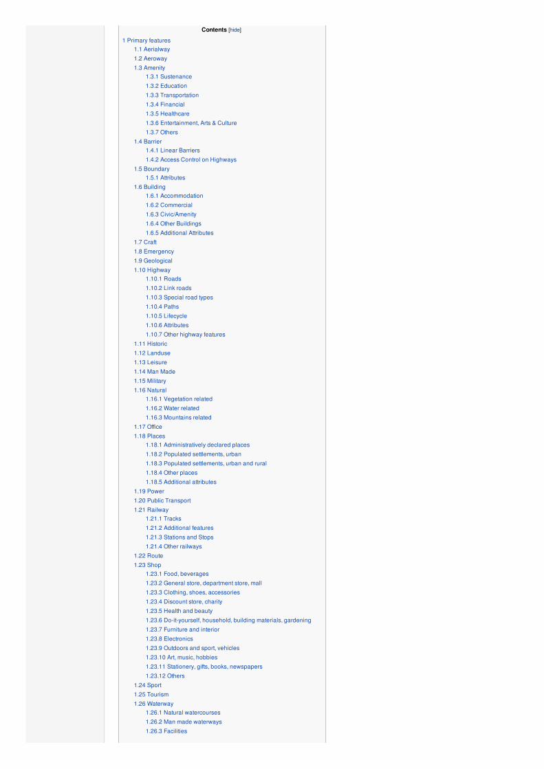
AerialwayThis is used to tag different forms of transportation for people or goods by using aerial wires. For example these may include cable-cars,chair-lifts and drag-lifts. See the page Aerialway for more information on the usage of these tags.
Key Value Element Comment Rendering Photo
aerialway cable_car
Cablecar or Tramway. Just one or two large cars. The
cable forms a loop, but the cars do not loop around, they
just move up and down on their own side.
aerialway chair_lift
Chairlift. Looped cable with a series of single chairs
(typically seating two or four people, but can be more).
Exposed to the open air. This implies oneway=yes. Any
two-way chairlifts should be tagged oneway=no.
aerialway drag_lift
Drag lift or Surface lift is an overhead tow-line for
skiers and riders. A T-bar lift, button lift, or more simple
looped rope drag lifts, or loops of wire with handles to grab.
See also aerialway=t-bar, aerialway=j-bar and
aerialway=platter.
aerialway gondola Gondola lift. Many cars on a looped cable.
aerialway goods A lift for goods. Passenger transport is usually not
allowed
aerialway j-bar J-bar lift. A type of aerialway=drag_lift. Like t-bar but
just on one side. This automatically implies oneway=yes.
aerialway magic_carpet Magic carpet. A type of ski lift. This automatically
implies oneway=yes.
aerialway mixed_lift
Mixed lift Also known as a hybrid lift is a new type of
ski lift that combines the elements of a chairlift and a
gondola lift.
aerialway platter
Platter lift. A type of aerialway=drag_lift. Similar to a
t-bar, but with a disc instead of a bar. Single-person only.
This automatically implies oneway=yes.

aerialway pylon Aerial lift pylon is a pylon supporting the aerialway
cable.
aerialway rope_tow Rope tow. A type of aerialway=drag_lift. This
automatically implies oneway=yes.
aerialway station A station, where passengers can enter and/or leave the
aerialway
aerialway t-bar T-bar lift. A type of aerialway=drag_lift. This
automatically implies oneway=yes.
aerialway user defined All commonly used values according to Taginfo
This table is a wiki template with a default description in English. Editable here.
AerowayThese are mainly related to aerodromes, airfields other ground facilities that support the operation of airplanes and helicopters. See thepage Aeroways for an introduction on mapping these features.
Key Value Element Comment Rendering Photo
aeroway aerodrome Aerodrome in the United Kingdom or Airport in North
America is used to map the main area details.
aeroway apron Airport apron is an area where planes are parked,
unloaded or loaded, refueled, or boarded.
aeroway gate Airport gate is used to mark the gate numbers at the
airports where passengers wait before boarding their flight.
aeroway helipad Helipad is used to mark the landing area or platform for
Helicopters
aeroway hangar Hangar is a structure to hold aircraft or spacecraft.
aeroway navigationaid
Radio navigation aid is used to mark systems that
determine a position on the Earth which helps pilots guide
their aircraft during flight.
aeroway runway Runway is a rectangular area in which aerodrome are
prepared for the landing and takeoff of aircraft.
aeroway taxiway Taxiway is a path on an airport connecting runways
with ramps, hangars, terminals and other facilities.
aeroway terminal
Airport terminal is a building at an airport where
passengers transfer between ground transportation and the
facilities that allow them to board and disembark from
aircraft.
aeroway windsock Windsock is designed to indicate wind direction and
relative wind speed.
aeroway User defined All commonly used values according to Taginfo
This table is a wiki template with a default description in English. Editable here.
AmenityUsed to map facilities used by visitors and residents. For example: toilets, telephones, banks, pharmacies, cafes, parking and schools.See the page Amenities for an introduction on its usage.
Key Value Element Comment Rendering Photo
Sustenance
amenity bar
A place selling alcoholic drinks. See description of
amenity=bar and amenity=pub for distinction between
bar and pub
amenity bbq
A public grill for cooking meat or vegetables, most
typically to eat outdoors. Use fuel=* to specify source of
heating. For campfires and firepits, use leisure=firepit
amenity biergarten An outdoor area in which beer, other drinks, and local
food are served.
amenity cafe A cafe. The kind of food served can be tagged with
cuisine=* and diet=*.
amenity drinking_water
Drinking water or Potable water is a place where
humans can obtain potable water for use. Typically the
water is used for only drinking. Other uses of the water
may include toilet flushing, washing and landscape
irrigation.
amenity fast_food
Fast food restaurant (see also amenity=restaurant).The kind of food served can be tagged with cuisine=*and diet=*.
amenity food_court An area with several different restaurant food counters
and a shared eating area. Commonly found in malls,
airports, etc.
amenity ice_cream Ice cream shop or ice cream parlour. A place that sells ice
cream and frozen yoghurt over the counter
amenity pub
A place selling beer and other alcoholic drinks; may also
provide food or accommodation (UK). See description of
amenity=bar and amenity=pub for distinction between
bar and pub
amenity restaurant
Restaurant (not fast food, see amenity=fast_food). The
kind of food served can be tagged with cuisine=* and
diet=*.
Education
amenity college A college campus or buildings
:
:
amenity kindergarten For children too young for a regular school (also known
as playschool or nursery school).
amenity library A public library (municipal, university, …) to borrow books
from.

amenity school School and grounds
:
:
amenity university A university campus
:
:
Transportation
amenity bicycle_parking Parking for bicycles
amenity bicycle_rental Rent a bicycle
amenity boat_sharing Share a Boat
amenity bus_station Has been replaced by public_transport=station.
amenity car_rental Rent a car
amenity car_sharing Share a car
amenity car_wash Wash a car
amenity ev_chargingElectric vehicle charging facility. Don't use,
amenity=charging_station is preferred.
amenity charging_station Charging facility for electric vehicles
amenity ferry_terminal Ferry terminal/stop. A place where people/cars/etc. can
board and leave a ferry.
amenity fuel Petrol station; gas station; marine fuel; … Streets to petrol
stations are often tagged highway=service.
amenity grit_bin A container that holds grit or a mixture of salt and grit.
amenity parking
Car park. Nodes and areas (without access tag) will get a
parking symbol. Areas will be colored. Streets on car
parking are often tagged highway=service and
service=parking_aisle.
amenity parking_entrance
An entrance or exit to an underground or multi-storey
parking facility. Group multiple parking entrances together
with a relation using the tags type=site and
site=parking.Do not mix with amenity=parking.
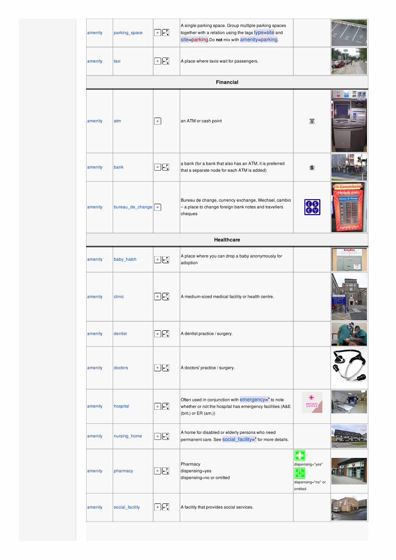
amenity parking_space
A single parking space. Group multiple parking spaces
together with a relation using the tags type=site and
site=parking.Do not mix with amenity=parking.
amenity taxi A place where taxis wait for passengers.
Financial
amenity atm an ATM or cash point
amenity bank a bank (for a bank that also has an ATM, it is preferred
that a separate node for each ATM is added)
amenity bureau_de_change
Bureau de change, currency exchange, Wechsel, cambio
– a place to change foreign bank notes and travellers
cheques
Healthcare
amenity baby_hatch A place where you can drop a baby anonymously for
adoption
amenity clinic A medium-sized medical facility or health centre.
amenity dentist A dentist practice / surgery.
amenity doctors A doctors' practice / surgery.
amenity hospital Often used in conjunction with emergency=* to note
whether or not the hospital has emergency facilities (A&E
(brit.) or ER (am.))
amenity nursing_home A home for disabled or elderly persons who need
permanent care. See social_facility=* for more details.
amenity pharmacy Pharmacy
dispensing=yes
dispensing=no or omitted
:
dispensing="yes"
:
dispensing="no" or
omitted
amenity social_facility A facility that provides social services.

amenity veterinary A place where a veterinary surgeon (vet) practices.
Entertainment, Arts & Culture
amenity arts_centre A venue where a variety of arts are performed or
conducted
amenity brothel An establishment specifically dedicated to prostitution
amenity casino A gambling venue with at least one table game(e.g.
roulette, blackjack) that takes bets on sporting and other
events at agreed upon odds.
amenity cinema A place where films are shown (US: movie theater)
amenity community_centre A place mostly used for local events and festivities.
amenity fountain A fountain for cultural / decorational / recreational
purposes.
amenity gambling
A place for gambling, not being a shop=bookmaker,shop=lottery, amenity=casino, or
leisure=adult_gaming_centre.
Games that are covered by this definition include bingoand pachinko.
amenity nightclub
A place to drink and dance (nightclub). The german word
is "Disco" or "Discothek". Please don't confuse this with
the german "Nachtclub" wich is most likely
amenity=stripclub.
amenity planetarium A planetarium.
amenity social_centre A place for free and not-for-profit activities.
amenity stripclubA place that offers striptease or lapdancing (for sexual
services use amenity=brothel).
amenity studio TV radio or recording studio
amenity swingerclub A club where people meet to have a party and group sex.
amenity theatre A theatre or opera house
Others
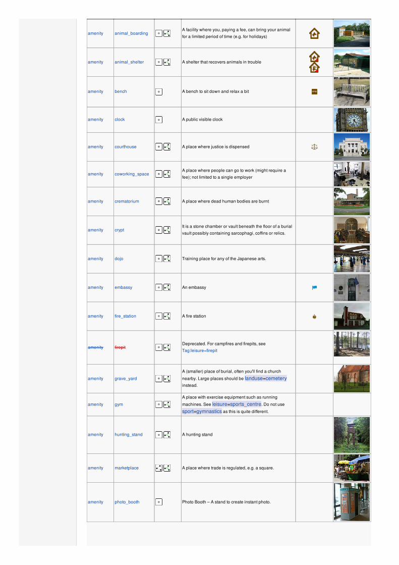
amenity animal_boarding A facility where you, paying a fee, can bring your animal
for a limited period of time (e.g. for holidays)
amenity animal_shelter A shelter that recovers animals in trouble
amenity bench A bench to sit down and relax a bit
amenity clock A public visible clock
amenity courthouse A place where justice is dispensed
amenity coworking_space A place where people can go to work (might require a
fee); not limited to a single employer
amenity crematorium A place where dead human bodies are burnt
amenity crypt It is a stone chamber or vault beneath the floor of a burial
vault possibly containing sarcophagi, coffins or relics.
amenity dojo Training place for any of the Japanese arts.
amenity embassy An embassy
amenity fire_station A fire station
amenity firepit Deprecated. For campfires and firepits, see
Tag:leisure=firepit
amenity grave_yard
A (smaller) place of burial, often you'll find a church
nearby. Large places should be landuse=cemeteryinstead.
amenity gym
A place with exercise equipment such as running
machines. See leisure=sports_centre. Do not use
sport=gymnastics as this is quite different.
amenity hunting_stand A hunting stand
amenity marketplace A place where trade is regulated, e.g. a square.
amenity photo_booth Photo Booth – A stand to create instant photo.

amenity place_of_worship
A church, mosque, or temple, etc. Note that you also need
religion=*, usually denomination=* and preferably
name=* as well as amenity=place_of_worship. See
the article for details.
amenity police A police station
amenity post_box Alternative mail-carriers can be tagged via operator=*
amenity post_office Post office building with postal services
amenity prison A prison
amenity public_building A generic public building. Don't use! See
building=public
amenity ranger_station National Park Visitor Headquarters
amenity register_office Register office. See also office=register
amenity recycling
Recycling facilities (bottle banks etc.). Combine with
recycling_type=container for containers or
recycling_type=centre for recycling centres.
amenity rescue_station A rescue station
amenity sauna
A small room or house to experience dry or wet heat
sessions.
Also frequently used: leisure=sauna
amenity shelter
A small shelter against bad weather conditions. To
additionally describe the kind of shelter use
shelter_type=*.
amenity shower Public shower or bath.
amenity telephone Public telephone
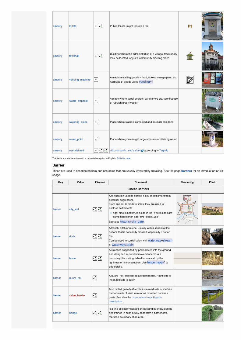
amenity toilets Public toilets (might require a fee)
amenity townhall Building where the administration of a village, town or city
may be located, or just a community meeting place
amenity vending_machineA machine selling goods – food, tickets, newspapers, etc.
Add type of goods using vending=*
amenity waste_disposalA place where canal boaters, caravaners etc. can dispose
of rubbish (trash/waste).
amenity watering_place Place where water is contained and animals can drink
amenity water_point Place where you can get large amounts of drinking water
amenity user defined All commonly used values according to Taginfo
This table is a wiki template with a default description in English. Editable here.
BarrierThese are used to describe barriers and obstacles that are usually involved by traveling. See the page Barriers for an introduction on itsusage.
Key Value Element Comment Rendering Photo
Linear Barriers
barrier city_wall
A fortification used to defend a city or settlement from
potential aggressors.
From ancient to modern times, they are used to
enclose settlements.
right side is bottom, left side is top. if both sides aresame height then add "two_sided=yes".
See also historic=city_gate.
barrier ditch
A trench, ditch or ravine, usually with a stream at the
bottom, that is not easily crossed, especially if not on
foot.
Can be used in combination with waterway=streamor waterway=drain.
barrier fence
A structure supported by posts driven into the ground
and designed to prevent movement across a
boundary. It is distinguished from a wall by the
lightness of its construction. Use fence_type=* toadd details.
barrier guard_railA guard_rail, also called a crash barrier. Right side is
inner, left side is outer.
barrier cable_barrier
Also called guard cable. This is a road side or median
barrier made of steal wire ropes mounted on weak
posts. See also the more extensive wikipedia
description.
barrier hedge is a line of closely spaced shrubs and bushes, planted
and trained in such a way as to form a barrier or to
mark the boundary of an area.

barrier kerb
A (for example footway) kerb is a barrier for vehicles
and wheelchair drivers. The height of the kerb is
important and with this information, the usage by
different groups can be determined. The height of the
kerb is tagged additionally as height=*, if available.
Right side is bottom, left side is top.
barrier retaining_wall Retaining walls serve to retain the lateral pressure of
soil. Right side is bottom, left side is top.
barrier wall
a freestanding solid structure designed to restrict or
prevent movement across a boundary. Usually made
from solid brick, concrete or stone and almost always
built so that it is opaque to vision.
Access Control on Highways
barrier block
A large, solid, immobile block that can be moved only
with heavy machinery or great effort.
Typically big solid things made of concrete for
stopping larger vehicles.
Sometimes natural boulders are used for the same
purpose.
barrier bollard solid (usually concrete or metal) pillar or pillars in the
middle of the road to prevent passage by some traffic.
barrier border_control
This is a control point at an international border
between two countries. Passports or other forms of ID
will be checked.
barrier bump_gate See wikipedia:Bump gate [1] [2] [3]
barrier bus_trap See wikipedia:Bus trap
barrier cattle_grid
Bars in the road surface that allow wheeled vehicles
but not animals to cross.
Sometimes known as a Texas Gate, even outside of
Texas
barrier chain A chain used to prevent motorised vehicles.
barrier cycle_barrier
Barriers to bicycle traffic, most typically a pair of
staggered steel bars perpendicular to the way itself
whose gaps allow pedestrians to pass.
barrier debris
A road is blocked by debris with or without ground.
This might be for short or long time. Often used as first
step in blocking an abandoned road. The photo does
not display the road after the debris because it was a
slope road and the photo was taken on the top.
barrier entrance
A gap in a linear barrier with nothing that limits
passing through.
access=yes is implied.
The limitations are the same of the way that crosses it,
if there is such.
barrierfull-
height_turnstile
A full-height turnstile, also called HEET-turnstile (High
Entrance/Exit Turnstile), like the ones to access
security areas. Note the mix of hyphen and
underscore.
barrier gate
An entrance that can be opened or closed to get
through the barrier.
Combine with access=* where appropriate.
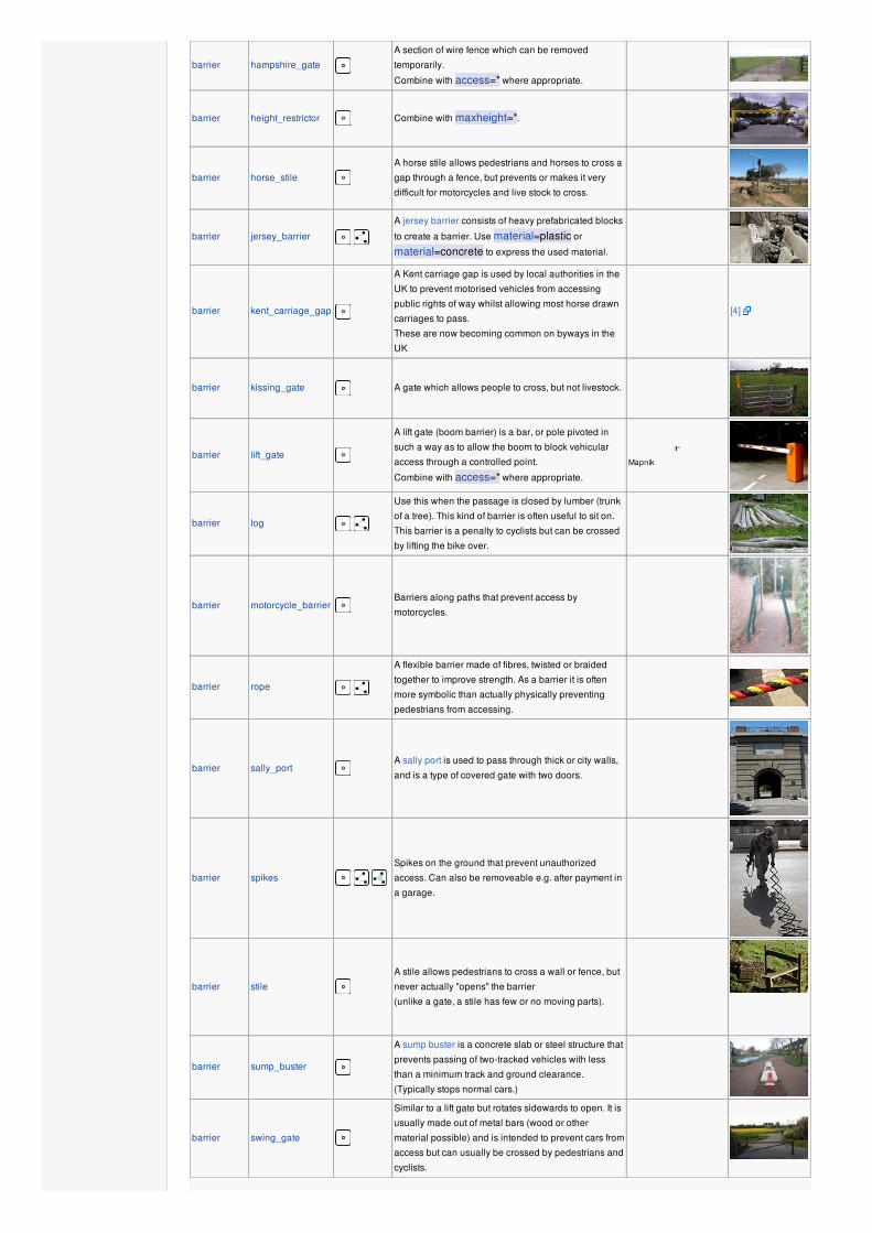
barrier hampshire_gate
A section of wire fence which can be removed
temporarily.
Combine with access=* where appropriate.
barrier height_restrictor Combine with maxheight=*.
barrier horse_stile
A horse stile allows pedestrians and horses to cross a
gap through a fence, but prevents or makes it very
difficult for motorcycles and live stock to cross.
barrier jersey_barrier
A jersey barrier consists of heavy prefabricated blocks
to create a barrier. Use material=plastic or
material=concrete to express the used material.
barrier kent_carriage_gap
A Kent carriage gap is used by local authorities in the
UK to prevent motorised vehicles from accessing
public rights of way whilst allowing most horse drawn
carriages to pass.
These are now becoming common on byways in the
UK
[4]
barrier kissing_gate A gate which allows people to cross, but not livestock.
barrier lift_gate
A lift gate (boom barrier) is a bar, or pole pivoted in
such a way as to allow the boom to block vehicular
access through a controlled point.
Combine with access=* where appropriate.
Mapnik
barrier log
Use this when the passage is closed by lumber (trunk
of a tree). This kind of barrier is often useful to sit on.
This barrier is a penalty to cyclists but can be crossed
by lifting the bike over.
barrier motorcycle_barrierBarriers along paths that prevent access by
motorcycles.
barrier rope
A flexible barrier made of fibres, twisted or braided
together to improve strength. As a barrier it is often
more symbolic than actually physically preventing
pedestrians from accessing.
barrier sally_portA sally port is used to pass through thick or city walls,
and is a type of covered gate with two doors.
barrier spikes Spikes on the ground that prevent unauthorized
access. Can also be removeable e.g. after payment in
a garage.
barrier stile
A stile allows pedestrians to cross a wall or fence, but
never actually "opens" the barrier
(unlike a gate, a stile has few or no moving parts).
barrier sump_buster
A sump buster is a concrete slab or steel structure that
prevents passing of two-tracked vehicles with less
than a minimum track and ground clearance.
(Typically stops normal cars.)
barrier swing_gate
Similar to a lift gate but rotates sidewards to open. It is
usually made out of metal bars (wood or other
material possible) and is intended to prevent cars from
access but can usually be crossed by pedestrians and
cyclists.

barrier toll_boothA road usage toll or fee is collected here. Used with
toll=* and charge=*
barrier turnstile
A turnstile (also called baffle gate) is used to allow
one person at a time to pass. Use this for small
turnstiles like the ones in supermarkets or some
subways.
barrier yesA barrier which nature cannot be determined; typically
only used in mapping using aerial imagery
barrier user defined All commonly used values according to Taginfo
This table is a wiki template with a default description in English. Editable here.
BoundaryThese are used to describe administrative and other boundaries. See the page Boundaries for an introduction on its usage.
Key Value Element Comment Rendering Photo
boundary administrative
An administrative boundary. Subdivisions of
areas/territories/jurisdictions recognised by
governments or other organisations for
administrative purposes. These range from large
groups of nation states right down to small
administrative districts and suburbs, as indicated by
the 'admin_level=*' combo tag
boundary maritime Maritime boundaries
boundary national_parkArea of outstanding natural beauty, set aside for
conservation and for recreation (Other languages )
boundary political Electoral boundaries
boundary postal_code Postal code boundaries
boundary religious_administration
An religious administrative boundary.
See: Talk:Key:boundary#Religious authority
boundaries
boundary protected_areaProtected areas, such as for national-parks, water
protection areas or indigenous areas.
border_type * To distinguish between types of boundary where
admin_level isn't enough. Used in several different
ways e.g in maritime contexts
fire_boundary yes
Tag fire_boundary used to mark the boundaries of
the areas of fire brigades out within the project
Karta01 .
boundary user defined All commonly used values according to Taginfo
Attributes
admin_level NumberApplies to boundary=administrative and is
usually in the range 1 to 10, except for Germany
where it might be 11 – see boundary.
This table is a wiki template with a default description in English. Editable here.
BuildingThis is used to identify individual buildings or groups of connected buildings. See the page Buildings for further details on the usage ofthis tag and man_made=* for tagging of various other structures.
Key Value Element Comment Photo
Accommodation
building apartments
A building arranged into individual dwellings, often on separate floors. May
also have retail outlets on the ground floor. How does one map the retail
elements? Use building:levels=* for the total number of floors.

building dormitory
For a shared building, as used by college/university students (not a share
room for multiple occupants as implied by the term in British English).
Would 'hall_of_residence' be better?
building farm
A residential building on a farm (farmhouse). For other buildings see below
building=farm_auxiliary, building=barn, … If in your country
farmhouse looks same as general residential house then you can tag as
building=house as well. See also landuse=farmyard
building hotel
A building designed with separate rooms available for overnight
accommodation. Normally used in conjunction with tourism=hotel for the
hotel grounds including recreation areas and parking.
building house
A single dwelling unit inhabited by family or small group sharing facilities
such as a kitchen. Houses forming half of a semi-detached pair, or one of a
row of terraced houses, should share at least two nodes with joined
neighbours, thereby defining the party wall between the properties.
building detachedA single dwelling unit inhabited by family or small group sharing facilities
such as a kitchen.
building residential
A general tag for a building used primarily for residential purposes. Where
additional detail is available consider using one or more areas tagged as
'apartments', 'terrace' or 'house'.
building terrace
A single way used to define the outline of a linear row of residential
dwellings, each of which normally has its own entrance, which form a
terrace (row-house in North American English). Consider defining each
dwelling separately using 'house'.
building houseboat A boat used primarily as a home
building static_caravan A mobile home (semi)permanently left on a single site
Commercial
building commercial
A building where non-specific commercial activities take place; use
office=* to describe the type of office. Consider tagging the area using
landuse=commercial. Use 'retail' if the building consists primarily of
shops.
building industrial
A building where some industrial process takes place. Use warehouse if
the purpose is known to be primarily for storage/distribution. Consider
using landuse=industrial for the surrounding area and the proposed
industrial=* tag to describe the industrial activity.
building retail
A building primarily used for selling goods are sold to the public; use
shop=* to identify the sort of goods sold. Consider use landuse=retailfor the surrounding area. How is one meant to indicate that there is also
residential accommodation or office use above?
building warehouseA building primarily used for the storage or goods or as part of a
distribution system.
Civic/Amenity
building cathedral
A building that was built as a cathedral. Used in conjunction with
amenity=place_of_worship, religion=* and denomination=* for the
cathedral grounds where it is in current use.
building chapel
A building that was built as a chapel. Used in conjunction with
amenity=place_of_worship, religion=* and denomination=* for the
chapel grounds where it is in current use.
building church
A building that was built as a church. Used in conjunction with
amenity=place_of_worship, religion=* and denomination=* for the
church grounds where it is in current use.

building civic
For any civic amenity, for example amenity=community_centre,
amenity=library, amenity=toilets, leisure=sports_centre,
leisure=swimming_pool, amenity=townhall etc. Use amenity=* or
leisure=* etc to provide further details. See building=public as well.
building hospitalA building which forms part of a hospital. Use amenity=hospital for the
hospital grounds.
building mosqueA mosque. Used in conjunction with amenity=place_of_worship,
religion=* and denomination=*.
building school
For any generic school buildings. Buildings for specific uses (sports halls
etc) should be tagged for their purpose. Use amenity=school for the
perimeter of the school grounds.
building train_station A train station building.
building transportation
A building related to public transport. You will probably want to tag it with
proper tranport related tag as well, such as public_transport=station.
Note that there is a special tag for train station buildings -
building=train_station.
building universityA university building. Use amenity=university for the whole university
area.
building public A public building. Don't use amenity=public_building.
Other Buildings
building barn An agricultural building used for storage and as a covered workplace.
building bridge
A building used as a bridge. Can also represent a gatehouse for
drawbridges. See also bridge=yes for highway=*. Don't use this tagjust for for marking bridges (their outlines). For such purposes
consider the proposed man_made=bridge.
building bunker A hardened military building. Also use military=bunker.
building cabinA cabin is a small, roughly built house usually with a wood exterior and
typically found in rural areas.
building constructionUsed for buildings under construction. Use construction=* to hold the
value for the completed building.
building cowshedA cowshed (cow barn, cow house) is a a building for housing cows, usually
found on farms.
building farm_auxiliaryA building on a farm that is not a dwelling (use 'farm' or 'house' for the farm
house).
building garage
A garage is a building suitable for the storage of one or possibly more
motor vehicle or similar. See building=garages for larger shared
buildings.
building garagesA building that consists of a number of discrete storage spaces for different
owners/tenants. See also building=garage.
building greenhouseA greenhouse is a glass or plastic covered building used to grow plants.
Use landuse=greenhouse_horticulture for the area
building hangarA hangar is a building used for the storage of airplanes, helicopters or
space-craft. Consider adding aeroway=hangar, when appropriate.
building hut A hut is a small and crude shelter.
building roofA structure that consists of a roof with open sides, such as a rain shelter,
and also gas stations
building shedA shed is a simple, single-storey structure in a back garden or on an
allotment that is used for storage, hobbies, or as a workshop.
building stable A stable is a building where horses are kept.
building styA sty (pigsty, pig ark, pig-shed) is a a building for raising domestic pigs,
usually found on farms.
building transformer_tower
A transformer tower is a characteristic tall building comprising a distribution
transformer and constructed to connect directly to a medium voltage
overhead power line. Quite often the power line has since been
undergrounded but the building may still serve as a substation. If the
building is still in use as a substation it should additionally be tagged as
power=substation + substation=minor_distribution.
building yes Use this value where it is not possible to determine a more specific value.
building user defined All commonly used values according to Taginfo, generally building types
Additional Attributes
entrance
yes / main / exit /
service /
emergency
An entrance in a building. Replaces the deprecated tag
building=entrance.
height number The height of the building in meters.
building:levels number The number of levels (floors) in the building.
building:fireproof yes/no Fire-resistance information.
This table is a wiki template with a default description in English. Editable here.
CraftThis is used as a place that produces or processes customised goods. See the page Crafts for more information on the usage of thesetags.
Key Value Element Comment Rendering Photo
craft agricultural_engines Planning, and Constructing engines and tools for
agricultural use.
craft basket_maker Producing baskets, often made from Willow.
craft beekeeper A place where honey bees are kept for the purposes
of securing commodities such as honey, beeswax or
pollen.
craft blacksmith A place where a blacksmith forges tools, horseshoes,
etc. from iron.
craft brewery A brewery is a dedicated building for the making of
beer
craft boatbuilder Planning, and Contructing boats.
craft bookbinder Physically assembling a book from a number of
sheets of paper.
craft carpenter Workplace or office of Carpenters that work with
timber to construct, install and maintain buildings,
furniture, and other objects.
craft carpet_layer Workplace or office of carpet layers that bring carpet
on your floor.
craft caterer Workplace or office of one who prepares customized
meals for takeout, or provides prepared meals or
supplies to a group at social gatherings.
craft clockmaker
Workplace or office of a clockmaker that is building or
repairing clocks but not watches. See also
craft=watchmaker
craft confectionery
A place where the set of food items that are rich in
sugar, any one or type of which is called a confection
is produced.
craft dressmaker A place where clothes are created, repaired or
altered to fit personal needs.
craft electrician
Workplace or office of an electrician which is a
tradesman specialized in electrical wiring of
buildings, stationary machines and related
equipment.
craft gardener Workplace or office of a garden designer or a
landscape gardener.

craft glaziery
A place where residential, commercial, and artistic
glass is selected, cutted, installed, replaced, and
removed
craft handicraft A place where useful and decorative devices are
made completely by hand or using only simple tools
craft hvac Workplace or office of an HVAC system designer
(Heating, Ventilating, and Air Conditioning)
craft insulation Workplace or office of of a person who does thermal
insulation in buildings.
craft jeweller A place where necklaces, rings, brooches, earrings
and bracelets and other personal adornments are
created or repaired.
craft key_cutter A place where keys can be duplicated from originals.
craft locksmith A place where locks and keys are created or
repaired.
craft metal_construction A place where handrails, gates, ramps and similar
things from metal are made.
craft optician A place where lenses for the correction of a person's
vision are designed, fitted and dispensed.
craft painter Workplace or office of a house painter which is a
tradesman responsible for the painting and
decorating of buildings.
craft parquet_layer Workplace or office of a parquet layer.
craft photographer Workplace or office of a person who takes
photographs using a camera.
craft photographic_laboratory A place where photos taken on a film or digital
images are transformed into a more permanent form,
often on paper or plastic foil.
craft plasterer
Workplace or office of a tradesman who works with
plaster, such as forming a layer of plaster on an
interior wall or plaster decorative moldings on
ceilings or walls.
craft plumber Workplace or office of a tradesman who specializes
in installing and maintaining systems used for
potable (drinking) water, sewage, and drainage.

craft pottery A place where earthenware, stoneware and
porcelain and other ceramic ware is made by potters.
craft rigger Workplace or office of a person who makes masts,
yards, sails, and cordage for sailboats and sailing
ships.
craft roofer Workplace or office of a tradesman who is
specialized in roof construction.
craft saddler A place where saddles or accessories for cars and
boats are produced or repaired.
craft sailmaker Workplace or office of a person who makes and
repairs sails for sailboats and sailing ships, typically
working on shore in a sail loft.
craft sawmill A workplace where logs are cut into boards.
craft scaffolder
Workplace or office of a tradesman who builds
temporary structure used to support people and
material in the construction or repair of buildings and
other large structures.
craft sculptor A place where Sculpture are made.
craft shoemaker
A place where shoes, boots, sandals, clogs and
moccasins are created, repaired or altered to fit
personal needs. See also shop=shoes for a place
where shoes are sold, but not made or altered
craft stand_builder Workplace of a company that builds stands/booths
for fairs.
craft stonemason A place where rough pieces of rock are shaped into
accurate geometrical shapes.
craft sun_protection A place where sun protection is made, repaired, or
delivered for assembly, especially awnings and
shutters.
craft sweep Workplace or office of a person who cleans chimneys
for a living.
craft tailor A place where clothing is made, repaired, or altered
professionally, especially suits and men's clothing.
craft tiler Workplace or office of a person who lays tiles on
floors, swimming pools and such.
craft tinsmith
A tinsmith, or tinner or tinker or tinplate worker.
Workplace or office of a person who makes and
repairs things made of light-coloured metal,
particularly tinware.
craft upholsterer A place where furniture, especially seats are
provided with padding, springs, webbing, and fabric
or leather covers.
craft watchmaker
A watchmaker is an artisan who makes and repairs
watches. Today due to industrial production they
mostly repair watches. For other kinds of clocks see
craft=clockmaker
craft window_construction Construct windows
craft winery Produces wine
craft user defined All commonly used values according to Taginfo
This table is a wiki template with a default description in English. Editable here.
EmergencyThis is used to describe the location of emergency facilities and equipment. See the page Emergency for an introduction on its usage.
Key Value Element Comment Rendering Photo
emergency ambulance_station
An ambulance station is a structure or other area set aside
for storage of ambulance vehicles, medical equipment,
personal protective equipment, and other medical
supplies.
emergency defibrillator
An Automated External Defibrillator (AED) is a first-aid
device that automates the process of diagnosing life-
threatening cardiac arrhythmia and performing
defibrillation. Previously tagged as emergency=aed or
medical=aed.
emergency fire_extinguisher
A fire extinguisher is an active fire protection device used
to extinguish or control small fires, often in emergency
situations.
emergency fire_flapper
A flapper is a wildland firefighting tool also called a swatter
or a beater. It is designed for extinguishing minor fires in
rural areas such as heaths.
emergency fire_hoseA fire hose is a high-pressure hose used to carry water or
other fire retardant (such as foam) to a fire to extinguish it.
emergency fire_hydrant
A fire hydrant is an active fire protection measure, and a
source of water provided in most urban, suburban and
rural areas with municipal water service or other water
source to enable firefighters to tap into the municipal water
supply to assist in extinguishing a fire.
emergency phone
An emergency phone is specifically provided for making
calls to emergency services and is most often found in a
place of special danger.
emergency ses_station A State Emergency Service is an Australian volunteer
organisation that provides emergency help during and
after declared (natural or otherwise) disasters.

emergency sirenA siren is a loud noise maker. Most modern ones are civil
defense, "air raid" sirens or tornado sirens.
emergency water_tank Stock tank for fire-fighting water.
emergency assembly_point Point or area, where people are crowd in a case of
emergency
emergency access_pointAccess points in areas which are hard to access (see also
highway=emergency_access_point)
emergency user defined All commonly used values according to Taginfo
This table is a wiki template with a default description in English. Editable here.
GeologicalThis is used to describe the geological makeup of an area. See the page Geological for an introduction on its usage.
Key Value Element Comment Rendering Photo
geological moraine
A moraine is any ice formed accumulation of
unconsolidated glacial debris (soil and rock) which can
occur in currently glaciated and formerly glaciated
regions, such as those areas acted upon by glacial ice.
geological outcrop An outcrop site is a place where the bedrock or
superficial deposits have become locally exposed and
are directly accessible to analysis.
geological palaeontological_site
A palaeontological site is a place (or group of physical
sites) in which remains of ancient living forms is
preserved. Area under the study of the forms of life
existing in prehistoric times, as represented by the
fossils of plants, animals, and other organisms
investigated using the discipline of palaeontology.
geological user defined All commonly used values according to Taginfo
This table is a wiki template with a default description in English. Editable here.
HighwayThis is used to describe roads and footpaths. For an introduction on its usage see the page titled Highways. See the page titledRestrictions for an introduction on access limitations by vehicles type, time, day, load and purpose, etc.
Key Value Element Comment Rendering Photo
Roads
These are the principal tags for the road network. They range from the most to least important.
highway motorway
A restricted access major divided highway,
normally with 2 or more running lanes plus
emergency hard shoulder. Equivalent to the
Freeway, Autobahn, etc..
highway trunk
The most important roads in a country's system
that aren't motorways. (Need not necessarily be
a divided highway.)
highway primaryThe next most important roads in a country's
system. (Often link larger towns.)

highway secondaryThe next most important roads in a country's
system. (Often link smaller towns and villages.)
highway tertiaryThe next most important roads in a country's
system.
highway unclassified
The least most important through roads in a
country's system – i.e. minor roads of a lower
classification than tertiary, but which serve a
purpose other than access to properties. (The
word 'unclassified' is a historical artefact of the
UK road system and does not mean that the
classification is unknown; you can use
highway=road for that.)
highway residentialRoads which are primarily lined with and serve
as an access to housing.
highway service
For access roads to, or within an industrial
estate, camp site, business park, car park etc.
Can be used in conjunction with service=* toindicate the type of usage and with access=*to indicate who can use it and in what
circumstances.
Link roads
highway motorway_link
The link roads (sliproads/ramps) leading to/from
a motorway from/to a motorway or lower class
highway. Normally with the same motorway
restrictions.
highway trunk_link
The link roads (sliproads/ramps) leading to/from
a trunk road from/to a trunk road or lower class
highway.
highway primary_link
The link roads (sliproads/ramps) leading to/from
a primary road from/to a primary road or lower
class highway.
highway secondary_link
The link roads (sliproads/ramps) leading to/from
a secondary road from/to a secondary road or
lower class highway.
highway tertiary_link
The link roads (sliproads/ramps) leading to/from
a tertiary road from/to a tertiary road or lower
class highway.
Special road types
highway living_street
For living streets, which are residential streets
where pedestrians have legal priority over cars,
speeds are kept very low and where children
are allowed to play on the street.
highway pedestrian
For roads used mainly/exclusively for
pedestrians in shopping and some residential
areas which may allow access by motorised
vehicles only for very limited periods of the day.
To create a 'square' or 'plaza' create a closed
way and tag as pedestrian and also with
area=yes.

highway track
Roads for agricultural or forestry uses etc, often
rough with unpaved/unsealed surfaces, that
can be used only by off-road vehicles (4WD,
tractors, ATVs , …) . In countries where mostroads are unpaved, you should still use themaintrunk/primary/secondary/tertiary/unclassifiedvalues, making sure to also tag the surface
type. Use surface=* or tracktype=* for
tagging to describe the surface.
highway bus_guideway
A busway where the vehicle guided by the way
(though not a railway) and is not suitable for
other traffic. Please note: this is not a normal
bus lane, use access=no, psv=yes instead!
highway raceway A course or track for (motor) racing
highway road
A road where the mapper is unable to ascertain
the classification from the information available.
This is intended as a temporary tag to mark a
road until it has been properly surveyed. Once it
has been surveyed, the classification should be
updated to the appropriate value.
Paths
highway footway
For designated footpaths; i.e.,
mainly/exclusively for pedestrians. This
includes walking tracks and gravel paths. If
bicycles are allowed as well, you can indicate
this by adding a bicycle=yes tag. Should not
be used for paths where the primary or
intended usage is unknown. Use
highway=pedestrian for pedestrianised
roads in shopping or residential areas and
highway=track if it is usable by agricultural or
similar vehicles.
highway cycleway See below.
highway bridlewayFor horses. Equivalent to highway=path +
horse=designated.
highway stepsFor flights of steps (stairs) on footways. Use with
step_count=* to indicate the number of steps
highway path
A non-specific path. Use highway=footwayfor paths mainly for walkers,
highway=cycleway for one also usable by
cyclists, highway=bridleway for ones
available to horses as well as walkers and
highway=track for ones which is passable by
agriculture or similar vehicles.
When sidewalk (or pavement) is tagged on the main roadway (see Sidewalks)
sidewalk both / left / right / noSpecifies that the highway has sidewalks on
both sides, on one side or no sidewalk at all
When cycleway is drawn as its own way (see Bicycle)
highway cyclewayFor designated cycleways. Add foot=* only if
default-access-restrictions do not apply.
When cycleway or lane is tagged on the main roadway (see Bicycle)
cycleway lane A lane is a route that lies within the roadway
cycleway opposite
Used on ways with oneway=yes where it is
legally permitted to cycle in both directions.
Used together with oneway:bicycle=no.
cycleway opposite_lane
Used on ways with oneway=yes that have a
cycling lane going the opposite direction of
normal traffic flow (a "contraflow" lane). Used
together with oneway:bicycle=no.
cycleway trackA track is a route that is separate from the
road.+oneway=yes if needed.
cycleway opposite_trackUsed on ways with oneway=yes that have a
cycling track going the opposite direction of
normal traffic flow
cycleway share_buswayThere is a bus lane that cyclists are permitted to
use.
cycleway shared_lane
Cyclists share a lane with motor vehicles, but
there are markings indicating that they should
share the lane with motorists.
Lifecycle
highway proposed
For planned roads, use with proposed=* and
also proposed=* with a value of the proposed
highway value.
highway construction
For roads under construction. Use
construction=* to hold the value for the
completed road.
Attributes
abutterscommercial/ industrial/
mixed/ residential/ retail etc.See Key:abutters for more details.
driving_side left/ right
Defines which side of the road vehicles must
legally use. (must only be used on highways
when they are an exception to the rule)
ford yes The road crosses through stream or river,
vehicles must enter any water.
ice_road yesA highway is laid upon frozen water basin,
definitely doesn't exist in summer.
incline Number %/°
Incline steepness as percents ("5%") or
degrees ("20°"). Positive/negative values
indicate movement upward/downwards in the
direction of the way.
junction roundabout
This automatically implies oneway=yes, the
oneway direction is defined by the sequential
ordering of nodes within the Way. This applies
on a way, tagged with highway=* already.
lanes number
The number of traffic lanes for general purpose
traffic, also for buses and other specific classes
of vehicle.

lit yes/no Street lighting
motorroad yes / no
The motorroad tag is used to describe
highways that have motorway-like access
restrictions but that are not a motorway.
mountain_pass yes The highest point of a mountain pass.
mtb:scale 0-6
Applies to highway=path and
highway=track. A classification scheme for
mtb trails (few inclination and downhill).
mtb:scale:uphill 0-5A classification scheme for mtb trails for going
uphill if there is significant inclination.
mtb:scale:imba 0-4
The IMBA Trail Difficulty Rating System shall be
used for bikeparks. It is adapted to mtb trails
with artificial obstacles.
mtb:description Text
Applies to highway=path and
highway=track. A key to input variable infos
related to mtbiking on a way with human words
overtakingyes/ no/ both/ forward/
backward
Specifying sections of roads where overtaking
is legally forbidden.
parking:condition:sidefree/ ticket/ disc/ residents/
customers/ private
Specifying the parking conditions (terms). See
parking:condition=* for more details.
parking:lane:side
parallel/ diagonal/
perpendicular/ marked/
no_parking/ no_stopping/
fire_lane.
Specifying the parking space. See
parking:lane=* for more details.
passing_places yes A way which has frequent passing places
sac_scale
hiking / mountain_hiking /
demanding_mountain_hiking
/ alpine_hiking /
demanding_alpine_hiking /
difficult_alpine_hiking
Applies to highway=path and
highway=footway. A classification scheme for
hiking trails.
servicealley/ driveway/
parking_aisle etc.See Key:service for more details.
surface
paved / unpaved / asphalt /
concrete / paving_stones /
cobblestone / metal / wood /
grass_paver / gravel /
pebblestone / grass / ground
/ earth / dirt / mud / sand
See Key:surface for more details.
tactile_paving yes / no A paving in the ground to be followed with a
blindman's stick.
Not to be
rendered on
standard maps.
tracktypegrade1/ grade2/ grade3/
grade4/ grade5
To describe the quality of the surface. See
Key:tracktype and Key:surface for more
information.
traffic_calmingyes/ bump/ hump/ cushion/
table etc. See Key:traffic calming for more details.
trail_visibility
excellent / good /
intermediate / bad / horrible /
no
Applies to highway=path,
highway=footway, highway=cycleway and
highway=bridleway. A classification for
hiking trails visibility

winter_road yesA highway functions during winter, probably
can't be driven in summer.
Other highway features
highway bus_stop
A small bus stop. Can be mapped more
rigorously using
public_transport=stop_position for the
position where the vehicle stops and
public_transport=platform for the place
where passengers wait. See
public_transport=* for more details.
highway crossingPedestrians can cross a street here; e.g., zebra
crossing
highway emergency_access_point
Sign number which can be used to define your
current position in case of an emergency. Use
with ref=NUMBER_ON_THE_SIGN
highway escape Emergency lane beside long descending
slopes for trucks and other vehicles to stop
safely after brake failure.
Not decided yet,
but a white/red
checkered line
has been
proposed.
highway give_way A "give way," or "Yield" sign
emergency phone
A calling device can be used to tell on your
current position in case of an emergency. Use
with ref=NUMBER_ON_THE_SIGN
highway mini_roundabout
Similar to roundabouts, but at the center there is
either a painted circle or a fully traversable
island. In case of an untraversable center
island, junction=roundabout should be used.
Rendered as anti-clockwise by default
direction=anticlockwise. To render
clockwise add the tag direction=clockwise.
highway motorway_junction
Indicates a junction (UK) or exit (US). ref=*should be set to the exit number or junction
identifier. (Some roads – e.g., the A14 – also
carry junction numbers, so the tag may be
encountered elsewhere despite its name)
highway passing_place The location of a passing space
highway rest_area Place where drivers can leave the road to rest,
but not refuel.
highway speed_camera A fixed road-side or overhead speed camera.
highway street_lamp
A street light, lamppost, street lamp, light
standard, or lamp standard is a raised source of
light on the edge of a road, which is turned on
or lit at a certain time every night

highway services A service station to get food and eat something,
often found at motorways
highway stop A stop sign
highway traffic_signals Lights that control the traffic
highway turning_circle
A turning circle is a rounded, widened area
usually, but not necessarily, at the end of a road
to facilitate easier turning of a vehicle. Also
known as a cul de sac.
highway User Defined All commonly used values according to
Taginfo
This table is a wiki template with a default description in English. Editable here.
HistoricThis is used to describe various historic places. For example: archeological sites, wrecks, ruins, castles and ancient buildings. See thepage titled Historic for an introduction on its usage.
Key Value Element Comment Rendering Photo
historic archaeological_site A place in which evidence of past activity is preserved
historic aircraft A decommissioned aircraft which generally remains in
one place
historic battlefield The site of a battle or military skirmish in the past. This
could be on land or at sea.
historic boundary_stone A historic boundary stone usually found along the way.
historic building If it's not clear what type a historic building has, it can be
tagged as a generic building.
historic castle Castles are (often fortified) buildings from medieval and
modern times. Other languages
historic cannonA historic/retired cannon. Usually found at on forts or
battlefields.
historic city_gate A city gate (or town gate) is a gate within a city wall.
historic citywalls A defensive wall is a fortification used to protect a city
or settlement from potential aggressors.
historic farm A historical farm, kept in it's original state.

historic fort A military fort – distinct from a castle as it is generally more
modern
historic manor Historic manors / mansions
historic memorial Much like a monument, but smaller. Might range from a
WWII memorial to a simple plate on a wall.
historic monument An object, especially large and made of stone, built to
remember and show respect to a person or group of
people. Other languages
historic ruins
Remains of structures that were once complete, but have
fallen into partial or complete disrepair. If the type of
original structure is known or apparent it can be described
using ruins=*, e.g. ruins=castle.
Alternative tagging is historic=castle, ruins=yes.See the proposal and discussion at Proposedfeatures/ruins for ruins of historic buildings.
historic rune_stoneA runestone is typically a raised stone with a runic
inscription.
historic ship A decommissioned ship or submarine
historic tomb Historic tomb
historic tree_shrineA single tree of a religious figure mounted onto a tree. Use
natural=tree + historic=wayside_shrine instead.
historic wayside_cross A historical (usually christian) cross. Frequently found
along the way in Southern Germany, Austria and probably
elsewhere.
historic wayside_shrine A historical shrine often showing a religious depiction.
Frequently found along the way in Southern Germany,
Austria and probably elsewhere.
historic wreck Nautical craft that has unintentionally been sunk or
destroyed.
historic yes Used to add the historic significance of the objects
described by other tags.

historic user defined All commonly used values according to Taginfo
This table is a wiki template with a default description in English. Editable here.
LanduseThis is used to describe the purpose for which an area of land is being used. See the page titled Landuse for an introduction on itsusage.
Key Value Element Comment Rendering Photo
landuse allotments A piece of land given over to local residents for
growing vegetables and flowers.
landuse basin
An area of water that drains into a river.
Together with basin=* for stormwater/rainwater
infiltration/detention/retention basins.
Other languages .
landuse brownfield
Describes land scheduled for new development
where old buildings have been demolished and
cleared
landuse cemetery
Place for burials. You can add religion=* (values
listed in the place of worship page). Smaller places
(e.g. with a church nearby) may use
amenity=grave_yard instead.
landuse commercial Predominantly offices, business parks, etc.
landuse conservation
Protected areas (Not approved) Alternate tagging of
same thing: boundary=protected_area,
protected_area=*
landuse construction "Under construction" site, should become something
different once the construction is finished
landuse farmAn area of farmland used for tillage and pasture
(animals, crops, vegetables, flowers, fruit growing).
landuse farmland
Synonyme for farm, used in JOSM because farm
was considered ambiguous (see ticket #1579 ).
Farmland has now been used more often (see
taginfo comparison ).
landuse farmyard
An area of land with farm buildings like farmhouse,
dwellings, farmsteads, sheds, stables, barns,
equipment sheds, feed bunkers, etc. plus the open
space in between them and the shrubbery/trees
around them.
landuse forest Managed forest or woodland plantation (Other
languages ).
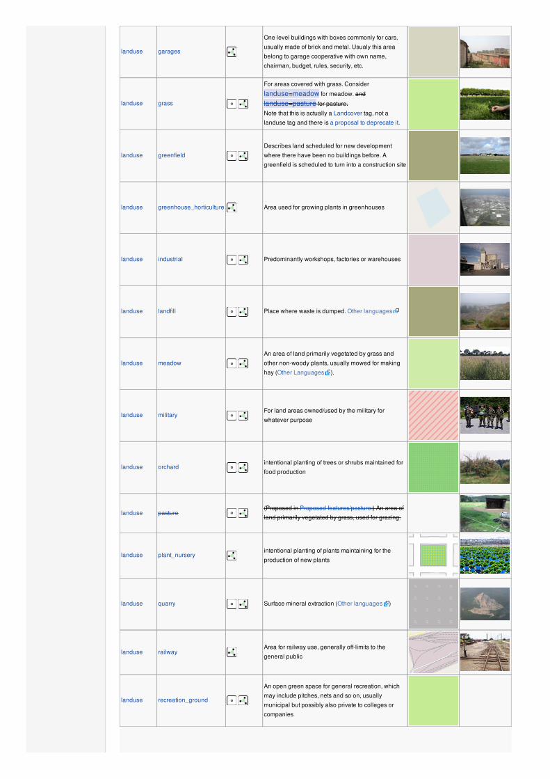
landuse garages
One level buildings with boxes commonly for cars,
usually made of brick and metal. Usualy this area
belong to garage cooperative with own name,
chairman, budget, rules, security, etc.
landuse grass
For areas covered with grass. Consider
landuse=meadow for meadow. and
landuse=pasture for pasture.
Note that this is actually a Landcover tag, not a
landuse tag and there is a proposal to deprecate it.
landuse greenfield
Describes land scheduled for new development
where there have been no buildings before. A
greenfield is scheduled to turn into a construction site
landuse greenhouse_horticulture Area used for growing plants in greenhouses
landuse industrial Predominantly workshops, factories or warehouses
landuse landfill Place where waste is dumped. Other languages
landuse meadow
An area of land primarily vegetated by grass and
other non-woody plants, usually mowed for making
hay (Other Languages ).
landuse military For land areas owned/used by the military for
whatever purpose
landuse orchard intentional planting of trees or shrubs maintained for
food production
landuse pasture (Proposed in Proposed features/pasture:) An area of
land primarily vegetated by grass, used for grazing.
landuse plant_nurseryintentional planting of plants maintaining for the
production of new plants
landuse quarry Surface mineral extraction (Other languages )
landuse railwayArea for railway use, generally off-limits to the
general public
landuse recreation_ground
An open green space for general recreation, which
may include pitches, nets and so on, usually
municipal but possibly also private to colleges or
companies

landuse reservoir
Stores water, may be covered or uncovered; for a
covered reservoir see also
man_made=reservoir_covered (Other
languages ). See water=reservoir for alternative
tagging.
landuse residential Predominantly houses or apartment buildings
landuse retail Predominantly shops
landuse salt_pondA place where sea water is evaporated to extract its
salt
landuse village_green
An area of common land, usually grass, in the centre
of a village (quintessentially English – defined
separately from 'common land' under the Commons
Registration Act 1965 and the Commons Act 2006).
landuse vineyard A piece of land where grapes are grown.
landuse user defined All commonly used values according to Taginfo
This table is a wiki template with a default description in English. Editable here.
LeisureThis is used to tag leisure and sports facilities. See the page titled Leisure for an introduction on its usage.
Key Value Element Comment Rendering Photo
leisure adult_gaming_centre
A venue with pay-to-play games, such as video
games, driving simulators, pinball machines,
merchandisers, etc. With a set age limit. As
opposed to leisure=amusement_arcade.
leisure amusement_arcade
A venue with pay-to-play games, such as video
games, driving simulators, pinball machines,
merchandisers, etc. Without a set age limit. As
opposed to leisure=adult_gaming_centre.
leisure beach_resort To mark the boundary of a managed beach.
leisure bird_hide A place to observe birds.
leisure dance A place to go dancing.
leisure dog_park Designated area, with or without a fenced
boundary, where dog-owners are permitted to
exercise their pets unrestrained

leisure firepit A permanent location or structure to host campfires,
bonfires, etc
leisure fishing
leisure garden
Place where flowers and other plants are grown in a
decorative and structured manner or for scientific
purposes.
leisure golf_course
The outline of a golf course. The node form may be
used to place an icon within the course. This tag
implies sport=golf.
leisure hackerspace
A place where people with common interests, often
in computers, technology, science, digital art or
electronic art, can meet, socialize and/or
collaborate.
leisure ice_rink A place where you can skate or play ice hockey.
leisure marina For mooring leisure yachts and motor boats
leisure miniature_golf A place or area that you can play miniature golf.
leisure nature_reserve Protected area of importance for wildlife, flora, fauna
or features of geological or other special interest.
leisure park Open, green area for recreation, usually municipal.
leisure pitch
e.g. a field for playing football/soccer, cricket,
baseball sports, and skate parks. To describe what
kind of sport(s) use sport=*.
leisure playground Playground for little children.:
:
leisure slipway Boats can be launched here
leisure sports_centre
A distinct facility where a range of sports take place
within an enclosed area. To describe what kind of
sport(s) use sport=*.

leisure stadium A major sports arena with substantial tiered seating.
To describe what kind of sport(s) use sport=*.
leisure swimming_pool
A swimming pool, see also Proposed
features/Swimming pool and
Tag:amenity=swimming pool
leisure track e.g. running, cycle-racing, greyhound, horses. To
describe what kind of sport(s) use sport=*.
leisure water_park Amusement area with water slides, recreational
swimming pools and dressing rooms.
leisure wildlife_hide A place to observe wildlife. See also
leisure=bird_hide.
leisure user defined All commonly used values according to Taginfo
This table is a wiki template with a default description in English. Editable here.
Man MadeA tag for identifying man made (artificial) structures that are added to the landscape. See the page Man-made for an introduction on itsusage.
Key Value Element Comment Rendering Photo
man_made adit From Wikipedia: An adit is a type of entrance to an
underground mine which is horizontal or nearly horizontal.
man_made beacon Structures for signalling on land and sea.
man_made breakwater Protects a shore or harbour from the sea and waves.
man_made bunker_silo Open-sided structure to store something. It can be used
with vehicles to fill and empty it.
man_made campanile
A freestanding bell tower, typically near a church.
See also man_made=tower with
tower:type=bell_tower.
man_made chimney
Large chimney for exhaustion. For attached mobile phone
base stations see the
communication:mobile_phone=yes.
man_made crane A stationary, permanent crane, such as those at docks

man_made crossCross with little historical or religion value, e.g. summit
cross.
man_made cutline Used to mark cut lines in forests.
man_made clearcut Area, where most or all trees are uniformly cut down. Used
in combination with natural=scrub.
man_made embankmentA raised bank to carry a road, railway, or canal across a
low-lying or wet area.
man_made dykeA dyke is a an embankment built to restrict the flow of water
or other liquids.
man_made flagpole A long pole built to hold a flag.
man_made gasometer A gasometer is a large storage container for gas.
man_made groyne
A rigid hydraulic structure perpendicular to a coastline or a
riverbank intended to interrupt longshore sediment
transport. See also: man_made=breakwater.
man_made kiln
A thermally insulated chamber in which temperature is
controlled in order to change the state of the item placed
inside, usually though the process of burning, baking,
drying or smelting.
man_made lighthouse Sends out a light beam to guide ships.
man_made mastMast is a vertical structure built to hold for example
antennas.

man_made mineshaft A vertical tunnel.
man_made monitoring_station A station that monitor something.
man_made offshore_platform Offshore platform.
man_made petroleum_wellA boring through the earth's surface that is designed to find
and produce petroleum oil.
man_made pier A "bridge into the ocean", usually for recreation.
man_made pipelineA pipe for carrying various fluids, such as water, gas,
sewage.
man_made reservoir_covered A covered water reservoir.
man_made silo A silo is a storage container for bulk material, often grains
such as corn or wheat.
man_made snow_fence
A snow fence is a solid fence-like structure built across
steep slopes to reduce risk and severity of (snow)
avalanches. Usually made of steel, sloping outwards, and
trussed underneath. Sometimes refered to as a snow shed.
man_made snow_net
A snow net netting fence built across steep slopes to
reduce risk and severity of (snow) avalanches. They
consist of a net made of steel cables, held up by posts.
Sometimes refered to as an Avalanche net.
man_made storage_tank A tank used for storage of liquids or gases.
man_made surveillance To mark places and buildings monitored by public or
private camera.
man_made survey_point
Triangulation pillars, geodetic vertices, and fixed
equipment used by topographers (e.g. DGPS radio
stations).
man_made tower
A tall and often lean building or structure e.g. telecoms.
Please also add a tower:type=* if possible. Also see
historic=* below.
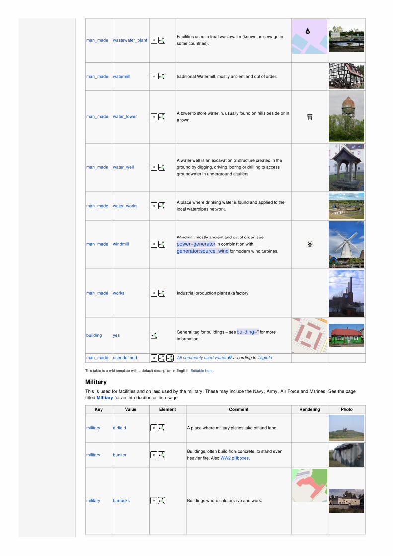
man_made wastewater_plant Facilities used to treat wastewater (known as sewage in
some countries).
man_made watermill traditional Watermill, mostly ancient and out of order.
man_made water_tower A tower to store water in, usually found on hills beside or in
a town.
man_made water_well A water well is an excavation or structure created in the
ground by digging, driving, boring or drilling to access
groundwater in underground aquifers.
man_made water_works A place where drinking water is found and applied to the
local waterpipes network.
man_made windmill
Windmill, mostly ancient and out of order, see
power=generator in combination with
generator:source=wind for modern wind turbines.
man_made works Industrial production plant aka factory.
building yesGeneral tag for buildings – see building=* for more
information.
man_made user defined All commonly used values according to Taginfo
This table is a wiki template with a default description in English. Editable here.
MilitaryThis is used for facilities and on land used by the military. These may include the Navy, Army, Air Force and Marines. See the pagetitled Military for an introduction on its usage.
Key Value Element Comment Rendering Photo
military airfield A place where military planes take off and land.
military bunker Buildings, often build from concrete, to stand even
heavier fire. Also WW2 pillboxes.
military barracks Buildings where soldiers live and work.
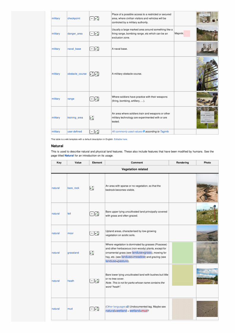
military checkpoint
Place of a possible access to a restricted or secured
area, where civilian visitors and vehicles will be
controled by a military authority.
military danger_area Usually a large marked area around something like a
firing range, bombing range, etc which can be an
exclusion zone.
Mapnik:
military naval_base A naval base.
military obstacle_course A military obstacle course.
military range Where soldiers have practice with their weapons
(firing, bombing, artillery, …).
military training_area
An area where soldiers train and weapons or other
military technology are experimented with or are
tested.
military user defined All commonly used values according to Taginfo
This table is a wiki template with a default description in English. Editable here.
NaturalThis is used to describe natural and physical land features. These also include features that have been modified by humans. See thepage titled Natural for an introduction on its usage.
Key Value Element Comment Rendering Photo
Vegetation related
natural bare_rockAn area with sparse or no vegetation, so that the
bedrock becomes visible.
natural fell Bare upper lying uncultivated land principally covered
with grass and often grazed.
natural moor Upland areas, characterised by low-growing
vegetation on acidic soils.
natural grassland
Where vegetation is dominated by grasses (Poaceae)
and other herbaceous (non-woody) plants, except for
ornamental grass (see landuse=grass), mowing for
hay, etc. (see landuse=meadow) and grazing (see
landuse=pasture).
natural heath
Bare lower lying uncultivated land with bushes but little
or no tree cover.
Note. This is not for parks whose name contains the
word "heath".
natural mud (Other languages ) Undocumented tag. Maybe see
natural=wetland + wetland=mud?
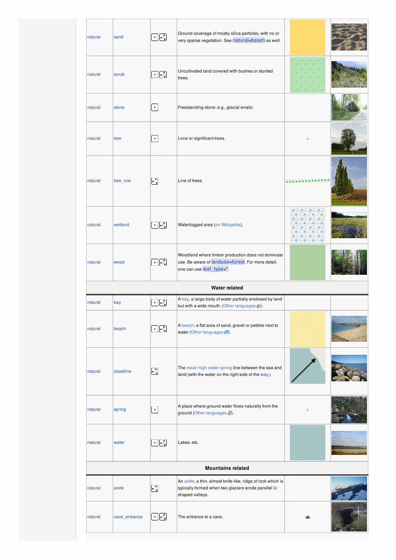
natural sand Ground coverage of mostly silica particles, with no or
very sparse vegetation. See natural=beach as well.
natural scrub Uncultivated land covered with bushes or stunted
trees.
natural stone Freestanding stone; e.g., glacial erratic.
natural tree Lone or significant trees.
natural tree_row Line of trees.
natural wetland Waterlogged area (on Wikipedia).
natural wood
Woodland where timber production does not dominate
use. Be aware of landuse=forest. For more detail,
one can use leaf_type=*.
Water related
natural bay A bay, a large body of water partially enclosed by land
but with a wide mouth. (Other languages ).
natural beach A beach, a flat area of sand, gravel or pebble next to
water (Other languages ).
natural coastlineThe mean high water spring line between the sea and
land (with the water on the right side of the way.)
natural springA place where ground water flows naturally from the
ground (Other languages ).
natural water Lakes, etc.
Mountains related
natural arete
An arête, a thin, almost knife-like, ridge of rock which is
typically formed when two glaciers erode parallel U-
shaped valleys.
natural cave_entrance The entrance to a cave.
natural cliff A cliff, a significant vertical, or near vertical, rock
exposure (leave the lower face to the right of the way.)
natural glacier Areas (or peaks) covered with ice throughout the year.
natural peak Top of a hill or mountain (summit).
natural ridge A ridge.
natural rock A notable rock or group of rocks with connection to the
ground.
natural saddle Saddle between hills
(suggested)
natural scree Loose rock.
natural sinkhole A natural depression or hole in the surface
topography.
natural volcano A volcano, either dormant, extinct or active.
natural user defined All commonly used values according to Taginfo
This table is a wiki template with a default description in English. Editable here.
OfficeAn office is a place of business where administrative or professional work is carried out. See the page titled Office for an introduction onits usage.
Key Value Element Comment Rendering Photo
office accountant An office for an accountant.
office administrative Local authorities, administrative and supervising
institutions that are not related to state government.
office architect An office for a architect.
office association An office of a non-profit organisation, society, e.g.
student, sport, consumer, automobile, bike association,
etc….
office company An office for a private company.
office educational_institution An office for an educational institution.
office employment_agency An office for a employment agency.
office estate_agent An office for a estate agent or realtor.
office forestry A forestry office.
office foundation An office for a foundation.
office government An office for a government agency or department.
office guide An office for tour guides, mountain guides, dive guides,
etc.
office insurance An office for a insurance company or agent.
office it An office for an IT specialist.
office lawyer An office for a lawyer.
office newspaper An office for a newspaper.
office ngo An office for a non-government organisation.
office notary Notary's office.
office political_party An office for a political party.

office quango An office for a quango (quasi-autonomous non-
governmental organisation).
officerealtor
real_estate_agent See office=estate_agent above.
office register A register office / civil registry office. See also
amenity=register_office.
office religion
An office of an religion instance. For example: parish
office. Use additionally religion=* and
denomination=*.
office research An office for R&D.
office tax Fiscal authorities, tax and revenue office.
office telecommunication Telecommunication company office.
office travel_agent An office for a travel agent. See also
shop=travel_agency.
office water_utility An office for a water utility company or water board.
office user defined All commonly used values according to Taginfo
This table is a wiki template with a default description in English. Editable here.
PlacesThis is used mainly to give details about settlements. See the page titled Places for an introduction on its usage.
Key Value Element Comment Rendering Photo
Administratively declared places
place country See boundary=administrative, admin_level=2
place state See boundary=administrative, admin_level=*varies; may not be used in all countries.
place region See boundary=administrative, admin_level=*varies; may not be used in all countries. For natural
regions other keys should be searched.
place province See boundary=administrative, admin_level=*varies; may not be used in all countries.
place district See boundary=administrative, admin_level=*varies; may not be used in all countries.
place county See boundary=administrative, admin_level=*varies; may not be used in all countries.
place municipality
See boundary=administrative, admin_level=*varies; depending on the country a collection of arbitrary
hamlets, villages and towns may form an administrative
unit; sometimes members of a unit reform or join with
another municipality as a result of political process.
Within a municipality individual settlements are a lot less
connected than those within a city, where they have
grown connected over time.
Populated settlements, urban
place city
The largest urban settlements in the territory, normally
including the national, state and provincial capitals.
These are defined by charter or other governmental
designation in some territories and are a matter of
judgement in others. Should normally have a population
of at least 100,000 people and be larger than nearby
towns. See place=suburb and
place=neighbourhood on how to tag divisions within
a city. The outskirts of urban settlements may or may not
match the administratively declared boundary of the city.
place borough
See boundary=administrative, depending on the
country suburbs in larger cities are often grouped into
administrative units called boroughs or city districts;
using the value borough avoids name confusion in
countries that declare districts within their states or
counties.

place suburb
A distinct section of an urban settlement (city, town, etc.)
with its own name and identity. e.g.
annexed towns or villages which were formerlyindependent,
independent (or dependent) municipalities within acity or next to a much bigger town
historical districts of settlements
industrial districts or recreation areas within asettlements with specific names.
place quarter
A named part of a bigger settlement where this part is
smaller then a suburb and bigger then a
neighbourhood. This does not have to be an
administrative entity.
The term quarter is sometimes used synonymously for
neighbourhood.
place neighbourhood
A named part of a place=village, a place=town or a
place=city. Smaller than place=suburb and
place=quarter.The term quarter is sometimes used synonymously for
neighbourhood, but may also stand for borough or
suburb and hence is often avoided in OSM. See
Quarter_(urban_subdivision)
place city_block A named city block that is part of a place=city. See
City_block
Populated settlements, urban and rural
place town
A second tier urban settlement of local importance, often
with a population of 10,000 people and good range of
local facilities including schools, medical facilities etc
and traditionally a market. In areas of low population,
towns may have significantly lower populations. See
place=neighbourhood and possibly also
place=suburb on how to tag divisions within a town.
place village
A smaller distinct settlement, smaller than a town with
few facilities available with people traveling to nearby
towns to access these. Populations of villages vary
widely in different territories but will nearly always be
less than 10,000 people, often a lot less. See
place=neighbourhood on how to tag divisions within
a larger village.
place hamlet A smaller rural community typically with less than 100-
200 inhabitants, few infrastructure.
place isolated_dwelling Smallest kind of human settlement. No more than 2
households.
place farm
A farm that has its own name. If the farm is not a part of
bigger settlement use place=isolated_dwelling. See
also landuse=farmyard
place allotments
Dacha or cottage settlement, which is located outside
other inhabited locality. This value is used mainly in
Russia and other countries of the former Soviet Union,
where a lot of such unofficial settlements exist
Other places
place continent One of the seven continents: Africa, Antarctica, Asia,
Australia, Europe, North America, South America
place archipelagoIdentifies the relation of an archipelago, which contains
several islands and islets.
place island Identifies the coastline of an island (> 1 km2), also
consider place=islet for very small islands
place islet Identifies an islet (< 1 km2).
place locality For an unpopulated named place.
place User Defined All commonly used values according to Taginfo
Additional attributes
population Number Number of inhabitants of the place. Among other things,
it might be used in selecting which name to render at a
given zoom level at what font size.
name Text To define the name of a place.
place_numbers Number Probably better to use the Karlsruhe Schema instead of
this tag.
postal_code Text Probably better to use the Karlsruhe Schema instead of
this tag.
reference_point yes Named landmarks used to identify locations (common in
some countries).
is_in Text
Optional. Rudimentary way to describe boundary
hierarchies, e.g. place=suburb, name=Eccleshall,is_in=Sheffield,South Yorkshire,England,UK. If
boundary polygons exist, it's usually not needed. Unless
categorization is wrongly done by e.g. Nominatim.
This section is a wiki template with a default description in English. Editable here.
PowerThese are used to map electrical power generation and distributions systems. See the page titled Power for an introduction on its usage.
Key Value Element Comment Rendering Photo
power plant
A place/industrial facility where power is generated.
Individual generating units within the facility should be
tagged as power=generator.
power cable
A way following the path of underground cables, such
as the local 0.4 kV network between transformer
stations, distribution boxes and cable connection
points, or sea cables. Not to be confused with non-
power supply cables such as cables for
telecommunication. May be combined with
location=underground;underwater;overground.
power cable_distribution_cabinet
In these cabinets, the 400-V circuits to the house
connections, connection and transfer points of the
regional utilities are branched. Other uses include
distributions of the municipal street lighting.
power converter
An HVDC converter converts electric power from high
voltage alternating current (AC) to high-voltage direct
current (HVDC), or vice-versa.
power generator
A device used to convert power from one form to
another. Use in combination with
generator:source=*, generator:method=* and
generator:output=*.
power heliostat A mirror of a heliostat device.
power line
A way following the path of (overground) power
cables. For minor power lines with poles and not
towers, you may want to use power=minor_line.
power minor_line
A way following the path of (overground) minor power
cables, supported by poles and not towers/pylons.
(This isn't quite so simple, as sometimes larger towers
are replaced by smaller poles made with a stronger
material; a better distinction might be based on
voltage).
power poleFor single (often wooden or concrete) poles carrying
medium/low voltage electricity cables.
power substation
A tag for electricity substations. These provide voltage
step-up/step-down, switching, conditioning, etc.
Substations may be large facilities (up to several
acres) for very high voltage transmission lines or just
small buildings or kiosks near the street for low
voltage distribution lines. Useful combinations:
voltage=*, substation=* and location=*, see the
feature page for details.
power switch
A tag for electricity switches which are devices which
allow operators to power up & down lines and
transformer in substations or outside.
power tower
For towers or pylons carrying high voltage electricity
cables. Normally constructed from steel latticework but
tubular or solid pylons are also commonly used.
Should not be used for medium or low voltage
electricity conductors carried on single wooden poles
which might be tagged power=pole. See
power=tower for detailed tagging of tower types.
power transformer
A static device for transferring electric energy by
inductive coupling between its windings. Large power
transformers are typically located inside substations.
cables 2 / 3 / 4 / 6 / 9 / 12 / etc...
Number of power-carrying cables represented by this
way. The power line on the photo (click on it to see
more details) has 6 double cables (the cable on top
does not carry power) and thus may be tagged as
cables=6 and wires=double.
circuits 1 / 2 / 3 / etc...
Number of electrical circuits represented by this way.
The tag may be used when the number of physical
cables is unknown (often the case for underground
cable connections) or when the number of circuits is
different from cables=* divided by 3. The photo
shows a power line that connects to a cable
connection having two circuits and thus may be
tagged as circuits=2.
tunnel yes
Notes that a line or cable is contained in a self-
supporting tunnel that may also be used for other
purposes such as road traffic or be provided for
maintenance purposes. Cables buried underground
should not use this tag but be tagged as
power=cable and
location=underground;underwater.
voltage… / 110000 / 220000 /
380000 / etc...Voltage of the power line.
wiressingle / double / triple /
quad
Number of wires per power cable. "single" (1),
"double" (2), "triple" (3) or "quad" (4). The photo shows
an example of "double".
power User Defined
All commonly used values according to Taginfo
This table is a wiki template with a default description in English. Editable here.
Public TransportThis is used for features related to public transport. For example: railway stations, bus stops and services. See the page titled Publictransport for an introduction on its usage.
Key Value Element Comment Rendering Photo
public_transport stop_positionThe position on the street or rails where a bus, tram or
train stops.
public_transport platform The place where passengers are waiting for the
transportation vehicle.
public_transport stationA station where several buses or trains end their service.
Used in combination with building=yes or area=yes.
public_transport stop_area
The stop area is a relation that contains all elements of a
train/subway/monorail/tram/bus/trolleybus/aerialway/ferry
stop.
public transport user defined All commonly used values according to Taginfo.
This table is a wiki template with a default description in English. Editable here.

RailwayThis tag includes all kinds of railways ranging from heavily used mainline railways to an abandoned rail line. See the page titledRailways for an introduction on its usage.
Key Value Element Comment Rendering Photo
Tracks
railway abandoned
The course of a former railway which has been
abandoned and the track and infrastucture removed.
The course may be still recognized through
embankments, cuttings, bridges, tunnel and rolling or
straight ways.
railway construction
A railway under construction. See construction=*and the construction=yes proposal Proposed
features/Construction.
railway disused
A section of railway which is no longer used but where
the track and infrastructure remains in place. See
disused=yes for alternative tagging.
railway funicular
Cable driven inclined railways. In many cases they
serve touristic interest, giving easy access to
spectacular mountain views.
railway light_rail
A higher-standard tram system, normally in its own
right-of-way. Often it connects towns and thus reaches
a considerable length (tens of kilometer).
railway miniatureMiniature railways are narrower than narrow gauge
and carry passengers. They can be found in parks.
railway monorail
A railway with only a single rail. A monorail can run
above the rail like in Las Vegas and Disneyland or
can suspend below the rail like the Wuppertal
Schwebebahn (Germany).
railway narrow_gauge
Narrow-gauge passenger or freight trains. Narrow
gauge railways can have mainline railway service like
the Rhaetian Railway in Switzerland or can be a small
light industrial railway. Use gauge=* to specify the
actual width of rails.
railway preserved
A railway running historic trains, usually a tourist
attraction (changed to preserved from preserved_rail
as "rail" is redundant).
railway railFull sized passenger or freight trains in the standard
gauge for the country or state.
railway subwayA city passenger rail service running mostly grade
separated (see Wikipedia:rapid transit).
railway tramOne or two carriage rail vehicles, usually sharing
motor road (Other languages ).
Additional features
bridge yesIf the railway goes over a street, waterway or other
railway.

cutting yesA section where the railway is significantly lower than
ground level.
electrified
contact_line
rail
yes
no
contact_line: a power line over the train head
rail: a third rail near the track supplying the train with
power
yes: electrified track, but no details available
no: track with no power supply.
embankment yesA section where the railway is raised significantly
higher than ground level.
frequencynumber
[kHz/MHz/GHz]
The frequency with which a line is electrified. Use 0 for
DC. Also see the voltage tag.
service sidingRelatively short lengths of track, running parallel to
(and connected to) a main route
service spurRelatively short lengths of track, built to give one
company or entity access to a main or branch line.
service yardTracks within railway company operated marshaling
or maintenance yards.
tracks number
Number of parallel tracks in close proximity when
mapped as a single way. If not given means unknown
and defaults to 1. In many parts of the world the tracks
are being drawn out separately so that there is more
detail, in which case this tag isn't used.
tunnel yesIf the railway goes below ground. Should be always
present on subways.
usage
main
branch
freight
industrial
military
tourism
main line: heavy traffic
branch line: connecting places with a mainline
freight: freight service only
industrial: servicing large plants (iron, chemical etc.),
surface mining, …
military: servicing military area
tourism: most mountain rails (rack-rails, funicular) and
preserved railways.
voltage numberThe voltage with which a line is electrified. Also see
the frequency tag.
Stations and Stops
railway haltA small station, may not have a platform, trains may
only stop on request.
public_transport platform
This is parallel to the rail line for showing where the
actual platforms are. It is also to know where you can
change platform and enter the station, so use
footpaths to connect them. This is really useful for
routing too.
railway station Railway station (Other languages ).
railway subway_entranceThe entrance to a subway station, usually going from
surface to underground.
railway tram_stopA tram stop is a place where a passenger can embark
/ disembark a tram.
Other railways
railway buffer_stop stops the train at the end of a track. see Buffer_stop.
railway derail
a device used to prevent fouling of a rail track by
unauthorized movements of trains or unattended
rolling stock. See Derail_(railroad).
railway crossing A point where pedestrians may cross.
railway level_crossing A point where rails and roads cross.
landuse railway Ground used around railways and railway-stations.
railway switch Full Connections between railways (aka 'points').
railway diamond Crossing rails with no interconnection.
railway turntable These are used for changing the direction that part of
a train is pointing in.
railway roundhouseA semicircular building with many stalls for servicing
engines.
railway user defined All commonly used values according to Taginfo
This table is a wiki template with a default description in English. Editable here.
RouteThis is used to describe routes of all different kinds. See the page titled Relation:route for an introduction on its usage.
Key Value Element Comment Rendering Photo
route bicycle Cycle routes explains how to tag cycle routes.
route bus The route a public bus service takes. See Buses.
route inline_skates Inline has more information on the subject.
route canoe Route for canoeing through a waterway.
route detour
Route for fixed detour routes. Examples are
Bedarfsumleitung in Germany and uitwijkroute in the
Netherlands
route ferry
The route a ferry takes from terminal to terminal Please
make sure to add at least one node per tile (zoom level 12),
better at least one every few km, so offline editors catch it
with bbox requests.
route hiking Hiking explains how to tag hiking routes.
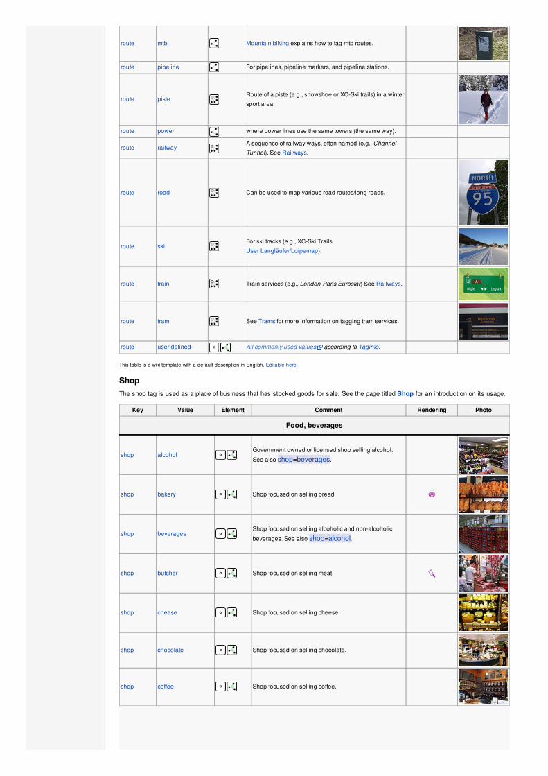
route mtb Mountain biking explains how to tag mtb routes.
route pipeline For pipelines, pipeline markers, and pipeline stations.
route pisteRoute of a piste (e.g., snowshoe or XC-Ski trails) in a winter
sport area.
route power where power lines use the same towers (the same way).
route railwayA sequence of railway ways, often named (e.g., Channel
Tunnel). See Railways.
route road Can be used to map various road routes/long roads.
route skiFor ski tracks (e.g., XC-Ski Trails
User:Langläufer/Loipemap).
route train Train services (e.g., London-Paris Eurostar) See Railways.
route tram See Trams for more information on tagging tram services.
route user defined All commonly used values according to Taginfo.
This table is a wiki template with a default description in English. Editable here.
ShopThe shop tag is used as a place of business that has stocked goods for sale. See the page titled Shop for an introduction on its usage.
Key Value Element Comment Rendering Photo
Food, beverages
shop alcohol Government owned or licensed shop selling alcohol.
See also shop=beverages.
shop bakery Shop focused on selling bread
shop beverages Shop focused on selling alcoholic and non-alcoholic
beverages. See also shop=alcohol.
shop butcher Shop focused on selling meat
shop cheese Shop focused on selling cheese.
shop chocolate Shop focused on selling chocolate.
shop coffee Shop focused on selling coffee.

shop confectionery Shop focused on selling sweets or candy
shop convenience A small local shop carrying a small subset of the items
you would find in a supermarket
shop deli Shop focused on selling delicatessen (fine foods),
possibly also fine wine.
shop dairy Shop focused on selling dairy products.
shop farm Shop or roadside stand focused on selling freshly
harvested farm produce
suggested:
shop greengrocer Shop focused on selling vegetables and fruits.
shop grocery Shop focused on selling food.
shop organic
Shop focused on selling organic food. Alternatively you
can use the more versatile organic=* in combination
with a general shop=* key (In this case:
shop=supermarket or shop=convenience).
shop pasta Shop focused on selling (fresh) pasta, ravioli, etc.
shop seafood Shop focused on selling fish/seafood. This tag includes
the abandoned tag shop=fish.
shop tea Shop focused on selling tea.
shop wine Shop focused on selling wine.
General store, department store, mall
shop department_store A single large store – often multiple storeys high – selling
a large variety of goods (see also shop=mall)
shop general A store that carries a general line of merchandise. (see
also shop=convenience if it sells food).
shop kiosk A small shop on the pavement that sells magazines,
tobacco, newspapers, sweets and stamps.
shop mallA shopping mall – multiple stores under one roof (also
known as a shopping centre)
shop supermarket Supermarket
Clothing, shoes, accessories
shop baby_goods Shop focused on selling objects for babies (clothes,
prams, cots, toys).
shop bag Shop focused on selling bags.
shop boutique A small shopping outlet, especially one that specializes
in elite and fashionable items
shop clothes Shop focused on selling clothes (other related value in
use is fashion)
shop fabric Shop focused on selling fabric and other materials for the
purpose of making clothes and other products, eg dress
making.
shop fashion Shop focused on selling fashion.
shop jewelry Jewellers shops.
shop leather Shop focused on selling products made out of leather.
shop shoes Shop focused on selling shoes.
shop tailor Use craft=tailor instead.
Discount store, charity
shop charity A charity shop is a shop operated by a charity, for the
purposes of fundraising.
shop second_hand A shop buying and selling used clothes and other things.
See also shop=pawnbroker
shop variety_store A variety store retailer is a retail store that sells
inexpensive items, sometimes with a single price point
for all items in the store.
Health and beauty
shop beauty A non-hairdresser beauty shop, spa, nail salon, etc.. See
also shop=hairdresser.
shop chemist
Shop focused on selling articles of personal hygiene,
cosmetics, and household cleaning products (for a shop
that potentially dispenses prescription drugs, cf.
pharmacy. U.S. drug store, see amenity=pharmacy)
shop cosmetics Shop focused on selling cosmetics
shop drugstore -
This tag is discouraged. Please use either
shop=chemist (if they sell prescription-free drugs,
cosmetics, household cleaning products, etc.) or
amenity=pharmacy (if they offer prescription drugs).
shop erotic Shop focused on selling erotic toys, -clothes or other
erotic stuff.
shop hairdresser Here you can get your hair cut, coloured, … See also
shop=beauty

shop hearing_aids Shop focused on selling hearing aids devices
shop herbalist Shop focused on selling herbs, often for medical
purposes
shop massage A massage shop
shop medical_supply Shop focused on selling medical supplies.
shop optician Shop focused on selling eyeglasses, contact lenses
(may also check your eyes).
shop tattoo A tattoo parlour.
Do-it-yourself, household, building materials, gardening
shop bathroom_furnishing Shop focused on selling bathroom furniture and
accessories
shop doityourself Shop focused on selling tools and supplies to do-it-
yourself householders, gardening, …
shop energy Shop focused on selling energy
shop florist Shop focused on selling bouquets of flowers (see
shop=garden_centre for potted flowers).
shop furnace Shop focused on selling furnaces and ovens
shop garden_centre Shop focused on selling potted flowers, maybe even
trees (see also shop=florist for flower bouquets).
shop gas Shop focused on selling technical gas, such as argon,
oxygen, acetylene, nitrogen, carbon dioxide, etc. in
bottles
shop glaziery Shop focused on selling and installing glazing for
windows and doors.
shop hardware Shop focused on selling building supplies including
screws, bolts & paints, … See also shop=doityourself
shop houseware Shop focused on selling crockery, cutlery, kitchenware,
small household appliances.
shop locksmith Shop focused on selling keys, see also craft=locksmithand craft=key_cutter
shop paint Shop focused on selling paints.
shop trade
Shop focused on selling one or more building supplies
such as timber/wood, cement etc. See also
shop=doityourself
Furniture and interior
shop antiques Shop focused on selling antiques.
shop bed Shop focused on selling mattresses and other bedding
products.
shop candles Shop focused on selling candles and candle accessories
(holders, etc)
shop carpet Shop focused on selling carpets
shop curtain Shop focused on selling curtains or drapes (see also
shop=fabric)
shop furniture Shop focused on selling furniture, might range from small
decorational items to a whole flat interior
shop interior_decoration Shop focused on selling interior decorations.
shop kitchen A shop where you can plan and buy your kitchen.
(Sometimes called "kitchen studio" and the like, but plain
kitchen is the most frequently used tag so far.)
shop window_blind Shop focused on selling window blinds.
Electronics
shop computer Shop focused on selling computers, peripherals,
software, …
shop electronics Shop focused on selling consumer electronics (TV, radio,
…). Larger ones may also sell computers, fridges, …
shop hifi Shop focused on selling High Fidelity or High End
environment to listen music or watch films at home

shop mobile_phone Shop focused on selling mobile phones and accessories
shop radiotechnics Shop focused on selling electronic components,
electrical products, radio measuring devices, supplies for
radio and electronics.
shop vacuum_cleaner Shop focused on selling vacuum cleaners and
associated products.
Outdoors and sport, vehicles
shop bicycle Shop focused on selling bicycles, bicycle equipment and
may rent or repair them
shop car Car store – a place to buy cars or to get your car repaired
shop car_repair Shop focused on car repair (usually independent of a
specific car brand).
shop car_parts Shop focused on selling auto parts, auto accessories,
motor oil, car chemicals, etc.
shop fishing Shop focused on selling fishing equipment.
shop free_flying Shop focused on selling free flying equipment.
shop hunting Shop focused on selling gun and hunting equipment.
shop motorcycle Shop focused on selling motorcycles and/or related
accessories, clothes, parts, repair and rental services.
shop outdoor Shop focused on selling camping, walking, climbing, and
other outdoor sports equipment (GPSes, etc.)
shop scuba_diving Shop focused on selling scuba diving equipment.
shop sports Shop focused on selling sporting goods.
shop tyres Shop focused on selling tyres.
shop water_sports Shop focused on selling water sports equipment.
Art, music, hobbies
shop art A private art gallery which sells works of art.
shop craft
An arts and crafts supply store. Commonly sold items are
paper, canvas, paint, pencils, crafting wood, crafting
tools, etc. - look at craft=*

shop frame Shop focused on selling frames.
shop music Shop focused on selling music (vinyl/CDs/...)
shop musical_instrument Shop focused on selling musical instruments, lyrics,
scores.
shop photo Shop focused on selling products or services related with
photography.
shop video Shop focused on selling or renting out videos/DVDs.
shop video_games Shop focused on selling video games.
Stationery, gifts, books, newspapers
shop anime Shop focused on selling anime stuff.
shop books Shop focused on selling books (for a library that lends
books, see amenity=library)
shop gift Shop focused on selling gifts, greeting cards, or tourist
gifts (souvenirs)
shop newsagent Shop focused on selling newspapers, cigarettes, other
goods
shop stationery Shop focused on selling office supplies
shop ticket Shop focused on selling tickets for concerts, events,
public transport, …
Others
shop copyshop Shop focused on selling photocopying and printing
services.
shop dry_cleaning Shop or kiosk offering a clothes dry cleaning service. The
actual cleaning may be done elsewhere.
shop funeral_directors Providing services related to funeral arrangements, may
also be known as a "funeral parlour" or "undertakers".
shop laundry A shop to get your normal clothes washed. Might be self
service coin operated, with service staff for drop off, …
suggested:
shop money_lender A money lender offers small personal loans at high rates
of interest.
shop pawnbroker
A pawnbroker (or pawnshop) is an individual or business
that offers secured loans to people. See also
shop=second_hand
shop pet A shop for pets, animals and toys or food for them.
shop pyrotechnics Store of pyrotechnics: fireworks, firecrackers, sparklers
etc.
shop religion Shop focused on selling religious articles, church shop.
See also religion=*
shop tobacco Shop focused on selling tobacco, cigarettes and their
related accessories.
shop toys Shop focused on selling toys.
shop travel_agency Shop focused on selling tickets for travelling.
shop vacant
Don't use this anymore – a vacancy is not a shop and
should not show up on maps as a shop. Use
disused:shop=* instead. Not deleting a shop that has
been closed can be useful to avoid confusing other
mappers who may not know about this (please leave a
note=*). Then you can keep the corresponding object
and simply edit it when a new shop opens on the same
spot.
shop weapons Shop focused on selling weapons like knifes, guns etc.
shop user defined All commonly used values according to Taginfo
This table is a wiki template with a default description in English. Editable here.
SportThis is used to provide information about which sports are placed on a facility such as a pitch or stadium. It is intended to be used inconjunction with tags landuse=* or leisure=*. See the page titled Sport for an introduction on its usage.
Key Value Element Comment Rendering Photo
sport 9pin
Nine-pin bowling (Also known as kegeln in German) is a bowling
game played primarily in Europe with only nine pins.
Useful combination: amenity=bar;pub;restaurant and
leisure=bowling_alleySee Also: sport=10pin;bowls;horseshoes
sport 10pin
Ten-pin bowling is a sport in which a player, or "bowler" rolls a
bowling ball down a lane with the objective of scoring points by
knocking down as many pins as possible. In Canada, the United States,
United Kingdom and Australia, the game is commonly referred to as just
"Bowling".
Useful combination: amenity=bar;pub;restaurant and
leisure=bowling_alleySee Also: sport=9pin;bowls;horseshoes
sport american_football
American football is a sport played by two teams of eleven players
on a rectangular field with goalposts at each end.
Useful combination: leisure=pitch;stadium;sports_centreSee Also: sport=rugby_league;rugby_union;soccer, or
sport=australian_football;canadian_footballThe ambiguous sport=football tag is sometimes confused with this
one.
sport aikido
Aikido is a Japanese martial art by blending with the motion of the
attacker and redirecting the force of the attack rather than opposing it
head-on.
Useful combination: amenity=dojoSee Also: sport=judo;taekwondo
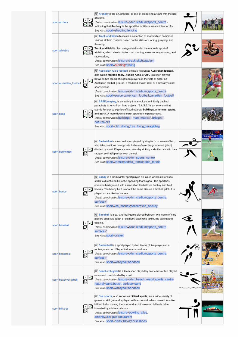
sport archery
Archery is the art, practice, or skill of propelling arrows with the use
of a bow.
Useful combination: leisure=pitch;stadium;sports_centre -
Indicating that Archery is the sport the facility or area is intended for.
See Also: sport=shooting;fencing
sport athletics
Track and field athletics is a collection of sports which combines
various athletic contests based on the skills of running, jumping, and
throwing.
Track and field is often categorised under the umbrella sport of
athletics, which also includes road running, cross country running, and
race walking.
Useful combination: leisure=track;pitch;stadiumSee Also: sport=running;cycling
sport australian_football
Australian rules football, officially known as Australian football,also called football, footy, Aussie rules, or AFL is a sport played
between two teams of eighteen players on the field of either an
Australian football ground, a modified cricket field, or a similarly sized
sports venue.
Useful combination: leisure=pitch;stadium;sports_centreSee Also: sport=soccer;american_football;canadian_football
sport base
BASE jumping, is an activity that employs an initially packed
parachute to jump from fixed objects. "B.A.S.E." is an acronym that
stands for four categories of fixed objects: buildings, antennas, spans,
and earth. A more down to earth approach to parachuting.
Useful combination: building=*, man_made=*, bridge=*,natural=cliffSee Also: sport=cliff_diving;free_flying;paragliding
sport badminton
Badminton is a racquet sport played by singles or in teams of two,
who take positions on opposite halves of a rectangular court (pitch)
divided by a net. Players score points by striking a shuttlecock with their
racquet so that it passes over the net.
Useful combination: leisure=pitch;sports_centreSee Also: sport=tennis;paddle_tennis;table_tennis
sport bandy
Bandy is a team winter sport played on ice, in which skaters use
sticks to direct a ball into the opposing team's goal. The sport has
common background with association football, ice hockey and field
hockey. The bandy field is about the same size as a football pitch. It is
played on ice like ice hockey.
Useful combination: leisure=pitch;stadium;sports_centre,
surface=*See Also: sport=ice_hockey;soccer;field_hockey
sport baseball
Baseball is a bat-and-ball game played between two teams of nine
players on a field (pitch or stadium) each who take turns batting and
fielding.
Useful combination: leisure=pitch;stadium;sports_centre,
surface=*See Also: sport=cricket
sport basketball
Basketball is a sport played by two teams of five players on a
rectangular court. Played indoors or outdoors
Useful combination: leisure=pitch;stadium;sports_centre,
surface=*See Also: sport=volleyball;handball
sport beachvolleyball
Beach volleyball is a team sport played by two teams of two players
on a sand court divided by a net.
Useful combination: leisure=pitch;beach_resort;sports_centre,
natural=sand;beach, surface=sandSee Also: sport=volleyball;handball
sport billiards
Cue sports, also known as billiard sports, are a wide variety of
games of skill generally played with a cue stick which is used to strike
billiard balls, moving them around a cloth-covered billiards table
bounded by rubber cushions.
Useful combination: leisure=bowling_alley,
amenity=bar;pub;restaurantSee Also: sport=darts;10pin;horseshoes

sport bmx
BMX or Bicycle motocross is a cycle sport performed on BMX
bikes, either in competitive BMX racing or freestyle BMX, or else in
general on- or off-road recreation.
Useful combination: leisure=track;pitch;sports_centre,
surface=earth, length=*, lanes=*, surface=*See Also: sport=cycling
sport bobsleigh
Bobsleigh, Luge, or Bobslede is a winter sport in which teams of two
or four make timed runs down narrow, twisting, banked, iced tracks in a
gravity-powered sled.
Useful combination: leisure=track;sports_centre, surface=*See Also: sport=toboggan, Piste Maps, OpenPisteMap, Winter sports
sport boules
Boules (Pétanque, lyonnaise, bocce, and bocce volo) is a group of
games in which the objective is to throw or roll heavy balls as close as
possible to a small target ball.
DO NOT USE this old style combined with the tag type=* when
describing the type of game. This is meant to specify the type of
relations.
Useful combination: leisure=pitch;sports_centre, surface=*, For
game type use boules=petanque;lyonnaise;bocceSee Also: sport=bowls;pelota;10pin, sport=9pin;horseshoes
sport bowls
Bowls or lawn bowls is a sport in which the objective is to roll biased
balls so that they stop close to a smaller ball called a "jack" or "kitty". It is
played on a pitch which may be flat (for "flat-green bowls") or convex or
uneven (for "crown-green bowls"). It is normally played outdoors
(although there are many indoor venues) and the outdoor surface is
either natural grass, artificial turf, or cotula (in New Zealand).
Useful combination: leisure=pitch;stadium;sports_centre,
surface=*See Also: sport=boules;pelota;10pin, sport=9pin;horseshoes
sport boxing
Boxing (pugilism, prize fighting, the sweet science or in Greek
pygmachia) is a combat sport played in a boxing ring in which two
people engage in a contest of strength, speed, reflexes, endurance, and
will, by throwing punches with gloved hands against each other.
Useful combination: leisure=stadium;sports_centre;pitch,
surface=*See Also: sport=aikido;fencing;athletics
sport canadian_football
Canadian football (CFL) is a form of gridiron football played in
Canada in which two teams of 12 players each compete for territorial
control of a field of play called a pitch. In Canada, the term football may
refer to Canadian football and American football collectively, or either
sport specifically, depending on context.
Useful combination: leisure=pitch;stadium;sports_centre and
surface=*See Also:
sport=american_football;australian_football;rugby_league,
sport=soccer;rugby_union
sport canoe
Canoe and Kayak are a narrow human-powered boats, primarily
designed to be manually propelled by means of a paddle for the use of
racing, whitewater canoeing, touring and camping, freestyle, and
general recreation. The intended use of the canoe dictates its hull shape
and construction material.
Useful combination: landuse=recreation_ground,
leisure=sports_centre, amenity=canoe_hire;boat_rental,club=*, shop=*See Also: sport=water_ski;swimming;surfing
sport chess
Chess is a two-player strategy board game played on a chessboard.
The intended use is for big chess-boards in the open air.
Useful combination: leisure=pitch;picnic_tableSee Also: club=chess
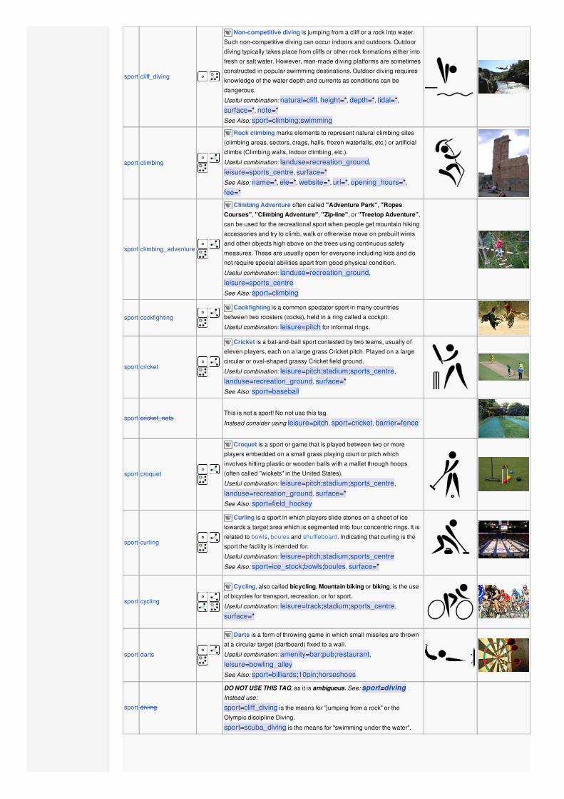
sport cliff_diving
Non-competitive diving is jumping from a cliff or a rock into water.
Such non-competitive diving can occur indoors and outdoors. Outdoor
diving typically takes place from cliffs or other rock formations either into
fresh or salt water. However, man-made diving platforms are sometimes
constructed in popular swimming destinations. Outdoor diving requires
knowledge of the water depth and currents as conditions can be
dangerous.
Useful combination: natural=cliff, height=*, depth=*, tidal=*,surface=*, note=*See Also: sport=climbing;swimming
sport climbing
Rock climbing marks elements to represent natural climbing sites
(climbing areas, sectors, crags, halls, frozen waterfalls, etc.) or artificial
climbs (Climbing walls, Indoor climbing, etc.).
Useful combination: landuse=recreation_ground,
leisure=sports_centre, surface=*See Also: name=*, ele=*, website=*, url=*, opening_hours=*,fee=*
sport climbing_adventure
Climbing Adventure often called "Adventure Park", "RopesCourses", "Climbing Adventure", "Zip-line", or "Treetop Adventure",
can be used for the recreational sport when people get mountain hiking
accessories and try to climb, walk or otherwise move on prebuilt wires
and other objects high above on the trees using continuous safety
measures. These are usually open for everyone including kids and do
not require special abilities apart from good physical condition.
Useful combination: landuse=recreation_ground,
leisure=sports_centreSee Also: sport=climbing
sport cockfighting
Cockfighting is a common spectator sport in many countries
between two roosters (cocks), held in a ring called a cockpit.
Useful combination: leisure=pitch for informal rings.
sport cricket
Cricket is a bat-and-ball sport contested by two teams, usually of
eleven players, each on a large grass Cricket pitch. Played on a large
circular or oval-shaped grassy Cricket field ground.
Useful combination: leisure=pitch;stadium;sports_centre,
landuse=recreation_ground, surface=*See Also: sport=baseball
sport cricket_netsThis is not a sport! No not use this tag.
Instead consider using leisure=pitch, sport=cricket, barrier=fence
sport croquet
Croquet is a sport or game that is played between two or more
players embedded on a small grass playing court or pitch which
involves hitting plastic or wooden balls with a mallet through hoops
(often called "wickets" in the United States).
Useful combination: leisure=pitch;stadium;sports_centre,
landuse=recreation_ground, surface=*See Also: sport=field_hockey
sport curling
Curling is a sport in which players slide stones on a sheet of ice
towards a target area which is segmented into four concentric rings. It is
related to bowls, boules and shuffleboard. Indicating that curling is the
sport the facility is intended for.
Useful combination: leisure=pitch;stadium;sports_centreSee Also: sport=ice_stock;bowls;boules, surface=*
sport cycling
Cycling, also called bicycling, Mountain biking or biking, is the use
of bicycles for transport, recreation, or for sport.
Useful combination: leisure=track;stadium;sports_centre,
surface=*
sport darts
Darts is a form of throwing game in which small missiles are thrown
at a circular target (dartboard) fixed to a wall.
Useful combination: amenity=bar;pub;restaurant,leisure=bowling_alleySee Also: sport=billiards;10pin;horseshoes
sport diving
DO NOT USE THIS TAG, as it is ambiguous. See: sport=divingInstead use:
sport=cliff_diving is the means for "jumping from a rock" or the
Olympic discipline Diving.
sport=scuba_diving is the means for "swimming under the water".
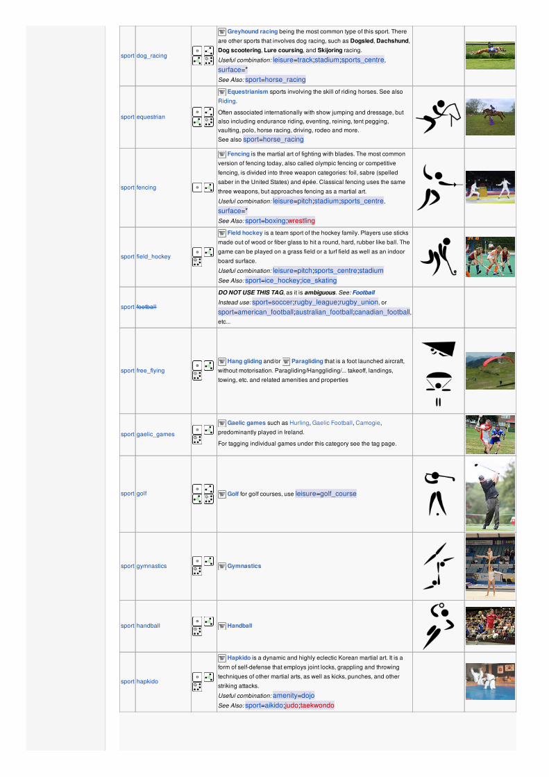
sport dog_racing
Greyhound racing being the most common type of this sport. There
are other sports that involves dog racing, such as Dogsled, Dachshund,
Dog scootering, Lure coursing, and Skijoring racing.
Useful combination: leisure=track;stadium;sports_centre,
surface=*See Also: sport=horse_racing
sport equestrian
Equestrianism sports involving the skill of riding horses. See also
Riding.
Often associated internationally with show jumping and dressage, butalso including endurance riding, eventing, reining, tent pegging,vaulting, polo, horse racing, driving, rodeo and more.
See also sport=horse_racing
sport fencing
Fencing is the martial art of fighting with blades. The most common
version of fencing today, also called olympic fencing or competitive
fencing, is divided into three weapon categories: foil, sabre (spelled
saber in the United States) and épée. Classical fencing uses the same
three weapons, but approaches fencing as a martial art.
Useful combination: leisure=pitch;stadium;sports_centre,
surface=*See Also: sport=boxing;wrestling
sport field_hockey
Field hockey is a team sport of the hockey family. Players use sticks
made out of wood or fiber glass to hit a round, hard, rubber like ball. The
game can be played on a grass field or a turf field as well as an indoor
board surface.
Useful combination: leisure=pitch;sports_centre;stadiumSee Also: sport=ice_hockey;ice_skating
sport football
DO NOT USE THIS TAG, as it is ambiguous. See: Football
Instead use: sport=soccer;rugby_league;rugby_union, or
sport=american_football;australian_football;canadian_football,etc...
sport free_flying
Hang gliding and/or Paragliding that is a foot launched aircraft,
without motorisation. Paragliding/Hanggliding/... takeoff, landings,
towing, etc. and related amenities and properties
sport gaelic_games
Gaelic games such as Hurling, Gaelic Football, Camogie,
predominantly played in Ireland.
For tagging individual games under this category see the tag page.
sport golf
Golf for golf courses, use leisure=golf_course
sport gymnastics
Gymnastics
sport handball
Handball
sport hapkido
Hapkido is a dynamic and highly eclectic Korean martial art. It is a
form of self-defense that employs joint locks, grappling and throwing
techniques of other martial arts, as well as kicks, punches, and other
striking attacks.
Useful combination: amenity=dojoSee Also: sport=aikido;judo;taekwondo
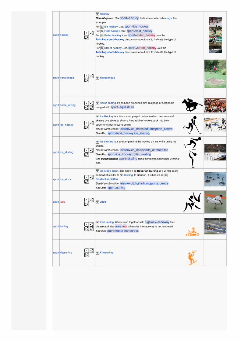
sport hockey
Hockey
Disambiguous. See sport=hockey. Instead consider other tags. For
example:
For Ice hockey Use: sport=ice_hockeyFor Field hockey Use: sport=field_hockeyFor Roller hockey Use: sport=roller_hockey Join the
Talk:Tag:sport=hockey discussion about how to indicate the type of
hockey.
For Street hockey Use: sport=street_hockey Join the
Talk:Tag:sport=hockey discussion about how to indicate the type of
hockey.
sport horseshoes
Horseshoes
sport horse_racing
Horse racing. It has been proposed that this page or section be
merged with sport=equestrian
sport ice_hockey
Ice Hockey is a team sport played on ice in which two teams of
skaters use sticks to shoot a hard rubber hockey puck into their
opponent's net to score points.
Useful combination: leisure=ice_rink;stadium;sports_centreSee Also: sport=field_hockey;ice_skating
sport ice_skating
Ice skating is a sport or pastime by moving on ice while using ice
skates.
Useful combination: leisure=ice_rink;sports_centre;pitchSee Also: sport=ice_hockey;roller_skatingThe disambiguous sport=skating tag is sometimes confused with this
one.
sport ice_stock
Ice stock sport, also known as Bavarian Curling, is a winter sport,
somewhat similar to Curling. In German, it is known as
Eisstockschießen
Useful combination: leisure=pitch;stadium;sports_centreSee Also: sport=curling
sport judo
Judo
sport karting
Kart racing. When used together with highway=raceway then
please add also area=no, otherwise the raceway is not rendered.
See also sport=motor;motocross
sport kitesurfing
Kitesurfing
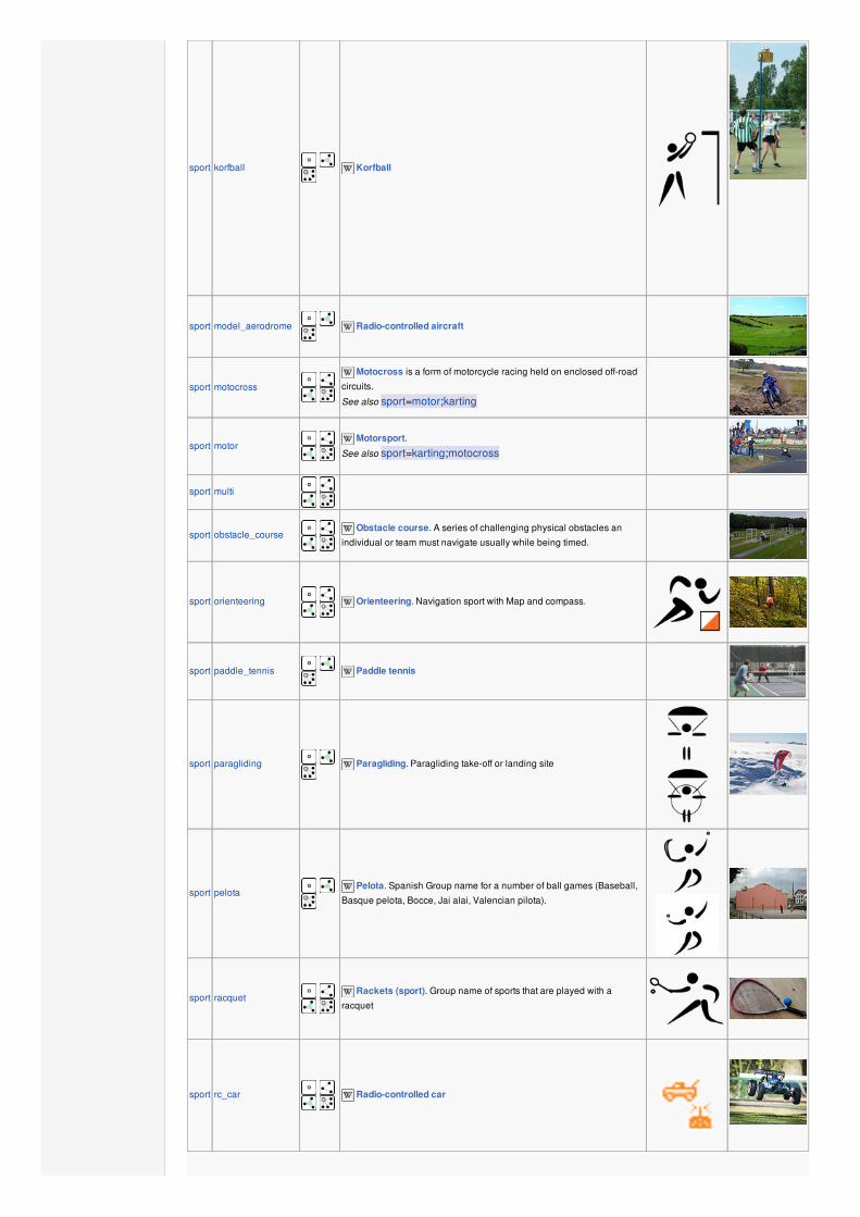
sport korfball
Korfball
sport model_aerodrome
Radio-controlled aircraft
sport motocross
Motocross is a form of motorcycle racing held on enclosed off-road
circuits.
See also sport=motor;karting
sport motor
Motorsport.
See also sport=karting;motocross
sport multi
sport obstacle_course
Obstacle course. A series of challenging physical obstacles an
individual or team must navigate usually while being timed.
sport orienteering
Orienteering. Navigation sport with Map and compass.
sport paddle_tennis
Paddle tennis
sport paragliding
Paragliding. Paragliding take-off or landing site
sport pelota Pelota. Spanish Group name for a number of ball games (Baseball,
Basque pelota, Bocce, Jai alai, Valencian pilota).
sport racquet
Rackets (sport). Group name of sports that are played with a
racquet
sport rc_car
Radio-controlled car
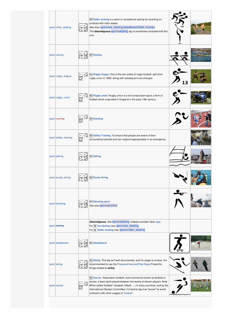
sport roller_skating
Roller skating is a sport or recreational activity by travelling on
surfaces with roller skates.
See Also: sport=ice_skating;skateboard;field_hockeyThe disambiguous sport=skating tag is sometimes confused with this
one.
sport rowing
Rowing
sport rugby_league Rugby league. One of the two codes of rugby football, split from
rugby union in 1895, along with subsequent rule changes
sport rugby_union Rugby union. Rugby union is a full contact team sport, a form of
football which originated in England in the early 19th century.
sport running
Running
sport safety_training Safety Training. To ensure that people are aware of their
surrounding hazards and can respond appropriately in an emergency.
sport sailing
Sailing
sport scuba_diving
Scuba diving
sport shooting
Shooting sport
See also sport=archery
sport skating
Disambiguous. See sport=skating. Instead consider other tags.
For Ice skating Use: sport=ice_skatingFor Roller skating Use: sport=roller_skating
sport skateboard
Skateboard
sport skiing
Skiing. This tag isn't well documented, and it's usage is unclear. It is
recommended to use the Proposed features/Piste Maps Project for
things related to skiing
sport soccer
Soccer. Association football, more commonly known as football or
soccer, a team sport played between two teams of eleven players. Note:
While called "football" (fussball, fotball, …) in many countries, and by the
International Olympic Committee, it is best to tag it as "soccer" to avoid
confusion with other usages of "football"

sport surfing
Surfing
sport swimming
Swimming
sport table_tennis
Table tennis
sport table_soccer
Table Soccer or Table Football, also known as Foosball, Fussball,
Kicker, or Tecball, is a table-top game and sport based off association
football (soccer).
Useful combination: amenity=pub;bar;restaurantSee Also: sport=soccer;table_tennis;billiards,
leisure=amusement_arcade;adult_gaming_centre,
club=table_soccer
sport taekwondo
Taekwondo
sport team_handball
DO NOT USE THIS TAG, as it is ambiguous. See:
sport=team_handballInstead use:
sport=handball which is a team sport in which two teams of seven
players each pass a ball to throw it into the goal of the other team.
sport tennis
Tennis
sport toboggan
Toboggan. public sledding run; see also Piste Maps (piste:type=sled,
piste:difficulty=advanced, piste:lit=yes)
sport volleyball
Volleyball
sport water_ski
Waterskiing either on a cable ski course, or pulled by a boat.
sport weightlifting
Olympic weightlifting
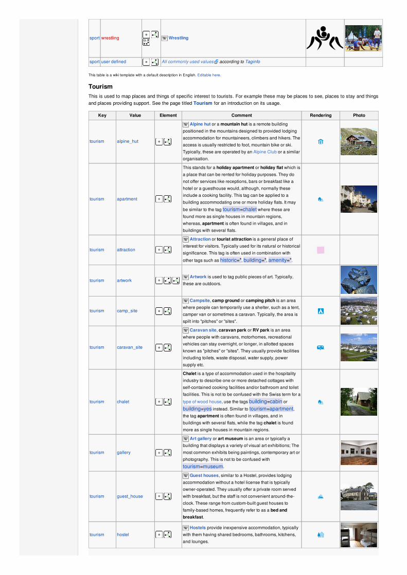
sport wrestling
Wrestling
sport user defined All commonly used values according to Taginfo
This table is a wiki template with a default description in English. Editable here.
TourismThis is used to map places and things of specific interest to tourists. For example these may be places to see, places to stay and thingsand places providing support. See the page titled Tourism for an introduction on its usage.
Key Value Element Comment Rendering Photo
tourism alpine_hut
Alpine hut or a mountain hut is a remote building
positioned in the mountains designed to provided lodging
accommodation for mountaineers, climbers and hikers. The
access is usually restricted to foot, mountain bike or ski.
Typically, these are operated by an Alpine Club or a similar
organisation.
tourism apartment
This stands for a holiday apartment or holiday flat which is
a place that can be rented for holiday purposes. They do
not offer services like receptions, bars or breakfast like a
hotel or a guesthouse would, although, normally these
include a cooking facility. This tag can be applied to a
building accommodating one or more holiday flats. It may
be similar to the tag tourism=chalet where these are
found more as single houses in mountain regions,
whereas, apartment is often found in villages, and in
buildings with several flats.
tourism attraction
Attraction or tourist attraction is a general place of
interest for visitors. Typically used for its natural or historical
significance. This tag is often used in combination with
other tags such as historic=*, building=*, amenity=*.
tourism artwork Artwork is used to tag public pieces of art. Typically,
these are outdoors.
tourism camp_site
Campsite, camp ground or camping pitch is an area
where people can temporarily use a shelter, such as a tent,
camper van or sometimes a caravan. Typically, the area is
spilt into "pitches" or "sites".
tourism caravan_site
Caravan site, caravan park or RV park is an area
where people with caravans, motorhomes, recreational
vehicles can stay overnight, or longer, in allotted spaces
known as "pitches" or "sites". They usually provide facilities
including toilets, waste disposal, water supply, power
supply etc.
tourism chalet
Chalet is a type of accommodation used in the hospitality
industry to describe one or more detached cottages with
self-contained cooking facilities and/or bathroom and toilet
facilities. This is not to be confused with the Swiss term for a
type of wood house, use the tags building=cabin or
building=yes instead. Similar to tourism=apartment,the tag apartment is often found in villages, and in
buildings with several flats, while the tag chalet is found
more as single houses in mountain regions.
tourism gallery
Art gallery or art museum is an area or typically a
building that displays a variety of visual art exhibitions; The
most common exhibits being paintings, contemporary art or
photography. This is not to be confused with
tourism=museum.
tourism guest_house
Guest houses, similar to a Hostel, provides lodging
accommodation without a hotel license that is typically
owner-operated. They usually offer a private room served
with breakfast, but the staff is not convenient around-the-
clock. These range from custom-built guest houses to
family-based homes, frequently refer to as a bed andbreakfast.
tourism hostel Hostels provide inexpensive accommodation, typically
with them having shared bedrooms, bathrooms, kitchens,
and lounges.

tourism hotel
Hotels provide accommodation for guests with usually
numbered rooms. Some facilities provided may include a
basic bed, storage for clothing and additional guest
facilities may include swimming pool, childcare, and
conference facilities.
tourism information
Information, visitor center or centre, visitorinformation center or tourist information center is an
information source for tourists, travellers and visitors. To
additionally describe the kind of information use the tag
information=*.
tourism motel
Motel is an abbreviation which is shortened by the term
"motor hotel". It's an establishment that provides
accommodation designed for motorists usually on a short-
term basis, with convenient parking for motor cars at or
close to the room.
tourism museum Museum is an institution which has exhibitions on
scientific, historical, artistic, or cultural artifacts. Typically
these are open to the public as a tourist attraction.
tourism picnic_site
Picnic site is an area that is suitable for eating outdoors
and may have a number of facilities within it. For example
they might include: toilets, water taps for drinking or
cleaning, BBQ grills, benches, table with benches (picnic
tables) and covered structures for bad weather. They also
may be used on a grassy area that is popular for picnics.
tourism theme_park
Theme park or amusement park is an area where
entertainment is provided by rides, game concessions, etc.,
catering to large numbers to people. For example:
Disneyland and Six Flags.
tourism viewpoint
Viewpoint, also known as a overlook, observationpoint, lookout, viewing point, scenic area or vista point isa place for visitors, often high, with good a scenery view of
the surrounding countryside or notable buildings.
tourism wilderness_hut
Wilderness hut or backcountry hut is a remote
building, with generally a fireplace, intended to provide
temporary shelter and sleeping accommodation. See also
Bothy
tourism zoo Zoo is an abbreviation for a zoological garden or park
that has confined animals on display for viewing by the
public.
tourism yes To add tourist interest to something described by other
tags.
tourism user defined All commonly used values according to Taginfo
This table is a wiki template with a default description in English. Editable here.
WaterwayThis is used to described different types of waterways. When mapping the way of a river, stream, drain, canal, etc. these need to bealigned in the direction of the water flow. See the page titled Waterways for an introduction on its usage.
Key Value Element Comment Rendering Photo
Natural watercourses
waterway river
For narrow rivers which will be rendered as a line. For
larger rivers (defined as more than 12 m across) see
waterway=riverbank (Other languages ).
waterway riverbank
Used for larger rivers, to define an area between the
opposite riverbanks. See water=river for alternative
tagging.
waterway stream
A naturally-formed waterway that is too thin to be classed
as a river. An active, able-bodied person should be able to
jump over it if trees along it aren't too thick.
waterway wadi
A natural, dry (ephemeral) riverbed that contains water only
during times of heavy rain or simply an intermittent stream,
in semi-arid areas. Also known as a "Wash" in the deserts
of America.
Man made waterways

waterway canalAn artificial open waterway used for transportation,
waterpower, or irrigation.(Other languages ).
waterway drainAn artificial waterway for carrying storm water or industrial
discharge.
waterway ditch A small to moderate depression created to channel water.
Facilities
waterway dock An 'enclosed' area of water used for building or repairing
ships.
waterway boatyardBoat yard – a place for constructing, repairing and storing
vessels out of the water.
Barriers on waterways
waterway dam A wall built across a river or stream to impound the water. A
dam normally does not have water flowing over the top of it.
waterway weir A barrier built across a river, sometimes to divert water for
industrial purposes. Water can still flow over the top.
waterway lock_gate
To mark the position of gates at each end of a lock.
Alternatively, for smaller locks use a single lock=yes node
in the middle of the lock.
Other features on waterways
waterway turning_point
A place to turn the driving direction for vessels, where the
boats are longer than the river/canal is wide. Use
maxlength=* to denote the maximum length of the vessel.
waterway water_pointThis tag is for ports/marinas where you can get large
amounts of potable water.
Some additional attributes for waterways
intermittent yesIndicates that the waterway does not have a permanent
flow (i.e. is sometimes/often dry).
lock yes ( )
A lock is used for moving boats between waterways at two
different levels. Can tag either the section of the way
between the gates (detailed) or just a single node in the
waterway (less detailed).
mooring yes, private, noA length of bank where boats are explicitly permitted to
moor. maxstay=* should be used for timing information.
service
transportation,
water_power,
irrigation
A waterway=canal may have one (or more; separate with
semicolons) uses.
tunnel culvert ( )
For a stream passing under a road use tunnel=culvert on
the section of stream passing under the road (don't use this
tag for open-top culverts or roads using the culvert structure
as a bridge (bridge=culvert)).
waterway user defined All commonly used values according to Taginfo
This table is a wiki template with a default description in English. Editable here.
Additional properties
AddressesThis is used to provide postal information for a building or facility. See the pages titled Addresses and addr=* for an introduction on itsusage.
Key Value Element Comment Rendering Photo

Tags for individual houses
addr:housenumber user defined
The house number (may contain letters,
dashes or other characters).
Addresses describes ways to tag a single
building with multiple addresses.
Please do not only tag
addr:housenumber=*, but also add at least
addr:street=* (or map the belonging to a
street with a relation using associatedStreet
relation).
addr:housename user defined
The name of a house.
This is sometimes used in some countries like
England instead of (or in addition to) a house
number.
addr:street user defined
The (main) name of the respective street.
A way with highway=* and the corresponding
name should be found nearby. The belonging
to a street can alternatively be represented by
a associatedStreet relation. The keys
addr:housenumber=* and addr:street=* inprinciple are the only necessary ones if there
are valid border polygons. If you are not sure if
it is so, just add addr:city=*,addr:postcode=* and addr:country=*.
addr:place user defined This is usually part of address, which is not
related to street, but to some territorial zone,
linear object, node or some abstract object.
addr:postcode user defined The postal code of the building/area.
addr:flats user defined Marking numbers of flats behind door.
addr:city user defined
May or may not be a clone of is_in:city=* (insome places the city in the address
corresponds to the post office that serves the
area rather than the actual city, if any, in which
the building is located)! The name of the city as
given in postal addresses of the building/area.
addr:country user defined
The ISO 3166-1 alpha-2 two letter country code
in upper case.
Example: "DE" for Germany, "FR" for France,
"IT" for Italy.
Caveat: The ISO 3166-1 code for Great Britain
is "GB" and not "UK".. See also:
is_in:country=*
addr:full user defined
Use this for a full-text, often multi-line, address
if you find the structured address fields
unsuitable for denoting the address of this
particular location. Examples: "Fifth house on
the left after the village oak, Smalltown,
Smallcountry" or "1200 West Sunset Boulevard
Suite 110A". Beware that these strings can
hardly be parsed by software.
For countries using hamlet, subdistrict, district, province, state
addr:hamlet user defined The hamlet of the object.
addr:suburb user defined If an address exists several times in a city. You
have to add the name of the settlement. See
Australian definition of suburb.
addr:subdistrict user defined The subdistrict of the object.
addr:district user defined The district of the object.
addr:province user defined The province of the object.
addr:state user defined The state of the object. For the US, uppercase
two-letter postal abbreviations (AK, CA, HI, NY,
TX, WY, etc.) are used.
Tags for interpolation ways
addr:interpolation all/even/odd/ alphabetic
How to interpolate the house numbers
belonging to the way along the respective
street.
See detailed description.
addr:interpolation NumberEvery nth house between the end nodes is
represented by the interpolation way.

addr:inclusion actual/estimate/potential
Optional tag to indicate the accuracy level of
survey used to create the address interpolation
way.
See detailed description.
This section is a wiki template with a default description in English. Editable here.
AnnotationProviding further information about tag values for other mappers and in some cases also for users. See the page titled Annotations foran introduction on its usage.
Key Value Element Comment Rendering Photo
attribution User defined Attribution to originator if required
comment User defined
Comment. Usually a description of a changeset
primarily for other mappers. See note=* for nodes,
ways and relations.
description User defined Text that might be viewable to the end user (perhaps
using a search system or a map with pop-ups)
email User defined E-Mail address associated with an object
fax User defined Fax number associated with an object
fixme User defined A description to yourself or to other mappers of a
(possible) error in the map
image URL Reference to an image (use the source_ref=* key
below when the image is referencing the source of the
element)
note User defined A note to yourself or to other mappers.
phone User defined Telephone number associated with an object
source User defined Indicates the source of some information added to
OpenStreetMap.
source extrapolation Extension of information from a known source
source historical From out-of-copyright mapping or other historical
document
source image Photograph or video
source knowledge Local or common knowledge
source survey
Track from GPS unit (usually GPX fomat) or other
physical survey; suggested addition -
survey:date=YYYY-MM-DD
source voice Voice recordings; e.g., dictaphone
source:name User defined Source used to gather name information; e.g., for street
names
source:ref User defined Reference data source; e.g., for road numbers
source_ref User defined To record the URI, source reference (e.g., Landsat) or
other link to physical sources
todo User defined A text note to yourself or another mapper describing
how the particular element can be improved
url URL
URL associated with an object. Use more meaningful
keys like website=*, image=* or wikipedia=* where
applicable!
website URL Official website of an object
wikipediaLanguage and
article title Wikipedia article associated with an object
This table is a wiki template with a default description in English. Editable here.
NameThe name tag is the primary tag used for naming a Element. See the page titled Names for an introduction on its usage.
Key Value Element Comment
name User Defined The common default name. (Note: For disputed areas, please use the name as displayed on
e.g. street signs for the name tag. Put all alternatives into either localized name tags (e.g.
name:tr/name:el) or the variants (e.g. loc_name/old_name/alt_name). Thank you.)
name:<lg> User Defined Name in different language eg. name:fr=Londres. See: Multilingual names
alt_name User Defined another name or names by which the feature is known e.g. name=Field Fare Road and
alt_name=Fieldfare Road, or name=University Centre and alt_name=Grad Pad
alt_name:<lg> User Defined Alternative name in different language eg. alt_name:fr=Londres. See: Multilingual names
int_name User Defined International name (note: consider using language specific names instead, e.g. name:en=... -
see above – International does not (necessarily) mean English)
loc_name User Defined Local name
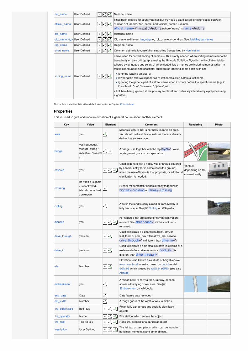
nat_name User Defined National name
official_name User Defined
It has been created for country names but we need a clarification for other cases between
"name", "int_name", "loc_name" and "official_name". Example:
official_name=Principat d'Andorra (where "name" is name=Andorra)
old_name User Defined Historical name
old_name:<lg> User Defined Old name in different language eg. old_name:fr=Londres. See: Multilingual names
reg_name User Defined Regional name
short_name User Defined Common abbreviation, useful for searching (recognized by Nominatim)
sorting_name User Defined
name, used for correct sorting of names — This is only needed when sorting names cannot be
based only on their orthography (using the Unicode Collation Algorithm with collation tables
tailored by language and script, or when sorted lists of names are including names written in
multiple languages and/or scripts) but requires ignoring some parts such as:
ignoring leading articles, or
lowering the relative importance of first names cited before a last name,
ignoring the generic part of a street name when it occurs before the specific name (e.g. inFrench with "rue", "boulevard", "place", etc.),
all of them being ignored at the primary sort level and not easily inferable by a preprocessingalgorithm.
This table is a wiki template with a default description in English. Editable here.
PropertiesThis is used to give additional information of a general nature about another element.
Key Value Element Comment Rendering Photo
area yes
Means a feature that is normally linear is an area.
You should not add this to features that are already
defined as an area type.
bridge
yes / aqueduct /
viaduct / swing /
movable / covered
/ …
A bridge, use together with the tag layer=*. Value
yes is generic, or you can specialize.
covered yes
Used to denote that a node, way or area is covered
by another entity (or in some cases the ground),
when the use of layers is inappropriate, or additional
clarification is needed.
Various,
depending on the
covered entity
crossing
no / traffic_signals
/ uncontrolled /
island / unmarked
/ unknown
Further refinement for nodes already tagged with
highway=crossing or railway=crossing
cutting yesA cut in the land to carry a road or tram. Mostly in
hilly landscape. See Cutting on Wikipedia
disused yes
For features that are useful for navigation, yet are
unused. See abandoned=* if infrastructure is
removed.
drive_through yes / no
Used to indicate if a pharmacy, bank, atm, or
fast_food, or post_box offers drive_thru service.
drive_through=* is different than drive_in=*}
drive_in yes / no
Used to indicate if a cinema is a drive-in cinema or a
restaurant offers drive-in service. drive_in=* isdifferent than drive_through=*
ele Number
Elevation (also known as altitude or height) above
mean sea level in metre, based on geoid model
EGM 96 which is used by WGS 84 (GPS). (see also
Altitude)
embankment yes
A raised bank to carry a road, railway, or canal
across a low-lying or wet area. See
Embankment on Wikipedia
end_date Date Date feature was removed
est_width Number A rough guess of the width of way in metres
fire_object:type poo / szo Potentially dangerous and socially significant
objects
fire_operator Name Fire station, which serves the object
fire_rank 1bis / 2 to 5 Rank fire, defined for a particular object
inscription User Defined The full text of inscriptions, which can be found on
buildings, memorials and other objects.
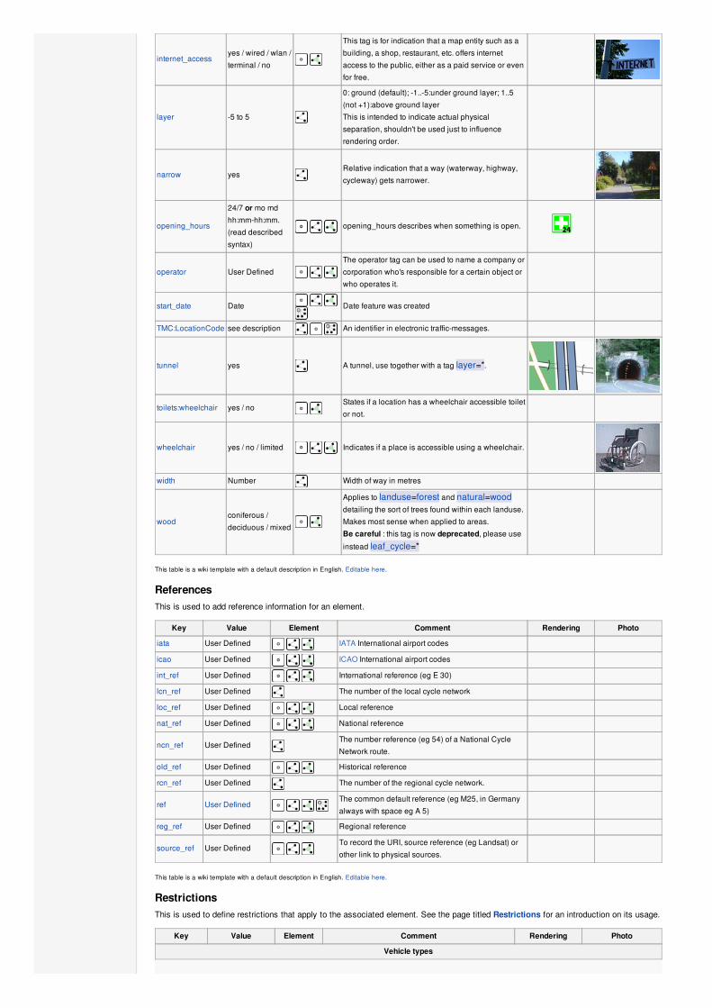
internet_accessyes / wired / wlan /
terminal / no
This tag is for indication that a map entity such as a
building, a shop, restaurant, etc. offers internet
access to the public, either as a paid service or even
for free.
layer -5 to 5
0: ground (default); -1..-5:under ground layer; 1..5
(not +1):above ground layer
This is intended to indicate actual physical
separation, shouldn't be used just to influence
rendering order.
narrow yesRelative indication that a way (waterway, highway,
cycleway) gets narrower.
opening_hours
24/7 or mo md
hh:mm-hh:mm.
(read described
syntax)
opening_hours describes when something is open.
operator User Defined The operator tag can be used to name a company or
corporation who's responsible for a certain object or
who operates it.
start_date Date
Date feature was created
TMC:LocationCode see description An identifier in electronic traffic-messages.
tunnel yes A tunnel, use together with a tag layer=*.
toilets:wheelchair yes / no States if a location has a wheelchair accessible toilet
or not.
wheelchair yes / no / limited Indicates if a place is accessible using a wheelchair.
width Number Width of way in metres
woodconiferous /
deciduous / mixed
Applies to landuse=forest and natural=wooddetailing the sort of trees found within each landuse.
Makes most sense when applied to areas.
Be careful : this tag is now deprecated, please use
instead leaf_cycle=*
This table is a wiki template with a default description in English. Editable here.
ReferencesThis is used to add reference information for an element.
Key Value Element Comment Rendering Photo
iata User Defined IATA International airport codes
icao User Defined ICAO International airport codes
int_ref User Defined International reference (eg E 30)
lcn_ref User Defined The number of the local cycle network
loc_ref User Defined Local reference
nat_ref User Defined National reference
ncn_ref User DefinedThe number reference (eg 54) of a National Cycle
Network route.
old_ref User Defined Historical reference
rcn_ref User Defined The number of the regional cycle network.
ref User Defined The common default reference (eg M25, in Germany
always with space eg A 5)
reg_ref User Defined Regional reference
source_ref User Defined To record the URI, source reference (eg Landsat) or
other link to physical sources.
This table is a wiki template with a default description in English. Editable here.
RestrictionsThis is used to define restrictions that apply to the associated element. See the page titled Restrictions for an introduction on its usage.
Key Value Element Comment Rendering Photo
Vehicle types

access
agricultural /
delivery /
designated /
destination /
forestry / no /
official /
permissive /
private / unknown
/ yes
General access permission.
agricultural – Only for agricultural traffic
delivery – Only when delivering to the element.
designated – A preferred or designated route for aspecific vehicle type or types. Not compulsory butoften marked by a traffic sign
destination – Used for ways in designated localtraffic areas, where traffic should only enter if itsdestination is within the area
forestry – Only for forestry traffic
no – No access for the general public. Considerusing another tag indicating who can use theelement
official – The way is dedicated to a specific modeof travel by law. Usually marked by traffic signs andexclusive. In Germany use is also compulsory.clarification needed
permissive – Open to general traffic until such timeas the owner revokes the permission which theyare legally allowed to do at any time in the future.
private – Only with permission of the owner on anindividual basis
unknown – No information provided on access.This is the default value for most features with ageneral assumption that access is allowed for allpurposes
yes – The public has an official, legal right ofaccess, i.e. it's a right of way (default value)
agricultural yes / noAccess permission for agricultural vehicles, e.g.
tractors.
atvFor values see
access above
Access restricted to wheeled vehicles 1.27m (50
inches) or less in width, for example ATV
bdoubleFor values see
access above
Access permission for Road Train B-double. A B-
double (B-Train) consists of a prime mover towing a
specialised trailer (known as a "lead" or "A"-trailer) that
has a fifth-wheel mounted on the rear towing another
semi-trailer, resulting in two articulation points.
bicycle
For values see
access above +
dismount
Access permission for bicycles. Usage of
bicycle=dismount and bicycle=no will vary in
different countries. If according to local traffic rules a
bicycle is no longer seen as a bicycle when there's no
one driving it, then there's no need for using
bicycle=dismount. If the local legislation still sees
an undriven bicycle as a bicycle then you may need to
use both bicycle=dismount and bicycle=no.
boatFor values see
access above
Access permission for small boats and pleasure crafts,
including yachts
emergency yesAccess permission for emergency motor vehicles; e.g.,
ambulance, fire truck, police car
footFor values see
access aboveAccess permission for pedestrians.
forestry yes / no Access permission for forestry vehicles, e.g. tractors.
goodsFor values see
access above
Access permission for light commercial vehicles
(LCV) or goods vehicles of category N1 with a
maximum allowed mass of up to 3.5 tonnes. In the
USA, combined weight 26,000 lbs or less.
hazmatFor values see
access above
Access permission for vehicles carrying hazardous
materials.
hgvFor values see
access above
Access permission for Heavy Goods Vehicles
(HGV) (UK), e.g. for goods vehicles of category N2
and N3 (trucks, lorries) with a maximum allowed mass
over 3.5 tonnes. In the USA, combined weight 26,001
lbs or greater.
horseFor values see
access aboveAccess permission for horse riders.
inline_skates yes / no Access permission for Inline Skates
lhvFor values see
access above
Access permission for Longer Heavier Vehicle
(LHV), e.g. for vehicles with 6 axles and can carry up
to 44 metric tons

This page was last modified on 28 August 2014, at 18:56.
Content is available under Creative Commons Attribution-ShareAlike 2.0 license unless otherwise noted.
mofaFor values see
access aboveAccess permission for mofas
mopedFor values see
access aboveAccess permission for mopeds
motorboatFor values see
access above Access permission boats and yachts using motor
motorcarFor values see
access aboveAccess permission for (motor) cars
motorcycleFor values see
access aboveAccess permission for motorcycles
motor_vehicleFor values see
access aboveAccess permission for any motorized vehicle
psvFor values see
access above
Access permission for Public Service Vehicles (UK),
e.g. buses and coaches
roadtrainFor values see
access above
Access permission for Road train, A road train
consists of a relatively conventional tractor unit, but
instead of pulling one trailer or semi-trailer, the road
train pulls two or more of them.
skiFor values see
access above Access permission for skiers
tankFor values see
access above Access permission for (military) tanks
vehicleFor values see
access aboveAccess permission for all vehicles
4wd_only yesA road signed as only suitable for 4WD (offroad)
vehicles
Other
charge Number Amount of toll or fee. See toll=* as well
maxheight HeightHeight limit – units other than metres should be
explicit
maxlength LengthLength limit – units other than metres should be
explicit
maxspeed SpeedMaximum speed – units other than km/h should be
explicit
maxstay Number Maximum stay, in units given (hour/hours/day/days)
maxweight WeightWeight limit – units other than tonnes should be
explicit
maxwidth Width Width limit – units other than metres should be explicit
minspeed SpeedMinimum speed – units other than km/h should be
explicit
noexit yes A dead end road/cul de sac with only one access road
oneway yes / no / -1
oneway=yes for traffic direction same as the
sequence of nodes of the way.
oneway=no for bidirectional traffic.
oneway=-1 for traffic direction opposite to the
sequence of nodes of the way (if the way cannot be
reversed).
Some road types are assumed to be one-way (e.g.
highway=motorway), others are assumed to be
two-way (most others).
toll yesToll or fee must be paid to access way. See also
barrier=toll_booth
traffic_sign city_limitStart/end sign of city limits, in most countries implies a
specific "city maxspeed".
This table is a wiki template with a default description in English. Editable here.
Categories: Proposals admin Reference Tagging guidelines Features Semantics

Privacy policy About OpenStreetMap Wiki Disclaimers


![[en]=> (LV-CAN200) - Teltonika Wiki](https://static.fdokumen.com/doc/165x107/63348b9f4e43a4bcd80d4495/en-lv-can200-teltonika-wiki.jpg)