Wikidata + OpenStreetMap
68
Wikidata + OpenStreetMap Naveen Francis Digital Humanitarian @naveenpf
-
Upload
khangminh22 -
Category
Documents
-
view
0 -
download
0
Transcript of Wikidata + OpenStreetMap

Wikidata + OpenStreetMap
Naveen FrancisDigital Humanitarian
@naveenpf

CHAPTER 1
What is
Wikidata?

Wikidata is a CC0-licensed
structured knowledge base
under the Wikimedia umbrella
that contains over 60 million
items.

Wikidata was intended to
solve two things:
● The mess of interwiki
links in the Wikipedias● The duplication of data in
Wikipedia infoboxes

Now, all interwiki link data is
stored in Wikidata (with
some exceptions)…

…and Wikipedia infoboxes
can populate themselves
from Wikidata.

Wikidata probably has the
largest collection of linked
IDs to other third-party
databases, data sets, and
knowledge bases.

Wikidata has grown outside its
original purpose and is fast
becoming a central data hub
especially for GLAM
institutions (galleries, libraries,
archives, and museums).

Wikidata data model

OpenStreetMap has nodes,
ways, relations, tags, keys,
values, roles, etc.
© OpenStreetMap contributors,
ODbL 1.0

Wikidata has items,
statements,
properties, values,
qualifiers, etc.

Data modeling discussions on
the Wikidata:Project chat page
are actually quite similar to
discussions on OSM’s tagging
mailing list.
(Both projects struggle with
ontology issues because both
projects are examples of
folksonomies.)
© OpenStreetMap contributors, ODbL 1.0

Wikidata data is stored
as a bunch of triples.
The most basic triples
in Wikidata are called
statements.
This design is heavily based on
W3C’s Resource Description
Framework [RDF].
triple
=
subject
predicate
object
+
+

Triples, subjects, predicates, and
objects are represented as IRIs.
Earth has the IRI:
http://www.wikidata.org/entity/Q2
Or Q2 for short.
Wikidata triple
=
Earth(Q2)
instance of(P31)
inner planet(Q3504248)
+
+

Triples themselves can be
subjects of secondary triples,
allowing us to qualify and
add sourcing info. These
secondary triples are called
qualifiers and references,
respectively.
Heidelberg(Q2966)
population(P1082)
150,335
point in time(P585)
2012-12-31

Shown here are how various
triples, subjects, predicates,
and objects related to Curie
are represented in Wikidata,
and the common terms
Wikidatans use to refer to them
depending on context.

Aside: Wikidata also has
lexemes (L-namespace)
for lexicographic data,
structured data for
Wikimedia Commons (SDC)
(M-namespace), and
shape expressions
(E-namespace).

Wikidata Query
Service

The Wikidata Query Service
(WDQS) is the official API for
querying data from Wikidata.
Think: Overpass API/Turbo for
Wikidata.
https://query.wikidata.org

WDQS uses W3C’s SPARQL
as the query language.
https://www.w3.org/TR/sparql11-query/
https://www.wikidata.org/wiki/
Wikidata:SPARQL_tutorial

Wikidata tools and
apps

Monumental is a site that
allows you to explore built
heritage and learn more
about monuments.
https://monumental.toolforge.org/

Crotos is a search and display
engine for visual artworks,
based on Wikidata and using
Wikimedia Commons files.
http://zone47.com/crotos/
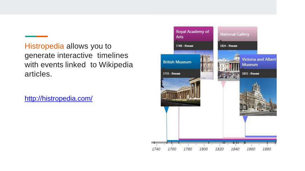
Histropedia allows you to
generate interactive timelines
with events linked to Wikipedia
articles.
http://histropedia.com/

More tools are listed on
Wikidata:
https://www.wikidata.org/wiki/Wiki
data:Tools/Visualize_data

CHAPTER 2
Linked Open Data

First: How OSM and
Wikimedia benefit from
each other

OSM has been used to
create maps to illustrate
Wikipedia articles and
populate Wikimedia
Commons.

OSM has been used to
create maps to illustrate
Wikipedia articles and
populate Wikimedia
Commons.
Bourrichon / CC BY-SA 3.0 .
https://commons.wikimedia.org/wiki/File:Macau_topographic_map-fr.svg

OSM powers the Wikimedia
Foundation’s Kartotherian map
tile service, which is used by
the Kartographer MediaWiki
extension and almost all other
interactive maps on the
Wikimedia projects.

The Wikimedia Foundation
released internationalized
map tiles for Kartotherian,
leveraging OSM’s name:*=*
tags.

WikiMiniAtlas, an older
MediaWiki plugin still in use in
many Wikipedias, is also
powered by OSM data,
including 3D building data.

Why link OSM and
Wikidata?

Tim Berners-Lee, the
inventor of the World Wide
Web and initiator of the W3C
Linked Data project,
suggested a 5 star
deployment scheme for
Linked Open Data.

1. On the Web
2. Machine-readable
3. Open data format
4. In RDF (use IRIs)
5. Linked to other datasets

Linked Open data (LOD)

Wikidata items on places
can link to OSM relations
using the OSM relation ID
(P402) property.

OSM objects can link to
corresponding Wikipedia
articles and Wikidata items
using the wikipedia=* and
wikidata=* tags respectively.
There are also secondary
tags like brand:wikidata=*
and architect:wikidata=*.

Ontology: Wikidata items
about features can link to
“equivalent” OSM features
using the OSM tag or key
(P1282) property.

Ontology: Tag definitions on
the OSM Wiki can link to
“equivalent” Wikipedia articles
and Wikidata items.
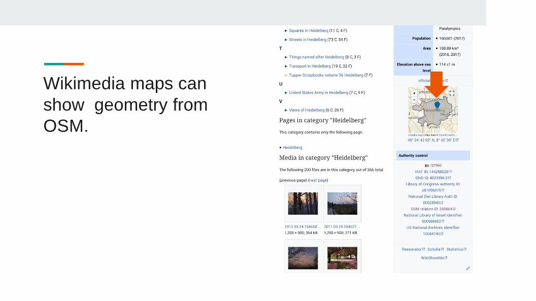
Wikimedia maps can
show geometry from
OSM.

കേരളത്തിലെ സംസ്ഥാനപാതേൾ
https://ml.wikipedia.org/wiki/List_of_state_highways_in_Keralahttps://ml.wikipedia.org/wiki/Municipalities_of_Kerala
കേരളത്തിലെ നഗരസഭേൾ

Mapbox and MapTiler uses
Wikidata to help with the
localization of their map
products.
If there are missing name:*=* tags on
an OSM object, they pull labels from
corresponding Wikidata entries.

For example, Heidelberg has
13 and 5 name:*=* tags in its
place=city node and admin
boundary relation, while
Wikidata has 123 labels for the
item.

User tchaddad recently
finished a GSoC project to
integrate wikidata=* tags into
Nominatim. This project is
intended to improve the
search results by looking at
Wikidata for additional
relevance data.
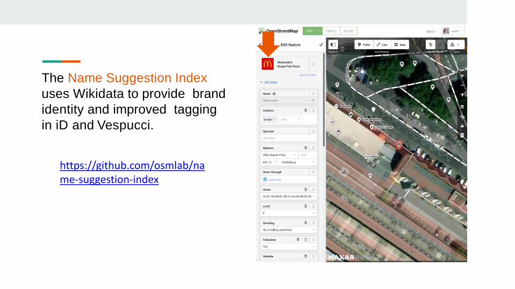
The Name Suggestion Index
uses Wikidata to provide brand
identity and improved tagging
in iD and Vespucci.
https://github.com/osmlab/name-suggestion-index
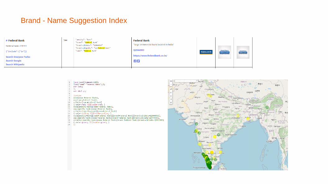
Brand - Name Suggestion Index

Yurik Astrakhan (OSM: nyuriks)
created Sophox, a SPARQL
endpoint for OSM. This service
can use RDF federation to also
query linked Wikidata items.
https://wiki.osm.org/Soph
ox https://sophox.org/

Federated Queries

Addendum: The OSM Wiki has
the Wikibase extension
installed. This is intended to
provide better multilingual
machine-
readable data on OSM’s
tags.

CHAPTER 3
How to add Wikidata to OSM

ID Editor

Linking OpenStreetMap and Wikidata• A semi-automated, user-assisted editing tool• https://osm.wikidata.link/

Challenges:River is line or shape ?

Challenges: Changing of tags
• Changing of tags in Wikidata and OSM causes issues.• Very difficult to find what tags has been changed.

Challenges

Challenges

Challenges

• Admin Boundaries:- Districts,Taluk, Village• Political Boundaries:- Lokshaba Constituency, Assembly
Constituency, Local Government Boundaries.

• LDF Keralam ( ldfkeralam.org website) images to CC release• Sarvavijnanakosham• Schoolwiki• Panchayatwiki• Wikipedia article CD (KITE – IT @ School )• Public release of Wikisource article CD• Wikisource – Digitalisation effort with IT @ School

• Activities in partnering with SMC• Partnering with HOTOSM – Remote Mapping during 2018 Floods• Govt opendata licence vetting by LWG• Partnering with Facebook –Mapping with AI during 2018 Floods
• Helping in Hospital data import – Facebook/RMSI• IT Dept contributing to OpenStreetMap – Mapathon Kerala• Intervention to start - Kerala Opendata Portal
• Data used• Kerala Rescue• Covid19Kerala• CoronaSafe Network


#opendata is the future
#opendata will win

Thank you
Thank you
Slides adapted :Eugene Alvin Villar
Inputs from : Manoj Karingamadathil