district survey report cuddalore district
39
1 DISTRICT SURVEY REPORT CUDDALORE DISTRICT DISTRICT ENVIRONMENT IMPACT ASSESSMENT AUTHORITY (DEIAA), CUDDALORE
-
Upload
khangminh22 -
Category
Documents
-
view
3 -
download
0
Transcript of district survey report cuddalore district

1
DISTRICT SURVEY REPORT
CUDDALORE DISTRICT
DISTRICT ENVIRONMENT IMPACT ASSESSMENT AUTHORITY (DEIAA), CUDDALORE
2
DISTRICT ENVIRONMENT IMPACT ASSESSMENT AUTHORITY (DEIAA),
CUDDALORE DISTRICT
CONTENT
Chapters 1.Introduction Page No.
1
Introduction 01
History 02
Land utilisation 02
Population 03
Drainage 04
Climate and Rainfall 04
Geomorphology 05
Ground water 06
Soil 07
Industries 07
2
2.Geology of the area 08
2.1.Achaeans 09
2.2.Cretaceous 10
2.2.1. Ariyalur Group 10
2.3.Tertiary 10
2.3.1. Neyveli Formation 11
2.3.2. Cuddalore Formation 11
2.4. Quaternary Formation 12
2.5. Structure: 13
2.6. Pediment and Pediplain/sediplain 14
2.7. Land use and Land cover 14
3
3. Mineral wealth of Cuddalore District. 15
3.1. Lignite: 15
3.2. Limestone: 16
3.3. Natural Gas: 18
3.4. Laterite : 19
3.5. Sands stone: 19
3.6. Silica sand: 20
3.7.Silica sand and other older sediments 20
3.9. Beach Sands 21
4 4. Mining and quarrying in Cuddalore districts 22
4.1. Details of Existing Quarries 22
4.2. The list of Mining Lease details 23
5 5. Conclusion and recommendation: 38
List of plates
Plate -1 Location map of Mines, Quarry and industry
Plate -2 District Resource map of Cuddalore District

3
DISTRICT SURVEY REPORT
CUDDALORE DISTRICT
Introduction:
The Cuddalore district is bounded in Latitude 11°11” and 12° 5”N Longitude78° 38”
and 80° 00” E covered in an area of 3678 Sq.kms . It is bounded on the north by
Viluppuram District, on the east by the Bay of Bengal, on the south by Nagapattinam District,
and on the west by Perambalur District. The headquarters of the Cuddalore district is
Cuddalore (11°44' 45" N and 79°45'56" E), a large industrial town which has experienced
coastal development at a rapid rate. Cuddalore is situated about 160 kms south of Chennai,
the state capital ( Fig.1.1). The district is drained by Gadilam and Pennaiyar rivers in the
north, Vellar and Kollidam River (Coleroon) in south.
The coastal stretch of Cuddalore extends from Gadilam estuary in the north to
Pichavaram mangroves in the south, a total length of 42 km along the Bay of Bengal. The
Bay of Bengal experiences severe tropical cyclones during the northeast monsoon (October
through December), and nearly 60 cyclonic storms and SCS have been reported in the past
century (Indian Meteorology Department (IMD) eAtlas 2011). An added risk factor is that
large parts of this coastal zone are low-lying with a gentle slope, resulting in wide inundation
areas, thus increasing the vulnerability of the region.
Figure 1.1. Showing location map of Cuddalore District:

4
History:
From ancient times the old town has been a seaport. For two centuries, Cuddalore had
been subject to a number of foreign powers including the Netherlands, Portugal, France and
more recently, the British. In the early 17th century, the Dutch obtained permission from the
ruler of Cuddalore to build a fort there, but political pressure from their Portuguese rivals
forced them to abandon it. Later, the French and English came to Cuddalore for trade and
business. The French established a settlement 10 miles up the coast at Pondicherry in 1674,
followed in 1690 by the British settlement of Fort St. David at Cuddalore.
During the 18th century various wars between the European powers spilled over to
their colonial empires, and to their allies, including those in the Indian sub-continent. During
this period the French and British fought several times in the area. In 1746, during First
Carnatic War, part of the War of the Austrian Succession, French forces besieged the
British at Fort St. David for several months before being driven off in 1747. In 1758, during
the Seven Years' War, the Fort was taken by the French, and there was an inconclusive naval
action, the Battle of Cuddalore, off the coast. The fort was later abandoned, in 1760, when the
British attacked Pondicherry. In 1782, during the Second Anglo-Mysore War, at the time of
the American War of Independence, the French again took Cuddalore, and were besieged
there in 1783 by the British. During the siege French and British naval forces again clashed
off the Cuddalore coast. The siege failed, but the fort was returned to the British in 1795. In
all there were five different naval actions off the coast during this period, all of which were
indecisive.
Some streets in Cuddalore retain their British names, such as Clive Street, Wellington
Street, Sloper Street, Canning Street, Rope Street (Rope Street, Wellington Street, Sloper
Street and Canning Street jointly known as Salangukara Village), Lawrence Road and
Imperial Road. The Cuddalore Central Prison, opened in 1865, is a historically important
landmark. Subramania Bharati and other political leaders served prison terms there.
Land utilization:
It is a predominately agricultural district with the coastline stretching from the
Puducherry Union Territory in the north to the mouth of the River Coleroon in the south. The
total geographical area of the district is 3706 km2 with a coast line of about 54 kms. It is 19th
largest district in Tamil Nadu and ranked 332 in India in terms of total area. The district is
11th most populous district out of 32 districts in Tamil Nadu and it is 158th most populous

5
district in India. It is 7th most densely populated district in Tamil Nadu and 168th most
densely populated bdistrict out of total 640 districts in India. Cuddalore District comprises 9
taluks, 14 Blocks, 5 Municipalities and 18 Town Panchayats shown in Fig1.2.
Figure 1.2. Showing Taluk and Blocks of Cuddalore District:
Population:
According to 2011 census, Cuddalore district had a population of 2,605,914 with a
sex-ratio of 987 females for every 1,000 males, much above the national average of 929. A
total of 279,950 were under the age of six, constituting 147,644 males and 132,306
females. Scheduled Castes and Scheduled Tribes accounted for 29.32% and .6% of the
population respectively. The average literacy of the district was 69.66%, compared to the
national average of 72.99%.
Table 1.1 .Population details of Cuddalore district:
ITEM INDIA TAMIL NADU CUDDALORE
Population (No.) 1,21,01,93,422 7,21,38,958 26,00,880
Male (No.) 62,37,24,248 3,61,58,871 13,11,151
Female (No.) 58,64,69,174 3,59,80,087 12,89,729
Sex Ratio (per 1000) 940 995 984
Density (No./km2) 382 555 702
Area 3,287,240 Km2 1,30,058 Km2 3706 Km2
Literacy (%) 74.04 80.33 79.06

6
The Cuddalore district had a total of 635,578 households. There were a total of
1,169,880 workers, comprising 136,035 cultivators, 325,599 main agricultural labourers,
19,151 in house hold industries, 356,486 other workers, 332,609 marginal workers, 29,135
marginal cultivators, 213,813 marginal agricultural labourers, 12,876 marginal workers in
household industries and 76,785 other marginal workers.[4] The district has a population
density of 702 inhabitants per square kilometre (1,820/sq mi).
Drainage :
Cuddalore is located at 11.75°N 79.75°E. It has an average elevation of 6 m (20 ft).
The land is completely flat with large deposits of black and alluvial soil inland and coarse
sand near the seashore. The sandstone deposits in the town are popular. The Pennayar River
runs north of the town, while Gadilam River runs across it. Cuddalore is situated at a distance
of 200 km (120 mi) from the state capital Chennai and 18 km (11 mi) from Puducherry, the
neighbouring union territory. The nearest airport is at Chennai, 200 kilometres (120 mi) from
Cuddalore. The period from November to February in Cuddalore is pleasant, with a climate
full of warm days and cool nights. The onset of summer is from March, with the mercury
reaching its peak by the end of May and June. The average temperatures range from 37 °C
(99 °F) in January to 22.5 °C (72.5 °F) in May and June. Summer rains are sparse and the
first monsoon, the South-West monsoon, sets in June and continues till September. North-
East monsoon sets in October and continues till January. The rainfall during South-West
monsoon period is much lower than that of North-East monsoon. The average rainfall is
1,400 mm (55 in), most of which is contributed by the North-East monsoon.
Climate and Rainfall:
The climate in general is moderately hot and humid tropical. The Mean Maximum
temperature from January to June varies from 28øC to 34øC. It has hot summer and
insignificant to mild winter with moderate to heavy rainfall. The area is affected mainly by
NE monsoon with some evening showers during SW monsoon. The average rainfall details
are shown in figure 1.3.

7
Table 1.2.: Rain fall Data of Cuddalore district:
Figure 1.3. Showing Average rain fall data of Cuddalore district:
Geomorphology:
The Cuddalore district, for the most part, is a flat plain, sloping gently from north to
south and from west to east, towards the sea. The only hill in the district is the Mount Capper
hill near Cuddalore. The Mount Capper plateau, just west of south-south-westwards to near
Shrimushnam .Mount Capper is the only part which can be termed as a prominent feature in
the landscape and even this is only about a hundred feet above mean sea level. For the rest,
S.No Year South West (mm) North East (mm) Total
1 2003 434.0 915.7 1349.7
2 2004 437.9 908.5 1346.4
3 2005 340.3 1346.1 1686.4
4 2006 246.5 1007.3 1253.8
5 2007 330.5 837.7 1168.2
6 2008 280.8 1136.5 1417.3
7 2009 278.0 960.5 1238.5
8 2010 362.9 1043.7 1406.6
9 2011 424.6 873.4 1298.0
10 2012 245.5 587.8 833.3
Month Jan Feb Mar Apr May Jun Jul Aug Sep Oct Nov Dec Year
Average
high °C
(°F)
28.1
(82.6)
29.2
(84.6)
31.1
(88)
33.2
(91.8)
36.1
(97)
37.0
(98.6)
35.5
(95.9)
34.6
(94.3)
34.0
(93.2)
31.7
(89.1)
29.1
(84.4)
28.0
(82.4)
32.3
(90.16)
Average
low °C (°F)
20.8
(69.4)
21.2
(70.2)
23.0
(73.4)
25.8
(78.4)
27.1
(80.8)
27.0
(80.6)
26.1
(79)
25.4
(77.7)
25.1
(77.2)
24.3
(75.7)
22.8
(73)
21.5
(70.7)
24.18
(75.51)
Average
rainfall mm
(inches)
30
(1.18)
36.8
(1.449)
11
(0.43)
21.5
(0.846)
71
(2.8)
70
(2.76)
85
(3.35)
144
(5.67)
129
(5.08)
247
(9.72)
330
(12.99)
216
(8.5)
1,391.3
(54.775)

8
the course of the formation, where it has not been cut away by the rivers which pass through
it, may be traced by the red soil to which it gives rise and which is some of the most unfertile
in the district. The geomorphology of the Cuddalore coastal stretch includes the coastal plain
with an average width of 6 km. Its coastal landforms include strand-lines, raised beaches,
sand dunes, mangrove swamps and tidal flats with predominantly sandy beaches on the
northern side and mangrove swamps to the south. The coastal towns of Cuddalore in the
North and Porto Novo (Parangipettai) in the South are the most densely populated along this
region.
The Cuddalore area mainly attained its present morphological configuration due to the
action of Uppanar River, wave action of Bay of Bengal, wind and other erosional or
weathering activities. The area broadly can be divided into coastal plain and undulating
elevated plateau regions. This inland high region bound the coastal plain occurring on its
eastern side. The drainage pattern of Uppanar is sub dendritic in the southern side (north
flowing river) and most of them have been converted as irrigational channels (Yazoo pattern).
The tidal limit of Uppanar is significantly long and sea waters reach upto Gopalapuram
during high tide times. Otherwise it is a Euphemeral stream with fresh water flowing only
during monsoon season. Due to erosion and depositional activity of various natural agents.
Ground Water:
Observations and occurrence of quality of ground water have been made with respect
to each of the geomorphic unit with the help of observations from open wells and bore wells.
Hydrogeologically the area can be divided into two broad sectors based on the depth and
quality of ground water occurrence. The eastern part of study area covered with coastal dunal
complexes have shallow ground water source at a depth of 22 to 25 feet (water bearing
horizon coarse sand) with limited yield. The water becomes saline at depths greater than 25
feet as the sandy horizon is underlain by sandy clay and sticky black clay of marine origin.
The water table depth in sandy areas varies from 6 to 8 feet and is associated in silica
sand. The water occurring at these depths is being extracted from broad shallow pits for
irrigation. The floodplain and pediplain terrain occurring on the western side is underlain by
weathered lateritised Cuddalore sandstone formation which holds a good amount of fresh
water. In the areas of Kullanchavadi, Chintamanikuppam, Palliodai and Sambareddipallayam
2 to 3m of sandy horizon occurs at depth of 120 feet and 140 feet. The pressure surface depth
is 45 to 55 feet during summer. In the entire region the overall quality of water is potable and

9
no severe salinity problem is encountered. The area also does not experience any ground
water overdraft pollution etc. Normal average rainfall is 1600 to 1800mm per year which
takes care of recharge. The low lying floodplain and sandy flat areas gets flooded during
heavy rains as Perumal Eri and other canals are already silted up and breached at places.
Soil:
The soils of the district can be divided into three main classes namely, the black soil,
the red ferruginous and the Arenaceous. The black soil prevails largely in the Chidambaram,
Vriddhachalam and Cuddalore Taluks. The Arenaceous occurs chiefly near the coast in the
Taluks of Chidambaram and Cuddalore. Black clay is the most fertile kind of soil, the loam is
the next best and the red sand & Arenaceous soils are the poorest. The total red soil
comprises of -3,67,791 hectare, Sandy clay loam -1,28,573 hectare, Clay loam -1,15,565
hectare, sandy loam -91,679 hectare and sandy soil -31,974 hectare in Cuddalore district.
Industries:
There is one Industrial Park by State Industrial Promotion Corporation of Tamil Nadu
(SIPCOT), Cuddalore OT and three Small Industries development Corporation (SIDCO)
industrial complexes at Cuddalore, Vriddhachalam and Vadalur.Compilation of important
industries in Cuddalore district with location and product is given below:
1. Neyveli Lignite Corporation , Neyveli- Thermal Power Station
2. MRK Sugar Mill, Sethiathope,- Sugar Mills
3. EID Parry (I) Ltd, Nellikuppam, - Sugar Mills
4. Ambika Sugar Mills, Pennadam, - Sugar Mills
5. TANFAC, Cuddalore OT- Chemicals
6. Vanavil , Cuddalore OT - Chemicals
7. National Cotton Mills, Chidambaram, - Textiles
8. SPIC Pharma Chemicals , Cuddalore OT- Pharma and Chemicals
9. Asian Paints(I) Limited, Cuddalore OT- Paints and Chemicals
10. Tagros Chemicals (I) LTD., Cuddalore OT- Chemicals
11. Clariant Chemicals LTD., Cuddalore OT- Chemicals
10
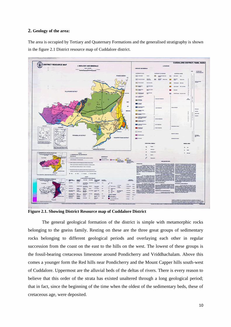
2. Geology of the area:
The area is occupied by Tertiary and Quaternary Formations and the generalised stratigraphy is shown
in the figure 2.1 District resource map of Cuddalore district.
Figure 2.1. Showing District Resource map of Cuddalore District
The general geological formation of the district is simple with metamorphic rocks
belonging to the gneiss family. Resting on these are the three great groups of sedimentary
rocks belonging to different geological periods and overlaying each other in regular
succession from the coast on the east to the hills on the west. The lowest of these groups is
the fossil-bearing cretaceous limestone around Pondicherry and Vriddhachalam. Above this
comes a younger form the Red hills near Pondicherry and the Mount Capper hills south-west
of Cuddalore. Uppermost are the alluvial beds of the deltas of rivers. There is every reason to
believe that this order of the strata has existed unaltered through a long geological period;
that in fact, since the beginning of the time when the oldest of the sedimentary beds, these of
cretaceous age, were deposited.

11
Cuddalore sandstones and there are a number of flowing wells in this area. Gneiss,
trap and sandstone are the main minerals of the district. Gneiss is used for building purposes
with excellent results especially in the temples. Its susceptibility to fine carving is
exemplified in the chains cut from it which may be seen in the shrine at Srimushnam and the
great temple at Chidambaram. Trap is scarcely used for building purposes because of its
intractable hardness and inherent moisture absorbing quality. Sandstone is used for building
purposes as well as for making mortars, troughs, etc. Besides these minerals, laterite occurs
over a wide belt of country between Pondicherry and Vriddhachalam (notably on Mount
Capper), in the red soil tract around Srimushnam and to the east of Vriddhachalam. It is
largely used for building purposes and road making.
There are a large number of clay deposits in the district. White clay occurs in many places. It
is exposed in the deep ravines below an overburden of35 feet of sandstones and grits at
Pannikappam, south of Panruti and just south of the Gadilam River. It burns to a pale grey
colour, it is refractory and its shrinkage is high, being 40 percent.
2.1. ARCHAEANS
The Archaean rocks are exposed in the north-western and western part of the study
area or more precisely a Hne passing roughly west of Virdhachalam and Ulundurpettai. The
basement rocks (i.e. Archaean) constitute granitoid gneisses with pegmatite and dolerite
intrusive in Neyveli Basin. The Archaean rocks form the basement in the area over which the
later sediments were deposited. Outcrops of granitoid gneisses (i.e. Archaean) can be seen
around Mangalam and Ulundurpettai. The well section shows coarse, weathered and pale
coloured gneisses up to a depth of2 to 4m passing into fresh bluish rocks below. The coarse
granite gneisses chiefly consist of quartz, feldspar, biotite and hornblende Pegmatite and
quartz veins intruding the granitoid gneisses. Chamockites are very common in the adjoining
area and less frequently in the study area. The pegmatite predominantly consists of quartz and
feldspar. The dolerites are the youngest intrusive rocks in the area. They cut across the
geinesses in NNE-SSW or NE-SW direction between Mangalam and Ulundurpettai.
Ground water prospect in these hard rock terrain are meager because of compact nature of
granitoid geinesses and chamockites.

12
2.2. CRETACEOUS
2.2.1. ARIYALUR GROUP
In the western section of the study area, marine fossiliferous limestone, calcarious sandstones
and marlstones succeed the Archaean crystalline basement rocks. They were deposited in
shallow marine environment and have been classified as Ariyalur group of rocks (i.e. upper
cretaceous). The rocks of Ariyalur group are exposed in a narrow NE-SW trending belt of
about 3-8 Km wide between Ulundurpettai in the west and Palakkollai in the east. The
marine cretaceous rocks are bounded in the west and east by Archaean crystaUine rocks and
Cuddalore sandstone (Tertiaiy Age) respectively. On the east the fossihferous limestone are
exposed at:
1. Around Patti, about 8 Km North West of Vridhachalam and 1.60Kms, SSW of Parur.
2. About 400 to 600 m. south of Puvanur and west of Vridhachalam- Ulundurpettai road and
3. About 1.6Kms SSW of Pelandurai anicut on the southern bank of Vellar, near a temple.
The limestones near patti are massive and fossiliferous having abandons of Trigonia
semiculata and various species of pecten. The low area in the east of Puvanur is covered by
kankar and saline black soils and devoid of outcrops. The Cretaceous rocks in the study area
are overlained by the younger Tertiary rocks. Between Vridhachalam and Mangalam, the
Cretaceous rocks are exposed in a few places in and around Puruver due to the erosion of the
overlying Cuddalore Formation.
2.3. TERTIARY
The Tertiary geology is represented by the sediments of Mio-Pliocene periods. No basement
rocks have been encountered even in the few deep bore holes drilled by the Neyveli Lignite
Corporation. But sediments probably representing Cretaceous period such as Siliceous
limestone, calcareous sandstone, black silts and clay with thin bands of lignite have been
encountered in the bore hole recently drilled by Neyveli Lignite Corporation near Palliodai
village on the eastern banks of PerumalEri (Personal communication). These Cretaceous
formations are overlain by the yellowish white to dirty white sandstone, grey siltstone, pebbly
gravelly coarse grained sandstones with minor clays which form the Mio-Pliocene Cuddalore
sediments. They are prominently seen as raised mounds around Pudur Sedapallayam,
Samatikuppam areas in the northwestern part and these are only the continuation of large
Tiruvendipuram sandstone plateau occurring south of Gadilam River. Pebbly, gravelly, ferri-
crete, concretionary soils with reddish brown sands (Lateritised, weathered gully eroded
outcrops) occur as veneer over the sandstone. This lateritic cover of sandstone slowly

13
disappears towards east as they are covered by thick alluvium and dunal sands. But the slopes
of the sandstone plateau have thin soil cover and form a gently sloping pediplain in the areas
of Kothandaramapuram, Palliodai, Puvanikuppam and Kullanchavadi.
2.3.1. NEYVELI FORMATION
The Neyveli Formation represents the lower most tertiary group of rocks. They are essentially
argillaceous and occur as a narrow belt overlying the Ariyalur group. It also occurs as inlires
and outliers surrounded by Cuddalore Formation and Ariyalur Formation respectively. The
Neyveli Formation is composed of silty claystones; black clays /shells, argillaceous
sandstones, calcareous sandstones, fossiliferous limestones, algal limestones, etc. The algal
limestones and argillaceous sandstones of the Neyveli Formation can be correlated to that of
the Niniyur Formation of Ariyular area. It is occurring around Gopurapuram village near
Vridhachalam and is assigned to Paleocene to Oligocene in age.
2.3.2. CUDDALORE FORMATION
The Cuddalore sandstones occur intermittently along the eastern coast of south India and
represent the upper most Tertiary Formation. The Cuddalore Formation occupies the major
part of the study area. The rocks of this Formation consist of argillaceous sandstone, pebble-
bearing sandstones, mottled sandstone, ferruginous sandstone, grits and clay beds and lignite
seams which occupied more than half of the study area. The presence of the pebble and
cobbles, mottled appearance, general impoverishment in micas and absence of garnet grains
help to distinguish them from the older group of rocks.
The sandstones of the Cuddalore Formation are whitish, pinkish or mottled in colour and are
chiefly argillaceous. The sandstone generally consists of rounded pebbles (pebbles and
fragments) of quartz. The Cuddalore sandstones were altered and covered by either Laterite
capping or by thick alluvium of Gadilam and Ponnaiyar rivers in the north and in the south by
Vellar and Manimukta rivers. The Cuddalore Formation in the southern coastal parts of
southern India is exposed in detached patches. The central patch extends between
Vriddhachalam and Cuddalore, which are about 56.00Kms long, and 26.00Kms wide,
trending ENE-WSW direction.The chief occurrence of Cuddalore sandstone is south west of
Cuddalore taluk and south of Panruti taluk. The "Mount of Copper west" of Cuddalore
comprises mainly fragments of rounded quartz bounded by the ferruginous contact. There is
another patch of the Cuddalore sandstone occurs to the south of Vellar River around
Srimushnam.

14
2.4. QUATERNARY FORMATION
The quaternary formation in the study area comprises sediments of fluvial, fluvio-marine and
marine regime. The sediments includes fine to coarse-grained sands, silts, clays, laterites and
lateritic gravels. The fluvial sediments are confined in the flood plains of the Ponniyar,
Gadilam, Manimuktha , Vellar and Kollidam rivers which consist of mostly of sands and
sandy or clay loams. The thickness of Vellar alluvium was recorded about 35m at
Vridhachalam and 40mts at Satiatope. Laterites and Lateritic gravels derived from the gravel
bearing Cuddalore sandstone are occupied large parts of the area. The laterites were generally
ferruginous, yellowish dark brown, metallic luster, hard and with fairly extensive occurrence
in the area are underlained by Cuddalore sandstones. In the far east of the study area between
Cuddalore and Portnovo, over a width of 1.50 to 3Kms from the coast occurs a low flat sand
dune below sands except where they are interrupted by the outlets of the rivers. The most
striking sand dunes occur near Cuddalore and Port Novo, where they formed irregular
mounds of 10 to 50m heights by wind action.
The predominant part of study area is occupied by the unconsolidated and semi-consolidated
Quaternary sediments which are mostly coastal dunal sands and river alluvium. No dating has
been done so far to fix the absolute age of formation of these sediments. Hence only a relative
age of Pleistocene and Holocene can be assigned. A.Prabhakar(1986) during the Quaternary
geological mapping of this area has classified the area geologically into fluvial, fluviomarine
and marine formations such as Auroville formations, Villiyanur formations, Ponnaiyar
formations, Kallapettai formations and Marakkanam formations based on the various
geomorphic surfaces.
Quaternary Sub recent White to grey silica sands Brown sand, Clayey sand Upper Pleistocene
Sandy clay and clay. Tertiary- Mio-Pliocene Cuddalore sandstone. The area in between the
Perumal Eri and coastal dunal complex and the areas adjacent to Manambattan channel and
Uppanar river bed are occupied by the medium to darkgrey coloured clay, silt and sandy clay
materials forming the recent alluvial materials. The over flow from Perumal Eri and multiple
tributaries of Uppanar riverhave contributed the sediment load in recent time over which
intense agricultural activities are going on. The two to three meter thick clay and silt is
underlain by weathered Cuddalore sandstone in the west and coastal sands in the east. Since
Uppanar is a tidal stream the alluvium on either side has tidal clay or marine sediments at its
subsurface.

15
2.5. STRUCTURE:
The Archaean-Cretaceous boundary in the west of the study area showed fault contact
near patti . Whereas, evidences of faulted contact between the Cretaceous and Tertiary
Cuddalore Formation is more pronounced than Archaean-Cretaceous contact. The down
thrown on the eastern side of the contact are visible about 1 Km to the south of the Pelandurai
anicut in Cuddalore Sandstones, where faults can be traced not less than 400m and the change
of dip amount in Cuddalore Formation may further strengthen the fault contact between them.
During 1954-55, Varaprasada and Raja mapped the part of Cuddalore sandstone of the area
recorded dips ranges from 5° to 8° ESE or SE and occasionally as much as 20° towards ESE
or SE. The dip of the Cuddalore Formation in a quarries situated about 1.5 Km to the ENE of
Pudupattai showing 20° to 25° towards ESE or SE direction. The change in the direction and
magnitude of dip close to Cretaceous-Tertiary contact, it may be a probable fault of post-
Cuddalore age as was observed near Penundurai. There are also evidences of a fault parallel
to the Gadilam river course, about 1.6 Km south of Panruti i.e. south of the Gadilam River. In
the west of Panruti-vadular road, Cuddalore sandstone was disturbed and steep diping. The
presences of conspicuous knolls of the Cuddalore rocks are found on the southern bank of the
Gadilam River in between Panruti and Cuddalore town. While absence of this physiographic
features to the north of the Gadilam river suggest a possible fault along this river course. On
the other hand Cuddalore outcrop, south of the Vellar River do not show any major structural
feature like folding, faulting, etc
Dunal ridges are aligned more or less parallelly in conformity with the coastline
configuration. As there is considerable human interference in the dunal areas it is difficult to
delineate the exact number of ridges (beach ridges or strand lines) formed in the study area.
But the dunal areas are narrow in the north and more wide spread longitudinally in the south.
Few dunes are oriented in an oblique way perpendicular to coast due to change in prevailing
wind direction. Cross bedding is seen in the dunal sections along the river course and in some
places on the walls of the pits dug for irrigation. The beds are inclined to the principal surface
of accumulation. Their thickness is 15cm to 20cm. Dunal surfaces exposed to wind action
develop the ripple marks due to land to sea breeze and vice versa. The asymmetrical and sub
parallel crests are either continuous or discontinuous and commonly transverse to the wind
direction. The predominant direction noted is E-W.

16
Mud cracks are noticed in a few areas of clayey terrain adjoining Uppanar River and on the
dry bed of Perumal Eri. They indicate dessication and compaction of water saturated muddy
sediments which produces shrinkage cracks of polygonal nature.
2.6. Pediment and Pediplain/sediplain
In the northwestern part of the area weathered, laterised reddish and yellowish brown
coloured outcrops of cuddalore sandstone occur as flat table land or plateau landform. They
are pebbly and gritty and in many place with rill and gully erosion. Due to constant erosion
and weathering the intercalated clay has been washed away leaving the loose quartz pebble
on the surface. This dissected plateau near Pudur and east of Samanthakuppam has elevation
of 34m above M.S.L.
The area between this plateau land and the coastal plain just north and west of Perumal Eri
(Kullanchavadi, Anukkumpattu villages) has a flat undulating topography. This pediplain has
a thick brownish soil cover overlying a deeply weathered sandstone. But no outcrops are seen
and the area gently slopes in the eastern direction towards the sea. A few small streams drain
this pediplain diverting leaving into Perumal Eri and coastal sands. The average elevation of
this area is 15m to 20m which has high ground water potential.
This erosional surface might have been formed during Pleistocene to Holocene age and
probably during one of the Glacial period when the sea level was lowered exposing the area
for fluvial erosion and natural weathering resulting in a sediplain with a gentle slope.
2.7. Land use and Land cover
Dunal areas are utilised mostly for raising casuarina and cashew plantations. Some of the
dunal flat areas are used for cultivating groundnut crop once a year. Besides these, there are
natural vegetations like wild saline shrubs and palm trees. It is evident that the smaller dunal
ridges and mounds have been flattened and landscape has been altered to suit agricultural
activity. On the otherhand old dunes are getting stabilised and small new dunal mounds are
getting created by the extensive cashew plantations going on this area. The cashew plantation
has a thick or bushy canopy due to its lateral growth which facilitates the arrest of sand
migration. The beach zone has a sparse cover of saline creepers and shrubs which also
contribute to stabilising the sand.

17
3. Mineral wealth of Cuddalore District.
The Cuddalore districts comprise the major minerals as Lignite, Natural Gas
occurrence and Limestone. The minor minerals comprises of Fire clay, Ball clay, Gravel,
Silica sand, Laterite, Pebbles and Red Soil.
3.1. Lignite:
The Neyveli south area, situated in the Vriddhachalam and Chidambaram Taluks of
Cuddalore district, Tamilnadu, lies between Latitudes 11°25’00" and 11°29’20"N and
Longitudes 79°24’50" and 79°33’45"E in parts of Survey of India Toposheet Nos.58M/7 &
11. It extends over distances of about 7.5 & 15 km in N-S and E-W direction covering an area
of about 95 sq km. The northern limit of the area coincides with the southern limit of the II
mine of the NLC and the southern limit coincides with Vellar river.
Exploration by drilling to assess the commercial potential of Neyveli lignite as a
source of fossil fuel was first carried out by the Geological Survey of India between 1943-
1946 and later by the Lignite Department of the Tamilnadu Government. As a result of these
investigations, the I Mine area of about 15 sq km with an estimated reserve of about 230
million tonnes and located to the north of the Vriddhachalam-Cuddalore railway line was
demarcated and the Neyveli Lignite Corporation was formed to construct and operate an
integrated mine, thermal plant and fertiliser plant. The first mine, inaugurated by the late
Pandit Jawaharlal Nehru, the then Prime Minister of India on 20th May 1957, first exposed
the lignite in August 1961 and has since been producing lignite. At present, NLC is
producing about 6.5 million tonnes of lignite per annum from the I Mine and are making
rapid progress in the opening of a second opencast nine, located in the area to the south of the
I mine. Production of lignite from the II nine is scheduled to commence from late 1984. In
the I stage it is expected to roduce 4.7 m tonnes of lignite from the II nine to he expanded
subsequently to 10.5 million tonnes. Production from the I mine is also to be raised to 6.5
million and 8.5 million tonnes in stages. On the basis of the data from cuttings of large
number of boreholes drilled for groundwater by private parties, the Department of
Agriculture, Govt. of Tamilnadu, the erstwhile, Exploratory Tub wells Organisation (E.T.O.),
the NLC itself and other agencies the reserve in the Neyveli lignite field has been inferred to
be very extensive by the Geological department of the NLC, According to the data collected
by them, the field extends in north-south direction over a strike length of about 55-60 km
between the Coleroon River in the south and Chattram in the north and has a width (in the

18
east-west direction of about 7 km to 12 km), the total areal extent being about 470 sq km
With potential resources of about 3300 million tonnes of lignite. Upto 1980, only the northern
part of the field extending over a strike length of about 15 km (the sector falling in the I & II
mine areas of the NLC and located to the north of the Vriddhachalam - Chidambaram road)
covering and area of about 130 sq km has been explored and assessed in a systematic manner.
The data available for the remaining, areas which are yet to be explored in a systematic
manner is mostly of a qualitative nature, derived from examination of cuttings from
boreholes drilled for groundwater.
The lignite produced at present from the I mine is being utilised in the 600 MW Thermal
power plant, Fertiliser plant and briquetting plant all located near the mines at Neyveli. The
production from the II nine is proposed to feed the super Thermal power plant, to be
constructed in stages to an ultimate capacity of 1470 MW. To meet the increasing demand for
power in the southern Region, the NLC propose to construct a third super thermal power
plant of 15 MW, and plan to meet the annual requirement of about 10 million tonnes of
lignite for this plant from a third nine located to the south of the II mine and therefore,
requested GSI to undertake regional exploration by drilling in the area lying between the II
mine and Vellar river and identify potential blocks for detailed exploration in the first
instance and to subsequently assess other areas to identify potential resources to meet their
long-term demands.
3.2. Limestone:
The Vriddhachalam sub-basin is bound by the Vellar – Manimukta Nadi in the south
and the Gadilam River in the north and the marine sedimentary sequences are concealed
below the alluvial cover. These marine sequences are belong Aladi Formation of Ariyalur
group. Vriddhachalam Sub-basin hosts cement grade to marginal grade limestone deposits
which are correlatable with the Niniyur limestone deposits of Trichinopoly sub-basin. The
limestone deposit is designated as Uchchimedu limestone prospect. The Uchchimedu
limestone is traced continuously for about 10 km strike length in NNE - SSW direction that
shows very gentle dip of around 3° towards SE. Uchchimedu area is covered by Quaternary
alluvium and located in the interfluve of Manimukta Nadi and Vellar River. Outcrops of
limestone are exposed in Peria odai nala section, Vellar riverbed and abandoned dug well
near Uchchimedu village. The limestone is also seen as sub-crops in the dug wells around
Uchchimedu village. The limestone is creamish white in colour, fine to medium grained,

19
moderately hard and massive with a pitted surface appearance. The limestone is directly
overlain by the Vellar River alluvium of Quaternary period.
The calcareous zone was intersected in all the boreholes which are composed mainly
of sandy limestone, calcareous sandstone, limestone and marl. Quaternary alluvium forms the
overburden which is manly comprises of argillaceous sandy material with silty clayey soil
and occasional occurrences of calcretes. The over burden varies from 2.10 m in the north to
40.13 m in the south along the main UM base line. The overburden increases towards down-
dip direction along UME baseline and decreases towards up-dip direction along UMW
baseline. In general, thickness of the alluvium appears to increase towards south and east.
The calcareous zone, which occurs unconformably below the alluvium, is demarcated by the
pebbly layer/conglomerate in the upper as well as the lower contact. The sandy limestone is
indurated, hard in nature and consists of quartz and other opaque minerals that are binded
together by the calcareous cement. Whereas, the calcareous sandstone is friable, less hard and
occasionally comprises of fossils. The limestone is indurated, hard and compact, dirty white
to cream white and frequently consist fossils of pelecypods and gastropods and lesser
association of corals. The surface karst features includes small channels and solution tubes
are observed over the limestone out crop exposed along the periya odai nalla section.
Figure 3.1.Showing Limestone formation of Uchimedu and Nandahambadi area.

20
3.3. Natural Gas:
The hydrocarbon assemblage and exploration around Bhuvanagiri , Thalai Kulam
,Oluthoor,Pinnaloor and adjacent villages of Bhuvanagiri and Chidambaram talk of
Cuddalore district. In valayamadevi village in cuddalore district available of post rig building
works and development of approach road leading vlma drill site.The public hearings were
conducted in the second half of last year and as all of them were pending before the TNPCB,
the ONGC approached the MoEF. Of the 35 proposed wells, 14 fall in Cuddalore district,
nine in Nagapattinam, six in Ariyalur, five in Thanjavur and one in Tiruvarur. The project
proponent reported that there was no wildlife sanctuary, national park or eco-sensitive area in
the proposed exploratory area of the block. There was no forest land in the block either,
submitted the project proponent. It promised to adopt zero-effluent discharge. In the event of
the well turning unsuccessful, it would be cement-plugged.The oil and gas industry has been
instrumental in fuelling the rapid growth of the Indian economy. The petroleum and natural
gas sector which includes transportation, refining and marketing of petroleum products and
gas constitutes over 15 per cent of the India's GDP.
Figure 3.2.Showing Natural Gas Pipline in Pinnaloor and Oluthoor Villages of Cuddalore
District.
A.Natural Gas Pipeline Near Pinnaloor
B.Natural Gas rig Near Uluthoor

21
3.4. Laterite :
The lateritised Cuddalore sandstone pediment areas are thicky capped with cashew trees as
iron rich soil supports that vegetation to a great extent. The study area is just adjacent to
Kudikadu SIPCOT industrial belt which is located on the coastal dunes with some problems
of effluent discharge (and creating pollution) into the Uppanar river which extends further
into our study area also. But no significant impact on land, vegetation, water and human
being is observed along the Coast of Uppanar River. Only one industry is located (EID Parry
Acetic acid plant) near Tiruchopuram and appear to be operating without any enviornmental
problems.
3.5. Sands stone:
Cuddalore sandstone are mostly seam on the escarpment side of the high ground stretching
between Virdhachalam and Cuddalore and also exposed along gullies traversing main part of
the Cuddalore area. The major part of the study area comprises of Cuddalore sandstone rocks
of Tertiary Age and Recent alluvium.

22
3.6. Silica sand:
The silica sand zone from Kottattai to Periyapattu has no preferred landuse / landcover even
though the ground water situation is comparitively better than the adjacent areas. Cashew
trees are grown invariably all along the silica sand zone as it offers a good return and
minimum expenditure is incurred owing to less irrigational needs. The floodplain and
pediplain areas surrounding the Perumal Eri are used for intensive paddy, sugarcane and
coconut cultivation owing to excellent water availing both from underground and from
canals.
The lateritised Cuddalore sandstone pediment areas are thicky capped with cashew trees as
iron rich soil supports that vegetation to a great extent. The study area is just adjacent to
Kudikadu SIPCOT industrial belt which is located on the coastal dunes with some problems
of effluent discharge (and creating pollution) into the Uppanar river which extends further
into our study area also. But no significant impact on land, vegetation, water and human
being is observed along the Coast of Uppanar River.
3.7. Silica sand and other older sediments
Only a limited portion of the study area contains white to light grey to white sand at a shallow
depth of 2 to 2.5m. The narrow linear belt of Periyapattu-Kottattai areas have coalesecening
type coastal dunal sand underlain by silica sands of varying thickness. They are rarely
exposed in this belt. In many places they have yellowish brown iron stains. There are yellow
patches within the greyish white sands. They are medium grained with more than 75 per cent
of the grains falling within 30 to 120 ASTM sieve sizes. The grains are mostly subrounded to
rounded, white and transparent with brown and yellow stains. A few translucent grains are
also seen. The fines (-120 mesh size) are mostly clay, weathered feldspars and heavy and
dark minerals viz. ilmenite, rutile. biotite and hornblende.
The meander section of the Uppanar River in the Andar Mullipallam and Tiruchopuram areas
exposes a few white sand patches within the thick dunal sand formations. They are dirty
white to grey in colour and very fine grained compared to the Kottattai - Periyappattu zones.
They are not persisting to deeper levels also.
The white sands occuring in the above areas are underlain by the semi consolidated sands,
clayey sand, sandy clay with shells and heavy minerals. In the other dunal sandy areas also
(Panjakuppam, Andikulli and Puchimedu) beyond the depth of 20 feet, clayey sands with

23
shells occur invariably presenting the lagoonal or tidal sedimentation probably during early
Holocene or upper Pleistocene period.
3.8. Dunal Sands
They occur as cover or overburden over the white sands and they predominate all along the
coastal track. Morphologically they have various kinds of expression and their colour varies
from place to place such as grey, brownish grey, brown, whitish brown with or without heavy
minerals. Ripple marks are prominently seen both in the dunal mounds and on dunal flats
with well defined crests. Some of the sections (pits and river sections) exposed near
Tiruchopuram, Kottattai and Silambimangalam areas exhibit good cross bedding features.The
older dunes are deep brown in colour due to intense oxidation in subaerial condition. The
grain size of the sand is medium to fine and they have good rounded to subrounded and
spherical shape also indicating thewell sorted uniform textural parameters.
3.9. Beach Sands
The Cuddalore-Portonova coast has a fairly broad beach with deposits comprising greyish
brown coarse to medium sand with heavy mineral and shell fragments. They extend from low
tide zones to the upper most zone of the wave action. The sediments are subjected to constant
removal, reworking and deposition. The sediments are contributed by the Gadilam, Ponnaiyar
and Uppanar river in the north and Vellar river in the south.

24
4. Mining and quarrying in Cuddalore districts:
Figure 3.3. Showing details of existing quarry and mines details in Cuddalore District:
Sl.
No Name of Mineral
No. of quarry
operation
No. of quarry
Non-Operation Total
1 Gravel 8 0 8
2 Gravel and Laterite 4 0 4
3 Gravel and Pebbles 2 0 2
4 Savudu 3 0 3
5 Rough Stone 1 0 1
6 Sand 6 4 10
7 Silica Sand 0 1 1
8 Fire Clay 0 3 3
9 Oil and Natural Gas 2 0 2
10 Lignite 1 0 1
Total 27 8 35

25
Details of Existing Quarry Leases as on 31.03.2019
LIST OF GRAVEL QUARRY LEASE IN PATTA LAND
Sl.
No Name of the Lesses Taluk & Village
S.F.No. & Extent
(Hects)
Period of
Lease
Status
1.
Tmt. R.Agilandheswari,
W/o. Gopu @ Raguraman,
No. 100, 1st Street,
Keezharugunamnatham
Nellikuppam (Post),
Panruti T.K.
Cuddalore
Naduveerapattu
220/1B -
4.05.0
26.05.2017
to
25.05.2019
Under
operation
2.
Thiru.R.Athinarayanan, S/o.
M.Rajagopal, No.196,
Pillaiyar Kovil Street,
Nanamedu & Post,
Cuddalore - 2.
Cuddalore -
Vellakarai
10/1 (P) (0.81.0 /
12.84.0),
10/1B (P) (0.64.0 /
0.81.0) -
1.45.0
28.07.2017
to
27.07.2019
Under
operation
3.
Thiru.G.Rajanbabu,
S/o.Gopalakrishnan,
Chinnakannadi(Post),
Kurinjipadi(Taluk)
Cuddalore(District)
Cuddalore -
Naduveerapattu 220/7C1B - 2.43.0
02.08.2018
to
01.08.2020
Under
operation
4.
Thiru. B.Kannan, S/o.
Bangaru, No. 81, Pudhu
Nagar, K.N.Pettai,
Thiruvanthipuram, Cuddalore
Taluk
Cuddalore –
Thiruvanthipuram
95/1 – 0.45.5,
95/8 – 0.06.0,
95/9 – 0.01.50
0.53.00
06.01.2019
to
05.01.2020
Under
operation
5.
Thiru. R.Raguraman, S/o.
Radhakrishnan, No. 43,
Mohansingh Street,
Cuddalore O.T. Cuddalore
Taluk & District.
Cuddalore
Cuddalore O.T.
(NMPL)
74/1 – 1.76.0
75/3A – 0.91.0
2.67.0
23.03.2018
to
22.03.2020
Under
operation
6.
Thiru.G.Ramalingam,
S/o.Gopalakrishnan, No.2,
Srinivasan Street,
Pudupalayam, Cuddalore
Taluk.
Panruti -Karaikadu
Village 45/4B1A - 3.24.5
28.07.2017
to
27.07.2019
Under
operation
7.
Thiru.
R.Krishnamoorthy, S/o.
Rajakannu, No. 213, South
Street, Meliruppu, Panruti
Taluk.
Panruti – Semmedu 78/3A – 1.72.5 05.04.18 to
04.04.2020
Under
operation

26
8.
Thiru. B.Ranjithkumar, S/o.
Bakthavachalam,
No. 63, Kambar Street,
Vridhachalam.
Chinnaparur -
Vridhachalam
49/4B1 – 0.15.0
49/4B2 – 0.11.0
49/4B6 – 0.26.0
50/5B – 0.19.0
50/5A – 0.18.0
50/3 – 0.18.0
1.07.0
05.04.2018
to
04.04.2020
Under
operation
List of Gravel and Laterite Quarry lease in Patta land
Sl.
No Name of the Lesses Taluk & Village S.F.No. & Extent
(Hects)
Period of
Lease
Status
9.
Tmt. S.Suseela, W/o.
Saravanan, No. 267,
Seruvathur Road,
Anguchettipalayam, Panruti
Talukl
Panruti –
Silampinathanpettai
55/2B (1.20.0),
56/1(P)
(0.78.0/4.09.50) –
1.98.0
06.01.2019
to
05.01.2021
Under
operation
10. 1
Tmt. P.Jayalakshmi, W/o.
Padmanaban, Puliyur,
Panruti Taluk
Panruti –
Silampinathanpettai
274/2 – 1.28.0,
272/2 – 0.37.0,
24/1 – 2.69.0
4.34.0
06.01.2019
to
05.01.2022
Under
operation
11. 1
Thiru. K.Sivakumar, S/o.
Kaliyamoorthy, No. 2/296-
B, Gengai Amman Kovil
Street, Vadathalakulam
Village, Chidambaram
Taluk.
Cuddalore -
Naduveerapattu 220/7A2 - 1.80.0
11.04.2017
to
10.04.2019
Under
operation
12. 1
Thiru.D.Chozhan,
S/o.Dhanasekaran,
Konjikuppam, C.N.Palayam
Village & Post, Cuddalore
Taluk.
Cuddalore -
C.N.Palayam
263/4 - 0.86.5,
266/3 - 1.18.0,
267/3 -1.19.5
3.24.0
28.07.2017
to
27.07.2020
Under
operation

27
List of Gravel and Pebbles Quarry lease in Patta land
Sl.
No Name of the Lesses Taluk & Village S.F.No. & Extent
(Hects)
Period of
Lease
Status
13. 1
Thiru.R.Punniyamoorthy,
S/o.Ramamoorthy,
Kumalankulam,
Naduveerapattu, Cuddalore
Taluk & District.
Cuddalore -
Vilangalpattu
175/4 - 0.27.5,
175/5 -0.32.0,
175/7A - 0.37.8,
175/7B - 0.20.20,
175/8B - 0.20.30,
175/9 - 0.36.0,
177/1B -0.22.30,
177/2B - 0.37.70
2.33.80
23.03.2018
to
22.03.2020
Under
operation
14. 1
Thiru.S.Sithankanthan, S/o.
Sekar, No. 206, Road Street,
Nadiyapattu Village,
Vridhachalam Taluk.
Nadiyapattu –
Vridhachalam 116/2 – 2.50.0
06.01.2019
to
05.01.2019
Under
operation
List of Savudu Quarry lease in Patta land
Sl.
No Name of the Lesses Taluk & Village S.F.No. &
Extent
Period of
Lease
Status
15.
Thiru. J.Rajaraman, S/o.
Jayaraman, No. 3/226,
Amman Kovil Street,
Thoppiruppu, Ariyakoshti,
Bhuvanagiri Taluk
Bhuvanagiri –
Chinnakumati
64/3A1 -0.38.0,
64/3B (P) –
0.61.0 / 1.22.0,
69/2A – 0.25.5 –
1.24.5
07.01.2019
to
06.01.2021
Under
operation
16.
Tmt. T.Sumathi, W/o.
Ramalingam, No. 504,
Thottimedu, B.Mutlur,
Bhuvanagiri Taluk.
Bhuvanagiri –
Kothattai 233/1 – 1.13.5
23.01.2019
to
22.01.2021
Under
operation
17.
Thiru.M.Vishwalingam,
S/o. Mani, No. 48,
Ambethkar Veethi,
Thondamanatham,
Pondicherry.
Cuddalore -
Vellakarai
248/2A – 0.40.0
248/2B – 0.10.0
/0.40.0
249/6 – 0.73.0
1.23.0
23.03.2018
to
22.03.2020
Under
operation

28
List of Silica Sand Quarry lease in Patta land
Sl.
No.
Name and Address of
Lessee
Location of the area -
Taluk, Village, Survey
No.
Lease
Area
(Hects)
Period
(Years) Lease Period
Status
Working /
Non-Working
1
S.Lavanya, W/o.Suresh
Babu, No.35, V.K.Road,
Maskalipalayam,
Coimbatore.
Chidambaram,
Sendhiraikillai
S.F.Nos.91/1, 91/2A,
91/2C, 91/3, 91/4,
90/1A2, 90/2A, 96/3,
80/1, 80/2
4.28.50 20 Years 21.08.2013 to
20.08.2033
Under Non
operation
List of Fire Clay Quarry lease in Patta land
Sl.
No.
Name and Address of
Lessee
Location of the area -
Taluk, Village, Survey
No.
Lease
Area
(Hects)
Period
(Years)
Lease
Period
Status
Working /
Non-Working
1 3 4 5 8 9 10
1.
R.Pounambal,
W/o.Ramakrishnan,
Keeliruppu Village,
Panruti Taluk.
Panruti
Thalampattu
S.F.No.183/2, 191/5B,
194/1, 2
3.93.5. 20 Years
08.12.2005
to
07.12.2025
Under Non
operation
2.
K.Ramalingam, Aruljothi
Clay Mines, Keeliruppu
Village, Panruti Taluk.
Panruti
Thalampattu
S.F.No.183/1A2, 1B
1.73.0. 20 Years
17.03.2006
to
16.03.2026
Under Non
operation
3.
V.Vaithiyalingam,
S/o.Varadharamanujam,
East Shanmugapuram,
Villupuram.
Panruti
Thalampattu
S.F.No.180/5A, 5B
1.10.0. 20 Years
29.05.2009
to
28.05.2029
Under Non
operation
List of Rough Stone & Gravel Quarry lease in Patta land
Sl.
No Name of the Lesses Taluk & Village S.F.No. & Extent
(Hects)
Period of
Lease
Status
18.
Thiru.Pon.Periyasamy,
S/o.Ponnusamy,
Kallur Village,
Ma.Podaiyur (Post),
Tittagudi Taluk,
Cuddalore District.
Tittagudi
Kallur
172/2,3A,3B,
3C,8A, 9(P),
10(P), 11(P) & 13
-
1.89.50
26.11.2014
To 25.11.2019
Under
operation

29
Existing Major Mineral Leases
List of existing Sand Quarry lease as on 31.03.2019
Sl.
No Mineral
Name and
Address of
Lessee
Location of the
area (Survey No.)
Village, Taluk
Lease Area
(Sq.Kms)
Period
(Years)
Date of
expiry
Status
Working
/ Non-
Working
1 2 3 4 5 6 7 8
1
Lignite
Ballclay
Silica sand
Fireclay &
Chinaclay
Neyveli
Lignite
Corporation
Ltd.,
Neyveli.
1. Vridhachalam
Taluk
Alandarkoil and 36
other villages
2. Chidambaram
Taluk
Thurinchikollai and
12 other villages
3.Kattumannarkoil
TK.
Perur and 9 other
villages
4. Cuddalore Taluk
Nainakuppam,
Kulakudi &
Karunkuli
5. Panruti Taluk
Athipattu and 9
other villages -
259.00
(Patta and
Government
Lands)
20 Years
2nd Renewal
06.12.1996 to
5.12.2016 (3rd
Renewal
application
under
process)
Under
operation
2
Crudeoil
and Natural
Gas
Tvl.Oil and
Natural Gas
Corporation
Ltd.,
Vridhachalam
Neyveli.
3.84
(Patta and
Governemnt
Lands)
20 Years 01.07.2008 to
30.6.2028
Under
operation
3
Crude oil
and Natural
Gas
Tvl.Oil and
Natural Gas
Corporation
Ltd.,
Chidambaram
Bhuvanagiri
14.00
(Patta and
Governemnt
Lands)
20 Years 15.12.2007 to
14.12.2027
Under
operation

30
Sl.
No. Taluk Village
S.F.No. &
Extent in
Hects.
River Name Lease Period Bullock Cart
/ Lorry
1. Cuddalore Azhagiyanat
ham
225 (P)
4.75.0 Thenpennai
07.04.2018 to
06.04.2020
Under non-
operation
2. Kattumannar
koil Kunjamedu
68 (P)
19.50.0 Coleroon river bed
07.04.2018 to
06.04.2020
Under
operation
3. Thittakudi T.Elamangal
am
150 (P)
9.00.0 Vellar River
07.04.2018 to
06.04.2020
Under
operation
4. Panruti Thirukandes
waram
Ward-A, Block-
1, T.S No.2 (P)
4.95.0
Thenpennai 07.04.2018 to
06.04.2020
Under non-
operation
5. Panruti Akkadavalli 1/1 (P)
4.90.0 Thenpennai
13.06.2018 to
12.06.2019
Under non-
operation
6. Panruti Enathiriman
galam
1/3 (P)
4.80.0 Thenpennai
20.06.2018 to
19.06.2020
Under
operation
7. Vridhachala
m
Manavalanal
lur
3 (P)
4.96.0 Manimuttar
13.06.2018 to
12.06.2019
Under
operation
8. Bhuvanagiri Miralur 196(P)
4.96.0 Vellar
13.06.2018 to
12.06.2019
Under
operation
9. Chidambara
m Kiliyanur
93 (P)
4.90.0 Vellar
14.08.2018 to
13.08.2019
Under non-
operation
10. Chidambara
m Ayipettai
2 (P)
3.60.0 Vellar
14.08.2018 to
13.08.2019
Under
operation

31
Rough stone quarry
Thitakudi N11°29'37.9" E79°03'4.9” Joints data J1= N35°E- S35°W/85° towards NW
direction, J2 = E-W vertical.
Gravel and pebbles
Gopuraburam - Vridachalam N11°33'51.8" E79°21'11.1"

32
Laterite and Gravel
Thenkuthu village Near Vadalur N11°34'13.5" E79°32'29.0"
Clay quarry :
Black clay , Kilayanoor N11°25'40.5" E79°35'29.4"

33
Silica sand :
Velangipattu N11°31'7.3" E79°42'53.6"
Velangipattu and kothattai N11°31'5.3" E79°42'52.6"

34
Periyakumatti and kothattai N11°30'55.6" E79°42'54.3"
Periyandikuzhi N11°33'23.7" E79°44'49.2"

35
Sendrakillai N11°30'34.8" E79°41'45.3"
Villiyanoor N11°31'50.2" E79°42'36.6"

36
Fire clay
Thazhambattu N11°43'12" E79°31'16.5"
Pathirankuppam-CN Palayam N11°42'59.6" E79°36'52.0"

37
Thirumanikuzhi N11°44'19.2" E79°41'21.3"
Thiruvanthipuram N11°44'13.6" E79°42'30.1"

38
South east of Thiruvanthipuram N11°44'21.3" E79°42'27.9"

39
5. Conclusion:
The State Geology and mining department adjoin with Geological survey of India for
preparaing the DEIAA (District Environment Impact Assessment Agency) report. The
various Quarry, mines and industries were visited and collected field data for preparation of
the DEIAA report for Cuddalore District of Tamilnadu.
The Cuddalore districts comprise the major minerals as Lignite (NLC), Natural Gas
(ONGC) occurrence and Limestone. The minor minerals comprises of Fire clay, Ball clay,
Gravel, Silica sand, Laterite and Granites which are profitable to the State as well the central
Government of India .
The hydrocarbon assemblage and exploration around Bhuvanagiri , Thalai Kulam ,
Oluthoor, Pinnaloor and adjacent villages of Bhuvanagiri and Chidambaram talk of
Cuddalore district are mostly non operative.
Recommendation
The silica sand quarrying and the river sand quarrying affecting the storage of ground
water condition in Cuddalore District. The hydrocarbon assemblage and exploration around
Bhuvanagiri and Chidambaram talk and most of the hydrocarbon rig were abandon hence
further it’s not necessary for Hydrocorbon refning industry in Cuddalore it may affect the
Environment and the ecosystem around Cuddalore . Some industry like (EID Parry Acetic
acid plant) near Tiruchopuram and appear to be operating with minimum enviornmental
problems.