
District Census Handbook, Dharwar - Linguistic Survey Of India
Upload
khangminh22Category
view
2download
0

DISTRICT SURVEY REPORT OF
KALIMPONG DISTRICT
(For mining of minor minerals) As per Notification No. S.O.3611 (E) New Delhi
Dated 25th of July 2018 and Enforcement & Monitoring Guidelines for Sand Mining (EMGSM) January 2020, Issued by Ministry of Environment,
Forest and Climate Change (MoEF & CC)
Government of West Bengal
(WORK ORDER No: MDTC/PM-5/160/66, dated 20.01.2020)
July, 2021
CONSULTANT
District Survey Report Kalimpong District, West Bengal
Work order No. MDTC/PM-5/160/66; dt. 20.1.2020
Table of Content
Chapter No Subject Page No
1 Preface 1-2
2 Introduction 3-15
3 General Profile of The District 16-36
a. General Information 16-17
b. Climate Condition 18
c. Rainfall and humidity 18-20
d. Topography & Terrain 20
e. Water courses and Hydrology 21-22
f. Ground water Development 23
g. Drainage System 23-25
h. Demography 25-27
i. Cropping pattern 27
j. Land Form and Seismicity 27-31
k. Flora 31-34
l. Fauna 34-36
4 Physiography of the District 37-41
4.1 General Landforms 37-38
4.2 Soil and rock pattern 38-40
4.3 Different geomorphology units 40-41
5 Land Use Pattern of The District 42-51
5.1 Forest 44-46
5.2 Agriculture and Irrigation 46-50

District Survey Report Kalimpong District, West Bengal
Work order No. MDTC/PM-5/160/66; dt. 20.1.2020
5.3 Horticulture 50-51
5.4 Mining 51
6 Geology 52-54
Regional and local geology with geological succession 52-54
7 Mineral Wealth 55-79
7.1 Overview of mineral resources 55
7.2 Details of Resources 55-77
7.2.1 Sand and other riverbed minerals 55-73
I. Drainage System 55-57
II. Annual deposition of riverbed minerals 57-72
A. Geomorphological studies 57-70
i. Place of Origin 57
ii. Catchment Area 57
iii. General profile of river stream 57-60
iv. Annual deposition factor 60-63
v. Replenishment Study as per EMGSM guidelines 2020
63-70
vi. Total potential of minor mineral in the river bed
70
B. Geological studies 70-70
i. Lithology of the catchment area 70
ii. Tectonics and structural behavior of rocks
70
C. Climate Factors 70-71
i. Intensity of rainfall 70
ii. Climate zone 71
iii. Temperature variation 71
III. Riverbed Mineral Potential 72-73

District Survey Report Kalimpong District, West Bengal
Work order No. MDTC/PM-5/160/66; dt. 20.1.2020
7.2.2 In-situ Minerals 73-76
7.3 Exploration Requirement of the district 77-78
8 Overview Of Mining Activity in the District 79-83
9 Details of Revenue Generated from Mineral Sector During Last Three Years
84-84
10 Transport 85-86
11 Remedial measure to mitigate the impact of Mining 87-90
12 Suggested reclamation plan for already mined out areas 91-91
13 Risk assessment & disaster management plan 92-93
14 Summary 94-95
References 96-97
Annexure 1 List of Brick Earth Mines NA
Plate 1 Drainage Map of The District 1-2
Plate 2A1-2A5
Distribution Map of Sand Bars on Rivers During Pre-Monsoon Period of Kalimpong District
3-8
Plate 2B1-2B5
Distribution Map of Sand Bars on Rivers During Post-Monsoon Period of Kalimpong District
9-14

District Survey Report Kalimpong District, West Bengal
Work order No. MDTC/PM-5/160/66; dt. 20.1.2020
List of Figure
Figure No Subject Page No
Figure 3.1 Location Map of Kalimpong 16
Figure 3.2 Block Divisional Map of Kalimpong 17
Figure 3.3 Graphical Representation of Kalimpong District Rainfall 19
Figure 3.4 Physiographic Map of Kalimpong District 20
Figure 3.5 Hydrogeological Map of Un-Divided Darjeeling District 22
Figure 3.6 Graphical Representation of Pre-Monsoon And Post-
Monsoon Data Of CGWB Monitor Well At Sevok 23
Figure 3.7 Drainage Map of Kalimpong District 25
Figure 3.8 Block-Wise Population Distribution in Kalimpong District 26
Figure 3.9 Demographic Map Showing Block-Wise Literacy Rate of
Kalimpong District 27
Figure 3.10 Earthquake Zonation Map of West Bengal Highlighting
the Kalimpong District Position 28
Figure 3.11 Landslide Hazard Zonation Map of Kalimpong District 31
Figure 3.12 District Location with Respect to Wild Life Scantuary of
West Bengal 36
Figure 4.1 Soil Map of Kalimpong District 39
Figure 4.2 Geomorphological Map of Kalimpong District 41
Figure 5.1 Land Use Pattern of Kalimpong District 43
Figure 5.2 Land Use Land Cover Map of Kalimpong District 44
Figure 7.1 Plan showing the major rivers along with the distribution
of Section Lines 58
Figure 7.2 Cross section of rivers during pre monsoon period 59
Figure 7.3 Cross section of rivers during post monsoon period 60
Figure 7.4 Figure Showing Site View of River Teesta 64
Figure 7.5 Figure Showing Site View of River Relli 65
Figure 7.6 Figure Showing Site View of Rishi River 65
Figure 7.7 Location of Gorubathan base metal deposits 75

District Survey Report Kalimpong District, West Bengal
Work order No. MDTC/PM-5/160/66; dt. 20.1.2020
Figure No Subject Page No
Figure 7.8 Quartz Magnetite chlorite schist boulder at Daling Chu
River section 75
Figure 11.1 Transportation Map of Kalimpong District 85
List of Table
Table No Subject Page No
Table 2.1 Requirement Of District Survey Report & Its Year Wise Modification of Guidelines
5
Table 2.2 Pictorial Description of Land Use Classification Methods 12
Table 2.3 Pictorial Description of Geomorphological Units Classification Methods
13
Table 3.1 Block Distribution of Kalimpong District 17
Table 3.2 Monthly Average Temperature Distribution of Kalimpong District
18
Table 3.3 Annual Rainfall Recorded in Kalimpong District 18
Table 3.4 Rivers And Tributaries in Kalimpong District 24
Table 3.5 Demographic Distribution of Kalimpong District 26
Table 3.6 Critical Landslide Prone Areas of Kalimpong District 30
Table 3.7 Vascular Flora in Kalimpong 32
Table 3.8 Threatened Plants of Un-Divided Darjeeling District 34
Table 4.1 Description of District Soil Type 39
Table 5.1 Classification of Land Utilisation Statistics in The District 42
Table 5.2 Distribution of Villages According to Agricultural Land Use, 2011
43
Table 5.3 Classification of Forest Area, Out-Turn of Forest Produce, Revenue and Expenditure of Forest Department
45
Table 5.4 Production of Principal Crops in the Un-Divided Darjeeling District (Thousand Tonnes)
48
Table 5.5 Production of Fruits and Vegetables in the District 49
Table 5.6 Production of Flowers in the District 50
Table 6.1 Geological Succession of Kalimpong 52

District Survey Report Kalimpong District, West Bengal
Work order No. MDTC/PM-5/160/66; dt. 20.1.2020
Table No Subject Page No
Table 7.1 Drainage System with Description of Main Rivers 56
Table 7.2 Salient Features of Important Rivers and Streams 56
Table 7.3 Estimation of Sand Resources in Pre Monsoon & Post Monsoon Period
67
Table 7.4 Sediment Load Comparison Between Pre and Post Monsoon Period for Different Rivers of Kalimpong District
69
Table 7.5 Annual Deposition of Riverbed Minerals 71
Table 7.6 Resources of Potential Riverbed Mineral 72
Table 7.7 Potential Zone of Riverbed Mineral 72
Table 7.8 In-Situ Minerals Occurrences 76
Table 8.1 Details of Sand Mining Leases of The Districts 80
Table 8.2 Details of Production of sand as per mine plan in Kalimpong district
83
Table 9.1 District Revenue Generation from Mineral Sector 84

District Survey Report Kalimpong District, West Bengal
Work order No. MDTC/PM-5/160/66; dt. 20.1.2020 Page 1 of 97
1 Preface
The need for District Survey Report (DSR) have been necessitated by MoEF & CC vide
there Notification No. 125 (Extraordinary, Part II Section 3, Sub-section ii), S.O. 141 (E), dated
15th January 2016. The notification was addressed to bring certain amendments with respect to
the EIA notification 2006 and in order to have a better control over the legislation, district level
committee’s for introduced in the system. As a part of this notification, preparation of District
Survey Reports has been introduced. Subsequently, MOEF & CC has published Notification No.
3611 (E), dt. 25th July, 2018 regarding inclusion of the “Minerals Other than Sand” and format
for preparation of the DSR has been specified. Monitoring Guidelines for Sand Mining
(EMGSM) January 2020, Issued by Ministry of Environment, Forest and Climate Change is
prepared in consideration of various orders/directions issued by Hon’ble NGT in matters
pertaining to illegal sand mining and also based on the reports submitted by expert committees
and investigation teams. This DSR has been prepared in conformity with the S O 141 (E), S O
3611 (E) and other sand mining guidelines published by MOEF & CC time to time as well as the
requirement specified in WBMMCR, 2016.
The purpose of District Survey Report (DSR) is to identify the mining potential areas
where mining can be allowed; and also to distinguish areas where mining will not be allowed
due to proximity to infrastructural structures and installations, areas of erosion. The DSR would
also help to estimate the annual rate of replenishment wherever applicable.
Preparation of this DSR involved both primary and secondary data generation. The
primary data generation involved the site inspection, survey, ground truthing etc. while
secondary data has been acquired through various authenticated sources and satellite imagery
studies.
Kalimpong district is the youngest member of the State West Bengal having a total
population of 251,642 numbers distributed over 65-gram panchayats. The district covers around
1,056.5 sq. km. area confined between the Teesta and the Jaldhaka watersheds. The District is
having enriched biodiversity and its temperate climate favours agro-horticultural activities. The
district has a rich diversification with respect to forest resources. Extensive tea plantation in the
district along with the forest resources generates considerable amount of revenue every year.
Drainage system of Kalimpong district is mostly controlled by the topography.
Numerous rivers coming down from the mighty Himalayas in the North and flowing to the Tarai
region in the South and South-East. The major rivers in the district are Teesta and Jaldhaka.
Because of the hilly topography for a large portion of the terrain, no rivers in the district is
navigable throughout the year, except Teesta and Jaldhaka. Kalimpong witnessed several
landslides and flood during monsoons.
The whole district falls under Zone IV as per the earthquake zonation map of India. Most
of the downhill areas of the district are susceptible to landslides as because of weathered and
unconsolidated formations. Therefore, mining in the hilly areas should be taken with utter most
care for sustainable development.
Presence of thick vegetation cover throughout the district, Neora Valley National Park
and high hill slopes has constricted the district from extensive mining activity although
occurrences of both major and minor minerals are reported.

District Survey Report Kalimpong District, West Bengal
Work order No. MDTC/PM-5/160/66; dt. 20.1.2020 Page 2 of 97
The district Kalimpong geologically made up of rocks of ages ranging from pre-Cambrian
to Quaternary. Three distinct geological formations found in the region are Lower Tertiary
Siwalik sediments, Damuda series of Gondwana age and Daling - Darjeeling Gneisses of pre-
Cambrian formation. The geological formation of the district indicates the presence of major
minerals such as coal, lead, zinc, copper, limestone and minor minerals such as building and
ornamental stones and silica sand. However, mineral resources of the district are still not well
established. Around 15 million tonne of inferred resources of coal has been identified in
Dalingkot coalfield which is extended from Pankhabari in the west of the Darjeeling district to
Jaldhaka in the east of Kalimpong. The base metal prospect of the Daling-Chu- MalNadi is
situated within the Gorubathan subgroup of the Dalings. MECL has carried out detailed
exploration in the Mal Khola block and established probable reserves of 1.79 million tonne. of
3.86% Pb and 3.64% Zn (TMC- 7.50% Pb+Zn) in the Mal Khola block within a vertical depth of
125m and a strike length of 200m. Geological Survey of India (GSI) has also established copper
deposits at Pedong in Kalimpong district.
The District is so far not exposed to extensive mining activities. The district is currently
generating revenue from mining of minor minerals such as sand, stone and gravels from the
riverbed. However, in-stream mining directly alters the channel geometry and bed elevation.
Therefore, mining of riverbed should be carried out scientifically and based on statutory
guidelines for conservation of land, river channels and sustainable development of the society.
As per the data received from DL& LRO office, Kalimpong, total 5 blocks have been
allotted for mining of river sand in the district. Out of which 3 blocks are allotted in Relli River, 1
block in Geet River and another in Palla River. Total allotted block area for 5 blocks is only 3.55
Ha and estimated reserve is around 1002285CuM. Beside this, about 22 blocks (area 16.61 Ha.)
are in the process of allotment by the competent authority. Revenue generated in the district of
Kalimpong from Minor minerals in the FY 2019-20 is Rs. 0.66 Crore. Potential areas where sand
blocks are not allotted yet are also identified and discussed in the current DSR.
The occurrence of riverbed sand and gravel in the district has been established by
Directorate of Mines and Minerals, Government of West Bengal and others in previous
instances. It requires further systematic and scientific approach to quantify the resource along
with their grade assessment. The occurrences of riverbed are mostly observed in the river Relli,
Geet, Palla, Rishi and Chel river. This report also recommends to undertake detail exploration
(G1 & G2 level) program to assess the mineral occurrences in the major rivers of the district and
should have a proper development and production plan for the specified minerals.

District Survey Report Kalimpong District, West Bengal
Work order No. MDTC/PM-5/160/66; dt. 20.1.2020 Page 3 of 97
2 Introduction The District Survey Report of Kalimpong District has been prepared as per the guide line
of Ministry of Environment, Forests & Climate Change (MoEF& CC), Government of India vide Notification S.O.-1533(E) dated 14th Sept, 2006 and subsequent MoEF& CC Notification S.O. 141(E) dated 15th Jan, 2016. This report shall guide systematic and scientific utilization of natural resources, so that present and future generation may be benefitted at large. Further, MoEF & CC published a notification S.O. 3611(E) Dated 25th July, 2018 and recommended the format for District Survey Report.
Preparation of District Survey Report (DSR) of Kalimpong District was awarded to Global Management and Engineering Consultant (GMEC) International vide tender Ref NIT No: MDTC/PM-5/160/1147, Dt: 20.11.2019.
The main objective of DSR is Identification of areas of aggradations or deposition where mining can be allowed; and identification of areas of erosion and proximity to infrastructural structures and installations where mining should be prohibited and calculation of annual rate of replenishment and allowing time for replenishment after mining in that area. The DSR would also help to calculate the annual rate of replenishment wherever applicable and allow time for replenishment. Beside the sand mining, the DSR also include the potential development scope of in-situ minor minerals.
The objectives of the District Survey Report are as following:
1. Identification and Quantification of Mineral Resource and its optimal utilization. 2. To regulate the Sand & Gravel Mining in the Country, identification of site specific end-use
consumers and reduction in demand & supply gaps. 3. Use of information technology (IT)& latest scientific method of mining for surveillance of the
sand mining at each step. 4. District Survey report shall enable Environmental Clearance for cluster of Sand & Gravel Mines.
It shall assist concern Department during post Environmental Clearance Monitoring. 5. To control the instance of illegal mining. 6. To control the flood in the area. 7. To maintain the livelihood of aquatic habitat. 8. To protect the incursion of ground water in the area. Limiting extraction of material in
floodplains to an elevation above the water table generally disturbs more surface area than allowing extraction of material below the water table.
9. To keep accumulated data records viz. details of Mineral Resource, potential area, lease, approved mining plan, co-ordinates of a district at one place.
10. To maintain the records of revenue generation. 11. In-stream extraction of gravel from below the water level of a stream generally causes more
changes to the natural hydrologic processes than limiting extraction to a reference point above the water level.
12. In-stream extraction of gravel below the deepest part of the channel generally causes more changes to the natural hydrologic processes than limiting extraction to a reference point above the thalweg.
13. Excavating sand and gravel from a small straight channel with a narrow floodplain generally will have a greater impact on the natural hydrologic processes than excavations on a braided channel with a wide floodplain.
14. Extracting sand and gravel from a large river or stream will generally create less impact than extracting the same amount of material from a smaller river or stream.
15. A concise guide line can be framed considering the point discussed in the DSR for sand and or minor mineral mining in the district.

District Survey Report Kalimpong District, West Bengal
Work order No. MDTC/PM-5/160/66; dt. 20.1.2020 Page 4 of 97
The District Survey report (DSR) is comprised of secondary data published and endorsed by various departments and websites about geology of the area, mineral resources, climate, topography, land form, forest, rivers, soil, agriculture, road, transportation, irrigation etc. Data on lease and mining activities in the district, revenue etc. are collected and collated from concern district Head Quarter and West Bengal Mineral Development Corporation Limited. Demand and Utilisation of Sand
Sand is a multi-purpose topographical material. It is known as one of the three fundamental ingredients in concrete. The composition of sand is diverse. Mostly sand is made of silica which is a common element. It can also come from another source of minerals like quartz, limestone, or gypsum.
From beds to flood plains to coastlines- we can find the sand at almost everywhere. The robustness of sand has played a significant role in everyday life. We use sand practically every other day.
Sand extraction from river beds and brick earth mining for making raw bricks are the main mining activities in the district. With a spurt in construction of real estate sectors and various govt. sponsored projects, the demand for both sand and bricks has increased manifold. The extraction of sand is carried out either manually or through semi- mechanized system. The depth of mining for both river bed sand and brick earth is restricted due to statutory provision in the regulations pertaining to conservation and development of minor minerals.
River sand mining is a common practice as habitation concentrates along the rivers and the mining locations are preferred near the markets or along the transportation route, for reducing the transportation cost.
In the real world, there are a lot of situations where we can find uses of sand. Followings are the common sand uses.
1. While bunging metal, we can mix sand with clay binder for frameworks used in the foundries. 2. Sand can be used for cleaning up oil leak or any spill by dredging sand on that spill. The material will
form clumps by soaking up, and we can quickly clean the mess. 3. Sand can be used as a road base which is a protective layer underneath all roads 4. Industrial sand is used to make glass, as foundry sand and as abrasive sand. 5. One creative usage of sand is serving as a candle holder. We can try putting some sand before
pouring tea light or any candle in a glass. It holds the candle still and refrain the candle from rolling by giving it an excellent decoration.
6. Adds texture and aesthetic appeal to space. 7. Sand is mostly pure to handle, promptly available and economically wise. 8. We use sand in aquariums, fabricating artificial fringing reefs, and in human-made beaches 9. Sandy soils are ideal for growing crops, fruits and vegetables like watermelon, peaches, peanuts, etc. 10. Sand can light a path by filling mason jars with sand and tea light which is another inexpensive way
to make a walkway glow. 11. Sand helps to improve resistance (and thus traffic safety) in icy or snowy conditions. 12. We need sand in the beaches where tides, storms or any form of preconceived changes to the
shoreline crumble the first sand. 13. Sand containing silica is used for making glass in the automobile and food industry- even household
products for the kitchen. 14. Sand is a strong strand which is used for plaster, mortar, concrete, and asphalt. 15. The usual bricks formulated of clay only is way weaker and lesser in weight than blocks made of clay
mixed with sand.

District Survey Report Kalimpong District, West Bengal
Work order No. MDTC/PM-5/160/66; dt. 20.1.2020 Page 5 of 97
2.1 Statutory Framework
Table 2.1: Requirement of District Survey Report & its year wise modification of
Guidelines
Year Particulars
1994 The Ministry of Environment, Forest & Climate Change (MoEF&CC) published Environmental Impact Assessment Notification 1994 which is only applicable for the Major Minerals more than 5 ha.
2006 In order to cover the minor minerals also into the preview of
EIA, the MoEF & CC issued EIA Notification SO 1533 (E), dated 14th
September 2006, made mandatory to obtain environmental
clearance for both Major & Minor Mineral more than 5 Ha.
2012 Further, Hon’ble Supreme Court wide order dated the 27th
February, 2012 in I.A. No.12- 13 of 2011 in Special Leave Petition (C)
No.19628-19629 of 2009, in the matter of Deepak Kumar etc. Vs.
State of Haryana and Others etc., ordered that “leases of minor
minerals including their renewal for an area of less than five hectares
be granted by the States/Union Territories only after getting
environmental clearance from MoEF”; and Hon’ble National Green
Tribunal, order dated the 13th January, 2015 in the matter regarding
sand mining has directed for making a policy on environmental
clearance for mining leases in cluster for minor Minerals.
2016 The MoEF & CC in compliance of above Hon’ble Supreme
Court’s and NGT’S order has prepared “Sustainable Sand Mining
Guidelines (SSMG), 2016” in consultation with State governments,
detailing the provisions on environmental clearance (EC) for cluster,
creation of District Environment Impact Assessment Authority,
preparation of District survey report and proper monitoring of minor
mineral. There by issued Notification dated 15.01.2016 for making
certain amendments in the EIA Notification, 2006, and made
mandatory to obtain EC for all minor minerals. Provisions have been
made for the preparation of District survey report (DSR) of River bed
mining and other minor minerals.
2016 West Bengal Minor Minerals Concession Rules,2016
amended the Mines and Minerals (Development and Regulation)
Act, 1957 (Act 67 of 1957), to make the rules regulating the grant of
mining licenses, prospecting license-cum-mining leases and mining
leases in respect of minor minerals by auction process. The rule also
incorporates EIA 2016 also includes SSMG 2016 for minor mineral
mining.
2018 MoEF & CC published a notification S.O. 3611(E) Dated 25th
July, 2018 and recommended the format for District Survey Report
District Survey Report Kalimpong District, West Bengal
Work order No. MDTC/PM-5/160/66; dt. 20.1.2020 Page 6 of 97
.The notification stated about the objective of DSR i.e. “Identification
of areas of aggradations or deposition where mining can be allowed;
and identification of areas of erosion and proximity to infrastructural
structures and installations where mining should be prohibited and
calculation of annual rate of replenishment and allowing time for
replenishment after mining in that area”.
2020 Enforcement & Monitoring Guidelines for Sand Mining
(EMGSM) 2020 has been published modifying Sustainable sand
Mining Guidelines, 2016 by MoEF & CC for effective enforcement of
regulatory provisions and their monitoring. The EMGSM 2020
directed the states to carry out river audits, put detailed survey
reports of all mining areas online and in the public domain, conduct
replenishment studies of river beds, constantly monitor mining with
drones, aerial surveys, ground surveys and set up dedicated task
forces at district levels. The guidelines also push for online sales and
purchase of sand and other riverbed materials to make the process
transparent. They propose night surveillance of mining activity
through night-vision drones.
Details statutory Guidelines for sand or gravel mining:
➢ The West Bengal Minor Minerals Concession Rules, 2016
1) (a) No person shall undertake mining operation in any area prohibited by the 'Stale
Government in the public interest by notification in the Official Gazette.
Provided that nothing in the sub-rule shall affect any mining operation undertaken in any
area in accordance with the terms and conditions of a mining lease or mineral concession
already granted.
(b) No person shall transport or store or cause to be transported or stored any mineral
otherwise than in accordance with the provisions of these rules and the West Bengal
Minerals (Prevention of Illegal Mining, Transportation and Storage) Rules, 2002.
(2) No minor mineral coming out in course of digging of wells or excavation of tanks Shall be
disposed of by the person digging or excavating without informing the District Authority as
well as the Executive Officer of the Panchayat Samiti or the Executive Officer of the
Municipality concerned, as the case may be, about such occurrence.
Provided that disposal of such minor mineral may be allowed on pre-payment of prices of
such minor mineral at the prevailing market rate as determined on the basis of the rates
published by the Public Works Department / concerned department of the State
Government for the concerned area from time to time.
(3) No mining of river bed occurrences shall be allowed within 300 meters, upstream and
downstream, measured from the centre line of any bridge, regulator or similar hydraulic
structure and from the end point of bank protection works.

District Survey Report Kalimpong District, West Bengal
Work order No. MDTC/PM-5/160/66; dt. 20.1.2020 Page 7 of 97
(4) No river bed mining shall be allowed beneath 3 meters of the river bed or ground water Ievel,
whichever is less.
(5) No mining operation in case of river bed occurrence shall be done within a distance of three
(3) kilometers of a barrage axis or dam on a river unless otherwise permitted by the
concerned Executive Engineer or Revenue Officer or authorized officer and such distance
shall be reckoned across an imaginary line parallel to the 'barrage, or dam axis, as the case
maybe.
(6) No extraction of river bed occurrence shall 'be allowed beyond the central one third of the
river bed, or keeping a distance of 100 meter from the existing bank line whichever is less,
unless otherwise permitted by the concerned Executive Engineer or Revenue Officer.
(7) No extraction of minerals other than river bed occurrence shall be allowed within fifty (50) meters from any road, public structure, embankment, railway line, bridge canal, road and other public works or buildings.
(8) No mining lease shall be granted without proof of existence of mineral contents in the area
for which the application for a mining lease has been made in accordance with such
parameters as may be prescribed by the Government from time to time.
N.B- The aforesaid application for mining lease shall succeed the competitive bidding for mining lease for a specified mineral(s).
➢ Sustainable Sand Mining Management Guidelines, 2016 (MoEF & CC)
The sustainable sand Mining Management Guidelines 2016 has been prepared after
extensive consultation with the States and Stakeholders over a period of one year. The main
objective of the Guideline is to ensure sustainable sand mining and environment friendly
management practices in order to restore and maintain the ecology of river and other sand
sources.
a) Parts of the river reach that experience deposition or aggradation shall be identified first. The
Lease holder/ Environmental Clearance holder may be allowed to extract the sand and
gravel deposit in these locations to manage aggradation problem.
b) The distance between sites for sand and gravel mining shall depend on the replenishment
rate of the river. Sediment rating curve for the potential sites shall be developed and checked
against the extracted volumes of sand and gravel.
c) Sand and gravel may be extracted across the entire active channel during the dry season.
d) Abandoned stream channels on terrace and inactive flood plains be preferred rather than
active channels and their deltas and flood plains. Stream should not be diverted to form
inactive channel.
e) Layers of sand and gravel which could be removed from the river bed shall depend on the
width of the river and replenishment rate of the river.
f) Sand and gravel shall not be allowed to be extracted where erosion may occur, such as at the
concave bank.
g) Segments of braided river system should be used preferably falling within the lateral
migration area of the river regime that enhances the feasibility of sediment replenishment.
h) Sand and gravel shall not be extracted within 200 to 500 meter from any crucial hydraulic
structure such as pumping station, water intakes, and bridges. The exact distance should be

District Survey Report Kalimpong District, West Bengal
Work order No. MDTC/PM-5/160/66; dt. 20.1.2020 Page 8 of 97
ascertained by the local authorities based on local situation. The cross-section survey should
cover a minimum distance of 1.0 km upstream and 1.0 km downstream of the potential
reach for extraction. The sediment sampling should include the bed material and bed
material load before, during and after extraction period. Develop a sediment rating curve at
the upstream end of the potential reach using the surveyed cross- section. Using the
historical or gauged flow rating curve, determine the suitable period of high flow that can
replenish the extracted volume. Calculate the extraction volume based on the sediment
rating curve and high flow period after determining the allowable mining depth.
g) Sand and gravel could be extracted from the downstream of the sand bar at river bends.
Retaining the upstream one to two thirds of the bar and riparian vegetation is accepted as a
method to promote channel stability.
Flood discharge capacity of the river could be maintained in areas where there are
significant flood hazard to existing structures or infrastructure. Sand and gravel mining may
be allowed to maintain the natural flow capacity based on surveyed cross- section history.
h) Alternatively, off-channel or floodplain extraction is recommended to allow rivers to
replenish the quantity taken out during mining.
i) The Piedmont Zone (Bhabhar area) particularly in the Himalayan foothills, where riverbed
material is mined, this sandy-gravelly track constitutes excellent conduits and holds the
greater potential for ground water recharge. Mining in such areas should be preferred in
locations selected away from the channel bank stretches.
j) Mining depth should be restricted to 3 meter and distance from the bank should be 3 meter or
10 percent of the river width whichever less.
The borrow area should preferably be located on the river side of the proposed embankment,
because they get silted up in course of time. For low embankment less than 6 m in height,
borrow area should not be selected within 25 m from the toe/heel of the embankment. In
case of higher embankment the distance should not be less than 50 m. In order to obviate
development of flow parallel to embankment, cross bars of width eight times the depth of
borrow pits spaced 50 to 60 meters centre-to-centre should be left in the borrow pits.
k) Demarcation of mining area with pillars and geo-referencing should be done prior to start of mining.
➢ Enforcement & Monitoring Guidelines for sand Mining, 2020 (MoEF & CC)
The Ministry of Environment Forest & Climate Change formulated the Sustainable Sand
Management Guidelines 2016 which focuses on the Management of Sand Mining in the
Country. But in the recent past, it has been observed that apart from management and
systematic mining practices there is an urgent need to have a guideline for effective
enforcement of regulatory provision and their monitoring. Section 23 C of MMDR, Act 1957
empowered the State Government to make rules for preventing illegal mining,
transportation and storage of minerals. But in the recent past, it has been observed that
there was large number of illegal mining cases in the Country and in some cases, many of the
officers lost their lives while executing their duties for curbing illegal mining incidence. The
illegal and uncontrolled illegal mining leads to loss of revenue to the State and degradation
of the environment.
District Survey Report Kalimpong District, West Bengal
Work order No. MDTC/PM-5/160/66; dt. 20.1.2020 Page 9 of 97
a) Parts of the river reach that experience deposition or aggradations shall be identified. The
Leaseholder/ Environmental Clearance holder may be allowed to extract the sand and gravel
deposit in these locations to manage aggradations problem.
b) The distance between sites for sand and gravel mining shall depend on the replenishment
rate of the river. Sediment rating curve for the potential sites shall be developed and checked
against the extracted volumes of sand and gravel.
c) Sand and gravel may be extracted across the entire active channel during the dry season.
d) Abandoned stream channels on the terrace and inactive floodplains be preferred rather than
active channels and their deltas and flood plains. The stream should not be diverted to form
the inactive channel.
e) Layers of sand and gravel which could be removed from the river bed shall depend on the
width of the river and replenishment rate of the river.
f) Sand and gravel shall not be allowed to be extracted where erosion may occur, such as at the
concave bank.
g) Segments of the braided river system should be used preferably falling within the lateral
migration area of the river regime that enhances the feasibility of sediment replenishment.
h) Sand and gravel shall not be extracted up to a distance of 1 kilometer (1 km) from major
bridges and highways on both sides, or five times (5x) of the span (x) of a bridge/public civil
structure (including water intake points) on up-stream side and ten times (10x) the span of
such bridge on down-stream side, subjected to a minimum of 250 meters on the upstream
side and 500 meters on the downstream side.
i) The sediment sampling should include the bed material and bed material load before, during
and after the extraction period. Develop a sediment rating curve at the upstream end of the
potential reach using the surveyed cross-section. Using the historical or gauged flow rating
curve, determine the suitable period of high flow that can replenish the extracted volume.
Calculate the extraction volume based on the sediment rating curve and high flow period
after determining the allowable mining depth.
j) Sand and gravel could be extracted from the downstream of the sand bar at river bends.
Retaining the upstream one to two-thirds of the bar and riparian vegetation is accepted as a
method to promote channel stability.
k) The flood discharge capacity of the river could be maintained in areas where there is a
significant flood hazard to existing structures or infrastructure. Sand and gravel mining may
be allowed to maintain the natural flow capacity based on surveyed cross-section history.
Alternatively, off-channel or floodplain extraction is recommended to allow rivers to
replenish the quantity taken out during mining.
l) The Piedmont Zone (Bhabhar area) particularly in the Himalayan foothills, where riverbed
material is mined, this sandy-gravelly track constitutes excellent conduits and holds the
greater potential for groundwater recharge. Mining in such areas should be preferred in
locations selected away from the channel bank stretches.
m) Mining depth should be restricted to 3 meters and distance from the bank should be ¼th or
river width and should not be less than 7.5 meters.
n) The borrow area should preferably be located on the riverside of the proposed embankment
because they get silted in the course of time. For low embankment, less than 6 m in height,

District Survey Report Kalimpong District, West Bengal
Work order No. MDTC/PM-5/160/66; dt. 20.1.2020 Page 10 of 97
borrow area should not be selected within 25 m from the toe/heel of the embankment. In the
case of the higher embankment, the distance should not be less than 50 m. In order to
obviate the development of flow parallels to the embankment, crossbars of width eight times
the depth of borrow pits spaced 50 to 60 meter center-to-center should be left in the borrow
pits.
o) Demarcation of mining area with pillars and geo-referencing should be done prior to the start
of mining.
p) A buffer distance /un-mined block of 50 meters after every block of 1000 meters over which
mining is undertaken or at such distance as may be the directed/prescribed by the
regulatory authority shall be maintained.
q) A buffer distance /un-mined block of 50 meters after every block of 1000 meters over which
mining is undertaken or at such distance as may be the directed/prescribed by the
regulatory authority shall be maintained.
r) River bed sand mining shall be restricted within the central 3/4th width of the river/rivulet or
7.5 meters (inward) from river banks but up to 10% of the width of the river, as the case may
be and decided by regulatory authority while granting environmental clearance in
consultation with irrigation department. Regulating authority while regulating the zone of
river bed mining shall ensure that the objective to minimize the effects of riverbank erosion
and consequential channel migration are achieved to the extent possible. In general, the area
for removal of minerals shall not exceed 60% of the mine lease area, and any deviation or
relaxation in this regard shall be adequately supported by the scientific report.
s) Mining Plan for the mining leases(non-government) on agricultural fields/Patta land shall
only be approved if there is a possibility of replenishment of the mineral or when there is no
riverbed mining possibility within 5 KM of the Patta land/Khatedari land. For government
projects mining could be allowed on Patta land/Khatedari land but the mining should only
be done by the Government agency and material should not be used for sale in the open
market.
The minerals reserve for riverbed area is calculated on the basis of maximum depth of 3
meters and margins, width and other dimensions as mentioned in para (s) above. The area
multiplied by depth gives the volume and volume multiplied with bulk density gives the quantity
in Metric Ton. In case of riverbed, mineable material per hectare area available for actual
mining shall not exceed the maximum quantity of 60,000 MT per annum.

District Survey Report Kalimpong District, West Bengal
Work order No. MDTC/PM-5/160/66; dt. 20.1.2020 Page 11 of 97
2.2 Methodology of DSR Preparation
The data related to district profile, geology, mineralization, mining activity are sketchy
and disjointed. There are multiple data sources, which are in the public domain, as well as in
Government website. To prepare District Survey Report, need to collate all the available
databases on these iron regards. A comprehensive and a meaningful interpretable database
created, which would be necessary to demonstrate the district overview. Workflow for the DSR
job is as follows.
Data source Identification: District Survey Report has been prepared based on the
Primary data base and secondary data base collated from different sources. This is very critical
to identify authentic data sources before collating the data set. The secondary data sources
which are used in DSR are mostly Government published data based or the published report in
reputed journal. District profile has been prepared based on the District Statistical handbook
published by West Bengal Government as well as District Census 2011. Potential mineral
resources have been described based on GSI or any other govt. agencies work done. Mining lease
details and the revenue generated from minor minerals has been prepared based on available
data from DL&LRO offices of the district. Satellite image has been used for map preparation
related to physiography and land utilization pattern of the district.
Data Analysis and Map preparation: Dataset which are captured during the report
preparation, are gone through detail analysis work. District Survey Report involves the
analytical implication of captured dataset to prepare relevant maps. Methodology adopted for
preparation of relevant maps is explained below.
Land Use and Land Cover Map: Land Use and Land Cover classification is a complex
process and requires consideration of many factors. The major steps of image classification may
include determination of a suitable classification system via Visual Image Interpretation,
selection of training samples, Satellite image (FCC-False Colour Composition)pre-processing,
selection of suitable classification approaches, post‐classification processing, and accuracy
assessment.
Here LISS-III satellite Imagery has been taken for Supervised Classification as
supervised classification can be much more accurate than unsupervised classification, but
Identification of data source
Data Analysis and Map preparation
Primary Data collection
Replenisment study
Report Preparation

District Survey Report Kalimpong District, West Bengal
Work order No. MDTC/PM-5/160/66; dt. 20.1.2020 Page 12 of 97
depends heavily on the training sites, the skill of the individual processing the image, and the
spectral distinctness of the classes in broader scale.
According to the Visual Image Interpretation (Tone, Texture, Colour etc.) training set of
the pixel has been taken.
Table 2.2: Pictorial description of Land Use Classification methods
Agricultural Land - Based on their Geometrical shape, Red and Pink colour tone,
Agricultural Land has been identified.
Vegetation Covered Area - Based on their continuous Red colour tone, Vegetation
Covered Area has been identified.
Agricultural Fallow Land - Based on their Geometrical shape, Light and dark cyan with light pink colour tone, Agricultural Land has
been identified.
Settlement – Area with Cyan Colour including geometrical shape has been
recognized as Settlement Area.
Water Bodies – Blue colour has been classified as Water Bodies.
Geomorphological Map: The major steps of preparing Geomorphological Map is
identifying features like – Alluvial Fan, Alluvial Plain, Hilly Region etc. from Satellite Imagery
(FCC-False Colour Composition)via Visual Image Interpretation and then digitization has been

District Survey Report Kalimpong District, West Bengal
Work order No. MDTC/PM-5/160/66; dt. 20.1.2020 Page 13 of 97
taken into the consideration to prepare map including all the Geomorphological features
according to their location.
Table 2.3: Pictorial description of Geomorphological Units Classification methods
Upper Hilly Region – Upper hilly region has been identified based on their high elevation and sharp edges of the land.
Lower Hilly Region – Lower hilly region has been identified based on their elevation
and sharp edges which is comparatively less in height than upper hilly region.
Alluvial Fan- A fan-based deposition formed by stream where the velocity is abruptly decreased. In Satellite Imagery the flat area has been identified as Alluvial Fan just below the
Lower hilly region.
Physiographical Map: The major step of preparing Physiographical Map is generating
contour at a specific interval to show the elevation of the area using Cartosat DEM.
Block Map: ➢ Raw Data collected from National Informatics Centre (NIC Website).
➢ Data has been geo-referenced using GIS software.
➢ Digitization of block boundary, district boundary, state boundary, international
boundary, and district headquarter, sub –district headquarter, places, road, railway,
river, nala etc.
➢ Road name, River name, Railway name has been filled in attribute table of the Layers
➢ Final layout has been prepared by giving scale, legend, north arrow, etc.
District Survey Report Kalimpong District, West Bengal
Work order No. MDTC/PM-5/160/66; dt. 20.1.2020 Page 14 of 97
Transportation Map: ➢ Raw Data collected from National Informatics Centre (NIC Website).
➢ Data has been geo-referenced using GIS software.
➢ Digitization of block boundary, district boundary, state boundary, international
boundary, and district headquarter, sub –district headquarter, places, road, railway,
river, nala etc.
➢ Road name, River name, Railway name has been filled in attribute table of the Layers
➢ Final layout has been prepared by giving scale, legend, north arrow, etc.
Drainage Map: ➢ Raw Data collected from National Informatics Centre (NIC Website).
➢ Data has been geo-referenced using GIS software.
➢ Digitization of block boundary, district boundary, state boundary, international
boundary, and district headquarter, sub –district headquarter, places, road, railway,
river, nala etc.
➢ Road name, River name, Railway name has been filled in attribute table of the Layers
➢ Final layout has been prepared by giving scale, legend, north arrow, etc.
Earthquake Map: ➢ Raw data collected from Ministry of Earth Science.
➢ Data has been geo-referenced using GIS software.
➢ Digitization of Earthquake zone and superimposed it over Block Boundary.
➢ Zone name has been filled in attribute table of the Layers
➢ Final layout has been prepared by giving scale, legend, north arrow, etc.
Soil Map: ➢ Raw data collected from National bureau of soil survey and land use planning.
➢ Data has been geo-referenced using GIS software.
➢ Digitization of Soil classification zone and superimposed it over District Boundary.
➢ Soil classification has been filled in attribute table of the Layers.
➢ Final layout has been prepared by giving scale, legend, north arrow, etc.
Wildlife Sanctuary and National Park location Map: ➢ Raw data collected from ENVIS Centre on Wildlife & Protected Areas.
➢ Data has been geo-referenced using GIS software.
➢ Digitization of Wildlife Sanctuary& National park and superimposed it over Block
Boundary.
➢ Wildlife Sanctuary & National park name has been filled in attribute table of the Layers
Final layout has been prepared by giving scale, legend, north arrow, etc.
Primary Data Collection: To prepare DSR, capturing primary data or field data has
also been carried out in the district. Field study involves assessment of the mineral resources of

District Survey Report Kalimpong District, West Bengal
Work order No. MDTC/PM-5/160/66; dt. 20.1.2020 Page 15 of 97
the district by means of pitting / trenching in specific interval. This provides clear picture of
mineral matters characterization and their distribution over the area.
Replenishment study: One of the principal causes of environmental impacts from in-
stream mining is the removal of more sediment than the system can replenish. It is therefore
need for replenishment study for river bed sand in order to nullify the adverse impacts arising
due to excess sand extraction. The annual rate of replenishment carried out on every river of the
district to have proper assessment of the sand reserve for mining purposes.
Physical survey has been carried out by GPS/DGPS/ Total Station to define the
topography, contours and offsets of the riverbed. The surveys clearly depict the important
attributes of the stretch of the river and its nearby important civil and other feature of
importance. This information will provide the eligible spatial area for mining.
Report Preparation: District Survey Report has been prepared to fulfill the purpose of
identification of mining area both major and minor mineral and their impact on environment.
Report provides details of the major and mineral potential zones. Assessing mining prospect
with respect to minor minerals. Replenishment study details includes in the report. Report also
provides the socio environmental study for establishing minor minerals in the district.
District Survey Report Kalimpong District, West Bengal
Work order No. MDTC/PM-5/160/66; dt. 20.1.2020 Page 16 of 97
3 General Profile of the district
3.1 General Information
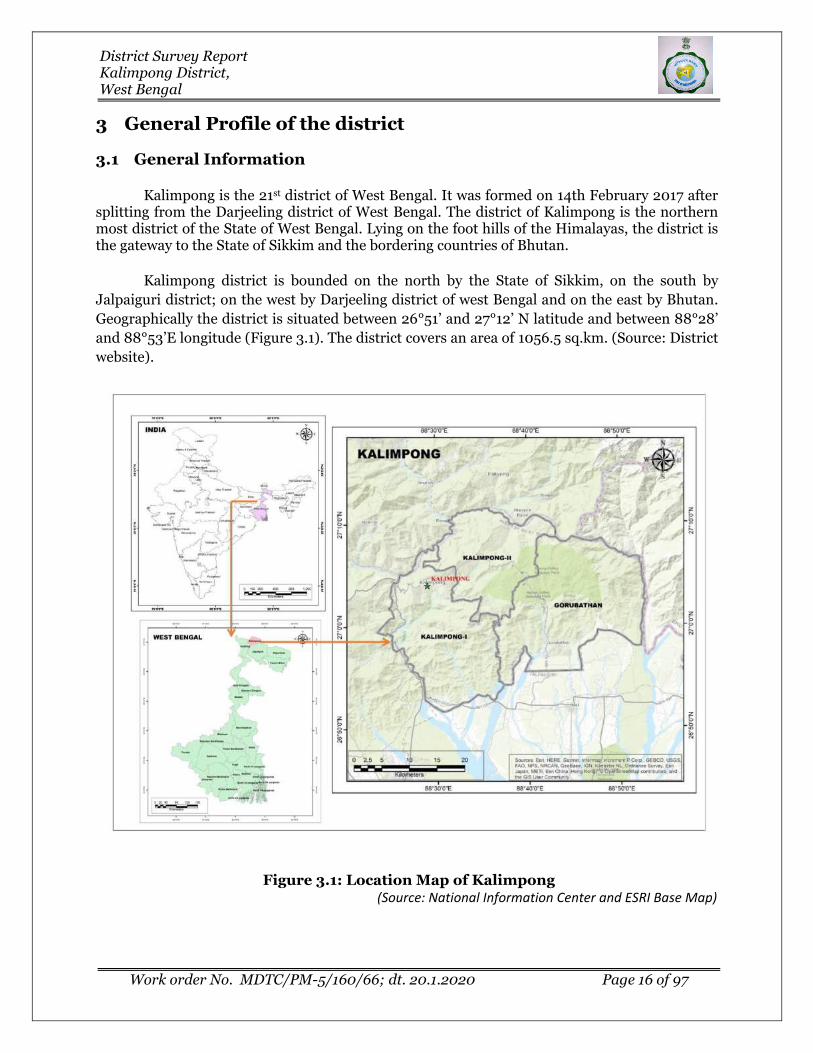
Kalimpong is the 21st district of West Bengal. It was formed on 14th February 2017 after splitting from the Darjeeling district of West Bengal. The district of Kalimpong is the northern most district of the State of West Bengal. Lying on the foot hills of the Himalayas, the district is the gateway to the State of Sikkim and the bordering countries of Bhutan.
Kalimpong district is bounded on the north by the State of Sikkim, on the south by
Jalpaiguri district; on the west by Darjeeling district of west Bengal and on the east by Bhutan.
Geographically the district is situated between 26°51’ and 27°12’ N latitude and between 88°28’
and 88°53’E longitude (Figure 3.1). The district covers an area of 1056.5 sq.km. (Source: District
website).
Figure 3.1: Location Map of Kalimpong (Source: National Information Center and ESRI Base Map)

District Survey Report Kalimpong District, West Bengal
Work order No. MDTC/PM-5/160/66; dt. 20.1.2020 Page 17 of 97
Kalimpong district comprises of 3Community Development Blocks, namely, Kalimpong -
I, Kalimpong -II, and Gorubathan and the Kalimpong Municipality (Figure 3.2). Kalimpong is
the district headquarters. Kalimpong I block consists of rural areas with 18 gram panchayats.
This block has one police station at Kalimpong. Kalimpong II block also consists of rural areas
only with 13 gram panchayats. This block is served by Kalimpong police station.
Gorubathan block consists of rural areas only with 11 gram panchayats. This block has two
police stations: Gorubathan and Jaldhaka. The Kalimpong municipality consists of 23 wards.
Table 3.1: Block distribution of Kalimpong District
District CD block Headquarters Distance from
District HQ (km) No of Gram Panchayat
Area (km2)
Kalimpong
Kalimpong Block - I
Kalimpong 0.0 18 360.46
Kalimpong Block - II
Algarah 12.82 13 241.26
Gorubathan Fagu 25.75 11 442.72
Figure 3.2: Block divisional map of Kalimpong (Source: National Information Center)

District Survey Report Kalimpong District, West Bengal
Work order No. MDTC/PM-5/160/66; dt. 20.1.2020 Page 18 of 97
3.2 Climate Condition
The climate of Kalimpong district is interesting because of its position in relation to the
Tibetan landmass, the wide differences in altitudes, the powerful effect of the monsoons against
the Himalayan barrier and the peculiar configuration of the neighboring monsoons, which
deflect winds and affect local temperature and rainfall.
The temperature in the Kalimpong district varies from 250C to80C. The maximum
summer temperature is 25°C and the minimum 15°C. The maximum temperature in winter is
17°C and the minimum temperature 80C recorded between December and March. The average
temperatures vary during the year by 10.1 °C.
The average maximum and minimum temperature recorded around Kalimpong Town
during preceding five years is as follows:
Table 3.2: Monthly average temperature distribution of Kalimpong District
Jan Feb Mar Apr May Jun Jul Aug Sept Oct Nov Dec
Avg. Temperature
(°C) 12 13.3 16.9 19.6 21.1 22.1 22 22.1 21.9 20.2 16.3 13.4
Min. Temperature
(°C) 8 9.4 12.6 15.4 17.5 19.2 19.4 19.5 19.1 16.4 11.9 9
Max. Temperature
(°C) 16.1 17.3 21.3 23.8 24.7 25 24.7 24.8 24.7 24 20.7 17.9
(Source: Climate-Data.Org)
3.3 Rainfall and humidity
Climate of the Kalimpong district is tropical monsoonal in nature. Kalimpong gets about
2,254 mm rainfall annually. The precipitation during the southwest monsoon constitutes about
80 percent of the rainfall, July being the wettest month. On an average, there are about 105
rainy days in a year (Figure 3.3). The maximum rainfall in the area as per IMD data was
recorded in the month of July followed by August and September. The following table shows the
annual total rainfall recorded for Kalimpong district along with the month(s) while maximum
precipitation is recorded over5 years from 2014-2018 (Table 3.3).
Table 3.3: Annual rainfall recorded in Kalimpong District
Month 2014 2015 2016 2017 2018 Average
Jan 0.1 5 6.5 0.9 0.7 2.64
Feb 10.3 11.8 3 4.6 6 7.14
Mar 20.5 44.3 46.3 79.1 40.4 46.12
Apr 26.9 146.5 34 61.3 79.9 69.72

District Survey Report Kalimpong District, West Bengal
Work order No. MDTC/PM-5/160/66; dt. 20.1.2020 Page 19 of 97
May 310 296.1 191.4 276.1 241.9 263.1
Jun 744.1 537.8 727.9 531 408.2 589.8
Jul 490.1 581.3 1168.3 760.2 592.9 718.56
Aug 825.4 691.7 310.9 767.9 558.7 630.92
Sept 453.4 556.2 535 531 579.7 531.06
Oct 56.8 50.4 306.2 63.8 59.4 107.32
Nov 4.9 5.2 0 7.6 1.7 3.88
Dec 0.9 3.8 0 0 11.3 3.2
Yearly Total 2943.4 2930.1 3329.5 3083.5 2580.8 2973.46
Source: Website of Indian Meteorological Department, Govt. of India
Figure 3.3: Graphical representation of Kalimpong District rainfall
3.3.1 Relative Humidity, Wind speed & Wind direction
Kalimpong has some very humid months, with other moderately humid months on the
other side of the year. The least humid month is January (48.6% relative humidity), and the
most humid month is August (80.8%).Sky remains heavily overcast during the monsoon. Fog or
mist is very common from June to September but rare in December.
Wind in Kalimpong is usually extremely calm. The windiest month is January, followed
by April and December. January’s average wind speed of around 1.3 knots (2.4 Km/H) is
considered “light air.” Maximum sustained winds (the highest speed for the day lasting more
than a few moments) are at their highest in early December where average top sustained speeds
reach 9.8 knots, which is considered a gentle breeze.
0
100
200
300
400
500
600
700
800
JAN FEB MAR APR MAY JUN JUL AUG SEPT OCT NOV DEC
Rai
nfa
ll in
mm

District Survey Report Kalimpong District, West Bengal
Work order No. MDTC/PM-5/160/66; dt. 20.1.2020 Page 20 of 97
Surface winds of Kalimpong District are generally from the east. But during winter
months the prevailing wind direction is E-NE. During the monsoon (June to September), the
prevailing direction is from E-SE.
3.4 Topography & Terrain
Physiographically Kalimpong district can be broadly divided into Hills and Plain land
(Figure 3.4). The natural slope of the land is from North to South. Numerous rivers and springs
flow South-wards emerging from the hills at the North, the most important river flowing in the
western boundary is Teesta and in the east Jaldhaka.
Topographically, the Kalimpong district is highly complex with innumerable variety of
micro and macro relief forms. Topography map of Kalimpong District indicates that north-
eastern portion is rugged where elevation is greater than 2000 meters. Highest elevation
recorded as 3177m. The elevation of southern and western portion is less than 400 meters and
the elevation of the remaining part ranges between 400 to 2000 meters. Lowest elevation of
137m located in the southern part of the district.
Figure 3.4: Physiographic map of Kalimpong District
(Source: Cartosat-1, Bhuvan India)
District Survey Report Kalimpong District, West Bengal
Work order No. MDTC/PM-5/160/66; dt. 20.1.2020 Page 21 of 97
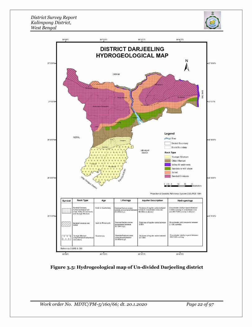
3.5 Water courses and Hydrology
The district is covered by three major geological formations viz, the Precambrian
crystallines, the Vindhyans and the Gondwanas. Besides, the tertiary laterite and alluvium also
covers part of the district. Ground water occurs mostly under phreatic condition in all the
lithological units and locally under semi-confined and confined condition (Source: District
census handbook 2011).
Figure 3.5 represents hydrogeological map of the district which includes Darjeeling
district also. Rock type of the district consists of Banded Gneisses, Schist, Sandstone with shale,
valley fill sediments and younger Alluvium of Azoic to Quaternary age. This rock group chiefly
comprises the district profile. Thickness of the aquifer varies between 5 to 50m in consolidated
rocks which poses yield of 2-2000 cum/day and the thickness of alluvium in this part varies
between 50-700m. Groundwater yield of the alluvium is 200-1500 cum/day.
Eastern and central part of the district comprises mainly of Banded gneiss and schist of
Azoic to Proterozoic age. Thickness of the rock type varies between 5 to 50m and having yield
value of 2-1000 cum/day.
District Survey Report Kalimpong District, West Bengal
Work order No. MDTC/PM-5/160/66; dt. 20.1.2020 Page 22 of 97
Figure 3.5: Hydrogeological map of Un-divided Darjeeling district

District Survey Report Kalimpong District, West Bengal
Work order No. MDTC/PM-5/160/66; dt. 20.1.2020 Page 23 of 97
3.6 Ground water Development
Central Groundwater Board (CGWB) has carried out hydrogeological investigation study
over different part India. The present report incorporates data published by CGWB. It has been
noted that the monitor station are located in the lower elevation or flat land, there are no
monitoring station fall in Kalimpong district. Kalimpong district is the newly formed district
from Darjeeling in 2014. Therefore, the report provides the information related to undivided
Darjeeling district.
Depth of water in wells measured by CGWB at 32 locations which varied from 1.46m to
14.24 m bgl during pre-monsoon period with an average of 4.6m and 1.01 to 9.6 m bgl during
post-monsoon period with an average of 3.2m in the year 1996 to 2018 (Source: CGWBWebsite).
Figure 3.6 represents water level fluctuation graph measured at Sevok monitoring station by
CGWB. Figure shows the depletion of groundwater level over the period.
Over all stage of ground water development is6% indicating sufficient scope of
development (Source: Dynamic Groundwater Resources Assessment of India – 2017, CGWB).
Figure 3.6: Graphical representation of pre-monsoon and post-monsoon data of CGWB monitor well at Sevok
3.7 Drainage System
The Kalimpong district is drained mainly by the Teesta and its tributaries, except the
extreme eastern portion where the chief effluent is the Jaldhaka. Teesta and its tributary Relli
0
1
2
3
4
5
6
1999 2000 2001 2002 2003 2004 2005 2006 2008 2009 2010 2011 2012 2013 2014 2015 2016 2017 2018
Sevok (Post) Sevok (Pre)

District Survey Report Kalimpong District, West Bengal
Work order No. MDTC/PM-5/160/66; dt. 20.1.2020 Page 24 of 97
are the main channels here. Besides these Lish, Geet, Chel, Rishi, Neora and Murti are also
important rivers in southern portion of the Kalimpong subdivision. The region fosters many
perennial rivers which flow through deep gorges and belong to Himalayan or extra peninsular
rivers. The rivers of this group are glacier, spring and rain-fed, originating from the Himalayans
to traverse great alluvial Indo-Gangetic plains.
A Drainage map of Kalimpong District is furnished as Figure 3.7 as well as in Plate-1.
The drainage system of the district is mainly governed by Brahmaputra drainage basin.
The Brahmaputra system is represented in the area by its Teesta sub-system and Jaldhaka sub-
system. Drainage system of Kalimpong is explained in detail in Chapter 7.2.
Table 3.4: Rivers and tributaries in Kalimpong District
Watershed Sub-
Watershed Flow
Regime Rivers &
Tributaries
Length in Kalimpong
(km)
Brahmaputra
Teesta Middle
Teesta 37 Lish 12.10 Geet 30.20 Chel 10.46
Neora 27.46 Relli 30.64
Riyang 18.70 Rangpoo Chu 9.66
Rishi Chu 17.36
Jaldhaka Upper Jaldhaka 19.47 Ni Chu 14.90 Murti 13.82
Source: Cajee L, 2018

District Survey Report Kalimpong District, West Bengal
Work order No. MDTC/PM-5/160/66; dt. 20.1.2020 Page 25 of 97
Figure 3.7: Drainage map of Kalimpong District
(Source: National Information Center)
3.8 Demography
According to the 2011 census, Kalimpong district (enumerated as Kalimpong subdivision
then) encompasses a geographical area of 1053.12sq km and has a population of 251642
(persons) including 129040 males and 122602 females. The district has a sex ratio of 950
females for every 1000 males. The Majority of the populations in Kalimpong district are the
Gorkhas, Lepchas and Bhutias etc. The major religions in the district are Hindu (65.69%) and
Buddhist (16.41%) followed by Christian (12.60%) of the total population. The literacy rate in the
district is 81.65% (persons), 87.18% (males) and 75.89% (females).
In 2014, Kalimpong sub-division of Darjeeling district has been declared as Kalimpong
district. Table 3.5 representing Kalimpong district demographic profile modified based on 2011
census. Literacy rate of Kalimpong city is 90.19 % higher than state average of 76.26 %. In
Kalimpong, Male literacy is around 93.79 % while female literacy rate is 86.49 %.Among the
community blocks, Kalimpong-I is having highest literacy rate. Figure 3.8 and 3.9 representing
block wise population distribution and literacy rate respectively for Kalimpong district.

District Survey Report Kalimpong District, West Bengal
Work order No. MDTC/PM-5/160/66; dt. 20.1.2020 Page 26 of 97
Table 3.5: Demographic distribution of Kalimpong District
C.D.Block/MC
Area (Sq.Km.)
Number of households
Male Female Population Literacy
(%)
Percent of population to district
population
Kalimpong Municipality
8.68 10113 25,690 23,713 49,403 90.19 19.63
Kalimpong-I 360.46 15358 37,750 36,996 74,746 81.43 29.7
Kalimpong-II 241.26 13172 34,546 32,284 66,830 79.68 26.56
Gorubathan 442.72 12662 31,054 29,609 60,663 76.88 24.11
TOTAL 1053.12 51305 129040 122602 2,51,642 81.65 100
(Source: Census of India, 2011)
Figure 3.8: Block-wise population distribution in Kalimpong District
(Source: Census of India, 2011)

District Survey Report Kalimpong District, West Bengal
Work order No. MDTC/PM-5/160/66; dt. 20.1.2020 Page 27 of 97
Figure 3.9: Demographic map showing Block-wise Literacy rate of Kalimpong District
(Source: Census of India, 2011)
3.9 Cropping pattern
Placed between the Teesta and the Jaldhaka rivers and stretched from the lesser
Himalayas to its foothills, the Kalimpong district is rich with an abundance of flora and fauna,
with temperate climate that favours agro-horticulture. More than 80% of people in Kalimpong
depend on farming for their livelihood. Major agro-products include paddy, maize, millet, pulse,
oilseed, and potato; however Kalimpong is more widely known as a hub of cash crops like
ginger, cardamom, betel-nut and oranges.
Kalimpong is also the home to the Dalle Khursani (Capsicum Annuum), a variety of
small but extremely hot chillies, which add delectable pungency to the exotic cuisine of the hills.
3.10 Land Form and Seismicity
The hilly region of the district is very prone to landslide due to poor water retention
capacity of the soil clubbed with steep land slope (from North to South, and South-East). The

District Survey Report Kalimpong District, West Bengal
Work order No. MDTC/PM-5/160/66; dt. 20.1.2020 Page 28 of 97
considerable portion of the district falls under the Seismic Zone IV (in a scale of I to V in
ascending order of propensity f Seismic Activity), making it very prone to the earthquakes
(Source: District census handbook 2011). Figure 3.10 shows the district position on the
earthquake map of West Bengal. However, no major earth quake event has been recorded with
its epicenter in Darjeeling district. Many earthquake shocks experienced in the district have
been recorded.
Figure 3.10: Earthquake zonation map of West Bengal highlighting the Kalimpong district position
(Source: Ministry of Earth Science)

District Survey Report Kalimpong District, West Bengal
Work order No. MDTC/PM-5/160/66; dt. 20.1.2020 Page 29 of 97
3.10.1 Earthquake:
District has many earthquake shocks experienced since, eighteenth century. During
Dhubri earthquake of 3rd July 1930, the district fell within the higher isoseismic zone of the
earthquake with its focus near Cherrapunji; the quake reached within minutes and caused
massive devastation. Cracks appeared in several buildings of Kalimpong and Darjeeling town
due to the earthquake. The Bihar-Nepal earthquake of 15th January 1934 was severely felt in the
district, the worst affected parts being Darjeeling town and its neighboring spurs and the railway
station at Tindharia. Kurseong and Kalimpong escaped with minor cracks in buildings but
landslides occurred at several places in the Teesta valley in Kalimpong district. The September
18, 2011 earthquake left a trail of devastation in Sikkim and Darjeeling hilly area damaging
roads, building and other structures, uprooting mobile phone towers and snapping
communication and power lines. The impact of the quake in Darjeeling hills was felt mainly in
Kalimpong district and Kurseong subdivisions of Darjeeling district (Source: Mili J, 2012).
On 25th April and 12th May 2015, Nepal and its surrounding area were hit by
earthquakes which are considered to be the most devastating in the living memory of the
inhabitants of these affected areas. The 7.9 magnitude quake was the strongest to hit Nepal for
81 years. It was the most horrible natural disaster to hit Nepal since the 1934 Nepal–Bihar
border earthquake. Earthquakes are often followed by landslides and rock avalanches and
glacier avalanches in Himalayan hilly areas. Landslides also blocked the river channels, sewage
and other communication system in Darjeeling district. Mud wall, buildings and boundary walls
in different locations of Siliguri and Jalpaiguri had collapsed because of the tremors (Source:
Dey S, 2015).
3.10.2 Landslide:
In Kalimpong district along with other district of Darjeeling Himalaya, occurrences of
landslides are prominent from a long time of history. The Teesta basin is one of the most
vulnerable among the Himalayan river basins considering the occurrence of landslides and
floods. The landslides occurred in 1899, 1950, 1968, 1976, 1991, 1993, 2003, 2004, 2005, 2006,
2009, 2011 and 2015. All of the slides occurred in the Kalimpong, Darjeeling Town, Kurseong,
Pulbazar, Rongtong, Tindharia, etc.
As per the landslides records available, in September 1899 landslide 72 lives were lost in
Darjeeling Himalaya. Darjeeling, Kalimpong, Kurseong, Ghum, Tindharia were affected by this
disaster. A massive landslide occurred in June 1950, in which 127 lives were lost along with the
loss of several properties including roads and Siliguri-Kalimpong railways line.667 lives were
lost along with the destruction of a tea garden due to October 1968 landslides. The affected areas
of the landslide were Kalimpong, Darjeeling town, Manpuri, Lebong, Tista Bazar, etc. Again,
Rimbik, Lodhama, Darjeeling Town, Bijanbari, Lebong, Ghum, Happy Valley were affected by
the landslides that occurred on September 1980. The landslide of June 2011 was the subsequent
effects of high rainfall of about 60 mm rainfall in about 3 hours at Kalimpong, 152 mm at
Darjeeling and Kurseong. In this landslide, no such significant casualties had occurred. In the

District Survey Report Kalimpong District, West Bengal
Work order No. MDTC/PM-5/160/66; dt. 20.1.2020 Page 30 of 97
same year, in September, the landslides occur due the subsequent effect of Sikkim earthquake
but the Darjeeling Himalayas has been less affected than the Sikkim Himalayas (Source: Biswas
and Pal 2015).
Heavy rain has triggered landslides at Kalimpong, Mirik, Darjeeling and Kurseong
during June-July, 2015, causes the loss of several lives and properties. Thus, the landslide
disaster of 2015 triggers severely the natural environment of the Darjeeling Himalayas.
Geological survey conducted for the Darjeeling Landslide by the Survey of India and the report
says that the Nepal earthquake has a significant role in the occurrence of the landslide.
However, historical record suggests that intense rainfall is the key factor for the June-July, 2015
landslide. As the developmental activity is increased in the mountainous region, thereby, the
land use management is significant to reduce the vulnerability of the landslides (Source: Biswas
and Pal 2015).
The mitigational measures to tackle the landslide hazard in the district are (Source: Nad,
2015)-
✓ Structural measures: The stability of a vulnerable slope may be increased either
by reducing the volume at the head or by expanding the volume at the toe.
✓ Drainage Corrections: The streams and temporary water resources particularly at
the head of the slides are diverted from the slide area.
✓ Proper land use measures: proper scientific land use planning and Ban on non-
biodegradable materials in hazard areas.
✓ Afforestation: Afforestation programmed lunched for minimize the breakdown
situation of environmental equilibrium. The grass cover must not be disturbed
unnecessarily in the hilly area.
✓ Public Awareness: Village wise Training Programmed, Landslide Management
Education from School Level.
✓ Settlement policy: Restricting Development in Landslide Prone Areas, Protection
of Existing Development, Monitoring and Warning System.
3.10.3 Critical landslide prone area:
The primary risk inclined territories of landslides prone areas tabulated as per research
work by Deepak and Pradeep, 2019:
Table 3.6: Critical landslide prone areas of Kalimpong district
Level of Landslide Prone Area Hazard Areas
Very high (severe) landslide prone area The north-central part of the Darjeeling hills falling
in Kalimpong district
High landslide prone area River bank of Teesta in Kalimpong district
Moderately high zone of landslide hazard North-west and south-east below high zone in
Kalimpong district

District Survey Report Kalimpong District, West Bengal
Work order No. MDTC/PM-5/160/66; dt. 20.1.2020 Page 31 of 97
Level of Landslide Prone Area Hazard Areas
Moderate zone of landslide hazard Eastern part where there remain a chance of at
least one landslide/ km2
Low landslide hazard prone area Small patches in southern part of Kalimpong
district
Figure 3.11: Landslide Hazard Zonation Map of Kalimpong District
(Source: Nad, 2015)
3.11 Flora
Kalimpong is a precious part of the Eastern Himalayas and boasts a rich bio-diversity.
The Neora Valley National Park (88 sq. km), on the north-eastern face of the district with its
dense subtropical and impenetrable temperate forest, is a national asset. A wide range of
vegetation structures with extremely rich plant and animal diversity developed in the district
due to the extreme climatic, edaphic and physiographic variations. Plants of diverse forms, such
as trees, shrubs, climbers, lianas, annual and perennial herbs, geophytes, epiphytes, parasites,
and saprophytes, are evenly distributed. The estimated vascular flora for the district is 2,912.

District Survey Report Kalimpong District, West Bengal
Work order No. MDTC/PM-5/160/66; dt. 20.1.2020 Page 32 of 97
Table 3.7: Vascular flora in Kalimpong
Taxa Estimated number of
Species
Angiosperms (dicots) 1900
Angiosperms (monocots)
750
Gymnosperms 12
Pteridophytes 250
(Source: Das, 2008)
There are six natural subtropical forests beginning at different zones: Mongpong (from
Tiger Bridge), continuing to Lish, Guling and Nazoke Chunabhatti, stretching to Nimbong.
Pubung-Mangzing stretching to Gitdabling, Dalimkot-Gourbathan, extending to Samsing and
above Kumai, taking its route to Rongo and above and Jholung Paren to Todey via Godak.
The Tarkhola and the forests along the eastern flank of river Teesta are connected to
Neora Valley through Munsong, Damsang-Algarah and Paktham-Lahba. The second
connectivity of forests begins at Chunabhatti (Bagrakote)-Pubung and continues through
Nimbong, Pemling, Lolaygaon and Lahba to join Neora Valley. The forests of Ambiok-Dalimkot
(Gorubathan), Samsing, Kumai, Rongo, Paaren- Godak and Todey Tangta skirt the national
park on the south-eastern flank.
At the foot of Kalimpong, along the river banks of Relli and Teesta, the rain forests can
be observed containing the species Acacia (Khair), Meliosma Pinnata (Dabdabe), Albizia (Siris)
and Dalbergia (sissoo). The lofty sal trees and the intermixed species of Terminalia,
Largerstroemia parviflora, and Dillenia from the sal forest lie in the lower hills. The tropical
mixed forests in this zone show the presence of Tetrameles (Maina), Beilschmiedia (Tarsing),
Macarange (Malata), along with the undergrowths. The subtropical forests, mostly deciduous,
extending to an altitude of 1800m, are home to species like Gynocardiaodrata (Gante),
Callicarpa (Guenlo), Duabanga (Lampate), Terminalia (Saj), Phyllanthus (Amala), Cinamomum
(Tejpat), Engelhardia (Mauwa) and Ficus (Khaniun). The beauty of these forests has been
enhanced by the magnificent and lofty climbers like Entada (Pangra), Tinospora (Gurjo,
Combretum (Thakauli), Mucuna (Kaoso&Baldengra), Cissus (Charchare).
The popular bio-diversity and typical Himalayan flora is exhibited by the evergreen
temperate forests. The temperate ranges cover the forests of Algarah, Charkhola- Lolaygaon,
Damsang, Thosum, Todey Tangta and continue above to the Rachela peak, the tri-junction of
Sikkim, Bhutan and Kalimpong. Floristically, this climatic border is marked by the presence of
certain species like Leucoceptrumcanum (Ghurpis), Edgeworthiagardneri (Argeli), Rapidophora
(Kanchirno), Thunbergia, Agapetes, etc. There are about seven species of Rhododendrons in the
Neora Valley, some of them forming a pure (monoculture) forest at the peak of Rachela. Species
like Rhododendron arboreum, Magnolia campbellii, Alcimandra cathcartii, Abutilon indicum,

District Survey Report Kalimpong District, West Bengal
Work order No. MDTC/PM-5/160/66; dt. 20.1.2020 Page 33 of 97
Mussaendatreutlerii and others can be seen along the ridges of Labha, Gumbadara, Jhandi,
Damsang, Todey Tangta and above and they are popular with explorers.
The evergreen patches of Pinus, Thuja and Cryptomeria can be seen along the roadsides
of Labha and Kafer. The common trees of this temperate forests are Quercus lamellose (Oak),
Betula alnoides (Birch), Acer spp. (Maple), Alnusnapalensis (Alder), Lyonia, Castanopsis,
Lithocarpus, Sorbus, Llex, etc. The upper ridges of this zone are often dominated by the thickets
of Arundinaria maling and allied spp. Neora Valley is host to a number of plants of tremendous
botanical value. The highly endangered saprophytic herbs of the humus soil of the deep forest,
Balanophora and Monotropa are available in this forest. The notable names of vegetational
wealth include Rhododendron spp, Tsuga dumosa, Taxus buccata, Helwingiahimalaica, Paris
Polyphylla, Polygonatumspp, Arasaemaspp, Smilax spp, etc., and they form the integral part of
this upper forest.
About 300 species of orchids have been reported in this part of the Himalayas. Some of
the popular orchids available here are Paphiopedilium, Pleone, Orchis, Herminium, Oberonia,
Liparis, Coelogyne, Dendrobium, Cymbidium, etc. along with the common ground orchids like
Habenaria, Satyrium, etc. The only medicinal plant garden of the nation that cultivates the
precious Cinchona (and has its headquarters at Mungpoo) has a major stretch of cultivation in
Kalimpong – at Munsong and Rongo – Gairibas. The commercial cultivation of Cinchona spp,
Dioscoreaspp, Cephaelisipecacuanha, and other herbal plants such as Digitalis, Solanum,
Rauwolfia, Mentha etc. have ben carried here since its inception in the 60s.
Kalimpong district has one protected area – Neora Valley National Park. It has rich
floristic diversity. The lower altitudinal zone or foothills (500 to 1,700m) displays characteristic
subtropicalvegetation. The dominant tall tree species (10-30m) include Duabanga grandiflora,
Micheliachampaca, Terminalia alata, Gmelina arborea, Schimawallichii, Castonopsis indica,
Phoebehainesiana, Ficus subincisa, Quercus glauca, Erythrina stricta, Syzygiumformosum,
Phyllanthusemblica, and others. The undergrowth includes Pandanus nepalensis, Maesa indica,
Garugapinnata, and Holmskioldiasanguinea. The common herbs are Ageratum conyzoides,
Oxaliscorniculata, Urnealobata, Pouzolziasanguinea, Mimosa pudica, Eranthemumpulchellum,
and others. Above this zone, lies a small sub-temperate zone (1,700-1,900m), characterized by
Ostodespaniculata, Ficus oligodon, Syzygiumclaviflorum, Catunregamlongispina,
Ehretiaserrata, Morinda angustifolia, and Solanum erianthumc. The ecological zone between
1,900and 3,150m receives comparatively more rainfall and has higher humidity than the
tropicalarea and therefore harbours rich vegetation with wide ranging biodiversity. The 15-25m
high trees form a dense, closed canopy, and include Michelia dolorosa, Magnolia campbellii,
Alnusnepalensis, Rhododendron arboreum, Acer thomsonii, Juglans regia, Betula
alnoides,Cotoneastergriffithii, Elaeocarpus lanceifolicus, Larix griffithiana,
Juniperuspseudosabina, Abiesdensa, Tsuga dumosa, Taxus baccata, Pinus roxburghii, and
Cryptomeria japonica. Therich biodiversity of this zone is displayed in the occurrence of natural
virgin forests, densebamboo grooves, and a colourful canopy of rhododendron trees and green
valleys. In addition the forests hold a number of epiphytes, mainly orchids. The common
climbers are Thunbergialutea, Clematis nepalensis, Lonicera macrantha, Jasminum dispermum,

District Survey Report Kalimpong District, West Bengal
Work order No. MDTC/PM-5/160/66; dt. 20.1.2020 Page 34 of 97
Schiandragrandiflora,andParthenocissussemicordata, and the rich undergrowth is comprised of
Rubuspaniculata, Arundinaria maling, Viburnum erubescens, Agapeteshookeri, Astilberivularis,
Strobilanthusthomsonii, and Hedychium coccinium. Herbaceous floras are represented by
Primula listeri, Swertia dulata, Galinsoga parviflora, Anaphaliscontorta, Aconitum spicatum,
Meconopsisnepalensis, Gentianacapitata, Rumexnepalensis, and Polygonum orientale. Except
in the very high altitude areas (above 3000m) the trees and shrubs are festooned with thick
growths of epiphytic flora such as bryophytes, pteridophytes, and angiosperms.
Heterophyticangiospermic flora such as Viscum, Loranthus, Balanophora,
Ropalocnemahimalaica, Aeginetia indica, andmany others are also abundant. (Source: Das,
2008).
Endangered Floral Species:
Table 3.8: Threatened Plants of Un-divided Darjeeling District
Scientific Name
Family Status Distribution sites and Avg.
altitude
Acer hookeri ACERACEAE Endangered Darjeeling, 600-1500 m
Acer osmastonii ACERACEAE Endangered Darjeeling (endemic), Salombong, Birch
hill Pimpinella tongloensis
APIACEAE Endangered Endemic to Singaleela range in the
Darjeeling-Sikkim Himalaya
Phoenix rupicola ARECACEAE Rare 450 m
Begonia scutata BEGONIACEAE Rare Darjeeling, Peninsular India. 1000-1500
m
Codonopsisaffinis CAMPANULACEAE Rare Darjeeling and Sikkim Hiamalaya. 1830-
3335 m Bulleyiayunnanen
sis ORCHIDACEAE Rare Darjeeling hills
Diplomerishirsuta ORCHIDACEAE Vulnerable Darjeeling. 1500-2000 m
Christiopteristricuspis
POLYPODIACEAE Indeterminate Darjeeling
Ophiorrhizalurida RUBIACEAE Rare Darjeeling. 300-1500 m
Christellaclarkei THELYPTERIDACE
AE Vulnerable Darjeeling. 4000 m
(Source: India Biodiversity Portal)
3.12 Fauna
The wildlife of Kalimpong is enriched by the presence of endangered species like the red
panda and munal pheasant, Himalayan black bear, clouded leopard tiger, Himalayan tahr, goral,
gaur and pangolin at widely different altitudes. The forest belts host the Siberian weasel, today
cat, Asiatic black bear, India leopard, barking bear, Indian bison, moupan hare and Himalayan
squirrels.

District Survey Report Kalimpong District, West Bengal
Work order No. MDTC/PM-5/160/66; dt. 20.1.2020 Page 35 of 97
The district possesses a rich variety of fauna. There are about 90 species of mammals in
the un-divided Darjeeling District. Among the large carnivores, Wild Leopard, Clouded Leopard,
Leopard-Cats are seen both in the hills and jungles of the Tarai region. The Jackal, Indian Fox
are also normal residents of the forests. The Himalayan Black Bear, Common Indian Sloth Bear
and Malayan Sun-Bear are the species belonging to Ursidae family which can still be found,
although in very limited number, in forests. Among the herbivore, Elephant is very common.
Several wild Elephants, sometimes in herds, sometimes singly can often beseen, mainly near the
forest areas in the vicinity of river streams and in the Tarai.Among the lesschallenging smaller
herbivore, the Gaur, Sambar, Spotted-Deer, Barking-Deer and Hog-Deer can also be
occasionally observed. Among the goats, Serow and Ghoral can still beseen in the forests. The
Red-Tailed Rabbit, Hispid Hare, Squirrels, Porcupines, Moles,Rats, Mice, wide variety of
poisonous and non-poisonous Snakes, Martens and numerous other small animals are the
common residents here. (Source: District census handbook 2011).
The District is very rich in Bird life containing about 550 species. Nearly one quarter of
the species of birds found in India, is found here. More than half of the species are passerine
birds, the largest families being the Timaliinae (Laughing-Thrushes, Babblers) with 61 species;
the Sylviinae (Warblers) with 60 species; the Turdinae (Chats, Robins, Thrushes) with 56
species; the Muscioa-pmas (Fly-catchers) with 27 species; the Fringillinae (Finches) with 22
species. There are plenty of Minivets, Orioles, Sunbirds, Malay Tree Sparrow. The best
represented families in the Coraciformes are the Picidae (Woodpeckers) with 15 species; the
Cuculidae (cuckoos) with 16 species and Asionidae (owls) with 14- species. There are five species
of King-fisher of which the tiny Indian three-toed Kingfisher (Ceyx e. enthaca) a forest species,
is the most beautiful one. Accipitrine birds number about 40 and include the fine Himalayan
Lammergeyer (Gypaetus barbatus hemachalanus), Hodgson's Feather-toed Hawk Eagle
(Spizaetus n. nipalensis), the Himalayan Rufous bellied Hawk-Eagle (Lophotnorohis k. kienerl)
and the handsome bold miniature Falcon, the Himalayan Red-legged Falconet (Microphierax c.
coerulscens). There are about a dozen species of pigeon and doves, some being only found at
high elevations. Only Bengal Green-Pigeon (Crocopus p. phoenicopterus) is found m the plains.
The Green-Pigeon (Sphenocercus s. spenurus) and the Himalayan Pintailed Green-Pigeon
(Sphenocercus a. apicandus) are common in the hills.
Endangered Fauna: There has been a depletion of natural fauna of this region to a
certain degree due to human interference on animal kingdom. Because of unnecessary shooting
and poaching, extension of tea cultivation and spread of human settlements on the fringe of
forests and even setting up of settlements on the seasonal migration routes of some animals like
elephants, there has been considerable depletion of fauna in this district. All of these have made
conservation of wild life an urgent need of the district for the maintenance of ecological balance.
In 1955, Mahanadi Wild Life Sanctuary has been setup for the protection of gaur (Indian bison).
Neora Velley National Park: The Neora Valley is bird watching heaven. The
dominant genera in the amphibian species are Rana, Loepa and butterflies like Pieris, Poutia,
Apollo, Papilio etc. can be spotted. The park is also home to the endangered red panda (Ailurus

District Survey Report Kalimpong District, West Bengal
Work order No. MDTC/PM-5/160/66; dt. 20.1.2020 Page 36 of 97
fulgens). The discovery of around 19 royal Bengal tigers (Panthera tigris) by the Tiger Census of
2002has listed the park among the most sensitive wildlife zones in the country.
Figure 3.12 is Wild Life Sanctuary and National park location map of West Bengal and
District Kalimpong highlighted in the map to show its proximity to the Sanctuary and National
Park.
Figure 3.12: District location with respect to Wild Life Scantuary of West Bengal
(Source: ENVIS Centre on Wildlife and Protected Areas)

District Survey Report Kalimpong District, West Bengal
Work order No. MDTC/PM-5/160/66; dt. 20.1.2020 Page 37 of 97
4 Physiography of the district
4.1 General Landforms
Darjeeling Himalaya rises abruptly from the North Bengal plain, the elevation changing
rapidly from 100-130 m above sea level (a.s.l) to 2000-3000 m a.s.l within a distance of few
kilometers. The hilly areas are a part of the Siwalik Range or Outer Himalayas. The general
slopes of the hills are from north to south. Narrow ridges separated by closely-spaced V-shaped
valleys, where the slope varies between 15ºand 40º.The region is highly prone to landslides,
often causing disruptions to socio-economic activities as well as destruction of life and
properties (Source: Geomorphological Field Guide Book, IGI).
The complex landform of the district has been form due to different geomorphic
processes, each of which has developed its own characteristic assemblage. The geomorphic
configuration of the hilly tract is the joint product of geologic foundation and fluvial processes;
although slope-wash, in particular mass-movements and related phenomena play a significant
role in the final shaping of the landform. The region is characterized by a myriad of ridges and
valleys because of the spurs ramifying into lateral spurs which give off lesser ones and these in
turn cut the terrain into ridges and valleys, creating a mosaic of micro-topographical units
(Cajee 2018).
Lower hills: This region is bounded by contour heights of approximately 400 - 1000 m
and covers most of the central section of the district which is found in the western and south-
eastern portion of the district in an around Teesta and Chal river valley region. The rivers in this
region are mostly south-flowing and cut deep gorges and V-shaped valleys. The landscape is
characterized by narrow ridges, deep incisions and numerous mass-movement scars. The
average slope in this zone varies between 10° - 30°, with slope length sometimes exceeding 800
m. These lower hills are the most dissected and eroded tract in the Darjeeling Himalaya.
Middle hills: Whole northern part of the district is a part of middle-hill zone and is
bounded by 1000 m and 2000 m contours. Kalimpong town and the Algara region fall under
this category. These hill slopes are mostly used by tea plantations.
Upper hills: The upper hills lie above the 2000 m contour line and have been identified
in Labha area that is north-eastern portion of the district.
Beyond the hill region in the North, starts the flat plain at South and South-west part of
the district. This foothills zone is called the “Terai”. It covers the tilted plains at the base of the
foothills. This is formed due to the coalescing of several alluvial fans within the catchment area
of the major rivers like Teesta, Jaldhaka. These streams form smaller fans, the apex part of
which could be noticed at the entrance of the mountains. Fragments of higher fan levels with
well-develop soil profile are preserved between the alluvialfans. The shape of the terraces and

District Survey Report Kalimpong District, West Bengal
Work order No. MDTC/PM-5/160/66; dt. 20.1.2020 Page 38 of 97
the fan systems on the Terai piedmont zone is irregular, and are partly controlled by tectonics
(Source: Geomorphological Field Guide Book, IGI).
4.2 Soil and rock pattern
Soils of the study area are heterogeneous in nature. The texture varies from gravely loam
to loam and itis classified as lithic and Typic Haplustepts. Alfisols are dominant and covers
52.96% of the area followed by Ultisols (36.27%). Darjeeling Himalayan soil generally classified
into six types such as Mountain glacial soil, Forest soil, Brown forest soil, Cinchona soil, Terai
soil and Tea soil.
The soil developed on steep hill slopes is shallow, excessively drained to vary severe
erosional hazards. These are mostly the residual of the eroded soil and lack profile development.
The soil, developed on foothill slopes and valley are moderately deep-to-deep, well drained,
loamy in texture with moderate erosion hazards, they show some degree of profile development
and are classified as Umbric and/ or Fluvaquentic Dystrochrepts, Lithic and/ or
Typic Haplustepts. These soil are strongly to moderately acidic in reaction and are rich in humus
content with moderate to low base saturation.
The basic soil types are yellow and red-brown soils and brown forest soils, all of siliceous
and aluminous type. Red and yellow soils have developed on gneisses and schists along the
upper part of slopes. Over the Siwaliks are developed coarse pale yellow to red brown soils, on
the Daling shales clayely dark greysoils and on the Gondwanas mainly sandy soils. Over the
Darjeeling gneisses prevail red to brown silty and sandy soils. On the floors of main river valleys
shallow sandy alluvial soils exits, which at the mountain foreland are more silty in nature.
The character of bedrock is reflected mainly in the grain size composition of soils. A very
high percentage of sandy and coarse particles reaching upto 50-80% are a characteristic feature
of grain composition of soils over the Darjeeling gneisses as well as Damuda and Daling series.
On the steeper slope segments a highcontent of coarse debris is present. Soil textural map of the
Kalimpong Subdivision area indicates that the entire area covered by coarse loamy and gravelly
loamy soil. In the slope deposits disturbed by mass movements there exist with the horizons of
various content of silty-clay fraction, influencing changes in the infiltration rate. On the contrary
in the tea gardens and on the terraced slopes the spatial differentiation in physical properties of
soilis connected mainly with agricultural practices (Source: Dasmondal, 2018).
Figure 4.1 is showing soil pattern of the Kalimpong district. Soil type of the district
mainly divided based on Brown Forest Soil of Hill slopes and Terai soil and their sub-type as
explained below table (Table 4.1).

District Survey Report Kalimpong District, West Bengal
Work order No. MDTC/PM-5/160/66; dt. 20.1.2020 Page 39 of 97
Figure 4.1: Soil Map of Kalimpong District (Source: National Bureau of Soil Survey and Land Planning)
Table 4.1: Description of District soil type
MAP SYMBOL DESCRIPTION
HILLS AND SIDE SLOPES (BROWN FOREST SOILS)
W001 Shalow, excessively drained, gravelly loamy soil occurring on very steep side slopes with gravelly loamy surface and severely eroded, associated with rock
outcrops.
W002
Moderately shallow, excessively drained, coarse loamy soil occurring on steep side slopes with gravelly loamy surface, severe erosion and strong rockiness associated with moderately shallow, well drained, gravelly loamy soils with
loamy surface and moderate erosion.
W003
Deep well drained, fine loamy soils occurring on steep side slopes with gravelly loamy surface, moderate erosion and moderate rockiness, associated with moderately shallow, excessively drained, coarse loamy soils with loamy
surface, severe erosion and moderate rockiness.

District Survey Report Kalimpong District, West Bengal
Work order No. MDTC/PM-5/160/66; dt. 20.1.2020 Page 40 of 97
W004
Moderately shallow, well drained, gravelly loamy soils occurring on steep side slopes with gravelly loamy surface, moderate erosion and moderate rockiness associated with moderately shallow, somewhat excessively drained, gravelly
loamy soil with loamy surface, moderate erosion and moderate rockiness.
W005
Moderately Shallow, somewhat excessively drained, coarse loamy soils on gently sloping side slopes with gravelly loamy surface, moderate erosion and
slight rockiness associated with deep, well drained, fine loamy soils with loamy surface and slight erosion.
PIEDMONT PLAIN (TERAI SOILS)
W007 Very deep, imperfectly drained, fine loamy soils occurring on very gently sloping lower piedmont plain with loamy surface and moderate erosion
associated with very deep, imperfectly drained, coarse loamy soils.
W008 Very deep, poorly drained, coarse loamy soils occurring on level to nearly level
lower piedmont plain with loamy surface associated with very deep, poorly drained, coarse lomay soils
The rock formations from north to south consist of the moderately resistant Darjeeling
Gneisses, the Daling Metamorphics of varying resistant (i.e., phyllite toquartzite), and the
Damuda Shales with coal beds. Tertiary sandy molass deposits of Siwalik unconformably overlie
the Damuda formation. The overall rock type of the district is mainly consisting of Granite,
Gneiss, Shales, and most importantly Sandstone and solidified but poorly consolidated clutter of
Conglomerate formations.
Rock type of the district may be divided into three tracts, which are, from north to south,
the hard rock area, the Bhabar belt, the Terai belt. The Bhabar belt comprises rock fragments,
big boulders and fine grained clastics derived from the hard- rock area is characterized by gentle
slope, boulder surface and forest of tall trees. These are the coarse alluvial zone below the
Siwalik Hills (outermost foothills of the Himalayas) where streams disappear into
permeable sediments. The Terai belt is the zone of rejected recharge and, as such has developed
swampy condition and is composed mostly of coarse granular materials alternating with finer
clastics (Source: Mili J, 2012).
4.3 Different geomorphology units
Geomorphologically the Kalimpong district can be broadly divided into two regions.
These are the valley regions (below 400 m.) and the mountain region (above 1000 m).The hilly
areas are a part of the Shivalik Range. Darjeeling Himalayas has an elevation range of 2000-
3000 m, and occurs as the foreland of the Kanchenjunga massif. Geological foundations of the
Darjeeling hills consist of Precambrian slates, schist, phyllite, quartzite, gneisses, lower
Gondwana and Siwalik sandstones and recent to sub-recent alluvium.

District Survey Report Kalimpong District, West Bengal
Work order No. MDTC/PM-5/160/66; dt. 20.1.2020 Page 41 of 97
The foothills of Darjeeling Himalayas, is known as the Terai. This is primarily a plain
land having elevation of 100 to 150 metres. Geological formations of these plains are Alluvium,
Older Alluvium and Laterite of Siwalik System.
Figure 4.2 below represent the Geomorphological variation of Kalimpong district. Map
shows the position of upper hills in the north-eastern part of the district where Neora Valley is
situated. Central region of the northern hilly area is also part of upper hills. Lower and middle
ranges are demarcated by Lower hill region. Southern part of the district fall under Alluvial Fan,
characteristic of hilly terrain where river off load sediments from narrow canyon to plan land.
Figure 4.2: Geomorphological map of Kalimpong District
(Source: Resourcesat-1&2 – Liss-3,Bhuvan India)

District Survey Report Kalimpong District, West Bengal
Work order No. MDTC/PM-5/160/66; dt. 20.1.2020 Page 42 of 97
5 Land use pattern of the district
The land share of un-divided Darjeeling district, which includes Kalimpong, is modest in
comparison to other districts in the state. Due to its mountainous terrain, fortunately, for a large
proportion of land there is still a forest cover. Data from Census-2011, shows that the total forest
land is 124.58ha.Total land for agricultural use is 160ha. Table 5.1 gives land utilization static of
Darjeeling district including Kalimpong as sub-division. Figure 5.1 is pie diagram representing
broad land use pattern of the district and Figure 5.2 is Land Use Land Cover map of the district.
Table 5.1: Classification of Land Utilisation Statistics in the district
Year 2008-09 2009-10 2010-11 2011-12 2012-13
Reporting Area (In Thousand Hectares)
325.47 325.47 325.47 325.47 325.47
Forest Area 124.57 124.57 124.57 124.57 124.58
Area under Non-agricultural use 39.88 40.16 40.53 38.62 39.21
Barren & unculturable land 2.48 2.14 2.46 2.57 2.33
Permanent pastures & other grazing land
0.87 1.13 0.83 0.57 0.5
Land under Misc. tree groves not included in Net area sown
2.21 2.33 2.35 2.64 2.78
Culturable waste land 1.67 1.55 1.49 1.31 1.12
Fallow land other than Current fallow
3.75 3.65 3.22 3.18 2.93
Current fallow 17.53 17.67 16.44 17.36 16.55
Net area sown 132.51 132.27 133.58 134.65 135.47
Source: Directorate of Agriculture (Evaluation), Govt. of W.B.

District Survey Report Kalimpong District, West Bengal
Work order No. MDTC/PM-5/160/66; dt. 20.1.2020 Page 43 of 97
Figure 5.1: Land use pattern of Kalimpong District
Table 5.2 : Distribution of Villages according to Agricultural Land Use, 2011
Name of C.D. Block Total area (in
Hectares) Percentage of cultivable
area to total area Percentage of irrigated area to cultivable area
Darjeeling Pulbazar 38370.91 44.37 44.05
Rangli Rangliot 27298.65 35.16 20.4
Jorebunglow Sukiapokhr
20293.16 55 23.91
Kalimpong-I 30486.93 37.19 27.49
Kalimpong-II 19810.14 34.5 21.81
Gorubathan 30389.16 44.17 14.01
Mirik 11917.62 63.02 25.74
Kurseong 31596.2 51.41 24.47
Matigara 11275.43 62.37 31.68
Naxalbari 16029.8 60.67 51.18
Phansidewa 30638.94 73.1 12.55
Kharibari 14078.23 66.5 2.7
Total 282185.2 50.2 24.56
Vegetation38%
Non Agricultural
12%
Agricultural land49%
Baren land1%

District Survey Report Kalimpong District, West Bengal
Work order No. MDTC/PM-5/160/66; dt. 20.1.2020 Page 44 of 97
Table 5.2 shows the distribution of agricultural land, both irrigated and un-irrigated
land, among the villages of un-divided Darjeeling district. In Darjeeling district around 50
percent land area of the total land of the district is available for cultivation. Irrigation is
considered as an important factor for cultivation. As per the Table 5.2, 24.56 per cent of the
cultivable land is under irrigation. The proportions of cultivable area in the block Kalimpong-I,
Kalimpong-II and Gorubathan, which are in the current Kalimpong district, are lowest to its
total area. Gorubathan is the lowest among all the blocks constituting un-divided Darjeeling.
Kalimpong-II and Gorubathan are also recorded having less proportion of irrigated area than
the district average.
Figure 5.2: Land Use Land Cover map of Kalimpong District
(Source: Resourcesat-1&2 – Liss-3,Bhuvan India)
5.1 Forest -detail of area
The forests under Kalimpong district mostly fall under the Kalimpong Forest Division
excluding the area under Neora Valley National Park which had been handed over to Wild Life
Wing of Forest Directorate. High temperature and high rainfall lead the growth of dense tropical
evergreen forest with thick undergrowth. The most remarkable features of the forests of the
district is the wonderful variety of species they contain; there are, in fact probably few places in
the world in which so many different types of forest, exist within so small an area. All the forests
in the study area are reserved forest controlled by the Forest Department.

District Survey Report Kalimpong District, West Bengal
Work order No. MDTC/PM-5/160/66; dt. 20.1.2020 Page 45 of 97
The forest area is 52 percent of the total subdivision. The Kalimpong division comprises
the reserved forests situated on the mountain slopes to the east of Teesta River, where they form
a continuous belt extending round that portion of the area. East of Chel river, they extend
northwards up to the frontiers of Sikkim and Bhutan. West of that river, they extend in a narrow
strip along the southern boundary of the district westward as far as the Teesta and then
northwards up the left bank of that river to where the Rangpo constitutes the frontier of Sikkim.
They are also connected with the broad tract of the forest east of the Chel River by a narrow belt
of forest running from Paiengaon to Labha, where they enlarged up to the Sikkim frontier, thus
forming a complete circle. Besides this, a narrow stretch extends from Labha some 20km in a
southwesterly direction into the interior of the circle thus formed.
The district has different kinds of vegetation cover due to various climate, edaphic,
topographical and altitudinal variations. The five major forest types according to altitudinal
variation found in study areas are:
• Tropical moist deciduous forest (300 – 1000m)
• Tropical evergreen lower mountain forest (1000 – 2000m)
• Tropical evergreen upper mountain forest (2000 – 3000m)
• Temperate forest (3000 – 3500m)
• Sub temperate forest (above 3500m)
About 30% of the forest covers found in the lower hills are deciduous. Evergreen forest
constitutes only about 6% of the total forest coverage. Shora robusta remains the most
prominent species of Tropical moist deciduous forest along with heavy under growth. Tropical
lower Montana evergreen forests are found on steep higher slopes, where drainage condition is
good. Tropical upper Montana evergreen forests are found in the areas where high humidity
along with dense fogs and less sunlight is available. Undergrowth is dense and contains Nettles,
Raspberries, Farms and bamboos. On the steep ridges, Rhododendrons and bamboos are
abundant. These forests, form belts along the left bank of the Teesta River and the northern
boundary of the Jalpaiguri district, where they descends to 150m elevation; and they occupy the
greater portion of the higher ground of the subdivision(1500 m to 3200 m in elevation). In the
greater part of the tract the rainfall is very heavy, amounting to over 5080mm a year on the
southern foothills, and the soil and sub-soil, consisting for the most part of soft micaceous
schist, are easily eroded.
Table below shows the forest classification and the statistic of revenue generation from
these forests as per census 2011.
Table 5.3: Classification of Forest Area, Out-turn of Forest Produce, Revenue and Expenditure of Forest Department
Item Unit 2006-07 2007-08 2008-09 2009-10 2010-11
1. Area by class of forest:

District Survey Report Kalimpong District, West Bengal
Work order No. MDTC/PM-5/160/66; dt. 20.1.2020 Page 46 of 97
Item Unit 2006-07 2007-08 2008-09 2009-10 2010-11
Reserved forest hectare 104373.00 104373.00 104373.00 104373.00 104373.0
0
Protected forest " 1752.30 1752.30 1752.30 1752.30 1752.30
Unclassed state forest " 5759.87 5759.87 5759.87 5759.87 5759.87
Khas forest " - - - - -
Vested waste land " - - - - -
Forest owned by Corporate Bodies
" - - - - -
Forest owned by Private Individuals
" - - - - -
Total 111885.17 111885.17 111885.17 111885.17 111885.1
7
2. Forest Produce:
Timber thousand cu. metre
96.75 98.29 91.35 93.10 93.45
Fuel " 22.56 18.27 15.30 17.20 17.10
Pole Number - - 17 14 18
3. Revenue & Expenditure:
Revenue Rs. in
thousand 184292.00 222943.00 87698.00 82921.00 88767.00
Expenditure " 188930.00 113070.00 74521.00 78701.28 80874.00
(Source: D.F.O., Wild life Division, DivisionOffice, W.B. Darjeeling, Kurseong; Div.Manager, W.B.F.D.C., Kalimpong; D.F.O., D.G.H.C., Forest Deptt.)
5.2 Agriculture & Irrigation
Agriculture not only dominates the economy but it is also varied in nature due to
variations in altitude, climate and soils. It is imperative to cut terraces for farming due to steep
slopes. The steep slope again encourages soil erosion, thereby affecting the cropping pattern.
The influence of temperature and heavy rain is also well-marked on the cropping pattern of the
district.
More than 80% of people in Kalimpong depend on farming for their livelihood. Major
agro-products include paddy, maize, millet, pulse, oilseed, and potato; however Kalimpong is
more widely known as a hub of cash crops like ginger, cardamom, betel-nut and oranges.
Kalimpong is also the home to the Dalle Khursani (Capsicum Annuum), a variety of small but
extremely hot chilies, which add delectable pungency to the exotic cuisine of the hills.
District Survey Report Kalimpong District, West Bengal
Work order No. MDTC/PM-5/160/66; dt. 20.1.2020 Page 47 of 97
The two distinct divisions of the district are mountainous region to the north forming the
greater part and the plains to the south. Most of the area in the district is under forest.
Cultivation is suitable between 300m and 600m in the hill areas. The lower hills are mainly used
for plantation crops like Tea, Cinchona and Rubber. The net cultivated area is 48% of the total
area of the district.
The plain-lands under the Tarai region are favourable for cultivation of rice, jute and
potato. Maize (Corn) and ginger are cultivated primarily in the sloping lands at the foot of the
hills. Organised sugarcane cultivation in the district has been accelerated after 2006-07. Among
the vegetables, production of Cucurbits like Squash, Pumpkin, Zucchini, Gourds etc. are
maximum in the district, followed by Cabbage, Cauliflower, Tomato, Bringaletc (Source: District
census handbook 2011).
The crops of the district broadly fall into two groups - (a) plantation crops like tea,
orange, cinchona and (b) non-plantation crops like rice, wheat, maize, jute, potato, vegetables
etc.
These two may again be conveniently grouped under the following broad categories;-
(1) Subsistence Farming — Paddy, maize, millet, soyabean, wheat, barley etc.
(2) Cash Crop Raising — Potato and vegetables, ginger, cardamom etc.
(3) Plantation Agriculture — Tea, medicinal plants and pineapples.
(4) Miscellaneous categories — Horticulture, floriculture, orchid culture, sericulture and
production of mushrooms.
Tea production form the most important part of the district economic scenario. Fruits
like Orange,Pomegranate, Pineapple, Mandarin Orange, Banana, Lichee, different Citrus fruits;
different vegetables and medicinal herbs like Cucumber, Brinjal, Cabbage, Cauliflower,
Cardamom, Chillies, Turmeric, Ginger, Dar-haldi (Daru-Haridra in Sanskrit), Khayer, Cumin,
Mint, Potato are cultivated in the district. Food Crops like Rice, Maize, and Wheat etc. are
cropped mainly in the Tarai region (Source: District census handbook 2011).
Agro-forestry is an integral part of the farming system of the district, where trees are
integrated extensively with crop and livestock production. Two type of agro-forestry is practiced
in the district. The large cardamom based agro-forestry system which accelerates the nutrient
cycling, increases the soil fertility and productivity, reduces soil erosion and also provides
aesthetic values for the mountain societies. Another is alder-based jhum system, a unique and
highly productive form of jhuming (shifting cultivation or slash and burn agriculture). This
system is usually practice at high altitude of Rimbhik and Lava region only by lepchas. Normally
a jhum farmer cultivates the jhum fields for two years within a nine-year cycle (1:4 ratio of
cropping to fallow). But the alder system allows two harvests in two out of every four to five
years (1: 1 ratio of cropping to fallow) (Source: Mukherjee D, 2012).

District Survey Report Kalimpong District, West Bengal
Work order No. MDTC/PM-5/160/66; dt. 20.1.2020 Page 48 of 97
Agriculture is a way of life to the people of Kalimpong as it is the source of livelihood,
employment and raw materials to leading industries. In the Kalimpong-I block in 2011, among
the class of total workers, cultivators formed 23.99%, agricultural labourers formed 33.47%. In
the Kalimpong II, 42.57% of total workers is cultivators and agricultural labourers is 19.37%. In
Gorubathan cultivators formed 30.99%, agricultural labourers formed 19.47% of total workers.
In 2013–14, Kalimpong I CD block produced 5,467 tonnes of Aman paddy, the main
winter crop, from 2,531 hectares, 42 tonnes of wheat from 37 hectares, 12,133 tonnes of maize
from 5,695 hectares and 2,775 tonnes of potatoes from 293 hectares. Kalimpong II CD block
produced 3,799 tonnes of Aman paddy, the main winter crop, from 1,754 hectares, 67 tonnes of
wheat from 59 hectares, 8,462 tonnes of maize from 4,071 hectares and 4,848 tonnes of
potatoes from 473 hectares. Gorubathan CD block produced 1,163 tonnes of Aman paddy, the
main winter crop, from 643 hectares, 75 tonnes of wheat from 66 hectares, 4,822 tonnes of
maize from 1,578 hectares and 5,820 tonnes of potatoes from 364 hectares. (Source: District
Statistical Handbook)
Table 5.4 and 5.5 are on the crop production capacity of the un-divided Darjeeling
district.
Table 5.4: Production of Principal Crops in the un-divided Darjeeling District(thousand tonnes)
Crops 2006-
07 2007-
08 2008-
09 2009-
10 2010-11
(1) (2) (3) (4) (5) (6)
Foodgrains :
1. Rice 58.7 59.5 68.7 75.4 77.8
Aus 8.9 6.2 5.9 7.6 8.2
Aman 46.6 49.6 59.6 64.4 65.6
Boro 3.2 3.7 3.2 3.4 4.0
2. Wheat 3.2 3.8 2.8 3.4 3.5
3. Barley - - - - -
4. Maize 30.8 38.2 42.9 39.6 40.8
5. Other Cereals 14.4 14.3 14.3 14.3 14.2
Total Cereals 107.1 115.8 128.7 132.7 136.3
6. Gram - - - - -
7. Tur (b) (b) (b) (b) (b)
8. Other Pulses 1.2 0.7 0.7 0.6 0.7
Total Pulses 1.2 0.7 0.7 0.6 0.7

District Survey Report Kalimpong District, West Bengal
Work order No. MDTC/PM-5/160/66; dt. 20.1.2020 Page 49 of 97
Total Foodgrains
108.3 116.5 129.4 133.3 137.0
Oil Seeds :
1. Rapeseed & Mustard
0.1 0.1 0.1 0.1 0.2
2. Linseed (b) (b) (b) (b) (b)
3. Other Oil seeds 8.0 0.2 0.2 0.1 0.2
Total Oil seeds 8.1 0.3 0.3 0.2 0.4
Fibres :
1. Jute 31.4 28.3 33.9 36.8 30.2
2. Mesta - - - - -
3. Other Fibres - - - - -
Total Fibres 31.4 28.3 33.9 36.8 30.2
Miscellaneous crops :
1. Sugarcane - 2.3 0.9 0.3 0.3
2. Potato 110.4 109.2 124.0 149.4 126.7
3. Tobacco - - - - -
4. Tea(P) 88.9 75.2 77.1 72.2 73.9
5. Chillies (dry) 0.3 1.1 0.6 0.6 0.6
6. Ginger 6.3 6.7 6.8 6.9 6.9
Total Miscellaneous crops
205.9 194.5 209.4 229.4 208.4
(Source: Directorate of Agriculture, Govt. of W.B.; B.A.E.& S., Govt. of W.B.)
Table 5.5: Production of Fruits and Vegetables in the district
Name of Fruits / Vegetables
Production (Thousand tonnes)
2006-07 2007-08 2008-09 2009-10 2010-11
A. Fruits
Mango 0.17 0.17 0.17 0.17 0.19
Banana 3.30 3.53 3.94 3.94 3.94
Pineapple 124.93 126.40 126.90 126.90 131.90
Papaya 2.80 2.99 2.99 2.99 3.01
Guava 1.44 1.45 1.45 1.45 1.45
Jackfruit 2.10 2.56 2.57 2.57 2.57
Litchi 2.92 0.55 0.55 0.55 0.55
Mandarin 0.46 35.98 35.98 36.23 36.53

District Survey Report Kalimpong District, West Bengal
Work order No. MDTC/PM-5/160/66; dt. 20.1.2020 Page 50 of 97
Name of Fruits / Vegetables
Production (Thousand tonnes)
2006-07 2007-08 2008-09 2009-10 2010-11
Orange
Other Citrus 5.69 1.24 1.24 1.24 1.24
Sapota - - - - -
Others 32.55 32.75 32.75 32.73 32.76
Total 176.35 207.62 208.54 208.77 214.14
B. Vegetables
Tomato 13.26 13.47 13.47 14.47 14.66
Cabbage 29.17 30.08 30.08 30.08 30.50
Cauliflower 26.19 26.62 26.62 26.62 26.97
Peas 12.19 12.22 12.22 12.22 12.59
Brinjal 46.39 24.57 24.57 24.57 20.64
Onion 0.49 0.46 0.46 0.46 0.48
Cucurbits 64.98 80.59 80.59 78.59 81.37
Ladies Finger 7.93 6.05 6.05 6.05 6.23
Radish 13.59 13.92 13.92 13.92 9.73
Others 23.70 26.68 26.68 26.68 36.80
Total 237.90 234.66 234.66 233.66 239.97
(Source: Directorate of Food Processing Industries and Horticulture, Govt. of W.B.)
5.3 Horticulture
A large variety of fruits such as Pine apples, Oranges, Plums, Peaches, Apples etc. are
grown in the valleys and on the slopes under moderate rainfall. The Oranges are of excellent
quality. The better orangeries usually occur at elevations of 650 m to 1300m. The traditional
orange orchards cover about 3.82 sq.km. of area. The production of Darjeeling Mandarin
Oranges and other variety of Citrus fruits are around 37,770 Metric Tonnes as on 2010-
11.Pineapples are the highest growing fruit variety in the district with an annual production of
1,31,900 Metric Tonnes in 2010-11 (Source: District census handbook 2011).
Table 5.6: Production of Flowers in the district
Name of Flowers
Production
2006-07
2007-08
2008-09
2009-10
2010-11
Rose 1.099 1.525 1.525 1.525 1.525
Chrysanthemum 1.870 1.770 1.770 1.770 1.770

District Survey Report Kalimpong District, West Bengal
Work order No. MDTC/PM-5/160/66; dt. 20.1.2020 Page 51 of 97
Name of Flowers
Production
2006-07
2007-08
2008-09
2009-10
2010-11
Gladiolus 19.015* 20.910 20.910 20.910 20.930
Tuberose - - - - -
Marigold .. 0.110 0.110 0.110 0.110
Jasmine 0.048 0.018 0.018 0.018 0.018
Seasonal Flower 0.102 0.102 0.102 0.102 0.103
Misc. Flower 0.066 0.078 0.078 0.078 0.078
* crore Spike
(Source: Directorate of Food Processing Industries and Horticulture, Govt. of W.B.)
5.4 Mining
The district is not very rich in mineral resources and there are no large mines in the
district. However, collection of sand, stone and gravels from the river-bed of the hilly torrents
are the minor mineral sources. These materials are primarily utilized for construction purpose.

District Survey Report Kalimpong District, West Bengal
Work order No. MDTC/PM-5/160/66; dt. 20.1.2020 Page 52 of 97
6 Geology
The Sikkim-Darjeeling Himalaya contains the stretch of tectonically active Eastern
Himalaya. It is composed of three main tectonic units: the Higher Himalaya, the Lower
Himalaya and the Siwaliks separated by thrusts, but joined by great fluvial system of the Teesta
River. The Higher Himalaya with relief up to 2,000–4,000 m was uplifted by about 2,000 m in
the Quaternary rising above the snowline. Its mountain massifs previously had fluvial relief
which later had been totally transformed by glacial processes. The Lower Himalaya dissected
1,000–2,000 m locally with remains of mature relief fragments are continuously in the forest
belt. The Siwaliks in this part of the Himalayan Range are reduced to a narrow belt, which blend
with the Lower Himalaya. Along the Frontal Fault it rises above 1,000 m directly over the
alluvial plains of the Sub-Himalayan foredeep, which is still active and split into blocks of
various tectonic tendencies (Singh and Keyho, 20014).
The geological formations of the district show the predominance of metamorphic rocks
over a major portion of the area. Unaltered sedimentary rocks occur on the south. Darjeeling
hills of Kalimpong district consist of Precambrian slates, schist, phyllite, quartzite, gneisses,
lower Gondwana and Siwalik sandstones and recent to sub-recent alluvium. The several tectonic
units of the Darjeeling Himalaya over-thrusted towards south are built mostly of metamorphic
rocks (Darjeeling gneisses, Daling schist and quartzite). The Main Boundary Thrust (MBT)
separates them from the Siwalik built of sandstones, conglomerates and mudstones, which are
over-thrusted over the Quaternary fore-deep along the Himalayan Frontal Thrust (HFT). The
foreland of the Himalaya is built of Quaternary sediments which show a distinct fractional
differentiation starting from boulders and gravels in the root part of piedmont fans and terraces,
at distance of 5-10 km from the margin turning to sand and farther downstream to sandy loam
and silt. A brief description of various formation of the Darjeeling Himalaya is given below:
Table 6.1: Geological succession of Kalimpong
Age Series Lithological Characteristics
RecenttoSub-recent
Alluvium
Younger flood plain deposits of rivers consisting of sands, pebbles,
gravels, bouldersetc.
Pleistocene to Lower Pleistocene (Lower Tertiary)
Siwalik
Micaceous sandstone with siltstone, clay, lignite lenticles, etc.
Thrust (Main Boundary Fault )
Permian
Damuda (Lower
Gondwana)
Quartzitic sandstone with slaty bands, seams of graphitic coal,
lampophyre silt and minor bands of limestone.
Thrust ( Fault Of Nappe Qutlier )

District Survey Report Kalimpong District, West Bengal
Work order No. MDTC/PM-5/160/66; dt. 20.1.2020 Page 53 of 97
Pre-Cambrian
Daling series Slate, chlorite-sericite schist,
chlorite- quartzschist.
Darjeeling Gneiss Golden silvery mica-schist, carboni ferousmica-schist, coarse grained
gneiss.
Source: Cajee L, 2018
6.1 Daling-Darjeeling Group:
The Daling series and the Darjeeling gneiss of the surrounding area are the parts of the
Daling and the Darjeeling series of Sikkim Dharwar. Formerly the Darjeeling series was
regarded as an older series over – trusted on the Daling. However, it has now been accepted that
the apparently higher grade of the metamorphism of the Darjeeling group (which seems older)
is due to interlaminated granite of a later date. Thus, the term Dalings and Darjeeling can be
applied respectively lower and upper portion of a sedimentary succession, the upper part of
which has been injected and metamorphosed by granite magma under stress.
The Daling-Darjeeling group is remarkable in Himalayan Geology for their constant
development and the monotonous lithology over a great thickness. They are represented by the
late Precambrian to early Precambrian argillaceous sequence exposed in far western Lower
Himalaya and an important litho-stratigraphic unit in Darjeeling Himalaya. The Dalings are
well exposed all along the lower and middle course of Teesta River.
6.1.1 The Darjeeling Gneiss:
The gneissic formation consist of garnetiferous mica schist, quartzite and biotite –
kyanite and sillimanite gneiss. The gneissic beds are foliated, much folded and crumpled. It is
highly micaceous and is composed of colorless and gray quartz, white opaque feldspar,
muscovite and biotite. It varies in texture from a fine grained to moderately coarse rock. The
Darjeeling gneiss dips in between angles of 35° to 45° towards North West.
6.1.2 The Daling Series:
The Daling group of rock comprises mica-schist, greenish fissile slate and Phyllite with
bands of quartzite. The most impressive feature is the progressively higher grade of
metamorphism of the Daling upwards. The surface exposure is bounded by the Darjeeling
Gneiss to the north and by the rocks of the Damuda series to the south. The dip of the rock beds
ranges from 30° to 80° towards mainly north and northeast. The rocks of the Daling series and
Darjeeling gneiss are overlain by the rocks of Permian age along a thrust.

District Survey Report Kalimpong District, West Bengal
Work order No. MDTC/PM-5/160/66; dt. 20.1.2020 Page 54 of 97
6.2 Gondwana Group:
During upper and middle Permian, the rocks of Lower Gondowana formation of Damuda
series were deposited which constitute a narrow belt being sandwiched in between the Daling
series on the north and Siwalicks of Tertiary on the south.
Along Teesta river section, Gondwana Group of rocks are exposed in a narrow strip of
about a kilometer, north of Main Boundary Fault extending either side along the general strike
varying between NE-SW and E-W. All along the foothills of Darjeeling district, south of Sikkim,
the Siwaliks are steeply over thrust by formations belonging to Damudas of Lower Gondwana.
The thrust planes are dipping at 60-70 degrees towards the north. This thrust zone coincides
with the well-known Main Boundary fault, which extends for the whole distance along the
Himalayan Range. The Damudas are characteristic coal bearing rocks, their fossil flora
indicating a lower Gondwana (Permo- Carboniferous) age. A few outcrops of Gondwanas are
also found as infolded imbricate slices within the Daling in some of the stream sections in
Kalimpong district.
6.3 Siwalik Group:
The Darjeeling Sub Himalayas and the foothill belt are mainly constituted of Siwalik and
younger group of rocks of middle Miocene to Lower Pleistocene age. The Siwalik are exposed in
a narrow strip of hill range. Siwalik beds are exposed along the Teesta River. The deepest
outcrops forming the southern margin ofthe Siwalik Hills consist of bluish grey nodular marls
and clays with micaceous fine grained sandstones of age from Pliocene to Pleistocene and dip
ranges from 40° to 70° north – northeasterly.

District Survey Report Kalimpong District, West Bengal
Work order No. MDTC/PM-5/160/66; dt. 20.1.2020 Page 55 of 97
7 Mineral wealth
7.1 Overview of mineral resources
The geological formation of the district indicates the presence of quite a number of major
minerals such as coal, lead, zinc, copper, limestone, graphite, nickel, mica, iron ore and minor
minerals such as building and ornamental stones and silica sand. Of these major minerals,
resource of coal is well established along with lead-zinc, copper-gold and limestone deposits.
Deposits of Sand and Building stones are explored economically.
7.2 Details of Resources
7.2.1 Sand and other riverbed minerals:
I. Drainage System
Drainage system of the district is controlled by following river courses:
River Teesta (also spelt as Tista) is the most important river of Kalimpong district. The
main stream of the river is originated from Cholamoo (Tso Lhamo) Lake in Tibet. Passing
through the mighty Himalayas during its early path, the river reaches the plain land at Sevok
near Siliguri and expands in the plains after entering Jalpaiguri district. The river ultimately
meets Brahmaputra as a tributary in Bangladesh. River Teesta is fed by numerous smaller
tributaries from East and large but fewer tributaries from West bank throughout its journey
from Sikkim to Bangladesh through Darjeeling and Jalpaiguri. The principal tributary of river
Teesta are river Rangpo to the left bank which creates a natural boundary between Darjeeling
and Sikkim for some distance and rivers Great Rangeet (Bari Rangeet/Rangeet Chhu) and
Rammam joins Teesta from the right bank forming the district boundary with Sikkim. The River
Teesta is primarily a snow-fed river in its upper course and fed by heavy rainfall during the
month of June to September in its lower course. Like all other hilly rivers in the region the river
bed almost remains dry in other seasons.
River Jaldhaka flows at the Eastern most portion of district Kalimpong and forms the
natural boundary (international boundary) with Bhutan flowing from Northto South. The river
is originated from the sacred Kupup Lake (also known as Bitan Cho) in Eastern Sikkim and
flows through Bhutan before entering Kalimpong. Beyond Kalimpong, the river flows East and
South-East ward direction and ultimately meets river Dharla (a tributary of Brahmaputra) in
Bangladesh after flowing through Jalpaiguri and Cooch Behar districts of West Bengal. The river
enters Kalimpong district at Bindu in the North-East corner of the district and meets with two
smaller streams named Bindu Khola and DudhPokhri and the combined flow is known as river
Jaldhaka. The major right bank tributary lying in Kalimpong district is Nakshal Khola. At the
lower course, beyond the boundaries of Kalimpong district, Jaldhaka is met with its other
tributaries like rivers Murti, Sutunga, Jarda in right bank and rivers Dayna (Diana), Kuchi
Dayna, Rehti-Duduya, Mujnai on its left bank.

District Survey Report Kalimpong District, West Bengal
Work order No. MDTC/PM-5/160/66; dt. 20.1.2020 Page 56 of 97
River Geet is originated from the Siwalik Himalayan region in the Gorubathan C.D.
Block of Kalimpong district and flows from North to South. It is also atributary of river Teesta.
The Geet is formed by the joining of two small rivulets, one originating below Lava and the other
below the Chumang reserve forest. Ramthi and Lethi form the major tributaries of the river.
The Neora originates from the Rechila Chawk just below the Rechila-danda and joins the
Thosum chu at the boundary of Thosum and Rechila. It then flows southwards and eventually
joins the Teesta.
The Relli originates in Khempong Reserve Forest below Labha-Algarah and runs along
the southern boundary of Saihur reserve forest after which it is joined by the Pala and
Lolleykhola and moving southwards it joins the Rani khola.
Leesh River originates at the ridge of Pabringtar village and flows downwards receiving
the Amlkhola on the western side and Turungkhola on the east further southwards it is joined by
the Phangkhola and Chunkhola near the Bagrakote colliery and eventually joins the Teesta at
the Kalagaiti Tea estate.
Murti originates in the Mo block south of Thosum hills flowing through the reserve
forest and emerging in the Samsing area and eventually joining the Jaldhaka River.
Rishi River is located at the north eastern corner of the Kalimpong district. The river
drains into the river Rongli, a left bank tributary of the river Rongpo.
(Source: District census handbook 2011; Cajee 2018)
Table 7.1: Drainage system with description of main rivers
S.No. Name of the River
Area drained (Sq.km) % Area drained in the
district
1 River Teesta 7.10 0.67%
2 Relli River 2.94 0.28%
3 Geet River 3.22 0.30%
4 Neora River 2.52 0.24%
5 Jaldhaka River 1.42 0.13%
6 Rishi River 0.85 0.1%
Table 7.2: Salient Features of important rivers and streams
S.No. Name of the
River or Stream
Total Length in the
District (in Km) Place of origin Altitude at Origin
1 River Teesta 37.00 Tso Lhamo Lake, Sikkim
5100m
2 Relli River 30.64 Alagara - Labha 2400m

District Survey Report Kalimpong District, West Bengal
Work order No. MDTC/PM-5/160/66; dt. 20.1.2020 Page 57 of 97
S.No. Name of the
River or Stream
Total Length in the
District (in Km) Place of origin Altitude at Origin
forest range, Kalimpong
3 Geet River 30.20 Lava in Kalimpong District
2195m
4 Neora River 27.46 RechilaChawk, Kalimpong
3000m
5 Jaldhaka River 19.47 Kupup Lake, Sikkim
950m
6 Rishi Khola 17.36 Lava-Pankhasari ridge
2000m
II. Annual deposition of riverbed minerals
Annual deposition of riverbed minerals is dependent on various factors which are
explained below.
A. Geomorphological studies
Geomorphological characteristic of a river is foremost factor for annual deposition of
sedimentary load. The study include following parameter:
i) Place of Origin
Name of the River or Stream Place of origin
River Teesta Tso Lhamo Lake, Sikkim
Relli River Alagara - Labha forest range, Kalimpong
Geet River Lava in Kalimpong District
Neora River RechilaChawk, Kalimpong
Jaldhaka River Kupup Lake, Sikkim
Rishi Khola Lava-Pankhasari ridge
ii) Catchment Area
The Kalimpong district is mainly drained by the Teesta and its tributaries, except the
extreme eastern portion where the chief effluent is the Jhaldhaka. Teesta and its tributary Relli
are forming the main catchment area. Besides these Leesh, Gish, Chel and Murti are also
important rivers in southern portion of the Kalimpong subdivision.
iii) General profile of river stream
River profile has been studied along the cross section lines which was chosen based on
the drastic variation of the river widths, proximity of the operating sand Ghats and the position

District Survey Report Kalimpong District, West Bengal
Work order No. MDTC/PM-5/160/66; dt. 20.1.2020 Page 58 of 97
of the sand bars. Relative disposition of rivers in Kalimpong district along with the distribution
of the section lines are shown in Figure 7.1.
Figure 7.1: Plan showing the major rivers along with the distribution of Section Lines

District Survey Report Kalimpong District, West Bengal
Work order No. MDTC/PM-5/160/66; dt. 20.1.2020 Page 59 of 97
Figure 7.2: Cross section of rivers during pre monsoon period

District Survey Report Kalimpong District, West Bengal
Work order No. MDTC/PM-5/160/66; dt. 20.1.2020 Page 60 of 97
Figure 7.3: Cross section of rivers during post monsoon period
iv) Annual deposition factor
Annual deposition of riverbed materials depends on various factors, such as process of
deposition, mode of sediment transport, sediment transport rate, sedimentation yield of the
river.
1. Process of deposition
Deposition is the processes where material being transported by a river is deposited.
Deposition occurs when the forces responsible for sediment transportation are no longer
sufficient to overcome the forces of gravity and friction, creating a resistance to motion; this is

District Survey Report Kalimpong District, West Bengal
Work order No. MDTC/PM-5/160/66; dt. 20.1.2020 Page 61 of 97
known as the null-point hypothesis. This can be when a river enters a shallow area or towards its
mouth where it meets another body of water.
The principle underlying the null point theory is due to the gravitational force; finer
sediments remain in the water column for longer durations allowing transportation outside the
surf zone to deposit under calmer conditions. The gravitational effect or settling velocity
determines the location of deposition for finer sediments, whereas a grain's internal angle of
friction determines the deposition of larger grains on a shore profile.
Deposition of non-cohesive sediments: Large-grain sediments transported by either
bedload or suspended load will come to rest when there is insufficient bed shear stress and fluid
turbulence to keep the sediment moving; with the suspended load this can be some distance as
the particles need to fall through the water column.
Deposition of cohesive sediments: The cohesion of sediment occurs with the small grain
sizes associated with silts and clays, or particles smaller than 4Φ on the phi scale. If these fine
particles remain dispersed in the water column, Stokes law applies to the settling velocity of the
individual grains. The face of a clay platelet has a slight negative charge where the edge has a
slight positive charge when two platelets come into close proximity with each other the face of
one particle and the edge of the other are electrostatically attracted, and then have a higher
combined mass which leads to quicker deposition through a higher fall velocity.
2. Mode of sediment transport in rivers
Sediment transport in rivers provides a dynamic linkage between flow and channel form.
Mainly there are three processes by which sediment load is transported and these are rolling or
traction, in which the particle moves along a sedimentary bed but is too heavy to be lifted from
it; saltation; and suspension, in which particles remain permanently above the bed, sustained
there by the turbulent flow of the water.
Another name for sediment transport is sediment load. The total load includes all
particles moving as bedload, suspended load, and wash load.
Bed load: Bedload is the portion of sediment transport that rolls, slides or bounces along
the bottom of a waterway. This sediment is not truly suspended, as it sustains intermittent
contact with the streambed, and the movement is neither uniform nor continuous. Bedload
occurs when the force of the water flow is strong enough to overcome the weight and cohesion of
the sediment. While the particles are pushed along, they typically do not move as fast as the
water around them, as the flow rate is not great enough to fully suspend them. Bedload
transport can occur during low flows (smaller particles) or at high flows (for larger particles).
Approximately 5-20% of total sediment transport is bedload. In situations where the flow rate is
strong enough, some of the smaller bedload particles can be pushed up into the water column
and become suspended.

District Survey Report Kalimpong District, West Bengal
Work order No. MDTC/PM-5/160/66; dt. 20.1.2020 Page 62 of 97
Suspended load: While there is often overlap, the suspended load and suspended
sediment are not the same thing. Suspended sediment are any particles found in the water
column, whether the water is flowing or not. The suspended load, on the other hand, is the
amount of sediment carried downstream within the water column by the water flow. Suspended
loads require moving water, as the water flow creates small upward currents (turbulence) that
keep the particles above the bed. The size of the particles that can be carried as suspended load
is dependent on the flow rate. Larger particles are more likely to fall through the upward
currents to the bottom, unless the flow rate increases, increasing the turbulence at the
streambed. In addition, suspended sediment will not necessarily remain suspended if the flow
rate slows.
Wash load: The wash load is a subset of the suspended load. This load is comprised of
the finest suspended sediment (typically less than 0.00195 mm in diameter). The wash load is
differentiated from the suspended load because it will not settle to the bottom of a waterway
during a low or no flow period. Instead, these particles remain in permanent suspension as they
are small enough to bounce off water molecules and stay afloat. However, during flow periods,
the wash load and suspended load are indistinguishable.
3. Sediment Transport Rate
The rate at which sediment is moved past a cross section of the flow is called either the
sediment transport rate or the sediment discharge. It‘s related to the sediment load, but it‘s
different, just because different fractions of the sediment load are transported at different rates.
It can be measured in mass per unit time, or in weight per unit time, or in volume per unit time.
The sediment transport rate is commonly denoted by Qs.
4. Estimation of Sedimentation
There are two approaches to obtaining values describing sediment loads in streams. One
is based on direct measurement of the quantities of interest, and the other on relations
developed between hydraulic parameters and sediment transport potential.
The total bed material load is equal to the sum of the bedload and the bed material part
of the suspended load; in terms of volume transport per unit width, qt = qb + qs. Here wash
load, i.e. that part of the suspended load that is too fine to be contained in measurable quantities
in the river bed, is excluded from qs.
There are number of equations to compute the total sediment load. Most of these
equations have some theoretical and empirical bases.
In 1973, Ackers and White developed a general theory for sediment transport which was
calibrated against the flume-transport data then available. Their functions have been widely
accepted as one of the best available procedures for estimating the total bed over the full width
of the flow section.

District Survey Report Kalimpong District, West Bengal
Work order No. MDTC/PM-5/160/66; dt. 20.1.2020 Page 63 of 97
Dandy Bolton formula is often used to calculate the sedimentation yield. But use of these
equations to predict sediment yield for a specific location would be unwise because of the wide
variability caused by local factors not considered in the equations development. However, they
may provide a quick, rough approximation of mean sediment yields on a regional basis.
Computed sediment yields normally would be low for highly erosive areas and high for well
stabilized drainage basins with high plant density because the equations are derived from
average values. The equations express the general relationships between sediment yield, runoff,
and drainage area.
5. Sedimentation Yield
All of the water that reaches a stream and its tributaries carries sediment eroded from
the entire area drained by it. The total amount of erosional debris exported from such a drainage
basin is its sediment load or sediment discharge and the sediment yield is the sediment
discharge divided by the total drainage area of the river upstream of the cross section at which
the sediment discharge is measured or estimated. Sediment yield is generally expressed as a
volume or weight per unit area of drainage basin—e.g., as tons per square kilometre. Further,
sediment yield is usually measured during a period of years, and the results are thus expressed
as an annual average.
v) Replenishment Study as per EMGSM guidelines 2020:
Replenishment study for a river solely depends on estimation of sediment load for any
river system and the estimation is a time consuming and should be done over a period. The
process in general is very slow and hardly measurable on season to season basis except
otherwise the effect of flood is induced which is again a cyclic phenomenon. Usually
replenishment or sediment deposition quantities can be estimated in the following ways as given
below:
A. Direct measurement of the sand bar upliftment, monitoring of the new sand
bars created in the monsoon within the channel, elimination of sand bars
during the monsoon etc. With systematic data acquisition, over a period,
regression equations can be developed for modeling of the sediment yield and
annual replenishment with variable components.
In this report, for volume estimation of sand, “Depth x Area” has
been followed. The sand bars are interpreted with the help of satellite
imageries. Ground truthing done for 100% of the total identified sand bars.
While ground truthing, width and length of each segment were physically
measured. It has also been observed that in few cases, sand bars have attained
more than 3 meters height from the average top level of the river beds.
Considerations of sand resources have been restricted within 3 meters from
the average top surface of the river bed. Thus, in few occasions, heights for
sand reserve estimation are found to be more than 3 meters.
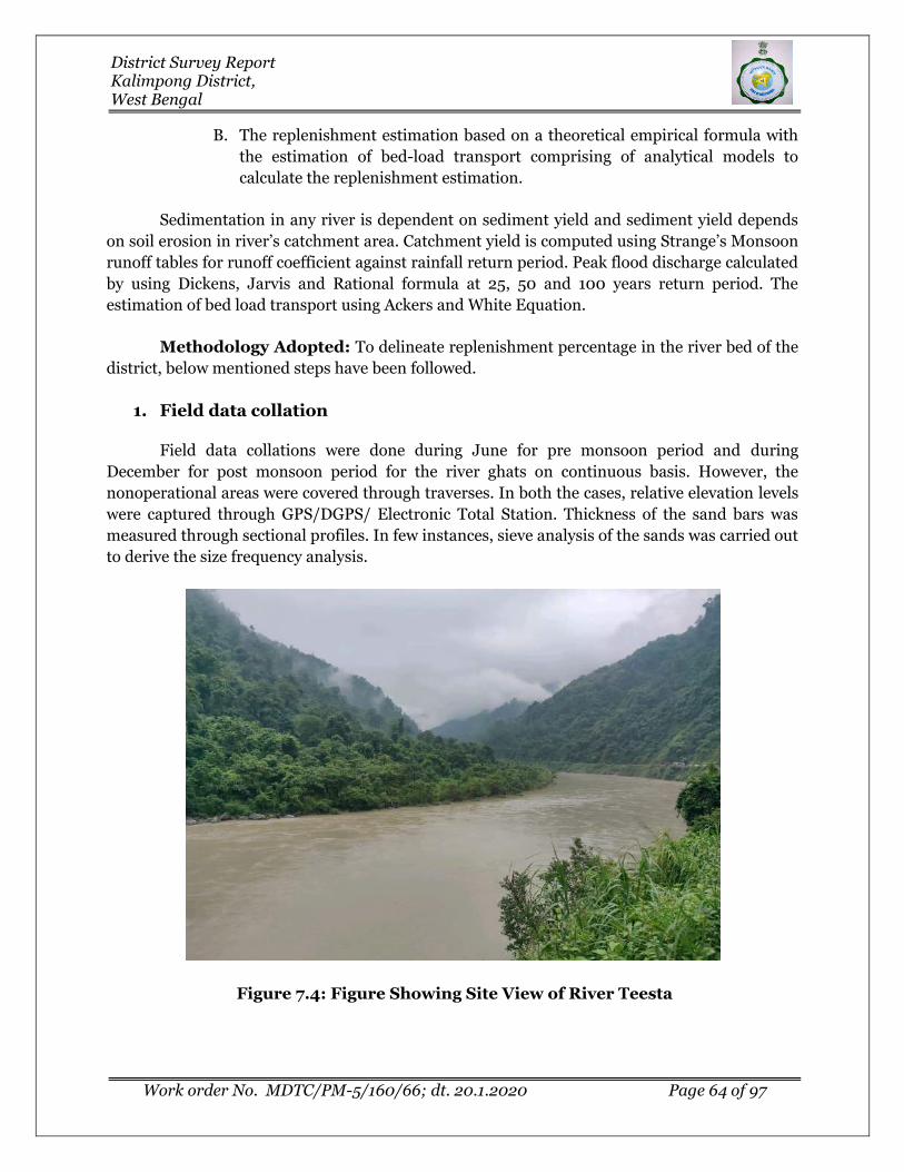
District Survey Report Kalimpong District, West Bengal
Work order No. MDTC/PM-5/160/66; dt. 20.1.2020 Page 64 of 97
B. The replenishment estimation based on a theoretical empirical formula with
the estimation of bed-load transport comprising of analytical models to
calculate the replenishment estimation.
Sedimentation in any river is dependent on sediment yield and sediment yield depends
on soil erosion in river’s catchment area. Catchment yield is computed using Strange’s Monsoon
runoff tables for runoff coefficient against rainfall return period. Peak flood discharge calculated
by using Dickens, Jarvis and Rational formula at 25, 50 and 100 years return period. The
estimation of bed load transport using Ackers and White Equation.
Methodology Adopted: To delineate replenishment percentage in the river bed of the
district, below mentioned steps have been followed.
1. Field data collation
Field data collations were done during June for pre monsoon period and during
December for post monsoon period for the river ghats on continuous basis. However, the
nonoperational areas were covered through traverses. In both the cases, relative elevation levels
were captured through GPS/DGPS/ Electronic Total Station. Thickness of the sand bars was
measured through sectional profiles. In few instances, sieve analysis of the sands was carried out
to derive the size frequency analysis.
Figure 7.4: Figure Showing Site View of River Teesta

District Survey Report Kalimpong District, West Bengal
Work order No. MDTC/PM-5/160/66; dt. 20.1.2020 Page 65 of 97
Figure 7.5: Figure Showing Site View of River Relli
Figure 7.6: Figure Showing Site View of Rishi River

District Survey Report Kalimpong District, West Bengal
Work order No. MDTC/PM-5/160/66; dt. 20.1.2020 Page 66 of 97
2. Selection of Study profiles:
Study profiles are selected based on the occurrence of the sand bars in the channel
profiles. Aerial extents of each of the profiles are mapped from satellite imageries. Frequency
distribution did while selection of the ground truthing of the blocks.
3. Data Compilation:
Following data were compiled for generation of this annual replenishment report:
• Elevation levels of the different sand Ghats and Sand Bar’s as measured at site.
• Extents of the sand bars are measured from the pre monsoon satellite imageries.
• Sand production data of the district.
All these data were compiled while estimation of the replenished sand in the Kalimpong
district.
4. Assessment of sediment load:
Assessment of sediment load in a river is subjective to study of the whole catchment
area, weathering index of the various rock types which acts as a source of sediments in the
specific river bed, rainfall data over a period not less than 20 years, and finally the detail
monitoring of the river bed upliftment with time axis. Again the sediment load estimation is not
a dependent variable of the imaginary district boundary, but it largely depends upon the aerial
extents of the catchment areas, which crossed the district and state boundaries.
The major sand producing rivers of the Kalimpong district are Relli, Geet, Rishi, Leesh
and Rangpo rivers. Teesta river is main river of the district but from sand mining prospective
the river is not sand producing. Planning has been done for systematic sand mining in these
rivers.
From the satellite imageries as well as ground survey during post monsoon period,
altogether 52 sand bars are identified in Kalimpong district. Out of 53 sand bars, 10 are falling in
Relli River, 11 are falling in Geet River, 10 are falling in Leesh River, 8 are falling in Chel River, 7
bars in Rishi River, 5 are in Rangpo River and remaining 2 sandbars are falling in small river
channels of Palla. Whereas during pre-monsoon period total 45 no of sand bars identified.
Among these, 9 are falling in Relli River, 11 are falling in Geet River, 7 are falling in Leesh River,
7 are falling in Chel River, 5 bars in Rishi River, 5 are in Rangpo River and remaining 1 sandbar
is falling in small river channel of Palla.
To calculate of the areas of sand bars, a classification system has been adopted with three
categories of land identified within the river channel. The class which followed for classification
is as follows:

District Survey Report Kalimpong District, West Bengal
Work order No. MDTC/PM-5/160/66; dt. 20.1.2020 Page 67 of 97
a. The untapped Sand Bars.
b. The Sand bars worked in the pre-monsoon period.
c. Main channel course within the channel.
Details of each sand bars along with their sand resources in pre monsoon and post
monsoon period are provided in Table 7.3.
Table 7.3: Estimation of Sand Resources in Pre monsoon &Post monsoon period
Pre monsoon period Post monsoon period
S L
No Sand Bar_Code
RL (m)
Area in Sq.m
Sand Thickness
in m.
Sand Volume
in M. Cum
S L
No Sand Bar_Code
RL (m)
Area in Sq.m
Sand Thickness
in m.
Sand Volume
in M. Cum
Estimation of Sand Resources in Relli River
1 PR_KPG_KPG2_RL_1 739.8 143459 0.8 0.11 1 PO_KPG_KPG2_RL_1 740 163637.7 1 0.16
2 PR_KPG_KPG1_RL_2 677.8 35979.7 0.8 0.03 2 PO_KPG_KPG1_RL_2 678 41729.55 1 0.04
3 PR_KPG_KPG1_RL_3 635.8 117574.1 0.8 0.09 3 PO_KPG_KPG1_RL_3 636 105623.2 1 0.11
4 PR_KPG_KPG2_RL_4 569.8 43142.69 0.8 0.03 4 PO_KPG_KPG2_RL_4 570 33629.06 1 0.03
5 PR_KPG_KPG1_RL_5 559.8 142848 0.8 0.11 5 PO_KPG_KPG1_RL_5A 560 72851.02 1 0.07
6 PO_KPG_KPG1_RL_5B 515 52136.75 1 0.05
6 PR_KPG_KPG1_RL_6 479.7 97928.55 0.8 0.08 7 PO_KPG_KPG1_RL_6 480 89361.15 1.1 0.1
7 PR_KPG_KPG1_RL_7 349.7 66295.86 0.8 0.05 8 PO_KPG_KPG1_RL_7 350 67334.4 1.1 0.07
8 PR_KPG_KPG1_RL_8 319.8 39929.18 0.8 0.03 9 PO_KPG_KPG1_RL_8 320 39929.18 1 0.04
9 PR_KPG_KPG1_RL_9 259.9 598911.6 0.8 0.48 10 PO_KPG_KPG1_RL_9 260 611403.8 0.9 0.55
Estimation of Sand Resources in Geet River
1 PR_KPG_KPG1_GT_1 369.7 113239.2 1 0.11 1 PO_KPG_KPG1_GT_1 370 118631.6 1.3 0.15
2 PR_KPG_KPG1_GT_2 339.7 58958.22 1 0.06 2 PO_KPG_KPG1_GT_2 340 53609.01 1.3 0.07
3 PR_KPG_GB_GT_3 324.8 16485.27 1 0.02 3 PO_KPG_GB_GT_3 325 16485.27 1.2 0.02
4 PR_KPG_KPG1_GT_4 314.7 13077.65 1 0.01 4 PO_KPG_KPG1_GT_4 315 13077.65 1.3 0.02
5 PR_KPG_KPG1_GT_5 297.8 64155.59 1 0.06 5 PO_KPG_KPG1_GT_5 298 73905.22 1.2 0.09
6 PR_KPG_KPG1_GT_6 282.8 64341.66 1 0.06 6 PO_KPG_KPG1_GT_6 283 69213.49 1.2 0.08
7 PR_KPG_GB_GT_7 269.9 84759.9 1 0.08 7 PO_KPG_GB_GT_7 270 86146.02 1.1 0.09
8 PR_KPG_KPG1_GT_8 229.8 57404.73 1 0.06 8 PO_KPG_KPG1_GT_8 230 57404.73 1.2 0.07
9 PR_KPG_KPG1_GT_9 215 131061 1 0.13 9 PO_KPG_KPG1_GT_9 215 178069.8 1 0.18
10 PR_KPG_GB_GT_10 205 101902.8 1 0.1 10 PO_KPG_GB_GT_10 205 132169.2 1 0.13
11 PR_KPG_KPG1_GT_11 185 281739.6 1 0.28 11 PO_KPG_KPG1_GT_11 185 364707.4 1 0.36
Estimation of Sand Resources in Leesh River
1 PR_KPG_KPG1_LH_1 689.8 56343.6 0.8 0.05 1 PO_KPG_KPG1_LH_1 690 67748.07 1 0.07

District Survey Report Kalimpong District, West Bengal
Work order No. MDTC/PM-5/160/66; dt. 20.1.2020 Page 68 of 97
Pre monsoon period Post monsoon period
S L
No Sand Bar_Code
RL (m)
Area in Sq.m
Sand Thickness
in m.
Sand Volume
in M. Cum
S L
No Sand Bar_Code
RL (m)
Area in Sq.m
Sand Thickness
in m.
Sand Volume
in M. Cum
2 PR_KPG_KPG1_LH_2 399.8 33762.23 0.8 0.03 2 PO_KPG_KPG1_LH_2 400 29973.85 1 0.03
3 PR_KPG_KPG1_LH_3 374.8 60023.24 0.8 0.05 3 PO_KPG_KPG1_LH_3 375 91555.61 1 0.09
4 PR_KPG_KPG1_LH_4 324.8 245525.2 0.8 0.2 4 PO_KPG_KPG1_LH_4A 325 215914.4 1 0.22
5 PO_KPG_KPG1_LH_4B 300 54602.73 1 0.05
6 PO_KPG_KPG1_LH_4C 275 70305.72 1 0.07
5 PR_KPG_KPG1_LH_5 249.8 43610.41 0.8 0.03 7 PO_KPG_KPG1_LH_5 250 41243.99 1 0.04
6 PR_KPG_KPG1_LH_6 226.8 88482.48 0.8 0.07 8 PO_KPG_KPG1_LH_6 227 79497.38 1 0.08
7 PR_KPG_KPG1_LH_7 209.8 638047.4 0.8 0.51 9 PO_KPG_KPG1_LH_7A 210 275690.1 1 0.28
10 PO_KPG_KPG1_LH_7B 200 408166.4 1 0.41
Estimation of Sand Resources in Chel River
1 PR_KPG_GB_CHL_1 524.8 10793.19 0.9 0.01 1 PO_KPG_GB_CHL_1 525 10793.19 1.1 0.01
2 PR_KPG_GB_CHL_2 474.8 76517.07 0.9 0.07 2 PO_KPG_GB_CHL_2 475 79347.22 1.1 0.09
3 PR_KPG_GB_CHL_3 444.8 17551.58 0.9 0.02 3 PO_KPG_GB_CHL_3 445 17551.58 1.1 0.02
4 PR_KPG_GB_CHL_4 417.8 10825.23 0.9 0.01 4 PO_KPG_GB_CHL_4 418 9000.108 1.1 0.01
5 PR_KPG_GB_CHL_5 279.8 106002.6 0.9 0.1 5 PO_KPG_GB_CHL_5 280 124210.3 1.1 0.14
6 PR_KPG_GB_CHL_6 259.8 222319.5 0.9 0.2 6 PO_KPG_GB_CHL_6 260 212018.6 1.1 0.23
7 PR_KPG_GB_CHL_7 244.8 627283.7 0.9 0.56 7 PO_KPG_GB_CHL_7A 245 221682.1 1.1 0.24
8 PO_KPG_GB_CHL_7B 237 244993 1.1 0.27
Estimation of Sand Resources in Palla River
1 PR_KPG_KGP2_PL_1 629.7 116515.1 0.7 0.08 1 PO_KPG_KPG2_PL_1A 630 28279.4 1 0.03
2 PO_KPG_KPG2_PL_1B 574 59751.49 1 0.06
Estimation of Sand Resources in Rangpo River
1 PR_KPG_KPG2_RNP_1 355.8 40374.96 0.7 0.03 1 PO_KPG_KPG2_RNP_1 356 27751.98 0.9 0.02
2 PR_KPG_KPG2_RNP_2 389.8 14337.64 0.7 0.01 2 PO_KPG_KPG2_RNP_2 390 13330.69 0.9 0.01
3 PR_KPG_KPG2_RNP_3 399.8 29615.08 0.7 0.02 3 PO_KPG_KPG2_RNP_3 400 44676.3 0.9 0.04
4 PR_KPG_KPG2_RNP_4 414.8 15143.05 0.7 0.01 4 PO_KPG_KPG2_RNP_4 415 17376.96 0.9 0.02
5 PR_KPG_KPG2_RNP_5 419.8 12456.55 0.7 0.01 5 PO_KPG_KPG2_RNP_5 420 12456.55 0.9 0.01
Estimation of Sand Resources in Rishi River
1 PR_KPG_KPG2_RS_1 684.8 1.680783 0.9 0.00 1 PO_KPG_KPG2_RS_1A 685 0.493217 1.1 0.00
0.9 0.00 2 PO_KPG_KPG2_RS_1B 720 0.550596 1.1 0.00
2 PR_KPG_KPG2_RS_2 724.9 1.252582 0.9 0.00 3 PO_KPG_KPG2_RS_2A 725 0.609764 1 0.00
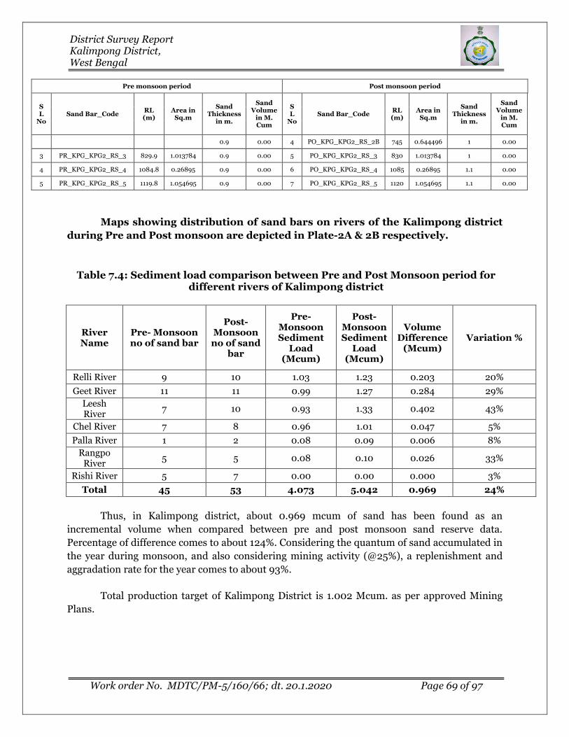
District Survey Report Kalimpong District, West Bengal
Work order No. MDTC/PM-5/160/66; dt. 20.1.2020 Page 69 of 97
Pre monsoon period Post monsoon period
S L
No Sand Bar_Code
RL (m)
Area in Sq.m
Sand Thickness
in m.
Sand Volume
in M. Cum
S L
No Sand Bar_Code
RL (m)
Area in Sq.m
Sand Thickness
in m.
Sand Volume
in M. Cum
0.9 0.00 4 PO_KPG_KPG2_RS_2B 745 0.644496 1 0.00
3 PR_KPG_KPG2_RS_3 829.9 1.013784 0.9 0.00 5 PO_KPG_KPG2_RS_3 830 1.013784 1 0.00
4 PR_KPG_KPG2_RS_4 1084.8 0.26895 0.9 0.00 6 PO_KPG_KPG2_RS_4 1085 0.26895 1.1 0.00
5 PR_KPG_KPG2_RS_5 1119.8 1.054695 0.9 0.00 7 PO_KPG_KPG2_RS_5 1120 1.054695 1.1 0.00
Maps showing distribution of sand bars on rivers of the Kalimpong district
during Pre and Post monsoon are depicted in Plate-2A & 2B respectively.
Table 7.4: Sediment load comparison between Pre and Post Monsoon period for different rivers of Kalimpong district
River Name
Pre- Monsoon no of sand bar
Post- Monsoon no of sand
bar
Pre- Monsoon Sediment
Load (Mcum)
Post- Monsoon Sediment
Load (Mcum)
Volume Difference
(Mcum) Variation %
Relli River 9 10 1.03 1.23 0.203 20%
Geet River 11 11 0.99 1.27 0.284 29%
Leesh River
7 10 0.93 1.33 0.402 43%
Chel River 7 8 0.96 1.01 0.047 5%
Palla River 1 2 0.08 0.09 0.006 8%
Rangpo River
5 5 0.08 0.10 0.026 33%
Rishi River 5 7 0.00 0.00 0.000 3%
Total 45 53 4.073 5.042 0.969 24%
Thus, in Kalimpong district, about 0.969 mcum of sand has been found as an
incremental volume when compared between pre and post monsoon sand reserve data.
Percentage of difference comes to about 124%. Considering the quantum of sand accumulated in
the year during monsoon, and also considering mining activity (@25%), a replenishment and
aggradation rate for the year comes to about 93%.
Total production target of Kalimpong District is 1.002 Mcum. as per approved Mining
Plans.

District Survey Report Kalimpong District, West Bengal
Work order No. MDTC/PM-5/160/66; dt. 20.1.2020 Page 70 of 97
vi) Total potential of minor mineral in the river bed
The major sand producing rivers of the Kalimpong district are Relli, Geet, Rishi, Leesh
and Rangpo rivers. The total potential of minor mineral in the riverbed is 3.053 mcum.
B. Geological studies
i) Lithology of the catchment area
The overall rock type of the catchment area is mainly consisting of Granite, Gneiss,
Shales, and most importantly Sandstone and solidified but poorly consolidated clutter of
Conglomerate formations.
The district may be divided into three tracts, which are, from north to south, the hard
rock area, the Bhabar belt and the Terai belt. The Bhabar belt comprises rock fragments, big
boulders and fine grained clastics derived from the hard- rock area. The Terai belt is composed
mostly of coarse granular materials alternating with finer clastics. Leesh, Geet, Chel are the most
sand producing river flowing in this belt. Whereas Relli, Rangpo river catchment is part of
Bhabar belt.
ii) Tectonics and structural behavior of rocks
The hilly region of the district is very prone to landslide due to poor water retention
capacity of the soil clubbed with steep land slope (from North to South, and South-East). The
considerable portion of the district falls under the Seismic Zone IV (in a scale of I to V in
ascending order of propensity f Seismic Activity), making it very prone to the earthquakes
(Source: District census handbook 2011).
The geological formations of the district show the predominance of several tectonic units
of the Darjeeling Himalaya over-thrusted towards south are built mostly of metamorphic rocks
(Darjeeling gneisses, Daling schist and quartzite). Along Teesta river section, Main Boundary
Fault extending either side along the general strike varying between NE-SW and E-W. All along
the foothills of Darjeeling district, south of Sikkim, the Siwaliks are steeply over thrust by
formations belonging to Damudas of Lower Gondwana. The thrust planes are dipping at 60-70
degrees towards the north. This thrust zone coincides with the well-known Main Boundary fault,
which extends for the whole distance along the Himalayan Range.
C. Climate Factors
i) Intensity of rainfall
Kalimpong gets about 2,254 mm rainfall annually. The precipitation during the
southwest monsoon constitutes about 80 percent of the rainfall, July being the wettest month.
On an average, there are about 105 rainy days in a year. The intensity of rainfall due to
depressions sometimes becomes very great and may cause enhanced soil erosion in the district

District Survey Report Kalimpong District, West Bengal
Work order No. MDTC/PM-5/160/66; dt. 20.1.2020 Page 71 of 97
ii) Climate zone
Climate of the Kalimpong district is tropical monsoonal in nature. The climate of
Kalimpong Sub-division is interesting because of its position in relation to the Tibetan
landmass, the wide differences in altitudes, the powerful effect of the monsoons against the
Himalayan barrier and the peculiar configuration of the neighboring monsoons, which deflect
winds and affect local temperature and rainfall.
iii) Temperature variation
The temperature in the Kalimpong district varies from 250C to 80C. The maximum
summer temperature is 25°C and the minimum 15°C. The maximum temperature in winter is
17°C and the minimum temperature 80C recorded between December and March. The average
temperatures vary during the year by 10.1 °C.
Table 7.5: Annual deposition of Riverbed minerals
Sl.No. River or Stream
Portion of the river stream
recommended for mineral concession
Length of area recommended
for mineral concession (in
meter)
Average width of area
recommended for mineral
concession (in meters)
Area recommended
for mineral concession (in
sq. m)
Mineable mineral potential (in million cubic meter) (60% of
total mineral potential
1 Relli River 43.39% 15,700.00 81.38 12,77,635.44 0.767
2 Palla River 23.38% 1,200.00 56.69 68,030.00 0.041
3 Leesh River 51.01% 11,300.00 118.11 13,34,698.00 0.801
4 Geet River 36.12% 10,300.00 112.95 11,63,419.00 0.838
5 Chel River 29.76% 11,000.00 83.60 9,19,596.00 0.607
6 Rangpo River 12.24% 4,650.00 24.86 1,15,592.00 0.062
7 Rishi River 6.57% 3,300.00 14.05 46,354.00 0.031
Total for the District 57450 491.64 4925324.44 3.053
Sand bar area recommended for mineral concession in the above table is
being calculated as per the Enforcement & Monitoring Guidelines for Sand Mining
(EMGSM) 2020. As per guidelines, mining depth restricted to 3 meters depth and
distance from the bank is ¼th of river width and not be less than 7.5 meters. Also
mining is prohibitated up to a distance of 1 kilometre (1 km) from major bridges
and highways on both sides, or five times (5x) of the span (x) of a bridge/public
civil structure (including water intake points) on up-stream side and ten times

District Survey Report Kalimpong District, West Bengal
Work order No. MDTC/PM-5/160/66; dt. 20.1.2020 Page 72 of 97
(10x) the span of such bridge on down-stream side, subjected to a minimum of 250
meters on the upstream side and 500 meters on the downstream side.
III. Riverbed Mineral Potential
Sand is the important riverbed mineral found to be potential for mining. Considerable
quantity of quality sands are found to occur in part of Relli, Geet and Chel, rivers. Smaller
patches are also available locally in the other smaller rivers as well. Sand mining can be
developed on cluster approach with restricted usage of Machinery’s for lifting of sands. The
rivers in the north Bengal are filled by Gravels & boulders. Development of river bed material
with huge boulders also requires usage of machinery’s to increase more production in turn
revenue.
Table 7.6: Resources of Potential Riverbed Mineral
Boulder (million
Cubic meter)
Pebbles/Gravel (million Cubic meter)
Sand/White sand (million Cubic meter)
Total Mineable, Mineral Potential (million Cubic
meter)
0.611 0.305 2.137 3.053
Table 7.7: Potential Zone of Riverbed Mineral
S. No
.
RIVER NAME
Location of potential zones Area within
prohibited zone as per rule 3
of WBMMC
Rules, 2016
(sq.m)
ZONE BLOCK NAME
MOUZA NAME
JL NO
COORDINATE
LATITUDE LONGITUDE
1 RELLI
KHOLA
ZONE 1 KALIMPONG
II
Icha Khaasmahal,
Pudung Khasmahal, Yokprintam Khasmahal
45, 46,5
8
27°4'49.39"N 88°33'29.283"
E
18540.24 27°2'50.965"N
88°31'49.805"E
ZONE 2 KALIMPONG I Lolay
KhasMahal 44
27°2'50.965"N 88°31'49.805"
E 11389.51 27°3'11.51"N 88°30'12.941"E
ZONE 3 KALIMPONG
II
Slokbhir Khasmahal, Samalbong Khasmahal
59, 60
27°2'20.252"N 88°29'42.727"E
54355.56 26°59'58.5"N 88°27'3.507"E
2 PALLA RIVER
ZONE 4 KALIMPONG
II Palla
Khasmahal 43
27°2'49.495"N 88°32'31.491"E 1868.276
27°2'28.858"N 88°31'47.578"E
3 LEESH RIVER
ZONE 5 KALIMPONG
II
Pemling Khasmahal,
Nobgaon
64, 66
26°57'50.126"N 88°30'43.824"
E 93506.11

District Survey Report Kalimpong District, West Bengal
Work order No. MDTC/PM-5/160/66; dt. 20.1.2020 Page 73 of 97
S. No
.
RIVER NAME
Location of potential zones Area within
prohibited zone as per rule 3
of WBMMC
Rules, 2016
(sq.m)
ZONE BLOCK NAME
MOUZA NAME
JL NO
COORDINATE
LATITUDE LONGITUDE
Khasmahal 26°52'45.648"N
88°34'2.985"E
4 GEET RIVER ZONE 6
KALIMPONG I &
GORUBATHAN
Nimbong Khasmahal,
Pagrangbong, Manbari
Khasmahal
65, 17, 20
26°58'43.207"N
88°36'49.294"E
84914.55 26°53'54.306"
N 88°37'24.306"
E
5 CHEL RIVER
ZONE 7 GORUBATHA
N
Dalingma Khasmahal, Gorubathan
Khasmahal, Mal Khasmahal
27, 28, 29
27°0'29.317"N 88°42'16.959"E
6631.036 26°55'29.627"N
88°39'35.107"E
6 RANGPO
RIVER ZONE 8
KALIMPONG II
Kashone Khasmahal
4 27°11'29.993"N 88°33'47.534"E
2875.966 27°11'1.775"N 88°35'51.16"E
7 RISHI RIVER
ZONE 9 KALIMPONG
II Lingsaykha Khasmahal
10 27°9'41.049"N 88°39'18.347"E
1344.708 27°8'29.318"N 88°39'53.472"E
ZONE 10
KALIMPONG II
Lingsaykha Khasmahal
10 27°7'7.823"N 88°40'18.014"E
193.1032 27°6'53.673"N
88°40'27.998"E
7.2.2 In-situ Minerals: I. Mineral Reserve
Mineral resources of the district are still not well established. Reserve of Coal is only
mentioned in the Mineral Year Book of West Bengal 2014. Occurrences of coal have been
established over a stretch of 77 km between Pankhabari to the west of the Darjeeling district and
Jaldhaka to the east of Kalimpong district. Coal reserves are found in Dalingkot coalfield, several
seam occur near Tindharia. A total of 15 million tonne of inferred resources of coal down to a
depth of 300m has been estimated (Source: Glimpse of Geology of West Bengal, GSI
Publication).
Coal bearing Dumuda series consisting of quartzitic and carbonaceous sandstone, shale
and coal occur as a thin bed being sandwiched in between two thrusts viz. Daling thrust in the
north against Daling rocks and Main Boundary Fault in the south against Siwalik rocks. As a
result of thrusting, Daling rocks of Precambrian age are lying above the Damuda of Lower
Gondwana (Permian) with a reverse succession. Generally the rocks striking in West-Southwest
to East-Northeast direction have a steep (up to 80°) northerly dip. These Gondwana rocks are
well exposed at Pankhabari, Tindharia, Kalijhora, Bagrakotx, Dalingkot and in the valley of
Mahanadi and Teesta. The coal exposures are not continuous everywhere due to nature of
thrusting. This coal bearing Damuda Series has been lithologically sub-divided into three units
i.e., upper and a lesser coal bearing unit separated by a barren unit. The upper, middle and
lower units are formally named as the Dalingkot, Chunabhati and Rongtong formation.

District Survey Report Kalimpong District, West Bengal
Work order No. MDTC/PM-5/160/66; dt. 20.1.2020 Page 74 of 97
II. Mineral Potential
The Sikkim-Darjeeling area highly potential with respect to the basemetal occurrences
confined essentially to the Daling/Darjeeling Group of rocks with biotitic granites occurring as
tongue-like bodies. The most important base metal deposits for lead and zinc in the Himalayan
terrain near Gorubathan, Darjeeling district are reported from KharKhola, Mal Khola, Daling
Chu and SukhaKhola blocks. Minor Occurrences of copper-ore are reported from Pedong area of
Kalimpong district.
Preliminary exploration of Gorubathan Lead-Zinc deposits, Kalimpong District, West
Bengal was continued in the field season 1979-80. The Gorubathan groups of base metal
deposits consist mainly of KharKhola, Mal Khola, Daling Chu and SukhaKhola Blocks
distributed intermittently over a strike length of about 7km, in respective order, from east to
west following the regional strike. Lenticular bodies of magnetite-quartz-galena-sphalerite-
pyrite-pyrrhotite ore, widely varying in grade and width, occur in the Mal Khola and Daling Chu
Blocks. Chalcopyrite occurs in minor amounts. Available drill hole data indicates that there are
only three mineralised horizons of quartz-magnetite rock in the Daling Chu - Mal Khola Blocks.
The two important zones are: - 1) Daling Kote Lode No. 1 and 2) Daling Kote Lode No. 2 with a
parting zone of about 30m between the lodes. The drilling data indicates that Daling Kote Lode
No. 1 consists of more than one ore shoot but there is a possibility that folding has caused
repetition of the mineralised zone. The other mineralised zone is the Mal Quartz-Magnetite
Rock, occurring 60m to 90m above the Daling Kote Lode No. 2. The existence of a fourth
horizon, below the Daling Kote Lode No. 1, indicated by a series of isolated mineralised bodies of
quartz-magnetite rock on the surface, has been disproved by drilling.
Figure 7.7: Location of Gorubathan base metal deposits

District Survey Report Kalimpong District, West Bengal
Work order No. MDTC/PM-5/160/66; dt. 20.1.2020 Page 75 of 97
Figure 7.8: Quartz Magnetite chlorite schist boulder at DalingChu River section
Drilling in the Mal Khola and Daling Chu Blocks has yielded significant results. With the
availability of additional analytical data the ore reserves have been updated and amounts to 3.25
million tonnes with 3.80% Pb and 3.83% Zn. The average thickness of the mineralised zone is
4.14m. This reserve has been categorised as "Probable Ore Reserve". Reserve of magnetite as a
by-product is 42 million tonnes (Bhattacharya and Neogi, 1984, GSI progress report).
MECL has carried out detailed exploration in the Mal Khola block. The rock types of the
Mal Khola Block are quartz-chlorite-biotite-sericite schist, quartzite, epidiorite and quartz
magnetite rock. These litho-units belong to the Gorubathan sub-Group of the Daling Group and
are of Precambrian age. The overall strike of the formations is E-W northerly dips varying form
20° to 45°. The lead-zinc mineralisation in the form of galena and sphalerite occurs mainly in
association with the quartz magnetite rock. Reserves of 1.79 mt. of 3.86% Pb and 3.64% Zn
(TMC- 7.50% Pb+Zn) have been estimated in the Mal Khola block within a vertical depth of
125m and a strike length of 200m. These reserves have been put under “Probable” category.
The important copper-lead-zinc prospects are located at Bhotang (Copper-Lead-Zinc)
(27°10’30'’:88°32’00'’) and Pedong (Copper) (27°09’:88°37'). In Pedong, the richer mineralize
zones have a grade of about 2.5% Cu (VE). However, drilling encountered poor mineralization in
Bhotang (Source: Mineral Resources of India, GSI).

District Survey Report Kalimpong District, West Bengal
Work order No. MDTC/PM-5/160/66; dt. 20.1.2020 Page 76 of 97
Table 7.8: In-situ Minerals Occurrences
Name of
mineral
Name of
associated
minerals, if any
Host rock of mineralizatio
n
Area of mineralizati
on
Depth of
mineralization
Whether virgin or partially
excavated
Name of land
(whether free for
mining/forest/agricul
tural
Mineral reserve
(approximate) mentioning
grade
Location of potential mineralized zones Infrastructure
available near the mineralized zone
Administrative Block
Mouza
Plot
No.s
Co-ordinat
es
1 2 3 4 5 6 7 8 9 11
Coal
No associat
ed mineral
s
Carbonaceous sandstone,
shale
Tindhari, Kalijhora, Bagrakot, Dalingkot
300m Partially
excavated
Forest/ agricultural
land
15 million tonne
Kalimpong –I to
Gorubathan NA NA
26°49'; 88°15'
to 26°54'; 88°43'
Metalled road
Lead-Zinc
Magnetite,
Tungsten,
Chalcopyrite
Quartz-chlorite-biotite-
sericite schist
Mal Khola 125m Virgin Forest land
1.79 mt. of 3.86% Pb and
3.64% Zn (TMC- 7.50%
Pb+Zn)
Gorubathan block
Forest
Mouza
NA
latitudes 26°58'10" and 27°00'
and longitud
es 88°36'15" and
88°45'00"
Metalled road
Lead-Zinc
Magnetite,
Tungsten,
Chalcopyrite
sedimento-volcanogenic association of
the Gorubathan
subgroup
DalingChu 150-
200m Virgin
Forest land
3.25 million tonnes with
3.80% Pb and 3.83% Zn
Gorubathan block
Forest
Mouza
NA
latitudes 26°58'10
" and 27°00'
and longitud
es 88°36'15
" and 88°45'0
0"
Metalled road

District Survey Report Kalimpong District, West Bengal
Work order No. MDTC/PM-5/160/66; dt. 20.1.2020 Page 77 of 97
7.3 Exploration Requirement of the district
Geologically, the district holds good prospect with respect to base metals, coal and
limestone deposits. However, due to lack to details investigation mineral prospect of the district
has not been established. GSI has carried out exploration during 1970’s to 2000’s in search of
base metals deposits of the district.
Base-metal (Pb-Zn) prospect in-between Daling-Chu and MalNadi for nearly 1.7 km.
strike length has been established at the foot hills of Kalimpong based on rigorous geological
investigation by GSI. The base metal prospect of the Daling-Chu- MaiNadi is situated within the
sedimento-volcanogenic association of the Gorubathan subgroup of the Dalings. The lithotypes
are an association of close alternation of sericite-chlorite phyllite and quartzite with epidiorites.
The mineralisation has been seen to-date to be restricted within a width of about 150 metres. It
occurs as distinct bands, consisting of several beds alternating with phyllitic or quartzitic strata.
Most of the beds show fine laminations to thick stratifications. The foliation surfaces are parallel
or sub-parallel to these interfaces. Within the mineralised horizons, the sulphides, magnetite
and silica and silicate gangues occur either as distinctly alternate lamina or as composite mosaic
(Ray et. al, 1971 GSI Progress report).
Tinkatare village of Gorubathan Block, Kalimpong Subdivision, Darjeeling District is
located on the east bank of Murti River. The area is a part of sub Himalayan terrain, where
thrusted sequences of Proterozoic Daling rocks along with Gondwana rocks and Siwalik
sediments are exposed in E-W trend. P-II stage investigation had been envisaged by GSI and
DMM of WB to assess the potentiality of base metal mineralization in the area. Under this
investigation an area of 1.5 sq. km. has been covered by detailed mapping along with pitting and
trenching and geochemical sampling petrological analysis. Dissemination, veins and stringers of
sulphide minerals are noticed within the Daling schist of the study area. The main ore forming
minerals are chalcopyrite, pyrite and rarely sphalerite and galena. In Khanigaon area at
Arikholaa 2m thick zone of copper mineralization is encountered within the quartz-chlorite-
sericite schist with average 0.80% Cu (Huin et. al, GSI report, FS 2003-04).
GSI has carried out investigation in search of wolframite-scheelite in Munsong area
principally by large scale mapping (1:2000), pitting and trenching, sampling and geological
traverses.The presence of small, concordant and highly ferruginised veins of quartz carrying
tungsten mineralization have been identified with associated sulphides, in sericite phyllite
belonging to Dalings. The tungsten minerals are wolframite and scheelite and the sulphides are
mainly pyrite with minor chalcopyrite and pyrrhotite. Quartz veins are arranged en echelon over
a length of about 20m and width varying between 2m and 7m ((Bhattacharya and Basu, 1986,
GSI report).
Search for gold was carried out by GSI in and around Samthar area of Kalimpong
district. Stratigraphically, the area exhibits the rocks belonging to Gorubathan Formation of
Dalling Group. The broad lithotypes of the area are dominantly arenaceous unit with some

District Survey Report Kalimpong District, West Bengal
Work order No. MDTC/PM-5/160/66; dt. 20.1.2020 Page 78 of 97
phyllitic/argillaceous partings. They comprise quartzite/quartz-sericite schist/quartzite with
concordant quartz veins; gritty, highly sheared and brecciated biotite-chlorite-quartz
schist/biotite quartzite and magnetite quartzite; and a dominantly phyllitic unit with some
intercalation of arenaceous bands/chlorite phyllite (at places carbonaceous)/slaty phyllite, etc.
The sulphides are generally associated with this litho assemblage. The general strike of the
lithounits is WNW-ESE to NW-SE with a moderate dip towards NNE to NE. The reported
arsenic in this area is in the form of arsenopyrite which occurs as dissemination, stringers,
veinlets and patches along with pyrite and pyrrhotite in epigenetic quartz veins intruding the
phyllites. Besides, there are also thin bands of magnetite quartzite with fine laminations of
sulphides representing syngenetic stratabound mineralisation. Analytical results of Deorali Pit,
where a zone of 2.8 m of 0.25 ppm (or a zone of 1.0 m of 0.84 ppm) wt. average of Au has been
established (Chattopadhyay and Ray, 2001, GSI Report).

District Survey Report Kalimpong District, West Bengal
Work order No. MDTC/PM-5/160/66; dt. 20.1.2020 Page 79 of 97
8 Overview of mining activity in the district
8.1 General overview
Kalimpong district is not having any large mines. Collection of sand, stone and gravels
from the river-bed of the hilly terrain are the minor mineral sources. These materials are
primarily utilized for construction purpose.
Census 2011 of Un-divided Darjeeling district recorded production of minor mineral.
Total production of Sand in the district during 2010-11 is 1913111.75 tonne, Stone of 1041403.42
tonne and Gravel of 2452.25 tonne (Source: District census handbook 2011).

District Survey Report Kalimpong District, West Bengal
Work order No. MDTC/PM-5/160/66; dt. 20.1.2020 Page 80 of 97
8.2 List of existing mining leases of the districts
Table 8.1: Details of sand mining leases of the districts
Sl. No. Name of mineral
Block Name of the River
Mouza (JL No.)
Plot No Area(in
Ha) Latitude Longitude Lease Holder Lease Status
Lease Period
EC issued or not
1
Sand
Kalimpong-I Relli Yokprintam
(58) 56(P) 0.49 27°03'03.37"N 88°30'15.38"E
Shri RudenSadaLepcha
Deed Executed 5 years Yes
2 Sand Kalimpong-I&II Relli PudungKM(46)
&Lolay KM (44)
RS 942 (P) Pudung& LR 1(P) Lolay
0.6677 27°03'35.89"N 88°31'47.54"E Shri
RudenSadaLepcha Deed Executed 5 years Yes
3 Sand Kalimpong-I&II Relli IchaKM(45) &Lolay KM
(44)
3035 (P) Icha&
1303(P) Loaly
0.73 27°03'46.48"N 88°31'44.73"E Shri Samim Ahmed Deed Executed 5 years Yes
4 Sand Kalimpong-III Geet Pagrangbong
(17) LR 1901 (P) 1.01 26°57'07.25"N 88°36'25.96"E Shri Samim Ahmed Deed Executed 5 years Yes
5 Sand Kalimpong-I&II Palla PudungKM(43)
&Kankebong KM (42)
18(P)Palla 563(P)
Kankebong 0.65 27°02'41.22"N 88°31'55.23"E LOI Issued 5 years No
6 Sand Kalimpong-I&II Palla PudungKM(43)
&Kankebong KM (42)
115(P)Palla 563(P)
Kankebong 0.4046 27°02'42.21"N 88°31'59.74"E LOI Not Issued
7 Sand Kalimpong-I&II Palla PudungKM(43)
&Kankebong KM (42)
115(P)Palla 563(P)
Kankebong 0.65 27°02'40.60"N 88°32'09.51"E LOI Not Issued
8 Sand Kalimpong-I&II Palla PudungKM(43)
&Kankebong KM (42)
115(P)Palla 563(P)
Kankebong 0.81 27°02'40.08"N 88°32'20.69"E LOI Not Issued

District Survey Report Kalimpong District, West Bengal
Work order No. MDTC/PM-5/160/66; dt. 20.1.2020 Page 81 of 97
Sl. No. Name of mineral
Block Name of the River
Mouza (JL No.)
Plot No Area(in
Ha) Latitude Longitude Lease Holder Lease Status
Lease Period
EC issued or not
9 Sand Kalimpong-I&II Palla PudungKM(43)
&Kankebong KM (42)
115(P)Palla 601(P)
Kankebong 0.32 27°02'40.85"N 88°32'26.76"E LOI Not Issued
10 Sand Kalimpong-I&II Relli PudungKM(46)
&Lolay KM (44)
RS 942 (P) Pudung& LR 1(P) Lolay
0.8093 27°03'40.89"N 88°31'42.31"E LOI Not Issued
11 Sand Kalimpong-I&II Relli PudungKM(46)
&Lolay KM (44)
LR 1926(P) Pudung& LR 1(P) Lolay
0.73 27°03'15.72"N 88°31'42.37"E LOI Not Issued
12 Sand Kalimpong-I&II Relli IchaKM(45) &Lolay KM
(44)
3034 (P) Icha&
1303(P) Loaly
0.4046 27°03'51.50"N 88°31'49.39"E LOI Not Issued
13 Sand Kalimpong-III Geet Pagrangbong
(17) LR 1901 (P) 1.01 26°57'34.80"N 88°36'40.01"E LOI Not Issued
14 Sand Kalimpong-III Geet Pagrangbong
(17) LR 1901 (P) 1.01 26°57'23.57"N 88°36'34.58"E LOI Not Issued
15 Sand Kalimpong-III Geet Pagrangbong
(17) LR 1901 (P) 1.01 26°57'27.53"N 88°36'24.90"E LOI Not Issued
16 Sand Kalimpong-III Geet Pagrangbong
(17) LR 1901 (P) 1.01 26°57'18.06"N 88°36'24.89"E LOI Not Issued
17 Sand Kalimpong-III Chel Mal KM (29) LR 15(P) 0.48 26°57'28.55"N 88°41'46.80"E LOI Not Issued
18 Sand Kalimpong-III Chel Mal KM (29) LR 15(P) 1.01 26°57'22.80"N 88°41'37.66"E LOI Not Issued
19 Sand Kalimpong-III Chel Mal KM (29) LR 15(P) 1.21 26°57'19.14"N 88°41'32.13"E LOI Not Issued

District Survey Report Kalimpong District, West Bengal
Work order No. MDTC/PM-5/160/66; dt. 20.1.2020 Page 82 of 97
Sl. No. Name of mineral
Block Name of the River
Mouza (JL No.)
Plot No Area(in
Ha) Latitude Longitude Lease Holder Lease Status
Lease Period
EC issued or not
20 Sand Kalimpong-III Chel Mal KM (29) LR 15(P) 1.21 26°57'31.89"N 88°41'14.83"E LOI Not Issued
21 Sand Kalimpong-III Chel Mal KM (29) LR 15(P) 1.21 26°57'10.55"N 88°41'09.85"E LOI Not Issued
22 Sand Kalimpong-I Relli Yokprintam
(58) 56(P) 0.61 27°02'56.80"N 88°30'19.89"E LOI Not Issued
23 Sand Kalimpong-I Relli Yokprintam
(58) 56(P), 501(P)
0.57 27°02'54.66"N 88°30'25.55"E LOI Not Issued
24 Sand Kalimpong-I Relli Yokprintam
(58) 501(P) 0.48 27°02'05.53"N 88°30'30.92"E LOI Not Issued
25 Sand Kalimpong-I&II Relli PudungKM(46)
&Kankebong KM (42)
1926(P) Pudung 562 (P)
Kankebong
0.69 27°02'39.89"N 88°31'38.89"E LOI Not Issued
26 Sand Kalimpong-I&II Relli PudungKM(46)
&Kankebong KM (42)
1926(P) Pudung 562 (P)
Kankebong
0.4046 27°02'35.63"N 88°31'32.60"E LOI Not Issued
27 Sand Kalimpong-I&II Palla PudungKM(43)
&Kankebong KM (42)
18(P)Palla 563(P)
Kankebong 0.57 27°02'39.16"N 88°31'49.70"E LOI Not Issued

District Survey Report Kalimpong District, West Bengal
Work order No. MDTC/PM-5/160/66; dt. 20.1.2020 Page 83 of 97
8.3 Detail of production of sand and other minerals during last three years
Table 8.2: Details of production of sand as per mine plan in Kalimpong district
Sl. No. Year Name of mineral Total Production
1 2017-2018 Not-Available Not-Available
2 2018-2019 Not-Available Not-Available
3 2019-2020 Not-Available Not-Available

District Survey Report Kalimpong District, West Bengal
Work order No. MDTC/PM-5/160/66; dt. 20.1.2020 Page 84 of 97
9 Details of revenue generated from mineral sector during last three years
Table 9.1: District revenue generation from mineral sector (in Crores)
Year Land Revenue
&Cess Minor Minerals Total revenue
2017-2018 Not-Available Not-Available Not-Available
2018-2019 Not-Available Not-Available Not-Available
2019-2020 0.18 0.66 0.84

District Survey Report Kalimpong District, West Bengal
Work order No. MDTC/PM-5/160/66; dt. 20.1.2020 Page 85 of 97
10 Transport (Railway, road)
Local transport infrastructure is critical in mineral transport point of view of Kalimpong
district. The district physiography is dominated by hilly terrain.
Kalimpong, the district headquarter is well connected by National and State Highways
with neighboring district. Highways are passing through the district and connected block
headquarters with Kalimpong. Kalimpong city is located off the NH10, which links Sevok to
Gangtok. The NH31A is an offshoot of the NH 31, which connects Sevok to Siliguri. These two
National Highways together, via Sevok, links Kalimpong to the plains. State highway no 12
connects Gorubathan and Kalimpong through Kalimpong-II. SH 12 joined NH 10 at Teesta
bazaar area.
The closest major railway station is at New Jalpaiguri, on the outskirts of Siliguri. The
Northeast Frontier Railway (NFR) zone along with IRCON international Limited, has proposed
to construct the 44.98 km long Sevok-Rangpo railway line, which will enable travelling between
Sevok in West Bengal to Rangpo in Sikkim.
Kalimpong does not have an airstrip. The nearest airport is Bagdogra airport (IXB), near
Siliguri which is located 80km from district head quarter.

District Survey Report Kalimpong District, West Bengal
Work order No. MDTC/PM-5/160/66; dt. 20.1.2020 Page 86 of 97
Figure 10.1: Transportation map of Kalimpong District
(Source: National Information Centre)

District Survey Report Kalimpong District, West Bengal
Work order No. MDTC/PM-5/160/66; dt. 20.1.2020 Page 87 of 97
11 Remedial measure to mitigate the impact of Mining
11.1 Environmental Sensitivity
The Kalimpong Hill area represents a unique geo- environmental perception. As the
mountains serve as the source of resources for the population residing in the hills as well as in
the plains, the form of environmental degradation is quite extensive particularly the extraction
of timber and other forest produces, mining and agriculture are also taken into account. As
human population expands in the hills, forests are being depleted for the extension of
agricultural lands, introduction of new settlements, roadways etc. The growing changes is
coming in the wake of urbanization and industrialization leave deep impression on the hill
ecosystem; disrupting normal functioning.
Due to unprecedented growth of population during the last few decades in the hill areas,
nature has started reacting sharply to the accumulated human guilt. Soil erosion and its
conservation play an important role in the hill areas. Because of the presence of very thin soil
cover plays an important role in the socio economic development. Landslide hazards, especially
during rainy season have become a common factor to the people of the hill.
The land use practices play the most important role in determining the stability factors
in respect of landslide hazards. Stone quarrying from the slope is another way of human
intervention that causes occasional slope failure.
In the rural and inaccessible high hills, demand for fuel is another important factor,
which may be treated as an important cause for slope failure. In West Bengal part of Eastern
Himalaya, because of the presence of coal and dolomite, mining started from eighteenth
century. Unscientific mining of low energetic coal seams and illegal felling of trees to meet the
demand of firewood is practically unavoidable in the hills. The adverse effect of this unscientific
mining is realized in the form of landslide, removal of soil cover, formation of gullies and
badlands; siltation of river beds leading to frequent floods, endangering the lives and properties
of local inhabitants.
11.2 Sand mining Impact
Another serious environmental problem around the globe in recent years is of Sand and
gravel mining. Sand mining is a process of extraction of sand from an open pit, river bed, sea
beaches, ocean floor, river banks, deltas and island dunes. The extracted sand could be utilised
for various types of manufacturing, such as concrete used in the construction of building and
other structures. The sand can also be used as an abrasive. The demand for sand increase as
population grows also urbanization with time. The high level of demands have offer led to the
use of unsustainable sand mining process for speedy urbanisation resulted in illegal mining.
District Survey Report Kalimpong District, West Bengal
Work order No. MDTC/PM-5/160/66; dt. 20.1.2020 Page 88 of 97
All though most jurisdictions have legal limit on the location and volume of sand that can
be mined, illegal sand extraction is following in many parts of the country due to rapid
urbanisation and industries.
Removal or extraction of too much sand from rivers leads to erosion shrinking of river
banks. Deltas can recede due to sand mining. These destructive effects of sand mining ultimately
results in loss of fertile land and property. It also destabilized the ground and causes the failure
of engineering structures for civilization.
In-stream mining directly alters the channel geometry and bed elevation. By removing
sediment from the channel, in-stream material extraction disrupts the preexisting balance
between sediment supply and transporting capacity, typically inducing incision upstream and
downstream of the extraction site. The resultant incision alters the frequency of floodplain
inundation along the river courses, lowers valley floor water tables and frequently leads to
destruction of bridges and channelization structures (Source: Wiejaczka2018).
Sand Mining in beaches disturbs the ecosystem of different fauna of the beaches. The
sand mining from natural barriers, made up of sand, causes flooding of the natural habitat. The
sand mining activity destroys the aesthetic beauty o beaches and river bank and makes the
ecosystem unstable. If there are popular tourist destination, tourism potential of such areas will
lose.
It could be concluding that there has been little in depth research in to the
environmental and social also political effect of land use practice and calls for urgent redressed
by the competent authority.
11.3 Remedial measure
11.3.1 Sustainable Mining Practices:
• The depth of mining in Riverbed shall not exceed one meter or water level
whichever is less, provided that where the Joint Inspection Committee certifies
about excessive deposit or over accumulation of mineral.
• Mining shall be done in layers of 1 meter depth to avoid ponding effect and after
first layer is excavated, the process will be repeated for the next layers.
• No stream should be diverted for the purpose of sand mining. No natural water
course and/ or water resources are obstructed due to mining operations.
• No blasting shall be resorted to in River mining and without permission at any
other place.
11.3.2 Monitoring the Mining of Mineral and its Transportation:
• For each mining lease site the access should be controlled in a way that vehicles
carrying mineral from that area are tracked and accounted for.

District Survey Report Kalimpong District, West Bengal
Work order No. MDTC/PM-5/160/66; dt. 20.1.2020 Page 89 of 97
• There should be regular monitoring of the mining activities in the State to ensure
effective compliance of stipulated EC conditions and of the provisions under the
Minor Mineral Concessions Rules framed by the State Government.
11.3.3 Noise Management:
• Noise arising out of mining and processing shall be abated and controlled at source
to keep within permissible limit.
• Restricted sand mining operation has to be carried out between 6 am to 7 pm.
11.3.4 Air Pollution and Dust Management:
• The pollution due to transportation load on the environment will be effectively
controlled and water sprinkling will also be done regularly.
• Air Pollution due to dust, exhaust emission or fumes during mining and processing
phase should be controlled and kept in permissible limits specified under
environmental laws.
• The mineral transportation shall be carried out through covered trucks only and
the vehicles carrying the mineral shall not be overloaded. Wheel washing facility
should be installed and used.
11.3.5 Bio-Diversity Protection:
• Restoration of flora affected by mining should be done immediately. Twice the
number of trees destroyed by mining to be planted preferably of indigenous
species. Each EC holder should plant and maintain for lease period at least 5 trees
per hectare in area near lease.
• No mining lease shall be granted in the forest area without forest clearance in
accordance with the provisions of the Forest Conservation Act, 1980 and the rules
made there under.
• Protection of turtle and bird habitats shall be ensured.
• No felling of tree near quarry is allowed. For mining lease within 10km of the
National Park / Sanctuary or in Eco-Sensitive Zone of the Protected Area,
recommendation of Standing Committee of National Board of Wild Life (NBWL)
have to be obtained as per the Hon'ble Supreme Court order in I.A. No. 460 of
2004.
• Spring sources should not be affected due to mining activities. Necessary
Protection measures are to be incorporated.
11.3.6 Management of Instability and Erosion:
• Removal, stacking and utilization of top soil in mining are should be ensured.
Where top soil cannot be used concurrently, it shall be stored separately for future

District Survey Report Kalimpong District, West Bengal
Work order No. MDTC/PM-5/160/66; dt. 20.1.2020 Page 90 of 97
use keeping in view that the bacterial organism should not die and should be
spread nearby area.
• The EC should stipulate conditions for adequate steps to check soil erosion and
control debris flow etc. by constructing engineering structures
• Use of oversize material to control erosion and movement of sediments
• No overhangs shall be allowed to be formed due to mining and mining shall not be
allowed in area where subsidence of rocks is likely to occur due to steep angle of
slope.
• No extraction of stone / boulder / sand in landslide prone areas.
• Controlled clearance of riparian vegetation to be undertaken.
11.3.7 Waste Management:
• Site clearance and tidiness is very much needed to have less visual impact of
mining.
• Dumping of waste shall be done in earmarked places as approved in Mining Plan.
• Rubbish burial shall not be done in the Rivers.
11.3.8 Pollution Prevention:
• Take all possible precautions for the protection of environment and control of
pollution.
• Effluent discharge should be kept to the minimum and it should meet the
standards prescribed.
11.3.9 Protection of Infrastructure:
• Mining activities shall not be done for mine lease where mining can cause danger
to site of flood protection works, places of cultural, religious, historical, and
archeological importance.
• For carrying out mining in proximity to any bridge or embankment, appropriate
safety zone should be worked out on case to case basis, taking into account the
structural parameters, location aspects and flow rate, and no mining should be
carried out in the safety zone so worked out.
• Mining shall not be undertaken in a mining lease located in 200-500 meter of
bridge, 200 meter upstream and downstream of water supply / irrigation scheme,
100 meters from the edge of National Highway and railway line, 50 meters from a
reservoir, canal or building, 25 meter from the edge of State Highway and 10
meters from the edge of other roads except on special exemption by the Sub-
Divisional level Joint Inspection Committee.

District Survey Report Kalimpong District, West Bengal
Work order No. MDTC/PM-5/160/66; dt. 20.1.2020 Page 91 of 97
12 Suggested reclamation plan for already mined out areas
As per statute all mines/quarries are to be properly reclaimed before final closure of the
mine. Reclamation plans should include:
a) A baseline survey consisting of existing condition cross-section data. Cross-sections
must be surveyed between two monumented endpoints set back from the top of bank, and
elevations should be referenced bench mark set;
b) The proposed mining cross-section data should be plotted over the baseline data to
illustrate the vertical extent of the proposed excavation;
c) The cross-section of the replenished bar should be the same as the baseline data. This
illustrates that the bar elevation after the bar is replenished will be the same as the bar before
extraction;
d) A planimetric map showing the aerial extent of the excavation and extent of the
riparian buffers;
e) A planting plan developed by a plant ecologist familiar with the flora of the river for
any areas such as roads that need to be restored;
f) A monitoring plan has to establish.

District Survey Report Kalimpong District, West Bengal
Work order No. MDTC/PM-5/160/66; dt. 20.1.2020 Page 92 of 97
13 Risk assessment & disaster management plan
Risk analysis is the systematic study of risks encountered during various stages of
mining operation. Risk analysis seek to identify the risks involved in mining operations, to
understand how and when they arise, and estimate the impact (financial or otherwise) of
adverse outcomes. The sand mining operation in the district is mainly done manually.
13.1 Identification of risk due to river sand mining
There is no land degradation due to mining activities as mining is done only on river bed
dry surface. There will be no OB or waste generation as the sand is exposed in the river bed and
is completely sellable. There will be neither any stacking of soil nor creation of OB dumps. The
mining activity will be carried out up to a maximum depth of 3m below the surface level. So,
there is no chance of slope failure, bench failure in the mines. However, there are some
identified risk in the mining activity which are as below:
1. Accident during sand loading and transportation 2. Inundation/ Flooding 3. Quick Sand Condition
13.2 Mitigation measures
13.2.1 Measures to prevent accidents during loading and transportation:
• During the loading truck would be brought to a lower level so that the loading operation suits to the ergonomic condition of the workers.
• The workers will be provided with gloves and safety shoes during loading.
• Opening of the side covers of the truck should be done carefully and with warning to prevent injury to the loaders.
• Mining Operations will be takes place during daylight only.
• The truck will be covered with tarpaulin and maintained to prevent any spillage.
• To avoid danger while reversing the trackless vehicles especially at the embankment and tipping points, all areas for reversing of Lorries should be made man free as far as possible.
• All transportation within the main working will be carried out directly under the supervision and control of the management.
• Overloading should not be permitted and the maximum permissible speed limit should be ensured.
• There will be regular maintenance of the trucks and the drivers will have valid driving liscence.
13.2.2 Measures to prevent incidents during Inundation/ Flooding:
To minimize the risk of flooding/ inundation following measures will be under taken:
• Mining will be completely closed during the monsoon months.

District Survey Report Kalimpong District, West Bengal
Work order No. MDTC/PM-5/160/66; dt. 20.1.2020 Page 93 of 97
• Proper weather information particularly on rain should be kept during the operational period of mines so that precautionary measures will be undertaken.
13.2.3 Measures for mitigation to quick sand condition:
• Quick sand zone and deep water zone will be clearly demarcated and all the mines workers will made aware of the location.
• Mining will done strictly as per the approved mining plan.
13.3 Disaster management plan
As the depth of mining will be maximum of 3m below the surface level considering local
condition, the risk related to mining activity is much less. The mining operation will be carried
out under the supervision experienced and qualified Mines Manager having Certificate of
Competency to manage the mines granted by DGMS. All the provisions of Mines Act 1952, MMR
1961 and Mines Rules 1955 and other laws applicable to mine will strictly be complied. During
heavy rainfall and during the monsoon season the mining activities will be closed. Proper
coordination with Irrigation Department should be maintained so that at the time of releasing
water, if any, from the dam suitable warning/information is given in advance. Special attention
and requisite precautions shall be taken while working in areas of geological weakness like
existence of slip, fault etc. The mining site will be supplied with first aid facilities and the entire
mines worker will have access to that.

District Survey Report Kalimpong District, West Bengal
Work order No. MDTC/PM-5/160/66; dt. 20.1.2020 Page 94 of 97
14 Summary
The District Survey Report for Kalimpong district has been prepared as per Ministry of
Environment, Forests and Climate Change (MoEF& CC) guidelines. The Guideline of
WBMMCR, 2016 is also taken into consideration while preparation of this report.
Potential areas where mining can be allowed are identified and discussed in this
DSR.This DSR would also help to estimate the annual rate of replenishment wherever
applicable.
Preparation of this DSR involved both primary and secondary data generation. The
primary data generation involved the site inspection, survey, ground truthing etc. while
secondary data has been acquired through various authenticated sources and satellite imagery
studies.
As per the study conducted during the preparation of the DSR of Kalimpong, drainage
system of the district is mostly controlled by the topography. Numerous rivers coming down
from the mighty Himalayas in the North and flowing to the Tarai region in the South and South-
East. The major rivers in the district are Teesta and Jaldhaka. Because of the hilly topography
for a large portion of the terrain, no rivers in the district is navigable throughout the year, except
Teesta and Jaldhaka.
The whole district falls under Zone IV as per the earthquake zonation map of India. Most
of the downhill areas of the district are susceptible to landslides as because of weathered and
unconsolidated formations. Kalimpong witnessed several landslides and flood during
monsoons. Therefore, mining in the hilly areas should be taken with utter most care for
sustainable development.
Presence of thick vegetation cover throughout the district, Neora Valley National Park
and high hill slopes has constricted the district from extensive mining activity although
occurrences of both major and minor minerals are reported.
Around 15 million tonne of inferred resources of coal has been reported in Dalingkot
coalfield which is extended from Pankhabari in the west of the Darjeeling district to Jaldhaka in
the east of Kalimpong. The base metal prospect of the Daling-Chu- MaiNadi is situated within
the Gorubathan subgroup of the Dalings. MECL has carried out detailed exploration in the Mal
Khola block and established probable reserves of 1.79 million tonne. of 3.86% Pb and 3.64% Zn
(TMC- 7.50% Pb+Zn) in the Mal Khola block within a vertical depth of 125m and a strike length
of 200m.Geological Survey of India (GSI) has also established copper deposits at Pedong in
Kalimpong district.
The District is so far not exposed to extensive mining activities. The district is currently
generating revenue from mining of minor minerals such as sand, stone and gravels from the
riverbed. However, in-stream mining directly alters the channel geometry and bed elevation.

District Survey Report Kalimpong District, West Bengal
Work order No. MDTC/PM-5/160/66; dt. 20.1.2020 Page 95 of 97
Therefore, mining of riverbed should be carried out scientifically and based on statutory
guidelines for conservation of land, river channels and sustainable development of the society.
The occurrence of riverbed sand and gravel in the district has been established by
Directorate of Mines and Minerals, Government of West Bengal and others in previous
instances. However, it requires further systematic and scientific approach to quantify the
resource along with their grade assessment. The occurrences of riverbed are mostly observed in
the river Relli, Geet, Palla, Rishi and Chel River. This report also recommends to undertake
detail exploration (G1 & G2 level) program to assess the mineral occurrences in the major rivers
of the district and should have a proper development and production plan for the specified
minerals.
As per the data received from DL& LRO office, Kalimpong, total 5 blocks have been
allotted for mining of river sand in the district. Out of which 3 blocks are allotted in Relli River, 1
block in Geet River and another in Palla River. Total allotted block area for 5 blocks is only 3.55
Ha and estimated reserve is around 1002285 CuM. Beside this, about 22 blocks (area 16.61 Ha.)
are in the process of allotment by the competent authority. Revenue generated in the district of
Kalimpong from Minor minerals in the FY 2019-20 is Rs. 0.66 Crore. Potential areas where sand
blocks are not allotted yet are also identified and discussed in the current DSR.
Incremental volume of sand is estimated in this DSR and found as around 0.22 Million
CuM when compared between pre and post monsoon sand reserve data. So, the district is
potential for scientific and systematic sand mining.

District Survey Report Kalimpong District, West Bengal
Work order No. MDTC/PM-5/160/66; dt. 20.1.2020 Page 96 of 97
References
1. A Devastating Disaster: A Case Study of Nepal Earthquake and Its Impact on Human
Beings, Dey S, Journal Of Humanities And Social Science (IOSR-JHSS) Volume 20,
Issue 7, 2015.
2. An Integrated approach towards Landslide Hazard Zonation and Mitigation in the
Kurseong Sub-division of Darjeeling Himalayas (2012) J Mili, Open access
shodhganga.inflibnet.ac.in /handle/10603/195005.
3. Causes of Landslides in Darjeeling Himalayas during June-July, 2015, Biswas S.S. and
Pal R, J Geogr Nat Disast 2016, 6:2.
4. District census handbook Darjeeling, West Bengal, Census of India 2011, Series 20, Part
XII-A.
5. Dynamic Ground Water Resources of India (As on March 2013), Ministry of Water
Resources, Central Ground Water Board (2017), Govt. of India.
6. Geological Report On Exploration For Lead-Zinc Ore Gorubathan (Mal Khola ) Block
District- Kalimpong, West Bengal, Mineral Exploration Corporation Limited, 1985.
7. Final Report on Base metal Investigation In Kumai Area, Darjeeling District, West
Bengal (P-II), Huin Ak, Roy N, Chakraborti S And Das S, GSI Report FS 2003-04.
8. Geomorphological Field Guide Book on Darjeeling Himalayas (2017), Indian Institute of
Geomorphologist.
9. Glimpse of Geology of West Bengal, GSI Publication, 2018.
10. Geology and Mineral Resources of India, GSI Publication.
11. Indian Minerals Year Book 2014, 53rd Edition, State Reviews (West Bengal), Indian
Bureau of Mines, GoI.
12. Indian Minerals Year Book 2012, 51stEdition, State Reviews (West Bengal), Indian
Bureau of Mines, GoI.
13. Investigation of Daling Chu-Mal Nadi Prospect, Kalimpong Subdivision, Darjeeling
District, West Bengal, Ray KK, Mukhopadhyay SK, Chatterjee SK and Ghosh PC, 1972,
GSI Progress Report for F.S. 1971-72.
14. Landslide Hazard Management of Darjeeling Hill - A Critical Need For Inhabited, Nad C,
International Journal of Humanities and Social Science Invention Volume 4 Issue 3 2015
PP.48-60.
15. Occurrence of Landslide and Management in Darjeeling Himalayas, Deepak and
Pardeep, Journal of Advances and Scholarly Researches in Allied Education, Vol. 16,
Issue No. 1, 2019.
16. Physical Aspects of the Darjeeling Himalaya: Understanding from a Geographical
Perspective (2018), CajeeLaitpharlang, IOSR Journal of Humanities And Social Science
(IOSR-JHSS), Volume 23, Issue 3, PP 66-79.
17. Physical Aspects of the Kalimpong District, Darjeeling Himalaya: Understanding From A
Geographical Perspective, Dasmondal P, 2018, International Journal of Humanities and
Social Science Invention, Volume 7 Issue 09, PP 01-09.
18. Preliminary Exploration Of Gorubathan Lead-Zinc Deposits, Darjeeling District, West
Bengal, Bhattacharya AC and Neogi S, 1984, GSI Progress Report of FS 1979-80.

District Survey Report Kalimpong District, West Bengal
Work order No. MDTC/PM-5/160/66; dt. 20.1.2020 Page 97 of 97
19. Report on the Basemetal Investigation of MangwaJhora - Peshok Area, Darjeeling
District, West Bengal, Shankar B and Tarafdar P, GSI Progress Report for FS 2000-2001.
20. Report on the Investigation For Tungsten In Munsong And Adjoining Areas Of
Darjeeling District West Bengal, Bhattacharya AC and BasuDL, 1986, GSI Report.
21. Report on Search For Auriferous Veins At Samthar (P - II), Darjeeling District, West
Bengal, Chattopadhyay S and Ray S, 2001, GSI Report on FS 1998-99.
22. Socio-environmental issues of river bed material extraction in the Himalayan piedmont
(India), WiejaczkaŁukasz, Tamang Lakpa, PirógDanutaand Prokop Paweł,
Environmental Earth Sciences (2018) 77:718.

District Survey Report Kalimpong, West Bengal
Work order No. MDTC/PM-5/160/66; dt. 20.1.2020 Page 1 of 1
Annexure 1: List of Brick Earth Mines in Kalimpong District
NA

District Survey Report
Kalimpong
West Bengal
Work order No. MDTC/PM-5/160/66; dt. 20.1.2020
P a g e 1 | 14
PLATE 1
DRAINAGE MAP OF THE DISTRICT

District Survey Report
Kalimpong
West Bengal
Work order No. MDTC/PM-5/160/66; dt. 20.1.2020
P a g e 2 | 14
Plate 1: Drainage Map of the District

District Survey Report
Kalimpong
West Bengal
Work order No. MDTC/PM-5/160/66; dt. 20.1.2020
P a g e 3 | 14
PLATE 2A
DISTRIBUTION MAP OF SAND BARS ON RIVERS
DURING PRE-MONSOON PERIOD OF KALIMPONG
DISTRICT

District Survey Report
Kalimpong
West Bengal
Work order No. MDTC/PM-5/160/66; dt. 20.1.2020
P a g e 4 | 14
Plate 2A1: Distribution Map of Sand Bars on Rivers During Pre-Monsoon Period of Kalimpong District

District Survey Report
Kalimpong
West Bengal
Work order No. MDTC/PM-5/160/66; dt. 20.1.2020
P a g e 5 | 14
Plate 2A2: Distribution Map of Sand Bars on Rivers During Pre-Monsoon Period of Kalimpong District
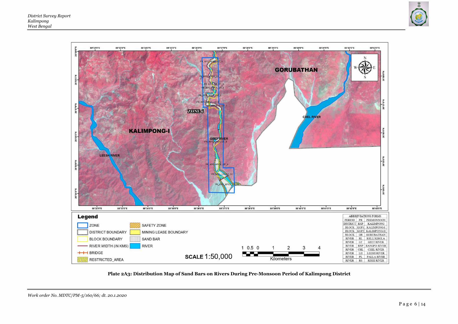
District Survey Report
Kalimpong
West Bengal
Work order No. MDTC/PM-5/160/66; dt. 20.1.2020
P a g e 6 | 14
Plate 2A3: Distribution Map of Sand Bars on Rivers During Pre-Monsoon Period of Kalimpong District

District Survey Report
Kalimpong
West Bengal
Work order No. MDTC/PM-5/160/66; dt. 20.1.2020
P a g e 7 | 14
Plate 2A4: Distribution Map of Sand Bars on Rivers During Pre-Monsoon Period of Kalimpong District

District Survey Report
Kalimpong
West Bengal
Work order No. MDTC/PM-5/160/66; dt. 20.1.2020
P a g e 8 | 14
Plate 2A5: Distribution Map of Sand Bars on Rivers During Pre-Monsoon Period of Kalimpong District

District Survey Report
Kalimpong
West Bengal
Work order No. MDTC/PM-5/160/66; dt. 20.1.2020
P a g e 9 | 14
ANNEXURE 2B
DISTRIBUTION MAP OF SAND BARS ON RIVERS
DURING POST-MONSOON PERIOD OF KALIMPONG
DISTRICT

District Survey Report
Kalimpong
West Bengal
Work order No. MDTC/PM-5/160/66; dt. 20.1.2020
P a g e 10 | 14
Plate 2B1: Distribution Map of Sand Bars on Rivers During Post-Monsoon Period of Kalimpong District

District Survey Report
Kalimpong
West Bengal
Work order No. MDTC/PM-5/160/66; dt. 20.1.2020
P a g e 11 | 14
Plate 2B2: Distribution Map of Sand Bars on Rivers During Post-Monsoon Period of Kalimpong District

District Survey Report
Kalimpong
West Bengal
Work order No. MDTC/PM-5/160/66; dt. 20.1.2020
P a g e 12 | 14
Plate 2B3: Distribution Map of Sand Bars on Rivers During Post-Monsoon Period of Kalimpong District

District Survey Report
Kalimpong
West Bengal
Work order No. MDTC/PM-5/160/66; dt. 20.1.2020
P a g e 13 | 14
Plate 2B4: Distribution Map of Sand Bars on Rivers During Post-Monsoon Period of Kalimpong District

District Survey Report
Kalimpong
West Bengal
Work order No. MDTC/PM-5/160/66; dt. 20.1.2020
P a g e 14 | 14
Plate 2B5: Distribution Map of Sand Bars on Rivers During Post-Monsoon Period of Kalimpong District
Copyright © 2022 FDOKUMEN