District Census Handbook, Kathua, Parts X-A & B, Series-8
172
CENSUS 1971 PARTS X-A & B TOWN & VILLAGE DIRECTORY SERIES-8 VILLAGE & TOWNWISE JAMMU & KASHMIR PRIMARY CENSUS DISTRICT CENSUS HANDBOOK ABSTRACT KATHUA DISTRICT J. N. ZUTSHI of the Kashmir Administrative Service Dlrecior of Census Operations Jammu and Kashmir.
-
Upload
khangminh22 -
Category
Documents
-
view
0 -
download
0
Transcript of District Census Handbook, Kathua, Parts X-A & B, Series-8

CENSUS 1971 PARTS X-A & B
TOWN & VILLAGE DIRECTORY
SERIES-8 VILLAGE & TOWNWISE JAMMU & KASHMIR PRIMARY CENSUS
DISTRICT CENSUS HANDBOOK
ABSTRACT
KATHUA DISTRICT
J. N. ZUTSHI of the Kashmir Administrative Service
Dlrecior of Census Operations Jammu and Kashmir.

, In
, \0 ' :'1
0 ...
"
IU ((
~ V)
o
?
1/1
iii ~ .., ... ..I 1&1
i :I
!:! 0 ..I it ~
CD
o
N
..
UI > o III
'" .. Eg ;';0
Ill'" Ul Z ~2 ..JI..J <t - ..J >. /t.
' 0 ' 0.
•
:t U ;,; Z " II
' :I: U
Z i
u. 0
J o O! , '" t-III
:I « 1&1
, In
0' In
~
A..~ • 0 \
" rg----
._,.._"'" *- i g
S Q~
/'

CENSUS OF INDIA 1971
LIST OF PUBLICATIONS
Central Government Publications-Census of India 1971-Series 8-Jammu and Kashmir is
being published in the following parts.
Number
Part I·A
Part I·B
Part I-C
Part II-A
Part II-B
Part H-C (i)
Part II-C (ii)
Part III
Part IV
Part VI-A
Part VI-B
Part VI-C
Part VIII-A
Part VIII-B
Part IX
Part IX-A
Miscellaneous (i)
(ii)
Part X-A
Part X-B
Part X-C
:I: Not for Sale
Subject Covered
General Report
General Report
Subsidiary Tables
General Population Tables .. Published
Economic Tables
Population by Mother Tongue, Religion, Scheduled Castes and Scheduled Tribes
Social and Cultural Tables and Fertility Tables
Establishments Report and Tables Published
Housing Report and Tables Published
Town Directory .. Published
Special Survey Reports on Selected Towns
Survey Reports on Selected Villages
tAdmini~tration Report on Enumeration ... Published
tAdministration Report on Tabulation
Census Atlas
Administrative Atlas
Study of Gujjars and Bakerwals
Srinagar City
*DISTRICT CENSUS HANDBOOKS
Town and Village Directory
Village and Townwise Primary Census Abstract
Analytical Report, Administrative Statistics and District Census Tables
• District Census Handbooks ( Parts A & B) of Dada, Srinagar, Anantnag, Udhampur, Jammu, Baramula, Rajuari, Punch and Ladakh already published.

CONTENTS
PREFACE
FIGURES AT A GLANCE
ALPHABETICAL LIST OF VILLAGES
PART A-TOWN AND VILLAGE DIRECTORY
Introductory Note:
Origin, Grawth and Scope of District Census Handbook-Primary-Census Abstract
Administrative Statistics and Report
Note on Town and Village Directory:
Page No.
i
iii
v-xiii
1.77
Definition of an urban Area-Broad appraisal on Statements 4-9
Number and Size of Villages-Educational- Medical Fa(;ilities-Power Supply-Communi-cation--Post and Telegraph Facilities--Staple Food-Land Use Pattern 10-14
TOWN DIRECTORY -Statements 15-22
STATEMENT I-Status, Growth History and Functional Category of Towns 16
STATEMENT II-Physical Aspects and Location of Towns, 1969 17
STATEMENT III-Municipal Finance, 1968-69 18
STATEMENT IV----Civic and Other Amenities 1969 19
STATEMENT V-Medical, Educational, Recreational and Cultural Facilities in Towns, 1969 20
STATEMENT VI-Trade, Commerce, Industry and Banking, 1969 21
STATEMENT VII-Population by Religion, 1971
VILLAGE DIRECTORY-Am.enities and Land Use
Tehsil Billa war
T£hsil Bashohli
Tehsil Kathua
Tehsil Hiranagar
Tehsil-wise Abstract of Amenities
PART B-VILLAGE AND TOWN WISE PRIMARY CENSUS ABSTRACT
Note on Primary Census Data
22
23-77
23-29
31·37
39-53
55·75
76-77
1-65
3

Page No.
Village/Urban block-wise Primary Census Abstract
District Abstract 5.9
Tehsil Billawar 11-17
Tehsil Bashohli 19-25
Tehsil Kathua 27-43
Tehsil Hiranagar 45-65
MAPS
District Map Frontispiece
Tehsil Billawar Facing Page 11
Tehsil Bashohli " " 19
Tehsil Kathua " " 27
Tehsil Hiranagar " " 45

PREFACE
The Kathua district to which the present volume pertains falls between 32°-17' to 32·-55' North latitude and 75°-7' to 75°-55' East longitude and encompasses an area of 2,651.0 square kilometres. The dtstrict Is made up of four constituent tehsils viz; Billawar, 8ashohli, Kathua and Hiranagar •. Billawar which was carved out from the former Bashohli tehsil during the decade 1961-71 is the smallest tehsil of the district. The district consists, in m09t part, of a plain area which stretches in close proximity, in the south and east with the States of Punjab and Himachal Pradesh respectively. It is bounded in the west by Jammu district and on the north and north-west by the districts of Doda and Udhampur.
The major part of the district belongs to 'yellow belt' region which receives an annual rainfall of 381.00 mms., compensating to a large extent for the scanty irrigatlonal facilities available in the district. Tehsils of Billawar and Bashohli, however, fall in the 'dark green belt', faring better in annual rainfall. But in the overall pOSition, 85% of the cultivated land still depends on the kind mercies of weather.
The headquarters of the district, Kathua town, Is situated at a distance of 87 and 378 kms. respectively from Jammu and Srinagar.
The district cl8ims the distinction of having recorded a growth rate of 3242% in Its population, during the past decade, the second highest after Jammu (40.52%) among all the districts of the State.
Amongst other factors, in'migration appears to be responsible for its comparatively high growth rate. It deserves to be mentioned here that the growth of population in district's urban sector has been all the rnore marked, having gone up by 61.47% during 1961-71. In the sphere of literacy too, the district has done well. Although the urban component of its population stands
Srinagar, 7th December, 1974
at 9.13% as compared to 26.15% In the case of Jammu district, It has registered a literacy level of 21.64%, the highest aft.r Jammu (30.34%) and Srinagar (21.72%) among all the districts of the State It is worthy of note that during the past decade, the district has made considerabie improvement in its sex ratio which has risen from 905 in 1961 to 921 in 1971. Barring Ladakh, the district has thus returned the highest sex ratio in the State.
Out of a population of 73,390 persons classifiable as workers, 31.26%, the third highest flgure among all the districts, were returned under the category of 'other workers'. showing that avenues of employment are becoming diversified gradually.
The reader will find that the contenrs of this volume have been apportioned Into two parts. Part A which encompasses TowA and Village Directory provides information on a wide range of subjects down to the village and ward/mohall a level. Part B covers 1971 census information on such topics as population, household size, sex ratio, literacy level, workers classified by nine Industrial categories and non-workers
The Handbook has been supplemented with flve maps, one pertaining to the district and the rest to its four constituent tehsils. These were prepared by our cartograDhic section under the guidance of the Map Officer of Registrar General's Office.
Despite strenuous efforts, we could not ensure the timely publication of the series. Shortage of paper and binding materials, frequent shedding of power were some of the factors which caused delay.
Even so, the labour put in by Shrl A. M. Kalloo, Tabulation Officer and Shri P. K. Khosa, Statistical Assistant, in compiling the data contained in this volume deserves appreciation.
J. N. ZUTSHI


FIGURES AT A GLANCE
Population Total
Rural
Urban
Decennial population growth rate, 1961-71
Area in km2
Density of population per km2.
Sex-ratio (Number of females per 1,000 males)
Literacy rate (0-4 age group included)
Percentage of urban population to total population
Percentage of workers to total population
Break-up of workers: Percentage to total workers :
I. Cultivators
II. Agricultural labourers
III. Other workers
Percoentage of schedule caste population to total population
Number of occupied residential houses
Number of villages
Number of urban areas
Persons
Males
FeDlales
Persons Males Females
Persons Males
Females
Persons Males Females
Persons Males Females
Persons Males
Females
Persons Males
Females Persons Males
Females
Persons
Males FEmales
Total
Inhabited Uninhabited
Jammu & Kashmir State
46,16,632 24,58,315 21,58,317 37,58,411 19,96,864 17,61,547
8,58,221 4,61,451 3,96,770
29.65 *2,22,236.0
N.A. 878
18.58 26.75
9.28 18.59 29.76 52.50
3.86
64.78 64.51 68.94
3.05 3.12 1.93
32.17 3237 29.13
8.26 8.06 8.48
6,66,753 t6,749
6,510 239 45
Kathua District
274,671 142,989 131,682 249,586 129,843 119,743
25,085 13,146 11,939
32.42 2,651.0
104 921
21.64 30.24 12.30
9.13 26.72 49.16
235
63.63 64.44 45.25 5.11 5.16 3.91
31.26 30.40 50.84
22.83 22.93 22.72
47,398
£58~
535 50
4
NOTE-*Inelu~es 78,932 ~m2 under the illegal occupation of Pakistan and 5,180 Km2 illegally handed over by Pakistan to Chma. Also meludes 37,555 Km2 under illegal occuption of China. tIndud~s 7 inhabited villages treated as out growth in the urban agglomeration of Srinagar and Jammu. £Excludes one Forest Block which has not been created as viIlagt".


SI. No.
Name of Village
Aglidhar
2 Amwala
3 Badnotta
4 Baggan
5 Barotta
6 Bathari
7 Beral
8 Bhaddu
9 Bhattodi
10 Bhattwal
11 Billawar
12 Chanera
13 Danbrah
14 Danjisdhar
].'} Darung
16 Derli
17 Dewal
18 Dhamlar
19 Dhannu Parol
20 Dharalta
21 Dhardugun
22 Dharmkot
23 Dheutta
24 Dungara
25 Galak
26 Godu Falal
27 Harnotta
28 Huttar
29 Kachhir
30 Kaha
31 Kahug
_ 32 Kandharnu
33 Kilyal
v
ALPHABETICAL LIST OF VILLAGES
BILLAWAR TEHSIL
Location Page No. Code No. --------
SI. No.
44
65
6
12
45
33
28
43
2
15
19
21
57
40
53
30
20
35
27
17
42
11
41
63
36
47
18
61
59
37
56
49
Village Directory
26
28
24
24
26
26
24
26
24
24
24
24
24
26
26
26
26
24
26
24
24
26
24
26
28
26
26
24-
28
28
26
26
26
Primary Census
Abstract
14
16
12
12
14
14
14
14
12
12
12
12
12
16
14
14
14
12
14
14
12
14
12
14
16
14
14
12
16
16
14
16
14
34
35
36
37
38
39
40
41
42
43
44
45
46
47
48
49
50
51
52
53
54
55
56
57
58
59
60
61
62
63
64
65
Name of Village
Kindli
Kishanpur
Komala
Kunu
Lahari
Lakhari
Machhedi
Makwal
Malabar
Malar
Malti
Mandli
Marhaan
Muni
Najot
Palehal
Pallan
Parnala
Rajwatta
Rarnkot
Rampur
Sadrota
Salor
Seri
Siyalaa
Sukral
Tehr
Thall
Thanthu
Tharai Klwa!
Tilla
Ucha Pind
Location Code No.
5
16
48
55
34
58
4
62
8
9
32
38
10
23
13
22
26
25
54
64
39
3
60
24
52
14
29
7
46
51
31
50
Page No.
Village Directory
24
24-
26
26
26
28
24
28
24
24
26
26
24
24
24-
24
24
24
26
28
26
24
28
24
26
24
26
24
26
26
26
26
Primary Census Abstract
12
12
14
14
14
16
12
16
12
-12 14
14
12
12
12
12
14
12
14
16
14
12
16
12
14
12
14
12
14
14
14
14

51. No.
Name of Village
Asooh
2 Athoon
3 Athyalta
4 Bani
5 Banjal
6 Bari
7 Barmota
8 Barot
9 Begoga
10 Bera
11 Dhandar
12 Bhikar
13 Bholri
14 llhoond
15 Chalog
!6 Chanda!
17 Chilla
18 Danna
19 Daulka
20 Dhaggar
21 Dharjhankar
22 Dhar Mahan Pur
23 Dharor
24 Dhanan
25 Dodala
26 Draman
27 Duggan
28 Dulangal
29
30
31
32
33
34
35
3" d
Fatehpur
Gatti
Ghoral
Hadat
Hutt
Jandrayali
Janu
Jhankar
vi
ALPHABETICAL LIST OF VILLAGES
BASHOHLl TEHSIL
LocOltion Page No. Name of Village Code No. --------~
Sl. No.
8
67
70
22
26
19
4
65
12
68
6
45
IS
44
24
10
32
42
3
14
49
55
27
16
41
36
13
18
30
23
52
56
35
46
43
47
Village Directory
32
36
36
32
32
32
32
36
32
36
32
34
32
34
32
32
34
34
32
32
34
34
32
32
34
34
32
32
32
:12
34
34
34
34
34
34
Pnrndry Census
Abstract
20
24
24
20
22
20
20
24
20
24
20
22
20
22
20
20
22
20
20
22
22
22
20
22
22
20
20
22
20
22
24
22
22
22
22
37 Kachir
38 Kagrod
39 Kailtri
40 Kalore
41 Kanthal
42 Kardoh
43 Khaddi
44 Kohrdhar
45 Kothi
46 Koti
47 Lawang
.JIl Mlldhota
49 Mahanpore
50 1dandla
51 Nagaa1i
52 Naw Shehra
53 Pathi
54 Plahi
55 Plakh
56 1'Iasi
57 Poonda
58 Preta
59 Raulka
60 Rehn
61 Salladi
62 Sandar
63 Sandhi
64 Sandroohn
65
66
67
68
69
70
71
72.
Sarthal
Satti
Siyalag
Siyara
Smahn
Sobar
Suryan
Thana
Location Page No. Code No. ---------
25
48
59
5
9
31
34
54
64
20
11
17
71
38
51
69
58
62
61
63
57
60
2
39
72
37
29
7
28
50
33
40
66
21
53
Village Directory
32
34
34
32
32
34
34
34
36
32
32
32
36
34
34
36
34
36
36
36
34
34
32
34
36
34-
32
32
32
32
34
34
34
36
32
34
Primary Census
Abstract
20
22
24
20
20
22
22
22
24-
20
20
20
24
22
22
24
24
24·
24
24
24
24
20
22
24
22
22
20
20
22
22
22
22
24
20
22

S1. No.
Name of Village
Airwan
2 Amargarh
3 Androt
4 Badalha
5 Badloli
6 Bagial
7 Bandrahr
8 Barmora
9 Barni
10 Baroi
11 Barthir:di
l:l Barwal
13 Basant-Pur
14 Bauhra
15 Bhadiyari
Hi Bhag Thali
17
18
19
20
Bhakhrial
Bharariyal
Bhar Mori
Bharrah
21 Bharthiyal
22 Bhatoli
23 Bhed Blore
24 Bhorthain
25 Bhugat
26 Bigwan
27 Bijjat
28 Brohandahi
29 Budhi
30 Chak Aidal
31 Chak Bhaga
32 Chak Bhagta
33 Chak Charuhn
34 Chak Devia
Location Code No.
112
127
152
74
26
164
176
111
41
10
40
139
36
182
129
85
118
102
103
43
128
8
151
179
27
71
2
29
162
125
69
119
14-2
80
35
36
Chak Diwan Kripa Ram 65
Chak Drabkhan
37 Chak Gadadhar
67
68
vii
ALPHABETICAL LIST OF VILL !\GES
KAfHUA TEHSIL
Page No. S1. No.
Name of Village Location Page No. CodeNo. ______________ __
Village Directory
46
48
50
44
40
50
52
46
42
40
42
48
42
52
48
44
48
46
46
42
48
40
50
52
40
44
40
42
50
48
44
48
48
44
44
44
44
Primary Census Abstr~ct
34
36
38
32
30
38
40
34
30
28
30
36
30
40
36
32
36
34
34
30
36
28
38
40
30
32
28
30
38
36
32
36
36
32
32
32
32
38 Chak Gainda
39 Chak Gokal
40 Chak Gota
41 Chak Gusaun
42 Chak Hari Singh
43 Chak Khuni
44 Chak Lachhaman
45 Chak Luddan
46 Chak Mansabdar
47 Chak Nanak
'it) Chak Partap Singh
49 Chak Phula
50 Chak Poorab
51 Chak Ramchand
52 Chak I{am Singh
53 Chak Riju
145
134
60
53
57
19
20
148
166
70
58
59
108
143
15
16
54
55
56
57
Chak Sajjan 147
Chak Sardah 54
Chak Sardar Desa Singh 64
Chak Shehzada 138
58 Chak Sheikhan
59 Chak Sohna Nupa
60 Chak Suyanpur
61 Changrah
62 Chatha
63 Chhajiya:1
64 Chhatiy.t1
65 Dabwal
66 Dadoli
67 Dakhnake
68 Danna
69 Daral
70 Dhanore
71 Dilwen
72 Damar
73 Drallam
74 Dukhat
18
146
75
66
136
114
122
171
130
38
42
155
44
5
32
1)0
Village Directory
50
48
44
42
42
40
40
50
50
44
44
44
46
48
40
40
50
42
44
48
40
50
44
44
48
46
48
50
48
42
42
50
42
40
42
46
40
Primary Census
Abstract
36
36
32
30
32
28
28
38 , 32
32
32
34
36
28
28
38
30
32
36
28
38
32
32
36
34
36
38
36
30
30
38
30
28
30
34
28

SI. j\o.
Name of Village
75 Fafal
76 Falote
77 Forlain
78 Gandial
79 Gehtarwan
80 Gharti
81 Govindsar
82 Gown
83 Hatli
84 Hote
85 Jagat Pur
86 Jakhbar
87 Jakhole
88 Jamalpur
S9 Jamraa!
90 Jandore
91 Jandore
92 Janglote
93 Jawala Pur
94 Jhumber Mahtaba
95 Jrai
96 Jugian
97 Juthana
98 Kadyer
99 Kalna
100 Kalspur
101 Kangrial
102 Kangriyal
103 Kanora
104 Karroh
105 Kasori
106 Kathera
107 Katlehr
108 Keerian
109 Kehnta
110 Khaniyara
111 Kharot
viii
ALPHABETICAL LIST OF VILLAGES
KATHUA TEHSIL
Location Code No. - ______ _
Page No. SI. No.
Name of Village Location Page No.
154
120
178
81
14
34
22
98
28
49
55
73
180
4
113
48
163
150
124
82
87
101
181
156
174
13
121
95
165
47
31
153
39
84
37
11
Village Directory
50
48
52
44
40
42
40
46
40
42
42
44
52
40
46
42
50
50
48
44-
46
46
52
50
52
40
48
46
50
42
42
50
42
44
42
40
40
Primary Census
Abstract
38
36
40
32
28
30
28
34
30
30
30
32
40
28
34
30
38
38
36
32
34
34
40
38
38
28
36
34
38
30
30
38
30
32
30
28
28
112 Khukhiyal
113 Kirpaal
114 Kothi Jagir
115 kumala
116 Lakhnote
Iii Logate
118 Maha
119 Mahichak
120 Majra
121 Makhsoos Pur
122 I'v1angari
123 Mangota
124 Manjli
125 Maroji
126 Matandi
127 lv]atore
128 Mohtab Pur
129 Menh
130 Mir Pur Jagoo
131 Miepur Ram
132 Muthi Jagir
133 Muthi' khurd
134 Muthi Rakhwalan
135 Nagrota
136 Nanan
137 Nangal
138 Narainpur
139 Narohan
]40 Narroha
141 Nihalpura
142 Nonaal
143 ]\ora
)44 Palli
[45 Pamwal
\46 ~)"'ndoll
147 Fidri Bala
: 48 Didri rain
-Code No. --------
89
90
12
157
94
161
50
117
79
86
45
23
3
21
52
96
9
173
132
93
131
126
133
172 175
115
160
76
109
137
46
35
168
99
iOO
107
\05
Village Directory
46
46
40
50
46
50
42
48
44
46
42
40
- 40
40
42
46
40
50
48
46
48
48
48
50 52
46
50
44
46
48
42
42
50
46
46
46
46
Primary Census
Abstract
34
34
28
38
34
38
30
36
32
34
30
28
28
28
30
34
28
38
36
34
36
36
56
38
38
34
38
32
34-
36
30
30'
38
34
34
34
34

ix
ALPHABETICAL UST OF VILLAGES
KATHUA 'I'EHSIL
SI. Name of Village Location Page No. SI. Name of Village Location Page No. No. Code No. No. Code No.
Village Primary Village Primary Directory CensUi Directory Census
Abstract Abstract
149 Pi tho Bala 92 46 34 166 Sherkotla 158 50 3a
150 Pitho Pain 104 46 34 167 Sherpur 72 44 32
151 Rajiani 61 44 32 168 Sher Tambar 123 48 36
152 Rakheh 7 40 28 169 Suraj BeJi 116 48 36
153 Rakh Hushiari 177 52 40 170 Syed Pore 97 46 34-
154 Rakh Jahfal' 56 42 32 171 Tarf Bajwal 63 44 32
155 Rakh Lachipura U5 48 36 172 Tarf Bala 106 46 3f
156 Rakh Sarkar Budhi 170 50 38 l'i3 Tarf Manjli 17 40 28
157 Rakh Sarkar Palahi 144 48 36 174 Tarf Pain 91 46 34
158 Ramnagar 83 44 32 175 Tarf Sanji 77 44 32
159 Rasooh 25 40 28 176 Tarf Tajwal 62 44- S2
160 ReI' 78 44 32 177 Tarrah 51 42 30
161 Sahaar 149 50 38 178 Than oon 169 50 38
162 Saiper Sipla 88 46 3i- 179 Then 33 42 30
163 Sanghan 159 50 38 180 Tridwan 30 42 30
164 Saniyad 140 48 36 181 Trihara 167 50 38
165 Sawla 24 28 182 Uttri HI 48 36

x
ALPHABETICAL LIST OF VILLAGES
HIRANA8A TEHSIL
Name of Village Location Page No. :\lame of Village SI. No. Code No. -------_
!:il. No.
Location Code No.
1
2
3
4
5
Allu Chak
Amala
Arjan Chak
Arngal
Badiyal
161
34
179
224
243
6 Bailiyan 57
7 Bakhrak 89
8 Balaahr 20
9 Balahn Bala 45
10 Balahn Pain 86
11 Balooni 236
12 Bandhor 84
13 Bann 27
14 Banni Chak 157
15 Barmal 171
16 Barnooh 108
17 Barsoo Chak 124
18 Basi Jamwal 165
19 Behri 184
20 Bhagwal 44
21 Bhagwane Chak 146
22 Bhaloora 217
23 Bhambarwan 39
24 Bhatiari Brahmanan II
25 Bhatiari Katlan 228
26 Bhati Mehru 152
27 Bhayia 259
28 Bijeypur 204
29
30
Bobie
Candwan
31 Chachwal
32 Chak Balunda
33 Chak Bannun
34 Chak Bathal
35 Chak Bhagta
36 Chak Bhohalan
37 Cbak Budhu
150
22
211
8
13
64
200
117
178
Village Directocy
56
58
68
70
72
58
62
56
58
60
72
60
56
66
6G
62
64
68
58
66
70
58
56
70
66
72
70
66
56
70
56
56
60
68
64
6S
Primary Census
Abstract
56
48
58
60
62
50
52
46
48
52
62
50
48
56
56
52
54
56
48
56
60
48
46
60
56
62
58
56
46
60
46
46
50
58
54
58
38
:,9
40
41
42
43
44
45
46
47
48
49
50
51
52
53
54
55
56
57
58
59
60
61
62
63
64
65
66
67
68
69
70
71
72
73
74
Chak Changa
C)wk Charakh
Chak Cbhabba
Chak Debo
141
77
94
129
Chak Desa Choudherian 123
Chak Dbari
Chak Dhota
Chak Diyalla
Chak Dulma
Chak Faroza
Chak Fatoo
Chak Ganga Ram
Cbak Gojar
Chak Gupala
Chak Gusaown
Chak Handa
Chak Haria
Chak Jahlla
Chak Jangi
Chak Jawahir
Chak Kahna
Chak Khaloo
Chak Lala
Chak Mahesha
Chak Nathal
Chak Prohtan
Chakra
Chak Rangi
Chak Sadda
95
!O3
175
198
218
46
51
140
132
7'2
110
106
162
58
137
105
23
202
135
73
155
60
71
196
Chak Sardar Attar Singh 112
Chak Shama
Chak Shiha
Chak Sukhu
Chak Wazir Chand
Chak Wazir Lahhju
Changi
Chan Tanda
104
82
185
93
107
78
142
Page No.
Village Directory
64
GO
62
64
64
62
62
66
68
70
58
58
64
64
60
62
62
66
58
64
62
56
68
64
60
66
60
60
68
62
62
60
68
62
62
60
64
Primary Cenlus Abstract
54
50
5'2
54
54
52
52
56
58
60
43
48
54
54
50
52
52
56
50
54
52
46
58
54
50
56
50
50
58
52
52
50
58
52
52
50
54

81. No.
75
76
77
78
79
80
81
82
83
84
85
86
87
88
89
90
91
92
94
95
96
97
98
99
100
101
102
103
104
10:')
106
107
108
109
110
III
xi
ALPHABETICAL LIST OF VILLAGES
HIRANAGAR TEHSIL
Name of Village Page No. Location CodeNo.------------------
Chapaki Kalan 50
Cha paki Khurd 69
Charwal 52
Chelak 4
Chhan Cbhakri 62
Chhan Dalial 16
ehhan Dhanu 188
Chhan Kahna 23~
Chhan Khatriyan 186
Chhan Matlani 252
Chhan Mian La! Din 120
Chhan Mlagar 240
Chhan Moraan W2
ehhan Prohtan l05
Chhan Ranga 15
Chhan Korian 29
Dhalli 12
Dhaloti 35
()halta 7
Dhamaal 31
Dhamiyal 257
Dhandiyari 32
Dhandowal 166
Dhangdev Pur 91
Dhangroli 174
Dinga Amb 2
Dohlian Gujran 208
Dohlian Jattan 102
Dolka 160
Feru Chak 169
Gangith 227
Gangu Chak 143
Ganjnal 130
Gara 261
Gehr 24
Ghagwal 249
Gota Ellha" 79
Villa.ge Directory
58
60
58
56
60
56
68
72
68
72
64
7'2
68
70
56
56
58
56
58
72
58
66
62
68
56
70
62
66
66
70
64
64
74
56
72
60
Prima.ry Census
Abstract
48
58
48
46
50
46
58
62
58
62
54
62
58
53
46
48
46
48
46
4H
62
48
56
52
56
46
60
52
56
56
60
54
54
62
46
62
.§O
Sl. No.
112
113
114
115
116
117
118
119
]20
121
122
1'23
124
125
126
127
12t\
1~9
]30
13]
132
133
134
135
136
137
138
139
140
141
142
143
144
145
146
147
148
Name of Village
Glldiyal
Gllrah Baildaran
Gurah Balu
Gllrah Jattan
Gurah Mehtian
Gurah Mondian
Gurah Sarkari
Gurah Suraj
Hamipru
Haripur Brahmanan
Haripllr 8ainiyan
Harsaath
Hira Nagar
Hor
Jandi
Jasaath
Jatwal
Jhajarth
Jhaliyat i Kalan
Jhaliyari Khurd
.Irain
Jugial
.Iuwaloo Chak
Kadiyal
Kaink
Kalwa)
Kannah
Karandi Kalan
Karandi Khurd
Kariyara
Karwal
Kata1 Brahmanan
Katal Gujran
Katli
Khanak
Kbandwal
Khanpur
Location Code No
68
176
181
251
256
177
156
33
30
66
121
248
55
65
114
247
23~
17i
214
213
201
92
168
139
225
203
2M:
37
38
170
172
187
191
5
153
97
87
Page No.
Village Directory
60
68
68
72
72
68
66
58
56
60
64
72
58
60
66
72
72
68
70
70
68
62
66
64
70
70
74
58
58
66
66
68
68
56
66
62
62
Primary Census
Abstract
50
58
58
62
62
58
56
48
48 /' 5U
54
62
48
50
66
62
60
56
60
60
58
52
56
54
60
58
62
48
48
56
56
58
58
46
56
52
52

S1. No
149
150
151
152
153
154
155
156
157
158
159
160
161
162
163
164
165
166
167
168
169
170
171
172
173
174
175
176
177
178
179
180
181
182
183
184
185
Name of Village
Khanwal
Kharroh
Khatriyal
Khurar
Kishan Pur Andhar
Kishanpul' Kandi
Koohtah
Koper
Kore Punoo
Kore Qasba
Korhl Buddu
Krahl Bathrian
Krohl Krishna
Kunthal
Lachhmi Pur
Ladhwal Kalan
Ladhwal Khurd
Ladwal
Ladwal
Langriyal
Loundhi
Mada
Madoon
Madwai
Maharaj Pur
Mailu
Malaabni
Malwan
Mandahla
Mandhera
Mandleyal
Mangloor
Mango Chak
Maniari
Marhin
Mast Chak
Mad'.ra Chak
Location Code No
131
42
43
18
113
28
254
101
6
147
148
149
59
125
49
48
90
151
53
194
115
216
221
114
260
189
81
122
231
138
3
197
128
75
133
145
xii
ALPHABETICAL LIST OF VILLAGES
HmANAGAR 'lEHSII..
Page No. SI. No.
Village Directory
64
58
58
56
62
56
72
56
62
56
66
66
66
58
64
58
58
62
66
58
68
62
70
70
62
72
68
60
64
70
64
56
68
64
60
64
66
Primary Census
Ahstract
54
48
48
46
52
48
62
46
52
46
56
56
56
50
54
48
48
52
56
48
58
52
60
60
5~
62
58
50
54
60
54
46
58
54
50
54
54
186
187
188
189
190
191
192
193
194
195
196
197
198
199
200
201
202
203
204
205
206
:L07
208
209
210
211
212
213
214
215
216
217
218
219
220
221
222
Name of Village Page No. Location CodeNo.------------~--
Matol'e 226
Mav" 220
Mukund Pur 98
Mukundpur Labanian 74
Murli Chak 61
Muthi Chahru 195
Muthi Hardo Dunga 183
Muthi Hardu 40
Muthi Kalan 223
Muthi Khllrd 229
Nadahla 215
Nahran 230
Naun Chak 126
Nihalpora 100
Nonaath 241
Padal 67
Pahar Pur ll6
Panj Grain Brahmanan 193
l'anj Grain Sainian 190
Pansar 127
Pantal 245
l'arkhwal 47
Passo Chak 85
Partyal 83
Pathwa1 54
Patta Rasana 255
Ploona 242
Qasba 10
Radiyal 233
Ragaal 219
Raghll Chak 250
Rajli 239
Rajpura 206
Rakh Sarkar Bagni 19
Rakh Sarkar Hira Nagar 56
Rakh Sarkar Ladwal 70
Rakh Sarkar Sahallan 9
Village Directory
70
70
62
60
60
68
68
58
70
70
70
70
64
62
72
60
64
68
68
64
72
58
60
60
58
72
72
56
72
70
72
72
70
56
58
60
56
Primary Census
Abstract
60
60
52
50
50
58
58
48
60
60
60
60
54
52
6~
50
54
58
58
54
62
48
5U
50
48
62
62
46
60
60
62
62
60
46
50
50
46

xiii
ALPHABETICAL LIST OF VILLAGES
HIRANAGAR TEHSIL
S1. Name of Village Location Page No. SI. Name of Village Location Palle No. No. Code No. No. Code No.
Village Primary Village Primary Directory Census Directory Census
Abstract Abstract
223 Ramgarh 134 64 54 245 Sohaal 263 74 62
224 Rampur 96 62 52 246 Sohanda 234 72 60
225 Randowal 246 72 62 247 Spalwan 154 66 56
226 Rathua 119 64 54 248 Spral Pain 109 62 52
227 Rattan Chak 63 60 50 249 Spreen 17 56 46
228 Ratwana 266 74 62 250 Stoora 258 72 62
229 Ruggnath Pora 136 64 54 251 Suba Chak 180 68 58
230 Sadwal 199 68 58 252 Sukhdev Pur 80 60 50
231 Sagal 232 72 60 253 Sultan pur III 62 52
232 SahlI an 14 56 46 254 Sungaali 237 72 62 /
233 Said 262 74 62 255 Sunjwan 88 62 52
234 Syjana 207 70 60 256 Surara 265 74 62
235 Salalpllr 99 62 52 257 Tanda Neknam 144 64 54
236 Sande Chak 36 58 48 258 Tapiyal 253 72 62
237 Saniyal 159 66 56 259 Thaggali 118 64 54
238 Sanoora 744 72 62 260 Thaka PUr Rajputan 21 56 46
239 Sarti Kalan 209 70 60 261 Thakur Pur Grore 158 66 56
240 Sarti Khurd 210 70 60 262 Thath 26 56 48
241 Sehswan 25 56 46 263 Thuthi Chak 167 66 56
242 Shetpur Bala 163 66 56 264 Treli 222 70 60
243 Sherpur Pain 192 68 58 265 Wand Monhas 76 60 50
244 Sial 212 70 60 266 Wazire Chak 41 58 48


PART X·A
TOWN AND VILLAGE
DIRECTORY


INTRODUCTORY NOTE ON TOWN AND VILLAGE DIRECTORY
Origin and Growth of District Census· Handbooks.
The District Census Handbooks were publi
shed for the first time in 1951 as part of the census publication P) ogramme m almost all
States of India except Jammu and Kashmir where due to unsettled conditions prevailing in
the wake of Pakistani invasion of 1947-48 no Census could be undertaken and no data was collected for the decade 1941-51. Even prior
to 1951, some States used to produce District Census Statistics. No attempt of the kind
appears to have been made in Jammu and Kashmir in an uninterrupted manner. The usual
practice prevailing was to publish the population figures on the basis of communities and adding other details in the two parts of the
General Report. From' 1951 on wards information provided in the Primary Census Abstract was built up on 8 livelihood classes. The series of District
Census Handbooks taken up for the first time at the 1951 Census fulfilled a long-felt need. These gave out not only the data contained in P. C. A.
according to the new classification but included
a succinct account of the district and its people, Census tables and a host of other data covering such topics as housing, communication, educa
tion, public health etc., I egarding tach town and village of the district. At the 1961 Census
a uniform frame was adopted adding a lot more useful information in the volumes which were
besides supplemented with maps, tables etc.
Scope of 1971 District Census Handbooks
Further improvements have been effected to the series at this Census not only by way of
enlarging their scope and content but presenting
the data in three parts A, B & C, with parts
A & B consisting of Town & Village Directories and P C. A. respectively fused into one
volume. This departure in the earlier method of presentation is intended to eliminate delay
and make readily available information reach
the data-users in advance of Part C of series contalllmg administrative statistics etc., the
collection of which IS bound to take time. Let us make a brief mention of the scope of each part:-
Part A: Town & Village Directory
It furnishes information about each town
and village of the district. The Town Directory covers such items as ~tatus of civic administration; growth of population since 1901; funclional characteristics of the towns at the 1961 and
1971 Censuses; physical aspects and location; civic finances; civic and other amenities, medical,
educational, recreational and cultural facilities, trade, industry, commerce and banking facilities and distribution of population by religion.
The Village Directory portion gives particulars of amenities available in each village of the district in the matter of educational and medical
institutions; power supply; drinking water; post and telegraph facilities; communication; particulars of land use statistics and places of
religious, historical and archaeological importance in the village.
Part B: Primary Census Abstract
This part of the publication is exclusively based on 1971 Census data. It provides infor
mation in respect of each village and ward/ mohall a of a town in the district In respect
of its area; number of residential houses; number of households; total population with seX-WIse
break up; scheduled caste population; literate and educated persons and working population by nine industrial categories and non-working
popUlation.
Part C: Administrative Statistics & Report
This part of the District Census Handbook which will come out as a slparate volume will

contain administrative statistics and census tables, besides indicating the socio-economic and
demographic changes the district has experienced during the last decade.
TOWN DIRECTORY
Urban Area defined
At the 1971 Census the following criteria
were laid down for a place being treated or
recognised as urban ;.
a) all places with a Municipality, Corporation, or Cantonment Board or a
Notified Area irrespective of their population and other characteristics,
b) all other places satisfying the following tests ;-
I. an area/village whose population is not below 5,000,
2. an area/village whose lth of male working population consists of non
agriculturists, and
3. an area which has a density of not
less than 1,000 persons per sq. mile (390 persons per km2)
As per this definition the following 4 places alone qualify to be treated as urban 10 the
case of Kathua district.
1. Bashohli,
2. Hiranagar, 3, Kathua and 4. Lakhenpur.
All the four satisfy criterion (a) though it is Kathua town alone which is also the
district headquarter, that fulfils the tests laid down in criterion (b) above.
The same towns existed in the district at the 1961 Census also. Thus there has been no
change in the urban composition of the district during the last decade, though during the inter
censal period, Billawar has come up as the
fourth tehsil of the district.
The Town Directory contains some basic
socio-economic and administrative data for the
4
4 towns of the district. The Directory consists of seven statements which may be explained here briefly ;-
STATEMENT-I
This statement is based on census data and contains information regarding status of
the towns, their growth history during the decades 1901-71 and their functional characteris
tics as returned at the 1961 and 1971 Censuses.
In column 5 of the statement, the administra
tive status of each town of the district has been indicated with the help of the following abbreviations.
Status I. Town Area 2. Notified Area
Abbreviation T.A. N.A.
The chronological history of towns as
indicated in cols. 6-13 of statement shows that 3 out of the 4 towns of the district viz, Bashohli,
Hiranagar and Kathua came into being in 1911. While Bashohli and Kathua have been able to maintain their urban status uninterruptedly for
all the decades ending 1971, Hiranagar had
lost its urban status in 1921. It was notified again in 1961 and since then continues in the urban list. Lakhenpur, on the other hand, was elevated to the status of town as late as in
1961 and continues as urban till to date.
The statement further reveals that the urban
population of the district which in 1961 Census
stood at 15,535 persons has during the last ten years increased by 9,550 persons, thus registering
a decennial growth rate of 6l.47% which is well above the urban growth of 44.65% returned for the State as a whole. Among the individual towns, Kathua has recorded the highest growth
rate of 80.53%. As a result, this town has improved its status from class-V to class-IV.
The other three towns continue to be cla~s
VI towns.
Functional Category
Columns 14 and 15 of the statement highlight the functional characteristics of the towns as per 1961 and 1971 Censuses. Functional traits
of a town have been arrived at by taking into

consideration the participation rates of the working population among the nine industrial
categories re-classified into the following five
broad groups:-
Groups Categories
1. Primary Activity I + II + III + IV
2. Industry Va +Vb + VI
3. Trade and Commerce VII
4. Transport VIn
5. Other Services IX
If the proportion of workers under any of
the above categories is 40% or more, the town has been classified as mono-functional e. g.
Industrial, Commercial etc.
If, on the other, the proportion under any of the above categories is less than 40% but when the two predominant categories are combined, the proportion comes to 60% or more the town has been treated as bi-functional, e. g., Primary Activity -cum-Industry etc.
Likewise, if the proportion of any two
predominant categories is less than 60%, but when combined with the third predominant category comes to 60% or more, the town has been designated as tri-functional e. g., Services-cum-Industry-cum-Transport, etc.
On the basis of above frame the four towns of the district present the following picture:-
TABLE NO.1
Functional Category
No. of towns No. of towns S.No.
I. Mono-functional
Services
2. Bi-functional
Industry-cum-Services
3. Tri-functional
Primary Activitycum-Services-cumIndustry
Total
in 1961 in 1971 Census Census
4 2
4 4
5
This shows that while at the 1961 Census all the 4 towns 'of the district were mono
functional-service towns, two have undergone
diversification during the last 10 years. Bashohli has acquired the status of a bi-functional town
and Kathua that of a tri-functional town. It is note worthy that both Bashohli and Kathua have developed industry as one of their functional traits.
STATEMENT -II
The statement highlights the physical and locational aspects of the four towns of the district. The statement also gives the distance
of each town from the nearest city with a
population of one lakh and over, from the state, district and tehsil headquarters, from the
railway station and bus route. It also indicates
navigable river/canal and sea port, if any, within 10 and 50 kms. from the town respectively.
/~
The details regarding rainfall, minimum and maximum temperature, as indicated in cols. 3 to 5 of the statement have been obtained from
the respective Chairman Town/Notified Area Committee.
The rainfall is generally maximum rainfall of 2160.6 recorded in Lakhenpur town.
adequate. mms. has
The
been
Jammu with a population of over I lakh
is the nearest city for all the towns of the
district.
All the towns of the district enjoy bus
route facilities. Of course, there is no navigable
river/canal within 10 kms. or sea port within
50 kms. of its periphery.
Till recently Pathankote was the nearest
Railway Station for all the towns of the district but with the extension of the railway line
right upto Jammu, Kathua has become the nearest rail way head for all the towns of the
district.
STATEMENT -III
This statement deals with the budgetary
picture as obtained in the towns of the district in 1968-69. The statement which is divided
into two parts has under receipt head the data

collected under sub.heads like receipt through taxes, receipt derived from municipal properties, Government grants, loans, advances and other sources. Under expenditure head, the data has been collected under sub·heads, like general administration; public safety; public health and conveniences; public works; public institutions
6
and others. For economy in, prmtmg space, the figures in the statement have been rounded off and expressed in hundreds.
The per capita receipt and expenditure of the towns of the district by their size class is indic.lted in the table below.
TABLE No; 2
Receipt (Rs.) Expenditure (Rs,) S. No. Size cla~s of
Town Total
No. of Towns
,,-------_,,_------~ ,,--_______ ..A. ________ ~
Total Receipt Receipt Total Expendi. Expenditure Expendi-receipt through from all expen- ture on on public ture on all
taxes other sources diture public institutions other
I 2 3 5
Class IV 1. ( 10,000-19,999) 8.92 7.68
Class VI
2. (Below 5,000) 3 ll.79 9.64
Total 4 9.79 8.27
I t will be seen that per capita total receipt and expenditure is higher in the 3 class-VI towns than in the lone class-IV town. In the latter case there is nil expenditure on public health and conveniences. Likewise, there is no expenditure on public institutions in any of the towns.
STATEMENT-IV
This statement brings out the position of civic and other amenities available in various towns of the district in such fields as road length (in kms.); system of sewerage/drainage; number and type of latrines; method of disposal of night soil; SOUrce of protected drinking water including capacity of reservoirs; firefighting facilities; electric connections etc.
Information regarding electricity has been made available by the respective local bodies.
For reasons of limitations in printing space, the following abbreviations have been used in the statement:-
health & aspects conveniences
6 7 8 9 10
1.24 8.60 8.60
2.15 9.34 1.55 7.79
1.52 8.83 0.47 8.36
Column: 4
PD Pucca Drainage
Column: 8
WB Wheel Barrows DS Dumping System TS Trench System H Hand-carts
Column 9
R River TW Tube-well
Roads
All th~ towns of the district enjoy road facilities. In all 13.17 kms. of road are exclusively maintained by the local bodies in all the towns of the district. The maximum road length of 10 kms. falls in Kathua and the minimum of 0.17 km. falls in Bashohli.
Drainage and sanitation
Drains are pucca in all the towns of the district. Sewers are, however, non·existant.

Method of disposal of night soil is the same as in other districts of the State, The night soil, garbage etc. is despatched to outside town limits by means of wheel barrows and handcarts where it is either dumped or deposited in deep
dug trenches.
Drinking water
All the towns of the district enjoy protected potable water facilities. However, if the norm of 30 gallons per day per head which is considered to be reasonable for urban areas were to be applied, the capacity of the existing reservoirs may well be treated as inadequate.
Fire-fighting facilities
Kathua town alone is provided with firefighting facilities. The need for provision of fire-fighting stations in other towns is obvious.
Power Supply
Electricity IS available in all the four towns. Barring Kathua town for which road lighting points are available, the total connections in the urban sector of the district stand at 1,343, of which domestic connections constitute 49%. The proportion of industrial connections is practically insignificant, being only of the order of 0.74% of the total -connections. This shows the level of industrial backwardness of these towns. Commercial connections which fa.re better account for more than 11 % of the total connections,
STATEMENT-V
Th.is statement brings out the position m the field of the medical, educational, recreational and cultural facilities, as in 1969 in each town of the district. Under medical facilities information on type of institution and beds available has been given. Likewise, under educational facilities the number as well as type of various educational and training institutions functioning in the towns has been given. Recreational and cultural aspect has been highlighted in term, of the availability of stadia, cinemas, auditoria drama halls and public libraries.
7
Some abbreviations have been used in the statement which are amplified below:-
Column No.3
Health Centre
Dispensary
Hospital
HC
D
H
FC Family Planning Centre
Column .No.5
AS Arts and Science College
Medical Facilities
The available medical facilities consist of one hospital, two health centres, five dispensaries and one family planning centre. Among the individual towns Kathua, the district headquarter,
/
alone is provided with a hos pital whicl{ is equipped with 75 beds to cater to inpatients. The towns of Hiranagar and Bashohli have one health centre each provided with 25 and 15 beds respectively. The following table gives the bed-population ratio:
TABLE No. 3
Total No, No. of beds Sl. No. Name of Town of beds per 1,000
popUlation
---- ------- ------ -----(1) (2) (3) (4)
-- ------- ------- -----
1. Bashohli 15 4.53
2. Hiranagar 25 6.68
3. Kathua 75 4.31
4. Lakhenpur
------ -----Total: 115 4.58
It will be seen that there are, in all, 115 beds available in the towns of the district which makes a proportion of 4.58 beds per 1,000 urban population. Lakhenpur has no facility for in-patients. Amongst the other three towns Hiranagar is better placed than the other two towns in bed streng,h in relation to its
population.

Educational Facilities
Kathua is the only town in the district
which is provided with a college equipped with facilities for imparting post-matric education in
arts and science upto the degree level. The other educational institutions functioning in the towns consist of 5 Higher Secondary/High schools,
4 Junior Secondary/Middle schools, 10 Primal y schools and 3 others. The following table gives the number of schools of various types per 1,000 population in each town of the district.
TABLE NO.4
Number of schools per 1,000 population S1. Name of ,.--_______ ..A... _______ -,
No. town All types Higher Middle/ Primary Secon- Junior schools dary / Secon-
Secon- dary dary schools
schools
(I) (2) (3) (4) (5) (6)
l. Bashohli 1.21 0,30 0.30 0,61
2. Hiranagar 1.33 0.53 0.80
3 Kathua 0.51 0.11 0.11 0.29
4. Lakhenpur 1.62 1.62
Total 0.76 0.20 0.16 0.40
The table reveals that existing schooling
facilities are still inadequate to meet the requirements of urban population of the district.
Recreational & Cultural Facilities
In the field of recreational and cultural
facilities, the towns have little to be boast of. One drama hall and one public library 111
Bashohli and one cinema and one public library in Kathua make the sum total of the facilities
available in this field.
STATEMENT -VI
This statement gives the details of the.
facilities of trade, industry and banking available in each of the towns of the district. Under
8
trade, commerce and industry are covered the particulars of three most important commodities
imported, exported and manufactured in each
town. The statement also throws up information about the number of banks and co-operative credit societies functioning in the towns.
In selecting three most important commodities imported, exported or manufactured for inclusion in the statement preference has been
given to such commodities as have direct relevance to the reputational value of the town.
However, in cases where these commodities were found to have no link whatsoever with the reputational traits of the towns, these were
selected by taking into consideration their money value or bulk involved in transaction.
Looking at the commodities imported, exported or manufactured in the towns of the district it appears that even by 1969 none of the towns of the district had acquired industrial complexion. These towns are more or less like
bigger villages which have yet to fabricate infra_ structure for industrial development. However, considering the fact that most of them have
now been linked with rail, it is expected that
within a short span of time the whole complexion of these towns will get changed.
It deserves to be mentioned here that no commodity is either exported or manufactured
from any of the towns of the district, except
that of Kathua town, the district headquarter, where furniture, the only item, is manufactured
and paddy and mangoes, the only commodities
exported. Essential commodities VIZ; wheat, cloth, grocery, medicines and coal are imparted by the towns of the district.
By 1968-69, there were 5 towns of the district, of which
functioning in the towns of
Kathua and one in Bashohli. the only town which had no
available
banks In the
2 each were
Hiranagar and Lakhenpur was
bank facilities
Besides this, there were also 4 agricultural
credit societies in the urban sector of the district,

of which 2 were in Kathua town and one each in the towns of Bashohli and Hiranagar. Nonagricultural credit societies are totally nonexistant in the towns of the district.
STATEMENT - VII
This statement highlights the religion-wise distribution of population of each town of the district based on' 197 I-Census. Like other districts in this district also, the towns are multi-religious, the composition of the population being as under :-
TABLE NO.5
Urban Population by Religion
Religion Urban Population ,-------"-----'"""\
Total Percentage
--------- ----- ----_ (1) (2) (3)
--------- ----- -----All Religions 25,085 100.00
Buddhist 3 0.01
Christian 259 1.03
Hindu 22,708 90.52
Muslim 679 2.71
Sikh 1,436 5.73
It wi.! be seen that Hindus represent the most predominant community, claiming a
VILLAGE
As already mentioned, the publication besides Town Directory also encompasses Village Directory which gives succinct details of the amenities available in such fields as education; medicine; power supply; drinking water; communication and post and telegraph facilities in respect of each village of the district. The Directory also presents for the first time land use statistics at the village level.
Appendices :
The Directory has been supplemented with the following appendices:-
9
proportion of 90.52% of the total urban population of the district. Sikhs accounting for more than 5% of the total urban population rank second. The third and fourth position has been taken by Muslims and Christians, the former contributing 2.71 % and the latter 1.03% of the total urban population. The proportion claimed by Buddhists is practically insignificant.
More or less the same position obtains in the individual towns except that in Bashohli town Muslims with a proportion of 13.18% rank next to Hindus and Sikhs with corresponding proportion standing at 1 % have been relagated to third position. Similarly, in Hiranagar town, Christians rank next to Hindus, their percentage to total population of the town being 1.01%.
Hindus, the predominant community of the district enjoy favourable sex ratio in all the towns of the district except in Lakhenpur where their sex ratio stands at 753 females per 1,000 males. Similarly, Sikhs also suffer unfavourable sex ratio in Lakhenpur, the ratio being 727 females per 1,000 males So far as Muslims are concerned, they enjoy favourable sex ratio in the towns of Hiranagar and Bashohli in the rest of the towns viz; Kathua and Lakhenpur there are less females than males, the reason is obvious.
DIRECTORY
Appendix-I - gives tehsil-wise list of villages
arranged alphabetically along
with their 1971 location code
numbers. It also gives page
numbers of both Village Direc
tory as well as Primary
Census Abstract whereunder
the amenities
census data
of the tehsil
as also the
of the villages
are indicated
and appears in the beginning
of the publication.

Appendix-II - provides tehsil-wise abstract of educational, medical and
other amenities and appears after the Directory.
Maps:
To add to the interest and usefulness of
the publication following maps have also been
incorporated :-
i) District map shows tehsil boundaries, location of towns, communication and water features etc. This map appears
as a frontis piece.
ii) Tehsil map depicts the boundaries of each village and town within the tehsil, the location code number of each village and illustrates by suitable symbols the population and various amenities available in villages and towns.
Abbreviations :
In the Directory, a number of abbreviations have been used which are amplified below:-
Column No.
4.
5.
6
7.
Item Abbreviation
Maktabas MKT Pathshalas PS Primary School Pro S. Basic Activity School BAS Central School CS Middle School Mid. s. Lower High School LHS High School HS Higher Secondary School Hr. Sec.
Health Centre HC Dispensary D Family Planning Centre FPC Sub-Centre SC First Aid Centre FAC
Electrified E
Tap water T Well W Tube-well TW Spring SP River R Stream S
10
tForest Block 0 f Kathua tl'hsil ha~ nol been treated as village.
8.
9.
12.
Tank Canal
Pucca Read Kutcha Road
TK C
PR
KR Navigable River R
Post Office PO Telegraph Office TO Post and Telegraph Office PO TO Telephone Phone
Government Canal *C Non-Government Canal C River Tube-well
Other than Canal and
River
R TW
o
Number and Size of Villages:
The rural part of the district is composed of t585 villages, of which 535 are inhabited and 50 un-inhabited. Tbe following table gives the distribution of these villages at the tehsil level :-
TABLE No.6
Sl. Name of Tehsil Number of villages No. ..-_____ ..A.. ___ ----.
b Un-in-Total Inha ited habited
---'~~-'~-'-~--~-'--
2
1. Billawar
2. Bashohli
3. Kathua
4. Hiranagar
Total
3
65
72
182
266
t585
4
65
72
163
235
535
5
19
31
50
It will be seen that Billawar which has come up a~ a tehsil during the intercensal period has the smallest jurisdiction, constituting only fth of the jurisdiction of Hiranagar which 13 the biggest tehsil of the district.
The following table gives the distribution
of villages by their area:-

TABLE NO. 7
81. Area (in acres) No. of Villages No.
(1) (2) (3) --------~------------
1. 50 or less 5 ( 0.86 )
2. 51 - 100 25 ( 4.27 )
3. 101 200 83 ( 14.19)
4, 201 500 191 ( 32.65 )
5. 501 1,000 105 (17.95)
6. 1,001 2,000 88 ( 15.04 )
7. 2,001 5,000 66 ( 11.28 )
8. 5,001 and above 22 ( 3.76 )
Total 585 ( 100.00 )
Note :- (Figures within brackets indicate percentage
to total number of villages.)
It will be seen that the district has sub
stantial number of large-sized villages. This is borne out from the fact that 296 villages or 50.60% of the total villages fall in the area groups between 201 acres to 1,000 acres and 176 villages or 30.08% of the total number
have areas between 1,001 acres to 5,001 and above. Smaller villages with their areas ranging
between 51 to 200 acres number 108 or 18.46% of the total villages. Those 5) or less than 50 acres m area are only 5 in number. On the contrary there are 22 villages which fall III
the area range 5,001 acres and above.
Educational Facilities:
11
constituting 40.75% of the total villages are provided with primary schools. Over 59% villages are
thus still devoid of this basic requirement. The tehsil-wise position of villages without educational
institutions is highlighted in the following table :-
Sl. No.
( I)
1. 2.
3.
4.
TABLE NO.8
Name of Tehsil
(2)
Billawar Bashohli
Kathua
Hiranagar
Total
No. of villages without any type of edu
cational institution
(3)
5 ( 7.69) 24 (33.33)
101 (61.96) 135 (57.45)
265 (49.53)
Note:- (Figures within brackets indicate percentage to total
number of inhabited villages in each tehsil). /
It will be seen that Kathua and Hiranagar tehsils are particularly far too behind III the march towards universal education. The position with regard to post-primary educational facilities
is all the poorer. Only 87 villages or 16.26% of total inhabited villages of the district are provided with central/middle schools. There are, all toto 92 such schools in the rural part of the district,
As regards lower high/high/higher secondary schools only 23 villages of the district are
provided with 27 such schools.
The following table gives the distribution
of villages with educational amenities by distance
Out of the 535 inhabited villages only 218 from the nearest town;-
TABLE NO 9
No. of villages having S1. Distance from Total No. of ~-------------~-------------~ No. the nearest town inhabited PS/MKT/Primary/ Central/Middle Lo~er High/Hight
(in kms) villages Basic Activity Schools HIgher Secondary Schools Schools
(1) (2) (3) (4) (5) (6)
I. 5 or less 98 39 ( 39.80 ) 12 ( 12.24 ) 3 ( 3.06 ) 2. 6 10 182 57 ( 31.32 ) 29 ( 15.93 ) 7 ( 3.85 ) 3. 11 15 70 25 (35.71) 10 ( 14.29 ) 2 ( 2.86 ) 4. 16 2!1 77 24 (31.17) 9 ( 11.69 ) 2 ( 2.60 ) 5. 26 50 36 19 ( 52.78 ) 7 ( 19.44 ) 3 ( 8.33 ) 6. 51 100 72 54 ( 75.00 ) 20 ( 27.78 ) 6 ( 8.33 )
Total 535 218 (40.75) 87 ( 16.26 ) 23 ( 4.30 )
Note :-(Eligures within brackets indicate percentage to total number of villag~s in each distance group).

It is encouraging to see that the available
schooling facilitie~, though scanty are widely
diffused to villages placed farthest away from a town. This shows that villages located far away from a town do not loose sight of the
Governmen t in the dispersal of the limited
schooling facilities.
Medical Facilities :
Column 5 to the statement reveals that by
1968-69, there were only 54 medical institutions consisting of 42 dispensaries, 3 health centres
and 9 family planning centres In the rural
part of the district, covering only 10.09% of the total inhabited villages of the district. Even
so, the position is much better now than ~hat obtained in 1961. There is one medical institution
for every 4,622 persons in the rural part of the district now as against one institution for
every 7,676 persons in 1961.
Amongst the tehsils, Billawar ranks top
with 23.08% of its villages provided with medical institutions. Hiranagar with 5.53% of its villages covered with medical institutions stands at the bottom. Out of 42 dispensaries,
12 are located in Billawar tehsil and 10 each in Bashohli, Kathua and Hiranagar tehsils. Of
the 3 health centres, except Kathua, one each is found in other 3 tehsils. There are, in all,
9 family planning centres, of which 3 are found in Bashohli tehsil and 2 each In Billawar, Kathua and Hiranagar tehsils.
The following table gives the distribution of medical institutions per 100 sq. kms.
TABLE NO. 10
S1. Name of Tehsil No.
( I) (2)
Total vil- No. of No. of lage paper mtdical medical
area institu-j institu-(in km.2) tions of tiom
any kind per 100 km.2
(3) ( 4) (5) -~------ -- ,--- -------- --- ,------
1. Billawar 673.3 15 2.23 2. Bashohli 859.1 14 1.63 3. Kathua 568.6 12 2.11 4. Hiranagar 530.9 13 2.45
Total 2,631.9 54 2.05
12
The table reveals that by 1968-69, there
were, all told, 54 medical institutions strewn over an area of 2,631.9 km2 which makes a ratio of 2.05 institutions per 100 km2. Among the tehsils, Bashohli is well bela w the district
average with a ratio of 1.63 institutions per 10J km2.
Electricity:
Available data shows that 57 villages or 10.65% of the total inhabited villages of the distri(;t stood electrified by 1968-69. Even these villages come from Hiranagar and Kathua tehsiIs, the other two tehsils Billawar and Bashohli being
entirely devoid of this amenity. The electrified
villages form a proportion of 12.88% and 15.32% of the total inhabited villages of Kathua and Hiranagar tehsils respectively.
The distribution of electrified villages by their distance f1 om the nearest town is indicated by the following table:
SI. No.
(1)
I.
2. 3. 4. 5. 6.
TABLE NO. 11
Distance from the nearest town
(in kms.)
(2)
5 cr less
6 10 11 15 16 25 26 50 51 100
Total
Total No. of inhabited
villages
(3)
98 }82
70
77 36
72
535
16
32
No. of electrified
villages
(4)
( 16.33) (17.58)
6 ( 8.57) 3 ( 3.90)
57 (10.65)
Note :-(Figures within brackets indicate percentage
to total number of villages in each distance
group).
I t will be seen that 48
electrified villages fall within kms. from the nearest town.
increases, the availability
diminishes.
out of the 57 a distance of 10 As this distance
of electrification

Drinking Water Facilities:
Only 56 villages or 10,47% of the total
inhabited villages of the district enjoy potable drinking water facilities. Billawar tehsil is totally devoid of this basic amenity. In other tehsils, namely Hiranagar, Kathua and Bashohli the
number of villages with protected drinking water facilities stands at 31,22 and 3 respectively.
268 villages of the district use well water for drinking purposes, Of these 183 villages fall in Hiranagar tehsil. In Bashohli tehsil, however,
wells are non-existent and these villages use either spring water or nallah/river water for drinking purposes.
COJDJDunication :
308 villages, constituting 57.57% of the total inhabited villages of the district are connected
by roads. Of these 112 village3 or 36.36% are connected by pucca roads and 196 villages or
63.64% by kutcha roads. Villages still without a road connection number 227. Biilawar and Bashohli tehsils are the least provided for in the matter of road communications.
The following table gives the distribution of villages with different types of communication facilities by distance from the nearest town:-
TABLE NO. 12
No. of villages SI. Distance Total connected by No. from the No of ------------
nearest inhabited Pucca Kutcha town villages road road
(in kms.)
(1 ) (2) (3) (4) (5)
1. 5 or less 98 38 (38.78) 34 (34.69) 2. 6- 10 182 52 (28.57) 59 (32.42) 3. il- lS 70 7 (10.00) 43 (61.43) 4. 16 25 77 11 (14.29) 39 (50.65) 5. 26 50 36 2 ( 5.56) 8 (22.22) 6. 51 100 72 2 (2.78) 13 (18.06)
-----~-- ----~---
Total 535 112 (20.93) 196 (36.64)
Note:- (Figures within brackets indicate percentage
to total number of villages in each
distance group)
13
The table by and large reveals that with increase in distance from the nearest town, the proportion of villages having pucca roads
diminishes. As regards kutcha roads the facility should increase with increase in distance from
the nearest town, but so far as this district is concerned this does not completely hold good.
The proportion is highest in the case of villages
placed between 11 to 15 kms. and lowest in the case of villages placed beyond 50 kms. from the nearest town.
Post and Telegraph Facilities:
There are, all told, 46 villages provided with post offices which make a proportion of 8.60% to total inhabited villages of the district. There is, thus one post office for every 5,426 persons of the rural population. Among,~ the tehsils Billawar commands the largest 'llhZlre of
17 post offices f-JIlowed by Bashohli with 12 post offices. The least number of post offices are found in Kathua tehsil. The two rural
telegraph offices are also located one each in the tehsils of BiIlawar and Bashohli. Only 3
villages in the district have telephone facilitiei,
of these, 2 fall in Billawar tehsil and one in Hiranagar tehsil.
The following table gives the distribution of post offices per 100 km2 :-
S1. No.
(1)
1.
2. 3. 4.
Name of tehsil
(2)
Billawar Bashohli Kathua
Hiranagar
Total
TABLE NO, 13
Total village No. of No. of paper area post post offices
(in km 2) offices per 100
(3)
673.3 859.1
568.6 530.9
2,631.9
(4)
17 12
8 9
46
km 2
(5)
2.53 lAO 1.4l 1.69
1.75
It will be seen that even on area basis
Billawar is better placed than other tehsils with

2.53 post offices per 100 sq. kms. In the case of all the other three tehsils this ratio is
less than the district ratio of 1.75 post offices
per 100 km2•
Staple Food
The sub.joined table reveals that wheat constitutes the staple and rice the co-staple
food of the rural population of the district. In the case of Billawar and Bashohli tehsils, however, rice forms the staple food while
wheat/maize serve as co-staple.
TABLE NO. 14
SL Name of Number of villages having No. tehsil staple food
_-------------Wheat Rice Maize
(I) (:l) (3) (4) (5)
1. Billawar 30 65 35 2. Bashohli 37 39 37 3. Kathua 161 109 55 4. Hiranagar 209 80 25
Total 437 293 152
14
Land Use:
The Directory presents the land use statistics pertaining to each village of the district in
terms of four categories viz. (1) Forest area; (2) Cultivated land sub-divided into (a) Irrigated
and (b) Un-irrigated; (3) Culturable waste and (4) Area not available for cult iva tion.
As per this data the total village paper area of the district stands at 6,50,374 acres, of
which, area not available for cultivation accounts
for 1,90,180 acres or 29.24% of the total area. The cultivated land constitutes 1,76,080 acres
or 27.07%, of which only 25,736 acres or
14.62% is irrigated, over 85% of the cultivated land being still dependent on vagaries of weather.
The proportion in respect of other categories
is as follows:-
1. Forests = 1,71,699 acres or 26.40% 2. Cultivable waste = 1,12,415 acres or 17.29%
The following table attempts to bring out
the percentage of cultivable waste land per
village to average cultivated land per village
by distance group from the nearest town:-
TABLE NO. 15
SI. Distance from No. the nearest
town (in kms.)
2
1. 5 or less
2. 6 10
3. II 15
4. 16 25
5. 26 50
6. 51 100
7. Un-inhabited
Total
It will be seen
Total No. of villages
3
98 182 70 77 36 72 50
585
that
Total cultivated land (in acres)
4
31,222 49,337 18,119 24,947 12,810 35,160
4,485
1,76,080
the proportion
Average cultivated land
(in acres)
5
318.59 271.08 258.84 323.99 355.83 488.33 89.70
300.99
Total culturable waste (in acres)
6
10,223 20,892 10,115 22,208 14,366 32,833
1,778
1,12,415
of nearest town. The
Average culturable
waste (in acres)
7
104.32 114.79 144.50 288.42 399.05 456.01 35.56
192.16
proportion is
Percentage of average cul
turable waste to average
cultivated land
8
32.74 42.35 55.83 89.02
112.15 93.38 39.64
63.84
lowest in the culturable waste to average cultivated land case of villages falling at a distance of 5 kms. increases with increase in distance from the or less from the nearest town.

TOWN DIRECTORY
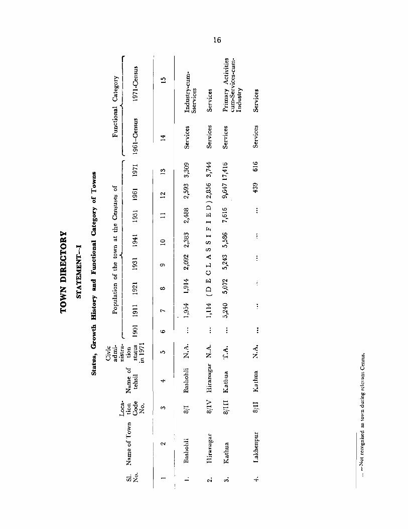
r I
~I ~I ~I 81 .... ~ .~ I ~I :::s 1
IJ:.t
I I L ( I
I '01 rn I ~ 1 ~ 1 5, 0, ]1 :1
cG I c 1 §~ C1I I -51 "'"'I
~ 1 ·3 , ..:sl
:::s 1 go, 0..,
I L
'" :::s '" c Q)
o I ....
to m
.... to m
.... c<)
m
.... C'I m
.... o m
(J • .!.~=:gr:: .;; S 1:: 0 +-l en a "C .~ ";:: ~ .-cG C "'.S
"'"' o .-Q) ....
ell 33 Q) z .....
·0 Ci5Z
o
I
S :::s u I >.'" ... C1I ... U rn .... :::s ;>
"'0'" C ~
1-4(/}
...... -co
'" Q) u .s: ... C1I r:n
16
rn Q) u .s: ... II)
r:n
...... ..... -co

r 1 , I I 1 I
a 1 o I ~I ........ 1 '" I ]1 '-'I ~ 1 a 1
."E , '"O~ '"01 ~ 1
~I ]1
.:1 o I S 1 «S 1 z,
1 1 I
11 ... ..d..!. ....... 9J
"' ... '~O..d-1 ~.~ g_ I:: ~ 0
I Q) >'0 O ..... S L z·o 0.:-=.... 8
r ( , ........ I 1 ~.§ 1
~ 1 ~ ~ 1 3. 1 ~.-= ~ '" 1 0.. s:: 1
~ ~ ~ ~ 1 ~ 1 E-<:.::- 1 .~ 1 L ..dl 0..
1
l
17
o
co
o c:) r-.....
. 'l"

-• Qo ... u ... ~
r , , 1
....... 1 01 q, ,
I I I I . ~
~
l
r , , ....... 1 01 o~ ,
I 1 1 I 1 ~
. I '" 1 ::, 0..\ .~ , ~ ,
c::t::1
I , I I 1
l
.... ... I: ? Il3 o .. Obi)
1S
o
co
o
o o
at")
o 00 C<")
..... co
00
o at")
00
00 co c-I
o o c-I
o o c-I
co r;--.. .....

19
( '" .... co I
~ ~
0') ...c
..--.. I c5 II> ;::
.5l I 1:) J ...0 ~!j ~
I l!') 0 C<") 0 0 c ~ .... ;:: 0) co ;:: o ....-._ 0 :<)
I A:::..QO C<") 0 ~c.. 0
I """ 0 I <is • 0 -< S·G ~
'~ l!') ~ o .... ~ r--
Z I Os ..._..
;:: I .5l I · ..,
I :l~ ~ I et')
~ ~ 0 "0 .... tJ:: I ;::!; . ;:::
I ..... ..,
(.)
I · cu ~ '"
I ~ 0 C\I 0 C<") l!') s· ... l!') r-- C<"":
L 0 .... C<") C\I
0
. ~~ ~ ~= .S! '" Q)
.... ..Q :> :>-< ~ bD t ~
to'" Ie >- --.. ~ .... ( '1""1 Q,;
~ en 0 ·G I:: C 0 0 0 j>o4 ....
I 0 0 0 til'"
ro ro .... 0 0 0 0 0
=: ::~I o..-~ 0 0 ~ ~ ro l!')~ O~ O~ O~
0 i>-..
"C c..-< ° bD ~ C\I C<") t'I ... .. CUo.. E-t .... = ti ::l I CU
0 I ~ Col '" 0
fo4 a '0 I .... $: $: S: ~ ::l Z -< &:: L 0 ~ = ~ rr.J ~ f-t ~ .... ~ .. Q ~
~ "C (IS ::r: ::r: ::r:
fo4 ;9 0 '" ..... - - -..s:: ..... o ..... ..s:::;:::: rr.J en rr.J
Z -< c Gi 0 ~ 0 .S2P Sl co Q Q ::r: E-< -~
fo4 ~ ;.a I:: ~ - - -." ~ I:Q fIJ a ~ 3:
til $:
0 • 0 r '" ~
.... u I
<I> ... ..Q r--;;. '" I
.... ... el) 0 0 I::
I .;:: ] I ~
0
..... -< 'S
0 .... I ~
ci en Z I
I .... ~ <I.> ;:: I ......... I ro 0
L ~..o
S V<I.> bDbD
~ ..... r: ~ 0 0 0 0 en 0 Q).~ >- s:ro ~ a:t. ~ 0.. en <1.> ....
","0
"O..Q ~biJ;::~ " 0 0 0 o c· ... S C<")
0> 0 c:: A:::Q)--' 0 ~ 0 - .....:
...... .... .... 0 0;1 ::l
I:: .:z: bD til 0..
Q) S: til C
E 0 0 I:: ::l Q)
..c <Il ..Q ..c (IS~ '" .::: (i ,..;.:: Z ~ ::r: ~
'II co H
.....: O· c-.i c<) ..,: enz

CIl ~ .... ... --]
" -til = o ... 5 :I
"CS ~
20
o -
o ::r:
......:

C (I .r1 011 I 0.. .... 1 SOl ..... 0.. , t; S 0'- I S '" J Q) .2 ") Q).~ I .. "C , ..co, ~S o S I ~ 8 I S I Z L
'0 Cl3z
o
co
-; o
U
>. ... Q) () o ...
d
21
-«I
8
..c ..... o tJ

If o ... bIl ... -GI =: ...
,.Q
J:l o ... ~
~ ~
r If :i (;!
I I 8 I~ I ~ ,~~ 't/) I I I ~ I 1"2 I L ~ I II f '" I Q)
I I ~ I 8 I 11.' ,;.::: r.... Z I ;; ~
I~ I
I I o I I
I I I \.. -, ( I I , I
C!) I ~ I 1"'l:I
-< .S ~ _ I::r: I I I ~ I I ";
~ I L;a I
~ I (UJ
'
I I ~ I ~ r ~
~ I.~ I ~ I.~ ~ III I 10 [ ~ ! I"; I L::;g I
I " ~ 1- I ] 1:2 I ~ I -c ~ l"g, VJ
II~ I ~ I l L::;g
~ ;i:
~ ....... C Q)
8 '" Z
""":0 t/)Z
o
co
C>I
00
0') .....
.... . ... ~ bIl :a til
0 ~ ..c:: ro
<Il .... ro ~ ~
~ c:-.i
22
..... 00 E:O
l1") .....
l1") -
tIS ~ ~
~ ~
e<)
00
co o e<)
... ~ 0.. ~ Q)
~ ...!<I ro ~
~
..... Q ....
.... (oj . .. !2 III
S 100
~ -t'$ .... Q
E-4
VILLAGE DIRECTORY TEHSIL BILLA W AR

24
VILLAGE
AMENITIES AND TEHSIL BILLAWAR
Location Name of the Total Code Village area Amenities available within the village
No. of the ~ __________________ A _______ ~ __________ ~
village (in acres)
Educational Medic;ll Power Drinking Cummuni- Postal and supply water cations Telegraph
2 3 4 5 6 7 8 9
8/1/1 Bhattodi 4,3.'35 C. S. (I) Sp
8/1/2 Bhattwal 3,044 Pro S. (I) Sp
8/1/3 Sadrota 6,719 Pro S. (2) Sp
8/1/4 Machhedi 5,950 Pro S. (2) D (I) Sp PO
8/1/5 Kindli 3,659 Pro S. (I) Sp
8/1/6 Badnotta 6,517 Mid. S. (1) Pro S. (I) Sp
8Jl/7 Thall 1,523 Sp
BIllS Malahar 4,108 H. S. (I) Pro S. (I) D (1) Sp PO
8/1/9 Malar 1,941 Pro S. (I) Sp
8/1/10 Marhoon 3,965 C. S. (I) Sp
8/1}11 Dheutta 5,108 Pro S. (I) Sp
8J 1 }12 Baggan 7,501 Mid. S. (1) Pro S. (1) D (1) Sp
8/1}13 Najot 4,961 Pro S. (1) Sp,O
811/[4 Sukral 640 Mid. S. (I) Pro S. (I) D (I) Sp,O PR PO
8/1/15 Billawar 3,344 H. S. (2) Mid. S. (I) Pro S. (1) H. C. (I) Sp, W PR PO, TO, Phone
8/1J16 Kishanpur 2,361 Mid. S. (I) C. S. (1) S. C. (I) Sp, Tw PO
8}1/17 Dhardugun 6,338 Pro S. (I) D (Il Sp
8/1/18 Huttar 2,804 C. S. (1) Sp
8/1/19 Chanera 1,379 Pro S. (1) Sp
8/1/20 Dhamlar 1,586 C. S. (1 ) Sp,O
8/1/21 Da.nbrah 1,780 Pro S. (1) Tw,O KR PO
8fl/22 Palehal 1,088 C. S. (1) Tw,O KR
8/l/23 Muni 981 Pr. S. (2) O.S KR
811/24 Seri 1,155 Pro S. (I) O. S KR
8/1j25 Parnala 1,718 Mid. S. (1) Pro S. (2) D (I) Sp,O KR PO
8[1/26 Pall an 1,077 C. S. (I) Sp,O KR
8/1/27 Dharalta 5,880 PI'. S. (1) Sp
8/1/28 Beral 1,083 Pro S. (2) S KR

DIRECTORY
NAND USE
Staple Food
25
Land use (i. e. area under different types of land use in acres rounded to the nearest unit)
r--------------A-..."..-----------,
10
Rice, Maize
Rice, Maize
Rice, Maize
Rice, Maize
Rice, Maize
Rice, Maize
Rice, Maize
Rice, Maize
Rice, Maize
Rice, Maize
Rice, Maize
Rice, Maize
Rice, Maize
Rice, Maize
Rice, Wheat
Rice, Maize
Rice, Maize
Rice, Maize
Rice, Maize
Rice, Maize
Rice, Maize
Rice, Maize
Rice, lv1aize
Rice, Maiz~
Rice, Maiztr
Rice, Maize
Ric!', Maize
Rice, Maize
Forest Irrigated
11 12
1,305 T(18) *C(18)
1,895
1,198 T (9) 0 (9)
1,932 T (36) 0 (36)
1,538 T (8) *C (8)
2,626 T (9) *C (9)
452 T (7) *C (7)
1,326 T (15) 0 (15)
882
1,071 T (3) *C (3)
250 T (6) 0 (6)
3,860 T (85) *C (85)
254 T (2) ·0 (2)
472 T (21) *C (21)
869 T(18) *C(18)
736 T (33) ·C (33)
2,845 T (42) 0 (42)
838
597 T (13) *C (13)
395 T (90) *C (90)
149 T (22) *C (22)
216
97
665 T (15) *C (15)
228 T (17) *C (17)
2,832
T (314) 0 (314)
Area not Un- Culturable available for
irrigated waste cultivation
13
522
328
734
732
531
566
241
521
220
385
401
872
524
77
539
565
857
484
282
376
736
417
423
518
542
373
691
29
14
368
399
317
938
551
585
216
760
214
617
3,099
964
1,818
24
655
327
414
485
212
219
447
200
143
49
120
251
698
142
15
2,122
422
4,461
2,312
1,031
2,731
607
1,486
625
1,889
1,352
1,720
2,363
46
1,263
700
2,180
997
275
506
426
255
318
588
376
208
1,659
598
Nearest town & distance (in kms.)
16
Bashohli (74)
Bashohli (86)
Bashohli (85)
Bashohli (79)
Bashohli (88)
Bashohli (90)
Bashohli (92)
Bashohli (94)
Bashohli (93)
Bashohli (92!)
Bashohli (90)
Bashohli (66)
Bashohli (68)
Bashohli (64)
Bashohli (54)
Bashohli (50)
Bashohli (41)
Bashohli (45)
Bashohli (27)
Bashohli (26)
Bashohli (63)
Bashohli (61)
Bashohli (58)
Bashohli (32)
Bashohli (31)
Bashohli (301)
Bashohli (47)
Bashohli (46)
Day or Remarks in-days of eluding ~ny place
the market! of rel!gtOus, hat, if any, hlstoncal .or held in the arc~aeoIoglcal
village mterest
17 18
Ancient Mosque
Temple of Kali Mata
Temple of Lord Shiva
Ancient Temple of
Location
Code No.
2
3
4
5
6
7
8
9
10
II
12
13
14
15
16
17
18
19
20
21
22
23
24
Narsing A vtar 25
26
27
28

2b
VILLAGE
AMENITIES AND TEHSIL BILLA WA II
Location Name of the Total Code Village area Amenities available within the village No. of the
I-----____________ .. ___ ..J!... _________________ ~
village (in acres) Paw~r Drinking Communi- Postal and
Educational Medical supply water cations Telegraph
2 3 4 5 6 7 8 9
8/1/29 Tehr 1,615 Pro S. (1 ) S. C. (1) Sp, W KR
8/1/30 Dewal 1,286 L. H. S. (I) Pro S. (1) Sp,O KR
8/1/31 Tilla 1,419 Pro S. ( 1) Sp
8/1{32 Malti 1,803 Pro S. (2) 0(1) Sp,O PO
8}1}33 Bathari 1,383 Pro S. (I) Sp,O
8/1/34 Lahari 3,312 B. A. S. (1) Sp,O
8}1{35 Dhannu Parol 6,112 B. A. S. (I) Sp,O
8/1}36 Godu Falal 3,999 Pro S. (1) Sp,O
8}1/37 Kahug 2,457 H. S. (I) Pro S (1) D(J) Tw KR PO
8[1[38 Mandli 858 C. S. (I) Pro S. (1) Sp,O
S[ 1{39 Rampur 1,450 C. S. ( I) Sp
8/1/40 Darung 1,271 Mid. S. (1) Pro S. (I) D(l) Sp,O KR PO
8[1[41 Dungara 1,704 Mid.S. (I) Pro S. (I) Sp, W
8}1}42 Dharmkot 1,336 C. S. (1) Pro S. (1) Sp,O
8/1/43 Bbaddu 3,080 H. S. (I) L. H. '>. 11) Pro S. (1) D (I) Tw KR PO
8[1/44 Aglidhar 2,194 Pro S. (I) Sp, a 8/1[4:5 Barotta 1,664 Pro S, (2) Sp, a 8/114:6 Thanthu 466 Pro S. (1) Sp, a KR
8[1/4:7 Harnotta 484 Sp, a KR
8/1/48 Kamala 1,012 B. A. S. (1) Sp
81 1149 Kilyal 3,(}21 Pro S. (1) Sp,G PO
8 /1/50 Ucha Pind 2,160 H. S. ( I) Mid. S. (I) Sp KR PO
8/1[51 Thara Kilwal 1,708 C. S. (I) Pro S. (1) Sp,O KR
Sll[52 Siyalna 1,720 Mid. S. (1) Pro S. (1) 0 KR PO
8/1[53 Derli 757 Sp,O
8/1/54 Rajwalta 5,234 Pro S. (I) Sp,O PO
8/1155 Kunu 931 Pro S. ( 1) W.O
8}1[56 Kandharnu 1,491 Pro S. ( 1) Sp,O
8f1/57 Danjisdhar 1,572 Pro S. (1) Sp,O

DIRECTORY
LAND USE
Staple Food
27
Land use (i. e. area under different types of land use in acres rounded to the nearest unit)
r-------------.A..--------------.
10
Rice, Maize
Rice, Maize
Rice, Maize
Rice, Maize
Rice, Maize
Rice, Maize
Rice, Maize
Rice, Maize
Rice, Wheat
Rice, Wheat
Rice, Wheat
Rice, Wheat
Rice, Wheat
Rice, Wheat
Rice, Wheat
Rice, Wheat
Rice, Wheat
Rice, Wheat
Rice, Wheat
Rice, Wheat
Rice, Wheat
Rice, Wheat
Rice, Wheat
Rice, Wheat
Rice, Wheat
Rice, Wheat
Rice, Wheat
Rice, Wheat
Rice, Wheat
Fo,est Irrigated Un- Culturable irrigated waste
11 12
T (7) * C (7)
121 T(17) *C(17)
51 T (26) *C (26)
T (1) 0 (I)
259 T (9) *C (9)
1,113 T (13) *C (Iil)
1,834 T (15) 0 (15)
576 T(17) *C(17)
552 T (14) *C (14)
T (1) *C (1)
T (4) *C (4)
T (50) *C (50)
13
927
491
432
745
381
665
603
272
526
261
440
707
933
92 T (104) *C (104) 594
238 T (38) 0 (38)
911
56 T (12) *C (12)
T (5) *C (5)
896
472
721
321
T (12) *C (12) 195
587 T (12) 0 (12) 159
760 T (62) 0 (62) 1,034
210 T (21) *C (21) 649
T(105) 0(105) 888
433 T (18) *C (18) 639
91
3,526 T (4) 0 (4)
245
341 T (6) *C (6)
11 T (46) 0 (46)
289
502
232
667
879
14
217
305
269
723
266
785
1,689
839
1,096
406
618
463
312
395
706
372
551
83
60
134
525
762
358
411
271
698
325
210
470
Area not available for cultivation
15
464
352
641
334
468
731
1,971
2,295
269
190
392
97
409
151
1,202
439
324
52
217
120
640
518
357
219
106
504
129
267
161,
Nearest town & distance (in kms.)
16
Bashohli (60)
Bashohli (65)
Bashohli (5 I )
Bashohli (63)
Bashohli (64)
Bashohli (57)
Bashohli (72)
Bashohli (78)
Bashohli (71)
Bashohli (66)
Bashohli (67)
Bashohli (59)
Bashohli (54)
Bashohli (61)
Bashohli (45)
Bashohli (70)
Bashohli (67)
Bashohli (68)
Bashohli (65)
Bashohli (69)
Bashohli (7 I)
Bashohli (79)
Bashohli (76)
Bashohli (92)
Bashohli (83)
Bashohli (35)
Bashohli (89)
Bashohli (90)
Bashohli (78)
Day or days of
the market! hat, if any, held in the
village
17
Remarks in-cluding any place
of religious, historical or
archaeological interest
18
Historical Ruins
Ancient Ruins
Location
Code No.
29
30
31
32
33
34
35
36
37
38
39
40
41
42
43
44
45
46
47
48
49
50
51
52
53
54
55
56
57

28
VILLAGE
AMENITIES AND TEHSIL BILL AWAR
Location Name of the Total Code Village area Amenities available within the village No. cf the r----------------,J....---------_________ ....._
village (in acres)
Educational Medical Power Drinking Communi- Postal and supply water cations Telegraph
2 :5 4- 5 6 7 8 9
8/1/58 Lakhari 1,567 Sp,O
8Jl/59 Kaha 1,079 Sp, S
8/1/60 Salol' 1,115 PI'. S. (2) D(I) Sp
8/1/61 Kachhil' 1,539 Pro S. ( I) Sp, W
8/1/62 Makwal 1,992 PI'. S. (2) Sp,O
8/1/63 Galak 4,336 Mid. S. ( I) C. S. (I) W.O KR PO
8/1/64 Ramkot 3,634 H. S. (I) Mid. S. (I)D(I) Sp,O PO, Phone
8/1/65 Amwala 1,073 B. A. S. (I) Sp,O
Total 166,379 H. S. (7) L. H. S. (2) D (12) W (6) Sp (55) PR (2) PO (17) Mid. S. (12) C. S. (12) H. C. (I) 0(35) Tw (5) KR (18) TO (1) B. A. S. (4) PI'. S. (54) S. C. (2) S (4) Phone (2)

29
DIRECTORY
I,AND USE
Staple Food Land use (i. e. area under different types of land Remarks in- Loca-use in acres rounded to the nearest unit Nearest town Day or eluding any place tion ,-_______________ A ____________ --,. & distance days of (in kms.) the marketf of religious, Code
historical or No. Un- Culturable Area not hat, if any, archaeological Forest Irrigated available for held in the irrigated waste cultivation village interest
10 11 12 13 14 15 16 17 18
Rice, Wheat 506 T (25) *C (25) 576 297 163 Bashohli (76) 58
Rice, Wheat 37 T (61) ·C (61) 413 267 301 Bashohli (79) 59
Rice, Wheat 240 T (4) *C (4) 498 214 159 Bashohli (75) 60
Rice, Wheat 139 T (29) 0 (29) 506 582 283 Bashohli (761) 61
Rice, Wheat 114 T (18) 0 (18) 1,240 422 198 Bashohli (80) Lord Shiva's Temple 62
Rice, Wheat 3,081 T (2) 0 (2) 421 432 400 Bashohli (82) 63
Rice, Wheat 1,542 T (12) 0 (12) 473 676 931 Bashohli (73) Historical Ruins 64
Rice, Wheat T (48) 0 (48) 607 199 219 Bashohli (85i) 65
47,194 1,606 34,740 32,645 50,194


TEHSIL BASHOHLI

32
VILLAGE
AMENITIES AND
TEHSIL BASHOHLI
Location Name of the Total Code Village area Amenities available within the village No. of the r-------___________ _A_ ___ ~ ___________________
village (in acres) Power Drinking Communi- Postal and Educational Medical supply water cations Telegraph
2 3 4 5 6 7 8 9
8/2/1 Sarthal 15,053 Pro S. (1) Sp
8/2/2 Raulka 5,575 Pro S. (I) Sp
8/2/3 Daulka 7,036 P. S. (I) Sp
8/2/4 Barmota 4,13!iJ Pro S. (1) Sp
8/2/5 Kalore 4,604 Pro S. (I) Sp
8/2/6 Bhandar 3,875 C. S. (I) D (1) Sp PO
8/2j7 Sandroohn 4,940 Pro S. (I) Sp
8/2}8 Asooh 1,212 Sp
8/2/9 Kanthal 3,480 Pro S. (1) Sp
8/2/10 Chandal 1,348 Pro S. (I) Sp
8i2/11 Lawan~ 7,654 C. S. (1) Pro S. (1) D(I Sp
8/2/12 Begoga 567 Sp
812/13 Duggan 3,179 Pro S. (I) D (I) Sp PO
8/2{l4 Dhag,ar 14,156 Mid. S. (1) C. S. (1) D (1) Sp PO
31 2/15 Bbolri 1,214 Sp
3/2/16 Dhaman 1,357 PI'. S. (1) Sp
8/2/17 Madhota 383 Sp
8:2fl8 Duiangal 2,764 1'r. S. (1) Sp PO
8/2/19 Bari 1,379 1'r. S. (I) Sp
8/2/20 Koti 1,325 Pro S. (1) Sp
8/2/21 5mjan 3,380 Sp
8/2/22 Bani 1,702 H.S. (1) Pr.S.(I) H. C. (I) Sp, R,S PO
8/2/23 Gatti 2,482 Sp
8/2/24 Chalog 1,958 Pro S. (1) Sp PO
8/2/25 Kachir 2,829 1'r. S. (I) Sp
8/2/26 Banjal 2,386 B. A. S. (I) Sp
8j2/27 Dharor 2,870 S
8/2/28 Satli 3,283 Pro S. (I) Sp PO
8/2/29 Sandhi 1,787 S
8/2/30 Fatehpur 2,867 S PO

DIRECTORY
LAND USE
Staple Food
33
Land use (i. e. area under different types of land use in acres rounded to the nearest IInit)
r----~---- ------"----------------...
]0
Maize
Maize
Maize
Maize
Maize
Maize
Maize
Maize
Maize
Maize
Maize
Maize
Maize
Maize
Maize
Maize
Maize
Maize
Maize
Maize
Maize
Maize
Maize
Maize
Maize
Maize
Maize
Maize
Maize
l\.Jaize
Forest Irrigated Un- Culturable irrigated waste
II
13,713
2,013
974
2,281
3,699
2,084
4,062
274
170
12 13
36
347
269
306
155
308
283
154
541
T (26) *C (26) 322
4,461 T (18) *C (18) 455
175 T (2) *C (2) 200
259 T (90) 0 (90) 259
8,522 T (142) 0 (142) 231
673 T (33) *C (33) 148
1,131 T (8) *C (9) 83
62 T (IS) 0 (IS) 69
T (28) 0 (28) 17-1-
T (43) 0 (43) 209
817 181
776 T (91) 0 (91) 506
1,098 222
530 T (5) 0 (5) 364
607 T (47) 0 (47) 2t2
1,442 T (131) 0 (131) 74
1,575
2,611
1,944 T (1) *C (I)
1,225
1,643
133
137
387
170
287
14
76
176
112
317
151
251
251
267
362
134
223
53
200
212
78
56
35
152
187
160
588
104
280
295
178
52
57
370
148
388
Area not available for cui tivation
15
1,228
3,039
5,681
1,235
599
1,232
344
517
2,407
866
2,497
137
2,371
5,049
282
78
202
2,410
940
167
1,419
278
1,303
767
1,004
626
65
581
244
549
Nea"st town & distance (in kms.)
16
Bashohli (70)
Bashohli (65)
Bashohli (72)
Bashohli (55)
Bashohli (60)
Bashohli (65)
Bashohli (60)
Bashohli (52)
Bashohli (45)
Bashohli (55)
Bashohli (60)
Bashohli (65)
Bashohli (60)
Bashohli (61)
Bashohli (35)
Bashohli (32)
Bashohli (35)
Bashohli (34)
Bashohli (60)
Bashohli (35)
Bashohli (45)
Bashohli (45)
Bashohli (50)
Bashohli (60)
Bashohli (30)
Bashohli (28)
Bashohli (28)
Bashohli (60)
13ashohli (70)
Bashobli (65)
Day or days of
the market/ hat, if any, held In the
village
17
Remarks in-cluding any place
of religious, historical or
archaeological interest
18
Location Code No.
2
3
4
5
6
7
8
9
II
II
12
13
14
15
16
17
18
19
20
21
22
23
24
25
26
27
28
29
30

34
VILLAGE
AMENITIES AND TEHSIL BASHOHLI
Location Name of the Total Code Village area Amenities available within the village No. of the ~-----------------~-~----------------~
village (in acres)
Power Drinking Communi- Postal and Educational Medical supply water cations Telegraph
2 3 4 5 6 7 8 9
8/2/31 Kardoh 1,347 S
8/2/32 Chilla 2,635 S KR
8/2/33 Siyara 948 Pro S. (I) Sp
8/2/34 Khaddi 1,366 Sp, R
8/2/35 Hutt 1,567 Pr. S. (2) D (1) Sp, S
8/2/36 Draman 3,082 PI'. S. (1 ) S
81 2/37 Sandar 4,738 Mid. S. (1) Pro S. (1) Sp PR
8/2/38 Mandla 1,967 Pro S. (1) S
8/2/39 Rehn 1,901 Pro S. (2) Sp
8/2/40 Smahn 3,320 Pro S. (1 ) S. C. (I) Sp
8/2/41 Dodala 1,358 S
8/2/42 Danna 803 S
8/2/43 Janu 1,842 pro S. (I) S
8/2/44 Bhoond 1,503 C. S. (I) Pro S. (2) D (I) T KR
8/2i45 Bhikar 1,861 Pr. S. (I) S
3/2/46 Jandrayali 1,417 Sp KR
8/2/47 Jhankar 2,836 Pro S. (1 ) Sp
8/2/48 Kagrod 3,199 Pro S. (I) Sp
8}2/49 Dharjhankar 5,160 Pro S. (I) Sp
3/2/50 Siyalag 2,(l27 Pro S. (1) S
8/2/51 Nagaali 2,124 S
8/2/52 Ghoral 2,307 Pro S. (1) S
8/2/53 Thana 1,508 Sp
8/2/54 Kohrdhar 2,345. Sp
8/2/55 Dbar Mahan Pur '2,271 C. S. (I) D (I) Sp
8/2/56 Hadat 1,871 Sp
8/2}57 Poonda 3,036 Pr. S. (I) Sp
8/2/58 Pathi 1,966 1'1'. S. (I) Sp KR PO
3/2/59 Kailtri 1,508 Sp
8}2/60 Preta 2,898 . C. 8. (1) Pr. S. (I) D{I) Sp."" KR

DIRECTORY
NAND USE
Staple Food Land use (i. e. area under different types of land use in acres rounded to the nearest unit)
r--------------..A...-------------_..._
10
Maize
Maize
Maize, Wheat
Rice, Wheat
Rice, Wheat
Rice, Wheat
Rice, Wheat
Rice, Wheat
Rice, Wheat
Rice, Wheat
Rice, Wheat
Rice, Wheat
Rice, Wheat
Rice, Wheat
Rice, Wheat
Rice, Wheat
Rice, Wheat
Rice, Wheat
Rice, Wheat
Rice, Wheat
Rice, Wheat
Rice, Maize
Rice, Wheat
Rict", Wheat
Maize, Rice
Maize, Rice
Rice, Wheat
Rice, \Nheat
Rice, "Vheat
Rice, Wheat
Forest
11
1,067
1,928
277
81 I
Irrigated
12
Unirrigated
13
67
158
96
144
517 T (111) *C (Ill) 423
250 T (439) *C (439) 281
T (73) 0 (73) 758
842 T (5) *C (5)
1,820 T (2) *C (2)
537 T (58) *C (58)
T (82) *C (82)
414
438
486
242
27
900 T (235) *C (235) 191
363 T (6) ·C (6) 259
843 T (112) *C (112) 153
755 T (1) *C (1) 297
1,077 579
T (22) *C (22) 879
2,8Dl T (377) *C (377) 4i3
252 T (100) *C (100) 169
1,458 T (29) *C (29) 16G
184 T (38) *C (38) 201
1,260 T (24) *C (24)
658 T (43) 'C (48)
673 T (8) *C (8)
294
300
2 T (48) 'C (48)
132
796
467
560
457
857
465
175
863
, bl Area not CUdLl a e 'I bl r t aVecl a e ,or
'Vd ~ e cultivation
14
67
169
ll5
184
254
351
87
1,326
417
144
294
598
59
112
180
257
287
1,714
823
990
75
65
469
199
451
210
9i7
746
C91
1,472
15
146
330
460
227
262
1,761
3,820
227
199
868
227
96
457
763
573
107
893
584
686
516
396
1,819
395
5.5+
523
968
455
592
431
Nearest town & di,tance (in kms.)
16
Bashohli (32)
Bashohli (35)
Basbohli (35)
Bashohli (30)
Bashohli (25)
Bashohli (25)
Bashohli (I)
Bashohli (3)
Bashohli (3)
Bashohli (14)
Bashohli (20)
Bashohli (22)
Bashohli (22)
Bashohli (22)
Bashohli (25)
Bashohli (18)
Bashohli (14)
Bashohli (5)
Bashohli (16)
Bashohli (28)
Bashohli (20)
Bashohli (23)
Bashohli (13)
Bashohli (25)
Bashohli (22)
Bashohli (24)
Bashohli (17)
Bashohli (22)
Bashohli (29)
Bashohli (12)
Day or Remarks in-days of eluding any place
the market! of leligious, hat, if any, historical or held in the archaeological
village in teres t
17 18
Ancient Ruips /'
Location
Code No.
31
32
33
34-
35
36
37
38
39
40
41
42
43
44
45
46
47
48
49
50
51
52
53
54
55
56
57
58
59
60

36
VILLAGE
AMENITIES AND TEHSIL BASHOHLI
Location Name of the Total Code Village area Amenities available within the village No. of the ,------------------~-----------------_,
village (in acres)
Educational row~r Drinking Communi. Postal and Medical supply water ca tiolls Telegraph
2 3 4 5 G 7 8 9
8/2/61 Plakh 3,124 Pro S. (3) Sp KR
8/ 2162 Plahl 4,204 PI'. S. (2) S. C. (1) T PR
8/2/63 Plasi 741 H. S. (1) Mid. S. (1) S. C. (1) Sp KR PO
8/2/64 Kothi 2,755 Pro S. (2) Sp PR
8/2/65 Barot 646 S KR
8/2/66 Sobar 3,217 Mid. S. (1) C. S. (1) Pro S. (I) D (I) Sp KR PO
8/2/67 Athoon 5,539 Sp
8/2/68 Bera 1,836 S KR
8/2/69 Nawshehra 1,702 Sp
8/2/70 Athyalta 7,722 Pro S. (1) Sp PR
8/2/71 Mahanpore 2,603 H. S. (1) C. S. (1) 0(1) Sp KR PO, TO
8/2/72 Salladi 710 Pro S. (1) Sp PR
Total 212,294 H. S. (3) Mid. S. (4) 0(10) T (3) SP (54) PR (5) PO (12) C. S. (8) PI'. S. (48) H.C. (1) R (2) S (19) KR (11) TO (1) B. A. S. (1) P. S. (1) S. C. (3)

'37
DIRECTORY
LAND USE
Slaple Food Land use (i. e. area under different types of land Remarks in. Loca. use in acres rounded to the nearest unit Nearest town Day or eluding lmy place tion ,--__ . __ . __________ .J.... ____________ --. & distance days of of religious, Code
(in kms.) the market/ historical or No. Un- Culturable
Area not hat, if any, archaeological Forest Irrigated irrigated waste
available for held in the interest cultivation village
-- - - ~----
10 11 12 13 14 15 16 17 18
Ric,", Wheat 488 1,300 608 728 Bashohli (4) 61
Rice, Wheat 144 T (25) ~C (25) I,GOO 1,217 1,218 Bashohli ( 1) 62
Rice, Wheal 192 226 21 I 112 Bashohli (13) 63
Rice, Wheat 35 T (2) ·C (2) 1,119 783 816 Bashohli (4) 64
Rice, Wheat 31 T (2) 'C (2) 282 201 130 Bashohli (15) ... / 65
Rice, Wheat 98 738 1,423 958 Bashohli (20) 66
Rice, Wheat 2,409 314 2,738 78 Rashohli (27) 67
Rice, Wheat 750 T (34) 'C (34) 208 407 437 Bashohli (18) 68
HicC', Wheat 496 430 30t 471 Bashohli (30) 69
Rice, Wheat 4,841 :,85 2,181 115 Bashohli (30) 70
Rice, Wheat 1,102 T (45) ·C (45, 467 514 475 Bashohli (32) 71
Rice, Wheat 350 180 liS 62 Bashohli (35) 72
89,758 2,607 26,043 30,541 63,345


TEHSIL KATHUA
40
VILLAGE
AMENITIES AND
TEHSIL KATHUA
Location Name of the Total Code Village area Amenities available within the village No. of the ,-----------------_---------------------__._
village (in acres) Power Drinking Communi- Postal and Educational Medical supply water cations Telegraph
2 3 4 5 6 7 8 9
8/3/1 Dukhat 1,058 Pro S. (I) W KR
8/3/?' Bijjat 306 Pro S. (I) W KR
8/3/3 Manjli 389 Sp KR
8/3/4 Jamalpur 255 W KR
8/3/5 Dilwan 2,497 Pro S. (1) W KR
8/3/6 Khaniyara 240 W KR
813J7 Rakheh 466 W KR
8/3/8 Bhatoli 137 W KR
81319 MehtabplIr 1,017 0 KR PO
8/3/10 Baroi 34 Pro S. (I) 0 KR
813111 Kharot 2,045 C. S. (2) E T,Tw PH. PO
813/12 Kothi Jagir 306 0 Kg
8/3/13 Kalspur 90 T,1'w Kl(
8/3/14 Gehtarwan 64 C. S. el ) 1',1'", KR
8/3/15 Chak Ram Singh 122 Pro S. (I) S PR
813/16 Chak Riju 224 Tw PR
8/3/17 Tarf Manjli 2,683 Tw,O PR
8/3/18 Chak Seheikhan 348 Pro S. (2) S,Tw PR
13/3/19 Chak khuni 80 Tw PR
8/3/20 Chak Lachhaman 53
8/3/21 Maroli 22 T,T", KR
8/31'22 Govindsar 731 Pro S. (2) E Tw PR
8 13j23 Mangota 382 W,Sp KR
8/3;24 Sawla 717 W KR
313/25 Rasooh 313 W KR
8/3126 Badloli 225 W KR
813/27 Bhugat 245 Sp KR
81'3/28 Hath 44! L. H. S. (I) Pro S. (I) D(I) W KR PU

41
DIRECTORY
LAND USE
Staple, Food Land use (i. e. area under different types of land Nearut town Day or Remarks in- Lo<:a-use in acres rounded to the nearest unit) eluding any place tion r---_
H
__________
A ____________ -, & distance days of
(in kms.) the market/ of religious, Code
Area not hat, if any, historical or No.
Forest Irrigated Un- Culturable available for held In the archaeological irrigated waste cultivation village interest
10 11 12 13 14 15 16 17 18
Maize, Wheat 3 271 83 701 Kathua (24)
Maize, Wheat 89 176 41 Kathua (8) 2
Ma.iz~, Wheat 13 122 ?n ~:J 231 Kathua (22) 3
Maize, Wheat 59 178 18 Kathua (8) 4-
Maize, Wheat 487 644 ],126 240 Kathua (8) 5
Maize, Wheat 103 76 56 Kathua (8) 6
Maize, Wheat 149 278 39 Kathua (8) 7
Ric .. , Wheat 67 11 59 Kathlla (10) 8
Rice, Wheat 30 322 44 621 Kathua (8) 9
Ric~, Maize 23 B 3 Kathua (8) 10
Maize, Wht'at 235 943 443 424 Kathua (6) II
Maize", Wheat 206 29 71 Kathlla (6) 12
Maize, Wheat 53 24 13 Kathua (7) 13
Maize, Wheat 48 10 6 Kathua (6) 14-
Rice, Wheat 74 12 36 Kathua (5) 15
Rice. Wheat T(II) *C (II) 110 17 86 Kathua (5) 16
Rice. Wheat T (772) *C (772) 494 6 1,411 Kathua m Ancient eave of Baba Dibar Nath & Ruins of a Fortress 17
Rice, Wh .. at T (77) *C (77) 146 23 102 Kathua (2) 18
Ric!". Wheat 41 13 26 Kathua (3) 19
49 3 Kathua (3) Uninhabited 20
Maiu, Wheat 19 3 Kathua (5) 21
Rice, Wheat 531 99 101 Kathua (5) 22
:MaizC', Wheat 118 129 135 Kathlla (15) Ancient Fortress 23
Maize. Wheat 223 215 25 254 Kathua (20) 24
Maize, Wheat 133 27 153 Kathua (22) 25
Maize, Wheat 106 21 98 Kathua (21) 26
l'v[aize. Wheat 77 68 12 38 Kathua (23) 27
J\iaize, Wheat 25 153 42 221 Kathua (20) Ancient Temple of Narsingh A vtal" 28

42
VILLAGE
AMENITIES AND TEHSIL KATHUA
Location Name of the Total Code Village area Amenities available within the village No. of the r------------------.--A------------------~
village (in acres) Power Drinking Communi- Postal and
Educational Medical supply water cations Telegraph
2 3 4 5 6 7 8 9
8/3/29 Brohandahi 296 Sp KR
8/3/30 Tridwan 2,914 Pro S. (I) W,O KR
8/3/31 Kasori 1,265 S PR
8/3/32 Domar 4,638 Pr. S. (1) Sp PR
8/3/33 Then 1,586 C. S. (1) Pro S. (I) D (I) Sp PR PO
8/3(34 Gharti 1,657 Pro S. (1 ) D (1) E Sp PR PO
8/3135 Nora 1,194 S PR
8/3/36 Basantpur 1,029 W,R PR I
8/3/37 Kehnta 1,025 Pro S. (1) W PR
813/38 Dakhnaka 288 Sp PR
8/3/39 Katlehr 380 Pro S. (I) lJ (1) W,Sp PR
8/3/40 Barthindi 613 Sp PR
8/3/41 Barni 600 W l'R
873/42 Danna 1,:.101 Pro S. (1) R, W PR
8/3/43 Bbarrab 239 W PR
8/3/44 Dbanore 1,894 Pc. S. (2) W KR
8/3/45 Mangari 234
8/3/46 Nonaal 287 0 KR
8/3/47 Karroh 1,377 Pro S. (1) W.O KR
8/3j48 Jandore 297 Pro S. (I) E W,O KR
8/3/49 Hote 510 Pro S. (l) Sp KR
8t3!50 Maha 882 Pro S. (I) 0 KR
8/3/51 Tarrah i02 Pro S. (I) 0 KR
8/3/52 l\latandi 191 0
8j3/53 Chak Gusaun 82 0
8/3/54 Chak Sardah 52
8/3/55 Jagat Pur 1,576 S,O PI{
8/3/5ti Rakh Jabfar 273
8/3,57 Chak Hari Singh 55

DIRECTORY
LAND USE
Staple Food
43
Land use (i. e. area under different types of land use in acres rounded to the nearest unit)
r-------------;-A.-------------.
10
Maize, Wheat
Maize, Wheat
Maize, Wheat
Maize, Wheat
Maize, Wheat
Maize, Wheat
Maize, Wheat
Wheat, Maize
Rice, Wheat
Rice, Wheat
Rice, Wheat
Rice, Wheat
Rice, Wheat
Rice, Wheat
Ricc-, Wheat
Rice-, Whe-at
Rice, Wheal
Rice, Wheal
Ric!", Wheat
Maize, Wheat
Rice, Wheat
Rice, Wheat
Rice, Wheat
Rice, Wheat
Rice, Wheat
Forest
11
26
548
543
2,335
502
187
78
237
38
73
235
139
123
Irrigated
12
Un- Culturable irrigated waste
13
74
485
118
367
104
114
74
268
161
67
127
90
99
158
14
23
510
181
1,356
640
1,329
316
72
35
36
81
25
30
93
23 33
546 T(182) *C(182) 193
~6 T (40) *C (40)
387 T (55) *C (55)
20
143
lOB T(21) *C(21)
T (16) *C (16)
134 T (83) *C (83)
183
81
250
121
161
314
452
120
21
50
347
24
50
166
75
473
9
41
338
97
44
4
2
272
Area not available for cultivation
15
173
1,371
423
580
340
27
804
611
592
147
99
263
332
827
183
807
233
65
212
147
165
101
152
27
41
740
66
4
Nearest town & distance (in kms.)
16
Kathua (20)
Kathua (20)
Kathua (22)
Bashohli (10)
Bashohli (14)
Kathua (24)
Kathua (20)
Kathua (22)
Kathua (20)
Kathua (18)
Kathua (17)
Kathua (20)
Kathua (18)
Kathua (15)
Kathua (16)
Kathua (15)
Kathua (12)
Kathua (10)
Kathua (10)
Kathua (10)
Kathua (15)
Kathua (8)
Kathua (8)
Kathua (7)
Kathua ' (7)
Kathua (7)
Kathua (6)
Kathua (6)
Kathua (3)
Day or days of
the marketJ hat, if any, held in the
village
17
Remarks in-cluding any place
of religious, historical or
archaeological interest
18
Ancient Fortress and Temple
Uninhabited
Uninhabited
Uuinhabited
Uninhabited
Loca. tion
Code No.
29
30
31
32
33
34
35
36
37
38
39
40
41
42
43
44
45
46
47
48
49
50
51
52
53
54
55
56
57

44
VILLAGE
AMENITIES AND TEHSIL KATHUA
Location Name of the Total Code Village area Amenities available within the village No. of the
,--__________________ .A. __________________ -.
village (in acres) Power Drinking C:>mmuni- Poslal and Educational Medical supply water cations Telegraph
2 3 4 5 6 7 8 9
8/3/58 Chak Partap Singh 85 0 PR
8/3/59 Chak Plmla 130 S I'R
813160 Chak Gota 105 S PR
8/3161 Rajiani 205 S KR
8/3/62 Tarf Tajwal 2,384 Tw,O PR
8/3/63 Tarf Bajwal 9BG '1'w,O KR
8/3/64 Chak Sardar Desa Singh 473 ]'r. S. (I) E W PR
8/3[65 Chak Diwan Kripa Ram 332 S KR
8/3/66 Changrah 1,403 Mid,S, (11 Pr, S ( l! .E S PH.
8/3}67 Chak Drabkhan ~5~ S, () l'R
8/3/68 Chak Gadadhal' 7(i:i :s PI<
8/3/69 Chak Bhaga 12Y S, \V PI{
8/3/70 Ghak Nanak 1:18 \\' KR
8/3/71 Bigwan 224 E W KR
8/3}72 Sherpur 223 Pro S, (1) E W KR
8/3/73 Jakhbar 848 L. H. S. (I) C. S. (I) n (I) E W KR
8j3/74 Badalha 704 Pr. S, (I) S,C KR
8/3[75 Chak Slljanpur 59
8/3/76 Narolian 293
'''" KR
8;'3;77 Tarf Sanji 235 PI'. S. (2) \" KR
8/3/7B Rer 170 W KR
3/3/79 Majra 261
3,3,'80 Chak Devia p--::>
8,3;31 Candial 166 Pro S. (I) W KR
83[82 Jhumber Mahtaba 127 W KR
3,'3'B3 Ramnagar 751 D(I) W KR
8/3;(\4 Keerian 693 Mid. S. (I) Pr, S. (1) W KR
8/3/85 Bhag Thali 783 W KR

DIRECTORY
LAND USE
Staple Food
45
Land use (i. e. area under different typt's ~ land use in acres rounded to the nearest !"Init)
r~------------~------------~
10
Rice, Wheat
Rice, Wheat
Rice, Wheat
Rice, Wh"at
Rice, Wheat
Rice, Wheat
Rice. Wheat
Rice, Wheat
Rice, Wheat
Rice, Wheat
Rice, Wheat
Rice, Wheat
Rice, Wheat
Rice, Wheat
Rice, Wheat
Rice, Wheat
Rice, Wheat
Rice, Wheat
Rice, Wheat
Rice, vVheat
Rice, Wheat
Rice, ""heat
Rice, \\-'heat
Rice, Wheat
Rice, Wheat
Forest
11
Irrigat"d
12
T (44) *C (44)
T(13) *C(13)
Unirrigated
13
69
4B
48
T (l03) *C (103) 68
T (941) *C (941) 403
T (467) *C (467) 227
T (219) *0 (219) 169
T (91) *C (91) 162
17 T (588) *C (588) 316
14 T 136) *C {36
T (197) "C (197, 2HH
T (52) *C (52) 53
T (83) *C (83) 42
T (98) *C (98) 86
T (153) *0 (153) 19
T (352) ·C (352) 263
50 T (40) 0 (40)
T (42) *C (42)
T (122)·C (122)
T (82) *C (82)
T (3) *C (3)
T (33) 0 (33)
T (3) *C (3)
311
9
243
40
38
29
55
59
114
561
410
26
Area not Culturable available for
wa,le cultivation
12
25
4
286
14»
25
35
11
·w
9
4
13
145
9
6
11
11
5
8
3
74
77
14
15
15
26
19
30
754
147
60
44
346
237
13
31
47
220
158
9
44
62
42
224
70
99
10
116
173
740
Nearest town & distance (in kms.)
16
Kathua (3)
Kathua (3)
Kathua (5)
Kathua (1)
Kathua (0)
Kathua m
Kathua (2)
Kathua (3)
Kathua (3)
KathuA ·4,
Kathua (6)
Kathua (5)
Kathua (6)
Kathua (5)
Kathua (6)
Kathua (4)
Kathua (4)
Kathua (4)
Kathua (5)
Kathua (5)
Kathua (6)
Katbua (10)
Kathua (29)
Kathua (9)
Kathua (9)
Kathua (9)
Kathua (6)
Day or days of
the market! hat, ifany, held in the
village
17
Remarks in-cluding any place
of religious, historical or
archaeological interest
18
Spring of Bor Sahib
Uninhabited
Uninhabited
Uninhabited
Location
Code No.
58
59
60
61
62
63
64
65
66
67
68
69
70
71
72
73
74
75
76
77
78
79
80
IJI
82
83
84
85

46
VILLAGE
AMENITIES AND TEHSIL KATHUA
Location Nam" of the Total Code Villag~ area Amenities available within the village No. of the r-
"" _________________ ..A.. _____ - - _________ ~ ___ _..
village (in acres) Power Drinking Communi- Postal and
Educational Medical supply water cations Telegraph
2 3 4 5 6 7 8 9
8/3:86 Makhsoos Pur 265 W KR
3/3/87 Jrai 436 Pro S. ( I) W KR
8/3/33 Saiper Sipla 183 W KR
8/3/89 Khukhiyal 608 C.S. (I) Pro S. <I) S. C. (I) E W KR
8/3/90 Kirpaal 378 W KR
8/3/91 Taraf Pain 623 W KR
8/3J92 Pitho Bala 324 W KR
813/93 Mirpur Ram 377 W KR
3/3}94 Lakhnote 550 Pro S. (I) W KR
8}3{95 Kangriyal 109 W
8/3)96 Matore 433 W
8/3}97 Syedporc 275 C. S. (I) 1': W
8/3/98 Gown 316 Pro S. (I) \V
8/3/99 Pamwal 208 W KR
8/31 100 Pandori 447 Pro S. (I) E W KR
8{3/101 Jugian 1,870 Sp KR
8/31102 Bhararyiyal 170 W
8/3/103 Bhar 1Jori 189 W
8/3/104 Pitho Pain 377 \V KR
8/3/105 pidri Pain 114
8/1/106 Tarf Bala 437 W KR
8:3/107 Pidri Bala 143
8; ~fl08 Chak l'oorab 19J
8/3/109 Narroha 125 Sp KR
U/3(IIO Drallan 175 Sp KR
8/3{1l1 Barmora 132 W,Sp
8/3/112 Airwan 226 Pr. S. (2) S.C. (I) W,Sp KR
8/3(113 Jamraal 206 W KR
,1/3/114 Chhajiyal 262 W KR
8J3t 115 Nangal 66S W PR

DIRECTORY
LAND USE
Stapk Food
47
Land use (i. e. area under different types of land use in acres rounded to the nearest unit
r--------------.-A..--.. ----------1
10
Rice, Wheat
Rice, Wheat
Rict:, Wht:at
Rice, Wheat
Rice, Wheat
Rice, Wheat
Rice, Wheat
Rice, Wheat
Rice, Wheat
Rice, Wheat
Rice, Wheat
Rice, Wheat
Rice, Wht:at
Rice, Wheat
Rice, Wheat
Rice, Wheat
Rice, Wh~at
Rice, Wheat
Rice, Wheat
Ric,,", V\'heat
Rice, Wheat
Rice, Wheat
Rice, Wheat
Rice, Wht:at
Rice, Wheat
Rice, Wheat
Rice, Wheat
Forest
11
Irrigated Area not
Un- - Culturable available for irrigated waste cultivation
12 13
T (19) *C (19) 33
T (133) *C (133) 162
T (153) *C (153) 5
T (356) *C (356) 143
T (243) *C (243) 58
T (438) "C (438) 100
T (129) .C (129) 106
T (613) *C (613) 114
T (418) *C (418) 56
T (31) *C (31) 19
T (223) *C (223) 122
T (218) *C (218) 30
T (135) *C (135) 103
T (99) *C (99) 61
T (153) *C (153) 48
T (197) *C (197) 480
T(I11)*C(111)
T (125) *C (125)
50
38
T (221) *C (221) 54
T (70) *C (70) 33
T (334) *C (334) 36
T (101) *C (101) 26
T (79) *C (79) 54
T (8) *C (8) 105
T (103) *C (103) 43
T (71) .C (71) 38
175
175
T (165) *C (165) 50
T(168) *C(168) 89
14
7
5
10
32
10
10
10
24
4
3
44
21
5
237
12
35
4
17
II
38
6
7
12
14
18
29
19
15
212
140
18
104
67
58
79
140
66
35
84
24
34
27
241
956
9
14
67
7
50
5
22
6
22
II
37
13
18
389
Nearest town & distance (in kms.)
16
Kathua (6)
Kathua (6)
Kathua (6)
Kathua (3)
Kathua (3)
Kathua (3)
Kathua (0)
Kathua (18)
Kathua (2)
Kathua (3)
Kathua (3)
Kathua (3)
Kathua (3)
Kathua (3)
Kathua (20)
Kathua (I8)
Kathua (18)
Kaihua (19)
Kathua (18)
Kathua (18)
Kathua (3)
Kathua (3)
Kathua (3)
Kathua (12)
Kathua (13)
Kathua (17)
Kathua (16)
Kathua (13)
Kathua (9)
Kathua (7)
Day or days of
the marketj hat, if any, held in the
village
17
Remarks in-cluding any place
of religious, historical or
archat:ological interest
18
Uninhabitt:d
Uninhabited
Uninhabited
Location CQde No.
86
87
88
89
90
91
92
93
94
96
97
98
99
100
101
102
103
104
105
106
107
lOB
109
110
111
112
113
114
115

'18
VILLAGE
AMENITIES AND TEHSIL KATHUA
Location Name of the Total Code Village area Amenities available within the village No. of the
~ __________________ A ___________ -_-_~-_~
village (in acres) Power Drinking Communi. Postal and
Educational Medical supply water Ca nons Telegraph
'2 7{ 4 5 6 7 8 9
-~~-.--~-- ---~.----- ---- -- -_.-_----
8/'j/ilG SurZlj !:lei; :lOt)
8/31117 Mahichak 609 Pro S. (I) W PR
8/S/ll8 Bh3khrial 102 W
8/31119 Chak Bhagta 504 S PR
8{3/120 Falote 1,033 C. S. (I) P. S. (I) E W KR
8/3/121 Kangrial 428 Pro S. ( I) T KR
8/3/122 Chatiyal 171 T KR
8/3/123 Sher Tambar 413 W KR
8/3/124 Jawa1a Pur 229 W~ KR
8/3/125 Chak Aidal 189 W KR
S/3jl26 Muthi Khurd 178 W KR
8/3/127 Amargarh 268 W KR
8/3/128 Bhanhiyal 167
8/3/129 Bhadiyari 318 Pro S. (I) W Kl{
8/31130 Dadoli 260 W KR
6/3/131 Mlithi Jagir 255 Pro S. (I) E W KR
813/132 Mirpur Jagoo 427 W KR
8/3/133 Mothi Rakhwalan 285 Pro S. (l> T KR
813/134 Chak Gokal 183
S13/135 Rakb Lachipma 819 Pr. S. (2) E S, T
8/3/136 Chatha 105
8/3Jl37 Nihal Pura 414 PI'. S. (I) T KR
8131138 Chak Shehzada J25 W
8/3/139 Barwal 896 H. S. (l) Mid. S. (I) P. S. (I) D (1) E TW,T PR PO
8131140 Sanijari IYI
813/141 Uttri 265 Pro S. (2) E T,Tw KR
8/31142 Chak Charuhn 497 0 KR
8/3/143 Chak Ramchand 351 T
8/3/144 Rakh Sarkat Palahi 376 Tw PR

DIRECTORY
LAND USE
Staple Food
49
Land use (i. c. area under different types of land use in acres rounded to the nearest unit)
~-------------~------------~
10
Maize, Wheat
Maize, Wheat
Maize, Wheat
Rice, Wheat
Rice, Wheat
Rice, Wheat
Rice, Wheat
Rice, Wheat
Rice, Wheat
Rice, Maize
Rice, Wheat
Rice, Wheat
F.ice, Wheat
Rice, Wheat
Rice, Wheat
Rice, Wheat
Rice, Wheat
Wheat, Maize
Wh~at, Maize
Wheat, Maize
Wheat Maize
Wheat, Maize
Rice, Wheat
Rice, Wheat
For.-st Irrigakd Un- Culturable
irrigated waste
11 12 13
34
T (4(,) *C (46) 351
85
T (15) ·C (IS) 263
T (713) ·C (713) 103
T (228) *C (228) 103
34 T (66) *C (66) 38
T (294) ·C (294) 47
T (192) ·C (192)
T (106) *C (J06) 41
T (129) ·C (129) 34
T (162) *C (162) 47
T (86) *C (86) 55
T (166) *C (166) 98
T (172) *C (172) 46
205
T (219) ·C (219) 110
71 T (93) *C (93) 77
5
139
T (6) *C (6) 135
T (82) *C (82)
T (89) *C (89)
T (9) *C (9)
651
85
250
90
384
148
181
416
304
123
14
18
34
62
8
11
16
41
14
6
28
11
69
2
9
145
18
14
S
8
13
Area not available for cui tivation
15
274
194
17
192
155
89
33
72
25
26
15
18
12
48
14
39
29
44
40
77
20
75
26
362
25
70
76
39
101
Near'~t town & distance (in kms.)
16
Day 0['
days of the market/ hat, if any, held In the
village
17
Remarks in-cluding any place
of religious. historical oc
archaeological interest
18
Uninhabited
.j.
Uninhabited
Uninhabited
Kathua (8)
Kathua (8)
Kathua (8)
Kathua (10)
Kathua (8)
Kathua (13)
Kathua (II)
Kathua (11)
Kathua (ll)
Kathua (11)
Kathua (7)
Hiranagar (11)
Hiranagar (9)
Kathua (6)
Kathua (3)
Kathua (7)
Kathlla (3)
Kathua (10)
Kathua (8)
Kathua (8)
Kathlla (9)
Kathua (II)
Kathua (11)
Uninhabited
Kathll.a (11)
Kathua (11)
Kathua (II)
Kathua (10)
Kathua (7)
Kathua (2)
Uninhabited
Location Code No.
116
117
118
119
120
121
122
123
124
125
127
128
129
130
131
132
133
134
135
136
137
138
139
140
141
142
143
144

50
VILLAGE
AMENITIES AND TEHSIL KATHUA
Location l'\ame of -the Total Code Village area Amenities available within the village No. of the
,----____________ • ___ ..A.. _________________ ~
village (in acres) Power Drinking Communi- Postal and Educational Medical supply water cations Telqraph
.------~ . - ~- -----~.--
2 3 4 5 6 7 8 9
- -----_--
8/3/145 Chak Gainda 236 S PR
8/3/146 Chak Sohna Nupa 540 Pr. S. (I) S PR
8}3}147 Chak Sajjan 645 Pro S. (1 ) S PR
8}3/I48 Chak Luddan 259
8}3/I49 Sahaar 1,173 Ii: 0
8}3}I50 Janglote 4,140 Mid. S. Pro S. (I) D (I) E T, Tw KR PO
8/3}I5I Bhed Blore 1,817 Pr. S. (1 ) W,O
8/3/152 Androt 861 Tw,O
8/3/153 Kathera 522 Mid. S. (I) W,O
8131154 Fafal 1,108 W,O
8/31 155 Daral 314 W,O
8}3/156 Kadyar 418 S
813/157 Kumala 164
8/3/158 Sherkotla 1,447 W,O
8}3/159 Sanghan 381 W,O
8/3/160 Narainpur 273 Sp,O KR
8}3/161 Logate 1,471 C. S. (I) Pro S. (1) E 0
8}3/I62 Budhi 3,156 H. S. (I) C. S. (I) D (I) T KR PO
8/3}I63 Jandore 219 T,Tw KR
8/3/164 Bagial 128 I'r. S. (I) T KR
8}3/I65 Kanora 365 T,Tw KR
813/166 Chak Mansabdar 153 T KR
8/3}I67 Trihara 784 T KR
8/3/168 Palli 656 Pr. S. (I) 0 KR
8/3/169 Thandoon 236 1'1'. S. (I) T KR
8/3/170 Rakh Sarkar Budhi 301
8/3/171 Dabwal 166 R,S KR
8}3/172 l'\agrota 434 E 0 KR
8/3/ 173 Merth 894· Pr. S. (2) T,Tw KR
DIRECTORY
LAND USE
Sta~le Focd
51
Land use (i. e. area under different types of land use in acres rounded to the nearest unit)
r-------------.A.-'---------" ---..
10
Rice, Wheat
Rice, Wheat
Rice, Wheat
Rice, Wheat
Rice, Wheat
Rice, Wheat
Rice, Wheat
Ric~. Wheat
Rice, Wheat
Rice, Wheat
Rice, Wheat
Rice, Wheat
Wheat
Maize, Wheat
Rice, Wheat
Wheat, Maize
Wheat, Maize
Wheat, Maize
Wheat, Maize
Wheat, Maize
Wheat, Rice
Wheat, Maize
Maize, Wheat
Maize, Wheat
1vlaize, Wheat
Maize, Wheat
Forest Irrigated
11 12
T (5) ·C (5)
2 T (II) ·C (11)
T (24) ·C (24)
331
151
354
21
503
118
259
233
97
21
1,043
281
T (78) *C (78)
T (ll) ·C (II)
T (341) *C (341)
T (37) ·C (37)
T (90) ·C (90)
Un- Culturable irrigated waste
13
205
393
378
162
798
1,328
270
148
189
144
45
51
4G
160
36
153
863
838
91
8
206
32
431
137
9
129
353
435
14
4
60
76
63
126
1,691
988
106
159
98
72
17
732
113
363
576
76
99
74
26
90
55
53
92
Area not available for cultivation
15
22
74
167
34
249
790
408
253
153
363
79
91
118
322
135
42
224
699
52
21
60
36
416
135
H
11
23
277
Nearest town & distance (in kms.)
16
Kathua (3)
Kathua (I)
Kathua (3)
Kathua (10)
Kathua (10)
Kathua (6)
Kathua (14)
Kathua (16)
Kathua (14)
Kathua (14)
Kathua (12)
Kathua (10)
Kllthu .. (II)
Kathua (12)
Katr.ua (16)
Kathua (21)
Kathua (10)
Kathua (16)
Kathua (12)
Kathua (12)
Kathua (12)
Kathua (13)
Kathua (13)
Kathua (14)
Kathua (14)
Kathua (14)
Kathua (11)
Kathua (16)
Kathua (13)
Day or days of
the market/ hat, if any, held in the
Remarks in- Loc ..
village
17
eluding any place lion of religious, Code historical or No.
archaeological interest
18
Uninhabited
Ancient Temple of
145
146
147
148
149
150
Narsingh Avtar 151
Uninhabited
Ancient Ruins
Uninhabited
152
153
1M
155
156
157
158
159
160
161
162
163
164
165
166
167
168
169
170
171
172
173

52
VU.LAGE
AMENITIES AND
TEHSIL KATHUA
Location Name of the Total Code Village area Amenities available within the village No. of the ,------_. __ .----------"---------------------.
village (in acres) Power Drinking Communi- Postal and
Educational Medical supply water cations Telegraph
2 3 4- 5 6 7 8 9
fl/3;I74 Kalna 449 Tw KR
3/3/175 Nanan 720 Tw KR
8/3/176 Bandrahr 1,079 T,Tw KR
8/3/177 Ruh Hushiari 2,482 W PR
8/3/178 Forlain 10,885 Mid. S. (I) Sp KR
8/3/179 Bhorthain 6,109 0, Sp KR
8/3/180 Jakhole 4,541 Pro S. (I) 0, Sp KR
8/3/ 181 Juthana 6,420 C. S. (1) D (I) O,Sp
8;3/182 Bauhra 6,697 0, Sp
Total 140,513 H. S. (2) L. H. S (2) D (10) E (21) T (22) PR (39) PO (8) Mid. S. (6) C. S. (11) S. C. (2) W (80) KR (99) Pro S. (58) P. S. (4) Tw (22)
C (I) R (3) S (21) Sp (22) 0(33)
53
DIRECTO]\Y
LAND USE
Staple Food Land use (i. e. area under different types of land Nearest town Remarks in- Loca-use in acres rounded to the nearest unit) Day or eluding any place tion ~ _____________ A ____________ ~
& distance days of of religious, Code (in kms.) the market! historical or No. Un- Culturable Area not hat, if any, archaeological Forest Irrigated irrigated waste available for held in the interest cultivation village
10 11 12 13 14 15 16 17 18
Maize, Wheat 49 T (7) *C (7) 285 29 79 Kathua (17) 174
l\.~aize, Wheat 265 T (5) *C (5) 2C8 60 182 Kathua (17) 175
Maize, Wheat 252 444 134 249 Kathua (18) 176
Maize, Wheat· 1,334 T (43) 0(43) 745 203 157 Kathua (13) 177
Maize, Wheat 1,024 T (669) *C (669) 1,512 3,271 4,409 ~athua (20) 178
Maize, Wheat 1,668 T (81) *C (81) 703 2,558 1,099 Kathua (22) 179
Maize, Wheat 951 T (25) 0 (25) 525 1,431 1,609 Kathua (23) Ancient Fortress 180
Rice, Wheat 933 T (15) 0 (15) 838 362 4,272 Kathua (27) 181
Rice, Wheat 3,069 469 1,934 1,225 Kathua (19) 182
21,047 14,547 35,040 27,260 42,619


TEHSIL HIRANAGAR

56
VILLAGE
AMENITIES AND TEHSIL HIRANAGAR
Locarion Name of the Total Corle Village area Amenities available within the village
No. of the r-------------------..A..-----------------~ village
(in acres) Power Drinking Communi- Postal and Educalicmal Medical supply water cations Telegraph'
2 3 4 5 6 7 8 9
-_.-----_ .. _
8/4/1 Koper 1,217 Tw
8/4/2 Dinga Amb 5,535 H. S. (I) Pro S. (2) D (I) E Sp KR pO
8/4/3 Mangloor 4,275 C. S. (I) E W,Tw
8/4/4 Chelak 4,306 Pro S. (I) E \IV PO
8/4/5 Katli 3,595 w,n
8/4/6 Kore Qasb:1 615 W
8/4}7 Dhalta 302 Pro S. (I) W J'R
8/4f8 Chak Balunda 525 W
8/4/9 Rakh Sarkar Shallan 575
8/4/10 Qasba 521 W PR
8/4/11 Bhatiari Brahmanan 391 Pro S. (I) W
8/4/12 Dhalli 369 C. S. (I) Tw
8/4/13 Chak Bannun 353 W
8/4/14 Sahllan 45 H.S. (I) Pro S. (I) E W PR
814/15 Chhan Ranga 399 W
8/4/16 Chhan Datial 288 Pro S. (2) T KR
8}4/17 Spreen 147 W
8/4/18 Khurar 66 W
8/4/19 Rakh Sarkar Bagni 1,469
8/4120 Balaahr 312 Tw
8/4/21 Thaka Pur Rajputan 250 W
8/4/22 Candwan 235 H. S. (I) C. S. (I) TW PO
8/4/23 Chak Khaloo 178 Pro S. (I) W PR
8/4/24 Cehr 141 Pro S. (2) W
8/4/25 Sehswan 847 Pro S. (2) D (I) E W PR
8{4{'26 Thath 559 W
8/4/27 Bann 728 Pro S. (I) W
8/4/28 Kishanpur Kendi 5G9 W
81429 Chhan Rorian 801 H. S. (I) Mid. S (I) S. C (I) E T PH.
8/4130 Hamirru 607 C. S. (1) Pro S. (1) D (1) T PR

DIRECTORY
LAND USE
Staple Food
10
Wheat, Maize
Wheat, Maize
Wheat, Maize
Wheat, Maize
Wheat, Maize
Wheat
Wheat
Wheat
Wheat
Wheat
Wheat
Wheat
Wheat
Wheat
Wheat
Wheat
Wheat
Wheat, Maize
Wheat, Maize
Wheat, Maize
Wheat, Maize
Wheat
Wheat, Maile
Wheat, Maize
Wheat, Maize
Wheat, Maize
Wheat
Wheat
57
Land use (i. e. area under different types of land use in acres rounded to the nearest unit)
-------------~------------~
Forest Irrigated Un- Culturable irrigated waste
II 12 13
890 62
1,455 670
1,053 T (613) *C (613) 264
383 1,172
592 T (16) C (16)
42
29 T(II) 0(11)
568
1,317
T (38) 0 (38)
T (2) 0 (2)
T (23) C (23)
T (5) C (5)
T (80) C (80)
T (26) *C (26)
644
168
160
83
206
228
279
153
22
158
199
74
23
4
154
152
164
76
79
6 T (273) C (273) 252
6 T (17) C (17)
43
29 T (45) *C (45)
332
307
307
336
447
14
188
1,320
648
1,642
1,609
42
47
57
3
103
61
56
64
lU
44
40
11
2
5
58
53
21
133
75
106
~O
154
30
Area not available for cultivation
15
77
2,090
1,697
1,109
734
363
95
345
4
212
102
34
136
13
159
47
62
41
143
77
45
45
22
35
183
129
272
91
237
130
Nearest town & distance (in kms.)
Day or days of
the marketl hat, if any, held in the
16
Hiranagar (10)
Hiranagar (10)
Hiranagar (10)
Hiranagar (9)
Hiranagar (10)
Hiranagar (6)
Hiranagar (6)
Hiranagar (5)
Hiranagar (6)
Hiranagar (6)
Hiranagar (6)
Hiranagar (6)
Hiranagar (6)
Hiranagar (5)
Hiranagar (8)
Hiranagar (8)
Hiranagar (6)
Hiranagar (5)
Hiranagar (7)
Hiranagar (6)
Hiranagar (7)
Hiranagar (8)
Hiranagar (8)
Hiranagar (6)
Hiranagar (7)
Hiranagar (8)
Hiranagar (8)
Hiranagar (6)
Hiranagar (6)
Hiranagar (6)
village
17
Remarks in-cluding any place
of religious, historical or
archaeological interest
18
Uninhabited
Uninhabited
Loca. tion
Code No.
2
3
4
5
6
7
8
9
10
1-1
12
13
14
15
16
17
18
19
20
21
22
23
24
25
26
27
28
29
30

VILLAGE
AMENITIES AND
TEHSIL HIRANAGAR
Location Name of the Total Code Village area Amenities available within the village No. of the r--- -----------------"'-----------------~----__.
village (in acres) Power Drinking Communi- Postal and EduCational Medical supply water cations Telegraph
2 3 4 5 6 7 8 9
8/4/31 Dhamaal 842 Pro S. (I) E Tw
8/4/32 Dhandiyari 486 Pro S. (I) E Tw
8/4/33 Gurah Suraj 42 Pr.S. (I) W,Tw
8/4/34 Amala 587 Mid. S. (I) Pro S. (2) E Tw
8/4/35 Dhaloti 660 C. S (I) Pro S. (I) E T
8/4/36 Sande Chak 145
8/4/37 Karandi Kalan 571 Tw PR
8/4;38 Karandi Khurd 83
8/4/39 Bhambarwan 440 W
8/4/40 Muthi Hardu 429 Mid. S. (I) E Tw PR
8/4/41 Wazire Chak 244 W PR
8(4/42 Kharroh 66
8/4/43 Khatriyal 58 T
8/4/44 Bhagwal 228 Pro S.( I) P. S. (1) T
8/4/45 Balahn Bala 278 \V
8/4/46 Chak Fatoo 119 W
8/4/47 Parkhwal 184 W PR
8/4/48 Ladhwal Khurd 133 Pro S. (I) W KR
8/4/49 Ladhwal Kalan 301 W KR
8/4/50 Chapaki Kalan 334 C. S. (I) Pro S. (I) W
8/4/51 Chak Ganga Ram 117 W
8/4 /52 Charwal 60 Pro S. (2) E T PR
8/4/53 Langriyal 525 W
8/4/54 Pathwal 776 Mid. S. (I) Pro S. (I) D(I) T PH.
8/4/55 Hira Nagar 1,450 Pr. S. (1) H. C. (I) \NT PI{
8/4/56 Rakh Sarkar Hira Nagar 354
8/4/57 Bailiyan J06
8/4/58 Chait Jangi 255 W PH.
8/4/59 Kunthal 574 E W

59
DIRECTORY
LAND USE
Staple Food Land use (i. e. area under different types of land Remarks in- Loca-use in acres rounded to the nearest unit) Nearfst town Day or eluding any place tion ~------------~------------~ & distance days of
(in kms.) the marketJ of religious, Cod" historical or No.
Un- Culturable Area not hat, if any, archaeological Forest Irrigat~d available for held In the irrigated, waste cultivation village interest
10 11 12 13 14 15 16 17 18
Wheat )31 418 ]87 106 Hiranagar (7) SI
Wheat, Maize 382 48 56 Hiranagar (10) 32
Wheat, Maize 17 11 14 Hiranagar (10) 33
Wheat 8 467 24- 88 Hiranagar (15) 34-
''''heat, Maize 80 264 154 162 Hiranagar (11) 35
U8 4- 23 Hiranagar (12) Uninhabited 36
Wheat T (15) 0 (15) 33 427 96 Hiranagar (7) 37
T (2) 0 (2) 18 22 41 Hiranagar (7) Uninhabited 38
Wheat T (38) 0 (38) 128 109 165 Hiranagar (7) 39
Wheat 402 4- 23 Hiranagar (7) 40
'''!heat T (45) 0 (45) 159 7 33 Hiranagar (7) 41
T (8) *C (8) 52 6 Hiranagar (6) Uninhabited 42
Wheat T (25) *C (25) 27 2 4 Hiranagar (6) 43
Wheat, Maize T (32) *C (32) 170 16 10 Hiranagar (6) 44
Wheat T (31) *C (31) 200 19 28 Hiranagar (6) 45
Whe:t T (16) *C (16) 81 2 20 Hiranagar (6) 46
Wheat T (77) C (77) 85 2 20 Hiranagar (10) 47
Wheat, Maize T (17) *C (8) 0(9) 107 9 Hiranagar (7) 48
Wheat, Maize T (33) *C (33) 237 2 29 Hiranagar (6) 49
Wheat T (55) *C (55) 228 5 46 Hiranagar (6) 50
Wheat T (12) *C (12) 87 18 Hiranagar (6) 51
Wheat T (10) *C (10) 40 10 I-liranagar (6) 52
Wheat 163 32 330 Hiranagar (6) 53
Wheat, Maize T (57) *C (57) 334 39 346 Hiranagar (4) 54
Wheat, Rice 756 196 498 Hiranagar (0) 55
183 34 137 Hiranagar (I) Uninhabited 56
103 2 Hiranagar (I) Uninhabited 57
Wheat 222 7 26 Hiranagar (3) S8
Wheat 288 35 251 Hiranagar (4) 59

60
VILLAGE
AMENITIES AND TEHSIL HIRANAGAR
Location Name of the Total Code Village area Amenities available within the village No. of the r-----------------~------------------~ village
(in acres) Power Drinking Communi. Postal and Educational Ivledical supply water cations Telegraph
2 3 4 5 6 7 8 9
8/4/60 Chakra 228 Mid. S. (I) E W KR
8/4/61 Murli Chak 193 W PR
8/4/62 Chhan Chhakri 827 Pr. S. (I) W PR
8/4/63 Rattan Chak 170 W
8/4/64 Chak Bathal 375 W
8/4/65 Hor 314 W PR
8/4/66 Haripur Brahmanan 325 Pr. S. (2) W PR
8/4/67 Padal 248 W PR
8/4/68 Gudiyal 327 C. S. (1) W
8/4/69 Chapaki Khurd 326 W
8/4/70 Rakh Sarkar Ladwal 108
8/4/71 Chak Rangi 97
8/4/72 Chak Gusaown 97 W
8/4/73 Chak Nathal 291 W PR
8/4/74 Mukandpur La!;,anian 167 Pro S. (I) W PR
8/4/75 Marhin 366 H. S. (1) C. S. (1) D(I) E W PR PO
8/4J76 Wand Monhas 99 W KR
8/4J77 Chak Charakh 102 W PR
8/4/78 Changi 515 Pro S, (1) E W
8/4/79 Gola Ruha 176
8/4/80 Sukhdew PUl' 357 \ \'
8/4/81 Malwan 127 W
8/4/82 Chak Shiba 73 Pr. S. (I) W PR
8/4/83 Parryal 108 E W PR
8/4184 Bandhor 271 C. S. (1) W PR
8/4{85 Parso Chak 265 W PR
8/4/86 Balahn Pain 160 W

61
DIRECTORY
LAND USE
Staple Food Land use (i. e. area under different types of land Remarks in- Loca. use in acres rounded to the: nearest unit) Nearest town Day or eluding any place tion ,.----------___ .A. ____________ ..... & distance days of
(in kms.) the market! of religious, Code
Area not historical or No. Un- Culturable hat, if any, archaeological Forest Irrigated available for held in the irrigated waste cultivation village interest
10 II 12 13 14 IS 16 17 18
Rice, Wheat 148 68 12 Hiranagar (5) 60
Wheat, Rice 109 22 62 Hiranagar (4) 61
Wheat 68 416 138 205 Hiranagar (4) 62
Wheat 59 III Hiranagar (I!) 63
Rice 285 19 71 Hiranagar (5) 64
Rice 280 13 21 Hiranagar (5) 65
Rice T (1) W(I) 309 3 12 Hiranagar (6) 66
Rice T (15) *C (15) 211 22 Hiranagar (1) 67
Wheat T (25) *C (25) 263 4 35 Hiranagar (7) 68
Wheat T (44) *C (44) 245 19 18 Hiranagar (6) 69
T (2) *C (2) 100 6 Hiranagar (6) Uninhabited 70
T (4) 0 (4) 86 6 Hiranagar (8) Uninhabited 71
Rice T (10) *C (9) 0 (1 ) 77 2 8 Hiranagar (11) 72
Rice, Wheat T (51) *C (51) 193 2 45 Hiranagar (8) 73
Rice, Wheat T (21) 0 (17) W(4) 137 9 Hiranagar (7) 74
Rice, Maize T (54) 0 (6) W (48) 261 51 Hiranagar (9) 75
Rice, Wh~at T (23) 0 (18) 76 W (5) 70 6 Hiranagar (8i)
Rice, Wheat T (34) 0 (34) 62 5 Hiranagar (8) 77
Rice, 69 T (88) Tw (4) 0(84) 303 19 36 Hiranagar (7) 78
T (60) C (27) *C (33) 82 7 27 Hiranagar (10) Uninhabited 79
Wheat, Rice T (78) C (78) 157 10 112 Hiranagar (9) 80
\'\'heat, Rice T (39) C (39) 79 3 6 Hiranagar (10) 81
Wheat, Rice 66 7 Hiranagar (8) 82
'Wheat, Rice 80 3 25 Hiranagar (10) 83
Wheat, Rice T (17) C (17) 207 !-J 38 Hiranagar (9) 84
Wheat, Rice T (60) C (60) 127 6 72 Hiranagar (0) 85
Wheat T (14) ·C (14) 123 22 Hiranagar (6) 86

TEHSIL HmANAGAR
Location Code No.
Name of the Village
Total area
of the village
(in acres)
62
VILLAGE
AMENITIES AND
Amenities available within the village ,.-----~--------------..,;.._------------------~
Educational Medical Po\vt"r supply
Drinking Communi- Postal and water cations Telegraph
----------------------~-------~~-- .. ~
2
8/4/87 Khan Pur
8/4/88 Sunjwan
8/4/89 Bakhrak
8/4/90 Ladwal
8/4/91 Bhangdev Pur
8/4/92 Jugial
814193 Chak Wazir Chand
814/94 Chak Chhabba
814/95 Chak Dhari
8/4/96 Rampur
8J4197 Khandwal
8/4/98 Mukundpur
8/4/99 Salalpur
8/4/100 Nihalpora
8/41101 Kora Punoo
814/ 102 I )ohlian Jattan
8/4/103 Cbak Dhota
8;4/\04 Ch<>k Shama
8/4/105 Chak Kahna
8/4/106 Chak Haria
8/4/107 Chak VlTazir Lallbju
8/4/108 Barnooh
8/4/109 Spral Pain
8/4/110 Chak Handa
8/4/111 Sultanpur
8/4/112 Chak Sardar Attar Singh
S14/ll3 Kishan Pur Andhar
8/4/114- Maharaj Pur
8/4/1\5 Mada
3
539
496
287
644
743
207
86
247
232
316
254-
740
840
213
569
706
252
50\
297
il9
653
230
492
520
473
291
249
409
451
4
C. S. (I)
C. S. (I)
Pro S. (I)
Pr, S. (I)
Mid. S. (I) Pro S. (I)
PI'. S (I)
C. S. (I)
PI'. S. (I)
5 li 7
W
W
W
W
W
W
W
W
Sp
W
W
W
W
\"" W
W
W
W
Tw
W
W
\\'
W
W,Sp
\'\'
W
8
PR
l'R
rR
PR
KR
KR
KR
KR
KR
KR
KR
KR
KR
KR
KR
9

63
DIRECTORY
LAND USE
Staple Food Land use ( i. e. area under different types of land Remarks in- Lac use in acres rounded to the nearest unit) Nearest town Day or eluding any place tim ~ _____________ A~ ________ ~ __ ~
& distance days of (in kms.) the marketJ
of religious, Cod, historical or No
Un- Culturable Area not hat, if any, archaeological For,.st Irrigated available for held in the
irrigatt'"d waste cultivatioR village interest
10 II 12 13 J4- 15 16 17 18
Rice, Wheat T (31) *C (31) 425 46 37 Hiranagar (10) 87
Rice, Wheat 320 92 84 Hiranagar (7) 88
Rice, Wheat T (31) C (31) 109 14 133 Hiranagar (10) 89
T (21) 0(21) 53 552 18 Hiranagar (7) Uninhabited 90
Wheat T (66) 0(66) 181 86 410 Hiranagar (7) 91
Wheat T (43) 0(43) 57 92 15 Hiranagar (7) 92
Wheat T (48) 0(48) 15 15 8 Hiranagar (7) 93
Rice T (77) C (77) 149 21 Hiranagar (15) 94
Wheat, Rice T (40) C (40) 78 64 50 Hiranagar (\4) 95
Rice T (96) C (96) 138 40 42 Hiranagar (IS) 96
Rice T (28) C (28) 80 146 Hiranagar (16) S7
Rice T (173) C (173) 229 94 244 Hiranagar (14) 98
Rice T (280) *C (280) 374 68 118 Hiranagar (16) 99
T (63) C (63) 128 2 20 Hiranagar (18) Uninhabited lOa
Rice T (179) C (179) 216 50 124 Hiranagar (18) }Ol
Rice T (231) C (231) 326 103 46 Hiranagar (16) 102
Rice T (62) C (62) 142 21 27 Hiranagar (18) 103
I~ia T (212) *C (212) 71 33 185 Hiranagar (15) 104
Rice T (52) C (52) 119 52 74 Hiranagar (16) 105
Rice T (81) C (81) 349 50 239 Hiranagar (16) 106
Wheat, Rice T (95) C (95) 222 170 166 Hiranagar (8) 107
Wheat, Rice T (130) C (130) 71 4 25 Hiranagar (9) 108
Wheat, Rice T (95) *C (95) 7<) 65 253 Hlranagar (9) 109
Rice 1'(186) C(186) 204 (i3 67 Hiranagar (16) 110
Ric .. , T (135) C (135) 100 158 80 Hiranagar (16) III
Wheat T (101) C (101) 129 22 39 Hiranagar (15) 112
T (64) C (64) 13 26 146 Hiranagar (14) Uninhabited 113
I{ice, Wheat T (98) G (98) 194 15 102 Hiranagar (16) 114
Rice T (29) C (29) 128 liS 179 Hiranagar (19) 115

64
VILLAGE
AMENITIES AND TEHSIL HIRANAGAR
Localion Name of the Total Code Village area Amenities available within the village No. of the r---------_. __________ ..A- ___________________
village (in acres)
Power Drinking Communi- Postal and Educational Medical supply \vater cations Telegraph'
2 3 4 5 6 7 8 9
8/4/116 Pahar Pur 155 W KR
8/4/117 Chak Bhohalan 124
8/4/118 Thaggali 391
8/4/1I9 Rathua 295 W
8/4/120 Chhan Mian Lal Din 274 W
8/4/121 Had Pur Sainiyan 294 W
8/4/122 Mandahla 1I3
8/4/123 Chak Desa Choudharian 683 Pro S. (I) W PR
8/4/124 Barsoo Chak 330 W PR
8/4/125 Lacbhmi Pur 369 PI'. S. (I) W
8/4fl26 Naun Chak 765 Pro S. (I) W
8/4/127 Pansar 758 Pl'. S. (1) W KR
8/4{128 Maniari 505 W KR
8/4/129 Chak Debo 609 Pro S. (I) W
8/4/130 Ganjnal 412
8/4/131 Khanwal 197 W
8/4/132 Chak Gupala 210 W
8/4/133 Mast Chak 180 W
8/4/134 Ramgarh 50
8/4/135 Chak Mahesha 165 W
8/4/136 Rughnath Pora 344 W PR
8/4/137 Chak Jawahir 188 W
814fl38 Mandleyal 441 W
8/4/139 Kediyal 232 Mid. S. (I) W KR
8/4/140 Chak Gojar 239 W
814/ 141 Chak Changa 619 W KR
814/142 Chan Tanda 425 \V
8f4 {l43 Gangu Chak 290 \\' KR
8/4/ 144 Tanda 0ieknam 262
65
DIRECTORY
LAND USE
Staple Food Land use ( i. e. area under different types of land Remarks in- Loca-me in acres rounded to the nearest unit) Near~st town Day or eluding any place tion
r-------------~------------~ & distance days of (in kms.) the market! of religious, Code
historical or No. Un- Culturable Area not hat, if any, archaeological
Forest Irrigated available for held In the irrigated waste cultivation 'Image interest
10 11 12 13 14 15 16 17 18
Rice, Wheat T (8) C (8) 56 70 21 Hiranagar (17) 116
T (35) C (35) 52 29 8 Hiran~gar (11) Uninhabited 117
130 172 89 Hiranagar (15) Uninhabited 118
Wheat 69 62 164 Hiranagar (14) 119
Rice, Wheat T (85) C (85) 65 72 52 Hiranagar (16) 120
Rice, Wheat T (89) C (89) 69 84 52 Hiranagar (I") 121
T (62) C (62) 19 13 19 Hiranagar (15) Uninhabited 122
Wheat, Rice T (220) C (220) 314 126 23 Hiranagar (10) 123
Wheat, Rice T (2) C (2) 214 16 98 Hiranagar (9) 124
Rice T (106) 0 (106) 179 56 28 Hiranagar (10) 125
Wheat 332 161 272 Hiranagar (5) 126
Wheat 322 109 327 Hiranagar (11) 127
Wheat 449 45 11 Hiranagar (9) 128
Rice T (2) 0(:2) 569 5 33 Hiranagar (8) 129
96 130 186 Hiranagar (10) Uninhabited 130
Wheat, Rice 179 18 Hiranagar (8) 131
Wheat, Rice T (31) 0(31) 158 21 Hiranagar (7) 132
Wheat, Rice 3 159 4 14 Hiranagar (6) 133
T (26) 0(26) 23 Hiranagar (9) Uninhabited 134
Wheat, Rice 28 T (21) *C (3) 0(18) 103 4 9 Hiranagar (8) 135
Rice T (9) *C (9) 310 5 20 Hiranagar (6) 136
Rice 166 8 14 Hiranagar (7) 137
Rice 374 12 55 Hiranagar (7) 138
Wheat, Rice 170 30 32 Hiranagar (8) 139
Wheat, Rice 199 6 34 Hiranagal' (7) 140
Wheat, Bajra 215 335 69 Hiranagar (7) 141
Wheat, Rice 279 53 93 Hiranagar (7) 142
Wheat, Ric€ 129 41 120 Hil'anagar (7) 143
122 37 103 Hiranagar (5) Uninhabited 144

66
VILLAGE
AMENITIES AND TEHSIL HIRANAGAR
Location Name of the Total Code Village area Amenities available within the village No. of the r--------------------..A...---------------~-_ _""'lI
village (in acres)
Pow~r Drinking Communi_ Postal and Educational Medical supply water cations Telegraph
2 3 4 5 6 7 8 9
8}4}145 Mathra Chak 266 W PR
8/4/146 Bhagwane Chak 388 W KR
8/4/147 Korhl Buddu 538 W PR
8/4/148 Krohl Bathrian 535 W PR
8/4/149 Krohl Krishna 285 W
8/4/150 Bobia 835 W PR
8/4/151 Ladwal 283 W PR
8/4/152 Bhati Mehru 306 W PH.
8/4/153 Khanak 524 W
8/4{l54 Spalwan 457 C. S. (I) W
8/4{155 Chak Prohtan 321 W
8/4/156 Gurah Sarkari 147 W
8/4/157 Banni Chak 326
8/4/158 Thakur Pur Grore 244 W PR
8/4/\59 Saniyal 185 Pro S. (2) E Sp KR
8/4/160 Dolka 78
814/161 Allu Chak 205
8/4/162 Chak JahlJa 297 W KR
8;4/163 Sherpur Bala 173 Mid. S. (I) W PR
8/4/164 Jandi 909 Mid. S. (I) Pro S. (2) E W,Sp KR PO
814}165 Basi J!l.mwal 108 W KR
8/41166 Dhandowal 57 W
8/4/167 Thuthi Chak 178 Pro S. (I) E W PR
8/4/168 Juwaloo Chak 156
8/4/169 Feru Chak 117 C. S. (1) E W PR
8/4/170 Kariyara 191 W PR
8/4/171 Barmal 63 W
8/4/172 Kalwa! 60 W
8/4/173 Chak Diyalla 152 E T PR PO

67
DIRECTORY
LAND USE
Staple Food Land use (i. e. area under different types of Land Remarks in- Loca-use in acres rounded to the nearest unit) Nearest town Day or eluding any place tion ,--_____________ ..A... .. ___________ ~ & distance days of (in kms.) the market! of religious, Code
historical or No. Un- Culturable Area not hat, if any, archaeological Forest Irrigated available for held in the irrigated waste cultivation village interest
10 II 12 13 14- 15 16 17 18
Wheat, Rice 199 59 8 Hiranagar (4) 145
\\heat, Rice L6 20~ 70 Hiranagar (7!) 146
WLest 216 86 236 Hiranagar (6) 147
Wheat 264 137 134 Hiranagar (7) 148
Wheat 7G 95 114 Hiranagar (6) 149
Wh~at 280 192 368 Hiranagar (8) 150
Wheat 151 11 121 Hiranagar (7) 151
Wheat 142 88 76 Hiranagar (5) 152
Wheat 205 26 293 Hiranagar (7) 153
Wheat 135 76 246 Hiranagar (4) 154
Wheat, Rice 72 116 133 Hiranagar (5) 155
Wheat 61 16 70 Hiranagar (6) 156
T (112) C (112) 49 49 116 Hiranagar (5) Uninhabited 157
Wheat, {'ice T (21) *C (21) 152 30 41 Hiranagar (6) 158
Wheat, Rice 108 27 50 Hiranagar (3t) 159
18 16 44 Hiranagar (2) Uninhabited 160
100 16 89 Hiranagar (2) Uninhabited 161
\\'heat, Rice T (29) 0(29) 173 18 77 Hiranagar (3k) 162
Wheat, Rice T (30) *C (30) 126 5 12 Hiranagar (6) 163
Wheat, Rice T (224) *C (10) 0(214) 462 69 154- Hiran,gar (3) Ancient Temple 164
Wheat, Rice 71 17 20 Hiranagar (3) 165
Wheat T (14) *C (14) 30 3 10 Hiranagar (4) 166
Wheat T (18) *C (18) 114 4 42 Hiranagar (4) 167
T (42) *C (42) 67 7 40 Hiranagar (2) Uninhabited 168
Wheat T {2B) *C {2B) 61 2 26 Hinmagar (2) 169
Wheat, Rice T (22) *C (22) 93 4 72 Hiranagar (I) 170
Wheat, Bajra T (II) *C (11) 31 2 19 Hiranagar (3) 171
Wheat, Bajra T (10) *C (10) 20 29 Hiranagar (3) 172
\\'heat, Maize 103 30 19 Hiranagar (6) 173

68
VILLAGE
AMENITIES AND
TEHSIL HIRANAGAR
Location Name of the Total Code Village area Amenities available within the village No. of the r--- -"--------------------~
village (in acres)
Medical Power Drinking Communi- Postal and Educational supply water cation Telegraph
2 3 4 5 6 7 8 9
8/4/174 Dhangroli 200 W
8/4/175 Jhajarth 267 Pro S. (I) Tw
8/41 176 Gurah Baildaran 409 Pro S. (1) Tw PR
814/177 Gurah Mondian 487 Mid. S. (I) Pro S. (I) E W PI{ PO
8[4/178 Chak Budhu 68
814/ 179 Arjan Chak 157 E W,C
8/4/180 Suba Chak 489 PI'. S. (2) W KR
814/ 13 1 Gurah Balu 234 Pro S. (I) Tw KR
8/4/182 Chhan Moraan 285 C. S. (I) Pro S. (1) W PR
8/4/183 Muthi Hardo Donga 321 W
8/41184 Behri 157
8(4(185 Chak Sukhu 353 W
814/186 Chhan Khatriyan 402 Pro S. (I) W PR
814/187 Katal Brahmanan 828 Mid. S. (I) 5.C.(1) W PR
814/188 Chhan Dhanu 175
814/189 Malaahni 651 W PR
8/4/190 Panj Grain Sainian 317 W
8/4/191 Katal Gujran 292 Pro S (I) W
8/4f192 bherpur Pain 320 W PR
8/4/193 Panj Grain Brahmanan 294 W
8/4/194 Loundhi 1,030 PI'. S. (I) W KR
8(4/195 Muthi Chahru 244 W
8(4J196 Chak Sadda 194 PI'. S. (I) W KR
8/4iJ97 Mango Cbak 613 Pro S. (I) T
8/4/198 Chak Dulma 515 W
8/4/199 Sadwal 302 W
8/4/200 Chak Bhagta 179 Mid. S, (I) W
8/4(201 Jrain 158 W
8/4/202 Chak Lala 208 Pro S. (1) W

69
DIRECTORY
LAND USE
Staple Food Land use (i. e. area under different types of land Remarks in. Loca· use in acres rounded to the nearest unit) Nearest town Day or eluding any place tion ,--------------!'o--------------. & distance days of (in kms.) the marketl of religious, Code
historical or No. Un· Culturable Area not hat, if any, archaeological Forest Irrigated available for held in the irrigated waste cultivation village interest
10 11 12 13 14- 15 16 17 18
Wheat T (15) "c (IS) Ill) 18 57 Hiranagar (2) 174
Wheat 183 44 40 Hiranagar (3) 175
Wheat T (34) "c (34) 240 11 124 Hiranagar (3) 176
Wh .. at 312 41 134 Hiranagar (3) 177
53 14 Hiranagar (2) Uninhabited 178
Wheat T (25) *C (25) 88 6 38 Hiranagar (3) 179
'Wheat 282 28 179 Hiranagar ( 1) 180
Wheat T (36) *C (36) 142 11 4S Hiranagar (3) 181
Wh .. at T (26) *C (26) 187 31 41 Hiranagar (6) 182
V.'heat, Rice T ('27) *C (27) 170 10 114 Hiranagar (4) 183
T (II) *C (11) 96 49 Hiranagar (6) Uninhabited 184
Wheat T (38) *C (38) 240 29 46 Hiranagar (4) 185
Wheat T (39) *C (39) 240 48 75 Hiranagar (7) 186
Wheat T (92) *C (92) 412 125 199 Hiranagar (5) 187
T (3) *C (3) 39 133 Hiranagar (6) Uninhabited 188
Wheat T (45) *C (45) 272 58 276 Hiranagar (9) 189
Wheat 211 34- 72 Hiranagar (9) 190
Wheat T (33) "C (33) 234 10 15 Hiranagar (5) 191
Wheat T (15) C (15) 190 90 25 Hiranagar (6) 192
Wheat T (4) C (4) 139 14 137 Hiranagar (9) 193
Wheat T (59) "C (59) 529 140 302 Hiranagar (10) 194-
Wheat 129 47 68 Hiranagar (10) 195
Wheat 109 50 35 Hiranagar (9) 196
Wheat 200 361 52 Hiranagar (10) 197
Wheat 253 14 248 Hiranagar (10) Temple of Lord Shiva 198
Wheat 219 8 75 Hiranagar (9) 199
Wheat 152 26 Hiranagar (7) 200
Wheat T (1) *C (I) 107 3 47 Hiranagar (8) 201
Wheat 145 62 Hiranagar (9) 202

70
VILLAGE
AMENITms AND TEHSIL HIRANAGAR
Location Name of the Total Code Village area Amenities available within the village No. of the
, __________________ A ________________ ~
village (in acres) Power Drinking Communi- Postal and
Educational Medical supply water cation Telegraph
2 3 4 5 6 7 8 9
8/4/203 Kalwal 308 W l'R
8/4/204 Bijq'pur 369
8/4/205 Chhan Plohtan 198 W KR
8/4/206 Rajpura 914 H. S. (1) D (1) E Tw PR
8/4/207 Sajana 428 Mid. S. (1) Pro S. (1) W
8/4;208 Dohlian Guiran 451 W KR
8/4;209 Sarti Kalan 539 W KR
8/4/210 Sarti Khurd 405 W KR
8/4/211 Chachwal 1,242 C. S. (I) W KR
8/4/212 !:-ial 444
8/4/213 ]haliyari Khurd 409 D(l) W KR
8/4/ 214 .Jhaliyari Kalan 466 W KR
8/4/215 Nadahla 726 Pro S. (1) W KR
8(4/216 Madoon 783 Pro S. (I) E W PR
8/4/217 Bhaloora 510 W KR
8/4'218 Chak Faroza 146
8j4/219 Ragaal 585 Pro S. (I) W KR
B/4/220 Mava 787 C. S. (I) W Pi{
8/41221 Madwal 475 W PR
8/4 222 Treli :.159 W KR
8/4/22'3 Muthi Kalan 281 T KR
8/4/224 Arngal 393
8/4/225 Kaink 284- tV PI{
8/4/226 Malore 242
8/4/227 Gangith 428 W KR
8,'4/228 Bhatiari Kat Ian 913 W KR
8/4/229 l'vluthi Khurd 195 T PR
8:'4/230 Nahran 144 Mid. S. (I) Pro S. (1) .•• T KR
8,4.231 l\fandhera 387 W

71
DIRECTORY
LAND USE
Staple Food Land use (i. e. area under different types of land Remarks in- Loca.
use in acres rounded to the nearest unit) Nearest town Day or eluding any place tion r-
.A ____________ -.. & distance days of of religious, Code
Area (in kms.) the market! historical or No.
Un- Culturable not hat, if any, archaeological Forest Irrigated available for held in the irrigated waste cultivation village interest
-------
10 11 12 13 14 15 16 17 18
Wheat 244 3 Ll Hiranagar (9) 203
T (81) *C (81) 253 3 32 Hiranagar (9) Uninhubited 204
Wheat 184 2 12 Hiranagar (9) 205
Wheat T (4) 0 (1) Tw (3) 815 18 77 Hiranagar (10) Ancient Temple 206
Wheat 382 45 Hiranagar (10) 207
Wheal 247 46 158 Hiranagar (15) 208
Wh~at 326 32 WI Hiram:gar (10) 209
Wheat 207 32 1(,6 Hiranagar (10) 210
'Wheat 546 428 26B Hiranagar (14) 211
138 160 146 Hiranagar (15) Uninhabited 212
Wheat 251 114 44 Hiranagar ( 12) 213
Wheat 317 90 59 Hiranagar (12) 214
Wheat 266 273 187 Hiranagar (12) 215
Wheat 452 30 301 Hiranagar ( 14) 216
Wheat 222 169 119 Hiranagar (H) :<:17
37 103 6 Hiranagar (17) Uninhabited 218
Wheat T (13) *C (13) 192 340 4·0 Hiranagar (14) 219
Wheat 420 247 120 Hiranagar (15) 220
Wheat 150 176 149 Hiranagar (i6) 221
Wheat, Rice 76 18 11,5 Hiranagar (15) 222
Wheat, Rice T (I) *C (I) 172 25 83 Hiranagar (17) 223
128 173 92 Iliranagar (13) Uninhabited 22:1-
Wh~at, Rice 137 32 115 Hiranagar (8~) 225
88 43 III Hiranagar (11) Uninlu.bited 226
Wheat 169 67 192 J-liranagar (J6) 227
Wheat 397 331 IB5 Hiranagar ( [0) 228
Wheat, Rice 125 10 60 Hiranagar (14) 229
Wheat, Rice 120 2 22 ITirana2ar ( 16) 230
Wheat, Rice 236 39 I j 2 lIiranagar (18) 231

72
VILLAGE
AMENITIES AND TEHSIL HIRANAGAR
Location Name of tb. Total Code Village area Amenities available within the village No. of the ,..--------------------"- -"""\
village (in acres)
Power Drinking Communi. Postal and Educational Medical supply water cation Telegraph
2 3 4 5 6 7 8 9
8/4/232 Sagal 373 1 KR
8/4/233 Radiyal 119 Pro S. (I) T KR
8/4/234 Sohanda 309 Tw
8/4/235 Jatwal 914 Mid. S. (I) E T
8{4/236 BalDoni 802 TW,T KR
8/4/237 Sungalaali 1,165 Pro S. (I) T KR
8/4/238 Chhan Kahna 130 T
8/4/239 Rajli 139 r
8/4/240 Chhan Mlagar 301 T KR
8/4/241 Nonaath 3,017 Pro S. (I) E T PR
8/4/242 PI Dona 322 W KR
8/4/243 Badiyal 288 Pro S. (I) W KR
8/4/244 Sanoora 1,134 H. S. (I) Pro .j. (1) E W KR
8/4/245 Pan tal 315 W
8/4/246 Randowal 320 W,T 1<.R
8/4/247 Jasaath 551 Pro S. (I) W,T KR
8/4/248 Harsaath 657 C. S. (1) Pro S. (1) T KR
8/4/249 Ghagwal 64 H. S. (2) L. H. S (I) D (I) E W Ka PO, Phone
8/4/250 Raghu Chak 466 C. S. (I) T PR
8/4/'251 Gurah Jattan 284 Pro S. (I) Tw,T PR
8/4/252 ehhaa Matlani 907 Pro S. (I) T PR
8/4/253 Tapiyal 1,601 E W,T KR
8/4/254 Koohtah 1,357 H. S. (1) Mid. S. (1) D (.) Tw PR
8/4/255 Patta-Rasana 947 T
8/4/256 Gurah Mehtian 415 Pro S. (I) Tw KR
8/4/257 Dhamiyal 192 Pr. S. (I) Tw KR
8/4/258 Stoora 597 Mid. S. (I) W KR
8/4/259 Bhayia 1,434 Mid. S. (I) Pro S. (1) E Tw PR
8/4/260 MaUu 1,314 Pro S. (I) E Tw KR PO

73
DIRECTORY
LAND USE
Staple Food Land use ( i. e. area under different types of land Remarks in- Loea-use in acres rounded to the nearest unit) "'earest town Day or eluding any place tion
r----~---~--------"------------ ---"'" & distance d&ys of (in kms.) the market/
of religious, Code historical or No.
Un- Culturable Area not hat, if any, archaeological
Forest Irrigated available for held in the irrisated waste cultivation village
interest
JO II 12 13 14 15 16 17 18
Wheat 267 62 44 Hirllnagar (15) 232
Wheat 83 10 26 Hiranagar (16) 233
Wheat 64 137 29 79 Hiranagar (15) 234
Wheat 26 332 369 187 Hiranagar (12) 235
Wheat, Maize 302 113 99 283 Hiranagar (12) 236
Wheat, Maize 277 331 137 370 Hiranagar (12) 237
Wheat 61 24 45 Hiranagar (12) 238
Wheat, Rice 75 25 39 Hiranagar (15) 239
Wheat 203 34 64 Hiranagar (II) 240
Wheat, Rice 441 T (10) .c (10) 902 348 1,316 Hiranagar (8) 241
Wheat 178 55 89 Hiranagar (3!) 242
Wheat 225 60 3 Hiranagar (4) 243
Wheat 631 420 83 Hiranagar (4) 244
Wheat 219 48 48 Hiranagar (4) 245
Wheat 236 22 62 Hiranagar (5) 246
Wheat 366 77 108 Himnagar (5) 247
Wheat, Rice 30 332 J69 J26 Hiranag'ar (16) 248
Wheat 35 6 23 Hiranagar (9) 249
Wheat T (94) *C (94) 3J(l 6 43 Hiranagar (9) 250
Wheat 192 20 72 Hiranagar (8l) 251
Wheat 109 324 183 291 Hiranagar (9) 252
Wheat 351 360 J76 7H Hiranagar (9) 253
Wheat 201 522 297 337 Hiranagar (4) 254
Wheat, Maiz('O T (3) *C (3) 396 331 217 Hiranagar (6) 255
Wheat 251 17 147 Hiranagar (4) 256
Wheat JO 74- 5J 57 Hiranagar (3) 257
Wheat 97 256 75 169 Hiranagar (7) 258
""heat 349 T (1) Tw (I) 590 211 283 Hiranagar (6) 259
Wheat 595 4U2 1>7 150 Hiranagar (6) Temple of Lord Shiva 260
-

74
VILLAGE
AMENITIES AND
TEHSIL HIRANAGAR
Location ;'Iiame of the Total Cod~ Village area Amenities available within the village No. of the
,----_______________ _,A._ ___________________ -.._
village (in acres)
Po" t'r Drinking Communi- Postal and Educational Medical slIppiy water cation Telegraph
2 3 4 5 6 7 8 9
[:;4;251 Gara 748 E W
8/4/262 Said 907 1:id. S. (I) W KR
8J4;263 Soha"l 380 W
8!4/2G~ Kannah 965 Pro S. (I) W
8/4/205 Surara 45:)5 Mid. S. (1) E W KR
Ui,1/. ,.6 Ratwana 1051 Pr. S. (1) D (1) E W KR
Total 131188 H. S. (10) L. H. S. (I) D (10) E (36) T (31) PR (66) 1'0 (9)
Mid. S. (20) C. S. (19) B.C.(I) W (185) KR (68) f'hon~ (1)
P. S. (1) Pro S. (82) S. C. (2) Tw (25)
SP (5)
T K (I}
C(l)

DIRECTORY
LAND USE
Staple Food
75
Land use (i. e. area under differ~nt types of land lise in acres rounded to the nearest unit)
,-______________ .A. ___________ - ____ --.
10
Wh~<.t
Wltat
Wheat
Wheat
Forest
II
302
375
2,945
4Z5
13,700
Irrigated
12
6,976
LTnirrigated
13
122
232
107
13::1
6'33
327
54,521
Culturablc Area reot availa': 'e for culti, (ion \\'." le
14 15
60 2r;·~
43 2:'7
12 261
81 70.f
303 619
82 217
21,969 34,012
Nearest town & di,t3nce (in kms.)
Day or days of
the ~8rkctl Lat, if any, held in the
\-iIlage
16 17
Hiranugar (7)
Hirar~gar (7)
Hk3r~~ar (3)
Jij~iln:lgar (6)
Hiranagar (10)
Hiranagar (6)
Remarks in-cluding any place
of religious, historical 01'
archaeological interest
13
Location
Code No.
261
262
263
264
265
2G6

76
APPE~DIX
TEHSll·WISE ABSTRACT OF EDUCATIONAL,
NATURE OF
Educational Medi ~. No. Name of ~-----------------~----------------~ r------------"""-
Tehsil Lower Highl Health Primary School Middle School High/Higher Sec. College Others Dispensary Centre School
,--___ ..A-___ -.." r--_..A-- -~ r---..A.--__. ,-_.A. ____
r-- . ..A.. ... --, , __ .A. __ -. ,_ .. A .. _--.
.... ? .... I.J
tlIl ~ " tlIl .<:'" bIJ- ... bIJ';' ~oc bIJ ~ Q on bj)
.. '~-c = 0 u
=0 Q.~ ,5 00 Q = ... ._ 0
';;::r:: bIJ';: ':; E C'J ~'> .. .<: v "'::;c .. .53 ., .;;
os (,) os~ os 11 os " '" " .<:"@.;: ..0:; en ~ .<:.<: .!C'lo .<: ~.~ .<: '''; .<: ~ .<:u 0() :r::-5 ., .S ~ G>l! < .g ., I.J ~ ~ii .... w
., I.J .<: " ,~ ;3 Q ., '" -5 u_ u 0() ",-0 U II> 1lD~ u bIJ"O ... bIJ~ u bO u OJ) " bIJ'" ... ~ t'CS .... 0 os "0 i5 "..s:: '" ;: , ;; '" ~ .. 0.
~e ~ bIJ-
2~~ ..0:;
~~ 2,~0 o \j '" " ~ .~ '" u OJ ~.~ Q ::t: U'J 0 ":r:: 0 ....1t:Jl ;- 0 -c ...... ';;0 "'..s::- :-;:0 '-~C-~ ... ... - .... ., <-:~-5 '- .. <-~ '-
;>._ .... '-~ '- .... .<: ... ....-0.<: '" 0 0 o ~ 00 o U OM 0 o ~ 0 0= 0 0_ 0 "en . ~ ... " ."@ ""'EO ·E 0 ci ;: u 0 ~~ 0'0 0 :::J 0 '0. 0 ci c. "._'<: o I.J 0·- 0"0 0", 0"
Z~~,;s Z zo ?:.3~ ;,-;::r:: ;'-;0 Z Zr.-o Z Z:.a z Z::r:: Z
2 3 4 5 6 7 8 9 10 II 12 13 14 15 16
Billawar 49 58 22 24 7 9 12 12
2 Bashohlt 43 50 10 12 3 3 10 10
3 Kllthua 54 62 16 17 4 4 10 10
4 Hiranagar 72 83 39 39 9 11 10 10
Total 218 253 87 92 23 27 42 42 3 3
77
MEDICAL AND OTHER AMENITIES
AMENITY
cal Power supply Drinking water Communication Postal & Telegraph _______________ ~ ,--___ -"-__ ~ ( ____ ...A... _____ --." ,--__ _A._ __ ~
r-- --------"----------Family Planning! No. of villages No. of villages Telegraph No. of
Hospital First Aid! where power No. of villages having having Post Office office villages Sub Centre supply is having
:-__ ...A- ___ _... ,-__ .A.. __ _.._ ,.----"'-----1 ,-___ .~_..A.. __ ~ __ _, r--..A..------. ,-_..A-_-"'""\ r----"---. '----"--""1
eo '" M M bJ) .., '-' b!) c;;; c '" .5 c ~ ,9 '> .= '~ II,; -_ '> c "" "" v
~ ~ 0 :> "' .....
c- <U C Q,; ~ .f' ~ .. ..c- '" C .::: ~ . '" ~ '" ..c ..c
M <" _ U
"" u tE tJ 0.. 3 ;.;...u -->=- '" '" u '" ~ ~.5 ~ ~.o -;:;-c u u 0 "$ ... v 'p_ bIlC- <> C~o.. ":) tJJ ~o bJJ ~ I:i)
to C C • ~ ;:l ::0 J3v.l ... ~ ~ =~ .... Ecn l']t:.a '0 '" ~ .: ~ 2 ~b :=..c u
::r:: ·~-u ~:E "'_ - '" 0.. E-< 'a '> .!! :>0.. , I) 'co rnv~ 0 :>0..
..c ::c .... '-~ 0 <....~ '- '- :>-;:l <....<C
;. --_ >- '" '0 ,-'" '- ..c '" brO;-
~ o v o So 0 0.0.. 0 0:= U) c J;! c<>'O ~ 0.. . a;,j - 'co 0 0.. '~..o C - o~ " 00 0 . '" 0:; ~;:::!~ u ;:l .'" 0 0 u 0<:1:'- z~
;. '" ~ " o u z::r:: z z .... <t: 0( z too; U)too;::r:: 0.. ::& Z;;..., Z Zt-o z too;
._- -------- --~- -----~ -
17 18 19 20 21 22 23 24 25 26 27 28 29 30 . 31 32
2 2 65 6 65 2 18 17 17 2
3 3 72 3 70 :j II l:l 12
2 2 21 142 22 M !l9 39 99 8 8
2 2 36 199 31 IR5 32 GG 68 '3 9
9 9 57 478 56 271 256 112 196 46 46 2 2 3


PART X·B
VILLAGE AND TOWN WISE PRIMARY CENSUS
ABSTRACT


PRIMARY CENSUS ABSTRACT
As already mentioned, Primary Census
Abstract constitutes part B of the publication. It is exclusively based on 1971 Census and provides information dowlI to village and
block/ward/mohalla of a town on items such as area ot the village in hectares and that of
towns in square kilometres; number of residential houses; number of households; total population
with sex-wise break-up; scheduled caste population; literate and educated persons; total working population and nonworking population. The
total working population has been classified into the following nine industrial categories with sex-wise break-up:-
1. Cultivators
II. Agricultural Labourers
III. Livestock, Forestry, Fishing, Hunting and Plantations, Orchards and allied activities
IV.
V.
Mining and Quarrying
Manufacturing, Processing, Repairs
a) Household Industry
b) Other than Household
VI. Construction
VII. Trade and Commerce
Servicing and
Industry
VIII. Transport, Storage and CommunicatiollS
IX Other Services
The following abbreviations have been used
in the Primary Census Abstract to facilitate
presentation :-
I. Town Area Committee
2. Notified Area Committee
TA
NA

DISTRICT ABSTRACT

Location Code No.
8
8/1
8/2
S/I
8/3
8/II
8 I III
8/4
!l/IV
Name of District/ TehsiIJTown
2
Kathua District
Total
Rural
Urban
Billawar Tehsil
Total
Rural
Urban
Bashohli Tehsil
'I '0121
Rural
Urban
Bashohli N.A.
Kathua Tehsil
Total
Rural
Urban
Lakhenpur N. A.
Kathua T. A.
Hiranagar Tehsil
Total
Rural
Urban
Hiranag"f "'. A.
6
Area of District/Tehsil/ Town in Sq. Km.
3
*2,651.0
2,643.0
8.0
6i3.3 (67,332 Hectares)
673.3 (li7,332 Hectares)
86.8 (86,377 Hectares)
859.1 (85,912 Hectares)
4.7 (465 Hectares)
4.ti5
570,8 (57,084 Hectares)
568.6 (56,864 Hectares)
2.2 (220 Hectares)
0.74
1.46
532.0 (53,201 Hectar~s)
530.9 (53,091 Hectares)
l.l (110 H~ctares)
1.10
Occupied Residential
Houses
4
47,398
42,808
4,590
10,104
10,104
9,138
8,806
632
632
14,143
10,854
3,289
128
3,1151
13,713
13,044
669
669
No. of Households
5
48,880
44,105
4,775
10,452
10,452
DISTRICT /TEHSILjTOWNWISE
Total Population (including Insti· tutional and Houseless Population ~-______ A-_____ ~
P M F
6
274,671
249,586
25,085
58,071
58,071
7
142,989
129,843
13,146
2lJ,8~7
29,857
25,121
8
131,682
119,713
11,939
28,214
23,578
ll,992 4~,390 23,382 22,008
687 3,309
687 3,309
14,783 84,254
11,373 (6,222
3,410 IS,03l
139 616
3,271 )7,4)6
13,966 83,647
13,281) 79,903
678 3,744
ti7H 3,744
1,739
1,739
44,820
35,297
9,523
353
'1, 170
43,191
41,307
I,B84
1,884
1,570
1,570
39,434
30,925
8,509
263
8,:/46
40,456
33,596
1,860
1,860
*Repretlents Pruvisional "geographical ale,," figures supplied by the Surveyor General, India. Figur~s for urban areas those supplied by the local bodies. Area figures for Rural areas are derived by subtracting the Urban area frolll total area of the district. The total of the area figures of the tehsils will not tally with the district figures because former represent "Land use" area and are derived [mIn the figur~s supplied by the Revenue Department.
are the the
Conversion fadtor 1 Acre=O.40,469 Hectares and 100 Hectares = I Km.'

PRIMARY CENSUS ABSTRACT-Coned.
Scheduled Castes
Scheduled Tribes
Literate and Educated Persons
7
WORKERS ~-------------~-------------
Total workers (I-IX)
I II
Cultivators
Agricultural Labourers
, ___ ~ ___ -. .---""' __ ...... ,.. ___ .A.. ___ -. , ___ .h. ___ -, ,.. __ ..A. ___ ....., r----..A..----. M F M F M F M F M F M F
9 10 11 12 13 14 15 16 17 18 19 20
32,792 29,924 43,241 16,193 70,292 3,098 45,296 1,402 3,629 121
30,230 27,541 36,401 12,202 64,347 2,746 44,579 1,396 3,255 119
2,562 2,383 6,840 3,991 5,945 352 717 6 374 2
5,891 5,459 7,045 2,035 15,162 1,170 12,048 788 255 19
5,891 5,459 7,045 2,035 15,162 1,170 12,048 788 255 19
3,815 3,396 5,080 1,576 14,338 908 11,158 493 140 5
3,597 3,209 4,129 928 13,570 819 11,085 490 122 4
218 187 951 648 768 89 73 3 18
218 187 951 648 768 89 73 3 18
13,162 11,832 15,397 6,683 21,886 669 10,272 55 2,000 61
11,070 9,893 10,603 4,058 17,283 469 9,689 52 1,662 60
2,092 1,939 4,794- 2,625 4,403 200 583 3 338
19 14- 201 91 190 7 4
2,073 1,925 4,593 2,534 4,213 193 579 3 338
9,924 9,237 15,719 5,899 19,106 351 11,818 66 1,234 36
9,672 8,980 14,624 5,181 18,332 288 11,757 66 1,216 36
252 257 1,095 718 774- 63 61 18
252 257 1,095 718 774 63 61 18
Location
Code No.
8
8/1
8/2
8/1
8/3
S/Il
8/III
8/4
81lV

8
DISTRICT jTEHSIL/TOWNWISE
WORKERS r-----------~------~---------------------
III IV V Manufacturing, processing, servicing
Live stock, forestry, fishing Mining and repairs Location Name of Districtl hunting & plantations & 1---------"---------"""\
Code Tehsil/Town orchards and quarrying (a) (b) No. allied activities Household Other than House-
Industry hold Industry r------.A.-----..... ,..-___ .A. ___ -. r-----...A... ___ ~ r----..A..---.~
M F M F M F M F
2 21 22 23 24 25 26 27 28
8 Kathua District
Total 1,882 332 30 2,910 449 1,695 95
Rural 1,755 324 16 2,778 428 921 41
Urban 127 8 14 132 21 774 54
8/1 Billawar Tehsil
Total 363 131 527 1\8 6
Rural 363 131 527 118 ti
Urban
8/2 Bashohli Tehsil
Total 801 123 13 553 189 100 5
Rural 765 115 12 538 181 10
Urban 36 8 15 8 90 5
811 Bashohli N. A. 36 8 15 8 90 5
813 Kathua Tahsil
Total 509 70 14 905 77 1334 88
Rural 438 70 815 68 739 40
Urban 71 13 90 9 595 48
8/11 Lakhenpur N. A. 8 4 4
8/III Kathua N. A. 63 13 86 8 591 48
8/4 Hiranagar Tehsil
Total 209 8 3 925 65 255 2
Rural 189 8 3 898 61 166
Urban 20 27 4 89
8/IV Hiranagar N. A, 20 27 4 89

9
PRIMARY CENSUS ABSTRACT-cone/d.
WORKERS _____ ~ ______________ _A... ___________________ .....
VI VII VIII IX X
Location Code No.
Consttuction Trade and Transport, Storage Other services Non-Workers Commerce & Communication
.-___ ..A. ___ --. .-___ ...A-___ ~ ,--____ ..A.. ____ , r----.A.---, r-----A ----,
M F M F M F M F M F
29 30 31 32 33 34 35 36 37 38
8 2,969 118 2,677 31 2,361 18 6,843 532 72,697 128,584
2,511 116 1,732 27 1,754 14 5,046 281 65,496 116,997
458 2 945 4 607 4 1,797 251 7,201 11,587
8/1
154 402 17 143 1,264 97 14,695 27,044
154 402 17 143 1,264 97 14,695 27,044
3/2
152 2 294 5 135 2 992 84 10,783 22,670
83 2 159 76 720 26 9,812 21,l b9
69 135 4 59 2 272 58 971 1,481
69 135 4 59 2 272 58 971 1,481 8/1
8}3
1,810 103 1,190 7 1,062 5 2,590 203 23,134 38,765
1,466 101 492 7 601 3 1,371 68 18,014 30,456
344 2 698 452 2 1,219 135 5,120 8,309
64 21 84 6 163 256 8/11
343 2 634 431 2 1,135 129 4,957 8,053 8}I1I
8/4
853 13 791 2 1,021 11 1,997 148 24,085 40,105
808 13 679 2 925 11 1,691 90 22,975 38,308
45 112 96 306 58 1,110 1,797
45 li2 96 306 58 1,110 1,797 8/IV


TEHSIL BILLA W AR

.. .. .. i .. ..
o
.. .. a: ... .. ~
3 ;;
) I
l~
:z: u i z .. OJ a:
" .. o
ti • .. 'In ... Q"
~
I

TEBSIL BILLA WAR

TEHSIL BILLAWAR
Location Code No.
Name Gf Village/Town/
Ward/Mohalla/ Urban
Enumerator's Block
2
8/1 Billawar Tehsil
Area of Village in Occupied hectares Resi-
& of dential Town Houses
in Km".
3 4
No. of Households
5
12
VILLAGEWISE PRIMARY
Total Population (including
Institutional and Houseless Scheduled Scheduled
Population) Castes Tribes ,-. ____ -A. _______ r--... ...A..-~ c --""---.., PM F M F M F
6 7 8 9 10 Il 12
Literate and
,.-------
Educated Total Workers Persons (I. IX)
,-_..A..._""_" , __ ..A.. __ ,
M F M F
13 14 IS 16
Total 673.3 Km" 10,104 10,452 58,071 29,857 28,214 5,891 5,459 7,045 2,035 15,162 1,17(l
I
2
3 4-
5
6
7 8
9 10
11 12 13 14 15
16 17 18 19 20
21 22 23 24 25
(67,332 Hectares)
Rural 673.3 Krn2 10,104 10,452 58,071 29,857 28,214 5,891 5,459 (67,332 Hectares)
Urban
RURAL AREAS
Bhattodi
Bhattwal
Sadrota Machhedi
Kindli
Badnotta
Thall Malahar
Malar Marhoon
Dheutta
Baggan
Najot
Sukral
Billawar
Kishanpur
Dhardugun
Hutlar Chanera
Dhamlar
Danbrah
Palehal
Muni
Seri Pamala
1,754 1,232 2,719 2,408 1,481
2,637 616
1,662 786
1,605
2,067 3,036 2,008
259 1,353
955 2,565 1,135
558 642
720 440 397 467 695
165 83
260 342
72
235
276 355 90
152
205 329 138 76
339
245 260 143
78 114
218 100 101
108 162
166 853 86 461
267 1,183 347 1,722
72 371
246 1,341 284 1,344 366 1,628 96 459
159 900
209 845 329 1,954 158 814
87 417 435 2,281
245 1,467 261 1,422
144 827 78 515
116 724
220 1,273 100 603 101 603
108 593 162 959
458 252 619 881 187
709 711 880 236
452
442 1,012
395
217 1,192
766
735 428 264 369
617
290 309
304
439
395 197 164 209 49 44-564 195 172 841 168 142 184 3 2
632 146 135 633 63 58
748 95 73 223 15 22 448 91 82
403 45 55 942 41 39 419 106 110
200 ~9 22
1,089 261 234
701 205 173
687 108 72 399 14 16 251 20 14
355 27 24
656 62 72 313 40 47 294 102 97 289 99 96 470 119 100
... 7,045 2,035 15,162 ], 70
29 29
45
64 12
70 168
228 32 30
29 94 39 66
527
234
85 123
71
III
159 64
110 95
165
2 14
5
6 14
3 7 3
33 306
80 5
15 7
40
60 J9 46
8 39
272 6
160 20
394 51 444 19 127
458 125 408 85 460 35
121 39 292
306 200 618 2
227 29
104
564 25
318 1
415 3
199
124 170
274 1
114 6 130 6 159 8 223

13
CENSUS ABSTRACT
WORKERS ----------------------~-------------------------~
1 II III IV V VI VI} VIII IX X
AgriCultivaters cultural
Labourers
17 18 19 20
12,048 788 255 19
12,048 788 255 19
244- 6 150 19 3
346 14 405 6
122
419 117 14 6 357 78 17 7 383 1 6 110 38 3 279 1 5
287 173 5~O 2 7 207 73 5
196 16
234 11 349 3 178 I lIZ 135 17
207 96 5
102 I 2 117 7 171
Live-Stock, Forestry, Fishing,
Hunting & Plantations,
Orchards and allied activities ,-_..A__~
M F
21 22
363 131
363 131
2 2
34- 36 15 11
4 13 5 I
2
13 24-
52
9
2 3
3
5
3
Manufacturing, Processing, £ervicing
Mining & and Repairs Construc-Quarrying ,-~ )--.A.-(b) --. tion
House- Other than hold Household
Industry Industry
Trade Transport,
d Storage &
an C . Co omrnum-mrnerce cations
Other Services
NonWorkers
Loca-tion Code No.
,-_.,.A...~ ,-_.A.._-.._ ,-_...A..._""",,,\ r--"""-~ r--..A..-1 ,-_..A.._ ........ r--...A.-~ ,-__ .A..-_~ M FM F M F M F M F M F M F M F
23 24 25 26 27 28 29 30 31 32 33 34- 35 36 37 38
8/1
... 527 118 6 154 ... 402 17 143 . .. 1,264 97 14,695 27,044
... 527 118 6 154 . .. 402 17 143 . .. 1,264 97 14,695 27,044
/ / ... /
4- 6 15 186 389 2 2 92 189 2 2 11 225 513 3
6 3 2 13 2 437 822 4-
2 2 60 184- 5
}3 2 4- 7 251 507 6 2 1 27 303 548 7
17 27 8 2 31 2 420 713 8 2 4 115 184 9
6 160 447 10
3 11 136 203 11 2 7 12 394 940 12
17 28 3 16B 390 13 5 2 3 15 113 199 14-
33 20 68 26 153 24 628 1,064 15
8 2 6 14- 7 27 443 700 16 45 5 6 8 320 684- 17
2 2 13 229 398 18 2 9 140 251 19
5 8 199 354 20
14 3 6 II 5 26 4- 343 649 21 5 1 2 2 9 176 307 22 4 2 6 2 13 2 179 288 23 15 1 3 2 20 145 231 24 9 6 7 3 22 266 469 25

TEHSIL BILLA WAR
Name of Village/Town/
L t ' Ward/Mohalla/ oca Ion U b Code r an N Enumerator's
o. Block
2
26 Pallan 27 Dharalta 28 Beral 29 Tehr 30 Dewal
31 Tilla 32 Malti 33 Bathari 34 Lahari 35 Dhannu Parol
36 Godu Falal
37 Kahug 38 Mandli 39 Rampur 40 Darung
41 Dungara 42 Dharmkot
43 Bhaddu 44 Aglidhar 45 Baratta
46 Thanthu 47 Harnotta 48 Kamala 49 Kilyal 50 Ucha Pind
51 Thara Kilwal 52 Siyalna 53 Dedi 54 Rajwalta
55 Kunu
Area of Village in
hectares & of Town
in Km2•
3
436
2,380 438 654 521
574 730 560
1,340 2,474
1,618 994 347 587 514
690 541
1,247 888
673
189 196 410
1,223 874
691 696
306 2,118
377
14
VILLAGEWISE PRIMARY
Total Population (including
Institutional
Occupied Residential Houses
No. of Households and Houseless Scheduled Scheduled
Population)' Castes Tribes ,-____ ..A.. ___ ----, ,-_-..A.. __ ...... ,--..A..-.......
PM F M F M F
4 5 6 7 8 9 10 11 12
101 101 687 360 327 39 38 167 167 980 502 478 23 21 76 77 411 218 193 56 28
164 173 932 483 449 72 64 77 106 661 338 323 II 4 93
73 89 585 298 287 31 37 135 182 1,141 582 559 122 101
79 79 451 220 231 64 53 176 178 955 499 456 93 95 205 205 1,152 598 554 101 90
114 114 482 251 231 28 27 235 237 1,276 639 637 152 156
96 101 508 278 230 31 36 94 94 614 320 294 68 60
141 142 822 413 409 108 117
222 224 1,363 737 626 278 228
168 171 1,057 531 526 364 381 320 324 1,927 955 972 173 146 109 112 633 330 303 48 56 130 130 652 331 321 102 91
57 57 363 172 191 65 57 29 29 192 87 105 9 12
32 32 197 95 102 12 9 254 257 1,542 805 737 223 187 176 178 1,038 538 500 121 100
217 217 1,232 618 614 162 155 144 145 850 431 419 83 68 47 47 297 143 154 5 4
134 134 905 480 425 39 51 44 44 301 158 143 10 2
r------
Literate and
Educated Total Workers Persons (I-IX)
,--..A..-...... ,_..A.. __ ......
M F M F
13 14 15 16
124 21 164 95 9 258 5 67 14 101 2
144 44 206 10
93 20 147
106 20 130 3 131 36 243
43 13 112 85 2 238 20 41 382
15 151l 1
226 117 300 14 88 28 153 5 97 23 159 13
140 64 176 5
263 62 350 4 123 40 256 330 184 383 24 54 4 187 2 6[ 21 162 5
40 6 84 24 7 43 28 3 33
166 33 428 15
168 63 278 26
165 78 289 9 126 17 193 20 3 78 86 5 269 1 40 3 67 3
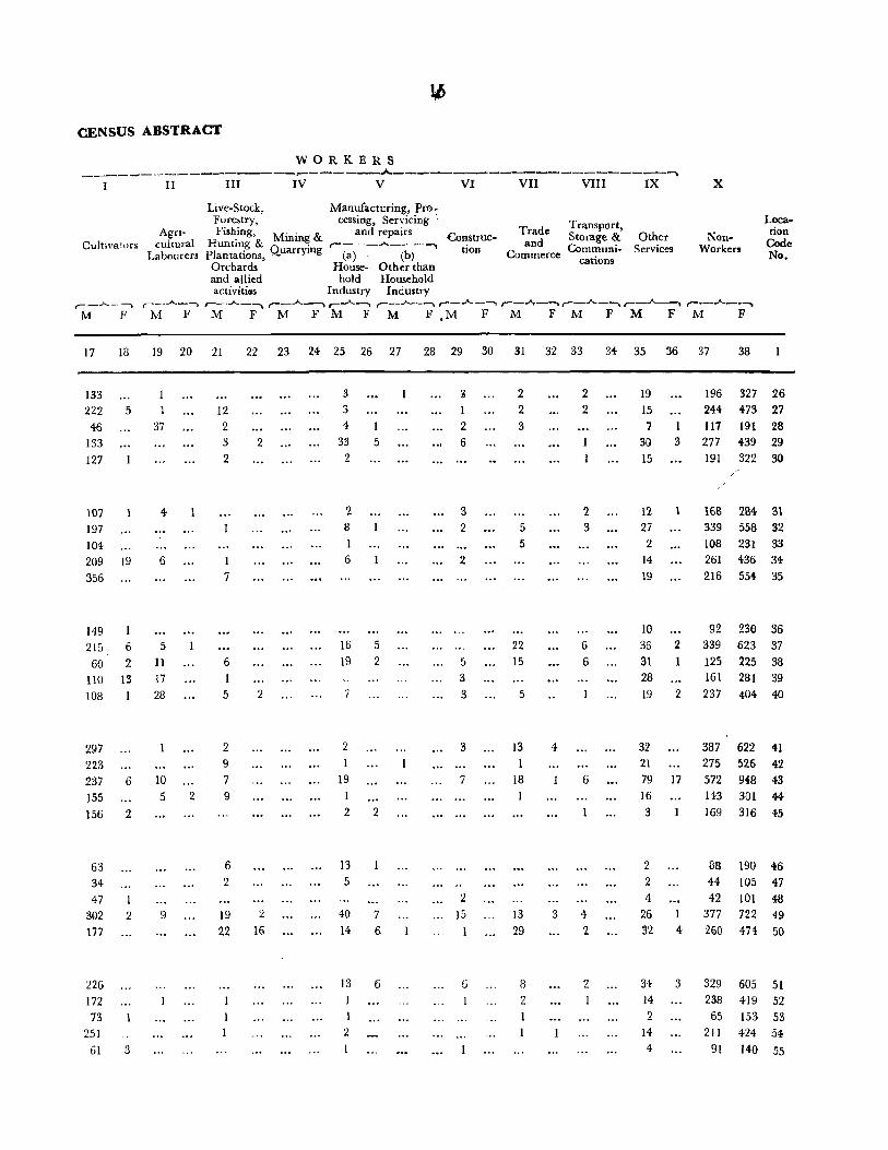
CENSUS ABSTRACT
WORKERS _____ -------------_------A----------------------.......
I II III IV V VI VII VIII IX X
Cultivators
r--.A-----.. M F
17
133 222
46
133
127
107
197
104
18
5
209 19
356
149
215
60
6
2
Agricuitural
Labourers
Live-Stock, Manufacturing, Pro-Forestry, cessing, Servicing Fishing, M"" & and repairs ·-COIl.stmc-
Hunting & mm~ .-___ ..A. ___ .......
Plantations, Quarrymg (a)· (b) Orchards House- Other than
tion
and allied hold Household activiti(ls Industry Industry
Trade Transport, and Storage &
Commerce Communications
Other Services
NonWorkers
Location
Code No.
r--..A..--. r--~-l r--J....----.. ,--..A--l r-_J.--~ r--"""_-~ r--""""'---"r--..A..-~ ,--~ r---..A..--~ M F M F M F M F M F ,M F M F M F M F M F
19 20 21
1
37
4-
6
5
11
12
2 3
2
1 7
6
22 23 24 25 26 27
2
3 3
4
33
2
:2 8
1 6
16
19
1
5
5 2
28 29 30 31 32 33
3
1 2 6
:3 2
2
5
2 2 3
5
5
22 15
2 2
2. 3
6
6
34- 35 36 37 38
19
15
7 1 30 3 15
12 27
2 14
19
2
1
196 327 26 244 473 27
117 191 28
277 439 29 191 322 30
/ /
16B 284 31 339 558 32
108 231 33
261 436 34
216 554- 35
92 230 36
339 623 37
125 225 38
110 13 17 3 3
10 36
31 28
19
161 281 39
108 28
297 223 237
155
6
156 2
63
34 47
302 2 177
226
172 73
251
61 3
10 5
9
2
5
2 9
7 9
6 2
19
22
2
2 16
2 1
19 1
2
13 5
40
14
13 I
1 :2
2
7 6
6
3
7
2 15
6
1
5
13 1
18
13 29
S 2
4
3
6
4
2
2
2 237 404 40
32 2l 79 17
16
3
2
387 622 41
275 526 42
572 948 43
143 301 44-169 316 45
88 190 46 2 44 105 47
4 42 101 48 26 1 377 722 49 32 4 260 474 50
34 3 14 2
14
4
329 605 51 238 419 52
65 153 53
211 424 54
91 140 55

16
VILLAGEWISE PRIMARY
TEHSIL BlLLAWAR ,.. ... _-----
Name of Area of
Location Village/Town/ Village in Occupied No. of Total }'cpuia1ion
Code WardlMohallaJ hectar('s Resi- Home- (Including Literate
No. Urban & cf dmtial holds Institutional and
Enumerator's Town Houses and Housel~ss Scheduled Scheduled Educated Total Workers Block in Km'. Population) Castes 'I ribes Pel sons (I-IX) '-__ ~ ______ I'-_..,A._ ___
r--.A_-, r--_A..,.-~ r--- ........ --~ P M F M F M F !vi F 111 F
2 3 4 5 6 7 8 9 10 II 12 13 14 15 16
56 Kandharnu 603 108 108 686 363 323 38 38 81 9 159 154
57 Danjisdhar 636 144 145 866 433 433 99 102 78 13 218 8
58 Lakhari 63} 113 113 642 342 300 27 17 61 u 170 u:: 59 Kaha 437 88 88 530 :e6G 264 50 59 77 10 IU 7 60 Salor -}51 137 137 ~28 433 395 51 49 182 72 2C4 5
61 :Kachhir 623 89 89 546 264- 2fl2 43 48 66 14 133 1 62 Makwal 806 192 193 1,104- 544 560 J94 2J2 J23 38 236 7
63 Galak 1,754- 198 202 1,040 525 515 103 116 164- 72 292 6 64 Ramkot 1,471 264 275 1,411 733 678 102 102 288 131 324- 47
65 Amwala 434 109 IH 653 330 323 88 88 67 13 173 9

17
CENSUS ABSTRACT
WORKERS ___________ ____ ~_ ~ ____ ...A_ .. ____________________ --------......
I II III IV V VI VII VIII IX X
Cultivators
17 18
145 154
20~ 3 147 82
102
1~4
117
192 182
90 120
4
3
2
Live-Stock, Manufacturing, PrQ-Forestry, cessing, Servicing
Agricultural
Labourers
Fishing, Mining & and R::pairs Construe-Hunting & ,,-___ .A. ___ --.
Trade Transport, and Storage &
Commerce Communications
Other
plantations, QuarrYlIIg (a) (b) Orchards, House- Other than
lion Services
and allied hold Household activities Industry Industry
,--_A_--"\ r---'---~,-- ..A._~ r-_A .. ~ r--';"_-~ ,--...A--"""-l ,--...A..-.-""'l ,-_...A.._~ ,--_..A...-1
M F M FM FMFM FM FMFM F MF
19 20 21
3 4
2 2
6 7
52
13
22 23 24 25 26 27
5
16 9
4
12
2
2
2
14 2
20 2 43 5
5
28 29
2 2 2
5 6
18 2
30 31 32 33 34 35 36
1
31
3 3
33 25
3
7
9 6 25
2
11
7 15
10
27
10 16 3 35 4 71 18
26
NonWorkers
r-".A..~-~
M F
37 38
Location
Code No.
204 169 56 215 425 57 172 218 58
142 257 59
229 390 60
131 2lJl 61 30G 553 62 233 509 63 409 631 64
157 314 65


TEHSIL BASHOHLI

TEHSIL BASHOHLI DISTRICT II ... THliA
eOUNOARY' sr"rE_._,_r)15TRIC1_ ._._~_ BOUNDARY: T[HSIL_,_._._ VILl,.AGE _______ ... __ ... __
POST OFFiCE ........ PO FOST' TElEGRAPH OFFle E ...• ..PTO OAK BUNGALOW , ... O~ REST HOUSE.,. ................... RH POLICE: STATfON •..... PS HOS~ITAL I OISPENSJ.RY.." ..••••. $ EI..£'CTRICIT'f " .... " ,f 'W,lr,'tER ~PP\.'f"" ••• , ... ,,, •. ,, ",.W 19'1 lOCATION CODE NU ... BER .... 13
UFl8A~ .AAer:.~~.I.l. .. ~~:'.~.~~~~.~~:::~.I!mm!
,_ o
a:: ,_ !:? ;I'
n,/ /\
I i i
i i "" ........... ,
\ i
..
.. o
u
o o D
o -'
.... --.,.--
II
./
, ~,/"
/ J
/ o
<
VILLAGts WITH POPULATION
HlOW 200....... 0 200 _<499 ....... , ...• ~. $00 _ .. 99 .... . IOOO_19~9. ..
>

1EHSIL BASHOHLI

20
VILLAGEWISE PRIMARY
TEHSIL BASHOHLl
Location Code No.
Name of Area of Village/Town I Village in Occupied WardlMohallaJ hectares R('st-
Urban & of dential Enumerator's Town Houses
Block in Km2•
2 3 4
8/2 Bashohli Tehsil
No. of Households
5
Total Population (induding
Institutional and House1ess Scheduled Scheduled
Population) Castes Tribes , ____ .A. ____ -. , __ .A. __ , ,-_.A.-,
PM F M F M F
6 7 9 10 II 12
Total 9,438 9,679 48,699 25,121 23,578 3,815 3,396 (86,377 Hectares)
Rural 859.1 Km'
(85,912 Hectares)
Urban 4.7 Km2
(465 Hectares)
1 2 :;
4
5
RURAL AREAS
S2Irthal
Raulka
Daulka
Barmata
Kalore
6 Bhandar
7 Sandroohn
8 Asooh 9 Kanth .. l
lO Chandal
II Lawang
12 Begoga
13 Duggan
14 Dhaggar
15 Bhalri
16 Dhaman
17 Madhota
18 Dulangal
19 Bari
20 Koti
21 Surjan
22 Bani
23 Gatti
24 Chalog
25 Kachir
6,092
2,256
2,847
1,675
1,863
1,568
1,999
491
1,408
546
3,098
229 1,287
5,729
491
549
155
1,119
558
536
1,368
689
1,004
792 J ,145
8,t!06 8,992 45,390 23,382 22,008 3,597 3,209
632
145
152
109
123
70
162
149
78
317
168
344
149
128
233
73
48
3'2 82
122 82
273
163
131
138
115
687 3,309 1,739
170 152
III 125
72
849 700
570 601
313
170 689
158 636
80 331
321 1,156
176 591
352 1.415
150 634
131 642
234 916
75 340
49 377
32 IG2 82 417
122 565
82 535
278 1,179 170 7JO 133 634
142 C07 117 464
434
359
317
329
150
363
346
183
576
338
747 326
319
445
176
221
84-220
307 274
595 377
343
313
232
1,570 218 187
415
341
253
67 51
37 91
20 19 272 108
163 6
94 7
326 67 54 290 46 32
143 12 7
580 2 6
253 38 29
668 27 26
308 5 3 323 65 61
471 147 127 164 7 10
156 :<2 16
78
197 29 38
258 54 39
261 4
584 20 24 333 82 :,(
286 56 48
289 HZ 61
232 108 117
Literate and
Educated Persons
,------
Total Workers (I-IX)
r--..A..--. r--.,..A...----"i M F M F
13 J4 15 16
5,080 1,576 14,338 90a
4,129
951
26
29 6
22
6
53
3l 10
110 16
164
22 43
95
fi3
34
9
22 54
S
125 J5r,
110
59
26
928 13,570 819
648
1
2
768 89
294
223
203 ~12
105
3
7
9
4 164 3
226
123 5 10 347 146 1 219 2
4 449 77
219 - 9 4 201 23
15 264 2 95
13'3 1-
52
3 145
2 205 lb
113
363 7
62 232 9
2 230 3
4 189 2 4 162 2
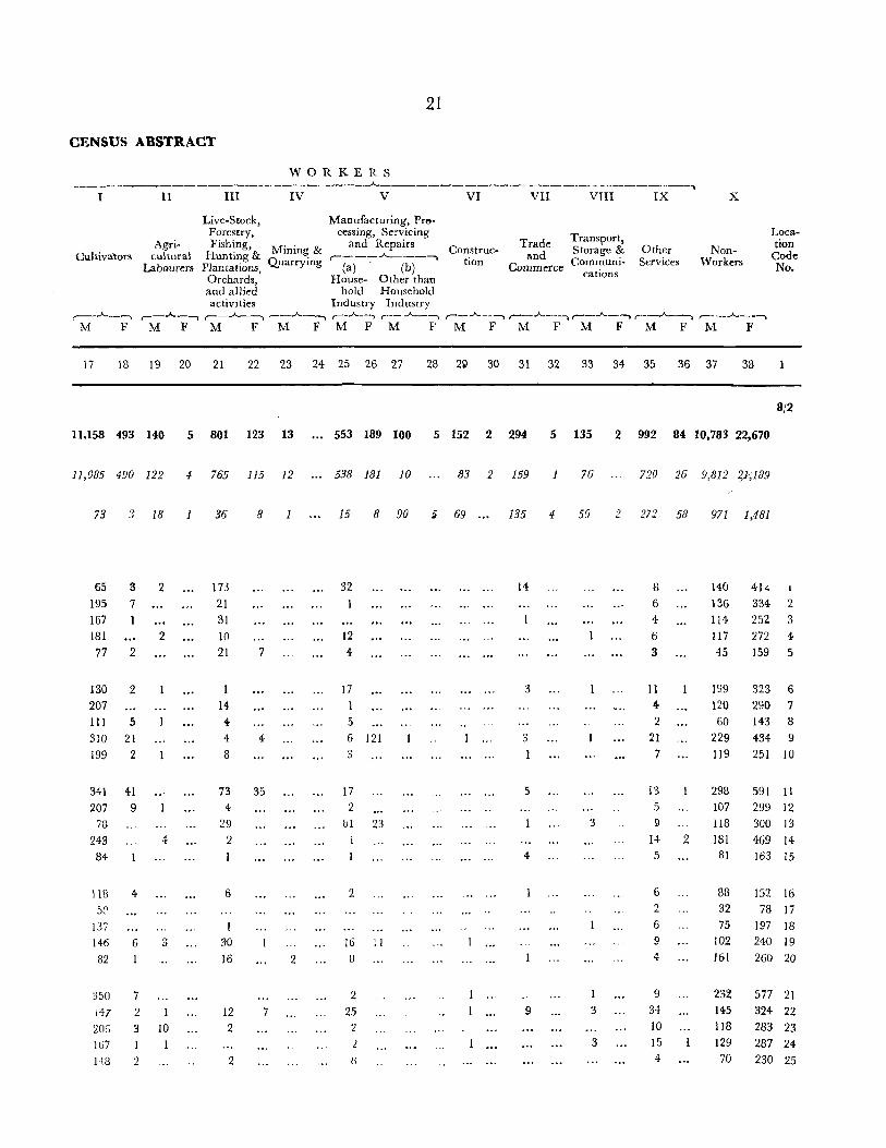
21
CENSUS ABSTRACT
WORKERS ---------------------------"-------------- --------------~
I II III IV V VI VII VTn IX X
Live-Stock, Manufacturing, Pr..,.
Cultivalors Agri
cultural Labourers
Forestry. cessing, Servicing Fishing, Mining & and Repairs Construe.
Hunting & ,..-----"-----....... Quarrying ( , b Plantations. a) ( )
tion
Trade Transport, and Storage &
Commerce Communi· cations
Other Services
NonWorkers
Location
Code No.
Orchards, House- Other than and allied hold Household activities Industry Industry
r--..A.._.-., r---...A--""I ,-_A~~ r--..A.._-,. r--...A.....-~ (_..A.._~ r--A---")r--...A--.-.. r--..A..~ r---..A..- .. -, MF M FM FMFM PM F M FM F M FM F
17 18 19 20 21 22 23 24 25 26 27 28 2~ 30 31 32 33 34 35 36 37 38
8/2
11,158 493 140 5 801 123 13 •.. 553 189 100 5 152 2 294 5 135 2 992 84 10,783 22,670
11,085 490 122 4 765 115 12 ... 538 181 10 83 2 159 1 76 720 26 9,812 2)',189
73 3 18 1 36 8 15 8 90 5 69 ..• 135 4 59 2 272 58 971 1,481
65 3 2 IB 32 14 S 140 41i.
195 7 21 6 136 334 2 167 31 4 114 252 3 181 2 10 12 6 117 272 4 77 2 21 7 4 3 45 159 5
130 2 17 3 11 199 323 6 207 14 4 120 290 7 III 5 4 5 2 60 143 8 310 21 4 4 6 121 3 21 229 434 9 199 2 8 3 1 7 119 251 10
341 41 73 35 17 5 13 298 591 11 ')07 9 4 2 5 107 299 12
78 29 b1 23 3 9 118 300 13 243 4 2 1 14 2 181 469 14 84 4 5 81 163 15
J18 4 6 2 6 88 152 16 5P 2 32 78 17
137 6 75 197 18 146 6 3 30 16 !l 9 102 240 19 82 16 2 B 4 161 260 20
350 7 2 I 9 232 577 21 147 2 1 12 7 25 9 3 34 145 324 22 206 3 10 2 2 10 118 283 23 167 1 2 3 15 129 287 24 US 2 2 IJ 4 70 230 25
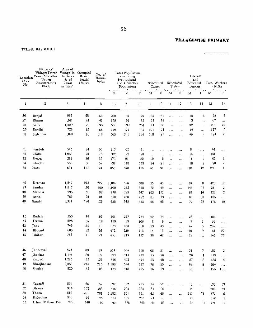
TEHSIL BASHOHLI
Name of Village/Town/
L t ' Ward/MohalIa; oca IOn U b Code r an N Enumerator's
o. Block
26 27 28 29 30
31 32 33
34 35
36 37 38 39 40
41 42 43 44
45
46
47 48 49 50
2
Banjal
Dharor
Satti
Sandhi
Fatehpur
Kardoh
Chill a
Siyara
Khaddi
Hutt
Draman Sandar
Mandla
Rehn
Smahn
Dodala
Danna Janu Bhoond
Dhikar
Jandrayali
Jhankar Kagrod
Dharjhankar
Siyalag
Nagaali
Ghoral
Thana Kohrdhar
Area of Village in
hectares & of Town
in Km2 •
3
966 1,161 1,329
723 1,160
545 1,066
384 553 634
1,247 1,917
796 769
1,344
550 325 745 608 753
573 1,148 1,295 2,088
820
51 52
53 54 55 D har Mahan Pur
860 934 610 949 £19
Occupied Residential Houses
4
68 41
129 65
116
34 73 36 56
171
219 198 BB 93
120
92 37
119 92 71
89 89
123 214 83
66 103 261
92 140
No. of Households
5
68 41
133 65
116
36 75 38 57
172
227 200 92
104 126
93 ~8
119 92 73
89 89
135 215
83
67 105 261
95 140
22
VILLAGE WISE PRIMARY
Total Population (including
Institutional and House]ess Scheduled Scheduled
Population) Castes Tribes ,-____ ..A.. ____ ~ r--__;"_--~ ,--..A-_~
PM F M F M F
6
260 179 550 339 565
113
3B2 173 291 855
1,184 1,100
476 550 658
491 199 673 472 400
524 593 816
1,196
473
397 516
1,582 534 768
7
135 91
299 174 301
62 192 91
148 450
:!58 345
257 99
363
259 213
264 314 392 584 248
192 293 801 269 378
8
125 88
251 165 264
51 190 82
143 405
588 548 247 292 313
234 100 310 213 187
260 279 424 612 225
205 223 781 265 390
9
55 23
III
101 108
10 24 51
55 72
103 81 96
92 8
53 14 30
68 25 53 76 36
54
134 42 24 40
10 11
61 18 88 74 97
5 21 31
45 49 III 73 98
74-9
43 16 42
51 26 45 55 29
52 99
46 26
55
12
r-------
Literate and
Educated Persons
Total Workers (I-IX)
r---"--....... ,-_.A. __ -, M F M F
13
15
3 32
14 49
8 i4
11 16
110
97 148 69 83 72
n 7
47 49 22
31 20 87 66 46
16 14
241 L3
36
14 15
3
2
1 2
42
8 67 14-68 35
5
9
7
18 8
I
73
92 67
204 117 194
44 131 63 90
259
423 281 122
126 178
186 59
207 151 145
188 179 185 364 156
133
206 372 120 250
16
2
2+
6
1
2
17 2
2
10
27 77
2
4
151
53
33
6

23
CENSUS ABSTRACT
WORKERS
-------------------------~-------------------------~ I II III IV V VI VII VIII IX X
Live-Srock, Manufacturing, Pro-Forestry, cessing, Servicing Transport, Loca-
Agri- Fishing, Mining & and Repairs Construc- Trade Storage & Other Non- tion Cultivators' cultural Huntmg & . .----~---.., tion and Cornmuni- Services Workers Code
Labourers Plantations Quarrymg (a) (b) Commerce No. , cations Orchards, House- Other than and allied hold Household activities Industry Industry
,-_A_--. r--.A..~ ,-_-A.._-"') r-..A----" r--..A.-~ ,.-_...A.._--. ~~A-~r-A-~r-A-~~-A_~ .----"----. M F M F M F M F M F M F M F M F M F M F M F
17 18 19 20 21 22 23 24 25 26 27 28 29 30 31 32 33 34 35 36 37 38
70 4 10 2 6 43 123 26 62 ~ 2 24 88 27
141 7 28 23 )5 4 2 7 95 227 28 80 18 4 17 2 57 160 29
147 3 14 3 26 6 107 258 30
40 2 2 18 51 31 112 15 3 61 190 32 60 1 2 28 81 33 74 2 13 3 58 141 34
189 24 5 12 15 13 191 404 35
353 9 5 15 24 8 6 :W 173 571 36 229 2 16 5 3 4 21 271 546 37 105 3 2 1 2 :) 4 107 245 38 92 5 19 8 132 292 39
142 7 11 7 10 5 2 167 303 40
155 2 9 15 4 71 234 41 54 2 3 40 100 42
174 9 10 8 6 156 310 43 115 11 8 J3 4 2 II 3 8 108 186 44 139 77 2 3 68 110 45
158 I 8 12 2 6 76 258 46 165 I 4 5 2 2 135 279 47 167 3 2 2 1 12 207 420 48 335 2 2 2 2 21 220 612 49 127 147 14 4 2 11 92 74 50
106 50 3 11 I 5 1 8 59 152 51 183 23 5 9 5 1 11 87 190 52 289 2 6 24 3 9 41 4 429 775 53 109 10 149 264 54 229 2 17 128 389 55

TEHSIL BASHOHLI
Location Code No.
56 57 58 59 60
61 62
63 64
65
66 67
68 69
70
71
72
a/I
I
2 3 4
5
6
7
Name of Village/Town /
WardjMohallaj Urban
Enumerator's Block
Hadat
Poonda
l'a!hi
Kailtri
Preta
Plakh Plahi
Plasi
Kothi
Barot
2
Sobar Alhoon
Bera Nawshehra
Nhyalta
Mahanpore
SaJladi
URBAN AREA
Area of Village in hectares
& of Town
in Km2•
3
757
1,229 796 610
1,173
1,264 1,701
300 1,115
261
1,302 2,242
743
689 3,125
1,053 287
Bashohli Notified Area 465 Km 2
Ward No.1 E. B. (I)
Ward No.2 E. B. (2)
Ward No.3 E. B. (3)
Ward No.4 E. B. (4) Ward No.5 E. B (5)
Ward 1\0. 6 E. B. (6)
Ward No.7 E. B. (7)
Occupied Resi
dential HOllses
4
114
150 143 72
161
217
193 24
142 25
178 56
69
97. 107
255 34
632 84
85
72
79 91
107 114
24
No. of Households
Total Population (including
Institutional and Houseless Scheduled
Population) Castes r----..A-----._.... r-"',..A._~ '-)
P M F M F
5 6
J14 656 150 848 143 783
72 415 167 968
217 1,227
204 1,077
24 164 152 824
25 146
178 1,096
56 316
69 385 97 625
107 770
255 1,528 34 215
687
!!2 91 79
82 99
116 1:L8
3,309 495
407
324
331 495
612
645
7
336 409
408 205 476
616 571 79
402 74
561 177 200 SI8
405
800 112
1,739 267
218
173
162
251
340 328
8 9 10
320 37 28 439 65 72
375 35 36 210 25 24 492 29 22
6ll 80 88 506 137 179 85
422 60 60
72 13 10
53.5 69 G4
139 15 17
185 21 26 307 36 24 365 33 19
728 142 110
103
1,570 228
189
151
169 244
272 317
218 187
2
5 2
54 48 157 137
VILLAGBWISE PRIMARY
Literate and
,..-------
Scheduled Educated Total Workers Tribes Persons (I-IX)
r--_.A._-, f--"-~--' ,---,..A._---l M F M F M F
II 12 13
53 83
102
36
98
160 124
27
92
12
17& 16
43 59 21
!W5 34
951
143 146 120
124 156
164 98
14 IS 16
3 175
9 231 3 39 178 4 110
32 205 .')
71 301 37 312 7 16 28 22 208 3
5 47
85 254 11
119 ~
8 108 6
24 l::ll,l
222
85 417 a 2 57 2
648
92
84
82 105
138
24
63
768
104 93
72 76 92
164 167
89 4
7
11 18
12
19
18

25
CENSUS ABSTRACT
WORKERS _____________ ...... ____ ._. _____ .___....A..--- ____________ ~ ____ ~ _____ ~_~
I II III IV V VI VII VIII IX X
AgriCultivators cultural
Labourers
,.-_-"-_ ~ ,--_.A__~ M F M F
Live-Stock, Forestry, Fishing,
Hunting & Plantations,
Orchards and allied activities
r--...A---s M F
Manufacturing, Processing, Servicing
Mining & and Repairs Construc-Quarrying '--~)--"--(b)-"""> ti(;m
House- Other than hold Household
Industry Industry
Trade Transport, Storage &
Co~:erce C~~:~~i- Services Other Non
Workers
Loca-tion Code No,
,---_"'_-~ r--..A--1 r--..A..-~ r--.A.-~ r--..A--~ ,----"---""'1 r--.A..-____ ,--__ ...A.._~ M FM F M j'M F M F M F M F M }<'
17 18 19 20 21 22 23 24 25 26 27 28 29 30 31 32 33 34 35 36 37 38
159
208 146
99 149
267 256
21 176 31
206 78 81
114 208
287 5;.(
73 9
2 3 3
2
8
46
3
3
1
9
6
3 2
2
2 5
4
3
9
2 2
3 18
3
1 16
1
6
5
4
1
7 28 11
9
27
36 1
4
5 3 3
16 4
2
8 1
8
6
5
2 15
3 4
7
2
4 4
4 2 ti
£
6
18
15
2
7 ;)
8 90 20 14 2
13
17
6 12
12
5
18
1 3
6 2
4
!J 69 7
6 3
2 8
11
14
20
1
3 3
6
4 2 2 4
5
18
1~5 4 8
17 24
25 17
23 21 4
1
2
2 2
3
5
6
9
17 '23
6
16
23
17 4
10 3
23
5 7
12 4
58 3
5
3
59 2 272 58 7 52 4 4 43 7 6 29 11
24 12 6 35 10
23 13
2 60 10 29 4
161 178
230 95
27~/
319 56 436 57
374 58 210 59 487 60
315 611 61
259 499 6~
51 84 63 194 419 64
27 72 65
307 58 92
180
183
383
55
524 66 130 67 179 68 307 69
364 70
720 71
101 72
971 1,481 8/1 163 224 1
125 182 2 101 140 3 86 151 4
159 232 5
176 161
253 6 299 7


TEHSIL KATHUA

TEHSIL KATHUA

28
VILLAGEWISE PRIMARY
TEHSIL KATHUA
Location Code No.
Name of Area of Village/Town! Village in Occupied Ward/MohallaJ he-ctares Resi-
Urban & of dential Enumerator's Town Houses
Block in Km",
No. of Households
Total Population (including
Institutional and Houseless Scheduled Scheduled
Population) Castes Tribes
Literate and
Educated Persons
,------
Total Workers (I-IX)
r----~..A..----~ ,----"---, r-___"____~ ,-__ .A.._, ,--__ _A.. __ ~
PM F M F M F M F M F
2 3 4 5 6 7 8 9 !O 11
8/3 Kathua Tehsil
'rotal 570.8 Km" 14,143 14,783 84,254 44,820 39,434 13,162 11,832 (57,084 Hectares)
Rural 568.6 Km2 10,854 11,373 66,222 35,297 30,925 11,070 9,893 (56,864 Hectares)
Urban 2.2 Km 2
(220 Hectares)
RURAL AREAS
I Dukhat
2 Bijjat
3 Manjli
4 Jamalpur
5 Dilwan
6 Khaniyara
7 Rakheh
8 Bhatoli
9 Mehtabpur
10 Baroi
II
12 13
14 15
Kharot
Kothi Jagir
Kalspur
Gehtarwan
Chak Ram Singh
428 124
157
103
1,011
97 189
55
412
14
828
124
36 26 49
16
17 18 )9
20
Chak Rijn 91
Tarf Manjli 1,086 Chak Sheikhan 141
Chak Khuni 32
Chak Lachhaman 21
21 Maroli
Z2 Govindsar
23 Mangota
24 Sav.la 25 [{asooh
9
296 155
290 127
3,289 3,110 18,032 9,523 11,509 2,092 1,939 ...
54
25 18 30
102
26 15 16
86
'l.
281 2
34 20 22
54
25 18 30
102
29 15
16
8& 2
316
207 101
83
663
204 110
93 530
22
316 1,837
2 9 39 196
23 1I8 22 10'7
185 185 459
38 40 173 42 45 192 17 17 62
16
300 18 40
44
(U N I
16 86
3C6 1,653
18 69 42 261 46 276
169
Jl6 59 45
352
104
55 50
286 10
979 6
102 58
60
147
91
42 38
311
100
55 43
244 12
858 3
94 60 47
372 87
21
21
2 23
80
104
33
27
18
24 ...
60
81
31
92 81 46 45
111 81 3 3 52 10 5 3
N H A BIT
42
949 42
119 147
44 2 704 372
27 14
142 3 129 23
279
II
4
22
12
E
13 14 15 16
15,397 6,683 21,686 669
10,603 4,058 17,283 469
4,794 2,625 4,403 200
36
28 12
G
56
27
13 18
91 4
426
42 26 25
152 10 55 23
D )
6 232
10
28 42
4
2 2 3
21 1
83
57 40 26
192
47 31 28
139 3
192 397 23 3
12 43 14 23
8 35
36 336
56 27 40 4 46
20 71 496 31
16 19
31 60
5 83

29
CENSUS ABSTRACT
WORKERS ---------------- ---_._----"------------- ---------------.
I II III IV V VI VII VTII IX X
Cultivators Agri
cultural Labourers
Live-Stock, Manufacturing, Pro-Forestry, cessing, Servicing Fishing, and Repairs
Hunting & Mining & ~ ___ ..J.._ ___ --.
Plantations, Quarrying (a) (b) Orchards, House- Other than and allied hold Household activities Industry Industry
Construction
Trade Transport, and Storage &
Commerce Communications
Other Services
NonWorkers
,_..A._--, ,--~_A.._~ __ ..A._--, ,---"--~ r-- _A..,__\ r--..A...---""I r--_.A._-~ r--..A..---., r--..A..---") ,-__ ..A.. __ ",""""\
M F M F M FM FM I M F M FM F M FM F
17 18 19 20 21 22 23 24 25 26 27 28 29 30 31 32 33 34 35 36 37 38
10,272 55 2,000 61 509 70 14 ... 905 77 1,334 88 1,810 103 1,190 7 1,062 5 2,590 203 23,134 38,765
9,689 52 1,662 60 .J38 70 1 ... 815 68 739 10 1,466 101 492 7 610 3 1,371 68 18,014 30,45(i
583 3 338 1 71 13 90 9 595 i2 344 2 698... 452 2 1,219 135 5,120 8;309
81 2 86 147
54 2 ~9 90
11 22 4 2 19 41
25 19 38
168 13 2 8 160 311
22 II 3 9 2 57 100
25 2 3 24- 55
23 1 4- 22 43
100 5 3 10 4 2 13 147 244
3 7 12
239 49 3 36 29 17 7 3 33 2 582 835
2 1 3 3
35 10 54 94
19 2 1 35 60
11 6 14 3 25 47
1 330 3 2 36 87
13 12 I 26 1 2 36 80
4 2 5 5 1 12 11 71 81
2 35 3 I 4 6 10
U N I N H A B I T E D
12 6 22 44
142 3 7 32 44 24 107 4 19 107 35 453 673
17 I 23 27
5'() 3 4 59 142
(iB II 3 64 \29
Location
Code No.
8'3
2 3 4 5
6
7 8 9
10
11 12 13 14 15
16 17 18 19 20
21 2:l
23 24
25

l'EHSIL KATHUA
Name of Area of
Location Code No.
Villeve!T'J\\"nf Village in \\'arri,'hlohalla/ hectares
Urban & of Enumerator's Town
Block in 1\.m'.
2
-26 Badloli
27 Bhugat
28 Hatli
29 Brohandahi
30 Tridwan
31 Kasori
32 Damar
33 Then
34 Gharti
35 Nora
36 Basantpur
37 Kehnta
38 Dakhnaka
39 Katlehr
40 Barthindi
41 Barni
42 Danna
43 Bharrah
44 Dhanore
45 Mangari
46 Nonaal
47 Karroh
48 Jandore
49 Hate
50 Maha
51 Tarrah
52 Matandi
53 Chak Gusaull
54 Chak Sardah
55 Jagat Fur
3
91 99
178 120
1,179
512
1,877
642
671 483
416 415
117
154
248
243
486
97
767
95
116 558 120
206 357
284
77 33 21
638
Occupi~d Resi.
dential Houses
4
19 5
72 31
104
16
70 56 24 10
38
25 14
23 12
27
44 58
47
63
66
56
27 125
36 35
2
63
30
Nfl. of House. holds
Total Popilialion (IlJcluding Institutional
and Housel~ss Population)
Scheduled Castes
r----___>...._----~ r----' -'---~ P M F "1,,1 F
5
19 5
72 31
107
16
70 56 24
10
39 25 14 23
12
6
114
30
445
163 657
81
483
245 164
70
188
146 129
103 57
2J 169
44 249
60 98
49 543 U 1\
63 66 57
27 127
426 363 366 164
724
3(; 218
35 188 2 j
7
65 17
231 95
359
37 264
140 83
37
110
81
94 65 33
8
49 13
214 68
288
44
219 105 81
33
73 65
35 38 24
9
2
34 11
5
1
14
3
17
6
6 7
8
10
4
36 G 7
2 17
:2
12 3
7 2 2
83 86 6 5
24 121 128 33 54 44
303 240 114 83 N H A B
216 194 188
87 400
210 63 66 169 15 17 178 'l8 33 77 16 18
324 217 164
118 100 11 14 ]06 82 47 41
3
VILLAGEWISE PRIMARl'
Scheduled Tribes
M F
II 12
T E
r""'------
Literauand
Educated Persons
Total Workers (I·lX)
r---"- ---~ r---_, ..... -----. M F M F
13
12 5
95 30 99
4
39
72 6
4-
19
16
38 15
2
13 16 8
46
D )
58 17 37 15
(is
29
14 15
40
1 13 39 114 2 55 7 196
2 22
6 1~9
27 81
42
21
3 67
2 42 78
7 35
11
44 6 71
I 35 9 163
22 98 19 93 8 90
4 35
9 193
[] 56
52 3
16
13 10
4
3
z
U N 1 :'\ H A B T E
3] 1
D ) 47 t4 407 225 ]82 128 109 11 113

31
CENSUS AB~TRACT
WORKERS _______________ • ____ ~ ___ ...A.. _____________________________ __"
I II III IV V VI VII VIII IX X
Cultivators Agri
cultural Labourers
Live-Stock, Manufacturing, Pro-Forestry, cessing, Servicing Fishing, Mining & and Repairs C:onstrl:lc-
Hunting & . r- ----"-----. Plantations, QuarrYlllg (a) (b) Orchards, House- Other than
tion
and allied hold ,Household activities Industry Industry
Trade Transport, and Storage & Other
Commerce Communi- Services cations
NonWorkers
Location Code No.
,--_..A.._---, ,----'-----, ,-_...A-_---, f- .A._-, r--..,A_ .. ~ r--"..A..,-~ ,-_..A.._..-... ,--........__--", r--..A.-~ r--..A.--~ r--_-A.._-""",\
M F M F M F M FMF M F M F M F M F M F M F
17 18 19
36 2
II 13
37 41
176
21
104 22
36
17
36 39 14 20
10
29 54
32 123
33 42 64 29
124
48 31
68
2 2
4
3
2
13
34 27
2 14 4
7
20 21
3
5
6
22 23 24 25 26 27
u N
u N
787 10
8 3
I
5 3
1
5
2
9
14 I N
10 8 6
2
9
3
2
I N 3
H
6 4
H
28 29
A
2
2 10
2
2
2
19
1 2
59 4
7 2 4
B
5 3
42
2 I:L
A B 34
30 31 32 33 34 35 36
2
J
I
15
9
4
2
T
4
4
5
3 T
E
E
I
4
2
11
7 D
4
1)
3
33
I 4
11
21 5 4
8
5
7 1
6
5
4
4-
6
2 2
5
2
37
25 4-
117
40 173
38
49 26 27
204 28 68 29
284 30
15 . 44 31 135 216 32 59 104 33 41 81 34
16 33 35
43 39 16 30 22
39 50 19
135
118
101 98
52 207
62 54
107
78 36 65 37 33 38 38 39 24 40
86 41 128 42 44 43
239 44 45
209 46 169 47 176 48 76 49
324 50
100 51 82 52
53 54
181 55

TEHSIL KATHUA
Name of VillagelTown!
L t· Ward/MohalIal
oca Ion U b Code r an No Enumerator's
• Block
2
Area of Village in
hectares & of Town
in Km'.
3
56 Rakh Jahfar 110
57 Chak Hari Singh 22 58 Cbak Partap Singh 34
59 Chak Phula 53
60 Chak Gota 43
61 Rajiani
62 Tarf Tajwal 63 'I ad Dajwal 6,t Chak Sardar Desa
Singh Chak Diwan Kripa Ram
65 Changrah
67 Chak Drabkhan
68 Chak Gadadhar
69 Chak Bhaga
70 Chak Nanak
71
72 73 74-75
76 77 78
79 80
Big-wan
Sherpur
Jakhbar Badalha Chak Sujanpur
Narolian Tarf Sanj,
Rer Majra
Chak Devia
23 965 :199
191
134
568
223 308
52 ';6
91 90
343
285
28
119 95 69
106 51
81 Gandial 67
82 Jhumber Mahtaba 51 83 Ramnagar 304
84 Keerian 280
85 Bhag Thali 317
32
VILLAGEWISE PRIMARY
Total Population (including
Instimtional
Occupied Resi_ dential Houses
No. of Households and Houseless Scheduled Schedul~d
POf"lation) Castes Tribes ,..------ -"------.. .--...... --.. ,----A--.. PM F M FM F
4 5 6 7 8 9 10 II
U N I .~ H A B I T I T 7
U N I N H A B
9 5
9
9 39 22 17 8
5 16 6 10 4 3
10 72 51 21
6 6
4:1
191
32
147 49
106 54
67
106 8
156
82
U
7 6
44
E12
32
149
49 110
55
67
108
8 156 89 N
78 78
48 51 8 8
(U N
(U N
63
102
156 41
65
102
156 4l
23 25
222
17 13
117
1,164 623
174 85
883 462 271 141 671 358 303 146 402 208
688
66 1,085
502 1 N
352
35 558
256 H
477 250 292 146
23 17
N H I N H
447 239
663 341 934 481
223 115
6
12 105 51
541 401
89 34
421 210
130 17 313 252 157 48
194 140
350
33
199
13
219
56 128
336 231 238 31
527 250 246 246 152 142
A BIT
227 168 154
146 15 12
lJ A BIT A B T
208 80
322 16
453 71
108 95
62
13
55
91
E
E E
12
E E
D
D D
~---~--
Literate and
Educated Total Workers Persons (I -IX)
,__;.._-"""""'\ ,----A...--l M .F M F
13
D ) D )
9
38
10
4
43
144
21
165 25
95 34
66
98 22
164 49
57 73
6
86
126 173 13
14 15
2 2 !l
15
5
33
2 10
3 4-
23 58
38 293
8 41
24 238 3 44
13 164-
II 81 48 90
28 12 60 14
156
17
293 137
15 128
76 54
LO
24 91
58 130
82 198
4~!
16
2
II
3
4-
2
:1

33
CENSUS ABSTRACT
WORKERS _~ ______________ --________ A _______________________ --.
II III IV V VI VII VIII IX X
Cultivators Agri
cultural Labourers
Live-Stock, Manufacturing, Pro-Forestry, cessing, Servicing Fishing, M" & and repairs
Hunting & n, mm~ ,-___ -"-___ -, Plantations, '><.uarrymg '(a) (b)
Orchards House- Other than and allied hold Household activities Industry Industry
Construc-tion
Trade and
Commerce
Transport, Storage & Communi-
cations
Other Services
NonWorker.
Locaion
Code No.
,-_A_~ r--"..A._-~ f-..A..-... r--..A..-1 ,--_..A-.---") ,--__ ..A-_~ ,---A-_ ... r--.J-.~---"\ r-..A..-~ ,-_.A... _____ r---..A..--~ M F M F M F M F M F M F ,M F M F M F M F M F
17
4-
:1
5
7
3
37 148
19
116 33
120 39
40
54 15
120 89
45 29 10
47 I
110
90 18
18
2
19 20 21
I
1
6 20
55
7 13 10
36
34
139 21
3
19
41 4
7
2
2
4
17
9
6
16
4
2
22 23 24 25 26 27
u u
( U
u u
N
N
N
N N
I I
I
I I
N N
II
8
12
12
4
17
5 8
N
4
2
N N
2
10
H
H
1
H
H H
A A
5
5
3
26
4
3
A
2
A
A
213 29 30
B B
I I
6 48
8
7
7 4
1
6
5
B I
B
B
49
I I
6 12
21
31 32 33
T T
E E
4
2
2 9
8 3
3 2
3
11
2 T E
T T
3
3
E E
4
5
1
D D
D
D D
5
6
3
1 2
10
3
4
17
1
25 3
34 35 36 37
23
4
24
24 1
6 4
10
20
17
6
5 10
7
14
2
2
7 I
18
7
9
59
330
44-
224 97
194
65
118
196
18
265 119
122
92 7
148
2It 283
66
38
56 57
17 58 10 59
21 60
6 61 12 62
104 63
541 64
88 65
419 66 130 67 302 68 157 69 194 70
:133 71
31 72 527 73 242 74
75
226 76
146 77
11 78 79
80
203 81
82
320 83
450 84-103 85

TEHSIL KATHUA
Location Code No.
86
Name of Village/Town/
Ward/Mohalla/ Urban
Enumerator's Block
2
Makhsoos Pur
87 Jrai 88 Saiper Sipla
89 Khukhiyal
90 Kirpaal
91 Tarf Pain
92 Pitho Bala
93 Mirpur Ram
94 Lakhnoe
95 Kangriyal
96 Matare
97 Syedpore
98 Gown
99 Pamwal
100 Pandori
101 102 103
104 105
106 107 108 109 110
Jugian Bharariyal
Bhar Mori
Pi tho Pain
Pidri Pain
Tarf Baja
Pidri Bala
Chak Poorab
Narroha
Drallan
111 Barmora
112 Airwan
113 Jamraal
114 Chhajiyal
115 Nangal
Area of Village in hectares
& of Town
in Km",
3
107 176 74
2% 153
254 131 355
223
44
175 III 128
84 181
757 69
76
153 46
177 58
78
51 71
53 91 83
106 209
Occupied Resi
dential Houses
4
9 88
146 116
299 26
301 66
64
4
27
52 34 60
42 12 32 20 ( U
No. of Households
5
9 88
1
151 117
308
26 303 67 65
12 27 52 36
63
44 12 35 20 N
178 186
(U N
U N 2 2
56 ::6
10 36 43
6 35
10 36
43 6
35
34
Total Population (inrluding
Insti i utional and ~ Iouseless
Population) Scheduled
Castes
VILLAGE WISE PRIMARY
Scheduled Tribes
Literate and
Educated Persons
r-------
Total Workers (I-IX)
,-____ _A_ ____ -"'\ r--.. ..A.---. r--..A..--"",\ r--..A--~ ,--_-"-__ ~ PM F M F M F M F M F
6 7
63 38 519 276
3 3
967 496
714 372
1,791 954 146 76
1,765 903 412 218
363 186
59 35 203 III 314 156 202 105 220 131
380 205 60 31
231 116 90 45
N H
1,126 5S8
1 N H
I N H 11 8
348 180
52 204 258
26 224
29 104
151 14
120
8 9 10
25 35 25 243 196 180
471 238 217 342 273 263
837 378 369
70 862 367 316
194 208 190 177 84 86
24 92 28 22
158 130 138 97 78 71 89 79 52
175 131 113 29 2
115 II 12 45 39 40
A BIT
528 180 199 A BIT
A BIT
3 6 3
168 III 107
23 100 107 12
104
3 45
59 11 85
51 46
9
69
11
E
E
E
12
D
13
4 59 3
130 80
297 45
327
64 61
2
40 40 29 37
62
11
40 11
238 D ) D )
48
5
29 24 2
33
14 15
19 18 122
3
72 259 32 200
113 475 27 25
lSI 429 19 93 23 91
24 9 58
9 80 13 66
2 66
12 101
2 20
7 54 29
90 285
4
17 96
4
18
12
.5
16 51 89 5
67
16
5
2
8 3
22 5
13
2
6

35
CENSUS ABSTRACT
WORKERS _________________________ .A.. __________________________ -.
I II III IV V VI VII VIII IX X
Cultivators
r--.A..-~
M F
Agricultural
Labourers
Live-Stock, Manufacturing, Pro-Forestry, cessing, Servicing Fishing, Mining & and Repairs
Huntmg & Q . ,---__ .A. ___ -,
Plantations, uarrymg (a) . (b) Orchards, House- Other than and allied hold Household activities Industry Industry
r--..A.----. r-- ...A._ ~ ~--,.--~ r--...A.._-~ r--..A_-~
M F M F M FM FM F
Construc_ tion
Trade Transport, Storage &
and Communi-Commerce cations
Other Services
r--~--.... r--..A--___,_ ~-..A..--_.,--_..A.._~ M FM FM F M F
17 18 19 20 21 22 23 24 25 26 27 28 29 30 31 32 33 34 35 36
3 62 3
119
103
21?,
iii 172 76
58
2 28 62
39 44
55
15
43
5
120
45
5
32
52 5
50
16 9
59 59
32
26 5 7
9
16
10
6
4
27
2
4
3
86
45
8 8
18
6
2
15
6
14
21
3
7
13
6 1
(U N
3 1
7
6
(U N (U N
4
9
6
28 2
2
4
2
49 12 3 2
5
2
3
8
3
20
N
I N I N
4 5
H
H H
2 4
9
6
1
1
2
A
A
A
11
27
64 4
55
B
2
9
1
7
3 B I B I
3
4
18 4
24 7
30
T
5
2 1 3
4
11
E
T E
T E
2
25
8
1
38
24
2
2
2 D )
1 ...
D ) D )
4
17
8
69 5
50
7 7
5
5 2 7
4
1 3 6
40
2 5
3
3
4
8
2
NonWorkers
Location
Code No.
r--_..A..---. M F
37 38
19 25 86 154 238 87
88
237 469 89 172 341 90
479 51
474
125 95
11
53
76
39
65
829 91 67 92
840 93
189 94
177 95
11 96 92 97
158 98 96 99
89 100
104 175 101
11 28 102 62 114 J03
16 44 104
105
313 526 105
107
108 4 3 109
84 168 110
13 ",3 III
53 94 112
62 106 113 9 12 114
53 103 115

TEHSIL KATHUA
Location Code No.
Name of Area of Village/Town/ Village in Ward/Mohalla/ hectares
Urban & of Enumerator's Town
Block in Km2,
2 3
116 Sutaj Beli 125 246
41
204 418
117 Mahichak 118 Bhakhrial
119 Chak Bhagta 120 Falot.,
121 Kangrial li3
69
167
93
77
122 Chhatiyal
123 Sher-Tambar
124 Jawalapur 125 Chak Aidal
126
127
128
129 130
13l 132 133 134
135
136
137 138 139
140
J41 142
143 144
145
Muthi Khurd
Amargarh Bbarthiyal
Bhadiyari
Dadoli
72 108 68
129
105
Muthi Jagir 103
Mir Pur Jagoo 173 Muthi Rakhwalan 115
Chak Gokal 74 Rakh Lachipura 331
Chatha
Nihalpura
Chak Shehzada Barwal
Saniyati
42 168
51 363
77
Uttri 107 Chak Charuhn 201 Chak Ramcband 142 Rakh Sarkar Palahi 152
Chak Gainda 96
Occupied Resi
dential Houses
4
No. of Households
5
(U N 33 33
2 2
43 43 204 448
1
29 6 2
2
31 6
'2 :2
7 7 6 6 (U N
168 liZ 52 52
95 99
70 70 35 35
U N 110 III
(.5
19
376
144 11
29 3
37
u
u
N 65
19 435
N
15B 12 29
3
39
36
Total Population (Including Institutional
and Houseless Scheduled Pop ulation) Castes
~---~----.~~~~~
P M F M F
6 7
I N H 206 IlO
6 2
267 141
1,357 748
6
162
46 6
19
4
79 26 4
11
31 14 25 13
I N H 934 503 317 176
564 295 393 213 21B lIS
N H 641 330
N H 378 212 98 46
2,335 1,208 I N H
956 476 59 35
139 74 44 38
224 112
8 9
A 13 96 37
4
126 57 £09 373
2 83 20 2 8
25
10
T 35
52 302
35
17 10 14
12 13 11 A BIT
431 242 230 141 135 105
269 68 67 180 192 168 103 42 40
A BIT 311 B7 86
A
166 52
1,128 A
B 1 153 45
126
B J
480 43 24 30
65 47 6 2
112 110
T 127
52 122
T
40
24 47
112
VILLAGEWISE PRIMARY
Literate and
,.--------
Scheduled Tribes
,-_A_--.
Educated TOlal Workers Persons (I-IX)
,--_..A.._~ r---""""'--____ M F M F M F
Il
E
E
E
E
E
12
D
D )
D )
D
13
34
62
20B
1
18
135
15
81
41 29
174
44
12 666
D )
2~7
10
7 5
37
15
16 51
2 39 75 5£ 358
4 2
38 15 2 4
8 7
18 263
96
24 149 8 112
13 50
113 125
17 3
415
97 24
432
112 196
19 2 47 3 35
4 56
16
4
7
2
9
2

37
CENSUS ABSTRACT
WORKERS ____ -____ .~_~ ___________ .A. __________________________ ~
I II III IV V VI VII VIII IX X
AgriCultivators cultural
Labourers
r-_J..-_~ r--..A...~
M F M F
Live-Stock, Forestry, Fishing,
Hunting & Plantations,
Orchards and allied activities
,-_..A._-"'\
M F
Manufacturing, Pro. cessing, Servicing
Mining & and Repairs Construc-Quarrying '-~)-""""-(b)-"""
House- Other than
tion
hold Household Industry Industry
Trade Transport, and Storage &
Commerce C~:~~~i-Other Services
NonWorkers
Loca-tion Code No.
,--~ ,--_..A.. .. _, r- __ ..A.._....__ r--A.----"\ r---A--.. ,--A_~ r--..A...-, ,-__ .A.. __ -.
M F M F M F M F M F M F M F M }'
17 18 19 20 21 22 23 24 25 26 27 28 29 30 31 32 33 34 35 36 37 3B
30
33 215
:1
28
7
7
175 61
82 55 38
54
60 7
251
90 +
19 2
24
7
9 46
5
14
27
14
7
12
7 9
2 41
11 12 7
26
2 1
20
15
3
{)
6
3
6
2
6
5
2
( U
u
4
( U
( U
( U
N
N
N
N
N
I N 4
21
I N
11
3
I N 1-
N
2
2 2
H A 2
2
H A 37
2
H A 2
H A
25 19 N H A
31 7
3
B
11 13
B
3
4
29
I
B I 5
B 9
1
8
I
B I
12
T
4
11
I T 6
1
13
E
2
2
T E 5
T :)
1 9
E
T E
6
2
D 5
10 6
E D 13
12
3
D
21
D 4
6 D
11
2
7 24
2
13 4
5 16
4
19
6 2
67
34
1 32
3
59
66
390
2 41
II 2 7
6 6
240 80
146
101
65
205
116 96 117
1- 118
126 119
605 120
2 121
10 122 20 123
2 124 tl 125
17 126 12 127
128 431 129 141 130
262 131
180 132 102 133
134 310 135
136 115 164 137
22 52 138 6 776 1,119 139
140
2 280 16 27 3
51)
478 141
24 142
64 143 6 144
112 145

TEHSIL KATHUA
Location Code No.
146
147 148 149
150
151 152 153 154
155
156 157 158
159 160
Name of Village/Townl Ward/Mohallal
Urban Enumerator's
Block
2
Area of Village in
h("ctares & of Town
in Km'.
3
Chak Sohna Nupa 219 Chak Sajjan 261 Chak Luddan 105
Sahaar 475 Janglote 1,675
Bhed Blare
Androt Kathera Fafal
Daral
Kadyar Kumala Sherkotla
Sanghan
Narainpur
735 348
211 448 127
169
66 586 154 111
161 Logate 595 1,277
89 52
148
162 Budhi
163 Jandore 164 Bagial
165 Kanora
166 167 168 169
170
171 172 173 174
175
Chak Mansabdar 62
Tlihara 317 Palli 266 Thandoon 96
Rakh Sarkar Budhi 122
Dabwal
Nagrota
Merth
Kalna Nanan
67 176
362 182 291
Occupied Rt"si
dential Houses
4
62 101
( U 81
333
~6
::lIS
38 24 7
G
( U 30 II
37
147
280
62 49 II
No. of Households
5
64 101 N 81
349
86 3G 38
24 7
6 N 31
II 45
148 283 66
52
11
39 qo 168 168 96 IU7
26 33
18 39
198 32
68
U N
18 39
198
32 68
38
VILLAGEWISE PRIMARY
Total Population (including
Institutional and Houseless Scheduled Scheduled
Population) Castes Tribes r------"------. ,--_.A.. __ , ,-_..A..-..,
P M :F M F M :F
6
346 508
I N 412
2,216
556 220
230 150
46
7
202 292
H
223 1,211
286 117
121 82 23
31 16
I N H 181 100
86 46 253 132
82~
1,721 370 327 70
406 861
187
173 34
229 129 890 474
649 324 204 99
I W H
99
818 1,157
192 372
54
437
663 110 196
8 9 10 11
144
216 A
189
1,005
270
103
109
ea ::3
169 216
B I
72 131
23 18
10
15 !O A B I
81 45 40 28
121 55
416 25
860 436 183 3
149 64 36
DO 1~4
T .E
59
133
26 16
II
6 T E
42 22 52
38 423
2 49
100 119 87 416 139 131
325 75 67 105
A BIT
45 14 19
381 223 165
494 105 101 82 176 99 86
E
12
D )
D )
D
,-------
Literate and
Educated Persons
Total Workers (I-IX)
,--...A.._, r----A...----. M F M F
13
74
59
74-411
46 31
35 25 7
8
11
35
184
296 72 56 11
11
152 117 45
9 159 186
48 .43
14
15 7
30
219
15
104 156
107
588
150 2 :;8
4 liO
5 38
2 17
14
9
55 22 69
108 152 167 364-58 65
18 76 3 18
4 60
67 229 53 126
36 23
2 31
49 212
5f) 391
20 49
11 102
16
40
'2
6
2 2
3
12 4
14 3
25

39
CENSUS ABSTRACT
WORKERS ________________ • _________ ...A... ____________ - ____________ ~
I 11 III IV V VI VII VIII IX X
Cultiva tors Agri
cultural Labourers
Live-Stock, Manufacturing, Pro-Forestry, cessing, Servicing Fishing, and Repairs
H & Mining & Construe-unting Q . ,.------"-----, t,'on
Plantations, uarrymg (a) (b) Orchards, House- Other than and allied hold ' Household activities Industry Industry
Trade Transport, and Storage &
Commerce Communications
Other Services
NonWorkers
Location Code No.
,--_.A._--.... r-A---"1 ;-_ . ..A..-~ __ -A-"lI ,-~..A.._~ ,_ ..A.._-",\ ,_.-- ..A._~,-_ .A._~ r--..A--~ r--_...._~ ,..-__ ..A.. __ ---.
M F MF M FM FMFM FM F M FM F M FM F
17
25 84
77 244
89 52 40 34 13
50 19 25
83 Hl5 47 34 S
33 80 96 18
19 98
165 33 73
18 19 20 21
13 39 38 (U N I
2
9
35
( U
13
3 31
2 3
3
10
10
9
I
(U
4 78
6
2
N
6
4
I
4
I 4
2 4
2
20
I
N I
2
2
22 23 24 25 26 27 28 29 30 31 32 33 34
N H
N H
N H
5 10
A B
A
II
29
12
'2 2 2
4
8 37
8
2
B
6
7 3
8
A B
4
16 10 2
5 11
I T
I
21
5 5 1
2
T
23 11
1
I T
3
39
E D
186
E
'2
15
3 10
2
D
7 ()
12 42 6
E
1
1
D )
188 22
5
8
1
II
2 2
17 20
1
6
II 4
2
2
7 6
2
35
4
2 24
I
6
24 2
1 3 3
3
35
6
10
10 56
7
8
4
31 50
8 6 2
13
8
2
14 12 7
11
36 37 38
5
2 4
3
98 136
116 623
144 146 176 147
148 187 149 999 150
136 269 151 59 103 152 61 107 153 44 66 154
9 23 155
7
45 24 63
254 497 122 102 16
69 245 198
76
15 156 157
80 158 40 159
121 160
413 161 848 162 179 163 149 164 30 165
100 166 402 167 322 168 104 169
170
23 45 171
225 381 172 272 469 173 61 82 174 94 176 175

TEHSIL KATHUA
Location Code No.
176 177
178 179 180
181 182 183
Name of Area of Village/Town/ Village in Ward/Mohalla/ hectares
Urban & of Enumerator's Town
Block in Km'.
2
Bandrahr
Rakh Hushiari
Forlain
Bhorthain
Jakhole
Juthana Bauhra
Forest Block
URBAN AREA
3
437 1,004
4,405
2,472
1,838
2,598
2,710
8/11 Lakhenpur Notified Area 0.74 Ktn' Lakhenpur E. B. (1)
8/1II Kathua Town Area 1.46 Ktn 2
E. B. (1)
E. B. (2) E. B, (3)
E. B. (4)
2 E. B. (5) E. B. (6)
3 E. B. (7)
E. B. (8) E. B. (9)
4
5
E. B. (10) E. B. (11)
E. B. (12)
E. B. (13) E. B. (14)
Occupied Resi
dential Houses
4
144 208 335 198 86
IS2 101
IS
128 128
3,161 204 106 109
66
120 91
114-123
79
161
71 56
113 123
No. of Households
5
162 208 491 203
86
192
101 25
139
139
3,271 209 117 llS
G8
120 91
123
132 82
178 77 57
113 123
40
Total Population (Including
Institutional and HDuseless Scheduled
Population) Castes ,-- ___ _____A__~ ___ -, ~ __ _A.._~
P M F M F
6
903
974 2,859
1,199
475
],132
G34 217
616 6]6
7
451 489
1,502 641
2li5
608
334 12'2
353 353
17,416 9,170 1,186 632
570 305
676 353 372 201
655 352 449 244 719 374 704 356 483 252
925 473
386 216
308 150 623 315 68Q 332
8
452 485
1,357
558
210
524
300 95
263 263
9
104 39
311
25 29
52 16 3
19 19
8,246 2,073 554 62 265 130
323 25 171 4-
303 205
345 196
348
231 66
10
76 30
273
7 22
51
12
14 14
1,925
52 128 28
177
66
452 234 208 170 10 5
158 308 4
348 14 11
VILLAGEWISE PRIMARY
Scheduled Tribes
11 12
,...-------
Literate and
Educated Total Workers Persons (I-1X)
,.--~_....... __ ~ ,...--__ -A.. __ --..
M F M F
13
168 219 346
163
42
112
50 9
201 201
14
III 125
80 61
6
17
1
15
183 224 743
308 134
345
188 90
91 190 "ll 190
16
4
51 12 2
51
7 7
... 4,593 2,534 4,213 193
8 2
II 7
319 164 259
151 62 139
201 115 136 140 89 100
245
179
164 234
141
]40
125
85
145 187
163 IS5
119 110 79 184
163 149
107 124
81 225
67 82 61 75
63 140 119 141
8
9
9 II 12
12
6 2 6
II

41
CENSUS ABSTRAC r
WORKERS -_.- ____ -~ _____ ~~_ ----___ ..A-_____________________________ ._...,.
I II III IV V VI VII VIII IX X
Live-Stock, Manufacturing, Pro-Forestry, cessing, Servicing
Trade Transport, C41tivators
Agricultural
Labourers
Fishing, Mining & and Repairs Construc-Hunting & Quarrying r-(a-)~--..A.-(-b) -......, tion
and Storage & Other Commerce Communi- Services
cations
NonWorkers
Location Code No.
17
142
64
564
262
119
333
182
4 4
579 33
il
8
16 35
11
28
11
5 8
6
Plan tations, . Orchards, House- Other than and allied hold Household activities lnd ustry Iud listry
r--..A--~ ~-_,..._-~ r- - _;.._ - ~ r--....A--~ r--........_-~ r--..A.-~ r-........__~ r---"---. r-_..A-_ ......... r--_.A... ... -, M F M F M FM F M F M F M F M F M F M F
18 19 20 21 22 23 24 25 26 27 28 29 30 31 32 33 34 35 36 37 38
7 5
6 19
5
3 338 7
66 2
13
2
1
6
24 14
75
8 8
63 4
I 4
4
3 4
1 3
2
2
51
13
12
7 5
25
12
4 4
86
I 2
2
6
19
9
I
2
70 47 39
14 11 1 3
1 4 4
1
1
8 591 48 343 42 2 23
25 31 27 3 II
6 2 5
18
28 24 9
2 11
32
27
4
2 28 28
10
1 3
+ 13 7
20 2
5
5 6 8
2
64 64
2 634 42
10 35
49
66 56
20 35
44
JO 19
9 21
23
3
12
32
21 21
431 37 14
15
12
3
4 9
10
72 9
6 39
37
22 3 22 4 52 3
16
8
II
5
15
84 6 84 6
268 448 176
265 434 177
759 1,345 178
333 556 179
131 210 180
263 524 181
146 300 182
32 44 183
163 256 8/II 163 256 1
2 1,135 129 4,957 8,053 B/III 71 6 373 546 I
36 166 263
34 27
8 5
50 7
22 9 46 8
44 7 35 10
43 11 14 5 44 2 19 3 27 4
217 312 101 164
197 295
134 196
190 336 207 337
128 219
2
3
248 440 4 134 164 75 156
175 302 5
191 337
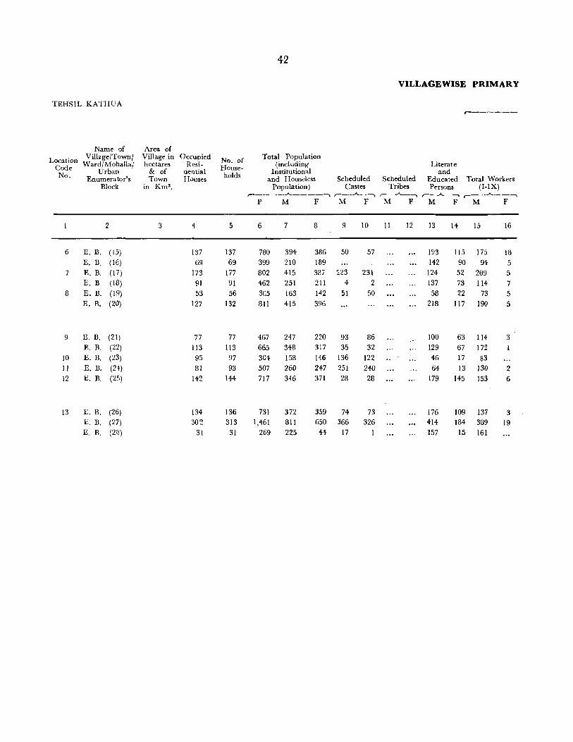
42
VILLAGE WISE PRIMARY
TEHSIL KATHUA r---~---
Name of Area of
I.ocation Village/Town! Village in Occupied No. of Total Population
Code Ward / Mohalla/ hectares Resi- House- (including Literate
No. Urban & of dential holds Institutional and Enumerator's Town Houses and Houseless Scheduled Scheduled Educated Total Workers
Block in Km'. Population) Castes Tribes Persons (I-IX) ,--____ ....A-_____ ~ ,.-_ ... ..A-_ ~ r--...A._-~ r--..A..~~ ,--__ ...A-__ ~
P M F M F M F M F M F
2 3 4 5 6 7 8 9 10 II 12 13 14 15 16
6 E. B. ( 15) 137 137 780 394 386 50 57 193 115 175 18 E. B. ( IE) 69 69 399 210 189 142 90 94 5
7 E. B. (17) 173 177 802 415 387 223 231 124 52 209 5 E. B. (18) 91 91 462 251 21 I 4- 2 137 73 114 7
8 E. B. (19) 53 56 305 163 142 51 50 58 22 73 5 E. B. (20) 127 132 811 415 396 218 117 190 5
9 E. B. (21) 77 77 467 247 220 93 86 100 63 114 3 E. B. (22) 113 113 665 348 317 35 32 129 67 172
10 E. B. (23) 95 97 304 158 146 136 122 46 17 83 II E. B. (24) 81 93 507 260 247 251 240 64 13 130 2 12 E. B. (25) 142 144 717 346 371 28 28 179 145 153 6
13 F,. B. (26) 134 136 731 372 359 74 73 176 109 137 3 E. B. (27) 302 313 1,461 811 650 366 326 414 184 389 19 E. B. (2(1) 31 31 269 225 44 17 157 15 161

43
CENSUS ABSTRACT
WORKERS ---------------------------~---------------------~
I n III IV V VI VII VIII IX X
Cultivators
r--...A...-~
M F
17
4-3
26 42 12 50
·tt 79 14 45
39
32 20
18
Agricultural
Labourers
Live-Stock, Manufacturing, Pro-Forestry, cessing, Servicing Fishing, M" & and repairs Construc-
Hunting & mm!? ,. ___ ..A.. ___ -.
Plantations, Quarrymg (a) (b) Orchards House- Other than
tion
and allied hold Household activities Industry Industry
Trade Transport and Storage &
Commerce Communications
Other Services
r--..A..--.. ,-_..A.._--"'\ ,-_..A..._-, r--..A...-~ ,-~_""_---.. r---"'---... ,-~-",_-,.,-_..A.._~r-_.A._~ M F M F M F M F M F.M F M F M F M F
19
1
2
14
61
14
7 44 39 16
40 6
20 21
1 3 3 2
2
2
2 3 4
8
22 23 24 25 26 27
3 5
15
19
42 13 33
23 3 15
12
16 38
9 4
42
14
21
28 29 30 31
10 7 :3 4 I 44 :3 2 2 2 ~ 5
18 3 5
3
2 96
48 25 25
8
11
9
2 13
3 12
6
32
32 33
30 9
29 6 7 3
21 3 I
5 16
13 21
34 35
39
32 47 30 9
33
16 20 10 11
22
36
6 2
4-
4
2
3
2 3
28 3 2 165 14
161
NonWorkers
,-__ ..A. .. _ ...
M F
37 38
219 368 116 184 206 382 137 204
90 137 225 391
133 217 176 316
Location
Code No.
6
7
8
9
75 146 10 130 245 11 193 365 12
235 356 13 422 631
64 44


TEHSIL HIRANAGAR

TEHSIL HIRANAGAR DISTRICT KATHUA
, .~
... _ '- ...... _ ... ....,.,...._ 01 .. ....,., _ oI'.<Ioa

TEHSIL HIRANAGAR

TEHSIL HIRANAGAR
Location Code No.
Name of Village/Town! Ward/Mohalla!
Urban Enumerator's
Block
2
Area of Village in
hectares & of Town
in Km'.
3
8/4 Hiranagar Tehsil
Occupied Resi
dential Houses
4
No. of Households
5
46
VILLAGEWISE PRIMARY
Total Population (including
Institutional and Houseless Scheduled Scheduled
Population) Castes Tribes r- ____ ",..A..,. -----~ ,-__ -A.. __ ---. r-_J----... PM F M F M F
6 7 8 9 10 11 12
Literate and
Educated Persons
,-_..A.._-"'"')
M F
13 14
,-------
Total Workers (I-IX)
,--__ _.A... __ ~
M F
15 16
Total 532.0 K:m' 13,713 13,966 83,647 43,191 40,456 9,924 9,'237 ... 15,719 5,899 19,]06 351
I
2 3
4
5
()
7
8
9
10
II
12 13 14 15
16 17 18 I')
20
~ 1
22 23 2+
(53,201 Hectares)
Rural 530.9 Km2
(53,091 Hectares)
Urban 1.1 Km 2
(11 0 Hectares)
RURAL AREAS
Koper Dinga Amb
:I>1angloor
Chelak
Katli
492 2,240 1,730 1,743 1,455
Kore Qasba 249 Dhalta 122 Chak Balunda 212 Rakh Sarkar Sahllan 233 Qasba 210
Bhatiari Brahmanan 158 Dhaili 149 Chak Bannun 143 Sahllan 18 Chhan Rallga 161
Chhan Dalial
Spreen
Khurar Rakh Sarkar Hagni
Babahr
117 59 27
594 126
Thaka Pur Rajputan 101
Candwan 95 Chak Khaloo (;ehr
Sehswan
72 57
343
13,044 13,288 79,903 41,307 38,596 9,672 8,980
669
11 239 344
362 195
17 7 4
25
76 98 26 85
13
87
31
17
72
44 97 26 59
205
678 3,744 1,884
II 85 239 1,425 344 1,997 366 2,191 196 1,161
45 767
1,065 1,116
589
17 7
4
U
25
111 64
76 98 26 86 15
88 31 17
U 77
45 107
57 28 30 17
N I N
141 75
411 551 161 542 94
504 165
89 N
450
231 660
L03
290 86
264
50
251 72 46 N
197
96
27 166 350 92
185 611
59 371 205 1,194
1,860 252 257
40
658 132 932 279
1,075 220 572 94
47 29 13
105 249 220 70
H A B I
66 58 56
208 261
75 278 44
22 25
:'>1
15
16
57
253 57 51 93 18 31 43
H A B
253 47 70
135
310 74 46 39
186 50 45 583 158 148
T
T
.. , 14,624 5,181 18,332 288
... 1,095
E
E
2 223 339 310 185
20 12 6
D )
27
80 102 31
149 15
74 42 26 D
87
48 123 22 54
124
718
87 125 84 82
2
6
27
39
104
4
25 25 12
31 77
774 63
29 372 12 496 7 514 14 287
34 16
8
42
77
143 46 93 20
119 31 14
63
15 142
3
5
4
4
6 4 35
23 88 93 239

47
CENSUS ABSTRACT
WORKERS ______ . __ ._.~ _______________ ..A... _________________________ ~
I II III IV V VI VII VIn IX X
Cultivators Agri
cultural Labourers
Live-Stock, Manufacturing, Pro-Forestry, cessing, Servicing Fis~ing. Mining & and Repairs Construc-Huntmg & . ,.--___ .A. ___ -,
Plantations, Quarrymg (a) (b) Orchards, House- Other than
tion
and allied hold Household activities Industry Industry
Trade Transport, d Storage &
an C . C ommUlll-ommerce cations
Other Services
r-.A. _____ r---A..---,. f-.A.-~ ,-_J...._-"""\ ,_..A.. ___ r--..A..-~ ,-_.A._-., r--..A..-~ r---A--, M F M F M FM FM F M F M F M F M F
17 18 19 20 21 22 23 24 25 26 27 28 29 30 31 32 33 34 35 36
NonWorkers
37 38
Location
Code No.
8/4
11,818 66 1,234 36 209 8 3 925 65 225 2 853 13 791 2 1,021 11 1,997 148 24,085 40,105
11,757 66 1,216 36 189
61
29 287 298 336 242
26 13 5
23
58 86 27 6
13
69 26
12
39
5 32 26 44
140
4
2
2 2
18
4
90 69 6
20
13
3 ..
3
26 4
13 7
20
8
3
2
7
8
u
u
3 ... 898 61 166
N I
N I
27 4 89
21 8 20 3 39 4
6
N
2 6
14
9
N
10 2 9
18
2
H
H
2 8 8
2
2
2
A
A
2
4
1 808 13 679 2 925 11 1,691 90 22,97~ 38,308
1 45... 112 ...
B
B
6
6 7
I
1
2
1 2
3
I
42
5 17
T
T
5 10 12 3
2 7
2 17
E
4
E
4
3
5
96
4 23
7
3
8
D ) 15
9 15 15
1
16
1
D ) 10
16 5 5 5
306 58 1,110 1,797
35 40 33
12
2 3
3
11
18 2
40 3
13 4
7
8 11
8 36
3
2
2
3
2
16 39 1 2 3 4
5
395 646 569 925 602 1,061 302 572
30 12 9
33
47 6 29 7
13 8 9
66 10
126 208 11
147 260 12 40 75 13
165 275 14 30 44 15
132 248 16 41 32
89 17 43 18
19 134 249 20
81 135 21 208 304 2:1 57 73 23 97 186 24
372 582 25

TEHSIL HI RAN AGAR
Location Code No.
Name of Village/Town!
Ward/Mohalla! Urban
Enumerator's Block
2
26 Thath 27 Bann 28 Kishanpur Kandi 29 Chhan Rorian
30 Hamipru
31 Dhamaal 32 Dhandiyari 33 Gurah Suraj 34 Amala 35 Dhaloti
36 37 38
39 40
Sande Chak Karandi Kalan Karandi Khurd
Bhambarwan Muthi Hardu
41 Wazire Chak 42 Kharroh 43 Khatriyal 44 Bhagwal 45 Balahn Bala
46 47 48
Chak Fatoo Parkhwal Ladhwal Khurd
Area of Village in hectares
& of Town
in Km2•
3
226 295
230 324
246
341 197 17
238 267
59
231 34
178
174
99 27 23
92
113
48 74 54
49 Ladhwal Kalan 122 50 Chpaki Kalan 135
51 Chak Ganga Ram 47 52 Charwa1 24 53 Langriyal 212 54 Pathwal 314 55 Hira Nagar 587
Occupied Resi
dential Houses
4
58 64 75
285 138
80 56 21
194 91
24
4 229
15
21 38 25
31 22 4
51
66
17 135
7 167 28
No. of Households
58 64 75
285 138
81 63 21
194 94
(U 24
( U 4
251
15 ( U 21 38 25
31
22 4
51
75
17
137 14
176 28
48
Total Population (including
Institutional and Houseless Scheduled
Population) Castes
VILLAGE WISE PRIMARY
Literate and
r------
Scheduled Educated Total Workers Tribes Persons (I-IX)
r-----..A.----~ ...... _ . .A._, r--....A--~ r--.,.II...-__ r--"""_--~ P M F M F
6 7
362 190 420 219 431 233
1,652 842 766 414
531 381 146
1,161 586
N 145
N 17
1,383
287 209 73
573 310
I N 81
I N 11
716
65 36
N I N 107 63 190 103 155 85
197 158 19
109 90 9
300 149 472 242
119 49 783 404
64 45 959 498
164 88
8 9 10
172 34 36
201 47 39 198 80 68 810 221 208 352 158 118
244 18 172 45 73 31
588 122 276 126
H 64 H
6 667
A
A
35
3 33
30 116 96
B I
B I
27
29 33 29 H A B I 44 37 25
87 70 24 15
88 65 68 10
151 22 230 33
70 24 379 52
19 461 57
76 43
55
19 34
32 41
61 38
M F M F M F
11 12
T
T
T
E
E
13 14 15
29 .. 6 72
405
141
127 73
14 249 137
D
5 74
16 84
II 99 224 350 48 188
42 139 16 102 6 35
119 236 63 130
60 33 28 D ) 5
372 196
8
7 288
20 E D
26
41 40
23 16
2
56 88
18
179
10 183 24
2 26
4 45 10 34
3 50 48 6
18 62
17 91
10 15
74 177
1 30 50 210 13 40
16
14 2
3
2
4 2
9

49
CENSUS ABSTRACT
WORKERS ________________ . ________ -.A.. ________________________ --.
I II III IV V VI VII VIII IX X
Cultivators Agri
cultural Labourers
Live-Stock, Manufacturing, Pro-Forestry, cessing, Servicing Fishing, Mining & and Repairs Construc-
Hunting & . ,------'-----__ -. PlaXltations, Quarrying (a) (b) tion
Orchards, House- Other than and allied hold Household activities Industry Industry
Trade Transport, and Storage &
Commerce Communications
Other Services
NonWorkers
Location Code No.
,_.A._--, ,--...... ___ ,--~ r------"---. ,-_.A._--, ,-_~ ,-_.A._-. ,_..A._--. ,---"'----.,----A---, ,-__ .A. __ -.
M F M F M F M FM F M F M F M F M F M F M F
17
61 65 65 99
122
94 72 35
195 88
6
7
108
18
19 33 30
25 34
4-48 60
12 79 3
112 33
18 19 20 21
2
2
3
4
1 6
II
4
12
3
5
2
3
2
10
22 23 24 25 26 27 28 29 30 31 32 33 34
u N
u N
u N
2 5 39 19
2 13
3
5
I N
I N
13
I
10 4
8
21
N
2
2
3
2
H A
2 H
H
2
1 2
A
A
1 3
24 14
19
12 20
B
B
2
B
2
3
1
2
3 24-15
I
I
3
69
4-4
3
T 10 T
23
T
2 2
29 2 I
10
E
E
10 8
11 59
6
8 12
2 3
D 2
D
58
2 E D
5 2
5 8
4 2 2
28
15
35 36 37
3 4
B 41 12 Ii 2
10 10
17 15
8
72
1 7 2
2 2
7 11
28
25 4
2
3
116 135 134 492 226
148 107 38
337 180
53
4-428
16
37 58 51
59
42
3
87 151
34 227
15 288
48
38
172 26 201 27 197 28 796 29 350 30
244 31 172 32 73 33
585 ~4
276 35
36 64 37
38
6 39 666 40
29 41 42
44 43 87 44 70 45
88 46 68 47 10 48
149 49 230 50
70 51 375 52
17 53 452 54
76 55
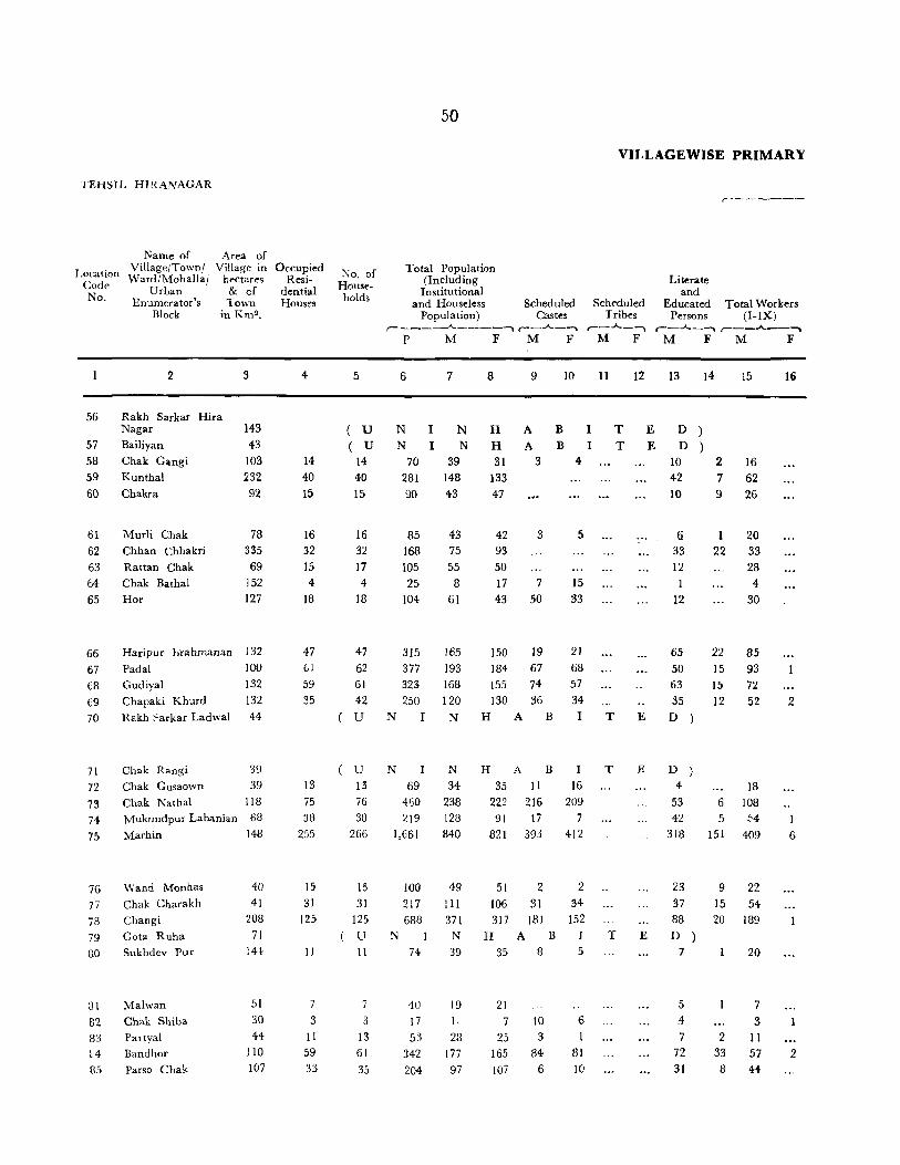
TEHSIJ. HWANAGAR
Location Code No.
56
57 58 59 60
61 62 63 64 65
66 67 68 69 70
71
72 73 74 75
76 77
78 79 80
81
82 83 ~4
85
Name of Area of Village/Town/ Village in Ward /Mohalla! hectares
Urban & cf Enumerator's Town
Block in Km".
2 :3
Rakh Sarkar Hira Nagar 143
Bailiyan 43 Chak Gangi 103 Kunthal 232
Chakra 92
Murli Chak
Chhan Chhakri
Rattan Chak
Chak Bathal
Hor
78 335 69
152 127
Haripur b:rahmanan 132 Padal 100 Gudiyal 132 Chapaki Khurd 132 Rakh :'arkar Ladwal 44
Chak Rangi 39
Chak Gusaown 39
Chak Nathal 118 Mukundpur Labanian 68
Marhin 148
Wand Monhas
Chak Charakh
Changi
Gota Ruha Sukhdev pur
Malwan
ehak Shib:.
Partyal
Bandhor
Parso Chak
40
41 208
71 144
51 30
44 110
107
Occupied Resi
dential Houses
4
14 40 15
16 32
15 4
IB
47 61
59
35
13 75 38
255
15 31
125
II
7
3 II
59 33
No. of Households
50
Total Population (Including
Institutional and Houseless
Population) Scheduled
Castes
VILLAGEWISE PRIMARY
Scheduled Tribes
Literate and
Educated Persons
,..~------
Total Workers (I-IX)
,--__ ---"-____ ......... r--..A--~ ,--...A..-1 ,-_..A._-..._ ,--_-"'---'-\
PM F M F M F M F M F
5
(U ( U
14 40 15
16 32
17
4 18
6 7
N I N N I N
70 39 281 148 90 43
85 168 105
25 104
43 75 55
8
61
47 315 165 62 377 193 61 323 168
42 250 120 U N I N
U N I N
13 69 34 76 460 238 38 219 128
266 1,661 840
15 31
125 U 11
7
3
13 61
35
100
217 688
74
40 17 53
342
204
49 III 371 N
39
19 I,
28 177
97
8 9 10
H A B I H A B I 31 3 4
133 47
42
93 50 17
43
3
7 50
5
15 33
150 19 21 184 67 68
155 74 57 130 36 34
H A B I
H A B I
35 11 16 222 216 209 91 17 7
821 393 412
51 106 317
H 35
21 7
25 165
107
2 31
181 A B
8
10
3
84 6
2 34
152 J
5
6
81 10
II 12 13 15
TED) TED)
T E
T
T E
10 2 42 7
10 9
16 62 26
6 33
12
1 20 22 33
12
65 22 50 15 63 15 35 12
D )
D )
28 4
30
85 93 72
52
4 18 53 6 108 42 5 54
318 151 409
23 37 88 D
7
5 . .4
7 72
31
9
15 20
2 33
8
22 54
189
20
7
3 11 57 44
16
2
I
G
2

5J
C,E.N'SU,S A.B,S.Il'RA,CT
WORKERS ---- ~ -~--- ----------------"---------------------------........
II III IV V VI VII VIII IX X
Live-Stock, Manufacturing, Pro-Forestry, cessing, Servicinr: Transport, Loca-
Agri- Fishing, Mining & and Repairs Construc- Trade Storage & Other Non. tion Cultivators cultural Hunting & Quarrying '(a)-_.A-(b)--' tion and Communi- Services Workers Code
Labourers Plantations, Commerce cations No. Orchards House- Other tha,n
and allied hold Household activities Industry Industry-
,-_.A._'"""""I ,-_A-....... ,---A-_~ ,- _..A..---., r--..A.. .. ~ ,-- -A..._-, r-- ....... -, r--A-~ ,_A_-",,"\ ,--_A_ ...... ,--_A-~ M F M F M F M F M F M F M F M F M F M F M F
17 18 19 20 21 22 23 24 25 26 27 28 29 30 31 32 33 34 35 36 37 38
U N I N H A B I T E D ) 56 U N I N H A B I T E D ) 57
16 23 31 58
53 '" - 3 5 86 133 59 16 5 2 2 17 41 60
18 23 42 61
30 42 93 62 26 27 50 63 4 4- 17 64
25\ 3 31 43 63
64 2 3 2 6 3 5 80 150 66 59 5 3 7 6 6 7 100 183 67 43 15 1 2 9 96 155 68 30 13 2 4 3 68 128 69
( U N I N H A B I T E D ) 70.
( U N N H A ~ I T E D ) 71 7 I 10 16 35 72
78 2 2 8 7 3 2 2 4- 130 222 73 29 2 5 3 3 5 5 74 90 74-
167 55 b 4J 9 17 49 22 39 4- ~31 815 75
19 I I 27 51 76
43 4 I 1 I 4 57 106 77 119 23 26 1 2 5 13 182 316 78
U N N H A B I T E D 79
10 tl 1 19 35 80
6 12 21 81
3 7 6 82
8 2 17 25 83
32 14 3 5 2 120 163 84
34- 5 3 2 53 107 85

TEHSIL HIRANAGAR
Area of
Location Code No.
Name of Village/Town! Ward/Mohalla!
Village in Occupied hectares Resi-
Urban Enumerator's
Block
& of dential Town Houses
86
87
88 89 90
2
Balahn Pain
Khanpur
Sunzwan
£akhl'ak Ladwal
in Km 2•
3
65 218 201
116
2GJ
91 Dhangdev fur 301
92 Jugial 84
S3 Chak Wazir Chand 35
94 Chak Chhabba IDO 95 Chak Dhari 94
96 Rampur
97 Khandwal
98 M ukundpur
99 Salalpur
100 l\i.!dpora
128
103
299
340 1:,6
1.01 Kore punoo 230
102 Dohlian Jattan 286 103 Chak Dhata 102
104 Chak Shama 203
105 Chak Kahna 120
106 Chak Haria :.'91
. 107 Chak v\azir Lahbju 264
108 Barnooh 93
J09 SfJral Pain 199
110 Chak Handa :cIO
111 112
113
114
115
Sultanpur 191
Chak ~ardar Attar Sing lIB Kishan Pur Andhar 101
Maharaj Pur 166 ~[ada 183
4
16
95
25
21
4
16
58
12
15
16
31
56
98 79 12
39 20
90
51
2 (i
31
20
22 14
VILLA6EWISE PRIMARY
TOlial Pop"lation (including
Institutional
No. of Households and Hous~less Scheduled Scheduled
Population) Castes Tribes r- - ---- ..A-~-- --. ,,----....A.....---""'l r--~
PM F M F M F
5 6 7
16 87 44 99 590 327
25 125 62
5 3 U N I i'\
21 4
18
58
13
115 18
I().J:
392 60
li~
II
07 211
36
15 74 39
17 128 70
31 162 94
56 324 173
fj N I N
98
79
12 39 20
90
51
2
6
37
693 485
85
291
132
513
310
10
25 234
352 c47 53
161 74
282
166
6 10
116
8 9 10
43 25 26 263 138 115
63 18 18 :1 3 2
H A B I
55 59
7 4 37 4ll
181 211
24 12
5:)
3
28
180
13
35 34 33 58 71 53
68 22 22 151 82 82
H A B
341 227
238 66 3') 51
130 5
58 31
231 115
144 66
4
15 10
118 75
234 78 31
5
29
j() l'
56
15
67
2iJ 104 :l7 47 24 24
24 158 87 71 12 13
lJ N N H A B
22 147 UO 67 5 10
14 116 5~ 40 28 23
11 12
T E
T E
T E
Literate and
Educated Persons
Total Workers (I-IX)
,---"--~ r---..A..--~
M F M F
13
14
104
18 1
D )
11
6 12
39
14
7
12 16 33 ])
87 56 7
32
33
7U 44
1 1
42
18
13
D ) 22 11
14 15
3 20 21 140
3
9
20 2
28
5 29
96 16
22
38
49
9 103
:W IbU
12 141
29 4 B5
I 'I 3~,
19 134
17 74 3
2
6
.1 S(,
2t;
39
39 3+
16
11
3

CENSUS A'3STRACT
WORKERS _________________________________ .A. ______________________ ..,
II III IV V VI VII VIII IX X
Cultivat'()r~
17
18 105
18 2
27 4
25
89
15
21 38
45 90
97
77
73 23
12 :
68 3
5 43
17
36
34
12
18
2
Agricultural
Labourers
Live-Stock, Manufacturin~, Pro-Forestry cessing, Servicing Fishing,' M·· & and repairs Canstruc-
Hunting & l mm~ , ____ ....... _--:_-.. Plantations Quarrymg (a) (b) Orchards ' House- Other than
tion
and alli~d hold Household activities Industry Industry
Trad~ Transport and Storage &
Commerce Communications
Other Services
r---"--~ ,--..A.._""""""'I ,---"'--____ , ... .,..A... .. -.. r-- .......... -~ ,----'"'--__,_ ,-~_.., _ __.,__..A..-~,_-.A..~~ M F M F M FM F M FM F M F M F M F
19
2
3
25
50 27
I 6
G
3
5
20
20 21
6
3
2
2
2
22 23
8
( U N
u N
u N
24 25 26 27
I
I
6
5
7 4
7
7
6
N
N
I N 2
2 H
2
H
A
A
A
28 29 30 31
B I T
B T
T
5
5 4-
2
E
E
E
32 33
2 6
D )
2
D )
012
D )
34 35
2 4
1
2
10
6 2
2 3
2 4
2
1 2
36
Non\-Vorkers
Locatiun
Code No.
37 38
24 43 86 187 252 87
42
32 6
38 115
20
17
32
45
70
63 88 2 89
90
55 91
7 92 37 93
180 94 24 95
35 9G
58 97
68 98 148 99
100
192 34-1 101 106 238 102 24 32 103 76 130 104-39 57 105
148 230 106 92 144 107 3 4 108 5 14 109
60 118 1,0
31
48
41 22
47 1 II
71 112 113
67 114 40 115

TEHSIL HIRANAGAR
Name of Area of Location Village/Town! Village in
Code Ward/Mohallal hectares No. Urban & cf
Enumerator's Town
116 117 118 119 12U
121 122
123
124 125
126 127 128
129 130
131 132 133
134 135
136
137 138 139 140
14·1 142 143 144 145
Block in Km2•
2 3
Pahar Pur 63 Chak Bhohalan 50 Thaggali 158 Rathua 119 Chban Midn Lal Din III
Hari Pur <:;ainiyal
Mandahla ('hak J)~sa
( houdha, ian
Barsoo Chak
Lachhmi Pur
Naun Chak
Pansar
Mani3ri
Chak Debo
Ganjnal
Khanwal Chak Gupala
Mast Chak
Ramgarh
Chak· Mahesha
Rughnath Pora
Chak Jawahir
Mandleyal
Kadiyal Chak Gojar
Chak Changa
Chan Tand ..
Gangu Chak Tanda Neknam
Mathra Chall.
119 1()
276
134 149
3JO 307 204
246 167
8(1
85
73 20 67
139 76
178 94 97
250 172 117 106
Iv8
Occupied Resi
dential Houses
4
7
21 56
17
43 2
2tl
38 18 27 60
41 24 27
34
46 13
53 31 11
14
28 17
22
54
VILLAGEWlSE PRIMARY
Total Population (Including
Institutional
No. of Households and Houseless Scheduled Scheduled
Population) Castes Tribes r- . ___ ____.A,_ __ ~ . ~ r-..A--~ r--.A.-~
PM F M F M F
5
7 ( U ( U
21 56
6 7
28 15 N I N
N I N 103 49
322 167
8 9 10
13 H A B H A B T
54 4~ 47 155 66 73
17 103 52 51 27 29
II
T
T
12
E
U N I N H A BIT ,I::
43
2 2ll
271 6
191
303 88
145
3
93
161 50
126
3 98
142
38
87 3
25
64 15
7f)
3 22
55 17
27 145 71 74 58 60
60 390 217 173 59 48
o N I N H A B I
41 26
22 V 35
47 13 5S 3: 11
287 165 139
N I 195
330 75
383 187 S~
14 83 28 163 17 JOI U l\" 22 ;,,;>
150 83 69 N 96
167
40 191 97 49
137 82
70
H
99
40
10 A B
15
163 122 35 10
192 46 90 15 33 10
40 10
I 15
131
7 46
9 8
42 41 4 6
92 71 81 63 51 50 N H A B 52 43
T E
T E
T E
,--------
Literate and
Educated Persons
Total Workers (I-IX)
,--_-"- __ -..._ ,-__ .A-__ ~
M F M F
13
2 D D
4 45
13
D
36
1 28
40 8
52 67 D
61
24 20 D
37
53 ~I
37 34 10
13 10 12 o 23
2
20
6
7
3
3 2
6
11 3 9
9
9 2
11 6
2
15
10
31
77
23
69 3
46
81
28 42 98
58 56
31
43
80 18
79 43 LO
24
44 22
30
16
3
2 4
3

CENSUS A_TRACT
WORKERS _~ __ • _____________________________ ...A... __________________________ .....
II III IV V VI VII VIII IX X
Cultivators Agri
cultural Labourers
Live-Stock, Manufacturing, Pro-Forestry, eessing, Servicing Fis~ing, Minit!g & and Repairs
Hunttnft/& Q '. ,----....... ----. PlantahQns, uarrymg (a) . (b)
Orchards ' House- Other than and allied hold Household activities Industry Industry
Trade Tranlport, d Storage &
an Communi-Commerce cations
Construe-tior;
Other Services
"lonWorkers
Location Code
No.
,--..A..- 1 r---""--~ r---A..-_..... ,-_..A..~ r-... ..A--~,-- ..A.. --. r--,A..,-~ ,--....A...-~r--..A.~ r-....... ~ ,-__ .A.-_, 1\1 F M F M . F M F M F M F M F M F M F M F M F
17
23 70
21
5f)
42
77
22 28 81
:19
34 24
17
riG
12 60 31
16
21 32 20
26
18 19 20 21
7
2
3
4-10
4-
2
9
8 3
11 3 3
6
2
2
+
6
2
3
22 23
( U
( U
( U
( U
u
u
N N
N
N
N
N
24 25 26 27
I I
I
5
N N
I l\'
5 ~
2 I N
G
I
4
1
N
2
H
H .\
H A
I
H
H .A.
H A
B
11
B
11
1'1 I
I
I
I
32 33 34 35
T T
T
T
2
E E
E
E
T E 2
4
T E
D ) D )
D ) ~
D )
9
I
D )
D ) 2
3
3
2
2
2 6
3
2
3
2
1
2
2
36 37
5
18
38
13 116
117 118
51 119 90 154 120
29 51 121
122
76 125 123
3 124-98 125 ~7
80 H2 126
22 36 127
29 70 128
119 173 129
130
92 137 131
27- 82 1~2
38 70 133 134-
53 98 135
87 163 136
22 35 137 112 189 138
54 90 139 29 33 140
18
48 29
22
40 141
70 142 50 143
144 43 145

TEHSIL HIRANAGAR
Name of Area of
Location Code No.
Village/Town! Village in Ward/Mohalla! hectares
Urban & of Enumerator's Town
Block in Km2 •
146
147
148 149
150
151 152 153 154 155
2
Bhagwane Chak
Korhl Buddu Krohl Bathrian
Krohl Krishna Bobia
Ladwal Bhati Mehru
Khanak
Spalwan Chak Prohtan
3
157 218 216 liS
S38
115 124
212 185 130
156 157 158 159 160
Gurah Sarkari 59
Banni Chak 13~
Thakur Pur Grore 99
Saniya1 Dolka
161 Allu Chak
162 Chak Jahlla 163 Sherpur Ba1a
164 Jandi 165 Basi Jamwal
166
J67 168
169 170
Dhandowal Thuthi Chak
Juwaloo Chak Feru Chak Kariyal'a
171 Bannai
172 Karwal
173, Chak Diyalla 174 Dhangroli
1 is Jhajarth
75
32
83 120
70
368 44
23 72 63
47
77
25 24 62 81
108
Occupied Resi
dential Houses
4
30 19 29
8
32
17 8
24 39 32
7
7
72
14 67
132 39
13 25
42 31
20 23 52 38 51
No. of Households
S
31 19
29 8
32
17 8
24
39 32
56
Total Population (Including Institutional
and Houseless Popula tion )
Scheduled Castes
,-- ___ --...A.. ____ -""'\ r-...A..--,
P M F M F
6
169
132 145 33
212
122 53
139
262 123
7
90 62 79
27 109
66 24 69
138 90
8
79 70 66
26 103
56 29 70
124 93
9
14
2
17
4
9 6
10
7
12
2
7 4
7 50 27
VILLAGEWIBE PRIMARY
Scheduled Tribes
r--..A...-, M F
II 12
,. ... _-----
Literate and
Educated Total Workers Persons (I-IX)
r--..A.-__._ r---..A.--~ M F M F
13
24 32 37 10 39
27 8
21 48 37
14 IS
11 38 16 33 l! 46
6 11 13 48
5 27 1 13
3 40 18 60 11 44
6 10
16
U N I 23 N 27
H A BIT E 2
D
4 212
E D
7 47 20 16 II 72 u
U 14
77 132 39
13 25
U 42 35
20 25 58 38 51
422 224 198- 25 24 N I N H A B
N I N H A B 1
88 43 45 10 6
435 222 213 48 41
811 397 414 138 117
222 99 123
63 22 41 4 2
137 64 73 13 14 N I N H A B I
271 144 127 7 2
207 101 106 26 24
118 136
286 231 310
56 • 62
66 70 8 11
171 115 3
125 106 2 166 144 22 26
T
T E
T E
37
D )
10 97
7 3 18 74 25 100
167 81 139
6~ 53 2u
6 30 D
79
39
25 20 47
49
36
7 16
28 29
17
2l.!
52 45
12 19 5 31
12 96 8 54
8 85
6
1 2
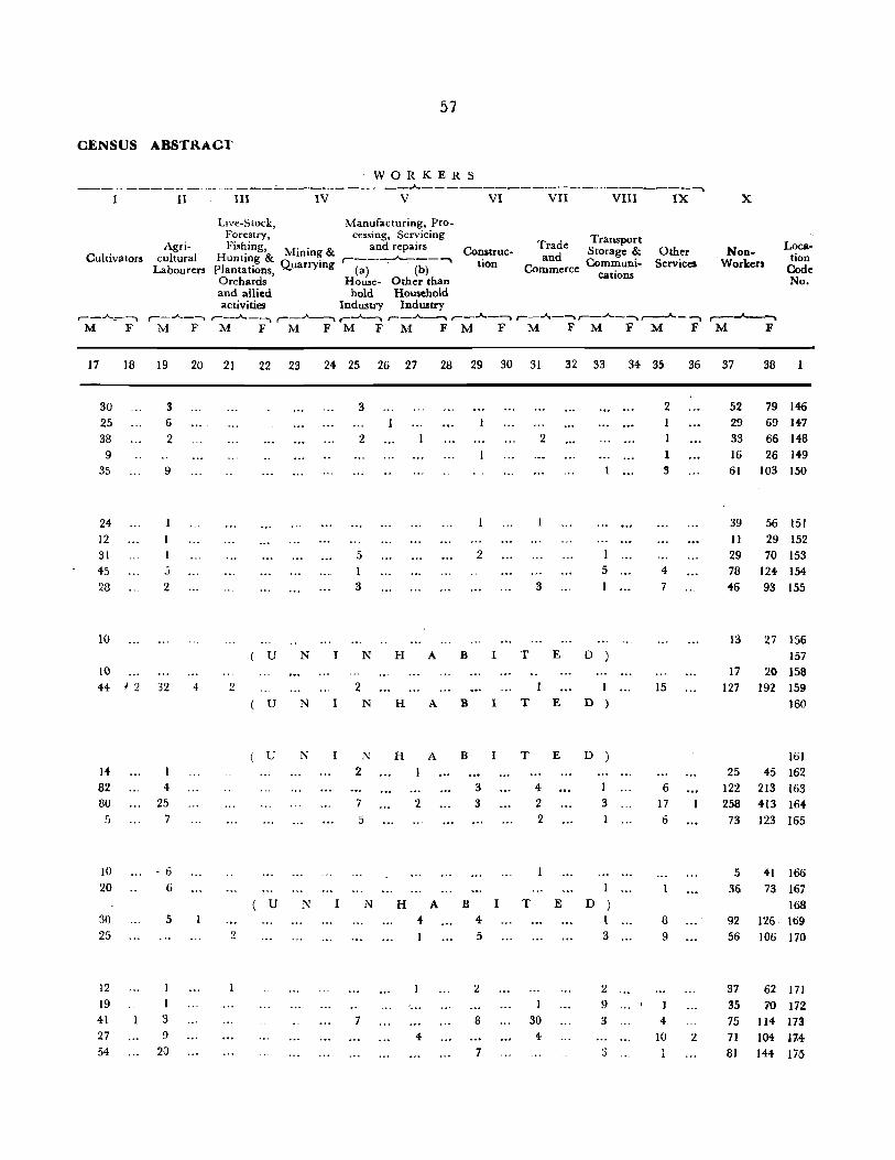
57
CENSUS ABSTRAC1'
WORKERS --_ - ------ _._-----.;._._---- ------~--------------------------
I II III IV V VI VII VIII IX X
Cuitiva tors
17
30
25
38
9
35
24
12 31
45
28
10
10
18
Agricultural
Labourers
Live-Stock, Manufacturing, Pro-Forestry, cessing, Servicing Fishing, M" & and repairs Construe-
Hunting & • mm~ , __ -,-""""'_ __ -" Plantations Quarrymg (a) (b) Orchards ' House- Other than
tion
and allied hold Household activities Industry Industry
Trade Transport d Storage &
an Communi-Commerce cations
Other Services
,-_.A._-.. ..... _ ...... _~ ,..-_"",,__, ,-_--'----. ..... _ _..____, ..... _ ...... _-.. ,..._.A,_ ..... ,..._.A._-..,_.A._~ M F M F M FM F M FM F M F M F M F
19
3
6
2
9
2
20 21 22 23
u N
24 25 26 27
3
2
5 I 3
N H A
28 29 30 31
2
2
3
8 I T
32 33
5
E D )
34 35
2 1 1
1 3
4
7
36
44 J 2 32 4 2 2 I N
1
D ) 15
14
82 80
5
10
20
30
25
12
19
41
27
54
4 25
7
- 6 6
5
I 3 9
2()
( U
( U
( U
2
N
N
N
I N 2
I
7
5
N
7
H
H
2
H 4
4
A
A
A
B I
B I
B
3
3
4
5
2
8
7
I
T E
T E
T
4-2
2
1
30
4
E
D )
3
I
D ) I 3
2
9
3
6 17
6
8
9
4
10 2
NonWorkers
Location
Code No.
37
52
29
33
16
38
79 146
69 IH
66 148
26 149
61 103 150
39 56 151
11 29 152
29 70 153
78 124 154-
46 93 155
13
17
27 156
157
20 158
127 192 159
160
161
25 45 162
122 213 163
258 413 164
73 123 165
5 36
41 166
73 167
168 92 126 169
56 106 170
37 62 171
35 70 172
75 114 173
71 104 J74
81 144 175

TEHSIL HI"ANAG.-\R
Location Code No.
176
177 173
179 130
131
182 183 18! IP,5
::\am~ of Village/Town!
Wardl.\fohalla/ Urban
Enumerator's Block
Area of Village in hectares
2
Gurah Baildaran
Gurah Mond;an
Chak Budhu
A.jan Chak
Suba Chak
& of Town
in Km2.
3
166
197 28 64
1S8
Gurah Balu 95
Chhan t.loraan 115 l\luth; H"J(jo Dunga 130
Behr; 64
Chak Sukhu 143
1(;:1 Chhan Kh",triyan 163
187 Katal Brahmananv 335
H:B ehhan Dhanu 71
189 .vlalaahni ~ 263 ,.1.1 "],,\11: G1.,',; Sainian 123
191
192 193
194 195
196 197 19.) 199 :,WO
201
202 :203
:c0+ 205
h.ata: (;l~jran
Sherpur Pain
Panj Grain Blahnlanan
Loundhi M Il[hi Ch;<ilfU
Chak Sadda
Mango Chak
Chak Dulma
Sadwal Chak Bhagta
Jrain Chak Lala
K"Iwal
[Lj· 'I'UI
Chhan ]'tohtan
118 129
119
417
99
79 248 208 122 72
64 84
125
149 80
Occupied Resi
dential Houses
4
47
202
34
lIS
27 80 18
10.'-
7'2
21
12
20
27
40
68 15
39 32
36 33 31
35 22
28
32
Total Population (ir<cluding
Institutional
No. of Households and Houseless Scheduled
Population) Castes ,,-___ -- _A._ ___ - __ _.._ ,------A..- 1
P ,\1 F M F
5
47
217 U 34
119
325
1,432 N I
230 (iN
i
183
843
N 125
:ns
3
142
589 H
105
346
9
liS
55 '\ B
19
142
10
92
61 I
11 142
27 1'_Q lOa 90 17 III
80 :,05 263 242 19 27
18 145 70 75
l_; X I ::\ H A B 22 ISO ~1I 30 SO 49
j OS (j{") :o!11
72 391 199 U ~, 1 ~
21 135 1)1 13 77 41
20
40
68
IS
39 32 36
34 31
121 :2]0
265
434
78
2~2
197
237 237
182
117
138
217
45
120
i02
112
131 97
;(97 2,; ~3
192 14 21
H .1\ B I 7+ :lG 40 3G
~8
93 25
127 43
217 104
33 12
112
95 125
106 !l5
57
4 i3
11
36
99 4
59
3 65
36 249 124 125
22 113 66 47 32 1[>4 88 7G 38 37
U l" I l\" H A B I 32 I!H ,. 101
ViU,AGE'WJ&E PRIMARY
Scheduled Tribes
r--..A..-...._ M F
11 12
T E
T E
T E
T E
r--------
Literate and
Educated Total Workers Persons (I-IX)
,_..A.._ ...... ,-----.-"----""") 1\1 F M F
13
63
388 D
59 158
37 89 39
D 24
9[
110
D 19
8
11
37
34
47 3
29 23 34
44 18
44 27 21 D 21
14
36
65
20 97
15
61;
47"
5) 143
9 .~:?
24 I~'t
II 2t;
25 15
10
9
12 7 5
II 5
3
7
25
III
:21
39
49 77 23
47 32 41
fO
16
1
1.1
J
2
7
3
3 4
2
I

5·9
CENSUS ABSTRACT
WORKERS .:._-.....:-_....:.:. ______________________ ..A. ---------------,
I II III IV V VI VII VIII IX X
Live-Stock, Manufacturing, Pro-Forestry, cessing, Servicing Transport, Loca-
Agri- Fishing, Mining & and Repairs Construc- Trade Storage & Other Non-
tion Cultivators cultural Hunting &
Quarrying ,------"'----~ tion and Communi- Services Workers Co,;r-Labourers Plantations, (a) (b) Commerce cations
1\-6:' Orchards, House- Other than and allied hold Household activities Industry Industry
r--...A--~ ,--...A---'1 r-~ ~ ,-_..A._~ ,-_"""'-_~ ,..-_..A...--~ ,_...JI.-_~ r--...A..--~,----"---~ r-__A..~ ,..-__ .A._~
M F ::VI F M F M F M F M F M F M F M F M F M F
17 18 19 20 21 22 23 24 2S 26 27 28 29 30 31 32 33 34 3S 36 37 38
53 1 4 1 6 117 141 176 85 2 17 3 _" 257 9 37 34 43 365 578 177
( U N N H A B I T E D 178 27 15 3 5 3 70 105 179 :1:> G9 2 (' J 3 4 2 3 20 195 343 180
26 1 4 68 90 181 103 3 5 3 8 139 210 182 17 .... -. 7 44 7S 183
U N I N H A B I T E D 184 20 12 37 80 185
160 2 10 174 297 186 46 19 2 1 2 4 13 112 191 187
( U N N H A B I T E D 188 25 36 74 18:1 16 23 36 190
J 2 6 2 42 58 191 30 3 :1 3 78 93 192
35 3 1 6 4 89 127 193 55 i 2 3 2 2 5 140 216 194 20 22 33 195
44 G 3 73 105 19G 49 2 50 95 197 41 3 2 3 65 122 198 51 3 2 3 I 9 65 103 199 3(j 'i' 7 2 5 42 81 200
41 I 1 2 77 125 201 23 3 3 2 34 45 202 39 2 47 75 203
U N I ," H A B -T E D 204 :16 4 50 101 205

TEHSIL HIRANAGAR
Location Code No.
206 207 208 209 210
211 212 213 214 215
216 :.117 218 219 220
221 222 223 224 225
226 227 228 229 230
231 232 233 234 235
Name of Village/Town I Ward/Mohalla'
Urban Enumerator's
Block
2
Rajpura
Sajana
Dohlian Gujran Sarti Kalan
Sarti Khurd
Chachwal Sial
Jhaliyari Khurd
Jhaliyari Kalan Nadahla
Madoon
Bhaloora Chak Faroza
Ragaal Mava
Madwal
Trdi Muthi Kalan Arngal
Kaink
Matore Gangith Bhatiari Katlan
Muthi Khurd ~ahran
Mandhera Sagal Radiyal
Sohanda
Jatwal
Area of Village in
hectares & of Town
in Km2 •
3
370
173 183 218 164
180 180 166 189 294
317 206 59
237 318
)92 105
IH 159 115
98 173 369
79 58
157
151 48
125 370
Occupied Resi
dential Houses
4
277 79 16 36 33
53
29 54 42
80 22
26 III
12 16 43
21
15 66 41
52
59 24 23 5
127
60
VILLAGEWISE PRIMARY
Total Population (including
Institutional
No. of Households and Houseless Scheduled Scheduled
Population) Castes Tribes .-- ____ .A.. ___ --. ,..-__ -"--_ .. ,-----'----,
PM F M F M F
5
283 80 16 37 33
6
1,577 432 95
228 244
7
780
218 50
127 130
54 365 182 lJ N I N 30 184 92 54 302 133 42 251 127
80 494 242 22 126 66 U N I N 26 227 117
112
l:i
16 43 U 21
U 15
66 41
52
59
24 23
5
128
605
97 76
230 N I
145
312
56
44-
112 1':
78
~ 1 N ) 19 66 405 21~
304 147 305 158
337
204 128 35
791
178 106 63 20
391
8 9
797 J43 214 II 45 43
101 24 114 65
183
10
154 10
42 21 60
11
H A BIT 92 55 59-
169 79 90 124 12 12
252 121 132 60 8 )0
H A B I
Ito 8 8 293 105
41 32
118 H A
67 B
67
112
I 57
H A B I 53 4 G
193 140 118 157 3 7
147
159 98 65 15
400
19 II 10
6
II
10 6
8
T
T
T
12
E
E
E
,--------
Literate and
Educated Persons
Total Workers (I-IX)
,----"---~ r--_..A..---M F M F
13
314 86 14 46 43
15
118 350
21 95 23
6 72 7 59
€a 12 73 D ) 28 5 42 33 J2 69
46 9 50
96 20
D ) bl
134
26 9
26
D ) 17
D )
22 il9 4- 34
26 48 44 124
6
2
25 20 57
'37
18 2 :13
96 87 68
78 II 53 25
74 33
52 36 23
144
19 66
8 44 2 29
12 26 184
16
7 12
2
2
10
2
1 2
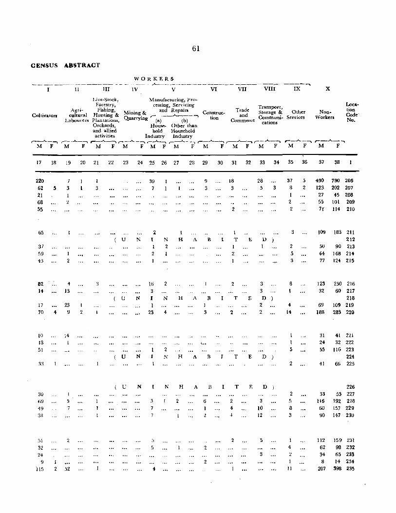
61
CENSUS ABSTRACT
Cultivators
WORKERS ___ A .. _____ · ____ ~ ___________ ---,..._.- ----...,._
II III IV V VI VII VIII IX
Agricultural
Labourers
Live-Stock, Mal1ufacturing, pro-Forestry, cessing, Sen· icing Fishing, M" & and Repairs
Hunting & mmg .A-plan (alions, Quarrying ,....(~-- (b) --. Orchards, House- Other than and allied hold HGusehold activities Industry Industry
Construe-tion
Trade Transport, and Storage & Other
Commerce Communi- Services cations
x
NonWorkers
Location Code' No.
,--_-A..._ ....... ,-_Jo.-_~ ,-_..A.._-","\ r---...A..-~ ,-_.A. .. ___ r--.A...-~ r--..A..--.. ,_..A...---. r--...A.._-._. ,-_...A.. ____ r---..A..-- ""'" M F M F M F M FMF M F M F M F M F M F M F
17
220 62 21 68 55
65
37 59 43
82 14
17
70
10 13 51
33
30 69 49
38
51
32 24
9 115
18
5
19
7
3
2
.. 13
23 4 9
I 2
:4
5
7
2
52
20 21
I
'2
1 3
3
22 23 24 25 26 27
u
u
u
u
30 7
2 N I N
1 2 2
16 3
N I 1
23
N
N
I
3
7 7
S
5
4
2
N
4
2
N
1
H
H
H
H
2
28 29
A
9
3
B
A B 1
A
A
3
~ ...
6
I
2
2
2
B
B
30 31 32 33 34 35 36
18
3
2
1
I T 1 2
2
I T
J
I
2
2
4 4
2
T
T
E
28 5
D
1
3 3
E D 2 2
E
E
D
3
10 12
5
3
D
3
37 8
1 '2 2
3
2 5 3
8
4
14
1
5
2
2 5
8 3
4
'2 J
11
5
2
37 38
430 790 206 123 202 207 27 45 208 55 101 209 7f 114 210
109 183 211 212
50 90 213 64 168 214 77 124 215
123 250 216 32 60 217
218 69 109 219
188 283 220
31 41 221 24 32 222 55 116 223
224 41 66 225
226 33 53 227
116 192 228 60 157 229 90 147 230
112 159 231
62 98 232 34 65 233 8 14 234
207 398 235

TEHSIL HIRANAGAR
Name of Location Village/Townl
Code WardfMohallaf
No. Enu~~r:~or's Block
2
236 Balooni
237 Sungaali
238 Chhan Kailna
239 Rajli 240 Chhan Mlagar
241 ~onaath
242 Ploona
243 Badiyal
244 Sanoora
245 Pantal
246 Randowal
247 Jasaath
248 Harsaath
249 Ghagwal
250 Raughu Chak
251 Gurah Jattan
252 Chhan Matlani
253 Tapiyal
254 Koohtah
255 Patta Rasana
256 Gurah Mehtian
257 Dhamiyal
258 Stoora
259 Bhayia
260 Mailu
261 Gara
262 Said 263 Sohaal
264 Kannah
265 Surara i66 Ratwana
Area ef Village in Occupied hectares R esi-
& of dential Town Houses
in Km".
3
325 471
53
56 122
1,221 130 117 459
127
129
223 266 26
189
115
367 648
549
383
168 78
242
580 532
303 367
154
391 1,823
425
4
43
23
9
5 44-
169 44
27
178
41
43
99 257 93
66
106 86 65
245
34
85 51
143 159 211
61 84-
27 45
202
118
No. of Households
5
43 82
9
5 44
169 46
30 178 41
49 105
259
98 66
107
86
65
257
36
8G 51
146 159
212
61 84 27
46 203
118
62
rotal Population (including
Institutional and Houseless
Population) Scheduled
Castes
V:'LLAGEWISE PRIMARY
Scheduled Tribes
Literate and
Educated Persons
,....----:----
Total Workers (I-IX)
,-____ ..A.. ____ -"'\ r--_..A---"'"'I r--..A--~ r--..A..-~ ~ __ _A.. __ -.....
P \1 F M F M F M F ,\1 F
6
219 527
62
32 241
1,108
244
163
107
277
38
IS
120
GOO 124
85 1,010 517
258 135
267 150 620 319
1,518 736 550 299
373 J94
786 377
573 296
404 209
1,596 796 323 16a
453 :238
320 153
745 383
1,000 517 1.3~G 673
421 220 479 241
181 95
243 117 1,197 596
6i6 355
3
112 250
24
14 121
508
120
78
9
20 15
J7
5
5
70 15
493 72 J 23 25
117 11 301 76
732 71 251 168
179 13
409 277 135 195 55
800 133
155
2l.~ 1
167 21
362 31 483 242 653 53
201 22 238 23
86
126 601 119 321 61
10
l!l J3
12
1 2
68
20
69 20
7 70 71
135 24
144 50
!l5
19
21 215
54
15 13
110
72
11 12 13
40 75 I:: 14 47
225
4fl 20
14 15
7 47 17 107
13 4 5
11 GB
50 24~
3 59
31 280 114 188
42 2 61
48 107 65
114 28 144
374 209 252
89 29 130
58 18 75
244 198 121 49 7 170
95 52 69
469 244 325
77 17 75
86 15 92
74 33 53 lSI 52 118
169 63 '227
153 6 296
85 20 81 99 27 124
20 2 53
54 13 46
163 41 285
119 20 159
16
4
3
J5 3
9
2
2
2
1 3
2

63
OENSUS ABSTRACT
WORKERS ~------------------------~----------------~--------~
I II III IV V VI VII VIII IX X
Cultivators
,.-_..A._--. 1\1 F
17 18
25 62 12 4
55
194-46 29.
131 ~2
45 67
III 26 62
62 159 43 69 58
49 32 44
132 223
~3 80 46 37
180 87
Agricultural
Labourers
Live-Stock, Manufacturing, Pro-Forestry, cessing, Servicing Fish:ing, Mining & and Repairs
Huntmg & n, . r-___ .A. ___ -,
Plantations, ",-uarrymg (a) (b) Orchards, House- OtRer thaD and allied hold Household activities Industry Industry
,--_.A._--.. ,-_..A- -- --. r--..A..-___ r--.A.-~ r--.A..-__ MF M FM FMFM F
19 20 21 22 23 24 25 26 27 28
3 8 32 4
5
13 (j
1 4
17
, I 2 20 2 3
7 15 I
25 3
2
2
12 7 28 2 7 4 2
2 13 2 4 I
4 5 2 5 3 4 :) 2 3
3 24
I
9 6 52 8
Construc_ tion
Trade and
Commerce
Transport, Storage &
Communi-cations
Other Services
,- ___ ..A.. ___ r--.A-.~-.. ,-_.A.. __ ~ r-_.A.---,
M FM FM F M F
29 30 31 32 33 34 35 36
7 2 2 2 5
4
3 7 3 22
2 2 3
2 7 9 22 3
3 2 3
7 2 9 2 5 35 II
n 20 13 62 13 28 13 8 26 2
6 4
9 2 8 '37
6 4
6 5 8 7
28 33 19 122 7 3 6
fl 5 9 :)
1 6 9 8 7 27 21
20 11 25 22 '2 II 21 34
I 12 7 II
3 2 :) 5 2 6 4 26 2
18 11 10 22
NonWorkers
37 38
60 112 170 250
25 24 13 14 52 121
351 508 65 119 54 78
329 489 74 '122
85 117 175 298 484 767 169 248 119 179
256 408 126 277 140 195 471 791
93 155
146 215 100 165 265 362 290 4BI
377 653
139 201 117 236 42 86 71 125
311 598 196 319
Location
Code No.
236 237 238 239 240
241
242 243 244 245
246 247 248 249 250
251 252 253 254 255
256 257 258 259 260
261 262 263 264 265 266

64
VILLAGEWISE PRIMARY·
TEHSIL HIRANAGAR r· -----~ .. -
l'iame of Area of
Location Village/Townl Village in Occupied No. of Total Population
Code Ward/Mohalla! hectares Resi- House-(Including Literate
No. Urban & of dential holds Institutional and Enumerator's Town Houses and Homeless Scheduled Scheduled Educated Total Workers
Block in Km'. Population) Castes Tribes Persons (I-IX) ~---~----~~-~-~ ,-_....A.. __ ~ ,-_ _..._ - .~ ,..---..."....--"'l
P "j F M F M F M F M F
2 3 4 5 6 7. S 9 IO I I 12 IS 14 IS 16
URBAN AREA
8/IV Hiranagar Notified Area 1.10 K:rn2 669 678 3,744 1,884 1,860 252 257 ... 1,095 718 774 63 Ward No. I Mandi E. B. (I) 40 45 274 127 147 17 13 80 60 36
2 Ward No. 2 Mandi Bhabkialian E. B. (2) 58 58 38) 170 219 112 106 47 2
3 Ward No.3 Mohalla Hirijan E. B. (3) 70 71 437 215 222 186 i97 58 14 110 I'
4 Ward No. 4 Mohalla Acharjian E. B. (4) 194 196 986 522 464 37 35 336 193 245 25
5 Ward No.5 MohaHa Chi veran E. B. (5) 106 106 612 311 301 3 2 194 121 117 9
6 Ward No. 6 J.lohalla Thana E. B. (6) 109. 110 611 327 284 8 10 184 112 143 9
7 Ward No. 7 Mohalla Patiyaran E. B. (7) 92 92 435 212 223 131 1I2 76 16

65
CENSUS ABSTRACT
WORKERS --_. ----------- - _______ ...A-__________________ ---- ---- -----~
I II I II IV V VI VII VIII IX x
Cultivators
17 18
Live-Stock. Manufacturing, pro-
Agricultural
Labourers
Forestry, . cessing, Servicing Fishing, Mining & and Repairs Construc-
Hunting & "uarrying r-(-a")---'--(-b) --, Plantations, '<;
Trade and
Transport, Storage & Communi-
Orchards, House- Other than cations
tion Commerce
and allied hold Householol activities Industrv Industrv
r--..A..--, ,---"----" r- ._ ..A- - ~ r---A.. ... ~ r--..A--~ r--..A..-~ ~--"-----""\ ,-...A..--"-l
M F M F M F MF M F M F M F M F
19 20 21 22 23 24 25 26 27 28 29 30 31 32 33 34
Other Non-Services Workers
35 36 37 38
Location Code No.
61 18 20 27 4 39 1 45 112 96 306 58 1,110 1,797 8/1V
11 5 16 91 146
9 5 2 5 :3 22 2 2 /
18 10 9 13 5 38 15 105 221 3
5 5 5 27 15 55 23 109 24 277 439 4
4 3 4 24 6 22 II 43 9 194 292 5
13 2 5 15 19 11 63 8 184 275 6
5 2 12 2 14 5 38 14 136 207 7


ERRATA
KATHUA DISTRICT
page Particulars of Entry Col. No. For Read No.
7 i3rd line from below term terms 16 Caption 5 1971 1970 16 Against Bashohli Tehsil 15 Sservices Services
Village Directory
33 L. C. No. 16 12 T (8) *C (9) T (9) .C (9) 37 L. C. No. 69 13 430 431 62 L. C. No. 90 4 C. S (1) 67 L. C. No. 150 15 368 363
Prhuary Census Abstract
6 L. C. No. 8/3 15 21,886 21,686 14 L. C. No. 48 15 33 53 35 L. C. No. 115 35 6 53 L. C. No. III 25 6 3 58 L. C. No. 190 3 123 128 60 L . C. No 211 3 180 503