Learning about precipitation orographic enhancement from ...
Upload
independentCategory
view
1download
0
HYDROLOGICAL PROCESSESHydrol. Process. 22, 3998–4008 (2008)Published online 13 June 2008 in Wiley InterScience(www.interscience.wiley.com) DOI: 10.1002/hyp.7073
Distribution of snow accumulation on the Svartisen ice cap,Norway, assessed by a model of orographic precipitation
T. V. Schuler,1,2* P. Crochet,3 R. Hock,4,5 M. Jackson,2 I. Barstad6 and T. Johannesson3
1 Department of Geosciences, University of Oslo, Norway2 Norwegian Water Resources and Energy Directorate (NVE), Norway
3 Icelandic Meteorological Office, Iceland4 Geophysical Institute, University of Alaska, Fairbanks, USA5 Department of Earth Sciences, Uppsala University, Sweden
6 Bjerknes Centre for Climate Research, Bergen, Norway
Abstract:
We apply a linear model of orographic precipitation (LT model) to estimate snow accumulation on the western Svartisenice cap (220 km2) in northern Norway. This model combines 3D airflow dynamics with simple parameterizations of cloudphysics. The model is forced by large-scale atmospheric input variables taken from the ECMWF Re-analysis (ERA-40) of theEuropean Center for Medium Range Weather Forecast (ECMWF), and the model parameters are kept constant for the entiresimulation period, after optimization. The domain covers a 120 ð 125 km area surrounding the ice cap. The model is runusing a 1-km resolution digital elevation model, and 6-h time steps over the period from 1958 to 2002. Precipitation data fromsurrounding meteorological stations and winter glacier mass balance measurements on several glaciers within the region areused to evaluate the model results. Precipitation obtained from the LT model agrees well with observations from precipitationgauges and there is also fair agreement between model results and specific winter mass balance observations on the ice capif these are corrected for winter rain. The LT model reproduces well the spatial pattern of winter accumulation across theice cap as well as the area-averaged winter mass balances of several other glaciers in the region. This indicates that it is auseful tool in providing high-resolution, deterministic estimates of precipitation in complex terrain as required for distributedhydrological and/or glacier mass balance modelling of unmeasured areas. Copyright 2008 John Wiley & Sons, Ltd.
KEY WORDS snow distribution; orographic precipitation; downscaling; glacier mass balance; modelling; ERA-40
Received 1 November 2007; Accepted 2 April 2008
INTRODUCTION
The accurate assessment of precipitation is a crucial com-ponent in any attempt to model glacier mass balance andrunoff from glacierized catchments. However, modellingprecipitation in high mountain areas is challenging dueto large spatial variability of precipitation and sparsityof data especially at higher elevations (e.g. Daly et al.,1994). In addition, the quality of precipitation-gaugeobservations may be affected by wind-induced under-catch, in particular when precipitation falls as snow.Low spatial coverage and a bias towards valley observa-tions render traditional interpolation methods problematicin complex terrain, although combining these methodswith regression models (e.g. Guan et al., 2005) cap-tures at least some of the effects of topography. Atthe other end of the spectrum in terms of complexity,high-resolution physically based numerical models, forexample the MM5 model (Grell et al., 1995), provide apromising tool for spatially distributed precipitation esti-mates. However, the large computational requirementscurrently limit the scope of applications of such models.To our knowledge, high-resolution precipitation estimates
* Correspondence to: T. V. Schuler, Department Geosciences, Universityof Oslo, Norway. E-mail: [email protected]
derived from physically based numerical models are notyet available in Norway.
In glacier mass balance and runoff modelling, precip-itation is often extrapolated using a linear increase ofprecipitation with elevation and a threshold temperatureto discriminate between snow and rainfall. The gradi-ent of precipitation with elevation, threshold temperatureand under-catch correction are treated as model parame-ters that are tuned to fit available observations (e.g. Hockand Holmgren, 2005; Schuler et al., 2005; de Woul et al.,2006). This simple scheme ignores all factors other thanelevation that contribute to spatial variability in precip-itation. Elaborating on the analyses by Taurisano et al.(2007), Schuler et al. (2007) modelled snow accumula-tion across the Austfonna ice cap in Svalbard based onmultiple regression relationships that included the spatialcoordinates as predictors to account for the considerablehorizontal accumulation gradients observed across the icecap. A similar approach involving vertical and horizon-tal gradients was used by Johannesson et al. (2006) formodelling precipitation on the Hofsjokull ice cap andby Bergstrom et al. (2007) on the Langjokull and Vat-najokull ice caps in Iceland. However, such empiricismrestricts the transferability of these types of models tounmeasured regions due to the need for site-specific cali-bration based on detailed measurements. In addition, the
Copyright 2008 John Wiley & Sons, Ltd.

SNOW ACCUMULATION ON THE SVARTISEN ICE CAP 3999
spatial variability is described by only a few indepen-dent variables using statistical relationships rather thanby physical principles. The validity of such models mayalso be questioned since model parameters may changedue to the inter-annual variability in both precipitationpatterns as well as precipitation gradients.
Crochet et al. (2007) applied an approach of inter-mediate complexity to estimate precipitation in Ice-land. They dynamically down-scaled precipitation fromcoarse resolution European Center for Medium RangeWeather Forecast (ECMWF) Re-Analysis (ERA-40) data(Kallberg et al., 2004; Uppala et al., 2005) over theperiod 1958–2002 to a 1-km resolution grid for the wholeof Iceland using the linear model of orographic precip-itation (hereafter referred to as the LT model) proposedby Smith and Barstad (2004). They obtained good agree-ment with observations from both meteorological stationsand glacier mass-balance data at time scales of months toseasons, and a variable agreement on a daily time scale.
The purpose of this study is to follow an approachsimilar to Crochet et al. (2007) and estimate a timeseries of gridded precipitation using the LT model on theSvartisen ice cap (368 km2) in northern Norway whereglacier meltwater is used for hydropower (Kennett et al.,1997). We run the model at a horizontal resolution of1 km for 1958 to 2002 using atmospheric input variablesfrom ERA-40, available at 6-h time steps. The results arecompared to precipitation-gauge data for the surroundingarea and glacier mass balance measurements. Finally, weproduce a snow accumulation index map for the entireice cap, which describes mean spatial variability in termsof deviation from the mean for each glacierized pixel ofthe 1 ð 1 km grid.
MODEL DESCRIPTION
The LT model is an extension of the well-known upslopeprecipitation model (Smith, 1979). A detailed descriptionis given by Smith and Barstad (2004) and a description ofits application by Barstad and Smith (2005). The modelcalculates precipitation resulting from forced orographiclifting of an air mass crossing an obstacle (mountainridge). The air mass is assumed to be saturated and to passover the obstacle without blocking. On the windward sideof the mountain, cloud water resulting from condensationis advected downstream, while changing into fallinghydrometeors. On the leeward side, the condensed waterand hydrometeors evaporate or precipitate, dependingon conditions. According to the model formulation, thespatial pattern of precipitation is determined by thewidth and shape of the mountain ridge, the ambientconditions (temperature, wind speed, influx of watervapour, and stability of the air column), the airflowdynamics (variation of vertical and horizontal velocitieswith altitude), and the competition between the micro-physical processes controlling the rate of condensationand conversion of cloud water into hydrometeors, andtheir fallout time to the ground. Nevertheless, the LT
model represents a computationally efficient tool toestimate precipitation at fine temporal and horizontalscales, over long periods of time. However, the modelis not appropriate when the atmosphere is unstable, anddoes not accommodate situations where the air mass isblocked by the mountain ridge.
The model consists of a pair of steady-state equationsdescribing vertically integrated advection of cloud waterand hydrometeors (e.g. raindrops or snowflakes):
Dqc
Dt³ U Ð rqc D S � qc/�c �1�
Dqh
Dt³ U Ð rqh D qc/�c � qh/�f, �2�
where (qc, qh) are vertically integrated cloud water andhydrometeor density. S is the rate of transformation tocloud water (source term; as a response to lifting overterrain) and U D Ux C Vy is the wind vector. The timerequired to transform cloud water into hydrometeors (�c)and to further precipitate this to the ground (�f) controlsthe amount of precipitation. The term (qh/�f) representsthe final sink when concatenating Equations (1) and(2) and corresponds to the precipitation rate (P). Byspectral decomposition (indicated by (^)) and algebraicmanipulation, the following transfer function relatingthe Fourier-transform of the terrain elevation (Oh) to theprecipitation field is obtained:
OP (k , l ) D Cw is Oh(k , l )[1 � imH w][1 C istf][1 C istc]
�3�
Here, � D Uk C Vl is the intrinsic frequency, m D[((Nm2 � �2
) /�2
) (k2 C l2
)]1/
2signifies the vertical
wave number, Hw D �Rv T20/�L�� is the vertical height
scale of water vapour in the atmosphere, k and l are thehorizontal components of the wave number and Cw D�v0 m/� is a ‘sensitivity lifting factor’, equal to unityfor moist neutral air. Further, �v0 is the density of vapourat the surface, m and � denote the moist adiabatic andthe environmental lapse rate, respectively. Rv is the gasconstant for vapour, T0 the surface temperature, and L isthe latent heat of vapourization. In contrast to the upslopemodel (Smith, 1979), the source term S is expanded toinclude airflow dynamics with flow both over and aroundterrain obstacles that depends among other things on therelative width of the obstacles. This new source term isequal to the numerator over the first term in brackets inthe denominator in Equation (3), cf. Barstad et al. (2007).The micro-physics (i.e. descriptions of conversion andfallout) are represented by the two latter brackets in thedenominator. The orographic enhancement is obtained bytransforming OP back to the space domain, and addingthe large-scale background precipitation P1 to yield thedown-scaled precipitation field PLT�x, y�
PLT�x, y� D max{ (∫ ∫
OP�k, l� ei�kxCly�dkdl
)
C P1, 0}
�4�
Copyright 2008 John Wiley & Sons, Ltd. Hydrol. Process. 22, 3998–4008 (2008)DOI: 10.1002/hyp

4000 T. V. SCHULER ET AL.
The background precipitation P1 represents large-scale frontal and convective precipitation, i.e. contribu-tions other than from orographic enhancement.
In order to determine Equation (3), temperature, stabil-ity of the air Nm and a representative wind in the moistlayer are needed. For a moist airflow with strong winds(i.e. large values of U, V), the influx of water vapour islarge. An air column stable against vertical movements(i.e. small values of Nm) will produce less condensa-tion because a smaller amount of the air column will belifted. Slow micro-physics (i.e. long time scales �c and�f) or narrow mountains will bring available condensateinto the lee side where it is subjected to evaporation,reducing the amount of precipitation. Thereby, the modelis capable of simulating an asymmetric precipitation pat-tern across a topographic obstacle with less precipitationon the lee side than on the stoss side.
STUDY AREA AND OBSERVATIONS
The model domain covers an area of 120 ð 125 km2 innorthern Norway (Figure 1). The area is characterizedby complex topography including the western (220 km2)and eastern (148 km2) Svartisen ice cap, steep mountains,numerous fjords and valleys. Elevation ranges from sealevel to about 1600 m a.s.l. We focus on the westernSvartisen ice cap since long-term records of glacier massbalance are available for this area.
In the context of hydropower exploitation, the Nor-wegian Water Resources and Energy Directorate (NVE)conducts annual glacier mass balance measurements (e.g.Kjøllmoen et al., 2006) on two outlet glaciers of westernSvartisen: Engabreen (¾38 km2, 1970–present) and Stor-glombreen (¾62 km2, 1985–1988, 2000–2005). Massbalance measurements have also been conducted onthree smaller glaciers nearby: Høgtuvbreen (¾2Ð6 km2,1971–1977), Svartisheibreen (¾5Ð4 km2, 1988–1994)and Trollbergdalsbreen (¾1Ð5 km2, 1970–1974 and1990–1994) (Figure 1). For Engabreen and Storglom-breen, detailed snow depth data are available for1985–1988 and 2000–2002. Each May, snow depth wasmeasured at about 200 points along profiles on Stor-glombreen and Engabreen, mainly at elevations above900 m a.s.l. These data are converted into water equiv-alent considering snow densities derived from severalsnow pits and represent specific winter mass balances.For comparison with model results, the data were re-sampled to the 1-km modelling grid by averaging allmeasurements within one grid cell for each year. Inaddition, we also use mean specific (i.e. area-averaged)glacier winter mass balances of all glaciers in themodel domain with available mass balance measure-ments. These quantities are reported annually by NVE(e.g. Kjøllmoen et al., 2006) and are derived from inter-polating point values and integrating these over the entireglacier.
0 20 40 60 80
0
200
400
600
800
1000
1200
1400
1600
Area/number %
Ele
vatio
n (m
a.s
.l.)
areamet stations
B6GL LeiråmoHS SvartisheibreenT Trollbergdalsbreen
B6
GL
S
T
H
Høgtuvbreen
GlomfjordBodø VI(a)
(b)
Figure 1. (a) Model domain (120 ð 125 km) including the western and eastern Svartisen ice caps and other glaciers (black outlines). Colours denotethe modelled annual precipitation (mm a�1) averaged over the reference period 1961–1990, while contour lines represent elevations with 200 mspacing. White dots mark the locations of meteorological stations. Black dots refer to the grid cells where winter snow accumulation data areavailable. The locations of the individual glaciers are outlined in black. The insert shows the location within Norway; (b) Hypsometric distribution(elevation-area) using 200 m elevation bands (black), and percentage of meteorological stations per elevation band (grey). Labels on the y-axis showthe minimum elevation of each band. Low elevations are overrepresented by the measurements and ¾58% of the land area lies above the highest
meteorological station (380 m a.s.l.)
Copyright 2008 John Wiley & Sons, Ltd. Hydrol. Process. 22, 3998–4008 (2008)DOI: 10.1002/hyp
SNOW ACCUMULATION ON THE SVARTISEN ICE CAP 4001
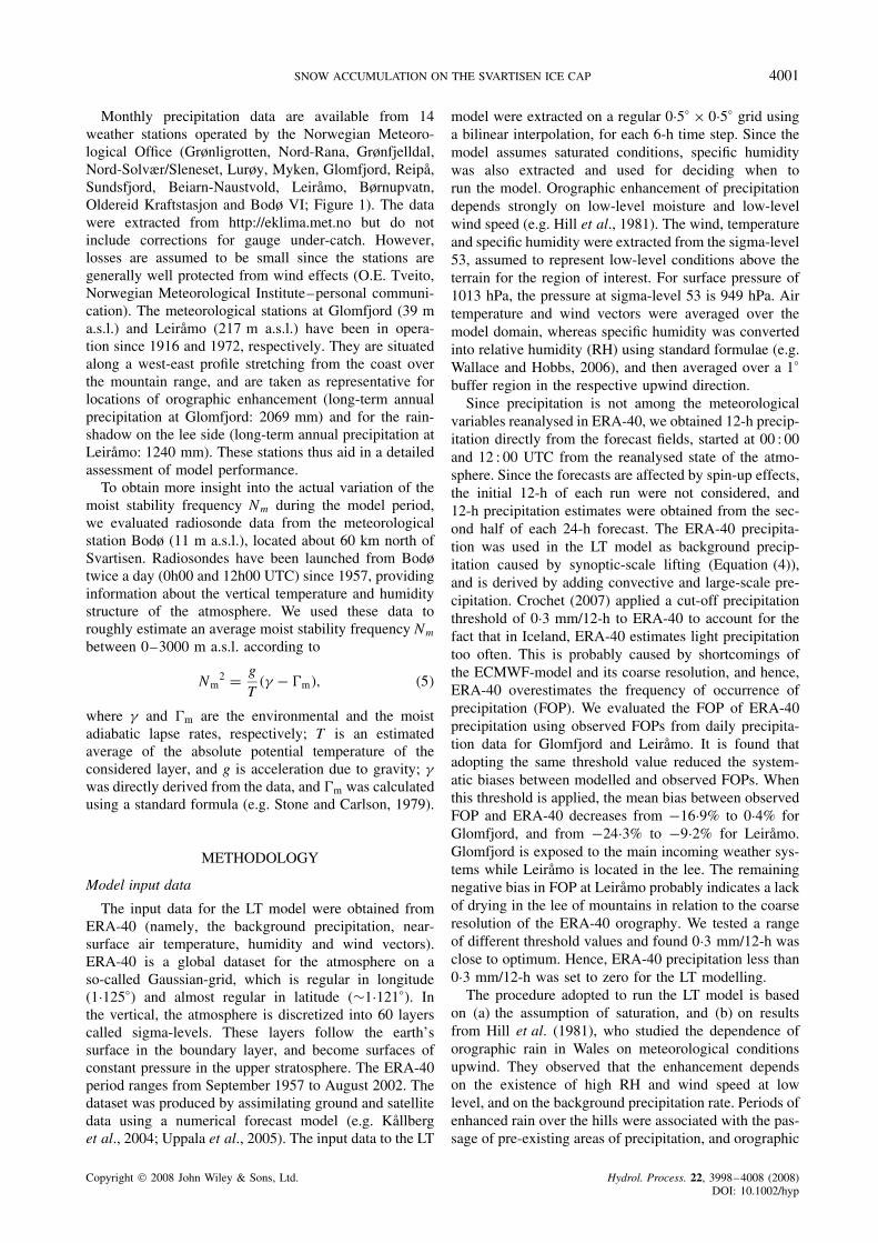
Monthly precipitation data are available from 14weather stations operated by the Norwegian Meteoro-logical Office (Grønligrotten, Nord-Rana, Grønfjelldal,Nord-Solvær/Sleneset, Lurøy, Myken, Glomfjord, Reipa,Sundsfjord, Beiarn-Naustvold, Leiramo, Børnupvatn,Oldereid Kraftstasjon and Bodø VI; Figure 1). The datawere extracted from http://eklima.met.no but do notinclude corrections for gauge under-catch. However,losses are assumed to be small since the stations aregenerally well protected from wind effects (O.E. Tveito,Norwegian Meteorological Institute–personal communi-cation). The meteorological stations at Glomfjord (39 ma.s.l.) and Leiramo (217 m a.s.l.) have been in opera-tion since 1916 and 1972, respectively. They are situatedalong a west-east profile stretching from the coast overthe mountain range, and are taken as representative forlocations of orographic enhancement (long-term annualprecipitation at Glomfjord: 2069 mm) and for the rain-shadow on the lee side (long-term annual precipitation atLeiramo: 1240 mm). These stations thus aid in a detailedassessment of model performance.
To obtain more insight into the actual variation of themoist stability frequency Nm during the model period,we evaluated radiosonde data from the meteorologicalstation Bodø (11 m a.s.l.), located about 60 km north ofSvartisen. Radiosondes have been launched from Bodøtwice a day (0h00 and 12h00 UTC) since 1957, providinginformation about the vertical temperature and humiditystructure of the atmosphere. We used these data toroughly estimate an average moist stability frequency Nm
between 0–3000 m a.s.l. according to
Nm2 D g
T�� � m�, �5�
where � and m are the environmental and the moistadiabatic lapse rates, respectively; T is an estimatedaverage of the absolute potential temperature of theconsidered layer, and g is acceleration due to gravity; �was directly derived from the data, and m was calculatedusing a standard formula (e.g. Stone and Carlson, 1979).
METHODOLOGY
Model input data
The input data for the LT model were obtained fromERA-40 (namely, the background precipitation, near-surface air temperature, humidity and wind vectors).ERA-40 is a global dataset for the atmosphere on aso-called Gaussian-grid, which is regular in longitude(1Ð125°) and almost regular in latitude (¾1Ð121°). Inthe vertical, the atmosphere is discretized into 60 layerscalled sigma-levels. These layers follow the earth’ssurface in the boundary layer, and become surfaces ofconstant pressure in the upper stratosphere. The ERA-40period ranges from September 1957 to August 2002. Thedataset was produced by assimilating ground and satellitedata using a numerical forecast model (e.g. Kallberget al., 2004; Uppala et al., 2005). The input data to the LT
model were extracted on a regular 0Ð5° ð 0Ð5° grid usinga bilinear interpolation, for each 6-h time step. Since themodel assumes saturated conditions, specific humiditywas also extracted and used for deciding when torun the model. Orographic enhancement of precipitationdepends strongly on low-level moisture and low-levelwind speed (e.g. Hill et al., 1981). The wind, temperatureand specific humidity were extracted from the sigma-level53, assumed to represent low-level conditions above theterrain for the region of interest. For surface pressure of1013 hPa, the pressure at sigma-level 53 is 949 hPa. Airtemperature and wind vectors were averaged over themodel domain, whereas specific humidity was convertedinto relative humidity (RH) using standard formulae (e.g.Wallace and Hobbs, 2006), and then averaged over a 1°
buffer region in the respective upwind direction.Since precipitation is not among the meteorological
variables reanalysed in ERA-40, we obtained 12-h precip-itation directly from the forecast fields, started at 00 : 00and 12 : 00 UTC from the reanalysed state of the atmo-sphere. Since the forecasts are affected by spin-up effects,the initial 12-h of each run were not considered, and12-h precipitation estimates were obtained from the sec-ond half of each 24-h forecast. The ERA-40 precipita-tion was used in the LT model as background precip-itation caused by synoptic-scale lifting (Equation (4)),and is derived by adding convective and large-scale pre-cipitation. Crochet (2007) applied a cut-off precipitationthreshold of 0Ð3 mm/12-h to ERA-40 to account for thefact that in Iceland, ERA-40 estimates light precipitationtoo often. This is probably caused by shortcomings ofthe ECMWF-model and its coarse resolution, and hence,ERA-40 overestimates the frequency of occurrence ofprecipitation (FOP). We evaluated the FOP of ERA-40precipitation using observed FOPs from daily precipita-tion data for Glomfjord and Leiramo. It is found thatadopting the same threshold value reduced the system-atic biases between modelled and observed FOPs. Whenthis threshold is applied, the mean bias between observedFOP and ERA-40 decreases from �16Ð9% to 0Ð4% forGlomfjord, and from �24Ð3% to �9Ð2% for Leiramo.Glomfjord is exposed to the main incoming weather sys-tems while Leiramo is located in the lee. The remainingnegative bias in FOP at Leiramo probably indicates a lackof drying in the lee of mountains in relation to the coarseresolution of the ERA-40 orography. We tested a rangeof different threshold values and found 0Ð3 mm/12-h wasclose to optimum. Hence, ERA-40 precipitation less than0Ð3 mm/12-h was set to zero for the LT modelling.
The procedure adopted to run the LT model is basedon (a) the assumption of saturation, and (b) on resultsfrom Hill et al. (1981), who studied the dependence oforographic rain in Wales on meteorological conditionsupwind. They observed that the enhancement dependson the existence of high RH and wind speed at lowlevel, and on the background precipitation rate. Periods ofenhanced rain over the hills were associated with the pas-sage of pre-existing areas of precipitation, and orographic
Copyright 2008 John Wiley & Sons, Ltd. Hydrol. Process. 22, 3998–4008 (2008)DOI: 10.1002/hyp

4002 T. V. SCHULER ET AL.
enhancement seldom occurred in the absence of back-ground precipitation. We thus ran the LT model when theaveraged upstream RH (at sigma-level 53) exceeded 90%,assuming that saturation was obtained during orographiclifting. We further assumed that orographic precipita-tion is formed in association with a pre-existing area ofprecipitation defined by ERA-40. Outside the ERA-40precipitation field, we did not consider orographicenhancement. This implies that we did not consider oro-graphic enhancement when RH �90% but assumed theERA-40 background precipitation, if non-zero, withoutfurther treatment. This simple procedure was used byCrochet et al. (2007), and proved satisfactory. Other diag-nostic precipitation models (e.g. Sinclair, 1994; Kunz andKottmeier, 2006) have also used RH thresholds to reduceor prevent precipitation when unsaturated conditions pre-vailed upstream.
The topography on which the ERA-40 dataset is basedhas coarse spatial resolution and is heavily smoothed. Forinstance, our study region is represented by six grid pointsreaching a maximum elevation of only a few hundredmetres while the actual topography exceeds 1600 m.Nevertheless, the ERA-40 precipitation includes someorographic enhancement based on its assumed orography.
To eliminate this orographic component from the ERA-40precipitation, we applied the LT model to the ERA-40topography and subtracted the resulting ‘orographic’precipitation from the ERA-40 background precipitation.Negative values were set to zero. This procedure ensuresa clear separation of background precipitation (providedby the corrected ERA-40 precipitation) and orographicprecipitation (obtained from running the LT model).Driven by the adjusted ERA-40 precipitation, the LTmodel was applied on a digital elevation model of 1 kmresolution which was derived from the official Norwegian25 m digital elevation model (Statens Kartverk). Thisdata set reproduces much of the complexity of theactual topography in the study area. Our methodology isillustrated in Figure 2. To avoid unwanted effects of thespectral decomposition at the boundaries of the domain,the 120 ð 125 km grid is wrapped into the centre of anouter domain consisting of 256 ð 256 grid cells.
Model calibration and validation
The LT model has three model parameters (the moiststability frequency Nm, the conversion and fallout times�c and �f), which were not explicitly estimated at eachtime step but obtained by optimization, i.e. varying their
Run LTmodel on DEM_1 --> OP_2 P = max(BGP_adj + OP_2,0)
Ste
p 2
Average over domain(T, U, V)
or over upwind region(RH)
Pre
-p
roce
ssin
g
P-fields:monthly, seasonal, annual
P-time series:for selected points
Po
st-
pro
cess
ing
ERA-40topography
(0.5°)PERA40 (0.5°)
LT-Modeltopography
Dat
a
Run LTmodel on DEM_2 --> OP_1(simulate orographic effect inherent in ERA40) BGP_adj = max(BGP – OP_1,0)
Ste
p 1
Interpolationto 1km
resolution
--> DEM_2
Interpolationto 1km
resolution
--> BGP
DEM_1 (1km)
ERA-40 data
(T, U, V, RH)
Figure 2. Workflow of the applied methodology. DEM D Digital Elevation Model; T, U, V, RH D meteorological variables as defined in the text;PERA40 D precipitation from ERA-40; BGP( adj) D �adjusted� background precipitation; OP D orographic precipitation
Copyright 2008 John Wiley & Sons, Ltd. Hydrol. Process. 22, 3998–4008 (2008)DOI: 10.1002/hyp

SNOW ACCUMULATION ON THE SVARTISEN ICE CAP 4003
values until good agreement was obtained between modelresults and available observations over the calibrationperiod. The optimum values of Nm, �c and �f, were thenkept constant throughout the entire modelling period, andadditionally, we assumed �c D �f (Smith and Barstad,2004; Barstad and Smith, 2005; Crochet et al., 2007).According to Smith and Evans (2007) the behaviourof the model is determined by the total time delay(�c C �f), whereas the partition between �c and �f is lessimportant.
The model was manually calibrated using winter totalsof precipitation-gauge data from 14 stations (Figure 1)and specific winter mass balance measurements for theseven years (1985–1988 and 2000–2002) when detailedsnow depth measurements for much of the western Svar-tisen ice cap are available. We selected these datasetsfor model calibration since they provide good spatialcoverage across the domain, and also over the entireelevation range. The latter is insufficiently representedby the precipitation-gauge data alone (Figure 1(b)). Toobtain consistency between the two datasets, we derivedan estimate of winter precipitation from the winter massbalance data because winter mass balance data are likelyto underestimate winter precipitation, because they onlyrefer to snow precipitation, not to precipitation that fallsas rain and runs off directly. In addition, any snow thatmelts and runs off or re-freezes below the last sum-mer surface (i.e. internal accumulation) is not includedin the glacier observation. We considered the neglectof rain to be most significant, especially during mildwinters with frequent and prolonged periods of above-freezing air temperatures. We compute rainfall usingthe precipitation routine of a distributed mass balancemodel which has previously been calibrated and appliedto Engabreen, an outlet glacier of Svartisen (Schuleret al., 2005). Using the model parameters obtained inthat study, we calculated the amount of rainfall in eachgrid cell containing winter mass balance measurementsaccording to the distribution of precipitation and tem-perature by the mass balance model. Thus, obtainedwinter rain is added to the measured water equiva-lent of the snow cover to yield an estimate of winterprecipitation. We did not, however, correct the win-ter balance for the effect of ablation during the winterseason, nor subtract rain that re-freezes in the snow-pack and is therefore included in the winter balancemeasurement.
For model validation, we used data from different peri-ods or from different locations than those used for calibra-tion. The records of mean specific winter mass balancesof Høgtuvbreen, Svartisheibreen and Trollbergdalsbreenwere not used for calibrating the model and were there-fore used for model validation. The long-term recordof mean specific winter mass balance (1970–2002) forEngabreen, and the precipitation-gauge data outside thecalibration period (i.e. 1957–1984 and 1989–1999) werealso used for model validation. Table I presents anoverview of the different datasets used for calibratingand validating the model.
RESULTS AND DISCUSSION
Model calibration
Model performance was evaluated by comparing thesimulated winter precipitation with winter precipitationfrom precipitation-gauge data and winter precipitationderived from glacier mass balance measurements. Forthis purpose, model results were extracted at locationscorresponding to those of the observations and integratedover a fixed period from 1 October to 31 May for theyears 1985–1988 and 2000–2002. Instead of using aformal and automatic calibration procedure, the param-eter values were changed manually until good agree-ment between model results and observations was evalu-ated by visual inspection. Good agreement was judgedin terms of: (a) maximizing the quality of agreementbetween modelled and measured spatial patterns pre-cipitation (correlation); (b) minimizing the bias indica-tive of systematic deviations; and (c) maximizing theroot mean square error of the model by reducing thescatter about the observations. During calibration, Nm
and � were changed over a range of plausible val-ues in steps of 0Ð001 s�1 and 200 s, respectively. Theparameter values thus obtained are Nm D 0Ð004 s�1 and� D 1200 s. Crochet et al. (2007) found the same valuesfor Iceland. However, they did not account for the oro-graphic effect inherent in the ERA-40 precipitation andhence, the parameter values are not directly compara-ble. Johannesson et al. (2007) re-estimated precipitationin Iceland using the LT model and accounted for the oro-graphic effect inherent in the ERA-40 precipitation. Theyreport slightly different values, with Nm D 0Ð003 s�1 and� D 1500 s.
Figure 3 shows a scatter plot of modelled versusobserved values during the calibration period usingthe optimized parameter set. Also presented are thecorresponding values extracted directly from the ERA-40precipitation fields to illustrate the effect achieved bythe downscaling procedure. Due to the coarse resolutionof the topography used in ERA-40, it considerablyunderestimates winter precipitation, especially at higherelevation where it deviates by up to a factor of fourfrom the observations. Comparing the performance ofERA-40 and the LT model, we find that using the LTmodel not only reduces the bias (161 mm compared to1884 mm) but also decreases the standard deviation ofthe residuals (407 mm versus 907 mm). The figure showsthat the LT model downscales the rather featureless andunderestimated ERA-40 precipitation field to produce aprecipitation field with similar magnitude and range ofvariation as the observations. However, the scatter is largein some years, i.e. in 1986 and 1987.
In Figure 4 we present mean values of the temperatureand rain precipitation as derived from the mass balancemodel (Schuler et al., 2005) for the elevation band1200–1400 m a.s.l., which accounts for roughly 35%of the surface area of the ice cap. This corroboratesthe observations that winter rainfall events even at thehighest elevations of Svartisen are not uncommon. The
Copyright 2008 John Wiley & Sons, Ltd. Hydrol. Process. 22, 3998–4008 (2008)DOI: 10.1002/hyp

4004 T. V. SCHULER ET AL.
Table I. Datasets used for model calibration and validation
Calibration Validation
Precipitation-gauge data 14 meteorological stations,winter months (Oct–May):1985–1988, 2000–2002
14 meteorological stations, allmonths 1957–1984,1989–1999
Specific mass balance Engabreen C Storglombreen1985–1988, 2000–2002
—
Mean specific mass balance — Engabreen (1970–2002)Høgtuvbreen (1971–1977)Svartisheibreen (1988–1994)Trollbergdalsbreen (1970–1974,
1990–1994)
0 1000 2000 3000 4000 50000
1000
2000
3000
4000
5000
1985 1986 1987 1988 2000 2001 2002
Observed (mm)
Mod
elle
d (m
m)
Figure 3. Winter precipitation obtained by the LT model (1 October–31May) versus winter precipitation derived from precipitation-gauge data(crosses) and from glacier mass balance measurements on western Svar-tisen ice cap (stars) for the years 1985–1988 and 2000–2002 (calibrationperiod). The dots represent the corresponding values derived from inter-polating ERA-40 data. The specific mass balances are arithmetic averagesof all point measurements per grid cell where measurements were madeto which rain computed by a distributed glacier mass balance model was
added to obtain winter precipitation
amount of winter rain that was added to the observedsnow water equivalent was largest for the two warmestyears, 2000 and 2002 (Figure 4). The performance of themodel is lowest for the years 1986 and 1987. Part of thesedeviations may be explained by the different intervalsto which the measured mass balance and the modelledprecipitation in the various years correspond. The massbalance measurements are based on the stratigraphicmethod where mass balance is measured relative to thepreceding summer surface. Hence, these values referto a budget period of unknown length. In contrast,modelled winter precipitation was integrated over afixed period (1 October–31 May). Any differences induration between these two measures might contribute toa mismatch between model results and observations. Infact, the field reports (e.g. Kjøllmoen et al., 2006) andmeteorological data indicate that in 1986 and 1987 theaccumulation period started before 1 October. Therefore,
the measured snow accumulation may be larger than thewinter precipitation accumulated over a fixed period (1October–31 May).
Sensitivity tests confirmed that, in general, an increasein the moist stability frequency Nm leads to less oro-graphic enhancement, and thus, to reduced precipitationdifferences between the stoss and lee sides of topographicobstacles. Changes in � have an effect similar to changesin Nm, such that longer � (or larger Nm) results in toolittle precipitation on the windward side and too much onthe lee side. These sensitivity tests agree with the resultsobtained by Smith and Barstad (2004) and Barstad andSmith (2005).
Finally, we investigated the possibility that the varia-tion in model performance for different years is relatedto shortcomings in the model formulation or applica-tion. The misfit could result from significantly differentweather patterns (e.g. in terms of moisture flux direc-tion and/or magnitude) that the model is not capable ofcorrectly handling. We found that neither direction normagnitude of the moisture flux in 1986 and 1987 exhibitsignificant deviation from other years. The shortcomingof our method might also be related to the use of con-stant parameter values for Nm and � although they varyin time, and are different for different weather patterns.Although the seasonally averaged Nm obtained from theradiosonde data at Bodø is observed to vary from one yearto the next, there is no significant correlation between thisvariability and the root mean square error of the modelresults. This suggests that the mismatches between data
1985 1986 1987 1988 2000 2001 20020
200
400
600
800
Rai
n pr
ecip
itatio
n (m
m)
-8
-6
-4
-2
0
Tem
pera
ture
(°C
)
Figure 4. Rain precipitation (grey bars) and mean air temperature com-puted for the elevation interval 1200–1400 m a.s.l. during the winter
period October to May for the years 1985–1988 and 2000–2002
Copyright 2008 John Wiley & Sons, Ltd. Hydrol. Process. 22, 3998–4008 (2008)DOI: 10.1002/hyp

SNOW ACCUMULATION ON THE SVARTISEN ICE CAP 4005
0 200 400 600 8000
100
200
300
400
500
600
700
800
r2 = 0.75
Observed (mm)
Mod
elle
d (m
m)
-40 -30 -20 -10 0 10 20 300
50
100
150
200
250
300
350
400
Deviation %
Ele
vatio
n (m
a.s
.l.)
(a) (b)
Figure 5. (a) Modelled versus observed monthly precipitation sums for all 14 stations during the validation period (1957–1984, 1989–1999), includingall modelled data for which observations were available. The number of observations varies between stations due to different lengths in operationperiods; (b) relative misfit versus elevation for each of the 14 meteorological stations. Deviation indicates the percentage the model overestimates
(positive values) or underestimates (negative values) the observed precipitation over the period of operation of each station
and model results are predominantly due to other factors,such as inaccuracies when correcting the glacier mass bal-ance data for rain, melting and refreezing, or other model-related shortcomings. Nevertheless, the model results aresensitive to changes in Nm, and it is possible that short-term variations of Nm may cancel each other out and arenot apparent at a seasonal scale. The effect of includingtransient Nm and �, instead of using constant values, hasnot been investigated, but may be a worthwhile approachfor future research. Instead of optimizing a temporallyconstant value, Nm could be calculated for each time step,for example, by using vertical distributions of tempera-ture and humidity from ERA-40 (following Durran andKlemp (1982)).
Model validation
The calibrated LT model was validated by compar-ing modelled monthly precipitation sums with observa-tions from precipitation gauges of all 14 meteorologicalstations for all remaining years outside the calibrationperiod. We evaluated the spatio-temporal performance ofthe LT model by examining modelled versus observedmonthly precipitation sums for all 14 meteorological sta-tions (Figure 5). In general, model results correlate wellwith observations (r2 D 0Ð79 for the calibration periodand r2 D 0Ð75 for the validation period). However, for afew stations, the model systematically over- or underesti-mates precipitation (Figure 5(a)). Since these deviationsdo not correlate with elevation (Figure 5(b)) we rule outthe possibility that the model systematically misrepre-sents the orographic effect.
In a further test, we compared the LT model perfor-mance with the un-scaled ERA-40 performance. Resultsare shown in Figure 6 for the meteorological station inGlomfjord which has the longest data record of all sta-tions. While the ERA-40 background precipitation sig-nificantly underestimates measured precipitation, the LT
model reduces this bias considerably although a tendencyfor some overestimation is evident. The results of the LTmodel are clearly superior to the un-scaled ERA-40 pre-cipitation, which cannot capture much of the topographiceffects due to the coarse resolution of the underlyingtopography.
Specific mean glacier mass balance measurementswere used in testing the ability of the LT model to predictprecipitation for areas and periods that have not been usedfor calibration. Figure 7 compares the simulated winterprecipitation for the individual glaciers with the availablewinter mass balance data and with a time series of winterprecipitation representing the ERA-40 winter precipita-tion averaged over the area covered by the four glaciers.
0 200 400 600 8000
100
200
300
400
500
600
700
800
ER
A40
/ LT
mod
el (
mm
)
Observed (mm)
Figure 6. Observed monthly precipitation (Jan–Dec) at Glomfjord (39 ma.s.l.) versus precipitation obtained from the LT model (crosses) and fromthe ERA-40 data for the grid cell containing Glomfjord (dots) for the
validation period (1957–1984, 1989–1999)
Copyright 2008 John Wiley & Sons, Ltd. Hydrol. Process. 22, 3998–4008 (2008)DOI: 10.1002/hyp

4006 T. V. SCHULER ET AL.
1970 1975 1980 1985 1990 1995 20000
6000r2 = 0.61
Engabreen
1970 1975 1980 1985 1990 1995 20000
6000
r2 = 0.92
HøgtuvbreenW
inte
r pr
ecip
./ w
inte
r m
ass
bala
nce
(mm
)
1970 1975 1980 1985 1990 1995 20000
6000r2 = 0.68
Svartisheibreen
1970 1975 1980 1985 1990 1995 20000
6000
r2 = 0.91
Trollbergdalsbreen
1970 1975 1980 1985 1990 1995 20000
1000
2000ERA40
Calendar year
Figure 7. Winter precipitation (October to May) obtained by the LT model averaged over each of the individual glaciers and observed mean specific(area-averaged) winter mass balance (bw) 1970–2002. The circles in the top panel mark the years for which specific winter mass balance data atpoint locations were used to optimize model parameters. The bottom panel shows the winter precipitation directly derived from ERA-40. Note the
different scaling of the y-axes
In general, the LT model captures the observed temporalvariation of winter mass balance at all glaciers (r2 values>0Ð6, Figure 7). The strong covariance between all timeseries and the ERA-40 data (r2 D 0Ð88) is not surprisingsince the LT model was driven by input from ERA-40.However, despite the relatively good performance inreproducing temporal variations, ERA-40 considerablyunderestimates the amount of winter precipitation, asnoted above (Section ‘Model calibration’). Comparisonof LT-modelled winter precipitation and observed win-ter mass balances show relatively good correspondencefor Engabreen and Høgtuvbreen, both with respect tobias and correlation. For Trollbergdalsbreen and Svart-isheibreen, the correlation is good but there is a negativebias (i.e. the model underestimates the observations).This may be related to the location of each of thesetwo glaciers in topographic depressions between moun-tain ridges where preferential snow accumulation by winddrift may be an important contribution to the winter massbalance. Furthermore, these glaciers are relatively small(<10 km2) and represented in our model by only a fewgrid points. This may indicate that processes which areimportant at the scale of these glaciers are not resolved byour model. This interpretation is in line with the findingsof Crochet et al. (2007) that the performance of the LT
model degrades somewhat with increasing complexity ofthe terrain, and that the model may not perform equallywell in simulating stoss and leeside precipitation. Simu-lations of the long-term record of mean specific wintermass balance of Engabreen using the LT model are ingood agreement with the mass balance observations, bothin terms of the period mean (around 3000 mm) as well asthe amplitude of year-to-year variations. The high accu-mulation observed at Engabreen during the end of the1980s and beginning of the 1990s is also well capturedby the model. This increased accumulation led to anadvance of Engabreen, contrary to the behaviour of mostother glaciers worldwide (Meier et al., 2007). Part of thediscrepancy between modelled winter precipitation andwinter mass balance may be related to the fact that themass balance data are not corrected to account for theliquid precipitation on the glacier.
Accumulation index map
Snow accumulation on glaciers often exhibits a per-sistent pattern from year-to-year (e.g. Hock and Jensen,1999; Taurisano et al., 2007), and accumulation indexmaps have often been used to describe this pattern. Suchan index map represents a mean spatial pattern of snowdistribution and can be used as a distribution template
Copyright 2008 John Wiley & Sons, Ltd. Hydrol. Process. 22, 3998–4008 (2008)DOI: 10.1002/hyp

SNOW ACCUMULATION ON THE SVARTISEN ICE CAP 4007
Easting UTM33X (km)
Nor
thin
g U
TM
33X
(km
)
430 435 440 445 450 455 460 465 4707380
7385
7390
7395
7400
7405
70
80
90
100
110
120
Accumulationindex (%)
1400
13001200
1100
100110
120
90
Figure 8. Mean spatial pattern of winter precipitation (October–May) as obtained from the LT model for 1958–2002. Values represent the ratio oflocal precipitation to precipitation averaged over the entire ice cap in %, and are illustrated by shades of grey and red contours (at intervals of 10%).The black contour lines illustrate the topography (at intervals of 50 m). Note that the patterns of accumulation deviate from the distribution of terrain
elevation, especially on the eastern side of the ice cap
for snow accumulation in distributed modelling, therebyefficiently reducing the computational effort. In doingso, the actual snow distribution for a given time stepis obtained either by adding an anomaly to the pre-scribed mean pattern (e.g. Greve, 1997) or by distributinga point value according to a map of weighting factors(e.g. Schuler et al., 2007). This approach provides a sim-ple scheme that is particularly suitable for distributedhydrological or glaciological models that concentrate onprocesses other than snow distribution, but still require areliable spatial representation of the snow cover. Accu-mulation index maps can be derived from densely spacedmeasurements (e.g. Hock and Jensen, 1999), but theseare seldom available. Here, we derived an index mapfrom high-resolution modelling using the LT model. Wecomputed a winter (October–May) precipitation indexfor western Svartisen defined as the percentage of thelocal pixel value relative to the spatial mean over the icecap (Figure 8). Values larger than 100% indicate win-ter precipitation larger than the mean and vice versa.Although there is a general tendency for precipitation toincrease with increasing altitude it is obvious that thespatial distribution is more complex. Figure 8 revealsthat the maximum precipitation occurs several kilome-tres WNW from the summit of the ice cap. Also, tracingthe precipitation index, for example, along the 1200 ma.s.l. contour line (labelled in Figure 8), shows clearlythat accumulation on the northwestern slopes of the icecap is generally higher than on the eastern and south-ern slopes which are located in the rain-shadow of themountain range. In contrast, scaling the ERA-40 precipi-tation directly onto the high-resolution topography usingconstant precipitation gradients as done in other stud-ies (e.g. Radic and Hock, 2006) would not resolve thestoss-leeside asymmetry apparent in Figure 8.
CONCLUSIONS
We have used a linear theory of orographic precipitationto dynamically down-scale precipitation from ERA-40 toa region surrounding the Svartisen ice cap in northernNorway, over the period 1958–2002. The parameters ofthe model were calibrated such that over a seven-yearperiod, the model performed optimally with respect toboth winter precipitation from low elevation precipitationgauges and high elevation glacier mass balance measure-ments. Having evaluated the un-scaled ERA-40 precipi-tation, we observed that ERA-40 considerably underesti-mates winter precipitation at high elevation whereas theprecipitation down-scaled using the LT model shows rea-sonable agreement with the observations. The numerousmass balance measurements allow a detailed assessmentof model performance and it was found that the LT modelcaptures well the asymmetric, orographically driven pat-tern of winter accumulation across the ice cap. The goodperformance illustrates the advantage of using the LTmodel since simple downscaling using local scaling fac-tors would not resolve such asymmetry.
The model results were validated using data fromlocations or periods not covered by the calibration, andwe found that the model provides a useful tool forestimating the distribution of precipitation in space andtime. Based on these findings, an accumulation index mapwas produced. This index map is useful for diagnosticmass balance modelling replacing elevation-dependentformulations, which do not accurately reproduce thespatial pattern of accumulation. The LT model alsoreproduced well time series of area-averaged winter massbalance of several glaciers in the region covered bythe model. It should be emphasized that these datawere not used to optimize the model parameters. Thegood agreement between modelled winter precipitation
Copyright 2008 John Wiley & Sons, Ltd. Hydrol. Process. 22, 3998–4008 (2008)DOI: 10.1002/hyp
4008 T. V. SCHULER ET AL.
and measured winter mass balances demonstrates thepotential of the LT model to provide high-resolution,deterministic estimates of precipitation over complexterrain where orographic enhancement is important fordistributed hydrological and/or glacier mass balancemodelling of unmeasured areas.
ACKNOWLEDGEMENTS
This project is part of the GMES-Polar View projectfinanced by the European Space Agency (ESA) and acontribution to the CES (Climate and Energy Systems)project funded by Nordic Energy Research (NEFP). TheERA-40, radiosonde and precipitation data were pro-vided by the Norwegian Service Centre for ClimateModelling (NoSerC), which is hosted at the Norwe-gian Meteorological Institute (met.no). The help of EgilStøren with extracting the ERA-40 data is highly appre-ciated. Further, radiosonde data was acquired throughhttp://raob.fsl.noaa.gov/. We also acknowledge HallgeirElvehøy for pointing out the existence of mass bal-ance data of Høgtuvbreen, Trollbergdalsbreen and Svart-isheibreen. Comments by two anonymous reviewersand the scientific editor Gwenn Flowers significantlyimproved the manuscript.
REFERENCES
Barstad I, Smith RB. 2005. Evaluation of an orographic precipitationmodel. Journal of Hydrometeorology 6: 85–99.
Barstad I, Grabowski WW, Smolarkiewicz PK. 2007. Characteristics oflarge-scale orographic precipitation. Journal of Hydrology 340: 78–90.
Bergstrom S, Johannesson T, Aðalgeirsdottir G, Ahlstrøm A, AndreassenLM, Andreasson J, Beldring S, Bjornsson H, Carlsson B, Cro-chet P, de Woul M, Einarsson B, Elvehøy H, Flowers GE, Gra-ham P, Grondal GO, Guðmundsson S, Hellstrom SS, Hock R, Holm-lund P, Jonsdottir JF, Palsson F, Radic V, Reeh N, Roald LA, Rogo-zova S, Rosberg J, Sigurðsson O, Suomalainen M, Thorsteinsson Th,Vehvilainen B, Veijalainen N. 2007. Impacts of climate change onriver runoff, glaciers and hydropower in the Nordic area. Joint finalreport from the CE Hydrological Models and Snow and Ice Groups ,Reykjavık, Climate and Energy, Rep. No. 6.
Crochet P. 2007. A study of regional precipitation trends in Iceland usinga high-quality gauge network and ERA-40. Journal of Climate 20:4659–4677.
Crochet P, Johannesson T, Jonsson T, Sigurðsson O, Bjornsson H,Palsson F, Barstad I. 2007. Estimating the spatial distributionof precipitation in Iceland using a linear model of orographicprecipitation. Journal of Hydrometeorology 8(6): 1285–1306.
Daly C, Neilson RP, Phillips DL. 1994. A statistical-topographic modelfor mapping climatological precipitation over mountainous terrain.Journal of Applied Meteorology 33: 140–158.
de Woul M, Hock R, Braun M, Thorsteinsson T, Johannesson T,Halldorsdottir S. 2006. Firn layer impact on glacial runoff–A casestudy at Hofsjokul, Iceland. Hydrological Processes 20: 2171–2185,DOI:10Ð1002/hyp.6201.
Durran DR, Klemp JB. 1982. On the effects of moisture on theBrunt-Vaisala frequency. Journal of the Atmospheric Sciences 39:2152–2158.
Grell GA, Dudhia J, Stauffer DR. 1995. A description of the Fifth-generation Penn State-NCAR Mesoscale Model (MM5). NCAR TechNote TN 398 CSTR, 122.
Greve R. 1997. Application of a polythermal three-dimensional ice sheetmodel to the Greenland Ice Sheet: Response to steady-state andtransient climate scenarios. Journal of Climate 10(5): 901–918.
Guan H, Wilson JL, Makhnin O. 2005. Geostatistical mapping ofmountain precipitation incorporating autosearched effects of terrain andclimatic characteristics. Journal of Hydrometeorology 6: 1018–1031.
Hill FF, Browning KA, Bader MJ. 1981. Radar and raingaugeobservations of orographic rain over south Wales. Quarterly Journalof the Royal Meteorological Society 107: 643–670.
Hock R, Jensen H. 1999. Application of Kriging interpolation for glaciermass balance computations. Geografiska Annaler 81 A(4): 611–619.
Hock R, Holmgren B. 2005. A distributed energy balance model forcomplex topography and its application to Storglaciaren, Sweden.Journal of Glaciology 51(172): 25–36.
Johannesson T, Sigurðsson O, Einarsson B, Thorsteinsson TH. 2006.Mass balance modelling of the Hofsjokull ice cap based on datafrom 1988–2004. Reykjavık, National Energy Authority, Report ISBN9979-68-180-2, OS-2006/004.
Johannesson T, Aðalgeirsdottir G, Bjornsson., Crochet P, ElıassonEB, Guðmundsson S, Jonsdottir JF, Olafsson H, Palsson F,Rognvaldsson O, Sigurðsson O, Snorrasson A, Gretar O, Sveinsson B,Thorsteinsson T. 2007. Effect of climate change on hydrology andhydro-resources in Iceland, Reykjavık, National Energy Authority,Report ISBN 978-9979-68-224-0, OS-2007/011.
Kallberg PW, Simmons AJ, Uppala SM, Fuentes M. 2004. The ERA-40archive. Technical Report ERA-40 Project Rep. 17, European Centrefor Medium-Range Weather Forecasts: Reading, 35.
Kennett M, Rolstad C, Elvehøy H, Ruud E. 1997. Calculation ofdrainage divides beneath the Svartisen ice-cap using GIS hydrologictool. Norsk Geografisk Tidsskrift 51: 23–28.
Kjøllmoen B, Andreassen LM, Engeset RV, Elvehøy H, Jackson M,Giesen RH. 2006. Glaciological investigations in Norway 2005, NVEReport 2 2006, 91.
Kunz M, Kottmeier C. 2006. Orographic enhancement of precipitationover low mountain ranges. Part I: model formulation and idealizedsimulations. Journal of Applied Meteorology and Climatology 45:1025–1040.
Meier MF, Dyurgerov MB, Rick UK, O’Neel S, Pfeffer WT, Ander-sson RS, Andersson SP, Glazovsky AF. 2007. Glaciers dominateeustatic sea-level rise in the 21st century. Science 317: 1064–1067,DOI: 10Ð1126/science.1143906.
Radic V, Hock R. 2006. Modeling future glacier mass balance andvolume changes using ERA-40 reanalysis and climate models: asensitivity study at Storglaciaren, Sweden. Journal of GeophysicalResearch 111: F03003, DOI:10Ð1029/2005JF000440.
Schuler TV, Loe E, Taurisano A, Eiken T, Hagen JO, Kohler J. 2007.Calibrating a surface mass balance model for the Austfonna ice cap,Svalbard. Annals of Glaciology 46: 241–248.
Schuler TV, Hock R, Jackson M, Elvehøy H, Braun M, Brown I,Hagen JO. 2005. Distributed mass balance and climate sensitivitymodelling of Engabreen, Norway. Annals of Glaciology 42: 395–401.
Sinclair MR. 1994. A diagnostic model for estimating orographicprecipitation. Journal of Applied Meteorology 33: 1163–1175.
Smith RB. 1979. The influence of mountains on the atmosphere.Advances in Geophysics 21: 87–230.
Smith RB, Barstad I. 2004. A linear theory of orographic precipitation.Journal of the Atmospheric Sciences 61: 1377–1391.
Smith RB, Evans JP. 2007. Orographic precipitation and water vaporfractionation over the Southern Andes. Journal of Hydrometeorology8: 3–19.
Stone PH, Carlson JH. 1979. Atmospheric lapse rate regimes and theirparameterization. Journal of Atmospheric Sciences 36: 415–423.
Taurisano A, Schuler TV, Hagen JO, Eiken T, Loe E, Melvold K,Kohler J. 2007. The distribution of snow accumulation across theAustfonna ice cap, Svalbard: direct measurements and modelling. PolarResearch 26: 7–13.
Uppala SM, Kallberg PW, Simmons AJ, Andrae U, Bechtold VD, FiorinoM, Gibson JK, Haseler J, Hernandez A, Kelly GA, Li X, Onogi K,Saarinen S, Sokka N, Allan RP, Andersson E, Arpe K, BalmasedaMA, Beljaars ACM, Van De Berg L, Bidlot J, Bormann N, CairesS, Chevallier F, Dethof A, Dragosavac M, Fisher M, Fuentes M,Hagemann S, Holm E, Hoskins BJ, Isaksen L, Janssen PAEM, JenneR, McNally AP, Mahfouf JF, Morcrette JJ, Rayner NA, Saunders RW,Simon P, Sterl A, Trenberth KE, Untch A, Vasiljevic D, Viterbo P,Woollen J. 2005. The ERA-40 re-analysis. Quaterly Journal of theRoyal Meteorological Society 131: 2961–3012.
Wallace JM, Hobbs PV. 2006. Atmospheric Science-an introductorysurvey , 2nd edn. Academic Press. Elsevier: Amsterdam, Boston,Heidelberg, London, New York, Oxford, Paris, San Diego, SanFrancisco, Singapore, Sydney, Tokyo, 483.
Copyright 2008 John Wiley & Sons, Ltd. Hydrol. Process. 22, 3998–4008 (2008)DOI: 10.1002/hyp
Copyright © 2022 FDOKUMEN