Development of urban planning guidelines for improving emergency response capacities in seismic...
20
Development of urban planning guidelines for improving emergency response capacities in seismic areas of Iran Kambod Amini Hosseini, Mohammad Kazem Jafari, Maziar Hosseini, Babak Mansouri and Solmaz Hosseinioon 1 This paper presents the results of research carried out to improve emergency response activities in earthquake-prone areas of Iran. The research concentrated on emergency response operations, emergency medical care, emergency transportation, and evacuation—the most important issues after an earthquake with regard to saving the lives of victims. For each topic, some guidelines and criteria are presented for enhancing emergency response activities, based on evaluations of experience of strong earthquakes that have occurred over the past two decades in Iran, notably Manjil (1990), Bam (2003), Firouz Abad- Kojour (2004), Zarand (2005) and Broujerd (2006). These guidelines and criteria are applicable to other national contexts, especially countries with similar seismic and social conditions as Iran. The results of this study should be incorporated into comprehensive plans to ensure sustainable development or reconstruction of cities as well as to augment the efficiency of emergency response after an earthquake. Keywords: Bam, Broujerd, earthquake, emergency operations, emergency road, evacuation, Firouz Abad-Kojour, Iran, Manjil, medical care, Tehran, Zarand Introduction Sustainable development in earthquake-prone areas requires special planning vis- à-vis disaster prevention and risk management, including the selection of safe sites for development, consideration of resilient types of construction based on hazard levels, planning for the reconstruction of old urban areas, strengthening of vulnerable lifelines and infrastructure, and promotion of capacities for emergency response activities (Amini Hosseini and Jafari, 2007). Of these items, the latter is considered key to saving the lives of victims of earthquakes. This paper examines some of the most important emergency response activities, taking into account experience gained during previous earthquakes in Iran, and proposes some guidelines to boost their efficiency. Emergency Operation Centres The main objective of emergency operations is to save the lives of people, especially those who are trapped or are in immediate danger. For this purpose, it is essential to assign a sufficient number of capable experts and to set up properly Emergency doi:10.1111/j.0361-3666.2008.01092.x Disasters, 2009, 33(4): 645−664. © 2009 The Author(s). Journal compilation © Overseas Development Institute, 2009. Published by Blackwell Publishing, 9600 Garsington Road, Oxford, OX4 2DQ, UK and 350 Main Street, Malden, MA 02148, USA
-
Upload
independent -
Category
Documents
-
view
3 -
download
0
Transcript of Development of urban planning guidelines for improving emergency response capacities in seismic...
Development of urban planning guidelines for improving emergency response capacities in seismic areas of Iran
Kambod Amini Hosseini, Mohammad Kazem Jafari, Maziar Hosseini, Babak Mansouri and Solmaz Hosseinioon1
This paper presents the results of research carried out to improve emergency response activities inearthquake-proneareasofIran.Theresearchconcentratedonemergencyresponseoperations,emergency medical care, emergency transportation, and evacuation—the most important issues afteranearthquakewithregardtosavingthelivesofvictims.Foreachtopic,someguidelinesand criteria are presented for enhancing emergency response activities, based on evaluations of experienceofstrongearthquakesthathaveoccurredoverthepasttwodecadesinIran,notablyManjil(1990),Bam(2003),FirouzAbad-Kojour(2004),Zarand(2005)andBroujerd(2006).These guidelines and criteria are applicable to other national contexts, especially countries with similar seismic and social conditions as Iran. The results of this study should be incorporated into comprehensive plans to ensure sustainable development or reconstruction of cities as well as toaugmenttheefficiencyofemergencyresponseafteranearthquake.
Keywords: Bam, Broujerd, earthquake, emergency operations, emergency road, evacuation, Firouz Abad-Kojour, Iran, Manjil, medical care, Tehran, Zarand
IntroductionSustainable development in earthquakeprone areas requires special planning visàvis disaster prevention and risk management, including the selection of safe sites for development, consideration of resilient types of construction based on hazard levels, planning for the reconstruction of old urban areas, strengthening of vulnerable lifelines and infrastructure, and promotion of capacities for emergency response activities (Amini Hosseini and Jafari, 2007). Of these items, the latter is considered key to saving the lives of victims of earthquakes. This paper examines some of the most important emergency response activities, taking into account experience gained during previous earthquakes in Iran, and proposes some guidelines to boost their efficiency.
Emergency Operation CentresThe main objective of emergency operations is to save the lives of people, especially those who are trapped or are in immediate danger. For this purpose, it is essential to assign a sufficient number of capable experts and to set up properly Emergency
doi:10.1111/j.03613666.2008.01092.x
Disasters, 2009, 33(4): 645−664. © 2009 The Author(s). Journal compilation © Overseas Development Institute, 2009. Published by Blackwell Publishing, 9600 Garsington Road, Oxford, OX4 2DQ, UK and 350 Main Street, Malden, MA 02148, USA
Kambod Amini Hosseini et al.646
Operation Centres (EOCs) in earthquakeprone areas. Furthermore, training should be provided to local residents to permit them to launch their own rescue operations in emergency situations. Given the responsibilities of different groups in emergency response and the variables that may affect emergency operations (including population density at risk and vulnerability level), some practical criteria can be developed to improve emergency operations in seismicprone areas. The criteria presented below are the product of a study of experience of previous earthquakes in Iran conducted between 2004 and 2006.
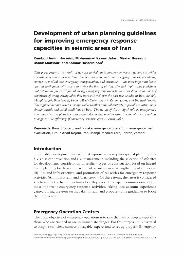
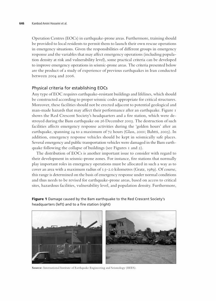
Physical criteria for establishing EOCsAny type of EOC requires earthquakeresistant buildings and lifelines, which should be constructed according to proper seismic codes appropriate for critical structures. Moreover, these facilities should not be erected adjacent to potential geological and manmade hazards that may affect their performance after an earthquake. Figure 1 shows the Red Crescent Society’s headquarters and a fire station, which were destroyed during the Bam earthquake on 26 December 2003. The destruction of such facilities affects emergency response activities during the ‘golden hours’ after an earthquake, spanning 24 to a maximum of 72 hours (Glass, 2001; Bahtti, 2005). In addition, emergency response vehicles should be kept in seismically safe places. Several emergency and public transportation vehicles were damaged in the Bam earthquake following the collapse of buildings (see Figures 1 and 2). The distribution of EOCs is another important issue to consider with regard to their development in seismicprone zones. For instance, fire stations that normally play important roles in emergency operations must be allocated in such a way as to cover an area with a maximum radius of 1.5–2.0 kilometres (Gratz, 1989). Of course, this range is determined on the basis of emergency response under normal conditions and thus needs to be revised for earthquakeprone areas, based on access to critical sites, hazardous facilities, vulnerability level, and population density. Furthermore,
Figure 1 Damage caused by the Bam earthquake to the Red Crescent Society’s
headquarters (left) and to a fire station (right)
Source: International Institute of Earthquake Engineering and Seismology (IIEES).
Development of urban planning guidelines 647
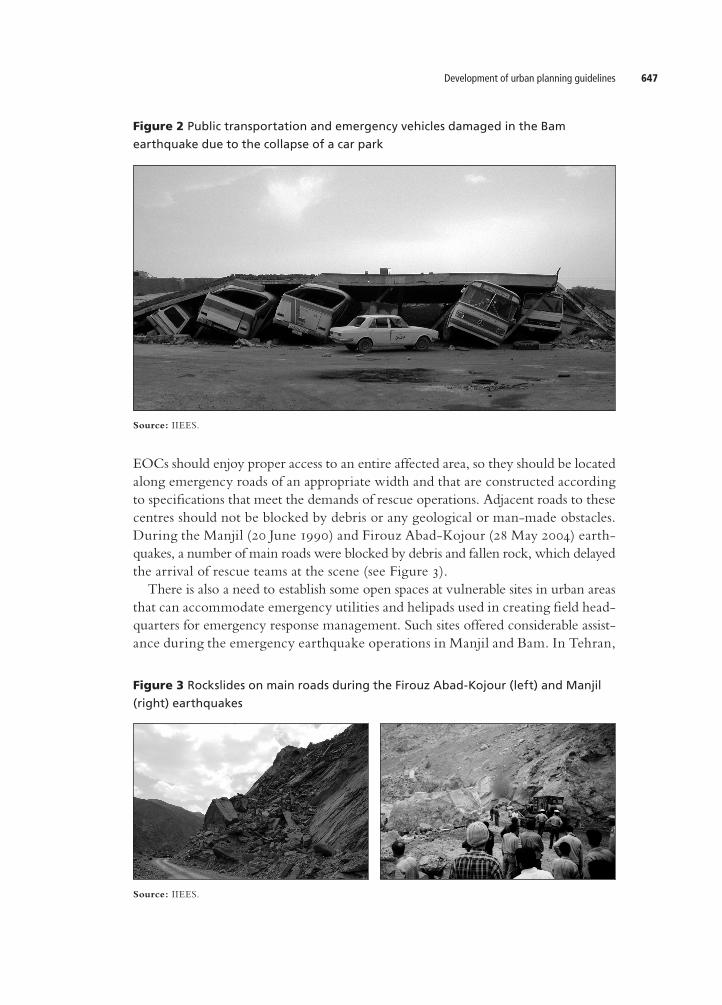
EOCs should enjoy proper access to an entire affected area, so they should be located along emergency roads of an appropriate width and that are constructed according to specifications that meet the demands of rescue operations. Adjacent roads to these centres should not be blocked by debris or any geological or manmade obstacles. During the Manjil (20 June 1990) and Firouz AbadKojour (28 May 2004) earthquakes, a number of main roads were blocked by debris and fallen rock, which delayed the arrival of rescue teams at the scene (see Figure 3). There is also a need to establish some open spaces at vulnerable sites in urban areas that can accommodate emergency utilities and helipads used in creating field headquarters for emergency response management. Such sites offered considerable assistance during the emergency earthquake operations in Manjil and Bam. In Tehran,
Figure 2 Public transportation and emergency vehicles damaged in the Bam
earthquake due to the collapse of a car park
Source: IIEES.
Source: IIEES.
Figure 3 Rockslides on main roads during the Firouz Abad-Kojour (left) and Manjil
(right) earthquakes
Kambod Amini Hosseini et al.648
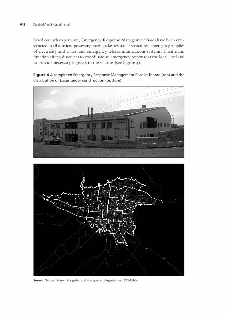
Figure 4 A completed Emergency Response Management Base in Tehran (top) and the
distribution of bases under construction (bottom)
Source: Tehran Disaster Mitigation and Management Organization (TDMMO).
based on such experience, Emergency Response Management Bases have been constructed in all districts, possessing earthquakeresistance structures, emergency supplies of electricity and water, and emergency telecommunications systems. Their main function after a disaster is to coordinate an emergency response at the local level and to provide necessary logistics to the victims (see Figure 4).
Development of urban planning guidelines 649
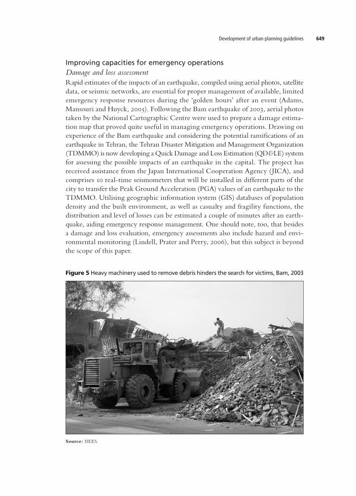
Improving capacities for emergency operations Damage and loss assessmentRapid estimates of the impacts of an earthquake, compiled using aerial photos, satellite data, or seismic networks, are essential for proper management of available, limited emergency response resources during the ‘golden hours’ after an event (Adams, Mansouri and Huyck, 2005). Following the Bam earthquake of 2003, aerial photos taken by the National Cartographic Centre were used to prepare a damage estimation map that proved quite useful in managing emergency operations. Drawing on experience of the Bam earthquake and considering the potential ramifications of an earthquake in Tehran, the Tehran Disaster Mitigation and Management Organization (TDMMO) is now developing a Quick Damage and Loss Estimation (QD&LE) system for assessing the possible impacts of an earthquake in the capital. The project has received assistance from the Japan International Cooperation Agency ( JICA), and comprises 10 realtime seismometers that will be installed in different parts of the city to transfer the Peak Ground Acceleration (PGA) values of an earthquake to the TDMMO. Utilising geographic information system (GIS) databases of population density and the built environment, as well as casualty and fragility functions, the distribution and level of losses can be estimated a couple of minutes after an earthquake, aiding emergency response management. One should note, too, that besides a damage and loss evaluation, emergency assessments also include hazard and environmental monitoring (Lindell, Prater and Perry, 2006), but this subject is beyond the scope of this paper.
Figure 5 Heavy machinery used to remove debris hinders the search for victims, Bam, 2003
Source: IIEES.

Kambod Amini Hosseini et al.650
Using special toolsIn areas where the risks of geological or industrial hazards are considerable, special tools (along with sufficient expertise) are necessary for postearthquake emergency operations. During the Manjil (1990) and Firouz AbadKojour (2004) earthquakes, for example, several houses and cars were crushed under rock or soil debris, due to landslides and falling rock, and the tools required for rescue operation in some places were not available during the initial hours. Moreover, in the first few days after an earthquake, the use of heavy vehicles in emergency response activities should be limited to avoid putting trapped victims unnecessarily at risk of further injury or endangering their lives (see Figure 5).
Promoting the capabilities of local residentsApproximately 80 per cent of the victims of the Bam earthquake of 2003 were rescued by local residents and neighbours. Such a figure, consistent with experience throughout the world, demonstrates the importance of the involvement of local residents in emergency operations. Consequently, developing the capacities of local people, by providing special training and facilities, could enhance the success of emergency operations. Given the high estimated number of victims and the relatively small number of existing emergency response experts and facilities in Tehran, the TDMMO has prepared a plan to engage volunteers in emergency operations (see Table 1). Under this plan, local residents and volunteers will assume the main role in emergency response at the community (1,000–5,000 persons) and subdistrict (5,00030,000 persons) level. In addition, special training programmes for residents and volunteer groups are in progress and equipment needed for rescue activities has been provided in some areas.
Table 1 Formation of search and rescue teams
Level Team category Target Personnel/equipment
III Hyper-rescue team: 100–200 staff
Target: priority facility
Personnel: rescue experts and fire brigades.
Equipment: imagers, search equipment, thermograph detector, night-vision cameras, ground sonar receivers, etc.
II District rescue team: 20–100 staff
Target:mid- and high-rise buildings
Personnel: trained team supported by fire brigade and rescue experts and trained dogs.
Equipment: imagers, search equipment, air compressor, steel cutter, mobile winch, etc.
I Sub-district rescue team: 10–20 staff
Target: conventional residential buildings
Personnel: trained team including rescue experts, with cooperation of the general public.
Equipment: hammer, chainsaw, steel cutter, rock drill, pinch bar, saw, rope, shovel, etc.
Source: JICA and the TDMMO, 2004.
Supporting response activitiesNormally after a large earthquake, a local government is unable to provide properly the required response using only its own resources. In such conditions, it is necessary

Development of urban planning guidelines 651
to involve professional entities, including the armed forces, and the capacities of auxiliary provinces, in supporting emergency response activities. The success level in such cases depends on several variables, such as practising initiatives before an incident. By way of example, after the Broujerd earthquake of 31 March 2006, military forces played important roles in rescue activities, while in other events, due to a lack of adequate training, they were unable to provide sufficient assistance—the same thing happened during the ChiChi (Taiwan) earthquake of 21 September 1999 (Prater and Wu, 2002). The TDMMO has prepared some guidelines to involve military forces and auxiliary provinces in emergency response operations after a major disaster. Under these guidelines, the Task Force Organization of Tehran (TFOrg), headed by the Mayor of Tehran, has the authority to ask military forces and auxiliary provinces to engage in emergency operations and to supply logistics after an earthquake. Seven of Iran’s 30 provinces that are adjacent to Tehran Province are responsible for providing necessary support to Tehran’s 22 districts. In addition, Isfahan Province is responsible for emergency coordination after a catastrophe.
Distribution of information on affected sitesFollowing a major disaster, rescue personnel from other provinces or countries are usually dispatched to the affected areas to assist with response activities. After the Bam earthquake (2003), several rescue teams equipped with hightech devices for implementing complicated rescue tasks in highrise buildings were deployed. However, they were unable to offer much assistance as most of the collapsed buildings were simple onestory traditional structures. Before dispatching expert groups, it is vital, therefore, to evaluate the situation, to inform effectively, and to recruit expertise based on local conditions.
Emergency medical care Mass casualty management after a devastating earthquake is one of the main challenges confronting emergency response planning, which could directly affect death and injury rates. Efficient planning in this regard requires special measures designed to increase the preparedness level and to improve the capacity and capabilities of medical care initiatives before an incident (Cooper, 2006). Experience of previous earthquakes indicates that existing standards and guidelines for developing medical care activities should be revised to enhance their efficiency under emergency conditions. The following sections discuss some parameters for augmenting emergency medical care services in seismicprone areas.
Emergency Medical Care UnitsEmergency Medical Care Units (EMCUs) are key facilities at the community level designed to help victims rescued by ordinary people or expert teams. EMCUs could serve as checkpoints/triage posts prior to the dispatch of injured people to hospital
Kambod Amini Hosseini et al.652
in order to control flows. Their main responsibilities, especially during the first few days after a disaster, are to provide first aid and basic treatment, to conduct triage, and to transfer severe cases to hospital after primary stabilisation. They are also tasked with providing healthcare and medical assistance to survivors and controlling infectious diseases for a couple of months after the incident. Few EMCUs have been established to date in Iran. The absence of EMCUs in Bam in 2003 led to existing hospitals being overwhelmed and considerable problems in treating serious cases (Movahedi, 2005). The required number of EMCUs depends on several factors, including access and expected damage/casualty levels. According to a rough estimation, the distance of individual buildings to EMCUs should not be more than 500 metres, permitting access by foot after an event ( JICA and the TDMMO, 2004). In addition, an area’s population density and the structural vulnerability of buildings should be considered when situating EMCUs. Furthermore, these centres should be located adjacent to emergency roads to accelerate transportation of the injured to hospital after primary treatment. The confined space needed for an EMCU is approximately 40 square metres, allowing them to retain essential materials and to accommodate medical experts for a few days. It is also appropriate to have some open spaces around them for triage, potential extension of medical care activities, or even to act as helipads (especially in those areas with poor road networks). Some other criteria are to be found in Schultz, Koenig and Noji (1996), who introduced a similar concept known as Disaster Medical Aid Centres. EMCUs can be organised by subdistrict governmental offices or even community people, but they should be in direct contact and coordinate with the hospitals, EOCs, and other emergency command facilities. A reliable communication system should, therefore, be provided to these centres in advance. Emergency water and power also should be supplied to EMCUs, as well as essential equipment, such as firstaid kits, devices for stabilising broken bones, oxygen supplies and ventilators. In addition, it is necessary to provide a detailed programme on supplying medical staff and logistics and training some local residents to assist in the operation of these units, as the latter are more likely to be available after an earthquake. To distribute casualties rationally among area hospitals, someone at the EMCU needs to be responsible for acquiring information from hospitals on their capacities and capabilities. This information needs to be updated continually, because hospitals are also likely to be receiving casualties who have travelled there on their own initiative (Auf der Heide, 1994). Given these criteria and the potential number of casualties in a strong earthquake in Tehran, the Tehran Disaster Management Master Plan (TDMMP) proposed, in 2005, to establish 3,000 EMCUs to offer critical emergency medical care to more than one million victims within 24 hours of an earthquake (JICA and the TDMMO, 2004). Clearly, there are not enough resources available in the capital to meet this goal: to do so would require at least 6,000 teams comprising 18,000 medical doctors,
Development of urban planning guidelines 653
assuming that a team consists of three doctors on two shifts around the clock. This is more than twice the number of doctors in Tehran Province (7,500) working under the Ministry of Health. Thus, a key challenge to this plan is how to supply necessary medical staff from the whole country in due time.
HospitalsHospitals are an important component of the emergency medicalcare cycle, and most medical treatment should be provided efficiently in these facilities. Planning for the development of the capacities of hospitals in seismic zones warrants special consideration.
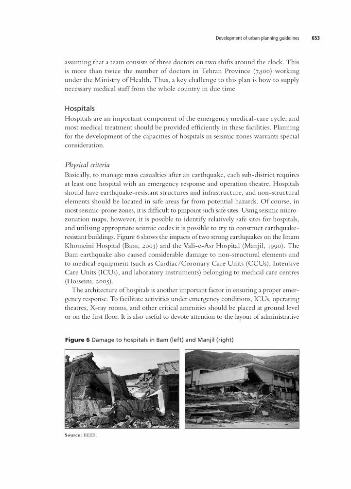
Physical criteriaBasically, to manage mass casualties after an earthquake, each subdistrict requires at least one hospital with an emergency response and operation theatre. Hospitals should have earthquakeresistant structures and infrastructure, and nonstructural elements should be located in safe areas far from potential hazards. Of course, in most seismicprone zones, it is difficult to pinpoint such safe sites. Using seismic microzonation maps, however, it is possible to identify relatively safe sites for hospitals, and utilising appropriate seismic codes it is possible to try to construct earthquakeresistant buildings. Figure 6 shows the impacts of two strong earthquakes on the Imam Khomeini Hospital (Bam, 2003) and the ValieAsr Hospital (Manjil, 1990). The Bam earthquake also caused considerable damage to nonstructural elements and to medical equipment (such as Cardiac/Coronary Care Units (CCUs), Intensive Care Units (ICUs), and laboratory instruments) belonging to medical care centres (Hosseini, 2005). The architecture of hospitals is another important factor in ensuring a proper emergency response. To facilitate activities under emergency conditions, ICUs, operating theatres, Xray rooms, and other critical amenities should be placed at ground level or on the first floor. It is also useful to devote attention to the layout of administrative
Figure 6 Damage to hospitals in Bam (left) and Manjil (right)
Source: IIEES.
Kambod Amini Hosseini et al.654
sections and to open spaces to be used for administering medical care under emergency conditions. Hospitals should be also equipped with an emergency telecommunications system, power generators, and water and fuel supplies that will endure at least for a few days after an earthquake if main lifelines fail. Hospitals should be easily accessible, preferably situated around wide emergency roads. The access roads should not be blocked by fallen debris or products of geological instability under any circumstances. According to the TDMMP, the distance between individual buildings and the nearest hospital should not be more than two kilometres ( JICA and the TDMMO, 2004). Of course, meeting such criteria in practice is difficult, so the priorities for hospital development visàvis hazard, population density, and vulnerability levels warrant special consideration. Existing hospitals in earthquakeprone areas should have the capability to expand their capacities after an event, so enough space and facilities should be made available within or around them for this purpose. Hospitals must also support helicopter operations and frequent ambulance services for transferring earthquake victims more efficiently. Several field hospitals were established after recent earthquakes in Iran to provide important services, including receiving patients from the scene, evacuating inpatients from damaged hospitals, and supporting the emergency functions of existing hospitals. In setting up field hospitals, some open lots should be selected, preferably around existing hospitals, and emergency water and power supplies should be provided to these sites. Field hospitals can be also developed as part of initiatives to expand existing hospitals—in such cases, they should not be established independently but should avail themselves of the services of these facilities.
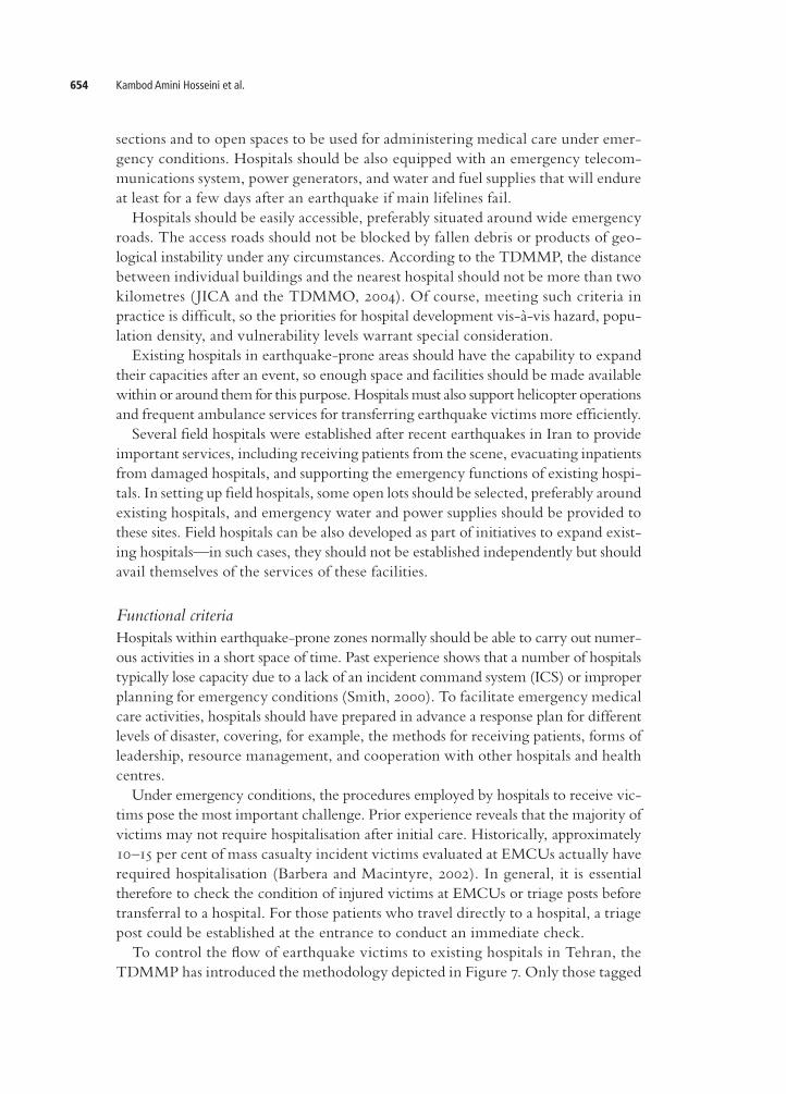
Functional criteriaHospitals within earthquakeprone zones normally should be able to carry out numerous activities in a short space of time. Past experience shows that a number of hospitals typically lose capacity due to a lack of an incident command system (ICS) or improper planning for emergency conditions (Smith, 2000). To facilitate emergency medical care activities, hospitals should have prepared in advance a response plan for different levels of disaster, covering, for example, the methods for receiving patients, forms of leadership, resource management, and cooperation with other hospitals and health centres. Under emergency conditions, the procedures employed by hospitals to receive victims pose the most important challenge. Prior experience reveals that the majority of victims may not require hospitalisation after initial care. Historically, approximately 10–15 per cent of mass casualty incident victims evaluated at EMCUs actually have required hospitalisation (Barbera and Macintyre, 2002). In general, it is essential therefore to check the condition of injured victims at EMCUs or triage posts before transferral to a hospital. For those patients who travel directly to a hospital, a triage post could be established at the entrance to conduct an immediate check. To control the flow of earthquake victims to existing hospitals in Tehran, the TDMMP has introduced the methodology depicted in Figure 7. Only those tagged
Development of urban planning guidelines 655
yellow at EMCUs are to be transferred to existing hospitals in the district. Transportation will be handled by the district municipality or the Red Crescent Society because equipped ambulances of the Tehran emergency management system may be totally committed, especially during the first few days. Serious cases should be then transferred to more advanced hospitals by helicopter or other means of transportation. Noncritical patients can be moved to backup hospitals in other provinces by airplane ( JICA and the TDMMO, 2004). In some cases, a local hospital could be designated as a disaster coordination centre responsible for collecting capacity information from hospitals and casualty information from the scene. This facility is then responsible for directing ambulances to destinations within the event zone and between the site and local hospitals (Auf der Heide, 1994). Resource management is another important issue in emergency medical care planning. As a general rule, regardless of location and ownership, all available resources in the public and private sectors should be mobilised to treat injured people. Moreover, to support onsite EMCUs/existing hospitals, necessary logistics (such as beds, blankets, electric generators, and tents) should be provided by non or lessaffected sites. Special steps should be also taken to protect those who need continuous medical attention, such as persons with cardiac diseases, diabetes or kidney failure, as well as people suffering, for instance, from multiple injuries and thirddegree burns. Since not every hospital can conduct surgical operations or offer intensive care, the victims should be transferred to proper medical centres with appropriate capabilities. A plan for staffing and supplying materials needed in emergency conditions should be also prepared for special occasions, such as national holidays. The Broujerd earthquake of 2006, for example, occurred during the Iranian New Year holidays. As most
Figure 7 TDMMP methodology to prevent existing hospitals from being overwhelmed
after an earthquake in Tehran
Source: JICA and the TDMMO, 2004.
Kambod Amini Hosseini et al.656
medical staff members were on leave at that time, some shortages in personnel and essential medicines were observed and reported during the first three days after the incident.
Emergency roadsEmergency roads are also an important variable in saving citizens’ lives after an earthquake. They provide links between disaster management centres and ensure easy access by response teams to affected areas. Some of the main characteristics of emergency roads in seismicprone areas are discussed below.
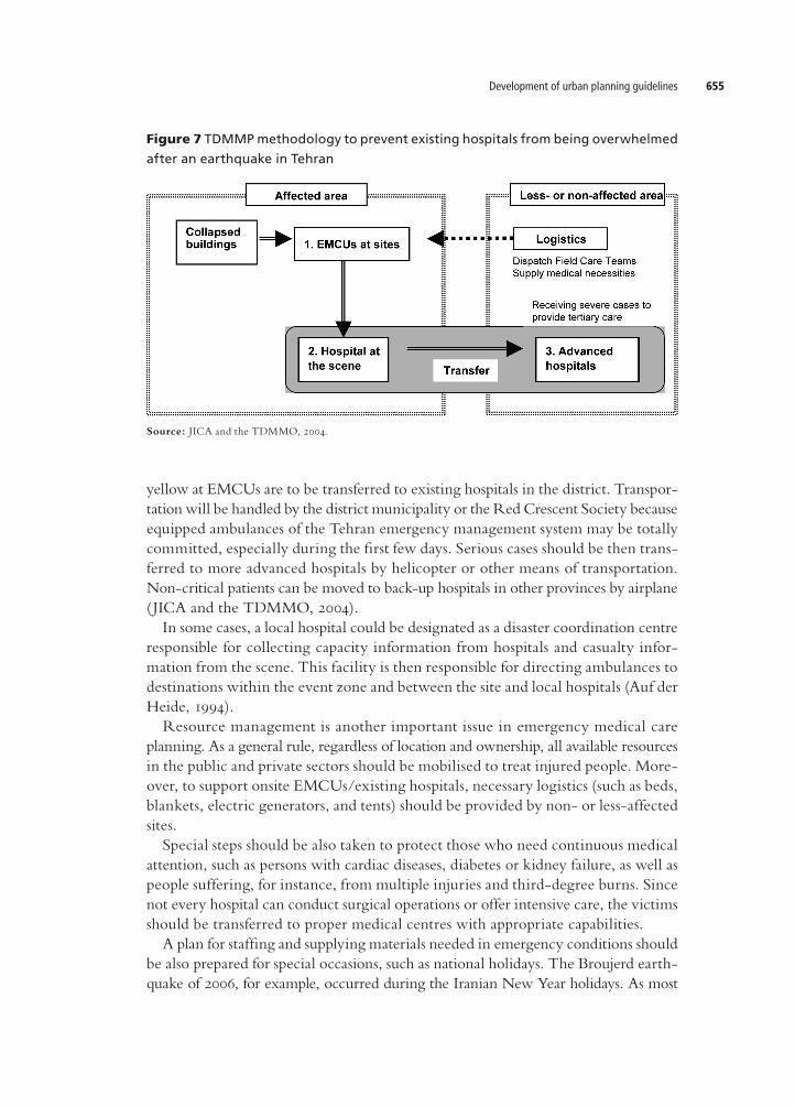
Physical criteriaEmergency roads should be fully operational at all times. If any part of the emergency road network becomes blocked, the whole system will not function properly and the traffic demand will be transferred to alternate routes, usually resulting in overload. For instance, damage to bridges or tunnels on the road network may affect directly emergency transportation efforts, and the recovery process will prove extremely timeconsuming. Vulnerable roadside structures and objects may also lead to road closure due to a partial or total collapse along the route, so it is essential to consider a buffer
Figure 8 Road damage due to the collapse of Qanats, Bam, 2003
Source: IIEES.
Development of urban planning guidelines 657
zone along these roads. A minimum setback distance for structures and a maximum height for buildings should be also formulated based on local conditions (Amini Hosseini and Hosseini, 2007). Moreover, it is necessary to revise landuse regulations along these roads, to enforce the building code for new constructions, and to recheck the design, construction procedures, and materials employed in relation to existing buildings in these restricted areas (see Lindell et al., 1997). Emergency roads could be affected by a failure of infrastructure passing under or around them (such as underground pipelines) and geological faults that may be triggered by an earthquake. During the Bam earthquake of 2003, some Qanats (underground irrigation tunnels) collapsed and blocked the main roads, causing delays in emergency response activities (Figure 8). In the Manjil (1990) and Firouz Abad–Kojour (2004) earthquakes, some main roads were blocked by landslides and fallen rock (Figure 3), and in the Zarand earthquake of 22 February 2005, fault displacement caused ruptures on some existing roads. Emergency roads should be of an appropriate width and gradient to handle emergency vehicle traffic. Considering the space required for passing evacuees and rescue vehicles and the fact that the area may be covered by debris, the minimum width of an emergency road should be approximately 15 metres (Gyosei Corporation, 1997). Roadwidening projects should be instigated on narrow emergency roads in advance of an earthquake, and alternative roads should be earmarked in places where the risk of blockage is high.
Functional criteriaGiven that emergency roads should provide easy access to, inter alia, command centres, city terminals, and EOCs, these facilities must be clearly identified and prioritised for selecting optimum paths between them using GIS base maps. To prevent malfunctioning of emergency roads, a traffic control system for emergency conditions should be also developed. After the Manjil (1990) and Bam (2003) earthquakes, there was heavy traffic along area roads for several hours, causing long delays to emergency activities. To prevent such problems, it is crucial to evaluate actual traffic flows during the day and night, and on weekdays and weekends. A control scheme should be applied, not only in damaged areas, but also to adjacent roads to avoid overflow effects. Information on the physical state of emergency roads after an earthquake should be collected and regularly broadcasted to residents via the mass media, emergency loudspeakers, and signboards. Moreover, information on prohibited or partially restricted roads, the road control system, and the estimated time of recovery should be also supplied to citizens and drivers of vehicles entering disasteraffected areas in a clear and timely manner. Of course, it is difficult to control the inflow of ordinary vehicles in an emergency situation. In such cases, people tend to use their cars to transfer injured family members or neighbours without respect for physical barriers or orders. Specific measures should be also prepared for opening emergency roads regularly, to remove obstacles and abandoned/illegally parked vehicles along them. In addition,

Kambod Amini Hosseini et al.658
it would be helpful if the necessary locations and means for such operations are considered in advance in comprehensive plans of seismicprone urban areas. The erection of tents for earthquake victims along main roads—a common scenario in Iran (see Figure 9)—poses another problem to the use of emergency roads and should be prohibited. Such action not only may cause traffic jams and delays to the response and recovery process, but also it may threaten the lives of those in these tents.
Emergency evacuation A large percentage of Iran’s population lives in vulnerable dwellings that could be severely damaged by earthquakes. Evacuation could play an important part in saving the lives of these residents before or after an earthquake. In the event of experiencing a foreshock, normally people prefer to evacuate to safe places to protect themselves from the potential impacts. After an earthquake, if structural damage poses a threat to life, or if there is a high risk of a geological or manmade hazard (such as a gas leak, landslide, or urban fire), evacuation is once more necessary. For this purpose, suitable places should be allocated in advance to provide temporary accommodation to residents. Some basic requirements for setting up such places are discussed below.
Figure 9 Tents erected along main roads after the Bam earthquake, 2003
Source: IIEES.
Development of urban planning guidelines 659
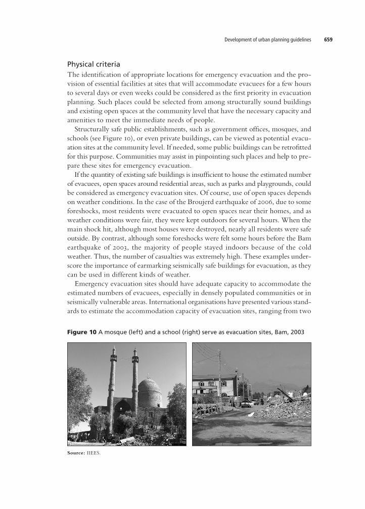
Physical criteriaThe identification of appropriate locations for emergency evacuation and the provision of essential facilities at sites that will accommodate evacuees for a few hours to several days or even weeks could be considered as the first priority in evacuation planning. Such places could be selected from among structurally sound buildings and existing open spaces at the community level that have the necessary capacity and amenities to meet the immediate needs of people. Structurally safe public establishments, such as government offices, mosques, and schools (see Figure 10), or even private buildings, can be viewed as potential evacuation sites at the community level. If needed, some public buildings can be retrofitted for this purpose. Communities may assist in pinpointing such places and help to prepare these sites for emergency evacuation. If the quantity of existing safe buildings is insufficient to house the estimated number of evacuees, open spaces around residential areas, such as parks and playgrounds, could be considered as emergency evacuation sites. Of course, use of open spaces depends on weather conditions. In the case of the Broujerd earthquake of 2006, due to some foreshocks, most residents were evacuated to open spaces near their homes, and as weather conditions were fair, they were kept outdoors for several hours. When the main shock hit, although most houses were destroyed, nearly all residents were safe outside. By contrast, although some foreshocks were felt some hours before the Bam earthquake of 2003, the majority of people stayed indoors because of the cold weather. Thus, the number of casualties was extremely high. These examples underscore the importance of earmarking seismically safe buildings for evacuation, as they can be used in different kinds of weather. Emergency evacuation sites should have adequate capacity to accommodate the estimated numbers of evacuees, especially in densely populated communities or in seismically vulnerable areas. International organisations have presented various standards to estimate the accommodation capacity of evacuation sites, ranging from two
Figure 10 A mosque (left) and a school (right) serve as evacuation sites, Bam, 2003
Source: IIEES.
Kambod Amini Hosseini et al.660
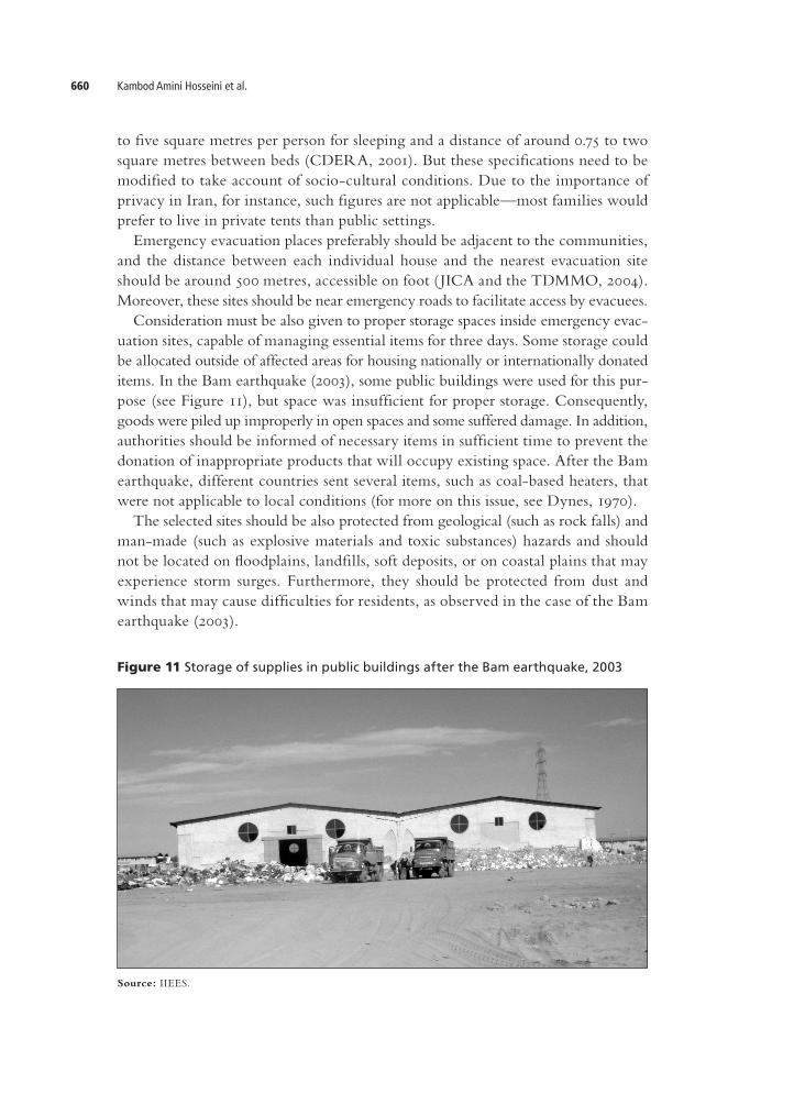
to five square metres per person for sleeping and a distance of around 0.75 to two square metres between beds (CDERA, 2001). But these specifications need to be modified to take account of sociocultural conditions. Due to the importance of privacy in Iran, for instance, such figures are not applicable—most families would prefer to live in private tents than public settings. Emergency evacuation places preferably should be adjacent to the communities, and the distance between each individual house and the nearest evacuation site should be around 500 metres, accessible on foot ( JICA and the TDMMO, 2004). Moreover, these sites should be near emergency roads to facilitate access by evacuees. Consideration must be also given to proper storage spaces inside emergency evacuation sites, capable of managing essential items for three days. Some storage could be allocated outside of affected areas for housing nationally or internationally donated items. In the Bam earthquake (2003), some public buildings were used for this purpose (see Figure 11), but space was insufficient for proper storage. Consequently, goods were piled up improperly in open spaces and some suffered damage. In addition, authorities should be informed of necessary items in sufficient time to prevent the donation of inappropriate products that will occupy existing space. After the Bam earthquake, different countries sent several items, such as coalbased heaters, that were not applicable to local conditions (for more on this issue, see Dynes, 1970). The selected sites should be also protected from geological (such as rock falls) and manmade (such as explosive materials and toxic substances) hazards and should not be located on floodplains, landfills, soft deposits, or on coastal plains that may experience storm surges. Furthermore, they should be protected from dust and winds that may cause difficulties for residents, as observed in the case of the Bam earthquake (2003).
Figure 11 Storage of supplies in public buildings after the Bam earthquake, 2003
Source: IIEES.
Development of urban planning guidelines 661
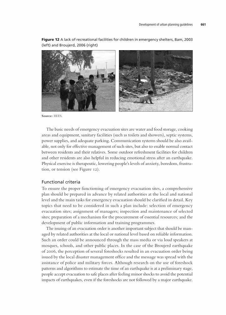
The basic needs of emergency evacuation sites are water and food storage, cooking areas and equipment, sanitary facilities (such as toilets and showers), septic systems, power supplies, and adequate parking. Communication systems should be also available, not only for effective management of such sites, but also to enable normal contact between residents and their relatives. Some outdoor refreshment facilities for children and other residents are also helpful in reducing emotional stress after an earthquake. Physical exercise is therapeutic, lowering people’s levels of anxiety, boredom, frustration, or tension (see Figure 12).
Functional criteriaTo ensure the proper functioning of emergency evacuation sites, a comprehensive plan should be prepared in advance by related authorities at the local and national level and the main tasks for emergency evacuation should be clarified in detail. Key topics that need to be considered in such a plan include: selection of emergency evacuation sites; assignment of managers; inspection and maintenance of selected sites; preparation of a mechanism for the procurement of essential resources; and the development of public information and training programmes. The issuing of an evacuation order is another important subject that should be managed by related authorities at the local or national level based on reliable information. Such an order could be announced through the mass media or via loud speakers at mosques, schools, and other public places. In the case of the Broujerd earthquake of 2006, the perception of several foreshocks resulted in an evacuation order being issued by the local disaster management office and the message was spread with the assistance of police and military forces. Although research on the use of foreshock patterns and algorithms to estimate the time of an earthquake is at a preliminary stage, people accept evacuation to safe places after feeling minor shocks to avoid the potential impacts of earthquakes, even if the foreshocks are not followed by a major earthquake.
Figure 12 A lack of recreational facilities for children in emergency shelters, Bam, 2003
(left) and Broujerd, 2006 (right)
Source: IIEES.

Kambod Amini Hosseini et al.662
The management of communitylevel evacuation sites is another important task. Special instructions should be prepared for different scenarios for receiving and supporting evacuees for a few hours to several days and for transferring them to regional evacuation sites or to their own houses. Before a disaster, assigned managers should inspect sites regularly and personnel must be identified and instructed accordingly. After an earthquake, the shelters should open and start to receive the people. In the initial days after an event, the primary job of managers will be to procure clothes, food, water and other necessary items and to distribute them among the evacuees. In the final stage, they should provide the necessary means to allow evacuees to move to other shelters or to return to their own homes (CDERA, 2001). The registration of evacuees and the dispatch of such information to the local disaster management headquarters are also important steps in the relief process. Such data is helpful in providing the required assistance, tracing missing people, and planning for longterm accommodation if the disaster and its consequences are prolonged. Registration should be quick, practicable, and carried out (using standard forms) at any place where people assemble. Medical services should be also provided at emergency evacuation settings. On arrival, evacuees’ medical problems should be noted and prioritised for treatment. A medicalaid station could be set up within the confines of the shelter, where minor medical cases can be treated by medical staff, if available among evacuees. Special measures must be taken to accommodate people with common health conditions, such as asthma, diabetes, and heart disease, as well as those who show signs of emotional stress or are suffering other adverse mental reactions to the disaster. Community volunteers can provide valuable assistance in this regard if they are well trained in advance. The reluctance of evacuees to be transferred to regional camps normally may cause several difficulties. After the Bam earthquake of 2003, several camps were established at different locations within the cities of Bam and Baravat, but only a few people left their damaged houses to seek accommodation therein. Most people preferred to stay in their properties to protect their possessions. The same situation was observed
Figure 13 Improper distribution of materials among evacuees, Bam earthquake, 2003
Source: IIEES.
Development of urban planning guidelines 663
after the Broujerd earthquake of 2006. Such conditions are problematic when trying to provide assistance to earthquake victims (see Figure 13) and promote reconstruction activities, especially in the debris removal phase (see also Tierny, Lindell and Perry, 2001).
ConclusionEfficiency in emergency planning and activities during the ‘golden hours’ after a devastating earthquake plays an important part in protecting people’s lives. With this in mind, an integrated plan should be formulated and implemented in advance, based on local and national conditions and taking into account physical and functional criteria. For proper effectiveness and applicability, these criteria must be prepared on the basis of experience gained in previous earthquake events. The issues discussed in this paper are based on experience of earthquakes in Iran and different aspects of the emergency response, but developments are similar around the world. The results of studies such as this one should be reflected in the comprehensive development plans of urban areas to improve emergency response after an earthquake.
CorrespondenceDr Kambod Amini Hosseini, Assistant Professor and Director, Risk Management Research Centre, International Institute of Earthquake Engineering and Seismology, 26 Arghavan Street, North Dibaji, Farmanieh, 1953714453 Tehran, Iran. Telephone: +98 21 2228 7388; fax: +98 21 2229 9479. Email: [email protected].
Endnotes1 Kambod Amini Hosseini is Assistant Professor at the International Institute of Earthquake Engineer
ing and Seismology, Iran; Mohammad Kazem Jafari Professor, International Institute of Earthquake Engineering and Seismology, Iran; Maziar Hosseini is Assistant Professor at the Islamic Azad University (South Branch) and President of the Tehran Disaster Mitigation and Management Organization, Iran; Babak Mansouri is Assistant Professor at the International Institute of Earthquake Engineering and Seismology, Iran; and Solmaz Hosseinioon Assistant Researcher, International Institute of Earthquake Engineering and Seismology, Iran.
ReferencesAdams, B.J., B. Mansouri and C.K. Huyck (2005) ‘Streamlining post earthquake data collection and
damage assessment for the 2003 Bam, Iran earthquake using VIEWS’. EarthquakeSpectra.21(S1). pp. S213–S218.
Amini Hosseini, K. and M. Hosseini (2007) ‘Evaluation of old urban structures and emergency road networks vulnerabilities to a potential earthquake in Tehran’. Proceedings of the 5th Conference on Earth-

Kambod Amini Hosseini et al.664
quakeEngineeringandSeismology(SEE5),InternationalInstituteofEarthquakeEngineeringandSeismology,Tehran, Iran, 13–16 May 2007.
Amini Hosseini, K. and M.K. Jafari (2007) ‘Development guidelines for disaster risk management in Tehran’. Proceedings of the 5thConferenceonEarthquakeEngineeringandSeismology(SEE5),InternationalInstituteofEarthquakeEngineeringandSeismology,Tehran,Iran,13–16 May 2007.
Auf der Heide, E. (1994) Disasterresponse:Principlesofpreparationandcoordination.http://orgmail2.coedmha.org/dr/pdf/DisasterResponse.pdf.
Bahtti, A. (2005) EarthquakeReliefandRecovery:ProcessesandPrinciples. Rural Development Policy Institute, Reliefweb. http://www.reliefweb.int/library/documents/2005/rdpipak10nov.pdf
Barbera, J.A. and A.G. Macintyre (2002) Medical and Health Incident Management System. Institute for Crisis, Disaster, and Risk Management, George Washington University, Washington, DC.
CDERA (Caribbean Disaster Emergency Response Agency) (2001) HandbookforEmergencyShelterManagement, Report on the Saint Kitts-Nevis. http://www.oas.org/pgdm/document/shelter/sheltrkn.doc.
Cooper, D. (2006) Mass Casualty Management in Disasters, Centers for Disease Control and Prevention. http://www.who.int/hac/events/experts2006/D_Cooper_Mass_casualth_disasters.pdf.
Dynes, R. (1970) Organized behavior in disaster. HealthLexington Book, Lexington, MA.Glass, T.A. (2001) ‘Understanding public response to disasters’. Public Health Report. 116 (Supplement 2).
pp. 69–73. http://www.publichealthreports.org/userfiles/116_SUP2/116069sup.pdf.Gratz, D.B. (1989) FireDepartmentManagement:ScopeandMethod. Macmillan, New York, NY.Gyosei Corporation (1997) UrbanDisasterPreventionHandbook. Ministry of Construction, Tokyo.Hosseini, M. (2005) ‘Behaviour of nonstructural elements in the Bam, Iran, Earthquake’. Earthquake
Spectra. 21(S1). pp. S439–S454.JICA ( Japan International Cooperation Agency) and the TDMMO (Tehran Disaster Mitigation and
Management Organization) (2004) The comprehensive master plan study on urban seismic disaster pre-ventionandmanagementfortheGreaterTehranAreainIran.Main Final Report. Pacific Consultant International, Tokyo.
Lindell, M.K. et al. (1997) ‘Adoption and implementation of hazard adjustments’. International Journal of Mass Emergencies and Disasters. 15(3) (Special Issue). pp. 327–453.
Lindell, M.K., C.S. Prater and R.W. Perry (2006) Fundamentals of Emergency Management. Federal Emergency Management Agency, Emergency Management Institute, Emmitsburg, MD.
Movahedi (2005) ‘Search, rescue and care of injured following the 2003 Bam, Iran earthquake’. EarthquakeSpectra. 21(S1). pp. S475–S486.
Prater, C. and J.Y. Wu (2002) ‘The politics of emergency response and recovery: Preliminary observations on Taiwan’s 921 earthquake’. Australian Journal of Emergency Management. 17(3). pp. 48–59.
Schultz, C.H., K.L. Koenig and E.K. Noji (1996) ‘A medical disaster response to reduce immediate mortality after an earthquake’. The New England Journal of Medicine. 334(7). pp. 438–444. http://content.nejm.org/cgi/content/short/334/7/438.
Smith, D.L. (2000) Planning guidance for mass fatalities. Emergency Management Guidance and Information Circular No. C20006. 24 April. Pennsylvania Emergency Management Agency (PEMA), Harrisburg, PA. http://www.pema.state.pa.us/pema/lib/pema/circulars/C20006.pdf.
Tierney, K J., M.K. Lindell and R.W. Perry (2001) Facingtheunexpected:DisasterPreparednessandResponse in the United States. Joseph Henry Press, Washington, DC.