Designing and Establishing Conservation Areas in the Baja California-Southern California Border...
34
VII Designing and Establishing Conservation Areas in the Baja California-Southern California Border Region Michael D. White, Jerre Ann Stallcup, Katherine Comer, Miguel Ángel Vargas Téllez, José María Beltrán-Abaunza, Fernando Ochoa, and Scott Morrison A BSTRACT The border region of Baja California in Mexico and California in the United States is a biologically diverse and unique landscape that forms a portion of one of the world’s global biodiversity hotspots. While the natural resources of this border region are continuous and interconnected, the land conservation practices on both sides of the international boundary are quite different. These binational differ- ences may cause certain natural resources, ecological processes, and wildlife movement patterns to fall through the cracks of conserva- tion efforts implemented in each country. Thus, effective conserva- tion in this region requires binational cooperation in planning and implementation. This paper describes the differences in land con- servation patterns and land conservation mechanisms between Baja 191
Transcript of Designing and Establishing Conservation Areas in the Baja California-Southern California Border...

VII
Designing and EstablishingConservation Areas in the
Baja California-Southern CaliforniaBorder Region
Michael D. White, Jerre Ann Stallcup, Katherine Comer,
Miguel Ángel Vargas Téllez, José María Beltrán-Abaunza,
Fernando Ochoa, and Scott Morrison
ABSTRACT
The border region of Baja California in Mexico and California inthe United States is a biologically diverse and unique landscape thatforms a portion of one of the world’s global biodiversity hotspots.While the natural resources of this border region are continuous andinterconnected, the land conservation practices on both sides of theinternational boundary are quite different. These binational differ-ences may cause certain natural resources, ecological processes, andwildlife movement patterns to fall through the cracks of conserva-tion efforts implemented in each country. Thus, effective conserva-tion in this region requires binational cooperation in planning andimplementation. This paper describes the differences in land con-servation patterns and land conservation mechanisms between Baja
191

Transboundary Ecosystem Management
California and Alta California (Southern California). The LasCalifornias Binational Conservation Initiative is discussed as a casestudy for binational cooperation in addressing local threats and con-ducting true transboundary conservation planning.
Diseño y Estableciemiento de Zonas deConservación en la Región Fronteriza
Baja California-Sur de California
Michael D. White, Jerre Ann Stallcup, Katherine Comer,
Miguel Ángel Vargas Téllez, José María Beltrán-Abaunza,
Fernando Ochoa, y Scott Morrison
RESUMEN
La región fronteriza de Baja California, México y California,Estados Unidos, es un paisaje único y biológicamente diverso queforma una sección de una de las zonas clave (candentes) de biodi-versidad del mundo. Aunque los recursos naturales de esta regiónfronteriza son continuos y están interconectados, las prácticas deconservación de la tierra en ambos lados de la frontera internacionalson muy diferentes. Estas diferencias binacionales hacen que algunosrecursos naturales, procesos ecológicos y patrones de desplazamientode la fauna silvestre están en peligro de caer entre las lagunas de losesfuerzos de conservación instrumentados en cada país. Por lo tanto,la conservación efectiva en esta región requiere de la cooperaciónbinacional con relación a los planes de conservación y su instru-mentación. En este documento se describen las diferencias en lospatrones y los mecanismos de conservación de la tierra entre BajaCalifornia y Alta California (Sur de California). La Iniciativa de
192

Designing and Establishing Conservation Areas in the Baja California-Southern California Border Region
Conservación Binacional de Las Californias se presenta como estu-dio de caso para la cooperación binacional que aborda las amenazaslocales y que establece una verdadera planificación de la conser-vación transfronteriza.
INTRODUCTION
The California-Baja California border region encompasses a portionof one of the world’s biodiversity hotspots—geographic locationsthat support very high levels of biological diversity and are under ahigh degree of threat (Dobson, et al. 1997; Mittermeier, et al. 1999;IUCN 2000). More than 400 species in this region have been iden-tified as endangered, threatened, or otherwise sensitive to humanimpacts. However, the biodiversity and environmental functionsprovided by the region’s natural resources, such as water quality pro-tection, water supply, flood control, and scenic and recreationalresources, are increasingly threatened by expanding human land usesand modifications of the natural landscape (Ganster and Metzner1993). Thus, effective conservation in this region of more than 5million people requires binational cooperation in planning andimplementation.
Natural resources conservation efforts in San Diego County,Calif., and in Baja California have historically treated the borderregion as two separate planning areas divided by the internationalboundary, which leaves the natural resources of the region vulnera-ble to habitat fragmentation and to loss of biodiversity. Such anapproach in this historically interconnected landscape could resultin two severed, dysfunctional landscapes instead of one larger, inte-grated ecosystem. In addition, land ownership patterns and availablemechanisms for implementing land protection differ in Californiaand Baja California, which complicates the establishment of a bina-tional reserve system. This chapter outlines the biogeographical sig-nificance of the border region, describes land ownership patternsand conservation mechanisms on both sides of the border, describessome of the local threats, and discusses a binational collaboration toidentify a reserve network that would conserve a functional repre-sentation of the border region’s ecosystems. The ultimate conserva-
193

Transboundary Ecosystem Management
tion goal is for U.S. and Mexican governments, academic andresearch institutions, and non-governmental conservation organiza-tions to embrace and adopt a shared conservation vision for thisborder region and to collaborate in its implementation.
BIOGEOGRAPHY OF THE BORDER REGION
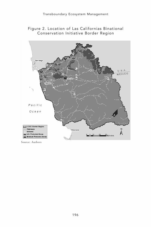
The border region lies at the center of the Peninsular or South Coastphysiographic region or “ecoregion,” which is part of the CaliforniaFlor is t ic Province—a recognized global biodivers i ty hotspot(Hickman 1996; Mittermeier, et al . 1999). The South CoastEcoregion is defined as the land area that lies westward of the crestof the Peninsular Ranges, and that extends from approximatelySanta Barbara, Calif., to El Rosario, B.C. (Figure 1). To focus atten-tion on the status and conservation needs of the border region, thischapter examines a subset of the South Coast Ecoregion, boundedgenerally by the Sweetwater River watershed to the north and theRío Guadalupe watershed to the south, including a relatively smallland area on the eastern side of the Peninsular Ranges (Figure 2).
The astounding biodiversity of the border region is largely aresult of the high diversity of topography, geology, climate, andsoils, which form a landscape of unique biogeographic subunits. Thesubunits are distributed throughout the region, along a coastal todesert continuum and within several different elevation gradients.These various and diverse subunits are the reason for the rich tapes-try of biodiversity that characterizes the border region. Effectiveconservation efforts must account for the distribution of these bio-geographic subunits, allow the movement of species between them,and maintain the processes that underlie the ecosystems of theregion.
Topography
The diverse topography of the border region ranges from flat coastalmesas and rolling foothills, to inland valleys and foothills, to iso-lated mountain peaks and steep mountain ranges. Within the coastalplain, coastal mesas are fairly level, uplifted marine terraces thatoccur at elevations that are generally less than 400 meters (m).
194

Designing and Establishing Conservation Areas in the Baja California-Southern California Border Region
195
Figure 1. Location of Las Californias BinationalConservation Initiative Border Region within the
South Coast Ecoregion
Source: Authors
Transboundary Ecosystem Management
196
Figure 2. Location of Las Californias BinationalConservation Initiative Border Region
Source: Authors

Designing and Establishing Conservation Areas in the Baja California-Southern California Border Region
Eastward from the coast, coastal mesas transition into the foothillsand ultimately into the peaks of the Peninsular Ranges, which reachmore than 1,800 m in the Cuyamaca Mountains and Sierra Juárez.The Jacumba and In-Ko-Pah Mountains (1,200 m) and LagunaMountains (1,600 m) are other notable mountain ranges in theregion. The mountains of the Peninsular Ranges are tilted to thewest, which produces the rolling foothill topography of the westernslope and the steep escarpment on the east. The border region alsosupports severa l s ignif icant val leys , including the Val le deGuadalupe, Val le de Ojos Negros , Campo Val ley, andJacumba/Jacumé Valley. Remnants of Mesozoic-era volcanoes (fromapproximately 128 million years ago to 117 million years ago[Abbott 1999]) form isolated peaks or cerros of gabbro and metavol-canic rock in a generally north-south swath throughout the westernportion of the border region, including Otay Mountain, TecatePeak/Cerro Cuchumá, Cerro San Is idro, Cerro Bola, CerroDieciseis, and Mother Miguel. In the eastern portion of the borderregion, near Jacumba and Jacumé, more recent Miocene-age volcanicevents (from about 19 million to 18 million years ago [Walawender2000]) formed cinder cones and lava flows, such as those that con-stitute Table Mountain. The major drainage systems of the borderregion, including the Sweetwater River, Otay River, Tijuana River,Tecate River/Río Alamar, and Río Guadalupe, dissect the westernflank of the Peninsular Ranges, whereas steeply incised canyons andcañadas characterize the eastern flank.
Climate
The border region enjoys a Mediterranean climate pattern, withmild, wet winters and hot, dry summers. However, because of dif-ferences in elevation and the rain shadow of the Peninsular Ranges,temperature and precipitation patterns vary significantly through-out the region. Mean annual temperatures range from 17.5°C alongthe coast, 16°C in inland valleys, to 11°C at the highest elevationsin the Cuyamaca Mountains and Sierra Juárez. Freezing tempera-tures and frost are uncommon in coastal areas, but more common inthe inland areas and at higher elevations. Average annual rainfall isabout 225 millimeters (mm) to 285 mm along the coast and it varies
197

Transboundary Ecosystem Management
widely in the inland valleys (235 mm to more than 500 mm) and athigher elevations of the Peninsular Ranges (Delgadil lo 1998;Western Regional Climate Center 2004). The Cuyamaca Mountainsreceive more than 850 mm of rainfall each year, whereas the SierraJuárez receives less than 400 mm. Higher e levat ions in thePeninsular Ranges also receive regular snowfall.
Biological Resources
The border region supports a particularly high biodiversity of floraand fauna, including many endemic species that have evolved withinthe diverse physical and climatic conditions of the region (Stebbinsand Major 1965; Raven 1988; Mittermeier, et al. 1999). Biologicalresources are organized into biological communities characteristic ofspecific biophysical and climatic conditions. For example, lower ele-vations within the border region support coastal scrub and grasslandcommunities whereas higher elevation areas support chaparral;conifer, oak, and cypress forests; and woodlands. Willows and cot-tonwoods dominate coastal-draining stream systems where water isabundant, and sycamores and oaks populate dryer areas. Eastern-draining streams and oases often support native palms. Communitydiversity in the border region is similarly high. For example, nearlya dozen different chaparral communities are distributed along dif-ferent elevation and climate gradients and among different soiltypes. Many communities, such as vernal pools, are highly restrictedin distribution and their species compositions are unique to the bor-der region.
The South Coast Ecoregion, which encompasses part of the bor-der region, is one of the most species-rich regions of the CaliforniaFloristic Province (Stebbins and Major 1965; Raven 1995). This sta-t i s t ic i s par t icular ly notable because the Cal i fornia Flor is t icProvince is recognized as one of the world’s richest floristic regions(Mittermeier, et al. 1999). Within the California/Baja Californiaborder region, endemic plant species live in isolated habitats, suchas vernal pools (e.g., Otay Mesa mint), peaks of metavolcanic andgabbro rock (e.g., Tecate cypress), and high elevation “islands” (e.g.,Cuyamaca cypress). Many plant species are listed as threatened orendangered or are otherwise considered sensitive, primarily due to
198
Designing and Establishing Conservation Areas in the Baja California-Southern California Border Region
habitat loss and fragmentation from development (Flores Villela andGerez 1994; Minnich and Franco Vizcaino 1998; Stephenson andCalcarone 1999).
Although levels of animal endemism are not as high as the levelsof plant endemism, many resident and migratory wildlife species inthe border region are listed as threatened or endangered or are oth-erwise considered sensitive. These species include invertebrates(e.g., Thorne’s hairstreak, Quino checkerspot butterfly, and SanDiego fairy shrimp), herpetofauna (e.g., arroyo southwestern toad,San Diego horned lizard, and San Diego pond turtle), birds (e.g.,California gnatcatcher, coastal cactus wren, and least Bell’s vireo),and mammals (e.g., bighorn sheep, mountain lion, and Americanbadger). It is particularly difficult to sustain viable populations ofmammalian species because they require large areas of unfragmentedhabitat.
In summary, the border region’s high topographic, geologic, andclimatic variations produce conditions that support the region’sdiverse and unique flora and fauna. Many of these species are foundnowhere else in the world and are threatened with extinction. Theecosystems that support these species were historically continuousacross the landscape. Today, however, the U.S.-Mexican borderbisects these ecosystems. Without proactive efforts to develop abinational conservation network, they may be irretrievably isolatedfrom each other. Effective conservation of ecosystems in the borderregion must address the distribution and characteristics of naturalresources, while at the same time it must consider differential landownership patterns and the conservation-implementation mecha-nisms that are available in the United States and Mexico.
LAND OWNERSHIP PATTERNS
Comparison of Land Ownership in Mexico andthe United States
There is a tremendous difference between the patterns of Mexicanand U.S. ownership of undeveloped, natural open space.Approximately 61% of undeveloped land in the U.S. border regionis federal, state, and locally-administered land that is set aside for
199
Transboundary Ecosystem Management
conservation or multi-use open space. A local jurisdiction (city orcounty) regulates land use on privately owned parcels. Land use onIndian reservations is outside the county’s land use authority, but itmust comply with federal regulations.
In contrast, less than 1% (5,000 hectares [ha]) of undevelopedland in the border region of Mexico is publicly owned. Ownershipof the remaining undeveloped lands includes ejidos, comunidades,pequeñas propiedades, and títulos colonias. The ejido lands includeurban plots, individual parcels, and lands that are worked on undercommunal social structures. Lands that are part of a comunidad arecollectively worked, usually by indigenous people. Communitiesmay privatize and become ejidos . Ejidos and comunidades can makedecisions on appropriate land uses within their boundaries. A 1992constitutional change allows ejidos to sell individual parcels underthe Programa de Certificación de Derechos Ejidales y Titulación deSolares Urbanos (PROCEDE) process.
Protected Areas
The U.S. federal government and State of California have alreadydesignated more than 150,000 ha as protected, public open space inthe border region of San Diego and Imperial Counties. These landsare complemented by more than 5,400 ha of county and city lands.In contrast , only 5,828 ha in Mexico (5,009 ha at ParqueConstitución de 1857 and 819 ha at Rancho Cuchumá) are currentlyprotected within the border region. The biological integrity of thesepublic conservation investments will be jeopardized if additionalconservation efforts are not implemented in a cooperative, bina-tional manner.
Protected Areas in Baja California
Historically, the federal government has been responsible for theprotection of natural resources in Mexico. The federal governmentestablished the Sistema Nacional de Áreas Naturales Protegidas(Natural Protected Areas System) to achieve this conservation objec-tive. However, in contrast to U.S. practices, the Mexican govern-ment can establish natural protected areas with land use restrictions
200
Designing and Establishing Conservation Areas in the Baja California-Southern California Border Region
over private lands without compensating landowners. Moreover,there is little funding for the administration and management ofthese protected areas.
Parques Nacionales and Áreas NaturalesProtegidas
In Mexico, protected areas are classified by a management categorythat infers the ecological function(s) contributed by each area. Ofall the Mexican states, Baja California supports the largest area (asopposed to the largest number) of government-decreed protectedareas (Flores Villela and Gerez 1994), including:
• National Parks (such as Parque Nacional Constitución 1857and Parque Nacional San Pedro Mártir)—the objective ofthese protected areas is to conserve a biogeographic represen-tation of one or more ecosystems that have aesthetic, scien-tific, educational, recreational, and/or historical value andthat can be used for tourism
• Biosphere Reserves (such as Alto Golfo de California andDelta del Río Colorado)—these areas are representative of oneor more ecosystems that humans have not significantly alteredand that support endemic, threatened, or endangered species
• Areas of Protection of Natural Resources (such as Valle de LosCirios)—these areas are conserved for the preservation andrestoration of forested areas and for conservation of land andwater
Within the border region, Parque Nacional Constitución de1857, which encompasses approximately 5,000 ha, is the only gov-ernment-decreed protected area.
Private Conservation Areas
Mexico encompasses 197.7 million ha of land, of which 89.6% isrural (nearly 175 million ha). Of this, 41% is private propertyowned by 1.4 million people from pequeñas propiedades, and 58.6%is social property owned by 3.5 million people from ejidos andcomunidades (CESPEDES and Pronatura 2002). However, due to the
201

Transboundary Ecosystem Management
lack of education and incentives, most of the private and sociallandowners do not attempt to conserve the biological resources ontheir lands.
The recent ef for ts of conservat ion organizat ions in BajaCal i fornia promote the establ ishment of private conservat ionreserves together with economic incentives or compensation forlandowners. Examples of these efforts include the servidumbresecológicas (conservation easements) established in Baja California inTecate and Bahía de Los Ángeles through agreements betweenlandowners and the Mexican nonprofit group Pronatura.
Protected Areas in Southern California
Areas of natural open space in the United States are owned by fed-eral, state, and local government agencies, private non-governmen-tal organizations (NGOs), and private landowners. Many of theselands have management mandates for multiple uses, such as recre-ation, timber harvest, grazing, and resource extraction, which canconflict with the protection of natural resources. The Gap AnalysisProgram (GAP) describes the land management and protection sta-tus of natural open space in the United States (Scott, et al. 1993).GAP category 1 lands are those with the strictest, natural resources-driven management programs. In the border region, designatedwilderness areas are considered GAP category 1 lands (Figure 2).
Federal Land
The federal government owns the largest area of protected land inthe U.S. portion of the border region. The land totals approximately129,715 ha and includes the Cleveland National Forest (includingthe Pine Creek Wilderness), San Diego National Wildlife Refuge(Otay-Sweetwater Unit, South San Diego Bay Unit, Vernal PoolUnit), Tijuana Slough National Wildlife Refuge, Sweetwater MarshNational Wildlife Refuge, Otay Mountain Wilderness, HauserWilderness , Sawtooth Mountains Wilderness , Carr izo GorgeWilderness, Jacumba Wilderness, and other properties that theBureau of Land administers.
202

Designing and Establishing Conservation Areas in the Baja California-Southern California Border Region
State Land
The State of California administers 41,542 ha in the border region.The Department of Fish and Game manages the Rancho JamulEcological Reserve (including Honey Springs Ranch), CrestridgeEcological Reserve, Hollenbeck Canyon Wildlife Management Area,and McCain Valley Wildlife Management Area. The Department ofParks and Recreation manages Anza-Borrego Desert State Park, thelargest s tate park in Cal i fornia ( including the Whale PeakWilderness , Sombrero Peak Wilderness , and Carr izo CanyonWilderness) ; Cuyamaca Rancho State Park in the CuyamacaMountains ; and Border Fie ld State Park on the coast . TheDepartment of Forestry and Fire Protection administers a singleproperty on the border, Tecate Peak.
Local Government Land
The City of San Diego, the City of Chula Vista, and the County ofSan Diego own preserve lands within the Mult iple SpeciesConservation Program (MSCP) area. These lands are conserved tomitigate development impacts in the region. These include MarronValley on the border, Otay River Valley Park, and Tijuana RiverValley Park. The City of San Diego Water Department also ownswatershed lands around the Otay Lakes, Barrett, and Morena reser-voirs, which are protected to prevent degradation of the municipalwater supply.
Private Conservancies
Private conservancies, such as The Nature Conservancy and Trustfor Public Land, purchase properties for conservation and relinquishownership and management to a government agency or community-based land trust. Many of the lands within the San Diego NationalWildlife Refuge were acquired under this scenario. For example,McGinty Mountain, which The Nature Conservancy owns, will bedeeded to the U.S. Fish and Wildlife Service as part of the refuge.There are few community-based land trusts in the border region thatown and manage protected land.
203

Transboundary Ecosystem Management
Examples of Binational Conservation Projects(Baja California-California)
The United States and Mexico signed the first binational easement(servidumbre) in March 2003. The easement protects the highestpeak in Tecate, known as Cerro Cuchumá to the native KumeyaayIndians, who consider the mountain sacred. This chaparral-coveredmountain supports endemic plants and other species protected byMexican Official Rule 059-ECOL-1994. The approximately 819 haeasement restricts land uses to those consistent with the conserva-tion of its biodiversity, such as research.
Two binational conservation and restoration projects have beeninitiated under the Coastal Training Program of the Tijuana RiverNational Estuarine Research Reserve in San Diego County. Bothprojects would result in an extension of the reserve into BajaCalifornia. The first binational effort focuses on Los LaurelesCanyon in urban Tijuana, which is a significant source of sedimentreleased into the Tijuana River Estuarine Reserve. Plans are under-way to revegetate the canyon, remove invasive species, stabilize theleast-degraded part of the canyon, construct an artificial wetland,and establish a recycling center administered by community groups.The second initiative, the proposed Matadero Canyon ConservationPark within the City of Tijuana, will provide crossborder educa-tional opportunities, environmental interpretation, and low-impactrecreational use. A new NGO will be created to administer the parkin collaboration with Pronatura and Mexican government officials.
The Tijuana River watershed straddles the U.S.-Mexican interna-tional boundary and includes approximately 1,750 square miles(4,465 km2), with one-third in California and two-thirds in BajaCalifornia. The Binational Watershed Advisory Council, a bina-tional team of multi-jurisdictional and multi-sector researchers andpractitioners, meets quarterly1. The stakeholders participate in thedevelopment of a binational vision for the Tijuana River Watershedand help devise strategies and options for achieving that vision. Theresulting group is planning for binational conservation of naturalresources, and funding is being sought for implementation of theplans.
204

Designing and Establishing Conservation Areas in the Baja California-Southern California Border Region
To summarize, land ownership patterns in California and BajaCalifornia are dramatically different. Approximately 61% of unde-veloped natural open space in the U.S. section of the border regionis publicly owned, while less than 1% of land in the Mexican sectionof the border region is publicly owned. On the U.S. side, these pub-lic lands can serve as the building blocks of a conservation networkthat can extend into Mexico. Land use regulations in California pro-vide additional protection to biological resources on private lands.In Baja California, individuals or community groups own a majorityof the undeveloped land. The dearth of financial resources andincentives for private and social landowners in Baja California hasconstrained resource protection efforts.
CONSERVATION-IMPLEMENTING MECHANISMS
There are many cultural, socioeconomic, and language barriers totransborder conservation efforts, and there is inadequate public edu-cation on the benefits of habitat conservation to the economy and toquality of life of border communities. Moreover, legal mechanismsfor land conservation differ widely in Mexico and the United States,which further complicates binational conservation implementation.The following section discusses some of the legal mechanisms avail-able to implement a binational conservation strategy. Differentmechanisms may be appropriate for different parts of the borderregion, depending on ownership, land use, socioeconomic factors,and participation by government and non-governmental organiza-tions and community groups.
Implementing Mechanisms in Baja California:Decreto Federal o Estatal (Federal or StateDecree)
Federal, state, or municipal government agencies can decree parks ornatural protected areas (áreas naturales protegidas). However, landwithin these areas may be privately owned and often land ownerswithin natural protected areas are not compensated for the eco-nomic losses associated with the decreed land use limitations.Consequently, since these land owners are not compensated and
205
Transboundary Ecosystem Management
have no incentive to act accordingly, these private lands may not bemanaged in a manner that is consistent with the protection of natu-ral resource values. Incentives and land management guidelines areneeded to supplement this designation.
Plan de Ordenamiento Ecológico Territorial(Ecological Master Plan)
This is a governmental policy tool for regulating and controllingland use and production activities, for providing for environmentalprotection, and for allowing for the preservation and sustainable useof natural resources. For example, scientists from the UniversidadAutónoma de Baja California are assisting the Municipality ofTijuana with the identification of important natural resource areas(áreas verdes) as part of the ordenamiento ecológico for the munic-ipality. The ordenamiento will be used to guide land developmentwithin Tijuana. One challenge is that this tool loses legal enforce-ability if land use zoning is changed from conservation to develop-ment (Gobierno de Baja California 1995).
Plan de Desarrollo Urbano del Municipio(Municipal Development Master Plan)
This municipal plan for urban development, which is updated everytwo years, establishes strategies, policies, and actions that will sup-port sustainable growth. See, for example, El Plan de DesarrolloUrbano del Centro de Población de Tijuana 2025 (IMPlan 2002).One drawback is that the plan can change if there is turnover amonggovernment representatives.
Other Land Use Policies or Zoning
A declaratoria is a special zoning tool that the state or municipalitycould use to conserve woodlands. Declaratorias have proven ineffec-tive in Baja California because of the lack of public sector enforce-ment and resources (see Chapter V, “Land Tenure andPreservation”).
206

Designing and Establishing Conservation Areas in the Baja California-Southern California Border Region
A municipal land bank allows municipalities to designate landsthey own for special uses, such as low-income housing or conserva-tion. They can also sell land for a low price. Permutas allow cities toexchange land in ecologically sensitive areas for less sensitive land ofequal monetary value.
The Unidad de Manejo para la Conservación de la Vida Silvestre(UMA) can be obtained from the Secretaría de Medio Ambiente yRecursos Naturales (SEMARNAT). An UMA legally allows localcommunities to manage resources, such as endangered species,under an approved management plan. The plan not only protects theresource, but includes methods to incorporate the resource into thelegal market and provides economic gain to the communities(SEMARNAT 2002). Examples of such methods include controlledharvesting, such as hunting and fishing; research; or husbandry ofendangered species. The economic incentives foster a genuine inter-est in protecting the resources for the community, and the UMAoften results in more vigilant monitoring of the species by authori-ties. This tool has been successfully used for gray whale protectionin Laguna San Ignacio, B.C., and could be used for the conserva-tion, reproduction, and commercialization of bighorn sheep (Cariño2004).
Legal Conservation Tools for Changes in LandUse Rights
The primary obstacles to establishing tools for the protection ofnatural resources in Baja California are Mexico’s conservation poli-cies and the mosaic of private land ownership. For this reason,changes in land use rights have been explored as a mechanism forconservation. Individuals, indigenous groups, and NGOs, such asPronatura, have been working to develop mechanisms for the pro-tection of natural resources on private lands (Gutiérrez Lacayo, etal. 2002). Legal conservation tools that allow landowners to volun-tarily restrict the type and amount of development to protect natu-ral resources are relatively new in Mexico (Gutiérrez Lacayo, et al.2002). Some examples are described below.
207

Transboundary Ecosystem Management
Donation or purchase—This is the most complete and securemethod of protecting land, but it is rare in Mexico. There are legalrestrictions on the amount of land a person can buy or own. Tax-exempt NGOs are restricted from owning more land than “theirimmediate goals require” (Corcuera, et al. 2000). Moreover, mostNGOs don’t have the resources that are required to administer theland. Foreigners are not allowed to own land within the 100 kilo-meter (km) strip along the border or within the 50 km strip alongthe coast, unless they own land through a bank trust (fideicomiso) .Income tax deductions are allowed for land donations, although onemust petition the Secretaría de Hacienda y Crédito Público.
Reassessment—Some landowners reassess their land to decrease itsvalue to development and thus protect it. However, current low landvalues in Mexico decrease the effectiveness of this practice. This toolworks best on large, low-income ejidos .
Bequest—This is the same as a land transfer or donation, but stip-ulated in a will and transferable after death (Corcuera, et al. 2000). Parques privados—The establishment of private parks in Mexicooccurs mostly without legal guarantees (Corcuera, et al. 2000). ElEdén research station in Quintana Roo, which was established in1990, was the first private conservation park.
Usufructo (right of use)—An usufructo is a written agreement thatgives a third party the right to use the resources on a property forcertain purposes (in this case, conservation) during a stipulatedtime. The contract is not tied to the land and it expires with thedeath of the landowner. The owner also retains the right to use, sell,donate, or pass on the land to heirs (Gutiérrez Lacayo, et al. 2002).As an economic incentive, an NGO could purchase or receive landsand subsequently grant a restricted usufructo back to the seller ordonor for living or working purposes. The previous landowner couldalso rent the usufructo land to private companies for purposes agreedupon with the NGO, such as camping or ecotourism.
Fideicomiso (property trust)—A person can use a financial institu-tion (usually a bank) to grant property for conservation purposes;this arrangement must be documented by a rights of use contract.Fideicomisos even allow foreigners to own property within therestricted areas, although the ownership title is held by the financialinstitution. Fideicomisos are easy to create under the Ley de
208

Designing and Establishing Conservation Areas in the Baja California-Southern California Border Region
Operaciones de Crédito and allow many people to invest land,money, and services in Mexico. Depending on the kind of fide-icomiso , there is a limit to the contract period. Nationally, thetourism department of Mexico, FONATUR, uses this system todevelop land (Gutiérrez Lacayo, et al. 2002). PRODUTSA inTijuana used this tool to develop projects such as the Río Alamar 3a.Etapa, Corredor Tijuana-Rosarito 2000, and San Antonio del Mar.However, this tool can be used for conservation as well.
Servidumbre (easement)—There are many types of servidumbres .The servidumbre ecológica (conservation easement) is a voluntarylegal agreement between two or more property owners where thetype or intensity of land use is restricted. The objective of this ease-ment is to preserve natural resources, scenic beauty, or historicaland cultural values of the land for a designated period of time, or inperpetuity. The servidumbre stays with the land and not with theproperty owner. Two parcels of land from different owners areneeded. There are also servidumbres ecológicas recíprocas in whichthere are reciprocal restrictions on each property. The properties canbe contiguous or noncontiguous. Servidumbres ecológicas have beenused to conserve areas of biological richness, to protect endangeredspecies, to preserve wildlife movement corridors, or to maintain sus-tainable land use practices. Restrictions have included policies thatforbid: hunting, cutting or clearing trees and other vegetation,impeding wildlife movement, burning, construction, subdividingthe property, or increasing housing density. Ecotourism can benefitfrom such restrictions. Rancho Cuchumá is the only example of aservidumbre ecológica in the border region.
Implementing Mechanisms in Southern California
There are a multitude of federal, state, and local regulations thatrestrict adverse impacts to the environment, including air, water,land, cultural resources, and socioeconomic impacts. Some of theseregulations provide mechanisms to protect natural resources andopen space. The following discussion summarizes a few of the lawsthat affect conservation of natural resources in California.
209
Transboundary Ecosystem Management
Federal Regulations
National Environmental Policy Act (NEPA) and Endangered SpeciesAct (ESA)—Federal projects, projects on federal lands, and projectsthat receive federal funding are subject to environmental reviewunder these acts. In addition, non-federal projects that may affectfederally listed threatened or endangered species are subject to fed-eral ESA regulations. Projects that may cause significant adverseimpacts to natural resources or that may jeopardize the continuedexistence of federally listed species must mitigate these impacts,often by establishing conservation areas. Where there are incidental,adverse impacts to listed species by non-federal projects, a habitatconservation plan (HCP) must be prepared to demonstrate thathabitat and species conservation actions, including long-term bio-logical management and monitoring, will mitigate impacts and con-tribute to the recovery of those species.
Clean Water Act—The U.S. Army Corps of Engineers administersthis act with oversight from the U.S. Environmental ProtectionAgency (EPA) and the U.S. Fish and Wildlife Service. The CleanWater Act regulates adverse impacts to “waters of the United States”and wetlands, and requires mitigation for permitted impacts in theform of wetland and aquatic habitat conservation and restoration.
Federal Conservation Programs
National Fish and Wildlife Refuge—Within the border region, federalfunding is being used to purchase private lands within the Otay-Sweetwater Unit of the San Diego National Wildlife Refuge and todevelop a management and land use plan for the South Bay Unit ofthe San Diego National Wildlife Refuge. These lands are consideredfederal contributions to the MSCP preserve system in southwesternSan Diego County.
Recovery Land Acquisition Grants Program (subsidized throughSection 6 of the Endangered Species Act)—Funding from this programis available to purchase land that benefits federally-listed threatenedand endangered species.
210

Designing and Establishing Conservation Areas in the Baja California-Southern California Border Region
Forest Legacy Program—The U.S. Forest Service administers thisvoluntary program in cooperation with the California Departmentof Forestry by purchasing qualified private properties and conserva-tion easements to maintain forest integrity. The Descanso LegacyArea is an example within the border region.
Natural Resources Conservation Service—Under provisions of theFarm Bill 2002, this branch of the U.S. Department of Agricultureworks with private landowners to manage land for the conservationof natural resource values.
State Regulations
Cali fornia Environmental Quali ty Act (CEQA), Cal i forniaEndangered Specie s Act , and Natural Community Conservat ionPlanning (NCCP) Act—Development projects are subject to envi-ronmental review under CEQA and must comply with a host ofother environmental regulat ions and permitt ing requirements.Projects that may cause significant adverse impacts to naturalresources or that may jeopardize the continued existence of state-listed endangered or threatened species must mitigate these impactsby modifying the project or by providing long-term conservationand management of natural resources that the project affects. Forexample, land developers and other project proponents often pur-chase or establish conservation easements as mitigation for biologi-cal impacts.
Historically, open space mitigation was accomplished on a proj-ect-by-project basis, which resulted in a fragmented patchwork ofconserved land that cannot sustain biological resources over the longterm. In 1991, California adopted the NCCP Act, which providesfor comprehensive land use planning to comply with CaliforniaEndangered Species Act regulations. The NCCP Act allows localjurisdictions to plan for conservation of ecosystems and ecosystemprocesses while allowing for economic growth. Compliance with theNCCP Act and California Endangered Species Act is often coordi-nated with federal ESA compliance, resulting in the preparation ofjoint NCCP/HCP plans that specify reserve systems of natural openspace for protected currently listed species and preclude the need forfuture listings of other species.
211

Transboundary Ecosystem Management
Local jurisdictions in Southern California, including the City andCounty of San Diego, were among the first to undertake jointNCCP/HCP planning. NCCP/HCP planning is conducted on a sub-regional basis – a subregion consists of a group of local jurisdictionswithin an ecoregion (such as the South Coast Ecoregion). In south-ern San Diego County, the coastal jurisdictions have almost com-pleted their conservation planning efforts, and in the near future thecounty will initiate planning for inland areas. Both the City and theCounty of San Diego must annually appropriate funds for acquisi-t ion, management, and monitor ing of this open space. TheSweetwater Authority and Otay Water District in San Diego Countyare in the process of completing NCCP/HCP plans that will for-mally designate the watershed lands they own as conserved openspace. NCCP/HCP plans have resulted in a significant amount ofopen space conservation in San Diego County and are an importantconservation tool for local governments.
State Conservation Programs
Multiple State of California departments and agencies have pro-grams for habitat conservation, including the Department of Parksand Recreat ion, Department of Fish and Game, State LandsCommiss ion, Cal i fornia Coasta l Commiss ion, and Wildl i feConservation Board, which provide some funding for land acquisi-tion. In recent years, California voters have enacted several statepropositions that authorize bonds for the conservation of naturalopen space, water resources, and park lands. These bond measureshave provided substantial funding for natural resources conservationthat are often used to leverage additional funding from private foun-dations and non-governmental conservation organizations.
Local Regulations
The border region encompasses portions of the cities of Chula Vista,Imperial Beach, National City, and San Diego in the west and por-tions of the County of San Diego in the east. Each municipality reg-ulates land use and development within its jurisdiction. Many ofthese land use regulations require developers to avoid sensitive or
212

Designing and Establishing Conservation Areas in the Baja California-Southern California Border Region
declining natural resources and to mitigate impacts to species andhabitats by conserving additional lands outside of the developmentproject.
General Plans/Zoning—In California, general plans describe poli-cies that guide land uses within a city or county jurisdiction, gener-ally over a 20-year planning horizon. A conservation element is amandatory element of a general plan that provides guidance on theconservation, development, and use of natural resources. Once ageneral plan is approved, the local jurisdiction then “zones” the typeand intensity (e.g., housing density) of land uses allowed. Certainland uses are compatible with natural resources protection, whilemany are not. Thus, while general plans can support conservationimplementation, they often reflect the political sentiments of indi-vidual boards of supervisors or city councils and, in many instances,facilitate urban sprawl rather than effective conservation.
Transfer or Purchase of Development Rights—Under this policy, alandowner has the right to sell the development rights to his land.The seller gives up the development rights (emitting zone), and thebuyer uses them to build on a more appropriate piece of land(receiving zone). This tool is proposed for use as part of the Countyof San Diego General Plan Update 2020.
County of San Diego Biological Mitigation Ordinance and ResourceProtect ion Ordinance—The County of San Diego enacted theBiological Mitigation Ordinance to legally implement the MSCP.The ordinance establishes criteria for avoiding impacts to importantresource areas and it outlines mitigation requirements for all discre-t ionary permit projects . The County’s Resource Protect ionOrdinance applies in unincorporated areas where the MSCP has notyet been adopted. It establishes development controls on environ-mentally sensitive lands, including wetlands, floodplains, steepslopes, and sensitive biological habitats (which are habitats that sup-port rare or endangered species or function as a wildlife corridor).
City of San Diego Environmentally Sensitive Lands Regulations,Resource Protection Ordinance, and associated guidelines—The City ofSan Diego enacted these regulations to legally implement the MSCP.The guidelines stipulate the biological standards that must be fol-lowed to receive a development permit from the city and the amountand location of lands to be conserved as mitigation.
213
Transboundary Ecosystem Management
Local Conservation Programs
Local municipalities have a variety of methods at their disposal forraising money for conservation purposes. These can include, amongother strategies, property taxes, sales and use taxes, transportationtaxes, special assessment districts, impact fees (a one-time cost tothe developer), general obligation bonds, and revenue bonds.Currently, the San Diego Association of Governments (SANDAG) isdiscussing the parameters for a countywide transportation tax thatwould not only pay for transportation improvements, but wouldalso support acquisition, management, and monitoring of lands foropen space as mitigation for transportation projects.
Mitigation banks—If approved by federal and state wildlife agen-cies, a property owner can sell “mitigation credits” on his land toother property owners or developers that need mitigation land fortheir own development impacts. The number and value of creditsdepend on the level and location of development impacts and thetype of natural resources affected.
Private land conservancies—In Southern California, many privatenon-profit organizations conserve land for natural and culturalresources protection, scenic beauty, recreation, community openspace, and agricultural resources. These organizations vary in sizeand scope from very large organizations with a global influence(e.g., The Nature Conservancy) to small, community-based landconservancies that focus on a particular area or watershed (such asthe Back Country Land Trust).
Land transfers—This mechanism is primarily used to avoid thebureaucratic delays that governments experience when they buyland. A land trust typically purchases and holds the land until thegovernment can purchase it.
Land exchanges—Landowners can exchange one property foranother without incurring capital gains taxes on the transaction.This allows a landowner to continue to own valuable real estate, buttransfer ecologically significant property to a land trust.
Land donations—Federal income tax deductions are a key incen-tive for land donations for conservation.
214

Designing and Establishing Conservation Areas in the Baja California-Southern California Border Region
Bargain sale—A landowner can sell his property for less than fairmarket value and claim a charitable deduction for income tax pur-poses for the difference between the bargain sale price and fair mar-ket value.
Conservation easements—A landowner can voluntarily place a con-servation easement on his property that legally restricts the landuses within the easement to protect the natural resources. The ease-ment is typically transferred to a conservation organization or gov-ernment agency for long-term management. The easement is specificto each property and stays with the land in perpetuity, or for a spec-ified period, regardless of transfer of ownership. There are federalincome tax benefits to donating a conservation easement. For taxpurposes, the value of an easement is generally calculated as the dif-ference between the value of the land with the easement restrictionsand the value of the land without the easement restrictions.
Comparison of Implementing Mechanisms in theUnited States and Mexico
Conservation strategies in the United States and Mexico varydepending on the location, resources, ownership, surrounding landuses, management requirements, and the participation of govern-ment and community groups. The large proportion of public landsin the U.S. border region, especially relative to the Mexican borderregion, provides a framework for building future conservationefforts, both in the United States and in Mexico. However, theUnited States has more conservation-oriented government agenciesand programs that administer financial resources than Mexico does.Moreover, government policies and regulations may be more widelyenforced in the United States than in Mexico, partly because of thelarger number of environmental “watchdog” NGOs in the UnitedStates. Rather than focusing on compliance with the law, MexicanNGOs in the border region have a heavy grassroots educationalfocus. Perhaps the greatest difference between each country’s con-servation mechanisms is the availability of financial compensationand incentives for imposing land use restrictions in the UnitedStates. However, Mexican groups like Pronatura are working tochange this reality with creative reciprocal agreements that benefit
215
Transboundary Ecosystem Management
both landowners and the public. Mexican Natural Protected Areasand parks also serve as models for integrating human activities andresource extraction into protected areas.
LAS CALIFORNIAS BINATIONAL CONSERVATIONINITIATIVE
The Las Californias Binational Conservation Initiative is being con-ducted through a partnership of Mexican and U.S. NGOs, includingPronatura, Conservat ion Biology Inst i tute , and The NatureConservancy, to facilitate effective, binational natural resourcesconservation in the border region (CBI, et al. 2004). The LasCalifornias Initiative proposes a binational conservation vision forthe border region that:
• Lays the foundation for a binational park system that con-nects the Parque Constitución de 1857 in Mexico to wilder-ness areas, forests, and park land in the United States
• Protects unique natural resources in an area of rich biologicaland cultural heritage that stretches from the coast to themountains to the desert
• Links protected areas to support crossborder wildlife move-ment, such as that required for the desert bighorn sheep,which is protected in both countries
• Promotes land protection strategies that involve local commu-nities and result in secure and sustainable conservation
The Las Californias Initiative recognizes that conservation of bio-logical resources in the region must include landscape-scale protec-t ion strategies , susta inable land use planning, and workablemanagement intervention. In light of today’s rapid and uncontrolledgrowth and socioeconomic realities, this is an enormous challenge.
Threats
The urgency of this program is marked by a rapidly urbanizing tri-angle of land between San Diego, Tijuana, and Tecate, and theiradjacent suburbs. In addition, reasonable land values in the eastern
216

Designing and Establishing Conservation Areas in the Baja California-Southern California Border Region
portion of the border region present a short-term opportunity toshape binational land protection patterns. Population growth anddevelopment patterns on both sides of the international border arequickly compromising the ability to conserve a representative por-tion of the South Coast Ecoregion in Southern California and BajaCalifornia.
Connectivity between high value wildland areas is critical tomaintaining the values of exis t ing conservat ion investments .Historically, species dispersed freely across the international border.Road and highway corridors and associated developments are nowmajor impediments to wildlife movement. Interstate 8 and StateRoad 94 in the United States and Highway 2 in Mexico largely severconnectivity between habitats north and south of these roads.Increasing development along these transportation corridors is clos-ing off opportunities for the designation of a transborder habitatlink. Low density rural development of San Diego’s backcountry,and sand mining in stream channels and riparian habitats and agri-cultural activities on both sides of the border are affecting habitatsand water supplies, which could severely impact human, plant, andanimal communities. In addition, Native American Indian tribeshave proposed new casinos and related projects in southern and east-ern San Diego County. Tribal regulations govern the reservationsand these regulations may not consider regional connectivity outsidethe reservations.
Increased urbanization heightens the human appreciation for, andtherefore the need to protect, open space, particularly in Mexico,where there is very little public land or designated open space. Thepatterns of ownership, land uses , topography, and biologicalresources suggest the need for binational conservation areas thatreflect this priority and reality. Conserving habitats along the bor-der, as opposed to continuing to allow the development of urbansprawl, would protect ecological integrity and symbolize a unifiedconservation ethic for the two countries. Additionally, conservationefforts would lay the framework for other and additional binationalcooperation.
217

Transboundary Ecosystem Management
Approach
Conservation planning may focus on a variety of factors, such asprotecting rare or at-risk species or habitat types, ensuring adequaterepresentation of vegetation communities, conserving intact habi-tats or watersheds, and maintaining important landscape connec-tions or wildlife movement corridors. Habitat conservation effortsare most effective when they use a science-based approach to plan-ning that seeks protection for suites of conservation attributes(Kirkpatrick and Brown 1994; Noss, et al. 1999). The suites of con-servation attributes considered in reserve planning must be tailoredto the ecosystems of the focal area and shared public values, whichare often embodied in environmental regulations and land use poli-cies. Identifying and prioritizing land areas that form a functionalreserve system in a collaborative, binational fashion has the poten-tial to produce an outcome that all levels of governmental and non-governmental agencies on both sides of the border can value andclaim as a success.
The Las Californias Initiative employs the Spatial PortfolioOptimization Tool (SPOT) reserve design algorithm. SPOT uses asimulated annealing technique, which was originally developed forthe SITES reserve selection algorithm (Andelman, et al. 1999), tofind the minimum area that meets established conservation goals, inthe least fragmented configuration, and within a landscape of“costs” (TNC 2003). For the Las Californias Initiative, the costlandscape is derived from the spatial distribution of roads and landcover, such as development and agriculture, which reflects theintegrity of habitats. Thus, SPOT identifies a reserve system thatmaximizes achievement of conservation goals within the most intacthabitats.
SPOT uses existing digital data sets on a geographic informationsystem (GIS) platform. Inputs to the model include the distributionand magnitude of costs, conservation targets and quantitative goalsfor these targets, parameters that guide the algorithm with respectto fragmentation, and penalties for missing conservation goals.
The production of seamless, standardized data layers for the bor-der region has been very difficult. Maps of vegetation communities,land use, and roads for the border region were assembled from
218

Designing and Establishing Conservation Areas in the Baja California-Southern California Border Region
numerous U.S. and Mexican sources. The constituent data layersdiffer with respect to scale, detail, and mapping conventions. Moredetailed data sets must often be generalized so that they can bemerged with less-detailed data sets. Additionally, many data layers(such as vegetation communities) use different classification systemsin Southern California and Baja California (Holland 1986; INEGI1997), which complicates the establishment of binational conserva-tion targets and goals.
Because of the lack of comprehensive and on-the-ground surveydata for the region, this landscape-level planning approach usespublicly available GIS databases, that are supplemented with infor-mation from individuals that have specific knowledge of the region’sbiological resources. No new data were collected for this study; how-ever, the assembled databases will serve as a baseline for refining andadding new site-specific data. The modeling approach is systematic,scientifically defensible, and fully transparent for stakeholder andscientific review. Although some of the available data are at a rela-tively coarse scale, and although the resolution is not consistentacross the study area, the scale and thematic detail of informationare adequate to support the analysis.
CONCLUSIONS
The border region of Cal i fornia and Baja Cal i fornia—LasCalifornias—lies at the center of one of the world’s biodiversityhotspots. It harbors ecosystems and species that occur nowhere elseon Earth. It is also a growing, multi-national metropolitan areawhere more than 5 million people live. The integrity and function-ality of ecosystems in the border region, as well as the health, econ-omy, and standard of living of its residents, depend on the creationof a system of open space reserves that are interconnected across theinternational border. The urgency of this need cannot be overstated,as the ever-growing human footprint of development is beginning topreclude opportunities for protecting a functional open spacereserve system.
However, there are institutional and political constraints that canhinder a binational conservation effort in this region. There is atremendous difference between each country’s ownership and con-
219

Transboundary Ecosystem Management
servation patterns, with a far greater percentage of both public own-ership and conserved land in California than in Baja California.Moreover, differences in legal mechanisms and available financialresources for land conservation efforts in the two countries compli-cate coordination.
The Las Californias Binational Conservation Initiative takes asystematic, phased approach to conservation in the border region.The planning phase uses a science-based approach, with uniformconservation targets and goals, to identify s ignificant naturalresource areas. These areas must be linked to conserve representativebiodiversity, functional ecological processes, and wildlife movementacross the region. The long-term goal for the initiative is for U.S.and Mexican governments, academic and research institutions, andnon-governmental conservation organizations to embrace and adopta shared conservation vision for the region, and to refine this visionover time with focused research and planning.
Implementation actions must raise the visibility of conservationobjectives and consider inherent barriers, such as those posed byU.S. Department of Homeland Security programs. The triple fenc-ing project in the western portion of the border region will signifi-cantly compromise landscape connectivity if it is extended eastward.Conversely, increased conservation of open space in the borderregion could facilitate border enforcement, if the U.S. and Mexicouse sensor and remote-sensing technologies. This would prevent theneed for extensive barriers.
Using a single, shared conservation blueprint for the borderregion allows coordinated implementation by different groups onboth sides of the border. Coordinated, but separate, implementationtools are necessary because of the differences in land protection sta-tus and legal mechanisms available for conserving land in the twocountries. Therefore, the implementation strategy developed in sub-sequent phases of the Las Californias Initiative must identify spe-ci f ic conservat ion mechanisms for individual port ions of theblueprint, based on ownership, surrounding land uses, and availablelegal tools and funding.
220

Designing and Establishing Conservation Areas in the Baja California-Southern California Border Region
ENDNOTE
1 The project is funded by the California State Water ResourcesControl Board, the County of San Diego, and San Diego StateUniversity.
REFERENCES
Abbott, P. 1999. The Rise and Fall of San Diego: 150 Million Yearsof History Recorded in Sedimentary Rocks. San Diego, Calif.:Sunbelt Publications.
Andelman, S., I. Ball, F. Davis, and D. Stoms. 1999. “SITES v.1.0: An Analytical Toolbox for Designing EcoregionalConservation Portfolios.” December. Unpublished.
Cariño, M. 2004. “Environmental Conservation in South BajaCalifornia.” Unpublished.
Comisión de Estudios del Sector Privado para el DesarrolloSustentable and Pronatura, A.C. 2002. Bosques y Biodiversidaden Riesgo. Vulnerabilidad en Areas Estratégicas y NuevosInstrumentos de Conservación. 1st edition.http://www.cce.org.mx/cespedes/publicaciones/otras/Bosques_Biodiver/Bosques%20y%20Biodiversidad%20en%20Riesgo.htm.
Conservation Biology Institute, Pronatura, A.C., and The NatureConservancy. 2004. “Las Californias Binational ConservationInitiative—A Vision for Habitat Conservation in the BorderRegion of California and Baja California.” Prepared for The SanDiego Foundation, Resources Legacy Fund Foundation, and TheInternational Community Foundation.
Corcuera, S. G., F. Steiner, and S. Guhathakurta. 2000. “LandTrust Mechanisms for Conservation.” Journal of BorderlandsStudies 15(Fall): 1–21.
Delgadillo, J. 1998. Florística y Ecología del Norte de BajaCalifornia. Ensenada, B.C.: Universidad Autónoma de BajaCalifornia.
Dobson, A. P., J. P. Rodríguez, W. M., Roberts, and D. S. Wilcove.1997. “Geographic Distribution of Endangered Species in theUnited States.” Science 275(24): 550–553.
221
Transboundary Ecosystem Management
Flores Villela, O., and P. Gerez. 1994. Biodiversidad y Conservaciónen México: Vertebrados, Vegetación y Uso del Suelo. Mexico, D.F.:Comisión Nacional para el Conocimiento y Uso de laBiodiversidad y Universidad Nacional Autónoma de México.
Ganster, P. M., and C. Metzner, Jr. 1993. “Border EnvironmentalIssues and Public Policy.” SCERP Project No. EP93-15 & MIEP.Cited 1 March 2004. http://www.scerp.org.
Gobierno del Estado de Baja California. 1995. “Plan deOrdenimiento del Estado de Baja California.” Periódico Oficialdel Estado de B.C. 42.
Gutiérrez Lacayo, M., A. Bacmeister, G. Ortiz Martínez de Kores,G. Ortiz Reyes, and J. A. Montesinos Cesar. 2002. HerramientasLegales para la Conservación de Tierras Privadas y Sociales.Mexico City: Pronatura, A.C.
Hickman, J. C., ed. 1996. The Jepson Manual. Higher Plants ofCalifornia. Berkeley, Calif.: University of California Press.
Holland, R. F. 1986. “Preliminary Descriptions of the TerrestrialNatural Communities of California.” Unpublished report forNongame-Heritage Program, California Department of Fish andGame.
IMPlan. 2002. “Plan de Desarrollo Urbano de Tijuana: H. XVIIAyuntamiento de Tijuana”. Periódico Oficial, Section II. RegistroPúblico de la Propriedad y el Comercio 5314832.
Instituto Nacional de Estadística Geografía e Informática. 1997.“Base de Datos Geográficos: Diccionario de Datos de Uso delSuelo y Vegetación (vector data).” http://www.inegi.gob.mx.
International Union for the Conservation of Nature and NaturalResources. (World Conservation Union). 2000. “IUCN Red Listof Threatened Species.” Cited 1 March 2004.http://www.redlist.org/.
Kirkpatrick, J. B., and M. J. Brown. 1994. “A Comparison ofDirect and Environmental Domain Approaches to PlanningReservation of Forest Higher Plant Communities and Species inTasmania.” Conservation Biolog y 8: 217–224.
Minnich, R. A., and E. Franco Vizcaino. 1998. Land of Chamiseand Pines: Historical Accounts and Current Status of NorthernBaja California’s Vegetation. Berkeley, Calif.: University ofCalifornia Press.
222

Designing and Establishing Conservation Areas in the Baja California-Southern California Border Region
Mittermeier, R. A., N. Myers, P. R. Gil, and C. G. Mittermeier.1999. Hotspots: Earth’s Biologically Richest and Most EndangeredTerrestrial Ecoregions. Washington, D.C.: ConservationInternational.
Noss, R. F., J. R. Strittholt, K. Vance-Borland, C. Carroll, and P.Frost. 1999. “A Conservation Plan for the Klamath-SiskiyouEcoregion.” Natural Areas Journal 19(4): 392–410.
Pronatura, A.C. 2003. “Las Californias Conservation InitiativePreliminary Report.” Prepared for the International CommunityFoundation. Ensenada, B.C.: Pronatura, A.C.
Raven, P. H. 1988. “The California Flora.” In TerrestrialVegetation of California Special Publication Number 9, 4th edi-tion, M. G. Barbour and J. Major, eds. Sacramento, Calif.:California Native Plant Society.
Secretaría de Medio Ambiente y Recursos Naturales. 2002.“Sistema de Unidades de Manejo para la Conservación de VidaSilvestre.” Cited 14 January 2005.http://www.semarnat.gob.mx/vs/suma.shtml.
Scott, J. M., F. Davis, B. Csuti, R. Noss, B. Butterfield, C. Groves,H. Anderson, S. Caicco, F. D’Erchia, T. C. Edwards Jr., J.Ulliman, and R. G. Wright. 1993. “Gap Analysis: A GeographicApproach to Protection of Biological Diversity.” Supplement toJournal of Wildlife Management 57(1). Wildlife Monographs No.123.
Stebbins, G. L., and J. Major. 1965. “Endemism and Speciation inthe California Flora.” Ecological Monographs 35(1): 1–35.
Stephenson, J. R., and G. M. Calcarone. 1999. Southern CaliforniaMountains and Foothills Assessment: Habitat and SpeciesConservation Issues. General Technical Report GTR-PSW-172.Albany, N.Y.: Pacific Southwest Research Station, Forest Service,U.S. Department of Agriculture.
The Nature Conservancy. 2003. “SPOT: The Spatial PortfolioOptimization Tool.” Prepared by Dan Shoutis.
Walawender, M. J. 2000. The Peninsular Ranges: A Geological Guideto San Diego’s Back Country. Dubuque, Iowa: Kendall/HuntPublishing Company.
223

Transboundary Ecosystem Management
Western Regional Climate Center. 2004. “Southern CaliforniaClimate Summaries.” Cited 1 March 2004.http://www.wrcc.dri.edu/summary/climsmsca.html.
224