Boundary-Layer Stabilization with Dielectric Barrier Discharge ...
Upload
independentCategory
view
2download
0
This article was downloaded by: [University of North Carolina], [Joel Gunn]On: 04 April 2012, At: 12:59Publisher: RoutledgeInforma Ltd Registered in England and Wales Registered Number: 1072954 Registeredoffice: Mortimer House, 37-41 Mortimer Street, London W1T 3JH, UK
The Journal of Island and CoastalArchaeologyPublication details, including instructions for authors andsubscription information:http://www.tandfonline.com/loi/uica20
The Influence of Enhanced Post-GlacialCoastal Margin Productivity on theEmergence of Complex SocietiesJohn W. Day Jr. a , Joel D. Gunn b , William J. Folan c , AlejandroYáñez-Arancibia d & Benjamin P. Horton e fa Department of Oceanography and Coastal Sciences, School of theCoast and Environment, Louisiana State University, Baton Rouge,Louisiana, USAb Department of Anthropology, University of North Carolina atGreensboro, Greensboro, North Carolina, USAc Centro de Investigaciones Historicas y Sociales, UniversidadAutonoma de Campeche, Campeche, Mexicod Unidad de Ecosistemas Costeras, Instituto de Ecologia, Xalapa,Veracruz, Mexicoe Department of Earth & Environmental Science, University ofPennsylvania, Philadelphia, Pennsylvania, USAf Earth Observatory of Singapore (EOS), Nanyang TechnologicalUniversity, Singapore
Available online: 29 Mar 2012
To cite this article: John W. Day Jr., Joel D. Gunn, William J. Folan, Alejandro Yáñez-Arancibia &Benjamin P. Horton (2012): The Influence of Enhanced Post-Glacial Coastal Margin Productivity on theEmergence of Complex Societies, The Journal of Island and Coastal Archaeology, 7:1, 23-52
To link to this article: http://dx.doi.org/10.1080/15564894.2011.650346
PLEASE SCROLL DOWN FOR ARTICLE
Full terms and conditions of use: http://www.tandfonline.com/page/terms-and-conditions
This article may be used for research, teaching, and private study purposes. Anysubstantial or systematic reproduction, redistribution, reselling, loan, sub-licensing,systematic supply, or distribution in any form to anyone is expressly forbidden.

The publisher does not give any warranty express or implied or make any representationthat the contents will be complete or accurate or up to date. The accuracy of anyinstructions, formulae, and drug doses should be independently verified with primarysources. The publisher shall not be liable for any loss, actions, claims, proceedings,demand, or costs or damages whatsoever or howsoever caused arising directly orindirectly in connection with or arising out of the use of this material.
Dow
nloa
ded
by [
Uni
vers
ity o
f N
orth
Car
olin
a], [
Joel
Gun
n] a
t 12:
59 0
4 A
pril
2012
Journal of Island & Coastal Archaeology, 7:23–52, 2012Copyright © 2012 Taylor & Francis Group, LLCISSN: 1556-4894 print / 1556-1828 onlineDOI: 10.1080/15564894.2011.650346
The Influence of EnhancedPost-Glacial Coastal MarginProductivity on theEmergence of ComplexSocietiesJohn W. Day, Jr.,1 Joel D. Gunn,2 William J. Folan,3 AlejandroYanez-Arancibia,4 and Benjamin P. Horton5,6
1Department of Oceanography and Coastal Sciences, School of the Coast and
Environment, Louisiana State University, Baton Rouge, Louisiana, USA2Department of Anthropology, University of North Carolina at Greensboro,
Greensboro, North Carolina, USA3Centro de Investigaciones Historicas y Sociales, Universidad Autonoma de
Campeche, Campeche, Mexico4Unidad de Ecosistemas Costeras, Instituto de Ecologia, Xalapa, Veracruz,
Mexico5Department of Earth & Environmental Science, University of Pennsylvania,
Philadelphia, Pennsylvania, USA6Earth Observatory of Singapore (EOS), Nanyang Technological University,
Singapore
ABSTRACT
We analyze the dynamics of post-glacial coastal margin (CM) produc-tivity and explore how it affected the emergence of six complex CM so-cieties. Following deglaciation, global relative sea level stabilized after∼7000 BP and CM productivity significantly increased in many areas.Primary and secondary productivity (fish) likely increased by an or-der of magnitude or more. Aquatic animals were readily available inthe CM providing sources of polyunsaturated omega-3 fatty acids, high-quality protein, and nutrients, especially essential to human nutrition.
Received 17 December 2010; accepted 28 November 2011.Address correspondence to John W. Day, Jr., Department of Oceanography and Coastal Sciences, Schoolof the Coast and Environment, Louisiana State University, Baton Rouge, LA 70803, USA. E-mail: [email protected]
23
Dow
nloa
ded
by [
Uni
vers
ity o
f N
orth
Car
olin
a], [
Joel
Gun
n] a
t 12:
59 0
4 A
pril
2012
John W. Day, Jr. et al.
In all six case studies, mature CMs appear to have been occupied byNeolithic agricultural and fishing villages within ∼500 years of sea-level stabilization. Within a few hundred years population densitiesincreased and roughly a millennium later social ranking and monu-mental architecture appeared. Sea-level stabilization and increased CMproductivity in conjunction with agricultural intensification in loweralluvial floodplains were major contributors to the origins of manycomplex CM societies.
Keywords origins of complex society, relative sea level, estuarine ecology, paleo-diet,polyunsaturated fatty acids, DHA
INTRODUCTION
This study hypothesizes a link between sea-level stabilization beginning about 7000 BP(all dates are calibrated years BP)1 and the ori-gins of complex coastal social organizationof two or more administrative tiers. Anatom-ically modern humans require a great deal oflong chain polyunsaturated fats or lipids (es-pecially docosahexaenoic acid or DHA, andarachidonic acid) that are important compo-nents of the brain and sensory nervous sys-tem. These lipids, primarily derived from an-imal sources, are required for gestation, lac-tation, and adult maintenance (Broadhurstet al. 2002; Crawford et al. 2008; Scherer etal. 2007). Animal foods containing DHA-richlipids are much more abundant in estuarine,lacustrine and lower river alluvial plain en-vironments than other habitats (Broadhurstet al. 2002). DHA has been the chemicalof choice for making brains for 500 millionyears, ever since brains have existed, in spiteof there being similar molecules. ApparentlyDHA molecules are the best electrical sig-nal conductor: they are the semiconductorsof brains (Crawford et al. 2008:67). Duringgrowth, to some degree controlled by arachi-donic acid, brains will only substitute similarmolecules under extreme conditions of de-privation and generally with mental retarda-tion as a result. During the Holocene (11,700BP to present), sustaining large populationswould have been difficult without sufficientlipids and animal protein as existed in CMresources.
We previously presented informationthat relative sea-level stabilization supported
increases in CM resources on flat inner con-tinental shelves and lower alluvial valleys,which seem to be clearly correlated withburgeoning late Neolithic populations andtheir eventual evolution into complex soci-eties (Day et al. 2004; Day et al. 2007). Inthis article we expand our investigations ofthese linkages by examining local sea-levelstabilization chronologies and the impact ofresulting increases in CM resources on the di-ets of local communities. We chart the devel-opment of six societies with data available onlocal sea-level stabilizationandprehistoricdi-ets.Ourobjective is toprovideaproofofcon-cept that linkages between increases in CMresources and increases in Neolithic popula-tions evolved into complex societies.
We recognize that other factors influ-ence the development of complex culturesincluding shelf width and depth, topogra-phy, intensification of agriculture, climate,and pre-existing Neolithic populations.These factors affected the specific trajec-tories of the development of complex cul-tures in different regions but we suggest thatthe establishment and evolution of coastalecosystems is an important component ofthe origins of complexity in the regions wehave studied.
CHANGE IN SEA LEVEL SINCE THE LASTGLACIATION
The Last Glacial Maximum occurred be-tween 26,500 and 19,000 BP when ice sheetswere at their greatest extent (Clark et al.
24 VOLUME 7 • ISSUE 1 • 2012
Dow
nloa
ded
by [
Uni
vers
ity o
f N
orth
Car
olin
a], [
Joel
Gun
n] a
t 12:
59 0
4 A
pril
2012
Coastal Margin Productivity and Complex Societies
2009; Peltier and Fairbanks 2006). The onsetof Northern Hemisphere deglaciation was in-duced by an increase in northern summer in-solation (Clark et al. 2009). It caused a rapidrise insea levelbytransferringapproximately50 million cubic kilometers of water fromterrestrial ice sheets to rising global sea lev-els. In regions beyond the major glaciationcenters (so-called intermediate and far-fieldlocations), sea level rose by as much as 120m (Lambeck et al. 2002). This caused shoresto move rapidly across continental shelves(Fleming et al. 1998). In contrast, sea levelsfell in regions once covered by the majorice sheets (near-field locations) as a conse-quence of isostatic “rebound”, which may
locally reach 500 to 1000 cm/century (Shen-nan et al. 2006).
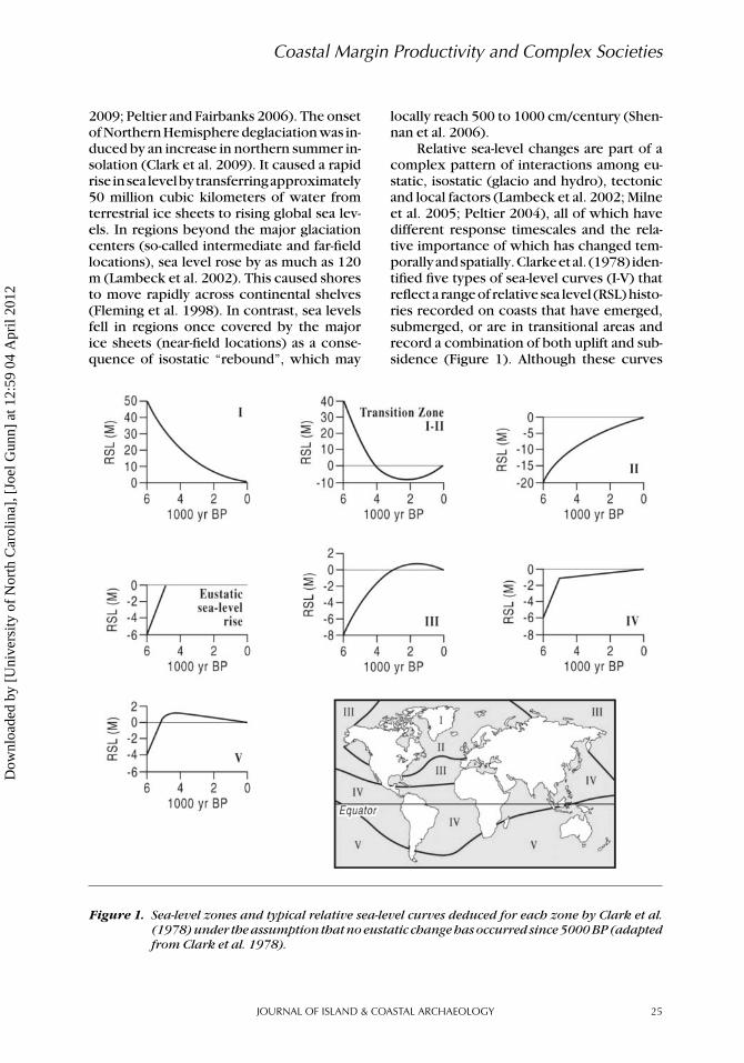
Relative sea-level changes are part of acomplex pattern of interactions among eu-static, isostatic (glacio and hydro), tectonicand local factors (Lambeck et al. 2002; Milneet al. 2005; Peltier 2004), all of which havedifferent response timescales and the rela-tive importance of which has changed tem-porallyandspatially.Clarkeetal. (1978) iden-tified five types of sea-level curves (I-V) thatreflect a range of relative sea level (RSL) histo-ries recorded on coasts that have emerged,submerged, or are in transitional areas andrecord a combination of both uplift and sub-sidence (Figure 1). Although these curves
Figure 1. Sea-level zones and typical relative sea-level curves deduced for each zone by Clark et al.(1978) under the assumption that no eustatic change has occurred since 5000 BP (adaptedfrom Clark et al. 1978).
JOURNAL OF ISLAND & COASTAL ARCHAEOLOGY 25
Dow
nloa
ded
by [
Uni
vers
ity o
f N
orth
Car
olin
a], [
Joel
Gun
n] a
t 12:
59 0
4 A
pril
2012

John W. Day, Jr. et al.
provide the general impression of the rateand direction of RSL change, they do notreflect the now-understood true uncertaintyassociated with estimates of the altitude andage of former sea levels.
The six societies we describe in this ar-ticle are from intermediate and far-field lo-cations. Therefore, they are characterizedby rapid relative sea-level increase follow-ing deglaciation. The eustatic contributionto sea-level change during deglaciation aver-aged 100 cm/century. However, peak ratespotentially exceeded 500 cm/century during“meltwater pulses” at 19,000 and 14,500 BP(Alley et al. 2005). Empirical data (Bard et al.1996; Fairbanks 1989) and glacial isostaticmodeling studies (Fleming et al. 1998; Lam-beck et al. 2002; Milne et al. 2005; Peltier2004) suggest a significant reduction in theeustatic contributions to sea-level change at∼7000 BP when the earth entered into a pe-riod of relative sea-level stability. After this,oceanelevationchangedonlybytwoorthreemeters.
At far-field locations (distant from glacialcenters), relative sea-level observations arecommonly characterized by a mid-Holocene(7000–5000 BP) sea-level maximum, or high-stand (Milne et al. 2005). The slight fall ofa meter or two in relative sea level from4500 BP until the second half of the nine-teenth century is a result of ongoing iso-static processes. These include local hydro-isostatic loading (termed continental lever-ing) and a global fall in the ocean surface dueto both glacio- and hydro-isostatic loading ofthe Earth’s surface (termed equatorial oceansiphoning, Milne et al. 2005).
INCREASED PRODUCTIVITY OF CMS INTHE MID HOLOCENE
Continental margins are commonly referredto as coastal margins or coastal marginecosystems (CMs) and include continentalshelves, near-shore upwelling zones, estuar-ies, deltas, and lower river floodplains thatare influenced by sea-level changes (Day etal. 2007:1). The latter is normally to the firstshoals/falls/rapids of rivers and may extendhundreds of kilometers inland (∼800 km for
the Mississippi and Yellow rivers, see for ex-amples, Brooks et al. 1986; Liu 2004).
The onset of Holocene conditions, stabi-lization of relative sea level, and the warm-ing of the global oceans, acted synergisti-cally two ways to increase productivity ofCMs worldwide (Figure 2), probably fromless than 300 g dry matter m−2yr−1 to morethan 2000 g dry matter m−2yr−1. As sea levelstabilized after ∼7000 BP, the area availablefor CMs increased greatly because it placedCMshigheron innercontinental shelves (i.e.,Roberts 1997; Stanley and Chen 1996; Stan-ley and Hait 2000; Stanley and Warne 1993a,1993b, 1997, 1998). The slope of continentalshelves ranges from 1 in 1,000 (steep) to 1 in20,000 (flat, e.g., the Persian Gulf) comparedto 1 in 200 for the steeper continental slope.Thus, a typical, productive estuarine depthrange of 10 m is as little as 2 km wide near theshelf break compared to as much as 200 kmon the inner shelf. At low stands of sea level,more of the CM would be over deeper slopewater. Thus, CM productivity was greater athigh stands of sea level both because produc-tivity was higher on a unit area basis and thetotal area of CMs was much higher.
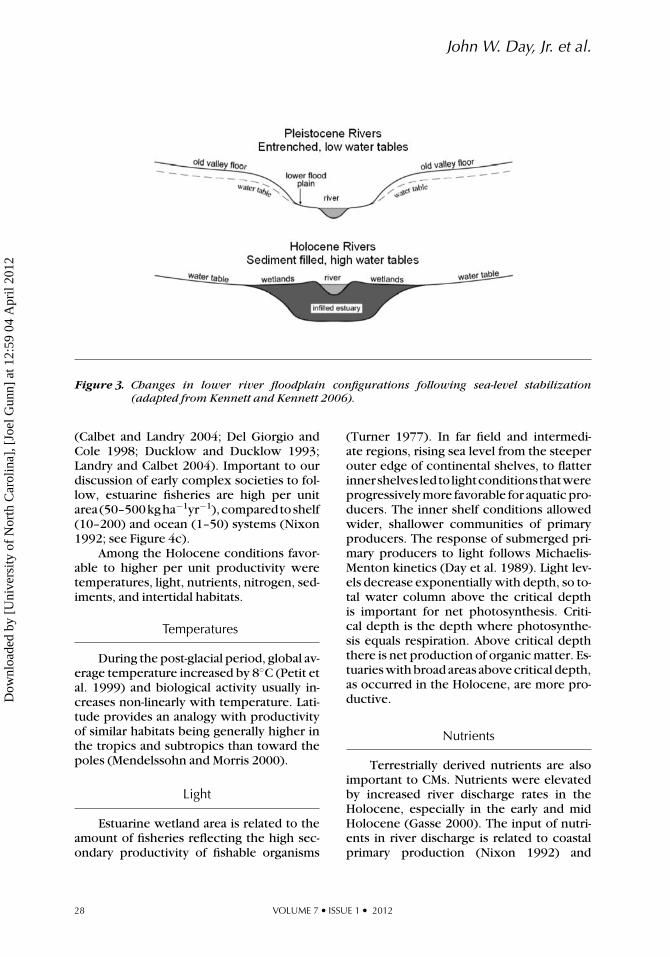
As relative sea level stabilized near itspresent elevation high on the continentalshelves, there was a great expansion of es-tuaries, wetlands (Stanley and Hait 2000),enclosed bays, and reefs. Lower river flood-plains (Figure 3) developed near-surface wa-ter tables and fertile river levees (Kennettet al. 2003). This is especially so near themouths of large rivers where deltas formed(i.e., Roberts 1997).
Another function of the cessation ofrapid sea-level rise is the stability of CMs.During deglaciation, on a 100 km wide conti-nental shelf, the sea moved landward about akm per century while depth increased 100–200 cm/century during some phases of theLate Pleistocene. CMs are less productive athigh rates of sea-level rise because large ar-eas of very high productivity habitats (i.e.,reefs, wetlands) cannot form because theyare continually drowned. Thus, estuaries hadlow levels of productivity during most of theearly Holocene period.
The same reasoning holds for lowerriver valleys. During the low stand of sea
26 VOLUME 7 • ISSUE 1 • 2012
Dow
nloa
ded
by [
Uni
vers
ity o
f N
orth
Car
olin
a], [
Joel
Gun
n] a
t 12:
59 0
4 A
pril
2012

Coastal Margin Productivity and Complex Societies
Figure 2. Width of a zone with a 10 meter depth range as sea-level rises across the continental shelfwhere more of the system is located over shallow shelf waters.
level, lower river channels were deeply en-trenched and floodplains narrow comparedto today (Kennett and Kennett 2006; seeFigure 3). Frequent inundations in narrowfloodplains would have prevented the es-tablishment of large permanent settlements,especially major urban areas with monumen-tal architecture. There would have been lit-tle subsurface water table to support agri-culture or human populations on adjacenthighlands. In addition, rapid infilling of en-trenched lower river channels during sea-level rise also would have prevented the de-velopment of large urban centers.
Holocene conditions acted on CMs byincreasing per unit productivity. It is knownthat the primary and secondary (e.g., fish-eries) productivity per unit area of CMs,especially estuaries and lower floodplains,is among the highest on Earth (Table 1).This productivity is supported by a varietyof prolific, shallow-water, primary-producercommunities: wetlands including marshesand mangroves, sea grasses, phytoplankton,macroalgae, benthic algae, and floodplain
forests. Dry matter productivity increasesdramatically from open ocean water (125 gdry matter m−2yr−1), to shelves (300), up-welling areas (500), to estuaries (2000) andlower river floodplains (1000). In ocean wa-ters, most phytoplankton production is con-sumed in the microbial food web, but in es-tuaries much more is channeled into large,fishable organisms higher in the food chain
Table 1. Primary productivity of coastalmargin ecosystems (g dry matterm−2yr−1). (Sources: Mann 1982;Whittaker 1975)
Habitat g dry matter m−2yr−1
Open ocean 125
Upwelling zones 500
Continental shelf 300
Estuaries (including wetlands,
algal beds, reefs)
2000
Floodplain forests 1000
JOURNAL OF ISLAND & COASTAL ARCHAEOLOGY 27
Dow
nloa
ded
by [
Uni
vers
ity o
f N
orth
Car
olin
a], [
Joel
Gun
n] a
t 12:
59 0
4 A
pril
2012
John W. Day, Jr. et al.
Figure 3. Changes in lower river floodplain configurations following sea-level stabilization(adapted from Kennett and Kennett 2006).
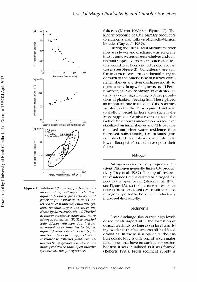
(Calbet and Landry 2004; Del Giorgio andCole 1998; Ducklow and Ducklow 1993;Landry and Calbet 2004). Important to ourdiscussion of early complex societies to fol-low, estuarine fisheries are high per unitarea(50–500kgha−1yr−1),comparedtoshelf(10–200) and ocean (1–50) systems (Nixon1992; see Figure 4c).
Among the Holocene conditions favor-able to higher per unit productivity weretemperatures, light, nutrients, nitrogen, sed-iments, and intertidal habitats.
Temperatures
During the post-glacial period, global av-erage temperature increased by 8◦C (Petit etal. 1999) and biological activity usually in-creases non-linearly with temperature. Lati-tude provides an analogy with productivityof similar habitats being generally higher inthe tropics and subtropics than toward thepoles (Mendelssohn and Morris 2000).
Light
Estuarine wetland area is related to theamount of fisheries reflecting the high sec-ondary productivity of fishable organisms
(Turner 1977). In far field and intermedi-ate regions, rising sea level from the steeperouter edge of continental shelves, to flatterinnershelves ledto lightconditionsthatwereprogressively more favorable for aquatic pro-ducers. The inner shelf conditions allowedwider, shallower communities of primaryproducers. The response of submerged pri-mary producers to light follows Michaelis-Menton kinetics (Day et al. 1989). Light lev-els decrease exponentially with depth, so to-tal water column above the critical depthis important for net photosynthesis. Criti-cal depth is the depth where photosynthe-sis equals respiration. Above critical depththere is net production of organic matter. Es-tuaries with broad areas above critical depth,as occurred in the Holocene, are more pro-ductive.
Nutrients
Terrestrially derived nutrients are alsoimportant to CMs. Nutrients were elevatedby increased river discharge rates in theHolocene, especially in the early and midHolocene (Gasse 2000). The input of nutri-ents in river discharge is related to coastalprimary production (Nixon 1992) and
28 VOLUME 7 • ISSUE 1 • 2012
Dow
nloa
ded
by [
Uni
vers
ity o
f N
orth
Car
olin
a], [
Joel
Gun
n] a
t 12:
59 0
4 A
pril
2012
Coastal Margin Productivity and Complex Societies
Figure 4. Relationships among freshwater res-idence time, nitrogen retention,aquatic primary productivity, andfisheries for estuarine systems. Af-ter sea level stabilized, estuarine sys-tems became larger and more en-closed by barrier islands. (A) This ledto longer residence times and morenitrogen retention. (B) This coupledwith higher nitrogen input fromincreased river flow led to higheraquatic primary productivity. (C) Inmarine systems, primary productionis related to fisheries yield with es-tuaries being greater than ten timesmore productive than open marinesystems. See text for references.
fisheries (Nixon 1982; see Figure 4C). Thekinetic response of CME primary producersto nutrients also follows Michaelis-Mentonkinetics (Day et al. 1989).
During the Last Glacial Maximum, riverflow was lower and discharge was generallyintooceanicwatersonouter shelvesandcon-tinental slopes. Nutrients in outer shelf wa-ters would have been diluted by open oceanwater (see Figure 2). Conditions were sim-ilar to current western continental marginsof much of the Americas with narrow conti-nental shelves and river discharge mostly toopen oceans. In upwelling areas, as off Peru,however, near-shore phytoplankton produc-tivity was very high leading to dense popula-tions of plankton feeding fish. These playedan important role in the diet of the societieswe discuss for the Peru region. Dischargeto shallow, broad, inshore areas such as theMississippi and Grijalva river deltas on theGulf of Mexico was uncommon. As sea levelstabilized on inner shelves and CMs becameenclosed and river water residence timeincreased substantially, CM habitats (bar-rier islands, deltas, estuaries, mollusk reefs,lower floodplains) could develop to theirfullest.
Nitrogen
Nitrogen is an especially important nu-trient. Nitrogen generally limits CM produc-tivity (Day et al. 1989). The log of freshwa-ter residence time is related to nitrogen ex-port to the open ocean (Nixon et al. 1996;see Figure 4A), so the increase in residencetime in broad, enclosed CMs resulted in lessnitrogen exported to the ocean. Productivityincreased dramatically.
Sediments
River discharge also carries high levelsof sediments important in the formation ofcoastal wetlands. As long as sea level was ris-ing, wetlands that became established faceddrowning. In the Mississippi delta, the ear-liest deltaic lobe is only one of seven majordelta lobes that have no surface expressionbecause it was inundated as it was formed(Roberts 1997). Fresh sediment supply is
JOURNAL OF ISLAND & COASTAL ARCHAEOLOGY 29
Dow
nloa
ded
by [
Uni
vers
ity o
f N
orth
Car
olin
a], [
Joel
Gun
n] a
t 12:
59 0
4 A
pril
2012
John W. Day, Jr. et al.
necessary to co-elevate wetlands with up-ward changes in sea level.
Intertidal Habitats
Intertidal reef communities such as oys-ters and clams have very high biomass andserve as a habitat for many species of fish(Turner 1977). They contribute greatly to es-tuarine productivity by providing food andhabitat for estuarine consumers and in con-serving and recycling nutrients.
In summary, we believe that initially,rapid sea-level rise and coastal advance re-sulted in small, ephemeral, intertidal com-munities.As relative sea level stabilized in theshallows of the continental shelves, the areaof intertidal habitats increased dramatically(Kennett et al. 2003; Stanley and Hait 2000)while their productivity was augmented bybetter light conditions, more river input,higher temperatures, and greater nutrientavailability. At the low stand of relative sealevel, rivers flowed across the coastal plainin entrenched valleys and discharged tothe outer shelf and slope, which had rela-tively low productivity. An exception wasupwelling coasts where high phytoplanktonproductivity was maintained by nutrients inthe deeper upwelled water. The rise and sta-bilization of sea level led to flooding of lowerriver valleys, infilling incised river channels,and the formation of extensive floodplains.An important consideration for this study isthedecades tocentennial timescale requiredto establish widespread, mature coastal habi-tats such as shellfish reefs and intertidal wet-lands that were also accessible to humans(i.e., Roberts 1997).
CM PRODUCTIVITY AND ORIGINS OFCOMPLEX SOCIETIES
Significant to human coastal margin resi-dents is that maritime and terrestrial habi-tats are often productive at different times ofthe year, especially in tropical and subtrop-ical latitudes (Perlman 1980; Rojas-Galavizet al. 1992), and easily accessible, thus en-suring an ample supply of high-quality an-imal polyunsaturated fats and protein year
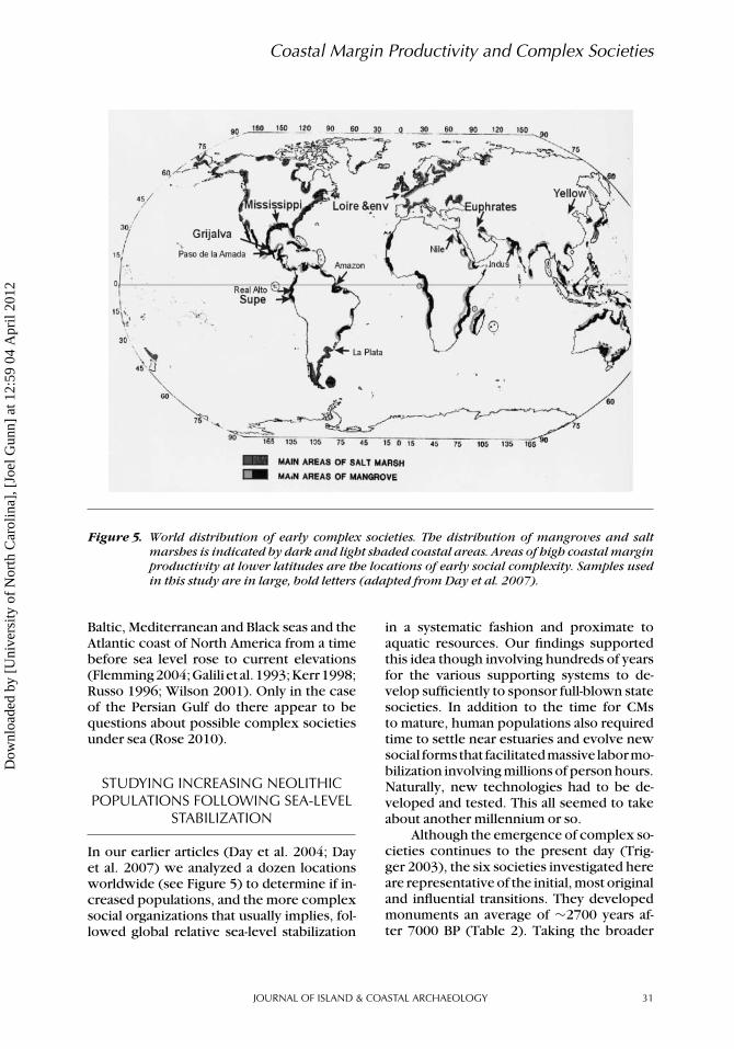
around. In arid and semi-arid environments,such as Mesopotamia and Peru, the contrastin productivity between aquatic and wetlandCMs and adjacent terrestrial ecosystems canbe extreme. These CMs encompass the ar-eas where ranked societies appeared amongearly farming communities (Figure 5).
Our hypothesis is that most initial com-plex social organizations developed follow-ing sea-level stabilization because they weresubsidized by the newly evolved, high pro-ductivity of CMs. The relationship of com-plex social organizations and the dramaticincrease in coastal margin productivity couldbe questioned if previous evidence of com-plex societies were hidden by sea-level risebefore 7000 BP (for example Washington2007). We believe, however, that this isimprobable because the rapidity of changeand instability of sea level before that datewould have prevented the establishment ofbroad areas of rich coastal margin resourcesandthus largepermanenthumansettlementswith multi-tiered administrative functions.
The issue of human adaptations be-fore and after sea-level rise has been re-searched and discussed for some time. Es-pecially helpful were chemical analyses ofhuman bone in discovering changing dietaryhabits (Benfer 1990; Quilter and Stocker1983;SchultingandRichards2001).Require-ments and availability of carbohydrates andprotein have been considered in terms ofterrestrial animals, fish, and shellfish (Er-landson 1988). Stothert et al. (2003) onthe Santa Elena Peninsula of Pacific coastSouth America found that before 7000 BPmarine resources in the area were ephemeralcausing the inhabitants to adjust to shift-ing, small estuaries and deltas. They, there-fore, relieddominantlyon terrestrial animals.After sea-level stabilization, however, fishreplaced small mammals. A similar case ismade for the Caribbean coast of South Amer-ica (Oyuela-Caycedo 1996). We suggest thatsimilarly elsewhere, under-sea archaeologi-cal sites will be limited to the Paleolithic,and Mesolithic. In special cases of regions af-fected by isostatic land surface adjustments,Neolithic communities may be drowned(medium field) or elevated (near field). Ex-amples are those found under the North,
30 VOLUME 7 • ISSUE 1 • 2012
Dow
nloa
ded
by [
Uni
vers
ity o
f N
orth
Car
olin
a], [
Joel
Gun
n] a
t 12:
59 0
4 A
pril
2012
Coastal Margin Productivity and Complex Societies
Figure 5. World distribution of early complex societies. The distribution of mangroves and saltmarshes is indicated by dark and light shaded coastal areas. Areas of high coastal marginproductivity at lower latitudes are the locations of early social complexity. Samples usedin this study are in large, bold letters (adapted from Day et al. 2007).
Baltic, Mediterranean and Black seas and theAtlantic coast of North America from a timebefore sea level rose to current elevations(Flemming2004;Galili et al.1993;Kerr1998;Russo 1996; Wilson 2001). Only in the caseof the Persian Gulf do there appear to bequestions about possible complex societiesunder sea (Rose 2010).
STUDYING INCREASING NEOLITHICPOPULATIONS FOLLOWING SEA-LEVEL
STABILIZATION
In our earlier articles (Day et al. 2004; Dayet al. 2007) we analyzed a dozen locationsworldwide (see Figure 5) to determine if in-creased populations, and the more complexsocial organizations that usually implies, fol-lowed global relative sea-level stabilization
in a systematic fashion and proximate toaquatic resources. Our findings supportedthis idea though involving hundreds of yearsfor the various supporting systems to de-velop sufficiently to sponsor full-blown statesocieties. In addition to the time for CMsto mature, human populations also requiredtime to settle near estuaries and evolve newsocial forms that facilitatedmassive labormo-bilization involving millions of person hours.Naturally, new technologies had to be de-veloped and tested. This all seemed to takeabout another millennium or so.
Although the emergence of complex so-cieties continues to the present day (Trig-ger 2003), the six societies investigated hereare representative of the initial, most originaland influential transitions. They developedmonuments an average of ∼2700 years af-ter 7000 BP (Table 2). Taking the broader
JOURNAL OF ISLAND & COASTAL ARCHAEOLOGY 31
Dow
nloa
ded
by [
Uni
vers
ity o
f N
orth
Car
olin
a], [
Joel
Gun
n] a
t 12:
59 0
4 A
pril
2012
John W. Day, Jr. et al.
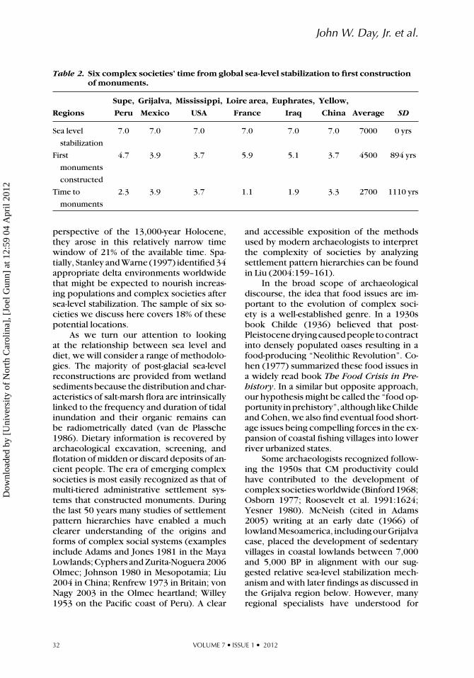
Table 2. Six complex societies’ time from global sea-level stabilization to first constructionof monuments.
Supe, Grijalva, Mississippi, Loire area, Euphrates, Yellow,
Regions Peru Mexico USA France Iraq China Average SD
Sea level
stabilization
7.0 7.0 7.0 7.0 7.0 7.0 7000 0 yrs
First
monuments
constructed
4.7 3.9 3.7 5.9 5.1 3.7 4500 894 yrs
Time to
monuments
2.3 3.9 3.7 1.1 1.9 3.3 2700 1110 yrs
perspective of the 13,000-year Holocene,they arose in this relatively narrow timewindow of 21% of the available time. Spa-tially, Stanley and Warne (1997) identified 34appropriate delta environments worldwidethat might be expected to nourish increas-ing populations and complex societies aftersea-level stabilization. The sample of six so-cieties we discuss here covers 18% of thesepotential locations.
As we turn our attention to lookingat the relationship between sea level anddiet, we will consider a range of methodolo-gies. The majority of post-glacial sea-levelreconstructions are provided from wetlandsediments because the distribution and char-acteristics of salt-marsh flora are intrinsicallylinked to the frequency and duration of tidalinundation and their organic remains canbe radiometrically dated (van de Plassche1986). Dietary information is recovered byarchaeological excavation, screening, andflotation of midden or discard deposits of an-cient people. The era of emerging complexsocieties is most easily recognized as that ofmulti-tiered administrative settlement sys-tems that constructed monuments. Duringthe last 50 years many studies of settlementpattern hierarchies have enabled a muchclearer understanding of the origins andforms of complex social systems (examplesinclude Adams and Jones 1981 in the MayaLowlands; Cyphers and Zurita-Noguera 2006Olmec; Johnson 1980 in Mesopotamia; Liu2004 in China; Renfrew 1973 in Britain; vonNagy 2003 in the Olmec heartland; Willey1953 on the Pacific coast of Peru). A clear
and accessible exposition of the methodsused by modern archaeologists to interpretthe complexity of societies by analyzingsettlement pattern hierarchies can be foundin Liu (2004:159–161).
In the broad scope of archaeologicaldiscourse, the idea that food issues are im-portant to the evolution of complex soci-ety is a well-established genre. In a 1930sbook Childe (1936) believed that post-Pleistocenedryingcausedpeople tocontractinto densely populated oases resulting in afood-producing “Neolithic Revolution”. Co-hen (1977) summarized these food issues ina widely read book The Food Crisis in Pre-history. In a similar but opposite approach,our hypothesis might be called the “food op-portunity inprehistory”,althoughlikeChildeand Cohen, we also find eventual food short-age issues being compelling forces in the ex-pansion of coastal fishing villages into lowerriver urbanized states.
Some archaeologists recognized follow-ing the 1950s that CM productivity couldhave contributed to the development ofcomplex societies worldwide (Binford 1968;Osborn 1977; Roosevelt et al. 1991:1624;Yesner 1980). McNeish (cited in Adams2005) writing at an early date (1966) oflowland Mesoamerica, including our Grijalvacase, placed the development of sedentaryvillages in coastal lowlands between 7,000and 5,000 BP in alignment with our sug-gested relative sea-level stabilization mech-anism and with later findings as discussed inthe Grijalva region below. However, manyregional specialists have understood for
32 VOLUME 7 • ISSUE 1 • 2012
Dow
nloa
ded
by [
Uni
vers
ity o
f N
orth
Car
olin
a], [
Joel
Gun
n] a
t 12:
59 0
4 A
pril
2012

Coastal Margin Productivity and Complex Societies
Figure 6. Location map of the Supe River valley and the locations of the Aspero and Caral archaeo-logical sites (adapted from Solis et al. 2001).
some time that increases in regional, lateNeolithic populations was often related tocoastal zone resources (Clark et al. 2010;Moseley1975;Perlman1980;Voorhies2004;Widmer 2004; and others), as have special-ists inotherdisciplines (KennettandKennett2006; Stanley and Warne 1997). Erlandsonand Fitzpatrick (2006) overview studies ofCMs and human utilization. After about 1980seriousdebatesoverCMproductivityandtherole they played in human social evolutionbegan (Erlandson 2001).
In this article we focus on the next stepin understanding issues of the influence ofcoastal zoneutilizationontheoriginsandsus-taining of complex societies. As Erlandsonand Fitzpatrick (2006:10) point out, “Insteadof global generalizations about the produc-tivity of dynamic island and coastal environ-ments, we need specific information on thenature of local or regional ecosystems (ter-restrial and marine) in coastal areas aroundthe globe—and how they changed throughtime.” In this article we are interested in bothwhether societiesusedmarine resourcesandto what extent those resources subsidizedthe evolution of middle Holocene complexsocieties and carried through to sustainingearly civilizations. Background to each of oursix regions is provided in the following re-gional discussions. Our objective here, then,is to examine our hypothesis in the contextof linked CM ecological systems (marine, es-tuarine, sedimentary, human) to population
increases late in the Neolithic period and so-cial complexity.
SEA LEVEL, DIET AND EARLY COMPLEXSOCIETIES
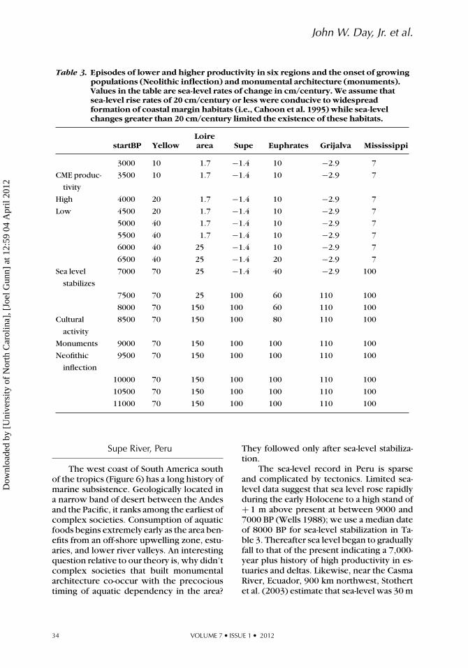
We have shown above that the productiv-ity of different CM primary producers is dra-matically different (see Table 1, Figure 4)and that the most productive habitats couldnot develop until the rate of sea-level riseslowed and stabilized on low-slope innercoasts (Nixon 1982; Nixon 1992; Nixon etal. 1996). Thus there is a general relationshipbetween the rate of sea-level rise and CMproductivity. This relationship is importantto our discussion of Post-Pleistocene coastalmargin evolution with the development ofcomplex societies. We used descriptions ofsea-level rise in each region and related thisto the advent of complex societies to localrates of change rather than to a worldwidedate of 7000 BP as was done in our originalarticle.
The order of discussion of the societiesis based on the intricacy of their culture his-tories, or narratives. This begins with therelatively straightforward South Americancase of the Supe River valley and proceedsthrough six steps to the very complex storyof China. Taken together, the six case studiesoffer a range of decision paths from Neolithicvillages to urbanized states.
JOURNAL OF ISLAND & COASTAL ARCHAEOLOGY 33
Dow
nloa
ded
by [
Uni
vers
ity o
f N
orth
Car
olin
a], [
Joel
Gun
n] a
t 12:
59 0
4 A
pril
2012
John W. Day, Jr. et al.
Table 3. Episodes of lower and higher productivity in six regions and the onset of growingpopulations (Neolithic inflection) and monumental architecture (monuments).Values in the table are sea-level rates of change in cm/century. We assume thatsea-level rise rates of 20 cm/century or less were conducive to widespreadformation of coastal margin habitats (i.e., Cahoon et al. 1995) while sea-levelchanges greater than 20 cm/century limited the existence of these habitats.
startBP YellowLoirearea Supe Euphrates Grijalva Mississippi
3000 10 1.7 −1.4 10 −2.9 7
CME produc-
tivity
3500 10 1.7 −1.4 10 −2.9 7
High 4000 20 1.7 −1.4 10 −2.9 7
Low 4500 20 1.7 −1.4 10 −2.9 7
5000 40 1.7 −1.4 10 −2.9 7
5500 40 1.7 −1.4 10 −2.9 7
6000 40 25 −1.4 10 −2.9 7
6500 40 25 −1.4 20 −2.9 7
Sea level
stabilizes
7000 70 25 −1.4 40 −2.9 100
7500 70 25 100 60 110 100
8000 70 150 100 60 110 100
Cultural
activity
8500 70 150 100 80 110 100
Monuments 9000 70 150 100 100 110 100
Neofithic
inflection
9500 70 150 100 100 110 100
10000 70 150 100 100 110 100
10500 70 150 100 100 110 100
11000 70 150 100 100 110 100
Supe River, Peru
The west coast of South America southof the tropics (Figure 6) has a long history ofmarine subsistence. Geologically located ina narrow band of desert between the Andesand the Pacific, it ranks among the earliest ofcomplex societies. Consumption of aquaticfoods begins extremely early as the area ben-efits from an off-shore upwelling zone, estu-aries, and lower river valleys. An interestingquestion relative to our theory is, why didn’tcomplex societies that built monumentalarchitecture co-occur with the precocioustiming of aquatic dependency in the area?
They followed only after sea-level stabiliza-tion.
The sea-level record in Peru is sparseand complicated by tectonics. Limited sea-level data suggest that sea level rose rapidlyduring the early Holocene to a high stand of+ 1 m above present at between 9000 and7000 BP (Wells 1988); we use a median dateof 8000 BP for sea-level stabilization in Ta-ble 3. Thereafter sea level began to graduallyfall to that of the present indicating a 7,000-year plus history of high productivity in es-tuaries and deltas. Likewise, near the CasmaRiver, Ecuador, 900 km northwest, Stothertet al. (2003) estimate that sea-level was 30 m
34 VOLUME 7 • ISSUE 1 • 2012
Dow
nloa
ded
by [
Uni
vers
ity o
f N
orth
Car
olin
a], [
Joel
Gun
n] a
t 12:
59 0
4 A
pril
2012
Coastal Margin Productivity and Complex Societies
below present in 10,000 BP, rising rapidly till7000BP.This latterfiguregivessomesenseofthe rate of sea-level rise during the early criti-cal years of Holocene societies (see Table 3).
Verifiable consumption of marine re-sources began relatively early after 13,000BP (Archaic Period) (Keefer et al. 1998) re-flecting the stable, long-term reliability onoff-shore upwelling. Domestication of plantsfollowed by 11,000 to 10,000 BP (Dillehayet al. 2007; Stothert et al. 2003) both onthe Peruvian and Ecuadorian coasts. Even so,there were notable upturns in intensity ofpopulation, sedentism, and ceremonialismaround 8000 BP corresponding to local sea-level stabilization. The coastal community’spre-adaptations to maritime resources sincethe late Pleistocene probably accounts for itsearly development of complex society sincethere was an immediate increase in popula-tion adjusting to the new range and magni-tude of resources at the onset of high coastalproductivity.
Indications of social complexity begin atthe mouth of the Supe River in the sea-sidesite of Aspero with some small mound build-ing after 5700 BP (Feldman 1983; Haas andCreamer 2006; Moseley 1975). Apparentlycotton was independently domesticated tomake fish nets. Solis et al. (2001) reportthis coastal adaptation evolved toward large-scale monuments in the interior by 4700BP. As we shall see, first stage complexitynear coasts, probably “chiefdoms” (two- orthree-tiered administrations, Liu 2004:160),followed by greater interior social complex-itymoreat thescaleof“states”(four tiered), ischaracteristic of the urban transition world-wide, a pattern repeated in other regions.This can probably be explained because CMresources cannot be expanded without ex-tensive modern aquaculture (Wilkinson, per-sonal communication to Gunn, 2011). Onthe other hand, lower river valley produc-tivity could be extended by intensifying Ne-olithic plant and animal species thanks tonew, near-surface water tables made pos-sible by sea-level stabilization (see Figure3 and related text). An important implica-tion of this study is that agricultural inten-sification did not arise from Neolithic vil-lages but rather from complex coastal system
communities extending their reach inland.To maintain population densities that sup-ported complexity, they had to make theresources of the lower river valleys corre-spond to coastal productivity by intensify-ing Neolithic plant species productivity byirrigation, and by fish farming. This conceptmight be somewhat in the mode of Cohen’s(1977) thinking about food crises, but solvedby agency.
As growing populations expanded in-land, they continued to rely on the oceanand estuaries for lipids and protein as wasfeasible. At Caral, Solis et al. (2001:725) re-port finding “squash, beans, lucuma, guava,pacay, camote, and cotton. Animal remainsare almost exclusively marine, includingquantities of clams and mussels and an abun-dance of anchovies and sardines. . . . a mixof plants grown in irrigated fields within theSupe Valley and marine resources from thePacific Ocean, 23km to the west.”
The presence of clams and mussels in-dicates that shallow-water food resourceswereaddedto theearlierconsumptionofma-rine fishes. Sardines would have come fromthe upwelling zone while clams and musselswould have been harvested from the inter-tidal and shallow subtidal zones. In otherwords, the society was intensifying its use ofboth marine and terrestrial resources to sup-port increased populations and social com-plexity.
Given that Caral was located in a desert,and that irrigation agriculture followed ma-rine resources, we suppose that aquaticspecies provided the subsistence capital forthis society to develop intensive agricultureand social complexity. This is a pattern wewill see repeated in some subsequently de-scribed regions. The Humboldt Current up-welling zone and coastal South America con-tinues to the present to supply large volumesof protein and fish oil to local and world mar-kets.
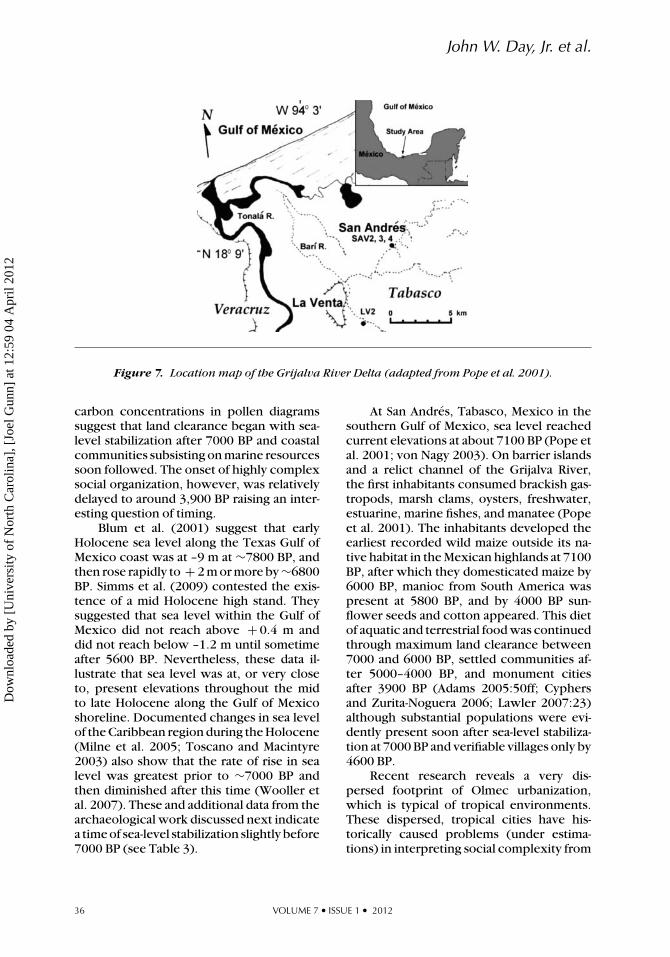
Grijalva River, Mexico
The Olmec whose heartland includesthe extensive delta of the Grijlava River,were the earliest monumental society inMesoamerica (Adams 2005). Increasing
JOURNAL OF ISLAND & COASTAL ARCHAEOLOGY 35
Dow
nloa
ded
by [
Uni
vers
ity o
f N
orth
Car
olin
a], [
Joel
Gun
n] a
t 12:
59 0
4 A
pril
2012
John W. Day, Jr. et al.
Figure 7. Location map of the Grijalva River Delta (adapted from Pope et al. 2001).
carbon concentrations in pollen diagramssuggest that land clearance began with sea-level stabilization after 7000 BP and coastalcommunities subsisting on marine resourcessoon followed. The onset of highly complexsocial organization, however, was relativelydelayed to around 3,900 BP raising an inter-esting question of timing.
Blum et al. (2001) suggest that earlyHolocene sea level along the Texas Gulf ofMexico coast was at –9 m at ∼7800 BP, andthen rose rapidly to + 2 m or more by ∼6800BP. Simms et al. (2009) contested the exis-tence of a mid Holocene high stand. Theysuggested that sea level within the Gulf ofMexico did not reach above + 0.4 m anddid not reach below –1.2 m until sometimeafter 5600 BP. Nevertheless, these data il-lustrate that sea level was at, or very closeto, present elevations throughout the midto late Holocene along the Gulf of Mexicoshoreline. Documented changes in sea levelof the Caribbean region during the Holocene(Milne et al. 2005; Toscano and Macintyre2003) also show that the rate of rise in sealevel was greatest prior to ∼7000 BP andthen diminished after this time (Wooller etal. 2007). These and additional data from thearchaeological work discussed next indicatea time of sea-level stabilization slightly before7000 BP (see Table 3).
At San Andres, Tabasco, Mexico in thesouthern Gulf of Mexico, sea level reachedcurrent elevations at about 7100 BP (Pope etal. 2001; von Nagy 2003). On barrier islandsand a relict channel of the Grijalva River,the first inhabitants consumed brackish gas-tropods, marsh clams, oysters, freshwater,estuarine, marine fishes, and manatee (Popeet al. 2001). The inhabitants developed theearliest recorded wild maize outside its na-tive habitat in the Mexican highlands at 7100BP, after which they domesticated maize by6000 BP, manioc from South America waspresent at 5800 BP, and by 4000 BP sun-flower seeds and cotton appeared. This dietof aquatic and terrestrial food was continuedthrough maximum land clearance between7000 and 6000 BP, settled communities af-ter 5000–4000 BP, and monument citiesafter 3900 BP (Adams 2005:50ff; Cyphersand Zurita-Noguera 2006; Lawler 2007:23)although substantial populations were evi-dently present soon after sea-level stabiliza-tion at 7000 BP and verifiable villages only by4600 BP.
Recent research reveals a very dis-persed footprint of Olmec urbanization,which is typical of tropical environments.These dispersed, tropical cities have his-torically caused problems (under estima-tions) in interpreting social complexity from
36 VOLUME 7 • ISSUE 1 • 2012
Dow
nloa
ded
by [
Uni
vers
ity o
f N
orth
Car
olin
a], [
Joel
Gun
n] a
t 12:
59 0
4 A
pril
2012
Coastal Margin Productivity and Complex Societies
an ethnocentric western perspective rootedin medieval European culture (Sassamanand Hekenberger 2004; Scarborough 2008).However, given the huge effort needed tobuild the Olmec’s first monumental city ofSan Lorenzo following 3900 BP, there canbe no doubt that it was a populous, well-organized and complex society with multi-ple administrative levels.
To the present day, the Olmec regionsupplies the greatest proportion of aquaticresources of any in Mexico and is noted forits seafood cuisine. It is worth observing thatin both the Supe and Grijalva cases, domes-tication of plants entrains on utilization ofaquatic resources.
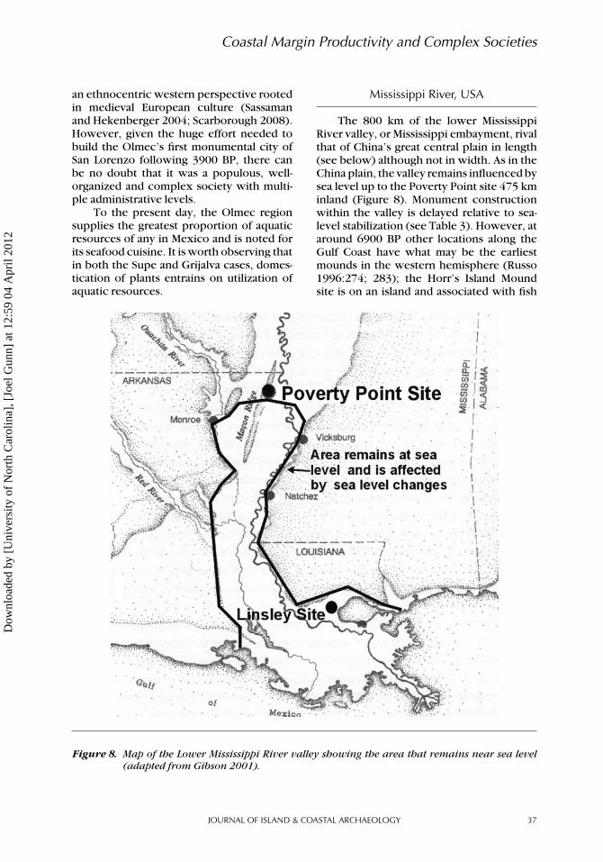
Mississippi River, USA
The 800 km of the lower MississippiRiver valley, or Mississippi embayment, rivalthat of China’s great central plain in length(see below) although not in width. As in theChina plain, the valley remains influenced bysea level up to the Poverty Point site 475 kminland (Figure 8). Monument constructionwithin the valley is delayed relative to sea-level stabilization (see Table 3). However, ataround 6900 BP other locations along theGulf Coast have what may be the earliestmounds in the western hemisphere (Russo1996:274; 283); the Horr’s Island Moundsite is on an island and associated with fish
Figure 8. Map of the Lower Mississippi River valley showing the area that remains near sea level(adapted from Gibson 2001).
JOURNAL OF ISLAND & COASTAL ARCHAEOLOGY 37
Dow
nloa
ded
by [
Uni
vers
ity o
f N
orth
Car
olin
a], [
Joel
Gun
n] a
t 12:
59 0
4 A
pril
2012

John W. Day, Jr. et al.
subsistence. Advanced social complexity inthe Mississippi valley is associated with thePoverty Point culture and its predecessors.It achieved truly monumental constructionworks (perhaps 7 million person hrs; Gib-son 2006), but the presence of the traditionwas intermittent with a period of archaeolog-ical invisibility around 5000 to 3500 BP (Gib-son 2006), a ∼–1m sea-level episode (Tanner1993). It may be that during such times whenthe lower valley would have been drained ofstanding water, the less-elevated Mississippidelta could have served as a refugium forthe ideas of complex societies; the earliestPoverty Point date comes from that area.
Following the Last Glacial Maximum, sealevel rose rapidly until the early Holocene(7000 to 8000 BP) when the rate of rise de-creased dramatically (Coleman et al. 1998).Coleman and Smith (1964) and Redfield(1967) illustrate a relative sea-level rise of 7cm/century until ∼4,500 BP with a markedreduction thereafter. More recently, an ex-tensive sampling program in the Mississippidelta by Tornqvist et al. (2004) focused onthe collection of basal peats (Figure 9). Theysuggest that sea-level rise rose rapidly from8000 to 6000 BP and followed a relativelysmooth trend to the present. In Table 3, weuse this latter figure to mark higher produc-tivity after 6000 BP.
The first appearance of the Poverty Pointculture was at around 5100 BP at the Lins-ley Site (Gibson 1996:293; Russo 1996:181–184). It lies on a levee within 15 km of the
Gulf with the Poverty Point culture level atabout 6 m below current sea level because ofsubsidence. Subsistence was brackish shell-fish with signature baked clay objects ofthe Poverty Point culture. Slightly later and485 km up the Mississippi valley, PovertyPoint mound sites begin to appear (Saunders2004). At 5000 BP, bone assemblages fromthese sites consist of 50–90 percent freshwa-ter fish from the immediate area (Sassamanand Hekenberger 2004). Poverty Point cul-ture seems to never have been concernedwith agriculture although the southeasternUnited States had a locally developed suiteof domesticated plants. Carbohydrates werecollected from aquatic plants such as cattail(Clark et al. 2010).
South Louisiana’s and New Orleans’seafood-based cuisine continues to thrive inspite of anthropogenic destruction of thedelta’s resources (Day et al. 2007).
Loire River Area, France
The regional culture of Northwest Eu-rope (Brittany, Normandy, Belgium, TheNetherlands, England, Ireland) constitutes alandscape whose nature is still being debatedfor the period under consideration. As a ge-ographic landscape it is difficult to define asa watershed because of intervening bodiesof ocean including the English Channel andthe Celtic Sea. Before sea-level rise, however,these seaways were river ways giving someancient unity to the area. We will address
Figure 9. Tornqvist et al. (2004) sea-level rise curve for the Mississippi delta. The error boxes showradiocarbon errors. The curve was corrected for a 1.1 mm/yr subsidence rate (adaptedfrom Tornqvist et al. 2004).
38 VOLUME 7 • ISSUE 1 • 2012
Dow
nloa
ded
by [
Uni
vers
ity o
f N
orth
Car
olin
a], [
Joel
Gun
n] a
t 12:
59 0
4 A
pril
2012
Coastal Margin Productivity and Complex Societies
this region by reference to the Loire Riverin western France because that is where theearliest megalithic monuments are and oneof the great salt-producing areas of Europe,always an important consideration in prehis-tory. However, the Loire area is understoodto include the drainages of the Avon, Seine,Boyne, and others that contain large monu-ments whose lower river valleys, were inun-dated by early Holocene sea-level rise.
Once thought to be a pale reflection ofthe Near East and North Africa, monumentconstruction is now known to compete fa-vorably with its eastern neighbors and therest of the world in times and scales of mon-ument building (Renfrew 1973). There isa long-standing debate over whether com-plex societies in the region developed outof maritime Mesolithic or Neolithic culture.There is a much argued understanding thatthe Mesolithic societies of Western Europewere something out of the ordinary forhunter-fishers, perhaps more like those ofthe North American Northwest Coast area(Warren 2005).
In Northwest Europe, there is an exten-sive archive of sea-level data that reveals acomplex, regionally and temporally varyingsea level since the Last Glacial Maximum.Relative sea-level observations and geophys-ical isostatic models clearly define the areaof postglacial rebound in Fennoscandia. Thisis surrounded by a subsiding zone situatedin the North Sea between Norway and GreatBritain that has the greatest post-glacial sub-sidence (the so-called glacial forebulge or pe-ripheral bulge). It extends through the north-western Netherlands and northern Germany(seeKempetal. 2011 fordetailedgeographicdescription).
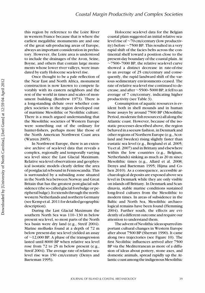
During the Last Glacial Maximum thesouthern North Sea was 110–130 m belowpresent sea level, so most parts of the NorthSea basin were dry land (e.g., Streif 2004).Marine mollusks found at a depth of 72 mbelow present-day sea level yielded an assayof ∼12,000 BP. A phase of the transgressionlasted until 8000 BP when relative sea levelrose from 72 to 25 m below present (e.g.,Streif 2004). The average rate of relative sea-level rise was 150 cm/century (Denys andBaeteman 1995).
Holocene sea-level data for the Belgiancoastal plain suggested an initial relative sea-level rise of ∼70 cm/century (low productiv-ity) before ∼7500 BP. This resulted in a veryrapid shift of the facies belts across the con-tinental shelf toward a position close to thepresent-day boundary of the coastal plain. At∼7500–7000 BP, the relative sea-level curveshowed a distinct decrease in rate-of-riseto an average of 25 cm/century and conse-quently, the rapid landward shift of the var-ious sedimentary environments ceased. Therate of relative sea-level rise continued to de-crease, and after ∼5500–5000 BP, it fell to anaverage of 7 cm/century, indicating higherproductivity (see Table 3).
Consumption of aquatic resources is ev-ident both in shell mounds and in humanbone assays by around 7500 BP (MesolithicPeriod, moderate fish resources) all along theAtlantic coast. However, because of the iso-static processes described above, the regionbehaved in a seesaw fashion, in Denmark andother regions of Northern Europe (e.g., Scot-land and Sweden) rising slightly faster thaneustatic sea level (e.g., Berglund et al. 2005;Yu et al. 2007) and in Brittany and elsewherewithin the low countries (e.g., Belgium,Netherlands) sinking as much as 20 m sinceMesolithic times (e.g., Allard et al. 2008;Denys and Baeteman 1995; Hijma and Co-hen 2010). As a consequence, accessible ar-chaeological deposits are exposed above sealevel in Denmark while they are only visibleon islands off Brittany. In Denmark and Scan-dinavia, stable marine conditions sustainedlong-lived cultures from the Mesolithic tomodern times. In areas of subsidence in theBaltic and North Sea, Mesolithic archaeo-logical remains have been found (Flemming2004). Further south, the effects are evi-dently of a different outcome and require ourattention to understand them.
TheadventofNeolithic ideasspurredim-portant cultural changes in Western Europeafter about 7500 BP (Sherratt 1990). It camealong two trajectories (see Figure 10). Thefirst Neolithic influences arrived after 7500BP via the Mediterranean as more of a diffu-sion of ideas about pottery, stone axes, anddomestic animals, spread rapidly up the At-lanticcoastamongthe indigenousMesolithic
JOURNAL OF ISLAND & COASTAL ARCHAEOLOGY 39
Dow
nloa
ded
by [
Uni
vers
ity o
f N
orth
Car
olin
a], [
Joel
Gun
n] a
t 12:
59 0
4 A
pril
2012
John W. Day, Jr. et al.
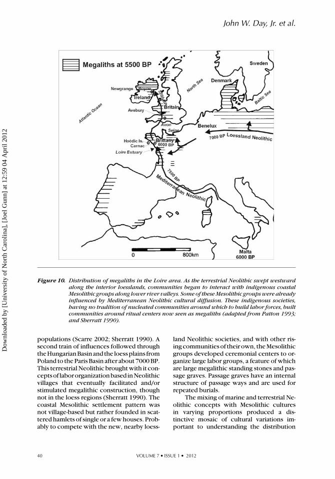
Figure 10. Distribution of megaliths in the Loire area. As the terrestrial Neolithic swept westwardalong the interior loesslands, communities began to interact with indigenous coastalMesolithic groups along lower river valleys. Some of these Mesolithic groups were alreadyinfluenced by Mediterranean Neolithic cultural diffusion. These indigenous societies,having no tradition of nucleated communities around which to build labor forces, builtcommunities around ritual centers now seen as megaliths (adapted from Patton 1993;and Sherratt 1990).
populations (Scarre 2002; Sherratt 1990). Asecond train of influences followed throughtheHungarianBasinand the loessplains fromPoland to the Paris Basin after about 7000 BP.This terrestrial Neolithic brought with it con-ceptsof labororganizationbased inNeolithicvillages that eventually facilitated and/orstimulated megalithic construction, thoughnot in the loess regions (Sherratt 1990). Thecoastal Mesolithic settlement pattern wasnot village-based but rather founded in scat-tered hamlets of single or a few houses. Prob-ably to compete with the new, nearby loess-
land Neolithic societies, and with other ris-ing communities of their own, the Mesolithicgroups developed ceremonial centers to or-ganize large labor groups, a feature of whichare large megalithic standing stones and pas-sage graves. Passage graves have an internalstructure of passage ways and are used forrepeated burials.
The mixing of marine and terrestrial Ne-olithic concepts with Mesolithic culturesin varying proportions produced a dis-tinctive mosaic of cultural variations im-portant to understanding the distribution
40 VOLUME 7 • ISSUE 1 • 2012
Dow
nloa
ded
by [
Uni
vers
ity o
f N
orth
Car
olin
a], [
Joel
Gun
n] a
t 12:
59 0
4 A
pril
2012
Coastal Margin Productivity and Complex Societies
of monuments of various types, includingmegalithics, earthen mounds and passagegraves. The Neolithic traditions of the ParisBasin threaded coastward toward the lowerLoire and Seine valleys. Along the Seine themix produced a culture more resemblingthe loessland Neolithic but the Loire andsouthern Brittany traditions lead to an explo-sive megalithic culture more related to theMesolithic and marine Neolithic.
Because of relative sea-level rise sincethe Mesolithic, coastal adaptations in thatperiod are preserved on islands off southBrittany and on the Channel Islands off theSeine River delta. Interpretations of humanbone composition analysis vary among au-thors (e.g., Bonsall et al. 2009; Richards etal. 2003; Scarre 2002; Schulting 2005). Fol-lowing Schulting and Richards (2001) andScarre’s (2002) arguments, evidence fromHoedic Island off the south Brittany coastshows that diet was predominantly of marinesources and that women raised in the interiorNeolithic sites were joining coastal groups,presumably as marital partners. Grain wasalso flowing from the interior to the coast.In ethnographic contexts, the movement ofwomen to the coastal society indicates thatit provided evident attractions as opposed tolife in the interior. The reason for this couldwell be the rising availability of CM resourcesas happened elsewhere in the world (Stanleyand Warne 1997). The added resources pro-vided rising populations that formed com-petitive groups utilizing newly learned ter-restrial Neolithic labor organization princi-ples.
TheHoedic Islandsitealsorevealsa fasci-nationwithstandingstones intheMesolithic.The site dated at 7600 BP contained smallstanding stones in association with a smallmound (Scarre 2002:25). These small mon-uments could well be the predecessors ofmore impressive Carnac monuments 1,500years later. At that time around 5900 BP mon-uments of huge proportions were erectedalong the south Brittany coast. The GrandMenhir Brise (348 tons, Patton 1993:62) isstill visible, apparently because it was toolarge to be re-used by later rebuilders (Pat-ton 1993:46). It is one of the largest objectsmoved by humans before the industrial age
and probably required about 800,000 personhours to acquire and erect judging by figuresPatton (1993:62–63) provides. Large earthenmounds were also constructed. The out-of-proportion efforts may imply that com-petitions between communities to erectmegaliths had become ends in themselves(Sherratt 1990).
As might be expected, the more mar-itime culture of Brittany appears to have in-fluenced western Britain and Ireland withsimilar monument building principles in-cluding megaliths and passage graves. Acrossthe Celtic Sea at Newgrange a large pas-sage grave was constructed around 5200 BP(Pryor 2003:213). Renfrew (1973) identifiesthe arrival of hierarchy (complex chiefdoms)with the building of henges that require overa million hours of labor to construct althoughthis inference remains controversial (Pryor2003).
An issue that bears watching is the ques-tion of dietary changes during the Neolithic.Measurements of nitrogen and carbon in hu-man bone collagen have been taken as indi-cators of proportions of protein and carbo-hydrate in the diet. The results in NorthwestEurope seem to be showing that Neolithicinhabitants changed rapidly to a carbohy-drate diet (Richards et al. 2003; Schulting2005). The picture has been obscured, how-ever, by a number of alternative hypothesesreviewed by Bonsall et al. (2009). For one,archaeologically recovered equipment indi-cates continued fishing activity in the Ne-olithic. Another is that changes in diet trendwith latitude and longitude suggesting envi-ronmental influences. Length of the growingseason, roughness of the seas, and changesin salinity of seawater have been suggestedas possible causes. It is not a problem forthe CM-and-complexity concept that a moreplant-oriented diet appeared following sea-level stabilization as that would be expectedonce complex social forms were in place, inthis case advanced labor organizations, andthe transition to inland agricultural intensifi-cation. We would expect fish consumptionto remain high during the Neolithic popu-lation inflection and in the coastal regions,which appears to have been the case onthe Baltic coast of Sweden. It may be that
JOURNAL OF ISLAND & COASTAL ARCHAEOLOGY 41
Dow
nloa
ded
by [
Uni
vers
ity o
f N
orth
Car
olin
a], [
Joel
Gun
n] a
t 12:
59 0
4 A
pril
2012

John W. Day, Jr. et al.
a change was made to shellfish, which ap-pear to not register in the carbon-nitrogenratio. On the east coast of the USA, shellfishin addition to being a common staple arethought to have been a protein backup foragriculturalistsbecause theyrequirednospe-cial skills to harvest and were easily activatedduring times of scarcity. A possible test of ourhypothesis that increased marine resourceswere important to subsidizing complexity iswhether the outburst of large megalithic ac-tivity on the south coast of Brittany, alongwith population increases that implies, wasfueled by marine diet.
Euphrates River, Iran
The Euphrates (and Tigris) river valley,otherwise known as Mesopotamia (Figure11), has long been regarded as the cradleof complex societies and has been stud-ied intensively, including detailed studiesof the settlement pattern hierarchy (John-son 1980). The complex, urbanized societyin the valley appears to have arisen out ofthe headwaters of the long, shallow PersianGulf. Infilling in the Holocene has left once-shorelineNeolithicfishingcommunitieskilo-meters from the sea. The sea-level stabiliza-
tion picture is left somewhat murky by aprecocious rise of population in Neolithiccommunities in the early Holocene at siteslike Jericho and Catalhoyuk. They are, how-ever, located near aquatic resources, Jerichoon a river exploited since the Upper Pale-olithic for fish (Erlandson and Fitzpatrick2006:11) and Catalhoyuk on a wetland. Theyrepresent critical trade nexi linked to themore populous coastal populations of south-ern Mesopotamia through what Stein (2002;see also Cowgill 2004) calls “trade diaspo-ras”, distant Sumerian communities attachedto local upper Mesopotamian communitiesfor purposes of facilitating trade. SouthernMesopotamia remains the original seat of ur-banization with aquatic food resources mak-ing a major contribution to the developmentof earliest complex societies. It is also clearthat the descendant communities of coastalvillages in Sumer played a leading role informinganearly,complex, sea-goingsociety.
Little is known about the post-glacialevolution of sea level in the Persian Gulfand there are some disagreements regardingthe quality of the observations (Heyvaert andBaeteman 2007). According to the relativesea-level record (Dalongeville et al. 1993) itis assumed that sea level rose progressively in
Figure 11. Location map of the Euphrates River with important sites. The solid line is the shore ofthe Persian Gulf at 6000 BP (adapted from Kennett and Kennett 2006).
42 VOLUME 7 • ISSUE 1 • 2012
Dow
nloa
ded
by [
Uni
vers
ity o
f N
orth
Car
olin
a], [
Joel
Gun
n] a
t 12:
59 0
4 A
pril
2012
Coastal Margin Productivity and Complex Societies
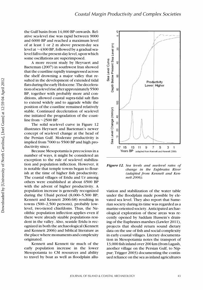
the Gulf basin from 14,000 BP onwards. Rel-ative sea-level rise was rapid between 9000and 6000 BP and reached a maximum levelof at least 1 or 2 m above present-day sealevel at ∼4300 BP, followed by a gradual sea-level fall to thepresent-day level,uponwhichsome oscillations are superimposed.
A more recent study by Heyvaert andBaeteman (2007) in southwest Iran showedthat the coastline rapidly transgressed acrossthe shelf drowning a major valley that re-sulted in the development of extended tidalflatsduring theearlyHolocene.Thedecelera-tionofsea-level riseafterapproximately5500BP, together with probably more arid con-ditions, allowed coastal supra-tidal salt flatsto extend widely and to aggrade while theposition of the coastline remained relativelystable. Continued deceleration of sea-levelrise initiated the progradation of the coast-line from ∼2500 BP.
The solid sea-level curve in Figure 12illustrates Heyvaert and Baeteman’s newerconcept of sea-level change at the head ofthe Persian Gulf. Moderate productivity isimplied from 7000 to 5500 BP and high pro-ductivity since.
Because Mesopotamia is precocious in anumber of ways, it might be considered anexception to the rule of sea-level stabiliza-tion and population inflection. However, itis notable that temple towns began to flour-ish at the time of higher fish productivity.The coastal villages of Eridu and Ur amongothers were established at about 6500 BPwith the advent of higher productivity. Apopulation increase is generally recognizedduring the Ubaid period (8,000–5,500 BP;Kennett and Kennett 2006:68) resulting intowns (500–2,500 persons), probably low-level, two-tiered chiefdoms. Thus, the Ne-olithic population inflection applies even ifthere were already sizable populations resi-dent in the valley. Also, seaside Eridu is rec-ognized in both the archaeological (Kennettand Kennett 2006) and biblical literature asthe place where monuments and complexityoriginated.
Kennett and Kennett tie much of theearly population increase in the lowerMesopotamia to CM resources and abilityto travel by boat as well as floodplain allu-
Figure 12. Sea levels and sea-level rates ofchange in the Euphrates River(adapted from Kennett and Ken-nett 2006).
viation and stabilization of the water tableunder the floodplain made possible by ele-vated sea level. They also report that Sume-rian society during its time was regarded as amarine-oriented society. Anticipated archae-ological exploration of these areas was re-cently opened by Saddam Hussein’s drain-ing of the Euphrates marshes (Lawler 2011),projects that should return sound dietarydata on the use of fish and social complexityin early coastal villages. Literary documenta-tion in Mesopotamia notes the transport of13,000 fish inland over 200 km (from Lagash,another village on the Persian Gulf, to Nip-pur; Trigger 2003) documenting the contin-ued reliance on the sea as inland agricultures
JOURNAL OF ISLAND & COASTAL ARCHAEOLOGY 43
Dow
nloa
ded
by [
Uni
vers
ity o
f N
orth
Car
olin
a], [
Joel
Gun
n] a
t 12:
59 0
4 A
pril
2012
John W. Day, Jr. et al.
were intensifiedbyirrigationtosupport largehuman populations.
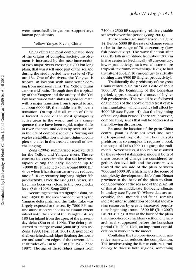
Yellow-Yangze Rivers, China
China offers the most complicated storyof the origins of complex society. Involve-ment is increased by the near-intersectionof two major rivers crossing a 700 km longplain, that was itself once part of the sea andduring the study period near sea level (Fig-ure 13). One of the rivers, the Yangtze, istropical in location with most water com-ing from monsoon rains. The Yellow drainsa more arid basin. Through time the tropical-ity of the Yangtze and the aridity of the Yel-low have varied with shifts in global climate,with a major transition from tropical to aridat about 6000 BP, the middle-late Holocenetransition. On top of it all, much of Chinais located in one of the most geologicallyactive areas in the world, and as a conse-quence there have been rapid, major shiftsin river channels and deltas by over 100 kmin the era of complex societies. Sorting outsea-level stabilization and the origins of com-plex societies in this area is above all others,challenging.
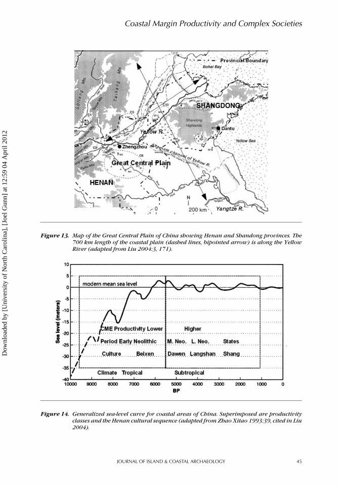
Zong (2004) summarized sea-level datafor the Yellow and Yangtze rivers. The re-constructed curve implies that sea level roserapidly during the early Holocene up to∼8000 BP. It reached –5 m around 8000 BP,since when it has risen at a markedly reducedrate of 10 cm/century implying higher fishproductivity. Over the last 3,000 years, sealevel has been very close to the present-daylevel (Saito 1998; Zong 2004).
According to litho-stratigraphic data, be-fore ∼8900 BP the area now occupied by theYangtze delta plain and the Taihu Lake waslargely exposed to the sea. By 7800 BP, ma-rine inundation reached its maximum extentinland with the apex of the Yangtze estuary180 km inland from the apex of the present-day delta (Zhu et al. 1996). The delta plainstarted to emerge around 3000 BP (Chen andZong 1998; Hori et al. 2001). A number ofshell-enrichedsandridges liealongthenorth-ern and southern edges of the current deltaat altitudes of –1 m to + 2 m (Liu 1987; Zhao1987). The age of these ridges ranges from
7500 to 2500 BP suggesting relatively stablesea levels over that period (Zong 2004).
These studies are summarized in Figure14. Before 6000 BP the rate of change seemsto be in the range of 70 cm/century (lowfish productivity). The wave function after6000 BP falls in amplitude from about 200 cmin five centuries (technically 40 cm/century,lower productivity, but it was a hotter, moretropical environment with large lakes) to halfthat after 4500 BP, 10 cm/century to virtuallynothing after 3500 BP (higher productivity).
Traditionally the prehistory of the greatChina central plain turns on a date of about5000 BP, the beginning of the Longshanperiod, approximately the onset of higherfish productivity. This would have followedon the heels of the above-cited retreat of ma-rine inundation, which reaches full effect by5000 BP (see Figure 14), also the beginningof the Longshan Period. There are, however,complicating issues that will be addressed inthe following discussion.
Because the location of the great Chinacentral plain is near sea level and nearthetropical-subtropicalclimateboundary, itsprehistory is so complex it requires a bookthe scope of Lui’s (2004) to grasp the rudi-ments. Nevertheless, it too can be resolvedby the sea-level stabilization model if both ofthese vectors of change are considered to-gether. Sea-level falls and the coast movestoward the sea side of the plain between7000 and 5000 BP, which means the scene ofcomplexity development shifts from Henanprovince at the back of the plain to Shan-dong province at the sea side of the plain, allof this at the middle-late Holocene climateboundary (see Figure 3). Where data are ac-cessible, shell mounds and faunal remainsindicate intense utilization of coastal and ma-rine resources by greatly increased popula-tions beginning around 6500 BP (Jiao 2007;Liu 2004:203). It was at the back of the plainthat three-tiered (chiefdom) settlement hier-archies first appeared before the Longshanperiod (Liu 2004:164), an important consid-eration to work into the model.
Conflating the two provinces in our nar-rative somewhat reduces the complication.This involves using the Henan cultural termi-nology to discuss both regions, something
44 VOLUME 7 • ISSUE 1 • 2012
Dow
nloa
ded
by [
Uni
vers
ity o
f N
orth
Car
olin
a], [
Joel
Gun
n] a
t 12:
59 0
4 A
pril
2012
Coastal Margin Productivity and Complex Societies
Figure 13. Map of the Great Central Plain of China showing Henan and Shandong provinces. The700 km length of the coastal plain (dashed lines, bipointed arrow) is along the YellowRiver (adapted from Liu 2004:3, 171).
Figure 14. Generalized sea-level curve for coastal areas of China. Superimposed are productivityclasses and the Henan cultural sequence (adapted from Zhao Xitao 1993:39, cited in Liu2004).
JOURNAL OF ISLAND & COASTAL ARCHAEOLOGY 45
Dow
nloa
ded
by [
Uni
vers
ity o
f N
orth
Car
olin
a], [
Joel
Gun
n] a
t 12:
59 0
4 A
pril
2012
John W. Day, Jr. et al.
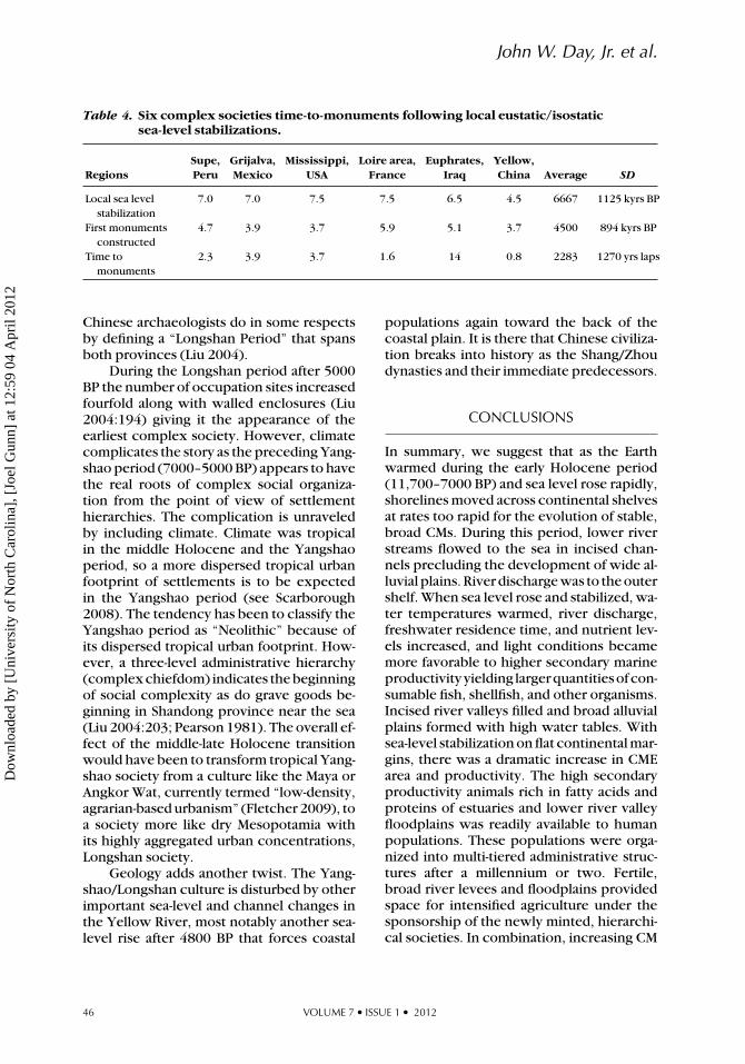
Table 4. Six complex societies time-to-monuments following local eustatic/isostaticsea-level stabilizations.
Supe, Grijalva, Mississippi, Loire area, Euphrates, Yellow,Regions Peru Mexico USA France Iraq China Average SD
Local sea levelstabilization
7.0 7.0 7.5 7.5 6.5 4.5 6667 1125 kyrs BP
First monumentsconstructed
4.7 3.9 3.7 5.9 5.1 3.7 4500 894 kyrs BP
Time tomonuments
2.3 3.9 3.7 1.6 14 0.8 2283 1270 yrs laps
Chinese archaeologists do in some respectsby defining a “Longshan Period” that spansboth provinces (Liu 2004).
During the Longshan period after 5000BP the number of occupation sites increasedfourfold along with walled enclosures (Liu2004:194) giving it the appearance of theearliest complex society. However, climatecomplicates the story as the preceding Yang-shao period (7000–5000 BP) appears to havethe real roots of complex social organiza-tion from the point of view of settlementhierarchies. The complication is unraveledby including climate. Climate was tropicalin the middle Holocene and the Yangshaoperiod, so a more dispersed tropical urbanfootprint of settlements is to be expectedin the Yangshao period (see Scarborough2008). The tendency has been to classify theYangshao period as “Neolithic” because ofits dispersed tropical urban footprint. How-ever, a three-level administrative hierarchy(complex chiefdom) indicates the beginningof social complexity as do grave goods be-ginning in Shandong province near the sea(Liu 2004:203; Pearson 1981). The overall ef-fect of the middle-late Holocene transitionwould have been to transform tropical Yang-shao society from a culture like the Maya orAngkor Wat, currently termed “low-density,agrarian-based urbanism” (Fletcher 2009), toa society more like dry Mesopotamia withits highly aggregated urban concentrations,Longshan society.
Geology adds another twist. The Yang-shao/Longshan culture is disturbed by otherimportant sea-level and channel changes inthe Yellow River, most notably another sea-level rise after 4800 BP that forces coastal
populations again toward the back of thecoastal plain. It is there that Chinese civiliza-tion breaks into history as the Shang/Zhoudynasties and their immediate predecessors.
CONCLUSIONS
In summary, we suggest that as the Earthwarmed during the early Holocene period(11,700–7000 BP) and sea level rose rapidly,shorelines moved across continental shelvesat rates too rapid for the evolution of stable,broad CMs. During this period, lower riverstreams flowed to the sea in incised chan-nels precluding the development of wide al-luvial plains. River discharge was to the outershelf. When sea level rose and stabilized, wa-ter temperatures warmed, river discharge,freshwater residence time, and nutrient lev-els increased, and light conditions becamemore favorable to higher secondary marineproductivityyielding largerquantitiesofcon-sumable fish, shellfish, and other organisms.Incised river valleys filled and broad alluvialplains formed with high water tables. Withsea-level stabilization on flat continental mar-gins, there was a dramatic increase in CMEarea and productivity. The high secondaryproductivity animals rich in fatty acids andproteins of estuaries and lower river valleyfloodplains was readily available to humanpopulations. These populations were orga-nized into multi-tiered administrative struc-tures after a millennium or two. Fertile,broad river levees and floodplains providedspace for intensified agriculture under thesponsorship of the newly minted, hierarchi-cal societies. In combination, increasing CM
46 VOLUME 7 • ISSUE 1 • 2012
Dow
nloa
ded
by [
Uni
vers
ity o
f N
orth
Car
olin
a], [
Joel
Gun
n] a
t 12:
59 0
4 A
pril
2012

Coastal Margin Productivity and Complex Societies
productivity and agricultural intensificationfacilitated widespread complex social orga-nizations.
The development of complex societiesfollowed the enrichment of CM food re-sources worldwide. In our sample of six so-cieties, the Neolithic population inflectionappeared in coastal zones and deltas in anaverage of 67 (s = 954) years after local sea-level stabilization. In about a millennium, so-cieties with social rankings were organizedas evidenced by increased diversity and rich-ness of grave goods. This was followed at re-gionally variable time intervals by construc-tion of monuments marking the end of theNeolithic-Urban transition.
In the late Holocene, coastal villageswith stratified societies were overshadowedby more powerful interior descendants. Thegreatly enhanced CM productivity helpedunderwrite the transition to complex so-cial organization and agricultural intensifica-tion. These later polities experienced eco-nomic and social stresses that required moregrandiose politico-religious infrastructuresand, reflecting that, greater monumental ed-ifices.
Using local sea-level stabilizations, themean time to monument construction in thesix regions was 2,283 (s = 1,270) years, adifference of 417 years (reduction in error)from the 2,700 (s=1,110) years calculated inTable 2 from the global relative sea-level sta-bilization (Table 4). Although obvious differ-ences can be seen between global and localfindings, especially in China, the results sug-gest that in areas where local sea-level studiesare not available, within a few 100 years anda few meters, the global value serves as a rel-atively reliable estimate of the local.
ACKNOWLEDGEMENTS
We would like to thank the numerousfriends and colleagues who read all or partof the manuscript and contributed to thepreparation of this article including J. P.Kennett and three anonymous reviewers.Michael Crawford provided us with exten-sivecorrespondenceandbackgroundones-
sential fatty acids and their function in thebrain and nervous system.
END NOTE
1. All dates calibrated by CalPal A Version2004 July 15.
REFERENCES
Adams, R. E. W. 2005. Prehistoric Mesoamerica.3rd ed. Norman: University of Oklahoma Press.
Adams, R. E. W. and R. C. Jones. 1981. Spatial pat-terns and regional growth among Classic MayaCities. American Antiquity 46:301–322.
Allard, J., E. Chaumillon, C. Poirier, and P.-G.Sauriau, O. Weber. 2008. Evidence of formerHolocene sea level in the Marennes-Oleron Bay(French Atlantic coast). Comptes Rendus Geo-sciences 340:306–314.
Alley, R. B., P. U. Clark, P. Huybrechts, and I.Joughin. 2005. Ice-sheet and sea-level changes.Science 310:456–460.
Bard, E., B. Hamelin, M. Arnold, L. Montaggioni,G. Cabioch, G. Faure, and F. Rougerie. 1996.Deglacial sea-level record fromTahiti corals andthe timing of global meltwater discharge. Na-ture 382:241–244.
Benfer, R. A., Jr. 1990. The Preceramic period siteof Paloma, Peru: Bioindications of improvingadaptation to sedentism. Latin American An-tiquity 1:284–318.
Berglund, B. E., P. Sandgren, L. Barnekow, G. Han-non, H. Jiang, G. Skog, and S.-Y. Yu. 2005. EarlyHolocene history of the Baltic Sea, as reflectedin coastal sediments in Blekinge, southeast-ern Sweden. Quaternary International 130–139:111.
Binford, L. R. 1968. Post-Pleistocene adaptations.In New Perspectives in Archaeology (S. R. Bin-ford and L. R. Binford, eds.): 313–341. Chicago:Aldine.
Blum,M.D.,T. J.Misner,E.S.Collins,D.B.Scott,R.A.Morton, andA.Aslan.2001.MiddleHolocenesea-level rise and highstand at + 2 m, centralTexas coast. Journal of Sedimentological Re-search 71:581–588.
Bonsall, C., G. Cook, C. Pickard, K. McSweeney,and L. Bartosiewicz. 2009. Dietary trends atthe Mesolithic-Neolithic Transition in North-West Europe. In Chronology and Evolutionwithin the Mesolithic of North-West Europe(P. Crombe, M. Van Strydonck, J. Sergant, M.
JOURNAL OF ISLAND & COASTAL ARCHAEOLOGY 47
Dow
nloa
ded
by [
Uni
vers
ity o
f N
orth
Car
olin
a], [
Joel
Gun
n] a
t 12:
59 0
4 A
pril
2012

John W. Day, Jr. et al.
Boudin, and M. Bats, eds.): 517–539. Brussels:University of Gent.
Broadhurst, C. L., Y. Wang, M. A. Crawford, S. C.Cunnane, J. E. Parkington, and W. F. Schmidt.2002. Brain-specific lipids from marine, lacus-trine, or terrestrial food resources: Potential im-pact on early African Homo sapiens. Compar-ative Biochemistry and Physiology - Part B:Biochemistry & Molecular Biology 131:653–673.
Brooks, M. J., P. A. Stone, D. J. Colquhoun, J. G.Brown, and K. B. Steel. 1986. Geoarchaeologi-cal research in the coastal plain portion of theSavannah River Valley. Geoarchaeology 1:293–307.
Cahoon, D., D. Reed, and J. Day. 1995. Estimatingshallow subsidence in microtidal salt marshesof the southeastern United States: Kaye andBarghoorn revisited. Marine Geology 128:1–9.
Calbet, A. and M. Landry. 2004. Phytoplanktongrowth, microzooplankton grazing, and car-bon cycling in marine systems. Limnology andOceanography 49:51–57.
Chen, X. and Y. Zong. 1998. Coastal erosion alongtheChangjiangdeltaicshoreline,China:Historyand prospective. Estuarine, Coastal and ShelfScience 46:733–742.
Childe, V. G. 1936. Man Makes Himself. London:Watts and Co.
Clark, J. A., W. F. Farrell, and W. R. Peltier.1978. Global changes in postglacial sea level:A numerical calculation. Quaternary Research9:265–287.
Clark, J. E., J. L. Gibson, and J. A. Zeidler. 2010.First towns in the Americas: Searching for agri-culture and other enabling conditions. In Be-comingVillagers:ComparingEarlyVillageSo-cieties (M. Bandy and J. Fox, eds.): 205–245.Amerind Studies in Archaeology. Tucson: TheUniversity of Arizona Press.
Clark, P. U., A. S. Dyke, J. D. Shakun, A. E. Carl-son, J. Clark, B. Wohlfarth, J. X. Mitrovica, S.W. Hostetler, and A. M. McCabe. 2009. The lastglacial maximum. Science 325:710–714.
Cohen, M. N. 1977. The Food Crisis in Prehis-tory: Overpopulation and the Origin of Agri-culture. New Haven: Yale University Press.
Coleman, J. M., H. H. Roberts, and G. W. Stone.1998. Mississippi River Delta: An overview.Journal of Coastal Research 14:698–716.
Coleman, J. M. and W. G. Smith. 1964. Late recentrise of sea level. Geological Society of AmericaBulletin 75:833–840.
Cowgill, G. L. 2004. Origins and develop-ment of urbanism: Archaeological perspec-tives.AnnualReviewofAnthropology33:525–549.
Crawford, M. A., L. Broadhurst C., C. Galli, K.Ghebremeskel, H. Holmsen, L. F. Saugstad, F.Schmidt, A. J. Sinclair, and S. C. Cunnane. 2008.The role of docosahexaenoic and arachidonicacids as determinants of evolution and hominidbrain development. In Fisheries for GlobalWelfare and Environment (K. Tsukamoto, T.Kawamura, T. Takeuchi, J. Beard, T. D. Beard,Jr., andM. J.Kaiser,eds.):57–76.5thWorldFish-eries Congress 2008. Tokyo: Terrapub.
Cyphers, A. and J. Zurita-Noguera. 2006. A landthat tastes of water. In Precolumbian WaterManagement: Ideology, Ritual and Power (L.Lucero and B. Fash, eds.):33–50. Tucson: Uni-versity of Arizona Press.
Dalongeville, R., P. Bernier, and B. Dupuis. 1993.Les variations recentes de la ligne de rivagedans le Golfe Persique. Bulletin de l’InstitutGeologique du Bassin d’Aquitaine 53:179–192.
Day, J., C. Hall, W. Kemp, and A. Yanez. 1989.Estuarine Ecology. New York: Wiley.
Day, J. W., W. J. Folan, J. D. Gunn, and A. Yanez-Aranciabia. 2004. Patrones de productividadcostera durante el ascenso del nivel del marpostglacial: Posibles implicacions para la for-macion del estado pristino. In XIV EncuentoInternacional: Los Investigadores de la Cul-tura Maya. Campeche, Mexico: Campeche.
Day, J. W., J. D. Gunn, W. J. Folan, A. Yanez-Arancibia, and B. P. Horton. 2007. Emergenceof complex societies after sea level stabi-lized. EOS Transactions, American Geophys-ical Union 88:169–170.
Del Giorgio, P. and J. Cole. 1998. Bacterialgrowth efficiency in natural and aquatic sys-tems. Annual Review of Ecology and System-atics 29:503–541.
Denys, L. and C. Baeteman. 1995. Holocene evo-lution of relative sea level and local mean highwater spring tides in Belgium—A first assess-ment. Marine Geology 124:1–19.
Dillehay, T. D., J. Rossen, T. C. Andres, and D. E.Williams.2007.Preceramicadoptionofpeanut,squash and cotton in northern Peru. Science316:1890–1893.
Ducklow, H. and F.-K. Ducklow. 1993. Bacterialproduction in estuaries. In Aquatic Microbiol-ogy (T. E. Ford, ed.):261–287. Boston: Black-well Scientific Publications.
Erlandson J. M. 1988. The role of shellfish inprehistoric economies: A protein perspective.American Antiquity 53:102–109.
Erlandson, J. M. 2001. The archaeology of aquaticadaptations: Paradigms for a new millennium.Journal of Archaeological Research 9:287–350.
48 VOLUME 7 • ISSUE 1 • 2012
Dow
nloa
ded
by [
Uni
vers
ity o
f N
orth
Car
olin
a], [
Joel
Gun
n] a
t 12:
59 0
4 A
pril
2012
Coastal Margin Productivity and Complex Societies
Erlandson, J. M. and S. M. Fitzpatrick. 2006.Oceans, islands, and coasts: Current perspec-tives on the role of the sea in human prehis-tory. Journal of Island and Coastal Archaeol-ogy 1:5–32.
Fairbanks, R. G. 1989. A 17,000-year glacio-eustatic sea level record: Influence of glacialmelting rates on the Younger Dryas event anddeep-ocean circulation. Nature 342:637–642.
Feldman, R. A. 1983. Marine chiefdom to agricul-tural state in formative coastal Peru. In Civi-lization and the Ancient Americas (R. M. Lev-enthral and A. L. Kolata, eds.): 289–310. Abu-querque: University of New Mexico Press andPeabody Museum of Archaeology and Ethnol-ogy, Harvard University, Cambridge.
Fleming,K., P. Johnston,D.Zwartz,Y.Yokoyama,K. Lambeck, and J. Chappell. 1998. Refin-ing the eustatic sea-level curve since the LastGlacial Maximum using far- and intermediate-field sites. Earth and Planetary Science Letters163:327–342.
Flemming, N. C. 2004. Submarine PrehistoricArchaeology of the North Sea: Research Pri-orities and Collaboration with Industry. CBAResearch Report 141. York: Council for BritishArchaeology.
Fletcher, R. 2009. Low-density, agrarian-based ur-banism: A comparative View. Insights 2:2–20.
Galili, E., M. Weinstein-Evron, I. Hershkovitz,A. Gopher, M. Kislev, O. Lernau, L. Kolska-Horwitz, and H. Lernau. 1993. Atlit-Yam: A Pre-historic site on the sea floor off the Israeli Coast.Journal of Field Archaeology 20:133–157.
Gasse, F. 2000. Hydrological changes in theAfrican tropics since the Last Glacial Maxi-mum. Quaternary Science Reviews 19:189–211.
Gibson, J.L.1996.PovertyPointandgreatersouth-eastern prehistory: The culture that did not fit.In Archaeology of the Mid-Holocene Southeast(K. E. Sassaman and D. G. Anderson, eds.):288–305. Gainesville: University Press of Florida.
Gibson, J. L. 2001. The Ancient Mounds ofPoverty Point: Place of Rings. Gainesville: Uni-versity of Florida Press.
Gibson, J. L. 2006. Navels of the earth: Seden-tism in early mound-building cultures in theLower Mississippi Valley. World Archaeology38(2):311–329.
Haas, J. andW.Creamer.2006.CrucibleofAndeancivilization: The Peruvian coast from 3000 to1800 BC. Current Anthropology 47:745–776.
Heyvaert, V. M. A. and C. Baeteman. 2007.Holocene sedimentary evolution and palaeo-coastlines of the Lower Khuzestan Plain (SW-Iran). Marine Geology 242:83–108.
Hijma, M. P., K. M. Cohen. 2010. Timing and mag-nitude of the sea-level jump preluding the 8200yr event. Geology 38:275–278.
Hori, K., Y. Saito, Q. Zhao, X. Cheng, P. Wang,Y. Sato, and C. Li. 2001. Sedimentary fa-cies and Holocene progradation rates of theChangjiang (Yangtze) delta, China. Geomor-phology 41:233–248.
Jiao, T. 2007. The Neolithic of Southeast China:Cultural Transformation and Regional Inter-action on the Coast. Youngstown, NY: Cam-bria Press.
Johnson, G. A. 1980. Rank-size convexity and sys-tem integration: A view from archaeology. Eco-nomic Geography 56:234–247.
Keefer, D. K., S. D. deFrance, M. E. Moseley, J.B. Richardson III, D. R. Satterlee, and A. Day-Lewis. 1998. Early maritime economy and ElNino events at Quebrada Tacahuay, Peru. Sci-ence 281:1833–1835.
Kemp, A. C., B. P. Horton, and S. Engelhart,E. 2011. Late Quaternary relative sea-levelchanges at midlatitudes. In Encyclopedia ofQuaternary Science (S. A. Elias, ed.):3064–3071. New York: Elsevier.
Kennett, D. J. and J. P. Kennett. 2006. Early stateformation in southern Mesopotamia: Sea levels,shorelines, and climate change. Journal of Is-land & Coastal Archaeology 1:67–99.
Kennett, J. P., K. G. Cannariato, I. L. Hendy, and R.J. Behl. 2003. Methane hydrates in Quaternaryclimate change: The clathrate gun hypothesis.Special Publication AGU 54:1–216.
Kerr,R.A.1998.BlackSeadelugemayhavehelpedspread farming. Science 279:1132.
Lambeck, K., T. M. Esat, and E.-K. Potter. 2002.Links between climate and sea levels for thepast three million years. Nature 419:199–206.
Landry, M. and A. Calbet. 2004. Microzooplank-ton production in the oceans. ICES Journal ofMarine Science 61:501–507.
Lawler, A. 2007. Beyond the family feud. Archae-ology 6:20–25.
Lawler, A. 2011. Did the first cities grow frommarshes? Science 331:141.
Liu, C. M. 1987. The Chenier Plains of China. In In-ternational Geomorphology, Part I (E. V. Gar-diner, ed.):1269–1279. New York: Wiley.
Liu, L. 2004. The Chinese Neolithic: Trajectoriesto Early States. Cambridge: Cambridge Univer-sity Press.
Mann, K. 1982. Ecology of Coastal Waters.Berkely: University of California Press.
Mendelssohn, I. A. and J. T. Morris. 2000. Eco-physiological controls on the productivity ofSpartina alterniflora loisel. In Concepts andControversies in Tidal Marsh Ecology (M.
JOURNAL OF ISLAND & COASTAL ARCHAEOLOGY 49
Dow
nloa
ded
by [
Uni
vers
ity o
f N
orth
Car
olin
a], [
Joel
Gun
n] a
t 12:
59 0
4 A
pril
2012
John W. Day, Jr. et al.
P. Weinstein and D. A. Kreeger eds.):59–80.Boston: Kluwer Academic Publishers.
Milne, G. A., A. J. Long, and S. E. Bassett. 2005.Modelling Holocene relative sea-level observa-tions from the Caribbean and South America.Quaternary Science Reviews 24:1183–1202.
Moseley, M. E. 1975. The Maritime Foundationsof Andean Civilization. Menlo Park, CA: Cum-mings Publishing Company.
Nixon, S. 1982. Nutrient dynamics, primaryproduction, and fisheries yields of lagoons.Oceanologica Acta 4:357–371.
Nixon, S. 1992. Quantifying the relationship be-tween nitrogen input and the productivityof marine ecosystems. In Proceedings of Ad-vanced Technology Conference, Vol. 5 (M.Tahahashi, K. Nakata, and R. Parsons, eds.):57–83. Tokyo: AMTEC.
Nixon, S. W., J. W. Ammerman, L. P. Atkinson, V.M. Berounsky, G. Billen, W. C. Boicourt, W. R.Boynton, et al. 1996. The fate of nitrogen andphosphorus at the land-sea margin of the NorthAtlantic Ocean. Biogeochemistry 35:141.
Osborn, A. 1977. Strandloopers, mermaids, andother fairy tales: Ecological determinants ofmarine resource utilization-the Peruvian case.In For Theory Building in Archaeology (L. R.Binford, ed.): 157–205. New York: AcademicPress.
Oyuela-Caycedo, A. 1996. The study of collectorvariability in the transition to sedentary foodproducers in northern Colombia. Journal ofWorld Prehistory 10:49–93.
Patton, M. 1993. Statements in Stone: Monu-ments and Society in Neolithic Brittany. Lon-don: Routledge.
Pearson, R. 1981. Social complexity in Chinesecoastal Neolithic sites. Science 213:1078–1086.
Peltier, W. R. 2004. Global Glacial Isostasy andthe surface of the Ice-Age Earth: The Ice-5G (VM2) Model and Grace. Annual Re-view of Earth and Planetary Science 32:111–149.
Peltier, W. R. and R. G. Fairbanks. 2006. Globalglacial ice volume and Last Glacial Maximumduration from an extended Barbados sea levelrecord. Quaternary Science Reviews 25:3322–3337.
Perlman, S. M. 1980. An optimum diet model,coastal variability, and hunter-gatherer behav-ior. Advances in Archaeological Method andTheory 3:257–310.
Petit, J. R., J. Jouzel, D. Raynaud, N. I. Barkov, J. M.Barnola, I.Basile,M.Bender,et al. 1999.Climateand atmospheric history of the past 420,000years from the Vostok ice core, Antarctica. Na-ture 399:429.
Pope,K.O.,M.E.D.Pohl, J.G. Jones,D.L.Lentz,C.v. Nagy, F. J. Vega, and I. R. Quitmyer. 2001. Ori-gin and environmental setting of ancient agri-culture in the lowlands of Mesoamerica. Sci-ence 292:1370–1373.
Pryor, F. 2003. Britain BC. London: HarperCollins.
Quilter, J. and T. Stocker. 1983. Subsistenceeconomies and the origins of Andean complexsocieties. American Anthropologist 85:545–562.
Redfield,A.C.1967.Postglacialchange insea levelin the western north Atlantic Ocean. Science157:687–692.
Renfrew, C. 1973. Social Archaeology: An In-augural Lecture. Southampton: Camelot PressLtd.
Richards, M. P., R. J. Schulting, and R. E. M.Hedges. 2003. Sharp shift in diet at onset ofNeolithic. Nature 425:366.
Roberts, H. H. 1997. Dynamic changes of theHolocene Mississippi River delta plain: Thedelta cycle. Journal of Coastal Research13:605–627.
Rojas-Galaviz, J., A. Yanez-Arancibia, J. Day andF. Vera-Herrera. 1992. Estuarine primary pro-ducers: Laguna de Terminos—a case study. InCoastal Plant Communities of Latin Amer-ica (U. Seeliger, ed.):141–154. New York: Aca-demic Press.
Roosevelt, A. C., R. A. Housely, M. Imazio daSilveira, S. Maranca, and R. Johnson. 1991.Eighth millennium pottery from a prehistoricshell midden in the Braziliam Amazon. Science254:1621–1624.
Rose, J. I. 2010. New light on human prehistory inthe Arabo-Persian Gulf oasis. Current Anthro-pology 51:849–883.
Russo, M. 1996. Southeastern Mid-Holocenecoastal settlements. In Archaeology of the Mid-Holocene Southeast (K. E. Sassaman and D. G.Anderson, eds.):177–199. Gainesville: Univer-sity Press of Florida.
Saito, Y. 1998. Sea levels of the last glacial in theEast China Sea continental shelf. QuaternaryResearch 37:237–242.
Sassaman, K. E. and M. J. Hekenberger. 2004.Crossing the symbolic Rubicon in the South-east. In Signs of Power: The Rise of CulturalComplexity in the Southeast (J. L. Gibson andP. J. Carr, eds.):214–233. Tuscaloosa: Univer-sity of Alabama Press.
Saunders, J. 2004. Are we fixing to make the samemistake again? In Signs of Power: The Rise ofCulturalComplexity in theSoutheast (J. L.Gib-son and P. J. Carr, eds.):147–161. Tuscaloosa:University of Alabama Press.
50 VOLUME 7 • ISSUE 1 • 2012
Dow
nloa
ded
by [
Uni
vers
ity o
f N
orth
Car
olin
a], [
Joel
Gun
n] a
t 12:
59 0
4 A
pril
2012
Coastal Margin Productivity and Complex Societies
Scarborough, V. L. 2008. Rate and process of so-cietal change in semitropical settings: The an-cient Maya and the living Balinese. QuaternaryInternational 184:24–40.
Scarre, C. 2002. Context of monumentalism: Re-gional diversity at the Neolithic transition inNorth-West France. Oxford Journal of Archae-ology 21:23–61.
Scherer, A. K., L. E. Wright, and C. J. Yoder.2007. Bioarchaeological evidence for socialand temporal differences in diet at Piedras Ne-gras, Guatemala. Latin American Antiquity18.1:85(20).
Schulting, R. J. 2005. Comme la mer qui seretire: Les changements dans l’exploitationdes ressources marines du Mesolithique auNeolithique en Bretagne. In Unite et diversitedes processus de neolithisation sur la facadeatlantique de l’Europe (7–4eme millenairesavant J.-C.), vol. XXXVI (G. Marchand and A.Tresset, eds.):163–171. Paris: Memoire de laSociete Pnrehistorique Francaise.
Schulting, R. J., M. P. Richards. 2001. Datingwomen and becoming farmers: New palaeodi-etary and AMS dating evidence from theBreton Mesolithic cemeteries of Teviec andHoedic. Journal of Anthropological Archae-ology 20:314–344.
Shennan, I., S. Bradley, G. Milne, A. Brooks, S.Bassett, and S. Hamilton. 2006. Relative sea-level changes, glacial isostatic modelling andice-sheet reconstructions from the British Islessince the Last Glacial Maximum. Journal ofQuaternary Science 21:585–599.
Sherratt, A. 1990. The genesis of megaliths: Mon-umentality, ethnicity and social complexity inNeolithic north-west Europe. World Archaeol-ogy 22:147–167.
Simms, A. R., N. Aryal, Y. Yokoyama, H. Mat-suzaki, and R. Dewitt. 2009. Insights on a pro-posedMid-Holocenehighstandalong thenorth-western Gulf of Mexico from the evolution ofsmall coastal ponds. Journal of SedimentaryResearch 79(10):757–772.
Solis, R. S., J. Haas, and W. Creamer. 2001. DatingCaral, a Preceramic site in the Supe Valley onthe central coast of Peru. Science 292:723–726.
Stanley, D. J. and Z. Chen. 1996. Neolithic settle-ment distributions as a function of sea level-controlled topography in the Yangtze delta,China. Geology 24:1083–1086.
Stanley, D. J. and A. K. Hait. 2000. Deltas, radio-carbon dating, and measurements of sedimentstorage and subsidence. Geology 28:295–298.
Stanley, D. J. and A. G. Warne. 1993a. Nile delta:Recent geological evolution and human im-pact. Science 260:628–634.
Stanley, D. J. and A. G. Warne. 1993b. Sea leveland initiation of Predynastic culture in the Niledelta. Nature 363:435–438.
Stanley, D. J. and A. G. Warne. 1997. Holocenesea-sevel change and early human utilization.GSA Today 7:1–7.
Stanley, D. J. and A. G. Warne. 1998. Nile deltain its destruction phase. Journal of Coastal Re-search 14:794–825.
Stein, G. J. 2002. From passive periphery to activeagents: Emerging perspectives in the archaeol-ogy of interregional interaction. American An-thropologist 104:903–916.
Stothert, K. E., D. R. Piperno, and T. C. Andres.2003. Terminal Pleistocene/Early Holocene hu-man adaptation in coastal Ecuador: The LasVegas Evidence. Quaternary International109/110;23–43.
Streif, H. 2004. Sedimentary record of Pleistoceneand Holocene marine inundations along theNorth Sea coast of Lower Saxony, Germany.Quaternary International 112:3–28.
Tanner, W. F. 1993. An 8000-year record of sea-level change from grain-size parameters: Datafrom beach ridges in Denmark. The Holocene3:220–231.
Tornqvist, T. E., J. L. Gonzalez, L. A. Newsom,K. van der Borg, A. F. M. de Jong, and C. W.Kurnik. 2004. Deciphering Holocene sea-levelhistory on the US Gulf Coast: A high-resolutionrecord from the Mississippi Delta. GeologicalSociety of America Bulletin 116:1026–1039.
Toscano, M. A. and I. G. Macintyre. 2003. Cor-rected western Atlantic sea-level curve forthe last 11,000 years based on calibrated C-14 dates from Acropora palmata frameworkand intertidal mangrove peat. Coral Reefs 22:257–270.
Trigger, B. G. 2003. Understanding Early Civ-ilizations. Cambridge: Cambridge UniversityPress.
Turner, R. 1977. Intertidal vegetation and com-mercial yields of Penaeid shrimps. Trans-actions of the American Fisheries Society106:411–416.
van de Plassche, O. 1986. Sea-level Research: AManual for the Collection and Evaluation ofData. Norwich: Geobooks.
von Nagy, C. L. 2003. Of Meandering RiversandShiftingTowns:LandscapeEvolutionandCommunity within the Grijalva Delta. Ph.D.Dissertation. New Orleans: Tulane University.
Voorhies, B. 2004. Coastal Collectors in theHolocene, The Chantuto People of SouthwestMexico. Gainesville: University Press of Florida.
Warren, G. 2005. Complex arguments. InMesolithic Studies:At theBeginningof the21st
JOURNAL OF ISLAND & COASTAL ARCHAEOLOGY 51
Dow
nloa
ded
by [
Uni
vers
ity o
f N
orth
Car
olin
a], [
Joel
Gun
n] a
t 12:
59 0
4 A
pril
2012

John W. Day, Jr. et al.
Century (N. Milner and P. Woodman, eds.):69–80. Oxford: Oxbow Books.
Washington, P. A. 2007. Comments on emer-gence of complex societies after sea level sta-bilized. EOS Transaction, American Geophys-ical Union 88:429.
Wells, L. E. 1988. Holocene Fluvial and ShorelineHistory as a Function of Human and GeologicFactors in Arid Northern Peru. Ph.D. Disserta-tion. Stanford: Stanford University.
Whittaker, R. 1975. Communities and Ecosys-tems. New York: MacMillian.
Widmer,R. J.2004.Explainingsociopoliticalcom-plexity in the foraging adaptations of the south-easternUnitedStates:Therolesofdemography,kinship and ecology in sociocultural evolution.In Signs of Power: The Rise of Cultural Com-plexity in the Southeast (J. L. Gibson and P. J.Carr, eds.):234–253. Tuscaloosa: University ofAlabama Press.
Willey, G. R. 1953. Prehistoric settlement patternsin the Viru Valley. Bureau of American Ethnol-ogy Bulletin, Vol. 155. Washington, DC: Smith-sonian Institution.
Wilson, I. 2001.Before the Flood.NewYork: SaintMartin’s Press.
Wooller, M. J., R. Morgan, S. Fowell, H. Behling,and M. Fogel. 2007. A multi-proxy peat recordof Holocene mangrove paleoecology fromTwin Cays, Belize. The Holocene 17:1129–1139.
Yesner, D. R. 1980. Maritime hunter-gatherers:Ecology and prehistory. Current Anthropology21:727–750.
Yu, S. Y., B. E. Berglund, P. Sandgrenm, K. Lam-beck. 2007. Evidence for a rapid sea-level rise7600 yr ago. Geology 35:891–894.
Zhao, X. 1987. Development of cheniers in Chinaand their significance to coastline shift. In Inter-national Geomorphology, Part I (V. Gardiner,ed.):1253–1268. New York: Wiley.
Zhu, C., P. Cheng, C. Lu, and W. Wang. 1996.Shoreline movements in the Yangtze delta andSu-bei coastal areas over the last 7000 years.Science Geographica Sinica 16:207–213.
Zong, Y. 2004. Mid-Holocene sea-level highstandalong the southeast coast of China. QuaternaryInternational 117:55–67.
52 VOLUME 7 • ISSUE 1 • 2012
Dow
nloa
ded
by [
Uni
vers
ity o
f N
orth
Car
olin
a], [
Joel
Gun
n] a
t 12:
59 0
4 A
pril
2012
Copyright © 2022 FDOKUMEN