1 1. Title page 1 2 Response of three krill species to hypoxia ...
Upload
khangminh22Category
view
3download
0

Cruising for KrillIn the Southern ocean wIth G.O. SarS

Cruising for KrillIn the Southern ocean with G.O. Sars
editors:Svein a. Iversen, Sigmund Myklevoll, Kjartan Mæstad og Leif nøttestad.
Maps:Jaime alvarez.
Graphic design: Maja Markegård, Bodoni aS, Bergen.
Bookbindig: Bokbinderiet Johnsen, Skien.
© copyright: Institute of Marine research
Publisher: Institute of Marine research
Design: Bodoni aS, Bergen, norway.
the publisher is not responsible for possible errors. any reproduction of the material in this book is prohibited according to copyright laws.
ISBn 978-82-7128-572-2
Bergen, norway 2010
MILJØMERKET
241 Trykksak 699
www.imr.no

editing:SveIn a. IverSen, SIGMunD MyKLevoLL, KJartan MæStaD
anD LeIf nøtteStaD
Cruising for KrillIn the Southern ocean wIth G.O. SarS
institute of Marine researChBergen 2009
www.imr.no

4 Cruising for Krill – institute of Marine researCh
InStItute of MarIne reSearchKNOWLEDGE AND ADVICE FOR RICH AND CLEAN MARINE AND COASTAL REGIONS
With a staff of almost 700 the institute of Marine research is norway’s largest centre of marine science.
our main task is to provide advice to norwegian authorities on aquaculture and the ecosystems of the Barents sea, the norwegian sea, the north sea and the norwegian coastal zone. for this reason, about fifty percent of our activities are financed by the Ministry of fisheries and Coastal affairs.
iMr’s headquaters are in Bergen, but important activities are also carried out at our department in tromsø, at the research stations in Matre, austevoll and flødevigen and on board our research vessels, which are at sea for a total of 1600 days a year. Besides we rent vessels from the commercial fishing fleet for about 1000 days a year.
the institute is heavily engaged in development aid activities through the Centre for development Cooperation in fisheries.
institute of Marine researCh – Cruising for Krill 5
the institute of Marine research is part of norway’s long tradition of ocean research, mapping and monitoring fish resources and other marine life in the northeastern atlantic. the institute provides scientific advice on the sustainable management of our fisheries, as well as the fast-growing fish farming industry. scientists from the iMr have participated in CCaMlr (Commission for the Conservation of the antarctic Marine living resources) since 1982, but this is the first time we have sent out own ships to do research in the southern ocean.
institute director tore nepstad presented a plan for an antarctic research survey in 2007-2009 with our largest research vessel, G.O. Sars, when planning the 5th international Polar Year.
senior scientist svein a. iversen was appointed leader of the expedition to the atlantic sector of the southern ocean. the main aim was to investigate the krill resources, the acoustic characteristics of krill, as well as the general marine ecosystem in the area. experienced scientists from other norwegian universities and institutes, from Brazil, China, europe and the us were invited to participate. Colleagues at the university of Bergen (which disposes of 25% of G.O. Sars’ annual ship time) planned research to be carried out during the transfer of the vessel to the southern hemisphere and back.
the expedition was named aKes (antarctic Krill and ecosystem studies) and was funded by the research Council of norway, the nare program run by the norwegian Polar institute, the norwegian Petroleum directorate, aBB and norsk hydro, in addition to the institute of Marine research’s own funding.
finally, on 15 november 2007, the norwegian Minister of fisheries helga Pedersen could wish the expedition a safe journey. the adventure was about to begin.
the expedition was a success scientifically as well operationally. data and samples collected are being analyzed and will be presented to the scientific community and the general public. a diary with photos was published regularly on the institute’s website during the entire cruise. Many of us who did not participate on the cruise found this diary very interesting, and the idea of publishing the cruise diary as a book came up.
the aKes expedition will provide new knowledge that will be vital to the sustainable management of the southern ocean ecosystem, especially for the area around Bouvet island, which has hitherto received little scientific attention. the expedition proves that norway is a major contributor to the international knowledge base for the region, allowing it to promote a forward-looking, sustainable management of parts of the atlantic ocean based on the country’s work through CCaMlr.
the aKes expedition consisted of two legs. svein a. iversen led the first one, which started in Montevideo, uruguay on 4 January 2008 and ended in Cape town, south africa. Webjørn Melle led the second part which started on 18 february and ended in Walvis Bay, namibia on 28 March.
We wish to thank the norwegian Ministry of fisheries and Coastal affairs, the Ministry of foreign affairs, the research Council of norway, the norwegian Polar institute, the university of Bergen, the international participants, the ship’s crew and our colleagues at the institute for all their contributions which made this expedition an important milestone in the institute’s scientific development.
ole arve MisundResearch director at the Institute of Marine Research
Member of the Committee for the Polar Year 2007-2009, the research Council of norway.
Preface

6 Cruising for Krill – institute of Marine researCh

institute of Marine researCh – Cruising for Krill 7
contentS Preface ....................................................................................................................... 5Contents ................................................................................................................... 7Bound for the falklands ........................................................................................ 9unpacking, setting up, stowing and securing .................................................... 12fire drill on board................................................................................................... 15first test catch under the microscope .............................................................. 1815,000 year-old climate data at a depth of 3,000 metres .............................. 22happy landing at grytviken, south georgia ..................................................... 26Calibration spheres and target strength ............................................................ 30still no krill ............................................................................................................... 33first krill catch ......................................................................................................... 37Considerable climate changes in the antarctic ................................................ 40images of the echo produced by krill ................................................................ 43studying krill without disturbing them ............................................................... 48Collecting data in the southern ocean for his Master’s degree ................ 51half way through the first part of the aKes survey....................................... 53a polar adventure! .................................................................................................. 56storm interrupts sampling .................................................................................... 59a selection of our fish catch ................................................................................ 61feeling cut off without the internet ................................................................... 62Making fresh water on board ............................................................................... 63a little piece of norway ........................................................................................ 64a stone’s throw from Bouvet island .................................................................. 67growth rate experiment becomes part of Master’s thesis ......................... 70hurricane ............................................................................................................... 72acoustic models for abundance estimates ........................................................ 74leaving the krill behind.......................................................................................... 76going home with new species ............................................................................. 7734 days of waiting are over .................................................................................. 82Plankton investigations .......................................................................................... 84spring cleaning ......................................................................................................... 87some thoughts before Cape town ..................................................................... 89Cape town ............................................................................................................... 91introduced two research vessels to Cape towners ....................................... 94heading for the astrid ridge ............................................................................... 97approaching the antarctic .................................................................................. 99the salps’ role in the southern ocean .............................................................. 101Mesopelagic fish, what is their significance in the southern ocean? .......... 103Mapping a piece of norwegian sea floor .......................................................... 105Krill south of the antarctic polar circle ............................................................ 107Birds from Cape town to the antarctic ........................................................... 109genetic analyses in stormy weather .................................................................. 113teeth like daggers .................................................................................................... 114Bigger and stronger krill at Bouvet island ......................................................... 116Weatherbeaten ........................................................................................................ 118small organisms – great importance .................................................................. 120When small changes make a huge difference ................................................... 124fish parasites in the southern ocean ................................................................ 125a key organism in the southern ocean ............................................................ 130Whale observations ............................................................................................... 132growth experiments on antarctic krill ........................................................... 135flying fish at Vema seamount ............................................................................... 137G.O.Sars calls at Walvis Bay ................................................................................... 139
list of authors and photographers ..................................................................... 142Photo: KM.

Our cruise started in Montevideo, Uruguay and finished in Walvis Bay, Namibia.
27.03.08
04.01.08
06.01
12-17.02.08
SouthGeorgia 30.01
28.01
26.01
05.01
12.01
10.01
FalklandIslands
Walvis Bay
Cape TownMontevideo
50 °40 °30 °20 °10 °0 °-10 °-30 °-50 °-60 °-70 °-80 °-90 °
30 °20 °10 °0 °-10 °-20 °-30 °-40 °-50 °-60 °
-30
°-4
0 °
-20
°-3
0 °
-40
°-9
0 °
-80
°-7
0 °
40 °
-20 °
-50 °
AstridRidge
BouvetIsland

InstItute of MarIne research – Cruising for Krill 9
at last we’re on our way to the southern ocean. We unpack and prepare our instruments and tools, carry out precise calibrations and begin taking measurements. We are doing research in, for us, new and unknown waters.
▲ A taxi boat brings delayed passengers and baggage. Photo: KM
enough oil and fresh water to take us to cape town, south africa six weeks from now.
our departure from Montevideo was delayed one day because of air traffic problems and the late arrival of some participants, but just after
from Montevideo in uruguay, where we started, to the falklands is a distance of 1000 nautical miles. We have maintained a steady speed of 11.5 knots since our departure on January 4th. at this speed we will arrive at Port stanley on tuesday morning. there we will bunker
▲ We have seen seals and whales, and now this strange fellow called a sunfish. Photo: EKL
07.01.08
06.01
05.01
Montevideo
Monday, January 7
Bound For THE FaLKLandS
→

10 Cruising for Krill – InstItute of MarIne research
▲ Scientists and crew for the first part of the G.o. sars Southern Ocean expedition. Photo: KM
▲ Henrik Søiland (right) and Karl Johan Nilsson launching an Argo buoy at 3:30 am on Sunday. Research goes on night and day. Photo: KM
the cook had announced dinner at half past five, we heaved anchor and were under way, southward bound.
sunday, January 6 at 3:30 it was time for the first piece of research: two argo buoys were launched off the coast of argentina. the buoys will record current, salinity and tem-perature data at various depths in the south atlantic ocean, as part of an extensive international research programme.
the buoys will drift with the current. they are programmed to sink to 650 metres, where they will drift for a while, then continue down to 1,000 metres before ascending to the surface. on the way up they will record the salinity, temperature and oxygen content of the water. at the surface, collected data will be transmitted to a research centre via satellite before the buoy starts another cycle. henrik søiland, who is responsi ble for this programme,
says the cycle takes 10 days and the buoys can operate for up to 5 years. Where they will end up finally, he does not know. More than 3,000 argo buoys are drifting in the world’s oceans, improving our understanding of current systems.
few research activities have started so far, but that does not make it a holiday cruise. Instruments and equipment have to be set up, checked and calibrated, and the satellite link, our contact with the world, had to be repaired. fortunately it is ok now. We are also discussing and planning how to organize work at the research locations.
sunshine and temperatures well above 20°c have given us a nice tan after dark autumn months at home, but over the weekend the temperature sank while the waves grew higher. no one seasick – so far…
▲ Atle Totland (left), Georg Skaret and Terje Torkelsen are busy setting up advanced acoustic equipment in the hangar. These instruments will record the behaviour of the krill. Photo: KM
InstItute of MarIne research – Cruising for Krill 11
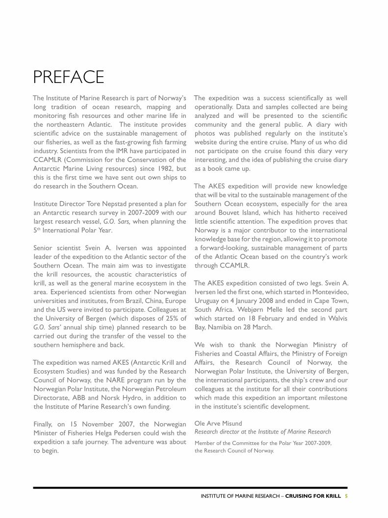
research VesseL G.o. sars:
• Built 2003.• Length 77.5 m, beam 18.6 m.• 4,096 tonnes. • cruising speed 10 knots, top speed 17 knots.• Very quiet.• advanced acoustical instruments
(echo sounders, sonars, current meter).• Large and well-equipped trawl deck.
• Large hangar amidships for storing and operating various pieces of sampling equipment and instruments.
• special laboratories for analysing samples: oceanography, plankton and fish.
• echo sounder that penetrates 150 m into the sea bottom, and core sampling equipment.
• equipment for seismic research.
▲ G.o. sars berthed at Grytviken, South Georgia. Photo: KM

12 Cruising for Krill – InstItute of MarIne research
It is a week since we left home and we are getting used to nice and sunny weather. We are approaching the falkland Islands, where we will bunker oil and fill our water tanks. seeing these islands, the scene of the short falklands War in 1982, will be a special moment.
08.01.08
06.01
05.01
Montevideo
TuESday, January 8
unPaCKInG, SETTInG uP, SToWInG and SECurInG
▲ Sunset off the coast of Argentina. Photo: KM

InstItute of MarIne research – Cruising for Krill 13
Bunkering takes place at sea off Port stanley. to save time we were not allowed shore leave to take a closer look at these famous islands.
Distances are huge in the southern ocean. We have to economize on time and fuel to complete our programme and reach cape town safely; it is a long journey with many different tasks to be performed on our voyage from the falklands via south Georgia and Bouvet Island. It feels like solving an equation with many unknowns, but we have experienced navigators, crew and research personnel – we are well prepared.
so far we have been busy unpacking and setting up our equipment, and discussing how to carry out all of our
tasks at the research locations. We expect to arrive at south Georgia by the end of the week. In sheltered waters, we will calibrate the acoustic instruments and perform target strength measurements on krill and mackerel icefish. the big question is, of course, will we find these species there. the experts are optimistic. as this is one of the main purposes of the survey, we must cross our fingers and hope for the best.
We are in frequent contact with the norwegian vessel Saga Sea, which is fishing off elephant Island. fishing is poor at the moment. ernest shackleton, with 22 crew members, stranded on the island in 1915 after his vessel endurance was crushed by ice in the Weddell sea.▲ A giant petrel following the vessel
towards the Falklands. Photo: KM
▲ A smiling expedition leader Svein A. Iversen. Photo: KM
▲ Helga “shoots” the geologists. Photo: KM

14 Cruising for Krill – InstItute of MarIne research
• the southern ocean, which surrounds the antarctic continent, covers an area of 20 million square kilometres, making it more than 60 times the size of norway. the Pacific, atlantic and Indian oceans all border the southern ocean. It is very deep, with a maximum depth of 7,235 metres. the continental slope rises steeply to a narrow shelf around the continent.
• the antarctic sea ice grows from 2.6 million square kilo metres in March (late summer) to 19 million square kilometres in september (late winter). It can be up to 3 metres thick.
• Much of the antarctic ice sheet rests on solid rock rising up to several hundred metres above sea level. at its thickest it is more than four kilometres deep. More than 90% of the world’s ice is found here. Much of the ice cap is over 3,000 metres above sea level, where temperatures can be extremely low. the russian research station Vostok at an altitude of 3500 metres has a mean temperature of –55ºc. the earth’s lowest temperature,
–89.6ºc, was recorded here. at sea level the mean temperature is –11ºc, and even in the summer temperatures seldom creep above zero.
• the antarctic circumpolar current, which runs around the continent, is 21,000 km long and moves perpetually eastwards
due to the earth’s rotation. It acts like an enormous refrigerator, which explains why the antarctic continent is so much colder than the arctic at the opposite end of the globe. this is the largest oceanic current, transporting 130 million cubic metres of water per second, 100 times more than all the world’s rivers put together.
the southern ocean – the IcY sea at the southern enD of the GLoBe
Photo: KM

InstItute of MarIne research – Cruising for Krill 15
after filling fuel and water off stanley in the falklands, it was time for a fire drill and other safety routines. the fire alarm sounded and everyone ran to deck five behind the bridge. there we were ordered to put on survival suits and enter the lifeboat.
▶ Looking for the Falklands. Photo: KM
▲ The G.o. sars lifeboat is built for 50 people. There were only 40 of us, but we found it cramped, hot and humid to sit there with survival suits on. The thought of spending a day or two in it is not very enticing, but practicing to put on the survival suit was a useful exercise. The suits seem to be made according to the principle “one size fits nobody”. In the picture we are just out of the lifeboat and captain Preben Vindenes is giving his last instructions about equipment and how to behave. Photo: GM
09.01.08
06.01
05.01
10.01
Montevideo WEdnESday, January 9
FIrE drILL on Board

16 Cruising for Krill – InstItute of MarIne research
▲ A small colony of African penguins has settled near Stanley. Photo: GM
▲ Fin whale. Photo: GM

InstItute of MarIne research – Cruising for Krill 17
▲ A “taste” of colourful Port Stanley, seen from G.o. sars. Photo: KM
▲ “Do you intend to come ashore?” some people in uniform asked when we got near the wharf in Stanley. “Yes, if possible,” we said. “Welcome!” But they were disappointed when we stayed for just ten minutes, barely enough time to take a few photos of the colourful houses in the town. Photo: KM
◀ Launching the man-over-board boat (MOB boat) is also part of the rescue drill. A few lucky members of the team got a chance to visit the penguin colony and the port. Here Roger Munns from the BBC (foreground) is filming eagerly. The others are (from left) Per Helge Sandtorv, Karl Johan Nilsson and Svein Are Simonsen. Photo: GM

18 Cruising for Krill – InstItute of MarIne research
the crew has rigged the trawl and tested it. the catch has given the biologists a chance to study the variety of species here and try out the routines for working up the samples. We set up the binoculars, microscopes and photo equipment so as to be prepared when the fun really starts.
some of the photos we took are shown here:
FrIday, January 11
FIrST TEST CaTCH undEr THE MICroSCoPE
11.01.08
06.01
05.01
12.01
10.01
Montevideo.
▲ A small squid. Photo: KM

InstItute of MarIne research – Cruising for Krill 19
▶ Krill – six species reported from this area and
85 species altogether in the sea. Photo: LN
▲ The cephalopod’s eye is highly developed and not unlike the human eye. Photo: LN

20 Cruising for Krill – InstItute of MarIne research
▲ This creature, a crustacean, belongs to the genus Phronima. Its appearance has inspired film makers when creating frightening creatures from other galaxies for their horror films. It lives inside a salp, an animal group that looks like a transparent barrel. The Phronima eats the salp until only the skin is left and then lays her eggs in it. Not very considerate! Photo: KM

InstItute of MarIne research – Cruising for Krill 21
the southern ocean meets the three world oceans in what we call the atlantic, Indian and Pacific sectors. G.O. Sars is operating in the atlantic sector. the southern ocean the antarctic circumpolar current (acc), the world’s mightiest current, flows from west to east. It runs uninterrupted around the antarctic continent and connects the three world oceans. It is driven by the prevalent winds in the western wind belt (45º-55ºs) where low pressure areas constantly move eastwards.
When crossing the acc from north to south one moves from temperate waters (about 10ºc) to ice-cold waters (about 0ºc). north of the current we find sub-tropical waters (above 12ºc) and south of the current the water is
saMPLInG PLanKton, KrILL anD fIsh
Plankton are defined as organisms with so weak powers of locomotion that they drift with the water currents. We use various types of gear to collect plankton samples. Microscopic algae are caught either in a fine-meshed net (0.01 mm) or by filtering water samples from various depths. Zooplankton vary greatly in size and various kinds of gear are used to catch them. a scoop net, with a 0.09 mm mesh, is used to catch the smallest, while a trawl with a 0.18 mm mesh takes the larger organisms. this trawl has 8 bags that can be opened and shut from the ship at various depths. this allows us to determine the vertical distribution of plankton in the water column. Krill and fish are too quick for these gears. We therefore also have a fish trawl and a krill trawl. the krill trawl has 5 bags that can be opened and closed from the vessel at selected depths.
the antarctIc cIrcuMPoLar current
mostly colder than 0ºc. Where the cold and warm water meet, there are fronts, where the current is stronger. the polar front is the most pronounced one, and it roughly follows the 50th parallel south in the atlantic sector. the polar front is the divide between temperate and polar water (colder than 2ºc). the polar front also marks the northern border of the sea ice surrounding the antarctic continent in winter. In summer most of this ice disappears.
the southern border of the acc is around 60ºs. here we enter the Weddell sea, where temperatures are below 1ºc from surface to sea bottom. It is, in fact, only between depths of 200 and 1,000 metres that we find temperatures above 0ºc.
▲ A plankton net coming up from the deep. Photo: KM.

22 Cruising for Krill – InstItute of MarIne research
Sunday, January 13
15,000 yEar-oLd CLIMaTE daTa aT a dEPTH oF 3,000 METrES
the core sampler comes up from a depth of 3,000 metres with its transparent plastic tubes half filled with bottom samples. satisfied with the result, stig Monsen and Øyvind Paasche seal and store the tubes. the contents will tell us about climate variations 15,000 years ago.
▲ Øyvind Paasche and Stig Monsen release one of four tubes of bottom
sediment samples from the multi-sampler. Photo: KM
13.01.08
06.01
05.01
12.01
10.01
Montevideo

InstItute of MarIne research – Cruising for Krill 23
▲ The frame, which can take six core samples, is hoisted out of the hangar and lowered to the sea bottom at 3,000 m. Photo: KM
▲ This sampler consists of a long plastic tube with a heavy weight at its upper end. Photo: KM
“the samples are perfect. this is a success,” says Øyvind. the project is called PaLeoDraKe. the name derives from PaLeo, Greek for old, and DraKe from Drake strait. this is an important narrow section of sea with a strong eastward current between south america and antarctica. the world’s largest current, ten times the size of the Gulf stream, and a hundred times all the world’s rivers put together, flows through here.
Knowledge about past climate variations can help us understand changes currently taking place, explain scientists from the Bjerknes centre, which is running this project. We have samples from three positions in the strait.
In the instrument room on deck five, Dag Inge Blindheim has followed the pictures on the topas echo sounder screen closely. It charts the bottom and penetrates deep into the sediment, helping him to find the best spot to take the samples. “I look for flat areas with thick, fine layers of sediment,” he explains.
We are approaching south Georgia, where we will take a sample at a depth of 250 metres in cumberland Bay before three of the five Bjerknes centre scientists disembark for further work on the island. the other two will come along with us to cape town.

24 Cruising for Krill – InstItute of MarIne research
▼ ▶ The sediment samples consist of some well-preserved and some more or less destroyed or dissolved organisms. The picture (left) shows contents from the upper layers. Various organisms and chemical compounds provide information about the climate several thousand years ago. For example, the ratio of magnesium to calcium tells us something about the temperature. Photo: LN
▲ A fine “catch” of sediments. Photo: KM
InstItute of MarIne research – Cruising for Krill 25
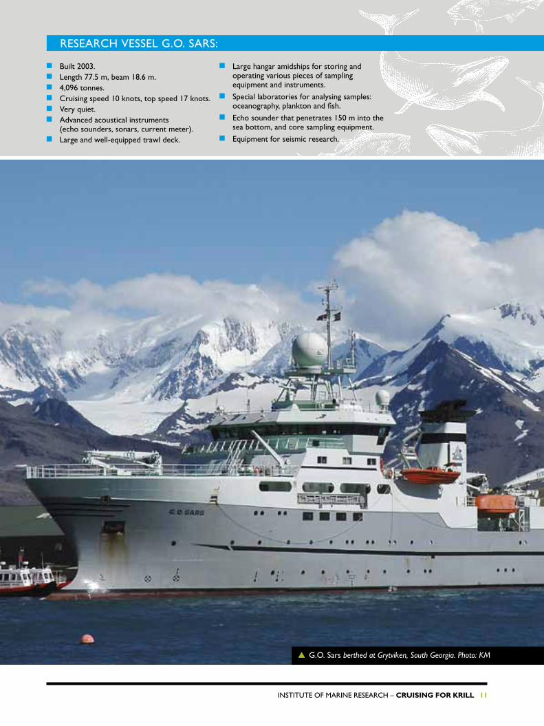
south Georgia lies 1,400 kilometres east of the tip of south america. the island covers about 3,800 square kilometres and has mountains nearly 3,000 metres high. the island was discovered in 1675, but the first landing, by James cook, took place a hundred years later. seal hunting commenced a few years after that, and norwegian whaling companies were active here at several bases in the first half of the 20th century. south Georgia is part of the British falkland Dependencies and there is a research station on the island.
▲ ▼ Glacier on South Georgia. Photo: KM
argentina claims the islands and occupied south Georgia for a month during the falklands War in 1982. During the second world war a small norwegian force was posted there for fear of a Japanese attack.
the island is rich in animal and bird life, with large stocks of fur seals, elephant seals and various species of penguins. norwegian whalers brought a small herd of reindeer to the island about 100 years ago, and today the flock numbers 3,000 animals.
south GeorGIa
2
26 Cruising for Krill – InstItute of MarIne research
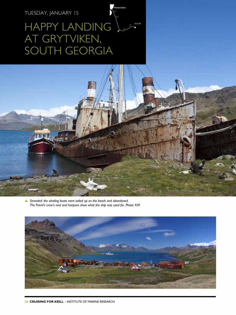
▲ Stranded: the whaling boats were sailed up on the beach and abandoned. The Petrel’s crow’s nest and harpoon show what the ship was used for. Photo: KM
15.01.08
06.01
05.01
12.01
10.01
Montevideo
TuESday, January 15
HaPPy LandInG aT GryTVIKEn, SouTH GEorGIa

InstItute of MarIne research – Cruising for Krill 27
When the scientists from the Bjerknes centre had got their bottom sediment samples in the fjord on Monday morning, we berthed at Grytviken, south Georgia. after two weeks at sea, everyone was given shore leave. from 1904 until the 1960s this was a large and important norwegian whaling station. today it is home to penguins, seals and a British research station.
◀ Southern summer: the whaling station at Grytviken was founded by a
Norwegian, Carl Anton Larsen, in 1904. When activity was at its peak,
300 people worked there. A total of 54,000 large whales (blue, fin
and humpback whales) were landed here. Today the main vestiges of the
once hectic activity are rusty tanks and vessels, ruins and abandoned
equipment. But the church and the director’s house (now a museum)
are well preserved. The G.o. sars is berthed at the British Antarctic
Survey’s wharf. Photo: KM
▲ Rusty remains: the whaling station had many factories. The wooden buildings are long gone and the machinery and tanks are rusting away in the open. Once there were living quarters, office buildings, a cinema, a football pitch and ski jump here. Photo: KM
▲ Movie stars: while the fur seals at times are aggressive and chase people away, the penguins accept our careful approach. Georg Skaret (right) is filming a penguin at close range. In the background, Atle Totland (left) and Bjørnar Ellertsen. Photo: KM

28 Cruising for Krill – InstItute of MarIne research

InstItute of MarIne research – Cruising for Krill 29
◀ Sunbathing fur seal: the animals feel comfortable among the rusty remains of the whaling station. This seal is enjoying the fine summer day on a rock by the rusty vessels and factory remains. Photo: KM
▼ The king penguins are moulting and have to stay on land. These “smartly dressed” creatures studied us with interest when we arrived and waved goodbye when we left. Photo: KM

30 Cruising for Krill – InstItute of MarIne research
WEdnESday, January 16
CaLIBraTIon SPHErES and TarGET STrEnGTH
We will soon be under way, looking for krill and mackerel icefish for our target strength measurements. the last few days we have been busy calibrating our instruments – and today we had guests for lunch.
to calibrate the echo sounder we lower a sphere 20–30 metres below the vessel. It is moved into place in the centre of the sound beam at the right depth by an arrangement of fishing rods with motorized reels mounted on the ship’s rail. We know the exact target strength of the sphere.
although the vessel is secured by three heavy anchors, it is difficult to keep it completely still when sudden gusts sweep down on us. We are afraid that inquisitive seals may take an interest in the sphere and even run away with it. calibration was off to a shaky start yesterday, before going more smoothly in the afternoon, but today the wind is interfering with our work again.
▲ Surprise visit: a group of volunteer maintenance workers from the Husvik whaling station came to say hello. From left: Thorfinn Myhre, Colin Doole, Henrik Culms, Hans Kristian Røkenes and Erik Myhre. Photo: KM
“the instruments should, if possible, be calibrated in the region where the measurements are going to be taken. conditions may vary from one place to another, and it is especially important to calibrate here since we have never been here before. the instruments may also have been affected by the long transit from norway,” says rolf Korneliussen, who is responsible for the acoustic measurements.
after our time ashore at Grytviken we have anchored off stromness, another old whaling station in a sheltered fjord to the northwest. this is where will we do the calibration. It is important to keep the vessel still to get accurate measurements. →
06.01
SouthGeorgia
05.01
17.01
12.01
10.01
FalklandIslands
Montevideo

InstItute of MarIne research – Cruising for Krill 31
▲ The calibration sphaeres are of different sizes and must be changed for the various frequencies. Photo: KM
▲ The white house was home to the manager of the Husvik whaling station. The volunteers are renovating the building. Photo: KM
We have 12 transducers that send and receive acoustic signals, all of which must be calibrated at various frequencies. We hope the wind will slacken and the seals will stay away. In the meantime we have had visitors on board – norwegians, no less.
Before lunch the small boat picked up five guys from sandefjord, Dram-men and sogna. at husvik, the neigh-bouring bay, they are repairing the manager’s house at one of the many whaling stations along this coast, giving it a new roof and windows. their next assignment is polar explorer ernest shackleton’s villa at stromness.
“It’s just great to be here,” says thorfinn Myhre. they arrived fairly recently. they are cheerful and happy to visit G.O. Sars, and skip a day of maintenance work for a good lunch, a hot shower and an opportunity to call home from the ship. they are not paid for the work they do. the British south Georgia heritage trust covers travel and expenses and companies in the old whaling port of sandefjord, norway are providing equipment and materials.

32 Cruising for Krill – InstItute of MarIne research
the echo sounder and sonar are used for finding, charting and measuring quantities of fish and plankton. the sounder operates vertically, downwards or upwards. the sonar can be tilted to any angle.
these instruments transmit sound waves. fish and other organisms return echoes that are recorded on screen and/or paper – an echogram. single fish will show up as a point or a hook, whilst schools will appear as smaller or bigger dots. echo strength, indicating target size or school density, is indicated by colour.
acoustIcs
fish with a swim bladder give an echo about 20 times stronger than fish without one. echo strength varies with the organisms’ orientation in relation to the sound beam. the organisms’ ability to reflect sound is called target strength. the echoes are added up by the computer, and if we know the target strength of the organisms, we can calculate the total weight and/or number.
the echo sounder transmits sound at various frequencies. this “music” is too high for the human ear to hear. together, the echoes at the different frequencies give a unique picture, called a frequency response, for each species.
▲ Rig for calibration. Photo: KM
▲ Instrument chief Martin Dahl (left) and Jarle Johannessen by the echo sounder screens. Photo: KM

InstItute of MarIne research – Cruising for Krill 33
▲ Nick Guy (left) and Roger Munns filming and photographing fur seals off South Georgia. Photo: KM
early in the day it was dead calm. nick and Guy looked for krill-eating birds, which might lead them to their target. according to the photographers, footage of schools of krill are scarce, and the BBc needs some for a new television series called “Life” (starting autumn 2009).
early this morning the two came-ramen were out in the man-over-board boat to look for krill in the fjords. on board, people were still busy calibrating instruments.
they are unlikely to find krill in these fjords, but they will at least have a chance to test their equip-ment.
roger Munns and nick Guy are two photographers who have been sent by the BBc to get footage of krill, preferably great swarms of them being attacked by predators. they will need a bit of luck to get what they’re after.
THurSday, January 17
STILL no KrILL17.01.08
06.01
05.01
12.01
10.01
Montevideo
▲ Roger Munns diving with his video camera in a waterproof box. Photo: KM →

34 Cruising for Krill – InstItute of MarIne research
20 reindeer to the island and now there are 3,000 of them. after a while roger grabs the underwater camera and dives in. no krill – but he needs to test the equipment anyway and they can always use another seal portrait.
▲ ▼ Roger Munns diving without oxygen tanks. He was under water for a minute each time. Even in mid-summer the water temperature is only 2oC. Photo: KM
no signs of krill, but plenty of seals. everywhere. roger and Guy are filming and photographing the playful seals on land and in the water. at the head of a bay reindeer are grazing among the seals. norwegian whalers brought

InstItute of MarIne research – Cruising for Krill 35
▶ Reindeer, penguins and seals on the same beach.
Photo: KM

36 Cruising for Krill – InstItute of MarIne research

InstItute of MarIne research – Cruising for Krill 37
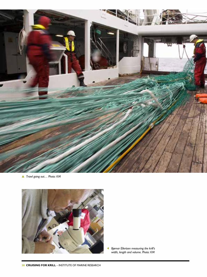
calibration completed. We have left behind the penguins, seals and rusty whaling stations of south Georgia. We searched for krill today in the open ocean, and it didn’t take long to find them. We had barely finished planning the day’s work when the trawl was set.
◀ Dag Nielsen is digging, hoping to find some fish among the millions
of krill. Photo: KM
“these are entering the trawl so smoothly, they must be krill. the only other creature caught so easily is the capelin, but you won’t find them here,” says captain Preben Vindenes. he is on the bridge, scrutinizing the echo sounder screen where we can see one dot after another being swallowed by the trawl. a few minutes earlier he had turned the ship 180 degrees and sent the crew to the trawl deck. We had passed several dots on the screen that told us there were big schools down there.
In the instrument room one deck below, rolf Korneliussen was ana-lyz ing the information from the sounders. he was certain that some of the spots were krill.
18.01.08
06.01
05.01
12.01
10.01
Montevideo
FrIday, January 18
FIrST KrILL CaTCH
→
38 Cruising for Krill – InstItute of MarIne research
▲ Trawl going out… Photo: KM
◀ Bjørnar Ellertsen measuring the krill’s width, length and volume. Photo: KM

InstItute of MarIne research – Cruising for Krill 39
▲ Bjørnar Ellertsen smiling happily, having secured two boxes of krill from our first catch. Photo: KM
Most of the crew and research staff were on deck when the first catch came in. two tonnes, the expedition leader svein a. Iversen announced. the catch was dropped on the trawl deck to sort the fish from the krill – but this was a clean krill catch, just two toothpick-sized fish, probably a kind of mackerel icefish. Bjørnar came and filled two ice cream boxes with krill, ample samples for his analyses, and disappeared into the laborato-ry where he measured the volume, length and width of the creatures, assisted by Volker siegel and Lars naustvoll – and other people came along to help out.
“this is fantastic!” exclaimed the expedition leader. “If this continues we can finance the whole expedition!”
KrILL anD the ecosYsteM
Krill are small shrimplike crustaceans that inhabit all of the world’s oceans. We know of 85 species. the scientific name for the antarctic variety is Euphausia superba – the superb krill. they have a lifespan of 7 years, can grow to a length of 6 cm and are extremely abundant.
In the southern ocean, krill are one of the key elements of the ecological system, some would say the key element. their
diet consists of algae, the “grass” of the ocean. In sunlight the algae transform co2 into food – through photosynthesis
– for krill and other organisms. Krill are food for fish, birds, penguins and sea mammals. Krill are the sole link between the algae and several of the large animals in the southern ocean, where there are no large fish stocks equivalent to the herring and capelin of the north.
40 Cruising for Krill – InstItute of MarIne research
SaTurday, January 19
ConSIdEraBLE CLIMaTE CHanGES In THE anTarCTIC
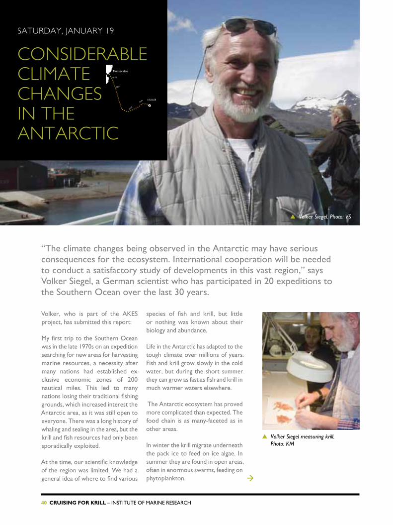
“the climate changes being observed in the antarctic may have serious consequences for the ecosystem. International cooperation will be needed to conduct a satisfactory study of developments in this vast region,” says Volker siegel, a German scientist who has participated in 20 expeditions to the southern ocean over the last 30 years.
Volker, who is part of the aKes project, has submitted this report:
My first trip to the southern ocean was in the late 1970s on an expedition searching for new areas for harvesting marine resources, a necessity after many nations had established ex-clusive economic zones of 200 nautical miles. this led to many nations losing their traditional fishing grounds, which increased interest the antarctic area, as it was still open to everyone. there was a long history of whaling and sealing in the area, but the krill and fish resources had only been sporadically exploited.
at the time, our scientific knowledge of the region was limited. We had a general idea of where to find various
species of fish and krill, but little or nothing was known about their biology and abundance.
Life in the antarctic has adapted to the tough climate over millions of years. fish and krill grow slowly in the cold water, but during the short summer they can grow as fast as fish and krill in much warmer waters elsewhere.
the antarctic ecosystem has proved more complicated than expected. the food chain is as many-faceted as in other areas.
In winter the krill migrate underneath the pack ice to feed on ice algae. In summer they are found in open areas, often in enormous swarms, feeding on phytoplankton.
19.01.08
06.01
05.01
12.01
10.01
Montevideo
▲ Volker Siegel measuring krill. Photo: KM
→
▲ Volker Siegel. Photo: VS

InstItute of MarIne research – Cruising for Krill 41
▲ Cold winters are not as frequent as before. Photo: KM
the ecosystem changes over time. Years with abundant krill resources are followed by meagre years, and this influences the species that feed on krill. having established a time series of 30 years, we can now see worrying developments. Krill resources seem to be dwindling, and this can hardly be blamed on fishing, which is insignificant. More likely the reduction is being caused by environmental changes. the sea is becoming warmer in the regions where krill are found. on
land, small glaciers are disappearing and large ones are shrinking. at sea, there is less ice around the antarctic Peninsula in winter, and the krill are dependent on ice.
to monitor developments in this vast ocean we need international cooperation. What happens to the climate in the southern ocean also influences the climate in the northern hemisphere, and vice versa.

42 Cruising for Krill – InstItute of MarIne research

InstItute of MarIne research – Cruising for Krill 43
estimates of krill abundance in the southern ocean vary greatly: from 37 million tonnes to more than 150 million tonnes in the exploited area. Georg skaret is taking pictures of the krill swarms, and in combination with acoustic data these photographs will give us more reliable abundance estimates.
◀ This is how good-looking krill are when you have got them on board safely. Photo: KM
Monday, January 21
IMaGES oF THE ECHo ProduCEd By KrILL
21.01.08
Montevideo

44 Cruising for Krill – InstItute of MarIne research
estimates of krill resources are based on acoustic measurements (see box on page 32). “the big problem is that the echo varies with the krill’s orientation in the sound beam,” says Georg. horizontally the krill give a much stronger echo than they do vertically. this results in enormous variations in estimates, depending on your assumptions about the krill’s orientation. It is therefore important to learn more about the krill’s behaviour. We are doing this by submerging a platform with an echo sounder directed downwards and a stereo camera operating horizontally. the stereo camera consists of two cameras mounted 30 cm apart. they take pictures simultaneously. combining these photos gives us information about the krill’s size and orientation in the water.
Georg thinks that krill seen by the camera and those in the sound beam have similar behaviour, giving us a better understanding of how many specimens are contributing to the recorded echo. “We hope that this will help us to obtain a more accurate assessment of the krill resources,” he says.
Georg had his first day as a postdoctoral researcher at the Institute of Marine research on January 1, and he spent that day in the air flying to Montevideo, uruguay to join the G.O. Sars. During the passage to south Georgia he put together and checked his equipment, and he is now collecting data. the cameras will also be used on another platform that will be placed on the bottom at various locations and depths.
▲ Georg and the platform with echo sounder and stereoscopic camera. Photo: KM
→
▲ Grazing krill under the vessel as seen by a camera.

InstItute of MarIne research – Cruising for Krill 45
We know the south Georgia region is rich in krill resources, which is why it has been chosen as Georg’s main area of investigation, but he hopes to collect data in other areas too. comparison and analysis of the material will have to wait until he is back at the institute in Bergen. If the work goes according to plan, he will have results before the end of the year.
We need more than just a pencil and paper to study life in the southern ocean. G.O. Sars has a variety of equipment on board, with some instruments recording continuously and others used when the vessel is stationary. We also have gear for collecting samples, from plankton to big fish. Information is collected from the air, the sea and the bottom.
We use two observation platforms developed at our institute. they have an echo sounder, hydrophones and stereo cameras for studying the size, swimming direction and behaviour of krill and other organisms. the hydrophones record sounds in the sea. off south Georgia we got some good recordings of humpback whales.
the platforms are submerged to chosen depths and anchored, where they record life in the sea without disturbing it. several instruments are shown in the book’s photos.
oBserVatIon PLatforMs
▲ Two waterproof cameras mounted on a platform. Taking pictures simultaneously they gives a 3D effect. Photo: KM
▲ The platform with stereo cameras is hoisted into the hangar. Photo: KM

46 Cruising for Krill – InstItute of MarIne research

InstItute of MarIne research – Cruising for Krill 47
▲ Observasjonsplattform på vei ut. Foto: KM.

48 Cruising for Krill – InstItute of MarIne research
TuESday, January 22
STudyInG KrILL WITHouT dISTurBInG THEM
▲ Atle Totland (foreground) and Terje Torkelsen mounting various instruments on the large platform. Photo: KM
22.01.08
06.01
05.01
12.01
10.01
Montevideo

InstItute of MarIne research – Cruising for Krill 49
22.01.08
06.01
05.01
12.01
10.01
Montevideo
even a lownoise vessel can disturb the organisms we want to study, and the progress of the ship makes it even more difficult to understand what is going on in the deep. We get only a few glimpses before we have moved on – but on the other hand we manage to cover vast areas. however, it is also interesting to study activities at one spot for prolonged periods without noise and movement. the aim is to get an impression of the undisturbed behaviour of creatures. the behaviour patterns of fish and krill change according to the time of day. these phenomena are difficult to observe from a moving ship. the Institute of Marine research has developed advanced platforms with
echo sounders that can be anchored at different levels, from the sea bottom to the surface, and quietly record life in the sea.
“the echo sounder cannot detect organisms in the upper 12–15 metres, since the sounder is placed on the keel of the ship and has a blind zone of about 5 metres,” explain atle totland and terje torkelsen.
the two electronic engineers spent the first part of the cruise building one of the platforms, which had been delivered in parts in Montevideo. they barely managed to finish their work before calibration of the instruments started. now the platforms have been
fish and krill will to some extent be disturbed by noise from the moving vessel. By deploying anchored platforms with echo sounders we are able to study the animal’s behaviour without disturbing them.
▲ Echogram of a krill swarm close to the surface. The recording is from a submerged echo sounder directed upwards. The red band is the surface.
▲ The nearly unbroken line in this echogram shows one fish that was recorded by the sounder for two hours. Or was it the fish watching the sounder?
▲ A platform is hoisted on board. Photo: KM →
3

50 Cruising for Krill – InstItute of MarIne research
in the water in various locations for several days, recording valuable data. When it is time to collect them, the technicians send a signal that opens an acoustic lock. the platform rises to the surface and is hoisted into the hangar where the recorded data are downloaded while the ship sails to the next location.
a similar platform was used for the mapping of the Midatlantic ridge between Iceland and the azores in 2004 (cf. the Mareco Project / www.mareco.no).
▲ An acoustic trigger releases the small platform, which then rises to the surface before being hoisted on board. Photo: KM

InstItute of MarIne research – Cruising for Krill 51
WEdnESday, January 23
CoLLECTInG daTa In THE SouTHErn oCEan For HIS MaSTEr’S dEGrEE
When he was invited to join the expedition to collect data for his master’s thesis in marine biology, einar Loshamn (26) took just two seconds to grab the opportunity. after a few days in south Georgian waters he is now acquainted with the species of the area and with who eats whom.
einar reports:
at the moment it is not possible to say exactly what my master’s thesis will focus on. It depends on the quality of the data collected by the platforms. the preliminary thesis title suggested at the university of oslo was “Vertical distribution and trophic interactions of plankton and fish in the sea around south Georgia”.
Vertical distribution means which species occupy the various layers of the sea. trophic interaction deals with who eats whom. the idea is that the large platform “looking” upwards will record the living organisms and their movements in the water column above it. Most organisms have a diurnal migration pattern:
they rise to the upper layers at night to feed and descend at dawn. the platform will, hopefully, record those movements, and the echograms will show their migration patterns.
to find out which species the platform is observing, we have to do some trawl hauls at various depths in the area. then we can compare the acoustic data with the catches and find where the various organisms stay during the day. the species I hope to focus on in my thesis are krill, amphipods (1–2 cm long crustaceans) and bathypelagic fish.
I have only completed one term of my master’s programme and have a lot to learn before I fully understand the topic of my thesis. the biggest →
▲ Einar Loshamn on deck. Photo: DN
23.01.08
06.01
05.01
12.01
10.01
Montevideo

52 Cruising for Krill – InstItute of MarIne research
challenge may be to interpret and understand the echograms.
I feel extremely privileged to be on this survey. few people are so lucky as to be able to collect data for a master’s degree in the southern ocean, with a bonus visit to south Georgia thrown in. so far this has been a fantastic journey, filled with memorable impressions of land and sea, and a great crew that has looked after an inexperienced studentsailor. I will have lots of good memories to look back on when I am sweating over the final stages of my thesis at home.
▶ One krill, then another… Einar Loshamn studies krill from a trawl haul, flanked by the German scientists Andreas Macrander and Volker Siegel. Photo: KM
▲ Observation platform going out. Photo: KM

InstItute of MarIne research – Cruising for Krill 53
time flies – perhaps even faster here than at home. the weather so far has been entirely on our side, but although this is midsummer the air temperature is only 3°c, a fraction above the sea surface temperature. By comparison it makes last summer in Bergen seem wonderful.
the survey so far has been a fantastic experience – icebergs, penguins, seals, whales and albatrosses. at south Georgia we met terns that may have passed through Bergen on their journey from pole to pole. our visit to Grytviken was unforgettable.
We calibrated our acoustic instruments at stromness, an old norwegian whaling station near Grytviken. calibration is an art of balance and accuracy, and this time we were in unknown territory with lots of nosy penguins and seals around. We were afraid they might disturb our work, but fortunately they showed little interest in the calibration spheres. having finished the calibration, we sailed out to the south Georgia shelf, set the trawl and immediately caught two tonnes of krill, and a couple of
juvenile icefish. Books on species identification were put on the table, and now, after several trawl hauls we are nearly experts on the identification of phytoplankton, zooplankton and fish in the area. a particularly interesting species is the icefish, with its transparent blood and white gills. It has no haemoglobin, the pigment that absorbs oxygen. It is interesting to find that a reference book on fish in the southern ocean mentions our retired colleague steinar olsen, who worked on antarctic cod and icefish at south Georgia in the early 1950s.
the krill swarms are often so dense that it is difficult to limit the catch to a reasonable sample for analysis. our first haul with the Åkra trawl to catch fish was a failure, because of dense concentrations of krill. the
▲ For several days we have seen South Georgia in the distance. Photo: KM
→
24.01.08
06.01
05.01
12.01
10.01
Montevideo
THurSday, January 24
HaLF Way THrouGH THE FIrST ParT oF THE aKES SurVEy

54 Cruising for Krill – InstItute of MarIne research
trawl master switched to a net with larger mesh to allow the krill to pass through, and that worked well.
It is not just krill that abound in this ocean, we have also seen huge numbers of other organisms, particularly amphipods.
We have had the observation platforms out for two periods and have secured large amounts of data that will eventually tell us how much echo a single krill or icefish contributes. our aim is to be able to report the preliminary results of the target strength measurements to the ccaMLr Krill Working Group meeting in st. Petersburg, russia in June. unfortunately for the BBc film crew, we have not yet found dense swarms of krill at the surface. they are not very upset. nature photographers are used to long periods of waiting and often meagre results, but if the right moment occurs, their task
can be accomplished in a couple of minutes. now they are placing their hopes on Bouvet Island, but the chances may be even smaller there.
the geologists, on the other hand, are very pleased with all the samples they have collected. favourable weather conditions and available time have even allowed them to collect some bonus material from the core samplers and bottompenetrating echo sounder. We have two geologists on board now, the three others disembarked at south Georgia to continue their investigations there. In sunny weather we collect aerosol data for nasa, and we hope, for both ourselves and nasa, that we will have a lot of sunshine.
Just before we left the south Georgia area last night, we had a trawl catch of 350 kg of fish, mainly mackerel icefish. We improvised an early fish breakfast. everyone agreed that nothing beats a
▲ Icefish from a trawl haul off South Georgia. Photo: KM
▲ An amphipod, a small crustacean, 2-3 cm long. Photo: KM→
▲ Rolf Korneliussen (left) and expedition leader Svein A. Iversen with a box of krill. Photo: KM

InstItute of MarIne research – Cruising for Krill 55
breakfast that you have fished yourself, whether in the southern ocean or anywhere else. the panel agreed that the Painted rockfish was the winner. the drawback is that this species is usually 15 cm long – it takes a patient person to cut enough fillets.
We are now bound for Bouvet Island at a good speed, with the current and a strong gale behind us. the G.O. Sars handles in an exemplary manner and makes the sailing comfortable. We will be at the first research location tomorrow evening. In the Bouvet Island area we will study the pelagic ecosystem. since last December five scientists from the norwegian Polar Institute have been on the island. they have tagged fur seals and penguins to study their movements and feeding habits around the island. It will be interesting to compare our krill/plankton/fish observations to the feeding areas of the island’s indigenous inhabitants. But that will be later.▲ Trawl bag full of krill coming in. Photo: KM
▲ A contented Terje Torkelsen in front of the advanced observation platform he has constructed. Photo: KM
56 Cruising for Krill – InstItute of MarIne research
FrIday, January 25
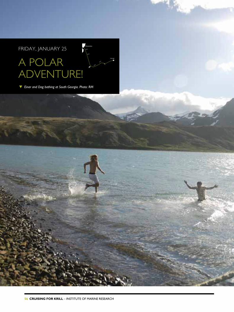
a PoLar adVEnTurE! ▼ Einar and Dag bathing at South Georgia. Photo: RM
25.01.08
06.01
05.01
12.01
10.01
Montevideo

InstItute of MarIne research – Cruising for Krill 57
Drifting icebergs, strange icefish, exotic penguins, rusty whaling stations, challenging master’s studies, erratic work patterns, frequent trawl hauls, a great ship and nice people. for master’s student Dag nielsen (22) the G.O. Sars expedition is a real adventure.
he has summed up his experiences so far in this journal contribution:
through the marine biology master’s degree programme at the university of oslo I was given this exceptional opportunity to see the southern ocean, south Georgia and cross the vast ocean on board the G.O. Sars. not many young students get a chance like this. I will write a thesis on the largescale distribution of krill between south Georgia and Bouvet Island. right from the day we were accepted for the survey, my fellow student einar Loshamn and I have looked forward to the expedition.
einar and I celebrated new Year in Buenos aires and travelled to Mon
tevideo the following day by boat and bus. We enjoyed the beach life and some culture before G.O. Sars departed. at first sight the ship seemed very large, and it took a few days to get acquainted with all the facilities on board, but now, after three weeks at sea we feel very much at home.
Initially we had nice sunny days and saw fin whales, sunfish, sea lions and albatrosses.
a typical day on board: breakfast at 07:30, then various duties: maybe a meeting or a trip down to the hangar to give a hand with the instruments, if necessary. or perhaps the trawl is coming in and the catch needs sorting, identifying, measuring and weighing, →
▲ Dag and Merete meet a king penguin. Photo: EKL
▲ Dag is just so happy to be here! Photo: KM

58 Cruising for Krill – InstItute of MarIne research
before being frozen or preserved in alcohol.
Lunch at 11:30. the cook’s booming voice over the intercom: “Lunch served!” Good food with hot dishes, vegetables, a variety of sauces and trimmings, cheese and biscuits. a feast fit for a king! then work, a short coffee break at 15:00, and back to work until dinner is served at 17:30.
Days and nights are flying past. sometimes we skip a meal and work instead, or work through the night and sleep during the day. We rest when we can and work when there is something to do, and so far we have enjoyed it as much as any holiday.
on January 13th, we passed the first iceberg, big like a multistorey building with a bluish glow, and on the morning of the 14th we saw south Georgia’s steep, snowclad mountain tops with glaciers creeping down the valleys. reindeer were grazing on the green hillsides, and on the beaches there were large flocks of elephant seals, fur seals and king penguins. Great!
In the fjords and bays we saw several abandoned whaling stations. We berthed at the British base at King edward’s Point, Grytviken. In the afternoon einar and I took a swim in the 2ºc water and rushed into the ship’s sauna afterwards. some people thought we were crazy, whilst others said we were tough guys.
▲ Dag with two icefish on the trawl deck. Photo: KM
▲ Dag enjoys the sunset. Photo: EKL

InstItute of MarIne research – Cruising for Krill 59
Sunday, January 27
STorM InTErruPTS SaMPLInG It is sunday morning and very few people are out of bed, but the wind has reached storm force. there is a lot of movement, and whatever is not bolted down or tied securely is sliding and rolling about.
▲ Beaufort’s definition of a storm, force 10 (wind speed 48-55 knots): Very high waves with overhanging crests. Large patches of foam from wave crests give the sea a white appearance. Considerable tumbling of waves with heavy impact. Large amounts of airborne spray reduce visibility. Photo: KM
06.01
30.01
28.01
26.01
05.01
12.01
10.01
27.01.08
Montevideo

60 Cruising for Krill – InstItute of MarIne research
I have to hold on to my pen, memory card and other loose items as I sit and try to write my diary. the laptop is barely safe, clinging to a rubber mat on the table, and my chair is now tied to the table legs. now and then I have to grab the table to avoid flying sideways. once I lost my grip, slid sideways four metres and hit the door. the first mate’s easy chair flew across his cabin and knocked out the escape hatch in the door. obviously we cannot expect nice weather throughout the survey.
We have left south Georgia and have since Wednesday been on our way towards Bouvet Island. the distance between these islands is about 1400 nautical miles, and we are not taking the shortest route. right now we are sailing south towards the pole before turning north again.
the work pattern on board has also changed. off south Georgia we had activities day and night. now there are long distances between research locations, and they may be reached at any hour, day or night. We have therefore set up watches to ensure there is always someone on duty, but we all join in when necessary. In between we find time for games, with yatzy being popular with some.
Last night we had reached a resear ch location at 2 a.m. the work was concluded with a trawl haul before breakfast. tonight we arrived at another location, but the storm prevented all work. now we are sailing southeast, waiting for conditions that will allow us to work.
▲ Georg Skaret (left), Einar Loshamn, Merete Kvalsund and Thor A. Klevjer concentrate on the dice. Photo: KM
▲ The chief mate’s door broke when a chair flew across the cabin. Photo: KM

InstItute of MarIne research – Cruising for Krill 61
TuESday, January 29
a SELECTIon oF our FISH CaTCHthe wind is still impeding our work. We have had to skip some research locations, but have nevertheless found many interesting species that are new to us. here you can see some of them:
faMILY: MYctoPhIDae (LanternfIsh)
the Myctophidae are a large family. they produce their own light. the small round spots are light producing organs that are used to attract prey, and perhaps also for communication. species identity is determined by the number and pattern of these light organs as well as other characteristics. Members of this family are found in all oceans, in the arctic as well as in the antarctic. almost all are pelagic and are found from the surface down to depths of several thousand metres.
faMILY: channIchthYIDae (IcefIsh)
antarctic species have adapted to the extremely cold (sea freezing point 1.9°c) environmental conditions in remarkable ways. the Icefish live only in the southern ocean. their most striking feature is the absence of hemoglobin, making their blood colourless and their gills almost white.
faMILY: stoMIIDae (DraGonfIsh)
these fish have a long barbel under their chins with a light organ at the end of it, and light organs along their bodies.
faMILY: sternoPtYchIDae (hatchetfIsh)
a family of small fish, seldom more than 10 cm long. they are compressed sideways and look like an axe or hatchet.
▲ argyropelecus hemigymnus, Half-naked hatchetfish. Photo: JA
▲ champsocephalus gunnari. Mackerel icefish. Photo: JA
▲ Pseudochaenichthys georgianus. South Georgia icefish. Photo: JA
▲ Idiacanthus atlanticus, Black dragonfish. Photo: JA
▲ Gymnoscopelus nicholsi, Nichol’s lanternfish. Photo: JA
▲ electrona antarctica. This is a small lanternfish that can reach 10 cm. Photo: JA
06.01
30.01
28.01
26.01
05.01
12.01
10.01
Montevideo
29.01.08

62 Cruising for Krill – InstItute of MarIne research
THurSday, January 31
FEELInG CuT oFF WITHouT THE InTErnET
We only realise how internetdependent we are when the connection is cut. even out here, near the south Pole, we take it for granted, but for several days the connection has been patchy. Withdrawal symptoms are evident, and when we get connected, everyone is immediately online.
the reason for this disastrous situation is our course and a mast. When we sail southeast the receiver stands in the shadow of a mast, and we are only connected when we turn at a research location. While some people run to the hangar or trawl deck to take care of plankton nets and trawl, I rush to the computer
to send reports and photos. as I write this I am also trying to send a photo of our 18 yearold deck hand thomas fylkesnes from Bømlo to his local newspaper Bømlo Nytt. the connection is rather slow so I’m able to finish this piece before the picture is successfully sent.
▲ The mast that interferes with our satellite connection. Photo: KM
▲ Time and time again we got the message “No contact”. Photo: KM
06.01
30.01
28.01
26.01
05.01
12.01
10.01
Montevideo
31.01.08
▲ Yesterday evening we spent some time taking pictures of icebergs at sunset. Photo: KM

InstItute of MarIne research – Cruising for Krill 63
cleaning, cooking, showering, etc. We consume about 10,000 litres – or 10 m3 – of fresh water each day. G.O. Sars’ two water tanks hold 184 m3 of fresh water, enough for nearly three weeks. there is, however, no water shortage.
▲ Sigmund Grønnevik and the evaporator. Photo: KM
the ship produces fresh water in an evaporator. first engineer sigmund Grønnevik explains: “the water is boiled under vacuum at a temperature of 30ºc. seawater enters a small chamber where there is 96–98% vacuum, evaporates, passes a filter that catches any particles, condenses in a cooler and ends up in a tank as fresh water.” after this explanation we go to the engine room to look at the evaporator. here it is too noisy for long lectures.
Water for heating comes mainly from the engine’s cooling water. a vacuum is created by a pump. the salt remains in the evaporator tank and is washed out at intervals. the evaporator can
produce up to 10 m3 of fresh water per day, which is about a day’s ration.
“the biggest consumer is the galley, and then there is cleaning and bathing (shower, no tubs), and the labs use a lot too,” says captain Preben Vindenes. normally we are not as fully booked as on this occasion. every bed was occupied until three scientists disembarked at south Georgia. Initially the captain urged us to save water. It is best to be careful – if the evaporator fails we will not have enough water. Washing of the hull and superstructure, which is preferably done with fresh water to get rid of the salt, is reduced to a minimum until we approach cape town.
01.02.08
06....
30.01
28.01
26.01
05....
12....
10....
Montevideo
FrIday, FEBruary 2
MaKInG FrESH WaTEr on Board

64 Cruising for Krill – InstItute of MarIne research
It will be interesting to see what the ocean offers here. We already know there will be krill and icefish. hopefully we will find bigger fish on the Bouvet shelf than we have seen in the open ocean.
Bouvet Island was discovered in 1739. It is inhabited by seals, penguins and seabirds and a small group of scientists from the norwegian Polar Institute.
for weeks we have been in contact with the scientists, who have been on the island since the middle of December. they have tagged macaroni and ring penguins, fur seals and birds and monitored their feeding routes. We have received charts of their movements.
at present the station has lost satellite contact and we have been asked to download a file and bring it
We can see Bouvet Island in the distance. this small island almost on the opposite side of the globe was annexed to norway on 1 December 1927. this lump of rock and ice is the loneliest place on earth, in that it is farthest away from any other dry land.
→
06.01
30.01
28.01
26.01
05.01
12.01
10.01
Montevideo
02.02.08
SaTurday, FEBruary 2
a LITTLE PIECE oF norWay
▲ G.o. sars approaching Bouvet Island. Photo: KM

InstItute of MarIne research – Cruising for Krill 65
Bouvet Island is situated in the southern ocean, half way between south africa and the antarctic continent. no place is further away from any other dry land – it can justifiably be called the loneliest place on earth. this uninhabited volcanic island measures seven by ten kilometres, reaches 780 metres above sea level and 94% of the island is covered by ice.
the island was discovered in 1739 by the french naval officer JeanBaptistecharles Bouvet de Lozier. his expedition was searching for the legendary terra australis. finding this inhospitable island, consisting of only rock and ice, after a long and rough voyage, they returned home in disappointment, without going ashore, exploring the coast or determining its exact position.
norway annexed the island in 1927, and it is now a nature reserve. the island is important for animals like seals, penguins and birds that need to stay on land at certain times. currents and eddies around the shelf provide good conditions for growth of the algae on which krill feed. the combination of dry land and a fertile sea makes the Bouvet area an oasis for landdependent animals.
– a fertILe oasIs?
BouVet IsLanD
ashore. It will probably be impossible to go ashore. We shall have to throw a line.
We shall perform research at several locations around the island. It will be interesting to compare our findings with the maps we received from the island. ccaMLr, the body that manages the resources in the southern ocean, has decided that fisheries shall not compete with the animals that live on fish and krill. therefore it is important to learn more about the feeding habits of these animals.
the scientists working on the island have reported constant bad weather, but we find the island bathed in
sunshine and the sea almost flat. the fine weather also gave us another memorable experience today. We sailed close to an iceberg where we saw many whales. the BBc cameramen hoped to find krill in the area, and the MoB boat was launched. nick Guy and roger Munns filmed the whales around the iceberg, but the whales were more interested in G.O. Sars.
they swam around the ship, blew and waved with their tail fins. everyone who was awake after breakfast got the chance of a lifetime to fill their cameras with whale photos. sadly, as I had been up all night, I was sleeping like a log and missed it all. hope there will be another opportunity….
Photo: KM
▲ Humpback whale close to the ship’s side. Photo: TAK

66 Cruising for Krill – InstItute of MarIne research
▲ Southern right whale near the ship. This species is found only in the southern hemisphere. Photo: KM
▲ G.o. sars admires an iceberg. Photo: KM
InstItute of MarIne research – Cruising for Krill 67
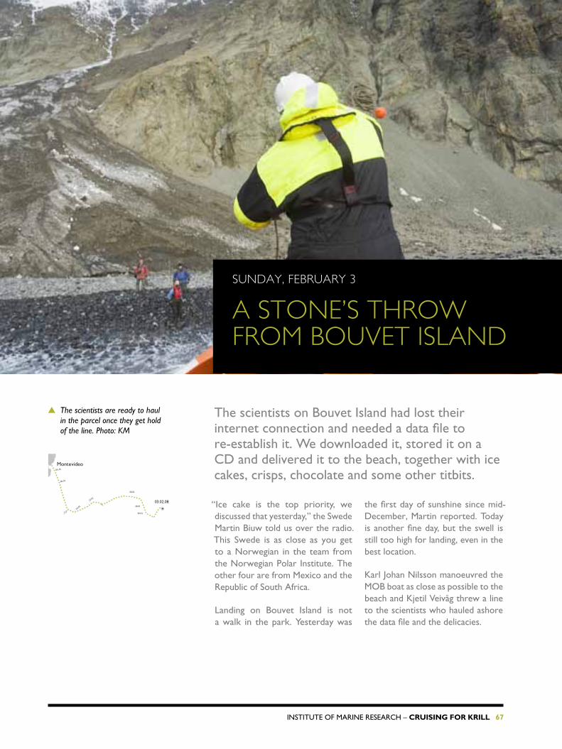
the scientists on Bouvet Island had lost their internet connection and needed a data file to reestablish it. We downloaded it, stored it on a cD and delivered it to the beach, together with ice cakes, crisps, chocolate and some other titbits.
“Ice cake is the top priority, we discussed that yesterday,” the swede Martin Biuw told us over the radio. this swede is as close as you get to a norwegian in the team from the norwegian Polar Institute. the other four are from Mexico and the republic of south africa.
Landing on Bouvet Island is not a walk in the park. Yesterday was
the first day of sunshine since midDecember, Martin reported. today is another fine day, but the swell is still too high for landing, even in the best location.
Karl Johan nilsson manoeuvred the MoB boat as close as possible to the beach and Kjetil Veivåg threw a line to the scientists who hauled ashore the data file and the delicacies.
▲ The scientists are ready to haul in the parcel once they get hold of the line. Photo: KM
06.01
30.01
28.01
26.01
05.01
12.01
10.01
Montevideo
03.02.08
Sunday, FEBruary 3
a STonE’S THroW FroM BouVET ISLand

68 Cruising for Krill – InstItute of MarIne research
▲ Kjetil Veivåg, Karl Johan Nilsson and Thomas Fylkesnes speeding in to deliver the parcel. Photo: KM
▲ G.o. sars by Bouvet Island. Photo: KM

InstItute of MarIne research – Cruising for Krill 69
▲ Part of Bouvet Island’s rugged landscape. The men in the upper part of the photo are walking over a glacier covered with rocks and gravel to get to the beach. Photo: KM

70 Cruising for Krill – InstItute of MarIne research
on this expedition I, Dag nielsen, am collecting data on the largescale distribution of krill for my master’s thesis. I am comparing distribution in the south Georgia area with that of Bouvet Island and studying the krill’s growth in laboratory experiments on board.
I shall use data from the echo sounders to ascertain the largescale distribution of krill. I will also use physical environmental data like temperature and salinity. Length will be measured and sex and maturity determined. We will study the growth rate of krill from the various bodies of water. I am responsible for the growth experiments, ably assisted by thor Klevjer and einar Loshamn.
I will use data from the echo sounders to discover the largescale distribution of krill and relate it to ambient temperature and salinity. the sex, maturity and size of the krill will be determined and measured, and
104 specimens in total. each krill is placed in a small tube and all of them are placed in a barrel with running cold sea water. the barrel is placed in a dark thermo regulated room.
the tubes are checked once a day at the same time. We check for moults and mortality. any krill that have shed their shells are put, with the old shell, into a tube and frozen. Dead krill are discarded. an experiment lasts for five days.
We have observed many moults, so I am happy.
we will study the growth of krill from various areas and depths. I am responsible for the growth experiment, ably assisted by thor Klevjer and einar Loshamn.
Live krill are selected from the trawl catches for these experiments. Krill are crustaceans with an external skeleton that becomes too tight when the animal grows, and therefore needs changing at regular intervals. the shell breaks, the krill creeps out and a new soft skeleton hardens within a short space of time.
normally we start two growth rate experiments simultaneously, using
▲ Einar Loshamn (left), Dag Nielsen and Thor Klevjer measure the krill’s growth rate. Photo: KM
Monday, FEBruary 4
GroWTH raTE EXPErIMEnT BECoMES ParT oF MaSTEr’S THESIS
06.01
30.01
28.01
26.01
05.01
12.01
10.01
Montevideo
04.02.08

InstItute of MarIne research – Cruising for Krill 71
▲ Fantastic design! Photo: LNø

72 Cruising for Krill – InstItute of MarIne research
TuESday, FEBruary 5
HurrICanE
Wind too strong for the wind gauge. air pressure too low for the barometer. It was quite fresh this morning! We are heading north from Bouvet Island along the 0 meridian.
▲ Air pressure was low this morning. Photo: KM
there were several excited photographers on the bridge this morning. their aim was to catch the highest waves breaking over the bow. Various wind forces were observed, 80 knots, 90 knots and sometimes the electronic wind gauge was saturated. We have got more weather than we need!
the highest wind speed I observed was 81 knots. Before lunch the mean was 67 knots, which is hurricane force, according to the captain. he estimated the highest waves to 15–17 metres. the pressure was very low this morning. at eight o’clock it was 958 millibars, rising fast to 978 millibars four hours later. this is extreme weather, says the captain, but fortunately it is a rare experience.
▲ A view from the bridge. Photo: KM
06.01
30.01
28.01
26.01
05.01
12.01
10.01
Montevideo
05.02.08

InstItute of MarIne research – Cruising for Krill 73
▲ Another view from the bridge. Photo: KM
4

74 Cruising for Krill – InstItute of MarIne research
WEdnESday, FEBruary 6
aCouSTIC ModELS For aBundanCE ESTIMaTES
on the bottom of its hull, G.O. Sars has six echo sounders and a sonar that operate continuously. the echoes from large and small organisms in the water are recorded and compared to acoustic models to identify and estimate the size of krill and other species.
“this is the first time we are using multifrequency data to estimate zooplankton size,” says rolf Korneliussen, who is in charge of the acoustic activities. It is important to learn how to interpret a given echo to reach a correct abundance estimate. this is true for all species, krill as well as herring. rolf takes herring as an example: “If you assume the echo is from 20 cmlong herrings, the result will be quite different from a calculation based on 10 cm herrings. It is the same when you calculate masses of krill. You need to know how much echo individual krill – or herrings – of different sizes contribute.”
the echo sounder’s frequency is important too. Krill give a strong echo at 70 and 120 kilohertz (khz). the largest krill give a maximum echo at 70 khz, the smaller ones at 120 khz. now we can compare the echoes at various frequencies and thereby calculate the size of the krill. We have turned back to take trawl samples from swarms several times.
“the catch is the true answer, and if the catch does not agree with the model, the model must be adjusted,” says rolf.
he has also scrutinized the echograms and interpreted them together with
▲ Rolf Korneliussen with an echogram on the computer screen. Photo: KM
→
06.01
30.01
28.01
26.01
05.01
12.01
10.01
Montevideo
06.02.08

InstItute of MarIne research – Cruising for Krill 75
▲ The same echogram after acoustic models were applied for species identification.
expedition leader svein Iversen and instrument chief Martin Dahl. that involves discussing what they think they observed on the screen and comparing it to the models’ answers. at south Georgia the models were controlled against catches several times. finally rolf had models he was quite satisfied with. “they are not 100 percent accurate, but if they give the krill’s length frequency distribution as 3540 mm and measurements from the catch are 4243 mm, I consider that acceptable,” says rolf.
Various models have been developed, and with their aid rolf can work back through the whole voyage correcting the figures. a lot of data have been accumulated. rolf estimates a terabyte at the end of the first half of the survey. that is a million million digits.
▲ Echogram.
▲ Three-dimensional sonar image of a krill swarm measured to 240,000 m3.

76 Cruising for Krill – InstItute of MarIne research
Velocity in layer 48−112m ;;2008−01−05 19:06:22−−−2008−02−12 17:28:40
60oW 50oW 40oW 30oW 20oW 10oW 0o 10oE 60oS
55oS
50oS
45oS
0.5m/s
0 1 2 3 4 5 6 7 8 9 10
−2 −1 0 1 2 3 4 5 6
0
500
1000
1500
Temperature [°C]
AKES 2008 CTD stations: 27 44 48
Dep
th (m
)
THurSday, FEBruary 7
LEaVInG THE KrILL BEHIndWe are passing through the front between the antarctic and subantarctic waters. that means we are leaving the area where we can expect to find krill.
▲ Three vertical temperature profiles along the 0 meridian.
the multicoloured line on the map shows the water temperature along our course. In the upper left corner we were sailing along the argentinean coast from our starting point of Montevideo, uruguay. We were close to the falkland Islands when the sea temperature first dropped below 10ºc. at our southernmost position, in the bottom right corner, the sea temperature was close to zero.
the front between the antarctic and subantarctic waters is clearly visible. the lines radiating from our course indicate the current’s direction and strength. the polar front is where the current is strongest and the temperature changes from yellow to green. the bottom topography also influences the front, which follows a deep trench that cuts through the ridge between the southern tip of south america and south Georgia. on the map, deeper areas are darker and shallower areas are lighter.
the other figure shows three sea temperature profiles from the surface to a depth of 1,500 metres along the 0 meridian. the left curve is from the southernmost station. even in midsummer the surface temperature is barely above 0ºc. It falls below zero 20–30 metres below the surface, then rises above zero again before falling slowly to about zero at 1,500 metres. the same pattern can be seen at the middle station. “We call this drop in temperature winter water, and it stays like this all through the summer. In winter these areas are covered with ice and the cold water reaches the surface. the right curve is our northernmost measurement so far. here it is much warmer at the surface and there is no winter water. the deeper layers are also warmer, about 2ºc. that means we are north of the polar front,” says henrik søiland.
◀ Temperature and current along our sailing track. The polar front is where the current is strongest (the longest arrows) and where the temperature changes from yellow to green.
06.01
30.01
28.01
26.01
05.01
12.01
10.01
Montevideo
07.02.08

InstItute of MarIne research – Cruising for Krill 77
FrIday, FEBruary 8
GoInG HoME WITH nEW SPECIES
nets and water sampling equipment have furnished Lars naustvoll with a lot of phytoplankton. some genera and species he knows from arctic areas, others he has only read about. he expects to find some that are so far not described in the literature.
he has not found them – yet. We have taken samples of phytoplankton at depths ranging from 150 to 5 metres. During the survey he has studied the samples from 30 metres. “there remains a lot of species identification work to be taken care of at home,”
says Lars, our phytoplankton expert on this first part of the survey.
silica algae are considered the krill’s main diet. Lars has found some silica algae, but far less than expected.
▲ The silica alga Eucampia antarctica is found only in Antarctic waters. Photo: LN
▲ The silica alga Asteromphalus. Three of this genus are well known in cold areas, both Arctic and Antarctic. Photo: LN
→
06.01
30.01
28.01
26.01
05.01
12.01
10.01
Montevideo
08.02.08

78 Cruising for Krill – InstItute of MarIne research
◀ The silica alga Corethron criophilum. A species found in both Arctic and Antarctic waters, but more common in the south. Photo: LN
▲ The silica alga Chaetoceros criophilus. A fairly common species in Antarctic waters, and found at several stations on this survey. Photo: LN.

InstItute of MarIne research – Cruising for Krill 79
five to six species dominate between south Georgia and our present position. the highest density is found near the front between antarctic/subantarctic waters. here he has also found them in krill stomachs. Where there were less silica algae the krill stomachs contained remains of ciliates and other phytoplankton species.
“We have observed a great variation in phytoplankton abundance. some areas have been very rich while other places have been poor. We have typical summer conditions here now and the dominant phytoplankton are small flagellates and ciliates,” says Lars.

80 Cruising for Krill – InstItute of MarIne research

InstItute of MarIne research – Cruising for Krill 81
Photo: EKL

82 Cruising for Krill – InstItute of MarIne research
In 2006 the alfred Wegener Institute for Polar and Marine research in Bremer haven, Germany placed nine echo sounders with pressure sensors on the sea bottom to register changes in the ocean currents. Much earlier than originally scheduled, andreas Macrander is here to look after three of the nine PIes, as he calls them.
Pies stands for “Pressure sensor equipped Inverted echo sounders”, or a pressure sensor with an echo sounder looking upwards.
I have been on board since January 4, and yesterday it was at last time to check the first PIes, which lies 4,300 metres below sea level. the pressure sensor is so sensitive that it can pick up changes of a few millimetres in the sea level. and that is what I am looking for. these data are used as reference points in the nasaled project Grace (Gravity recovery and climate experiment). for the
last five years the satellites in the Grace project have been measuring the earth’s gravitational field, and they have already detected melting glaciers in Greenland and changing seasonal patterns related to the monsoon season.
the project I am working on also uses the Grace data for worldwide measurements of changes in the water bodies.
the PIes units also measure sound velocity, which together with pressure gives the water temperature. taken
▲ Andreas’ PIES ready to be placed at a depth of 4,300 m. Photo: KM
→
▲ The German research vessel Polarstern passes G.o. sars. Photo: KM
06.01
30.01
28.01
26.01
05.01
12.01
10.01
Montevideo
09.02.08
SaTurday, FEBruary 9
34 dayS oF WaITInG arE oVEr

InstItute of MarIne research – Cruising for Krill 83
together, the information from nine PIes allows us to calculate water flow, thus enabling us to monitor the whole circumpolar current.
Yesterday we planned to take up one PIes and replace it, but we were unable to make contact with the instrument 4,300 metres below the vessel. now we are sailing for another PIes, and if we manage to get it we will change its batteries and place it at the third and last position.
▲▼ PIES being prepared for launching. Photo: KM

84 Cruising for Krill – InstItute of MarIne research
Sunday, FEBruary 10
PLanKTon InVESTIGaTIonS ▲ One of the many salps that often filled our nets. Salps (Thaliacea)
are a class of free-swimming tunicata. Photo: KM
06.01
30.01
28.01
26.01
05.01
12.01
10.01
Montevideo10.02.08

InstItute of MarIne research – Cruising for Krill 85
our plankton biologists are excited every time a net is hauled in. We recognise a variety of planktonic organisms from our northern waters, but the many strange creatures that we are encountering here is surpassing our wildest expectations. out of the deep cold water come strange crustaceans, related to the freshwater shrimp and sand hopper, some an intense red and soft like jelly, others wearing hard armour, some with big eyes, others blind jellyfish and small squid that are round like marbles, as is the world’s largest seed shrimp, which we catch in large quantities. and thousands of salps. the jellylike salps are sometimes observed in the norwegian sea and by our coast. In the south they occur in vast quantities.
But our work consists of more than merely looking and marvelling at the strange plankton forms sustained by the cold ocean. samples must be selected and prepared for subsequent analysis in laboratories in Bergen or sent to experts at institutes in other countries.
Krill spawn during the antarctic summer. the spawning process in the region between south Georgia and Bouvet Island is not well known, and some people believe that the krill do not spawn in this area at all. our investigation shows that a large part of the population is ready to spawn, while some have already spawned.
the antarctic krill is the world’s largest and can reach a length of 6.3 cm. Very little research has been done on this species in the area where we are operating. our expectations for what we will find in the way of krill and other planktonic life are therefore quite high.
▲ When the nets of the multi-sampler are opened, the catch ends up in these boxes. Photo: KM
▲ Satisfied with the catch. Photo: KM

86 Cruising for Krill – InstItute of MarIne research
▲ A solid catch of krill coming in. Photo: KM

InstItute of MarIne research – Cruising for Krill 87
Monday, FEBruary 11
SPrInG CLEanInG
the end of the first part of our southern ocean survey is approaching. Before we arrive at cape town the whole ship must be washed, inside and out, and all the samples we have collected must be marked and packed safely before being brought home for further analyses.
In the late evening we will reach andreas Macrander’s last location. We expect to meet the German research vessel “Polarstern” there. they have set off from cape town for a two month survey in the southern ocean. they will pick up a PIes, and we will place the last one that andreas brought. If things work out according to plan there will be a photo of this meeting in tomorrow’s bulletin. In the meantime, we have plenty to do on board.
▶ Ole Daniel Pedersen rinsing off salt. Photo: KM
▲ Biologist Merete Kvalsund turned charwoman. Photo: KM

InstItute of MarIne research – Cruising for Krill 89
We are heading for cape town, and there are no more samples to collect on this first part of the aKes survey. When we arrive we will have sailed 6,309 nautical miles. We have stowed the instruments and samples safely, stored all data, and are preparing for a press seminar and open ship in cape town on february 14 and 15.
Tuesday, February 12
sOMe THOuGHTs beFOre CaPe TOWN
▲ G.o. sars passing an iceberg. Photo: KM
the first part of the expedition, discussed daily and planned since 2004, is over already – and it feels like a success, thanks to the good atmosphere between the crew and research staff, and the weather, which has been much better than expected most of the time.
We have accumulated a lot of physical and biological data, and will obtain more during the second part of the expedition. Many of us
will be busy for a long time studying and processing the material we have collected. at this stage we can say that we have found good quantities of krill in several areas, including near Bouvet Island, and a lot of salps almost everywhere. It is a bit disappointing that, with the exception of the toothfish, which lives at great depths, there have been few food fish. only near south Georgia did we catch some food fish; since then it has only been lanternfish and other small
12.02.08
06.01
30.01
28.01
26.01
05.01
12.01
10.01
Cape TownMontevideo

90 Cruising for Krill – InstItute of MarIne research
species. We have gathered data on bottom sediments, hydrography, and the whole range of biological systems, from phytoplankton to whales. We did not see any blue whales, but perhaps the next group will be lucky. as a bonus we had a very interesting stop at south Georgia, and we are now members of the very exclusive
“club” of people who have seen Bouvet Island in sunshine. We feel for the
▲ A cruise ship approaching South Georgia. Photo: KM
five scientists on the island. they are doing a great job under very difficult working conditions. If they leave the island according to schedule, we may meet them in cape town.
finally I wish to thank the crew and research staff for making this such a great expedition, and I really hope the next group will have a survey as successful as ours. Good luck!

InstItute of MarIne research – Cruising for Krill 91
WedNesday, February 13
CaPe TOWN
We have arrived. cape town! after an ocean of adventure and new impressions, we have reached our journey’s end. new scientists and crew will soon arrive to begin the second part of the aKes Project.
▲ After everything we have experienced during the survey, it seems like an eternity since we left Montevideo in early January. Einar Loshamn (left) and Dag Nielsen look at the great city that we had too little time to explore. Photo: KM
▲ With Cape Town and Table Mountain as a backdrop, Dag Inge Blindheim immortalizes Signe Roska. Photo: KM

92 Cruising for Krill – InstItute of MarIne research
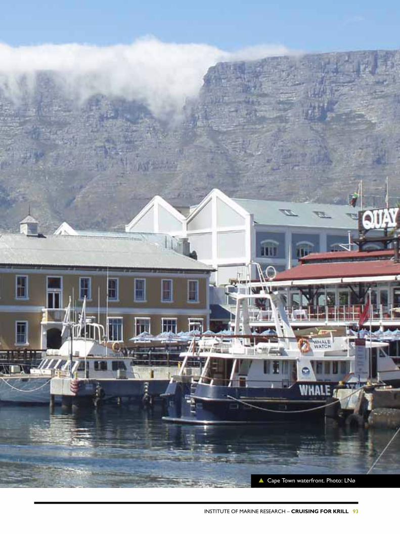
InstItute of MarIne research – Cruising for Krill 93
▲ cape town waterfront. Photo: Lnø

94 Cruising for Krill – InstItute of MarIne research
With Dr. Fridtjof Nansen and G.O. Sars, two of our institute’s research vessels, in harbour, south african scientists and civil servants were invited aboard yesterday. they were duly impressed with the vessels, the equipment and the research being carried out.
“this is very interesting. I am impressed with the versatility of the vessels, the ability to carry out so many different types of investigations,” said Kevern cochrane, director of the fisheries and aquaculture department of the fao.
“I know the Nansen well already, and am well aware of what it is capable of. G.O. Sars is very impressive, particularly the hangar that makes it
possible to operate various types of equipment safely in rough weather,” says Johann augustyn, director of research and antarctic Islands at the south african Department of environmental affairs’ branch for Marine and coastal Management.
these were two of the guests who visited first the Nansen and then the G.O. Sars on thursday afternoon. Dr. Fridtjof Nansen is owned by norad, run →
12.02.08
06.01
30.01
28.01
26.01
05.01
12.01
10.01
Cape TownMontevideo
Friday, February 15
iNTrOduCed TWO researCH VesseLs TO CaPe TOWNers▲ G.o. sars berthed in Cape Town harbour. Photo: KM

InstItute of MarIne research – Cruising for Krill 95
▲ Dr. fridtjof nansen and G.o. sars (behind) berthed in Cape Town. Photo: KM
▲ Atle Totland (right) explains to guests how the yellow platform is used to collect data. Photo: KM

96 Cruising for Krill – InstItute of MarIne research
by the Institute of Marine research and has the coasts of africa as its permanent research area. the two vessels are berthed at the Waterfront.
onboard the Nansen, the guests were given an update on the state of the hake stocks off West africa. this is the most important fish resource for both south africa and namibia.
on the G.O. Sars, guests were briefed on the first part of the aKes expedition. Various techniques for collecting data and samples, includ ing echo sounder, sonar and various types of fishing gear, were demonstrated, and some preliminary results were presented.
“It is important to establish how large the krill resources are, to prevent overfishing and secure enough food for animals that feed on krill,” says cochrane. south africa will build a polar research vessel at a cost of around 80-90 million euros. Johann augustyn says that there are limits to what you can accomplish with two surveys in an area as wide as the southern ocean, but that these expeditions are still important because this is an ocean crying out for more research. the area south of south africa particularly needs surveying, and therefore the acoustic work here may improve our understanding of the ecology in the area, he said.
▲ Rolf Korneliussen (seated) explains how the echo sounders and sonars are used to measure krill abundance. Photo: KM

InstItute of MarIne research – Cruising for Krill 97
THursday, February 21
HeadiNG FOr THe asTrid ridGe
We left cape town on february 19 at 14.30 with new crew and research personnel on board, all with great expectations. In addition to our own staff we have participants from Brazil, china, Germany, Mexico, Poland, scotland and the us.
We soon noticed the difference between the warm waters of the Indian ocean and the colder atlantic waters. the two oceans meet off the southern tip of the african continent. Less than 12 hours after leaving cape town the surface temperature increased from 11°c in the cold atlantic waters, to 21°c further south where we entered the warm current from the Indian ocean. no wonder
the south africans head to the Indian ocean to go swimming.
sharKs, WhaLes, schooLInG fIsh anD PenGuIns
Just a couple of miles south of cape town we observed dusky dolphins and south african penguins chasing sardinella schools at the surface. nearby there were ten humpback whales, probably looking for something →
21.02.08
Walvis Bay
Cape Town
▲ Fishing vessel landing the day’s catch in Cape Town. Photo: LNø
5

98 Cruising for Krill – InstItute of MarIne research
to eat, and a large shark swimming slowly along the surface.
InVestIGatIons start at the coLD front
It will take about five days for us to reach the cold front where the krill will appear, and biological and hydrographical research will commence near the front around 50-52°s, after which we will be busy day and night.
We will map the bottom in detail along the astrid ridge at 68°s – 12ºe using a sophisticated bottom-penetrating echo sounder. along the way we will pass the antarctic circle at 66°33.4’s.
BIrDs – an IMPortant Part of the ecosYsteM
our ornithologists have already recorded, near the continental slope, two kinds of albatrosses (the shy
albatross and Black-browed albatross) as well as cory’s shearwater and Great shearwater, all elegant gliders.
Large numbers of albatrosses, petrels and shearwaters were gathered around some fishing vessels. near our vessel we have spotted storm-petrels looking for zooplankton, and schools of flying fish that can glide above the waves for more than 100 metres on their wing-like fins. they look like birds.
VarIous fIeLDs of research
the scientists and students on board cover a wide variety of scien tific dis-ciplines: phytoplankton, parasitology, genetics, biochemistry, oceanography, acoustics (echo sounder and sonar), zooplankton, krill, fish, seabirds and sea mammals.
▲ Surface temperature where the Atlantic and Indian Oceans meet. Temperatures in degrees Celsius.

InstItute of MarIne research – Cruising for Krill 99
We have crossed the warm current that flows westwards from the Indian ocean. We are in a colder climate now, with the surface temperature at 6.6°c and the air at 5.6°c, a fairly dramatic change from the 30°c we enjoyed in cape town a few days ago.
saTurday, February 23
aPPrOaCHiNG THe aNTarCTiC
▲ Trawl bags with catch containers. Photo: BAK
Walvis Bay
CapeTown
23.02.08

100 Cruising for Krill – InstItute of MarIne research
We will reach our first sampling station near the cold front tonight. there we will measure temperature, salinity, and collect nutrients, phyto- and zooplankton and fish. Yesterday we carried out a test sampling station at 45ºs – 15ºe. the intention was to collect hydrographical and biological information north of the antarctic convergence where the temperate water masses meet the cold water of the southern ocean. this will allow us to compare these samples with those from stations in the considerably colder antarctic ecosystem south of 50ºs. this was also an opportunity to
test the equipment and organization of the work.
We are getting acquainted with many species of plankton and fish that are new to us. the catches included small krill species, various crustaceans, shrimp, fish, and a small squid. Phyto plankton were collected with water samplers down to a depth of 200 metres. soon we will pass the antarctic convergence and enter waters near freezing point. there we will encounter a different flora and fauna.
▲ The multi-sampler coming in. The five trawl bags can be opened and shut at chosen depths by remote control. Photo: BAK

InstItute of MarIne research – Cruising for Krill 101
at four this morning the pelagic trawl, with five separate nets fishing at depths of 0 to 750 metres, landed on deck packed with thousands of gelatinous organisms, among them several species of salps.
Tuesday, February 26
THe saLPs’ rOLe iN THe sOuTHerN OCeaN
We also found some spectacular jel-lyfish, one of them a one metre long giant weighing over 20 kg. there were also some interesting species of fish, krill and amphipods in the samples. eve-rybody helped with sorting, classifying, measuring and dissecting the salps.
the VacuuM cLeaners of the ocean
You may be wondering what kind of organisms salps are, and what
they look like. Well, they are the vacuum cleaners of the ocean. they are cylindrical organisms with muscular bands along their bodies. By contracting these bands salps are able to move by jet propulsion, rather like squid. the distribution of the muscle bands is characteristic and used for species identification. each species appears in two forms: solitary or in aggregations. the aggregates are chains of 100-150 individuals. they
▲ A sample of salps and fish. Photo: KM
→
Walvis Bay
Cape Town
26.02.08
▲ A salp in the hand. Photo: LNø

102 Cruising for Krill – InstItute of MarIne research
can appear in swarms of several thousand individuals.
salps are important and efficient plankton eaters, feeding on a wide range of species. they produce a mucous sheet that serves as a net to capture tiny organisms.
saLPs anD KrILL
Previous studies have suggested that salps and krill compete for food.
however, salps tolerate higher temperatures than krill. In winter, krill feed on the ice algae growing under the ice. If the sea temperature increases in the southern ocean, sea ice and the ice algae will diminish. since salps can survive at higher temperatures than krill, salps may then take advantage of a warmer climate and gradually replace krill as the major species in the southern ocean.
▲ A specimen of salpa thompsoni. Photo: LN

InstItute of MarIne research – Cruising for Krill 103
THursday, February 28
MesOPeLaGiC FisH, WHaT is THeir siGNiFiCaNCe iN THe sOuTHerN OCeaN?▲ Iceberg with colour bands, possibly caused by algae in the ice. Photo: LNø
G.O. Sars is better equipped than any other research vessel for studies of mesopelagic fish. We can conclude already that in the area south of Bouvet Island there are less mesopelagic fish than in many other oceanic areas.
for several days the southern ocean has presented its best side, a nearly flat sea. We feel comfortable and we can work efficiently. We are thriving on excellent and varied food from the galley. our international participants are trying out new variations on typical norwegian dishes, e.g. oatmeal porridge with soy sauce.
our survey is covering a large area, and there is often a long sail between
sampling stations. this allows us to rest, socialize and have technical discussions between the busy sampling stations, and we can enjoy the sight of beautiful drifting icebergs, preserving them in our memories, on film and on disk.
orGanIsMs In the DeeP
While many of us relax between stations, the echo sounders never rest. nearly every second, six echo →
Walvis Bay
Cape Town
28.02.08

104 Cruising for Krill – InstItute of MarIne research
▲ A sample of mesopelagic fish and krill from a trawl catch. Photo: LNø
sounders send sound waves into the abyss. the echoes return information about ocean depth and the quantity, and to a certain degree the type, of organisms that are present in the water. trawl hauls confirm or correct what we “read” on the echo sounder screen.
MesoPeLaGIc fIsh In the antarctIc
one of the fish groups we are studying are the mesopelagic fish. they are named after the depth zone they inhabit. We find them at depths of 200 to 800 metres in daytime, but at night they rise to the
richer feeding grounds in the upper layer. Mesopelagic fish are found in all of the world’s oceans. What their role is in this ecosystem is somewhat uncertain. We can already conclude that in the area south of Bouvet Island there are less mesopelagic fish than in many other oceans. What is the reason for this? after the survey we will analyze our data and compare them with measurements from the northern hemisphere. We hope our investigations will help answer questions such as these, thereby improving our understanding of the ecosystem in the southern ocean.

InstItute of MarIne research – Cruising for Krill 105
Tuesday, MarCH 4
MaPPiNG a PieCe OF NOrWeGiaN sea FLOOr
Mapping the sea bed along the astrid ridge at about 66°s – 13°e using multi-beam echo sounder is one of the tasks of this survey. here the ocean depth varies between 2000 and 5000 metres, which is just at the operational limits of the instrument.
successful mapping requires nice weather with almost a dead calm sea. five days have been allocated to this task. We started friday night four days ago along the first of ten trajectories, covering a distance of 1200 nautical miles. the sea floor is
mapped by a 30 khz multi-beam echo sounder. It transmits 135 beams in an athwartship fan-shape, where each beam is 2 degrees along ship and 1 degree arthwart ship.the mapping project was commissioned by the norwegian Petroleum Directorate.
▲ Screenshot of the sea bed. Photo: LNø
▼ Illustration of an area of sea bottom mapped by the multi-beam echo sounder. Graphics: AS
Walvis Bay
Cape Town
04.03.08

106 Cruising for Krill – InstItute of MarIne research
▲ A trawl net filled with krill. Photo: LNø

InstItute of MarIne research – Cruising for Krill 107
WedNesday, MarCH 5
KriLL sOuTH OF THe aNTarCTiC POLar CirCLe
after 13 days at sea we crossed the southern polar circle and arrived at the southernmost point of the survey, 67°17’s 8°00’e. this is 153 nautical miles from the antarctic mainland, in an area covered by thick ice in winter. We observed large quantities of krill, and friendly humpback whales circled the vessel.
▲ Antarctic krill. Photo: LNø
Walvis Bay
Cape Town
05.03.08

108 Cruising for Krill – InstItute of MarIne research
samples from this southernmost area consisted almost exclusively of krill. Microscopic studies revealed that many krill were mature and ready to spawn. It is nice to see that they are on schedule for spawning in January-March. the stomachs and intestines had a greenish colour, showing that they are feeding on phytoplankton, which they filter from the water.
KrILL at the surface
We had considerable echo recordings of krill and could also see by eye dense swarms of krill colouring the sea surface red. Krill form large swarms, with densities of 10,000 to 30,000 individuals per cubic metre. there are several reasons for the krill to form swarms. In a swarm, the probability of a single krill being eaten by a predator is lower, while it increases its chances of finding
food. In the swarm they also use less energy for swimming and increase the likelihood of meeting individuals of the opposite sex in the spawning season. the plankton samples showed low abundance of food for krill in the surface layer. so why do they stay at the surface? Perhaps the survey will provide some answers.
fooD aLL arounD
Maybe it was the huge swarms of krill that attracted the humpback whales that visited us the other morning? In the southern ocean the whales are somewhat larger than their relatives in the north. the southern humpbacks can reach 18 metres and weigh 40 tonnes. our visitors were about 15 metres long, and very inquisitive. they circled the vessel for a couple of hours, often only a few metres away.
▲ A playful humpback whale near the ship’s side. Photo: CB

InstItute of MarIne research – Cruising for Krill 109
THursday, MarCH 6
birds FrOM CaPe TOWN TO THe aNTarCTiCBy observing birds along the 15ºe meridian from cape town towards the antarctic continent we are obtaining important ecological data.
eXceeDInG aLL eXPectatIons
Most studies of bird life in the southern ocean have been carried out close to land or at brooding areas. our studies take place in the open ocean. I was therefore very pleased to be able to join the expedition in cape town. for 40 days I will be surrounded by interesting birds, and hopefully learn more about the sea birds’ ecology. I knew very little about what to expect, and so far I have learnt more than I dared hope for.
It is interesting to observe how the bird fauna changes as we sail south. When we enter colder waters, some species disappear and others appear. the only species that stays with us all the time is the White-chinned petrel (Procellaria aequinoctealis).
the uLtIMate DreaM
for a birdwatcher from the northern hemisphere who focuses on sea birds, the albatross is the ultimate dream. the grace and aura of tranquillity that this great seafarer exudes are truly amazing. no human being – whether birdwatcher or not – will come away from an albatross encounter untouched.
But – there is a sad side to the story of the birds in the southern ocean. for years albatrosses and other birds have been killed in their thousands, getting hooked on long-lines. there is international agreement that line-setting techniques must be changed. releasing the line deeper, through a tube, is recommended. It has been calculated that from 1996 to 2000 somewhere between 105,000 and 260,000 sea birds were killed
Walvis Bay
06.03.08
Cape Town
▲ Grey albatross. Photo: EG
▲ Close-up study of seabird. Photo: LNø

110 Cruising for Krill – InstItute of MarIne research

InstItute of MarIne research – Cruising for Krill 111
▲ Hungry albatrosses. Photo: HS

112 Cruising for Krill – InstItute of MarIne research
by long-line fishing. the figure includes between 22,000 and 70,000 albatrosses. Many birds brood only every second year and produce only one offspring. snowy albatrosses (Diomedea exulans) do not reach maturity until the age of ten, which makes them very vulnerable. they are threatened by extinction. one of the most threatened birds is the spectacled petrel (Procellaria conspillata), which we have seen five times so far. this species broods on small inaccessible islands in the southern atlantic. In the year 2000 the population was estimated at
10,000 individuals, and it is declining. It is estimated that 5% of these birds are killed each year by long-line fishing off the coast of Brazil.
an aBunDance of BLue PetreLs
Blue petrels (Halobaena caerulea) were abundant in the southern part of the investigated area. Between 500 and 1000 individuals were counted daily. We also encountered cold-water species like the Grey albatross (Phoebetria palpebrata) whose smiling appearance is fun to watch. for a norwegian it was also
interesting to see antarctic petrels (Thalassoica antarctica), which have colonies 300–400 km inland on the antarctic continent. one of their colonies is at svarthammaren, close to the norwegian research station troll. they fly 800 km to find food for their only offspring.
stewart Murray from scotland is also onboard. his objective is to study the different moult stages and look at plumage variation in the world’s largest flying seabirds, the wandering albatrosses. these birds can reach a wingspan of 3.5 metres.
▲ Wandering albatross. Photo: EG

InstItute of MarIne research – Cruising for Krill 113
Walvis Bay
CapeTown
10.03.08
Monday, March 10
GEnETIc anaLySES In STorMy WEaThEr
analyses of genetic variations in proteins (enzymes) must be carried out on fresh krill. We were in doubt as to whether the equipment would work properly under rough weather conditions, but everything functioned perfectly, even in winds of 40-50 knots (strong gale).
▲ Knut Jørstad pondering over his genetic analyses. Photo: LNø
Both the layout of the laboratory on the G.o. sars and the vessel’s good stability are important to our ability to perform successful analyses. In addition, a gimballed table borrowed from the fish lab was very useful under rough weather conditions, particularly at some critical stages of the analyses. so far, we have sampled krill (Euphausia superba) at 11 stations. the samples from the first 8 locations, nearly 800 specimens,
have been analyzed for 5 different enzymes. three of the enzymes show significant genetic variation, and the data can therefore be used in detailed statistical comparisons of genetic profiles between samples from different areas.
Genetic variation appears as various banding patterns and identifies the individual krill’s genetic type.

114 Cruising for Krill – InstItute of MarIne research
TuESday, March 11
TEETh LIKE daGGErS
It was the first time on this second leg of the expedition we used the big fish trawl, and it was lowered 1200 metres. It came up with many fascinating creatures, including one which, for obvious reasons, is called a Daggertooth (Anothopterus pharaoh).
the longest Daggertooth in the catch was a 77 cm specimen. It has razor-sharp teeth. the body is slender, but both body and stomach are extendible, enabling the Daggertooth to swallow prey half its size.
Both scientists and crew waited eagerly for the trawl to reveal the secrets of the deep. More than 2,000 metres of towing wire must be let out before the trawl reaches a depth of 1,200 metres. the bottom of the
▶ The common endemic lanternfish electrona
antarctica of the Southern Ocean. Photo: LNø
→Walvis Bay
Cape Town
11.03.08
▲ Daggertooth. Photo: LNø

InstItute of MarIne research – Cruising for Krill 115
southern ocean is generally 4,000 to 5,000 metres deep, so when we fish at 1,200 metres we are still in mid-water. there is very little light, temperatures are low and there is not much food. We call this the mesopelagic layer. from this layer the trawl brought 26 kg of fish, 10 kg of jellyfish and 2.5 kg of squid.
this was a golden opportunity for us Brazilian scientists to collect various species of fish for our research programme evolution and biodiversity in the antarctic: a response of life to change. the aim is to study how fish adapt to a krill-dominated ecosystem. the krill shell contains large amounts of fluorine, which is poisonous. We are studying how fish are able to excrete and transform it. We are also collecting samples for genetic analyses for comparison with samples taken simultaneously at the Brazilian
research station on King George Island.
another important task for our project is to study the anatomy and morphology of the organisms, to understand how they have adapted to the mesopelagic environment. fish have adapted in various ways. some are silver-tinted, others are transparent and some are pitch-black. some have enormous eyes and some produce their own light.
the samples we collect will be further analyzed by scientists and students at various universities in Brazil. the international cooperation established on this expedition is representative of research in the antarctic, particularly during this International Polar Year.
▲ The trawl is coming in. Photo: HGK
▼ Fresh sample of lanternfish, krill and jellyfish from a deep haul. Photo: LNø
▲ Daggertooth. Photo: LNø

116 Cruising for Krill – InstItute of MarIne research
FrIday, March 14
BIGGEr and STronGEr KrILL aT BouVET ISLand
Bouvet Island is the world’s most remote island, and is important for seals, birds and penguins, as it provides a site for them to rest, feed and reproduce. over the last 10 years the norwegian Polar Institute has carried out five surveys to study seals and penguins on Bouvet Island. these animals are krill predators and so these studies also provide some information about the krill abundance in the area. however, krill distribution and abundance are being observed directly for the first time in our survey. We are also collecting hydrographical data to learn more about the preferred environment of krill.
Due to their high biomass and rich protein content, pigments (carotenoids), natural anti-oxidants and omega-3 fatty acids, krill are of interest to commercial fisheries. as knowledge about this resource is limited, it is essential to obtain more data to enable catch quotas to be set at reasonable and sustainable levels. the krill and fish resources in the southern ocean are managed by ccaMLr (convention for the conservation of antarctic Marine Living resources) which was established in the early 1980s. the results from this survey will be reported to ccaMLr.
We have now investigated the krill resources both north and south of Bouvet Island. Preliminary results indicate that the krill near the island are bigger and stronger than their siblings in other areas.
→
Walvis Bay
Cape Town
14.03.08
▲ Second visit to Bouvet Island. Photo: KM

InstItute of MarIne research – Cruising for Krill 117
our preliminary results show that the krill in the Bouvet area are big and in good condition. this also seems to apply to the animals living on Bouvet Island. Despite the fact that Bouvet Island is located in a rather inhospitable and harsh region, the animals seem to be thriving.
happy easter!
▲ Bird at Bouvet Island. Photo: LNø
▲ Chinstrap penguin. Photo: EG

118 Cruising for Krill – InstItute of MarIne research
During this survey we have crossed the most powerful oceanic current in the world: the antarctic circumpolar current. It is mainly wind-driven. the wind blows mainly from west to east producing an upwelling of colder water in the south, creating a significant temperature front.
Based on our wind measurements during the survey, we have tried to check if the wind systems deserve their dubious reputation. the loser, defined as the belt with the lowest wind speed, was the shrieking sixties, average speed 10.4 m/s. second came the roaring forties, average speed
roaring forties, furious fifties and shrieking sixties are popular names for the wind systems in the southern ocean. But are they really that bad, and which is worst?
11.6 m/s. the unquestionable winner was the furious fifties with an average wind speed of 14.1 m/s, equivalent to strong breeze, force 6. a strong breeze may not seem too frightening, but do not forget that this is the summer wind! It is worth mentioning that the norwegian Bouvet Island is located at 54°s, right in the middle of the furious fifties. our colleague, Bjørn Krafft who has worked on the island, says that previous attempts to establish permanent installations on the island have literally gone with the wind. any volunteers for overwintering on Bouvet Island?
Walvis Bay
Cape Town
15.03.08
SaTurday, March 15
WEaThErBEaTEn▶ Storm. Photo: KM
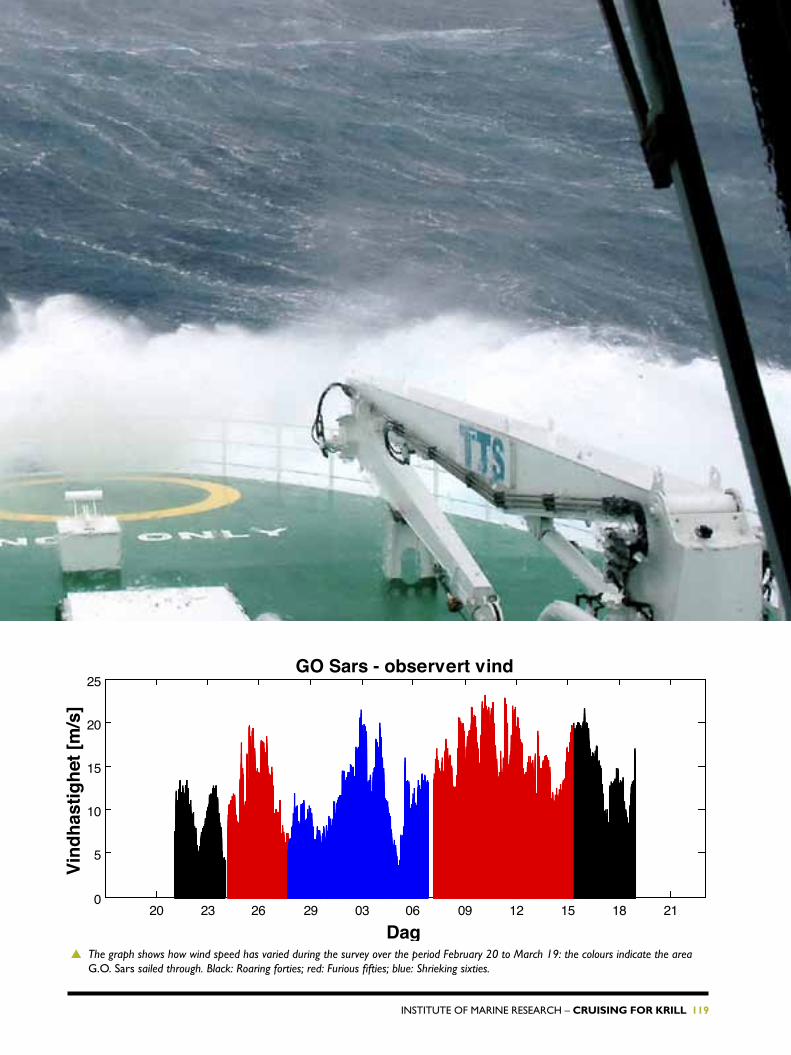
InstItute of MarIne research – Cruising for Krill 119
20 23 26 29 03 06 09 12 15 18 210
5
10
15
20
25
Dag
Vind
hast
ighe
t [m
/s]
GO Sars - observert vind
▲ The graph shows how wind speed has varied during the survey over the period February 20 to March 19: the colours indicate the area G.o. sars sailed through. Black: Roaring forties; red: Furious fifties; blue: Shrieking sixties.

120 Cruising for Krill – InstItute of MarIne research
after three weeks at sea, Bouvet Island appeared in a sunny spell, with its blue ice, snow and mountains. a few minutes later it disappeared in the fog. Krill from a sampling station close to the island were big (6 cm), with the stomach and gut filled with a greenish matter, which under the microscope turned out to be remnants of various diatoms.
Monday, March 17
SMaLL orGanISMS – GrEaT IMPorTancE
one of the aims of this survey, and the aKes project, is to study abundances of the phytoplankton that are available to krill and salps, looking at what species there are and how they are distributed in the deep. We also want to learn more about how a changing environment influences the abundance and species composition of the algae. environmental data are collected with a ctD sonde with several water sampling bottles working at depths of 5–1,500 metres.
▲ The silica alga chaetoceros dichaeta under the microscope. Photo: BE
→
Walvis Bay
Cape Town
17.03.08

InstItute of MarIne research – Cruising for Krill 121
the water from the sampling bottles is stored in different bottles for subsequent analysis of hydrochemistry, chlorophyll-a (algae density) and the abundance and species distribution of phytoplankton.
sampling goes on around the clock. a phytoplankton net is towed from 100-0 metres to collect algae larger than 10 µ (0.001 mm). Diatoms are predominant in the samples. Many of the genera common in norwegian waters are also present here (e.g. Chaetoceros, Dactyliosolen, Fragilariopsis, Pseudo-nitzschia, Proboscia and Rhizo-solenia), but the species are often different .
Diatoms are encased in a protective silica wall, and they are often link ed together in long chains. the chain-forming diatom fragilariopsis kergue-lensis is common both in the samples and in the krill stomachs. algae are
unicellular organisms and the number of each species in a given volume of water is counted under the micros-cope. the smallest phytoplankton organisms (pico- and nanoplankton), including various flagellates and smal-ler types of diatoms, are now most numerous in the samples. this is a typical species composition for the late summer both here and in our own northern waters, and is related to low levels of nutrients. Little is known about the diversity of plankto-nic algae in the southern ocean. the collected algae will be further studied by electronic microscopes and their genetics will be analyzed later at the university of oslo.
the ship has temperature- and light-controlled rooms for cultivation and growth studies of algae and other organisms. Planktonic algae are currently growing there to be used for detailed studies later.
▲ The chain-forming silica alga fragilaropsis kerguelensis. Photo: BE
▲ CTD sampler with water bottles ready for launching. A plankton net can be seen at the right of the picture. Photo: EB
6

122 Cruising for Krill – InstItute of MarIne research

InstItute of MarIne research – Cruising for Krill 123
▲ Fur seal at full speed. Photo: EG

124 Cruising for Krill – InstItute of MarIne research
acoustic mapping of krill, fish and other marine organisms is based on an advanced understanding of how sound propagates from a transducer fitted under the hull of a ship until it hits and is reflected by an organism (e.g. krill). the intensity of the echo is called the target strength of a given individual at a specific sound frequency.
TuESday, March 18
WhEn SMaLL chanGES MaKE a huGE dIFFErEncE
the size and orientation of the or-ganisms, as well as the material pro-perties of animals in the sea, are very important factors when determining the target strength. our knowledge of the material properties of zoo-plankton is incomplete, primarily because it’s difficult to do the measu-rements on living organisms. on the G.O. Sars we use a specially designed instrument called aPoP (acoustic Properties of Plankton) for these measurements. It consists of two pa-rallel tubes or sound chambers with one transducer at each end, one for emitting sound and one for receiving the echo.
usually 15-25 live krill are placed inside a chamber and the system is submerged to 200 metres at 20 metre intervals in order to observe
the effect of pressure/depth. When the instrument is back on deck the animals are removed from the cham-ber and put in sea water for volume measurements. this work is very time-consuming. It is therefore re-ally surprising that most krill are still alive after both rough treatment and a journey into the deep in a small container. so far the data on sound velocity and density are quite uniform and generally higher than observed for krill from the western part of the antarctic in 2002. our theory prior to this survey was that krill might be in better condition with higher den-sity and sound speed in the summer than in other seasons. the data seem to confirm this.
▶ Peter Wiebe prepares a krill for measuring its weight, volume and density. Photo: LNø.
Walvis Bay
Cape Town
18.03.08

InstItute of MarIne research – Cruising for Krill 125
about half of all these species are parasites, which means they feed on their hosts and have a great impact on their hosts’ lives. It’s well known that a tapeworm infection influen-ces appetite as well as growth, but sometimes parasites cause disease and death (e.g. Gyrodactylus, a lethal parasite on salmon).
Generally parasites and diseases in fish are often considered horrors caused by human activities such as fish-farming or pollution. Is there some truth in this?
on this aKes expedition we are pretty much as far away from human activity as possible. this gives us a chance to investigate to what degree fish in the southern ocean are in-fected by the viruses, bacteria and
WEdnESday, March 19
FISh ParaSITES In ThE SouThErn ocEan.
Very little research has been done on the parasites and diseases of antarctic fish. We have sampled fish at Queen Maud Land and north to Bouvet Island, and have discovered a series of new microscopic fish parasites.
parasites dreaded by the fish-farming industry in our home waters.
the question is: what is natural? the results from our virus and bacteria samples will not be ready until after we have analyzed them at the lab back in Bergen.
We have already discovered several new microscopic fish parasite species on this expedition. they are unicellu-lar small creatures (flagellates) swim-ming around in the fish’s stomach, single-celled spore-forming animals (coccidia) in the mucous membrane of the intestines and flatworms in the gut.
the examined fish are all pelagic species. Demersal fish usually have fewer parasites, mainly tapeworm larvae. some of the tapeworm larvae
▲ Several species of deep sea fish have large mouths and long teeth. This photo shows a Daggertooth (anotopterus pharaoh), the largest fish we’ve caught so far (77cm). This large fish had relatively few parasites and only 8 tapeworm larvae. Photo: LNø.
Walvis Bay
CapeTown
19.03.08
→

126 Cruising for Krill – InstItute of MarIne research
◀ Even krill have got parasites. Every single euphaucia superba’s intestine is infected by single-celled protozoa (gregarines) of the species cephaloidophora pacifica. Photo: EK
▲ Crustacean parasites on the deep water species Bathylagus sp. from the Southern Ocean. The three upper fish are infected , with the deep red sarcotretes sp. with long pink egg-strings. The three lower fish are infected with the yellowish copepod Paeonocanthus antarcticensis, with two short cocoons. photo: EK
wriggled happily when warmed, telling us that their hosts as adults might be warm-blooded animals.
other tapeworm larvae died when warmed, indicating that their adult hosts might be cold-blooded animals (fish). We will investigate the Dna sequences of these parasites at our labs back in Bergen to determine if they are destined for cold or warm blooded hosts.
some of the more peculiar fish parasites we have examined so far are various types of transformed crustaceans (copepods), like the gill worm in cod, which is probably familiar to some of you.

InstItute of MarIne research – Cruising for Krill 127
▲ This Antarctic jonasfish (notolepis coatsi) is infected by sarcotretes sp. The lower picture shows a jonasfish infected with sarcotretes, where the green arrows point to the parasites’ heads with their anchor-like structure fastened deep inside the flesh. Photo: EK
▲ Paeonocanthus antarcticensis is attached deep inside the fish, with its mouth at the top of the kidneys ( shown by the tip of the tweezers in the lower picture). Photo: EK.

128 Cruising for Krill – InstItute of MarIne research

InstItute of MarIne research – Cruising for Krill 129
▲ A solid catch on its way onboard. Photo:KM.

130 Cruising for Krill – InstItute of MarIne research
▲ A krill swarm photographed by the cameras on the TS-sonde at 30 metres. Photo: CB.
after weeks with sea temperature close to 0°c we are now heading for Walvis Bay and sailing in warmer waters. Krill prefer much colder waters than this, and we have observed no krill over the last few days. our attention now turns to analyzing the data we have collected.
We mapped the distribution of krill when sailing south along 15°e and north along 7°30’e. along the way we investigated abundance and vertical distribution of krill using echo sounders and fine-meshed trawls. We have also mapped the environment and the pelagic ecosystem.
FrIday, March 21
a KEy orGanISM In ThE SouThErn ocEan
the figure on the next page shows the distribution of krill from 50° to 67°s, recorded continuously by the ship’s echo sounders, going south along 15°e.
Krill were mainly observed in the upper 100 metres with the highest
Walvis Bay
CapeTown
21.03.08
abundance close to the antarctic continent. Krill were larger in the south than further north.
Most of the krill were observed in dense swarms. We also observed scattered swarms of krill as reddish stains at the surface. the patchy distribution of krill, as well as the fact that krill are also distributed above the area the echo sounders are able to register, add to the uncertainty of the estimates of krill biomass.

InstItute of MarIne research – Cruising for Krill 131
▶ Distribution of krill along the 15°E meridian from 50° to 67°S, given as acoustic values of krill. Graphics: PHW.
▲ Antarctic krill, euphausia superba. Photo: CB

132 Cruising for Krill – InstItute of MarIne research
the bridge is an excellent viewpoint for observing sea mammals and birds. so far we have seen eight different species of whales, including sperm whale, minke whale, humpback and fin whales.
the humpbacks have been most numerous so far, with 41 observations totaling about 100 individuals. We spotted several groups of two to four animals, often adults with young calves. the humpback is stoutly built, and can reach 18 metres in length and weigh up to 50 tons.
Its name is derived from how it curves its back when diving. the underside of its fluke is white. Individuals can
be distinguished by determining the shape and colour pattern of the fluke.
Photographs taken on this cruise will be sent to a large international database for humpbacks. some of the individuals we spotted may have been observed off cape town during the winter. By indentifying the same individuals at different locations we can learn about the humpback’s migration patterns.
SaTurday, March 22
WhaLE oBSErVaTIonS
▶ Humpback whale, with its typical white fluke, dives
into the deep for krill. Photo: LNø.→
Walvis Bay
22.03.08CapeTown
▲ Humpback whale with its knobbly head. Photo:LNø

InstItute of MarIne research – Cruising for Krill 133
the humpbacks in the northern areas have no contact with their relatives in the southern hemisphere. Marine mammals do not cross the equator.
the humpbacks gather in frontal areas where cold and warm water meet, especially near the antarctic continent.
In some areas we observed humpbacks near icebergs feeding on krill close to the surface. they can take mouthful of up to 500 kg. Krill are attracted by drifting icebergs, probably due to the favourable feeding conditions, and for protection. such krill →
▲ Relaxing whales near the icebergs. Photo: EKL

134 Cruising for Krill – InstItute of MarIne research
abundances attract the humpbacks, because krill are their favorite food.
some of the whales approached the side of the vessel, seeming quite inquisitive. there is very little shipping in these waters. the closest ship we observed (on the radar screen) was the German research vessel Polarstern, more than 200 km away!
the low frequency sound waves used by whales to communicate travel great distances underwater. Many sea mammals use sound waves to detect food, for instance, just like we use echo sounders and sonars. some whales might perhaps hear the sounds from wires, propellers and the whole “symphony” from all the acoustic instruments transmitting a range of different sound frequencies, which whales are able to hear from a distance of several kilometres.
▲ The map shows distributions of humpback whales, krill and surface temperatures from Cape Town to the Astrid Ridge near Queen Maud Land.

InstItute of MarIne research – Cruising for Krill 135
It’s early morning and the trawl is expected on deck any moment. We are ready in our hard hats and protective boots, photographing a group of humpbacks that surround the vessel while we wait. It is magnificent and great fun!
▲ Antarctic krill euphausia superba. Photo: TLT
Monday, March 24
GroWTh EXPErIMEnTS on anTarcTIc KrILL
Walvis Bay
CapeTown
24.03.08

136 Cruising for Krill – InstItute of MarIne research
What have we got in the trawl? Jellyfish, krill, weird fish or salps? We crane our necks to get a glimpse as the trawl lands on deck. today’s catch is krill, millions of them, some of which are even alive. this means we can start new growth experiments.
the krill go into tanks of sea water for about 30 minutes. the healthy swimming specimens are transferred to individual glass jars. these jars are placed in large containers with circulating sea water at about 0°c.
We check on the krill daily to see if they are still alive and if they have moulted. one day we discovered a jar with no krill inside! We still do not understand how the little rascal managed to escape. Krill have no internal skeleton like humans, but an exoskeleton, i.e. an external carapace. the krill literally outgrow their shells, discard them and grow new ones. the old skeleton lies on the bottom of the jar like a ghost. We estimate that krill moult once every two or three weeks.
We freeze the moulted krill and store them in small plastic tubes. We have to take great care with the tail (telson) which is essential for measuring growth. that is a tedious task which cannot be done onboard. It will be very exciting to see the final results back home.
Krill are able to live several weeks without food, and their bodies can actually shrink. the eyes are the only part of the animal that does not shrink. the relationship between eye size and body length can therefore tell us how long the krill have been without food. We have stored krill from various areas and look forward to seeing if we can relate growth rates to other factors such as food (algae) for krill and sea temperature. ▲ A krill has cast off its old shell. Photo: AH
▲ Tonie and Anna busy checking the krill in the growth rate experiment. Photo: TLT

InstItute of MarIne research – Cruising for Krill 137
▲ Blue flying fish (exocoetus volitans) gliding above the waves in front of G.o. sars near Vema Seamount. Photo: EG
Vema seamount lies in the southern atlantic ocean about 1,000 km WnW of cape town, at 31°38’s, 8°20’e. It was discovered by the research vessel Vema in 1959. the very shallow and steep seamount in the middle of nowhere was first explored for possible diamond resources
WEdnESday, March 26
FLyInG FISh aT VEMa SEaMounT
no diamonds were found, but a rich rock lobster fishery developed. this highly praised and priced resource was nearly wiped out in the 1980s, and the fishery dwindled when the catch no longer paid for the trip. stocks have recovered and the fishery has resumed, but for how long? this is international territory and the
international community has not yet agreed on a management regime for the resources here.
over the last two days we have mapped the seamount’s topography in great detail, and measured the currents, temperature and nutrient salts in the area. the volcano rises →
Walvis Bay
Cape Town
26.03.08

138 Cruising for Krill – InstItute of MarIne research
▲ Detailed bottom topography of Vema Seamount, charted by Simrad EM 300 and EM 1002 multi-beam echo sounders. Graphics: AS
from the surrounding seabed at 5,000 metres to 11 metres below the surface.
after leaving Vema, we discovered some fascinating creatures: “flying fish!” someone shouted, and then about three dozen of them provided us with an hour’s entertainment, shooting out of the water and elegantly gliding over the waves for up to 100 metres. their exceptionally large pectoral fins, and in some species also extended pelvic fins, give them a bird-like appearance. they glide along and can adjust their direction, using their tails as rudders.
the species we saw is called the Blue flying fish (Exocoetus volitans). they can grow to a length of about 45 cm. they are widespread in the atlantic, Indian and Pacific oceans, including coastal areas. they feed mainly on small crustaceans and other planktonic animals, and are hunted by swordfish and tunas.
We have left the southern ocean, and our course is set for Walvis Bay, nami-bia. there, in the warm sub-tropical waters, we will encounter an animal community quite different from the one we saw in the antarctic region.
▲ A Spanish fishing boat has set numerous rock lobster traps along the summit (11-200 metres deep) of Vema Seamount. Photo: SM

InstItute of MarIne research – Cruising for Krill 139
We have completed the aKes expedition. our navigators have guided us safely to harbour, assisted by the pilot and a south-african fur seal that accompanied us into the port.
It feels strange to put our feet on solid ground in namibia after more than five weeks at sea in the southern ocean, where we’ve had to deal with everything from a moderate breeze to storm force winds. the ground seems to sway a bit as we walk across the pier.
We’ve been working into the small hours for some time in order to complete the survey report. one terabyte (1012) of data has been collected by a wide range of
instruments and sampling gears. some of the preliminary results are ready.
We estimate the total abundance of antarctic krill to be roughly 14 million tonnes in a 500,000 square kilometre area around Bouvet Island, an area which only accounts for about 5% of the southern ocean. If we assume similar abundances of krill in the entire southern ocean, the total krill biomass would be roughly 280 million tonnes.
▲ Research personnel and crew on board G.o. sars during the second part of the AKES survey. Photo: LNø
→
27.03.08
Walvis Bay
CapeTown
ThurSday, March 27
G.o. SarS caLLS aT WaLVIS Bay

140 Cruising for Krill – InstItute of MarIne research
84 people from many different countries have sailed with the G.O. Sars during the aKes expedition. We would like to thank everyone for their contribution, both those who joined us on the survey and those back home who made it all possible.
▶ We are also joined by a South African fur seal. Photo: EG
▲ The pilot boat flamingo accompanies G.o. sars into the Walvis Bay harbour. Photo: LNø

InstItute of MarIne research – Cruising for Krill 141
▲ A trawl bag full of krill coming to the surface. Photo: KM

142 Cruising for Krill – InstItute of MarIne research
LIST oF auThorS and PhoToGraPhErS
InItIaLs naMe authors InstItutIon
JanuarY feBruarY March
ah anna hoelter 24 university of Bergen
aM andreas Macrander 9 alfred Wegener Institute, frankfurt
as asgeir steinsland 4 Institute of Marine research
BaK Bjørn a. Krafft 14 Institute of Marine research
Be Bente edvardsen 17 university of oslo
Bje Bjørnar ellertsen 10 Institute of Marine research
cB cecilie Broms 5 Institute of Marine research
cWc caroline W. cooke 11 furG, riao Grande Brasil
Dc Dezhang chu 18 noaa, usa
Dn Dag nielsen 25, 29 university of oslo
eB espen Bagøien 21 Institute of Marine research
eG eirik Grønningsæter 6 www.Wildnature.no
eGo elise Golten Institute of Marine research
eK egil Karlsbakk 19 Institute of Marine research
eKL einar Kristen Loshamn 23 university of oslo
GM Gunnleiv Midttveit Institute of Marine research
hGK helena G. Kawall 11 uniandrade, curitiba, Brasil
hL herdis Langøy 5 Institute of Marine research
hs henrik søiland Institute of Marine research
Ja Jaime alvarez 29 Institute of Marine research
KJ Knut Jørstad 10 Institute of Marine research
KM Kjartan Mæstad7, 9, 11, 13, 15, 16, 17, 18, 21, 22, 27, 31
1, 3, 5, 6, 7, 8, 11, 13, 15
Institute of Marine research
Ln Lars naustvoll Institute of Marine research
Lnø Leif nøttestad 2114, 22, 26, 27
Institute of Marine research
MK Merete Kvalsund 29 Institute of Marine research
PGBL Paola G. Batta Lona 26 university of connecticut, usa
PhW Peter h. Wiebe 18 university of california, usa
rM roger Munns BBc
rP ronald Pedersen 4 Institute of Marine research
saI svein arnholt Iversen 8, 24 2, 12 Institute of Marine research
sK stein Kaartvedt 28 university of oslo
sM stuart Murray university of oslo
taK thor a. Klevjer university of oslo
tLttonie Leonora tor-grimsby
24 university of oslo
Vs Volker siegel 19Johann heinrich von thünen-Institut, forestry and fisheries, hamburg
WM Webjørn Melle 21 Institute of Marine research
Øs Øystein skagseth 15 Institute of Marine research
Øt Øyvind tangen Institute of Marine research

88 Cruising for Krill – InstItute of MarIne research
▲ Meticulously marked jars with plankton samples. They will be analyzed at the laboratory in Bergen.Photo: KM
◀ ▼ More cleaning - Ole Daniel Pedersen (left photo) and Håkon Andreassen. Photo: KM

Copyright © 2022 FDOKUMEN