Cruising Compendium | NWVYC
30
North West Venturers Yacht Club Cruising Compendium Photo: Mike Hollingworth
-
Upload
khangminh22 -
Category
Documents
-
view
0 -
download
0
Transcript of Cruising Compendium | NWVYC

1
North West Venturers Yacht Club
Cruising Compendium
Phot
o: M
ike
Holli
ngw
orth

2
Contents
Cruising Trophies ........................................................................................................... 3Passage Planning ........................................................................................................... 4
Course Planner ......................................................................................................... 5Log ............................................................................................................................ 6
Cruising Crib Sheets ....................................................................................................... 8Anglesey ................................................................................................................... 8Cardigan Bay ............................................................................................................. 9Isle of Man ............................................................................................................. 10Irish Sea .................................................................................................................. 11North Irish Sea ....................................................................................................... 12
Harbour Contacts ........................................................................................................ 13Marina Contacts .......................................................................................................... 13Coastguard MSI transmissions .................................................................................... 14Flag Etiquette .............................................................................................................. 14
Dressing overall ...................................................................................................... 14Chart Catalogues ......................................................................................................... 15
Admiralty Tidal Stream Atlas .................................................................................. 16Tidal Streams ............................................................................................................... 17
Menai Strait ............................................................................................................ 17Bardsey Sound ....................................................................................................... 18Jack & Ramsey Sounds ........................................................................................... 20
Tidal Differences .......................................................................................................... 22On Dover ................................................................................................................ 23On Brest ................................................................................................................. 23
Recommendations for Safety Equipment .................................................................... 24Means of Propulsion .............................................................................................. 24Anchors .................................................................................................................. 24Bailing & Bilge pumping ......................................................................................... 24Detection Equipment ............................................................................................. 24Fire fighting equipment .......................................................................................... 24Personal safety equipment..................................................................................... 24Radio ...................................................................................................................... 25Navigational equipment ......................................................................................... 25First Aid & Medical ................................................................................................. 25General Emergency Equipment .............................................................................. 25
Publications ................................................................................................................. 26Charts & Guides ..................................................................................................... 26Pilots and Sailing Directions ................................................................................... 26
VHF Emergency Sheet ................................................................................................. 27VHF Call Sheet ............................................................................................................. 28SOLAS Distress Signals ................................................................................................. 29
v.1.0.3September 2017

3
Cruising CompendiumPh
oto:
Bria
n &
San
dra
Finn
ey
Phot
o: G
ordo
n &
Mar
jorie
Rutt
er
North West Venturer’s cruise to Ireland, Scotland, France - and further afield. Left: Off Bora BoraAbove: Village Bay, St. Kilda.
Even for local journeys, we need access to a lot of data, much of which requires some searching to find. This document offers recommendations and access to information of use for passages from Anglesey. If you think something is missing, let the Vice commodore know about it. The decision to sail is your own, not the Club’s. The Club and its OoD’s, are not responsible for your safety.
Cruising TrophiesThe Club awards a number of trophies, mainly donated by past members, both to recognise cruising achievement and to encourage further exploration.
Trophy Description
Commodore’s Cup Awarded to the winner of the Senior Log Competition, for logs of cruises of 10 days duration or more.
Storm Trophy Awarded in recognition of a sailing achievement by a relative newcomer to sailing.Kioni Cup Awarded to the winner of the Children’s Log Competition, for logs of cruises of any
duration.Venturer’s Cup Awarded at the discretion of the committee (and not necessarily every year) for an
outstanding sailing achievement during the year.Junior Venturer’s Cup Awarded at the discretion of the committee (and not necessarily every year) for an
outstanding achievement during the year by a Junior member.Junkette Bowl Awarded to the yacht which cruises to the furthest point of call from Anglesey around
the coast of Ireland (North or South about).St. Kilda Trophy This is a plaque mounted on the wall of the clubhouse. It bears the name of every club
yacht and skipper who visits St. Kilda. The trophy was presented by club members in 1979 as a memorial to Dick Partington, the Club’s Training Officer for many years, whose boat, Lindora, was the first club boat to reach St. Kilda.

4
Passage PlanningIntroduction
Going to sea in a boat is potentially dangerous and no amount of equipment will make sea-going safe if the skipper and crew are not fully competent or if conditions become extreme. However, the right equipment can help everybody to cope with danger and misadventure, so that the risks are reduced to an acceptable level. Members are encouraged to register with the Coastguard CG66 scheme (http://mcanet.mcga.gov.uk/public/cg66/).
Overall Planning
Start planning at home with small scale (paper) charts covering the entirety of each passage and adjoining waters. • Make sure that charts are up to date by using the UKHO updating web site, (https://www.ukho.gov.uk/nmwebsearch/ ) or the equivalent Imray web site, (http://www.imray.com/corrections/ ). Identify dangers and highlight on charts.• Check that you have all necessary plotter cartography and that all cards are still working in the plotter.• Check that you have relevant pilots.• Identify shipping lanes & Traffic Separation Schemes to plan transits, if possible, in daylight hours. Remember • that TSS must be crossed at right angles (as viewed on RADAR).Identify alternative routings for different weather and tidal conditions. (A passage from Kilmore Quay to Holyhead • can vary by up to 6 hours depending on the state of the tide at the departure point).Check sunrise and sunset times (for light identification) and soundings (which might give progress checks). Check • moon rise and set to assess visibility at night.Identify bolt holes in case of severe changes in the weather.• Check VHF MSI transmission times and MMSI numbers for Coastguard Operations centres (COC). • Check all safety equipment.• Transfer waypoints along track and at boltholes to plotter and/or charts• Create an outline plan with distances and likely passage time for each leg. •
Tides and Tidal Streams
Note the times and heights of tides at departure and destination.• Note expected tidal streams at selected points along route. (Admiralty NP256 covers the Irish Sea)• Identify limiting depths, overfalls, fast streams etc. which will create tidal gates.•
Aids to Navigation
Confirm (from chart corrections) the light characteristics of all AtoN along route and towards boltholes.• Check VHF working channels at all harbours and marinas • en route.
Detailed Plan
Check availability of large scale charts & pilots etc. for destination(s) and boltholes.• Create hourly plot (allowing for tides) on passage chart using Admiralty Tidal Stream Atlases. • Mark clearing lines for dangers along route• Check depths at destination at ETA.• Calculate worst case fuel requirements: gallons/hr; endurance vs passage time; allow 20% reserve. • If going overseas, check:•
Passportso
Courtesy flagso
Customs requirements at destination(s)o
Coastguard (Crosse) stations and weather transmission timeso
Overseas agents for essential equipmento

5
Course Planner Pl an Date ____________________
Depart From
ETD (Time) Tide Height
Local HW (am)
Local HW (am)
Dover HW
State of TideNeap Mark state with X Spring
Hours Out Clock Time Tide State Strength (Kn) Direction Notes
ETD
1
2
3
4
5
6
7
8
9
10
11
12
13
14
FROM: Waypoint TO: Waypoint Course Notes°T °M
Destination
ETA (Time) Tide Height
Local HW (am)
Local HW (am)
Dover HW
Course Planner

6
LOGPassage Planning Pactctage Sçtackçt Daçte __________________________
Skippeck:
Cckew:
Chackçtct Rechuicked:
AM PM
ETA/ETD Location HW Ht LW Ht HW Ht HW Ht
Depart
Dest’n
Neap Spring DOVER
R=3.3 Dover (mark X) R =5.9 Range
Range | Height above LAT @ ETA Depth Required
% Springs
Name Position Name Position Name PositionWaypoinçtct
FockecactçtctTime
Area
Wind
Weather
0710 0110 Scillies 64 F0750 0150 St Ann’s 62 F, L0750 0150 Hartland 64 F, L0750 0150 Gt. Orme 64 IS0750 0150 South Stack 63 IS0750 0150 Blaenplwyf 62 IS0750 0150 Dinas Head 64 IS
0730 0130 Moel-y-Parc 63 IS0730 0130 Caldbeck 63 IS0730 0130 Langthwaite 62 IS0730 0130 Snaefell 64 IS0730 0210 Slieve Martin 64 IS, M0730 0210 Greenock 62 IS, M0810 0210 Black Mt 63 IS, M
Schedule A: (12 hourly at 07xx/080xx and 19xx)Gale Warnings, Local Inshore waters forecast andoutlook, Shipping Forecast, WZ Navigation Warningsincluding Negative Tidal Surge Warnings, SUBFACTS& GUNFACTS and the Three-Day Fisherman’s Fore-cast, when and where appropriate.Schedule B: (3 hourly from 01xx or 02xx).Gale Warnings, Local Inshore waters forecast andoutlook.
MSI Bckoadcactçt Timect
Tidal RangectDover Liverpool Beaumaris Holyhead Milford Hn
Springs 5.9 8.4 6.8 4.9 6.3
Neaps 3.3 4.5 3.5 2.4 2.7
0 5 10 15 20 25 30
0 1 2 3 4 5 6 7 8 9 10
Feet
Metres
F - Fastnet: L - Lundy: IS - Irish Sea: M - Malin
Ch. Ch.A B A B

7
LOGDeck LogTime E Log Depth Baro Wind Weather Lat Long Course
Sailing Hours Engine Hours Distance (Sail) Distance (Eng) Average Speed Fuel State Water State
TODAY
CUMULATIVE
Time Remarks
Nackckaçtive Log
Daily Summacky

8
Fl 1
0s
Fl(2)
15s
5.6
3.5
Rh
osco
lyn
Sla
ck -
0100
HW
-0120/-
0045
3
14
Ab
erm
en
ai
Sw
ellie
s
3
8
Ab
erm
en
ai
Sla
ck -
011
5
HW
-011
5/-
0035
Depart
HW
-0500 for
Sw
elli
es
Depart
HW
-0100 for
Holy
head
Depart
HW
-0200 for
Port
h D
inlla
en
Po
rt D
ino
rwic
3
Fl 5s
4
13
45
Sla
ck -
0035
HW
-0010/-
0000
7.5
Carm
el H
ead
Oc.
10s
4.3
S
lack
-0050
HW
-0015/-
0005
6
4
Sla
ck -
0120
HW
-0050/-
0045
Beau
mari
s
Mo
elf
re
Cem
aes
Sw
elli
es
Sla
ck is
HW
-0
21
5.
Le
ave
Me
na
i B
rid
ge
at
tha
t tim
eE
nte
r S
we
llie
s fr
om
So
uth
at
-02
45
Be
wa
re u
nm
ark
ed
ro
ck
- M
ae
n P
isc
ar
Cru
isin
g C
rib
sh
ee
t fo
r
An
gle
se
y
All
tidal d
ata
refe
r to
DO
VE
R.
Liv
erp
ool =
DO
VE
R +
0015/+
0020 (
Sp/N
p)
Sla
ck fig
ure
s re
fer
to tim
e d
iffere
nce
fro
m D
ove
r.
Co
nw
y
Sla
ck -
011
0
HW
-0010/-
0010
Depart
HW
-0100 for
Holy
head
Depart
HW
-0330 for
Sw
elli
es
Depart
HW
-0100 for
Conw
y vi
a S
watc
hS
lack
-0000
HW
-0015/-
0000
Poin
t Lyn
as
Skerr
ies
Trw
yn D
u
Lla
nddw
yn
South
Sta
ck
7
Caern
arf
on
Bar
Channel ch
anges fre
quently
Call
Caern
arf
on H
r fo
r la
test
Ente
r fr
om
seaw
ard
at
HW
-0300
Ente
r fr
om
Str
ait
at
HW
-0100
Men
ai B
rid
ge
Sla
ck -
0150
HW
-0005/-
0010
Ho
lyh
ead
Sla
ck -
0045
HW
-0036/-
0020
Depart
1hr
befo
re lo
cal LW
for
Carm
el o
r S
outh
Sta
ck
NO
T T
O B
E U
SE
D F
OR
NA
VIG
AT
ION
Fl.W
R 2
.5s
Be
au
ma
ris
to
:
Po
rtp
atr
ick
110
Po
rt S
t M
ary
5
8C
on
wy
1
2H
oly
he
ad
3
2B
ard
sey
3
5P
wllh
eli
5
5L
ive
rpo
ol
5
0D
un
La
og
ha
ire
9
0T
usk
ar
1
25
Fis
hg
ua
rd
85
Ho
lyh
ea
d t
o:
Po
rtp
atr
ick
93
Po
rt S
t M
ary
4
6C
on
wy
3
6B
ea
um
aris
32
Ba
rdse
y
35
Pw
llhe
li
52
Liv
erp
oo
l
68
Du
n L
ao
gh
aire
5
6T
usk
ar
9
3F
ish
gu
ard
9
0
Ap
pro
xim
ate
Dis
tan
ces
Fro
m a
n id
ea
by I
an
Ro
dg
er
© I
an
Ro
dg
er
20
00
Usefu
l C
on
tacts
Ho
lyh
ea
d C
.G.
01
40
7 7
62
05
1
00
23
20
01
8
Ch
16
Me
na
i B
rid
ge
Pie
r 0
12
48
71
23
12
Ho
lyh
ea
d H
arb
ou
r 0
14
07
60
67
00
H
24
C
h.1
6,1
4H
oly
he
ad
Ma
rin
a
01
40
7 7
64
24
2
H2
4
Ch
.37
Ho
lyh
ea
d S
aili
ng
Clu
b
01
40
7 7
62
52
6
C
h.3
7C
ae
rna
rfo
n H
arb
ou
r 0
12
86
67
211
8
HW
±3
Vic
toria
Do
ck (
Ma
rin
a)
H
W±3
C
h.8
0P
ort
Din
orw
ic M
arin
a
01
24
8 6
71
50
0
HW
±2
½
Ch
.80
Co
nw
y H
arb
ou
r 0
14
92
59
62
53
Ch
.14
Co
nw
y M
arin
a
01
49
2 5
93
00
0
HW
±3
C
h.8
0D
eg
an
wy
Ma
rin
a
01
49
2 5
76
88
8
HW
±3
C
h.8
0L
ive
rpo
ol M
arin
a
01
51
70
7 6
77
7
HW
±3
C
h.8
0
Dis
tance
s are
AP
PR
OX
IMA
TE
Ch
art
sIm
ray
C52
UK
HO
SC
5609
Liv
erp
oo
l M
ari
na

9
5
Tenby
Swansea
Dale
Jack Sd.
Fishguard
Cardigan
Newquay
Aberystwyth
Aberdovey
Barmouth
Mochras
Pwllheli
AbersochAberdaron
Caernarfon Bar
Bardsey Sd
Sarn BadrigSt Tudwals
12
15
2
14
15
14
10
96
14
30 15
6
Patches
Strumble Head
Smalls
Helvick Channel
9
5
9 15
45
35
15
12
15
15
St Ann’s Head
Bishops and Clerks
Bias Bank
9
70
Cruising Cribsheet for
Cardigan Bay
Developed by Ralph Morris from an idea by Ian Rodger© Ian Rodger 2000
All tidal data refer to DOVER. Liverpool = DOVER +0015/+0020 (Sp/Np)Slack water figures refer to time differences on DoverDistances (nautical miles) are APPROXIMATE.
48
Porth DinllaenSlack -0240HW -0140
Slack-0205HW -0300
Slack -0100HW -0305
Slack -0310HW - 0310
PorthmadogSlack -0310HW - -0245
HW -0305
HW -0245
HW -0330
HW -0335
HW -0405
HW -0400
HW -0500HW -0510
HW -0500
Ramsey Sd.South-going -0330North-going +0400Rate 6kn
South-going -0230North-going +0300Rate 6kn
Fl.WR 5s
Heavy Overfalls
Castlemartin Range Manorbier Range
Fl(3).15s
Fl.5s
Fl(4).15s
FlR.10s
Fl.WR.15sRange InformationAberporth 01239 813462 Ch16Castlemartin 01646 662367 Ch16/12Manorbier 01834 871282 Ch16/73
Useful Contacts MMSI ChHolyhead C.G. 01407 762051 002320018 16Milford Haven C.G. 01646 690900 002320017 16Pwllheli Marina 01758 701219 H24 80Aberystwyth Marina 01970 611422 HW±2 80Milford Marina 01646 696312 H24 MNeyland Yacht Haven 01646 61601 H24 37, 80Swansea Marina 01792 470310 HW±4 80
ChartsImray Pack 2700,C51, C52, C60UKHO SC5609, SC5620, 1971,1972, 1973, 1478, 1076, 1165
Aberporth Bombing range
Heavy Overfalls
Heavy Overfalls
Aberporth Bombing range
NOT TO BE USED FOR NAVIGATION
10
ChartsImray C62, Y70UKHO 2094, 2696, 5613
9nm
9nm
7.5nm
5nm
6nm
8nm
3nm2nm
10.5nm
Ramsey
5nm
3nm
Cruising Cribsheet for
Isle of Man
Laxey
Douglas
Peel
Port Erin
Port St Mary
Langness Point
Jurby Head
Contrary Head
Direction of floodis SOUTH
Direction of floodis NORTH
NOT TO BE USED FOR NAVIGATION
From an idea by Ian Rodger© Ian Rodger 2000
OffshoreSandbanks
Maughold Head
Point of Ayr
Maughold Head Fl(3) 30s
Point of Ayr Fl(4) 20s
Chicken Rock Fl 5s Useful Contacts MMSI ChHolyhead C.G. 01407 762051 002320018 16Peel Harbour 01624 842338 HW±2½ 16,12Peel Sailing Club 01624 842390 Port St Mary Harbour 01624 833205 H24 16,12Castletown 01624 823549 HW±2½ 16, 12Douglas Harbour 01624 686628 H24 16,12Laxey 01624 861663 HW±3Ramsey Harbour 01624 812245 HW±3 16,12
All tidal data refer to DOVER. Liverpool = DOVER +0015/+0020 (Sp/Np)Slack figures refer to time difference from Dover
Port St Mary to:
Howth 62Holyhead 46Beaumaris 58Conwy 57Liverpool 80Fleetwood 61
Slack -0010 HW -0010
Slack +0005 HW +0005
Slack -0015 HW -0015
Calf SoundN-going -0115S-going +0315
Slack +0545 HW-0015
Slack -0005 HW -0005
Slack +0000 HW +0000
Slack +0430 HW +0430
Scotland: Leave at -0200Ramsey: Leave at +0500Anglesey: Leave at -0530
Slack +0005 HW +0005
Slack -0015 HW -0015
Slack -0015 HW -0015

11
Primary Lights
Hook Head Fl.3s. 23MConingbeg Fl(3).30s 24MTuskar Rock Q(2).7.5s 24MWicklow Hd Fl(3).15s. 23MKish Bank Fl(2).20s. 22MBailey Fl.15s. 26MRockabill Fl.WR.12s.17/13Haulboline Fl(3).10s. 17MMew Island Fl(4).30s. 24MAltacarry Hd Fl(4).20s. 26MKintyre Fl(2).20s. 24MAilsa Craig Fl.4s. 17MCorsewall Pt Fl(5).30s. 24MCrammag Hd Fl.10s. 18MGalloway Fl.10s. 18MPt of Ayre Fl(4).20s. 19MMaughold Pt Fl(3).30s 21MDouglas Hd Fl.10s. 24MChicken Rock Fl.5s. 21MPoint Lynas Oc.10s 18MSkerries Fl(2).15s. 20MSouth Stack Fl.10s. 24MBardsey Is Fl(5).15s. 26MStrumble Hd Fl(4).15s. 26MSmalls Fl(3).15s. 18MSt Anns Hd Fl.WR.5s 18/17
ChartsCharts for the waters of this crib sheet are too numerous to list.UKHO 1121 covers the entire area.Imray Pack 2700 covers the Welsh coastline. C61, C62 and C64 are needed for the Irish coastline.
Mew Is
Rockabill
Kish
Tuskar Rock
Coningbeg
Hook Hd
St Anns Hd
Wicklow Hd
Smalls
Strumble Hd
Bardsey
Skerries
Haulboline
Crammag Hd
Corsewall Pt
Ailsa Craig
Altacarry
Maughold Pt
Troon
South Stack
Chicken Rk
Pt of Ayre
Kintyre
Galloway
Douglas Hd
Lynas
2342
49
30
50
43 46
3527
44
7040
54
6324
57
65
105
110
80
60
48
114
52
58
HW +0030
HW +0030
HW +0025
HW +0045
HW -0010
HW -0150
HW -0510
HW -0535HW -0535
HW -0500
HW -0400
HW -0310
HW -0035
HW -0015
Dunmore EastKilmore Quay
Rosslare
Arklow
Wicklow Pwllheli
Fishguard
Milford Haven
Conwy
Port St Mary
Douglas
Strangford
Ardglas
Carlingford
Glenarm
Belfast
Portpatrick
Campbeltown
Millbay
Dun Laoghaire
Howth
Ramsey
All tidal data refer to DOVER. Liverpool = DOVER +0015/+0020 (Sp/Np)Slack water figures refer to time differences on DoverDistances (nautical miles) are APPROXIMATE.
Cruising Cribsheet for
Irish Sea
Useful Contacts MMSI ChHolyhead C.G. 01407 762051 002320018 16Milford Haven C.G. 01646 690900 002320017 16Belfast C.G. 02891 463933 002320021 16
For calls from UK to Eire, preface with +353 and drop the ‘0'.Kilmore Quay Marina 05 3912 9955 H24 09Arklow Marina 04 023 9901 H24 12Dun Laoghaire 01 202 0040 H24 80Howth 01 839 2777 H24 80Malahide 01 845 4255 HW±4 M,80Carlingford 04 2937 3073 H24 MArdglas 02844 842323 H24 M,80Portaferry 02842 729598 H24 80Bangor 02891 453297 H24 M,80Carickfergus 02893 366666 H24 MGlenarm 02828 841285 H24 16,MBallycastle 02820 768525 H24 80
Malahide
Holyhead
NOT TO BE USED FOR NAVIGATIONFrom an idea by Ian Rodger© Ian Rodger 2000

12
16
nm
6n
m
28
nm
23
nm
26
nm
6n
m
25
nm
18
nm
8n
m
4n
m
11
nm
16
nm
27
nm
25
nm
40
nm
46
nm
11
nm
11
nm
14
nm
Pt
of A
yre
F
l(4
).2
0s.
Litt
le R
oss
Fl(2
).5
s.
Cra
mm
ag
He
ad
F
l.10
s.
Ch
icke
n R
ock
F
l.5s.
Ma
ug
ho
ld H
d.
Fl(3
).3
0s.
St
Be
es H
d.
Fl(2
).2
0s.
Wa
lne
y I
s..
Fl.1
5s.
N
Ma
ryp
ort
Wo
rkin
gto
n
Wh
iteh
ave
n
Po
rtp
atr
ick
Ra
mse
y
Do
ug
las
Pe
el
PS
Ma
ry
Ba
rro
w
He
sta
nF
l(2
).1
0s.
Ra
ve
ng
lass
Isle
of
Wh
itho
rn
Kirku
db
rig
ht
Kip
pfo
rd
Dru
mm
ore
Mu
ll o
f G
allo
wa
y F
l.20
s.
Cru
isin
g C
rib
she
et
for
No
rth
Iri
sh
Se
a
All
tida
l da
ta r
efe
r to
DO
VE
R.
Liv
erp
oo
l = D
OV
ER
+0
01
5/+
00
20
(S
p/N
p)
Sla
ck f
igu
res
refe
r to
tim
e d
iffe
ren
ce
fro
m D
ove
r
Be
au
ma
ris
to
:
Do
ug
las
58
Po
rt S
t M
ary
5
8R
am
sey
68
Po
int
of A
yre
7
1R
ave
ng
lass
7
2P
ee
l
73
Wo
rkin
gto
n
89
Mu
ll o
f G
allo
wa
y 9
3K
irku
db
rig
ht
94
Ma
ryp
ort
9
5P
ort
pa
tric
k 1
09
Sla
ck +
00
15
Sla
ck +
00
25
Sla
ck +
00
15
Sla
ck +
00
00
Ch
art
s:
Imra
y:
C6
2
Iris
h S
ea
UK
HO
:S
C5
61
3
Iris
h S
ea
(E
)
Us
efu
l C
on
tac
ts:
M
MS
I/A
ccess
Ch
Ho
lyh
ead
CG
01407 7
62051
002320018
16
Belf
ast
CG
02891 4
75310
002320021
16
Mary
port
Marina
01900 8
14431
HW
±2.5
12
White
haven M
arina 01946 6
92435
HW
±4
12
Dougla
s M
arina
01624 6
87543
HW
±2
12
Port
patr
ick H
arb
our
07565 1
02096
Fro
m a
n id
ea
by
Ian
Ro
dg
er
© I
an
Ro
dg
er
20
00
NO
T T
O B
E U
SE
D F
OR
NA
VIG
AT
ION

13
Harbour Contacts
Marina ContactsAberystwyth marina 01970 611422 80Ardglas (Phennick Cove) 02844 842332 M, 80Arklow marina (+353) 87 2588078 16, 8Ballycastle marina 02820 768525 80Bangor marina, NI 02891 453297 11, 80Carlingford marina (+353) 42 937 3072 MCarrickfergus marina 02893 366666 MConwy marina 01492 593000 80Deganwy marina 01492 576888 80Fleetwood Haven marina 01253 879062 12Glenarm marina 02828 841285 07703 606763 16, MGreystones marina (+353) 1 287 3131 (+ 353)86 2718161 M, 80Holyhead marina 01407 764242 MKilmore Quay marina (+353) 53 9129955 16, 09Liverpool marina 0151 707 6777 80Malahide marina (+353) 1 845 4129 M, 80Milford marina 01646 696312 14Neyland Yacht Haven 01646601601 M, 80Port Dinorwic Yacht Haven 01248 671500 80Portaferry marina 02842 729598 80Preston marina 01772 733595 80Victoria Dock (Caernarfon) 01286 672118 80
Aberdovey harbour 01654 767626 07879 433148 16, 12Barmouth harbour 01341 280671 07795 012747 16, 12Castletown harbour 01624 823549 07624 451503 12Caernarfon harbour 01286 672118 14Conwy harbour 01492 596253 16, 14Fishguard harbour 01348 873369 07721 860803 12Holyhead harbour 01407 606700 14Peel harbour 01624 842383 07624 495036 12Port Erin harbour 01624 833206 07624 460096 12Port St Mary harbour 01624 833205 07624 460096 12Porthmadog harbour 01766 512927 07879 433147 16, 12

14
Coastguard MSI transmissionsTwo complete weather forecasts are transmitted each day (Schedule A), with Inshore forecasts (Schedule B) at three hourly intervals. Gale warnings are also transmitted when received.Schedule A: (12 hourly at 07xx and 19xx)Gale Warnings, Local Inshore waters forecast and outlook, Shipping Forecast, WZ Navigation Warnings including Negative Tidal Surge Warnings, SUBFACTS & GUNFACTS and the Three-Day Fisherman’s Forecast, when and where appropriate.Schedule B: (3 hourly from 01xx or 02xx).Gale Warnings, Local Inshore waters forecast and outlook.Transmissions in our area are:1st Aerial Ch Area0110 Scillies 64 F0150 St Ann’s 62 F, L0150 Hartland 64 F, L0150 Gt. Orme 64 IS0150 South Stack 63 IS0150 Blaenplwyf 62 IS0150 Dinas Head 64 IS
1st Aerial Ch Area0130 Moel-y-Parc 63 IS0130 Caldbeck 63 IS0130 Langthwaite 62 IS0130 Snaefell 64 IS0210 Slieve Martin 64 IS, M0210 Greenock 62 IS, M0210 Black Mt 63 IS, M
Flag EtiquetteFlag etiquette is a combination of law (what you must do) and maritime tradition (expectations of behaviour within the sea faring community). See RYA information. (www.rya.org.uk/infoadvice/regssafety/flagetiquette/Pages/febook.aspx).
The ensign is the most important flag and is worn at the stern or mizzen • masthead. No other flag may be carried in these positions. NWVYC yachts must wear the Red Ensign.Need not be worn offshore.• Is hoisted at 0800 and lowered at sunset (or 2100 if sunset is later than • 2100).Is not worn when racing.• The club burgee, the most important flag after the ensign, is worn at the main • masthead, or at the superior (top) position below the starboard spreader.Courtesy flags must be worn when in the territorial waters of foreign • countries. Isle of Man and Channel Islands count as foreign in this context - Wales, Scotland & Northern Ireland do not.They are carried on the starboard spreader, superior to any other signal • flags. This creates a conflict with the burgee, normally resolved by wearing the burgee below the courtesy flag(s).In Brittany it is usual to fly the Breton flag immediately below the French • flag.The Q-flag (for Customs clearance) need not be flown when entering EU • countries from another EU country (including UK). It is required when entering the Channel Islands (or entering the UK from the Channel Islands). Form C1331 from www.gov.uk/government/publications/import-and-export-pleasure-craft-on-non-eu-
voyages-leaving-or-arriving-in-uk-c1331 is required.House flags (e,g, RNLI, RYA) are flown from the port spreader in order of • seniority.
Dressing overall[Bow] EQ3G8Z4W6P1 I Code TBX 1st H 3rd DF 2nd UAOMR2J0N9K7V5LCS [Stern]
Split after “3rd” on sloop: split after I and 2nd on ketch. Commodore does not dress overall but wears ensign at both masthead and stern.
F - FastnetL - LundyIS - Irish Sea M - Malin

15
Chart CataloguesAdmiralty
The UKHO publishes “Small Craft” or “Leisure” folios for regions around the UK coast. These comprise several sheets (up to 12 or more) of paper charts at varying scales to include harbour plans as well as passage charts.The folio most local to Anglesey is SC5609. To cover all Club sailing waters additional folios are needed.
Imray
Imray charts include harbour plans and a single chart covers much of the territory covered by a UKHO SC folio. Their charts for NWVYC waters are C52 (Cardigan Bay to Liverpool), C62 (Irish Sea), C61 (St George’s Channel) and Y70 (Isle of Man). They have no written catalogue, but present their charts via an interactive online graphic:www.imray.com/imraycharts.php
13

16
1715
Trwyn Du
S
S
S
S
S
S
S
S
S
S
S
S
S
PortDinorwic
PortDinorwic
PortDinorwic
PortDinorwic
PortDinorwic
PortDinorwic
Bangor
Bangor
Bangor
Bangor
BangorBangor
Beaumaris
Beaumaris
Beaumaris
Beaumaris
BeaumarisBeaumaris
Trwyn Du
Trwyn Du
Trwyn Du
Trwyn DuTrwyn Du
LlanddwynIsland
LlanddwynIsland
LlanddwynIsland
LlanddwynIsland
LlanddwynIsland
LlanddwynIsland
PortDinorwic
PortDinorwic
PortDinorwic
PortDinorwic
PortDinorwic
PortDinorwic
Bangor
Bangor
Bangor
Bangor
Bangor
Bangor
Beaumaris
Beaumaris
Beaumaris
Beaumaris
Beaumaris
Beaumaris
Trwyn Du
Trwyn Du
Trwyn Du
Trwyn Du
Trwyn Du
Trwyn Du
LlanddwynIsland
LlanddwynIsland
LlanddwynIsland
LlanddwynIsland
LlanddwynIsland
LlanddwynIsland
H W Dover-6
Local port
H W Dover-5
Local port
H W Dover-4
Local port
H W Dover-3
Local port
H W Dover-2
Local port
H W Dover-1
Local port
H W Dover
H W Dover+1
Local port
H W Dover
Local port
H W Dover+2
Local port
H W Dover+3
Local port
H W Dover+4
Local port
H W Dover+5
Local port
Tides in the Menai Strait
08,16
13,23 11,18 04,09
02,04
21,43 11,20
14,20 07,13
21,39 14,29
25,35 15,2503,05
24,42 14,27
21,3207,12
26,51 18,3620,35 10,18 02,03
11,20
17,32 14,27
20,31 08,1305,09
24,45 14,2514,20 13,25
08,14
06,11 12,23 10,1814,20 04,08
08,13
11,20 06,11
07,1205,09
Slack05,10 07,12
07,10 11,20
08,13
17,35
06,11
06,11 07,12 06,1110,19
06,11
Tidal data taken from “Cruising Anglesey & adjoining waters”.© Ralph Morris
Tidal Streams Menai Strait
18
16
Braich-y-Pwll
Bardsey Island
Maen Mellt
TRIPODS
N
Braich-y-Pwll
Bardsey Island
Maen Mellt
TRIPODS
N
Braich-y-Pwll
Bardsey Island
Maen Mellt
TRIPODS
N
Braich-y-Pwll
Bardsey Island
Maen Mellt
TRIPODS
N
Braich-y-Pwll
Bardsey Island
Maen Mellt
TRIPODS
N
Braich-y-Pwll
Bardsey Island
Maen Mellt
TRIPODS
N
S
HW Dover -6 HW Dover -5
HW Dover -4 HW Dover -3
HW Dover -2 HW Dover -1
Bardsey Sound

19
17
Braich-y-Pwll
Bardsey Island
Maen Mellt
TRIPODS
N
Braich-y-Pwll
Bardsey Island
Maen Mellt
TRIPODS
N
Braich-y-Pwll
Bardsey Island
Maen Mellt
TRIPODS
N
Braich-y-Pwll
Bardsey Island
Maen Mellt
TRIPODS
N
Braich-y-Pwll
Bardsey Island
Maen Mellt
TRIPODS
N
S
Braich-y-Pwll
Bardsey Island
Maen Mellt
TRIPODS
N
HW Dover HW Dover +1
HW Dover +2 HW Dover +3
HW Dover +4 HW Dover +5

20
18
Ramsey Sound
Jack Sound
S
Ramsey Sound
Jack Sound
S
Ramsey Sound
Jack Sound
S
Ramsey Sound
Jack Sound
Ramsey Sound
Jack Sound
Ramsey Sound
Jack Sound
HW Dover -6 HW Dover -5
HW Dover -4 HW Dover -3
HW Dover -2 HW Dover -1
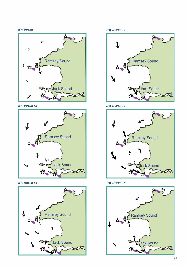
Jack & Ramsey Sounds
21
19
Ramsey Sound
Jack Sound
Ramsey Sound
Jack Sound
Ramsey Sound
Jack Sound
Ramsey Sound
Jack Sound
Ramsey Sound
Jack Sound
Ramsey Sound
Jack Sound
HW Dover HW Dover +1
HW Dover +2 HW Dover +3
HW Dover +4 HW Dover +5

22
-6.5
-7
-6.5
-6
-5
-6
-5
-4 -3 -2 -1
0
-5.5
0
-1-2
-3
-4
Plymouth(2.2, 4.7)
Portsmouth(2.0, 4.1)
Dover(3.3,5.9)
Padstow(3.0, 6.4)
Troon(2.2, 4.0)
Loch Ryan(1.9,2.8)
PSM(3.0, 5.3)
Liverpool(4.5, 8.4)
Fleetwood(4.5, 8.3)
Tobermory(1.5, 2.7)
Portree(1.8, 4.6)
Gigha(0.5, 0.9)
Holyhead(2.5, 5.0)
Pwllheli(2.2, 4.3)
Milford Haven(2.7, 6.3)
Swansea(3.1, 8.6)
Valencia(1.7, 3.3)
Baltimore(1.6, 3.0)
Cork(2.0, 3.6)
Dunmore East(2.4, 4.1)
Arklow(0.3, 0.9)
Howth(1.9, 3.6)
Strangford(2.6, 4.0)
Belfast(1.9, 3.1)
St Mary’s(2.4, 5.0)
St Helier(4.0, 9.8)
St Malo(4.7, 10.7)
Lines show approx. HW timedifferences on Dover.Figures below Ports show Neap & Spring ranges.
Tidal Differences

23
On Dover
England — South Coast Isles of Scilly —0635 Penzance —0635 Falmouth —0610 Fowey —0555 Plymouth —0540 Salcombe —0535 Dartmouth —0505 Torquay —0500 Exmouth Approaches —0445 Lyme Regis —0450 Portland —0430 Portsmouth +0020 Newhaven 0000England — East Coast Ramsgate +0020 Sheerness +01 30 Burnham—on—Crouch +0115 Brightlingsea +0050 Harwich +0040 Lowestoft —0145 Hunstanton —0455 Spurn Point —0550 Bridlington +0545 Whitby +0500 North Shields +0430Scotland — East Coast Leith +0340 Dundee +0350 Aberdeen +0220 Inverness +01 00 Wick +0015Orkney and Shetland I Kirkwall —0040 Lerwick —0010Outer Hebrides Stornoway —0420 Castle Bay —0510Scotland — West Coast Ullapool —0415 Portree —0440 Fort William —0505 Tobermory —0510 Oban —0510 Campbeltown +0045 Rothesay +0100 Stranraer +0055
England — West Coast Barrow in Furness +0025 Liverpool +0015Isle of Man Douglas +0015Wales Holyhead —0050 Aberystwyth —0330 Fishguard —0400 Milford Haven —0500 Swansea —0500England — West Coast Avonmouth —0410 llfracombe —0525 St. Ives —0610Ireland Rosslare —0525 Wicklow —0020 Dublin Bar +0015 Lough Carlingford +0010 Strangford Lough +0200 Belfast +0010 Londonderry —0300 Lough SwiIly —0455 Killybegs —0530 Broadhaven —0533 Galway —0510 Tarbert Island —0535 Bantry +0555 Cobh —0600Channel Islands Alderney Braye —0410 Guernsey St Peter Port —0450 Jersey St Helier —0455France Brest +0510 Calais +0025 Boulogne 0000 Dieppe —0035 Le Havre —0120 Cherbourg —0320 St MaIo —0515 Les Heaux de Brehat —0525 Morlaix —0610 Ouessant (Ushant) +0505
On Brest HW LW 0000 0600 0000 0600 1200 1800 1200 1800 L’Aber Wrac’h +0030 +0039 +0040 +0035 Camaret -0010 -0010 -0015 -0010 Morgat -0005 -0010 -0020 -0005 Douarnenez -0010 -0010 -0020 -0010 Ile de Sein -0005 -0005 -0015 -0010 Audierne -0035 -0030 -0035 -0030 Benodet -0000 -0020 -0025 -0015 Loctudy 0010 -0030 -0030 -0020 Concarneau -0010 -0030 -0030 -0020 Le Foret -0010 -0030 -0030 -0020 Port Tudy -0000 -0025 -0025 -0015 Lorient +0005 -0020 -0020 -0010 Etel +0020 -0010 +0030 +0010
Le Palais -0005 -0025 -0025 -0010 Hoedic +0010 -0035 -0025 -0020 Port Haliguen +0010 -0020 -0015 -0010 La Trinite +0025 -0020 -0015 -0010 Port Navalo +0030 -0005 -0010 -0005 Crouesty +0010 -0025 -0025 -0030 Penerf +0015 -0025 -0015 -0015 Trehiguier +0035 -0020 -0005 -0010 Le Croisic +0015 -0040 -0020 -0015 Le Pouligen +0020 -0025 -0020 -0025 Pornichet +0020 -0045 -0022 -0022 St Nazaire +0030 -0040 -0010 -0010 Pornic -0050 +0030 -0010 -0010 Joinville, Ile d’Yeu -0040 +0015 -0030 -0035 Les Sables D’Olonne -0030 +0015 -0035 -0035

24
Recommendations for Safety EquipmentThe safety of a yacht and her crew is the responsibility of the skipper! The recommendations which follow have been drafted for yachts (generally between 8.0m and 13.7m) which are unlikely to be more than 12 hours from a harbour or suitable anchorage, but with wave heights likely to exceed 2m (the limit for Category D waters). That is, the conditions in which a Venturer’s cruiser is most likely to find herself. The Club cannot take responsibility for any mishap to a yacht following these guidelines, however it may be caused. The recommendations represent MINIMUM requirements and many skippers will carry additional kit such as spare anchors & warps, EPIRBs and hand-held VHF sets.
Means of PropulsionYachts should have:
a deep reef in the main which will reduce the luff to 60% of full hoist or a storm trysail.• a storm jib.• an isolated battery whose sole purpose is to start the engine or means of hand cranking the engine.•
AnchorsAnchors and chain should be at least as heavy as those recommended by the RYA. Jimmy Green Marine has an excellent guide (www.jimmygreen.co.uk/p/technical/chandlery-technical-articles/anchor-size-guide). A yacht should carry:
at least TWO anchors for bower and kedge. • adequate chain or chain & warp for the waters in which it is sailing. Around Anglesey that equates to a minimum • of 30m chain or 50 warp, of suitable size.anchor fittings which include:• a fairlead at the stem capable of being closed over the anchor chain (or warp).• a strong point on the foredeck - a mooring cleat, sampson post or anchor winch - securely fitted to the structure • of the hull.
Bailing & Bilge pumpingBailing equipment should be chosen with the strength of the crew in mind.
A small hand bailer.• Buckets (2) of between 9 litres (1.2 galls) and 14 litres (3 galls) fitted with a lanyard and a strongly secured • handle. Hand bilge pumps (2) (or one electric, one hand) discharging overboard and capable of being operated with all • hatches closed.All through-hull fittings should be capable of being closed with attached softwood plugs.•
Detection EquipmentRadar reflector, properly mounted.• Fixed navigation lights.• Foghorn (and spare cartridge).• Powerful torch (preferably waterproof).• Anchor light.• Daytime signals• Motoring cone (for motor-sailing).• Anchor ball.•
Fire fighting equipmentFire blanket (BS EN1869) placed for use in the galley.• A minimum of two (2) and preferably three (3) multi-purpose fire extinguishers (of minimum rating 5A/3B (to • BS EN34) - Foam or dry powder, for example) or two 5A/3B and one larger 13A/113B on bigger boats.
Personal safety equipmentThe following items should be available for every person on board:

25
Warm clothing, oilskins, seaboots and hat.• A lifejacket of 150 newtons buoyancy (BS EN 396).• Light attached to lifejacket.• Safety harness to EN1095 (BS4474 for children).•
Pyrotechnics
It is no longer a SOLAS requirement for yachts under 13.7m to carry flares and the withdrawal of facilities to dispose of old flares makes it inadvisable to carry them.
RadioReceiver capable of receiving shipping forecasts on LW (incl. 198khz) and from local radio stations. In the Irish • Sea this also includes Irish (RTE1) .A marine band VHF radio telephone capable of transmitting 25w. • Emergency aerial for the VHF R/T.•
Navigational equipmentIncreasingly, integrated electronic equipment is reducing the apparent necessity for basic navigation gear. However, complete power failure in the most adverse weather conditions (fog) must be assumed when equipping a yacht for any form of passage, however short. The following should be carried as a matter of course. Other Club boats must not be relied on to provide assistance.
Charts (corrected to latest Notices to Mariners) covering the intended cruising area and all adjacent coasts • where stress of weather might force the yacht to go.Tide tables and pilots covering the same areas.• Fixed steering compass, capable of being lit at night.• Hand bearing compass (at least one).• Surface suitable for use as nav. table, with plotting instruments and dividers.• Echo sounder and/or leadline.• Distance Log.• Binoculars (at least one pair).• Radio navigation system (GPS).• Barometer. • Accurate Clock in addition to GPS clock.•
First Aid & MedicalA first aid kit should be carried, containing:
Dressings, bandages and lotions.• Seasickness remedies, painkillers, anti-emetics.• Manuals, from Red Cross or St. John Ambulance for instance. Additional information about medical care overseas • (EHIC form, from Post Offices), vaccinations etc. is available from GP’s and the Health Travel Line (http://www.nhs.
uk/NHSEngland/Healthcareabroad/EHIC/Pages/about-the-ehic.aspx).
General Emergency EquipmentAn emergency grab-bag containing food, navigation aids and medical supplies.• An inflatable liferaft, either designed or adapted for use as such.• Horse-shoe lifebelts with drogue, fitted with self igniting lights (2).• Buoyant heaving line at least 30m in length.• Boarding ladder.• Dan buoy (NOT attached to yacht).• Emergency tiller on wheel steered yachts.• Towing warp (12/14 mm, at least 30m in length) or equivalent anchor warp.• Mooring warps and fenders. • Tender - rigid or inflatable.• Tool kits for: Engine, Electrics, Sails, General.•

26
Spares for engine, electrics, sails and bosun’s bag (shackles, blocks, winch springs, clevis pins, split pins, assorted • nuts & bolts etc.)Emergency water supply, isolated from main tank.• Emergency hull repair materials. • Waterproof torch• Bosun’s chair (BS EN813 1997)•
PublicationsThese recommendations are for guidance. For more detail skippers should purchase a copy of RYA booklet, “Boat safety” (G103). www.rya.org.uk/shop/pages/product.aspx?pid=G103(RYADefaultCatalog))
Charts & GuidesImray
Chart C52 covers most of the regular cruising grounds.• C61 - St George’s Channel• C62 - Irish Sea• Y70 - Isle of Man• Pack 2700 provides detailed chartage for West Wales (and across to Rosslare) up to Blackpool.•
Admiralty (UKHO)
The Admiralty charts for the areas included in the Club programme are: Chart Title Scale SC5609 Leisure Folio - North Wales - SC5910 Tough Folio - Anglesey & Lleyn Peninsula 1411 Irish Sea - Western Part 200,000 1413 Approaches to Holyhead 25,000 1463 Conwy Bay and Approaches 25,000 1464 Menai Strait 25,000 1512 Plans on the Lleyn Peninsula - 1826 Irish Sea - Eastern Part 200,000 1951 Approaches to Liverpool 25,000 1953 Approaches to the River Dee 25,000 1970 Caernarfon Bay 75,000 1971 Cardigan Bay - Northern Part 75,000 1977 Holyhead to Great Ormes Head 75,000 1978 Great Ormes Head to Liverpool 75,000 2011 Holyhead Harbour 6,250 2094 Kirkcudbright to Mull of Galloway and IoM 100,000 2696 Plans in the Isle of Man - See also p12 for a link to the relevant chart catalogues.Pilots and Sailing Directions
‘• Cruising Anglesey and adjoining waters’, Ralph Morris**, published by Imray‘• Irish Sea Pilot’ David Rainsbury, published by Imray‘• Isle of Man Sailing Directions’ Manx Sailing & Cruising Club‘• Firth of Clyde Sailing Directions’ Clyde Cruising Club. ‘• East & North coasts of Ireland’ Irish Cruising Club
** Club member

27
VHF Emergency SheetThe next two pages contain sheets which may be displayed in the yacht. The Emergency sheet is intended to be placed near the VHF radio so that inexperienced crew can make RT calls in an emergency. Space has been left to add the name of the yacht.In the adjoining example, the left half of the sheet describes routine calls. The right hand side is the Emergency part.
It is a SOLAS requirement that vessels carry a guide to Distress Signals. Thie following sheet has been accepted by MCA as suitable for carriage on yachts.
Oscar Charlie Echo Alpha NovemberBravo Romeo Echo Echo Zulu Echo
Mike Yankee Victor Hotel Seven
Use Channel 16 for HAILINGwith lowest power capable of reaching target
$ Listen 30 secs. for other users before depressing microphone switch.
$ Wait 2 secs before speaking (to allow scanning sets to lock to channel)
NONSUCH NONSUCHthis is
OCEAN BREEZE, OCEAN BREEZE$ Wait at least 30 secs before repeating the call. $ After establishing contact� or when repl�ing to a call�
reduce repetition of boat name to a minimum. $ Check that channel ���� �ou are going to offer is free.
NONSUCH OCEAN BREEZE Channel [xx]$ W�it ��� st�ti�� t� ����i�� �h����� th�� t���s���.
USE Channel 16 FULL POWER for ALL emergency traffic.
MAYDAY MAYDAY MAYDAYAll stations All stations All stations
this isOCEAN BREEZE, OCEAN BREEZE, OCEAN BREEZE
MAYDAY OCEAN BREEZE
My position is [Lat] [Long] from GPS fixThere are [xx] persons on boardOur problem is [...............................]I require immediate assistance
Wait 30 secs for Coastguard Station to respond before repeating the call.
Coastguard 10, 67, 73 (Simplex), 84, 86 (Duplex)Marinas 37 (Simplex), 80 (Duplex)
Yacht to yacht 6, 8, 72 - 77Bridge to Bridge 13Port Operations 9, 11, 12, 14
VHF Channel designationsChannel 16 Hailing & Emergency ONLY Channel 70 Reserved for DSC. DO NOT USE

2826
MM
SI:
Use
C
ha
nn
el 1
6 fo
rH
AIL
IN
G
with
lo
we
st p
ow
er ca
pa
ble
o
f re
ach
in
g ta
rg
et
L
iste
n 3
0 se
cs. fo
r o
th
er u
se
rs b
efo
re
d
ep
re
ssin
g
micro
ph
on
e sw
itch
.
W
ait 2
se
cs b
efo
re
sp
ea
kin
g (to
a
llo
w sca
nn
in
g se
ts to
lo
ck to
ch
an
ne
l)
NO
NSU
CH
N
ON
SU
CH
this is
_________________________________
W
ait a
t le
ast 3
0 se
cs b
efo
re
re
pe
atin
g th
e ca
ll.
A
fte
r e
sta
blish
in
g co
nta
ct, o
r w
he
n re
plyin
g to
a
ca
ll,
re
du
ce
re
pe
titio
n o
f b
oa
t n
am
e to
a
m
in
im
um
.
C
he
ck th
at ch
an
ne
l [xx] yo
u a
re
g
oin
g to
o
ffe
r is fre
e.
NO
NSU
CH
______________ C
hannel [xx]
W
ait for station to confirm
channel then transfer.
US
EChannel16
FU
LL
PO
WER
for
ALL
em
ergency traffic.
PR
ESS &
hold red D
SC
button for a count of 5
Select C
h.16
and say:
MAYD
AY M
AYD
AY M
AYD
AY
All stations All stations All stations
this is
______________________________________________________
MAYD
AY ___________________________
My position is [Lat] [Long] from
G
PS fix
There are [xx] persons on board
Our problem
is [...............................]
I require im
mediate assistance
Wa
it 3
0 se
cs fo
r C
oa
stg
ua
rd
S
ta
tio
n to
re
sp
on
d b
efo
re
re
pe
atin
g th
e ca
ll.
Co
astg
uard
10, 67, 73 (Sim
plex),
84, 86 (D
uplex)
Marin
as
37 (Sim
plex), 80 (D
uplex)
Yach
t to
yach
t6, 8, 72 - 77
Brid
ge to
B
rid
ge
13
Po
rt O
peratio
ns
9, 11, 12, 14
VH
FC
han
nel d
esig
natio
ns
Ch
an
nel
16
Hailin
g &
Em
erg
en
cy
ON
LY
Ch
an
nel
70
Reserved
fo
rD
SC
.D
ON
OT
US
E
______________________________________________________________________________
_____________________________________________________________________________
_____________________________________
______________________________
________________________________________________________________________________________

29
27
DISTRESS SIGNALSFire rocketvertically
If windy fire 15°downwind
In low cloudfire at 45°
Wind
WindOrange smoke for useby day - especially instrong sunlight.NEVER fire into the wind
NEVER fire a parachute flare if ahelicoptor is approaching.
Floating orangesmoke
Use handheld flare to pinpointprecise position at night or indull conditions
Parachute flare for useat long range offshore
White flare -collision warning
Handheld orange smoketo pinpoint preciseposition in brightconditions
Reproduced by kind permission of the RYASignal Morse S O S by sound or light
LIFE SAVING SIGNALS
Air to Surface Replies
➤
➤
➤
➤
➤
Drop a message Rocking wings Flashing landing ornavigation lights twice
Message understood
T
R
Any one of:MORSE by light
Surface to Air Signals
I require assistance V
I require medical assistance W
No or Negative N
Yes or affirmative C
Proceeding in this direction
Message International Code of Signals
�
ICAO VisualSignals
V
W
N
Y
➤ ➤ ➤
Search and Rescue Unit Replies Shore to Ship SignalsYou have been seen, assistance will be given as soonas possible.
Orange smoke flare Three white star signals or threelight & sound rockets fired atapprox. 1 minute intervals.
➤
➤
➤
➤
➤➤➤
➤
➤
➤
➤
Safe to land here
Unsafe to land here. Additional signals mean safer landing in direction indicated
KVertical waving of both arms, white flag, light or flare
Horizontal waving of white flag, light or flare. Morse S.Putting one flag, light or flare on groundand moving off with a second indicatesdirection of safer landing.
LR
SLand to your RIGHT
➤
Land to your LEFT
Message NOT understood - Repeat
➤
Straight and level flight Circling
MORSE signal RPT by light
Any one of:
Air to Surface Direction Signals Surface to Air RepliesSequence of 3 manueuvres meaning proceed in this direction
➤➤
➤
➤
➤
➤
Circle vessel atleast once
Cross low ahead of vesselrocking wings
Overfly vessel and headin required direction
1 2 3
Your assistance is no longer required
➤
➤
➤
➤
Cross low astern of vessel rocking wings
As a non preferred alternative torocking wings, varying engine toneor volume may be used.
Message understood - I will comply
➤ T
Change course torequired direction
Morse code by light Code & answeringpendant “Close Up”
I am unable to comply
NMorse code by light International flag N
Wave both armsvertically
Hoist anchorball over any‘flag’ upforestay
Hoist ‘V’ atyardarm
Reproduced by kind permission of MCA. It is believed that this document meets the requirementsof SOLAS V for leisure craft to carry an illustrated presentation of Life Saving Signals.
Adapted by North West Venturers Yacht Club for cabin display.
SOLAS Distress Signals

30