
The Indonesia Compendium - Soggy Paws
450
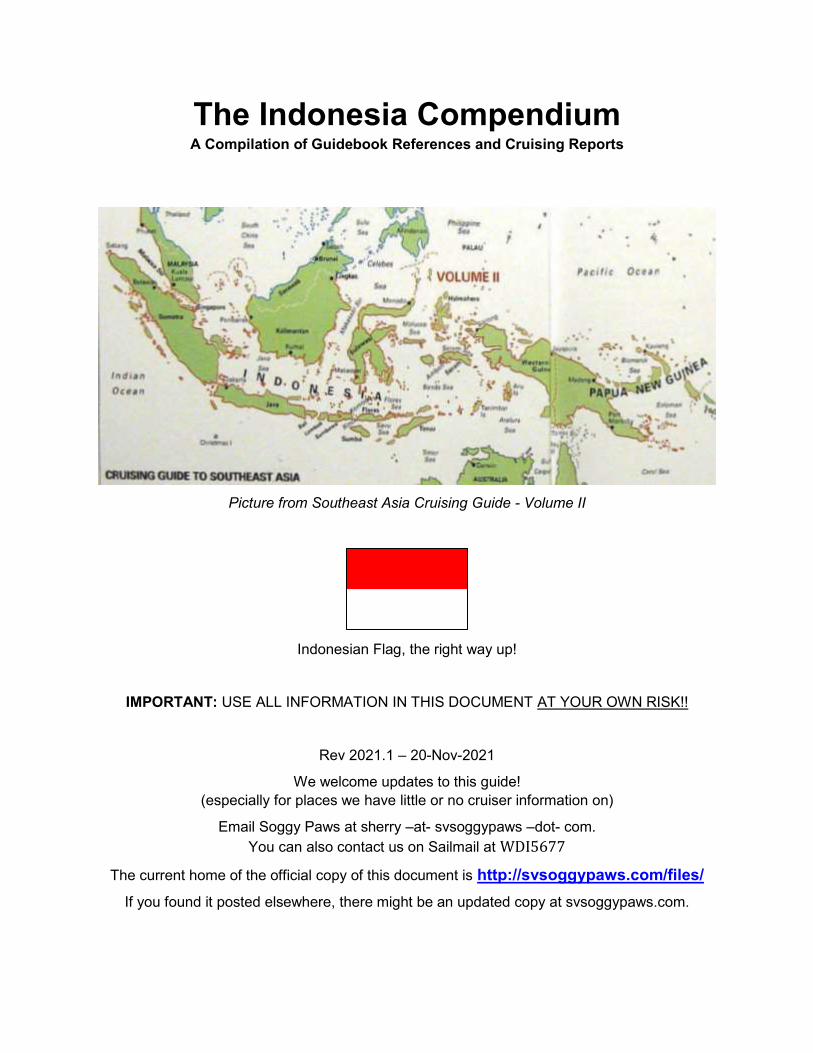
The Indonesia Compendium A Compilation of Guidebook References and Cruising Reports Picture from Southeast Asia Cruising Guide - Volume II Indonesian Flag, the right way up! IMPORTANT: USE ALL INFORMATION IN THIS DOCUMENT AT YOUR OWN RISK!! Rev 2021.1 – 20-Nov-2021 We welcome updates to this guide! (especially for places we have little or no cruiser information on) Email Soggy Paws at sherry –at- svsoggypaws –dot- com. You can also contact us on Sailmail at WDI5677 The current home of the official copy of this document is http://svsoggypaws.com/files/ If you found it posted elsewhere, there might be an updated copy at svsoggypaws.com.
-
Upload
khangminh22 -
Category
Documents
-
view
0 -
download
0
Transcript of The Indonesia Compendium - Soggy Paws
The Indonesia Compendium A Compilation of Guidebook References and Cruising Reports
Picture from Southeast Asia Cruising Guide - Volume II
Indonesian Flag, the right way up!
IMPORTANT: USE ALL INFORMATION IN THIS DOCUMENT AT YOUR OWN RISK!!
Rev 2021.1 – 20-Nov-2021
We welcome updates to this guide!
(especially for places we have little or no cruiser information on)
Email Soggy Paws at sherry –at- svsoggypaws –dot- com.
You can also contact us on Sailmail at WDI5677
The current home of the official copy of this document is http://svsoggypaws.com/files/
If you found it posted elsewhere, there might be an updated copy at svsoggypaws.com.

Page 2 of 450
Revision Log
Many thanks to all who have contributed over the years!!
Note: The COVID situation changes weekly, and I have not attempted to keep up with the
changes in this document. See Sail SE Asia FB Group for discussions on latest situation.
Rev Date Notes
2021 05-Dec-2021 Added 2022 Holiday list.
2021.1 20-Nov-2021
Contact info for Raymond’s Uncle in Tanimbar Islands.
Canvas and Sail Repair in Bali. Kumai River Orangutan Tour
update. Some updates on the latest info on getting into
Indonesia.
2020.2 22-Dec-2020
Updating Holiday list to 2021, Updated info on haulout facility
in Lombok. New Regs on registering foreign cell phones.
Updates on new e-Visa.
2020.1 20-January-2020 Updating Holiday list to 2020.
… Many updates from 2014-2018
2019.05 16-Nov-2019
Exiting Indonesia through the Sunda Strait. Update on
clearance in Tual, Kai Islands. Update on Biak check-in and
Sorong Check-out, Manokwari and Biak. Wick’s new marina
in Sorong. Passage notes from Ninigos to Sorong to Davao
Philippines in Oct/Nov.
2019.04 12-Aug-2019
Updates and additions on many anchorages on the
Wonderful Sail 2 Indonesia Rally Route in 2018, Kai Islands
to Nongsa. Thanks Starry Horizons!!
2019.03 07-Aug-2019
Update on marinas and moorings in the Bali area. Guide
recommendations for the Kumai River Trip. Updates on
Sorong, and Kai Islands/Tual. Visa renewal in Sumbawa.
Check in updates on Kupang and Sumlauki. Matilda’s
passage through Selat Surabaya.
2019.02 20-June-2019
Finding engine repair parts in Kupang, update on Lombok
Marina del Ray, 2019 and tentative 2020 holidays. Minor
updates on recent experiences with visa renewals.
2019.01 11-Feb-2019 Soggy Paws updates while sailing from Philippines through N
Sulawesi to Biak. Biak details.
2018.03 19-December-2018 Screensaver’s info on stops between Sorong and Jayapura.
2018.02 19-October-2018
Tiger Lilly’s check-in in Sabang. Minor updates on getting a
visa in Penang and Johor Baru. Saumlaki check-out. Note
from Highway Star about Natuna. Ambon notes from Field
Trip. Passage notes Anambas to Tioman. Cruising west
coast of Sumatra. Diesel in Belitung. Lots of info bits here
and there from the Sail SE Asia FB group. Screensaver’s info
on stops between Sorong and Jayapura.
A.00 15-Oct-2014 Initial version, still very rough at this point!!

Page 3 of 450
Table of Contents
1 INTRODUCTION ................................................................................................................................. 10
1.1 ORGANIZATION OF THE GUIDE ........................................................................................................ 10 1.2 OVERVIEW OF THE AREA ................................................................................................................ 11
1.2.1 World War II in Indonesia .................................................................................................... 11 1.3 TIME ZONES .................................................................................................................................. 11 1.4 NAVIGATION AND CHARTING ........................................................................................................... 12 1.5 WEATHER IN THIS AREA ................................................................................................................ 16
1.5.1 General Weather Conditions ............................................................................................... 16 1.5.2 Weather Sources – With Onboard Email ............................................................................ 17 1.5.3 Weather Sources – Voice ................................................................................................... 18 1.5.4 Weather Sources – Internet ................................................................................................ 18
1.6 CUSTOMS & IMMIGRATION .............................................................................................................. 18 1.6.1 The overall process ............................................................................................................. 19 1.6.2 AIS Requirement ................................................................................................................. 25 1.6.3 Pre-Arrival (Getting Cruising Permit and Visas) 2020-2021 ............................................... 26 1.6.4 Pre-Arrival (Getting Cruising Permit and VISAS) Pre-COVID ........................................... 28 1.6.5 Pre-Arrival Notification ........................................................................................................ 34 1.6.6 Immigration – Initial Check-In .............................................................................................. 34 1.6.7 Immigration – Renewing Visas ............................................................................................ 38 1.6.8 Customs .............................................................................................................................. 47 1.6.9 Health / Quarantine ............................................................................................................. 49 1.6.10 Port Authority / Harbormaster ............................................................................................. 50 1.6.11 Stopping at Places Before Officially Clearing In ................................................................. 51 1.6.12 Pets ..................................................................................................................................... 51 1.6.13 Port Clearances Inside Indonesia ....................................................................................... 51 1.6.14 Checking Out of Indonesia .................................................................................................. 52 1.6.15 Firearms in Indonesia .......................................................................................................... 58
1.7 LOCAL INFORMATION AND CUSTOMS............................................................................................... 59 1.7.1 Public Holidays .................................................................................................................... 59 1.7.2 The Language Factor .......................................................................................................... 61 1.7.3 The Religion Factor ............................................................................................................. 61 1.7.4 The Subsidized Fuel Factor ................................................................................................ 64 1.7.5 Getting Around in Indonesia ................................................................................................ 65 1.7.6 Leaving a Clean Wake ........................................................................................................ 66
1.8 YACHTSMEN'S SERVICES - OVERVIEW ............................................................................................ 66 1.8.1 Money .................................................................................................................................. 66 1.8.2 Diesel and Gasoline ............................................................................................................ 67 1.8.3 Propane (Cooking Gas) ...................................................................................................... 68 1.8.4 Groceries ............................................................................................................................. 68 1.8.5 Water ................................................................................................................................... 69 1.8.6 Boat Parts & Repairs ........................................................................................................... 69 1.8.7 Canvas and Sail Repair ...................................................................................................... 69 1.8.8 Medical ................................................................................................................................ 70 1.8.9 Medical Services ................................................................................................................. 70 1.8.10 Laundry ............................................................................................................................... 70
1.9 HAULOUT, STORAGE, AND REPAIR FACILITIES ................................................................................. 70 1.9.1 Helena Marina, Sorong, Raja Ampat (Eastern Indo) .......................................................... 70

Page 4 of 450
1.9.2 Sulawesi .............................................................................................................................. 71 1.9.3 Jakarta ................................................................................................................................. 72 1.9.4 Lombok Marina del Ray (Gili Gede) .................................................................................... 73 1.9.5 Lombok Barat – PT Marine Service .................................................................................... 74 1.9.6 Western Indonesia .............................................................................................................. 74
1.10 EMBASSIES AND CONSULATES ....................................................................................................... 75 1.10.1 USA ..................................................................................................................................... 75
1.11 GETTING VISITORS IN AND OUT ...................................................................................................... 75 1.11.1 Via Jakarta .......................................................................................................................... 75 1.11.2 Via Makassar ....................................................................................................................... 75 1.11.3 Via Manado ......................................................................................................................... 75 1.11.4 To Raja Ampat (via Manado) .............................................................................................. 75 1.11.5 To Raja Ampat (via Sorong) ................................................................................................ 76
1.12 COMMUNICATIONS ......................................................................................................................... 78 1.12.1 VHF ..................................................................................................................................... 78 1.12.2 SSB Radio Frequencies and Nets ...................................................................................... 79 1.12.3 Telephone, Cell Phones, and Internet Access .................................................................... 79 1.12.4 Mail & Shipping Stuff In ....................................................................................................... 83 1.12.5 News ................................................................................................................................... 84
1.13 DIVING .......................................................................................................................................... 84 1.14 CRUISING INFORMATION SOURCES ................................................................................................. 84
1.14.1 Facebook Groups ................................................................................................................ 84 1.14.2 Local Websites ................................................................................................................... 84 1.14.3 Cruiser Reports ................................................................................................................... 85 1.14.4 Facebook Groups ................................................................................................................ 88 1.14.5 Noonsite .............................................................................................................................. 88 1.14.6 Seven Seas Cruising Association ....................................................................................... 88 1.14.7 Ocean Cruising Club ........................................................................................................... 88
1.15 PRINTED SOURCES ........................................................................................................................ 88 1.15.1 Cruising Guide to Indonesia - 2017..................................................................................... 88 1.15.2 Southeast Asia Cruising Guide – Vol II - 2008 .................................................................... 89 1.15.3 Southeast Asia Pilot – 5
th Ed ............................................................................................... 89
1.15.4 101 Anchorages in Indonesia .............................................................................................. 89 1.15.5 Lonely Planet Indonesia (latest edition) .............................................................................. 90 1.15.6 Lonely Planet - SE Asia on a Shoestring ............................................................................ 90 1.15.7 Indonesian Phasebook and Dictionary (Lonely Planet) ...................................................... 90 1.15.8 Diving the Bird’s Head Seascape ........................................................................................ 90 1.15.9 Cruising the Tanimbar Islands of Eastern Indonesia .......................................................... 90
1.16 RECOMMENDED READING .............................................................................................................. 90
2 PASSAGE REPORTS ........................................................................................................................ 93
2.1 SAILING HERE FROM ELSEWHERE .................................................................................................. 93 2.1.1 To/From Philippines ............................................................................................................ 93 2.1.2 To/From Palau ..................................................................................................................... 95 2.1.3 To/From Australia ................................................................................................................ 96 2.1.4 To/From Malaysia/Singapore ............................................................................................ 102 2.1.5 To/From PNG .................................................................................................................... 103 2.1.6 To Cocos Keeling .............................................................................................................. 110
2.2 BETWEEN ISLANDS IN INDONESIA .................................................................................................. 111 2.2.1 Tawau (E Borneo) to NW Sulawesi................................................................................... 111 2.2.2 East along the N Coast of Sulawesi .................................................................................. 111

Page 5 of 450
2.2.3 Tawau (E Borneo) to Bali .................................................................................................. 112 2.2.4 Sangihe to Morotai or vice versa ....................................................................................... 112 2.2.5 Lembeh / Bitung (NE Sulawesi) to Halmahera ................................................................. 113 2.2.6 From Lembeh/Bitung to Ambon ........................................................................................ 114 2.2.7 From Ambon to Banda ...................................................................................................... 115 2.2.8 Between Triton Bay / Kaimana and the Kai Islands/Tual .................................................. 115 2.2.9 From Kalimantan Across to Northern Sulawesi ................................................................ 116 2.2.10 Komodo to Gili Air ............................................................................................................. 117 2.2.11 Bali to Singapore ............................................................................................................... 118 2.2.12 Bali to Komodo through Lombok Straits ........................................................................... 119 2.2.13 Singapore to Sunda Strait ................................................................................................. 119 2.2.14 Kumai River Borneo to Belitung ........................................................................................ 125 2.2.15 West Coast of Sumatra ..................................................................................................... 126 2.2.16 Belitung to Kumai, Borneo ................................................................................................ 127 2.2.17 East Along the North Coast of Java .................................................................................. 128 2.2.18 Passage through Selat Surabaya ..................................................................................... 129 2.2.19 Surabaya Eastward to Bali, Lombok, Komodo, Labuan Bajo ........................................... 130 2.2.20 Between Biak and Sorong ................................................................................................. 131
3 EASTERN INDONESIA .................................................................................................................... 133
3.1 EASTERN INDONESIA OVERVIEW .................................................................................................. 133 3.2 BETWEEN SOUTHERN PHILIPPINES AND NORTHERN SULAWESI ISLANDS ......................................... 135 3.3 NORTH SULAWESI PROVINCE ....................................................................................................... 135
3.3.1 Talaud Island (Karakatang) ............................................................................................... 136 3.3.2 Sanghie (Sangihe) – Port of Entry for Rally Only .............................................................. 137 3.3.3 Islands Between Sangihe and Bitung/Lembeh Strait ........................................................ 145 3.3.4 NE Tip Sulawesi ................................................................................................................ 154 3.3.5 NW Tip Sulawesi ............................................................................................................... 156 3.3.6 Manado (West Coast) ....................................................................................................... 157 3.3.7 Bitung and Lembeh Strait (East Coast) (Port of Entry) ..................................................... 157
3.4 NORTH MALUKU PROVINCE .......................................................................................................... 167 3.4.1 Anchorages between Sulawesi and Halmahera ............................................................... 167 3.4.2 Anchorages Between Sangihe and Morotai ...................................................................... 168 3.4.3 Morotai .............................................................................................................................. 169 3.4.4 North Coast of Halmahera ................................................................................................ 174 3.4.5 West Coast of Halmahera ................................................................................................. 178 3.4.6 Islands South of Halmahera .............................................................................................. 185
3.5 MALUKU PROVINCE ..................................................................................................................... 185 3.5.1 Ceram (Seram) N Coast ................................................................................................... 185 3.5.2 Ceram (Seram) S Coast, including Ambon ....................................................................... 189 3.5.3 Banda Islands (04-31S / 129-50E) .................................................................................... 194 3.5.4 Tanimbar Islands / Timur Laut / Saumlaki (Saumlakki) (08S / 131E) ............................... 204 3.5.5 Kai Islands / Tual (05-37S / 132-44E) ............................................................................... 207 3.5.6 Tayando Islands (05-32 S / 132-17 E) .............................................................................. 217 3.5.7 Aru Islands (06-17S / 134-22E) ......................................................................................... 217 3.5.8 Babar Island (07-52S / 129-35E) ...................................................................................... 218 3.5.9 Leti Island (08-19S / 127-39E) .......................................................................................... 218 3.5.10 Wetar (07-40S / 125-30E) ................................................................................................ 218 3.5.11 Pasar Suba on Lomblen Island (08-30S / 123-14E) ......................................................... 219
3.6 WEST PAPUA PROVINCE .............................................................................................................. 219 3.6.1 Raja Ampat General Info ................................................................................................... 220
Page 6 of 450
3.6.2 Ayu Islands (00-30N / 131-08E) ........................................................................................ 222 3.6.3 Sayang (00-18N / 129-53E) .............................................................................................. 223 3.6.4 Wayag Archipelago (00-10N / 130-01E) ........................................................................... 223 3.6.5 Kawe Island (00-00N / 130-07E) ....................................................................................... 226 3.6.6 NW Waigeo & Alyui Bay (00-12S / 130-13E) .................................................................... 227 3.6.7 Batang Pele and Minyaifun Islands (00-19S / 130-12E) ................................................... 228 3.6.8 Western Gam And Surrounding Islands (00-30S / 130-35E) ............................................ 229 3.6.9 South Coast of Gam & Surrounding Islands ..................................................................... 232 3.6.10 South Waigeo Island & Waisai Town (00-25S / 130-45E) ................................................ 238 3.6.11 East and North Coasts of Waigeo ..................................................................................... 249 3.6.12 Between Mansuar and Batanta ......................................................................................... 250 3.6.13 Batanta Island ................................................................................................................... 251 3.6.14 East End of Batanta .......................................................................................................... 251 3.6.15 Penemu Island (0-34S / 130-17E) ..................................................................................... 253 3.6.16 Fam Island (00-39S / 130-17E) ......................................................................................... 254 3.6.17 Pulau Augusta (00-39S / 130-35E) ................................................................................... 254 3.6.18 Pulau Boo (01-09S / 129-19 E) ......................................................................................... 255 3.6.19 Kofiau Island (01-09S / 129-51E) ...................................................................................... 255 3.6.20 Misool Area (02S / 130E) (Batanme) ................................................................................ 256 3.6.21 Sorong Channel Area (S of Sorong, E of Salawati) .......................................................... 261 3.6.22 SORONG – Port of Entry – Provisioning – Visa Renewal - THEFT ................................. 262 3.6.23 Between Sorong / Misool and Triton Bay, N to S .............................................................. 277 3.6.24 Triton Bay (03-50S / 134-06E) .......................................................................................... 280 3.6.25 Between Sorong and Cenderawasih Bay along N Coast New Guinea ............................ 294 3.6.26 West Cenderawasih Bay & Manokwari (00-51S / 134-04E) ............................................. 297
3.7 PAPUA PROVINCE ........................................................................................................................ 301 3.7.1 East Cenderawasih Bay & the Islands .............................................................................. 301 3.7.2 Biak (Port of Entry) ............................................................................................................ 301 3.7.3 Between Biak and Jayapura ............................................................................................. 306 3.7.4 Jayapura (Not Official Yacht Port of Entry) ....................................................................... 310
4 CENTRAL INDONESIA – NORTH PART ........................................................................................ 320
4.1 CENTRAL INDONESIA OVERVIEW .................................................................................................. 320 4.2 NORTH SULAWESI ....................................................................................................................... 322 4.3 CENTRAL SULAWESI – NORTH AND WEST SIDE ............................................................................. 322
4.3.1 Laulalang / Teluk Belonligum ............................................................................................ 322 4.3.2 Lokadaka Bay .................................................................................................................... 323
4.4 GORONTALO PROVINCE ............................................................................................................... 323 4.4.1 Gorontalo ........................................................................................................................... 323 4.4.2 Tanjung Datu ..................................................................................................................... 324
4.5 CENTRAL SULAWESI – EAST SIDE ................................................................................................ 324 4.5.1 Togean Islands .................................................................................................................. 324 4.5.2 Banggai Islands (Kepulauan Banggai) .............................................................................. 325 4.5.3 Kepulauan Sula ................................................................................................................. 326
4.6 WEST SULAWESI ......................................................................................................................... 326 4.7 SOUTHEAST SULAWESI ................................................................................................................ 326
4.7.1 Wakatobi (Wangi Wangi) (Pulau Hoga) ............................................................................ 326 4.7.2 Pasar Wajo, Buton ............................................................................................................ 332 4.7.3 Bau Bau, Buton ................................................................................................................. 334 4.7.4 Telaga Island, Bombano ................................................................................................... 336 4.7.5 Sikeli Bay, Bombana ......................................................................................................... 337
Page 7 of 450
4.8 SOUTH SULAWESI ........................................................................................................................ 339 4.8.1 Taka Bonerate (Atoll off Southern Sulawesi) (Bone Rate) (Takabonerate) ...................... 339
4.9 NORTH KALIMANTAN .................................................................................................................... 343 4.9.1 Nunaken (Port of Entry) .................................................................................................... 343 4.9.2 Tarakan (Port of Entry) ...................................................................................................... 343 4.9.3 Kurung Tigau ..................................................................................................................... 344
4.10 EAST KALIMANTAN ....................................................................................................................... 344 4.10.1 Pulau Derawan .................................................................................................................. 344 4.10.2 Maratua Island / Atoll ........................................................................................................ 344
4.11 SOUTH KALIMANTAN .................................................................................................................... 345 4.12 CENTRAL KALIMANTAN ................................................................................................................. 345
4.12.1 Kumai River ....................................................................................................................... 345 4.13 WEST KALIMANTAN ...................................................................................................................... 349
5 CENTRAL INDONESIA – SOUTH PART ........................................................................................ 349
5.1 CENTRAL INDONESIA OVERVIEW .................................................................................................. 349 5.2 EAST NUSA TENGGARA................................................................................................................ 351
5.2.1 Kupang / Timor (Check In Port) ........................................................................................ 351 5.2.2 Alor Island ......................................................................................................................... 361 5.2.3 Flores Island N Coast ........................................................................................................ 362 5.2.4 Labuan Bajo ...................................................................................................................... 365 5.2.5 Komodo National Park ...................................................................................................... 370 5.2.6 Islands East of Flores ........................................................................................................ 374
5.3 TIMOR L’ESTE (EAST TIMOR) / DILI ............................................................................................... 375 5.4 WEST NUSA TENGGARA............................................................................................................... 378
5.4.1 Sumbawa Island ................................................................................................................ 379 5.4.2 Medang island (52 in 101 Anchorages book) ................................................................... 380 5.4.3 Lombok Island ................................................................................................................... 380
5.5 BALI ............................................................................................................................................ 386 5.5.1 Marinas, Moorings, and Haulout Facilities ........................................................................ 387 5.5.2 Cruiser’s Services ............................................................................................................. 389 5.5.3 Anchorages ....................................................................................................................... 390
5.6 EAST JAVA .................................................................................................................................. 393 5.6.1 Bawean ............................................................................................................................. 393
5.7 CENTRAL JAVA ............................................................................................................................ 394 5.7.1 Jepara (Marina Facilities) .................................................................................................. 394
5.8 WEST JAVA ................................................................................................................................. 394 5.8.1 Jakarta (Marina Facilities) ................................................................................................. 394 5.8.2 Pulau Pamayan Besar (Northern Tip) ............................................................................... 395 5.8.3 Carita (Near Sunda Strait) ................................................................................................. 396 5.8.4 Palau Liwungan ................................................................................................................. 396 5.8.5 Ujong Kulon ....................................................................................................................... 397
6 WESTERN INDONESIA ................................................................................................................... 398
6.1 WESTERN INDONESIA OVERVIEW ................................................................................................. 398 6.2 ISLANDS SOUTH AND EAST OF SINGAPORE (RIAU & ANAMBAS) ...................................................... 400
6.2.1 Batam / Nongsa Point Marina (01-12N / 104-06E) ........................................................... 400 6.2.2 Bandar Bentan Telani ....................................................................................................... 402 6.2.3 Pulau Bulan (01-01N / 103-55E) ....................................................................................... 402 6.2.4 Tanjung Pinang, W Coast Bintan Island (00-56N / 104-26E) ........................................... 402 6.2.5 Tanjung Sembulang (00-52N / 104-15E) .......................................................................... 403

Page 8 of 450
6.2.6 Pulau Abang Besar (00-34N / 104-14E) ........................................................................... 403 6.2.7 Pulau Ranoh (00-34N / 104-14E)...................................................................................... 403 6.2.8 Benan (00-28 N / 104-27 E) .............................................................................................. 404 6.2.9 Mesanak (00-26N / 104-31E) ............................................................................................ 405 6.2.10 Pulau Setemu (00-14N / 104-29E) .................................................................................... 405 6.2.11 Pulau Kentar (#87) (00-03N / 104-46E) ............................................................................ 405 6.2.12 Pulau Lingga (00-18S / 104-49E)...................................................................................... 406 6.2.13 Anambas Islands (03N / 106E) ......................................................................................... 406 6.2.14 Natuna (03-55N / 108-10E) ............................................................................................... 411
6.3 ISLANDS BETWEEN BORNEO AND SUMATRA .................................................................................. 411 6.3.1 Bangka (01-31S / 105-53E) .............................................................................................. 411 6.3.2 Belitung / Belitong (PORT OF ENTRY) (02-34S / 107-39E) ............................................ 412 6.3.3 Pulau Karangraya (02-35S / 108-43E) .............................................................................. 417
6.4 IN THE SUNDA STRAIT .................................................................................................................. 418 6.4.1 1000 Islands – Genteng Besar (#76) (05-37S / 106-33E) ................................................ 418 6.4.2 Passage Thru the Sunda Strait ......................................................................................... 419 6.4.3 Krakatoa (#81-83) ............................................................................................................. 420 6.4.4 Panaitan (#79-80).............................................................................................................. 422 6.4.5 Pulau Peucang (#78) (06-45S / 105-16E) ......................................................................... 422
6.5 SW COAST OF SUMATRA (SUMATERA) ......................................................................................... 422 6.5.1 Bengkulu ........................................................................................................................... 422
6.6 MIDDLE WEST COAST OF SUMATRA (SUMATERA) .......................................................................... 423 6.6.1 Padang .............................................................................................................................. 423
6.7 NW COAST OF SUMATRA (SUMATERA) ......................................................................................... 423 6.7.1 Pulau Weh (We) – Sabang – Port of Entry ....................................................................... 423 6.7.2 Banda Aceh – Port of Entry ............................................................................................... 427
6.8 ISLANDS OFF THE WEST SUMATRA COAST .................................................................................... 428 6.8.1 Pulau Enggano .................................................................................................................. 430 6.8.2 Pulau Pagai Selatan .......................................................................................................... 430 6.8.3 Pulau Sipora ...................................................................................................................... 430 6.8.4 Pulau Nias ......................................................................................................................... 430
7 DILI, EAST TIMOR ........................................................................................................................... 430
7.1 RENEWING INDO VISA IN DILI........................................................................................................ 430
8 CMAP CHART OFFSETS FOR OPENCPN ..................................................................................... 433
8.1 HOW TO APPLY OFFSETS IN OPENCPN ........................................................................................ 433 8.2 OFFSET LIST ............................................................................................................................... 435
9 INDONESIAN LANGUAGE REFERENCE ....................................................................................... 438
9.1 RECOMMENDED LANGUAGE REFERENCE MATERIALS .................................................................... 438 9.1.1 Google Translate ............................................................................................................... 438 9.1.2 LearningIndonesian.com ................................................................................................... 438 9.1.3 Indonesian (Mondly App) .................................................................................................. 438 9.1.4 eBooks You Can Carry With You ...................................................................................... 438
9.2 COMMON WORDS ........................................................................................................................ 438 9.2.1 Greetings & Courtesies ..................................................................................................... 438 9.2.2 Food .................................................................................................................................. 439 9.2.3 Time and Date ................................................................................................................... 440 9.2.4 Numbers ............................................................................................................................ 440 9.2.5 Colors ................................................................................................................................ 441
Page 9 of 450
9.2.6 Nautical Terms .................................................................................................................. 442 9.3 DIVE TERMS ................................................................................................................................ 445

Page 10 of 450
1 Introduction The original Compendium for the Tuamotus in French Polynesia started out as a way for s/v
Soggy Paws and a few friends to organize notes and various internet sources on the Tuamotus,
prior to our cruise there in Spring of 2010. Later, it became a way for us to pass on what we've
learned while cruising the Tuamotus in 2010 and 2011. Now the idea has migrated with Soggy
Paws, from the Tuamotus, to the Marquesas, to the Societies, Hawaii, the Cooks and Samoas,
Tonga, Fiji, the islands between Fiji and the Marshall Islands, the Marshall Islands, Micronesia
the Philippines, and now Malaysia and Indonesia.
If you haven't yet found our other ‘Compendiums', they're available online at
http://svsoggypaws.com/files/
This is not intended to replace the guidebooks or charts, but to supplement out-of-date guides
with recent cruiser first-hand reports, and fill in places that the guides don't cover.
To compile this 'compendium', we have used all sources at our disposal, including websites,
blogs, emails, and our own experience. We always try to indicate the source of our information,
and the approximate time frame.
If your information is included in this guide, and you object to its inclusion, please just email us,
and we'll remove it. But this is a non-commercial venture mainly to help cruisers from all of our
collective experiences.
1.1 Organization of the Guide
This guide is loosely organized first in major areas of Indonesia (East, Central, West), and then
loosely by province.
Eastern
Central Western

Page 11 of 450
1.2 Overview of the Area
Figure 1 - Overview of Indonesia As Covered in this Compendium
The above figure identifies the Provinces of Indonesia, and indicates how this Compendium
divides up Indonesia into manageable sections, starting from Eastern Indonesia and ending with
Western Indonesia.
Note that Singapore and northwestern Borneo are NOT part of Indonesia and is covered in
the Malaysian Compendium. You can find the Malaysian Compendium free to download here:
http://svsoggypaws.com/files/#se-asia
1.2.1 World War II in Indonesia
Below is a map I picked up from somewhere showing Japanese activities during World War II.
Though Indonesia doesn’t tout WWII history as a tourism draw, if you ask in local areas where
there was Japanese occupation, you may be shown gun emplacements and wrecks by the
locals.
1.3 Time Zones
Indonesia spans 3 time zones:
Eastern
Central Western
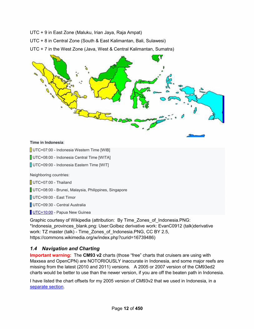
Page 12 of 450
UTC + 9 in East Zone (Maluku, Irian Jaya, Raja Ampat)
UTC + 8 in Central Zone (South & East Kalimantan, Bali, Sulawesi)
UTC + 7 in the West Zone (Java, West & Central Kalimantan, Sumatra)
Time in Indonesia:
UTC+07:00 - Indonesia Western Time [WIB]
UTC+08:00 - Indonesia Central Time [WITA]
UTC+09:00 - Indonesia Eastern Time [WIT]
Neighboring countries:
UTC+07:00 - Thailand
UTC+08:00 - Brunei, Malaysia, Philippines, Singapore
UTC+09:00 - East Timor
UTC+09:30 - Central Australia
UTC+10:00 - Papua New Guinea
Graphic courtesy of Wikipedia (attribution: By Time_Zones_of_Indonesia.PNG:
*Indonesia_provinces_blank.png: User:Golbez derivative work: EvanC0912 (talk)derivative
work: TZ master (talk) - Time_Zones_of_Indonesia.PNG, CC BY 2.5,
https://commons.wikimedia.org/w/index.php?curid=16739486)
1.4 Navigation and Charting
Important warning: The CM93 v2 charts (those “free” charts that cruisers are using with
Maxsea and OpenCPN) are NOTORIOUSLY inaccurate in Indonesia, and some major reefs are
missing from the latest (2010 and 2011) versions. A 2005 or 2007 version of the CM93ed2
charts would be better to use than the newer version, if you are off the beaten path in Indonesia.
I have listed the chart offsets for my 2005 version of CM93v2 that we used in Indonesia, in a
separate section.
Page 13 of 450
The latest Garmin G2 Vision chart (2016) is pretty good, but in some areas is still off enough
to put you on a reef if you are not careful (Manokwari, for one). We found these to be the most
accurate charts we had in Indonesia, except the GoogleEarth (satellite) charts. It is
recommended that you have good Google Earth charts for every area, and navigate with your
Mark I Eyeballs at all time.
With GoogleEarth, of course, there’s always the problem certain areas with poor satellite
pictures, poor sun angle, clouds hiding reefs, and low res pictures, so if you go off the beaten
path in reefy areas, also have SAS Planet and download the Nokia DG Sat (maps.ovi.com) and
Bing maps for those areas too. Often Google or SAS Planet will have a different satellite pic
(which one is better varies). SAS Planet is a little quirky, so take a little time to figure out how it
works. A good selection of pre-made GE2KAP chartlets of eastern Indonesia can be
downloaded from Terry Sargent’s website http://valhalla.net. Also look for his Indonesia
waypoints gpx file.
Navionics and Jeppsen (newer C-Map) charts are also off by varying degrees. Navionics,
though fairly detailed maps, IS WAY OFF in most places, at least in eastern Indo (I don’t know
about the rest of Indonesia). Do NOT assume your just-purchased 2019 chart package will
not put you on a reef in Indonesia.
If you MUST use a tablet, the recommended app is Ovital Map, where you can pre-download
sections of the map for a given area. It runs on both iPad and Android tablets (access via
http://www.ovital.com/en/download/ I couldn’t find it in the Google Play Store). It uses the same
Nokia DG Sat pictures that SAS Planet can access.
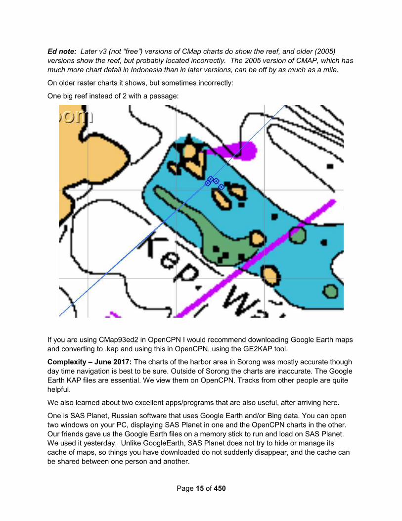
Jef Pijnenburg – June 2017: On C-Map CM93ed2 (maps of 2010 and 2011) a huge reef of
around 27 nm long does not show (see S of Wakatobi). We sailed past it, and where C-Map
showed deep water, people were actually standing on the reef.
Luckily it was a day passage, and our chosen route lead nicely between the 2 reefs.
On Navioncs on the iPad this big reef shows:

Page 14 of 450
On Cmap / OpenCPN it does not: (I drew a red line where it should be)
The center of the missing reef is approx 05-46.86 S / 123-42.60 E—check your chart!
Page 15 of 450
Ed note: Later v3 (not “free”) versions of CMap charts do show the reef, and older (2005)
versions show the reef, but probably located incorrectly. The 2005 version of CMAP, which has
much more chart detail in Indonesia than in later versions, can be off by as much as a mile.
On older raster charts it shows, but sometimes incorrectly:
One big reef instead of 2 with a passage:
If you are using CMap93ed2 in OpenCPN I would recommend downloading Google Earth maps
and converting to .kap and using this in OpenCPN, using the GE2KAP tool.
Complexity – June 2017: The charts of the harbor area in Sorong was mostly accurate though
day time navigation is best to be sure. Outside of Sorong the charts are inaccurate. The Google
Earth KAP files are essential. We view them on OpenCPN. Tracks from other people are quite
helpful.
We also learned about two excellent apps/programs that are also useful, after arriving here.
One is SAS Planet, Russian software that uses Google Earth and/or Bing data. You can open
two windows on your PC, displaying SAS Planet in one and the OpenCPN charts in the other.
Our friends gave us the Google Earth files on a memory stick to run and load on SAS Planet.
We used it yesterday. Unlike GoogleEarth, SAS Planet does not try to hide or manage its
cache of maps, so things you have downloaded do not suddenly disappear, and the cache can
be shared between one person and another.
Page 16 of 450
Another program that we saw for the first time in Raja Ampat, is called Ovital. It uses satellite
pictures like GoogleEarth, but you download all the files ahead of time. It is available for the
iPad and the Android. You can drill down for ever greater detail. It is very valuable in Raja
Ampat.
We have been in contact with a boat named Ocelot via Iridium email the past few days. Ocelot
apparently left digital copies of their voluminous KAP files for the area with a man named Victor
in Sorong. (Victor’s contact info is in the Sorong section of this Compendium)..
Whatever way you find easiest to access Google Earth files off line you might want to organise it
before you leave the place where you have "good" Internet connectivity..
1.5 Weather In This Area
1.5.1 General Weather Conditions
Indonesia is a huge place that straddles the equator, so “general weather conditions” are really
hard to say with any certainty, except the following…
1. Locations north of the equator are affected somewhat by northern winter winds,
November to February. The “monsoons” here are NE and SW, with northerly
component winds from October to May, and S-W winds in from June to October. May
and October, being “shoulder season” are generally very light. NE Indonesia may get
some effect from passing typhoons, usually in November/December when the typhoons
stay further south when they get through Micronesia. This effect would be stronger/more
westerly than normal (but not usually dangerous) winds.
2. Locations within a couple of degrees of the equator are generally “light and variable” all
the time. Weather forecasts are rarely accurate in these areas. Make sure you have a
reliable engine and lots of diesel. Winds are flukey and currents are typically quite
strong.
3. Locations south of the equator are affected by the southern winter winds. The
“monsoons” in the south are NE and SE, and the SE winds can be very strong in June
and July. Most of the resorts and dive operations in eastern Indonesia “close down”
from June/July to October, due to the strong SE winds. The liveaboard dive boats all
seem to move out of Raja Ampat and down to Komodo in the SE wind season, and
Banda sort of shuts down for the summer. The further south you go in Indonesia during
the Australian winter, the stronger and more trade-wind-like the winds will be (from the
SE). SE Indonesia may get some effect from cyclones passing through northern
Australian waters in the Australian summer. This effect would be stronger/more westerly
than normal (but not usually dangerous) winds.
Neither the GFS nor the ECMWF do a good job of forecasting winds in Indonesia. Generally
they get the direction right, but we have experienced several hours worth of 20-30kt winds on
passage between Triton Bay and Tual, almost every trip during June, when all the models said
we should be expecting 10-15.
Page 17 of 450
1.5.2 Weather Sources – With Onboard Email
Soggy Paws - 2016: In eastern Indonesia (Raja Ampat area), you are right near the equator,
and so are affected by passing weather systems on both sides of the equator. When it is winter
in Australia (June, July, August), occasionally a big strong wind system will push up from
Australia, increasing the winds from normally light and variable to as much as 20-25 knots from
the SW. Likewise during these months, a passing cyclone/typhoon going by north of the area,
will drag a long trough of bad weather behind it (the N hemisphere lows circle counter-
clockwise, so the trough will normally drape SW).
In July 2017, we actually had one of these push all the way up to the NE tip of Sulawesi,
causing 15-25 kts S-SW.
In our transit through this area, what we used most of the time for watching the weather were
these files (via the free service Saildocs):
Text forecasts ():
send aus.met10n (the Australian forecast)
send abpw10.pgtw (the Joint Typhoon Warning Center bulletin)
Neither of these are likely to be needed during northern winter / southern summer. A spot forecast for the location we were in—every 6 hours for 10 days send spot:02.1N,171.3E|10,6|PRMSL,WIND,WAVES,RAIN,LFTX
A ‘local' GRIB file that gave a fairly detailed forecast for a reasonably small area for about 5
days, and included sea state information
send GFS:6N,10N,173E,165E|.5,.5|0,6..144|PRMSL,WIND,HTSGW,WVDIR,RAIN
A ‘wide range' GRIB that watched conditions approaching us. The area we request while in
transit was a pretty wide area on a 3x3 grid, for the next 10 days. This is about a 25K GRIB file.
This provided a decent long range forecast.
send GFS:0N,30N,160E,175W|3,3|0,12..240|PRMSL,WIND,RAIN
Australia puts out a low-res surface analysis picture that is small enough to pick up via Saildocs.
send http://www.bom.gov.au/difacs/IDX0016.gif
Getting the ECMWF forecast
Our forecaster buddy, David, from Gulf Harbor Radio in New Zealand claimed over and over
that the ECMWF did a much better job of forecasting the tropics. (But they have been
upgrading the GFS, so I’m not sure this is true anymore).
Since sometime in 2017, Predict Wind has been furnishing the ECMWF forecast as a grib file.
PredictWind has a free option, but I’m not sure what that provides (check it out at
PredictWind.com). But I have been using their “cheap” option—I think I’m paying $90 per
quarter for access to the ECMWF and some routing. I use Windows, so setup a request for the
forecast area I want, then save the request info, which is then attached to a Saildocs email to
PredictWind. This way you can compare the two forecasts, GFS & ECMWF.
Page 18 of 450
Around the equator in Indonesia, BOTH forecasts have proven to be wildly wrong at times. We
crossed from Halmahera to Sulawesi with some unsettled weather in the air. Both forecasts
predicted no more than 15-20 knots, but we had sustained 25-30 with gusts to 40, for a number
of hours. PredictWind did seem to get the direction a little more accurately. (GFS seemed to
always forecast more west in the SW winds than the ECMWF and the ECMWF was more often
right.
RCC Pilotage Foundation - Nov 2008: Weather faxes…
Australia broadcasts on 5100.0kHz, 11030.0kHz, 13920.0kHz, 20469.0kHz, 5755.0kHz,
7535.0kHz, 10555.0kHz, 15615.0kHz, 18060.0kHz and Japan on 3622.5kHz, 7305.0kHz,
13597.0kHz, 18220.0kHz.
1.5.3 Weather Sources – Voice
Australia has a voice broadcast on 6227 USB, on the hour, I believe. It is quite loud. Listen in
to figure out times and frequencies for broadcasts in your area.
1.5.4 Weather Sources – Internet
We consistently used 2 sources when we had internet access.
A color, moving satellite picture of the whole western Pacific, eastern Asia area. Most of the
weather around the equator is more affected by passing squalls than anything else, so this gave
us warning when weather was going to be more or less stable.
http://www.goes.noaa.gov/sohemi/sohemiloops/shirgmscolw.html
If you don’t have bandwidth enough to get this picture in, here is a lower-bandwidth link. Not
moving, though you can request several of them (every 15 minutes) and save them to your
computer, and cycle through them in succession to get the movement.
http://aviationweather.gov/data/obs/sat/intl/ir_ICAO-F.jpg
Windyty.com: https://www.windyty.com/?-1.340,130.518,5
1.6 Customs & Immigration
The Indonesian Flag, Correct Side Up

Page 19 of 450
1.6.1 The overall process
As of 2017, here is the official list of approved yacht entry/exit ports. A 17th port has been
added in the Anambas Islands (between Singapore and Borneo), but I don’t have details on that
port.
The designated ports for visiting yachts are :
a. Port of Sabang, Sabang, Aceh;
b. Port of Belawan, Medan, North Sumatera;
c. Port of Teluk Bayur, Padang, West Sumatera;
d. Nongsa Point Marina, Batam, Riau Islands;
e. Port of Bandar Bintan Telani, Bintan, Riau Islands;
f. Port of Tanjung Pandan, Belitung, Bangka Belitung;
g. Port of Sunda Kelapa and Marina Ancol, Jakarta;
h. Port of Benoa, Badung, Bali;
i. Port of Tenau, Kupang, East Nusa Tenggara;
j. Port of Kumai, Kotawaringin Barat, Central Kalimantan;
k. Port of Tarakan, Tarakan, North Kalimantan;
l. Port of Nunukan, Bulungan, East Kalimantan;
m. Port of Bitung, Bitung, North Sulawesi;
n. Port of Ambon, Ambon, Maluku;
o. Port of Saumlaki, Western Maluku, Maluku;
p. Port of Tual, South East Maluku, Maluku;
q. Port of Sorong, Sorong, West Papua;
r. Port of Biak, Biak, Papua.
2018 added Marina del Ray, Lombok as a clearance port.
Unless you are with a Rally, and the Rally has made special provisions for entry/exit from a port
not on this list, you MUST clear in, and clear out in one of these ports. Customs does a “boat
visit” both on clearing in and clearing out—to make sure the yacht that cleared in is the yacht
that cleared out (and still has all the same equipment aboard).
These are also where you can for sure get a visa renewal.
Soggy Paws – 2017: We plotted the general locations of the “official yacht clearance ports” in
Indonesia as a separate gpx file that can be downloaded and imported into OpenCPN.
Complexity – June 2017: The offices where you clear in expect respectful dress which means
long pants, covered shoulders and knees and no flip flops. I wore pants that could be easily
rolled up to be cooler when not in the offices. We wore sandals but shoes might have been
better, the officers all had on close-toed shoes.

Page 20 of 450
Boat Stamp: Be sure to take your boat stamp with you everywhere you go. The officials require
it on some documents that Jim competed and signed in their offices. Jim had stamped all of our
copies of various documents that we had copied ahead of time in a print shop in Koror before
we left Palau. I had carried all the documents I thought we might need to the print shop on a
memory stick. I like to have as much of that done ahead of time before we depart to a new
country.
Corruption: Indonesia used to have a bad reputation for official corruption with officers asking
for bribes to compete required processes. There has been a concerted effort to eliminate
corruption and it has been successful. There were banners in most of the offices with verbiage
about anti-corruption and announcing that tipping was not allowed. No one even hinted that they
would like a tip or gift. Without exception the officers who cleared us in were professional and
polite. Most spoke at least a little English. The downside is that they are not allowed to take
money for fees directly. You have to pay into the agency's account at a bank or in the case of
the Harbormaster to their billing office.
Documents We Made Copies or Printed Aboard (2-6 each)
- Boat Fact Sheet (our own reference document with boat and crew details)
- Vessel Certificate of Documentation (referred to as vessel particulars by officials)
- Republic of Indonesia Vessel Declaration - Completed online on Yachters and printed
- eMail confirmation from Yachters that they received our submittal (not needed)
- Indonesian Declaration of Health - Downloaded and completed with PDF app
- Crew List
- List of last ten ports and arrival dates
- Vaccination records for each crew member
- Vessel equipment list including make, model and serial numbers
- Vessel food inventory (both Quarantine and Customs wanted copies)
- Vessel alcohol inventory (not requested in Sorong)
- Clearance document from Palau (all of the agencies wanted to see and have copy)
- Vessel photos showing vessel name (not requested in Sorong, but had already been
uploaded via the Yachters website.
- Bank statement showing sufficient funds for time in Indo (not requested in Sorong)
- Passport Photos (did not need in Sorong - officials made copies in their offices)
- Indonesian Declaration letter that CAIT no longer required (did not need in Sorong)
- Indonesian President Decree 104 of 2015 re free 30 day visa (did not need)
- Indonesian President Decree 105 of 2015 re no CAIT and liberalisation of entrance
procedures (did not need - I can't imagine how difficult it must have been before!)
Soggy Paws - May 2016: In November 2015, the Indonesian government enacted changes
that would simplify the process and make it easier to enter Indonesia without a rally. They have

Page 21 of 450
eliminated the CAIT (this has been replaced by the Yachters website, the official 16 ports listed
above, and the Cruising Permit issued by Customs at your arrival port).
There are two visas that cruisers normally get … a “visa on arrival”, or a “social visa”. The “visa
on arrival” is given at an arrival port (must be one of the 18 ports), and is good for one month
and can be extended for another month. The social visa, in which you are sponsored by
someone (normally the rally sponsor), is good for 2 months on arrival and can be extended for a
total of 6 months.
Also with the new regulations, they are requiring an AIS (the “AIS number” is an entry on the
Cruising Declaration Form). In Tahuna, Sangihe, with a rally, they didn’t even ask. Customs
did take a picture of the boat and crew, but did not otherwise do anything unusual. (These were
officials who were brought over from Menado for the rally, as Tahuna is not an official port of
entry).
Yawana – November 2015 (after cruising West Papua): I found the Indonesia formalities of
clearing in everywhere I went in Eastern Indonesia very frustrating.
Some officials have been helpful, others have seemed obstructive, and several have been quite
intimidating. Time spent waiting in offices have consumed many of the precious days of my
tourist visa. I have tried to remain polite and patient as this seems the only way to make
progress through the labyrinth of bureaucracy, but it has not been easy. I'm sure this would be a
more positive experience for someone able to speak Indonesian.
I make a point of wearing trousers and shoes covering the toes and I would suggest women
dress very conservatively when visiting Indonesian government offices.
I felt my boat was safe at all times as there is a significant military presence in West Papua. In
every town I saw many stern men dressed in a dazzling variety of military and police uniforms.
Brickhouse – August 2015 – Summary of our Officialdom Experiences in Indo: "They are
all corrupt in Indonesia." Those are often heard words from cruisers when describing
immigration, customs, harbor masters and other officials. From our 7 months experience,
cruising throughout Indonesia, we have found irregularities of the officials to be infrequent. What
is a far greater problem is the ruthless yacht agents who are supposed to be looking out for the
good of their customers but are more interested in lining their own pockets at the expense and
ignorance of their clients, and at times, blaming it on the Indonesian officials.
Except for some paperwork, which our very able agent in Jakarta took care of for us and with
one other exception, we always renewed our own Indonesian immigration visa and dealt with
updating our customs inspections. We have dealt with immigration and customs officials in
Sangehi, Sorong, Ambon, Tual, Kupang and Lombok. We have visited with port captains in far
more locations . Only in Sorong and Lombok did we have major problems with government
officials. In all other offices the officials were extremely pleasant and efficient.
The Sorong immigration office is infamous among cruisers, charter boat operators, agents, and
hotel operators, for their foot dragging in processing visa renewals. They are equally well known
for their asking for extra payments. For our first visa renewal in Sorong, we were offered a
speedy renewal, to be completed in 3 days, at a cost of $35 extra, above the required $28 fee.
We declined as we were not in a hurry and could wait the week the visa renewal would take. But
then sitting in the immigration office for the required total of 16 hours, in hot humid air, stirred by

Page 22 of 450
a slowly revolving overhead fan , we realized our mistake and would have gladly handed over
the money if the offer were still valid. If you have to endure the visa renewal process in Sorong,
for fun, be sure to put your feet on the foot stool in front of the couch and check your watch to
see how long it takes a young official to scolded you like an uncouth child. But he does it in
Indonesian so you can give him odd quizzical looks then feign an apology. Simple amusements
to help pass the many hours.
Sorong immigration will take a week for what other immigration offices will do in 24 hours. As
hard as the Indonesian Board of Tourism works to attract tourists, the Sorong office does what
they can to undo that work. But it isn't just cruisers, any foreigner working in the Raja Ampat
area must use the same office to renew visas and they too endure the same negative
experience. It does not matter if you use an agent or not, Sorong is a majorly malfunctioning
office. In Sorong, there does not seem to be an agent who targets yachts for assisting in
renewing visas or customs requirements so cruisers handle the process themselves. Upon
renewing our visa for the second time in the Sorong office, we offered to pay extra so we would
not have to wait a week for the renewal and sit in the office for another 16 hours, but we could
bribe only the counter worker with a pack of cigarettes. When the visa was renewed, he
grabbed the paperwork off of the boss's desk and handed it to us which saved us additional
hours of waiting for the boss's return from his extended lunch break.
The Customs office in Sorong was not a problem at all, run by friendly, helpful people.
One month when we cleared back into Indonesia in the city of Kupang, Rebecca hired a motor
cycle driver to take her to all the distant government offices to complete our entry paperwork.
The driver cost was $20 over two days. No government official asked for extra or unusual
payment. They were all very honest and helpful. Other cruisers who hired a "yacht agent" paid
far more for their entry clearance. In Kupang, one American cruiser recently paid a local well
known, "unlicensed", agent, $150 to carry him around and help clear his boat into the country. A
larger, nicer looking Australian boat paid the same person $350 to do the same work. It pays, in
Indonesia, to dress down and claim not to be a rich Australian! Much of the money this agent
charged was for "bribes" to smooth the paperwork formalities. And this is what we found in the
harbor of Serangan in Bali and in Medana Bay, Lombok; the "agents" are the instigators asking
for "bribe money" or "admin fee", which often goes no further than their own pocket.
In Dili, East Timor, we met an American cruising couple newly arrived from Kupang, Indonesia.
The yacht owner had hired this same non "licensed" agent to quickly clear them out of
Indonesia, for weather reasons they were in a hurry. After a day and a half, the agent still hadn't
delivered the final paperwork. The yacht owner gave the agent the equivalent of $100 and told
him to go bribe the officials and get his paperwork done!. At the end of the day, the agent
returned without the paperwork saying they were still working on it but now things were
speeding along. The American was a big dude and had a temperament not to mess with. The
agent had gotten himself into a real bind and was about to get pummeled when wisely he
slipped the $100 from his pocket and handed it back to the American.
As an example of the local economy in Kupang, a casual worker will earn $10 for a day. A
college educated person working in an administrative position in a container ship office will earn
around $25 per day. For a "yacht agent" to charge hundreds for a couple hours work is
outrageous.
Page 23 of 450
Any time we sniff illegal but substantial charges being thrown at us by a government agent, we
are not shy to ask for a receipt and to ask for a good explanation. It is amazing how this request
dissolves the situation, not only in Indonesia but also the Philippines and other countries.
In Lombok, we paid a person at Medana Bay Marina, to handle our visa renewal. This person
declined to call them self an "agent" and wanted to be considered an "assistant". There was a
big snag and in the end rather than getting the expected 30 days, we were given 4 days before
we had to renew again or leave the country. In the process of this failed renewal, our
agent/assistant, informed us that there would be an additional fee of $58 "admin fee" for
immigration. But when we went to immigration to pick up our passports and clear out of the
country, they did not ask for additional payment. This was money the agent/assistant was trying
to collect from us to either stuff in their own pocket or pay under the table to the government
agent so of course we never paid it.
To clear out of the country, the next official to deal with after immigration, was customs. The
Customs man inspected our boat and finalized our papers. There is no legitimate charge for this
formality, however he now asked us for the equivalent of $58 "transportation and
accommodation fee". That money was in my hand and the customs man was ready to accept
the money but to my question, he could not adequately explain "transportation and
accommodation fee". He verified the vehicle he was driving was not his but belonged to the
government. He mumbled something about what taxi fares would cost if he had to take one or if
we had to take a taxi to his office. What he said about "accommodation fee" made no sense at
all as though he was tongue tied in a lie. What finally settled the deal was when I asked for him
to write a receipt for the money, which he declined to do. Instead, he suggested I give the
money to the agent/assistant who works out of Medana Bay Marina. But that agent/assistant
had nothing to do with our formalities with customs and we were not about to throw money into
the air like that. It was all quite obviously a scam between the agent/assistant and the customs
man of which we called their bluff. In the end, we got all of our proper clearances from
Immigration, Customs and the Harbor Master. The only charge was $1 anchoring fee from the
Harbor Master for the month our boat was in Lombok.
Over 7 months, we had a lot of good times in Indonesia, saw fantastic sights and met many
good people but the "yacht agents" and those business people closest to the tourist centers,
can certainly ruin a cruisers attitude. They feel no fiduciary responsibility to their clients and see
cruisers as rich ATMs that should be spitting out stacks of cash into their hands.
We have heard from a couple of reliable people that Indonesia will soon streamline the
paperwork for visiting yachts. That should put a big dent in the need for, and the corruption of,
the "yacht agents/assitants".
I have filed a report about our Lombok experience with the home office of Customs, in Jakarta.
But I was careful to get names dates and recite all the information about the situation. Best of all
was the incriminating emails from the agent/assistant.
If I had to do it again in Sorong, I would have taken pictures of the people we dealt with and
written down their names and filed a complaint. On the complaint form, there is a means to send
attachments.
I think it is time for cruisers to stop being stooges for the unethical people in Indonesia and step
forward to file complaints against them as the officials in Jakarta would like. When filing a report,

Page 24 of 450
use Google Translate to change the words into Indonesian but also send along the English
version.
I have heard that the Directorate General of Sea Transportation, in Jakarta, licenses yacht
agents, which means, there are many non licensed "agents/assistants" operating in Indonesia.
But I cannot find any information about or a contact address for the office which handles the
task of licensing. No "agent" has been cooperative in supplying me with that information. It
would be good to have access to a list of legitimate agents. If anyone knows of such a contact
point, it would benefit many cruisers if you could add that information in the "Comment" section
of this blog. If you have problems with any officials, here are the contact offices to deal with for
reporting.
1. Custom (Bea Cukai)
Telepon : 0800 - 100 - 3545 (bebas pulsa)
SMS : 0821 - 30 - 202045
Faksimili : 021 - 489 - 0966
Email : [email protected]
Surat : Kepala Pusat Kepatuhan Internal Diraktorat Jenderal Bea dan Cukai
Kantor Pusat Bea dan Cukai
Jl. Ahmad Yani By Pass - Rawamangun, Jakarta Timur
Jakarta - 13230
2. Port Health Clearance (Kesehatan Pelabuhan)
Letter : KEMENTERIAN KESEHATAN REPUBLIK INDONESIA
Jl H.R.Rasuna Said Blok X.5 Kav. 4-9, Jakarta 12950
Telp. 021-5201590 (hunting)
Contact Center : (Kode Lokal) 500567 (Halo Kemkes)Fax : (021) 52921669
E-mail: [email protected]
3. Immigration (Imigrasi)
Letter : Sekretariat Jenderal Kementerian Hukum dan Hak Asasi Manusia RI
Jl. HR. Rasuna Said kav 6-7, Jakarta, Jakarta Selatan, Indonesia-12940
Telp/Faks : 021- 5253004
http//www.kemkumham.go.id (go to : Kontak Kami, then Pengaduan)
4. Harbour Master (Syahbandar)
Contact 24 hours services : +62 151
Letter : Kementerian Perhubungan RI
Jl. Medan Merdeka Barat No.8, Jakarta 10110
Website : www.dephub.go.id (go to : Pelayanan, then Pengaduan Masyarakat)
Email : @dephub.go.id
Telepon: 021-3811308
Faks: 021-3451657

Page 25 of 450
1.6.2 AIS Requirement
Soggy Paws – June 2017: When we checked in in Bitung in 2017, the Customs officials not
only checked MarineTraffic.com to see if we were transmitting on our AIS, but also wanted to
SEE and PHOTOGRAPH our AIS Transmit screen.
Also, in June, we received an email from Bitung Customs indicating that we had not been
keeping our AIS on, and that failure to do so was against regulations.
“We notice that your AIS device is inactive.
We would like to remind you of your responsibility, that you must keep the AIS device active
pursuant to Article 13 paragraph 2 of Regulation of the Minister of Finance No.
261/PMK.04/2015.
AIS inactivity until July 1st, 2017 would result in poor compliance record.
You may reply to this message if you are in a condition that does not allow you to activate your
AIS device along with explanatory notification, or if there is any discrepancy between our
system and the actual situation.
Regards,
KPPBC Tipe Madya Pabean C Bitung (Bitung Customs Office)”
Soggy Paws – August 2016: With the new regulations that were enacted in Dec 2015 came a
requirement that cruising yachts have an AIS. We have been asked several times if this is
being enforced. Here is what we know:
- The online Cruising Declaration Form has a required field for your “AIS Number” (normally
this is your MMSI). We know of one newly-purchased boat that didn’t yet have and
MMSI. They made up a plausible number to put on the form, and were never
questioned further about it. They had purchased an AIS but had not yet had a chance to
register it.
- When the Blue Water Rally boats checked in to somewhere in early 2016, the
Harbormaster told the rally master “make sure your boats have their AIS turned on”. But
nothing more was said about it.
- We checked in in Sangihe, and no one asked us about it. We also cleared out of Sorong,
and no one asked us about it.
- Another friend who did his initial clearance in Sangihe, but his Customs clearance in
Sorong, only had an AIS receiver. Nothing was said about it.
That said, we believe a transmitting AIS is a very valuable piece of safety and navigation
equipment. Plus it makes traveling in company with one or more boats ever so much easier. If
you don’t yet have an AIS, I recommend you get one!
Small Cat Fun – March 2016 (Sorong) OK I am getting to the AIS question - haha Part of the
paperwork that needs to be filled out is the Cruising Declaration Form. You need to specify your
AIS (MMSI) number, and they did check that we had one listed. They did come out to the boat,
but only to take pictures of the engines and the back with the name on it (even though they were
already submitted) - they did not even go inside. They did not ask to see the AIS
screen. However, Sorong Vessel Traffic Services did already see us on AIS and contacted us

Page 26 of 450
on entry to the harbour. They just wanted to know our intentions and wished us welcome to
Sorong. They are obviously monitoring AIS...
1.6.3 Pre-Arrival (Getting Cruising Permit and Visas) 2020-2021
Sail SE Asia FB Group – November 2021: With the advent of COVID, and after 6 months of
lockdowns and lockouts, Indonesia opened-closed-reopened. The procedure to apply for a visa
at an Indonesian Embassy/Consulate is still not available. So you MUST contact an agent to
have them apply for a B211 visa. Only registered and bonded agents in Indonesia can apply for
your visa—this costs them $10,000 USD. So the cost of getting a visa in Indonesia has gone up
substantially. Price quotes from agents run from about $275 USD per passport to $500 USD
per passport. These prices INCLUDE the Indonesian government visa fee.
The interim (2020) mechanism allowing cruisers to renew visas without going to an Immigration
office also seems to have gone away. You must get a sponsor letter for each renewal, and that
letter must be snail-mailed in advance by your agent to the Immigration office that you will
renew your visa at. So the cost for renewals has gone up.
You CAN apply for your Vessel Declaration online on your own. The URL has changed, and it
seems a little less buggy than the last iteration. You can no longer “print to pdf” the resulting
declaration. The only way I could figure to save the info we entered was to take a screen print
of each section. Start here: https://vds.beacukai.go.id/YachtOnline/login.html
Here is what we know… the primary source is an email from Raymond Lesmana (and Indonesia
agent, tourism advocate, and rally organizer), with additional notes and info from Raymond
Lafontaine (Marina del Ray, Lombok). This info was originally from December 2020, but I have
edited in a few new bits I have discovered as we are getting ready to try to go to Indonesia in
January 2022. You should confirm this information directly with your chosen agent.
PRELIMINARY INFO
To Visit Indonesia by boat: There are 2 main documents that you must obtain
1. VESSEL DECLARATION - for custom Clearance and Approval
2. INDONESIAN VISA of Each Person - Visit Visa B211A
Under the COVID restrictions, this has amended as follows:
1. VESSEL DECLARATION - for Custom Clearance and Approval
2. INDONESIAN VISA - not B211A but now called an E-VISA and must be Sponsored by
an Indonesian Citizen
3. The Indonesian Citizen who Sponsor you has to put USD. $10,000 in the bank.
ACTION
1. I will be your agent
2. I will do your Vessel Declaration and visa application based on your data
3. I will send the Vessel Declaration and visa to you by email as it’s done
4. This process will take about 7 working days to complete

Page 27 of 450
5. After then you can sail to Entry Point + Health Protocol from Previous Port
6. Do Clearance In (there are 21 Entry Points for Visiting Yachts to Indonesia)
Nov 2021 Update: OFFICIALLY as of the latest reopening, there are only 2 entry points…
Batam near Singapore and Nunaken NE Borneo. Unofficially, vessels have also managed to
clear in at Sorong, Tual, Ambon, and Kupang. I am told by an friend in the business that Bitung
is also a possibility.
The documents you receive will be:
1. VESSEL DECLARATION is worth for 3 years
2. Visa start with 60 days and can be extended 4 times @ 30 days (you don’t have to go to the
Immigration Office to do it - we will do it online for you). This means that you don’t have to go to
the Indonesian Embassy or Consulate to get your visa, and when you are going to extend your
Visa you do not have to go to an Immigration Office. We will do it on line for you - by email.
COST AND FEE (Note these numbers are from December 2020 and may have changed)
1. E-VISA COST 6.0000.000 IDR/ Passport
2. AGENT FEE USD $125 (125X 14.000 = 1.750.000 IDR)
Please transfer to:
Raymond Timotius Lesmana
Bank BNI
Acct. No 0127440278
Swift Code BNINIDJA
Home Address:
Perum Nuansa Kori XVI No. 1
Ubung Kaja - Denpasar
Bali - INDONESIA 80116
Visa Extension Cost is USD $65/Passport for 30 days
We will start the processing after Payment and Data Received
AGENT’S JOB
A Tourism Vessel Agent must
1. Share Information regarding the Passage, Stop and the needed info to the Captain
1. Assist with any Documentation needed
2. Keep in Contact with the Vessel at any time continuously during visit in Indonesia
COVID REQUIREMENT: ALL VISITORS MUST HAVE PCR COVID 19 TEST BEFORE
ENTERING INDONESIA
To get started, please fill and sign the form attached then send them back to me with other
mentioned documents. (contact Raymond Lesmana at [email protected] to get the
forms required).

Page 28 of 450
Note: There are other agents that can also get visa and the Vessel Declaration and do visa
renewals, including Marina del Ray in Lombok and Nongsa Point Marina.
Alternative Retiree Visa: The above process will give you 2-6 months in Indonesia. After 6
months are up, you must leave Indo and re-enter to get a new visa. There is also an option for
a “retiree visa” which gives you an initial 1 year entry and is renewable for ?? years. However, I
believe the retiree visa can only be finalized in Bali and maybe Jakarta.
Indonesia Immigration Website: https://www.imigrasi.go.id/id/covid19-1/
1.6.4 Pre-Arrival (Getting Cruising Permit and VISAS) Pre-COVID
Note: The dreaded CAIT is no longer needed, however, you DO need to do a Vessel
Declaration form, online. See step 1 below.
Sail SE Asia FB Group - June 2019 – Visa Applications in Penang: We were at the Penang
consulate this morning submitting our Social Budaya Visa at the Indonesian embassy. A heads
up is that today they asked us for proof of bank balance. We have never been asked this before,
in all our years of sailing Indonesia. They said they want proof we had enough to support
ourselves on route. Just sharing so you are prepared if the question comes up on your next
application.
Other comments on that post:
I think you either need a sponsor letter or to show a bank statement. Of the 2, the bank
statement (with appropriate bits blackened out) is probably easier.
We personally had a sponsor letter before we went, but they did not tick the box saying
we NEEDED to provide it when they gave us the form. As we had one, we gave it
anyway, and they still asked for bank balances. But yes. I believe we would have gotten
away WITHOUT a sponsor letter this time.
1.6.4.1 Davao, Philippines
Soggy Paws – Feb 2017 – Getting a Visa from Davao, Philippines (and applies with minor
variations at other locations).
1. Register and Fill Out a Yacht Declaration. Go to the YachtERS website, and create a login. Then fill out your captain’s info, your boat info, and your cruise info. If you are not sure of the answers to some questions, put something in so you can complete the entire document. On the last page where they want a bunch of documents, I didn’t provide anything. You will need
a. A boat photo
b. The Captain’s photo
c. A copy of your boat registration as a JPG file.
d. (??) Not sure if this was required… JPG copies of passport photo pages for each crew, but you will need them in Step 3 anyway.
Once you create a login on this system, you can go in and change your crew and your
entry/exit and Ports List plan right up until you arrive at the Customs office, as Customs
has a terminal in their office in the “approved” entry ports.
Page 29 of 450
2. Print/save a PDF file from the YachtERS site. This is called your Vessel Declaration.
3. Getting Your Sponsor Letter for a Social Visa: Note that some Consulates will issue a B211 (60 day, extendable to 6 month) visa without a sponsor letter, but the Davao Consulate still insisted on a sponsor letter in early 2017. Contact someone who will furnish a “sponsor letter”. We used Ruth at Isle Marine in Bali [email protected] (other contacts given below). Email Ruth or other Indo contacts suggested below, and ask if they can do a Social Visa for you. (A Social Visa gives you an initial 2 months, extendable in 1 month increments up to 6 months). Ruth’s fee is around $35 USD for up to 3 people/1 boat, and she takes Paypal or a direct transfer to her bank. Ruth generally wants this by email:
a. The PDF file from #2 above
b. Copies of the photo passport pages from each crew member’s passports
c. Information about WHICH Indonesian consulate you will be getting your visa from
Other cruisers have used the following other contacts in Indonesia for help in getting a
Social Visa:
Raymond Lesmana (the organizer of several Sail Indonesia Rallies)
[email protected] Cost: Quoted around $75 USD in late 2016.
Raymond comes well-recommended by many cruisers.
ASWINDO and Dr. Aji Sularse used to organize the Samal to Raja Ampat Rally.
But in 2016 the turnout was so low that they did a poor job of organizing and
supporting the rally. As Rally organizers in 2016, if we sent an email to Dr. Aji
with 3 questions about procedure, only one would be answered. And we got into
several unexpected SNAFUs because of the changing regulations in Indonesia.
ASWINDO did not do a good job of making sure we understood and were in
compliance with the new rules, and we ended up with a problem with our TIP
(Customs Paperwork for the boat) because of that. Second, an email to them in
late 2016 asking for sponsorship possibilities in 2017 was never answered (or
answered several weeks late, in someone else’s case). I have no idea whether
they are interested in sponsoring individual boats going forward, or what the cost
is, but here is their contact info:
Aji’s secretary/admin: [email protected] Dr. Aji: [email protected]
and another email address we have: [email protected]
As reported on Noonsite, people in other locations (Malaysia) have applied for and
received a Social Visa from an Indonesia Consulate WITHOUT having a sponsor letter,
but I don’t think anyone has succeed in getting one without a sponsor letter at the Davao
Indonesian Consulate.
4. Ruth will email you a Statement Letter for you to sign (one for each person). Print and sign it and send it back to her. It essentially gives her permission to be acting as your
agent, and also informs you and everyone else “I would like to confirm that Rutyasi
Pilemon is not responsible on anything I am doing or done in Indonesia. Everything I am
doing or anything about me is my own responsibility. Rutyasi Pilemon also will not
represent me in any legal matters.
Ruth will also give bank details or ask you if you want to pay by Paypal.

Page 30 of 450
5. If paying by Paypal, Ruth will send a Paypal invoice. Mine was $45 (includes markup for Paypal fees).
6. Getting the Visa: Ruth will email you copies of her Sponsor Letter and her ID card. Print these out, and take them, along with a visa application form, the Yacht Declaration from YachtERS, and about $50 USD, to the Indonesian Consulate in Davao. Leave your passports with them. Come back a day or two later and pick up your passports, and verify the visa is in each passport. Visa’s time period should START when you enter Indonesia.
1.6.4.2 Singapore
Alba – Mid-2016: You can obtain a 60-day Indonesian Tourist Visa in Georgetown, Johor
Bahru and Singapore. This involves filling in a form, supplying a passport photograph and
paying $35 US dollars. Other documentation is required to support your application (see below).
YOU MUST WEAR LONG TROUSERS AND A DECENT SHIRT or you will be refused access
to the embassy. In Singapore applications are made in the mornings and pickups are done in
the afternoon.
Our friends on “Amulet” obtained their visas in Georgetown and it was much easier than in
Singapore.
In Singapore, when the embassy found out that we were travelling by private yacht, they
demanded a CAIT and an itinerary of our intended route. They didn’t know that the regulations
had changed and sent us to a local Singapore agent. The agent confirmed that we did not need
a CAIT and sent us back to the Embassy.
We reapplied, taking along a print-out of a completed Cruising Declaration form which contains
a section for an itinerary. We also took along a copy of a memorandum from the Indonesian
Marine department informing the Ports of Entry that the CAIT is no longer required. As backup,
we took along a recent bank statement showing that we have sufficient funds to buy a ticket out
of the country and a copy of our ships registration document.
The embassy staff accepted the Cruising Declaration in lieu of the CAIT and we received our
visas 2 days later.
So, we suggest that you go along armed with the following documents:
The completed Visa application form (download from the embassy you are visiting)
A recent passport photograph
Enough cash to pay the $35US dollar fee in the local currency.
A completed Cruising Declaration form, including an itinerary and make sure that it is signed (a
boat stamp probably helps)
A copy of your ship’s registration document
A copy of the memo detailing the change of CAIT regulations
A recent bank statement showing that you have sufficient funds to leave the country.
The visa application form for the Singapore Embassy can be downloaded from:
http://kemlu.go.id/singapore/en/Immigration-Services/Pages/Tourist-Visa.aspx
Page 31 of 450
1.6.4.3 Vanaimo, PNG
Perry – July 2017 (from Noonsite): Just a quick note to alert folks of an issue with the
Indonesian Online Yacht Electronic Registration System (Yachters) that's been frustrating to us
and a number of others we've talked to.
Some versions of Microsoft Internet Explorer will not work with the system and will not allow you
to create an entry for your vessel. After filling in all the info and pressing the "save" button the
system just sits there. It never reports an error, but your info will not be saved and you will not
see the data the next time you log in. The solution to this is to use Google Chrome (perhaps
some other browsers will work too). After switching browsers, everything worked smoothly.
Also, with regard to some of the comments about the need for a sponsor letter to obtain a 6
month social visa, we emailed the Indonesian consulate in Vanimo PNG and were told in no
uncertain terms that we still needed a sponsor letter for them to issue a social visa. This may be
contrary to the actual law, but it seems to still be the process they are using at that particular
consulate.
Adina – August 2015 – Getting Visa in Vanaimo, PNG: Indonesian Visa
The Indonesian Embassy is about ten minutes’ walk from the dock and is located at 02
41.0828S 141 18.3242E. Ask anybody and they will show you where to go. From the dinghy
dock head immediately right, then straight across the main intersection and head up the street
for about 5-8 minutes and turn right at the second road – you can’t miss it as it is well sign
posted.
The office opens at 9am and it pays to get there a little early to be first in the queue. They are
closed on Friday afternoon so time your arrival Monday to Thursday if you want to leave in one
day.
The paperwork was straightforward given we had the required sponsor letter from our
Indonesian agent. You will need your passport and we paid 120 Kina per visa. The visa needs
two passport photographs per person. I asked if the visa could be processed that day stating
that we were on a yacht and didn’t want to stay in the bay due to security reasons. I was told to
return to collect them at 2pm at which time they were ready.
1.6.4.4 Johor Baru, Malaysia
FB – January 2018 – Social Visas in Johor Baru: Several people affirmed that it was still
possible to get a Social Visa in JB without having to have a “sponsor letter”. I believe there is a
need to show available funds instead.
Yindee Plus – July 2015: Getting a Social Visa in Johor Baru (from Noonsite):
CAIT: We arranged our CAIT for Indonesia with Lytha in Jakarta ("PT. Kartasa Jaya":
email [email protected]). It was superbly efficient and we received the documents by email
within the 30 days she stated. The original CAIT was posted to us by courier and should have
arrived 'next day' but took two.
Visas: Next on the list was the Indonesian Visas. We were assured by several people that it
was possible to get them issued in Johor Bahru, Malaysia.

Page 32 of 450
There are at least two addresses for the Consulate on the internet, but this is the one you need
for Social Visas:
Konsulat Jenderal Republik Indonesia,
No 46, Jalan Taat, off Jalan Tun Abdul Razak
Johor Bahru
Malaysia
The building is quite close to Danga City Mall. Taxi fare from Senibong Cove Marina was about
25 RM.
We were given contact details for the Consulate by the staff there, but haven't tried the email or
phone numbers so don't know if they respond or not.
Tel: +607 227 4188 or +607 221 3241
Opening hours are:
Sunday to Thursday: 9am – 1pm
Dress Code: There is a strict dress code: Wear long pants or skirts; shirts should have collars
and sleeves should cover shoulders; no thongs (flip-flops). Children under 12 years are exempt
from this.
Items to take with you:
Passports
One photocopy of the photo page of each passport
One passport photo per applicant
One copy of CAIT plus sponsor letter and ID (Lytha provided this with the CAIT) for each
applicant
We also took with us:
Boat papers
Bank statements
A boat stamp
And anything else we thought they might want, but were only asked for the above items. This
could change in the future of course!
At the entrance you are asked to provide ID to leave with the guard, which will be returned when
you leave the building. A driving license was fine
The process: We were asked to go straight to the VISA desk, where we were given application
forms to fill in. Apart from the normal passport-type questions, the form asked for any previous
visa reference numbers. So if you have any in an expired passport, it might be a good idea to
take that along.
We then went back to the official with the forms and the documents listed above. We were
asked to attend another window to pay 190RM per person and then returned the receipts to the
Page 33 of 450
VISA window. We were given a receipt for each passport and asked to return after 10am the
next day to collect the visas.
That whole process took about 45 minutes (mostly form-filling) and was friendly and efficient, in
an air-conditioned waiting area.
One person can collect a group of passports the next day as long as they have all the receipts.
1.6.4.5 Penang, Malasia
Coquette – May 2018 (from Noonsite): When we got visas in May 2018 In Penang, you now
must have a sponsor letter with your application. Also provide your boat registration and a copy
of recent bank financial info. Visa cost 205 MYR.
We found a visa agent in Bali who provided us with the sponsor letters for less than $19.00 US
each. Recommend www.visaforbali.com , email [email protected] with 1-day service.
Unsure if we will be able to renew the visa in Anambas as the sponsor whose ID was provided
lives in Sulawesi.
Note: our photos have been on a white background on the 5 visa applications we have
submitted.
Coquette – May 2017: We got visas in both May 2016 and May 2017 in Penang and no
sponsor needed. Leave that space blank on the application. As we gave our yacht as address in
Indonesia, we included a copy of boat documentation with the application as well as copy of
bank account. Passport photos did not need a red background.
Dress appropriately, as my husband wore surfer shorts (below knee) but a guard gave him a
sarong to wear. I wore 3/4 pants. No comment about our flipflops. Price RM205 each, up from
2016, and painless process.
Free “Visas on Arrival” are not extendable unless you have applied and paid for a 30-day visa.
And many check-in ports cannot process a paid extendable visa on arrival.
FB – January 2018 – Applying for Social Visa in Penang, Malaysia: Several people
reported being turned away at the Penang Consulate, being told there was a “quota” and to
apply again next month. A few weeks later, Raymond Lesmana (a yachtie advocate in
Indonesia) reported that the problem was solved and Penang would no longer impose a quota
on Social Visas.
Asylum – April 2017: Regarding the new visa regulations, we just applied for the 2-month
social visa (extendable after in monthly increments up to 6 months) in Penang at the Indonesian
Consulate.
The process was totally painless, and the staff were very helpful. We went on a Wednesday
morning just after 0900, and the place was not busy at all. We were given applications to fill out,
and a number in the queue. We were seen within 15 minutes, paid our RM205 each, and were
told to return the following day after 1400.
We returned at 1530 on Thursday, and immediately collected our passports. Requirements
were:
Passport
Page 34 of 450
Copy of passport Photo page
Passport-size photo
Copy of bank account showing funds to be able to leave Indonesia (we stated that we were
traveling on our boat, and they did not require an onward flight ticket).
The application provided was in Bahasa and English. The counter clerk was helpful if we had
questions about the form.
1.6.4.6 Dili, Timor L’Este
Sail SE Asia FB Group – May 2019: We just walked in. Tips. Wear long pants and take your
hat off at the gate. Fill all forms in with black ink. (Not blue!) get your passport photo with red
background at the mall. You can only apply in the mornings and collect in the afternoon. It took
5 days.
1.6.5 Pre-Arrival Notification
Complexity – June 2017: Be sure to complete the online form on the Yachters website before
you leave for Indonesia. Don't neglect to do this as it is your official required notification that you
are coming to Indonesia. Then print out a copy for your records and to present upon arrival.
Other boats have said if they arrived earlier or later than estimated, and that the Customs
officials just had them do a revised version at their office on a computer. They did not do so with
us in Sorong.
Soggy Paws – March 2017: This is the first time we have tried to a do a check-in on our own
without being with a rally. We were already in Bitung before I thought about the question of
needing to send in something like a 24 hour notice of arrival. So I emailed the agent that helped
us get a social visa, Ruth at Isle Marine in Bali, to ask about it. She told me that our Yachters
declaration was sort of a notice of arrival, but that we should still let Customs know we had
arrived, and she did so by texting them for us.
1.6.6 Immigration – Initial Check-In
1.6.6.1 Visa on Arrival
Soggy Paws – 2017: Important Note: Note: Not all ports that are on the list of 18-19 full
CIQP ports (since the rules changes in late 2016) can process an extendable Visa on Arrival. I
am still not sure what differentiates the ports, but according to cruiser’s reports, the following will
ONLY issue a 30-day non-extendable visa on arrival:
Sorong
Saumlaki
Tual
Biak (reported late 2018, confirmed late 2019)
(there may be others)
The following are known to be able to issue extendable “Visa on Arrival” (30 days extendable to
60 days):

Page 35 of 450
Bitung
(there may be others)
If you do not get a visa in advance, best to research capabilities at your arrival port!!
1.6.6.2 Sorong, Raja Ampat
Complexity – June 2017 – Clearing in in Sorong, Raja Ampat Visa on Arrival:
Immigration stamps and signs two copies of your crew list, one for us, one for them which
serves as our Immigration clearance. They went to the boat for an inspection. As noted earlier,
Immigration does not usually do so. They did not actually inspect anything while aboard. Maybe
they just wanted to verify we had arrived by boat due to some technicality regarding the free
visa on arrival.
We had planned to leave on Friday morning at first light. We were in their office on Wednesday
afternoon to clear in. He wanted us to return at 8 am the day of our departure to clear out, but
we explained we wanted to leave at first light to assure arrival at our anchorage before dark. He
said to come back on Thursday at 3:30 PM. We went back at 3 PM after killing several hours
ashore. After a slow process to complete one piece of paper, the officer told us we could not
complete the process that day as their billing office closes at 3:30 pm. We were dismayed since
we needed to depart early. We asked if we could just pay him. He had to go discuss it with his
manager. In the end we paid him cash 5,000 r and 8,000 r which is very very little US money.
He gave us the two 1000 r in change from his wallet. The Harbormaster official stamped our
Immigration clearance paper and asked to see our green book from health. I think he stamped
the green book too. The whole process took about an hour.
Small Cat Fun – March 2016 – Clearing In in Sorong under New Regs: Regarding the
clearing in process in Sorong, you need to do Customs - Immigration - Quarantine - Port
Authority in that order.
The new process is only for Customs, and you need to fill in the online form beforehand located
on noonsite that explains the new formalities for Indonesia:
http://www.noonsite.com/Countries/Indonesia/indonesia-new-ciqp-procedures-now-in-place-for-
visiting-yachts
Don’t bother with the online form for the Harbourmaster in step 2 - it doesnt work and it is not in
place yet in Sorong. Do fill out the form in step 3 at: http://yacht.beacukai.go.id/ - select English
and it will have a form for you to fill in the fields. When you select 'View to Print', it sends a copy
to the Customs office which they bring up on their PC when you visit them (you don’t need a
printed copy).
Each office wanted a copy of all the paperwork even though they did not know what it was they
were copying. Quarantine did not ask us ONE question about anything, nor come to the
boat! It was all pretty easy to do, just time consuming, especially for us since we didn’t do it in
order like we were supposed to.
1.6.6.3 Bitung, NE Sulawesi
Soggy Paws – April 2017 – Clearing in with Immigration in Bitung, NE Sulawesi: Clearing in
with Immigration in Bitung was an easy process. Immigration is downtown, a few blocks up

Page 36 of 450
from the water. There is usually a person at the “front desk” who can speak English, and they
direct you to the proper desk. They will want passports and two copies of the crew list. They
will stamp your visa with an arrival date. Be sure to check your passport, and if you are NOT
given a date 60 days in the future, question it. With a B211 Tourist visa (applied for in
advance), you should get 60 days on initial arrival.
Make sure you understand when your current visa expires. (and understand that you need to
start the renewal process approximately a week in advance). We found Google Translate on a
smart phone to be invaluable in Indonesia, because you can use your camera to “look” at a
phrase in Indonesia, and Google will translate it for you (this feature requires internet access,
but you can pre-download the Indonesian dictionary and can translate (by typing in) things while
off the grid, with Google Translate).
1.6.6.4 Nongsa Point
Alba - May 2016 – Clearing in at Nongsa Point Marina: The staff at Nongsa Point will
efficiently handle your inward clearance and domestic clearance to Tarempa in the Anambas.
We handed over our paperwork and they came back two hours later with everything done.
However, there are some things that you need to do prior to arrival.
1. There is a Cruising Declaration form which should be filled in and printed out before
arrival. This replaces the CAIT required in the past. This is produced by filling out an
on-line form, no more than 48 hours before you arrive at Nongsa Point marina. You will
need to print out a copy of this document to give to customs.
2. If you arrive in Nongsa Point Marina with no visa, then most nationalities will be issued
with a 30 day “On-Arrival” visa. If you arrive with a (B211 60 day, renewable for up to 6
months Tourist visa) then you will be given 60 days.
3. Port Captain - There’s nothing special to be done in advance. They issue a Port
Clearance document at Nongsa.
4. Quarantine - There’s nothing special to be done. They issue a Quarantine Clearance
document at Nongsa.
1.6.6.5 Belitung, E Sumatra
GOSI – May 2015 – Checking in in Belitung/Belitong (east end of Sumatra) A few items of
interest for those coming this way.
We did clear in officially with a CAIT (from Raymond Lesmana) and a prearranged visa. They do
not do visa on arrival so you must get visa in advance. Social visa is easiest with sponsor letter
from Raymond.
Jonny here in Belitung assists with the local clearance for 75 USD and was great to deal with.
Took about three hours total for customs, immigration, harbourmaster and quarantine. Customs
did come to the boat. Everyone will clear you in and out at the same time. No need for
temporary import permit.
We used the anchorage to the north west of the Sail Indonesia anchorage as much calmer in
the strong southerly/southeasterly winds.

Page 37 of 450
We got fuel from the shop/restaurant in the left hand corner of this anchorage for 10000 rupiah a
litre. This was arranged by Johny. About a ten minute dinghy ride.
Local provisioning is excellent and main grocery store is well stocked.
1.6.6.6 Maumere
Thor – 2014 – Arriving without a Social Visa: We arrived without a visa in Maumere (we just
had the CAIT) and got the 30 day visa on arrival. This can only be extended ONCE for another
30 days. Definitely different from the social visa that gives you an initial 60 days and can be
extended several times in 30 day intervals. The extension is possible in every immigration
office, although we heard that it is supposed to be very complicated in Bali. We extended our
visa in Maumere and it was no problem whatsoever. The extension takes some time though, we
had to wait about 4 days for our passports to come back with the new visa.
1.6.6.7 Anambas Islands
Alba – June 2016: We had already cleared in to Indonesia in Nongsa, but the officials still
wanted us to visit on arrival. Here is what we did.
Port Captain. Their office is next to the Ferry Terminal. Ask for the Syahbandar (“si-ban-dar”),
but the sign outside the office is “Kementerian Perhubungan”. They simply stamp the back of
the Port Clearance document issued in Nongsa. We believe that this clears the yacht into the
Anambas and give clearance back to Nongsa.
Customs. Their office is on the main street. Turn left at the end of the boardwalk from the
floating dinghy dock (there’s a model of a customs boat outside). The sign outside the office is
Kantor Bea Cukai Tarempa. They took a photocopy of the clearance documents, we don’t think
that we have to go back before we leave the Anambas.
Quarantine. Their office is behind two government buildings across the street from the
hospital, next to the Tarempa Beach hotel. Turn left at the end of the boardwalk from the floating
dinghy dock and at the T-junction turn left then the building is immediately across the road on
the right. The sign outside the office is “Departemen Kesehatan”. They wanted a new crew list
which they stamped and signed and gave back to us, we don’t think that we have to go back
before we leave the Anambas.
Immigration. Their office is on a road parallel to the main street. Turn right at the end of the
boardwalk from the floating dinghy dock and after 200 metres take the road to the left that goes
over a small bridge. Before the bridge, turn left and the immigration office is on the left. The
sign outside the office is “Kantor Immigrasi”. They disappeared with our passports and
clearance papers for ten minutes, presumably they just recorded our details.
It sounds a bit complicated, but it’s all very easy. The offices are all within 400 metres of each
other and everyone is friendly and laid back - you might find that the officers aren’t there or may
be asleep - it’s an island, dude…
1.6.6.8 Tual, Kai Islands
Sirius – Oct 2019: Tukan (a local agent we used) may or may not have contacts with the
harbour master and customs but for whatever reason, our clearing in was the fastest we had
ever experienced in the eight times we've cleared into Indonesia - all done in three hours.
Page 38 of 450
However we were subjected to the most thorough inspection by customs we had ever
experienced anywhere with particular emphasis on the master cabin and medical supplies.
(More on Tual and Tukan in the Tual section).
1.6.6.9 Clearing in with Retirement Visa
Loupe – November 2016 – Clearing in with Retirement Visa: We have a tiny issue with our
retirement visa, that we worked so hard to get (so we didn’t have to do renewals every month).
Visa. Sorong Immigration can not validate this sort of visa. They do not have the right stamp ....
So we will fly on Sunday to Bali for a week.
The agent told us that we could have validated in Manado (2 hr cab ride from Bitung) if he knew
in advance, or that we could have flown from Davao to Bali before our trip.
Soggy Paws Note: I think you need to clear in at a Class I Immigration office. See this list:
http://www.imigrasi.go.id/index.php/en/contact-us/immigration-offices If you are arriving with a
Rally, be sure to ask the Rally people if you are trying to clear in with a Retirement Visa.
1.6.7 Immigration – Renewing Visas
Soggy Paws – August 2019 – “Local” Sponsor Letter Requirement: Some people trying to
renew their social visas in Indonesia at certain locations are reporting that Immigration is
demanding a “local sponsor” (vs using Ruth in Bali or Raymond Lesmana). Some locations
reported are: Gunungsitoli, Sibolga, and Padang
Soggy Paws – June 2019 – End of Ramadan Holidays Caution: Be aware that the end of
Ramadan is a week-long holiday, and may also include some extra days on either end,
depending on the locality. NO GOVERNMENT OFFICES ARE OPEN, including Immigration.
One cruising family was fined $2,500 USD in 2019 for “overstaying their visa” because they
came in to Sorong to submit for visa renewal the day before the official Idul Fitri week-long
holiday, only to find Immigration closed a day early due to some local-to-West Papua extra
holiday. Though they went to Immigration daily for the entire holiday period, there was no
sympathy in Immigration for their efforts to renew on time.
Sail SE Asia FB Group – May 2019 – Visa Renewal in Jakarta: If you want to extend your
visa in Indonesia, don't do it in Jakarta unless you have a week to kill. This is just a heads up on
the procedure of extending here.
We got our 30 day visa on arrival at the airport, which you can extend at any time for an
additional 30 days (make sure you PAY for your visa on arrival, do not accept the free one, as it
is NOT extendable). We decided to do this in Jakarta in order to give us our remaining six
weeks clear to head north and out of Indo.
On Wednesday we went in to immigration to make our application (I was refused entry initially
as I was wearing shorts and had to nip to the shopping mall next door to buy some trousers!).
To be fair, the staff warned us at this point that it could take a few days to process. On Thursday
we returned to pay our fee, which has to be paid into any bank. Fortunately there's one next
door to immigration. On Friday we returned once again to have our photograph and finger prints
taken. Passports 'should' be ready on Tuesday.
Page 39 of 450
Like I say, this is just a heads up. We were warned not to do this in Jakarta and I am sure it is a
quicker elsewhere, but since we are here we figured we'd do it anyway. Bear in mind each trip is
a taxi journey away from the marina and, although cheap ($3 one-way), the traffic is can be bad,
so we combined each trip with a shop in town.
On a separate note, Mr Putu and his staff at Batavia Marina are very welcoming and helpful. It's
relatively expensive IMO but it's safe, the club house is an impressive building (extensive menu,
happy hour beer, great views etc etc) and we're a walk away from Batavia Old Town. There's
loads to do and provisioning and shopping is excellent; we've been able to get everything. It's
possible to anchor outside the marina providing it isn't blowing from the east when the fetch can
build.
Ed Note: On your first renewal for a social visa, you are normally fingerprinted and
photographed. This adds time to the renewal process. Normally, subsequent renewals take
less turnaround time.
Soggy Paws – 2018: There have been a number of reports on the Sail SE Asia facebook
group in 2018 that they had a problem renewing Social Visas in various places using a sponsor
letter from a sponsor/agent who was NOT LOCAL. In most instances the people trying to renew
were able to find a local sponsor (usually an agent) who provided the sponsor letter. In one
instance, the Immigration office would not LET them use a local sponsor, but insisted that their
original visa sponsor (Raymond Lesmana) handle the paperwork.
Whether this was because the non-local agent/sponsor didn’t follow the right procedures, or
whether Immigration has changed their requirements, has not been clear.
Brickhouse – July 2014: After the initial 60 day Social Visa, we have to start doing renewals
every 30 days to stay current, so here is a list of the various Immigration offices:
www.indonesiapassport.com/immigration_offices.htm
Soggy Paws – 2017: We plotted the general locations of the “official yacht clearance ports” in
Indonesia as a separate gpx file that can be downloaded and imported into OpenCPN. Below
are individual reports of renewing in various locations.
If it’s your first renewal after checking in, they will want to take your picture and fingerprints, so
each person renewing will have to be present for that. But in general, only one person from a
yacht needs to initiate the process and go pick up the passports at the end
Usually the process is
1. drop the passports and paperwork off one day
2. do the photo/fingerprints the next day (everyone must be present)
3. pick up the visas with the renewed visa stamp in them the next day.
It is useful to leave them a cell phone number to contact you with questions/issues. It MAY be
possible in any given place, if you are truly have a reason, to get a same day or next day
renewal, but so far that hasn’t been necessary for us.
Page 40 of 450
1.6.7.1 Sorong, Raja Ampat
Changing Spots – June 2017 – Renewing Visa in Sorong: It is now possible to renew a visa
in 2 days in Sorong without paying an onerous “expedite” fee.
No longer do you need to face the reported thefts from anchoring in Sorong for a week.
Leave your boat at the marina in Waisai and take the fast ferry from Waisai (9 AM, but leaves
later) to Sorong. If you want the convenience of a taxi right from the ferry, negotiate very clearly
up front, as there are scammers: but get to immigration.
We needed a copy of the front page of the passport, a copy of the sponsor letter, and a copy of
the crew list for each person. At the office you fill out 2 copies of almost the same form. Then
fingerprints and photos. Come back next day to pick up your completed visa renewal.
There are plenty of decent inexpensive hotels in Sorong. We checked one of the online travel
sites, and minutes later booked at Royal Mamberamo hotel. (Or just take the ferry down and
back both days.). We didn't know how rapid the immigration process was, and came on a
Friday, so need to come back on Monday. We could have taken the ferry back same day.
This is a much nicer experience than the anticipated 3 weeks of cruising followed by one week
of sitting in Sorong waiting for the visa renewal process to complete, as in prior years.
Soggy Paws – August 2016 – Renewing Visas in Sorong: (We hear from cruisers in 2017
that Sorong Immigration has become a “nice” place to renew your visas, with 1-3 day renewals
with no extra fees.) As of mid-2016, the Sorong Immigration office still had its little scheme
going to try to charge “expedite fees” from visitors for a one-day visa renewal. Their official
position is that you can renew your visa for the official fee of 350,000 Rp, but the process takes
7 days. If you want it any quicker, you will pay. The normal expedite fee is 1M Rp, and with
that you can get one day renewal.
We contacted a local “agent” who had helped another cruiser. I don’t know where our friend
dug up this lady, but she got him out of a jam (expired visas, etc). I don’t think Eflin is a legally
registered agent, but she knows the ropes and did help us get a slightly expedited renewal.
Because we had 4 boats, and the following week was the week-long holiday associated with the
end of Ramadan, we chose to pay Eflin to expedite our visas. We wanted to know if there was
a “group discount” for the lot of us. She waited until a specific person arrived at work (at 10am
after Ramadan prayers), and negotiated a reduced fee for our group for a guaranteed 5-day
renewal (so we’d get our renewals on Friday before the Ramadan holiday). I think we paid
850,000 Rp per person, which included the normal renewal fee, and Eflin’s cut. We never saw
or talked to the “big cheese” who made these decisions, so we can’t report exactly who it was.
We had talked to people at one of the dive resorts in Gam and they told us they are faced with
the same problem. So it’s not limited to cruisers.
Also, the 7 day process includes a visit back at the Immigration office in the middle of the 7 day
period, to get your picture taken. (We think this only happens on the first renewal, but are not
sure). So in theory, you can’t drop your passports off, go out cruising for a week, and then
come back. Our friend who DIDN’T pay the expedite fee, submitted his paperwork on Friday,
was told to come in on Weds, and that he would receive his visa on Friday. When he got there
on Weds, apparently his paperwork wasn’t ready yet, so they didn’t take his picture until Friday

Page 41 of 450
when he came back to pick up his visa. So you could probably skip the mid-week visit and
show up on the 7th day and get your picture taken and pick up your passport.
1.6.7.2 Tual, Kai Islands
Soggy Paws – June 2017 – Renewing Social Visas in Tual: Tual in the Kai Islands is
another good place to renew visas, as Immigration is within walking distance of the harbor.
You fill a form out, and they want a copy of the following, for each passport you are renewing:
- your passport page,
- your current visa page
- your boat documentation
- the Cruising Declaration you got from Customs on checking in
- a new sponsor letter (we were able to use the same sponsor letter for two successive
renewals in Tual, but if you are going to a different office from your last renewal, you
may need a new one for each renewal).
- A crew list.
- Rp 355,000
If it’s your first renewal after checking in, they will want to take your picture and fingerprints, so
each person renewing will have to be present for that.
Usually the process is
4. drop the passports and paperwork off one day
5. do the photo/fingerprints the next day
6. pick up the visas with the renewed visa stamp in them the next day.
It is useful to leave them a cell phone number to contact you with questions/issues. It MAY be
possible in any given place, if you are truly have a reason, to get a same day or next day
renewal, but so far that hasn’t been necessary for us.
Sanpoi – February 2017 – Renewing Visa in Tual: Our visa ran out on the 16th of this month.
A week prior to the expiration date, we left Kaimana to head to Tual to ensure we had plenty of
time to extend before it expired. On our way to Tual, we got hit with a squall with 50knt winds
and a bit of swell--we were going only 1knot, so we were forced to anchor at Pulau Adi. We got
stuck there for two nights. When it cleared a bit we retreated back to Kaimana.
Finally when we had a window of good weather we made a dash to Tual, arriving the day our
visas expired. We went to Immigration and explained what happened and had proof (emails,
phone calls, sms etc) that we had tried to contact immigration about being late on our extension
due to the horrid weather. They were very good about it and didn’t fine us or anything--just the
normal process, the lady even said how bad the weather can get here so she understood.
We have now renewed twice in Sorong and once in Tual, and had no dramas at all. Each time
they have been friendly and helpful. I do know of some people having problems with sponsor
letters and also waiting for hours in immigration office but it has never happened to us.
Page 42 of 450
Not sure about the expedite fee as we have never asked for a hurry/rush on extension. Normal
turn around time is 4 days. Not sure about expedite fees and how quick you can get a turn
around.
1.6.7.3 Ambon
Soggy Paws – May 2017 – Renewing Social Visas in Ambon: When we got to Ambon, we
still had 5 weeks left on our 2 months entry visa. We tried to renew early in Ambon, citing that
we were going to Triton Bay/Kaimana, where we couldn’t renew, and were told no, they couldn’t
renew us that early. The official word now seems to be consistently that you can renew up to 2
weeks early.
Our friends on Vaa Nui renewed in Ambon in 1 day. They had done the 30 day visa on arrival
with extension possible in Bitung, and had no problems renewing a week early. The lady at the
front desk in Ambon is friendly and speaks English.
Instructions for getting to Ambon Immigration from Amahusu: Leave your dinghy on the beach
to the left (as looking at shore) of the hotel. Our dinghy was never molested there. There is
quite a tide, so be sure to take that into consideration. On the road, take a #17 or #18 bemo to
the left (towards town/east). Ask the driver to let you off at Gareja Rehoboth (Rehoboth
Church). There’s a road going up the hill there. Walk across the street to position yourself for a
bemo going up the hill. Take a #12 bemo and ask to be let off at Imigrasi (it’s not far). The
whole process should cost less than Rp 10,000 pp. (It may be possible that the bemo from
Amahusu will divert and drop you at Immigration for a little bit of extra money).
There is more on Ambon transportation in the Ambon section below.
Be sure to start your renewal approximately 1 week before your 60 days is up. If you are on a
“social” visa with a sponsor, your sponsor will need to send you a new sponsor letter for your
renewal, and there may be a separate fee for that. There is also a fee you must pay to renew at
Immigration—in 2016 it was about $35 per passport. Some Immigration offices will turn around
a renewal in a day, others may take as long as 7 days, unless you pay an “expedite fee” (this
was $100 USD in Sorong in 2016, but has since been abolished). The average processing
time in 2017 seemed to be 2-3 days.
The first renewal, after your paperwork is submitted, you will need to report to the Immigration
office for a photo and fingerprint.
Brickhouse – January 2015 – Renewing Visa in Ambon: I want to share a very positive
experience with you about Indonesia officialdom. Sometimes we all only hear the negative, the
problems - especially when it comes to Sorong immigration, but there are positives to hear
about too, and you don't always hear about them. SO here you go...starting the new year on a
happy note!
We arrived in Ambon during this holiday season, needing to renew our visas again, as well as
our customs paperwork. We were nervous that the holidays would forbid us getting everything
done on time, and that our lack of understanding the language and the customs paperwork
procedure would only further complicate it. We could not have been more mistaken!
Here is the procedure and experience for both Immigration and customs today:
IMMIGRATION

Page 43 of 450
Take a Bemo to the "Terminal". Then take Bus #12. Ask if they will bring you to 'Imigrasi
Kantor". It will be going up a hill, behind gates on the right hand side.
Today we went to Immigration, and it went very quickly, efficiently and professionally. They
communicated the process to us, didnt keep us waiting for hours only to tell us to come back
another day, but told us right away to come back after 2 pm to get the visa. They didn't try to
overcharge us, or put us through interviews, or suggest bribes, or anything else negative. Here
is the black and white copied paperwork you need in Ambon to get your extension started: ( you
need one copy for each person even if married) There is a copy shop nearby if forget
something. They can not make copies at the office.
1. Copy of Visa and every extension stamp to date
2. Copy of current CAIT
3. Copy of Sponsor letter specific to Ambon
4. Copy of ID of Sponsor
5. Copy of Boat registration
6. Your passport
Then when they give you 2 papers, you bring them to the cashier who collects 300,000 rupiahs
per passport. She makes some paperwork in about 10 minutes of waiting. You bring the
stamped paperwork after you pay back to the front.
Then they tell you when you can get your passport.
You return and they give you your passport but they do ask you to make a copy of the new
stamp for them, which you can do down the road across from the hospital for less than 1000 Rp.
You may think you can skip this step since you have your passport, but please dont...lets keep
Ambon officials friendly and liking us yachties, as they seem to now.
You return to immigration and hand her the copies, and you are done.
The process was completed in less than a half day, and in perfect English, with a smile!
CUSTOMS:
Take a Bemo to the 2 big mosques in the center of the city ( past 'Terminal'). You will see PORT
OF AMBON on a big arch near the water. Ask anyone to point you to 'customs' and everyone
will point you down all the way to the left of the arch.
We went in to the office wondering in our head if we weren't supposed to have some customs
paperwork. All we had was our customs clearance from Sangihe. They gave us an English
interpreter who was very nice and polite, as was everyone in the office. They explained that it
was difficult for them to do an extension with no paperwork, which is of course understandable!
But they made lots of calls to Manado and others, and we called Aji, and they all talked, and got
what they needed. They could have sent us away telling us to get the proper paperwork, and
come back later, but instead they made a major effort to track down paperwork for us. They
didn't want to keep us waiting, so they went ahead and did the inspection on our boat. I was
worried they would make us move the boat 2 hours up the harbor to a terribly uncomfortable

Page 44 of 450
anchorage, to get close to their office, but with a smile, and in a very nice car, they drove us
down to Lateri - 4 villages/a half hour away from the city where we were anchored.
We took them out to the boat, and they took some pictures, and asked some standard
questions, and then we brought them back to the dock in our dinghy, and they drove us back to
the office. No paperwork for us to fill out, just some standard questions, everyone in a very
friendly manner. They didn't want to keep us waiting when we returned after the inspection, so
they said they would email it to us when it was complete in maybe 2 days. Before we even got
back to the boat, I got a text saying that the paperwork was in my email, and that as soon as
Menado processed it we would get another email. At all times the exchanges with everyone
were friendly, professional, and very efficient. It made me feel like I was back in America it was
so efficient.
The whole thing took less than 3 hours, but probably a whole lot more behind the scenes work
by the men at customs to make it all happen in time! At least 2 of them worked right through
lunch time to make it all happen! Dedication and customer service.
SO kudos to all of the officials in Ambon!!! They all deserve raises and awards! They are
definitely working WITH the tourism people to promote tourism and yachts visiting, and while
they take their jobs very seriously, and don't skip steps, they worked hard to provide outstanding
customer service to us. We will most definitely be sad to leave Indonesia in 6 or 8 weeks, but
we will be returning as soon after that as we can!!! The effort is definitely worth it to see this
beautiful and friendly nation!
1.6.7.4 Medana Bay, Lombok
Alba – Sep 2015 – Renewing Visa in Medana Bay, Lombok: In Gili Air, we spotted that our
friends on “Laragh” had arrived, so we stopped by and chatted to them, catching up on their
adventures over the past few weeks.
They've been trapped at Medina Bay Marina waiting for their visas to be extended. It took three
days to get their passports back and cost twice as much as we paid in Bau Bau. The whole
process has been a nightmare with travel to the immigration office taking a whole day. Some
people have spent over a week getting their visas sorted out, which is a horrible waste of time.
Apparently Medina Marina is subject to swells and is very rolly, so having to wait there was very
unpleasant.
1.6.7.5 Bali
Velella – January 2018: Btw extending our visa here in Bali seems more complicated and will
take longer than others have reported of Mataram and Labuan Bajo. Something to keep in mind
for those sailing east in the coming months.
Kelearin – April 2012 - Visa Extension in Bali: We had heard it was so easy to get the visa
extension so we didn't give it much thought. When we were about to leave Bali, I decided to
walk over to immigration in Benoa to ask about the visa extension and found out you can't just
get that done at any immigration office. Only Class I (Kelas I) offices can do that. There was
one in Denpasar so I jumped in the cab and got over there to find out that they wanted our
passports for 7 days. Oh no. This was a bit of a calamity as we really needed to get moving if
we were going to visit all the places we wanted to visit.
Page 45 of 450
There wasn't enough time to get to the next Class I office (Maumore, Flores) as you had to turn
in the passport 7 days in advance of the expiration date of the visa. You can't count on
weather or really anything when you cruise, so we decided we could not possibly make it and
besides, Maumore was pretty far out of our way. So begrudgingly we turned in the passports
and waited for the 7 days, only to find out it wasn't really 7 days, it was 8 as you had to go back
on the 7th day, pay for the visa extension and then return the next day to pick it up. Buggers.
When I went to pay, I asked as nicely as possible if they would please give me the passport that
day as we were in a boat and had to get going. Believe it or not, it worked and I got them back
that afternoon.
1.6.7.6 Belitung
FB Discussion – October 2018: Our friends were asked for approximately $900 dollars CAD
- We did ours in Belitung. Young, professionals. Only snag was having to go back the next
day to pick. Not a hint of anyone wanting a bribe.
- Did it too last year. No bribe. Director of the place came to shake our hands. Kept
apologizing for the new computer system. Had to be patient but everyone was nice. Also
had to go back and payement is at the bank not at their office.
- Very easy to renew visa, we also got our AUSTRALIAN gas cylinders refilled, brought fuel
and water all at a reasonable price.
1.6.7.7 Kupang
Java – 2017: Kupang Immigration, not good for Visa renewals. They are OK for checking into
the country, but if you just want to do your monthly Social Visa renewal, this is not the place
since they require you to use a LOCAL Agent.
We had used Ruth in Bali ([email protected]) to get our Social Visa while in Davao,
Philippines. She's a very reasonably-priced, popular Agent.
Kupang would not accept her, so we asked around and found Isak who was supposedly the
most honest local Agent. He charged us 1 million Rp each and took care of it, but this is 10
times what Ruth charges to just produce the sponsor letter and let you handle the paperwork
yourself. Also, I could not get a receipt from Immigration, I think because Isak gave some
money to the "Boss" behind closed doors. I never saw him give any money over the Immigration
counter.
This duplicity is reported to be a problem in Lombok also.
1.6.7.8 Labuan Bajo
Java – 2017: In Labuan Bajo it only took 5 days for Visa Extensions with no "funny business".
1.6.7.9 Denpassar (Bali)
Java – 2017: Denpassar (Bali) takes 10 days for the same process and you have to make
three trips to their office, which will cost you in Taxi fares the same amount as two Visa
Extensions.

Page 46 of 450
1.6.7.10 Tarempa, Anambas Islands
Alba – July 2016: It’s possible to do a 30 day visa extension in Tarempa. It took Immigration
two days to process our application - the major delay was that their internet connection back to
headquarters was not working and they couldn’t use the on-line system on the first day.
We extended our 60 day tourist visas by 30 days. We’re not certain if it’s possible to extend a
30 day on-arrival visa, but I don’t see any reason why not.
When we asked for an extension, they initially told us to come back a week before our current
visas expire, because the visa extension would run for 30 days from the date that it was issued.
We argued that we’d extended last year and the extension had run from the end of the initial
visa for a further 30 days. We showed them the stamps in our passports, which convinced them
that they could do the same.
So, we entered Indonesia on the 29th June (at Nongsa) and were given 60 days until the 27th
August. We then had 30 day extensions issued on the 26th July and they gave us an exit date
of 24th September. The number of days doesn’t quite add up, but it’s nearly 90 days.
The process was as follows:
1. Write a letter to the Kantor Immigrasi, requesting 30 day visa extensions for your crew,
put the crew names and passport details in the letter - an official boat stamp would go
down well.
2. Fill in an official visa extension form which they will provide.
3. Give them your Boat clearance papers, which they keep hold of for the duration of the
process (It would be prudent to get photocopies of the documents before you hand them
over.)
4. Pay a fee of 300,000 Rupiah each. Immigration will give you a bill that you have to pay
at the BNI Bank on the main street. The teller is upstairs and it was a very fast process.
5. They enter your details into their on-line system - this took 24 hours…
6. They then take your biometric data - photograph, finger prints and signature.
7. Pay a fee of 55,000 Rupiah each. Again, they give you a bill which you pay at the BNI
Bank.
8. Wait half an hour for your passports to be stamped with the extension details. (They will
give you back your Boat clearance papers.)
1.6.7.11 Benkulu, SW Coast of Sumatra
Sail SE Asia FB Group – Aug 2019: The Bengkulu anchorage 3.46.74S 102.15.32E was good
with a little swell at times. We went from Lombok to Sabang from mid April to end of Sept. We
did visa extensions at Bengkulu (excellent) and Nias (poor). My tip would be to get 2 extensions
in Bengkulu even if you have to spend a few days there as Nias office is really out of the way
(wrong coast) and will take 3-4 days anyway! The whole of the Mentawai, Telos, Nias islands
are stunning with mostly clean beaches, crystal clear water and green Jungle backdrops and is
one of the highlights of our 3 yr time in Indo. Pulau Asu (E of Nias and Pulau Lasia (N of Nias)

Page 47 of 450
had the most amazing clear water I have ever seen in Asia !Not much wind ,take your time and
enjoy.
1.6.8 Customs
Sail SE Asia FB Group – Dec 2020: There’s a new requirement to register your non-
Indonesian cell phone(s) with Customs. Probably should ask about this when you check in.
More details in Cell Phone section.
Complexity – June 2017 – Clearing in in Sorong, Raja Ampat: Customs was very
professional and polite. There was an anti-corruption poster at door and a No tipping poster
inside.
They wanted our clearance from last port (copied it and returned original to us) declaration
printed from Yachties, passports, copy of vessel Certificate of Documentation (which they call
vessel particulars) and crew list. Three officers went to the boat for an inspection. They did not
accept an offer of food and drinks as they were fasting for Ramadan. One got seasick during the
process below and had to go up on deck and sit through the rest of the process. On board they
asked for a copy of our food stores list, equipment inventory and list of medicines. When they
asked us for last port and departure date, we gave them a copy of our last ten ports list. They
took many pictures including of the engine room.
They asked us for our "ICE" number several times. We told them we did not have one. At some
point I realised they were asking for our AIS number so I gave them our MMSI number.
The Customs officials liked having all of the documents we gave them stamped with our boat
stamp and repeatedly reminded us to take the stamp back to the office with us for the final bit of
paperwork after the inspection aboard.
They did not ask for Customs Declaration even though Jim had it signed and completed it
ahead of time. We showed it to them. I had read that it was required, I think on Yachters website
so had downloaded and printed it before we left Palau.
Customs clearance for boat is good for three years. We must report our current position to
Customs every six months by email to the email address on the clearance form.
They told us that we do not have to check with Customs again until clearing out in Ambon.
Before we left the office one of the officers asked to have his picture taken with us.
Soggy Paws – April 2017 – Clearing in in Bitung, NE Sulawesi: The clearance process in
Bitung was Immigration, Customs, Health (and maybe we should have done Port Captain, first?,
but didn’t).
The Customs part was pretty easy—find the Customs office, bring your printed copy of the
Yacht Declaration form that you filled out ahead of time with you. (If you have not filled it out
ahead of time, as you should have, they have a computer terminal that you can use to fill it out
in their office, however, the process wants uploaded pictures of the captain, the boat, and
vessel documentation, so bring these on a stick or bring your laptop).
We gave them all our paperwork, and sat for awhile while they reviewed it. Then we made an
appointment for Customs to come out to the boat (they wanted to right away, but we wanted to
do a little shopping before returning to the boat). They provided their own transportation, and
Page 48 of 450
sent a crew of about 6 young people aboard to do the yacht review. They had 2 cameras and
took pictures of EVERYTHING, including the Engine serial numbers. They asked about liquor
and drugs, and we showed them what we had, and they took pictures of it. Pretending you
don’t have ANY is a mistake. Finally, they wanted to see our AIS transmit screen. It wasn’t
enough that they could see the boat name on the MarineTraffic.com website, they wanted to
see that we were actually transmitting. Also, we got a follow-up email 3 months later asking us
why we hadn’t been transmitting. (We had been in ports with no MarineTraffic relay station). A
simple email back indicating where we had been was sufficient—they are just trying to ascertain
whether a specific yacht is still inside or outsite the country.
After the yacht visit, we had to return to the Customs office the next day to pick up our official
piece of paper.
We understand that if you leave your yacht in Indonesia, after 6 months you should check in
with your ORIGINAL CLEARANCE PORT to let them know.
Make SURE that when you leave the Customs office, you understand how long your yacht can
stay in Indonesia without any further extensions. (I think it is a year with possible extensions up
to 5 years, but not positive—it should say on the form they give you). DO NOT ignore this—if
you overstay your “Temporary Importation” they automatically assume you have imported your
yacht into Indonesia, and you are immediately liable for the 30-40% duty. They are serious
about this! We once were given only 90 days when we thought we had a year!! (because we
did the procedure wrong in 2016, as part of a Rally).
Segue – August 2016 (from Noonsite): A note about the new electronic check-in system, the
"Yacht's Electronic Registration System -- YachtERS" I LOVE this new initiative! We had
completed the registration process when we first checked into Sorong some months ago. When
it came time to check back into the country in Kupang, all we needed to do in the Customs office
was update the "Itinerary" section of our Yacht Profile (using their computer) and we were done.
So easy!
Soggy Paws – August 2016: While the change in Indonesian laws that occurred in Dec 2015
is great, it caused us a problem. We were with the Sail Samal 2 Raja Ampat Rally that left
Philippines on May 6, 2016. The Rally organizers handled the Social Visa application process
for us (done at the Davao Indonesian Consulate). We were told NOT to register in the online
system. We filled out whatever paperwork was emailed to us, and sent it back to the agent
handling the process.
As in previous years, we were checked in to Indonesia in Sangihe, which is not an official port of
entry. The rally organizers arranged for officials to be flown in from Manado to do our
clearance. We checked our passports carefully to make sure they had been properly stamped
and dated. We ended up with a handful of paperwork in Indonesian, with lots of official stamps
and signatures. We didn’t pay too much attention to what the papers meant, as we believed we
were good for 6 months, except for the visa renewal process, which started after 2 months. And
we actually thought we’d leave at the end of our initial 2 month period.
However, we were enjoying Raja Ampat so much that we decided to extend for a month. So we
went to Sorong with 4 other Rally boats to do our visa renewal. (our experience with visa
renewal is reported under the Immigration section). While in Sorong, one of our boats went to
Customs to ask about importing a spare part. As part of that discussion, we discovered that all
Page 49 of 450
the rally boats had only been issued a 3 month Temporary Importation Permit (TIP). This is a
document that waives the duty normally due on an imported item because you plan on taking
the item back out of the country within a defined period. And, to make matters worse, it
appeared that our TIP might expire a week before our (just-renewed) visas expired. (There
were 2 dates on the form that was completely in Indonesian…one was the date the TIP was
applied for and the other was the date that we arrived in Sangihe. It was not completely obvious
which date was the controlling date for the 90-day TIP… it did end up being the date of entry,
not the date of application).
To heighten our worry, we were told of a cruiser in Sorong who had just been assessed $10,000
(AUD) fine because, also not knowing he only had a 90-day TIP, had left his boat in Indonesia
for 5 months while he flew back to Australia. The original “fine” he was assessed was the 30-
40% duty due on his vessel, which was assessed at a valuation of $1.5M AUD!! He was able to
negotiate it down to “ONLY” $10K AUD. This did get our attention!!
Finally, another cruising boat who had just come in from the Philippines, but not with the rally,
had used the automated system and was automatically issued a 3 year TIP. This boat checked
in with Immigration in Sangihe, but was told to do Customs in Sorong. When he got to Sorong,
he went in to Customs and used the computerized system.
So, bottom line—make sure you understand what your paperwork says. Pay attention to dates
on the forms, and make sure you understand what they mean! And make sure you USE the
new computerized systems, as Customs is not very happy about dealing with boats who are
outside the new system.
Because we were on the old paper system, when we went to clear out of Customs in Sorong,
they told us we had to wait to clear out until the paperwork from Manado could be forwarded to
their office. (However, we knew that ahead of time, so our paperwork was ready when we
finally cleared out from Sorong). The Sorong Customs guy is really nice, but they go by the
rules. We were told “next time, make sure you are registered in our system, and clear in at one
of the 18 ports”.
1.6.9 Health / Quarantine
Soggy Paws – April 2017: The Customs office in Bitung didn’t even know where the
Quarantine office was (nearly next door to them).
This is where you take the MARITIME DECLARATION OF HEALTH form you downloaded from
the last page of your Yachters entry, which we had filled out, signed, and stamped.
There was a very nice lady in the first office who spoke English. She organized the whole
procedure. Since we did not already have a “green book” (Ship’s Health Book), which we
apparently require in Indonesia, we had to get one of those. A few minutes waiting, and the
lady brought us to a wall that had all the charges for Quarantine on it, indicating we had to pay
35,000 for one thing (our Certificate of Pratique) and $15,000 for the Green Book. (A total of
about $4.50 USD per boat). After paying that, we waited a few more minutes and were
presented with a Certificate of Pratique stapled inside our new Green Book. No boat visit
required (we didn’t ask, they didn’t mention it).
The very last word the nice lady said to me was “You know that you have to return and get
cleared out of Bitung before you leave for your next port.” (we didn’t know). It’s unknown

Page 50 of 450
whether you can get by without going to Quarantine at all. Had we not asked the question,
nobody would have told us to do it. But you may run into problems down the way somewhere if
you do not have the Certificate of Pratique. The Green Book, though technically not required (so
we’ve heard) always makes Quarantine happier. I know that in Sorong, clearing out of Indonesia
last year, Quarantine was a mandatory stop in the clearing-out process. Customs would not
give us our clearance document without it.
We didn’t ask if they would come to the boat…and they never mentioned it. So we got our
paperwork without having to hassle with a visit from a Quarantine officer.
1.6.10 Port Authority / Harbormaster
Soggy Paws – Nov 2019: We had a similar experience in Biak—we looked for the Port
Captain / Harbormaster in Biak and could not find him. Customs told us we only had to see
Customs, Immigration, and Quarantine on checking in.
We checked out a month later in Sorong. When I told the Sorong Harbormaster/Port Authority
person that we didn’t have an inbound clearance from Biak, he shrugged and made us fill out a
piece of paper, and wanted to see our Customs clearance from Biak. Didn’t seem to be a major
issue, as I guess by now a number of boats have cleared in through Biak and didn’t receive a
Port Authority clearance.
Rehua – January 2018 (From Noonsite.com): We completed our outward clearance of
Indonesia in Belitung in January 2018. The entire exit process took the most part of the day, in
the following order: Immigration, Customs, Quarantine and Port Authority.
When we went to the Port Authority to get our exit clearance document, this is where we had an
issue. We did not go and see Port Authority on entry in Biak in July 2017 as per the advice of
the local authorities there. However, apparently it is required to see Port Authority on entry and
exit (but not at any other ports in between during your cruise around Indonesia).
They said we were not the first yacht who did not have an entry document and asked us to pass
this information to noonsite.
They resolved the issue by contacting Customs and told us to come back after lunch to collect
our exit clearance document. They wanted photocopies of all other documents and then issued
us the exit paper the same day.
Complexity – June 2017 – Clearing in in Sorong, Raja Ampat Visa on Arrival: HARBOR
MASTER: When we first got to the office, the official had Jim write the following on a blank piece
of printer paper:
When arrived
Arrived from where
How many crew
When leaving
Where going
Sign by skipper.
He took the paper notes away. He borrowed and copied the following paperwork:
Page 51 of 450
- Our vessel Certificate of Documentation (vessel particulars)
- Clearance documents from Indonesian Customs office
- Indonesian Immigration clearance
- Stamped Crew list
- Clearance document from Palau
He gave us a folder of paperwork to bring back when ready to clear out with them before
departure.
1.6.11 Stopping at Places Before Officially Clearing In
Soggy Paws – 2017: It is always a good idea to do the right thing, which means clearing in at
the first available port. We don’t condone the practice of sneaking through Indonesia to avoid
paying fees or doing paperwork, or delaying your entry to extend your legal time in Indonesia.
This can become problematic if you end up with a yacht or crew emergency, or get asked by an
official for your paperwork. Imagine the uproar in your home country if a foreign yacht did the
same thing there.
However, we do know of one circumstance in 2016 where another boat we know stopped in
Sangihe, which is not one of the 16 or 17 official clearance ports. Historically, Sangihe was a
Rally clearance port in the past, but they brought the officials in specially for the Rally. In
Sangihe, the first Indonesian town south of the Eastern Philippines, there is an Immigration
office, but no Customs. So, our friends who stopped there not with a Rally, cleared Immigration,
but were told to continue to an official Customs clearance port (Bitung or Sorong) to complete
their clearance. This seemed to work out OK for them in the long run.
1.6.12 Pets
Soggy Paws – 2017: Pets are possible, as I know several boats with cats and dogs aboard
who cruised Indo in the last few years, but I don’t know the details.
1.6.13 Port Clearances Inside Indonesia
The days of having to clear in and out of every port you visit in Indonesia seem to be over.
However, it is normal for officials to want you to clear out of your port of arrival.
Complexity – June 2017 – Clearing out of Sorong for Ambon:
We had planned to leave Sorong on Friday morning at first light. We had just been in their office
on Wednesday afternoon to clear in. He wanted us to return at 8 am the day of our departure to
clear out, but we explained we wanted to leave at first light to assure arrival at our anchorage
before dark. He said to come back on Thursday at 3:30 PM.
We went back at 3 PM after killing several hours ashore. After a slow process to complete one
piece of paper, the officer told us we could not complete the process that day as their billing
office closes at 3:30 pm. We were dismayed since we needed to depart early. We asked if we
could just pay him. He had to go discuss it with his manager. In the end we paid him cash
Rp5,000 and Rp8,000 which is very very little US money. He gave us the two Rp1000 in change
from his wallet.
Page 52 of 450
The Harbormaster official stamped our Immigration clearance paper and asked to see our green
book from health. I think he stamped the green book too. The whole process took about an
hour.
Soggy Paws – June 2017: We cleared in at Bitung in April, and listed Ambon, Tual, and
Sorong on our ports list (with some others further on). We did clear OUT of Bitung, because the
officials wanted us to do so. We went to all 4 offices (Immigration, Quarantine, Customs, and
the Port Captain), and got clearances from them.
We stopped in Ambon, and never did any port clearance there. We went twice to Tual for visa
renewals, and did not do any port clearance. We managed to skip Sorong, as a change in
plans led us back to Bitung to clear out. There was no discussion by any official on clearing out
of Bitung for the Philippines asking why we hadn’t cleared in and out of the other ports we listed.
Alytes – January 2016 (from Noonsite): We have been cruising Indonesia from Jayapura via
Raja Ampat (Sorong), Ambon, Wangi-Wangi (Sulawesi), Komodo, Bali (Serangan) and
Kalimantan. We only cleared in in Jayapura and out in Kumai (Kalimantan). Didn't bother to
check the officials in the other places and were never approached by anyone. Even made good
friends with the police in Ambon. The Harbour Master in Kumai made no comments about the
more than 60 days spent with only one clearance. They simply did not care.
I think in case you do not really point anybodies nose at you, you are fine without checking into
every harbour in Indonesia.
Noonsite – February 2016: It has been decreed by the Government in Jakarta that domestic
clearance is no longer required. However, things do take time to filter out to the far reaches of
Indonesia and individual harbor masters continue to make their own local bylaws. It appears in
West Papua - nothing has changed.
1.6.14 Checking Out of Indonesia
Starry Horizons - November 2018: We checked out with the rally, so I won’t go into detail, but we found that rally participants that cleared out with the rally received a Sanitation Certificate. Boats that cleared out on their own did not.
When clearing into the Maldives, they asked to see our certificate, and we saved ourselves $65.
Rehua – January 2018 (From Noonsite.com) - Belitung: We completed our outward
clearance of Indonesia in Belitung in January 2018, after checking in in Biak and making our
way west through Indonesia.
The entire exit process took the most part of the day, in the following order: Immigration,
Customs, Quarantine and Port Authority.
We were anchored in the town harbour in Panjung Pandan and took a taxi to Immigration who
are based on the other side of town. They took photocopies of our passports and stamped our
passports. It took roughly one hour.
Then we went to Customs, located opposite the Port Authority in the centre of town. They
wanted to check the boat (engines and AIS mainly) and stamped the documents we had
received from Customs at entry in Biak.
Next we had to visit Quarantine who are based in the same area of town. They stamped our
green book and collected a fee of 20,000 RP (£1). This was the only fee we had to pay.

Page 53 of 450
Finally we went to the Port Authority to get our exit clearance document. This is where we had
an issue. We did not go and see Port Authority on entry in Biak in July 2017 as per the advice of
the local authorities there. However, apparently it is required to see Port Authority on entry and
exit (but not at any other ports in between during your cruise around Indonesia).
They said we were not the first yacht who did not have an entry document and asked us to pass
this information to noonsite.
They resolved the issue by contacting Customs and told us to come back after lunch to collect
our exit clearance document. They wanted photocopies of all other documents and then issued
us the exit paper the same day.
January 2018: A boat trying to check out of Saumlaki in January 2018 was told they needed to
go to Tual to clear out. Sorry, this was second hand, don’t know any further details. However,
in April 2018, another boat cleared out OK. See report in Saumlaki section.
Changing Spots – August 2017 – Sorong: There are changes to the check-out procedure,
and the order is critical.
Immigration. They only need your passports and crew list, and there is no charge. The secret
code word is CLEARING OUT. Anything else, such as leaving the country, sailing to wherever,
don't need another visa extension will only get demands for another sponsor letter.
Quarantine. The cost is 20,000Rp (1.50USD), but you need to get an invoice, take it to a bank
to pay it, and then take the receipt back to Quarantine. They want the green folder you got
upon entry, and also asked for immunization records, clearance papers from the previous
country, list of prior ports visited, and a few more things we didn't have. These might have been
relevant questions upon entry, not when leaving the country. He made copies of some
mundane papers I gave him, and eventually accepted that we turned over all the relevant
papers upon arrival. He needed a copy of a paper from Immigration.
Customs: Very nice folk in a new, clean, cool office. After they complete their extensive
paperwork, you are responsible to get them (only 2 guys here, compared to 6 in Bitung for
checking in) to the boat and back to their office. When we checked in, they photographed many
big ticket items, supposedly to assure we weren't selling them here. These guys didn't know
about that, but confided that they were mainly interested in narcotics, having recently found a
Chinese boat with several tons of drugs. Unfortunately, the captain needs to go back to their
office to wait for more paperwork completion, and signatures. Don't forget your boat stamp.
Port Authority. Finally, loaded with the customs paperwork, you can visit Port Authority. If you
are using the water taxi from Doom island, it is very conveniently located on the short road to
the main street. They are open until 5 PM, and Saturday. But- they also have a small fee,
which also needs to be paid at a bank. The banks are closed on Saturdays.
Doom Island is a good place to anchor, with good holding in sand and John Raunsai
(082238444120) to help out, and watch over your boat. We still hoisted and locked the dinghy
every night, and locked the boat up when leaving and at night.
While you can certainly use your dinghy, it is very convenient to have the water taxi pick you up
and drop you off at your boat. John can arrange a pickup, but be flexible in your time. The
water taxi fee is 50,000Rp when you hire the boat. I don't know the fee if it is based per
passenger.

Page 54 of 450
Additional Suggestions:
Stop at Port Authority early in the day, and ask for an invoice. (I checked, and it is ok.) Then
you can have that already paid when you visit them, the last stop of the exit process.
If you decide to check out on your own with public transport (yellow vans, called taxis), look up
where the offices are, and a bank close to the Quarantine office. But it is much easier if you hire
a car (nice SUV with A/C) by the hour. The rate is 100,000Rp (7.50 USD) per hour. John can
also arrange that.
While the water at Sorong isn't inviting, John says that a nearby island has great snorkeling, and
over a hundred species of fish. While at anchor at Doom island, keep your eye out for a
magnificent sea eagle. It was hand raised, but is now wild and free, going “home” for frequent
visits. It likes to perch on the green nav light.
Soggy Paws – July 2017 – Bitung: Because we had checked in in Bitung, we already knew
where all the offices were, and so it was a breeze. We started with Immigration (see our check-
in notes for descriptions of locations), then did Customs, Port Captain, and Health/Quarantine. I
think the only charge was at Quarantine—a very small amount.
One quirk—on our original Customs declaration on the Yachters website, we had planned to
check out of Biak. But because of issues with the boat, we had decided to return to the
Philippines to fix the problem. They were quite confused by us changing our minds! They
asked us to write a letter to put in the file, why we were going to the Philippines instead of east
to Biak. We had a legitimate reason (boat equipment issues), but I don’t know what they’ll do if
you just changed your mind about where you wanted to go.
The only mistake we made was not organizing the Customs boat visit right then (around 10am)
—we deferred it until later in the afternoon “3 or 4 o’clock” when we knew we would be back
onboard.
We were anchored up off Bastianos. At about 4:05pm, we got a call from the Customs person
“We have problems with the boat, can you bring your boat down here to the dock?” Because it
was going to be dark soon, we didn’t really want to move. We told them if they could take a car
to the “Water Police” dock, we would pick them up in our dinghy. They said maybe they’d be
there by 4:30. At nearly 5:30, they finally arrived at the Water Police dock, easy dinghy distance
of the northern anchorages, so as darkness fell, they were onboard asking the same questions
and taking the same pictures as if we were checking in. And… they didn’t bring the clearance
paper with them. They told us to come to Customs tomorrow to sign and pick up the clearance!
We told them we were leaving tomorrow morning early. So they agreed to email us the
document, if we would sign and stamp it, scan it, and send it back. It was Monday before they
actually emailed it, after a reminder from us.
Complexity – July 2017 – Ambon: Bertie lives near the Amahusu Hotel. He had organized
delivery of our diesel fuel. He offered to go with us through the clearance process as he knew
the locations of the offices, the process and some of the officials. Bertie is the chief of the
committee of the local sailing community that runs Indonesian side of the Darwin to Ambon race
so has worked with these offices in the past. He was visibly frustrated several times during the
day at the inefficiency and delays in the process.

Page 55 of 450
We showed up at 9 am near the hotel. The offices open at 9 am. I had suggested an earlier start
when we talked the day before, buy Bertie said officials would be coming back the first day after
a week of post-Ramadan holiday and that showing up as soon as the door opened might not
gain us much time benefit.
Bertie had brought his motorbike and suggested we rent a second one to make the rounds. We
had been into the city the day before and knew the traffic was heavy and full on with streams of
motorbikes zooming into oncoming traffic and between lanes. Rain was forecast for most of the
day. Our skipper had not driven a motorbike for many years. I decided immediately that a bemo
(local minivans that serve as buses) would be a safer option. I suggested we "charter" or
engage one for the day as there were three of us and we had multiple stops that would require
transfers in between. In addition to clearing out, we also needed to buy engine oil, a larger
Indonesia flag and postage stamps. We also had to make two trips to the boat and back with
officials, three from Customs and one from Quarantine. Turns out we needed the efficiency of
the dedicated bemo and probably saved money when it was all said and done. We paid the
driver 500,000 r at the end of the day and he was very happy. A side benefit was not visiting the
offices soaking wet. As it was we barely got through the process in one day before the offices
were closed.
We are also glad that we included Bertie in our day. We might not have figured out where to go
for the 15W-40 engine oil. I suggested buying extra since we were not sure it would be available
if we needed more before expected in a small village further west in Indonesia. Bertie suggested
buying a case and bargained for a better deal. We would not have been able to carry the case
of motor oil on the motorbike. Bertie had called ahead to the Harbormaster's Office when it was
taking a long time to finish in Customs. He learned that the official we needed to see in the
Harbormaster's Office would be leaving at 3 pm which would have meant we could not finish
clearing out in one day. He also learned that we needed to clear out with Quarantine!!!! In all our
travels no country has cared about health issues at the time of departure! We might have
skipped that step only to find out it was necessary after arriving in the Harbormaster's Office.
While in the Quarantine Office Bertie walked over to the Harbourmaster's Office and persuaded
the guy to stay until we arrived which was a bit before 5 PM.
Immigration: he address is:
Kantor Immigration Ambon
Jl. Dr. Kay adobe No. 48A
Kuda Marti - Ambon
When you arrive at the office don't wait in line in the upstairs office, go down stairs where the
outbound clearance process takes place. Bertie was friends with the manager and seemed to
get us through the process quicker than might have otherwise been the case. You will need
your passports for your exit stamps. Take two copies each of your crew list and the details page
of your passports.
The Customs, Immigration and Quarantine offices are located within a block or so of each other
right at the Port of Ambon within walking distance of each other.
Customs: At Customs we were asked for our arrival date, last port and next port. They had a
very nice glassed waiting room with upholstered arm chairs where they directed us to wait when
we first arrived. They asked to see our passports and took one of the copies of vessel

Page 56 of 450
Certificate of Documentation (some countries call it registration rather than documentation).
They also took one of our copies of the crew list that had been stamped and signed by the
Sorong Customs Officials and our skipper which serves as the official Customs approval
document in Indonesia. Customs sent three people to inspect our boat. As in the inbound
clearance, they took lots of pictures of the boat from the outside and inside many of our lockers.
They, like the Sorong Customs officers, also took selfies of themselves with the boat and
skipper. They signed some paperwork aboard and then we all took the private Bemo back to
their office.
After returning to their office, Customs asked for additional copies of following documents.
Some were ones we had given a different Customs Officers when we arrived that morning! We
carry lots of copies of the documents likely to be requested. We pre-stamp them with our boat
stamp which Indonesian officials seem to appreciate.
Photo copy of passport
Narcotics list (we just give them our medical and first aid supplies list)
Crew list again
Ship's documentation
Alcohol inventory
Equipment inventory
Food/galley inventory
One of the Customs officers went to his office to complete their paperwork while we again
waited. It took a very long time and we were beginning to get worried about finishing that day.
Part of the delay was the call to prayers during that time. The Muslim staff stop their work and
go to beautiful minaret-topped little prayer rooms adjacent to the building. We asked if we could
go to the nearby Quarantine Office (it is adjacent to the big mosque) to get that done while we
waited. Customs took our phone number and said they would call us when we were finished.
They called us while we were waiting in the Quarantine Office so Jim walked back for our
completed Customs paperwork.
Quarantine: They asked for our green book, crew list and vessel details. They required a trip to
the boat to conduct a sanitation inspection of the galley and head. One guy at Quarantine
insisted that every boat going through clearance needs an agent. We assured him it was not
true. We cleared in through Sorong and none of the officials suggested a required agent. It
might make the process easier though. :) The fee at Quarantine was Rp 20,000.
The sanitarian who inspected our boat did so by taking photos from the shore. We had
emphasized that neither of us was sick and that the boat was clean and free of pests. It was
raining and the day was getting very late. I worked in environmental roles my whole career. I
think he accepted that as well to mean that I knew how to maintain a disease and pest free
vessel. He also knew that we very much needed to leave the next day to take advantage of a
favorable weather window to cross the sometimes nasty Banda Sea.
We were grateful that he was as efficient as he could be and still do his job responsibly. He
noted that Indonesia takes responsibility for protecting their citizens from disease from inbound
boats and the people of other countries from illnesses from outbound boats. I can't imagine that
Page 57 of 450
he would have not let us leave had my galley been dirty. In all our years of travel, Indonesia is
the only country to require Quarantine clearance and inspections as part of the departure
process.
Harbormaster: The stop at the Harbormaster's Office was brief, maybe because they had
stayed late as a favour to Bertie. They needed our crew list, Ambon Immigration clearance and
the Sorong port clearance. The fee at the Harbormaster's office was ???? R.
General thoughts
Be patient and keep smiling through the inefficient process. Bertie and the chartered bemo were
very helpful. It is quite possible to do it all yourself, but we think the money was well spent. Also,
Bertie and the skipper of an Aussie boat said you can clear out days or a week ahead of your
departure. I don't know if this is true, but would be worth investigating further. We had assumed
that, like most countries, Indonesia expects you to leave soon after clearing out, at least by the
next day. If you can do it all further ahead, it would be good to start sooner. We barely finished
in one day.
Soggy Paws – August 2016 – Sorong: The officials in Sorong were pretty good all in all,
except our experiences documented elsewhere with the “expedite fee” for visa renewals.
Here is the procedure in Sorong for clearing OUT. References for distances assume you are in
the anchorage close to the navy boat (the port location that the locals call Usahamena).
1. Go to Customs, drop off your paperwork (you will come back for it later). They will want
your Cruising Declaration and a copy of your crew list. Good English, helpful.
Location: Up a side road, up the hill, close walking distance of the Navy ship dinghy
dock.
2. Immigration. Take passports (we took all crew with us), and a crew list (the stamped
copy you got on entry?)
Location: Taxi ride into town, to the east on the interior road (Jalan Ahmad Yani), and left
turn at the mosque onto Jalan Mesjid Raya. East-bound bemos do pass by this way,
and will drop you in front of the office. You are looking for: Kantor Imigrasi To get a
bemo out, walk back to the main road and catch a bemo going the other way.
3. Quarantine Health (Port Health Office) They will want a copy of your boat
documentation, a crew list, your last pink form (from check-in?), and 20,000 IDR. If you
got a “Green Book” on check-in, take your Green Book, too.
Location: Take a bemo A to Swiss Bell Hotel, it is near there, down a side dirt road. In
Indonesian you are looking for: Kantor Kesehatan Pelabuhan.
4. Port Captain / Harbor Master: They will want a copy of your boat documentation, crew
list with Immigration clearance on it, port clearance from Quarantine, and port clearance
from your previous (arrival?) port in Indonesia. Port clearance cost “a good bit of
money”, but we don’t have a record of exactly what that amount was.
Location: 100 meters beyond (to the west of) the blue-roofed port building, turn left, the
office will be on the right. You are looking for Harbor Master Office. It’s not at the ferry
terminal, but further west down the main road. Take a taxi/bemo.

Page 58 of 450
5. Back to Customs. Take your Port Clearance and other documents back to Customs.
He will have finished filling out his paperwork. They will want to come to your boat to
take pictures (to prove the boat and gear leaving is the same as the boat and gear that
arrived). No charge at Customs.
Note that clearance steps may be different in other locations. Also note that it is difficult to get
all this done in one day!
Anaconda – December 2014 – Immigration Issues with Flying In People and Sailing Out:
(Soggy Paws - August 2016: We were able to clear out of Sorong with 2 crew who had flown in
to Indonesia on tourist visas…we understand from other cruisers that were there at the time,
that the problems that Anaconda had may have been related to the fact that the 2 girls had
already overstayed their non-renewable tourist visa, and perhaps that Sangihe/Tahuna is not an
official port of arrival).
I am so disappointed in the bureaucracy of Indonesia, and the lack of communication between
Mr. Aji (the agent who facilitates the Indonesia rally from the Philippines) and the Immigration
department in Sangihe. As you all probably know we have for months been expecting 2 20-year
old girls to travel with us. They arrived by plane in Bali and spent a few weeks there, and then
joined us in Bitung to sail with us to the Philippines till the end of December.
Mr. Aji included them on the CAIT, and we thought everything was fine. Upon check out in
Sangihe, the 2 girls were not allowed to leave Indonesia with us. They were told that they must
travel back to Manado and return to the Philippines by plane. What is this? They are not
allowed, according to the Sangihe immigration to arrive by plane and leave by boat? They have
to leave Indonesia by plane!
According to Mr. Aji they are allowed to join the boat, but he says the immigration does not
know their own law. The immigration, after spending ALL day at their office, refused several
times to even speak with Mr. Aji to help clear the matter. I think this is a very important topic for
yachts cruising the Indonesian waters!
We had to leave in the middle of the night with the girls otherwise they would have had to fly to
Manado, pay overdue fees for not having a visa extension which would expire by then,
purchase a plane ticket to Philippines and catch up with us there after several days in a hotel in
Manado!
Why were we not informed of this in the beginning, and why does Mr. Aji have completely
different information from the Immigration department? Why is Indonesia so different from all
other countries in this matter? We cannot recommend other cruisers to visit Indonesia, if they
are sensitive to Bureaucracy. Why look for trouble?
We are about to prepare a notice to Noonsite.com, so all the worlds cruisers will know. We are
not novices; we have been sailing for almost 14 years and have visited more than 100
countries. Indonesia stands alone with this ridiculous system.
1.6.15 Firearms in Indonesia
Indonesian regulations regarding firearms and ammunition are very restrictive and strictly
enforced. All weapons MUST have a registration certificate from the country of origin. Proof of
Page 59 of 450
purchase is NOT acceptable. Declare ALL firearms and ammunition on arrival in the country to
the Indonesian Customs.
In 2004, a Charter Boat Captain spent four months in a Bali jail for not declaring his shotguns
and ammunition.
In 2005, a Sail Indonesia Rally skipper declared his two shotguns to Customs in Kupang with
the receipt from the store where they were purchased in the USA. In accordance with the
regulations in the USA these weapons were not required to be registered in the USA and as he
could not produce a registration certificate his guns were confiscated. He was also threatened
with court proceedings and a possible 16 year jail term. It required considerable negotiations
and the intervention of his country’s diplomatic mission to resolve the issue and his guns were
never given back to him.
1.7 Local Information and Customs
1.7.1 Public Holidays
Public holidays in Indonesia are regulated by the government. Apart from public holidays, there
are also “libur bersama” or “cuti bersama”, or joint holidays declared by the government. Similar
rules apply for holidays that fall on the weekend, which will be moved to another day.
Indonesia is a predominantly Muslim country. This is why most public holidays consist of Islamic
holidays such as Ramadan, Eid Al-Adha, and Eid Al-Fitr.
Here’s a complete list of public holidays in Indonesia for 2021:
(source: https://publicholidays.co.id/2021-dates/)
Date Holiday Remark
1 Jan Fri New Year's Day
12 Feb Fri Chinese New Year
11 Mar Thu Isra Mi'raj
12 Mar Fri Isra Mi'raj Holiday
14 Mar Sun Bali Hindu New Year
2 Apr Fri Good Friday
1 May Sat Labour Day
12 May Wed Lebaran Holiday
13 May Thu Ascension Day of Jesus Christ
13 May to 14 May Thu to Fri Hari Raya Idul Fitri
17 May to 19 May Mon to Wed Lebaran Holiday
26 May Wed Waisak Day
1 Jun Tue Pancasila Day
20 Jul Tue Idul Adha

Page 60 of 450
10 Aug Tue Islamic New Year
17 Aug Tue Independence Day
19 Oct Tue Prophet Muhammad's Birthday
24 Dec Fri Christmas Holiday Cancelled due to Covid Concerns
25 Dec Sat Christmas Day
27 Dec Mon Christmas Holiday
31 December Old/New Year Celebrating the start of a new year
Apart from official, public holidays. There are also other religious, cultural, and traditional
holidays celebrated in some parts of Indonesia.
Tentative 2022 Holidays (source: https://publicholidays.co.id/2022-dates/ )
Date Day Holiday
1 Jan Sat New Year's Day
1 Feb Tue Chinese New Year
28 Feb Mon Isra Mi'raj
3 Mar Thu Bali Hindu New Year
15 Apr Fri Good Friday
Warning: Be aware that the end of Ramadan is a week-long holiday, and may also include
some extra days on either end, depending on the locality. NO GOVERNMENT OFFICES ARE
OPEN, including Immigration. One cruising family was fined $2,500 USD in 2019 for
“overstaying their visa” because they came in to Sorong to submit for visa renewal the day
before the Idul Fitri week-long holiday, only to find Immigration closed a day early due to some
local-to-West Papua extra holiday. Though they went to Immigration daily for the entire holiday
period, there was no sympathy in Immigration for their efforts to renew on time.
1 May Sun Labour Day
2 May Mon Hari Raya Idul Fitri (see Ramadan comments here).
3 May Tue Lebaran Holiday
16 May Mon Waisak Day
26 May Thu Ascension Day of Jesus Christ
1 Jun Wed Pancasila Day
9 Jul Sat Idul Adha
30 Jul Sat Islamic New Year
17 Aug Wed Independence Day
8 Oct Sat Prophet Muhammad's Birthday
25 Dec Sun Christmas Day

Page 61 of 450
1.7.2 The Language Factor
Very few people in Indonesia speak English. You will find English spoken among some people
in the tourism businesses, and there is usually at least one teacher in a town that speaks
English. Otherwise, better start learning Indonesian (it’s a fairly easy language to learn, if you
practice at it). See Section 7 for suggestions on learning tools, and a basic dictionary.
The more Indonesian you know, the more you will enjoy the country.
1.7.3 The Religion Factor
From Wikipedia “Indonesia is constitutionally a secular state and the first principle of Indonesia's
philosophical foundation, Pancasila, is "belief in the one and only God". A number of different
religions are practised in the country, and their collective influence on the country's political,
economic and cultural life is significant. The Indonesian Constitution guarantees freedom of
religion.
The government recognises only six official religions (Islam, Protestantism, Catholicism,
Hinduism, Buddhism and Confucianism). Indonesian law requires that every Indonesian citizen
hold an identity card that identifies that person with one of these six religions, although citizens
may be able to leave that section blank.
In the 2010 Indonesian census, 87.18% of Indonesians identified themselves as Muslim, 6.96%
Protestant, 2.91% Catholic, 1.69% Hindu, 0.72% Buddhist, 0.05% Confucianism, 0.13% other,
and 0.38% unstated or not asked.
Wikipedia has a nice map of where the religions are
concentrated. Big version here.
Soggy Paws – July 2017: We have now done 4
cruises from 2014-2017 in Indonesia. At first the
Muslim factor was a big worry with us. But the
Indonesian Muslims are relaxed and happy about their
religion. Just like Christian, some are devout and some
are not. As Americans with a vocally anti-Muslim
president, we have not felt any animosity or issues with
cruising in Indonesia. We have been proudly flying our
American flag, and get mostly “thumbs up” and smiles and waves “Hello Mister” as people go
past our boat.
It is useful to note where mosques are on the map (Google Maps or Google Earth), and attempt
not to anchor directly in front of the mosque, due to the ~4:30am call to prayer. During
Ramadan (a holy month usually in May-June-July) there is more Muslim religious activity than
normal.
1.7.3.1 The Muslim Call to Prayer
Alba – August 2015: We've been in a strongly Muslim part of Indonesia for over a month now
and I'm becoming a bit of a connoisseur of the Adhan (Call to Prayer), which is broadcast by
every mosque five times a day.
Page 62 of 450
The first one is at twilight (0430) and the last is after sunset (1900). The words for the Adhan
are the same every time that it is sung (apart from an additional phrase before dawn, which
states "Prayer is better than sleep" to get the lazier believers out of bed.)
These are the words to the Sunni Muslim Adhan (the words for Shia and other branches of
Islam vary slightly):
Allah is Most Great. (four times)
I bear witness that there is no God but Allah. (twice)
I bear witness that Muhammad is the Messenger of Allah. (twice)
Hasten to prayer. Hasten to prayer. (twice)
Hasten to Success. Hasten to Success. (twice)
Prayer is better than sleep (twice, but only in the morning.)
Allah is Most Great. (twice)
There is no God but Allah.
The Adhan is sung by the Muezzin, who is one of the most important men in a mosque - women
are not allowed to sing the Adhan because their voices are too provocative. At first I thought
that the Adhan was a recording, but every performance is live and that is one of the problems.
The quality of the singing is very variable, some sound beautiful, melodic and poetic, while
others do not. Unfortunately, the beautiful singers are few and far between.
All mosques have loudspeakers which boom out the Call to Prayer, but most sound systems
seem to be distorted with the Muezzin screaming into the microphone or the amplifier turned up
so loud that the Rolling Stones would be happy. There are often multiple mosques in each
town, blasting out their message at slightly different, but overlapping times, which distorts the
message even more.
The early morning Adhan (at about 0430) always seems to be louder than the rest. Our solution
is to close the hatch above our bed and turn on our two electric fans, which make a neutral
whirring noise and cancel out the sound.
1.7.3.2 Ramadan, the Muslim Holy Month
Important: Ramadan for 2022 starts April 2 and ends May 2. So that month, most of the
restaurants are shut down during the day, but everyone is out gorging after sunset. And May 2,
for a few days, is a massive holiday.
The below informaiton copied from: https://passportandplates.com/learnings-musings/tips-for-
traveling-during-ramadan/
What is Ramadan?
Every year on the 9th month of the lunar calendar, millions of Muslims fast from sunrise to
sunset for 30 days. Yes, this means no food or water, even if you’re really, really thirsty
(seriously, people ask me that). To us, it’s not just about fasting from food and water, but about
spiritual reflection as well. It’s a month of increased prayer, charity and hospitality. It’s also a
time to refrain from bad behavior and thoughts – think cursing, gossiping, and all the other
habits that you promised yourself you’d break on January 1st ;). Ramadan starts on June 5th
this year (like Easter, the actual date changes every year).
Page 63 of 450
There are Muslim communities pretty much everywhere, but the only places where Ramadan
may affect your travels are in Muslim-majority countries. The Middle-East and North Africa,
parts of Sub-Saharan Africa, Central Asia, and a couple of countries is Southeast Asia more or
less cover it. Note that intensity of practice varies widely depending on the country you’re in.
This list offers some good country-specific tips, so read about the specific country you’re visiting
if you’ll be traveling during Ramadan.
Useful Terms to Know
Ramadan: The Muslim holy month when Muslims fast from sunrise to sunset for 30 days.
Iftar: This translates directly to breakfast, and refers to sunset when people break their fast.
Suhoor: This refers to the meal that people oftentimes eat before the sun rises to try to keep the
morning hunger at bay. Many hotels and restaurants open for suhoor.
Eid-al-Fitr: Translating directly to “breakfast celebration”, this refers to the holiday that marks the
end of Ramadan and fasting.
Tips for Traveling During Ramadan:
1. Don’t eat or drink publicly during the day
While nobody will chide you for eating, and it certainly isn’t against the law, it’s a tad
disrespectful when everyone is you know, starving. Some countries are stricter than others, but
as a general rule, try to be discreet and bring lots of snacks and water. Also, note that in many
restaurants will be closed to the public in preparation for breakfast at sundown and it may be
harder to find local food in general. Prepare accordingly!
2. Avoid alcohol
Alcohol is forbidden for Muslims, although this a rule that many people and countries follow
quite loosely except during Ramadan. Many countries actually go dry for Ramadan: the sale of
alcohol is forbidden for the entire month.
If you’re staying at a beach resort or upscale hotel somewhere you should still have access to
drinks, but either way, Ramadan certainly isn’t the best time for a boozy holiday. As Aretha
Franklin once sang, “R-E-S-P-E-C-T!”
3. Dress appropriately
In all honesty, I’ve found that it’s important to dress modestly in many Muslim countries year-
round, but it’s especially important if you’re traveling during Ramadan. Locals can spot the
tourists, so just try not to be too skimpy or revealing. Also, no “public displays of affection”. This
can get you in trouble on a normal day in some places, so better safe than sorry.
4. Plan ahead
Normally, bustling cities tend to slow down during Ramadan and many office and store hours
are shortened. While many places come alive at night and can stay open until the wee hours of
the morning, don’t expect shops to be opening bright and early. If you’re one of those people
who travels on a tight schedule, be sure to do extra research for opening times of attractions,
tours, and restaurants.
5. Become a night owl
Page 64 of 450
The nightclubs and bars don’t turn around and open after sunset, but the streets come alive
after everyone has broken their fast. Many shops sell special Ramadan treats, and cafes and
public spaces are open late to accommodate socializing, family time, and suhoor. Don’t hesitate
to join in on the local festivities! If you can join a family for iftar or walk by the local mosque at
sunset, do it. You get to observe the local culture in action and really get a taste for the special
time that is Ramadan – a time for hospitality and generosity.
Final thoughts:
At the end of the day, Ramadan isn’t just about not eating or drinking. It’s a month when millions
of people join their family and friends to eat, celebrate, and reflect. It’s a time of charity and
appreciation and despite the hanger pains, a time that the whole community really comes
together. While it certainly isn’t the most convenient time to travel, it is by far one of the most
interesting. If you can get past the pain points and the occasional hungry person like me, you’ll
gain a little more insight on a religion that the whole world should certainly learn more about.
Happy travels – and to my fellow Muslims out there, Ramadan Kareem!
1.7.4 The Subsidized Fuel Factor
Subsidized fuel should be a good thing, right? Not! The problem with subsidized fuel is that
Indonesia sells fuel to its people at less than world market prices. So naturally there’s a black
market that buys subsidized fuel in Indonesia and takes it somewhere else and sells for a profit.
Therein lies the problem.
So, as a visitor to (mostly) windless Indonesia, it’s an endless quest to get fuel. If you are
participating in a rally, the rally sponsors will help with obtaining fuel. But if you are cruising on
your own, it can sometimes be quite a hassle. And we have yet to ever see a fuel pump on the
dock, so it’s always jugs—or buying fuel of possibly questionable origin from someone in barge.
In our experience, there is only ONE Pertamina (the government gas company) station in any
given town/port that is authorized to sell diesel to foreigners. So when trying to obtain diesel on
your own, you need to take your jugs to this station to legally buy diesel.
In 2017, Indonesia is trying to phase out the fuel subsidies for this and many other reasons.
As of 2019, there were 3 grades of diesel fuel in Indonesia… solar (subsidized), Dex Lite
(unsubsidized medium grade), and Pertamina Dex (high grade diesel for touchy cars). The
solar is still subsidized and now has a healthy (or unhealthy) mix of biodiesel component. The
gas stations are not supposed to sell you solar or put it in jugs—it must go into a car or truck.
The price for Dex Lite is 10,400 IDR per liter in Sorong in November 2019. There is typically
only one or two stations in any given location that sell Dex Lite.
There are sometimes fuel shortages, and you will see cars and trucks lined up at the gas
station, this is usually for petrol (benzine) and solar. USUALLY, Dex Lite doesn’t run out, and
doesn’t have a long line.
Sloepmouche – Fall 2012: “Everything is more difficult as compared to the 50 countries we
visited in our 20-yr of cruising so far”. Most people are quite nice, don't take me wrong! But most
of them do not speak English, or French, or Spanish … so there is a bigger language barrier.
Then the bureaucracy is quite heavy and it shows in many ways. We had to go see the local
immigration office to extend our visas and we ended up spending about 5 hours during 3

Page 65 of 450
separate visits (some said we were lucky to be quickly served!) and instead of a one-time 4-
month visa renewal we were hoping to get (being a participant of Sail Morotai), we only got a
miserly 30-day extension! That makes cruising much harder if you have to renew every month
from the same, or, different bureau of immigration along your route. How can you cruise relaxed
when you have an immediate date with an immigration office somewhere far away?
This leads me to the 3rd frustrating thing in this part of Indonesia: not much wind to really sail
anywhere so we end up motoring everywhere, thus putting wear and tear on the engine and
buying lots of fuel!
That is a 4th frustrating subject: buying diesel or gasoline! Only the government stations can sell
it and they do not fill jerry jugs from just anyone. The BS reason is that the prices of fuel are
subsided by the gvt for locals. Whoever comes with a car or moto gets fuel at about 50 cents a
liter (quite inexpensive indeed). But anyone not having a car/moto has to either buy from the
company hdqts at over twice that amount or find someone that illegally resells his fuel (with a
profit). This is difficult for all the local boats- fishing as well as charter boats and makes it quite
difficult for cruisers to re-fuel! Our fuel tanks being quite low, we had to jump thru hoops to get
300 liters of diesel that I now filter into the tanks very carefully as fuel here is not very clean and
tends to plug the filters quickly and thus caused us engine problems.
To get money to buy fuel and other things, one has to go to the banks, a 5th source of
difficulties. Just to exchange some money, like US dollars, is a whole adventure. Every bank will
either decline changing or they inspect the bills and only accept the more recently printed (after
2006) and in mint condition ... any little mark or fold in the bill is an excuse for not accepting it!
Perhaps I should start printing our own so they can be in mint condition for their acceptance??
6th, Many cruisers were disappointed by the lack of skilled people to repair much of anything …
our society of selling junk and throw it away instead of repairing has it’s feet well implanted here
too! Cheap Chinese products are overtaking quality products because of their lower prices.
7th, internet connection is often poor or non-existent.
8th, I should add that anchorages are quite deep and/or not well protected from swell or mild
winds coming from unpredictable directions, ah ah!
But to end up on a cheerful note, lets say that our past experiences and learning, gives us a big
advantage dealing with all these problems. ... many local people are very nice and helpful ...
and the diving is really fantastic here in Raja Ampat.
Check our 20 or so videos covering our 4-month Indonesian cruise on
www.youtube.com/SLOEPMOUCHE as well as the other 200+ videos.
1.7.5 Getting Around in Indonesia
Traveling from island to island, take a ferry, or if available a flight. Flights are surprisingly
cheap.
Within a city, there are usually 3 transportation options:
Ojek – A motorcycle, one person per motorcycle.
Bentor – A tricycle with some weather protection, usually can take 2 people and some parcels.

Page 66 of 450
Bemo – A “route van” that travels a specific route picking up and dropping off people. These
usually hold only 6-8 people. If you have a few people, it’s usually pretty easy to “charter” a
bemo to go someplace specific. The going rate seems to be about Rp100,000 per hour.
Private Taxi – In some towns/cities there are air conditioned private taxi’s, and you may actually
find someone who speaks English, but this is the expensive way to go.
1.7.6 Leaving a Clean Wake
Remember that everything you do as a “yachtie” in Indonesia will set expectations among the
population for cruisers who follow behind you, for years to come.
Unless you want this remote paradise to turn into another tourist destination where the kids
follow you around with their hands out, think carefully before you are too generous. It’s always
better to “trade” than to just “give”. This gives the local population their respect, and keeps you
from setting unrealistic expectations, which will weigh on the next yachtie to pull into the
anchorage, who may not be able to be as generous as you are.
1.8 Yachtsmen's Services - Overview
1.8.1 Money
Ed note: I’ve seen a number of reports about not being able to get cash in the more remote
islands, in spite of the existence of ATM’s. Bottom line: when you are in a place that you can
get cash, get as much as you think you need (and more) until you get to the next large city.
Very few establishments, except high-end resorts, accept credit/debit cards.
The largest bank in Indonesia is BRI, and their ATM’s are everywhere, but I was never able to
get my Visa debit cards to work in a BRI ATM. I finally used a Mastercard and was able to get a
cash advance. For Visa cards, look for Mandiri ATM’s.
Villa G – April 2015: Ed Note: This specific comment was about ATM’s in Kaimana/Triton Bay,
but may also hold true in other places: There is a BRI bank with ATM machines that take
Master Charge cards and a Mandiri Bank that takes Visa cards.
From Indonesia Matters: Most ATMs dispense Rp50 000 notes, although some give Rp100
000 notes. It is usually marked on the ATM whether it is Rp50 000 or Rp100 000.
The maximum amount that the ATM can dispense is limited to 25 bills, so a 50,000 ATM will
have a maximum limit of Rp 1 250 000 (about US $100) for Rp50 000 ATMs, and Rp2 500 000
($US200) for the Rp100 000 ATMs.
The number of times you can do a withdrawal in one day is usually dependent on your ATM
card issuer’s rules.
Sail Samal 2 Raja Ampat Rally Booklet – 2015: In this part of the world cash is king, so travel
with a reasonable reserve of cash. Only a few businesses in large cities accept credit cards. In
the larger towns you may find an ATM and banks, however, it may only accept one type of
credit card, so make sure you carry both a Mastercard and a Visa card.
Exchanging foreign currency can be problematical. The easiest currency to convert into Rupiah
is the US dollar. But many notes will be rejected if the series issue date earlier than 2006 or if
Page 67 of 450
bills are marked, torn or defaced even in some minor way so if you bring any US$ for later
exchange, make sure they look like you printed them the night before!
1.8.2 Diesel and Gasoline
Sail SE Asia FB Group – Aug 2019 - What I Learned About Indonesia Diesel Fuel:
1: Solar is the specific name for the cheapest and lowest quality diesel fuel in Indonesia. It is not a general term for diesel fuel. (Maybe it was in the past)
2: There are better cleaner alternatives, DexLite (better) and Pertamina Dex (best), which are a bit more expensive about 13,500Rp/lt for the best. Solar is about 10,000Rp/lt
This week on the Kumai River my Yanmar stalled due to clogged Racor filters. It happens, but never this quickly. I use a pre-filter funnel and have done pretty well in Indonesia, but it seems I got really bad fuel somewhere. We were able to sail most of the way up the river but eventually dropped anchor short of the designated spot.
A mechanic hired to help us sort the problem said they only use Solar on the cheap “bang bang” boats and use the better fuel in their tour boats. He also said that Solar is cut with Palm Oil... He helped us limp to the anchorage and the next day I cleaned my tanks and replaced the fuel in my jerry cans with the good stuff. As for the fuel, there is plenty of info on the web about the difference and even some YouTube videos, some advertising and some from individuals but most are in Indonesian so you have to be handy with google translate.
Everything I read before arriving in Indonesia says that Solar is the term for diesel fuel, but there is definitely better options in some locations, maybe not everywhere.
Starry Horizons - July - November 2018: Every time we got diesel in Indonesia it was via jerry cans. Often the cans leaked diesel all over the boat. We heard rumors of several boats in our rally having issues with dirty fuel, so we made sure to always use a filter between the jerry can and our tank, plus our fuel polisher. The filter often caught a lot of sludge.
Could not find oil cloth or diesel additive anywhere, so come prepared.
Alba – 2015: It's complicated to get diesel and petrol in Indonesia. All fuel is subsidized by the
government and foreigners are not normally allowed to buy it directly. It’s illegal for locals to buy
fuel to resell and, in the more populated areas, policemen are posted at petrol stations to
enforce the law. In most places, we will either have to pay an international rate of 15,000
rupiah/litre or get a local to buy some for us. If locals get it for us, they won't use our nice clean,
containers, but will use a rag-tag of their own containers, so the police won't suspect them of
reselling fuel to foreigners.
Kelaerin – 2012: Solar (diesel) and Benzine (petrol) are regulated in Indonesia by the
government. You usually cannot go the station yourself and get fuel. Many stations will even
have a policeman posted to be sure fuel is not being bought for re-sale.
Generally, you can find someone who will happily get fuel for you for a fee. They will not use
your nice jerry jugs as that signals it is for re-sale so they will use their own containers. They
may have to make several trips, as they must stand in line and if they try to fill too many
containers, the others in line get angry.
The cost at the pumps may read 4500 RPH p/liter however you will pay more than that most of
the time. Agents can arrange to get fuel for you, and that varies greatly in price. We paid a tour
agent in Kumai (Herry’s) and were charged 8,000 RPH p/liter. In Benoa we were able to dinghy
Page 68 of 450
to the head of the bay, go under the bridge and to the station on the water in Serangan where
they let us fill our own jerry jugs for 4,900 p/litre. I’m sure that if a policeman were present that
would not have happened. In Labuanbajo we hired a couple of fishermen to get fuel for us for
6,000 p/liter.
The harbormaster in Bau Bau, Sulawesi, ordered his staff to get fuel for us and charged us
11,000 p/liter. Ternate has a solar pump on the dock at the fishing port and we were offered fuel
there for 6,000 p/liter.
1.8.3 Propane (Cooking Gas)
Soggy Paws – 2016: In some parts of Indonesia, they are still using palm oil to cook with, not
cooking gas. When we were in Morotai (Eastern Indonesia) in May 2016, they told us that
cooking gas had JUST come to their island, and almost nobody was using it. That said, it was
possible to arrange for a tank of cooking gas, and to purchase an adaptor so that we could
gravity fill US-style propane tanks. We had to get a local from the Tourism Department to vouch
for us, promising to bring the tank back the next day. It cost about $25 US for the tank.
Alba – August 2015 - In Bau Bau with a Rally: Our guide Komang took us in the car to try to
get some propane gas. One of our gas bottles has run out, but it appears that there is nowhere
in Bau Bau that can refill bottles - the locals only have the facility to exchange bottles. The local
bottles have a different valve to our POL fittings, so my next mission was to try to find a valve
that would fit the Indonesian bottles - I would then be able to decant propane into my bottle.
No chance - we went around various hardware shops. There doesn't appear to be anyone who
actually installs fixed gas pipework - the local people all use simple regulators and rubber hoses
to connect to their stoves - like we would use on a barbecue. Another minor problem is that I
can’t hire a propane tank for a few hours; I have to buy one at a cost of $75 US, so it would be
expensive. After a couple of hours, I admitted defeat - if we run out of gas then I will have to
buy an Indonesian bottle, a regulator and rig it up as a temporary solution.
Migration – 2016: In Tanjung Pandan on Belitung you can have US-style LPG tanks filled.
Contact Harun at +62 8117178895 or [email protected]. Harun is a very interesting
and nice man and will be happy to help you with sourcing parts or any other assistance.
If you are anchored at Kelayang on the NW corner of the island, Efan who runs a restaurant and
yacht services on the beach at the foot of the pier (Phone +62 81278344854 or +62
81977781455) can arrange transport for your LPG tanks to Tanjung Pandan which is about a 35
minute drive. Efan also rents cars and motorbikes and can get diesel.
1.8.4 Groceries
Starry Horizons - July - November 2018: Fresh produce and fish were always readily available. I had a fantastic time picking up new ingredients and trying them out, especially after taking a cooking class.
Every village has the convenience stores, which sell snacks, chips, cookies, plus eggs, onions, garlic, and shallots.
For your familiar meats and more westernized products (cereal, cheese, condiments), you are unlikely to find them in even the bigger supermarkets. Lovina Beach’s (north coast of Bali) Pepito Market was a welcome relief for restocking the luxuries.

Page 69 of 450
1.8.5 Water
1.8.6 Boat Parts & Repairs
Obtaining yacht spare parts in Indonesia is almost impossible, engine spares may be available
but they will be difficult to locate away from the main centers, you should take any spares that
you may need while in Indonesia with you, especially fuel filters. Some parts when found are
often of quality #2 (Chinese imitations)
Importing Yacht Parts: This is a complicated and difficult process as the Indonesian Customs
procedures are very bureaucratic for yachts in transit and in any case these services are only
easily available in ports of entry and exit such as Kupang, Bali, Surabaya, Batam and Jakarta.
Do not rely on the postal service in Indonesia as it very slow and unreliable. Most important,
according to Customs Regulations, to avoid having to import taxes on items you are expecting,
even though you will be taking them with you when you leave Indonesia, you will need to go to
the Fedex or DHL office with your paperwork to make import arrangements BEFORE the items
arrive in the country, if you do not do this you will have to pay the full Indonesian import duty of
around 30-50 percent and there is no way around this. Avoid using Fedex for delivery in Bali,
many yachts have had problems with clearing incoming items with the local agent the FEDEX
office is actually in Jakarta.
See more comments about this in “Mail and Shipping Stuff In” section
Ocelot – August 2018 – Getting Parts in Indonesia and repairs in Bali: For parts, Hasta
Bramsovia (+628‑133‑871‑9088) is actually a mechanic but he's also an excellent source for
Yanmar or Volvo engine parts. He's based in the south end of Bali, with a workshop near
Dempasar, but he can get parts from Jakarta and send them by courier to anywhere in
Indonesia in only a few days. His prices were on a par with Singapore (cheaper than the US)
and his parts supplier(s) seem to have pretty good stock, as he was able to get us several
gaskets (including head‑gaskets) quickly. To pay him, you currently need to deposit money in
either of 2 common Indonesian banks (BNI or Mandiri). We've talked to Hasta many times on
the phone and he seems like a good guy - businesslike, helpful, and we never felt he was trying
to take advantage of us. He speaks excellent English and he seems to know his engines. If we
needed engine work done in Bali, he's the first person we'd go to.
Small Cat Fun – April 2016 – Yanmar Dealer Jakarta: Here is the contact information for the
Yanmar guy. He was a bit slow getting back to us so we didn't end up going with him but I
recommend others do because there won't be any duty/tax/import issues and the prices are just
as good or better than overseas suppliers.
What we ended up doing for our order was using the DHL shipping office in Sorong as our
mailing address. I'll let you know how that turns out if/when our parts show up! LOL...
Agus Hermawan [email protected]
1.8.7 Canvas and Sail Repair
Sail SE Asia – January 2021: Out of necessity we found the only sailmaker in Bali and South
Indonesia - Juli. She can fix and made virtually anything - sails, biminis, upholstery - for small
and large yachts. Very friendly. Can do some jobs at the boat location.

Page 70 of 450
Address and contact info:
SaiL Su ModisTa
Jl. Kerta Dalem No.2, Sidakarya, Kec. Denpasar Sel., Kota Denpasar, Bali 80224
0821-4525-8237
WhatsApp: +62082145258237
1.8.8 Medical
1.8.9 Medical Services
Away from the main urban areas medical services vary from limited to non-existent. If you need
medical treatment SOS International Medical Clinics in Bali, and Jakarta offer a first class
service. The SOS contact in Bali is International SOS, Bali Jalan Bypass Ngurah Rai Number
505X Kuta 80221 24 hours Alarm Center number +62 361 710 505
In Indonesia medical supplies are very reasonably priced and are available at most "Apotik"
stores, prescription drugs are usually available however their quality and authenticity is not
always guaranteed.
The very popular stomach upset known as "Bali Belly" may not be in fact a bug but rather the
result of different food or too just much fun, a very effective remedy you may wish to try first are
the activated charcoal pills called "Norit" again these are easily obtained from any Apotik store.
1.8.10 Laundry
1.9 Haulout, Storage, and Repair Facilities
1.9.1 Helena Marina, Sorong, Raja Ampat (Eastern Indo)
Wamon River, Sorong, Eastern Indonesia - Papua, Indonesia
Email: [email protected]
Facebook: https://www.facebook.com/helena.marina.54772
Phone Number:+62 811485371
Private dock with space for approx 10 yachts. Run by Wick Alliston. Approx. 4.5nm up the
Wamon River. The approach over the bar (mud, sandy bottom) has a depth of 3m maximum.
Pilot boat available if required. CCTV installed. Water and fuel available. Long term boat storage
and guardinage service. Wick is a good local contact for repair work and parts/spares. The
trailer-based haul-out facility is due to open here in 2018.
Toucan (45’ Catamaran) - September 2021: If you're coming to Raja Ampat and need to haul
out in Sorong, we can highly recommend Helena Marina, owned by Wick Alliston and run by
Captain Dahlan and his great team. We've hauled out with them twice in the last two years, and
both times we've been so impressed with the care they've taken of our boat.
For our most recent haul-out, the guys looked after the sanding and anti-fouling for us while we
got on with other tasks, and the job they did was extremely professional and efficient. Nothing is
Page 71 of 450
too much trouble, and you couldn't hope for a friendlier team with a great work ethic. Thanks
Wick and everyone at Helena Marina!
Tramontana – September 2018 – Helena Marina: After three months in Helena Marina
Tramontana motored down the creek shining like new and ready to begin cruising again. The
transom is repaired, repainted, and rigid. We have a new battery bank- 700amp hours of AGMs
delivered from Bali after a slow boat ride from China. The lights are bright and we’re well
supplied with power. The starter motor on the genset has been repaired and it’s taken 4
different capacitors and 4 relays, but the fridge is now doing its job and keeping the bintang icy
cold. Thanks to Imam, the local marine electrician. The tool cupboard has converted to a linen
cupboard, and the pantry is now where the linen used to be. No more scrabbling under seats
looking for provisions. The two heads (toilets) have new motors and are working with gusto. The
forward bathroom has been repainted in glossy white. The HF radio antenna has a new housing
and the duckie has a new cover. It’s been a mission.
We couldn’t have completed it without the help of Wick Alliston and his staff at Helena Marina.
Captain Dahlan and his crew Iman, Sale, Appi and the others have been amazing. Helpful,
reliable, honest and hard working and never without a smile on their faces. Going beyond the
contract and also teaching me Indonesian cooking and Bahasa. We are honored to feel like part
of the Marina family.
It’s been a challenge sourcing all the parts we’ve needed, information to get the job done or to
find local workers who could. Wick has gone out of his way to help us. He’s even organized
parts to be delivered to his daughter while she was holidaying in Australia. Ayu is consistently
kind and efficient in the office and there are more staff that I haven’t mentioned who all did their
part.
We’ve been able to use our duckie, push bikes and local transport to get into town for supplies
and the marina staff were happy to run the occasional errand (like a cold beer after a hard days
work).
We’re ready to explore the beautiful Raja Ampat and beyond. Snorkeling, fishing, sailing,
sharing food, laughs and sunset drinks. Let the fun begin. But we’ll be back.....
Helena Marina is expanding to include a slipway and a hand stand area. We’ll definitely return
next year to haul out and antifoul and to take advantage of the facilities.
1.9.2 Sulawesi
Verite – October 2017 – Haulout in Bitung, Sulawesi: Details for slip in Bitung
Pt. Unggul Sejati Abadi - Dock Yard, Ship Design and Ship Building
Address: Papusungan Bitung
Telephone- +62 (0)43834387
Email - [email protected]
Contact Person for slip - Mr Jhan
085213239723
You can call Mr Jhan Mr Blonde (dyed blonde hair)

Page 72 of 450
The crew to lift the boat were very particular and careful. There were divers in the water,
supervisor on shore, translator, four people on our boat with ropes and radios etc. Greg was in
the water also checking placement of supports (sand bags). They used the wide trolley for us
(8meters) adjustable length. They also have a 7m trolley. Trolley runs on rails. This facility
maybe not suitable for Monohulls.
There are good workers available. Welding, fiberglass etc etc. Good contact base. Company
has insurance for the lift. Yard has reliable nighttime security. We have had the keel refitted with
epoxy resin and fiberglass. Very happy with the result and the service. Timing was as quoted.
Final Cost for lift TBA.
This is still a work in progress so will keep updating as we go.
Back in the water either tomorrow or Saturday.
Will also give you details of the contact here for tourism, Erfina, who has been very helpful. She
helped us find a good diesel mechanic to fix our Volvo engine. Thought it was a blown head
gasket (coolant in the oil, oil in the coolant) but turned out to be a leaking oil cooler. Took the
engine apart, cleaned it, flushed it, put it all back together and all seems good.
1.9.3 Jakarta
Mark Bongers (FB) – June 2018 – Batavia Marina: Anyone in the Jakarta area or passing
through the Sunda Straits, I can highly recommend coming to Batavia Marina, right in the heart
of Jakarta.
A beautiful little marina, very clean, power, water and excellent security. We left our Leopard 45
catamaran here for over a month and it was well looked after.
There is an excellent restaurant at the marina and 5 minutes by Bluebird taxi to a choice of
huuuge shopping malls (more than my little yachtie brain could handle!).
There is a fuel dock and with all the local fancy boats, all repair services are readily available.
Being only 50 miles from the Sunda Straits, it's a very handy place to stop and stock up before
heading further afield.
For any further info, you can contact Putu Suryadi, who is also a great source of knowledge
when it comes to finding anything in Jakarta.
Thanks Putu and your team for taking care of us, and Zizi, while we were away!
Putu Suryadi
Batavia Marina
+6281806394938
http://www.bataviamarina.com
We paid IDR9,000,000 for a 45ft catamaran for one month.
Note, in the subsequent discussion on Facebook, several people posted that their insurance
company would not cover them for the island of Java (both Topsail and Pantanaeus), so you’d
better check to see if you have any exclusions.

Page 73 of 450
1.9.4 Lombok Marina del Ray (Gili Gede)
There is a new marina operation that opened in ~2018 that is now a clearance port for
Indonesia, and a marina.
https://www.lombokmarinadelray.com/
From this website:
Location: 08-45.600 S / 115-55.96 E.
Welcome to Indonesia’s first and only integrated Marina and provisioning facility with 24-hour
international Port clearance.
We are the only year-round protected western-standard Marina between the 2500 NM of
Australia and Singapore.
We are the only safe location in Indonesia to leave your boat unattended, 12 months of
the year.
We are the only professionally maintained marina with moorings located close too two
international airports of Bali & Lombok.
Due to Indonesia natural topography, good holding is difficult to find in less than 30+ meters.
Suitable anchorages in bays with 12+ meters can be found but are far from international
airports.
Owners should never leave foreign boats unattended overnight.
Indonesia does not have cyclones, typhoons or long oppressive wet seasons.
Indonesia is the largest archipelago in the world with 17400 islands to explore, many still
undiscovered by the modern world.
There is no piracy in Indonesian waters.
Port Gili Gede is the largest privately operated Superyacht port in South East Asia. We have an
average depth of 25 meters & can be navigated by 100 meter+ Superyachts by two deep
channels from the West & North. Our location is: 08-45.600S & 115-55.96E.
SERVICES
12 to 22-meter LOA western standard marina Berths in 15 meters MLW. 32 & 64 Amps
electricity & drinking water, Moorings up to 50 Meters LOA, 24-7 security.
ONSHORE FACILITIES: Yacht club with pool, beach bar and restaurant positioned majestically
overlooking our breath-taking private port that is surrounded by mountain ranges which protect
the largest super yacht port in Asia, called Port Gili Gede. Other Facilities include:
Clearance, Fuel Supply, Showers & Toilets, Provisioning, ATM, Wifi, Fresh Produce, Chandlery,
Laundry, Yacht Care & Maintenance, Daily Ferry Service to Bali, International Airport Transfers
DOCKYARD: 10 NM North of the Marina there is a Haul out facility for yachts and catamarans
with a maximum draft of 1.8 meters. There is a Marine Engineering repair facilities run by an
Australian Marine Engineer. Dredging is currently underway to deepen the channel to 2.5
meters at low water. Enquirers: please email your boats LOA, Beam, Tonnage and pictures of
her hull to, [email protected]

Page 74 of 450
RATES & RESERVATIONS
Marina Berths are charged by the area your boat uses. Moorings are charged on the gross tons
of your boat. Our base rate is discounted for a minimum of 32 days visit. TO MAKE A
RESERVATION and calculate what it will cost click on the Reservations button.
TRANSPORT FROM BALI AND LOMBOK AIRPORTS: There is a 90-minute daily ferry Service
from Seranggan harbor Bali to Gili Gede book at [email protected] or by a
25-minute domestic flight from Bali to Lombok Praya International airport. Which has daily
international flights from KL, Singapore, China and Air Asia from Perth Australia. There are also
10 other connecting flight from Jakarta and Bali daily. From the airport by Taxi takes 80 minutes
to the Marina.
1.9.5 Lombok Barat – PT Marine Service
http://ptmarine.asia/ (note this website looks old!)
PH: +62 370 634 525
FAX: +62 370 644 165
HP: Steve Knudson: +62 812 3716 7818
Email: [email protected]
Sail SE Asia FB Group – November 2020: Just come off the slip at PT Marine Service
Engineering, Lembar, Lombok Barat & I must say we were really impressed with the service.
Friendly & professional team, can do as little or as much for you as you want- we chose to do
our work ourselves but friends got efficient sanding, welding & painting done by the crew at
really reasonable rates. I would recommend this company if you are in need of slipping your
yacht. Conveniently positioned between Singapore & N Australia for most of your slipping needs
& antifoul is obtainable by direct onshore delivery. Contact & price list last 2 photos (always
check for up to date information). Terima Kasih Steve, Widia, Ridwan, Seehan & the rest of the
team.
From pictures posted, it’s an open dirt yard. They can haul cats and mono’s both, of a decent
size. The haulout machine looks like (for cats) it would go under the bridge deck.
1.9.6 Western Indonesia
Blue Steel – June 2017 – Haulout near Nongsa Point Marina: We hauled out at Asian Fast
Marine (Batam - Indonesian). We cleared in at Nongsa Point Marina then motored onto the
yard, anchored overnight and we're hauled out this morning by their massive crane, boat weight
78 tonne.!!! ..no mean feat.
We have very good feelings about this boat yard, very professional, staff have tons of
experience and are used to hauling out big boats, they service Batam Fast’s fleet of fast ferries
The yard looks superb, and service (Watch this space) is so far very good .we will be here for
the next 15 days or so..ill update you as we go.
Page 75 of 450
1.10 Embassies and Consulates
1.10.1 USA
The U.S. Embassy in Jakarta (http://jakarta.usembassy.gov/us-service.html), is located at 5
Jalan Medan Merdeka Selatan, Jakarta, at +62-21 3435-9055/9054, 07:30 a.m. to 04:00 p.m.
Monday through Friday. The after-hours emergency number for U.S. citizens is +62-21 3435
9000, then press 0 for the operator. The American Citizen Services Unit of the Embassy can
also be reached by e-mail at [email protected].
The U.S. Consulate General in Surabaya (http://surabaya.usconsulate.gov/service.html) is
located at Jl. Citra Raya Niaga No. 2, Surabaya, at +62 31-297-5300, 07:30 a.m. to 04:00 p.m.
Monday through Friday. The after-hours emergency number for U.S. citizens is +62 81-133-
4183. The American Citizen Services Unit of the Consulate General can also be reached by e-
mail at [email protected] 1-888-407-4747 toll-free in the United States and Canada
or 1-202-501-4444 from other countries from 8:00 a.m. to 8:00 p.m. Eastern Standard Time,
Monday through Friday (except U.S. federal holidays).
1.11 Getting Visitors In and Out
1.11.1 Via Jakarta
Lots of airlines fly from Southeast Asian hubs to Jakarta.
1.11.2 Via Makassar
Silk Air flies from Singapore to Makassar (flights codeshared with Singapore Airlines and
Garuda Indonesia)
Air Asia offers direct flights from Kuala Lumpur to Makassar
1.11.3 Via Manado
Silk Air flies Singapore to Manado (flights codeshared with Singapore Airlines)
Note that these are merely the most convenient entry points for international travelers bound for
Sorong. There are other international airports in Indonesia, but to the best of our knowledge,
none of those offer non-stop flights to Sorong. (Correct us if we’re wrong about that!)
1.11.4 To Raja Ampat (via Manado)
Silk Airlines, Singapore Airlines regional subsidiary, does a daily flight from Singapore to
Manado.
From StayRajaAmpta.com
In December 2016, Lion Air subsidiary Wings Air opened a new daily direct route between
Manado and Waisai, the capital of Raja Ampat. The Marinda Airport at Waisai is listed as “Raja
Ampat” on most ticket booking websites. The Raja Ampat Marinda Airport IATA code is RJM.
Check their schedule here.

Page 76 of 450
A NOTE: You can’t be picked up by boat from the airport, so if you are heading for the other
islands you’ll need to get transport to the ferry harbour. Depending on ferry arrival times, you
may have a long wait for your island transfer. In some cases the wait will mean it’s actually
quicker to reach your accommodation by flying to Sorong and getting the ferry instead. (You’ll
also have twice the baggage allowance on a flight to Sorong than you will on a flight to Waisai.)
1.11.5 To Raja Ampat (via Sorong)
From StayRajaAmpta.com
Getting to Sorong
Flight info presented here is aimed at international travelers seeking the quickest route to Raja
Ampat from outside Indonesia and so ignores flights to Sorong from airports not serviced by
international flights (Ambon, Jayapura etc).
Domine Eduard Osok Airport – SOQ
Sorong’s airport is Domine Eduard Osok (IATA code: SOQ) not Jefman Airport as some
sources report. Jefman is an older airport (originally built by the Japanese during World War II)
on an island off Sorong. There is also the Marinda Airport at Waisai, with twice weekly flights
between it and Sorong. See below for information about Sorong-Waisai flights.
There are no international flights into Sorong
There are no direct (non-stop) flights from Bali to Sorong
1.11.5.1 Flights From inside Indonesia
Use Traveloka, Tiket.com, Tiket2Indonesia or Skyscanner to check availability of flights from
your departure point.
If you’re having trouble booking internal flights online, Mau ke Mana are reliable agents and can
arrange ticket purchases for you
If you want to experience sea travel in the archipelago, here’s Indonesia’s Pelni ship schedules.
Direct flights to Sorong
As Raja Ampat tourism grows, so do the number of flights available to Sorong. We used to
publish a table of airlines and their flight times here, but the last few years’ growth in the
available options has made it impractical for us to keep those up to date.
Instead, here’s a list of links to the airlines that fly direct (no stops) to Sorong from the most
convenient international airports mentioned above. This information was current in November
2015. We recommend searching Traveloka to quickly find available flight dates and times from
the Indonesian airport that best that suits you.
Jakarta to Sorong (CGK-SOQ): Xpress, Sriwijaya (Nam Air)
Makassar to Sorong (UPG-SOQ): Garuda, Xpress, Sriwijaya, Lion (Batik Air)
Menado to Sorong (MDC-SOQ): Lion (Wings Air)
Page 77 of 450
1.11.5.2 Sorong airport to harbour transfers
The taxi ride from Sorong airport to the ferry harbour takes around 10-20 minutes, depending on
traffic, and costs around 100,000 Rupiah (~ USD10.00)
If you don’t have a lot of luggage you can get a lift on the back of a motorbike (ojek) for about
20,000 Rupiah (~USD2.00)
If you’re trying to keep costs as low as possible you can get there for 6000 Rupiah if you’re
happy to walk a few hundred metres to the main road and catch the yellow public bimos
(minibuses) to the city terminal, then transfer to the bimos heading for the harbour. Each leg of
the trip is 3000 Rupiah – no news yet on how long that takes…
1.11.5.3 How to get from Sorong to the Raja Ampat islands
From StayRajaAmpta.com
There are three choices for making your own way from Sorong to the Raja Ampat islands:
Public Ferries
There are two ferry types (express and ‘slow boat’) that make the crossing between Sorong and
Waisai. Waisai is on the island of Waigeo and is the capital of the Raja Ampat regency. Almost
all of the accommodation options on this website provide pickup from Waisai.
Both the express ferries and the slow boat run every day and both types have departures from
both Sorong and Waisai scheduled at around 2.00pm. Departures can often be delayed, so it’s
worth asking someone to call the harbour if you’re running late. The current express ferry
schedule is posted below.
The express ferry takes around two hours to make the crossing. The slow boat takes about four
hours. Naturally, most travellers prefer the express boats!
At last report, slow boat tickets cost IDR 140,000 (~USD 14.00) and can be purchased either on
the pier before boarding or on the boat itself. A limited number of private cabins are available if
you want one. For the best deal ask one of the crew about these.
Express ferry tickets are IDR 130,000 for economy class, or IDR 220,000 for a VIP ticket. A VIP
seat will give you an adjustable-back chair in an airconditioned room equipped with a state-of-
the-art loud karaoke system that usually sees a lot of use. Tickets are sold on the wharf and at
the Raja Ampat Tourism Office.
At Sorong harbour, the white and orange Bahari Express ferries can be found by going to the
very end of the L-shaped pier. The express ferry is usually tied up alongside another ship at the
end of dock and you have to cross that ship’s deck to board the ferry. The slow boat (normally
the Fajar Mulia) is usually to be found on the right hand side of the jetty, at the corner of the “L”.
Express ferry schedule
The table below shows the express ferry schedule and was correct at Feb 2017. Schedules can
change without notice. The Sorong Tourism Office and your accommodation provider will be
able to provide up to date accurate ferry information. Ferry departures can sometimes be
delayed. We experienced a delay of over 90 minutes on one occasion, as the ferry waited for
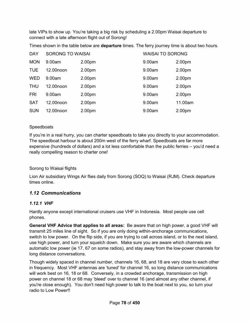
Page 78 of 450
late VIPs to show up. You’re taking a big risk by scheduling a 2.00pm Waisai departure to
connect with a late afternoon flight out of Sorong!
Times shown in the table below are departure times. The ferry journey time is about two hours.
DAY SORONG TO WAISAI WAISAI TO SORONG
MON 9.00am 2.00pm 9.00am 2.00pm
TUE 12.00noon 2.00pm 9.00am 2.00pm
WED 9.00am 2.00pm 9.00am 2.00pm
THU 12.00noon 2.00pm 9.00am 2.00pm
FRI 9.00am 2.00pm 9.00am 2.00pm
SAT 12.00noon 2.00pm 9.00am 11.00am
SUN 12.00noon 2.00pm 9.00am 2.00pm
Speedboats
If you’re in a real hurry, you can charter speedboats to take you directly to your accommodation.
The speedboat harbour is about 200m west of the ferry wharf. Speedboats are far more
expensive (hundreds of dollars) and a lot less comfortable than the public ferries – you’d need a
really compelling reason to charter one!
Sorong to Waisai flights
Lion Air subsidiary Wings Air flies daily from Sorong (SOQ) to Waisai (RJM). Check departure
times online.
1.12 Communications
1.12.1 VHF
Hardly anyone except international cruisers use VHF in Indonesia. Most people use cell
phones.
General VHF Advice that applies to all areas: Be aware that on high power, a good VHF will
transmit 25 miles line of sight. So if you are only doing within-anchorage communications,
switch to low power. On the flip side, if you are trying to call across island, or to the next island,
use high power, and turn your squelch down. Make sure you are aware which channels are
automatic low power (ie 17, 67 on some radios), and stay away from the low-power channels for
long distance conversations.
Though widely spaced in channel number, channels 16, 68, and 18 are very close to each other
in frequency. Most VHF antennas are ‘tuned' for channel 16, so long distance communications
will work best on 16, 18 or 68. Conversely, in a crowded anchorage, transmission on high
power on channel 18 or 68 may ‘bleed' over to channel 16 (and almost any other channel, if
you're close enough). You don't need high power to talk to the boat next to you, so turn your
radio to Low Power!!
Page 79 of 450
Also be aware that some channels that Americans use frequently are ‘duplex' channels in
International mode. So, for example, you may have trouble communicating with a European
boat, or an American boat whose radio is in International mode, on Channel 18. (see any VHF
guide for the full list of international and US channels and frequencies, but any US channel
designated ‘a', like 18a, 22a, etc will cause trouble with VHF's in international mode).
Make sure you ask in each port what the local channels are--both so you know how to reach
someone ashore and so you know not to use those channels for your off-channel conversations.
1.12.2 SSB Radio Frequencies and Nets
Soggy Paws 2016: We carried on a small net with our friends who were scattered between
Davao, Raja Ampat, Palau and Bali, and found that we could usually get good propagation on
either 8Mhz or 6Mhz. At 0730 eastern Indonesia time (+9) we’d start on 8146, and if we
couldn’t hear well enough, we’d switch to 6224. One or the other frequency had propagation
good enough to hear most people most of the time.
As far as we are aware, there are no regular nets in the area.
Australian Weather Broadcasts are regularly held on 6227, and they are quite loud in Indonesia,
so avoid that frequency when planning a sched.
1.12.3 Telephone, Cell Phones, and Internet Access
There may be wifi available at some resorts, and there are still “Internet Café’s” in the bigger
cities, but internet access in Indonesia is largely by data sim cards. The most wide-spread cell
phone operator in Indonesia is Telkomsel. Regionally, there may be other smaller operators
with better coverage or better prices, but if you want a sim that works in the fringe areas, get
Telkomsel.
When you are in a bigger town, “top up” when you can. In the smaller towns, it can be difficult.
Sail SE Asia FB Group – December 2020 – Activating a Foreign Phone (NEW 2020
Regulation): Apparently, as of Sep 2020, there’s a new regulation in Indonesia that blocks cell
phone internet access from cell phones purchased overseas. This appears to be more an effort
to block bulk importation of cell phones bought overseas without paying duty (not an effort to
cause cruisers trouble). (note: only applies to cell phones not used in Indo before April 2020, so
if you are back again, and have your old phone, it should work).
Here’s what the article says: “If you arrived in Indonesia after 18th April 2020, with a phone that
hasn’t been used in the country before, your phone may stop working with local SIM cards. In
this case, you will need to visit your local Bea Cukai, or customs office, with your phone and
proof of your date of arrival in Indonesia, such as a flight ticket.
Your phone can be registered after paying the appropriate taxes and customs. The tax applies
to the full value of the phone, there is no US$500 threshold in this instance.”
“In simple terms, if the value of the smartphone brought is under US$500, or around Rp7million,
it will not be subject to customs duties. If it is more than US$500, then a tax fee will be charged
in accordance with the prevailing laws and regulations. Bringing in a large number of
smartphone devices from abroad with the clear purpose of trade will result in a different
calculation system.”

Page 80 of 450
Full details in this link:
https://indonesiaexpat.biz/outreach/info-for-expats/heres-how-to-report-cell-phones-purchased-
from-abroad-and-avoid-getting-blocked/
The registration seems to require that you use an Indonesian identity card, it is not known
whether a foreign passport will work.
This is the direct link to the Customs site to register a cell phone:
https://www.beacukai.go.id/register-imei.html
Have your Google Translate page ready, as the “EN” version isn’t complete. It does appear that
they will accept registrations for people with a foreign ID.
Best plan is to register your phone on check-In with Customs.
If you have an older phone, here’s a place you can check the IMEI of your phone to see if
Indonesia recognizes it:
https://imei.kemenperin.go.id/
Soggy Paws – March 2017: The first question you will be asked when you go to buy a sim
card in Indonesia is “is it for a phone or for internet”. If it is for a phone and you WANT to do
internet with that phone, tell them you want INTERNET.
The 12GB simPATI sim cards we bought for Rp85,000 ($6.36) had 12GB on it, but in an
interesting array of “pockets”.
5 GB of “Local 4G”
1.5 GB of “Local Data”
500 MB of “Flash”
5GB of HOOQ + VIU (video streaming)
“Local” data as I understand is only good in the area that you bought it in.
4G data is only good if (a) you have a 4G cell device (b) the cell device actually operates on the
Indo 4G freqs and (c) there is 4G coverage. Our old Samsung S3’s from AT&T did NOT use
from the “4G” pocket, because the US-sourced Samsungs had US 4G freqs, not Indo 4G freqs.
Even though my cell phone says “4G” on it in the signal indicator.
Even if you have a 4G device, If you want data good all over, wherever there is coverage in
Indonesia, you want to get NON 4G “Flash” data. Only 500MB of actually good-everywhere
“Flash” is included in our 12GB package! (note, if you know when shopping for a sim, you might
be able to buy a sim with a different package of data on it, but since we stayed in Bitung for 10
days, I definitely got $6.35 worth of Local Data from the sims we did buy).
To purchase data from applied credit, either use the (*363#) USSD code on the phone (more
details below), or use the MyTelkomsel app on your cell phone. MyTelkomsel is mostly in
English!!! (the USSD code stuff is not). I can’t always find all packages on one mechanism vs
the other, however.
You CAN manage 2 numbers with the MyTelkomsel app WITHOUT creating an account with an
email address. Just log in with whatever cell number you want to manage (once you verify that

Page 81 of 450
you really own the number by receiving an SMS on the actual device and typing the temp code
in to the MyTelkomsel app, you can easily log in with either number by just typing in the
number) Use the Logout function to change from one number to another, because it remembers
the last number you used with the app.
DO NOT try to ADD CREDIT using a foreign credit card on the MyTelkomsel app, even
though it will accept one. Purchase credit is only valid with an Indonesian credit card. I tried it
with my US Visa card, and the credit actually went through and showed up on my credit card
account within minutes, but Telkomsel couldn’t accept the payment (probably some
banking/telcom regulation). I then called the Telkomsel Customer Support number, had a
fruitless half hour on the phone, but did eventually see that the transaction on the credit card
was canceled before it ever went completely through.
The “MyTelkomsel” app for Android or Apple is very useful for monitoring your credit and your
data, because it’s (mostly) in English. If you click on the “Remaining Quota” number for
Internet, it will expand to show you what kind of data you have.
Topping up with a 3rd Party Service: IT IS POSSIBLE, a lot more convenient, but a little bit
more cost, to use a 3rd party website to add credit to a Telkomsel simPATI sim. I used the
Ding (Ding.com) app or Recharge.com and paid with Paypal (but they also accept credit cards
too). The credit got applied immediately. It was fantastic! (unlike some other experiences I
have had trying desperately to buy credit online while offshore or in a remote anchorage before
my data ran out). The only problem is the total cost was $12.99 USD for Rp100,000 (if you
bought it at a shop, it would only cost ~$7.50 USD). The max you can buy is Rp100K at a time.
It is very transparent as to the cost, but I didn’t realize at the time what a terrible exchange rate
they were giving until I multiplied it out. I would still do it again if I couldn’t easily find someone
to top me up with cash. (it’s not as easy as you think in the remoter regions, to buy enough
credit to get a decent package).
Trying to add credit to my sim in Bitung, I had a 15 minute discussion in a local shop in Bitung,
trying to explain to them why I wanted to put 300,000 IDR on my phone (they kept trying to sell
me another “12GB” sim for only 85,000). Fortunately someone who spoke good English
stopped by and helped explain that we were going away from Bitung and the “Local Data”
wouldn’t be any good for us. It also helps to show them the data package you plan to buy using
the MyTelkomsel app (though it was in English and they didn’t understand it).
Be wary when buying credit in an office—in Tual, I was trying to buy credit (so I could buy my
own data at the next port, in the future), and the guy put Rp 100,000 worth of DATA on (with a
30 day expiration date). So be clear that you want the credit, not the data (if that’s what you
want). Money on an account seems not to expire, while data always has an expiration date.
If you are using the USSD Code method to buy data (*363#) from your credit, select Flash
Regular (unless you want 4G and you know you will have 4G coverage). If you want data to last
more than a day or a week, you need to know the correct Indo words (Harian-Daily, Minguuan-
Weekly, Bulanan-Monthly, Paket Flash>30 hari (more than 30 days). You need to complete the
entire back and forth within a certain time period, or it times out and you get an error, and you
have to start all over. So, to get 6 GB of Flash data good anywhere in Indo, good for 60 days,
here are the menu items…

Page 82 of 450
*363# 2 (Regular Flash) 4 (> 30 days) 1 (Yes). Then they send you an SMS, which you
MUST reply to, to confirm. Even then you should check your MyTelkomsel app when finished,
to make sure your package actually got purchased (your available credit should go down and
your FLASH data should go up). Note that they change the menu sequences all the time, so
you do need to translate your menu items to make sure you are on the right track.
For some odd reason, pricing of various packages seems to vary from city to city, so the price
isn’t shown until you get the SMS for confirmation, but you haven’t bought anything until you
answer the SMS. And they will send you the SMS even if you don’t have enough credit to buy
it.
When you say yes on the last step, you should get a popup that says in Indonesian “Your
request is being processed”. And then you will receive an SMS giving the price. For example, I
just tried it and the 6GB flash for 60 days is Rp175,000. The SMS is all in Indonesian, so get
familiar with cutting and pasting SMS’s into Google Translate!! (Using the USSD method, you
cannot cut and paste, so it is helpful to have a computer or other device standing by to translate
what you type in)
You need to reply to the confirming SMS with FLASH YA (or whatever the confirming SMS says
to reply with) in order to actually buy this package. Make sure you reply with the Indonesian
words, not the translated English words!
There is a mind-boggling array of packages to choose from (and again, different offerings, it
seems via *363# vs Internet Packages on MyTelkomsel app). So explore around. Some
combine voice minutes and SMS. Under MyTelkcomsel / Flash Mingguan, there’s a 3.5GB
package good for 30 days which includes 300 SMS and 100 minutes of voice.
There are also add-on packages, once you’ve bought some regular Flash, that will give you
some 4G data and/or data good from Midnight to 7am, at attractive rates. These are labeled
“Ekstra”. (“MDS” or “00-07” is data only good from midnight to 7am).
Alba – August 2015: Our first stop was to get the data SIM card in our iPad topped up. Again
we had trouble with this normally simple job. In the first small shop, the guy spoke a couple of
words of English and kept saying "Empty, empty". We tried to explain that we didn't want a new,
empty SIM card, but he didn't understand. Eventually, we asked if there was somewhere else
and he pointed us down the street.
The next shop was the same - the lady kept saying "Berakhir", which our dictionary told us was
"Expired". Well, yes, our credit had expired, that was why we wanted a top-up. The lady then
wrote down 4.1 GB data and told us to come back at two o’clock in the afternoon. The penny
dropped. These small shops are only allocated a certain amount of air time each day and she
had sold out. She would be topped up at two o'clock and could then top us up.
There was another small shop across the road selling SIM cards, so we tried there and to our
relief, the lady had some data available, so we bought 3 GB for one month for $10. Five
minutes later, we were on-line again. What a strange system.

Page 83 of 450
1.12.4 Mail & Shipping Stuff In
Sail SE Asia – October 2021 – How to Ship Stuff in “Yacht In Transit”: Anyone have
experience with importing stuff to Indonesia with the “yacht spare parts” written on the box?
Specifically want to ship in a water maker and dinghy. Here are the various answers:
Don't do it and don't try to get a transit permit either to avoid tax. They are super corrupt
and they will drawn you in red tape and bullshit for months Until you give up and pay in
full.. The tax is a percentage which is ridiculous like 40% or something but don't quote
me on that.
2-4 months tied up once it lands plus 40-70% import duty. Don’t bother.
(From an Indonesian yachtie facilitator): The procedure is complicated and not down to
earth. Please get them before your arrival in Indonesia
Some information to the time frame: Based on my experience in Malaysia I can say,
when there is Ramadan, nobody will answer your phone-call or proceed. But also no one
tell you: "Look, we have our Ramadan, please be patient a few weeks". So I phoned ond
phoned and got almost crazy. End of Ramadan plus 2 days and everything was
delivered by itself ... So schedule carefully your orders!
Do NOT import anything to Indonesia. You will pay 40% in import duties on the delivery
of the parts. Even you write Yacht in Transit or not. We have tried it. We also tried to
import a replacement motor for an electric toilet. It would cost almost one thousand
dollars including tax, duties and shipping, so we gave up. A positive thing is, that
Indonesia is not expensive when you buy things here. We just bought a complete new
electric TMC toilet for 340 dollars.
In Jakarta we ordered some marine bedding and some teak deck caulking from the US.
It was delivered after 6 days ! But we had to pay the duties. Here in Sorong we ordered
some more bedding etc. the 29th of September. We have not received it yet (late
October). My experience is, that Shipping inside Indonesia is not so good and not safe.
Maybe you get it, maybe not. The address system in Indonesia is very complicated and
the address itself is a long one. So when the shipper write the address on the package it
is missing important information, because the rest of the World do not have space in
their address label for long addresses. So our last package is stuck in Jakarta and the
UPS write to us: Incomplete address. Delivery delayed. Its a pain in the a--. My advice.
Get the spare parts before you enter Indonesia.
Duty-free is not likely. You will always pay 25 to 49% duty + shipper + taxes and
anything else they can come up with. And never consider shipping in a used item, no
matter it's condition. They will keep it.
I’ve ordered dozens of packets from AliExpress without drama, the duties weren’t much
higher than I’d pay in europe for the same merchandise. But that’s only from
AliExpress… other sellers/nations can be more problematic.
Don't do it ... 7 meetings with customs before I sent the parts, all the papers from them ...
Held for 4 months and 30% tax on parts plus a big bill from DHL for storage, nightmare
Batam Island is the only spot in Indonesia to do this, things get done here

Page 84 of 450
If in Batam (via Nongsa Point Marina), no taxes neither VAT. I did it a few times.
Anywhere else in Indonesia you will pay taxes, about 30-35%, the import process takes
about 1 week, all through email.
1.12.5 News
There are several English language news sources in Indonesia:
https://indonesiaexpat.biz/
1.13 Diving
1.14 Cruising Information Sources
We are indebted to the people and organizations below for documenting their experiences and
sharing them with us. We hope they don't mind that we've gathered their comments into this
document to share with other cruisers who don't have internet
A few details about the boats are included, where we know them, so you can assess what ‘a
foot under the keel' means, for example.
Where it's important, we've annotated the contributions. But every section is a mix of several
sources.
1.14.1 Facebook Groups
Facebook Groups are becoming an increasingly common source for cruising information. It’s
not in a particularly organized format, but if you want to ask a question, or monitor what’s going
on, here are a few sources:
https://www.facebook.com/groups/SailSEAsiaGroup/
https://www.facebook.com/groups/wonderfulsail2indonesia/
Related Facebook Pages:
https://www.facebook.com/Sail2Indonesia/
1.14.2 Local Websites
Here are some websites you should visit when you are looking for information on this area:
1.14.2.1 Learning Indonesian.com
Free? Indonesian language mp3’s can be found at http://LearningIndonesian.com
Indonesian (called “Bahasa” or “Bahasa Indonesian” and “Malay”, is a fairly easy language to
learn. Pronunciation is easy and straightforward, and there are few “exceptions”. Learning the
basics will greatly increase your comfort and enjoyment in this country.
1.14.2.2 Indonesia’s Underwater Paradise
This is a brochure from the Indonesian Tourism Department that can be downloaded as a pdf
file.

Page 85 of 450
http://www.visitindonesia.ae/voila/wp-
content/documents/Indonesia's%20Underwater%20Paradise.pdf
1.14.2.3 Bird’s Head Seascape Website
Information about visiting in a private yacht (permits required, etc) and maps with dive
waypoints.
http://birdsheadseascape.com/
1.14.2.4 East Indonesian Info
A private website with lots of good info on seeing Maluku and Papua provinces.
http://www.east-indonesia.info/
1.14.2.5 Sail 2 Indonesia Website
https://www.downunderrally.com/about-go-north?
1.14.2.6 Lombok Marina del Ray
https://www.lombokmarinadelray.com/
1.14.3 Cruiser Reports
Terry Sargent from s/v Valhalla has been gathering anchorage waypoints from other cruisers,
and making GoogleEarth charts for most of the countries in SE Asia and has the info on the web
to download for free.
http://yachtvalhalla.net/navigation/terrystopics.htm
Likewise Sue and Jon Hacking from s/v Ocelot have been cruising SE Asia for many years,
and leaving a trail of information behind. Check out their extensive collection of GoogleEarth
charts (as KAP files) here:
http://svocelot.com/Cruise_Info/Equipment/KAP_Downloads.htm
And cruising notes here:
http://svocelot.com/Cruise_Info/Indian/Indo_NE_Cruising.htm
http://svocelot.com/Cruise_Info/Indian/Indonesia_Cruising.htm
For most of the earlier sources below, we have gleaned the information off the internet (cruiser's
websites, blogs, and online forum postings) or out of an SSCA bulletin. For the sources
reported below as 2013-2018, much of the info has come directly from our cruising friends,
helping to round out the information in our various Compendiums, as well as from monitoring
various Facebook groups.
Toucan – Nov 2019 through ??: Toucan is a FP 46 catamaran. They cruised into Indonesia
from PNG via Biak, and then proceeded into Raja Ampat.
L’il Explorers – 2019: L’il Explorers is a 50+ foot catamaran. They started the year in Davao
Philippines and made their way to Raja Ampat and then joined up with one of the rallies coming
from Australia.
Page 86 of 450
Sail SE Asia – 2018-??: This is a Facebook group (link provided above) where cruisers
exchange lots of information. Many bits here have come from those information exchanges.
Starry Horizons – 2018 (with the Rally): Starry Horizons with Amy & David aboard is a 44 ft
Helia catamaran. Starry Horizons joined the Sail 2 Indonesia Rally, but only made it on time to
four of the stops. They cruised 100 days.
https://outchasingstars.com/2018/11/24/100-days-cruising-indonesia-the-wonderful-sail-2-
indonesia-rally/
Soggy Paws – 2014-2019: Soggy Paws made several trips into Indonesia… Davao,
Philippines to Sangihe (N Sulawesi) in Sept 2014, Davao to Raja Ampat to Palau May-August
2016, Davao to Bitung, Ambon, Banda, Triton Bay, Tual, and Raja Ampat, then east along the
north coast toward PNG, from March 2015 to Feb/Mar 2018. In 2014, Soggy Paws WAS a CSY
44, a 44 foot monohull with a 5.5' draft. Since mid-2015, Soggy Paws has been a catamaran,
but any “catamaran only” anchorages or passages are noted in their notes.
Soggy Paws' blog is here:
http://svsoggypaws.blogspot.com
http://svsoggypaws.com
Complexity – June-July 2017: Jim and Barbara sailed down from Palau and cleared in to
Indonesia in Sorong, receiving a 1-month visa on arrival. They cruised Raja Ampat for a couple
of weeks and then sailed to Ambon, clearing out in Ambon just before their 1-month visa
expired. Complexity is a 36-foot Halberg Rassy monohull. Their website is available here:
http://svcomplexity.com
Screensaver – March-May 2017: Screensaver cruised from Samal Philippines, checking in at
Bitung, and heading east toward PNG. They blogged every day and left a satellite GPS snail
trail.
https://screensaver49.wordpress.com/2017/03/page/2/
Changing Spots – April-August 2017: Rob and Anne Marie cruised from Davao to Raja
Ampat in April-July 2017, and cleared out of Sorong for Palau in August, 2017. Changing spots
is a 45 ft catamaran.
Ariel IV – March-July 2017: Ariel IV is a 46 steel monohull. They cruised from Davao to Raja
Ampat and then westward toward the Indian Ocean. http://www.arielfyra.se/ (in Swedish).
Yindee Plus – 2014/2015: Yindee Plus detailed their trip on Noonsite, plus in their blog. So
entries here have been taken from both sources.
http://www.yindeeplus.net/Yindee_Plus/Welcome.html
Alba – July-October 2015: Alba set out from the Eastern Caribbean in 2011, and slowly
headed west. In 2015, they went from NZ all the way to Malaysia (skipping a few places). They
entered Indonesia, after a direct trip from the Louisiades in Papua New Guinea to Tual, in
eastern Indonesia. There, the joined a rally for a couple of months, slowly heading west.
Eventually they turned north and ended up in Singapore. They blogged pretty much every day,
with waypoints and pictures. The important points have been edited below, but their entire log
can be accessed from this link.

Page 87 of 450
http://www.thehowarths.net/alba-chronicles/2015-nz-to-thailand
Alba is a 42 ft monohull.
Minnie B – June/July 2015 (from Noonsite): MINNIE B is an OVNI 395 with centreboard and
folding rudder, drawing less than 1 metre with all in the up position and 2.1 metres with the
centreboard down. Some anchorage and marina information: south from Singapore, Thousand
Islands, Jakarta to Sunda Strait . Phil and Norma Heaton s/y MINNIE B
http://sailblogs.com/member/philandnorma
Brigadoon – 2014 – From a PDF file I think I found on Noonsite or OCC: sv Brigadoon
departed Davao, Philipines June 2014 and then departed Manokwari, Indonesia Dec 2014.
Keel draws 1.8m. We had strong SE winds for July Aug, and did a lot of sailing. We had our
much loved & nearly 15 year old spaniel Fergus on board until Banda. We have no freezer, so
markets/supermarkets were of importance to us, as were Rumah Makans.
Ed note: several anchor waypoints given by Brigadoon in that PDF file have been proven to be
well off the intended spot (at least 1/3 mile), so use these waypoints with caution/skepticism. I
think they must have plotted the locations after the fact from a paper or perhaps Navionics
chart. One spot we visited claimed to be in 45 ft, and it was off soundings, nowhere near any
anchorable depths.
Brick House (2014-2015) – Patrick and Rebecca on Brick House started the Indonesian
odyssey in Sangihe with the rally from the Philippines. But they quickly broke off and did their
own thing after the rally ended in Raja Ampat, working their way eastward all the way to Bali.
They spent nearly a year cruising in Indonesia. You can see all their adventures on their blog
at: http://www.whereisbrickhouse.com/
Lorelei (2015) - Lorelei arrived January 2015, from Davao, Philippines, and made their way
slowly back to Australia via Raja Ampat.
http://yachtlorelei.blogspot.com/
Totem (2013) – Totem made their way west along the north coast of PNG and checked into
Indonesia at Jayapura. They spent time in Raja Ampat before moving on towards Malaysia via
Borneo. You can see their Indonesia posts on their blog at:
http://www.sailingtotem.com/tag/indonesia
Delos (2013) – Delos was in Raja Ampat Sep-Nov 2013. http://svdelos.blogspot.com/2013/09/
There are two PDF files that Delos produced that are referenced but not incorporated into this
guide.
Carina (2013-2015) - http://sv-carina.org
Westward II (2014) - http://westward.steddy.com.au , but most of the information in this guide
attributed to Westward II was gained by verbal communications over the HF radio.
Lorelei (2014) - http://yachtlorelei.blogspot.com/
Zephyr (2013) - http://www.sailblogs.com/member/svzephyr
Sloepmouche (January-July 2012) - Sloepmouche is a trimaran.
http://thetropicalsailinglife.com

Page 88 of 450
Carillion (2007/2008) - Carillon is a Tayana 48 monohull, 14.3m LOA, draft 2m.
www.yachtcarillon.net
1.14.4 Facebook Groups
Sail SE Asia General group covering all of SE Asia
Women Who Sail SE Asia (women only!)
1.14.5 Noonsite
Originally started by Jimmy Cornell, this site is a great repository of information for all those out-
of-the-way places. Made possible by YOUR contributions.
http://www.noonsite.com/Countries/Indonesia
1.14.6 Seven Seas Cruising Association
The SSCA is a world-wide organization for cruisers whose primary function is to exchange
information about cruising destinations. They have a monthly publication that is mostly letters
from cruisers about the areas they are cruising. They also have a good website and a well-
attended bulletin board. Membership is reasonable, and the monthly publication is available
electronically every month. Indexed back issues are also available electronically.
http://www.ssca.org
1.14.7 Ocean Cruising Club
The OCC is a world-wide organization for cruisers whose primary function is to exchange
information about cruising destinations. They have a website and bi-annual publication that is
mostly letters from cruisers about the areas they are cruising. Membership is reasonable, and
the publication is available electronically. Indexed back issues are also available electronically.
http://oceancruisingclub.org
1.15 Printed Sources
From the Sail Indonesia rally page – 2016: There are three cruising guides that cover
Indonesia. First pick is the new Cruising Guide to Indonesia. The Imray publication Southeast
Asia Cruising Guide Vol 2 is the first pick for those making the trip along the Archipelago, with
101 Anchorages a good supplement.
1.15.1 Cruising Guide to Indonesia - 2017
Cruising Guide to Indonesia (2nd edition, 2017) by Andy Scott.
Area covered: Indonesia
This fairly new publication covers the cruising grounds of Indonesia and is
probably the best available. With 18,000 islands covering some two million
square miles of pristine tropical water and a rich and vibrant culture there are
plenty of places to see unencumbered by crowds. This guide covers everything
the prudent navigator needs to safely ply these waters and enjoy the largest
island nation in the world. Includes comprehensive anchorage maps and descriptions.
Page 89 of 450
It is available as either a paper or ebook on Amazon, here: http://amzn.to/2vWMQJl
1.15.2 Southeast Asia Cruising Guide – Vol II - 2008
Southeast Asia Cruising Guide (Volume II) (2nd Edition, 2008), by Stephen Davies & Elaine
Morgan
(only has scant information about the Raja Ampat area)
Area covered PNG, East Timor, Indonesia, Malaysia, West Thailand
This is the book of choice for cruisers heading from Darwin through
Indonesia to Singapore, Malaysia and Thailand. It is also excellent for the
more northerly trip via PNG, Palau, and then through Indonesia. Stephen
Davies and Elaine Morgan's detailed text provides cruise planning
information, an extensive discussion on climate, technical data concerning
radio and weather forecasting services and general background
commentary on each country. Each region is then treated in detail and pilotage information is
given for key harbours. This pilot is a unique source of information for cruise planning and also
will be an essential reference for yachtsmen on passage.
Yindee Plus – 2014: This contains very useful general information about the region and it
would be difficult to negotiate the straits between the islands without it. Note, that to
complement the information in the guide, you also need to know the timing of the upper and
lower transits of the moon. You can download this from the internet or buy a current year's
Sailing Almanac. The guide was not helpful for anchorages, although there are plans and
information for each of the main ports in Indonesia.
1.15.3 Southeast Asia Pilot – 5th Ed
https://www.southeastasiapilot.com/
Yindee Plus – 2014: Southeast Asia Pilot. We bought the brand new fourth edition because it
included a new section on Indonesia. The limited number of anchorages covered had good
plans and information, but there were nowhere near enough of them to make the book worth
buying for this large area. We are hoping it will earn it's keep further north.
1.15.4 101 Anchorages in Indonesia
Area covered: Indonesia
Recently reprinted, 101 Anchorages covers cruising anchorages
throughout Indonesia, mostly along the Sunda Islands Archipelago
(Timor to Java), but also Maluku, Sulawesi, Kalimantan &
Sumatra. Each anchorage includes a rating, approach
suggestions, hazards, weather suitability, pictures, maps, water
clarity, local facilities & attractions, all presented in an easy to read
sailing format. It covers more cruising anchorages than the Imray Guide, although in less detail.
Some coverage in eastern Indonesia. Certainly worth getting if cruising through Indonesia
Yindee Plus – 2014: This book is a recent publication and a very welcome addition too. When it
arrived it looked very thin and insignificant, but we found that once we reached the region it
covered (mostly Flores and further west), the boats in our group used it more than any other
Page 90 of 450
guide. If they decide to print another edition in the future, then adding in anchorages between
Saumlaki and Wetar would be a great idea.
1.15.5 Lonely Planet Indonesia (latest edition)
It’s always useful to have the Lonely Planet that covers the area you are traveling in, to give you
background information about what’s ashore.
A downloadable version can be purchased online on Amazon or on the Lonely Planet website:
http://amzn.to/2vad0uA
1.15.6 Lonely Planet - SE Asia on a Shoestring
Yindee Plus – 2014: We regretted buying this. Because it covers such a huge area, the
information on Indonesia just concentrates on the islands where tourists fly in for holidays. A
much better option would have been the Lonely Planet Indonesia guide.
1.15.7 Indonesian Phasebook and Dictionary (Lonely Planet)
Yindee Plus – 2014: We found this a really useful, pocket-sized book, for general tourist
activities. For a nautical vocabulary, use the glossary sections at the backs of the Cruising
Guide to SE Asia Vol II or Sailing Directions.
1.15.8 Diving the Bird’s Head Seascape
This is THE diving guide to the Raja Ampat area of Indonesia. Available in print
format on Amazon.com, not available in downloadable format. Has waypoints and
dive descriptions for many dives in eastern Indonesia.
Amazon Link
1.15.9 Cruising the Tanimbar Islands of Eastern Indonesia
By Jan Carter
To Purchase Email: [email protected]
Further information and an extract from the book can be seen at jancarter18.blogspot.com.
This 88-page book has been written by Jan Carter and is for sailors who intend to cruise in this
area as well as those interested in learning about this area. The book contains information
about Tanimbarese culture and history, craft, forestry and birdlife. It also includes information
about 16 anchorages, food, health, trading, prices, availability of water and visa information. The
book includes a six-page English/Indonesian ‘sailing terms’ dictionary, more than 90 photos and
six maps.
1.16 Recommended Reading
For background on the culture and history of Indonesia, we recommend the following books:
Soggy Paws 2016: Nathaniel’s Nutmeg is a great book about the Dutch and English history in
the Indonesia, and their attempts to dominate the supply of nutmeg, once proclaimed to be a
cure for the plague. Available on Amazon as an eBook.

Page 91 of 450
Also, The Malay Archipelago: A Travel Narrative, by Alfred Russel Wallace. Available on
Amazon as an ebook. Written in the 1860’s by a British naturalist who was a poor relative to
Charles Darwin, and conducting similar types of natural explorations in a different part of the
world than Darwin. It is said that some of Darwin’s ideas on the Origin of Species may have
come from correspondence with Wallace. Here is an excerpt from the Preface to the first
edition of Wilson’s book:
My journeys to the various islands were regulated by the seasons and the means of
conveyance. I visited some islands two or three times at distant intervals, and in some cases
had to make the same voyage four times over. A chronological arrangement would have
puzzled my readers. They would never have known where they were; and my frequent
references to the groups of islands, classed in accordance with the peculiarities of their animal
productions and of their human inhabitants, would have been hardly intelligible. I have adopted,
therefore, a geographical, zoological, and ethnological arrangement, passing from island to
island in what seems the most natural succession, while I transgress the order in which I myself
visited them as little as possible.
I divide the Archipelago into five groups of islands, as follow :—
I. THE INDO-MALAY ISLANDS : comprising the Malay Peninsula and Singapore, Borneo,
Java, and Sumatra.
II. THE TIMOR GROUP : comprising the islands of Timor, Flores, Sumbawa, and Lombock,
with several smaller ones.
III. CELEBES : comprising also the Sula Islands and Bouton.
IV. THE MOLUCCAN GROUP : comprising Bouru, Ceram, Batchian, Gilolo, and Morty; with
the smaller islands of Ternate, Tidore, Makian, Kaiòa, Amboyna, Banda, Goram, and Matabello.
V. THE PAPUAN GROUP : comprising the great island of New Guinea, with the Aru Islands,
My sol, Sal watty, Waigiou, and several others. The Ké Islands are described with this group on
account of their ethnology, though zoologically and geographically they belong to the Moluccas.
The chapters relating to the separate islands of each of these groups are followed by one on the
Natural History of that group; and the work may thus be divided into five parts, each treating of
one of the natural divisions of the Archipelago.
It was Wilson who discovered evidence that half of Indonesia was once attached to Australia,
and half attached to Asia, with a huge dichotomy of flora and fauna separated by a small bit of
water. This division is today called The Wilson Line.
Even if you are not interested in his search for beetles, orangutangs, and birds, his travel
narratives are very interesting, as he got himself all over the Indonesian archipelago by local
transport (sailing boats).
Alba – 2015: Most Indonesians are Muslim and our knowledge of Islam is a lamentably thin, so
we're trying to understand what it's all about. I've found a novel called "Mother of the Believers"
by Kamran Pasha, which tells the story of the early days of Mohammed from the view point of
one of his wives. It's well written and fascinating. The most interesting thing to me is the huge
historical similarities between Judaism, Christianity and Islam, yet the few fundamental
differences have caused such trouble.

Page 92 of 450
Page 93 of 450
2 Passage Reports
2.1 Sailing Here from Elsewhere
2.1.1 To/From Philippines
2.1.1.1 Between Davao and Sorong or Biak
Soggy Paws – Oct Nov 2019 – Biak to Sorong to Davao, hopping: We pretty much
reversed the route we took in January (a few different stops along the Bird’s Head coast).
The last 2 days into Sorong were unpleasant as the wind ended up pretty much on our nose, no
matter that we made nearly a 90 degree turn to go down into Sorong.
In this season, the prevailing winds are SW, going more westerly the further north you get. If
you wait too late, you may run into northerlies on the last leg or two into Davao.
The wind speeds definitely increased from “barely sailable” down in the Sorong area to “rousing”
as we got north of Halmahera.
Biak to Sorong (with a stop in Manokwari) took 6 days. More details on the Indonesia Sorong to
Biak portion of the trip can be found in the Between Biak and Sorong section.
Sorong to Davao took 10 days, again, day hopping as much as possible. (3 overnights)
We arrived at Holiday Oceanview Marina on Nov 15. There were 2 typhoons wandering around
the western Pacific, and also a few days later, the winds started becoming northerly.
Soggy Paws – January 2019 – Davao to Sorong Area and Biak, hopping: We left the south
end of Samal Island, Gulf of Davao on January 1, arriving a daysail away from Sorong on
January 11, and in Biak on January 17. Davao to Biak direct is only 685 nm, and with N-NW
winds, we could have gone direct in about 5 days. But we wanted to do day hops as much as
possible.
Here are the stops we made:
South Samal Island to South end of Talaud Island (Internet) – 187 nm
Talau to Rau Island, West Morotai (internet) – 140 nm
Rau, Morotai to NE Halmahera (no internet) – 67 nm
NE Halmahera to Wayag (no internet) – 120 nm
Wayag to N Coast Waigeo (no internet) – 71 nm
N Coast Waigeo to SE Waigeo (no internet) – 28 nm
SE Waigeo to Pulau Amsterdam (no internet) – 52 nm
N Coast “Birds Head” (2 days 50 nm each day, internet on one segment during the day)
N Coast Birds Head 2 to Biak (internet in Biak) – 150 nm
* note that “internet” requires an activated Telkomsel sim card
Details on all the anchorages we have found between Biak and Sorong can be found in this
section: Between Sorong and Cenderawasih Bay.
It was a slow motorsail south out of the Gulf of Davao, but once we hit the mouth of the Gulf of
Davao (around sunset), the wind picked up and we had a rousing sail south to Talaud
Page 94 of 450
(Karaketang), arriving the next morning. There is good 4G internet around the town at the south
end of Talaud.
The next day we did another overnight to Rau, Morotai, another good/fast sail. The next day we
did a very long day to arrive at an anchorage just at the NE corner of Halmahera right at sunset.
The next day we did an overnight to Wayag, battling noserly current and worrying about the
possibility of uncharted volcanic areas, as the chart mentions.
After a couple of days rest in Wayag, we did 2 hops to the SE corner of Waigeo, where we met
our friends who were heading east to PNG with us.
From there we day-hopped along the top of the Bird’s Head, with one final overnight to Biak.
More details on the Indonesia Sorong to Biak portion of the trip can be found in the Between
Biak and Sorong section.
2.1.1.2 From Davao to Northern Sulawesi
Soggy Paws – March 2017 – Davao to Bitung: We did day-hops all the way south to
Bitung (sometimes LONG days). Here are the stops:
Holiday Oceanview Marina to Tubalan – 47 nm
Tubalan to Sarangani Islands (several anchorages) – 72 nm
Sarangani to W Kawio – 48nm
Kawio to Sangihe, Tahuna (draggy mooring) – 68 nm
Sangihe to Siau – 58 nm
Siau to Bitung – 78 nm
Several of these hops are very long to do as day hops! Basically we got up and got going at the
crack of dawn and motorsailed when necessary to keep our speed up. We had been into
Sarangani before and had tracks and waypoints and felt comfortable with a night approach if it
was necessary (it wasn’t).
Catamini – July 2013 – Anchorages Between Davao and Sangihe
We adapted the location of the anchorages considering wind directions. Mornings good sailing
and favourable currents, but afternoons rain and rolly seas this time of the year. So we always
left at 5am and dropped the hook around 3pm :
- Davao to Mapagbo Cr.- 9kt wind NE; calm anchorage N06.59'249/E125.58'754 in 7m
sand/mud
- Mapagbo to Kanikian Pt - 8kt wind NE - anchorage N06.19'664/E126.10'983 in 11m sand/coral
As the wind changed late evening to SW, the anchorage became rolly.
- Kanikian Pt to Quality Pt - morning 20kt wind SW; calm anchorage N05.48'393/E125.33'936 in
10m sand
- Quality Pt to East Balut Isl -morning 13kt wind SW; calm anchorage N05.24'286/E125.25'764
in 14m mud

Page 95 of 450
Here we got a welcome to Indonesia on VHF 16 by the coastguard. They saw us on the AIS or
radar.
- Balut Isl to East Kawio - morning 15kt wind SW; calm anchorage N04.40'018/E125.26'393 in
7m sand/coral
- Kawio to NW Sangihe - morning 22kt wind SW; calm anchorage N03.43'336/E125.24'573 in
8m black sand
- NW Sangihe to Tahuna Harbour – morning no wind; N03,36'467/E125.29'564 in 22m mud
Five officials from the Tourist Department were welcoming us. Mr Tommy TIWA, Kabid
Pemasaran Pariwisata Sangihe, and his English speaking collegae Mrs Ice (pronounce Itche),
drove us to Immigration and took care of all the clearance. Only the Customs Officer came on
board. We asked them to build a floating dinghy pontoon for the rally Sail Derawan. Some
Internet cafés in the centre but it's easier to buy a "Wifi Internet Voucher", which you can use on
your boat. Only Rp100,000 for 250Mb, valid 30 days. We will extend our visit here as there is so
much to see and people so nice.
2.1.1.3 Return route from Ternate to Davao, Philippines
Sloepmouche – December 2012: After 4 months of cruising this small part of Indonesia, it was
time to take care of Sloepmouche in a good boatyard. So we decided to go back to the
Philippines making short hops when possible and take advantage of wx windows.
Our first leg was Ternate to Jailolo bay. We anchored west of the harbor on a small isolated
shoal at 01-02’89N / 127-27’23E (25ft, coral rubbles, space for 1 boat). We were in calm water
there despite rainstorms passing and winds changing from NW to NE.
Our second leg was to 01-15’65N / 127-25’20E in front of a small village (25ft, good sand, but
rolly with NW and N swell, we did not sleep so well that night).
Our third leg up the coast of Halmahera brought us to lovely Loloda bay. We anchored at 01-
40’69N / 127-34’03E (38ft, good sand). This bay is well protected from seas coming from any
direction. It also comprises some interesting looking islets, one even boasting a waterfall. We
dinghied over to the 2 waterfalls and swam under them. Near the NE entrance of the bay is a
new fish processing plant (they gave us a tour) and on the South side of the bay, there is a
village where people welcomed us warmly too. It was a perfect place to wait for the bad wx
fronts to pass before heading NW towards Mindanao. From there we both sailed and
motorsailed 3-day non-stop to the entrance of the bay of Mindanao.
2.1.2 To/From Palau
2.1.2.1 Sorong to Palau
Soggy Paws – August 2016: We made the trip to Palau with as many day-hops as possible.
The winds were S-SE for the whole trip. Our stops were:
1. North coast of Batanta
2. NE Coast of Waigeo (long day hop)
3. Ayu Atoll (long day hop)
Page 96 of 450
4. Helen Reef (2 days, 1 night)
5. Palau (3 days, 2 nights)
This was a pretty easy (mostly windless) trip, except the last night on our way to Palau. We had
seen the system coming in and our options were to wait a week in Helen Reef, or go now. We
got hit with 30-40 kt winds in a frontal type storm in the middle of the last night. Fortunately the
winds were behind us, so we just reefed down and whistled along, dead downwind. This
allowed us to get into Palau during working hours on the 3rd day. It was nasty for a few hours—
needed to hand steer to stay on course with our DDW configuration, but by dawn the wind was
calming down and we gybed over and headed for Koror.
2.1.3 To/From Australia
Also see this section (Eastbound, N Coast of New Guinea), especially if you are heading for
Sydney or Melbourne, and want to see a bit more of the world before heading back to Australia.
2.1.3.1 Kupang to Dampier
Soggy Paws Australia – June 2016 – Kupang to Dampier: Our Passage to Australia was as
such: my plan to ride in the SE Aust monsoon south worked for 36 hours until a massive storm
hit southern Australia and sucked all the wind down there. We had 3 days of calms then a
massive storm hit us, which you've already heard about.
We were overflown at least once daily by Australian Customs planes (now called Border Force),
and met by 7 customs officers + dog on arrival in Dampier. We were delayed by a day because
of the storm plus the raw water pump failing, which they thought was suspicious!
The clearance process cost about $500 but Jo and I made sure we were in 100% compliance
so we had no issues as we got rid of all fresh food and frozen meat before arrival.
2.1.3.2 From Sorong to Thursday Island via Triton Bay
New Views – 2017 (from Noonsite.com): After 3 years cruising in SE Asia it was time to
return to Australia and we had to face the more challenging conditions of sailing to windward
back to Australia. My research showed there are two main routes back to the east coast of
Australia.
- The first and most popular is to check out of Indonesia in Tual and position at the bottom of
Aru Island until a weather window opens up to cross the Arafura Sea to Gove. This will normal
occur from the middle of October onwards as the monsoon changes from SE to NE. After
checking into Australia at Gove, the Gulf of Carpentaria is crossed and one tracks down the
Queensland coast when there are periods of less SE trade wind blowing.
- The other route is to sail to the north of New Guinea and then south west across the Coral Sea
to Queensland. This is a much longer route, and a bit more adventurous. Best time for this
route is to leave Sorong, West Papua in Nov-January. Depending on how far south you are
trying to get in Australia (ie Melbourne), the earlier the better, to make it to at least Vanuatu
before the strong SE winds kick in in mid-May. In Nov-Jan you will have NW winds along the N
coast of New Guinea. By March the winds die, and by May, they are on your nose.
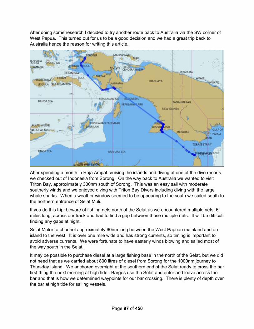
Page 97 of 450
After doing some research I decided to try another route back to Australia via the SW corner of
West Papua. This turned out for us to be a good decision and we had a great trip back to
Australia hence the reason for writing this article.
After spending a month in Raja Ampat cruising the islands and diving at one of the dive resorts
we checked out of Indonesia from Sorong. On the way back to Australia we wanted to visit
Triton Bay, approximately 300nm south of Sorong. This was an easy sail with moderate
southerly winds and we enjoyed diving with Triton Bay Divers including diving with the large
whale sharks. When a weather window seemed to be appearing to the south we sailed south to
the northern entrance of Selat Muli.
If you do this trip, beware of fishing nets north of the Selat as we encountered multiple nets, 6
miles long, across our track and had to find a gap between those multiple nets. It will be difficult
finding any gaps at night.
Selat Muli is a channel approximately 60nm long between the West Papuan mainland and an
island to the west. It is over one mile wide and has strong currents, so timing is important to
avoid adverse currents. We were fortunate to have easterly winds blowing and sailed most of
the way south in the Selat.
It may be possible to purchase diesel at a large fishing base in the north of the Selat, but we did
not need that as we carried about 800 litres of diesel from Sorong for the 1000nm journey to
Thursday Island. We anchored overnight at the southern end of the Selat ready to cross the bar
first thing the next morning at high tide. Barges use the Selat and enter and leave across the
bar and that is how we determined waypoints for our bar crossing. There is plenty of depth over
the bar at high tide for sailing vessels.

Page 98 of 450
Although choppy across the bar, the seas calmed down in the deeper water and we crossed the
Arafura Sea and Torres Strait to Thursday Island in just under 2 days. This route saved us
hundreds of miles of ocean crossing. The border control and quarantine inspections at
Thursday Island took place efficiently and the officials were very helpful and friendly.
So our experience for returning to Australia via Selat Muli was very good. Not only did we
significantly shorten the ocean crossing, we required only a short weather window to cross to
Thursday Island.
2.1.3.3 Kai Islands to Gove, Australia
Catchcry I (Power Cat) – Tual, Kai Islands to Gove, Australia – Oct 2017:
We ended up crossing in the last week of October, leaving Tual on 25th October, and doing 3
day hops to Pulau Enu.
First night we stopped on the west coast of Pulau Kai Besar, near a place called "Ad" on
OpenCPN. We chose it from the Google Earth images, and the river coming out. 5°24.70S,
133°04.13E - 5-10m on sand at low tide.
For the second night we went northwards around Kai Besar (this was due to wind direction at
different times of the day as per Predictwind - accurate too) to the large inlet to the west of
Trangan on Aru, between Tg Derehi and Tg Alarjir. There is a small navy/oil tender base (?)
there. 6°27S, 134°07.36E I think it was 13m deep.
Then on to Pulau Enu on the west side 7°04.4S 134°28.85E, the usual anchorage to wait it out I
think but we only had one night, as we had seen the forecast in Tual. We also had Predict Wind
Offshore, and could confirm the forecast had not changed by Grib files thru SSB.
We had virtually calm conditions all three days, less than 10 knots of wind, so these anchorages
may not be suitable in the usual 15-20 of SE.
This was the last good crossing weather for a powerboat for weeks and weeks. There would
have been some opportunities for a sailing boat. We had a wet trip down the east coast of
Queensland, as there just weren't any northerlies in the parts we were in, and ended up having
to settle for easterly 10-15, but this is still forward of the beam.
Pacific Express – Tual, Kai Islands, Indonesia to Gove, Australia – Oct 2012:
07 Oct – Day/Night 1: We left the south end of Kai Besar at 6.15am and stayed well clear of the
headland. We motored into a reasonable swell with a few very big waves which was a bit of a
hang on and close the eyes job! As we got further away from the islands it settled a bit and we
tacked to try to keep wind in the sails – motor sailing. We emailed (sail mail) off our letter of
Intent to return to Customs. Saw a big clump of seaweed with a turtle floating beside it eating
the seaweed. The skipper saw a pilot whale. Just on dark a beautiful booby bird started circling
and flying alongside us. We went through the night with breeze on the nose and lots of current
against us. The seas were very comfortable though.
8 Oct – Day/Night 2: The skipper said he should clean the filters before they clogged again but I
wasn’t keen to stop the engine. Something about if it ain’t broke don’t fix it. Well at 11.30am that
was proven to be folly when the motor stopped. The skipper had to change the engine fine fuel
filter (we have only one left!) and the pre fuel filters (we have two left). We had been unable to
secure anymore in Tual. The dirty fuel is proving a disaster. He was able to get us going again
Page 99 of 450
and has tried to clear up a used engine fine filter just in case There is not enough wind to sail so
are following the rhumb line and it is so painfully slow. Doesn’t feel like we are making any
headway. And it’s so worrying about the motor. We have very calm seas but no wind so we
can’t sail. Heaps of small dolphins travelling with the boat in the late afternoon.
9 Oct – Day/Night 3: What a gorgeous day. Sea so calm, current not quite as bad. Have seen
six turtles snoozing on the surface. The skipper did the 8am sked, cleaned both filters and went
to bed. We had both sails out for a while but the wind was on the nose – it’s really just a breeze.
We crossed into Australian economic waters at 11.08am so took down the Indonesian courtesy
flag and put up the yellow Q (quarantine) flag. We passed a big tanker in the afternoon on its
way to Singapore. Saw a few tankers on the AIS after that. One changed course to go behind
us. We heard the coast watch plane call up a couple of boats but they didn’t call us. The half
moon came up at 1.15 and the sky is so full of stars. Saw five fishing buoys which we hadn’t
expected to see here.
10 Oct – Day/Night 4: Anchored 11⁰23.07S / 136D53.24E The sea is so calm and it’s a
beautiful day. We motor sailed and rounded Cape Wessel at 3pm – as far as crossings go it
was pretty good – just long. And then the nightmare began. The skipper turned the motor off
and was so excited because we were sailing and doing 6 knots but when he went to start the
motor again there was a terrible smell and though the water pump was pumping it wasn’t
pumping water. We sailed till around 8pm with the skipper working on the motor the whole time
and then we lost the wind altogether and were slowly heading towards land with the current. So
we had to anchor 20 miles out to sea in 43m – the first time we have had to use the 100m of
rope.
11 Oct – Day 5: Anchored 12⁰10.92S / 136⁰40.06E We didn’t sleep terribly well and had the
anchor hauled in and the sails out by 6.00am. We knew our weather window was closing and
strong winds were predicted for the afternoon. We sailed with not a lot of wind so we got the
jenniker out and that got us along quite well for awhile til the wind came up. We saw a tanker on
the AIS go right over the spot where we had been anchored!!!!
Australian Customs called us around 3.45 as they had been expecting us in the morning so they
told us to anchor where we could and they would contact us at 8am. As we got closer to Gove
the wind was building and then it changed direction and went on the nose so we had to tack all
the way across the harbour to the beach in gale force winds with spray coming off the top of the
waves. The skipper estimated 30 – 40 knots and 3-4 m waves. The conditions are the worst we
have experienced as we had to head into it. We sailed across to the beach on the other side but
that was no good so we tacked back towards Gove just behind the big jetty and we anchored
there. We pulled in the headsail first and we slowed too much so had to use the motor to get us
a bit further in – an awful knock coming from it.
Dropped anchor and luckily it grabbed immediately so the skipper dropped the main and laid the
anchor out and I secured the sail. It was a little more sheltered from the waves but the wind was
howling – its a horrible noise.
Fri 12 Oct – Gove, Australia: Anchored 12⁰12.04S / 136⁰41.92E We didn’t sleep well. The wind
howled all night but the sea settled till the early hours of the morning. Customs called us at 8am
and they said they weren’t coming to where we were and we should move so we advised that
we needed a tow so they had someone contact us but he couldn’t come till 11am.
Page 100 of 450
The Michael J came for us after 11 and towed us the extra 2 – 3 miles round to the anchorage.
It was very rough and still blowing like mad with waves. We anchored about 1 km from the
shore and just sat. An hour or two later we had Customs, Immigration and Quarantine on board.
They were pleasant young men (one was from Pine Rivers) and of course they took all our meat
and fruit and veg and noodles which we had expected. But we had to pay them $330 for the
privilege. No it is not a fine – it is what we Australian citizens have to pay to come home and if
we come in on a weekend you can just about double it!! We don’t pay it if we fly in – these guys
get paid for doing their job so why the fee! It cost us about that to replace all the stuff we lost.
2.1.3.4 From Darwin to Indonesia
Sail SE Asia FB Group – August 2019 – Checking in at Kupang or Sumlaki: This is a
discussion from the FB group, each “bullet” below is a different cruiser’s opinion in answer to
this post: Hi everyone! We are heading towards indo very soon from Darwin. Still hesitating on
our port of entry. Kupang VS Saumlaki. Is arriving on a Saturday ok in indo? Or should we
arrive on a week day?
Week days are better. We've never cleared in at Saumlaki, & always with the rally in
Kupang. The officials in Kupang are pretty spread out, so a bit difficult to find them
without hiring a taxi all day.
On arrival at Kupang there are massive oyster farms on your starboard side
We have checked in at both places and prefered Saumlaki. Easier and very friendly. A
great little place!
yes I agree. We have cleared in in both also and loved Saumlaki. Deep anchorage
though so hope your windlass works well.
We also prefer Saumlaki, better anchorage and very friendly.
Those that help you haven’t been taught to charge in Aus $ by others splashing money
around.
Kupang check in is tedious/tiring and all offices are quite spread out. Took me nearly
6hrs on a Saturday with a taxi driver who knew where everything was located in April,
2018. Can be done in a day but must have a car and know where you’re going.
New system in Kupang, anchor off the jetty west of Teddys bar and catch a local taxi to
Customs...then they will all come out to your boat...also local guy Napa can assist you
(he's an old agent from the old system). There are some fees, not all that much and
completely above board, but you don't have to go all the way out to immigration
anymore.
We've also done both (checked in Kupang and out Saumlaki). Prefer Saumlaki both for
the anchorage as well as the officials. We stayed away from the deep part of the
anchorage just off the town as we had heard of many boats dragging. We anchored
across the bay in 5 meters with great holding (S7°57.6525' E131°16.6940'). Only
downside is that it makes for a longer dinghy ride in. Immigration is a bit hard to find as
it's just a random house in a residential neighborhood. Coordinates are S7°58.7163'
E131°17.9831'.
Page 101 of 450
Just saw that you're coming from Darwin. Not sure that Saumlaki is THAT much easier
that it warrants the harder sail. Kupang should be a nice relaxing downwind cruise.
Depends on where you are ultimately heading I suppose. Raja Ampat? For sure to
Saumlaki. Komodo and Bali? Go to Kupang.
Kupang system is good now, just call me or email when you arrive and I give hand to
you to prepare immigration custom quarantine and harbour master to come to your boat
for finish all the document easy. Just need you to pick them up when all of them be at
the beach. MATTHEW 085253243999 (WA) email ([email protected])
We had a great experience a month ago checking in Kupang with the help of Matt.
Amulet – With The Darwin to Kupang Rally – 2010:
Date: 7/24/10, 07:30 Darwin Time Moored: Upped anchor!
Next port: Kupang, Timor, Indonesia Lat/Lon: S 10d 09m, E 123d 34m
Last port: Darwin, NT Australia nm: 470 to go Eng Hrs: 5,806 (leaving Darwin)
Comments: Upped anchor this morning with a handful of other boats to beat the crowd of Sail
Indonesia rally boats (109 total) supposedly leaving at 11 AM. Also we wanted to catch the
ebbing tide for a favorable current. Next stop Kupang about 470 nm to the west. Originally we
had signed up to go to Banda, 500 nm due North, but the strong winds and poor "technical" rally
presentation made us change our minds and take the easier downwind destination of Kupang.
We should be in Indonesia in about 3 days time. We plan 3 months there then on to Singapore,
Malaysia and Thailand.
Date: Day 1, 0730 Darwin Time (07/24/10, 22:00 UTC)
Lat/Lon: S 11 46.765, E 128 43.220
Course/Speed: 285 T, 8.0 knots Wind: E 20 knots Seas: 4-6' and a bit confused
Past 24 hrs: 130 nm; Avg Spd: 5.4 knots; Motored: 4 hrs
COMMENTS: Uneventful 24 hrs, wind 0-20 knots and from S to NE!
Date: Monday 7/26/10, Day 2, 0730 Darwin Time (07/25/10, 22:00 UTC)
Lat/Lon: S 11d 03.450m, E 125d 58.131m
Course/Speed: 285 T / 6.4 knots Wind: 8 knots ESE Seas: 8' swell mostly from ESE, some
E as well
Past 24 hrs: 169 nm; Avg Spd: 7.0 knots; Motored: 2 hrs
COMMENTS: Yesterday was a boisterous sail. The seas got pretty nasty at 10-15' with some
confusion from slightly different directions. Winds were 20-25 knots mostly easterly (behind us).
The autopilot had trouble maintaining a course but managed barely as the big seas sometimes
from different directions threw AMULET about like a cork. We had the main up as the winds
were light the night before and taking it down after sunrise when the wind/seas picked up was
tough. We sailed thru-out the day with the two headsails poled out at speeds of 8-8.5 knots,
thank goodness for our twin pole twin headsail downwind rig. As the sun set the wind and seas
backed-off a bit until finally at 0500 this morning we were back to motorsailing.
Page 102 of 450
We expect to make landfall mid day tomorrow. We are pretty much at the front of the 60 or so
boats in the fleet to Kupang.
Date: 7/27/10, Tuesday 09:30 Darwin time, 08:00 Local time (00 UTC on 7/27/10)*
Moored: Anchored 20' @ 1/2 tide
Present port: Kupang, West Timor, Indonesia Lat/Lon: S 10 09.604, E 123 34.442
Last port: Darwin NT Australia nm: 471 Total nm: 51,174 Eng Hrs: 5,820
Darwin to Kupang Passage Summary: 471 nm, 74 hrs, 6.4 knots average, sailed 81%
Comments: Pretty easy passage as it was mostly downwind, glad we didn't persist in going
North to Banda. First day was nice, second day quite rough with confused seas and 20-25 knot
winds, last day nice with settled seas and 15knot winds (true) from astern. We had to reef way
down last night to slow down and wait for sunrise to run between the islands. We were warned
that in Indonesia there are lots of fish traps and nets along the coast that are unlit.
As we are learning to expect Customs and Quarantine check in on the yachts here in Kupang
was disorganized by the Sail Indonesian Rally people, this is the 10th year they've been doing
this rally. No orderly list of who goes first, just grab them as you can, luckily we arrived about 5th
in a fleet of 60, most will not arrive til tonight or tomorrow.
Quarantine and Customs was quite thorough in checking thru the boat, but no problems. The
Customs guy must think that all American yachts have guns as he asked about 10 times as he
searched the boat.
2.1.4 To/From Malaysia/Singapore
2.1.4.1 Tawau to Tarrakan (East Borneo)
Sea Topaz - September 2012 (OCC Newsletter): In early September 2012 we left Tawau in
Sabah, Malaysia and motor-sailed to the anchorage at the north end of Pulau Bungyu.
Along the way we saw a number of very big Fish Attraction Devices (FADs), the largest we had
seen. There are several coalmines on Pulau Bungyu so there were plenty of tugs and coal
barges, either anchored or manoeuvring.
We reached the anchorage off Tarakan late in the afternoon – again there was a lot of small
boat movement, and a strong current.
The next day we checked into Indonesia, which was more difficult than the previous year as we
did not have the backup of the Rally this time. We did, however, have Raymond’s contacts Dewi
and Rory from the Department of Tourism.
The following morning the first group of four officials arrived on board at 0900 claiming to be
from ‘Quarantine’ and came with a photographer but no paperwork. After taking lots of
photographs of us and themselves they left. Later two more quarantine officers came, this time
with paperwork, then customs officers with more paperwork.
We then had to wait for a boat to collect us to take us to Immigration and Customs. At Customs:
more papers to sign, more waiting, but still no clearance. The difficult issuewas the ‘self
guarantee of export’ document and we were told to ‘come back tomorrow’.
Page 103 of 450
We finally got all our (many) papers from Customs, including the ‘self guarantee’ and headed to
the Harbour Master who was, of course, out to lunch, but returned later to give us our final
papers. We then had to stop at a copy shop to make the essential copies of all the documents.
Before we got onto the longboat to go back to our boat we were presented with a bill for 5
million rupiahs (US $500), which was a huge surprise as we thought we had paid for everything
with the application for the CAIT. We were told it was for boat and car hire for two days, fuel,
and marine police protection fees. We objected strongly, and after phone calls to Raymond and
some recalculations we paid 1∙8 million (US $180), plus a tip for Dewi and Rory. We were free
to go!
2.1.4.2 From Penang to Sabang (Pulau Weh)
Tiger Lilly March 2018: Yesterday we arrived safely at Sebang, Pulau Weh, Indonesia after an
uneventful 300 mile voyage of two and a half days from Penang Island, Malaysia.
Check-in notes here.
2.1.4.3 From Anambas to Tioman
David Cherry (FB) – September 2018: There is a N flowing current of about 1.5 to 2 kts which
gives a 20 to 30 degree offset at 6 kts. I should have taken advantage of all the lifts across to
make southing, but I expected the wind to remain to the E of S for the remainder of the day, but
I got a SW header.
I still managed to sail all the way across except for the last 15nm or so, despite one tack. I even
caught up and eventually passed a monohull that was motorsailing.
I caught a 20' length of heavily barnacle incrusted bamboo on my daggerboard ...... however did
it manage to cling on? ..... It made my boat feel sluggish and cut the speed down by a knot or
two.
I also caught a fish on one tack.
2.1.5 To/From PNG
2.1.5.1 Westbound, North Coast
Soggy Paws – October 2019 – Manus to Ninigos to Biak to Manokwari to Sorong: We
cleared out of PNG in Manus, making the decision NOT to stop in Vanimo for an Indonesian
visa. Manus to Hermits was an easy overnight motorsail in light winds. Hermits to Ninigos was
an easy light motorsail.
The wind in October is habitually less than 10 knots out of the south. We waited for a period
where there was a little more wind, but as the window came closer, it fizzled and we decided to
go anyway. We pretty much motored (with sails up) the entire 500 miles to Biak.
Our trip from Biak into Sorong is covered in the section Between Biak and Sorong.
Wandering Waterhorse – Dec 2018 – Kavieng, PNG to Biak, Indonesia, nonstop: Miles to
cover: 898 NM. Estimated passage time: 6 to 7 days.
We are sailing this passage with our Australia friends on their catamaran, Lukim Yu. We met
Denise and Jamie in Vanuatu and since then have spent time in 3 different countries with them.

Page 104 of 450
Our boat, being slightly larger, will be a little faster, so we will try and keep relatively close and
buddy boat together, it will be nice to have another boat travelling with us, as this big blue can
be very wide and lonely on your own at times.
DAY 1: There was actually wind as we left Kavieng Harbour, Papua New Guinea, so we got to
sail for most of the day at varying speeds. Up to 9.4kts at one stage.
It was nice to sail and to save some diesel. We will potentially need it all with the calm that is
predicted on the weather routing maps. We loaded up with 700L, so hoping this will get us
there!
We had a huge squall for an hour or so directly on the nose with big 2 m waves. Super
uncomfortable and things inside went flying, this was a bit of a wake up as we have had none of
this for a long time. Everything was re stowed easily and no breakages. It passed and sea
settled.
We saw whales in the afternoon!!! We followed them at a distance for a while and tried to fish a
few work ups. Nothing.
My first watch was entirely uneventful, the second had a huge rain and lightning squall come
through. I had to turn the complete opposite direction almost to avoid the lightning, and then the
headsail line got caught in one of the mast winches, so had to get Chae up to help me untangle
it up the front. He went straight back to bed and I carried on, very wet and refreshed after the
excitement.
I got to watch a beautiful sunrise as the air heated again, ready to dry boat and me.
DAY 2: Super relaxing and calm day, this is the passage I had dreamed of. Enjoying being out
here in the sun, although it is super-hot and being windless means we are all sweating buckets!
No fish as of yet. Are there no fish in this part of the ocean like everyone says? Or is it that our
speeds are slightly lower than usual so trawling the lines is not working?
Night comes again, and it is still glassy calm and easy.
Our buddy boat is a wee bit behind now as we had sailed for a bit and got ahead and also
motored faster for a while trying to fish during the day. I look for them on the AIS but cannot
seem to see them.
DAY 3: Entirely uneventful. Glass smooth seas. Hot as a mother. Did catch 1 average sized
tuna and it had weird white colored flesh that seemed to fall apart very easily when touched and
filleted. Not the usual.
DAY 4: Day 4 messed with us from the beginning. My morning shift had the winds building and
sea very choppy. It was manageable and comfortable still. We were able to sail which was
good.
Then it got worse. A super mega squall happened when 4 large squalls merged. We had a
water spout from sea to sky and thought we needed to get the heck out of there.
We then spent almost 12 hours, gaining bugger all ground, going up and down and back and
forward to try and get away from the ever-changing winds and systems. It was rough and it
sucked big time.

Page 105 of 450
Contact was kept with Lukim Yu who were a few hours behind us now, as we tried to give them
some advance warning of what was coming. They too, got slammed by it all.
It was almost 10pm before the chop and swell became an organized sea again. There were still
big rollers but no more white caps.
We wish like mad we had stopped at the Ninigo islands that we had passed at first light. Pretty
happy for today to be almost over. Both of us are uber tired.
There are huge ships out here, 300 m ones, crossing outer paths regularly during the night. I am
glad for AIS which tells us their information, speed over ground and direction etc. so we can
make sure that we will not crash into them, it gives you time to work out courses and change
sailing angles accordingly.
DAY 5: Ships in the night passed by this morning, many and close again.
The night watch was super slow. Motoring on 1 engine. No sail. Got annoyed at going 4 knots
after the sun came up so put the other engine on to get up to 6.
Went to put main sail up when Chae woke and halyard had got loose in the weather yesterday
and caught around the tip of the Genoa at the top of the mast…ugh. 30 mins of acrobatics to
untangle. Luckily the sea was relatively calm.
Ticking along motor sailing in the afternoon. Dodging weather systems that appear out of
nowhere…
We bounced our way over into Indonesian waters at 2305, with breeze filling the air, coming
from the right direction for a change. The clouds were shadowing the half moon that hung in the
sky, weakly illuminating the darker squall clouds I was desperately hoping would pass behind
us.
DAY 6. More of the same.
DAY 7: When will it end? We drive/sail back and forth in currents, wind and waves, hoping for
a path and never finding one. The ocean is horrifically rough and we have a washing machine
like effect going on from wave directions coming from everywhere.
We chose to go the inside of some islands up the coast to try and get some relief from the
adverse wind, as was meant to be slightly better there, well now we are stuck with very strong
currents slowing us down along with all the other crap in this situation.
It has been another day of tacking back and forward up and down and going nowhere really,
Catamarans are not designed for this weather and sea state, in fact no boat would be enjoying
this.
We did manage to catch 4 fish, one after the other when we managed to get an angle to sail,
hitting 8 knots was obviously what the Walu decided was a good bite speed, as each time the
boat would climb over 7 to 7.5 we would get a strike.
Full sail up, so we turned into the wind on the first one to pull it in, and then subsequent fish we
just hauled on the line to get them in rather than mess with the boat. It was madness, within 30
mins we had 4 fish.

Page 106 of 450
We stopped the boat to a knot for dinner in some resemblance of calm, managed to have her
spin while we were just about to get started again and one of the lines got caught around the
prop cone.
With a rope tied to him, Chae had to get in the water and try and sort it out. Line was cut, lovely
lure lost and we just had to get on our way into the mess that was the weather again.
It was just getting worse again. Winds were building significantly again with waves to match. On
the back of stuff all sleep, this was beyond me.
We covered 32 NM in the right direction over an entire day, to put this in perspective we can
easily do 160+ miles per day in good sailing conditions, or motoring if we can use both engines.
This was demoralizing to say the least when we worked it out.
DAY 8: Winds continue all night and into the morning. My husband stayed up most of the night,
I just couldn’t handle it. I did one watch at midnight as it settled slightly but then the wind got up
toward the end of my time and I had to go and get him to help me.
The wind got to 40 knots and we were smashing up and down into giant waves.
The daylight provided no relief.
Huge currents while trying to get across the top of West Papua made us make little way again,
and it was into horrific chop and big waves.
We finally managed to get off the river mouth dirty mixed up water area into sea again and
started actual sailing.
The waves were getting too big again and with the wind strengthening we headed back to
where we came from, dad providing intel on the river mouths where we could potentially go and
hide.
We chose one, the Maremembo River. Apparently it is like the Amazon of West Papua and
teams with amazing creatures. Sounds cool, any other day….
Huge almost standing waves tore us in. I sat in the cockpit and watched as they rode above the
solar panels, threatening to swamp the back of the boat, but she rode them like a boss with our
captain safely bringing us in through the chaos.
Once in the river we pulled to a jetty, a giant random jetty, and were surrounded by locals who
spoke no English.
We tried to ask if they had solar (diesel) as by this stage we were running very, very low on it.
‘Yes’ was a confused translation, Chae went to go and see.
He came back, said we need to leave, there was not a good vibe in this place.
While he was gone I had a guy jump on the boat and just start to walk around looking around
outside. A bit scary and weird.
We tried to anchor at the river mouth, away from the village. A 5-knot current meant we had a
nightmare of a time and we realized we needed to leave properly, not just to the mouth of the
river.
Back out through those waves was a prospect I didn’t not think kindly of.

Page 107 of 450
Luckily, the waves had dropped a bit and Chae took us out, again calm and measured (on the
outside at least) while I was all but having to go and change my underwear.
We turned and headed for the other river mouth around the corner. By this time our buddy boat
had already gone in, they were anchored in the still water.
We had another surfing experience to contend with before we got there.
The charts, which have so far been pretty reliable, must have been off centered and we again
surged in on these rollers, that when you looked back were breaking after we went over them. It
was manic. We were literally surfing in our boat, on giant rolling waves that would break behind
us.
We slowly made our way over to the calmer water while driving on land apparently according to
the charts, we picked our way into the bay.
We had locals waving and cheering at us as we went past, they probably never see yachts in
here and then all of a sudden there are 2….
Seeing Lukim Yu and being able to anchor and be still for the first time in 8 days was a feeling I
just cannot describe. Although it’s only a night to get out of the wild that is happening outside
this calm spot, it’s going to be good to have a sleep and regroup.
Dinner and MANY drinks were had and we all fell exhausted into our beds.
DAY 9: We woke in the calm bay, wondering what was going to be thrown at us next when we
leave today.
Yesterday was the most eventful day we have ever had. And when I say eventful it is a loose
and positive sounding word for the actual experience we went through. I cannot describe
accurately the horror that we had to endure.
The pressure is now on to get it Biak before they close for Christmas on Friday, 3 days. Oh
dear…
Diesel situation is heavy on the mind, if it is anything like yesterday we may be in trouble with
the lack of fuel. Who knew over 600L would not be enough…
Stopping for sleep and re grouping was the right decision, but now we just need to get on track
again. I tell you, it’s not going to be easy to up anchor and head back out that river mouth.
OK, so highlight reel for the day….
– obviously waking up in the flat calm bay is no 1!
– getting out of the river mouth, riding over huge rollers (at least not surf this time) was pretty
terrifying.
– hitting the open after the river mouth and having a good angle and fresh breeze to get us over
the dirty river current water.
– getting to the ocean/river mix and raising we are going to get dicked again.
– constant 27 knots for several hours with waves that one would expect with that wind speed.
– winds slowly dropping during the day.
– sailing all day tacking back and forth and making hardly any miles in the right direction….

Page 108 of 450
– winds calming even more, bringing sea state to a comfortable size
– having our buddy boat next to us for moral support over the day made it more bearable
– cooking dinner in the swell and waves while on a bit of a heel (yes catamarans do heel….
ugh, don’t know how you monohull sailors do it….)
– a stunning moonlight night to sail backwards and forwards in
– only 97 miles to go (in a straight line) by the time we tacked again at midnight.
– tunes up at the helm while sailing through the night
DAY 10: Sailing sailing, will it ever end. We make progress on each tack and inch our way
slowly to the destination.
At some point during my sleep the wind dropped enough for us to turn in the right direction and
motor sail on a very high wind angle to gain some ground. This makes all the difference. We
actually make headway.
We have a decision to make on if we go over or under the Schouten Islands (which look
incredible by the way, Google satellite view them…) We had always planned under, but with
the wind shifts, both boats decide the top way is more favorable.
Continue on the same tack and the weather locks into high gear again with big gusts and the
seas build again.
It is interesting though, this type of conditions would have had me hiding out, but after what we
have been through it seems a mere breeze. 25 knots, bring it on…. maybe there is a sailor in
me somewhere after all.
Lukim Yu has one jerry can of diesel left and since we are on below zero, and we’re not quite
sure how low our fuel gauges go, as they seem to work a long way under zero, they give it to us
so we can all make it together.
Eternal gratitude is given to them and a promise that I will do all their laundry once we arrive as
they have no washing machine on board.
A high seas diesel transfer happens, Chae heads to their boat in the dinghy, bringing back the
Turning back into the wind we fly off again, siphoning diesel as we go and avoiding waves as
they break over the front of the boat. Never have we had so much water over her as on this
passage. One particularly keen one makes it all the way over the cabin roof and into the
hatches that open to the cockpit…right where I am standing! Thanks ocean!
Dinner is cooked in the bouncy seas, by the time we are ready to eat, the island we are going
around are giving us some shelter from the waves, so we can fly along with the calming area
and continuing good winds.
Into the night again. Night 10…. of what we thought would be a straightforward calm 6 or 7 day
passage!! Ha ha ha….
Winds die down the channel between the islands, but we don’t care, we have enough diesel
now to make it motor sailing.

Page 109 of 450
We change shifts and Chae brings her the final stretch. The moon is full, lighting a glittering path
for us, on the finally calm seas.
We pull into Biak Harbour at 4 am and anchor in the darkness, so very, very glad to have made
it after all the trials along the way.
The anchorage is super rolly, but we don’t care. We flop into beds, our tired and aching bodies
molding into the mattresses, enveloping ourselves on the marshmallow like comfort that is a
boat off the open seas.
Customs still needs to be cleared, along with Health and Quarantine, Immigration and a visit to
the Harbour Master. We will do this as soon as we can, being so close to Christmas this will be
their last working day to get formalities cleared.
Funnily enough the predictions for the next 6 or 7 days is NO wind and glass calm doldrums
conditions again…what are the chances.
2.1.5.2 Eastbound, North Coast of New Guinea
Soggy Paws – Jan-March 2019: We left Davao (Mindanao) Philippines on January 1, and
made our way south toward Sorong, West Papua, Indonesia in about a week. Nice northerly
winds helped us along nicely—we sailed most of this leg. We met up with our friends who had
been cruising Raja Ampat, just outside of Sorong. On Jan 13, we set out from the east end of
Waigeo, dayhopping. The winds were light NW along the coast of West Papua, and to make
the miles to the next anchorage, we motorsailed most of this trip. There were a couple of welly
open roadstead anchorages, but we didn’t really want to night sail along this coast because of
logs and fishing boats. We saw almost no fishing boats, but quite a few logs (during the
daytime). The last leg into Biak we did an overnighter with light NW winds, sailing most of the
way.
We checked in and out of Biak, and did our last provisioning and fueling before the remote N
coast of PNG. It would be a month before we saw a town again (in Kavieng, PNG).
After spending a couple of days in the islands east of Biak getting ready, we did a 4 day / 3 night
passage to the Ninigo Islands off the coast of PNG. We spent a nice week in the Ninigos (too
short), and on Feb 5, started working our way further east, stopping in the Hermit Islands and
New Hanover, briefly. By timing our hops with the wind, we could mostly sail, though having an
engine was essential at times to make any progress when the wind went light.
We are a lightweight catamaran with twin 27 HP Yanmar diesels. When trying to conserve fuel
we usually go to one engine at “fuel saving” RPMs. We used 110L on the leg from Biak to
Kavieng.
We did a few stops in PNG and cleared out of Rabaul on Mar 14. From there to Gizo in the
Solomon Islands, the winds were very light and we did quite a bit of motoring. We fueled up at
Duty Free prices in Noro (near Gizo).
After fooling around in Vona Vona lagoon and Gizo, Noro, and Munda, on April 17, we headed
south from Munda, through Rendova, Tetepare, Marovo Lagoon, the Russells, and in to
Honiara.
Almost like a switch was thrown, the wind started filling in from the SE almost exactly at May 15,
and the further south you go from Honiara to Vanuatu, the stronger the SE winds and the more
Page 110 of 450
regularly they blow. But there are times when the wind eases. We turned around in Honiara
and headed back north, but our friends island hopped down to Vanuatu without much drama.
Facebook (Catamaran) – 2018 – Sorong to Kavieng: We cleared from Sorong and carried
extra fuel on deck. We don’t usually do that. But even with no main and having to motor much of
the way after Ninigo we made it to Kavieng without using the spare. Tanks hold 360-380 L but I
imagine we would use more than you being heavier. And the tanks weren’t empty by Kavieng.
We bought 200 L in Kavieng.
2.1.6 To Cocos Keeling
Tahina Expeditions – May 2014: We passed through the Sunda Strait on April 30. We sailed
out to Krakatoa, just to see it. But weather wasn’t favorable at that time to make the jump to
Cocos Keeling, so we sailed down to the coast of West Java (Carita) and topped up on diesel
fuel. Finally on May 5, we saw the weather we wanted and set out from our anchorage near
Ujung Kulon.
Had a great start leaving from the western end of Sunda Straight where we anchored near the
Ujung Kulon National Park of Indonesia. Using a tide prediction program called Total Tide, we
knew there would be favorable currents if we left near dawn. We had 1.6-1.8 knots of current at
the start. Just as we got to the currents, the winds kicked up to 12-14 knots, so we raise sails.
Karen had gone back to sleep, but I was giggling with delight when our speed over ground
reached 10-11 knots for a short while when the winds and currents combined! It was a great
way to start a passage.
During the course of the day, our winds were good at during the early morning, but later in the
day they clocked to the east and lessened. Our speed dropped to 4-5 knots for a good part of
the afternoon. Thankfully, in the evening they sped up and clocked southeast. We were making
7+ knots average until about 3 AM. Then the winds died off and clocked east again. We motor
sailed a bit to keep the sails from flopping during the pre-dawn hours. Estimated first day
distance: 150 out of 592 nautical miles.
The first two days we had lighter winds than we hoped at times. It made it a bit challenging
because we had to tweak the sails due to variable conditions in order to keep our speeds up.
But, there were times when the winds would pick up and our speeds shot up to a more normal 8
knots. We made 150 nautical miles (nm) the first day, and 163 nm the second day.
We have been keeping in touch with our buddies on s/v Gryphon 2 who left the day before us
for Cocos. We have been using our SSB (single side-band) radio to call at noon each day and
give each other position and status reports. Their boat is a mono-hull, so we are a little faster.
The winds picked up on the second night and we were making much better speeds – 8-9 knots
for much of it. In the morning, at about 9 AM, I spotted sails ahead. We knew it must be
Gryphon 2. Unfortunately, they have a problem with their short range – VHF radio – and so
when I tried to hail then we got no answer. Although we were going faster, it still took us 3 hours
to catch up with them as they were 4-5 miles away when we first spotted them.
At noon, we made radio contact, but no position report was necessary. Instead, we coordinated
taking pictures of each others’ boat over 250 miles away from any land in the Indian Ocean. If
our speed continues to go so well, we will make it a half day earlier than we had expected to
Cocos. In a few hours it will be end of day 3 and we expect to have made close to 200 nm in a

Page 111 of 450
24 hour period (current estimate 192). This is considered very fine progress indeed and we are
very proud to be sailing Tahina as usual!
Last day: We had to pay close attention to our sailing today to ensure we maintained more
than 8 knots of speed the rest of the day, so we could arrive before dark at Cocos Island. Since
we had been maintaining 8 knots for the previous 24+ hours, we knew it was feasible. But, there
were some challenges to wind direction and speed, combined with rain squalls, that kept us on
our toes.
We did achieve our goal and arrived at the top of the lagoon entrance at about 5:30 PM. But,
there were rain squalls approaching the islands as we arrived. We were worried one of them
was headed straight for the anchorage, so we quickly dropped our sails and motored faster than
I had intended into the lagoon.
Just as we reached the lagoon entrance I saw two largish dark bodies moving in the water. I
suddenly realized it was dolphins! A pod of 7 dolphin danced on our bows, one of them leapt 12
feet in the air!, and they even escorted us all the way into the anchorage. Very cool! Cocos
Island has the best welcoming committee anywhere.
Luckily for us, the rain missed us – except for a few sprinkles – and so we didn’t get too wet
while setting our anchor. We had called in to Australia customs on the way in, and they directed
us to anchor at Direction Island (the designated anchorage for cruisers), and call them again
after we anchored. We did, and they told us they would come by to clear us in the morning.
Since our friends on Gryphon 2 are expected then, they told us to expect our clearance after
they arrive.
As soon as we got our anchor set, I noticed three small sharks. Suddenly there were 5 or 6
black-tipped shark around the back of our boat. These sharks obviously know that a boat
anchored here might drop some food in the water. Not good that they have become so
dependent on boats, but it is exciting to see so much sea life so quickly here.
We are very happy to be here, and pleased that we made it here in less than 3.5 days – a total
of 592 miles.
2.2 Between Islands in Indonesia
2.2.1 Tawau (E Borneo) to NW Sulawesi
Ocelot – August 2014 & 2016: We sailed south from Nunaken for a few days with the rest of
the boats that ended the Passage to the East rally over the top of Borneo by joining Raymond’s
Return to Down Under rally through Indo. RtDU normally hops along the top of Sulawesi, which
is what we always did.
We would continue across the top of Sulawesi with fairly strong southerly winds that were
mostly blocked by the mountains along that arm of Sulawesi. But we had to wait until those
strong southerlies abated somewhat before jumping off from Bitung.
2.2.2 East along the N Coast of Sulawesi
Ocelot – September 2014, 2016, & 2018: Our trip across the top of Sulawesi in 2014 was
really just to get to Manado and Morotai. Our trips in 2016 and 2018 had several rally stops,
with tours and local guides, and was much more fun. Also, those trips took longer, which gave
Page 112 of 450
the strong southerly winds that plagued us in September 2014 a chance to die down. It's
strongly recommended that boats not attempt overnight sails near Sulawesi, as there are too
many Fish Attracting Devices (FADs). These are often big steel drums that might be 10' (3m)
long and 6' (2m) in diameter. They're generally unlit and, although their positions are supposed
to be registered, we've been unable to obtain a list of their locations. They're unlikely to hurt
freighters much, but cruising boats can be hurt badly, especially if a multihull catches one
between the hulls. In our opinion, they're a HUGE hazard to navigation. FADs can be found in
extremely deep water, so just being deep doesn't mean you're safe. Our track files have noted
all the FADs that we know about, but we're sure there are many more around, and we've
noticed they're particularly abundant around Sulawesi.
Ocelot’s Website with Waypoints & Descriptions
2.2.3 Tawau (E Borneo) to Bali
Ocelot – September 2016: About 30-50% of the Sail Malaysia Rally to the East fleet went
south from Toli Toli in the NW corner of Sulawesi. This took them between Borneo & Sulawesi,
so they could meet the Sail Indo rallies in Bali. They typically had a difficult trip south, as the
winds were coming from the south, but it couldn’t have been too bad, as several returned in
later years to do it again.
2.2.4 Sangihe to Morotai or vice versa
Brick House – September 2014: 1. Nice helping current north of Sangihe and going southeast down its east coast making for a
comfortable ride, but obviously a little longer than going around the south. FADs along east
coast fairly far out.
2. Nice helping current the whole way east. Probably 1 knot of current flowing west to east.
Had a lively passage east in 20-25 SW the whole time, so it was perfect, although a little wet
and uncomfortable. Very fast passage always at 6.5 knots or more. Waves maybe as much as 2
meters. Not the kind of passage you enjoy in your cockpit, but very satisfactory down below with
a good book.
Another boat came a day after us who had turned back to fix something in the calm of an island
west of Morotai and said they had 8 hours of 35 knots! The GRIBS were completely accurate-
they did say Saturday night was the one night to avoid, and indeed it was. We got here just in
time to avoid that.
We will head back out this morning to go the rest of the way...abut 20 miles or so.
Carina – October 2014 – Morotoi to Sangihe: We made intermediate stops at Dodola,
Supu, and Doi, and then waited for the right weather to cross to Sangihe.
One truth about this part of Indonesia is that at this time of year navigating by small sailboat is a
challenge. Monsoon winds tend to be light and unreliable and currents are strong, ever-
changing and difficult to predict. The gods must have finally taken pity on us and a short
weather window of south winds emerged and we sailed off slowly west through the capricious
currents of the Molucca Sea towards Sangihe Island where we would check out of Indonesia.

Page 113 of 450
We still had three weeks on our visa, but thought it prudent to spend these weeks enjoying
Sangihe.
This passage, though incredibly slow, was nearly perfect with settled weather and steady soft
breezes. Carina, even when sometimes moving on backwards-moving water at over-the-
ground speeds of less than 2 knots, was a joy to sail and we were content. We rounded the
south end of Sangihe Island at dusk after two and a half days and finally found a favorable
current, but only a whisper of wind that barely allowed steerageway and we spent the night drift-
sailing north towards Tahuna, 20 miles north. As the sky began to lighten at 0430, Carina
began to turn in circles in the dying wind and our distance from Tahuna began to increase due
to the current, so Leslie, on watch, started the engine and we motored towards the bay. We
arrived in on a bright sunny morning at 0530 on Sunday October 18.
2.2.5 Lembeh / Bitung (NE Sulawesi) to Halmahera
Ariel IV – April 2017 - Bitung to Tobelo : After two nice weeks in Bitung, Sulawesi we set sail
for Halmahera. It took two to three hours on leaving Bitung until we reached clear open water
going slowly through dirt, plastic, bags, ropes, fishing nets, had to dive down and cut a big
plastic bag of the propeller once. Then we finally could set sail and we had two good days
sailing in light winds and came around the top of Halmahera at sunrise.
We saw quite a few FAD's coming down the east coast of Halmahera towards the town Tobelo,
especially around the Morrow Reefs, good look out is important.
We came into the very nice and well protected anchorage between the islands of Kokara. The
passage to come in, between Tagalaya and Kokara is deep, no hazards and the passage into
the lagoon is 100 meter wide. We had 7-8 meters depth over the entrance bar. Inside it is deep
in the middle 44 meter, but we were two boats with no problem anchoring in 20 meter.
Lorelei – December 2014: We waited at Lembeh for a few days for a new dive computer for
Lisa to arrive. We were watching the weather and hoping for a decent weather window that
would allow us to sail for a change.
Being 1 degree north of the equator and in the doldrums, the winds are light and fickle.
On the 13th Dec we departed for the 165nm run East to the large island of Halmahera.
We had only 3 days of wind forecast and it was anywhere from the N to E so we just had to go
and hope for more N and less E!
We left a 6am and motored for the first 3 hours until the wind kicked in and it was all sails up
and fortunately N winds. So we cranked everything on tight and went NE as close to the wind as
possible which also increased the apparent wind through the sails.
On the way we passed many floating pontoons with a small shack on them. The men come out
and spend a few days fishing from and around them as most are anchored in very deep water
(over 1000m) and they are like an oversized FAD.
Each night on anchor at Lembeh the wind dropped out. We had hoped it wouldn’t on the
crossing but knew that it probably would.
At 3pm it died and on went the motor but luckily after 45 minutes the wind kicked back in.
Page 114 of 450
It’s the first time in years that we have sailed towards the East so it was unusual to have a
sunset behind us.
We sailed all through the night with crystal clear skies, a million stars and light winds on a flat
sea. With current assistance we travelled along nicely.
We actually had no planned anchorage or stopping point but were hoping to round the top of the
island if the N winds held. By daybreak it had swung just south of NE and we had to run south
of E and we were heading for the centre of the island.
Fortunately Lisa had done some research and took some Google earth overlays of the area
before we left Lembeh. Thank goodness she did as the electronic charts have very little detail
on the area. She found us a series of islands just off the Halmahera coastline and we arrived
there at 10am after having to motor for the final 3 hours. We had managed to sail over 2/3rd’s
of the way so we were very happy.
The coastline of the Loloda Seletan islands was amazing with some large cliffs, tall stone pillars
and lots of sea caves. As we rounded the last reef corner to enter the bay, there were 2 long
right hand surf beaks mechanically peeling off the 2 corners of the reefs. What an unexpected
score!
Just in from the break was a large modern fish processing plant. We were hoping they didn’t
discard the fish waste into the waters around the surf and the place would be packed with big
Tiger Sharks….
Within 10 minutes of being anchored we had some nice guys come out to greet us and give us
6 mangoes which we exchanged for a 50c bottle of Filipino Rum. Smiles all round….
2.2.6 From Lembeh/Bitung to Ambon
Soggy Paws - April 2017: We knew we were leaving on a light wind window, and only had
wind forecast for the first day. Fortunately, that wind turned out to come in earlier, last a little
longer, and was a little stronger than forecast. After motoring for only a couple of hours, we had
a cracking good sail all day, ending up throwing a reef in midafternoon. We shook the reef out
sometime before midnight, and by 6am were ghosting along at 3 knots, so we started the
engine.
Before making this passage, make sure you study the currents along the route. There is a
ripping northbound current between Halmahera and Sulawesi, becoming stronger in the “neck”
between Kepulan Sula and Pulau Obi. So we stayed west of the rhumbline effectively using the
long east-west island of Kepulan Sula to block the northbound current. This worked really well.
But at some point, you still have to cross the current stream to get east to Ambon.
We chose to do this during the lighter wind (on our nose). I can’t imagine what the seas would
be like with this 2-3 knot northbound current opposing a 15 knot north wind. It was bad enough
in high-current areas with almost no wind!!
We had planned to stop at some place on the way, but each anchorage we picked out, we
would have arrived at in the middle of the night, so we kept going.
On the evening of the 3rd night, we went through the pass between the two easternmost small
islands west of Ceram (sorry, no names for them on my chart). This turned out to be a fairly

Page 115 of 450
busy pass, with ships both coming and going in the night through that pass. Fortunately it is
pretty wide and deep and everyone we saw had AIS on. No unlit fishing boats in the pass,
though we did see a couple of dim lights very close in shore.
With light southerly winds, the last day into Ambon was arduous and took a lot longer than
expected. The SW corner of Ambon Island has a wind tunnel effect, with winds up to 20 knots
and seemed always right on the nose. Plus current against us. We tacked and motor sailed
and tacked some more, into the wind and current, and made very slow progress. And of course
once we finally got around the windy corner into the harbor where we should have been able to
sail, the wind died.
2.2.7 From Ambon to Banda
Soggy Paws – April 2017: We left from Amahusu, Ambon Bay on a light wind weather
window, and had… light wind. Our log shows engines on most of the time, with the main up and
sometimes the jib. Dodging showers which had wind in them to 25 kts. Tacking against the ½
to 1kt current was pretty useless. We ended up making landfall in the early morning at Run
Island, and then cruising east in the near zero winds up Run, across the N end of AI and into the
N entrance of Banda. Pretty painless 28 hr trip, but we used 100 liters of diesel in the process.
Friends left Amahusu in the evening and made it a 2 night crossing, and were able to sail more.
Note that there is a large power line across the harbor at the south end of the harbor. To get
inside the big bay, you have to come in the north way, though there is anchoring south of the
power lines.
Ocelot – 2015: We went to the big bay on the south coast just east of Ambon city and jumped
off for Banda from there, which made it an easy overnight. We went in the TOP of Banda, &
picked up one of the 4 moorings that were there.
2.2.8 Between Triton Bay / Kaimana and the Kai Islands/Tual
Soggy Paws – May/June 2017: We made 2 trips from the Triton Bay area to Tual to renew
visas in May and June 2017. Generally, the wind is SE, and the trip can be anywhere from a
close reach to a beam reach, depending on the winds. It’s about 100 miles. After doing the first
Triton Bay to Tual as an overnighter, we made the next two legs as long day trips.
From Tual we sailed a few hours across to the top end of Kai Besar. We then left at about 0430
from there and sailed to Triton Bay. We thought we could make an anchorage at the southeast
end of Aiduma Island before dark, but the wind shifted and lightened up and suddenly we were
struggling to make heading and speed. Even though we fired up the engines and fell off for the
north end, we didn’t make it before dark. We didn’t have a good night arrival waypoint on the
NW end of Aiduma, so we opted to go all the way in to the relatively open anchorage off Triton
Bay Divers. It was quite hairy as it was a very dark night and the currents were running strong
(new moon).
Going back to Tual a few weeks later, we had the bright idea of stopping at Turtle Island (the
turtle protected island west of the southern tip of Adi Island). But when we arrived there, the
winds were more easterly and stronger than we expected, and we couldn’t find an anchorage
that was out of the swell and deep enough or shallow enough. So we headed for Adi, and tried
two other spots along the west coast of Adi, neither had a good enough hook to get us out of the

Page 116 of 450
SE/S swell. So we ended up, late in the day, in Blumpot Bay, which is a good all-weather
anchorage in SE wind season, and an easy in and out. We left there at 5am for the 95 mile trip
to Tual. The winds (as always here, it seems) were higher than forecast so we had a screaming
wet salty close reach to Tual. Though the forecast was for a max of 17 kts, we had 20-30 kts for
several hours. But we made good time, reaching Tual and getting our anchor down just before
full dark. The wind and seas died off as we got closer to Tual, and we had to motor for the last
2 hrs to make it in before dark.
We don’t like night arrivals, but going all night in a patch of water where there seem to always
be squalls and higher-than-normal winds, plus the unlit fishing boats and occasional FADs,
seemed to be the worse choice.
2.2.9 From Kalimantan Across to Northern Sulawesi
Gaia – November 2013: After Derawan we decided to go slowly to Raja Ampat and sailed via
Sulawesi and Halmahera. The people there are amazing. Not many yachties go that way and
they really welcome you. You will be treated as a moviestar. They all want to have their picture
with you. The only problem is language. No one speaks other than Bahasa Indonesia
Beginning of November we reached Raja Ampat. This area is absolutely amazing. Beautifull
places, good diving, good swimming, a real holiday feeling. We stayed for over a month in Raja
Ampat.
For all the anchorages we have stayed, we felt safe and very welcome in Indonesia.
Anchorages:
31/9/2013 Onerweg nar Sulawesi
1/10/2013 voor ingang baai 001.21.859 120.55.560
3/10/2013 Laulalang 001.19.226 120.55.572
8/10/2013 Papaya 000.59.593 122.38.323
9/10/2013 Holuwa 000.57.825 122.53.493
10/10/2013 Sulawesi, Wakat 000.54.525 123.21.254
12-17/10/2013 Sulwesi, Saul 000.50.755 123.56.931
18/10/2013 Sulawesi, Batutindung 001.17.798 124.31.063
19-22/10/2013 Sulawesi, Menado 001.29.302 124.49.447
23/10/2013 Sulawesi, baai Gudang 001.36.196 124.51.974
28/10/2013 Sulawesi, Puisan 001.40.924 125.09.371
31/10/2013 Halmahera, teluk Loloda 001.42.374 127.33.581
4/11/2013 Morotai, P Tuma 02 13.082 128 13.082
5/11/2013 Morotai, Daruba 02 03.248 128 17.319
6-7/11/2013 Raja Ampat, Wayag 00 09.710 130 02.001
Sea Topaz – September 2012 (OCC Newsletter): After a quiet day at Derawan, we headed
east in winds of 10–20 knots, making good progress throughout the day and night. We saw no
fishing platforms or fishing boats at all.
Our first stop was at Teluk Belonligum on the north coast of Sulawesi, where we spent one night
deep in the lagoon. We tried to anchor off the village, as mentioned in other cruising notes, but
found there was very little swinging room between the reefs. From there an overnight sail took
us to Manado.
Page 117 of 450
2.2.10 Komodo to Gili Air
Alba - Sep 2015: We lifted the anchor from our anchorage in NW Komodo before seven
o’clock and motored north-west in a flat calm sea heading for the small island of Gili Air on the
west side of Lombok. The wind soon picked up to 5-10 knots, but we carried on motor-sailing
for an hour until the wind increased to 10-15 knots because there are very strong currents in the
area.
The wind died as we passed to the north of Pulau Banta, but once clear of the island, we had a
good sail for the rest of the day. We caught a small tuna in the afternoon. After dark, we stayed
5-6 miles off shore and followed the curve of the land, having to gybe the sails a few times as
the wind changed along the coast.
The wind died completely just after midnight then slowly came back from the west - directly on
the nose. By half past one, it had backed and increased enough to sail again - it’s hard work
sailing along a coast. For most of the night we had a favourable one knot current.
Day 2: In the morning, we had good wind and were doing over 7 knots over the ground. With
80 miles to go and 12 hours to sunset, it was touch and go whether we’d be able to get to the
island of Gili Air before dark. The north coast of Lombok doesn't have any good anchorages
and our research hadn't found any on the west coast either, so it was either get to Gili Air or
heave-to for the night.
Unfortunately, the wind started to die later in the morning and by lunchtime we were resigned to
spending the night hove-to.
Just after lunch, “Red Herring” appeared on our AIS and I chatted to them on the VHF. They
spent a couple of days at Palau Moyo and are now heading directly to Bali. I explained that we
faced a night hove-to and Karen came back a little later saying that she had found an entry in
“Catamini’s” blog from a couple of years ago and they had anchored at a place called
Amoramor on the west coast of Lombok.
I checked it out on the chart and it looked okay for a night stop. It was 30 miles away, so we
could just make it before dark if we averaged six knots. We turned the engine on and hoped
that we wouldn't meet a strong counter-current.
We arrived at the anchorage by half past five. Amoramor is a small fishing village with a black
sand beach - more a road-stead than an anchorage. There wasn't any depth information on our
charts and the sea bed is black sand making it impossible to judge water colours especially with
the overcast sky that we had. We carefully motored in a rectangle, plotting out the depths
between 6 and 10 metres, then anchored in the middle at 08°14.076S 116°17.705E.
It seems to be good holding, but there isn't much protection from the swell and we’re bobbing
about a bit. However, it’s better than being at sea and we just had time to get a cold beer and
watch the fishermen coming out to lay their nets before the sun went down.
It wasn't too bad a night, a bit rolly and we had waves slapping the stern as the current moved
us around, but we slept well. There was absolutely no wind in the morning, so we motored all
the way to Gili Air.

Page 118 of 450
2.2.11 Bali to Singapore
Yindee Plus – Nov 2014 - Bali to Singapore in the transition season
We've just done a passage from Bali to near Singapore and thought the weather we
experienced might provide useful information for others. I couldn't find anything on it when we
were planning the passage.
We were delayed in Bali, making repairs to the boat, and were getting worried about the change
in monsoons. We wanted to catch up with the Sail2Indonesia rally and we had plans for
spending time in Malaysia too. Traditionally the Darwin – Singapore rally boats all arrive at the
end of October and although the new Sail2Indonesia Rally would not arrive until the end of
November, most of the distance would be covered by early November. So there isn't much blog
information available about the conditions to expect at this time of year. Also, we weren't sure
whether the NW monsoon would just start with a bang or would begin fitfully.
We watched the forecasts carefully and up until the beginning of November, Passage Weather
was forecasting 10 – 15 knots SE in the Java Sea. The boats ahead of us on the rally had had
mixed fortunes with the wind. Those who planned their passages around it, found they were
able to sail most of the way to Belitung in late October but others motor-sailed for much of it. We
expected to sail some of every day and were prepared for squalls and rain. We planned just one
stop, at Balwean island, on our route between Bali and Kentar Island in the Lingga Group. This
would get us north as quickly as possible.
We left Bali with bright sunshine on 6th November and had either absolutely no wind or 5 knots
from astern (cancelling out the cooling, apparent breeze). We motored for 50 hours solid.
After Bawean island we had complete cloud cover until we reached the Karimata Strait and we
could see lightening flashing in the distance. We had occasional squalls but they didn't pack
much wind and not a huge amount of rain either. We came across an enormous number of
fishing boats with super bright lights in the SE entrance to the straits. Fortunately they didn't
move about much so it was possible to pick a dark area between sections of them and get
through.
We only managed to sail 29 miles on this part of the passage (in 2.5 days) and some of that at
2.5 knots. To say the sea was glassy would have been an understatement! Passage Weather
was forecasting zero wind for the South China Sea, so we expected more of the same for the
next stage. Instead of continuing to Lingga, we detoured to Belitung to pick up more fuel.
We managed to increase our sailing hours by another 3 miles (in 4 hours) on this leg and were
then heading north. A light headwind of only 5 knots managed to kick up a slight chop in the
shallow sea and this, combined with an adverse current of 1 knot, slowed our speed
considerably. We motored for this entire section.
We had one spectacular squall at the southern end of Lingga island: lightening strikes about
600 m from the boat and the most torrential rain ever. The wind only picked up to about 20
knots though. Apart from that, we just had rain showers.
In summary: If you need to get north in November, do it as early as you can and expect to motor
a lot of miles. We did 962 miles under engine. It would be a very bad idea to try it without a
reliable motor. We're not fussy with wind; we'll take anything we can and will sail at less than 2
knots to save fuel. When we say there was no wind, there really was NONE.

Page 119 of 450
On a positive note, the Java Sea was pancake flat, so the motoring was easy and the squalls
we experienced were not severe. Luckily the NW monsoon kept away.
2.2.12 Bali to Komodo through Lombok Straits
Kelarin – April 2012: Our plan was to get up the Lombok Straits by crossing beneath Nusa
Penida, hopefully catching a swift current up to the northwest of Lombok. The currents here
are nuts. The tides do not match the tide tables but we kind of had it figured that you add 3
hours to the table and that would more accurately reflect the state of the tide.
It was a bust. Once we were past the bottom of Nusa Penida the current was still raging
southwards but hitting a flooding tide causing stand up waves. It was like being caught in a surf
and not a comfortable feeling at all. After a few hours of that, we were going against a current
that dropped our speed down to almost 0 at some times. It took 20 hours to do the 60 miles up
to the NW corner of Lombok. Over the top finally, but now no wind and we really needed to sail
as we had used quite a lot of fuel in the straits. By the time we reached Komodo, after 72
hours, we had only sailed about 12.
2.2.13 Singapore to Sunda Strait
Yindee Plus – August 2015: We were aiming for a September crossing of the Indian Ocean.
September and May are supposed to be the 'quieter' months for weather and swell but we had
too much school and boat work to be ready in time for the May window. Trouble is...by August,
the trades are blowing fairly strongly; great for passage making....but only if the wind's behind
you! We needed to get to Sunda although didn't want to get ourselves and the boat bashed up
by the 500 mile beat to windward. We decided to allow a whole month to do it. The trades do
vary in intensity and we thought we could move south during the lighter periods.
We left Pengileh Cape (at the eastern end of the Johor Strait) at 09:40 hrs on 30th July, having
just cleared out of Malaysia (easy and friendly, as expected) and by 12:10 hrs had crossed the
TSS in the Singapore Strait. We had SE/SSE wind of up to 10 knots, so a motor-sail.
Here are the places we anchored (note, anchorage positions are described in detail in the
respective section):
Anchorage 1 – Behind the headland of Tanjung Sembulang 00°52'.176N 104°14'.906E
The next day we motor-sailed 48 miles to Pulau Setemu. Winds were light (SE 8) with heavy
rain and squalls in the afternoon. We had a very lumpy half hour of wind against current in the
south of the Selat Riau but otherwise the seas were fairly flat.
Anchorage 2 – Pulau Setemu 00°13'.548N 104°29'.167E
On 2nd August we motor-sailed the 26 miles to Kentar Island, via the inside route on the west
side of Sebangka. There was no wind protection from the SE 12 knots but we had pretty flat
water.
Anchorage 3 – Kentar Island 00°03'.250N 104°45'.559E
Our crossing-of-the-equator-day dawned with black skies, but only to the north. We set off south
towards Lingga and then the clouds followed us. Heavy rain and strong wind from the south
caused us to hold our position while it went through; we didn't want to make our offerings to
Poseidon while it was like that!
Page 120 of 450
The rain stopped, we presented the God of the Seas with the last of our Mount Gay Rum, our
very special crisps and a couple of poems the boys had written specially...and carried on our
way. We assume Poseidon didn't think much of that because a little later the wind and rain
picked up again (to about 20 knots S) and continued for the next 27 miles.
We were heading for the anchorage at the southern-most tip of Lingga but, from the wind
direction, we weren't sure it would be tenable. We stopped to dry out at: 00°15'.4S 104°56'.0E,
just off the beach, north of the headland. Wind protection was excellent but the swell and
current made us roll around horribly. We continued on later in the afternoon, once the weather
conditions improved and the wind was from the SE again, but hobby-horsed through a section
of wind versus current close to the headland. Not a great day. But this was the last rain / squall /
thunderstorm weather we were to see.
Anchorage 4 – Pulau Lingga SE - 00°18'.487S 104°58'.784E
Because of our late arrival and the poor light we couldn't risk tucking in close to shore as we
couldn't see the reef. Our anchorage position was: 00°18'.487S 104°58'.784E in 3.3m
sand/mud. Wind protection was very good but we rolled badly and couldn't wait to get away the
next day. Telkomsel weak but usable for email / weather.
Passage Weather was showing a continuation of the light trades for the next few days, so we
decided to make the first of our open sea passages to windward: 92M to the NE tip of Bangka.
The forecast was accurate; we had winds from the SSE to ESE of up to 12 knots only and
motor-sailed the entire way. The waves were only about 0.5m high, although the short intervals
between them gave enough chop to make the boat pitch up and down for the whole trip. We
had spray on the foredeck but we stayed dry in the cockpit.
Anchorage 5 – NE Bangka - 01°30'.555S 105°52'.567E in 5m sand
This is listed as anchorage 86 in the 101 Anchorages of Indonesia guide, although it is mis-
named as Pulau Lingga! Position was: 01°30'.555S 105°52'.567E in 5m sand. Good wind
protection and reasonable swell protection too. Telkomsel signal OK from the various cellphone
masts.
We left the next day, on 5th August, to make the last of the windward open-sea passages, to
Belitung. The forecast was for up to 15 knots SE, so we decided to allow 2 nights to make the
154 M trip as we don't go well to windward and wanted to be able to sail some of it to make it
more comfortable. A good decision as it turned out. We started out motor-sailing and had no
more than 15 knots (SSE to ESE) but the shallow choppy sea made the motion of the boat
unpleasant. As soon as we steered off the wind it was much better and a combination of
motor/sail and sail alone completed the 42 hour trip (we slowed down to make an arrival after
09:30 to have good enough light to see the reefs).
Anchorage 6 – NW Belitung - 02°33'.568S 107°39'.076E in 6m sand
This anchorage, in the NW of Belitung, behind the headland of Tanjung Kalayang, is well
described by SV Baraka on Noonsite. Our position was: 02°33'.568S 107°39'.076E in 6m sand.
We made our approach at midday, with good overhead light and could easily see the reefs in
the bay. A beautiful anchorage, and well protected in the SE trades, although a fairly long
dinghy ride from the headland, where the cafes / transport is located. The house next to the

Page 121 of 450
pier, near the anchorage, is now derelict. Telkomsel signal was so good that we could stream
youtube experiments for a chemistry module we were doing in school.
We cleared in and out of Indonesia here (details in Belitung section)
We stayed 12 days. Clearance in was done on day 4 of our stay and clearance out on day 7,
due to weekends / public holidays. Just required patience and paperwork, as expected.
When we were planning the route through Indonesia, we had hoped to visit Jakarta too but
Batavia Marina was completely full for 10 days in the middle of August due to the Indonesian
Boat Show.
Anchorage 7 – SW Belitung - 03°08'.525S 107°36'.77E, in 3m sand/mud
On 18th August, at first light, we moved to the SW of Belitung, via the small inner channel. We
had clear skies later and with eyeball, plus our broadband radar, were able to see that the
islands and reefs were all as charted on Navionics Gold. Depths too were very accurate. We
had 17 knots of SE wind, on the nose for most of the 56M, but the water was flat and we
managed to sail some of it.
Anchorage position in Bermepun: 03°08'.525S 107°36'.77E, in 3m sand/mud. It was wind-swept
and we were a long way from shore but no swell and very little chop. Telkomsel OK.
From Belitung, the rhumb line to Sunda Strait takes you through a mass of oilfields. We weren't
too worried about the lack of lights on some of them, as radar will pick them up, but the chart
warning of 'submerged' ones alarmed us. So, we followed the edge of the shipping lane which
runs from the Selat Baur at Belitung, in the slightly deeper water, down the east side of the
Thousand Islands (Pulau Pulau Seribu). Most of the fishing activity seemed to be in the
relatively shallower area between the shipping and the oil rigs.
We decided to stop at the 1000 Islands for a night so that we could time our arrival in Sunda
more accurately. We'd had a wonderful 170M trip, leaving Belitung early morning and arriving at
lunchtime the next day with perfect overhead light for the reef entry. We sailed the whole way,
making over 7 knots at times in SE / ESE / E winds of up to 12 knots: pure bliss after so many
months of burning diesel.
Anchorage 8 – 1000 Islands - 05°37'.150S 106°33'.392E in 22m sand
This is number 76 in the 101 Anchorages book. Approach needs to be made via the main
channel which runs east / west, south of the Genteng Besar island group. There are uncharted
reefs and islands in the area so good light is important. There is now a long pier off the west
side of P. Kayuangin (see No 76 'mud map') and the east jetty on Genteng Besar is derelict, so
it can be confusing initially. When you get closer in, it's easy to see that there's a lagoon behind
the reef but it's not obvious at all from a distance. There is no guard house and the buildings on
shore at the eastern end of Genteng Besar are falling down, so we didn't think it likely we'd be
moved on.
There is room in the lagoon for 3 or 4 boats to put out 65m chain. It was a beautiful spot,
surrounded by turquoise reef and protected from swell. Many of the islands were bristling with
cellphone masts but very poor Telkomsel signal from this anchorage.
Sunda Strait
Page 122 of 450
We sailed, with the cruising chute, in 7 knots of NE / ENE wind and completely flat water
towards the Sunda approach on 22nd August. We were aiming for an 8pm start to the Strait
itself (when the SE monsoon current and the daily tides were heading the same way ie south).
None of our pilot guides had information about the direction of flow of the daily tides, and we
couldn't find out on the internet, but fortunately we'd been given the Total Tides programme and
it was spot-on.
We had zero wind, glassy water and lots of shipping and ferry traffic at the narrowest point of
the Strait. All the ferries and virtually all the ships had AIS and were well lit. Tugs were lit but
tows were not. Our route took us down the Java side. Just south of Pulau Sangiang, the boat
started pitching into short 'waves'. There was no wind, so we assumed it was ocean swell
getting bounced around and against the southerly current. No spray on the deck and not too
uncomfortable but it lasted two or three hours, until we were well south of Carita beach. We
were transiting at neaps and had a maximum current of 3 knots in the narrowest section.
We had hoped to catch a glimpse of Krakatoa, or even anchor there, but the forecast was for 25
knots SE, and the gribs showed it blowing strongly over the low-lying SW Javan peninsula. We
didn't fancy the 45M beat afterwards to our planned anchorage at Pulau Peucang, so gave it a
miss. Winds were as forecast or more, so we were happy to be fairly close to Java and in flat
water.
Anchorage 9 – Pulau Peucang - 06° 45'.055S 105°15'.895E in 13m sand.
Arrived at 08:30 on 23rd August. This is Anchorage 78 in the 101 Anchorages book. Fantastic
spot. We initially anchored off the ranger station, as suggested in the guide, but when the wind
picked up significantly we moved off the lee shore to a position opposite: 06° 45'.055S
105°15'.895E in 13m sand. Trades blowing strongly over the low-lying coast but good holding
and flat water. We weren't approached for fees. Unfortunately, with our dinghy out of use, we
couldn't go ashore to walk across the island. No internet connectivity with the cellphone mast
here but OK for text / calls.
Conclusions: We achieved our objective of reaching Sunda in lighter winds, didn't break any
equipment on the boat (the dinghy is another story entirely) and we enjoyed spending time in
new anchorages but the 24 days spent getting there did seem to drag on somewhat. We
cleared into Indonesia partly because we prefer to be legal but also to be able to access fuel /
water / provisions easily and to enable us to stop and repair the boat should it become
necessary. This was all achieved but at quite a financial cost (visas, CAIT, clearance etc),
considering the length of time we were actually cleared into the country. We only saw two other
yachts; both anchored in Belitung. As we had internet access, we used Passage Weather and
Windty for weather info. Windty gave much more detailed information for the Sunda Strait but
both were accurate. We were able to pick up Singapore and Jakarta Navtex broadcasts but the
weather forecasts were too broad to be of any real help.
Minnie B – June/July 2015 - South from Singapore: The Johor and Singapore Straits were
as usual very interesting with a wide range of vessels on the move or at anchor. This being our
second outing it was not so daunting and we chose to cross the TSS at Buffalo Rock (01
09.32’N:103 48.39’E) which meant that we missed a lot of traffic around the main port area of
Singapore.
Page 123 of 450
We then cut through various channels, relying on the accuracy of C-Map (good), for Selat
Bulan. Our destination anchorage was at Pulau Boyan, just 36nm, where we found good
shelter, but tucked into the bank closer to Pulau Tanjungkubu (01 01.162’N:103 54.876’E) to
avoid the villagers’ nets. It was very sheltered and got us away from the busy shipyards that line
the Batam side of the channel, albeit there was strong tidal current but with anchor well dug in
we celebrated the start of our next adventure.
From there we had a 38nm trip to Pulau Abang Besar, and joy of joys we even managed to sail
for nearly three hours when we had a SSW wind – we were wishing for this to speed us on our
way as our course overall was mostly SE. We declined the suggested anchorages in the
Cruising Guide and went “mouillage sauvage”, finding a very sheltered spot – a bit closer to the
reef than we had intended when we awoke the following morning, but safe enough (00
33.624’N:104 13.811’E).
Wednesday 17th June we had our destination of choice as Pulau Kentar and maybe the SSW
wind would be kind – no such luck as it did not last and backed to lightish from the SE, so after
a mere hour of sailing it was motor-sail/motor again. The anchorage was again very pretty and
sheltered (00 03.231’N:104 45.619’E).
Next day was a short run to Pulau Lingga of 37nm and we crossed the Equator for the seventh
time in MINNIE B at 1115 and so there was the toast, prayers and thanks to Neptune and, of
course, his share of the champagne – what a guy, as we sailed for five of the seven hours it
took and had a fine spot to anchor on the north side of Tanjung Jang (00 16.674’S:104
54.080’E).
Then we had some options. At first we thought of heading for Pulau Pekacang where we had a
splendid beach BBQ last October with Sail Indonesia friends, but the island and its neighbour,
Cebiu, are aligned SE-NW so don’t offer shelter in SE winds. Then we considered doing a two-
nights/three-days run direct to Belitung as it would be a beat all the way, but finally we settled on
heading for a bay on the NE corner of Bangka. The rhumb line was 92nm but we ended up
sailing 132nm and it took us 25 hours. Fortunately there were few fishing boats about and fewer
cargo ships. At the anchorage (01 30.593’S:105 52.442’E), some friendly local people called by
to say hello – it was good to be back in Indonesia.
We rested that day and had a good night’s sleep before leaving for Tanjung Kelayang in the
NW of Belitung. The rhumb line was 125nm and with a light wind we luffed up a bit and motor-
sailed for 10 hours, having departed at first light – 0530. This gave us a course of around 10-15
degrees off the rhumb line. However, in late afternoon the wind backed and we were 40+
degrees off the rhumb line and beating again. We were closer to the shipping lanes and all was
well with cargo ships altering course to avoid us – quite a change. We motor-sailed the last
20nm to arrive at the anchorage (02 33.363’S:107 40.361’E) at 0830 on Monday 22nd June,
having travelled 155nm. We worked our way through the reef and anchored in 3.0 metres –
OVNI time.
So back again, but this time instead of lots of Rally boats, we have the anchorage to ourselves –
well, and the local boats taking tourists into the nearby bay and to the granite rock formations
that guard the west side of the anchorage.
A phone call to our agent, Johnny, had him meeting us ashore at 1100 so that we could give
him our passports and papers to start the inward clearance process. Next day we went with
Page 124 of 450
Evan in his car to Quarantine and Customs, and met Johnny who carried on with the clearance.
He had everything completed that afternoon and Customs were too busy to come to MINNIE B.
So, that was all good then …
We left Tanjung Kelayang at 0630 on Saturday 27th June, and headed for the shelter of a bay
on the south-west of Belitung for the night. The chart showed an area that should be OK with
protection from the SE winds. We were able to sail some and motor-sail some as we dodged
various islands and reefs. We carefully crept into the bay at Bermepun and anchored in 3.7
metres to be in 3 metres at low water. The holding was good in mud (03 08.540’S:107
36.827’E). The trip was 56nm and the idea had been to reduce the passage to Pulau Pulau
Seribu (The Thousand Islands) to around 160nm so that we would have a daylight arrival.
We were up again at dawn on 28th June and left the anchorage at 0605, motoring through reefs
that protect the SW of Belitung, and with current against us we cleared the final hazard by 0830
and were sailing in 13kts E wind making 5.5-6.0 kts. Dolphins welcomed us and we thought it
was a good omen. We sailed on through the day on a close reach, making our rhumb line, but in
the early evening we saw a brown sea snake and thought this was not a good omen, and sure
enough by 2130 the wind was down to 5kts and it was burn diesel time. The wind was not kind
and did not rise above 5kts for the rest of the passage.
Our arrival in Pulau Pulau Seribu was a bit of a let-down as it suffers from the
Javanese/Jakarta haze – must be so much air pollution. So visibility was about 6-7 nm, which
did detract from the atmosphere. Notwithstanding this, we went in search of an anchorage.
Cruising guides tell you that there are many sandy beaches where you can anchor. The 101
Indonesian Anchorages Guide gives one anchorage and the South East Asia Pilot (Fourth
Edition) gives just one anchorage also.
We did not like the look of either and tried to find somewhere better. We identified a shallow
area between P Putrigundel and P Tongkeng. C-Map showed 6 metres CD, but when we got
there it was more like 4 metres CD and the bottom was rocks and coral heads – no thank you.
So, off to the 101 Anchorages spot – all fine until rounding the NE of P Genteng, where the
chart showed >20 metres depth and our echosounder showed less than 3 metres. Let’s get out
of here. So, next to the SE Asia Pilot anchorage which it describes as a 6 metres deep shoal.
We are bang on the waypoint, we circle around, we go to the position shown on C-Map, we
circle around – no shoal and in any case it’s a mile and a half from the shore. Oh dear. So we
head for the nearby village on P Kelepadua. Great we find a spot in 12 metres then as the
chain rattles down we see just how close to the reef we are. No thanks, so up anchor and move
to the middle of the channel and anchor in 23 metres in mud.
Although we did not go right to the 101 Anchorages spot, from looking at the chart and our
experience of fooling around the islands we do not believe that it is tenable as it is most likely
too close to the reef. So, it seems that if you want to enjoy the Thousand Islands, just put up
with anchoring in 20-25 metres and ignore the haze.
We had a trip ashore to the village – the people were friendly enough but this was not a well-off
place.
Then to Batavia Sunda Kelapa Marina at Jakarta – the main things to note are that (1) before
and at the 90 degree turn inside the marina wall the depths are shallow but it is soft mud and
you are not likely to get stuck – low water would not be a good idea though; and (2) the marks

Page 125 of 450
for the start of the channel into the marina are at 06 06.920’S:106 48.956E – NOT at the
waypoint provided by the Marina Manager as this takes you into the old Sunda Kelapa Harbour.
The marina staff are some of the most welcoming, helpful and considerate, so we highly
recommend it. If clearing out here try Hans Otto on +62 816 747 919 or
[email protected] – he will keep you right at a very sensible cost, and his advice
proved sound for our arrival in Cocos Keeling. We left the boat here for a couple of days while
we visited Jogjakarta – excellent security, non-potable water, and diesel available.
On Thursday 9th July, we crawled out of Batavia Marina at first light, 0550 with keel up and
rudder in the safe knock-up position. Well, our lowest spot was 1.8 metres of water and we were
clear. The wind was nowhere to be seen so we motored towards Teluk Banten to seek shelter
for the night. The Cruising guide suggest stopping at Pulau Kali on the west side but this is a
port area with electricity generating plants and other industrial activity. We stopped on the west
side of Pulau Pamuyan Besar (05 56.507’S:106 12.864’E) in 14 metres and well sheltered
from NE to S … so there was a late afternoon sea breeze form NW. It died away and our night
was fine.
For the trip to Krakatoa the tides were bizarre – C-Map and Admiralty Tide Tables were the
same - and we should have had tide against us but rather it turned out that at times we had 2kts
with us, so we covered the 51nm in 8 hours. The “101 Indonesian Anchorages” guide made it all
sound a bit difficult, but we had downloaded a free chapter on Java from a new Indonesian
cruising guide and this was much more positive and helpful. We decided to anchor at Pulau
Panjang, otherwise known as Rakata Kecil or Krakatoa East and this was excellent as we had
shelter from all except NW and the wind was mostly SSE. The holding was very good in 12
metres at 06 05.705’S:105 26.943’E.
It was awesome, with Anak Krakatau (Child of Krakatoa) steaming and smoking, and most of its
sides covered in ash and lava from eruptions as recent as 2008 and 2009. Across the way was
Rakata Besar, all that is left of the rim of Krakatoa, which exploded in 1883. Very highly
recommended.
2.2.14 Kumai River Borneo to Belitung
Sail SE Asia FB Group – June 2019 – Route to Belitung from Kumai:
We overnighted from Kumai to Belitung with little traffic-then Belitung to Lingga which was busy
with fishing and Commercial traffic. After that we chose to day sail - Kentar, Sembulang, Batam.
Sanpoi – September 2017 – Piracy Warning: We had only heard about this happening when
your anchored, not moving, so it took us by surprise.
We were on day 2 of our 3 day 2 night crossing from the Kumai River to Belitung. Everything
was going so well...except we were going directly down wind. We tried numerous angles on
wind with no luck. Head sail would flap or our boom would bang etc...So Richard put the main to
starboard and headsail poled out to port. It was working well we averaged 5 - 5.5 knots. Not our
fastest but it was so pleasant.
At about 2.30 in the afternoon, I was making lunch and having a little rest on the couch but
decided to get up and see how Richard was. As I got upstairs I saw a decent sized fishing boat
just a mile or so from our starboard bow heading towards us....not again we
thought....previously that day we had had 2 fishing boats...big ones....come right up to us to say
Page 126 of 450
hi and have a look at our boat...they would come so close and then at last minute turn their boat
to go behind us or would turn up to go up and around the front of us. Those times the sails were
set up "normally" so we were able to move around easily. Also we would only see one or two
guys on board. They would wave and carry on.
This generally happens when you anchor...the locals come to see the yacht ..say hi...ask for
things then harmlessly go on their way....well this happened twice that day....
So when I came up into the cockpit we thought not again. This time however we were unable to
maneuver the boat easily if we had to. We were both starting to get nervous as they came
closer and closer. We both also thought how weird it was that there were about 10 or more guys
on the bow watching us. We didn’t voice our concern to each other as it just seemed odd. In our
guts we knew something wasn’t right.
They were coming so close we started to yell at them to move out of the way....a fair few
profanities were added. Our hearts were thumping as we thought...we are going to hit....and just
as they crossed in front of our bow (coming from our starboard crossing to our port) the men ran
to the back of their boat and began dropping a huge rope net! Not a fishing line net...a big thick
rope one!
Well it was all systems go on Sanpoi. Richard released the main and jumped into the cockpit
and turned her hard to starboard. That way we avoided the net and fishing boat and would be
heading away and parallel to the lines and nets. The whole boat shook as the boom went
crashing to port, we were sure there was damage and thanked our lucky stars nothing broke!
As we veered away we began yelling louder and louder, more swear words for being so stupid.
However the men were yelling back and then the fishing boat turned and began to chase us.
That’s when we realised they weren’t just being dumb--they did it on purpose. We trimmed the
sails and got the wind on the beam and got the motor started. With the best angle on the wind
we got up to 8 knots. (Hull speed is 7.5) not bad for a heavy old steel yacht! They were chasing
us.
So I got on the radio and put an urgent call out to a nearby cargo ship. We were scared is an
understatement. When I got a response from the cargo ship they stopped chasing us. We
assume the big heavy net was too big to pull up on the move or it got caught it their prop or
heard we got a response. Either way they stopped. Luckily for us! However we kept going and
headed for the cargo ship who I was now communicating with.
Lesson learnt big time! Do not let fishing boats come within a few miles! We don’t know anyone
who has travelled through Indonesia and had an "attack", been robbed or had anything bad
happen!. Nor have we ever had someone try to steal anything from us, even when anchored! It
was unbelievable! We couldnt believe it had happened and still cant!
So stay safe out there especially if your travelling to and from the Kumai river!
We were at 03 25.1120 S / 109 44.9000 E when this happened.
2.2.15 West Coast of Sumatra
Sail SE Asia FB Group – Aug 2019: We opted for the long route to Malaysia via the West
coast of Sumatra- clearing out of Sabang. We renewed visas in Bengkulu. The Bengkulu
anchorage 3.46.74S 102.15.32E was good with a little swell at times. We went from Lombok to

Page 127 of 450
Sabang from mid April to end of Sept. We did visa extensions at Bengkulu (excellent) and Nias
(poor).
My tip would be to get 2 extensions in Bengkulu even if you have to spend a few days there as
Nias office is really out of the way (wrong coast) and will take 3-4 days anyway! The whole of
the Mentawai, Telos, Nias islands are stunning with mostly clean beaches, crystal clear water
and green Jungle backdrops and is one of the highlights of our 3 yr time in Indo. Pulau Asu (E
of Nias and Pulau Lasia (N of Nias) had the most amazing clear water I have ever seen in Asia
!Not much wind ,take your time and enjoy.
We also stopped one night at Krakatoa - with Rakata Kecil (very close) being the only "safe "
anchorage we found.
FB Discussion – September 2018: I am interested in views on sailing the west coast of
Sumatra.
Our blog http://geminiladyblog.wordpress.com covers our quick trip through there in
March April this year. We left from Langkawi, checked in at Sabang & checked out
Nongsa Pt 60 days later. I recommend more time, but we had other commitments.
We sailed from Langkawi to Sabang early Feb this year, West coast of Sumatra to
Calang, across to Simileue and then down the offshore islands to Enggano - arriving in
Bali in late March to do our visa extension - lots of wind with the Sumatra storms and
also days with no wind - but great surf and awesome people wherever we anchored -
definitely worth it!
Just did it March/April so transition period, nth to Sth. Beautiful but not much wind from
any direction. If doing in SW season suggest Sth to nth. Great people/beaches/water.
Coral patchy, stunning surf! Highly suggest trip up to lake Toba from Sibolga, take 3
days. Stay out at outer islands as much as possible.
Nothing wrong with outer islands ..Sibolga is a rip off place, with touts wanting lots of
money to look after your boat?? (It's like a black mail..if you don't pay..and go away to
look at lake..who knows what your boat will be like on return) and extortion prices to take
you to the lake...some yachties have made it very hard, by paying and accepting these
prices!! Shame on them..
Best to bypass as outer islands have fantastic views and good anchorage with no one to
hassle you.
2.2.16 Belitung to Kumai, Borneo
Matilda – July 2019 – Not!: After checking in and re-stocking in Belitung, we left with the hope
of making a passage to Borneo to visit the orangutan's up the Kumai River. To get ourselves
into a good position we sailed down the western coast of Belitung and headed south to the
island of Seliu. During the evening we had discussions over grib files and we all decided the
intended passage wasn't going to work in our favour, so we had a change of plans to make a
passage to Karimunjawa. As it was the trip east to Karimunjawa was going to be a very long
and a hard 3 days sailing.
Next morning we departed at sunrise bound for Karimunjawa. It didn't work out either. The swell
was revolting, rolling Matilda so badly we couldn't go down stairs and the current was very

Page 128 of 450
strong pushing us backwards, plus the wind was blowing steady at 17-25 knots without fail from
the SE, (our direction of travel) and we could not make way east at all. After 2 hours of some of
the worst sailing we have ever experienced we all decided to change direction and head straight
for Java.
Finally after 2 nights out, we made landfall on Java's northern coast line at Telug Sentigi (06
13.24S, 108 09.03E). We covered 251nm's over a 54 hour period.
There were a few things we noticed: the northeasterly blow came in around 4pm each day and
the depths around the points have been reduced by the delta outflows by at least 5 meters. Due
care was needed as we navigated each point.
Once amongst the oil platform areas, both boats had trouble working out exactly where the
exclusion zones stopped and started according to various navigational aids, including our paper
charts. However, the bonus of being in this area was trawling is prohibited. So for 2 days, we
only saw 1 fishing boat, making our night passage easier as we only had to stay out of the way
of commercial vessels.
2.2.17 East Along the North Coast of Java
Matilda – July 2019: From our first anchorage at Telug Sentigi (06 13.24S, 108 09.03E), we
day hopped along the coast, mostly motor sailing. The afternoon blow came in each day as if on
cue so we anchored around 1500 or so each afternoon. The white water made it easy to spot
the extending deltas as waves broke on the mud banks forcing us to motor well out to sea
before turning. As we moved further east, the current reduced its hold allowing us to make easy
days of 40nm's or so with off shore breezes filling our sails.
Here are our anchorages in July and August, along the N coast of Java. (Note, all of these are
available in Terry Sargent’s Indonesia Anchorages gpx file, downloadable from here:
http://svsoggypaws.com/terrystopics.htm#ANCHORAGES
July 17-19: 251nm's to Java: Tg. Sentigi. Anchored at 06 13.24S, 108 09.03E in 12.1mtrs.
July 20: 61.6nm's to Java: Tg. Sanggarung. Anchored at 06 46.97S, 108 45.68E in 6.9mtrs.
July 21: 15.4nm's to Java: Brebes Lighthouse. Anchored at 06 48.29S, 108 56.44E in 4.3mtr.
July 23: 34.8nm's to Java: Tg. Pemalang. Anchored at 06 47.60S, 109 29.62E in 4.9mtrs.
July 24: 40.6nm's to Java: Tg. Korowelang. Anchored at 06 51.66S, 110 08.80E in 4.9mtrs.
July 25: 35.9nm's to Java: Jepara Marina Bungalows. Anchored at 06 36.70S, 110 38.67E in
3.7mtrs.
We spent 5 days at Jepara Marina, restocking and repairing our mainsail. We also made a little
time to do some sightseeing.
July 30: 50.1nm's to Java: Pecangakan (open roadstead). Anchored at 06 34.74S, 111 13.21E
in 7.1mtrs.
July 31:44.6nm's to Java: Perang. Anchored at 06 46.38S, 111 55.52E in 5.5mtrs.
On the very last day of July, we pushed hard against the current to what is called an open road
stead anchorage (no protection) at Perang. The daylight was fading fast so we dropped our

Page 129 of 450
anchors in a bay but miles off the coast, only to be treated to an amazing sunset. But sadly our
main ripped again.....Onwards to the island of Madura.
August 1: 35.9nm’s to Java, Tg. Pakis. Anchored at 06 52.27S, 112 29.69E in 5mtrs.
Others had told us to avoid the Surabaya Strait, so at first we gave it a wide berth, choosing
instead to travel east along Java and Madura’s north coastlines bound for the island of Raas.
From there we planned to drop down to the southern archipelago, Bali being the first stop then
on to Lombok, Komodo, Flores etc until our jump off point for Australia.
The current had been flowing strong in a westerly direction since getting to the Java north coast.
However we made allowances and motor sailed when needed to gain our travel east. We were
nearly at the jump off point at the east end of Madura but the current and wind soon forced our
hands and we turned back. The body of water flowing around the eastern tip of Madura proved
too strong for us, mixed with a decent 2 – 3 mtr swell from the east and 20-26 knot SE’ly winds
(on our nose) we could not motor more than 1- 2 knots. The risk to our vessel was too great, so
in the name of safety we turned back and decided to go under the infamous Suramadu Bridge.
August 2 to 4: 199nm’s to Java/Madura Selat Surabaya. Anchored at 06 56.47S, 112 43.19E in
8.3mtrs.
During our travels since 2016 when we left Australia and even before then, we have learned a
lesson: when asking others for advice and their opinions you need to ask the right questions.
For us that meant asking: has anyone actually done the passage and when did they do the
passage? Things change quickly in Asia especially in Indonesia, so recent information is
imperative to making a well informed decision.
We had let others who only spoke from speculation sway our original passage making plans to
bypass the bridge out of fear. It is said that the strait is insanely busy, very shallow and full of
hazards. Even knowing that the current was strong on the eastern end of Madura when heading
south this still didn’t motivate us to review or change our plans. So once the current made that
decision for us and we turned back, we then stuck to our own ‘rules’, this time asking the right
questions. It turned out that recent passages had been made by a few boats, one in particular
with a taller mast than ours and a deeper draft. They confirmed that the passage was not only
pleasant but safe, appropriately buoyed, with good depths and well protected from the SE winds
for the better part of the strait.
2.2.18 Passage through Selat Surabaya
Matilda – August 2019: Once we had completed our overnight passage from the eastern end
of Madura back to the body of water between Madura and Java: Selat Surabaya, we anchored
at 06 56.47S, 112 43.19E in 8.3mtrs of water, east of the channel behind the #8 red beacon and
behind the small island of P. Karang Jamuang which is used as a base for the pilot boats. For
the remainder of the day we went over our passage one more time. Feeling confident and well
rested we took off the next day at 0630.
The current plays a major factor in this journey. The current for the strait floods north and ebbs
south. We use Total Tide, which as it turned out was very accurate and at one stage we had a 3
knot current with us – sensational. The strait is very well charted with all its buoys and markers
as per Navionics. Yes the shipping traffic volume is a little crazy, but not unlike crossing the
Singapore Strait, most of the ships were at anchor. Those that were on the move all had their

Page 130 of 450
AIS on allowing us to keep Matilda safe to one side of the channel as they passed each time.
Some of the locals who no doubt don’t see a lot yachts in their part of the world here, were
extremely friendly, waving like mad as we passed them by. Amongst all the shipping traffic the
locals are fishing so be careful to watch out for their nets, again give them a wave as you pass
they are very happy people.
The bridge itself was approximately 20 nm’s from our chosen anchorage point. The clearance
as at HAT is 35mtrs according to Wikipedia. With our 18mtr overall height of our mast, we had
loads of clearance. The strait is a never-ending passing parade of vessels of all kinds: ships,
ferries, tug and tows, high speed craft, fuel barges, training vessels and the Indonesian Navy
has a substantial base on Java, just before you head under the bridge. Both the Madura and
Java sides of the strait are one never-ending commercial venture, Java more so. It is mind
blowing what is going on here, it’s not the backwards place many seem to think it is.
Once under the bridge, life is very different. After passing the first red beacon, pick the ‘middle
channel’ and angle to 135 degrees to remain in the deeper water as marked. It does shallow up
some, but we never had any less than 3 meters under our 2 meter keel at a full tide of 2.5mtrs.
On the day we went through we did experience some wind over tide as the SE’ly was not
buffeted anymore and we were exposed. It was approximately 35nm’s from our anchorage to
the end of the shallow section. Although the chop eased as we moved further east out to the
Madura Strait and the body of water widened. Once we reached the end of the ‘shallow’ section
we had a sensational sail to our anchorage for the night.
What is amazing is once you go under the bridge (heading south), the locals have built the most
incredible ‘fence’s’ made of bamboo sticks so they can catch fish in the nets. The first fence you
come across heading south runs both to Madura and to Java. The gap (as per the charted
deeper water) was around 07 12.90S, 112 50.10E: this is where the opening is to pass through.
Again this may sound daunting but the channel is well marked, as per Navionics. Our second
fence was at: 07 15.13E, 112 51.98E, but this fence ran only back to Java and was easily seen.
We felt confident passing the fences as commercial shipping use this lane. However, unless you
have a track to follow we would not advise to do this path at night.
Our total passage was 52.8nm’s and took us 11 ½ hours total. We dropped anchor along Java’s
coastline at Tg. Warangan: 07 38.21S, 113 00.70E behind the breakwater wall for the power
station. This position is amongst an exceptional amount of squid houses and we would not
advise anyone to enter at dusk or at night, clear vision is essential.
The bonus to those who choose this route and stop by this anchorage will be the whale sharks
who feed here. We finished our day off having a very cold beer in the cockpit watching
approximately 8 of these incredible creatures swim around Matilda, with their mouths wide open
catching their dinner!
2.2.19 Surabaya Eastward to Bali, Lombok, Komodo, Labuan Bajo
Matilda – August 2019:
August 5: 52.8nm’s to Java, Tg.Warangan. Anchored at 07 38.21S, 113 00.70E in 4.3mtrs.
August 6: 56.6nm’s to Java, Tg. Paras. Anchored at 07 40.18S, 113 57.26E in 5.8mtrs.
August 7: 35.9nm’s to Java, Tg. Sumberbatak. Anchored at 07 46.93S, 114 25.50E in 7.5mtrs.
Page 131 of 450
August 8: 42.6nm’s to Bali, Lovina. Anchored at 08 09.65S, 115 01.24E in 6.4mtrs.
August 12: 47nm’s to Bali, Amed. Anchored at 08 20.02S, 115 39.13E in 7.3mtrs.
August 13: 33.3 to Lombok, Marina del Ray. Anchored at 08 45.70S, 115 55.77E in 18.6mtrs
August 17: 32.1nm’s to Lombok, Medana Bay Marina. Anchored at 08 21.64S, 116 07.71E in
22.1mtrs.
August 19: 37.48nm’s to Lombok, Gili Lawang. Anchored at 08 17.95S, 116 39.99E in 8mtrs.
August 20: 46.3 nm’s to Sumbawa, Badas Harbour. Anchored at 08 27.93S, 117 22.16E in
14mtrs.
August 22: 34.3 nm’s to Sumbawa, Kananga. Anchored at 08 08.51S, 117 45.97E in 14mtrs
(drifted back to 35/40 mtrs)
August 23: 43.8nm’s to Sumbawa, Kilo. Anchored at 08 19.85S, 118 23.12E in 6.9mtrs.
August 24: 38.8nm’s to Sumbawa, Wera Bay. Anchored at 08 17.56S, 118 55.85E in 8.7mtrs.
August 25: 33.2nm’s to Komodo Island, Loh Serau. Anchored at 08 27.05S, 119 26.98E in
5.7mtrs.
August 28: 35.8nm’s to Flores, Labuan Bajo. Anchored at 08 30.33S, 119 52.49E.
2.2.20 Between Biak and Sorong
Soggy Paws – October 2019 – Biak to Sorong: After a couple of days in Biak, we did an
overnight to Manokwari, again motorsailing most of the way. There was a huge line of logs and
debris running up the coast of Biak, from the town, northwest, about a half mile out, for about 10
miles.
We hit a log at 8pm on the NE side of Numfoor Island. It was about 30 ft long and 10 inches in
diameter, fortunately with no bark and no branches. We hit it squarely and it bounced under our
keels (without hurting the saildrives, as they are above the keels) and got lodged crossways in
front of the rudders. We tried unsticking it by pulling and pushing on the end of the log with the
boathook, trying to push it sideways out from the boat. It ultimately took one of us getting in the
water and pushing the log down, while the other pulled sideways with the boathook. Fortunately
the weather was very calm, and the only damage the encounter caused was a few chips of paint
off the starboard rudder.
After enjoying a couple of days in Manokwari, we did 4 day-hops along the top of the bird’s head
to Sorong. The first 2 days we had variable winds—offshore in the mornings, windless in the
middle of the day, and onshore in the afternoon. The last 2 days we had wind on the nose. The
last day into Sorong, we motored straight into 15-20 knots of SW wind (not forecast).
The anchorages we used are detailed in the section Between Sorong and Cenderawasih Bay.
Soggy Paws – January 2019 - E Waigeo to Biak: We left the Momfasa area on the east end
of Waigeo Island for Biak, and made the trip in light NW winds. We did 3 day-hops of approx 50
nm east, motorsailing (mostly motoring). The last day we did an overnight from just NW of
Manokwari into Biak. We saw quite a few logs and debris fields—this trip is best done during
daylight hours with a good watch. We had decent Telkomsel cell signal/internet along the coast
about mid-way, but none on the first 2 days. Also good internet near Manokwari.
Page 132 of 450
With NW winds, we found little bays to hide in on the east side of small promontories. These
got us out of the wind, but not always out of the swell. At least one anchorage was alarmingly
swelly. Details on the anchorages are in the section Between Sorong and Cenderawasih Bay.
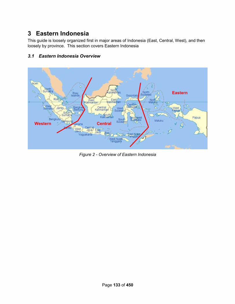
Page 133 of 450
3 Eastern Indonesia This guide is loosely organized first in major areas of Indonesia (East, Central, West), and then
loosely by province. This section covers Eastern Indonesia
3.1 Eastern Indonesia Overview
Figure 2 - Overview of Eastern Indonesia
Eastern
Central Western

Page 134 of 450
Davao
Sangihe
Talaud
Figure 3 - Routes Through Eastern Indonesia from SE Asia Pilot

Page 135 of 450
3.2 Between Southern Philippines and Northern Sulawesi Islands
See green line on the chartlet above.
Lorelei – September 2014: Monday morning we left Port Patuco (Sarangani Islands,
Philippines) at 6am to scores of people waving frantically from their houses along the water’s
edge.
With only a little wind we motor-sailed for 50nm down to 2 small islands joined by a shoaling
reef. It was very open but just fine in the calm conditions. The water was so blue and we could
see the anchor and chain clearly on the bottom in 22m of water.
Catamini – July 2013:
- Balut Isl to East Kawio - morning 15kt wind SW; calm anchorage N04.40'018/E125.26'393 in
7m sand/coral
- Kawio to NW Sangihe - morning 22kt wind SW; calm anchorage N03.43'336/E125.24'573 in
8m black sand (ed note, In 2014, Sangihe officials were not happy about someone anchoring in
this spot without checking in)
- NW Sangihe to Tahuna Harbour – morning no wind; N03,36'467/E125.29'564 in 22m mud
3.3 North Sulawesi Province
Wikipedia – 2016: There are 5 Nature Tourist Parks and
Animal Sanctuaries in North Sulawesi and all are under
government jurisdiction:
1. Batuputih (Whitestone) Nature Tourist Park is 64 kilometers
from Menado and covers 615 hectares. It has a white sandy
beach and tourists can also see the Celebes crested
macaque (monyet hitam), Spectral tarsier (tangkasi), knobbed
hornbill (burung rangkong) and kingfisher (burung rajaudang).
2. Batuangus Nature Tourist Park is 65 kilometers from Menado or 3 hours drive, but just 45
minutes from Whitestone Nature Tourist Park with 635 hectares area. From the peak of
Batuangus Mount we can see Bitung city.
3. Karakelang Island Animal Sanctuary in Talaud Islands is 15 hours sailing from Menado by
speedboat or ferry and covers 24,669 hectares. The endemic birds are the red-and-blue
lory (sampiri), Talaud kingfisher (rajaudang talaud), Talaud bush-hen (kareo talaud)
and Talaud rail (mandar talaud).
4. Manembo-nembo Animal Sanctuary is 100 kilometers from Menado or 90 minute drive with
5,426 hectares. The location is habitat for knobbed hornbill, kingfisher,white
cockatoo, Celebes crested macaque, Sulawesi dwarf cuscus and Javan rusa.
5. Nantu Animal Sanctuary covers 31,125 hectares and can be reach in a 4-hour drive plus 3
hours by boat. There is a salt lick in a dried pond by Buru babirusa andanoa. The others can
be seen at other areas are Celebes warty pig, spectral tarsier, Heck's macaque, Sulawesi
palm civet, knobbed hornbill and other birds.

Page 136 of 450
3.3.1 Talaud Island (Karakatang)
Soggy Paws – November 2019: After a boisterous ride up from Morotai, we came in in the
strong westerly wind and rain and anchored first just west of our January anchorage. It seemed
like it would be protected but after staying an hour or two there, we decided to move somewhere
with shelter from the 20 knot WSW winds.
It looked like there was a perfect place (from the sat chart) about 2 nm SW of where we were.
But when we checked it out, we found crashing big swell coming in from the opening to the NE
and it was totally untenable. We checked out the coast to the north of where we thought we’d
anchor and found 2 spots that were possible:
03-59.75 N / 126-38.59 in about 45-50 ft
04-00.21 N / 126-38.66 in about 35-40 ft
The second one had a fishing boat anchored in it, and we didn’t feel there was enough swinging
room, plus the village there looked poor and unkempt.
So we went back to the first one, anchoring carefully on the shelf trying to place our anchor just
in from the drop-off, so we could put out enough scope but not hit the shore if we got an
onshore wind. One small house on shore, not sure if it was occupied.
There is tons of current everywhere in the bay, and our anchorage was no exception. By some
miracle the huge swells rolling in did not affect us in this spot. And of course we were well
protected from the westerly winds, and with at least 2 cell towers in sight.
Soggy Paws – January 2019: After a boisterous ride down from Samal, we arrived at mid day
in the rain. Java and Sloepmouche’s anchorages looked too exposed to the swell and very
northy winds, so we carried on around the southern tip of the island, and anchored at 04-00.0N /
126-41.71 E, in about 40 feet. The bottom looked flat on the fishfinder and the anchor came up
with sticky mud and sand. It was a little swelly at times in this spot, from swell coming in from
the east, but better than the windswept spot near the town wharf. We spent about 24 hrs here.
There is a whiff of internet (get your device as high as possible). Probably much better internet
at the town anchorage.
We could see swirls just to the east of us indicating a submerged reef. Be careful if going
further east that close in.
Java 2017: Our favorite stop in Talaud is at Melonguane town, N 03*59.8 / E126*40.61, anchor
in 25ft sand outside of moored pangas off end of wharf past Police boat. The Pasar is 2 blocks
E on main street, 1 block N.
Or you can anchor at Lirung across the bay, but it was too deep for us at 20mts.
Sloepmouche – August 2012: Our first sailing leg was from the marina in Davao, Philippines
to Talaud. We motorsailed with the wind hard on the nose, wind that varied a lot in strength as it
often does in the North Pacific. We dodged the fishing boats in the Mindanao bay and made
good time to Talaud (200nm away).
In Talaud, anchor just outside the nav markers of harbor area in 30ft in coral rubble, very poor
holding on a lee shore in the southerly winds (03-59’91N / 126-40’40E).

Page 137 of 450
The officials had come especially to clear us all into Indonesia for the rally, as Talaud is not a
normal port of entry. We all had our CAIT and a 2-month visa from the Indonesian embassy in
Davao City so we cleared in without problems. We were welcomed warmly with dances, dinner
on the beach on the first day and a lunch on a nearby pretty little island the next day. We were
all sorry to sail away so soon but the festivities in Morotai were to begin soon.
3.3.2 Sanghie (Sangihe) – Port of Entry for Rally Only
Internet is available in the harbor via wifi (paid) and Telkomsel data (in harbor and various spots
along the coast). Sometimes there is a free wifi signal, maybe only with the rally and only close
in.
Soggy Paws – July 2017 – Anchorages on the East Side of Sangihe: Because we knew
how bad Tahuna harbor is in SW winds, we chose this time to stop on the east side of Sangihe.
With S-SW-W winds, the east side is very calm, and there are several places that look like
decent anchorages.
We had Telkomsel 2G internet starting about 5 miles S of Sangihe and pretty much the whole
way up the east coast. It was best in the bay
Soggy Paws – April 2017: We arrived late in the day and only intended to spend the night and
leave early the next morning. So we drove right in near the new dinghy/fishing dock (on the N
side of the harbor), and picked up the first new-looking mooring we saw. We knew there were
some anchoring depths in this part of the harbor, but between the moorings and the new dock,
we couldn’t find anything that was less than 85 ft, and that was on a down-slope. The mooring
was identical to the moorings they had put in for the Rally last year. It looked brand new. Since
the wind was calm and we were only staying for one night, we didn’t worry too much about what
was on the bottom.
But the wind came up to 20kts in the night and we drug the mooring off the narrow shelf.
Fortunately we had the anchor alarm set! It was quite a trip to get unhooked from the
mooring—we ended up having to drag it back up on the shelf, as we couldn’t get the mooring up
far enough to get our expensive clip off the mooring until there was some slack in the line.
Lesson learned: don’t attach anything to a mooring that you wouldn’t want to leave if you
needed to escape.
The guys fishing in their small boats near us (that we only saw AFTER dragging the mooring all
over) must have had fun watching our antics!
By the time we got detached from the mooring it was 4:30am and we just got underway an hour
early…
Soggy Paws – May 2016 (with Rally): The May 2016 Sail Samal 2 Raja Ampat Rally ended
up being only 6 boats. But still we had problems finding suitable moorings for all 6 boats.
Several of the moorings were either occupied with fishing boats or large steel FAD buoys, or too
close to a raft of fishing boats. The last boat ended up on a mooring close to the small ferry
boat location in the NE end of the bay (near the bridge). It was OK for the first day, but the
second day, one of the ferry boats tied a stern line to the mooring. And with the swirly winds
and currents, the cruising boat on that mooring kept getting fouled in the stern line. The ferry
captain refused to drop the line or move. The cruising boat ended up moving to another
mooring.
Page 138 of 450
The new dinghy dock is fabulous. It is located on the north side of the bay, about halfway in.
Just inshore from the dock is a small market selling fish and fruits & veggies. Within a block or
two inland you can find an ATM, a small “mall” with many cell phone stores, a few hardware
stores, and a decent grocery store. There is a dumpster (which was overflowing) just inshore of
the dinghy dock.
The Telkomsel sims we bought worked just fine in my ATT Samsung S3, and in our Huawei wifi
hotspot.
As in past Rallies, we were shuttled around most places, so we didn’t have to use the local
transport, but that is plentiful and inexpensive. The Marina Restaurant is still operating, about
100m east of the dinghy dock, on the waterfront road.
Lorelei – November 2014 – Getting Around
The microlet buses in town are a hoot to catch. They are 3000rp (0.25c) from one end of
Tahuna to the other. Most of the buses have thumping stereo systems and most have around
24 speakers inside including up to 6 x 15” sub-woofers in the back section. They have massive
batteries on the floor in the front area to cope with the enormous sound systems.
Lorelei – November 2014 – Diving in Sangihe
The day after we arrived, we spoke to David who worked at the tourism office and tried to
organise some exploratory diving in other parts of the island.
The following day we loaded up a rental car and travelled over to his family’s village on the
eastern side of the island. We met his uncle (the chief) and got permission to do some diving.
We then linked up with another uncle named Set and his son Jack who are local fisherman and
chartered their boat for the day.
He brought it around to the local wharf and we loaded it up and headed out with perfect weather
conditions.
According to the Chief, no-one had ever scuba dived along the coastline that is within his village
jurisdiction so we were the first and he was very interested to find out what we saw.
The first dive was along a coral wall surrounding a very small island. The viz looked good and
the dive was interesting with scattered coral and lots of big barrel sponges but not jam packed
with coral and fish action.
For lunch we stopped at a nice little beach on the small island.
For the second dive we returned back into the bay and dived on a small coral reef protruding out
from a headland.
The spring tide was flooding in and the viz looked OK but we were a little dubious as the coral
outside was only ok and inside should technically be worse.
When we jumped in we were amazed to find great viz and a fantastic coral garden in the
shallows. The deeper we got the better it was and on the floor at 32m the coral was simply
amazing with stunning soft and hard corals as far as the eye could see. It was pristine and
colourful – and we were the first ever to see it!

Page 139 of 450
Coming back up the wall we had the setting sun in front of us creating some great photo ops in
the shallows.
We were allowed to name the dive site so we called it Tumsu Gardens after the name of Set’s
boat. Tumsu in the Indonesian language roughly translates to “God bless every effort”
The next morning we were up very early to dive a pinnacle in a southern bay 3nm away. The
high tide was at 7:30am and we dived from 7am to 8:30am but were surprised to still find a
moderate current.
The wall was only OK but the shallows were great.
You must see the stunning dive photos of these dives on their blog.
Lorelei – October 2014 – Not With Rally: Finally!!!! We had Sangihe in sight.
From 10nm out the island looked massive with its high active volcano hidden up in the clouds.
As if to welcome us, 2nm out we hear a huge series of booms that sounded like long & loud
thunder. To our amazement we discover it is the volcano as 30 seconds later we could see
dozens of steam vents on the side of the mountain become active. They only lasted a few
minutes and were gone again. WOW!!! The volcano’s last major eruption was in 1963 and over
1800 people perished.
As we transited down the coast we sailed past some amazing coastline.
Underwater was the same and many times the sounder went from 60m down to 300m+ and
back to 60m in the space of only a few hundred meters.
The capital of Sangihe is Tahuna. It has a very deep harbour and is too deep for anchoring so
mooring buoys have been installed for visiting vessels. We picked up a mooring after surveying
a few.
The next morning we were woken at 4am by the Mosque (which is only 150m from Lorelei)
calling all followers to prayer.
We went in to clear with the officials and Paul got grilled over coming in with a yacht rally visa
and being nearly a month later and well after the rally participants had already left.
We expected the worst but 20 minutes later the same guy is laughing and joking with us and
gave us a full 60 days on the visa. So happy as technically he could have backdated the 60
days to the rally start, leaving us with only about 30 days left on that visa.
As we waited for the paperwork to be processed we watch in horror at the live TV coverage of
the Volcano eruption in Northern Sumatra.
And to think we were only talking over breakfast about how excited we were about maybe
visiting the local active volcano here and were planning to be in the erupted volcano’s location in
about 9 months time.
We walked into town and were just blown away at how friendly the people are. Everyone was
waving from bikes, cars, house doorways and shopfronts.
We had been studying the Indonesian language for a few weeks (the Ipad apps are really
helpful) so it was great to put it into practice.
Page 140 of 450
Our first meal had to be one of our favourites – Indonesian Satay Chicken (Sate Ayam). We
pigged out on it with rice, stuffed tofu squares and bottled drinks all for less than A$2.50 each.
Guess we will be eating-out a lot here – we cannot make it for that price.
We stopped at the local markets and had a look at what was available.
For our first scuba dive in Indo and Sangihe, we dived a Japanese WW2 shipwreck which was
located in the harbour.
By fluke rather than good management, the wreck was right next to Lorelei’s mooring. We
simply jumped off the aft swim platform and descend onto the wreck.
We took our cameras complete with new arms, floats, strobes for Paul and port, lens and
modelling light for Lisa. However we have no photos of the wreck!!!
We had heard that the wreck and the black sand around it is teaming with macro life so we set
both cameras up for macro. Of the 300 photos between us, we culled it to 45 before editing
them and picking a final 14 for the blog. The next day we did another dive on the same wreck.
What we found on the wreck in these two dives, that we could photograph well enough to put in
the blog:
Tassled Scorpionfish
Broad Club Cuttlefish
Brownblotch Jawfish spitting out sand from his burrow
Many Toothed Garden Eel (A new variation of Garden Eel for us)
Pygmy Lionfish (A new variation for us and only found in SE Asia)
Squat Shrimp – less than 5mm long
Tassled Scorpionfish
Yellow Barred Jawfish (Only found in Indo, Borneo and The Philippines. A first for us…)
Tassled Scorpionfish
Ringed Pipefish
Lionfish
Nudibranch – Colourful Hypselodoris
Mantis Shrimp
Peacock Mantis Shrimp
Yellow Spotted Anemone Shrimp
Holthuis Anemone Shrimp
Spotted Porcelain Crab
Nudibrach – Swollen Phyllidia -
Yellow Spotted Anemone Shrimp
Spotted Porcelain Crab
Page 141 of 450
Anker’s Whip Coral Shrimp (only 4mm long)
Unusual Radiant Sea Urchin
We orgainised an around island tour by car. We linked up with Nirwan who works at the local
tourism office and he arranged for his friend Armin to drive his small taxi bus for the day.
We were picked up at 8am and got home after 6pm. Firstly we climbed high into the mountains.
The roads were steep with many tight corners and hair pin bends. Sounding the horn at each
corner was a must.
We went to a small mountain village and saw the old king’s house and visited a workshop where
the men were making traditional bamboo furniture.
In the mountains Nutmeg is grown in large quantities and is handpicked. They dry the nutmeg
in the sun and it needs about 4 days so the best place to do it – on the flat hot tarred road of
course…!!
The road back down to the eastern coastline was also steep and tight but the view through the
trees was amazing.
We stopped at one black-sand beach side village for a walk around.
The white sand beaches on the eastern coastline were stunning with small islands offshore,
amazing coral reefs and even a few potential surf breaks.
After lunch we went back into the hills to visit a waterfall. The 20 minute hike up the
watercourse was stunning.
On the way back down we had to re-cross a log over a deep pool with steep vertical rock sides.
Paul had his tripod out with a camera attached (and 2 more cameras and a flash unit in his
backpack.
When he got 4 steps across – disaster – the log broke and Paul was thrown into the water.
Instinctively he thrust the tripod into the air and the camera and lens surprisingly stayed dry. The
backpack was not so lucky. He quickly gave Lisa the camera and backpack and we emptied the
contents to find the backpack soaked. The camera cases inside were a little wet on the outside
but the cameras and flash unit were all dry. Whew!!! Talk about lucky….
The issue though was finding a new way to get down. Fortunately Nirwan had already crossed
and managed to find a new log (although a lot smaller) and held it in place while we scurried
across.
In the afternoon we went to the base of the volcano and had a look at the area of the lost city.
The lost city was the capital of Palau Sangihe that completely disappeared when the tectonic
plates moved violently during the last major eruption, causing the entire town to sink into the
sea. Many lives were lost. The village now rests under the ocean at depths down to as deep as
100m. We had heard about it before as a dive site and Nirwan confirmed this.
During the last eruption the lava cut huge tracks into the land as it made its way to the sea.
They now have become natural watercourses but are deep and filled with black soil and heavy
ash. Road bridges have been constructed to get across them.

Page 142 of 450
There are no roads up to the volcano but you can hike it. It is however a minimum 2 day hike
from the closest car drop-off point.
For our last stop we went up to a lookout. It was so high up and we could only just see Lorelei. It
was late afternoon and the sun was low in the sky lighting up all the west coast. Just amazing!
All in all it was a perfect day. Nirwan is a great guide and Armin a careful and considerate driver.
And the cost for the day all inclusive - $350 000 rupeh or about $30 aus...
2 days later Nirwan wasn’t able to find us a boat to take us up to The Lost City. Instead we
loaded up our RIB with our dive gear and headed north along the western coast of the island to
a location we thought may be The Lost City.
It was a small bay 6nm north of Tahuna and we scuba dived the northern end and wall of the
bay for the morning but no luck in finding the ruins. It was still an interesting dive though.
For our picnic lunch we found a great fresh water stream that was pouring out into the sea on a
black sand beach.
For the second dive we did the southern area and wall. The wall was amazing and obviously
was created from where the tectonic plates had moved.
The topography was made up of perfect terraces all the way to 40m depth.
After the dive we went back to the fresh water stream and washed all our scuba gear, the
cameras and us.
On the way home the setting sun was illuminating the coastline.
What little wind there was had died and the seas glassed off for a perfect run home. The sun
was just setting over the point of the bay as we made it back to Lorelei.
Oh well, we didn’t find the lost city but it was a fantastic day and beaut weather.
Soggy Paws – September 2014 – With Rally:
Harbors – We were only there with the Rally, and during SW Monsoon season. I’m not sure
why, but we still used the SW facing Tahuna Harbor, rather than what looked like a much better
anchorage on the east side of the island. During the SW Monsoon (at least for the two weeks
we were there), every few days they wind and waves pick up and the Tahuna harbor gets pretty
rolly. There is quite a bit of tide-associated current in the harbor, and when the wind/waves are
up and the tide is right, there can be quite a swell in the harbor. It’s not too bad during the day,
when the wind is usually facing you into the swell, but at night when the wind dies and becomes
offshore, you can sometimes get sideways to the swell and it’s awful. I would think this harbor
would be wonderful during the 8-9 months of the year when it’s NOT SW Monsoon season.
There is a really nice bay with a beach directly across from Tahuna on the east side of the
island. We visited this by car. It was lovely on a day when the Tahuna harbor wasn’t.
However, we couldn’t tell, from charts, Google Earth, or visually, whether there is a break in the
reef to get in to that bay. And it’s far from civilization (except on weekends when it is a popular
beach for the locals).
Page 143 of 450
On the NW corner of the island is a spot that our friends on Catamini stopped several times for
a rest up on arrival from the Philippines. Just don’t mention stopping here to the officials when
you arrive in Tahuna.
03 43.336 N / 125 24.573 E
This is reported as 8m, black sand bottom, and can be rolly if the swell is up.
Tahuna Harbor Moorings - We used the rally-supplied moorings that had just been installed.
They looked adequate for normal conditions. The one we saw with our own eyes (#19) had 3
50-gallon drums filled with concrete, tied together (well, it appeared) with one up-line that went
all the way up, and with a swivel on top (however, I would suspect that these nice swivels will
disappear). Someone else told us that the one they checked out only had 2 drums. However,
be leery of #19 because it is up against a wreck and the line could be chafed on the wreck.
Most moorings are in 70-100 feet. Moorings with orange buoys were installed in Aug-Sep 2014.
Moorings with yellow buoys were from 2012 or 2013.
We were moored along the north side of the bay, with the dinghy dock set up for us (specially
for the rally) in about the middle of that seawall. (Just mentioning this because if you anchor
down by the main harbor and use their dock, other places might be more convenient to you than
what we used).
Immigration/Customs - Checking in and out is done at the commercial port in the SE corner of
the bay. Take your dinghy around the long pier (E end) and there's a ladder that comes down.
Ask around, but it would be good to have a few phrases ready. Not many people speak English
(not near as many as in the Philippines).
Internet - Cell internet worked spotty. We had TelKomSel sims (given to us free as part of the
rally). My Samsug S3 worked fine most of the time, but I couldn’t get the hotspot feature to
work (locked out by my phone provider), so I had another sim in a USB stick I brought with me.
This one worked well once and never worked again. It also didn’t work with an Indonesian
“hotspot” device someone else had given me.
It seemed that different people had different successes with USB sticks bought there. The
cheapest sticks maybe only worked with Win XP and/or Win 7. Seemed like the Vodafone
sticks purchased in town worked most consistently—be sure to ask when buying whether it
works with your version of Windows.
But there was a great wifi signal in the harbor. Free (special hotspot set up for us) when we
were there in the rally, but would be worth paying for access if you are there otherwise, if you
can track it down. (note, lots of Telkomsel advice in the upfront section on Communications
now)
Laundry - The rally people took our laundry somewhere. When it came back it had a flyer
attached to it that said Fresh Laundry facebook.com/FLaundry Call 0432-22182 or SMS 0853-
1790-9017. Minimum 2Kg 8,000Rp/Kg but larger items (eg sheets and towels) you pay by item,
so be sure to ask ahead of time. (they had a printed sheet).
ATM - One street inland from the waterfront road (on the north side of the harbor), about a block
east of the road that comes out at the lighthouse, was an ATM. We got a max of 1,125,000 Rp
out--that's about $100 USD. Our debit card was a Mastercard-based card. I don’t think we tried
with a Visa.

Page 144 of 450
Groceries - In the same vicinity (across the street) there is a medium sized grocery store, and
down the street to the west, same side as the ATM, is another larger grocery store. Again, this
is the road that runs east-west one block inland from the N side of the bay.
There are two fresh markets we found in that area. One is at the corner of the waterfront road
near the lighthouse, and the other bigger one is east along the one-block-in road about a block
or two from the grocery stores. This is a huge multi-building town market.
Things to Do – The rally took us on several expeditions—one on a boat to the southern end of
the island (you could probably go there yourself in your own boat). Another expedition was to a
nearby waterfall, and the beach across the island from Tahuna harbor.
Thank You - Terima Kasih
Nasi Goreng - Fried Rice
Cap Cae (pron Chop Chai) - Chop Suey
Brigadoon – June 2014 – Not with a Rally: Checked in with Immigration, and coast guard.
Told Customs not necessary, so accepted that. Got Port clearance from Coast guard. All
straight forward. No boat inspections. For fuel, need a permit can call Mrs Ice (Itchie) 0852 561
14172, from Tourist Board, and she will organise. Was only 5500 IDR per liter when we got it.
But you to need to organise transport, ask her for any suggestions.
Supermarket- well stocked. Telekom outlet. Internet, phone, fresh produce basic. Not great
locations for landing dinghy if tide too low then hard to get up to wall or jetty, and if swell then
wall not so great. We used jetty by harbour master for loading fuel, and wall for doing the
shopping.
Our Odyssey – Jun 2014: We anchored in 20m at head of bay opposite 'Blue Mosque'
Dinghy Landing - we went around behind the concrete dock into a creek where the Police
boats were tied up. We used a piece of brown sand beach just near the police boats.
Walk up to the road near the small bridge and catch any small blue van that passes. 3000RP
per person for a trip anywhere within the town. Turn LEFT to go into town; turn right, go over the
bridge and then turn hard right again, through the Archway to get Immigration, Port Master etc,
etc.
Laundry - a good laundry just up the road on the way into town, it is in easy walking distance
from dinghy landing.
ATM - we had some difficulty as we have Visa debit cards, however we found a MANDARI ATM
at the large supermarket in the centre of town.
SIM cards are available at MMS just up the road from the supermarket.
Diesel – You have to obtain a letter from the Tourist Office
Tourist Office - we contacted Mrs. ICE ( pronounce Itchie) who was extremely helpful. Her
number is 0852 5611 4172
Catamini – July 2013:
We anchored in two places in Sangihe:
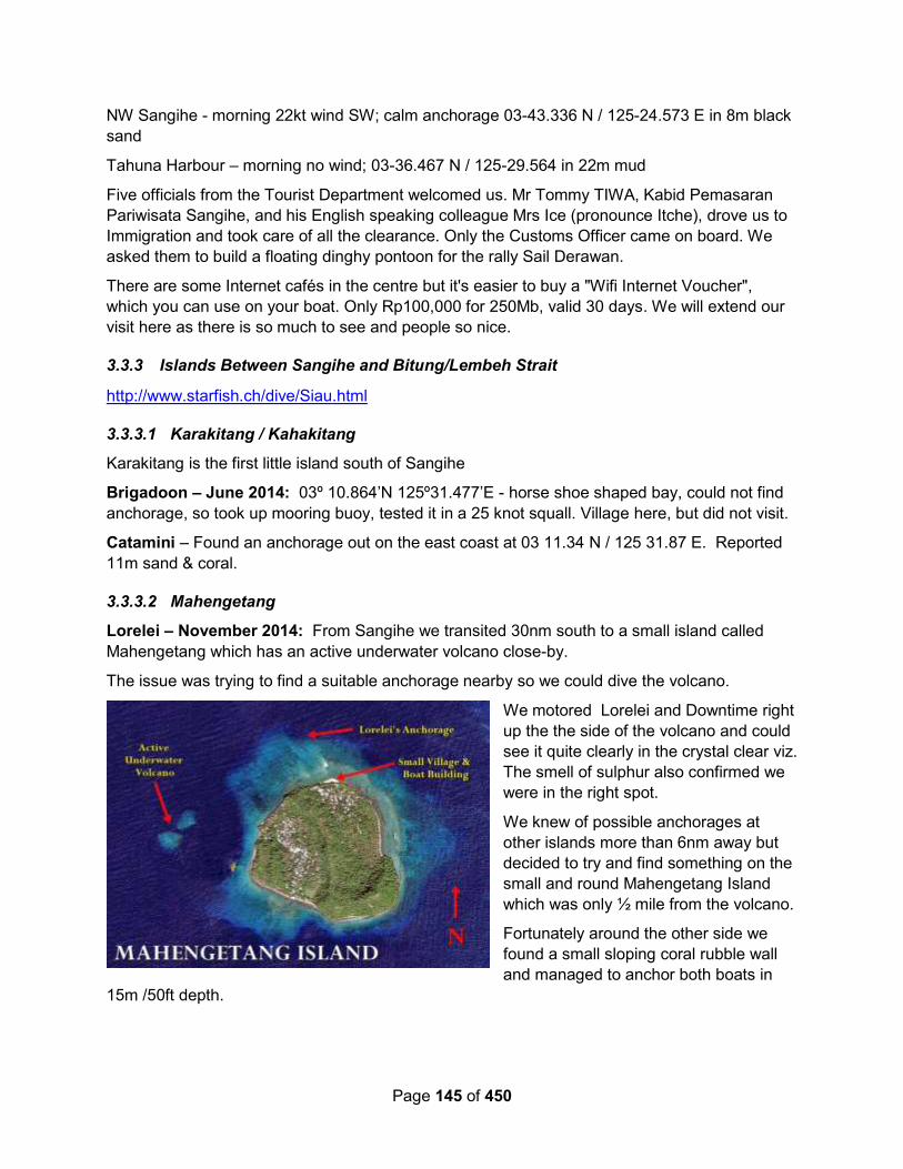
Page 145 of 450
NW Sangihe - morning 22kt wind SW; calm anchorage 03-43.336 N / 125-24.573 E in 8m black
sand
Tahuna Harbour – morning no wind; 03-36.467 N / 125-29.564 in 22m mud
Five officials from the Tourist Department welcomed us. Mr Tommy TIWA, Kabid Pemasaran
Pariwisata Sangihe, and his English speaking colleague Mrs Ice (pronounce Itche), drove us to
Immigration and took care of all the clearance. Only the Customs Officer came on board. We
asked them to build a floating dinghy pontoon for the rally Sail Derawan.
There are some Internet cafés in the centre but it's easier to buy a "Wifi Internet Voucher",
which you can use on your boat. Only Rp100,000 for 250Mb, valid 30 days. We will extend our
visit here as there is so much to see and people so nice.
3.3.3 Islands Between Sangihe and Bitung/Lembeh Strait
http://www.starfish.ch/dive/Siau.html
3.3.3.1 Karakitang / Kahakitang
Karakitang is the first little island south of Sangihe
Brigadoon – June 2014: 03º 10.864’N 125º31.477’E - horse shoe shaped bay, could not find
anchorage, so took up mooring buoy, tested it in a 25 knot squall. Village here, but did not visit.
Catamini – Found an anchorage out on the east coast at 03 11.34 N / 125 31.87 E. Reported
11m sand & coral.
3.3.3.2 Mahengetang
Lorelei – November 2014: From Sangihe we transited 30nm south to a small island called
Mahengetang which has an active underwater volcano close-by.
The issue was trying to find a suitable anchorage nearby so we could dive the volcano.
We motored Lorelei and Downtime right
up the the side of the volcano and could
see it quite clearly in the crystal clear viz.
The smell of sulphur also confirmed we
were in the right spot.
We knew of possible anchorages at
other islands more than 6nm away but
decided to try and find something on the
small and round Mahengetang Island
which was only ½ mile from the volcano.
Fortunately around the other side we
found a small sloping coral rubble wall
and managed to anchor both boats in
15m /50ft depth.
Page 146 of 450
After lunch we went ashore to meet the local people and ask permission to dive the volcano.
They spoke no English but we got the message across in our broken Indonesian. We also had
a look around the village and a large boat the local men were building.
With a 4pm high tide, we dived the volcano late arvo.
At 3:30pm the current on top was still flying across the crater top.
It was a mission to swim over the crater and down the wall but once we were below 12m it was
fine. The coral and fish life were immense and the water crystal clear. The topography was
also just awesome.
During the dive we could hear the occasional small rumble or boom but at the end as we were
under the Rib and doing our safety stop, we heard and felt a huge boom. The noise and
pressure wave went right though us.
We were a little concerned for the cameras and what impact it would have on the electronics
and housings but they appear to be fine.
On the low tide the next morning we dived it again but this time the current was going in the
opposite direction which allowed us to dive the other side.
It was awesome with loads of coral, sharks and fish life both big and small.
After the dive we snorkelled all around the crater looking for sulphur gas vents (which were
reported to be seen during a 2011 exploratory dive expedition) but we did not see any.
It was also interesting to note that we found 2 pinnacles on the craters edge that break the
surface. In 2011 they were reported to be at a depth of 5m/17ft underwater.
3.3.3.3 Pulau Siau & Karangetang Active Volcano
Soggy Paws – April 2017: While sailing these waters down from the Philippines in the NE
winds makes for better sailing, all the anchorages previously listed in the summer and fall
months are good for SW winds, not NE winds! Unfortunately, we arrived a near sunset and
didn’t have time to see if the anchorages near the volcano would be tenable in NE winds. The
only place we could see on the chart that would be protected would be west of the two islands
at the SE corner of Siau.
We could see several fishing boats “anchored” in the bight between the two islands on Google
Earth. Much to our dismay when we arrived with the sun setting to find all these boats were on
moorings over 100 ft deep!
There is a big pier between the two islands not shown on our GE chart. We eased up to that
and asked where we could anchor. With hand gestures they offered us the pier, but it was a big
concrete pier with reversing current and a big tidal range—not for a yacht (at least not for ours!).
Then they gestured right off the pier, and that’s where we dropped. It was the usual Indonesia
problem of very deep or too shallow and anything in between is likely coral. We ended up
anchoring in about 65 ft at 02 40.5505 N / 125 27.0933 E. We kept the scope short to keep us
from swinging into the dock or the inshore reef. Wasn’t a comfortable night as I was up several
times checking on our position. The wind which was nearly calm when we anchored came up
out of the east about 20 knots during the night. And the current switched, swinging us toward
shore, over the shallower water. Our outer hull showed 25 ft—no telling what the inner hull

Page 147 of 450
showed. Changing the rudders pulled us back out a little bit further and we were OK. It was
high tide and with our 3’ draft we could have floated right over the reef, so I needn’t have
worried (but I still did!). We left at sunrise to go all the way to Bitung.
Seemed like a typical friendly fishing town, would have been fun to explore a little, as I bet they
don’t get very many sailboats in there.
Mystic Rhythms – Oct 2015: We stopped at several islands on the way from Sangihe to
Lembeh, but none were that amazing for diving and many were bouncy anchorages. The best
stop was Siau island with an active volcano! Yes at night you could have a beer watching lava
flows and hear the occasional whoosh as the volcano vented.
The diving did improve the farther south we went and the number of FADs rose dramatically. A
FAD is the technical name is Fish Attraction Device. The reality is some sort of floating
crap anchored by a tiny rope out in the middle of nowhere in very deep water. Some are long
metal tubes about the diameter of a 55 gallon oil drum and 20 or so feet long, others are just
rafts, some are small huts, and the most elaborate ones we saw were like 2 story houses! Few
are lighted up, most are almost impossible to spot, and they can all do major damage to your
boat. If that is not enough, throw in trash, big trees, small limbs, etc and navigation here is
always done in day hops, if possible, with someone of the deck at all times.
Lorelei – Nov 2014: With no wind, we motored down to Palau Siau which was a 30nm run. On
the way we passed many smaller but mountainous islands.
From 15nm out we could start seeing the huge shape of Siau and the Karangetang Volcano.
When we got closer (around 7:30am) we saw plumes of smoke bellowing out of the crater.
By 8:30am it was getting hot and the clouds had started to form around the 1800m high peak.
As we transited down the eastern side we searched in the bays for a suitable anchorage but
they were all too deep and mostly over 50m/175ft deep within 30m of the rocky shoreline.
We were amazed to find a second mountain and caldera to the south behind Karangetang. It
too had so amazing cloud formations around its peak. Looking up the hill side we could see
huge lava flows from recent eruptions.
It is a very active volcano and from 1980 to 1988 it was in a state of continual eruption. In 1992
there was a major eruption and one of the worst in the recorded history of the volcano. Since
then it has erupted over a dozen times with a large one in 2009 when 6 people died, another in
2013 and even a mild one in August 2014 – only 3 months prior.

Page 148 of 450
We finally found a shallow 20m/65ft
section just off the main town called
Ulu.
The view from Lorelei looking up to
the volcano was just awesome.
A short time later Downtime had
also arrived and 1 hour after that a
Police launch pulled up and the
officials came onboard both boats.
They were super friendly and the
police chief just loved Lisa.
With the paperwork all in order they
helped with some information for
dive locations and a possible guide
up to the crater’s edge if we wanted
to tackle the 12+ hour hike.
They get very few tourists and only
1 or 2 visiting yachts a year so we
were certainly celebrities.
Over on Downtime, Pete also got
close for many photos with the
officials but interestingly, they were
a bit wary of Deb with her frizzy red hair, pale skin and freckles. The 4 of us had a bit of a giggle
about it later on.
With the sunrise illuminating the entire face above Lorelei we were able to see it with much
better detail, particularly all the lava flows and burnt tracts of land from recent eruptions. Wow!!
Exploring Siau: We linked up with Dominik (who was with the boarding party the day before)
and he took us for a walk around town and was very helpful with a lot of information and gave
some assistance with the language as very few people spoke English.
On the way we dropped into a local primary school which turned into an hour of great fun. We
visited classes and talked to the kids about our travels. They were very interested and Paul
organised to return early next week with a slideshow of photos from our diving and in particular
the underwater volcano.
In Siau the public transport buses are very different from the blue microlet buses on Sangihe
with the side doors. These were more like Filipino Jeepnee’s with the open rear area and bench
seating. But like Sangihe they have thumping stereo systems. Indonesians are soccer/football
mad and most of the buses have a theme based around their favourite European club.
Whilst the buses where really fancy, the gas stations were not. Buying gasoline/fuel in
Indonesia is an unusual set-up. Indonesians can line up for many hours at the main gas station
to fill cars or jerry cans at a government assisted subsidised price of around 0.60c. If you don’t
want the wait you can simply pull up to one of the scores of people selling fuel in 1 litre coke
Page 149 of 450
bottles for around $1.00 each. It’s certainly an unusual system and unfortunately foreigners
cannot buy bulk fuel at the gas station. Buying 6 or 8 one litre bottles is certainly not logical
when refuelling a large vessel and therein lies the yachties refuelling dilemma.
Lorelei – Nov 2014 - Diving Siau: When we spoke to Dom about diving he recommended a
local named Harry and that evening they came out to our boat to discuss diving options.
Harry is one of the nicest people you could wish to meet. He is an ex Lembeh dive guide and
fantastic at spotting unusual things, particularly the macro stuff. He is also a past national water
ski champion and his daughters are current national wakeboard champions. We arranged to do
some diving with Harry over the next few days.
For the first dive we did a muck dive in the Harbour with Harry and his younger protégé Carol.
We were blown away at how good the macro life was with the highlights being a family of Giant
Frogfish and Ornate Ghost Pipefish.
For a day expedition we loaded all our dive gear into a bus and went to the other side to the
island to a Town called Ondong Chity.
On the way over to the other side we stopped to have a look at some of the mud slides and
devastation caused by past volcano eruptions.
Harry had arranged an awesome boat to charter and we went out for a great days diving.
First dive was the well known Eddy Point which has amazing coral and a wreck in 32-45m on
sand just out from the point. The wreck is covered in coral both inside and out.
On the way back up from the wreck we swam towards the point which had fantastic coral. We
drifted along the wall that was interspaced with black sand giving Lisa great macro photo
options too.
For the second dive we did an amazing wall dive with stunning coral and lots of fish in the
shallows at the end.
We finished the dive right near a volcanic hot spring and went up for a swim.
It was scalding (boiling) hot in the shallows and we had to be careful not to get burnt.
In the late arvo we had a look around the islands Government district which is very well laid out.
The offices are all centred around a statue of the main local produce crop – Nutmeg. We had
many people come out to say hello and invite us to see their office.
Lorelei – November 2014 - Climbing the Karengetang Volcano: After discussing the climb
with Dom, Lisa and Pete decided not to do the climb but Paul and Deb were keen.
It was not as simple as just heading on up. The day before (while we were out diving), Dom
went to the Volcanologist office to ask permission to go up and to register the route, persons,
etc… He was given clearance to 1000m only on the eastern face but had to phone the next
morning if we reached that level and wanted to continue to 1300m. Even though the peak is at
1800m, due to its recent activity, people are not permitted higher than 1300m.
It would be near impossible to climb 1800 vertical meters on that terrain in a single day anyway.
Page 150 of 450
By 4am we were on motorbikes and winding our way up into the hills and at 4:30am we had
started walking up though the rainforest by torchlight. With us was Kiki, Dom’s good friend and
fellow mountain guide.
By the time the sun had risen we were already well up a lava flow and past 500m. By 9:30am
the sun was beaming straight onto the east face and we were completely soaked with sweat
and doing it tough as we walked up over the unstable rocks of the lava flow. It was very tough
and slow going. The view however was just awesome!
At 850m we started to get clouds roll in. It was just amazing watch them roll up the lava flow
towards us and totally engulf us. With it came the colder temperatures which helped to cool us a
little. We reached 1000m by 10:30 but it was mostly cloudy with rain patches and only the
occasional clear patch to see the peak.
We tried to push a bit further but the cloud was very thick limiting visibility and time was against
us.
Descending was a mission!!! We all had burning thigh muscles and with many loose rocks, we
all had a few falls. At 2/3rd’s the way down Deb was very fatigued and down to ¼ speed on the
rocks, having to stop every few minutes for a rest.
At that rate we risked not getting off the mountain before dark so Dom made the decision to use
an alternate route and exit the lava flow and continue down though the rain forest. Even though
it was a lot faster, it was very slippery and we all fell at least once.
We got back to Ulu at around dusk and just in time to meet Pete and Lisa before the 6 or us
headed to the local Chinese Restaurant for dinner.
Paul had taken 5 litres of water with him and consumed the lot. His top end Kathmandu hiking
shoes left in perfect order and returned trashed. His legs were not much better.
All in all though it was an incredible experience but very challenging and certainly Paul’s
toughest ever one day hike.
For the next 4 days his body slowly recovered but his leg muscles were very fatigued and he
found it difficult to walk for 3 days afterwards.
Presentation to the Regent: On our last full day at Siau we arranged to go back to the school
and give a small presentation about the local diving and what we saw.
They had removed a wall to link 2 classrooms so the whole school could cram in. There was
also a projector and mic set up ready to go and both the students and teachers were really
excited.
For an hour we talked about our travels, the local diving and Paul’s volcano hike the day before.
There were also some other adults watching too and soon the word was spreading like wildfire
across the island about our presentation and photos.
1 hour later we are at the local markets when Dom arrives to tell us a car has been sent to pick
us up and we have a noon appointment with The Regent, Mr Toni Supit. (The title “The Regent”
would be similar to Mayor or President, etc..)
Lisa explained we were only in casual clothes and the presentation was designed for 10 year
old children, not someone of Toni’s position but it didn’t seem to matter. So we were ushered to

Page 151 of 450
the Government Building and went through all the normal signing in and security checks before
the audience with The Regent.
It turns out Toni studied in Australia and had an interest in boating. We showed him the
underwater photos and explained how incredible and somewhat unique the diving was and he
was just amazed.
The area is trying to promote a 2015 festival with lots of activities including an underwater
photography competition and our photos certainly helped Toni and his team understand the
value of their diving locations.
Before leaving we were presented with a fantastic new book on diving in Indonesia by Eddy who
is the head of the Coast Guard.
The Tarsiers: The last thing Lisa really wanted to do on Siau was try to see a Siau Tarsier
which is a small marsupial which has evolved into a separate species due to its isolation on
Siau island.
Dom had arranged this for 4pm that evening. When many people at the government found out
they said they may meet us there as it would be fun. You sit quietly in a designated area and
slowly they build confidence and come up to you. Wow sounds great we thought. We had
images in our head of the scene but they were far from reality…
At 4pm we are in a bus heading up a tough winding road that made us car sick.
From there we hiked (with Paul barely able to walk….) along a slippery track with failing light
and lots of bugs until we stopped mid track.
The guide starts to look, sees one and proceeds to bush bash into the dense undergrowth to
follow it. After a while we are encouraged to follow but it is wet, slippery and steep.
Eventually we saw one in the branches above but only with our strong dive lights and
photography just wasn’t possible.
Dom is hoping one day to make a decent path and clearing with seating for a better experience.
So our best photo of the cute little critters came from Mr. Google.
We sailed out of Siau at 6am the next morning with Downtime after an amazing 1 week there. It
was a fantastic week if not a little full-on with activities. The diving is just amazing and the
volcano is an incredible spectacle, even from sea level.
We highly recommend the place and they have already started the new waterfront plaza and
hotel complex and the airport is due for 2019 completion.
We envisage that this place will soon become one of scuba diving’s new hot spots when the
word gets out. With it being only a 5 hours high speed boat ride from Menado, we can see in
future divers spending time at world famous Lembeh/Menado dive resorts and then having a
few days or a week in Siau.
Dominik is an excellent go-to person in the area for tourism and speaks very good English and a
little French. Harry has an excellent little dive business with stacks of tanks, complete scuba
sets for hire, great boats available from both sides of the island and his guiding is first rate.
Highly recommended!!
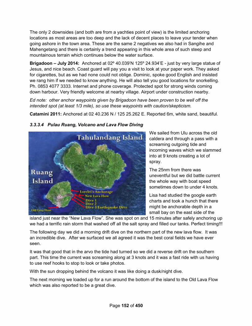
Page 152 of 450
The only 2 downsides (and both are from a yachties point of view) is the limited anchoring
locations as most areas are too deep and the lack of decent places to leave your tender when
going ashore in the town area. These are the same 2 negatives we also had in Sangihe and
Mahengetang and there is certainly a trend appearing in this whole area of such steep and
mountainous terrain which continues below the water surface.
Brigadoon – July 2014: Anchored at 02º 40.039’N 125º 24.934’E - just by very large statue of
Jesus, and nice beach. Coast guard will pay you a visit to look at your paper work. They asked
for cigarettes, but as we had none could not oblige. Dominic, spoke good English and insisted
we rang him if we needed to know anything. He will also tell you good locations for snorkelling.
Ph. 0853 4077 3333. Internet and phone coverage. Protected spot for strong winds coming
down harbour. Very friendly welcome at nearby village. Airport under construction nearby.
Ed note: other anchor waypoints given by Brigadoon have been proven to be well off the
intended spot (at least 1/3 mile), so use these waypoints with caution/skepticism.
Catamini 2011: Anchored at 02 40.236 N / 125 25.262 E. Reported 6m, white sand, beautiful.
3.3.3.4 Pulau Ruang, Volcano and Lava Flow Diving
We sailed from Ulu across the old
caldera and through a pass with a
screaming outgoing tide and
incoming waves which we slammed
into at 9 knots creating a lot of
spray.
The 25nm from there was
uneventful but we did battle current
the whole way with boat speed
sometimes down to under 4 knots.
Lisa had studied the google earth
charts and took a hunch that there
might be anchorable depth in a
small bay on the east side of the
island just near the “New Lava Flow”. She was spot on and 15 minutes after safely anchoring up
we had a terrific rain storm that washed off all the salt spray and filled our tanks. Perfect timing!!!
The following day we did a morning drift dive on the northern part of the new lava flow. It was
an incredible dive. After we surfaced we all agreed it was the best coral fields we have ever
seen.
It was that good that in the arvo the tide had turned so we did a reverse drift on the southern
part. This time the current was screaming along at 3 knots and it was a fast ride with us having
to use reef hooks to stop to look or take photos.
With the sun dropping behind the volcano it was like doing a dusk/night dive.
The next morning we loaded up for a run around the bottom of the island to the Old Lava Flow
which was also reported to be a great dive.
Page 153 of 450
We checked many spots along the face of the flow but found that underwater was just the same
as above – bare rocks interspaced with black sand and no coral. We just could not believe the
difference in the 2 locations. So we aborted and went back for dive 3 on the new one and did
the southern end as a drift back to the north.
There was a lot of quality coral on the black sand which made for great photos.
At the 20 minute mark, the 3 of us were at 24m/80ft depth when we hear this heavy thumping
sound that sounded like a large ship approaching. Within seconds it was super heavy thumping
and just too much to bear. We were holding our hands over our ears to try and stop the
pressure that was killing our ear drums.
We looked up to find the whole reef wall shaking violently! We were experiencing an
earthquake – and a BIG one! It was so bad we could not even focus on the reef and seconds
later the wall began to break up. The 3 large sponges Paul was photographing toppled and
landed on him and Pete was over near a rockier part and had huge rocks (some nearly as big
as cars) rolling down towards him.
We quickly swam out off the wall away from the carnage. Paul managed to snap a few quick
shots before the sand completely silted everything up and we were in an underwater sand
storm.
When the main quake passed, we ascended with Lisa and Pete staying together at 10m and
Paul making a rush for the surface.
A quick scan showed the volcano above had not erupted and both RIB’s appeared to be still
afloat and anchored. Fortunately it was a glassy flat day and he drifted for a few minutes
scanning the horizon making sure there was no tsunami which was our worst fear.
The rocks on the lava flow near the water’s edge had sand running off the side of them which
was a good indication that they had all moved violently too.
We were still a long way from the second RIB so all we could do was go to 10m/33ft depth, stick
close and drift to the waiting RIB. On the way we had 4 more small tremors but nothing like the
initial quake.
Back at the yachts we were all pretty shaken up. We had arvo plans but decided to cancel and
stay with the yacht and got ready to sail, just in case anything else happened.
We actually witnessed some small landslides on the water’s edge where the sand became
unstable and collapsed.
A few hours later a boat load of locals came past and whilst they didn’t speak English we gave
them some shaking signs and they all gave signs back that certainly indicated they had
experienced it too.
It really rattled us. At Mahengetang when we felt the volcano booming and rumbling underwater
we thought it was pretty freaky but at no time did we feel unsafe. This was completely different
and we never want to experience anything like that again.
With no phone reception and no internet we could not check to see if it was widespread or not.
After a bit of a restless night we were up at 6am and decided to move on with a 35nm final push
to reach the northern islands of Sulawesi.
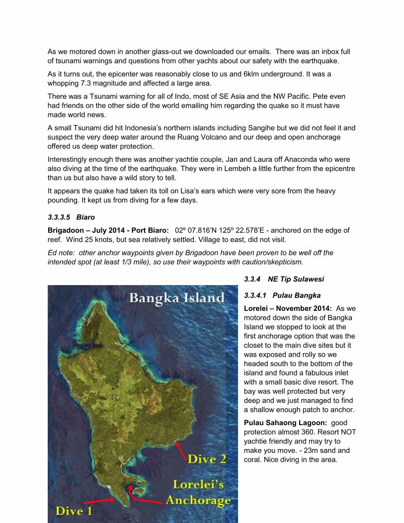
Page 154 of 450
As we motored down in another glass-out we downloaded our emails. There was an inbox full
of tsunami warnings and questions from other yachts about our safety with the earthquake.
As it turns out, the epicenter was reasonably close to us and 6klm underground. It was a
whopping 7.3 magnitude and affected a large area.
There was a Tsunami warning for all of Indo, most of SE Asia and the NW Pacific. Pete even
had friends on the other side of the world emailing him regarding the quake so it must have
made world news.
A small Tsunami did hit Indonesia’s northern islands including Sangihe but we did not feel it and
suspect the very deep water around the Ruang Volcano and our deep and open anchorage
offered us deep water protection.
Interestingly enough there was another yachtie couple, Jan and Laura off Anaconda who were
also diving at the time of the earthquake. They were in Lembeh a little further from the epicentre
than us but also have a wild story to tell.
It appears the quake had taken its toll on Lisa’s ears which were very sore from the heavy
pounding. It kept us from diving for a few days.
3.3.3.5 Biaro
Brigadoon – July 2014 - Port Biaro: 02º 07.816’N 125º 22.578’E - anchored on the edge of
reef. Wind 25 knots, but sea relatively settled. Village to east, did not visit.
Ed note: other anchor waypoints given by Brigadoon have been proven to be well off the
intended spot (at least 1/3 mile), so use their waypoints with caution/skepticism.
3.3.4 NE Tip Sulawesi
3.3.4.1 Pulau Bangka
Lorelei – November 2014: As we
motored down the side of Bangka
Island we stopped to look at the
first anchorage option that was the
closet to the main dive sites but it
was exposed and rolly so we
headed south to the bottom of the
island and found a fabulous inlet
with a small basic dive resort. The
bay was well protected but very
deep and we just managed to find
a shallow enough patch to anchor.
Pulau Sahaong Lagoon: good
protection almost 360. Resort NOT
yachtie friendly and may try to
make you move. - 23m sand and
coral. Nice diving in the area.
Page 155 of 450
Anchorage: 01 44.8439 N / 125 09.1746 E
Ten minutes later a boat from the resort comes out and says we must move as a huge cruise
ship is arriving in a few hours and will be picking up the mooring also in the bay.
It looked a long way from us but we assumed it must be a very big ship and moved to the other
end of the bay even though it was right on the anchoring depth limit, more exposed and very
close to the reef edge.
The next day in the arvo the wind got up and pushed us dangerously close to the reef (only a
few meters away…) so we had no option but to move again.
So we went to another part of the bay but the resort staff were running up and down the beach
screaming at us saying we are now in the entrance path for the big ship. We were nowhere near
the deep water channel but we moved anyway and went up into the bay but this time a long way
from the mooring.
Out comes the resort staff telling us we are still too close to the mooring for the super cruise
ship that will be arriving in less than 1 hour.
We were miles away but still moved again having no choice but the new location put us too
close for comfort to the reef edge just to make the resort happy.
The next morning we wake up to find the ship on the mooring. It was about a 65ft old timber
fishing boat converted to a dive live aboard. We were really pissed. The thing was not much
bigger than Lorelei, smaller than Downtime and they had us giving enough room for the Titanic
to do 360’s. We are conservative and still could have anchored 6 boats between us and the
boat.
At least the diving was good and for the first dive we did a fast drift down an outer wall.
It was completely different than anything we have dived in Indo and just like diving the Ribbon
Reefs back home.
The terrain looked identical to Challenger Bay (a popular spot Paul used to guide at whilst on
SOF) and we started to look in areas we knew the unusual things would be.
Sure enough 5 minutes into the dive we found a Black/Red Leafy Scorpionfish and a few
minutes later an Orang-utan Crab – a first for us.
With the super dive liveaboard now in, there were alot of dive boats running from it and the 2
nearby resorts. Great we thought – well just follow them as they must know where all the top
spots are. So we head out around the corner to find most of the boats dropping divers around a
series of exposed rocks out from a point.
We had a look but found the surface was choppy, the water green, the viz crap, the rocks bare
of coral and colour and more plastic & junk in the water than the garbage tip.
We checked 4 different spots around the area and all were the same. We couldn’t believe they
were putting paying guests into such crap conditions. So we headed 2nm north to an area we
thought looked much better – and it was. We saw adult and juvenile Ribbon Eels and more
Orang-utan Crabs amongst other unusual things.
Even though we wanted to do more diving in the area we decided to move further south to
Lembeh Straights. A combination of the Super Liveaboard giving us a marginal anchorage, too

Page 156 of 450
many divers in the area, onshore winds on the dive sites making it choppy, and an upcoming
crew change, decided the matter for us.
3.3.4.2 Petimati Bay
Petimati Bay is on the very NE tip of Sulawesi. It faces north, so would not be a good choice in
NE Monsoon season, but would be a nice place in the SW Monsoon.
Soggy Paws – 2016: There are a couple of dive spots from Wannadive.net in this bay.
Water Rat – August 2009 – Petiman Bay: Great Anchorage 1 40.83 N 125 07.23 E
After a couple of great days at the Sedona Resort (south of Manado) it was time to get back
sailing. The weather wasn’t favourable for the dash south so we headed back to the anchorage
just around the corner from Bitung. The nearest village is called Petiman, so we call it Petiman
bay. Sounds fair to me.
The little bay is fantastic, the water is clear, sand white and fringed with palm trees and light
jungle. It even as a pirate cave! No treasure though. We checked! It’s a bit freaky navigating into
the bay as the electronic charts put you about a km inland!!! Not good for confidence, but the
water is clear and you can see the reefs easily.
Sea of Topaz - Good holding sand, 15 metres. Big bay with a Resort onshore, nice beach and
snorkelling. Off shore wind. 01 40.902 N / 125 09.374 E
3.3.4.3 NE Sulawesi Headland
Brigadoon – July 2014: 1º36.074’N 125º08.959’E - where they make fish aggregating devices.
We were anchored, but another fishing boat came in, and took up mooring buoy quite close by.
Good protection from SE winds.
Ed note: other anchor waypoints given by Brigadoon have been proven to be well off the
intended spot (at least 1/3 mile), so use their waypoints with caution/skepticism.
3.3.5 NW Tip Sulawesi
3.3.5.1 Bunaken (Park, West Coast)
unaken park is a set of islands NNW of Manado.
Soggy Paws – April 2017: We checked in to Indonesia at Bitung, and because we’re on a
schedule to get down to Triton Bay (way SE end of Indonesia) before the SE trades set in, we
opted to dive Bunaken as an overland trip from Lembeh/Bitung, rather than taking the boat
around. Bastianos Lembeh organized everything for us (and it was correspondingly expensive).
While we were diving, I didn’t see much in the way of available, yacht-quality mooring buoys (I
think the buoys mentioned by Brigadoon were put in for a rally). The walls at Bunaken come up
from 80-90 ft to 2 feet, so anchoring would be difficult (and I’m not sure it’s permitted in the
park). I think if we planned to go try to dive on a budget, we’d anchor in Wori.
Brigadoon – July 2014: lots of mooring buoys, but everything too close to the coral for us. We
drifted with Brigadoon of various patches, and took turns snorkeling. Amazing coral walls, and
Page 157 of 450
water very clear. Very impressive. Another yacht ‘Blue Star’ found a great mooring buoy in the
main bay, round to left of resorts, but don’t have waypoint.
3.3.5.2 Kima Bajo / Gudang (West Coast)
Sirius – 2015: Wori aprox 01-36.51N / 124-51.71E Anchor inside the lagoon. Fits 3 boats
easily. Muck snorkel outside. Good dive resort and very nice restaurant. Very friendly little
village outside the resort doors. Easy to get to Bunaken from here.
Sea of Topaz: Anchored 01 36.1880 N / 124 52.0370 E Soft mud, reasonable holding 20
meters Large bay, we went in as far as we dared and anchored between the two resort jetties.
We had a good meal at “Cocodame Resort”. Mosque very loud.
Gaia – Oct 2013: 001-36.196 N 124-51.974 E
3.3.6 Manado (West Coast)
Brigadoon – July 2014: 01º29.244’N 124º49.885E - we took up mooring buoy, exposed to
swell, not so comfy. Could leave dinghy behind seawall protection with other small craft. Internet
& phone. Offered fuel but didn’t need. Could do boat trip from here to Bunaken. Multimart 3
mins walk away to right, very well stocked supermarket. Big city, friendly people on the streets,
helpful with directions.
Sea Topaz – September 2012: Manado does not have an easy anchorage as the prevailing
wind makes it a lee shore, but we anchored in front of a small harbour. The shore was reached
via a dinghy tow from one the commercial boats, and once there we met Lucky, who appeared
to be the self-appointed yacht services man. He arranged checking-in, diesel, water, laundry
and rubbish disposal, as well as a tour of the Minahasa district. Manado is a big town and there
are good supermarkets and restaurants near the harbour. We left a few days later well
provisioned
3.3.7 Bitung and Lembeh Strait (East Coast) (Port of Entry)
Verite – October 2017 – Haulout in Bitung, Sulawesi: Details for slip in Bitung
Pt. Unggul Sejati Abadi - Dock Yard, Ship Design and Ship Building
Address: Papusungan Bitung
Telephone- +62 (0)43834387
Email - [email protected]
Contact Person for slip - Mr Jhan
085213239723
You can call Mr Jhan Mr Blonde (dyed blonde hair)
The crew to lift the boat were very particular and careful. There were divers in the water,
supervisor on shore, translator, four people on our boat with ropes and radios etc. Greg was in
the water also checking placement of supports (sand bags). They used the wide trolley for us
Page 158 of 450
(8meters) adjustable length. They also have a 7m trolley. Trolley runs on rails. This facility
maybe not suitable for Monohulls.
There are good workers available. Welding, fiberglass etc etc. Good contact base. Company
has insurance for the lift. Yard has reliable nighttime security. We have had the keel refitted with
epoxy resin and fiberglass. Very happy with the result and the service. Timing was as quoted.
Final Cost for lift TBA.
This is still a work in progress so will keep updating as we go.
Back in the water either tomorrow or Saturday.
Will also give you details of the contact here for tourism, Erfina, who has been very helpful. She
helped us find a good diesel mechanic to fix our Volvo engine. Thought it was a blown head
gasket (coolant in the oil, oil in the coolant) but turned out to be a leaking oil cooler. Took the
engine apart, cleaned it, flushed it, put it all back together and all seems good.
Soggy Paws – July 2017 – Bitung Check-Out: We used the taxi driver that we met when we
checked in in April to get fuel. It was basically the same price as hiring a bemo (Rp100K) for a
trip out to the Pertamina place and back to the Artembaga fishing pier. Hamid speaks pretty
good English and can be hired for whatever transportation you need. +62 812-4484-202.
No surprises in the checkout, except the need to justify why we were not leaving Indonesia from
Biak as we had originally planned. We wrote a short explanation so the Customs guy could put
in our file.
We did our checkout with the boat anchored off Bastianos, but because Customs visits the boat
to verify you are leaving with the same stuff you came in with (ie you haven’t sold off your
equipment “duty free” in Indonesia), it would be much easier for everyone to move your boat
down closer to the port for the day.
Also, after the final visit, they will ask you to come back to their office to get (and sign/stamp) the
final piece of paper. Details of our checkout are in the Customs section.
Changing Spots – April 2017: Bitung Check-In
We finally got checked in at Bitung yesterday, and this morning anchored off the point near
Bastianos Dive resort. After a day or two of more things to fix, off to Raja Ampat.
The check in was a lengthy process, but generally pleasant. We hired (an agent?) who was a
great help. The fisheries anchorage was very interesting (for one night, but we spent 2), and
quite convenient. Beware your dinghy after school gets out! But no real damage done.
We had 7 customs people on the boat, and they all had a nice time. We could give them cold
water, with ice, but no alcohol. Regarding the list of equipment on board, my suggestion is to
keep it simple, but make sure that anything interesting and fun is listed. They were fascinated
at the drone.
They wanted to see the "MMSI" and make sure it could transmit, they wanted to see one of the
Diesel engines. They didn't care that I had 2 outboards. They also asked about medicines and
wanted to see medicines and alcohol. But it was a fun visit, with lots of pix taken.
Soggy Paws – March 2017 - Bitung Checkin & Diving Lembeh

Page 159 of 450
Before you leave the Philippines, make sure you have a boat stamp. Customs especially
reminded Dave 4 times yesterday when they were onboard to bring the stamp with him when he
came to the office to collect the final signed, stamped piece of paper that signifies our Customs
clearance (and substitutes for the CAIT). He couldn't find it in his backpack and thought he'd
forgotten it, and he is sure that they would have made him go back to the boat to get it before
they would have issued the paper. On the other hand, not having a proper rubber boat stamp
last year, we used the one we had previously made for the old Soggy Paws, with the wrong
hailing port and wrong registration number, and no one seemed to notice.
If you do not have a boat stamp, we had a nice self-inking one made in Davao, Philippines at
Stamp Haus, a few doors toward the water from the Davao Famous Restaurant, I can't
remember what it cost, but not much.
Here is what we did... not sure it was all exactly what we should have done, but this is it. There
is another boat clearing in today that came directly from Palau who does not have a Social Visa
(no Indo representative in Palau to procure one from). And I don’t think they even input their
stuff in the Yachters site in advance. We will pass on their experiences later.
We had our AIS on, and I am pretty sure we were listening on Channel 16 (which is very quiet
here), when we arrived around 5:30pm. We did not call in though, and no one called us. (The
big ships seem to go around Lembeh Island and approach Bitung from the south, and we came
in from the north, through the strait). Other yachts called Bitung Traffic Control on 16 when they
approached the southern entrance.
We came in the north entrance to Lembeh Strait and went direct to the Serena Besar anchorage
(the little island in the middle of the strait at the north end of Bitung). There is a LOT of trash in
Lembeh strait, including massive plastic accumulations and lots of logs / tree branches, etc.
There are also scattered FADs. At dusk there are tons of fishing boats headed out. Best to try
to time arrival during daylight.
There is space on the south side of Serena Besar in about 50-65 ft for at least 2-3 boats. It is a
decent anchorage except quite a bit of current, and the fishing boats coming and going at all
hours. It is swimmable at the right time of the tide. At the wrong time, the tidal debris is hanging
about and would discourage going in the water. The water is clear enough to see the reefs in
good light.
Dinghy: We went ashore the first day at the Water Police station that is on the mainland coast
just a short dinghy ride almost due west of the Serena Besar anchorage (usually a big boat
labeled Polisi there). We went around the end of the big boat and into the inner harbor, in the
left hand corner there is a ramp, and you could either wheel your dinghy up the ramp, or put a
stern anchor out and tie to shore. The police guys keep an eye on your dinghy. The tidal range
here can be as much as 6 ft, so you need to consider tidal issues. We went in at nearly low
tide, so coming back at high tide, one of us had to wade out to where the dinghies were. Bring
a stern anchor!!
This is a short dinghy ride but a long taxi ride into town.
Transportation: We were told you take a motorcycle (ojek) from there into town and once in
town, the blue mini-vans (bemos) are shared route taxis and go all over. A route taxi costs
between 3000-5000 rupiah in town, and maybe as much as 10000 on a longer haul. We were
told different amounts by different people on the same route, so it's same as in the Philippines,

Page 160 of 450
once you know what it should cost, you try to have exact change and just hand it to the driver
and walk away. That way you avoid the tourist markup.
In our case, however, we were fortunate on our first day to be offered a ride in to Immigration by
one of the policemen. They were all very nice. It is quite a long way, so we gave the driver
(unasked–for) 40,000 rupiah (about $3) for taking the 4 of us quite a long way into town. Later,
we took a bonafide taxi (an English speaking guy hanging around the taxi area outside the port
gate) and he asked us for 100,000 rupiah, but accepted 50,000, for the trip back which included
picking us up at the grocery store and a short stop at a public market for veggies. (note about
13,300 Rupiah per dollar)
Dinghy 2: Later, on our other 2 trips in to finish the formalities, we opted to dinghy into the
Fishing Pier (Perlabuhan Perikanan Aertembaga on Google Maps) (I will give a couple of
lat/longs at the bottom). Here, we put our dinghy in a protected niche in the NW corner of the
harbor, squeezed in between the small fishing boats, again with a stern line out and the bow line
on a big bollard. We asked a couple of the fishermen working on nets nearby if this was OK.
They said they’d keep an eye on it. (We ended up paying one guy when we came back, a
“tip”—had planned on 4,000 but ended up giving him 10,000, less than $1, because we didn’t
have change). This location is a longer, and usually wet, dinghy ride, but much easier with land
transportation.
Transportation: From the fishing harbor, we walked out through the gate, and hung out in the
shade at the intersection until a blue mini bus went by in the right direction (west). The guy took
us to the end point for his route, which is at the corner of Jalan Sam Ratulangi and Jalan Sam
Ratulangi/Jalan Desa Simalong. (this intersection is marked by the Summer Hotel on Maps.me,
but Summer is located in a different place on Google Maps). I will call this intersection, the
"main intersection", and use it as a reference point for the rest of the locations. A lady on the
bus told us it was 4,000 per person. Later going back the other way, someone else told us to
only pay 3,000.
Once at the main intersection, it is about a 5 minute walk west along that Sam Ratulangi street
to Immigration. You could perhaps get your bemo to go the whole way, we saw some going
past us as we walked, but our guy stopped at the main intersection and insisted we get out.
Immigration is on the left hand (south) side of the road. You know you are going in the right
direction if you soon pass a roundabout with an Eiffel Tower-like monument. In this stretch of
street we saw several ATM's and cell phone stores. A Google Map search for Immigration
came up with the correct place. Maps.me unfortunately has streets here but not much on
information. So I recommend you pre-download the Google Map for the area and locate
Immigration (or make your first stop a stop at a cell phone store, so you have a working Google
Maps). I also recommend that you get the Google Translate app, and pre-download the
Indonesian dictionary for offline use, before you leave leave internet for Indonesia. It is
incredibly helpful, because no signs are in English. If you are online you can even point the
camera at a sign or document, from within the app, and it will (usually) translate for you.
Immigration: (Kantor Imigrasi) We went inside, the lady at the Customer Service desk spoke
good English, and told us to sit in the waiting area. About a minute later, we were called up to
the desk, they took our passports and we showed them our visas. We waited about 5-10
minutes in a semi-air conditioned waiting room, and they gave us our passports back with a
stamp in them, on the visa page, with that day’s date. I can’t remember if they asked for a crew
Page 161 of 450
list. No charge. We have 60 days (not 2 months) from that date. They told us clearly to begin
the visa renewal process one week ahead of the end of the 60 days.
Customs: (Kantor Pabean) Walk back to the main intersection and turn right, heading south
toward the water. At the end of that street is a gate area with a sleepy guard. Just inside that
gate, to the left, is the Customs building. (remind me to say something about pre-arrival
notices). Inside, we asked at the desk, and they directed us into an air-conditioned “waiting
area”. This area includes a computer terminal to make adjustments to your Yachters Yacht
Declaration.
The first problem we had was that the printed copy of our declaration had our only crew member
(me) repeated 4 times). Apparently there was a bug in the system that when you edit some
things, each time, it adds a duplicate of the crew member (I am told this is now fixed). At this
point in time, the ONLY way to resolve this, I was told, was to delete the entire “yacht” from the
system, and start with a new “yacht”, and go through the whole process again. There is no
delete capability for the crew lines after a certain point in time. Fortunately the captain’s info is
not deleted, but all the yacht info is (sorry Evan!). What a PITA!! Also, the photos of the yacht
and the registration that I had uploaded were on my laptop, which I didn’t bring. So we agreed
that I would go back to the boat and re-enter the information from my laptop, print a new copy
there, and give them the printed copy when they came out to inspect the boat. This would only
work for you if you had internet aboard, and had a printer.
Ariel IV (a) forgot to bring their printed copy and (b) and somehow there was NO crew on their
crew list, though it had been there when they applied for their Visa! And they had entered the
“Port of Origin” as their original location in Europe, not “Davao”, which had to be corrected.
They got those corrected using the computer at the Customs office (don’t forget to bring your
username and password, or maybe wise to bring your own laptop), and were able to print a
copy for Ariel IV. We signed and stamped the respective printed copies of the Declaration form,
waited a bit (for someone to look them over and make sure they were correct). And then we set
up a time for the Customs inspection onboard. As we were in the office in the morning, they
wanted to come that afternoon. Another boat that went in in the afternoon, had them come the
next morning. They did show up more or less on time.
No charge at all for Customs, or Immigration.
Quarantine: The Quarantine office is in another building down the road toward the water from
Customs. You have to go outside the Customs compound, turn left and down the road and turn
left into the Quarantine compound. This is where you take the MARITIME DECLARATION OF
HEALTH form you downloaded from the last page of your Yachters entry, which we had filled
out, signed, and stamped.
There was a very nice lady in the first office who spoke English. She organized the whole
procedure. Since we did not already have a “green book” (Ship’s Health Book), which we
apparently require in Indonesia, we had to get one of those. (Though Noonsite.com’s updated
regulations says this is no longer required). A few minutes waiting, and the lady brought us to a
wall that had all the charges for Quarantine on it, indicating we had to pay 35,000 for one thing
(our Certificate of Pratique) and $15,000 for the Green Book. (A total of about $4.50 per boat).
After paying that, we waited a few more minutes and were presented with a Certificate of
Pratique stapled inside our new Green Book. No boat visit required (we didn’t ask, they didn’t
mention it).

Page 162 of 450
The very last word the nice lady said to me was “You know that you have to return and get
cleared out of Bitung before you leave for your next port.” (we didn’t know). It’s unknown
whether you can get by without going to Quarantine at all. Had we not asked the question,
nobody would have told us to do it. But you may run into problems down the way somewhere if
you do not have the Certificate of Pratique and a Green Book. I know that in Sorong, clearing
out of Indonesia last year, Quarantine was a mandatory stop in the clearing-out process, and
they did want to see our “Green Book”. Customs would not give us our clearance document
without Quarantine clearance paperwork.
We didn’t ask Quarantine if they would come to the boat…and they never mentioned it. So we
got our paperwork without having to hassle with a visit from a Quarantine officer.
Port Captain: Nobody at Customs or Immigration or Quarantine mentioned the Port Captain.
We should have gone there on check-in, but didn’t. On leaving Bitung, we did “check out” of the
port, and basically did a check-in, check-out at the Port Captain at the same time. (Since we
hadn’t checked out with the Port Captain in Davao, we made a copy of our Customs “Port
Clearance” and gave that to the Port Captain in Bitung, which was accepted without question).
Port Captain is on the main road that runs parallel to the waterfront, about a block back towards
the Fishing Pier from Customs, next to a big mosque.
Customs Inspection: At the end of your visit to Customs ashore, you will negotiate with them
for a time to have them visit your boat. This is absolutely mandatory in Indonesia both arriving
and departing the country. We managed to put them off for a couple of hours so we could shop
a little and get lunch. They came out in their own small launch with 4 or 5 young people (they
were all still in, or just barely out of, Customs school). A couple of them spoke very good
English, and the rest spoke a little. They circled the boat and took a couple of exterior pictures
and then came aboard. They have a detailed checklist for the inspection, and they faithfully
went down the list item by item asking if we have this, and if so, taking a picture of it. There
were at least two guys with cameras (not sure how they split up who took pictures of what).
When asked about liquor, I showed them my 2 cases of beer and 4-5 open liquor bottles, which
they faithfully photographed. When asked about drugs, I showed them our medicine cabinets
and the prescription meds for blood pressure etc, and our prescription antibiotics (these were
already listed in the “do you have drugs aboard” question. They photographed both cabinets.
They wanted engine serial numbers, and they wanted to SEE them (we didn’t actually know
where they were, so that took a little time). I had listed a gas generator on our list of equipment,
they wanted to see that. Dive compressor (wanted to see and photograph). Dive tanks (we had
4 in the cockpit and 2 stowed, they took pics of the 4 in the cockpit). I had listed 2 personal
computers and one nav computer. They took pictures of the Nav station. Finally, the AIS, he
wanted to see the AIS Transmit screen… to prove that our AIS was actually transmitting. I said
“you can see us on MarineTraffic.com, right?” but he still wanted to see the transmit screen on
the AIS, and he took a picture of it. Our Vesper has an AIS Status screen that shows it’s
transmitting. I guess they have gotten wise to the scam of having an AIS receiver only and
using a cell phone app to post your position on AIS.
All in all, they were very pleasant, and professional, and thorough. I offered them some cold
water and was declined. The whole visit took about 30 minutes per boat. After the visit, we
then had to return to Customs the next morning to receive our clearance paperwork, and “make
Page 163 of 450
sure you bring your stamp”. Part of the Customs clearance paper is a half-page list of things the
Captain is agreeing to, and the Captain has to sign and stamp that he agrees to this list.
Cell/Internet: We bought simPati Telkomsel sims with 12GB emblazoned on them for 85000
Rupiah (note, the 12GB is split into several different applications so it's not quite 12GB usable,
but it only costs $6.30). Make sure you download the MyTelkomsel app, it's the best way to
manage "loads" on the device and buy packages, because all the text messages and the sim
card built-in menus are in Indonesian. Best to bring your device with you, so you get the right
sized sim card and get it all activated. You will need to specify when buying whether you want a
phone sim (phone/text only) or phone sim with data. The simPati is a phone sim with data. We
got that one for both phones and for our wifi device. (Note, if you have a PH wifi device and
want to use it here, I suggest you try to get it opened up in downtown Davao vs waiting til you
get here to try to use it--to check whether you need it opened up, just put a different carrier's sim
card in it). All my notes on simPati sims and recharging are in the Cell Phone section in Section
1.
Cash / ATMs: There seem to be ATM’s all over the place. Max withdrawal at the ATMs has
been 1,250,000 Rupiah (about $100) but you can do multiple w/d. ATM’s seemed to be
everywhere. I found Mandiri worked best for me, but Ariel IV also used a different one (BRI, I
think) that didn’t work for me. There is a Mandiri ATM at the big hospital building across the
street from Immigration and back toward the main intersection a block or so. Mandiri sign out
on the street.
Groceries: The largest supermarket that we have found is called Citi Mart (Citirumah Makanart
Swalayan). It is on the road that the Customs gate is on (Jalan Yos Sudarso), about a 5 minute
walk west of the Customs gate, on the north side of the street. They sell beer and some liquor
there. Being well stocked, we didn’t even ask the prices of the liquor. The Bintang beer was
373,200 Rupiah ($28) for a case of 24 330ml bottles. We also saw Heiniken there, probably a
little more. Bintang is pretty good beer. We were able to get it in cans in Sorong for about $2
per can, but I didn’t notice cans there. They had a reasonable array of food, including potatoes
and big onions. Some green veggies (the usual stuff), but I didn’t buy any because we were
planning to stop at a market. Some sliced American cheese. I saw chicken products for sale
(didn’t really look closely at the meat because my freezer is full). Boxed milk. Half of the
building was a department store, and upstairs, a fried chicken restaurant with a menu in English.
There are several other smaller stores we saw in the taxi rides further out of town.
We went by taxi to the small veggie market (on our way back to the boat the first day). Probably
can get there by blue bus, but can’t tell you how. I have a pushpin for it in Maps.me but no real
location I can point to on Google Maps, the road layout doesn’t look identical.. Somewhere in
the general vicinity of Pondok Café Three Putra (search for it on Google Maps) (due NW of the
Fishing Pier, inland, several blocks up and several blocks west).
There is a much bigger market in the town of Girian to the west of Bitung along the coast road.
The blue Bemo’s do go to Girian.
Fuel: We “hired” a bemo near the fishing pier to take us to the Pertamina gas station that sells
un-subsidized fuel—3 guys with about 10 fuel jugs. This is apparently the only station in town
that will sell you (foreigners) fuel. It west of the main area of Bitung on the coast road, about
halfway to Girian. While 1 guy was filling fuel jugs at the pump, the other two took the bemo to
the fresh market nearby in Girian. We paid the bemo driver 100,000 for the whole deal.

Page 164 of 450
Though there are guys that will bring you fuel in their boat, the one cruiser who used a guy in
Bitung ended up with TERRIBLE fuel (frothy emulsified stuff). Fortunately he looked at it before
putting it in his tanks, and refused it. But the guy still wanted payment! Big argument ensued.
So best thing in Indonesia is to do the jug thing into town, or very carefully negotiate ahead of
time with the “boat delivery” dealers, and make them understand that you will refuse anything
that is less than perfect fuel. Like everywhere, most people are very honest, but there are a few
scammers, and as a newcomer, it’s impossible to tell in advance.
There is a fish market nearby the fishing pier—the big blue building. But at 10am there was no
one there selling fish. The next day at 6:30 am there were tons of people buying and selling
fish!
Boat Parts: Right near the “main intersection” is a wonderful store with an amazing array of
boat stuff, including Icom and Garmin products (a few), stainless steel screws, etc etc. This
would be the first stop if you were looking for something. The name of the store Ud Karya
Mentari and it’s on Google Maps in approximately the right place. They will take a credit card
with a surcharge. There are lots of smaller hardware stores on the street going away from the
Fishing Pier. We also saw a big Yamaha sign somewhere when in the taxi.
Pre-Arrival Notification: Before we went ashore the first day, I was re-reading what I could
find on my computer about completing the formalities in Indonesia. The newest Indonesia
Guidebook says something about having your agent do the required pre-arrival notification. So I
emailed Ruth, asking her how a yacht that didn’t have an agent would do the pre-arrival
notification, and whether it was required. Her response was something along the lines of “your
Yachters entry is your pre-arrival notification” but she had also texted Customs in Bitung that we
had arrived. I again asked her if there was an email address to email to, and I never got a
straight answer to that question. So I would make sure your Yachters arrival date is as accurate
as possible. (I guessed right and we actually arrived on the day we said we would). But, if it
were me, I would also try emailing or texting a pre-arrival notification. Here are some email
addresses: [email protected] and [email protected] Cell # +62 0877 5165
6225
Bastianos Anchorages: While anchored at the Serena Besar anchorage, we went over by
dinghy to Bastianos Dive Resort on Lembeh Island and saw that the anchorage area there
would be much cleaner and quieter, plus less current. We talked to the manager (A Swiss guy
named Tomas) and he was welcoming to us. So we moved over there. We had several
waypoints from others, but ended up at 01-26.89N / 125-14.374 This was fairly deep (60-75 ft),
but a much nicer anchorage (if you go further in the bay toward the east, it gets shallower).
We had several dinners ashore at the resort—it has a combination Euro and local cuisine
presented buffet style for Rp150,000. Their bar has a nice overlook to watch the sun go down
and beer and mixed drinks at typical resort prices. We also negotiated a group rate for 6
cruisers to go out diving in Lembeh Strait, and they were happy to come pick us up on the boat.
They have a fairly attractive package dive rate if you make 5 dives with them.
We ultimately left our boat for 3 days in front of Bastianos to go dive Bunaken (the other side of
the N Sulawesi peninsula). The anchor waypoint right in front of Bastianos that Thomas wanted
us to use (so his guards could keep an eye on the boat) is 01-26.79N / 125-14.25E. This was
deep, about 75 ft, but Thomas didn’t want us in any closer/shallower because his “house reef” is
just inshore of that.
Page 165 of 450
Other Anchorages: If you have a small dinghy, or just want to be closer to town, you can
anchor off the fishing pier. One boat we talked to spent a week anchored there with no
problems while the captain went on a visa run. I also noticed that Screensaver went right down
next to the main commercial pier and anchored for the day for clearance out.
Serena Besar anchorage: 01-27.545 / 125-13.862 E
Water Police Dock (approx.): 01 27.58 N / 125 13.30 E
Fishing Pier (approx.) 01 26.84 N / 125 12.57 E
Dinghy Tie Up (northerly sector winds): 01 26.80 N / 125 12.53 E
“Main Intersection” 01 26.66 N / 125 11.43 E
Small Fresh Market Near Fishing Pier: 01 27.00 N / 125 12.00 E
Citimart Supermarket: 01 26.58 N / 125 11.15 E
Sightseeing in the Bitung Area: We met a taxi driver in downtown Bitung that spoke good
English. He offered to take us on a “tour” for Rp1M for the day. There are a number of taxi
drivers hanging about in downtown and around the waterfront areas offering their services. One
boat hired a driver with no English skills for 500,000 pesos for the day. We ended up going with
Hamid, our English-speaking driver. We had scoured the Lonely Planet and Trip Advisor
information and had a few specific places we wanted to see (lakes, mountains, and waterfalls).
Hamid picked us up at the dock at 7am and drove us around all day in a nice car big enough for
4-6 people. We split the tour fee between two boats, and bought Hamid lunch. We thought it
was a good tour for a good value. Hamid can be reached at 0812-4484-202. He has several
businesses, but with a day or two notice could be hired to do pretty much anything you need
(provisioning, driving someone to the airport, etc).
Soggy Paws – 2017 – Diving Bitung/Lembeh Strait: A great resource for divers in N
Sulawesi is this website:
http://www.starfish.ch/dive/info/Manado-info.html
Keep following the linked pages as there is a ton of information about the islands from Sangihe
to Bitung, including Manado.
If you have your own equipment you can dive Lembeh Strait on your own. There are two or
three bays on the north/west side of the strait that have good sand plateaus to anchor in, and
from there, the dive sites are easily within dinghy distance. (Check this one: 01 29.46N / 125
14.25 E). Watch where the dive boats go. In spring 2017, there was an Eco-Divers boat
anchored off the south side of Serena Besar that would fill tanks, so getting fills when anchored
there is easy.
We ultimately opted to dive with Bastianos Dive Resort. They had great guides and we got a
package of dives, so the dives only cost about $35 USD per dive (with our equipment). We got
so much more out of a guided dive than trying to do it on our own out of our dinghy. So many
times our guide pointed out something that looked like harbor trash only to find it’s a rare/weird
fish/invertebrate. We photographed a ton of new-to-us creatures in the 3 days of diving we did
with Bastianos. If you’re new to “muck diving” I’d definitely do at least one dive day with a dive
operation. That said, diving in Lembeh isn’t for everyone. If you’re looking for blue water or
Page 166 of 450
coral, go to Bunaken instead, on the other side of the peninsula. But I’d definitely recommend a
day or two of diving in Lembeh for any diver. The creatures are amazing.
As a 10th Wedding Anniversary present to ourselves, we had Bastianos arrange a visit for us to
dive at Bastianos Bunaken. We got the transfer to and from Bastianos Lembeh to Bastianos
Bunaken, 3 nights in a superior a/c room on the water, all meals, and 7 dives for two of us for
around $1,500 USD. It was a great short getaway for us. Bunaken is the exact opposite of
Lembeh…big coral walls, lots of (small) fish (some big), turtles, etc. We enjoyed diving both
places equally, for different reasons.
Mystic Rhythms – October 2015 – Diving in the Strait: Entering the top of Lembeh expect
many rafts/FADs and if the south winds are pumping expect a wind tunnel effect. We had 35
knot headwinds for the last 5 miles and were happy as heck to get inside the straight and find a
safe spot to anchor.
It was certainly worth the effort. The muck diving in Lembeh Straight just blew us away. Every
dive was strange critters living out on the black sand bottom. Many of these are ugly and seem
straight out of science fiction. Some are way cool like the flamboyant cuttlefish that lights up
when scared or the mimic octopus that changes shapes. We found tons of new nudibranchs
and so far Indonesia seems to be the capitol for this diversity. Heck in one dive we found 6
seahorses. Tons of pipefish including the ornate and robust ghost pipefish. Basically this is the
mecca for an experienced macro diver and we stayed a month. After leaving here we were
back into corals reefs and boy it is hard to find anything with all that coral.
Sirius - 2015: Anchor outside of Bastianos Dive Resort and Restaurant. Jetty and dive shop on
the seashore; the resort and restaurant are up the hill through internal stairs. Excellent dive
leaders, great meals at night.
Anchorage at N1 26.83 E125.14.30 26m – could go in closer, we were the outer boat of 3.
There is a wreck inside the lagoon, avoid.
Lorelei – December 2014: Lorelei did a whole blog post with many pictures and information
about diving in Lembeh Straits.
http://yachtlorelei.blogspot.com/2014/11/episode-31-northern-indonesia-sangihe.html
Water Rat - August 2009 (with a Rally): 01 26.871 N 125 12.606 E
We anchored in 8m of water with good holding amongst the rest of the depleted fleet. The
anchorage varied from 25 m to 3m with significant holes. The area was just out front of a
slipway suitable for good sized ships and an active fishing jetty. This meant that the best depths
and most protected areas were needed for manoeuvring space by the commercial fleet. A good
anchorage never the less.
Bitung itself is an industrial shipping port tucked in behind a protective island. A volcano forms a
back drop to the ring of mountains. The town has a very different feel to the other places we
have been and it is amazingly clean! No rubbish, bins everywhere and everything neat. It shows
that it is possible! The city has won the tidy town award for the last few years. This is a really
nice place.

Page 167 of 450
In short, we saw monkeys, lots of boats, jungle, photographed heaps of locals, had the BEST
seafood dinner ever, drank too much Bintang and met some great people.
We snorkelled at Bitung on an interesting wall 500m south of the anchorage. It’s just opposite a
couple of small islands in the main channel. A treed cliff face overhangs the water and you tie
the dingy off to the overhanging branches. Soft corals ok and a few brightly coloured fish. Even
saw a lion fish in about 4 m of water.
3.4 North Maluku Province
The islands of North Maluku are mostly of volcanic origin, with
the volcanoes of Dukono on Halmahera, Gamalama on Ternate
still active and the whole of Tidore consisting of a large
stratovolcano. The rainforests of Halmahera, Morotai, the Obi
Islands, the Bacan islands and other islands of North Maluku
have been described by the World Wildlife Fund as the
"Halmahera rain forests" ecoregion and are home to a number of
plant and animal species unique to the islands, containing a
mixture of species of Asian and Australasian origin.
3.4.1 Anchorages between Sulawesi and Halmahera
3.4.1.1 Mayu
Brigadoon – August 2014 – Pulau Mayu: Anchored at 1º20.567’N 126º 23.829’E - visited by
friendly villagers. Other yachts went to Pulau Tifore, just south of here, and had a very good
experience.
Ed note: other anchor waypoints given by Brigadoon have been proven to be well off the
intended spot (at least 1/3 mile), so use their waypoints with caution/skepticism.
3.4.1.2 =Tifore
Island Time 2 – July 2017 - Entering and anchoring at Tifore
WP1 outside entrance 0 58.189'N 126 09.417'E. Then 236 degree track to
WP2 0 58.138'N 126 09.341'E.
Then 230 degrees track between floats. Shallowest we experienced was 4 meters under keel.
Last single float keep just to port. There is a small float well to starboard with fishing platform.
WP3 inside reef 0 58.079'N 126 09.270'E.
Then straight, 245 degrees, deep clear water to anchor at 0 57.956'N 126 09.009'E in 19
meters good bottom.
Honey – Pulau Tifore: 00 57.956 N / 126 09.009 E – Beautiful snorkeling, beautiful water,
beautiful island.
Page 168 of 450
3.4.2 Anchorages Between Sangihe and Morotai
3.4.2.1 Pulau Doi
No cell or internet coverage here.
Carina – October 2014: Another firm promise of diminished swell encouraged us enough to
venture further west to Doi Island where the bay was significantly smaller but still exposed.
Doi's northern shore was magnificent; steep and rocky with offshore sea stacks standing firm
against the smashing of tons of wave-driven water.
If you photo-shopped out the smattering of palm trees you might think you were on Vancouver
Island. And, though we would find reasonable holding amongst a fleet of large wooden fishing
boats rafted together and cabled to shore, the dangerous swell again kept us aboard watching
the surf. Our first evening after dark, the raft broke up and we were briefly surrounded by boats,
whose large diesel engines rumbled off and on like erupting volcanoes, as they maneuvered
around us in the tight space.
Our neighbors proved to be good sailors and the armada eventually went to sea, leaving a small
boat attached to their various bits of ground tackle that nearly spanned the bay. They didn't go
far this night but performed a complicated dance, choreographed to entrap all inbound fish, and
were back after dawn to resume their raft and process their catch. A few of our fisher-neighbors
paddled by and stopped to chat but our poor grasp of bahasa Indonesian made it difficult to
carry on a meaningful conversation. With the help of our handy Indonesian phrase book, we
did, however, manage to trade a thick hard cover (read heavy) biography of Ellen MacArthur for
a couple of nice fresh fish.
Again, our stay was pleasant but subdued as we fiddled with the engine and watched the
weather.
Brick House – September 2014: We stopped at a a nice anchorage at 02 16.664N/127 46.952
Palau Doi. We came in where there were 2 groups of fishing boats (big) all tied together, so we
could see where NOT to anchor. They tie forward and stern- don’t go over their lines.
If you anchor at our waypoint, you won’t be in their way when they return. We don’t know what
the bottom is, it’s about 35 feet deep. Charts are off a little bit--use google earth images. Waves
breaking on reef to shore, so no shore access is immediately visible.
There is a small looking village ashore - a local came out and helped us avoid lines from fishing
boats, but didn't talk much to us after we had our anchor down. Didn’t seem to even understand
that there was a different language than his own. Very flat, but still good wind if you have a
wind generator. Good protection west through to south, but would be very bad in east or NE, or
N. At night silent and no wind.
3.4.2.2 Supu
No cell or internet coverage here.
Carina – October 2014 – Headed NW from Morotai: From Dodola, we jumped across the
Selat Morotai to land at Supu, a rural outpost at the northern frontier of Halmahera. Our run
began with calm winds and seas but we were soon battling a strong north-setting current,
headwinds and enormous intimidating southbound swell generated by the remnants of a super

Page 169 of 450
(SUPER!) typhoon east of Japan. We had not expected the swell to reach so far south, and
therefore expected a typical SW monsoon season swell and protection at Supu.
Supu's bay is wide and open but the northeast swell rolling in broke heavily on both shores and
produced surf-able waves on the offshore reef and along the beaches. We had the sensation of
rolling downhill as we worked our way in to find anchor-able depths safely away from the
breaks. Looking ahead in binoculars, we could see fishing boats still in the bay, so this gave us
some confidence we would find a place to put the pick. As it turns out, the boats in the bay
were working diligently to pull a sister ship off the beach where it had been driven by the large
waves. (They eventually succeeded.) We found a sand bottom and safe depths and settled in
to wait for things to calm down. Each day, the NWS discussion for Micronesia (north of us)
promised the swell would recede but it continued to roll in. A smattering of giggling children
came to visit in canoes to practice English, enjoy our "gula-gula" (candy) and to take and pose
for photos, so our time sitting watching the surf was not uninteresting.
Brick House – September 2014: There is another nice anchorage at Supu, 02 11.0856 N/02
11.0856 N , 10 miles or so to the east of Palau Doi. Just go to the left of the fishing boats as you
look towards shore and you won’t hit anything. There is a reef between the fishing boats and the
ocean. 30 feet of water. Flat and silent. More flies here, and more people to come and speak no
English to you. But pleasant enough. We traded a pair of sunglasses for 2 brown coconuts.
Then he wanted a shirt, but never came back with anything for us that we asked for.
3.4.2.3 Rau Island
Soggy Paws – January 2019: We arranged to meet our surfer friends on s/v Java at Morotai.
By the time we got there, the surfers were congregating at Rau Island. The preferred
anchorage is on the N side of the SE tip of the island. There’s a great surf break there.
However, when we arrived, the N winds were strong enough that everyone (3 boats) had moved
to the S side of the SE tip of the island.
We anchored at 02-17.413N / 128-10.394 in about 40 ft of water. We didn’t spend much time
looking around for the best spot—just tried to anchor near our friends who were using kayaks as
their dinghy. There was great 4G Telkomsel there. One of the other boats said they had just
put in the tower on the SW corner of Morotai.
The anchorage was nice and protected in strong N winds and a big swell. But there was a rock
crushing operation west of where we anchored that banged on even on Sunday.
Our Odyssey – Jun 2014: We did an overnight from Sanghie, good run, good SSE winds 10-
15knts. Excellent anchorage at RAU Island 02 18.862 N / 128 11.110 E
3.4.3 Morotai
The Battle of Morotai during WWII was an important turning point in the war. There is a small
museum in Morotai that might be open when you visit, and there is a huge monument to
General Douglas MacArthur on a small island near Daruba town.
Cell internet coverage from Telkomcel in the Daruba town anchorage. Top up possible in town.
1-2 ATMs available, some of the time.
Soggy Paws – November 2019: We had checked out of Sorong and were transiting to the
Philippines. This hop was Wayag to Morotai, overnight. As we approached Morotai from the

Page 170 of 450
east, the wind really picked up (not forecast) out of the west. We sailed into the lee of the east
side of Morotai, put our sails down, and motored slowly over the barrier reef at 01-58.65 N /
128-15.22 E I didn’t record the exact minimum depth, but it was 25-30 ft there, so no drama.
Then we made our way to the west side of Morotai inside the reef. The light wasn’t good but my
Garmin chart was fairly accurate and we had pretty good satellite charts. With a squall coming,
we finally anchored with protection from SW to NW at 02-07.177 N / 128-13.712 E in about 20 ft
sand. There was one shack on shore that looked unoccupied. We stayed a day here (using the
pretty good internet) and never saw anyone except a couple of fishermen.
We exited Morotai by motoring up the channel to the north—just wanted to sightsee that area.
Big mistake. About 2.5 miles north of our anchorage we began to encounter pearl buoys, and
they got thicker and thicker. We did manage to work our way through them by staying in very
close to the barrier island shore (inside). None of this showed up on our satellite chart.
There’s a 4G Telkomsel town in the town just opposite Rau Island.
Soggy Paws – May 2016: We had only 3 boats / 5 people at this rally stop, so our hosts didn’t
do a big deal for us. There was one dinner, and we “rented” someone’s car (tourism
department’s person’s brother) with driver for a drive along the coast, one day in one direction
and one day in another direction. It’s a pretty island, but with no real rental cars, difficult to see
on your own.
We also saw the amazing collection of World War 2 relics that a fellow named Muhlis Eso has
dug out of the jungle and assembled at his small house. It is pretty much his efforts, mostly
single-handed, that has populated the relics in the small World War 2 Museum in Daruba. But
he has much much more in his house than is on display at the Museum. If you are a World War
2 buff, and would like to try to meet Muhlis while you are at Morotai, his contact info is:
[email protected] cell: 0813 4075 0982 Twitter: @esomuhlis
The dinghy dock mentioned by Sloepmouch is still in good shape, though kids were playing in
our dinghy one day when we came back.
Unfortunately, we made contact with Arfi the first day we were there, and he was helpful, but he
was no longer assigned to the job of hand-holding visiting yachts. The new head of tourism
(who didn’t speak English as well, and wasn’t quite as helpful) wanted to do it all himself. Once
we realized that we were putting Arfi in a spot by asking him for help, we resigned ourselves to
the “help” provided by our new minder (who’s name I’ve forgotten).
We spent one morning at the college doing a Q & A session with the kids and teachers—mostly
so they could get an inkling of the outside world, and practice their English. We then offered to
take anyone who wanted to go on our boats for a trip out to the islands (Dodola and Zum Zum),
and surprisingly on the day of the excursion (which was unfortunately a weekday), we only had
2-3 girls from the tourism department, who pretty much kept to themselves and talked in
Indonesian…not much of a cultural exchange.
We were aghast at the state of affairs on Zum Zum—the “tourist facility” was abandoned, the
weeds growing everywhere. We did find the big statue of MacArthur, however, which is why
Dave wanted to visit. It’s apparent that Morotai’s attempts at tourism are failing.
At least one boat had a card that worked in the primary ATM in town. I speculate that going to
the ATM when the cell data lines are not bogged down, may be the solution to getting money

Page 171 of 450
out. You should try to have a sufficient amount of cash in hand when you arrive in Morotai.
(Later I discovered that my Visa debit cards from 2 different banks do not work in the BRI ATM’s
anywhere—but a Mastercard worked).
One boat managed to borrow a propane tank for long enough to use a gravity rig to fill his own
tank (he already had all the fittings needed). It took a personal guarantee by one of the tourism
department representatives to get him the tank (that the tank would be returned).
Since we had just topped up in Sangihe, no one needed any fuel, so we did not test that
possibility (though we ended up nearly running out of dinghy gas, among the group of boats, in
Wayag, so make sure you bring plenty—there are no stores or anything at Wayag).
Sloepmouch – Sepbember 2014 – With the Rally: Morotai (Daruba town):
This is a short update of our January 2013 Letter to the Bulletin. This time the floating dinghy
dock was at the end of the bay instead of at the main harbor facility.
What a great welcome once again. There was no planned festival at this time, but the tourism
office, working with local authorities, organized a few special events for us, the visiting cruisers.
Some folks had problems getting money at the local banks, which didn’t exchange cash, or had
ATMs that didn’t like certain credit cards. So get what you can in Sangihe or later in Tobelo.
The guides from tourism were so helpful. The main coordinator, Arfi (who remembered us from
Sail Morotai 2012), was so conscientious to help us to get things done, like laundry, getting
drinking water, fuel and gasoline delivery (again, not an easy job, as fuel is rationed). He
offered a bus tour and a modestly priced boat tour to Mac Arthur’s island and neighboring small
islands. We also had the option of going on a modestly-priced boat tour to waterfalls and do
some scuba-diving.
Arfi, always so polite, so eager to please, and so quietly efficient, did a great job of catering to
our requests, keeping us informed and putting up with complainers. We had an official welcome
with traditional dance and a nice buffet lunch, a couple of dinners and some fun dancing with
the local officials while waiting for the Regent to arrive and give us a brief speech and some
spiced coffee and dessert. The last evening, a bunch of us yachties invited all the tourism staff
to a thank-you dinner, and they were moved to tears when saying farewell.
Carina – September 2014 – With the Rally: We got a warm welcome at Morotai, on an island
that IS predominantly Muslim. A young smart tourism office manager, Arfi, assembled a crew of
bright smiling helpful twenty-somethings - Isra, Derwin, Choco, Anna, Tal & Nofa - who were
highly organized and who enveloped the whole fleet in their warmth and wriggled themselves
right into our hearts. These people were wonderful to us and we all bonded so much so there
were lots of tears at a going away dinner a group of us threw for them on our last evening
A morning welcoming ceremony after a bus tour to WWII sites, included the ceremonial washing
of the feet of our representatives, a subtle traditional dance and then a number of other upbeat
songs done on local instruments. Everyone in the fleet was dragged in to dance and there was
much laughter from the audience of dignitaries and locals. Indonesians seem to love to laugh -
at you, at themselves, at situations. After an abundant brunch of Indonesian specialties such as
gado gado and fish (ikan) done a number of ways, the inevitable karaoke began, and Glenda
from Helena once again saved the day by singing. (Glenda was a celebrity amongst celebrities

Page 172 of 450
in Sangihe after singing a song in Spanish one evening to about 500 spectators. After that
EVERYONE in Sangihe knew - and adored - Glenda.)
At Morotai, we joined in a number of excursions such as trips to out islands - including Zum
Zum, because "Zum Zum MacArthur Island" was General Douglas MacArthur's base during
WWII. We also went to Dodola and Rau, visiting schools to be interviewed in English by both
teachers and students, waterfall hikes, etc. We smelled Batu Kopi - so called Coffee Rock - a
scenic arch on an isolated beach that does indeed smell like roasting coffee. On one waterfall
hike, it was interesting to watch Isra, in full cover head to toe (though in the end she took off her
socks) enter the water in a pool at the base of a waterfall after a wet walk through the woods.
None of the Morotai tourist "kids" wore bathing suits and most didn't know how to swim except
perhaps for saucy Nofa who bravely jumped off one of the waterfalls after being teased
unmercifully by her peers.
Zum Zum Island is named for General ("Zum Zum") Douglas MacArthur and though the island is
tiny and uninhabited, it sports two statues of the man. Morotai lagoon was where the Pacific
fleet headquarters was located during the latter part of WWII. On Zum Zum, there is little now,
just the statues and the remnants of two finely-constructed wooden guest cottages left to slowly
disintegrate in the heat and humidity, all in the presence of voracious sand fleas.
Later, we went back and anchored there. The anchoring is pleasant just off the dock and there
are abundant reefs around that welcome exploration with mask and snorkel. Philip encountered
three whitetip sharks one afternoon whose interest in him belied this species' non aggressive
reputation. He beat a hasty retreat.
We passed many pleasant days resting, relaxing and visiting after months of rush-rush-rushing
about.
As pleasant as it was, it soon became time for our departure from Morotai, so we ventured the
short distance to town (Daruba) and were met and assisted by Isra (and her husband) who
helped us procure water, fresh vegetable supplies, and a case of Bintang beer to keep Philip's
thirst at bay.
As in most places we visited in Indonesia, purified water is easy to come by IF you have the
proper bottles (what we would call carboys, in blue plastic) or plenty of your own jugs. The
concept of leaving a bottle deposit is foreign here so, unless you can trade in an empty bottle for
a full one, water is only sold to those the vendor trusts to bring back the bottle. Thus we needed
the kind and patient Isra, from the tourist office, to assist us.
The water arrived in two separate trips by two scooters equipped with ungainly-looking carriers
for two large 5 gallon jugs. One young man had a third jug wedged between his knees as he
drove down the street and along the rutted path leading to the dinghy dock. Then it was a
matter of putting all 460 lbs of us into Bacio for the trip out through the swell to where Carina
bucked at anchor. With the swell, hoisting the cumbersome bottles from the dinghy and over
the lifelines was anxious work but we managed without a mishap or a swim. Philip soon
returned to the dock for the second load, picking his way around reefs now beginning to break
as the tide rapidly fell and the eel grass threatened to entangle our outboard's propeller. We
worked rapidly but the whole exhausting expedition took many more hours than planned and we
were not underway headed north until well after lunch. Thankfully our destination this day was
Dodola Island, only 6 nm to the north in the Morotai Lagoon.

Page 173 of 450
Dodola Island is the site of a once-and-maybe-still-yet-to-be small resort of cottages similar to
those on Zum Zum. A sign in Indonesian suggested that hundreds of millions of rupiahs were
pledged to its development but we found only sparse equipment and supplies and only a few
workers who seemed barely able to keep the property from salt water inundation, let alone to
make improvements. Picking our way in through shallows with the declining sun shining in our
eyes, we eventually found a nice spot off a small uninhabited island connected at low tide to
Dodola. From this spot, we had a fantastic view of the sun setting through volcanic ash to the
west over Halmahera which preceded an even-more spectacular sight of the full moon rising
and being eclipsed by the earth.
Our Odyssey – Jun 2014: We anchored in Daruba Harbor off blue dinghy dock (legacy of Sail
Morotai 2012) this is a great place to leave dinghy. We also used dinghy landing in front of small
park which has a large fountain and a Tall Spire. This is close to the main town.
OFFICIALS Port Clearance is in a large white building at the Wharf .
DIESEL - We obtained this from drums in a shed near the wharf, not sure of the legalities of this
bit could not find where/who to get letter from.
There is not many English speaking people here.
ENGLISH speaking guide. We came across a young high school student who spent the day
helping us out. His English is OK. His name is JUL phone number 081342501719
Museum is worth a look if you are interested in military history.
Sloepmouche – September 2012: For the leg from Taluad to Morotai, we sailed most of the
150nm, (no wind for the last 20nm).
Good holding in 30-40ft, sand (02-03’23N / 128-17’25E).
What a great welcome once again … all cruisers felt like visiting dignitaries! We had guides from
tourism helping us to get laundry done, fuel (we even received 100 liters free) and gasoline
delivery, free tourism pamphlets & T-shirts, … We were invited several nights for dinner by the
different authorities (Regent, Governor, Local Council). We had a bus tour around town & WWII
artifacts; we had a boat trip to 2 small islets nearby.
Sept. 15 was the anniversary of the Battle of Morotai during WWII, an important turning point in
the war. They had built a new WWII Museum commemorating the event and honoring General
MacArthur. Sail Morotai banners were flying all around the small town, fountains were flowing,
and the govt had even built an equivalent of an Olympic Village! The President of Indonesia
came on that day, and the yachts participated in a “Sail by” along with all the visiting Warships,
and some colorful local boats. (Too bad the organizers didn’t think about the fact that warships,
even at minimum speeds of 8 kts, quickly out distance yachts motoring at 4-5 kts!) Everywhere,
we were treated like celebrities, and the Indonesians all wanted to have their photos taken with
us to show their friends!
After everyone left, friends Roger & Lucie on s/v Catimini stayed with us another week to star in
some small videos we made to promote local tourism in Morotai. The highlight was the trip to 2
of 7 waterfalls (called the 7 steps), which included the cars having to drive over very precarious
log bridges to get there.

Page 174 of 450
3.4.4 North Coast of Halmahera
3.4.4.1 Tobelo
Amarula – September 2019: We had made our way from Sorong to the north end of
Halmahera before we realized there is no official yacht checkout port between here and Davao,
Philippines. The closest ones were to return to Sorong (not!) or slog our way upwind (west,
against the SW winds) to Bitung.
As we were in a fairly big city (Tobelo, Halmahera), we decided to plead ignorance, fatigue, bad
weather, running out of visa time, etc, and see if we could check out for Davao from Tobelo. By
some miracle we were able to do so.
We caused a bit of head scratching, but it all worked out in the end. There is no Customs in
Tobelo, but for checkout that’s OK as we’re not a cargo vessel (Ed note: They are very lucky,
Customs checkout in Indonesia for yachts is a serious business, requiring a boat visit and a ton
of paperwork.)
Unfortunately I did not get the Immigration guy’s contact details, his name was Wawan. He
spoke good English. The quarantine officer was lovely. No English there, but we used Google
Translate to communicate. The Q officer’s name is Desi and her WhatsApp is +62 821-5364-
8534.
The toughest nut to crack was the Immigration guy’s boss. He said “We don’t do clearing in and
out here” but somehow they worked it out for us. Our worst case scenario if we could arrange
checkout would be to extend our visa, which would have given us time to get to Bitung for
checkout in an official yacht port.
Ariel IV – April 2017: We came around the top of Halmahera at sunrise. We saw quite a few
FAD's coming down the east coast of Halmahera towards the town Tobelo, especially around
the Morrow Reefs, good look out is important.
We came into the very nice and well protected anchorage between the islands of Kokara. The
passage to come in, between Tagalaya and Kokara is deep, no hazards and the passage into
the lagoon is 100 meter wide. We had 7-8 meters depth over the entrance bar. Inside it is deep
in the middle 44 meter, but we were two boats with no problem anchoring in 20 meter.
Alternatively you can anchor just outside town. The water is clean. Not a lot of trash like in
Bitung.
SASPlanet was spot on but C-map and Navionics were not even close!
The Indonesian Pilot Book have marked anchorage "A" where there is a 2.5 meter coral head
so look out!
There are many local boats going back and forth between Tagalaya and the town. It is about 2,5
nm in to town. You can stop a local taxiboat but they are often full, and you never know when
and where they go back? We got stuck ashore once and finally had to pay a local boy 50,000Rp
to take us back to the boat. Taxiboat should cost 10 000RP per person.
We felt safe leaving the boat at anchor, we did not have anyone coming out and asking for
anything. The fishermen shouted and waved every day coming in after fishing. One day we
stopped them and bought two yellowfin tuna for 70 000 Rp.
Page 175 of 450
We took the dingy in to town and left it with a military boat just to the left when you come in
behind the two piers in the harbor. Or you can probably leave the dingy in the corner by the
stairs, the people in the little outdoor store in the corner will surly look after the dingy.
We always took the "bentors", the "tricycles" into town, but it is not more than 20 to 30 min walk
in the heat. We first went all the way out to the government building, to the tourist office and
spoke to "Yus". He takes tourists diving, he recommended an underwater volcano, hiking up to
a real volcano, waterfalls. He spoke good English and the office has a little exhibition and you
can also get a map of the region.
Then take a new bento downtown again, always 5 000 Rp per person. "Galaxy" is the biggest
supermarket, it has no frozen things, eg no meat and not even chicken. Some canned food ok,
but the best we found was the Dutch canned butter, very good! It is in the big and very good
market just two blocks away from Galaxy that you do the main provisioning, "the Pesaar
Modern". Even if they had chicken we did not like what we saw, we bought fish and also lots of
Tofu, soya meat. A good thing is that there are many food stalls and we had tasty chicken soup
and rise and could provision and leave our gods at the table overlooking the market. Then we
hired a "Microlett" -mini-bus taking us all the way out to the pier.
One afternoon we and "Making Time" took the dingy out to the small island Pawhole just north
of Kokara Island and had a nice afternoon and sunset with a big fire and grilled tuna fish. No
problem getting back in the dark, we had the moon and also our track on the IPad.
They say the town is 50/50 Christian and Muslims but hard to say when just walking the streets,
but we visited the little very nice village on Tagalaya on a Sunday. Everybody is Christian and
all go to church. The village is one long 200 meter street with one row of houses on each side.
Very nice houses, painted in many colours and beautiful gardens. Lots of children as always
and we got invited for tea. Lots of the young people wanted to take selfies. Nobody spoke any
English! But we had a fantastic day.
Snorkeling is ok at the reef passage into the anchorage and that is also where they fish at night.
Some of the reef has been heavily dynamited but that is now forbidden since two years and we
did not hear anything so we hope the corals will now start growing again.
If you want a good lunch and meet an interesting man, Lutz from Germany and his wife Uno
runs a resort out in Kupa village, "The Kupa Kupa Beach Cottage". Take a Microlett 20 000 RP
per person. Lutz has also a nice little botanic garden and he is a beagle collector. But the food
was good and the beach nice.
So after a hard days work it is time to take your cold Philippine beer and sit on deck and just
relax and se the sun going down behind one of the volcanos. The big volcano behind the town
is always active and the smoke goes high up in the sky while the rest of the sky is turning red.
Sail Samal 2 Raja Ampat Booklet – 2015: You can anchor off Kumu Island, just opposite of
Tobelo Harbor on a shallow coral shelf (room for 2-3 boats)(01-43.720’N-128deg01.163’E). You
can use the frequent and inexpensive water-taxi to go to town (only ~25 cents US/pers) … that
way, you don’t have to leave your dinghy in the dirty harbor.
Tobelo is one step up from Morotai as far as local businesses & fresh food market. Prices are
lower than in Morotai probably due to more abundance of locally grown produce here.

Page 176 of 450
You can go diving with the govt dive center located on nearby Kakara Island (they can pick you
on your boat). You should meet Yus, the tour liaison from the Tourism Office again and do some
scuba/snorkeling and touring with him: dive on seamounts and on the underwater volcano with
warm water vents … You will enjoy the numerous soft corals and reef life here. Despite
dynamiting in the past, the reefs are healthy when you know where to go! (Another good reason
to go with the locals.)
You can take a land tour to see three fresh water lakes, one waterfall hike (beautiful, with a rock
arch), hot springs (perfect soaking temperature after hiking), and WWII artifacts in Kao (not that
exciting). Have meals in inexpensive local restaurants. Visit some small hotels/resorts like the
Kupa Kupa Beach Cottage well run by Ona and Lutz (German), inexpensive and located on a
nice beach. Only negative point is the possible volcanic ash on your deck depending the wind
conditions and the volcanic activity nearby.
Carina – September 2014 – With Rally: From Morotai we moved on 26 miles to the island of
Halmahera as we were invited as special guests of the bupati of Halmahera Utara to the
opening of a festival of semi-precious stones (Festival Batu Alum Mulia). There we dropped
anchor in a well protected anchorage at the small island of Kumo a short local water taxi ride
from town from Tobelo's busy port where we could walk or take a bentor (motorcycle taxi)
anywhere in town.
Being an area of active volcanoes, semi-precious stones are mined in Halmahera and finished
for the jewelry market. The festival was much like a small trade show, with regional or island-
specific booths. Participants were competing for a whole list of prizes and showed their wares
at their best. Stones of every imaginable color were being cut and polished, though the
predominant style was of big bold rings set in massive settings of silver. The festival was NOT
for tourists, we were just lucky enough to be amongst the only foreigners in town, so our
presence demanded we receive an invitation. So, we put on our best batik, showed up for the
buffet dinner and then we were given seats in front, right behind the dignitaries and their wives.
The bupati was an interesting person; clearly a politician and clearly popular. He offered every
one of us a firm handshake and a sincere welcome smile. A short stocky man, he was dressed
in a bright blue satin tunic with matching pants and with a wide belt and stylish head wrap of a
bright red tapestry. He sat in an overstuffed chair, tapping his big (batu alum mulia) ring to the
opening act, a mezzo-soprano rock star, and smiling approvingly at all who bowed when going
to and back from the stage. When his turn came to speak, he spoke animatedly without notes,
told jokes and then thrilled the crowd by belting out a song as he strutted across the stage.
Tobelo sits under a volcano that is continuously active, which means that you cannot escape
being blanketed in ash if the wind blows in the wrong direction or stops blowing at all. Evenings
were calm, so Carina got (and remains) covered. We were only in Tobelo a week but thanks to
a man named Yus at the Tourism Bureau we not only attended the opening of the festival but
snorkeled an amazing wall at Pawole Island, hiked into a magnificent waterfall and wallowed in
a hot spring. Tobelo's traditional market was reputed to be one of the finest in the province and
- being public market enthusiasts - we were not disappointed in the expansive area of stalls
selling everything from perfume to multi-colored chicks to clothing to fresh local veggies and
fish. Few vendors knew any English at all, so our market excursions involved much pantomime
and lots of laughing (mostly at our expense)! So, despite the pesky ash, Tobelo was a good
side trip.

Page 177 of 450
Tobelo marked our turn-around point; we have decided to skip Raja Ampat and slow down our
pace a bit. Instead, we are beginning our slow trek back to the Philippines by moving back to
the Morotai lagoon at Zum Zum Island, dealing with a backlog of maintenance items neglected
during our festivaling, including a mysterious coolant leak.
Our Odyssey – Jun 2014: We anchored at head of a very small bay. 01 43.640N 128 01.230E
Harbor is very busy so we used local water taxi which depart from blue roofed dock. The town
has everything you would need.
LAUNDRY can be done by a local lady at the head of the dinghy dock.
ATM we found that our Visa card also works at BNI branches.
Sloepmouche – September 2012: Tobelo is one step up from Morotai as far as local
businesses & fresh food market. Prices were lower than in Morotai probably due to more
abundance of locally grown produce here. We were able here to get a local propane tank and
do the transfer ourselves (not easy to do … we had to modify a local tank regulator to connect
to the valve-less Indonesian tank. … more details on this procedure in various cruisers forums).
We visited the Kantor Bupati where the fancy tourism office is located. As in previous towns, we
were warmly received. We went diving with the govt dive center located on nearby Kakara
Island (they picked us up on our boat). Did 5 dives from the island, on seamounts and on the
underwater volcano with warm water vents … We really enjoyed the numerous soft corals and
reef life here so far. Despite dynamiting, the reefs are healthy when you know where to go!
(Another good reason to go with the locals.)
An Australian guy, Jono, was in the process of trying to start a dive center here and went diving
with us as a guide.
We took land tours to see three fresh water lakes, one waterfall hike (beautiful, with a rock
arch), hot springs (perfect soaking temperature after hiking), and WWII artifacts in Kao (not that
exciting).
We had numerous meals in inexpensive local restaurants. We visited some small hotels/resorts
and were impressed by the Kupa Kupa Beach Cottage well run by Ona and Lutz (German),
inexpensive and located on a nice beach.
Internet: We had bought a dongle with local SIM card so we could do Internet and it worked
slowly and intermittently here. (as in many places later on this side of Indonesia). Don’t bother
to buy the expensive dongle w/ capacity for 7.2 speed (unless you’re going to use it in other
places with much better Internet capabilities).
3.4.4.2 Kumu Island
Sloepmouche – September 2012: We decided to explore some of the East coast of
Halmahera on our way to Raja Ampat.
We anchored off Kumu Island, just opposite of Tobelo Harbor on a shallow coral shelf (room for
2 boats) 01-43.720 N / 128-01.163 E
We elected to use the frequent and inexpensive water-taxi to go to town (only ~25 cents
US/pers) … that way, we did not have to leave our dinghy in the dirty harbor.

Page 178 of 450
3.4.4.3 Bobolo Bay
Sloepmouche – October 2012: Our first convenient anchorage to avoid too many overnighters
on the trip to Raja Ampat. We anchored in this small bay in 45ft, corals (01-32.125 N / 128-
30.958 E) as advised by our friends Walt & Jane on s/v Callisto. Natives paddled to us to offer
us coconuts. Anchorage was rolly with weak shifting winds every so often. No easy way to go
ashore but we were in a hurry anyway. Note: don’t try to anchor on the side of the bay near the
village (too deep), and avoid the shallow area between the 2 sides of the bay. You’ll end up on
the side fairly close to a tall cliff.
3.4.4.4 Lelai Pt (lee of Petak Pt)
Sloepmouche – October 2012: Another convenient stop enroute. We anchored in 30ft, sand,
quite far from shore.(01-24.170 N / 128-44.657E). Due to big 6m swell, we could not go ashore.
3.4.5 West Coast of Halmahera
3.4.5.1 Loloda (01-42N / 127-34E)
Lorelei – December 2014: Lorelei blogged about some great surf on the point at Loloda.
With the big Christmas spring tides approaching we were not able to surf in the mornings as the
tides were just too low and too dangerous with the super shallow coral.
So we changed to afternoon surfs instead on the rising tide. The waterfall didn’t have loads of
water because of the lack of rain, but there was enough to bring the RIB right up to the edge of
the rocks and get a good dousing of cold fresh water.
Brigadoon – August 2014 – Loloda: 1º42.518’N 127º33.674’E - fish factory in bay. Lots of
visitors. Went with one family back to their village Buoh, for pisang goring (fried bananas) and to
get some water. To date we have not had the rain we expected for filling our tanks.
Ed note: other anchor waypoints given by Brigadoon have been proven to be well off the
intended spot (at least 1/3 mile), so use their waypoints with caution/skepticism.
Sloepmouche – December 2012: Our third leg up the coast of Halmahera brought us to lovely
Loloda bay. We anchored at 01-40.69N / 127-34.03E (38ft, good sand). This bay is well
protected from seas coming from any direction. It also comprises some interesting looking islets,
one even boasting a waterfall. We dinghied over to the 2 waterfalls and swam under them. Near
the NE entrance of the bay is a new fish processing plant (they gave us a tour) and on the
South side of the bay, there is a village where people welcomed us warmly too. It was a perfect
place to wait for the bad wx fronts to pass before heading NW towards Mindanao
3.4.5.2 Jailolo (01-04N / 127-28E)
Sloepmouche – 2012: We made ourselves a mooring in the tiny harbor at 01-03.534N / 127-
28.181E in 10ft off a dead coral head at the edge of a small 40ft patch between the dock and
us. The harbor is well protected and we were glad to have made a mooring as the wind
switched 360deg in each rain squall.
I would recommend that you do visit Jailolo, but do it with the fast, inexpensive ferries and book
a lodging. Contact Jailolo Culture and tourism office. Ask the tourism folks in Ternate. Our
Page 179 of 450
impression of the area is that of cleanliness and lots of flowers and plants around the houses
that are more spaced than in other cities we visited earlier. It was more rural, a LOT cleaner and
healthier than the city. Houses were brightly painted; the people seemed to take more pride.
Don’t know if there is a correlation, but Jailolo is a large majority Christian, with the Dutch
influence. It was a pleasant relief from Ternate City.
We visited 2 traditional villages and a large plantation of nutmeg, cinnamon, clove, durian, and
other local spice specialties. We went to a hot spring and mangrove river trip and drove to
“Regret” mountain where we had a perfect view all around the bay. There are great views of
towering volcanoes everywhere you look.
Kelearin – August 2012: Anchorage at Jailolo (01 03.38 3N; 127 28 36.3E) There's not
much for getting stocked up here in Jailolo. Best to do that in Ternate. There is a ferry that
goes back to Ternate several times a day.
One bank with an ATM a bit of a walk up the hill or ask a taxi to take you up there.
3.4.5.3 Tofiri
Brigadoon – August 2014 – Teluk Tofiri: 0º59N 127º 30E - tried Jailoda, but suitable area
very small with plenty of other vessels competing for the same space. Could pick up internet
from jetty as we were searching for anchorage.
Ed note: other anchor waypoints given by Brigadoon have been proven to be well off the
intended spot (at least 1/3 mile), so use their waypoints with caution/skepticism.
3.4.5.4 Ternate
Brigadoon – August 2014: 0º47.160’N / 127º 23.451’E - Government pier, could leave dinghy
here. Supermarket & produce market 5 mins walk to right, just past mosque in photo. Ojek
(motorbikes) 5,000. IDR flat fee. Aziz (tour guide) ph. 0813 3443 5241 organized fuel for us.
We rang told him how much, checked price (IDR9000), took containers to Government pier and
he returned them to there.
We found poor holding for anchor, and very congested. Took many attempts to set and then
finally drug in a squall (exposed to winds). So moved to Tidore, across harbor.
Ed note: other anchor waypoints given by Brigadoon have been proven to be well off the
intended spot (at least 1/3 mile), so use their waypoints with caution/skepticism.
Sloepmouche – Oct 2012: We anchored at 00-47.10N / 127-23.50E in 30ft on hard coral and
coral heads. There is only room for 2 boats to anchor because even though the shelf is shallow,
the holding is quite poor, and you have to lay a lot of anchor line…and there are strong tidal
currents with unpredictable directions of flow. Everywhere else around is above 20meters (70ft).
We were right in front of the special tourism dock that is guarded 24/24 so no theft should be
expected! The governor keeps his official yacht there! After our outboard had been stolen in
Sorong, this was a relief! Alas at low tide it was difficult to get on the dock, as the former ladder
was gone … Make sure you use a stern anchor to keep your dinghy away from the local boats
and the dock. The tourism office has local guides to assist you while here.
We were invited for dinner at the private English school run by Rusdi a very bright and
enthusiastic Indonesian who has US and UK accreditations. The school has over 300 students
Page 180 of 450
and offer courses from kindergarten to adults, 7 days a week to suit everyone’s schedule. The 4
of us cruisers were the guests of honor and speakers to 50 students who attended. It was all fun
and we were happy to help them practice as well as to have the opportunity to spread some
goodwill and inspirational messages. Mr Rusdi also arranged a tour with students and their
parent’s cars, to take us around the island to see the sights. Many students came with us to
practice their English and it was a win-win for all. We were also invited at Mr Bla-Bla’s
(nickname!) English school for English public performance by students.
Shopping: Ternate offers 2 malls with more upscale products than found in the other cities
visited and has a big fresh market. Lots of inexpensive local food. The supermarket in the Mall
is large and modern, but did not offer the range of specialty choices in “western” food that
Sorong did. (We heard that Manado (NW Sulwesi Is) was the best, followed by Sorong, then
Ternate) We were able to get diesel and gasoline here easily with the help of the fellows on the
dock. Contact Azis (North Maluku Province Culture and Tourism office) or Samin (Saa-MEEN)
(at RRI Radio station) for help if they do not find you first!
December was a month filled with events where we were invited: to 4 different weddings! (one
at the Sultan’s palace for one of his sons), to the Kora Kora boat festival as well as a big cultural
event for the visit of Indonesia’s vice-president. Quite amazing to have people in the street smile
at us and calling us “Mister” no matter what gender we are! Lots of people seem eager to learn
English and like westerners and western consumerism. (In some ways, it is sad to see the
negative influence, like the one-time-serving-throw-away wrappers and water bottles. All these
things just get thrown in the streets and end up in the sea … Still the local culture is strong so it
is quite a different world for us. We stayed here one month and were quite busy interacting with
locals the whole time! If you have animals onboard, be very careful here that they don’t fall
overboard as the current can be swift in the anchorage.
Kelearin – August 2012: Anchorage at Ternate fishing port: (00 46.04.7N; 127 22
47.4E). Great little market right off the dock. We tied up to the Navy boat and gave the guys
cigarettes a couple of times. There is a solar pump right on the dock and we negotiated to get it
in our jerry jugs for 6,000 rph a litre. Again, solar is subsidized so it is not legal for us to get it
without an agent, however, it is done, and the Navy guys looked the other way.
Shopping: Catch bemos into town just next to the market. There is a large supermarket in
town near the grand mosque. Around the corner there is a laundry across from the mosque.
On our second visit to Ternate, we anchored near the grand mosque which has a poorly
constructed minaret that is collapsing into the sea. Anchorage at Ternate mosque (0 47.1N;
127 23.5E).
We went on tours around the island, including a very nice stop at a park dedicated to the
volcanic eruption of Mt. Gamelama in 1997 which sent a lava flow down the mountain and
destroyed a town.
We had a very nice hosted buffet lunch at the Florida restaurant with this view of Tidore and
Maitara islands. Later we were driven 17 miles across the bay in a posh jet boat and spent a
nice sunset on the terrace of the governor’s palace complete with the gov himself. We also
went to Sulamahada beach for a very pretty snorkel in the cove.
Page 181 of 450
3.4.5.5 Tidore
Island Time 2 – July 2017: The northern bay at Cobo (pronounced Chobo) doesn’t offer much
choice of anchorage. However, we did find a spot in 16m at 00 44 9217 N 127 24
5820 E. Small area but good holding away from reef inside the floats in the corner where the
beach meets the rocks.
Excellent market at Soasio but no public transport from Cobo. We made a quick, very scenic trip
on the back of an ojeck. We made the trip to Soasio a second time in a small blue bus that left
Chobo at about 8.30am. Chobo is about a 15min walk east along the ringroad.
Soasio had a great clean fresh market and we really enjoy the scenic drive/ride there and back.
Easy to get transport back so you could organise fuel from here if you really want to avoid
Ternate...though Ternate would be an experience in itself.
We were able to get 4G Telkomsel by hoisting our device to the first spreader.
Brigadoon – August 2014: 0º45.101’N / 127º 24.332’E fresh water from well by village on east
side of bay. Reef with large grouper, despite nearby houses. Mosques much quieter over here
than Ternate. Phone & internet work.
Ed note: other anchor waypoints given by Brigadoon have been proven to be well off the
intended spot (at least 1/3 mile), so use these waypoints with caution/skepticism.
3.4.5.6 Goraichi / Gura Ici Islands (SW Coast Halmahera)
Brigadoon – September 2014:
Pulau Laigoma - Goraichi islands - 0º08.777’N / 127º 12.942’E - good snorkeling. Welcomed
by Mr Turtle. Fisherman came to have his water bottle filled up. Whale crossed equator with us.
Pulau Tolimao - Goraichi islands - 0º00.593’S / 127º 10.766’E - stopped for snorkelling. Pulau
Kasiruta - Goraichi islands - 0º16.385’S / 127º 17.077’E - good snorkeling- sharks, rays, big
fish.
Ed note: other anchor waypoints given by Brigadoon have been proven to be well off the
intended spot (at least 1/3 mile), so use these waypoints with caution/skepticism. They
probably indicate an anchorable area, but you’ll have to search for it!
Sloepmouche – October 2012: We could not find a good anchorage around Leley Island, so
we anchored at 00-07.80N / 127-12.86E in 30ft of sand off Gunange Island. We did not go
ashore but this was a convenient overnight stop on our way to Ternate Island. Nice scenery and
a big enough area for more than 2 boats to anchor. We ended up coming back in Leley Island
by speedboat (2-3h) from Ternate. Diving is supposed to be good around here; even a dive spot
with mantas … but everything has to be arranged in Ternate first.
Kelearin – August 2012 (with Rally): Anchorage at Guru Ici (00 01.3S; 127 14.8E)
3.4.5.7 Pulau Kayoa / Laloein
Soggy Paws – July 2017: We motorsailed up the east coast of Kayoa in nearly calm
conditions. It was a falling tide and we had a little current against us. FADs started at the
bottom end of Kayoa, at about 00-02 S, and run in a string up the coast, in the middle part of the

Page 182 of 450
island. Though we’d intended to go to anchor at the north end, we opted to stop at Island
Time’s spot, a few miles south of the north end, on the east coast, as it was getting late and it
seemed very protected. There is a little mound of gravel? that humps up to about 45 ft. We
dropped in the middle of the hump, set the anchor well, and had a quiet night. Forecast was for
S-SW winds but they ended up more SW-W, and we were well protected. We dropped our
anchor at 00-06.92 N / 127-26.59 E.
Some parrots ashore and a large flock of some very twittery birds in the trees to the SW. They
sorted sounded like fruit bats / flying foxes, but we never saw one fly, so might have been
another type of bird.
Island Time – July 2017: Kayoa/Kajoa is a long island and next north of Bacan. Found a
small area of shallow in a large deep bay at 00 06 9005 N / 127 26 6029 E 15m good holding.
Leaving here, the SSE wind backs more into the S, thanks to the shape of Halmahera which
gave us a great sail up the channel to Tidore.
3.4.5.8 Pulau Bacon / Batjan
Soggy Paws – July 2017 - Telkomsel: We had weak 2G internet most of the way up the west
coast of Halmahera, starting from Pulau Bacan (on the east side of Bacan). Have to get your
device outside the boat and as high as possible, and be patient! It came and went all day as we
motored north for the next 2 days to Ternate.
Island Time – July 2017 – NE Bacan: Here we went through Selat Gilalang between Bacan
and Gilalang Islands. Interesting passage, no dangers. Anchored off a long black sand beach at
00-19.5172 S 127-30.7540 E Good holding in 22m, hard sand bottom. This anchorage is open
to the west and we did get a strong westerly squall but holding was good so safely rode it out.
The swell is now invading from the west between the islands confusing the current.
FADS start at 00 02 S
Island Time – July 2017 – Kusu Island (just off Bacan E coast): Entered Selat Patientie on
neap tides slightly flooding north. This area is subject to very strong currents so beware of
strong spring tides.
Anchored inside the lagoon at Kusu Island at 00 27 4042 S 127 42 5129 E in 17m on clean
bottom BUT were immediately asked to leave by the owner of a new resort being constructed
on the other side of the island.
This group of islands that run north across the selat to Halmahera are all part of a marine
reserve where anchoring is strictly prohibited . There are no moorings. Good coral but
horrendous currents. The area is still open for fishing by the local population.
Soggy Paws – July 2017 – SE Bacan near Teluk Balipota: Anchor position 00-41.554 S /
127-45.544 E We were disappointed again to find Brigadoon’s waypoint (which is listed in their
writeup to 4 decimal places, and which I double-checked to make sure I’d entered it correctly 3
times) to be in over 400 ft of water. Coming in after a dawn start for a 50 mile day, late in the
afternoon, with poor light, a squall approaching, and a good-for-nothing GoogleEarth chart, we
had to find our own anchor spot! We skulked along the coast, finding it fairly steep-to. But we
did find a couple of spots where small streams came out, that were better than the rest. We first
dropped in 70 ft, only to find we were too close to the reef along shore when we stretched the
Page 183 of 450
chain out. So we moved out and dropped in 80 ft, with 166 ft of scope and a 100 lb anchor, and
we THINK we’ll be OK for the night. Please god, no 25 kt winds out of the north! This is a
protected spot from all directions except north. Off a black beach lowland with a couple of
scattered fishing boats. No town.
Island Time – July 2017 – SE Bacan: We tucked inside behind the reef at 00º41.8410 S
127º49.5825 E 25m clean bottom . Sadly, a rubbish collection spot.
Brigadoon – September 2014: Pulau Bacan - Teluk Balipota 0º40.948’S / 127º45.839’E -
anchored in 54ft, currents. Did not snorkel. (Ed note: This waypoint is in 400 ft of water!)
Ed note: Anchor waypoints given by Brigadoon have been proven to be well off the intended
spot (at least 1/3 mile), so use their waypoints with caution/skepticism.
3.4.5.9 Labuha (West Side of Pulau Bacan)
Kelearin – August 2012 (With Rally): Anchorage at Labuha (0 37.795S; 127 25.892E). We
managed to get propane here which is kind of a rigamarole as it is regulated. We had to get a
large tank, decant it to our smaller ones and do it surreptitiously as that is illegal. Bank on the
main street just behind the ferry docks.
Located on W. Halmahera, Labuha’s harbor was pretty open to the SE swell. We opted to
anchor about 2 miles away near a resort island along with 2 of the other boats, while everyone
else anchored in front of town and then abandoned their boats PDQ due to the rolling and
headed to the hotel being used as rally HQ.
The town officially greeted us the next morning with, you guessed it, more kids, traditional
dances and dignitaries. We were told there was to be a parade but learned that we were the
parade when they loaded us up in becaks (small pedicabs) and pedaled us around town and
neighborhoods.
Irish Melody – October 2011: Anchorage 0 38.121'S:127 28.711'E. As we left Pulau Kasiruta
behind us to the north, boat traffic increased and little settlements began appearing. The
distinctive calls emanating from the mosques drifted out to us as we motored by. The imposing
form of Gunung Sibela, the mountain near Labuha, appeared, along with the rain
showers/thunderstorms that seemed to be an inevitable part of our arrival into any new
anchorage. The binoculars were put to good use identifying the various markers noted in the
NGIA sailing directions, although I looked in vain for the two distinctive trees allegedly growing 1
m south of the Customs Pier. We puttered south anyway, to where 3-4 small Indonesian vessels
were anchored. Weaving through them, we stopped the boat and dropped the pick, obtaining
good holding first up and seconds before the rain came down! Time for a late lunch and a cup of
tea.
Cruising notes: Arrived around 2.00 pm - used the information provided in the latest National
Geospatial Intelligence Agency Sailing Directions (Pub. 164) and MaxSea charts with satellite
overlay - spotted the reef marked by the tree at the NE of the bay despite warnings that reefs in
these passages do not show clearly by discolouration. Motored inside an anchored fishing
platform, followed the curve of the bay at the 15 meter mark around south of what looked to be
the Customs wharf. Final anchorage in 6-8 meters (water so murky couldn't see the bottom)
beside long rock wall, about 300 meters south of the radio towers and 30 metres north of a
small bridge over a little creek. Could not identify the other two 'distinctive' trees mentioned in

Page 184 of 450
the Sailing Directions. Maybe they have been cut down. We were up early again this morning to
make sure we would arrive at Pulau Obi before dark. We got away quickly, motoring (again!) up
the bay, with a reasonable tidal assist of 1.5 k helping us along. Once out of the bay what we
thought was the ripple of wind turned out to be the E-W current mentioned in the sailing notes,
and for the first time since leaving Davao our boat speed was faster than our speed over
ground.
3.4.5.10 Waringin / Daga Islands
Island Time 2 – July 2017: Anchored between these 2 small islands at 00 47 5158 S 128 09
5013 E 10m , medium holding but well protected . Mangroves, sand flats and flying foxes.
3.4.5.11 Damar (0-58S / 128-21E)
Soggy Paws – July 2017: Arriving from Boo very late in the day, we went for Brigadoon’s spot
on the east side of Damar, but never found 40 ft. We ended up anchoring at 00 58.3697 S / 128
21.6395 E, in about 48 ft. It looked like mixed sand and coral (light was bad), but the fishfinder
didn’t indicate any big bommies. We were fine here overnight in light winds, and didn’t have any
anchor snags in the morning. The pearl farm mentioned by Brigadoon is a massive area to the
north, but the buoys are easily visible. They extend well east of a direct line from our anchor
spot and the east end of the small island to the north.
Island Time – July 2017: We anchored on the western side of Damar inside the lagoon behind
the reef at 00 59 9592 S 128 19 8108 E 24m, clean bottom
Brigadoon – Sep 2015: 0º58.156’S 128º 21.598’E - anchored in 40ft behind pearl farm.
Ed note: Anchor waypoints given by Brigadoon have been proven to be well off the intended
spot (at least 1/3 mile), so use their waypoints with caution/skepticism.
3.4.5.12 Joronga (01-06S / 128-23E)
Island Time – July 2017: Sailing west from Boo Besar we experienced strong current coming
down out of the Halmahera Sea.
Caution!! - On approach to the 2 large island groups off the SE tip of Halmahera there is a rocky
islet at 01-10.5109 S 128-30.0458 E. It is not marked on Open CPN or visible on our standard
Google Earth images, but found it on a BING image.
Because of the strong current and light winds we came into this area in the dark so anchored in
a large area of offshore shallow of 25m at 01 09 5208 S 128 30 4194 E. 1.1nm NNE of the
rocky islet. Clean bottom and excellent holding in the strong current from the north. Calm
weather option only.
Next day we anchored just in the mouth of the atoll at 01 09 0493 S 128 26 7348 E in 7m sand
bottom. No dangers coming in from the SE. Exposed to the SE but we had very light winds.
Possible anchorages further in.
Anchorage From track and waypoint files, unknown date: Anchored in lee of small
entrance island inside lagoon in 6m sand. Great anchorage. Indonesian fishing boats anchor
here, very friendly. 01-08.728 S / 128-26.5890 E

Page 185 of 450
3.4.6 Islands South of Halmahera
3.4.6.1 Pulau Obi
Irish Melody – Oct 2011 – Laiwui: Anchorage: 01 19.973'S:127 38.226'E. Arrived Laiwui
5.30pm after losing the easterly wind once in the lee of Pulau Bisa - motored up the bay taking
heed of the Sailing Notes and keeping closer to Pulau Bisa to avoid the reefs on the north shore
of Pulau Obi. Turned into Laiwui at the compass bearing of 170, anchoring east of the pier as
suggested, in 14.5m. Good holding in mud, peaceful night.
3.4.6.2 Gumumu Island
Solita – September 2010: Anchorage: 01*51.57’S / 127*33.9’E Easy entry but watch fringing
reef. Good holding 10 M over coral. Protection good from SE to SW, open NW to NE. No cell
signal
3.4.6.3 Kepualan Sula
These islands are off the east coast of Sulawesi, but belong to the North Maluku Province.
3.5 Maluku Province
Maluku Province is south of Raja Ampat.
See highlighted green areas to right. Map
courtesy Wikipedia.
3.5.1 Ceram (Seram) N Coast
3.5.1.1 Boana Island (02-59S / 127-51E)
Solita – September 2010: Anchorage
02*59.5’S / 127*51.9’E Easy in, good
holding, 15‑20 M over sand/coral. Protection
good from NE to S, open to west. No cell
signal.
We left the gloomy atmosphere of the
Ambon group to continue north and the
weather cleared as we entered more open
water.
We stopped at Boana Island, a very beautiful island with a picturesque coastline – tall
mountains, small rocky outcrops, deep inlets, white sandy beaches, great coral. There were a
few huts on the north coast where we anchored in 17M, but no village. There was a small village
inside the large inlet to the east.
3.5.1.2 Tandura (02-52S / 128-09E)
Brigadoon – October 2014: 02º52.6’S 128º 09.4’E - found shallow spot in wide bay, was good
anchorage for the night (in S conditions)
Ed note: other anchor waypoints given by Brigadoon have been proven to be well off the
intended spot (at least 1/3 mile), so use their waypoints with caution/skepticism.
Figure 4 Maluku Province

Page 186 of 450
3.5.1.3 Pulau Air (02-45S / 129-01E)
Brigadoon – October 2014: 02º45.36’S 129º 01.18’E Inside a coral lagoon. Very pretty.
Entrance easy to see in good light.
Ed note: other anchor waypoints given by Brigadoon have been proven to be well off the
intended spot (at least 1/3 mile), so use their waypoints with caution/skepticism.
3.5.1.4 Sawai (02-55S / 129-07E)
Brigadoon – October 2014: Anchored at 02º55S 129º 07’E - very scenic, but couldn’t find
sheltered anchorage. This one out in the middle.
Ed note: other anchor waypoints given by Brigadoon have been proven to be well off the
intended spot (at least 1/3 mile), so use their waypoints with caution/skepticism.
3.5.1.5 Wahai 02-48S / 129-31E
Pacific Express - Sept 2012 - Wahai, Seram Islands
02 47.616S / 129 31.019E We went past the town of Wahai and came through the red and
green markers leading in to where we were going to anchor. There was reef both sides of the
markers and we motored in with the motor in neutral to where we thought the waypoint was
which was supposed to be in mud. We were very close to the mangroves when a fishing boat
came in behind us and started yelling at us to get out of there and then the depth sounder hit
7.8m and Pacific Express's bow was over reef and we had a big bommy just beside the cockpit!
We reversed out of there very carefully and went around the jetty and anchored up the back in
the mud very close to where the waypoint we had been heading to was. We just had to go
around the jetty first!! That’s probably as close as we have come (except for once when the
crew was driving!) to putting Pacific Express on a reef! Excuses and lessons learnt - both
exceedingly tired, almost home so took the eye off the road; we always have crew up the front
when coming in but because we thought we were coming into mud we hadn't bothered!
We anchored at 9.30 in 9m and went back to 4m backing towards the mudbank - at least its
only mud! Anyway we are in the calmest place off a little village which is surrounded by mud at
low tide. We can also see all the reef where we tried to take Pacific Express into!
The fishing Boat Inkamina anchored beside us to clean their nets and asked if we wanted any
tuna. The place is absolutely beautiful. The only blight is the big generator running on the big
boat at the jetty.
We walked to town about 10.30 - quite hot and a couple of kms but we decided we needed the
exercise. We walked through the town being greeted by the 'hullo mister' and 'hullo missus'. The
petrol station was just at the end of the road at the port but it was closed and had been for quite
some time. We went to the market which was just some sari stores and a few veggies for sale
on the street. The town is almost enclosed by reef. We bought some bananas and then ran into
an Australian who knew where to get beer - of course! There were three Aussies working doing
thermal seismic work in a plane and helicopter to find minerals - apparently a joint venture
between the Australian and Indonesian Governments. Had lunch then caught ojeks back. An
ojek is on the back of a motor bike. The tide was way out and if we didn’t have wheels on the
dinghy, we wouldn't have got it back in the water. We did not locate any diesel.

Page 187 of 450
Around 4 we were sitting on the deck and there were some kids on the wharf whooping and
waving so we waved back and next thing they had jumped in the water and were swimming out.
We suspect they had under estimated how far it was to the boat! We told them to go to the back
of the boat so the five of them stood there so excited. The skipper got the map out and showed
them what we have done/are doing. Gave them some orange juice and biccies and they were
full of boyish exuberance and just such a delight. They were high school boys and shook our
hands and had their photos taken on the bow of the boat - so polite. The skipper took two of
them back ashore in Bob - the other three were yelling that they were going to Australia. The
skipper then took the other three in - it made their day and it made our day too.
The next day we did the long hot walk to town again and got some eggs and more beer (it is a
long way home!). The beer shop always seemed to be closed but the locals yelled through the
windows and they then opened! Very funny.
We walked right to the end of town and we could not find anyone to sell us any diesel. We
ordered lunch and the skipper waited outside and the makan place was right by the police
station and a policeman came over and told the skipper he had to fill in some forms so off he
went. The police only wanted to know what we were doing and were amazed and they had a
good old laugh and chat - no forms.
We were sitting on the deck around 5 when we saw four heads swimming to the boat. We had
already put the dinghy on board so had no way of taking them back. This lot were aged 14, 16,
18 and 19. They asked for cigarettes - tidak!!. The skipper did a good job talking to them. It was
starting to get dark and the skipper explained they would have to swim back and they asked if
he would like them to go now and he said yes so off they went and swam back - it was still
exciting for them to just stand on the back of the boat and even though sometimes we don't feel
like it, to an extent we are a window to the world for them. And they are so polite.
We had a little rain the previous nights, not enough to give us anything really so the skipper took
the rain catcher down so of course it bucketed down! We caught enough in the buckets to do a
wash at any rate.
3.5.1.6 Malakabo (02-59S / 130-08E)
Pacific Express – Sep 2012: 02 59.207S / 130 07.965E We left Wahai around 6.30 and all
the guys on the big boat waved us off - bless em. Motored into a 10 knot breeze and current
against us but it was a pleasant day. The scenery changed from mountains to rolling hills.
Around lunch time the wind came up on the nose and it got quite rough. We got the main down
and headed to the beach we were going to anchor off. We just got the anchor down and the rain
hit and it poured. The other thing that happened at the same time was the height adjustment
bolt holding the tiller up sheared off and the tiller collapsed! We anchored in 6m off the beach
thinking we were going to have a rolly night.
A pod of dolphins came in swimming not far from the boat but were very shy. Talk about an
isolated spot - no lights, no cooking fires - absolutely no one here!
3.5.1.7 Bula Bay
Pacific Express – Sep 2012 - 03 06.308S / 130 32.692E

Page 188 of 450
A surprisingly comfortable night. Just a gentle rock at times or else calm. Got up at 5.30am just
as it started to sprinkle. Up anchored at 6am and motored along on calm seas in the rain.
Cleared and saw a huge tuna swimming along with its fin out of the water about 6ft long - at
least thats what we think it must have been - it was not a shark. We sailed for an hour or so and
then the wind went on the nose and the chop picked up a bit. When the tide changed the current
went against us so we decided on a short day and anchored at 11.30 behind a sandspit off a
beach quarter of a mile east of a big jetty. We could see the town of Bula right across the bay. It
was a little rolly during the afternoon but once again it settled through the night.
Miles: 29 TTT: 1,772
3.5.1.8 Waru Bay
Pacific Express – Sep 2012 – Waru Bay: 03 24.044S / 130 40.616E We left Bula Bay at 6am
to try to get around the Cape before the wind and the tide picked up. The swell really picks up
around the Capes. The sea was flat but there was a large rolling swell. We had a pleasant
journey around. The seas were flat with a slight swell. Anchored in 14m off a village at 10.07am.
A very pretty place.
Had a restful day. It was sunny and very protected. Late in the afternoon two boatloads of men
came in to the village - we thought they may have been working on the outlying island. There
was activity on the beach and a truck drove along the beach. We had a feeling they may have
been dropping off firewood for the cooking fires which sprang up in the evening. We could hear
the mosque but we could also hear what sounded like a disco - quite a contrast! A lovely calm
night.
We left at 5.45am in calm conditions for Tual. Our original plan had been to island hop to Tual
but the weather across the region is blowing up in four days time so we have decided to do an
overnighter to an island 20 miles short of Tual. The islands on the way are reefy and deep and
we would have to feel around to find somewhere to anchor and you need good light for that. The
seas started out calm with a nice breeze. Full sails up with motor assist. Lovely day till we got to
Gorong Island around 3.30pm and then the wind went on the nose and we had current against
us with a choppy sea - not uncomfortable though - 2200 revs for 4.7 knots!
Passing Gorong Island with a few small villages and we can see four mosques - one with a
huge gold dome. It looked a very pretty island but we kept going. We motored through the night
with a lovely full moon and a slight chop on the sea and it was a very comfortably night and we
both managed to sleep.
3.5.1.9 Seram Laut
Brigadoon – November 2014: 03º52.5’S 130º 57.3’E - expanse of reef around entrance to
village. We just stayed for a day, and moved on.
Ed note: other anchor waypoints given by Brigadoon have been proven to be well off the
intended spot (at least 1/3 mile), so use their waypoints with caution/skepticism.
Page 189 of 450
3.5.2 Ceram (Seram) S Coast, including Ambon
3.5.2.1 Ambon & Surrounding Islands (03-38S / 128-14E)
Field Trip – August 2018 – Baguala Bay: Instead of anchoring in the bustling, dirty, busy bay
of Ambon, we decided to drop the hook in the shallow, calm, quiet waters of Baguala Bay, just
around the corner. It was easy to hop on a bus and get to the city’s amenities and shopping,
but the traffic and noise was left behind once we were back at Field Trip. Friends had told us to
make sure to meet Kaj and Barb, the UK/Australian couple running the Dive Into Ambon dive
shop in the Maluku Resort, so that was first on our agenda.
Kaj and Barb were lovely and very helpful, as were Phoebe and Azza on their staff. They each
gave tidbits of insider information about fuel, bus names, shopping, etc., and we made sure to
support them by doing a few dives through their operation. Diving in Ambon is world-renowned.
It is specifically known for its “muck” dives. As the name suggests, muck dives involve looking
for critters in the muck, or silt, that settles on the sea bottom here. It is especially helpful to go
with experienced guides who can spot even the most camouflaged of creatures.
Diving was only a small part of our Ambon experience, though. Most of our time was spent
hanging out with new friends we met here. Thus far in Indonesia, not being able to speak the
language has really limited our interactions and our connections. Coming from the intense
relationships we built with villagers in PNG, the Solomon Islands, and Vanuatu, it feels very
disconnected. We find ourselves once again back to our visitor/ tourist status, held at arms
length and viewed from afar as aliens in a foreign land. In all honesty, this has its upsides, for
sure. It’s kind of nice to have less expectations and less pressure to interact with such intensity.
However, we were missing that people time.
God knew just what we needed, and while Mark and Michael were waiting in the Immigration
office, an American family of six came in for their annual paperwork updates. They were young
missionaries from Oregon who had been living in Indonesia for the past 7 years.
Mark and I really enjoyed getting to know Matt and Chelsea. They had so much information to
share with us and such interesting life stories. Both of them were missionary kids (Matt in PNG
and Chelsea in the Philippines), so we were very curious to hear their take on growing up in
remote, foreign places.
Back at the boat, we got a chance to hang out with some other Americans, divers who were
staying at the Maluku Resort and diving with Dive into Ambon. Two of them, Carlos and Allison,
were from Key West, Florida, and provided yet another lesson for us - fish identification. Turns
out, they have worked with Reef.org for a number of years, logging fish counts and leading
webinars to teach others about how to identify certain species of fish. That night, they wowed
us with a computer presentation differentiating various types of pufferfish. We even learned
how some tribal people used the toxins from pufferfish to turn wrongdoers into zombies! And
did you know that some dolphins have been observed getting high on small doses of a puffer
fish they play with? Puff, puff, give suddenly takes on a new meaning!
Our stay in Ambon truly was delightful. The city itself didn’t offer much in the way of culture,
sightseeing, or history (except that it was the VOC, Dutch East Indies Trading, headquarters
during the spice trade days), but it did have an air-conditioned mall where we wandered on

Page 190 of 450
many hot afternoons! No, it was the people that made Ambon a place that will linger on in our
hearts and minds.
Complexity – July 2017 - Amahusu Moorings: While we were on one of the moorings in the
Amahusu area, we broke loose from the mooring in the middle of the night. It appeared that the
mooring loop at the connection to the weight on the bottom, chafed through.
We spoke to Bertie who is involved with the local sailing community, when we took the float and
line to him ashore. He said that the committee planned to pull and service all of the moorings,
including replacing lines, before the Darwin to Ambon race fleet arrives in August. They will also
be adding more moorings to accommodate 24 boats.
The second mooring that we picked up in front of the hotel seemed to have too long a line. It
offered enough swing to bring our boat much too close to the concrete walls extending from the
hotel. It also allowed our boat to swing rather too close to one of the local longboats which was
on a nearby mooring. When we picked up the pennant it was rotten and went to bits. We then
grabbed the mooring line itself.
After breakfast we moved to yet a third mooring east of the public pier and just out from the red
and white telecommunications tower at approximately 3 43.335 S 128 8.754 E. It may not be
exactly there depending on the current and wind at the time. The third mooring seemed to be in
newer condition with just the right amount of swing in all tides. The pennant was in sound
condition. Bernie said that all of the moorings are of the same age and materials but thought
that maybe the one that parted sending us adrift had been missed in the last retrofit.
We noticed that some of the moorings are on lines that are too short during high tide. They
submerge partially or completely. Other mariners should be aware of their presence, maybe
below water level if seeing a spot that looks like enough space to anchor and swing. You would
not want to get your anchor hung on the mooring weight on the bottom or your rode fouled with
the mooring line.
We noted the issues with line length on the moorings, some too long and some too short to
Bertie. He will supervise retrofitting of the moorings by checking the depth of each spot and
making the line the proper length. The ones in the mooring field now were all cut to the same
length which resulted in some being too long and some too short for their depth.
Bertie and the rest of the sailing community at Amahusu Beach are very friendly and committed
to enhancing amenities for visiting yachts. It will be good for the cruisers to work with them as
they learn the ropes. They have learned a lot and will learn more as more yachts stop and use
their facilities.
Diesel: We got our diesel through Bertie. But Yan, the English-speaking shopkeeper, in the
store across the street from the hotel can also organize delivery of diesel fuel to your boat. He
told us he does so for the yachts in the Darwin Ambon race. Yan's phone number is
081343222100. We did not think to ask the cost per litre of fuel.
Telkomsel Phone Voice and Data Recharge can be purchased at the same little store.
Laundry: We had our laundry done at the Amahusu Hotel. Unfortunately, some of it was not
fully dry but we did not have time to take it back for more time in the drier. It was very rainy most
of our time in Ambon so we had towels etc hanging in the salon to finish drying. If anyone has
their laundry done there, they should emphasise that it must be fully dry when they pick it up.
Page 191 of 450
Clearing Out of Indonesia in Ambon: We had Bertie’s help in clearing out. We had him hire a
bemo for the day (Rp 500,000) and with the dedicated bemo and Bertie’s help, we just barely
got all 4 steps (Customs, Immigration, Quarantine, Harbormaster/Port Captain) done in one day.
Our saga is detailed in Section 1 in the Customs & Immigration section.
Soggy Paws – April 2017: We had heard reports that at least one cruiser who tried to anchor
in the inner harbor was chased out by police, so we weren’t sure whether it was possible to
anchor in there. Arriving late in the day after 3 nights from Bitung, we didn’t feel like going all
the way up to the inner harbor, only to find we couldn’t anchor there (it’s another 7 miles ENE
from here). So we stopped at the Amahusa area, on the southern jaw of the Ambon harbor,
where we saw another cruising boat anchored. It turned out that that boat was stored on a
mooring, and there were other moorings along the coast in the area.
As we prepared to try to drop anchor between moorings in about 45 ft, a dinghy came up to us
and offered us a free mooring. This turned out to be Bertie, Nico, and Delly, from the Amahusa
Sailing Community. They are Amahusa area residents, and they are actively working to restore
the area as a sailing destination. Later we met “Johny Ambon” a local boat captain staying on
an Australian boat on the moorings. All were friendly and helpful and gave us their phone
numbers in case we needed any help.
After questioning them about what was on the bottom, and looking at the mooring lines, we
ended up picking up one of their moorings. Our position in the middle of the mooring field
strung along the coast is 03-43.42S / 128-08.67E. This is right off the hotel, there is a
restaurant in the hotel, and they serve cold beer. There is a dock here, but Johny told us if we
wanted to take the dinghy ashore to just pull it up on the beach to the east of the hotel. The
fishermen and their families will keep an eye on it.
This area has a “beach town” atmosphere. We can see bemos going by in both directions, so
getting in to town shouldn’t be a problem. The Amahusa people gave us their phone numbers
and said “whatever you need, we can help you get it/do it”.
The forecast for today is for very light SW winds, and we have about 10 knots in the harbor.
Any more and it would be pretty choppy here on the mooring when the tide is outgoing.
There is a reversing current here, and the usual Indonesia trash passes us by twice a day.
We were surprised to see a local dive outfit bring divers here—must be some good muck diving
in and around the moorings east of the hotel. We later arranged a day of diving outside the
harbor, with Blue Rose Divers. Their shop is on the water almost due north of Amahusu. With
6 divers going, they picked us up at our boats in Amahusu. Ambon is known for its muck diving
in the harbor, but our friends insisted on going outside the harbor. It was OK but not fantastic.
When we asked, Bertie and Nico answered my question about anchoring in the inner harbor
with raised eyebrows, making me think that it was off-limits. But Johny said that definitely we
could get under the bridge and definitely we could anchor there still.
In strong westerlies (a passing low going by south of Ambon, or maybe in SW Monsoon season
(not sure that comes this far south)), you’d definitely want to be in the inner harbor rather than
out at Amahusa.
We got this contact info from Nico: 0812-8199-5977, Berti: 0812-4747-6808 Johny Ambon:
0822-8396-5505 [email protected]

Page 192 of 450
Provisioning: From Amahusu, take a bemo towards town (to the east) and you have 3 primary
choices… the Amahusu area bemos end their route at Terminal Mardika. This is a large area of
typical Indonesian open air markets. Walk around a bit and you can find all the fresh stuff you
need. For supermarkets, there are two Hypermarts further to the east, one in Maluku City Mall
near the base of the bridge, and one out at the east end of the eastern lagoon in the Passo
area. To get to either one, make your way in the Terminal Mardika area toward the water and
toward the east, and you will see a line of bemos heading east. Asking for Hypermart got us to
the Passo Hypermart, which was the better stocked one. But more other stuff in the other mall,
including a hardware store in the basement.
Getting back from either mall, you have to cross the street to pick up a bemo towards Terminal
Mardika, and it’s hairy doing so at the Maluku City Mall. In either case, a Tantui (#22) bemo
seemed to be the one to take.
Most bemos around town are 3000 – 5000. The #18 bemos out to Amahusu cost 5000 while
the #17’s cost 3000.
Fuel: When we asked the Amausu fellows about getting diesel, they offered to deliver it for
14,000 per liter. Having just got diesel ourselves in Bitung for about half that, we balked and
whined a little. We ended up getting our own transportation, and taking our jugs to the
Pertamina station that sells unsubsidized diesel, down near Passo (~20 min car ride each way).
The price on the pump was 8,400/L, but the station manager charged an extra 10,000 per jug
“jug fee”, bumping the price to more like 9,000/L, and transportation costs bumped it to near
10,000/L. The problem with having it delivered is not knowing exactly where it came from and
what the quality is. And once it has been paid for and delivered to you, it’s hard to refuse it. We
always preferred to make a little extra effort to get fuel from the Pertamina station.
To do: There are a few things to see in Ambon. We took a bemo to several “sights” listed in the
Lonely Planet… a small museum near Amahusu, and a WWII memorial/cemetery downtown.
The trash floating in the harbor and the noise from bemos and motorcycles ashore kind of put
us off Ambon, so we got out of there as soon as we could finish our business.
Cash: My debit cards only seem to work at Mandiri ATM’s. We found a Mandiri at the bank of
ATMs outside Passo Mall.
Brigadoon – October 2014: 03º38.2’S 128º 14.4’E - anchored 39ft Inner harbour by fish
platforms and Marine Police. Area called Latori. New Hypermarket super-market 5 mins West.
Mini van 2,000.IDR - good selection. Imported tins expensive. Many rumah makans on the road
to supermarket, and some good ones just beyond supermarket before intersection. Mini van
East to main market area in town.
Ed note: other anchor waypoints given by Brigadoon have been proven to be well off the
intended spot (at least 1/3 mile), so use their waypoints with caution/skepticism.
Fuel available 8,000. a litre. (organised through Marine police staff) Propane available.
Hardware shops in centre of town.
We liked Ambon, everyone friendly, easy to get about. And they make great mango shakes in
the city.
We did visa renewals here. After your 2 month visa they then become monthly, up to a total stay
of 6 months. After that first 2 month one, then they will do photographs and fingerprints, so can

Page 193 of 450
take a bit longer. Need photocopies of main passport page, plus visa page and entry stamp
page.
Harbour Master - this is the only time we checked in and out of a harbor mainly because we
were going to Sorong next, and wanted our paper work in good order.
Quarantine: 50,000 IDR - Harbour Master requires this, as well as Crew List stamped by
Immigration.
Airport has lots of internal flights for guests wanting to fly in.
Prop got fouled both entering and exiting Ambon outer harbour.
Brigadoon – Oct 2014 - Amahusa Yacht rally mooring buoys - to E of main Ambon harbour.
Very exposed and a rolly night. Can buy LPG tanks in Amahusa (but not get them filled)
16,000IDR for the gas and 36,000 for the bottle. Close also for a visit to the Siwa Lima Museum.
Solita – September 2010: We had visited Ambon in 2008 and didn’t want to go
back. The harbor is very dirty, the holding poor and there were no reasons to visit again. So we
went from Nusa Laut to Hila.
Hila, Ambon Is. 03*34.8’S / 128*4.5’E Easy in. Good anchorage 20 M over mud. Protection
good from S, open NW to NE. Small town, Int & Ph cover.
Water Rat – August 2009 (with rally): Ambon is a protected waterfront city with a narrow bay
giving good shelter from the SE trade winds. When the Northerlies kick in later in the year for a
few days, the fishing fleet has to leave with waves cresting the break water.
The “city” basically tumbles off the steep heavily treed mountain range and spills out over the
water. The higher up you go the better the housing. The high points have massive government
buildings and wealthy houses. The waterfront properties face the road, which is the only
reasonably level surface around and consist of ramshackle tin and timber sheds propped
precariously over the water. Narrow pathways zig zag up the steep hills between houses
perched on rocky outcrops.
The port area has a large dock running parallel to the shore line and is ideal for tying off stern
first. It requires the anchor to be dropped 50 m off the dock in 20+ metres of water and the boat
reversed in until lines can be thrown to the dock. We had plenty of uniforms on the dock to catch
and tie us off. Sometimes you have to fight the locals off because they insist on being helpful;
fortunately they seem to know what they are doing because it is a major fishing port.
Of the 140 boats in the fleet 138 docked this way, a very impressive sight. The officials had
moved the entire fishing feet (big boats) and the police patrol boats to give us priority. Two
yachts moored parallel to the dock taking up the space of 5! One had a blown motor so had
limited choice, the other got there first so stiff. It was amazing watching them argue with the
harbourmaster.
The tidal fall was a bit less than 2 metres and made getting off the boats via dingy tricky at low
tide. A limited number of ladders combined with a dock designed for ships kept things
entertaining. No one fell in as far as I know. The water was clear but the muck in it was scary.
Anne and I explored mostly on foot, the local taxi services consisted of green minivans, few
doors, no tyre tread, huge rattles, 10 seats and a lot of incomprehensible activity. They are fun,
Page 194 of 450
a bit like the Indiana Jones ride at Disneyland without the occupational health and safety issues.
You know minor things like brakes, seatbelts, door catches, glass etc… For locals a 8 minute
ride into the city is about 2000 R each, for us it was to be 4000 R (hey we are bigger than the
locals) but when we got there it jumped to 8000 R ($1 Aus), after much haggling (which lasted
longer than the actual trip!!!) it was 6000 R but then refused to give us the change making it
about 10 000 R. It felt like the Monty Python sketch about haggling the price UP rather than
down! All this and we had 2 Indonesian guides (Higgi from Sumlaki and a local). We walked
back to the boat and got there 40 min before the others who caught a taxi back such is the
traffic grid lock in downtown Ambon!
On foot was marginally safer (no real footpaths-well not entirely true, there were footpaths in
some places but they are in a seemingly perpetual state of construction and not usable.) One
way streets were fun too, one-way has a very different meaning in indo, apparently if you’re on a
bike, a motorcycle or a truck, it is optional to comply. The fact that 98% of the other traffic is
going the opposite direction doesn’t matter; this is where footpaths are very handy for traffic.
The good thing about being on foot is that you get to say hello to huge numbers of smiling locals
and you never know where you will end up. We were invited into a beautifully build house with
intricately pained ceilings and stained glass windows. We visited mosques, got invited into
sensational timber lined churches and discovered the red light district cat houses. All within
walking distance of each other.
3.5.2.2 Nusa Laut (SE End of Ceram)
Brigadoon – Oct 2014: 00º38.4’S 128º 45.9’E Current a bit much for swimming from boat.
Visited village, warm reception. Tour of Fort.
Ed note: other anchor waypoints given by Brigadoon have been proven to be well off the
intended spot (at least 1/3 mile), so use their waypoints with caution/skepticism.
Solita – September 2010: 03*38.7’S / 128*46.8’E Easy Very good, 12‑14 M over mud.
Excellent protection from all directions but NE to NW. Village shops, Internet &
Phone coverage, hot springs
We didn’t go ashore here this trip, but did in 2008. The island is predominantly Christian. A
small road runs around the island just above water level and there are several other villages on
the island. You need to climb a huge set of steps to reach the village above the anchorage,
where there is a very prominent Catholic church, a school, some small shops and many houses.
There are also some hot water springs, one for men and another for women, which are reached
by more steps going down from the centre of the village to water level to the north‑west of the
anchorage. The island gets several regular ferry visits each week, mainly from Ambon. The
ferries use the main concrete wharf and the small roll‑on ramp to the right of the wharf.
3.5.3 Banda Islands (04-31S / 129-50E)
Starry Horizons - July 2018 (with Rally): We tied up to the wharf med-moor style at 04°31.419 S 129°53.840 E. Mind your lines carefully; one night we were having sundowners and a squall passed through, entirely shifting everyone’s boats and we had to break up the party to adjust in the rain.

Page 195 of 450
Banda is a very scenic place. The volcano is a gorgeous backdrop. We went diving here with
Eddie at the nearby dive shop (two dives, Banda Blonda and Lava Flow) as well as did the
Spice Islands tour with Bakri. Dinner at Cilu Bintang Estate was a highlight meal in all of
Indonesia: Javanese buffet in a beautiful hotel. We also dined at Maulana Hotel right next to
the dock, standard Indo fare. Delfika Cafe in town was also Indo, and very good.
Soggy Paws – April 2017: We loved Banda! When we came into the harbor at Banda Neira,
there were no moorings to be found. Of the 4 reported moorings, there may have been 1 or 2,
but they were occupied by local fishing boats. As we were milling around trying to decide what
to do, we saw a guy on the shore waving us in to his place, to med-moor next to another
catamaran already there. This turned out to be Reza (pronounced ray-za), the owner of The
Nutmeg Tree Hotel and Dive Shop.
The Nutmeg Tree is located at 04-31.38S / 129-53.86E, it is between the bigger hotel (with a
cannon on the sea wall) and a bigger dive ship. It is a small place (4 rooms total, I think) with a
small but good dive operation. Most of the time it was just the two of us diving.
Reza has a huge ship’s mooring out front of his place, and 2-3 boats can tie bow lines to the
mooring and back into his quay, with stern lines to the quay. Reza has steps down into the
water and you can leave your dinghy tied to his tree with a stern line out. One of Reza’s guys
took our diesel jugs and got diesel for us (Rp11,000 per liter plus a tip for the guy). Reza has a
fresh water outdoor shower at the dive shop and I’m sure you could use it discretely. You could
probably also jug water from the hotel (with permission). We also dropped our trash there.
Dinners are available from Reza’s cook, and everything we ate there was good. Typical
Indonesian fare, including vegetarian meals. We weren’t charged anything for our week-long
stay there, but we did 10 dives with them. I think Reza is contemplating a modest fee for
hosting yachts that don’t dive with him. I believe there is wifi on the premises and I’m sure he
wouldn’t mind letting you use it.
All of Banda Neira is within easy walking distance of The Nutmeg Tree. There is a small area of
town with a fresh market, and a fish market on the waterfront. We had just stocked up in
Ambon, so weren’t looking for anything other than fresh stuff, so don’t know about other
provisions.
Eating Out: We ate out several nights, including twice at the nice-looking Spice Island Café on
the main street. The place just next to the Spice Island Café (Rumah Makan Nusantara) was
also recommended by Reza, but we didn’t eat there. The owners at Spice Island are an
Indonesian guy with an American wife, so English is spoken! They have cold Bintangs in big
bottles. We also ate at the Cilu Bintang Resort when they were having a buffet night (it’s across
from the big fort). Abba told us we could bring our own wine to dinner (he knows yachties!).
That was also good food (somewhat westernized for the nearly-all-western clientele that was
there that night). Abba, the manager there, also speaks excellent English and was very
helpful—he offered to do a cash advance for us if we couldn’t get cash from the ATM (with a 3%
markup to cover the credit card fees). We also ate at the big hotel just south of The Nutmeg
Tree. It was OK, they serve beer. There are many other Rumah Makans around the village, but
the lower end ones probably don’t serve beer.
We did have a little trouble at the one working ATM in Banda… it is a fairly new BRI ATM in a
nice air conditioned room. But it didn’t at all like my Visa-backed debit cards from either bank I
have. We ultimately got cash advances on our Mastercard credit card. One Visa card was
Page 196 of 450
rejected immediately. One went all the way through the transaction and then failed with a
communications error (twice), but the Mastercard worked immediately. While we were at the
ATM, Abba, the manager at Cilu Bintang Resort offered again that he could do a cash advance
from a credit card, if we needed it. We eventually paid for our diving with The Nutmeg Tree,
with a credit card through Abba.
Diving: Because Reza was so gracious, we felt obligated to dive with him rather than Blue
Motion next door. It was a good decision. The Blue Motion dive shop next door was a bigger
operation and therefore had bigger groups of divers. We pretty much went to the same dive
spots they did, and the price per dive was pretty much the same. But we never had more than
4-6 divers in our boat (with usually 2 guides), and about half the dives, we two were the only
divers. We made dives on the walls at Hatta, the wall at AI, the Lighthouse (next to the green
marker on the way in the north entrance), the Lava Flow (off the lava flow on the north end of
the volcano island), and a couple of average dives off the east end of the airport. The wall dives
would be difficult to do on your own, but the other dives would be possible from a dinghy. Here
are the ones you could probably do yourself:
Lighthouse: 04 30.19 S / 129 53.32 E. We went NW along the island from here. High point was
coral area with 2 large spotted eels fighting with each other. Many green and spotted morays.
Lava Flow: 04 30.35 S / 129 52.79 E. Careful of coral if you are anchoring!! The area is solid
solid new coral of a fragile variety. Drift east along the coral.
Airport N & S: 04 30.95 S / 129 54.64 E There is a light at approximately this position, we went
south from this light. The current is almost non-existent here, so it would be possible to anchor
the dinghy and get back to it (double check the current, of course). Just NW of the light is a
sand patch with garden eel. We also saw 2 different ribbon eels in the area S of the light, plus
some green and spotted morays. A few nudi’s, fish, etc. We dove again in this area, starting
right off the N end of the runway and working our way N. Not as much to see as starting from
the light. Fairly shallow dive.
Muck Dive: 04 30.74 S / 129 53.36 E Typical muck dive… grotty bottom with interesting
creatures. We saw 2 sea snakes, some nudi’s crabs, shrimp, etc.
I strongly recommend doing a couple of wall dives, with a dive shop. It was some pretty
spectacular diving.
Sightseeing: Reza arranged for a “guide” to walk us around town. He was a poor guide—
didn’t know much and hardly any English. But we only paid him 50,000. Reza would have been
a much better guide if he had been free—he truly has an interest in the history of Banda and
knows quite a lot. Otherwise I’d ask Abba for a guide (at the Cilu Bintang, a higher end hotel).
We could easily have guided ourselves around town—we scored a tourist map from a previous
year’s Rally that had the interesting places marked. There are signs in front of each place, but
it’s all in Indonesian, so take your smartphone and Google Translate.
The museum was a little disappointing. The lights don’t work in a couple of the rooms, so we
had to use our cell phones to light up the captions on the things. There was a small fee for the
museum. If the museum is closed, the lady across the street in the little souvenir shop has the
key.

Page 197 of 450
We didn’t do the “spice tour” (that’s probably a rally thing, but could also be arranged I’m sure
with Cilu Bintang)
Volcano Hike: The actual start of the hike was at: 04 31.63 S / 129 53.49 E. There is a house
there, and next to it a concrete “hiker’s rest hut”. We put a stern anchor out from the dinghy and
tied to land. Dave had to wade out to the dinghy because the tide had come back up so much
by the time we got back down. There is a sign on shore and it was confusing which way to go,
but the correct way was left (west).
It took us 2.5 hrs to get up and 2.5 hrs to get down. The biggest problem was that much of the
hike was on loose rock—my shoulders were almost as sore as my legs were the next day, from
hauling myself up by trees. Wear serious hiking shoes (not crocs or flipflops!). We lucked out
and went on an overcast day. It would be a brutal hike in the sun. Many people opt to do it very
early in the morning for a sunrise view from the top.
Ocelot – 2015: We went to the big bay just east of Ambon city and jumped off for Banda from
there, which made it an easy overnight. We went in the TOP of Banda, & picked up one of the 4
moorings that were there. The alternative is to Med moor to one off the hotels on the east side
of the bay (the bay’s VERY deep). One of those hotels had a high powered WiFi, which you
should be able to pick up from your boat. If those options don’t appeal, then you have to enter
from the west & find an anchorage in the southern bay, because the power lines prevent you
from going from the north bay to the south bay. It’s shallower in the south, but also lots of coral,
& it puts you farther from town (& the town is cute).
The moorings in Banda were very robust (2 years ago) but they're in 50m, so I doubt they're
inspected. But there were 2 big fishing boats on 1 of the moorings, & nobody moved even when
we had 40 knot squalls come through the anchorage.
The only real problem was that we like to have some line between us & the float, so when we
pull back the float goes underwater & acts like a soft snubber, eliminating any snatch on the
fittings. But doing this drowned the float(!!). We couldn't find out who owned it, & we didn't want
to just let it sink, so we gathered more floaty flotsam & built a better float. Hopefully, nobody
else has drowned them...
Sirius I – July 2016: (Sirius visited Banda before the 2016 Sail Indonesia rally, with 3 other
boats, and graciously wrote up this intro to Banda for the rally boats coming a week or two later)
To rally participants intending to visit Banda - here are a few (we hope) helpful hints to make
your arrival and stay more enjoyable. Banda is a small but charming town full of history and
colonial architecture. Once, not so long ago, these islands were so rich in spices that the Dutch
traded Manhattan Island for them. Here, it was also said, the cure for the great plague could be
found and the wealthy of Europe would pay anything to get it.
The locals are delighted that the rally is coming but the 36 yachts will stretch their resources so
please be sympathetic to their efforts to accommodate you all.
Our understanding is the only paperwork required will be your crew list. This will allow them to
approach central government for funding to help with future rallies.
Approach the entry to the harbour at Banda Naira (Pulau Naira) from the north at 04 30'.095S -
129 53'.394E
Page 198 of 450
Anchoring and tying stern to the harbour wall is possible at 04 31'.411S - 129 53'.844E. We
estimate that approximately 15 yachts should be able to anchor here between the small wooden
jetty (at southern end of the wall) and the large yellow mooring buoy - that is if you are willing to
raft up. Make sure you have 2 long (15 meters plus) mooring lines ready on stern cleats and
fenders down both sides of your vessel. Put your anchor down in 25 meters and back straight
up to the harbour wall until you are about 5 to 6 meters from the wall - low tide is shallow along
the wall and the concrete steps are the main docking point for dinghies.
WARNING - When anchoring to the wall do NOT extend past the wooden jetty at the southern
end as this will hinder cargo boats and ferries from entering to the main wharf - you risk having
your boat damaged.
If you are not willing to raft up or there is no more space left there are alternative anchorages:
- firstly directly opposite the harbour wall under the volcano at 04 31'.203S - 129 53'.474E in
about 20m. (Behind where 2 white trawlers are anchored at present)
- a shallow area to the north of the harbour wall at 04 31'.253S - 129 53'944E in about 18m.
Take care of the sharp drop off into 60m.
- also at the southern gap between the 2 islands at 04 31'.541S - 129 53'.575E in about 12m.
Things to do:
- The spice trail (a must). By local boat to the nearby island (Pulau Banda Besar), a walk
through the town and then up into one of the oldest spice plantations. Cinnamon tea on the way
back. A great way to spend half a day.
- A guided walk up the volcano crater (optional - needs some effort).
- Snorkeling and diving at the lava flow (interesting)
- Walks up to the old Dutch fort (impressive)
- Local Boat trip to nearby islands of Pulau Ai, Pulau Rhun and Pisang (a great day out in good
weather). Beautiful white sandy beaches and an interesting town with very enthusiastic locals.
- Cooking lessons in Indonesian cuisine (excellent flavours)
- Visit Abba at his Cilu Bintang Estate. A local character with good English . Their hotel does
great meals and his wife does a well renowned cooking class. He is one of the main people who
will organise trips, massages etc. (0813-3034-3377).
- Massage. For a great massage go see the little old lady with the steel fingers - see or call
Abba to organise.
- Lounging in the waterfront cafe/bar (great for either coffee and pancake breakfasts or evening
beers and meals).
- Eating. There are only a few small restaurants in town but they all do a great variety of meals
and drinks.
- A visit to local schools to help the kids practice their English (give something back).
RUBBISH is a huge problem in Indonesia. There is no or very little awareness about it. Except
in Banda, thanks to the efforts of one man. Magga has for the last 10 years been trying (quite
Page 199 of 450
successfully) to rally his communities to do something about it. Bins on the streets, recycling,
rubbish collection and volunteer clean ups are all thanks to his efforts. He is a local preschool
teacher and lives hand to mouth and subsidizes this initiative from his own pocket - plus
donations. The visit of the rally fleet is an opportunity for him and his community to raise a little
money to further their goal of tidying and recycling. There will be recycling bins placed on shore
for the use of the rally - please make a donation for this. Magga will also organize spice trail
tours, laundry and your fuel requirements - a part of this will go to help support this initiative.
You can also sponsor a rubbish bin and have your boat name put on it. Magga can be reached
on 0823-9951-0706. He's in his 30's, very slight build, wavy hair.
Visit this site to see the effort and progress he and his community are making.
http://www.tangaroablue.org/tangaroa-media/media-release/418-banda-waste-program-parnek-
environment-matters.html
There is a mechanic on the island that is good with Diesel engines - he can be reached through
Magga.
There is no ATM or bank - bring all cash with you.
There is good internet available here.
Alba – August 2015 (with a Rally): We entered after an overnight passage from Tual via the
channel past Pisang Island into the Bandas Island group.
One of the islands is an impressive cone-shaped volcano called Gunung Api, which rises
steeply to a height of 666m and last erupted in 1988. Just across a ½ mile stretch of water lies
the island of Pulua Neira and the main town Banda Neira. There were already ten or so boats
from the Sail2Indonesia rally in the harbour and they helped us to dock stern-to a sea wall
outside the Hotel Maulana (04°31.41S 129°53.85E).
Once secured, we relaxed for the afternoon, catching up on some sleep. In the evening, we
met “Red Herring” for a beer or two along with a load of other cruisers including Mike and Rosie
from “Shakti” who we last met in the Marquesas. We had a buffet dinner at the hotel - our first
Indonesian meal and very nice, but tourist prices at 10,000 rupiah each ($10US). “Red Herring”
talked us into climbing the volcano with them tomorrow.
The Hike: We picked up Graham and Karen from “Red Herring” at eight o’clock and dinghied
across the harbour to the island called Gunung Api (“Mountain of Fire”). There’s a prominent
blue house on the shore and the trail starts a white building that is a kind of shelter (around
04°31.52S 129°53.54E). We pulled our dinghy up onto the small rocky beach and chained it to
this building.
We walked up past the building and followed an obvious footpath heading straight up the hill.
After going through a lovely bamboo grove, the path became steeper and at times we were
scrambling. The ground is very loose in places, so we were glad that we were wearing our
strong hiking shoes. The trail goes straight up the mountain (no nice switch-backs here), so it
was a gruelling 90 minutes to get to the top.
The view of the Banda Island group is fantastic. At the summit is a very dodgy-looking,
overhanging cornice on the edge of the steep-sided crater. The ground is compacted pumice
and ash, with large cracks and holes in the soil, so we kept well away from the edge. Instead,
we followed the crater rim anti-clockwise for a hundred metres to a point below the summit,
Page 200 of 450
where we had a fabulous view down into the crater and could clearly see the lava flow from the
1988 eruption, all the way down to the sea.
The walk back down was a mission, hanging onto tree branches while sliding down on the loose
path. Part way down, we stopped and watched a huge ferry maneuvering onto the town dock.
Its stern was only 50 metres from our raft of yachts and the prop wash was bouncing our boats
around. One boat called “Tulu” who was closest to the ferry and was pushed onto the harbour
wall, putting a dink in their transom and banging their rudder off the rocky seabed. They
escaped with minor damage.
Town: Back on the boat, we had lunch and a quick nap, then walked into town. We’ve run out
of cash and had to borrow R700,000 rupiah from Karen on “Red Herring”, so our first stop was
the bank. Unfortunately, we couldn’t get any money out of the ATM using either our Mastercard
or Visa cards. The damn bank closed at three o’clock, ten minutes before we got there.
We wandered off down into the narrow streets near to the shore where there are lots of small
shops selling all sorts of things. There’s no supermarket here, so you have to hunt out the
things you want. The locals here are used to yachties, so some of them speak a little English
and everyone knows how to say “Hello”.
We’re trying to speak Indonesian (“Bahasa Indonesia”) and the locals love our feeble attempts.
There’s no relationship to any of the European languages that we have used, so it’s a matter of
just remembering the words - “Terima Kasih” is “Thank you” and “Tidak” is “No”. Fortunately,
there are no tenses, plurals or genders, so once we’ve mastered the pronunciation and start
remembering the words, it should become easier. They speak the same language in Malaysia,
so there’s a great incentive to learn.
The biggest challenge at the moment is the money. Not only do we have to cope with the
strange numbers (Satu, Dua, Tiga, Empat…), but we also have to cope with the fact that the
locals miss out the thousands. So the tomatoes that we bought cost “Dua Puluh” which is 20,
but the note we hand over says 20,000, which is $2US…
Back at the boat, I tried to check how much Internet data we had left on our iPad. The iPad is
“clever” because it has a special mechanism that automatically works out how much data is left
on a SIM Card. Unfortunately, the Indonesia telecom company (Telkomsel) who we’re using
haven’t implemented this “clever” protocol. To find out how much data we have left, we have to
ring special number (*888#), but the iPad doesn’t have a phone, so I can’t ring it. The iPad SIM
card doesn’t fit in our phone, so we have a catch 22.
I eventually found an app provided by Telkomsel, which runs on the iPad and lets you find out
how much data is left and even allows us to top-up on-line. Brilliant! I downloaded it and went
to log in, but the app wants a token code and ….. to get the token code, you have to ring a
special number (*232#) and we already know the iPad doesn’t have a phone - Aaarrrrgghhhh!
We went for beers and a meal of fried rice and noodles with “Red Herring” at the dive centre.
While I was there I arranged a scuba dive in a few days’ time on the 6th.
The dive centre is struggling because petrol is in very short in the Bandas because the boat that
normally goes to Ambon to get fuel has a damaged engine. The dive centre has a small dive
compressor (like mine), but can’t fill tanks because they have no petrol.

Page 201 of 450
I’ve arranged for a boat to take six of us diving, but we’ve got to bring our own tanks & gear and
they just provide the boat and a dive master. We’ll come back to the anchorage at lunch time,
fill our tanks and then go out for a second dive in the afternoon. It will only cost $15US per dive,
so that’s cool.
I called our bank and credit card companies on Skype to check if there was a problem with our
cards, but they both said that there they weren’t blocking the cards and they are fine for use in
Indonesia. We walked into town to the bank and tried the ATM machine again, but no joy. We
went inside the bank and they told us that we can only get money over the counter if we have
an account there.
The bank won’t even exchange US dollars, so we were sent over the road to a Chinese shop. A
really nice guy there exchanged $200US at a good exchanged rate giving us R2.6 million
rupiah. It’s obvious that he does this a lot because he even had a machine to count bank notes.
We had a wander around the narrow streets, stopping to chat with some of the locals. We met
one guy who runs a business exporting nutmeg and other spices to Holland.
After lunch, we went on a spice plantation tour organised by a nice lady called Ayu at the hotel
which we’re moored off. There were only two of us, so instead of us having a private charter
boat, our guide Cinta, took us to the dock and we clambered on board one of the many wooden
boats that chug between the islands. It cost us $0.50US for the two mile trip to the village of
Lothoir on Banda Besar, where we learned some of the turbulent history of the region.
<much more on their website/blog about the nutmeg industry, etc>
http://www.thehowarths.net/alba-chronicles/2015-nz-to-thailand
The public water buses stop running from Lothoir in the afternoon, so we walked to another
village and picked up a water bus at their very long pier. There were only a few people on the
boat, so we had a great time chatting to the locals, getting them to teach us “Bahasa Indonesia”
(Indonesian).
Back at the boat, before we settled down for the night, I went for a snorkel along the sea wall.
I’ve been told that there are Mandarinfish living in the coral rubble at about 5 metres depth in
front of the dive centre. These two inch long, beautiful, red and green fish only come out at
dusk, but despite spending 30 minutes looking, I couldn’t find any. The sea bed is littered with
rubbish and the water is filthy, so I won’t be trying again.
We went to sort out our phone and iPad. We were lucky because there was a young man at the
phone shop, who spoke good English. When I say phone shop, it was actually a six foot by six
foot booth opening out onto the street. Anyway, he tried to get our phone working, but
eventually worked out that the SIM card wasn’t registered properly - we should take it back to
where we bought it - Tual, 120 miles back upwind - yeah right!
A new SIM card costs R20,000 ($2US), so I said that we’d buy a new one, but they didn’t have
any left. We moved onto the iPad and explained that we wanted to add 3GB to our data SIM
card. He asked another guy who said that they couldn’t do that - mass confusion. It turned out
that these small operators are only allowed a certain amount of call time/data and they had used
all of theirs up for the time being.

Page 202 of 450
They directed to another shop past the fort. Unfortunately, they didn’t speak any English, but
after ten minutes, they’d also worked out that the phone SIM was useless, so I bought another
one plus $10 worth of call time. Once we’d sorted that out we tackled the iPad. After removing
the SIM card and inserting it onto various phones, they managed to add 3GB of data to the card
and even managed to get the token code, so we now have the telecom app working.
We went for a look around the nicely restored Dutch fort perched above the town. The guide
book says: It’s a five-pointed star fort in classic Vauban style, built at great expense in 1611.
The massive cannon-deflecting bastions, over-engineered for the relatively easy task of keeping
out lightly armed island intruders, were clearly designed to withstand English naval
bombardment. So in 1796, it caused quite a scandal in Holland when the English managed to
seize it without firing a shot.
We went for a meal at a very nice hotel/restaurant called “Cila Bintang Estate”, which is across
the road from the fort entrance. There were already some cruisers in there, so we joined
them. We had a nice lunch of Fried Rice and Fried Noodles for 4,000 rupiah each. Not bad for
such a flash place.
The dive boat came to pick us up at nine o’clock and then collected Brian & Sandy from
“Persephone” and Stan & Val from “Buffalo Nickel”. They took us over to Pulua Pisang (Banana
Island) and we entered the water at the north end of a low cliff (around 04°29.64S 129°56.05E).
We descended to 25 metres and followed a nice wall, heading south. Unfortunately, the
visibility was poor, with lots of plankton in the water, but we spotted a Nudibranch called a
Crested Nembrotha. These are a kind of sea slug, only a couple of inches long, which have
their gills exposed on their backs.
After the dive, the boat dropped us off at our yachts, were we had time to fill our tanks and have
lunch, before being taken to the edge of the lava flow on Gunung Api (04°30.35S 129°52.82E).
The volcano last erupted in 1988, so the coral at this dive spot is very young, but it is
impressively varied and colourful. Despite being a shallow dive at less than 15 metres, the
visibility was worse than the first dive, but I got a nice snapshot of a Spine-cheek Anenomefish.
Brigadoon – November 2014 - Pulau Run: Exchanged with Dutch for Manhattan Island! Did
not find suitable location for anchoring, so carried onto
Brigadoon – November 2014 - Pulau Ai: 04º30.9’S 129º 46.1’E - good snorkelling from boat.
Nice village for stretching your legs.
Brigadoon – November 2014 - Banda Neira: 04º31.4’S 129º 54.8’E - anchor & stern line to
wall in front of old rambing hotel. We chose spot by steps. We also used a mooring buoy on
starboard side when entering harbour first time we visited. We spent a month total in the Banda
islands.
Ed note: other anchor waypoints given by Brigadoon have been proven to be well off the
intended spot (at least 1/3 mile), so use their waypoints with caution/skepticism.
Provisions: Very basic food supplies, hardware, produce markets generally ok, but they do run
out of stock, go early.
Cash: There is a bank with ATM.
Internet can be painfully slow on boat, faster at the warnet but she was not always open.

Page 203 of 450
Post Office generally open to 1pm.
Laundry: There is a laundry lady opposite the hospital, 10 min walk, go through lower fort as
short cut.
Water: We filled our tanks from the water taps at the front of the hotel.
Fuel: Someone will approach you re buying fuel, either do that, or try the station itself 2 minutes
walk to the left on leaving the hotel grounds. Directly they were offering 8000. IDR/L , but ask
early in your stay as they do run out, and can tell you when it will be available again.
History: Good book to read on local history “Nathaniel’s Nutmeg” by Giles Morten.
Restaurants: Lots of places to eat. Cart lady makes very good mie & nasi goreng. Smoked
tuna on sticks good.
To Do: Abba of Mutiara GuestHhouse, ph. 0813 3034 3377 can organise anything for you. Plus
his wife Dila is an excellent cook. Buffet style meals for 80,000 using local produce, spices, very
tasty.
I did a tour of Banda Besar and the old plantations through Abba.
We climbed Guning Api by ourselves. Get someone to point the starting place out to you and
you can leave dinghy there. The path starts to the right hand side of these houses. Need
sensible walking shoes, water and go early as gets hot.
Snorkeled around both Lava flows at entrance to harbour and around Karaka island, amazing
number of fish around light house.
Large passenger boats come in twice a week. And they have a small airport. If you stay for a
while someone will ask if you want to go and talk to their students. We did and it was a good
experience. The Museum and Fort Belgica are worth looking at too. And generally stroll around
passing the old VOC warehouses and offices.
We witnessed a Kora Kora canoe welcome, which was very good. And the nutmeg dance, but
not the famous Cakalele dance. Just ask someone what is on, and they will happily tell you what
might be happening. Look for the exotic Ikan Banda (mandarin fish) of the wall you are tied to in
front of the hotel late afternoon.
Solita – September 2010: The Banda Islands look spectacular as you approach. They are a
collective group of 6 small islands in the middle of the Banda Sea, and the 3 main islands form a
naturally enclosed safe harbour that can accommodate a large number of boats.
Most people anchor in front of the main town, Bandaneira, opposite the volcano Gunung Api,
but there are also excellent anchorage options off Lonthor Island.
Prime anchorage can be found right in front of the Maulana and Laguna Hotels, by dropping
your anchor in 30 metres and tying a stern rope to the shore. We entered the western channel
between Lonthor and Api Guning Islands by 1700 the next day and anchored off Lonthor Island
in 12 M.
Lonthor Anchorage: 4*32.3’S / 129*53.1’E Good from all directions but N‑NE
The next day we moved over to Bandaneira Island, anchoring stern to in front of the Laguna
Hotel. The history of these Spice Islands is well documented – they have had a long,

Page 204 of 450
convoluted and bloody past that is well worth reading about. The atmosphere of these islands is
quite unique – a visit to the town of Bandaneira, with it’s old Dutch and Portuguese forts,
perkeniers’ houses, nutmeg and clove trees, old bronze canons lying in the streets and tropical
gardens evokes a strong sense of its past. The museum is a treasure trove of artifacts from the
spice trading days.
Bandaneira‑Laguna Hotel Anchorage: 4*30.6’S / 129*53.5’E 12m Excellent protection from
all directions. Internet and phone coverage.
Now the locals are mostly peaceful Moslems, keen to have more tourists visit. We had a
wonderful few days here, catching up with old friends we had met here in 2008, and walking
about the main island. We climbed to the first stage of the volcano, enjoyed a banquet meal at
the Mutiera Guest House, did some snorkeling, visited the northern side of the island by bike,
reprovisioned our stores and refuelled the boat. On our last night, we had a BBQ at the Laguna
Hotel with local friends.
We left Bandaneira at 0500 for the long trip to Nusa Laut. We enjoyed brilliant calm seas with
just a cooling NE sea breeze of 3-5 kts. We finally reached Nusa Laut by 1800 and anchored to
the right of the main wharf, in 12‑14 M. We were visited by Sammy, the local “meet & greet” guy
– we also met him here in 2008.
3.5.4 Tanimbar Islands / Timur Laut / Saumlaki (Saumlakki) (08S / 131E)
The Tanimbar Islands, also called Timur Laut, are a group of about 65 islands in the Maluku
province of Indonesia, including Fordata, Larat, Maru, Molu, Nuswotar, Selaru, Selu, Seira,
Wotap, Wuliaru and Yamdena. The Indonesian phrase timur laut means 'northeast'. Saumlaki is
a port on the southeast coast of the big island of Yamdena. It is an official clearance port for
Indonesia.
Raymond Lesmana – Dec 2020 – Saumlaki Contact: Anyone exiting or entering from
Saumlaki please contact my uncle George
George Kdise (facebook name)
For telephoning I use this number : 082 1983 2000 2
For Whatsapp & FB Messenger I use this number : 082 1981 85 413
Sail SE Asia FB Group – May 2018 – Saumlaki Check In: On the fourth day Quarantine
didn't have our paperwork complete. 45mins of shuffling paper, stapling, undoing the staples,
redoing the staples, weighing the "guide" and taking his blood pressure, our green book was
produced with a bill of 200,000 rupiah.
Immigration was efficient. Ojek (motorcycle taxi) to his office near the high school (Harbour
master might be able to help you arrange ojek)
Customs. This position is shared between here and Tual. His office is about a 10min ojek ride
from town. Ask the Immigration officer to phone to make sure he is home and arrange an ojek.
We had to wait two days for him and it appeared to be his first day on the job and wouldn't
accept our yachter-id paperwork as he didn't know what it was. He wanted us to fill out the
official form and told us to google yachters id.
Harbour Master efficient also.
Page 205 of 450
Only quarantine was a problem and required payment.
No one took any notice of the memorandum of new procedures provided in bahasa.
Saumlaki is a lovely place and worth a visit. Hopefully the system will improve here.
Cold beer can be enjoyed at the beautiful Hotel Harapan Indah waterfront bar and the market is
excellent.
John Rogers (FB) - April 2018 – Checking out of Saumlaki: There has been recent debate
here about customs representation at Saumlaki. I checked out last week and can confirm that
customs are now represented there full time. We wanted a fast check out so used Ester at the
hotel Harapan Indah who arranged Customs and Immigration to meet me at the hotel at 5pm.
They came to the boat to prepare documentation then at 1000 next day Ester drove us around
to all offices to complete check out.
The only problem we had was with Quarantine where the Q. Officer insisted he needed
clearance papers for each port we had stopped at in Indonesia. After a heated debate (with
Ester translating for us) I phoned our sponsor Ruth of Islemarine in Bali and Hilda her assistant
in the office persuaded Quarantine that things had changed. Hopefully he won’t create the
same problem again. Ester was very helpful and arranged a very fast turnaround for us
including filling our diesel cans and delivering them back to our dinghy on her very convenient
dinghy dock.
Perry - January 2018 – Checking Out of Saumlaki: Here's our update on checking out at
Saumlaki. Well, we are checked out. It did take all day--things just move slowly, and they're not
used to yachts.
Our experience was similar to what has been previously posted. Our first stop was Quarantine,
located just outside the main gate of the harbor complex. We also had a bit of trouble getting
him to answer the door, but after a couple of calls from the Port Captain's office and us standing
outside the door for a bit, he opened up and then all was good.
While attending to the quarantine documents we asked the officer (Mr. Jong) if he could call
Customs to meet us. He happily obliged and about 20 minutes later the Customs officer arrived
at the Quarantine office and collected a stack of our papers (lots of crew lists needed, copies of
passports, copies of boat registration).
Both Quarantine and Customs had a number of documents to generate, so we were asked to
return at 4:00 pm to pick up the completed docs (we asked nicely if they could make it 3 and
they did). After this we headed out to find Immigration. The coordinates provided by another
cruiser (07°58’43”S 131°17’59”E) were pretty spot on, perhaps one house off. There is a small
banner advertising passports on the house to announce that it is the right place. We also used
the email address that Kate posted ([email protected]) to notify Immigration that we
would be coming.
The Immigration officer was there when we arrived and had seen the email. He had to fight with
his computer, but eventually it was sorted and we got the required stamps in the passports.
We checked on the dinghy, ate at the Hotel Harapan Indah, and soon it was 3:00 pm. We
picked up our completed paperwork at Quarantine (for Q and Customs). Once we had those in
hand it was across the street to the Harbor Master to get our final set of documents. Again we
Page 206 of 450
needed crew lists and passport copies. The Harbor Master only needed about 15 minutes to
complete his paperwork and once done, we were finished and cleared out.
No requests from anyone for alcohol or bribes. Customs did want to come out to the boat but
when we told him how far out we were anchored and how wet he would get, he just asked
whether we had any alcohol, cigarettes or guns on the boat ('no'). No costs other than a small
Quarantine fee of 20,000 IRP.
Another boat here had Esther at the Hotel Harapan Indah arrange for everyone to come to the
hotel (they also let you leave your dinghy) to process all the paperwork. She said she provides
this assistance at no charge. In hindsight this service for us would certainly have been worth
buying a meal or drinks at the hotel (she can also arrange fuel and water at a reasonable cost).
Although it may not have been any faster, it would certainly be a lot easier.
Yindee Plus – Fall 2014 - Saumlaki: Anchored at 07°58'.578S 131°17'.196E in 20m; good
holding in mud; plenty of room; couldn't get close enough to shore for wind protection so
choppy most of the time and very rolly with southerly swell. Very wet dinghy ride to shore
(even with waterproofs on). Dirty water, so not good location for watermakers. Dinghy dock at hotel was excellent (safe, flat water, easy shore access) but couldn't be used
around LW. Dinghy tie-up at ferry wharf steps subject to swell and not easy but could be used at
all states of tide. Dinghy anchor useful to keep dinghy off rocks.
Shops selling: basic grocery provisions; clothes; hardware; cellphones; For sim cards for
internet / phone go to Telkomsel, about 0.5mile north of hotel. This is the best chance to get
your internet and phone connections sorted out before Maumere. Cellphone internet is very
cheap but often extremely slow.
Market: tomatoes, cucumbers, pak choi, shallots, garlic, ginger, eggplant, green beans,
pumpkin, bananas, coconut, some herbs, sweet potatoes, green papaya, cabbages, limes, lots
of fish, chicken. We didn't see any large onions until Flores so if you don't want to peel shallots
every time you cook, bring plenty with you.
Photocopy shop: make lots of copies of your CAIT, passports, port clearance and boat papers
to hand to harbour masters.
Street stalls selling pastries and bread (mainly white and small loaves / rolls)
Cafes and street stalls selling local food: very cheap and tasty (meal for $1.50 US). Hotel food
good but comparatively v expensive.
Yindee Plus – Fall 2014 - Selaru (island south of Yamdena): Anchorage on west side of this
island 08°07'.70S 130°58'.61E. Anchored in 13m, sand/mud, Not able to get close enough to
shore for wind protection but no swell coming into bay. Fishing nets around entrance and reefs
on each side. No access to shore. Locals visited some boats and boarded one boat while
owners were out in dinghy; thought to be curiosity.
Page 207 of 450
3.5.5 Kai Islands / Tual (05-37S / 132-44E)
3.5.5.1 Tual (Clearance Port, Immigration Renewal)
Sirius – August 2019: After reading all the posts regarding Tukan when we arrived at Tual to
clear into Indonesia we were somewhat wary when he approached us soon after dropping our
anchor.
There were three other yachts here so we thought we'd check in with them first. Two had used
John and one had used Tukan and none had a negative experience of either. We decided to
use Tukan because he could provide fuel/diesel from a petrol station whereas Johns fuel came
from somewhere in the port. Price was the same but we thought the fuel from the petrol station
would possibly be cleaner.
Tukan may or may not have contacts with the harbour master and customs but for whatever
reason our clearing in was the fastest we had ever experienced in the eight times we've cleared
into Indonesia - all done in three hours. However we were subjected to the most thorough
inspection by customs we had ever experienced anywhere with particular emphasis on the
master cabin and medical supplies.
And as for Tukan - perhaps he's seen the error of his ways or that it was that I read him the riot
act before engaging him and making it very clear there was alot of negative comment on the
internet about him. Whatever it was he behaved well, did what we expected, charged only what
we agreed - so no complaints from us.
L’il Explorers – July 2019: We were with Amarulla in Tual. Just wanted to add a few notes.
Tukan lied to us about being John (Pasumain Jhon) initially and only an hour or so later did we
realize we weren’t working with the recommended John.
He was able to arrange an air conditioner repairman, but rather than give us the contact info, he
escorted them and charged us hourly for the time he spent “babysitting them” with no added
benefit.
He quoted us 600,000 for the car for the day, later coming down to 400,000. We ended up
paying John 300,000 for a car for the day plus 100,000 for fuel.
Then Tukan came to our boat in Ngurbloat and tried to charge us 100,000 anchoring fee. He
claimed the chief wanted it. We insisted he take us to meet the chief and he faked a phone call
to the chief saying he couldn’t meet with us. Upon further questioning later, he indicated the
chief was the man driving the boat (this man appears to be a water taxi that we’ve seen driving
many locals around). The whole thing was sketchy and we simply said no.
Tukan is capable of helping, but I’d be very wary as he seems to be manipulative and lies.
We also found John quite helpful, capable, and friendly. He is who we will use when in Tual.
Amarulla – July 2019: We would like to add a good word for Pasumain Jhon (look for him on
Facebook) +62-82248713457 (also his WhatsApp #) who has reasonable English and is keen to
learn more.
We found Jhon very helpful when he assisted us and 2 other boats with check in here. He
helped smooth any issues with our dogs with the Quarantine officer who boarded and shook his
Page 208 of 450
finger at the dogs as if saying they were not allowed. After producing all their paperwork (all up
to date) he was satisfied and moved on to medications.
Jhon also arranged for a car for the island tour for a very reasonable rate and his electrician
friend John +62-85254373599 repaired our wind instrument, wind generator & organised 2 new
solar panels (AUD$130 each) & installed them for us.
On another note, I wouldn't normally bad mouth people, but our first meeting with Tukan (also
previously mentioned in the compendium) was when he rudely interrupted us in a shop as we
were talking with the owner and told us not to buy from there and he could show us where to
buy oil cheaper. He introduced himself and told us he had a car and to call him if we needed
anything. We were polite and friendly, said thank you and left. He told other friends that his
name was John and they only found out later that he was Tukan.
Then on Sunday when we arrived back at Ngurbloat beach after a few days away with L'il
Explorers, he came out to our boat and got onboard uninvited. He appeared to be drunk, he was
slurring his words and his body language was aggressive, asking us why we were there and
talking about immigration, then making a call as if he was trying to report us. Very creepy.
Catchcry I – October 2017: We ended up following Soggy Paws’ advice and calling George
(Jhords). He is just great and we recommend him highly. His English is very good we thought.
We were able to get diesel at pump price, very easily with no stuffing around. We had to pay
350,000 for half day for a car (not his), and John paid him generously for his time and did not
negotiate, so I don't know how much he would have asked for.
One of the other boats we know, used Tukan, but he stuffed them around a bit, and they said he
didn't seem to know what he was doing, and wouldn't get him again. There is a man on the
customs boat which seems to be permanently tied to the customs dock, called John, who
seems to try to get everyone’s business, as he has a captive audience.
To avoid problems with John, we made sure we had George organised before we went ashore.
Someone else used John and were happy, as he took him to the "good" petrol station (over the
bridge) and charged him 10,000 per litre, and time for the car. He tried to tell George and also
Tukan about they could only get 100 litres at a time, and yet another cruiser had to get his (60
litres) at night using John. All hassles you don't need, and we had none of this nonsense with
George.
Two of the girls we have met were in last years’ Sail2Indonesia, so had been to Tual. I also
asked for their recommendation. They both used Budhi Toffi, who also works as a tour guide. I
believe that he works with Raymond Lesmana when the rally comes here in July (about 60
boats this year). He quoted me 13,000 per litre for diesel, even though we were purchasing 400
litres, and extra for the car. I ended up cancelling with him, it was just a rip off. He may get away
with charging that much with the rally, as it is their first stop, but we have been all through
Indonesia and Malaysia, where the going price for Solar, being bought and delivered to you with
a generous markup for the provider, has been 10,000 per litre (or A$1 which makes it easy for
us).
Also, George helped us in Tual when I was sick for a number of days, and ended up having to
go to the "clinic" at the hospital. Basically a big room, take a number and wait. By then I had
worked out what was wrong, and told the nice young lady doctor, via Google Translate, and

Page 209 of 450
George saying it for me. I had an ultrasound, 4 lots of medication, consultation all for $10. I was
improving within hours, and we were able to go ahead and clear out and leave instead of
renewing.
George also took us to the market, and supermarket to help with translating. A couple of people
in the street did chat to us, as they had some English, but I would say that is rare. We used him
3 times, for fuel, tour & market and hospital and clearing, and we were very happy to pay for his
services. Such a lovely young man.
Soggy Paws (& Ocelot) – June 2017: We renewed our visas twice in Tual, and had a very
reasonable experience, with about 3 day turnaround time, for the standard Rp 355,000 per
passport.
Transportation and Guides: Like elsewhere in Indonesia, the main transportation for the
average person is via Bemo (minibus) or Ojek (back of a motorcycle). A little Indonesian is
essential in getting around, though, as not many speak more than a few words of English (“Hello
Mister!”)
We used two English speaking guys to help us arrange diesel and find things. The first was a
guy named Tukan, who has a nice car and who spoke passable English. He ended up being a
bit of a “fixer” though, inserting himself into transactions we were trying to conduct (like getting a
sail repaired) and trying to take a cut of the fee. This caused us some problems, as he irritated
the tradesmen we were working with. But generally he’s available for Rp 100,000 per hour for
whatever you want to do. We were able to buy subsidized diesel from the Pertamina station in
our jugs, with his help. Cell# +62 812 9923 9147
The second guy we found through the Tourism department in Tual, after we complained a bit
about Tukan and asked for their help in finding another sail repair guy (actually an upholsterer).
His name is George (Jhords), and his real job is in conservation, but he was between projects
with nothing to do, and speaks reasonable English and is a good guy. We used him to arrange
for a taxi, arrange for a scooter tour with several scooters (with him as our guide), find a
machine shop, and get diesel. With just him and his scooter, he asks around Rp 50,000 per
hour. He arranged an air conditioned taxi for a diesel/grocery run for Rp 100,000/hr. Scooters
were Rp 100,000 for the day, we paid gasoline. George (or Jorge?) +62 813 5433 9856
Anchoring: We anchored at 05°37.74'S / 132°44.13'E in about 45 ft good holding. From there
we used the dock that the Coast Guard boat is attached to as our dinghy dock (at the north end
of the big ship pier). This anchorage is close to everything (clearance officials, Immigration, etc)
and it is well protected in the strong SE winds we get this time of year.
Money: There is an ATM right at the big ship pier, and another one up and around the corner.
These are both BRI which none of my cards would work. But Ocelot was able to get money
from them. I found the Mandiri ATM’s to be the only ones that worked for me 100% of the time.
There is a Mandiri ATM next to the Gota Supermarket in Langgur. There is one machine there
that will dispense Rp 100,000 bills, so it has a limit of 2,500,000 vs the normal 1,250,000.
Shopping: The best supermarket we know of is the Gota Supermarket in Langgur. Go into
Tual town right off the shipping pier, and catch a bemo labeled Langgur (shortest trip is if you
walk up to Immigration and catch one from there, headed directly to Langgur then). The Gota
Supermarket takes credit cards with a 2% fee. For fresh stuff, there is an extensive market if
you wind your way to the left of the big ship pier.

Page 210 of 450
Immigration: The Immigration office is about 2 blocks off the water up behind Tual. There is
an alley / staircase off the road that parallels the water (come out the gate of the ship dock, take
1st left, and left again on the street, look for the BRI Bank/ATM there, the alley/staircase is then
a right turn just beyond that).
Frank Hubbard – April 2017: If you need a good agent in Tual check out Budhi Tourism, Mr
Budhi. +62 813-4331-2704. He helped us last year. He also helped Lea's friend from Yacht
Supply Darwin get his extension.
Sanpoi – February 2017: We desperately needed to contact the Immigration office in Tual, but
none of the phone numbers posted on Noonsite or other cruiser websites seemed to work.
Here is updated contact info for the Tual Immigration office:
Ph: 0811-478-1223
FB: http://www.facebook.com/imigrasi.tual
Email: [email protected]
We are finding extensions super easy. We don’t have sponsors so that might be why. We just
walk in, fill in paperwork, give passports, pay the 350000 rupiah and pick it up 3-4 days later.
This is our third time extending and never had an issue. Only thing we found is to not go to
immigration before 2pm if picking up extension. Seems they have lunch between 12pm and
2pm.
Yawana – November 2015 (from Noonsite): I anchored on the west side of the port in 20m
opposite the main town. I tied my dinghy to the Customs boat and went ashore after exchanging
friendly smiles with the men lounging about.
I cleared into Indonesia at Tual. The process took a full day. Officials were polite but spoke little
English, and at times they seemed unsure of what paperwork was required. Customs insisted
searching my boat and I was expected to provide transport there and back. Immigration also
stated they would visit the boat but never arrived. I was not asked for any bribe, but the
harbourmaster hinted quite clearly. There was however a small fee for Quarrantine.
Alba – August 2015: (Arriving from 7 day trip direct from Port Moresby, PNG). We spotted
land at ten o'clock in the morning, when we were 10 miles from the south end of the Kai Islands.
We still had over 50 miles to sail between two islands and then into the large Tual harbour. This
meant that we would be anchoring in the dark, but Tual is a large commercial port, so we hoped
that the charts and buoys would be accurate. We decided to go for it.
The morning remained pleasant with SE 20 winds, but he winds and seas increased as we
approached the southern headland of the islands. Once past the headland, we were in a 5 mile
wide channel between two islands and the winds became very gusty - one minute we had 10
knots, the next 25 knots. It was very frustrating because we were under time-pressure to get
there before dark, so we motored for a couple of hours. The wind returned briefly, but after an
hour of sailing, we had to put the engine on again - then off, then on, then off, then on …
We motored in to the main harbour just after dark, so we were anxious to find a home for the
night. Unfortunately, as we rounded a major buoy, we discovered that the Navionics charts are
out by ½ mile (the chart is 0.4 miles from the GPS position on a heading of 225 degrees). This

Page 211 of 450
makes it a little difficult to navigate in the dark, especially as there are plenty of shallow reefs
and seaweed farms around to add to the challenge.
Fortunately, our friends on “Red Herring” had given us the GPS coordinates of where they
anchored, so we headed for there and dropped the hook at 05°36.67S 132°44.43E in 15m of
water, just outside a sea-weed farm. It seems to be good holding.
After breakfast the next day, we went closer to town, dropping the anchor at 05°38.04S
132°44.20E in 15 metres of water. It’s at the edge of yet another seaweed farm, which is a
mass of small plastic bottles, which appear to be holding up lines where the sea weed grows - I
need to investigate this some more.
After I’d lifted the dinghy off the front deck, we went across the harbour and tied up to the
Coastguard dock (05 37.97 S 132 44.55 E). Everyone was very friendly with big smiles and
there was no problem with us being there.
We walked out of the port into a sensory-overload of colour, smells and noise. I don’t think that
they get a lot of white people (“Orang Bule”) here, so we were the centre of attention – it was
very unsettling with people shouting things at us as we walked past, probably being friendly and
trying to say hello, but not understanding a single word of Indonesian, I don’t know.
We were approached by a guy called Tukan, who had a nice car and offered to take us around.
We thanked him, but said that we wanted to walk. One block away from the port, we found an
ATM opposite a small mosque, but couldn’t get any cash out with either our Visa or Mastercard.
A guy pointed us up the road to a bank, but we could get anything out of their ATM either.
No problem, I had $100US with me, so we’d go into the bank to exchange it. No chance. One
of the guards spoke a little English and seemed to tell us that no bank in Tual would exchange
any currency. Yikes … what do we do if we can’t get any money?
We decided to walk up to Immigration, where we’d heard that one of the ladies spoke really
good English, but got a bit lost. While we were dithering about looking confused, Tukan pulled
up alongside us (he must have been following us) and offered his help again. This time, with no
cash and very anxious, we agreed to let him drive is around. Tukan speaks some English, but
50% of the time he didn’t understand us and 50% of the time we didn’t understand him, so there
was a lot of smiling and nodding of heads.
Tukan took us to Immigration, who said that we need to first go to Quarantine. Okay. Back in
Tukan’s car, we explained that first we needed to get some cash and our cards didn’t work in an
ATM. Is there somewhere that we exchange some dollars? Tukan said knew a Chinese guy
who changed money.
We drove across a bridge to the nearby town of Langur. Tukan stopped on the side of the road
and started to lead us down a scruffy alley towards industrial warehouses. Errr… Should we be
doing this? We followed because we had no other way of getting cash.
Tukan stopped at a warehouse door and walked into the gloom, speaking to some guys as he
passed by. We were surrounded and waited. A young Chinese guy appeared and, with lots of
smiles, exchanged $70US for 875,000 Rupiah. They were all so friendly, even posing for a
picture.
Page 212 of 450
Having obtained some cash and escaped a perceived robbery, we felt a little more relaxed.
Tukan took us to the Quarantine office, who were very nice and spoke a little English. They
didn’t charge us anything. We said that we wanted to leave Tual for Banda tomorrow morning
and they gave us two certificates - one for the clearance into Tual and another for clearance to
Banda. It’s a bit weird getting quarantine to another port, but I just thanked them and moved on.
We headed back to Immigration, who were lovely - very polite, no fees and lots of smiles - even
playing us some Adele on their computer. Again we asked for clearance to go to Banda
tomorrow morning, which was no problem. They said that we had to go to customs next and
spoke to Tukan in Indonesian.
Tukan took us to an office right next to the Coastguard, where they spoke less English, but were
friendly and gave us a very official looking document clearing us to Bintan, which is the last
island before we leave Indonesia in three months’ time. I asked if that was everything finished
and they said yes, so we left.
Back at his car, Tukan asked for 200 for his petrol. I was very confused, looking through my
wallet at notes with denominations of 10,000 and 20,000. Eventually, I realised that he was
asking for 200,000 rupiah ($20USD) and let him pick four 50,000 rupiah notes out of my wallet.
It was probably a very good deal for him, but a bargain for us after two hours of driving around
and his assistance.
Before we let Tukan go, we asked him to take us to get some SIM cards for our phone and
iPad. Nobody in the shop spoke English and Tukan wasn’t very technical, so it took twenty
minutes to get two SIM cards for $13US. Later on, we discovered that the iPad connected to
the Internet okay, but we had no call time on the phone. Why on earth they didn’t sell me some
airtime minutes, I don’t know.
After three hours, totally exhausted - mentally, emotionally and physically, we parted company
with Tukan and escaped back to Alba for lunch. Our anchorage opposite the town was noisy
with the sound of motor bikes and the (seemingly) constant calls to prayer, so we headed back
up the harbour to a more peaceful spot. We anchored a little south of last night’s anchorage
and a little more out of the shipping channel at 05:36.82S 132:44.45E.
We had lunch and chilled out. Glenys had a nap, but I couldn’t settle - something was nagging
at the back of my mind. None of the officials had asked how much alcohol or tobacco we had
on board - in fact, we’d not been asked any of the usual customs questions and no one had
asked for our customs clearance from the last port.
At three o’clock, I cracked up, jumped in the dinghy and went the mile or so back into town to
check whether we’d completed the clearance. It turned out that the office that Tukan thought
was customs was the Port Captain and yes, we needed to see customs as well - I obviously
asked the wrong questions this morning.
As I walked out of the Port Captain’s office, my mate Tukan was lurking about and said that he’d
take me up to customs for no money because he was happy with me. OK - I’ve obviously paid
him too much.
The customs were great. It took over 30 minutes to sort out my paperwork, but I spent the time
chatting to four officers (and Tukan) about snorkelling, England, smoking, alcohol and other
blokey, blokey stuff. Two officers wanted to come out to do an inspection of the boat, so Tukan
Page 213 of 450
dropped us off at my dinghy. Tukan wanted to come with us, but I stopped him because I knew
that we wouldn’t be able to plane with four people - I feel really bad about it now. No doubt he
would have enjoyed visiting a yacht - I’ll make sure that we invite more people on board as we
continue through Indonesia.
The customs guys were wonderful and their inspection was very relaxed. They took photos of
random lockers and our medical kit, as well as asking questions about alcohol, tobacco and
drugs. Interestingly, they said that if we had beer that was over 5% then they would put it under
customs seal until we leave the country, but in moderation, wine at 12% and rum at 40% is OK.
Before they left, they wanted to take “selfie” photographs of themselves and us on our foredeck.
I dropped the customs guys back at the Coastguard dock, where Tukan (bless him) was waiting
to take them back to their office. I said goodbye to Tukan, once again regretting that I didn’t
bring him out to our boat.
Back at the boat, I put the dinghy on deck and then collapsed with a cold beer as the sun went
down, waving to the friendly locals coming to have a look at us and listening to the mosques
starting their mournful chants calling the faithful to prayer.
We found out as we left Tual for Banda the next day that the Sail2Indonesia Rally had been
anchored on the other side of the island in a town called Debut. There are over 50 boats on the
rally and we've been hearing them on the VHF radio, while we were in Tual. Their next stop is
Banda, so we'll be bumping into them when we arrive. We know a few of the boats in the rally,
so it will be good to see old friends.
Villa G – April 2015: The harbor in Tual is very protected and busy enough to be interesting,
but not too busy. The current Navionics charts are very good. There are lights and markers for
the channel. Lots of shallows near the channel, so keep a lookout for the navigational markers.
We anchored at S 005 038.027 & E 132 044.219 in about 15 meters, close to the harbor
terminal, coast guard/harbor master and quarantine (building near the coast guard powerboat
boat at the NE corner of the passenger terminal wharf. Here you can tie the dinghy, see GPS
coordinates below)) and the adjacent traditional market with fresh fruit, veggies and high quality
halal vacuum packed frozen chickens. There are lots of small shops around the terminal area.
You can take a bemo/taksi across the bridge and ask for the supermarket. It is not great, but it
has plenty of the basics.
Best dinghy landing is at the very small jetty where the coast guard boat is tied up. Just smile
at the guys there and ask if it is okay to leave your dinghy there. Some of them will chat with you
in English. This little jetty is to the left of the passenger/freight terminal. The Harbour Master and
Quarantine offices are adjacent to this little dock. Nice people in the Harbour Master office who
will issue you new clearance when you are ready to leave. Andy, the quarantine guy, is very
nice, speaks English and has an official list of fees. He is the only one that charges in Tual and
the fees are 35,000 arriving and 20,000 IDR leaving.
Dinghy dock in harbor terminal complex: S 05 38.032, E 132 44.55
On the topic of getting port clearances, I would suggest that you have one at all times. We
were stopped by Navy once and by a Harbour Master once. Each time they were satisfied when
we showed them our visas, CAIT and clearance. The clearance costs nothing and only takes an
hour to do. I suggest that you request a clearance to somewhere far away. We chose Sorong

Page 214 of 450
and then before leaving Sorong we reported there only once to get a new one back to Tual.
Nobody seems to care that there are months between issuance of a clearance and reporting-in.
Immigration and Customs is in large modern buildings located high over the terminal area,
about 15 minutes on foot. Immigration will stamp you in while you wait. If you need a visa
renewal, they can do this, but usually require 24 hours and may require payment of
fingerprinting and taking a photo.
Customs is in an adjacent building and may require you to post a boat bond. They did for us,
but there was no charge, just a lot of paperwork done in the same day. When we left Indonesia
after six months we exited via Tual and again there was a lot of paperwork and they insisted
upon an inspection of the vessel. The inspection was no big deal, but we all had a wet dinghy
ride out to the boat where they were very polite and ask to look around and to see our "drugs".
We showed them our prescription meds and all was fine. Immigration and customs are
professional though a bit on the slow side. No bribes or delays just nice people in no hurry. As
an aside, when we arrived in Darwin and had the Customs/Immigration meet us to check in at
Cullen Bay Marina, they brought a dog to search the boat for drugs. The dog had no problem
finding our prescription meds.
Diesel (solar) is available from a number of dealers on stilt houses to the right of the terminal
areas. Look for the 55 gallon metal drums and small fishing boats tied up.
Some useful Tual area GPS coordinates which may be used with Google Maps or Google Earth
Kap charts and even the Navionics iPAD app:
Quarantine Blue Building: S 05 38.01, E 132 44.553 (Harbormaster and dinghy dock within 50
meters)
Gate out of harbor terminal complex: S 05 38.032, E 132 44.57
From here turn Left to go to Immigration/Customs: S 05 38.113, E 132 44.58
Continue uphill and turn another Left here: S 05 38.11, E 132 44.69
Immigration office: S 05 38.038, E 132 44.70
Fuel Docks: S 05 38.194, E 132 44.48
Pacific Express – October 2012 - Tual Channel: 05 38.248S / 132 44.360E
Best sleep in ages after our crossing from Waru. So calm wouldn't have known you were on a
boat. Headed to the small beach thinking to snorkel but it was rocks not coral so we had a very
welcome swim off the beach. We then went to the next beach over which was lovely and walked
to the end. Saw a fisherman diving for clams. Lots of clam shells on the beach. It was starting to
blow up.
A big blow is due tomorrow for at least five days. We were going to head up to the channel to
Tual tomorrow but a bit worried the blow may come in early and don't want to get caught in
20m. So we put the dinghy on board and followed the red and green markers up the channel
and anchored in 12m opposite the town just before the bridge, beside a seaweed (we think)
farm at 2.15pm. Very happy to be here and looking forward to exploring the town. There is a big
cemetery just over the way on the hill. It seemed to be a ship grave yard on the way in - lots of
rusting and sunken ships. A beautiful red orb sunset and a huge full moon rising!
Page 215 of 450
Day 2
Well the wind came in a day early. We are anchored beside a mass of small water bottles and
floats which is either a pearl or a seaweed farm. Eddie came by in his long boat to see if we
needed solar (diesel) so we gave him our jerries and he got our diesel. The skipper was not that
thrilled with the quality of it though. Bit cloudy.
Day 3
The wind drops off at night but comes back with a vengeance through the day. We are watching
the weather via grib files and also listening to the HF reports and we think we may be able to
move in five days or so.
Walked down the port road to the town. Most people said hullo though some people were a bit
reticent. We walked down the street till we got to a police post where the skipper asked
directions and the crew walked further up a side street. There were some school boys there and
some other men walking towards me and I felt uneasy so went back. We caught a minibus to
where we thought the fuel filters were and they werent. It was very hot so we walked back to the
supermarket and picked up a few things then walked all the way back over the bridge looking for
a restaurant. There really wasn't anything around. We found a little makan place and had a nasi
goring freshly cooked. Most of the places had their food already prepared and all deep fried. We
walked to the market and everyone said hello how are you - it got rather wearing. All the same
the town doesn't exactly have a friendly vibe. We went back to the boat. Eddie drives past in his
boat most afternoons to check on us! Each afternoon there has been a game of soccer on with
quite a crowd cheering. It is on a small soccer field specially set up near the port (bare
dirt/gravel not lawn). All the fishermen who go past wave and are friendly.
Day 4 - Tual The skipper took an ojek to Lenggur across the bridge looking for fuel filters while I
went to the market to do some shopping having every single stall owner say hullo and I didn't
feel like bargaining so walked up the street and up the hill to find an interesting looking building
we had seen from the boat but after I copped an F you from some youths I retreated back to the
main street and just wandered around. Happened upon a shop which sold beer much cheaper
than the last town.
I had walked back to the dinghy and met about six young school children, one of whom was
Marga who were lovely. We got the beer and I chatted with the children while the skipper went
on a further foray for fuel filters. One of the children asked for money but Marga said no. I think
when people leave here they may give their small change to the kids but that then only
encourages the kids to ask for money. We went back to the boat, both of us just not quite liking
the place. There are heaps of mosques around and at 4am they all started singing at once - all
different tunes and from different directions and many of them! They don't seem to do the
Malaysian call to prayer - this is actually quite nice but not when it goes for an hour and they
sermonise then sing all over the loud speakers. 4am to 5am!
Day 5 - Tual Went to Immigration to check out which took about ten minutes and the chap was
lovely. We went next door to Customs but it wasn't open yet so walked down the street and saw
another cemetery among the houses. When Customs opened there was no one from Customs
actually there - they had gone to Ambon (we think) so we walked down to the Harbour Master
but he wanted two copies of the Immigration stamped crew list so he sat me down to watch TV
while the skipper walked back up the hill to Immigration. The skipper meanwhile had an
Page 216 of 450
entourage of school girls follow him back down the hill! It took about 45 mins with the Harbour
Master and that was it - didn't have to worry about Customs.
Went to the market and bought our fruit and veg then back to the dinghy. But the tide had gone
out so had to walk the dink along the bank and then put it in between the fishing boats. Good
thing it has wheels! We were assisted by 3 or 4 small boys so we gave them a couple of bubble
blowers. In the afternoon we had a very loud knocking on our boat and when we went up there
was another yacht anchored next to us and its skipper had come calling. He came aboard and
was after information on Indonesia. He was Swiss and his wife Belgique and they had come
from New Caledonia via the Louisiades. He didn't have a visa or a CAIT and he also had a dog
on board so not sure how he will get on with Immigration. Anyway we had a good chat and we
gave him some info on anchorages etc so he was delighted.
3.5.5.2 Kai Besar
Helpful website (2018): http://www.keicares.com/8-best-kei-besar-waterfalls/
Helpful website (2018): http://thespicerouteend.com/kei-islands-kecil-besar-tanimbar/
L’il Explorers – July 2019 – Elat (town on west coast): (Elat approx location: 05-38.8S / 132-
59.6 E) Nice walk around town today. We were helped up the rocks out of the dinghy by a
security man, bought some fresh baked goods, resupplied on eggs, carrots, coconuts, etc,
founds universal remote that works with our TV, got directions to a cave and waterfall, took
many selfies, and met some lovely new people. Strangely this entire island does not carry
cooking propane, so we will save that errand for later.
L’il Explorers – July 2019 – Larat: Anchored at the south end of Kai Besar island, Indonesia.
Beautiful beach all to ourselves, protected anchorage, soft white sand, and coral for snorkeling.
Kids are hunting mudskippers and shells.
Soggy Paws – May/June 2017: We made 2 round trips between Triton Bay and Tual for visa
renewals during SE windy season. We tend to want to sail in lighter winds, so the first trip we
just looked at the wind speeds. It was a mistake not to pay attention to the rain part also,
because with the rain squalls come higher than forecast wind. Anyway, on the trips BACK from
Tual to Triton Bay, we made a stop at the NW corner of Kai Besar. Using GoogleEarth/
SASPlanet, we chose a couple of likely anchorages. Here are the two we ended up anchoring
at.
First: 05 18.34 S / 133 06.44 E in a 35 ft sand patch with surrounding coral, Christian village
ashore.
Better: 05 19.8856 S / 133 05.9225 E in a large 35 ft sand area, big enough for 2 boats, beach,
and no village.
3.5.5.3 Debut (Rally Stop 2018 and 2019)
Starry Horizons - July 2018: Arrived with the rally. The anchorage here is big enough to fit the whole rally, but normal charts are notoriously bad (even Navionics, which is perfect in Australia). Two boats hit reefs coming in. Water is not clear at all.
There are a variety of small shops in Debut, but it’s easy to find a taxi to Langgur, where there are bigger grocery stores (Gota Supermarket), fresh markets, ATMs, and a Telkomsel office. Being with the rally helps.

Page 217 of 450
Our anchorage: 05°44.713 S 132°40.679 E
3.5.6 Tayando Islands (05-32 S / 132-17 E)
Starry Horizons - July 2018 – Walir Island: Anchorage: 05°35.270 S 132°17.029 E in 60 ft.
This cluster of islands is a few hours’ sail west from Debut. We anchored in 60 feet, and
suspect it’s coral. There is a lagoon in the reef just in front of our anchoring spot. We could see
the village on Pualu Tajondu about five miles away, but there was very little just in front of us.
The beach is a lovely walk, with, for some reason, many dead puffed-up pufferfish. We did
often see villagers with dugout canoes or small sailing boats.
We snorkeled here too.
Anchorage: 05°35.270 S 132°17.029 E
3.5.7 Aru Islands (06-17S / 134-22E)
Wikipedia – January 2018: The Aru Islands Regency (also Aroe Islands, Indonesian:
Kepulauan Aru) are a group of about ninety-five low-lying islands in the Maluku province of
eastern Indonesia. They also form a regency of Maluku province.
The islands are the easternmost in Maluku province, and are located in the Arafura Sea
southwest of New Guinea and north of Australia. The largest island is Tanahbesar (also called
Wokam); Dobo, the chief port of the islands, is on Wamar, just off Tanahbesar.
Other main islands are Kola, Kobroor, Maikoor, and Trangan. The main islands rise to low hills,
and are separated by meandering channels. Geologically, the group is part of the Australian
continent, along with New Guinea, Tanimbar, Tasmania and Timor on the Indo-Australian Plate.
Aru is covered by a mix of tropical moist broadleaf forests, savanna, and mangroves. The
Islands lie on the Australia-New Guinea continental shelf, and were connected to Australia and
New Guinea by land when sea levels were lower during the ice ages. The flora and fauna of Aru
are part of the Australasia ecozone, and closely related to that of New Guinea. Aru is part,
together with much of western New Guinea, of the Vogelkop-Aru lowland rain forests terrestrial
ecoregion.
Pearl farming provides a major source of income for the islands. The Aru pearl industry has
been criticized in national media for allegedly maintaining exploitive debt structures that bind the
local men who dive for pearls to outside boat owners and traders in an unequal relationship.[2]
Other export products include sago, coconuts, tobacco, mother of pearl, trepang (an edible sea
cucumber, which is dried and cured), tortoiseshell, and bird-of-paradise plumes.
In November 2011, the Government of Indonesia awarded two oil-and-gas production-sharing
contracts (PSC) about two hundred kilometres west of the Aru Islands to BP. The two adjacent
offshore exploration PSCs, West Aru I and II, cover an area of about 16,400 square kilometres
with water depths ranging from 200 metres and 2,500 metres. BP plans to acquire seismic data
over the two blocks.

Page 218 of 450
3.5.7.1 Pulau Enu
Pulau Enu is a small island in the Arafura Sea at the southeastern corner of the Aru group. It is
a known turtle breeding area. Cruising boats on their way from Indonesia to Australia
sometimes use this as a jumping off point.
Catchcry I (Power Cat) – Oct 2017: We ended up crossing in the last week of October, leaving
Tual on 25th October, and doing 3 day hops to Pulau Enu, SE of Aru Islands.
We anchored at Pulau Enu on the west side 7°04.4S 134°28.85E. We only spent one night
here, in mild weather.
3.5.8 Babar Island (07-52S / 129-35E)
Yindee Plus – Fall 2014: Anchored north of wharf 07°52'.012 S 129°35'.475E
Sand 7.5m gently shelving, no coral reef at head of bay. Lots of room.
Excellent wind protection. Slight swell worked it's way in occasionally. Tie dinghy to post on
scruffy beach with local boats and put dinghy anchor out.
Ask for Mr Joseph or Aristotle. Joseph is a school teacher and speaks good english. Aristotle is
his assistant. They will help you to visit all the necessary people. Allow plenty of time to see the
Harbour Master, Chief of Police, Chief of Army, Head Chief, Local chiefs etc. Have photocopies
of passports and port clearance papers to give them if they ask. Very interesting rural
experience if you have the energy for it. They don't get many foreign visitors here. Joseph and
Aristotle will arrange any tours you would like on the back of their motorbikes (no cars here).
The town has a cafe, which is unusual in these remote islands. Cheap and friendly.
There are several small shops selling basic groceries, clothes and some hardware. A market
sells some vegetables.
3.5.9 Leti Island (08-19S / 127-39E)
Yindee Plus – Fall 2014: Anchored west of wharf to try to drop anchor in a patch of sand:
08°09'.981S 127°39'.40E, coral and sand bottom. We got a hold but didn't feel it was a good
anchorage for any sort of bad weather.
Other boats had anchored east of wharf but several had had to dive to free their anchors. We
found erratic depths there and a coral rubble bottom.
Took dinghy to small beach at base of wharf on east side. The lady harbour master speaks
good english. She wanted copies of our passports and port clearance. Walked to main village,
Sewaru. Small shops with very basic groceries and one had some tasty pastries. Very friendly
locals ashore.
3.5.10 Wetar (07-40S / 125-30E)
Yindee Plus – Fall 2014 – North Coast: Anchored 07°37'.830S 126° 25'. 437E in 7m, gravel
and stones about 80m from steeply shelving shore. Some katabatic wind from hills kept us
streaming away from shore. Slight swell worked it's way in. Beautiful. No habitations. Keep clear
of river mouth as lots of shoaling around it.

Page 219 of 450
Yindee Plus – Fall 2014 – West Coast: Anchored 07°51'.215S 125°49'.547E in lovely
horseshoe shaped bay. Anchored in 12m, sand. Onshore breeze most of day but offshore at
night. Small village ashore. Saltwater crocodile reported by an earlier boat but not seen by us.
3.5.11 Pasar Suba on Lomblen Island (08-30S / 123-14E)
Yindee Plus – Fall 2014: 08°30'.471S 123°13'.629E in 6.5m sand. Some coral heads.
Beautiful scenery. No village visible. Swell rolling onto the beach but we didn't roll much.
3.6 West Papua Province
Anui – August 2011 – Traveling East Across
Papua: A brief internet interlude in the town of
Manokwari, at the top of the Cenderawasih Bay in
Papua, before we are out of range again. Hmm,
what to say about Papua? Well, it is not the kind of
cruising ground that makes you want to buy a boat
and head off into the blue. Coming here as a land-
based tourist would probably be quite different,
with the few people that come here mainly taking
dive tours with everything organised for them.
Coming here on our own boat brings some
administrative challenges and we haven't felt
comfortable to leave the boat unattended so that
limits how much we are able to see. Papua
certainly has a wealth of beautiful islands and the
interior sounds fantastic and untouched by the
Western world, but if it doesn't come with a good
anchorage, we can't see it! We are still heading
East and are optomistic that PNG should be far
more fun than Moluku and Papua have thus far been.
Papua, as you will know, has seen its fair share of unrest and part of the outfall of this has been
a lack of tourism - makes sense. Coming here on boats, we are the only tourists to be seen and
whilst people are generally friendly, it really is unknown territory. Due to the problems that arise
when we anchor near villages, we try to find places to stay that are isolated but inevitably word
spreads and someone comes to find us and ask us to see the 'kepala desa' or village head. This
is no problem if we want to stay a while, but if we arrive at 4pm to eat and sleep and then leave
again it is hard - we're going to be asked for money and it's going to take all our free time.
In one location a few nights ago everyone but me - on all three boats I think - was in bed when a
light shone into the boat and I went out to find six men - one with a rifle - on the back steps.
They spoke no English; I could have used our Indonesian phrase book if it hadn't been stolen in
Page 220 of 450
the backpack with the alternator (in Sorong) .... Scott got up and we tried to figure out what they
wanted. The one wearing a hat saying 'Polisi' was apparently the local bobby and they wanted
us to go to the police station at the village some miles away. Right then, in the middle of the
night.
We managed to convey that we had kids sleeping, showed them our paperwork and were told
to come at 8 in the morning - we weren't going anywhere in the dark in a canoe with six men
and a gun, even if one of them did have a nice hat. At 5.30am we had our anchors up and were
heading as far away as possible.
As I write, we are in Manokwari and I am standing anchor watch. After our Sorong experience
we're just extra careful in towns - am sure that the locals are friendly and not bent on crime.
When we went briefly to the town today the local people were very interested in us and there
was a lot of smiling, with clear evidence of the local Papuans' liking for betel nut.
3.6.1 Raja Ampat General Info
A great online resource for Raja Ampat information is http://www.stayrajaampat.com
Raja Ampat, or the Four Kings, is an archipelago comprising over 1,500 small islands, cays, and
shoals surrounding the four main islands of Misool, Salawati, Batanta, and Waigeo, and the
smaller island of Kofiau.
Raja Ampat Regency is a new regency which separated from Sorong Regency in 2004. It
encompasses more than 40,000 km² of land and sea, which also contains Cenderawasih Bay,
the largest marine national park in Indonesia.
Sirius – May 2016: We had guests flying in to Sorong. We bought Raja Ampat tags for them
from the Tourist Office in Raja Ampat (they were not available at the airport as someone else
had told us). The Tourist Office is near the Meridien Hotel, so you can tell your taxi you want to
go to the Meridien Hotel. Everyone knows where that is.
Brigadoon – Nov-Dec 2014: Raja Ampat tags are meant to be purchased, supposedly easily
in Waisai. US$50. per person, last for a year. But we never did discover just where, and we
were only asked for them in Misool as we were heading north from Banda and explained that
we did not have yet. Would make more sense for the resorts to actually sell them.
One of the other vessels we anchored with had hired their own Dive master - Arif Munandar ph
0813 8147 1527 [email protected] - 300,000.idr daily fee. Great guy, good
assistance in general on the boat, and knows the area very well.
Raja Ampat is a high risk malaria area, although we weren’t too bothered by mozzies. But pays
to bring medication for treatment of.
Have been asked on a few occasions by the local fishermen for fuel for their outboards, but
nothing else.
A very useful book to pick up is the Bird’s Head Seascape dive book on Raja Ampat, Triton bay
and Cenderawasih Bay--gives you way points, and other pieces of useful information. This was
how we found a lot of the sites we snorkelled. We did loads of snorkeling and enjoyed it all.
Generally going back to the same spot at different times of day. Everywhere something different
on offer.
Page 221 of 450
Delos – Sep-Nov 2013: Delos has onboard 75M of chain and 25M of rode on our main anchor.
We carry 4x50M ¾” warp and probably another 200M in various lines we can use in a pinch. We
could have used another 25M of anchor chain on the main.
Most of the anchoring in Raja Ampat is deep. Even if you do have plenty of anchor chain and
rode most of the anchorages are just too small to put out sufficient scope, so you’re better off
tying off to the rock faces. We found most places went from >50M to 2M in less than a boat
length so the cliffs are really steep. We have four 50M lengths of line onboard that we used
most of the time and found this to be sufficient. There were a few times when we needed to tie
spare lines together to make them even longer however.
Quite often the reef ledges can be 20M in width before the limestone exits the water, so if you
are 15M from the reef and need 10M to scramble up the cliff to tie off you’ve already used 45M
and haven’t tied off to the boat yet. The longer the better!
In a lot of places we also saw existing rope loops hanging from the cliffs. Where you see one
you will often find 2 or 3 more as they’re used by local fishing boats in bad weather.
If the line is in good shape it could save you some trouble and potential scrapes from
scrambling over the razor sharp limestone.
From http://stayrajaampat.com – Cultural Environment in Raja Ampat
In the islands where the majority of homestays featured on this website are to be found, the
culture is predominantly Papuan and Christian. The people are among the friendliest and most
welcoming you’re likely to meet, usually having a carefree attitude and a ready smile. You’ll
have the best time if you adopt a similar approach!
Language: English is not widely spoken, but you should always be able to find someone with
enough to communicate. Bahasa Indonesia is of course widely understood, but most people use
their “mother tongue” (one of the many Papuan languages) in day to day conversation. We
noticed an apparent preference for English over Bahasa Indonesia among the people who had
both – but maybe that was only because our Bahasa Indonesia isn’t very good…
Dress: This is important. We’ve been asked by local people to make sure visitors understand
the issue: Be aware of how your hosts and local village people dress and adopt a similar attire if
you want to be sure not to give offence. Just because nobody seems to mind seeing a lot of
your skin doesn’t mean it’s so. Local people more than likely won’t say a word, but it’s definitely
offensive to them to see you wandering around their village in swimming gear. Don’t do it. A
minimum of t-shirt and shorts that cover your knees should be worn whenever you’re in public.
It’s a different matter when you’re in the water of course. Nude and female topless bathing
though, should definitely be kept utterly private – something that’s almost impossible to be sure
of in the islands!
Sundays: Boat trips, tours and other activities dependent on service from your hosts are not
available on Sundays. We’ve also been asked to do our best to make you aware that Sundays
are a day of rest and religious observance for the Christian folk of Raja Ampat.
Please resist the temptation to pressure your hosts into taking you anywhere on Sundays –
there’s plenty of swimming, snorkelling and exploring to be had around your
accommodation. Meals will be served as usual, but apart from that and departures to Waisai for
the ferry, your hosts will be spending the day with their family and community. If you’d like to be

Page 222 of 450
truly considerate, avoid scheduling arrivals and departures for Sundays so as to allow your
hosts to participate in their traditional community and family life.
Places of worship: Never enter a church or mosque without seeking permission first and
always ensure you are appropriately dressed before doing so. It’s best to only visit places of
worship in the company of a local villager after consulting them as to whether your dress is
suitable. (You need to be better dressed than on average – especially if a service is taking
place.)
Food: The staple carbohydrate in Raja Ampat has traditionally been sago, which is prepared in
a variety of ways from the pith of the sago palm. The potato-like root of the cassava plant and
rice are also widely eaten.
Fish provides the bulk of the protein in the Raja Ampat diet with chicken, tempe and tofu also
featuring. A variety of jungle greens and vegetables and the judicious use of spices
(predominantly chilli) rounds out the cuisine. Desserts aren’t neglected – there’s a surprisingly
large number of ways to create sweet delights from sago! Surprisingly, with the exception of
banana, there doesn’t seem to be much tropical fruit available in the islands.
Traditional Raja Ampat cooking provides a wide array of tastes and dishes, but unfortunately
there’s a perception among many homestay providers that western tastes don’t extend to
appreciation of traditional fare. Consequently, most homestays stick to the basics and present a
few trusted westernised versions of the real thing. If you’re not staying at a busy homestay with
lots of guests to serve, you can always ask that your hosts prepare more traditional food for you.
Service & Facilities: Raja Ampat is an adventure. It doesn’t provide the level of facilities and
service found in more developed holiday destinations. The relaxed local lifestyle and lack of
experience of the expectations of time-poor foreigners means there might be times when you’ll
find yourself frustrated. It might be due to an occasional lack of punctuality. Perhaps by the no-
show of a promised guide or boat pickup. Quite possibly by an over-optimistic expectation of
your willingness to part with cash.
Dispute resolution: If you encounter a problem, stay cool and keep smiling while you make
your point. A domineering or aggressive approach that you might resort to to resolve an issue at
home won’t work here. Shouting or berating somebody will almost certainly guarantee a
negative outcome. And not only for you: your attitude will determine local people’s expectations
of those who come after you.
3.6.2 Ayu Islands (00-30N / 131-08E)
Ayu is an atoll north and east of Wayag, a bit detached from the rest of Raja Ampat.
Brick House – September 2014: Google Earth image good for navigation. Lots of false
passes, so waypoints or image is necessary to get in. Easy in good light. Wide pass. Much
kinder than what google earth makes it look like. No noticeable current. 30 feet least seen, but
mostly 80-100 feet the whole way in.
00 30.0507 N / 131 08.0796 E In front of smallest village. 21 feet sand and coral. Near to
village without being too close for swimmers.

Page 223 of 450
00 30.6029 N / 131 07.1243 E A 1/2 mile or so around the corner from village, closer to
reef for snorkeling. 30-60 feet in sand, amongst patches of
coral. Nice breeze. Good protection - a little bouncy at high
tide with west wind 15 knots. Near to lots of snorkeling. no
apparent current. Gifts of coconuts, lobster, and fish upon
arrival. No English, but nice people. Will explore reefs
tomorrow.
Not really an atoll, just 4-5 islands with lots of reef all around. Reportedly luris (parrots) on
middle island, no birds of paradise. It seems like a laid back place that if you were passing by
after checkout or coming in from the north, you wouldn't be asked for papers, but I can’t tell you
that for certain since I don't know Indonesia very well yet...this is our first stop after the rally.
Nice place to relax from all the socializing, and lots of reef to explore.
3.6.3 Sayang (00-18N / 129-53E)
Soggy Paws – May 2016: We did an overnighter from Morotai to Wayag, but due to light winds
and adverse currents, we weren’t quite going to make Wayag before dark. So we stopped at
Sayang, about 10 miles north of Wayag.
We arrived late in the day without much time or good light to explore. But we dropped anchor at
00 18.29 N / 129 51.52 E in 6m sand, with good protection from the east. The wind was very
light and we had no troubles here.
The next morning on our way out, we checked out an anchorage closer in. 00 17.64 N / 129
52.26 E. Nice sand spot 5-6 meters. Min depth on way in 3.5m over coral. Could tuck up
further in if needed. Small house on beach.
3.6.4 Wayag Archipelago (00-10N / 130-01E)
Wayag is an uninhabited remote place. There is no cell signal and no stores of any kind. The
nearest internet is reported to be at the resort on Pulau Pef, 45 miles south of Wayag (though in
an emergency, the ranger station at Wayag may have some comms capability).
Soggy Paws – May 2016: We stayed about 2 weeks in Wayag, and in that time we only saw 3
other overnight boats that we didn’t bring with us. The boats we did see stayed only a day or
two and then left.
Both moorings mentioned by Sloepmouche are still in place. Plus there’s a 3rd mooring we saw
(similar-looking…a black 50-gallon drum) off the ranger station on the south side of Wayag. We
did not take a close look at any of the moorings, but one of our friends with a 50 ft catamaran
hung on the #1 mooring for a few days. They are divers, so I assume he checked the mooring
out.
This time of year the wind is nearly zero all the time. In a squall we get only about 10 knots.
The Ranger Station is located near the Bommie Bowl dive spot. (00-09.2N / 130-03.6E) We
went for a snorkel on Bommie Bowl (fantastic) and stopped in at the collection of houses to say
hi. It seemed like just “workers” there. No one spoke more than a few words of English. But
we managed to convey that we were “out for a walk” (Jalan jalan).

Page 224 of 450
The Ranger boat comes through the archipelago at least once a day. On the first day we were
there, they stopped at our boats and asked us to sign their logbook, but did not ask for any
money. Another cruising boat who was here a week ahead of us, said they were asked to pay
the 1,000,000 IDR fee by men in an outboard boat, who at least one had a ranger T-shirt on.
Our friends politely declined and said they would buy the tag when they get to Waisai. Not
much English on their part and very little Bahasa on our part. Other people warned us to not
pay unless you are given a tag, as someone paid and then later had to pay again to actually get
a tag.
Since this is “off season”, we’ve only seen one live-aboard boat. Occasionally an outboard boat
comes by with tourists/divers on a day trip.
Snorkeling inside the lagoon is a bit murky, but better on an incoming tide. There is a lot to see,
but the water is not clear. One notable spot is inside the big lagoon at 00-10.115N / 130-
01.866E. Friends on Carina named this “Sea Horse Bommie”, but the critters on top are 3-4”
long pipefish, not actually seahorses. But they are fun to watch. There is also a gorgeous sea
anemone on this bommie and on surrounding coral structures.
If the winds are right, the best snorkeling is on the outside, on the south side of the archipelago.
There are a couple of passes that can be used to go out the south side for snorkeling/diving.
One is at 0-09.12N / 130-02.28E, but that is impassable at low tide. Another is at 00-09.52N /
130-01.48E (not sure about low tide at this one).
We anchored off the beach near where Sidewinder anchored. In almost no wind we were
occasionally bothered a little bit by no-see-ums at dusk. But these are much less bitey than
those we encountered in the Marquesas. We had sprinkles of rain every other day, and had a
few small mozzies, but not bad. We never did try to have sundowners on the beach, however.
Brigadoon – November 2014: 00º10.172’N / 130º 02.203’E- anchored 20ft, stern line, no
underwater life around boat. This is reached via main channel, then going to the inner bays thru
a hole in the wall.
00º09.69’N / 130º 01.98’E - anchored in sand 30ft up main channel, better location for reaching
outer areas for snorkeling.
Mooring buoy 00º10.187’N / 130º 01.072’E
Mooring buoy 00º09.800’N / 130º 01.473’E
Ed note: other anchor waypoints given by Brigadoon have been proven to be well off the
intended spot (at least 1/3 mile), so use their waypoints with caution/skepticism.
We used the buoys when we climbed Mt Pindito, and for snorkelling in those areas. But only for
day use, as we found them rolly.
Mt Pindito a must - views very impressive. For us Wayag was more about what’s above water
than below. Did lots of exploring trips in dinghy, and moved Brigadoon around also. Saw some
very large clams.
Sloepmouche – October 2014: This is a magical place that should not be missed if visiting the
Raja Ampat region. Two years ago we could only stay here for one day, as we were heading for
the Raja Ampat Festival, but we vowed to return here later. And this time we stayed for a week!

Page 225 of 450
We convinced Anaconda they just had to experience this place, and we had some great fun
together exploring, diving and sharing meals.
There are several areas you can anchor in good sand within the maze of islets of West Wayag
islands. The two big moorings were still there if you don’t have good light to find yourself a
favorite anchorage.
We did find the path to a stunning overlook: Go to the northernmost big boat mooring. From
there, with your back to the open ocean and facing into the lagoon, look to your right hand side
to the ridge of karst rock formations (south of you). Now look for a long white sand beach that
uncovers at low tide and almost disappears at high tide. You will need to be careful of shallow
reefs if the tide is especially low. Once at the beach (the tourist boats often plant sticks near the
beach to tie the dinghy to), walk into the forest and you will find the path that starts up the side
of the mountain. The path is easily seen as you ascend up the rocks. The only tricky part (where
we almost gave up) is near the top. The beaten path leads to a very dangerous looking
crevasse that looks too hazardous to climb. Just back track a ways and you will find the path
takes a sharp left as you descend (right, as you face upward) that takes you around the
hazardous area. It is worth the climb; the views are breathtaking, as you can see both sides and
both moorings and the incredible colors and formations of Wayag.
We also dinghied everywhere in the lagoon and snorkeled in several places near both
entrances. We dinghied to the west entrance (too shallow for any boat) and snorkel drifted
inside. We had some nice dives on the isolated rock islets NW of the main entrance. Check the
dive guides for info and pay attention to strong surge and currents. There are pristine sand
beaches covered at high tide with a few exceptions, where we had a great beach. Wayag is a
real pleasure for the eyes: such beautiful colors, all blues, greens and white! We could easily
come back some day and spend weeks here peacefully.
Sidewinder – Oct 2014: The WP's for Wayag are as follows:
1) Outside approach 00 10.0496 S 130 00.6378
2) 00 10.1627 130 00.7717
3) 00 10.2419 130 01.0030
4) 00 10.2445 130 01.2000
5) 00 10.1619 130 01.3521 Bommie on your Rt. and reef on your left ( keep your eyes open
but there is lots of room.
6) 00 10.1441 130 01.4440 Bommie on right
7) 00 09.9178 130 01.8537
At this point you have an option of two anchorages. The following WP's are for the more
protected one but it requires going over a shoal that is deeper than it looks but keep an eye on
it.
8) 00 09.8886 130 01.8317
9) 00 09.8217 130 01.8058 ( across the shallow area )
10) anchor around 00 09.7971 130 01.8096

Page 226 of 450
Or from point # 7) you can continue to:
00 09.7014 130 02.0342 and we dropped there. It was a bit more windy but that kept us cool
and the wind generator kicked ass.
There about a million other anchorages if you wanted to look around more but we got settled in
and never moved. Jackster was right in front of us and Brickhouse just to the north with plenty of
room for swinging.
Gaia – November 2013: Anchorage: 00 09.710N 130 02.001E
Sloepmouche – October 2012: A magic place that should not be missed if visiting the Raja
Ampat region. If you enjoyed the scenery of the karst islands of Vavau in Tonga … this is even
more dramatic. Great photo & video opportunities. Incredible scenery. This is the area that
appears on all brochures of Raja Ampat. Some live-aboard dive boats installed 2 sturdy
moorings here that one can tie to when available (please, vacate when any passenger boat
needs them).
00-10.187 N / 130-01.072 E Mooring 1
00-09.800 N / 130-01.473 E Mooring 2
Good snorkeling and scuba diving reported on the outside. Nice secluded beaches at low tide.
We spent only one afternoon here as we were enroute to the Raja Ampat festival … but we
vowed to return here later … this time for a week or two!
3.6.5 Kawe Island (00-00N / 130-07E)
Brigadoon – Dec 2014: NE Kawe 0º00.277’S 130º 07.686’E - small anchorage area. Mantas
come in for evening feeding, right beside boat. Coral at first glance unattractive, but on exploring
further lots of interesting things. Resident turtles also. Most mosquitos we have encountered to
date.
Equator islands, looked very nice. Birds Head Seascape book talks of Liveaboards’ mooring,
but we found none, and no anchorage.
NE Kawe Is 0º00.870’S 130º 07.217’E - abandoned tin mine, fresh water available. Local
family in residence. Anchored 30ft.
Ed note: other anchor waypoints given by Brigadoon have been proven to be well off the
intended spot (at least 1/3 mile), so use their waypoints with caution/skepticism.
Sloepmouche – Oct 2014: We anchored right on the equator at 00°00.24’N, 130°06.69’E in
one of the bays on the east side.
On a little island nearby we visited the monument erected in May this year by the hydrographic
and tourism offices to mark the equator. The passengers of many charter dive boats in the area
must visit this place.
From here it was a dinghy ride to dive One Tree Rock (a dive spot). For safety, we took our
dinghy and Anaconda took theirs. If we had encountered strong currents, we would have taken
turns diving; one team making surface watch or following the bubbles of the others for a drift
Page 227 of 450
dive. We had a great dive with lots of fish there. The diving around the several isolated rocky
islets is probably good because of the current bringing nutrients. A few bays below, we visited
an old abandoned copper mine settlement. Some cruisers a few weeks earlier did find some
fresh water to fill their tanks, but we only found dry pipes, so perhaps it comes with rain and not
from a spring?
Gaia – November 2013 – Anchorage: 00 02.267S 130 07.786E
3.6.6 NW Waigeo & Alyui Bay (00-12S / 130-13E)
Changing Spots – May 2017 – Dentrecasteau: We anchored at 00 10.684S, 130 12.523E in
the channel between Dentrecasteaux and its little island. A large bommie-free, 25 ft deep sand
plateau with deep coral on one side and a deep channel with fast current on the other side. It
has a gentle back eddy in the middle, and the bay is protected on 3 sides, but totally exposed
the the NW. Dramatic rock cliffs, caves, dolphins, turtles, rays (small, looked just like a spotted
eagle ray without the spots, not like a cownose ray), parrots and sometimes phone service.
Although the Google earth picture is dark, you can see this sand patch clearly.
A few boats could easily fit here, but the weird currents from the back eddy might be a
challenge.
Through the channel, there is a village about a mile south, on Selpele island. I suspect the
channel could be a challenge against the current, but it is deep and wide, except for a shallow
spot off the sandy beach at the narrows. A few small boats come past here to fish.
It is a great snorkel all the way from the sandy point at the narrows to the caves just beyond the
point. One is very easy to swim inside, and because of the bright white sand on the bottom, is
not dark. The corals are good variety, in some places look like a patchwork of carpeting in
different colors, shapes, sizes, and textures. Some of the reef fish are as large as I have ever
seen.
Brigadoon – Dec 2014 – Teluk Saripa: NW Waigeo 0º07.487’S 130º 22.096’E - anchored 11ft
sand. Snorkelled in centre of bay, lots of little fish.
Ed note: other anchor waypoints given by Brigadoon have been proven to be well off the
intended spot (at least 1/3 mile), so use their waypoints with caution/skepticism.
Brigadoon – Dec 2014 - Teluk Alyui: 0º12.218’S 130º 12.568’E - Conservation mooring, by
White dive arrow location.
Ed note: other anchor waypoints given by Brigadoon have been proven to be well off the
intended spot (at least 1/3 mile), so use their waypoints with caution/skepticism.
Permission to do anything in bay must be done via VHF87 to the Cendara Pearl Farm (use
some bahasa ), as these folks actually lease the whole bay from the villagers. Unfortunately for
us, the village has just instigated claiming another fee per boat also, must be paid before you
are allowed to do anything in bay (even to visit Pearl Farm) Currently 1,000,000 IDR!
Pearl Farm employees suggest you ring them first to see what the current story is, and if need
to pay then you need to go to the village as you enter the bay on the southern side, Selepele.
Page 228 of 450
The bay is very pretty, but we opted to leave early the next morning. There are 3 mooring
buoys, the other 2 belong to the Pearl farm.
There is a small pass in the islands immediately north of pearl farm. Very pretty, indeed. Saw
dolphins and turtles, and more mantas at the entrance of the bay.
Pulau Me also pretty, but we did not stop.
3.6.7 Batang Pele and Minyaifun Islands (00-19S / 130-12E)
Soggy Paws – June 2016: We came into the area from the north, taking a shortcut between
Pulau Kodor (small island west of Batang Pele) and Batang Pele. This passage was deep and
easy to navigate in good sun and light south winds. There are several nice beachy anchorages
possible in this area, in 15 meters or so.
There is also a deep cove on the west end of Batang Pele, with what looks like a defunct small
resort (a couple of bungalows, etc). on a beach.
Way back up in the end of cove, it’s lined with mangroves. We never did pinpoint the location of
the croc attack reported below, but this area looked “crocky” to us (though we are far from croc
experts).
We anchored approximately where Sloepmouche anchored (below), about a mile west of town.
One of our group went into town and found bananas and eggs and nothing much more.
Midafternoon the town was pretty much asleep. A couple of boys came by in a leaky canoe and
we gave them a few pieces of candy. They were polite and watchful, and didn’t approach the
boat until we waved them over. We exchanged names with them, but not much else was
possible with the language difference.
There is a small blue-topped mosque in the town, and we heard faint calls to prayer broadcast
around sunset. There were a few lights on after dark, but later in the night the small town was
completely dark.
The current rips through the anchorage in both directions and we found ourselves stern to a 10-
15kt southerly wind in the middle of the night.
We anchored about 1:30pm, and the current was almost slack, but a northerly current was
starting to pick up. It ran gangbusters to the north until after dark. Our friends said the current
turned southerly around midnight, and we woke up at 03:30am backwards to the wind. At
6:30am the current was slack, and by 07:30, starting to run north again.
Saonek Tide point (in Dampier Straits) for these times, from WXTide:
1455 Low Low
2158 High
0317 Higher Low
0903 High
Page 229 of 450
It appears the current turns (to run south) about 1 hr after high tide (using the Saonek tide point
from WXTide).
We did not pick up any phone signal at all in this anchorage.
News Report – April 2016: The body of Sergey Lykhvar was discovered on Tuesday in Raja
Ampat islands of West Papua, four days after he was reported missing.
Local search and rescue head Prasetyo Budiarto said Lykhvar was reported missing to the
authorities last week, one day after he left to snorkel around the remote Minyaifun island.
Budiarto told AFP that rescuers spotted a large saltwater crocodile trailing behind Lykhvar's
body when he was discovered.
"We believe he was killed by a crocodile judging from the missing body parts and the extent of
his injuries," he said.
The 37-year-old normally snorkelled with his friends and a guide but decided go alone the
morning before he was reported missing, Budiarto said. He added that the location where
Lykhvar's body was retrieved was quite remote, and dangerous because of the strong currents
and sharp rocks.
Brigadoon – December 2014: 0º19.095’S / 130º 12.882’E - also used this location 0º19.511’S
/ 130º 12.158’E, lots of currents. But when tides turn the snorkeling off the boat was very good.
Great array of corals. Fish jumping in bay constantly. Sting rays doing somersaults by the boat.
Peaceful.
Ed note: other anchor waypoints given by Brigadoon have been proven to be well off the
intended spot (at least 1/3 mile), so use their waypoints with caution/skepticism.
Phone reception, no internet.
Sloepmouche – Oct 2014: We anchored in a channel between a small islet and Minyaifun at
00°19.51’S, 130°12.16’E in good sand in 55’.
We visited the small village (they have a small dock you can tie the dinghy to). We had fun
interacting with the villagers and buying some fruits (bananas and sugarcane) and vegetables
(kang kung) despite our minimum Indonesian and their minimum English. We shared this
anchorage with SSCA Commodores Jon and Sue (and their daughter Amanda) on s/v Ocelot.
Gaia – November 2013 – Batang Pele: 00 19.082S 130 13.295E
3.6.8 Western Gam And Surrounding Islands (00-30S / 130-35E)
Gaia – Nov/Dec 2013 – Anchorages:
20/11/2013 Raja Ampat, Gam (E) 00 30.752S 130 20.422E
10/12/2013 Raja Ampat, Gam 00 24.788S 130 34.637E

Page 230 of 450
3.6.8.1 Pulau Pef (00-27S / 130-27E)
Changing Spots – May 2017: We stopped in at Pulau Pef but it was VERY expensive. We
tried to find a spot to anchor near Pulau Pef so we could snorkel there. No luck, even assuming
3:1 scope. Finally when it got so overcast that we couldn't see bommies, we gave up and
headed to Yangelo.
Totem – January 2013: Pulau Pef turns out to be a lot less friendly than the impression we
were given by their pretty photos in the Raja Ampat tourist office. For the privilege of one night
anchoring off their island (not using a mooring they have installed, not going ashore, not using
resort facilities) they want 25 euros per person. On our boat, that’s more than the cost of an
annual pass to Raja Ampat - for one night! It might happen in some parts of the world
(Caribbean?), but here, it’s very unusual. The vibe from the Swiss fellow on shore is pretty clear:
we’re not wanted there. It’s too late to change anchorages, so we decide just to leave in the
morning and make the most of it. Blog link.
Kelearin – August 2012 – Pulau Pef: Palau Pef is formed from small limestone islets. There
is a new eco-resort here, built and managed by Maja, a Swedish woman. Bungalows on the
beach, cooled by sea breezes, sinks made from a solid stone, everything as natural as you can
possibly get it.. We arrived for the two week maintenance closure as our luck would have it, but
Maja was very welcoming.
When we arrived we were directed to go anchor behind the resort in a cove that is not shown on
the charts. We entered the cove between two rock monoliths and anchored in 80 feet with
perfectly still water and quiet except for the chatter of jungle birds.
Jo, of Island Time, and I snorkeled the reef in front of the resort and we both had to say it was
the best snorkel ever. The reef system in Raja Ampat is almost pristine and the variety of
hard and soft corals and fish is just awesome.
The weather soured on us but even on the worst day we dinghied around the coves, under
mangrove arches into small lagoons and snorkeled again on a protected reef. Could not have
been better and we could have stayed there a week at least. But duty, as it were, called us and
we had to get to Sorong on Papua, Indonesia, for checkout before our visa expired.
Cruiser notes: Anchorage at Palau Pef (00 26 542S; 130 26.639E) 80 feet. This place is
magic, deep in a cove with jungle sounds around you. There is a dock where you can land
your dinghy, then walk on the boardwalk through the swamp to the Raja4divers resort.. Maja
was closed for maintenance but welcomed us anyway, even offering us employee meals. Jim
and Matt helped her solve a radio issue she had so she gave them beers and cokes. Internet
available even. Nice walks around the area and QUAD A snorkeling, the best ever. Dives
available at around $60 per dive. The rooms are beautiful. Cost to stay at this resort would
be about $450 a night all inclusive (3 dives per day).
3.6.8.2 Pulau Yangello (00-31S / 130-27E)
Changing Spots – late May 2017: We anchored in the west branch of the Yangelo anchorage
area. Our anchor was thoroughly set in 80+ ft, with 250+ ft of chain and lots more onto the
bridle. Finally got to try the new stern line system and tied to a mangrove tree. Even managed
to get it very snug and felt good that it worked so well, until...
Page 231 of 450
The squall hit from the beam. Curious why the stern line was slack, the flashlight showed the
mangroves right on our transom. If I extended the boathook I could have touched the trees.
Obviously the anchor had dragged from the strong force on the beam. The stern line was
preventing the boat from swinging safely with the wind, away from shore. We nervously
watched for over a half hour, ready to start an engine, until things settled down a bit. Once the
stern line was removed, Spots swung nicely away from shore.
Next morning we took the dinghy, along with a depth sounder, a laser range finder, dive mask,
and GPS. We found a spot that might allow safe anchoring.
Then we noticed the 2 live aboard dive boat moorings were empty, and didn't list owners, or
"private" so we nabbed one. At 00 30 48.75S. 130 27 44.16E
As we hoisted the anchor, it was found to have encapsulated itself in a big piece of towel.
We would have left that bay anyway because of all the bugs, all night.
We snorkeled 3 spots today, with Hookah plans tomorrow. This is a nice spot on the mooring,
and unless kicked off, might spend a couple more days.
Although nice, the listed dive spots we checked out so far, pale in comparison to 2 unlisted sites
we found on the way here.
Next time you travel in our wake, you may hear some parrots whistling a new bird song- the
Woody Woodpecker song, or the opening to Star Wars. We heard one do the opening nine
notes perfectly today - better than I whistled it!
Soggy Paws – June 2016: Yangelo (also called Yangefo in some places) was our next stop
after Minyafuni. We were originally going to skip it, because of anchoring depth issues, but our
friends Jules and Mike from Sirius said it was a "must do", and we would find plenty of room for
3 boats.
When we got here, we found 80-90 ft depths (as expected) and plenty of room to put 3 boats, in
the light air conditions we have this time of year. Evia Blue anchored a little bit outside the
normal cove, and tied stern-to a mangrove tree. John on Sapphire is in the middle, and after
looking all over, we ended way far in on the west end. We found a 75 ft "hump" very close to the
ringing coral reef and mangroves, dropped our 100-lb anchor, and backed like hell to make sure
it was set. Dave put out 3:1 scope, but Sapphire and Evia Blue said they were on more like 1.5-
2:1 scope. With max winds of about 10 knots, this seems to be sufficient.
The north entry channel into Yangelo is a world-class dive and snorkel spot called Citrus Ridge.
So as soon as we got the boats settled on their anchors, we jumped in the dinghies and went
out to explore Citrus Ridge. More superlatives... fish of all shapes and sizes, hard coral, soft
coral, sea fans, etc etc, and a ripping current. So we put in up-current, where the current is still
mild and manageable, and with dinghy painter in hand, drifted in around the corner. Where the
current is strongest, it's difficult to enjoy snorkeling, because you are flying past all the sea life.
But we found a giant eddy towards the mouth of the cut, that let you enjoy snorkeling, and even
move back up-current to do the fast part again. We snorkeled both sides of the cut before we
got tired and headed for Happy Hour.
The next day, we went out to dive the same area. This time, we put a dinghy at each end, so we
wouldn't be having to manage a dinghy on a line while diving in the current. It was another great

Page 232 of 450
dive with lots to see. My "reef hook" from Palau came in handy. A reef hook allows you to hook
in to a spot of dead coral and hold on in current, without doing as much damage to the reef as
you would if trying to hold on with hands. And my reef hook has a snap shackle on the end, so I
can snap it in to my BC, and be able to "fly" in the current, hands-free. It's a pretty awesome
way to relax and enjoy the scenery in a high-current dive.
The part that no one told us about Yangelo is the bird life in the trees--especially at sunrise and
sunset. We have enjoyed sitting out on deck with the binoculars trying to spot the birds making
noises (and sometimes beautiful song) in the trees. We saw a hornbill yesterday evening, and
there are several species of parrots flying around. We're not birders so can't identify most of the
birds, but we enjoy watching and listening to them.
We hear one sound in the trees that sounds awfully much like howler monkeys, but really don't
think there are monkeys here. It must be a bird, but we have no idea what would make that
hoarse growling sound...
When we tried to leave Yangelo, we found that our anchor (chain) was stuck. After 15 minutes
of trying to free it by tugging in different directions, we put a diver down and found one tiny coral
ledge that our chain had gotten snagged on. Might make a good argument for tying stern to
something (so you don’t swing around).
Our anchor spot was 00°30.72'S 130°27.23'E
Brick House – 2014: We spent nearly a week here- lots of critters. See Birdhead Guide of
where to snorkel. Saw Dugong on west side of Yangello Island! Lots of animals here!
Brigadoon – December 2014: 0º30.737’S 130º 27.290E - anchored in 82ft, and stern line to
Mangroves. Great snorkelling. Not in immediate bay, but out in passage.
Around island to western side, probably best, saw Dugong here. Nice beach, with couple of
fisherman huts here. We had a 4ft dog toothed tuna jump on board! Dinner sorted. Details in
Bird’s Head seascape book.
Ed note: other anchor waypoints given by Brigadoon have been proven to be well off the
intended spot (at least 1/3 mile), so use their waypoints with caution/skepticism.
Shango – 2013: Anchorage 00.30.73 S 130.27.23 E Nice snorkeling in area. Very, very
protected and not too deep. A little tight, used stern hook. Sand. Nice snorkeling in area. Very,
very protected
Totem – 2013: 00 30.7250 S / 130 27.3070 E Very snug spot 90' anchor and 2 shore lines.
3.6.9 South Coast of Gam & Surrounding Islands
Brigadoon – December 2014: 0º30.376’S 130º 33.626’E - anchored 32ft. Phone reception.
Ed note: other anchor waypoints given by Brigadoon have been proven to be well off the
intended spot (at least 1/3 mile), so use their waypoints with caution/skepticism.
3.6.9.1 Besar Bay (00-31S / 130-34 E)
Changing Spots – August 2017: Anchorage Position: 00-31.03 S: 130-34.15 E

Page 233 of 450
Besar Bay is another beautiful, safe, easy anchorage area in Raja Ampat. This is right across
from Mansour island. This one spot was recommended by friends on Jumpa Lagi.
Once in a while you find a spot that is just beautiful, sheltered, easy, and very secure. This is
one of them. We anchored in 40 feet of sand, but could have anchored closer to the head of the
bay in shallower water. There is no coral in the middle of the sandy bay. The surrounding rocks
are not tall enough to block the breeze. Because we were 00 31 03 S: 130 34 15 E of the
current and actually swinging with the wind, our “wind tunnel” managed to capture the cooling
breeze all night.
The head of the bay is a sandy beach, and has 2 homestays. Friends here previously had
arranged to eat there, but nobody was home when we swam over. The west side of the bay is
decent snorkeling (not the east side.). Snorkeling around one of the islands we saw several
pipefish (like a seahorse that went straight), and a mantis shrimp (look it up, see why you are
unlikely to find these creatures an aquarium) the size of a lobster.
On approach to the bay, on the east side, there may have been a couple of shallow places to
anchor in 20-30 feet, but it would be exposed, and possibly rough in the rainy/windy season.
Approaching the point where you turn to enter this little bay, either have a good bow watch, or
go around this shallow spot with lots of coral. But the shallowest we saw was 9 feet.
Manta Sandy, whose reefs are renowned for Manta rays, is about a mile out of the bay.
A dinghy ride along several inlets and rock islands along the SE shore of Besar Bay showed
many places to anchor, based on the color of the water or snorkeling. You could get lost in
there. There are enough similarities to the north part of Kabui Bay (AKA, Alice in Wonderland),
that I would call this The Rabbit Hole. I leave it to somebody else to report on cruising here,
since we are soon leaving Indonesia.
The only drawback to this otherwise perfect anchorage is that there is no cell phone signal.
Ocelot – January 2017: We have made several visits to this bay over the years. The first year
we stopped here, we stayed for Christmas, hence we call it Christmas Bay. Our preferred
anchoring spot is 00 30.46 S / 130 33.64 E in about 12m sand.
If you don’t have a water maker, there is available in 2 homestays ashore on the beach. The
bay is a great spot for kayaking. Cell & data service is light but often available from the small
tower on Mansuar.
3.6.9.2 Yenwaupnor (00-32S / 130-36E)
Alk – September 2016 (Noonsite): For spotting Red Bird of Paradise ask Nico in Yenwaupnor
on Pulau Gam. The display tree is about an hour walk from the kampong.
Anchor around 0° 31.87'S 130° 36.08' E in 20m in sand off Maria's Homestay.
3.6.9.3 Pulau Arborek (00-34S / 130-31E)
Gaia – December 2013 – Anchorage: 00 33.947S 130 31.268E
Page 234 of 450
3.6.9.4 Manta Sandy (00-36S / 130-33E)
Changing Spots – May 2017: Anchored at Manta Sandy (00 35.136S / 130 32.341E), and it
was a rough evening with no protection here, but the calm morning, with very little current, was
magnificent. At times the current is very strong, making snorkeling a challenge. A long narrow,
beautiful reef, with a small hard sand place to anchor. Turtles and a dugong (while snorkeling),
but no mantas.
A fellow came by in his launch and asked if we had seen any mantas or caught any fish. No,
twice. He said that the place to see mantas is at the nearby red shack on stilts. No wonder we
hadn't seen any dive boats out by the reef, but several went to the shack. Apparently, no
sightings in a long time.
He was from a homestay at Friwin. He was not aware of any place to load a SIM card until
Wasai. When he asked for a beer, or a drink, I told him to come back when we got to Friwin.
And weird. My data plan expired over a week ago, but I was just notified that I have email. The
phone signal is on and off, with an E when on.
??: 00 35.136S / 130 32.341E Don't anchor further east than this - it is too shallow. Land is at
least 2 miles away in every direction. Mostly sand slope, but a few bits of coral here and there:
Anchor in about 40 feet, hanging in 40-70 depending on where you hang with the current/wind.
Watch where and when the dive boats come - they know the best time- but sometimes they
don't hang around log enough, so right before or right after is OK too. Its about ½ mile from this
anchorage by dinghy.
Brigadoon – December 2014: We took a day visit to see Mantas, saw only 2, lots of divers
there same time. Details in Bird’s Head Seascape book.
Gaia – December 2013 – Anchorage: 00 35.649S 130 32.623E
3.6.9.5 Pulau Mansuar (00-35S / 130-37E)
Totem – March 2013: Heading past Mansuar island, looking for a place to drop the anchor, we
see an open mooring in front of a dive resort. There’s a liveaboard boat on the other mooring,
so we putter up and ask if we can take it and are happy to recieve their enthusiastic response.
It’s 130 feet deep here, and the current runs at 3-5 knots, so we’d be a tad anxious on the hook.
We go ashore to get details on the mooring. It’s $20/night, which sounds great to us. They take
our booking for dinner. There’s even wifi! We make plans to come back later in the afternoon,
after some snorkeling time. This is the polar opposite experience to the cold shoulder at resort
on Pulau Pef the day before.
The staff is friendly and attentive- we feel like welcomed guests. The dive master remembers
seeing us off a dive site the prior week and asks what we saw. We get tips from another on
islands to visit in Nusa Tenggara- places he thinks will be especially interesting for us. The
children are over the moon with a “nice” restaurant dinner, and the chef basks in their adoration,
bringing extra treats to the table. We play Mexican Train Dominoes on the lanai, and wait for the
sunset.
We cruise out in the dinghy to a manta ray hangout, but are skunked on sightings. There were
many the day before, just not our luck! But we meet a sweet couple who have paddled across
the channel to collect shellfish in the reef. They give us mangoes, and cut them for us to eat

Page 235 of 450
when they realize we don’t have a knife in the dinghy (not touching that gorgeous mango with a
fishy dive knife. oh no).
In front of the resort, we discover the most amazing collection of fish hanging out right under the
jetty. There are at least four lionfish, but instead of hiding in nooks and crannies, they are
floating around in full display. It is both alarming and spectacular. Masses of glassfish part for
the lighting fast passes of predatory trevally. Pairs of moorish idols and a school of batfish just
kind of glam around looking fabulous. We should have stayed here!
We end up spending two nights in front of the resort. It’s just too nice and relaxing to leave after
only one, especially when faced with the far less appealing anchorage in Sorong- where the
water attractions will be dirty diapers floating by instead of jumping needlefish. It means we’ll
only have one day to get everything we need in Sorong before Dan arrives, but we are feeling
up to the task.
The second afternoon, a squall kicks up. It peaks around 45 knots. Not awful, but we think about
how anxious we would be if we had anchored. I am trapped ashore with the kids: there’s a steep
chop built up between the jetty and the boat, and the rain is epic. It’s fine, though. The chef (new
best friend to the kids) makes them hot cocoa while we watch a movie on the iPad and wait for
the weather to settle, which it eventually does. Blog Link
Delos Anchoring Log: Mooring! Really deep here > 50M. Ripping current at 2-3 knots
sometimes. No protection from the North.
Great access to the Raja Ampat Dive Lodge where they serve amazing food and have internet
you can use!
See S\V Delos Raja Ampat Dive Log #15, 16
“Diving Bird’s Head Seascape, pages 86-92”.
We had been out a few weeks and were feeling social so rocked into the Raja Ampat Dive
Lodge. They have two moorings here that are used by the live aboards. If one is open just talk
to reception and make sure they aren’t expecting another live aboard that day. The charge is
typically $15.00 US per night which is a bit pricey but there really are no other options for this
area for anchoring, especially due to the massive current that flows through the strait.
There is good food but it’s fairly expensive at $20-25 per plate. It was a buffet though so we
went for it and gorged ourselves after having cooked our own food for so many weeks. The
internet is painfully slow but can be used in their nice bar\reception area over Wi-Fi. The entire
resort is beautiful and very relaxed. You can even hike on their trails over to the other side of the
island if you want to stretch your legs.
The diving and snorkeling off the end of their pier was surprisingly good and they regularly take
tourists diving there in the evenings. The staff were very cool and we felt welcome. Best of all
it’s a great place to run around the corner and do the amazing Cape Kri dive for a day trip.
Directly north is where all the Red Bird Of Paradise tours are run from so with Delos on a
mooring we dingied across in the early morning light for this experience. Amazing! Just take the
dinghy to the long pier at the village marked Red Bird Of Paradise. It’s best to go the day before
to arrange a guide. Once you have that set up he’ll meet you at dawn at the pier and take you
into the jungle. It’s quite a show and well worth the fee they charge. We had a slight

Page 236 of 450
misunderstanding thinking the fee was for our group, when in fact it was per person so be sure
to sort this out ahead of time!
Sloepmouche – October 2012: Off the Raja Ampat Dive Lodge. We tied to one of the 2
moorings in front of the resort at 00 34.59 S / 130 36.85 E. Difficult otherwise to find any place
to anchor in less than 100ft! This is space-available mooring, and the caveat is that it’s pretty
often that at least one mooring will be needed every 2 days. If you are one boat, not 2 like we
were, it should be no problem. Deka, the manager was very nice and made us feel welcome.
The resort is beautifully blended into the surroundings and is was the most upscale of those we
visited in RA. We indulged ourselves with meals at the resort as well as to scuba diving with
their dive operation. The divemasters were not as personable or competent as those of the
other 2 resorts we dove with earlier, but they were ok. Unlike Arif of RA Dive Resort, most
Indonesian dive guides from the majority of dive resorts and live-aboards are not certified as
Divemasters or Instructors…that being said, some veterans are much more skilled and
conscientious than any rookie Instructor.
3.6.9.6 Pulau Kri (00-34S / 130-40E)
Gaia – November 2013 - Anchorage: 00 33.930S 130 40.048E
Dreamkeeper – April 2009: If you’re a scuba diver, then we would recommend paying a visit
to Kri Eco-resort and doing some diving with them. The owner, Max Ammer, has been in this
area for over 20 years and runs Papua Diving and the two resorts at Kri Island. He welcomes
yachts to come visit and do some diving with them. Also, if you want info on great dive spots
you can access on your own, as well as info on where you can hire guides to visit the “birds of
paradise” and other adventures, he is your man. Max is a wealth of knowledge and is also doing
a lot of work in these islands with local communities and conservation groups to keep this part
of Indonesia healthy.
It’s best to contact Max and Kri Eco-Resort ahead of time to make sure they aren’t too busy and
to be respectful.
This address worked for us: [email protected].
If you visit Kri, then you will anchor in the strong current-swept channel in front of the jetty of Kri
Eco-Resort. Go about 400 meters past the jetty on the northern side of Kri Island and drop your
hook in 35-45 meters; very deep, but good holding.
The currents here sometimes run 3+ knots, so put out everything you have. We attached our
chain and rode together and put out 280’ of chain with an additional 100’ of rode. We also used
an “anchor buddy.” We didn’t have a problem with dragging, but the strong currents were pretty
intense.
The snorkeling in the channel and around Kri corner is excellent! You can expect to see
anything here. If diving, don’t miss Kri Corner, Chicken Reef, Sardine Reef and the giant manta
hangout. The dive site called The Channel is supposed to be excellent too, but we didn’t make it
there.

Page 237 of 450
3.6.9.7 Pulau Freiwin (00-28S / 130-41E)
Ocelot – December 2018: We were able to negotiate with Simon for a Bird of Paradise hike
(described in detail below) for 200,000 IDR for our group of 4 people. More people might be
more money.
Soggy Paws – July 2016: The Friwen anchorage ended up being our favorite place in the
area, for these reasons:
Internet access (fairly reliable but slow 2G signal on our wifi hotspot)
Cute village nearby, but not aggressive
Good diving nearby
Close enough to Waisai to make a day trip for groceries
Good holding (though deep) and good protection in most weather conditions
Friendly dive resort nearby
Easy in and out, could even anchor at night
We probably spent about 20 nights anchored off the north coast of Friwen in June and July.
Our general anchorage spot was in 22 meters at 00-28.174 S / 131-41.564 E. We never dove
the spot, but one day we had glassy conditions and we could see the bottom clearly. Nice flat
sand, good holding.
We found the Biodiversity Eco Resort, a 5 minute dinghy ride across to the SE end of Gam. We
negotiated some excellent offseason rates for diving, and made 22 dives with them. They have
an excellent dive operation, and a nice small resort (max 14 guests). We went in for dinner
several times by prior arrangement ($15 USD pp per dinner), and found the food always good.
http://rajaampatbiodiversity.com
They may not be as welcoming during high season, as they are a small operation, but it is worth
making contact to see if they could accommodate you for a few dives. They go to all the same
dive sites everyone else does, and there are no other locations that we know of that have a
protected anchorage from southerly winds.
If you want to dive on your own, a number of good dive spots are within dinghy distance,
including Batu Lima and Friwin Bonda (in the book) and Fernando’s Spot, off the NE end of
Friwin. With a big dinghy you could also easily do Mike’s Point (in the book).
We did several dives out in the Straits from a cruising boat (a friend’s catamaran). We would
either have a non-diver drive the boat while we were down, or do “two up, two down”. It’s
impossible to do the Cape Kri, Sardines, and Blue Magic dives without a surface boat, because
of the ripping currents.
Bird of Paradise Tours: Simon is still doing the Bird of Paradise tours. He, Martin, and
Martin’s wife Nellie are related somehow. They all live in the small village that is due north of
the Friwen anchorage.
Page 238 of 450
When we were there with 4 catamarans in May, Martin’s wife Nellie (who speaks good English)
came out with Simon (who does not) and told us the price was 300K IDR per person. We
couldn’t budge her down from that price, even with a group of 5 people. Though we did get her
to throw in breakfast at here homestay afterward. We went anyway, and it was well worth it.
Nellie’s and Martin’s number is 0821 9982 4610
However, another time we anchored there later, Simon, not recognizing us, approached us by
himself and offered the same tour (without breakfast) for 200K IDR. Simon’s direct contact
numbers are: 0812 4794 1013 or 0823 9848 3683 But his English is almost non-existent. Text
message would probably be the best way to contact him.
Make sure you synchronize your clocks with Simon’s—he showed up a half an hour early on
one morning—his clock was off that much.
We asked Nellie when we were eating breakfast whether she could make dinner for us by pre-
arrangement some night (yes) and also would consider doing laundry. We never followed up on
either of those, however.
Brigadoon – December 2014: 00º28.247’S 130º 41.45’E - 65ft. Handy base, boats just swing
with the currents. Great snorkelling off boat on NE tip of island. Resident turtle here. Also dinghy
over to other Island.
Ed note: other anchor waypoints given by Brigadoon have been proven to be well off the
intended spot (at least 1/3 mile), so use their waypoints with caution/skepticism.
Internet & phone coverage here.
Red Birds of Paradise can be visited from village opposite. We went with Simon ph. 0852 4301
2894, 100,000. per person. Martin who speaks better English in the village charges 300,000.,
and he uses Simon as his guide. Great trip, they like to go at 5am, sensible walking shoes.
Pretty location.
Gaia – Nov 2013: Anchored at Pulau Friewin 00 28.229S 130 41.482E
3.6.10 South Waigeo Island & Waisai Town (00-25S / 130-45E)
East Indonesia Info – April 2016: There are 2 boats connecting Waisai with Sorong on most
days of the week (maybe only one on weekends), taking ca 2 hours. I recommend taking the
slower boat where you can sit on a shaded deck watching the scenery, rather than the express
where passengers sit inside an often heavily-bouncing hydrofoil. Note that the wharf of Waisai is
ca 3 kms west of the town over a hill, so don't try to walk - ojeks can take you to town for 20.000
Rp. Local village boats usually pull up around the market in Waisai proper, and this is the place
to start asking about charters and perhaps rides to villages around Waigeo and beyond.
Waigeo is the only island in Raja Ampat with a road-system, though it is still very much in its
infancy, too. Eastwards it reaches 2 villages on Mayalibit Bay, whereas to the west it passes
Waiwo and the future airport before heading into the hills, where it becomes too badly broken to
drive on. Public transport is extremely limited, so be prepared to hire a car, minbus, or one of
Waisai's hundreds of ojeks to take you around.
Page 239 of 450
3.6.10.1 Waisai Marina
I have left in some of the early reports of the “marina”, just for fun, so you can see the pace of
change in Waisai and Raja Ampat. The marina evolved from a protected anchoring area in
2014 to a free place to use a floating dock temporarily in 2015, to a full-blown marina (as of
2017). Apparently the government sold the facility to Meridian Adventures in 2017, to be the
base for their 6 large luxury charter catamarans.
Changing Spots – July 2017 - The Marina at Waisai: This is part of Meridian Adventures, a
seriously luxurious, upscale company with facilities around the world. They will officially open
here August 2017, but as of July 28, the rates are unknown. Googling for Meridian Adventures
Marina Waisai, I got this link.
Besides their “high class” clientele, they also want to serve cruisers. Let's see how it works.
The staff have been great and helpful.
Services to be provided:
Shore power, 60 cycle, both 110, and 220 volts
Fuel dock for diesel
Water, trash disposal, laundry
Provisioning, including meats.
Visa renewal on site, but I don't know how many days a month this will be available.
Security. They even check your dock lines.
ATM
Wifi, although the cellular data connection is usually very good here.
Access to resort, bar, restaurant, pool
Diving. Their dive boats are beautiful, state of the art.
Assistance with boat problems.
Bottom cleaning, the boat’s, that is.
They have big plans, including taking over the commercial dock for cruisers and mega yachts.
Placement of moorings, and construction of another new dock, more appropriately sized for
cruisers.
A breakwater is needed, but I don't know where that is on the list.
The reef outside the marina has a well marked channel around it (white floats). It would be nice
if there were marked so you could see which ones to go between, or not. At low tide, the reef
protects the marina from swell.
The downside - for now.
The docks are very small. My boat is about 40 feet, and about a third is sticking out. The
docks can bounce - perhaps a foot. That said, the docks, cleats and pilings are very
strong. Do not rely on fenders, but tie multiple lines between the docks. Make them
Page 240 of 450
snug, keeping the boat away from the docks. No problem if you want to put out an
anchor too.(Note: When Soggy Paws was there in 2016, we put an anchor out S and
backed in to the slip.)
The bay is very exposed to the south wind, as is the bay at the town of Waisai. It gets
rough during the SE monsoon period (June-Sep), and boats and docks bounce fiercely.
It is a long walk to town, and transportation is limited.
There is a conveniently covered walkway to the ferry, where you can go to Sorong, or pick up
packages.
I don't know what it will be like when they officially open and make all the services available, but
we have been made to feel like family.
Diesel: I finally got my diesel at the marina, without having to do it with jugs and a taxi. The first
guy I talked to worked for the marina, but by the time I got back to take delivery, he was very
busy working for the company. I talked to the guys manning the fuel shed next door. They said
it was 10,000 per liter, (half of what I was quoted originally a week or so before by someone
else - I guess he would have pocketed the difference) but they couldn't deliver the fuel drum to
the boat. I had to bring jerry cans (all in pantomime). They do it for the marina all the time.
I waited a couple of hours (for their hangovers to get better?) and returned, with a handful of
cash for the 200 liter drum of diesel, and 100,000 for delivery, gesturing the motion.
Before I even got settled back on the boat, they were rolling the drum down the ramp, with a
couple of young kids bringing a hand pump and hose.
It looked like good fuel, and I got every last drop out and into my tanks via my fuel polishing
system.
I will need to check the new gas station up the river in Waisai proper some day when I need
more gas or diesel.
Ariel IV – May 2017 – Waisai Marina Project: We want to inform you and the other boats
about the big marina project in Waisai. It is planned to be an impressive new super-modern
marina with hotel and yacht club and restaurant. It will open in June but for now it is free. It is
located where the ferries come in and the reef is now well marked with white markers, easy
today, depth 18 feet over the entrance. Andrew the manager is very helpful.
Later they will have full service marina. And the great thing is also it is easy to leave the boat in
the marina and take the ferry into Sorong and go shopping at Saga. To do the visa you might
consider a night stay at a hotel instead of taking your boat over to Sorong. And we really liked
Waisai village, so nice and clean and it is now getting popular for backpackers. There is now a
good dive shop in town, speaks good English. You can buy your Raja Ampat tag in the Ferry
station.
The marina will be on the Home Page of Meridian Adventures, they have superyachts all over
the world.
The prices is not yet set for the marina but we suspect it will be a bit higher than elsewhere in
this part of the world, but just hope they understand that cruisers are cruisers and not

Page 241 of 450
superyachts. They have also bought the whole harbor and will take in superyachts later to the
ferry docks. Good luck and hope you get more info when you get there.
In the marina will be six Mega-catamarans, 20 X 10 meters Lagoon catamarans, all new with
four crew on each boat. That is part of the Meridian Adventure concept to bring out rich people
seeing Raja Ampat in the most comfortable way. Nearly all the crew are from South Africa.
Carina – November 2015: There is a visitors dock now in the bay west of the main town - the
bay where the ferry is. Slips are for small inter-island runabouts, patrol boats, etc. but the bigger
cats (Mind the Gap, Odyssey 9) in the rally end tied, as we have. There are no "marina"
facilities other than the dock and no security but we have had no issues. Cut in the reef is at: 00
26.1080 S / 130 48.3650 E
You can walk to Waisai town from the marina in about 30 minutes. Or, hire a car and driver
100,000 rp/hr or a motorbike and driver (20,000 rp anywhere). We usually walked in and hired
a car to bring us back with our groceries. Don't expect much except from the traditional market,
which is nicely stocked.
The tourist folks hired the driver Erwin for us to get fuel, water, etc. He worked really hard for
three hours for us and knew all the right places to go, including ATMs.
Sidewinder – October 2014 – Waisai Duck Pond: We are still in Waisai anchored in the
"Duck Pond" which is about the only protected place to anchor around here and it's only 20 + ft.
deep instead of 70 !!!! The anchorage waypoint is 00 26.005 S / 130 48.390 E It's a small
little area and a dinghy ride inside first would be advised during midday so the vis. is good as
there are a few reefs to avoid.
3.6.10.2 Waisai Town on Waigeo island (00-26S / 130-48E)
Changing Spots – July 2017: This town is being developed to be the hub for Raja Ampat,
trying to bypass Sorong.
There is an attempt to make it look and feel welcoming. Clearly it is a work in progress. The
river entrance needs to be dredged, and a breakwater needs to be built to protect the bay.
The produce and fish market are just inside the river on the port side. Although small, the
market is well provided. I am not one for fish markets, and usually try to avoid them. But meat,
except chicken, (which is plentiful, frozen) is scarce. While a few people in the produce market
spoke English, nobody in the fish market did.
Just up the river on the starboard is a new gas station. While there was no fuel dock, but the
launches passed their jerry cans up to be filled.
There are 3 ATM’s that I have used.
There are many small shops and “supermarkets” where much of your shopping can be done.
Finding Repair Parts: There’s not much for parts in Waisai. But parts can be ordered from
Sorong and picked up at the ferry the next day. (See Sorong section for contacts and much
more Sorong info). Or you can take the ferry to Sorong. It is an easy trip, and if you don't have
time to catch the 2PM return ferry, there are plenty of decent inexpensive hotels to choose from.
Use a travel app on your smart phone to choose one and book it. Public transit in Sorong is
called taxi, and they are old yellow vans, costing 5000Rp per person for the route. There are
Page 242 of 450
also motorcycles for transport, everywhere. The same vans (more beat up?) at the ferry charge
100,000 Rp, but will take you to direct to your destination.
You should be able to bargain down to 70,000 Rp, for the van, not per person. Make very sure
what you are paying for, as some of these drivers are crooks (first hand experience).
Buying Adult Beverages in Waisai: Forget it! There is one place in Waisai to buy warm beer
by the case. It is expensive, and the “shop” doesn't have a sign. I don't know if any of the
restaurants serve alcohol. Sorong is much better for that.
Transportation in and Around Waisai. Wawon (+62 822 59112072) is expensive but a good
deal. 200,000 Rp gets his driving around town to find the things you need. His English isn't
quite there (yet), but he goes into the shop to help find things, and even carry them for you. If
you want to have lunch or wander the town, tell him he can go and you will call him when you
are ready to leave. A nice, newish, clean SUV with good A/C. With a nice guy driving it.
Internet. Although hit and miss here, when it works, it is faster than many places in the US.
SIM card are readily and available. A new SIM card includes some data, phone and SMS. The
shop can load money onto your card. Unless you read and speak Indonesian, download the
MyTelkomsel app. Rather than quickly running through the money you load onto you card, use
the app to find a plan (they change frequently), and buy it. Usually it expires in 30 days, but I
found a special that expired in 60 days. The data plans include different amounts and types of
data, that make no sense to me. One time when the app said it still has several GB of data left,
it suddenly stopped - out of data. I tried several times to load money onto my SIM card using
the app, and a debit card. No luck. The last time it took my money but didn't put it on my SIM
card. I got an email saying there was a problem and to reply to this email to fix it. Of course it
was sent from a do not reply email address. A friend later recommended Recharge.com, which
will recharge Indonesian (and many other countries’) sim cards from a credit card.
It may be better to buy a new card than load an old one. If you leave money on your card it will
disappear. Perhaps paying for all the junk emails from the phone company?
But it is inexpensive. My newest SIM card includes over 8 Gb of data (and maybe video data),
100 minute for phone and 100 SMS, for 100,000Rp (about $7.50 US).
Soggy Paws – July 2016 – Anchoring off Waisai Town: We had provisioned well in the
Philippines, and got more fuel and a few provisions in Sorong when we did our visa renewal, so
it was several months before we tried to do any provisioning in Sorong. This time, rather than
going into the marina, we picked a calm day and anchored right off the outlet of the river on the
east end of Waisai town. We just went in slowly watching the Depth Sounder until we got to a
depth we liked. I think we anchored in only about 10 ft. There’s kind of a river delta, so it does
get very shallow, be careful.
We launched our dinghy and followed the local boats over the bar (hug the left side going in, but
just watch others). It got very shallow for about 10 ft and then it was OK. We squirmed the
dinghy in with the local canoes and tied to a tree, and climbed up the muddy bank. This was
right out the back of the fish market. The veggie market is one small muddy street to the west,
and the “grocery store” about a block west on the road.
I don’t know how well the grocery store is stocked during the winter months, but in July, the only
meat in the whole place was 2 slightly freezer-burned whole frozen chickens. I bought them

Page 243 of 450
both! There were a few basics—cooking oil, sugar, rice, and 2 aisles of junk food—chips and
crackers. The owner of the grocery store speaks pretty good English and is a nice guy. If you
talk to him, it might be worth mentioning what you were looking for but didn’t find—maybe as
cruising yachts become more frequent in Waisai, they will do a better job of stocking.
Since we were not fishing (the no-take zone, remember?), we bought a grouper at the fish
market. You buy it whole and then they will clean it for you, but you pay for the whole fish.
If the weather stays settled, or during northerly wind season, you can stay anchored off here.
But for us, we just made it a day trip for a few hours to get what we need, then we went back to
our favorite anchorage at Freiwin.
Soggy Paws – June 2016: We went out to a restaurant one night with a group. It was
recommended by the ladies in the tourism office. The restaurant is called Rama. We took a
group of about 20 in, and they managed a credible dinner (no alcohol, though). It is off-season
and we were the only ones there. Call ahead at 0813-4438-9994. There are lots of “roadside”
places to eat, plus a kind of a food court near the veggie market in downtown Waisai.
Small Cat Fun – April 2016: I know you're aware of the 'free' marina at Waisai. It's great.
There are generally about 3 free berths at any given time from what we've seen. It seems very
secure we've had no problems in three visits here.
Water: This is a great place to get bottled water. If you go out of the marina and turn right on
the road it will take you eventually to the market area. Along that road about 2km on the LHS
there are two water places that will deliver bottles to the marina. We got 750L for 300,000 rupia
delivered.
Fuel: We did try to get fuel here and you can get it, the problem is the quality. We made
arrangements with one supplier only to find out after they delivered that their fuel was basically
black. This was from a guy named 'Jusman'. They took the fuel back after I complained but I
only got 2/3 of my money back. There is another supplier at the top of the ramp on the LHS and
I got a jar of his fuel and it was much better than the stuff I got but still not the greatest. When
we went to Sorong by ferry I got another sample from the filling station there and it was perfect.
So I would recommend getting fuel in Sorong even though it is a hassle to haul it out by dinghy.
Ferry to Sorong: There are daily ferries to Sorong. We took one overnight and left the boat in
the marina. There is a 'fast' variety 125,000 pp each way or the 'slow' variety 50,000 pp each
way. Both are fine. We took the fast one over and I took the slow one back because I had
purchased a 15 KG propane and they wouldn't let me on the fast one (which is passenger only)
with it. They let us on with our bikes on the fast one, but only reluctantly. The point being, the
'slow' ferry is only about 1 hour longer at the most and they allow pretty much all cargo. I didn't
ask, but I'm almost positive you could bring fuel jugs if you wanted to. It was all quite
convenient. Caution though: When you get off in Sorong the 'bus' operators will offer to take you
places in the city for 60-100,000 rupia. Don't do it. Just walk and then get a bus further along
when they offer a lift, you'll pay 5000 like everyone else in the city does! We found almost
everything we needed in Sorong.
I also have the contact for Yanmar parts his name is Agus I will send along his contact details
he is located in Jakarta and prices are better than Davao or Singapore.
Page 244 of 450
Fishing: Not sure if there are any fishermen on the rally but in most areas of Raja you can't
fish. You can fish offshore (from what the tourist place told me) but not near islands, reefs,
resorts etc. There is a map you can get when you buy your RA pass but it is all in Indonesian
not easy to interpret and pretty much useless. There is a group of Islands offshore called
Penumu and Fam that are outside the park area and you can fish there, and it is very good
fishing.
East Indonesia Info – April 2016 - Waterfalls: About an hour east of Waisai by ojek, you will
find 2 waterfalls in a small patch of protected forest. The further one is visible from the roadside,
but the more interesting, multi-tiered one a few kms before takes some local knowledge to find.
The pools here can offer a refreshing change from swimming in the sea! They are likely to be
more impressive after heavy rains - during a long period of dry, sunny weather, they will be
reduced to a trickle, as on this photo.
Carina – November 2015: We were very surprised how well we were received as a rally boat
despite the fact we arrived eight days late. We didn't get any free fuel or free dinners or free
rides but otherwise got the whole "rally" package of gifts - hats, shirts, etc. - and the
GORGEOUS Raja Ampat coffee table book. Sherly and Husna (silent H) are the key contacts
in Tourism. We mentioned you were planning a spring rally and they are of course interested
to be kept in the loop as to when boats might arrive.
Tourism also told us that the moorings in front of Waiwo were actually installed by the
government. We hadn't heard that. We may tie up to one tomorrow. We'll just see how they
look and how we feel.
Aladin is a nice motorbike driver; a teacher from Java who's moved here to apply for a teaching
job. Nice man, speaks good English. Jajang or JJ is a teacher at the high school. He is an
entertaining man who will love you if English speakers will come to his class and spend some
time helping his students. He will come and pick you up, feed you and be ever so thankful. We
enjoyed our interactions with him and his students.
Sherly 0813 2958 6555
email: [email protected]
Husna 085254550411
email: [email protected]
Tourism office 0812 4786 8574
Aladin 0821 6217 2732
Erwin 0813 4483 8387
JJ 0812 4885 1231
Brigadoon – December 2014: When calm can anchor off river entrance. We overnighted here,
but easy to do things in a day and leave again.
Great fresh produce market, (mornings best) but 4 kms out of town, either dinghy around to first
bay east of anchorage or take return Ojek (30-40,000. rtn, depends on your bargaining skills,
but way more expensive than anywhere else in Indo.)
Argo supermarket under hotel, all the basics, and frozen chickens. And another small store in
the road parallel, had yeast.
Page 245 of 450
Many rumah makans. Printers. Internet cards.
Fast ferry from next bay to Sorong, 2pm 100,000.IDR.
Fuel available but wanting 15,000. a litre.
During the strong south winds, two boats found a small space in the ferry terminal harbor, but
there is not much room and you get ferry wakes. Two years ago, we anchored in 30’ over black
sand/mud from the river estuary at 00°25.800’S, 130°49.410’E right in front of the town. One
note, if you are approaching from the west, you will see a pile of rocks in the bay. Stay offshore
until you see these rocks well on your port side when you turn in toward the big cement pier with
monument. There is a very shallow reef to their west side.
The five to six boats that braved the strong winds and made the effort to be there for the rally
activities were welcomed by the Raja Ampat Tourism folks and treated to festivities and
activities and some nice gifts, including a dinner and cultural dance show at Aiwa Resort, an all-
day snorkel trip to some of the fabulous reefs and a beautiful coffee table book featuring the
most stunning photos of Raja Ampat, the richest area of biodiversity on the planet.
Gaia – November 2013 – Anchorage: 00 11.622S 130 15.691E
Also: 00 26.326S 130 46.360E and 00 25.985S 130 49.460E
Sloepmouche – October 2012: It took us some effort to find this new (less than 6 yrs old)
Capital town as it did not show on our old CM93 … and to make things trickier, the town is
located about 30 nm East of the Waisai Pt and bay we do see on our chart!
We anchored in 30ft of black sand/mud from river estuary at 00-25.800S / 130-49.410E. One
note, if you are approaching from the west; you will see a pile of rocks in the bay, stay offshore
until you see these rocks well on your port side when you turn in toward the big cement “pier” w/
monument. There is very shallow reef to their west side
The annual 4-day Raja Ampat festival was a very good introduction to the region. The event is
mostly like a fair for the locals. (We saw maybe 5-6 accidental tourists). We were treated with
plenty of cultural performances, both traditional & contemporary … got to sample local foods,
including the famous BBQed larvae kabobs. The fair had booths from all the different
resorts/dive centers so we had a chance to meet lots of people and plan where we would visit
next … We enjoyed the marching parades, the boat parade, the dancing and the nightly
contemporary music concerts. On the closing night we were even treated with fireworks.
3.6.10.3 Waiwo Bay (W of the Waisai Marina)
Soggy Paws – June 2016: We checked these moorings out when we came into Waisai. Of
the 6 original moorings, only 2 or 3 remained. We could see at least one dragged up in a
shallow area inshore. I would not trust these moorings unless you verify with the resort that
they have been maintained/renewed since they were put in in 2014.
The rally in June 2016 went into the “marina”. We were bussed to this resort by the tourism
department for the final rally dinner (which was very nice).
East Indonesia Info – April 2016: Waiwo - To those mostly Indonesian visitors who can't
afford to travel further, the beach at Waiwo, a 50.000 Rp ojek-ride west of Waisai, is the easiest
excursion from the town. There is OK snorkeling off the long jetty here, as well as lots of fish

Page 246 of 450
used to being fed. There's also a good resort for overnight stays, also offering diving. Those
with more time can also use Waiwo as a starting point to explore a bit of the interior, or to visit
nicer and quieter beaches further west.
Sloepmouche – October 2014: The Sail Raja Ampat 2014 organizers, with the help of the
local government, installed nine beefy moorings widely-spaced in an out-of-the way area along
the south coast just before getting to Wasai. Position: 00°26.46’S, 130°46.71’E in front of Waiwo
Dive Resort. We dove to check this mooring and we were impressed at how strong it was built ,
not like most flaky moorings we see in other places! Under the gigantic orange soft-sided,
reflectively taped mooring buoy, there is 15’ of beefy chain with oversized shackles clamped to
three-quarter inch steel cable then another piece of chain shackled to a giant eye embedded in
a concrete block of approximately four tons. It turns out that the owner, Becki, of the Waiwo
Resort was the one to get the moorings made. The resort welcomes cruisers. You can book
some diving or meals and climb up the hill to see birds and a nice vista. You may even see a
cuscus, a possum-type animal in the trees of the resort. When we stayed on the mooring four
days and did some diving with them they even offered a ride to the Wasai public market and
refilled our drinking water bottles. We also got wash water from the spigot at the resort. From
what we heard, theirs was the most reasonable rate for diving in the area (approximately $50
USD). All the dive centers basically go to the same areas to dive. Meals were basic Indonesian,
but tasty and nicely presented. We finally got Internet aboard, which we hadn’t had since
Tobelo.
Sloepmouche – October 2012: For scuba divers, we recommend the Raja Ampat Dive
Resort, www.rajaampatdiveresort.com located just a few miles west of Wasai (00deg26’398S-
130deg44’429E) We did 7 scuba dives with them to GREAT dive sites with an abundance of
soft corals, myriads of fish (big schools of small and big fish) and even a close encounter dive
with manta rays. Arif, the Indonesian manager/dive guide, is very friendly, competent and
professional with attention to details, especially safety. We also went with them in Kabui bay to
explore caverns, wall paintings and other natural curiosities. We took the speedy dive boat
through “The Pass” a river-like waterway between Gam Island and Waigeo that forms a short
cut from Pef Isand to Kabui Bay. We went with them for a short walk at sunrise/sunset to see
the famous red birds of paradise and also had a very nice dinner at the resort. They have fast
dive boats and do no hesitate to take you long ways out!
We anchored at 00-27.52 S / 130-45.52E on a 15-40ft shoal and they picked us up on our
boats … but they promised to install some moorings just in front of the resort for future visitors.
The diving was the most spectacular and colorful with the most exotic sea creatures we have
seen in many years of coming across the Pacific. Because of its geography, it is one of the
richest areas of marine biodiversity in the world. The dive with the mantas was the best manta
dive we’ve ever done…and it was the worst time of the year, according to operators!
3.6.10.4 Saonek Island (Across from Waisai Marina)
Changing Spots – June 2017: Right across from the marina is Saonek Island where you can
conveniently anchor in 55-75 feet, either on the north side or NW corner (in southerly season),

Page 247 of 450
depending on conditions. Quiet, nice snorkeling, and also good internet. Locals visit on
weekends, and there is often considerable boat traffic.
East Indonesia Info – April 2016: The small island of Saonek, just south of Waiwo is home to
what used to be the main town of the South Waigeo region before Waisai was established.
Nowadays it is very quiet, but retains something of a colonial atmosphere with its old houses.
There's also good snorkeling off its wharf.
Saonek Munde - West of Saonek itself, close to Waisai's harbour, is the smaller, uninhabited
island of Saonek Munde. It has a nice little beach and a paved hiking trail leading to a
monument on the island's forest-covered "peak".
3.6.10.5 Mayalibit Bay
Soggy Paws – August 2016: We kept talking about going up and exploring this bay, but never
got around to it. We got fairly detailed Google Earth/SASPlanet charts, and it does look like a
great place to explore. Someone told us that the big liveaboard dive boats occasionally go up
into this bay. If they can do it, you can do it.
East Indonesia Info – April 2016: This incredibly long, narrow bay with its towering cliffs
reminds one more of Norwegian fjords than of most other bays in Raja Ampat! Though it is the
bay most easily reached from Waisai, to which it is connected by road, it is rarely visited by
cruises which prefer to go westwards. Of course exploring the bay, with its islets, cliff burial sites
and several villages will require a boat charter, as usual.
3.6.10.6 Kabui Bay on Waigeo Island (00-23S / 130-42E)
Brigadoon – December 2014: Plenty of anchorage choices here. 42ft Very calm. Small
homestay on southern corner, fresh water supply, need to pay for same.(10,000. IDR seemed to
keep them happy)
Our dingy with its 2hp motor was not up to the pass, even though we attempted it when we
thought it was calm.. So buddied up with some other yachties,and took one dinghy in, and
someone drifted with that as we snorkelled.
The coral was Dr Suess stuff, interesting colours, not the same we have been use to looking at
and because of the current very murky. Lots of local boats go thru with tourists, or just making
their way home.
We motored Brigadoon through Kabui Passage and went across the bay to anchor at Hidden
Passage 0º25.263’S 130º 29.9’E - anchored off entrance, and took dinghy into waterways. Nice
sight seeing trip. (Ed note: other anchor waypoints given by Brigadoon have been proven to be
well off the intended spot (at least 1/3 mile), so use their waypoints with caution/skepticism.)
We also took a daytrip to Pulau Mois Ko, day visit great schools of fish
Sloepmouche – October 2014: This interesting bay of beautiful karst islands is located
between Waigeo Island and Gam Island.
Page 248 of 450
Coming from the west, we decided this year to enter the bay through the west pass (The
Passage or Kabui Pass). It is important to time your passage carefully since the current can run
more than 5kn either way.
Best is to anchor at 00°26.2625’S, 130°33.1663’E on a 10-30’ seamount (watch out for another
seamount just 100 yards to the west as that one dries at low tide! From there you are close to
the entrance of the channel and you can explore it by dinghy and get an idea of current strength
and tide direction. It is about 1.5nm from this outside anchorage to the inside anchorage just off
the Kabui Bay Yacht Club (Warikaf Homestay).
We anchored at 00°25.42’S, 130°34.19’E in 45’ over sand and coral rubble. We went in about
one hour before high tide so we had a mild current with us through the passage. This pass is
one of the popular dive spots in Raja Ampat and you most probably will see some local dive
boats doing drift dives here with their customers. Follow them and you will find the bat cave and
another cave that you can snorkel or dive into and come up inside and see light and trees and
vegetation through the roof.
When you go visit Daoud Mayor, the manager of the homestay, you will need to smile, use
gestures and imagination to communicate with him or ask one of the dive guides passing by to
translate for you. Daoud lets you use and take all the spring water you need, and he can also
spearfish and prepare a meal at the restaurant. Passing cruisers help him with technical stuff
and small gifts of useful items like gasoline for his outboard and household items.
We now dubbed his place the Kabui Bay Yacht Club and decorated it with old flags and
banners, and installed an LED light in his restaurant hut, and filled the battery to his solar panel
with water (he didn’t know he was supposed to do that), and we hope the battery will recuperate
enough to run the light.
Sloepmouche – October 2012: A nice calm bay to snorkel or explore by dinghy. We anchored
on a small shallow area in 30ft at 00-23.68S / 130-42’03E. It’s a peaceful natural area where
one feels isolated from it all. Plenty of karst islands to explore by dinghy to hear & see endemic
birds, snorkel around the islets, see bats in caves, … We even dinghied through the narrow and
scenic channel that separates Gam from Waigeo … possible by sailboat but we are glad we did
not do as we saw the shallow waters on the west side and the swift currents passing thru this 1-
nm long channel.
3.6.10.7 Imbikwan (00-22S / 131-12E)
Screensaver – April 2017: 00-21.73 S / 131-11.75 E 26nm NE of Waisai Marina, Anchor in
9m, mud, 2G. This was just a place to stop to give us a sailing line to head east, then south east
over the coming few days down to Manokwari.
2XS – July 2016: Anchored at 00-21.401 S / 131-11.812 E in 9.8m.

Page 249 of 450
3.6.11 East and North Coasts of Waigeo
3.6.11.1 Momfasa Bay (SE Tip Waigeo)
Soggy Paws – January 2019: We had a rendezvous set up with several boats planning to trek
east together to PNG. The chosen rendezvous spot was Momfasa. We arrived first and found
a very pretty bay, with a much deeper indent in the coast than is indicated on any chart we
have. We found a beautiful sand beach, a small coral reef, and about 20 ft sand. Plenty of
room for a couple of boats. The large slow swell was broken by the reef, but the bay itself was
a little sloshy. So we carried on another mile further west into the next indentation. It was not
as pretty, but a little more protected, and lots of bird life.
Anchorage Position: 00°18.00'S / 131°19.06'E in about 25 ft sand and mud
We noticed a local boat with outboard motor round the small headland to the west and
disappear. It looks like there’s a river there on GoogleEarth, but we did not investigate.
There is no cell signal in this bay.
Carina - December 2015: Carina anchored at 00-17.97 S / 131-19.77E for an overnight
anchorage before jumping off to Palau.
3.6.11.2 East Coast Waigeo
Soggy Paws – August 2016: We had planned to anchor where Carina had anchored in
Momfasa Bay, but the SW winds were strong (~20 kts) when we left Sorong. So we looked
around on Google Earth for an alternate.
At first we chose a couple of spots in the bay just north of Momfasa. (00-15.82 S / 131-18.93 E
and 00-15.22 S / 131-18.65 E) However, the winds stayed strong as we approached, and were
almost due south. We were afraid we wouldn’t find enough protection there. So we decided to
go around to the NW a little further. On passing the anchorage areas we had selected, they
were probably good enough for an overnight as long as the winds weren’t very far east of south.
But we didn’t have daylight enough to explore those anchorages and still get around to one we
were sure would provide protection from the now 20-25kt southerly winds.
So we proceeded another 12 miles north to another bay that had definite protection from the S
and even SE. This bay isn’t named on our chart, but is just north of Teluk Warai. The wind was
screaming and it was late in the day, so we were a bit anxious about finding anchorable depths,
as the mountain dropped off rapidly into the sea. Our Google Earth picture was very poor and
the CM93 chart was quite far off, and featureless. So we dropped our sails and motored slowly
in. With the binocs we could see at least one stream emptying into the bay—that was a good
sign. Amazingly, quite far out, the depthsounder showed 20 meters. We eventually anchored
close in on the SE side of the bay, in 9m, good holding. We could see a few habitations along
the shore, and some construction equipment nearby, but no village. The construction
equipment looked like they were building a road, but no clue as to what it really was.
Anchorage Position: 00-08.52S / 131-14.389E 9m sand
The next morning, our crew went ashore to see if we could fill our water jugs from the
construction site’s water supply. They directed us to the stream nearby, which was running fast
and clear, with a tiny waterfall and a nice pool. The water looked good enough that we filled all
Page 250 of 450
the jugs, put them in our tanks, and went back for a second trip. Our water worries were over.
(Note: it’s rainy season, and we haven’t had trouble keeping the tanks full, as it seemed to rain
every other day. However, as soon as we got 2 crew aboard, using more water than usual, we
had a “dry” period of almost a week, and we were starting to get worried about water. We have
a Seagull Filter on our drinking water, so we weren’t too worried about drinking questionable
water).
3.6.11.3 North Coast Waigeo
Soggy Paws – January 2019: We were trying to get from Wayag to the east end of Waigeo as
fast as possible, so we didn’t explore the north coast as much as we would have liked. We
made a 70 mile motorsail in light wind from Wayag to Bombedier Island, coming into the area
behind the reef, in the channel west of Bone Island, and around to the anchorage at Bombedier.
The Garmin chart was pretty accurate as to depths (and of course, the GoogleEarth charts were
most accurate).
We anchored just at sunset at 00-03.78S / 131-05.71E in about 50 ft sand/mud. There is a
huge encircling reef around Bone and Bombardier and we had calm water in spite of the large
NE swell.
We did have phone coverage and hints of “G” internet on and off while motoring along this
coast.
Soggy Paws – August 2016: The Indonesia Guide has 3 anchorages on the north coast—at
Bombedier Island, at Bone Island, and at Kaberi Bay. We had intended to explore a little on this
coast, but decided to take advantage of the wind and sail up to Ayu Islands.
3.6.12 Between Mansuar and Batanta
3.6.12.1 Agusta Island (Augusta)
Soggy Paws – July 2016: Several friends had told us about Agusta Resort, on a small island
south of the west end of Mansuar. It is run by Italians, Marco and Mara. Marco is an avid diver
and has a good dive operation that covers the whole area between Mansuar and Batanta
(include Cape Kri). We thought it would be a good way to see more/different dive spots. Plus
we heard that Marco regularly dove the P47 airplane wreck off Pulau Jerief.
We had also been told that Marco only had one mooring, and it was kind of exposed, so we
needed to visit in settled weather. We had tried once to visit in early July on our way north from
Sorong back to Gam and Kabui Bay, but the weather was squally out of the south, so we
bypassed it.
But we were only 13 miles away on the north coast of Batanta exploring, when a nice day
presented itself, so we impulsively switched plans and headed for Agusta.
The resort was essentially closed—no guests, and Mara and the manager Melissa were off
island. Since they weren’t expecting anyone, Dave had to put the dinghy in to go find Marco
and see if we were welcome. Marco had his boatman move his biggest dive boat off a mooring
so we could pick it up.
We stayed for 2 days, having dinner ashore both nights, and diving with Marco. Marco was
fantastically welcoming and the Italian cooking was a welcome change from our own. We did
Page 251 of 450
dives on reefs in protected coves on the south side of Mansuar—both were very very nice. And
of course we dove the P47 wreck and the reef nearby.
His mooring on the south side is a bit exposed to the current and especially bad if there are
strong SW or SE winds. It wouldn’t be too bad with northerly sector winds.
Marco has just renewed the mooring (after we broke it in a squall), and plans to put in a second
yacht-friendly mooring, plus 1-2 moorings on the north side of the island for southerly winds.
Recommend you email a couple of days in advance to make sure the mooring is available.
Telkomsel signal is weak but usable east, west, south, or north of the island, but NOT sitting
close in on the mooring, so a couple of days advance notice would give them time to react to
your email.
If you have guests coming in who are divers or just want to hang out on the beach, he has a
beautiful resort with a tiered price structure (some lower end cabins for a more reasonable price,
plus the upscale ones).
http://agustaresort.com
+62 812 430 0911
3.6.13 Batanta Island
3.6.14 East End of Batanta
Soggy Paws – July 2016 – Batanta East End: We escaped Sorong too late in the day to
make it around to the anchorage mentioned by Sloepmouche, so we stopped in the large bay
on the east end of Batanta. We came in just at sunset on a cloudy day—couldn’t see the reefs
at all until we were right on top of them. But the Google earth picture we had was very detailed,
so we worked our way in slowly. We dropped anchor near Brick House’s waypoint at 00 49.57
S / 130 52.94 E. I think we’re in coral in about 11m. As the sun is coming up, I can see that
there are some sand spots that we could have dropped in. This is a great spot as we are
protected from nearly every direction. It’s calm and lots of birds in the hills.
Sloepmouche – 2014 – Batanta East End: 00 48.7620 S / 130 53.6208 E We anchored in
30ft of sand and coral rubbles. Watch out for pearl farm buoys in deeper water but it is easy to
pass between groups and anchor in the shallower water off the beach. Calm anchorage making
a perfect break between Wasai and Sorong if you have the wind against you.
3.6.14.1 Biries Island (00-46S / 130-45E)
Biries Island is about mid-way along the N Coast of Batanta and is home to up-scale Papua
Paradise Eco Resort. Their guest houses line the NW coast of Biries Island, and their
maintenance operation is on the NE coast of Biries Island.
Soggy Paws – July 2016: We found a beautiful 1-2 boat anchorage on the east side of Biries
Island at 00 46.74 S / 130 44.86 E, with a nice sloping beach and a great snorkel spot on the
point to the east. The slope is steep at the anchor spot—we dropped in 15-18m sand and
backed toward the beach to make sure the anchor was well set. Most of the time we drifted
around almost right on top of the anchor. We had fairly strong ENE winds one day, and we

Page 252 of 450
were fine. And it’s totally protected from anything out of the south. We stayed here 5-6 nights
and never felt any swell reaching the inner part of the bay where we were (mentioned by
Sloepmouche).
Our friends on Rigel anchored around the corner from us off a tiny little island called Pulau Yum,
with a beach. At approximately 00 47.353 S / 130 45.364 E. They stern tied to the shore. We
tried to find a spot nearby, but didn’t find one that suited us. It’s all very steep-to.
We went in by dinghy and though the workers were friendly, the manager, Sim Yee, was not
particularly welcoming. It’s off season and even though there were only a few guests, and a
handful of dive guides were sitting around doing nothing (and inviting us to dive), the manager
said that they did not allow outside divers. Apparently they had a bad experience with a yachtie
showing up late once and delaying their high-end clients. (The clean wake philosophy extends
in a lot of directions!)
We asked about coming in for a meal and were told it was possible with prior arrangement. The
office stands by on Channel 11 VHF, and you can call to make arrangements in the morning.
Lunch 25 Euros, Dinner 30 Euros. It looked sumptuous.
The manager asked us to, next time, bring our dinghy around to the front side of the resort
where they can see us approach from the office. The workers on the back side (on the side
where we are anchored) don’t speak much English, and their garbled radio message about who
we were and what we wanted had alarmed her.
An email ahead of time to the resort might smooth the way a little bit [email protected] ,
if you are serious about trying to dive with them. If you have pampered guests who want to visit
you, but don’t want to stay onboard, this would be a good place to situate them, because there
is a nice anchorage nearby.
Gaia – December 2013 – Anchorage: 00 47.380S 130 45.329E
Sloepmouche – October 2012 – Batanta N Coast: We anchored close to the Papua Paradise
Eco Resort to do some diving with them. One boat could possibly anchor in the bay on the
backside of the resort very close to the end of their jetty on the shallow area. Perhaps the resort
will have installed some moorings by the time you visit??
We elected to anchor on top of a large shallower flat coral plateau in 10-30ft at 00 46.22 S / 130
45.11E. This area is totally exposed to all sides, but in Nov, the wx was mild, and rolling was
acceptable for a tri. There is a tidal current that switches 180 every 6 hrs.
Chris & Lea, the managers, were very friendly and we gave them one of our old SSCA bulletins
as they plan to become cruisers themselves someday. We also tried to go to the nearby Batanta
Waterfalls but could only see the first one because of earlier torrential rains that made the
outpour of water too dangerous to walk another 40 min to see the second fall. The boat trip thru
the mangrove channel was nice, though.
Papua Paradise is a Hungarian owned resort with many over-water bungalows, a nice buffet
restaurant for guests (but Chris and Lea might be convinced to let yachties buy dinner
depending on space and food availability). We had a nice meal with a great pasta dish, as their
cook just returned from an Italian cuisine workshop…great change from Indonesian.
Page 253 of 450
They accept walk-in divers on space available basis, as houseguest satisfaction is necessarily
their first priority. The seasonal visibility was down, and roaring currents are the norm in Raja
Ampat, but the best dive we did with them was a totally calm dive under a pier in less than 25
feet, where we spent over an hour poking around and discovering amazing bizarre sea
creatures with wondrous shapes and forms and behaviors. Raja Ampat is famous for this kind if
“muck” diving, where you just poke around in boring looking surroundings and discover these
wonders of nature.
3.6.15 Penemu Island (0-34S / 130-17E)
Soggy Paws – June 2016: We went to Penemu from Yangelo to dive. We anchored one boat
at 00 34.6390 S / 130 17.0520 E, and loaded both crews onto Soggy Paws for a trip up to the
dive site at the very northern tip of Penemu. We motored very close inshore on the east side,
looking for possible anchor spots. In calm weather there might be one or two possible, but
generally it is very steep-to and any shallow water is littered with coral heads. We had a very
nice drift dive (timed for almost slack current)—one person stayed aboard Soggy Paws to be the
dive boat, while the others dove or snorkeled. We made another dive at the little islands east of
Penemu proper, again looking out for anchoring spots that were shallower than 100’ deep, and
without coral.
The two dive spots are:
Anita’s Garden: 00 32.66 S / 130 14.99 E
Melissa’s Garden: 00 35.3990 S / 130 18.8369 E
Note that the actual entry points vary according to the current, which runs very swiftly in both
places, unless you time your dive around periods of low current.
We poked a dinghy into the enclosed anchorage area on the east coast of Penemu, but were
told that it would cost us “big boat” fees to come in with our big boat. It looked do-able (very
narrow entrance with a big coral pinnacle in the middle), but we didn’t want to pay the fees.
By the time we got finished diving, we didn’t like the looks of the open roadstead type
anchorage where we left the other boat, so we made a snap decision to run for Yangelo. A big
black cloud was forming up, so we instead sailed back to Yangelo’s secure anchorage.
The Sea Sanctuary Mooring was no longer there.
Later, we visited the Penemu lookout tourist spot twice—once on a Rally-sponsored boat trip
and once with a dive outfit from the Wayag area. It is beautiful and everyone should make an
effort to climb to the top of the stairs and take a picture.
Brigadoon – December 2014: We picked up a Sea Sanctuary mooring buoy. Dinghy into bay,
to do walk. Now has a landing jetty and steps all the way to top, great views.
Had unfriendly local man jump on board and ask us to pay him some money for the mooring,
but we didn’t give him anything.
On our way to Penumu, we stopped at Melissa’s Garden and tied off to rocks just like local
boats. Snorkelled many times, each time something different. Loads of big fish, largest star fish,
black tip shark. And the coral is right to the water surface on side of islets, so can see the fish
very clearly. Details in Bird’s Head seascape book.

Page 254 of 450
Gaia – December 2013 – Anchorage: 00 35.501S 130 17.193E
Sloepmouche – October 2012: We were lucky to be able to pick up the big mooring located
at 00 34.307 S / 130 17.098 E in 130ft of water. It belongs to the Seas Conservation NGO that
is trying to protect the Fam islands group from dynamite fishing. Their big live-aboard was
leaving for Sorong for a few days.
We dinghied into the small inner lagoon on the East side (you could eventually find your way in
with your sailboat but it might not be easy to find a suitable anchoring depth) and walked up the
trail, about 200 yards left of the local dwelling in the bay. If the old man is there, he speaks
good English and can direct you to the trailhead. Great photo/video ops from up there.
The lagoon is like a mini Wayag, with lots of smaller karst islets to dinghy around. It’s like
winding your way thru a maze, discovering new views around each corner.
We also did a scuba dive from our dinghy. We dove “Galaxy” one of the dive sites described in
the CI book “Diving Indonesia’s Birds Head Seascape”. If you plan to dive on your own, we
really recommend that book that describes and gives GPS points for lots of great dive sites in
the area (alas, no easy anchorages or waypoints). Warning: Unless you are very experienced in
diving tricky and challenging currents, we recommend diving with the dive centers that have
surface security personnel that can pick you up at the end.
3.6.16 Fam Island (00-39S / 130-17E)
Brigadoon – December 2014: 00º38.94’S 130º 16.96’E - 30ft, wee way off beach but did not
want to go any closer in order to not damage the coral everywhere. And snorkelling seemed
better closer to boat than shore.
Sloepmouche – October 2012: We anchored at 00 38’96S / 130 16’96E in 30-40ft. We went
by dinghy into the small bay, where we found a pier and a big road leading to the 3 villages. The
people from the first village gave us a tour around their tidy village.
When we came back, both s/v Catimini and us were visited by a small canoe with 6 or 7 guys
aboard saying they were the Port Captain and Coast Guard appointees for Fam and Penemu.
They tried to use their uniforms to extract some clearance fee from us but when we told them
that so far, we had not been asked to pay anything for any of our port clearance papers, they
did not know what reason to make up to charge a fee. They asked for cigarettes, alcohol and
anything at all. We gave them a few trinkets just to keep them in a good mood and to not create
a negative atmosphere … small gifts are better than theft later or arguments. Having got
meager pickings, they might not bother other cruisers later!? They do seem to get some kind of
fees from the live-aboard dive boats. We told them it’s normal for the commercial boats to pay
since they are making money from Indonesia’s beautiful resources, but we are just passing
visitors.
3.6.17 Pulau Augusta (00-39S / 130-35E)
2XS – December 2015: There’s a resort on this island called Augusta Island Resort, run by
Marco and Maura Reinaldi. [email protected] There is one mooring here for guest
boats—well constructed and maintained, in 60 ft of water, lots of current. Marco knows all the
diving spots in the area, including the 3 downed US airplanes supposedly nearby. They
charged about $60 for a half day of diving.
Page 255 of 450
(We have a waypoint for “3 planes one waypoint” off Pulau Jerief which might also be called
Pulau Wai… American P47-D Razorback plane. WW2 00 42.2260 S / 130 42.5070 E)
3.6.18 Pulau Boo (01-09S / 129-19 E)
Boo is on the way from the southern tip of Halmahera to Raja Ampat.
Soggy Paws – July 2017: On our way from MIsool to Halmahera, we stopped overnight at
Boo. We had several waypoints from other boats, but most were fairly exposed, and our
weather was unsettled—we weren’t sure where the wind was going to come from. We used
some excellent Google Earth charts to go into one of the channels between the islands. With a
little sun at 4pm, it was pretty easy to see everything (with the help of GE charts). We went all
the way through the channel from S to N, making a track for an early morning exit the next day.
We never saw less than about 40 ft the whole way through the archipelago. We anchored at
01-10.75 S / 129-22.56 E in about 45 ft, off to the side of the channel. There is coral on the
sides of the channel, but a fairly smooth bottom out in the middle. Current runs N and S, as the
tide changes.
There are two tiny settlements and houses scattered on both sides of the channel, and people
fishing in various spots. The vegetation ashore looks pretty beat up, almost like they had a
hurricane (or maybe a tornado?) go through. We had seen a waterspout about 10 miles east of
us on the way up to Boo.
Island Time – July 2017: On the N side of Boo Kecil we anchoraged at 01 09 9841 S 129
27 3403 E in 24m clean bottom, good holding.
Also anchored over at Palau Burung Besar at 01 10 8491 S 129 24 6389 E in 24m clean
bottom, good holding.
Quite a reefy area around Burung Besar.
Sailing west from Boo Besar we experienced strong current coming down out of the Halmahera
Sea .
On approach to the 2 large island groups off the SE tip of Halmahera there is a rocky islet at 01
10 5109 S 128 30 0458 E not marked on Open CPN or our standard google earth images but
found it on a BING image.
Because of the strong current and light winds we came into this area in the dark so anchored in
a large area of offshore shallow of 25m at 01 09 5208 S 128 30 4194 E. 1.1nm NNE of the
rocky islet. Clean bottom and excellent holding in the strong current from the north. Calm
weather option only
Brigadoon – Sept 2014: 01º09.117’N 129º 19.372’E - anchored in 28ft
Ed note: other anchor waypoints given by Brigadoon have been proven to be well off the
intended spot (at least 1/3 mile), so use their waypoints with caution/skepticism.
3.6.19 Kofiau Island (01-09S / 129-51E)
Sloepmouche – October 2012: We anchored at 01 09’312S / 129 50’893E in 50-60ft between
the small island village and the beach on the main island. We were immediately greeted by lots
of canoes with kids … we were the entertainment for the month Unfortunately for us, from

Page 256 of 450
sundown to sun up, we heard the religious, pre-Christmas celebration (on 26th of Nov) via the
very loud loudspeakers! It seemed the Moslems and the Christians wanted to see who had the
loudest sound system!
From here, we rejoined Halmahera Island. We passed the southernmost point and rounded up
on the west side. We did this on a night passage, being sure to give a wide allowance for
inaccuracies on the charts. Luckily we had a full moon.
3.6.20 Misool Area (02S / 130E) (Batanme)
See Delos’ Anchorage and Dive Logs (separate PDF for now)
Soggy Paws – July 2017 – Charting: Google Earth imagery in the Misool area isn’t great.
Download many useful gpx tracks and waypoints from Ocelot (hackingfamily.com) and Valhalla
(yachtvalhalla.net).
Internet: The resort has internet, but they charge for it, and it’s expensive. There is a cell tower
located (according to Ocelot) 02 03.49 S / 130 24.78 E, and we got weak 2G signal in Balbulol
from it, but not in Kalig (which is closer). Also picked up a signal when passing SW of that point.
Provisions: There is a town, probably near the cell tower, that our contact at Misool Eco
Resort said we could get basic fruits and vegetables.
3.6.20.1 Misool Eco Resort (02-24S / 130-56E)
From the Lodge – July 2017 – First email, in response to our inquiry: Unfortunately Misool
Eco Resort is already closed for the off-season and won't be able to offer any diving
opportunities at this time. Hopefully you have a compressor on-board so that you will be able to
do some exploring on your own though! We do still have our construction teams on the island
and they will be maintaining channel VHF 6; however, most of the staff on island aren't able to
speak English only our HR and Logistics manager, I believe.
We also don't maintain or have any moorings for yachts to use within our No Take Zone, Marine
Protected Area. We have small moorings that our dive boats use each day but these are only
for very small dive vessels and during the south monsoon they are exposed to the prevailing
winds.
We can suggest a couple of places that are commonly used to anchor close to Misool Eco
Resort in the Kalig and Yillet island areas.
I have attached a couple of screenshots of the GPS position's on google earth map's.
There are also two moorings put in by the government in the general area. I don't know the
official specifications for the mooring but I know that liveaboards as big as 60m (800ton) moor
there, so I guess it is strong enough.
Yillet mooring: 2 11' 08" S / 130 35' 42" E
Wayil mooring: 2 11' 59" S / 130 25' 43" E
(Soggy Paws confirmed the Yillet mooring was in place in July, 2017, offering reasonable
protection from the SE to SW).
Page 257 of 450
These are taken from the approximate location from Google Earth so may be a few hundred
meters off, but close enough to find them.
When inside the Misool 1220 square kilometer No Take Zone please keep in mind that there is
no fishing of any kind allowed. Anchoring is allowed but needs to be at least 200 meters from
any reef and in at least 60 meters depth.
Kalig Bay will be your best bet for staying in a protected area. At the moment we have both of
our platforms tied up inside the bay and you could tie up next to them. Our supply boat will also
be using this bay for protection when it makes its journey out to the island and so there might
need to be some juggling done when it arrives and have Kerena Budi 02 pull up next to the
platforms and then have Soggy Paws off of it.
When entering Kalig Bay, make sure to enter from the East and not directly from the North
because there is a shallow reef across the North opening.
Second Email, after we left - I really appreciate your offer for adding information to your
cruiser's guide, it does seem that a lot of the information is word of mouth and sometimes the
yachties that come through have been passed the wrong information. I believe what is most
important for people to note is the No Take Zone and its restrictions. There is no anchoring
within 200 meters of any island or reef and anchors must be placed at least 60 meters or
deeper. The entire area is a No Take Zone, including no fishing and no collecting from land as
well.
We're happy to receive yachts to visit the island, look at the map, and discuss best places for
anchorage when they come to the area; however, we don't have any moorings that we can offer
at this time. All moorings in front of the resort are for our smaller dive boats and all are
necessary for smooth operations. (I am hopeful that this is something that will change soon, but
with all of the projects going on at the moment it's too tricky to set a date that this will be
completed.)
As far as information for yacht crews being able to go diving and snorkeling on resort boats, this
is also a little bit tricky since we cannot say for sure if we can accommodate extra guests. It will
all depend on the time of year and how many guests we have staying at the resort at that time.
Again, yachties would be welcome to stop by or radio and enquire about the possibility.
We operate on VHF channel 01 for the resort, the rangers in the area, and our speed boats; we
communicate with the liveaboards in the area on channel 16. Yachts that are visiting and diving
inside the No Take Zone should call into the resort via the VHF radio at 5pm each evening to
find out the resort's dive plan for the following day. Our dive guides prepare our dive schedule
and then co-ordinate with all liveaboards in the area their schedule to ensure that there is only
one boat at each dive site at any one time. This is also part of the rules of the No Take Zone in
order to ensure that each guest visiting the area will have the benefit of diving with only a few
other people and be able to fully appreciate the site without any over-crowding. It also reduces
the impact and stress on the ecosystem.
We're always happy to lend a hand when possible and I'm so glad to hear that our staff were
helpful to you, while we were in maintenance mode. Being where we are, we certainly
understand how challenging the circumstances can be at the best of times. I wish you all of the
best and happy sailing!
Page 258 of 450
Soggy Paws – July 2017: We emailed the resort asking about diving with them. The “first
email” above was the response. After we left, we emailed again thanking them and telling them
of our adventure at Kalig (mooring broke in storm), and got the second email back. The
logistics guy who was in charge while the resort was shut down for 3 months was very cordial
and showed us around the resort. The resort operates from around mid-September to mid-
June, then is completely shut down for maintenance.
Totem – March 2013: The Misool Eco Resort (S 02° 24.498S E 130° 55.635.) is nestled in
another string of islands below our nook in the karst maze. We’ve heard about this beautiful
place from other cruisers who stopped by in the last few years, and were excited to spend a few
days here and see it for ourselves.
We hoped to arrive at slow time when there would be a mooring available (they have several
used for their supply boats and dive tenders). Some email attempted to coordinate but it really
came down to luck that our arrival timing coincided with a week of fewer guests, so we could
visit and enjoy some of the facilities without feeling like a burden.
The resort has been instrumental in establishing conservation practices in the area and funding
much of the work. It’s impressive to learn about their commitment to the healthy reef- if only
more places could be like this! If the underwater grandeur of the area weren’t enough, the resort
itself is aesthetically stunning and staffed by a sweet crew. We joined their guests for a “Manta
Masterclass” presentation by the dive master, and learned so much about these spectacular
creatures.
We only had three days to enjoy this magical place before timelines required us to press on for
Ambon for a crewmember’s flight home. It was really tough to depart, and we left very seriously
thinking we might make a U-turn from Ambon and sail the 2-3 days back to Misool.
Our prior anchorages in Raja Ampat were conservation areas, but not no-take zones. Here
there is no fishing at all, and the difference is immediately apparent. The fish weren’t skittish of
us, more often they were even curious. The average fish size was significantly larger than
anything we have seen in a very, very long time. And oh, the turtles. So many turtles I lost
count! Finally we had the routine appearance of sharks as well. They may make many people
uncomfortable, but they are the essential hallmark of a healthy reef environment. Even if that
one blacktip was a serious PITA and chased us out one day. Blog Link
Dreamkeeper – April 2009: After a return to Sorong to check out and provision and re-fuel, we
headed to the southern group through Selat Sagewin (heads up on the super strong currents
through here—we encountered over 5 knots) based around the huge island of Pulau Misool,
also called Pulau Batanme.
Once again there are so many places to explore, but we had a lot of rainy weather and mostly
stayed at Pulau Wagmab (another gem with amazing soft corals, huge schools of bumphead
parrotfish with hornbills and cockatoos flying around us and wild orchids growing in the rock
faces) and then over to Batbitem Island where the new Misool Eco-Resort is up and running.
Like Max and Kri Eco-Resort, it’s best to email ahead of time and check in with Misool to see if
they are open to visiting yachts. They are more of a “package dive tour” place, and anchoring
here is not possible because of the coral. They have a mooring you may be able to use, but, like
I said, email beforehand (www.misoolecoresort.com, [email protected] ).

Page 259 of 450
Andrew and Marit, the managers who run Misool Eco Resort, are wonderful people, and we
made good friends with them by the time we left. They are doing an amazing job working with
the local people to create a large MPA (marine protected area) around this area. The resort is
not only aesthetically beautiful, but is truly “eco” too:
90% built with driftwood they hauled over from the remote beaches of Pulau Seram and milled
on site. This was no easy task, and countless hours of work and sweat went into this.
If they can’t accommodate you for diving, I’m sure they could offer some good suggestions for
your own personal adventures or personal diving ideas if you are equipped with a compressor
on your yacht.
We fell in love with this area and had a difficult time leaving. Just on the Misool Eco-Resort
house reef alone we saw gray reef sharks, green and hawksbill turtles, big schools of
bumphead parrotfish, nudibranchs galore, three species of pygmy seahorses, orangutan crabs,
scorpion fish, huge schools of trevally and an incredible diversity of sponges and soft corals.
The night diving here is also excellent!
3.6.20.2 Balbulol Bay (02-01S / 130-41E)
Soggy Paws – July 2017: We were in the southwest of the two possible bays to tie up with
lines ashore. We spent quite some time trying to figure out if we could anchor and back into the
wall, but ended up with 2 bow lines and 2 stern lines. The shortest expanse is 400 ft across, so
we ended up with 4 essentially 200 ft lines, 2 bow and 2 stern, tied SSE / NNW. There was a tie
up to the SE, so we’d be into the prevailing wind, but we’d need longer lines to tie to that.
It MIGHT be possible to drop an anchor in the NW corner, in about 70 ft, and back into that tie-
up spot on the SE point. The slope on the bottom in the NW corner seemed a little less steep in
that corner. But we didn’t do that.
We also checked out the other bay that cruisers have tied up to (just northeast of the bay we
were in).
We snorkeled the bay to the west of us, and did a dive inside our anchorage area, on the south
wall of the bowl. It was OK. Lots of profile (caves, drop-offs, etc), some interesting coral, a few
interesting nudi’s, not great visibility, not a lot of fish.
Note: if you can get your device high enough, we found weak but (barely) usable 2G signal in
this bay. We spent one sunny morning when we should have been diving, on the computers
collecting email and checking weather.
Brigadoon – Nov 2014: 02º01.433’S 130º 40.579’E – 135 ft! Tied with stern line and 2 bow
lines.
Rocks sharp! We used round floats on our lines so visitors could spot. Snorkeling great from
boat, also out in gap to open sea on south side just past beach. 10 fishermen were in temporary
residence when we were there. Saw a large eagle ray here.
3.6.20.3 Ef Na / Panan (02-02S / 130-39E)
Soggy Paws – July 2017: This is a pair of islands just SW of Balbulol that several cruisers had
anchored off. We explored around a little as we went through, and found some protection from

Page 260 of 450
various directions, if you could predict what those directions would be! Here are the waypoints
we have:
Totem’s spot: 02 02.33 S / 130 38.77 E – between the 2 islands in 60 ft, some sand and coral.
Brickhouse: 02 02.35 S / 130 38.68 E – on the east side of the west island. 55 ft deep.
Soggy Paws: 02 02.22 S / 130 39.01 E – on the n coast of the e island. 60-65 ft deep, looked
like an OK bottom on the fishfinder. Protected from S, but open to N.
There are nice beaches around. The west island has a shack or two on the n side.
3.6.20.4 Pulau Yellit (02-11S / 130-33E)
Soggy Paws – July 2017: We circled the mooring buoy and confirmed it is roughly in the
position given by Brigadoon, in deep water with plenty of swinging room. But after our
experience the night before in Kalig, where we got northerly winds for an hour or two, because
of a passing thunderstorm, it felt exposed. It did look fairly strong. The mooring is off a pretty
beach, and friends told us they made a dive on the wall off the beach, and it was a nice wall.
We saw signs of rangers (one boat on the beach and another moored just off the beach).
We went on to Balbulol.
Brigadoon – Nov 2014: Mooring buoy 02º11.261’S 130º 35.888’E. This is a base for guards
protecting the area, they have a camp onshore. Is a no take zone for fishing.
Excellent snorkeling just off island on NE. (small island in image) Many turtles and large fish.
3.6.20.5 Pulau Kalig (02-13S / 130-33E)
Soggy Paws – July 2017: The resort is shut down in July, and they told us by email that their
“rafts” (floating docks) would be on the mooring, but we could tie up to the rafts. We stayed
there for 2 nights feeling very protected. On the 3rd afternoon, when we came back from a dive,
we found the resort’s logistics boat on the other side of the raft from us. The rafts were tied to
the mooring on one end and to the east wall on the other end. We were on the N side of the raft
and the Budi was on the south side. The bowl that the mooring is in is very protected from
about NE-E-S-SW-W-NW, but open in 2 slots on the north side. When a good SE wind is
blowing, the wind wraps around and it appears that the wind is coming from the NNE. Weird
feeling!
At about 2am on our 3rd night, we heard some rumbles in the distance, and saw lightning
flashes to the north. We started getting chop in the bowl. About 2:30, the wind picked up from
the N to about 20 kts. Shortly thereafter we started swinging and moving, both boats and the
rafts. We ended up on the south side of the bowl, on the shelf. Fortunately it was very high tide
right then. Both boats used engines to keep off the coral until the wind died again. I don’t think
it ever got over about 20 knots and was 10-15 from the north for about an hour.
We only draw 3 ft, so we suffered a nick in one rudder and a nick on the keel. Fortunately not
hard enough grounding to bend our somewhat tender rudder post. All in all, we were very lucky.
We left the Kalig bowl at first light. The resort’s logistics manager said they would have to repair
the mooring that day, as the rafts needed something to hang on to. He offered to have us stay
on one of the stronger moorings in front of the resort, but when we got there, the SE breeze vs

Page 261 of 450
opposing current in the cut made it seem like not a good idea. So we went off to Balbulol for a
couple of nights.
When we came back, we couldn’t raise the resort on the VHF, in spite of trying for several
hours, to ask about the status of the mooring. When we finally got to Kalig, the rafts were now
moored with lines to the NE wall and the S wall. Unfortunately, the line to the S wall was only
cheap (but new) 3/8” polypropylene. Plenty strong to hold the raft in most conditions, but
probably not strong enough if we got a N or NW wind in the night. But the winds were calm and
the forecast was for SE winds less than 10 kts. So we took some old rope laying on the raft and
made a second make-shift line to the S wall, and hoped that was good enough.
Sure enough, in the middle of the night, the wind was up out of the N (it was really SE about 15-
20, but wrapping around and coming in the north entrance). We and the raft were dangerously
close to the E shelf. If either of the 2 stern lines parted, we’d probably be back on the shelf
again. We didn’t want to cause problems for us or the resort. So we left. Fortunately there was
good moonlight, and it was easy to navigate out of there. The wind wasn’t super-strong, but
“fresh”. It turned out to be a good decision (once we got out of there safely) as we had a great
sail all the way to the west end of Misool and up to the Blue Water Mangroves anchorage.
Brigadoon – November 2014: 02º13.1’S 130º 32.8’E -tied off to new raft they have in bay,
(this has replaced mooring buoy) as was dead calm. But not so easy to get off the mooring in
the morning with a fresh breeze. First snorkeling experience of large shark!
3.6.20.6 Western Misool (#32) (01-54S / 129-44E)
Soggy Paws – July 2017: We made such good time from Kalig in unexpected fresh SE winds,
that we didn’t anchor here, but we did motor in and confirm the anchoring area is as several
people told us, very protected, and fairly easy in/out. The only surprise was that the center area
of the big bay doesn’t contain land, but is shallow reef (looked like land on GE).
On the N side of the east side of the lagoon, near Brigadoon’s spot, there is a shack on shore,
with a sign on it. We saw 2 longboats tied up here and about 5 guys hanging out on the porch.
Could not read the sign. There were also signs posted on either side of the entrance, couldn’t
read those either, but they looked official (an emblem was visible on the corner of one of them).
Brigadoon – September 2014 – SW Misool: 01º53.657’S 129º 44.309’E - reefs on both sides
on entering. 101 anchorage description wrong - no market, no water taxi’s, but guessing they
are right about the crocodiles. Dinghy trip into mangroves to discover too many mosquitos.
Good protected anchorage, although wind still whistles through.
3.6.20.7 Pulau Nampale / Blue Water Mangroves (01-46S / 129-37E)
Brigadoon – Sep 2014: Anchored at 01º46.473’S 129º 37.931’E
3.6.21 Sorong Channel Area (S of Sorong, E of Salawati)
Brigadoon – Nov 2014: 01º13.072’S 131º 03.062’E southern channel to Sorong - most
amazing currents, and whirl pools all going different directions around the boat at first. But
settled and calm night.
Page 262 of 450
3.6.22 SORONG – Port of Entry – Provisioning – Visa Renewal - THEFT
BIG WARNING: This port is notorious for theft. Cruisers have had dinghies stolen and
there have been thefts onboard. Be on high alert while in or near Sorong.
New January 2019: There was a rash of dinghy/motor thefts in December 2018/Jan 2019.
3.6.22.1 Anchorages / Marinas
Soggy Paws – November 2019 – Tampa Garam Marina & Helena Marina: Wick Alliston of
Helena Marina has opened a new facility (still a little rough around the edges) closer to Sorong
than Helena Marina (which is still open and used as a storage dock and haulout).
The entry waypoint is 00-50.444 S / 131-14.309 E
This is a totally enclosed basin with Med Moor type dockage. There is a bit of swell that comes
in, so you must keep your boat well off the jetty (which is rough concrete). You need a dinghy to
get on and off the boat. The basin can accommodate approximately 15 boats with a mix of
monohulls and big cats. Minimum draft to get in is about 10 ft (consult with Wick for details).
Wick’s cell number is +62 811-485-371 and his Marina assistant Ayu is on WhatsApp at +62
823-9938-3203 or email [email protected] or [email protected] They are
also on Facebook as Helena Marina.
This facility is a failed resort, and Wick has leased the rights to use the basin. One room is
available to use for a bathroom. Water is available on the dock in a few places. No power
hookups available.
There is a nice restaurant and huge fresh water swimming pool next to the basin.
It is possible to anchor outside in about 20 ft sand/mud, but with limited facilities and a long way
to town, I don’t see why you would.
Getting in to town is a bit of a job, as bemos (the local shared mini-vans) don’t usually come this
far out of town. Your three options are (a) to call Wick to get a nice a/c car taxi sent out, at the
cost of 100,000 Rp (about $7 USD) per hour. (b) Call a local taxi driver (same cost) The taxi that
Wick called for us was Iki (+62 813-8101-6272 cell/WhatsApp) or (c) Walk out the road and hail
an “ojek”—a motorcycle—to take you into where the bemo’s start running. Options (a) and (b)
offer nice vehicles, with aircon, the driver knows where yachties want to go, and usually speaks
some English. We did a diesel, cash, and grocery run, and it took 2 hours or $15 USD.
Stopped at ATM, Saga grocery store, went out to the gas station that still had a supply of Dex
Lite diesel (better than Solar). When we did our checkout, we knew the waiting time would be
substantial, so we used the ojek/bemo route, and the whole day (lots of hops between offices
for 2 of us) only cost about 60,000 Rp. The bemo price, in town, is 5,000 per person.
Wick now has a haulout trailer at Helena Marina, but as of now, can only haul one boat at a
time—he is unable to shift boats off the cradle to the hardstand due to rainy weather and soft
ground.
Ocelot – January 2019 – Anchorage and Dinghy Dock off town: We typically anchor near
0°52.86'S 131°15.15'E. If you go into the bay there & start heading back out to the SW
(typically into the wind) then there's a bump or berm on the bottom. Depth starts at 23m but
comes up to about 10m & then falls back down to ~17m. We typically anchor just on the far

Page 263 of 450
(SW) side of the berm, so the anchor would get pulled uphill if it dragged. It's not coral - it's nice
& smooth.
The dinghy dock is actually at 0°52.75'S 131°15.30'E. To get there from the anchorage, you go
around the police boats at the end of the pier & into the little bay. One of the docks comes out
in an L, providing you a place to tie the dinghy such that the SW winds blow it off the dock. It's
known as "Bintang Marina" around town, which you’ll want to know to get back there.
At the dock is a rather large (but often empty) brown restaurant on the right, a large covered
eating area with tables on the left (with a small Pertamina station just past it), & in the middle but
set back a fairly modern convenience store, sort of a 7-11 type thing. To leave the area, walk
past the convenience store & out to the road on the left, then turn right (away from the water) &
out the gates (150m), turn right & about 150m there's a real road, with real traffic. You can pick
up a taxi or Bemo there, or if they turn left & walk another 150m they'll get to the main Saga
road, where you can certainly catch transport to anywhere. We usually pay about Rp100K to
taxi our way to the airport from the Bintang dock.
Tramontana – September 2018 – Helena Marina: After three months in Helena Marina
Tramontana motored down the creek shining like new and ready to begin cruising again. The
transom is repaired, repainted, and rigid. We have a new battery bank- 700amp hours of AGMs
delivered from Bali after a slow boat ride from China. The lights are bright and we’re well
supplied with power. The starter motor on the genset has been repaired and it’s taken 4
different capacitors and 4 relays, but the fridge is now doing its job and keeping the bintang icy
cold. Thanks to Imam, the local marine electrician. The tool cupboard has converted to a linen
cupboard, and the pantry is now where the linen used to be. No more scrabbling under seats
looking for provisions. The two heads (toilets) have new motors and are working with gusto. The
forward bathroom has been repainted in glossy white. The HF radio antenna has a new housing
and the duckie has a new cover. It’s been a mission.
We couldn’t have completed it without the help of Wick Alliston and his staff at Helena Marina.
Captain Dahlan and his crew Iman, Sale, Appi and the others have been amazing. Helpful,
reliable, honest and hard working and never without a smile on their faces. Going beyond the
contract and also teaching me Indonesian cooking and Bahasa. We are honored to feel like part
of the Marina family.
It’s been a challenge sourcing all the parts we’ve needed, information to get the job done or to
find local workers who could. Wick has gone out of his way to help us. He’s even organized
parts to be delivered to his daughter while she was holidaying in Australia. Ayu is consistently
kind and efficient in the office and there are more staff that I haven’t mentioned who all did their
part.
We’ve been able to use our duckie, push bikes and local transport to get into town for supplies
and the marina staff were happy to run the occasional errand (like a cold beer after a hard days
work).
We’re ready to explore the beautiful Raja Ampat and beyond. Snorkeling, fishing, sailing,
sharing food, laughs and sunset drinks. Let the fun begin. But we’ll be back.....
Helena Marina is expanding to include a slipway and a hard stand area. We’ll definitely return
next year to haul out and antifoul and to take advantage of the facilities.

Page 264 of 450
Noonsite – March 2019 – Soof Island: Position: 00-53.452 S / 131-12.382 E
There is a new public mooring (part of the Soof Island Reef Protection Project), 3.2 kms (two
miles) from Sorong City. There is a no fishing and no anchoring zone marked by white buoys.
Very tranquil place.
The Soof project included installing a mooring which, day boats and overnight yachts (<15m)
may use instead of anchoring, first come first served. Cost: Rp100.000/night or +50,000 if you
are leaving the boat unattended and want someone to guard it overnight (Sep. 2017). Mooring
located just off the beach on the NE end of Soof Island, installed April 2017. Depth 12m, easy
diving to inspect ground tackle.
Managed by a local family (Adiryan, Maria and children). There is a reasonable toilet/washroom
with good quality well water. No rubbish, no provision (2 mile trip into town). Dinghies must be
pulled up the beach.
Good protection from most directions except SE, however, there is very little fetch. Everyone is
encouraged to snorkel or dive on the adjacent reefs.
For more information download the Soof Island Reef Protection Project Summary.
Complexity – July 2017 – Anchoring off Doom Island: If conditions permit, anchor off the
north side of Palau Doom at 00 52.961 S 131 14.224 E which is near John Raunsai's home
ashore. You will see a green Nav aid on a wall along the shore. This seems to be the Christian
side of the island. We could see a church on the hillside as we approached. The churches and
mosques play loud music over an amplifier off and on all day so you get a mostly secular and
Christian "sound track" on this side of the island. It got very rolly one night on the north side
since it is more exposed. A professional skipper, Federico, on another sailboat, La Cardinala,
strongly prefers this location because he said that John and his family keep an eye on the boats
anchored there so they are less vulnerable to theft which is reported to be a problem in Sorong.
When our first anchorage got too rough, we moved around to the other side of the island and
anchored at 00 25.405 S 130 34.211 E. We could see two mosques from the boat and enjoyed
a Muslim sound track there. You can expect the loud music to begin before dawn.
La Cardinala moved too and we were joined by Island Time, an Aussie boat, when they arrived
later that day. We looked after each other's boats and helped one another, sharing rides etc.
We and La Cardinala hung flashing colored fish net lights forward and aft in addition to our
usual anchor lights. The lights can be purchased in hardware or fishing stores. The fast long
boats zoom around even in the dark. Anchor lights are hard to see up on the top of the mast
and look a lot like a bright star or lights ashore. The local longboats are usually unlit. Island
Time hangs a white anchor light lower, where it is easier to see than those mounted on the
mast. I thought that it disappeared into the white lights on shore. The flashing colored lights are
irregular from a legal perspective but they sure do make you visible. I highly recommend using
them.
Segue – June 2016 – Anchoring off Doom Island (from Noonsite): A note about Sorong
Harbour. This has had some very bad press among the sailing community around here.
Frankly, we were quite nervous. At least my partner was...
Page 265 of 450
We had been given a tip that there was a lovely chap named "John" who lives on the waterfront
on "Doom Island". Yes, that really is the name! Anyway, we anchored in front of John's House
at 00 52.9200 S / 131 14.2080 E on sand in about 20 meters. The boat will do 180s when the
tide changes and we had NO problems at all with either fouled anchors or dragging. I HIGHLY
recommend John. His number is +62 821-8388-8844. His kids and family will take care of your
dinghy for you while you explore ashore.
Ocelot – May 2017 – Helena Marina: As Zephyr said, Helena Marina is remote, but it is safe
and a good place to leave your boat, either to do some inland travel, or go off to renew visas.
We left Ocelot there for several weeks while we flew to Penang to get a new 6-month visa, and
while we went to see the Beliem Valley in West Papua.
Zephyr – November 2016 – Helena Marina: We left our Bahia 46 at the Helena Marina for 10
days in November 2016. The marina is fully secured and well protected. This is a very quiet
place in the countryside. There is no internet connection, mobile coverage is ok, and the access
to Sorong is not easy from the marina.
But, Wick and his team look after us and the boat so well. They organise everything for you.
They even organise a skipper to come on board to help you find the marina from Sorong. Wick
knows also the right people and the marine business here, so he can facilitate and help you.
Everything went smoothly and we were very happy to leave the boat here. If we need to leave
the boat in this area again we will not hesitate to leave it in Helena marina.
Noonsite – May 2016 – Helena Marina in Sorong: My name is Warwick (Wick) Alliston and I
have lived in Sorong, Papua Barat for 25 years. We operate the small live-a-board vessel
Helena and several marine related businesses. We have a private jetty and haul out area on the
Wamon river which we can make available to yachts with draft less than 3 m.. I would be happy
to be contacted by phone ( +62 811485371) OR EMAIL: [email protected] at any time if we
can be of assistance to passing yachts.
I am also the Australian Citizens Warden for Papua and Papua Barat.
Also as part of our community assistance, I operate the Emergency Response Fund Sorong
(ERFS) .. which is a volunteer rescue and assistance service for yachts and live-a-board dive
vessels.
I am happy to be contacted at any time.
Soggy Paws comment August 2016: We met Wick in Sorong and he’s a very good guy. He
helped us with some information and some things, especially diving equipment-related (one of
his businesses is testing and repairing dive tanks and compressors).
He took us out to see his small marina one day. It does have along-side dock space for 2-3
cruising yachts. It’s up a river a few miles (but 30 minutes drive) from downtown Sorong. There
is power available, and he does have 3 guys who provide 24x7 security. He has plans to
dredge and expand the area to a bonafide marina, but it’s not there yet. If you leave your boat
there, especially during monsoon season, you will wish you had at least a dehumidifier, if not an
air conditioner. And it is very remote—a long way on a dirt road to the main road where you
*might* be able to find passing public transportation on an infrequent basis. Until he really has a
marina with a regular shuttle bus into town, this should be considered a storage location, not a
real marina.
Page 266 of 450
Anchor in Sorong Harbor, contact Wick, and he will arrange for a guide up the river.
2XS – Fall 2015: We anchored near Doom Island at 00-52.974 S / 131-14.192 E This is a small
island near Sorong but cleaner nicer. Just inshore from this waypoint, there’s a nav light on the
corner of a cove. Go into the small cove, and John’s house is the furthest north in the cove.
John has a place where you can leave your dinghy and will watch your dinghy and keep an eye
on your big boat while you are away from the boat for 20000 Rp per day. From Doom you can
take a 5 minute ~50 cent ferry into Sorong.
Sloepmouche – November 2014: This is a very busy port with a fair size city.
We anchored in 40-50’ at 00°52.88’S, 131°15.11’E in front of the Hasamina Harbor where the
dive charters (Indonesian-type boats) use the rickety wooden dock to transfer passengers and
cargo. You can leave your dinghy behind the police and other boats at the dock. It’s no problem
during the day and convenient to load up stuff. We really locked everything at night and had the
dinghy raised way up in the davits to avoid outboard theft, which was rampant during our visit
here two years ago.
We bought some gasoline (benzine) via John (cell phone: 0822 3844 4120). He delivered the
gasoline a few hours later. Friends did get diesel (solar) from him without problems.
We also anchored in much cleaner water and a peaceful place south of Doom island, a small
island right off Sorong town at 00°53.497’S, 131°13.818’E in 30’ over good sand. In strong
southerlies, you could anchor on the north side of the island.
Gaia – December 2013 – Anchorages: 00 53.067S 131 15.315E
3.6.22.2 Check-in / Check-out
Soggy Paws – November 2019 – Clearing Out in Sorong: Here is the procedure in Sorong
for clearing OUT. References for distances assume you are in the anchorage close to the navy
boat (the port location that the locals call Usahamena).
It is possible to check out from the new Tampa Garam “marina”.
Once checked out, you have 24 hours to leave. It is difficult to complete your checkout in one
day, start early and hustle all day. With any luck, you will not need to spend more than an hour
at each stop. To minimize waiting time, it is useful to have 4 copies of your crew list, boat
documentation, and passports, plus maybe an extra copy of your Vessel Declaration (the one
you got from Customs after your arrival check-in was completed).
1. Customs (Bea Cukai (choo-kai)) On your way to Immigration, stop off at Customs to let
them know you are checking out later in the day. They will need to schedule a trip to
your boat, where ever it is—having them informed ahead of time will reduce the time
required to complete the process. Confirm with them the order of stops you need to do.
We got a contact cell number for the guy who would be making the boat visit, and kept
him up to date as we proceeded through the steps.
Location: Up a side road, up the hill, close walking distance of the Navy ship dinghy
dock. (Usahamena). The bemo’s usually know where it is.

Page 267 of 450
2. Immigration (Kantor Imigrasi). Take passports (we took all crew with us), and a crew
list (the stamped copy you got on entry). They may have also wanted to see the Vessel
Declaration.
Location: An “A” bemo (taxi) ride into town, to the east on the interior road (Jalan Ahmad
Yani), and left turn at the mosque onto Jalan Mesjid Raya.
With any luck, you will find someone there who will handle your checkout immediately.
We were told (at 10:30 am) that all the officers were in a meeting, and then had to go to
prayers (on Friday), and for us to come back at 2pm!
3. Quarantine Health (Port Health Office) (Kantor Kesehatan Pelabuhan) They will
want a copy of your boat documentation, a crew list, and if you have one, a “Green
Book” from your check-in. We understand that there is no longer a fee for Quarantine so
they shouldn’t be asking for a receipt, or asking for any money.
Location: Take a Taxi A to Swissbel Hotel, it is near there, down a side dirt road. In
Indonesian you are looking for: Kantor Kesehatan Pelabuhan.
4. Customs. Take your previous clearances and other documents back to Customs. They
will want to come to your boat to take pictures (to prove the boat and gear leaving is the
same as the boat and gear that arrived). Once they come to your boat and take pictures
and fill out their checklist, they have to go back to the office to finish the paperwork, and
you have to either go with them or come back later and pick it up. You need this
paperwork to finish your clearance at the Harbor Master.
Since we were clearing out this time from Tampa Garam (far out of town), we asked
Customs if we could ride with them out to the boat and back in to finish the paperwork.
No charge at Customs.
5. Harbor Master/Port Authority (Otoritas Pelabuhan): They will want a copy of your
boat documentation, crew list with Immigration clearance on it, port clearance from
Quarantine, and port clearance from your previous (arrival?) port in Indonesia, plus they
will want to see the outbound Customs Vessel Declaration you should have just received
from Customs.
The fee for Harbormaster clearance was a total of 30,000 IDR (about $2 USD). When
we checked out in 2016, we had to take the invoice to a bank and pay at the bank, and
then bring the receipt back (2 more taxi rides and another hour). This time, we paid the
money in cash to a guy at the HM office, and he deposited it via a banking app, and
gave us a receipt.
Location: ¼ mile west of the blue-roofed port building, turn left, the white office building
will be on the right. You are looking for Harbor Master Office. It’s not at the ferry
terminal, but further west down the main road. Take a taxi.
Note that clearance steps may be different in other locations, or even in this location, another
time!! It literally took us from 9am to 5:30 pm to complete all the steps (with some hiccups).
L’il Explorers – April 2019 – Checking in: With check-in here in Sorong, there is no agent
needed. You can anchor south of Doom island, take your dinghy to the dinghy pier just south of
the police and rescue boats. Catch one of those yellow Bemo vans for Rp 5,000 ($0.30 US).

Page 268 of 450
Tell the driver to take you to Swissbel Hotel. (Nobody knows where quarantine is). To the left of
the Swissbel Hotel is a road, walk down it to the nice Quarantine building. They will look at your
paperwork and give you a bill for Rp 40,000 ($2.70) to pay at the bank on the main road also
just to the left of the Swissbel Hotel. Bring the receipt back to Quarantine and they will give you
the paper Customs needs.
Then you are off to Customs. (Don't go to Immigration as they will send you to Customs first).
Customs is the big blue roofed building just a little up the hill from where you tied up your
dinghy. If you don't have the Yachters paperwork filled but they will help you fill it out on your
tablet or computer. Or you can use their computer. (Helps to bring your computer so you can
upload boat and captain pictures, and scanned copy of boat registration).
Once the paperwork is done, you will need to take two Customs agents to your boat to
photograph your engines and AIS.
Then you go back to Customs and they will give you the paperwork that Immigration needs.
So now you must go to Immigration (imagrasi) for another Rp 5,000 in another Bemo. They do
some paperwork and also come out to the boat. They asked for Rp 400,000 for a convenience
fee once at the boat (Corruption). I told them the max I would pay was Rp 20,000, which they
agreed to. But I never gave them any money, and they did not ask again.
Complexity – June 2017 – Clearing in from Palau: We might have been able to finish the
clearance process in one day but for two factors. I think some of the offices might open at 8 am.
It would be worth asking John and starting earlier if you want to get it all done in one day. John
had proposed us being picked up at the boat at 9 am. Another factor was that Immigration
decided to come out to the boat for an inspection. They usually don't go to the boats. We think it
may have been a lark since they did not inspect anything aboard. They were young,
professional and very polite. They just did some paperwork while aboard and took selfies with
us. They did not even go below.
We had finished with Health/Quarantine and Immigration by 3 PM. At 3 PM we finished on the
boat with Immigration. At that time we stayed on the boat because Customs closes at 4 PM and
we knew we could not finish by that time. We called it a day.
Ed note: It was Ramadan when Complexity cleared in. It is not unusual for offices to open late
during Ramadan. The Muslims must wake up before dawn to eat something before the sun
rises, so often they go back to sleep after eating, and don’t show up until 10am..
Segue (via Noonsite) – June 2016 – Clearing In in Sorong: I'm HAPPY to report that the new
clear in process has filtered out into the hinterlands of Indonesia.
We entered Indonesia in the Port of Sorong (we came down from Koror, Palau).
We DID do the online check-in via the new website (at https://yachters.beacukai.go.id/ ) before
we left Palau, but we did take our time getting to Sorong with stops into Helen's Reef and we did
dawdle around Raja Ampat before we made it into Sorong. By the time we got there, the online
paperwork had, apparently, expired. This was NO problem. Customs set me up at a
workstation in their office and I re filled out the web based forms.
It IS worth noting that the site for doing the TIP (http://yacht.beacukai.go.id/) now asks you to
click on the "Yachters" page, and it brings you back to the first website
Page 269 of 450
(https://yachters.beacukai.go.id/ ). There is NO longer a SEPARATE set of forms for the TIP
and only the one website needs to be accessed. VERY cool!
This was the FIRST country we checked into, where officials wanted to see our international
vaccination cards.
A Summary of the Check-in steps in Sorong
1. Quarantine First, go to Quarantine to request Free Pratique. The office is located behind
the Swissbell Hotel. This office doesn't quite understand yachts. After paying around
90,000 rupiahs we were given a SPECTACULAR collection of health documents -- for the
boat, for us, as well as Free Pratique. I DON'T THINK you need all this stuff, but it is an
impressive selection of docs none the less! Make SURE you bring your vaccination records!
2. Customs After Quarantine, go to Customs. Bring the paperwork from Quarantine. You'll
also need the usual -- previous port clearance, passports, ships papers, crew list, etc. You
do NOT need to bring multiple copies as this office has gone TOTALLY paperless and they
will scan everything they need! VERY VERY COOL!
3. Immigration Next is Immigration. We showed up there at around 2:00m pm on a Friday. It
was absolutely DESERTED! We did a few "hallooos" and a couple of immigration officers
emerged and took care of stamping us into Indonesia inside of a few short minutes.
IMPORTANT NOTE about Visa on Arrival: This is NOT NOT NOT possible in Sorong.
Due to the fact that we came to Indonesia from Palau, which has NO Indonesian Embassy,
we entered on a Visa Exemption. This is ONLY valid for 30 days. It CANNOT be converted
into any other form of VISA. So, we're heading tomorrow for Dilli in East Timor to exit
Indonesia and obtain a proper VISA before re-entering!
4. Bio-Security? The only office we haven't visited is BioSecurity. The Customs officer in
Sorong called them for us and they didn't seem to have any interest at all in seeing us (even
though we have a declared dog onboard.....) Curious....
5. Harbour Master? We have yet to visit any harbour masters as there is no longer any
cruising booklet to get stamped. No one seems to really be concerned about this anymore.
If we run into problems because of this, we'll be sure to let you know.
Small Cat Fun – March 2016 – Clearing In in Sorong under New Regs: Regarding the
clearing in process in Sorong, you need to do Customs - Immigration - Quarantine - Port
Authority in that order. The new process is only for Customs, and you need to fill in the online
form beforehand located on noonsite that explains the new formalities for
Indonesia: http://www.noonsite.com/Countries/Indonesia/indonesia-new-ciqp-procedures-now-
in-place-for-visiting-yachts
Don’t bother with the online form for the Harbourmaster in step 2 - it doesnt work and it is not in
place yet in Sorong. Do fill out the form in step 3 at: http://yacht.beacukai.go.id/ - select English
and it will have a form for you to fill in the fields. When you select 'View to Print', it sends a copy
to the Customs office which they bring up on their PC when you visit them (you dont need a
printed copy).

Page 270 of 450
OK I am getting to the AIS question - haha Part of the paperwork that needs to be filled out is
the Cruising Declaration Form - see attached. You need to specify your AIS (MMSI) number,
and they did check that we had one listed. They did come out to the boat, but only to take
pictures of the engines and the back with the name on it (even though they were already
submitted) - they did not even go inside. They did not ask to see the AIS screen. However,
Sorong Vessel Traffic Services did already see us on AIS and contacted us on entry to the
harbour. They just wanted to know our intentions and wished us welcome to Sorong. They are
obviously monitoring AIS...
Each office wanted a copy of all the paperwork even though they did not know what it was they
were copying. Quarantine did not ask us ONE question about anything, nor come to the
boat! It was all pretty easy to do, just time consuming, especially for us since we didn’t do it in
order like we were supposed to.
Sloepmouche – November 2014: We checked out of Sorong, (one of the few ports with
Customs to check you out) to sail to Palau, so I had to see different government agencies to do
that. I first went to the harbor captain (a three-quarter mile walk to the left when you leave the
gate of Hasamina Harbor, on the main road). We gave him our last internal port clearance
(Tobelo in our case). No fee, no difficulties.
Then I went to see Customs (up the hill, just opposite of where you come out of Hasamina
Harbor). Also friendly. I gave them all the required paperwork (printed from the documents
emailed to us by the rally organizer, Dr. Aji Sularso). They said that they would need to come
aboard to inspect the vessel and that after that we would have to leave at once. I told them that
we were only leaving the next day after checking with Immigration. They said it was fine; they
would prepare the paperwork and would await my return the next day. Jackie did provisioning at
the Saga supermarket again, as well as the local market (you can take inexpensive public
transport).
On our departure day, we went to the Immigration office, a yellow bus ride away (Bus B) and
had our passport stamped out. Only a short waiting time, no fees. After a last bit of provisioning
for fruits and veggies at the local market (pasar), another yellow bus ride away (4,000
rupiah/IDR per person), I went to see Customs again. Everybody was very nice and after
waiting about 45 minutes for the official to arrive, we went all together on the boat for inspection.
I took both agents by dinghy and they took some photos of the outside of the vessel and came
aboard for the paperwork. They stayed in the cockpit. Easy and friendly, no fee. It is nice to see
that government agents’ corruption is being eradicated little by little.
Kelearin – August 2012 – Checking Out in Sorong: We were dreading the checkout. I
imagined we would be hung up for days, arguing with officials about the export documents and
dealing with corruption. Nothing could have been further from the truth.
The customs officials actually picked us up, took us to their office, had the documents ready,
even working overtime to make a couple of corrections, and then took us to port authority for
clearance. Everyone was above board and completely professional and helpful. We were out
in under 2 days.

Page 271 of 450
3.6.22.3 Visa Renewals
Changing Spots – June 2017 – Renewing Visa in Sorong: It is now possible to renew a visa
in 2 days in Sorong without paying the onerous “expedite” fee mentioned by Soggy Paws.
No longer do you need to face the reported thefts from anchoring in Sorong for a week.
Leave your boat in Waisai and take the fast ferry from Waisai (9 AM, but usually leaves later) to
Sorong. If you want the convenience of a taxi right from the ferry dock in Sorong, negotiate very
clearly up front, as there are scammers: but get to immigration.
We needed a copy of the front page of the passport, a copy of the sponsor letter, and a copy of
the crew list for each person. At the office you fill out 2 copies of almost the same form. Then
fingerprints and photos. Come back next day to pick up your completed visa renewal.
There are plenty of decent inexpensive hotels in Sorong. We checked one of the online travel
sites, and minutes later booked at Royal Mamberamo hotel. (Or just take the ferry down and
back both days.). We didn't know how rapid the immigration process was, and came on a
Friday, so need to come back on Monday. We could have taken the ferry back same day.
This is a much nicer experience than the anticipated 3 weeks of cruising followed by one week
of sitting in Sorong waiting for the visa renewal process to complete, as in prior years.
Soggy Paws – August 2016 – Renewing Visas in Sorong: As of mid-2016, the Sorong
Immigration office still has its little scheme going to try to charge “expedite fees” from visitors for
a one-day visa renewal. Their official position is that you can renew your visa for the official fee
of 350,000 Rp, but the process takes 7 days. If you want it any quicker, you will pay. The
normal expedite fee is 1M Rp, and with that you can get one day renewal.
We contacted a local “agent” who had helped another cruiser. I don’t know where our friend
dug up this lady, but she got him out of a jam (expired visas, etc). I don’t think Eflin is a legally
registered agent, but she knows the ropes and did help us get a slightly expedited renewal for a
slightly reduced fee. Because we had 4 boats, and the following week was the week-long
holiday associated with the end of Ramadan, we chose to pay Eflin to expedite our visas. We
wanted to know if there was a “group discount” for the lot of us. She waited until a specific
person arrived at work (at 10am after Ramadan prayers), and negotiated a reduced fee for our
group for a guaranteed 5-day renewal (so we’d get our renewals on Friday before the Ramadan
holiday). I think we paid 850,000 Rp per person, which included the normal renewal fee, and
Eflin’s cut. We never saw or talked to the “big cheese” who made these decisions, so we can’t
report exactly who it was. We had talked to people at one of the dive resorts in Gam and they
told us they are faced with the same problem. So it’s not limited to cruisers.
Also, the 7 day process includes a visit back at the Immigration office in the middle of the 7 day
period, to get your picture taken. (We think this only happens on the first renewal, when they
take your picture and fingerprints, but are not sure). So in theory, you can’t drop your passports
off, go out cruising for a week, and then come back. Our friend who DIDN’T pay the expedite
fee, submitted his paperwork on Friday, was told to come in on Weds, and that he would receive
his visa on Friday. When he got there on Weds, apparently his paperwork wasn’t ready yet, so
they didn’t take his picture until Friday when he came back to pick up his visa. So you could
probably skip the mid-week visit and show up on the 7th day and get your picture taken and pick
up your passport.

Page 272 of 450
2XS – Fall 2015 – Immigration Help: We recommend a lady who acted as our agent to sort
out my immigration issues. Her name is Eflin and phone number is 0812-4889-396. For $50
AUD she handled all our paperwork and got our extension in one day
Sloepmouche – November 2014: Other rally participants had differing experiences when
renewing their visas for another 30 days. Be sure to have a new sponsorship letter for the
renewal. The stories we heard included not-very-nice Immigration people who charged one
million IDR per person (about $100 USD), but got the visa the same day; one million IDR for two
people; people having to wait four days to a week for the process to be done (computer down
with Jakarta office), but the fees were less; and what should be the norm—application papers
given one day, extension given the next and the cost should be about 350,000 IDR per person.
This is Indonesia. Take it all with equanimity, but don’t get taken!
3.6.22.4 Fuel & Propane
Soggy Paws – Nov 2019: We purchased Pertamina DexLite (mid-grade diesel fuel) from a
Pertamina station with our jugs, for 10,400 Rp per liter. We had Wick arrange for a “taxI” to pick
us up at Tampa Garam and take us to the one Pertamina station known to actually have diesel
fuel in the pumps, dropping one person off at the Saga grocery store on the way and picking
them back up on the way back. We paid 100,000 Rp per hour for the taxi and driver, who spoke
some English. The whole trip took 2 hours. Iki (+62 813-8101-6272 cell/WhatsApp) some
English.
Rehua – Sep 2017 (via Noonsite): A heads up on buying fuel from locals on Doom Island,
insist up front that they purchase fuel from the Pertamina Dock just across the water in Sorong,
recent deliveries to yachts have come from ships in the harbour, the fuel from these vessels can
only be descibed as crude oil at best, a sample jar I saw yesterday was black sludge. The
current subsidised price at the Pertamina (08/09/17)is 5100rps a litre, expect a 60% mark up for
delivery.
Gas bottles are obtainable but you will need a DIY decanting mechanism to transfer if you have
US style valves.
Complexity – June 2017: The same longboat and crew that took us back and forth to shore
brought diesel fuel to us. We had told John that we needed 250 litres of diesel. Emphasize that
it must be clean fuel. John knows that and tells the delivery guys, but it doesn't hurt to be direct.
They did not call or let us know they were coming. They just showed up, so it would be smart to
have all your stuff ready to siphon into your tanks ahead of time. We visually inspected the fuel
from each jerry jug in a bucket before putting it in our tanks. It was all, we hope, OK. Another
boat reported having to reject one jerry jug of fuel delivered to his boat. He refuelled with 1000
litres a few days before we did.
Andre, the longboat crewman, helped us handle the heavy jugs and manage them during the
siphoning process. Jim held the siphon and Andre lifted the jug high enough to get the last bit of
fuel out of the bottom. John will tell you by phone how much you owe them for the fuel and
delivery. We gave Andre and the driver each Rp 100,000 extra for their help with the fuel and
they were very pleased. The fuel cost ? We paid Rp 8000 per litre.
Soggy Paws - August 2016: We got diesel and gasoline for 9000 Rp per liter in jugs from the
Pertamina truck in the shed next to the navy boat where we put our dinghy. It was good clean

Page 273 of 450
fuel. Others needing large quantities arranged with John, or Wick, or Victor to bring the diesel
to the boat. At one point John charged another cruiser an extra 50,000 Rp “delivery fee” for
each trip, and when he filled our gas jug, we didn’t get all the fuel we had paid for. So… buyer
beware.
I believe that the government-set price for fuel has been edging up, so take fuel prices for prior
years with a grain of salt.
Segue – June 2016 – From Noonsite: John at Doom Island, where we were anchored, was
able to organize 400 liters of diesel (DELIVERED to our boat) at 7,000 rupiah per liter. He has a
very nice clean minivan and is happy to help with running around in Sorong. We had daily visits
from tons of GREAT kids.
Note from Soggy Paws, July 2016…several boats who were there with us tried to use John and
didn’t have nearly as satisfactory an experience. I think he may have been out of his regular
quota of fuel or something, and having to do it a different way. He socked us with a 50,000 IDR
extra charge for each cruising boat for every trip he made in his “fuel barge”. He did not tell us
about this charge up front. It just felt like he was scamming us. We got one jug of gasoline that
was only about 20 liters instead of the 25 liters we had paid for. We ended up getting our diesel
fuel from the Navy facility near the anchorage (in jugs).
Unlike some of the reports we heard about Sorong, we had a GREAT time, love the funky chaos
of the place and very much appreciated some fairly decent shopping for "Western" foods at the
two good grocery stores and LOVED the "wet" market. Truly a fun fun place!
2XS – Fall 2015: I was anchored off John’s house at Doom Island. I had diesel (solar)
delivered to the boat by Flory / Ewan. He came out in a boat with a bunch of 20L jugs of nice
clean diesel fuel. He has an electric motor with a hose, and pumps the diesel into your tank. It
cost 7500 per liter in 2015. 0812-9846-3351 Flory does not speak English, but tell him the
number of liters / boat name / Doom Island (pronounced Dom). On my second visit in June
2016, Flory was not to be found, but I used John instead.
3.6.22.5 Cruiser’s Services, Money, Parts & Provisioning
L’il Explorers – April 2019: If you want to get money in Sorong, the best ATM we found was
at the Saga store about a 5 minute walk from the dinghy pier. The second to last ATM on the left
works best and will give you Rp2,500,000 per withdrawal with no fee. You can get a SIM inside
Saga at the first phone store on your left with 12GB data for Rp 150,000.
Complexity – June 2017: John Raunsai: We had sent an email to John using an email
address we got from another cruiser, but John never responded. We only met John once face-
to-face when he visited the boat a few days after we arrived.
The phone number he gave us to reach him was 0821 8388 8884.
We unfortunately arrived on a Friday late. We had to wait through the weekend and Monday
which was a regency holiday as all the official offices were reported to be closed. I did not verify
that fact but should have done so. John's son and a friend paddled out to us before we even
had our anchor down. It took John several days to come out to the boat.
You might have a note ready to send with John's son when you arrive if John does not come
straight away. John works and is often not around but is very responsive to phone calls. In
Page 274 of 450
Indonesia, the person initiating the call pays. When our phone was not working for some reason
and we called him, it did not go through but apparently left our number on his phone and he
usually called us back. John was extremely helpful.
Water taxi from Doom to Sorong: John arranged a long boat for us on the two days we were
clearing in. Andre was the crew, I don't know the name of the skipper who drove the boat.
Neither spoke English, but we managed. The long boats serve as water buses for the general
public, but for a bit more they will work just for you picking you up at the boat and taking you
straight to the "ferry terminal". You can take your dingy there, but it is not really a safe place to
leave it. It is very busy with the long boats coming and going. There is barely room for them, let
alone a small fragile dingy. It costs Rp 50,000 one way, Rp 100,000 two way, for them to carry
just you. They nudge their way into the mass of longboats to get to shore upon arrival. Do wear
pants as you need to duck walk to your seat on the longboat. Island Time and La Cardinala took
crew to the ferry terminal by dinghy, and left them to do errands ashore. They radioed for pickup
when back at the ferry terminal.
Taxis: John lined up a car and driver to run us around to the various offices for clearance. The
driver's name was Ahmed. He was very nice, a careful driver and spoke a little bit of English. I
think we paid him Rp 100,000 per hour. Amed knows where all of the clearance offices are
located, and he waits while you are inside. I recommend calling John when leaving an office to
be sure the longboat is ready at the ferry terminal, if you are taking officials back to do an
onboard inspection.
Laundry: John offered for his wife to do our laundry and said she had machines for the job. We
took him up on the offer. We did not get the laundry back the same day. Another cruiser used a
laundry service ashore and reported good results. We were happy to give John's family our
business since he was so helpful.
Raja Ampat Tourism Office: Each person must have a permit to cruise Raja Ampat. You can
buy them at the tourism office across from the road to the airport in Sorong. Be sure to take your
passports along. We went to the office three times and were unsuccessful each time (it was
Ramadan). The first time was on Monday which was a regency holiday and found the office
closed. We went back on Wednesday. The office was open, but no one present could issue the
permits or take our money. We were invited to enjoy the air conditioning and limited number of
brochures on the racks inside. They told us to come back the following morning after 9 am and
the appropriate person would be there to issue our permits. We did return the next day in spite
of Jim's assertion that it would be a waste of time. It turns out it was a waste of time, the guy in
the office told us that the person who could issue the permits was out sick. It was very
frustrating and even more frustrating that another cruiser’s crew stopped by the tourism office a
half hour after we were there and were issued their permits with no difficulties! I wonder if the
right person was just late to work. We are told we can also buy the permits in Waisai at the
Tourism building near the Ferry terminal, and out in Raja Ampat from the rangers. If we see
them, we will. We do think it is good to support the environmental protection of special places
and have tried to do our bit by buying the required permits.
Soggy Paws – August 2016 – Cruiser Services
A few more things not mentioned by others… Groceries: The Saga grocery store is the closest
to the place where we anchored (off the Navy boat at Hushamena). However, there are two
more fairly large grocery stores reachable by 5000 Rp Bemos. We would take a bemo to

Page 275 of 450
“Robinsons”, which has a small but fairly well organized store, and then walk back toward the
boats less than a block, and there’s another grocery store (I forget the name) on the same side
as Robinsons. It is possible from there to walk to Saga, but it’s a long walk.
There are two open-air markets, one on each end of town. One is at the end of the A or B bemo
run near the airport. The other is near the other end of the A or B bemo run. (I keep getting
mixed up which letter goes farther in which direction, but one letter goes farther toward the
airport, and the other goes farther in the other direction, around the corner and north up the
coast). Both do the major run through town.
Our first visit to Saga was just before the end of Ramadan and I was not impressed. Things
were pretty sparse on the shelves. But we came back a month later and everything had been
restocked and was pretty fresh. There was a lot better variety of imported goods the second
visit.
Laundry: We found a laundry within walking distance, about a 10 minute walk further on from
Saga, on the opposite side of the road. We had trouble making bemo’s understand where we
wanted to go. We would say “past Saga” but they only heard “Saga” and would drop us there.
Later, we realized it is just before the Telkomsel office, on the opposite side of the road from
Saga. Price was reasonable, and they did a nice job of wash/dry/fold but they really loaded up
on the floral smelly stuff.
Cell Phone Recharge: There is a cell phone desk right next to Saga, and another one in the
grocery store near Robinson’s. I tried to get money on my cell phone at both, and neither would
deal with me. I think they are limited to only 5,000 Rp (that’s what I thought I understood when
they told me they couldn’t do it). I had the best success at the Telkomsel office (a long walk or
short taxi ride past Saga on the opposite side of the road). I have downloaded the Telkomsel
app (which is in English) and what worked for me was to show them the package I wanted to
buy on my cell phone, and then hand them money.
Another cruiser told me they got a recharge at a cell phone store between Hushamena and
Saga, on the same side of the road.
Restaurants: There are a couple of “Ruma Makans” near the laundry. We ate twice at Kitong
Papua, a nicer restaurant between the laundry and Saga, on the opposite side of the road from
Saga. One of the waitresses there speaks good English, and they have an air conditioned
section. Other cruisers have eaten at the Swissbel Hotel, but we never went there.
Dive Equipment Maintenance: Wick at Eon Engineering has a service for Tank Hydro and he
can also repair and provide supplies for Dive Compressors. ( +62 811485371) OR EMAIL:
[email protected] One cruiser (Lorelei) in 2015 had tank valves “refurbished” by Wick’s
people and didn’t check them until they got out to MIsool. All 4 valves (which were working
when given to Wick) leaked air profusely and were unusable. On the other hand, we had very
good luck with what Wick did for us.
http://emeraldoceannusantara.com/
Carina – Fall 2015 – Cruiser Services
Intraco Dharma Ekatama (Victor Saputra)
Page 276 of 450
For parts, mechanical repairs, supplies (filters, outboard engines, safety equipment) &
provisions (fuel, water)
Hope to offer marina berths and haulout facilities in the future. (Note, this is a different outfit
than Wick’s place mentioned above).
English, Bahasa Indonesia and other languages spoken.
contact: Victor or Niko Saputra +62 (0) 812 483 3831 or [email protected]
Contacts from other cruisers:
Downey +62 (0) 853 4469 2129 - helped Mind the Gap, Highway Star and others. At Ushamina
Dock, will guard dinghy, supply water, fuel, etc.
Jems +62 (0) 852 1133 5820 - helped La Gitana with supplies, fuel, etc. at fishing pier (Jalan
Baru)
Yoan +62 (0) 821 9839 5094 - recommended by Mind the Gap
Brigadoon – Nov 2014: 00º52.8’S 131º 15.2’E - produce markets opens at 6am. Saga
supermarket (was open by 8.30am) 5 min walk from our anchorage. Very good array of foods,
even had bacon. Stall on outside has phone/ internet cards. And photocopier just next door.
Robinsons supermarket not so well stocked, and didn’t open till later in morning. Use Yellow
angkot (minivan) for public transport. Flat fee 4000ird. Produce market at end of angkot ride
(market at the end of the ride in either direction).
Everyone has a different experience with the officials. Ours was relatively straight forward.
Harbour master does not open till 11am. Quarantine: 20,000. We parked dinghy at slip way,
near Govt department called Husamina and checked with guys working there ok to leave. Prop
got fouled as leaving anchorage.
One contact for fuel etc is Victor Saputra ph. 0812 4833 831.
A lot of theft from boats, lock up.
Emma Peel – 2013: There is one grocery store called Forza that would change US Dollars for
Rupees. But as everywhere in Indonesia, your bills must be PERFECT before they will accept
them.
Sloepmouche – November 2012 - Theft: We anchored in 50-60ft at 00 52.88S / 131 15.11E
in front the Hasamina harbor. Because one of our davit winches was broken, we had been lazy
for weeks; we left the dinghy in the water, even at night. I should have heeded the little voice in
my ear that showed me the image of the dinghy stolen… we would have avoided finding the 2
dinghy painters cut the next morning!
By luck, our friend Roger (now nicknamed “oeil de lynx”) spotted our dinghy with his binoculars.
Sure enough the dinghy was loosely attached within a raft of 3 big night-fishing trimarans … but
no trace of our 15HP Mariner! The lock had been cut and the dinghy plug opened. By luck RIBs
float even flooded so we recovered our Carib dinghy, which would have been far more difficult
and expensive to replace than an outboard. A few weeks prior, I had been considering selling
our 5-yr old Mariner to replace it with a brand new Yamaha. Thanks to the Sorong thieves, I
ended up getting a new engine right there, right then!

Page 277 of 450
When I talked the next day to some other cruisers there, we found out that our outboard was
already the 4th outboard stolen in the past weeks … so beware if you anchor here! We wasted
our time to declare the theft to the marine police but you never know. As when anchored in any
official port, we did check in and out with the harbormaster. No cost associated with the
procedure of getting a new inter-island clearance.
Sloepmouche – November 2014 – Provisioning: In town, we were happy to re-provision at
SAGA, the mini-mall supermarket. You can find plenty of fresh produce, frozen foods, bread,
…In fact you will find a lot more “White Folk” (westerner) food (real cheese!, ham, French
butter…) because all the live-aboard dive charter boats (about 40 of ‘em) provision for their
American, Australian, and European guests in Sorong. Yellow public buses take you there or
anywhere close in town for 4000 Rp /pax.
Another interesting area to yachties is the place where we bought our outboard: Semeru
Teknindo Lestari, Eksan Hamadan speaks English. Take the “A” bus and get off near a store
with a big sign: MultiMart. It’s across from the big gas station/convenience/liquor store (Yes,
Liquor!)
Another good source if you need any special marine parts is PT Intraco Dharma Ekatama,
located at Jalan Rajawali No.66, Sorong. These guys, raised in Singapore, are very helpful and
efficient. While they might be a little more expensive, they can provide many services like
ordering parts from Java, money changing, fuel provisioning…) Niko Saputra ; mobile number:
0852 5477 6088 or Victor Saputra; Mobile number: 0812 4833 831
Dreamkeeper – 2009: If you need diesel, we found a fuel boat at approximately 00°50.3’S,
131°13.5’E. There is an old, black, rusty boat here that you can anchor next to if you come in
the bay during the night or off hours too. The fuel boat is close by next to the shore. Go
alongside to tie up for diesel and work out the price with the guys. We paid about 6,000
rupiah/liter, cash only, in April/May 2009. It was clean and easy, and the guys were really nice.
This is a good place to anchor outside of town if you are coming/going from Sorong.
If you plan on diving, you should get a Raja Ampat dive tag. When we were there, it was $50
USD per person. All divers are required to have the tag to dive in Raja Ampat.
Locating the sales person in Sorong was tricky for us. It would be easier to ask Kri or Misool if
you can buy one through them if you plan on visiting the resorts.
3.6.23 Between Sorong / Misool and Triton Bay, N to S
Soggy Paws – June 2017: We left the Blumpot Bay anchorage and started a series of day
hops to get to Misool quickly. stopped at the following spots in our transit between Triton Bay
and SE Misool:
3.6.23.1 Pulau Pisang
Soggy Paws – June 2017: Pisang is “banana”, and Pulau Pisang is a banana-shaped island
about 40 miles NW of our anchorage (10 miles w of FakFak). We got there early, in case we
couldn’t find a place to anchor. But with light SE winds, we found a great spot.
We anchored at 02-37.35 S / 131-39.26 E in 45-50 ft sand. Nice beach, and a couple of small
fishing boats and a fishing camp ashore. This would not be a good spot in North winds.

Page 278 of 450
We left our anchorage at Pisang around midnight, for a long hop to Misool. We wanted to make
sure we arrived in Misool with plenty of daylight to find some anchorage or mooring.
3.6.23.2 FakFak
Catchcry I – October 2017: We were particularly keen to try to find a place at FakFak to use
internet (modern cruiser dilemma). We had good KAP files and tried a number of dips in the
reefs along the eastern side of Pandjang Island. They were all too deep, 40 metres right up to
the reef. We had 3G for quite a while, and within a few miles of the city, 4G. The chart shows a
small river or inlet right at the city itself, but we had no interest in going in there - too many
boats, rubbish, noise, and the police/harbour master.
There is a bay and inlet to the east of Tubiserang Island, the small island about a mile and a half
SE of the city. We did try to go into the inlet but it was too shallow even for us, and so we
anchored to wait for the tide to start coming in. Eventually we went in the dinghy and did some
soundings, and decided it was too shallow.
Between Tubiserang Island and the headland to the east it shallows gradually, and is sandy, so
an ideal anchorage, but in E through N to W winds, alas the southerly or SW swell was coming
straight in, and there had been very little wind. Maybe in the NW monsoon times. It was now
2pm and we had to find an anchorage for the night, and because of our speed, we were able to
make it to Weri Bay, approximately 25 miles SE of FakFak.
Again using Google Earth and eyeball, we went through the small channel between Pulau
Semai and the mainland. The reef was clear, and I was standing on the cabin top looking, but
the Google Earth photos are just great. Navionics had us well inland. We went down to Weri
Bay where there is a small village, no internet. We thought in a stronger SE wind, the wind
would come over the hill and down the valley, of course some swell may come in, but it was fine
the night we were there. 3deg 13.07 and 132deg 38.0.
Later we met someone who had anchored at Fakfak. They were "guided" in by a boat to behind
P. Tubiserang towards the land, and were able to get out of the swell a bit. But his guide then
wanted money of course. When we were there, John did talk to a man in a small boat fishing (it
was a Sunday), and the first thing he said to him was had he registered with the police, so that
put us off a bit.
Soggy Paws – June 2017: FakFak is a major city on the west coast of West Papua. I
understand it has 4G internet. But we didn’t go there. I couldn’t find any info from any cruiser
who has ever been there, about anchoring. We had good GoogleEarth charts and I identified
several places that it would be possible to anchor. But when it came right down to it, we were in
a hurry, and didn’t really have a day or two to spend fooling around FakFak. We eaked out our
veggies, and our fuel, and kept going. The freezer was still full from Tual, and we didn’t really
need to stop.
We did, however, get 2G internet a number of miles offshore from FakFak (starting at Teluk
Tubokmian, 10 miles SE of FakFak). And, where we anchored overnight, about 10 miles west
of FakFak, we still had some internet. You have to get your device up high, set it to 2G, and
don’t expect very fast internet. I am sure that the closer you get to FakFak, the better internet
you will receive.

Page 279 of 450
So, bypassing FakFak, we were looking for the west-most anchorage, to make the next day’s
trip to Pulau Pisang, as short as possible. We first looked at anchorages along the N coast of
Ekka island. Again, the “too deep or too shallow” problem. We had some great GoogleEarth
pictures (thanks, Ocelot) of the bays north of Ekka, and finally worked our way in to a nice
protected anchorage. We dropped our anchor in 70 ft at 02-57.15 S / 132-06.44 E. The bottom
looked flat here and we had good holding. Conditions were very mild (< 10 kts SE). Just be
careful going in, there are several reef spots. But we managed to get in in late afternoon
between rain squalls, just by going slowly and keeping a good lookout. Thank god for Google
Earth charts!!
3.6.23.3 Karas, Tannah, Tuburuasa, Faur (03-26 S / 132-40 E)
Soggy Paws – June 2017: Not sure I’ve got the names of these 3 islands right, but… we were
going to anchor at Tannah, on the east side of the big western island, but by the time we got
there late in the day, the wind was blowing pretty strong out of a more easterly direction, and it
seemed it might be exposed. So we looked along the west coasts of Faur and Tuburuasa, the
two smaller islands to the east of Tannah (I think Tannah may be the name of a town, not the
name of the island).
There were several nice spots along the west coast of the two smaller islands. Fearing the wind
would veer back south, we went to the northwestern end of the northern island and anchored at
03-24.46 S / 132-44.17 E in 10-20 ft of nice sand. Right under out boat was a large colony of
garden eels! (never seen them in such shallow water) We swam into the beach, but didn’t do
much else. The beaches nearby were popular swimming spots for locals on the weekend.
3.6.23.4 Waterfall Anchorage (Teluk Sanggala)
Catchcry I – October 2017: As we approached the waterfall at Teluk Sanggala, 2 of our
friends were anchored there, right at the waterfall waypoint, and reported a calm night. They
were much heavier cats, but there was a ground swell, and we wanted to be first to the Soggy
Paws recommended anchorage between the small islands, in case they changed their minds.
We found that anchorage tight, but was great for the 3 nights we were there. I imagine
sometimes the swell would come through the gap, but it was good when we were there. We
loved it and had a few interesting visitors. Several large canoes of "boys", one had been hunting
and had 2 dead and one alive small deer and 15 dogs. One day the live aboard dive boat "True
North" 36 pax came for the day, anchoring in the bay.
We went from there to Tual 103 miles, leaving 4am, following our track out.
Soggy Paws – June 2017: There is a huge waterfall falling into the water, on the coast about
30 miles north of Adi Island. In settled weather you can anchor right at the waterfall, but we
anchored a couple miles away in a more protected spot. 03 55.27 S / 132 48.90 E. This is
another “too deep or too shallow spot”. We spent quite a bit of time looking for an alternative
anchorage and found this to be the best alternative. Our friends dinghied further in (west) and
said there was a beautiful sand anchorage. But it was getting late, the light wasn’t good and we
needed to get the anchor down, so we chose the anchorage in 65 ft. There is some current in
this spot. And fishing boats do hang out in the protected areas, but they never bothered us.
Page 280 of 450
The next day, we needed to make water, and wanted to go see the waterfall up close, so we
took the big boat around, over to the waterfall, and then down deep into the southern part of the
bay. At the waterfall itself, we anchored at 03-53.45 S / 132-49.30, in 25 ft, nice sand. But it is
exposed. We anchored for a few hours and dinghied around to the waterfalls and found a cave
along the wall south of the waterfall. The cave is at 3-54.20 S / 132-49.733 E. It’s a cool
snorkel. Take your underwater camera.
We had a waypoint from someone that was supposedly a Japanese anti-aircraft gun installation,
and at least one gun was still intact. The waypoint was wrong, but we eventually found it.
We anchored at 03-57.32 S / 132-50.65 E in about 45 ft sand/mud.
The remaining gun debris is at approximately 03-57.284 S / 132-50.707 E. We searched in vain
in the area, up and down the shoreline and back into the vegetation to find more than the gun
carriage. But apparently someone has carried off the barrel of the gun since the note we got
was created. Interesting place for an anti-aircraft gun!
On the way between the waterfall and the Japanese gun, Dave took the dinghy into the little bay
on the east side of the bay. He said we could get in there and anchor if we wanted. At the
south end of the barrier reef, it was about 10 ft deep, and there was a sand spot to anchor
nearby. Go in with good light, calm weather, caution, or a dinghy.
3.6.24 Triton Bay (03-50S / 134-06E)
Soggy Paws – June 2017: We spent so much time in this area that I did quite a bit of fiddling
with OpenCPN and offsets. The offsets we found are in the list in the CMAP Offsets section.
Just remember that there are multiple editions of the CM93 charts floating around. We mostly
used the 2005 version, because it has the most detail in Indonesia.
Villa G – April 2015: East of Tual about 100 miles is the Triton Bay area. This area is well
described in the Birdshead Seascape book which also lists many of the dive sites. It is best to
check-in with the Harbour Master in Kaimana 35 miles north of Triton Bay before going to Triton
Bay. Visitors are supposed to pay 500,000 IDR for a permit. This is the same concept as in Raja
Ampat. The main difference is that there are very few visitors and thus they are not efficient as
in Sorong. Jimmy and Lisa or Triton Bay Divers can get them for you if ask ahead of time.
Alternatively, you can go to the tourist office and get them.
Charting: Navionics charts are out by a mile or two; however, just for the immediate Kaimana
harbor area the C-map charts in the Jeppesen iPAD app are spot on. For Triton Bay, Aiduma
Island and Namatote Island, C-map and Navionics are both off, but in opposite directions. Like
most of eastern Indonesia, the official government charts are pretty accurate, but less detailed. I
suggest you download our Google Earth kap charts and install in either Fugawi or OpenCPN on
your PC before you go. Go here for the necessary info.
The Harbor master in Kaimana said we were the first sailing yacht to come there. Note: likely to
be a lot of dolphins coming to the bagan too. It was great to see them attack the small fish being
poured into the sea. When you go to the bagans at dawn, be prepared to hop into the the water
after tying up to the bagans and saying hello and asking if they have the big fish. If they say yes,
ask if you can snorkel (same word in Indonesian, snorkel) and then jump in. Note there may be
a notable current.
Page 281 of 450
We returned to the Kaimana/Triton area in late January and stayed another month. This time
the winds were more from the west or NW, so the anchorages needed were a bit different.
We returned to the area in February and March 2015 with SV Brickhouse, SV Ocelot and SV
Per Ardua. The whale sharks were at home and we had some really good snorkels with them.
After a day or two with the bagans, head southeast down the strait toward Triton Bay. It gets
deep about a third of the way down. About two thirds of the way toward Triton, just south of the
entrance to Teluk Raf, are walls on the mainland side with historically significant rock art. If you
have time, it is worth anchoring and checking these out with a dinghy.
There are not a lot of good anchoring places in Triton Bay, but the two we mention are excellent
and provide good protection.
One other last note about this area. The local people are quite nice, but have their own rules.
They do not hesitate to come up to you boat and step aboard to say hello and maybe ask for
some medicine or sell you some fish. If you don't want them on your boat, just say "tidak bagus"
(not good) and smile.
We had a guy walking around on our deck at 10:30pm one night after we were asleep. He was
delivering freight from Kaimana to the resort, but needed to know where it was or if he had gone
past it. Once I told him it was only 5 minutes further, he hopped off and motored on. All the area
is owned by family clans so they simply feel at home. Not much Bahasa Indonesian spoken
either.
Brickhouse – SSCA Bulletin – March 2015: Triton Bay, located in Kaimana Regency, in the
Indonesian province of West Papua, is a logical place to go after one visits Raja Ampat. It is
approximately a two-day sail southward to a town called Kaimana (the main city). Triton Bay
itself is another 20 miles south of it. There are very few accommodations outside of Kaimana
itself and no stores. If you didn’t bring another sailboat friend with you, it’s extremely likely you
will be by yourself for a month before you have to go to the nearest Immigration office, which is
in Tual—an overnight sail to the southwest, to renew your visa. The area seems to be calm,
even when 50 miles outside of it the wind is blowing hard. But the winds from November until
March are generally from the west quadrant, and southeast the rest of the year. We were there
in January and February. You can get vegetables in Kaimana and basic provisions, but do your
main shopping in Tual, Sorong or Ambon before you arrive.
Here are some anchorages that we explored, but there is much territory here left to be
discovered that has probably never seen a sailboat anchor, except perhaps early explorers. I
would expect the bay to the south of Triton Bay to be another undiscovered paradise. There is
much more to be learned about the area. Our one month there just scratched the surface.
There is a park tag that is required. It is currently $40 per person with no charge for children
(since they look to Raja Ampat as their example to follow). The one dive resort and an
occasional patrol boat occasionally inspects for these. The pass is valid for one year. Make sure
to get a copy of Diving Indonesia’s Bird’s Head Seascape. It gives waypoints for snorkeling and
diving and is invaluable to have. Also visit Triton Bay Divers website at
www.tritonbaydivers.com for more information on dive spots.

Page 282 of 450
3.6.24.1 Diving in Triton Bay
Make sure you get the Diving in Bird’s Head Seascape Book, which covers Triton Bay.
Also, the Hacking Family website (s/v Ocelot) lists details on a whole bunch of dives they did
with Triton Bay Divers. http://hackingfamily.com/Underwater/Diving/diving_indonesia.htm
Ocelot – April 2017: Just did another fabulous dive here ("Little Komodo") with TBD. This
place kind of spoils one. The viz was actually pretty bad (10m?) but the array of soft corals,
hard corals, & fish life (scorpion-fish, giant sweet-lips, 2 huge bumphead, pygmy seahorse & a
giant moray eel on this dive) is lovely.
3.6.24.2 River Explorations in Triton Bay
Soggy Paws – June 2017: Here are the rivers we explored while in the Triton Bay area:
1 May 13 - Tombona River, Triton Bay
2 June 5-7 - Lakahia River Basin (near Triton Bay)
3 June 22-24 - Karufa River, Kaimana Area
4 June 25-28 - Kamrau Bay River System, Kaimana Area
We went up 4 rivers in the West Papua region of Indonesia.
(Important note on place names in this part of the world... the lands here have changed hands
several times over the past 500 years, and various cartographers have made charts of the area,
many times not bothering to get the correct local name for the river/point/island, etc). And even

Page 283 of 450
if they did get the "correct" local name, the locals have their local dialect, and then there's the
common "Bahasa Indonesia" language that is the official language of Indonesia. Many names
are misspelled, or the same-sounding name is spelled 3 different way. So names on charts, for
the same location, vary wildly from chart (ie CMap, vs Navionics, vs paper Indonesian, vs
GoogleEarth). The names I am using are from our CMAP chart
#1 - Tombona River
The first river we explored is listed on our CMap chart as the Tombona River. The river mouth is
located at 03 45.76 S / 134 07.52 E, near the tiny town of Lobo. It is approximately 22 miles
ESE of Kaimana, as the crow flies.
The Tombona River exploration was an easy one for us. We were with our friends from s/v
Ocelot, who had been up the river by dinghy 2 years previously. So we knew where to anchor
the big boats to be near the mouth, and approximately how far up the river we could get by
dinghy. We anchored at 03 45.733 S / 134 06.944 E during the day, to be near the river mouth,
but then moved to 03 46.157 S / 134 06.028 E before nightfall, to get a little more protection
from the southerly winds. First anchorage was in only about 10 feet, and you must approach by
coming in toward the town of Lobo along the western side of the bay, and then heading east
toward the waypoint. There is a huge shallow delta straight off the river. Our nighttime
anchorage was fairly deep (60 ft) but more sheltered than the shallower water off Lobo.
Our CMap chart shows only the mouth of the river, with no depths. And, like most of West
Papua, the chart location is offset nearly 1 mile to the west (or east?) of where it actually is.
Fortunately, between Ocelot and ourselves, we had good high-resolution GoogleEarth charts of
the river (thanks to GE2KAP). I loaded a set of GE charts on my smartphone running
OpenCPN, and we grabbed our hand-held depth sounder, and off we went in the dinghies.
The tide was pretty high at the time, so we had no troubles going in over "the bar". And in fact,
we could have brought the big boats quite far up the river. The lowest depth we saw going over
the bar at high tide was about 10 ft. On the way in, we saw a small settlement about a mile
inside the river, with a new road being constructed, presumably going to the town of Lobo,
nearby. There were a few huts placed on high spots along the river, and a few people watching
the crazy "Bulay" (white people) going up the river in their funny boats. About 3 miles in, we
finally reached the rapids that we had been told about. The water was high enough that we
couldn't see any rocks, but we noticed some ripples on the water, and the current was running
very fast against us. Sounding with the hand-held sounder revealed that we were in only 4 ft of
water. We didn't attempt going higher up the river--the water was running so fast that we'd need
to plane with the dinghy, and we didn't want to be going that fast with unknown depths. So we
turned our engines off and floated down with the current.
We saw some kids hanging out on an over-water hut--but no one swimming--this is crocodile
territory. At another spot in the river there were several trees with a few fruit bats hanging in the
trees. Once we got down toward the mouth of the river, the current slowed down, so we fired up
the outboards and sped back down the rest of the river and back to the boats.
#2 - Lakahia River
Once we explored this river, Dave was hot to see some other rivers. He queried Lisa from Triton
Bay Divers about the big river to the east of Triton Bay. This is actually a system of rivers. We

Page 284 of 450
will call the whole river adventure the Lakahia River Basin, named for the Lakahia Bay which
leads into the river system.
Lisa told Dave that one of her boat drivers had grown up in that area, and she would ask him if
he would guide us up the river. Well, Andreas said he would. However, Andreas's English was
about as bad as our Indonesian, so we took Lisa along as interpreter for a several day trip up
the river. We were fortunate that it was off-off season at Triton Bay Divers, and Lisa felt she
could get away for a few days.
We could have spent a week or two gunkholing up in the Lakahia River System, but since Lisa
and Andreas could only get away for 3 days, we did the whole trip in 3 days. Day 1 we made
our way from Triton Bay Divers to the mouth of the river, where Andreas's family still lives.
Day 2 was up the river to the very end, and then back a little to anchor in a tributary off the main
river. Day 3 was back out the river and back to Triton Bay Divers.
With Andreas assuring us that the river was deep enough, and providing guidance in a few
places, we made it 35 miles up the river, to the very end. Between our Google Earth charts and
the 2005 version of CM93 charts, we probably could have done it without Andreas.
We got all the way to the town at the very end of the river. The last half mile or so, the depths
shallowed slowly to quite shallow off the pier at the end of the river. The entire town came down
to the pier to goggle at us. One guy, a teacher whom Andreas recognized, spoke English.
They wanted us to come ashore, but we wanted to anchor out in the wilds looking for crocodiles
and white dolphins. You could anchor off the village in about 6-8 ft probably soft mud. Or
maybe tie to the pier, if so inclined. 03 57.73 S / 134 57.9 E
Andreas spent the whole night up looking for crocodiles when we anchored overnight in a
tributary. Unfortunately we never saw a crocodile. But Andreas regaled us with a tale of a 27-ft
crocodile that men from his village saw when he was growing up. (The official world record is 24
ft, but in order for it to be an official record, you have to measure the beast from tip to tail. Try
doing that from a dugout canoe with a 27 foot crocodile!). We did see the White Dolphins that
Andreas had told us about.
We backtracked a little and went up a side river to anchor (Majo River is what I called the
waypoint). 03 57.93 S / 134 50.01 E We did a bunch of dinghy explorations in this area.
Maybe saw one croc, and definitely saw a few river dolphins and a lot of birds.
The next day we made it all the way back to Triton Bay Divers from this waypoint, in fairly strong
winds.
#3 - Karufa River
We started our exploration of the Karufa River from Blumpot Bay. For some reason, other than
a small village outside the mouth of the river, we saw no signs of habitation at all up this river.
We spent 2 nights on the river, and went as far up the river as we could get.
We anchored the first night at 03 50.97 S / 133 16.91 E up a small tributary. Least depth we
saw on the way in was about 16 ft at high tide. Definitely a visual approach.
We still had 8 ft of depth when we turned around, but the river was getting so narrow we feared
we would have trouble turning around. 03 44.752 S / 133 11.715 E

Page 285 of 450
The second night, we backtracked a little from the end of the river and anchored at 03 44.65 S /
133 12.62 E in about 15-20 feet. A big log drifted down the river and got hung up on our anchor
chain… but we got it loose. Lots of debris, even though we tried to anchor off the center line of
the river.
As we approached the mouth of the river on the 3rd day, we had a squall come up, so we
anchored for an hour or so in about 20 ft near shore for lunch and to let the squall go by. 03
54.47 S / 133 21.46 E. This would probably be a pretty good anchorage in almost anything.
There wasn't much to see up this river except lots and lots of fruit bats. There was a half mile
stretch of river in which both sides of the river was lined with trees that were black with bats. We
could hear the bats before we saw them--screeching and chittering in the trees, and then flying
off in a big cloud when we got close.
#4 - Kamrau Bay River System
Again we're not sure of the proper local name for the river, and again it is complicated in that
several rivers merge into one bay. Unlike the Karufa River, this bay had a number of villages
indicated on the various charts we had, and visible on GoogleEarth. We also could see a road
running from Kaimana along the east side of the river.
We spent 3 nights poking around in the lower half of the river. Finding a good anchorage was
complicated by the great depths of the river, but also because of a fairly strong current. The first
night we anchored, we did some exploring ashore along the road to Kaimana. We could see
signs of a massive road construction project.
The next day we moved further up the river. It was difficult finding a good place to anchor
because of fairly brisk winds and surprisingly brisk current.
On the 3rd day, we started going further up the river, but we only got halfway up. We had
planned to go further up the river than we did, but the increasing current as the river narrowed,
plus the increasing signs of habitation, caused us to turn around before we reached the very
end. As we slowly motored into the 3-4 knot current, we could see into the upper part of the
river, and were shocked to see lots of fishermen and boat traffic.
Not an upriver wilderness adventure at all! So we turned around and shot back down the river
with the current, and spent a second night at our second anchorage.
On the 4th day we went all the way out the river, we for once had a good wind behind us, and
made great time heading west. We made it all the way out to Blumpot Bay again, just before
sunset. This positioned us in a good place to leave early the next morning for the long leg to our
next destination—the waterfall you can anchor next to!
Important Note: We had friends get very stuck on a submerged reef in this river in heavy
current, and almost lost their boat (ended up with a big hole in the boat, fortunately a cat and
was able to get repairs rather than sinking). Be very careful when exploring—poor visibility,
poor charts, and strong currents make a bad combination.
3.6.24.3 Kaimana (Town, Supplies, ATM)
Ocelot – April 2017: Kaimana itself isn't really worth visiting unless you need supplies (& even
those are pretty thin). Better to just come straight to Triton Bay.

Page 286 of 450
Anchorage 3°39.53'S 133°45.49'E, 25' mud
Kaimana is the regency capital for Triton Bay and surrounds. Note that the CM93 Charts are
offset by almost 1nm to the NW, so some form of satellite derived charts are helpful. There is a
green buoy marking the northern edge of an extensive reef south of town. Landing a dinghy
involves a beach landing, either between the piers (which gets rocky at low tide) or to the south
of the main pier, in front of the big green mosque, which is where we preferred.
Ashore you can get a bemo to the north (towards the airport) to the fresh market and a couple
small grocery stores.
There are a few local restaurants in town.
The customs and Harbor Master are located near the main mosque on the waterfront. At the
police station you should ask for a Surat Jalan or travel permit, which costs about a dollar, and
gives you permission to travel throughout the regency and south to Triton Bay and Kayu Merah
Bay.
The tourism office is amongst the government buildings out near the fresh market. Here you
can buy a Conservation Medallion, much like that required in Raja Ampat. Good for 1 year, the
Medallion will be tied to your name, and contributes to the marine conservation of the area.
These medallions are also sold by Triton Bay Divers resort.
Villa G – April 2015: Kaimana Harbor is not very sheltered, but it works okay as the winds die
in the evening.
Dinghies should land on the wall or the adjacent beach to the south of the freight and passenger
ship jetties. The beach is a natural point that extends out into the sea and provides good
protection for swells and wind.
The Harbour Master's office is in a two story blue building labeled PERHUB. We checked in and
were told to return the next morning (Saturday) for clearances out to Sorong, all was in order
when we returned. No monies requested. We stayed in the area over one month before going to
Sorong.
Near the Harbor master's office inland one block is a street right from a movie set. Nothing has
changed in 50 years. Many shops with staples. The hardware store has freezers with frozen
items like whole halal chickens (very good quality too). Take a bicycle rickshaw for a quick tour.
There is a BRI bank with ATM machines that take Master Charge cards and a Mandiri Bank that
takes Visa cards.
The bemo's; called taksi in Kaimana patrol the street. About 4000 IDR/person for a ride to the
large, modern veggie/fruit market a 15 minute ride away.
For assistance in Kaimana, call Rizal an English teacher who hails from Sulawesi. He speaks
fluently and can be most helpful. Offer him 50,000 IDR for a couple of days help. He can
organize fuel, laundry, repairs, showing you where to find the internet cafe etc.
Rizal organized a large (1200 liter) purchase of diesel for us and it was brought to Villa G and
poured through filters into our tanks under our supervision, but local guys do the heavy lifting.
There was a small charge for the delivery, but we felt it was money well spent.
Page 287 of 450
3.6.24.4 Adi Island
Soggy Paws – May/June 2017 – Blumpot Bay: Ocelot’s anchorages were all for northerly
winds. We found them to be exposed to southerly winds. We found an excellent, protected,
easy-in/out anchorage in Blumpot Bay. We first anchored at 04-09.69 S / 133-20.64 E, in the
middle in a beautiful beach backed by a coconut plantation. The bottom was smooth and the
depths come up very gradually, so you can pick your depth. Our spot was in 25 ft sand. We
returned to this anchorage several times when arriving and leaving from Triton Bay (2 visa runs
to Tual). It would be easy to enter or leave at night.
Once when we arrived, the southerly wind was quite fresh, so we anchored in the SE corner of
the bay at 04-10.32 S / 133-20.57 E. But I would recommend this anchorage for coming in at
night—coral quite close by.
There are two encampments at either end of the beach (why we anchored in the middle most of
the time), and some traffic back and forth between them. There is also a bagan (fishing
platform) parked in the SE part of the bay, but might be out further when not SEly season—I
think we saw a mooring ball out by Blumpot Point in 100 ft of water.
Soggy Paws – May/June 2017 – Other Anchorages West Coast Adi: We tried to stop at
Turtle Island overnight on a transit from Aiduma to Tual. As was common in the area, the
forecast winds were for light SE, but they were blowing about 15-20 by the early afternoon when
we started to round the S tip of Adi and even higher right at Turtle Island due to “cape effect”
from the southern tip of Adi. We could not find a protected spot in reasonable depths that we
felt comfortable spending the night at, so we headed for the west coast of Adi, looking for
another anchorage that was protected. Unfortunately, with the winds blowing strong SE, we
had to go all the way to Blumpot Bay to find any protection. There are several spots with
anchorable depths, if the winds were not blowing so strongly. Might be a little swelly, though.
On the NW tip of Adi, we checked out an anchorage in the bay just N of Blumpot. It would have
been anchorable, but once we found the calm beauty of Blumpot, we never anchored in the
other spot.
Ocelot – April 2017: 2 years ago we had pretty good winds so were able to sail from Banda to
Adi Island, at the entrance to the big Kaimana Bay, in a single overnight (200nm). But the
current can rip enough for sizable overfalls in the gap between Adi Island & the mainland, & the
charts don't have the little islands in that gap positioned correctly at all, so it's not recommended
to do that gap at night if you can help it. The overfalls don't happen often, but when they do, it
can get ugly.
If the winds are light or from the north, there are several anchorages along that southern coast
of Papua, opposite Adi. None of them are more than a place to put the hook (& your head) down
for a bit, & most can be approached at night, especially if you have GEKAPs or Ovital. If the
winds are from the south, then you sort of have to come through the gap, but keep to the Adi
Island side, to avoid the shallows & small islands.
If you're like us & like to anchor when possible (as opposed to sailing all night) then there's a
good anchorage 7nm down the NE coast of Adi that we've used a couple of times at 4°09.0S
133°25.0E in 20' of sand. You have to go around some shallows to get there, but it's pretty
protected. There should also be a good protected anchorage just around the tip of Tanjung
Kainara on the northern tip of Adi, snuggled into the shallows, but we've never tried it.

Page 288 of 450
3.6.24.5 Aiduma (Triton Bay Divers)
Ocelot – April 2017: We're now anchored off the Triton Bay Divers resort. They have a
satellite dish, & I gave them a WiFi router when we were here 2 years ago, which I can *just*
see from the anchorage. But their satellite link is really bogus (they're not getting near the
quality that they're paying for) so even Winlink is a struggle. But it's better than gmail over
Imap...
TBD is delightful. Very friendly & their house reef is lovely to snorkel (although we're seeing
less viz than 2 years ago). They even have flasher-wrasse & Mandarin Fish on it! It's exposed
to the SE, but protected from other directions. And they have their own spring, so fresh water
isn't a problem. We run it through the watermaker before drinking it, but others drink it straight
with no problems.
And if they're not too busy, they let us go diving with them. They know where all the good stuff
is, & we're getting old enough that we can't find the pygmy sea-horses, or the tiny nudibranchs
by ourselves anymore... (Don't ever get old - just find an age you like & stick with it! :)
Villa G – January/February 2015: We were now very comfortable right in front of Triton Bay
Divers resort. Anchored at and later nearby S 03 56.30 & E 134 08.27. Plenty of room for our
friends to join us too.
Villa G – October 2014: We spent 3 weeks anchored in the Selat Iris next to Aiduma Island,
not far from its confluence with Triton Bay;
Anchorage: S 003 55.99 & E 134 007.09.
There are three nice beaches in the bay off the big channel.
The small peninsula off of Aiduma has a new dive resort being built October 2014 called Triton
Bay Divers. Liza and Jimmy hope to be open by New Years. It is on the east side of the little
peninsula, so you will not see them without a ride around to the other side. There is great
snorkeling by the two big rocks near their resort.
Diving in this area is superb! Saw manta rays, masses of soft and hard corals; hundreds of
species of fishes. The snorkeling is good too; especially the south side of the Dive Site called
Little Komodo. Be cautious about the currents! If you want to go diving with Jimmy and Lisa,
email to [email protected] and see www.tritonbaydivers.com . They are really nice and
have few customers yet. We never saw another European while in the Triton Bay area.
Conservation International have an office in Kaimana and staff visit Triton Bay regularly. There
is an unlisted dive site that is absolutely one of the most beautiful ones I have seen and it is also
a manta cleaning station. I won't give away the location, but contact Jimmy and Lisa and go dive
there with them.
Brickhouse – SSCA Bulletin – March 2015:
Triton Bay Divers Resort (four bungalow resort opened March 2015)
Anchorage: 03°56.2857S, 134°07.2200E
This anchorage is on Aiduma North in 49-82’/15-25m depending on how close to the beach and
reef you want to be. There’s room for two to three boats, possibly more. You’ll find a sand
bottom with good holding and great protection. You can anchor on other side to the north in SE
Page 289 of 450
season. There’s a heavy water supply from a water pipe and a small, but powerful, waterfall on
the western shore that is perfect for showering after snorkeling, laundry, and filling water tanks!
We tested the water and it IS contaminated, so be sure to chlorinate if you will be using it for
drinking. There’s great snorkeling around the rocks and wall to the east of the anchorage and
north to the big island on the NE side.
Aiduma South Anchorage, 04°00.3500S, 134°10.7400E
This anchorage is very well protected in all but east winds. Depths are 40-50’/12-15m over
sand. There’s space for one boat with lots of swinging room or two boats if positioned well.
There is also room to anchor outside in the southern hole, but it is not as protected in W/NW/N
winds. The entrance is at 04°00.2773S, 134°10.8854 E. Dinghy to Christmas Rock and Gobey
Alley for great snorkeling.
3.6.24.6 Namatote Strait
Villa G – April 2015: An alternative anchorage near here is in Teluk Raf right off of Nametote
Strait It is a great anchorage and most comfortable S 03 44.73 & E 133 55.01.
Brickhouse – SSCA Bulletin – March 2015:
Raf Anchorage, Namatote Strait 03°44.7804S, 133°55.0191 E
There’s room here for two boats with depths of 60-90’/18-27m, but you can also go right into a
big bay with space for six more boats. You can go about one-third of the way in that direction
before it gets too shallow. It’s a sand bottom. Snorkeling is not good. There are two fresh water
sources waiting for you to find them! This is a good area to watch weather and prepare to go to
the more exposed anchorage to see whale sharks (see our Letter in the June Bulletin on
swimming with whale sharks).
3.6.24.7 Iris Strait
Villa G – April 2015: Two other absolutely beautiful and very comfortable anchorages were
enjoyed: 1) across Iris Strait from the resort in a long bay that gets shallow enough for several
boats S 03 53.94 & E 134 10.01 and 2) on the NW side of Triton Bay in a Wayag-like area S 03
41.15 & E 134 01.17. Both of these are easy to enter if you use our Google Earth kap files.
These two are good of either SE or NW monsoon season.
Brickhouse – SSCA Bulletin – March 2015: Iris Strait East
Anchorage: 03°53.9S, 134°10.0 E (approximate position)
There’s room for at least four boats here. You can go in all the way to the first rock. It quickly
shallows after that. This is a great anchorage with depths of 33-66’/10-20m, well protected in all
winds and with a sand bottom. There are lots of birds here. It is very quiet and quite peaceful.
The river here doesn’t go in very far (maybe ¼ to ½ mile?), but there is a variety of bird life.
3.6.24.8 Walker’s Reef
Brickhouse – SSCA Bulletin – March 2015: Anchorage 03°50.3581S, 134°05.9605E
Page 290 of 450
This is a settled weather anchorage in NW winds. It can get choppy when the wind comes from
the SSW. Depths are about 16.5’/5m, but it’s deeper farther out. The snorkeling at Walkers Bay
is about the same as the other places, and it’s actually a bit deep for snorkeling. We did see
some pelagic fish. The other islands around here were OK, but not as fantastic as you would
expect.
3.6.24.9 Lobo Bay
Villa G – April 2015: Lobo Village Triton Bay: We took a beautiful 5 hour cruise up Triton Bay
to the town of Lobo. This town previously had been a Dutch outpost and has a memorial to
solders at the fort. You will not recognize this town as an Indonesian one. It is populated by
people that could easily be mistaken for the local black folks in the low country of South
Carolina, picket fences, gardens, houses and churches put together.
Anchoring in the bay/harbor for Lobo is excellent, good bottom and very protected by 500 meter
tall mountains on 3 sides. It is a stunning setting.
They say dugongs can be seen in the river estuary that feeds into Triton Bay near Lobo. They
apparently feed on the sea grasses that thrive in the incoming fresh water.
No shopping in Lobo. They grow everything they need for themselves.
We anchored at S 003 045.83 & E 134 006.38. We met the head man on the jetty and he was
welcoming. The village is full of nicely dressed kids and women with smiles. Rather more shy
here, so very little "hey mister".
There are other sites to anchor in the Triton Bay/Selat Iris area. One recommendation is to look
further SE in Selat Iris toward the SE end of Aiduma Island, in the area of Christmas Rock
(great snorkeling here and this is where we saw our first wobbegong shark). Turtles abound
around all the rocks. Just keep a sharp eye for them.
Brickhouse – SSCA Bulletin – March 2015: Anchorage 03°45.83S, 134°06.38E
We didn’t find the village here that interesting, but when we inquired about buying vegetables,
they gifted most of them to us. We paid 2,000 and 5,000 IDR (Indonesian Rupiah) anyway (20-
50 cents USD).
There’s plenty of room to anchor for at least four boats in about 40’/12m over sand.
We took our dinghy upriver (using Google Earth as a guide). We saw some birds, although not
an abundance. We saw no dugongs, although there may have been one—or maybe it was a
turtle. The misty and lush green forest was pleasant. The village people were not too friendly—
most didn’t smile or wave when we smiled and waved to them. Maybe they wanted our heads.
Maybe they never saw white faces before and thought they had seen a ghost or two.
3.6.24.10 Mauwara
Brickhouse – SSCA Bulletin – March 2015:
Mauwara North Anchorage, 03°49.0500S, 134°01.0500E
This is a completely protected bay that fits at least four boats. There are many anchoring spots
to choose from with depths ranging from 13-72’/4-22m. We anchored in 9-10 meters over
Page 291 of 450
mostly sand. The snorkeling was OK, but better elsewhere. There were dolphins in the outer
bay. It’s a beautiful spot, though.
Northwest side of Mauwara amongst lots of small rock islands, 03°48.958S, 134°00.015E
Brick House dropped anchor on a 35’/10.6m rock outcropping, hanging in 50’/15m’. The anchor
seemed likely to get hung up, but didn’t. There were lots of 70’/21m anchoring options all
around us, as well as spots in the bay to the NE on your approach in. Bottom is likely sand.
Good protection everywhere. Surprisingly, there were no biting bugs last night, although we did
see some flying fruit bugs.
The area at the beginning of the pass has the right depths for anchoring, but it would be right in
the way of the pass for the lone boat that may come through. This is a scenic location and it’s
close to lots of snorkeling, but the snorkeling is only mediocre at best. We found one species of
nudibranch, but not an interesting one—black and white. It may be better farther out on the
ocean side of the pass. After checking the depths and currents by dinghy we took the big boat
through the passage (with a great Google Earth image). It cuts off seven miles of motoring and
we had no trouble. We had at least 15’/4.6m under the keel the entire way—no surprises or
excess adrenaline. But we’d recommend going through with the dinghy first so you know which
way to go.
3.6.24.11 Turtle Island (Vogel Island / Tumbu Tumbu)
Soggy Paws – May/June 2017 – We tried to stop here overnight on a transit from Aiduma to
Tual. As was common in the area, the forecast winds were for light SE, and they were blowing
about 15-20 by the early afternoon when we got to the island. We could not find a protected
spot in reasonable depths that we felt comfortable spending the night at, so we headed for west
coast of Adi, looking for another anchorage that was protected. Unfortunately, with the winds
blowing strong SE, we had to go all the way to Blumpot Bay to find any protection.
Ocelot – Mar 2016: Turtle Island, 4°19.37'S 133°20.33'E, 70' sand
As the name implies, Turtle Island is a sanctuary where turtles come up to lay their eggs in pits
they dig in the sand at night. We anchored in the little bay on the north side, but others have
anchored on the east side of the island. It's pretty deep in either place.
There is a small ranger station on the island but they were gone most of the time we were there,
perhaps because it was full moon and the turtles tend not to come out during the full moon.
Walking around the island takes less than an hour. The island is covered in turtle tracks, but we
didn't see any turtles coming out to lay their eggs, despite circum-perambulating the island each
night. We did, however, find some baby hatchlings that were making their way to the water.
Cute!
Brickhouse – SSCA Bulletin – March 2015:
Turtle Island, 4°19.37'S 133°20.33'E, 70' sand
On the way to/from Triton Bay there is an island called Turtle Island (although that’s just the
name the tourist board is trying to call it). It is more commonly called Vogel Island or a variation
of this.

Page 292 of 450
We anchored at 04°19.5956S, 133°30.7419E. It was a rolly night, but it was worthwhile.
Supposedly turtles nest here every night and are protected from poachers. We went ashore to
talk to the rangers and they told us to come back just after high tide that night. We were
rewarded with watching a female lay her eggs, bury them and then waddle back to the ocean.
Another cruiser was rewarded a month later seeing baby turtles hatch and run for the water.
During the day there is good snorkeling with lots of turtles and moray eels to the north of the
island.
3.6.24.12 Whale Shark Information
A bagan is a bait-fishing platform commonly found in Indonesia and neighboring Asian
countries. This fishing method targets small pelagic species that are sold fresh, sundried for
secondary edible products or used as live bait for pole-and-line fisheries.
Brickhouse – SSCA Bulletin – March 2015:
Anchorage for whale shark bagans, 03°43.3260S, 133°53.3340E
This anchorage has depths of 15-50’/4.6-15m and offers nice holding in sand with coral
patches. There were lots of native passers-by, some not nice, some very nice. All very curious.
Don’t do business with the sailing outrigger with the green and white tarp sail (or now possibly a
blue tarp sail). He will want 10 times the going rate for veggies—or just a free handout. And
whatever you do give him, he will be displeased that is isn’t enough. Patrick had to get forward
with him to get him off our boat and not to return. We think he possibly had a mental problem
because we experienced no such behavior with anyone else in this area.
Approximate position for bagan with whale sharks on 2-17-2015, 03°42.0000S,
133°52.5000E
This is the most northerly bagan with a clear view out to the ocean. Think like a whale shark—
would you pass up five or six bagans to go to one of the more inner ones? Probably not. It was
about a two-mile dinghy ride from our anchorage to this bagan. We went out at 5:30 a.m. and
there was one teenage male there when we arrived and he stayed until about 8 a.m. when we
left. We were lucky that a liveaboard dive boat was there with 18 guests. The captain paid the
bagan 1,000,000 IDR ($80 USD) to keep chumming the water and that kept the whale shark
nearby. (The conservation society here really does not want cruisers or others to use cash with
the fisherman. They don’t want it to become like Cenderawasih Bay where it costs hundreds of
dollars now to see the whale sharks and the economy there is becoming all out of whack and
the animals are starting to get abused). Nearby means he was bumping into us and it was at
times hard to get far enough away to get the whole shark in the picture frame of our camera. We
got some great in-the-mouth shots! So, it was well worth buying fish from the bagan so they
could throw it back into the water for the photo op of a lifetime. We used cigarettes, household
items and food as our payment.
The captain who paid the money said the bagan started out asking for 3 million IDR and then
settled on 1 million in the end. The down side was that there were 18 snorkelers in the water so
we had to watch for their fins too, not just the shark! But they eventually left and we had the
shark to ourselves. What a show! There were dolphins too, but they stayed in the distance, just
outside of our visibility. Apparently, at 100’ down, there were tiger sharks picking up the scraps
Page 293 of 450
of fish. They were too deep for us to see them. It could not have been any better or more
beautiful or more exciting!
Our gifts, between the two of our boats, Villa G and Brick House, were a carton of cigarettes (10
packs), some snack foods, three DVDs, a bar of new soap, and 50,000 Rupiahs.
We actually ended up seeing whale sharks several more mornings, always at different bagans.
Our advice is to go the day before and tell the fishermen that you will be there the next morning.
Then go back the next morning and if you don’t see a whale shark at one bagan after 5 or 10
minutes, move to another one. Just keep visiting from one bagan to another until you get lucky.
Every single time we went to the bagans in the open water coming in to Namatote Strait we saw
whale sharks, as long as we kept going from bagan to bagan. When we looked for them in the
more convenient area inside of Namatote Strait, we never saw them. You MUST go to the north
of the strait. Also, we were told the best time to see them is at new moon (dark), but then we
had a report of someone else seeing them near a full moon, so it may not be as important to go
at the time of the new moon as we had been told. But then those people who saw the whale
sharks near the time of the full moon may have just gotten lucky.
Get good Google Earth images before you visit. Then explore and enjoy. But have respect.
Don’t overpay the fisherman in your excitement of wanting to be sure to see the whale sharks.
Don’t spoil it for those who come after you. It is considered good luck to the fisherman to have
the “big fish” around the bagans, and they enjoy seeing everyone laughing and having a good
time during their otherwise boring day.
Pay them what the fish are worth because they won’t be selling them because they are throwing
them in the water for you, but don’t pay them like you are a tourist on vacation with hundreds of
dollars to spend on this special treat!
They sell a big bucket of fish for something less than $5 as baitfish for other fisherman. Trade
accordingly.
Villa G – April 2015: Stop to see the whale sharks on the way to Triton Bay (Teluk Triton). As
you sail south from Kaimana, around the point to the left is a large bay called Teluk Bitsyara
which extends to the north and also is the entrance to a channel called Selat Nametote which
runs east between Nametote Island and Papua mainland. It is this area where about 10 fishing
bagans are found. These small ships have extended outriggers and shine lights into the sea and
drop nets at night. The nets come up just as dawn breaks (5am). It is a good idea to anchor in
the afternoon and then go around to the bagans closest to the sea (not down the strait) and ask
about the whale sharks. They believe the whale sharks bring good luck and love to see them
too. Ask "ada ikan besar" (have big fish?) or "ada hui paus" (have shark whale?). The key is to
get some to say yes and to be welcoming when you come back before dawn. They will feed the
big guys small fish for you if you ask (say "ikan Kecil" and make some sign like pointing down or
pouring something). If they feed the whale sharks and/or dolphins, it is probably a good thing to
give the 100,000 IDR before you leave.
We anchored in 15 meters at S 003 042.66 & E 133 052.80 with good holding in sand and
protection from the S wind. There are shoals around this area, so have a lookout. Villagers will
come by to sell coconuts either for money or treats like biscuits or candy and, of course,
cigarettes for the men. They get very few visitors, mainly live-a-boards.

Page 294 of 450
3.6.24.13 Visa Runs to Tual
Soggy Paws – May/June 2017: We did 2 round-trips to Tual from Aiduma in late May and
again in mid-June. The winds blow SEly, sometimes very strongly, and it looks like it should be
an easy reach. But we found that this area is poorly forecast (at least by the GFS GRIB files).
The first time we did it as an overnight, leaving from the S tip of Aiduma about noon in absolute
calm, with a forecast of 8-10 kts. We motored half the way and sailed some, got some squally
weather with winds to 25 kts. The winds were very shifty, and 20-30 degrees different than the
forecast. There are strong currents in the area, so the seas can be quite steep and choppy,
even without much wind. This whole passage was a struggle, an so unlike most of our
Indonesian wind-less passages.
About midnight in a calm period (fortunately), we had the engine on and all of a sudden a dim
white light appeared just off our stbd bow. Another mile later, another one, and yet another one
another mile later. Never saw the “mother” boat, and as soon as we passed, the lights went out
again. Can only presume unlit fishing boats with a flashlight. If they hadn’t heard our motor…?
Coming back, we decided we wanted to try to make it as a (mostly) day trip. We looked for a
little more wind in the forecast, and hopped over to the N end of Kai Besar, and scheduled a
3am departure, with a planned arrival at the SE end of Aiduma before dark. This was mostly
successful, but we didn’t make it before dark, as the wind died and went more on our nose, and
we encountered some adverse current. We ended up going in and anchoring off Triton Bay
Divers after dark. The currents in the strait were running strong, and it was a moonless night.
Not fun.
The next trip, again trying to make it a daytime experience, we moved to the NW corner of
Aiduma, and left from there in the morning, for “Turtle Island”. Unfortunately, the wind out there
ended up much more east and much higher than we expected, and we couldn’t find an anchor
spot we felt comfortable. We had to detour 10 miles north to Blumpot Bay before we found a
place to anchor. We left from Blumpot at 0500, and with MUCH higher winds than forecast, just
made it in to Tual before full dark that day. The forecast had been for 10-15 kt winds and we
had 25-30 kts for several hours out in the middle. It was a fast but very wet passage.
Fortunately, winds were only a little ahead of the beam.
Going back to Triton Bay, we again left from Kai Besar, but this time decided to aim for Blumpot
Bay, Adi Island. This took the pressure off, as we knew we could get in to Blumpot safely, no
matter what time we arrived.
As always, we had winds that varied in direction nearly 30 degrees, and up to 35 kts in squalls.
There seems to be a permanent squall line about midway that gives a big wind shift.
Ocelot – April 2017: Getting to Tual from TB is a pretty easy overnight. In the NW season we
leave from the N end of the bay, & in SE season we leave from the south, to give us a better
angle. And once the winds turn, you won't be in much of a hurry.
3.6.25 Between Sorong and Cenderawasih Bay along N Coast New Guinea
These anchorages are listed west to east…

Page 295 of 450
3.6.25.1 Dore (00-46S / 131-32E)
Unknown Boat - 2014: 00-46.024 S / 131-31.937 E Great anchorage in 12m mud. Could
shelter here in any conditions. Locals very friendly. We were not checked in—but met the local
police and no problems when we said we were sheltering and resting here.
3.6.25.2 Mega (00-40S / 131-54E)
Soggy Paws – Late October 2019: Pulau Amsterdam didn’t look like a good stop in the
southerly winds we had, so we pushed on down the coast to Mega. Mega has a couple of
offshore reefs that look possible to tuck behind. By the time we were approaching in the late
afternoon, a big squall had risen up almost right over Mega. It was getting late and we couldn’t
afford to hang off and wait for the squall to dissipate, so we went in slowly and blindly, motoring
into 25 knots of wind, using our satellite charts and with limited visibility in the rain. We
anchored in 35 ft, at 00-40.032 S / 131-53.683 E. The bottom looked like sand, from our
fishfinder.
There is a cell tower in the town, and we had phone signal and SMS, but no data.
We left at dawn and did not venture into the town.
3.6.25.3 Sansapor (00-30S / 132-05 E)
Soggy Paws – October 2019: We did not actually anchor here. Sansapor has a small town
and a reef sticking out that might provide shelter from N winds and seas, if you can tuck up in
enough. 00-30.43 S / 132-40.80 E
3.6.25.4 Pulau Amsterdam / Mios Su (00-21S / 132-11E)
Soggy Paws – January 2019: We had NW winds and a NE swell, so ended up anchoring
along the SE side of the island. With 4 boats in our little fleet, we had to scrunch up along the
coast. It was a little swelly and we worried about south winds swinging us ashore. But it was
OK. Best anchor spot was Alk’s at 00-21.11 S / 132-10.47 E, but that was occupied by one of
our buddy boats. We dropped our anchor at 00-21.12 S / 132-10.42 E. (I didn’t record internet
here—but passing the island in October on our way into Sorong from the east, we had not a
whiff of a signal)
Screensaver – April 2017: 58nm East of Imbikwan, anchored in 22m, Sand/rock at 00-21.04 S
/ 132-10.03 E. Had 2G some 3G. We probably sailed 50% of the leg. Quite a nice spot we had
intended to stay another day but in the morning after diving to clean and check the prop, the
wind got up and was nearly west, a tail wind. I had picked out a few stops down the coast
between here and Manokwari, but these were a little dubious as to whether they would work.
Alk – September 2016: Pulau Amsterdam is a good anchorage at 0°21.11'S 132° 10.47'E 8m
over sand, close to sunken WWII landing craft. Nice dive site.
Friendly Kampung Werur on the mainland opposite.
3.6.25.5 Yamur (00-21S / 132-24E)
2XS – July 2016: We anchored between 2 rocky reefs at 00-21.21 S / 132-24.09 E.

Page 296 of 450
3.6.25.6 Warmandi (00-22S / 132-39E)
Soggy Paws – Late Oct 2019: With swell from the NE and winds from the NW, it was difficult
to find a spot that felt sheltered on the top of the bird’s head. Fortunately the swell was not bad
and the wind was light and went to nil and then offshore at night.
We anchored at 00-21.851 S / 132-38.895 E in 28 ft at high tide. Some swell but not terrible.
Just don’t go any further in.
No cell signal at all. There were a couple of houses ashore and plenty kids waving on the
beach, but the waves were too big for anyone to come out.
3.6.25.7 Sukorum (00-33S / 133-07E)
2XS – July 2016: Anchored overnight at 00 32.70 S / 133 07.28 E
3.6.25.8 Teluk Boropen (00-44S / 133-34E) (Internet)
Soggy Paws – Oct 2019: With very light W-SW winds (expected to die and go offshore
overnight) and a hefty NE swell, we elected to anchor on the west side of Teluk Boropen.
Imagine our surprise when we pulled in and found a new heavy duty concrete pier and a bunch
of construction, as well as a functioning cell tower with 4G data capabilities. None of the
construction shows on the satellite photos we have.
We anchored in 30 ft of sand at 00-43.866 S / 133-33.922 E. Had a quiet night.
The cell signal from here is usable 5-6 miles in either direction of the point.
3.6.25.9 Teluk Wibain (00-44S / 133-44E)
Soggy Paws – January 2019 – East Side: Anchored at 00-43.52 S / 133-45.68 E in 30ft. Not
much wind. Fairly large NE swell. We thought we’d get protection from the swell by tucking in
behind the reef, but it doesn’t stick out far enough, and we don’t want to go in any shallower.
This is the rolliest anchorage we’ve ever anchored in (except maybe Cocos Island, Costa Rica,
10 years ago). In retrospect we’d probably have been better off on the west side of the point, or
1 nm east of here. But we got in so late there really wasn’t time to poke around.
It drizzled all night here.
Screensaver – Early December 2018 – West Side: 00 43.75 S / 133 44.01 E This will be
exposed in NW, and can't go in further to get protection.
Unknown Boat – 2014 – West Side: 00 44.02 S / 133 44.00 E Pleasant anchorage in about
10m sand. But maybe not so good in northerly season.
3.6.25.10 Mios Arui (00-45S / 134-00E)
2XS - July 2016: Anchored at 00 44.9010 S / 133 59.5360 E in 7.2m depth. This is just outside
of Manokwari and has Telkomsel coverage.

Page 297 of 450
3.6.26 West Cenderawasih Bay & Manokwari (00-51S / 134-04E)
Cenderawasih Bay is on the eastern side of the “bird’s head” that juts west and forms West
Papua. It encompasses Cenderawasih Bay National Park. The gateway to this area is the city
of Manokwari, located on the NE tip of the bird’s head.
Highlights of this area are:
a collection of Japanese shipwrecks, near Manokwari,
swimming with whale sharks, and
the diversity of marine life in the bay. (Get the Diving Indonesia’s Bird’s Head Seascape book
for details).
A trip up into the Arfak Mountains
According to a list of Immigration offices taken off the internet in 2014, there is an Immigration
office in Manokwari that may be able to extend a visa.
Soggy Paws – October 2019 - Manokwari: Heading east toward Sorong from Biak, we made
a several day stop in Manokwari, with 2 goals: to see the Arfak Mountains and to dive a couple
of the shipwrecks.
On arrival, we had planned to anchor off the west side of the outer bay, but a police boat came
out to meet us and my husband asked “where should we anchor” and they led us into the inner
harbor. Thankfully, we had just cleared in in Biak and they did not feel they needed to come
aboard and check our papers.
Here are the anchor spots we used:
#1 Manokwari Inner: 00 51.67 S / 134 04.17 E In 25 ft mud. Too close to swimming kids.
#2 Manokwari Inner: 00 51.74 S / 134 04.12 E In 35 ft mud. Closer to boat watchers.
#3 Mansinam Island: 00 53.37 S / 134 05.52 E In 50 ft sand. Nice tourist island
All of the anchorages had good 4G Telkomsel signal. The inner anchorage is not very nice, but
it is very protected for leaving the boat. The first anchorage we were too close to where kids
were swimming off the beach, and in 2 hours there had to shoo several of the kids off the boat.
As we were planning to leave the boats for a 2 night trip up into the mountains, we wanted to be
further away from the kids.
With the help of our mountain guide (Zeth Wonggor, more on him later), we contracted with a
guy on shore to have someone sleep on each of our boats at night, and watch for mischievous
kids during the day. So the 2nd anchorage was closer to where those people lived (and further
from the swimming kids).
The inner lagoon is convenient to town but disgusting with floating garbage, and all the houses-
over-water who are no doubt making poo-poo into the water.
There is a Hadi Supermarket almost directly N of our #1 anchorage on the main road. We took
our dinghy to one of the houses-over-water and asked politely if we could leave it there to go to
the Hadi. We were embarassingly welcomed, and of course, selfied, by everyone in this poor
but friendly community. The owner of our dinghy dock house escorted us (without being asked)
all the way to Hadi, waited for us to shop, and escorted us back to his house and our dinghy.
Page 298 of 450
There is a bank of 5-6 ATMs at the Hadi in the parking lot, and the Hadi probably takes credit
cards.
After we came back from our inland trip, we made a quick trip in to the fresh market (Pasar
Sanggeng) and then moved out to the clear water and sand beach of Mansinam. This was a
nice anchorage. Avoid anchoring on top of the wreck that’s there.
Inland Trip to Arafak Mountains: One of our group is an avid birder and we just wanted to
see the mountains, so we arranged a 2 night trip in to see what was there. We contacted 2
people for trip quotes—Charles Roring and Zeth Wonggor. Charles is a trip arranger gave us a
price of $4m Rp per person, all inclusive. We thought he was a bit pushy.
Zeth on the other hand, is the genuine article, brought up hunting birds in the mountains for food
and converted to world-renowned birding guide promoting ecology and eco-tourism among the
West Papuan people. He owns a homestay in a small village in the mountains, with bird “hides”
near his homestay, plus a remote mountain camp for the more adventurous types. He knows
intimately the habits and calls of the birds in the mountains.
Once we sorted out all the bits and pieces of Zeth’s offering, the price came out to about half of
Charles’ quote (about 2M Rp per person for a group of 4). Zeth is world famous and the most
popular times for the Birds of Paradise watching (June/July/August) get booked up a year in
advance. We were luck (or unlucky) that mating season was over and Zeth and his homestay
were free on short notice. We did glimpse one or two BoP’s but there were no females around
to entice the males to do their dance.
Our trip was supposed to include a trip to Anggy Lakes, but the day before we went, a murder
occurred on or near the road to Anggy, and the road was closed.
Here is the cost breakdown for 4 p:
- Provisioning – Hadi Supermarket (we bought/brought all food and snacks)
- A/C 4WD truck: 1.5M Rp each way (3 hr drive on mostly very rough roads)
- 200K Rp per person for night at the homestay (300 Rp if you want private bathrooms)
- 150 Rp per night for the group for a cook
- Zeth bird guide services 800K Rp per day (in half day increments)
- 100K Rp per night per boat for someone to sleep on the boats and keep watch
The biggest expense was the transportation, but public transportation options are slim to get all
the way up to Zeth’s village (google around to find some trip reports of other backpackers).
Check out details: https://papua-travel.com/ Zeth doesn’t have a website (no internet access
up at his house in the mountains), but he does have a cell phone. You can call or text him at:
+62 852-5405-3754
Diving: The only dive operation listed in Manokwari is Molo Dive Center. We contacted them
via Whatsapp at +62 812-4839-828, but not sure why, we never connected. He referred us to
Abu Din, a local guy who runs a “dive club”. We arranged with Abu Din to take us diving on
Sunday. He arranged a local fisherman for a dive boat (no cover), and borrowed some tanks,
and brought along a friend. We did a 1-day trip 3-tank dives, with pickup to and from our boats
at Mansinam for 900K Rp per person. They took us to the Cross Wreck, another wreck not far

Page 299 of 450
away, and Pantai Putih. Very low budget, but Abu Din and his friend were nice guys and
probably didn’t make a lot out of the trip (but got free dives). Abu Din: +62 813-4402-2986
You could probably do the dives we did by yourselves if you have the equipment. Here are the
waypoints:
Wreck 1 (Cross Wreck): 00 53.425 S / 134 05.430 E In about 60 ft, visible from the surface if
the water is clear (it was VERY clear when we were there—probably the clearest water we’d
swam in all year).
Wreck 2: 00 53.921 S / 134 05.396 E We dropped the boat’s anchor right on the top of the
wreck. The wreck is on its side, so you can see inside without having to penetrate much. Some
nice coral on and near the wreck.
There’s not much to the Cross Wreck, so it only takes about 15-20 minutes to see it all. We then
drifted towards the shore and explored some of the reef. It’s a beautiful dive except for the
trash.
Pantai Putih: 00 52.323 S / 134 06.359 E We had one snorkeler, so the dive boat went into
shallow water approximately here and let us all off. Right under the boat there was a HUGE
octopus just sitting in the sand. We followed a guide approximately perpendicular to the beach
out to an area in about 30-35 ft where someone had dumped (?) a couple of motorcycles and
some other stuff. (could have also been a staged set for an underwater wedding or something).
Cute and photogenic. Then we turned right approx 90 degrees and swam over to a reef area
and explored around. Then we followed the reef back to the beach.
Screensaver – April 2017 - Manokwari: Manokwari is 148nm SE from Amsterdam, anchor in
18m, 4G. When we left Amsterdam conditions were pretty much ideal for heading east, with the
wind behind us. We had a choice of going into an open coast possibly swelly anchorage at night
for 2 stops traveling by day only, or do one overnighter. We decided to do the overnighter.
Mistake! We had thunder, lighting, heavy winds and rain from around 11:00pm through till
around 2:30 3:00pm. So it was far from a pleasant trip.
As day broke there were many logs, some at least as long as Screensaver with a girth bigger
than mine including my beer padding. Luckily these were not around during the night, or at least
as far as I know. We saw about 3 or 4 vessels, mostly tugs towing those big long barges, none
of which had AIS, and only the tug was correctly lit.
About midday, we anchored just east of Pantai Putih at 00 52.273 S / 134 06.546 E, and lay
down to take a nap. In the afternoon, Screensaver was on her hobby horse bobbing up & down,
the wind had turned to the South so the swell was coming at about 1.5m, and this anchorage
was not such a good idea.
A local outrigger boat approached calling for me. It was a boat load of customs officials who
wanted to come aboard. This was apparently the same guys who were yelling on the beach an
hour earlier. Offering to come and see them later, or them come back after I move, did not work
for them even though conditions in the anchorage were bad.
After multiple attempts to get on board and bashing into Screensaver once, I made it very plain,
now was not the time, one person only one more attempt only that’s it. Well one guy did
manage to get on board just, as I saved him from going for a swim. They asked if I had been to
Page 300 of 450
Immigration, and I said no, I have no need to go and won’t be going. They weren’t keen on that,
but I wasn’t in the mood for more unnecessary crap. So we completed his Customs paper work
and he made is leap of faith back to the outrigger that had been motoring around in circles.
Just after he left, we dug into a wave and broke the snubber, so we hustled to move to a better
anchorage.
We moved to Barat / Mansinam 1.52Nm SW of previous anchorage, sand & rock, 4G. I
anchored at approximately 00 53.36 S / 134 05.50 E
The spot we were now in was much better, but still a little exposed to the seas and squalls that
have been coming now for 10 days or more.
Customs must have told Immigration that I was here and wasn’t coming to see them, so they
came to me instead. I explained this is not an official port (Which it is not) and hence had no
need to come. They agreed but said given we are here can we come aboard. So a quick look at
our passports and they were happy to chat about other things before departing.
The next day, we moved a little ways back (1nm North anchor in 18m, mud and god knows
what, 4G.), and went ashore. Supplies were needed, and it was well protected anchorage with
good amount of room handy to the things we wanted.
I was after some quality beef and found a market a little out of town going west just before the
bridge. She had no tenderloin now and I needed to come back before 8:00am tomorrow if that’s
what I wanted. I did go back, I got my tenderloin and it was some of the best steak I have had in
years.
Alk – September 2016 (From Noonsite) - Manokwari: Good anchorage in 0° 51.8'S, 134°
04.21' E 15m in mud.
Good fresh market on the east side of the bay, Hadi supermarket in town.
Getting permit for whale shark watching can be wild goose chase.
Yoris from Arfak Paradigalla Tours, will gladly assist visiting yachts
Tel: +62 81248092764 email: [email protected]
Diving: Shinwa Maru in 30m and Cross ship wrecks in 20m within 5M from anchorage.
Once out of range from Manokwari no internet/telephone further S in Cendrawasi Bay
Whale sharks: Around bagans (fish platforms) at approx. 03° 11.6568'S, 134° 57.3339' E in
Cenderawasi Bay, the bagan guys here want ridiculous prices for snorkelling with the whale
sharks (possibly based on dive live aboard prices) and hard bargaining is a must.
Anui – August 2011 - Manokwari: We spent 24 hours in Manokwari, and had another
sleepless night on anchor watch due to feeling uneasy about the attention the boats were
drawing. The Lonely Planet described Manokwari as 'mellow' and described a few restaurants
that suggested the presence of tourists and the possibility of a trip to shore. In the event, the
town was the usual dusty mess of small shops and motorbikes and the locals stared at us like
we had a few too many heads. The prolific use of betel nut may have had something to do with
this...The Harbormaster was only willing to let us stay overnight as Manokwari had not been
listed on our cruising permit, and only allowed us to stay at all because the gear box on our port
engine had finally given up the ghost earlier that afternoon.

Page 301 of 450
3.7 Papua Province
3.7.1 East Cenderawasih Bay & the Islands
3.7.1.1 Pulau Numfoor
Screensaver – April 2017 - Pulau Numfoor: Numfoor
is 47nm SE of Manokwari, Anchor Sand/Rock 20m, No
internet. This anchorage was not my worst choice, but a
long way from my better ones. Holding wasn’t great until
you got locked in and then the chain would get wrapped
around rocks, and took us some time to get the anchor
up in the morning plus we rolled most of the night.
3.7.1.2 Mios Num
Anui – August 2011 – Heading East from Manokwari:
We crossed the top of the Cenderawasih Bay from
Manokwari to the island of Mios Num where we were glad to find an anchorage just off a palm-
fringed beach. There were reefs to snorkel and even a perfect 4-5' right hand reef break, which
Scott had a ball on and named 'Scott's Break', after we all agreed that it was unlikely that it had
ever been surfed before.
The locals came past in their canoes on their way between villages but nobody bothered us –
we stayed a few days. Our friend on Unicorn went to have a look at the next bay and reported
back that it was the perfect spot to beach the boat. An inspection by dinghy confirmed this and
so last week we were able to go up at dawn on the high tide. Scott, Seth and I worked to
replace the dog clutch in the gear box, install the new propeller and clean the hulls and by the
time the tide came back in we were tired but all the work was done.
A few local guys came by with their machetes to have a look and nod sagely at Scott working
under the boat. We gave them a spark plug and a litre of engine oil and they were off into the
bush. Later that night they came back to the boat to bring some cooked fish and 'bread' to trade.
They watched whilst we tried the food. I hope I am not required to eat Papuan bread again. It
was a mixture of dubious raw fish and a bready mixture made from palms. You can imagine.
We were also offered their local moonshine made from nipah palms, but this we refused, having
been warned that it smelt like paint stripper.
3.7.2 Biak (Port of Entry)
From a local website: Papua's most accessible island is Biak, which was a major World War II
base. That role blessed it with a good airport that makes it a straightforward gateway to Papua.
Other than the war relics, Biak offers some cliff burial sites, unique woodcarvings, and plenty of
beaches and smaller off-shore islands for diving and snorkeling.
Soggy Paws – January 2019: We checked out of the Philippines and headed straight to Biak.
We checked in and out in Biak in the space of 4 days. We spent the first day off the town
anchorage, with 3 other boats. We were last in and furthest NW, not a great anchorage. Wind
was blowing about 10-15 onto the beach. Had to anchor too close to the shipping pier in 50 ft to

Page 302 of 450
make sure we didn’t swing onto the shelf in the wind against current situation, and there was
coral on the bottom.
Town Anchorage: 01 11.23 S / 136 04.82 E
With the wind out of the W and chop, there was nowhere good to put the dinghy. The others
said the blue and white boat mentioned by Screensaver was no good, so we beached our
dinghy at Julius’s place—the first house on the NW side of the small beach NW of the fish
market pier. Now, there’s a yellow flag flying there, but who knows how long that will last. You
have to negotiate your dinghy around the long lines tying the boats to shore to get into the
beach. Julius was friendly and helpful (+62 852 4496 0506) and speaks pretty good English.
On a light wind day or one with more north in the wind, this would have been OK.
Just at sunset we concluded our business and hauled anchor for the “northern anchorage”.
Here we found about 35-40 ft and a bit corally. We didn’t have the visibility to pick and choose
where to anchor. This would be good if you had winds from a northerly quadrant. We were
right on the edge of reef, don’t go any further north than this.
Northern Anchorage: 01 09.93 S / 136 02.83 E
By morning, the winds had picked up to 20-25 out of the W, due to a low passing north of us. It
was getting really nasty where we were, as we had a large reef opening to the west. So we
moved a quarter mile away to a spot tucked up behind the reef. This was a lot better. With the
poor light and winds, we thought we were anchoring in sand, but ended up anchoring in an area
with scattered “brush” coral on the bottom. Nothing that snagged the anchor, but we felt bad
about damaging any coral. This was MUCH better in SW-W winds than anything else. We
stayed here for the rest of our stay, even when the wind died and went back to NW.
West Wind Anchorage: 01 10.59 S / 136 02.89 E
This anchorage is right off the “BMJ Pier” (Pelabuhan Laut BMJ), and the Nirmala Beach
Resort, both of which have places to leave your dinghy if the wind isn’t blowing like stink out of
the west.
We met the manager of Nirmala Beach Resort, Harris (+62 811-495-195) and his assistant,
Sylvester. Both speak good English and seemed willing to help us with what we needed help
with (mostly transportation).
There are normally no taxis out this far, but there is an Ojek (motorcycle taxi) stand on the road
halfway between the BMJ Pier and the resort. Harris said he could arrange a taxi if we needed
one. There is also a ferry that comes into the pier a couple of times a week. That would be a
good time to try to get the number of a taxi driver who would come pick you up.
Getting Around: In town, there are shared route taxi’s all over the place (yellow vans). Taxi’s
with a red sign on top are “private taxi’s”. In Sorong they call these Bemo’s but here they just
call them taxi’s. Taxi’s are easy to find in town, but are scarcer further out. The other
alternative are motorcycle taxi’s (called Ojek’s). These are cheap and are found everywhere.
We ended up using a guy named Saenal (sy-en-al) (+62 852-5445-5251), whom our friends
arranged to go birding with. He’s not really a bird guide, but a taxi driver who knows where the
birding and tourism sites are. We used him for a fuel run for 300,000 Rp—he picked us and our
jugs up at the pier, took us to the Pertamina station, took someone else to the Laundry to pick

Page 303 of 450
up laundry, and made a quick stop at the market for veggies, and brought us back to the pier.
His car is a small mini van and can accommodate about 4-5 people comfortably, with room in
the back for “stuff”. He speaks reasonable English, and is a very nice man. The birders hired
him for an all day birding trip for 1M Rp.
We also used Julius as a water taxi. Still worried about leaving our dinghy unattended at the
pier, plus the logistics of getting a ride in, we hired Julius to come by boat and pick us off the
boats, bring us to his house (right near markets and Immigration and Customs) and take us
back in the afternoon, for 150,000 Rp. This was effective when we had 4-5 people coming and
going.
Fuel: The Pertamina station, that has the good quality (and taxed) Dexolite diesel, is about a
10 minute walk from Julius’s, and Julius or one of his family helped arrange a taxi back from the
station to Julius’s with the full jugs. BTW that station would not fill jugs on Sunday for some
reason, but another Pertamina station would. See above for another fuel run using Saenal, the
taxi driver.
Another cruiser told us they needed 500 liters and someone helped them arrange to have diesel
brought to their boat in 50-gallon Pertamina barrels. This was good fuel, reportedly (but often
times this is a risky business because you never know the source of the fuel—we prefer to
pump the diesel into our jugs at the Pertamina station, to make sure we are getting good fuel).
Trash we took into Julius’s and he took care of it for us.
Groceries: The Pasar Ikan (fish market) near Julius’s and the town anchorage sells fresh fish,
and some fruits and vegetables. This is just steps away. Walk inland up the main road about a
mile and you will find the Hadi Supermarket. It is big for an Indonesian town, is air conditioned
and clean. Stock is limited, but you will find all the basics, including imported fruits and veggies
(but not local), and frozen chicken. Sometimes there is cheese. There are several other fresh
markets in town, but we didn’t go to them.
Formalities: Immigration is right on the corner up from the Fish Market. They had several
people who spoke good english, and we got a free 30day “visa on arrival” without any problems.
Note that this “Visa on Arrival” IS NOT EXTENDABLE. If you want to stay more than 30 days in
Indonesia, get a Social Visal in advance.
Customs is about a half mile to the left as you come out of the fish market, past the Pertamina
station, across the street and down another half a block, under a really big tree. It’s in a big
square building with lots of windows, and a ramp leading up to the parking lot. There is no sign
outside at all. We dealt with a young man named Noel who speaks good English and was very
helpful. They insisted on visiting the boat on clearing in (Friday) and again on clearing out
(Monday), and taking pictures of everything as is normal. We had done the Yachters paperwork
online before we arrived, so had no troubles with paperwork. Noel’s cell is +62 852 0762 4039
and the Customs’ email address is [email protected].
Quarantine has an office at the port, but it’s usually unoccupied. Their main office is on Jalan
Raya Bosnik, on the north side of the airport, about halfway down the airport. Look for Kantor
Kesehatan Pelabuhan on Google Maps, they have it located properly. There is another
Quarantine office just down the street from Customs, outside the main port, but that is Plant
Quarantine, not Health Quarantine. They were friendly, but not who we needed to see. If you

Page 304 of 450
are taking a taxi, don’t ask for the airport, as the airport entrance is on the south road. Ask for
Jalan Raya Bosnik.
The Quarantine guy we dealt with was named Yan and his assistant was Ratna. Ratna’s cell
number is +62 822-4808-9656. Both spoke English. They required a boat visit as part of our
clear in / clear out paperwork. They were happy we had a Green Book and took their job very
seriously.
Port Captain. There is a Port Captain’s office at the port. However, when one of us went in and
asked for Port Clearance paperwork, the girl there had no idea what they were talking about,
even after they showed her a Port Clearance paper from another Indonesian Port. So you don’t
need to bother with Port Captain on clearing in or out.
On clearing in, we went to Immigration, Customs, then Quarantine. On clearing out, we went to
Quarantine, Immigration, and Customs. Both Customs and Q wanted to come out to the boat to
do their inspection, take the paperwork back to the office to finish it, and have us come in and
pick it up the next day. They knew where the BMJ Pier was and agreed to have us pick them
up off that pier.
Restaurants: We had lunch one day at 99 Restoran on Jalan Bonjol. It was air conditioned,
had a decent bathroom, and the food was good. Extensive menu in English and Indonesian.
Money: We had fistfuls of Rupiah from our last trip to Indonesia, so didn’t use any ATM’s. But
there’s a Mandiri bank right as you walk out of the fish market, and several other banks around.
Internet: Good 4G Telkomsel all along the coast of Biak town (all anchorages, plus out 10
miles to the NW, west and south).
Getting Visitors In and Out: There are several ferries—Pelni has a weekly ferry schedule
betwene here and Jayapura. We heard several airplanes landing every morning.
Diving: We arranged with Julius to go diving on the Catalina airplane, which is in deep water
up off the BMJ Pier, near the northern anchorage. Julius provided tanks and we all had our own
gear. He told us he has BCD’s and regulators but we didn’t see them. The cost for 5 of us to
do two dives was 500,000 Rp per person. If you’re a diver, the Catalina is a nice dive. The
second dive was not far away at “Ammunition Point”, also along the outer reef drop off. There
were a few bits of ammunition and several sharks and big fish circling the point.
Screensaver – December 2018: Typically you anchor off town, off the Fish Market, to do your
clearance in and out. The officials are not far from there. We were directed by a policeman to
tie our dinghy up to a blue and white boat just inside the jetty.
Screensaver – May 2017: We anchored in 10m, mud/sand, with a whiff of 4G internet. The
anchorage in Biak is behind the reef and we had nothing under 10m up behind the reef. The
entrance at the SE end has markers (no lights), and there are two other unmarked entrances.
We went right up the NW end but its a long way from town.
The next day we took Screensaver down adjacent the main town center to makes it easier for
supplies, fuel, and to access the authorities. We did the rounds and got checked out, with no
great issue. This is supposed to be the last exit point for yachts heading down the coast to
checkout under the new “Yachters Website”. I’m not sure what will happen when we get to
Jayapura as this is still in Indonesia and we will be illegal. Watusi later suggested we probably

Page 305 of 450
should have just cleared the boats out, and then completed immigration clearance and
Jayapura.
Watusi got some fuel and we managed to siphon some LPG from the local Oxygen outlet whom
supplies LPG into one of our bottles…. yea Oxygen for name supplying LPG…himmmm
The officials were pretty cool here, they wanted to come and have a look at the boat and take
their pictures of the motor, and bunch of other things. They want to see the AIS unit physically,
and in my case its hidden away as part of my security system so it takes some explaining. I
never went to Quarantine as it is some miles away and typically you don’t on exit.
The next day we moved 21nm SE to Woendi, where we anchored in 8m Sand, with 3G internet.
This a group of small Islands forming a lagoon surrounded by coral reefs, so it is nice and flat
water wise, and the beaches are easily accessible. There is an entrance at the SE end that
locals suggest was made by the Americans bombing it. However the charts suggest it was local
bombing range, so who knows, but it was a nice quiet spot and sandy beach. We crept our way
in but I never saw less than 14m until we anchored.
We managed a bit of snorkeling, but the water was not all that clear though, and we gave
Screensaver a bit of scrub around the water line.
Another couple of mono yachts turned up but they clearly are not good cruisers, they could not
find the way in, they did not answer numerous calls on VHF we made to offer help, so they
ended up anchoring outside.
Alk – September 2016 (from Noonsite): Anchor in 01° 11.2'S, 136° 04.79' E in 15m sand
between barrier reef and coastal reef off the kampung/fish market. Entrance is from the east.
With high water the barrier reef can be crossed in some places.
Anchorage can be rolly but good holding. Going ashore is tricky with high quay but once tackled
you walk through very good fish market into town with Immigration close by and Hadi
supermarket 1km further.
Alternative anchorage further NW behind barrier reef at 01° 10.2738 S 136° 02.7251 E with
better protection.
Local Tourist guide, Mr Benny Lesomar from PT Ekowisata Papua Tel: +62 852 44940860 for
local help and island tours http://www.discoverpapua.com
Very nice Catalina aircraft wreck in 30m some 3M from anchorage. Ask divemaster Julius in
Biak Tel: +62 852 44960506 e-mail [email protected]
Yawana – November 2015 (from Noonsite): I anchored in 15m a few hundred meters west of
a prominent green mosque, next to a disused platform that may have served as a beacon
marker. There is a small beach of coral sand directly ashore where you can leave your dinghy.
People living there are very friendly and will keep an eye on it.
I went to the police station to get a Surat Jalan travel permit required for this region. The next
day I was summoned by immigration and told to report to their office also. Again I was required
to present all relevant paperwork despite having cleared in weeks earlier in Tual. All officials
were polite, but very little English spoken. I was unaware at the time that Biak is a port of entry.

Page 306 of 450
Buying diesel is a very complicated affair. I required the assistance of a fixer and a couple of
days of patience. Some strong SW winds blew in the afternoon making this an uncomfortable
anchorage. Boats have been known to drag here during these winds.
I spent a week out on the Padaido islands 20 miles SE of Biak. Excellent anchorage inside the
lagoon at Wundi island. A particularly vicious sub -pecies of sandfly inhabit these islands, so
bring the Deet. You can return to Biak with the local boats that go daily if more supplies are
required.
Facebook – Unknown Date: We haven't checked in there but have heard from others that
they are very strict about alcohol and very thorough in searching your boat. Check out might be
less of an issue.
Facebook – 2015: We cleared out from there in 2015. All the government offices were very
helpful apart from customs, who hit us up for a bribe.
Facebook - Earlier than 2015 – Terrible experience in Biak: My husband had malaria and we
were told to avoid Biak. But we had no choice because he was so sick!
Some guy, head of the police, said we needed on overland permit (the Surat Jalan). We
showed him our CAIT (cruising permit), but he did not accept it. We were on our way to Manus
so did not have much Indo money. Bribe, then he wanted to lock up Rick, I got very upset, by
this time Rick was so ill he was hallucinating. So then he went into the boat and started filling his
pockets, to which I was trying to take items back. Then wanted our alcohol, this went on for
about 3 days.
Finally one of the locals came and got us and took Rick to the Medical Centre. When we finally
got to Manus found out he had typhoid as well! It was just so bad, thought Rick was going to
die! Since then have heard of other bad things that have happened to other yachties. So my
advice, BEWARE!!!
3.7.3 Between Biak and Jayapura
3.7.3.1 Padaido Islands (Nusi, Dawi)
Soggy Paws – January 2019: After clearing out at Biak, we headed out to the islands about
20 miles SE from Biak port. We entered the archipelago using these waypoints:
Turn 1: 01-19.812S / 136-24.483E
Turn 2: 01-19.467S / 136-24.462E
Anchorage off Uriv Island: 01-18.481S / 136-22.659E in 15-20 ft good sand
Hard to tell how protected this spot is as the wind is nil and the seas have subsided to less than
1m offshore. Pretty beach on the island, but fishing families ashore. They seem friendly, but as
they don’t speak English and we don’t speak Bahasa, there wasn’t much to say.
We ended up beaching our cat on Uriv’s eastern side overnight to do some work on our
saildrives. The next day the village elders (we think) came by and asked for money. We gave
them 100K Rp.
Anui – August 2011 – Heading East from Manokwari: From Mios Num we went across the
North of Pulau Sonorawa (also known as Yapen) and then up to the Padaido Islands South of
Page 307 of 450
Biak. They were heavenly and very hard to leave. We divided a week between the islands of
Nusi and Dawi.
In Dawi, we anchored in a lagoon surrounded by reef, next to the beautiful island. The small
fishing village on the point of the island was deserted when we arrived but over the days its
residents returned from the larger islands to the North and began their routine of fishing from
their hand-dug canoes and sleeping the afternoons in their hammocks under the trees. The
island is mainly inhabited by women and children; we didn't discover where the men were, but
assumed them to be working elsewhere. As they got used to us, the women would come by for
a chat but generally waved from the shore.
We made sure to use the beach at the other end of the island, so as to not to invade their
peace. Over the last couple of days, we were visited by a couple of the older women with their
grandchildren, to trade shells with us in exchange for kids' clothes and some food and to ask for
paracetamol for their headaches and back ache. (Must remember to buy more in Jayapura).
One little boy, Martin, who had been out with his grandmother, came back to the boat for the
afternoon after watching the boys snorkelling and sat quietly on the back steps until we invited
him on board. Seth replaced the rope on his very leaky canoe and he spent a few hours drawing
with Seth and Finn and eating his way through whatever was put in front of him – anything that
had sugar in it, anyway! He was a lovely little guy and when the sun had gone down he smiled
and waved and was gone, stopping several times across the bay to bail his leaky canoe.
3.7.3.2 Insamfursi
Screensaver – May 2017 – Insamfursi (Dauwi): 01 16.4231 S / 136 40.1789 E Anchor 17m
sand, 3G just. This is another nice spot well protected from sea action.
It can get a bit of current so if you dive off the boat for a swim as we did probably best you
chose your timing more wisely than us. I earnt my beer just swimming back to the boat as a
thunderstorm loomed on the horizon.
Again, had timing been different I would have spent more time here and the prior anchorage,
but we are worrying about getting down the PNG coast with the SE winds and current setting in
very soon.
3.7.3.3 Mamberamo River
Wandering Waterhorse (Catamaran) – December 2018: They were heading westbound
along the north coast of New Guinea and the winds were up higher than forecast (25-30 kts,
against them). Had planned to pass it by, but in the dirty weather, decided to turn back and go
into the river. We finally managed to get off the river mouth dirty mixed up water area into sea
again and started actual sailing.
The waves were getting too big again and with the wind strengthening we headed back to
where we came from, my dad providing intel via email on the river mouths where we could
potentially go and hide.
We chose one, the Maremembo River. Apparently it is like the Amazon of West Papua and
teams with amazing creatures. Sounds cool, any other day….
Page 308 of 450
Huge almost standing waves tore us in. I sat in the cockpit and watched as they rode above the
solar panels, threatening to swamp the back of the boat, but she rode them like a boss with our
captain safely bringing us in through the chaos.
Once in the river we pulled to a jetty, a giant random jetty, and were surrounded by locals who
spoke no English.
We tried to ask if they had solar (diesel) as by this stage we were running very, very low on it.
‘Yes’ was a confused translation, Chae went to go and see.
He came back, said we need to leave, there was not a good vibe in this place.
While he was gone I had a guy jump on the boat and just start to walk around looking around
outside. A bit scary and weird.
We tried to anchor at the river mouth, away from the village. A 5-knot current meant we had a
nightmare of a time and we realized we needed to leave properly, not just to the mouth of the
river.
Back out through those waves was a prospect I didn’t not think kindly of.
Luckily, the waves had dropped a bit and Chae took us out, again calm and measured (on the
outside at least) while I was all but having to go and change my underwear.
We turned and headed for the other river mouth around the corner. By this time our buddy boat
had already gone in, they were anchored in the still water.
We had another surfing experience to contend with before we got there.
The charts, which have so far been pretty reliable, must have been off centered and we again
surged in on these rollers, that when you looked back were breaking after we went over them. It
was manic. We were literally surfing in our boat, on giant rolling waves that would break behind
us.
We slowly made our way over to the calmer water while driving on land apparently according to
the charts, we picked our way into the bay.
We had locals waving and cheering at us as we went past, they probably never see yachts in
here and then all of a sudden there are 2….
Seeing Lukim Yu and being able to anchor and be still for the first time in 8 days was a feeling I
just cannot describe. Although it’s only a night to get out of the wild that is happening outside
this calm spot, it’s going to be good to have a sleep and regroup.
Dinner and MANY drinks were had and we all fell exhausted into our beds.
DAY 9: We woke in the calm bay, wondering what was going to be thrown at us next when we
leave today.
Yesterday was the most eventful day we have ever had. And when I say eventful it is a loose
and positive sounding word for the actual experience we went through. I cannot describe
accurately the horror that we had to endure.
The pressure is now on to get it Biak before they close for Christmas on Friday, 3 days. Oh
dear…
Page 309 of 450
Diesel situation is heavy on the mind, if it is anything like yesterday we may be in trouble with
the lack of fuel. Who knew over 600L would not be enough…
Stopping for sleep and re grouping was the right decision, but now we just need to get on track
again. I tell you, it’s not going to be easy to up anchor and head back out that river mouth.
OK, so highlight reel for the day….
– obviously waking up in the flat calm bay is no 1!
– getting out of the river mouth, riding over huge rollers (at least not surf this time) was pretty
terrifying.
Screensaver – May 2017 – Mamberamo River: The original intent was to stop up the
Mamberambo River located about 76 nm due east of our last anchorage, and thus avoid an
overnighter. I have done a few rivers before, some as long as 200nm, and been in and out of
few in Oz over the years, so I was relatively comfortable with the idea.
We left in the early hours of the morning around 4:00am so we would arrive at the entrance late
afternoon with time to get up the river. As we approached, the tide was going out but its nearly
low tide and for some reason the river was quite well charted…. well at least it looked that way
on the chart even on Cmap and Navionics was better… well looked better anyway.
On entering, and attempting to proceed 5 miles up the river where we planned to anchor, we
found the river current quite strong. Eventually it reached almost 3 knots
There was a recommended track on both charting systems that agreed with each other and I
initial followed these, but my depth sounder started indicating very shallow water.
With engine rev’s equal to 4 knts we crept forward at under 1knt waiting for Watusi. In the mean
time I tried to check the chart offset using Google as I had done many times before, because
now it was dark and if the offset is wrong, and with no reliable depth sounder, we could easily
get in trouble. Radar showed me the land but it was no real help because I had no idea where
the real channel was.
As I looked at the offset, it was out in two separate directions. Western headland was too far
North and the eastern headland was too far South. This means the original paper chart is badly
wrong, not the electronic offset, and what’s more, the recommended track did not agree with
Google.
Watusi attempted to anchor off to one side, but fearful of depth and high current this didn’t work.
At short while later, we were going backwards out of the river at 2 knts, while still pointing up
the river with equivalent revs for 6knts, the current is getting worse not better. It seemed like my
only way to maintain steerage not do 11odd nots. We had woven such a convoluted track up
here I could not follow it out, trying to find the bottom and position via river depth was not
possible either.
In the end I turned around and used reverse to slow our exit and keep some form of steering. I
was no prepared to race with it at 11 Knts as Watusi had done. By rights I should have been
going backwards at over 4 knts and instead I was going forward at about 4-5, the current had
got worse. I’m guessing it was running at least around 8knts when we abandoned the river.
Page 310 of 450
We were very lucky. Why this river was like this I have no idea, it was not exactly a huge river,
nor were there great floods going on, but it will be a very long time before I go up another river.
We continued through the night and stopped at Masi.
3.7.3.4 Insumoar
Screensaver – May 2017 – Insumoar: 01 56.5515 S / 139 00.4501 E Anchor in 20m,
Sand/mud, some 3G. The locals all seemed nice enough. Eventually however one came and
asked us for money for anchoring here. I have never paid to anchor, and won’t. As I explained if
he had a good mooring that is difference, and if you had told use when we first came, that too
would be different.
3.7.3.5 Demta
Screensaver – May 2017 – Demta: 58nm SE of Insumoar, 02 21.39 S / 140 08.97 E Anchor in
9m, Mud Sand, 2G internet just. We are late in the season and the research I had done
suggested by 2nd week May the transition season would be nearly over after which the current
and wind will be against us. There was no wind, but the current is starting to appear against us
now. At this point it is not too bad, but the writing is on the wall as they say. This was really just
a place to stop for the night and I doubt if there have ever been two yachts in here. Today for us
it was flat but I guess based in the ship aground it can be a bit nasty.
3.7.4 Jayapura (Not Official Yacht Port of Entry)
Note: Though Jayapura does seem to have full Customs, Immigration, Quarantine, Port Captain
(CIQP), for some reason it is not listed as a port of entry on the Yachters website.
Screensaver – May 2017: Jayapura 38nm SE, Anchor in 18m mud, 4G good internet. As we
came down the coast yet again we were making like a stink boat and motoring with the odd puff
of wind to tantalize us with false hope. The natural debris was getting worse with some seriously
big logs around, some quite pointed that if hit the wrong way could do some serious damage.
As we approached Jayapura I counted some 22 cell looking towers, the place was full of
communications. This is both good, insomuch as typically internet will be good, but also bad
because it implies also a lot of security especially on a border town. When you see on your
phone’s cell network xxxxxx (5303) private, yes they have their own private cell network as
well.
Jayapura used to be the capital going back some years, and it would appear the authorities
here are once again going for independence and already running their own show differently in a
number of places. Locals also refer to the area as Papua not Indonesia, which didn’t help me
any as Papua to me, meant PNG. There is a substantial difference in pricing between PNG and
Jayapura in a number of items, like fuel for example is in the order of 2.5 times more expensive
in Vanimo PNG just down the road.
Could we have checked out in Jayapura? I think so. Checking out in Biak and trying to stop in
Jayapura was a mistake. If you know for sure that the particular port handles any international
sea traffic you can be 99% assured you can be processed there no matter what anyone may
say to the contrary. It seems to be that the official promoters of tourism have hidden agenda’s to
drive you to specific ports, and not to others. Anyone using the new Indo Yachters Website

Page 311 of 450
(replacement for the CAIT) will see a list of ports they can use for clearance, and Jayapura is
notably missing from that list as are many others.
We understood that by checking out of Biak as advised (said to be the last exit port) some
300nm from the border would be problematic for us especially given we need to stop at
Jayapura to obtain PNG Visa’s, fuel supplies etc. So in an attempt to do the right thing, we had
asked at Biak what we should do, and wrote to officials in Indonesian and the local offices
asking how can we come to Jayapura after we have checked out at Biak. We also explained
that going back and forth was not possible as we would be out of fuel. Most of the government
email address listed, and phone numbers don’t work, but I did get a delivery conformation from
one email sent to Jakarta I have used before, but they chose to ignore it.
So we anchored in amongst a few small islands near the container wharf and Army base.
The next day we went ashore and spoke to the Army guys asking if we could leave our tenders
there and was the yacht ok etc. They said yea no problem and were very helpful, but said you
need permits to anchor here, It is a military area. We asked if we could move somewhere that is
outside this area, the answer was no, it is the whole area…. So we then asked how do we get
such a permit…. long story short what he meant was the CAIT.
We were directed to Customs, whom asked all the usual questions and why we were here.
Explaining this was due to a breakdown plus the need for fuel and supplies, and the PNG visa
was all accepted, although we did have to put that in writing.
We needed to get a PNG Visa and to do that required us to leave our passports with the
consulate for processing over 3-5 days. Our mistake was in applying for the visa before we
finished sorting out our status with Indonesian officials.
No matter how many times I explained the new Yachters process, and gave him all the usual
paper work plus the official letter from Jakarta explaining this whole thing he would not have a
bar of it, after all that letter was dated 2016--its out of date, the (CAIT) is the process now, and
show me your passports again. Volunteering to bring our passports to his office was of no help,
the contact number for the consulate where the passports were was of no interest, nor were
copies of anything. Making absolutely no headway after two visits and 4 or so hours and being
threatened to be arrested or evicted I had enough.
I grabbed my phone held my hands out and said either arrest me or get off my boat and I will
come and see you this afternoon when I have my passport in hand. There will be no CAIT and I
will not be leaving without my passport so do whatever you need to do and I will call the NZ
Embassy and make an international incident of this. At that they left shortly after. The guy in
white was the worst of the bunch, but not the only one with this attitude sadly.
I went ashore and he was with the army and asked why I was here, I explained to get the
passports for you and some fuel. I was told I cannot get fuel here there is no non-subsidised
outlet. I smiled walked off with my fuel containers and said thank you and I will see you at
5:00pm. We later took on some 400 odd litres which we transported through the Army base to
our tenders.
Same went for the Alcohol which is is illegal here and I ended up buying like I imagine one did in
prohibition days. Mind you the hotel where the President was to stay would openly sell me a

Page 312 of 450
case of beer at $160au, just more of the hypocrisies that exist here, and supporters and officials
call it “Charm”
On returning at 5:00pm as promised with original passports the Head honcho/arrogant man met
me at the door and directed me to one of his staff. His staff asked for all the usual paper work
and said the lack of a CAIT is not an issue, I understand it is not needed, I need to explain this
to my boss. (WTF) He said also my pronunciation of Bitung (Indonesia) had confused him with
Philippines which Mr Head honcho not reading any of the stuff I gave him did not pick up.
The underling proceeded to explain that the CAIT was still a valid document and is required for
those arriving unannounced and yachters is used for advanced notice cruising only and we
should have contacted them before arriving. I wasn’t going tell him that one can’t contact 99% of
officialdom because none of the contacts ever work, instead I just said yep. The Harbour
master also confirmed there is no military restriction in the harbour, other than being in
proximately of warships which is standard.
After the staff had processed everything, they would not provide a port clearance, and by now I
was once again getting to the end of my patience with these guys and simply responded that’s
fine I don’t need it. I will be gone as soon as is humanly possible, never to return.
We left the next morning.
Adina – September 2015 (from Noonsite) – Clearing In: SY Adina checked in to Indonesia at
Jayapura on 1st September 2015.
Jayapura is a busy city with many restaurants, ATMs and shops; for us it was a it was a useful
stop after time spent travelling through remote islands in Papua New Guinea.
Remember the clocks go back one hour when arriving from PNG!
Anchoring
Having completed departure formalities in Vanimo, PNG, we left at sunset and arrived into the
bay at Jayapura before midnight. We had used satellite images to select a location away from
potential hazards for a nighttime arrival. We anchored at 02 37.012 S 140 46.382 E in 7m of
mud. There was some swell, but it was tolerable.
We slept here before raising the anchor at first light to motor the 6.5nm to the main harbour. We
dropped anchor at 02 32.405 S 140 42.512 E in 32m of mud and plastic bags. This location is
tucked in to the north of the harbour, away from heavy shipping, and close to town.
On our second morning we were woken to be asked to move closer in, as a ferry and a Navy
ship were coming in. We re-anchored as close to the shore as we felt comfortable. A friend’s
yacht who came in after we had left, anchored here as well and the navy actually moved their
boat while they were in town! They then anchored at 02.32.548S 140.42.535E. in 28m of mud.
This is further from town, but removes the risk of disturbing the navy boat should it be around.
The anchorage is not very pleasant, littered with plastic bags and general debris, but the holding
seemed ok.
Getting ashore
We used the Police dock (02 32.2841 S E140 42.483 E) visible nearby for our dinghy using the
phrase "Boleh kami tinggal disini?"; to ask permission to leave it there. We used the dock many

Page 313 of 450
times and there were often different Police personnel around. We were always friendly and
checked with the new personnel and never had an issue and were always given a friendly wave.
The watch-out here is that the tide gets very low, down to less than 30cm of water at the side of
the dinghy dock closest to the river mouth. Once we realised this, we left our dinghy on the
outer side of the dock between the large Police boats.
If you arrive needing cash, walk up to the street from the Police dock and turn right. Less than
fifty metres along is the closest ATM.
Getting around
Whilst many of the distances around the city look walkable, the heat makes it challenging.
Fortunately there are many cheap mini-vans that operate as taxis: white for within the city,
3000Rp per person wherever you want to go; green for locations out of the centre, 4000Rp per
person - you will need to take one of these to get to the Immigration office; blue ones are for the
airport.
Formalities
The best way to complete all the formalities is to start with Harbour Master, then Customs, then
Quarantine and finally Immigration. The one snag here is it is difficult to pronounce the word for
Harbour Master, so you may want to go to Customs first and walk back 300m to the Harbour
Master. It’s a good idea to carry a boat card to show in case you get problems explaining what
we needed to do; this seemed to work well given our non-existent Indonesian and most people's
limited English. A boat stamp is essential and was well used and it sped things up to have
copies of all our main documents to hand over to the officials.
1. Harbour Master = "Kantor Syahbandar Dan Otoritas Pelabuhan"
Location: Jl Koti #8.
The Harbour Master is located on the road running south out of the city along the waterfront –
take a taxi – you may want to go to customs as it easier to pronounce and then walk back here
– it’s around 300m from the customs office. They took copies of our boat registration document,
CAIT, clearance document from Vanimo, our crew list and passports. As the officer wanted to
keep the original of the clearance document from Vanimo we asked him to provide us with a
copy in case we needed it to show Customs, which it turned out we did. We received no
paperwork back, but were asked to return before departing from the port in order to get our Port
Clearance. Other yachts after us have reported being asked for bribes – refuse.
2. Customs = "Bea Cukai" (pronounced Choo-kai)
Location: On Jl Koti, further south (out of town) from the Harbour Master – about 300m.
There was a large pile of papers for us to complete. We provided copies of our boat registration
document, CAIT, clearance document from Vanimo, our crew list and passports. They wanted
details of all our boat equipment including navigation systems, computers, liferaft etc. but never
checked the detail which was good as we didn’t know the serial numbers off all our equipment.
They also want details of alcohol/tobacco onboard.
We asked about the need for a temporary import permit (PIB) and were told that yes, we
needed to have one and that they could not be issued in Jayapura but in Sarong or Biak. We
asked the officer to stamp and sign the letter we had produced ourselves for our PIB in case we

Page 314 of 450
had any issue in the meantime. This letter, which you can do yourself, simply states that you will
not engage in commercial activities or sell your boat.
Having completed the paperwork we were told we would need to return to the office before
leaving the port to collect our completed arrival papers from him. The officers also wanted to
inspect Adina in person, which we arranged for later that day. The inspection was quite
thorough, rummaging around under the sinks, looking under the floor boards and in most
cupboards, but there were no issues.
To note, when we got to Sarong we were told that the letter we had with Jayapura customs'
stamp and signature was all we needed for the PIB, and there was nothing more the Sarong
office would issue. We produced it when we checked out in Belitung and had no problems.
3. Quarantine = "Kesehatan Pelabuhan"
Location: On Jl Koti, 100 metres south from Customs, 02 32.798S 140 42.786E.
We were immediately shown into a car and driven out of the city up to another facility where the
relevant officer was working. He completed the paperwork very quickly and efficiently, providing
us with a receipt for the 40,000Rp fee for the Certificate of Practique. The paperwork required
from us were the boat papers, CAIT, passports and crew list. Again we were asked to return
before departing the port in order to obtain a Quarantine Port Clearance. Both of these
documents were needed for our clearance out of Indonesia.
4. Immigration = "Kantor Imigrasi"
Location: Jl Fery, Cepos Lama Kelapa II, Entrop, 2.34.0399S 140.42.1039E.
This was the most challenging of all formalities, purely because the office had recently moved
out of the city and few people seem to know about this! To get to the new office you need to
take a green mini-van to Entrop which is an area on the outskirts of Jayapura. The journey takes
about 15 minutes and costs 4000Rp per person. The office is down a side street and not
obvious. We suggest writing the address on a piece of paper to show the driver. If he cannot
find it, ask him to go to the Papua New Guinea Embassy which is nearby - the gentleman
working there knew where to find the Immigration office. Another option that worked for friends
after us is when you have finished at Quarantine, give the officers there the address and get
them to get you a taxi and explain it to the driver.
Having already obtained our Social Visas in Vanimo (PNG), once at immigration we needed to
fill in an arrival card and provide copies of our boat registration, CAIT, crew list and passports.
Once our passports had been stamped, we were asked to go and get copies of the visa and
entry stamp for Immigration to keep - there was no photocopy machine in the office. There are
plenty of photocopy shops around, we just asked to be shown to the nearest one. Immigration
will give you a blank departure card and a stamped crew list – hold on to this, you will need it to
clear out.
5. Police = "Polisi"
Location: Polresta, Jl Yani 11 (in the centre of town), 02 32.573S 140 42.231E.
As we were planning a couple of stops in Papua we needed to get a "Surat Jalan", a tourist
permit for the region. We went to the central Police Station ("Polresta"), asked at the reception
for a "Surat Jalan" and were shown to the correct office. We needed to provide copies of our

Page 315 of 450
passports, visas and entry stamps, two passport photos per person, the boat papers and our
CAIT. The officer asked for a "contribution to the administrative costs". We asked if there would
be a receipt for the contribution, to which the answer was "no", so we politely declined. This
caused no issue. We went to a photocopy shop and made five copies of the "Surat Jalan" in the
expectation we would need them in other towns, as advised by the officer.
You will need one of these letters if visiting Raja Ampat.
As an aside, in the alleyway opposite the Polresta there were numerous stalls making rubber
stamps to requirement.
Diesel = "Solar"
Technically you are now allowed to take your own jerry cans to a petrol station and get fuel, but
this is a new law and slow to filter out to all the islands. When we were in Jayapura the law had
yet to be introduced. Having got chatting to the Police officers at the dock, we asked about
obtaining "solar" and were introduced to Selfi, one of the officer's wives. She was able to help us
obtain diesel at a price of 11,000Rp per litre. We tried to negotiate, but there was no budging, so
given we wanted to be in Jayapura as short a time as possible we went ahead. We felt if we had
moved to an anchorage out of the main harbour we might have found it easier to find someone
who would sell us diesel for a more reasonable price – you should be able to get it from
fisherman for 10,000Rp per litre. Be warned this fuel is not the cleanest - so use filters. Overall
we found Selfi helpful, but pushy. She is keen to work with yachts and can be contacted on +62
812 40882018.
Gas
After visiting various shops with Selfi we established that gas bottles cannot be refilled in
Jayapura, only exchanged.
Provisioning
There is a hypermarket in the Jayapura Mall which is within walking distance of the Police dock.
Go up to the street and turn left, follow to the main road, look to the right across the cross road
and you will see Jayapura Mall. The hypermarket is in the basement. We found the stock to be
adequate to restock on a few things we were missing, including decent beef and chicken (no
pork or lamb available). In the Mall you will also find various clothes and electronics shops with
items at good prices.
On departure (to Sorong)
We revisited Quarantine, Customs and the Harbour Master in that order to complete departure
formalities, taking just over two hours in total. The resulting documents all cleared us to our next
port in Indonesia, Sorong. They would not clear us to our final port in Indonesia, insisting we
had to stop in Sorong.
Useful phrases
Salam = Hello
Terima kasih = Thank you
Selamat tinggal = Goodbye (when you are leaving)
Di mana...? = Where is....?

Page 316 of 450
Di mana kantor Imigrasi? = Where is the immigration office?
Boleh kami tinggal disini = Can I leave the dinghy here?
Heading on
You do not need to go to Sorong, and may prefer to skip yet another dirty harbour and head
straight to Waisai (00 25.831S, 130 49.422E). Provisioning is better in Sorong and fuel probably
a little cheaper. But you can get fuel in Wasai and provision there. And Raja Ampat is where you
want to be.
Yawana – November 2015 (from Noonsite): Initially I anchored just south of a couple of small
islands in 20m but I found this spot very uncomfortable with plenty of rolling about, so I moved
further west into the main port anchoring in 30m just in front of the main road running along the
waterfront. Not much privacy, but options are limited here. I noticed the navionics chart on the
iPad put me about 300m inland.
One must report to all the relevant officials as if clearing in, even if you you have already done
so at a previous port. Don't forget to bring the boat stamp.
The Harbourmaster should be the first stop. I tied up the The Harbourmaster should be the first
stop. I tied up the dinghy to a disused customs boat in front of the Harbourmaster then climbed
onto the wharf. The Harbourmaster was very thorough. He did not ask me for a bribe, but other
yachts having arrived earlier told me he had made this demand from them and they refused. He
then directed me to the offices of Quarrantine, Customs & Immigration, the last of which is a
very long way from the port. This all took about 2 days.
I was able to buy fuel from a couple of Papuans delivering in a banana boat. This is an illicit
trade and they preferred to do business after dark. Other yachts also bought fuel from them and
reported no problems.
It is possible to obtain a PNG visa at the PNG Consulate. The office is not far from the Jayapura
Immigration office.
Totem – January 2013 (from Noonsite): Here is a bit of practical information I hope will be
helpful for boats clearing into Indonesia at Jayapura, Papua. A more informal review of our
experience of clearing in is on the Sailing with Totem blog at http://sv-
totem.blogspot.com/2013/01/welcome-to-indonesia-big-bureaucracy.html.
Anchorages: Our initial anchorage near police docks was at 2*32.406 S, 140*42.558 E. This is
deep (90’) but convenient to the main part of town. We also anchored at 2*33.039, 140 43.2485
E- south of town- after our formalities were completed. This is on the south side of two islets
with stilt villages; other boats have anchored on the north side of those islets, which is
convenient to the customs and quarantine locations.
At the first anchorage, look for a dock at the N end of the bay with a smaller police boat or two
tied up to it. This is a helpful place to come ashore. Ask the guys on the dock nicely (boleh kami
tinggal disini?) and they'll let you leave the dink or do a dropoff. The lovely families in the
laneway to the left of the police dock will also look after your dinghy for you, and you may be
directed to tie up there instead.
We later moved to the more southern waypoint. Watch for reefs you must go around to tuck into
this spot. The water was much cleaner here, so we could run our watermaker again- simply not

Page 317 of 450
possible in the very foul water at the first anchorage. This is closer to the Hamadi neighborhood,
which has a thriving open market. Lots of curious and friendly Papuan families from the adjacent
stilt village stopped by. Very little English spoken so it really helps to have a couple of phrases
to use. OK, almost no English spoken, except “Hey Mister” (universally applied to men and
women).
Clearing in: The police dock is the closest point to immigration for leaving your dinghy- see the
Lonely Planet map (our 2007 edition showed the location accurately) or ask anyone “di mana
kantor imigrasi?” We acquired social visas at the Indonesian Consulate in Vanimo prior to
arrival, with our ship’s agent providing the sponsorship for the 60-day visa. After the initial grant,
these are later renewed at monthly (not 60 day) increments.
Customs and quarantine are adjacent to each other, near the dock for the Pelni ferries. Ask for
the Dok Pelni on a taksi (which is not actually what we know as a taxi, but the local term for
what is called a bemo everywhere else in Indonesia, the ubiquitous minivan “bus”) headed
toward Hamadi from downtown- 2,000 Rp. Use the English word for customs, but Quarantine is
easier to find by asking for the Indonesian “Kesehatan Pelabuhan”. Quarantine is located about
100 meters south down the road from customs. Quarantine wanted Rp 50,000 and- to our
surprise- vaccination records for everyone on board: we haven’t been asked for that before and
cobbled one together from existing records.
The Harbormaster was offended that we did not visit their offices first; it is located on the road
towards town from the customs and quarantine offices.
You’ll want a boat stamp. Officials were visibly dismayed when we didn’t have a stamp,
although only one insisted we delay paperwork until I brought out stamp from the boat. New
stamps can be cheaply made at Gramedia, a bookshop on the waterfront. Anyone can direct
you there. This is a great place to pick up a pocket sized English/Indonesian dictionary or
regional maps.
Surat Jalan (travel letter): Coming west from PNG, make sure to get a surat jalan after you
arrive in Jayapura. This letter is a police clearance used in Papua to keep track of expats and is
a product of the ongoing Free Papua Movement. There was heightened concern during our visit
and police were very serious about this paperwork being acquired. I don’t believe you can get
one in advance, only in Jayapura. The police facility where this is acquired is adjacent to the
police dock anchorage- go left when coming ashore there. It seems boats coming from the east
aren’t always required to take this step, but we most certainly were. We think we look pretty
innocent, but Totem received a great deal of military attention during our <1 week stay, probably
because expats have been implicated in trafficking for the Free Papua Movement. Spare
yourself the interrogation we had with the intelligence police and approach them within a day of
your arrival.
Boat inspection: We weren’t inspected. Customs officials stopped by the boat, on their way to
a shooting range (!), while Jamie and the kids were aboard and I was ashore at immigration with
all our paperwork. The customs guys just wanted to make sure we planned to clear in; this was
as close as any officials ever came to boarding Totem. However, we most definitely felt watched
by officials for the duration of our stay. There is clearly significant concern with the current
violence in the Free Papua Movement. It is occasionally uncomfortable, as we were approached
several

Page 318 of 450
Getting online: Galilea Computer, behind the post office, sells broadband modems that work
across a variety of services. Get the modem there, but then go purchase a SIM card and high
speed data plan from Telkomsel: a large Telkomsel office is just up the road from Galilea
towards town. The data bundled with the modem runs out quickly and is effectively useless
(sold as “unlimited” but so slow, it’s not functional, making this two-step process necessary.
Data plans are 30 days and readily recharged around the country.
Fuel: The local subsidized price for gas or diesel at the time of our visit was 4500 Rupiah/liter,
or about US$0.45. You cannot legally purchase this subsidized fuel, but someone will do it for
you for a markup. Just keep asking (you will probably be approached) and eventually you’ll get
hooked up. Depending on how much you need, a payoff to the police is involved as well. We
had offers to help acquire from several people (including government officials!) but many of
them weren’t actually able to follow through despite apparent good intentions.
Groceries: Many local groceries have all the basic staples. There’s an upscale grocery store
near immigration with imported goods. Look for the big KFC restaurant signage; it’s on the
ground floor underneath the restaurant. It was nice to restock on things like olives, capers,
muesli and peanut butter after a few months of yams and coconuts. The Hamadi public market
is the best place for fresh produce, but a smaller market exists in town as well.
Anui – August 2011: I am sitting on the boat at night in the small harbour at Jayapura where
the lights of the bay spread up the hill. It is not quiet, though I would imagine that many locals
will be sleeping. It is the last week of Ramadam and the largely Muslim population cannot eat or
drink between 5am and 6pm. They get up at 4 in the morning to eat before their day of fasting
begins. In every town in Indonesia and Malaysia that we have anchored in over the past year,
the sounds of the mosque or 'masjid' have been our companions. Each mosque is surrounded
by its own village, and each town has any number of mosques. Each of them has a number of
loud-speakers fixed to the roof and the imam's call to prayer rings out every four hours through
the day and night. There have been many nights when we've woken at four to this call and
though Scott grumbles about being woken, I think that the sound of the mosque's song will be
something that I will miss. When I am lying awake in the early hours, the sound is exotic and
reminds me of how far from home we are. I have no religion of my own but I like the idea of
people rising to devotion because they have been called – the people of the village going
together to worship.
The other songs that come across the water at night are those of another kind of song. In each
country that we've visited, karaoke is a serious business. Amateur Indonesian Aretha Franklins
and Frank Sinatras gather at restaurants to sing. We've eaten in a few restaurants here in
Jayapura and each of them has a karaoke stage set up, so we've had some interesting
entertainment whilst we eat our noodles.
The past few days have been spent wandering around Jayapura looking for all the things that
need to be bought for Papua New Guinea – new fishing line; rice, sugar, fishing hooks and soap
for trading; LPG gas and 500 litres of diesel. I've spent literally hours in the depot at the post
office waiting whilst the clerk sorts through his meticulous lists to see if our mail has arrived (it
hasn't). Finn has proclaimed the town 'not too bad' as there has been very little pinching and
grabbing and Scott, Captain Number 7, has allegedly been wolf-whistled by a bus load of girls.
His only witness was his eldest son, who is prone to exaggeration, but has had his fair share of
female attention over the past days....

Page 319 of 450
We are checking the weather and waiting for the right day to head North East towards the
Ninigo Islands, a couple of days' sailing. As we probably won't be able to buy fuel very easily in
PNG as we'll be avoiding main towns, we have to conserve diesel so will have to – shock horror
– even do some up-wind sailing where possible. Will hope to find internet at Kavieng in a couple
of weeks' time.
I have dragged what feels like hundred of kilos of food onto the boat – sacks of potatoes and
rice, watermelons, cabbages and a whole basket of onions and garlic. These have been bought
from the local markets, which take place mostly at night. Today I had my hair cut at a salon run
by a transvestite and staffed by an army of nice gay guys who made a fuss of me, gave me a
great shoulder massage and were keen to practice their English – learnt entirely from listening
to Radio Australia. They also pronounced that 'your husband is SO handsome!' I really need to
get Scott out of Indonesia.
Jayapura's harbour is filthy and the sewer empties directly into it. Everyone throws their rubbish
straight into the water and at low tide the bay is a mess of plastic bottles, every kind of
discarded item and slimy stuff that we don't want to identify. The family that we have been
befriended by live right on the water in the photo. Their house is spotless but they live with the
filthy river splashing next to their walls and rubbish drifting against their makeshift walkway.
They are part of the village community surrounding the mosque, with a maze of neat swept
laneways overhung by baskets of flowers and drying washing. They are the kindest people, who
have helped us in countless ways over the past week.
http://www.anui.com.au/

Page 320 of 450
4 Central Indonesia – North Part This guide is loosely organized first in major areas of Indonesia (East, Central, West), and then
loosely by province. This section is about Central Indonesia. As you can see by the map, there
is a large gap in the map between the southern part and the northern part. So I have divided
this section into South and North as well.
4.1 Central Indonesia Overview
Figure 5 - Central Indonesia Overview
Eastern
Central Western
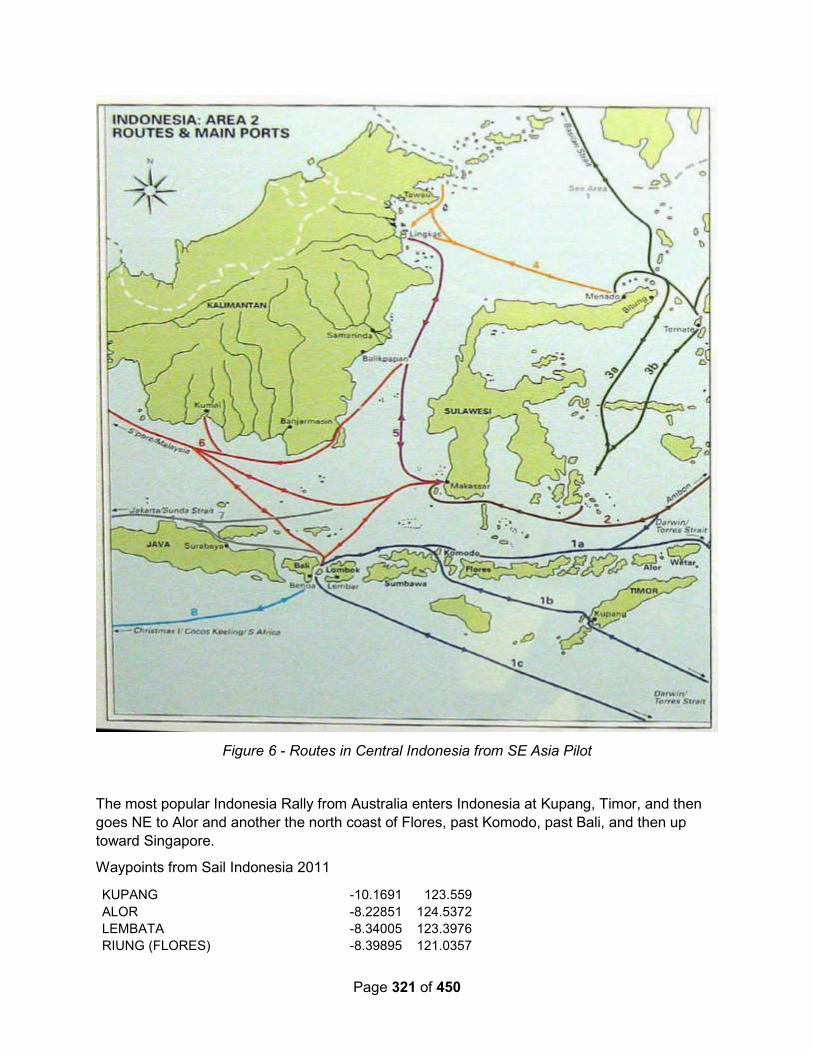
Page 321 of 450
Figure 6 - Routes in Central Indonesia from SE Asia Pilot
The most popular Indonesia Rally from Australia enters Indonesia at Kupang, Timor, and then
goes NE to Alor and another the north coast of Flores, past Komodo, past Bali, and then up
toward Singapore.
Waypoints from Sail Indonesia 2011
KUPANG -10.1691 123.559
ALOR -8.22851 124.5372
LEMBATA -8.34005 123.3976
RIUNG (FLORES) -8.39895 121.0357

Page 322 of 450
LABUAN BAJO (FLORES) -8.47 119.84
SAUMLAKI -7.975 131.3
TUAL -5.633 132.67
BANDA -4.511 129.877
AMBON -3.683 128.155
WAKATOBI -5.77378 123.9115
BALI -8.72617 115.2588
MAKASSAR -5.14 119.4
KARIMUNJAVA -5.92238 110.5285
KUMAI RIVER -2.89315 111.7206
BINTAN 1.197801 104.0968
BELITUNG -2.85428 107.9371
4.2 North Sulawesi
Is covered in the North Sulawesi sub-section in the Eastern Indonesia section, Section 3.3
above.
4.3 Central Sulawesi – North and West Side
4.3.1 Laulalang / Teluk Belonligum
Sea Topaz – September 2012 (OCC Newsletter): Our first stop was at Teluk Belonligum on
the north coast of Sulawesi, where we spent one night deep in the lagoon. We tried to anchor
off the village, as mentioned in other cruising notes, but found there was very little swinging
room between the reefs.
Pacific Express – August 2012: Anchorage position: 01 19.649N / 120 55.341E. We
zigzagged through the reef around 10.45am using Mark 1 eyeball as the charts were out by
about half to three quarters of a mile (C-map and Navionics) and came into anchor where the
guys from last year had been, in the most gorgeous scenic little bay behind a sandspit between
a Muslim village and Christian village. We are just off the Muslim village and the Christian
village is across the small bay. A Muslim man swam out to visit us and a Christian man turned
up in his boat.
We went ashore the next day and were met by a few people including Umbra who was really
excited to know that we know Bernie off Single Malt who came through here last year. She
invited us into her home, we took some photos of her baby daughter Apeecka, and they
presented us with some mangoes. Its mango season! Maman then escorted us around the
village.
The village has 500 people as does the Christian village across the way. It has an Elementary
School and a High School and hospital. Some of the houses look poor but we don't really think
its a poor village. Everyone greeted us as we went round and offered us mangoes! They all
wanted their photos taken with us and one man in uniform chased us down - just to have his
photo taken with us! The nurses came and the schoolmaster came as we walked around to
have photos taken. Maman found us a store where we got a sim card for the phone.
During the afternoon the Christian kids came aboard quite out of control - the boys running up
the boat and he girls standing at the back making a huge racket - it was all a bit much so the
Page 323 of 450
skipper got rid of them. I was working on the computer printing off the photos and looked up and
there was one still onboard!!! We put five muffins on four plates and took them in for Seir (the
young lady who wanted bread), Umbra, Maman and Udin. Seir and Umbra took theirs home
while Maman and Udin shared theirs with all the people who had been waiting to greet us. One
woman asked if they were halal. I hadn't even thought about cakes and muffins being halal!!!
Thought that was just meat! Anyway they really appreciated it. We also gave Umbra a large
photo of her baby. We had thought we were going to watch them play soccer with Maman but
no one was moving and it was threatening rain so we went back to the boat. We had dinner and
were relaxing when about 7.30 a canoe turned up in the dark. It was Seir (25 & married and
wears a scarf) and Adrea and Idha (two sisters aged 21 and 26). So they came on board and
we sat below chatting for quite some time and they were really fun. Ahdria and Eda had a little
bit of English. When it was time for them to leave Seir realised her oar had been knocked
overboard (probably by Bob) and was lost. So funny! So we lent them an oar to get home. Quite
a day!!
Udin then took us to see the lobster farm but it was locked so we sat and talked to some
students for a while. These people have seven fish farms - some fish, some lobster which they
export to Korea. The surrounding hills are filled with cloves trees and there are cloves laid out
drying all through the village - smells wonderful.
The villagers were all very friendly and very curious, and we did quite a bit of visiting around.
Sea of Topaz – Anchorage position: 01 19.095 N / 120 55.428 E. Good holding soft mud, 11
metres We tried to anchor off the village first, but that did not give much swinging room in
between reefs. We explored the lagoon; found 28-50 m, ended up right into the top end. Both
Maxsea and Navionics were out by 0.5 m in NS and EW directions.
4.3.2 Lokadaka Bay
Pacific Express – August 2012: Anchorage position: 01 02.919N / 121 39.313E. We were
coming into an anchorage given by MV Solita trying to beat the rain. The chart was out - we
were coming over land by the chart and then it went from 50m to 8m so we went further to
starboard. Kind of scary as we couldn’t see the bay and it t looked like we were heading into
land.
Came into the bay in very strong winds and there was a village and a jetty and we hit 5.6m and
shallowing - crew panicking! And the depth sounder stops working!! But we eventually managed
to anchor in 16m going back to 14m just off some cottages built over the water.
There were three little girls on their verandah singing and doing a welcome dance -s o sweet!!
Two boys went past rowing a canoe then came back towing some huge sticks of bamboo. The
fishermen waved but no one has visited. Still cloudy and slight swell but a beautiful spot.
4.4 Gorontalo Province
4.4.1 Gorontalo
Sea Topaz – September 2012 (OCC Newsletter): We wanted more diesel before reaching the
Togean Islands, so decided to go into Gorontalo – which turned out to be a real challenge.
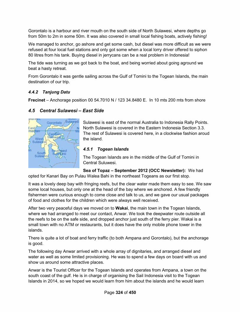
Page 324 of 450
Gorontalo is a harbour and river mouth on the south side of North Sulawesi, where depths go
from 50m to 2m in some 50m. It was also covered in small local fishing boats, actively fishing!
We managed to anchor, go ashore and get some cash, but diesel was more difficult as we were
refused at four local fuel stations and only got some when a local lorry driver offered to siphon
80 litres from his tank. Buying diesel in jerrycans can be a real problem in Indonesia!
The tide was turning as we got back to the boat, and being worried about going aground we
beat a hasty retreat.
From Gorontalo it was gentle sailing across the Gulf of Tomini to the Togean Islands, the main
destination of our trip.
4.4.2 Tanjung Datu
Frecinet – Anchorage position 00 54.7010 N / 123 34.8480 E. In 10 mts 200 mts from shore
4.5 Central Sulawesi – East Side
Sulawesi is east of the normal Australia to Indonesia Rally Points.
North Sulawesi is covered in the Eastern Indonesia Section 3.3.
The rest of Sulawesi is covered here, in a clockwise fashion aroud
the island.
4.5.1 Togean Islands
The Togean Islands are in the middle of the Gulf of Tomini in
Central Suluwesi.
Sea of Topaz – September 2012 (OCC Newsletter): We had
opted for Kanari Bay on Pulau Walea Bahi in the northeast Togeans as our first stop.
It was a lovely deep bay with fringing reefs, but the clear water made them easy to see. We saw
some local houses, but only one at the head of the bay where we anchored. A few friendly
fishermen were curious enough to come close and talk to us, and we gave our usual packages
of food and clothes for the children which were always well received.
After two very peaceful days we moved on to Wakai, the main town in the Togean Islands,
where we had arranged to meet our contact, Anwar. We took the deepwater route outside all
the reefs to be on the safe side, and dropped anchor just south of the ferry pier. Wakai is a
small town with no ATM or restaurants, but it does have the only mobile phone tower in the
islands.
There is quite a lot of boat and ferry traffic (to both Ampana and Gorontalo), but the anchorage
is good.
The following day Anwar arrived with a whole array of dignitaries, and arranged diesel and
water as well as some limited provisioning. He was to spend a few days on board with us and
show us around some attractive places.
Anwar is the Tourist Officer for the Togean Islands and operates from Ampana, a town on the
south coast of the gulf. He is in charge of organising the Sail Indonesia visit to the Togean
Islands in 2014, so we hoped we would learn from him about the islands and he would learn
Page 325 of 450
from us about what cruising yachts need in the way of safe anchorages etc. We had an
interesting morning, carefully motoring between islands and reefs under Anwar’s pilotage, and
ended up anchoring over white sand in a channel between Pulau Pangempang and the village
of Katupat.
In the few days we were there we visited many places by local boat, swam with stingless
jellyfish in a saltwater lake, snorkelled on the huge and beautiful reef, explored a Bajo (sea
gypsy) village and had a drink at Lestari Resort. (There are a number of small resorts in the
area, frequented mainly by backpackers and scuba divers).
After four days Anwar left for Ampana and, after provisioning back in Wakai, we headed for
Bomba at the west end of the group. On the way we spent a night anchored off the Bajo village
of Siatu, and then anchored beyond Bomba, between Island Retreat Resort and Poyalisa
Resort. The first is run by an American lady and the other by local people.
There were no guests at the Island Retreat Resort, but the twelve guests at Poyalisa made us
very welcome and it was great fun joining them for the excellent and very reasonable evening
meals. Poyalisa is a real gem! Duncan went diving with the Spanish dive-master from the Island
Retreat Resort, and Ria went snorkelling on the reef around the nearby island of Pulau Taupan.
The coral was stunning, and the reefs seem to be recovering quickly after years of fishing with
cyanide and dynamite. The rest of our time was spent exploring the bays by dinghy and
snorkelling, but finally we had to leave and sailed south and east to our next destination, the
Banggai Islands.
4.5.2 Banggai Islands (Kepulauan Banggai)
Sea of Topaz – September 2012 (OCC Newsletter): We had an uneventful passage to
Banggai Town with a fair current. Although the town lies in a big bay, it was not easy to find a
suitable place to anchor – either too deep, on a lee shore or too close to reefs.
We anchored at 01 35.9510 S / 123 29.6380 E Sand good holding dropped in 26 metres and
sat back towards shore in 11 meters. We anchored away from the town, near fishing boats.
Dirty busy town, very difficult to find a place to go ashore and tie dinghy up.
Next day we went ashore to meet up with our Banggai contact – again not easy, with lots of
small boat activity and a significant tidal range, but with some help we found a place to land. We
met up with Jemi and his friend Alex, a local schoolteacher who spoke good English, and while
Jemi sorted out diesel we went with Alex to the ATM, topped up the phone, got water, and
shopped at the local market.
The mode of transport here is by bento – three-wheel motorbike rickshaw with the passengers
sitting in the front – great fun.
We delayed leaving Banggai as Alex wanted us to visit the high school where he taught English,
hoping we could motivate his students. It was an interesting experience!
Later that day Jemi and Alex, plus six local dignitaries, visited us aboard Sea Topaz. It was the
first time any of them had ever seen a sailing boat, so they had a good look around and took
many photographs of both themselves and the boat.

Page 326 of 450
Banggai was a rather dirty town and we were keen to get away, so we motored about 30 miles
southwest to Pulau Sidoela, a small island off Pulau Bangkulu (or Bangkurung). It was
wonderful to be on our own again.
We were anchored off a long white beach with crystal clear water, where we could see the
bottom in 20m and enjoyed some good snorkelling.
The next day, before breakfast, we had some visitors who arrived by boat from Bangkulu –
Suhardin, whom we had met in Banggai Town a few days before, with his brother and the
headman of the village. He runs a losmen (guesthouse) in one of the villages on the island and
had spotted our boat – the first yacht ever to visit these islands, he told us. They took
photographs, had a good look around the boat, and invited us to the village.
Then we moved three miles to the next island, Pulau Bundu, where we anchored in a crescent-
shaped bay with a nice beach and well marked reefs. The reefs provided good snorkelling, but
only small fish. Later we found out why, as in the late afternoon we saw a large spout of water,
followed by a bang – somebody was dynamiting the reef.
We wanted to make one more stop in the Banggai Islands, but were not sure where. We ended
up anchoring off Pulau Togong Bojoko in about 7m of beautiful blue water, but about a mile from
the shore. Most of the islands are fringed with mangroves, rather than the long white beaches
and palm trees we were used to. This was disappointing, and we wished that we had visited
Suhardin’s village.
4.5.3 Kepulauan Sula
The Sula Islands are off the east coast of Central Sulawesi, east of the Banggai Islands, but
they technically belong to North Maluku Province. See that section.
4.6 West Sulawesi
4.7 Southeast Sulawesi
4.7.1 Wakatobi (Wangi Wangi) (Pulau Hoga)
Starry Horizons - July 2018: We dropped anchor just off Hoga Island at 05°28.356 S 123°45.399 E.
There is a shallow reef just in front of this anchorage. We nosed right up to the reef, which goes from 90 feet - 4 feet really quickly. Dropped at the 90 feet and hoped not to swing. Several other boats were anchored there with us for nearly a week. We did have an official boat come by selling marine permits. We paid 430.000 Rp ($24 USD) for the boat and two people.
We went diving on the wall and had our tanks filled by the Hoga Island Dive Resort. There are a variety of (mostly) abandoned buildings around the south side of the island, and over grown trails, though there are definitely people staying at the dive resort.
The southern pier is better suited to dinghy use; the northern one is taller and hard to climb up onto.
Page 327 of 450
Fishermen come by nearly every day selling their tiny fish, or something more creative, like lobsters, octopus, or mantus shrimp. I bought two mantus shrimp - treat them just like lobster or regular shrimp.
You can take your dingy across to Sampela, the sea gypsy village.
Our friends anchored in the shallower but less protected lagoon at 5°28.903 S 123°46.018 E
Field Trip – August 2018: After leaving Ambon, we sailed/motored for a few days before
arriving in Wakatobi Marine National Park. Entering the anchorage was a bit of a narrow
passage, and we fought 2+ knots in the channel to anchor.
Lately, we’ve been working hard to keep on our school schedule in hopes that we won’t have to
take any schoolwork back to the US with us when we visit this summer.
Only once we ticked all our subject boxes did we head into shore to check out the Hoga Island
Dive Resort. When we beached the dinghy, we were surprised to find the island teeming with
college students! Turns out Essex University marine biology department was visiting for their
annual marine biology camp! There must have been over 200 young adults there - some
cleaning their dive gear, others gathered around computers working on research projects, still
more seated at wooden tables participating in seminars about fish and coral identification, and
yet a small number who’d obviously had their fill of learning were sprawled out in the shade -
head on their backpack and mouth gaping open in full snooze mode.
We met the owners, and said we might be back in a few days when things settled down to talk
about doing a guided dive through their resort. Turns out, though, that we decided to take
advantage of the favorable weather pattern we were in and continue chewing off miles heading
to Komodo. That night we enjoyed our Friday Family Night taco salad and Despicable Me 3,
then rested up for our early morning departure. Mark had to really crunch the numbers for this
passage to ensure we hit the currents right on our way back out the channel. Then we stopped
Mark and I hopped in the dinghy to do a quick dive in the pass. The reef walls were steep and
bursting with life. A huge dog-toothed tuna came up close to check us out, as we changed
direction with the indecisive currents. I noticed the massive table corals that protruded from the
wall were doing something I’d never seen before. Some of them had fallen sideways under their
own weight, and along the perpendicular edge, parallel with the sunlit surface, new table corals
were growing like plants that always reorient themselves to the sun. A crocodile fish, at least a
meter in length, rested in a ledge of sand, and a lionfish huddled inside a barrel coral. Along the
dive, we saw at least 3 varieties of nudibranchs, too. I peeked closely at a few of the fans, but
my seahorse-spotting skills weren’t quite up to the task. After 83 minutes, we ascended and
headed back to the boat to get dinner going.
We thought we had tucked in out of the current, but later that night, we noticed a fast-moving
ripple trailing behind each of our transom steps. We all tried to guess how strong it was, then
Mark flipped on the instruments - 2.4 knots! It seemed much stronger than that! He could barely
get the dinghy hooked onto the davits to raise it for the night with the current pushing
perpendicular to where he needed to be! Our anchor was securely set, though, and we slept
well that night in preparation for our 4-day passage to Komodo. Westward Ho!

Page 328 of 450
Sirius – 2015: Inside the lagoon, we anchored at 05-19.727S / 123-31.812E We anchored
outside just past the entrance till high tide as the entrance is narrow and shallow. If you are
there look for a girl Windi approx 14 - was the cutest guide for the rally. Say hi from Sirius.
Gypsy village to the S of the town you can walk thru.
Alba – August 2015 (with a Rally): At sunset, we were 40 miles away from Wanci (giggling
schoolboys, note that it's pronounced “Wanchi"). We picked up a strong broadcast on VHF
ch16 from Wakatobi Information Centre (W.I.C.) radio, who were =lready and some had gone
through the very narrow, dredged channel at midnight - not us thank you.
A bit later, I chatted to Karen from "Red Herring" on the SSB radio and found that they are
already in the anchorage. Our cruising guide says that the dredged channel into the anchorage
is 2.1 metres at HIGH tide. "Red Herring" went through with a 0.8 metre low tide and had at
least 3.4 metres of water, so the cruising guide is completely wrong and we should be able to
get in and out at any state of the tide, which is a relief.
By eight p.m., we started to see the lights of shipping, mostly fishing boats, but we had two large
commercial vessels pass within ½ mile of us. At ten o'clock, we heavily reefed the genoa and
bobbed along at 2 knots with a scrap of sail and were rounding the north of the island at
midnight. We've been warned that there are many unlit Fish Attraction Devices (FADs) around
the area, so we made sure that we kept outside the 1,000 metre depth contour, which is about
four miles off-shore and hove-to for the night.
At dawn, we started to motor towards the channel through the reef. Gino from W.I.C. came out
to meet us in a RIB powered by a 15hp outboard. He’s a nice guy, but his English is not too
good and he’s a little chaotic. He babbled to us on the radio and said to follow him between the
marker poles, which I think that he said had red flags and some other colour. He then zoomed
off at high speed leaving us behind.
It was eight o'clock in the morning and the sun was very low in the sky, straight into our eyes, so
it was impossible to see the colour of the water and the marker posts were difficult to see in the
glare. There was a large dredging barge on the inside of the lagoon, presumably at the end of
the channel. I tentatively motored towards the centre of two lines of flags. The water looked
very shallow, but I had faith in the markers and carried on. Suddenly we hit the bottom,
bounced over something hard and stopped.
Don’t Panic Mr Mannering! I tried to motor backwards - no chance! I tried to turn the bow with
our bow thruster - no chance! I even tried to move forwards - no chance! We were hard
aground. It was now one hour after high tide, so the tide was going out and, if we delayed, the
situation would only get worse.
I ran down below and grabbed two long ropes from under our fore-berth, throwing anything in
the way to one side. By the time I was back on deck, Gino had realised that we were on the
reef and came alongside. I could see deeper water only 5 metres to port.
Page 329 of 450
I quickly tied the two ropes together and gave Gino one end, tying the other end to our
spinnaker halyard, which runs to the top of the mast. I then told him to use his dinghy to pull the
rope to our port side, hence pulling our mast top to port and heeling us.
As we heeled over, I hit the bow thruster, which slowly turned our bow to port. At the same time,
I gunned our engine in forward gear and with a couple of sickening lurches and bangs, we
floated free. Total time from going aground to getting off was only ten minutes, but seemed like
an hour.
From the safety of deep water, I could see my mistake. The red flags were hidden by the glare
of the sun and the bulky shape of the dredging barge. On the other side of the channel, there
were actually two rows of green flags and I had mistakenly gone for the middle of them - right
onto the reef. As always, it was an accumulation of errors - tiredness, going directly into the
sun and trusting rather than thinking - if Gino hadn't been "helping" me, I doubt that I would have
done the same thing.
On the second attempt, we safely negotiated the channel and arrived in the relative safety of the
lagoon. Now we had to anchor. There were four other boats anchored at the end of the
entrance channel, but Gino insisted that we motor further south into the lagoon towards some
mooring buoys. I think that he was telling me that he wanted all yachts to pick up moorings or
anchor near them.
We attempted to pick up a couple of moorings, but neither of them had pennants to tie onto and
looked dodgy, so we decided to anchor. We tried in a couple of places in 5-8 metres of water,
but both times we dragged our anchor - it felt like loose broken coral. By this time, we were
feeling very tired and grumpy.
We picked up a third mooring, which had a reasonably new pennant, but as the wind caught us
and put tension on the rope, the whole mooring pulled away and we drifted off downwind with
the buoy in tow. Finally, we anchored in 12m to the west of the moorings (05°19.80S
123°32.07E) and the anchor held, so we collapsed in a heap. We're in Wakatobi- we've
survived.
In the morning, we went ashore at W.I.C. intending to go for a stroll around town. We were met
by a group of the young guides and there was obviously no way that we were going anywhere
by ourselves. A young lady called Novi and a lad called Rama accompanied us and were very
protective, with Novi holding Glenys’ hand as she crossed the roads - very sweet.
We visited three banks, but none of the ATMs would give us any money. I talked to the
manager of the biggest bank, but he confirmed that there is no way to get money over the
counter - we have to use the ATM. It’s so frustrating.
The young guides proved their worth when they helped us to find a couple of dive centres and
translated for us. I was trying to find a replacement “burst disk” for our scuba tank and had
some success at the Mawadah Dive Centre. At first, the owner of the dive shop said that the
only place to get the burst disks was from Jakarta and it takes at least a week, but then he
Page 330 of 450
searched around and found three old ones that look okay. I was astounded and very grateful
when he just gave them to me for free.
While at the dive shop, we found out that they will do scuba dives for only $20US including a
tank, provided that we have our own equipment, so I'm going to get a group together.
We visited the central market, which has lots of very narrow lanes between hundreds of stalls
selling an eclectic variety of goods. Novi introduced us to her aunt who runs one of the stalls
and we had to take the obligatory photograph.
After lunch on the boat, we went to do a snorkel on the outside of the reef near to where we are
anchored. It was very nice, but not quite the vertical wall that I was expecting. The water is still
a bit murky - will we ever get the crystal clear water that the tourist brochures promise?
We went for a meal at the Wisata fish restaurant with “Red Herring” and “Catimini”. This
restaurant is built on stilts on the shore close to the anchorage and was very good value at
75,000 rupiah each with a soft drink. The only downside was that they didn't have any Bintang
beer.
The dive boat picked us up at the W.I.C. dock and took us out to Sombu Jetty. We descended
to 20 metres on a 60 degree wall and followed it north, returning at 12 metres. The visibility
wasn't good enough to take long-range shots of divers, so I concentrated on small creatures,
getting a couple of nice shots, including another nudibranch called a Swollen Phylidia. The dive
master Arif, was very good at pointing out things and showed us a tiny, tiny shrimp on a sea fan
which was so small that I couldn't see it at all until I took a photo and enlarged it.
On another dive, the dive boat took us to Shark Point, where we descended to 25 metres and
headed north. We saw over a dozen Blacktip Reef Sharks, but they were very shy and almost
impossible to photograph. It was still a nice dive and, thankfully, the Imodium worked.
The organisers had organised a cultural visit to Liya Village. Five of the boats in the anchorage
decided to do something else, so only four boats with eight cruisers attended the event, which
was a bit of a disappointment for the organisers and the villagers who had laid on a welcome
and food expecting over twenty five people.
However, it was an interesting visit. Liya village is actually four villages (housing 5,000 people)
which are located around an old colonial fort made from coral rubble. The fort was built in the
13th century and there are old rusty cannons lying about the place.
We were welcomed by village elders in traditional costume, who performed a graceful traditional
dance. Our group was led to a meeting hut called a Baruga, where a fabulous pyramid of food
had been prepared - this is called Livo and is the traditional food for ceremonies, such as births,
circumcisions and weddings. After a rather lengthy prayer given by a village elder, we were
invited to tuck in. With lobster, crab, barbecued fish, curried eggs and rice on offer, we obliged
happily, even though it was only just past ten o’clock.
Page 331 of 450
On the way back to town, we asked the driver to stop off at a seaweed farm. The seaweed is
grown on thin lines held up by thousands of polystyrene floats and plastic bottles. Using a long
canoe, the seaweed is harvested and then taken to stilt platforms, where it’s spread out to dry in
the sun. Some of the harvested sea weed is reattached to the lines and replaced in the sea.
Amulet – August 2010 – Wangi Wangi: Moored: anchored 40' Present port: Wangi Wangi,
Wakatobi Island group, Indonesia Lat/Lon: S 05 19.790, E 123 32.059
We thought this Wangi Wangi harbor would be a small village as it's supposed to be in the
national park, it's a major commerce center again. We were told by the rally organizer
(Raymond) that 100 moorings would be available, another piece of misinformation, only two.
Luckily we are the fourth boat to arrive so still room.
We stayed at Wangi Wangi 11 days. We were the 4th boat to arrive and luckily not the first,
eventually about 25 would arrive. Despite Raymond (rally organizer) saying there would be 100
moorings none were seen, a few days later they laid a half dozen outside the reef. The
anchorage at Wangi Wangi is inside a reef which is not shown on C-Map or the local Indonesian
chart. We arrived at 0700, about high tide and didn't know what to do, we saw the other boats
anchored inside the reef and the reef looked deep enough to possibly go over. Gino (local
everything guy with the rally) wasn't on the VHF yet. Luckily another cruiser saw us and told us
how to enter the lagoon behind the reef. The waypoints we took are:
1) S 05 19.600, E 123 31.768, between two steel poles, 10.5 feet deep at HW (+2.1m)
2) S 05 19.578, E 123 31.852, Single pole with flags, keep close (30') to starboard
Proceed about 100' past the single pole then turn to the right. We anchored at S 05 19.790, E
123 32.050, 35' sand.
We were made welcomed and check-in was painless and organized by Gino. They were having
parades the next two days and we were invited to view them at the Bupati Regent's (like a
governor) home. The next day they asked if the cruisers would like to march in the parade. We
put together a rag-tag group and marched displaying our national flags; USA x 3, Canada &
Australia. The 40,000 people lining the streets loved us. As we passed the governor's house all
the officials stood and returned our salute and waved with big smiles. They had teen age
"guides" waiting to show us around and interpret, no payment they just wanted to practice their
English. We invited two guide girls out to the boat to show our appreciation. We felt very
welcomed indeed.
Wakatobi is a marine park consisting of 4 islands whose initials make up the name. We
envisioned a small sleepy village not the busy and overpopulated Wangi Wangi which is the
main commerce center for Wakatobi. They have 3 markets spread around, a morning, mid-day
and nighttime market. The nighttime one is the most fun and you can eat your fill of prepared
food and snacks for very little money. None of the vendors tried to rip us off, refreshing. Overall
the food in Indonesia is not very good but some of the snacks and donuts ($0.12 USD, not
$2.50 USD ea. like in Australia!) from the street vendors are good.
We did a few scuba dives on the reefs near the anchorage and they were pretty good. Lots of
fish and mostly alive coral. There's less trash in the water here as the population is beginning to
realize they have something worth protecting. Dive tourism is just beginning to take hold.

Page 332 of 450
The government sponsored a free dinner and cultural dance show at a new resort, which was
the now usual so-so food, speeches and such. The next day they invited the cruisers to a
cultural festival being held as part of their Independence Day celebration.
The celebration abruptly ended when protestors began destroying one of the props, protesting
among other things they resented the money the government was spending on the visiting
yachts and that we were eating during the day which being Ramadan is against their religion.
The cruisers were escorted by the police back to the boats and were advised to stay onboard
that night. The next day was Independence Day (8/17) with more celebrations planned, but
about 1/2 of the boats left in the morning. We were supposed to participate in the underwater
ceremony and had attended two practice sessions but felt it best we not attend any more public
events, a few others went and had no problems. We finally went ashore briefly to pick up a few
snacks (including donuts) and clear out with the officials, the next morning we left as did the
remaining boats. A sad ending to an otherwise good stay.
One common complaint was the very loud noise (chants and music, not all religious) at all hours
of the night from the loudspeakers on the Muslim Mosques near the anchorage, not much
respect for other religions it seems.
4.7.2 Pasar Wajo, Buton
Starry Horizons - August 2018 (with a Rally): The festival was the biggest one of the rally and well worth it. We also did a small cooking class with Rusdi, the local tourism contact.
One day we took a car over to Bau Bau for a big supermarket trip. Pasar Wajo has an excellent fresh market.
Our mooring: 05°31.395 S 122°50.905 E
Alba – Aug 2015 (with a Rally): We arrived in Pasar Wajo mid-afternoon, and anchored in the
south west of the bay at 05°31.34S 122°50.89E in 17 metres of water. The holding is good, but
the prevailing east winds have put the fringing reef fairly close behind us. There are lots of
turtles surfacing around us, but the water is cloudy and there are haloclines here, which are
layers of fresh water and sea water. I guess that there are underwater springs nearby.
There’s a Buton Information Centre (B.I.C.) ashore, who started to call us as soon as they
spotted the first sail. They don’t have a boat, but directed us to the best anchorage. All of the
five boats who arrived this afternoon gathered on “La Passarola” for a few beers - no one
wanted to go ashore and be organised just yet.
The next morning we had a late start and went ashore at around ten o’clock. The B.I.C has set
up a tent by the main dock and we were met on the beach by a gaggle of guides. Again they
are all volunteers who speak good English. The head of B.I.C., Rusdi, told us that they have
organised for us to attend a “baby” ceremony on the 24th - not quite sure what it’s all about, but
it seems to involve 500 babies… The Takawa (a colossal dance with over 20,000 dancers) is
not taking place this year, which is a bit of a disappointment.
However, there is a big Expo taking place here over the next week, with various exhibition
stands set up where government departments and private companies are promoting
themselves. We've been invited to the opening ceremony this afternoon and there’s a party
tonight. After that they will organise events and trips depending on what we want to do.
Page 333 of 450
Some guides were allocated to us and, together with “Red Herring”, we jumped on a Pete-pete
(mini bus) and zoomed off to the local market, where we spent a happy hour wandering around
looking at the fish, vegetables and other goods on sale. It’s a riot of colours and images, so it’s
difficult to stop myself taking photographs. We stopped off at a small eating place and had
Nasi Goring (Fried Rice) and Gardo Gardo (Vegetable in Peanut Sauce). At $1.50US for a
meal, it’s not worth cooking here.
In the afternoon, we picked up “Red Herring”, to go to the Expo opening ceremony. On the
way, Graham noticed a two foot long Banded Sea Snake in the bottom of our dinghy. These
are one of the most poisonous snakes in the world. They are normally shy and keep away from
humans, but unfortunately, this one was trapped in an enclosed space with us and couldn’t get
out.
The snake became more and more agitated as the four of us lifted our feet out of its way, while
trying to stop it hiding behind the fuel tank or disappearing under the hollow floor. It started
moving faster and faster as I frantically pulled the paddle from the end of one of our oars. After
a couple minutes of panic, I finally managed to get the paddle under the snake and flip it
overboard - phew!
Things to do (besides rally partying and events): Our guides Erick and Lis took us for a
walk to the Blue River, which is a fresh water lagoon that that has been made into a huge
swimming area with concrete walls and a promenade with plenty of little food stalls. It’s
obviously a place where young people come to eat and have a good time in the evening - we’ll
be back.
We met Erick and Lis ashore and they took us off in a car on a little tour of the local area. In
convoy with “Red Herring”, we first went to Kali Buki, which is a sinkhole with a fresh water
spring at the bottom. The enterprising owner of the land has built steps down to several
concrete fish ponds where he breeds carp - he sells fish food to visitors. It is a very cool and
tranquil place.
We then visited Takimpo Fort. It’s perched on a hill above Pasar Wajo and used to be the
home of the Takimpo tribe, who built the walls as a defence against the Europeans who arrived
in the 1600s. The village was abandoned a hundred years ago and the only things left is a
small mosque and a Baruga (a raised platform used for a meeting place), which the ancestors
of the Takimpo people maintain for their historical value.
Diving: At half past four, I zipped over to a fishing pier (05°30.95S 122°51.97E) on the eastern
shore of the bay to do some snorkelling by myself. This is the location of a “muck dive” called
Magic Pier (the “muck” meaning a shallow dive on a rubbish-strewn seabed, close to shore,
often with poor visibility). My main aim was to photograph the elusive Mandarinfish, which only
come out of their hidey holes at dusk, but I couldn't find any.
I didn't mind because this was possibly the best place that I ever been to for underwater
photography. There are hundreds of small fish and creatures wandering around the rubble,
broken fishing traps and general rubbish. I got some good photographs of new creatures
including a Shortfin Lionfish and the fabulous Peacock Mantis.
On another day, at half past four, I picked up Les from “La Passarola” and we went for a dive at
“Magic Pier”. We anchored the dinghy to the north east of the pier and descended to 15 metres
heading south west then came back up to 5 metres directly under the “T” end of the pier. There

Page 334 of 450
we found huge concrete blocks, dumped as part of the pier construction and lot of other rubbish,
like car tyres.
Amongst the concrete blocks, I finally found the elusive Mandarinfish. There were scores of the
two inch long, colourful fish hovering above the rubble going through their mating display. In my
excitement, I neglected to set up my camera properly and most of the dozens of photographs
that I took were rubbish, but I managed to edit a couple of decent ones. I also got a nice photos
of the brightly coloured Ribbon Eel and a well camouflaged Tassled Scorpionfish.
On a third dive a Magi Pier, hosted by a local divemaster, the dive was very good. They took us
straight to the end of the pier to where the Mandarinfish appear. I’d already seen these fish, but
the dive masters were great at pointing out other little creatures, especially when they saw that I
had a decent camera.
I was also excited to see two Ornate Ghost Pipefish. These are less than two inches long and
almost transparent, so they are very difficult to see. Even when pointed out to me, my tired old
eyes had trouble focusing on them. They are one of the weirdest fish in the sea with their
unearthly camouflage. The guides also pointed out a lovely yellow nudibranch called a Great
Bergia.
On another dive we went to Asphalt Pier (05°31.02S 122°50.71E). This is another muck dive
underneath the end of a dock by an old Asphalt Works. There’s lots of junk on the sea bed, but
we saw some creatures amongst the mess, including a couple of big Painted Lobster, a
Broadclub Cuttlefish that flared bright yellow when disturbed and some lovely yellow Anenomes
on the columns of the pier.
4.7.3 Bau Bau, Buton
Alba – August 2015 (With a Rally): As we were approaching the harbour, I hooked and
landed a big 15 Kg Wahoo. I caught it on the hand-line, so it was easy to bring it in, but once on
the aft deck, it flailed around and refused to die despite a liberal dose of rum in its gills - only
continual blows to the head with my “judge” put an end to it. The aft deck was covered in blood.
It was a bit chaotic when we arrived in Bau Bau. There were three boats ahead of us and the
coordinates given by Sail Indonesia were incorrect, so they were all milling about. We spotted a
new-looking, floating dock next to a hotel, so we anchored off that in 20 metres depth at
05°27.36S 122°37.21E. Fortunately, it turned out to be the correct place.
Renewing Visas: There were no events planned for the day, so together with “Red Herring”,
we went off in a car with a driver called Komang to renew our visas.
The Indonesian immigration will initially only issue a 60 day visa, and we have to renew it every
month for a further 30 days. The rally organisers have scheduled the fleet to renew visas in
Lombok in the middle of September, which is 400 miles away, meaning that we would have to
rush to get there - we would rather take our time and stay longer in Takebonerate and Komodo.
By obtaining our visa extension early, we will be able to miss out the stop at Lombok giving us
extra time.
The Bau Bau rally team were great and helped us to prepare all of our documentation, including
writing a local sponsorship letter for us. The Immigration department don’t often do visa
Page 335 of 450
extensions and ran out of forms - they only had two, so we had a lengthy wait for a couple of
hours at the tourist office, while they found some more.
We filled in all the relevant paperwork and delivered it to the immigration department. All
seemed to be in order, so we have to go back tomorrow to have our fingerprints taken - this has
to be online and the internet connection between here and Jakarta is not good enough in the
afternoon! By the time that we’d finished running around, it was well past one o'clock so we
went for a Nasi Goreng lunch.
Halfway through the tour the next morning, the immigration department said that they had a
network connection with Jakarta, so Komang whisked us off to the immigration office where we
quickly had our fingerprints and photograph taken. It cost us 355,000 rupiah ($35US) each for
the extension, but they kept our passports - they had to wait for a reference number from
Jakarta, before they could stamp our passports. Komang picked them up later in the afternoon.
It was all pretty painless - thank goodness we had the use of a car and driver.
Things to Do: We all went on an organised coach trip to the Bau Bau fort, which is apparently
the largest fort in the world. Unfortunately, it’s so huge that there’s no real focus to it - it seems
to be a five kilometre long wall with normal houses built inside.
They took us to the old Sultan’s residence. The last sultan was removed from office after their
independence in 1945, so the residence is now a museum. It’s a fabulous, airy, wooden house
with lovely furniture and lots of photographs of old sultans on the walls. All of the Sultans have
been direct descendants of Genghis Khan, but rather than inheriting the position, the living
descendants used to be nominated for an election and the sultan was voted in by the people.
It’s an interesting mix of democracy and hereditary succession.
Propane: Komang took us in the car to try to get some propane gas. One of our gas bottles
has run out, but it appears that there is nowhere in Bau Bau that can refill bottles - the locals
only have the facility to exchange bottles. The local bottles have a different valve to our POL
fittings, so my next mission was to try to find a valve that would fit the Indonesian bottles - I
would then be able to decant propane into my bottle.
No chance - we went around various hardware shops. There doesn't appear to be anyone who
actually installs fixed gas pipework - the local people all use simple regulators and rubber hoses
to connect to their stoves - like we would use on a barbecue. Another minor problem is that I
can’t hire a propane tank for a few hours; I have to buy one at a cost of $75 US, so it would be
expensive. After a couple of hours, I admitted defeat - if we run out of gas then I will have to
buy an Indonesian bottle, a regulator and rig it up as a temporary solution.
Diving: I’d arranged a dive trip for five of us cruisers. We loaded all our gear in a very slender
boat with two bamboo pole outriggers and zipped across the harbour to the opposite shore near
05°24.17S 122°36.18E. There’s a 20 metre high cliff and underneath the surface is a fabulous
coral wall.
Our first dive was into a cave system. Glenys refused to go in and went off with one of the
guides along the wall. The rest of us went into the cave which had two large chambers with a
sink hole at the surface between them. It was an atmospheric dive, but not many creatures
apart from a few cardinal fish and some lobster.

Page 336 of 450
The second dive was a drift dive along the coral wall. The visibility was very poor, so we all
concentrated on small creatures. I got very excited when I spotted a small Yellow Sea
Cucumber and took some photographs, but then Adrian from “Anthem” pointed out hundreds
more - the reef was plastered with them. The coral was beautifully coloured and we saw quite a
few nudibranches and flat worms including a Linda's Flatworm. It was great diving for only
$25US per dive.
Sirius – 2015: This is a sizeable town for repairs, provisioning etc
We anchored at 05-27.378S 122-37.290E
Beware of petty theft!
Sea of Topaz: 05 27.1470 S / 122 36.352 E Sand, good holding, 14 metres Anchored off KFC
in town amongst big local boats; they don’t leave much swinging room! Hard to go ashore and
tie up dinghy with many small outrigger boats. Mukmum, from the local tourist office was our
contact, we got water, but no diesel. Good local market, but not much else.
Kelearin – July 2012: We arrived at Bau Bau in the middle of the night but were able to anchor
across from the town. In the morning we dumped our jerry jugs of diesel into the tanks and
prepared to move over to town but a squall hit so we waited out the storm and then moved
over. As we were coming in a water taxi flagged us down and soon we had a boat full of
uniforms and civilians directing us to the Coast Guard office. Everyone was very friendly but
we were unsure as to why we needed 7 people on board.
I visited the harbormaster while Jim guarded the boat. They see very few yachties in this part
of the world so I was a kind of “celebrity” for a bit. My picture was taken dozens of times and
behind the counters heads would pop up like a video game to take a peek at me. I just smiled
and waved and posed. The head guy looked over the paperwork, gave permission for us to get
fuel and then for a fee sent off a crew to fill our containers. Only one officer was a bit short
with me and reprimanded me for not speaking “Bahasa”.
Anchorage at Bau Bau (05 26.2S; 122 34.3E) (05 27.1S; 122 36.3E) Nothing much here to
stay for. The cut between the island and the mainland looked interesting but we were worried
about currents so chose to take the outside route. Still a current, probably at least 2-l/2 knots.
I was looking at the island lighthouse at Wakatobi forever it seemed.
4.7.4 Telaga Island, Bombano
This is due west of Bau Bau, about 35 miles.
Alba – August 2015 (With a Rally): We pulled up the anchor in Bau Bau at around nine
o'clock, when the wind started to pick up. We managed to sail for an hour, but the wind died
after we cleared the harbour, so we motored for a couple of hours. Then just after lunch, we
started to get a breeze and, by one o'clock, we were romping along with a 20 knot sea breeze
putting us on a fast reach.
A few hours later, we dropped anchor on the north side of Telaga Island along with “Catamini”,
“Red Herring”, “Sea Monkey” and “Conrad”. It’s a pleasant anchorage in 15 metres just off a
small white-sand beach (05°24.17S 122°01.45′E). We’ll definitely be staying here tomorrow,
well away from the constant calls to prayer and the attention of well-meaning guides.
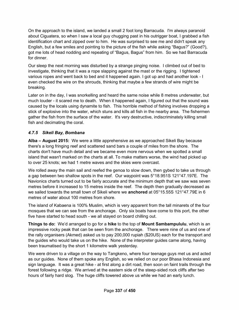
Page 337 of 450
On the approach to the island, we landed a small 2 foot long Barracuda. I'm always paranoid
about Ciguatera, so when I saw a local guy chugging past in his outrigger boat, I grabbed a fish
identification chart and zipped over to him. He was surprised to see me and didn't speak any
English, but a few smiles and pointing to the picture of the fish while asking “Bagus?” (Good?),
got me lots of head nodding and repeating of “Bagus, Bagus” from him. So we had Barracuda
for dinner.
Our sleep the next morning was disturbed by a strange pinging noise. I climbed out of bed to
investigate, thinking that it was a rope slapping against the mast or the rigging. I tightened
various ropes and went back to bed and it happened again. I got up and had another look - I
even checked the wire on the shrouds, thinking that maybe a few strands of wire might be
breaking.
Later on in the day, I was snorkelling and heard the same noise while 8 metres underwater, but
much louder - it scared me to death. When it happened again, I figured out that the sound was
caused by the locals using dynamite to fish. This horrible method of fishing involves dropping a
stick of explosive into the water, which stuns and kills all fish in the nearby area. The fishermen
gather the fish from the surface of the water. It's very destructive, indiscriminately killing small
fish and decimating the coral.
4.7.5 Sikeli Bay, Bombana
Alba – August 2015: We were a little apprehensive as we approached Sikeli Bay because
there's a long fringing reef and scattered sand bars a couple of miles from the shore. The
charts don't have much detail and we became even more nervous when we spotted a small
island that wasn't marked on the charts at all. To make matters worse, the wind had picked up
to over 25 knots; we had 1 metre waves and the skies were overcast.
We rolled away the main sail and reefed the genoa to slow down, then gybed to take us through
a gap between two shallow spots in the reef. Our waypoint was 5°18.951S 121°47.197E. The
Navionics charts turned out to be fairly accurate and the minimum depth that we saw was seven
metres before it increased to 15 metres inside the reef. The depth then gradually decreased as
we sailed towards the small town of Sikeli where we anchored at 05°15.55S 121°47.79E in 6
metres of water about 100 metres from shore.
The island of Kabaena is 100% Muslim, which is very apparent from the tall minarets of the four
mosques that we can see from the anchorage. Only six boats have come to this port, the other
five have started to head south - we all stayed on board chilling out.
Things to do: We’d arranged to go for a hike to the top of Mount Sambampululu, which is an
impressive rocky peak that can be seen from the anchorage. There were nine of us and one of
the rally organisers (Akmed) asked us to pay 200,000 rupiah ($20US) each for the transport and
the guides who would take us on the hike. None of the interpreter guides came along, having
been traumatised by the short 1 kilometre walk yesterday.
We were driven to a village on the way to Tangkeno, where four teenage guys met us and acted
as our guides. None of them spoke any English, so we relied on our poor Bhasa Indonesia and
sign language. It was a great hike - at first along a dirt road, then soon on faint trails through the
forest following a ridge. We arrived at the eastern side of the steep-sided rock cliffs after two
hours of fairly hard slog. The huge cliffs towered above us while we had an early lunch.
Page 338 of 450
Yesterday, I'd had a look at the mountain on Google Earth and there seemed to be a gully with
trees on the south side of the mountain that might give access to the top of the rocky peak. So,
I left the others chilling out and went to have a look around. The lead guide followed me and
when I indicated in sign language that I wanted to have a look, he shot off like a mountain goat
down a gully.
He led me westwards along the bottom the cliffs, which seemed to be impenetrable without
serious climbing gear. After fifteen minutes of fast scrambling, we stopped at a cliff that had a
tree growing up the side. The guide indicated that this was the way up. It looked tricky, but I'd
come this far, so why not?
I would say that it's a V.Diff using the tree and the vertical rock face, with the crux at a point
where you have to swing out around the overhanging tree trunk. Once at the top of the initial
steep section, it’s a scramble up to a subsidiary peak. The mountain is actually made up of four
peaks surrounding gullys. From the peak that we were on, I would say that the highest peak
could be climbed in a couple of hours of scrambling. It would be an epic day out.
The next day Akmed tried to get us to go on a trip out to the nearby Sagori Island, but it seemed
very complicated and he seemed to be trying to get as much money as he could from us -
$10US each for a one mile trip, $5 each for a meal at the school and then even more for the
interpreter guide’s time. It was so confusing that we’re all paranoid that we’ll be sucked into
chaos and the costs will escalate. The trip is only to go snorkelling, which we can do anytime,
so we politely said no.
The last couple of days have been great, but of the places that we’ve stopped in this rally, the
guides here seem to be the least organised. I think that they’ve been shipped in from other
parts of Bombana, whereas in other places, we’ve been dealing with the locals. I suspect that
the problems with Akmed all stem from the fact that he isn’t from Sikeli and the locals are trying
to get him to pay expensive prices for things. The best and friendliest guides that we’ve had
have been local students from high school or university, who have a genuine desire to chat in
English.
Services: It was a lot easier to get diesel (solar) in this small fishing town than some other
places we have been. There's a brand new fuel station right on the sea front, which only
opened a couple of days ago. A local guy met us at the landing steps and helped carry the jerry
cans to the petrol station. The forecourt was littered with various containers being filled for
fishing boats, but they very kindly stopped filling them and immediately filled ours. We got 69
litres of diesel and 15 litres of petrol at the subsidised rate (< 8,000 rupiah/ litre), and were back
on the boat within 30 minutes.
After stowing the jerry jugs, we went into town again to do some provisioning. Our first stop was
to get the data SIM card in our iPad topped up. Again we had trouble with this normally simple
job. In the first small shop, the guy spoke a couple of words of English and kept saying "Empty,
empty". We tried to explain that we didn't want a new, empty SIM card, but he didn't
understand. Eventually, we asked if there was somewhere else and he pointed us down the
street.
The next shop was the same - the lady kept saying "Berakhir", which our dictionary told us was
"Expired". Well, yes, our credit had expired, that was why we wanted a top-up. The lady then
wrote down 4.1 GB data and told us to come back at two o’clock in the afternoon. The penny
Page 339 of 450
dropped. These small shops are only allocated a certain amount of air time each day and she
had sold out. She would be topped up at two o'clock and could then top us up.
There was another small shop across the road selling SIM cards, so we tried there and to our
relief, the lady had some data available, so we bought 3 GB for one month for $10. Five
minutes later, we were on-line again. What a strange system.
We wandered around the market while Glenys bought some vegetables and some fresh
prawns and I bought a small machete in a wooden sheath that is better weighted than my old
one. White people are very, very rare here, so we caused chaos as everyone stopped what
they were doing so that they could watch us. I guess that we paid slightly inflated prices for
things, but it's cheap enough anyway. My nice new machete only cost 150,000 rupiah ($15US).
4.8 South Sulawesi
4.8.1 Taka Bonerate (Atoll off Southern Sulawesi) (Bone Rate) (Takabonerate)
Alba – September 2015: Together with "Red Herring", we arrived at the eastern pass into the
atoll around eight o'clock and hove-to, waiting for the sun to get higher.
The pass through the reef was very straight-forward and the shallowest depth we saw was
around 9 metres. Our waypoints were
06°28.58S / 121°17.80E
06°28.51S / 121°16.76E
“Ubatuba” was already anchored in 8 metres over sand at 06 28.71S 121 16.92E, but it looked
too open to the waves coming through the pass. Instead, we headed south and anchored at
06°30.39S 121°16.89E in 6 metres of water over white sand amongst widely spread coral
heads.
Page 340 of 450
Figure 7 - Alba's First Anchorage at Takabonerate and their Track Through the Atoll
The water colours here are stunning - it’s much, much better than being stuck in front of a town
(and no mosque droning away.) We chilled out for the rest of the morning and got the dinghy in
the water.
After lunch, we jumped in the dinghy and went to look at the huge sand bar to the east of the
anchorage. We arrived at low tide and the sand was miles long. We could see some local
fishermen walking around in the distance and started to walk towards them to see what they
were doing, but after fifteen minutes, we were hot and still only half way, so we gave up.
There’s almost nothing on the sand apart from a few crabs scuttling away. Glenys was hoping to
find a few shells but the area is as bleak as the Sahara Desert.
We retreated to the boat and went snorkelling on a patch of reef to the north of the anchorage.
It was okay, but large areas of coral have been reduced to rubble, probably by dynamiting and
there aren’t many fish. It’s a little disappointing because this is a National Marine Reserve and
we were expecting pristine reef. It looks like the locals are still allowed to fish here because at
sunset, we could see a dozen or so fishing boats in the five miles around us.
Page 341 of 450
The next day we went for another snorkel, starting off in the shallower water to the east of the
anchorage near the sand bar. It was okay and the water was fairly clear, but much of the coral
is damaged either by storms or more likely destructive fishing practices and there weren’t many
fish.
I swam back to the boat and the quality of the reef improved nearer to the anchorage. It’s
mostly sand with good coral on the isolated outcrops, but the water clarity reduced. I found
some False Clown Anenomefish, which amused me for a while.
Takabonerate is the third largest coral atoll in the world covering an area of 1,000 square miles,
with around fifty distinct reef systems. We entered at the north-eastern corner and were keen to
explore further. Unfortunately, we only had a few days to do so. On our 2nd full day in the atoll,
we upped anchor at nine o’clock (as soon as the sun was high enough to give us decent light)
and motored west through a pass in the seven mile diameter reef system encircling us.
There’s a park ranger station at an island called Tinabo (06°34.12S 121°05.62E), but the
anchorage is in 30 metres on the edge of a steep drop off and we’ve been told by “Per Ardua”
that the park rangers will try to charge us a park fee of $10US for the boat and $15US per
person PER DAY, so we’re avoiding that island and exploring other areas.
The weather in this region of Indonesia is perfect. For the past month, we’ve had blue skies and
consistent 15-20 knot winds from the south-east to east. Today was no different and to make it
even better, we were sailing in flat calm water in the lee of the reefs surrounding us.
From another cruiser’s blog, we’d made a note of a possible anchorage at 06°39.28S
121°12.03E and we had a lovely sail to get there. Unfortunately, when we arrived, there was
only one small spot that was shallow enough to anchor in and that was littered with coral heads.
We thought that it wasn’t even good enough for a lunch stop, so we headed west for another
anchorage.
An hour later, we anchored at 06°43.25S 121°08.76E in 6 metres of water over white sand
amongst scattered coral heads. To get to the anchorage, we had to weave our way through
coral heads that appeared to be several metres underwater, but in good light it was simple
enough. This is another beautiful spot with a large sand bar at low tide. “Red Herring” followed
us in and anchored behind us.
Glenys and I jumped into the dinghy and went off to explore a shallow reef that we’d spotted on
the way in, but the reef was again mostly rubble. This should be pristine reef and it’s very
depressing to see it in this state - perhaps the marine park status will help it recover, but later,
as night fell, we could see twenty fishing boats within view, so I don’t hold up much hope.
Karen and Graham went for a walk on the sand bar at low tide and came back with some nice
shells, so there’s good shelling here. Unfortunately, by the time they stopped by, the tide was
coming in fast, so Glenys missed out, but at least Karen gave her a lovely, big Cassis shell.

Page 342 of 450
I’m very frustrated here, the anchorages and water colours are stunning, but the snorkelling
close to the anchorages is very poor. There are plenty of very steep drop-offs going down to
40-60 metres, which I suspect would be good scuba diving, but there’s nowhere to anchor close
by. From the protected anchorages, we would have to travel a few miles in our dinghy to go
diving and we don’t want to do it alone - “Red Herring” don’t dive and they don’t have a big
outboard on their dinghy, so we’re very restricted here in the middle of nowhere. In retrospect,
we should have travelled in company with other keen divers.
The next day, after a leisurely breakfast (waiting for the sun again), we left the anchorage and
weaved our way through the maze of sand bars and reefs, heading south. Once again, I was
very grateful for the KAP charts that I’d previously made from Google Earth because they were
spot on and showed every channel, whereas the commercial Navionics charts gave us very little
detail. At one point, the Navionics charts showed a reef blocking our way whereas in reality we
had a 100 metre wide, 20 metre deep channel.
Just before lunch, we caught and landed a nice 10lb tuna as we approached Tambuna Lompo
Island (07°00.27S 121°12.9679E). Our plan was to stop overnight at this idyllic-looking,
deserted island, but we couldn't find anywhere to anchor. Very shallow coral stretches 350
metres from the shore and then plunges down to 40 metres. We tried to anchor in 10 metres
depth about 15 metres from the reef edge in a sandy valley, but the anchor just dragged -
probably rubble. After fifteen minutes, we gave up and set off on 130 mile passage down to
Labua Bajo. It was very frustrating because it looked like there would be good diving around the
island.
There wasn't much wind (and what we had was behind us), so we motor-sailed all afternoon,
until we rounded the western end of Pulua Kaloa when we finally had enough wind to sail.
Sirius - 2015: We anchored in front of the ranger headquarters at 06 34.137 S / 121 05.664 E
Equanimity – September 2013: Taka Bonerate rocks! Some of the best diving I've ever done.
The diversity of coral and fish was amazing. The reef system sits right in the middle of the
Flores Sea with only small sand cays for islands and a couple of small villages, so the water is
crystal clear (no run-off) like in the middle of the ocean. The constant current provides much
nutrients, so the coral and fish thrive without any manmade or natural pollution to disturb it.
Hence, very dense coral growth of everything you could imagine. Spectacular wall dives!!! And
the water is so clear, floating along in the current next to bottomless walls is like floating in
space. Imagine being absolutely still, no swimming or paddling, just hanging in space using your
buoyancy compensator to control your ascent/descent and letting the current swept you along
the vertical wall, around heaps of colourful coral and through big schools of fish. Spectacular is
an understatement for sure!
It's a hard place to get to for most people, so very little tourists go there, which also means there
is little damage to the reefs. But we did meet a lovely gentleman from Jakarta who was there to
film some of the reef, so we got to go diving with him, and make a new friend, Mr Muis.

Page 343 of 450
The weather started to change and we needed to get south and keep moving to get to Labuan
Bajo for the next set of events (and more diving), so we sadly had to depart. But we are off to
see some dragons! We are having such a great time, Sherry is now talking about spending
another year here in SE Asia, as there just isn't enough time in a day to see and do it all. But
that's another day, so we'll see :).
Kelearin – July 2012: Because of our lack of full understanding of the bureaucratic process in
Indonesia with regard to our visas we wasted a lot of time in Bali and then had to make tracks
for Ternate in order to extend our visa on schedule. So we missed some great spots, like Bone
Rate and Wakatobi Islands. We actually poked our bow into Bone Rate for a few minutes but
were unable to find a suitable spot to anchor. Like everywhere in this part of the world, the
anchorages are very deep and then you hit reef. We wanted to check out the pinisi boat
building operation on the beach but we could only take a quick glance as we backed out of the
harbor and continued on our way to Bau Bau on the bottom of SE Sulawesi to get fuel.
4.9 North Kalimantan
4.9.1 Nunaken (Port of Entry)
October 2021 – As COVID restrictions are starting to ease in Indonesia, only 2 ports are open
for foreign yacht check-in. One of these is Nunaken. Looking at Satellite photos, the port
appears to be located at approximately 04-08.735 N / 117-40.023 E.
4.9.2 Tarakan (Port of Entry)
Sea Topaz - September 2012 (OCC Newsletter): In early September 2012 we left Tawau in
Sabah, Malaysia and motor-sailed to the anchorage at the north end of Pulau Bungyu.
Along the way we saw a number of very big Fish Attraction Devices (FADs), the largest we had
seen. There are several coalmines on Pulau Bungyu so there were plenty of tugs and coal
barges, either anchored or manoeuvring.
We reached the anchorage off Tarakan late in the afternoon – again there was a lot of small
boat movement, and a strong current.
The next day we checked into Indonesia, which was more difficult than the previous year as we
did not have the backup of the Rally this time. We did, however, have Raymond’s contacts Dewi
and Rory from the Department of Tourism.
The following morning the first group of four officials arrived on board at 0900 claiming to be
from ‘Quarantine’ and came with a photographer but no paperwork. After taking lots of
photographs of us and themselves they left. Later two more quarantine officers came, this time
with paperwork, then customs officers with more paperwork.
We then had to wait for a boat to collect us to take us to Immigration and Customs. At Customs:
more papers to sign, more waiting, but still no clearance. The difficult issuewas the ‘self
guarantee of export’ document and we were told to ‘come back tomorrow’.
We finally got all our (many) papers from Customs, including the ‘self guarantee’ and headed to
the Harbour Master who was, of course, out to lunch, but returned later to give us our final
papers. We then had to stop at a copy shop to make the essential copies of all the documents.

Page 344 of 450
Before we got onto the longboat to go back to our boat we were presented with a bill for 5
million rupiahs (US $500), which was a huge surprise as we thought we had paid for everything
with the application for the CAIT. We were told it was for boat and car hire for two days, fuel,
and marine police protection fees. We objected strongly, and after phone calls to Raymond and
some recalculations we paid 1∙8 million (US $180), plus a tip for Dewi and Rory. We were free
to go!
4.9.3 Kurung Tigau
Sea Topaz - September 2012 (OCC Newsletter): We weighed anchor from Tarakan at 0500
to catch the tide as we had a long passage ahead. After the good omen of seeing some
dolphins, we made an overnight stop in Kurung Tigau, a big open bay with many fishing
platforms but not a soul in sight.
4.10 East Kalimantan
4.10.1 Pulau Derawan
Gaia – November 2013: After Derawan we decided to go slowly to Raja Ampat and sailed via
Sulawesi and Halmahera. The people there are amazing. Not many yachties go that way and
they really welcome you. You will be treated as a moviestar. They all want to have their picture
with you. The only problem is language. No one speaks other than Bahasa Indonesia
12/9/2013 Derawan 002.17.494 118.14.440
28/9/2013 Muratau 002.14.785 118.37.738
Sea Topaz - September 2012 (OCC Newsletter): From Kurung Tigau, we stayed outside the
reef in deep water and were able to sail in a gentle breeze. We reached Pulau Derawan in the
early afternoon and tried to anchor on the south side of the island, the accepted anchorage.
It was a lee shore, however, with too many coral heads so we backtracked to the north side and
anchored in 15m on loose coral.
We went ashore and walked around the island, finding very friendly locals and several dive
resorts.
The evening brought two big electric storms, each with 25+ knots of wind but from opposite
directions, but to our relief the anchor held.
4.10.2 Maratua Island / Atoll
Ocelot – August 2016: Maratua is a beautiful atoll, with excellent scuba diving on the outer
eastern wall. Snorkeling is also possible, but the current often sets strongly south along the
wall, so be prepared. Getting into Maratua can be a challenge, as the gap in the reef is narrow,
can be difficult to find, and the current can run very strongly through the cut (like 5+ knots). The
anchorage shown is from 2016, but there were several other boats anchored here, so our
choices were limited. Anchoring is somewhat better a bit to the north and a bit further in, to
avoid the worst of the currents. The nearby village doesn't have much, but the road out of town
makes a nice walk in the afternoon. The village to the SW is almost 3nm away, but it's
somewhat bigger. There was no cell coverage in 2018. The dive resort south of the anchorage
was happy to fill tanks for us. Ocelot’s Website.
Page 345 of 450
There are a few other activities available, including walks & tours along the ring road. They
have a jellyfish lake you can swim in, but it doesn’t have many jellyfish. If you like that sort of
thing, there’s a huge jellyfish lake at the next island SW, with a dock ish thing at 2°08.26’N
118°30.63’E. LOTS of non stinging jellies in 4 varieties, but I’m not sure you can anchor there,
& it’s exposed to the south.
4.11 South Kalimantan
4.12 Central Kalimantan
See note on Sanpoi’s encounter with a fishing boat while on passage between the Kumai River
and Belitung. Here.
4.12.1 Kumai River
The Kumai River is a very popular stop on the Indonesia Rally.
Sail SE Asia FB Group – November 2021 – River Trip Guide: We’ve just finished our
1n/2day Orangutans tour, Tanjung Puting National Park, Kumai. Indonesia.
We can recommend, Nina and Rini of Orangutan Sister Tour, who did a superb job from start to
finish, excellent English spoken, excellent local knowledge and guided us through the booking
system in this ‘new normal’ world we find ourselves. They organized a security guy to sit on our
yacht in our absence.
The tour was amazing, relaxing and unhurried. The food was good and plentiful. So many
orangutans to be seen and probiscus monkeys. Our boat captain and crew went out of their
way to spot wildlife along the river banks, very entertaining. A big thumbs up to our guide Dedy.
Very few tourists at present so the Park is quiet.
You do need to book a day or two in advance for the antigen testing. Mask are required in the
town and National Park (but can be taken off whilst on the boat)
There is a 3D/2N option as well but camp Leaky is not yet open so we opted for 2D/1N.
However, things are changing daily in the NP so best to check with Nina/Rini .
There is a 1D speed boat option if your time is limited but you’d miss out on a whole load of
things….ambience, tranquility, time to stop along the river when wildlife is spotted (great for
photography)overnight experience, great food etc etc.
You are required to have COVID antigen test to go in park(all boat crew do too), Nina/Rini
organised.
Cost at present: 7,350,000IDR for 2.
Thank you Urangatan Sister Crew. [email protected] +62 8115219922
Sail SE Asia FB Group – June 2019 – River Trip Guide Recommendations: We will be in
Kumai in June to see the Orangutans. I know there are lots of tour companies, it's hard to
choose and I am always dubious of potential fake review on Trip Advisor. Can anyone
recommend a good company? We have people joining us and I want it to be a good experience;
good English spoken, decent food, relatively comfy boat BUT most of all a knowledgable guide.
We are happy to pay the cost of a good, reputable and ethical company/guide. I just don't want
to support the wrong business!
Page 346 of 450
Sky Hunter Vespa was used/recommended by several cruisers:
Email:[email protected] +6281254564322 Can be found on FB as Sky Hunter
Vespa, and is a member of Sail SE Asia FB Group.
Several people also mentioned and recommended a guy named Adi (Addi?). We used
Adi. He may visit your boat (along with other tour operators) and was also hanging
around the dinghy dock when we were there.
Adi Yacht Services, 62 81 336 358 474, 62 852 49666 830. In September 2018 it was
$191 US pp ($174 for kids) for a 3 day/2 night trip (we--a family of four--had the boat to
ourselves). We had a great guide (Even), cook and captain. Note that the operators don't
always own the kolotoks (the river boats) and that the tour guides are often independent
contractors, so it pays to see the boat and meet the proposed guide ahead of time.
Our friends worked with Liesa ([email protected] ,
[email protected] ) and were happy. They paid $233 US per adult, $190
for kids but were pressed for time. They also had a bit longer of a tour on the second
morning, which we did not get, but we didn't mind too much. Also, their first boat broke
down and they had to wait a bit for a second boat that was smaller. Their family of four
was with another couple of guys on a boat smaller than ours, but they found that it was
more interesting that way.
Cathryn Hutton Take the 3 day / 2 nights trip. The one day trip on the speed boat is
crazy. Can't remember the name but the guy runs a hotel in the main street parallel to
the water. I also forgot the price but it should include all food, a group guide and security
for your boat whilst you are away.
Majid Hotel, they were great!
Jennifer Lee We also used Adi, mentioned above. He may visit your boat (along with
other tour operators) and was also hanging around the dinghy dock when we were there.
Adi Yacht Services, 62 81 336 358 474, 62 852 49666 830. In September 2018 it was
$191 US pp ($1…See More
We went with Addi mentioned in the comments above. He will also arrange for someone
to sleep on your boat. Make sure you stipulate no smoking on boat though.
We also used Addi and were very happy. We only did the 2 day/1 night (for boat and
cost reasons) and felt it was still amazing. You see all the same places as the longer
tour, you just have a little less time. Make sure you get to do the “night hike”, it was
amazing!
Take your malaria protection. It has outbreaks from time to time. It is a long way to a
hospital once you depart Kumai and discover one of your crew has the first signs of
malaria- that is a fever that comes and goes which progressively worsens over a few
days...
Tuan Romadh Dhon is brilliant
In October 2017 we used Orangutan Sister Tour.
Page 347 of 450
[email protected] . Nina was an excellent and pleasant guide. Ituy the
cook. Great food. They discussed our preferences before they went to market, even
organised cold beer for the 2night 3 day trip and security for Nautilus while we were
away. Oh yes and washing, fuel and water. Great sightings of Orangutan, Proboscis and
Macaque monkeys and spotted some great birds incl. stork billed king fisher, blue eared
kingfisher, broad bills and rhionoserus hornbill. We planted trees and had some great
jungle walks. We definitely went for 2 nights but could have been 3.
Sail SE Asia FB Group – June 2019 – Solar & Electrical: If anyone is ever in need of any
electrical parts in Kumai there is a guy in Sampit who has Solar Panels, Cables, Solar
controllers the works. We bought two new 100w panels (Venus solar) and a cheap pwm
controller just until we can get our hands on a good mppt. Its all cheap from China but it will get
you out of trouble until you can get the good stuff. Shop name: UD. Dua Putra
Starry Horizons - October 2018: We anchored in the Kumai River in a very industrial setting at
02°44.546 S 111°43.923 E The river is filthy, and the town is not much nicer.
We booked a klotok for a river tour through Magid Hotel. All klotoks are basically the same - I
didn’t see any “nicer” ones out on the river. We did a two-night, three-day tour. Our guide Danu
was AMAZING.
Tanjung Puting National Park is the base for Dr Galdikas’ orangutan research. She was one of
the three Trimates, female biologists who studied primates under Dr Leakey, the other two
being Goodall (chimpanzees in Tanzania) and Fossey (gorillas in Rwanda).
We stopped at three feeding stations, including Camp Leaky. Each time we saw 6-2
orangutans, males, females, babies. Other apes included gibbons (much more elusive),
proboscis monkeys, and macaques. We spotted tons of horn bills and kingfishers.
Both nights we did a night trek, one in the park with a tour guide, and one in the local “village”
with one of the locals leading us through the palm oil fields. That second night we saw a flat-
headed cat, a very rare small cat species. Other nocturnal sightings were glow in the dark
mushrooms, tarantulas, owls, and dragonflies.
Our final day, we visited a reforestation project, where we both planted saplings to regrow
where wildfires, caused by the nearby companies exploiting the land, occurred.
Java – August 2017: This was a great experience, but we didn't want to take a two-decker
Klotok up the river in the Park for 2-3 days, even though it's touted to be like an "African Queen"
experience. This is far from the truth since the jungle is not that dense and there are probably
40-50 Klotoks on the river at any time.
So we opted to do a one day trip up and back in a speedboat which worked out for the best as
the river was blocked to the last destination, Leakey Camp, by a "floating island" of vegetation
(which happens quite often) and we had to turn around. The 30+ Klotoks we passed just kept on
chugging upriver to the blockage, thus making their own blockade!
We rented our boat with driver from Adi (0822 4222 1430) who will most likely visit your vessel
offering his services. Very nice guy, was a good guide, good English and we just had to provide
our own lunch.
Page 348 of 450
Tiger Lilly – September 2016: We took a guided boat tour up the Sekonyer River to southern
Borneo's Tanjung Puting National Park - the orangutan's were absolutely FANTASTIC! We saw
orangutan - wild in the forest and at park feeding stations, gibbons - the acrobats of the jungle,
proboscis monkeys - an entire troop of these Jimmy Durante look a-likes flew out of the tree
tops and into the river as we passed them, and of course the ubiquitous macaques.
We normally prefer to take TIGER LILLY up tropical rivers and explore on our own, but
unfortunately foreign yachts are not allowed in the park; however, we likely saw much more with
our guide Andi than we would have on our own. The three day tour aboard the Klotok Kelimutu
(riverboat) with five other couples from the Sail Indonesia Rally will certainly go down as one of
the highlights of our world cruise.
Brahminy Too – October 2016 – Orangutans: The trip to see the Orangutans was brilliant.
No fires in the area this year so it was very busy on the river with many kelotoks taking folk.
If you book you tour from afar and accept the quoted price you may pay $100 more than if you
negotiate it in Kumai.
We had 3 different touts come around our boat offering tours. With one the price for 3 days/2
nights all permits and tickets, meals and beer included went from $310 per person to much
lower with little effort.
Our final decision, on who to go with, was not based on the lowest offer but who had helped us
arrange boat repairs, fuel and laundry. Adi, is a Dayak, who will put his hand to anything to earn
a living. The guide he provided was also a Dayak, who loves his forests and the native animals.
Along a river journey we saw wild Macaque and Proboscis monkeys. Awoke one morning to the
calls of Gibbons and spotted wild Orangutans drinking from the river. At the feeding stations
many of the rehabilitated Orangutans came in to eat bananas and sugar cane. Thats when we
had better photo opportunities.
Birding along the river was limited by the canopy but I did see some new birds. All very
colourful.
The food was delicious and abundant 3 times a day. The crew, courtious and helpful. Our guide
was knowledgeable and funny (though he did like to hit the arak).
The weather was kind. Whilst the humidity was appalling, it did rain at night and cool everything
down. Parts of the days were overcast and hence less taxing. No problem with mosquitoes
which was amazing however the night insects were abundant if we had the lights on.
If you missed the experience last year due to the fires, I can recommend visiting Kumai on a
return voyage.
Migration – March 2016 – Clearing Out of Kumai: We just cleared out of Indonesia in Kumai
and, as in Belitung, everyone was extremely helpful. We checked out on a Saturday, when most
offices were closed to the public, but the officials let us clear out anyway. It was “Wives Day” at

Page 349 of 450
the Harbour Master’s office (the wives get together from various governmental branches) and
they fed us lunch while we waited for our paperwork! And, though it was Saturday, we were
never asked for any bribes or overtime fees. There were "NO TIPPING" signs on the desks at
the Customs office.
Though a lot of waiting is sometimes involved, in this part of Indonesia, officials have been very
easy to work with.
4.13 West Kalimantan
5 Central Indonesia – South Part This guide is loosely organized first in major areas of Indonesia (East, Central, West), and then
loosely by province. This section is about Central Indonesia. As you can see by the map, there
is a large gap in the map between the southern part and the northern part. So I have divided
this section into South and North as well.
5.1 Central Indonesia Overview
Figure 8 - Central Indonesia Overview
Eastern
Central Western
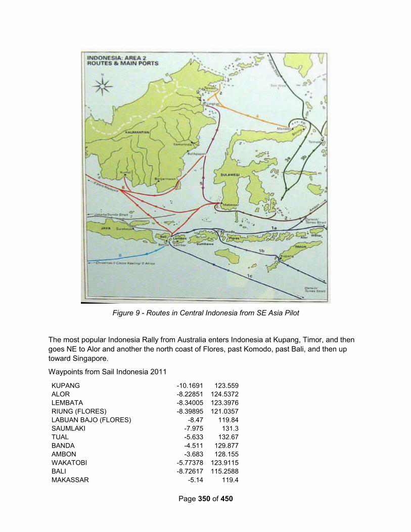
Page 350 of 450
Figure 9 - Routes in Central Indonesia from SE Asia Pilot
The most popular Indonesia Rally from Australia enters Indonesia at Kupang, Timor, and then
goes NE to Alor and another the north coast of Flores, past Komodo, past Bali, and then up
toward Singapore.
Waypoints from Sail Indonesia 2011
KUPANG -10.1691 123.559
ALOR -8.22851 124.5372
LEMBATA -8.34005 123.3976
RIUNG (FLORES) -8.39895 121.0357
LABUAN BAJO (FLORES) -8.47 119.84
SAUMLAKI -7.975 131.3
TUAL -5.633 132.67
BANDA -4.511 129.877
AMBON -3.683 128.155
WAKATOBI -5.77378 123.9115
BALI -8.72617 115.2588
MAKASSAR -5.14 119.4
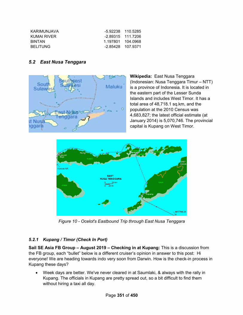
Page 351 of 450
KARIMUNJAVA -5.92238 110.5285
KUMAI RIVER -2.89315 111.7206
BINTAN 1.197801 104.0968
BELITUNG -2.85428 107.9371
5.2 East Nusa Tenggara
Wikipedia: East Nusa Tenggara
(Indonesian: Nusa Tenggara Timur – NTT)
is a province of Indonesia. It is located in
the eastern part of the Lesser Sunda
Islands and includes West Timor. It has a
total area of 48,718.1 sq.km, and the
population at the 2010 Census was
4,683,827; the latest official estimate (at
January 2014) is 5,070,746. The provincial
capital is Kupang on West Timor.
Figure 10 - Ocelot's Eastbound Trip through East Nusa Tenggara
5.2.1 Kupang / Timor (Check In Port)
Sail SE Asia FB Group – August 2019 – Checking in at Kupang: This is a discussion from
the FB group, each “bullet” below is a different cruiser’s opinion in answer to this post: Hi
everyone! We are heading towards indo very soon from Darwin. How is the check-in process in
Kupang these days?
Week days are better. We've never cleared in at Saumlaki, & always with the rally in
Kupang. The officials in Kupang are pretty spread out, so a bit difficult to find them
without hiring a taxi all day.
Page 352 of 450
Kupang check in is tedious/tiring and all offices are quite spread out. Took me nearly
6hrs on a Saturday with a taxi driver who knew where everything was located in April,
2018. Can be done in a day but must have a car and know where you’re going.
New system in Kupang, anchor off the jetty west of Teddys bar and catch a local taxi to
Customs...then they will all come out to your boat...also local guy Napa can assist you
(he's an old agent from the old system). There are some fees, not all that much and
completely above board, but you don't have to go all the way out to immigration
anymore.
Kupang system is good now, just call me or email when you arrive and I give hand to
you to prepare immigration custom quarantine and harbour master to come to your boat
for finish all the document easy. Just need you to pick them up when all of them be at
the beach. MATTHEW 085253243999 (WhatsApp) email ([email protected]) Also
on Facebook as Matthew Mechanic
We had a great experience a month ago checking in Kupang with the help of Matt.
Tanya Ham – June 2019 – Check In Help: Just a helpful hint for those heading to Kupang to
check into Indonesia. Our friends told us to find Michael to help us do the check in but a bloke
called Ayub got to our boat first. He was friendly enough and told us he could take us where we
needed to go for $150 Aussie dollars. We spent from 8 am till 6 pm running around from
immigration, customs, harbour master. It was a disaster and ended up costing the same for
extra car hire etc. Michael charges $200 but having met him later, we realized how much more
professional he was, his English is excellent and our friends spent 3 or 4 hours with him and it
was done! Wait for Michael to come out to your boat and see you!
Simon Berryman – June 2019 – Check In Help: We anchor a few hundred metres west of the
old "Teddies Bar" between the point and the jetty....no problems leaving the dingy....no dodgy
people....if you want help there's a guy there though "Mr Napa" he's got good English and will
help out at a price....not too much......but it's easy to do it yourself
Devo Khan - December 2018 – Finding Parts for Engine Repair: We fixed up our engine
last season while stranded in an island east of Timor. We bought or picked up parts while in
Kupang. Big thanks to Mathew the mechanic for driving around to show me some of these
places!
Automobile Parts Store - Motor scooter and car parts are easily found, especially on the
coastal road from Teddies Bar and eastward. Here you'll find belts (sabuk), gasket (paking),
sealants, hoses, lights (senter), wrench (kunci) and other tools.
Rimba Mas Motor
Jl. Timor Raya
KM.7 Oesapa Kupang
Tel. 0380 823559
Trijaya Motor
Jl. Pulo Indah Kupang
Tooling and Hydraulic Store - Mathew said there is only one place in Kupang that does
hydraulic hoses. They also sell bolts, sockets, wrench and other tools:

Page 353 of 450
UD. Metro Jaya Baut
Jl. Pulau Indah, Oesapa Bar., Klp. Lima, Kota Kupang
Hardware Store
ACE Hardware is inside the big mall called Lippo. We saw home appliances, gen sets, and two
shelves of tools.
Jl. Veteran RT. 06/05 Fatululi Kec. Oebobo Kota Kupang
Ask your taxi driving to go to Lippo Plaza.
Agriculture and Motors - They sell gen sets, diesel motors, and some agriculture machinery.
The owner --rather the son-- speaks fluent English.
Sumber Teknik Motor
Bonipoi, Lama City, Kupang City
Next door is another store that sells similar stuff to Sumber Teknik
Outboards Honda Yamaha - Last I saw, they have on stock plenty of Honda generators, one
small Honda outboard 2 HP, and one 8HP yamaha outboard. More may be in the back. Some
diesel gensets too.
Makmur Sentosa
Jl. Siliwangi No.7, Solor, Kec. Kota Lama, Kota Kupang
Metal Scrap Yard - Mathew took me to this scrap yard on the eastern end of Jl Timor Raya. I
picked up some metal plates, super cheap. Unfortunately, I don't have a name or address.
How to Get There - Use Grab app, its the SE Asia version of Uber. Just enter the store name
and request your taxi. We use it all the time.
Sail SE Asia FB Group – October 2018 – Checking in at Kupang: Thought it might be worth
sharing our experiences of checking into Kupang over the last couple of days.
Teddy’s Bar moved 50 metres along beachfront. Now just a shack, barely even sells a beer (the
old Teddy’s now a bar called 999 - has decent wifi and food).
The usual scrum of boatboys who want to look after your tender - going rate is 50,000 Rp ($5) -
it’s worth it, because when the afternoon sea breeze kicks in you’ll be grateful they’re wading
out to chest height to keep your dinghy from being pooped.
Agent Michael tried to charge us $200 USD to help us check in. Yeah right! We ended up
paying Ayoub $30USD, and a further $40USD for a driver.
So long as you have plenty of copies of paperwork with you (at least 6 copies of crew list,
Yachters Vessel Declaration, clearance form prior country, passports, ships registration papers),
you don’t actually need an agent - driver will do just fine. We used Willem as our driver - find
him at Teddy’s Bar or on +62 813 3925 5116 and he will come in with you to the various
appointments and act as a translator if need be.
Sequence of appointments is as follows:
- Immigration
- Quarantine
Page 354 of 450
- Customs at their office
- Customs then come and inspect your boat
- Customs office again
- Harbourmaster
Neither immigration or customs looked for bribes, but we were shaken down by both Quarantine
(“non-government tax” of 200,000 Rp / $20 AUD) and HarbourMaster (port usage fee of 20,000
Rp / $2 AUD). We argued with Quarantine at first but gave in in the end because we were hot
and tired and the day was getting on. With the harbour master, we just winked and paid it - she
even gave us change from her son’s pocket!
Harbour master will want you to come back on the day you leave, so best to tell her you’re
leaving same day - that way you’ll save a second trip. Then if you don’t happen to leave that day
and in the unlikely event you were pulled up, well that’s engine trouble for you 😉
Immigration office is near the airport, so a good 30 minutes drive from Teddy’s. All other offices
are at the other end of town, about 15 mins away from Teddy’s bar in the opposite direction.
The whole process end to end took about 6 hours.
Our driver William also organised fuel for us. We paid $12,000 Rp per litre for 300 litres. For that
price they supplied the containers and brought the fuel to us. Didn’t seem too bad when we
filtered it (they claimed to have gotten it straight from the service station), but time will tell!
Liz Datsun – November 2017 – Checking Out (Noonsite.com): Visit Immigration first. They
are out near the airport. You will need 4 copies of everything, passports, showing photo AND
visa page, vessel registration, crew list.
I also had with me a single set of the papers (all 6 of them) that had been originally issued when
we cleared from Terempa. Port clearance from Terempa, crew list, port health clearance from
Terempa, cruising declaration form, vessel declaration form (2 pages)
Having obtained the departure stamp in the passports it was a 20min drive back to the main port
for Quarantine, Customs, and the Harbour Master.
At Quarantine, they asked for a copy of the original MDH (Maritime Declaration of Health),
which I hadn't seen since checking in at Nongsa, and didn't have a copy with me. It then
appeared not to be an issue, I just filled out another one on the spot. They also wanted the
“green book”, which we never had. They produced one from the cupboard, but it was never
given to us and was still on the desk when we departed with our health port clearance.
Next it was off to Customs - delightful and helpful officers.
Customs need to come on board the vessel before they can complete their paperwork, so it was
back to the boat and we transported the officer (with his trousers rolled up and his bare feet) out
to the boat in the dinghy. He filled out his paperwork and gave me a YELLOW copy which I
thought was a receipt. We then took him ashore and it was back to the customs office (this is a
good 10 mins drive from the popular mooring off Teddies Beach). We gave him a 15 minute
head start. Arriving back at the customs office, we then were given the appropriate
documentation and it was off to the Harbour Master for the final all important port clearance.

Page 355 of 450
This took about 20minutes to obtain, and it would have apparently been helpful if I had had the
yellow copy of the paper that Customs had given me, which I had filed already on board.
However we left with the port clearance that we required.
The four copies of everything were thus consumed, by all 4 departments.
We found all four departments pleasant to deal with. It is just a very long and spread out
performance. We managed it in only 5.5 hours, which is apparently quite fast!
We were assisted with transport by AYUB - 0812 37993500. Without him I would have started
the process in the wrong order.
Ayub also provided us with good quality CLEAN diesel, obtained from the local service station,
and offered other services, water ,laundry etc.
He also offered to act as agent for us which we declined, but he accompanied us through the
clearing out process anyway- for which we recompensed him for his time - but not for acting as
our agent.
Ayub also 'suggested' that 50000 IDR ($5aud) for cigarettes for Immigration and 50,000 IDR
(cash) for Quarantine would be appropriate and would help get through the queue (which there
didn't appear to be!) whether it was really necessary I don't know . It was the only time we had
been asked for anything throughout Indonesia.
The Customs officer was specific that there was no charge for his service and asked if we had
been asked by any other departments.
There was no request or suggestion at the Harbour Masters office either.
In hindsight, I think that anchoring off Ayub's location- off the wooden boat constructions, would
have been a better bet than off Teddies Beach. Quieter for a start !
The beach off Teddies seems to have a “consortium” of chaps who offer for 50000 IDR,(non
negotiable) per day to watch your dinghy, they also offered fuel water etc etc. Not sure what
happens if you decline their offer to keep a watch on your dinghy in exchange for the requested
payment.
The only other tip I now have, is that when checking in to Indonesia, and asked what your next
port is, this is your opportunity to name the most distant port that your anticipated route through
Indonesia will take you to. Name the port that you anticipate checking out at.
We avoided most major ports where a visit to the HM would have been necessary, however we
did check in with the HM at both Terempa and Serengan, and at Serengan he duly endorsed
the back of my port clearance obtained in Terempa.
I did also engage as agent Raymond Lesmana, who provided sponsorship letter for original
visa, and the extension (which we never proceeded with, as it appeared it was going to take
longer to get the extension than it took to get the original visa- if anyone has a recent
experience with visa extension it would be handy to know, as we were told in Bali it could take
up to 7 days and would require finger prints etc, could only be done in Denpassar itself, not an
option at the Immigration office at Benoa).
Raymond was good to have as agent, when I had a small issue in Terempa, trying to obtain
clearance.

Page 356 of 450
Finally, I'm sure most people do, but use your phone to instantly photograph any and all official
papers you are given by the multitude of official departments, just in case in the paper shuffling,
a page gets "lost or mislaid". This did happen to me, but having a photo of the now missing
page, meant it was found before we departed the office we were in.
Noonsite.com – September 2017 – NO AGENT NEEDED
Use of an Agent to obtain clearance papers in Kupang are no longer required. YOU CAN GO
BY YOURSELF.
Don't trust the people on the beach who say that they are the agent. They will cheat on you.
They will ask for 200-300 dollars just for the clearance which is free from Customs. Then if you
want to go to the bank, or supermarket, or buy something, they will ask you for extra money, too
much.
Clearing in: Quarantine, Customs, and the Harbour Master are located close one to another at
the Tenau Harbour, west of town, and Immigration is in a completely different location not far
from the airport, east of town. Because the Harbour Master demanded paperwork from the other
three to be completed first.
The logical order would be to visit Immigration first, then Quarantine, then Customs, and
Harbour Master last.
Transportation: You must walk a few meters from Teddys Bar to find a taxi or motorcycle with
normal price. Because the taxi and motorcycle just outside Teddys Bar will ask twice the normal
price.
Margarita - November 2016 – Clostly Inward Clearance (from Noonsite.com): My recent
costly experience of clearing into Indonesia at Kupang on Timor. This episode is somewhat
embarrassing because I am usually more savvy to the slimy antics of two bit hustlers, but this
time they played me like a fiddle. Dismiss my experience as an ignorant American at your own
peril, as in retrospect; I acknowledge my errors were numerous. I write this to serve as a
warning to other cruisers, that the agents I dealt with in Kupang are crooks and they are good at
it.
Under the new visa system, we chose to seek “On Arrival” visas in Kupang due to the reported
problems with renewing the “Social Visa”. Additionally, the Indonesian embassy in Darwin was
reportedly taking up to a week to process and grant “Social Visa’s”. We were anxious to get
moving and the Indonesian embassy assured us the “On Arrival” visa would be granted for 30
days and be renewable for a one-time 30-day extension. We did complete and print multiple
copies of the relatively simple on-line application at https://yachtersindonesia.id/ in Darwin
before departure.
My wife, infant son and I approached Kupang in the predawn hours of November 28th, 2016
aboard our Westsail 32’. It was a long windless passage from Darwin, motoring most of the way.
Clearly, this is not the best time of year to be headed W’NW but we are trying to make as much
headway as we can before the NW’erly monsoon season kicks into full swing. Arriving after very
little sleep, we easily scoped out an anchorage spot and dropped the hook for some sleep (10⁰
09.433’ S / 123⁰ 34.598’ E) with six meters under the keel.
Page 357 of 450
Not long after sunrise, a curiously stubby looking homemade workboat approached with two
men. One of the men introduced himself as “Ayub”, a tourist agent as the other man struggled
to silence the loud PUT, PUT, PUT of the sputtering engine.
Ayub proceeded to sell us on the advantages of his clearance assistance skills. He quoted us
US$125 to include the taxi services and all the fees, legitimate or not. He claimed to be much
cheaper than the competition and able to complete the process in only four hours. After reading
several other cruisers reports of arrival in Indonesia, I was anticipating lots of bribing required
for a terminally slow bureaucratic process. From reading various sources, I had the impression
that under the table handouts were the only way to keep the two or three day process rolling
with any momentum at all.
We agreed to hire Ayub to assist with our inbound clearance procedures and met him on the
beach shortly thereafter with numerous photocopies of the standard documents in hand. We all
jumped into a spacious air-conditioned taxi for the ten-minute first leg to Quarantine.
The Quarantine officer was very friendly and spoke good English, (unfortunately, I didn’t get his
name). He appeared to be good friends with our agent Ayub. After completing our paperwork
relatively quickly, he advised us that we would have to pay IDR 170,000 for the services. I
thought to myself, little concern to me as this will come out of Ayub’s US$125. I did not question
the likely dubious fee or even demand a receipt. The quarantine officer stated that there would
be no need to inspect the boat. As it turns out, Customs advised me later that Quarantine rarely
if ever inspects boats.
Next stop was just down the street a few buildings to Customs. Azar, the customs officer, was a
smartly dressed young man who greeted us with a smile and spoke good English. He handed
me a pile of blank forms and requested signatures on each before advising that he would be out
to inspect the boat that afternoon. Our brief visit was concluded for the time being.
Next stop was a 30-minute ride out to Immigration, near the airport. Upon entrance into the busy
lobby, we were ushered past some 30 or 40 people presumably waiting to see an officer,
directly to a cubicle in a back room. A jovial officer joined us shortly to inspect the paperwork.
He laughed and joked with our agent Ayub in Indonesian and never spoke a word of English.
Stamped our passports, completed some additional forms and waved goodbye. I saw Ayub
pass him a pack of cigarettes with a new lighter and what looked like IDR 100,000 folded
underneath. No one ever asked the type of visa we were requesting and frankly, I didn’t know
there was more than one type of “On Arrival” visa.
Next, we proceeded all the way back across town to the port area where Quarantine and
Customs are located to visit the Harbor Master. It struck me as odd at the time but our agent
Ayub seemed almost afraid to accompany me into the Harbormasters office. In fact, he had the
taxi driver accompany me to translate if necessary. The Harbormaster who was also quite
friendly, advised that they needed nothing from me until 24 hours prior to departure. Was our
agent unfamiliar with this procedure, why had we come all the way out here to be told to go
away? Still running on hardly any sleep, I was just happy to be finished.
Returning to the beach landing area of our dingy, I settled up with Ayub and he in turn paid the
taxi driver IDR 400,000 for his work. The total came to slightly more than the agreed US$125
but not enough to quibble about. We headed back to our boat to await Customs and get some

Page 358 of 450
long deserved sleep. As it turned out, the weather picked up some and Customs never showed
up.
The next day, we ran into Azar, the Customs officer, in town. He advised that he would be
conducting the inspection at 1200 LT aboard. While waiting, we met another cruiser and talked
about the clearance procedures. When this other cruiser heard that we received free “On
Arrival” visas, he warned us that we would not be able to renew this visa. Heading back out to
the boat for the inspection, Azar arrived around 1330. Azar asked us if we had any alcohol or
cigars but the inspection was cursory and brief. He completed some paperwork and advised us
that we would need to collect the final on-line version from him later on. He offered to bring it
down to the beach for us but we agreed to meet him in his office before clearing out. As the
others, Azar was very friendly, efficient, spoke good English. On top of that, Azar never asked,
hinted, or implied that some under the table payment was required. To the contrary, he stated
that Customs never does.
Now back to this visa issue of non-renewability. This was going to become a problem for us as
we plan to need at least two months to even scratch the surface of Indonesia. We ran into a well
know agent named Charles near the meeting point of Teddy’s Bar. In retrospect, Charles clearly
had us marked from the word go. He confirmed that our visas could not be renewed and that if
we had wanted the option to renew, we were required to purchase “US$ 35 On-Arrival” visas on
arrival. He was surprised that neither our agent, Ayub, Immigration, nor the embassy in Darwin
had mentioned this fact. Never the less, he would help us out “Free of Charge” out of the
goodness in his heart to get to the bottom of this. He offered some solutions such as flying to
Singapore or Dili and back via Bali to obtain new visas but assured me that what was done was
done and Immigration simply could not rectify the error at this point (one day after clearing in).
His friend the travel agent would be more than happy to make the arrangements of course.
Weighing our options, it was feeling not the least like being stuck between a rock and a hard
spot. When we decided, to hell with it, we would just take our 30 days and deal with the
consequences, suddenly the options started to become considerably less time consuming and
expensive. In other words, when we refused to play ball, Charles apparently feared losing his
meal ticket. At this point, he offered to arrange a meeting with his friend, the immigration officer.
“Let’s just go talk to him and see if there is something he can do”.
So, we sat down with Charles’s buddy in the same back room cubicle of the Immigration office
we had visited initially. Charles explained the predicament and the two of them spoke for some
time in Indonesian. The Immigration officer got up and explained that he would need to clear
this alteration with his boss upstairs. He returned only seconds later, quicker than he could have
even reached the stairs, let alone explain the issue to his boss. Returning to his seat behind the
desk, the Immigration officer, with a big smile said, “You help me and I will help you”. I am
kicking myself for not getting his name, especially after he urged that I not discuss this meeting
with the boating community.
Back into the taxi as the US$35 per visa has to be paid to a specific bank in town. The taxi
driver drove with his horn crowding the motorcycles out of the way as he raced to make the
round trip back to Immigration before the officer finished for the day. We returned with time to
spare and the visa payment receipts in hand. But before going into the office, Charles advised
that a bribe was going to be necessary. I was expecting as much but asked what kind of money
are we talking about here. Charles advised IDR 1,500,000 would be appropriate. Now

Page 359 of 450
considering this Immigration officer probably earns around IDR 250,000 for an eight-hour day,
IDR 1,500,000 for ten minutes of corruption must be good work when you can get it. I bitterly
handed Charles IDR 1,300,000 and said that that was going to have to be close enough.
I am doubtful the Immigration officer received the entire “donation” as Charles grasped at the
cash like a crazed drug fiend and disappeared around the corner for some personal time with
the money. Never the less, the Immigration officer received enough to generate a big smile and
a STAMP, STAMP, STAMP in record time.
Returning to Teddys Bar with Charles in the cab, remember he was doing this out of the
goodness in his heart. The taxi driver wanted IDR 225,000 for the three hours. I did not expect
Charles to work for free but when he asked for an additional IDR 1,300,000 for his services, it
was clear to me that I had been played from the beginning.
To summarize, Quarantine appears to be on the take demanding illegitimate fees. Officer Azar
at Customs was professional and honest. Both of the despicable officers at Immigration made it
clear ahead of time that an under the table bribe was required for their service. The agent Ayub
charges vastly too much given the economy, especially considering his poor knowledge of the
system. The agent Charles is nothing more than a vile common crook. Charles’s knowledge of
the system is much better and he uses that to manipulate and extort as much money as he
thinks he can get away with.
I should have known better than to get into a situation like this. If I were doing it all again, I
would have landed on the beach with my papers in hand, caught a cab out to Quarantine and
Customs, demanded receipts if charges were levied, proceeded to the bank (PT. BANK
RAKYAT INDONESIA (PERSERO) Tbk.) for the “US$ 35 On-Arrival” receipts, and finished up
at Immigration. Never would I have bothered with the Harbormaster (until 24hrs prior to
departure) and certainly would have given the likes of Ayub and Charles a wide berth. If one felt
they needed an agent, I have since been told an agent by the name of Napa is much better and
a charge of IDR 300,000 is more reasonable.
On a positive note, one stellar individual we came across was Roberto. He lives in a lean-too
shack on the beach to the left of the main city beach, in front of the three story yellow and red
apartment building with his family. Distinguishable by having only one leg and a crutch modified
to work in the sand, Roberto is maybe the most trustworthy, sincere, friendly individual in
Kupang. He works harder than most bipeds I know. He was exceptionally helpful in assisting us
with diesel, potable water, and laundry all the while keeping an eye on our dingy free of charge.
At the time of writing the Indonesian Rupiah to United States Dollar exchange rate: 1 IDR =
0.000074 USD,
Rp 1,000,000 IDR = $ 74.00 USD.
PS After spending a total of five months cruising Indonesia, I have nothing but glowing remarks.
We only scratched the surface of these fantastic cruising grounds. With the exception of the
previously named bad apples, the Indonesian people have been wonderful, welcoming, honest
and sincere. I cannot speak highly enough about the visit. We anticipate clearing out of
Indonesia on Bintan Island within a few weeks.
Page 360 of 450
Segue – August 2016 – Checking In: We arrived in Kupang one day before the Sail2Indonesia
rally from Australia and chose to use an agent, Mr. Frenky Charles, to help us. While an agent
really isn't needed any more, we DID need a sponsor for Immigration.
It was the best US$200 we've ever spent.
We'd contacted him while in Dili for sponsorship for a Cultural Visa. He was TOTALLY
responsive and provided the documentation required by the Indonesian embassy the day after
we asked him. Upon our arrival in Kupang in the early afternoon, Frenky was waiting onshore
for us and quickly whisked us through, in order, Immigration, Customs, Quarantine, and Port
Captain, within two and a half hours -- and most of this time was spent in a taxi, as Immigration
is at one end of town and the rest at the other! He knew everyone in each office and we never
had to wait for processing. We were back on board Segue before 5:00 pm.
Frenky was a huge asset during out time in Kupang and we spent much time with him touring
the area -- we were even invited to his home to meet his wife and family. Lovely man.
Frenky's Contact Information on the website is correct -- he may switch mobile phones once in a
while but is ALWAYS super responsive by email ([email protected])
New Electronic Check-In
A note about the new electronic check-in system, the "Yacht's Electronic Registration System --
YachtERS" I LOVE this new initiative! We had completed the registration process when we first
checked into Sorong some months ago. When it came time to check back into the country in
Kupang, all we needed to do in the Customs office was update the "Itinerary" section of our
Yacht Profile (using their computer) and we were done. So easy!
Logistics info:
Most yachts anchor in front of "Bar 999". It's as good a place as any with a good mooring area
and a small bay where there are boat boys that will take care of your dinghy for $5.00/day. As
one contributor noted the small bay is a bit ugly, so we felt that the small amount the locals
asked to haul the dinghy up and down the beach to be money well spent....
We anchored in sand in 10 meters at: 10° 09.5210' S / 123° 34.4330' E -- SUPERB holding.
Didn't move so much as one meter even during the strong afternoon thermals.
There are a couple of "Hypermarts" in town which are the closest thing you'll find to a "Western"
supermarket. Take the #10 Bemo from "Bar 999" (and we were NEVER charged more than
locals, rph3,000 per person - GREAT value!).
Soggy Paws Australia – June 2016 – Clearing Out: Our clearing out process at Kupang was
as such: We engaged a local agent, Napa Rachman (found via Noonsite) to handle authorities
for us as we wanted to go as quickly as possible. He really was an asset. We were cleared out
overnight - amazing results given another yacht, who didn't want to use Napa, had spent a week
waiting for visa renewal. He cost us $50 Australian (500000 Rupees) and there was an
additional $70 AU in Fees for authorities - who knows if they were legitimate, but they got
results so not worried.
Local yachtie net told us that Napa is hated by the local authorities because he is stubborn and
fights for a good deal - however, when we saw him with authorities all together it was all smiles
so who knows if that is true.
Page 361 of 450
The special fees for authorities broke down as such (price in rupees)
Customs 200 000
Immigration 200 000
Harbour Master 250 000
Photocopes/papers 50 000
The Customs chaps came out to the beach, intending to do a farewell inspection of Soggy
Paws. However, when they saw the afternoon chop and considered their nice uniforms and
polished shoes, they settled for inspecting Soggy from the beach ("I can see good from here -
yachtie is okay") and wanting to hear about Abu Sayyaf gossip and pose for photos. We did
paperwork on shore.
No mention of needing paperwork from Manado or contacting our agent, and they provided the
necessary paperwork needed for Dr Aji and Aust Customs without incident.
Amulet – July 2010: Moored: Anchored 20' @ 1/2 tide Lat/Lon: S 10 09.604, E 123 34.442
Darwin to Kupang Passage Summary: 471 nm, 74 hrs, 6.4 knots average, sailed 81%
Kupang is a dirty, crowded, exciting, energetic and friendly place. Ride the local bemo (small
van buses) to anywhere for $0.23 USD and a thrill. As part of the rally, the locals really
welcomed us with two free official dinners under the stars with entertainment, one sponsored by
the governor and one by the mayor. The best though was a free bus trip up to a remote
mountain village by a lake. About 1500 locals dressed in their finest all with smiling faces met us
for a day of feasting and dancing. About a mile from the village they lined the road with
handmade flags on stakes every 50' welcoming us!! It doesn't get any better.
The only problem was the rally organizers didn't know what was going on so only about 30 of
the 120 cruisers found out about it word of mouth the night before and went. Really quite
embarrassing given all the trouble the village went to.
5.2.2 Alor Island
Yindee Plus – Fall 2014 - Kalabahi, Alor island
Anchored at 08°13'.423S 124°30'.286E. Deep, apart from shelving edges of the bay, which
were mostly not coral. We were in 25m. Room for 20 boats but some in water over 30m deep.
Good holding. Bottom quality unknown. The wind, in late August, blew up the long bay (from
SW) from 10am - 4pm but didn't enter this indented area as much as the town anchorage. No
wind at night. Water springs at the head of the small bay; take advantage of easy access with
dinghy to do laundry next to the local women. Superb internet/phone reception here as mast is
right next to anchorage.
Access to shore at all states of tide. Tie dinghy to wall by houses and walk through to get to the
road. Locals exceptionally friendly and helpful here. Turn right at road to walk to town (about 20
minutes) or wait for a bemo to pass.
Town has a full range of shops selling all the usual basics, plus a small air conditioned
supermarket but with very few western products. There is a small market in the centre but a
larger one further out (ask for Pasar Kaduela on the bemo). There are several small cafes in
town and a western style one (with equivalent prices) near the large market. Banks with ATMS.

Page 362 of 450
You can get fuel here but they have limited supplies; if you order too much then the local people
go short.
Amulet – August 2010: Moored: anchored 40' Present port: Kalabahi, Alor I., Indonesia
Lat/Lon: S 08 13.215, E 124 30.873
The overnight trip from Kupang was uneventful, wind came and went, the motor went on too
much but at sunrise we entered the green mountainous pass and a hour or so later anchored in
front of a crowded and dirty looking village. I was hoping it would be neat and tidy like the
mountain villages we passed on the terrific bus trip above but I guess not.
Kalabahi, Alor was a smaller and dirtier (if that's possible) version of Kupang. The harbor was
particularly trashy as it's at the end of a fiord and doesn't flush as well as Kupang. The locals
throw everything into the water. That was ok 100 years ago but most of the trash these days is
not degradable. What doesn't float sinks as one rally boat found out when he dragged anchor
and found a large rice bag on the anchor. Luckily he had just gone ashore and we were able to
call out to him and his boat missed the other anchored boats. Kalabahi is a natural harbor and
the commerce center for the region. Overloaded local boats and small ships came and went at
all hours.
The locals built a floating dinghy dock which was appreciated. The dinghy dock boys were
helpful and on the last day just asked for a donation, no fixed daily fee like Kupang. The Regent
(like a governor I think) gave a gala dinner party at his large residence. He and his wife were
gracious and friendly hosts, very approachable. There was also a daytime cultural contest on a
stage right at the anchorage.
Diesel was a little cheaper (6,000 R/L vs 7,000) than at Kupang but I was shorted about 10%
and never did get all my change back. They don't seem to understand the concept of change in
Indonesia. No free tours were offered and the tour guy (also the diesel guy) was shifty and not
very honest in my opinion. He's holding our drinking water bottle ransom ($100 US he says),
long story. We were told there was excellent diving in Alor (one of the reasons we went there)
but nothing was arranged or available they said. With the strong currents in the passes and poor
anchoring we didn't try by ourselves.
5.2.3 Flores Island N Coast
FB Group – Oct 2018: We were in Maumere in Feb 2018, we tried to clear in there but the
Customs said it was not an official port of entry and they could not fill out the boat declaration. It
is easy to renew your social visa here, you don’t need a sponsor letter to renew.
We sailed on to Bali to clear in.
Yindee Plus – Late Summer 2014: The winds we had in late August / early September were
all light land and sea breezes. Just occasionally we'd see evidence of SE trades, breaking
through to the north coast but not often. This area is remote and peaceful: lots of small, quiet
anchorages with friendly villagers.
5.2.3.1 Tanjung Gedong (#12)
Yindee Plus – Late Summer 2014: (Anchorage 12 in 101 Anchorages Guide)

Page 363 of 450
08°04'.608S 122°50'.709E in 8m sand and stones. There is only room for one yacht in this
depth of water, the rest of the bay is deeper (about 20 - 25m). Very attractive bay and lovely
local people who sold us fruit and chatted without being too persistent. Saw monkeys on the
shore.
5.2.3.2 Teluk Hading (Anchorage 11 in 101 Anchorages Guide)
Yindee Plus – Late Summer 2014: 08°13'.672S 122°46'.018E in 4m sand and small coral
heads. Note that the lat/long in the 101 guide is incorrect; it's the same as the one given for
number 10. There is a large area of reef in the entrance to the bay (position of western end is
08°13'.806S 122°45'.925E). Beautiful spot: white sandy beach, turquoise water and some
interesting snorkeling opportunities. No village ashore and just the occasional local person on
the beach or in a boat.
5.2.3.3 Waimalung (Number 15 in 101 Anchorages Guide)
Yindee Plus – Late Summer 2014: 08°25'.334S 122°35'.369E in 8m sand. The reef provides
some protection from swell. Very friendly locals. Coastal road goes through the village but very
little traffic. School teacher, Powell, speaks english and will show you where the ikat weaver
lives. Very small shop in the village.
5.2.3.4 Maumere / Sea World Hotel anchorage
Reboot – August 2017 (from a FB post): Reboot is participating in the Wonderful Sail to
Indonesia rally and we are at the anchorage in Maumere in front of the Sea World Resort. Some
anchorage notes:
DANGER: To the East of Reboot at about S 08 37.915 E 122 18.643 is a large set of rocks.
They are very visible in daytime but invisible at night. I know this because as usual I arrived at
night. There may be good spots to my East beyond the rocks. We have not yet explored that far.
Weather: The bay is subject to high land breezes. I thought Steve (Chandara) was kidding
when he reported 25- 30 knot winds and 1.5 to 2 meter seas. At the time I was about 5 nautical
miles behind with flat seas and 3 knots of true wind. Steve came through the pass at S 08
22.872 E 122 21.029. Reboot came through at S 08 22.409 E 122 15.502. In both cases as
soon as we turned into the bay we were hammered by wind and wave until very close to shore.
XO was not amused but at least he didn't puke! There are a couple of buoys in the bay. I
missed them. Perhaps the next arrivals can mark their lat/!ong.
Anchorage: The water shoals in steps. It is unlikely you will be able to anchor behind (further
from shore) anyone. Pick a spot in the line and move forward carefully. Although the anchorage
is sheltered from the wind you will swing and reverse. Most of us have a lot of chain out. That is
because one boat has already dragged. Reboot has 88 meters in 20 meters of water. Don't get
too close to your neighbors. Bring your insect repellent. The place is loaded with flies. So far we
have not been contacted by any officials. Although we are in an open roadstead we have not
seen much roll to date.
Town: Starting at the Resort and heading West there is a continuous development. Big public
market. Very nice grocery/general store. We paid $450,000 rupiah for a car and driver to take
four of us to town (three hour time limit.) There is a dive shop at the resort and they also arrange
tours of local attractions.

Page 364 of 450
Consumables: Solar (Diesel), gas, water, laundry, etc. Huck has made some good contacts.
Since I don't have a phone I did not write the names and numbers down. Perhaps one of the
other boats here will share. You will also probably be visited by a local offering to deliver fuel
and get your laundry done. To my knowledge no one has used them yet. We will pass on our
experience.
Air/Water: This is by far the hottest anchorage to date. Daytime temperatures are in the low
90's Fahrenheit. Water is 83 degrees Fahrenheit. The water is beautifully clear. I swam a couple
of times today and did some bottom scraping. We did notice some people swimming the rocks
to my East. Maybe some good snorkeling over there.
Radio: To date SSB 8122 has been unusable due to constant noise. I am researching
alternative frequencies for a net but there has been a lot of noise across the board. 12Mhz
seems clearest but is more long range.
Yindee Plus – Late Summer 2014: 08°38'.138S 122°18'.375E sand, good holding. Further
out it's coral rubble; less good holding. Onshore breeze most afternoons but offshore at night.
Numerous fish traps on approach to anchorage. Pull dinghies up onto beach in front of
bar/restaurant. Water from tap near dive centre. Access to main road (sealed and no pot-holes)
via hotel. Some small fruit and veg stalls along the road. You can arrange laundry, fuel, drinking
water, fruit and vegetables and rubbish disposal with 'boat boys' in the anchorage. We wanted
to give them some trade but didn't need much so one bag of rubbish was disposed of for 15,000
rp! We expect the veggies they provide are pretty expensive. Loud music from the resort several
nights a week until very late / early.
You can arrange for a driver and air conditioned car to take you where you want to go for about
100,000 rp / hr or walk to the main road and catch a bemo.
Maumere town: Two supermarkets. Roxy is the main one (at the back of the church which
faces the football ground - you only know it's a football ground if you look carefully for the two
goal posts). It sells quite a lot of western foods including cereal, tinned butter, long life cheese,
olive oil, mayonnaise, crisps, chocolate, beer, sodas and crackers. There's another
supermarket, which sells some different products, right next to the My Bread bakery, on the
south side of the football ground. The air-conditioned bakery had some pretty cup cakes and
doughnuts but the bread was light weight i.e. no good for filling up two 11 year old boys.
The run-down market has the usual range of fruit and veg but much of it was cheaper than other
towns we've been to. There's a bigger market further out of town to the west which we didn't
visit.
Apparently you can find an English speaker in the cellphone stores in town to help with internet
issues and many cruisers were able to sort out their connection problems here.
There is a laundry in the town.
Golden Fish restaurant: we were looking for a proper local place but ended up here at
lunchtime, having recognised the name from the Lonely Planet Guide. It had a nice balcony
overlooking the sea but the food was unremarkable and prices were hotel ones: not good value
for money.
This was the first town we went to in Indonesia where the locals didn't bat an eyelid when
foreigners walked down their streets: no 'hello mister', 'photo please' or anything else.

Page 365 of 450
5.2.3.5 Batu Boga East (Anchorage 19 in 101 Anchorages book)
Yindee Plus – Late Summer 2014: 08°28'.228S 121°57'.318E in 10.5m sand. Enter in good
light and the reef is easily seen. Google Earth is helpful. Absolutely silent apart from birdsong.
No signs of human habitation at all. Very arid hills surrounding the anchorage and not really
fjord-like but a very beautiful remote anchorage and well protected from swell and wind.
5.2.3.6 Maurole
Yindee Plus – Late Summer 2014: 08°30'.430S 121°48'.159E 14m sand. Quite choppy with
afternoon breeze and small amount of swell works it's way in. This was a rally stop and not an
anchorage we would have selected. Having said that, there was a very good Tourism team here
and they could arrange some interesting tours. Some of the rally boats went to visit local
plantations and watched palm sugar being made and learnt about cashew nut and arak
production. Not sure if the team are permanent or just set up when the rallies are in town. No
market here.
5.2.3.7 Nagakeo
Yindee Plus – Late Summer 2014: Anchored 08°31'.655S 121°20'.135E in 5m sand. Some
wave protection from reef north of village. See Google Earth for image. Lots of room for many
boats. Small market in village but most produce sells early in morning. Villagers tend the rice
fields along the coast. Saw a soccer match in the village with each player wearing full kit;
surprising given the lack of other material possessions here. The town is dusty and
impoverished but has quite different architecture to previous places, which was interesting.
5.2.3.8 Lingeh Bay (no 22 in 101 Anchorages book)
Yindee Plus – Late Summer 2014: Anchored 08°17'.301S 120°35'.936E 12m sand. Plenty of
space. Excellent holding. Reef at entrance to bay keeps most of swell out. Kids came to boat in
canoes, asking for books, clothes, hats. Gave them each a pencil and bought a green coconut
from them and they went away smiling.
5.2.3.9 Gili Bodo (No 23 in 101 Anchorages book)
Yindee Plus – Late Summer 2014: Anchored in patch of light blue sand (visible on Google
Earth) 08°22'.165S 120°00'.912E in 16m (streamed back to 5m with afternoon on-shore
breeze). Can be choppy as not much protection from reef. Pretty, although coral not the best for
snorkelling. Saw a black and white striped sea snake here.
5.2.4 Labuan Bajo
Recommendation for a Mechanic in Labuan Bajo (2018): Try Kahar. His number is
+62 822 3270 9475.
He helped us with our diesel engine. He may know someone if he can't help.
Recommendation for a taxi driver in Labuan Bajo (2020): We used Maxymus Gagungpedo
+62821-4611-6363

Page 366 of 450
Max is a very reliable young man with great English. He helped us with many different requests.
Highly recommended—he even went into the market place with us to help barter. He can also
help if you want to do any tours in the area.
Alternately call Nur +62 812 36452244 for anything. Very helpful.
Beni was excellent driver and person you can reach him on whats app +62 81246714020 or
+6281236802562, and he speaks English.
Sail SE Asia FB Group – Aug 2019: Labuan Bajo, Indonesian local contact Rudolf, nice guy
very helpful
+62 821 46470871
Starry Horizons - September 2018: Anchorage: 08°31.173 S 119°52.040 E Labuan Bajo is a
great stop. We arrived before the rally by several days and anchored in front of the Puri Sari
hotel. The staff there had a billboard on the beach advertising upcoming events with contact
information. Huberth helped us source diesel, though he is no longer at Puri Sari. For the cost
of a drink you can use the hotel grounds, including the pool. Puri Sari put on a BBQ one night
on the beach, open to cruisers and hotel guests alike. We also had a fabulous meal at the hotel
restaurant. Both times, we were entertained by a man playing a sasando, an instrument name
to Rote Island. He’s been playing since he was 8 years old and played instrumental covers
from Beatles to Bruno Mars. After the beach bbq, the staff showed us some traditional dances
jumping between wooden poles being clapped together in rhythm. Fun night!
Provisions here are a bit more westernized. There are two stores called Roxy Mart, which have
good meats. Denny’s is another. The local market is a bit out of town, but also really good.
Dugout canoes come by the boat to sell crafts here. I bought a hibiscus wood komodo and a
small bowl of abalone shell and fiberglass.
In town, I went for a massage (100.000 Rp) at Flores Spa. Also, grab a treat of potato
doughnuts at Treetop Cafe.
Labuan Bajo is the base for a lot of liveaboard trips to Komodo, so it’s bustling with tourists.
SlipAway (FB) – April 2018: The diving in Komodo is fantastic! We anchored in Waecicu Bay
and dove with Uber Scuba. http://uberscubakomodo.com/
Alba – September 2015 (not with a rally): Dawn found us thirty miles from Labuan Bajo and
we managed to carry on sailing until just before nine o’clock, when the wind died as we
approached land. We arrived at the anchorage off the ECO Lodge (08°31.13S 119°52.04E) at
noon.
We had a quick lunch on board, then dinghied 1½ miles into town. Labuan Bajo is a very busy
tourist town with all the dock space taken up with local fishing boats, tourist boats and cargo
ships. We eventually found a place at the floating dock just outside the fish market. There were
lots of local boats coming and going, so we locked the dinghy up and prayed that everything
would still be there when we got back.
The main street is a dusty, rutted road that follows the contours of the shore, lined with small
stores and tourist shops. Rubbish is strewn everywhere and the place has a run-down, scruffy
appearance.
Page 367 of 450
After buying a few provisions, we wandered back to the market, where Glenys bought some
vegetables. Thankfully our dinghy was still there and undamaged. We zipped back to the boat
and reappraised the anchorage at Eco Lodge. It’s an open roadstead, with a long shallow
sandbar/reef protecting the beach. We were hoping to be able to have dinner at the Eco Lodge,
but the logistics of getting over the sand bar in the dark didn’t seem to be worth the effort.
We upped anchor and moved closer to Labuan Bajo town, anchoring in 20 metres at
08°30.13S 119°52.51E. The anchorage is in the middle of a fleet of large tourist boats that look
like Greek gulets. These wooden boats are used to take guests out on luxury, multi-day cruises
around the Komodo, we’re told that some of the more luxurious 80 foot boats only take 2 guests
and cost over $5,000USD per day.
Later we did a day trip to the nearby island of Tebolon, so that we could run the water maker in
clean water and go snorkelling. We anchored at 08°28.79S 119°50.11E in 15 metres of water.
It seemed to be sand, but the wind was blowing us onto the shore - okay for a day stop, but it
would be uncomfortable overnight.
Diving: Our plan is to go diving tomorrow with a commercial operator, so we called in a few
dive shops. There are dozens of dive centres advertising diving trips, so it was difficult to know
where to go.
We tried a posh shop called Blue Marlin, but they wanted $150 US to do a three-dive trip. We
tried some of the local operators, who were a lot cheaper, but didn’t have a plan for the next day
and seemed very chaotic. We then chatted to an Austrian guy in Diver’s Paradise Komodo,
who had a planned itinerary for tomorrow, was only $90US for three dives (including $15US
daily park fee) and seemed very professional, so we handed over our money.
The next day, the alarm went off early, so that we could go diving. We jumped in the dinghy just
before seven o’clock and zipped to the dock where the diving boats are berthed. I left Glenys in
the dinghy and walked to the dive shop to pay and join the group. After they’d walked us to the
dive boat, I zipped back to Alba and the dive boat came and picked me up. It was all a bit
complicated, but I felt much happier not leaving our dinghy in town.
It was a brilliant day’s diving. The boat was very basic and a little bit slow (it took over two
hours to get to the first dive site), but comfortable enough. They even had a resident Praying
Mantis wandering around on the upper deck, which amused us for a while.
Our first two dives were in the world-famous Gili Lawa Laut area, which is on the northern tip of
Komodo Island. We dived Crystal Rock and Shotgun in the morning - both drift dives. Crystal
Rock is an isolated pinnacle with good pelagic fish and Shotgun is a drift dive in a channel
between two islands. We dived in a group of five divers and the pace set by the dive master
was a little too fast for my liking making taking photographs difficult. Having said that, the fish
were extremely unafraid, so I took some good photographs of a very friendly Hawksbill Turtle
and a Titan Triggerfish.
After a reasonable lunch of tuna and rice, we did a drift dive called Tatawa Besar. Sometimes
whizzing along at five knots, this was a very fast drift dive - not good for photography as the
subjects were whizzing past, but great fun. The coral was in fantastic condition and it was nice
to just look at it passing by. We spent the last fifteen minutes of the dive in a sheltered spot out
of the current, hunting small creatures such as the colourful Kubaryana's Nembrotha and a 4 cm
diameter Upsidedown Jellyfish.
Page 368 of 450
Great day out and world class diving - we found the staff of Diver’s Paradise Komodo to be
very friendly and professional.
The dives were so good that we decided to hang around for a few more days and do some
more diving, so we went into town to arrange another day out tomorrow.
Again we tried a few dive shops. Diver’s Paradise were going to the same area, so we
eventually opted for Uber-Scuba, which is run by an English and German couple. They are a
little more expensive at $105US for three dives (including the park fees), but it sounds like their
boat is much more comfortable and they’re going to a different area. They couldn’t handle a
credit card, so Glenys had to put her credit card through the ATM four times to get out
4,000,000 rupiah to pay for it all and give us some spare cash.
It was another early start to go diving. This time we’d arranged for Uber-scuba to come directly
to Alba to pick us up, which worked well. Their boat was a bit more comfortable than the
previous day and the food was excellent, being cooked on board.
They took us to the central region of Komodo National Park. Our first dive was at Siabar Besar,
which was fabulous. We dived as a pair with our own dive guide, so we could go as slow as we
wanted. The guide was great at spotting unusual creatures and found us a Giant Frogfish, an
Ornate Ghost Pipefish, a pregnant Thorny Seahorse and, best of all, a Flambouyant Cuttlefish,
which hardly ever swim, but instead walk along the seabed using their tentacles. It was
interesting that 50% of the dive was on a flat sandy area and that was where we found the
unusual creatures.
Our second dive was at Manta Point, which is (obviously) a favourite place to spot Mantas.
Most of the dive site is a very bleak, lunar landscape of coral rubble and sand patches. We
saw a couple of Manta, but they kept their distance and the visibility was poor. The last part of
the dive was on lovely coral where we hunted out more small creatures including the colourful
Magnificent Chromodoris.
The third dive was at Tatawa Besar, which we had already done, but that was okay because it’s
a fun dive whizzing along. I snapped a nice picture of a Yellowmask Angelfish at the end of the
dive once we were out of the current.
The dive boat dropped us off at Alba and we had an early night, after another great day of
diving.
Yindee Plus – September 2014: Anchored off the Laprima Hotel at 08°30'.356S 119°52'.476E
in 16m sand. The main harbour (no 24 in 101 Anchorages) is far too busy for cruising boats to
anchor in now and those who did try were advised that the bottom is too soft and they would
drag. Local guys in boats will offer services e.g. fuel, water, laundry etc. They are helpful
although some of the services were not high quality. Many boats were disappointed with the
laundry, which came back damp and didn't smell clean. Some of the diesel supplied was very
dirty.
Security was not an issue in this anchorage. Dinghies can be safely left on the beach in front of
the hotel. You can use the hotel bar and restaurant and swimming pool, although the staff
seemed to have different charging policies for this each day (it was too expensive for us). Fairly
easy walk from the hotel into the town. Roxy Supermarket, bakeries, cafes, restaurants and tour
operators. Market is at the far end of town by the dock and has a lot of fish and not so much fruit

Page 369 of 450
and veg, but you can easily find enough to provision here. I can recommend the simple hair
salon opposite the market. I had a wash and cut for $5. No english spoken but sign language
worked fine.
The airport has a brand new terminal and tourism is starting to take off here: expect it to be
much more developed in a few more years. We needed to access medical care in Bali and flew
there from here. We booked our tickets online with Nusatrip (cost $100 each one way). Good
service.
Kelearin – April 2012: We meandered over to Labuhanbajo and anchored behind an island
just off of town so we could be away from all the tour boats and local fishing boats.
Anchorage at island off Labuhanbajo (08 28.54S; 119 52.10E) Jackie charged us 6,000 rph per
litre for the fuel. That's a good price as it included delivery. He also took our laundry so his
sister would have something to do that day. And, they provided us a taxi service into town for
50,000 round trip. Not bad as it was a good distance and would have used some gas to get
back and forth for us. Town has one bank with an ATM about 1 kilometer walk south from the
pier. Market is to the north of the pier but grocery stores and hardware stores, restaurants and
bakery are on the way to the bank.
We no sooner were dropping the anchor when we were visited by Jackie and his father who
offered to help us with just about anything we would need. The big thing was fuel. Fuel in
Indonesia is government subsidized so we cannot just march up to a pump with our jerry jugs
and fill them up. We might get away with filling up two, but that would be the limit. These
guys can go to the pump and get much more, however, even they are limited to a few jugs at a
time as the line behind them gets impatient if they are taking too long. It is also illegal for
them to do this but it is commonly done. We would have to get a permit, order a barrel and
deal with it that way. Since we do not have enough tankage for a barrel's worth of fuel, this is
not a viable option for us or very many cruisers unless traveling in groups. Jackie and his
father couldn't even take our jerry jugs as they were too conspicuous (clean and new) so they
cobbled together a bunch of their old ones, some from friends, and the few large detergent
containers we had got for extra fuel to be carried on deck.
Amulet – August 2010 – Labuan Bajo: Anchored 55' deep S 08 29.808, E 119 52.508
The diving is supposed to be superb in this area and we hope to visit the park to see the famed
Komodo Dragons.

Page 370 of 450
5.2.5 Komodo National Park
Figure 11 - Oscelot's Track Through Komodo National Park
Although in theory the trade winds should have meant wind coming from the SE, we found all
sorts of different wind directions here (although none were more than 20 knots) and only
modified versions of land / sea breezes. We wondered if some of the wind was current-
generated by the straits.
SlipAway (FB) – April 2018: The diving in Komodo is fantastic! We anchored in Waecicu Bay
and dove with Uber Scuba. http://uberscubakomodo.com/
5.2.5.1 Sebayor Kecil and Sebayor Besar (#42-1)
Starry Horizons - September 2018 – Sebayor Besar: Located just outside of the national park, we stopped here for some excellent shallow snorkeling. We tried to hike to the blue hole over the hill, btu the dock out into the water is broken.
Our anchorage: 08°30.407 S 119°42.758 E
5.2.5.2 Loh Buaya, Rinca Island (39 in 101 Anchorages book)
Sail SE Asia FB Group – Feb 2020: The channel below Pulau Rinca (and above Pulau Kade)
has a couple of moorings - popular with dive boats, so be quick. This is my favourite spot in the
Komodos - lots of wild life (dragons, eagles, deer) in the wild. Can be blustery if the SE Trades
build.
Starry Horizons - September 2018: 08°39.115 S 119°42.796 E This is where we accessed the National Park. We anchored just before noon and the bay was very empty. It quickly filled up A LOT. It’s best to avoid the interior, and instead anchor off to the starboard side of the channel. The interior fills up with tour boats who are constantly coming and going (even at night!).

Page 371 of 450
An intrepid cruiser went to shore in the afternoon to arrange the next day’s tours.
At 0600, 18 cruisers filed into the park office to pay their fees (300.000 per person). There are three trails; small, medium, long. We opted for the long, which had us hiking up hills, across fields, and down into riverbeds. Komodos are spotted immediately as they hang out near the office. Our guide was fantastic, very knowledgeable about the Komodos and other wildlife.
Alba – September 2015: We upped anchor and motored through the reefs to Rinca Island,
with the intention of doing a hike tomorrow to search out Komodo Dragons. Loh Buaya is a long
and narrow bay, with mangroves and very shallow water at the end. There are lots of local
boats moving in and out of the anchorage, delivering tourists to the Park Ranger station ashore.
We anchored close to the end of the bay in 12 metres of water, but as the wind swirled around
we ended up too close to a French catamaran. Eventually we re-anchored in a better spot.
While I was doing the repairs on our windlass and watermaker, Glenys went ashore and
arranged for us to go on a hike to search for Komodo Dragons tomorrow at 0700 - no rest for
me. While she was ashore she spotted a Komodo Dragon, so I think that there are plenty
about.
By five o’clock, the tourist boats had left and it was a lovely peaceful anchorage with only two
other yachts anchored nearby. We’re surrounded by mangroves, with fish eagles hunting and
Long-tailed Macaques monkeys foraging on the shoreline. It was all very nice, but to my mind
Mangroves + Monkeys = Mosquitos, so we went to MOSCON 5 and put up the mosquito net in
the cockpit.
It was another early start. We were ashore at the ranger station at 0700 because we’ve been
told that the Komodo Dragons are more active in the mornings. We did the two hour hike with
other cruisers from “Dream Catcher” and “Flour Girl”.
We spotted several Komodo Dragons close to the buildings of the Park Ranger station. They’re
attracted by the smell of food from the kitchen and the rangers still hand out the occasional
scraps to them which act as nice little snacks for the huge lizards, so I guess that it’s worth their
while hanging about.
The hike was very interesting; we spotted a few Komodo Dragons and also a water buffalo,
some deer, wild pigs, megapode (a bird) and Long-tailed Macaque monkeys - all of which make
a good meal for a hungry dragon. The water buffalo and deer were brought to the island by
people from Flores, but they are now wild.
Near the end of the hike, we were shown a large female dragon who was guarding her nest. As
we kept our distance from the very suspicious reptile, a young male dragon came wandering
along the path. One guide used his forked pole to keep the male off the path and away from our
group, which the dragon wasn't happy about. The female suddenly ran towards us to chase off
the male and chaos ensued with cruisers backing away rapidly, while the two guides fended off
the male (who was trying to run away through the middle of us) and the female (who was trying
to chase him off). Very exciting stuff and showed us how fast these apparently docile creatures
can move.
By the time that we arrived back at Alba, the tourist boats had descended on the bay, so we
upped anchor and motored north to Loh Serau on Komodo Island.

Page 372 of 450
Yindee Plus – Late Summer 2014: Anchored in the inlet near the Ranger Station
08°39'.182S 119°42'.803E in 16m mud, good holding. Good breeze blowing out of this bay
during the daytime. Tie dinghy to dock (no steps, so a bit of a climb up the supports at low
water) and walk to Ranger Station via Komodo Dragon archway. Good paths and well organised
National Park staff. Various charges are applicable and we paid $63 in total for them all. That
included a tour with a ranger lasting a couple of hours. We saw plenty of Komodo dragons,
Long-tailed Macaques and Buffalo. Tours seem to be available anytime but we chose to go
early the next morning so it was cooler on the hike. Very interesting although lots of tourists and
feels a little like a production line. There is a small shop in the ranger complex which sells
snacks and souvenirs (the first postcard we came across). They do have saltwater crocodiles
here, although the last one seen was 10 months ago.
Kelearin – April 2012: Anchorage: 08 39.45S; 119 43.05E An official greeted us and
informed us he was from the harbormaster's office at Labuhanbajo. Unbeknownst to us they
extend their coverage to the park islands so we didn't have our documents with us when we
went ashore. A guide translated between us and the official seemed to be pretty nice and let
us go into the park for our trek. Before that, though, he whipped out paperwork and stamps
and cleared us out of Labuhanbajo for Ternate. Now we had 2 port clearances for Ternate!!!
Park ranger charged us 50,000 for the guide and another 50,000 each for government fee of
some sort. Legit....we got tickets.
Our guide here was Rambli who likes to be called Rambo. He was a very good guide with
good English skills. He was educated until the 6th grade, and then like so many Indonesian
kids, just couldn't afford school after that so he went fishing with his father. He dreams of
becoming a teacher one day, but this position at the park came open so he jumped at the
chance to improve his skills. He virtually learned English by conversing with tourists. He is a
volunteer!! He gets only 25,000 RPH a day (about $2.60) stipend for food. He works for 10
days, then goes home and fishes for 10 days.
5.2.5.3 North Komodo (48 in 101 Anchorages book) Loh Gebah East
Selma Haouet (FB) – April 2018: We just left our mooring buoy in Loh Gebah East, very calm
bay, 2 moorings buoys (not occupied most of the time if you arrive early morning or before
12am). Position is 8°29.60'S 119°33.07'E.
Yindee Plus – Late Summer 2014: 08°29'.656S 119° 32'.946E at head of large bay, south of
mooring buoys, 11m over coral rubble and sand, good holding. Saw wild pigs on shore one
morning. Local tour boats use the moorings to stay overnight. Good location to dinghy to the
pass (1.3M away) for drift snorkel / dive. The small bay right next to the pass and directly north
of this anchorage has a sign saying “no anchoring” on the shore.
5.2.5.4 Gili Lawa Darat (#43-4) & Gili Lawa Laut (#40)
Warning: Note that the location for #43-4 in 101 Anchorages plots inland!
Starry Horizons - September 2018: Beautiful, arid spot. Thankfully we snagged one of the
mooring balls at 08°26.806 S 119°34.080 E, as it’s deep here! We enjoyed some great
snorkeling, and breifly saw manta rays, although friend boats had more awesome sightings.

Page 373 of 450
Yindee Plus – Late Summer 2014: A dive boat beat us to the bright orange mooring buoy.
The other buoy was far too close to the reef for our liking so we found a mound of coral rubble
at 08°28'.107S 119°33'.873E and anchored there. Stunning coral all around the edges of this
bay; great snorkelling but we discovered to our consternation that the coral rubble we anchored
in was in fact pristine coral. We left. Don't advise anchoring here: just take mooring if available
to avoid damage to the environment.
Totem – 2015: - 08 27.183 S / 119 34.249 E SE corner 65' coral/gravel
5.2.5.5 Batu Moncho, Loh Serau (NW Komodo)
Alba – Sep 2015: We left Loh Buaya and motored north to Loh Serau on Komodo Island,
where we found a big patch of sand in 8 to 10 metres of water (08°26.75S 119°27.11E). It’s a
lovely peaceful anchorage, the water is crystal clear and there’s no one else around.
We've been told that we’re not allowed to anchor in water less than 35 metres anywhere in
Komodo National Park. This is a bit awkward and annoying especially because there are no
moorings provided for visiting yachts. Apparently, every time that someone puts down a
mooring, the local fishermen cut it away and steal the rope. I felt a little uneasy about anchoring
here, but it’s at the far edges of the Marine Park and it’s doubtful that there will be any patrols
out here.
After lunch the next day, I went for a dive by myself on the sandy area under the boat to practise
some of my camera technique. I’ve not been happy with some of the photos over the past few
weeks, so this was an opportunity to take pictures of boring subjects, trying out different
settings.
When I surfaced, there was a park ranger boat tied to our stern with two of the rangers on board
giving Glenys a hard time. We weren't expecting to see anyone at this most northern bay in the
Marine Park, so it was a shock to see them. Despite my paranoia, they didn't seem to be at all
worried about where we had anchored, but wanted to see the receipts for our park fees.
I dragged out the receipts that we’d received in Rinca yesterday and they decided that we’d
already paid for yesterday, but we were ordered to go to the nearest ranger station to pay for
today. This is 15-20 miles away and we didn't want to waste time doing this tomorrow, so the
rangers agreed to accept the money directly from us. They wanted 150,000 rupiah per person
per day -that’s $10US each - very expensive considering that they don’t have any moorings
about.
If they’d been “old-school” officials, I would have suspected them of wanting to pocket the
money, but they seemed to be earnest young men, so I made them write out a receipt and then
took a picture of them in case there was any problem tomorrow with other rangers.
Yindee Plus – Late Summer 2014: 08°26'.483S 119°27'.024E in 20m on sand and coral.
Watched Manta Rays feeding in a current stream near the boat. Great snorkeling in the north
east of the bay although the recommended spot in 101 book is on the north west of bay, which
we didn't visit. Nice beach for sundowners. Deserted.

Page 374 of 450
5.2.5.6 Gili Banta (NW Komodo)
Starry Horizons - July 2018: 08°24.425 S 119°18.683 E This was our favorite stop in
Indonesia. There’s a small break in the coral here, full of sand, and enough room to drop
anchor. Other boats anchored further out along the shore, probably in coral.
The water is amazingly clear. We snorkeled all around the sandy patch and the coral on either
side.
I went diving twice around the northeast tip of the island, but the currents can be wicked! On
one dive, we saw mantas swimming in the rip tide over and over again…..must be feeding
station. Also went out to GPS mount for a dive and spotted a mantus shrimp in the wild (he
looked yummy).
Liveaboard phinisis do come to Gili Banta. We kept seeing them go snorkel the inside of the
northeast point. Finally, on our last day I said ‘let’s go check it out’. Manta rays!! The water
was super clear and the manta rays stayed to play with us for half an hour. It was such an
awesome experience!
With the clear water, excellent coral, and the manta rays, Gili Banta is our favorite snorkel
location in 5 years of cruising.
5.2.5.7 Koh Liang (SE Komodo)
Kelaerin – April 2012: Anchorage at Koh Liang, Komodo (08 34.23S; 119 30.05E) Park
ranger charged us each 20,000 rph for park fee, 50,000 for guide, 50,000 for anchoring and
another 50,000 fee for something ???. All legit, we got tickets. He also wanted to charge us
50,000 for snorkelling but I told him we would go snorkel for free elsewhere. He was o.k. with
that. Keep your tickets, they are good for 3 days.
5.2.5.8 Batu Bitong (SE Komodo)
Kelaerin – April 2012: (08 39.9S; 119 35.8E) We anchored for one night on a reef which is
noted for attracting manta rays. When Jim and I snorkeled we saw a lot of flattened coral, a
sign of blast fishing, but a few nice bommies.
You had to be really careful about the currents here as you could end up miles from your boat
before you knew what was happening, so we dragged the dinghy along with us and started up
current from the boat. Only after getting out of the water (it was actually cold here, due to the
swift current) later in the day did we see that our boat was surrounded by manta rays. I just
didn't have enough time to get my gear back out and jump in so had to enjoy watching them
from the boat.
5.2.6 Islands East of Flores
5.2.6.1 Lembata (08-22S / 123-25E)
Yindee Plus – Summer 2014: 08°22'.139S 123°24'.650E 6.5m depths, sand. The anchorage
has beautiful views of the volcanoes and the waterfront is cleaner than other towns we'd been
in. Mostly flat water (and always calm at night) but when the north setting current in the Boleng
Strait combines with the afternoon sea breeze, it sets up a chop in the anchorage which makes
the boats pitch and bounce around. Not dangerous, just annoying and only lasts a few hours.

Page 375 of 450
Shoreside facilities best so far. Dinghy dock with locals to help tie up. Tourist office next to dock
with local people who could speak english and could arrange laundry, water delivery, fuel etc
and book local tours.
Cafes and sheltered seating area next to dock. Entrance to docks guarded by sentries so very
secure.
Town was cleanest we'd seen so far in Indonesia. Market excellent. Roads outside the main
town are terrible. It took 2 hours to travel about 10 miles.
Tour up the volcano fantastic. Leave at 1am and hike up in the dark (just as well as the incline is
scary in the daylight) while it's cool. On the top for sunrise. Walk around the inside of the
caldera next to smoking, sulphurous areas, then down again by 10am. Very tiring; a tough walk
but our 11 year old twins managed it. You will get filthy with ash / dust so wear clothes that don't
matter or can be easily washed. We carried plenty of water but only drank about 2L each as it
wasn't hot. Coconut water available on way down. Cool temperature on top but only needed a
light jacket.
5.2.6.2 NE Adunara Island (08-14S / 123-19E) (#10)
Yindee Plus – Summer 2014: (Anchorage 10 in 101 Anchorages in Indonesia Guide)
Anchored at position 08°14'.396S 123°19'.171E in 23m in sand and coral. Lovely views of
surrounding islands and volcanoes. Small sand cay good for sundowners and exercise. Good
snorkelling off smallest of outlying islands. Current in anchorage of about 1.5 knots. Note:
Navionics Gold charts are not accurate when approaching from Lembata. Good light overhead
needed to see the reefs clearly.
5.3 Timor L’este (East Timor) / Dili
East Timor is NOT part of Indonesia. However, some cruisers hop out of Indonesia to Dili, East
Timor to reset their 211B visa. Hence why Timor L’este is included in this spot.
Headwind – February 2020: Timor-Leste is an independent state surrounded by Indonesia.
We only experienced minimal tourism and were more exotic.
During our research before visiting the country, we found little information, so we are writing
down our essential experiences here to make it a little easier for successors.
Europeans do not need a visa for Timor-Leste! This offers the possibility to make a spontaneous
stop. There is only one port of entry / exit: Dili, the capital on the north side of the island.
When we approached Timor-Leste and the Indonesian archipelago, we came across various
plastic waste miles beforehand. Above all, the plastic bags floating below the surface of the
water are a real danger point for the propeller and the sea water intake when the engine is
running! We had wrapped one of these plastic bags around the propeller about 300 miles before
Dili.
Dili lies in a bay that is open to the north and is surmounted by a large, unmistakable statue of
Christ. The harbor is protected by a reef, which, however, is under water when the tide is high.
Large cargo ships are usually anchored in front of the port, waiting to be unloaded in the port.
Page 376 of 450
The port entrance is marked with a very clearly visible port and starboard barque. Like others
before us, we tried to reach the port authorities via VHF channel 16 but got no answer, so we
just drove into them.
Anchorage: Finding a suitable anchorage was not that easy. Our electronic nautical chart
(Navionics) provided us with credible data that matched reality (water depths and the position of
the reef next to the anchorage). We needed a lot of anchor attempts at different places in the
12m depth range) to finally bring the anchor to a stop at position S08°33.055' / E125°34.779'
but at 16.6m. The ground is heavily contaminated with everything that could be brought to the
surface during the various tests with our anchor and consists mainly of hard ground.
Dinghy Dock: There is no dinghy dock here, but the beaches are within paddle reach, so that
light dinghies can easily be carried outside of the tidal range. We used the Policia Maritima
beach for our dinghy after asking for permission each time. All we had to do was sign in a book
when leaving and entering the premises - you should have a pen with you, because they are
always in short supply in the sentry box.
Clearing in / out: for clearing inyou have to go ashore and register first with Immigration, then
with Customs and last but not least with the Port Captain. The route to immigration leads from
the Policia Maritima to the right towards the port area to the main gate and onto the port area.
Immigration can be found in what is actually a pretty, beige building with a red roof in colonial
style, which unfortunately looks rather shabby, sunken on the first floor. The forms are simple
but without glasses you are almost lost in order to decipher the small, fuzzy font size in the dark
room. Then it goes to the customs office. This is right at the main gate in the container. Here,
too, we only filled out a simple form and then went on to the port captain. The building is outside
the port area. You leave the port area to the right and follow the fence to the end of the port
area. There you will find the last white stone building with a flat roof and an entrance through the
fence - in front of the park. The door to the port captain is at the back of the building. That was it
with the declaration. We have described it in so much detail here because there are no clearly
visible signs and information on the order and location of these offices is very sparse.
A couple of little catches:
The length of stay is 90 days. An extension is not possible. All that remains is to enter and leave
the country, for example to Indonesia (in the western part of Timor for one night).
On our second entry, Immigration wanted a crew list with our stamp on it, which we had to hand
in later because we didn't have a list with the ship's stamp with us.
The crew of another ship was also in the health office - we weren't there and weren't asked to
do so.
To clear in, you have to go to the Immigration for the stamp in your passport, to Customs to fill
out a form and to the Port Captain for the cruising permit. This time, however, the port captain
still demands the demurrage, which has to be paid to the port authority. But that's not that easy
either. To do this, you first go to the port captain, from whom there is a slip of paper for
clearance clearance. With this note you go back to the main gate and there to an office to get a
port summary. The office for this is located behind the pedestrian entrance of the main gate
directly at the traffic barriers: the fixed building at the zebra crossing is on the left in the direction
of entry. With the port summary you go to pay in the newest, two-story main administration
building of the Port Authority and you will find the payment office on the ground floor at the back

Page 377 of 450
on the right. The mooring costs are calculated from the weight of the ship, the length of the ship
and the time spent lying in hours (we paid 27USD for the first three-week stay). With the paid
receipt, it goes back to the Port Captain, who then issues the cruising permit for the onward
journey to the next country.
Money: Attention: US dollars are used to pay. It is best to bring enough with you into the
country (there is no limit that is asked) !!!!!!!
And change is not always available in sufficient quantities, it is best to always have enough
change on hand. Local coins from $ 2 down are used as change.
Timor-Leste has its own bank cards! The bank cards of European banks are NOT accepted (not
even at machines, in hotels, at the international airport, ...). The ONLY foreign cards with which
you can withdraw money (at the bank counter or at some machines) are VISA cards. (Master- /
AmericanExpress or other credit cards are NOT accepted here! The local ANZ bank does not
offer any other option either).
The exchange of Australian dollars or euros is possible on the street and at local banks, but we
strongly advise against it, because the exchange rates and fees are exorbitant and are more
like robber barons or highway robbers. As an emergency alternative, the only alternative is to
send money via “Western Union” or, if you are lucky, you will experience the rare visit of a
crusader. Then money exchange booths at the cruise ship landing pad offer good currency
exchange options and rates.
Internet: We used a prepaid SIM card for Internet access. We landed at Telemor - allegedly
the best, up to 4G, but many applications only work to a limited extent here or very, very slowly
if they don't break off at some point. 5USD for “unlimited access” = 1.1GB for one week. We
never reached the limit. Or 25USD for “unlimited access” = 10GB for 30 days. To register for the
SIM card you have to go to a Telemor shop and present your passport.
Diesel: To refuel you have to go to a street gas station and drag the canisters on board. Most
of the gas stations (on the way to Timor Plaza) don't look bad. The diesel, however, is quite
dark, sometimes almost black. Costs 0.90-1USD per liter. A taxi there and back was 10USD,
OneWay 3-4USD each way, there are enough taxis around.
Gas (propane) bottles: Cooking gas is relatively new in the country. Most of the time, firewood
is still used for cooking here.
Everyone said that you can't have gas bottles filled here. We still managed to do the impossible.
It was very time-consuming to find a professional solution, but in the end it worked out great.
The only company in Dili that can do it is "Klean Gas" in Rua Comoro Malinamok (Google Maps:
Estr. Do Rio Comoro). It is on the west side of the Comoro River across from “RMS” (a large
road construction company that is shown on Google Maps, while Klean Gas itself is not
currently shown there). It's about half an hour's walk from Timor Plaza. It is best to register in
advance: Telephone: (+670) 7723-1056 or -1057 or 7725-2278; Email: [email protected]
Es wird professionell aus großen Tanks abgefüllt. Der Standard sind australische- und
indonesische Gasflaschenanschlüsse. Für unsere deutschen, grauen 5kg- Gasflaschen konnten
allerdings Adapter- und Aufsatzstücke gefunden werden. Wir steuerten ein deutsches
Fülladapterstück „F3“ bei. Und so wurde unsere Flasche dann in wenigen Minuten gefüllt.
Allerdings dauerte die Suchaktion nach den passenden Anschlüssen ziemlich lange und war
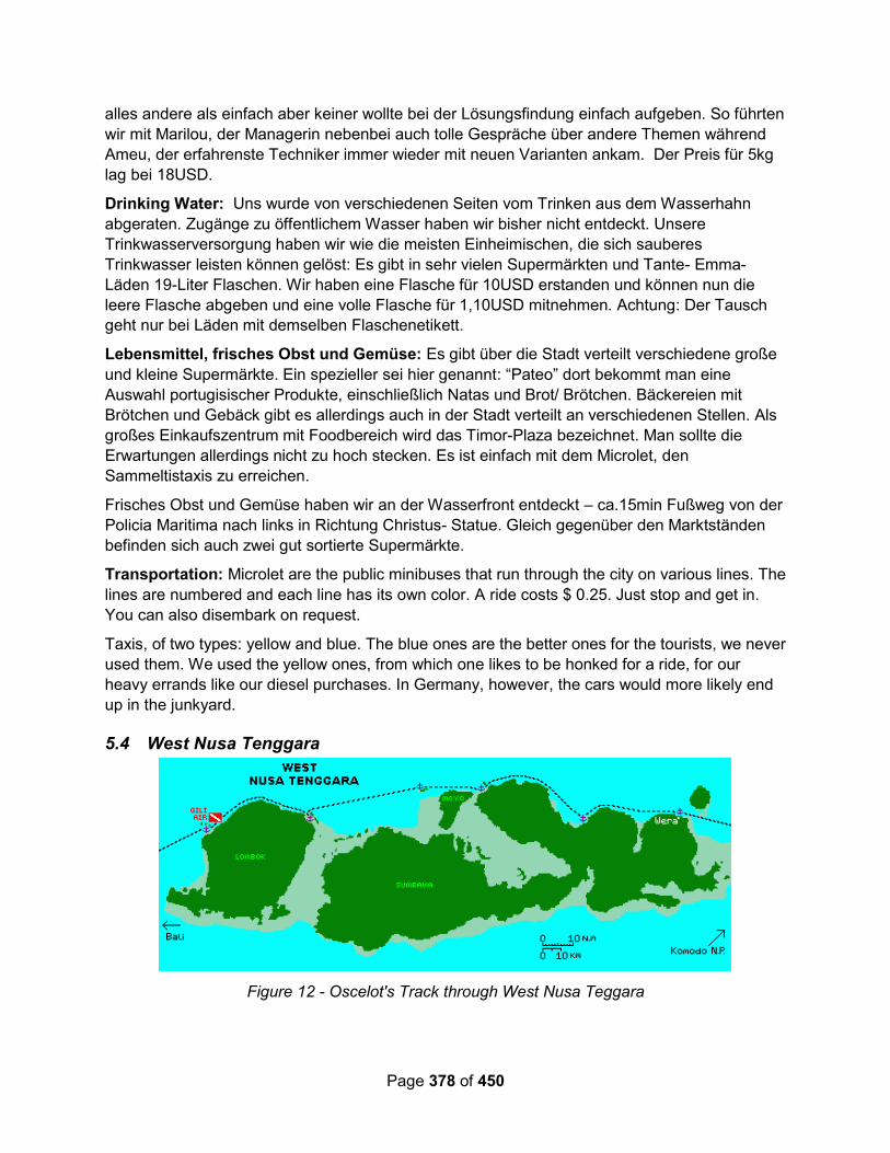
Page 378 of 450
alles andere als einfach aber keiner wollte bei der Lösungsfindung einfach aufgeben. So führten
wir mit Marilou, der Managerin nebenbei auch tolle Gespräche über andere Themen während
Ameu, der erfahrenste Techniker immer wieder mit neuen Varianten ankam. Der Preis für 5kg
lag bei 18USD.
Drinking Water: Uns wurde von verschiedenen Seiten vom Trinken aus dem Wasserhahn
abgeraten. Zugänge zu öffentlichem Wasser haben wir bisher nicht entdeckt. Unsere
Trinkwasserversorgung haben wir wie die meisten Einheimischen, die sich sauberes
Trinkwasser leisten können gelöst: Es gibt in sehr vielen Supermärkten und Tante- Emma-
Läden 19-Liter Flaschen. Wir haben eine Flasche für 10USD erstanden und können nun die
leere Flasche abgeben und eine volle Flasche für 1,10USD mitnehmen. Achtung: Der Tausch
geht nur bei Läden mit demselben Flaschenetikett.
Lebensmittel, frisches Obst und Gemüse: Es gibt über die Stadt verteilt verschiedene große
und kleine Supermärkte. Ein spezieller sei hier genannt: “Pateo” dort bekommt man eine
Auswahl portugisischer Produkte, einschließlich Natas und Brot/ Brötchen. Bäckereien mit
Brötchen und Gebäck gibt es allerdings auch in der Stadt verteilt an verschiedenen Stellen. Als
großes Einkaufszentrum mit Foodbereich wird das Timor-Plaza bezeichnet. Man sollte die
Erwartungen allerdings nicht zu hoch stecken. Es ist einfach mit dem Microlet, den
Sammeltistaxis zu erreichen.
Frisches Obst und Gemüse haben wir an der Wasserfront entdeckt – ca.15min Fußweg von der
Policia Maritima nach links in Richtung Christus- Statue. Gleich gegenüber den Marktständen
befinden sich auch zwei gut sortierte Supermärkte.
Transportation: Microlet are the public minibuses that run through the city on various lines. The
lines are numbered and each line has its own color. A ride costs $ 0.25. Just stop and get in.
You can also disembark on request.
Taxis, of two types: yellow and blue. The blue ones are the better ones for the tourists, we never
used them. We used the yellow ones, from which one likes to be honked for a ride, for our
heavy errands like our diesel purchases. In Germany, however, the cars would more likely end
up in the junkyard.
5.4 West Nusa Tenggara
Figure 12 - Oscelot's Track through West Nusa Teggara
Page 379 of 450
5.4.1 Sumbawa Island
Sail SE Asia FB Group – Sep 2019 – Whale Sharks: If you’re sailing over the top of
Sumbawa, you have an opportunity to visit the second largest whale shark population in
Indonesia. Only recently discovered, these whale sharks are being studied by Conservation
International Indonesia, currently. The local community is interested in managing the visitors
with an eye to conserving and protecting the whale sharks.
If you’d like to see the whale sharks, you should be sure to hire a local guide trained by
Conservation International Indonesia to take you to the bagans (local fishing platforms where
the whale sharks congregate). Arrange for this guide by contacting the local tourism
organization “Pokdarwis.” Their contact person is Muhaidin +62.85337214814 (telephone or
whatsapp).
Sail SE Asia FB Group – Aug 2019 – Visa Renewal: Just spent three days in Sumbawa
Besar for Social Visa extension. Very good experience.
The Kantor Imigrasi was efficient and very kind. No issue regarding the need for a “local agent”
and our sponsor/extension letters from Raymond were accepted. It would be helpful to have a
real Materai and signature on there. Scans can raise eyebrows and require explanation. The
office was not very busy; paperwork was submitted and fingerprints/photos were taken on the
same day. Passports were returned the following afternoon. No expediting fees paid. Easiest,
fastest extension we’ve ever experienced.
We anchored off town (Pantai Jempol Harbour). At 117°23.86’E, 08°28.06’S in 5m in black sand
with excellent holding. There is room for plenty of boats, and it was very comfortable in SE
breeze.
The shoreline is a rock wall that can make landing the dinghy an issue during more extreme
tides. There are beaches to either side, but the kids turned our dinghy into a trampoline and the
oars into shovels. We ended up soliciting the service of a water taxi during our stay that
transports around the cargo ship crews. They’d pick us up in the morning and return us
whenever we were ready. The fee was exorbitant, but we didn’t even bother negotiating and it
could probably be much less. They operate off the small concrete wharf with swings on it.
The town is awesome. The locals are awesome. Lots of places to eat and the hours surrounding
sunset can be a lot of fun. We made a point to dress very conservatively and I believe it was
appreciated.
There is no organised scooter rental, but we procured one for two days and it was great to have.
The traditional market burned down recently, so it has been relocated to Taman Kerato and I
would not consider it walking distance.
Lots of things to see and do if you have the time to discover them
Cool Runnings – June 2017 - Wera: We just wanted to give you a quick update on our
experience at Wera. We are actually leaving now and are going to sail overnight. We went
ashore and the only ones that made us feel somewhat welcome were the little kids. People
scowled at us, never greeted us back when we said hello and some of the older folk actually
"shoo-ed" us away. We saw the boats, luckily, but then we were approached on the beach by
2 young "thugs" who started demanding money from us to anchor here. When we refused, they
got quite aggressive. By the time we got back to our dinghy there was a whole crowd of men.
Page 380 of 450
We felt very uncomfortable and threatened. We we quickly got in the dinghy, back to Cool
Runnings and picked up anchor.
We will just sail through the night as we did not feel safe staying there.
Yindee Plus – Sep 2014 – Kananga: 08°08'.423 S 117°46'.028 E in 16m sand and weed. The
'shallow' shelf that runs parallel to the beach probably has room for three or four boats. Lovely
clean beach and friendly locals. They have a market on a Friday morning, which we missed, but
we managed to buy some veggies from the small shops. Met a young man called Arif, who
showed us around and explained what was happening on the beach (a large crowd of fishing
families from Wera who were temporarily living on the beach while they caught and dried flying
fish) and an area covered with pieces of a root from the island opposite, which is cooked and
used in soups. The island opposite reportedly has a lovely lagoon inside which you can walk to
easily. There are a couple of mooring buoys which were unfortunately occupied when we went
to have a look. Some rally boats did use the moorings though.
5.4.2 Medang island (52 in 101 Anchorages book)
Yindee Plus – Sep 2014 – Kananga: 08°08'.646S 116°22'.343E in 6.5m sand, good holding.
The turquoise sand patch is obvious in good light and would hold about 7 or 8 boats, and more
further out. This bay is deserted of settlements although fishermen use it to anchor off and
collect lug worms. The water is lovely for swimming and it's very pretty. Snorkelling not that
special but there are plenty of reef fish. Stayed two nights here as it was so nice.
5.4.3 Lombok Island
Wikipedia: Amid fighting between local factions in Bali and Lombok, the entire island was
annex by the Netherlands East Indian Company in 1895. The Dutch ruled over Lombok's
500,000 people with a force of no more than 250 by cultivating the support of the Balinese and
Sasak aristocracy. The Dutch are remembered in Lombok as liberators from Balinese
hegemony.
During World War II a Japanese invasion force comprising elements of the 2nd Southern
Expeditionary Fleet invaded and occupied the Lesser Sunda Islands, including the island of
Lombok. They sailed from Soerabaja harbour at 09:00 hrs on 8 March 1942 and proceeded
towards Lombok Island. On 9 May 1942 at 17:00 hrs the fleet sailed into port of Ampenan on
Lombok Island. The Dutch defenders were soon defeated and the island occupied.
Following the cessation of hostilities the Japanese forces occupying Indonesia were withdrawn
and Lombok returned temporarily to Dutch control. Following the subsequent Indonesian
independence from the Dutch, the Balinese and Sasak aristocracy continued to dominate
Lombok. Eventually Lombok was made part of West Nusa Tenggara Province.
5.4.3.1 Lombok Marina del Ray (Gili Gede)
There is a new marina operation that opened in ~2018 that is now a clearance port for
Indonesia, and a marina.
https://www.lombokmarinadelray.com/
From this website:
Page 381 of 450
Location: 08-45.600 S / 115-55.96 E.
Welcome to Indonesia’s first and only integrated Marina and provisioning facility with 24-hour
international Port clearance.
We are the only year-round protected western-standard Marina between the 2500 NM of
Australia and Singapore.
We are the only safe location in Indonesia to leave your boat unattended, 12 months of
the year.
We are the only professionally maintained marina with moorings located close too two
international airports of Bali & Lombok.
Due to Indonesia natural topography, good holding is difficult to find in less than 30+ meters.
Suitable anchorages in bays with 12+ meters can be found but are far from international
airports.
Owners should never leave foreign boats unattended overnight.
Indonesia does not have cyclones, typhoons or long oppressive wet seasons.
Indonesia is the largest archipelago in the world with 17400 islands to explore, many still
undiscovered by the modern world.
There is no piracy in Indonesian waters.
Port Gili Gede is the largest privately operated Superyacht port in South East Asia. We have an
average depth of 25 meters & can be navigated by 100 meter+ Superyachts by two deep
channels from the West & North. Our location is: 08-45.600S & 115-55.96E.
SERVICES
12 to 22-meter LOA western standard marina Berths in 15 meters MLW. 32 & 64 Amps
electricity & drinking water, Moorings up to 50 Meters LOA, 24-7 security.
ONSHORE FACILITIES: Yacht club with pool, beach bar and restaurant positioned majestically
overlooking our breath-taking private port that is surrounded by mountain ranges which protect
the largest super yacht port in Asia, called Port Gili Gede. Other Facilities include:
Clearance, Fuel Supply, Showers & Toilets, Provisioning, ATM, Wifi, Fresh Produce, Chandlery,
Laundry, Yacht Care & Maintenance, Daily Ferry Service to Bali, International Airport Transfers
DOCKYARD: 10 NM North of the Marina there is a Haul out facility for yachts and catamarans
with a maximum draft of 1.8 meters. There is a Marine Engineering repair facilities run by an
Australian Marine Engineer. Dredging is currently underway to deepen the channel to 2.5
meters at low water. Enquirers: please email your boats LOA, Beam, Tonnage and pictures of
her hull to, [email protected]
RATES & RESERVATIONS
Marina Berths are charged by the area your boat uses. Moorings are charged on the gross tons
of your boat. Our base rate is discounted for a minimum of 32 days visit. TO MAKE A
RESERVATION and calculate what it will cost click on the Reservations button.

Page 382 of 450
TRANSPORT FROM BALI AND LOMBOK AIRPORTS: There is a 90-minute daily ferry Service
from Seranggan harbor Bali to Gili Gede book at [email protected] or by a
25-minute domestic flight from Bali to Lombok Praya International airport. Which has daily
international flights from KL, Singapore, China and Air Asia from Perth Australia. There are also
10 other connecting flight from Jakarta and Bali daily. From the airport by Taxi takes 80 minutes
to the Marina.
Sail SE Asia FB Group – June 2019: At least 2 cruisers have had “unsettling” experiences
with Marina del Ray owner Raymond La Fontaine, where he has become verbally abusive over
fairly trivial issues. (details, see post from Franz Maschke on June 26, 2019)
Response from one of the marina management: A few sailors come by expecting our
investment was put there to support their life style for free. We work on a strict policy of payment
for service, same as any commercial operation. Unfortunately there are a few people who come
all this way to take advantage of the marina only then not to pay, complain about our fees after
knowing them full well before they arrive then bitch about it on platforms such as this.
People who read these comments should be careful about coming to a conclusion without
knowing the full story.
5.4.3.2 Tampas / Amoramor, North Coast of Lombok
Alba - September 2015: We were enroute to Lombok but could not make Gili Air before dark.
A friend told us that someone else had anchored at a place called Amoramor on the west coast
of Lombok.
I checked it out on the chart and it looked okay for a night stop. It was 30 miles away, so we
could just make it before dark if we averaged six knots. We turned the engine on and hoped
that we wouldn't meet a strong counter-current.
We arrived at the anchorage by half past five. Amoramor is a small fishing village with a black
sand beach - more a road-stead than an anchorage. There wasn't any depth information on our
charts and the sea bed is black sand making it impossible to judge water colours especially with
the overcast sky that we had. We carefully motored in a rectangle, plotting out the depths
between 6 and 10 metres, then anchored in the middle at 08°14.076S 116°17.705E.
It seems to be good holding, but there isn't much protection from the swell and we’re bobbing
about a bit. However, it’s better than being at sea and we just had time to get a cold beer and
watch the fishermen coming out to lay their nets before the sun went down.
It wasn't too bad a night, a bit rolly and we had waves slapping the stern as the current moved
us around, but we slept well.
Another Boat – From a track, 08 14.2308 S / 116 17.4235 E
5.4.3.3 Medana Bay, NW Coast
Sail SE Asia – October 2021 – Medana Bay Marina Haulout: Apparently Medana Bay Marina now has a haulout facility big enough to haul big cats.
https://www.medanabaymarina.com/
“Medana Bay Marina is proud to announce to be the first marina with a yacht haul out facility in Indonesia

Page 383 of 450
The Dutch manufactured ROODBERG HBC38 hydraulic haul out trailer with 38 tonne and 2m draft capacity, in Medana Bay Marina Lombok, is the first of its kind in Indonesia. Prior to Medana Bay becoming operational, there were no marinas with a facility for keeled yachts to be hauled out between Darwin and Singapore.
With the addition of this new facility, yachts will now be able to undergo a variety of maintenance works including painting, body works, repairs and hard stand docking. So far we have successfully hauled out two mono-hulls in December. Medana Bay Marina is ready and excited to welcome yachts for haul out.
Hosting the Sail Indonesia Rally since 2009, the marina is fully equipped to provide all yachting services and mooring facilities. In addition to a slipway and haul out facility, the marina also has 15 moorings, 6 serviced berths with metered water and electricity. Services such as re-fueling, boat cleaning, boat repairs, LPG gas refills as well as long term mooring facilities are available.
The Marina also includes a beautiful hotel, beach side restaurant and function hall all available for an easy and comfortable stay. The family run business, and the welcoming staff, is proud to boast family friendly service – you will be more than our guest, you will be our family.
For more information on how to book your boat to be hauled out
Call Soraya at +6287765859666”
Coordinates 08°21.833’S 116°07.750’E.
Entry way-point almost due north at 08°20.432’S 116°07.685’E
VHF CHANNEL 17
Starry Horizons - September 2018 – Medana Bay Marina: We arrived ahead of the rally to Lombok. We put Starry Horizons on a mooring at 08°21.885 S 116°07.767 E and flew home.
Cruisers with the rally pooled together to help the local community, who had suffered a massive earthquake in August. Organized by Kimi and Trevor from S/V Slow Flight, a temporary school was built. The cruisers who helped out put in long days of back breaking work. We arrived back just in time for the ribbon cutting ceremony.
We found Medana Bay and its owner, Peter, very helpful. I was able to hire a driver to take me to Mataram for provisioning. Laundry, diesel, propane, etc, all available here.
You can anchor outside the mooring field but will pay a dinghy fee.
Alba – Sep 2015 – Renewing Visa in Medana Bay: In Gili Air, we spotted that our friends on
“Laragh” had arrived, so we stopped by and chatted to David and Katrina catching up on their
adventures over the past few weeks.
They've been trapped at Medina Bay Marina waiting for their visas to be extended. It took three
days to get their passports back and cost twice as much as we paid in Bau Bau. The whole
process has been a nightmare with travel to the immigration office taking a whole day. Some
people have spent over a week getting their visas sorted out, which is a horrible waste of time.
Apparently Medina Marina is subject to swells and is very rolly, so having to wait there was very
unpleasant.
Yindee Plus – Sep 2014 - Medana Bay Marina: Picked up a mooring. Intended to only stay 2
nights but stayed 5; it was so great. British ex pat Peter and his Indonesian wife Ace, have
created a lovely, quiet haven for yachties. They can help you arrange fuel, water, laundry (the
best anywhere in Indonesia and nearly the cheapest) and tours of the island. They also have a

Page 384 of 450
great cafe with nice food and inexpensive prices. The employ some very helpful local people
too. Highly recommended.
Equanimity – Sep 2013: We arrived at the Medana Marina on the north west side of Lombok
Island and anchored. Lombok is just east of Bali. It is a lovely little spot and we made ourselves
at home, booked a city tour, brought laundry in to be done (very inexpensive and much easier
than trying to hand wash and line dry sheets, towels and everything else that gets dirty and
salty). The city tour was fun... A long and full day with many stops including temples, ATM,
monkeys, supermarket at the mall (provisioning at a "real" supermarket is a highlight for sure!),
beach resort, hand-made pottery shop, traditional weaving village, and pearl shop. We were
taken by bus all over and it was a little like a grade-school field trip including box lunch sammies
and soda.
5.4.3.4 Gili Trawagan, Gili Menos, Gili Air
Sail SE Asia FB Group – Aug 2019 – Moorings in the Northern Gilies: Can anyone shed
some light on the current mooring situation in the the northern Gili’s? Locals keep directing us to
the “ones for yachts” only to be kicked off a few hours later by the boats who “own” them. We
were aggressively chased away from Trawangan and will have to figure out an alternative.
Too deep for us to anchor. Getting frustrated... we were just in Trawangan. Moving to Air now.
(each “bullet” below is an answer from a different cruiser)
Be very careful use any of the mooring balls. They are not maintained and I dragged
there twice in the same night. Ended up anchoring in 40 meters with 70 m of chain. Big
currents and big swells.
We used the Gili Air moorings. Had a disaster at Gili T. Would not recommend there at
all. Mad currents and weird swinging mooring lines.
The little area in the reef at Gili air was fine tho. Dont get the one furthest from the beach
as it is for the big ferry that comes in.
We anchored for the night in Gili Air (got in just before sunset) but moved to a mooring in
the morning. The anchorage area is used for dive training so we didn’t want to be in the
way.
Yes, the mooring situation is a problem. We did find shallow patch but hundreds of
snorkelers floated past while we were eating. In the end we gave up and went to the SW
Gilis of Gede - a bit like what Gili T was like 20 years ago before the fast ferries ship
1000s of day trippers fro Bali! Sengigi has a good anchorage in front the Sheraton Hotel
and maybe best to anchor there and get the ferry back if you are going West.
The morrings at Trewangan have been sunk for some turtle conservation thing so dont
anchor, or there is a good chance of fouling your anchor. Not sure of Meno but there are
at least 6 black ball moorings just a little way west of the main ferry jetty on Air. If you
pick them up you are likely to either be left alone or if you go ashore there is a guy called
Reni who runs a fast boat service he will direct you to the owners and you pay them
50,000 rupiah BUT you must make sure you get a receipt. Once you have that no one
can touch you.

Page 385 of 450
The moorings on Gili Air Meno And Trawaggan are not made for yachts nor are they
maintained. It is not a secure anchoring area. Also yachts have been losted frequently
over the years the on the NW Gilis and the mainland bays opposite on the mainland due
to wind on tide and unexpected onshore winds. The best anchoring is in the deep bays
south of the northern Gili Islands just up from Sengiggi. Then there is the bullet proof
Southern Secret Gili Islands where Marina Del Ray is.
Verite – October 2018: There are plenty of moorings available at Gili Air close to
08 21.93S / 126 05.02E.
Pick up yellow or blue. We dived ours and it’s good.
Alba – September 2015: Gili Air is a tourist island and the shore line of the small one mile
diameter island is packed full of restaurants and bars - as we motored around the island, we
could see hundreds of people on the beach that fringes the whole island.
The small harbour was crammed with scores of local boats on moorings or pulled up on the
beach and there were eight or so yachts at anchor or on moorings. We picked up a mooring,
but a guy on a power boat told us that we’d get kicked off, so we went to anchor further out in
20 metres of water (08°22.00S 116°04.89E).
We went to chat to another boat to get some local knowledge, and then went ashore to grab
lunch. There’s a narrow track which runs parallel to the beach, lined with small shops, dive
centres, restaurants and small hotels. There are no cars or motor bikes allowed on the island,
so the locals use small carts pulled by ponies to move heavy goods and act as taxis for tourists.
It was quite a shock to our systems to see so many tourists, but it’s a relaxed place to chill out.
Having had our fill of Indonesian food over the last couple of months, we ignored the local
Warungs and opted for burger & chips and a couple of cold beers at a touristy beach bar -
luxury. We then wandered around for a while buying a few things at a small grocery store and
we've booked a dive for tomorrow morning.
We spent the afternoon on-board Alba. There’s a constant stream of small ferries that power
through the anchorage, bringing tourists from mainland Lombok or Bali. These don’t slow down
as they enter the harbour and their bow waves can be up to a metre high, so we have
everything stowed away like we’re at sea. Fortunately, they stopped in the late afternoon and
we had a very peaceful night.
We went diving in the morning. The dive centre took us to a small bay on the Lombok mainland
where we first looked at a couple of small wrecks and then swam across a huge sandy area to a
shallow rubble area. It was a muck dive, so the whole point was to try to find small creatures,
but the environment was a bit dull and all my photos came out muted - I need to reassess how
I'm using my strobe. However, we saw some new creatures including a Dark Margin
Glossodoris and a Tigertail Seahorse.
It was very, very hot in the afternoon with hardly any breeze, so we lounged about reading and
dozing (and hanging on whenever a ferry went by).
The next day, we spent the morning walking on the beach, doing a circumnavigation of the
island - only about three miles. It’s a pleasant beach, but most of the coast line is packed with
Page 386 of 450
hotels and lodges and where there’s a gap, the locals are building. We had lunch in one of the
beach side restaurants - Malaysian food this time.
In the afternoon we prepared to go to sea, heading for north Bali, a 75 mile passage.
5.4.3.5 Teluk Kombal, NW Coast Lombok (#58)
Yindee Plus Oct 2014 - Teluk Kombal, NW Lombok (58 in 101 Anchorages book)
08°24'.223S 116°04'.537E in 25m sand. Lots and lots of moorings here (but none that were
obviously for rent) and it was difficult to find room to swing between them given the anchorage
depths. Lots of traffic to and from the Gili Islands, so boat wakes are a problem too. This place
is hardly recognizable from the description in the 101 Guide. This anchorage seems to have
changed a lot since the entry was written and is not recommended unless you can arrange a
mooring.
5.4.3.6 Southern End of Lombok
Verite – October 2018 – Gili Gede: We visited Marina Del Ray, Gili Gede, Lombok last week
and it’s up and running. Moorings all new and in good shape. 95,000 IR per night. See website
for special opening deal on dock berthing. Showers and toilets all operational and the yacht club
opening very soon. Friendly, helpful staff. Swimming pool to be filled shortly. VHF 72.
The Lombok area is recovering. We are in Gili Gede today and it’s beautiful!! If you are sailing in
the area drop in and support these resilient people who are rebuilding their businesses and lives
after the earthquake early August. Good moorings, easy access, great restaurants and clear
water.
FB – July 2018: This is just to let you know that Secret Island Resort on Gili Gede, south west ,
Lombok has 4-5 full on heavy recently serviced MOORINGS with excellent security about
$125/mo. And please be informed that our long wooden pier has two Bungalows over the reef
for rent, not for Yachts to tie up! Beautiful spots where you can also keep an eye on your yacht!
CALL +62 8103 76 2001
Email - [email protected]
5.4.3.7 Hiking Mount Rinjani
Sail SE Asia FB Group – Sep 2019: Has anyone hiked Mount Rinjani?
You can no longer go to the summit since the earthquakes. There are many tours. I
recommend the 3 day 2 night walk as it is a fair hike. Unless you go and back from
Senaru. Adi Gili Lombok Driver (look up on Facebook) has good contacts and well
organised.
5.5 Bali
Bali is both an island and a province in Indonesia.

Page 387 of 450
Figure 13 - Oscelot's Track Through Bali
5.5.1 Marinas, Moorings, and Haulout Facilities
Stellamaris – June 2019 (Noonsite report) – Bali Marina, Benoa Harbour:
The Marina is in serious disrepair and can be quite hazardous depending upon the berth
assigned & weather conditions;
your vessel will sit in putrid garbage
the marina management requires that you go through them for fuel and water;
the marina management will not allow any work to be done on the vessel unless you go
through them & they will assign or approve your contractor;
the marina management will require that you pay for a month in advance, and say that if
you don't stay a month, they will "refund" your money; BEWARE, as if you ask them how
and when they will refund your money, they do not have an answer. Note: it is our
opinion that you will not get your money refunded.
Recommend that if all you want is to clear Customs, use another location in Benoa Harbour, or
have an agreement with the marina management clarified in advance.
Sail SE Asia FB Group Discussion – June 2019: There is now a new marina 300m away
from the old one, it’s called Benoa Marina it’s at the Pilot Station. They have shore power but
nothing else there, the dock is nice and new. It’s a bit more exposed to the channel enterance
than the old marina so the swell is a bit of a bother right now. I just spent 4 months in there. It is
more expensive than the old marina.
Page 388 of 450
It's the first marina on the left after the sharp right turn. The Manager’s name is Abid, he uses
Whatsapp to communicate if you have that. His number is +62 812 3456 0391.
Jeff Lim: I can’t comment on the marina condition but we are currently in Serangan
Harbour on a mooring. We picked up an outer mooring from Ruth for $200K Rp per day.
We ended up moving further into the bay for better protection and found a mooring for
$100K Rp per day on a monthly basis. FYI when the swell and ESE wind is up it rolls
right into the outer mooring field which made it quite uncomfortable. Wet ride back to
boat every time.
Peter Windsor: Better to go to Lombok Marina if leaving your boat. The ferry is only
about $6 back to Bali or Approx $40 Aus to fly
Ian Todd: The newer marina was just way too expensive at $86aud a day--the old one
is less than half that even if it is a bit quaint.
Kerry Hall: Another option is to go to Medana Bay Marina on the North West tip of
Lombok. 4.4 Nm from Gili Air.. and 6.5Nm from Gili T... place is awesome, safe and you
can provision easily... I have been there for 3 years... just returned from a VISA run to
Dili... and will be there for another 3 years... http://www.medanabaymarina.com. Costs
are very low to stay at MBM
Rob Isted: Lombok marinas are a reasonable option. A swing mooring buoy at Medana
Bay is IDR140K per day. Fast boat to Padang Bai on Bali is 250K, takes an hour and a
half. Taxi from Medana to ferry terminal is 10 minutes at most. Medana Bay is a very
safe marina and pleasant place to hang out. My boat is there now and I'm typing this
while I wait for a boat to Bali.
Brick House – July 2015 – Bali Haulout – Beware!!: The pirates of Serangan Yacht Service
will hold you on shore till you pay their arbitrary and changing ransom. Ruth, the local yacht
agent lead us into this deal. But how nice, because of all the money she cost us, she gave us
10% off of our mooring bill. Ruth owns no moorings but rents out moorings owned by Serangon
Yacht Service and boots up the price.
We have made some mistakes operating Brick House over the past 8 years. But there is a
number one, top of the list, biggest mistake which supersedes all others. And what a terrible
experience it has been. This mistake was the decision to haul Brick House out of the water in
Serangan, Bali.
We had some damage to the skeg and keel. We could have carried on another thousand miles
northward to Malaysia where we knew there was a proper yard with a travel lift and prices for
haulouts were very economical, but we thought it prudent to make the repairs as quickly as
possible. We didn't need help- we simply needed to haul the boat out of the water for two weeks
so we could make the repairs ourselves.
This is not the time to go into details but I feel a civic responsibility to post basic information to
warn other cruisers so they have the information to avoid the terrible situation we experienced in
Bali. We have since heard that some cruisers were warned when they arrived in Serangan, Bali,
by other cruisers, who have their own negative stories about dealing with the local yacht
facilities and yacht services. But those cruisers tend to speak in hushed voices while they
remain in Indonesia. We somehow missed getting the word but it did not matter as we were

Page 389 of 450
working with a trusted agent to help us arrange everything. But we were led astray by this local
Bali based, well known professional yacht "agent" who arranged everything for us. This not our
first haulout, and we knew what to ask and get in writing. It was all in emails, the prices, what
was included, like electricity, pressure washing etc.
Once hauled out of the water, we became captive to changing and arbitrary costs. Through this
professional agent, we originally had agreed to pay an exorbitant $1,580 USD to be hauled out
and put back in the water 15 days later. In the end, we were forced to pay an incredible and
arbitrary $2,484.00 USD (after much stressful negotiating) for the same thing. We did all the
work and we supplied all of our own materials...we are talking ONLY about a haul out/in, 14
days on the hard.
ven the pressure washing which was supposed to be done was a joke. The pressure washer
was an electric toy producing less pressure than a normal garden hose. Plus, when hauling then
launching, these people were not careful and deeply gouged through the forward section of
fiberglass of the keel to expose the lead ballast. They would not take responsibility for their
damage and would charge me another $400 to lift the boat off the keel into a position for me to
repair the damage. This we did not do so now we have to haul out someplace else to repair the
damage these people caused.
The people who operate the haul out facility are the biggest and most unpredictable thieves.
Contracts, hand shake agreements, honesty, are things that are not understood here. Cruisers
are seen as floating ATMS that have no daily limits for withdrawals, and who only come to Bali
to provide financial security, even if it involved no service or product in exchange.
This situation is reminiscent of what has been posted about a haul out facility in Port Villa,
Vanuatu. Now there are two places in the world cruisers need to stay away from.
In Bali, we made a few new friends who we would like to see again. However, far too often,
because of this place being a tourist trap and a stopover for cruising yachts with perceived
pockets overstuffed with cash, many new smiling friends have dollar signs for retinas. In Bali,
you can trust no one, even those who have been touted as honest on previous postings.
Lombok island, to the east of Bali, is far more tourist friendly and interesting. But more on this
later.
If you are sailing with an organized rally, do yourself a favor and skip south east Bali and go to
Lombok. But beware the smiling, helpful, "agent" in Lombok! The one primary yacht "agent"
there is no better than the other thieves....more on that situation soon.
5.5.2 Cruiser’s Services
Sail SE Asia – January 2021 – Sail Repair & Canvas Work: Out of necessity we found the
only sailmaker in Bali and South Indonesia - Juli. She can fix and made virtually anything - sails,
biminis, upholstery - for small and large yachts. Very friendly. Can do some jobs at the boat
location. Address and contact info:
SaiL Su ModisTa
Jl. Kerta Dalem No.2, Sidakarya, Kec. Denpasar Sel., Kota Denpasar, Bali 80224
0821-4525-8237
WhatsApp: +62082145258237

Page 390 of 450
FB Discussion – September 2018 – Watermaker Help: Try Roni +6281238318882 in Bali.
He is not on FB. But can get him on What’s App. Supplies and installs Spectra in Bali.
FB Discussion – August 2019 – JJ Marine Indonesia is located in
“We are the only one with western experience for assist you a 360° in your new build, diesel
engine repair , Electrical repair and other matters your boat need planning
maintenance/preventive maintenance is meaning safe money and safety for your investment.
We can make a package for your boat in base size boat , genset model , HP main engine with a
good price.
Not hesitate to contact us:
Office Number : 0361 4481319
5.5.3 Anchorages
Starry Horizons - October 2018 – Amed Beach (NE Bali): 08°19.986 S 115°38.632 E
We anchored in the black sand with an incredible view of the massive volcano on Bali. Amed is
very touristy (well, all of Bali is). The town is extra dirty to boot. The anchorage had quite the
swell, and its tough to pick a shallow enough spot around the local mooring balls.
We packed up our dive gear into the dinghy on morning and motored 9km to the USS Liberty
wreck dive site. We anchored off the beach and dove. Lots of big fish and an easy dive site, no
deeper than 50 feet or so.
Starry Horizons - October 2018 – Lovina (NW Coast): 08°09.587 S 115°01.417 E
This is a lovely anchorage. We arrived just after the rally, so our friends were all there, but there is plenty of room just tucked in behind the reef on the east side. Very shallow water, but the sand is black so it’s hard to tell that you can actually see the bottom!
This the best place to provision your western products in all of Indonesia’s cruising grounds (I’m sure Jakarta has big supermarkets too, but no one cruises there). Just 200 feet off the beach is Pepito Supermarket, with all your imported products and some high end domestic ones. Lovina’s fresh market is rubbish compared to most other stops, but by god, we can find cranberry sauce for the upcoming Thanksgiving and cheeses galore!
Visa extensions were handled through LA Tour. As we missed it, we had to make arrangements through LA Tour for our own extensions, which included a trip to Singaraja.
We also booked a driver through LA Tour twice. Once to the FedEx in Ubud and once for a full day tour of the area. We visited the Gitgit and Secret waterfalls (Secret was worth the extra money in my opinion), the Ulun Danu Beratan Buddhist Water Temple, Handara Resort Balinese Gate, Twin Lakes, Munduk Rice Terrace (skip it and visit Jatiluwih or Tegalalang instead), and the Air Panas Banjar Hot Springs - quite a day! Full day driver: 650.000 Rp.
Starry Horizons - October 2018 - Menjangan Bay (NW Coast): We did not stop here ourselves, but rally friends did and I thought it was worth a mention. They said the nearby resort was very welcoming to cruisers and they enjoyed several meals in this well protected bay. I’m sure it was less rolly than the other two points on the north coast!
General area: 8°08.335 S 114°33.831 E
Page 391 of 450
Popeye – Mar – Aug 2018 – Banyu Wedang: 08 08.2000 S / 114 33.8500 E This is a beautiful, well protected bay. It is an easy entry despite the narrow entrance with the reefs being very obvious. We anchored off the Menjangan Dynasty Resort in about 16m. Big anchorage with plenty of room for us and the five other yachts anchored when we arrived. It could hold many more.
The Resort was very welcoming and allowed us to use their facilities for Rp 200k which we could then use towards food and drinks. Prices a tad on the high side (for Indonesia) but a beautiful location. We could get their wifi from the boat but it was very slow so we found it better to sit at the bar! Kama Gede, the F&B Manager was fabulous – we took him as crew to Lovina – most photographed leg of our trip!
The location was a little inconvenient but we loved the security of the anchorage and it was very peaceful when compared to even Lovina and a far cry from the chaos of Kuta. It took about an hour to get to Lovina and the immigration office by road. We used Nyoman (balidriverhire.com) whom we rented by the day for about USD50. He ferried us to and from the immigration office, supermarket, local market and toured us around the island. He was punctual, his English adequate, his driving skills excellent, his vehicle was clean and in good repair and, importantly, all his seatbelts worked. He helped us purchase non-subsidy diesel (solar) and arranged laundry. This was the best and cheapest (US$3/10kg) laundry we had done in Indonesia. It was perfectly dry, beautifully folded and smelt wonderful. We would highly recommend him (and feel free to use our name).
We paid Rp7300/litre plus Rp5000/jerry can to fill. Nyoman drove us to the service station where we could purchase it – it seems there is only one in Singaraja. (Pertamina Service station is at 8°07.614’S 115°04.757’E) We had a receipt showing it was non-subsidy but no receipt for the jerry can charge. The diesel was very clean. Refueling from Lovina is more convenient.
We left our dinghy at the eastern end of the bay on the concrete jetty. The tide does rise and fall a couple of metres here so beware when tying up your dinghy. We locked it securely first day only to come back and find that it had been moved and retied as the tide had fallen. After that, we just left it tied up – it was always there when we came back, but sometimes had been moved!
Java – August 2017 – Singaraja (N Coast): Anchored in 17ft sand/mud South of overwater
pavilions by statue. 08 06.148 S 115 05.264 E
Velella (FB) – January 2018 – Bali Area Anchorages: In quick succession having recently
visited Lembar, Gili Gede and Serangan, I can confirm the Gili Gede anchorage with Marina
Delray moorings is the most attractive for leaving a boat unattended for any length of time. It is a
pleasant place also to be aboard. We enjoyed walks ashore (some interesting small birds for
any birdwatchers), eating ashore - we sampled Tanjungan Bukit and Secret Island, and
negotiated clothes laundry at a small village on the shoreline. We were sorry not to meet Ray
while in the vicinity.
Lembar anchorage was very suitable for accessing the local market, finding a reasonably
stocked minimart and obtaining diesel.
We anchored to port of the channel coming in and past some floating restaurants or fish
platforms. That was excellent for a first night but apparently it is a Watersport area and we had
to move. We took up a single mooring - a lot of them are double, fore and aft. 'Mande' came to
us by dinghy to offer a mooring. Ruth, ashore at Isle Marine Services, also has moorings.
Page 392 of 450
Where we are now, on the outer to starboard coming in, is a bit rolly, but it suits our needs; Ruth
may have offered moorings further in where the water is calmer. Depends on your
requirements. We didn’t try the actual anchorage because we would be a lot further from shore.
We have a small dinghy and need numerous trips back n forth hence happy with the mooring
So, we didn't actually anchor in the designated area so cannot really comment on holding.
Brick House – July 2015 – Bali Impressions: We once watched a travelogue on Bali and that
is when I decided there was nothing there of interest for me. I don't need a massage on the
beach or to pay a lot of money to watch the new day sun rise up while sitting on the top of an
old volcano. But sometimes it is good to see for oneself just how undesirable a place can be.
Maybe like a quick trip to hell, just for the fun of it. Now I have a long list of reasons not to
suggest Bali as a destination for anyone, except for someone I would like to send away to a bad
place.
Bali is a tourist trap. To the Balinese, the purpose of a tourist is to disgorge money into their
hands faster than an ATM. Everyone, even pleasant, successful business people, suddenly
become a newest best friend offering any service imaginable. The water sports owner in
Serangan, in south east Bali, had a pitch to sponsor us into the country as a resident. We only
needed to deposit $100K into an account...oh and that gets us 5% interest. But then more
money is needed so he could build us a house, which really can't be owned because the land
can only be leased. Or you could buy a timeshare in a building which does not exist....it is just a
little snag in the permit but it will be started soon.
On the long white beaches in Bali, the hawkers are thicker and more bothersome than flies.
They trail a strolling tourist and are difficult to shake. They persist in the hope of selling carvings,
weavings, string bracelets, toy bow and arrows and things few tourists would want. I would
prefer to deal with a horde of garbage flies as that problem is solved with a little DEET. Taxi
drivers will try to charge $10 for a $2 ride. Don't deal with any taxi that does not have a meter.
In Bali and the rest of Indonesia, health and sanitation in the food service industry is not what
would be found in westernized countries. In little restaurants along the sidewalks, stir fried rice,
fried chicken and all other food is cooked then sits all day heaped on display plates at ambient
tropical temperature or further affected by the sun blasting through the window glass.
Sometimes the food is reheated before serving. We learned a new Indonesian word, "mencret"
meaning, diarrhea. In the modern looking city of Bali, full of hotels and tall buildings, we thought
it worth playing it safe and order a hamburger at Burger King. What I found under the bun was a
speck of meat, sort of stuff, the size and look of a breakfast sausage patty. When I asked about
the smudge hiding inside of the bun, it was verified as the Whopper sized burger. But the meat
was more the texture and taste of ground tofu! To help ease things down, this became a
Whopper of a ketchup sandwich. There is no finer sauce for correcting poorly imitated American
cuisine. We had nearly the same disastrous experience at Pizza Hut; a wafer thin crust of "what
is this transparent gooey stuff?" Although these fine dining experiences were very expensive
relative to restaurants serving more traditional food, we were successful in not experiencing
mencret.
Surfers do come to Bali because they have heard big wave stories, but the waves are not
always there and I have seen better surf in Fiji.

Page 393 of 450
The only good tourist things we found in Bali were the Bird Park and the Bali Zoo. At each, we
spent at least 5 hours wandering the well cared for grounds and viewing all the amazing species
which would be difficult to spy in the wild. The employees and caretakers were well chosen by
the management. They spoke good English, were knowledgeable and attended well to the
tourists.
I can't imagine why any Australian would want to travel to Bali when the north east of
Queensland has so much more to offer or Fiji is just as easy to get to. And why would an
American tourist fly half way around the world when Orlando, the Florida Keys, Costa Rica,
Dominican Republic or so many other preferable places take only a day flight to get to. Bali is
the pits.
5.6 East Java
5.6.1 Bawean
From a tourism site 2018: Bawean island can be reached by a 3 hour fast ferry from East
Java. Bawean island consists of 2 districts, Sangkapura and Tambak district and 17 villages.
Sangkapura is the largest district in Bawean island. This island has many tourist destinations
which are as good as other tourist destinations in Indonesia.
Besides its marine tourism, and lakes and waterfalls tourism, visitors can also enjoy the culture
of the indigenous people in Bawean Island.
This island said to be able to compete with Bali or Bunaken in North Sulawesi. Bawean name
itself special meaning, Bawean is taken from the Sanskrit word meaning "There Sunlight".
There deer species that only found (endemic) in Bawean Island, called as Axis Kuhli. Besides,
mangosteen, bark, red fruit, and durian are planted in this island. Dozens of fishes species are
also on the coast of the island.
Iswanto (FB Name, SE Asia Group) – October 2018: Bawean is a small island located in the
East Java Sea between Java and Borneo.
For all the Yachters, plan and arrange your anchor in Bawean. Explore our local tourist
destinations.
Let me help you arrange your short tour (if desired)
Info : +6281252673483 Swan
www.baweantourtravel.com
Popeye 1 (From Noonsite) – July 2017 – Bawean North Anchorage
Bawean – North Anchorage 05°43’47”S 112°40’14”E
The reef to the east is marked with a white flag. Be cautious as the reef does extend a little
further that you would imagine, keep to the middle of the bay. We had an unfortunate incident,
ending up on the reef, all turned out well but scared the bejesus out of us! There are a couple
of soft drink bottles tied to a coral head in the middle of the bay. Steer clear of that too!
A great anchorage on sand in 4-8m water. We did have a very uncomfortable night the first
night when a swell came in from the NW and we rocked and rolled all night but the anchor was
Page 394 of 450
sound. Once this died out, it was dead calm. Beautiful scenery with the ubiquitous mosque
call-to-prayer and cock calls in the pre-dawn.
Head to the beach at the top of the bay, the reef extends along both sides. It is about a
kilometre to walk into the town. You will likely be offered a ride. Everyone is very friendly, you
will be treated like a celebrity and you are asked for a ‘selfie’ at every turn!
Hartono (who runs the warung on the left, just before the bridge in town – if you pass the police
station, you have gone too far) helped us with diesel, on-shore accommodations for crew and
arranged a tour of the island hitting all the high points. His buddy with the car, car-owning
buddy’s best mate, Hartono himself, his two kids and Grandpa all accompanied us on this tour!
It made for great fun.
Despite its source, the diesel was cleaner than what we purchased in Kumai and we paid
Rp7000/litre.
Page 204 Cruising Guide to Indonesia.
Yindee Plus – Nov 2014: We planned just one stop, at Balwean island, on our route between
Bali and Kentar Island in the Lingga Group. This would get us north as quickly as possible.
5.7 Central Java
5.7.1 Jepara (Marina Facilities)
FB – Sep 2021: There is a resort and small marina here.
http://www.jeparamarina.com/
Several cruisers in the Sail SE Asia FB group have mentioned the help and hospitality of
Sorgen and Dina Lax of Jepara Marina, on the N Coast of Java, about 25 nm NNE of
Semarang.
In July 2019, s/v Matilda reported anchorage there in 3.7mtrs. 06° 36.70’ S / 110° 38.67’ E
Soren Lax on FB: https://www.facebook.com/soren.lax.9
Lea Pennicot (FB) - May 2021: For those heading through Indonesia, Jepara Marina Beach
Bungalows offers an oasis mid Java. Lax, son Chris and wife Dina go out of their way to assist
yachties calling in. Fuel, provisioning, resort facilities and a first class restaurant. There is even
a delicatessen on site offering bacon, yoghurt, pork, steak, cheeses and breads.
5.8 West Java
5.8.1 Jakarta (Marina Facilities)
Mark Bongers (FB) – June 2018 – Batavia Marina: Anyone in the Jakarta area or passing
through the Sunda Straits, I can highly recommend coming to Batavia Marina, right in the heart
of Jakarta.
A beautiful little marina, very clean, power, water and excellent security. We left our Leopard 45
catamaran here for over a month and it was well looked after.
There is an excellent restaurant at the marina and 5 minutes by Bluebird taxi to a choice of
huuuge shopping malls (more than my little yachtie brain could handle!).
Page 395 of 450
There is a fuel dock and with all the local fancy boats, all repair services are readily available.
Being only 50 miles from the Sunda Straits, it's a very handy place to stop and stock up before
heading further afield.
For any further info, you can contact Putu Suryadi, who is also a great source of knowledge
when it comes to finding anything in Jakarta.
Thanks Putu and your team for taking care of us, and Zizi, while we were away!
Putu Suryadi
Batavia Marina
+6281806394938
http://www.bataviamarina.com
Minnie B – July 2015 – Batavia Sunda Kelapa Marina: From 1000 Islands we went to Batavia
Sunda Kelapa Marina at Jakarta. The main things to note are that
(1) before and at the 90 degree turn inside the marina wall the depths are shallow but it is soft
mud and you are not likely to get stuck – low water would not be a good idea though; and
(2) the marks for the start of the channel into the marina are at 06 06.920’S:106 48.956E – NOT
at the waypoint provided by the Marina Manager as this takes you into the old Sunda Kelapa
Harbour.
The marina staff are some of the most welcoming, helpful and considerate, so we highly
recommend it. If clearing out here try Hans Otto on +62 816 747 919 or
[email protected] – he will keep you right at a very sensible cost, and his advice
proved sound for our arrival in Cocos Keeling.
We left the boat here for a couple of days while we visited Jogjakarta – excellent security, non-
potable water, and diesel available.
On Thursday 9th July, we crawled out of Batavia Marina at first light, 0550 with keel up and
rudder in the safe knock-up position. Well, our lowest spot was 1.8 metres of water and we were
clear.
5.8.2 Pulau Pamayan Besar (Northern Tip)
Minnie B – July 2015: On Thursday 9th July, we crawled out of Batavia Marina at first light,
0550 with keel up and rudder in the safe knock-up position. Well, our lowest spot was 1.8
metres of water and we were clear. The wind was nowhere to be seen so we motored towards
Teluk Banten to seek shelter for the night. The Cruising guide suggest stopping at Pulau Kali on
the west side but this is a port area with electricity generating plants and other industrial activity.
We stopped on the west side of Pulau Pamuyan Besar (05 56.507’S:106 12.864’E) in 14 metres
and well sheltered from NE to S … so there was a late afternoon sea breeze form NW. It died
away and our night was fine.

Page 396 of 450
5.8.3 Carita (Near Sunda Strait)
Tahina Expeditions – April 2014: We had gone out to Krakatoa from the Sunda Strait, but the
weather for departing to Cocos wasn’t going to be right for nearly a week, so we motorsailed
into the Java coast and ended up at Carita.
As soon as we anchored at the coastal bay we selected, some local boys motored out in a small
boat and asked if we needed any services (all in Indonesia mind you and lots of hand
gesturing). I said we needed “Solar” (diesel fuel) and “Berapa?” (how much) for 200 liters. They
said they would go ashore and come back and tell us tomorrow. A plus, the Internet 3G service
is good here, so this looks like a good waiting spot for now.
We got fuel the next day at Carita. The young men sent an english-speaking friend to negotiate
and help with the process. The picture here is of the interpreter and me in front of a little
restaurant on the beach. The fuel guys insisted they had to sell us the unsubsidized fuel, so we
were paying about twice the rate paid locally. I wasn’t entirely happy with that, but I rationalized
that we would be paying a lot more in Cocos Keeling. The interpreter drove me on a motor bike
to Labuhan a few km south to a bank ATM so I could pay them in local currency.
Carita and Labuhan are not tourist towns. I didn’t see a single other foreigner, and it seemed a
foreigner was quite unusual judging from reactions I got.
We had to wait several hours as the fuel guys supposedly had to go to a town on the northwest
end of Java to get the unsubsidized fuel. But, they did show up with the fuel, and two of them
helped me load the fuel into Tahina’s tanks. I paid them the rest of their money plus a tip for the
helpers and interpreter. After taking them back to the shore with the jugs, I had to wash down
the dinghy. It was a long day.
Carita is a resort beach for the locals. They have jet skis and banana boats in the bay. After the
traffic to our boat, the operators decided Tahina must be an attraction. By the end of the day we
had 10 or more visits – and they not only circled our boat, but stopped to take pictures. So, the
next day we decided to leave.
5.8.4 Palau Liwungan
Tahina Expeditions – May 2014: After getting fuel at Carita, and still waiting for weather, We
moved down south past Labuhan to a little island called Palau Liwungan (-6.495, 105.7243 –
map below).
The charts aren’t very accurate around this little island, but I took a chance with Google Earth’s
imagery and eye-ball navigation. We negotiated a sandbar and a reef and managed to get
behind this pretty little island. We had a “little” thunderstorm behind us that, thankfully, passed
by in the afternoon.
This little island is surrounded by bamboo fishing platforms anchored in place. A large fishing
village is located in the corner of the bay where the island is located.
We are still waiting for wind. There is currently little to no wind between Sunda Straight and
Cocos Keeling. Next week, some southeast trades are forecast to fill in at last. We are hoping to
leave on Monday. Liwungan has 3G service, so we can get the best weather data available
while we wait.

Page 397 of 450
5.8.5 Ujong Kulon
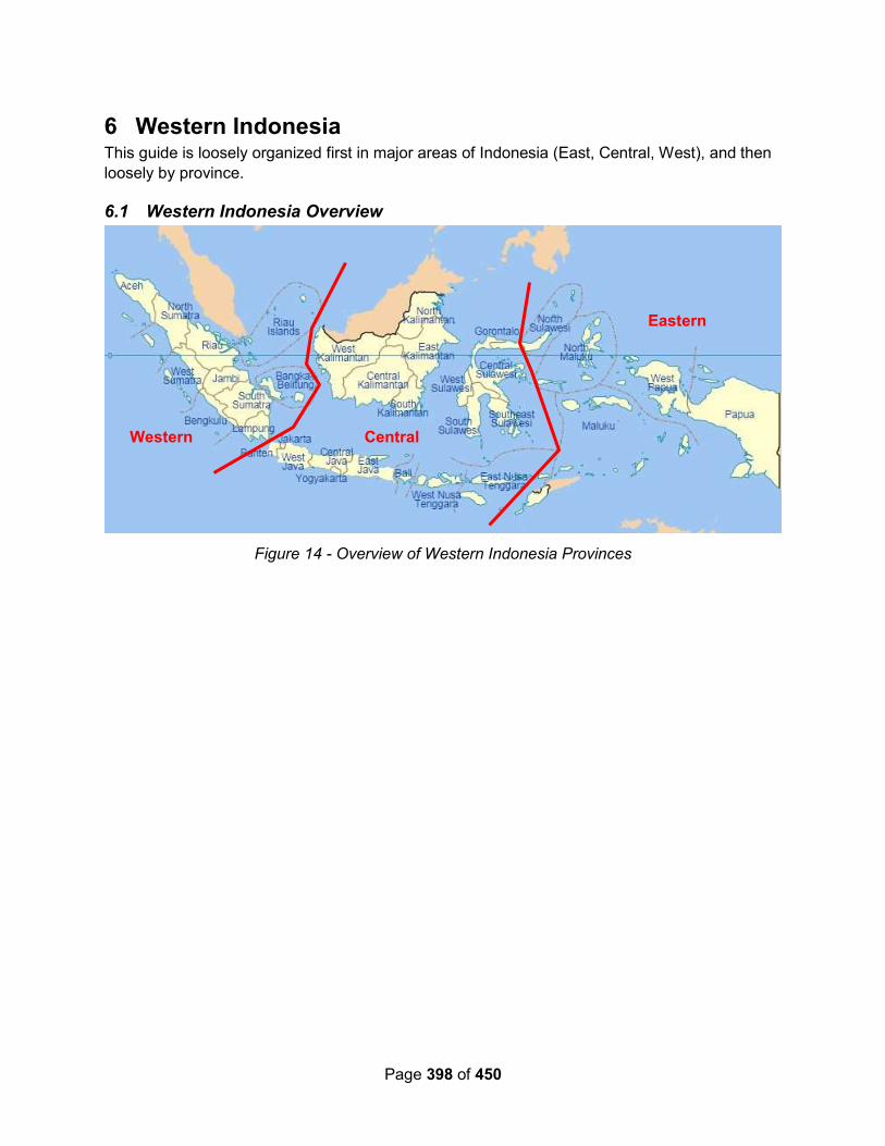
Page 398 of 450
6 Western Indonesia This guide is loosely organized first in major areas of Indonesia (East, Central, West), and then
loosely by province.
6.1 Western Indonesia Overview
Figure 14 - Overview of Western Indonesia Provinces
Eastern
Central Western
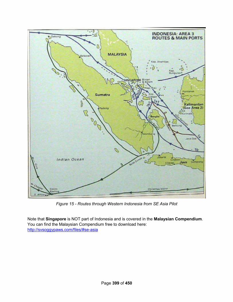
Page 399 of 450
Figure 15 - Routes through Western Indonesia from SE Asia Pilot
Note that Singapore is NOT part of Indonesia and is covered in the Malaysian Compendium.
You can find the Malaysian Compendium free to download here:
http://svsoggypaws.com/files/#se-asia
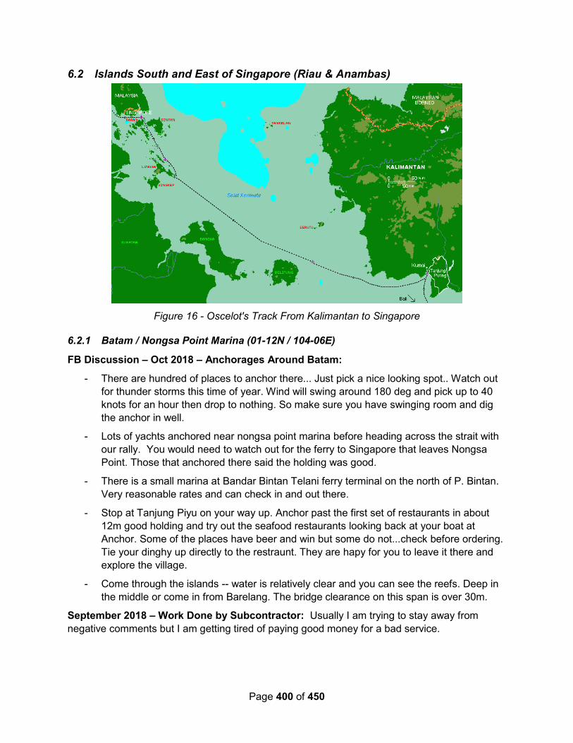
Page 400 of 450
6.2 Islands South and East of Singapore (Riau & Anambas)
Figure 16 - Oscelot's Track From Kalimantan to Singapore
6.2.1 Batam / Nongsa Point Marina (01-12N / 104-06E)
FB Discussion – Oct 2018 – Anchorages Around Batam:
- There are hundred of places to anchor there... Just pick a nice looking spot.. Watch out
for thunder storms this time of year. Wind will swing around 180 deg and pick up to 40
knots for an hour then drop to nothing. So make sure you have swinging room and dig
the anchor in well.
- Lots of yachts anchored near nongsa point marina before heading across the strait with
our rally. You would need to watch out for the ferry to Singapore that leaves Nongsa
Point. Those that anchored there said the holding was good.
- There is a small marina at Bandar Bintan Telani ferry terminal on the north of P. Bintan.
Very reasonable rates and can check in and out there.
- Stop at Tanjung Piyu on your way up. Anchor past the first set of restaurants in about
12m good holding and try out the seafood restaurants looking back at your boat at
Anchor. Some of the places have beer and win but some do not...check before ordering.
Tie your dinghy up directly to the restraunt. They are hapy for you to leave it there and
explore the village.
- Come through the islands -- water is relatively clear and you can see the reefs. Deep in
the middle or come in from Barelang. The bridge clearance on this span is over 30m.
September 2018 – Work Done by Subcontractor: Usually I am trying to stay away from
negative comments but I am getting tired of paying good money for a bad service.

Page 401 of 450
We stopped at Nongsa Point Marina because of a leak in our hydraulic steering. The marina is a
little expensive for us but we felt we did not have another choice to continue with a leaking
cylinder. The marina manager got in touch with a local company to do the job.
They said that they replaced all the seals and pressure tested the cylinder. Shortly after we left
the marine the cylinder started to leak again. Now we are taking the cylinder apart again to
discover worn out seals and rings that don't even fit our systems. Disappointed!
Blue Steel – June 2017 – Haulout near Nongsa Point Marina: We hauled out at Asian Fast
Marine (Batam - Indonesian). We cleared in at Nongsa Point Marina then motored onto the
yard, anchored overnight and we're hauled out this morning by their massive crane, boat weight
78 tonne.!!! ..no mean feat.
We have very good feelings about this boat yard, very professional, staff have tons of
experience and are used to hauling out big boats, they service Batam Fast’s fleet of fast ferries
The yard looks superb, and service (Watch this space) is so far very good .we will be here for
the next 15 days or so..ill update you as we go.
Tiger Lilly – October 2016: At the Nongsa Point Marina and Resort we fueled and took a berth
for a few days before we check-out of Indonesia and sail for Malaysia. The NPM&R is an
absolutely first class facility - probably the nicest marina that Indonesia has to offer. It has
floating docks, a hotel / resort, permanent residence villas, and a beautiful well-groomed golf
course. But in a lush green country with plenty of rain, the tap water cannot be drunk - what's up
with that? It was quite a culture shock to go from Tanjungpinang to Nonsa Point Marina in only
about 6 hours!
The only down-side of our luxury marina environment is that the place is absolutely infested with
high-roller power boaters; and the dock parties can be pretty noisy when real sailors need their
sleep... It seems that the power boaters hibernate in their air conditioned cabins all day, and
then once the sun sets they crank their ghetto-blasters and start partying in the cockpit until the
wee hours of the morning.
Ocelot – October 2006: Nongsa Point Marina at N1°11.8 E104°05.8 is a little dodgy to get
into. There are a series of 8 poles that are quite visible, arranged in 2 lines of 4, oriented
east/west. The 4 poles to the east mark each side of the channel to the marina, while the 4 to
the west mark the entrance to the river that the high-speed Singapore ferries use. Some CM93
charts show these poles although it has them shifted about 100m to the east. There are also
some rocks just outside the channel that are usually marked by floats. Call the marina on VHF
before you come in for directions. Make sure you run down the center of the channel (which will
show you as running over the 2 western poles on the CM93 charts) as some boats have
damaged keels on rocks.
The marina itself was a pleasant surprise as we don't go to marinas very often. Although prices
are all quoted in Singapore dollars, slips were actually fairly reasonable, and included the huge
pool (towels provided by the hotel) and slow wireless internet. Even the resort restaurant,
expensive by Indonesian standards, was quite reasonable by world standards. The only flies in
the ointment are that town is a long taxi ride away, and the marina officials charge a hefty fee for
organizing clearance out of Indonesia. Make sure you're ready to leave when the officials return
with your passports, because you don't get any slack-time. As soon as they hand you your
clearance documents, they undo your dock-lines and hand those to you as well - you're
Page 402 of 450
expected to leave immediately. Luckily, they usually come in the morning, so you have ample
time to cross the busy shipping lanes to get to Singapore.
6.2.2 Bandar Bentan Telani
Starry Horizons - November 2018: Anchored as close into shore as we could get. A bit swelly, but cleaner than Tanjung Pinang. Ferry dock here throws up lots of wake, but you can catch the ferry to Singapore for a very reasonable price. There is a small marina, though when a rally participant tried to come in and book a slip they said they were “full”, though only 3 of 14 slips were being used.
By now, the rally has dwindled to about a dozen boats. Several boats went over to Batam and Nongsa Point Marina. We wanted to clear out with the rally, and also see many of our friends again, but in reality, everyone is still headed the same direction; we saw rally friends for months cruising Malaysia and Thailand. And, Nongsa Point Marina helps with the check out process, so….next time, we’d do Batam instead.
Marina info pdf: https://www.bintan-resorts.com/wp-content/uploads/2018/04/bintan-resorts-marina-2018.pdf
Our anchorage: 01°10.164 N 104°18.603 E
6.2.3 Pulau Bulan (01-01N / 103-55E)
Minnie B – June 2015: After leaving Singapore, our destination anchorage was at Pulau
Bulan/Boyan, just 36nm, where we found good shelter, but tucked into the bank closer to Pulau
Tanjungkubu (01 01.162’N:103 54.876’E) to avoid the villagers’ nets. It was very sheltered and
got us away from the busy shipyards that line the Batam side of the channel, albeit there was
strong tidal current but with anchor well dug in we celebrated the start of our next adventure.
Baraka – June 2012: We had an easy day-sail from Nongsa Point to Tanjung Pinang, where
we enjoyed an interesting night in the busy estuary; anchorage 00°56.1856N, 104°26.4425E,
22’ of mud.
6.2.4 Tanjung Pinang, W Coast Bintan Island (00-56N / 104-26E)
Starry Horizons - November 2018: Filthiest town we’ve been to. Not much to redeem it that we could find, although we did have a fantastic meal up at The Manabu.
Would not have stopped here except for the rally clear out - this is where you have to turn your papers into the rally admins. Isana Supermarket for provisioning.
Our anchorage: 00°56.233 N 104°26.360
Tiger Lilly – October 2016: On our way north from the Kumai River, the only place we put the
dink down and went ashore was at the town of Tanjungpinang, Bintan. TJPA is right out of a
Joseph Conrad Novel. For hundreds of years TJPA has been a trading cross-roads of
Southeast Asia; it is certainly not a tourist town, but it is an interesting place for a seaman to
knock around the waterfront.
TJPA is a bustling harbour, and quite dirty, but every cruising destination is not a swaying palm
tree white sand anchorage; and thankfully so - variety is the spice of life. We anchored off the
police dock in 5 meters of water with a mud and clay bottom. The holding was good; we
experienced a 40 knot squall while we were there, but Big Bruce our Best Bower held faithfully.

Page 403 of 450
We used the Police Pontoon Dock as our dinghy landing; we stopped at the Marine Police
Office at the foot of the pier, and the young staff sergeant on duty told us that we were welcome
to use their pontoon. We paid a taxi driver (Rian at the main taxi-stand) 100Rp (almost $8 USD)
to drive us around the general area for 90 minutes, and it was a most interesting ride.
After our two-day stay, when we picked up the hook to depart, we had about 10KG of plastic
trash and a section of old mooring line fouling our anchor. As we left, we cruised around the
inner harbour while Lilly sat on the bow and snapped pictures of life on TJPA's waterfront. We
can just imagine all the strange cargos in the holds of the coastal freighters, the clandestine
negotiations - and the various specie used as payment.
6.2.5 Tanjung Sembulang (00-52N / 104-15E)
Yindee Plus – Aug 2015 - Tanjung Sembulang: We'd read in another boat's blog that they'd
had a 'comfortable night' anchored behind the headland of Tanjung Sembulang. On the chart, it
didn't look like it would afford much protection but we had a look anyway. It was slightly rolly and
we couldn't get that close to shore but the protection was fine for a night. Position was:
00°52'.176N 104°14'.906E, in 2.5m mud (NB all depths are tide-adjusted). We had a new
Telkomsel SIM and vouchers and were able to get a connection, via smartphone, as soon as we
were in Indonesian waters (used SIMs don't seem to work, even with new credit). Signal poor in
this anchorage though.
6.2.6 Pulau Abang Besar (00-34N / 104-14E)
Minnie B – June 2015: We declined the suggested anchorages in the Cruising Guide and went
“mouillage sauvage”, finding a very sheltered spot – a bit closer to the reef than we had
intended when we awoke the following morning, but safe enough (00 33.624’N:104 13.811’E)
6.2.7 Pulau Ranoh (00-34N / 104-14E)
Miss Foxy – March 2019 – Pulau Ranoh: Last week I took Miss Foxy with a couple of mates
for an 8-day mini-cruise around the smaller islands S of Batam and Bintan in the Riau
Archipelago, Indonesia. We all know there are tons of interesting anchorages in the 1,800+
islands in the Riaus and we stopped at five of these during the cruise, but many of you may not
know that the nicest little resort recently opened on Pulau Ranoh only 50nm S of Nongsa Point
Marina. The resort is called Ranoh Island Resort and the tiny sandy island is nestled between
Pulau Abang Besar and Pulau Abang Kechil only 4.5nm SW of the southern tip of the last island
linked by bridges to Batam, Pulau Galang Bahru.
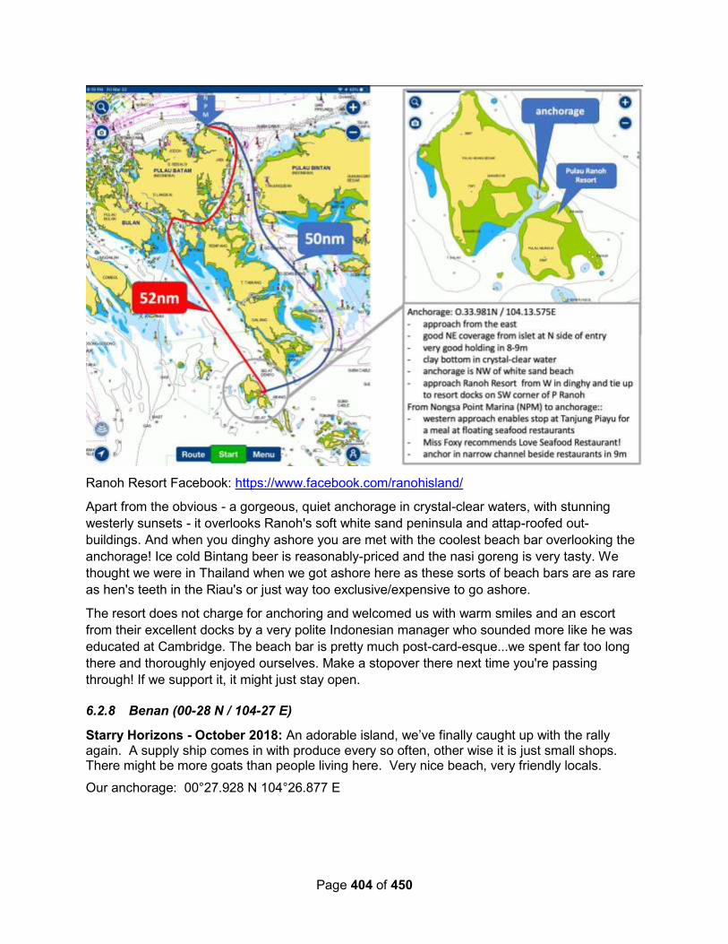
Page 404 of 450
Ranoh Resort Facebook: https://www.facebook.com/ranohisland/
Apart from the obvious - a gorgeous, quiet anchorage in crystal-clear waters, with stunning
westerly sunsets - it overlooks Ranoh's soft white sand peninsula and attap-roofed out-
buildings. And when you dinghy ashore you are met with the coolest beach bar overlooking the
anchorage! Ice cold Bintang beer is reasonably-priced and the nasi goreng is very tasty. We
thought we were in Thailand when we got ashore here as these sorts of beach bars are as rare
as hen's teeth in the Riau's or just way too exclusive/expensive to go ashore.
The resort does not charge for anchoring and welcomed us with warm smiles and an escort
from their excellent docks by a very polite Indonesian manager who sounded more like he was
educated at Cambridge. The beach bar is pretty much post-card-esque...we spent far too long
there and thoroughly enjoyed ourselves. Make a stopover there next time you're passing
through! If we support it, it might just stay open.
6.2.8 Benan (00-28 N / 104-27 E)
Starry Horizons - October 2018: An adorable island, we’ve finally caught up with the rally again. A supply ship comes in with produce every so often, other wise it is just small shops. There might be more goats than people living here. Very nice beach, very friendly locals.
Our anchorage: 00°27.928 N 104°26.877 E
Page 405 of 450
6.2.9 Mesanak (00-26N / 104-31E)
Starry Horizons - July 2018: Anchored just off the reef. Not much here - just a waypoint to make daytrips instead of an overnight.
Rally friends dinghied many miles to the nearest village for fresh veg.
Our anchorage: 00°25.780 N 104°31.418 E
Baraka – June 2012: We overnighted at Mesanak, sheltered though slightly rolly; anchorage
00°26.0459N, 104°31.1790E in 27’ of sand. Avoid the reefs and rocks in the east side of the bay
which cover a larger area than charted.
Ocelot – Oct 2006: The normal anchorage for Mesanak is in the big bay to the NE, but that
was exposed and choppy when we got there so we went around the top and anchored off the
NW corner. The anchorage was fairly deep (N0°26.1 E104°30.6, 45-50' or 15m) and we had to
get closer to the reef than I liked, but the holding was good and reefs down the western side of
Mesanak broke up most of the swell. This anchorage was only OK - I would recommend the NE
bay anchorage if the winds allow it.
6.2.10 Pulau Setemu (00-14N / 104-29E)
Yindee Plus – Aug 2015 - Pulau Setemu: This looked, from the chart, to be a superbly
sheltered spot; and it was. Pulau Setemu at position: 00°13'.548N 104°29'.167E We anchored
in 6.5m in mud. It was very isolated, with only a tiny stilt village in the south of the bay: lovely.
We decided to stay for 2 nights and were glad we had as the next day it rained non-stop from
dawn to dusk. A local fisherman exchanged some squid for some old rope. Telkomsel signal
poor.
6.2.11 Pulau Kentar (#87) (00-03N / 104-46E)
101 Indonesia Anchorages #87
Starry Horizons - October 2018: Back in the northern hemisphere! This anchorage is tucked
away in a shallow but wide bay. There are fishing trees here, and ladies come by to trade (we
traded bananas for a hat).
Our anchorage: 00°03.428 N 104°45.720 E
Yindee Plus – Aug 2015 – Kentar Island: We'd spent a night here on our way up to
Singapore and were happy to be back again. This time it was a little rolly though. Position:
00°03'.250N 104°45'.559E in 10m sand / mud. A local man swapped a large scaly fish for
another of our ropes.
Minnie B – June 2015: The anchorage at Pulau Kentar was again very pretty and sheltered
(00 03.231’N:104 45.619’E).
Baraka – June 2012: From Mesanak we went to restful Kentar, entering from the west through
fascinating fish platforms, where we waited for lighter winds for the beat to Belitung; anchorage
00°03.2160N, 104°45.5470E, in 32’
Ocelot – Oct 2006: The obvious anchorage in Kentar is in the big northern bay at about
N0°03.2 E104°45.6 in 30' (9m). The bay is big but protected from the normal SE trades. The
CM93 charts have Kentar displaced about 400m NW of its actual position, but everything's easy
Page 406 of 450
to see. Kentar was a fun anchorage for us because we arrived with several other cruisers who
had all, like us, just crossed the equator, so an equator party soon developed. The next day,
one of the boats decided to do a leukemia fund-raising event, the woman shaving off all her
hair. In the end, 1 man and 2 women shaved their heads and some A$2,000 was raised for
leukemia research!
6.2.12 Pulau Lingga (00-18S / 104-49E)
Yindee Plus – Aug 2015: We were heading for the anchorage at the southern-most tip of
Lingga but, from the wind direction, we weren't sure it would be tenable.
We stopped to dry out at: 00°15'.4S 104°56'.0E, just off the beach, north of the headland. Wind
protection was excellent but the swell and current made us roll around horribly. We continued
on later in the afternoon, once the weather conditions improved and the wind was from the SE
again, but hobby-horsed through a section of wind versus current close to the headland. Not a
great day. But this was the last rain / squall / thunderstorm weather we were to see.
We anchored overnight around the corner at 00°18'.487S 104°58'.784E in 3.3m sand/mud.
Because of our late arrival and the poor light we couldn't risk tucking in close to shore as we
couldn't see the reef. Wind protection was very good but we rolled badly and couldn't wait to
get away the next day. Telkomsel weak but usable for email / weather.
Minnie B – June 2015: We had a fine spot to anchor on the north side of Tanjung Jang (00
16.674’S:104 54.080’E). (Note, plotting this waypoint, it plots inland. Might try 104-58.080E)
6.2.13 Anambas Islands (03N / 106E)
Mark Bongers – September 2019: For anyone coming to Tarempa, Anambas... Iski (look him
up on Facebook) is your man!! He can arrange anything you need... from diesel delivered to the
boat, assistance with checking in, motorbike rentals, tours around the island, etc. He’s a wealth
of information, speaks excellent English and to top it off, he's a really nice guy. You can contact
him on: +62 812 68344549 (phone or WhatsApp)
David Cherry – October 2018 – Moon Rock Lagoon: I've just got back to Terampa from
Moon Rock Lagoon, Pulau Sagu Dampar
I talked to couple who are building an 'Eco-symbiosis' resort on Samak ... the island opposite
the Moon Rock. Their intention is to get a marine license so that they can exclude cruisers and
local fisherman from the lagoon and their islands.
It sounds to me that their 'resort' may be so exclusive that it will end up being a nest of private
islands in practice.
Leanne Bartlett (FB) – August 2018: Here are some contacts we made while cruising in the
Anambas Islands this year.
TAREMPA
Axel. +62 8128 5988 886 [email protected]
(Has good English) & will assist with
- motor bike rental
Page 407 of 450
- Flights to & from Matak on Xpress Air.
Farizan (or Mr. J) (fair English) +62 8217 3780 094
- will assist with clearing in. (He charged us 150000rp for the privilege, but also help us with a
few difficult provisioning items)
JAMAJA ISLAND
Gusdi Munandar. +62 8228 3351 471 (excellent English)
- motor bike or car hire
- group bus tour around the island (highly recommended)
- can take you to the money exchanger
CREW / GUEST CHANGE OPTIONS
A few options for crew changes to Anambas Islands.
Fly to Singapore, then taxi ($10) to Tanah Merah Ferry terminal & catch one of 15 per day to
Tanjung Pinang (Bintan Island, Indonesia) & fly via Xpress Air
(www.xpressair.co.id or Axel +62 8128 5988 886 could be of assistance )to Matak, Anambas
OR take the large ferry Bukit Raya (15hrs with sleeper cabins) to Tarempa, Anambas
OR
Ferry to Batam Is, Indonesia & take the newer, faster, Catamaran ferry Blue Seajet1 to
Tarempa, Anambas
We visited the lovely new LaTung airport on Jamaja island & was told they receive 3 flights per
week from Tanjung Pinang (Bintan Is, Indonesia). It’s an excellent Anchorage in the SW
monsoon & a delightful start/finish to a visit. Some useful numbers for the LeTung flights a
security guard gave us.
LeTung +62 8126 8181 597 Rika
Batam +62 8126 6662 415
Tanjung Pinang +62 8116 177 701
Hope this helps as our guests found the travel arrangements very difficult to source. They
persisted and we all had the most wonderful time in this gorgeous part of the world.
Originally it was only possible to visit the Anambas Islands as part of the “Passage to the East”
Rally, but as of late 2016, it is now possible to clear in and out of Indonesia in the primary port of
Terempa.
Serafin - September 2017 – Pulau Bawah: The resort on the very pretty lagoon of Pulau
Bawah opened at the end of July. They now refuse for cruisers to anchor and make the use of
their mooring balls mandatory. For a fee of course....5 USD per FOOT, per day....!!!

Page 408 of 450
So, unless they change their policy in the future, spare yourself the sail there, as the closest
anchorage is...20 miles away!! It happened to us a few days ago.
Alba – September 2016 (from their website): These notes are a result of a 2 month cruise in
the Anambas Islands in July and August 2016 on “Alba” our Hallberg Rassy 42F. Our draft is
2.0 metres (6’ 8”). Some of the time we were accompanied by “Amulet” (USA) and “Sea
Monkey” (AUS). We visited over 50 anchorages and only met 4 other boats in our time in the
area.
Before we visited the islands, I had email conversations with various people who provided
information on anchorages and regulations. I would particularly like to thank Captain Warren
Blake, who has visited the Anambas Islands no less than 78 times and provided a wealth of
information on the outlying islands, including some lovely hand drawn charts. Prakash Reddy at
Nongsa Point Marina was also extremely helpful on the regulations for clearing into and out of
Indonesia.
The latest version of this document can be viewed on line at:
http://www.thehowarths.net/cruising-information/cruising-notes
A PDF version is available from:
http://www.thehowarths.net/cruising-information/downloads
We kept a daily diary of our time in the Anambas, which can be found at:
http://www.thehowarths.net/alba-chronicles/2016-thailand-malaysia
A set of GPX routes and waypoints (which will load into OpenCPN) can be downloaded from:
http://www.thehowarths.net/cruising-information/downloads
A set of KAP charts (which will load into OpenCPN) can be downloaded from:
http://www.thehowarths.net/cruising-information/downloads
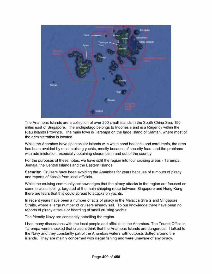
Page 409 of 450
The Anambas Islands are a collection of over 200 small islands in the South China Sea, 150
miles east of Singapore. The archipelago belongs to Indonesia and is a Regency within the
Riau Islands Province. The main town is Tarempa on the large island of Siantan, where most of
the administration is located.
While the Anambas have spectacular islands with white sand beaches and coral reefs, the area
has been avoided by most cruising yachts, mostly because of security fears and the problems
with administration, especially obtaining clearance in and out of the country.
For the purposes of these notes, we have split the region into four cruising areas - Tarempa,
Jemaja, the Central Islands and the Eastern Islands.
Security: Cruisers have been avoiding the Anambas for years because of rumours of piracy
and reports of hassle from local officials.
While the cruising community acknowledges that the piracy attacks in the region are focused on
commercial shipping, targeted at the main shipping route between Singapore and Hong Kong,
there are fears that this could spread to attacks on yachts.
In recent years have been a number of acts of piracy in the Malacca Straits and Singapore
Straits, where a large number of cruisers already sail. To our knowledge there have been no
reports of piracy attacks or boarding of small cruising yachts.
The friendly Navy are constantly patrolling the region.
I had many discussions with the local people and officials in the Anambas. The Tourist Office in
Tarempa were shocked that cruisers think that the Anambas Islands are dangerous. I talked to
the Navy and they constantly patrol the Anambas waters with outposts dotted around the
islands. They are mainly concerned with illegal fishing and were unaware of any piracy.

Page 410 of 450
During our various visits to Tarempa, we saw about a dozen armed ships belonging to the coast
guard, navy and police. I believe that these are all patrolling the area.
Any hassle with local officials has been resolved with government controls - the customs office
even had a large sign saying that customs officers should not be offered tips and the
Immigration have a price list prominently displayed. All of the officials that we met were
extremely friendly, pleased to see us and there was no suggestion of bribes.
We were woken up by the Navy one night in Tarempa at 02:00. They were very polite and
asked if they could come aboard. As we were then awake, we invited them on board and had a
long chat. They wanted to see our papers, but I think that they were mostly curious about what
we were doing in the Anambas Islands. They also approached “Amulet” who told them to go
away and come back tomorrow - they didn’t go back.
The local people and the fishermen were curious about our yachts, but are surprisingly shy
(unlike other places in the world.) The small fishing boats will chug past slowly to have a look
and a quick wave will be sufficient to receive a beaming smile. When we have shared remote
anchorages, the fishermen normally keep a respectful distance and we never felt threatened
about being boarded at night. It's nice to go over and have a chat to the fishermen and see if
they have any fish for sale. They won't speak any English, so first work out what you're going to
say in Indonesian. We were paying 10,000 Rupiah for a fish.
Another reason that cruisers have avoided the Anambas Islands is that obtaining international
clearance has not been possible in Tarempa. With the prevailing south to south-west winds in
the summer, it would be logical to sail from the Anambas to either Borneo or Tioman, but
without being able to clear out, cruisers are faced with a punishing 150 mile slog upwind to
Nongsa Point marina to clear out of Indonesia.
In 2016, there were CIPQ (Customs, Immigration, Port Captain, Quarantine) offices in Tarempa
in the Anambas. HOWEVER, they are not allowed to do INTERNATIONAL clearances. We
have been told that Tarempa will be made into an International Clearance Port in the near future
- contact Prakash, the Manager of Nongsa Marina ([email protected]) who will
know the latest situation.
***UPDATE NOV 2016 *** Prakash at Nongsa Point Marina has informed me that IT IS NOW
POSSIBLE TO DO INTERNATIONAL CLEARANCES BOTH IN AND OUT AT TAREMPA,
ANAMBAS.
We did our clearance in and out of Indonesia at Nongsa Point Marina, Batam, 20 miles south of
Singapore. The staff at Nongsa will take the various documents (see below) and obtain an
international inward clearance on arrival. The day before you leave for the Anambas, they will
obtain the internal domestic clearance from Batam to Tarempa, Anambas. The process is
effortless and quick. They charged 500,000 Rupiah (£25) for inward clearance and the same for
outward clearance.
There was some confusion when we arrived in Tarempa, but it appears that each of the CIQP
offices would like yachts to report in (see below).
The latest regulations can be found on the Nongsa Point Marina web site at:
http://www.nongsapointmarina.com/marina-service-ciqp.php

Page 411 of 450
6.2.13.1 Tarempa
6.2.13.2 Jemaja
6.2.13.3 The Central Islands
6.2.13.4 The Eastern Islands.
6.2.14 Natuna (03-55N / 108-10E)
The Natuna Regency is an archipelago of 272 islands located in the south part of the South
China Sea in the Natuna Sea. It is part of the larger Tudjuh Archipelago, off the northwest coast
of Borneo. Administratively, the islands (including the nearby Bunguran Islands) constitute a
regency within the Riau Islands Province of Indonesia and are the northernmost non-disputed
island group of Indonesia.
Indonesia's exclusive economic zone (EEZ) off the coast of Natuna slightly overlaps the area
within China's South China Sea claim indicated by the so-called "Nine-Dash Line". In 2014–
2015, the presence of the Indonesian army on the islands was reinforced, which the Indonesian
government hoped would reduce the chance of any conflict.
The Natuna Islands themselves are divided into three groups:
North Natuna, which includes Laut Island (Pulau Laut);
Middle Natuna, which includes Bunguran (Natuna Besar); and
South Natuna, which includes the Subi Islands and Serasan.
Raymond Lesmana – June 2018 (FB): Anyone would like to visit Natuna can clear in
Anambas and ask for permission to Customs in Tarempa for Exiting in Natuna...if you need to
do so.
Highway Star – June 2018 (FB): If you are on the Sail Malaysia East don’t miss Natuna. It is a
treat! Zain and the team will look after you!!
We were there last year. There’s lots to love about Natuna! Great people. Protected sandy
anchorages and a welcoming paradise in the South China Sea. If you go. Look up Muhammad
Zain Akbar, he will welcome you and is a great ambassador. Zain heads a team focussed on
encouraging yachties to their paradise.
There are anchorages for Natuna in the electronic version of the Sail Malaysia Cruising Guide.
Go to the Sail Malaysia website. Natuna is fabulous and worth the effort to get there though you
can't clear in or out there unless with the PTE rally
6.3 Islands Between Borneo and Sumatra
6.3.1 Bangka (01-31S / 105-53E)
Yindee Plus – August 2015 - NE Bangka (#86). This is listed as anchorage 86 in the 101
Anchorages of Indonesia guide, although it is mis-named as Pulau Lingga! Position was:
01°30'.555S 105°52'.567E in 5m sand. Good wind protection and reasonable swell protection
too. Telkomsel signal OK from the various cellphone masts.
Page 412 of 450
We left the next day, on 5th August, to make the last of the windward open-sea passages, to
Belitung. The forecast was for up to 15 knots SE, so we decided to allow 2 nights to make the
154 M trip as we don't go well to windward and wanted to be able to sail some of it to make it
more comfortable. A good decision as it turned out. We started out motor-sailing and had no
more than 15 knots (SSE to ESE) but the shallow choppy sea made the motion of the boat
unpleasant. As soon as we steered off the wind it was much better and a combination of
motor/sail and sail alone completed the 42 hour trip (we slowed down to make an arrival after
09:30 to have good enough light to see the reefs).
Minnie B – June 2015: Fortunately there were few fishing boats about and fewer cargo ships.
At the anchorage (01 30.593’S:105 52.442’E), some friendly local people called by to say hello.
Baraka – June 2012: We stopped for a night at the north end of Bangka to swap out our raw
water pump; 01°30.5936S, 105°52.4507E
6.3.2 Belitung / Belitong (PORT OF ENTRY) (02-34S / 107-39E)
6.3.2.1 Clearing In/Out
Matilda – July 2019 – Clearing In: Our friend Ringgo and his family welcomed us with open
arms. Their Resto is located here on the beach at 02 33.364S 107 40.047E. With their help we
managed a fair bit during our 9 day stay. We checked into Indonesia which took 2 days
including some confusion with the Quarantine ladies but that's OK, as they are only use to
dealing with commercial vessels. Customs, Harbour Master and Immigration where fantastic
and thrilled to see us, making us feel most welcome. We had 2 lovely young Customs officers
come to our boats and they were an absolute delight to deal with.
Sail SE Asia FB Group – June 2019 – Recommended guide in Belitung:
Melly Susanti is a local guide, English speaking WhatsApp +6281328180000
Highly recommend Melly, lovely person and very helpful!
Rehua – January 2018 (From Noonsite.com): We completed our outward clearance of
Indonesia in Belitung in January 2018.
The entire exit process took the most part of the day, in the following order: Immigration,
Customs, Quarantine and Port Authority.
We were anchored in the town harbour in Panjung Pandan and took a taxi to Immigration who
are based on the other side of town. They took photocopies of our passports and stamped our
passports. It took roughly one hour.
Then we went to Customs, located opposite the Port Authority in the centre of town. They
wanted to check the boat (engines and AIS mainly) and stamped the documents we had
received from Customs at entry in Biak.
Next we had to visit Quarantine who are based in the same area of town. They stamped our
green book and collected a fee of 20,000 RP (£1). This was the only fee we had to pay.
Finally we went to the Port Authority to get our exit clearance document. This is where we had
an issue. We did not go and see Port Authority on entry in Biak in July 2017 as per the advice of
Page 413 of 450
the local authorities there. However, apparently it is required to see Port Authority on entry and
exit (but not at any other ports in between during your cruise around Indonesia).
They said we were not the first yacht who did not have an entry document and asked us to pass
this information to noonsite.
They resolved the issue by contacting Customs and told us to come back after lunch to collect
our exit clearance document. They wanted photocopies of all other documents and then issued
us the exit paper the same day.
Yindee Plus – August 2015: We cleared into Indonesia with the help of Mr Johny (Lytha's
agent). His fee for clearance in / out and issue of the PIB was $125 US (he accepts US or local
currency). This seemed expensive initially but he worked hard for it and the process was time-
consuming. We had already sent him our yacht and crew details before we left Malaysia.
GOSI – May 2015 – Checking in Belitung/Belitong: A few items of interest for those coming
this way.
We did clear in officially with a CAIT (from Raymond Lesmana) and a prearranged visa. They do
not do visa on arrival so you must get visa in advance. Social visa is easiest with sponsor letter
from Raymond. Jonny here in Belitong assists with the local clearance for 75 USD and was
great to deal with. Took about three hours total for customs, immigration, harbourmaster and
quarantine. Customs did come to the boat. Everyone will clear you in and out at the same time.
No need for temporary import permit.
We used the anchorage to the north west of the Sail Indonesia anchorage as much calmer in
the strong southerly/southeasterly winds.
We got fuel from the shop/restaurant in the left hand corner of this anchorage for 10000 rupiah a
litre. This was arranged by Johny. About a ten minute dinghy ride.
Local provisioning is excellent and main grocery store is well stocked.
6.3.2.2 Visa Renewal
FB Discussion – October 2018: Our friends were asked for approximately $900 dollars CAD
- We did ours in Belitung. Young, professionals. Only snag was having to go back the next
day to pick. Not a hint of anyone wanting a bribe.
- Did it too last year. No bribe. Director of the place came to shake our hands. Kept
apologizing for the new computer system. Had to be patient but everyone was nice. Also
had to go back and payement is at the bank not at their office.
- Very easy to renew visa, we also got our AUSTRALIAN gas cylinders refilled, brought fuel
and water all at a reasonable price.
6.3.2.3 NW Belitung Anchorages
Sail SE Asia FB Group – August 2019 – Belitung NW Anchorage: This is a fine anchorage
at Beilitung. Look for Ervan (he has a cafe near the jetty) if you need assistance with anything:
such as water, fuel, a car, scooter, laundry, shopping, beer, visiting authorities for clearance
etc.he is a great guy and his wife Fenny makes great food. We had a great time at his place!

Page 414 of 450
Ervan took us to see Harun to buy a gearbox heat exchanger...great machine shop opposite the
market.
His telephone number is +62 819-7778-1455 and he is on Whatsapp.
Starry Horizons - October 2018: This was a lovely stop, one of my favorites actually. The bay is big enough for the rally (we were still behind), but it’s shallow and sandy. The huge granite boulders provide a nice scene and playground. There’s a nearby lighthouse to dinghy to.
Our anchorage: 02°33.320 S 107°40.732 E
Brahminy – March 2018 – Propane Refill: When we had visited in 2016, we anchored at
Tangung Ketayang on the north west corner. We had fond memories of the granite boulder
seascape and white sandy beaches. This time with the prevailing NW winds our port anchorage
was well protected. We were in close proximity to all the CIQ and Harbour Master authorities for
the other vessels. Similarly, the very large and friendly ‘wet market’ provided lots of
opportunities for provisioning and interacting with the locals.
For yachties who may come this way in the future, we were able to have one of our gas bottles
filled in Tg Pandan. This was not always possible for those using Australian fittings in other
ports in Indonesia. A very reliable “man on the ground” contact was: Harun mobile +62 811
7178 895.
Rehua – January 2018 (From Noonsite.com): Chart datums are inaccurate in the channel,
there are wooden poles that should be left to port on entry over the shallowest section on the
chart; (you must enter on high water or close to, we had 2.1mtrs on 2nd hour of ebb).
Anchoring: Round the point in the harbour the water depth increases and there is good
holding in minimum 3.4mtrs with a stern line to the mangroves, just opposite the large blue ferry
hulk. Very good shelter, dingy to shore a challenge at low water, use fishermans wooden jetties.
Yindee Plus – August 2015 – NW Belitung – Tj Kalayang: This anchorage, in the NW of
Belitung, behind the headland of Tanjung Kalayang, is well described by SV Baraka on
Noonsite. Our position was: 02°33'.568S 107°39'.076E in 6m sand. We made our approach at
midday, with good overhead light and could easily see the reefs in the bay. A beautiful
anchorage, and well protected in the SE trades, although a fairly long dinghy ride from the
headland, where the cafes / transport is located. The house next to the pier, near the
anchorage, is now derelict. Telkomsel signal was so good that we could stream youtube
experiments for a chemistry module we were doing in school.
There are lots of eateries around the headland as this bay is a tourist attraction for visitors from
Jakarta. Many of the cafe owners can organise a car and driver, fuel, water and tours. There
didn't seem to be a bus service and a car/driver for a day cost 500,000Rp. We can highly
recommend Evan, whose cafe is at the base of the concrete pier north of the headland. Evan is
fun, friendly, speaks excellent english and understands the needs of cruisers. He arranged
transport, laundry, beer (can only be acquired by those with a permit to sell it ie a cafe owner)
and water for us and helped us after our dinghy was put out of action. The cafe nearest the
anchorage (Pak Ajung) arranged to bring diesel out to the boat, in jerries. We met Harun, who is
mentioned in lots of blogs and lives up to his reputation. His large warehouse-style hardware
store sells lots of useful items. He filled our propane bottles.

Page 415 of 450
The town has good provisioning but the prices in the market were much more expensive (for
'bule') than other parts of Indonesia; tourism has arrived in Belitung. We found that roadside
veggie stalls were much more reasonably priced.
We stayed 12 days. Clearance in was done on day 4 of our stay and clearance out on day 7,
due to weekends / public holidays. Just required patience and paperwork, as expected.
Minnie B – June 2015 – NW Belitung: We motor-sailed the last 20nm to arrive at the
anchorage (02 33.363’S:107 40.361’E) at 0830 on Monday 22nd June, having travelled 155nm.
We worked our way through the reef and anchored in 3.0 metres – OVNI time.
So back again, but this time instead of lots of Rally boats, we have the anchorage to ourselves –
well, except the local boats taking tourists into the nearby bay and to the granite rock formations
that guard the west side of the anchorage.
A phone call to our agent, Johnny, had him meeting us ashore at 1100 so that we could give
him our passports and papers to start the inward clearance process. Next day we went with
Evan in his car to Quarantine and Customs, and met Johnny who carried on with the clearance.
He had everything completed that afternoon and Customs were too busy to come to MINNIE B.
So, that was all good.
Baraka – June 2012: We motor-sailed overnight to Belitung against 10-12kn, to a most
picturesque and well-protected anchorage near the Langkuas Lighthouse on the NW corner of
the island, arriving with Estrellita and Taipan. Baraka was surrounded by rocky islets, piles of
huge granite boulders and white sand beaches.
We initially anchored in 40’ at 02°33.4145S, 107°38.3624E, later moving closer in to
02°33.481S, 107°38.952E. in 27’, sand. There are a couple of reefs to work around on the way
in to this second anchorage, so good overhead light is needed.
Mr. Harun Cahyadi was our Belitung host. He can be reached at [email protected] or
[email protected] and can accept SMS messages at +62 811 717 8895. Harun
operates a sand barging business and his entrepreneurial family owns a hardware store, a
machine shop and is developing a beach property.
Though he’s a busy man, he generously spent much of the week with us, arranging delivery of
diesel, petrol and beer, helping us fill propane tanks, a scuba tank, arranged laundry service,
provided a rental van to go to town to get groceries, ATM, market and cell top-up cards. He
facilitated our arrival and departure clearances, which involved a bit of trailblazing, as outside
the Sail Indonesia rally, officials are not used to processing yachts and are still trying to figure
out what to charge us. Hopefully, the clearance fees will remain reasonable so as not to become
an obstacle to visiting Belitung.
Harun is interested in developing an array of services for visiting yachts, with a possibility of
providing moorings or a marina, inside an island he owns. Given the near total lack of marina
facilities in Indonesia, this would be a most welcome oasis for visiting yachts, on both the Sail
Indonesia rally path, and the South Africa path.
We were honored by a luncheon meeting with the Regency of West Belitung and the Head of
the Belitung Department of Tourism, so they could hear directly from us what services and
facilities would benefit cruising yachts, as well as the local economy.

Page 416 of 450
We can’t say enough good things about Harun. He made our visit to Belitung a delight and we
wish him every success. He will develop a fee structure for his services; we warmly recommend
that you contact him for all your needs. We also recommend you plan to linger at pretty and
friendly Belitung.
6.3.2.4 SW Belitung Anchorages
Yindee Plus – August 2015 – SW Belitung: On 18th August, at first light, we moved to the
SW of Belitung, via the small inner channel. We had clear skies later and with eyeball, plus our
broadband radar, were able to see that the islands and reefs were all as charted on Navionics
Gold. Depths too were very accurate. We had 17 knots of SE wind, on the nose for most of the
56M, but the water was flat and we managed to sail some of it.
Anchorage position in Bermepun: 03°08'.525S 107°36'.77E, in 3m sand/mud. It was wind-swept
and we were a long way from shore but no swell and very little chop. Telkomsel OK.
From Belitung, the rhumb line to Sunda Strait takes you through a mass of oilfields. We weren't
too worried about the lack of lights on some of them, as radar will pick them up, but the chart
warning of 'submerged' ones alarmed us. So, we followed the edge of the shipping lane which
runs from the Selat Baur at Belitung, in the slightly deeper water, down the east side of the
Thousand Islands (Pulau Pulau Seribu). Most of the fishing activity seemed to be in the
relatively shallower area between the shipping and the oil rigs.
Minnie B – June 2015 – SW Belitung: We left Tanjung Kelayang at 0630 on Saturday 27th
June, and headed for the shelter of a bay on the SW of Belitung for the night. The chart showed
an area that should be OK with protection from the SE winds. We were able to sail some and
motor-sail some as we dodged various islands and reefs.
We carefully crept into the bay at Bermepun and anchored in 3.7 metres to be in 3 metres at low
water. The holding was good in mud (03 08.540’S:107 36.827’E). The trip was 56nm and the
idea had been to reduce the passage to Pulau Pulau Seribu (The Thousand Islands) to around
160nm so that we would have a daylight arrival.
6.3.2.5 Provisioning & Other Supplies
Matilda – July 2019: Belitung has fabulous markets offering a good array of fruits, vegetables,
chicken and beef. We enjoyed being able to stock up here, even buying an Indonesian gas
bottle so we don't have to worry about refilling our Australian gas bottles while in Indo for the
next 5 months. Also we brought our Indo Telkomsel SIM cards and topped them up while at
Belitung. The ladies in the Telkomsel shop here provide the best customer service we have ever
had while trying to set up an account - including Australia.
6.3.2.6 Fuel in Belitung
Matilda – July 2019: Ringgo was fantastic helping out with refuelling both boats at a
competitive price with clean fuel. Due to the volume of fuel needed they spent a considerable
amount of time assisting Jeremy to fuel up.
FB Group – September 2018 - Fuel:
The guys at Belitung will come out to you with Barrels, a pump and a clear RACOR filter
so you can see the fuel they are giving you... As others have said one liter in Indonesia
Page 417 of 450
can be slightly less than one liter in the rest of the world. But if often so little money in
real terms is just not worth making a fuss about.....plus they have the fuel and you need
it!
Contact Efran (sp) at the pier at Tanjung Kelayang Whatsapp +62 819 777 81455 - they
will deliver to the boat. Clean fuel, good service. You can also take jerry cans to a
bowser in the harbour at Karimun Jawa. Easy dinghy trips. Any problems, the Karimun
Jawa Harbour Master is nearby and very helpful and english speaking.
6.3.2.7 Restaurants and Things to Do
Sail SE Asia FB Group – Sep 2019: We have just spent 6 wonderful days in Belitung. I want
to share two relatively new businesses on the island making a go of it. Firstly The Rock and
Wreck Dive Resort run by Geoff, his wife Linda and son Zach. It’s a magic spot with rooms
which are individual reconditioned houses from around the island and a magnificent pool.
We spent a day with Zach on his boat touring the island with some superb snorkeling, lunch at
the lighthouse and some amazing views. He was a fantastic guide with all of his local
knowledge- well worth booking a day with him. Zach’s email is [email protected]
The second business is run by Alex and his lovely wife Rosa. They cook the best pizzas and
cheeseburgers!! Turn left out of Geoff’s resort and walk 500 metres up the road and on the
right is Kebonkupukupu. They have a beautiful backyard where you can sit and enjoy nature
and beautiful food. Alex is happy to take orders for bacon ( something we have missed travelling
Indonesia) with 2 weeks notice. Also frozen burgers, buns (not sweet!) and baked beans. Their
number is 0818857564 or email [email protected]
We ate there several times and have left with frozen burgers and rolls which are so good!
Belitung is a check out Port and Efan next door to the resort took us to do our checkout
yesterday. A relatively painless process. The place is a hidden paradise and a must do for
yachties heading this way.
PS if anyone knows of a page or site that the rally from Aus is following, please share this post
with them as we know the rally is stopping in Belitung.
Matilda – July 2019: Once boat jobs were done each day we would swim, buzz around in the
tender and explore the local islands. One afternoon we even did a 2nm trip to the light house in
our tenders, it was a fascinating place to visit. Also it was a surprise to see a natural pool on one
of the islands amongst the granite boulders.
Shaunnaugh Jones – Oct 2018: We found a great vegetarian/vegan restaurant in Belitung
“Hakka Vegetarian” on Jalan Madura, Parit, Tanjung Padang. You can find them on Google.
6.3.3 Pulau Karangraya (02-35S / 108-43E)
Oscelot – October 2006: The charts show some shallows around Pulau Karangraya but we
couldn't find them, even around the abandoned village. But it was late and we didn't want to sail
all night again, so we dropped the hook at S2°34.9 E108°43.5 in 80' (24m) of sand/coral. This
was our deepest anchorage to date.
In the morning when we tried to leave, we couldn't recover the anchor! After 45 minutes of
trying, Jon had to don scuba gear and dive down to free the anchor, a first for us in 12 years of
Page 418 of 450
cruising. He found that the anchor had snuggled up into a narrow crack in an isolated, flat lump
of dead coral. Nothing we could have done from the surface would have freed it, but with scuba
gear it came out easily enough and we left soon afterwards. Needless to say, we do not
recommend this anchorage. In fact, friends had bad anchoring experiences NW of Pulau
Telegapanat, about 10nm to the west, so perhaps many of the islands northeast of Pulau
Belitung are difficult to anchor behind.
6.4 In the Sunda Strait
6.4.1 1000 Islands – Genteng Besar (#76) (05-37S / 106-33E)
Yindee Plus – August 2015: We decided to stop at the 1000 Islands for a night so that we
could time our arrival in Sunda more accurately. We'd had a wonderful 170M trip, leaving
Belitung early morning and arriving at lunchtime the next day with perfect overhead light for the
reef entry. We sailed the whole way, making over 7 knots at times in SE / ESE / E winds of up to
12 knots: pure bliss after so many months of burning diesel.
This is number 76 in the 101 Anchorages book. Approach needs to be made via the main
channel which runs east / west, south of the Genteng Besar island group. There are uncharted
reefs and islands in the area so good light is important. There is now a long pier off the west
side of P. Kayuangin (see No 76 'mud map') and the east jetty on Genteng Besar is derelict, so
it can be confusing initially. When you get closer in, it's easy to see that there's a lagoon behind
the reef but it's not obvious at all from a distance. There is no guard house and the buildings on
shore at the eastern end of Genteng Besar are falling down, so we didn't think it likely we'd be
moved on.
Anchorage position: 05°37'.150S 106°33'.392E in 22m sand. Room in the lagoon for 3 or 4
boats to put out 65m chain. It was a beautiful spot, surrounded by turquoise reef and protected
from swell. Many of the islands were bristling with cellphone masts but very poor Telkomsel
signal from this anchorage.
Minnie B – July 2015: Our arrival in Pulau Pulau Seribu was a bit of a let-down as it suffers
from the Javanese/Jakarta haze – must be so much air pollution. So visibility was about 6-7 nm,
which did detract from the atmosphere. Notwithstanding this, we went in search of an
anchorage.
Cruising guides tell you that there are many sandy beaches where you can anchor. The 101
Indonesian Anchorages Guide gives one anchorage and the South East Asia Pilot (Fourth
Edition) gives just one anchorage also.
We did not like the look of either and tried to find somewhere better. We identified a shallow
area between P Putrigundel and P Tongkeng. C-Map showed 6 metres CD, but when we got
there it was more like 4 metres CD and the bottom was rocks and coral heads – no thank you.
So, off to the 101 Anchorages spot – all fine until rounding the NE of P Genteng, where the
chart showed >20 metres depth and our echosounder showed less than 3 metres. Let’s get out
of here.
So, next to the SE Asia Pilot anchorage which it describes as a 6 metres deep shoal. We are
bang on the waypoint, we circle around, we go to the position shown on C-Map, we circle
around – no shoal and in any case it’s a mile and a half from the shore. Oh dear. So we head

Page 419 of 450
for the nearby village on P Kelepadua. Great we find a spot in 12 metres then as the chain
rattles down we see just how close to the reef we are. No thanks, so up anchor and move to the
middle of the channel and anchor in 23 metres in mud.
Although we did not go right to the 101 Anchorages spot, from looking at the chart and our
experience of footling around the islands we do not believe that it is tenable as it is most likely
too close to the reef. So, it seems that if you want to enjoy the Thousand Islands, just put up
with anchoring in 20-25 metres and ignore the haze.
We had a trip ashore to the village – the people were friendly enough but this was not a well-off
place.
6.4.2 Passage Thru the Sunda Strait
Yindee Plus – August 2015: We sailed, with the cruising chute, in 7 knots of NE / ENE wind
and completely flat water towards the Sunda approach on 22nd August. We were aiming for an
8pm start to the Strait itself (when the SE monsoon current and the daily tides were heading the
same way ie south). None of our pilot guides had information about the direction of flow of the
daily tides, and we couldn't find out on the internet, but fortunately we'd been given the Total
Tides program by another cruiser, and it was spot-on.
We had zero wind, glassy water and lots of shipping and ferry traffic at the narrowest point of
the Strait. All the ferries and virtually all the ships had AIS and were well lit. Tugs were lit but
tows were not. Our route took us down the Java side. Just south of Pulau Sangiang, the boat
started pitching into short 'waves'. There was no wind, so we assumed it was ocean swell
getting bounced around and against the southerly current. No spray on the deck and not too
uncomfortable but it lasted two or three hours, until we were well south of Carita beach. We
were transiting at neaps and had a maximum current of 3 knots in the narrowest section.
We had hoped to catch a glimpse of Krakatoa, or even anchor there, but the forecast was for 25
knots SE, and the gribs showed it blowing strongly over the low-lying SW Javan peninsula. We
didn't fancy the 45M beat afterwards to our planned anchorage at Pulau Peucang, so gave it a
miss. Winds were as forecast or more, so we were happy to be fairly close to Java and in flat
water.
Minnie B – July 2015: For the trip to Krakatoa the tides were bizarre – C-Map and Admiralty
Tide Tables were the same - and we should have had tide against us but rather it turned out
that at times we had 2kts with us, so we covered the 51nm in 8 hours. The “101 Indonesian
Anchorages” guide made it all sound a bit difficult, but we had downloaded a free chapter on
Java from a new Indonesian cruising guide and this was much more positive and helpful.
Tahina Expeditions – April 2014: We reached the southern tip of Sumatra where a ton of
shipping activity flows between Java and Sumatra (the Sunda Strait). Some are ships going
through the gap to or from the Indian Ocean to distant destinations. There were many large
ferries going back and forth between the two big islands on a continuous basis. The picture to
the right shows Java on the left, Sumatra on the right, and the Indian Ocean straight ahead
through the Straight.
A ferry terminal on the Sumatra side lies behind several islands that provide shelter for the port.
We went close to the coast behind the islands hoping to find a place to take on fuel. At a small
fishing village near the port I spotted a dock with two fuel barrels with our binoculars. But, there
Page 420 of 450
was a very narrow passage to the locations and we had over 2 knots of current going by. It was
too dangerous for us to attempt getting to the location, and we had no idea whether they would
sell us the fuel. We went by the ferry docks, but there was no sign of fueling going on.
Apparently they get all their fuel on the Java side. This makes sense since there are large fuel
refineries in Java. So we dodged the large ferries, as they danced there way in and out, and
continued into the Sunda Straight itself.
We started sailing with plenty of wind in the Sunda Strait, unfortunately from the direction we
wanted to go. We decided we would tack our way there even if it took all day to go the 27 miles.
By the time we were attempting our third tack, I was wondering if there was something wrong
either with the boats instruments, or my sailing skills. It seemed like the wind was bending us
the wrong direction on each tack. Then I slapped my forehead and realized we not only had the
wind against us, but also a large current as well. I knew from our tide predicting software the
current was going to be against us until late in the day. So, we dropped the sails and decided to
motor to Krakatoa spending another 15-20 liters of fuel.
Three Ships – May 2014: On 7 May we set off south again for the Sunda Strait and Krakatoa
island. We passed the Strait at 0430 on 9 May with a thunderstorm raging, torrential rain, nil
visibility and four ferries maneuvering across our course all within a four mile radius. Thankfully
AIS works regardless of the weather, and we were able to heave-to and contact them on VHF to
ensure they were aware of our position.
An hour later the rain cleared and we were on our way, and by mid-morning we were anchored
below the steaming crater of Krakatoa.
6.4.3 Krakatoa (#81-83)
Minnie B – July 2015: We decided to anchor at Pulau Panjang, otherwise known as Rakata
Kecil or Krakatoa East and this was excellent as we had shelter from all except NW and the
wind was mostly SSE. The holding was very good in 12 metres at 06 05.705’S:105 26.943’E.
It was awesome, with Anak Krakatau (Child of Krakatoa) steaming and smoking, and most of its
sides covered in ash and lava from eruptions as recent as 2008 and 2009. Across the way was
Rakata Besar, all that is left of the rim of Krakatoa, which exploded in 1883. Very highly
recommended.
Totem – July 2014: KRAKATOA UPDATE: SV Nae Hassle was stopped by Indonesian park
rangers who wanted a Park permit when they anchored. These are available at Bandar
Lampung for Rp 7,500,000 per person for <1 month visit to the volcano. Rangers asked to get
the word out that the permist *is* required and will be enforced: future boats risk being evicted if
they cannot present a permit. Consider your plans before stopping there! (They did not,
however, ask for CAIT or any other documentation).
Kite & Shango - 2014: In the Sunda Strait, between Java and Sumatra, we anchored for a
night in the old caldera of Krakatoa, the massive volcano that blew apart in 1883 with the
loudest bang ever recorded on earth. It was a little eerie, particularly since a new active volcano,
Anak Krakatoa (“child of Krakatoa”), sits growing and smoking in the middle. The volcano didn’t
erupt on top of us, but we did almost get nailed by a big and very scary waterspout!
Page 421 of 450
Ujong Kulon Anchorage - 06.44.99S / 105.15.65E - Good holding in 20' but on lee shore for
prevailing SE. Not much fetch however. Great spot to get ready for passage to Cocos. Park is
worth exploring.
Krakatoa Anchorage - 6.05.42S / 105.27.02E - Good holding in 32 '. Great view of baby
Krakatoa
Three Ships – May 2014: When the volcano erupted in 1883 it unleashed huge tsunamis
which killed 36,000 people, the explosion was heard 3000 miles away in Perth, and the shock
waves went around the earth seven times – but it looked fairly benign as we explored its lower
slopes the next morning, marvelling at the huge gouges left by lava bombs the size of small cars
and collecting multi-coloured souvenir rocks.
Tahina Expeditions – April 2014: Despite the huge explosion that destroyed most of the
original volcano, the main island of Krakatoa is still an impressive site even from 25 miles away
(especially with a big storm behind it). As we got closer, we could see Krakatoa was covered in
lush tropical vegetation since the main island has been inactive for many years. But, the Son of
Krakatoa is still actively growing in size, and we could see its barren rocky surface and the
caldera spewing smoke and steam.
At first we didn’t find Gryphon 2, a boat we were trying to hook up with, and they had not been
answering our VHF radio calls. They were not at the base of Krakatoa like we expected. So, we
thought they must have left. We also did not find a place to anchor where we expected.
The winds were from the southwest, and the options with shelter were limited according to our
charts. We decided to go to the far side of the active volcano. As we got closer to the active
volcano we suddenly spotted a sailboat at anchor at the northwest side of it. Sure enough, it
was Gryphon 2! We hailed them on the radio and they said there might be room to anchor
nearby. We got to the location, but we were uncomfortable with the limited anchoring room and
the proximity to the sulfuric gasses coming down the side of the mountain.
We attempted going to another nearby island, but the charts (three different sets) were all wrong
about the depths. It was far deeper (40 to 50 meters) than the 10 to 15 meters charted. So, we
sailed to the last available option and discussed sailing over to Java if it didn’t work (which at
this point would have meant a night time passage as sunset was approaching). Fortunately, the
charts were much more accurate here and we anchored next to two fishing boats that were also
sheltering here. At last, a break after 2.5 days of passage-making!
Unfortunately, we had no view of the volcano, so we put the dinghy in the water. After sunset,
we took a quick trip around the tip of the island we were hiding behind. But, the volcano had no
visible night-time activity. Bummer.
After dinner we discussed our options. There were some light winds in the forecast that we
could possibly use to attempt to sail to Cocos Keeling starting the next day. But, the winds
looked really weak and we would probably have to resort to using fuel. There are more winds
forecast for 5 days from now. We could either go to the Java coast to wait for better weather, or
go ahead and leave for Cocos Keeling. We discussed this plan with Gryphon 2 in the morning
as we departed. They plan to stay for now at Krakatoa and wait. We knew we can get 3G about
10 miles east, so we motored out there first thing in the morning. The latest weather data
confirmed now is not the time to leave, so we sailed (and motored) to the Java coast.

Page 422 of 450
6.4.4 Panaitan (#79-80)
6.4.5 Pulau Peucang (#78) (06-45S / 105-16E)
Heather Patava (shared on FB) – April 2018: We've just done west Coast Sumatra, highly
recommend it to all sailors. Only sour note was Peucang Island on northwest tip of Java. We
went to the national park there--with rhinos (didn't see any), leopards (didn't see any) gibbons
(didn't see any) which is all ok, except the costs, 150k per boat per night (that's anchoring, no
moorings), 150k per person per night & 3k per person for insurance???? So for a couple on a
boat that's 456k per night!!!! Don't think any of us mind contributing to the upkeep of parks & this
is a good one, but costs like this will make it prohibitive for most yachties. (Total $45AU)
Yindee Plus – August 2015: Arrived at 08:30 on 23rd August. This is Anchorage 78 in the 101
Anchorages book. Fantastic spot. We initially anchored off the ranger station, as suggested in
the guide, but when the wind picked up significantly we moved off the lee shore to a position
opposite: 06° 45'.055S 105°15'.895E in 13m sand. Trades blowing strongly over the low-lying
coast but good holding and flat water. We weren't approached for fees. Unfortunately, with our
dinghy out of use, we couldn't go ashore to walk across the island.
No internet connectivity with the cellphone mast here but OK for text / calls.
Minnie B – July 2015: The wind was nowhere to be seen so we motored towards Teluk
Banten to seek shelter for the night. The Cruising guide suggest stopping at Pulau Kali on the
west side but this is a port area with electricity generating plants and other industrial activity.
We stopped on the west side of Pulau Pamuyan Besar (05 56.507’S:106 12.864’E) in 14 metres
and well sheltered from NE to S … so there was a late afternoon sea breeze form NW. It died
away and our night was fine.
Three Ships – May 2014: We sailed south from Krakatoa to Pilau Peucang, a sheltered
anchorage on the southern tip of Java, and spent the day with the headsail down and the
sewing machine on deck while we mended a 1∙5m rip in the leech of the sail. The next day we
left to cross the Indian Ocean.
6.5 SW Coast of Sumatra (Sumatera)
6.5.1 Bengkulu
Sail SE Asia FB Group – Aug 2019: We opted for the long route to Malaysia via the West
coast of Sumatra- clearing out of Sabang. We renewed visas in Bengkulu. The Bengkulu
anchorage 3.46.74S 102.15.32E was good with a little swell at times. We went from Lombok to
Sabang from mid April to end of Sept. We did visa extensions at Bengkulu (excellent) and Nias
(poor).
My tip would be to get 2 extensions in Bengkulu even if you have to spend a few days there as
Nias office is really out of the way (wrong coast) and will take 3-4 days anyway! The whole of
the Mentawai, Telos, Nias islands are stunning with mostly clean beaches, crystal clear water
and green Jungle backdrops and is one of the highlights of our 3 yr time in Indo. Pulau Asu (E
of Nias and Pulau Lasia (N of Nias) had the most amazing clear water I have ever seen in Asia
!Not much wind ,take your time and enjoy.
Page 423 of 450
6.6 Middle West Coast of Sumatra (Sumatera)
6.6.1 Padang
Peregrine – January 2018: If you plan on buying fuel in Padang, bring lots of extra fuel filters.
If you think you have enough spare fuel filters, go get more.
We bought the fuel from Usman at the "yacht services". It was convenient, in that his sons
delivered it to the boat, but it was thick, the color of tea and overpriced.
If you went to the fuel station with your own jerry cans, I am certain it would be better quality and
cheaper. Ardif (082 390 783 642) was our blue bird taxi driver. He was affordable (metered),
helpful, and had some English. You will need a taxi or a car to do the clearance in Padang, as
the offices are not near one another, and only the Port Captain is near the water. It also took
eight hours to clear out of Padang.
6.7 NW Coast of Sumatra (Sumatera)
6.7.1 Pulau Weh (We) – Sabang – Port of Entry
Position 5°53’N 95°19’E.
Kiwidream (FB) – April 2018: Kiwidream has just left Sabang. We will sadly miss this years
April Marine festival but if your if your thinking of attending we urge you to do so. We attended
last years festival and had the most wonderful hospitable time enjoying the warmth and
generosity and culture of the people in Sabang, Indonesia.
There has been so much effort and work in the town in the last 12 months ,and its never looked
better. New moorings ,a great new dinghy dock give access to the town and new markets and
the open friendlyness of the people again won us over. It is such a great and interesting place to
visit...
Support these guys in their collective efforts to gain some tourism and prosperity for Sabang
and you will be rewarded with memories of a lifetime. You really wont beleive how well you are
treated as guests...do it!
Tiger Lilly – March 2018: Yesterday we arrived safely at Sebang, Pulau Weh, Indonesia after
an uneventful 300 mile voyage of two and a half days from Penang Island, Malaysia.
Check-in took up almost all day with visits aboard and ashore from the Quarantine Officer (plus
assistant), Immigration Officer (plus two assistants), Customs Officer (plus two assistants), and
a lone Indonesian First Class Coast Guard Petty Officer who seemed to be able to handle the
duties of both law enforcement and the Port Captain by himself (and of course a Coast Guard
coxswain to deliver them all to TIGER LILLY in a sinking red inflatable).
It was a busy time signing and stamping over twenty documents; most of which were in
Indonesian, and we had no idea what they stated! They called Lilly “Mum” and Tom “Captain”
and to a man, they were friendly, polite young blokes - we enjoyed talking with them. Although
virtually EVERYONE in Indonesia smokes, they all thankfully refrained while aboard.
Sebang is a quiet little village, the harbour is deep and clear, and we like it here. Five times a
day - in case we forgot - we are reminded of our mortality and the necessity to commune with
God by the powerful speakers atop the three village Muslim mosques calling the faithful to
Page 424 of 450
prayer. We were given 30 day visas on arrival - with no possibility for extension - so the Sea
Gypsies aboard TIGER LILLY will be on the move again towards the setting sun no later than
10 April.
This morning Lilly is off ashore to wash clothes in buckets on the Quay, and pay for our
Quarantine clearance and Rat-Free Certificate at the local bank; the practique fee is 35,000
Indonesian Rupees (about $2 USD). Meanwhile Himself will be head down and tail up replacing
an errant fresh water hose in the engine room.
We are hanging off a free mooring buoy at
5-53.4N 095-19.3E
which is directly in front of the village’s new floating dock.
The Sebang Harbour is deep, and the Indonesian Government Tourist Board has placed
several of these buoys around the harbour. They are large, marked with white strobe lights, and
are in new condition. They were placed here to accommodate Sebang’s annual Marine Festival.
Gaia – April 2016 (From Noonsite): This note describes information of interest to those
wanting to visit Pulau Weh - an island off the NW coast of Sumatra.
It was our second visit to the west coast of Sumatra, having earlier visited here in 2012. We
consider Pulau Weh a premier destination in SE Asia, particularly from Langkawi and Phuket,
and an island not to be missed. Pulau Weh and her people are gems.
Checking-In and Out: Check in procedureshave been made easier in 18 ports of Indonesia -
and Sabang is one of them. No more CAIT needed and you can enter all your information
beforehand on their website: www.piyohsabangcustoms.com. Eventually Customs, immigration
and quarantine should have all your information already printed on forms, but that was not the
case yet when we arrived in March 2016.
When approaching the harbour call the harbour master on channel 16. He may or may not
answer. Just try again a bit later. He will alert Quarantine, Customs and Immigration. One
should not go ashore until the Formalities are completed. If however for some reason the HM
does not answer (hours are 0800 to 2000) you can go ashore to look for him. His office is to the
east of the dinghy dock along the water side road. Simply ask.
If you were able to contact the harbourmaster he will have organized quarantine, customs and
immigration to come to the dinghy dock. Quarantine people will want to board your boat and you
will have to pick them up from shore.
The Quarantine people take it upon themselves to confiscate out of date medicines and out of
date beer. We only showed them a small portion of our medicines and they did take some out
of date seasickness meds. People seem very friendly, but do ask for beer. We offered apples
instead, which they accepted. They do look in lockers and may take out bottles of alcohol,
probably hoping you will give them some.
Checking out when staying in Indonesia you will need to see the harbourmaster and the
Quarantine people. You will get the green health book from Quarantine with lots of stamps and
signatures to be shown in your next port. 110,000R. Not needed when you check out for
another country. Harbour master wanted 20,000R for a stamp. Make sure you have the correct
change. Bring him a cold coke and he may not ask for a gift.

Page 425 of 450
Anchoring/Mooring in Sabang harbour:
Anchoring: The good news is, anchoring in the harbour here is not as bad as the guide books
and some blogs lead one to believe. Along the shore towards the east one can find depths of
less than 40 feet and in fact one of the boats present while we were there was anchored in less
than 30 feet. They found the spot near the south end of a rather large white building with four
large blue shipping doors, easy to recognize when you approach.
While we were there, there were six of us, including two boats belonging to the Blue Planet
Odyssey.
We would recommend just circling along the shore clockwise. No doubt people will shout at you
with advice as to where and where not to anchor, just ignore them and go where you feel
safe. Of course try not to be in the way of arriving or leaving boats, such as at the fish market
and the commercial docks. We anchored further south in between the Navigasi building and a
small beach in 36 feet, but we occasionally heard the sound of chain on rock.
Position: 05 53.11N and 095 19.39E.
Surface diving in the surprisingly clear and clean water showed flat rocks interspersed with
sand. When we raised the anchor it had sand and fine gravel on it. In our opinion the preferred
area is not here, but off the large white shed with the four blue doors in the northeast corner in
30 to 50 feet.
A large cruise ship dock now occupies the southern edges of the harbour.
Moorings: There are no moorings in the main harbour. And no plans for any as far as we
know. We, in conjunction with the coordinator of the Blue Planet Odyssey rally, urged the
"powers-that-be" to consider their installation, if only for checking in purposes.
Marina: There is a marina under construction a long way from town, but it is not finished and
not being used until a manager has been hired. It will be used for the Sabang Marine
Festival. It is also in an awkward location for access to the officials and the city. We questioned
the expense, location and design and would personally not stay there, preferring the main
harbour or Pulau Rubiah instead.
Getting Ashore: There is a small floating dinghy dock near the bluish building to the west of
the large shed mentioned before. Usually gates are closed, except when ships are unloading,
but there is access in or out through a small gate near the BKPS building. On Sundays there
may be kids hanging out near the dinghy dock. No one had problems leaving their dinghy there,
including one yacht that visited Kuala Lumpur from here.
Other options for anchoring or moorings:
1. Behind the large island in Sabang Bay, Pulau Klay. Positives are isolation, protection and
privacy. Negatives? It is deep, there is a lack of shore access and it's a long way from the dinghy
dock.
2. Moorings behind Pulau Rubiah--50,000 per day ($5 Canadian). Nice back-packers village on
shore with restaurants, dive shops, scooter rental.
Security: We were assured that while anchored in Sabang harbour no one will board your
yacht. This part of Sumatra is mainly a Muslim country and hence, in our experience, safe.

Page 426 of 450
Charts: Using Open CPN will find you anchored mostly on land. Navionics is more accurate,
but misses the rocky patch just north of Pulau Rubiah, in the middle of the pass when coming
from Sabang, easily seen during the day only. Entrance to Sabang harbour is well marked.
Water: There are small stores along the main road where you can fill up containers with filtered
drinking water. Or you can buy 20 liter bottles in the grocery stores and decant in to your own
bottles/jerry cans. We were able to jerry jug water for washing from the BKPS building, there is
a tap behind the small security building at the gate, which they allow you to use when you ask.
Fuel: Gasoline (Bensin) in litre bottles widely available as well as oil and of course diesel
(Solar). Jerry jugged but arrangements can possibly be made.
Provisions/Restaurants: Basic provisions are available in the town where there are many
small grocery stores. There are markets with vegetable stalls open in the morning only. Fruit
available in stalls all day. Many stores are closed for a long lunch hour,
There are many restaurants and foodstalls. If you have a craving for western food you may
need to go to a resort. Freddie's has good food and a great view, but is out of town.
Internet/Phone: There is a Telcomsel office in town where you can buy SIM cards, we also
went to a store along the main street called Mustika Baru where you can buy SIM cards or top
up.
Banks: There are several banks with ATMs. You may have to try several to find one that works
with your card or that will dispense more then 1,250,000. We went to the Mandiri Bank, one of
their ATMs dispenses 100,000 bills and you can take out 2,500,000.
Land trips: Rent a scooter from Bang Bang, 0821 7293 8579 and drive around the island. This
can be done in one day. Visit the volcano with steaming fumaroles, the hot springs, waterfall,
have a drink or lunch at one of the many beach restaurants or have a delicious rojak (spicy fruit
salad) in one of the restaurants along the road. There is also a very small museum in town with
some interesting pictures of what the Sabang harbor looked when the Dutch held sway. Take
your snorkeling gear and snorkel on the underwater volcano, a highlight. Easily done from the
shore. You can also rent a scooter in Ipoih, if you are staying at the moorings near Pulau
Rubiah.
Spend a day in Banda Ache. Ferry leaves from the south side of the island at 8:00am and takes
about 45 minutes. Call Herry 0852 6058 9852 a few days before, he has a becak (motorcycle
powered taxi) speaks good English, will meet the ferry and will take you around to all the
interesting spots in Banda Aceh such as the Tsunami Museum and the fishing boat on the roof
etc, or to any kind of store you want to visit. 50,000R per hour. Ferry returns 4:00pm
Take a flight. Sabang has an airport! Flights to Medan happen three times a week and are very
affordable. With your yacht safe at anchor in Sabang harbour or on a mooring off Rubiah,
internal Sumatra is yours to explore.
Doctors/Hospitals: There are several clinics and a hospital on the island. We visited the
hospital for what turned out to be an allergic reaction around my eyelids. Service was fast, but
little English was spoken. By the way there is no malaria on Pulau Weh. We were much
assisted for the visit to the hospital by Trisnani (Nani) 0813 2506 0117 who also reserved our
mooring for us off of P. Rubiah. Nani is the head of the Tour Guide Association, speaks
Page 427 of 450
excellent English and is very interested in us cruisers and is willing to help solve any problems
you may encounter. Her email is [email protected]
Other: We were unable to get our Torqeedo 1003 electric outboard to start while in Sabang
and with the kind help of Hasan, 0852 7070 6909, a very helpful English speaking Sabang local
and the above mentioned Herry in Banda Aceh, we purchased a 3.5 HP gearless two stroke
Tohatsu outboard for 8 million Rupiah ($600 US) . It had to be ordered from Medan, the capital
of north Sumatra, and arrived in Sabang two days later. Our thanks are to Herry for holding half
the cash and assuring the engine was picked up from the dealer and put on the ferry and to
Hasan for picking it up from the ferry and delivering it to GAIA. We could not have been more
pleased! Hasan also works for one of the dive shops, his email is
In order to attract more yachts, Sabang puts on the Sabang Marine Festival at the end of April.
For further information: visit http://www.sabangmarinefestival.com/ for further details. You can
register for the event for free on the Customs website.
Noonsite – April 2016: Sabang is on the island of Pulau We off the northern tip of Sumatra.
The Japanese occupied the island and installed numerous bunkers, fortifications and gun
emplacements. Their remnants can still be seen, though most have been re-purposed or
removed.
Clearance: This is an official Port of Entry.
NEW Indonesian CIQP procedures came into effect from the 27th February, 2016.
A CAIT, Green Book/Sailing Permit and use of an Agent to obtain clearance papers are no
longer required. See Noonsite Indonesia Formalities for full details.
Customs and Immigration are located on top of the hill. Expect the Harbour Master
and Customs to visit the boat and do an inspection and look for a “souvenir”.
You may have to ferry the Quarantine officers out to the boat.
Sabang Customs Office
Jl. Diponegoro No.19, Kota Atas, Sabang 23511
Phone : +62652-22810
Fax : +62652-21105
E-mail: [email protected]
http://www.piyohsabangcustoms.com/
Sabang Customs request that yachts intending to clear into Indonesia here should visit their
website and complete the form under the tab "PIYOH facility". This will enable them to prepare
the necessary documents for clearance in advance.
6.7.2 Banda Aceh – Port of Entry
Note: not recommended as a port of entry, see comments below the history section.
Wikipedia – December 2019: Banda Aceh, situated at the tip of Sumatra, has long been a
strategic, transportation and trading hub in the eastern Indian Ocean. Its first mention in western
accounts comes from 1292 when Marco Polo and his expedition visited the city, referred to as
Page 428 of 450
'Lambri' from Lamuri Kingdom which previously existed there and noted as the logical first port
of call for travelers from Arabia and India to Indonesia.
Ibn Battuta also reported visiting the city in the mid-14th century when under the control of the
trading kingdom of Samudera Pasai, the then dominant entity in northern Sumatra. However
the Pasai began to collapse under pressure from declining economic conditions and the
Portuguese, who occupied much of the area after occupying Malacca in the early 15th century.
Sultan Ali Mughayat Syah, ruler of the newly founded Sultanate of Aceh, aggressively expanded
in the area in the 1520s and established sultanate was built on the remains of the Pasai and
other extinct kingdoms in the area, and made Banda Aceh the capital, naming it for himself as
Kutaraja or 'City of the King'.
After a long period of rule by the Sultanate, Aceh began to come into conflict with the Dutch and
the British in the second half of the 18th century. At the end of the 18th century, the territory of
Aceh in the Malay Peninsula, namely Kedah and Pulau Pinang, were seized by the British. In
1871, the Dutch began to threaten Aceh, and on 26 March 1873, the Dutch formally declared
war on Aceh. The Dutch bombarded the capital in that year and sought to capture the Sultan's
palace in the city to bring about a capitulation of the Acehnese. Significant support from the
British in the region led the modernization and fortification of the city, and while coastal areas
were lost the Dutch underestimated the city's defenses. The Dutch expedition commander
General Johan Köhler was killed in a skirmish around the city, leading to the failure of the first
expedition. A second expedition was mounted by the Dutch within months and was successful
in overwhelming the city. The Dutch moved into the capital in January 1874 believing the
Acehnese to have surrendered; however, the conflict moved into the countryside, and the
Acehnese continued to actively oppose Dutch rule.
After it entered the Government of the Republic of Indonesia on 28 December 1962, the name
of the city was changed back to Banda Aceh by the Ministry of Public Administration and
Regional Autonomy on 9 May 1963.
On 26 December 2004, the city was hit by a tsunami caused by a 9.2-magnitude earthquake in
the Indian Ocean. The disaster killed 167,000 inhabitants and destroyed more than 60% of the
city's buildings. Based on the statistical data issued by the City Government of Banda Aceh,
Banda Aceh had 248,727 inhabitants in May 2012.
Sail SE Asia FB Group – December 2019 – Checking In: Checked into Banda Aceh town
itself 2 years ago. It was educational, to say the least. Offices far apart and hard to find.Harbour
master would not give us any paper which then caused headaches at future Sumatra and island
ports.Customs wanted "boat import duty". Checked out Sabang island nearby, that process
was professional and easy.
6.8 Islands off the West Sumatra Coast
FB Discussion – September 2018: I am interested in views on sailing the west coast of
Sumatra. (Each bullet below is someone else’s comments on the question)
Our blog http://geminiladyblog.wordpress.com covers our quick trip through there in
March April this year. We left from Langkawi, checked in at Sabang & checked out
Nongsa Pt 60 days later. I recommend more time, but we had other commitments.
Page 429 of 450
We sailed from Langkawi to Sabang early Feb this year, then down the west coast of
Sumatra to Calang, across to Simileue and then down the offshore islands to Enggano -
arriving in Bali in late March to do our visa extension - lots of wind with the Sumatra
storms and also days with no wind - but great surf and awesome people wherever we
anchored - definitely worth it!
Just did it March/April so transition period, north to south. Beautiful but not much wind
from any direction. If doing in SW season suggest south to north. Great
people/beaches/water. Coral patchy, stunning surf! Highly suggest trip up to Lake Toba
from Sibolga, take 3 days. Stay out at outer islands as much as possible.
Nothing wrong with outer islands ..Sibolga is a rip off place, with touts wanting lots of
money to look after your boat?? (It's like a black mail…if you don't pay, and go away to
look at lake--who knows what your boat will be like on return) and extortion prices to take
you to the lake...some yachties have made it very hard, by paying and accepting these
prices!! Shame on them!
Best to bypass as outer islands have fantastic views and good anchorage with no one to
hassle you.
Linda Lim (shared on FB) – March 2018: Heads up for anyone contemplating sailing the west
coast of Sumatra -then the Islands- Simileue, Nias, Telos, etc - to Bali or elsewhere -we got
“visited” at Lugu Sibigo by the village police chief asking for beer, cigarettes and soft drink -
none of which we had so he left disappointed; We provisioned at Teluk Dalam on Nias -which
was excellent -but again a visit from the harbourmaster and a request for 500,000 IDR resulted
in us negotiating this to 200,000. At Telos Town we anchored at the southern end and at dusk
two young guys came by demanding we pay 200,000IDR - we refused and they eventually left -
and we left at first light the next morning! Final stop at Enggano and again a visit by the local
polis rep who politely requested a “fee” in Aussie dollars - we eventually negotiated 50,000 IDR
and he left.
On a positive note - Pulau Lasia was AMAZING! The locals at Calang were awesome in helping
us source fruit, vegetables and diesel - look for Zulfico - the Thursday morning market at Afulu
Lagoon is great and the people are lovely! Mama Silvi at Asu served us an excellent dinner;
Seru at Teluk Dalam was extremely helpful in helping us provision; Got excellent vegetables at
the local market at Sikakap; and Leny’s shop was a great stop at Enggano for Chocolate Fullo
biscuits - she also gave us her precious bread that had arrived that morning on the ferry from
Bengkulu - so like most of Indonesia the good experiences negated the bad.

Page 430 of 450
6.8.1 Pulau Enggano
6.8.2 Pulau Pagai Selatan
6.8.3 Pulau Sipora
6.8.4 Pulau Nias
7 Dili, East Timor
7.1 Renewing Indo Visa in Dili
Ulani – June 2019: Our experience in Dili East Timor
See map above.
Embassy Indonesia: 8 33.004 'S 125 33.910' E
Timor Plaza: 8 33.237 'S 125 32.495' E
Dress code: For the visit to the embassy are required
- long trousers
- closed shoes
- Shirt with a collar (possibly a T-shirt with a collar)
Procedure (suggestion):
1. Compile all documents (incl. sponsor letter - see below)
2. Visit 1 to the Indonesian embassy, to pick up application form and make an appointment
Working days at 2:00 p.m. on the application form
Page 431 of 450
to pick up and have the names written in the big book
(Appointment usually for the following day 09:00, will be noted)
We still have the forms in the Message filled in to be able to ask if anything is unclear.
3. Visit 2 to the Indonesian embassy
On the agreed day (according to visit 1)
09:00 am to submit the documents and pay the $ 50 per person in cash (there is a receipt)
4. Visit 3 to the Indonesian embassy: Collect passports and visa (approx. 3 working days later).
The exact time will be communicated on visit 2
Documents to be submitted for each passport:
- Completed form with a photo attached
Important: Dili has their own form, we didn't find it on-line. A form from another consulate will
not be accepted. You have to collect the form from them at the Consulate
Fill in everything with a black pen and capital letters, and don't forget the back side of the form
We took the forms right at visit 1, already filled in, to be able to ask if anything is unclear.
- Print out sponsor letter with copy of sponsor's ID card
- Boat registration/documentation papers
- Printout of the electronic system YachtERS (Indonesian online registration)
- Copy of Passport Info page
- Original passport
> At least 2 pages must be blank for the visa!
> Passport must be valid for at least 6 months!
- Print out bank account as proof of financing the stay
- Passport photo with red background (2 were required, we only needed 1)
Sponsor:
-------------------------------------
We commissioned Ruth and were super satisfied
with their service. We did everything by email.
> The sponsor letter can already be in Australia
Page 432 of 450
be organized (save time in Dili)
Phone: +62 81 238 478 50
Mobile: +62 896 83003762
Email: [email protected]
Website: www.islemarine.com
Skype: islemarineservices
We paid Ruth via PayPal
> Price about 60 USD for 1-3 crew together
> A sponsor letter for everyone
Make sure that you also have a copy of your ID card with you
Passport photos with a red background:
-------------------------------------
We have the passport photos on the first floor of the shopping center
Have TIMOR-PLAZA done. Spontaneously and waited for 20 minutes.
> 2 USD for 6 pictures
Timor Plaza: 8 33.237 'S 125 32.495' E
***
www.ulani.net - 2019
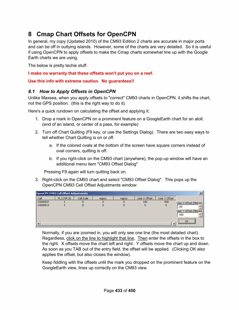
Page 433 of 450
8 Cmap Chart Offsets for OpenCPN In general, my copy (Updated 2010) of the CM93 Edition 2 charts are accurate in major ports
and can be off in outlying islands. However, some of the charts are very detailed. So it is useful
if using OpenCPN to apply offsets to make the Cmap charts somewhat line up with the Google
Earth charts we are using.
The below is pretty techie stuff.
I make no warranty that these offsets won't put you on a reef.
Use this info with extreme caution. No guarantees!!
8.1 How to Apply Offsets in OpenCPN
Unlike Maxsea, when you apply offsets to "correct" CM93 charts in OpenCPN, it shifts the chart,
not the GPS position. (this is the right way to do it).
Here's a quick rundown on calculating the offset and applying it:
1. Drop a mark in OpenCPN on a prominent feature on a GoogleEarth chart for an atoll.
(end of an island, or center of a pass, for example)
2. Turn off Chart Quilting (F9 key, or use the Settings Dialog). There are two easy ways to
tell whether Chart Quilting is on or off.
a. If the colored ovals at the bottom of the screen have square corners instead of
oval corners, quilting is off.
b. If you right-click on the CM93 chart (anywhere), the pop-up window will have an
additional menu item "CM93 Offset Dialog"
Pressing F9 again will turn quilting back on.
3. Right-click on the CM93 chart and select "CM93 Offset Dialog". This pops up the
OpenCPN CM93 Cell Offset Adjustments window:
Normally, if you are zoomed in, you will only see one line (the most detailed chart).
Regardless, click on the line to highlight that line. Then enter the offsets in the box to
the right. X offsets move the chart left and right. Y offsets move the chart up and down.
As soon as you TAB out of the entry field, the offset will be applied. (Clicking OK also
applies the offset, but also closes the window).
Keep fiddling with the offsets until the mark you dropped on the prominent feature on the
GoogleEarth view, lines up correctly on the CM93 view.

Page 434 of 450
4. Now check the offset in several other places on the chart. Often you will get it perfect in
one spot, and it will be off in another spot. This is the nature of imperfect charts. Fiddle
until you are happy with it… either the pass you intended to go in is dead-on, or you
have an average view.
Notes:
See the OpenCPN help file for more info (there's not a lot in v3.2.2, but may be in the future).
In OpenCPN, these offsets are, I think, saved in the CM93 folder in the OpenCPN folder in the
Program Data folder (see the Help/About tab for where the log file is… that's where you'll also
find a CM93 folder.) (ie where the layers folder is).
They appear to be saved in a file that is named the same as your CM93 chart folder name.
Backing up this folder, AND keeping the same naming convention on another computer MIGHT
allow you to transport these offsets to another computer. I haven't found any other way in
OpenCPN to do so.
Warning: There are a LOT of different CM93 chart sets floating around. Offsets for a 2010
version of charts may not be appropriate for a 2011 (or 2005) version of charts. And different
versions may be better, either more accurate, or more detailed, in one area and not better in
another. For example, the 2011 update made the charts in Fiji much more accurate, but also
removed a bunch of detailed charts.
Also, if your set of charts have been made from combined directories (ie copying an "update"
into an existing CM93 directory, some charts may be there that are not in someone else's
"2010" list. Example: Below is a screen shot from the most detailed chart I have for Likiep Atoll
on one computer.
And here is about the same view with the "same" chart set on another computer:

Page 435 of 450
Note considerably more detail. This chart, 2940504, dated 2010-03-01, does not exist apparently in
the "latest" 2010 chart set. (it also won't be displayed by Maxsea, even if it is present in the CM93 folder).
8.2 Offset List
I make no warranty that these offsets won't put you on a reef. Use this info with extreme
caution. No guarantees!! USE YOUR OWN EYEBALLS and only navigate in reefy areas
with good light!!
Note: The best CM93 chart set for cruising Indonesia is a 2005 or 2007 version. Newer
versions are missing place names and are not as detailed in many places, though they
may be more accurate in places where big ships frequent.
DANGER: In one place (near Wakatobi), an entire reef is completely missing from the
newer (ie 2010/2011) CM93 map (see details in the charting section up front). As you can
see from the list below, the errors in the charts are significant!!
Place Chart Cell
M COVR
ID Cell
Scale X
Offset Y
Offset My Chart
Date Comments
NE Sulawesi N End Lembeh 02730375 1 D -300 -150 2005
West Halmahera Ternate Overview 02700381 1 D -600 300 2005
Ternate Detail 02720382 1 F -600 250 2005
Tidore W 02720382 1 F -500 150 2005
Tidore E 02700381 1 D -600 150 2005
Poor detail for Tidor. Same chart as Ternate Overiew, slight diff in offset

Page 436 of 450
Kayoa Island SW of Ternate 02700372 2 C -550 150 2005 Gunange Island SW of Ternate 02700372 2 C -600 250 2005 Dowora Islands SW of Ternate 02670384 1 D -600 -200 2005 Islands SW of Ternate 02580372 2 C -800 420 2005 Note—same chart—significant
difference in offsets from one harbor to another!
Bacan Island NW Side 02580372 2 C -750 70 2005 Bacan Island NE Side 02670381 1 D -850 220 2005 Note—same chart—significant
difference in offsets from one harbor to another!
Bacan Island SE Side 02670381 1 D -750 1500 2005
Damar Island 02580384 3 C -400 -100 2005
Raja Ampat Batanta North Side 02670390 2 D -400 -200 Waigeo East End 02670393 1 D -340 -130
N Sorong 02670393 2 D -280 -290 Sansapor, N of Sorong 02580396 3 C -950 -500
Banda Islands
Pulau Hatta 02460384 1 C -100 349 2005 Note—same chart—significant difference in offsets from one harbor to another! Banda Harbor 02460384 1 C -450 400 2005
AI Island 02460384 2 C -369 50 2005
Misool Area Batanme NW Coast 02580384 1 C -200 0 2005 Note—same chart—significant
difference in offsets from one harbor to another!
Batanme S Coast 02580384 1 C 0 0 2005 Batanme SW Coast 02610387 1 D -300 -100 2005
Batbitiem 02610390 1 D -470 -150 2005
Daram 02610390 1 D -750 -100 2005
Pulau Pisang East End 02580384 1 C -1950 -900 2005 Note major offset difference
between here and Batanme above
Pulau Pisang West End 02580384 1 C -1950 -700 2005
FakFak Area
P Tubiserang 02610396 1 E -1670 -620 2010
FakFak 02610396 1 E -1750 -660 2005
N of TRITON BAY
Mommon 02580398 1 E -1580 -350 2005 Btwn Mommon & T.Tongerai 02580396 1 D -1800 -180 2005
Batu Putih 02610393 2 D -2050 -650 2005
TRITON BAY AREA

Page 437 of 450
Cape Vaan der Bosch 02550396 1 D -1700 -500 2005 Tanjung Papisoi West 02550396 2 D -2000 -500 2005 Tanjung Papisol East 02550399 1 D -2000 -500 2005
Note—same chart—significant difference in offsets from one
place to another!
Karufa River N of Adi Island 02580399 1 D -1900 -150 2005 Adi Island Blumpot Pt 02550399 1 D -1900 -150 2005
Adi Island Southern Tip 02550399 1 D -1700 0 2005 Vogel Island (S of Adi I) 02550399 1 D -1900 -250 2005
Kaimana 02580399 1 D -2000 450 2005 Note—same chart—significant difference in offsets from one
place to another!
Lauzaro (Btwn Adi and Aiduma) 02580399 1 D -1630 360 2005 NW Tip Aiduma 02580402 1 D -1630 560 2005
SE of TRITON BAY Kayu Merah and areas north 02580402 1 D -1450 670 2005
Same chart as NW Tip Aiduma, diff coords
Teluk Bohia (SE Lakia Bay) 02550402 1 D -1600 800 2005 Entrance to River in NE corner Lakia Bay 02580402 1 D -1300 750 2005
Same chart as NW Tip Aiduma, diff coords
BALI North Coast Central North Coast 02450345 1 E -230 680 2010 Central North Coast 02450345 2 D -230 680 2010 Central North Coast 02450342 1 D -230 680 2010

Page 438 of 450
9 Indonesian Language Reference
9.1 Recommended Language Reference Materials
9.1.1 Google Translate
If you have a smartphone, get Google Translate, and download the Indonesian section for
offline use. It will then do basic translations with no internet access. Play with the “camera”
feature when you do have internet—it will translate directly off a picture framed by your camera
on your smartphone.
9.1.2 LearningIndonesian.com
Soggy Paws – 2017: Someone gave us a pile of 32 MP3’s and associated study guides from
http://LearningIndonesian.com I believe this website is free. The lessons seem good, and they
are accompanied with a PDF study guide that elaborate on the day’s lesson a little more. There
is an option to become a premium member for $149 US that provides more in-depth instruction.
But the average cruiser can do pretty well with just the free version.
The benefit of learning from an audio “tape” first is that you don’t start by learning to mis-
pronounce the words (as you would if you read them out of a book).
9.1.3 Indonesian (Mondly App)
Soggy Paws – 2017: I downloaded an app from the Google Play store that is a ‘Learning
Indonesian’. It is similar to the Rosetta Stone approach. This app only works if you have
internet. There is a “free trial” and then you have to sign up for a monthly fee to get the full set
of language lessons.
9.1.4 eBooks You Can Carry With You
We also have a couple of guides on our Kindle and smartphone:
Instant Indonesian: How to Express 1000 Different Ideas with Just 100 Words.
Tuttle Concise Indonesian Dictionary
9.2 Common Words
These are taken from the Quick Reference Guide from Tuttle Concise Indonesian Dictionary and the introductory lessons of LearningIndonesian.com
9.2.1 Greetings & Courtesies
Selamat Pagi Good Morning!
Selamat Siang Good Day!
Selamat Sore Good Afternoon!
Selamat Malam Good Evening/Night!
Selamat Datang Welcome! (Datang means “to arrive”)

Page 439 of 450
Selamat Natal Merry Christmas!
Sampai Nanti Until Later/See you Later
Apa Kabar? What’s New?/What’s Going on?
Terima Kasih Thank you!
Terima Kasih Kembali You are Welcome!
Selamat Tinggal Good Bye!
Ya (or Iya) Yes
Tidak No
Mungkin Possibly/Maybe
Lain Kali Another Time
Jangan Don’t (as in “Don’t Do That!”)
Bukan Not a (as in “This is not a...”)
Ma’af Sorry
Permisi Excuse Me!
9.2.2 Food
Saya Suka I Like
Saya Tidak Suka I Don’t Like
Enak Delicious
Makan To Eat
Makanan Food
Minum To Drink
Minuman Drink (noun)
Air Botol Bottled Water
Nasi Goreng Fried Rice
Pedas Hot/Spicy
Manis Sweet
Garpu Fork
Saya Perlu Ini I Need This
Boleh Saya Minta Itu? May I Have That?
Saya Tidak Mau Itu. I Don’t Want That
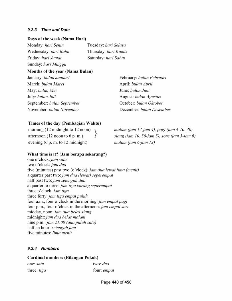
Page 440 of 450
9.2.3 Time and Date
Days of the week (Nama Hari)
Monday: hari Senin Tuesday: hari Selasa
Wednesday: hari Rabu Thursday: hari Kamis
Friday: hari Jumat Saturday: hari Sabtu
Sunday: hari Minggu
Months of the year (Nama Bulan)
January: bulan Januari February: bulan Februari
March: bulan Maret April: bulan April
May: bulan Mei June: bulan Juni
July: bulan Juli August: bulan Agustus
September: bulan September October: bulan Oktober
November: bulan November December: bulan Desember
Times of the day (Pembagian Waktu)
morning (12 midnight to 12 noon) }
malam (jam 12-jam 4), pagi (jam 4-10. 30)
afternoon (12 noon to 6 p. m.) siang (jam 10. 30-jam 3), sore (jam 3-jam 6)
evening (6 p. m. to 12 midnight) malam (jam 6-jam 12)
What time is it? (Jam berapa sekarang?) one o’clock: jam satu
two o’clock: jam dua
five (minutes) past two (o’clock): jam dua lewat lima (menit)
a quarter past two: jam dua (lewat) seperempat
half past two: jam setengah dua
a quarter to three: jam tiga kurang seperempat
three o’clock: jam tiga
three forty: jam tiga empat puluh
four a.m., four o’clock in the morning: jam empat pagi
four p.m., four o’clock in the afternoon: jam empat sore
midday, noon: jam dua belas siang
midnight: jam dua belas malam
nine p.m.: jam 21.00 (dua puluh satu)
half an hour: setengah jam
five minutes: lima menit
9.2.4 Numbers
Cardinal numbers (Bilangan Pokok)
one: satu two: dua
three: tiga four: empat
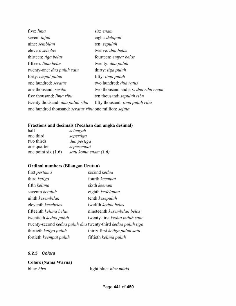
Page 441 of 450
five: lima six: enam
seven: tujuh eight: delapan
nine: sembilan ten: sepuluh
eleven: sebelas twelve: dua belas
thirteen: tiga belas fourteen: empat belas
fifteen: lima belas twenty: dua puluh
twenty-one: dua puluh satu thirty: tiga puluh
forty: empat puluh fifty: lima puluh
one hundred: seratus two hundred: dua ratus
one thousand: seribu two thousand and six: dua ribu enam
five thousand: lima ribu ten thousand: sepuluh ribu
twenty thousand: dua puluh ribu fifty thousand: lima puluh ribu
one hundred thousand: seratus ribu one million: sejuta
Fractions and decimals (Pecahan dan angka desimal) half setengah
one third sepertiga
two thirds dua pertiga
one quarter seperempat
one point six (1.6) satu koma enam (1,6)
Ordinal numbers (Bilangan Urutan)
first pertama second kedua
third ketiga fourth keempat
fifth kelima sixth keenam
seventh ketujuh eighth kedelapan
ninth kesembilan tenth kesepuluh
eleventh kesebelas twelfth kedua belas
fifteenth kelima belas nineteenth kesembilan belas
twentieth kedua puluh twenty-first kedua puluh satu
twenty-second kedua puluh dua twenty-third kedua puluh tiga
thirtieth ketiga puluh thirty-first ketiga puluh satu
fortieth keempat puluh fiftieth kelima puluh
9.2.5 Colors
Colors (Nama Warna)
blue: biru light blue: biru muda
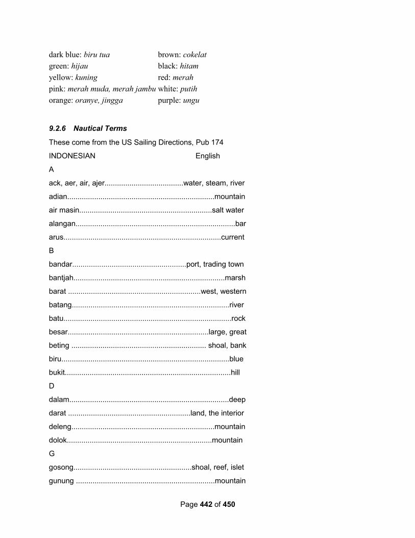
Page 442 of 450
dark blue: biru tua brown: cokelat
green: hijau black: hitam
yellow: kuning red: merah
pink: merah muda, merah jambu white: putih
orange: oranye, jingga purple: ungu
9.2.6 Nautical Terms
These come from the US Sailing Directions, Pub 174
INDONESIAN English
A
ack, aer, air, ajer......................................water, steam, river
adian.......................................................................mountain
air masin................................................................salt water
alangan.............................................................................bar
arus............................................................................current
B
bandar.......................................................port, trading town
bantjah.........................................................................marsh
barat ................................................................west, western
batang............................................................................river
batu.................................................................................rock
besar....................................................................large, great
beting ................................................................. shoal, bank
biru.................................................................................blue
bukit................................................................................hill
D
dalam.............................................................................deep
darat ...........................................................land, the interior
deleng.....................................................................mountain
dolok......................................................................mountain
G
gosong.........................................................shoal, reef, islet
gunung ...................................................................mountain
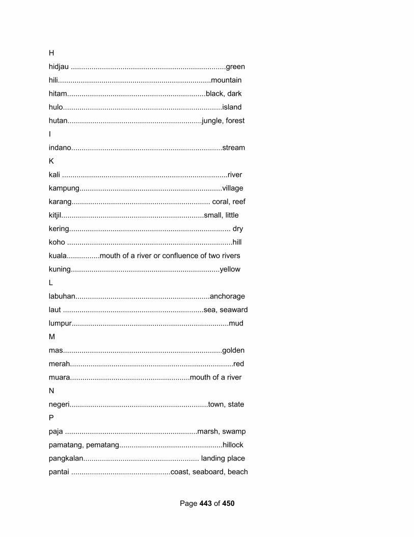
Page 443 of 450
H
hidjau ...........................................................................green
hili..........................................................................mountain
hitam...................................................................black, dark
hulo.............................................................................island
hutan.................................................................jungle, forest
I
indano.........................................................................stream
K
kali ................................................................................river
kampung.....................................................................village
karang................................................................... coral, reef
kitjil.....................................................................small, little
kering.............................................................................. dry
koho ................................................................................hill
kuala................mouth of a river or confluence of two rivers
kuning........................................................................yellow
L
labuhan.................................................................anchorage
laut ....................................................................sea, seaward
lumpur............................................................................mud
M
mas.............................................................................golden
merah...............................................................................red
muara..........................................................mouth of a river
N
negeri...................................................................town, state
P
paja ................................................................marsh, swamp
pamatang, pematang..................................................hillock
pangkalan........................................................ landing place
pantai ................................................coast, seaboard, beach
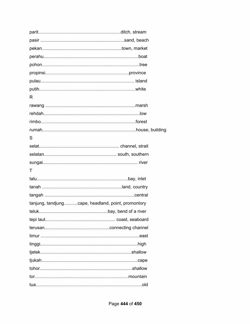
Page 444 of 450
parit..................................................................ditch, stream
pasir ...................................................................sand, beach
pekan................................................................town, market
perahu............................................................................boat
pohon..............................................................................tree
propinsi...................................................................province
pulau........................................................................... island
putih.............................................................................white
R
rawang ........................................................................marsh
rehdah.............................................................................low
rimbo............................................................................forest
rumah...........................................................................house, building
S
selat................................................................ channel, strait
selatan.......................................................... south, southern
sungai............................................................................ river
T
talu.........................................................................bay, inlet
tanah ................................................................land, country
tangah ........................................................................central
tanjung, tandjung...........cape, headland, point, promontory
teluk.......................................................bay, bend of a river
tepi laut........................................................ coast, seaboard
terusan....................................................connecting channel
timur ...............................................................................east
tinggi..............................................................................high
tjetek.........................................................................shallow
tjukah.............................................................................cape
tohor..........................................................................shallow
tor...........................................................................mountain
tua.....................................................................................old
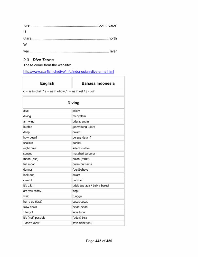
Page 445 of 450
ture......................................................................point, cape
U
utara .............................................................................north
W
wai ................................................................................ river
9.3 Dive Terms
These come from the website:
http://www.starfish.ch/dive/info/indonesian-diveterms.html
English Bahasa Indonesia
c = as in chair / e = as in elbow / i = as in eel / j = join
Diving
dive selam
diving menyelam
air, wind udara, angin
bubble gelembung udara
deep dalam
how deep? berapa dalam?
shallow dankal
night dive selam malam
sunset matahari terbenam
moon (rise) bulan (terbit)
full moon bulan purnama
danger (ber)bahaya
look out! awas!
careful hati-hati
it's o.k.! tidak apa apa / baik / beres!
are you ready? siap?
wait tunggu
hurry up (fast) cepat-cepat
slow down pelan-pelan
I forgot saya lupa
it's (not) possible (tidak) bisa
I don't know saya tidak tahu
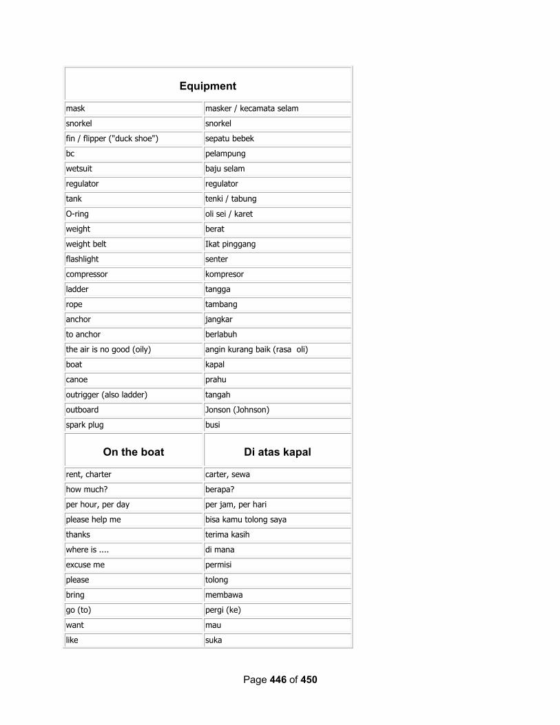
Page 446 of 450
Equipment
mask masker / kecamata selam
snorkel snorkel
fin / flipper ("duck shoe") sepatu bebek
bc pelampung
wetsuit baju selam
regulator regulator
tank tenki / tabung
O-ring oli sei / karet
weight berat
weight belt Ikat pinggang
flashlight senter
compressor kompresor
ladder tangga
rope tambang
anchor jangkar
to anchor berlabuh
the air is no good (oily) angin kurang baik (rasa oli)
boat kapal
canoe prahu
outrigger (also ladder) tangah
outboard Jonson (Johnson)
spark plug busi
On the boat Di atas kapal
rent, charter carter, sewa
how much? berapa?
per hour, per day per jam, per hari
please help me bisa kamu tolong saya
thanks terima kasih
where is .... di mana
excuse me permisi
please tolong
bring membawa
go (to) pergi (ke)
want mau
like suka

Page 447 of 450
have punya
give memberi
jump lompat (melompat)
follow ikut
when do we arrive kapan datang / kapan sampai
how long? berapa panjang?
thirsty haus
drinking water air minum, aqua
hungry lapar
eat makan
lunch makan siang
hot (spicy) pedas
good tasting enak
nausea / queasiness rasa mual
vomit muntah
I have a cold saya masuk angin
sunglasses kacamata hitam
sunburn luka bakar akibat berjemur
towel handuk
bathing suit baju renang
to swim berenang
wet basah
cold dingin
hot / heat panas
toilet kamar kecil
toilet sign women wanita
toilet sign men pria
no smoking dilarang merokok
open buka
closed tutup
Ocean conditions Keadaan cuaca untuk
menyelam
ocean / sea laut
current arus
strong current arus kuat
water air
high tide air pasang
low tide air surut

Page 448 of 450
wave ombak
big wave ombak besar
little wave ombak kecil
cold water air dingin
hot water air panas
visibility pandangan
east timur
west barat
north utara
south selatan
island / small island / large island pulau / gili / nusa
strait selat
sand pasir
shoal, sandbank gosong
rock batu
cave gua
beach pantai
bay, gulf teluk
cape tanjung
harbour labuan / pelabuhan
sunny day hari cerah
sun matahari
rain hujan
- -
Animals Binatang
barracuda senuk / alu-alu
coral (hard) karang (keras)
Clam kima
dolphin lumba lumba
fish ikan
manta ray pari hantu / pari manta
scorpionfish ikan pipi-perisai / ikan kalajengking
seahorse kuda laut
sea urchin ("pig bristle") bulu babi
shark hiu (ikan hiu)
snake antrean / ular
turtle penyu

Page 449 of 450
Every day words Kata-kata sehari-hari
I saya
you anda
he, she dia
we (including person addressing) kita
we (excluding person addressing) kami
they mereka
zero nol
one satu
two dua
three tiga
four empat
five lima
six enam
seven tujuh
eight delapan
nine sembilan
ten sepuluh
eleven sebelas
twelve dua belas
twenty dua puluh
thirty tiga puluh
one hundred seratus
three hundred tiga ratus
one thousand seribu
five thousand lima ribu
minute menit
hour jam
day hari
week minggu
month (moon) bulan
year tahun
tomorrow besok
day after tomorrow lusa
next week minggu depan
last month bulan yang lalu
today hari ini
yesterday kemarin
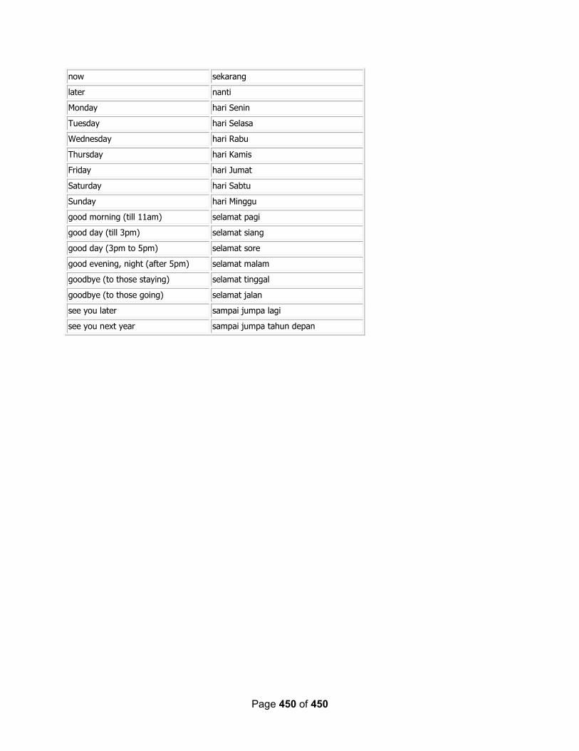
Page 450 of 450
now sekarang
later nanti
Monday hari Senin
Tuesday hari Selasa
Wednesday hari Rabu
Thursday hari Kamis
Friday hari Jumat
Saturday hari Sabtu
Sunday hari Minggu
good morning (till 11am) selamat pagi
good day (till 3pm) selamat siang
good day (3pm to 5pm) selamat sore
good evening, night (after 5pm) selamat malam
goodbye (to those staying) selamat tinggal
goodbye (to those going) selamat jalan
see you later sampai jumpa lagi
see you next year sampai jumpa tahun depan


