Crowdsourcing Urban Form and Function
22
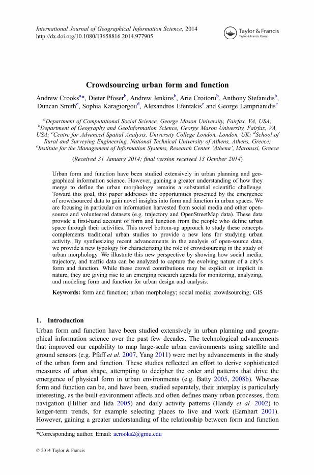
Crowdsourcing urban form and function Andrew Crooks a *, Dieter Pfoser b , Andrew Jenkins b , Arie Croitoru b , Anthony Stefanidis b , Duncan Smith c , Sophia Karagiorgou d , Alexandros Efentakis e and George Lamprianidis e a Department of Computational Social Science, George Mason University, Fairfax, VA, USA; b Department of Geography and GeoInformation Science, George Mason University, Fairfax, VA, USA; c Centre for Advanced Spatial Analysis, University College London, London, UK; d School of Rural and Surveying Engineering, National Technical University of Athens, Athens, Greece; e Institute for the Management of Information Systems, Research Center ‘Athena’, Maroussi, Greece (Received 31 January 2014; final version received 13 October 2014) Urban form and function have been studied extensively in urban planning and geo- graphical information science. However, gaining a greater understanding of how they merge to define the urban morphology remains a substantial scientific challenge. Toward this goal, this paper addresses the opportunities presented by the emergence of crowdsourced data to gain novel insights into form and function in urban spaces. We are focusing in particular on information harvested from social media and other open- source and volunteered datasets (e.g. trajectory and OpenStreetMap data). These data provide a first-hand account of form and function from the people who define urban space through their activities. This novel bottom-up approach to study these concepts complements traditional urban studies to provide a new lens for studying urban activity. By synthesizing recent advancements in the analysis of open-source data, we provide a new typology for characterizing the role of crowdsourcing in the study of urban morphology. We illustrate this new perspective by showing how social media, trajectory, and traffic data can be analyzed to capture the evolving nature of a city’ s form and function. While these crowd contributions may be explicit or implicit in nature, they are giving rise to an emerging research agenda for monitoring, analyzing, and modeling form and function for urban design and analysis. Keywords: form and function; urban morphology; social media; crowdsourcing; GIS 1. Introduction Urban form and function have been studied extensively in urban planning and geogra- phical information science over the past few decades. The technological advancements that improved our capability to map large-scale urban environments using satellite and ground sensors (e.g. Pfaff et al. 2007, Yang 2011) were met by advancements in the study of the urban form and function. These studies reflected an effort to derive sophisticated measures of urban shape, attempting to decipher the order and patterns that drive the emergence of physical form in urban environments (e.g. Batty 2005, 2008b). Whereas form and function can be, and have been, studied separately, their interplay is particularly interesting, as the built environment affects and often defines many urban processes, from navigation (Hillier and Iida 2005) and daily activity patterns (Handy et al. 2002) to longer-term trends, for example selecting places to live and work (Earnhart 2001). However, gaining a greater understanding of the relationship between form and function *Corresponding author. Email: [email protected] International Journal of Geographical Information Science, 2014 http://dx.doi.org/10.1080/13658816.2014.977905 © 2014 Taylor & Francis
Transcript of Crowdsourcing Urban Form and Function
Crowdsourcing urban form and function
Andrew Crooksa*, Dieter Pfoserb, Andrew Jenkinsb, Arie Croitorub, Anthony Stefanidisb,Duncan Smithc, Sophia Karagiorgoud, Alexandros Efentakise and George Lamprianidise
aDepartment of Computational Social Science, George Mason University, Fairfax, VA, USA;bDepartment of Geography and GeoInformation Science, George Mason University, Fairfax, VA,USA; cCentre for Advanced Spatial Analysis, University College London, London, UK; dSchool of
Rural and Surveying Engineering, National Technical University of Athens, Athens, Greece;eInstitute for the Management of Information Systems, Research Center ‘Athena’, Maroussi, Greece
(Received 31 January 2014; final version received 13 October 2014)
Urban form and function have been studied extensively in urban planning and geo-graphical information science. However, gaining a greater understanding of how theymerge to define the urban morphology remains a substantial scientific challenge.Toward this goal, this paper addresses the opportunities presented by the emergenceof crowdsourced data to gain novel insights into form and function in urban spaces. Weare focusing in particular on information harvested from social media and other open-source and volunteered datasets (e.g. trajectory and OpenStreetMap data). These dataprovide a first-hand account of form and function from the people who define urbanspace through their activities. This novel bottom-up approach to study these conceptscomplements traditional urban studies to provide a new lens for studying urbanactivity. By synthesizing recent advancements in the analysis of open-source data,we provide a new typology for characterizing the role of crowdsourcing in the study ofurban morphology. We illustrate this new perspective by showing how social media,trajectory, and traffic data can be analyzed to capture the evolving nature of a city’sform and function. While these crowd contributions may be explicit or implicit innature, they are giving rise to an emerging research agenda for monitoring, analyzing,and modeling form and function for urban design and analysis.
Keywords: form and function; urban morphology; social media; crowdsourcing; GIS
1. Introduction
Urban form and function have been studied extensively in urban planning and geogra-phical information science over the past few decades. The technological advancementsthat improved our capability to map large-scale urban environments using satellite andground sensors (e.g. Pfaff et al. 2007, Yang 2011) were met by advancements in the studyof the urban form and function. These studies reflected an effort to derive sophisticatedmeasures of urban shape, attempting to decipher the order and patterns that drive theemergence of physical form in urban environments (e.g. Batty 2005, 2008b). Whereasform and function can be, and have been, studied separately, their interplay is particularlyinteresting, as the built environment affects and often defines many urban processes, fromnavigation (Hillier and Iida 2005) and daily activity patterns (Handy et al. 2002) tolonger-term trends, for example selecting places to live and work (Earnhart 2001).However, gaining a greater understanding of the relationship between form and function
*Corresponding author. Email: [email protected]
International Journal of Geographical Information Science, 2014http://dx.doi.org/10.1080/13658816.2014.977905
© 2014 Taylor & Francis
Dow
nloa
ded
by [
Geo
rge
Mas
on U
nive
rsity
] at
06:
40 0
8 Ja
nuar
y 20
15
remains a substantial scientific challenge. Toward this goal, in this paper we are addres-sing the opportunities presented by the emergence of new data sources to gain novelinsights into form and function in urban spaces. We are focusing in particular oncrowdsourced content provided through social media and other open-source and volun-teered datasets (e.g. trajectory and volunteered geographical data). Harvesting geolocatedinformation from such sources provides us with a new lens to study urban spaces,enabling the crowdsourcing of form and function information, which is the topic of thispublication.
The last decade has been one of refinement and transition for geographical informa-tion. Refinement has occurred through technological advancements and improved datacollection mechanisms, which led to the emergence of detailed and accurate urbangeometric and socioeconomic data (Smith and Crooks 2010). This advanced the studyof urban form and function at multiple geographical scales, linking geography to geome-try (Batty 2007). Nevertheless, this study has remained one of the snapshots. For example,decadal censuses show population counts and provide us with travel-to-work information,but in essence, these are static datasets with obvious limitations when it comes to studyingthe constantly evolving urban landscapes. The transition of geographical informationallows us to overcome this limitation.
By transition we refer to the emergence of crowd-contributed data to complementauthoritative content (Goodchild 2007). The proliferation of locational-aware devicesmeans that data with either explicit or implicit spatial content are being collected atunprecedented spatial and temporal resolutions (Batty et al. 2012). These data arepublished and broadly disseminated by taking advantage of Web 2.0 technologies(Batty et al. 2010). For example, the OpenStreetMap (OSM) initiative started withcrowdsourcing road network data (Haklay 2010), but has now far exceeded its initialobjective, becoming a major source of broad crowdsourced urban form information (Overet al. 2010). Furthermore, while in OSM geographical information is explicit and inten-tionally contributed, social media (e.g. blogs, micro-blogs, social multimedia) conveyimplicit and often unintentionally provided geographical information, also referred to asambient geographical information (AGI) (Stefanidis et al. 2013). These crowdsourceddata complement traditional authoritative geographical datasets to provide us with aunique insight of urban spaces as integrated, living, breathing organisms, defined bytheir users and their activities. Crowdsourcing such information is particularly appropriatefor the study of function, in the sense that it is a bottom-up process that allows us to gatherfirst-hand information rather than attempting to derive such insight from aggregate, staticdatasets (as has been the past practice). Jointly, crowdsourced urban form and functiondata allow us to explore cities not just as spaces but rather as systems of multiple,interacting networks.
In the remaining of this paper, we synthesize recent research advancements that canserve as quantitative and qualitative geocomputational building blocks for an emergingnew science of cities (Batty 2013c). More specifically, in Section 2, we introduce atypology of form and function along the degree of explicitness of the contributions, andbriefly review the evolution of form and function content collection capabilities. InSection 3, we focus on form and function content that resides implicitly in a variety ofcrowdsourced datasets, ranging from global positioning system (GPS) tracks andFoursquare to Twitter, Flickr, and weblogs. We present novel capabilities to analyzecrowdsourced data that emerge at the intersection of geography, social science, andcomputer science, and demonstrate the broad spectrum of insight that can be gleanedthrough this new lens of studying urban spaces. We show how this analysis enables us to
2 A. Crooks et al.
Dow
nloa
ded
by [
Geo
rge
Mas
on U
nive
rsity
] at
06:
40 0
8 Ja
nuar
y 20
15
capture the evolving nature of the city’s form and function and better comprehend urbanactivities. These advancements signify a key step toward advancing our understanding ofthese ‘most complex inventions’ (Levi-Strauss, 1954) and ‘complex systems par excel-lence’ (Batty et al. 2012) that are today’s cities. In Section 4, we present an emergingresearch agenda that arises from our typology that focuses on our ability to monitor,analyze, and model urban morphology through crowdsourcing and fusion with moretraditional data sources. Finally, in Section 5, we provide a summary of our paper andits relation to the science of cities.
2. Form, function, and crowdsourcing information
2.1. The realm of form and function data sources
Before discussing how crowdsourced information can be used to identify form andfunction, let us first define these terms in the context of this paper. There are manydifferent perspectives on the exact meaning of form and function (e.g. Lynch 1960, Talen2003), and the distinction among these terms is often vague and context dependent (Levy1999). The term ‘urban morphology’ has also been used often in conjunction with bothterms (e.g. Batty and Longley 1994, Moudon 1997, O’ Sullivan, 2000). Building on thisprior work, in the scope of this paper we use the term ‘urban form’ to refer to theaggregate of the physical shape of the city, its buildings, streets, and all other elementsthat make up the urban space. In essence, we consider in this paper urban form to beequivalent to the geometry of the city. In contrast, we use the term ‘urban function’ torefer to the activities that are taking place within this space. These activities are not onlyenabled and driven by form, but also affect it, or provide semantic attribution to it.Function is a core element in understanding urban structure at various levels of resolution,from the description of basic urban districts such as centers and suburbs, to detailedstudies of mix-of-uses and urban agglomeration (Smith and Crooks 2010). Moreover,form and function are highly interrelated, as urban spaces emerge and evolve from thecoalescence and symbiotic interaction of infrastructures, people, and activities (Besussiet al. 2010).
For the longest time, our efforts to understand the relation between urban form andfunction had been hampered by the lack of data at sufficiently fine spatial, temporal, andthematic resolutions. This led to two notable limitations:
● Firstly, it limited the study of form and function to distinct time instances, whichare clearly inadequate to reveal the complex dynamics that are shaping urbanspaces, and to advance our understanding of these processes.
● Furthermore, authoritative datasets fail to capture the informal connotations of formand function that emerge through the public’s perception of urban space. While GISdatabases capture administrative divisions of space they fail to capture perceptualdivisions of it: the boundaries of a hip neighborhood, for example, are understoodby the public, but cannot be found in a map. Yet, the emergence of this neighbor-hood is a reflection of sociocultural dynamics and activities, and also has asubstantial effect on the subsequent evolution of urban form and function.
The emergence of crowdsourced geographical information is complementing technologi-cal advancements to help us slowly overcome both of these limitations, opening up novelopportunities to study form and function in tandem.
International Journal of Geographical Information Science 3
Dow
nloa
ded
by [
Geo
rge
Mas
on U
nive
rsity
] at
06:
40 0
8 Ja
nuar
y 20
15
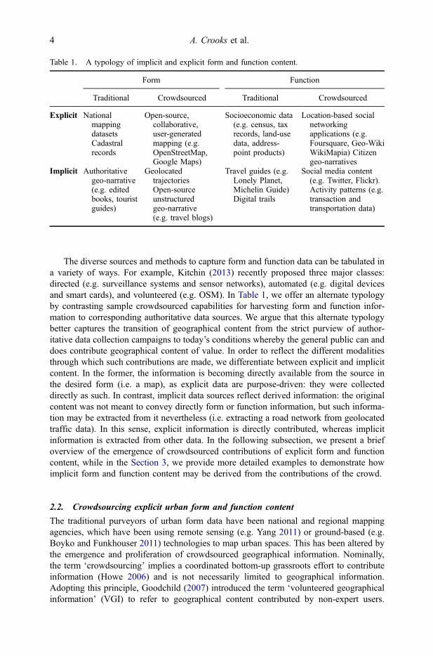
The diverse sources and methods to capture form and function data can be tabulated ina variety of ways. For example, Kitchin (2013) recently proposed three major classes:directed (e.g. surveillance systems and sensor networks), automated (e.g. digital devicesand smart cards), and volunteered (e.g. OSM). In Table 1, we offer an alternate typologyby contrasting sample crowdsourced capabilities for harvesting form and function infor-mation to corresponding authoritative data sources. We argue that this alternate typologybetter captures the transition of geographical content from the strict purview of author-itative data collection campaigns to today’s conditions whereby the general public can anddoes contribute geographical content of value. In order to reflect the different modalitiesthrough which such contributions are made, we differentiate between explicit and implicitcontent. In the former, the information is becoming directly available from the source inthe desired form (i.e. a map), as explicit data are purpose-driven: they were collecteddirectly as such. In contrast, implicit data sources reflect derived information: the originalcontent was not meant to convey directly form or function information, but such informa-tion may be extracted from it nevertheless (i.e. extracting a road network from geolocatedtraffic data). In this sense, explicit information is directly contributed, whereas implicitinformation is extracted from other data. In the following subsection, we present a briefoverview of the emergence of crowdsourced contributions of explicit form and functioncontent, while in the Section 3, we provide more detailed examples to demonstrate howimplicit form and function content may be derived from the contributions of the crowd.
2.2. Crowdsourcing explicit urban form and function content
The traditional purveyors of urban form data have been national and regional mappingagencies, which have been using remote sensing (e.g. Yang 2011) or ground-based (e.g.Boyko and Funkhouser 2011) technologies to map urban spaces. This has been altered bythe emergence and proliferation of crowdsourced geographical information. Nominally,the term ‘crowdsourcing’ implies a coordinated bottom-up grassroots effort to contributeinformation (Howe 2006) and is not necessarily limited to geographical information.Adopting this principle, Goodchild (2007) introduced the term ‘volunteered geographicalinformation’ (VGI) to refer to geographical content contributed by non-expert users.
Table 1. A typology of implicit and explicit form and function content.
Form Function
Traditional Crowdsourced Traditional Crowdsourced
Explicit NationalmappingdatasetsCadastralrecords
Open-source,collaborative,user-generatedmapping (e.g.OpenStreetMap,Google Maps)
Socioeconomic data(e.g. census, taxrecords, land-usedata, address-point products)
Location-based socialnetworkingapplications (e.g.Foursquare, Geo-WikiWikiMapia) Citizengeo-narratives
Implicit Authoritativegeo-narrative(e.g. editedbooks, touristguides)
GeolocatedtrajectoriesOpen-sourceunstructuredgeo-narrative(e.g. travel blogs)
Travel guides (e.g.Lonely Planet,Michelin Guide)Digital trails
Social media content(e.g. Twitter, Flickr).Activity patterns (e.g.transaction andtransportation data)
4 A. Crooks et al.
Dow
nloa
ded
by [
Geo
rge
Mas
on U
nive
rsity
] at
06:
40 0
8 Ja
nuar
y 20
15
Nevertheless, the two terms have been used in our community practically interchangeably,and we consider them thus in the context of this paper. This explicitly and intentionallycontributed crowdsourced content can be augmented through open-source-harvested AGI.
The prototypical example of crowdsourced geographical content is OSM, but otherplatforms, such as WikiMapia (http://wikimapia.org) and Google Map Maker, (http://www.google.com/mapmaker) also allow non-experts to perform basic cartographictasks. These contributions result in substantial volumes of data. Neis et al. (2011) showedthat in the case of Germany, OSM now provides 27% more road network data thanproprietary road datasets such as TomTom. While the contributors of these data areminimally aware of mapping standards, quality control procedures, and metadata ingeneral (Flanagin and Metzger 2008), their contributions tend to be quite accurate incomparison with authoritative mapping products such as the UK’s Ordnance Survey roaddatasets or comparable commercial (e.g. TomTom, NAVTEQ) datasets (see Haklay 2010,Neis et al. 2011, Jackson et al. 2013).
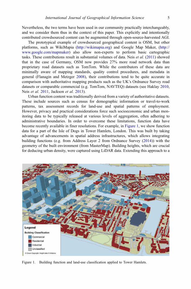
Urban function content was traditionally derived from a variety of authoritative datasets.These include sources such as census for demographic information or travel-to-workpatterns, tax assessment records for land-use and spatial patterns of employment.However, privacy and practical considerations force such socioeconomic and urban mon-itoring data to be typically released at various levels of aggregation, often adhering toadministrative boundaries. In order to overcome these limitations, function data havebecome recently available in finer resolutions. For example, in Figure 1, we show functiondata for a part of the Isle of Dogs in Tower Hamlets, London. This was built by takingadvantage of advancements in spatial address infrastructures, which allows integratingbuilding functions (e.g. from Address Layer 2 from Ordnance Survey (2014)) with thegeometry of the built environment (from MasterMap). Building heights, which are crucialfor deducing urban density, were captured using LiDAR data. Extending this approach to a
Figure 1. Building function and land-use classification applied to Tower Hamlets.
International Journal of Geographical Information Science 5
Dow
nloa
ded
by [
Geo
rge
Mas
on U
nive
rsity
] at
06:
40 0
8 Ja
nuar
y 20
15
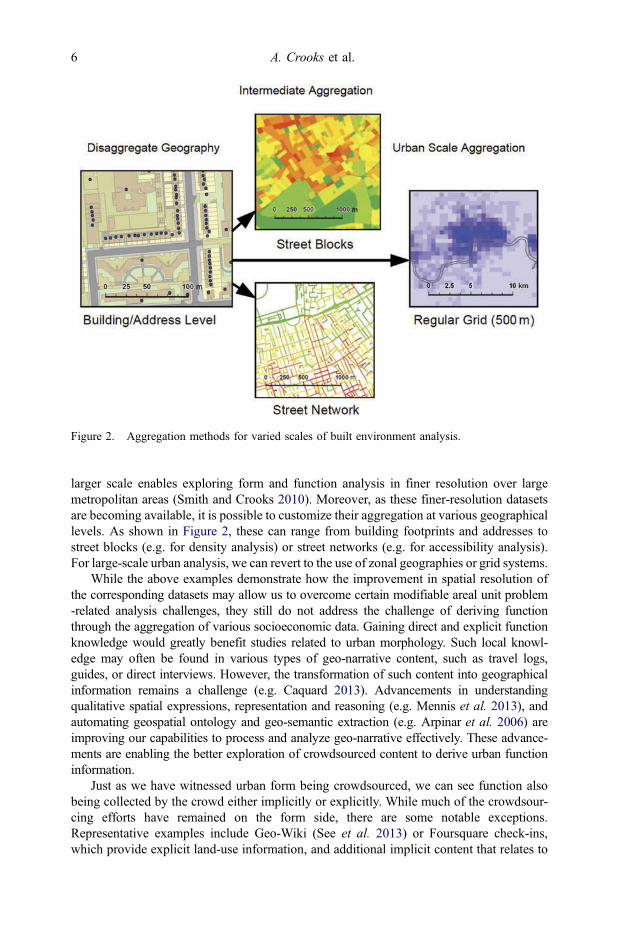
larger scale enables exploring form and function analysis in finer resolution over largemetropolitan areas (Smith and Crooks 2010). Moreover, as these finer-resolution datasetsare becoming available, it is possible to customize their aggregation at various geographicallevels. As shown in Figure 2, these can range from building footprints and addresses tostreet blocks (e.g. for density analysis) or street networks (e.g. for accessibility analysis).For large-scale urban analysis, we can revert to the use of zonal geographies or grid systems.
While the above examples demonstrate how the improvement in spatial resolution ofthe corresponding datasets may allow us to overcome certain modifiable areal unit problem-related analysis challenges, they still do not address the challenge of deriving functionthrough the aggregation of various socioeconomic data. Gaining direct and explicit functionknowledge would greatly benefit studies related to urban morphology. Such local knowl-edge may often be found in various types of geo-narrative content, such as travel logs,guides, or direct interviews. However, the transformation of such content into geographicalinformation remains a challenge (e.g. Caquard 2013). Advancements in understandingqualitative spatial expressions, representation and reasoning (e.g. Mennis et al. 2013), andautomating geospatial ontology and geo-semantic extraction (e.g. Arpinar et al. 2006) areimproving our capabilities to process and analyze geo-narrative effectively. These advance-ments are enabling the better exploration of crowdsourced content to derive urban functioninformation.
Just as we have witnessed urban form being crowdsourced, we can see function alsobeing collected by the crowd either implicitly or explicitly. While much of the crowdsour-cing efforts have remained on the form side, there are some notable exceptions.Representative examples include Geo-Wiki (See et al. 2013) or Foursquare check-ins,which provide explicit land-use information, and additional implicit content that relates to
Figure 2. Aggregation methods for varied scales of built environment analysis.
6 A. Crooks et al.
Dow
nloa
ded
by [
Geo
rge
Mas
on U
nive
rsity
] at
06:
40 0
8 Ja
nuar
y 20
15
urban function. Furthermore, the POI component of some of the above-mentionedcrowdsourced platforms bridges the gap between form and function by allowing con-tributors to record a geographical entity’s function characteristics (e.g. WikiMapia).
Social media are also emerging as a novel type of crowdsourced geo-narrative. Theanalysis of their content can often reveal function information that is difficult to decipherfrom traditional, authoritative data sources. For example, Flickr imagery can be analyzedto identify tourist hotspots and movement patterns (Girardin et al. 2009). Travel blogshave also been mined to give researchers a person’s conceptualization of place based ongeo-referenced text to construct regions of thematic saliency (Adams and McKanzie 2013)or differentiating between local and global topics of place (Hao et al. 2010). Data minedfrom automatic fare collection systems using smart card technology allow us exploretravel patterns for transportation planning (e.g. Batty 2013a).
What crowdsourcing is providing is that unlike past sensor networks, they are not undercentralized control, today, people acting as sensors are leaving rich digital footprints(Girardin et al. 2009) and analyzing these data allows for the tessellation of space emergingfrom the people as we will see in Section 3 from examples of our own work. We can nowexplore form and function without having to lose information through aggregation. Builtenvironment studies ideally require analysis that is both fine-scale, to include premises,buildings and streets, and large extent, to allow the study of citywide processes.
3. Extracting implicit form and function content from crowdsourced data
As noted above, traditional studies of urban form and function had been limited toauthoritative and/or copyrighted national data collections limiting the scale or extent ofthe study area. For example, while street connectivity has been explored in previous work(e.g. Masucci et al. 2009), such analyses have relied on authoritative datasets that werelimited to specific countries or cities. This is now changing with the growth of crowd-sourced data, which is not limited by such restrictions, opening the way for new avenuesfor the study of form and function. For example, VGI now enables researchers to carry outcomparative analysis across multiple European, American, Middle Eastern, and EastAsian cities (Jiang et al. 2013). Within this section, we give examples from our ownwork that demonstrates how urban form and function can be implicitly crowdsourced. Inparticular, we focus on deriving road networks (Section 3.1), spatial areal entities(Section 3.2), thematic spaces (Section 3.3) and finally the spatial-temporal sentimentmapping (Section 3.4) which all tie to our typology presented in Table 1.
3.1. Crowdsourcing implicit form: road networks as they emerge from digital trails
Street maps and transportation networks are of fundamental importance in a wide range ofapplications, from personal navigation to commercial and emergency response routing.Traditionally, as shown in Table 1, the production of street maps required expensive fieldsurveying and labor-intensive post-processing. Proprietary data vendors such as TeleAtlasand Google therefore have tended to dominate the market. However, over the last yearsVGI initiatives such as OSM have been able to complement and augment such commer-cial map datasets. They are often able to provide map coverage especially in areas whichare of less commercial interest. While prevalent, VGI efforts still require dedicated usersto author maps using specialized software tools. Lately, on the other hand, the commo-ditization of GPS technology and integration in mobile devices coupled with the advent oflow-cost fleet management and positioning software has triggered the generation of vast
International Journal of Geographical Information Science 7
Dow
nloa
ded
by [
Geo
rge
Mas
on U
nive
rsity
] at
06:
40 0
8 Ja
nuar
y 20
15
amounts of tracking data. As an indication to the sheer volume of such data, one canconsider the contribution of tracking data in OSM, which is steadily increasing in size andcurrently amounts to 2.6 trillion points (OpenStreetMap 2013).
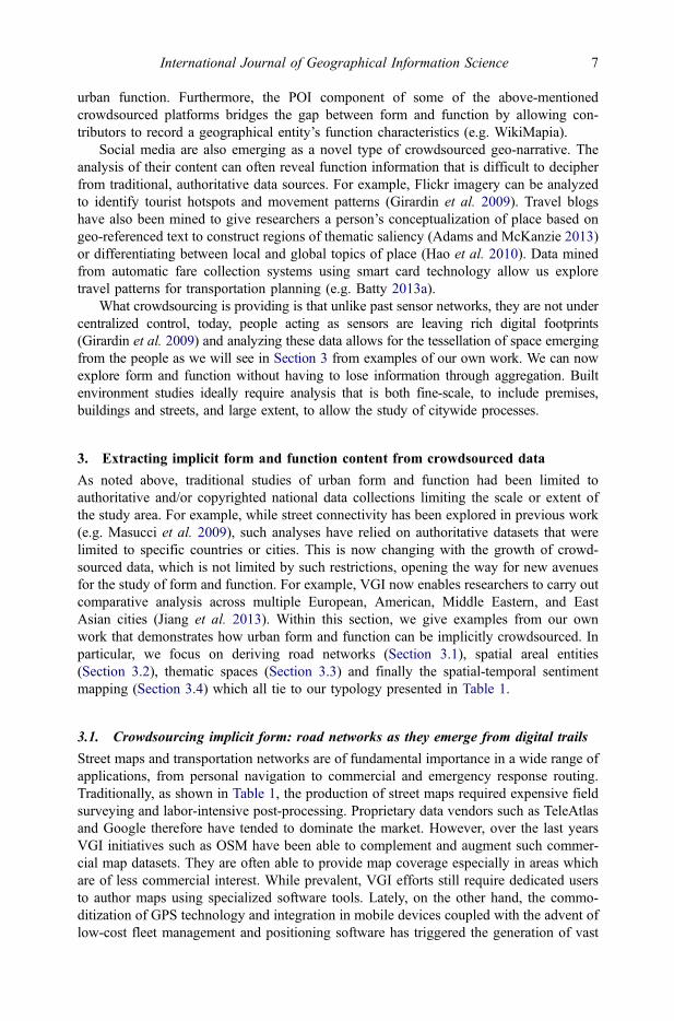
In conjunction with the use of such data in traffic assessment and forecasting, that ismap-matching vehicle trajectories to road networks to obtain travel-times (e.g. Wenk et al.2006), there has been a recent surge of actual map construction algorithms that derive notonly travel-time attributes, but also actual road network geometries from tracking data(e.g. Karagiorgou and Pfoser 2012). An example of this implicitly constructed roadnetwork is given in Figure 3, which shows (1) the vehicle trajectories collected for
Figure 3. Map construction results for Berlin, Germany. (a) Raw GPS tracking data. (b)Reconstructed road network (black) overlaid on the OSM road network (grey).
8 A. Crooks et al.
Dow
nloa
ded
by [
Geo
rge
Mas
on U
nive
rsity
] at
06:
40 0
8 Ja
nuar
y 20
15
Berlin taxis over a week period and (2) the respective constructed road network using thealgorithm developed by Karagiorgou and Pfoser (2012) with an OSM background map.As the figure shows, using tracking data collected over 1 week does not cover all of themain roads, but does reveal the principle structure of the network. One could also drawanalogies with other works, for example that of Jiang (2009) who utilized GPS data fromtaxis to explore their movement based on the network properties of the underlying streetsand demonstrated the major roads had the greatest traffic.
Such implicit data can highlight how urban form impacts function and conversely howfunction impacts form. An example being the dyadic relationship of traffic conditions, asthey communicate both the present condition of the road network, and the links betweenthe locations that are connected through it. It is not just the form of the city that can bederived from GPS data but also travel-times between locations (i.e. by adding attributesfor how long it takes to go along a network segment). Such information can be collectedexplicitly through location-based social networking services such as Waze or implicitlyfrom GPS-enabled devices.
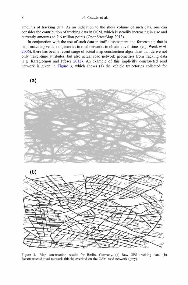
Furthermore, by simultaneously collecting tracking data on a large scale (e.g. throughGPS-enabled vehicles) over an urban environment, we can render an accurate picture ofthe traffic conditions in time and space (e.g. Efentakis et al. 2013). Figure 4 shows the
Figure 4. Changing traffic situation as detected by floating car data – Berlin, Germany (only majorroads shown). (a) 16 December 2013 – 1 am. (b) 8 am. (c) 5:30 pm.
International Journal of Geographical Information Science 9
Dow
nloa
ded
by [
Geo
rge
Mas
on U
nive
rsity
] at
06:
40 0
8 Ja
nuar
y 20
15
example of such changing traffic conditions in the road network of Berlin, Germany,based on GPS data from 4000 taxis. The colors green, yellow, and red are used to indicatefree-flowing, slower-moving, and very slow-moving traffic, respectively (live serviceavailable at http://maps.simplefleet.eu/map/berlin). A collection of such historical datacan be used to capture trends in travel-time behavior according to temporal variations.
3.2. Crowdsourcing implicit function: colloquial spatial entities
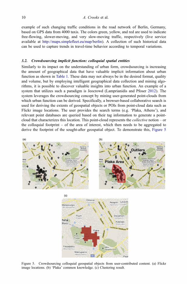
Similarly to its impact on the understanding of urban form, crowdsourcing is increasingthe amount of geographical data that have valuable implicit information about urbanfunction as shown in Table 1. These data may not always be in the desired format, qualityand volume, but by employing intelligent geographical data collection and mining algo-rithms, it is possible to discover valuable insights into urban function. An example of asystem that utilizes such a paradigm is Jeocrowd (Lamprianidis and Pfoser 2012). Thesystem leverages the crowdsourcing concept by mining user-generated point-clouds fromwhich urban function can be derived. Specifically, a browser-based collaborative search isused for deriving the extents of geospatial objects or POIs from point-cloud data such asFlickr image locations. The user provides the search terms (e.g. ‘Plaka, Athens’), andrelevant point databases are queried based on their tag information to generate a point-cloud that characterizes this location. This point-cloud represents the collective notion – orthe colloquial footprint – of the area of interest, which then needs to be aggregated toderive the footprint of the sought-after geospatial object. To demonstrate this, Figure 5
Figure 5. Crowdsourcing colloquial geospatial objects from user-contributed content. (a) Flickrimage locations. (b) ‘Plaka’ common knowledge. (c) Clustering result.
10 A. Crooks et al.
Dow
nloa
ded
by [
Geo
rge
Mas
on U
nive
rsity
] at
06:
40 0
8 Ja
nuar
y 20
15
shows a polygon derived from the point-cloud of all Flickr images representing the spatialextent of a colloquial place of the ‘Plaka’ tourist area in Athens, Greece. While this area iswell known to both tourists and locals, it has no definitive administrative boundary and assuch cannot be delineated through authoritative data sources alone. Instead, by miningsuch non-authoritative content we can transform implicit user references into meaningfulinformation about the function of an area (e.g. a polygon representing the location of aspatial object).
3.3. Crowdsourcing implicit function: thematic spaces (buildings, streets, andneighborhoods)
While Section 3.2 addressed the delineation of colloquial spaces by mining peoples’references to them, we can also follow the opposite route in order to assign thematicmeaning to spaces, in order to capture the formation and evolution of the social functionof urban space at different scales. In today’s fast-paced urban landscape, the socialfunction of a city evolves through space and time, weaving a contextual tapestry ofthemes and meanings linked to geographical locations. While in the past capturing suchinformation through traditional methods was virtually impossible, through a crowdsour-cing approach, it is now possible to tap into a wealth of implicit information on topics andthemes as they relate to space. These topics are the aggregations of implicit content thatare generated by users of Web 2.0 technologies as shown in Table 1. They describe socialactivities occurring within the form of the city. Such topics, as captured by social media,are highly dynamic at all scales, as spaces can change with the latest trends, newsheadlines, or social movements. Prakash and Kruse (2008) articulated this dynamic natureby stating that a city is made and remade on a daily basis through a complex network ofinteractions yielding social narratives. Similarly, Crang and Graham (2007) contended thatcities are continually forged and re-forged by informational and communicative processes.As cities continually change and evolve, the study of such change by merging differentimplicit crowdsourced data and deriving emerging topics from those provides us a uniqueopportunity to explore the interplay between social function and urban form.
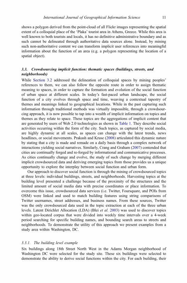
Our approach to discover social function is through the mining of crowdsourced topicsat three levels: individual buildings, streets, and neighborhoods. Harvesting topics at thebuilding level presented a challenge because of the proximity of the structures and thelimited amount of social media data with precise coordinates or place information. Toovercome this issue, crowdsourced data services (i.e. Twitter, Foursquare, and POIs fromOSM) were linked and used to match building features using string comparisons ofTwitter usernames, street addresses, and business names. From these sources, Twitterwas the only crowdsourced data used in the topic extraction at each of the three urbanlevels. Latent Dirichlet Allocation (LDA) (Blei et al. 2003) was used to discover topicswithin geo-located corpus that were divided into weekly time intervals over a 4-weekperiod searching for specific building names, and bounding search areas to streets andneighborhoods. To demonstrate the utility of this approach we present examples from astudy area within Washington, DC.
3.3.1. The building level example
Six buildings along 18th Street North West in the Adams Morgan neighborhood ofWashington DC were selected for the study site. These six buildings were selected todemonstrate the ability to derive social functions within the city. For each building, their
International Journal of Geographical Information Science 11
Dow
nloa
ded
by [
Geo
rge
Mas
on U
nive
rsity
] at
06:
40 0
8 Ja
nuar
y 20
15
place name and Twitter user names (i.e. @tryst) were used to search for messages. TheLDA and manual classification process led to the discovery of only two topic themes,entertainment and food and drink. During the 4-week time period, depicted in Figure 6,only the Madam’s Organ and New Orleans buildings were found to have consistent topicthemes being communicated through the crowdsourced data. Although the themes are notoverly surprising given the selected locations and building types, they do underscore thevalue of linking multiple crowdsourced data to gain an understanding of human activities,and therefore function, at the individual building level.
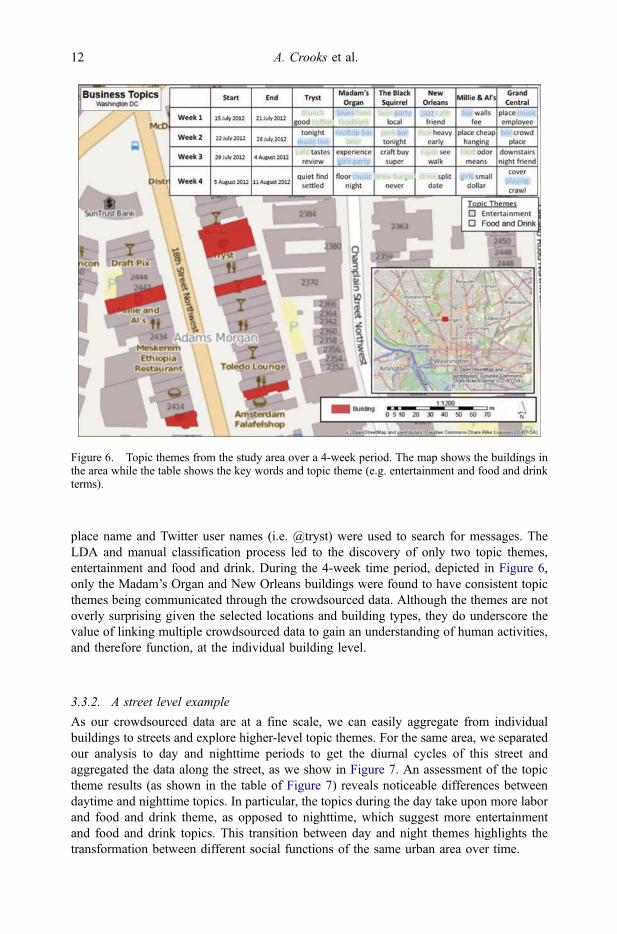
3.3.2. A street level example
As our crowdsourced data are at a fine scale, we can easily aggregate from individualbuildings to streets and explore higher-level topic themes. For the same area, we separatedour analysis to day and nighttime periods to get the diurnal cycles of this street andaggregated the data along the street, as we show in Figure 7. An assessment of the topictheme results (as shown in the table of Figure 7) reveals noticeable differences betweendaytime and nighttime topics. In particular, the topics during the day take upon more laborand food and drink theme, as opposed to nighttime, which suggest more entertainmentand food and drink topics. This transition between day and night themes highlights thetransformation between different social functions of the same urban area over time.
Figure 6. Topic themes from the study area over a 4-week period. The map shows the buildings inthe area while the table shows the key words and topic theme (e.g. entertainment and food and drinkterms).
12 A. Crooks et al.
Dow
nloa
ded
by [
Geo
rge
Mas
on U
nive
rsity
] at
06:
40 0
8 Ja
nuar
y 20
15
3.3.3. A neighborhood level example
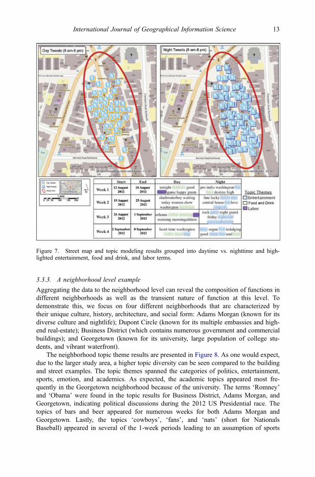
Aggregating the data to the neighborhood level can reveal the composition of functions indifferent neighborhoods as well as the transient nature of function at this level. Todemonstrate this, we focus on four different neighborhoods that are characterized bytheir unique culture, history, architecture, and social form: Adams Morgan (known for itsdiverse culture and nightlife); Dupont Circle (known for its multiple embassies and high-end real-estate); Business District (which contains numerous government and commercialbuildings); and Georgetown (known for its university, large population of college stu-dents, and vibrant waterfront).
The neighborhood topic theme results are presented in Figure 8. As one would expect,due to the larger study area, a higher topic diversity can be seen compared to the buildingand street examples. The topic themes spanned the categories of politics, entertainment,sports, emotion, and academics. As expected, the academic topics appeared most fre-quently in the Georgetown neighborhood because of the university. The terms ‘Romney’and ‘Obama’ were found in the topic results for Business District, Adams Morgan, andGeorgetown, indicating political discussions during the 2012 US Presidential race. Thetopics of bars and beer appeared for numerous weeks for both Adams Morgan andGeorgetown. Lastly, the topics ‘cowboys’, ‘fans’, and ‘nats’ (short for NationalsBaseball) appeared in several of the 1-week periods leading to an assumption of sports
Figure 7. Street map and topic modeling results grouped into daytime vs. nighttime and high-lighted entertainment, food and drink, and labor terms.
International Journal of Geographical Information Science 13
Dow
nloa
ded
by [
Geo
rge
Mas
on U
nive
rsity
] at
06:
40 0
8 Ja
nuar
y 20
15
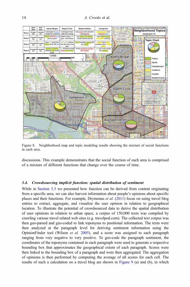
discussions. This example demonstrates that the social function of each area is comprisedof a mixture of different functions that change over the course of time.
3.4. Crowdsourcing implicit function: spatial distribution of sentiment
While in Section 3.3 we presented how function can be derived from content originatingfrom a specific area, we can also harvest information about people’s opinions about specificplaces and their functions. For example, Drymonas et al. (2011) focus on using travel blogentries to extract, aggregate, and visualize the user opinion in relation to geographicallocation. To illustrate the potential of crowdsourced data to derive the spatial distributionof user opinions in relation to urban space, a corpus of 150,000 texts was compiled bycrawling various travel related web sites (e.g. travelpod.com). The collected text corpus wasthen geo-parsed and geo-coded to link toponyms to positional information. The texts werethen analyzed at the paragraph level for deriving sentiment information using theOpinionFinder tool (Wilson et al. 2005), and a score was assigned to each paragraphranging from very negative to very positive. To geo-code the paragraph sentiment, thecoordinates of the toponyms contained in each paragraph were used to generate a respectivebounding box that approximates the geographical extent of each paragraph. Scores werethen linked to the bounding box of a paragraph and were then aggregated. The aggregationof opinions is then performed by computing the average of all scores for each cell. Theresults of such a calculation on a travel blog are shown in Figure 9 (a) and (b), in which
Figure 8. Neighborhood map and topic modeling results showing the mixture of social functionsin each area.
14 A. Crooks et al.
Dow
nloa
ded
by [
Geo
rge
Mas
on U
nive
rsity
] at
06:
40 0
8 Ja
nuar
y 20
15
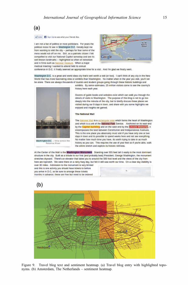
Figure 9. Travel blog text and sentiment heatmap. (a) Travel blog entry with highlighted topo-nyms. (b) Amsterdam, The Netherlands – sentiment heatmap.
International Journal of Geographical Information Science 15
Dow
nloa
ded
by [
Geo
rge
Mas
on U
nive
rsity
] at
06:
40 0
8 Ja
nuar
y 20
15
toponyms are highlighted and sentiment is shown using a heatmap visualization (green –positive, yellow – neutral, and red – negative).
4. An emerging research agenda
The typology that we have presented fosters the emergence of a new paradigm ofcollecting, analyzing, and modeling urban morphology, with a notable shift from author-itative to crowd-harvested content. This new paradigm that enables the crowdsourcing ofform and function (e.g. through social media, tracking, and location-based services)represents a novel, hybrid form of big geographical data, characterized by high velocity,high variability, and high volume. More importantly, though, this new paradigm providesa new lens for studying the conceptualization of how cities operate, at much finertemporal, spatial, and social scales, than we had been able to study so far. The keyconstruct for this evolution is the transition from traditional sensors and data sources tothe emergence of humans as hybrid sociocultural sensors. This development can have atransformative effect on urban planning, shifting its focus from traditional, top-down,long-term strategic planning (Jin and Batty 2013, Batty 2013b) to a finer understanding ofthe bottom-up mechanisms that make use of the physical and social infrastructure to drivethese complex systems that are today’s urban spaces. This shift on focus from top-down tobottom-up views of urban spaces allows us to revisit the concept of the smart city (Battyet al. 2012): instead of attempting to infuse sensors in these environments to automateprocesses, we realize that cities are smart, reconfigurable, and adaptive systems, and weare presented with the opportunity to observe the mechanisms that drive their operations.
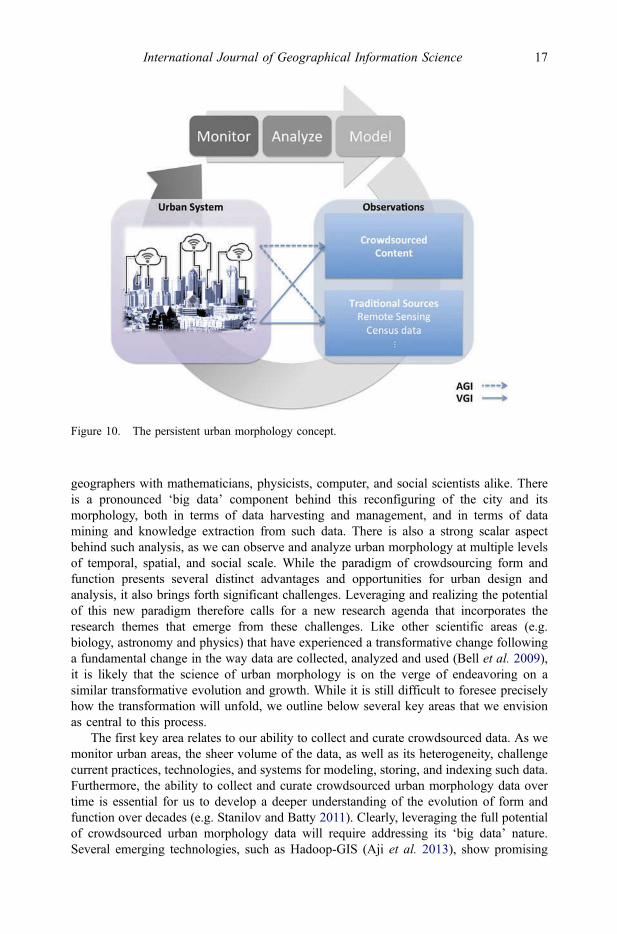
In this emerging paradigm, the traditional sources of urban form and function can becomplemented by crowdsourced content, in the form of both VGI and AGI. For example,explicit VGI road data can be used to augment existing road network data as well astraffic control systems, which are often based on traditional census data. At the same time,AGI data, derived from implicit sources, can assist in the management and maintenance ofthe same road network based on the topical context of different locations at the building,street, and neighborhood level. Similarly, user opinions and sentiment can assist in betterplanning of road maintenance priorities (e.g. filling potholes and fixing sidewalks). Whilethe above example focuses only on the transportation domain, similar approaches could beextended to other domains of a given urban system, such as utilities, education, and publichealth. The higher frequency at which VGI and AGI is made available can enable thecreation of a persistent urban morphology concept as shown in Figure 10, in which VGIand AGI along with traditional sources are fused to monitor, analyze, and model urbanmorphology. Rather than a static snapshot of urban morphology, this paradigm is observedand continually updated, to establish its historical records. By doing so, we are able notonly to have current views of urban form and function, but also to mine their histories toreveal hidden morphological patterns in space and time. Such patterns can in turn serve asthe basis for enabling the smart city to learn and eventually respond intelligently todynamic changes as they occur within the city. This new concept would allow us to betterassess how such information relates to existing urban theories and models. For instance,Lynch’s (1960) concept of mental maps of the city, which was put forward more than halfa century ago, can now be extended and explored on a massive scale through crowdsour-cing. This requires not only deriving new knowledge from such data, but also exploringhow such knowledge could be studied through the lens of Lynch’s work.
Accordingly, crowdsourced data allow us to explore and develop a new kind of urbanscience (Thrift 2014), which necessitates an interdisciplinary approach – combining
16 A. Crooks et al.
Dow
nloa
ded
by [
Geo
rge
Mas
on U
nive
rsity
] at
06:
40 0
8 Ja
nuar
y 20
15
geographers with mathematicians, physicists, computer, and social scientists alike. Thereis a pronounced ‘big data’ component behind this reconfiguring of the city and itsmorphology, both in terms of data harvesting and management, and in terms of datamining and knowledge extraction from such data. There is also a strong scalar aspectbehind such analysis, as we can observe and analyze urban morphology at multiple levelsof temporal, spatial, and social scale. While the paradigm of crowdsourcing form andfunction presents several distinct advantages and opportunities for urban design andanalysis, it also brings forth significant challenges. Leveraging and realizing the potentialof this new paradigm therefore calls for a new research agenda that incorporates theresearch themes that emerge from these challenges. Like other scientific areas (e.g.biology, astronomy and physics) that have experienced a transformative change followinga fundamental change in the way data are collected, analyzed and used (Bell et al. 2009),it is likely that the science of urban morphology is on the verge of endeavoring on asimilar transformative evolution and growth. While it is still difficult to foresee preciselyhow the transformation will unfold, we outline below several key areas that we envisionas central to this process.
The first key area relates to our ability to collect and curate crowdsourced data. As wemonitor urban areas, the sheer volume of the data, as well as its heterogeneity, challengecurrent practices, technologies, and systems for modeling, storing, and indexing such data.Furthermore, the ability to collect and curate crowdsourced urban morphology data overtime is essential for us to develop a deeper understanding of the evolution of form andfunction over decades (e.g. Stanilov and Batty 2011). Clearly, leveraging the full potentialof crowdsourced urban morphology data will require addressing its ‘big data’ nature.Several emerging technologies, such as Hadoop-GIS (Aji et al. 2013), show promising
Figure 10. The persistent urban morphology concept.
International Journal of Geographical Information Science 17
Dow
nloa
ded
by [
Geo
rge
Mas
on U
nive
rsity
] at
06:
40 0
8 Ja
nuar
y 20
15
results but are still not prevalent in GIScience and geography more generally. In conjunc-tion, various efforts have been made to address the heterogeneity of the data and thefusion of multiple data sources (e.g. Croitoru et al. 2013) due to a lack of standardizationin crowdsourced data. Unlike traditional geographical information for which well-estab-lished data and metadata standards exist (e.g. Open Geospatial Consortium), this is not yetseen in crowdsourced data. This hinders the ability to share, to exchange and to fusecrowdsourced data with existing legacy datasets.
A second key area relates to the issue of analysis and visualization. Crowdsourcedurban morphology data contain rich information in various data formats, from point dataand geometry to physical and social networks, thematic attributes and multimedia. As thecity is constantly evolving and reshaping, these data can be highly dynamic, requiring theemergence of innovative spatiotemporal analysis approaches beyond the current spectrumof GIScience solutions (e.g. dynamic spatiotemporal social network analysis, and machinelearning for narrative analysis). These challenges further extend to the visualization ofsuch data. Unlike more traditional spatial data sources, crowdsourced is often comprisedof an intertwined tapestry of links and associations among users, weaved with bothexplicit and implicit content and context. This complex structure is the result of severalkey constructs that shape public participation in crowdsourced data (Kietzmann et al.2011). Focusing only on the visualization of buildings and infrastructure is no longersufficient, as crowdsourced urban morphology requires the visualization of abstractconcepts like the flow of information in a society, contextual information associatedwith places, and the emergence of communities.
The third key area relates to this issue of scale. The availability of streaming urbandata content allows us to explore urban morphology at much finer scale and greatercoverage. This raises the question of the appropriate scale of analysis in terms of bothtime and space. As we discussed in Section 2, such analysis is often constrained by somepredefined unit of analysis (e.g. census areas). However, since crowdsourced data are notbound by such units of analysis, and often transcends such units, we now need new waysfor aggregating data, and new methods to generate meaningful units of analysis.Particularly pertinent to this topic is the issue of privacy. In past practice, when exploringdemographics, spatial units such as census areas were designed to mask individuals whileproviding meaningful information. With these new data, a variety of contributor-levelattributes can easily be revealed through the integrative analysis of multiple data sources.The availability of geo-tagged information further intensifies these concerns, as studieshave shown that the analysis of human mobility data (e.g. cell phone tracks) allows theunique identification of individuals (de Montjoy et al., 2013). Accordingly, the broadrange of information that is communicated through crowdsourced data, an aggregate oflocation, social connections, and personal views is accentuating the need to reconceptua-lize the concept of privacy (Elwood and Leszczynski 2011). As we collect, analyze, andintegrate crowdsourced data, it is important to remain cognizant of the digital dividewithin society and how representative such contributions are. Currently, little is knownabout the biasness within crowdsourced data and how this biasness affects the quality ofsuch data (e.g. Mullen et al. 2014). This area needs substantial further investigation withrespect to our ability to account for any biases in the sample and to discover their impacton the data quality.
While the above has focused on research challenges pertaining to monitoring andanalyzing urban morphology data, it is also important to address how such informationcan be leveraged for modeling in order to better inform urban design and management.We would argue that crowdsourced data can and will provide the building blocks for
18 A. Crooks et al.
Dow
nloa
ded
by [
Geo
rge
Mas
on U
nive
rsity
] at
06:
40 0
8 Ja
nuar
y 20
15
urban models and inform modeling assumptions (e.g. providing parameters for travel-to-work patterns, or public perceptions about places) to a variety of modeling techniques,and act as a new model validation paradigm (Batty et al. 2012). In addition, it can providea rich layer of geographical features in the model (e.g. Crooks and Wise 2013). As urbanmodels have transitioned over the last 50 years from macro-statics to micro-dynamics(Batty 2008a), these models were lacking dynamic data feeds to support them, especiallypertaining to human behavior. Just as the emergence of GIS-advanced traditional urbanmodeling (e.g. Batty 1992), so too, crowdsourced form and function content will advanceour modeling capabilities by making them more dynamic and realistic.
5. Summary
The contemporary urban landscape is highly dynamic and diverse. Rather than anaggregate of fixed form and assigned functions, this landscape has become a socioculturalgraffiti that is written and is constantly re-written, assigning meaning to the physicalspace, and expressing its usage and character as they are perceived by the general public.Increasingly, urban space is becoming the setting in which people forge physical anddigital paths, leaving trails of observations, interactions, events, and opinions both inphysical and in cyber domains. As people intertwine their physical and cyber presence inthis new urban landscape, mining these trails to extract information – and ultimatelyknowledge – about urban form and function presents unique opportunities to advance ourunderstanding of urban morphology. Unlike the static color-coded urban zoning map,through such crowdsourced data we are able – for the first time – to render urban spacewith more realistic depictions of road usage, traffic congestion, colloquial spaces, thematiclocations, and sentiments. This marks a significant shift toward a more holistic approachto the study of urban morphology.
In this paper, we have presented a typology of implicit and explicit form and functioncontent that builds upon traditional and crowdsourced data, and reflects the evolution ofcorresponding capabilities. Our typology is focused on the nature of the data from whichform and function can be derived: while explicit form and function data are purpose-driven and target-specific usages and users, implicit form and function content resultsthrough the repurposing of open-source data to address a variety of usages and user types.This enables us for the first time to study urban morphology without being restricted totop-down aggregations of space and activities, as has been the case with census data. Weprovided representative examples to showcase how a variety of geocomputation techni-ques may be employed to harvest form and function content from a variety of sources(e.g. GPS tracks, social media) and at various levels of abstraction ranging for examplefrom road networks to local thematic attributes that allow us to understand how neighbor-hoods are forged, perceived, and used by the people within them.
This new typology, along with the geocompuational techniques showcased in thispaper, is giving rise to an emerging research agenda to support the new science of cities.In particular we discussed in Section 4 several key areas that we envision to be central tothis process as they pertain to monitoring, analyzing, and modeling the city. By harvestingdirectly from the crowd a better understanding of place as it is defined through flows,networks, and links (Batty 2013c), we can gain deeper insights into the intricate interplaybetween inhabitants and the form and function of the modern urban landscape. As ourworld is becoming increasingly urban, and cities around the world are bound to experi-ence increasing pressures on their infrastructure, advancing this new science of cities isnot just an opportunity but rather a necessity.
International Journal of Geographical Information Science 19
Dow
nloa
ded
by [
Geo
rge
Mas
on U
nive
rsity
] at
06:
40 0
8 Ja
nuar
y 20
15
ReferencesAdams, B. and McKenzie, G., 2013. Inferring thematic places from spatially referenced natural
language descriptions. In: D. Sui, S. Elwood, and G.M. F., eds. Crowdsourcing geographicknowledge: volunteered geographic information in theory and practice. New York, NY:Springer, 201–221.
Aji, A., et al., 2013. Hadoop GIS: a high performance spatial data warehousing system overmapreduce. The Proceedings of the VLDB Endowment, 6 (11), 1009–1020. doi:10.14778/2536222.2536227
Arpinar, B.I., et al., 2006. Geospatial ontology development and semantic analytics. Transactions inGIS, 10 (4), 551–575. doi:10.1111/j.1467-9671.2006.01012.x
Batty, M., 1992. Urban modeling in computer-graphic and geographic information system environ-ments. Environment and Planning B: Planning and Design, 19 (6), 663–688. doi:10.1068/b190663
Batty, M., 2005. Cities and complexity: understanding cities with cellular automata, agent-basedmodels, and fractals. Cambridge, MA: The MIT Press.
Batty, M., 2007. Model cities. Town Planning Review, 78 (2), 125–151. doi:10.3828/tpr.78.2.3Batty, M., 2008a. Fifty years of urban modelling: macro-statics to micro-dynamics. In: S. Albeverio,
et al., eds. The dynamics of complex urban systems: an interdisciplinary approach. New York,NY: Springer Physica-Verlag, 1–20.
Batty, M., 2008b. The size, scale, and shape of cities. Science, 319 (5864), 769–771. doi:10.1126/science.1151419
Batty, M., 2013a. Big data, big issues. Geographical, 85 (1), 75.Batty, M., 2013b. Big data, smart cities and city planning. Dialogues in Human Geography, 3 (3),
274–279. doi:10.1177/2043820613513390Batty, M., 2013c. The new science of cities. Cambridge, MA: MIT Press.Batty, M., et al., 2012. Smart cities of the future. The European Physical Journal Special Topics,
214 (1), 481–518. doi:10.1140/epjst/e2012-01703-3Batty, M., et al., 2010. Map Mashups, Web 2.0 and the GIS revolution. Annals of GIS, 16 (1), 1–13.
doi:10.1080/19475681003700831Batty, M. and Longley, P.A., 1994. Fractal cities: a geometry of form and functions. London, UK:
Academic Press.Bell, G., Hey, T., and Szalay, A., 2009. Computer Science: beyond the data deluge. Science, 323
(5919), 1297–1298. doi:10.1126/science.1170411Besussi, E., 2010. The structure and form of urban settlements. In: T. Rashed and C. Jürgens, et al.,
eds. Remote sensing of urban and suburban areas. New York, NY: Springer, 13–31.Blei, D.M., Ng, A.Y., and Jordan, M.I., 2003. Latent Dirichlet allocation. Journal of Machine
Learning Research, 3, 993–1022.Boyko, A. and Funkhouser, T., 2011. Extracting roads from dense point clouds in large scale urban
environment. ISPRS Journal of Photogrammetry and Remote Sensing, 66 (6), S2–S12.doi:10.1016/j.isprsjprs.2011.09.009
Caquard, S., 2013. Cartography I: mapping narrative cartography. Progress in Human Geography,37 (1), 135–144. doi:10.1177/0309132511423796
Crang, M. and Graham, S., 2007. Sentient cities ambient intelligence and the politics of urban space.Information, Communication & Society, 10 (6), 789–817. doi:10.1080/13691180701750991
Croitoru, A., et al., 2013. Geosocial gauge: a system prototype for knowledge discovery from socialmedia. International Journal of Geographical Information Science, 27 (12), 2483–2508.doi:10.1080/13658816.2013.825724
Crooks, A.T. and Wise, S., 2013. GIS and agent-based models for humanitarian assistance.Computers, Environment and Urban Systems, 41, 100–111. doi:10.1016/j.compenvurbsys.2013.05.003
De Montjoye, Y.A., et al., 2013, Unique in the crowd: the privacy bounds of human mobility.Scientific Reports, 3 (Article No. 1376).
Drymonas, E., Efentakis, A., and Pfoser, D., 2011. Opinion mapping travelblogs [online]. In:Proceedings of Terra Cognita workshop (in conjunction with the 10th international semanticweb conference). Bonn, 23–36. Available from: http://ceur-ws.org/Vol-798/ [Accessed 12September 2014].
Earnhart, D., 2001, Combining revealed and stated preference methods to value environmentalamenities at residential locations. Land Economics, 77 (1), 12–29. doi:10.2307/3146977
20 A. Crooks et al.
Dow
nloa
ded
by [
Geo
rge
Mas
on U
nive
rsity
] at
06:
40 0
8 Ja
nuar
y 20
15
Efentakis, A., et al., 2013, Towards a flexible and scalable fleet management service [online]. In:Proceedings of the 6th ACM SIGSPATIAL international workshop on computational transpor-tation science, Orlando, FL. New York: ACM, 79–84. Available from: http://dl.acm.org/citation.cfm?id=2533835
Elwood, S. and Leszczynski, A., 2011. Privacy, reconsidered: new representations, data practices,and the Geoweb. Geoforum, 42 (1), 6–15. doi:10.1016/j.geoforum.2010.08.003
Flanagin, A.J. and Metzger, M.J., 2008. The credibility of volunteered geographic information.GeoJournal, 72 (3–4), 137–148. doi:10.1007/s10708-008-9188-y
Girardin, F., et al., 2009. Quantifying urban attractiveness from the distribution and density ofdigital footprints. International Journal of Spatial Data Infrastructures Research, 4 (1), 175–200.
Goodchild, M.F., 2007. Citizens as sensors: the world of volunteered geography. GeoJournal, 69(4), 211–221. doi:10.1007/s10708-007-9111-y
Haklay, M., 2010. How good is volunteered geographical information? A comparative study ofOpenStreetMap and Ordnance Survey datasets. Environment and Planning B: Planning andDesign, 37 (4), 682–703. doi:10.1068/b35097
Handy, S.L., et al., 2002. How the built environment affects physical activity: views from urbanplanning. American Journal of Preventive Medicine, 23 (2), 64–73. doi:10.1016/S0749-3797(02)00475-0
Hao, Q., et al., 2010. Equip tourists with knowledge mined from travelogues [online]. In:Proceedings of the 19th international conference on world wide web (WWW’10), Raleigh,NC. New York: ACM, 401–410. Available from: http://dl.acm.org/citation.cfm?id=1772732
Hillier, B. and Iida, S., 2005. Network and psychological effects in urban movement. In: A.G. Cohnand D.M. Mark, eds. Spatial information theory. Germany: Springer, 475–490.
Howe, J., 2006, The rise of crowdsourcing, Wired, 14.06: 161–165, Available from http://www.wired.com/wired/archive/14.06/crowds.html [Accessed 25 September 2008].
Jackson, S., et al., 2013. Assessing completeness and spatial error of features in volunteeredgeographic information. ISPRS International Journal of Geo-Information, 2 (2), 507–530.doi:10.3390/ijgi2020507
Jiang, B., 2009. Street hierarchies: a minority of streets account for a majority of traffic flow.International Journal of Geographical Information Science, 23 (8), 1033–1048. doi:10.1080/13658810802004648
Jiang, B., et al., 2013, Topological structure of urban street networks from the perspective of degreecorrelations. arXiv preprint arXiv:1308.1533.
Jin, Y. and Batty, M., 2013. Applied urban modeling: new types of spatial data provide a catalyst fornew models. Transactions in GIS, 17 (5), 641–644.
Karagiorgou, S. and Pfoser, D., 2012. On vehicle tracking data-based road network generation[online]. In: Proceedings of the ACM SIGSPATIAL international conference on advances ingeographic information systems. Redondo Beach, CA. New York: ACM, 89–98. Availablefrom: http://dl.acm.org/citation.cfm?id=2424334
Kietzmann, J.H., et al., 2011. Social media? Get serious! Understanding the functional buildingblocks of social media. Business Horizons, 54 (3), 241–251. doi:10.1016/j.bushor.2011.01.005
Kitchin, R., 2013. Big data and human geography: opportunities, challenges and risks. Dialogues inHuman Geography, 3 (3), 262–267. doi:10.1177/2043820613513388
Lamprianidis, G. and Pfoser, D., 2012. Collaborative geospatial feature search [online]. In:Proceedings of the ACM SIGSPATIAL international conference on advances in geographicinformation systems, Redondo Beach, CA. New York: ACM, 169–178. Available from: http://dl.acm.org/citation.cfm?id=2424344
Lévi-Strauss, C., 1955. Tristes tropiques. Paris: Plon.Levy, A., 1999. Urban morphology and the problem of the modern urban fabric: some questions for
research. Urban Morphology, 3 (1), 79–85.Lynch, K., 1960. The image of the city. Cambridge, MA: MIT Press.Masucci, A.P., et al., 2009. Random planar graphs and the London Street Network. The European
Physical Journal B, 71 (2), 259–271. doi:10.1140/epjb/e2009-00290-4Mennis, J., Mason, M.J., and Cao, Y., 2013. Qualitative GIS and the visualization of narrative
activity space data. International Journal of Geographical Information Science, 27 (2), 267–291. doi:10.1080/13658816.2012.678362
International Journal of Geographical Information Science 21
Dow
nloa
ded
by [
Geo
rge
Mas
on U
nive
rsity
] at
06:
40 0
8 Ja
nuar
y 20
15
Moudon, A.V., 1997. Urban morphology as an emerging interdisciplinary field. Urban Morphology,1 (1), 3–10.
Mullen, W.F., et al., 2014. Assessing the impact of demographic characteristics on spatial error involunteered geographic information features. GeoJournal, doi:10.1007/s10708-014-9564-8
Neis, P., Zielstra, D., and Zipf, A., 2011. The street network evolution of crowdsourced maps:OpenStreetMap in Germany 2007–2011. Future Internet, 4 (4), 1–21. doi:10.3390/fi4010001
O’Sullivan, D., 2000. Graph-based cellular automaton models of urban spatial processes. PhDThesis. London, UK: University College London.
OpenStreetMap. 2013. Bulk GPX track data. Available from: http://blog.osmfoundation.org/2013/04/12/bulk-gpx-track-data/ [Accessed 15 January 2014].
Ordnance Survey. 2014. OS MasterMap products. Available from: http://www.ordnancesurvey.co.uk/business-and-government/products/mastermap-products.html [Accessed 15 January 2014].
Over, M., et al., 2010. Generating web-based 3D city models from OpenStreetMap: the currentsituation in Germany. Computers, Environment and Urban Systems, 34 (6), 496–507.doi:10.1016/j.compenvurbsys.2010.05.001
Pfaff, P., et al., 2007. Towards mapping of cities [online]. In: IEEE international conference onrobotics and automation, Roma. IEEE, 4807–4813. Available from: http://ieeexplore.ieee.org/xpl/articleDetails.jsp?arnumber=4209838 [Accessed 12 September 2014].
Prakash, G. and Kruse, K.M., eds., 2008. The spaces of the modern city: imaginaries, politics, andeveryday life. Princeton, NJ: Princeton University Press.
See, L., et al., 2013. Comparing the quality of crowd sourced data contributed by expert and non-experts. PLoS One, 8 (7), e69958.
Smith, D.A. and Crooks, A.T., 2010. From buildings to cities: techniques for the multi-scaleanalysis of urban form and function. London: Centre for Advanced Spatial Analysis,University College London: Working Paper 155.
Stanilov, K. and Batty, M., 2011. Exploring the historical determinants of urban growth patternsthrough cellular automata. Transactions in GIS, 15 (3), 253–271. doi:10.1111/j.1467-9671.2011.01254.x
Stefanidis, A., Crooks, A., and Radzikowski, J., 2013. Harvesting ambient geospatial informationfrom social media feeds. GeoJournal, 78 (2), 319–338. doi:10.1007/s10708-011-9438-2
Talen, E., 2003. Measuring urbanism: issues in smart growth research. Journal of Urban Design, 8(3), 195–215. doi:10.1080/1357480032000155141
Thrift, N., 2014. Commentary: the promise of urban informatics: some speculations. Environmentand Planning A, 46 (6), 1263–1266. doi:10.1068/a472c
Wenk, C., Salas, R., and Pfoser, D., 2006. Addressing the need for map-matching speed: localizingglobal curve-matching algorithms [online]. In: Proceedings of the 18th international conferenceon scientific and statistical database management, Vienna. IEEE, 379–388. Available from:http://ieeexplore.ieee.org/xpl/articleDetails.jsp?arnumber=1644335 [Accessed 12 September2014].
Wilson, T., et al., 2005. OpinionFinder: a system for subjectivity analysis [online]. In: Proceedingsof human language technology conference and conference on empirical methods in naturallanguage processing, Vancouver. Stroudsburg, PA: Association for Computational Linguistics,34–35. Available from: http://dl.acm.org/citation.cfm?doid=1225733.1225751
Yang, X., ed., 2011. Urban remote sensing: monitoring, synthesis and modeling in the urbanenvironment. Hoboken, NJ: John Wiley & Sons.
22 A. Crooks et al.
Dow
nloa
ded
by [
Geo
rge
Mas
on U
nive
rsity
] at
06:
40 0
8 Ja
nuar
y 20
15