CPC-2016-3630.pdf - Los Angeles City Planning
129
DEPARTMENT OF CITY PLANNING R ECOMMENDATION R EPORT City Planning Commission Case No.: CPC-2016-3630-ZC-HD-DB- MCUP-SPP-SPR-WDI CEQA No.: ENV-2016-3631-SCPE Related Case: VTT-74496 Council No.: Plan Area: 13 – O’Farrell Hollywood Specific Plan: None Certified NC: Central Hollywood General Plan: Regional Center Commercial Current Zone: Proposed Zone: C4-2D-SN, C4-2D; (T)(Q)C4-2D-SN, (T)(Q)C4-2D; Applicant: Representative: 6400 Sunset, LLC Edgar Khalatian, Mayer Brown LLP Date: March 14, 2019 Time: After 8:30 A.M. Place: Los Angeles City Hall 200 N. Spring Street, Room 340 Los Angeles, CA 90012 Public Hearing Completed: January 9, 2019 Appeal Status: Appealable to City Council Expiration Date: March 14, 2019 Multiple Approval: Pursuant to Section 12.36 of the LAMC (Multiple Entitlements), appealable to City Council by any party; Off- Menu items not appealable. PROJECT LOCATION: 6400 Sunset Boulevard, 1440-1460 North Cahuenga Boulevard, 6400-6416 West Sunset Boulevard, 1419 North Ivar Avenue, 1441-1453 North Ivar Avenue, 1418 North Cahuenga Boulevard, Los Angeles, 90028. PROPOSED PROJECT: The Project is a transit priority project that meets all of the specified requirements that qualify it to be a sustainable communities project and is therefore exempt from CEQA pursuant to Public Resources Code Section 21155.1. Such criteria to be considered includes but is not limited to being a Transit Priority Project that is consistent with the general use designation, density, building intensity and applicable policies specified for the project area in a sustainable communities strategy. The Project proposes the removal of the existing retail use and its associated subterranean parking and the construction of a 26-story mixed-use building containing up to 200 dwelling units, and up to 7,000 square feet of commercial floor area on a 0.83 acre lot. Five percent of the units will be reserved for Very Low Income households. All construction will occur on the northerly lot. REQUESTED ACTIONS: CPC-2016-3630-ZC-HD-DB-MCUP-SPP-SPR-WDI 1. Pursuant to Los Angeles Municipal Code (“LAMC”) Section 12.32 F and 12.32 Q, a Zone and Height District Change to remove the “D” limitation on the site to allow a development with a 6:1 FAR in lieu of the otherwise permitted 3:1 FAR; 2. Pursuant to Los Angeles Municipal Code (“LAMC”) Section 12.22-A,25, a Density Bonus Compliance Review, for seven additional units (four percent) reserving five percent, or 10 units, for Very Low Income Households, and utilizing Parking Option 1, seeking the following incentives:
-
Upload
khangminh22 -
Category
Documents
-
view
0 -
download
0
Transcript of CPC-2016-3630.pdf - Los Angeles City Planning

DEPARTMENT OF CITY PLANNING
RECOMMENDATION REPORT
City Planning Commission Case No.: CPC-2016-3630-ZC-HD-DB-MCUP-SPP-SPR-WDI
CEQA No.: ENV-2016-3631-SCPE Related Case: VTT-74496 Council No.: Plan Area:
13 – O’Farrell Hollywood
Specific Plan: None Certified NC: Central Hollywood General Plan: Regional Center Commercial Current Zone: Proposed Zone:
C4-2D-SN, C4-2D; (T)(Q)C4-2D-SN, (T)(Q)C4-2D;
Applicant:
Representative:
6400 Sunset, LLC
Edgar Khalatian, Mayer Brown LLP
Date: March 14, 2019 Time: After 8:30 A.M. Place: Los Angeles City Hall
200 N. Spring Street, Room 340 Los Angeles, CA 90012
Public Hearing Completed:
January 9, 2019
Appeal Status: Appealable to City Council Expiration Date: March 14, 2019 Multiple Approval: Pursuant to Section 12.36 of
the LAMC (Multiple Entitlements), appealable to City Council by any party; Off-Menu items not appealable.
PROJECT LOCATION:
6400 Sunset Boulevard, 1440-1460 North Cahuenga Boulevard, 6400-6416 West Sunset Boulevard, 1419 North Ivar Avenue, 1441-1453 North Ivar Avenue, 1418 North Cahuenga Boulevard, Los Angeles, 90028.
PROPOSED PROJECT:
The Project is a transit priority project that meets all of the specified requirements that qualify it to be a sustainable communities project and is therefore exempt from CEQA pursuant to Public Resources Code Section 21155.1. Such criteria to be considered includes but is not limited to being a Transit Priority Project that is consistent with the general use designation, density, building intensity and applicable policies specified for the project area in a sustainable communities strategy. The Project proposes the removal of the existing retail use and its associated subterranean parking and the construction of a 26-story mixed-use building containing up to 200 dwelling units, and up to 7,000 square feet of commercial floor area on a 0.83 acre lot. Five percent of the units will be reserved for Very Low Income households. All construction will occur on the northerly lot.
REQUESTED ACTIONS:
CPC-2016-3630-ZC-HD-DB-MCUP-SPP-SPR-WDI
1. Pursuant to Los Angeles Municipal Code (“LAMC”) Section 12.32 F and 12.32 Q, a Zone andHeight District Change to remove the “D” limitation on the site to allow a development with a 6:1FAR in lieu of the otherwise permitted 3:1 FAR;
2. Pursuant to Los Angeles Municipal Code (“LAMC”) Section 12.22-A,25, a Density BonusCompliance Review, for seven additional units (four percent) reserving five percent, or 10 units,for Very Low Income Households, and utilizing Parking Option 1, seeking the following incentives:

Case No. CPC-2016-ZC-HD-DB-MCUP-SPP-SPR-WDI Page 2
a. Pursuant to LAMC 12.22-A,25(G), an Off-Menu incentive to permit floor-area averaging and residential density transfer across the project site;
b. Pursuant to LAMC 12.22A.25(G), a Waiver of Development Standard (Off-Menu) to permit compact parking spaces be utilized to meet the parking requirement;
3. Pursuant to Los Angeles Municipal Code (“LAMC”) Section 12.24-W,1, a Master Conditional Use to permit the sale and dispensing of a full line of alcoholic beverages for on-site sales and service of alcoholic beverages at four establishments for the 7,000 square-foot ground floor commercial use;
4. Pursuant to Los Angeles Municipal Code (“LAMC”) Section 11.5.7, a Project Permit Compliance review for signage in the Hollywood Signage Supplemental Use District;
5. Pursuant to Los Angeles Municipal Code (“LAMC”) Section 16.05, Site Plan Review for a project that would result in an increase of 50 or more dwelling units; and
6. Pursuant to Los Angeles Municipal Code (“LAMC”) Section 12.37 Waiver of Dedication and or Improvement to waive a two-foot sidewalk easement along Ivar Avenue to the east of the project site.
RECOMMENDED ACTIONS: CPC-2016-3630-ZC-HD-DB-MCUP-SPP-SPR-WDI
1. Recommend that the City Council Approve Pursuant to Los Angeles Municipal Code (“LAMC”) Section 12.32 F and 12.32 Q, a Zone Change and Height District Change to remove the “D” limitation on the site.
2. Approve Pursuant to Los Angeles Municipal Code (“LAMC”) Section 12.22-A,25, a Density Bonus Compliance Review, ,reserving five percent, or 10 units, for Very Low Income Households, resulting in seven additional units (four percent), and utilizing Parking Option 1, seeking the following incentive and waiver of a development standard:
a. Pursuant to LAMC 12.22-A,25(G), an Off-Menu Incentive to permit floor-area averaging and residential density transfer across the project site;
b. Pursuant to LAMC 12.22A.25(G), a Waiver of Development Standard to permit compact parking spaces be utilized to meet 20 percent of the residential parking requirement;
3. Approve Pursuant to Los Angeles Municipal Code (“LAMC”) Section 12.24-W,1, a Master Conditional Use to permit the sale and dispensing of a full line of alcoholic beverages for on-site sales and service of alcoholic beverages at four establishments for the 7,000 square-foot ground floor commercial use;
4. Approve Pursuant to Los Angeles Municipal Code (“LAMC”) Section 11.5.7, a Project Permit Compliance review for signage in the Hollywood Signage Supplemental Use District;
5. Approve Pursuant to Los Angeles Municipal Code (“LAMC”) Section 16.05, Site Plan Review for a project that would result in an increase of 50 or more dwelling units;
6. Dismiss without Prejudice a request for a Waiver of Dedication and or Improvement to waive a two-foot sidewalk easement along Ivar Avenue to the east of the project site. Find that on November 21, 2018 the City Council determined in their independent judgement, that Pursuant to PRC Section 21155.1 the project is a Sustainable Communities Project and is therefore exempt from CEQA, based upon the entirety of the administrative record;
7. Adopt the attached Conditions of Approval; and
8. Adopt the attached Findings.

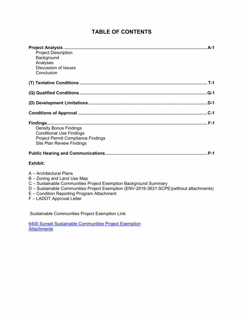
TABLE OF CONTENTS Project Analysis .................................................................................................................... A-1 Project Description Background Analyses Discussion of Issues Conclusion (T) Tentative Conditions ....................................................................................................... T-1 (Q) Qualified Conditions ....................................................................................................... Q-1 (D) Development Limitations ................................................................................................ D-1 Conditions of Approval ........................................................................................................ C-1 Findings ................................................................................................................................. F-1 Density Bonus Findings Conditional Use Findings Project Permit Compliance Findings Site Plan Review Findings Public Hearing and Communications .................................................................................. P-1 Exhibit: A – Architectural Plans B – Zoning and Land Use Map C – Sustainable Communities Project Exemption Background Summary D – Sustainable Communities Project Exemption (ENV-2016-3631-SCPE)(without attachments) E – Condition Reporting Program Attachment F – LADOT Approval Letter Sustainable Communities Project Exemption Link: 6400 Sunset Sustainable Communities Project Exemption Attachments

Case No. CPC-2016-3630-ZC-HD-DB-MCUP-SPP-SPR-WDI A-1
PROJECT ANALYSIS Project Description Pursuant to PRC Section 21155.1, which provides that projects are statutorily exempt from CEQA if a hearing is held by the City Council and the City Council finds, based on the whole of the administrative record, the project qualifies as a transit priority project, as defined by PRC Section 21155(b), and further meets all of the criteria set forth in PRC Section 21155.1 (a) and (b) and one of the criteria of subdivision (c). If the City Council finds, after conducting a public hearing, all of the above, then the project is declared to be a Sustainable Communities Project and shall be exempt from the California Environmental Quality Act (CEQA). At a Meeting of the Planning and Land Use Management Committee (PLUM), on November 6, 2018 the Committee found the project exempt from CEQA pursuant to PRC Section 21155.1, based on the whole of the administrative record. At the November 21, 2018 City Council meeting, the project was determined exempt from CEQA pursuant to PRC Section 21155.1, based on the whole of the administrative record. The Project proposes demolition of a three-story, 47-foot tall commercial structure containing 43,077 square-feet of floor area, and a single-level subterranean parking garage for the construction of a mixed-use development containing 200 residential units, with 10 units reserved for Very Low-Income Households (five percent), and 7,000 square-feet of ground floor commercial space within a 26-story building (maximum height of 284 feet) on the northern lot. The building would include 20 floors of residential, six levels of parking (four above-grade and two subterranean parking levels), and the 26th floor would include mechanical equipment. The project would include a mix of studio, one-bedroom, two-bedroom, and three-bedroom units as shown in Table 1 below. The ground floor would contain 7,000 square-feet of commercial space. The project site consists of two lots, a northern and southern lot, all development will occur on the northern lot. No changes are proposed for the southern lot, currently a surface parking lot with 21 spaces. The project would result in 231,836 square feet of new floor area, 190,735 square feet of residential floor area, and a maximum Floor Area Ratio of 6:1.
Table 1: Residential Mix Unit Type Quantity Studio 39 1 Bed 72 2 Bed 76 3 Bed 11 3+ Bed 2
Total 950

Case No. CPC-2016-3630-ZC-HD-DB-MCUP-SPP-SPR-WDI A-2
Ground Floor Plan
Open Space In total, approximately 23,963 square feet of open space is proposed, consisting of approximately 4,099 square feet of interior amenity space, 19,664 square feet of common open space, and approximately 200 square feet of private open space (penthouse) will be provided in accordance with the open space provisions set forth in LAMC Section 12.21-G. The project is required to provide 22,875 square feet of open space per LAMC standards. Additionally, the

Case No. CPC-2016-3630-ZC-HD-DB-MCUP-SPP-SPR-WDI A-3
project would provide ground floor seating as part of ground floor commercial amenities along Sunset Boulevard and Cahuenga Boulevard. Additionally, the project will mirror the streetscape improvements on the west side of Cahuenga Boulevard, instituted by the CNN office tower, creating a consistent streetscape along Cahuenga Boulevard. The outdoor seating, ground floor commercial space, and consistent streetscape treatments will activate Cahuenga and Sunset Boulevards, furthering thereby contributing to an active pedestrian environment in an area containing residential, commercial, and entertainment uses. At the podium level, the project would provide outdoor gathering spaces, a roof deck at the 6th and 25th level, a pool and spa, fire pit, barbeque, and private patios. Additional podium amenities include a fitness center, lounge, outdoor fitness area, pool changing rooms, and a dog run. The upper amenity level (floor 25) includes a roof deck, cooking facilities, seating and patio space. The Project is required to provide 50 trees. The Project will provide 93 new trees, including roof deck trees, and street trees along Cahuenga Boulevard, Ivar Avenue, and Sunset Boulevard. Full landscape Plans can found on page L 1.3 of Exhibit A Project Access The Project will provide pedestrian access for residents along Cahuenga Boulevard, and Ivar Avenue. Commercial uses will have access along Sunset Boulevard, Cahuenga Boulevard, and Ivar Avenue. Vehicular access, as seen in the ground floor plan above, will be provided through driveways mid-block along Ivar Avenue and Cahuenga Boulevard only. There will be no curb cuts along Sunset Boulevard. Left turns will be prohibited from Cahuenga Boulevard to and from the project driveway. Passenger loading and rideshare loading will be facilitated through interior circulation to the project site. Loading spaces are provided interior to the structure, and allow for the loading of passengers, encouraging vehicles to enter the site. Vehicle Parking Parking for commercial and residential uses will be provided in two subterranean parking levels and five above-grade parking levels. The project proposes to utilize Parking Option 1 as part of LAMC Section 12.22-A,25 as part of the Density Bonus application. Additionally, the project seeks, through an off-menu waiver, to utilize compact parking for 20% of its residential requirement. With additional reductions due to bike parking incentives, a total of 256 parking spaces are required and 277 spaces will be provided. The 21 parking spaces over the code requirement will be provided in the unaltered Southern Lot, currently a surface parking lot; new construction will be parking to the code minimum. Bicycle Parking Bicycle parking spaces will be located in both subterranean parking levels, and podium levels two to four. In addition, the Project is proposing a bicycle repair room at basement level one and on the fifth level of the podium.

Case No. CPC-2016-3630-ZC-HD-DB-MCUP-SPP-SPR-WDI A-4
Background The Project Site is located in the Hollywood Community Plan (Community Plan) Area at the intersection of Hollywood Boulevard and Cahuenga Boulevard, as seem in the aerial photograph below. The Project Site has a Regional Center Commercial land use designation and is primarily zoned C4-2D-SN. The northern lot consists of two parcels perpendicular to Sunset Boulevard, both zoned C2-4D-SN, with a third parcel parallel to Sunset Boulevard zoned C4-2D. The Southern Lot consists of one parcel zoned C4-2D. The project site is a relatively flat, non-contiguous rectangular-shaped 0.83 net acre site, with an additional lot located 150 feet south of the lots fronting Sunset Boulevard. The project site is zoned C4-2D-SN and C4-2D, consistent with the range of zones under the associated land use designation, Regional Center Commercial. The project site consists of two parcels, split by two one-story commercial buildings operating as nightclubs to the south of the Northern Lot, and otherwise bounded by Sunset Boulevard to the north, an alley to the south, Cahuenga Boulevard to the west and Ivar Avenue to the east. A southern lot, currently a surface parking lot, is located 150 feet south of the northern lot, adjacent to an alley, and one parcel north of De Longpre Avenue. The project site has a 139-foot frontage on Sunset Boulevard, 229-foot frontage on Cahuenga Boulevard, and 228-foot frontage on Ivar Avenue. The Project Site is currently improved with a three-story, 47-foot tall commercial structure with 43,077 square feet of floor area, and a single-level subterranean parking garage. The southern lot of the project site is a surface parking lot consisting of 21 spaces. The commercial structure and subterranean parking structure will be demolished to allow for the construction of the project, the surface parking lot will remain. The Subject Property is legally described as Parcel 1 Lot 12 of Tract No. 1998, in the City of Los Angeles, as per map recorded in Book 22, Page 106 of maps in the Office of the County Recorder, Parcel 2 Lot 13 and 14 of Tract No. 1998, in the City of Los Angeles, as per map recorded in Book 22, Page 106 of maps in the Office of the County Recorder, Parcel 3 Lot 24 of the Lander Tract, in the City of Los Angeles, as per map recorded in Book 1, Page 53 of maps in the Office of the County Recorder, and Lot 17 of the Lander Tract No. 2 of Hollywood, in the City of Los Angeles, as per map recorded in Book 4, Page 57 of maps in the Office of the County Recorder.

Case No. CPC-2016-3630-ZC-HD-DB-MCUP-SPP-SPR-WDI A-5
Aerial View of Project Site
Adjacent Uses The following provides a summary of the existing uses adjacent to the Project Site: North: A one story commercial building is located to the north of the project site on the north side of Sunset Boulevard, in the (T)(Q)C4-2D-SN and, C4-2D-SN zones. A new 19-story hotel was approved on March 1, 2017 at this location. South: A one-story commercial development is located south of the northern lot in the C4-2D Zone, while an alley bounds the project site to the south, adjacent to the southern lot. East: The one- to four-story ArcLight Cinema complex, including the historic ArcLight Dome, in the C4-2D-SN Zone is located to the east of the project site. West: A 14-story office building currently, associated with the CNN News Network, across Cahuenga Boulevard in the C4-2D-SN Zone, is located to the west of the project site.
Streets and Circulation Sunset Boulevard is a designated Avenue I in Mobility Plan 2035 with a right-of-way width of 100 feet, and is improved with a gutter, curb, and sidewalk along the project’s site’s south street frontage. Sunset Boulevard is a two-way street with on-street parking. Cahuenga Boulevard is a designated Modified Avenue II in Mobility Plan 2035 with a right-of-way width of 80 feet, and is improved with a gutter, curb, and sidewalk. Cahuenga Boulevard is a two-way street with on-street parking, to the south of the project site and no parking restrictions adjacent to the project site on both sides of the street.

Case No. CPC-2016-3630-ZC-HD-DB-MCUP-SPP-SPR-WDI A-6
Ivar Avenue is a designated Local Street – Standard in Mobility Plan 2035 with a right-of-way width of 60 feet, and is improved with a gutter, curb, and sidewalk along the project site’s west street frontage. Ivar Avenue is a two-way street with on-street parking on the west side of the street. Bureau of Engineering has conditioned reconstruction of the sidewalk to provide along Ivar Avenue. Freeway Access and Surrounding Public Transit Primary regional access to the Project Site is provided by US-101, which generally runs in a northwest-southeast direction and is located approximately 0.8 miles east of the Project Site. Project access to and from US-101 is available via interchanges at Cahuenga Boulevard, Highland Avenue, Western Avenue, Franklin Avenue, Gower Street, Hollywood Boulevard, Sunset Boulevard, and Santa Monica Boulevard. The Project Site is well-served by public transit, including both bus and rail service. Metro provides several bus lines in the form of both rapid and local bus service, as well as one subway line in the vicinity. DASH and West Hollywood Cityline also provide local bus transit service in the area. The following list presents a brief description of the bus lines providing service in the immediate vicinity of the Project Site:
• Metro Local 2 – Route 2 is a local line that travels from downtown Los Angeles to Pacific Palisades via Sunset Boulevard, with average headways of 10 to 15 minutes during the weekday morning and afternoon peak hours. This line provides service to Hollywood, West Hollywood, and Westwood and travels along Sunset Boulevard in the vicinity of the Project Site.
• Metro Local 180/181 – Route 180/181 is a local line that travels from Hollywood to
Altadena via Los Feliz Boulevard and Colorado Boulevard with average headways of approximately 35 to 40 minutes during the weekday Morning and afternoon peak hours. This line provides service to Pasadena, Eagle Rock, and Glendale, and travels along Hollywood Boulevard in the vicinity of the Project Site.
• Metro Local 210 – Route 210 is a local line that travels from Hollywood to Redondo
Beach via Crenshaw Boulevard with average headways of 15 minutes during the weekday morning and afternoon peak hours. This line provides service to Torrance, the Metro Green Line Crenshaw Station, and the Metro Expo Line Expo/Crenshaw Station, and travels along Vine Street in the vicinity of the Project Site.
• Metro Local 212 – Route 212 is a local line that travels from the Hollywood/Vine Station
to the Hawthorne/Lennox Station via La Brea Avenue with average headways of 15 to 20 minutes during the weekday morning and afternoon peak hours. This line provides service to Miracle Mile, Baldwin Hills, and Inglewood. It travels along Hollywood Boulevard in the vicinity of the Project Site.
• Metro Local 217 – Route 217 is a local line that travels from Vermont Avenue & Sunset Boulevard to Fairfax Avenue & Washington Boulevard with average headways of 15 to 20 minutes during the weekday morning and afternoon peak hours. This line provides service to Los Feliz, Hollywood, and Culver City, and travels along Hollywood Boulevard in the vicinity of the Project Site.
• Metro Local 222 – Route 222 is a local line that travels from Sunland to Hollywood via
Hollywood Way, Barham Boulevard, and Cahuenga Boulevard with average headways

Case No. CPC-2016-3630-ZC-HD-DB-MCUP-SPP-SPR-WDI A-7
of 40 minutes during the weekday morning and afternoon peak hours. This line provides service to Sun Valley, Burbank, and Universal City, and travels along Hollywood Boulevard in the vicinity of the Project Site.
• Metro Limited 302 – Route 302 is a limited service line that travels from downtown Los Angeles to Pacific Palisades via Sunset Boulevard, with average headways of 10 minutes during the weekday morning and afternoon peak hours. This line provides service to Hollywood, West Hollywood, and Westwood and travels along Sunset Boulevard in the vicinity of the Project Site.
• Metro Limited 312 – Route 312 is a limited service line that travels from the
Hollywood/Vine Station to the Hawthorne/Lennox Station via La Brea Avenue with average headways of 10 minutes during the weekday morning and afternoon peak hours. This line provides service to Miracle Mile, Baldwin Hills, and Inglewood. It travels along Hollywood Boulevard in the vicinity of the Project Site.
• Metro Rapid 780 – Route 780 is a rapid line that travels from Washington Boulevard &
Fairfax Avenue to Pasadena via Fairfax Avenue and Hollywood Boulevard with average headways of 15 minutes during the weekday morning and afternoon peak hours. This line provides service to Los Feliz, Glendale, and Eagle Rock, and travels along Hollywood Boulevard in the vicinity of the Project Site.
• LADOT DASH Beachwood Canyon – DASH Beachwood Canyon is a local line that
travels from the Metro Red Line Hollywood Station to Beachwood Drive & Westshire Drive with average headways of 25 minutes during the weekday morning and afternoon peak hours. This line provides service to Beachwood Canyon and Hollywood, and travels along Vine Street and Sunset Boulevard in the vicinity of the Project Site.
• LADOT DASH Hollywood – DASH Hollywood is a local line that currently travels from
Argyle Avenue & Hollywood Boulevard to Santa Monica Boulevard & Vermont Avenue via Hollywood Boulevard and Fountain Avenue with average headways of 30 to 35 minutes during the weekday morning and afternoon peak hours. It currently provides service to the Metro Red Line Vermont/Sunset, Vermont/Santa Monica, and Hollywood/Vine Stations, and travels along Hollywood Boulevard and Fountain Avenue in the vicinity of the Project Site. DASH Hollywood is currently undergoing Phase II of LADOT Transit Services Analysis, which includes a modified route and increased service frequency. The proposed DASH Hollywood will have average headways of 15 minutes during the weekday morning and afternoon peak hours. It will provide service to the Metro Red Line Hollywood/Highland, Hollywood/Vine, Hollywood/Western, Vermont/Sunset, Vermont/Santa Monica, and Hollywood/Vine Stations, and travel along Hollywood Boulevard in the vicinity of the Project Site.
• LADOT DASH Hollywood/Wilshire – DASH Hollywood/Wilshire is a local line that travels
from the Metro Purple Line Wilshire/Western Station to the Metro Red Line Hollywood/Vine Station with current average headways of 25 to 30 minutes during the weekday morning and afternoon peak hours. DASH Hollywood/Wilshire is currently undergoing Phase II of LADOT Transit Services Analysis, which includes a modified route and increased service frequency. The proposed DASH Hollywood/Wilshire will have average headways of 15 minutes during the weekday morning and afternoon peak hours. This line will continue to provide service to Koreatown and Hollywood, and continue to travel along Vine Street in the vicinity of the Project Site.

Case No. CPC-2016-3630-ZC-HD-DB-MCUP-SPP-SPR-WDI A-8
In addition to the above bus lines, Metro operates the Red Line subway in the immediate vicinity of the Project Site. The Metro Red Line runs between North Hollywood and downtown Los Angeles, connecting with the Metro Orange Line in North Hollywood, the Metro Purple Line at Wilshire Boulevard, the Metro Blue Line and Metro Expo Line in downtown Los Angeles, and the Metro Gold Line at Union Station. The Metro Red Line Hollywood/Vine Station is located approximately 0.3 miles from the Project Site, and the Metro Red Line Hollywood/Highland Station is approximately 0.8 miles from the Project Site. In 2017, the Red Line had a total ridership of 44,861,106 trips.
Surrounding Transit Land Use Designation and Zoning The adopted Hollywood Community Plan designates the Project Site for Regional Center Commercial land uses, as shown in Exhibit B. Surrounding land use designations include Public Facilities south of the project site along Delongpre Ave, where Los Angeles Fire Department facilities are located. Most parcels surrounding the Project Site have a Regional Center Commercial land use designation toward Hollywood Boulevard, and slightly to the south, along Sunset Boulevard. To the south of the Regional Commercial Center land use designation along Sunset, the land use designation is Low Medium II Residential. Finally, the land use designation to the south along Highland Avenue is Highway Oriented Commercial. The proposed Project is consistent with the Regional Center Commercial land use. Parcels under the Regional Center Land Use Designation of the Hollywood Community Plan have corresponding zones of C2, C4, P, PB, RAS3, and RAS4. The project site is not located in a Specific Plan Area. The project site contains 0.83 acres and is presently zoned C4-2D-SN and C4-2D, as shown in the figure below. The C4-2D Zone allows for Commercial uses, with a Height District 2, and Development “D” Limitation, and the C4-2D-SN Zone allows for Commercial uses, with Height District 2, Development Limitation, and Signage Supplemental Use District. The Development “D” Limitation in the zoning prefix indicates that development shall not exceed a FAR of 2:1 and 3:1 unless certain approvals are received. The “SN” designation identified for the C4-2D-SN-zoned parcels in northern lot, indicates that these parcels are located in the Hollywood Signage Supplemental Use District (HSSUD). As shown in the figure, the parcels fronting Sunset Boulevard are zoned C4-2D-SN, while the remainder of the Project Site is zoned C4-2D. The C4 Zone generally allows for any land use permitted in the C2 Zone, which, in turn, allows for any land use permitted in the C1.5, C1, and CR zones. The commercial zones allow for a wide array of land uses, such as retail stores, restaurants, offices, hotels, schools, parks, and theaters. The C4 Zone also allows for any land use permitted in the R4 (Multiple Residential) Zone, which includes one-family dwellings, two-family dwellings, apartment houses, multiple dwellings, and home occupations at a maximum density of 108 dwelling units per acre (a minimum lot area of 400 square feet per dwelling unit). In addition, pursuant to LAMC Section 12.22-A,18(a), developments combining residential and commercial uses are also allowed to develop any land use permitted in the R5 Zone, which allows for residential development at a maximum density of 217 dwelling units per acre, based on a minimum lot area of 200 square feet per dwelling unit. Height District 2 within the C4 Zone does not impose a height limitation. Surrounding Bike Lanes In the vicinity of the Project Site, dedicated bicycle lanes exist along Cahuenga Boulevard, Fairfax Avenue, and Bronson Avenue. In addition, bicycle routes exist along Selma Avenue, Orange Drive, Wilcox Avenue, Vine Street, Argyle Avenue, Van Ness Avenue, Odin Street,
Public Facility

Case No. CPC-2016-3630-ZC-HD-DB-MCUP-SPP-SPR-WDI A-9
Franklin Avenue, Yucca Street, and Fountain Avenue. Based on the City of Los Angeles 2010 Bicycle Plan, the bicycle system in the immediate vicinity of the Project Site would be expanded to include dedicated bicycle lanes along Highland Avenue, Sunset Boulevard, Hollywood Boulevard, Fairfax Avenue, La Brea Avenue, Wilcox Avenue, Cahuenga Boulevard, Cole Avenue, Vine Street, Bronson Avenue, Van Ness Avenue, Wilton Place, Western Avenue, Pilgrimage Bridge, Los Feliz Boulevard, Yucca Street, Fountain Avenue, Santa Monica Boulevard, and Beverly Boulevard, to create a more integrated network. However, the proposed dedicated bicycle lanes are not scheduled for implementation at this time. Environmental Clearance Sustainable Communities Project Exemption: PRC Section 21155.1 provides that projects are statutorily exempt from CEQA if a hearing is held by the City Council and the City Council finds, based on the whole of the administrative record, the project qualifies as a transit priority project, as defined by PRC Section 21155(b), and further meets all of the criteria set forth in PRC Section 21155.1 (a) and (b) and one of the criteria of subdivision (c). If the City Council finds, after conducting a public hearing, all of the above, then the project is declared to be a Sustainable Communities Project and shall be exempt from the California Environmental Quality Act (CEQA). Planning has reviewed the Sustainable Communities Project Exemption (SCPE) that was prepared for the proposed project and recommended that the City Council consider and determine that the project is exempt from CEQA pursuant to PRC Section 21155.1. At a Meeting of the Planning and Land Use Management Committee (PLUM), on November 6, 2018 the Committee found the project exempt from CEQA pursuant to PRC Section 21155.1, based on the whole of the administrative record. At the November 21, 2018 City Council meeting, the project was determined exempt from CEQA pursuant to PRC Section 21155.1, based on the whole of the administrative record. Guidelines and requirements for eligibility for a Sustainable Communities Project, as well as the proposed project compliance with those requirements can be found in Exhibits C and D. Notable requirements include affordable housing requirements, energy and water efficiency, transit proximity, and a maximum of 200 residential units. The project is reserving 5 percent of the total units (10 units) for Very Low Income Households, providing the maximum total of 200 residential units. Furthermore, the project is required to provide a development which is 15 percent more energy efficient than Title 24 standards, and uses 25 percent less water than the average household in the region. The project will meet these requirements through a combination of efforts. The combination analyzed in the exemption prepared for the project includes various elements which meet this requirement, but may change with technological advancements or changing markets. Finally, the project is located less than 0.5 miles from the Metro Red Line, meeting the requirement for transit accessibility. For more detailed information, see Exhibits D for the exemption document. Measure JJJ The project’s Vesting Tentative Tract Map application was filed and was deemed complete on November 1, 2016. Pursuant to LAMC Section 17.15-C the proposed project is subject only to the regulations at the time of filing, and therefore not subject to the requirements of Measure JJJ, which applies to projects with Zone Changes or General Plan Amendments deemed complete after December 13, 2016.

Case No. CPC-2016-3630-ZC-HD-DB-MCUP-SPP-SPR-WDI A-10
On-Site Related Cases ENV-2016-3631-SCPE: PRC Section 21155.1 provides that projects are statutorily exempt from CEQA if a hearing is held by the City Council and the City Council finds, based on the whole of the administrative record, the project qualifies as a transit priority project, as defined by PRC Section 21155(b), and further meets all of the criteria set forth in PRC Section 21155.1 (a) and (b) and one of the criteria of subdivision (c). If the City Council finds, after conducting a public hearing, all of the above, then the project is declared to be a Sustainable Communities Project and shall be exempt from the California Environmental Quality Act (CEQA). Planning has reviewed the Sustainable Communities Project Exemption (SCPE) that was prepared for the proposed project and recommended that the City Council consider and determine that the project is exempt from CEQA pursuant to PRC Section 21155.1. At a Meeting of the Planning and Land Use Management Committee (PLUM), on November 6, 2018 the Committee found the project exempt from CEQA pursuant to PRC Section 21155.1, based on the whole of the administrative record. At the November 21, 2018 City Council meeting, the project was determined exempt from CEQA pursuant to PRC Section 21155.1, based on the whole of the administrative record. Guidelines and requirements for eligibility for a Sustainable Communities Project, as well as the proposed project compliance with those requirements can be found in Exhibits C and D. VTT-74496-CN: On January 9, 2019, the Advisory Agency approved Vesting Tentative Tract Map No. VTT-74496-CN for the Vesting Tentative Tract Map No. 74496-CN for the merger of existing lots on a 0.73 acre site into one ground lot for condominium purposes, in conjunction with a mixed-use project consisting of 200 residential units and 7,000 square feet of commercial area. There was no action taken on an environmental clearance at the hearing. VTT-74496-CN-1A: On January 28, 2019, an appeal was filed relative to the Advisory Agency’s approval of Vesting Tentative Tract Map No. 74496-CN. Ordinance No. 182,173: Effective August 6, 2012, the ordinance established a Zone Change from C4-2D to C4-2D, with the following “D” Development Limitations: 1) Development shall not exceed a height of 75 feet. A project may exceed a height of 75 feet per approval of the Zoning Administrator pursuant to Los Angeles Municipal Code (LAMC) Section 12.24 W. 2). The total floor area of all buildings or structures on a lot shall not exceed a Floor Area Ratio (FAR) of 3:1. 3) Development subject to historic preservation review which exceeds an FAR of 2:1 shall require approval by the Office of Historic Resources. 4) A project may exceed the 3:1 FAR provided that a) the project is approved by the City Planning Commission, or the City Council on appeal, pursuant to the procedures set forth in LAMC 12.32 D; and, b) the project conforms with the Hollywood Community Plan policies. Ordinance No. 182,173 only applies to the Project Site areas that are in the C4-2D Zone and identified as “SA 4:5B” in the Ordinance zoning maps. Ordinance No. 181,340: Effective November 17, 2010, the ordinance amended the Hollywood Signage Supplemental Use District and was enacted to acknowledge and promote the continuing contribution of signage to the distinctive aesthetic of Hollywood Boulevard, as well as control the blight created by poorly placed, badly designed signs throughout Hollywood. This ordinance applies to the parcels of the Project within the C4-2D-SN Zone (the parcels which front Sunset Boulevard only).

Case No. CPC-2016-3630-ZC-HD-DB-MCUP-SPP-SPR-WDI A-11
Ordinance No. 165,661: Effective May 7, 1990, the ordinance states that the total floor area contained in all buildings on a lot shall not exceed two times the buildable area of the lot. A project may exceed the 2:1 floor area ratio provided that a) the Community Redevelopment Agency Board finds that the project conforms to (1) the Hollywood Redevelopment Plan, (2) a Transportation Program adopted by the Community Redevelopment Agency Board pursuant to 518.1 of the Redevelopment Plan, and, if applicable, (3) any Designs for Development adopted pursuant to Section 503 of the Redevelopment Plan; and, b) the project complies with the following two requirements: a Disposition and Development Agreement or Owner Participation Agreement has been executed by the Community Redevelopment Agency Board; and the Project is approved by the City Planning Commission, or the City Council on appeal, pursuant to the procedures set forth in Municipal Code Section 12.24-B.3. Off-Site Related Cases CPC-2015-2025-DB-MCUP-CU-SPR: At its meeting of September 13, 2018 the City Planning Commission approved Density Bonus and Master conditional Use Permit for the construction of eight mixed-use buildings containing up consisting of 950 residential units, 308 hotel rooms, and approximately 190,000 square feet of commercial/retail uses and a new above-ground parking structure on the eastern side of the Project Site, located at 6701 West Sunset Boulevard. CPC-2016-1380-VZC-HD-MCUP-ZAA-SPR: At its meeting of September 13, 2018 the City Planning Commission approved and recommended that the City Council adopt a Zone Change and Height District Change for the construction of a mixed-use building containing up to 270 residential units and up to 12, 120 square feet of commercial retail and restaurant uses, located at 6200 West Sunset Boulevard. CPC-2016-3841-ZV-CU-CUB-SPR: At its meeting of February 8, 2018 the City Planning Commission approved and recommended that the City Council adopt a Zone Change and Height District Change for the construction of a 220 room hotel, 2,273 square foot ground floor restaurant, and 1,440 roof top lounge located at 1400 North Cahuenga Boulevard. CPC-2015-2893-VZC-HD-MCUP-SPR: At its meeting of September 8, 2018 the City Planning Commission approved and recommended that the City Council adopt a Zone Change and Height District Change for the construction of a 275 room hotel, and 1,900 square foot ground floor commercial space, located at 6407 West Sunset Boulevard. DIR-2015-3166-SPR: On June 16, 2016 the Director of Planning issued a determination letter for the approval of a Site Plan Review for the construction of a 175-room hotel, located at 1400 North Cahuenga Boulevard. ZA-2015-1766-MCUP-VCU-SPR: At its meeting of April 20, 2017, the City Planning Commission approved a Master Conditional Use and Site Plan Review for the construction of a mixed-use development consisting of 200 residential units, 285,719 square feet of office space, and 16,315 square feet of restaurant space in four buildings, located at 1341 North Vine Street. CPC-2014-4279-ZC-HD-ZAA-SPR: At its meeting of September 26, 2016 the City Planning Commission approved and recommended that the City Council adopt a Zone Change and Height District Change for the construction of a mixed-use building with 369 dwelling units and 2,570 square feet of commercial area, located at 1311 Cahuenga Boulevard.

Case No. CPC-2016-3630-ZC-HD-DB-MCUP-SPP-SPR-WDI A-12
CPC-2014-750-VZC-HD-DB-CUB-SPP-SPR: At its meeting of May 12, 2016, the City Planning Commission approved and recommended that the City Council adopt a Zone Change and Height District Change for the construction of a mixed-use building with 200 dwelling units and 4,700 square feet of ground floor commercial area, located at 6250 West Sunset Boulevard. CPC-2014-3808-GPA-ZC-HD-CU-CUB-ZAI-SPR: At its meeting of November 19, 2015, the City Planning Commission approved and recommended that the City Council adopt a General Plan Amendment, Zone Change and Height District Change for the proposed construction of a mixed-use project comprised of 731 residential dwelling units and 24,000 square feet of retail and restaurant uses, located at 6201 West Sunset Boulevard. ZA-2013-4015-CUB: On May 15, 2014, the Zoning Administrator approved a Conditional Use to permit the continued sale and dispensing of a full line of alcoholic beverages for on-site consumption in conjunction with an existing 2,538 square-foot restaurant, located at 6255 West Sunset Boulevard. ZA-2011-2835-CUB: On July 27, 2012, the Zoning Administrator approved a conditional use to allow the sale and dispensing for consideration of a full line of alcoholic beverages for on-site consumption in conjunction with an existing restaurant which is authorized to sell beer and wine, located at 6270 West Sunset Boulevard. ZA-2010-460-CUB: On June 29, 2010, the Zoning Administrator approved a Conditional Use Permit to allow the sale and dispensing of a full line of alcoholic beverages for on-site consumption in conjunction with a 2,837 square-foot restaurant, located at 6290 West Sunset Boulevard. CPC-2007-9911-GPA-VZC-HD-CUB-CUX-CU-SPR-DA: At its meeting of December 10, 2009, the City Planning Commission approved and recommended that the City Council adopt a General Plan Amendment, Zone Change, and Height District Change for a mixed-use project comprised of a maximum 200 residential units, a 125-room hotel, 442,610 square feet of office floor area, and a total of 41,300 square feet of retail, bar, and restaurant commercial floor area, located at 6121 West Sunset Boulevard. CPC-2006-3871-ZC-CUB-SPR: At its meeting of March 8, 2007, the City Planning Commission approved and recommended that the City Council adopt a Zone Change for the proposed construction of a 428,423 square foot mixed-use building consisting of 306 apartment units and a ground floor grocery market of approximately 69,000 square feet with an overall floor area ratio of 4.5:1, located at 1540 North Vine Street. DIR-2006-2586-SPR: On August 9, 2006, the Director of Planning approved a Site Plan Review for the construction, use and maintenance of a new approximately 96,681 square foot six-story office building, located at 6040 West Sunset Boulevard. Public Hearing and Noticing A duly noticed joint public hearing for the Project was held on January 9, 2019, which was conducted by both the Hearing Officer on behalf of the City Planning Commission, and the Deputy Advisory Agency on behalf of the Advisory Agency to consider the vesting tentative tract map (see Public Hearing and Communications, Page P-1).

Case No. CPC-2016-3630-ZC-HD-DB-MCUP-SPP-SPR-WDI A-13
Issues Approximately 15 members of the public attended the public hearing and 7 people provided testimony. The following is a list of general concerns related to the Project that were brought up at the public hearing:
• The number of affordable units is inadequate • Historic resources are present on the site • The height of the new building would set a precedent.
Historic resources do not exist on site as described in the Historic Resource Report prepared for the project. Public comment contended that murals on the interior and exterior of the structure were historic resources. Give the age of the building (2001) no historic resources are present as defined by CEQA. Furthermore, the site was not listed on the most recent CRA historic survey. Additionally, multiple members of the public raised concerns about the validity of the exemption document prepared for the project. As the exemption was approved by City Council November 21, 2018, the exemption was not before the Deputy Advisory Agency, and no action was taken on the exemption. PROJECT ANALYSIS Site Planning and Architectural Design As shown in the ground floor level plan on page 7 of Exhibit A the project has located ground floor commercial uses, with entrances along each of Sunset Boulevard, Ivar Avenue, and Cahuenga Boulevard. The ground floor commercial uses will activate each of the streets of the project with actives uses, as well as seating, in addition to creating a uniform and inviting pedestrian experience along these frontages. Ivar Avenue as a local collector street does not have the same commercial activity or frontage due to facilities restrictions, and infrastructure requirements of the project which preclude expansion of commercial space along Ivar Avenue. The Project utilizes a contemporary architectural style with a variety of materials and modulated facades to create visual interest. Specifically, the materials include vision glass, tinted glass, blackened steel frame, prefinished aluminum, perforated metal paneling, prefinished aluminum, architectural concrete panel, and poured in place concrete. The project consists of a single point tower which is oriented to be consistent with other similar tower designs in the Hollywood Center. The tower features horizontal and vertical articulation. The project utilizes an offset vertical pattern of windows to create a vertical rhythm as well as material differentiation to create pronounced horizontal planes, creating a pleasant and visually interesting tower. The siting of the tower concentrates the height and mass along Sunset Boulevard to the east, maintaining views from Cahuenga Boulevard, and orienting height towards a major street, Sunset Boulevard. Walkability Analysis Walkability is a measure of how interesting, inviting, and comfortable the street and sidewalk environment is for pedestrians. The City of Los Angeles Walkability Checklist for Site Plan Review (“Walkability Checklist”) was created by the City’s Urban Design Studio of the Department of City Planning. The Walkability Checklist consists of a list of design principles intended to improve the pedestrian environment, protect neighborhood character, and promote

Case No. CPC-2016-3630-ZC-HD-DB-MCUP-SPP-SPR-WDI A-14
high quality urban form and is to be used by decision-makers and/or hearing officers to assess the pedestrian orientation of a project when making the required findings for approval of a project. The design elements are consistent with the General Plan and applicable Urban Design Chapters of the Community Plans. Guidelines address such topics as building orientation, building frontage, landscaping, off-street parking and driveways, building signage, and lighting within the private realm; and sidewalks, street crossings, on-street parking, and utilities in the public realm. An analysis of site plans, community context, and building elevations is essential to improve and ensure walkability. The Project is consistent with many of the goals and implementation strategies of the Department of City Planning’s Walkability Checklist. While the guidance provided by the Walkability Checklist is not mandatory and is not a part of the LAMC, incorporating the criteria listed to the maximum extent feasible would create a more walkable environment and a higher quality urban form for the proposed project. The essential purpose of the Walkability Checklist is to guide City Planning staff in working with developers to make developments more “walkable” by way of enhancing pedestrian activity, access, comfort, and safety. In addition, the Walkability Checklist encourages planners and developers to protect neighborhood character and pursue high‐quality urban form. The following is an analysis of the proposed project’s consistency with the applicable guidelines. a) Building Orientation. The project has designed the ground floor of the building to be
pedestrian friendly in its orientation, the project has no driveway on the major boulevard Sunset Boulevard, minimized driveways along Cahuenga Boulevard and Ivar Avenue. Furthermore, the commercial spaces each have exterior pedestrian entrances along each frontage, as well as outdoor seating. Residential entrances are located along Ivar Avenue and Cahuenga Boulevard, feature prominent entryways, wayfinding, canopies, and lighting.
b) Building Frontage. The building will have frontages along Sunset Boulevard, Ivar
Avenue, and Cahuenga Boulevard. Each frontage will have architectural treatments, including glass at the ground floor level, canopies, metal architectural elements, and wayfinding signage. Sunset Boulevard will have additional glass along the façade, while Ivar Avenue and Cahuenga Boulevard will have matching treatments of painted metal and concrete, maintaining a rhythm and visual attractiveness.
c) On‐Site Landscaping. The project will provide landscaping along each street frontage,
with Sunset Boulevard featuring Palm Trees to match the surrounding area, Cahuenga Boulevard matching the treatment implemented by the CNN Tower across the street, and Ivar Avenue providing street trees. Additional shade trees and landscaping will be provided at the 6th level amenity deck and 25th level amenity deck.
d) Off‐Street Parking and Driveways. The Project supports the walkability guidelines
discussing off‐street parking and driveways, which states that the safety of the pedestrian is primary in an environment where pedestrians and automobiles must both be accommodated. Two driveways currently exist on the property, and the project proposes only two driveways for the new building. In each case, the vehicular driveway is the minimum width required to be as efficient as possible. Primary vehicle access will be provided on Cahuenga Boulevard and Ivar Avenue, with through access and parking. Both driveways are a sufficient distance from adjacent intersections to not interfere with driver and pedestrian visibility and safety in accordance with LADOT standards and approvals.

Case No. CPC-2016-3630-ZC-HD-DB-MCUP-SPP-SPR-WDI A-15
e) Building Signage and Lighting. Project lighting will include lighting from within the interior, as well as lighting at the building exterior elevations, exterior courtyards, and roof decks. Exterior lighting will include light at each building entrance and exit, light for the canopies and shade structures adjacent to the building façade, and light for the courtyards and deck spaces surrounding the buildings. Exterior façade lighting will include accent lighting at the glazed façade components. The pattern of exterior lighting would vary at the commercial, hotel, and residential buildings to create different effects, unique to each building’s architectural composition. Site lighting will also include light for circulation and safety, as well as accent light onto trees and other landscape elements. Pathway lighting will be provided by low bollards and poles, and wall-mounted down lights at the building perimeter. Landscape lighting will also include up lights on trees, and recessed fixtures within the parapet walls, planters and benches. All on-site lighting will comply with regulatory requirements, including the requirements that are set forth by CalGreen and Title 24 that stipulate the use of high performance lights with color and glare control. In addition, design elements will be incorporated to limit the direct view of the light source surface for all exterior light fixtures and to ensure that the light source cannot be seen from adjacent residential properties or the public right-of-way. In addition, Project illuminated signs will not exceed 600 candelas per square meter during nighttime hours (with a maximum of 150 candelas per square meter adjacent to and facing Selma Avenue), as identified in Project Design Feature AES-PDF-9 below. All on-site exterior lighting will be automatically controlled to illuminate only when necessary. All interior lighting will be equipped with occupancy sensors that would automatically extinguish and/or dim lights when not in use. Project signage will be compatible with the commercial and entertainment-oriented uses of the Project Site and the Project vicinity. Proposed signage will include monument or mounted project identity signage, building and commercial tenant signage, and general ground-level and wayfinding pedestrian signage, as permitted by the HSSUD (applicable to the western portion of Development Parcel A and the southern portion of Development Parcel B only). Wayfinding signs will be located at parking garage entrances, elevator lobbies, vestibules, and residential corridors. Illuminated signage will include identification signs, digital message boards, and tenant retail signs. Finally, all new street and pedestrian lighting within the public right-of-way will comply with applicable City regulations and would be approved by the Bureau of Street Lighting in order to maintain appropriate and safe lighting levels on both sidewalks and roadways while minimizing light and glare on adjacent properties.
f) Sidewalks. The Project supports the walkability guidelines discussing sidewalks, which
describes that pedestrian corridors should be delineated by creating a consistent rhythm, should be wide enough to accommodate pedestrian flow, and provide pedestrian safety, specifically creating a clear separation from the roadway and from traffic. The Project results in reconstructed sidewalks along Sunset Boulevard, Cahuenga Boulevard, and Ivar Avenue.. Sidewalks will be continuous to ensure continuous pedestrian flow and meet minimum width requirements
g) Utilities. The Project generally supports the walkability guidelines discussing utilities,
which describe that ideally utilities should be placed underground in order to improve and preserve the character of the neighborhood, increase visual appeal, and minimize obstructions in the pedestrian travel path. The Project would place utility equipment underground and/or in the specified zones outlined in the Walkability Checklist. Therefore, the proposed project will be substantially consistent with Walkability Checklist guidelines related to utilities.

Case No. CPC-2016-3630-ZC-HD-DB-MCUP-SPP-SPR-WDI A-16
Sustainability Features Pursuant to PRC Section 21155.1 Transit Priority Projects are required to incorporate sustainability features in multiple facets of the project, including operations, design, and landscaping. Specifically, the project must be within 0.5 miles of a transit stop, must have reductions of 15 percent below Title 24 baseline for energy use (15 percent more efficient), and consume 25 percent less water than the average household. To meet these requirements, the project has proposed a menu of measures which, barring technological advances, market forces, or design constraints, would be implemented with the project and therefore reach the reductions required by the PRC section (for a full description and calculations see SCPE Attachments E and I for water and energy respectively). The project must meet the reductions, and while the menu of options may change, the project will comply. Below is a summary of the measures determined to reach the efficiency requirements listed above. Water consumption
• Low Flow Fixtures: o Toilets – 1.28 gallons per flush o Urinals – 0.125 gallons per flush o Shower heads – 1.8 gallons per minute
• Energy Star Certified Clothes Washers • Energy Star Certified Dish Washers • Drought tolerant plants – 64 percent less water usage than a typical California
household • Proper hyrdozoning of landscaping to ensure efficient water use and plant viability
As detailed in Attachment E of the SCPE, the above measures would reduce project consumption to 25 percent below average household use. Energy
• High performance water source heat pump system for HVAC • Condensing domestic hot water boilers with 96% efficiency ratings (Title 24 base line
80% efficiency) • Solar hot water panels on the roof top to meet 44 percent of the hot water demand • Daylight sensors for lighting • R-30 roof insulation (R-24 Title 24 baseline) • R-13 wall insulation (R-10.5 Title 24 baseline) • Energy efficient glazing of windows
As detailed in Attachment I of the SCPE the project menu of options would result in a 15.3 percent reduction in energy usage when compared to a Title 24 (2016) Baseline building. Furthermore, the project will provide 5 percent of the required vehicle parking with electric vehicle charging stations, with 20 percent of the required vehicle parking provided constructed as “EV-ready” parking, which includes infrastructure facilitating future electric vehicle charging equipment installation without construction. In addition, the project proximity to transit, high-density, electric vehicle parking, and pedestrian orientation demonstrate the project’s focus on sustainable design and operational efficiencies which will last the life of the structure.

Case No. CPC-2016-3630-ZC-HD-DB-MCUP-SPP-SPR-WDI A-17
Urban Design Studio and the Professional Volunteer Program The Project was presented to the Professional Volunteer Program (PVP) by the Urban Design Studio on September 4th, 2018. The comments include the following:
Podium improvements:
Staff expressed concerns with the Podium design to the applicant prior to consolation with the Professional Volunteer Program, and requested input from PVP on the podium. Below are suggestions from PVP:
• “Hide n seek” panels could extend to the podium level to activate the façade
• Consider a break in the façade up on the podium to reduce monolithic appearance
• Acknowledge parking entrances with canopy or other architectural feature – focus on east more than west entrance
• Consider making pedestrian entrance more prominent than vehicular entrance on western elevation
Sunset Frontage:
• Consider incorporating podium massing pattern on podium on Sunset Boulevard
South Elevation:
• Consider incorporating more language from east and west elevations on the south face of the podium
• Consider including more shadow lines in the concrete to change the texture of the elevation
General:
• Consider shade elements on the amenity level of the west elevation
Response The applicant has incorporated an updated glass façade on the podium levels that includes the introduction of a strong horizontal line to break up the surface area as well as an opaque pattern on the glass to block views into the parking garage. The pattern on the podium glass is the same technique used as on the tower to create a relationship between the massing. The project has incorporated the podium façade to have vertical bands integrated into the envelope that align with the windows in the tower above. These vertical, metal panels break up the linear façade and also have the building signage integrated into the architecture. Large rectangular portals are introduced over the garage entrances to further reiterate the breaking up of the podium massing. The podium envelope also changes between a horizontal treatment on Cahuenga and Ivar, to a glass treatment on Sunset. This directional switching of façade

Case No. CPC-2016-3630-ZC-HD-DB-MCUP-SPP-SPR-WDI A-18
expression contributes to the effects of a reduced perception in the podium massing. The façade is also dimensionally rich with horizontal fins to cast shadows and create depth in the system. Lastly, the façade will be a mix of formed metal panels, three colors, arranged in a way to further break down the perception of the planar surface. The parking entrances have been treated with a rectangular architectural feature that has an edge trim that cast a shadow to create depth and visibility from afar. Additionally, a signature pedestrian canopy has been introduced at the residential lobby to differentiate it from the other entries and elevate its visibility from the sidewalk. Sunset frontage The podium massing pattern was updated as well as the detail at the floor slab to create a strong horizontal shadow as described above. South elevation The podium envelope was pulled around the corners at the south façade to create a perception of volume and cohesion with the south face. A detailed concrete lattice pattern was introduced onto the southern façade. The genesis for this pattern is the need for a visual resolution between the east, horizontal envelope and the west, vertical envelope. The pattern itself is an artful transition of the horizontal to the vertical. Finally, a shade element at the dog run, west elevation, was added to provide shade at this otherwise open area. Issues Parking Podium City Planning staff raised concern with the design, materials, pattern, and size of the parking podium throughout the environmental review process. The podium was discussed at the Professional Volunteer Program, as well as subsequent discussions with the applicant prior to the Deputy Advisory Agency hearing and Planning Commission Hearing. Plans were updated in August, 2018 but were not to satisfaction of Staff. Additional Plans were submitted March 1, 2019 which have not satisfied Staff concerns. March 1 Submittal Podium Treatment Sunset Frontage The applicant has revised the facade of the podium parking structure to include, among other materials, precast concrete. While an effort was made to improve upon the podium, the precast concrete in its current design lacks architectural rhythm, fenestration, or articulation and is not appropriate for Sunset Boulevard nor is it consistent with Citywide residential and commercial design guidelines which call for variation in materials and articulation to reduce monolithic design to reduce and avoid dull and repetitive facades. The use of windows, balconies, glass, and other features is encouraged. In addition to the precast concrete, additional Glass elements were added to the podium along the Sunset Boulevard frontage. However, the materiality and pattern of the glass elements do
Case No. CPC-2016-3630-ZC-HD-DB-MCUP-SPP-SPR-WDI A-19
not compliment the overall architecture and theme of the development, introducing disparate patterns that are less compatible with the strong vertical and horizontal character of the development. The current plan set introduces less transparency along the Sunset Boulevard frontage, than previous plans resulting in seemingly larger building massing rather than providing an architecturally integrated parking podium screening Cahuenga and Ivar Frontages The revised plan set satisfies Staff’s concerns of divergent architectural treatment, and uneven quality of design by adding more detail and articulation to the Ivar Avenue frontage to create a uniform treatment along the elevations on Cahuenga and Ivar.
The treatment could be improved to reduce the massing of the current building, by providing with a more compatible vertical articulation to respond to and compliment the vertical articulation, pattern, rhythm of the tower level.
The applicant should consider including further Horizontal articulation to create a distinct pattern and rhythm, and to better connect the podium levels to the tower levels. South Elevation Staff concerns are assuaged by the southern elevation treatment, PVP comments and staff concerns have been addressed with horizontal and vertical articulation added.
CONCLUSION
Based on the information submitted, the testimony received at the public hearing, and the determination by the City Council that the project is exempt from CEQA, the Department of City Planning is recommending that the City Planning Commission approve the Project as proposed. The proposed use is allowable under the current adopted zone and the land use designation, and helps achieve the objectives of the Hollywood Community Plan. Specifically, the Project helps achieve the objective to provide housing to satisfy the varying needs of all economic segments of the community, maximizing the opportunity for individual choice, as the project would result in a total of 200 new housing units, including 10 Very Low Income Household units, with a mix of studio, 1-bedroom, 2-bedroom and 3-bedroom units. In addition, the Project helps further the development of Hollywood as a major center of population, employment, retail service and entertainment by adding new residents and 7,000 square feet of new commercial space. Additionally, the project has met the requirements outlined by PRC section 21155.1 to be considered a Transit Priority Project and Sustainable Communities Project, the requirements require the project to be consistent with regional and local plan goals, objectives, and policies. The project will be consistent with these plans, as well as providing new residential and commercial uses in a building which is 15 percent more energy efficient and 25 percent more water efficient than a typical household in the region. Finally, the Project helps achieve the Community Plan’s objective to promote economic well-being and public convenience through allocating and distributing commercial lands for retail service in quantities and patterns based on accepted planning principles and standards by replacing older structures with new development featuring ground floor retail, thus revitalizing this portion of Hollywood.

Case No. CPC-2016-3630-ZC-HD-DB-MCUP-SPP-SPR-WDI T-1
CONDITIONS FOR EFFECTUATING (T) TENTATIVE CLASSIFICATION REMOVAL
Pursuant to Section 12.32-G of the Municipal Code, the (T) Tentative Classification shall be removed by the recordation of a final parcel or tract map or by posting of guarantees through the B-permit process of the City Engineer to secure the following without expense to the City of Los Angeles, with copies of any approval or guarantees provided to the Department of City Planning for attachment to the subject planning case file. Dedication(s) and Improvement(s). Prior to the issuance of any building permits, the following public improvements and dedications for streets and other rights of way adjoining the subject property shall be guaranteed to the satisfaction of the Bureau of Engineering, Department of Transportation, Fire Department (and other responsible City, regional and federal government agencies, as may be necessary). Dedications and improvements herein contained in these conditions which are in excess of street improvements contained in either the Mobility Element 2035 or any future Community Plan amendment or revision may be reduced to meet those plans with the concurrence of the Department of Transportation and the Bureau of Engineering: Responsibilities/Guarantees. 1. As part of early consultation, plan review, and/or project permit review, the applicant/developer shall contact the responsible agencies to ensure that any necessary dedications and improvements are specifically acknowledged by the applicant/developer. 2. Prior to issuance of sign-offs for final site plan approval and/or project permits by the Department of City Planning, the applicant/developer shall provide written verification to the Department of City Planning from the responsible agency acknowledging the agency's consultation with the applicant/developer. The required dedications and improvements may necessitate redesign of the project. Any changes to project design required by a public agency shall be documented in writing and submitted for review by the Department of City Planning. 3. BUREAU OF ENGINEERING
a. Dedication Required i. That a 20-foot radius property line returns or 15-foot by 15-foot cut corner
be a limited dedication adjoining the subdivision at Sunset Boulevard intersection with Cahuenga Boulevard. Above dedication shall be limited to 15-foot above finished sidewalk grade and 10-foot below sidewalk grade.
ii. That the subdivider make a request to the Central District Office of the Bureau of Engineering to determine the capacity of existing sewers in this area.
b. Improvements Required i. Improve Ivar Avenue and Sunset Boulevard adjoining the subdivision, by
the removal and reconstruction of the existing sidewalk to provide a new full-width concrete sidewalk with tree wells including any necessary transitions to join the existing improvements.
ii. Improve all newly dedicated corner cuts with concrete sidewalks.

Case No. CPC-2016-3630-ZC-HD-DB-MCUP-SPP-SPR-WDI T-2
4. BUREAU OF STREET LIGHTING
a. Install street lighting facilities to serve the tract as required by the Bureau of Street Lighting. Relocate and upgrade street lights; two (2) on Cahuenga Boulevard, two (2) on Sunset Boulevard, and two (2) on Ivar Avenue.
5. URBAN FORESTRY
a. Plant street trees and remove any existing trees within dedicated streets or proposed dedicated streets as required by the Street Tree Division of the Bureau of Street Maintenance. All street tree plantings shall be brought up to current standards. When the City has previously been paid for tree planting, the subdivider or contractor shall notify the Street Tree Division (213-485-5675) upon completion of construction to expedite tree planting.

Case No. CPC-2016-3630-ZC-HD-DB-MCUP-SPP-SPR-WDI Q-1
(Q) QUALIFIED CONDITIONS OF APPROVAL Pursuant to Section 12.32-G of the Municipal Code, the following limitations are hereby imposed upon the use of the subject property, subject to the “Q” Qualified classification.
1. The use and development of the 200 multi-family units shall not be permitted to operate
as a Transit Occupancy Residential Structure (TORS). To enable the TORS apartment/hotel hybrid use, the applicant is required to request a Conditional Use Permit.
2. Site Development. Except as modified herein, the project shall be in substantial conformance with the plans and materials stamped “Exhibit A” and dated March 1, 2019, and attached to the subject case file. No change to the plans will be made without prior review by the Department of City Planning, and written approval by the Director of Planning, with each change being identified and justified in writing. Minor deviations may be allowed in order to comply with provisions of the Municipal Code, the subject conditions, and the intent of the subject permit authorization.
3. Zoning. In compliance with the LAMC, uses permitted in the (T)(Q)C4-2D-SN and (T)(Q)C4-2D Zone shall apply to the project site.
4. Residential Density. The project shall be limited to a maximum of 200 residential units.
5. Commercial. The project shall be limited to 7,000 square feet of commercial uses. The use of the subject property shall be limited to those uses permitted in the C4 Zone as defined in Section 12.16.A of the LAMC.
6. Affordable Units.
a. A minimum of 10 units, that is 5 percent of the 200 base dwelling units, shall be
reserved as affordable units, as defined by the State Density Bonus Law 65915 (c)(1) or (c)(2).
b. Changes in Restricted Units. Deviations that increase the number of restricted
affordable units or that change the composition of units or change parking numbers shall be consistent with LAMC Section 12.22-A,25.
c. Adjustment of Parking. In the event that the number of Restricted Affordable Units
should increase, or the composition of such units should change (i.e. the number of bedrooms, or the number of units made available to Senior Citizens and/or Disabled Persons), or the applicant selects another Parking Option (including Bicycle Parking Ordinance) and no other Condition of Approval or incentive is affected, then no modification of this determination shall be necessary, and the number of parking spaces shall be re-calculated by the Department of Building and Safety based upon the ratios set forth pursuant to LAMC Section 12.22-A,25.
7. Calculation of Residential Density. For the purposes of calculating the total number of
dwelling units allowed at the site, any land required to be dedicated for street or alley purposes may be included as lot area.
8. Housing Requirements. Prior to issuance of a building permit, the owner shall execute
a covenant to the satisfaction of the Los Angeles Housing and Community Investment Department (HCIDLA) to make 10 units available to Very Low Income Households, for sale or rental as determined to be affordable to such households by HCIDLA for a period of 55 years. Enforcement of the terms of said covenant shall be the responsibility of

Case No. CPC-2016-3630-ZC-HD-DB-MCUP-SPP-SPR-WDI Q-2
HCIDLA. The applicant will present a copy of the recorded covenant to the Department of City Planning for inclusion in this file. The project shall comply with the Guidelines for the Affordable Housing Incentives Program adopted by the City Planning Commission and with any monitoring requirements established by the HCIDLA. Refer to the Density Bonus Legislation Background section of this determination.

Case No. CPC-2016-3630-ZC-HD-DB-MCUP-SPP-SPR-WDI C-1
D LIMITATIONS Pursuant to Section 12.32-G of the Municipal Code, the following limitations are hereby imposed upon the use of the subject property, subject to the D limitation. A. Development Limitations:
1. Floor Area Ratio. Floor area over the entire site, as identified in the Ordinance Map, shall not exceed six times the buildable area of the site (6:1), or a a total of 231,836 square feet of floor area.
2. Building Height. Building height shall be limited to a maximum height of 284 feet
consistent with Exhibit A.

Case No. CPC-2016-3630-ZC-HD-DB-MCUP-SPP-SPR-WDI C-2
CONDITIONS OF APPROVAL Density Bonus Conditions of Approval
1. Development Services Center. Prior to sign-off on building permits by the Department of City Planning’s Development Services Center for the project, the Department of City Planning’s Major Projects Section shall confirm, via signature, that the project’s building plans substantially conform to the conceptual plans stamped as Exhibit “A”, as approved by the City Planning Commission. Note to Development Services Center: The plans presented to, and approved by, the City Planning Commission (CPC) included specific architectural details that were significant to the approval of the project. Plans submitted at plan check for condition clearance shall include a signature and date from Major Projects Section planning staff to ensure plans are consistent with those presented at CPC.
2. Residential Automobile Parking. Vehicle parking shall be provided consistent with
LAMC 12.22-A.25(d) Density Bonus Parking Option 1.
a. Residential parking shall be met with up to 20% of the minimum code required spaces as compact parking spaces.
b. Residential parking shall be reduced by 15% (43 stalls) pursuant to LAMC 12.21-A,4.
3. Commercial Parking. A minimum of 10 parking stalls for commercial uses shall be provided. In the event that the commercial area is reduced, parking shall be provided in compliance with LAMC Section 12.21-A,4.
4. Bicycle Parking. Bicycle parking shall be provided consistent with LAMC 12.21-A,16. Long-term bicycle parking shall be provided at a rate of one per dwelling unit or guest room. Additionally, short-term bicycle parking shall be provided at a rate of one per ten dwelling units or guest rooms, with a minimum of two short-term bicycle parking spaces. Short-term and long term bicycle parking for general retail stores and restaurants requires one bicycle parking per 2,000 square feet, with a minimum of two bicycle parking spaces for both long- and short-term bicycle parking. Based upon the number of dwelling units and commercial square footage, a minimum of 180 long-term and 21 short-term bicycle parking spaces shall be provided on-site.
5. Floor Area Ratio (FAR). The requested Off-Menu incentive allows for the Floor Area
Ratio to be averaged across the site resulting in no greater than a 6:1 FAR.
6. Density The requested Off-Menu waiver incentive allows for the Density calculations to be averaged across the project site, resulting in a density no greater than 200 units.
Master Conditional Use Conditions A. Entitlement Conditions – Master Conditional Use for Alcohol Sales.
1. Grant. Approved herein is a Master Conditional Use Permit to allow for the service of a
full line of alcoholic beverages for on-site sale and consumption at four establishments.
2. Master Plan Approval (MPA) Requirement. Each individual venue shall be subject to a Master Plan Approval (MPA) determination pursuant to Section 12.24-M of the Los

Case No. CPC-2016-3630-ZC-HD-DB-MCUP-SPP-SPR-WDI C-3
Angeles Municipal Code, or as otherwise provided for in the LAMC for on-site alcohol sales in conjunction with the operation of restaurants, in order to implement and utilize the Master Conditional Use authorization granted. The purpose of the Master Plan Approval determination is to review each proposed venue in greater detail and to tailor site-specific conditions of approval for each of the premises subject to analysis of the venue's individual mode and character of operations including but not limited to hours of operation, seating capacity, size, security, live entertainment, the length of a term grant and/or any requirement for a subsequent MPA application to evaluate compliance and effectiveness of the conditions of approval. These conditions may include additional conditions not included in the Master Conditional Use Conditions of Approval. A Plan Approval without a hearing may be granted by the Chief Zoning Administrator if the operator agrees to the Conditional Use Permit Conditions.
3. Employee Training. Within six months of the effective date of the any subsequent plan approvals, all employees involved with the sale of alcoholic beverages shall enroll in the Los Angeles Police Department “Standardized training for Alcohol Retailers” (STAR). Upon completion of such training, the applicant shall request the Police Department to issue a letter identifying which employees completed the training. The applicant shall transmit a copy of the letter from the Police Department to the Zoning Administrator as evidence of compliance. In the event there is no change in the licensee, within one year of such change, this training program shall be required for all new staff.
4. Additional Conditions. The authorized use shall be conducted at all times with due
regard for the character of the surrounding district, and the right is reserved to the Department of City Planning to impose additional corrective conditions, if, it is determined by the Department of City Planning that such conditions are proven necessary for the protection of person in the neighborhood or occupants of adjacent property.
5. Security. The operator shall install and maintain surveillance cameras in all areas of the
restaurant premises, including any outdoor dining area and a 30-day video library that covers all common areas of such business, including all high-risk areas and entrances or exits. The tapes shall be made available to the Police Department upon request.
6. Lease Agreements. All establishments applying for an Alcoholic Beverage Control license shall be given a copy of these conditions prior to executing a lease and these conditions shall be incorporated into the lease. Furthermore, all vendors of alcoholic beverages shall be made aware that violations of these conditions may result in revocation of the privileges of serving alcoholic beverages on the premises.
7. Building Plans. A copy of this grant and all Conditions and/or any subsequent appeal of this grant and resultant Conditions and/or letters of clarification shall be printed on the building plans submitted to the Development Services Center and the Department of Building and Safety for purposes of having a building permit issued.
8. Ownership/Operator Change. Should there be a change in the ownership and/or the operator of the business, the property owner and the business owner or operator shall provide the prospective new property owner and the business owner/operator with a copy of the conditions of this action prior to the legal acquisition of the property and/or the business. Evidence that a copy of this determination has been provided to the prospective owner/operator, including the conditions required herewith, shall be submitted to the BESt (Beverage and Entertainment Streamlined Program) in a letter from the new operator indicating the date that the new operator/management began and

Case No. CPC-2016-3630-ZC-HD-DB-MCUP-SPP-SPR-WDI C-4
attesting to the receipt of this approval and its conditions. The new operator shall submit this letter to the BESt (Beverage and Entertainment Streamlined Program) within 30 days of the beginning day of his/her new operation of the establishment along with the dimensioned floor plan, seating arrangement and number of seats of the new operation.
9. MViP – Monitoring, Verification and Inspection Program. At any time, before, during, or after operating hours, a City inspector may conduct a site visit to assess compliance with, or violations of, any of the conditions of this grant. Observations and results of said inspection will be documented and used to rate the operator according to the level of compliance. If a violation exists, the owner/operator will be notified of the deficiency or violation and will be required to correct or eliminate the deficiency or violation. Multiple or continued documented violations or Orders to Comply issued by the Department of Building and Safety which are not addressed within the time prescribed therein, may result in denial of future requests to renew or extend this grant.
10. Covenant and Agreement. Within 30 days of the effective date of this grant, a covenant acknowledging and agreeing to comply with all the terms and conditions established herein shall be recorded in the County Recorder's Office. The agreement (standard master covenant and agreement form CP-6770) shall run with the land and shall be binding on any subsequent owners, heirs or assigns. The agreement with the conditions attached must be submitted to the Development Services Center or the BESt (Beverage and Entertainment Streamlined Program) for approval before being recorded. After recordation, a certified copy bearing the Recorder's number and date shall be provided to the Development Services Center or BESt (Beverage and Entertainment Streamlined Program) for inclusion in the case file.
Project Permit compliance Conditions
1. Use District All signs must comply with the Hollywood Signage Supplemental Use District Section 7.
2. Illumination All Digital Displays shall have an illuminance not to exceed 0.3 footcandles above ambient illuminance.
3. Illumination Transition All digital Displays shall have a brightness after sunset and
before sunrise of no greater than 300 candelas per square meter.
4. Refresh Rate All Digital Displays shall be limited to a refresh rate of no less than 8 seconds.
Site Plan Review Conditions
1. Public Improvements. Prior to the issuance of any building permits, public improvements and dedications for streets and other rights-of-way adjoining the subject property shall be guaranteed to the satisfaction of the Bureau of Engineering, Department of Transportation, Fire Department.
2. Electric Vehicle Charging Stations The project shall include at least twenty (20)% of the total code required parking spaces provided for all types of parking facilities, but in no case less than one location, shall be capable of supporting future electric vehicle supply equipment (EVSE). Plans shall indicate the proposed type and location(s) of EVSE and also include raceway method(s), wiring schematics and electrical calculations to verify that the electrical system has sufficient capacity to simultaneously charge all

Case No. CPC-2016-3630-ZC-HD-DB-MCUP-SPP-SPR-WDI C-5
electric vehicles at all designated EV charging locations at their full rated amperage. Plan design shall be based upon Level 2 or greater EVSE at its maximum operating ampacity. Of the 20% EV Ready, five (5)% of the total code required parking spaces shall be further provided with EV chargers to immediately accommodate electric vehicles within the parking areas. When the application of either the 20% or 5% results in a fractional space, round up to the next whole number. A label stating “EVCAPABLE” shall be posted in a conspicuous place at the service panel or subpanel and next to the raceway termination point.
3. Solar–Ready Buildings. The project shall comply with the Los Angeles Municipal Green Building Code, Section 99.05.211, to the satisfaction of the Department of Building and Safety.
4. Solar and Electric Generator. Generators used during the construction process shall
be electric or solar powered. Solar generator and electric generator equipment shall be located as far away from sensitive uses as feasible.
5. Tree Maintenance. All newly planted trees must be appropriately sized, staked and tied;
provided with a watering moat; and shall be properly watered and maintained.
6. Landscaping. Prior to the issuance of a building permit, a landscape and irrigation plan shall be submitted to the Department of City Planning for approval. The landscape plan shall be in substantial conformance with the landscape plan stamped Exhibit A. a. Tree Wells.
i. The minimum depth of tree wells shall be as follows:
1. Minimum depth for trees shall be 42 inches. 2. Minimum depth for shrubs shall be 30 inches. 3. Minimum depth for herbaceous plantings and ground cover shall be 18
inches. 4. Minimum depth for an extensive green roof shall be three inches.
ii. The minimum amount of soil volume for tree wells shall be based on the size of
the tree at maturity as follows: 1. 600 cubic feet for a small tree (less than 25 feet tall at maturity). 2. 900 cubic feet for a medium tree (25-40 feet tall at maturity). 3. 1,200 cubic feet for a large tree (more than 40 feet tall at maturity).
b. Any trees that are required pursuant to LAMC Section 12.21 G and are planted on
any podium or deck shall be planted in a minimum three-foot planter.
c. New trees planted within the public right-of-way shall be spaced not more than an average of 30 feet on center, unless otherwise permitted by the Urban Forestry Division, Bureau of Public Works.
7. Greywater Irrigation. The Project shall be constructed with an operable
recycled water pipe system for on-site greywater use, to be served from on-site non-potable water sources such as showers, washbasins, or laundry and used as untreated subsurface irrigation for vegetation or for cooling equipment. The system specifics shall be required as determined feasible by Department of Water and Power in consultation with Department of City Planning.

Case No. CPC-2016-3630-ZC-HD-DB-MCUP-SPP-SPR-WDI C-6
8. Stormwater/irrigation. The project shall implement on-site stormwater infiltration as feasible based on the site soils conditions, the geotechnical recommendations, and the City of Los Angeles Department of Building and Safety Guidelines for Storm Water Infiltration. If on-site infiltration is deemed infeasible, the project shall analyze the potential for stormwater capture and reuse for irrigation purposes based on the City Low Impact Development (LID) guidelines.
9. Graffiti Removal. All graffiti on the site shall be removed or painted over to match the
color of the surface to which it is applied within 24 hours of its occurrence.
10. Aesthetics. The structure, or portions thereof shall be maintained in a safe and sanitary condition and good repair and free of graffiti, trash, overgrown vegetation, or similar material, pursuant to Municipal Code Section 91,8104. All open areas not used for buildings, driveways, parking areas, recreational facilities or walks shall be attractively landscaped and maintained in accordance with a landscape plan, including an automatic irrigation plan, prepared by a licensed landscape architect to eh satisfaction of the decision maker.
11. Trash/Storage.
a. All trash collection and storage areas shall be located on-site and not visible from the public right-of-way.
b. Trash receptacles shall be stored in a fully enclosed building or structure,
constructed with a solid roof, at all times.
c. Trash/recycling containers shall be locked when not in use.
12. Mechanical Equipment. Any structures on the roof, such as air conditioning units and other equipment, shall be fully screened from view of any abutting properties and the public right-of-way. All screening shall be setback at least five feet from the edge of the building.
13. Lighting. Outdoor lighting shall be designed and installed with shielding, such that the light source cannot be seen from adjacent residential properties, the public right-of-way, nor from above.
14. Parking Structure Design.
a. Facades of parking structures shall be screened to minimize their visual impact on
the public realm.
b. Parking and loading access shall be a minimum of 25 feet from a primary building entrance, pedestrian paseo or public plaza.
c. Entrances, elevators and stairs for parking structures shall be easily accessible and
highlighted architecturally. d. Any above ground parking structure shall be designed to be utilized and easily
repurposed to other uses. The conversion of floor area from parking into new uses may be subject to additional discretionary actions.
e. Above ground parking structures shall have flat parking levels, not including the
driveway ramps.

Case No. CPC-2016-3630-ZC-HD-DB-MCUP-SPP-SPR-WDI C-7
f. The height of the above ground parking levels shall have sufficient clearance to be
adaptable to non-parking uses. Once converted, the building shall permit a minimum floor to ceiling height of 9 feet for commercial uses and 8 feet for residential uses.
g. Architectural treatment for Ivar Avenue to match the Cahuenga Boulevard elevation
to the satisfaction of the Director of Planning.
Environmental Conditions
15. Condition Reporting Program. The project shall be in substantial conformance with the Condition Reporting Program measures in the attached CRP and stamped “Exhibit E” and attached to the subject case file. Pursuant to PRC Section 21155.1(b), the project is required to incorporate applicable Mitigation Measures, a detailed explanation of these Mitigation Measures and their applicability can be found in Attachment K of the exemption document. The implementing and enforcing agencies may determine substantial conformance with mitigation measures in the CRP. If substantial conformance results in effectively deleting or modifying the condition measure, the Director of Planning shall provide a written justification supported by substantial evidence as to why the condition measure, in whole or in part, is no longer needed and its effective deletion or modification will not result in a new significant impact or a more severe impact to a previously identified significant impact.
If the Project is not in substantial conformance to the adopted condition measures or CRP, a modification or deletion shall be treated as a new discretionary action under CEQA Guidelines, Section 15162(c) and will require preparation of an addendum or subsequent CEQA clearance. Under this process, the modification or deletion of a condition measure shall not require a Tract Map Modification unless the Director of Planning also finds that the change to the mitigation measures results in a substantial change to the project or the non-environmental conditions of approval.
16. Condition Monitor (Construction). During the construction phase and prior to the issuance of building permits, the Applicant shall retain an independent Construction Monitor (either via the City or through a third-party consultant, the election of which is in the sole discretion of the Applicant), approved by the City of Los Angeles Department of City Planning which approval shall not be reasonably withheld, who shall be responsible for monitoring implementation of project design features and condition measures during construction activities consistent with the monitoring phase and frequency set forth in this CRP.
The Construction Monitor shall also prepare documentation of the Applicant’s compliance with the project design features and condition measures during construction every 90 days in a form satisfactory to the Department of City Planning. The documentation must be signed by the Applicant and Construction Monitor and be included as part of the Applicant’s Compliance Report. The Construction Monitor shall be obligated to report to the Enforcement Agency any non-compliance with condition measures and project design features within two businesses days if the Applicant does not correct the non-compliance within a reasonable time of written notification to the Applicant by the monitor or if the non-compliance is repeated. Such non-compliance shall be appropriately addressed by the Enforcement Agency.

Case No. CPC-2016-3630-ZC-HD-DB-MCUP-SPP-SPR-WDI C-8
17. Tribal Cultural Resource Inadvertent Discovery. In the event that objects or artifacts that may be tribal cultural resources are encountered during the course of any ground disturbance activities , all such activities shall temporarily cease on the project site until the potential tribal cultural resources are properly assessed and addressed pursuant to the process set forth below:
• Upon a discovery of a potential tribal cultural resource, the project Permittee shall
immediately stop all ground disturbance activities and contact the following: (1) all California Native American tribes that have informed the City they are traditionally and culturally affiliated with the geographic area of the proposed project; (2) and the Department of City Planning at (213) 473-9723.
• If the City determines, pursuant to Public Resources Code Section 21074 (a)(2), that the object or artifact appears to be tribal cultural resource, the City shall provide any effected tribe a reasonable period of time, not less than 14 days, to conduct a site visit and make recommendations to the Project Permittee and the City regarding the monitoring of future ground disturbance activities, as well as the treatment and disposition of any discovered tribal cultural resources.
• The project Permittee shall implement the tribe’s recommendations if a qualified archaeologist, retained by the City and paid for by the project Permittee, reasonably concludes that the tribe’s recommendations are reasonable and feasible.
• The project Permittee shall submit a tribal cultural resource monitoring plan to the City that includes all recommendations from the City and any effected tribes that have been reviewed and determined by the qualified archaeologist to be reasonable and feasible. The project Permittee shall not be allowed to recommence ground disturbance activities until this plan is approved by the City.
• If the project Permittee does not accept a particular recommendation determined to be reasonable and feasible by the qualified archaeologist, the project Permittee may request mediation by a mediator agreed to by the Permittee and the City who has the requisite professional qualifications and experience to mediate such a dispute. The project Permittee shall pay any costs associated with the mediation.
• The project Permittee may recommence ground disturbance activities outside of a specified radius of the discovery site, so long as this radius has been reviewed by the qualified archaeologist and determined to be reasonable and appropriate.
• Copies of any subsequent prehistoric archaeological study, tribal cultural resources study or report, detailing the nature of any significant tribal cultural resources, remedial actions taken, and disposition of any significant tribal cultural resources shall be submitted to the South Central Coastal Information Center (SCCIC) at California State University, Fullerton.
• Notwithstanding the above, any information determined to be confidential in nature, by the City Attorney’s office, shall be excluded from submission to the SCCIC or the general public under the applicable provisions of the California Public Records Act, California Public Resources Code, and shall comply with the City’s AB 52 Confidentiality Protocols.
Administrative Conditions
18. Approval, Verification and Submittals. Copies of any approvals, guarantees or verification of consultations, review or approval, plans, etc., as may be required by the subject conditions, shall be provided to the Department of City Planning for placement in the subject file.

Case No. CPC-2016-3630-ZC-HD-DB-MCUP-SPP-SPR-WDI C-9
19. Code Compliance. Area, height and use regulations of the zone classification of the subject property shall be complied with, except where herein conditions may vary.
20. Covenant. Prior to the issuance of any permits relative to this matter, an agreement concerning all the information contained in these conditions shall be recorded in the County Recorder's Office. The agreement shall run with the land and shall be binding on any subsequent property owners, heirs or assigns. The agreement shall be submitted to the Department of City Planning for approval before being recorded. After recordation, a copy bearing the Recorder's number and date shall be provided to the Department of City Planning for attachment to the file.
21. Definition. Any agencies, public officials or legislation referenced in these conditions shall mean those agencies, public offices, legislation or their successors, designees or amendment to any legislation.
22. Enforcement. Compliance with these conditions and the intent of these conditions shall be to the satisfaction of the Department of City Planning and any designated agency, or the agency’s successor and in accordance with any stated laws or regulations, or any amendments thereto.
23. Building Plans. Page 1 of the grant and all the conditions of approval shall be printed on the building plans submitted to the Department of City Planning and the Department of Building and Safety.
24. Corrective Conditions. The authorized use shall be conducted at all times with due regard for the character of the surrounding district, and the right is reserved to the City Planning Commission, or the Director of Planning, pursuant to Section 12.27.1 of the Municipal Code, to impose additional corrective conditions, if in the decision makers opinion, such actions are proven necessary for the protection of persons in the neighborhood or occupants of adjacent property.
25. Indemnification and Reimbursement of Litigation Costs.
Applicant shall do all of the following:
(i) Defend, indemnify and hold harmless the City from any and all actions against the City relating to or arising out of, in whole or in part, the City’s processing and approval of this entitlement, including but not limited to, an action to attack, challenge, set aside, void, or otherwise modify or annul the approval of the entitlement, the environmental review of the entitlement, or the approval of subsequent permit decisions, or to claim personal property damage, including from inverse condemnation or any other constitutional claim. (ii) Reimburse the City for any and all costs incurred in defense of an action related to or arising out of, in whole or in part, the City’s processing and approval of the entitlement, including but not limited to payment of all court costs and attorney’s fees, costs of any judgments or awards against the City (including an award of attorney’s fees), damages, and/or settlement costs. (iii) Submit an initial deposit for the City’s litigation costs to the City within 10 days’ notice of the City tendering defense to the applicant and requesting a deposit. The initial deposit shall be in an amount set by the City Attorney’s Office, in its sole discretion, based on the nature and scope of action, but in no event shall the initial deposit be less than $50,000. The City’s failure to notice or collect the deposit does not relieve the
Case No. CPC-2016-3630-ZC-HD-DB-MCUP-SPP-SPR-WDI C-10
applicant from responsibility to reimburse the City pursuant to the requirement in paragraph (ii). (iv) Submit supplemental deposits upon notice by the City. Supplemental deposits may be required in an increased amount from the initial deposit if found necessary by the City to protect the City’s interests. The City’s failure to notice or collect the deposit does not relieve the applicant from responsibility to reimburse the City pursuant to the requirement in paragraph (ii). (v) If the City determines it necessary to protect the City’s interest, execute an indemnity and reimbursement agreement with the City under terms consistent with the requirements of this condition.
The City shall notify the applicant within a reasonable period of time of its receipt of any action and the City shall cooperate in the defense. If the City fails to notify the applicant of any claim, action, or proceeding in a reasonable time, or if the City fails to reasonably cooperate in the defense, the applicant shall not thereafter be responsible to defend, indemnify or hold harmless the City.
The City shall have the sole right to choose its counsel, including the City Attorney’s office or outside counsel. At its sole discretion, the City may participate at its own expense in the defense of any action, but such participation shall not relieve the applicant of any obligation imposed by this condition. In the event the applicant fails to comply with this condition, in whole or in part, the City may withdraw its defense of the action, void its approval of the entitlement, or take any other action. The City retains the right to make all decisions with respect to its representations in any legal proceeding, including its inherent right to abandon or settle litigation.
For purposes of this condition, the following definitions apply: “City” shall be defined to include the City, its agents, officers, boards, commissions, committees, employees, and volunteers.
“Action” shall be defined to include suits, proceedings (including those held under alternative dispute resolution procedures), claims, or lawsuits. Actions includes actions, as defined herein, alleging failure to comply with any federal, state or local law.
Nothing in the definitions included in this paragraph are intended to limit the rights of the City or the obligations of the applicant otherwise created by this condition.

Case No. CPC-2016-3630-ZC-HD-DB-MCUP-SPP-SPR-WDI F-1
FINDINGS 1. Zone Change and Height District Change Findings
a. Pursuant to Section 12.32.C.7 of the Los Angeles Municipal Code, the
recommended zone and height district change is deemed consistent with the General Plan and is in conformity with the public necessity, convenience, general welfare and good zoning practice
The project is in request of a Zone and Height District Change for the entire project site from C4-2D-SN and C4-2D to (T)(Q)C4-2D-SN and (T)(Q)C4-2D. The requested Zone Change and Height District Change allow for the development of a new mixed-use project containing up to 200 residential units and up to 7,000 square feet of commercial retail and restaurant uses. The proposed uses will be located within a 26-story building comprised of up to 231,836 square feet of floor area. A total of 256 new vehicle parking spaces will be provided within two subterranean levels and four above grade levels. The project proposes to retain the existing surface parking lot consisting of 21 existing parking spaces. The project’s maximum floor area ratio (FAR) will be 6:1 with a maximum height of 285 feet. In order to allow for the development of the proposed project and maximum FAR of 6:1, the Zone and Height District Change will amend the existing D Limitation, which currently limits the FAR on the project site to 3:1. The proposed mixed-use project will serve the public convenience through the provision of commercial retail and restaurant uses, and new multi-family housing units, on a site that is currently a surface parking and a two-story commercial structure. The zone and height district change are deemed consistent with the public necessity, convenience, general welfare and good zoning practice in that they will allow for the development of a mixed-use building that provides new housing and commercial opportunities on a site located near transit, employment options, and commercial amenities. The project is a Transit Priority Project, with requirements for additional energy and water conservation above code requirements, as well as locating high density uses within a half mile of transit, the project accomplishes City and regional land use goals while providing a project that is substantially more sustainable than the code requirement. Furthermore, the project is required to incorporate all mitigation measures from relevant local Environmental Impact Reports, further distinguishing the project. Public necessity, convenience and general welfare will be better served as a result of adopting the proposed Zone and Height District Change, as they allow a commercially-zoned site along a main commercial corridor within a designated Regional Center to be redeveloped with a mixed-use project that will provide new multi-family dwelling units, with five percent (10 units) reserved for low income residents, and commercial uses. The project will provide needed housing and job opportunities within half a mile of transit. The proposed project site is in a Transit Priority Area as defined in Public Resources Code 21099. The project site is served by the Metro Hollywood and Vine Red Line subway station 0.3 mile from the project site, as well as by multiple bus lines (Metro Local Lines 2, 180/181, 210, 212, 217, 222, 302, 312, Metro Rapid Line 780, and LADOT DASH Hollywood, Hollywood/Wilshire, and Beachwood Canyon). These transit lines provide connections within Hollywood as well as to job- and entertainment-rich destinations in Downtown Los Angeles and throughout the greater Los Angeles area. The project is further in conformity with public necessity, convenience, general welfare and good zoning practice because it includes upgraded streetscapes, sidewalk improvements, and will be built to stringent environmental requirements, reducing electricity, gas, and water consumption 25 percent more than code requirements, including stringent landscaping
Case No. CPC-2016-3630-ZC-HD-DB-MCUP-SPP-SPR-WDI F-2
efficiency requirements, and by reducing Vehicle Miles Traveled due to its transit accessible location. The proposed project will be lined by restaurant and retail space on the ground floor, and vehicular access will be along Cahuenga Boulevard and Ivar Avenue, thereby activating a site that currently contains a low density commercial use in a pedestrian arrangement. Furthermore, the project continues streetscape improvements along Cahuenga Boulevard, and pedestrian realm improvements which enhance Sunset Boulevard. The Project continues pedestrian realm improvements along Sunset Boulevard from Sunset and Vine to the project site, creating continuity necessary for a pedestrian oriented district, consistent with the intent of the framework element and good zoning practice. The proposed uses are consistent with the surrounding area and with the General Plan. The General Plan Framework Element establishes general principles to encourage growth and increase land use intensity around transit nodes, to create a pedestrian oriented environment while promoting an enhanced urban experience, and to provide for places of employment. In this case, the proposed function of the project is to support the Framework Element’s goal of encouraging development in proximity to rail and bus transportation corridors and stations, encouraging transit use, reducing vehicle dependency, and improving air quality. The project site is designated as Regional Center Commercial in the Hollywood Community Plan. The Framework Element’s Land Use Chapter identifies Regional Centers as the focal points of regional commerce, identity, and activity. Surrounding properties along Sunset Boulevard are similarly designated for Regional Center Commercial land uses. The surrounding built environment is developed and highly urbanized, and is characterized by a mix of low- to high-intensity multi-family and commercial buildings, including the historic ArcLight Cinema Dome in the ArcLight Center. Main thoroughfares such as Sunset Boulevard are generally developed with more dense residential, commercial and mixed-use development, while lower-density commercial and residential areas are located along the adjacent collector streets. The proposed project is consistent with this land use pattern, and will orient the larger scale portions of the project towards Sunset Boulevard, maintaining lower scale away from Sunset Boulevard. The proposed (T)(Q)C4-2D-SN Zone is a corresponding zone for the Regional Center Commercial land use designation as set forth in the adopted Hollywood Community Plan. Per LAMC Section 12.32-G,1 and 2, the current action, as recommended, has been made contingent upon compliance with new “T” and “Q” conditions of approval imposed herein for the proposed project. The “T” Conditions are necessary to ensure the identified dedications, improvements, and actions are undertaken to meet the public’s needs, convenience, and general welfare served by the actions required. These actions and improvements will provide the necessary infrastructure to serve the proposed community at this site. The “Q” conditions that limits the scale and scope of future development on the site are also necessary to protect the best interests of and to assure a development more compatible with surrounding properties and the overall pattern of development in the community, to secure an appropriate development in harmony with the General Plan, and to prevent or mitigate the potential adverse environmental effects of the subject recommended action. Therefore, based on the above, the recommended zone and height district change is deemed consistent with the General Plan and is in conformity with the public necessity, convenience, general welfare and good zoning practice.

Case No. CPC-2016-3630-ZC-HD-DB-MCUP-SPP-SPR-WDI F-3
ADDITIONAL FINDINGS FOR A “Q” QUALIFIED AND “D” LIMITED CLASSIFICATIONS:
b. The project will protect the best interests of and assure a development more compatible with the surrounding property or neighborhood
The proposed project is reflective of the character of development pattern and land use designations in the immediate vicinity, which support the goals and policies of the General Plan Framework Element. As described in the Framework Element, the Regional Center Commercial land use designation typically provides for high-density places whose physical form is substantially differentiated from the lower-density neighborhoods of the City. Generally, regional centers will range from FAR 1.5:1 to 6:1 and are characterized by six- to twenty-story (or higher) buildings as determined in the community plan. Their densities and functions support the development of a comprehensive and inter-connected network of public transit and services. Framework Element Goal 3F envisions regional centers as mixed-use centers that provide jobs, entertainment, culture, and serve the region. The project is consistent with the Framework Element through its provision of 200 multi-family units and 7,000 square feet of ground-floor commercial uses, for a 6:1 FAR, within the vicinity of rail transit as well as several Metro Local and Rapid bus stops. The project’s ground floor commercial uses will be compatible and complementary with the commercial uses in the vicinity, including the ArcLight Complex containing various commercial uses immediately to the east across Ivar Avenue and to the east and west of the project site along Sunset Boulevard, and commercial uses to the north along Cahuenga Boulevard. Directly across Sunset Boulevard to the north at 6407 Sunset Boulevard, a 19 story hotel has been approved for the site. In addition, the project’s on-site mix of residential and commercial uses will be compatible and complementary with existing and proposed mixed-use buildings along Sunset Boulevard, which are discussed further below.
The project proposes a maximum FAR of 6:1 consistent with FAR permitted in Height District two (2). The project is further restricted by the D-limitation affecting the site, (Ordinance No. 165,661), which limits the FAR for the site to 3:1, unless otherwise approved through exemptions established by the ordinance. While the project’s increase in FAR is greater than the site’s currently permitted 3:1 FAR, the proposed FAR and height of 26 stories is consistent with the nature of the surrounding area, specifically existing buildings to the west of the project site, such as the CNN office tower (14 stories), the ArcLight Cinema Complex which consists of the historic ArcLight Dome and commercial uses, and a recently approved 19-story hotel directly across Sunset Boulevard from the project site at 6407 Sunset Boulevard. A seven-story hotel currently under construction is located south of the project site at 1400 Cahuenga Boulevard. The project site is located to the north of a currently under construction 20-story mixed use complex at Vine Street and De Longpre Avenue, with up to 250 dwelling units, and 100 hotel rooms, a restaurant, bar, market, and office. Further south, at the intersection of Fountain Avenue and Cahuenga Boulevard, a 7-story mixed use project consisting of 369 units and commercial space is under construction. The project site is also located two blocks west of Sunset Boulevard and Vine Street, characterized by mid-rise and high-rise structures including the recently completed 23-story Hollywood Panorama Tower. The project site is surrounded by development with various heights and FAR, and the project podium is compatible with lower scale development directly abutting the southern property line, while the tower scale and height is compatible with additional mid-rise to high-rise buildings along Sunset Boulevard, as well as currently under construction development to the south with a maximum height of 20 stories. The project site is also located approximately 0.3 miles from the Hollywood/Vine Metro Red Line Station, which includes numerous mixed-use developments ranging in FAR with 6:1 as maximum. Therefore, the project is consistent with nearby development thereby creating a

Case No. CPC-2016-3630-ZC-HD-DB-MCUP-SPP-SPR-WDI F-4
consistent street wall and a prevailing sense of pedestrian-oriented scale along this stretch of Sunset Boulevard. Further, the proposed increase in FAR affords the square footage needed to provide much needed housing within a designated Regional Center in close proximity to mass transit within a regional center land use designation. The project will focus its mass and height along the major street to the north, Sunset Boulevard, where it will be consistent with the varied heights along the Boulevard and recently approved and constructed taller developments. The project has been designed such that the major southern component of the project will be consistent with the varied heights to the south which range from one to four stories, and further with the changing heights of recently approved or under construction projects (nine to 20 stories), all of which are commercial or mixed-use in nature. Overall, the project height of twenty-six stories is consistent with the myriad heights of existing, approved, under construction, or proposed developments in the area. Lastly, the project will provide an improved and consistent streetscape along Cahuenga Boulevard, creating rhythm and responding to the CNN News Network development. The changing and more intense nature of development directly adjacent to the project is reflected in the project’s overall height, while the podium reflects the existing low to mid rise structures immediately to the south, and mid-rise structures currently under construction farther south. The project site has been conditioned so that any development on the site will be compatible with existing and future development in the area. In addition, the “Q” Conditions will ensure that the project is constructed as approved herein and subject to the Condition Reporting Program measures and identified in the Sustainable Communities Exemption (Exhibits C and D).
b. That the project will secure an appropriate development in harmony with the objectives of the General Plan.
The project’s proposed multi-family residential, commercial retail and restaurant uses are consistent with the surrounding area and will secure an appropriate development in harmony with the objectives of the General Plan. The General Plan Framework Element establishes general principles to encourage growth and increase land use intensity around transit nodes. In particular, the General Plan Framework identifies Regional Centers as focal points of regional commerce, identity, and activity. The Framework Element further states that regional centers, typically, provide a significant number of jobs and many non-work destinations that generate and attract a high number of vehicular trips. The project site is designated as Regional Center Commercial in the Hollywood Community Plan. The proposed Zone and Height District Change are consistent with the principles of the General Plan, as they will allow a commercially-zoned site along a main commercial corridor within a designated Regional Center to be redeveloped with a mixed-use project that will provide new multi-family dwelling units and commercial uses. The project will provide needed housing and job opportunities in proximity to transit. The project site is approximately 0.3 mile from the Metro Red Line Hollywood and Vine Station and is served by multiple Metro Local and Rapid bus lines. The proposed (T)(Q)C4-2D-SN Zone is a corresponding zone for the Regional Center Commercial land use designation as set forth in the adopted Hollywood Community Plan. The project is consistent with the Hollywood Community Plan’s provisions to provide for needed housing while also preserving and enhancing the residential character of the Community and protecting lower density housing from the scattered intrusion of apartments. The project will provide 200 new multi-family housing units within a mixed-use project on a site that currently does not provide any housing units. These multi-family units will include

Case No. CPC-2016-3630-ZC-HD-DB-MCUP-SPP-SPR-WDI F-5
studio, one-bedroom, two-bedroom, three-bedroom, and three bedroom with den units in order to satisfy a variety of housing needs within the community, thus maximizing the opportunity for individual choice. Additionally, the project will provide five percent Very Low Income units, in further support of the Hollywood community plan objectives to provide for all economic segments of the community. The project avoids encroaching into lower-density neighborhoods to the south by providing a mixed-use project on a commercially zoned site on Sunset Boulevard. The proposed project is a 26-story building with a maximum height of 284 feet and is consistent with the surrounding built environment, which is developed and highly urbanized, and is characterized by a mix of low- to high-intensity multi-family and commercial buildings. Main thoroughfares such as Sunset Boulevard are generally developed with more dense residential, commercial and mixed-use development, while lower-density commercial and residential areas are located along the adjacent collector streets. The proposed project is consistent with this land use pattern, and will provide a transition from the larger scale development along Sunset Boulevard to the north of the project site to the under construction mid-rise multi-family residential and mixed-use structures to the south of the project site. The project orients the height and mass of the tower towards the major street, Sunset Boulevard, while the remaining podium portion of the project responds to and reflects the increasing intensity of development of the neighborhood immediately south of Sunset Boulevard, as well as the existing lower scale multi-family development. As such, the project will secure an appropriate development in harmony with the objectives of the General Plan.
2. Density Bonus/Affordable Housing Incentives Program Findings
Pursuant to Section 12.22-A,25(g)(2)(i)(c) of the LAMC and Government Code Section 65915(d), the City Planning Commission shall approve a density bonus of five percent (10 units) for Very Low Income Households for an increase of seven units or four percent of the base density and requested incentive(s) unless the City Planning Commission finds that:
a. The incentives do not result in identifiable and actual cost reductions to provide for
affordable housing costs as defined in California Health and Safety Code Section 50052.5 or Section 50053 for rents for the affordable units.
The record does not contain substantial evidence that would allow the City Planning Commission to make a finding that the requested incentive is not required to provide for affordable housing costs as defined in California Health and Safety Code Section 50052.5, which defines “affordable housing cost” having the same meaning as affordable rent as defined in Section 50053. Section 50053 of the California Health and Safety Code defines affordable rent, including a reasonable utility allowance shall not exceed 30 percent times 50 percent of the area median adjusted for family size appropriate for the unit for Very Low Income Households. Affordable housing costs are a calculation of residential rent or ownership pricing to not be less than 15 percent of gross income nor exceed 25 percent gross income based on area median income thresholds. The list of on-menu incentives in 12.22-A,25 were pre-evaluated at the time the Density Bonus Ordinance was adopted to include types of relief that minimize restrictions on the size of the project. As such, the City Planning Commission will always arrive at the conclusion that the density bonus on-menu incentives are required to provide for affordable housing costs because the incentives by their nature increase the scale of the project.

Case No. CPC-2016-3630-ZC-HD-DB-MCUP-SPP-SPR-WDI F-6
Pursuant to LAMC Section 12.22-A,25(f)(4)(i), a project qualifies for a percentage increase in the allowable floor area ratio equal to the percentage of Density Bonus for which the housing development is requesting, not to exceed 35 percent. The Project is setting aside 10 units for Very Low Income Households (five percent), and is utilizing the density bonus for seven additional units or a four percent increase in base density. In exchange, the Project is eligible for a 20 percent Density Bonus (68 additional units). Specifically, the Project Site lot area consists of 38,574 square feet, which would permit 193 units (38,574 square feet / 200 square feet, per LAMC 12.22-A,18(a)). With the additional units, the Project could provide up to 261 units (193+68). However, the Project is proposing 200 units. With the five percent set aside for Very Low Income Households, the project is eligible for one Off-Menu Incentive and one Waiver of Development Standard. In this instance, the Project is seeking approval of an Off-Menu Incentive to permit floor area averaging and residential density transfer across the Project Site, and a Waiver of Development Standard to permit 20 percent of the code required parking be satisfied with compact spaces. Off –Menu Incentive (Floor Area Ratio) Floor Area Ratio and Density Averaging across two non-contiguous Parcels: Since the applicant is offering 5% (10 units) to be set aside for families earning Very Low Income, the project is entitled to one incentive. The requested Off-Menu incentive, would allow the requests averaging of Floor Area Ratio across the entire project site and density transfer across the project site. The project is seeking an Off-Menu incentive to average FAR and Density across two non-contiguous parcels, which is not otherwise permitted by the On-Menu incentives. Furthermore, the project does not provide the required affordable unit composition to be eligible for the averaging as established in 12.22-A,25(f)(8) to allow for an On-Menu incentive ( at least 11 percent Very Low Income, 20 Low Income, 30 Moderate Income), therefore, the project is requesting averaging for Floor Area Ratio and Density as an Off-Menu incentive.
Height District FAR
North Lot Area
South Lot Area
Total Buildable Lot Area (sf)
Floor Area without Averaging(sf)
6:1 31,663 6,911.5 38,574 31,663 *6 = 189,978
Height District
FAR Total Buildable
Lot Area (sf) Proposed FAR Without
Averaging (North Lot Area)
Proposed with FAR Averaging
6:1 38,574 231,836 / 31,663 = 7.32 231,836 / 38,574= 6
Total
Buildable Lot Area (sf)
North Lot
Area
South Lot
Area
Zone Density*
Base Density Without
Averaging
Maximum Density Bonus (20%)
Maximum Units Allowed With Density
Bonus
38,574 31,663 6,911.5 1/200 sq. ft.
31,663 / 200=159
159 * .2 = 32
159 + 32 = 191 units

Case No. CPC-2016-3630-ZC-HD-DB-MCUP-SPP-SPR-WDI F-7
Total
Buildable Lot Area
(sf)
Zone Density
Base Density without
averaging
Base Density
with Averaging
Maximum Density Bonus (20%)
Maximum Units
Allowed With Density
Bonus
Proposed Units
38,574 1/200 sq. ft.
31,663 / 200=159
38,574 / 200 = 193
193 * 0.2 = 38
193+38 = 231 200
The averaging of Floor Area Ratio and Density averaging across the project site would include the southern lot in the calculations, allowing for an approximately 6:1 FAR across the project site, in lieu of the proposed floor area ratio without averaging, 7.32:1, which is above the 6:1 maximum FAR permitted in Height District 2. Furthermore, the project would not comply with the base density and maximum percentage density bonus allowable pursuant to LAMC 12.22-A,25(c)(1). The project proposes 5 percent of the total reserved for Very Low Income Households, which permits a 20 percent increase in density. Density is calculated using the dwelling unit per square foot of lot area as determined by the zone. The C2 Zone refers to the R4 Zone for calculation, which requires 400 square feet of lot area per dwelling unit. However, pursuant to LAMC Section 12.22-A,18(a), developments combining residential and commercial uses in a Regional Center or Regional Commercial land use are also allowed to develop any land use permitted in the R5 Zone, which allows for residential development, based on a minimum lot area of 200 square feet per dwelling unit. Therefore, the project calculates density utilizing 200 square feet of lot area per dwelling unit. The averaging of non-contiguous lots allows the project to take advantage of the additional lot area of the southern lot, thereby allowing the project to be built at the intensity and designed as proposed. With the southern lot, included the project would result in a 6:1 FAR across the project site, in contrast with a 7.32:1 FAR, which is not permitted in Height District 2. Without the southern lot included in the lot area calculations, the project would be required to reduce the proposed floor area to comply with Height District 2. The project as proposed includes mechanical, utility, parking and ingress/egress requirements which limit its ability to arrange uses on the ground floor, necessitating additional height and increasing the project’s FAR. Furthermore, the project would not be able to provide the proposed housing units without the averaging of density across the project site, as the base density would be reduced when calculated without the lot area of the southern lot. Waiver of Development Standard (Residential Compact Parking) The project additionally seeks a waiver of development standard for the utilization of compact parking spaces to meet its residential parking requirement. The project seeks to meet 20 percent of its residential parking requirement with compact spaces. The incentive is not listed in the On-Menu list, and is required to accommodate the required parking in a narrow lot, while allowing for a project with pedestrian orientation and scale. The project as proposed includes limited curb cuts, ground floor commercial spaces, and internal circulation designed for individual mobility options, including the increased need for passenger loading. Without the reduction in parking stall sizing throughout the development the project would not be able to orient the building as proposed, requiring additional levels, curb cuts, or less pedestrian focused orientation. Furthermore, additional cost would result with the construction of additional parking and parking levels
Case No. CPC-2016-3630-ZC-HD-DB-MCUP-SPP-SPR-WDI F-8
The requested incentive is not expressed in the Menu of Incentives Per LAMC Section 12.22-A,25(f) The Off-Menu provisions in LAMC Section 12.22-A,25(g)(3) state that that the decision-maker (City Planning Commission) shall approve a Density Bonus and requested waiver or modification of any development standard(s) unless the City Planning Commission, based on substantial evidence, makes either of the two findings set forth in LAMC Section 12.22-A,25(g)(2)(i)(c). Per LAMC 12.21 A.5(c), in each parking area or garage devoted to parking for dwelling uses all parking stalls in excess of one parking stall per dwelling unit may be designed as compact parking stalls to accommodate compact cars. The limitation to provide compact stalls after one parking space per dwelling unit has been provided would physically preclude construction of these aspects of the proposed project (Government Code 65915(e)(1)). The above development standard would have the effect of physically precluding construction of a development providing 200 residential units, with five percent reserved for Very Low Income Households. The unit mix, arrangement, design, and lot size preclude the project from an economical arrangement of vehicle parking pursuant to code requirements. The requested incentive would result in building design or construction efficiencies that would physically allow the construction of the project that contains the permitted densities and incentives. The Project Site contains D Limitations that restrict FAR to 3:1. The project site is a narrow lot, with less than an acre of land area total including the non-contiguous southern lot. The Floor Area Ratio and Density Averaging across the site, as well as Compact Parking utilization would be required for the economically feasible construction of the proposed affordable units. The increase in FAR would also physically enable the Project to provide the commercial/retail spaces on the ground floor, while providing a mix of residential unit types, on-site parking and common open space, resulting in total floor area of 231,836 square feet. The incentives support the applicant’s decision to set aside 10 dwelling units for Very Low Income Households for 55 years.
b. The Incentive will have a specific adverse impact upon public health and safety or the physical environment, or on any real property that is listed in the California Register of Historical Resources and for which there are no feasible method to satisfactorily mitigate or avoid the specific adverse impact without rendering the development unaffordable to Very Low, Low and Moderate Income households. Inconsistency with the zoning ordinance or the general plan land use designation shall not constitute a specific, adverse impact upon the public health or safety.
As required by Section 12.22-A,25(e)(2), the Project meets the eligibility criterion that is required for projects requesting on-menu incentives in that the Project: i) provides facade articulation through the use of varying materials and architectural differentiation between the ground floor and upper stories of the building; ii) provides street orientation by including glazed storefront frontages along Sunset Boulevard, Ivar Avenue, and Cahuenga Boulevard; iii) does not involve a contributing structure in a designated Historic Preservation Overlay Zone, or a structure listed on the National Register of Historic Places; and iv) is not located on a substandard street in a Hillside Area or Very High Fire Hazard Severity Zone, as recorded in the City’s Zoning Information and Map Access System. There is no substantial evidence that the proposed incentive will have a specific adverse impact. A “specific adverse impact” is defined as “a significant, quantifiable, direct and unavoidable impact, based on objective, identified written public health or safety standards, policies, or conditions as they existed on the date the application was deemed complete” (LAMC Section 12.22-A,25(b)). The comments on record do not identify any written objective health or safety standards that

Case No. CPC-2016-3630-ZC-HD-DB-MCUP-SPP-SPR-WDI F-9
are exceeded or violated. Nor does the record provide any evidence that significant, quantifiable, direct and unavoidable impacts will occur. Therefore, there is no substantial evidence that the incentives for the Project will have a specific adverse impact on the physical environment, or on public health and safety, or on any property listed in the California Register of Historical Resources.
3. Conditional Use Beverage Findings
a. That the project will enhance the built environment in the surrounding
neighborhood or will perform a function to provide a service that is essential or beneficial to the community, city, or region.
The Project proposes the construction of a mixed-use development containing 200 residential units, with, and 7,000 square-feet of ground floor commercial space within a 26-story building LAMC Section 12.24 W.1 allows a Conditional Use Permit to be granted for the sale and dispensing of alcoholic beverages. The Project requests a Master Conditional Use to permit the sale and dispensing of a full line of alcoholic beverages for on-site consumption for up to four establishments. The commercial establishments will be located at street level along existing commercial corridors along Sunset Boulevard, Cahuenga Boulevard, and Ivar Avenue. The Hollywood Community Plan, page HO-2, states that “the focal point of the Community is the Hollywood Center, located generally on both sides of Hollywood and Sunset Boulevards between La Brea and Gower Street.” The Project Site is located approximately three blocks west of Gower Street on the south side of Sunset Boulevard. Therefore, the Project Site is located within the Hollywood Center. In addition, the Hollywood Community Plan, page HO-2, states that “this center area shall function as: 1) as the commercial center for Hollywood and surrounding communities and 2) as an entertainment center for the entire region.” The mixed-use Project includes commercial and residential uses, such as restaurants and bars to encourage residents, visitors, and employees to remain on-site to meet their retail and entertainment needs. In addition, the Project is located in a highly-urbanized area identified in the Hollywood Community Plan as an entertainment center for the entire region where residents, visitors, tourists and employees that are within walking distance to the Project Site from various Hollywood tourist attractions. Adjacent residential and hotel uses will also be able to take advantage of the retail and entertainment services included in the Project. Specifically, the proposed project is located within the Regional Commercial Center in the heart of Hollywood. The project is located two blocks west of the intersection of Sunset & Vine, and less than a mile from the Hollywood and Highland Complex and other entertainment destinations, which house multiple restaurants, theaters and bars. Adjacent uses include the ArcLight Cinema Complex to the east, the CNN office tower to the west, and an approved 19-story hotel located across the street on the north side of Sunset Boulevard at 6407 Sunset Boulevard. As the entertainment center of the Hollywood Community Plan Area, the project site and surrounding area are a destination for local workers, residents, visitors, and businesses, providing a 24-hour, seven days-a-week regional center of dining, entertainment, and activity. The availability of alcoholic beverages in commercial uses is a customary and incidental component of these uses. For example, restaurant patrons expect the ability to order alcoholic beverages in conjunction with food service. In addition, the ability to offer alcoholic beverages to patrons is essential in attracting top quality dining establishments, and bars to the project. The Project’s commercial uses will serve as an attraction for visitors, tourists and

Case No. CPC-2016-3630-ZC-HD-DB-MCUP-SPP-SPR-WDI F-10
neighbors in the area and will reduce the need for local residents, and nearby hotel guests to travel to other areas for dining and entertainment experiences. The proposed commercial uses will provide desired food, beverage, and entertainment options for visitors to the Hollywood Center, as identified by the Hollywood Community Plan, and will help achieve the Community Plan’s land use goals for this area as a commercial and entertainment center. The Master Conditional Use permit provides an umbrella entitlement with conditions that apply to all establishments within the Project. Specific physical and operational conditions will be included as part of the Approval of Plans determination required for each establishment pursuant to the Master Conditional Use permit provisions. Further, as conditioned, the sale of alcoholic beverages will occur within a controlled environment within the store by trained employees, subject to security measures, limited hours of operation, STAR training, inspections, and evaluations of any nuisance complaints. The proposed commercial uses, in conjunction with the imposition of operational conditions as part of the Approval of Plans, will provide a service that is essential or beneficial to the community. Therefore, the grant for alcohol sales will be desirable to the public convenience and welfare and represents good zoning practice. Therefore, as conditioned, the service of alcoholic beverages to permit the sale and dispensing of a full line of alcoholic beverages for on-site consumption for up to four establishments will enhance the built environment in the surrounding neighborhood and provide a service that is beneficial to the community, city or region.
b. That the project’s location, size, height, operations, and other significant features will be compatible with and will not adversely affect or further degrade adjacent properties, the surrounding neighborhood, or the public health, welfare and safety.
The Project proposes the construction of a mixed-use development containing 200 residential units and 7,000 square-feet of ground floor commercial space within a 26-story building. The Project Site is located in the Hollywood Community Plan Area, and is designated Regional Center Commercial. The Hollywood Community Plan describes the Hollywood Center as “The focal point of the Community is the Hollywood Center, located generally on both sides of Hollywood and Sunset Boulevards between La Brea and Gower Street,” located in the Hollywood Center. The Hollywood Community Plan, page HO-2, states that “the focal point of the Community is the Hollywood Center, located generally on both sides of Hollywood and Sunset Boulevards between La Brea and Gower Street.” The Project Site is located approximately three blocks west of Gower Street on the south side of Sunset Boulevard. Therefore, the Project Site is located within the Hollywood Center. In addition, the Hollywood Community Plan, page HO-2, states that “this center area shall function as: 1) as the commercial center for Hollywood and surrounding communities and 2) as an entertainment center for the entire region.” The mixed-use Project includes commercial and residential uses, such as restaurants and bars to encourage residents, visitors, and employees to remain on-site to meet their retail and entertainment needs. In addition, the Project is located in a highly-urbanized area identified in the Hollywood Community Plan as an entertainment center for the entire region where residents, visitors, tourists and employees that are within walking distance to the Project Site from various Hollywood tourist attractions. Adjacent residential and hotel uses will also be able to take advantage of the retail and entertainment services included in the Project. Specifically, the proposed project is located within the Regional Commercial Center in the heart of Hollywood. The project is located two blocks immediately west of the intersection of

Case No. CPC-2016-3630-ZC-HD-DB-MCUP-SPP-SPR-WDI F-11
Sunset & Vine, and less than a mile from the Hollywood and Highland Complex and other entertainment destinations, which house multiple restaurants, theaters and bars. Directly adjacent uses include the ArcLight Cinema Complex to the east, the CNN office tower to the west, and an approved 22 story hotel located across the street on the north side of Sunset Boulevard. As the entertainment center of the Hollywood Community Plan Area, the project site and surrounding area are a destination for local workers, residents, visitors, and businesses, providing a 24-hour, seven days-a-week regional center of dining, entertainment, and activity. Specifically existing buildings to the west of the project site, such as the CNN office tower (14 stories), the ArcLight Cinema Complex which consists of the historic ArcLight Dome and commercial uses, and an approved 19-story hotel directly across Sunset Boulevard from the project site at 6407 Sunset Boulevard, for which a determination letter was issued on March 1, 2017. Additionally, a four-story hotel currently under construction is located south of the project site at 1400 Cahuenga Boulevard, with a determination letter issued July 19, 2016. Additionally, the project site is located to the north of the currently under construction 20-story mixed use complex at Vine Street and De Longpre Avenue, with up to 250 dwelling units, and 100 hotel rooms, a restaurant, bar, market, and office. Further south, at the intersection of Fountain Avenue and Cahuenga Boulevard, a 7-story mixed use project consisting of 369 units and commercial space was approved, with a determination letter issued May 23, 2017. The project site is also located two blocks west of Sunset Boulevard and Vine Street, characterized by mid-rise and high-rise structures including the recently completed 23-story Hollywood Panorama Tower. The project site is also located approximately 0.3 miles from the Hollywood/Vine Metro Red Line Station, which includes numerous mixed-use developments ranging in FAR with 6:1 as maximum. The project will be compatible with the current arrangement, uses, and urban context of Hollywood, the 26 story tower will be similar in design, with a north-south arrangement to facilitate views of the Hollywood Hills, and height with other developments in the area. Specifically new development listed above, as well as recently completed construction, as tall as 21 stories, as well as existing development buildings which have similar heights, from 8 stories to 14 stories, the project will seamlessly integrate into the existing development pattern. The surrounding area is generally zoned C4-2D, C4-2D-SN, PF-1XL, RD1.5-1XL and R4-2D, and is generally designated Regional Commercial Center land use to the north and east, and Low Medium II Residential to the west and south. Directly to the east, designated Regional Commercial Center, is the ArcLight Complex, a major entertainment destination. The nearest public school Selma Avenue elementary are located one quarter mile away from the project site, the next closest school, Hollywood High School is located one half mile from the project site. No evidence was presented at the Hearing Officer hearing or in writing that the sale of alcoholic beverages for on- and off-site consumption will be materially detrimental to the immediate neighborhood. The sales of alcohol will not be detrimental to nearby schools, since the establishments serving alcohol will be carefully controlled and monitored, and will be located a half mile away from the project site and buffered throughout this distance by a wide variety of existing commercial and residential uses. The project has been designed in a manner to enhance the public realm and improve the aesthetics and safety of the surrounding area. The inclusion of alcohol uses will allow for added vibrancy within the project, which is appropriate for a mixed-use transit priority project in the Hollywood Center, a Regional Commercial Center. Furthermore, the project site is located in the Hollywood Center, a focal point of the community plan area as an entertainment center for the entire region. The area is characterized by commercial uses, residential uses, institutional uses, entertainment uses, restaurant uses, movie theaters, and movie studios; the Hollywood Center contains a unique mixture of uses including movie production and screening. The project’s operation and uses will be compatible with existing uses and development patterns.

Case No. CPC-2016-3630-ZC-HD-DB-MCUP-SPP-SPR-WDI F-12
The project site is zoned C4-2D, designated Regional Center Commercial, and is in within the Hollywood Supplemental Sign District. The zone and land use designation permits the project as proposed, and the Supplemental Use District allows for signage incidental to commercial developments, therefore, the operations will be compatible with surroundings, also with the same land use designation and zoning, and will not have an adverse effect. Currently, Selma Elementary School is located 0.25 miles from the project site, and Hollywood High School 0.56 miles from the project site. Additional schools are unlikely to be located immediately adjacent to the Project Site, as limited available land exists. Any establishments serving alcohol will be carefully controlled and monitored, while being compatible with immediately surrounding commercial uses consisting of the various commercial, entertainment, and restaurant uses in the Hollywood Center, hotels, retail shops, and multi-family residential. The Proposed Project will provide a place for residents, workers and visitors to eat, drink, and socialize; as such, the sale of alcoholic beverages is a normal part of restaurant operation and an expected amenity. Additionally, the conditions recommended herein will ensure that the establishment will not adversely affect or further degrade the surrounding neighborhood, or the public health, welfare, and safety. Approval of the conditional use will contribute to the success and vitality of the commercial development and help to reinvigorate the site and vicinity. Since the alcohol sales will be in conjunction with food service, and hotel uses, therefore, permitting alcohol sales on the site will not be detrimental to the development of the community. Thus, as conditioned, the Project's location, size, height, operations and other significant features will be compatible with and will not adversely affect or further degrade adjacent properties, the surrounding neighborhood, or the public health, welfare, and safety. Furthermore, this grant also includes conditions of approval intended to address alcohol-related issues to safeguard public welfare and enhance public convenience, such as proper employee training. In addition, as each operator comes in, they will be required to file a plan approval to allow for the Zoning Administrator to review the floor plan, and impose any other conditions as deemed appropriate. The location of the project’s alcohol-sale will continue to add to the diversification of commercial activities being conducted in the area and will not adversely affect the surrounding neighborhood. As mentioned, the alcohol-sales will be compatible and complement the Hollywood Center, further contributing to the vitality and attractiveness of the regionally significant area. The proposed hours of operation are reasonable and the sale of alcohol is in conjunction with commercial uses. Therefore, as conditioned, it is anticipated that the project features and uses will not adversely affect or further degrade adjacent properties, the surrounding neighborhood, or public health, welfare, and safety.
c. That the project substantially conforms with the purpose, intent and provisions of
the General Plan, the applicable community plan, and any applicable specific plan.
The elements of the General Plan establish policies that provide for the regulatory environment in managing the City and for addressing concerns and issues. The majority of the policies derived from these Elements are in the form of Code Requirements of the Los Angeles Municipal Code (LAMC). The Land Use Element of the City’s General Plan divides the city into 35 Community Plans. The Hollywood Plan Community Plan Map designates the property for Regional Center Commercial land use with the corresponding zones of C2, C4, P, PB, RAS3, and RAS4. The project is consistent with the underlying C4-2D-SN and C4-2D Zones, which are intended to provide for commercial uses, including residential uses. The

Case No. CPC-2016-3630-ZC-HD-DB-MCUP-SPP-SPR-WDI F-13
Hollywood Community Plan text is silent with regards to alcohol sales. In such cases, the decision-maker must interpret the intent of the plan. The proposed project will provide 7,000 square feet of commercial retail and restaurant uses along with required parking facilities. The sale of a full line of alcoholic beverages are consistent with the following objectives of the Community Plan:
Objective No. 1: To further the development of Hollywood as a major center of population, employment, retail service and entertainment. Objective No. 4: To promote economic well-being and public convenience through allocating and distributing commercial lands for retail service and office facilities in quantities and patterns based on accepted planning principles and standards.
The Community Plan encourages new uses which strengthen the economic well-being and promote development of Hollywood as a major center of population, employment, retail service and entertainment. The project is located within the Hollywood Center, as identified by the Hollywood Community Plan, which includes Hollywood attractions such as the Hollywood & Highland complex, the Hollywood Walk of Fame, TCL Chinese Theatre, Dolby Theatre, etc., promoting visitors to Hollywood for business, entertainment events such as the Academy Awards, and tourism. Objective No. 4 also encourages the promotion of retail service, and the Project will provide commercial uses and restaurants with alcohol to further the existing activity within the heart of Hollywood. The request achieves the objectives of the Hollywood Community Plan, which seeks to promote the development of Hollywood as a major center of population, employment, retail service and entertainment, and that promotes the economic well-being and public convenience through allocating and distributing commercial lands for retail service.
d. The proposed use will not adversely affect the welfare of the pertinent community. The subject property is located directly within the Hollywood Center, as well as adjacent to various hotel, tourist attractions and entertainment uses. Multi-family residential is also located in the vicinity of the Project Site in structures ranging from single story to high-rise towers. A variety of commercial uses are an intrinsic part of the service amenities necessary for the conservation, development, and success of a vibrant neighborhood, especially entertainment districts, such as the Hollywood Center, as identified by the Community Plan. As the Hollywood Center is one of the premiere entertainment destinations in the region, alcohol services are common in the vicinity, and even necessary for the entertainment uses in the area. The surrounding area is characterized by various alcohol related uses; the introduction of another such establishment would not create an adverse or unique condition. As conditioned, the sale of a full line of alcoholic beverages for on-site and off-site consumption in conjunction with the operation of new commercial establishments located on the Project Site will not adversely affect the welfare of the pertinent community. Negative impacts commonly associated with the sale of alcoholic beverages, such as criminal activity, public drunkenness, escort services, and loitering are mitigated by the imposition of conditions requiring deterrents against loitering and responsible management. As part of the Approval of Plans process, each individual venue will have additional conditions imposed and tailored towards the specific use. Such impositions of conditions will make the use a more compatible and accountable neighbor to the surrounding uses. Conditions are intended to integrate the use into the community as well as protect community members from potential adverse impacts associated with alcohol sales. Furthermore, employees are required to undergo training on the sale of beer and wine including training

Case No. CPC-2016-3630-ZC-HD-DB-MCUP-SPP-SPR-WDI F-14
provided by the Los Angeles Police Department Standardized Training for Alcohol Retailers (STAR) Program. Other conditions related to excessive noise, litter and noise prevention will safeguard the residential community. Therefore, with the imposition of such conditions the sale of a full line of alcoholic beverages for on-site consumption at this location will further support and augment the Hollywood Center, and not adversely affect or further degrade adjacent properties, the surrounding neighborhood, or the public health, welfare and safety.
e. The granting of the application will not result in an undue concentration of
premises for the sale or dispensing for consideration of alcoholic beverages, including beer and wine, in the area of the City involved, giving consideration to applicable State laws and to the California Department of Alcoholic Beverage Control’s guidelines for undue concentration; and also giving consideration to the number and proximity of these establishments within a one thousand foot radius of the site, the crime rate in the area (especially those crimes involving public drunkenness, the illegal sale or use of narcotics, drugs or alcohol, disturbing the peace and disorderly conduct), and whether revocation or nuisance proceedings have been initiated for any use in the area.
According to the State of California Department of Alcoholic Beverage Control (ABC) licensing criteria in 2017, two (2) on-sale and three (3) off-sale licenses are allocated to Census Tract No. 2077.10. There are currently a total of 112 licenses (98 on-site and 14 off-site) in this Census Tract. Within the census tract of the subject property, the following types of alcoholic beverage licenses are active or pending:
(0) Type 20 Off Sale Beer and Wine (3) Type 21 Off Sale General (0) Type 40 On Sale Beer (10) Type 41 On Sale Beer and Wine - Eating Place (0) Type 42 On Sale Beer and Wine - Public Premises (33) Type 47 On Sale General - Eating Place (10) Type 48 On Sale General - Public Premises
According to statistics provided by the Los Angeles Police Department’s Central Division, within Crime Reporting District No. 666, which has jurisdiction over the subject property, a total of 1,403 crimes were reported in 2018 (422 Part I and 981 Part II crimes), compared to the total citywide average of 185 crimes for the same reporting period. Part 1 Crimes reported by LAPD include, Homicide (0), Manslaughter (0), Rape (15), Robbery (47), Aggravated Assault (49), Burglary (25), Auto Theft (32), Larceny (254). Part II Crimes reported include, Other Assault (46), Forgery/Counterfeit (3) Embezzlement/Fraud (13), Stolen Property (5), Weapons Violation (18), Prostitution Related (19), Sex Offenses (9), Offenses Against Family (2), Narcotics (203), Liquor Laws (17), Public Drunkenness (14), Disturbing the Peace (2), Disorderly Conduct (66), Gambling (0), DUI related (27), Moving Traffic Violations (18), and other offenses (284). Of the 1,403 total crimes reported for the census tract, 27 arrests were made for driving under the influence and 14 for public drunkenness. Concentration can be undue when the addition of a license will negatively impact a neighborhood. Concentration is not undue when the approval of a license does not negatively impact an area, but rather such a license benefits the public welfare and

Case No. CPC-2016-3630-ZC-HD-DB-MCUP-SPP-SPR-WDI F-15
convenience. No information was provided by LAPD showing that the approval of the Master Conditional Use Permit would negatively impact the neighborhood. Of the 1,403 arrests in the crime district, only 2 percent (41) of the total (1,403) were for alcohol-related offenses, and 27 were for driving under the influence (DUI). The above figures indicate that the mixed-use development is located in a high crime reporting district. Due to high crime statistics, conditions typically recommended by the Los Angeles Police Department, such as those related to the STAR Program and age verification, have been imposed in conjunction with this Master Conditional Use Permit approval. Each establishment is part of a larger development will benefit from oversight of the building complex as a whole. Any concerns associated with any individual venue can be addressed in more detail through the Approval of Plans determination which is an opportunity to consider more specific operational characteristics as a tenant is identified and the details of each venue are identified. Security plans, floor plans, seating limitations and other recommended conditions, as well as the mode and character of the operation, will be addressed and assured through site specific conditions. DUI offenses cannot be blamed in this case as the crime district includes Sunset Boulevard and Vine Street, which are major traffic access routes through Hollywood to adjacent residential areas with freeway access to other major entertainment areas such as the Central City, Koreatown, Silver Lake and Echo Park.
f. The proposed use will not detrimentally affect nearby residentially zoned communities in the area of the City involved, after giving consideration to the distance of the proposed use from residential buildings, churches, schools, hospitals, public playgrounds and other similar uses, and other establishments dispensing, for sale or other consideration, alcoholic beverages, including beer and wine. The Project Site is zoned for commercial uses and will continue to be utilized as such with the development of new restaurant uses on the project site. With regard to surrounding sensitive uses, there are the following within a 1,000-foot radius of the site:
• Frances Howard Goldwyn – Hollywood Regional Branch Library • Single Family and Multi-family residential uses
Consideration has been given to the distance of the subject establishment from the above-referenced sensitive uses. Residential uses are separated by two blocks of structures, as well as additional uses, creating a buffer between the project site and sensitive uses. Further, the Frances Howard Goldwyn – Hollywood Regional Branch Library is located one and a half blocks to the north, separated by multiple uses. As conditioned, the Project would protect the health, safety and welfare of the surrounding neighbors. The potential effects of excessive noise or disruptive behavior have been considered and addressed by imposing conditions related to noise and loitering. The Project is consistent with the zoning and in keeping with the existing uses adjacent to the development and will contribute to a neighborhood and will serve the neighboring residents and the local employees as well as visitors. Therefore, as conditioned, the Project will not detrimentally affect residentially zoned properties or any other sensitive uses in the area.
4. Project Permit Compliance Review Findings:
a. That the project substantially complies with the applicable regulations, findings,
standards and provisions of the Hollywood Signage Supplemental Use District
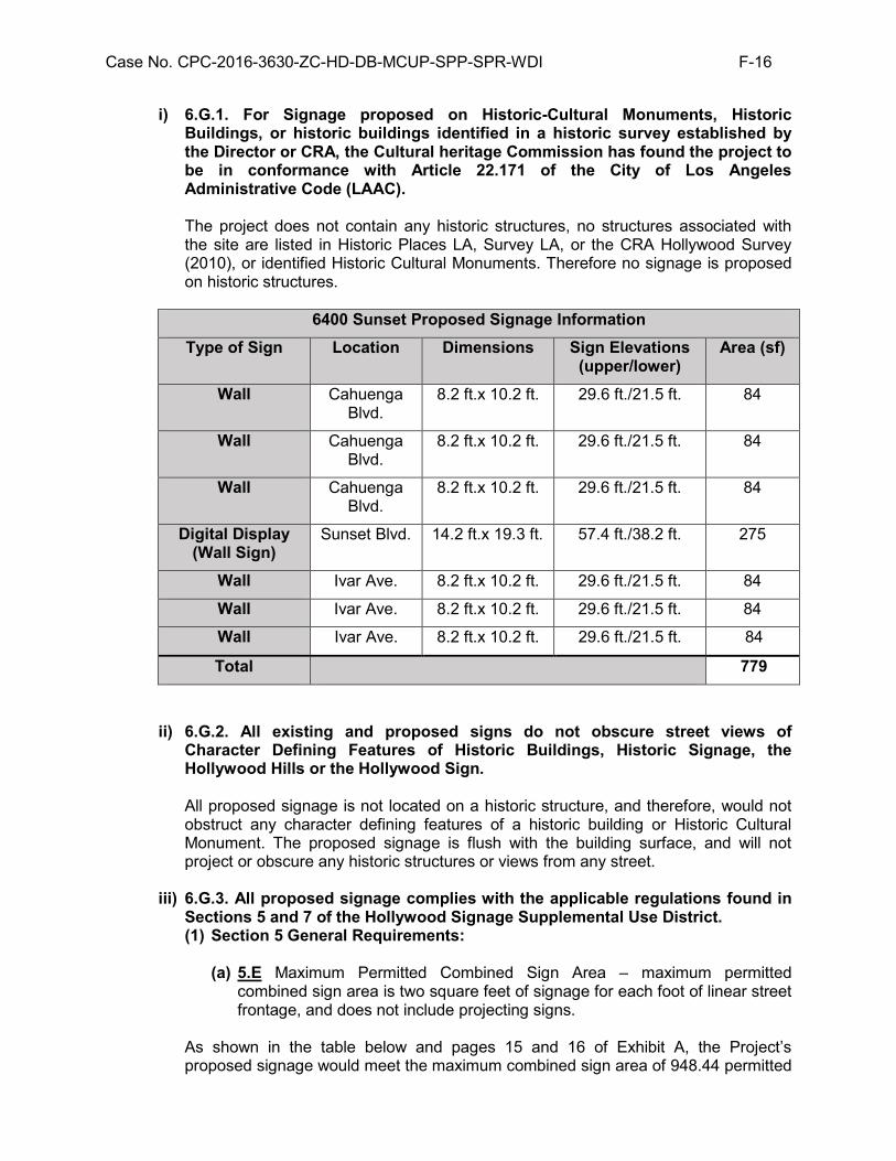
Case No. CPC-2016-3630-ZC-HD-DB-MCUP-SPP-SPR-WDI F-16
i) 6.G.1. For Signage proposed on Historic-Cultural Monuments, Historic Buildings, or historic buildings identified in a historic survey established by the Director or CRA, the Cultural heritage Commission has found the project to be in conformance with Article 22.171 of the City of Los Angeles Administrative Code (LAAC). The project does not contain any historic structures, no structures associated with the site are listed in Historic Places LA, Survey LA, or the CRA Hollywood Survey (2010), or identified Historic Cultural Monuments. Therefore no signage is proposed on historic structures.
6400 Sunset Proposed Signage Information Type of Sign Location Dimensions Sign Elevations
(upper/lower) Area (sf)
Wall Cahuenga Blvd.
8.2 ft.x 10.2 ft. 29.6 ft./21.5 ft. 84
Wall Cahuenga Blvd.
8.2 ft.x 10.2 ft. 29.6 ft./21.5 ft. 84
Wall Cahuenga Blvd.
8.2 ft.x 10.2 ft. 29.6 ft./21.5 ft. 84
Digital Display (Wall Sign)
Sunset Blvd. 14.2 ft.x 19.3 ft. 57.4 ft./38.2 ft. 275
Wall Ivar Ave. 8.2 ft.x 10.2 ft. 29.6 ft./21.5 ft. 84
Wall Ivar Ave. 8.2 ft.x 10.2 ft. 29.6 ft./21.5 ft. 84
Wall Ivar Ave. 8.2 ft.x 10.2 ft. 29.6 ft./21.5 ft. 84
Total 779
ii) 6.G.2. All existing and proposed signs do not obscure street views of Character Defining Features of Historic Buildings, Historic Signage, the Hollywood Hills or the Hollywood Sign. All proposed signage is not located on a historic structure, and therefore, would not obstruct any character defining features of a historic building or Historic Cultural Monument. The proposed signage is flush with the building surface, and will not project or obscure any historic structures or views from any street.
iii) 6.G.3. All proposed signage complies with the applicable regulations found in Sections 5 and 7 of the Hollywood Signage Supplemental Use District. (1) Section 5 General Requirements:
(a) 5.E Maximum Permitted Combined Sign Area – maximum permitted
combined sign area is two square feet of signage for each foot of linear street frontage, and does not include projecting signs.
As shown in the table below and pages 15 and 16 of Exhibit A, the Project’s proposed signage would meet the maximum combined sign area of 948.44 permitted

Case No. CPC-2016-3630-ZC-HD-DB-MCUP-SPP-SPR-WDI F-17
along the Sunset Boulevard, Cahuenga Boulevard, and Ivar Avenue frontages. As seen in the table below, the maximum combined sign area for the project site would total 948.44 square feet of sign area, double the combined street frontage of 474.22.
The street frontage along Sunset Boulevard is 137.6 feet with a maximum permitted combined sign area of 275.2 square feet. The Digital Display on Sunset Boulevard would meet this square footage with a combined sign area of 275 square feet. The street frontage along Cahuenga Boulevard is 168.31 feet with a maximum permitted combined sign area of 336.62 square feet. The Wall Signs on Cahuenga Boulevard would meet this square footage with a combined sign area of 252 square feet. The street frontage along Ivar Avenue is 168.31 feet with a maximum permitted combined sign area of 336.62 square feet. The Wall Signs along Ivar Avenue would meet this square footage with a combined sign area of 252 square feet. Therefore, the proposed signage would be in compliance with the combined maximum sign area along the Sunset Boulevard, Cahuenga Boulevard and Ivar Avenue frontages.
Location Street Frontage
within SUD boundary (ft)
Max Combined Sign Area
Permitted (sf)
Sign Area Proposed
(sf)
Difference
Sunset Blvd.
137.6 275.2 275 - 0.2
Cahuenga Blvd.
168.31 336.62 252 - 84.62
Ivar Ave. 168.31 336.62 252 - 84.62
Total 474.22 948.44 779 169.44
(b) 5.G Fire Safety – news signs shall be constructed of noncombustible materials.
The proposed signage would be constructed to the standards of the Los Angeles Fire Department and the Department of Building and Safety.
(c) 5.H: Illumination – illuminated signs shall be designed, located or screened
so as to minimize direct light sources onto walls of residential units and into windows of commercial buildings.
Additionally, the proposed signage would not direct light sources onto any exterior walls of residential units or into the window of any commercial buildings, in compliance with Section 5.H.
iv) Section 7.C Standards for Digital display Signs:
(1) Location. (a) C.1.a.(1). Location. The bottom of a sign consisting of a Digital Display
as measured vertically shall be Located between 35 and 75 feet above grade, as measured.
The bottom of the Digital Display along Sunset Boulevard, as measured vertically, would be 38.2 feet from the finished grade of the sidewalk, as
Case No. CPC-2016-3630-ZC-HD-DB-MCUP-SPP-SPR-WDI F-18
illustrated on pages 15 of Exhibit A. As such, the Sunset Boulevard Digital Display would comply with Subsection C.1.a.(1). (b) C.1.b. Location. The top of a sign consisting of a Digital Display, as
measured vertically, shall not be greater than 75 feet above grade.
The top of the Sunset Boulevard Digital Display, as measured vertically, would be 57.4 feet from the finished grade of the sidewalk, as illustrated in (still awaiting final plan submittal for this page) Exhibit A. As such the proposed Sunset Boulevard Digital Display would comply with Subsection C.1.b. (c) C.1.c.(2). Location. A Wall Sign consisting of a Digital Display shall be
limited to a maximum of one Digital Display for each side of the block.
The Project Site entails the entire Sunset Boulevard frontage between Cahuenga Boulevard and Ivar Street. The Project would install only one digital display along Sunset Boulevard between Cahuenga Boulevard and Ivar Avenue. There would be no other digital display signs installed along the Sunset Boulevard frontage of the Project. As such, the Project would comply with Subsection C.1.c.(2). (d) C.2. Area. A Digital Display that is installed as a Wall Sign shall not
exceed 300 square feet in area.
The Sunset Boulevard Digital Display installed as a wall sign would be 275 square feet in area, as illustrated on page 15 of (still awaiting final plan submittal for this page) Exhibit A. As such, the Sunset Boulevard Digital Display would not exceed 300 square feet in area. (e) C.3. Illumination. Digital Displays shall have both a daytime and night
time illumination, and the night time illumination shall not be as bright as the daytime illumination.
The Sunset Boulevard Digital Display would have less illumination during the night time than daytime, and would be designed in accordance with the applicable sign regulations. As such, the Sunset Boulevard Digital Display would comply with Subsection C.3.
v) Section 7.L Standards for Wall Signs, regulating:
L.1.a. Location. Notwithstanding the provisions of Section 14.4.10 of the Code to the contrary, no portion of any Wall Sign shall be located above the second story of the building on which it is placed or higher than 35 feet above grade as measured vertically, whichever is lower.
The proposed wall signs along Ivar Avenue and Cahuenga Boulevard would be located on the second story of the building and no higher than 29.6 feet above the finished grade of the sidewalk, as illustrated in Exhibit A. As such, no portion of any wall signs would be located above the second story or would be placed higher than 35 feet above grade. Therefore, the project will comply with Subsection L.1.a. L.1.b. Location. A Wall Sign shall not cover the exterior of windows, doors, vents, or other openings that serve occupants of buildings.

Case No. CPC-2016-3630-ZC-HD-DB-MCUP-SPP-SPR-WDI F-19
The proposed wall signs would not cover the exterior of windows, doors, vents, or other openings that serve occupants of buildings, as shown on pages 15 and 16 of Exhibit A. The three (3) Ivar Wall Signs and three (3) Cahuenga Wall Signs would be integrated into the Project’s parking structure and seamlessly blend with the Project’s architectural design elements. The Project’s parking structure would still be able to meet City’s requirements for natural ventilation. As such, the walls signs would comply with Subsection L.1.b. L.2. Area. A single Wall Sign shall not exceed 300 square feet in area.
The three proposed wall signs along Ivar Avenue and three proposed wall signs along Cahuenga Boulevard would each be 84 square feet in area, as listed in the above table and illustrated on page 15 and 16 of Exhibit A. As such, a single wall sign would not exceed 300 square feet in area.
5. Site Plan Review Findings
In order for the Site Plan Review to be granted, all three of the legally mandated findings delineated in LAMC Section 16.05 F must be made in the affirmative.
a. The project is in substantial conformance with the purposes, intent and provisions
of the General Plan, applicable community plan, and any applicable specific plan.
The Project Site is located within the Hollywood Community Plan Area, which was adopted by the City Council on August 2, 2014 (pursuant to Council File 12-0303 S4). The Plan Map designates the subject property for Regional Center Commercial land use with corresponding zones of C2, C4, P, PB, RAS3, and RAS4. The Project Site is zoned C4-2D-SN and C4-2D. The zone permits uses consistent with commercial and multi-family residential uses. The Project is consistent with the land use and zoning and in substantial conformance with the intent and provisions of the General Plan as reflected in the adopted Community Plan. General Plan Text. The Hollywood Community Plan, a part of the Land Use Element of the City’s General Plan, states the following objectives that are relevant to the Project: Hollywood Community Plan
Objective No. 1: To further the development of Hollywood as a major center of
population, employment, retail service and entertainment. Objective No. 3: To make provision for the housing required to satisfy the varying
needs and desires of all economic segments of the community, maximizing the opportunity for individual choice.
Objective No. 4: To promote economic well-being and public convenience through
allocating and distributing commercial lands for retail service and office facilities in quantities and patterns based on accepted planning principles and standards.
The project supports Objective No. 1 by developing a new mixed-use building providing 200 new residential units, as well as 7,000 square feet of commercial space to support and compliment the surrounding uses such as the ArcLight Plaza, and the Hollywood/Vine Metro Station area. The project supports additional residents, employment opportunities, retail and

Case No. CPC-2016-3630-ZC-HD-DB-MCUP-SPP-SPR-WDI F-20
restaurant space, as well as supporting entertainment destinations with additional residents. The project helps achieve Objective No. 3 by providing both a mix of unit configurations, including studio, one-bedroom, two-bedroom, and 3-bedroom, as well as reserving 5 percent of units for Very Low-Income Households. The project is also consistent with Objective No. 4 above because of its mixed-use nature which will promote economic well-being by providing commercial uses in a transit rich, commercially zoned property. In addition, the project’s uses are consistent with the adjacent properties which are primarily within the C4 Zone and are generally developed with commercial, institutional and office uses. The project further supports this goal by adding to the concentration of pedestrian friendly, transit accessible commercial and mixed use buildings along Sunset Boulevard. Finally, the project also promotes public convenience as it is located along a major transit corridor, Sunset Boulevard, and within walking distance (less than half a mile) of high-capacity transit, including the Metro Red Line located at the intersection of Hollywood Boulevard and Vine Street. The project site is located within an area of Hollywood that is seeing many new developments, including mixed-use projects that are either built (such as the Columbia Square Project and the Eastown Apartments), under construction (such as the South Block Development and 6250 Sunset Project, Academy Square, and Dream Hotel), approved (Crossroads Hollywood, a hotel project located at 6407 Sunset Boulevard) or proposed. This project will help achieve Objective No. 1 above to revitalize the Hollywood Center by creating a lively, pedestrian-oriented area, continuing right of way improvements, and pedestrian oriented development spanning from Sunset and Vine to the project site at Sunset and Cahuenga Boulevard. Specifically, the project includes a 26-story structure with 200 residential units, including five percent set aside for Very Low Income Households. The Project will also help achieve Objective No. 3 above by resulting in the construction of 200 residential units, including five percent, or 10 units, for Very Low Income Households. According to the City’s Housing Element 2013-2021, “[i]t is the overall housing vision of the City of Los Angeles to create for all residents a city of livable and sustainable neighborhoods with a range of housing types, sizes and costs in proximity to jobs, amenities and services.” The project achieves this vision by providing needed housing, including affordable housing, along a major transit corridor, Sunset Boulevard, and within a quarter mile radius of several high-capacity transit lines including the Metro Rapid Bus and Metro Red Line. Specifically, the project is located 0.3 miles west of the Hollywood and Vine Metro Subway Station, where the Red Line connect Hollywood to Union Station and North Hollywood. This type of development is also consistent with the City’s Framework Element which states that anticipated growth should be directed toward high-density, mixed-use centers and to the neighborhoods around its 80 rail stations. The Project is also consistent with Objective No. 4 above because of its mixed-use nature which will promote economic well-being by providing commercial uses in a commercially zoned property. In addition, the project’s uses are consistent with the adjacent properties which are primarily within the C4 Zone and are generally developed with commercial, institutional (i.e., churches and schools) and office uses. Finally, the project also promotes public convenience as it is located along a major transit corridor, Sunset Boulevard, and within walking distance (less than half a mile) of high-capacity transit, including the Metro Red Line located at the intersection of Hollywood Boulevard and Vine Street. In addition to achieving the objectives of the Hollywood the Community Plan, the Project would also support and be consistent with the following objectives identified in subsection 506.2.3: Regional Center Commercial Density of the Hollywood Redevelopment Plan:

Case No. CPC-2016-3630-ZC-HD-DB-MCUP-SPP-SPR-WDI F-21
Objective a: To concentrate high intensity and/or density development in areas with reasonable proximity or direct access to high capacity transportation facilities or which effectively utilize transportation demand management programs.
Objective b: To provide for new development which complements the existing
buildings in areas having architecturally and/or historically significant structures.
Objective d: To encourage the development of appropriately designed housing to
provide a balance in the community.
The project supports Objective “a” above by locating high-density commercial and residential uses near high capacity transportation facilities like the Metro Red Line Hollywood/Vine Station. The project accomplishes Objective “b” above by incorporating architecture features that complement the surrounding unique structures such as the CNN building and the historic ArcLight complex. The CNN building has implemented streetscape treatments that the project will implement to create a unified streetscape along Cahuenga Boulevard, further the project will provide two palm trees along Sunset Boulevard, consistent with the current treatment along Sunset Boulevard. The proposed new buildings would have varying materials, colors and facade plane variations to complement the eclectic architectural styles of the surrounding area. Furthermore, the height of the tower is compatible with the surrounding area and adjacent CNN building, and follows the same North-South orientation pattern of towers in the Hollywood Plan Area. As previously stated, the project will also help achieve Objective “d” above by developing 200 residential units with 5 percent, or 10 units, for Very Low Income Households. The residential portion of the project is appropriately designed to accommodate tenants who wish to live near public transit, near employment centers in Hollywood, and near commercial establishments that would be created by the project. In addition, the unit mix of the project includes studios, one bedrooms and two bedrooms to create a housing balance to serve several segments of the population.
Framework Element. The Framework Element for the General Plan (Framework Element) was adopted by the City of Los Angeles in December 1996 and re-adopted in August 2001. The Framework Element provides guidance regarding policy issues for the entire City of Los Angeles, including the Project Site. The Framework Element also sets forth a Citywide comprehensive long-range growth strategy and defines Citywide polices regarding such issues as land use, housing, urban form, neighborhood design, open space, economic development, transportation, infrastructure, and public services. Specifically, the proposed development would be consistent with the following objectives and policies of the Framework Element:
Objective 3.1: Accommodate a diversity of uses that support the needs of the City’s existing and future residents, businesses, and visitors.
Policy 3.1.4: Accommodate new development in accordance with land use and density provisions of the General Plan Framework Long-Range Land Use Diagram (Figures 3-1 to 3-4) and Table 3-1.

Case No. CPC-2016-3630-ZC-HD-DB-MCUP-SPP-SPR-WDI F-22
Objective 3.2: Provide for the spatial distribution of development that promotes an improved quality of life by facilitating a reduction of vehicle trips, vehicle miles traveled, and air pollution. Policy 3.2.3: Provide for the development of land use patterns that emphasize pedestrian/bicycle access and use in appropriate locations. Objective 3.4: Encourage new multi-family residential, retail commercial, and office development in the City’s neighborhood districts, community, regional, and downtown centers, as well as along primary transit corridors/boulevards, while at the same time conserving existing neighborhoods and related districts. Policy 3.7.1: Accommodate the development of multi-family residential units in areas designated in the community plans in accordance with Table 3-1 and Zoning Ordinance densities indicated in Table 3-3, with the density permitted for each parcel to be identified in the community plans. Objective 3.10: Reinforce existing and encourage the development of new regional centers that accommodate a broad range of uses that serve, provide job opportunities, and are accessible to the region, are compatible with adjacent land uses, and are developed to enhance urban lifestyles. Policy 3.10.1: Accommodate land uses that serve a regional market in areas designated as “Regional Center” in accordance with Tables 3-1 and 3-6. Retail uses and services that support and are integrated with the primary uses shall be permitted. The range and densities/intensities of uses permitted in any area shall be identified in the community plans. Policy 3.10.4: Provide for the development of public streetscape improvements, where appropriate. Objective 4.2: Encourage the location of new multi-family housing development to occur in proximity to transit stations, along some transit corridors, and within some high activity areas with adequate transitions and buffers between higher-density developments and surrounding lower-density residential neighborhoods. Objective 5.8: Reinforce or encourage the establishment of a strong pedestrian orientation in designated neighborhood districts, community centers, and pedestrian-oriented subareas within regional centers, so that these districts and centers can serve as a focus of activity for the surrounding community and a focus for investment in the community. Policy 7.2.3: Encourage new commercial development in proximity to rail and bus transit corridors and stations.
Policy 3.13: Enhance pedestrian circulation in neighborhood districts, community centers, and appropriate locations in regional centers and along mixed-use boulevards; promote direct pedestrian linkages between transit portals/platforms and adjacent commercial development through facilities orientation and design.
In addition, the proposed project would be consistent with the General Plan Framework’s land use objectives and policies for the Regional Center Commercial designation.

Case No. CPC-2016-3630-ZC-HD-DB-MCUP-SPP-SPR-WDI F-23
Goal 3F: Mixed-use centers that provide jobs, entertainment, culture, and serve the region.
Objective 3.10: Reinforce existing and encourage the development of new
regional centers that accommodate a broad range of uses that serve, provide job opportunities, and are accessible to the region, are compatible with adjacent land uses, and are developed to enhance urban lifestyles.
Policy 3.10.2: Accommodate and encourage the development of multi-
family transportation centers, where appropriate. Policy 3.10.3: Promote the development of high-activity areas in
appropriate locations that are designed to induce pedestrian activity, in accordance with Pedestrian-Oriented District Policies 3.16.1 through 3.16.3, and to provide adequate transitions with adjacent residential uses at the edges of the centers.
The project would integrate housing with commercial uses and amenities in a new development in proximity to local and regional public transit, including less than .5 miles from the Metro Red Line Hollywood/Vine Station, in addition to local, limited, and rapid Bus line routes. The project would include complementary and supportive uses within the regional center designation. Generally, Regional Centers are characterized by 6- to 20-story (or higher) mid- and high-rise buildings with a floor-to-area ratio of 1.5:1 to 6:1 as determined in the community plan. The project proposes a 26-story mixed-use building with a height of 284 feet, as well as two subterranean levels, with a floor-to-area ratio of 6:1. In total, the Project will include approximately 231,836 square feet of developed floor area corresponding with a total FAR of 6:1 averaged across the Project Site. Therefore, the Project is within the FAR acceptable in a Regional Center. Furthermore, the Metro Red Line Hollywood/Vine Station is located approximately 0.3 miles east of the Project Site. The Project is also located in an area well-served by public transit provided by Metro and LADOT, including bus stops along Sunset Boulevard, Vine Street, and Hollywood Boulevard. As such, the Project, which will create additional housing to meet a growing demand in the Hollywood community and short- and long-term employment opportunities, will be consistent with the type of development that is envisioned for the Regional Center in the General Plan Framework. The proposed project will provide 200 residential units and 7,000 square feet of commercial space that is directly accessible from the ground level of Sunset Boulevard. The proposed commercial uses would provide easier access to amenities for residents of Hollywood. The project would be located in the Hollywood Center, and is designated Regional Center Commercial, in accordance with General Plan Diagrams and Designations, concentrating housing and commercial uses in an existing center. Locating mixed-use development close to transit and incorporating commercial areas, with streetscape improvements, and architectural elements, encourages pedestrian activity and provides an incentive for residents not to use their cars for commuting errands, dining, entertainment and employment, thereby reducing vehicle trips. Furthermore, locating the new uses in an existing regional center that is well served by transit will reinforce the Hollywood Center, reduce Vehicle Miles Traveled, conserve surrounding neighborhoods, and develop a context sensitive building that is compatible with higher density uses in the regional center.

Case No. CPC-2016-3630-ZC-HD-DB-MCUP-SPP-SPR-WDI F-24
The project would be pedestrian-oriented with residential access on each frontage, commercial uses along the Sunset Boulevard frontage, as well as elements, such as shade trees, outdoor seating, canopies, lighting, pedestrian scaling of the ground floor, and ground floor commercial spaces along each elevation, that activate the pedestrian realm. The location of vehicle access along Ivar Avenue and Cahuenga Boulevard would not inhibit pedestrian flows into the area, and would allow for connections to and from the greater Hollywood area. In addition, the Project will provide a total of 180 spaces (172 long-term and 21 short-term) for bicycle parking. As such, the Project will provide opportunities for the use of alternative modes of transportation, thereby promoting an improved quality of life and facilitating a reduction in vehicle trips, vehicle miles traveled, and air pollution. As mentioned above, the Project will include streetscape improvements along Cahuenga Boulevard and Ivar Avenue, with ground level commercial space along Sunset Boulevard, encouraging and promoting walkability in a high-activity area in the Project vicinity. Furthermore, the Project will result in an improved and aesthetically appealing streetscape that would promote pedestrian activity and enhance the urban lifestyle and livability of the surrounding neighborhood. The continuation of ground floor commercial space and streetscape improvements will create a continuous pedestrian friendly environment from Sunset Boulevard and Vine Street west to Sunset Boulevard and Cahuenga Boulevard. The Project will provide street trees in accordance with Urban Forestry Division requirements. The Project will be located along Sunset Boulevard, which is characterized as a high pedestrian area and also within proximity to the Hollywood Entertainment District to the north. Thus, the Project will encourage and promote walkability in the high-activity Project Site vicinity, particularly between the Metro Red Line Hollywood/Vine Station, Hollywood & Highland Center, tourist attractions, and other entertainment-related uses along Sunset Boulevard and Hollywood Boulevard. In addition, the Project will promote pedestrian activity by providing ground floor retail that will feature extensive glazing to encourage pedestrian activities and create a human-scaled frontage. The Project will include development of 200 multi-family residential units in accordance with Table 3-1 and Table 3-3 of the General Plan Framework. The Project, which results in a density of approximately 119 units per acre, falls under the High Density designation identified in Table 3-1. This density is also consistent with the corresponding R5 Zone, as identified in Table 3-3. Although the Project Site is currently zoned C4-2D (Commercial, Height District 2 with Development Limitation) and C4-2D-SN (Commercial, Height District 2 with Development Limitation, Signage Supplemental Use District) by the LAMC, the C4 Zone allows for residential development at the density permitted in the R5 Zone when a mix of commercial and residential uses is developed, pursuant to LAMC section 12.22-A,18(a). Height District 2 within the C4 Zone does not impose a height limitation and has a maximum FAR of 6:1. The Development “D” Limitation (Ordinance No. 165,661) in the zoning prefix indicates that development shall not exceed a FAR of 3:1. However, the applicant may utilize the State Density Bonus Law to request increased FAR and averaging of floor area across the site. In addition, the applicant may request a waiver of development standard to allow for increased FAR. Thus, the Project will be developed within the allowable density and, with approval of the requested On-Menu and Off-Menu Incentives pursuant to 12.22-A,25(G), will comply with the Framework Element Long-Range Land Use Diagram. Housing Element. The 2013-2021 Housing Element, the Housing Element of the General Plan, is the City’s blueprint for meeting housing and growth challenges. The Housing Element identifies the City’s housing conditions and needs, identifies goals, objectives, and policies that are the foundation of the City’s housing and growth strategy, and provides an array of programs the City has committed to in order to implement and create sustainable, mixed-income neighborhoods across Los Angeles. The Project is consistent with the following objectives and policies of the Housing Element:

Case No. CPC-2016-3630-ZC-HD-DB-MCUP-SPP-SPR-WDI F-25
The 2013-2021 Housing Element of the General Plan is the City’s blueprint for meeting housing and growth challenges. The Housing Element identifies a need for more housing while Chapter 6 of the Housing Element lists the goals, objectives, policies and programs that “embody the City’s commitment to meeting housing needs.” The applicable housing goals, objectives and policies are as follows:
Goal 1: A City where housing production and preservation result in
an adequate supply of ownership and rental housing that is safe, healthy and affordable to people of all income levels, races, ages, and suitable for their various needs.
Objective 1.1: Produce an adequate supply of rental and ownership
housing in order to meet current and projected needs.
Policy 1.1.2: Expand affordable rental housing for all income groups that need assistance.
Policy 1.1.3: Facilitate new construction and preservation of a range of
different housing types that address the particular needs of the city’s households.
Policy 1.1.4: Expand opportunities for residential development,
particularly in designated Centers, Transit Oriented Districts and along Mixed-Use Boulevards.
Goal 2: A City in which housing helps to create safe, livable and
sustainable neighborhoods.
Objective 2.2: Promote sustainable neighborhoods that have mixed-income housing, jobs, amenities, services and transit.
Objective 2.3: Promote sustainable buildings, which minimize adverse
effects on the environment and minimize the use of non-renewable resources.
Policy 2.2.5: Provide sufficient services and amenities to support the
planned population while preserving the neighborhood for those currently there.
Objective 2.4: Promote livable neighborhoods with a mix of housing
types, quality design and a scale and character that respects unique residential neighborhoods in the City.
Policy 2.4.1: Promote preservation of neighborhood character in
balance with facilitating new development.
The project is consistent with the above goals, objectives and policies because the project will provide 200 new residential units, adding to the citywide housing supply for current and future residents of the Hollywood Community Plan area. Additionally, the project will set aside 10 (5 percent) Very Low Income units for affordable housing, in addition to providing varied floor plans from studio (39), one-bedroom (72), two-bedroom (76), three-bedroom (11), and

Case No. CPC-2016-3630-ZC-HD-DB-MCUP-SPP-SPR-WDI F-26
Three-bedroom with den (2) configurations, providing for more housing opportunities and choices for the community. Along with housing, the project includes commercial uses, which will serve the residents living at and around the project area. The project will also expand commercial opportunities, with ground-floor, commercial uses along Sunset Boulevard, activating the pedestrian life along the streets. The project’s close proximity (less than .5 miles) to the Metro Red Line Hollywood/Vine station and rapid/local bus lines will give residents the ability to take transit or walk to access amenities, employment, or recreation. The project proposes to reserve five percent (10 units) of the total units for Very Low Income Households. . The income restriction as well as additional market rate units, in various configurations, meet Goal 1, Objective 1.1, and Policies 1.1.2. and 1.1.3. The project further supports Objective 2.3 through the requirements the project has met to be determined to be a Sustainable Community Project, which requires the project be 15 percent more energy efficient than Chapter 6 of Title 24 of the California code of Regulations, and both the building and landscaping water usage be reduced 25 percent below average household usage. The project also supports Objective 2.3 by virtue of requirements of the Sustainable Communities Project, which precludes projects from attaining such designation if they would be built on open space, prime habitat for endangered species, wetlands, be located on site identified by the Toxic Substances pursuant to Section 65962.5 of the Government Code, and that the project site is adequately served by utilities or the developer has committed to paying impact fees associated with upgrades. The stringent standards in the Sustainable Communities Project which the project meets would comply with the Objective, minimizing environmental impacts. The project further supports Goal 2, Objectives 1.1.4, 2.2, 2.2.5, 2.4, and Policy 2.4.1 by locating a new development in the Hollywood Center, a regional center well served by transit, employment opportunities, and services, as well as providing new residential units, employment opportunities, and services. The new uses would be provided in a new mixed-use 26-story tower development which activates the pedestrian realm, responds to and respects surrounding development, is consistent with size, orientation, and character of surrounding development, while developing a project with the intensity the project site has been planned for with a Regional Center Commercial Land Use Designation. The project would provide new housing units on a site which is currently a commercial structure, while still providing commercial amenities; preserving the existing neighborhood, while improving the public right of way, adding additional commercial uses, and developing the site with the designated and planned density. Therefore, the Project is consistent with the General Plan, the Hollywood Community Plan, the Housing Element of the General Plan, and the Hollywood Redevelopment Plan.
b. The project consists of an arrangement of buildings and structures (including height, bulk and setbacks), off-street parking facilities, loading areas, lighting, landscaping, trash collection, and other such pertinent improvements that is or will be compatible with existing and future development on neighboring properties. The surrounding area is highly urbanized and land uses within the general vicinity of the Project Site are characterized by a mix of low- to high-intensity mixed-use, commercial, institutional and residential uses. Specific uses around the Project Site consist of the following:
North: A one story commercial building is located to the north of the project site on the north side of Sunset Boulevard, in the (T)(Q)C4-2D-SN and, C4-2D-SN zones. A new 19-story hotel was approved on March 1, 2017 at this location.

Case No. CPC-2016-3630-ZC-HD-DB-MCUP-SPP-SPR-WDI F-27
South: A One-story commercial development is located south of the northern lot in the C4-2D Zone, while an alley bounds the project site to the south, adjacent to the southern lot.
East: The One- to four-story ArcLight Cinema complex, including the historic ArcLight Dome, in the C4-2D-SN Zone is located to the east of the project site.
West: A 14-story office building currently, associated with the CNN News Network, across Cahuenga Boulevard in the C4-2D-SN Zone, is located to the west of the project site
The following elements are incorporated into the Project design in a manner that is compatible with both existing and future development in the surrounding area: Building Design. The Project is designed in a contemporary architectural style. The upper stories are differentiated from the ground floor to create horizontal articulation and reduce the perceived bulk of the building. To create a pedestrian oriented area, the Project will locate retail uses on the ground floor, as well as two pedestrian entries for residents on Cahuenga Boulevard and Ivar Avenue, with direct entries with glazing from Sunset Boulevard, Cahuenga Boulevard, and Ivar Avenue. The project additionally includes streetscape improvements along Cahuenga Boulevard and Sunset Boulevard, creating a more inviting pedestrian environment, further augmented by the ground floor commercial along each street frontage. Finally, the architectural design uses a material palette (i.e., vision glass, tinted glass, blackened steel frame, prefinished aluminum, perforated metal, and architectural concrete) that reflects a modern, unified identity. Additionally, the project focuses the tower towards Sunset Boulevard, concentrating height and mass along the major boulevard. Building Orientation/Frontage. The primary frontage of the Project is oriented toward the major street, Sunset Boulevard, with frontages along Ivar Avenue and Cahuenga Boulevard responding to their respective character. Specifically, the entrances to the retail are located along each street frontage, with entrances to all commercial spaces along Sunset Boulevard. Access along Ivar Avenue and Cahuenga Boulevard are located to the north of the site, closest to Sunset Boulevard. The project residential access is located primarily at Cahuenga Boulevard midblock, with a residential lobby, mail room, and elevators. Ivar Avenue also facilitates circulation and residential access with midblock access. Finally, as mentioned before, the project has oriented its tower with a north-south direction to maintain view corridors of the Hollywood Hills, maintaining the unique pedestrian experience in Hollywood. Height/Bulk. The mixed-use building would reach a maximum of 26 stories, or 284 feet with mechanical equipment, with a six level podium. While there is no height limit for the Project Site, the structure is oriented towards Sunset Boulevard, locating the tower footprint at the north end of the lot. The parking podium height would transition to the lower height commercial buildings directly to the south. As discussed, the project site is surrounded by buildings of varying height, with taller buildings located on Sunset Boulevard, and lower scale development to the south. The project focuses height and bulk along Sunset Boulevard, continuing the existing pattern of higher density development along the Boulevard. The podium height is limited to six stories, which is compatible with existing lower scale development, as well as currently under construction ranging from seven stories to twenty stories within two blocks of the project site. The facades of all the buildings are articulated through changes in material, and breaks in the planes of the facade to reduce the perceived bulk of the buildings. Window patterns, changes in material, and fenestration create visual interest and prevent a monolithic character. The towers are articulated with both opaque and

Case No. CPC-2016-3630-ZC-HD-DB-MCUP-SPP-SPR-WDI F-28
clear glass. Thus giving the buildings a sense of lightness, rhythm, and visual interest. Through architectural design and site planning, the Project’s perceived height and bulk are reduced. Finally, the changes in materials and planes on the facade create visual interest. Setbacks. The Project will provide the required setbacks per the LAMC. The project is not required to provide setbacks for the ground floor commercial element of the project pursuant to the C4 Zone. Pursuant to the C4 Zone, the project is required to provide setbacks pursuant to the R4 Zone for the project’s residential uses, which begin at the top of the parking podium. The project provides a five foot front yard setback, 5 foot side yard setback, and 15 foot rear yard setback at the podium level, setting back the lowest residential story of the residential tower from the property lines. The setbacks will contribute toward activating the pedestrian realm by providing space for pedestrian circulation and landscaping. Therefore, the Project will enhance the streetscape around the Project Site. Off-Street Parking and Driveways. Parking for commercial and residential uses will be provided in two subterranean levels and five podium levels. The project proposes nominal ground floor parking, and is providing a circulation program which encourages passenger loading and drop-off within the podium. The ground floor includes a loading area interior to the building with three loading zones curbs, as well as a through driveway with access to both Cahuenga Boulevard and Ivar Avenue, and up and down ramps to access additional parking. The proposed project includes 256 new parking spaces, meeting its code requirement. The Southern Lot of the project site is currently a surface parking lot with 21 spaces on the southern lot, and the Project does not propose alterations to this lot. The project proposes to utilize Parking Option 1 pursuant to LAMC Section 12.22-A,25 as part of the Density Bonus application. With additional reductions due to bicycle parking incentives, a total of 256 parking spaces are required for the project, and 256 new spaces are proposed, with 21 existing spaces retained, for a total of 277 spaces across the entire project site. Vehicular access will be through two midblock driveways; one along Ivar Avenue and the second along Cahuenga Boulevard. The project is proposing to restrict left turns out of the project site on to Cahuenga Boulevard, while allowing all turning movements at the driveway on Ivar Avenue. Commercial loading will be located in the same area as passenger loading, within the interior ground floor parking area. The vehicular driveways are the minimum width required to be as efficient as possible and all driveways will be at a sufficient distance from adjacent intersections to not interfere with driver and pedestrian visibility and safety in accordance with LADOT standards and approvals. Building Signage and Lighting. Project lighting will include lighting from within the interior, as well as lighting at the building exterior elevations, exterior courtyards, and roof decks. Exterior lighting will include light at each building entrance and exit, light for the canopies and shade structures adjacent to the building façade, and light for the courtyards and deck spaces at various levels on the building. Site lighting will also include light for circulation and safety, as well as accent light onto trees and other landscape elements. All on-site lighting will comply with regulatory requirements, including the requirements that are set forth by CalGreen and Title 24 that stipulate the use of high performance lights with color and glare control. In addition, design elements will be incorporated to limit the direct view of the light source surface for all exterior light fixtures and to ensure that the light source cannot be seen from adjacent residential properties or the public right-of-way. All on-site exterior lighting will be automatically controlled to illuminate only when necessary. Project signage will be compatible with the commercial and entertainment-oriented uses of the Project Site and the Project vicinity. Proposed signage will be consistent with existing development regulated by the Hollywood Signage Supplemental Use District, and would include monument or mounted project identity signage, building and commercial tenant signage, and general ground-level and wayfinding pedestrian signage, as permitted by the HSSUD. Additionally, the project

Case No. CPC-2016-3630-ZC-HD-DB-MCUP-SPP-SPR-WDI F-29
proposes wall signs along each frontage, with a digital display sign on Sunset Boulevard, as permitted by the HSSUD. Sizes would comply with the HSSUD, total 84 square feet, with 8.2 feet by 10.2 feet dimensions. Wall signs would be located at 21 to 29 feet above grade on the podium level. The digital display sign located at 38 feet above grade along Sunset Boulevard would be 14 feet by 19 feet for a total of 275 square feet. Wayfinding signs will be located at various locations pursuant to HSSUD requirements and to best aid pedestrians. Illuminated signage will include identification signs, digital message boards, and tenant retail signs. Finally, all new street and pedestrian lighting within the public right-of-way will comply with applicable City regulations and would be approved by the Bureau of Street Lighting in order to maintain appropriate and safe lighting levels on both sidewalks and roadways while minimizing light and glare on adjacent properties. Open Space and On-Site Landscaping. In total, approximately 23,963 square feet of open space, consisting of approximately 4,099 square feet of interior amenity space, 23,763 square feet of common open space, and approximately 200 square feet of private open space (i.e., balconies) will be provided in accordance with the open space provisions set forth in LAMC Section 12.21-G. The project will also provide 5,470 square feet of planted common area, as required by code. The project will provide an amenity level at level six of the podium, which includes private patios, a dog run, cooking facilities, a pool and spa, changing areas, a fire pit, seating, indoor and outdoor fitness area, and a resident lounge. An additional amenity level is located at level 25 and consists of two private roof decks and a common roof deck. The Project will also provide 93 new trees, including roof deck trees, and street trees along Cahuenga Boulevard, Ivar Avenue, and two new Palm Trees on Sunset Boulevard. Trash Collection. The residential trash areas are located within enclosed trash rooms within the Project building, and are not visible to the public. Trash rooms are located on each residential floor, the podium amenity level, and the ground floor. Similarly, commercial trash room is fully enclosed and not visible to the public, located on the ground floor. Loading Areas. The project’s loading areas will be located interior to the project site, within the ground floor parking area. Loading would share the same space as ground floor parking and passenger loading. The project’s 7,000 square feet of commercial space would not be likely to receive large scale deliveries such as those associated with a grocery store or other large commercial use. In conclusion, the Project consists of a mixed-use building with off-street parking facilities, loading areas, lighting, landscaping, trash collection, and other such pertinent improvements, that are compatible with existing and future planned development on adjacent and neighboring properties.
c. That any residential project provides recreational and service amenities in order to improve habitability for the residents and minimize impacts on neighboring properties.
The project will provide approximately 23,963 square feet of open space, consisting of approximately 23,763 square feet of common open space, approximately 4,099 square feet of interior amenity space, and approximately 200 square feet of private open space (i.e., balconies) will be provided in accordance with the open space provisions set forth in LAMC Section 12.21-G. The project will provide an amenity level at level six of the podium, which includes private patios, a dog run, cooking facilities, a pool and spa, changing areas, a fire pit, seating, indoor and outdoor fitness area, and a resident lounge. An additional amenity level is located at level 25 and consists of two private roof decks and a common roof deck. Landscaped planters and hardscape features will be distributed throughout the podium and rooftop levels, and perimeter landscaping will be installed at the ground level. Due to the

Case No. CPC-2016-3630-ZC-HD-DB-MCUP-SPP-SPR-WDI F-30
amount, variety, and availability of the Project’s proposed open space and recreational amenities, it is anticipated that Project residents and employees will generally utilize on-site open space to meet their recreational needs and reduce the Project’s demand on public parks and recreational facilities. Therefore, it is determined that the Project provides sufficient recreational and service amenities to serve residents without creating negative impacts on neighboring properties. Environmental Findings
Pursuant to Senate Bill (SB) 375 and Public Resources Code (PRC) Section 21155, a project that qualifies as a Transit Priority Project and is declared by a legislative body to be a Sustainable Communities project is statutorily exempt from the California Environmental Quality Act (CEQA). These SB 375 clearances are intended to meet the goals of the Sustainable Communities Strategy to encourage higher density, infill development located near transit.
In order to qualify as a Transit Priority Project, the project must be consistent with general land use policies of an adopted Sustainable Communities Strategy per PRC Section 21155(a) and meet the criteria in PRC Section 21155(b) related to minimum density, residential uses, and distance from a major transit stop or high-quality transit corridor. In order to qualify as a Sustainable Communities Project, the project must meet all environmental criteria in PRC Section 21155.1(a), all land use criteria in PRC Section 21155.1(b), and one public benefit criteria in PRC Section 21155.1(c). A public hearing must be held by City Council prior to declaring a project to be a Sustainable Communities Project and the City Council is required to find the necessary criteria are met in Subsections (b) and (c) of PRC Section 21155.1. Unlike other CEQA clearances, the SCP Exemption must be approved by the City Council, even if the initial decision-maker or appellate body is a lower decision-making body or officer.
The Department of City Planning has reviewed the Sustainable Communities Project Exemption (SCPE) that was prepared for the proposed project and recommended that the City Council consider and determine that the project is exempt from CEQA pursuant to PRC 21155.1 as a Transit Priority Project and Sustainable Communities Project.
At a Meeting of the Planning and Land Use Management Committee (PLUM), on November 6, 2018 the Committee found the project exempt from CEQA pursuant to PRC Section 21155.1, based on the whole of the administrative record.
At the November 21, 2018 City Council meeting, the project was determined exempt from CEQA pursuant to PRC Section 21155.1, based on the whole of the administrative record.

Case No. CPC-2016-3630-ZC-HD-DB-MCUP-SPP-SPR-WDI P-1
PUBLIC HEARING AND COMMUNICATIONS
Summary of Public Hearing Testimony and Communications Received
The Public Hearing on this matter was held at Los Angeles City Hall in Downtown Los Angeles, on January 9, 2019 which was conducted by both the Hearing Officer on behalf of the City Planning Commission, and the Deputy Advisory Agency on behalf of the Advisory Agency to consider the vesting tentative tract map. Approximately 30 members of the public attended the public hearing and 6 people provided testimony. Three emails were received and are part of the record within the case file. Two of the correspondence from members of the public were against the project, while letter was received from the Central Hollywood Neighborhood Council in favor of the project. A representative of the Applicant, Edgar Khalatian, and a representative of the Project Architect spoke at the hearing. The project applicant presented the project features and project design. The applicant described the design concept within the context of the surrounding area. The applicant stated that public outreach has been conducted, and that the neighborhood council has voted to support the Project. Below is a summary of comments from speakers opposed to or concerned with one or more aspects of the Project:
• The number of affordable units is inadequate. • A member of the public raised a concern that the height would set a new precedent in
Hollywood. Of the six members of the public that provided testimony, five presented concerns with the environmental document for the project, which was not before the Advisory Agency, and was certified prior to the Public Hearing at a meeting of the City Council on November 21, 2018. No members of the public spoke in favor of the project. Letters received from the public were not related to the Tract Map Hearing, but the Exemption prepared for the project. As the exemption was approved by City Council, November 21, 2018, prior to the January 9, 2019 hearing, the project is exempt from CEQA and no action on the environmental clearance was before the Advisory Agency. A letter of support was received from the Central Hollywood Neighborhood Council. It detailed support for the project subject to requests from the Council.

Exhibit A

T
ENTITLEMENT SET
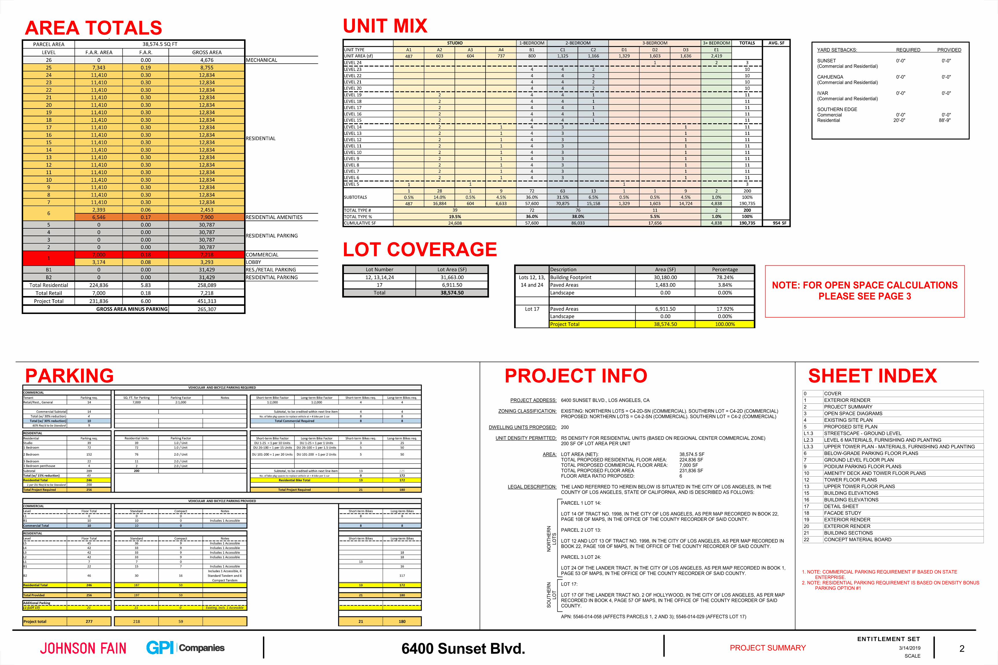
SCALEPROJECT SUMMARY 2
ENTITLEMENT SET3/14/20196400 Sunset Blvd.
AREA TOTALS
PROJECT INFOPARKING SHEET INDEX0 COVER1 EXTERIOR RENDER2 PROJECT SUMMARY3 OPEN SPACE DIAGRAMS4 EXISTING SITE PLAN5 PROPOSED SITE PLANL1.3 STREETSCAPE - GROUND LEVELL2.3 LEVEL 6 MATERIALS, FURNISHING AND PLANTINGL3.3 UPPER TOWER PLAN - MATERIALS, FURNISHING AND PLANTING6 BELOW-GRADE PARKING FLOOR PLANS7 GROUND LEVEL FLOOR PLAN9 PODIUM PARKING FLOOR PLANS10 AMENITY DECK AND TOWER FLOOR PLANS12 TOWER FLOOR PLANS13 UPPER TOWER FLOOR PLANS15 BUILDING ELEVATIONS16 BUILDING ELEVATIONS17 DETAIL SHEET18 FACADE STUDY19 EXTERIOR RENDER20 EXTERIOR RENDER21 BUILDING SECTIONS22 CONCEPT MATERIAL BOARD
6400 SUNSET BLVD., LOS ANGELES, CA
EXISTING: NORTHERN LOTS = C4-2D-SN (COMMERCIAL). SOUTHERN LOT = C4-2D (COMMERCIAL)PROPOSED: NORTHERN LOTS = C4-2-SN (COMMERCIAL). SOUTHERN LOT = C4-2 (COMMERCIAL)
200
R5 DENSITY FOR RESIDENTIAL UNITS (BASED ON REGIONAL CENTER COMMERCIAL ZONE)200 SF OF LOT AREA PER UNIT
LOT AREA (NET): 38,574.5 SFTOTAL PROPOSED RESIDENTIAL FLOOR AREA: 224,836 SFTOTAL PROPOSED COMMERCIAL FLOOR AREA: 7,000 SFTOTAL PROPOSED FLOOR AREA 231,836 SFFLOOR AREA RATIO PROPOSED: 6
THE LAND REFERRED TO HEREIN BELOW IS SITUATED IN THE CITY OF LOS ANGELES, IN THE COUNTY OF LOS ANGELES, STATE OF CALIFORNIA, AND IS DESCRIBED AS FOLLOWS:
PARCEL 1 LOT 14:
LOT 14 OF TRACT NO. 1998, IN THE CITY OF LOS ANGELES, AS PER MAP RECORDED IN BOOK 22, PAGE 108 OF MAPS, IN THE OFFICE OF THE COUNTY RECORDER OF SAID COUNTY.
PARCEL 2 LOT 13:
LOT 12 AND LOT 13 OF TRACT NO. 1998, IN THE CITY OF LOS ANGELES, AS PER MAP RECORDED IN BOOK 22, PAGE 108 OF MAPS, IN THE OFFICE OF THE COUNTY RECORDER OF SAID COUNTY.
PARCEL 3 LOT 24:
LOT 24 OF THE LANDER TRACT, IN THE CITY OF LOS ANGELES, AS PER MAP RECORDED IN BOOK 1, PAGE 53 OF MAPS, IN THE OFFICE OF THE COUNTY RECORDER OF SAID COUNTY.
LOT 17:
LOT 17 OF THE LANDER TRACT NO. 2 OF HOLLYWOOD, IN THE CITY OF LOS ANGELES, AS PER MAP RECORDED IN BOOK 4, PAGE 57 OF MAPS, IN THE OFFICE OF THE COUNTY RECORDER OF SAID COUNTY.
APN: 5546-014-058 (AFFECTS PARCELS 1, 2 AND 3); 5546-014-029 (AFFECTS LOT 17)
PROJECT ADDRESS:
ZONING CLASSIFICATION:
DWELLING UNITS PROPOSED:
UNIT DENSITY PERMITTED:
AREA:
LEGAL DESCRIPTION:
UNIT MIX
LOT COVERAGENOTE: FOR OPEN SPACE CALCULATIONS
PLEASE SEE PAGE 3
NO
RTH
ERN
LO
TSSO
UTHE
RN
LOT
YARD SETBACKS: REQUIRED PROVIDED
SUNSET 0'-0" 0'-0"(Commercial and Residential)
CAHUENGA 0'-0" 0'-0"(Commercial and Residential)
IVAR 0'-0" 0'-0"(Commercial and Residential)
SOUTHERN EDGE Commercial 0'-0" 0'-0"Residential 20'-0" 88'-9"
1. NOTE: COMMERCIAL PARKING REQUIREMENT IF BASED ON STATE ENTERPRISE.
2. NOTE: RESIDENTIAL PARKING REQUIREMENT IS BASED ON DENSITY BONUS PARKING OPTION #1

1042 SFPRIVATE OPEN SPACE (100 SF ALLOWABLE)
1929 SFOPEN SPACE - OUTDOOR
1042 SFPRIVATE OPEN SPACE (100 SF ALLOWABLE)4099 SF
OPEN SPACE - INDOOR
17735 SFOPEN SPACE - OUTDOOR
N
SCALEAs indicatedOPEN SPACE DIAGRAMS 3
ENTITLEMENT SET3/14/20196400 Sunset Blvd.
SCALE: 1/16" = 1'-0"LEVEL 25 (3 UNITS) OPEN SPACE
SCALE: 1/16" = 1'-0"LEVEL 6 (AMENITIES LEVEL) OPEN SPACE
0' 8' 16' 32' 64'
1. NOTE: TREE REQUIREMENT = 1 TREE PER EVERY 4 UNITS PURSUANT TO LAMC SECTION 12.21.G

N
SCALEEXISTING SITE PLAN 4
ENTITLEMENT SET3/14/20196400 Sunset Blvd.
0 32 48 6416
EXISTING BUILDING TO BE DEMOLISHED
0 80 120 16040
EXISTING SITE PLAN EXISTING ROOF PLANSCALE: 1" = 40'-0" SCALE: 1/16" = 1'-0"
SUNSET BLVD
SUNSET BLVD
CAH
UEN
GA
BLV
D
IVAR
AVE
NU
E

S S S S
UP
S S SUPDN
16.67% RAMP
COMMERCIAL
SUNSET BOULEVARD
NORT
H CA
HUEN
GA
BOU
LEVA
RD
IVAR
AVE
NUE
LOT 17
ALLEY
PAR
KING
DRI
VEW
AY
PARKING DROP-OFF
SUBJ
ECT
PROP
ERTY
229'-
5"
3 STORYCOMMERCIAL
(ADJACENT PARCEL)NOT IN PROJECT
3 STORYCOMMERCIAL
(ADJACENT PARCEL)NOT IN PROJECT
8 STORYCOMMERCIAL
(ADJACENT PARCEL)
14 STORYBUSINESS COMMERCIAL
(ADJACENT PARCEL)
4 STORYPARKING
(ADJACENT PARCEL)
6 STORYPARKING
(ADJACENT PARCEL)
1 STORYCOMMERCIAL
(ADJACENT PARCEL)
16.67% RAMP
SUBJECT PROPERTY139'-7"
PAR
KING
DRI
VEW
AY
(SUB
JECT
PAR
CEL)
50'-0
"
(NO
RTH
ERN
LOT)
(SO
UTH
ERN
LO
T)R
IGH
T O
UT
RIG
HT
IN
N
SCALE 1" = 30'-0"PROPOSED SITE PLAN 5
ENTITLEMENT SET3/14/20196400 Sunset Blvd.
0' 30' 60' 120'
SCALE: 1" = 30'-0"SITE PLANAERIAL MAP
NOTE: FOR EXISTING CONDITIONS PLEASE SEE SHEET A1.02NOT TO SCALE(SUBJECT PROPERTY SHOWN IN RED)


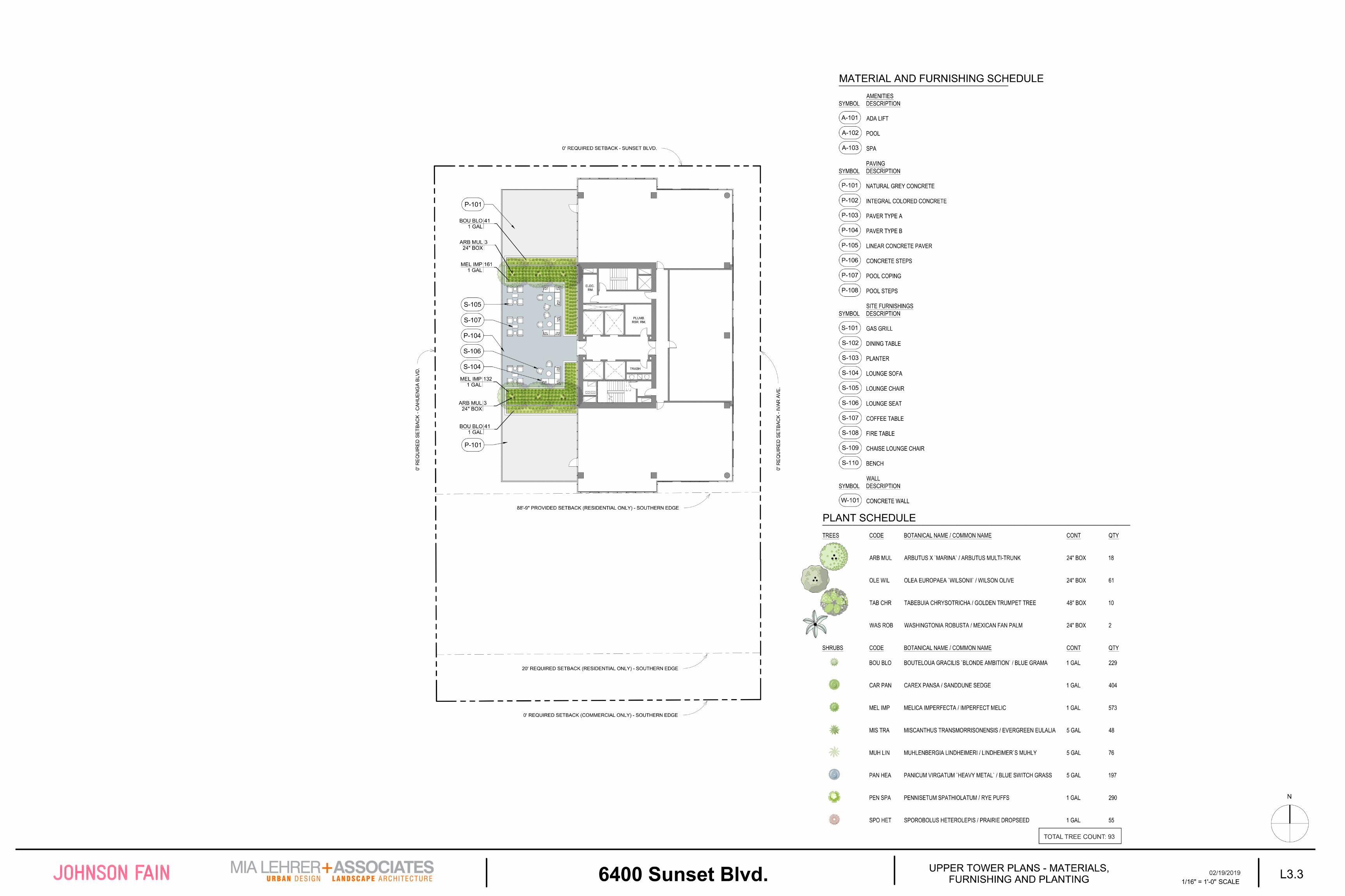
jdonaldson
Snapshot

C C S
S
S C
S C SS
S
C CC
SS
S
S
S S S SS
SS
SS
SS
S
S C
C C
SS
CC
CC
S
SC
SC
C C S
SS
SS
S
SS
C CC
SS
SS
S
S
S S S
SS
C C
SS
S
S
UP
30 STANDARD16 COMPACT (35%)46 TOTAL STALLS
FANROOM200 SF
FANROOM200 SF
STOR.
ELEC. RM.
STORAGE240 SF
FANROOM200 SF
21'-4
"
25'-4"25'-4"
LONGTERMBIKE
STORAGE117 BIKES
ELEVPIT
AREA UNDER RAMP
STORAGE1,050 SF
STOR.
UP
15 STANDARD 7 COMPACT (32%)22 TOTAL STALLS
DN
FIRE PUMP ROOM22' X 26'
12' CEILING
FIRE WATER TANK
30' X 38'10' CEILING
DOMESTIC WATER PUMP ROOM
270 SF
36'-4
"
32'-0"
FANROOM200 SF
FANROOM200 SF
ELEC. RM.
FANROOM200 SF
FANROOM200 SF
LONGTERMBIKE
STORAGE16 BIKES
21'-4
"
25'-4"
25'-4"
SEW.EJC.
STOR.
RES.STORAGE
885 SF
RES.STORAGE
690 SF
GATE
GAT
E
10 RETAIL PARKING
BIKE REPAIR170SF
RESIDENTIAL
VERTICAL CIRCULATION
LEGEND
COMMERCIAL
SUPPORT
AMENITY
CIRCULATION
ENTRANCEN
SCALEAs indicatedBELOW-GRADE PARKING FLOOR PLANS 6
ENTITLEMENT SET3/14/20196400 Sunset Blvd.
SCALE: 1/16" = 1'-0"LEVEL B2
0' 8' 16' 32' 64'
SCALE: 1/16" = 1'-0"LEVEL B1
NOTE: 20% of the total required spaces will be EVSE; and that 5% of the total required spaces will be equipped with EV chargers.

S S S SS S S
COMMERCIAL
EMERG.ELEC. RM.
18' X 16'14' CEILING
GENERATOR ROOM
34' X 16'16' CEILING
FIRE CNTRL.
RM.200 SF
MAIL ROOM320 SF
LOBBYMAIN ELECTRICAL RM.
24' X 40'14' CEILING
LADWP ROOM30' X 50'
18' CEILING
FUEL STOR.
RM.230 SF
GASMTR.RM.
DCURM.
RES.TRASH
RM.
WC
COMMERCIALTRASH RM.
240 SF
UPDN
18'-0" 18'-0"
TRANSFER BEAM
TRANSFER BEAM
15'-0"
MOBILITYPLAN
SIDEWALKWIDTH
8'-1"
47'-11"
FANROOMVENT
FANROOMVENT
36'-1"
29'-8
"35'-8
"
COM.BIKE
PRIMARYRESIDENTIAL
ENTRANCE
SUNSET BLVD
IVAR
AVE
CAH
UEN
GA
BLV
D
22'-3
"
22'-3
"
SHORT TERM BIKE
RACKS 9 BIKES
SHORT TERM BIKE
RACKS 9 BIKES
SHORT TERM BIKE
RACKS 10
BIKES
15'-0
"
SECONDARYRESIDENTIALENTRANCE
COMMERCIALENTRANCE
COMMERCIALENTRANCE
CO
MM
ERC
IAL
ENTR
ANC
E
CO
MM
ERC
IAL
ENTR
ANC
E
BIC
YCLI
ST
ACC
ESS
COMMERCIALELEVATOR
EGRESS CORRIDOR
15'-0"15'-0"
15'-0
"
RESIDENTIAL
VERTICAL CIRCULATION
LEGEND
COMMERCIAL
SUPPORT
AMENITY
CIRCULATION
ENTRANCEN
SCALEAs indicatedGROUND LEVEL FLOOR PLAN 7
ENTITLEMENT SET3/14/20196400 Sunset Blvd.
SCALE: 1/16" = 1'-0"LEVEL 1 (GROUND)
0' 8' 16' 32' 64'
C.U.B. AREA
NOTE: A Master C.U.B. is being requested to permit the sale of a full-line of alcohol beverages for on-site consumption for up to 4 establishments, and up to 7,000 square feet.
Energy EfficiencyThe Project will use at least 15% less energy than a standard Title 24 design, by including design features such as solar hot water panels, condensing domestic hot boilers, and high performance water source heat pump system.
Water ConservationThe Project building and landscaping will use approximately 25% less water than the average household in the region, and approximately 64% less water than the average California household and the irrigation system would use 45% less than MAWA.
Accessibility and MobilityBeing located in Hollywood, surrounded by commercial and neighborhood resources, near various transit options, and providing a pedestrian-friendly streetscape and active ground-floor, and ample bicycle parking facilities, the Project will encourage walkability and active transportation.
Landscaping and StreetscapeThe Project will be landscaped with drought-tolerant shaded trees, shrubs and native grasses. The streetscape conditions will complement the landscape design of CNN’s building on Cahuenga Avenue.
Sustainable StrategiesThe Project will meet the City’s Green Building Code, CALGreen and Title 24, if not exceed certain standards, by incorporating a variety of strategies such as water-efficient fixtures and appliances; efficient heating, cooling, and ventilation techniques; a high performing water heating system; and an overall high performance envelope design.
KEY PROJECT SUSTAINABILITY ITEMS

SS
SS
SS
SS
S
SS S S SS S
S
C C C CCC
SS
SS
SS
SS
S
S C
S C
S C
SS
S
SS
S
S
C C C CCC
SS
SS
SS
SS
S
S C
S C
S C
SS
SS
SS
SS
SS
SS
SS S S SS S
DN
DN
36 STANDARD 9 COMPACT (20%)45 TOTAL STALLS
ELEC. RM.
PLUMB.RSR. RM.
STO.
BIKEREPAIRROOM
RES. STORAGE440 SF
RES. STORAGE2,150 SF
RESIDENTIAL
VERTICAL CIRCULATION
LEGEND
COMMERCIAL
SUPPORT
AMENITY
CIRCULATION
ENTRANCE
UPDN
33 STANDARD 9 COMPACT (21%)42 TOTAL STALLS
ELEC. RM.
PLUMB.RSR. RM.
STO.
LONGTERMBIKE
STORAGE18 BIKES
RES. STORAGE440 SF
RES. STORAGE1,025 SF
RES.STORAGE
885 SF
N
SCALEAs indicatedPODIUM PARKING FLOOR PLANS 9
ENTITLEMENT SET3/14/20196400 Sunset Blvd.
0' 8' 16' 32' 64'
SCALE: 1/16" = 1'-0"LEVEL 5
SCALE: 1/16" = 1'-0"LEVELS 2-4 (TYPICAL PARKING)
NOTE: 20% of the total required spaces will be EVSE; and that 5% of the total required spaces will be equipped with EV chargers.

RESIDENTIAL
VERTICAL CIRCULATION
LEGEND
COMMERCIAL
SUPPORT
AMENITY
CIRCULATION
ENTRANCE
3 BED
ELEC. RM.
PLUMB.RSR. RM.
TRASH
FITNESS CENTER
RESIDENT'S LOUNGE
SALES OFFICE
PRIVATEPATIO
PRIVATEPATIO
PRIVATEPATIO
MW
MW
OUTDOORFITNESS
SOAK / LAP POOL
M
W
SPA
FIRE PIT
BBQ
DOG RUN
STUDIO STUDIO 2 BED 3 BED
1 BED
1 BED
2 BEDSTUDIO
2 BED
1 BED
1 BED
STUDIO
ELEC. RM.
PLUMB.RSR. RM.
TRASH
STUDIO
2 0'- 0"
8 8'- 9"
20' REQUIRED SETBACK (RESIDENTIAL ONLY) - SOUTHERN EDGE
88'-9" PROVIDED SETBACK (RESIDENTIAL ONLY) - SOUTHERN EDGE
0' REQUIRED SETBACK - SUNSET BLVD.
0' R
EQU
IRED
SET
BAC
K -C
AHU
ENG
A BL
VD.
0' R
EQU
IRED
SET
BAC
K -I
VAR
AVE
.
0' REQUIRED SETBACK (COMMERCIAL ONLY) - SOUTHERN EDGE
N
SCALEAs indicatedAMENITY DECK AND TOWER FLOOR PLANS 10
ENTITLEMENT SET3/14/20196400 Sunset Blvd.
0' 8' 16' 32' 64'
SCALE: 1/16" = 1'-0"LEVEL 6 (3 UNITS + AMENITIES)
SCALE: 1/16" = 1'-0"LEVELS 7-15 (11 UNITS PER FLOOR)
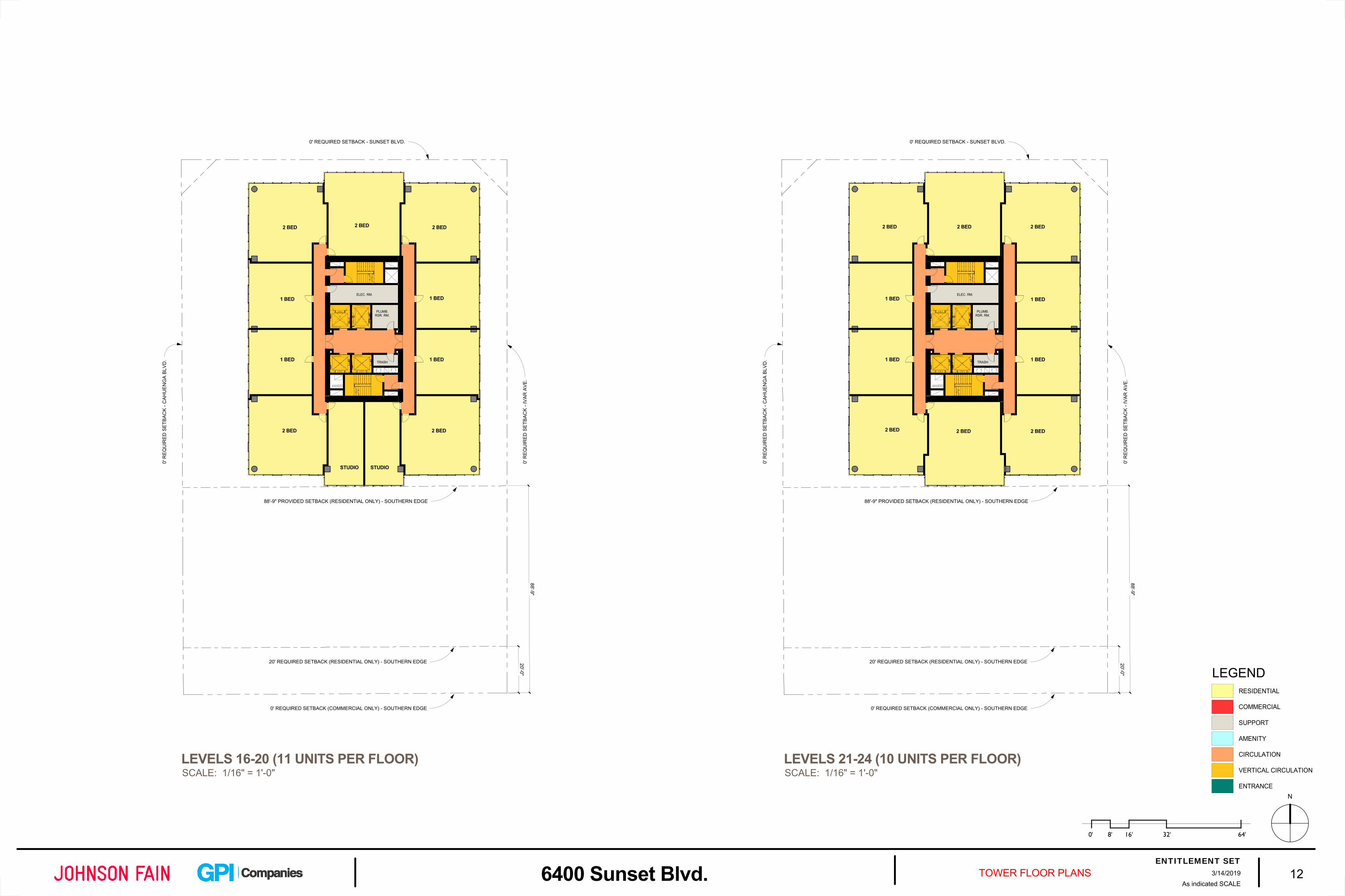
2 BED 2 BED
1 BED
1 BED
2 BED
STUDIO
2 BED
1 BED
1 BED
2 BED
ELEC. RM.
PLUMB.RSR. RM.
TRASH
20'-0"
8 8'- 9"
20' REQUIRED SETBACK (RESIDENTIAL ONLY) - SOUTHERN EDGE
88'-9" PROVIDED SETBACK (RESIDENTIAL ONLY) - SOUTHERN EDGE
0' REQUIRED SETBACK - SUNSET BLVD.
0' R
EQU
IRED
SET
BAC
K -C
AHU
ENG
A BL
VD.
0' R
EQU
IRED
SET
BAC
K -I
VAR
AVE
.
0' REQUIRED SETBACK (COMMERCIAL ONLY) - SOUTHERN EDGE
STUDIO
2 BED 2 BED
1 BED
1 BED
2 BED2 BED2 BED
1 BED
1 BEDELEC. RM.
PLUMB.RSR. RM.
TRASH
2 BED2 0'- 0"
8 8'- 9"
20' REQUIRED SETBACK (RESIDENTIAL ONLY) - SOUTHERN EDGE
88'-9" PROVIDED SETBACK (RESIDENTIAL ONLY) - SOUTHERN EDGE
0' REQUIRED SETBACK - SUNSET BLVD.
0' R
EQU
IRED
SET
BAC
K -C
AHU
ENG
A BL
VD.
0' R
EQU
IRED
SET
BAC
K -I
VAR
AVE
.
0' REQUIRED SETBACK (COMMERCIAL ONLY) - SOUTHERN EDGE
RESIDENTIAL
VERTICAL CIRCULATION
LEGEND
COMMERCIAL
SUPPORT
AMENITY
CIRCULATION
ENTRANCEN
SCALEAs indicatedTOWER FLOOR PLANS 12
ENTITLEMENT SET3/14/20196400 Sunset Blvd.
SCALE: 1/16" = 1'-0"LEVELS 16-20 (11 UNITS PER FLOOR)
SCALE: 1/16" = 1'-0"LEVELS 21-24 (10 UNITS PER FLOOR)
0' 8' 16' 32' 64'

PLUMB.RSR. RM.
TRASH
3 BED
PENTHOUSE PRIVATEROOF DECK
RESIDENTS ROOF DECK
PENTHOUSE PRIVATEROOF DECK
ELEC.RM.
20'- 0"
8 8'- 9"
20' REQUIRED SETBACK (RESIDENTIAL ONLY) - SOUTHERN EDGE
88'-9" PROVIDED SETBACK (RESIDENTIAL ONLY) - SOUTHERN EDGE
0' REQUIRED SETBACK - SUNSET BLVD.
0' R
EQU
IRED
SET
BAC
K -C
AHU
ENG
A BL
VD.
0' R
EQU
IRED
SET
BAC
K -I
VAR
AVE
.
0' REQUIRED SETBACK (COMMERCIAL ONLY) - SOUTHERN EDGE
3+ BED
3+ BED
RESIDENTIAL
VERTICAL CIRCULATION
LEGEND
COMMERCIAL
SUPPORT
AMENITY
CIRCULATION
ENTRANCE
ELEV.OVR.
ELEV.OVR.
ELEV.OVR.
ENCLOSEDMECHANICAL AND PLUMBING
EQUIPMENT ROOM
ENCLOSEDMECHANICAL AND PLUMBING
EQUIPMENT ROOM
UNENCLOSEDMECHANICAL SPACE
ENCLOSED ELECTRICALSUBSTATION
PLUMB.RSR. RM.
20'- 0"
8 8'- 9"
20' REQUIRED SETBACK (RESIDENTIAL ONLY) - SOUTHERN EDGE
88'-9" PROVIDED SETBACK (RESIDENTIAL ONLY) - SOUTHERN EDGE
0' REQUIRED SETBACK - SUNSET BLVD.
0' R
EQU
IRED
SET
BAC
K -C
AHU
ENG
A BL
VD.
0' R
EQU
IRED
SET
BAC
K -I
VAR
AVE
.
0' REQUIRED SETBACK (COMMERCIAL ONLY) - SOUTHERN EDGE
ELEC. RM.
SOLAR THERMAL COLLECTORS, ROOF LEVEL
SCREENED,
N
SCALEAs indicatedUPPER TOWER FLOOR PLANS 13
ENTITLEMENT SET3/14/20196400 Sunset Blvd.
SCALE: 1/16" = 1'-0"LEVEL 25 (3 UNITS)
SCALE: 1/16" = 1'-0"LEVEL 26 (MECHANICAL)
0' 8' 16' 32' 64'

jdonaldson
Snapshot
croades
Text Box
DIGITAL SIGN

jdonaldson
Snapshot

A
A
BB
LEVEL 1(GROUND)
0"
LEVEL 330'-4"
LEVEL B1-12'-4"
LEVEL 664'-4"
LEVEL 776'-4"
LEVEL 886'-4"
LEVEL 996'-4"
LEVEL 10106'-4"
LEVEL 11116'-4"
LEVEL 12126'-4"
LEVEL 13136'-4"
LEVEL 14146'-4"
LEVEL 15156'-4"
LEVEL 16166'-4"
LEVEL 17176'-4"
LEVEL 18186'-4"
LEVEL 19196'-4"
LEVEL 20206'-4"
LEVEL 21216'-4"
LEVEL 22226'-4"
LEVEL 23236'-4"
LEVEL 24246'-4"
LEVEL 25 (PH)256'-4"
LEVEL 26 (MECH)268'-4"
LEVEL 27 (ROOF)284'-4"
LEVEL 219'-0"
LEVEL B2-23'-8"
LEVEL 553'-0"
MECH.
AMENITIES PODIUM DECK
PARKING
PARKING
PARKING
MECH.PARKING PARKING
PARKING
MECH.
PARKING
PARKING
PARKING
COMMERCIAL
PARKING
SUNSET BLVD. SOUTHERN EDGE
RAMP
RAMP
RAMP
RAMP
RESIDENTIAL DROP-OFF
RESD
RESDRESD
RESDRESD
RESDRESD
RESDRESD
RESDRESD
RESDRESD
RESDRESD
RESDRESD
RESDRESD
RESDRESD
RESDRESD
RESDRESD
RESDRESD
RESDRESD
RESDRESD
RESDRESD
RESDRESD
RESDRESD
RAMP LEVEL 441'-8"
RESDRESD
PARKINGPARKING
LEVEL 1(GROUND)
0"
LEVEL 330'-4"
LEVEL 664'-4"
LEVEL 776'-4"
LEVEL 886'-4"
LEVEL 996'-4"
LEVEL 10106'-4"
LEVEL 11116'-4"
LEVEL 12126'-4"
LEVEL 13136'-4"
LEVEL 14146'-4"
LEVEL 15156'-4"
LEVEL 16166'-4"
LEVEL 17176'-4"
LEVEL 18186'-4"
LEVEL 19196'-4"
LEVEL 20206'-4"
LEVEL 21216'-4"
LEVEL 22226'-4"
LEVEL 23236'-4"
LEVEL 24246'-4"
LEVEL 25 (PH)256'-4"
LEVEL 26 (MECH)268'-4"
LEVEL 27 (ROOF)284'-4"
LEVEL 219'-0"
LEVEL 553'-0"
PARKING
PARKING
PARKING
RESD
RESD
RESD
RESD
RESD
RESD
RESD
RESD
RESD
RESD
RESD
RESD
RESD
RESD
RESD
RESD
RESD
DECK
MECH.
PARKING
PARKING
PARKING
AMENITIES
RESD
RESD
RESD
RESD
RESD
RESD
RESD
RESD
RESD
RESD
RESD
RESD
RESD
RESD
RESD
RESD
RESD
RESD
PARKING
PARKING
PARKING
PARKING
LOBBY MECH.
PODIUM DECK
CAHUENGA IVAR
LEVEL 441'-8"
RESD
RESD
PARKING PARKING
SCALEAs indicatedBUILDING SECTIONS A3.10
ENTITLEMENT SET11/17/20176400 Sunset Blvd.
SCALE: 1" = 20'-0"SECTION A - LONGITUDINAL
SCALE: 1" = 20'-0"SECTION B - TRANSVERSE
TLEMENT SET3/14/2019

MATERIAL KEY
TYPE DESCRIPTIONGL-1
GL-2
MT-1
MT-2
MT-3
C-1
VISION GLASS
TRANSLUCENT GLASS
METAL MULLIONS
PERFORATED METAL PANEL
PREFINISHED ALUMINIUM
ARCHITECTURAL CONCRETE
PC-1 PRECAST
GL-3 PATTERN GLASS (FRIT)
SCALE 3/16" = 1'-0"CONCEPT MATERIAL BOARD MAT01
ENTITLEMENT SET3/14/20196400 Sunset Blvd.

Exhibit B

ZIMAS INTRANET General Plan Land Use 02/27/2019City of Los Angeles
Department of City Planning
Address: undefined Tract: TR 1998 Zoning: C4-2D-SN
APN: 5546014058 Block: None General Plan: Regional Center Commercial
PIN #: 147A187 151 Lot: FR 12
Arb: None
Streets Copyright (c) Thomas Brothers Maps, Inc.

ZIMAS INTRANET Generalized Zoning 02/27/2019City of Los Angeles
Department of City Planning
Address: undefined Tract: TR 1998 Zoning: C4-2D-SN
APN: 5546014058 Block: None General Plan: Regional Center Commercial
PIN #: 147A187 151 Lot: FR 12
Arb: None
Streets Copyright (c) Thomas Brothers Maps, Inc.

LAND USERESIDENTIAL
Minimum Residential
Very Low / Very Low I Residential
Very Low II Residential
Low / Low I Residential
Low II Residential
Low Medium / Low Medium I Residential
Low Medium II Residential
Medium Residential
High Medium Residential
High Density Residential
Very High Medium Residential
COMMERCIAL
Limited Commercial
Limited Commercial - Mixed Medium Residential
Highway Oriented Commercial
Highway Oriented and Limited Commercial
Highway Oriented Commercial - Mixed Medium Residential
Community Commercial
Community Commercial - Mixed High Residential
Regional Center Commercial
INDUSTRIAL
Commercial Manufacturing
Limited Manufacturing
Light Manufacturing
Heavy Manufacturing
PARKING
PORT OF LOS ANGELES
General / Bulk Cargo - Non Hazardous (Industrial / Commercial)
General / Bulk Cargo - Hazard
Commercial Fishing
Recreation and Commercial
Intermodal Container Transfer Facility Site
LOS ANGELES INTERNATIONAL AIRPORTAirport Landside
Airport Airside
Airport Northside
OPEN SPACE / PUBLIC FACILITIES
Open Space
Public / Open Space
Public / Quasi-Public Open Space
Other Public Open Space
Public FacilitiesFRAMEWORKCOMMERCIAL
Neighborhood Commercial
General Commercial
Community Commercial
Regional Mixed Commercial
INDUSTRIAL
Limited Industrial
GENERAL PLAN LAND USE
Light Industrial
Hybrid Industrial
GENERALIZED ZONINGOS, GW
A, RA
RE, RS, R1, RU, RZ, RW1
R2, RD, RMP, RW2, R3, RAS, R4, R5, PVSP
CR, C1, C1.5, C2, C4, C5, CW, WC, ADP, LASED, CEC, USC, PPSP
CM, MR, CCS, UV, UI, UC, M1, M2, LAX, M3, SL
P, PB
PF
LEGEND

Exhibit C CPC-2016-3630-ZC-HD-DB-MCUP-SPP-
SPR-WDI

Sustainable Communities Project Exemption
Senate Bill 375 (“SB 375”), enacted on September 30, 2008 to incentivize development of environmentally superior residential projects near transit, created a statutory exemption to the California Environmental Quality Act (“CEQA”) for transit priority projects that meet rigorous statutory requirements. A transit priority project is defined as a project that shall:
(1) contain at least 50 percent residential use; based on total building square footage and, if the project contains between 26 and 50 percent nonresidential uses, a floor area ratio of not less than 0.75;
(2) provide a minimum net density of at least 20 dwelling units per acre; and
(3) be within one-half mile of a major transit stop or high-quality transit corridor included in a regional transportation plan. Specifically, for a transit priority project to be considered for an exemption, the City Council, after conducting a public hearing, must find that specific environmental criteria, land-use criteria, and one of three affordable housing criteria have all been met.
Pursuant to Public Resources Code, Section 21155.1, a Sustainable Communities Project CEQA Statutory Exemption (“SCPE”) was prepared for the Project. The Department of City Planning recommended that the City Council consider and determine that the Project satisfies all of the SCPE’s criteria, and is therefore exempt from CEQA pursuant to Public Resource Code (PRC) Section 21155.1, as set forth in the SCPE. On November 6, 2018, after a duly-noticed public hearing and based on the whole of the administrative record, the City Council’s Planning and Land Use Management Committee made a recommendation to the full City Council to determine that the Project is exempt from CEQA pursuant to PRC Section 21155.1 as a Sustainable Communities Project. Notice of the hearing before the Planning and Land Use Management Committee was provided October 2, 2018. On November 21, 2018, after a duly-noticed public hearing and based on the whole of the administrative record and using its independent judgment, the City Council found that the Project met the criteria for a Sustainable Communities Project exemption and approved the exemption pursuant to PRC Section 21155.1. The approval of the exemption did not equate to approval of the Project which must still go through the public entitlement approval process that could result in approval, modification, or disapproval of the Project. PRC Section 21155.1 merely states that “if the legislative body finds, after conducting a public hearing, that a transit priority project meets all of the requirements of subdivisions (a) and (b) and one of the requirements of subdivision (c), the transit priority project is declared to be a sustainable communities project and shall be exempt….” As previously discussed, the exemption determination for the Project was made by the City Council on November 21, 2018. Thereafter, the City provided public notice and commenced the public hearings for the entitlements
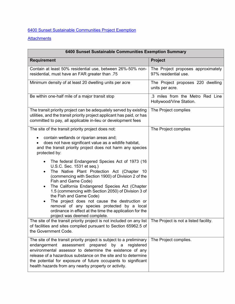
6400 Sunset Sustainable Communities Project Exemption
Attachments
6400 Sunset Sustainable Communities Exemption Summary
Requirement Project
Contain at least 50% residential use, between 26%-50% non-residential, must have an FAR greater than .75
The Project proposes approximately 97% residential use.
Minimum density of at least 20 dwelling units per acre The Project proposes 220 dwelling units per acre.
Be within one-half mile of a major transit stop .3 miles from the Metro Red Line Hollywood/Vine Station.
The transit priority project can be adequately served by existing utilities, and the transit priority project applicant has paid, or has committed to pay, all applicable in-lieu or development fees
The Project complies
The site of the transit priority project does not:
• contain wetlands or riparian areas and; • does not have significant value as a wildlife habitat, and the transit priority project does not harm any species protected by:
• The federal Endangered Species Act of 1973 (16 U.S.C. Sec. 1531 et seq.)
• The Native Plant Protection Act (Chapter 10 (commencing with Section 1900) of Division 2 of the Fish and Game Code)
• The California Endangered Species Act (Chapter 1.5 (commencing with Section 2050) of Division 3 of the Fish and Game Code)
• The project does not cause the destruction or removal of any species protected by a local ordinance in effect at the time the application for the project was deemed complete.
The Project complies
The site of the transit priority project is not included on any list of facilities and sites compiled pursuant to Section 65962.5 of the Government Code.
The Project is not a listed facility.
The site of the transit priority project is subject to a preliminary endangerment assessment prepared by a registered environmental assessor to determine the existence of any release of a hazardous substance on the site and to determine the potential for exposure of future occupants to significant health hazards from any nearby property or activity.
The Project complies.

6400 Sunset Sustainable Communities Exemption Summary
The transit priority project does not have a significant effect on historical resources pursuant to Section 21084.1
There are no Historical Resources on site.
The transit priority project site is not subject to any of the following:
(A) A wildland fire hazard, as determined by the Department of Forestry and Fire Protection, unless the applicable general plan or zoning ordinance contains provisions to mitigate the risk of a wildland fire hazard.
(B) An unusually high risk of fire or explosion from materials stored or used on nearby properties.
(C) Risk of a public health exposure at a level that would exceed the standards established by any state or federal agency.
(D) Seismic risk as a result of being within a delineated earthquake fault zone, as determined pursuant to Section 2622, or a seismic hazard zone, as determined pursuant to Section 2696, unless the applicable general plan or zoning ordinance contains provisions to mitigate the risk of an earthquake fault or seismic hazard zone.
(E) Landslide hazard, flood plain, flood way, or restriction zone, unless the applicable general plan or zoning ordinance contains provisions to mitigate the risk of a landslide or flood.
The site is not subject to any of the following
The transit priority project site is not located on developed open space.
The Project Complies
The buildings in the transit priority project are 15 percent more energy efficient than required by Chapter 6 of Title 24 of the California Code of Regulations and the building and landscaping are designed to achieve 25 percent less water usage than the average household use in the region.
The Project has committed to the efficiency requirements. The Project will be 15 percent more energy efficient than Chapter 6 of Title 24 CGC requirements, and use 25 percent less water in operations and landscaping than the average household in the region
The site of the transit priority project is not more than eight acres in total area.
The Project Site is .89 acres.
The transit priority project does not contain more than 200 residential units.
The Project proposes no more than 200 units.
The transit priority project does not result in any net loss in the number of affordable housing units within the project area.
There are no housing units currently on site.

6400 Sunset Sustainable Communities Exemption Summary
The transit priority project does not include any single level building that exceeds 75,000 square feet.
The project contains no single level over 75,000 square feet.
Any applicable mitigation measures or performance standards or criteria set forth in the prior environmental impact reports, and adopted in findings, have been or will be incorporated into the transit priority project
Applicable Mitigation Measures have been incorporated as Conditions of Approval.
The transit priority project is determined not to conflict with nearby operating industrial uses.
There nearest Industrially zoned property is located 2,000 feet east, the Sunset Gower Studios facility, which would not be operationally conflicted by the project.
The transit priority project meets both of the following:
(A) At least 20 percent of the housing will be sold to families of moderate income, or not less than 10 percent of the housing will be rented to families of low income, or not less than 5 percent of the housing is rented to families of very low income.
(B) The transit priority project developer provides sufficient legal commitments to the appropriate local agency to ensure the continued availability and use of the housing units for very low, low-, and moderate-income households at monthly housing costs with an affordable housing cost or affordable rent, as defined in Section 50052.5 or 50053 of the Health and Safety Code, respectively, for the period required by the applicable financing. Rental units shall be affordable for at least 55 years. Ownership units shall be subject to resale restrictions or equity sharing requirements for at least 30 years.
The Project proposes 5 percent of its units as Very Low Income restricted units.
*This Table is meant for informational purposes only, please see the full Exemption document, linked above for the full Exemption requirements, explanation, and substantiation of the Project’s qualifications.

Exhibit D

City of Los Angeles 6400 Sunset Boulevard Project Sustainable Communities Project CEQA Exemption September 2018
Page 1
6400 Sunset Boulevard Project Sustainable Communities Project CEQA Exemption
SUSTAINABLE COMMUNITIES STRATEGY—PUBLIC RESOURCES CODE (PRC) § 21155
PRC § 21155(a). Consistency with the general use designation, density, building intensity, and applicable policies specified for the project area in a sustainable communities strategy.
Consistent?Yes No
The Project would develop a 26-story (25 occupiable floors and one mechanical floor) mixed-use building on a 0.89-acre infill Project Site located in a highly urbanized part of the Hollywood Community Plan Area of the City of Los Angeles. The Project Site is comprised of a Northern Lot and a Southern Lot. The Northern Lot is currently occupied by the two-story Amoeba Music store. The Southern Lot is located 150 feet south of the Northern Lot and is comprised of a surface parking lot that contains 21 surface parking spaces for the Amoeba Music store. All Project construction would occur on the Northern Lot. No excavation or construction would occur on the Southern Lot, which would remain as a surface parking lot to provide parking for the Project. The proposed building would consist of up to 200 residential units with 5 percent reserved for Very Low Income Households, and 7,000 square feet of commercial uses. Adjacent land uses are a mix of low-, mid-, and high-rise buildings containing commercial, office, retail, entertainment, and institutional uses. The Project Site is accessible by regional and local transit, and the Project would provide bicycle and vehicle parking on-site. The Project Site’s land use designation in the City of Los Angeles (City) General Plan is Regional Center Commercial (see Attachment A for the General Plan Land Use Map of the Project Site and area). The proposed uses are consistent with the Regional Center Commercial land use designation, which permits commercial and residential land uses.
The Project is consistent with the general land use designation, density, and building intensity in the Southern California Association of Government’s (SCAG) 2016–2040 Regional Transportation Plan/Sustainable Communities Strategy (2016 RTP/SCS). Using data collected from local jurisdictions, including general plans, SCAG categorized existing land use into land use types, then combined the land use types into 35 place types, and then classified sub-regions into one of three land use development categories: urban, compact, or standard. SCAG used each of these categories to describe the conditions that exist and/or are likely to exist within each specific area of the region. (SCAG, 2016 RTP/SCS, p. 20-21.)
Based on Exhibit 5 and Exhibit 6 of SCAG’s SCS Background Documentation, the Project Site and surrounding area are within the “Urban” Land Development Category (SCAG, 2016 RTP/SCS Appendix: SCS Background Documentation, p. 10-11). The 2016 RTP/SCS provides the following definition for the “Urban” Land Development Category:
These areas are often found within and directly adjacent to moderate and high density urban centers. Nearly all urban growth in these areas would be considered infill or redevelopment. The majority of housing is multi-family and attached single-family (townhome), which tend to consume less water and energy than the larger types found in greater proportion in less urban locations. These areas are
X
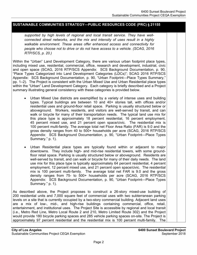
6400 Sunset Boulevard Project Sustainable Communities Project CEQA Exemption
City of Los Angeles 6400 Sunset Boulevard Project Sustainable Communities Project CEQA Exemption September 2018
Page 2
SUSTAINABLE COMMUNITIES STRATEGY—PUBLIC RESOURCES CODE (PRC) § 21155
supported by high levels of regional and local transit service. They have well-connected street networks, and the mix and intensity of uses result in a highly walkable environment. These areas offer enhanced access and connectivity for people who choose not to drive or do not have access to a vehicle. (SCAG, 2016 RTP/SCS, p. 20.)
Within the “Urban” Land Development Category, there are various urban footprint place types, including mixed use, residential, commercial, office, research and development, industrial, civic and open space (SCAG, 2016 RTP/SCS Appendix: SCS Background Documentation, p. 90, “Place Types Categorized into Land Development Categories (LDCs)”; SCAG 2016 RTP/SCS Appendix: SCS Background Documentation, p. 90, “Urban Footprint—Place Types Summary,” pp. 1–2). The Project is consistent with the Urban Mixed Use and Urban Residential place types within the “Urban” Land Development Category. Each category is briefly described and a Project summary illustrating general consistency with these categories is provided below.
Urban Mixed Use districts are exemplified by a variety of intense uses and building types. Typical buildings are between 10 and 40+ stories tall, with offices and/or residential uses and ground-floor retail space. Parking is usually structured below or aboveground. Workers, residents, and visitors are well-served by transit, and can walk or bicycle for many of their transportation needs. The typical land use mix for this place type is approximately 18 percent residential, 16 percent employment, 45 percent mixed use, and 21 percent open space/civic. The residential mix is 100 percent multi-family. The average total net Floor Area Ratio (FAR) is 9.0 and the gross density ranges from 40 to 500+ households per acre (SCAG, 2016 RTP/SCS Appendix: SCS Background Documentation, p. 90, “Urban Footprint—Place Types Summary.” p. 1).
Urban Residential place types are typically found within or adjacent to major downtowns. They include high- and mid-rise residential towers, with some ground-floor retail space. Parking is usually structured below or aboveground. Residents are well-served by transit, and can walk or bicycle for many of their daily needs. The land use mix for this place type is typically approximately 64 percent residential, 4 percent employment, 12 percent mixed use, and 21 percent open space/civic. The residential mix is 100 percent multi-family. The average total net FAR is 9.0 and the gross density ranges from 75- to 500+ households per acre (SCAG, 2016 RTP/SCS Appendix: SCS Background Documentation, p. 90, “Urban Footprint—Place Types Summary.” p. 1).
As described above, the Project proposes to construct a 26-story mixed-use building of 200 residential units and 7,000 square feet of commercial uses with two subterranean parking levels on a site that is currently occupied by a two-story commercial building. Adjacent land uses are a mix of low-, mid-, and high-rise buildings containing commercial, office, retail, entertainment, and institutional uses. The Project Site is accessible by regional and local transit (i.e., Metro Red Line, Metro Local Route 2 and 210, Metro Limited Route 302) and the Project would provide 180 bicycle parking spaces and 285 vehicle parking spaces on-site. The Project is approximately 97 percent residential and the residential mix is 100 percent multi-family. The

6400 Sunset Boulevard Project Sustainable Communities Project CEQA Exemption
City of Los Angeles 6400 Sunset Boulevard Project Sustainable Communities Project CEQA Exemption September 2018
Page 3
SUSTAINABLE COMMUNITIES STRATEGY—PUBLIC RESOURCES CODE (PRC) § 21155
maximum FAR is 6:1 with an average density per acre of 225 household units per acre. In addition, as described in further detail below, the Project would be at least 15 percent more energy efficient than Title 24 standards. The Project building and landscaping are also designed to achieve 25 percent less water usage than the average household in the region. Thus, the Project is consistent with the SCAG “Urban” Land Use Designation, as well as the associated density and building intensity assumptions in the SCAG’s 2016 RTP/SCS. Furthermore, the Project is consistent with the applicable goals and policies in the 2016 RTP/SCS, as outlined in Attachment B. As such, the Project is consistent with this criterion.
PRC §21155(b). To be considered a Transit Priority Project (TPP) as defined by §21155(b), the project must meet all of the following criteria. A TPP shall:
Consistent?Yes No
(1) Contain at least 50 percent residential use, based on total building square footage and, if the project contains between 26 percent and 50 percent nonresidential uses, a floor area ratio of not less than 0.75;
The Project would construct a mixed-use residential and commercial building with a total floor area of 231,836 square feet that will consist of approximately 7,000 square feet of commercial uses, and 200 residential units totaling 224,836 square feet. Therefore, the Project contains approximately 97 percent residential use (224,836 square feet ÷ 231,836 square feet = 0.97 x 100 = 97%) and less than 26 percent nonresidential uses (7,000 square feet ÷ 231,836 square feet = 0.03 x 100 = 3%). As such, the Project is consistent with part (1) of this criterion.
X
(2) Provide a minimum net density of at least 20 dwelling units per acre; and
The Project will develop a 0.89-acre site with a mixed-use residential and commercial building that includes up to 200 residential units. The net housing density for the Project is approximately 225 dwelling units per acre (200 units/0.89 acre), which is more than the required minimum of 20 units per acre. Thus, the Project is consistent with part (2) of this criterion.
X
(3) Be within one-half mile of a major transit stop or high-quality transit corridor included in a regional transportation plan. A major transit stop is as defined in Section 21064.3, except that, for purposes of this section, it also includes major transit stops that are included in the applicable regional transportation plan. For purposes of this section, a high-quality transit corridor means a corridor with fixed route bus service with service intervals no longer than 15 minutes during peak commute hours. A project shall be considered to be within one-half mile of a major transit stop or high-quality transit corridor if all parcels within the project have no more than 25 percent of their area further than one-half mile from the stop or corridor and if not more than 10 percent of the residential units or 100 units, whichever is less, in the project are farther than one-half mile from the stop or corridor.
The applicable regional transportation plan is the SCAG 2016 RTP/SCS. PRC Section 21064.3 defines a major transit stop as “a site containing an existing rail transit station, a ferry terminal served by either a bus or rail transit service, or the intersection of two or more major bus routes with a frequency of service interval of 15 minutes or less during the morning and afternoon peak commute periods.”
X

6400 Sunset Boulevard Project Sustainable Communities Project CEQA Exemption
City of Los Angeles 6400 Sunset Boulevard Project Sustainable Communities Project CEQA Exemption September 2018
Page 4
SUSTAINABLE COMMUNITIES STRATEGY—PUBLIC RESOURCES CODE (PRC) § 21155
All parcels within the Project Site are located within one-half mile of an existing major transit stop and an existing high quality transit corridor, as shown in the SCAG 2016 RTP/SCS. An existing rail station, the Metro Red Line Hollywood/Vine Station, is considered a major transit stop as defined in Section 21064.3 above and is located approximately 0.3 mile northeast of the Project Site. The intersection of Sunset Boulevard and Vine Street, which is approximately 0.13 mile east of the Project Site, is also considered a major transit stop where Metro Local Line 2, Metro Local Line 210, and Metro Limited Line 302 intersect (Attachment C: Gibson Transportation Consulting, Inc. [Gibson], Transportation Impact Study for the 6400 Sunset Boulevard Mixed-Use Development [Traffic Study], p. 18-20 and Figure 3 on p. 25). These bus lines have frequency of service intervals of 15 minutes or less during peak commute periods (Attachment C: Gibson, Traffic Study, p. 18-20).
The Project is also located within one-half mile of a high-quality transit corridor with bus service intervals of 15 minutes or less during peak commute hours. There are 12 bus lines that operate in the immediate vicinity of the Project Site (Attachment C: Gibson, Traffic Study, p. 18-20). Sunset Boulevard is considered a high quality transit corridor since it has fixed route bus service provided by Metro Local Line 2 and Metro Limited Line 302 (Attachment C: Gibson, Traffic Study, p. 18-20 and Figure 3 on p. 25). Furthermore, the Project Site is in an area identified a High Quality Transit Area by SCAG (SCAG 2016-2040 RTP/SCS Exhibit 5.1, High Quality Transit Areas in the SCAG Region for 2040 Plan). Thus, the Project is consistent with part (3) of this criterion.
PRC §21155.1(a). The transit priority project complies with all of the following environmental criteria:
Consistent?Yes No
(1) The transit priority project and other projects approved prior to the approval of the transit priority project but not yet built can be adequately served by existing utilities, and the transit priority project applicant has paid, or has committed to pay, all applicable in-lieu or development fees.
The immediate vicinity of the Project Site is fully built out and there is no other transit priority project that has been approved but not built. The Project Site is currently developed with a retail building (Amoeba Music store) on the Northern Lot and associated surface parking lot on the Southern Lot, which are both in operation. The Project Site is currently served by existing utilities, including water mains, sewer lines, and storm drain inlets maintained by the Los Angeles Department of Water and Power (LADWP) and the City’s Department of Public Works (Bureau of Sanitation). The Project would connect to the existing utility structures, as explained in detail below.
Based on the 6400 Sunset Wastewater and Water Utility Infrastructure Technical Report (Utility Report), prepared by KPFF Consulting Engineers (KPFF), dated August 2018, there is an 8-inch water main in Sunset Boulevard, an 8-inch water main in Ivar Avenue, and a 12-inch water main in Cahuenga Boulevard (Attachment D: KPFF, Utility Report, p. 4). The Project Site has two domestic water connections off of Ivar Avenue and one connection off of Cahuenga Boulevard (Attachment D: KPFF, Utility Report, p. 4). While the Project would increase demand for utility services, LADWP has confirmed that there is sufficient capacity to provide water service to the Project (Attachment D: KPFF, Utility Report, p. 11). In addition, as the Project is consistent with regional growth projections, the Project would not require new water supply entitlements and/or
X

6400 Sunset Boulevard Project Sustainable Communities Project CEQA Exemption
City of Los Angeles 6400 Sunset Boulevard Project Sustainable Communities Project CEQA Exemption September 2018
Page 5
SUSTAINABLE COMMUNITIES STRATEGY—PUBLIC RESOURCES CODE (PRC) § 21155
require the expansion of existing or construction of new water treatment facilities beyond those already considered in the LADWP 2015 Urban Water Management Plan. Furthermore, the Project would be required to comply with numerous water conservation regulations contained in the Los Angeles Municipal Code (LAMC) to reduce water consumption (i.e., Ordinance Nos. 166,080; 180,822; 181,480; 181,899; 182,849; 183, 608; 183,833; 184,248; and 184,250), and with the California Green Building Standards Code, which contain standards designed for efficient water use. The Project, with inclusion of the required water conservation features, will use approximately 15,519 gallons per day, which is equivalent to approximately 30.4 gallons per person per day (Attachment E: Glumac, Water Consumption Calculations—6400 Sunset Blvd., p. 3). The average residential household water use in California in 2016 was 85 gallons per person per day. Therefore, the water usage for the Project would be approximately 64 percent less than the average California household. See also response to PRC § 21155.1(a)(8), below.
The Project would connect to the existing wastewater system by connection to the existing 12-inch sewer main at Cahuenga Boulevard and the existing 12-inch sewer main at Ivar Avenue (Attachment D: KPFF, Utility Report, p. 14). The Project would connect to the existing wastewater system through these existing mains by utilizing existing or new on-site sewer connections to the existing sewer mains adjacent to the Project Site. The results of the Sewer Capacity Availability Request (SCAR) obtained from the City’s Bureau of Engineering confirms that there is sufficient capacity to service the Project (Attachment D: KPFF, Utility Report, p. 14). In addition, based on KPFF’s Utility Report, the Hyperion Water Reclamation Plant has sufficient capacity to treat wastewater flows from the Project (Attachment D: KPFF, Utility Report, p. 14). Therefore, the Project would not result in or require the construction of a new wastewater treatment facility.
The Project would not increase the existing peak flow rate or runoff volumes into the stormwater drainage system since the Project Site is currently 100 percent impervious and does not contain any landscaping on-site. Per City requirements, the Project would be required to comply with the Los Angeles County Department of Public Works Hydrology Manual and the City’s Low Impact Development (LID) Ordinance to treat stormwater for pollutants and control runoff at buildout. Therefore, the Project would not create or contribute runoff water which would exceed the capacity of existing or planned stormwater drainage system. As such, the existing stormwater drainage system would have sufficient capacity to service the Project and the Project would not require or result in the construction of new stormwater drainage facilities or expansion of existing facilities.
The Project would pay all applicable in-lieu or development fees pursuant to code requirements and conditions of Project approval. Thus, the Project is consistent with part (1) of this criterion.
(2) (A) The site of the transit priority project does not contain wetlands or riparian areas and does not have significant value as a wildlife habitat, and the transit priority project does not harm any species protected by the federal Endangered Species Act of 1973 (16 U.S.C. Sec. 1531 et seq.), the Native Plant Protection Act (Chapter 10 (commencing with Section 1900) of Division 2 of the Fish and Game Code), or the California Endangered Species Act (Chapter 1.5 (commencing with Section 2050) of Division 3 of the Fish and Game Code), and the project does not cause the destruction or removal of any species protected by a local ordinance in effect
X

6400 Sunset Boulevard Project Sustainable Communities Project CEQA Exemption
City of Los Angeles 6400 Sunset Boulevard Project Sustainable Communities Project CEQA Exemption September 2018
Page 6
SUSTAINABLE COMMUNITIES STRATEGY—PUBLIC RESOURCES CODE (PRC) § 21155
at the time the application for the project was deemed complete.
(B) For the purposes of this paragraph, “wetlands” has the same meaning as in the United States Fish and Wildlife Service Manual, Part 660 FW 2 (June 21, 1993).
(C) For the purposes of this paragraph:
(i) “Riparian areas” means those areas transitional between terrestrial and aquatic ecosystems and that are distinguished by gradients in biophysical conditions, ecological processes, and biota. A riparian area is an area through which surface and subsurface hydrology connect waterbodies with their adjacent uplands. A riparian area includes those portions of terrestrial ecosystems that significantly influence exchanges of energy and matter with aquatic ecosystems. A riparian area is adjacent to perennial, intermittent, and ephemeral streams, lakes, and estuarine-marine shorelines.
(ii) “Wildlife habitat” means the ecological communities upon which wild animals, birds, plants, fish, amphibians, and invertebrates depend for their conservation and protection.
(iii) Habitat of “significant value” includes wildlife habitat of national, statewide, regional, or local importance; habitat for species protected by the federal Endangered Species Act of 1973 (16 U.S.C. Sec. 1531, et seq.), the California Endangered Species Act (Chapter 1.5 (commencing with Section 2050) of Division 3 of the Fish and Game Code), or the Native Plant Protection Act (Chapter 10 (commencing with Section 1900) of Division 2 of the Fish and Game Code); habitat identified as candidate, fully protected, sensitive, or species of special status by local, state, or federal agencies; or habitat essential to the movement of resident or migratory wildlife.
The Project Site is fully developed with a commercial building and a surface parking lot, and is located in a heavily urbanized area of Hollywood Community Plan Area in the City of Los Angeles. Adjacent and surrounding land uses include a mix of commercial, office, retail, entertainment, and institutional uses. Review of the National Wetlands Inventory identified no protected wetlands in the vicinity of the Project Site and the Project Site is not located within a riparian area (U.S. Fish and Wildlife Service, National Wetlands Inventory, Wetlands Mapper, www.fws.gov/wetlands/Data/Mapper.html, accessed February 2018). Further, as the Project Site is fully developed and there are no open spaces with water courses such as streams or lakes, the Project Site does not support any riparian or wetland habitat, as defined by Section 404 of the Clean Water Act. Therefore, the Project would not have a substantial adverse effect on wetlands, riparian habitat, or other sensitive natural communities identified in federal, state, or local plans, policies, and regulations.
The Project Site is not located in or adjacent to a Biological Resource Area as defined by the City (City of Los Angeles, Department of City Planning, Los Angeles Citywide General Plan Framework, Draft Environmental Impact Report, January 19, 1995, p. 2-18-4). Moreover, the Project Site and immediately surrounding area are not within or near a designated Significant

6400 Sunset Boulevard Project Sustainable Communities Project CEQA Exemption
City of Los Angeles 6400 Sunset Boulevard Project Sustainable Communities Project CEQA Exemption September 2018
Page 7
SUSTAINABLE COMMUNITIES STRATEGY—PUBLIC RESOURCES CODE (PRC) § 21155
Ecological Area (Los Angeles County Department of Regional Planning, Planning & Zoning Information, GIS-NET3 online database, website: http://planning.lacounty.gov/gisnet3, accessed February 2018). The Project Site is built-out with the existing Amoeba Music Store and a surface parking lot and does not contain any trees or any habitat capable of sustaining any species identified as a candidate, sensitive, or special status species in local or regional plans, policies, or regulations, or by the California Department of Fish and Wildlife or U.S. Fish and Wildlife Service. Additionally, there are no known locally designated natural communities at the Project Site or in the immediate vicinity, nor is the Project Site located immediately adjacent to undeveloped natural open space or a natural water source that may otherwise serve as habitat for state- or federally listed species. Thus, the Project would not harm any species protected by the Federal Endangered Species Act of 1973 (16 U.S.C. Sec. 1531 et seq.), the Native Plant Protection Act (Chapter 10 (commencing with Section 1900) of Division 2 of the Fish and Game Code), or the California Endangered Species Act (Chapter 1.5 (commencing with Section 2050) of Division 3 of the Fish and Game Code) and therefore meets part (2) of this criterion.
(3) The site of the transit priority project is not included on any list of facilities and sites compiled pursuant to Section 65962.5 of the Government Code.
The California Department of Toxic Substances Control (DTSC) maintains a database (EnviroStor) that provides access to detailed information on hazardous waste permitted sites and corrective action, facilities, as well as existing site cleanup information. The Regional Water Quality Control Board (RWQCB) maintains a similar database (Geotracker). EnviroStor and Geotracker also provide information on investigation, cleanup, permitting, and/or corrective actions that are permitting, planned, being conducted, or have been completed under DTSC’s and the RWQCB’s respective oversight.
A preliminary endangerment assessment (PEA) was prepared by California Environmental (CE), dated August 2018, for the Project (see Attachment F: CE, Environmental Site Assessment—Phase I PEA Report). As part of the PEA, inquiry letters were sent to the DTSC and RWQCB, and the DTSC and RWQCB online databases were reviewed. The results of the database review are contained in the PEA (see Appendix IV of the PEA). Based on this review, the Project Site is not listed on these databases (Attachment F: CE, Environmental Site Assessment—Phase I PEA Report, p. 11). In addition to the DTSC and RWQCP databases, agency database lists were reviewed for known or suspected contaminated sites and for sites that store, generate or use hazardous materials.
The Project Site is listed on the HAZNET databases for the generation and offsite disposal of asbestos waste in the late 1990s, associated with the demolition of existing structures. (Attachment F: CE, Environmental Site Assessment—Phase I PEA Report, p. 18.) This listing on the HAZNET database does not represent a significant environmental concern because the asbestos was removed from the Project Site and disposed of in accordance with regulations. Furthermore, the PEA did not identify any other recognized environmental conditions, historical recognized environmental conditions, or controlled recognized environmental conditions on the Project Site. Therefore, the Project is not located on a site that is included on a list of hazardous material sites or create a significant hazard to the public or the environment. Thus, the Project meets part (3) of this criterion.
X

6400 Sunset Boulevard Project Sustainable Communities Project CEQA Exemption
City of Los Angeles 6400 Sunset Boulevard Project Sustainable Communities Project CEQA Exemption September 2018
Page 8
SUSTAINABLE COMMUNITIES STRATEGY—PUBLIC RESOURCES CODE (PRC) § 21155
(4) The site of the transit priority project is subject to a preliminary endangerment assessment prepared by a registered environmental assessor to determine the existence of any release of a hazardous substance on the site and to determine the potential for exposure of future occupants to significant health hazards from any nearby property or activity.
(A) If a release of a hazardous substance is found to exist on the site, the release shall be removed or any significant effects of the release shall be mitigated to a level of insignificance in compliance with state and federal requirements.
(B) If a potential for exposure to significant hazards from surrounding properties or activities is found to exist, the effects of the potential exposure shall be mitigated to a level of insignificance in compliance with state and federal requirements
As part of the PEA, the previous uses of the Project Site and nearby properties were evaluated to identify any historically recognized environmental conditions. As detailed in the PEA, the Northern Lot remained undeveloped until the early 1900s when it was developed with stables, a riding academy, and residential structures from 1907 to 1919 (Attachment F: CE, Environmental Site Assessment—Phase I PEA Report, p. 20). By 1950, the Northern Lot was occupied by retail stores, offices, a residence, and an auto sales/repair facility (Attachment F: CE, Environmental Site Assessment—Phase I PEA Report, p. 20). Additional commercial and retail buildings were developed on the Project Site by 1955 (Attachment F: CE, Environmental Site Assessment—Phase I PEA Report, p. 20). Commercial and retail uses, including auto-related uses, continued on the Project Site until the 1970s (Attachment F: CE, Environmental Site Assessment—Phase I PEA Report, p. 20). The Southern Lot was vacant until approximately 1919 when it was developed for residential uses (Attachment F: CE, Environmental Site Assessment—Phase I PEA Report, p. 20). Records indicate that the Southern Lot continued to be utilized for residential purposes between 1933 and 1942 (Attachment F: CE, Environmental Site Assessment—Phase I PEA Report, p. 21). By 1950, the Southern Lot was again vacant land (Attachment F: CE, Environmental Site Assessment—Phase I PEA Report, p. 9). By the 1960s, the Southern Lot was developed for its current use as a surface parking lot (Attachment F: CE, Environmental Site Assessment—Phase I PEA Report, p. 20). The PEA did not identify the historic use of the Northern Lot for auto repair uses as a significant environmental concern.
The PEA reported no evidence of existing aboveground or underground storage tanks, clarifiers, sumps, or grease interceptors on the Project Site during the site reconnaissance (Attachment F: CE, Environmental Site Assessment—Phase I PEA Report, p. 14). In addition, no evidence of transformers or equipment containing toxic polychlorinated biphenyls (PCBs) or evidence of spills or stains was observed on-site (Attachment F: CE, Environmental Site Assessment—Phase I PEA Report, p. 14). Furthermore, no strong, pungent, or noxious odors were evident during the site reconnaissance and no other indications of release of hazardous substances or other conditions of environmental concern were observed (Attachment F: CE, Environmental Site Assessment—Phase I PEA Report, p. 14-17).
The Project Site is not located within a Methane Zone or Methane Buffer Zone identified by the City (City of Los Angeles Department of City Planning, Zone Information and Map Access System [ZIMAS] Parcel Profile Reports for APN 5546-014-058 Lots 12, 13, 14, and 24, and APN
X

6400 Sunset Boulevard Project Sustainable Communities Project CEQA Exemption
City of Los Angeles 6400 Sunset Boulevard Project Sustainable Communities Project CEQA Exemption September 2018
Page 9
SUSTAINABLE COMMUNITIES STRATEGY—PUBLIC RESOURCES CODE (PRC) § 21155
5546-014-029 Lot 170). According to the PEA, the Project Site is not located within a recognized methane hazard zone and there are no oil wells or oil fields within a 2,000-foot radius of the Project Site (Attachment F: CE, Environmental Site Assessment—Phase I PEA Report, p. 17-18). Furthermore, the PEA indicated that although a radon hazard assessment was not conducted for the Project Site, the radon levels at 13 sites located within the 90028 ZIP Code were below the federal action level (Attachment F: CE, Environmental Site Assessment—Phase I PEA Report, p. 15). Thus, the likelihood of radon levels being above the federal action level at the Project Site is considered low. The PEA also concluded that a vapor encroachment condition does not exist on the Project Site (Attachment F: CE, Environmental Site Assessment—Phase I PEA Report, p. 19).
The Project will require the demolition of the existing 43,077-square-foot commercial building in order to construct the proposed 26-story mixed use building. The PEA concluded that based on the age of the existing building, which was built in 2001 according to its Certificate of Occupancy, it is unlikely that asbestos containing materials (ACMs) and lead-based paint (LBP) would be present in the demolition debris. In the unlikely event that ACMs and/or LBP are discovered during construction, all ACMs and LBP would be removed in accordance with all applicable regulatory requirements. Specifically, in accordance with SCAQMD Rule 1403 (Asbestos Emissions from Demolition/Renovation Activities), prior to demolition activities associated with the Project, the Applicant would conduct a survey of the existing areas where construction would occur to verify the presence or absence of any of these materials and conduct remediation or abatement before any disturbance occurs. Furthermore, the California Division of Occupational Safety and Health (Cal-OSHA) has established limits of exposure to lead contained in dusts and fumes through California Code of Regulations, Title 8, Section 1532.1, which provides for exposure limits, exposure monitoring, and respiratory protection, and mandates good working practices by workers exposed to lead, since demolition workers are at greatest risk of adverse health exposure. Lead-contaminated debris and other wastes must also be managed and disposed of in accordance with applicable provisions of the California Health and Safety Code. Mandatory compliance with these regulatory requirements would reduce any potential risks associated with ACMs and LBP to acceptable levels.
According to the PEA, the Project Site was identified in the regulatory database as a HAZNET database for the generation and off-site disposal of asbestos waste in the late 1990s, associated with the demolition of existing structures. However, this listing on the HAZNET database does not represent a significant environmental concern since asbestos has been removed from the Project Site and disposed of in accordance with regulations. Furthermore, the PEA did not identify any other recognized environmental conditions, historical recognized environmental conditions, or controlled recognized environmental conditions on the Project Site. Therefore, the Project meets part (4) of this criterion.
(5) The transit priority project does not have a significant effect on historical resources pursuant to Section 21084.1.
There are no historical resources on the Project Site. The existing building on the Project Site was constructed in 2001 and has not been determined to be eligible for listing in the National Register of Historic Places, California Register of Historic Resources, the Los Angeles Historic-Cultural Monuments Register, and/or any local register (Attachment G: Historical Resources
X

6400 Sunset Boulevard Project Sustainable Communities Project CEQA Exemption
City of Los Angeles 6400 Sunset Boulevard Project Sustainable Communities Project CEQA Exemption September 2018
Page 10
SUSTAINABLE COMMUNITIES STRATEGY—PUBLIC RESOURCES CODE (PRC) § 21155
Group, Historic Resources Technical Report, Amoeba Music—6400 Sunset Boulevard, Hollywood, p. 33). In addition, although Historical Resources Group identified several historical resources in the vicinity of the Project Site, none of these historical resources would be directly or indirectly impacted by the Project (Attachment G: Historical Resources Group, Historic Resources Technical Report, Amoeba Music—6400 Sunset Boulevard, Hollywood, p. 38-40). Thus, the Project meets part (5) of this criterion.
(6) The transit priority project site is not subject to any of the following:
(A) A wildland fire hazard, as determined by the Department of Forestry and Fire Protection, unless the applicable general plan or zoning ordinance contains provisions to mitigate the risk of a wildland fire hazard.
As described above and recognized in the 2016 RTP/SCS, the Project Site is located in a highly urbanized area and is fully developed with a surface parking lot and the Amoeba Music Store. There are no wildlands located in the vicinity of the Project Site. Furthermore, the Project Site is not located within a City-designated Very High Fire Hazard Severity Zone (City of Los Angeles Department of City Planning, ZIMAS Parcel Profile Reports for APN 5546-014-058 Lots 12, 13, 14, and 24, and APN 5546-014-029 Lot 17). Therefore, the Project Site is not subject to a wildland fire hazard and meets part (6)(A) of the criterion.
(B) An unusually high risk of fire or explosion from materials stored or used on nearby properties.
The buildings surrounding the Project Site are currently occupied by office, retail, restaurant, entertainment, and institutional uses. Specifically, surrounding uses include a Jack In The Box restaurant with a drive-thru to the north; the Los Angeles Film School to the northeast, and a two-story commercial building to the northwest across Sunset Boulevard; one- and two-story office buildings, including a night club and hotel under construction to the south; a full-block mixed-use Academy Square project currently under construction to the southeast; the Hollywood Civic Center, which includes the Los Angeles Fire Department Station 27, the Los Angeles Fire Department Historical Society Museum, and the Los Angeles Police Department—Hollywood Station to the southwest; the ArcLight Cinema complex, which includes the Cinerama Dome, a 24-Hour Fitness facility, several restaurants and retail shops, and a seven-story parking structure to the east; and the 14 story CNN high-rise building to the west. Any hazardous materials stored on such sites typically consist of small quantities of cleaning products and similar household and commercial materials. Such properties typically do not contain large quantities of hazardous materials that would pose an unusually high risk of fire or explosion. In addition, the PEA identified sites of environmental concern within a quarter-mile radius of the Project Site. However, the risk of release of hazardous materials from these identified sites is considered unlikely (Attachment F: CE, Environmental Site Assessment—Phase I PEA Report, p. 21). Therefore, the Project Site is not subject to an unusually high risk of fire or explosion from materials stored or used on nearby properties, and meets part (6)(B) of this criterion.
(C) Risk of a public health exposure at a level that would exceed the standards established by any state or federal agency.
X

6400 Sunset Boulevard Project Sustainable Communities Project CEQA Exemption
City of Los Angeles 6400 Sunset Boulevard Project Sustainable Communities Project CEQA Exemption September 2018
Page 11
SUSTAINABLE COMMUNITIES STRATEGY—PUBLIC RESOURCES CODE (PRC) § 21155
As discussed above, the Project Site is not located within a Methane Zone or Methane Buffer Zone identified by the City, and according to the PEA, the Project Site is not located within a recognized methane hazard zone and there are no oil wells or oil fields within a 2,000-foot radius of the Project Site (Attachment F: CE, Environmental Site Assessment—Phase I PEA Report, p. 17-18). In addition, the PEA indicated that the likelihood of radon levels being above the federal action level at the Project Site is considered low (Attachment F: CE, Environmental Site Assessment—Phase I PEA Report, p. 15). The PEA also concluded that a vapor encroachment condition does not exist on the Project Site (Attachment F: CE, Environmental Site Assessment—Phase I PEA Report, p. 19). Moreover, the PEA did not identify any other recognized environmental conditions, historical recognized environmental conditions, or controlled recognized environmental conditions on the Project Site (Attachment F: CE, Environmental Site Assessment—Phase I PEA Report, p. 21). Therefore, the Project would not result in public health exposure at a level that would exceed the standards established by any state of federal agency, and thus meets part (6)(C) of this criterion.
(D) Seismic risk as a result of being within a delineated earthquake fault zone, as determined pursuant to Section 2622, or a seismic hazard zone, as determined pursuant to Section 2696, unless the applicable general plan or zoning ordinance contains provisions to mitigate the risk of an earthquake fault or seismic hazard zone.
PRC Section 2622 requires the State Geologist to delineate earthquake fault zones and to continue to revise and delineate additional earthquake fault zones when warranted by new information. PRC Section 2696 requires the State Geologist to compile maps identifying seismic hazard zones. CGS released the Earthquake Zones of Required Investigation Map for the Hollywood Quadrangle on November 6, 2014 (Earthquake Fault Zones Map). This map is the State of California’s currently official earthquake fault zone map for the Hollywood area. The recently revised map shows the location of Alquist-Priolo Earthquake Fault Zones and Seismic Hazard Zones based, in part, on current geographic information system (GIS) technology. According to the Earthquake Fault Zone Map, the Project Site is not within the Alquist-Priolo Earthquake Fault Zone for the Hollywood Fault, which is located approximately 1,558 feet (0.30 mile) north of the Project Site. The Project Site is also not located within the Hollywood-Raymond Preliminary Fault Study Zone (City of Los Angeles Department of City Planning, ZIMAS Parcel Profile Reports for APN 5546-014-058 Lots 12, 13, 14, and 24, and APN 5546-014-029 Lot 17). Furthermore, a Geotechnical Engineering Investigation (Geotechnical Investigation) was prepared for the Project Site by Geotechnologies, Inc., dated August 2018 (Attachment H: Geotechnologies, Geotechnical Investigation, p. 4-11), which concluded that there are no known active faults or potentially active faults that cross the Project Site. Therefore, the potential for surface fault rupture hazard at the Project Site is considered low (Attachment H: Geotechnologies, Geotechnical Investigation, p. 4-12). As such, the Project would not result in seismic risk as a result of being within a delineated earthquake fault zone or a seismic hazard zone, and the Project meets part (6)(D) of this criterion.
(E) Landslide hazard, flood plain, flood way, or restriction zone, unless the applicable general plan or zoning ordinance contains provisions to mitigate the risk of a landslide or flood.

6400 Sunset Boulevard Project Sustainable Communities Project CEQA Exemption
City of Los Angeles 6400 Sunset Boulevard Project Sustainable Communities Project CEQA Exemption September 2018
Page 12
SUSTAINABLE COMMUNITIES STRATEGY—PUBLIC RESOURCES CODE (PRC) § 21155
The Project Site and surrounding area are fully developed and generally characterized by flat topography. The Project Site is not located in a landslide area as mapped by the City of Los Angeles, or within a landslide zone as mapped by CGS, and the probability of seismically induced landslides occurring at the Project Site would be considered low (City of Los Angeles, Los Angeles General Plan Safety Element, November 1996, Exhibit C, Landslide Inventory & Hillside Areas, p. 51; California Geological Survey. Earthquake Zones of Required Investigation, Hollywood Quadrangle, released November 6, 2014). The Project Site is not located within a designated 100-year flood plain area as mapped by the Federal Emergency Management Agency (FEMA) or by the City (Federal Emergency Management Agency, Flood Insurance Rate Map, Map Number 06037C1605F, September 26, 2008; City of Los Angeles, Los Angeles General Plan Safety Element, November 1996, Exhibit F, 100-Year & 500-Year Flood Plain, p. 57). Furthermore, based on the Geotechnical Investigation, the probability of seismically induced landslides is low and the risk of flooding from a seismically induced seiche is remote (Attachment H: Geotechnologies, Geotechnical Investigation, p. 14-15). Therefore, the Project would not result in landslide hazard, flood plain, flood way, or restriction zone, and the Project meets part (6)(E) of this criterion.
(7) The transit priority project site is not located on developed open space.
(A) For the purposes of this paragraph, “developed open space” means land that meets all of the following criteria:
(i) Is publicly owned, or financed in whole or in part by public funds.
(ii) Is generally open to, and available for use by, the public.
(iii) Is predominantly lacking in structural development other than structures associated with open spaces, including, but not limited to, playgrounds, swimming pools, ballfields, enclosed child play areas, and picnic facilities.
(B) For the purposes of this paragraph, “developed open space” includes land that has been designated for acquisition by a public agency for developed open space, but does not include lands acquired with public funds dedicated to the acquisition of land for housing purposes.
The Project Site is privately owned, has not been designated for acquisition by a public agency for use as open space, and is located in a highly urbanized area that includes a mixture of low-, mid-, and high-rise buildings containing a variety of office, retail, restaurant, entertainment, and institutional uses. The Project Site is currently occupied by the Amoeba Music store and associated surface parking lot, contains no active or passive recreational facilities, and has not been used by the public for recreational purposes. There is no landscaping on the Project Site or in the surrounding sidewalks. Instead, existing electrical poles and street lights are situated within the Project Site and along the sidewalks surrounding the Project Site. The Project Site is zoned C4-2D-SN (Commercial, Height District 2 with Development Limitation, Hollywood Signage Supplemental Use District) and C4-2D (Commercial, Height District 2 with Development Limitation), which provides for residential and commercial uses. The immediate surrounding area is also fully built out with commercial buildings and does not include any open spaces. Therefore,
X

6400 Sunset Boulevard Project Sustainable Communities Project CEQA Exemption
City of Los Angeles 6400 Sunset Boulevard Project Sustainable Communities Project CEQA Exemption September 2018
Page 13
SUSTAINABLE COMMUNITIES STRATEGY—PUBLIC RESOURCES CODE (PRC) § 21155
the Project is not located on developed open space and meets part (7) of this criterion.
(8) The buildings in the transit priority project are 15 percent more energy efficient than required by Chapter 6 of Title 24 of the California Code of Regulations and the buildings and landscaping are designed to achieve 25 percent less water usage than the average household use in the region.
Based on the Title 24 Energy Performance Report—6400 Sunset Blvd. prepared by Glumac, dated August 2018, the Project will be 15.3 percent more energy efficient than the 2016 Title 24 standards, referenced in Chapter 4.2 of CEQA (Implementation of the Sustainable Communities Strategy). This Chapter of CEQA was a by-product of SB 375, which was originally drafted and presented to the California Senate in February 2007, amended several times, and approved in September 2008. At the time of passage of SB 375, California had not adopted mandatory green building standards, and was in the process of developing voluntary green building standards. The intent regarding this performance standard arose from the California’s original Climate Change Scoping Plan (December, 2008) which called reducing reduction of GHG emissions by approximately 15 percent from 2008 levels in order to meet 2020 targets (Climate Change Scoping Plan, CARB, December 2008, page ES-1). This 15-percent reduction goal from 2008 levels is reflected in the criteria written in CEQA pursuant to California Public Resources Code Section 21155.1(8).
After the passage of SB 375, state agencies began the compliance process by reviewing existing green building standards, best practices, guidelines, and other published material. The 2008 California Green Building Standards Code was composed of voluntary measures that formed the basis of what would become the mandatory 2010 California Green Building Standards Code (CALGreen), codified as Part 11 of Title 24, California Code of Regulations. This landmark code achieved significant reductions in greenhouse gas emissions, energy consumption, and water conservation for the State (Climate Change Scoping Plan, CARB, December 2008, page ES-1). Building efficiency standards were updated in 2013 (effective January 1, 2014) for residential and non-residential buildings that are new, additions, or alterations. Building efficiency standards were again updated in 2016 (effective January 1, 2017) and are more efficient than 2013 standards.
For the purposes of this analysis, the 2016 version of Title 24 is the applicable version referenced in part (8) of this criterion. Based on the Title 24 Energy Performance Report—6400 Sunset Blvd. prepared by Glumac, dated August 2018, the Project will be 15.3 percent more energy efficient than the 2016 Title 24 standards ( Attachment I: Glumac, Title 24 Energy Performance Report—6400 Sunset Blvd., p. 4). For the detailed analysis of building efficiency above Title 24 standards, please see Attachment I.
The Project will also be required to comply with numerous water conservation regulations contained in the LAMC (Ordinance Nos. 166,080; 180,822; 181,480; 181,899; 182,849; 183, 608; 183,833; 184,248; and 184,250) to reduce water consumption, and with CALGreen, which contains standards designed for efficient water use. These water-saving features were adopted after construction of most existing developments in the region, so the Project will be required, at a minimum, to include more water efficient fixtures and appliances than other local residences.
X
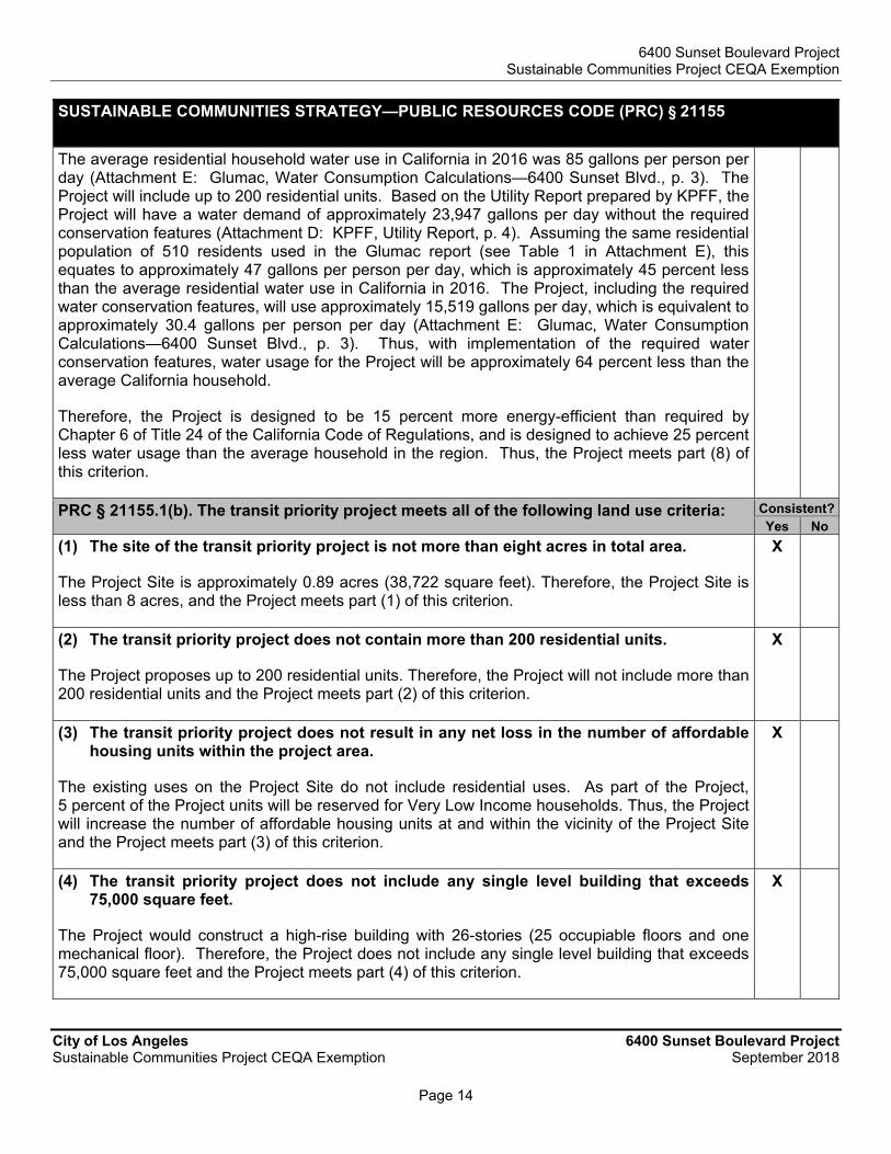
6400 Sunset Boulevard Project Sustainable Communities Project CEQA Exemption
City of Los Angeles 6400 Sunset Boulevard Project Sustainable Communities Project CEQA Exemption September 2018
Page 14
SUSTAINABLE COMMUNITIES STRATEGY—PUBLIC RESOURCES CODE (PRC) § 21155
The average residential household water use in California in 2016 was 85 gallons per person per day (Attachment E: Glumac, Water Consumption Calculations—6400 Sunset Blvd., p. 3). The Project will include up to 200 residential units. Based on the Utility Report prepared by KPFF, the Project will have a water demand of approximately 23,947 gallons per day without the required conservation features (Attachment D: KPFF, Utility Report, p. 4). Assuming the same residential population of 510 residents used in the Glumac report (see Table 1 in Attachment E), this equates to approximately 47 gallons per person per day, which is approximately 45 percent less than the average residential water use in California in 2016. The Project, including the required water conservation features, will use approximately 15,519 gallons per day, which is equivalent to approximately 30.4 gallons per person per day (Attachment E: Glumac, Water Consumption Calculations—6400 Sunset Blvd., p. 3). Thus, with implementation of the required water conservation features, water usage for the Project will be approximately 64 percent less than the average California household.
Therefore, the Project is designed to be 15 percent more energy-efficient than required by Chapter 6 of Title 24 of the California Code of Regulations, and is designed to achieve 25 percent less water usage than the average household in the region. Thus, the Project meets part (8) of this criterion.
PRC § 21155.1(b). The transit priority project meets all of the following land use criteria: Consistent?Yes No
(1) The site of the transit priority project is not more than eight acres in total area.
The Project Site is approximately 0.89 acres (38,722 square feet). Therefore, the Project Site is less than 8 acres, and the Project meets part (1) of this criterion.
X
(2) The transit priority project does not contain more than 200 residential units.
The Project proposes up to 200 residential units. Therefore, the Project will not include more than 200 residential units and the Project meets part (2) of this criterion.
X
(3) The transit priority project does not result in any net loss in the number of affordable housing units within the project area.
The existing uses on the Project Site do not include residential uses. As part of the Project, 5 percent of the Project units will be reserved for Very Low Income households. Thus, the Project will increase the number of affordable housing units at and within the vicinity of the Project Site and the Project meets part (3) of this criterion.
X
(4) The transit priority project does not include any single level building that exceeds 75,000 square feet.
The Project would construct a high-rise building with 26-stories (25 occupiable floors and one mechanical floor). Therefore, the Project does not include any single level building that exceeds 75,000 square feet and the Project meets part (4) of this criterion.
X
6400 Sunset Boulevard Project Sustainable Communities Project CEQA Exemption
City of Los Angeles 6400 Sunset Boulevard Project Sustainable Communities Project CEQA Exemption September 2018
Page 15
SUSTAINABLE COMMUNITIES STRATEGY—PUBLIC RESOURCES CODE (PRC) § 21155
(5) Any applicable mitigation measures or performance standards or criteria set forth in the prior environmental impact reports, and adopted in findings, have been or will be incorporated into the transit priority project.
The City has identified four prior environmental impact reports (EIRs) (collectively the “Prior EIRs”) with mitigation measures that apply to the Project Site: (i) Hollywood Redevelopment Project Final EIR (January 1986); (ii) Hollywood Community Plan Revision Final EIR (July 1988); (iii) Hollywood Redevelopment Plan Amendment Final EIR (February 2003); and (iv) SCAG 2016-2040 RTP/SCS Final Program EIR (April 2016). Each of these Prior EIRs are included in Attachment J.
The City, in its independent judgment, has determined that some of the mitigation measures, performance standards or criteria in the Prior EIRs (collectively “Mitigation Measures”) are applicable to the Project and some are not applicable. These Mitigation Measures will be incorporated into the Project as either a Project Condition or as a result of compliance with existing regulatory requirements. The Mitigation Measures that will be applied to the Project as Project Conditions are identified in Table K-1 of Attachment K. The Mitigation Measures that will be applied to the Project as a result of compliance with regulatory requirements are identified in Table K-2 of Attachment K. The Mitigation Measures that are not applicable to the Project are listed in Table K-3 of Attachment K, along with an explanation of why they are not applicable to the Project.
The following technical reports were prepared to assess Project-specific impacts and the applicability of corresponding Mitigation Measures: (i) Attachment C—Transportation Impact Study (Gibson); (ii) Attachment D—Wastewater and Water Utility Infrastructure Technical Report (KPFF); (iii) Attachment E—Water Consumption Calculations (Glumac); (iv) Attachment F—Environmental Site Assessment—Phase I PEA Formatted Report (CE); (v) Attachment G—Historic Resources Technical Report (HRG); (vi) Attachment H—Geotechnical Engineering Investigation (Geotechnologies); (vii) Attachment I—Title 24 Energy Performance Report (Glumac); (viii) Attachment L—Paleontological Resource Evaluation and Impact Assessment (SRI); and, (ix) Attachment M—Vibration Impacts Analysis (AES). These reports concluded, and upon its review, the City has determined, that the Project will have less than significant impacts in the following environmental areas: (i) Transportation and Traffic; (ii) Utilities; (iii) Water; and, (iv) Vibrations. As a result, the City has determined in its independent judgment that Mitigation Measures identified in the Prior EIRs that address these four areas of environmental concern are not applicable to the Project.
Based on the technical appendices prepared for the Project and all other documents in the record, the City determines that the Project has potential impacts that require the incorporation of applicable Mitigation Measures contained in the Prior EIRs for the following impact categories: Air Quality, Cultural Resources, Geology, GHGs, Energy, Land Use, Noise, Public Services, and Recreation, Utilities and Service Systems: As noted above, the City is incorporating into the Project the applicable Mitigation Measures for these identified impact categories, as set forth in Attachment K, Table K-1 and K.2. Thus, the Project meets part (5) of this criterion.
X

6400 Sunset Boulevard Project Sustainable Communities Project CEQA Exemption
City of Los Angeles 6400 Sunset Boulevard Project Sustainable Communities Project CEQA Exemption September 2018
Page 16
SUSTAINABLE COMMUNITIES STRATEGY—PUBLIC RESOURCES CODE (PRC) § 21155
(6) The transit priority project is determined not to conflict with nearby operating industrial uses.
The nearest site utilized and zoned for industrial uses is located approximately 2,000 feet east of the Project Site, on the southeast corner of Sunset Boulevard and Gower Street, occupied by Sunset Gower Studios (a production studio). The site is zoned “M1-1,” which is a limited industrial zone and allows for light manufacturing uses by the City (City of Los Angeles Department of City Planning, ZIMAS, http://zimas.lacity.org/). Due to distance from the Project as well as the buffering provided by existing development located between the Project and the nearest industrial zoned site, the Project will not conflict with nearby operating industrial uses and, therefore, meets part (6) of this criterion.
X
(7) The transit priority project is located within one-half mile of a rail transit station or a ferry terminal included in a regional transportation plan or within one-quarter mile of a high quality transit corridor included in a regional transportation plan.
The Metro Red Line Hollywood/Vine Station is located approximately 0.3 mile northeast of the Project Site. In addition, Sunset Boulevard is considered a high quality transit corridor since it has fixed route bus service provided by Metro Local Line 2 and Metro Limited Line 302 (Attachment C: Gibson, Traffic Study, p. 18-20 and Figure 3 on p. 25). Therefore, the Project Site is located within one-half mile of a rail transit station and directly within a high quality transit corridor included in a regional transportation plan. As such, the Project meets part (7) of this criterion.
X
PRC 21155.1(c). The transit priority project meets at least one of the following three criteria:
Consistent?Yes No
(1) The transit priority project meets both of the following:
(A) At least 20 percent of the housing will be sold to families of moderate income, or not less than 10 percent of the housing will be rented to families of low income, or not less than 5 percent of the housing is rented to families of very low income.
(B) The transit priority project developer provides sufficient legal commitments to the appropriate local agency to ensure the continued availability and use of the housing units for very low, low-, and moderate-income households at monthly housing costs with an affordable housing cost or affordable rent, as defined in Section 50052.5 or 50053 of the Health and Safety Code, respectively, for the period required by the applicable financing. Rental units shall be affordable for at least 55 years. Ownership units shall be subject to resale restrictions or equity sharing requirements for at least 30 years.
Five percent of the 200 proposed residential units (10 units) shall be reserved for Very Low Income households for at least 55 years. Therefore, not less than 5 percent of the housing shall be rented to Very Low Income Households. The Project operator will enter into a housing regulatory agreement memorializing these requirements and making them binding on any successors or assigns for the regulatory period. Thus, the Project meets this criterion.
X

6400 Sunset Boulevard Project Sustainable Communities Project CEQA Exemption
City of Los Angeles 6400 Sunset Boulevard Project Sustainable Communities Project CEQA Exemption September 2018
Page 17
SUSTAINABLE COMMUNITIES STRATEGY—PUBLIC RESOURCES CODE (PRC) § 21155
(2) The transit priority project developer has paid or will pay in-lieu fees pursuant to a local ordinance in an amount sufficient to result in the development of an equivalent number of units that would otherwise be required pursuant to paragraph (1).
The Project meets part (1) of this criterion, above. Therefore, the Project meets the requirements of PRC 21155.1(c).
N/A
(3) The transit priority project provides public open space equal to or greater than five acres per 1,000 residents of the project.
The Project meets part (1) of this criterion, above. Therefore, the Project meets the requirements of PRC 21155.1(c).
N/A

Exhibit E

CPC-2016-3630 Condition Reporting Program
Page 1 City of Los Angeles 6400 Sunset CPC-2016-3630-ZC-HD-DB-MCUP-SPP-SPR
Sustainable Communities Project Exemption Summary Senate Bill 375 (“SB 375”), enacted on September 30, 2008 to incentivize development of environmentally superior residential projects near transit, created a statutory exemption to the California Environmental Quality Act (“CEQA”) for transit priority projects that meet rigorous statutory requirements. A transit priority project is defined as a project that shall:
(1) contain at least 50 percent residential use; based on total building square footage and, if the project contains between 26 and 50 percent nonresidential uses, a floor area ratio of not less than 0.75;
(2) provide a minimum net density of at least 20 dwelling units per acre; and
(3) be within one-half mile of a major transit stop or high-quality transit corridor included in a regional transportation plan. Specifically, for a transit priority project to be considered for an exemption, the City Council, after conducting a public hearing, must find that specific environmental criteria, land-use criteria, and one of three affordable housing criteria have all been met.
Pursuant to Public Resources Code, Section 21155.1, a Sustainable Communities Project CEQA Statutory Exemption (“SCPE”) was prepared for the Project. The Department of City Planning recommended that the City Council consider and determine that the Project satisfies all of the SCPE’s criteria, and is therefore exempt from CEQA pursuant to Public Resource Code (PRC) Section 21155.1, as set forth in the SCPE. On November 6, 2018, after a duly-noticed public hearing and based on the whole of the administrative record, the City Council’s Planning and Land Use Management Committee made a recommendation to the full City Council to determine that the Project is exempt from CEQA pursuant to PRC Section 21155.1 as a Sustainable Communities Project. Notice of the hearing before the Planning and Land Use Management Committee was provided October 2, 2018. On November 21, 2018, after a duly-noticed public hearing and based on the whole of the administrative record and using its independent judgment, the City Council found that the Project met the criteria for a Sustainable Communities Project exemption and approved the exemption pursuant to PRC Section 21155.1. An additional requirement of PRC Section 21155.1 (b)(5) requires any applicable mitigation measures or performance standards from prior EIRs be incorporated into the project. On Page 14 of the exemption document, a discussion of prior EIRs and applicability is provided, narrowing the applicable previous EIRs to four. The prior EIRs consist of:
1. Hollywood Redevelopment Project (1986) 2. Hollywood Community Plan (1988) 3. Hollywood Redevelopment Plan Amendment (2003) 4. SCAG 2016 RTP/SCS
For a detailed breakdown of previous EIRs and mitigation measures see the Exemption document, and attachment K.

CPC-2016-3630 Condition Reporting Program
Page 2 City of Los Angeles 6400 Sunset CPC-2016-3630-ZC-HD-DB-MCUP-SPP-SPR
Below are the applicable previous mitigations measures. I. Conditions of Approval incorporated from applicable mitigation measures
of prior EIRs
In accordance with Public Resources Code Section 21155.1(b)(5) which states the following mitigation measures, performance standards or criteria from Prior EIRs (collectively “Mitigation Measures”) have been incorporated as Project Conditions. The agency or agencies responsible for enforcement and monitoring of these Project Conditions are also provided below.0F
1
A. Noise
COA-NOI-1: The applicant shall retain an acoustical engineer to submit evidence of the application of sound insulation sufficient to mitigate interior noise levels below a CNEL of 45 dBA in any habitable room.
Enforcement Agency: Dept. of Building and Safety
Monitoring Agency: Dept. of Building and Safety
Monitoring Phase: Pre-Construction
COA-NOI-2:
• Construction and demolition shall be restricted to the hours of 7:00 am to 6:00 pm Monday through Friday, and 8:00 am to 6:00 pm on Saturday.
• Demolition and construction activities shall be scheduled so as to avoid operating several pieces of equipment simultaneously, which causes high noise levels.
• The project contractor shall use power construction equipment with state-of-the-art noise shielding and muffling devices.
• Siting of cranes, hoists, or other semi-stationary heavy equipment shall be as far from noise-sensitive uses as is practical, consistent with construction requirements.
• Electrically powered equipment shall be used instead of equipment driven by internal combustion engines where feasible.
• A temporary noise control barrier shall be installed on the property line of the construction site abutting residential and other sensitive uses. The noise control barrier shall be engineered to reduce construction-related noise levels at the adjacent residential structures. The supporting structure shall be engineered and erected according to applicable codes. The temporary barrier shall remain in
1 Note that as set forth in Table K-2 of the Sustainable Communities Project CEQA Exemption, the Project will also implement applicable mitigation measures from the prior EIRs through compliance with regulatory requirements.

CPC-2016-3630 Condition Reporting Program
Page 3 City of Los Angeles 6400 Sunset CPC-2016-3630-ZC-HD-DB-MCUP-SPP-SPR
place until all windows have been installed and all activities on the project site are complete.
Enforcement Agency: Dept. of Building and Safety
Monitoring Agency: Dept. of Building and Safety
Monitoring Phase: Pre-Construction
COA-NOI-3: The Applicant shall complete a structure vibration monitoring during the Project construction as follows:
• Prior to start of construction, the Applicant shall retain the services of a structural engineer to visit the building adjacent to the Project Site’s Northern Lot to the south (vibration building V3) to inspect and document (video and/or photographic) the apparent physical condition of the building’s readily-visible features.
• The Applicant shall retain the services of a qualified acoustical engineer to develop and implement a vibration monitoring program during the site demolition and grading/excavation capable of documenting the construction-related ground vibration levels at the building adjacent to the Project Site to the south. The vibration monitoring system shall continuously measure (in vertical and horizontal directions) and store the peak particle velocity (PPV) in inch/second. The system shall also be programmed for two preset velocity levels: a warning level of 0.25 inch/second (PPV) and a regulatory level of 0.30 inch/second (PPV). The system shall also provide real-time alert when the vibration levels exceed the two preset levels.
• The vibration monitoring program shall be submitted to the Department of Building and Safety, prior to initiating any construction activities.
• In the event the warning level of 0.25 inch/second (PPV) is triggered, the contractor shall identify the source of vibration generation and provide feasible steps to reduce the vibration level, including but not limited to halting/staggering concurrent activities and utilizing lower vibratory techniques.
• In the event the regulatory level of 0.30 inch/second (PPV) is triggered, the contractor shall halt the construction activities in the vicinity of the building and visually inspect the building for any damage. Results of the inspection must be logged. The contractor shall identify the source of vibration generation and provide feasible steps to reduce the vibration level. Construction activities may then restart.
Enforcement Agency: Dept. of Building and Safety and Dept. of City Planning
Monitoring Agency: Dept. of Building and Safety and Dept. of City Planning
Monitoring Phase: Pre-Construction
B. Geology and Soils

CPC-2016-3630 Condition Reporting Program
Page 4 City of Los Angeles 6400 Sunset CPC-2016-3630-ZC-HD-DB-MCUP-SPP-SPR
COA-GEO-1: The applicant shall record a covenant and agreement to ensure building management performs the following:
• Prepare brochures detailing what to do and where to go in the event of a major earthquake shall be prepared and distributed.
• Provide emergency evacuation assembly areas within each new medium- and high-rise building as a condition of project approval. In addition, building managers shall designate such areas in existing medium- and high-rise buildings.
• A program for earthquake education shall be implemented.
• Semi-annual earthquake response drills for employees in all buildings with over 50 occupants shall be required.
Enforcement Agency: Dept. of Building and Safety
Monitoring Agency: Dept. of Building and Safety and Los Angeles Fire Department
Monitoring Phase: Pre-Construction
C. Traffic
COA-TRA-1: A detailed Construction Management Plan, including street closure information, a detour plan, haul routes, and a staging plan, would be prepared and submitted to the City for review and approval. The Construction Management Plan would formalize how construction would be carried out and identify specific actions that would be required to reduce effects on the surrounding community. The Construction Management Plan shall be based on the nature and timing of the specific construction activities and other projects in the vicinity of the Project Site what are under construction at the same time, and shall include, but not be limited to, the following elements, as appropriate:
• Advance notification of adjacent property owners and occupants, as well as any nearby schools, of upcoming construction activities, including durations and daily hours of construction.
• Prohibition of construction worker parking on adjacent residential streets.
• Temporary pedestrian and vehicular traffic controls during all construction activities adjacent to Sunset Boulevard, Cahuenga Boulevard and Ivar Avenue to ensure traffic safety on public right of ways. These controls shall include, but are not limited to, flag people trained in pedestrian and student safety.
• Temporary traffic control during all construction activities adjacent to public rights-of-way to improve traffic flow on public roadways (e.g., flag men).
• Scheduling of construction activities to reduce the effect on traffic flow on surrounding arterial streets.
CPC-2016-3630 Condition Reporting Program
Page 5 City of Los Angeles 6400 Sunset CPC-2016-3630-ZC-HD-DB-MCUP-SPP-SPR
• Parking restrictions on construction-related vehicles parking on surrounding public streets.
• Safety precautions for pedestrians and bicyclists through such measures as alternate routing and protection barriers as appropriate, including along all identified Los Angeles Unified School District (LAUSD) pedestrian routes to nearby schools.
• Safety precautions for pedestrians and bicyclists through such measures as alternate routing and protection barriers as appropriate.
• Scheduling of construction-related deliveries, haul trips, etc., so as to occur outside the commuter peak hours to the extent feasible, and so as to not impede school drop-off and pick-up activities and students using LAUSD’s identified pedestrian routes to nearby schools.
• Advanced notification of temporary parking removals and duration of removals. Enforcement Agency: Dept. of Transportation
Monitoring Agency: Dept. of Transportation and Dept. of Building and Safety
Monitoring Phase: Pre-Construction
D. Cultural Resources
COA-CUL-1: The services of a qualified paleontologist for the City or Los Angeles County, as applicable, shall be retained prior to earthmoving activities associated with construction, in order to carry out a comprehensive Paleontological Resource Management Plan (PRMP). A qualified paleontologist is defined as an individual with an M.S. or Ph.D. in paleontology or geology who is familiar with paleontological procedures and techniques, is knowledgeable in the geology and paleontology of the region, and has worked as a paleontological resource management project supervisor in the region for at least 1 year. It is recommended that a field reconnaissance survey of the Project area be conducted by a qualified paleontologist prior to any earthmoving activities, in order to visually inspect the ground surface for the presence of any exposed paleontological resources and to evaluate any exposed geologic features in the vicinity of the Project.
Prior to earthmoving activities, a qualified paleontologist shall develop a site-specific PRMP to be implemented during construction activities. During Project planning and construction, the PRMP shall be implemented under a qualified professional paleontologist (as defined above). The plan shall specify the level and types of monitoring and treatment efforts, based on the types and depths of earthmoving activities and the geologic and paleontological settings of the Project area. If artificial fill, significantly disturbed deposits, or younger deposits (too recent to contain paleontological resources) are encountered during construction, the Project paleontologist may reduce or curtail monitoring in the affected areas, after consultation with the Project proponent and the City.
Enforcement Agency: Dept. of City Planning and Dept. of City Planning

CPC-2016-3630 Condition Reporting Program
Page 6 City of Los Angeles 6400 Sunset CPC-2016-3630-ZC-HD-DB-MCUP-SPP-SPR
Monitoring Agency: Dept. of Building and Safety and Dept. of City Planning
Monitoring Phase: Pre-Construction
COA-CUL-2: A qualified professional paleontologist should attend any pre-construction meetings, to consult with grading and excavation contractors concerning excavation schedules, paleontological field techniques, and safety issues. Communication protocols will be established to ensure that all relevant earthmoving activities are monitored and assessed to comply with the PRMP.
A paleontological monitor should be on-site at all times during the original cutting of previously undisturbed deposits of high paleontological resource potential (e.g., Quaternary old alluvial fan deposits), to inspect exposures for contained fossils. A paleontological monitor is defined as an individual who has experience in the collection and salvage of fossil materials. The paleontological monitor will work under the direction of a qualified professional paleontologist. Because of the potential for recovering small fossil remains (e.g., isolated small mammal teeth, foraminifera, or otoliths), screen washing may be required onsite at the discretion of the paleontological monitor or qualified professional paleontologist.
If paleontological resources are discovered during construction, the monitor will have the authority to temporarily divert or direct ground-disturbing activities in the immediate vicinity around the find until they are assessed for scientific significance and recovered (i.e., collected). Often fossil salvage will be completed relatively quickly. However, some fossil specimens (e.g., large skeletons) may require an extended salvage period. Such extended salvage activities rarely (if ever) stop construction activities at a project site but may require some period during which construction activities in the immediate area are redirected.
Enforcement Agency: Dept. of City Planning and Dept. of Building and Safety
Monitoring Agency: Dept. of Building and Safety and Dept. of City Planning
Monitoring Phase: Pre-Construction
COA-CUL-3: Paleontological resources collected during monitoring will be prepared in a properly equipped fossil-preparation laboratory. Preparation will include the removal of rock matrix from fossil materials as well as the stabilization, consolidation, and repair of specimens, as necessary. Fossil preparation will be done to the point that specimens are ready for curation. Specimens will be identified to the finest taxonomic level that is reasonably possible before being sorted and catalogued as part of the monitoring and treatment program.
Once prepared, fossils should be deposited (as a donation) with an appropriate public, nonprofit scientific institution with permanent paleontological collections (such as a natural-history museum), along with copies of all pertinent field notes, photographs, and maps. The cost of curation and accession of fossil specimens at such a repository will be the responsibility of the Project owner and is required for compliance with the PRMP.

CPC-2016-3630 Condition Reporting Program
Page 7 City of Los Angeles 6400 Sunset CPC-2016-3630-ZC-HD-DB-MCUP-SPP-SPR
Enforcement Agency: Dept. of City Planning and Dept. of Building and Safety
Monitoring Agency: Dept. of Building and Safety and Dept. of City Planning
Monitoring Phase: Pre-Construction
COA-CUL-4: Following the conclusion of all monitoring, laboratory work, and curation, a final summary report will be completed that describes the results of the paleontological resource monitoring and treatment program. This report will include an overview of the methods and procedures used during the monitoring and treatment program, describe the stratigraphy exposed and the fossils collected during construction activities, and discuss the significance of recovered fossil finds. If monitoring efforts during the monitoring program produce fossil remains, then a copy of the final report will be provided to the designated scientific institution where the fossil specimens are deposited.
Enforcement Agency: Dept. of City Planning and Dept. of Building and Safety
Monitoring Agency: Dept. of Building and Safety and Dept. of City Planning
Monitoring Phase: Pre-Construction

Exhibit F

FORM GEN. 160A (Rev. 1/82)
CITY OF LOS ANGELES
INTER-DEPARTMENTAL CORRESPONDENCE 6400 W. Sunset Bl DOT Case No. CEN 16-44489
Date: February 12, 2018 To: Luciralia Ibarra, Senior City Planner
Department of City Planning From: Wes Pringle, Transportation Engineer
Department of Transportation Subject: TRAFFIC ANALYSIS FOR THE PROPOSED DEVELOPMENT PROJECT
LOCATED AT 6400 WEST SUNSET BOULEVARD DOT has reviewed the traffic analysis, prepared by Gibson Transportation, dated January 2018, for the proposed mixed-use project located on the southeast corner of Cahuenga Boulevard and Sunset Boulevard. The study evaluated sixteen intersections and determined that, based on DOT’s current traffic impact criteria1, none of the study intersections would be significantly impacted by project-related traffic. The results of the traffic analysis, which accounted for other known development projects in evaluating potential cumulative impacts and adequately evaluated the project’s traffic impacts on the surrounding community, are summarized in Attachment 1. DISCUSSION AND FINDINGS A. Project Description
The project proposes to construct 200 Apartments, 4,000 square-feet of high turnover restaurant, and 3,000 square-feet of quality restaurant use. The site is currently occupied by 43,077 square-feet of retail space. The project would provide 294 parking spaces on site and in an existing surface parking lot south of the project site. Vehicles access parking via a full service driveway on Ivar Avenue and a right-turn ingress/egress only driveway on Cahuenga Boulevard. The existing surface parking lot south of the project site will maintain the current access, ingress only on Ivar Avenue and egress only on Cahuenga Boulevard. The project is expected to be completed by 2020.
B. Trip Generation
The project is estimated to generate a net increase of approximately 11 daily trips, 91 trips during the a.m. peak hour and 51 trips during the p.m. peak hour. These estimates were derived using trip generation rates from the Institute of Transportation Engineers (ITE) “Trip Generation Handbook, 9th Edition.” A copy of the trip generation table from the traffic study can be found in Attachment 2.
1 Per DOT’s Traffic Study Policies and Procedures, a significant impact is identified as an increase in the Critical
Movement Analysis (CMA) value, due to project related traffic, of 0.01 or more when the final (“with project”) Level of Service (LOS) is LOS E or F; an increase of 0.020 or more when the final LOS is LOS D; or an increase of 0.040 or more when the final LOS is LOS C.

Luciralia Ibarra - 2 - February 12, 2018
C. Freeway Analysis
The traffic study included a freeway impact analysis that was prepared in accordance with the State-mandated Congestion Management Program (CMP) administered by the Los Angeles County Metropolitan Transportation Authority (MTA). According to this analysis, the project would not result in significant traffic impacts on any of the evaluated freeway mainline segments. To comply with the Freeway Analysis Agreement executed between Caltrans and DOT in October 2013, the study also included a screening analysis to determine if additional evaluation of freeway mainline and ramp segments was necessary beyond the CMP requirements. Exceeding one of the four screening criteria would require the applicant to work directly with Caltrans to prepare more detailed freeway analyses. However, the project did not meet or exceed any of the four thresholds defined in the agreement; therefore, no additional freeway analysis was required.
PROJECT REQUIREMENTS A. Construction Impacts
DOT recommends that a construction work site traffic control plan be submitted to DOT for review and approval prior to the start of any construction work. The plan should show the location of any roadway or sidewalk closures, traffic detours, haul routes, hours of operation, protective devices, warning signs and access to abutting properties. DOT also recommends that all construction related traffic be restricted to off-peak hours.
B. Highway Dedication And Street Widening Requirements
On January 20, 2016, the City Council adopted the Mobility Plan 2035 which represents the new Mobility Element of the General Plan. A key feature of the updated plan is to revise street standards in an effort to provide a more enhanced balance between traffic flow and other important street functions including transit routes and stops, pedestrian environments, bicycle routes, building design and site access, etc. Per the new Mobility Element, Sunset Boulevard has been designated an Avenue I which would require a 35-foot half-width roadway within a 50-foot half-width right-of-way and Cahuenga Boulevard has been designated as a Modified Avenue II which would require a 28-foot half-width roadway within a 40-foot half-width right-of-way. Ivar Avenue has been designated as a Local Street which would require an 18-foot half-width roadway within a 30-foot half-width right-of-way. The applicant should check with Bureau of Engineering’s Land Development Group to determine the specific highway dedication, street widening and/or sidewalk requirements for this project.
C. Parking Requirements
The traffic study indicated that 294 off-street parking spaces would be provided by the project. The applicant should check with the Department of Building and Safety on the number of Code-required parking spaces needed for the project.

Luciralia Ibarra - 3 - February 12, 2018
D. Driveway Access and Circulation The conceptual site plan for the project (illustrated in Attachment 3) does not include any driveways. While there may not be any review required, the review of this study does not constitute approval of any issues regarding driveway dimensions, access or the circulation scheme. Those require separate review and approval and should be coordinated with DOT’s Citywide Planning Coordination Section (201 North Figueroa Street, Room 550, at 213-482-7024). In order to minimize and prevent last minute building design changes, the applicant should contact DOT, prior to the commencement of building or parking layout design efforts, for driveway width and internal circulation requirements so that such traffic flow considerations are designed and incorporated early into the building and parking layout plans. New driveways should be a Case 2 - designed with a recommended width of 30 feet for two-way operations. Delivery truck loading and unloading should take place on site with no vehicles having to back into the project via the proposed project driveway.
E. Development Review Fees An ordinance adding Section 19.15 to the Los Angeles Municipal Code relative to application fees paid to DOT for permit issuance activities was adopted by the Los Angeles City Council in 2009 and updated in 2014. This ordinance identifies specific fees for traffic study review, condition clearance, and permit issuance. The applicant shall comply with any applicable fees per this ordinance.
If you have any questions, please contact me at (213) 972-8482. Attachments G:\Expedited Studies\6400 Sunset\CEN 16-44489_6400 Sunset Bl mixed-use ts ltr.docx c: Amy Ablakat, Council District No. 13
Carl Mills, Central District, BOE Bhuvan Bajaj, Hollywood-Wilshire District, DOT
Taimour Tanavoli, Case Management, DOT Casey Le, Gibson Transportation Consulting, Inc.

TABLE 10
FUTURE WITH PROJECT CONDITIONS (YEAR 2021)
SIGNIFICANT IMPACT ANALYSIS
Future without Project
ConditionsFuture with Project Conditions
V/C LOS V/C LOSChange in
V/C
Significant
Impact
1. Wilcox Ave & AM 0.865 D 0.865 D 0.000 NO
Hollywood Blvd PM 0.721 C 0.721 C 0.000 NO
2. Cahuenga Blvd & AM 0.960 F * 0.961 F * 0.001 NO
Hollywood Blvd PM 0.799 F * 0.799 F * 0.000 NO
3. Ivar Ave & AM 0.626 B 0.627 B 0.001 NO
Hollywood Blvd PM 0.622 B 0.622 B 0.000 NO
4. Vine St & AM 0.894 F * 0.894 F * 0.000 NO
Hollywood Blvd PM 0.906 F * 0.907 F * 0.001 NO
5. Wilcox Ave & AM 0.385 A 0.385 A 0.000 NO
Selma Ave PM 0.503 A 0.503 A 0.000 NO
6. Cahuenga Blvd & AM 0.514 A 0.515 A 0.001 NO
Selma Ave PM 0.530 A 0.533 A 0.003 NO
7. Ivar Ave & AM 0.272 A 0.273 A 0.001 NO
Selma Ave PM 0.299 A 0.299 A 0.000 NO
8. Vine St & AM 0.628 B 0.629 B 0.001 NO
Selma Ave PM 0.620 B 0.620 B 0.000 NO
9. Wilcox Ave & AM 0.641 B 0.643 B 0.002 NO
Sunset Blvd PM 0.680 B 0.684 B 0.004 NO
10. Cahuenga Blvd & AM 0.946 F * 0.955 F * 0.009 NO
Sunset Blvd PM 0.841 F * 0.840 F * -0.001 NO
11. Ivar Ave & AM 0.554 A 0.555 A 0.001 NO
Sunset Blvd PM 0.634 B 0.648 B 0.014 NO
12. Vine St & AM 0.958 F * 0.964 F * 0.006 NO
Sunset Blvd PM 1.141 F * 1.141 F * 0.000 NO
13. Wilcox Ave & AM 0.573 A 0.579 A 0.006 NO
Fountain Ave PM 0.607 B 0.611 B 0.004 NO
14. Cahuenga Blvd & AM 0.827 D 0.833 D 0.006 NO
Fountain Ave PM 0.780 C 0.783 C 0.003 NO
15. Vine St & AM 0.828 D 0.829 D 0.001 NO
Fountain Ave PM 0.810 D 0.810 D 0.000 NO
16. Cahuenga Blvd & AM 0.453 A 0.464 A 0.011 NO
De Longpre Ave PM 0.492 A 0.494 A 0.002 NO
Notes
* LOS based on field observations, as the CMA methodology for individual intersections does not in every case account for vehicular queues along corridors,
pedestrian, conflicts, etc., and thus, the calculated average operating conditions may appear better than is observed.
No. Intersection Peak Hour
Attachment 1 6400 W. Sunset Bl
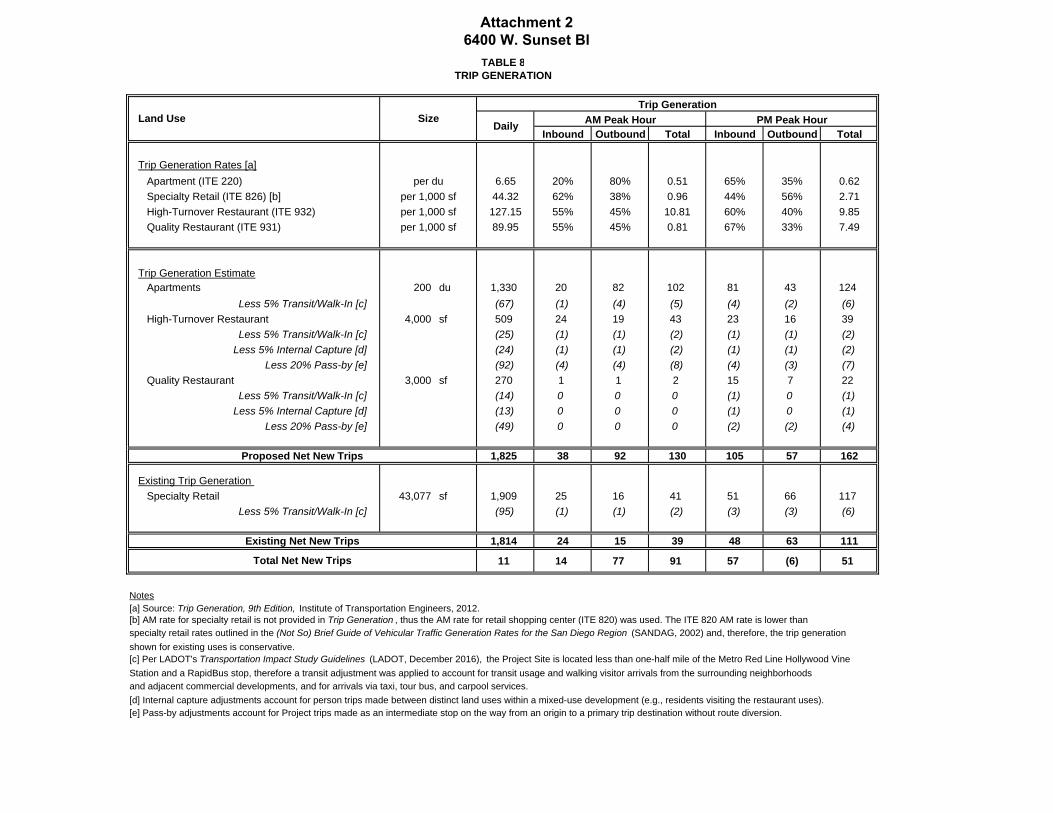
TABLE 8
TRIP GENERATION
Trip Generation
AM Peak Hour PM Peak Hour
Inbound Outbound Total Inbound Outbound Total
Trip Generation Rates [a]
Apartment (ITE 220) per du 6.65 20% 80% 0.51 65% 35% 0.62
Specialty Retail (ITE 826) [b] per 1,000 sf 44.32 62% 38% 0.96 44% 56% 2.71
High-Turnover Restaurant (ITE 932) per 1,000 sf 127.15 55% 45% 10.81 60% 40% 9.85
Quality Restaurant (ITE 931) per 1,000 sf 89.95 55% 45% 0.81 67% 33% 7.49
Trip Generation Estimate
Apartments 200 du 1,330 20 82 102 81 43 124
Less 5% Transit/Walk-In [c] (67) (1) (4) (5) (4) (2) (6)High-Turnover Restaurant 4,000 sf 509 24 19 43 23 16 39
Less 5% Transit/Walk-In [c] (25) (1) (1) (2) (1) (1) (2)Less 5% Internal Capture [d] (24) (1) (1) (2) (1) (1) (2)
Less 20% Pass-by [e] (92) (4) (4) (8) (4) (3) (7)Quality Restaurant 3,000 sf 270 1 1 2 15 7 22
Less 5% Transit/Walk-In [c] (14) 0 0 0 (1) 0 (1)Less 5% Internal Capture [d] (13) 0 0 0 (1) 0 (1)
Less 20% Pass-by [e] (49) 0 0 0 (2) (2) (4)
Proposed Net New Trips 1,825 38 92 130 105 57 162
Existing Trip Generation
Specialty Retail 43,077 sf 1,909 25 16 41 51 66 117
Less 5% Transit/Walk-In [c] (95) (1) (1) (2) (3) (3) (6)
Existing Net New Trips 1,814 24 15 39 48 63 111
11 14 77 91 57 (6) 51
Notes
[a] Source: Trip Generation, 9th Edition, Institute of Transportation Engineers, 2012.
[b] AM rate for specialty retail is not provided in Trip Generation , thus the AM rate for retail shopping center (ITE 820) was used. The ITE 820 AM rate is lower than
specialty retail rates outlined in the (Not So) Brief Guide of Vehicular Traffic Generation Rates for the San Diego Region (SANDAG, 2002) and, therefore, the trip generation
shown for existing uses is conservative.
[c] Per LADOT's Transportation Impact Study Guidelines (LADOT, December 2016), the Project Site is located less than one-half mile of the Metro Red Line Hollywood Vine
Station and a RapidBus stop, therefore a transit adjustment was applied to account for transit usage and walking visitor arrivals from the surrounding neighborhoods
and adjacent commercial developments, and for arrivals via taxi, tour bus, and carpool services.
[d] Internal capture adjustments account for person trips made between distinct land uses within a mixed-use development (e.g., residents visiting the restaurant uses).
[e] Pass-by adjustments account for Project trips made as an intermediate stop on the way from an origin to a primary trip destination without route diversion.
Land Use SizeDaily
Total Net New Trips
Attachment 2 6400 W. Sunset Bl
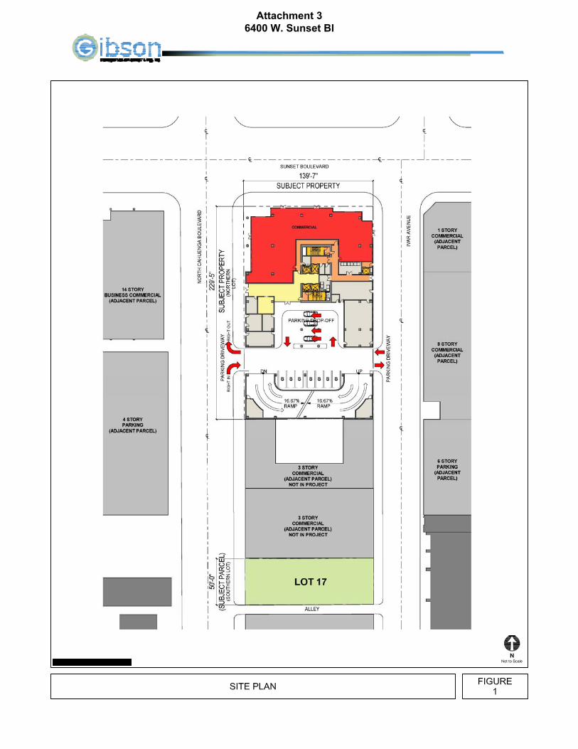
Attachment 3 6400 W. Sunset Bl