consultancy services for preparation of two stage dpr of cluster ...
101
CONSULTANCY SERVICES FOR PREPARATION OF TWO STAGE DPR OF CLUSTER VII OF PROPOSED 53 NATIONAL WATERWAYS FEASIBILITY REPORT-SAL RIVER (14KM) - (NW-88) Project No. P.009051 Document No. P.009051-W-10204-D03 Final Report Goa and Maharashtra | INDIA Inland Waterways Authority of India (IWAI) - Government of India Ministry of Shipping - Head Office RESTRICTED 23 September 2016 Report Rev.03
-
Upload
khangminh22 -
Category
Documents
-
view
1 -
download
0
Transcript of consultancy services for preparation of two stage dpr of cluster ...
CONSULTANCY SERVICES FORPREPARATION OF TWO STAGEDPR OF CLUSTER VII OFPROPOSED 53 NATIONALWATERWAYS FEASIBILITY REPORT-SAL RIVER (14KM) - (NW-88)Project No. P.009051Document No. P.009051-W-10204-D03Final Report
Goa and Maharashtra | INDIAInland Waterways Authority of India(IWAI) - Government of India Ministry ofShipping - Head Office
RESTRICTED
23 September 2016ReportRev.03

CATEGORY-II WATERWAYS: STAGE-I REPORTS
SALIENT FEATURES AT A GLANCE
Sl. No.
Particulars Details
1. Name of Consultant Tractebel Engineering Pvt. Ltd.
2. Cluster Number & State(s) Cluster-VII & Goa
3. Waterway stretch, NW# Sal River (14 km), NW-88
4. Navigability status
a) Tidal & non tidal portions
(from……….to, length, average tidal variation)
Fully Tidal (Chainage 0.0 km to Chainage 14.26 km, average tidal
variation of 1.15 m)
Tidal Variation 0.00m/2.30m
b) LAD status (w.r.t.CD)
i) Survey period (01/03/2016)
ii) < 1.0 m (km)
iii) 1.0 m to 1.5 m (km)
iv) 1.5 m to 2.0 (km)
v) >2.0 m (km)
0 - 3 3 - 7 7 - 10 10 – 14.26 Total
0.37 1.03 1.04 1.96 4.40
0.68 1.03 0.23 1.27 3.21
0.97 0.82 0.92 0.69 3.40
0.97 1.12 0.81 0.35 3.25
c) Cross Structures
i) Dams, weirs, barrage etc.
(total number; with navigation locks or not)
ii) Bridges, Power cables etc. (total number; range of
horizontal and vertical
clearances)
Cross Structures
i) Nil
ii) 1 no. of Bridge, HC: 42 m , VC: 8.5 m
1 no. HT line, VC : 10.0 m
2 no. Electric line, VC: 6.5 m – 8.5 m
(VC are above MHWS/HFL)
d) Avg. discharge & no. of days Since the entire stretch is tidal, discharge of the river is not relevant for navigability.
e) Slope (1 in………) 1 in 7000
5. Traffic Potential
a) Present IWT operations, ferry services, tourism, cargo, if any
Ferry services are under operation at Cavelossim and Aslona.
b) Important industries within 50
km
Cuncolim Industrial Estate (Approx 8km from nearest River Front) &
Margao Industrial Estate (Approx 8km from nearest River Front) (For details Refer Annexure 4.1)
c) Distance of Rail & Road from
Industry
--
6. Consultant’s recommendation
for going ahead with Stage-II
(DPR preparation)
Recommended for development as Class-III waterway for Ch 0.00
km to 14.26km.
7. Any other information/comment MHWS –2.37m, HTL—2.37m, LTL—0.00m, Average Tidal
Variation—1.15m, Port Name: Marmagao Port.
Date: 23-09-2016
Consultant signature

FEASIBILITY REPORT SAL RIVER (NW-88)
P.009051 W-10204
D03
Rev.03-23.09.2016 Cluster-VII (Goa & Maharashtra)/Inland Waterways Authority of India Page 1 of 65
CONSULTANCY SERVICES FOR PREPARATION OF TWO
STAGE DETAILED PROJECT REPORT OF PROPOSED 53
NATIONAL WATERWAYS
SAL RIVER
(NW-88)
CLUSTER - VII
GOA AND MAHARASHTRA, INDIA
03 23.09.2016 For Acceptance N Bawa Pradyumna Machhkhand
B. C. Jha
Rev. Date Description Prepared By Checked By Approved By
FEASIBILITY REPORT SAL RIVER (NW-88)
P.009051 W-10204
D03
Rev.03-23.09.2016 Cluster-VII (Goa & Maharashtra)/Inland Waterways Authority of India Page 2 of 65
TABLE OF CONTENTS
LIST OF ABBREVIATIONS ................................................................................................. 4
LIST OF ANNEXURES ........................................................................................................ 6
LIST OF DRAWINGS ......................................................................................................... 6
LIST OF MAPS ............................................................................................................... 6
LIST OF TABLES ............................................................................................................... 7
LIST OF FIGURES ............................................................................................................. 8
EXECUTIVE SUMMARY ..................................................................................................... 9
CHAPTER 1: INTRODUCTION ........................................................................................ 17
1.1 Introduction to Inland Waterways .................................................................................... 17
1.2 Project Background of the Present Study ......................................................................... 19
1.3 Objectives of the Study ..................................................................................................... 23
1.4 Scope of the Assignment ................................................................................................... 23
1.5 Methodology Adopted ........................................................................................................ 23
1.5.1 Physical System .......................................................................................................................... 24
1.5.2 Current Functions ....................................................................................................................... 24
1.5.3 Market Potential .......................................................................................................................... 25
1.6 Collection of Data .............................................................................................................. 26
1.7 Expected Outcome of the Assignment............................................................................... 28
1.8 Description of Sal River (NW-88) ...................................................................................... 29
1.9 Structure of the Feasibility Study Report (FSR) ................................................................ 29
CHAPTER 2 ANALYSIS OF PRESENT STATE OF AFFAIRS .............................................. 32
2.1 Current Utilization ............................................................................................................. 32
2.2 Existing Waterway Structures ........................................................................................... 32
2.3 Crossing Over Sal River Water Way .................................................................................. 34
2.4 Connectivity of Waterway ................................................................................................. 34
2.5 Important Places ............................................................................................................... 35
2.6 Road Connectivity .............................................................................................................. 35
2.7 Rail Connectivity ................................................................................................................ 36
2.8 Status of Goods Transport ................................................................................................. 36
2.9 Conclusion ......................................................................................................................... 36
CHAPTER 3 RECONNAISSANCE SURVEY ...................................................................... 37
3.1 River Profile ....................................................................................................................... 37
3.2 Reconnaissance Survey ..................................................................................................... 38
3.2.1 Methodology of Survey ................................................................................................................ 38

FEASIBILITY REPORT SAL RIVER (NW-88)
P.009051 W-10204
D03
Rev.03-23.09.2016 Cluster-VII (Goa & Maharashtra)/Inland Waterways Authority of India Page 3 of 65
3.2.2 Chart Datum of the Proposed Waterway ....................................................................................... 40
3.2.3 Bathymetry and Site Data Collected ............................................................................................. 40
3.2.4 Soil Texture Classification ............................................................................................................ 45
3.3 Classification of Waterways .............................................................................................. 45
3.3.1 Cross Over Structures ................................................................................................................. 47
3.3.2 Dams, Barrages and Reservoirs ................................................................................................... 48
3.3.3 Bends along the Route ................................................................................................................ 48
3.3.4 Gauge & Discharge data .............................................................................................................. 48
3.3.5 Bed Profile of Waterway .............................................................................................................. 48
3.4 Agencies to be approached for Clearances, if any ............................................................. 49
3.4.1 Compilation of Data in Feasibility Format ...................................................................................... 50
3.5 Conclusion ......................................................................................................................... 50
CHAPTER 4 MARKET ANALYSIS .................................................................................... 52
4.1 Introduction....................................................................................................................... 52
4.2 Existing Profile................................................................................................................... 52
4.3 Existing Cargo Traffic ........................................................................................................ 55
4.4 Future Cargo Potential ...................................................................................................... 55
4.5 Conclusions ........................................................................................................................ 60
CHAPTER 5 OBSERVATIONS AND INFERENCES ........................................................... 61
5.1 Waterway Feasibility ......................................................................................................... 61
5.2 Cargo Feasibility ................................................................................................................ 62
5.3 SWOT Analysis ................................................................................................................... 62
5.4 Development Cost (Tentative) .......................................................................................... 63
5.5 Classification of Waterway ................................................................................................ 64
5.6 Recommendation ............................................................................................................... 65
FEASIBILITY REPORT SAL RIVER (NW-88)
P.009051 W-10204
D03
Rev.03-23.09.2016 Cluster-VII (Goa & Maharashtra)/Inland Waterways Authority of India Page 4 of 65
LIST OF ABBREVIATIONS Abbreviations Acronyms
BFL Bombay Floating Light
CD Chart Datum
Ch Chainage
CRZ Coastal Regulation Zone
CWC Central Water Commission
DGPS Differential Global Positioning System
DFPCL Deepak Fertilizers & Petrochemical Corporation
DMIC Delhi Mumbai Industrial Corridor
DPR Detailed Project Report
FSL Full Supply Level
GAIL Gas Authority of India Ltd.
HC Horizontal Clearance
IO Iron Ores
IOCL Indian Oil Corporation Ltd.
IWAI Inland Waterways Authority of India
IWT Inland Water Transportation
KP Km Points
LAD Least Available Depth
LNG Liquefied Natural Gas
MHWS Mean High Water Spring
MIDC Maharashtra State Industrial Development Corporation
MMB Maharashtra Maritime Board
MMTPA Million Metric Tonne Per Annum
MnT Million Tonnes
MOEFCC Ministry of Environment, Forest & Climate Change
MOS Ministry of Shipping
MSEB Maharashtra State Electricity Board
MSME Micro, Small & Medium Enterprises
MSPGC Maharashtra State Power Generation company
MTPA Metric Tonne Per Annum
NH National Highway
NTPC National Thermal Power Corporation
NTPC 1980 National Transport Policy Committee, 1980
NW National Waterway
PGCIL Power Grid Corporation of India Limited
PWD Public Works Department
RGPPL Ratnagiri Gas and Power Private Limited
SEB State Electricity Board
SH State Highway

FEASIBILITY REPORT SAL RIVER (NW-88)
P.009051 W-10204
D03
Rev.03-23.09.2016 Cluster-VII (Goa & Maharashtra)/Inland Waterways Authority of India Page 5 of 65
Abbreviations Acronyms
UP Uttar Pradesh
VC Vertical Clearance
WRD Water Resources Department
WRIS Water Resources Information System of India
FEASIBILITY REPORT SAL RIVER (NW-88)
P.009051 W-10204
D03
Rev.03-23.09.2016 Cluster-VII (Goa & Maharashtra)/Inland Waterways Authority of India Page 6 of 65
LIST OF ANNEXURES
Annexure No. Title
Annexure 1.1 Data Collection & Source of Data
Annexure 3.1 Overview Chart for Sal River Bathymetry
Annexure 3.2 Daily Heights of High and Low Waters at Mormugao obtained from Captain of Ports,
Panaji, Goa
Annexure 3.3 Bathymetric Survey as Received from Hydrographic Surveyor
Annexure 3.4 Photos Captured by Survey Team during Reconnaissance Survey
Annexure 3.5 Longitudinal Bed Profile of Sal River Waterway
Annexure 3.6 Compilation of Field Information of Sal River in IWAI Format
Annexure 4.1 List of Industries in Sal River Catchment Region
LIST OF DRAWINGS Drawing No. P.009051-W-20201-A03 R0 (Sheet-1 to 1): Layout Plan – Sal River.
LIST OF MAPS
Map 4.1 – Layout Map showing existing jetties and industries in vicinity of Sal River.
FEASIBILITY REPORT SAL RIVER (NW-88)
P.009051 W-10204
D03
Rev.03-23.09.2016 Cluster-VII (Goa & Maharashtra)/Inland Waterways Authority of India Page 7 of 65
LIST OF TABLES
Table 1.1: List of Rivers/Creeks of Maharashtra and Goa under Cluster-VII (length-467.0 km) ...... 19
Table 1.2: Description of Sal River (NW-88) ............................................................................. 29
Table 2.1: Existing Facilities on Sal River (NW 88) .................................................................... 32
Table 2.2: Details of Rail and Road Bridges across Sal River ...................................................... 34
Table 2.3: List of District/Town/Taluka in vicinity of Sal River Waterway ..................................... 35
Table 3.1: Geodetic Datum and Projection Parameters .............................................................. 39
Table 3.2: Details of Chart Datum Used for Data Reduction ....................................................... 40
Table 3.3: Maximum – Minimum Depth in Sal River from Ch 0.00km – Ch 3.00km ....................... 41
Table 3.4: Maximum – Minimum Depth in Sal River from Ch 3.00km to Ch 7.00km ...................... 42
Table 3.5: Maximum – Minimum Depth in Sal River from Ch 7.00km to Ch 10.00km .................... 43
Table 3.6: Maximum – Minimum Depth in Sal River from Ch 10.00km to Ch 14.26km .................. 44
Table 3.7: Maximum – Minimum Depth in Sal River from Ch 0.00km to Ch 14.26km .................... 44
Table 3.8: Soil Texture in Sal River at 10.0km Interval .............................................................. 45
Table 3.9: Classification of Inland Waterways for Rivers ............................................................ 45
Table 3.10: Classification of Inland Waterways for Canals .......................................................... 45
Table 3.11: Classification of Vessel Size ................................................................................... 46
Table 3.12: Details of High Tension and Electric Lines across Sal River ....................................... 47
Table 3.13: Details of Bridges across Sal River .......................................................................... 47
Table 3.14: River Bend Radius in Sal River ............................................................................... 48
Table 3.15: List of Clearances and Approvals Required .............................................................. 50
Table 3.16: Classification of Proposed Waterway ...................................................................... 50
Table 3.17: Final Conclusion for Possible Navigation.................................................................. 51
Table 4.1: Industrial Units in South Goa ................................................................................... 53
Table 4.2: Industrial Profile of South Goa District ...................................................................... 53
Table 4.3: Fish Production in Goa ............................................................................................ 56
Table 4.4: Tourist Growth in Goa ............................................................................................. 58
Table 4.5: Tourist Growth in Salcete ........................................................................................ 59
Table 5.1: Tentative Development Cost of Sal River Waterway (NW 88) ..................................... 64
Table 5.2: Classification of Sal River (NW 88) ........................................................................... 64
FEASIBILITY REPORT SAL RIVER (NW-88)
P.009051 W-10204
D03
Rev.03-23.09.2016 Cluster-VII (Goa & Maharashtra)/Inland Waterways Authority of India Page 8 of 65
LIST OF FIGURES
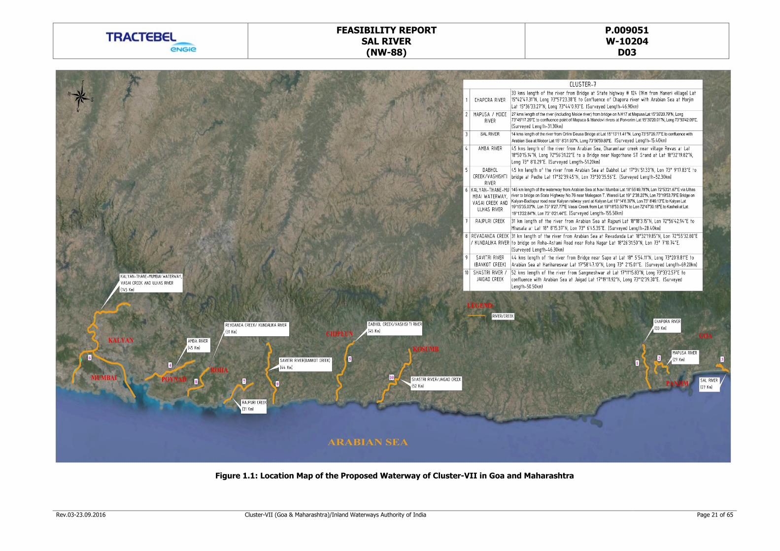
Figure 1.1: Location Map of the Proposed Waterway of Cluster-VII in Goa and Maharashtra ......... 21
Figure 1.2: Index Map of Sal River ........................................................................................... 22
Figure 2.1: Cutbona Fishing jetty at Chainage 12.00 km ............................................................ 33
Figure 2.2: Hotel on the Sal River bank at Chainage 10.70 km ................................................... 33
Figure 2.3: Boat Repairing Yard at Chainage 11.00 km .............................................................. 33
Figure 2.4: Asolna Ferry Jetty at Chainage 7.90 km .................................................................. 33
Figure 2.5: Ferry Jetty of Cavelossim village at Chainge 8.00 km ................................................ 33
Figure 2.6: View of Rail and Road Network around Sal River ...................................................... 34
Figure 3.1: Catchment Area of Sal River ................................................................................... 37
Figure 3.2: Route Map of Sal River .......................................................................................... 38
Figure 3.3: Equipment Diagram ............................................................................................... 39
Figure 3.4: Team Surveying at Site with Equipment Mounted on the Boat ................................... 40
Figure 3.5: Route Chart of the Survey from Ch 0.00km to Ch 3.00km ......................................... 41
Figure 3.6: Route Chart of the Survey from Ch 3.00km to Ch 7.00km ......................................... 42
Figure 3.7: Route Chart of the Survey from Ch 7.00km to Ch 10.00km ....................................... 43
Figure 3.8: Route Chart of the Survey from Ch 10.00km to Ch 14.26km ..................................... 44
Figure 3.9: Longitudinal River Bed Depth Profile of Sal River from Ch 0.00km to Ch 14.26km ....... 49
Figure 4.1: Methodology for Market Potential Analysis ............................................................... 52
Figure 4.2: Industrial Estates of Goa ........................................................................................ 54
Figure 4.3: Road/Rail Connectivity of Sal River Catchment Area ................................................. 55
Figure 4.4: Annual Fish Production in Goa ................................................................................ 56
Figure 4.5: Mining Areas in Salcete .......................................................................................... 57
Figure 4.6: Traffic Growth at Mormugao Port ............................................................................ 58
Figure 4.7: Tourist Growth in Salcete ....................................................................................... 60
FEASIBILITY REPORT SAL RIVER (NW-88)
P.009051 W-10204
D03
Rev.03-23.09.2016 Cluster-VII (Goa & Maharashtra)/Inland Waterways Authority of India Page 9 of 65
EXECUTIVE SUMMARY
A. Introduction
The available water resource in the globe can be used and utilized in various ways whereas Inland Water
Transport (IWT) is one among them. The water bodies can be utilized for IWT also. India has been bestowed
with vast water bodies consisting of rivers, canals, backwaters, creeks and lakes and having the potential for
development of efficient waterways transport network. However, when compared to the development of IWT
in certain countries, the same is to be geared up in our country. IWT mode remains underdeveloped and its
share in overall internal cargo transport remains abysmally low. IWT sector presently has a meager modal
share of 0.1% in India compared to 42% in European Union, 8.7% in China and over 8% in USA. This is a
great economic opportunity loss to the country.
Based on various earlier studies on IWT, subsequent to the recommendations of National Transportation
Policy Committee (NTPC 1980) and in order to give more thrust to the Inland Water Transport mode, duly
keeping in view the major benefits of this mode viz., Cheaper operational cost on comparison / Higher fuel
efficiency / Eco friendly nature of the mode, the IWT development system is under consideration in our
country. The potential through IWT mode can be used as an alternate and supplementary mode of
transportation in certain favorable conditions.
India has about 14,500 km of navigable waterways which comprise Rivers, Canals, Backwaters, Creeks, etc.,
out of which about 5200 km of the river and 4000 km of canals can be used by mechanized crafts. About 55
million tonnes of cargo is being moved annually by Inland Water Transport (IWT). Its operations are currently
restricted to a few stretches in the Ganga-Bhagirathi-Hooghly Rivers, the River Brahmaputra, the River Barak,
the Rivers in Goa, the Backwaters in Kerala, Inland Waters in Mumbai area and the Deltaic regions of the
Godavari - Krishna Rivers.
Inland Waterways Authorities of India (IWAI), a statutory body under the Ministry of Shipping, Government of
India, intends to explore the navigational potential of newly declared national waterways across the country
for year round commercial navigation.
National Waterways Act, 2016 has come into force to make provisions for existing national waterways and to
provide for the declaration of certain inland waterways to be national waterways and also to provide for the
regulation and development of the said waterways for the purposes of shipping and navigation and for
matters connected therewith or incidental thereto. There are now a total of one hundred and eleven national
waterways altogether across the country which include five existing national waterway besides 106 newly
declared waterways as national waterways through National Waterways Act, 2016. The objective is to
FEASIBILITY REPORT SAL RIVER (NW-88)
P.009051 W-10204
D03
Rev.03-23.09.2016 Cluster-VII (Goa & Maharashtra)/Inland Waterways Authority of India Page 10 of 65
promote integrated development of waterways throughout the country so as to have a considerable and
maximum mode shift to IWT, which can reduce the density in rail/road apart from the environmental benefits
of IWT mode.
It has been planned to study in two stages comprising feasibility study in stage-I followed by preparation of
DPR in stage-II and recommending thereafter the possibility of composite and integrated development of
proposed newly declared national waterways to achieve navigation and to develop water transport facilities.
This report presents study detail of stage-I of national waterway of Sal River in the State of Goa. Sal River has
been designated as national waterway-88 with its description in the gazette notification as, Sal River from
Arabian Sea at Mobor Lat 15° 8'31.93"N, Long 73°56'59.89"E to Orlim Deusa Bridge at Lat 15°13'11.41"N,
Long 73°57'29.77"E.
Sl No. Introductory Consideration Description of the River
1 Name of the river / canal Sal River (NW-88)
2 State/ District through which river passes The Sal River passes through the South Goa district of Goa State.
3 Length of the river / canal Out of the total 35km length, 14km length of the
Sal River starts from Arabian Sea at Mobor Lat 15° 8'31.93"N, Long 73°56'59.89"E to Orlim Deusa
Bridge at Lat 15°13'11.41"N, Long 73°57'29.77"E
has been declared as new national waterway.
4 Catchment Area The total catchment area of Sal River is 301 sq. km.
B. Methodology Adopted
The feasibility of the navigation in the considered waterway has been examined from the following three
perspectives:
a) The Physical System: - It includes the study of hydrographic characteristics of the channel/stability of
channel/water depth/width of river/ LAD/ terminal/ infrastructure/ cross over structure/ sediment
analysis/ physical constraints/ hindrances etc.
b) The Current Functions: - It covers the current utilization of the river – existing navigation/ ferry services/
jetties/ cross over structures/ irrigation facilities/ dam/ barrage/ canals/ fishery/mining etc.
c) The Market Potential: - This aspect covers ferry services, existing cargo movement, existing rail & road
network, population served, local produces, industrial establishment, future potential, transfer of cargo
movement to inland waterways transport system etc.
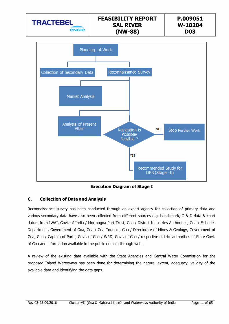
Work Execution for stage-I study has been depicted through following diagram.
FEASIBILITY REPORT SAL RIVER (NW-88)
P.009051 W-10204
D03
Rev.03-23.09.2016 Cluster-VII (Goa & Maharashtra)/Inland Waterways Authority of India Page 11 of 65
Execution Diagram of Stage I
C. Collection of Data and Analysis
Reconnaissance survey has been conducted through an expert agency for collection of primary data and
various secondary data have also been collected from different sources e.g. benchmark, G & D data & chart
datum from IWAI, Govt. of India / Mormugoa Port Trust, Goa / District Industries Authorities, Goa / Fisheries
Department, Government of Goa, Goa / Goa Tourism, Goa / Directorate of Mines & Geology, Government of
Goa, Goa / Captain of Ports, Govt. of Goa / WRD, Govt. of Goa / respective district authorities of State Govt.
of Goa and information available in the public domain through web.
A review of the existing data available with the State Agencies and Central Water Commission for the
proposed Inland Waterways has been done for determining the nature, extent, adequacy, validity of the
available data and identifying the data gaps.

FEASIBILITY REPORT SAL RIVER (NW-88)
P.009051 W-10204
D03
Rev.03-23.09.2016 Cluster-VII (Goa & Maharashtra)/Inland Waterways Authority of India Page 12 of 65
D. Observations and Inferences
Following conclusions have been derived for establishing the navigability of the proposed waterway;
1. The river length as given by IWAI is 14km, whereas the total surveyed length along the river to capture
the thalweg is 14.26km. The deepest channel route has been reckoned as 14.26km. All inferences
derived for identifying the navigable length have been derived with reference to the deepest channel
length (14.26km).
2. The full study stretch of river is under tidal effect. The relevant chart datum has been used. However,
only 23% of the surveyed length has water depth more than 2.0 m, which is also not continuous. The
average tidal variation is 1.15m with maximum high tide of 2.3m and low tide of 0.0m as per the records
available for this region. The average tide height of 1.15m would be an added advantage for the safe
navigation.
3. As per the observation, the feasibility study suggests that the river is navigable without any significant
obstructions up to the end of the stretch i.e., up to the Orlim Deusa Bridge (at the end of the stretch).
Smoothening of the bends is required at the critical bends and modifications in the clearances under H.
T. Line and Electric Lines are to be carried out. By considering the above, the entire stretch can be
considered under Class III Waterway.
4. The lengths of the waterway, with a depth more than 2.0m, 1.5m and 1.0m with reference to the Chart
datum have been compiled in the main report. This is given in Table 3.7 of the report and is being
reproduced below:
Maximum – Minimum Depth in Sal River from Ch 0.00km to Ch 14.26km
Chainage
(Km)
Draft Available Length of River (Km)
Max. (m) Min. (m) >2m 1.5-2.0m 1-1.5m <1m
0-3 6.66 0.75 0.97 0.97 0.68 0.37
3-7 3.68 0.09 1.12 0.82 1.03 1.03
7-10 4.37 0.02 0.81 0.92 0.23 1.04
10-14.26 2.65 0.12 0.35 0.69 1.27 1.96
Total 3.25 3.40 3.21 4.40
5. Two Electric Lines and one H. T. Line are crossing the study stretch with the vertical clearance ranging
from 2.2m to 10.00m above MHWS. The minimum vertical clearance required shall be 20.1m
corresponding to 220kVA transmission line.
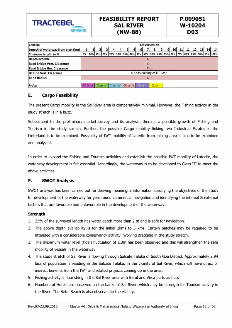
The description & classification of the waterway has been presented schematically based on the survey
observation and duly keeping in view the river classification criteria in Table 3.16 as reproduced below.
FEASIBILITY REPORT SAL RIVER (NW-88)
P.009051 W-10204
D03
Rev.03-23.09.2016 Cluster-VII (Goa & Maharashtra)/Inland Waterways Authority of India Page 13 of 65
Criteria
Length of waterway from start (km) 1 1 2 3 4 4 5 6 6 7 8 9 9 10 11 11 12 13 14 14
Chainage length in % 5% 10% 15% 20% 25% 30% 35% 40% 45% 50% 55% 60% 65% 70% 75% 80% 85% 90% 95% 100%
Depth availble
Raod Bridge Vert. Clearance
Raod Bridge Hor. Clearance
HT Line Vert. Clearance
Bend Radius
Index
Classification
Needs Raising of HT Base
C-III
C-III
C-III
C-III
All Class Class-V Class-IV Class-III Class-II Class-I
E. Cargo Feasibility
The present Cargo mobility in the Sal River area is comparatively minimal. However, the Fishing activity in the
study stretch is in a buzz.
Subsequent to the preliminary market survey and its analysis, there is a possible growth of Fishing and
Tourism in the study stretch. Further, the possible Cargo mobility linking two Industrial Estates in the
hinterland is to be examined. Possibility of IWT mobility of Laterite from mining area is also to be examined
and analyzed.
In order to expand the Fishing and Tourism activities and establish the possible IWT mobility of Laterite, the
waterway development is felt essential. Accordingly, the waterway is to be developed to Class III to meet the
above activities.
F. SWOT Analysis
SWOT analysis has been carried out for deriving meaningful information specifying the objectives of the study
for development of the waterway for year round commercial navigation and identifying the internal & external
factors that are favorable and unfavorable in the development of the waterway.
Strength
1. 23% of the surveyed length has water depth more than 2 m and is safe for navigation.
2. The above depth availability is for the initial 2kms to 3 kms. Certain patches may be required to be
attended with a considerable conservancy activity involving dredging in the study stretch.
3. The maximum water level (tidal) fluctuation of 2.3m has been observed and this will strengthen the safe
mobility of vessels in the waterway.
4. The study stretch of Sal River is flowing through Salcete Taluka of South Goa District. Approximately 2.94
lacs of population is residing in the Salcete Taluka, in the vicinity of Sal River, which will have direct or
indirect benefits from the IWT and related projects coming up in the area.
5. Fishing activity is flourishing in the Sal River area with Betul and Virca ports as hub.
6. Numbers of Hotels are observed on the banks of Sal River, which may be strength for Tourism activity in
the River. The Betul Beach is also observed in the vicinity.

FEASIBILITY REPORT SAL RIVER (NW-88)
P.009051 W-10204
D03
Rev.03-23.09.2016 Cluster-VII (Goa & Maharashtra)/Inland Waterways Authority of India Page 14 of 65
7. Two industrial estates viz., Margao Industrial Estate (12kms from the nearest river front) and Cuncolim
Industrial Estate (8kms from the nearest river front) are in the catchment of Sal River.
8. Laterite Mining is in the catchment of Sal River.
9. The above Industrial Estates and the Mining zone are well connected with Road and also with Mormugoa
Port.
Weakness
1. Presently, there is no IWT movement.
2. Connectivity of Industrial Estates / Mining Zone with Road may be a weakness, if not used
advantageously for IWT.
Opportunity
1. 23 % of the existing waterway is having a depth more than 2m, which can be used advantageously for
the mobility of hinterland cargo.
2. The existing fishing activity (through the river and Betul fishing Port & Verca fishing Port) will get
encouragement with the development of Sal River.
3. Since many Hotels are on the banks of Sal River and with the presence of Betul Beach in the proximity,
Tourism may flourish, if the Sal River is developed.
4. The existence of two industrial estates viz., Margao Industrial Estate and Cuncolim Industrial Estate in the
catchment of Sal River is an opportunity, if used by IWT.
5. Possibilities of Laterite mobility from the Mines in the hinterland through IWT can be explored.
6. The present Rail and Road connectivity though may be competing with IWT may also be an opportunity
for creating an efficient intermodal hub for IWT.
7. Policies are to be firmed up for development of IWT in this stretch.
Threat
1. The Mumbai-Goa Highway in the study area may create competing mode of transport.
2. The Sal River banks covered by marginal mangrove trees in certain places may involve some socio-
environmental issues and may require statutory approvals and clearances to construct the jetties/
terminal/ ports/ intermodal connectivity.
G. Development Cost (Tentative)
The reconnaissance survey data with regard to physical constraints may have cost implications for making the
river stretch navigable to the required standards of Waterway. Henceforth, the development of the proposed
national waterway involves physical interference in the form of dredging, construction of terminals at the
identified locations, modification of HT Lines at crossing locations to provide a minimum vertical clearance of
20.1m (with respect to 220 kVA) or the case may be combined with some unforeseen expenses. Moderate
dredging effort has been envisaged with an average dredging of 1.0m required in 11.0km of the length of
proposed waterway reckoned with reference to ascertained data. The cost of dredging has been considered

FEASIBILITY REPORT SAL RIVER (NW-88)
P.009051 W-10204
D03
Rev.03-23.09.2016 Cluster-VII (Goa & Maharashtra)/Inland Waterways Authority of India Page 15 of 65
@ INR 230 per cum. The cost of terminal has been estimated @ INR 20.0 crore each for one terminal. HT line
/ Electric Lines crossing shall need modification which shall require two towers at the bank of requisite height
and the stringing over pair of poles crossing the Sal River. The cost of transmission tower has been estimated
to be INR 20.00 lacs each and the stringing cost across the towers shall be INR 4.0 lacs per pair of towers.
The total estimated cost for modification to the three HT / Electric Lines shall be INR 3 x 44.0 lacs = INR
132.0 lacs. No modification is required for bridge structures. The cost of navigational aids for day/night
navigation has been considered as INR 263 lacs. 10% of the amount for dredging, terminal construction,
tower / bridge modification and night navigational aids has been envisaged as unforeseen. The tentative total
cost of development to make the river navigable round the year to achieve safe navigation for the required
classification of vessel mobility has been estimated to INR 37.50 crore. (Reproduced below is Table 5.1).
Sl No.
Name of Waterway
Length of Waterway
Dredging Required (wrt. 2 m draft & 40.0m width)
Dredging Cost @
INR 230/ cum
Terminal Proposed
Terminal Cost @ INR 20 Cr each
Cost of Modification
of Transmission
line
Night Navigation
Total cost incld. 10% unforeseen
(km) (km)
(INR in Cr.)
(Nos.) (INR in
Cr.) (INR in Cr.)
(INR in Cr.)
(INR in Cr.)
1 Sal River 14.26 11.0 10.12 1 20.00 1.32 2.63 37.50
H. Classification of Waterway
The Ministry of Shipping, Road Transport and Highways (Inland Waterways Authority of India) has classified
the Inland waterways into seven categories for rivers and canals for safe plying of self propelled vessels up
to 2000 DWT and tug-barge formation in push tug + four barge units of carrying capacity up to 8000 DWT
(Ref: IWAI, Gazette Notification dated 26th January 2007).
As per the above Classification of Inland Waterways, the entire waterway of Sal River (NW 88) of 14.26km
length has been classified based on available minimum water depth, bottom width, minimum vertical and
horizontal clearances of cross over structures and bend radius in the river. The classification of Sal River is
described below. (Reproduced below is Table 5.2).
Chainage
(km)
Minimum
Depth
(m)
Bottom
Width
(m)
Minimum
Vertical
Clearance
(m)
Minimum
Horizontal
Clearance
(m)
Bend
Radius
(m)
Classification of
Waterway
(Proposed)
0.0 – 14.26 0.02 120.0 6.5 (Bridge & H. T. Line)
25 (Bridge) 165 Class – III
The study stretch of the waterway is amenable for development as Class III waterway as explained above.
However, considerable Dredging may be required.
FEASIBILITY REPORT SAL RIVER (NW-88)
P.009051 W-10204
D03
Rev.03-23.09.2016 Cluster-VII (Goa & Maharashtra)/Inland Waterways Authority of India Page 16 of 65
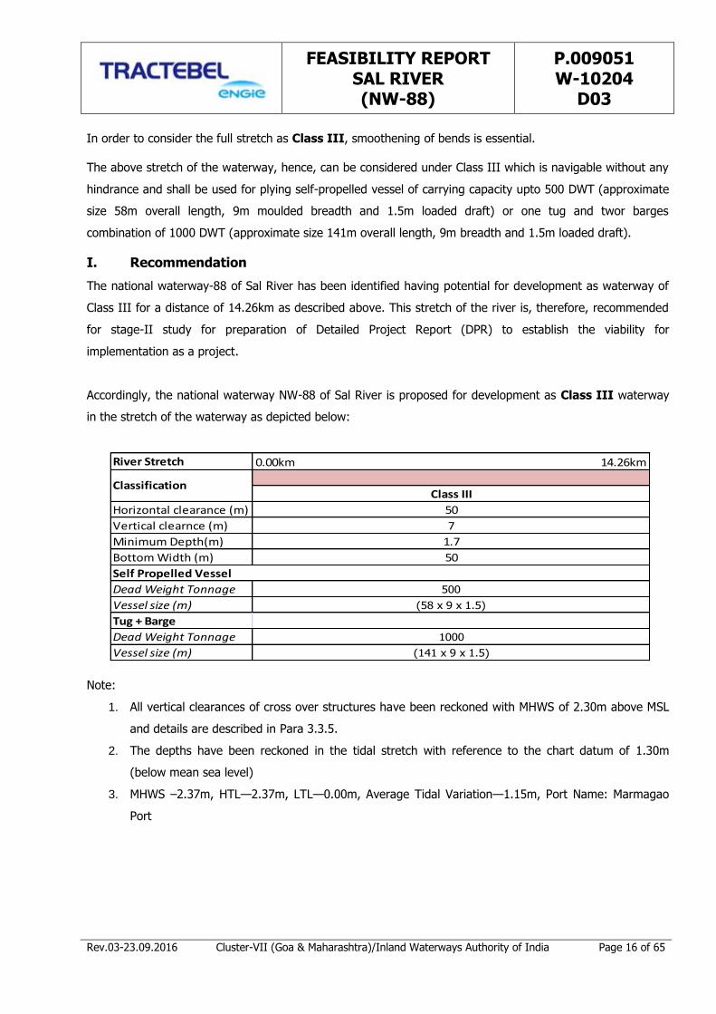
In order to consider the full stretch as Class III, smoothening of bends is essential.
The above stretch of the waterway, hence, can be considered under Class III which is navigable without any
hindrance and shall be used for plying self-propelled vessel of carrying capacity upto 500 DWT (approximate
size 58m overall length, 9m moulded breadth and 1.5m loaded draft) or one tug and twor barges
combination of 1000 DWT (approximate size 141m overall length, 9m breadth and 1.5m loaded draft).
I. Recommendation
The national waterway-88 of Sal River has been identified having potential for development as waterway of
Class III for a distance of 14.26km as described above. This stretch of the river is, therefore, recommended
for stage-II study for preparation of Detailed Project Report (DPR) to establish the viability for
implementation as a project.
Accordingly, the national waterway NW-88 of Sal River is proposed for development as Class III waterway
in the stretch of the waterway as depicted below:
River Stretch
Horizontal clearance (m)
Vertical clearnce (m)
Minimum Depth(m)
Bottom Width (m)
Dead Weight Tonnage
Vessel size (m)
Tug + Barge
Dead Weight Tonnage
Vessel size (m)
0.00km 14.26km
ClassificationClass III
50
1000
(141 x 9 x 1.5)
7
1.7
50
Self Propelled Vessel
500
(58 x 9 x 1.5)
Note:
1. All vertical clearances of cross over structures have been reckoned with MHWS of 2.30m above MSL
and details are described in Para 3.3.5.
2. The depths have been reckoned in the tidal stretch with reference to the chart datum of 1.30m
(below mean sea level)
3. MHWS –2.37m, HTL—2.37m, LTL—0.00m, Average Tidal Variation—1.15m, Port Name: Marmagao
Port
FEASIBILITY REPORT SAL RIVER (NW-88)
P.009051 W-10204
D03
Rev.03-23.09.2016 Cluster-VII (Goa & Maharashtra)/Inland Waterways Authority of India Page 17 of 65
CHAPTER 1: INTRODUCTION
1.1 Introduction to Inland Waterways
The Inland Waterways Authority of India (IWAI) came into existence on 27th October 1986 for development
and regulation of inland waterways for shipping and navigation. Inland Waterways Authority of India (IWAI)
is the statutory authority in charge of the waterways in India. The Authority primarily undertakes projects for
development and maintenance of IWT infrastructure on national waterways through grant received from the
Ministry of Shipping, Government of India. The head office of the Authority is at Noida, UP. It does the
function of building the necessary infrastructure in these waterways, surveying the economic feasibility of new
projects and also administration. The Authority also has its regional offices at Patna, Kolkata, Guwahati and
Kochi and sub-offices at Allahabad, Varanasi, Bhagalpur, Farakka, Swaroopganj, Hemnagar, Dibrugarh
(Assam), Dhubri, Kollam, Vijayawada (Andhra Pradesh) and Bhubaneshwar (Odisha).
India has about 14,500 km of navigable waterways which comprise Rivers, Canals, Backwaters, Creeks, etc.,
out of which about 5200km of the river and 4000km of canals can be used by mechanized crafts. About 55
million tonnes of cargo is being moved annually by Inland Water Transport (IWT), a fuel - efficient and
environment - friendly mode. Freight transportation by waterways is highly underutilized in India compared to
other large countries and geographic areas like the United States, China and the European Union. Its
operations are currently restricted to a few stretches in the Ganga-Bhagirathi-Hooghly Rivers, the River
Brahmaputra, the River Barak, the Rivers in Goa, and the Backwaters in Kerala, Inland Waters in Mumbai area
and the Deltaic regions of the Godavari - Krishna Rivers.
Besides these organized operations by mechanized vessels, country boats of various capacities also operate in
various rivers and canals and substantial quantum of cargo and passengers are transported in this
unorganized sector as well. The total cargo moved (in tonne kilometres) by the inland waterway was just
0.1% of the total inland traffic in India. There are now one hundred and eleven national waterways across
the country which include five existing national waterways besides 106 waterways which have been declared
recently as national waterways through a central legislation.
1) National Waterway 1
The Ganga - Bhagirathi - Hooghly river system between Haldia (Sagar) & Allahabad.
Declared = October 1986.
Length = 1620 km
Fixed terminals = G R Jetty 2, Kolkatta, Pakur, Farakka, Gaighat (Patna) & Allahabad.
Floating terminals = Kolkatta, Diamond Harbour, Katwa, Bahrampur, Jangipur, Bhagalpur,
Semaria, Doriganj, Ballia, Ghazipur, Varanasi, Chunar, Allahabad.
Cargo Movement = 3 million tonnes Approx.
FEASIBILITY REPORT SAL RIVER (NW-88)
P.009051 W-10204
D03
Rev.03-23.09.2016 Cluster-VII (Goa & Maharashtra)/Inland Waterways Authority of India Page 18 of 65
2) National Waterway 2
Sadiya — Dhubri stretch of Brahmaputra river.
Estd = September 1988.
Length = 891 km
Fixed terminals = Pandu
Floating terminals = Dhubri, Jogighopa, Tezpur, Silghat, Jamgurhi, Bogibil, Dibrugarh, Saikhowa and Sadiya
Cargo Movement = 2.0 million tonnes Approx.
3) National Waterway 3
Kottapuram-Kollam stretch of the West Coast Canal, Champakara Canal and Udyogmandal Canal.
Estd = February 1993
Length = 205 km
Fixed terminals = Kottapuram, Aluva, Bolgatty, Willingdon Island, Maradu (Kochi), Cherthala (Vaikom),
Thannermukkom, Alappuzha, Thrikkunnapuzha, Kayamkulam (Ayiramthengu), Chavara
and Kollam.
Cargo Movement = 1.0 million tonnes Approx.
4) National Waterway 4
Kakinada–Pondicherry stretch of canals and the Kaluvelly Tank, Bhadrachalam – Rajahmundry stretch of River
Godavari and Wazirabad – Vijayawada stretch of River Krishna.
Estd = November 2008
Length = 1095 km
Tentative Cargo Potential = 2.0 million tonnes Approx which can go up to 4.0 million tonnes in next 15
Years or so.
5) National Waterway 5
Talcher–Dhamra stretch of the Brahmani River, the Geonkhali - Charbatia stretch of the East Coast Canal, the
Charbatia–Dhamra stretch of Matai river and the Mangalgadi - Paradip stretch of the Mahanadi River Delta.
Established = November 2008
Length = 623 km
Tentative Cargo Potential = Coal from Talcher to Dhamra and Paradip ports is the most important
potential cargo for this waterway. Immediately after the development of the
waterway, it is estimated in the DPR that about 11.0 million tonnes of cargo
can be transported per year which can go up to 23.0 million tonnes in next
15 years or so.
FEASIBILITY REPORT SAL RIVER (NW-88)
P.009051 W-10204
D03
Rev.03-23.09.2016 Cluster-VII (Goa & Maharashtra)/Inland Waterways Authority of India Page 19 of 65
6) 106 Newly Declared National Waterways
For newly declared national waterways, IWAI is carrying out feasibility studies /DPR preparation through a
number of consultants.
1.2 Project Background of the Present Study
IWAI, Ministry of Shipping, Government of India intends to explore the potential of additional waterways
across the country for year round commercial navigation. For this, it is planned to study in two stages
comprising feasibility study followed by preparation of DPR and recommending thereafter the possibility of
composite and integrated development of proposed waterways to achieve navigation and to develop water
transport facilities across India.
106 more waterways across the country have been declared as new national waterways through a bill passed
in the Parliament in March 2016 with contention that the measure is aimed at providing a cheaper mode of
transport and reducing traffic burden on the roads. These 106 new national waterways will be in addition to
the five existing national waterways. The proposed legislation is aimed at integrated development of inland
waterways throughout the country since the water transport is "lagging behind" road and rail sectors.
Promotion of waterways is a priority as it is a cheaper mode of transportation, being economical compared to
roads and railways, and at the same time it is environment friendly too.
Feasibility study shall examine the viability of navigational routes and therefore potential to develop waterway
transport facility is to be established. This shall be followed by preparation of Detailed Project Report (DPR)
for those feasible waterways, which would include detailed hydrographic surveys and investigation, traffic
survey, proposed location for terminals and cost assessment etc. Tractebel Engineering had been awarded
two of the clusters i.e. Cluster-VI & Cluster-VII consisting of the rivers/canals/creeks for two stage studies,
screen the rivers with respect to navigational feasibility and subsequently prepare a Detailed Project Report
for the development of Inland Waterways. This report deals with the study of Sal River which is one of the
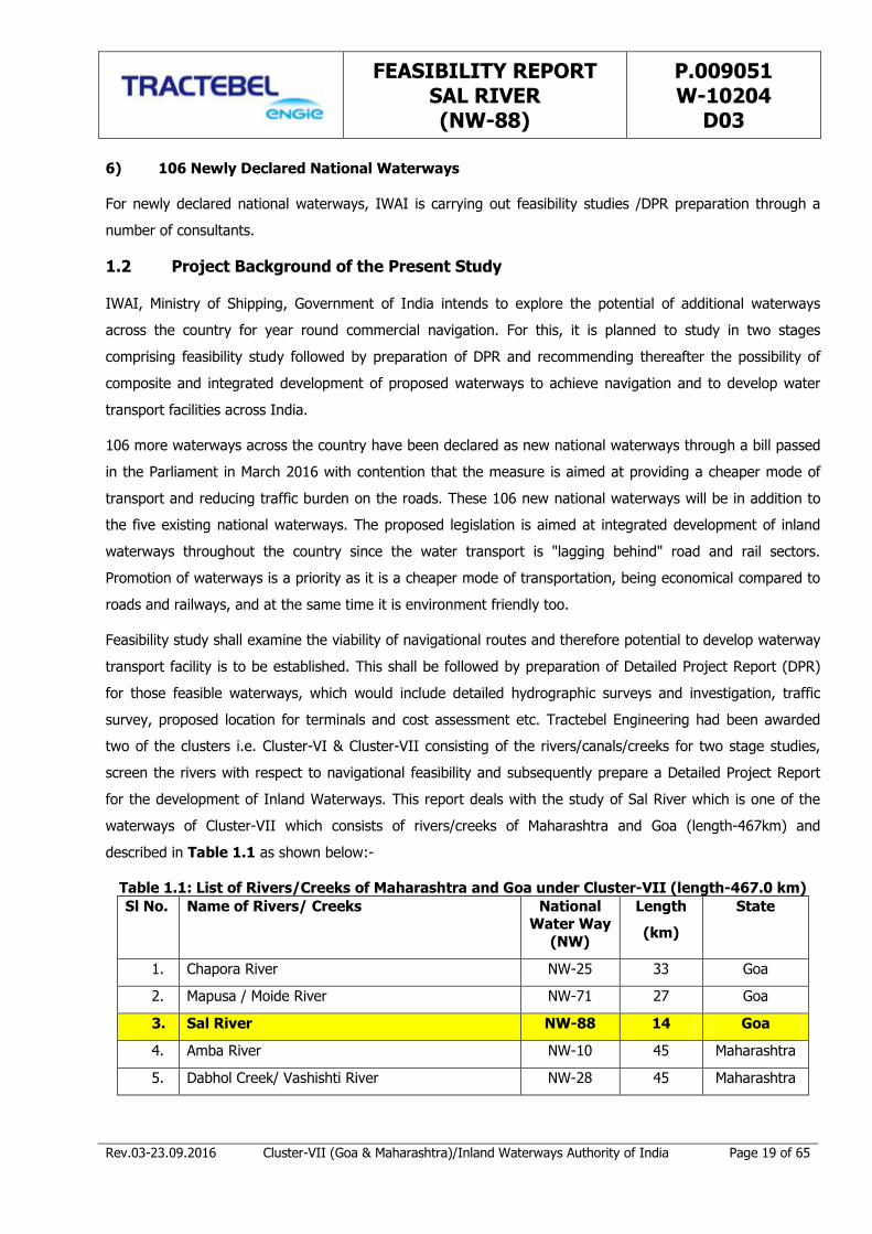
waterways of Cluster-VII which consists of rivers/creeks of Maharashtra and Goa (length-467km) and
described in Table 1.1 as shown below:-
Table 1.1: List of Rivers/Creeks of Maharashtra and Goa under Cluster-VII (length-467.0 km)
Sl No. Name of Rivers/ Creeks National Water Way
(NW)
Length
(km)
State
1. Chapora River NW-25 33 Goa
2. Mapusa / Moide River NW-71 27 Goa
3. Sal River NW-88 14 Goa
4. Amba River NW-10 45 Maharashtra
5. Dabhol Creek/ Vashishti River NW-28 45 Maharashtra

FEASIBILITY REPORT SAL RIVER (NW-88)
P.009051 W-10204
D03
Rev.03-23.09.2016 Cluster-VII (Goa & Maharashtra)/Inland Waterways Authority of India Page 20 of 65
Sl No. Name of Rivers/ Creeks National
Water Way (NW)
Length
(km)
State
6. Kalyan-Thane-Mumbai Waterway, Vasai Creek
and Ulhas River NW-53 145 Maharashtra
7. Rajpuri Creek NW-83 31 Maharashtra
8. Revadanda Creek / Kundalika River NW-85 31 Maharashtra
9. Savitri River (Bankot Creek) NW-89 44 Maharashtra
10. Shastri River/ Jaigad creek NW-91 52 Maharashtra
Total 467
The layout plan of all the ten rivers/creeks covered in Cluster-VII, showing the location and Index Map of Sal
River are shown in Figure 1.1 and Figure 1.2 respectively.
FEASIBILITY REPORT SAL RIVER (NW-88)
P.009051 W-10204
D03
Rev.03-23.09.2016 Cluster-VII (Goa & Maharashtra)/Inland Waterways Authority of India Page 21 of 65
Figure 1.1: Location Map of the Proposed Waterway of Cluster-VII in Goa and Maharashtra
FEASIBILITY REPORT SAL RIVER (NW-88)
P.009051 W-10204
D03
Rev.03-23.09.2016 Cluster-VII (Goa & Maharashtra)/Inland Waterways Authority of India Page 22 of 65
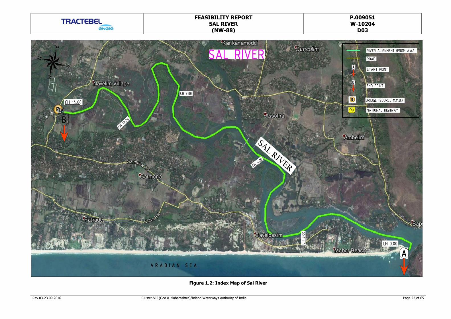
Figure 1.2: Index Map of Sal River
FEASIBILITY REPORT SAL RIVER (NW-88)
P.009051 W-10204
D03
Rev.03-23.09.2016 Cluster-VII (Goa & Maharashtra)/Inland Waterways Authority of India Page 23 of 65
1.3 Objectives of the Study
IWAI, Ministry of Shipping, Government of India intends to explore the potential of additional waterways
across the country for commercial navigation.
The objectives of the study shall necessarily include:
1. To Explore the Potential of Year Round Commercial Navigation on the Proposed National Waterways by
conducting Feasibility Studies.
2. Recommending thereafter the possibility of Composite and Integrated development of proposed
waterways under cluster – VII consisting of Creeks/ Rivers to achieve navigation and to develop water
transport facilities on these waterways.
After carrying out the feasibility study, if there is scope for navigation and potential to develop waterway
transport facility, a Detailed Project Report needs to be prepared for those waterways which would include
detailed hydrographic surveys and investigation, traffic survey, proposed location for terminals and cost
assessment, viability etc.
1.4 Scope of the Assignment
The complete scope of the assignment shall include the study in 2 stages:
1. Stage-I is only for feasibility of the waterway for navigation, which may have the potential for year round
navigation or at least for a few months in a year.
2. Stage-II would consist of the detailed hydrographic survey, topographic survey, detailed traffic survey
including the divertible traffic, selection of terminal locations and preparation of detailed project report
including the returns /viability analysis for implementation as a project.
This report covers the activities of Stage-I only for feasibility of the Sal River for navigation, which may have
the potential for year round navigation or at least for a few months in a year.
Stage-I consists of the following activities:
A. Reconnaissance Survey
B. Collection and review of available data
C. Feasibility Report
1.5 Methodology Adopted
The Stage I Feasibility Study of the Inland Waterway stretches is based on three approaches:
1. The Physical System
2. The Current Functions and
3. The Market Potential
FEASIBILITY REPORT SAL RIVER (NW-88)
P.009051 W-10204
D03
Rev.03-23.09.2016 Cluster-VII (Goa & Maharashtra)/Inland Waterways Authority of India Page 24 of 65
1.5.1 Physical System
The potential for inland navigation strongly depends on the physical environment. Success of navigation will
depend on:
- The stability of the channel: frequent variations of channel positions requires river conservancy
measures;
- The regime: in most cases good navigation conditions are required most of the time for fluvial navigation
to develop as a competitive transport mode, if such conditions are not met, other - more reliable - modes
of transportation will be used, making it difficult to get a return on the investments required for
navigation (ships, maintenance, port infrastructure):
o The regime which defines the variability of water depth, draught and water level (position of port
infrastructure, vertical clearance at bridges).
o Sediment supply: certain stretches are characterized by high sediment supply; developing such
sections would require high maintenance efforts to keep the channels at depth; it must be
economically and technically feasible to maintain a balance between dredging and sediment supply;
therefore, the decision to construct barrages to increase the water depth, must be taken with care,
as these may act as sediment traps.
- Hydrographic characteristics of the channel: depth and width of the channel. The fairway design shall
conform to channel geometry. The discharge should guarantee sufficient water depth alternatively, weirs,
canals could be constructed to allow required water depth for safe navigation.
From a quick scan of satellite images it becomes clear that the morphological and hydrological conditions of
the different rivers vary strongly, even within the same river. Satellite images provide a complete, accessible
and qualitative data source for a first appraisal of potential.
Morphological features can be easily derived from satellite images. The morphological analysis of satellite
images, therefore, has been used as a basis for a first, but reliable appraisal of the physical potential of the
river (for navigation). Such analysis is, therefore, proposed as one of the methods in stage I.
It should be pointed out, however, that the period in which the satellite images have been taken may strongly
affect the appearance: otherwise dry sections may well be flooded in monsoon season. A careful evaluation
shall be contemplated. Also, information obtained from water managers such as CWC, and local authorities will
be useful complement to evaluate navigability.
1.5.2 Current Functions
Current functions of the river have also been taken into consideration:
- Navigation, present in certain areas – it’s relevant to know why, how it’s organized:
o Transportation of people (including the tourism potential) and goods
- Structures aligned to rivers

FEASIBILITY REPORT SAL RIVER (NW-88)
P.009051 W-10204
D03
Rev.03-23.09.2016 Cluster-VII (Goa & Maharashtra)/Inland Waterways Authority of India Page 25 of 65
- Crossing infrastructure
o Bridges: vertical clearance, may even be absent for navigation.
o Weirs, barrages: water supply, regulation, hydropower.
o Ferry terminals: variations in water levels and terminal infrastructure.
- Fishery
- Mining, occurring along certain rivers, and depending on (the often) shallow channels for processing
- Irrigation/ water supply, the available water may be shared between different functions, barrages
exist to tap water for supply – as Indian agriculture is important for the GDP and the employment of
most of the population, an equilibrium must be found between available water resources and
additional uses such as use for navigation.
1.5.3 Market Potential
Historically, economic demand is a driving force behind waterway development. In several cases waterways
were constructed and developed for specific industries. Also navigation was developed using existing irrigation
or water supply canals. Further, the accessibility also was another driving force, when alternative mode
development was difficult/ uneconomical.
In an emerging economy, such as India, the presence of waterways probably will also stimulate further
economic development. While rail and road networks connect cities and industrial areas independently of the
hydrographic network, now it must be analyzed where the hydrographic network can establish alternative and
new links between cities. In navigable portions such links would be logical.
Environmental concerns viz. the emissions, consequences on air pollution and climate change, and social and
economic pressure of congestion, led to a boost of inland navigation projects in all around the world. Such
development can also be expected in India, as the development of waterways may be economically and
socially more beneficial than the construction of the road and rail networks, not necessarily as a substitute, but
to be developed in parallel, in a multi-modal transportation system.
The current scope for Stage I is executed as per following framework shown in Figure 1.4.

FEASIBILITY REPORT SAL RIVER (NW-88)
P.009051 W-10204
D03
Rev.03-23.09.2016 Cluster-VII (Goa & Maharashtra)/Inland Waterways Authority of India Page 26 of 65
Figure 1.4: Execution Framework for Stage I
1.6 Collection of Data
For evaluating the feasibility of the waterway in Sal River for year round navigation, the reconnaissance survey
for collecting the Primary data has been taken up. Secondary data have also been collected from various
sources. IWAI issued a letter in the name of M/s Tractebel, to all the concerned stakeholders for data
collection from State/ Central Government.
(A) Primary Data: M/s Tractebel Engineering Pvt. Ltd. has appointed a separate survey agency M/s
Fugro Survey (India) Pvt. Ltd. (FSINPVT) for carrying out the reconnaissance survey for collection of
following primary data:
(i) Single line longitudinal survey (Bathymetric survey or Topographic survey);
(ii) Details (horizontal and vertical clearances above High Flood Level of bridges, aqueducts, electric lines,
telephone lines, pipe lines, cables en-route etc;)
(iii) Details of locations of permanent structures viz. Bridges, Barrages, Dams, Locks, Jetties, Ports etc;
(iv) Photographs of important structures along the route;
(v) Topographical features of the proposed Inland Waterways;
FEASIBILITY REPORT SAL RIVER (NW-88)
P.009051 W-10204
D03
Rev.03-23.09.2016 Cluster-VII (Goa & Maharashtra)/Inland Waterways Authority of India Page 27 of 65
(vi) Typical physical features along the alignment i.e. land use pattern;
(vii) Preliminary identification of stretches having year round flow;
(viii) Critical depth for navigational purpose;
(ix) Preliminary traffic identification on the proposed Inland Waterways;
(x) Inland Waterway width, Terrain, Bridges and structures across the proposed Inland Waterways;
(xi) Urban areas (location & extent);
(xii) Geologically sensitive areas and environmental features;
(xiii) Critical areas requiring detailed investigations;
(xiv) Soil (textural classifications) (only visual inspection at every 10km);
(xv) Drainage conditions;
(xvi) Existing utility services along the alignment;
(xvii) Present Status of navigation on different sub stretches of the waterway;
All the data derived from the above reconnaissance surveys shall be utilized for planning and programming the
detailed surveys and investigations. All reconnaissance field studies including the traffic surveys have been
taken up and the classification of proposed waterway has been carried out as per IWAI guidelines on this
matter. The list of data collected and sources of data are being enclosed as Annexure 1.1.
(B) Secondary Data: The following secondary data has been collected from the concerned authorities as
well as from sources available in public domain.
(i) Benchmark Data from IWAI, Noida;
(ii) Chart Datum data and other related data from Captain of Ports, Goa;
(iii) Mormugao Port Trust, Goa;
(iv) District Industries Authorities, Goa;
(v) Fisheries Department, Government of Goa, Goa;
(vi) Goa Tourism, Goa;
(vii) Directorate of Mines & Geology, Government of Goa, Goa;
(viii) WRD, Govt. of Goa
All the data derived from the above reconnaissance surveys details shall be utilized for determining the
navigability of the proposed national waterway. A review of the existing data available with the State Agencies
and Central Water Commission for the proposed Inland Waterways has been done for determining the nature,
extent, adequacy, validity of the available data and identifying the data gaps. Feasibility Report is to be
prepared for the proposed national waterway based on the available data, reconnaissance survey and the
market analysis. The structure of the report has been elaborated in succeeding section 1.9 of this chapter.
FEASIBILITY REPORT SAL RIVER (NW-88)
P.009051 W-10204
D03
Rev.03-23.09.2016 Cluster-VII (Goa & Maharashtra)/Inland Waterways Authority of India Page 28 of 65
1.7 Expected Outcome of the Assignment
Combining knowledge on the physical constraints, actual and future uses of the river and the valley, economic
potential and needs, or absence thereof, allows the characterization of the river for development as a
waterway.
The reconnaissance survey data with regard to physical constraints may have cost implications for making the
river stretch navigable. The potential of possible navigation in the stretches of proposed inland waterways has
been determined using raw water depths reduced to the chart datum in the area of tide affected rivers. To
define the navigability of river/creeks, several gradations can be distinguished:
- No or limited effort: navigable (for a specific draught) without measures;
- Limited to moderate effort: e.g. occasional dredging works at a limited number of location;
- Moderate to high: frequent dredging over a considerable length or large number of locations;
- High to very high: the construction of one or more weirs and or locks, or the construction of a canal;
In accordance with the above criteria, the stretch of the proposed waterway of Sal River under Cluster VII has
been defined in the context of availability of navigable depth (more than 2m). Taking into account for further
development in the stretches of less than 2m depth, the solutions for the navigation have been proposed.
Combining economic potential and physical characteristics allows categorizing the river or specific stretches for
navigation potential on the basis of following criteria:
(i) Water Availability
(ii) Flow Depth
(iii) Vertical & Horizontal Clearance
(iv) Nautical Continuity
(v) Cargo Availability
(vi) Economic & Social Parameters
The analyses of physical and economic parameters have been the basis of a suggestion for classification of
Inland Waterways for further study. The waterways shall be classified into categories of Class-I to Class VII as
per description derived from the compilation of Inland Waterways Authority of India (Classification of Inland
Waterways in India) Regulations, 2006. Referring the data derived from the reconnaissance single beam
bathymetry survey, cargo traffic details, market potential, vertical and horizontal clearances with respect to
existing cross over structures, the proposed waterway has been classified in to seven categories on the basis
of IWAI guidelines for safe plying of self-propelled vessels up to 2000 Dead Weight Tonnage (DWT) and tug-
barge formation in push-tow units of carrying capacity up to 8000 DWT. A recommendation of a selection of
proposed inland waterway stretch has been done (based on IWAI classification) for further analysis and
preparation of DPR in Stage II.
FEASIBILITY REPORT SAL RIVER (NW-88)
P.009051 W-10204
D03
Rev.03-23.09.2016 Cluster-VII (Goa & Maharashtra)/Inland Waterways Authority of India Page 29 of 65
1.8 Description of Sal River (NW-88)
The Sal River originates from Verna hills near Mahalsa temple and flows parallel to the west coast in South
Goa district of Goa State. It is one of the nine main rivers of Goa and add to the economy of Goa due to their
impact on fishing and trade. The detailed description of the river has been compiled in Table 1.2.
Table 1.2: Description of Sal River (NW-88)
Sl. No. Introductory Consideration Description of the River
1 Name of the river / canal Sal River (NW-88)
2 State/ District through which river passes The Sal River passes through the South Goa district
of Goa State.
3 Length of the river / canal Out of the total 35km length, 14km length of the
Sal River starts from Arabian Sea at Mobor Lat 15° 8'31.93"N, Long 73°56'59.89"E to Orlim Deusa
Bridge at Lat 15°13'11.41"N, Long 73°57'29.77"E has been declared as new national waterway.
4 Map The index map of Sal River showing proposed waterway stretch, topographic features and road
networks is shown in Figure 1.2. The section of
the Sal River under feasibility study for inland waterway showing reconnaissance survey routes is
presented in Drawing No. P. 009051-W-20201-A03.
Characteristic of River
5 River Course
The Sal River originates from Verna hills near
Mahalsa temple and flows parallel to the west coast in South Goa district of Goa State. It is the only
river in Goa which flows in north-south direction. The River passes through Margao, Dramapur,
Chinchinim, Navelim and Assolna and eventually
meets Arabian Sea at Betul in Southern Goa. The Sal River flows on a flat plain and its morphology
makes the river basin extremely vulnerable to the impact of rising sea levels. Sal River opens in
Cavelossim, which is a town in Southern Goa and is
home to one of the best known beaches in Goa.
6 Tributaries / Network of Rivers / Basin The tributaries of Sal River are small feeder streams
and canals which join into the River at various locations.
7 Catchment Area The total catchment area of Sal River is 301 sq. km.
1.9 Structure of the Feasibility Study Report (FSR)
The Feasibility Study Report for proposed Inland Waterways of Sal River has been prepared and emphasized
with stretches of proposed inland waterways having the potential for navigation. Stage-II study for preparation
of DPR shall be carried out only for those stretches of proposed inland waterways, which have the potential for
navigation.
FEASIBILITY REPORT SAL RIVER (NW-88)
P.009051 W-10204
D03
Rev.03-23.09.2016 Cluster-VII (Goa & Maharashtra)/Inland Waterways Authority of India Page 30 of 65
The Feasibility Study Report starts with a comprehensive report in the form of executive summary giving
description of the methods used for the data collection, overview of the collected data followed by a
description of the Present State of Affairs, Reconnaissance Survey, findings of Market Potential and
observations & inferences thereof.
The executive summary concludes with Waterway Navigation Potential of the proposed waterway on Sal
River followed with recommendations for going ahead with classification of river. The structure of FSR is as
below;
I. Executive Summary: Executive summary describes the suitability of the proposed waterway in
terms of its navigability and market potential. It contains a brief statement of the characteristics of the
river, present use of the river, data captured in the reconnaissance survey, hindrances, acceptability of
the waterway, enhanced connectivity to the region, capability to decongest the existing mode of
transport, important aspects for techno commercial viability etc. The background information, concise
analysis and main conclusions form part of the document. It helps to understand the overall scenario
and decide the suitability of development of a specific waterway.
II. Introduction: This chapter describes the Project background of the present study, objective of the
assignment, scope of the assignment, methodology adopted, outcome of the assignment, river
characteristics including the structure of the feasibility study report.
III. Analysis of Present State of Affairs: It provides the details about the existing town/ city/ taluka/
historical & tourist places, current utilization of proposed waterway, status of goods transport, road
and rail transport as well as existing river facilities. The quantitative and qualitative description of the
current utilization of proposed inland waterways are provided in the report. In addition, the
descriptions about the status of goods transport, including utilization of road and transport services as
well as river facilities have been covered.
IV. Reconnaissance Survey: The analysis of the data collected in the reconnaissance survey has been
carried out to reflect the possibility of year round flow in the proposed Inland Waterways to achieve
the commercial navigation. Bathymetry survey details, observed bed profiles and soil texture
classification @ 10 km are compiled in this section. Observed waterway bed profile has been plotted
with respect to existing Chart Datum in case of tidal affected rivers else the bed profile relates to
CWC/ Irrigation water level data or FSL in case of canal. Maps of proposed Inland Waterways have
been generated and referred with at the relevant locations indicating existing cross structures viz.
bridges, jetties, established chart datum locations, dams, barrages, HT line, LT line, water pipe line,
cables etc.
V. Market Analysis: The analysis of the market and potential usage of proposed Inland Waterways
have been carried out. In the analysis, both the existing market and the potential future market have
been examined. The details of available existing industries along the waterway, type of production in
FEASIBILITY REPORT SAL RIVER (NW-88)
P.009051 W-10204
D03
Rev.03-23.09.2016 Cluster-VII (Goa & Maharashtra)/Inland Waterways Authority of India Page 31 of 65
these industries, ferry services, cargo movement, type of crop along the waterway, previous history of
movement of cargo in the waterway etc. have been collected and included in the report. All the data
have been collected after discussion with local people while conducting reconnaissance survey etc.
and also after interaction with State Govt. Officials, Irrigation / Water Resources Departments and
other stakeholders. The possible divertible cargo to IWT has been assessed.
VI. Observations and Inferences: The observations and Inferences of the feasibility study are
presented in context of stretches of proposed inland waterways, which have potential for navigation
and for which Stage-II studies may be conducted. Technical Feasibility has been discussed which shall
establish the navigability and potential usage of proposed Inland Waterway. The stretches of proposed
inland waterways which have potential for navigation have been categorized into Class-I to Class VII
as per description derived from classification of rivers/canals by Inland Waterways Authority of India
Regulations, 2006. SWOT Analysis of Proposed Waterway has also been described covering the overall
aspect of the proposed waterway in terms of its Strength, Weakness, Opportunity and Threat to
decide the suitability and the ranking of the waterway.
FEASIBILITY REPORT SAL RIVER (NW-88)
P.009051 W-10204
D03
Rev.03-23.09.2016 Cluster-VII (Goa & Maharashtra)/Inland Waterways Authority of India Page 32 of 65
CHAPTER 2 ANALYSIS OF PRESENT STATE OF AFFAIRS
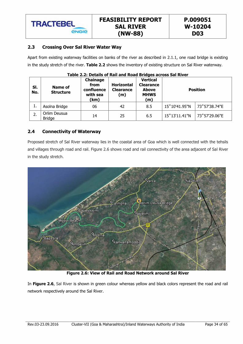
In order to establish the feasibility of waterways the present state of affairs as existing today along proposed
inland waterway on Sal River (NW-88) is studied. Out of total 35 km length of the river, 14 km has been
proposed by IWAI for feasibility study. This chapter provides details about the current affairs, status of goods
transport including utilization of road and rail transport along or near by the waterway.
2.1 Current Utilization
The River Sal originates from Verna hills near Mahalsa temple and flows parallel to the west coast. It is third
largest river in the state of Goa, India. It passes through Margao, Dramapur, Chinchinim, Navelim, Assolna,
before leading into the Arabian Sea at Betul in Goa. The total length of the river is about 35 km before joining
the sea. The river is under tidal effect of the Arabian Sea (backwater effect) upto Deusua about 14 km from
sea. Currently there is no cargo movement in the river; however a ferry service between Cavelossim & Asolna
is functional across Sal.
2.2 Existing Waterway Structures
There are five jetties existing in this waterway. Table 2.1 below provides the details of existing facilities along
Sal River waterway with current utilization status. Further two Fish Landing Jetties also are existing in the Sal
River at Betul (Medium) and Verca (Minor).
Table 2.1: Existing Facilities on Sal River (NW 88)
Sl.
No. Existing Facility Coordinates
DD MM SS Chainage Current Utilization
1. Cutbona Fishing Jetty 15 09 06.9 N
73 57 07.9 E 1.22 km Fishing jetty
2. Boat Repairing Jetty 15 10 07.8 N
73 56 42.8 E 3.41 km Local boat repairing jetty
3. Ferry Jetty 15 10 48.21 N 73 57 40.73 E
6.28 km Ferry Jetty connecting Cavelossim &
Asolna is functional across Sal. 4. Asolna Ferry Jetty 15 10 47.05 N
73 57 46.05 E 6.28 km
5. Ferry Jetty 15 12 07.27 N 73 58 19.85 E
9.84 km

FEASIBILITY REPORT SAL RIVER (NW-88)
P.009051 W-10204
D03
Rev.03-23.09.2016 Cluster-VII (Goa & Maharashtra)/Inland Waterways Authority of India Page 33 of 65
Figures 2.1 to 2.5 show some of facilities along Sal River.
Figure 2.1: Cutbona Fishing jetty at
Chainage 12.00 km (15˚09’06.9”N, 73˚57’07.9”E)
Figure 2.2: Hotel on the Sal River bank at
Chainage 10.70 km (15˚10'19.0"N, 73˚56'46.1"E)
Figure 2.3: Boat Repairing Yard at
Chainage 11.00 km (15˚10'07.8"N, 73˚56'42.8"E)
Figure 2.4: Asolna Ferry Jetty at Chainage 7.90
km (15˚10'47.0485"N, 73˚57'46.0493"E)
Figure 2.5: Ferry Jetty of Cavelossim village at Chainge 8.00 km
(15˚10'48.2124"N, 73˚57'40.7286"E)
FEASIBILITY REPORT SAL RIVER (NW-88)
P.009051 W-10204
D03
Rev.03-23.09.2016 Cluster-VII (Goa & Maharashtra)/Inland Waterways Authority of India Page 34 of 65
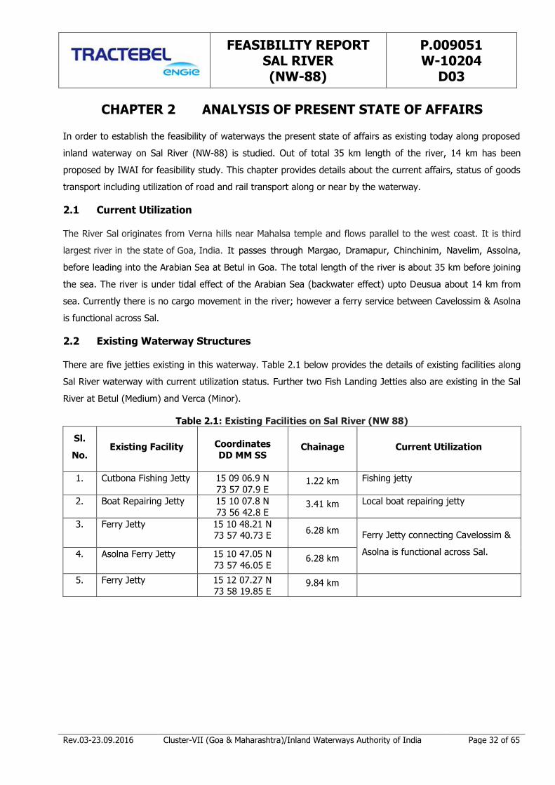
2.3 Crossing Over Sal River Water Way
Apart from existing waterway facilities on banks of the river as described in 2.1.1, one road bridge is existing
in the study stretch of the river. Table 2.2 shows the inventory of existing structure on Sal River waterway.
Table 2.2: Details of Rail and Road Bridges across Sal River
Sl.
No.
Name of
Structure
Chainage
from confluence
with sea
(km)
Horizontal Clearance
(m)
Vertical
Clearance Above
MHWS
(m)
Position
1. Asolna Bridge 06 42 8.5 15˚10'41.95"N 73˚57'38.74"E
2. Orlim Deusua
Bridge 14 25 6.5 15˚13'11.41"N 73˚57'29.06"E
2.4 Connectivity of Waterway
Proposed stretch of Sal River waterway lies in the coastal area of Goa which is well connected with the tehsils
and villages through road and rail. Figure 2.6 shows road and rail connectivity of the area adjacent of Sal River
in the study stretch.
Figure 2.6: View of Rail and Road Network around Sal River
In Figure 2.6, Sal River is shown in green colour whereas yellow and black colors represent the road and rail
network respectively around the Sal River.

FEASIBILITY REPORT SAL RIVER (NW-88)
P.009051 W-10204
D03
Rev.03-23.09.2016 Cluster-VII (Goa & Maharashtra)/Inland Waterways Authority of India Page 35 of 65
2.5 Important Places
Sal River is in the vicinity of various important places of South Goa. Table 2.3 shows the distance of Sal River
from nearby important places.
Table 2.3: List of District/Town/Taluka in vicinity of Sal River Waterway
Sl No. Important Places Category Distance from Creek/River (km)
Bank
1. Salcette Taluka 4.0 Right
2. Quepem (Taluka) Taluka , Town with
Municipal Council
12.0 Right
3. Sanguem (Taluka) Taluka, Municipal Council 18.0 Right
4. Margao City 7.5 Right
5. Dramapur Village 4.0 Right
6. Chinchinim Village 1.5 Right
7. Navelim Village 0.2 Right
8. Paroda Village 7.0 Right
9. Asolna Village 0.8 Right
10. Carmona Village 1.4 Left
11. Cavelossim Village 0.2 Left
12. Varca Town 2.0 Left
13. Fatrade Village 2.3 Left
14. Kankanamoddi Village 1.9 Right
15. Cuncolim City and Municipal
Council
2.5 Right
16. Ambelim Village 1.7 Right
17. Fatorpa Village 4.5 Right
18. Quitol Village 1.5 Right
19. Morpirla Village 6.0 Right
2.6 Road Connectivity
Sal River in the study stretch is well connected with Mumbai Goa National Highway and is surrounded by roads
on left and right bank. The roads surrounding Sal River connects to Mumbai Goa National Highway at end of
study stretch by Verlim Deusa Bridge.

FEASIBILITY REPORT SAL RIVER (NW-88)
P.009051 W-10204
D03
Rev.03-23.09.2016 Cluster-VII (Goa & Maharashtra)/Inland Waterways Authority of India Page 36 of 65
2.7 Rail Connectivity
Railway transport in Sal River catchment is developed under the Konkan Railway Project. The main trunk route
of the railway is aligned almost parallel to the coast line. The end point of study stretch of the river is at
Dasgaon and nearest railway station is 9.5 km from end point i.e. at Madgaon.
Madgaon railway station is on the Konkan Railway and is the busiest railway station in the state of Goa and
has direct rail connection with several major cities in India and is connected with Mumbai Goa National
Highway 66.
2.8 Status of Goods Transport
Status of goods transport through River waterway is detailed in Chapter 4 on Market Analysis of this
report.
2.9 Conclusion
a) The River Sal is third largest river in the state of Goa, India. The Sal River flows typically runs parallel
to the west coast.
b) Total length of Sal River is 35 km before joining the sea. The river is under tidal influence of Arabian
Sea (backwater effect) upto Deusua (about 14 km), thus total study stretch of National Waterway
(NW-88) is under tidal effect
c) There are five (05) jetties in the study stretch of the river.
d) Sal River in the study stretch is well connected with Mumbai Goa National Highway and is surrounded
by roads on both banks.
e) Railway transport in Sal river catchment is developed under the Konkan Railway Project. The end point
of study stretch of the river is 9.5 km from Madgaon railway station. Railway station is connected to
NH-66 (Mumbai – Goa).
f) Two road bridges exist in the study stretch of which one is at the end of the stretch.

FEASIBILITY REPORT SAL RIVER (NW-88)
P.009051 W-10204
D03
Rev.03-23.09.2016 Cluster-VII (Goa & Maharashtra)/Inland Waterways Authority of India Page 37 of 65
CHAPTER 3 RECONNAISSANCE SURVEY
3.1 River Profile
The Sal River originated as a small stream from Verna hills near Mahalsa temple and flows parallel to the west
coast. It is the only river which flows in north-south direction prior to its flowing into the Arabian Sea at Betul
in Southern Goa. The total catchment area of Sal River basin is about 301 sqkm. The total length of the river
from its origin to outfall in the Arabian Sea is about 35 km. The catchment receives an average annual rainfall
of about 2800mm. A map showing Sal catchment basin is shown in Figure 3.1. Sal River has a relatively small
catchment area and its tributaries are small feeder streams and canals. It passes through Margao, Dramapur,
Chinchinim, Navelim and Assolna before draining into the Arabian Sea. The Sal River is the life line to the
Salcete taluka. The Sal River flows on a flat plain and its morphology makes the river basin extremely
vulnerable to the impact of rising sea levels.
Figure 3.1 indicates that most part of the river flows close to the coastal region; thus the lower stretch of river
is expected to be tidal affected zone. Given the size of the river, lower reaches may have navigation potential.
IWAI expects the lower 14.00km, shown in green colour in Figure 3.1, to have potential for navigation and
thus, the subject of study under this assignment.
Figure 3.1: Catchment Area of Sal River
The stretch of the Sal River considered for assessment of navigation potential is defined as below:
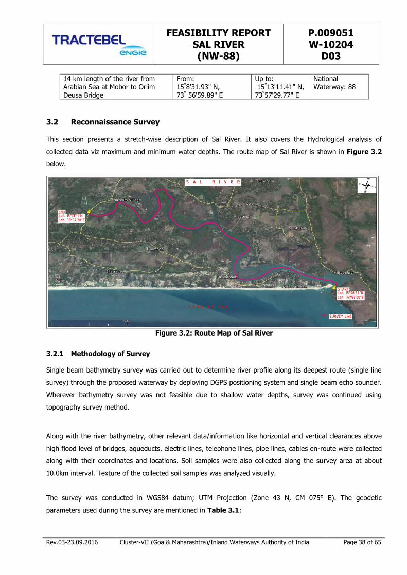
FEASIBILITY REPORT SAL RIVER (NW-88)
P.009051 W-10204
D03
Rev.03-23.09.2016 Cluster-VII (Goa & Maharashtra)/Inland Waterways Authority of India Page 38 of 65
14 km length of the river from
Arabian Sea at Mobor to Orlim Deusa Bridge
From:
15°8'31.93" N, 73° 56'59.89" E
Up to:
15°13'11.41" N, 73°57'29.77" E
National
Waterway: 88
3.2 Reconnaissance Survey
This section presents a stretch-wise description of Sal River. It also covers the Hydrological analysis of
collected data viz maximum and minimum water depths. The route map of Sal River is shown in Figure 3.2
below.
Figure 3.2: Route Map of Sal River
3.2.1 Methodology of Survey
Single beam bathymetry survey was carried out to determine river profile along its deepest route (single line
survey) through the proposed waterway by deploying DGPS positioning system and single beam echo sounder.
Wherever bathymetry survey was not feasible due to shallow water depths, survey was continued using
topography survey method.
Along with the river bathymetry, other relevant data/information like horizontal and vertical clearances above
high flood level of bridges, aqueducts, electric lines, telephone lines, pipe lines, cables en-route were collected
along with their coordinates and locations. Soil samples were also collected along the survey area at about
10.0km interval. Texture of the collected soil samples was analyzed visually.
The survey was conducted in WGS84 datum; UTM Projection (Zone 43 N, CM 075° E). The geodetic
parameters used during the survey are mentioned in Table 3.1:

FEASIBILITY REPORT SAL RIVER (NW-88)
P.009051 W-10204
D03
Rev.03-23.09.2016 Cluster-VII (Goa & Maharashtra)/Inland Waterways Authority of India Page 39 of 65
Table 3.1: Geodetic Datum and Projection Parameters
Global Positioning System Geodetic Parameters
Datum: World Geodetic System 1984
Spheroid: World Geodetic System 1984
Semi Major Axis: a = 6 378 137.000m
Inverse Flattening: 1/f = 298.257 223 563
Map Projection: Universal Transverse Mercator
Grid System: UTM Zone 43 N;
Central Meridian: 075° 00’ 00” East
Latitude of Origin: 0° 00’ 00” North
False Easting: 500 000m
False Northing: 0m
Scale Factor on Central Meridian: 0.9996
Units: Metre
The layout diagram of the equipment used for bathymetric survey has been shown in Figure 3.3 below:
Figure 3.3: Equipment Diagram
Team surveying at site with equipment mounted on the boat is depicted in Figure 3.4 as shown below:
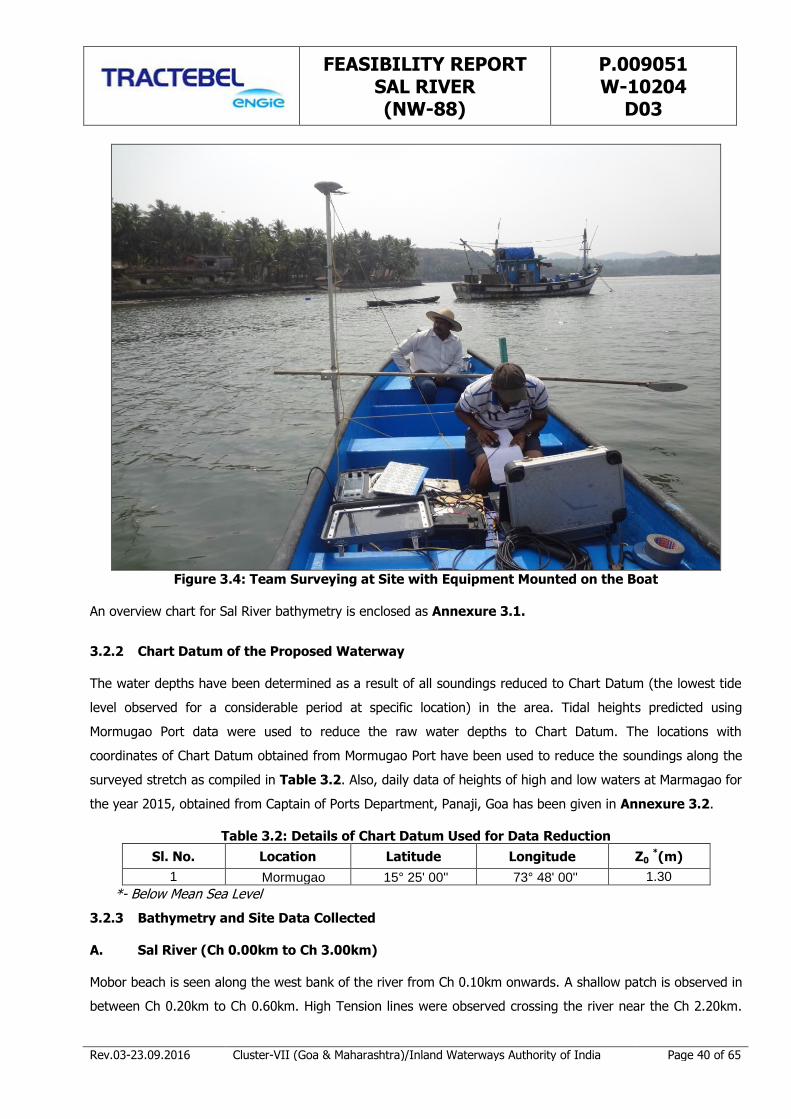
FEASIBILITY REPORT SAL RIVER (NW-88)
P.009051 W-10204
D03
Rev.03-23.09.2016 Cluster-VII (Goa & Maharashtra)/Inland Waterways Authority of India Page 40 of 65
Figure 3.4: Team Surveying at Site with Equipment Mounted on the Boat
An overview chart for Sal River bathymetry is enclosed as Annexure 3.1.
3.2.2 Chart Datum of the Proposed Waterway
The water depths have been determined as a result of all soundings reduced to Chart Datum (the lowest tide
level observed for a considerable period at specific location) in the area. Tidal heights predicted using
Mormugao Port data were used to reduce the raw water depths to Chart Datum. The locations with
coordinates of Chart Datum obtained from Mormugao Port have been used to reduce the soundings along the
surveyed stretch as compiled in Table 3.2. Also, daily data of heights of high and low waters at Marmagao for
the year 2015, obtained from Captain of Ports Department, Panaji, Goa has been given in Annexure 3.2.
Table 3.2: Details of Chart Datum Used for Data Reduction
Sl. No. Location Latitude Longitude Z0 *(m)
1 Mormugao 15° 25' 00'' 73° 48' 00'' 1.30
*- Below Mean Sea Level
3.2.3 Bathymetry and Site Data Collected
A. Sal River (Ch 0.00km to Ch 3.00km)
Mobor beach is seen along the west bank of the river from Ch 0.10km onwards. A shallow patch is observed in
between Ch 0.20km to Ch 0.60km. High Tension lines were observed crossing the river near the Ch 2.20km.

FEASIBILITY REPORT SAL RIVER (NW-88)
P.009051 W-10204
D03
Rev.03-23.09.2016 Cluster-VII (Goa & Maharashtra)/Inland Waterways Authority of India Page 41 of 65
Cutbona Jetty may also be seen at Ch 2.20km. Along the East bank, numbers of wharves are present in the
stretches. Again, shallow patch was seen at the centre of the river from Ch 2.20km to Ch 3.00km. Fishing
stakes may be seen at Ch 2.20km. The minimum depth recorded in this section is 0.8m at Ch 2.69km and the
maximum depth is 6.7m at Ch 0.00km as given below in Table 3.3. The stretch is shown in Figure 3.5.
Table 3.3: Maximum – Minimum Depth in Sal River from Ch 0.00km – Ch 3.00km
Maximum –Minimum Depth
Chainage (km) Reduced Water Depth (m) w. r. t. Chart Datum
From To Max Min
0.0 3.0 6.7 0.8
Lat 15°08'31.93"N, Long 73°56'59.89"E
Rocky Shore
Shallow Patch
Cutbona Fishing Jetty
Fishing Stakes
Figure 3.5: Route Chart of the Survey from Ch 0.00km to Ch 3.00km
B. Sal River (Ch 3.00km to Ch 7.00km)
A boat yard is seen at the west side of the river at Ch 3.59km. Cavelossim town is located along the West
bank from Ch 3.60km to Ch 3.90km. An electric wire crosses the river at Ch 4.21km. An island has been
observed in the river portion between Ch3.0km and Ch 4.0km. Also there is another island observed between
Ch5.0km and 6.0km. These islands typically describe the river meandering phenomenon. Green pastures and
vegetations have also been observed in these islands. A series of shallow patches along the East bank were
recorded between Ch 5.30km to Ch 6.30km. Cavelossim on the West bank and Asolna on the East bank are
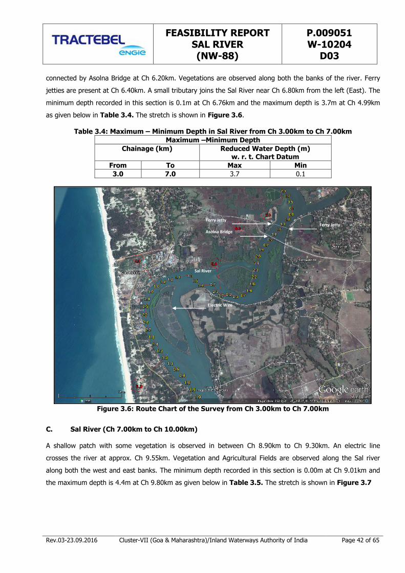
FEASIBILITY REPORT SAL RIVER (NW-88)
P.009051 W-10204
D03
Rev.03-23.09.2016 Cluster-VII (Goa & Maharashtra)/Inland Waterways Authority of India Page 42 of 65
connected by Asolna Bridge at Ch 6.20km. Vegetations are observed along both the banks of the river. Ferry
jetties are present at Ch 6.40km. A small tributary joins the Sal River near Ch 6.80km from the left (East). The
minimum depth recorded in this section is 0.1m at Ch 6.76km and the maximum depth is 3.7m at Ch 4.99km
as given below in Table 3.4. The stretch is shown in Figure 3.6.
Table 3.4: Maximum – Minimum Depth in Sal River from Ch 3.00km to Ch 7.00km
Maximum –Minimum Depth
Chainage (km) Reduced Water Depth (m) w. r. t. Chart Datum
From To Max Min
3.0 7.0 3.7 0.1
Sal River
Electric Wire
Asolna Bridge
Ferry Jetty Ferry Jetty
Figure 3.6: Route Chart of the Survey from Ch 3.00km to Ch 7.00km
C. Sal River (Ch 7.00km to Ch 10.00km)
A shallow patch with some vegetation is observed in between Ch 8.90km to Ch 9.30km. An electric line
crosses the river at approx. Ch 9.55km. Vegetation and Agricultural Fields are observed along the Sal river
along both the west and east banks. The minimum depth recorded in this section is 0.00m at Ch 9.01km and
the maximum depth is 4.4m at Ch 9.80km as given below in Table 3.5. The stretch is shown in Figure 3.7

FEASIBILITY REPORT SAL RIVER (NW-88)
P.009051 W-10204
D03
Rev.03-23.09.2016 Cluster-VII (Goa & Maharashtra)/Inland Waterways Authority of India Page 43 of 65
Table 3.5: Maximum – Minimum Depth in Sal River from Ch 7.00km to Ch 10.00km
Maximum –Minimum Depth
Chainage (km) Reduced Water Depth (m)
w.r.t. Chart Datum
From To Max Min
7.0 10.0 4.4 0.00
Electric Wire
Bridge
Sal River
Figure 3.7: Route Chart of the Survey from Ch 7.00km to Ch 10.00km
D. Sal River (Ch 10.00km to Ch 14.26km)
The waterways stretch for the Sal River ends at the Orlim Deusa Bridge (Ch 14.26km, 15°13'11.41"N,
73°57'29.77"E) having vertical clearance of 4.5m and horizontal clearance of 25m. A jetty is located at Ch
10.20km on the left bank. Agricultural Fields and Vegetation are seen on either sides of the river. Shallow
patch is observed in between Ch 12.20km to Ch 12.80km. Orlim village is located at the West bank at Ch
14.10km. Thereafter, no settlements were observed on the either sides of the river. The minimum depth
recorded in this section is 0.10m at Ch 10.10km and the maximum depth is 2.6m at Ch 11.59km as given
below in Table 3.6. The stretch is shown in Figure 3.8

FEASIBILITY REPORT SAL RIVER (NW-88)
P.009051 W-10204
D03
Rev.03-23.09.2016 Cluster-VII (Goa & Maharashtra)/Inland Waterways Authority of India Page 44 of 65
Table 3.6: Maximum – Minimum Depth in Sal River from Ch 10.00km to Ch 14.26km
Maximum –Minimum Depth
Chainage (km) Reduced Water Depth (m)
w. r. t. Chart Datum
From To Max Min
10.0 14.26 2.6 0.10
Lat 15°13'11.41"N
Long 73°57'29.77"E
Orlim Deusa Bridge
Jetty
Figure 3.8: Route Chart of the Survey from Ch 10.00km to Ch 14.26km
The maximum and minimum depth with reference to the Chart Datum (CD) in the small intervals have been
summarized in Table 3.7, which describes the length of stretch showing various ranges of water depth
available.
Table 3.7: Maximum – Minimum Depth in Sal River from Ch 0.00km to Ch 14.26km
Chainage
(Km)
Draft Available Length of River (Km)
Max. (m) Min. (m) >2m 1.5-2.0m 1-1.5m <1m
0-3 6.66 0.75 0.97 0.98 0.68 0.37
3-7 3.68 0.09 1.12 0.82 1.03 1.03
7-10 4.37 0.02 0.81 0.92 0.23 1.04
10-14.26 2.65 0.12 0.35 0.68 1.27 1.96
Total 3.25 3.40 3.21 4.40
The above data indicates that the availability of water depth of 2.0m and above is not found in continuous
stretch. However, 23% of stretches have more than 2.0 water depth available. About 70% of the stretches
FEASIBILITY REPORT SAL RIVER (NW-88)
P.009051 W-10204
D03
Rev.03-23.09.2016 Cluster-VII (Goa & Maharashtra)/Inland Waterways Authority of India Page 45 of 65
have water depth of 1.0m and above. It may be noted that the above depths have been reckoned with CD.
Since the entire study stretch of Sal River is under tidal influence and hence the available effective depths
would be more than 1.15m (average tide height) which will be advantageous for safe navigation. The detailed
hydrographic survey information indicating location, observed water depth (at each point of data reading) has
been given in Annexure 3.3.
3.2.4 Soil Texture Classification
The soil texture has been observed during the reconnaissance survey. The observed soil texture at 10km
interval has been given in Table 3.8.
Table 3.8: Soil Texture in Sal River at 10.0km Interval
Chainage (Km) Latitude Longitude Depth (m) Soil Texture
0.01 15°08'31.126" 73°57'00.571" 6.7 Sand
10.00 15°12'06.147" 73°58'21.190" 1.7 Sand 14.26 15°13'11.316" 73°57'29.944" 1.5 Sand
From the above table, it is observed that Sandy soil is present in most part of the river under study stretch.
3.3 Classification of Waterways
The Ministry of Shipping, Road Transport and Highways (Inland Waterways Authority of India) has classified
the Inland waterways into seven categories for rivers and canals for safe plying of self propelled vessels up to
2000 Dead Weight Tonnage (DWT) and tug-barge formation in push-two units of carrying capacity up to 8000
DWT (Ref: IWAI, Gazette Notification 2006). The classification criteria of waterways are mentioned in Table
3.9 for Rivers and in Table 3.10 for canals.
Table 3.9: Classification of Inland Waterways for Rivers
Class of Waterways
Rivers
Minimum Depth (m)
Bottom Width (m)
Bend Radius (m)
Vertical Clearance
(m)
Horizontal Clearance
(m)
I 1.2 30 300 4 30
II 1.4 40 500 5 40
III 1.7 50 700 7 50
IV 2.0 50 800 10 50
V 2.0 80 800 10 80
VI 2.75 80 900 10 80
VII 2.75 100 900 10 100
Table 3.10: Classification of Inland Waterways for Canals
Class of
Waterways
Rivers
Minimum
Depth (m)
Bottom
Width (m)
Bend Radius
(m)
Vertical
Clearance (m)
Horizontal
Clearance (m)
I 1.5 20 300 4 20
II 1.8 30 500 5 30
III 2.2 40 700 7 40

FEASIBILITY REPORT SAL RIVER (NW-88)
P.009051 W-10204
D03
Rev.03-23.09.2016 Cluster-VII (Goa & Maharashtra)/Inland Waterways Authority of India Page 46 of 65
IV 2.5 50 800 10 50
V - - - - -
VI 3.5 60 900 10 60
VII - - - - -
The vessel sizes for self propelled or tug and barge combinations for different classes of waterways are
described in Table 3.11.
Table 3.11: Classification of Vessel Size
Class of Waterways
Self Propelled Vessel Tonnage
(Size, L x B x Draft in m)
Tug and Barges Combination Tonnage
(Size, L x B x Draft in m)
I 100 (32 x 5 x 1)
200 (80 x 5 x 10)
II 300
(45 x 8 x 1.2)
600
(110 x 8 x 1.2)
III 500
(58 x 9 x 1.5)
1000
(141 x 9 x 1.5)
IV 1000 (70 x 12 x 1.8)
2000 (170 x 12 x 1.8)
V 1000
(70 x 12 x 1.8)
4000
(170 x 24 x 1.8)
VI 2000
(86 x 14 x 2.5)
4000
(210 x 14 x 2.5)
VII 2000 (86 x 14 x 2.5)
8000 (210 x 28 x 2.5)
Vertical Clearance for power cables or telephone lines or cables for any transmission purpose for
all classes
Low Voltage Transmission lines and Telephone line 16.5m
High Voltage Transmission line not exceeding 110 kV 19.0m
High Voltage Transmission line exceeding 110 kv 19.0m +1 cm per each additional kv
In case of underwater pipelines, power cables and other cables, norms are to be decided as per site condition
and navigational requirement.
Reference level for vertical clearance for different types of channels
For Rivers:- Over the Navigational High Flood Level (NHFL), which is the highest flood level at frequency
of 5 % in any year over a period of last twenty years;
For Tidal Canals:- Over the highest high water level;
For Other Canal:- Over designed full supply level (FSL);
The above classification for rivers and channels shall be effective if:
Minimum depth of channel is available for about 330 days in a year (about 90% days in a year)

FEASIBILITY REPORT SAL RIVER (NW-88)
P.009051 W-10204
D03
Rev.03-23.09.2016 Cluster-VII (Goa & Maharashtra)/Inland Waterways Authority of India Page 47 of 65
Vertical clearance at cross structure over the waterways is available at least in central 75% portion of each
of the spans in the entire width of the waterways.
The data gathered through the reconnaissance study has been analyzed from the parameters mentioned
hereinabove and conclusions have been made with regard to the class of navigation channel that the relevant
stretch of Sal River falls into. Furthermore, it is to be determined whether the entire 14.0km stretch can be
classified under one class of channel or there is a possibility and advantage of developing sub-reaches under
different classes of navigation channel.
3.3.1 Cross Over Structures
The details of High Tension lines and Bridges crossing the Sal River are given below in Table 3.12, and Table
3.13.
Table 3.12: Details of High Tension and Electric Lines across Sal River
Sl.
No.
Cross- Structure
Name
Chainage
(km)
Position (Above vessel track)
Vertical Clearance
above MHWS (m)
Latitude Longitude
1. HT Line 2.20 15°09’33.31” N 73°57’12.13” E 10.00
2 . Electric Line 4.21 15°10’14.26 N 73°56’56.79” E 8.50
3 . Electric Line 9.55 15°11’53.95 N 73°58’15.20” E 6.50
Table 3.13: Details of Bridges across Sal River
Sl.
No.
Name of
Structure
Chainage
(km)
Vertical Clearance
above
MHWS (m)
Horizontal
Clearance (m)
Center Position
Latitude Longitude
1. Asolna Bridge
6.20 8.50 42.00 15˚10'41.95"N 73˚57'38.74"E
2.
Orlim
Deusa
Bridge
14.26 6.50 25.00 15˚13'11.41"N 73˚57'29.06"E
From the above information, it may be inferred that the support base of HT line and electric lines will have to
be raised to about 9.0m to 10.0m to get the required clearance.
The horizontal and vertical clearances at Asolna Bridge at Ch 6.20km are sufficient for Class III. Orlim Deusa
Bridge at Ch 14.26km is located at the upstream end of the proposed waterway and hence its vertical
clearance as well as horizontal clearance has not been considered for analysis. Hence, the entire stretch is
suitable for class II.
Photos of important structures such as port, bridges, jetties, transmission lines and plants as taken during site
visit are shown in Annexure 3.4.

FEASIBILITY REPORT SAL RIVER (NW-88)
P.009051 W-10204
D03
Rev.03-23.09.2016 Cluster-VII (Goa & Maharashtra)/Inland Waterways Authority of India Page 48 of 65
3.3.2 Dams, Barrages and Reservoirs
No dams, barrages or reservoirs exist there along the surveyed route.
3.3.3 Bends along the Route
On the proposed waterway route, there are many bends in Sal River, which are given below in Table 3.14.
Table 3.14: River Bend Radius in Sal River
Sl. No. Chainage
(Km)
Radius
(m)
1 3.66 450
2 4.95 300
3 6.95 350
4 7.95 500
5 8.80 500
6 10.00 165
7 11.75 175
8 12.90 100
In the study stretch, based on the river radius criteria, it may be fit only for Class I Vessels up to Ch 10.0km.
Keeping in view the maximum utility of this stretch for various activities including Fishing and Tourism, the
study stretch of Sal river can be developed for Class III, however by smoothening the bends.
The pictorial detailed information showing the proposed waterway indicating various cross-structures (i.e.
bridges, transmission lines etc.), major industrial locations and important places along the waterway have
been shown in Drawing No P009051-W-20201-A03. Drawing also depicts various information such as
Jetties, Rail and Road location along the waterway.
3.3.4 Gauge & Discharge data
In the Sal River catchment, no gauge and discharge site as established by Central Water Commission was
observed. For the Stage II study, the gauge data will be analyzed if the same is available within a reasonable
reach and if found relevant.
3.3.5 Bed Profile of Waterway
All soundings were reduced to Chart Datum in the area. Tidal heights are predicted using Marmagao data to
reduce the raw water depths to Chart Datum. The observed bed profile of Sal River waterway is shown below
in Figure 3.9 and presented in Annexure 3.5.

FEASIBILITY REPORT SAL RIVER (NW-88)
P.009051 W-10204
D03
Rev.03-23.09.2016 Cluster-VII (Goa & Maharashtra)/Inland Waterways Authority of India Page 49 of 65
Chart Datum
-7
-6
-5
-4
-3
-2
-1
0
1
2
0 1 2 3 4 5 6 7 8 9 10 11 12 13 14 15
De
pth
(m)
be
low
ch
art
dat
um
/ab
ove
ch
art
dat
um
sh
ow
n in
(+
)
Chainage (km)
Sal River Logitudinal Bed Profile
Chart Datum
1.7m Depth Below Chart Datum
Sal River Bed Profile
Mean High Tide
Figure 3.9: Longitudinal River Bed Depth Profile of Sal River from Ch 0.00km to Ch 14.26km
Figures 3.9 also shows the Chart Datum line, 1.7m below the Chart Datum line and mean tide variation 1.15m
above Chart Datum. However, high tides in this region were observed in the range of about 0.00m to 2.30m
(MHWS) (Ref: Indian Tide Tables, 2016, Survey of India). The following key observations are made from
Figure 3.9:
(i) The tidal effect of the Arabian Sea in the Sal River is affected up to the Khareband Bridge at about
22.0 km from the sea (Ref: Information as gathered from the office of Captain of Ports Department,
Goa). The study stretch ends upto Orlim Deusa Bridge at about 14.0 km from the sea. It has been
observed that the study stretch is under tidal affect. The tide in the region is Semi-Diurnal
characteristics.
(ii) As observed from the site, the study stretch has the soil texture as sandy.
(iii) The initial half of the river stretch from the mouth is flatter which gradually becomes steeper having
an overall average slope of 1 in 7000 in 14km of the river stretch under study.
(iv) An average 1.7m depth is available in the initial 4kms stretch of the waterway which suggests only
minimum dredging requirement.
(v) With minimum to moderate dredging in the entire stretch, a minimum depth of 1.7m for Class III
may be achieved.
3.4 Agencies to be approached for Clearances, if any
Based on reconnaissance survey, interaction with local people and consultation with government officials, the
information regarding clearances and approvals required from the concerned authorities for operation of
National Waterway NW-88 (Sal River) has been given in Table 3.15.

FEASIBILITY REPORT SAL RIVER (NW-88)
P.009051 W-10204
D03
Rev.03-23.09.2016 Cluster-VII (Goa & Maharashtra)/Inland Waterways Authority of India Page 50 of 65
Table 3.15: List of Clearances and Approvals Required Environment
Clearance Forest
Clearance Wildlife
Clearance Coastal
Regulation Zone (CRZ) Clearance
Consent to Establish/ Operate
No Objection Certificate
from Directorate of
Fisheries
NOC from WRD/PWD/
Railways
√
To be
ascertained
at DPR Stage-II
To be
ascertained
at DPR Stage-II
√ √ √ √
3.4.1 Compilation of Data in Feasibility Format
The field information gathered through single line bathymetry survey, data collection from IWAI, data
collection from various agencies, site visit and information derived from web has been compiled in the format
as provided by IWAI for the Sal River. The consolidated data shall be useful in deriving basic information
about each of the waterway in IWAI format as enclosed in Annexure 3.6.
3.5 Conclusion
Based on the survey observation, the classification of proposed waterways based on various criteria has been
summarized in below Table 3.16.
Table 3.16: Classification of Proposed Waterway Criteria
Length of waterway from start (km) 1 1 2 3 4 4 5 6 6 7 8 9 9 10 11 11 12 13 14 14
Chainage length in % 5% 10% 15% 20% 25% 30% 35% 40% 45% 50% 55% 60% 65% 70% 75% 80% 85% 90% 95% 100%
Depth availble
Raod Bridge Vert. Clearance
Raod Bridge Hor. Clearance
HT Line Vert. Clearance
Bend Radius
Index
Classification
Needs Raising of HT Base
C-III
C-III
C-III
C-III
All Class Class-V Class-IV Class-III Class-II Class-I
Finally, with due consideration of all aspects, the classification of the proposed Sal Waterway in light of
technical navigability may be adopted as shown in Table 3.17 below:

FEASIBILITY REPORT SAL RIVER (NW-88)
P.009051 W-10204
D03
Rev.03-23.09.2016 Cluster-VII (Goa & Maharashtra)/Inland Waterways Authority of India Page 51 of 65
Table 3.17: Final Conclusion for Possible Navigation
River Stretch
Horizontal clearance (m)
Vertical clearnce (m)
Minimum Depth(m)
Bottom Width (m)
Dead Weight Tonnage
Vessel size (m)
Tug + Barge
Dead Weight Tonnage
Vessel size (m)
0.00km 14.26km
ClassificationClass III
50
1000
(141 x 9 x 1.5)
7
1.7
50
Self Propelled Vessel
500
(58 x 9 x 1.5)
The conclusion has been drawn keeping in view the present river condition and linking the same with various
characteristics of classification viz., available draft; vertical clearance under Road Bridge/ HT Line and Bend
Radius etc.
In order to consider the full stretch as Class III, smoothening of bends along with moderate dredging is
essential.

FEASIBILITY REPORT SAL RIVER (NW-88)
P.009051 W-10204
D03
Rev.03-23.09.2016 Cluster-VII (Goa & Maharashtra)/Inland Waterways Authority of India Page 52 of 65
CHAPTER 4 MARKET ANALYSIS
4.1 Introduction
Market analysis of Sal river catchment area comprises of existing waterway traffic (cargo and passenger
traffic), its trends and feasibility of diversion from existing modes of transportation to waterways.
The methodology that has been adopted for examining the market potential is as shown in Figure 4.1 below:
Figure 4.1: Methodology for Market Potential Analysis
4.2 Existing Profile
Sal river waterway falls under South Goa district of the State and the district headquarters of South Goa
district is at Margao. Margao is one of the major commercial areas in Goa. The district is further divided into
six (6) talukas namely Salcete, Quepem, Canacona, Sanguem, Darbandora and Mormugao. The catchment
area of Sal River has been observed to be within Salcete Taluka. The area includes the laterite mine in
Deusua, industrial clusters in Margao, Cuncolim and industries as well as fishing centers along the waterway.
River Sal falls under Salcete taluka which has a total population 294,464 (Census 2011). The proposed
waterway stretch has a total length of 14 km.
Industrial Profile
South Goa district has seen a continuous increase in the industrial investments over the past years. The details
of total no. of units registered and related information is given in Table 4.1.
FEASIBILITY REPORT SAL RIVER (NW-88)
P.009051 W-10204
D03
Rev.03-23.09.2016 Cluster-VII (Goa & Maharashtra)/Inland Waterways Authority of India Page 53 of 65
Table 4.1: Industrial Units in South Goa
Sl. No.
Profile of Industries Quantity (No.)
1. Registered Industrial Units 2,940
2. Total Industrial Units (Goa) 51,492
3. Registered Medium & Large Units 75
4. No. of Industrial Areas 6
Source: Industrial Profile of South Goa District, MSME, Govt. of India
These registered units include various types of industries and the details of the same are given in Table 4.2.
Table 4.2: Industrial Profile of South Goa District Sl. No. Type of Industry
1. Food Products
2. Beverages & Tobacco products
3. Jute, hemp & Mesta Textile
4. Textile Products & Garments
5. Wood Products & Wooden Furniture, Fixture
6. Paper Products including Printing/publishing
7. Leather & Leather Products
8. Rubber, Plastic, Petroleum and coal products
9. Chemical Products (except Petroleum and coal products)
10. Non Metallic Minerals
11. Basic Metal & Alloys
12. Metal Products & parts (except M/c. & transport eqpt.)
13. Machinery, Tools & Parts (except & electrical m/c.)
14. Electrical Machinery & Apparatus & Supplier Parts
15. Transport Equipment & Parts
16. Other Mfg. Industries
17. Repair/Services
Source: Industrial Profile of South Goa District, MSME, Govt. of India
These industries are located in various industrial clusters; the location of the same is shown in Figure 4.2.
Out of all the clusters, two (2) clusters fall in the vicinity of the Sal River, namely Margao Industrial Estate &
Cuncolim Industrial Estate.
Refer Annexure 4.1 & Map 4.1 for location of major industries along the waterway & in its vicinity.
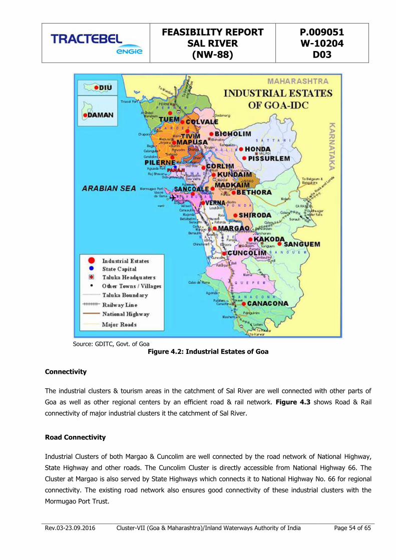
FEASIBILITY REPORT SAL RIVER (NW-88)
P.009051 W-10204
D03
Rev.03-23.09.2016 Cluster-VII (Goa & Maharashtra)/Inland Waterways Authority of India Page 54 of 65
Source: GDITC, Govt. of Goa
Figure 4.2: Industrial Estates of Goa
Connectivity
The industrial clusters & tourism areas in the catchment of Sal River are well connected with other parts of
Goa as well as other regional centers by an efficient road & rail network. Figure 4.3 shows Road & Rail
connectivity of major industrial clusters it the catchment of Sal River.
Road Connectivity
Industrial Clusters of both Margao & Cuncolim are well connected by the road network of National Highway,
State Highway and other roads. The Cuncolim Cluster is directly accessible from National Highway 66. The
Cluster at Margao is also served by State Highways which connects it to National Highway No. 66 for regional
connectivity. The existing road network also ensures good connectivity of these industrial clusters with the
Mormugao Port Trust.
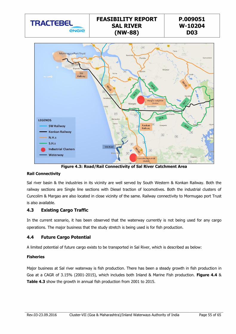
FEASIBILITY REPORT SAL RIVER (NW-88)
P.009051 W-10204
D03
Rev.03-23.09.2016 Cluster-VII (Goa & Maharashtra)/Inland Waterways Authority of India Page 55 of 65
Figure 4.3: Road/Rail Connectivity of Sal River Catchment Area
Rail Connectivity
Sal river basin & the industries in its vicinity are well served by South Western & Konkan Railway. Both the
railway sections are Single line sections with Diesel traction of locomotives. Both the industrial clusters of
Cuncolim & Margao are also located in close vicinity of the same. Railway connectivity to Mormugao port Trust
is also available.
4.3 Existing Cargo Traffic
In the current scenario, it has been observed that the waterway currently is not being used for any cargo
operations. The major business that the study stretch is being used is for fish production.
4.4 Future Cargo Potential
A limited potential of future cargo exists to be transported in Sal River, which is described as below:
Fisheries
Major business at Sal river waterway is fish production. There has been a steady growth in fish production in
Goa at a CAGR of 3.15% (2001-2015), which includes both Inland & Marine Fish production. Figure 4.4 &
Table 4.3 show the growth in annual fish production from 2001 to 2015.
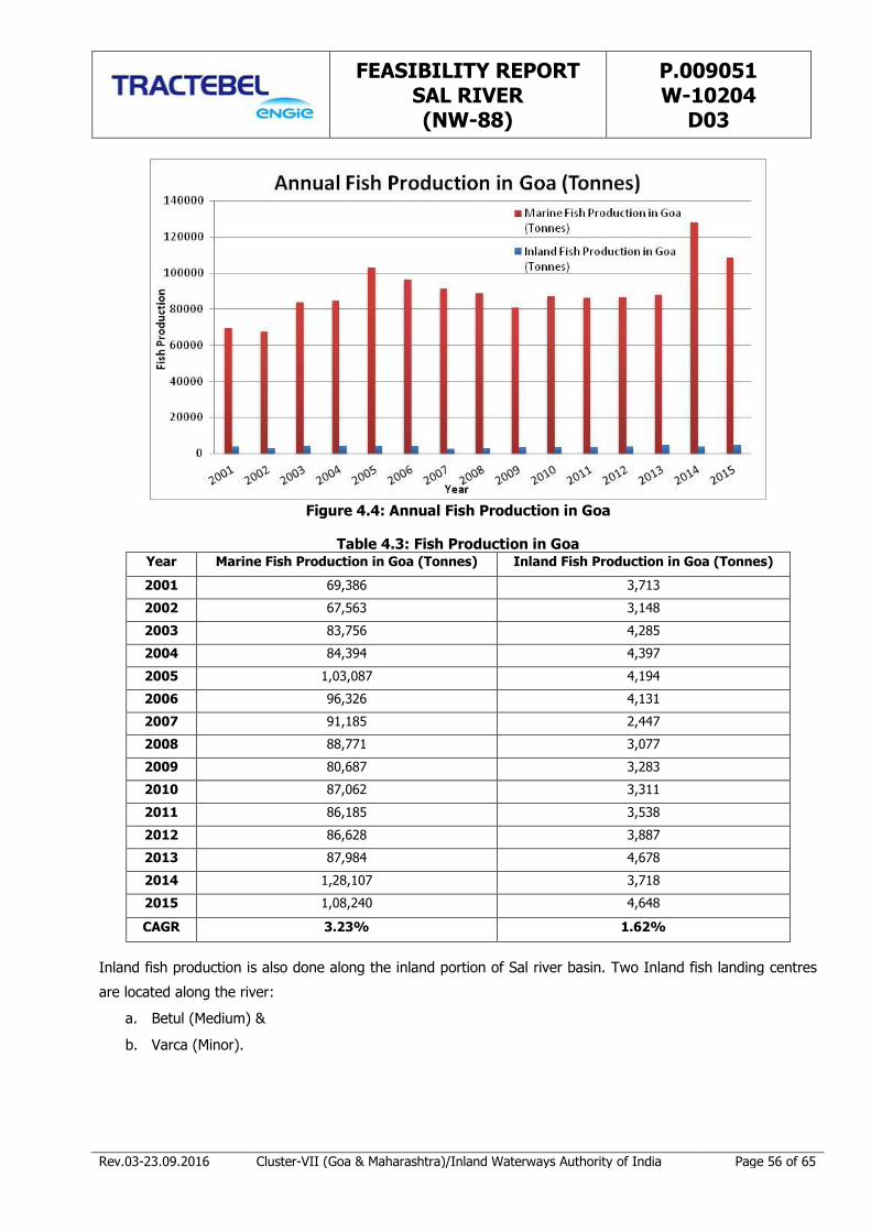
FEASIBILITY REPORT SAL RIVER (NW-88)
P.009051 W-10204
D03
Rev.03-23.09.2016 Cluster-VII (Goa & Maharashtra)/Inland Waterways Authority of India Page 56 of 65
Figure 4.4: Annual Fish Production in Goa
Table 4.3: Fish Production in Goa Year Marine Fish Production in Goa (Tonnes) Inland Fish Production in Goa (Tonnes)
2001 69,386 3,713
2002 67,563 3,148
2003 83,756 4,285
2004 84,394 4,397
2005 1,03,087 4,194
2006 96,326 4,131
2007 91,185 2,447
2008 88,771 3,077
2009 80,687 3,283
2010 87,062 3,311
2011 86,185 3,538
2012 86,628 3,887
2013 87,984 4,678
2014 1,28,107 3,718
2015 1,08,240 4,648
CAGR 3.23% 1.62%
Inland fish production is also done along the inland portion of Sal river basin. Two Inland fish landing centres
are located along the river:
a. Betul (Medium) &
b. Varca (Minor).
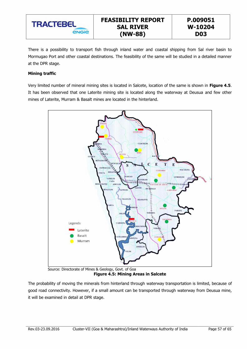
FEASIBILITY REPORT SAL RIVER (NW-88)
P.009051 W-10204
D03
Rev.03-23.09.2016 Cluster-VII (Goa & Maharashtra)/Inland Waterways Authority of India Page 57 of 65
There is a possibility to transport fish through inland water and coastal shipping from Sal river basin to
Mormugao Port and other coastal destinations. The feasibility of the same will be studied in a detailed manner
at the DPR stage.
Mining traffic
Very limited number of mineral mining sites is located in Salcete, location of the same is shown in Figure 4.5.
It has been observed that one Laterite mining site is located along the waterway at Deusua and few other
mines of Laterite, Murram & Basalt mines are located in the hinterland.
Source: Directorate of Mines & Geology, Govt. of Goa
Figure 4.5: Mining Areas in Salcete
The probability of moving the minerals from hinterland through waterway transportation is limited, because of
good road connectivity. However, if a small amount can be transported through waterway from Deusua mine,
it will be examined in detail at DPR stage.
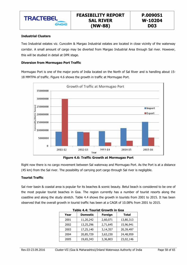
FEASIBILITY REPORT SAL RIVER (NW-88)
P.009051 W-10204
D03
Rev.03-23.09.2016 Cluster-VII (Goa & Maharashtra)/Inland Waterways Authority of India Page 58 of 65
Industrial Clusters
Two Industrial estates viz. Cuncolim & Margao Industrial estates are located in close vicinity of the waterway
corridor. A small amount of cargo may be diverted from Margao Industrial Area through Sal river. However,
this will be studied in detail at DPR stage.
Diversion from Mormugao Port Traffic
Mormugao Port is one of the major ports of India located on the North of Sal River and is handling about 15-
18 MMTPA of traffic. Figure 4.6 shows the growth in traffic at Mormugao Port.
Figure 4.6: Traffic Growth at Mormugao Port
Right now there is no cargo movement between Sal waterway and Mormugao Port. As the Port is at a distance
(45 km) from the Sal river. The possibility of carrying port cargo through Sal river is negligible.
Tourist Traffic
Sal river basin & coastal area is popular for its beaches & scenic beauty. Betul beach is considered to be one of
the most popular tourist beaches in Goa. The region currently has a number of tourist resorts along the
coastline and along the study stretch. Table 4.4 shows the growth in tourists from 2001 to 2015. It has been
observed that the overall growth in tourist traffic has been at a CAGR of 10.08% from 2001 to 2015.
Table 4.4: Tourist Growth in Goa
Year Domestic Foreign Total
2001 11,20,242 2,60,071 13,80,313
2002 13,25,296 2,71,645 15,96,941
2003 17,25,140 3,14,357 20,39,497
2004 20,85,729 3,63,230 24,48,959
2005 19,65,343 3,36,803 23,02,146
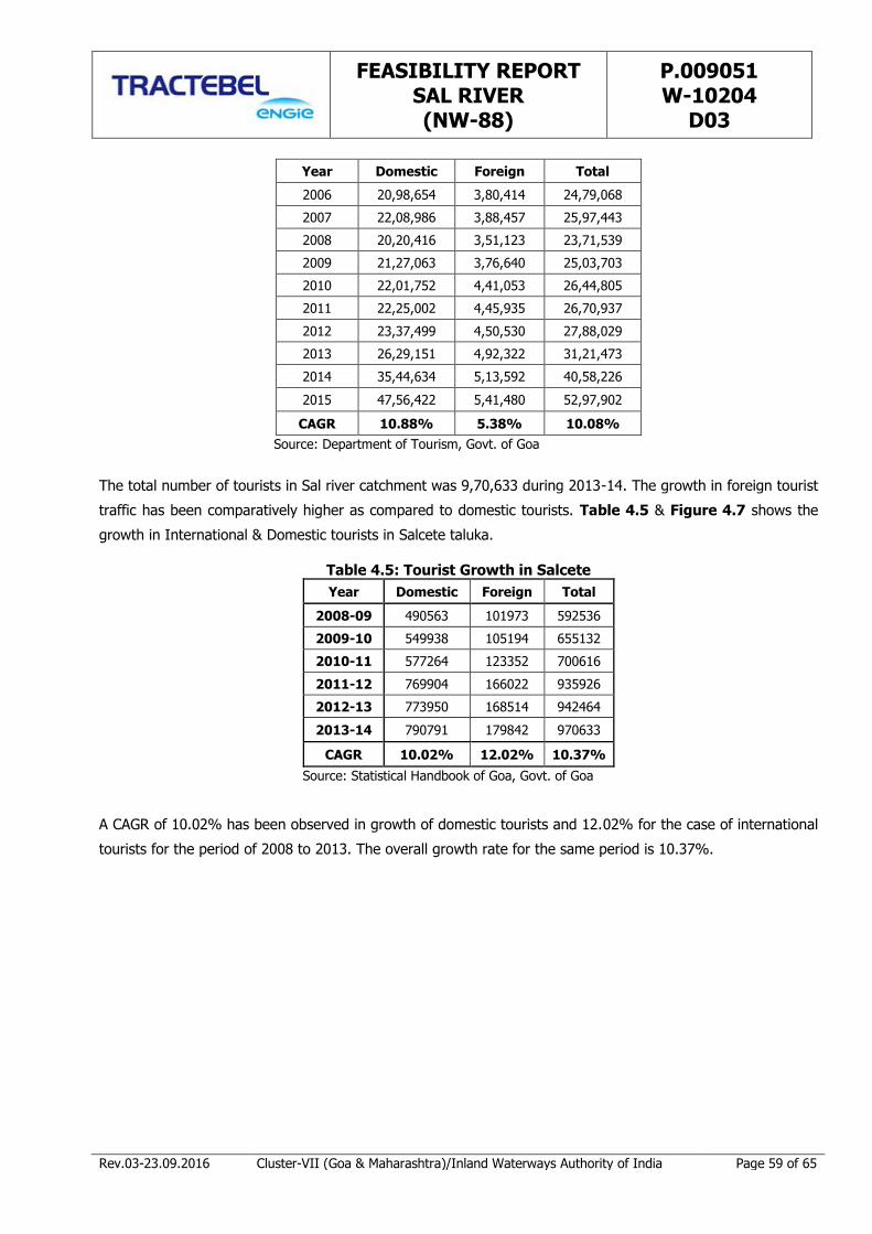
FEASIBILITY REPORT SAL RIVER (NW-88)
P.009051 W-10204
D03
Rev.03-23.09.2016 Cluster-VII (Goa & Maharashtra)/Inland Waterways Authority of India Page 59 of 65
Year Domestic Foreign Total
2006 20,98,654 3,80,414 24,79,068
2007 22,08,986 3,88,457 25,97,443
2008 20,20,416 3,51,123 23,71,539
2009 21,27,063 3,76,640 25,03,703
2010 22,01,752 4,41,053 26,44,805
2011 22,25,002 4,45,935 26,70,937
2012 23,37,499 4,50,530 27,88,029
2013 26,29,151 4,92,322 31,21,473
2014 35,44,634 5,13,592 40,58,226
2015 47,56,422 5,41,480 52,97,902
CAGR 10.88% 5.38% 10.08%
Source: Department of Tourism, Govt. of Goa
The total number of tourists in Sal river catchment was 9,70,633 during 2013-14. The growth in foreign tourist
traffic has been comparatively higher as compared to domestic tourists. Table 4.5 & Figure 4.7 shows the
growth in International & Domestic tourists in Salcete taluka.
Table 4.5: Tourist Growth in Salcete
Year Domestic Foreign Total
2008-09 490563 101973 592536
2009-10 549938 105194 655132
2010-11 577264 123352 700616
2011-12 769904 166022 935926
2012-13 773950 168514 942464
2013-14 790791 179842 970633
CAGR 10.02% 12.02% 10.37%
Source: Statistical Handbook of Goa, Govt. of Goa
A CAGR of 10.02% has been observed in growth of domestic tourists and 12.02% for the case of international
tourists for the period of 2008 to 2013. The overall growth rate for the same period is 10.37%.
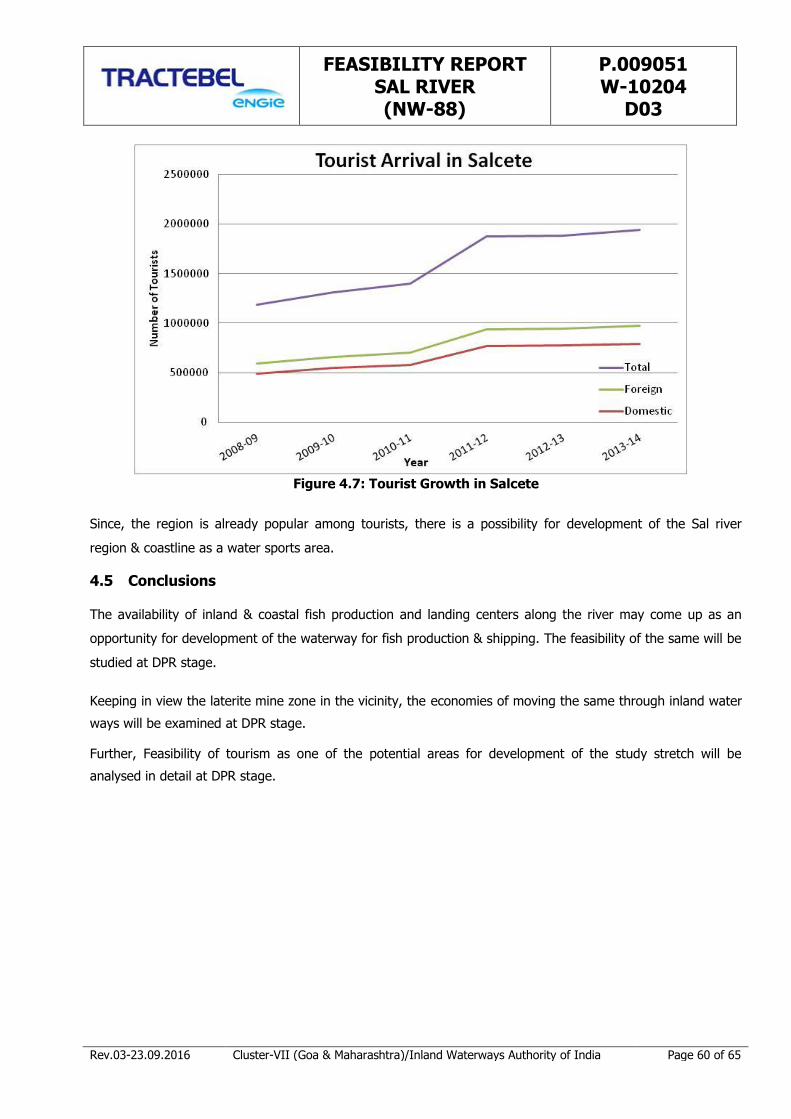
FEASIBILITY REPORT SAL RIVER (NW-88)
P.009051 W-10204
D03
Rev.03-23.09.2016 Cluster-VII (Goa & Maharashtra)/Inland Waterways Authority of India Page 60 of 65
Figure 4.7: Tourist Growth in Salcete
Since, the region is already popular among tourists, there is a possibility for development of the Sal river
region & coastline as a water sports area.
4.5 Conclusions
The availability of inland & coastal fish production and landing centers along the river may come up as an
opportunity for development of the waterway for fish production & shipping. The feasibility of the same will be
studied at DPR stage.
Keeping in view the laterite mine zone in the vicinity, the economies of moving the same through inland water
ways will be examined at DPR stage.
Further, Feasibility of tourism as one of the potential areas for development of the study stretch will be
analysed in detail at DPR stage.

FEASIBILITY REPORT SAL RIVER (NW-88)
P.009051 W-10204
D03
Rev.03-23.09.2016 Cluster-VII (Goa & Maharashtra)/Inland Waterways Authority of India Page 61 of 65
CHAPTER 5 OBSERVATIONS AND INFERENCES
5.1 Waterway Feasibility
Based on the details presented in the Chapter-3, following conclusions have been derived for establishing the
navigability of the proposed waterway;
1. The river length as given by IWAI is 14km, whereas the total surveyed length along the river to capture
the thalweg is 14.26km. The deepest channel route has been reckoned as 14.26km. All inferences derived
for identifying the navigable length have been derived with reference to the deepest channel length
(14.26km).
2. The full study stretch of river is under tidal effect. The relevant chart datum has been used. However,
only 23% of the surveyed length has water depth more than 2.0m, however not continuous. The average
tidal variation is 1.15m with maximum high tide of 2.3m and low tide of 0.0m as per the records available
for this region. The average tide height of 1.2m would be an added advantage for the safe navigation.
3. As per the observation, the feasibility study suggests that the river is navigable without any significant
obstructions up to the end of the stretch i.e., up to the Orlim Deusa Bridge (at the end of the stretch).
Smoothening of the bends is required at the critical bends and modifications in the clearances under H. T.
Line and Electric Lines are to be carried out. By considering the above, the entire stretch can be
considered under Class III Waterway.
4. The lengths of the waterway, with a depth more than 2.0m, 1.5m and 1.0m with reference to the Chart
Datum have been compiled in the main report. This is given in Table 3.7 of the report and is being
reproduced below:
Maximum – Minimum Depth in Sal River from Ch 0.00km to Ch 14.26km
Chainage
(Km)
Draft Available Length of River (Km)
Max. (m) Min. (m) >2m 1.5-2.0m 1-1.5m <1m
0-3 6.66 0.75 0.97 0.97 0.68 0.37
3-7 3.68 0.09 1.12 0.82 1.03 1.03
7-10 4.37 0.02 0.81 0.92 0.23 1.04
10-14.26 2.65 0.12 0.35 0.69 1.27 1.96
Total 3.25 3.40 3.21 4.40
5. Two Electric Lines and one H. T. Line are crossing the study stretch with the vertical clearance ranging
from 2.2m to 10.00m above MHWS. The minimum vertical clearance required shall be 20.1m
corresponding to 220kVA transmission line.

FEASIBILITY REPORT SAL RIVER (NW-88)
P.009051 W-10204
D03
Rev.03-23.09.2016 Cluster-VII (Goa & Maharashtra)/Inland Waterways Authority of India Page 62 of 65
The description & classification of the waterway has been presented schematically based on the survey
observation and duly keeping in view the river classification criteria in Table 3.16 as reproduced below.
Criteria
Length of waterway from start (km) 1 1 2 3 4 4 5 6 6 7 8 9 9 10 11 11 12 13 14 14
Chainage length in % 5% 10% 15% 20% 25% 30% 35% 40% 45% 50% 55% 60% 65% 70% 75% 80% 85% 90% 95% 100%
Depth availble
Raod Bridge Vert. Clearance
Raod Bridge Hor. Clearance
HT Line Vert. Clearance
Bend Radius
Index
Classification
Needs Raising of HT Base
C-III
C-III
C-III
C-III
All Class Class-V Class-IV Class-III Class-II Class-I
5.2 Cargo Feasibility
The present Cargo mobility in the Sal River area is comparatively minimal. However, the Fishing activity in the
study stretches is in a buzz.
Subsequent to the preliminary market survey and its analysis, there is a possible growth of Fishing and
Tourism in the study stretch. Further, the possible Cargo mobility linking two Industrial Estates in the
hinterland is to be examined. Possibility of IWT mobility of Laterite from mining area is also to be examined
and analyzed.
In order to expand the Fishing and Tourism activities and establish the possible IWT mobility of Laterite, the
waterway development is felt essential. Accordingly, the waterway is to be developed to Class III to meet the
above activities.
5.3 SWOT Analysis
SWOT analysis has been carried out for deriving meaningful information specifying the objectives of the study
for development of the waterway for year round commercial navigation and identifying the internal & external
factors that are favorable and unfavorable in the development of the waterway.
Strength
1. 23% of the surveyed length has water depth more than 2 m and is safe for navigation.
2. The above depth availability is for the initial 2kms to 3 kms. Certain patches may be required to be
attended with a considerable conservancy activity involving dredging in the study stretch.
3. The maximum water level (tidal) fluctuation of 2.3m has been observed and this will strengthen the safe
mobility of vessels in the waterway.
4. The study stretch of Sal River is flowing through Salcete Taluka of South Goa District. Approximately 2.94
lacs of population is residing in the Salcete Taluka, in the vicinity of Sal River, which will have direct or
indirect benefits from the IWT and related projects coming up in the area.
5. Fishing activity is flourishing in the Sal River area with Betul and Virca ports as hub.

FEASIBILITY REPORT SAL RIVER (NW-88)
P.009051 W-10204
D03
Rev.03-23.09.2016 Cluster-VII (Goa & Maharashtra)/Inland Waterways Authority of India Page 63 of 65
6. Numbers of Hotels are observed on the banks of Sal River, which may be a strength for Tourism activity in
the River. The Betul Beach is also observed in the vicinity.
7. Two industrial estates viz., viz., Margao Industrial Estate (12kms from the nearest river front) and
Cuncolim Industrial Estate (8kms from the nearest river front) are in the catchment of Sal River.
8. Laterite Mining is in the catchment of Sal River.
9. The above Industrial Estates and the Mining zone are well connected with Road and also with Mormugoa
Port.
Weakness
1. Presently, there is no IWT movement.
2. Connectivity of Industrial Estates / Mining Zone with Road may be a weakness, if not used advantageously
for IWT.
Opportunity
1. 23 % of the existing waterway is having a depth more than 2m, which can be used advantageously for the
mobility of hinterland cargo.
2. The existing fishing activity (through the river and two ports) will get encouragement with the
development of Sal River.
3. Since many Hotels are on the banks of Sal River and with the presence of Betul Beach in the proximity,
Tourism may flourish, if the Sal River is developed.
4. The existence of two industrial estates viz., Margao Industrial Estate and Cuncolim Industrial Estate in the
catchment of Sal River is an opportunity, if used by IWT.
5. Possibilities of Laterite mobility from the Mines in the hinterland through IWT can be explored.
6. The present Rail and Road connectivity though may be competing with IWT may also be an opportunity
for creating an efficient intermodal hub for IWT.
7. Policies are to be firmed up for development of IWT in this stretch.
Threat
1. The Mumbai-Goa Highway in the study area may create competing mode of transport.
2. The Sal River banks covered by marginal mangrove trees in certain places may involve some socio-
environmental issues and may require statutory approvals and clearances to construct the jetties/
terminal/ ports/ intermodal connectivity.
5.4 Development Cost (Tentative)
The reconnaissance survey data with regard to physical constraints may have cost implications for making the
river stretch navigable to the required standards of Waterway. Henceforth, the development of the proposed
national waterway involves physical interference in the form of dredging, construction of terminals at the
identified locations, modification of HT Lines at crossing locations to provide a minimum vertical clearance of
20.1m (with respect to 220 kVA) or the case may be combined with some unforeseen expenses. Moderate
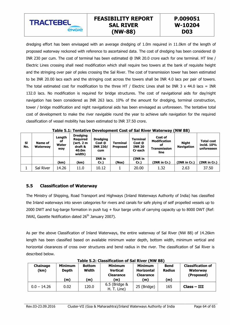
FEASIBILITY REPORT SAL RIVER (NW-88)
P.009051 W-10204
D03
Rev.03-23.09.2016 Cluster-VII (Goa & Maharashtra)/Inland Waterways Authority of India Page 64 of 65
dredging effort has been envisaged with an average dredging of 1.0m required in 11.0km of the length of
proposed waterway reckoned with reference to ascertained data. The cost of dredging has been considered @
INR 230 per cum. The cost of terminal has been estimated @ INR 20.0 crore each for one terminal. HT line /
Electric Lines crossing shall need modification which shall require two towers at the bank of requisite height
and the stringing over pair of poles crossing the Sal River. The cost of transmission tower has been estimated
to be INR 20.00 lacs each and the stringing cost across the towers shall be INR 4.0 lacs per pair of towers.
The total estimated cost for modification to the three HT / Electric Lines shall be INR 3 x 44.0 lacs = INR
132.0 lacs. No modification is required for bridge structures. The cost of navigational aids for day/night
navigation has been considered as INR 263 lacs. 10% of the amount for dredging, terminal construction,
tower / bridge modification and night navigational aids has been envisaged as unforeseen. The tentative total
cost of development to make the river navigable round the year to achieve safe navigation for the required
classification of vessel mobility has been estimated to INR 37.50 crore.
Table 5.1: Tentative Development Cost of Sal River Waterway (NW 88)
Sl No.
Name of Waterway
Length of
Waterway
Dredging Required (wrt. 2 m draft & 40.0m width)
Dredging Cost @
INR 230/ cum
Terminal Proposed
Terminal Cost @ INR 20 Cr each
Cost of Modification
of Transmission
line
Night Navigation
Total cost incld. 10% unforeseen
(km) (km)
INR in Cr.) (Nos)
(INR in Cr.) (INR in Cr.)
(INR in Cr.) (INR in Cr.)
1 Sal River 14.26 11.0 10.12 1 20.00 1.32 2.63 37.50
5.5 Classification of Waterway
The Ministry of Shipping, Road Transport and Highways (Inland Waterways Authority of India) has classified
the Inland waterways into seven categories for rivers and canals for safe plying of self propelled vessels up to
2000 DWT and tug-barge formation in push tug + four barge units of carrying capacity up to 8000 DWT (Ref:
IWAI, Gazette Notification dated 26th January 2007).
As per the above Classification of Inland Waterways, the entire waterway of Sal River (NW 88) of 14.26km
length has been classified based on available minimum water depth, bottom width, minimum vertical and
horizontal clearances of cross over structures and bend radius in the river. The classification of Sal River is
described below.
Table 5.2: Classification of Sal River (NW 88)
Chainage
(km)
Minimum
Depth
(m)
Bottom
Width
(m)
Minimum
Vertical
Clearance
(m)
Minimum
Horizontal
Clearance
(m)
Bend
Radius
(m)
Classification of
Waterway
(Proposed)
0.0 – 14.26 0.02 120.0 6.5 (Bridge & H. T. Line)
25 (Bridge) 165 Class – III
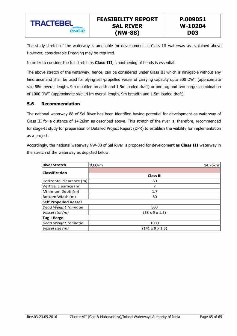
FEASIBILITY REPORT SAL RIVER (NW-88)
P.009051 W-10204
D03
Rev.03-23.09.2016 Cluster-VII (Goa & Maharashtra)/Inland Waterways Authority of India Page 65 of 65
The study stretch of the waterway is amenable for development as Class III waterway as explained above.
However, considerable Dredging may be required.
In order to consider the full stretch as Class III, smoothening of bends is essential.
The above stretch of the waterway, hence, can be considered under Class III which is navigable without any
hindrance and shall be used for plying self-propelled vessel of carrying capacity upto 500 DWT (approximate
size 58m overall length, 9m moulded breadth and 1.5m loaded draft) or one tug and two barges combination
of 1000 DWT (approximate size 141m overall length, 9m breadth and 1.5m loaded draft).
5.6 Recommendation
The national waterway-88 of Sal River has been identified having potential for development as waterway of
Class III for a distance of 14.26km as described above. This stretch of the river is, therefore, recommended
for stage-II study for preparation of Detailed Project Report (DPR) to establish the viability for implementation
as a project.
Accordingly, the national waterway NW-88 of Sal River is proposed for development as Class III waterway in
the stretch of the waterway as depicted below:
River Stretch
Horizontal clearance (m)
Vertical clearnce (m)
Minimum Depth(m)
Bottom Width (m)
Dead Weight Tonnage
Vessel size (m)
Tug + Barge
Dead Weight Tonnage
Vessel size (m)
0.00km 14.26km
ClassificationClass III
50
1000
(141 x 9 x 1.5)
7
1.7
50
Self Propelled Vessel
500
(58 x 9 x 1.5)

ANNEXURE 1.1
DATA COLLECTION & SOURCE OF DATA
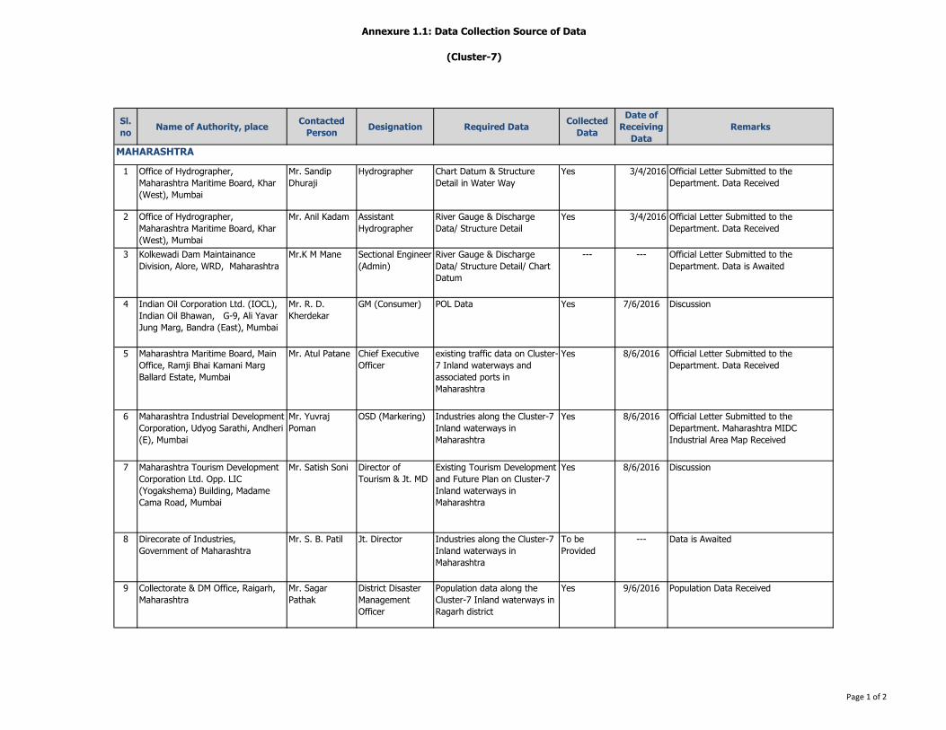
Annexure 1.1: Data Collection Source of Data
(Cluster-7)
Sl.
noName of Authority, place
Contacted
PersonDesignation Required Data
Collected
Data
Date of
Receiving
Data
Remarks
1 Office of Hydrographer,
Maharashtra Maritime Board, Khar
(West), Mumbai
Mr. Sandip
Dhuraji
Hydrographer Chart Datum & Structure
Detail in Water Way
Yes 3/4/2016 Official Letter Submitted to the
Department. Data Received
2 Office of Hydrographer,
Maharashtra Maritime Board, Khar
(West), Mumbai
Mr. Anil Kadam Assistant
Hydrographer
River Gauge & Discharge
Data/ Structure Detail
Yes 3/4/2016 Official Letter Submitted to the
Department. Data Received
3 Kolkewadi Dam Maintainance
Division, Alore, WRD, Maharashtra
Mr.K M Mane Sectional Engineer
(Admin)
River Gauge & Discharge
Data/ Structure Detail/ Chart
Datum
--- --- Official Letter Submitted to the
Department. Data is Awaited
4 Indian Oil Corporation Ltd. (IOCL),
Indian Oil Bhawan, G-9, Ali Yavar
Jung Marg, Bandra (East), Mumbai
Mr. R. D.
Kherdekar
GM (Consumer) POL Data Yes 7/6/2016 Discussion
5 Maharashtra Maritime Board, Main
Office, Ramji Bhai Kamani Marg
Ballard Estate, Mumbai
Mr. Atul Patane Chief Executive
Officer
existing traffic data on Cluster-
7 Inland waterways and
associated ports in
Maharashtra
Yes 8/6/2016 Official Letter Submitted to the
Department. Data Received
6 Maharashtra Industrial Development
Corporation, Udyog Sarathi, Andheri
(E), Mumbai
Mr. Yuvraj
Poman
OSD (Markering) Industries along the Cluster-7
Inland waterways in
Maharashtra
Yes 8/6/2016 Official Letter Submitted to the
Department. Maharashtra MIDC
Industrial Area Map Received
7 Maharashtra Tourism Development
Corporation Ltd. Opp. LIC
(Yogakshema) Building, Madame
Cama Road, Mumbai
Mr. Satish Soni Director of
Tourism & Jt. MD
Existing Tourism Development
and Future Plan on Cluster-7
Inland waterways in
Maharashtra
Yes 8/6/2016 Discussion
8 Direcorate of Industries,
Government of Maharashtra
Mr. S. B. Patil Jt. Director Industries along the Cluster-7
Inland waterways in
Maharashtra
To be
Provided
--- Data is Awaited
9 Collectorate & DM Office, Raigarh,
Maharashtra
Mr. Sagar
Pathak
District Disaster
Management
Officer
Population data along the
Cluster-7 Inland waterways in
Ragarh district
Yes 9/6/2016 Population Data Received
MAHARASHTRA
Page 1 of 2
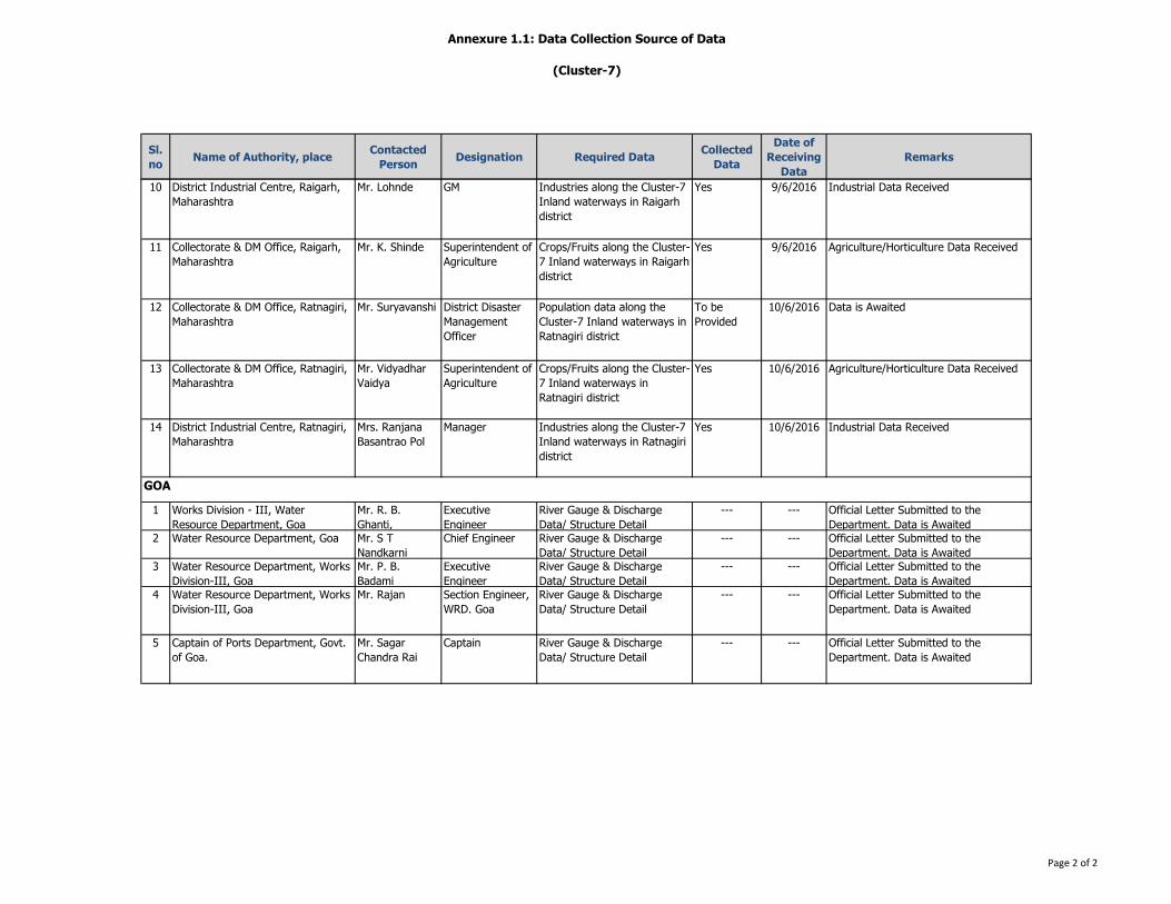
Annexure 1.1: Data Collection Source of Data
(Cluster-7)
Sl.
noName of Authority, place
Contacted
PersonDesignation Required Data
Collected
Data
Date of
Receiving
Data
Remarks
10 District Industrial Centre, Raigarh,
Maharashtra
Mr. Lohnde GM Industries along the Cluster-7
Inland waterways in Raigarh
district
Yes 9/6/2016 Industrial Data Received
11 Collectorate & DM Office, Raigarh,
Maharashtra
Mr. K. Shinde Superintendent of
Agriculture
Crops/Fruits along the Cluster-
7 Inland waterways in Raigarh
district
Yes 9/6/2016 Agriculture/Horticulture Data Received
12 Collectorate & DM Office, Ratnagiri,
Maharashtra
Mr. Suryavanshi District Disaster
Management
Officer
Population data along the
Cluster-7 Inland waterways in
Ratnagiri district
To be
Provided
10/6/2016 Data is Awaited
13 Collectorate & DM Office, Ratnagiri,
Maharashtra
Mr. Vidyadhar
Vaidya
Superintendent of
Agriculture
Crops/Fruits along the Cluster-
7 Inland waterways in
Ratnagiri district
Yes 10/6/2016 Agriculture/Horticulture Data Received
14 District Industrial Centre, Ratnagiri,
Maharashtra
Mrs. Ranjana
Basantrao Pol
Manager Industries along the Cluster-7
Inland waterways in Ratnagiri
district
Yes 10/6/2016 Industrial Data Received
1 Works Division - III, Water
Resource Department, Goa
Mr. R. B.
Ghanti,
Executive
Engineer
River Gauge & Discharge
Data/ Structure Detail
--- --- Official Letter Submitted to the
Department. Data is Awaited
2 Water Resource Department, Goa Mr. S T
Nandkarni
Chief Engineer River Gauge & Discharge
Data/ Structure Detail
--- --- Official Letter Submitted to the
Department. Data is Awaited
3 Water Resource Department, Works
Division-III, Goa
Mr. P. B.
Badami
Executive
Engineer
River Gauge & Discharge
Data/ Structure Detail
--- --- Official Letter Submitted to the
Department. Data is Awaited
4 Water Resource Department, Works
Division-III, Goa
Mr. Rajan Section Engineer,
WRD. Goa
River Gauge & Discharge
Data/ Structure Detail
--- --- Official Letter Submitted to the
Department. Data is Awaited
5 Captain of Ports Department, Govt.
of Goa.
Mr. Sagar
Chandra Rai
Captain River Gauge & Discharge
Data/ Structure Detail
--- --- Official Letter Submitted to the
Department. Data is Awaited
GOA
Page 2 of 2
ANNEXURE 3.1
OVERVIEW CHART FOR SAL RIVER BATHYMETRY
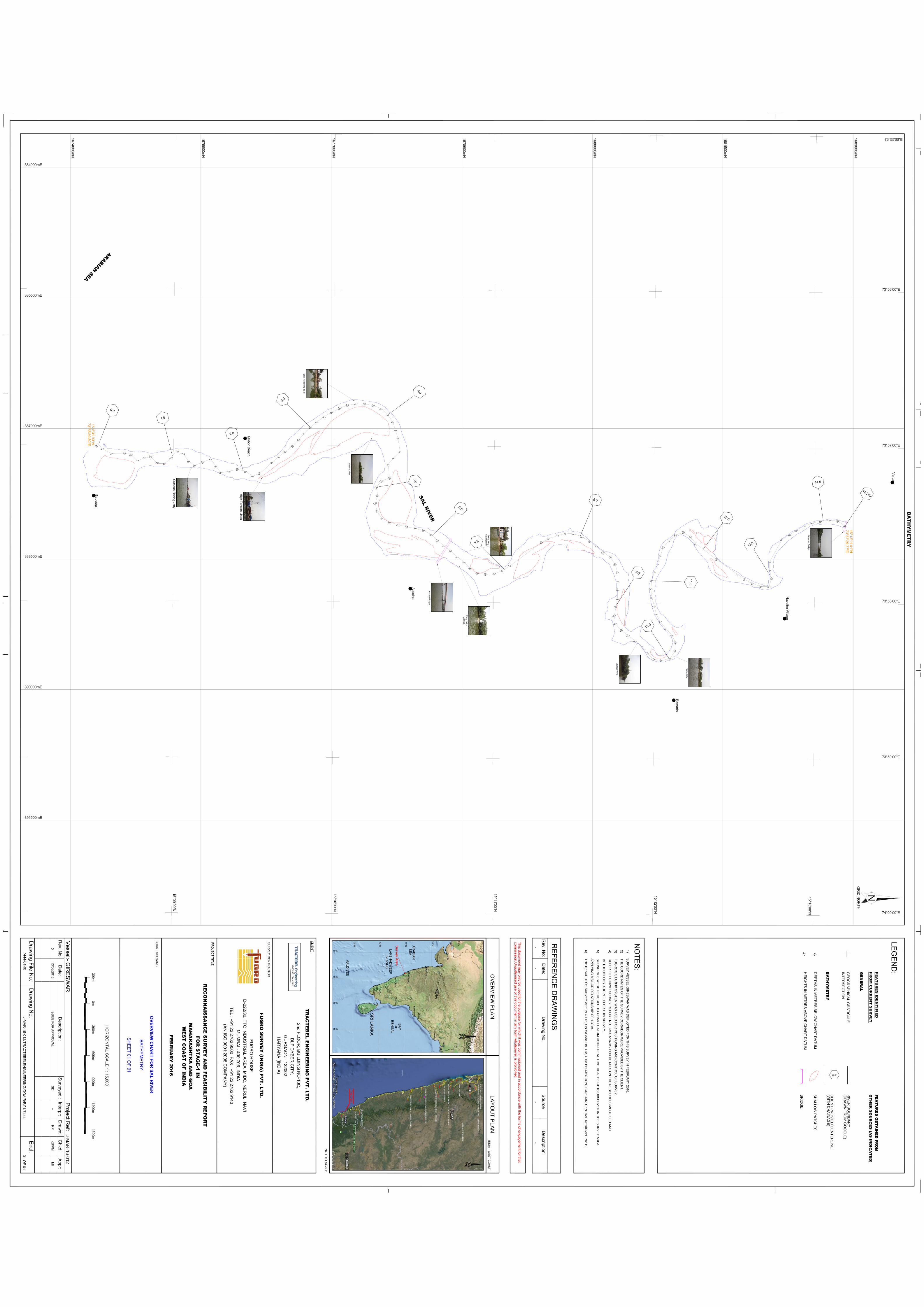

ANNEXURE 3.2
DAILY HEIGHTS OF HIGH AND LOW WATERS AT MORMUGAO OBTAINED
FROM CAPTAIN OF PORTS, PANAJI, GOA
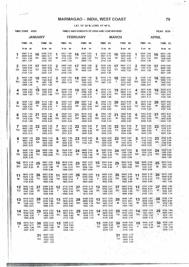
HHF051
Typewritten Text
HHF051
Rectangle
HHF051
Typewritten Text
5
HHF051
Typewritten Text
HHF051
Typewritten Text
HHF051
Typewritten Text
HHF051
Typewritten Text

HHF051
Typewritten Text
5
HHF051
Rectangle
HHF051
Typewritten Text
5
HHF051
Typewritten Text
HHF051
Typewritten Text
HHF051
Typewritten Text

HHF051
Typewritten Text
HHF051
Rectangle
HHF051
Typewritten Text
5
HHF051
Typewritten Text
HHF051
Typewritten Text
ANNEXURE 3.3
BATHYMETRIC SURVEY AS RECEIVED FROM HYDROGRAPHIC SURVEYOR

Chainage (km) Easting(m) Northing(m) Raw Depth(m)Reduced Depth
w.r.t CD (m)
0.00 15° 08' 30.96245" 73° 57' 00.28704" 7.26 6.66
0.07 15° 08' 33.18133" 73° 57' 01.28422" 3.00 2.39
0.20 15° 08' 36.81169" 73° 57' 03.20921" 3.73 3.06
0.34 15° 08' 41.45687" 73° 57' 02.91964" 3.49 2.80
0.42 15° 08' 44.01879" 73° 57' 03.57475" 3.17 2.46
0.52 15° 08' 46.37158" 73° 57' 05.86757" 2.70 1.98
0.61 15° 08' 48.86496" 73° 57' 04.72755" 3.42 2.69
0.68 15° 08' 51.29749" 73° 57' 04.28973" 3.46 2.73
0.78 15° 08' 53.86684" 73° 57' 06.40494" 2.30 1.56
0.87 15° 08' 56.50274" 73° 57' 06.87309" 2.15 1.41
0.97 15° 08' 58.97146" 73° 57' 04.69754" 2.85 2.10
1.07 15° 09' 01.26491" 73° 57' 02.27625" 2.75 1.99
1.14 15° 09' 03.60060" 73° 57' 03.19919" 2.73 1.96
1.25 15° 09' 05.51330" 73° 57' 05.95894" 2.42 1.65
1.33 15° 09' 07.75057" 73° 57' 07.48179" 2.27 1.48
1.43 15° 09' 10.80182" 73° 57' 06.28940" 3.47 2.67
1.52 15° 09' 13.69557" 73° 57' 05.03009" 2.21 1.40
1.62 15° 09' 15.63727" 73° 57' 07.72910" 2.72 1.90
1.72 15° 09' 17.58411" 73° 57' 10.34466" 5.47 4.64
1.82 15° 09' 20.65330" 73° 57' 09.72244" 2.57 1.73
1.92 15° 09' 23.83418" 73° 57' 08.97335" 1.63 0.78
2.01 15° 09' 26.82412" 73° 57' 09.78556" 2.35 1.49
2.11 15° 09' 29.58745" 73° 57' 11.55514" 2.78 1.91
2.20 15° 09' 32.12451" 73° 57' 10.50230" 2.09 0.91
2.39 15° 09' 36.66003" 73° 57' 06.22033" 3.05 1.87
2.49 15° 09' 39.14898" 73° 57' 04.06064" 2.65 1.46
2.59 15° 09' 41.72278" 73° 57' 02.02182" 2.75 1.56
2.69 15° 09' 44.30411" 73° 56' 59.92464" 1.95 0.75
2.79 15° 09' 46.55790" 73° 56' 57.51712" 2.15 0.95
2.89 15° 09' 48.68010" 73° 56' 55.08544" 2.34 1.13
2.99 15° 09' 50.97477" 73° 56' 52.65357" 2.54 1.33
3.09 15° 09' 53.47847" 73° 56' 50.52589" 2.51 1.29
3.19 15° 09' 56.11931" 73° 56' 48.56673" 2.59 1.36
3.29 15° 09' 58.91296" 73° 56' 46.85542" 2.98 1.75
3.39 15° 10' 01.83831" 73° 56' 45.33243" 3.42 2.18
3.49 15° 10' 04.83230" 73° 56' 44.01650" 3.60 2.35
3.59 15° 10' 08.02872" 73° 56' 43.46586" 3.57 2.31
3.69 15° 10' 11.27943" 73° 56' 43.53050" 3.80 2.54
3.79 15° 10' 14.46875" 73° 56' 44.10609" 3.69 2.42
3.89 15° 10' 17.47896" 73° 56' 45.42042" 3.22 1.94
3.99 15° 10' 19.83766" 73° 56' 47.71274" 3.12 1.84
4.09 15° 10' 21.76439" 73° 56' 50.39625" 2.64 1.36
4.19 15° 10' 22.89237" 73° 56' 53.54077" 2.50 1.21
4.29 15° 10' 23.75534" 73° 56' 56.73420" 2.41 1.12
Annexure 3.3: Bathymetric Survey as Received from Hydrographic Surveyor
Page 1 of 3

Chainage (km) Easting(m) Northing(m) Raw Depth(m)Reduced Depth
w.r.t CD (m)
4.44 15° 10' 24.55633" 73° 57' 01.92403" 2.44 1.14
4.54 15° 10' 22.27646" 73° 57' 04.25406" 2.81 1.51
4.64 15° 10' 20.16189" 73° 57' 06.78966" 2.71 1.40
4.80 15° 10' 20.63941" 73° 57' 12.06652" 2.06 0.74
4.90 15° 10' 17.59043" 73° 57' 13.18696" 3.64 2.32
4.99 15° 10' 15.75799" 73° 57' 15.51641" 5.00 3.68
5.09 15° 10' 16.28492" 73° 57' 18.82542" 1.53 0.20
5.18 15° 10' 15.39762" 73° 57' 21.66757" 1.67 0.32
5.28 15° 10' 16.06364" 73° 57' 24.94138" 2.09 0.74
5.37 15° 10' 17.93985" 73° 57' 27.56524" 2.70 1.35
5.47 15° 10' 20.86512" 73° 57' 29.03431" 2.98 1.63
5.57 15° 10' 23.95573" 73° 57' 30.01335" 3.58 2.23
5.67 15° 10' 27.12057" 73° 57' 30.79133" 3.69 2.34
5.77 15° 10' 30.32099" 73° 57' 31.37847" 4.40 3.05
5.87 15° 10' 33.47828" 73° 57' 32.14208" 3.98 2.63
5.97 15° 10' 36.37881" 73° 57' 33.68168" 2.75 1.40
6.07 15° 10' 38.62798" 73° 57' 36.02970" 2.05 0.70
6.17 15° 10' 41.19406" 73° 57' 38.01395" 2.05 0.70
6.27 15° 10' 43.73134" 73° 57' 39.96485" 2.19 0.84
6.37 15° 10' 46.14911" 73° 57' 42.25244" 2.87 1.52
6.47 15° 10' 48.76204" 73° 57' 44.23483" 2.69 1.34
6.57 15° 10' 51.03644" 73° 57' 46.62804" 3.15 1.80
6.67 15° 10' 53.67411" 73° 57' 48.47428" 1.63 0.28
6.76 15° 10' 56.84533" 73° 57' 49.01340" 1.43 0.09
6.86 15° 11' 00.06982" 73° 57' 48.68200" 1.79 0.45
6.96 15° 11' 03.07960" 73° 57' 47.51960" 3.02 1.68
7.06 15° 11' 05.81391" 73° 57' 45.68765" 3.32 1.98
7.52 15° 11' 17.60217" 73° 57' 36.54061" 2.21 0.87
7.62 15° 11' 20.48124" 73° 57' 34.98367" 4.20 2.86
7.72 15° 11' 23.58356" 73° 57' 33.99163" 3.34 2.00
7.81 15° 11' 26.59134" 73° 57' 33.03657" 2.52 1.19
7.91 15° 11' 29.82277" 73° 57' 33.15410" 2.84 1.51
8.01 15° 11' 32.82106" 73° 57' 34.43964" 2.98 1.65
8.11 15° 11' 35.63821" 73° 57' 36.10376" 3.00 1.67
8.21 15° 11' 38.19266" 73° 57' 38.10529" 4.31 2.98
8.31 15° 11' 40.75581" 73° 57' 40.16075" 5.53 4.20
8.41 15° 11' 43.40352" 73° 57' 42.06166" 1.81 0.48
8.51 15° 11' 45.21101" 73° 57' 44.82359" 1.93 0.60
8.61 15° 11' 46.05797" 73° 57' 48.04129" 2.01 0.68
8.71 15° 11' 46.37362" 73° 57' 51.43016" 2.32 1.00
8.81 15° 11' 46.36007" 73° 57' 54.78177" 3.19 1.87
8.91 15° 11' 46.19742" 73° 57' 58.12439" 3.19 1.87
9.01 15° 11' 45.54177" 73° 58' 01.33368" 1.34 0.02
9.11 15° 11' 45.00330" 73° 58' 04.62383" 1.87 0.55
9.20 15° 11' 45.44955" 73° 58' 07.76475" 1.88 0.56
Page 2 of 3

Chainage (km) Easting(m) Northing(m) Raw Depth(m)Reduced Depth
w.r.t CD (m)
9.30 15° 11' 47.68210" 73° 58' 10.19895" 2.21 0.89
9.40 15° 11' 50.21410" 73° 58' 12.28888" 2.18 0.86
9.50 15° 11' 52.87024" 73° 58' 14.27132" 2.88 1.56
9.60 15° 11' 55.31616" 73° 58' 16.39889" 4.28 2.96
9.70 15° 11' 57.40477" 73° 58' 18.95751" 5.56 4.24
9.80 15° 11' 59.69157" 73° 58' 21.30606" 5.69 4.37
9.90 15° 12' 02.87622" 73° 58' 21.79701" 3.94 2.62
10.00 15° 12' 05.98418" 73° 58' 20.95788" 2.99 1.66
10.10 15° 12' 07.72072" 73° 58' 18.18598" 1.45 0.12
10.20 15° 12' 07.98689" 73° 58' 14.83272" 2.07 0.74
10.29 15° 12' 06.56332" 73° 58' 11.96119" 2.64 1.31
10.39 15° 12' 04.34890" 73° 58' 09.50674" 2.63 1.30
10.49 15° 12' 02.26134" 73° 58' 06.89919" 2.27 0.94
10.59 15° 12' 00.72209" 73° 58' 03.99945" 2.30 0.97
10.69 15° 11' 59.89059" 73° 58' 00.80370" 2.62 1.29
10.79 15° 11' 59.07032" 73° 57' 57.57641" 2.51 1.18
10.89 15° 11' 58.61137" 73° 57' 54.23040" 2.28 0.95
10.99 15° 11' 58.96894" 73° 57' 50.95984" 2.61 1.27
11.09 15° 11' 59.89400" 73° 57' 47.74850" 2.57 1.23
11.19 15° 12' 01.08734" 73° 57' 44.63839" 2.50 1.16
11.29 15° 12' 02.11570" 73° 57' 41.46239" 2.88 1.54
11.39 15° 12' 03.21496" 73° 57' 38.28033" 1.75 0.41
11.49 15° 12' 05.27305" 73° 57' 35.75813" 2.30 0.96
11.59 15° 12' 07.69609" 73° 57' 33.47776" 4.00 2.65
11.69 15° 12' 10.71181" 73° 57' 32.41065" 1.90 0.55
11.78 15° 12' 13.36165" 73° 57' 34.13631" 2.17 0.82
11.88 15° 12' 15.39365" 73° 57' 36.74139" 2.23 0.88
12.18 15° 12' 23.19302" 73° 57' 42.74566" 1.64 0.28
12.58 15° 12' 33.82776" 73° 57' 50.42732" 1.71 0.34
12.68 15° 12' 36.70142" 73° 57' 52.00319" 2.29 0.92
12.78 15° 12' 39.74346" 73° 57' 53.18212" 3.99 2.62
12.88 15° 12' 42.86585" 73° 57' 53.08443" 3.83 2.45
12.97 15° 12' 43.75661" 73° 57' 50.12845" 1.96 0.58
13.07 15° 12' 43.02812" 73° 57' 46.98366" 2.49 1.11
13.17 15° 12' 43.02479" 73° 57' 43.58094" 2.66 1.28
13.46 15° 12' 47.57776" 73° 57' 35.02916" 1.84 0.45
13.56 15° 12' 50.32587" 73° 57' 33.23771" 2.23 0.84
13.66 15° 12' 53.00280" 73° 57' 31.39600" 2.66 1.27
13.76 15° 12' 55.84079" 73° 57' 29.75791" 3.05 1.66
13.86 15° 12' 58.89625" 73° 57' 28.63120" 3.20 1.80
13.96 15° 13' 02.05838" 73° 57' 27.91082" 3.23 1.83
14.06 15° 13' 05.27623" 73° 57' 27.48745" 2.54 1.14
14.16 15° 13' 08.46115" 73° 57' 27.82303" 2.32 0.92
14.26 15° 13' 11.15310" 73° 57' 29.71314" 2.94 1.54
Note: Reduced depth has been reckoned by applying tide variation Min 0.60m & Max 1.40m
Page 3 of 3
ANNEXURE 3.4
PHOTOS CAPTURED BY SURVEY TEAM DURING RECONNAISSANCE
SURVEY
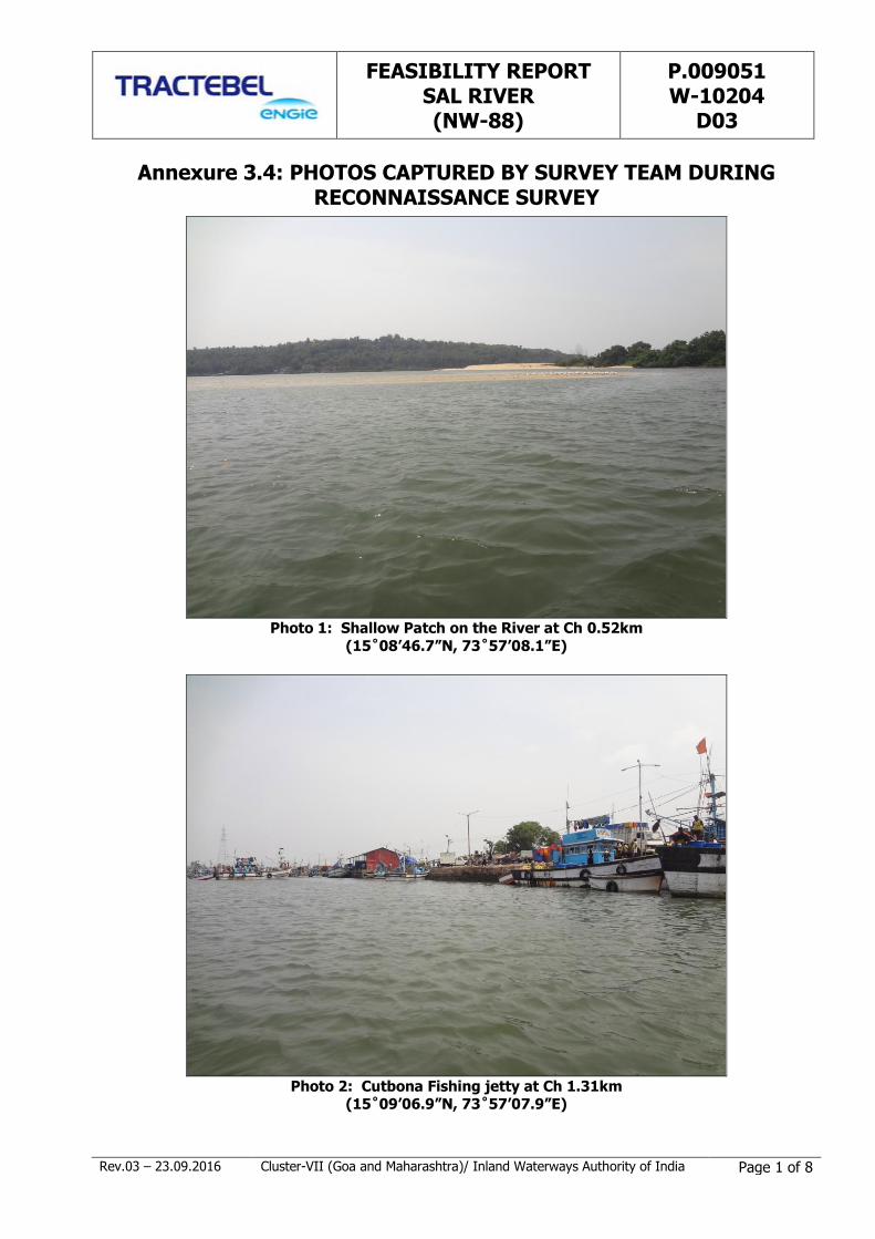
FEASIBILITY REPORT SAL RIVER (NW-88)
P.009051 W-10204
D03
Rev.03 – 23.09.2016 Cluster-VII (Goa and Maharashtra)/ Inland Waterways Authority of India Page 1 of 8
Annexure 3.4: PHOTOS CAPTURED BY SURVEY TEAM DURING RECONNAISSANCE SURVEY
Photo 1: Shallow Patch on the River at Ch 0.52km
(15˚08’46.7”N, 73˚57’08.1”E)
Photo 2: Cutbona Fishing jetty at Ch 1.31km
(15˚09’06.9”N, 73˚57’07.9”E)
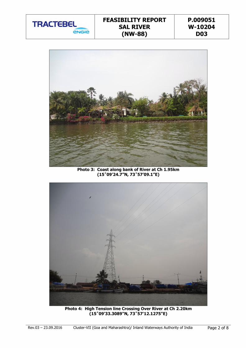
FEASIBILITY REPORT SAL RIVER (NW-88)
P.009051 W-10204
D03
Rev.03 – 23.09.2016 Cluster-VII (Goa and Maharashtra)/ Inland Waterways Authority of India Page 2 of 8
Photo 3: Coast along bank of River at Ch 1.95km
(15˚09’24.7”N, 73˚57’09.1”E)
Photo 4: High Tension line Crossing Over River at Ch 2.20km
(15˚09'33.3089"N, 73˚57'12.1275"E)

FEASIBILITY REPORT SAL RIVER (NW-88)
P.009051 W-10204
D03
Rev.03 – 23.09.2016 Cluster-VII (Goa and Maharashtra)/ Inland Waterways Authority of India Page 3 of 8
Photo 5: Fishing stakes in the middle of the River at Ch 2.32 km
(15˚09'35.1275"N, 73˚57'07.8832"E)
Photo 6: Cutbona fishing jetty at Ch 2.34km
(15˚09'39.4690"N, 73˚57'11.8464"E)
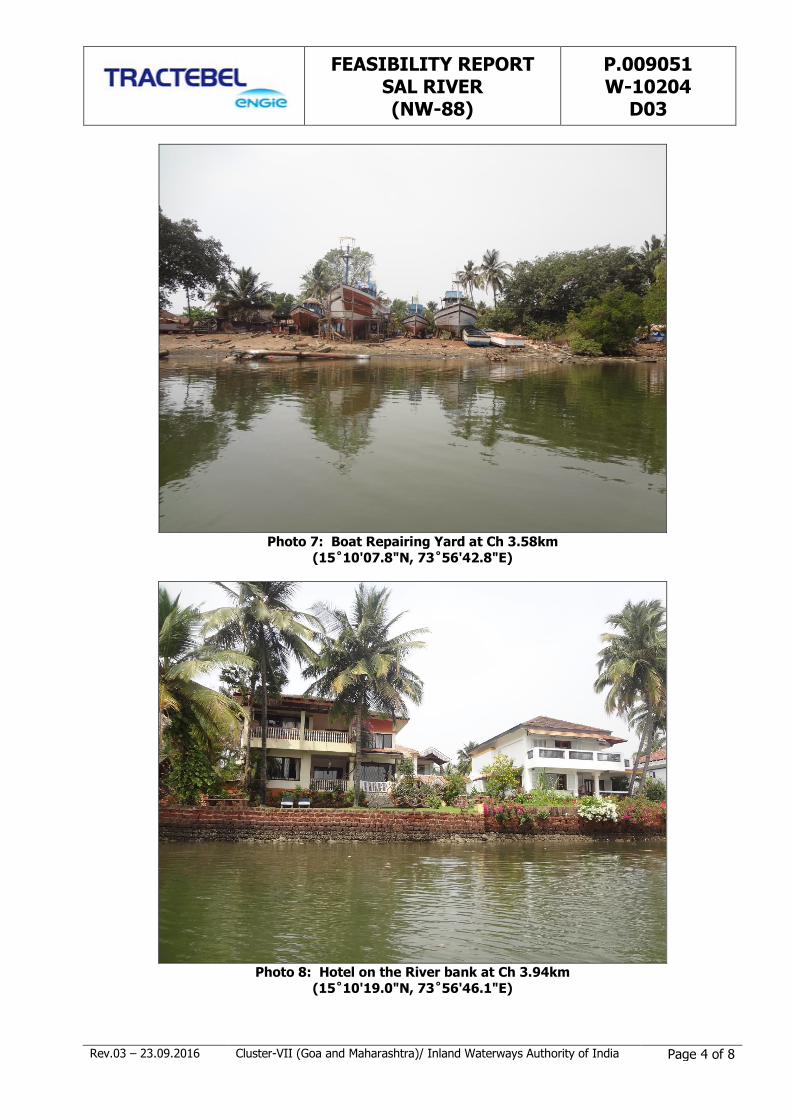
FEASIBILITY REPORT SAL RIVER (NW-88)
P.009051 W-10204
D03
Rev.03 – 23.09.2016 Cluster-VII (Goa and Maharashtra)/ Inland Waterways Authority of India Page 4 of 8
Photo 7: Boat Repairing Yard at Ch 3.58km
(15˚10'07.8"N, 73˚56'42.8"E)
Photo 8: Hotel on the River bank at Ch 3.94km
(15˚10'19.0"N, 73˚56'46.1"E)

FEASIBILITY REPORT SAL RIVER (NW-88)
P.009051 W-10204
D03
Rev.03 – 23.09.2016 Cluster-VII (Goa and Maharashtra)/ Inland Waterways Authority of India Page 5 of 8
Photo 9: Electric Wire crossing River at Ch 4.21km
(15˚10'14.2572"N, 73˚56'56.7898"E)
Photo 10: Asolna Bridge at Ch 6.20km (15˚10'41.9539"N, 73˚57'38.7456"E)

FEASIBILITY REPORT SAL RIVER (NW-88)
P.009051 W-10204
D03
Rev.03 – 23.09.2016 Cluster-VII (Goa and Maharashtra)/ Inland Waterways Authority of India Page 6 of 8
Photo 11: Ferry Jetty of Cavelossim village at Ch 6.39km
(15˚10'48.2124"N, 73˚57'40.7286"E)
Photo 12: Asolna Ferry Jetty at Ch 6.46km
(15˚10'47.0485"N, 73˚57'46.0493"E)

FEASIBILITY REPORT SAL RIVER (NW-88)
P.009051 W-10204
D03
Rev.03 – 23.09.2016 Cluster-VII (Goa and Maharashtra)/ Inland Waterways Authority of India Page 7 of 8
Photo 13: Electric Wire Crossing River at Ch 9.55km
(15˚11'53.9536"N, 73˚58'15.2019"E)
Photo 14: Ferry Jetty at Ch 10.05km
(15˚12'07.2748"N, 73˚58'19.8492"E)

FEASIBILITY REPORT SAL RIVER (NW-88)
P.009051 W-10204
D03
Rev.03 – 23.09.2016 Cluster-VII (Goa and Maharashtra)/ Inland Waterways Authority of India Page 8 of 8
Photo 15: Navelim Bridge at Ch 14.26km
(15˚13'11.4112"N, 73˚57'29.0631"E)
ANNEXURE 3.5
LONGITUDINAL BED PROFILE OF SAL RIVER WATERWAY

ANNEXURE 3.6
COMPILATION OF FIELD INFORMATION OF SAL RIVER IN IWAI FORMAT
SL# DESCRIPTION DETAILS REMARKS
NAME OF THE FIRM Fugro Survey (India) Pvt Ltd
REGION / CLUSTER NO. Cluster-7/ Stage-I/ Goa
1 NAME OF THE WATERWAY Sal River
2 LENGTH OF THE WATERWAY (km) 14Kms
3 WATERWAY IN THE STATES OF Goa
4 FIELD WORK COMPLETED FOR THE LENGTH OF THE WATERWAY (km) 14 kms (Data acquisition done on 01.03.2016)
5 Length of the waterway having tidal effects (km) 14Kms
6 Start & end location name having tidal effects Betul to Khareband Bridge
7 Tidal variation (m) For Tide Variation measurement 24 Hrs continuous
observation is required at one place which is not in scope
in Stage-1.
8 Length of the waterway, where depths more than 2m is observed 3.25 Km
9 Length of the waterway, where depths more than 1.5m is observed 6.65 Km
Length of the waterway, where depths more than 1.0m is observed 9.86 Km
10 Existing Water level (m) 0.02m to 6.66 m
11 Minimum Water Level (m) 0.02
12 Highest Flood level (m) - We have not seen HFL marking in any Bridges
13 Existing list of Dam, Barrages, Locks Nil
14 Existing Bridges (nos.) 2
15 Minimum Vertical and Horizontal clearances (m) as per visual estimation 1) Asolna Road Bridge - Ch 6.20 km, VC: 8.5 m, HC: 42
m
1) Orlim-Deusa Road Bridge - Ch 14.26 km, VC: 6.5 m,
HC: 25 m
Assolna Bridge is left with old piers erected below the
bridge, hence clearance is reduced, can be seen in photos.
Vertical clearance above MHWS
16 High Tension lines 1 HT Line (Near Cutbona fishing jetty at Ch 2.2Km), 1 electric wire at Ch 4.2 km and 2nd electric wire at Ch 9.5
km from starting point
17 Rocks Nil
18 Steep gradients Refer the Drawing
19 Details of wildlife /forest area Nil
20 Protected areas Nil
21 Security clearances Nil
Annexure 3.6: Compilation of Field Information of Sal River in IWAI Format
TIDAL WATERWAYS
DEPTH INFORMATION
CROSS-STRUCTURE INFORMATION
NAVIGATIONAL OBSTRUCTION
ENVIRONMENTAL & OTHER ISSUES
Page 1 of 2
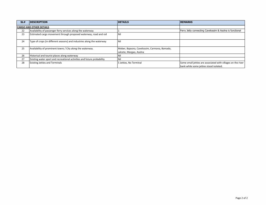
SL# DESCRIPTION DETAILS REMARKS
22 Availability of passenger ferry services along the waterway 1 Ferry Jetty connecting Cavelossim & Asolna is functional
23 Estimated cargo movement through proposed waterway, road and rail Nil
24 Type of crops (in different seasons) and industries along the waterway Nil
25 Availability of prominent towns / City along the waterway. Mober, Bapsora, Cavelossim, Carmona, Bamado,
salcete, Margao, Asolna
26 Historical and tourist places along waterway Nil
27 Existing water sport and recreational activities and future probability Nil
28 Existing Jetties and Terminals 5 Jetties, No Terminal Some small jetties are associated with villages on the river
bank while some jetties stood isolated.
CARGO AND OTHER DETAILS
Page 2 of 2
ANNEXURE 4.1
LIST OF INDUSTRIES IN SAL RIVER CATCHMENT REGION
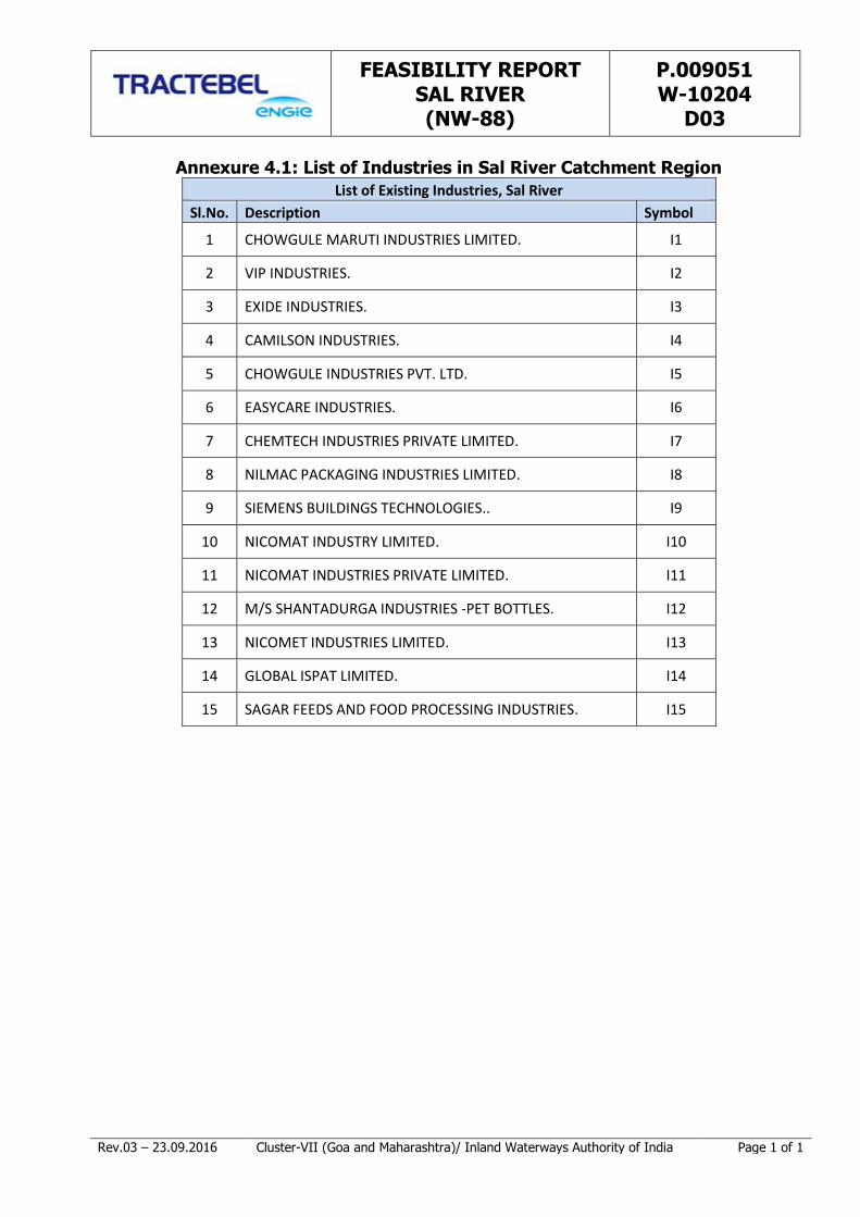
FEASIBILITY REPORT SAL RIVER (NW-88)
P.009051 W-10204
D03
Rev.03 – 23.09.2016 Cluster-VII (Goa and Maharashtra)/ Inland Waterways Authority of India Page 1 of 1
Annexure 4.1: List of Industries in Sal River Catchment Region
List of Existing Industries, Sal River
Sl.No. Description Symbol
1 CHOWGULE MARUTI INDUSTRIES LIMITED. I1
2 VIP INDUSTRIES. I2
3 EXIDE INDUSTRIES. I3
4 CAMILSON INDUSTRIES. I4
5 CHOWGULE INDUSTRIES PVT. LTD. I5
6 EASYCARE INDUSTRIES. I6
7 CHEMTECH INDUSTRIES PRIVATE LIMITED. I7
8 NILMAC PACKAGING INDUSTRIES LIMITED. I8
9 SIEMENS BUILDINGS TECHNOLOGIES.. I9
10 NICOMAT INDUSTRY LIMITED. I10
11 NICOMAT INDUSTRIES PRIVATE LIMITED. I11
12 M/S SHANTADURGA INDUSTRIES -PET BOTTLES. I12
13 NICOMET INDUSTRIES LIMITED. I13
14 GLOBAL ISPAT LIMITED. I14
15 SAGAR FEEDS AND FOOD PROCESSING INDUSTRIES. I15
DRAWINGS
DRAWING NO. P.009051-W-20201-A03 R0 (SHEET-1 TO 1): LAYOUT
PLAN – SAL RIVER
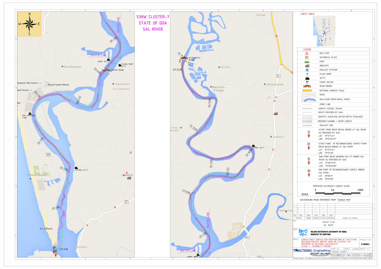
MAPS
MAP 4.1 - LAYOUT MAP SHOWING EXISTING JETTIES AND INDUSTRIES
IN VICINITY OF SAL RIVER
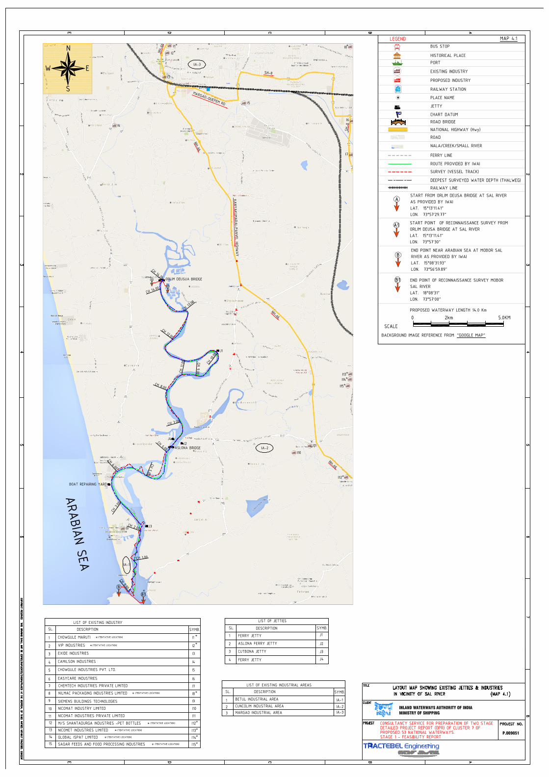
TRACTEBEL ENGINEERING PVT. LTD.2nd Floor, Building no. 10C,DLF Cyber CityHaryana122 002 - Gurgaon - INDIAtractebel-engie.com
Bidhan Chandra JHAtel. +91 [email protected]
At the helm of the Energy Transition, Tractebel provides a full range of engineering and consulting services throughoutthe life cycle of its clients’ projects, including design and project management. As one of the world’s largest engineeringconsultancy companies and with more than 150 years of experience, it's our mission to actively shape the world oftomorrow. With about 4,400 experts and offices in 33 countries, we are able to offer our customers multidisciplinarysolutions in energy, water and infrastructure.