Concept of regions: Types of regions and their delineation
14
2.17.1 Unit :I.REGIONAL PLANNING Concept of regions: Types of regions and their delineation Dr. SAYANI MUKHOPADHYAY ASSOCIATE PROFESSOR,DEPT OF GEOGRAPHY
-
Upload
khangminh22 -
Category
Documents
-
view
0 -
download
0
Transcript of Concept of regions: Types of regions and their delineation

2.17.1 Unit :I.REGIONAL PLANNING
Concept of regions: Types of regions and their delineation
Dr. SAYANI MUKHOPADHYAY
ASSOCIATE PROFESSOR,DEPT OF GEOGRAPHY

Definition of Region
• The concept of Region is generally linked with SPACE and has spatial dimensions.
• It is sometimes also used to as ‘SUBJECTIVE’ (a ‘mental construct’) or ‘spaceless’.However, for most Geographer, REGION is an OBJECTIVE REALITY linked with spaceDEFINED IN TERMS OF SPACE.
• Sometimes a part of a DISTRICT (sometimes even a village) is called REGION,Sometimes A DISTRICT, A STATE, A GROUP OF STATES is regarded as REGION.
• Broadly on the basis of methods of Delimiting a REGION can be grouped under THREECATEGORIES---A. HOMOGENITY, B. NODALITY , C. PROGRAMMING
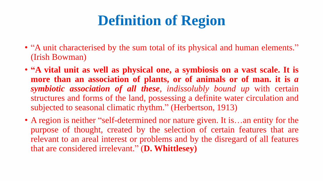
Definition of Region
• “A unit characterised by the sum total of its physical and human elements.”(Irish Bowman)
• “A vital unit as well as physical one, a symbiosis on a vast scale. It ismore than an association of plants, or of animals or of man. it is asymbiotic association of all these, indissolubly bound up with certainstructures and forms of the land, possessing a definite water circulation andsubjected to seasonal climatic rhythm.” (Herbertson, 1913)
• A region is neither “self-determined nor nature given. It is…an entity for thepurpose of thought, created by the selection of certain features that arerelevant to an areal interest or problems and by the disregard of all featuresthat are considered irrelevant.” (D. Whittlesey)

Spatial Dimension of Region
Position of 3 Dimensional Natural
Regions with the Geographic Envelop
(Based on R. P. Mishra)
Boundaries:
1. Geographic Envelop
2. Region
3. Sub Region
4. Land Surface

Classification of RegionClassification of Region
Based on GenesisBased on SizeBased on Principle
Principle of
Homogeneity
Principle of
Interlinking
Natural
Region
Cultural
Region
Economic
Region
Commodity
Flow
Human
Flow
Information
Flow
Capital
Flow
Commuters
Migrants
Local
Region
Micro
Region
Meso
Region
Macro
Region Denoted
RegionInstituted
Region
Naive
Region
Planning
Region

Homogeneous/Formal Regions
• It is the older concept, evolved during the phase of agrarian economy.
• According to Whittlesey Committee- homogeneity of a region is determinedby criteria formulated for the purpose of sorting from the whole range ofearth phenomena.
• Homogeneity is not total but lies within a predefined range, and is relatedto certain selected features, while the unrelated ones are disregarded.
• Homogeneity can be decided on physical, economic, social character ofregion or a combination of these three.
• It is an intellectual concept, an entity for the purpose of thought.
• It has objective view- “an end in itself, an areal entity, that can be identifiedand mapped.”-Glasson
• Methods for its delineation are fixed index, weighted index, andsuperimposition of maps etc.

Types of Formal Region
The Great Mountain Wall Western Himalayas Kashmir HimalayasPunjab Kumaan Himalayas
Eastern Himalayas Darjeeling Sikkim, Assam HimalayasEastern Bodar Hills & Plateau
The Great PlainSutlaj, Beas,Ravi
Ganga,Upper Ganga Yamuna,BrahmaPutra
North Western North Punjab, South Punjab, Rajasthan
Upper Ganga Ganga Yamuna, Rohilkhand, Avadh
Middle Ganga
Delta
Assam Valley
The Great Plateau ofPeninsular India
North Western Peninsular
Peninsular India
Aravalli Hills, Chambal BasinBundelkhand upland, MalwaVindhyan Scrap land
North EasternPeninsular Plateau
Baaghelkhand, Chattisgarsh BasinBastar Plateau, Orissa Hills, Chotnagpur Hills
Maharastra Western Ghats, Lava Plateau, Western Ganga Valley
Karnataka Plateau Malnad region, Maiden region
Tamilnadu Plateau
Andhra Plateau
Coastal Plains West Coast Kutch Peninsular, Kathiawar Peninsular, Gujarat Plains, Konkan Coast, Karnatic Malabar Coast
East Coast Tamilnadu Coast, Andhra Coast, Orissa Coast
The Island Laccadive, Minicoy & Amindivv, Andaman & Nicobar Islands
Formal (social) Regions, Tribal areas in 9 states
covered under The Fifth Schedule
Source: http://www.mmpindia.org/triballand.jpg
Formal (natural) regions of India
Formal (Physical) Regions of India; After S. P. Chatterjee
Types of Formal (Homogenous) Region:
1. Natural Region
2. Cultural Region
3. Economic Region

Functional/Nodal/Polarized Region• It is a product of modern economy, industrial
development and urbanization
• It is based on the principle of interdependenceand interlinking
For delineation of functional regions
Quantitative methods are used, such as:
• Zipf’s- principle of ‘Distance Decay’
• Stewart ‘s– ‘Gravity Model’
• Chistaller’s and Losche’s- ‘Central Place’
theory.
• Thiessen Polygon method
Example of Varanasi City as a
Functional Region
(After R. Ramachandran)

Elements of Functional Region
Elements of a Functional Region (After Hagget)
A. Movements
B. Channels
C. Nodes
D. Hiararchies
E. Surfaces
F. Diffusion
• Peter Haggett has identified six
elements of a functional region.
• These regions show flows related to
people, commodity, capital etc. that
bind the various sub parts of a region
in a coherent whole.
• Cities serve as nodes within such
regions and control all activities within
their sphere of influence.

Planning Region
• Concept of these regions is a product of problems caused byindustrialization, urbanization, uneven regional development, andecological problems
• They are subjective in nature
• “At each stage of development different regional delimitation will bethe most convenient and efficient for purpose of planning.” (JohnFriedman)

Types of Planning Region based on Economic Development(After Friedman)
• 1. Beginning of economic development, rural agricultural base – Multistateregion
• 2. Stage of industrialization & urbanization – Metropolitan region andproblem specific regions.
• 3. New technologies, pressure on old spaces, new national objectives -Frontier region (virgin territories).
• 4. Declining or stagnated economy – Depressed regions

P. SEN GUPTA’s Scheme of Planning Regions of India (1968)
• Keeping natural regions of the country as a base and consideration
of nodality, production specialization and utilization of power
resources as bases of delineation, in view of accepting the
importance of state boundaries , P. Sen Gupta (1968) presented a
framework of planning regions of India of different order. He
divided India into 7 major planning regions by grouping states
approximately coinciding with the drainage basin. . Her 7macro
regions are further divided into 42 meso regions.
• These 7 regions include :
• (1) North Eastern Region
• (2) Eastern Region
• (3) Northern Central Region
• (4) Central Region
• (5) North-Western Region
• (6) Western Region, and
• (7) Southern Region

Classification on the Basis of Genesis
• Naive Region – They don’t have well defined boundary and their existencedepends upon social acceptance .
• Instituted region – These are bounded by administrative boundaries likedistrict or state.
• Denoted region – These are identified by regionalization technique, theyare also called planning regions.

THANK YOU