Commons in Cape Town
55
Transcript of Commons in Cape Town


Why commons now?
Towards a Cape Town of commons
The colloquium Urban Commons Cape Town
A new map of Cape Town
1. Reasons for commoning
The island of Collaborative Agency
2. Creating a common understanding
The island of Aspiration
The island of Understanding
The island of Responsibility
3. Commons as a model for change
The island of Perception
The island of Playful Place-making
The island of Shared interest
Resource Lab and participants
4–5
8–11
12–15
16–17
18–19
20–27
28–29
30–39
40–59
60–71
72–73
74–83
84–93
94–101
102
Resource/Lab Mejan Arc
Advanced Studies in UrbanismRoyal Institute of Art
Box 16315, 103 26 Stockholm, Sweden
www.kkh.se
2 3

Why are so many activists, practitioners and academics sud-denly using the concept of commons in their thinking and doing? What changes in society are behind the resurfacing of this old concept? As we know from history, commons were the pastures, waters and forests managed collectively for the benefit of a group of villagers, shepherds or fisher-men who used them as their common resource. The enclo-sure of these well-sited lands in sixteenth century Britain became the foundations of industrialisation and the capital-ist society in which we still live. Today, it appears, different groups in different societies in reaction to a variety of wants and needs and augmented by different aspirations, are looking for approaches to creat-ing ways of living not defined by the state or guided by the private domain. Instead, they turn towards the notion of the commons to explore whether it could imply possibilities for providing access to possible common resources, or if it could promote the creation of new resources for their own collective use. The once rural concept has moved into the urban and city dwellers are commoning the city. Who then are these urban commoners? Who is invited to participate in the urban commoning process, and who is excluded? Who has no other choice than to common the few urban resources that are accessible? What type of society could be imagined where diverse groups provide themselves with different necessities, but also with innovative types of
cial practices of commoning go much deeper than academic and theoretical constructs – although these are helpful in understanding the process. Such commoning is under-pinned by a local vernacular of agency for social change, ac-cess to resources, and security. These strong motivators are often guided by mutual values, language and participation. What emerges from the social practices of commoning are radical shifts towards new models for incremental change. In September 2012 Aditya Kumar, an architect from the Cape Town-based NGO Community Organisation Re-source Centre (CORC), visited Stockholm and the Royal Institute of Art (KKH). At that point, a group of six young professionals who the previous year had studied Cape Town within the KKH-Mejan Arc course Just Grounds: Cape Town, had just started an investigation of Cape Town through the lens of the commons. The program in which they were participating at KKH, In Search of Common Ground, had a particular focus on the urban commons in contemporary Europe. The group of six directed their parallel research of the implications of commons in Cape Town, incorporating a dialogue with Aditya and CORC. Five individual projects grew out of the investigation and an urge to create a collo-quium on urban commons, held in South Africa, bringing ideas of the commons up against the reality of Cape Town. The colloquium, called Urban Commons Cape Town, was
self-organization? Will the state then escape its duty to pro-vide basic services to its citizens, or can mutual agreements between state and ‘commoners’ create a new way forward that guarantees those services? What will the role of the state eventually be in a future where the commons is the norm? This work does not have the intention of idealizing dep-rivation and lack of access – the urban reality that can be found in many areas of Cape Town – where people are com-moning as a means of survival. But it looks at what is actu-ally happening on the ground in terms of commoning in Cape Town, and at the models of agreements that have been created around those processes, and speculates on what could possibly be commoned from some existing Capetow-nian conditions and on what would be the outcomes. Cape Town is a city of many ongoing commoning proc-esses. The urban poor of Cape Town create commons out of necessity to access water, sanitation, food and childcare, to reach basic services – or should one rather say, to access their basic urban rights? They common without using these terminologies, without the understanding of practices in other parts of the world where other groups of citizens are experimenting with similar models of self-organization to achieve a politically different future. Yet a common underlying factor forged through struggle and agency binds together these isolated practices. The so-
held in early February 2013 as a collaborative platform of KKH and CORC. In mid-April, another group of research-ers from In Search of Common Ground organized a conference in Stockholm called Commoning the City, which further ex-plored the present and future of commoning processes in relation to the urban environment. What this publication brings to you as a reader are seven projects exploring the commons in Cape Town, in its wid-est sense. It points towards practical models for common-ing as well as to new contributions to and interpretations of the concept. It looks at models of agreements, responsibil-ity and change, of aspirations and transformative cases and thresholds. It discusses the need for a common language and common tools to reveal lacks and needs and to manage processes of transformation. With this work we are trying to understand what the concept of commons can offer the city and its citizens in terms of political change, in terms of self-organisation for access to resources and in terms of creating a resilient city. We are at the very beginning of this exploration and would like to ask you to join us on the road into the unmapped ter-ritory of the urban commons.henrietta palmer Architect and Professor
WHY COMMONS NOW?
4 5

Map Cape Town Metropolitan area
6 7

Cape Town’s eclectic history – a way station in the mid-1600s to provide fresh produce for passing ships which evolved into a colony ruled by various European powers – in many ways mirrors its present circumstances. The city is still characterized by the same apartheid-based roots laid by its early European colonizers. Spatial divides and perva-sive inequalities which have not yet been solved by the new democratic dispensation, the consolidation of metropolitan functions, and a range of policy reforms since the end of apartheid, in many ways obstruct the creation of social and spatial justice. Cape Town is the second largest South African city af-ter Johannesburg, and boasts a thriving services and real estate economy at the southwest tip of Africa. Boasting the title of ‘World Design Capital’ for 2014, Cape Town aims to present its diversity, culture, and an economically vibrant inner-city hub in as a world-class city. The spectacu-lar sights of Table Mountain, the Cape Winelands, and the Cape Floristic Kingdom are complemented by well-patron-ised tourist attractions, Atlantic seaboard coastal drives, a Mediterranean climate and diverse languages and cultures, making Cape Town Africa’s top tourist destination. However, Cape Town is also frequently called ‘the city with
been located on the peripheries of cities where land is cheap-er. Part of the problem lies in the nature of South African housing policy which focuses narrowly on individual own-ership of a 50 square metre plot and a built structure, and has ignored other approaches such as upgrading of informal settlements or forms of rentals. The housing delivery model has failed to enable the crea-tion of socially and economically sustainable urban envi-ronments. While communities wait for subsidized housing, the City’s high water table means seasonal flooding and the hot dry summer conditions result in many shack fires. As a spatially divided city, accessibility remains a problem, and more than a third of the city’s population reportedly travels by foot daily because of the unavailability of public trans-port. Those who can afford it spend up to 25% of their in-come on public transport. The main issues and challenges to be addressed by plan-ners and city-builders concerns the spatial restructuring of the city to overcome inefficiencies entrenched by apartheid planning. This would include better integration of work and residences across the city. The neighborhoods located in southeast Cape Town, including Mitchell’s Plain, Gu-gulethu, Nyanga, Crossroads and Khayelitsha, have rich
two faces’ because of its spatial segregation, a segregation which has impact on social stratifications. The vast expans-es of the low-lying Cape Flats in the southeast of Cape Town are home to more than a third of the City’s population (ap-proximately 1,000,000 people). The Cape Flats have been described as ‘apartheid’s dumping ground’ when the former racist state cleared all ‘non-whites’ from better located areas beginning in the 1950s, a period marked by extensive spa-tial restructuring to achieve urban separation. Despite efforts to spatially integrate the city, it can be argued that the more transformative notions of spatial re-structuring which have characterized many discourses on the ‘post-apartheid city’ – a critical and post-colonial project – have been eclipsed by more conservative and neo-liberal development trajectories. Redressing the pervasive urban and land crisis has also come at a cost. The backlog waiting for state-subsidized housing currently stands at 300,000, with an annual supply of only 30,000 units, which is decreasing due to the lack of available land. The provision of low-income housing for the poor has generally not contributed to building more integrated and sustainable human settlements in close proximity to eco-nomic opportunities, as these developments have often
histories. These thriving and partly informal spaces cre-ate a secondary economy to that of the ‘formal’ city. In the sprawling informal areas, jobs are created and livelihood networks are established. The demographics of these areas show residents are mostly African and Coloured, with more than 30% of the population under the age of 26. Cape Town continues to strive towards the goals of so-cial and spatial justice. In recent years a number of cross-cutting and inter-societal conversations have filled the vacuum created by many years of service delivery neglect in the forgotten ghettos of apartheid planning. Citizens are mobilizing around alternative and more desirable futures, and expressing the richness and diversity of cultures, race, language and belonging. Be it through dance and the per-forming arts, film and media, intercultural exchanges and dialogue, spoken word and poetry – ordinary citizens are voicing their aspirations for urban futures rooted in expres-sions of community, high quality public spaces, and more generally, a revival of the ‘commons’. walter fieuw and aditya kumar, corc
TOWARDS ACAPE TOWNOF COMMONS
8 9

© A
mb
er
Bre
iten
berg
10 11

THE COLLOQUIUMURBAN COMMONSCAPE TOWNThe need to place make and integrate the poor into the spa-tial fabric of cities has been underscored in all major South African policy frameworks since the dawn of the new de-mocracy in 1994. Reimaging the city with an inclusive and pro-poor social structure has to be guided by the values of social and political change. In January 2013 the collo-quium Urban Commons Cape Town was held in Cape Town to try to address these issues and attempt to create a com-mon language. The colloquium also wanted to introduce the concept of commons into the ongoing discussion on ur-ban rights. Three perspectives of commons where chosen. The first addressed the commons as a way to self-organize around certain lacking or existing resources. The second spoke about commons as a political tool to change the dom-inant global neo-liberal model of urban planning. Thirdly, the commons was addressed as a means to create resilience within the urban environment. By creating a neutral platform for learning and exchange, a multiplicity of views on ‘commoning’ the city was uncov-ered. A unique mixture of participants who seldom meet
The lack of integration into the fibre of the city by al-locating better-located land to the poor which would help create a sense of belonging continues to obscure the dreams of a more equal society, a community leader from Langrug informal settlement observed. Cape Town ranks as one of the most unequal and segregated cities in the world, per-petuated through patterns of uneven development. One of the participating academics commented that pov-erty, inequality and unemployment are the three macro-in-stitutional constraints that obscure local action against this spatial injustice. Current forms of delivery are top-down and disempowering, viewing citizens as mere consumers and not as the co-producers they are capable of being. New modes of urban production can be spurred through the co-existence of formal and informal processes and from a shift from private services to investing in public infrastructure that would bring the neighbourhoods of the city into focus. Cape Town’s urban and peri-urban spaces are currently characterised by the new geographies of the elites – shop-ping malls, gated communities, golf courses, and so on. An architect reflected on the transformative potential of rezon-ing some of these spaces for low-income housing, making the city more spatially integrated. This is just one of the mental shifts that will need to take place to fully recognize that the city needs to be a place in common to gain the ca-pacity to meet both present and future challenges. The sort of urban archipelago Cape Town experiences today is too vulnerable as our common urban future.
face-to-face, from civil society – both community organisa-tions and NGOs – practitioners in the fields of architecture, art and planning, local government officials, and academics and researchers, came together for an afternoon and contrib-uted to a rich experience-based narrative on the commons.
Creating commons: the obstacles
The colloquium began by discussing the on-going obstacles to creating urban commons in the neglected informal ar-eas of South African cities, which are characterised by high densities, lack of access to services, crumbling infrastruc-ture, and social pathologies and vulnerabilities. The social and physical distance from basic and critical services often means that communities are exposed to crime and vigilant-ism. This not only points to the underlying breakdown of the ability of the state to deliver public security, as a representa-tive of one of the participating civil society organisations, So-cial Justice Coalition remarked, but also to the steady erosion of citizen-accountability, community-based policing func-tions, access to information and faith in the justice system.
Imagining urban commons in the urban experience
After exploring the obstacles to creating urban commons, succeeding discussions during Urban Commons Cape Town touched upon a range of topics where three central themes emerged: 1.Reasons for commoning: how can issues of limited re-sources, security and basic needs be dealt with and how will they be managed? 2.Creating a common understanding: values, language and recognition. Lack of information, lack of recognition, ac-tors talking past each other and a culture that suffers from racial prejudices is a fertile ground for conflicts and for change not to take place. 3.Commons as models for change: the need of both radical shifts and incremental change in the process of urban devel-opment. How can existing commons be nurtured and how can they can contribute to broader change? How do individuals and institutions deal with these dif-ficulties? How could a language in common be produced? What role can and should the public sector and various dia-logue processes take on to deliver communication and coor-dination at different scales? The questions examined at Urban Commons Cape Town continue to shape and inform the discussion on commons in the South African context, trying as well to create a com-mon language which will bind diverse interests and agendas together.
12 13

14 15

A NEW MAP OF CAPE TOWN
Cape Town – an uncountable number of lives separated from one another and operating by compet-ing rationalities. In describing Cape Town the image of the split, the separation of the city, a space marked by the apartheid system that established mental and physical barriers between people and places, is constantly repeated. Without denying the city’s history, we have been asking ourselves – can these fragments be knit together? We have tried to imagine Cape Town as a composite of di"erent entities of commons, an archipelago of urban islands, to investigate whether it is possible to sketch out a new map of the city – a map that zooms in on small portions of all the commoning processes underway there. What urban imaginaries can help move to forward and create a new language, visions and understandings? Our wish is that this map could possibly contribute to images, concepts, relationships and actions that would give an impetus to constructing a space where change can happen.We have arrived at di"erent islands connected to levels of all the sectors that constitute a city. What sorts of conceptual, site-specific and emotional maps do these islands form and how can they be used? What skills does Cape Town have? What can these skills of commoning and entities of com-mons learn from each other?
On The Island of Collaborative Agency we find a community’s struggle for recognition, slowly build-ing a bridge towards the mainland; the terrain of policies, government and service delivery.
The Island of Aspiration is a trickster, but also a place of silence, where you can concentrate on achiev-ing your goal.
Visiting The Island of Understanding one will gain a new understanding of the loud needs of the dense body beneath a beautiful surface.
It is easy to meet on The Island of Responsibility. Curious people who are careful listeners visit this place. Everyone is welcome to The Island of Playful Place-making. It is growing organically, developing with every new arrival.The Island of Perceptions is populated by a network of people, plants and animals. The landscape is full of sudden unexpected qualities and sensuous knowledge.
The Island of Shared Interests is occupied by young farm workers who create commons through the sharing of the resources available, reconfiguring space.
This is a first attempt to map the urban commons in Cape Town, building on Collaborative Agency, Aspiration, Understanding, Responsibility, Playful Placemaking, Perceptions and Shared Interests. These are all ongoing processes that can be part of a shift towards a more just and resilient urban fu-ture for Cape Town.
16 17

The poor are commoning the city out of necessity. The chal-lenges of producing livelihoods from limited resources en-courages the creation of dense networks of interaction, co-dependence and resilience. Yet many other factors promote social practices that lead to commoning the city. When thecommons are understood as the wide array of shared re-sources produced through co-operation, conflict and ne-gotiation, the particular reasons why communities create, maintain and protect the commons come into view. With the trend towards dismantling the welfare state and the ero-sion of social safety nets, social movements and other civil
society formations emerge as critical agents of change, ad-vocating a more inclusive and participatory control over theprocesses of building the commons. Yet one must ask: should communities take responsibility for self-providing basic rights in commoning processes? Or, as the geographer Ash Amin points out, should the city – any city – guarantee these infrastructural rights to its citizens? Commoning is then not about basic rights, or about the common good it-self, but about the possibilities that could be created using these common resources as starting-points in acts of em-powerment and co-production of the city.
1.REASONSFOR COMMONING
Limited resources | Basic needs and how they are managed
COMMUNITY LEADER
NGO STAFF
PRACTITIONER
COMMUNITY LEADER
NGO STAFF
ACADEMIC
PRACTITIONER
PRACTITIONER
PRACTITIONER
COMMUNITY LEADER
PRACTITIONER
COMMUNITY LEADER
18 19

Mtshini Wam (isiXhosa for “machine gun”, a popular struggle song in apartheid days) is a densely populated informal settlement located in what used to be an open space in between formal subsidised houses. The settlement is located at the intersections of Democracy Drive, Hlosi Drive and Ingwe Drive in Joe Slovo Park in Milnerton, Cape Town. In 2006 occupants of backyard shacks in the wider area of Joe Slovo Park, who had not been accommodated in large-scale housing developments in the early 1990s, decided to invade and occupy this vacant piece of land. Although the Anti-Land Invasion Police Unit responded with threats of demolitions and evictions, arguing that the community had illegally occupied the site, the South African National Civic Organization (SANCO) and Informal Settlement Management Department of the City of Cape Town were able to stop such actions, warning the police against further encroachment.
20 21

Mtshini WamCreating urban commons through settlement upgradingBy Walter Fieuw, CORC
Mtshini Wam settlement expanded and continued to grow as new migrants settled on the land. Service levels in the community were very low, and the backyard occupants were paying more than R200 (144 SEK) per month to the formal houses to access basic services such as water, sanita-tion and an intermittent electricity supply. In 2012 the community of Mtshini Wam initiated an innovative approach to upgrading this dense informal set-tlement. Working closely with the Informal Settlement Network (ISN) – a collective network of informal settle-ments linking informal settlement civil society groups in five cities in South Africa – and supported by the NGOs Community Organisation Resource Centre (CORC) and iKhayalami, the community worked closely alongside City of Cape Town officials, engineers and field officers to radi-cally improve access, services and interim housing in the settlement. Here we explore how the community of Mtshini Wam exercised agency in a collaborative manner in producing critical knowledge, participating in designing spatial devel-opment plans and managing implementation of the project. What can be learnt from one community’s solidarity and cohesion? What are the prospects for creating urban com-mons through upgrading informal settlements? Knowledge is power!
Mtshini Wam community had already showed high levels of organisation before interacting with the Informal Settle-
ment Network (ISN). For example, one of the few stand-pipes in the community was located in a low-lying area and its waste water quickly flooded shacks nearby. The commu-nity drafted a constitution which incorporated rules for us-ing the public tap to ensure minimal disruption to neigh-bours. Those who did not observe the rules were fined, and refusal to cooperate could result in expulsion from the set-tlement. When the residents of Mtshini Wam were introduced to the ISN they were presented with the practice of “self-enu-meration” – community-initiated and run censuses used to generate a socio-economic and demographic profile of an area. The community quickly took on the task of conduct-ing this household level census. The data collected showed that 497 people lived in 250 shacks and had access to only six chemical toilets and two water taps. For many years the City of Cape Town alleged difficulties in providing services as being due to high densities and lack of access roads. The community, with support from ISN and CORC, considered the current spatial configuration of the settlement. Through the process of “re-blocking” – an incremental re-arrangement of groups of shacks following a community design framework which opens up safer and more dignified semi-private courtyards – space was created for a circular access road, services and the improvement of interim housing solutions. Working from an aerial photo-graph and scaled cardboard models, the “community design-ers” re-planned their settlement cluster by cluster.
This high level of organisation and knowledge genera-tion speaks to the locally-rooted social practice of ‘com-moning’ space. A new urban fabric has been socially pro-duced through collectivity and cooperation. Horizontal organisation and community mobilisation by providing opportunities to participate in the design and implementa-tion of the re-blocking project intersected with the vertical relationships of city planning and delivery mechanisms. In Mtshini Wam the co-production of urban space, prompted and assisted by an active citizenry, demonstrated the crucial linkages between issue-based mobilisation for better living conditions and the politics of service delivery. Moving be-yond the view that the urban poor are passive recipients of services and welfare, the Mtshini Wam community illus-trates active forms of citizenship. The improvements to the structures were grant-funded and the project benefited individuals by the provision of in-
terim housing. For this reason the community was request-ed to contribute 20% to the project costs. However, com-munity contributions went much deeper than the financial: it created a gender-sensitive mobilisation strategy in which women played a critical role in collecting, accounting and reporting on savings. It also created conditions for ongoing mobilisation and engagement of the settlement’s residents. As the saying goes, “we do not collect money, we collect people”. At first the community did not see the value in savings and the re-blocking process stalled after Cluster One was completed. It has been difficult to maintain savings levels in clusters that have not seen improvements. Currently com-munity leaders are working to broaden the leadership base so that each cluster has a community leader responsible for informing their neighbours about the ongoing process, re-moving obstructions at each step of the way as re-blocking
ISLAND OF COLLABORATIVE AGENCY ISLAND OF COLLABORATIVE AGENCY
new access road after re-blocking
Aerial photograph before re-blocking
New layout plan based on community design
22 23

continues throughout the settlement. Despite the chal-lenges in raising savings, an impressive R146,000 (105,500 SEK) has been transferred as the community’s contribution to the project. Vuyisile Memani, Cluster Two resident and construction team member commented:
“We attended the general meetings where we heard about this project in which there will be an improvement in the shacks. We were told that we had to contribute to the project. At first we did not believe it, but now we saw it and liked the idea. So I also saved and contributed to my shack because of the way in which I was living. This place is full of water and we can’t even walk. It is raining all the time. If there is a fire, the emer-gency cars can’t get in.”
ways characterises municipal planning in South Africa, as Mzwandile Sokupa, manager of City of Cape Town’s Infor-mal Settlements Management Department, explained:
“In the past my department has always done things for people; we have always taken the lead. Sometimes when we come back to the people with our plans, they reject it saying, ‘This is not what we wanted. Why do you sit in your boardrooms with air conditioners and make plans for us? We don’t want that, we want this’. I am happy now that what is happening in front of me is wanted by the people of Mtshini Wam.”
Before the re-blocking project the settlement was subject to major environmental challenges. The narrow pathways between shacks were prone to flooding, especially in the rainy seasons. This complicated access and mobility, and
Co-production of services and urban upgrading
With the initial planning completed and dialogue with City officials well advanced, project implementation started in May 2012. Forty-five short-term employment opportuni-ties were created through the Extended Public Works Pro-gramme (EPWP), a programme that had previously been the terrain of private contractors on larger infrastructure works. The special characteristic of this EPWP contract was that the community took full ownership of the devel-opment project. The EPWP initiative therefore hinged on the Mtshini Wam community taking the initiative to save towards their own development, to conduct a self-enumer-ation, to establish community project committees, and to design their future settlement layout. This was a radi-cal departure from the top-down planning that in many
the spread of water-born disease and illnesses were a daily reality. Moreover, informal residents had informal arrange-ments with formal house owners over the sharing of elec-tricity and water. Power lines criss-crossing between the formal houses and the shacks are a significant safety con-cern as children play freely around the settlement. Through the re-blocking and the associated community mobilisation processes many of these topographical, insti-tutional and social issues were overcome. The re-blocking project demonstrated a solution to improving very dense informal settlements and reconfiguring open space to al-low for better access to services. The City has committed to the full servicing of the settlement, which will include the provision of trunk water and sanitation services and associ-ated service points, as well as electricity poles and metering-boxes for each home.
ISLAND OF COLLABORATIVE AGENCY ISLAND OF COLLABORATIVE AGENCY
Step 1: Shacks are pulled down Above: Step 2: ground level is raised. Below: Mtshini Wam implementation team
24 25

ISLAND OF COLLABORATIVE AGENCY ISLAND OF COLLABORATIVE AGENCY
Advocacy through pragmatic interventions
The re-blocking of Mtshini Wam informal settlement in Milnerton, Cape Town is making an impact on the imag-ining of what informal settlement upgrading could look like. Most importantly, the technical interventions have been lead by the community, which has led to considerable neighbourhood solidarity and cohesion. The community has demonstrated that given sufficient institutional sup-port from community networks, NGOs, academic experts and Metropolitan government officials, and through the introduction of institutional enabling factors, upgrading not only improves communities’ living conditions, but also builds critical “social capital” for a changed and more active citizenry.
The settlement has been transformed into productive spaces used for many activities (like carrying out household chores), ensuring public safety, and mitigating against en-vironmental risks such as fires, floods and other threats. It could be argued that the upgrading of informal settlements in this South African city can be understood as creating an urban common. The political agency and struggle for legiti-mate occupancy, the high levels of community participa-tion and the modes of co-production in Mtshini Wam pro-vide vital insights in the social relationships that produced these spaces.
Community leader Luthando Klaas presenting design to National Department of Human Settlements deputy minister Ms. Zoe Kota-FredricksStep 3: Compaction of cluster site
26 27

Values | Language | Recognition
A situation where information and recognition are absent, where the main players do not engage in a meaningful dia-logue with each other and a culture still rife with racial prej-udices becomes a setting for conflicts, preventing change from taking place. How do individuals and institutions deal with these difficulties? How could a language in common be produced? The process of commoning can result in new systems for organizing resources, in physical structures and other expressions, but it could also lead to a language in common, a basis for a common understanding of certain contexts and situations. It is perhaps not possible to under-stand one another fully – it might never be. But when indi-vidual experiences and intentions are expressed and mutu-ally recognized, and when local potentials and problems are visualized and revealed, the stage is set to understand the conditions under which different stakeholders act and thus the basis for finding points of contact.
A common understanding is also an understanding that goes beyond local needs. It is also the urgent understand-ing that a radical shift needs to happen. It is a universal agreement that we all have the same resources in common – the air, the polar ice caps that regulate our climate, freely available, drinkable water, clean oceans with their stock of fish – resources that cannot be violated by urbanization or domestic growth. The radical agreement of commoning those resources in a global or national act would position all citizens side by side in an ethical and sensitive response to the environment. This sensitivity should first direct the affluent in their daily way of life, in a shared responsibility for the global and local environment. The urban poor need to see a change take place in other parts of the society than their own, to feel confident in the creation of a common language for change.
MUNICIPALITY
ACADEMIC
2.CREATING A COMMON UNDER-STANDING
COMMUNITY LEADER
ACADEMIC
PRACTITIONER
ACADEMIC
ACADEMIC
PRACTITIONER
ACADEMIC
ACADEMIC
ACADEMIC
28 29

How can a space be imagined di"erently through the creation of new narratives based on people’s aspirations? When discussing the global city a range of images will come to mind of commerce and culture, led by the market and the creative classes. But in definitions of the global city there seems to be a blind spot, what geographer Ash Amin has called a kind of telescopic urbanism that only sees parts of the urban landscape and prevents the scale and harshness of most of human existence from being considered as anything other than a problem of indigenous development. This view neglects the city of the urban poor that is growing in parallel to the wealth of the global city.Our investigation is concerned with understanding the community of Du Noon in Cape Town and the potentials for development building on the aspirations of the young people who live there. The investigation was a first step towards evolving artistic research methods and approaches to exam-ine how people’s aspirations can be perceived and expressed.
30 31

The site
Du Noon is a community of about 40,000 inhabitants situ-ated in the north of Cape Town characterized mainly by is-sues related to urban poverty such as lack of infrastructure, high crime rate, high unemployment and low education levels. Despite this, Du Noon is a place which attracts new migrants from South Africa and neighbouring countries in a search for new opportunities. Inkwenkwezi Secondary School was built in Du Noon in 2007 as a result of a provincial school building program. The school has been successful in raising the level of pass rates for a secondary school diploma from 40% to 82%. It also functions as a meeting place for various local groups.
The investigation
We visited Du Noon in 2012 and 2013. In February 2013 we conducted interviews with fifteen learners in the library at Inkwenkwezi Secondary School. Based on the visits and the interviews we created a story with drawings and written dialogue incorporating real and imaginary characters. This has been a way to understanding and describing the differ-ent driving forces affecting the learners and some of their strategies for reaching their aspirations. Our main impression of the learners we interviewed was that they are all very ambitious, eloquent high performers who want to contribute to their society and are aiming at
professional occupations like doctor, lawyer, social work-er and executive director. When we asked them how they would best be able to achieve their aspirations they sug-gested initiatives to strengthen various parts of the school and the community, such as improving IT-infrastructure, creating safe spaces and introducing after-school activi-ties. Beyond that, some of the learners expressed the need to mentally isolate themselves from the outside world to be able to focus on their aspirations. We wondered how the learners’ experience of their sur-rounding environment could be interpreted. As a part of the interview they were asked to reflect upon Du Noon and the school, based on drawings and characters developed in our investigation. The learners defined Du Noon and Inkwenkwezi Sec-ondary School as two animals: a jackal and a police dog. They described the jackal (Du Noon) as a trickster with the capacity to persuade you and to change your mind. The po-lice dog (Inkwenkwezi Secondary School) was described as an animal which can be tamed and controlled by humans but can simultaneously protect humans.Based on our visits to Du Noon and our interviews with the learners, we created a story: Du Noon, The Protector and The Ignorant Schoolmaster*. * The one who always poses the right question.
Learners in the library at Inkwenkwezi Secondary School, DuNoon
ISLAND OF ASPIRATION ISLAND OF ASPIRATION
Du Noon, The Protectorand the Ignorant SchoolmasterBy Katarina Nitsch, Artistand Gustav Fridlund, Municipality o!cial
32 33

the ignorant schoolmaster: Good morning everyone!
the learners: Good morning Ignorant Schoolmaster!
is: Today we will do geography!
the learners: How?
is: We will start right here where we are, in Du Noon.
What is the first thing that comes to mind when you think of Du Noon?
girl 2: May I comment? I think we should think of an animal.
is: What do you mean?
girl 2: As I said, I think we should think of an animal, an animal that changes.
is: Can you explain this a little further?
girl 2: I think of an animal that has humanity but can be dangerous to you.
It can be dangerous to you but on the other side…
boy 1: …Du Noon can be cruel at times, dangerous, but it can also be the other
way around.
the learners: thinking
girl 12: The jackal?
Du Noon, The Protector and The Ignorant Schoolmaster
ISLAND OF ASPIRATION ISLAND OF ASPIRATION
Hunting for possibilities
34 35

girl 2: A jackal? Yes, a jackal. Du Noon reminds me of that kind of animal.
is: Do you all agree on that?
the learners: Yes.
is: Now you have to tell me more because I don’t know that animal.
girl 12: A jackal is like a dog. But it is tricky and persuasive.
A jackal can change your mind.
girl 7: They come from Eastern Cape. Sometimes it is such a nice animal.
But sometimes it just runs away.
girl 12: It is an animal that lives by itself in the forest.
is: But there is no forest in Du Noon?
girl 2: Yes, but Du Noon is almost isolated from Cape Town.
is: What can break this isolation?
the learners: thinking
boy 4: I think the jackal needs to work together with other animals.
girl 6: But a jackal has its own mind, it can’t work together with
other dogs. The jackal always tricks the other dogs.
is: Can you change the jackal?
boy 4: I made a decision within myself, a mental shift. I have to get away
from everybody and everything…ignore them so I can achieve my goal. There
is nowhere to be private and quiet, but I have to isolate myself...
girl 6: There is something else I would like to draw your attention to. Us
together with the police dog... we can change the minds of our selves and all
the learners.
School bell ringing.
is: That is the bell.
ISLAND OF ASPIRATION ISLAND OF ASPIRATION
Du Noon, The Jackal
36 37

ISLAND OF ASPIRATION ISLAND OF ASPIRATION
Du Noon, The Protector and The Ignorant Schoolmaster
38 39
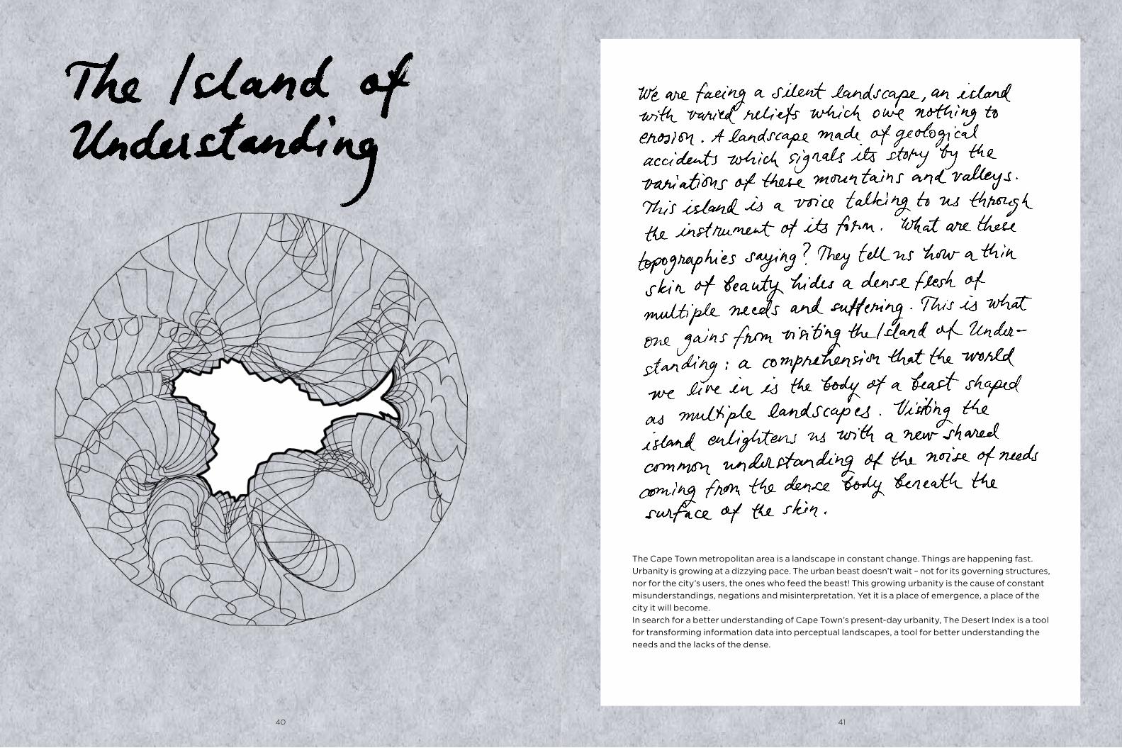
The Cape Town metropolitan area is a landscape in constant change. Things are happening fast. Urbanity is growing at a dizzying pace. The urban beast doesn’t wait – not for its governing structures, nor for the city’s users, the ones who feed the beast! This growing urbanity is the cause of constant misunderstandings, negations and misinterpretation. Yet it is a place of emergence, a place of the city it will become.In search for a better understanding of Cape Town’s present-day urbanity, The Desert Index is a tool for transforming information data into perceptual landscapes, a tool for better understanding the needs and the lacks of the dense.
40 41

Deserts and Shortages
The concept of the desert as been traditionally considered as an inhabited immensity, incapable of offering the envi-ronmental minimum for human survival and settlement. In Roman times the desert – deserere – was a place that had lost its meaning, its content. Yet contemporary deserts are of another genre. In an age where the urban has touched almost all corners of the plan-et, modern deserts, spaces of lacks, shortages and needs, can be found in the midst of urbanity, as well. Unlike the deserts of the Romans, today’s ‘urban deserts’ are full of meaning and content.
leys and mountains, is a territory never seen before, a ter-ritory far from the well-known topography of Cape Town. With its iconic geographic feature of Table Mountain, Cape Town is shaped as a relief that has been – and is still – too connected to the historical freight of Apartheid when the mountain and its adjacent coast were the retreat of the wealthy white elites. Meanwhile the Flats were reserved for low-income coloured and black working communities. Desert Indexes help to reshape new mental territories to free observers from a too rigidly-perceived reality by invit-ing a new understanding of the hidden topography of Cape Town, shared on a common ground.
The principle of the Desert Index is to superimpose data re-lating to specific issues – like access to food, access to digital media, or incidence of depression and illness – over a map of population density. The second step transforms the data into topographic relief, creating a new unfamiliar landscape which rises from familiar places, moving the reception of information from a factual to a visual level. This reconformed map, with its new formations of val-
Orbis Terrarum, first Roman mapping. when deserts
were the boundaries of the worldTopography ,Cape Town Metropolitan Area
The space of dense African urbanity is also a place of high informality, a place of a badly-regulated and poorly-moni-tored relations between the spatial and the human. Because this unknown frightens it is often grasped through a nega-tive approach. The informal becomes perceived as a place of violence, a place of insecurity and crime. The creation, development and the analytical tools of a new Desert Index will allow us to rediscover these places of higher density and to visualize some responses to the ques-tions: How can the deficiencies in the African urban be lo-calized? Who do they affect? And which mental landscapes do they reshape?
Population density, Cape Town Metropolitan AreaSchematic map of Apartheid’s racial location
Urban density, the one that matters
It is in the extreme closeness of the dense that human-ity weaves its future by tensions and distensions, by light touches, by contacts and pressures. It is only through the touch of one person against another that humanity finally occurs, in an extreme density, which requires a strong effort to be understood. The Desert Index is about localizing the contemporary deserts occuring within high densities. It is an attempt to refocus the social and urban discourse towards highly-populated places, thus approaching the needs of the densest masses – those who matter most.
ISLAND OF UNDERSTANDING ISLAND OF UNDERSTANDING
Desert Indexunderstanding the needs of high densityBy Yvan Ikhlef, Architect
42 43

Nyanga
Imizamo Yethu
Grassy Park
Lavender Hill
Strandfontein
MitchellsPlain
Town 3Khayelitsha
Macassar
Mfuleni
Belhar
New Rest
Ikwesi Park
DuNoon
Phoenix
Brooklyn
Bloekombos
an urban actor, the depressive becomes then an key figure to consider, as their disabled ability to project puts in dan-ger the common process of citymaking. Mapping depression in the Cape Town Metropolitan area shows a large predominance of depression in areas of high densities, often synonymous with a high incidence of informal settlements. The Satisfaction Desert Index reveals an obvious relation between informal high densities and the epidemic of depression in the city and points at the need to reflect over the truth that depressive behaviours are an obstacle to successful participation of emerging new urban-ites in the common process of citymaking.
Satisfaction Deserts The phenomenon of the urban depressive
Recent research by Mark Tomlinson and Anna Grimsrud reveals dramatic figures for the incidence of major depres-sion in the Cape Town Metropolitan Area, showing that a striking 75% of depression is found within the black com-munity. Described as the illness of the century, depression has been repeatedly shown as rising in parallel to the fast grow-ing phenomenon of urbanity. Depression has been de-scribed as an urban illness. The depressive suffers a loss of sense of time and form, feeling themselves disengaged from their surroundings and unable to anticipate. Within psy-choanalysis, Pierre Fédida showed that this double loss is accompanied by an inability to project into the future. As
Epidemic of depression
Racial demographics of
Cape Town, South Africa
source: Eric Fisher, Race and
Ethnicity 2010
Population density map,
Cape Town Census 2001
source: Wikimedia Commons
Depression per Ethnicity,
Cape Town 2009
source: Statistic from Research
Tomlinson Grisrund 2009 Department
of Psychology, Stellenbosch University
Satisfaction Deserts,
mapping of Epidemic of depression
¶ ¹)#���).�$%*!�)�$#2��#(�).
´�%'�((�$#2F2¹)#���).´�%'�((�$#2%$%*!�)�$#
���)�(���)�$#2´�(�')2I2
¶ ³�!!2%�$#�2�$+�'���2C2�#)�'#�)2��()2��#*�(�$%*!�)�$#2��#(�).
´���)�!2´�(�')2I2
¶ ��$�$���2�,��)(C2�!�� '2��$)$(2C2��$)�����2�$$�!�2�$�(2�$%*!�)�$#2��#(�).
��"$'.2´�(�')I2
Z�)2,�(2�(2��2)��'�2,�'�2#$2#�"�(2��'�D2�(2��2)��'�2,�'�2#$2,$'�(E2���2��(�')2�!��#(��2�+�'.)��#�2�#2�)(2,�#�D2,�%��2�+�'.)��#�2�,�.E2Z���2��2³!�/�$D2Z´�(�')[24<;3
Z���)2�(2#$)2����2�!�(�G2�)2'�)��#(2�!!2)��2(*���'�#�(2�#�2�((*"�(2�!!2)��2�$!$'(2$�2!�+�#�2�!�(�E2�)2"�#���()(2(*��2�$#+*!(�+�2%��#2�#�2+*!#�'���!�).D2�*)2�!($2(*��2��!���)�*!2�#+�#)�$#D2�$!$'D2�#�2��'$��)��(E2Ö�)2�(×2#$)2)$2(�.G2Z��).2)��2���()([2�*)2'�)��'2)��)2�+�'.2"�#2,�$2(*���'(2�(2�2%����2$�2"��)E2���)2�(2)��2�$""$#2/$#�2$�2"�#2�#�2)��2���()2EZ2�2´�*!�*/�D2Z�'�#��(2p��$#G2)��2!$���2$�2(�#(�)�$#[25338
¶ "��#2�*%�'"�' �)(2'�)��!�'(
�$%*!�)�$#2��#(�).�$$�2´�(�')I2
ISLAND OF UNDERSTANDING ISLAND OF UNDERSTANDING
44 45

Depressive Landscapes, a vision from the lake bed of informality
46 47

ISLAND OF UNDERSTANDING ISLAND OF UNDERSTANDING
Digital deserts
Lotus river
San Michel
Mitchells plain
Guguletu
Elsies Rivier
Clairwood
Kuils River
Belmont Park
¶ ¹)#���).�$%*!�)�$#2��#(�).
´�%'�((�$#2F2¹)#���).´�%'�((�$#2%$%*!�)�$#
���)�(���)�$#2´�(�')2I2
¶ ³�!!2%�$#�2�$+�'���2C2�#)�'#�)2��()2��#*�(�$%*!�)�$#2��#(�).
´���)�!2´�(�')2I2
¶ ��$�$���2�,��)(C2�!�� '2��$)$(2C2��$)�����2�$$�!�2�$�(2�$%*!�)�$#2��#(�).
��"$'.2´�(�')I2
Z�)2,�(2�(2��2)��'�2,�'�2#$2#�"�(2��'�D2�(2��2)��'�2,�'�2#$2,$'�(E2���2��(�')2�!��#(��2�+�'.)��#�2�#2�)(2,�#�D2,�%��2�+�'.)��#�2�,�.E2Z���2��2³!�/�$D2Z´�(�')[24<;3
Z���)2�(2#$)2����2�!�(�G2�)2'�)��#(2�!!2)��2(*���'�#�(2�#�2�((*"�(2�!!2)��2�$!$'(2$�2!�+�#�2�!�(�E2�)2"�#���()(2(*��2�$#+*!(�+�2%��#2�#�2+*!#�'���!�).D2�*)2�!($2(*��2��!���)�*!2�#+�#)�$#D2�$!$'D2�#�2��'$��)��(E2Ö�)2�(×2#$)2)$2(�.G2Z��).2)��2���()([2�*)2'�)��'2)��)2�+�'.2"�#2,�$2(*���'(2�(2�2%����2$�2"��)E2���)2�(2)��2�$""$#2/$#�2$�2"�#2�#�2)��2���()2EZ2�2´�*!�*/�D2Z�'�#��(2p��$#G2)��2!$���2$�2(�#(�)�$#[25338
¶ "��#2�*%�'"�' �)(2'�)��!�'(
�$%*!�)�$#2��#(�).�$$�2´�(�')I2
Cell phone coverage, Cape Town
source: Vodacom 3G, Wimax, Cell C
Internet Access,
fast venues, Cape Town
source: Google Maps 2013
Digital Deserts Index,
mapping of accessibility to Internet
Belhar
The internet carries within itself the germs of an em-blematic space for being a commons – a resource pool for all to use. Internet is regarded as an obvious and undeniable route of access to knowledge; a plural and chaotic knowl-edge with fluctuating values and whose quantity grows exponentially. Access to knowledge remains a cornerstone for improving the social conditions of disadvantaged popu-lations. Numerous studies point to illiteracy as one of the major factors to battle against within informal urbanities, making internet access one of the most effective tools. The internet comes packaged in a complex mix of tech-nological and economic levers and is in permanent state of
Digital DesertsLooking at access to digital knowledge resources
Capetownmagazine.com, a website for tourism informa-tion, declares that “Cape Town has excellent wireless in-ternet coverage via different hotspot providers. A variety of cafés, restaurants and bars in Cape Town offers free wireless internet.” However, if this depicts a reality within the city centre, most of the Metropolitan area remains cut from ac-cessing the internet, both through lack of physical points of access and expensive connections through cell phone net-works.
evolution. Whereas for a few years the computer was the main means of access, the evolution of technology favors the cell phone at present, with (particularly in informal zones) the appearance of complex modes of behavior in us-ing those two ways of accessing the web. Recent studies by Marion Walton and Jonathan Donner show the importance of the internet in public venues in Cape Town (like librar-ies, community centers and schools) offering free or less ex-pensive access and better conditions for working. If an obvious effort has been carried out to offer increased access to the internet in low-income neighborhoods, the
mapping of a Digital Desert Index for Cape Town still indi-cates evidence of a critical lack of access in the densest areas showing major shortages of public internet venues within densely populated areas. Landscapes of low income areas are transformed into digital deserts, territories of knowl-edge shortages disclosing the absence of what should be a common resource.
48 49

0101 Landscape, Cape Town as hills and valleys of digital access
ISLAND OF UNDERSTANDING ISLAND OF UNDERSTANDING
50 51

Lotus River
Bay View
Mandela Park
Palm Park
LansdowneHannover Park
Ikwezi Park
Elsies Rivier
Delft
Kenridge
Atlantis
Retreat
Food deserts
¶ ¹)#���).�$%*!�)�$#2��#(�).
´�%'�((�$#2F2¹)#���).´�%'�((�$#2%$%*!�)�$#
���)�(���)�$#2´�(�')2I2
¶ ³�!!2%�$#�2�$+�'���2C2�#)�'#�)2��()2��#*�(�$%*!�)�$#2��#(�).
´���)�!2´�(�')2I2
¶ ��$�$���2�,��)(C2�!�� '2��$)$(2C2��$)�����2�$$�!�2�$�(2�$%*!�)�$#2��#(�).
��"$'.2´�(�')I2
Z�)2,�(2�(2��2)��'�2,�'�2#$2#�"�(2��'�D2�(2��2)��'�2,�'�2#$2,$'�(E2���2��(�')2�!��#(��2�+�'.)��#�2�#2�)(2,�#�D2,�%��2�+�'.)��#�2�,�.E2Z���2��2³!�/�$D2Z´�(�')[24<;3
Z���)2�(2#$)2����2�!�(�G2�)2'�)��#(2�!!2)��2(*���'�#�(2�#�2�((*"�(2�!!2)��2�$!$'(2$�2!�+�#�2�!�(�E2�)2"�#���()(2(*��2�$#+*!(�+�2%��#2�#�2+*!#�'���!�).D2�*)2�!($2(*��2��!���)�*!2�#+�#)�$#D2�$!$'D2�#�2��'$��)��(E2Ö�)2�(×2#$)2)$2(�.G2Z��).2)��2���()([2�*)2'�)��'2)��)2�+�'.2"�#2,�$2(*���'(2�(2�2%����2$�2"��)E2���)2�(2)��2�$""$#2/$#�2$�2"�#2�#�2)��2���()2EZ2�2´�*!�*/�D2Z�'�#��(2p��$#G2)��2!$���2$�2(�#(�)�$#[25338
¶ "��#2�*%�'"�' �)(2'�)��!�'(
�$%*!�)�$#2��#(�).�$$�2´�(�')I2
Map of supermarkets five leading
retailers: Cash & Carry, Checkers,
Woolworths, Spar,
Shoprite, Pick n’ pay
source: Google maps
Food Desert Index, mapping
of accessibility to Food
Population density map,
Cape Town Census 2001
source: Wikimedia Commons
ISLAND OF UNDERSTANDING ISLAND OF UNDERSTANDING
according to Jane Battersby (showing the necessity of better understanding and mapping the diverse food resources in both formal and informal urbanities), the supermarket, the dominant source of access to food in the global north, turns out to be a model unadapted to the varied needs of Cape Town. Access to food, even though conditioned mainly to the prerequisites of a market-based society, is also conven-tionally considered as a fundamental human right. Map-ping the Food Desert Index shows distinct lacks of access and an uneven distribution of food. Supermarkets are lo-cated far from the poorest and most populated areas. Easy access to food turns into being the privilege of the rich. Food access – a cornerstone of urban commons – becomes in Cape Town the sign of a fundamental inequity.
Food DesertsLooking at the needs for accessible food
In a city where 35% of the population live below the poverty line, and 80% are considered as moderately or severely food insecure, the food desert, traditionally considered as pre-vailing in rural African areas, turns out to be a phenomenon in urban zones as well. Within high densities, however, the occurence of food insecurity should be approached differ-ently. Food insecurity comes not from a lack of availability, but from a lack of access to the food market. The question of accessibility is a critical aspect of the informal city. Despite the obviousness of the complex behavior pat-terns involved in getting food within informal settlements
52 53
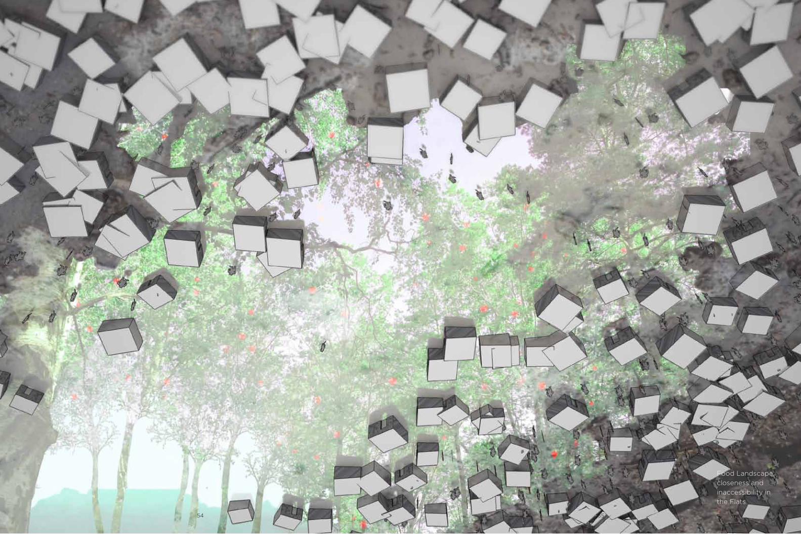
Food Landscape, closeness and inaccessibility in the Flats
54 55

Tourism, and in a wider perspective, the act of visiting, documenting and disseminating a body of information on a place are leading factors in the establishment of a com-mon consciousness of a place. If memory is an individual experience, it only truly acquires sense when it is shared, when it melts into a collective consciousness. The processes of remembrance, social memory and storytelling could be perceived as primary resources for city planning to come, the underlying energies of the process of place-making. Anthropological studies conducted in the United States
Memory DesertLooking at remembered and forgotten places
The tourism sector is a key part of Cape Town’s economy. According a survey from 2009, Cape Town’s tourism in-dustry was worth R17.3 billion, representing 10% of the City’s real gross geographic product (GGP). Those figures “show the importance of tourism and its development over the years. Figures tracking the growth of the industry can be used when motivating for the development of infrastructure for the tourism sector, because they illustrate how vital the business is for Cape Town,” as Grant Pascoe, mayoral com-mittee member for tourism, events and marketing, has stated.
San MichelGrassy Park Parow
Atlantis
City bowlRobben Island
Sunset Beach
Melkbosstrand
Bellville Park
Muitzenberg
Hout Bay
Simon’s Town
Mitchells plain
Khayelitsha
Heinz Park
Bellmont Park
Delft
¶ ¹)#���).�$%*!�)�$#2��#(�).
´�%'�((�$#2F2¹)#���).´�%'�((�$#2%$%*!�)�$#
���)�(���)�$#2´�(�')2I2
¶ ³�!!2%�$#�2�$+�'���2C2�#)�'#�)2��()2��#*�(�$%*!�)�$#2��#(�).
´���)�!2´�(�')2I2
¶ ��$�$���2�,��)(C2�!�� '2��$)$(2C2��$)�����2�$$�!�2�$�(2�$%*!�)�$#2��#(�).
��"$'.2´�(�')I2
Z�)2,�(2�(2��2)��'�2,�'�2#$2#�"�(2��'�D2�(2��2)��'�2,�'�2#$2,$'�(E2���2��(�')2�!��#(��2�+�'.)��#�2�#2�)(2,�#�D2,�%��2�+�'.)��#�2�,�.E2Z���2��2³!�/�$D2Z´�(�')[24<;3
Z���)2�(2#$)2����2�!�(�G2�)2'�)��#(2�!!2)��2(*���'�#�(2�#�2�((*"�(2�!!2)��2�$!$'(2$�2!�+�#�2�!�(�E2�)2"�#���()(2(*��2�$#+*!(�+�2%��#2�#�2+*!#�'���!�).D2�*)2�!($2(*��2��!���)�*!2�#+�#)�$#D2�$!$'D2�#�2��'$��)��(E2Ö�)2�(×2#$)2)$2(�.G2Z��).2)��2���()([2�*)2'�)��'2)��)2�+�'.2"�#2,�$2(*���'(2�(2�2%����2$�2"��)E2���)2�(2)��2�$""$#2/$#�2$�2"�#2�#�2)��2���()2EZ2�2´�*!�*/�D2Z�'�#��(2p��$#G2)��2!$���2$�2(�#(�)�$#[25338
¶ "��#2�*%�'"�' �)(2'�)��!�'(
�$%*!�)�$#2��#(�).�$$�2´�(�')I2
the lenses of the Memory Desert Index, most of Cape Flats disappears from the collective conscience and very few seem to be engaging in the act of “remembering”, thus excluding the residents of these “forgotten areas” from being active participatants in the process of city-making.
by Ann Louise Buckun on places undergoing transformation processes “emphasize the value of making primary sources of material accessible in public domain, for future generations”.Looking at Cape Town and tracking ‘mementoes’ left on the internet within the Metropolitan Area of Cape Town in the form of uploaded photos, geocoded Tweets and Google maps material, we can observe clear areas of remembrance and oblivion. While most of the Internet memories come from central Cape Town and along the coast, the “forgotten areas” are absent from this digital memory bank. Through
Geocoded Tweets, nov. 2012source: Dr Mark Graham, Oxford Internet Institute
Geotagged Google maps hitssource: Pr Stan BrunnUniversity of Kentucky
Flickr photossource: www.Flickr.com /Loc.alise.Us
Memory Desert, mapping of souvenir and oblivion
Amount of internet
hits
Memory Desert
ISLAND OF UNDERSTANDING ISLAND OF UNDERSTANDING
56 57

Island of Understanding
Landscape of Remembrance and Forgetness: Does your memory matters?
ISLAND OF UNDERSTANDINGISLAND OF UNDERSTANDING
58 59

What is essential to make the city more flexible and resistant towards climate change? Who writes the visionary agenda, leading the way, rousing citizens to action? Could planning policy be a tool towards constructing a shared green vision and the development of ‘commoning’? What would that process look like?
The Green Space Factor is a planning tool developed by the City of Stockholm, Sweden, for implementing the vision of a greener and more sustainable city in new development areas. Could this type of tool enhance greener solutions and design in the development of Cape Town?
60 61

ISLAND OF RESPONSIBILITY ISLAND OF RESPONSIBILITY
City planning for a future for all
The colloquium Urban Commons in Cape Town was explicit in its demands for stronger policies on negotiations and responsibilities between the city and its citizens, organized mainly through the medium of neighbourhood communities. It also underlined the gap in communication, information and knowledge between the different parties. By making social-ecological resilience a priority for the city, communication and collaboration with its inhabitants becomes a key factor. Responsible citizenship is the basis for a resilient society which has the ability to deal with
change and future development. Natural processes in urban nature and the eco-system services they provide are important parts of a resilient cityscape, as is a strong sense of community among its citizens. Could it work together with a green planning policy that outlines a process of communication and exchange of knowledge, and works within the framework of a series of agreements on responsibility towards the outdoor environ-ment? Would such a Green Community Guide be one way of strengthening both physical and social structures in the
City of Cape Town? The communication process itself implies recognition of the different stakeholders involved, giving them a certain voice (and thus power), even to the local communities involved. As many researchers, planners and practitioners now conclude, this recognition is an important step forward in upgrading poor urban areas.
A Green Space Policy for Cape TownCould planning policy be a guide to a shared green vision? By Johanna Jarméus, Landscape architect
62 63

ISLAND OF RESPONSIBILITY ISLAND OF RESPONSIBILITY
The commons and responsibility
The reliance on local communities for responsibility and maintenance of their environment increases urgently, and the possibility of engaging citizens in urban development is a valuable chance that the City of Cape Town should not waste. Commoning processes create social and physical organisations that enhance not only individual situations, but also facilities for collective use reaching beyond the community. Experiences from projects in Cape Town show that this is a possible way of directing grass-roots’ initiatives towards a solution that nourishes all participants. Collaborations between the city and communities, like the Langrug-project in Stellenbosch, are good examples of collaboration on the development and maintenance of public facilities between the municipality and the community. A development of these kinds of processes should clarify the roles and rights of the stakeholders, for example by introducing planning policies that include some kind of responsibility contracts between the different parties involved.
Tools in city-planning
Beside the draft district plan as a legal tool of restrictions that a city imposes on property, a number of other tools can be linked to a city planning process. Quantifying tools can be used to analyse a particular situation or proposal and its possibilities for answering specific issues, for example the space syntax – a tool which analyzes the degree of integration by measuring the distances in a network of paths. There are also tools that classify construction projects for their environmental performance, like LEED and BREEAM. Another range of tools often used in participatory planning
are different dialogue methods like Community Planning, Visioning Forum or Open Space, which aim to draw out local residents’ ideas and gain a consensus on the further development of their environment.
The Green Space Factor – an open planning tool
The Green Space Factor (GSF), an environmental planning
tool currently used in Stockholm is a sort of quantifying analysis of the green part of a development proposal, working like a check-list to trigger a more eco-efficient planning and design in privately developed city-blocks. Eco-efficiency is a notion used to define elements that contribute to a strong eco-system, such as trees, bio-swales (open ditches with vegetation that help remove pollution from surface run-off water) and food gardens. Achieving a defined GSF rating set by the City for a project is mandatory for obtaining a building permit. However this tool is considered to have a two-stranded agenda. Besides being a quantifying check-list it should also act as a visionary guide to bring stakeholders in the construction process together in a deepened comprehension of the needs and values of a resilient city structure. This should be transmitted through an initial visioning meeting where the city’s aims and goals towards sustainability are stated and agreed on.
What could a Green Space Planning policy
do for Cape Town?
In Cape Town a planning policy declaring the high priority of ecological aspects in development could be a loud signal of the City’s intentions and offer a method for planning for resilient physical structures. It could also start the process of deciding which aspects and interventions would give the most valuable eco-services in the conditions of the Western Cape, an achievement that would contribute to all future projects. A development of such a planning tool should be to try to build it as a process guide, a Green Community Guide that would help to describe the dialogue process and encourage citizens to participate in the definition of the ecological interventions suitable for each project. This issue is of equal importance to all citizens and every project, whether the project is initiated by the city, by a private developer or by a local community. In the dense city, green investments are often expensive and technically difficult, but the most important solutions, like trees and food gardens, are big investments mainly with regard to their maintenance over the long term and thus local engagement and responsibility is an important question. The application of the tool could contribute to strength-ening ecological infrastructure, enhancing the greening of private property in the city-bowl of Cape Town with, for instance, roof gardens and green facades. Outside the city-bowl it could help in the creation of water retain-ing soils, and the introduction of trees and food gardens to make the outdoor environment cooler, as well as to provide storm-water systems to prevent flooding.
Pros and cons of using a Green Space Planning policy
Openness towards any sort of suggestions from the developer through this factor-tool is a positive way of guidance without spatial limitations. In Stockholm it has proved to be a very instructive and straightforward way of making developers engage, giving clear notice of their efforts in the proposals. This makes it easy to use in different situations and with different stakeholders, something that could make it an efficient tool in the complexity of the very different processes in Cape Town. Using a dialogue process and engaging in participative design puts high demands on its leaders and on the process in itself. It also demands honesty about the process’s intentions and the possibility of adjusting its plans in accordance with the wishes of local residents and, at the same time, not raising false expectations.
“In the process of participation, role-players are empowered and they take ownership of their design decisions. However, participation is generally seen only as a social process. This is when it fails. It needs to be underscored by making.” Carin Smuts, architect, Cape Town
It is a powerful threat to society if the use of participatory processes leads to disappointment and anger, which will harm rather than strengthen a sense of community. In Cape Town knowledge of these processes among particular architects, planners and organisations is very high, and their experiences should be used in the formulation of such a guide would be an important statement. The development of this tool could start in NGO-based activities, but should be governed by the City and open to invited experts and citizens.
64 65

INITIATIVE!
Who initiate development
projects in Cape Town? GCG
welcomes any initiator to the
communication process!
INVESTIGATION
Who brings the parties together
in exploring the needs and pos-
sibilities? GCG is the guideline
for a greener infrastructure.
VISION
Who brings the parties share
the same vision? GCG commu-
nicates the need for developed
eco-systems.
PROPOSAL – DRAFT
Who develops the plans and
lead the design process? GSF
proposes structural possibilities.
APPROVAL
Who is giving the official build-
ing plan approval for the design
to advance to construction? GSF
gives the note on green aspects.
REALISATION
Who is leading the construction,
and who is the constructor?
GCG could give the check-list for
the work.
PROPOSAL – DESIGN
Who is designing the new
neighbourhoods, and for which
supposed client? GCG proposes
detailing possibilities.
AGREEMENT
Who is managing the economi-
cal deals between stakehold-
ers? GCG states the need for
contracts on responibilities.
63(&,),('�$5($
�RU�$63(&7�
)$&725� 180�
$5($�9$/8(�
*5((1,1*�$63
(&76
%6&(M�XQGHU
E\JJG�PDUNJU|QV
ND
����
������
%6&9l[WElG
G��������PP�
����
�����
%6&9l[WElG
G����������PP�
����
��������
%6&*U|QD�WD
N��!�����PP�
����
��
%6&*U|QD�WD
N�����������PP�
����
��
%6&*U|QVND
�Sn�YlJJDU
����
��
%6& ,QWHJUHUDGH�EDONR
QJOnGRU
����
��
&RPSOHPHQWDU\�DVSHFWV��
JUHHQLQJ�ELR�GLYH
UVLW\
%'LYHUVLWH
W�L�IlOWVNLNWHW
����
��������
%1DWXUOLJW
�DUWXUYDO
����
��
%'LYHUVLWH
W�Sn�JU|QD��WXQQD
�VHGXPWDN
�����
��������
%,QWHJUHUD
GH�EDONRQJOnGRU�
PHG�KlQJ��HOOHU�NO
lWWHUYl[WHU
����
���
%)MlULOVUH
VWDXUDQJHU
����
������
%%XVNDU�J
HQHUHOOW
���
�������
%%lUDQGH
�EXVNDU
���
������
%6WRUD�WUl
G��VWDP�!���FP�
���
��
%0HOODQVW
RUD�WUlG��VWDP�������FP
�
���
������
%6Pn�WUlG��V
WDP�������FP�
�
������
%7UlG�PRW�JDWXP
LOM|
���
������
%%lUDQGH
�WUlG
���
������
%+RONDU��I
nJHO�PP�
���
����
&RPSOHPHQWDU\�DVSHFWV��
JUHHQLQJ�UHNUHDWL
RQDO��VRFLDO�YDO
XHV
6*UlV\WD�
�I|U�EROOVSHO�OHN
����
������
62GOLQJV\
WRU
����
�����
6%DONRQJ
HU�RFK�WHUUDVVHU�V
DPW�Yl[WKXV�I|UEHUH
GGD�I|U�RGOLQJ
����
������
6*HPHQVDPPD�WDNWHUD
VVHU
����
��
66\QOLJD�
JU|QD�WDN
�����
��
6%ORPVWHUSUDN
W
���
��������
6%XVNDU�X
SSOHYHOVHYlUGHQ
���
�������
6%lUDQGH
�EXVNDU�PHG�lWOLJ�I
UXNW�HWF
���
������
67UlG��XS
SOHYHOVHYlUGHQ
���
������
6)UXNWWUlG
�RFK�EORPPDQGH�WUl
G
���
������
63HUJRORU
�HWF
����
������
6)nJHOKR
ONDU��XSSOHYHOVHY
lUGHQ
���
���
6*U|Q\WD
�Sn�NYDUWHUVPDUN�PRW�ORNDOJ
DWD
���
�����
&RPSOHPHQWDU\�DVSHFWV��
JUHHQLQJ�FOLPDWH��KH
DW�LVODQGV
&7UlG�SOD
FHUDGH�Vn�DWW�GH�J
HU�O|YVNXJJD
���
�����
&3HUJRORU
��O|YJnQJDU�PP�VRP�JHU�O|YV
NXJJD
����
��������
&*U|QD�WD
N�HOOHU�IOHUVNLNWD
G�PDUNJU|QVND
�����
�������
67250:$7(5�$6
3(&76
%6&9DWWHQ\W
RU�L�GDPPDU��ElFN
DU�RFK�GLNHQ
����
��
%6&gSSQD�K
nUGJMRUGD�\WRU
����
��
6&+DOY|SS
QD�KnUGJMRUGD�\WR
U
����
������
6&+nUGJMRU
GD�\WRU�PHG�IRJDU
�����
�������
�7lWD�\WR
U
����
��
&RPSOHPHQWDU\�DVSHFWV��
ZDWHU�ELR�GLYHUV
LW\
%%LRORJLV
NW�WLOOJlQJOLJD�SHU
PDQHQWD�YDWWHQ
����
��
%)XNWVWUn
N�PHG�WLOOIlOOLJW�NYDUG
U|MDQGH�YDWWHQ
����
��
%)|UG��DY
�GDJYDWWHQ�IUnQ�K
nUGJMRUGD�\WRU�L�\
WYDWWHQVDPOLQJDU�RF
K�IXNWVWUnN
����
�����
%)|UG��DY
�GDJYDWWHQ�IUnQ�K
nUGJMRUGD�\WRU�L�X
QGHUMRUGLVND�PDJDVLQ
����
��
%$YYDWWQL
QJ�DY�KnUGJMRUGD
�\WRU�WLOO�RPJLYDQGH�
JU|QVND�Sn�PDUNHQ
����
�������
&RPSOHPHQWDU\�DVSHFWV��
ZDWHU�UHNUHDWLYH
��VRFLDO�YDOXHV
69DWWHQVS
HJODU
����
��
6%LRORJLV
NW�WLOOJlQJOLJD�YDW
WHQ���XSSOHYHOVHY
lUGHQ
����
��
6)RQWlQH
U��FLUNXODWLRQVDQO
lJJQLQJ��R�G\O�
���
��
&RPSOHPHQWDU\�DVSHFWV��
ZDWHU�FOLPDWH���KHD
W�LVODQGV
&9DWWHQVD
POLQJDU�I|U�WRUUSHU
LRGHU
����
��
&8SSVDP
OLQJ�UHJQYDWWHQ�I|
U�EHYDWWQLQJ�
�����
��
&)RQWlQH
U��R�G\O��
���
��
7RWDO�VXP��HNR�HII
HFWLYH�DUHD��
����
7RWDO�DUHD�RI�VLWH
�
����
)$&725�$&+,(9
('�
����
%DODQFLQJ�
�0D[�DQWDO� �1XPE��
���
%� �%LRGLYHUVLW\��
FRQWULEXWLRQ�WR�G
LYHUVH�IORUH�DQG�ID
XQH
���
��
6� �6RFLDO�DVSHF
WV��HQKDQFLQJ�VRF
LDO�LQWHUDFWLRQ�FR
PPXQLWLHV�DQG�UHFUH
DWLRQ��
���
&� �&OLPDWH�HIIHF
WV��HQKDQFLQJ�WHP
SHUDWH�ORFDO�FOLPDWH
���
��
(City of Stockholm 2010)
ISLAND OF RESPONSIBILITY ISLAND OF RESPONSIBILITY
To communicate the need for urban nature
What is resilience? Why should we need a greener city? The questions are difficult to answer when the principal interest is the short-term economics of a single construction project and its investors. When the discussion is extended to embrace not only investors and property developers, but also local residents, the focus changes to long-term economics, and to responsibility and maintenance. If the municipality has over-all responsibility for the maintenance of the natural processes, resources and services of the metropolitan area, the development of the city should also include communications with both developers and citizens. The development of a Green Com-
munity Guide could build a common understanding of the needs and possibilities that every community has, as well as of the gains offered by participation in the process. The eco-system services contributing to an inclusive urban structure are many and very crucial in a long-term perspective. If these complex systems and their service to the environment are hard to describe, it is even harder to value them in economic terms. But the actual costs of not having resilience are becoming increasingly important as human activity stresses natural resources, of which only one result is extreme weather events. In Cape Town yearly flooding causes considerable damage to public and private property.
A contribution to a change of mind set?
There is a need for a mind-shift in how we consider urban life. We need to understand our-selves as part of the urban eco-system. We need a shift in perception, not only for ordinary citizens, but also for planners, architects and designers, helping them understand their project as a part of that eco-system. A general focus needs to be put on the overall green structure of any city, and on the possibilities, in each project or community, to consider how common spaces and connections between communities and their surroundings can contribute to this structure, as well as how their future maintenance will be provided for. Through this issue the City of Cape Town, like any other municipality, can be part of planning for structures that guide people to live in more sustainable ways. Many
poorer communities live much more sustainable lives than the middle class inhabitants due to their lack of material resources. But they also have access to an environment that offers a richer local life than the examples that contemporary city planning is offering. What can we learn from them? How could the City show respect and inject pride into poorer communities for their contributions? How could upgrading living conditions in very deprived areas take place without using the bad examples of consumerist modern urbanism? Maybe a deeper communication can build mutual understanding and respect? By using an inclusive process, the City can also contribute to the commoning processes, ensuring that poor communities are empowered to take greater part in controlling their environment.
66 67

ISLAND OF RESPONSIBILITY ISLAND OF RESPONSIBILITY
A green contribution to Mtshini Wam?
The Mtshini Wam re-blocking is a community-led project being carried out in collaboration with CORC. What would have changed if the City of Cape Town had been prepared to use a Green Community Guide to drive the dialogue on the re-blocking project? Would it have been possible to enhance the quality of the environment by using vegetation? Would the community be more prepared or engaged in the maintenance of their neighbourhood and its plant-life? Could better connections to possible green structures beyond the borders of the settlement been introduced? Would the notion of creating common spaces have been different? The community has already shown high ambitions with
regard to questions of basic infrastructure, a central common space, safety issues and storm-water run-off. Several straight-forward elements, such as organising water collection-basins, planting trees in courtyards or constructing storm water channels could have been part of the initial discussion. The architect Stephen Lamb has developed some proposals for Mtshini Wam in collaboration with the community. A simple greenhouse facade working as a cooling device, as well as for fire prevention, would make a big contribution even in narrow areas. The introduction of a cultivation shelves system creates small but efficient food-gardens. Teaching how to cultivate in the arid landscape is important. The educational work that, for example, the NGOs Soil for
Life and Abalimi are doing in Cape Town is inspiring, but the possibilities for the engagement of the NGOs are limited. Perhaps the City could initiate an interest in this kind of knowledge through the Green Community process guide? A contract between the community and the City on maintenance and responsibilities towards the environment is an important part of the goal of the policy, and it would be essential to clarify if the city does not have the ability to carry out regular maintenance. The possibility of continuing such a collaboration through City-employment contracts with local residents on maintenance could be useful.
68 69

ISLAND OF RESPONSIBILITY ISLAND OF RESPONSIBILITY
The Green Space Factor as a design tool –
three examples from Cape Town
The Green Space Factor is planned to be implemented as a try-out in three areas in Cape Town: Milnerton, DuNoon and Wescape. These areas are linked by the main large future growth corridor of the city and by the public transport of the IRT bus system. Through these pilot-projects the usage of the GSF tool can be tested in very different demographic situations while still dealing with a similar landscape morphology. Each of the areas represents a different built typology, and for each of these the GSF has different, site-specific aims. The relationship between density, greenery, mobility and access, as well as safety, are important aspects that can be supported by the GSF. The areas for implementation of the GSF are also the interface between the coastal edge and the hinterland, highlighting the importance of the conscientious ecological planning of these areas. The projects are conceived by ARG Design, led by the architect and sustainability specialist Gita Goven, and implementation of the GSF is planned to be worked out in collaboration with the author, Johanna Jarméus, a
landscape architect from Stockholm. Various government departments within the City of Cape Town are also involved, such as Spatial Planning and Urban Design, Environmental Resource Management, City Parks, Western Cape Provincial Department of Environmental Affairs – Strategic Services Branch: Environmental Pro-grammes Sustainability Africa for benchmarking and creating the tool.
Fact and figures for the three projects:
Milnerton
• Client: City of Cape Town.• Area: 671 ha.• Population: waiting for 2011 census data.• Typology: Urban regeneration of existing sub-optimised area.
Milnerton is an urban regeneration area with high potentials, close to the City Bowl. By focusing on the creation of possible parklands this area can develop into a modern inner city, based on an ecological infrastructure.
Items for the GSF are revitalisation of eco-system services around the Zoarvlei wetlands, mitigating the effects of climate change, increasing infiltration and safe storm-water runoff and create an asset value for property.
Du Noon
• Client: City of Cape Town.• Area: 95 ha.• Population: approximately 31,000.• Typology: Formal settlement with informal backyard dwellings and informal settlements on available open space.
Du Noon has potentials for development in both economical and ecological terms, as it is close to industries, employments as well as to a surrounding rural landscape. The GSF could in this area define the level of green possibilities connected to very basic needs and investments. This could be to promote food production and water- and energy security. It could also be to link the settlement to Diepriver or to enhance the regeneration of the ecosystem around Diepriver, while aiding infiltration, reducing run-
off and preventing flooding. It could as well increase the liveability and the place-making of the area.
Wescape
• Client: PACT – a property development company based in Cape Town, South Africa. • Area: 3,101ha.• Population: future development will allow for ±800,000.• Typology: New development.
Wescape project is a new urban development, which aims to expand Cape Town north, along the coast towards Atlantis, with high ambitions for an infrastructure integrating transport, economical, social and ecological aspects. This project explores a closed loop water and nutrient cycle. The settlement is based on sub-watershed management and the optimisation of water and urban resources to generate adaptive microclimates. The GSF could here be used as a steering tool to develop public spaces and private properties over a long period of development.
MilnertonFrom bottom to top: Milnerton, Du Noon, Wescape Du Noon Wescape
70 71

How can existing commons be nurtured and how can they can contribute to broader change? Small change innova-tion at local level can be strengthened through building capacity within communities and coordination with public policies and services. It is a shared responsibility between various stakeholders to make this incremental change hap-pen. Ultimately, what is needed is that horizontal networks – local initiatives – are coordinated with vertical networks – municipalities and the state. What roles can and should
the public sector and various commoning processes take on to deliver communication, coordination and production at different scales? As the architect and academic Nabeel Hamdi proposed in a conversation with students from Re-sources.Lab: “To be an agent of change one has to unravel the orders behind the visible. Urban life is about reinvent-ing the commons – how do we invite change in order to lib-erate solutions?”
3.COMMONS AS A MODEL FOR CHANGE
Radical shift | Incremental change | New models
NGO STAFF
NGO STAFF
NGO STAFF
ACADEMIC
ACADEMIC
ACADEMIC
ACADEMIC
NGO STAFF
ARTIST
PRACTITIONER
ACADEMIC
ACADEMIC
72 73

I was invited by architect Carin Smuts and a local committee to conduct a series of art workshops which were to be steps towards building a new cultural museum in Hawston, Hermanus, 100 km east of Cape Town. Hawston is deeply a"ected by an unbalanced use of natural resources such as abalones and fish for the global market. A part of the museum project deals with the indigenous Khoisan people. I focused on how performative art prac-tices can make shifts in perceptions, give support to dreams and invent new spaces of shar-ing. In my investigation I explore the carnival as an act of and a metaphor for commoning. The carnival is a dynamic self-organising system that works through collective play and re-joicing in an atmosphere of humour and chaos. It invades common spaces and in-betweens such as streets and beaches.It is only through long-term participatory processes and shared ownership – through the creation of a commons – during both the planning and building processes that the locally-initiated future museum has a chance of success and continued commitment and support from residents.
74 75

Students hanging upside-down in a tree. These young people expressed feelings of imprisonment. They are eager to succeed and study hard, but
sometimes feel they are floating in an uncertain situation, as if in a looking-glass land or a carnivalesque upside-down world. The images show some
of those feelings.
ISLAND OF PERCEPTIONS ISLAND OF PERCEPTIONS
Art as a commoning methodology The carnival, the sea and performative art as common resources By Paula von Seth, Artist
Hawston is a coastal town 100 km east of Cape Town, near Hermanus in Western Cape. The town has about 30,000 inhabitants, the majority of whom are Cape Coloureds with diverse racial and geographic origins. The sea is the dominant natural resource in Hawston. However, the fishing rights have been taken away from its inhabitants, partly because the rights of small-scale fishermen are badly supported in South African fishing policies. Local fishermen are banned from fishing without a license, which is costly and complicated to obtain from the municipal authorities. Hawston’s offshore waters, above all, have become a place for the illegal harvest and trade in endangered abalones
to the Asian market, where consumption of abalones is a marker of economic status and where the shellfish are sold at prices similar to drugs. Hawston which is characterised by unemployment and little development has consequently become connected with syndicated criminal networks linked to drug trade. This illegal trade is causing severe social problems and contributing to layers of negativity within the coastal communities. Tensions between the community and law enforcement came to a head in November 2012 when the local police station was burned down by a furious mob in response to the death of a well-known 19-year-old youth suspected to have been beaten to death by the police while fishing illegally. It was against this background that I was invited by the architect Carin Smuts and a local committee to conduct a series of art workshops which were to be steps towards building a new cultural museum in Hawston. The town, my workshops and the idea of the commons – those natural and cultural resources, which should be accessible to all –
were the starting points for my investigation. I wanted to discover how the process of forming an inclusive institution could activate the commons, bridge antagonisms and infuse hope and creativity.
Art practices as a commons
In my workshops I focused on how interventionist and performative art practices could bring about shifts in perceptions, give support to dreams – young people’s dreams of Hawston and the new approaching realities of the wider world – and invent new spaces of sharing. Interventionist art methods engage directly in the world, applying art practices to issues rather than simply representing them. In performative art one’s own body is used and the focus is on the doing, in the here and now. My aim was to examine how these techniques would act as catalysts for creating a common ground, and in the longer term, for creating a future cultural institution which would help bring about co-existence between ecological, cultural
and social values. A common ground of respect between people is a good starting point. I deepened my knowledge with background research during several art and urban ecology working visits to South Africa. Over two weeks I gave lectures and work-shops in Hawston and produced an exhibition displayed at Hawston Library. The final outcome came from one week of workshops with eleventh and twelfth graders at Hawston Secondary School and a handful of local residents. Together we employed cameras, laughter and our bodies, drawing on performance art techniques. On the last day, together with the learners, I staged a carnival on Hawston beach as an art performance, using the sea as a backdrop. My goal was to re-enchant the beach and the sea, and to highlight the prob-lematic natural commons in Hawston. The carnival tuned into the area’s historic connections to Creole cultures that maintain the carnival tradition.
A young man equipped with an instrument for looking and therefor thinking in a looking-glass world.
76 77

ISLAND OF PERCEPTIONS ISLAND OF PERCEPTIONS
The carnival as a commons
In my research I explore the carnival as an act of and as a metaphor for ‘commoning’. The carnival is a dynamic self-organising system that builds interaction between people. It works through collective play and rejoicing in an atmos-phere of humour and chaos. The carnival is something peo-ple create and achieve for themselves, in the same way com-mons are self-organised common spaces. As Goethe wrote, the carnival “is a feast that is not really held for the people, but which the people arrange for themselves.” As with archetypal English commons, it is through fes-tivities, dance, games, rituals, free speech and other fun-damental forms of social life that interactions are built be-tween people. English commons are open common spaces once used by the people of the village to host social activi-ties. In Dancing in the Streets: A history of collective joy, Bar-bara Ehrenreich records an inhabitant in Buckinghamshire
in southern England describing the emptiness of the com-mons after the suppression of Sunday recreations there. Where once the commons was a cheering spectacle, he ex-plains, “full of groups of happy people” the place was now deserted and the pub a substitute place for men to gather. He calls the emptying of the commons “a depressing loss”. European carnivals were banned and recreational activi-ties on English commons were suppressed for religious (and political) restrictive reasons. From 1600-th century and onwards, and with the beginning of the Calvinist ver-sion of protestantism, collective expressions of joy were condemned in different periods of time. However contem-porary carnivals continue to inhabit public space for local groups of people of all kinds. In undulating movements carnivals invade common spaces and in-betweens such as streets and beaches, and re-enchant them with animated
I staged a carnival at Hawston beach together with students at Hawston Secondary School.
78 79

transformed through time along with changes in many dif-ferent factors, among them cultural perceptions, architec-ture and ecology. Here I would like to introduce into the vocabulary of commons the traditional South African phi-losophy of ubuntu, generally translated as “togetherness” or “I am who I am because of what we all are”. This cul-tural notion underlines the importance of understanding oneself as a collective being dependent on and in response to larger cohesive groups of people. It was brought into the political language in 1994 as an image of the new South African mind-set resting on old traditions. Since being is a ‘doing together’ that constantly holds changing ethical and ecological imperatives, what does this wider perception of responsiveness – as an aspect of commoning – mean in to-
day’s urban and rural landscapes which are so heavily under pressure? What knowledge formations and participatory planning processes can support building the responsive in-stitution, city, country or world?
The museum project as a commons
The question of commoning brings us to the reason why the Hawston museum project needs to involve long-term participatory forms and processes. Only then will the re-sulting institution be shaped by – and respond to – the place and its complex reality, integrated into the whole body of the community, a community which is predominately poor and disempowered in the midst of rich natural resources. One early ambition was to make a museum dedicated to the
indigenous populations of the region, representing hunter gatherer San cultures and pastoralist Khoi collectively re-ferred to as Khoisan. Recent archaeological evidence indi-cates evidence of the emergence of intelligent human so-cieties took place along this coast some 80 000 years ago, whose ancestors continue to inhabit Southern Africa. However, in Hawston only a few local people could have claim to Khoisan heritage. The museum project needs to be well grounded for all of Hawston’s inhabitants. It is only through shared ownership – through the creation of a com-mons – and through participatory activities during both the planning and building processes that the locally initi-ated museum project has a chance of success and continued commitment and support from residents.
ISLAND OF PERCEPTIONS ISLAND OF PERCEPTIONS
social life, though they might happen only once a year.In a good carnival many issues are processed, be they po-litical disappointments, class antagonism, gender rights or ecological rights. In the Brazilian carnivals new songs are written and sung each year to connect to local politics, his-torical events or climate change. The carnival in Cologne, Germany, has a long history of political criticism. Staged in front of an audience, the carnival performers act out a confrontation that takes the edge off conflicts. The aim is to go beyond the interests of minority groups and specific identities. In carnivals many different groups are presented and a wider humanity is proposed beyond differences of sex, age and ethnic background. The preconditions for interactions and social sharing are
Common resources in Hawston with Hawston Museum as
the central goal of the project. There are different catalysts
at play. Interventionist and performative art methodologies
can become new resources and the institution can become
a physical manifestation of commons.
80 81

ISLAND OF PERCEPTIONS ISLAND OF PERCEPTIONS
Creating the commons
I looked into the commons of Hawston from various points of views with differentlenses. In my investigations I found that performative and interventionist art techniques can enable novel ways of experiencing, understanding and creating commons. The tradition of carnivals is a commons that can be infused into the future museum, being engaging, inclusive, rich of people and socially and ecologically critical. Where the carnival is a brief social revolution, in which dignity and empowerment are bestoved to those in a subordinate position– whereas the
museum can become a physical manifestation of commons. Furthermore, the situation in Hawston exemplifies globalisation as an everyday process that affects each context in different ways. If we want to grapple with the dynamics of the interpretation and politics of commons, an attention to multilayered local specificities is required. Generally, we should be asking what resources are there for commoning and who is invited to participate and make use of the commons?
Three aspects of maps and shifts
of perceptions. A window inside of
Hawston police station.
The local police station was burned down by a furious mob when a young man died, probably due to a police raid on poachers. Archives, documents and south
african police service– cap where left at the scene of the crime.
82 83

Here we introduce three successful processes of urban transformation and placemaking in Cape Town’s townships where play, imagination and collectivity take physical form and create places of safety and education.All these projects include elements of urban commons as communities emerge from an urban con-text with a strong social agenda built on common beliefs, skills, interests and creativity. Originally these communities were less connected to a specific site, but through their actions and interactions place emerges and is created around them. Commoning means in all these cases the generation of collective knowledge, dignity, social values, and a common imagination for the future.
84 85

Models of engagementTHE SPRING, THE SANCTUARY AND THE STAGE
By Nadine Aschenbach, architect
The Spring
Violence Prevention through Urban Upgrading (VPUU) and the Informal Settlement Transformation Programme (ISTP) are municipal urban settlement upgrading strate-gies facilitated by the City of Cape Town in partnership with SUN (Sustainable Neighbourhoods) Development and the German Development Bank (KfW). The projects are spread across several Cape Town townships. Tradi-tional planning based on survey/ analysis, master plan-ning and implementation are combined with community organisation and developing skills amongst local residents, reinforcing the relevance and acceptance of the upgrade in-terventions. Local knowledge, wishes, and needs are included in the survey and planning process and are reviewed in collabo-ration with community representatives throughout the project. VPUU works towards the upgrading of existing formal settlements, ISTP for the in situ upgrade of infor-mal settlements. While the broad and integrated method is the same for both strategies, ISTP also involves the issue of tenure security and the legal and administrative recognition
of informal settlements as a precondition for implementa-tion of the infrastructural work by the City of Cape Town. Small interventions are being implemented in the early phase of the ISTP projects, one of which is the Emthonjeni network and outreach programme in Monwabisi Park. Monwabisi Park, with its 20,000 inhabitants, is an infor-mal settlement on the outskirts of Cape Town, approxi-mately 30 km southwest of the city centre. The Emthonjeni programme is being developed in partnership with SikhulaSonke, a local NGO, which works with Early Childhood Development (ECD) in a system of improvised creches for young children in the area.
Emthonjeni is a Xhosa word meaning “well” or “place of collectivity” – a common place. Multifunctional spaces are being created in the neighbourhood of existing water standpipes to combine the everyday activities of fetching water and doing laundry with a safe playground for chil-dren. Toys are provided and trained child carers work to create a stimulating learning environment for the chil-dren, as well as to be there for contact and advice to par-ents. They aim to establish parents’ networks for mutual support and sharing knowledge around child health, nutri-tion and other parenting issues.
ISLAND OF PLAYFUL PLACE–MAKING ISLAND OF PLAYFUL PLACE–MAKING
VPUU / ISTP
Process overview diagram
showing principles and structure
of the upgrading strategy
Extract from the Monwabisi Park
Master plan by SUN / CoCT,
Emthonjeni network
Extract from the Monwabisi Park
Master plan by SUN / CoCT.
Spatial relocation
Emthonjeni, Monwabis Park (photograph by
Stephanie Potgieter, architect at SUN)
VPUU+ISTP
Workstreams / Method
Survey / Analysis
Design Structural Plan Training, Skilling Land Management and Tenure Strategy
Trading Plan
Project Approval(s) through the City of Cape Town
Interventions
Project Manage-ment
SUN Development(Sustainable Neighbourhoods,
private consultants)
Job creation through local business development,
administrative work, maintenance work
New infrastructure / services:Water, electricity, sewage,
roads
Landscaping
Housing
Waste collectionAmenities (public),community centres,
Active Boxes / safe houses
“Ethonjeni”:Water standpipes = common space
ECD - Early Childhood Development,creches
Sports !elds / facilities
Education, skilling + certi!cation, points system,
Community Learning Centres
1 - Operation and Maintenance 3 - Institutional / Design Team 5 - Community Participation 6 - Tenure Security4 - Monitoring and Evalua-tion
2 - Situational / Busi-ness
Facilitators (Local Leaders)
Collaboration with local NGOs
and SANCO
Community audit
Investigation of
Tenure Options
Architects, Planners, Consultants
Baseline Survey: Interviews, Data collection, Statistics
Local Workforce and Administration
SNAC(Safe Node Area Committee, Community represenatives)
CAP(Community Action Plan)
Community Wishes, Needs, Input
The City of Cape Town (Planning team)
KfW(Kreditanstalt für Wiederaufbau,
KfW group, German government-owned Development Bank)
86 87

HIV VICTIMS SUPPORT
BEYOND GUGULETUSOCIAL ACTIVITY
EDUCATION
LEADER-SHIP
CARE
OUT-REACH
COMMU-NITY
JL Zwane(Ikhaya lethu lokuphambukela)is committed to protecting the dignity of the individual,developing human capital, rescuing hopethrough Word and Deedwith Christ in the center of our lives.
After School Programme
Nutrition Programme
Internet access
Associations, social groups, church groups
Skilling
Leadership training
Sports Ministry
HIV/AIDS support groupSt Luke’s Hospice
partnership
Siyaya Music, Dance and Theater Group - HIV/AIDS education
Emergency parcels
Shelter
Food
Love
Scholarship Programme
Weddings, celebrations
St Luke’s Hospital
Stellenbosch University
International Christian Community
Malungeni (village) tree planting project
ISLAND OF PLAYFUL PLACE–MAKING ISLAND OF PLAYFUL PLACE–MAKING
The Sanctuary
“We are all storytellers and create our own world of imagination… that is the world we live in.” dr rev spiwo xapile
The JL Zwane Church and Centre is home to Guguletu Reformed Presbyterian Church community lead by Dr Rev. Spiwo Xapile. Guguletu has 80,000 inhabitants and is situated approximately 12 km southwest of the city centre. It is known for being one of Cape Town’s most problematic and crime-ridden townships. The Church and Centre is an exceptionally well-respected and safe place, a sanctuary within the area. The secret of its success lies in the openness and inclusiveness the church community practice at the core of its extensive network of outreach and support programmes, such as for example for HIV victims. At every Sunday service the problem of AIDS is addressed in front of the whole congregation, raising awareness and openness on the issue.
The outreach programmes are adapted to the community’s most urgent needs, including nutrition programmes that distribute food parcels, and shelter and hospice services. The various educational programmes like extra-curricular and scholarship programmes for young learners, and leadership and skills training for adults are of particular importance. The main objectives of the JL Zwane Church and Centre’s programmes are to lift peoples’ capabilities through changing their imagination for their future so that this will incrementally change the world they live in. This is reflected in the beautifully designed and maintained church and community buildings which replaced the original building, dedicated in 1976. The site is bordered by a transparent fence with an open gate for visitors to enter freely. In 1992 the Church was renamed after the renowned peacemaker, the Rev. JL Zwane and the spirit of the church community is well rooted in his legacy.
Tree in JL Zwane Church yard
After school programme, teacher with young learners
The diagram shows the JL Zwane
Church and Centre network, the
church and centre at the core of
outreach programmes,
educational programmes
88 89

Masi Massive Collective
Activate public space Reshape city
space
Stage makes space visible Lighting
creates safety
Conscious-ness creates
safety“Owner-ship” of public place
New meetings around events -
new forum platform for new
networks
Community
Positive message
against drugs and violence
Creativity
Success
Social skills
Education
ISLAND OF PLAYFUL PLACE–MAKING ISLAND OF PLAYFUL PLACE–MAKING
The stage
“Start with aspirations instead of needs.” “Start with something that has immediate impact.” nabeel hamdi, professor of architecture and pioneer of participatory planning
Soundwaves for Change (SW4C), a collaboration between hip hop artists, artists, surfers and architects that uses music, visual art and urban design to create positive change in the urban landscape of Cape Town, started in Masiphumelele. Masiphumelele, situated on the southern peninsula between Noordhoek and Kommetjie, was established in the 1980s as an overflow from Khayelitsha for an estimated 750 households, but now has 30,000 residents. With very high unemployment rates and an estimated 30-40% HIV-infected inhabitants, Masiphumelele stands for the typical problems and conflicts that divide Cape Town’s urban landscape. But Masiphumelele is also home to the Masi Massive Hip Hop collective who, spearheaded by Oscar Da O’ Thethe, organise hip hop events on Kolobe Road. About twice a month this cul-de-sac is transform from a dull tarmacked parking lot into a pulsating Sunday afternoon gathering with a very clear programme based on the Masi Massive’s agenda:
The “five elements” of Hip-Hop: Bboying/ Bgirling, MC-ing, Graffiti art, DJ-ing and Knowledge of Self will be used as the conceptual building blocks for a programme of life-skills (and) to channel potential and enable education. Masi Massive Hip Hop collective press release March 2013
The Soundwaves for Change collaboration consists of Oscar Da O’ Thethe, founder of Masi Massive and Waves for Change coach, Sergio Rinquist and Claire Homewood (artists of The One Love Studio), architects Joe Schutzer Weissmann and Nadine Aschenbach (the author), Tim Conibear, (founder of Waves for Change surfing programme) and graffiti artist Mak1one. We are aiming to both lift the Masi Massive to grow into a bigger community and at the same time create change in the urban space. Following our winning proposal at the Design Indaba Your Street competition in February 2013, the Masi Massive are to get a permanent, but mobile, studio in a refurbished shipping container with a temporary stage. The studio and stage will enhance the collective’s presence on Kolobe Road, as well as making it possible to travel and reach out to a greater part of the neighbourhood and the city. The hip hop events provide a platform for new encounters and emergent networks and provide possibilities to socialise in a non-commercial public space. Creative workshops facilitated
by Mak1one and the One Love Studio will connect to the events to support the community and contribute to the reshaping of the space with collective artworks. The street space is activated and transformed through both the shift in mind-set of the community by creating positive memories of the place, as well as by the incremental physical upgrade. SW4C is developing an urban strategy based on our collective competence as a group of practitioners. Our ambition is to combine community-building and urban design with awareness of ecological issues. One is the collective planting project which will complement the studio, stage and artworks and serve as a pilot to show how to include truly green aspects in projects with limited resources. Models and methods of growing plants and vegetables will be introduced alongside education about food and nutrition provided through associated workshops. The greenery will also enhance local spatial qualities, natural beauty and the urban micro-climate.
SW4C concept illustration, the
transformation of the Kolobe Rd
cul-de-sac
SW4C diagram showing the
impact of the Masi Massive
collective
Masi Massive Hip Hop event on Kolobe Road, Sunday afternoon
90 91

Muizen Massive
Monwa Massive
Masi Massive on Kolobe Rd
Activate public space
Reshape city space
Stage makes space visible
Lighting creates safety
Conscious-ness creates
safety
“Ownership” of public
place
New meetings around the MM
events - new forum platform
for new networks
Community
Positive message
against drugs and violence
Creativity
Success
Social skills
Education
Masi Massive on... Road
Masi Massive on ...Road
Masi Massive on ....Road
ISLAND OF PLAYFUL PLACE–MAKING ISLAND OF PLAYFUL PLACE–MAKING
The commons of the imagination
“These imagined places seemed to liberate the mind, they helped to build a collective meaning because they could be what the imagination conspires them to be rather than what planners say they ought to be.” from Small Change: About the Art of Practice and the
Limits of Planning in Cities by nabeel hamdi
The Spring is a source of learning and social interaction that promotes the development of young children who carry Cape Town’s future, a safe and stimulating playground which triggers children’s capabilities to imagine their own world beyond the deprived everyday conditions of the informal settlement. The Sanctuary provides shelter and the support of a strong community in an environment of dignity and beauty.
It allows local people to see themselves in a different, impro-ved, stronger context and encourages them to grow. The Stage, is an active and creative mobile platform, where people can be heard and seen and are challenged to express and share their dreams and thoughts with others to become part of a new community, changing the pattern of their life.
Fun, playful education, creative processes and positive experiences are keys for engagement that can trigger processes of transformation. They unlock people’s aspi-rations and imagination for a different, more positive future expressed in the urban space.
SW4C strategic diagram, upscaling process
92 93

Not long ago, the notion of Langrug community partnering with Stellenbosch Municipality would have seemed an impossibility, far from reality. But an eager community coupled with a motivated municipality found a framework of shared interests for working together. By 2010 the impact of a community-led, partnership-based approach to urban development was clearly visible. Starting in November 2011 community-led mapping and self-enumeration, a process of community-driven data collection, evolved into a detailed spatial development plan, laying the basis for extension of the electricity grid, the introduction of additional toilets and stand pipes, and the installation of play parks.
94 95

“New modes of production can be spurred through the co-existence of formal (physical) and informal (social) processes. Currently there is a shift from private services to investing in public infrastructure.” Iain Low, Professor of Architecture, University of Cape Town Participants at the colloquium Urban Commons Cape Town, 30 January 2013
“We have recognised that informality is an undisputed part of Stellenbosch’s spatial and urban fabric of the future. We have restructured core municipal functions to respond to this situation, prioritising the rapid delivery of services. We therefore highly value participation of organised communities, and have opened up our budgets to a great inclusive allocation of expenditure.” Johru Robyn, Stellenbosch Municipality
LANGRUG: Background
The Franschoek area of Stellenbosch municipality is home to world-famous restaurants, lavish vineyards, and holiday homes to international bankers and industrialists. Amidst such affluence lies Langrug, an informal settlement of over 1,900 households cramped into a 12ha space, the size of a medium sized farm in the Franschhoek area. The settlement grew steadily over the last two decades to its current size. Confrontation and frustration between the community and local authorities was the order of the day in Langrug, just as in many similar settlements throughout the country. This partnership-based approach has further led to a radical shift in the management of municipal funds, allowing new ways of distributing them. The approach has also lent itself to projects that are implemented and managed by communities. Langrug informal settlement has been a pioneer in informal settlement upgrading, sharing its processes with several South African and international municipalities and community networks.
ISLAND OF SHARED INTEREST ISLAND OF SHARED INTEREST
This is My SlumThe story of LangrugBy Aditya Kumar, CORCInformal settlement Network/ Federation of the Urban and Rural Poor/ Community Organization Resource Centre in partnership with Stellenbosch Municipality.
Langrug informal settlement Constant issues of floodingPoor condition of shelter
96 97

spatial knowledge of the settlement, which became the foun-dation for the provision of basic services. The enumeration highlighted the need for an upgrade of sanitation facilities within the settlement. The national standard for provision of basic services is 1 toilet per 5 households (1:5) and 1 water point (tap) per 25 households .In Langrug, the enumerations revealed a ratio of 49 households to 1 toilet, and 1 water point to 72 households, with these services irregularly dispersed through the settlement, access to them unequal, and with significant distances between services. Another notable outcome was comprehensive mapping of all the open spaces with the settlement, location of electrical poles and auditing the condition of all shared sanitation facilities. This data informed the generation of a visionary community based spatial development plan. Through this process of self-enumeration, the Municipality
Settlements Network (ISN) and Federation of the Urban and Rural Poor (FEDUP), supported by the NGOs Community Organization Resource Centre (CORC) and Slum/Shack Dwellers International (SDI). By January of the following year, Stellenbosch municipality and the alliance agreed to work together towards the informal settlement upgrading of Langrug. After three months of challenging meetings and dialogues involving politicians, community-based organizations (CBOs), NGOs, and community meetings, a leadership structure that represented the community started to emerge. The new leadership was mandated to champion the partner-ship with the municipality towards the development of Langrug. A community-led data collection and mapping (self-enumeration) exercise was completed in May 2011, generating in-depth demographic, socio-economic and
the core issues of poverty, slums and urbanization, but rather entrenched reliance on state and welfare. In an attempt to respond to this challenge, Stellenbosch Municipality undertook a restructuring of core municipal functions and created an Informal Settlements Management department. The new department was tasked with the core mandate of dealing with issues of urbanization, informal settlements and in particular, basic service delivery. Communities like Langrug were no longer seen as nuisance that had to be eradicated or housed through state subsidies. Instead it was clearly accepted that informal settlements are here to stay for a foreseeable future. This department diverged from the normative paternalistic approach, rather adopted a spirit of cooperation with willing communities. In November 2010, through the initiative of Stellenbosch Municipality, Langrug was introduced to the Informal
THIS IS MY SLUM: the story of Langrug
In Stellenbosch the housing backlog stands at 19,701 households and more than 20,000 families live in informal settlements and backyard shacks. The municipality receives subsidies for 300 houses a year from the national and provincial governments. This also assumes that there is enough Municipal land available for housing. If delivery continues at this pace, families could wait up to 130 years to receive a state-subsidised house. This disproportionate demand versus a limited supply of housing for the poor has been the cause of major strife between local governments and slum dwellers. The house, rather than being a socio-economic-cultural asset, has become in many cases a trade-able commodity on the outskirts of city peripheries and a tool for manipulation by local politicians. Furthermore, state subsidised housing has not addressed
ISLAND OF SHARED INTEREST ISLAND OF SHARED INTEREST
Community led mapping and planningHousing backlog versus informal settlement uppgrading
98 99

ISLAND OF SHARED INTEREST ISLAND OF SHARED INTEREST
and community defined their roles- the former focusing on deliver of basic services and the latter on implementation and maintenance. The immediate reaction was to improve the conditions and serviceability of existing toilet facilities. By November 2012 fifteen households were successfully relocated to make way for an access road and were integrated into other sections of the settlement. The community has developed re-blocking design strategies for almost all sections of the settlement and is waiting for the funding details to be finalised so that they can begin incremental upgrading of the settlement. Besides the projects, community structures have started many social initiatives, among them setting up a health support group for chronically-ill, carrying out educational research around existing crèches and schools, making a
comprehensive assessment of all communal toilet facilities, and setting up block committees in the community. All these initiatives were tied into a livelihood strategy that provided community members ‘extended public works’ employment, generating almost 150 jobs just in Langrug. In 2012, South African Planning Institute (SAPI) awarded the prestigious Community based planning award to the Langrug community, CORC and Stellenbosch Municipality. With the support of academic institutions such as Worcester Polytechnic Institute (WPI) from Boston, USA and University of Cape Town (UCT), the community has sharpened their developmental vision for Langrug. This has included implementing several grey water channels, improving existing communal toilet blocks and building a large communal water and sanitation facility. The community is also preparing a long-term plan with UCT
students that conforms to the Upgrading of Informal Settlements program (UISP), a national program for land subdivision and tenure security. The Langrug case presented a very unique platform for institutional arrangements. In 2011 Stellenbosch Municipality and SDI alliance signed a municipality-wide Memorandum of Understanding that allowed for a new model for managing municipal funds. Rather than the top-down approach of the municipality taking decisions on behalf of the people and implementing projects, a shared pool of resources between municipality and NGO was created. These shared resources allowed for slum dwellers to access resources more easily, without the red-tape of tendering and other bureaucratic processes. Slow delivery was replaced by sharing risks, rights, and responsibilities with communities and NGOs.
The Langrug model has pushed citywide planning and decision-making into an indeterminate space, where decisions can no longer be predicted or predicated just by the state. This also poses many crucial questions. Who is ultimately responsible for service delivery? What is the role of the state? What is the role of communities and citizens? How can the urban commons both inform and learn from a partnership between government and communities? The Langrug case has generated significant political momentum from provincial and national leaders. It has made it possible for other municipalities to share and learn from this partnership. One lesson that comes out clearly is that neither the state nor communities have all the answers to urban poverty. But through a common understanding, a shared vision, perhaps we can come closer to improving the lives of the people in slums.
Community meetings to discuss development issues
Inproving conditions of existing ablution facilities
Re-purposing stones for community built drainage
Play park and reconfiguring of shacks Medium lto long term community development plan
100 101

CODA
This work is the outcome of the collaboration between
Resources.Lab at the Royal Institute of Art (KKH) in
Stockholm and the Community Organization Resource
Centre (CORC) in Cape Town, with support from The
Swedish Arts Council (KUR). The publication is grounded
in ongoing studies conducted by the Resources.Lab
at KKH and in this publication drew on projects carried
out by communities with support from CORC. The
collaboration was initiated as a knowledge exchange
through a colloquium involving actors from different
sectors and backgrounds, which was held in Cape Town
in January 2013. After the colloquium, an intensive period
over the spring of drafting this publication followed.
The purpose of the publication is to generate new
knowledge and awareness of urban commons in Cape
Town and their impact on the living conditions of the urban
poor. The collaboration between Resources.Lab and CORC
goes a long way to add value to this aim. Inviting actors
from diverse social environments into the conversation
on urban commons continues to contribute to a shared
knowledge and understanding of what commons in
Cape Town entails. Was new knowledge generated?
What concrete implications will follow this publication?
Our view is that during this intensive collaboration,
seeds have been planted – ideas and concepts of how
the commons can be understood in Cape Town – through
the lenses and disciplines that we represent. Now, it
is up to readers to consider what fresh perspectives
we may have contributed. Our local and international
partners will continue to explore opportunities for
further projects, dialogue and sharing of practices
between Cape Town and Stockholm. In this way, we
can begin to understand particular urban issues and
topics and tie them to the spheres of art, architecture,
urbanism and culture. There is a great need to bring
together separate forms of learning, disciplines and
contexts to create a broader and deeper understanding
of the challenges cities around the world face today.
The collaboration between CORC and Resources.Lab
pivots on a joint interest in building bridges between
community organizations, government, academia and
NGOs for mutual knowledge creation. This collaboration
shares the viewpoint that the more we learn about
specific local urban challenges and solutions, the more
we can contribute to addressing poverty globally.
102 103

Royal Institute of Art, StockholmResources Mejan Arc at the Royal Institute of Art
explores the relation between the world’s limited
resources and our built environment. Over eight years
the course has conducted a series of case study-based
urban investigations to embrace the complexity of spe-
cific urban landscapes.
The nested urgencies of our future urban environ-
ments need multiple approaches and viewpoints, one
reason why the course has been attracting multidis-
ciplinary professionals from within the fields of archi-
tecture, urban planning, systems thinking, natural- and
social sciences, economics, storytelling and art.
Research at Resources.Lab is founded on relevant
architectural and urban planning theories, as well as
art, biology, philosophy, resource theory and ecologi-
cal-economic theory. Throughout the existence of the
course a wide network of partnerships has evolved
between Stockholm/ Sweden, China/ Shanghai, India/
Mumbai/ Pune/ Goa, the United States/ Los Angeles
and South Africa/ Cape Town/ Johannesburg.
(For more details, see: www.kkh.se/arkitektur)
1. Island of Collaborative Agency (ISN/FEDUP/CORC)
In partnership with Mashiniwami community
and City of Cape Town.
2. Island of Aspiration (Gustav, Katarina)Mr. Kutu, Principal of Inkwenkwezi Secondary
School, Du Noon, Cape Town
Teachers and Learners at Inkwenkwezi
Secondary School, Du Noon, Cape Town
3. Island of understanding (Yvan)Jane Battersby, African Center for Cities, Cape Town
Rob Small, Abalimi, Cape Town
Xolisa Bangani, Khayelitsha
Stephan Bartel, Stockholm Resilience Centre, Stockholm
Amber Breitenberg, Abalimi, Cape Town
4. Island of Responsibility (Johanna)Christina Wikberger, Environment and Health
Administration, City of Stockholm
Helena Ackelmann, City Planning Administration,
City of Stockholm
Gita Goven, ARG Design, Cape Town
Peter Wrenfelt, Project leader U&We, Stockholm
Stephan Barthel, Stockholm Resilience Centre, Stockholm
Community Organization Resource Center (CORC), Cape TownCORC is a South African non-governmental organisa-
tion (NGO) that provides social and technical support
to two national social movements: the Informal Settle-
ment Network (ISN), a network of 600 informal settle-
ments in the five major cities of South Africa, and the
Federation of the Urban and Rural Poor (FEDUP), a
collective of 400 woman-led savings schemes. Togeth-
er, this alliance is the South African affiliate of Shack
Dwellers International.
CORC sees its primary role as creating platforms for
horizontal peer-to-peer learning between organized
communities, implementing precedent-setting projects
and supporting social movements to build collaborative
partnerships with government.
(For more details, see: http://sasdialliance.org.za/)
THANKS TO5. Island of Playful Place-making (Nadine) Dr Rev Spiwo Xapile, Minister of
JL Zwane Memorial Church, Guguletu
Kathryn Ewing PhD, Urban Designer/Architect/
Town Planner at SUN, Cape Town
Stephanie Potgieter, Urban Designer Assistant/
Architect at SUN, Cape Town
Claire Homewood, Visual Artist, Cape Town
Oscar, Mak1one, Serge, Joe, Tim, The SoundWaves
for Change Team
Stephen Lamb, designer, Cape Town
6. Island of Perceptions (Paula)Carin Smuts, Carlton Mouton, (CS Studio Architects)
Cathleen Wyngaard, Mariana Booysen, Mercia Louw, (Hawston Economical Action Group)
students: Joanda van Rooyen, Shiobon Jansen, Kevin Swartz, Juadene Aries, Abilgail Swartz, Sheree Bottom, Farren Gil-lion, Megan Hendricks, Jessica Botha, Cameron Stemmet, Dillon Matinka, Jo-Dean Benjamin, Doney Slabbert, Chelton Arinds, Gary Felix and Jeandry de Silva – Cape Town.
Gerard Barangè Brun, architect, Stockholm
7. The Island of shared interests (ISN/FEDUP/CORC)In partnership with Langrug Community and
Stellenbosch Municipality
Worcester Polytechnic institute, Boston MA,
United States of America
University of Cape Town, Planning Department
104 105

Participants of the Commons in Cape Town Colloquium, January 2013
Nadine Aschenbach, architect, Resources.Lab,
Royal Institute of Art, Stockholm
Walter Fieuw, research and documentation, CORC, Cape Town
Gustav Fridlund, municipality official, Resources.Lab,
Royal Institute of Art, Stockholm
Gita Goven, planner, ARG Design, Cape Town
Claire Homewood, artist, Cape Town
Yvan Ikhlef, architect, Resources.Lab,
Royal Institute of Art, Stockholm
Fadly Isaacs, architect and researcher at University of Cape Town
Johanna Jarméus, landscape architect, Resources.Lab, Royal
Institute of Art, Stockholm
Nokhwezi Klaas, community leader, Mtshini Wam
Aditya Kumar, architect, CORC, Cape Town
Iain Low, architect and professor of Architecture,
University of Cape Town
Virginia MacKenny, artist and Senior lecturer,
Michaelis School of Fine Art, University of Cape Town
Trevor Masiy, community leader, Langrug
Baraka Mwau, CORC
Katarina Nitsch, artist, Resources.Lab, Royal Institute of Art,
Stockholm
Axolile Notywala, Social Justice Coalition (SJC), Cape Town
Henrietta Palmer, architect and professor of Architecture, Royal
Institute of Art, Stockholm
Johru Robyn, municipality official, Stellenbosch Municipality
Urs Schmid, architect, CS Studio Architects, Cape Town
Gavin Silber, Social Justice Coalition (SJC), Cape Town
Carin Smuts, architect, CS Studio Architects, Cape Town
Nonceba Vable, community leader, Mtshini Wam
Paula von Seth, artist Stockholm, Resources.Lab,
Royal Institute of Art, Stockholm
Supervisors:
Henrietta Palmer
Architect and Professor
Katarina Nitsch
Artist and teacher
Resources.Lab – an international forum on future urban environments.
Mejan Arc, Royal Institute of Art, Stockholm, Sweden.
Global cities are growing rapidly. The consequences of climate change, economic crises and
geopolitical conflicts enhance this growth. Suddenly old traditions and ancient lifestyles coexist
with the urban and all the demands and behaviours of contemporary life.
What kind of urban transformations are essential for us to survive as a functioning ecosystem
and, ultimately, as a planet? How can we, within the urban, deal with the complex and intertwined
challenges ahead? We need new visions of urban life and the environment that are resilient and robust,
adaptive and inclusive – alternatives to those produced during the oil-dependent era of planning.
While looking into solutions we should also ask ourselves for whom and for what ways of life we are
imagining an urban future.
Resources.Lab is an international forum for knowledge production about future urban environments.
Resources.Lab utilizes design-based research methods to explore the potentials of urban
environments in an unpredictable world of increasing social division and uneven distribution of
resources.
Resources.Lab engages with particular regional contexts through a number of local stakeholders –
academics, NGOs, activists and practitioners. The key objectives for this approach are to learn from
local experience and to contribute to a resilient local development, while at the same time adding to
a broader and more complex international discourse and theory about our common urban future in a
time of great uncertainty.
For further information:
www.kkh.se/index.php/en/study-programmes/mejan-arc
RESOURCES.12/LAB
106 107

ZLJŐŐ
>ćŐŐ�ŝŶ�ŝŶĨŽƌŵĂƟŽŶĞŶ�ŽĐŚ�ƐćƩ�ĚĞŶ�ŝ�ŵŝƩĞŶ͘
RES
OU
RCES.12
/LAB