COLLINA-GIRARD J. (2002). -Underwater mapping of Late Quaternary submerged shorelines in the Western...
10
Quaternary International 92 (2002) 63–72 Underwater mapping of Late Quaternary submerged shorelines in the Western Mediterranean Sea and the Caribbean Sea Jacques Collina-Girard UMR 6636 CNRS, MMSH, 5, Rue du Ch # ateau de l’Horloge, BP 647, 13094 Aix-en-Provence, France Abstract Underwater mapping of sea-floor profiles using the Self Contained Underwater Breathing Apparatus was carried out along the rocky coasts of Provence in southern France, west Corsica and the Isle of Elba in Italy. An analysis of 150 underwater profiles in these regions has provided a sequence of sub-aerial erosion notches at common depths of 11, 17, 25, 35, 45, 55, and 100 m. Because notches at similar depths have also been found in the French West Indies, these notches are suggested to have been formed by the same lower eustatic sea levels during the Late Quaternary. The occurrence of submerged sub-aerial erosion notches may indicate uplift and/or subsidence in tectonically active coasts. r 2002 Elsevier Science Ltd and INQUA. All rights reserved. 1. Introduction Off southern France, near Marseille, submerged outcrops of Mid-Cretaceous limestones were observed using the Self Contained Underwater Breathing Appa- ratus (SCUBA) below the rocky cliffs of the ‘‘Massif des Calanques’’ (Guieu, 1968, 1969; Guieu et al., 1996; Gouvernet et al., 1979) and off the inshore islands between Marseille and Cassis (Figs. 1 and 2). In these areas, the submarine geomorphology is a succession of subvertical cliffs and subhorizontal or slanting areas. A systematic bathymetric study of the cliff bases using French Navy charts (scale 1:10,000 and 1:20,000) as a data source showed the existence of three conspicuous lines of submerged beaches or rocky bottom irregula- rities from 100 m up to the surface (100, 90, and 55 m). These are interpreted as palaeoshorelines (Collina-Girard et al., 1996; Collina-Girard, 1998a, b). At depths shallower than 55 m, charts cannot be used to locate possible palaeoshore levels, because hydro- graphic surveys are too risky within 100 m of submerged cliffs. Direct observation by SCUBA diving was preferred to echo-sounding data as the coast slope in the study areas is too abrupt (and sometimes over- hanging) to allow accurate echo sounding. Pioneering observations (Flemming, 1972) had already been under- taken in the same area more than 20 years ago, but they were too imprecise and included some erroneous observations (notably a misinterpretation of differential erosion lines in the limestone cliffs of Cape Sormiou shown in Fig. 2 as elevated littoral notches). In the present study, a more precise statistical method was devised and applied to the study areas selected. 2. Methods The method (Collina-Girard, 1997a) is a simple application of the axiom of Pythagoras (Fig. 3). An aluminium stick with a length of 1.5 m is laid on the slope (Fig. 3A) beginning at its deepest point. The depths are measured at each end of the rod using a diving computer (‘‘Aladdin Pro’’ model) with a preci- sion of 1 cm or an accurate electronic depth gauge. The former device is better since it gives an automatic computation of decompression stops. The readings are noted using a plastic writing slate (Fig. 3B). The stick is then swung upwards around its upper extremity and in the same direction (controlled by a plastic compass glued to the plastic slate). The new depth of the stick’s upper end is then noted and the operation is repeated until the diver reaches the surface. When extra accuracy is needed, it is possible to use a shorter stick with a length 0.5–1 m. One of the strong points of this method is that it facilitates sketching of overhanging profiles. An arrow affixed to the corresponding value indicates that E-mail address: [email protected] (J. Collina-Girard). 1040-6182/02/$ - see front matter r 2002 Elsevier Science Ltd and INQUA. All rights reserved. PII:S1040-6182(01)00115-X
Transcript of COLLINA-GIRARD J. (2002). -Underwater mapping of Late Quaternary submerged shorelines in the Western...

Quaternary International 92 (2002) 63–72
Underwater mapping of Late Quaternary submerged shorelines in theWestern Mediterranean Sea and the Caribbean Sea
Jacques Collina-Girard
UMR 6636 CNRS, MMSH, 5, Rue du Ch #ateau de l’Horloge, BP 647, 13094 Aix-en-Provence, France
Abstract
Underwater mapping of sea-floor profiles using the Self Contained Underwater Breathing Apparatus was carried out along the
rocky coasts of Provence in southern France, west Corsica and the Isle of Elba in Italy. An analysis of 150 underwater profiles in
these regions has provided a sequence of sub-aerial erosion notches at common depths of �11, �17, �25, �35, �45, �55, and�100m. Because notches at similar depths have also been found in the French West Indies, these notches are suggested to have been
formed by the same lower eustatic sea levels during the Late Quaternary. The occurrence of submerged sub-aerial erosion notches
may indicate uplift and/or subsidence in tectonically active coasts. r 2002 Elsevier Science Ltd and INQUA. All rights reserved.
1. Introduction
Off southern France, near Marseille, submergedoutcrops of Mid-Cretaceous limestones were observedusing the Self Contained Underwater Breathing Appa-ratus (SCUBA) below the rocky cliffs of the ‘‘Massif desCalanques’’ (Guieu, 1968, 1969; Guieu et al., 1996;Gouvernet et al., 1979) and off the inshore islandsbetween Marseille and Cassis (Figs. 1 and 2). In theseareas, the submarine geomorphology is a succession ofsubvertical cliffs and subhorizontal or slanting areas. Asystematic bathymetric study of the cliff bases usingFrench Navy charts (scale 1:10,000 and 1:20,000) as adata source showed the existence of three conspicuouslines of submerged beaches or rocky bottom irregula-rities from �100m up to the surface (�100, �90, and�55m). These are interpreted as palaeoshorelines(Collina-Girard et al., 1996; Collina-Girard, 1998a, b).At depths shallower than �55m, charts cannot be usedto locate possible palaeoshore levels, because hydro-graphic surveys are too risky within 100m of submergedcliffs. Direct observation by SCUBA diving waspreferred to echo-sounding data as the coast slope inthe study areas is too abrupt (and sometimes over-hanging) to allow accurate echo sounding. Pioneeringobservations (Flemming, 1972) had already been under-taken in the same area more than 20 years ago, but they
were too imprecise and included some erroneousobservations (notably a misinterpretation of differentialerosion lines in the limestone cliffs of Cape Sormioushown in Fig. 2 as elevated littoral notches). In thepresent study, a more precise statistical method wasdevised and applied to the study areas selected.
2. Methods
The method (Collina-Girard, 1997a) is a simpleapplication of the axiom of Pythagoras (Fig. 3). Analuminium stick with a length of 1.5m is laid on theslope (Fig. 3A) beginning at its deepest point. Thedepths are measured at each end of the rod using adiving computer (‘‘Aladdin Pro’’ model) with a preci-sion of 1 cm or an accurate electronic depth gauge. Theformer device is better since it gives an automaticcomputation of decompression stops. The readings arenoted using a plastic writing slate (Fig. 3B). The stick isthen swung upwards around its upper extremity and inthe same direction (controlled by a plastic compassglued to the plastic slate). The new depth of the stick’supper end is then noted and the operation is repeateduntil the diver reaches the surface. When extra accuracyis needed, it is possible to use a shorter stick with alength 0.5–1m. One of the strong points of this methodis that it facilitates sketching of overhanging profiles. Anarrow affixed to the corresponding value indicates thatE-mail address: [email protected] (J. Collina-Girard).
1040-6182/02/$ - see front matter r 2002 Elsevier Science Ltd and INQUA. All rights reserved.
PII: S 1 0 4 0 - 6 1 8 2 ( 0 1 ) 0 0 1 1 5 - X

Fig. 1. Location of areas studied in West and East Provence, Corsica and Isle of Elba.
Fig. 2. Geographical location of profiles mapped in the Marseille area.
J. Collina-Girard / Quaternary International 92 (2002) 63–7264

the slope is overhanging, thus avoiding confusion.The method is well adapted to the diver’s safetyprocedures for decompression, allowing for a slowascent and the shortest possible time in deep water.The many profiles successfully sketched provedthat the method was quick, accurate and repro-ducible by different observers. It can also be easilymastered by the average amateur SCUBA diver: acomplete profile from �60m upwards to the surface canbe completed in about half an hour, in excellentsafety conditions and with minimal decompressionrequirements. The graphical depiction of the profilescan be made later in the laboratory, or even directly onthe boat using graph paper and a ruler or dividers(Figs. 3C and 4).
3. Marseille: a first test for the method
As a preliminary test, 66 underwater profiles weredrawn along a 50 km stretch of coastline, in the area ofMarseille, from Carry-le-Rouet, west of Marseille toCassis, southeast of Marseille (Figs. 1 and 2). Thedepths of the slope-breaking points were plotted. Twofrequency curves were then calculated, one for thenorthwestern and one for the southeastern zone. A firstremarkable result was that the depth values obtainedwere not random, but presented well-defined modaldepths, identical in the two regions (Fig. 5). Thus therewas clear evidence that, in this area at least, submarinecliff bases were always at the same depth, independentof their local geological context, which pointed to a
Fig. 3. Illustration of the underwater mapping method used. (A) SCUBA diver in the field; (B) information recorded, and (C) graphical
reconstruction used.
J. Collina-Girard / Quaternary International 92 (2002) 63–72 65
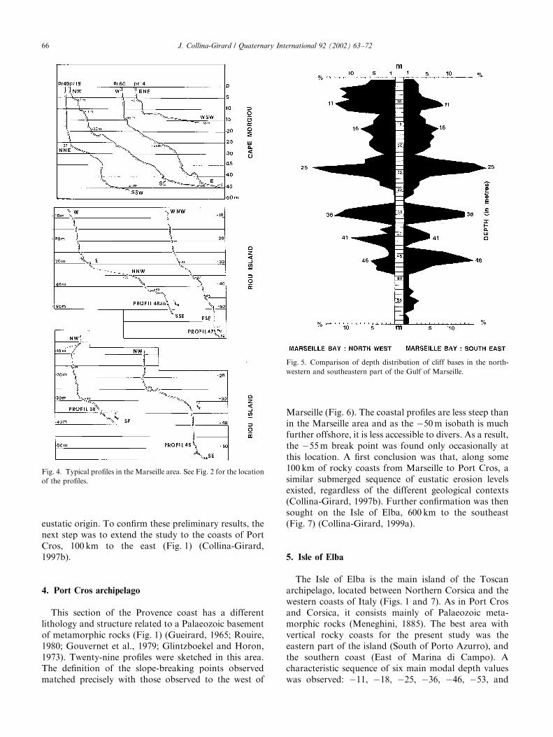
eustatic origin. To confirm these preliminary results, thenext step was to extend the study to the coasts of PortCros, 100 km to the east (Fig. 1) (Collina-Girard,1997b).
4. Port Cros archipelago
This section of the Provence coast has a differentlithology and structure related to a Palaeozoic basementof metamorphic rocks (Fig. 1) (Gueirard, 1965; Rouire,1980; Gouvernet et al., 1979; Glintzboekel and Horon,1973). Twenty-nine profiles were sketched in this area.The definition of the slope-breaking points observedmatched precisely with those observed to the west of
Marseille (Fig. 6). The coastal profiles are less steep thanin the Marseille area and as the �50m isobath is muchfurther offshore, it is less accessible to divers. As a result,the �55m break point was found only occasionally atthis location. A first conclusion was that, along some100 km of rocky coasts from Marseille to Port Cros, asimilar submerged sequence of eustatic erosion levelsexisted, regardless of the different geological contexts(Collina-Girard, 1997b). Further confirmation was thensought on the Isle of Elba, 600 km to the southeast(Fig. 7) (Collina-Girard, 1999a).
5. Isle of Elba
The Isle of Elba is the main island of the Toscanarchipelago, located between Northern Corsica and thewestern coasts of Italy (Figs. 1 and 7). As in Port Crosand Corsica, it consists mainly of Palaeozoic meta-morphic rocks (Meneghini, 1885). The best area withvertical rocky coasts for the present study was theeastern part of the island (South of Porto Azurro), andthe southern coast (East of Marina di Campo). Acharacteristic sequence of six main modal depth valueswas observed: �11, �18, �25, �36, �46, �53, and
Fig. 4. Typical profiles in the Marseille area. See Fig. 2 for the location
of the profiles.
Fig. 5. Comparison of depth distribution of cliff bases in the north-
western and southeastern part of the Gulf of Marseille.
J. Collina-Girard / Quaternary International 92 (2002) 63–7266

�54m (Fig. 8). An almost perfect fit is found betweenthese data and those from Provence (Fig. 8). Theseresults confirm the existence of at least six eustaticerosion levels from �60m up to the sea surface for theWestern Mediterranean region.
6. Marie-Galante Island (French West Indies)
A survey in the French West Indies (Marie-GalanteIsland) was used to obtain more clues as to whether theerosion levels found in the western Mediterranean Seaare more geographically widespread (Collina-Girard,1999a). Marie-Galante Island (Fig. 7) located in theFrench West Indies (Guadeloupe Archipelago) is mainlybuilt of coralline limestones of Tertiary age, depositedupon a volcanic substratum (Bouysse et al., 1993). Fourpreliminary SCUBA dives in front of the small city ofSaint Louis, in the western part of the island allowedobservation of at least three levels of submerged cliffs,clearly underlined by scant coral growth at �24/25,�35/37, and �40/41m. Complementary observationswere sought on the charts of the French Navy, (scale1:10,000). A similar methodology had already been usedfor identifying palaeoshorelines along the shores ofMartinique Island in the same Guadeloupe Archipelago(Froidefond et al., 1985).Using these documents, 90 more profiles were
sketched from 0m to �60m, distributed along ninecoastal areas all around the island (Figs. 9A–H). Asystematic comparison of cliff-base depth level wascarried out in order to point out possible neotectonicuplifting. This was a test of great importance, since
Fig. 6. Depth distribution of cliff bases in the Gulf of Marseille and off
the Port Cros archipelago.
Fig. 8. Depth distribution of cliff bases off Provence (277 from 95
profiles) and off the Isle of Elba (98 from 35 profiles). A, B, C, D, E,
and F are the main modal values common to the both areas. C0 and D0
are secondary modal values found only in the Marseille and Port Cros
areas.
Fig. 7. Location map of Marie-Galante island and the Isle of Elba
showing the localities referred to in the text. Marie-Galante island: (A)
Anse Madame (89.7.19); (B) Saint Louis (85.19.29); (C) Folle Anse
(85.19.30); (D) Pointe Ballet (85.19.30); (E) A!erodrome (89.7.13); (F)
Pointe Lucien (89.7.14); (G) Capesterre (89.7.14), and (H) Anse Piton
(89.7.16). Isle of ElbaFSCUBA diving spots 1–10.
J. Collina-Girard / Quaternary International 92 (2002) 63–72 67
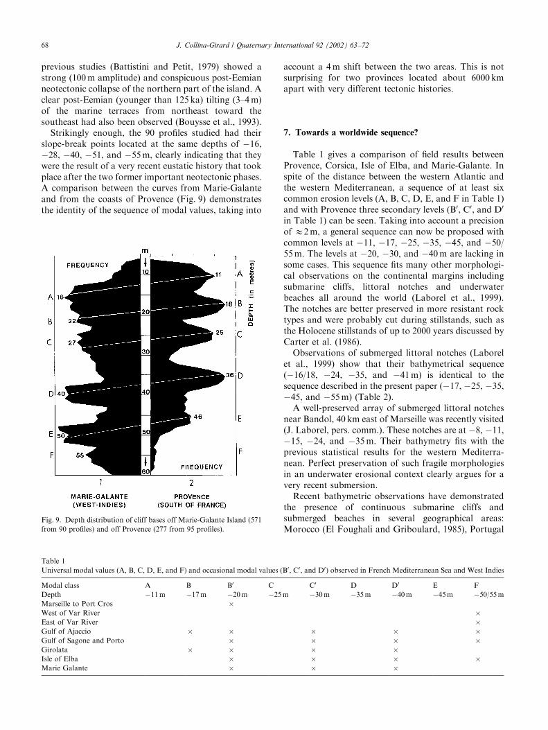
previous studies (Battistini and Petit, 1979) showed astrong (100m amplitude) and conspicuous post-Eemianneotectonic collapse of the northern part of the island. Aclear post-Eemian (younger than 125 ka) tilting (3–4m)of the marine terraces from northeast toward thesoutheast had also been observed (Bouysse et al., 1993).Strikingly enough, the 90 profiles studied had their
slope-break points located at the same depths of �16,�28, �40, �51, and �55m, clearly indicating that theywere the result of a very recent eustatic history that tookplace after the two former important neotectonic phases.A comparison between the curves from Marie-Galanteand from the coasts of Provence (Fig. 9) demonstratesthe identity of the sequence of modal values, taking into
account a 4m shift between the two areas. This is notsurprising for two provinces located about 6000 kmapart with very different tectonic histories.
7. Towards a worldwide sequence?
Table 1 gives a comparison of field results betweenProvence, Corsica, Isle of Elba, and Marie-Galante. Inspite of the distance between the western Atlantic andthe western Mediterranean, a sequence of at least sixcommon erosion levels (A, B, C, D, E, and F in Table 1)and with Provence three secondary levels (B0, C0, and D0
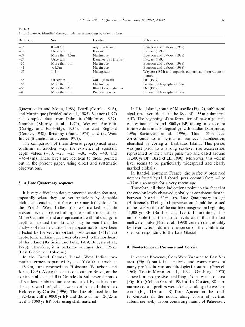
in Table 1) can be seen. Taking into account a precisionof E2m, a general sequence can now be proposed withcommon levels at �11, �17, �25, �35, �45, and �50/55m. The levels at �20, �30, and �40m are lacking insome cases. This sequence fits many other morphologi-cal observations on the continental margins includingsubmarine cliffs, littoral notches and underwaterbeaches all around the world (Laborel et al., 1999).The notches are better preserved in more resistant rocktypes and were probably cut during stillstands, such asthe Holocene stillstands of up to 2000 years discussed byCarter et al. (1986).Observations of submerged littoral notches (Laborel
et al., 1999) show that their bathymetrical sequence(�16/18, �24, �35, and �41m) is identical to thesequence described in the present paper (�17, �25, �35,�45, and �55m) (Table 2).A well-preserved array of submerged littoral notches
near Bandol, 40 km east of Marseille was recently visited(J. Laborel, pers. comm.). These notches are at �8, �11,�15, �24, and �35m. Their bathymetry fits with theprevious statistical results for the western Mediterra-nean. Perfect preservation of such fragile morphologiesin an underwater erosional context clearly argues for avery recent submersion.Recent bathymetric observations have demonstrated
the presence of continuous submarine cliffs andsubmerged beaches in several geographical areas:Morocco (El Foughali and Griboulard, 1985), Portugal
Fig. 9. Depth distribution of cliff bases off Marie-Galante Island (571
from 90 profiles) and off Provence (277 from 95 profiles).
Table 1
Universal modal values (A, B, C, D, E, and F) and occasional modal values (B0, C0, and D0) observed in French Mediterranean Sea and West Indies
Modal class A B B0 C C0 D D0 E F
Depth �11m �17m �20m �25m �30m �35m �40m �45m �50/55mMarseille to Port Cros �West of Var River �East of Var River �Gulf of Ajaccio � � � � �Gulf of Sagone and Porto � � � �Girolata � � � �Isle of Elba � � � �Marie Galante � � �
J. Collina-Girard / Quaternary International 92 (2002) 63–7268
(Quevauviller and Moita, 1986), Brazil (Corr#ea, 1996),and Martinique (Froidefond et al., 1985). Vanney (1977)has compiled data from Dalmatia (Nikiforov, 1967),Namibia (Murray et al., 1970), Western Australia(Carrigy and Fairbridge, 1954), southwest England(Cooper, 1948), Britanny (Pinot, 1974), and the WestIndies (Blanchon and Jones, 1995).The comparison of these diverse geographical areas
confirms, in another way, the existence of constantdepth values (�10, �20, �25, �30, �35, �40, and�45/47m). These levels are identical to those pointedout in the present paper, using direct and systematicobservations.
8. A Late Quaternary sequence
It is very difficult to date submerged erosion features,especially when they are not underlain by dateablebiological remains, but there are some indications. Inthe French West Indies, the well-marked eustaticerosion levels observed along the southern coasts ofMarie Galante Island are represented, without change indepth all around the island as may be seen from theanalysis of marine charts. They appear not to have beenaffected by the very important post-Eemian (o125 ka)neotectonic sinking which was observed to the northeastof this island (Battistini and Petit, 1979; Bouysse et al.,1993). Therefore, it is certainly younger than 125 ka(Last Glacial or Holocene).In the Grand Cayman Island, West Indies, two
marine terraces separated by a cliff (with a notch at�18.5m), are reported as Holocene (Blanchon andJones, 1995). Along the coasts of southern Brazil, on thecontinental shelf of Rio Grande do Sul, several phasesof sea-level stabilization are indicated by palaeoshor-elines, several of which were drilled and dated asHolocene by Corr#ea (1996). The date obtained for the�32/45m cliff is 9000 yr BP and those of the �20/25mlevel is 8000 yr BP both using shell material.
In Riou Island, south of Marseille (Fig. 2), sublittoralalgal rims were dated at the foot of �55m submarinecliffs. The beginning of the formation of these algal rimswas estimated around 9000 yr BP, taking into accountisotopic data and biological growth studies (Sartoretto,1996; Sartoretto et al., 1996). This �55m levelcorresponds to a period of sea-level stabilization,identified by coring at Barbados Island. This periodwas just prior to a strong sea-level rise accelerationrepresented by melt water pulse two and dated around11,300 yr BP (Bard et al., 1990). Moreover, this �55mlevel seems to be particularly widespread and clearlymarked globally.In Bandol, southern France, the perfectly preserved
notches found by (J. Laborel, pers. comm.) from �8 to�35m also argue for a very recent age.Therefore, all these indications point to the fact that
the erosion levels observed globally at consistent depths,between 0 and �60m, are Late Quaternary in age(Holocene?). Their good preservation should be relatedto the acceleration of the marine transgression beginning11,000 yr BP (Bard et al., 1990). In addition, it isimprobable that the marine levels older than the lastmeltwater pulse (Bard et al., 1990) were eroded, notablyby river action, during emergence of the continentalshelf corresponding to the Last Glacial.
9. Neotectonics in Provence and Corsica
In eastern Provence, from West Var area to East Vararea (Fig. 1) statistical analysis and comparisons ofmany profiles in various lithological contexts (Goguel,1965; Toutin-Morin et al., 1994; Ginsburg, 1970)showed a progressive uplifting from west to east(Fig. 10), (Collina-Girard, 1997b). In Corsica, 88 sub-marine coastal profiles were sketched along the westerncoast (Figs. 11A and B) from Ajaccio in the southto Girolata in the north, along 70 km of verticalsubmarine rocky shores consisting mainly of Palaeozoic
Table 2
Littoral notches identified through underwater mapping by other authors
Depth (m) Size Location References
�16 0.2–0.3m Anguilla Island Bouchon and Laborel (1986)
�18 Uncertain Hawaii Fletcher (1993)
�24 More than 0.5m Martinique Bouchon and Laborel (1986)
�24 Uncertain Kanehoe Bay (Hawaii) Fletcher (1993)
�35 More than 1m Martinique Bouchon and Laborel (1986)
�41 o0.5m Martinique Bouchon and Laborel (1986)
�55 1–2m Madagascar Weydert (1974) and unpublished personal observations of
Laborel
�55 Uncertain Oahu (Hawaii) Dill (1977)
�55 More than 1m Martinique Isolated bibliographical data
�55 More than 2m Blue Holes, Bahamas Dill (1977)
�90 More than 1m Red Sea, Pacific Isolated bibliographical data
J. Collina-Girard / Quaternary International 92 (2002) 63–72 69

metamorphic and rhyolitic bedrock (Collina-Girard,1998b, 1999b). The sequence in the Gulf of Sagonedisplays some eastward tilting compared to the sequenceobserved in Provence (Fig. 11C). A general downwardtilt of the depths of submarine cliff bases off Ajaccio inthe south contrasts with an upward tilt of the cliff basesoff the Gulf of Girolata in the north (Fig. 11D). Thetotal vertical movement reaches 3–7m along a distanceof some 70 km (Fig. 11D) increasing northwards toGirolata.
At first glance, the direction of the movementsappears to contradict former results, notably thoseobtained from comparison of levelling data in this sameregion (Len #otre et al., 1996). This study of Lenotreimplies that the region of Ajaccio in the south has beenrising, and that of Girolata in the north has beencollapsing during the last 50 years. This is the oppositetrend to that indicated in the present study. Of course, itis possible to conclude that the uplifting/collapsingregional scheme has undergone a total reversal duringthe present period, as compared with the Last Glacialperiod. However, the geological validity of levelling dataobtained for such an insignificant period of thegeological time scale may also be questioned. Thepresent study involving the analysis of underwaterprofiles, and which covers a more significant period oftime, may eventually prove to be a better suited tool forthe study of neotectonic trends.
10. Conclusions
A regularly notched submarine morphology is wide-spread along the inner continental shelves of theWestern Mediterranean and the West Indies between 0and �60m. The steps are located at depths of �11, �17,�25, �35, �45, and �50/55m.In some cases (many profiles studied in Marseille and
other Provence areas), secondary levels are observed at�20, �30 and �40m. At greater depths, two levels at�90 and �100m were measured in the Marseille area(Collina-Girard, 1993; Collina-Girard et al., 1996).These deep levels are also a global feature (Vanney,1977). It is proposed that these steps are LateQuaternary in age, representing the slowing down ofsea-level rise and very possibly stillstand during thepostglacial rise in sea level.The method described in this paper proves to be an
efficient way to detect and measure neotectonic move-ments, as shown by results from the Nice area, aroundthe Var River (Collina-Girard, 1997b), and on the westcoast of Corsica (Collina-Girard, 1998b). The efficiencyof the method is limited by the necessity of findingvertical rocky coasts with good accessibility for scientificdivers. Flatter areas may only provide occasionalobservations, which must be correlated with map data.
Acknowledgements
This work was conducted with the financial help ofthe Minist"ere de la Culture (DRASSM) of Franceand with the active participation of Jean-MichelIcard, Captain of the Vaillant and the divers of theScuba Dive Club Les Plaisirs de la Mer: A. Barthes,A. Cardoso, S. Carcolse, P. Festinesi, Y. Gaertner,
Fig. 10. Depth distribution of cliff bases in southern France west of
the Var River (24 profiles, 79 cliff bases) and east of the Var River (20
profiles, 83 cliff bases). The pattern indicates neotectonic subsidence
west of the Var River and neotectonic uplift east of the Var River.
J. Collina-Girard / Quaternary International 92 (2002) 63–7270

G. Fimbel, P. Lacourte, G. Henry, N. Moniez, J.Tapissier and O. Trubert. The author is particularlygrateful for the efficiency of these friendly volunteers.This paper is a contribution to IGCP Project No. 396‘Continental shelves in the Quaternary’.
References
Bard, E., Hamelin, B., Fairbanks, G., 1990. U–Th ages obtained by
mass spectrometry in corals from Barbados: sea level during the
past 130 000 years. Nature 346, 456–458.
Battistini, R., Petit, M., 1979. R!ecifs coralliens, constructions algaires
et "a r!ecifs "a la Guadeloupe, Marie Galante et la D!esirade. Atoll
Research Bulletin 234, 1–8.
Blanchon, P., Jones, B., 1995. Marine planation terraces on the shelf
around Grand Cayman: a result of stepped Holocene sea-level rise.
Journal of Coastal Research 11, 1–33.
Bouchon, C., Laborel, J., 1986. Les peuplements coralliens des c #otes de
la Martinique. Annales de l’Institut Oc!eonagraphique, Nouvelle
S!erie, Masson 2, 199–237.
Bouysse, P., Garrab!e, F., Maubussin, T., 1993. Marie-Galante et #ılets
de la Petite-Terre. Notice explicative, carte g!eologique "a 1/50 000,
D!epartement de la Guadeloupe, BRGM !editeur.
Carter, R.M., Carter, L., Johnson, D.P., 1986. Submergent shorelines
in the southwest Pacific: evidence for an episodic post-glacial
transgression. Sedimentology 33, 629–649.
Carrigy, M.A., Fairbridge, R.W., 1954. Recent sedimentation,
physiography and structure of the continental shelves of Western
Australia. Journal Royal Society Western Australia 38, 68–95.
Collina-Girard, J., 1993. Pr!esentation d’une carte bathym!etrique au
1/25 000 du pr!econtinent marseillais. G!eologie M!editerran!eenne
XIX, 77–87.
Collina-Girard, J., 1997a. Profils littoraux en plong!ee et niveaux
d’!erosion eustatique pr"es de la grotte Cosquer (Marseille) et en
Provence. Comptes Rendues, Academie des Sciences Paris (s!erie
IIa) 324, 607–615.
Collina-Girard, J., 1997b. Analyse de profils sous-marins lev!es en
plong!ee sur les c #otes proven-cales, implications eustatiques et
n!eotectoniques. Comptes Rendues, Academie des Sciences Paris,
s!erie II 325, 955–959.
Collina-Girard, J., 1998a. Niveaux de stationnement marins observ!es
cartographiquement et en plong!ee (0 "a �60m) entre Marseille et
Cassis (B.du Rh. France). Abstracts L’Homme Pr!ehistorique et la
Mer, 120!e congr"es CTHS, Aix en Provence, 23–26 October, 1995,
pp. 31–52.
Collina-Girard, J., 1998b. Observations n!eotectoniques en plong!ee
sur le littoral occidental de la Corse. Comptes Rendues,
Academie des Sciences Paris Sciences de la Terre et des Plan"etes
327, 121–126.
Collina-Girard, J., 1999a. Observation en plong!ee de replats d’!erosion
eustatique "a l’#ıle d’Elbe (Italie) et "a Marie-Galante (Antilles): une
s!equence bathym!etrique mondiale? Comptes Rendues, Academie
des Sciences Paris, Sciences de la Terre et des Plan"etes 328,
823–829.
Collina-Girard, J., 1999b. Les replats littoraux holoc"enes immerg!es en
Provence et en Corse: implications eustatiques et n!eotectoniques.
Quaternaire 10, 121–131.
Collina-Girard, J., Degiovanni, C., Lafont, R., 1996. Datation d’un
pal!eorivage submerg!e en rade de Marseille. Comptes Rendues,
Academie des Sciences Paris (s!erie IIa) 322, 341–344.
Cooper, L.H.N., 1948. A submerged ancient cliff near Plymouth.
Nature 161, 280.
Fig. 11. Location map of Corsica showing the localities studied (A and B) and the depth distribution of cliff bases at Ajaccio and Girolata (D), and
Sagone in comparison to off Provence (C). Abbreviations in A and B: MaFMarseille; NiFNice; AjFAjaccio; GirFGirolata; PoFPorto, and
SagFSagone.
J. Collina-Girard / Quaternary International 92 (2002) 63–72 71

Corr#ea, I.C.S., 1996. Les variations du niveau de la mer durant les
derniers 17,500 ans BP: l’exemple de la plate-forme continentale du
Rio Grande do Sul-Br!esil. Marine Geology 130, 163–178.
Dill, R.F., 1977. The Blue Holes-geologically significant submerged
sink holes and caves off British Honduras and Andros, Bahamas
Islands. Proceedings of the Third International Symposium on
Coral Reefs, Miami 2, 237–242.
El Foughali, A., Griboulard, R., 1985. Les grands traits structuraux et
lithologiques de la marge atlantique marocaine de Tanger "a Cap
Cantin. Bulletin Institut G!eologique Bassin d’Aquitaine, Bordeaux
38, 179–211.
Flemming, N.C., 1972. Relative chronology of submerged Pleistocene
marine erosion features in the Western Mediterranean. Journal of
Geology 80, 633–662.
Fletcher, C.H., 1993. Steps toward a RSL history of Hawa.ıi over the
last interglacial cycle (125 ka-present). UNESCO, International
Union of Geological Sciences, Earth Processes in Global Change;
Climates of the Past, Report 1993. Occasional Publication 25,
Geneva, pp. 24–29.
Froidefond, J.M., Berthois, L., Griboulard, R., Julius, C., Pons, J.C.,
1985. Terrasses submerg!ees d’origine r!ecifales; Variations du
niveau marin et activit!e n!eotectonique sur le plateau sud et est de
la Martinique. G!eodynamique des cara.ıbes, Symposium Paris,
F!evrier 1985, Editions Technip, Paris, pp. 5–8.
Ginsburg, L., 1970. Carte g!eologique de la France, 1:50,000, Feuille
Grasse-Cannes, Editions du Bureau de recherches g!eologiques et
mini"eres, Paris.
Glintzboekel, C., Horon, O., 1973. A la d!ecouverte des paysages
g!eologiques de Marseille "a Menton. Editions du Bureau de
recherches g!eologiques et mini"eres.
Goguel, J., 1965. Carte g!eologique de la France au 1:80,000, Feuille
Nice-Pont-St-Louis. Editions du Bureau de recherches g!eologiques
et mini"eres, Paris.
Gouvernet, C., Guieu, G., Rousset, C., 1979. Guides g!eologiques
r!egionaux, Provence. Masson ed., Paris, 238pp.
Gueirard, S., 1965. Description p!etrographique et zon!eographique des
schistes cristallins des Maures (Var). Th"ese Marseille, Annales de la
Facult!e des Sciences de Marseille, Vol. 6, 194pp.
Guieu, G., 1968. Etude tectonique de la r!egion de Marseille. Th"ese
d’Etat, Universit!e de Provence, Aix-Marseille 1, 608pp.
Guieu, G., 1969. Carte g!eologique de la France au 1:50,000, Feuille
Aubagne-Marseille. Editions du Bureau de recherches g!eologiques
et mini"eres, Paris.
Guieu, G., Ricour, J., Rouire, J., 1996. D!ecouverte g!eologique de
Marseille et de son d!ecor montagneux, Jeanne Lafitte ed.,
Marseille, 215pp.
Laborel, J., Mohrange, C., Collina-Girard, J., Laborel-Deguen, F.,
1999. Littoral bio-erosion, a tool for the study of sea-level
variations during the Holocene. Bulletin of the Geological Society
of Denmark 45, 144–148.
Len #otre, N., Ferrandini, J., Delfau, M., Panighi, J., 1996. Mouvements
verticaux actuels de la Corse (France) par comparaison de
nivellements. Comptes Rendues, Academie des Sciences Paris,
(s!erie IIa) 323, 957–964.
Meneghini, G., 1885. Carta geologica dell’isola d’Elba nella scala di
1:50,000, Virano ed. Roma.
Murray, L.G., Joynt, R.H., O’Shea, D.O.C., Foster, R.W., Kleinjan,
L., 1970. The geology of the East Atlantic continental margin.
ICSU/SCOR, Working Party, 31 Symposium, Institute Geological
Sciences Report, London 70/13, pp. 119–141.
Nikiforov, L.G., 1967. Underwater terraces off the Dalmatian coast.
Oceanology 7, 101–106.
Pinot, J.P., 1974. Le pr!econtinent breton, entre Penmarch, Belle-lle et
l’escarpement continental, !etude g!eomorphologique, Lannion,
Impram, 248pp.
Quevauviller, P., Moita, I., 1986. Histoire Holoc"ene d’un syst"eme
transgressif: la plateforme du Nord Alentejo (Portugal).
Bulletin Institut G!eologique Bassin d’Aquitaine, Bordeaux 40,
85–95.
Rouire, J., 1980. Carte g!eologique de la France au 1:250,000,
Marseille, Editions du Bureau de recherches g!eologiques et
mini"eres, Paris.
Sartoretto, S., 1996. Vitesses de croissance et de bio!erosion des
concr!etionnements ‘‘corallig"enes’’ de M!editerran!ee nord-occiden-
tale. Rapport avec les variations holoc"enes du niveau marin. Th"ese
de Doctorat, Universit!e Aix Marseille II, 193pp.
Sartoretto, S., Verlaque, M., Laborel, J., 1996. Age of settlement and
accumulation rate of submarine coralligene (�10 to �60m) of thenorthwestern Mediterranean sea, relation to Holocene rise in sea
level. Marine Geology 130, 317–331.
Toutin-Morin, N., Bonijoly, C., Brocard, J., Broutin, G., Cr!evola, G.,
Dardeau, M., Dubar, M., F!eraud, J., Giraud, P., Godefroy, P.,
Laville, A., Meinesz, A., 1994. Carte g!eologique de la France au
1:50,000, Feuille 1024, Fr!ejus-Cannes, Bureau de recherches
g!eologiques et mini"eres ed., Paris.
Vanney, J.R., 1977. G!eomorphologie des plates-formes continentales,
Doin, Paris, 300pp.
Weydert, P., 1974. Morphologie et s!edimentologie de la pente extrerne
du Grand Recif de Tulear (Sud Ouest de Madagascar). Marine
Geology 30, 9–19.
J. Collina-Girard / Quaternary International 92 (2002) 63–7272