Holocene palaeoecology and human environmental interactions at the coastal Black Sea Lake...
10
Holocene palaeoecology and humaneenvironmental interactions at the coastal Black Sea Lake Durankulak, northeastern Bulgaria Spassimir Tonkov a, * , Elena Marinova b, c , Mariana Filipova-Marinova d , Elissaveta Bozilova a a Laboratory of Palynology, Faculty of Biology, Sofia University St. Kliment Ohridski, 8 Dragan Tzankov Blvd., 1164 Sofia, Bulgaria b Center for Archaeological Sciences, University of Leuven, Celestijnenlaan 200E, 3001 Leuven, Belgium c Royal Belgian Institute for Natural Sciences, Rue Vautier 29, B-1000 Brussels, Belgium d Museum of Natural History e Varna, 41 Maria Louisa Blvd., 9000 Varna, Bulgaria article info Article history: Available online xxx abstract The environmental changes (vegetation history, human impact and land use, influence of the Black Sea) in the area of Lake Durankulak, northeastern Bulgaria, were reconstructed and synthesized for the last ca. 8000 years. The palaeoecological information derived from various proxies (pollen, plant macrofossils, molluscs, sediments) was compared on a regional scale with the evidence from the nearby coastal lakes ShablaeEzeretz and Bolata. The Early Holocene xerothermic steppe vegetation, dominated by Cheno- podiaceae, Artemisia and Poaceae species, and accompanied by stands of trees in moister habitats, was transformed after 6000 cal. BP into a forest-steppe, comprising oak woods with Carpinus betulus, Ulmus, Tilia, Acer. This vegetation pattern has been periodically modified, depleted and replaced by arable land or xerothermic herbaceous communities enriched with anthropophytes and ruderals, particularly after the intensification of human activities since 3300 cal. BP. The archaeobotanical evidence from the region has provided valuable information about the occupation phases and subsistence strategy of the local people since the Late Neolithic (5300 cal. BC/7250 cal. BP). Periods with cultivation of cereals (Triticum, Hordeum) and/or stock-breeding activity were interrupted by abandonment of the settlements and the arable land due to unfavourable environmental changes. The periodical connection/isolation of Lake Durankulak with the Black Sea and the periods of marine influence were recorded by changes in the composition of the fossil molluscan fauna and the lithology of the sediments, and chronologically confirmed by radiocarbon dates. The development of the coastal lakes throughout the largest part of the Holocene has been also considerably influenced by the fluctuations of the Black Sea level. Ó 2013 Elsevier Ltd and INQUA. All rights reserved. 1. Introduction The Holocene vegetation history, human impact and palae- oenvironment of the northern Bulgarian Black Sea coastal area have continuously attracted the interest of researchers during recent decades. Pollen diagrams spanning the last ca. 8000 years were published from the coastal lakes Durankulak (Bozilova and Tonkov, 1985, 1998; Marinova, 2003; Marinova and Atanassova, 2006), ShablaeEzeretz (Filipova, 1985) and Bolata (Tonkov et al., 2011) (Fig. 1). In broad lines, the earliest palynological evidence derived from Lake Durankulak (Bozilova and Tonkov, 1985) indicated a steppe phase followed by a forest-steppe, characterized by the presence of groups of deciduous trees. In the course of the last millennia, herbaceous communities, secondary in origin, started to dominate in place of the former deciduous oak forests. In addi- tion, marinopalynological investigations from the western sector of the Black Sea (Fig. 1C) complemented the information from the coastal lakes and showed that during the Lateglacial, and until ca. 8000 cal. BP, the vegetation was dominated by steppe elements, Artemisia and Chenopodiaceae in particular (Atanassova, 2005; Filipova-Marinova et al., 2013). The woodstands along the north- ern coastal area were periodically destroyed during phases of hu- man activity after the first prehistoric settlements were founded in the Late Neolithic near the lakes and limans (Todorova, 1995, 2002; Filipova-Marinova, 2007; Yanko-Hombach et al., 2007; Peev, 2009; Tonkov et al., 2011). Abundant palaeoecological information from various proxies has been collected from the coastal Lake Durankulak. In the course of the years, study was enriched by the application of pollen analysis, micro-charcoal record, determination of plant * Corresponding author. E-mail addresses: [email protected] (S. Tonkov), [email protected] (E. Marinova), marianafi[email protected] (M. Filipova-Marinova), bozilova@ biofac.uni-sofia.bg (E. Bozilova). Contents lists available at ScienceDirect Quaternary International journal homepage: www.elsevier.com/locate/quaint 1040-6182/$ e see front matter Ó 2013 Elsevier Ltd and INQUA. All rights reserved. http://dx.doi.org/10.1016/j.quaint.2013.12.004 Quaternary International xxx (2013) 1e10 Please cite this article in press as: Tonkov, S., et al., Holocene palaeoecology and humaneenvironmental interactions at the coastal Black Sea Lake Durankulak, northeastern Bulgaria, Quaternary International (2013), http://dx.doi.org/10.1016/j.quaint.2013.12.004
-
Upload
denkmalpflege-bw -
Category
Documents
-
view
1 -
download
0
Transcript of Holocene palaeoecology and human environmental interactions at the coastal Black Sea Lake...

lable at ScienceDirect
Quaternary International xxx (2013) 1e10
Contents lists avai
Quaternary International
journal homepage: www.elsevier .com/locate/quaint
Holocene palaeoecology and humaneenvironmental interactions atthe coastal Black Sea Lake Durankulak, northeastern Bulgaria
Spassimir Tonkov a,*, Elena Marinova b,c, Mariana Filipova-Marinova d, Elissaveta Bozilova a
a Laboratory of Palynology, Faculty of Biology, Sofia University St. Kliment Ohridski, 8 Dragan Tzankov Blvd., 1164 Sofia, BulgariabCenter for Archaeological Sciences, University of Leuven, Celestijnenlaan 200E, 3001 Leuven, BelgiumcRoyal Belgian Institute for Natural Sciences, Rue Vautier 29, B-1000 Brussels, BelgiumdMuseum of Natural History e Varna, 41 Maria Louisa Blvd., 9000 Varna, Bulgaria
a r t i c l e i n f o
Article history:Available online xxx
* Corresponding author.E-mail addresses: [email protected] (S. Tonkov), elen
(E. Marinova), [email protected] (M. Fibiofac.uni-sofia.bg (E. Bozilova).
1040-6182/$ e see front matter � 2013 Elsevier Ltd ahttp://dx.doi.org/10.1016/j.quaint.2013.12.004
Please cite this article in press as: Tonkov, SLake Durankulak, northeastern Bulgaria, Qu
a b s t r a c t
The environmental changes (vegetation history, human impact and land use, influence of the Black Sea)in the area of Lake Durankulak, northeastern Bulgaria, were reconstructed and synthesized for the last ca.8000 years. The palaeoecological information derived from various proxies (pollen, plant macrofossils,molluscs, sediments) was compared on a regional scale with the evidence from the nearby coastal lakesShablaeEzeretz and Bolata. The Early Holocene xerothermic steppe vegetation, dominated by Cheno-podiaceae, Artemisia and Poaceae species, and accompanied by stands of trees in moister habitats, wastransformed after 6000 cal. BP into a forest-steppe, comprising oak woods with Carpinus betulus, Ulmus,Tilia, Acer. This vegetation pattern has been periodically modified, depleted and replaced by arable landor xerothermic herbaceous communities enriched with anthropophytes and ruderals, particularly afterthe intensification of human activities since 3300 cal. BP. The archaeobotanical evidence from the regionhas provided valuable information about the occupation phases and subsistence strategy of the localpeople since the Late Neolithic (5300 cal. BC/7250 cal. BP). Periods with cultivation of cereals (Triticum,Hordeum) and/or stock-breeding activity were interrupted by abandonment of the settlements and thearable land due to unfavourable environmental changes. The periodical connection/isolation of LakeDurankulak with the Black Sea and the periods of marine influence were recorded by changes in thecomposition of the fossil molluscan fauna and the lithology of the sediments, and chronologicallyconfirmed by radiocarbon dates. The development of the coastal lakes throughout the largest part of theHolocene has been also considerably influenced by the fluctuations of the Black Sea level.
� 2013 Elsevier Ltd and INQUA. All rights reserved.
1. Introduction
The Holocene vegetation history, human impact and palae-oenvironment of the northern Bulgarian Black Sea coastal area havecontinuously attracted the interest of researchers during recentdecades. Pollen diagrams spanning the last ca. 8000 years werepublished from the coastal lakes Durankulak (Bozilova and Tonkov,1985, 1998; Marinova, 2003; Marinova and Atanassova, 2006),ShablaeEzeretz (Filipova, 1985) and Bolata (Tonkov et al., 2011)(Fig. 1). In broad lines, the earliest palynological evidence derivedfrom Lake Durankulak (Bozilova and Tonkov, 1985) indicated asteppe phase followed by a forest-steppe, characterized by the
[email protected]), bozilova@
nd INQUA. All rights reserved.
., et al., Holocene palaeoecolaternary International (2013)
presence of groups of deciduous trees. In the course of the lastmillennia, herbaceous communities, secondary in origin, startedto dominate in place of the former deciduous oak forests. In addi-tion, marinopalynological investigations from the western sector ofthe Black Sea (Fig. 1C) complemented the information from thecoastal lakes and showed that during the Lateglacial, and until ca.8000 cal. BP, the vegetation was dominated by steppe elements,Artemisia and Chenopodiaceae in particular (Atanassova, 2005;Filipova-Marinova et al., 2013). The woodstands along the north-ern coastal area were periodically destroyed during phases of hu-man activity after the first prehistoric settlements were founded inthe Late Neolithic near the lakes and limans (Todorova, 1995,2002; Filipova-Marinova, 2007; Yanko-Hombach et al., 2007;Peev, 2009; Tonkov et al., 2011).
Abundant palaeoecological information from various proxieshas been collected from the coastal Lake Durankulak. In thecourse of the years, study was enriched by the application ofpollen analysis, micro-charcoal record, determination of plant
ogy and humaneenvironmental interactions at the coastal Black Sea, http://dx.doi.org/10.1016/j.quaint.2013.12.004

Fig. 1. Study region (1. Lake Durankulak: photo by P. Simeonov, 2. Lake ShablaeEzeretz: photo by B. Dimitrov, 3. Lake Bolata: photo: http://www.moew.government.bg/cpg/). A. Thestudy area within Europe; B. Location of the pollen cores from coastal lakes in northeastern Bulgaria; C. Bulgarian Black Sea coast and location of coastal lakes (closed circles) andmarine pollen cores (open circles) mentioned in the text (XK-71, A-76A, A-159: Atanassova, 2005; GGC-18: Filipova-Marinova et al., 2013).
S. Tonkov et al. / Quaternary International xxx (2013) 1e102
macroremains and non-pollen palynomorphs, supplemented byradiocarbon dating (Bozilova and Tonkov, 1985, 1998; Marinova,2003; Marinova and Atanassova, 2006), archaeobotanical finds(Marinova, 2006; Popova, 2009), determination of fossil molluscan(gastropod) fauna (Shopov and Yankova, 1987) and valuablearchaeological information since Neolithic time (for most recentoverview see Todorova, 2002).
The key location of Lake Durankulak allows detailed tracing ofthe palaeoenvironmental changes in an area sensitive to climatechange and human impact, which has archived the characteristicsof the alternation between steppe and forest-steppe, the millennialanthropogenic impact on the surrounding environment and theinfluence of the Black Sea. The main goal of the paper is to present areconstruction synthesis of the local and regional vegetation andlandscape changes, interactions with the Black Sea and humanactivity during the largest part of the Holocene, on the basis of thepalaeoecological information collected from Lake Durankulak,comparedwith the available evidence from the nearby coastal lakesShablaeEzeretz and Bolata.
2. Study area
Lake Durankulak is the northernmost coastal lake in SouthernDobrudza (Fig. 1) and occupies an area of 3.4 km2. It is 5.2 km longand 0.2e2 km wide. The lake sediments fill two depressions inMiocene limestone. The maximum water depth reaches 4 m andthe lake level isw40 cm higher than the level of the Black Sea. Twoislands exist in the southwestern part of the lake. The larger islandhas a pear shape, 207 m long and l17 mwide, with an area of 1.8 ha(Fig. 1). The lake is separated from the sea by a sand strip, 100e200mwide, which is occasionally washed away in stormy weather.The lake is slightly brackish (average salinity is 2&), oligohalobicand eutrophic, with high pH (8e8.5) (Bozilova and Tonkov, 1998).
The climate in the area is determined by the northeasterncontinental influence and by the Black Sea. The mean annual pre-cipitation is 440 mm, with 140e170 mm precipitation in lateautumn and early winter, while in spring and in summer therainfall is 100 mm and 125e150 mm, respectively. The thin snow
Please cite this article in press as: Tonkov, S., et al., Holocene palaeoecolLake Durankulak, northeastern Bulgaria, Quaternary International (2013)
cover is usually blown away by the strong northeasterly winds. Thesoils around the lake are rich in carbonates and consist of erodedchernozems (Bozilova and Tonkov, 1998).
The southern parts of the Dobrudza phytogeographical regionare characterized by the existence of disappearing small fragmentsof natural forest-steppe vegetation and vast areas of arable land onchernozem soils. Near the coast are remnants of riparian (longoz)forests and terrains occupied by psammophyte, halophyte andhasmophyte vegetation (Bondev, 2002). Around Lake Durankulak,xerothermic herbaceous communities are developed dominated bygrasses such as Chrysopogon gryllus, Andropogon ischaemum, Agro-pyrum brandzae and xerophytes Artemisia pedemontana, Paeoniatenuifolia, and Iris pumila. On the lower terraces and in the ravinesnear the lake, isolated groups of trees and shrubs are thrivingcomposed of Ulmus minor, Fraxinus excelsior, Crataegus monogyna,Corylus avellana, and Sambucus nigra. In former times, most of thearea with woodstands was cleared for agriculture. The halophytesalong the eastern shore of the lake are represented mainly by Sal-icornia europaea, Limonium gmelinii and Aeluropus littoralis(Bozilova and Tonkov, 1998). South of Lake Durankulak, near theLake ShablaeEzeretz and the coast of the Cape Kaliakra area closeto the former Lake Bolata, herbaceous steppe and xerothermic as-semblages are distributed on a restricted flat limestone territory,dominated by Agropyron pectiniforme, A. brandzae, Poa bulbosa,Dichantium ischaemum, Artemisia pontica, Festuca pseudovina, Fes-tuca dalmatica, Stipa pennata, Stipa capillata, Adonis vernalis, Adoniswolgensis, and Jurinea mollis (Kozuharov et al., 1997; Bondev, 2002;Velchev, 2002).
The steppe vegetation in Dobrudza has been discussed by anumber of botanists who had different opinions about its origin.Jordanov (1936) considered the steppe vegetation in northeasternBulgaria as primary. Stojanov (1941) suggested that the naturalvegetation has been forest-steppe, while not excluding the possi-bility for the existence of primary herbaceous communities.
Based on the palynological evidence, the Holocene vegetationhistory in the northeastern part of the country revealed that thesteppe vegetation was of different origin. Its primary character wasconfirmed only for a narrow coastal area, particularly around Cape
ogy and humaneenvironmental interactions at the coastal Black Sea, http://dx.doi.org/10.1016/j.quaint.2013.12.004

Fig.
2.Co
rrelationof
thepa
lyno
logicalreco
rdsfrom
theco
astallake
sstud
iedacco
rdingto
theirag
e/de
pthmod
els.
S. Tonkov et al. / Quaternary International xxx (2013) 1e10 3
Kaliakra. After 8000 cal. BP under a forest-steppe phytoclimate, thevegetation was highly modified by anthropogenic impact, itscomposition being continuously depleted and enriched with ru-derals and anthropophytes (Bozilova and Filipova, 1986; Bozilovaand Tonkov, 1998; Marinova and Atanassova, 2006; Tonkov et al.,2011).
3. Archaeological background
In Bulgaria the Neolithic period starts at the end of the VIIthmillennium BC and continues until ca. 4900 cal. BC (6850 cal. BP),followed by the Eneolithic (or Chalcolithic) period (4900e3800 cal. BC or 6850e5750 cal. BP). The subsequent Bronze Agespans the time interval from ca. 3000 to 1200 cal. BC (4950e3150 cal. BP) (Görsdorf and Boyadziev, 1997).
The human occupation in the coastal area of northeasternBulgaria commenced during the Late Neolithic (5300e4900 cal. BC or 7250e6850 cal. BP). At Lake Durankulak, a LateNeolithic settlement and an Eneolithic and Bronze Age necropoliswere discovered on the southwestern shore (Dimov, 2003) nearthe places from where cores for pollen analysis were obtained(see Fig. 1 and Table 1 in Marinova and Atanassova, 2006). Someof the Late Eneolithic and Early Bronze Age burials are sub-merged between the lake shore and the large island. The firstinhabitants belonged to the Hamangia culture which existedalong the Black Sea coast in Romania and Bulgaria, in the sur-roundings of the Danube River and the Dobrudza area. On thehighest part of the large island, a complex archaeological sitedating back to the Early Eneolithic (4750e4450 cal. BC or 6700e6400 cal. BP) was excavated. It comprises cultural layers from theLate Bronze Age (15the14th centuries BC) and Mediaeval (Proto-Bulgarian) settlements (900e1000 AD), and a Thracian sanctuary(1-st century BC). Evidence for settlement activities on the largeisland from the end of the Eneolithic to the Early Bronze Age islacking (Todorova, 2002).
In the course of the first millennium BC, Gethic tribes inhabitedthe territory of Dobrudza. Subsequently this coastal area wascolonized by the Greeks (700e600 BC) and the Romans (45 BCe284 AD). The network of settlements was destroyed in the 6the7thcenturies AD after the devasting invasions of Slavonic, Proto-Bulgarian and Avaric tribes (see references cited in Tonkov et al.,2011).
4. Material and methods
4.1. Pollen data
For local correlation the percentage pollen diagrams from coresDurankulak-2 (N 43�39052.5000, E 28�31046.1100) (Bozilova andTonkov, 1998) and Durankulak-3 (N 43�39055.8900, E 28�31041.4100)(Marinova, 2006) were used. For the regional comparison, thepollen datasets from Lake ShablaeEzeretz (Filipova, 1985) and fromLake Bolata (Tonkov et al., 2011) were added. The original pollendiagrams with the sedimentological characteristics and the levelsof radiometric dating are presented as electronic supplementarymaterial (see Figs. 1e6 in ESM). In the synthetic diagram (Fig. 2),selected pollen taxa relevant for the discussion on the vegetationhistory in the study area and humaneenvironmental interactionswere plotted against the age scale using the software TILIA ver.1.5.17 (Grimm, 2011), considering the interpretation of the radio-carbon dates presented in the above mentioned publications. Eachpollen dataset begins with an AP/NAP curve to illustrate the generaltendencies of landscape openness in the respective area. All othertaxa are graphically presented as histograms. The values for themain arboreal pollen types representing the forests in the area
Please cite this article in press as: Tonkov, S., et al., Holocene palaeoecology and humaneenvironmental interactions at the coastal Black SeaLake Durankulak, northeastern Bulgaria, Quaternary International (2013), http://dx.doi.org/10.1016/j.quaint.2013.12.004

Fig. 3. Percentage proportions of wood charcoal analyzed from the Late Eneolithiclayers of the settlement on the large island.
S. Tonkov et al. / Quaternary International xxx (2013) 1e104
(Quercus robur-type, Quercus cerris-type and Carpinus betulus) arestacked in order to demonstrate the changes through time of theforest extent. These can be considered with the curve of the ri-parian forests (longoz) in which all of the potential representativesare included (Alnus, Salix, Ulmus, F. excelsior-type, Hedera, Humulus/Cannabis-type). Comparing this group with the oak woodlandcould be helpful in estimating the contribution of the alluvial for-ests to the arboreal component of the vegetation. In regions like thestudy area, where the dominant vegetation outside the wetlands issteppe and forest-steppe, it appears important to consider theorigin of arboreal pollen from local (wetland) or extralocal (forest/steppe) origin. The last arboreal pollen taxon in the dataset isCarpinus orientalis-type. Next in the diagrams follow the mainsteppe components (Poaceae, Artemisia and Chenopodiaceae),shown separately. In some cases these taxa also are representativeof the local vegetation, such as Chenopodiaceae, originating fromthe psammophytic communities along the shores, or partly Poa-ceae originating from the reed formations. The sums of pollen typesconsidered as reliable primary and secondary anthropogenic pollenindicators for the study area (Bozilova and Tonkov, 1990) werestacked. The group of primary anthropogenic indicators includedTriticum-type, Hordeum-type, Secale, Cerealia-type, Juglans, andCastanea. The group of the secondary anthropogenic indicatorscomprises Agrostemma githago-type, Centaurea cyanus, Cirsium-type, Plantago lanceolata, Plantago major/media-type, Polygonumaviculare-type, Plantago convolvolus-type, Rumex, Scleranthus,Ranunculus acris-type, Convolvolus, Malva-type, Melampyrum,Mercurialis, and Urtica.
4.2. Plant macrofossil remains
From part of the core Durankulak-3, for the period 6000e4300 cal. BP, plant macrofossil evidence was also obtained(Marinova and Atanassova, 2006). This allows a more preciseinterpretation of the local vegetation development (see Fig. 7 inESM). This plant macrofossil record indicates continuous presenceof open steppe-like vegetation together with representatives of theaquatic and mainly telmatic vegetation. Most of the aquatic mac-rofossils indicate shallow, meso- to euthrophic water.
Further plant macrofossils comprising fruits and seeds fromvarious wild and cultivated taxa, as well as wood charcoal frag-ments were recovered from the Late Eneolithic (4450e4200 cal. BC/6400e6150 cal. BP) settlement layers on the large is-land (Marinova, 2006). The main cultivated plants for the periodwere emmer (Triticum dicoccum) and einkorn (Triticum mono-coccum), followed by free threshing wheat (Triticum aestivum/durum) and bitter vetch (Vicia ervilia). The finds of free threshingwheat in the study area are representedmainly by single grains andrarely by rachis fragments and occur inland since the EarlyNeolithic (6100e5900 cal. BC or 8050e7850 cal. BP) (Marinova,2006). Exceptions from this observation are the storage findsfrom the Eneolithic period of the Black Sea area, including Duran-kulak, which also imply more advanced and labour intensivecultivation methods. A diversity of fruits gathered from the sur-roundings including cornelian cherry and especially differentplums was recorded. The seeds of wild-growing plants representnot only the segetal flora, but also ruderal places, open vegetationandwetlands used by the inhabitants of the Late Eneolithic site. Thepercentage proportions of the wood charcoals (487 fragmentsextracted from 16 samples) coming from the same site and periodare presented on a circle diagram (Fig. 3). It is interesting to note therather low participation of Quercus in the wood directly used by thepeople at that time. Wood charcoal is dominated by open helio-philous vegetation representatives (Cornus sp., Maloideae, Prunussp., Corylus, etc., in total 35% of the charcoal assemblage) and those
Please cite this article in press as: Tonkov, S., et al., Holocene palaeoecolLake Durankulak, northeastern Bulgaria, Quaternary International (2013)
most probably coming from the riparian forests (Fraxinus, Ulmus,Populus/Salix, in total 46%).
Charred plant macrofossils were also studied from the LateBronze Age settlement on the large island (Popova, 2009). Thestudy revealed a wide variety of cultivated plants includingseveral cereal crops (T. dicoccum, T. monococcum, T. cf. spelta,T. aestivum, Panicum miliaceum, Hordeum vulgare) and also pulses(Vicia ervilia). Together with the annual crops, numerous cherrystones (Prunus avium/cerasus) suggest the introduction ofarboriculture, as also indicated by the palynological evidence.Further fruit remains from S. nigra and Cornus mas most probablyrepresent gathered plants.
4.3. Fossil molluscan fauna
The content of the fossil molluscan (gastropod) fauna preservedin core Durankulak-2 was analyzed at each 20 cm by Shopov andYankova (1987) parallel to the samples for pollen analysis. It com-prises a wide range of species of diverse ecological groups e
terrestrial, freshwater, brackish, to typical marine. The analysis wasfocused on the freshwater, the terrestrial and the most commonsemi-freshwater gastropods. Their presence through time wasinterpreted in connection with the periodical interactions of LakeDurankulak with the Black Sea and the changes in the lithologicalcomposition of the lake sediments (see Fig. 8 in ESM).
5. Results and discussion
The chronological parallelisation of the main palaeoecologicallines of evidence allows an overview and synthesis (Fig. 4).
5.1. Local vegetation history
The palynological evidence from core Durankulak-2 dates to ca.7300 cal. BP (Bozilova and Tonkov, 1998). At that time, the vege-tation surrounding the lake was extensively dominated by Cheno-podiaceae species (possibly from Atriplex, Salsola, Chenopodium,etc.) with various representatives of Asteraceae (Artemisia, Achillea,Centaurea, etc.) and Poaceae. The high participation of chenopodsreflects their role in saline coastal habitats. The character of thelocal vegetation could be described as a xerothermic steppedominated by herbs (Poaceae, Artemisia, Asteraceae, Chenopodia-ceae, Adonis, Apiaceae) and scattered isolated groups of deciduoustrees and shrubs (Quercus, Corylus, Carpinus betulus). The low levelof precipitation combined with the first human activities in the
ogy and humaneenvironmental interactions at the coastal Black Sea, http://dx.doi.org/10.1016/j.quaint.2013.12.004

Fig. 4. Correlation scheme of the main tendencies of vegetation development, land use and human impact, ecological signals of fossil molluscs at Lake Durankulak area with theregional vegetation development, archaeological chronology in Dobrudza (Bojadjiev, 1992; Todorova, 2002) and the changes in the Black Sea water level (the occupation phases onthe Large Island of Lake Durankulak are marked in bold; the arrows pointing down indicate periods of lower sea levels and those pointing higher sea levels; LBA e Late Bronze Age).
S. Tonkov et al. / Quaternary International xxx (2013) 1e10 5
region contributed to further reduction of the woodstands andexpansion of the species growing on saline terrains. Along thestreams running into the lake and in moister ravines weredistributed patches of riparian forests composed of Alnus, Ulmus,Fraxinus, and Salix. After ca. 6300 cal. BP during the Mid/LateEneolithic the primary anthropogenic pollen indicators (Cerealia-type, Hordeum-type, Triticum-type) increased, together with thesecondary indicators, pointing to the development of early humanoccupation in the study area.
Subsequently, after 6000 cal. BP Quercus, Carpinus betulus and toa lesser extent the other deciduous trees such as Ulmus, Tilia, F.excelsior started to gain importance. In the course of several cen-turies the vegetation was gradually transformed into a forest-steppe and the share of Chenopodiaceae and Artemisia signifi-cantly declined, chiefly in favour of Poaceae. Around 5000e5300 cal. BP a pronounced reduction of the forests was recorded inboth pollen profiles, particularly in core Durankulak-2. This short-term expansion of the steppe elements was favoured byincreasing drought after the abandonment of the arable land by thelocal population (Bozilova and Filipova, 1986). Another possibleexplanation for the interruption of the human occupation could bethe rise of the sea level ca. 5300e5100 cal. BP at the end of theperiod transitional between the Eneolithic and the Bronze Age(Todorova, 2002).
From 4400 cal. BP to 2300 cal. BP the palynological dataconfirmed a partial reforestation in the study area, mainly due tothe spread of Quercus (robur- and cerris-type), followed by Car-pinus betulus and Fagus. The evidence from core Durankulak-3
Please cite this article in press as: Tonkov, S., et al., Holocene palaeoecolLake Durankulak, northeastern Bulgaria, Quaternary International (2013)
(Marinova, 2003) pointed to a steady, continuous existence ofpatches of riparian forests, especially well pronounced around3000e2000 cal. BP. The herbaceous vegetation continued tooccupy large areas on more open places and closer to theseashore, but its composition was dominated by Poaceae species.The plant macrofossils from core Durankulak-3 (Stipa sp., Nessliapanniculata, Chenopodium sp., Stachys, etc., see Fig. 7 in ESM)indicated drier conditions. The anthropogenic pollen indicatorsstarted to rise, visible in the increase of Cerealia-type, Triticum-type, and Hordeum-type. Following the age/depth model, thischange could be assigned to the Early Bronze Age (Fig. 2). In coreDurankulak-3, a peak of the pollen-curve of Plantago lanceolataand seeds of Plantago lanceolata/media occur, indicating pastureactivities (Marinova, 2003). In the macrofossil and non-pollenpalynomorphs records between 4700 and 4300 cal. BP, a con-stant presence of eutrophication indicators is visible, whichcould be related to the human activities in the area (Marinovaand Atanassova, 2006).
Since 2000 cal. BP, plant communities highly influenced byhumans developed, dominated by herbs, which could be a signalfor the widespread of a secondary xerothermic vegetation aroundthe lake, resembling the situation in more recent times. The rem-nants of oak woods were regularly reduced by the local people andreplaced by arable land or xerothermic herbs. This continuousreduction of the arboreal vegetation including the patches of ri-parian forests is parallel to the increase of the anthropogenic pollenindicators, and hence points to the main driving factor for thisdeforestation phase.
ogy and humaneenvironmental interactions at the coastal Black Sea, http://dx.doi.org/10.1016/j.quaint.2013.12.004
S. Tonkov et al. / Quaternary International xxx (2013) 1e106
5.2. Regional vegetation history
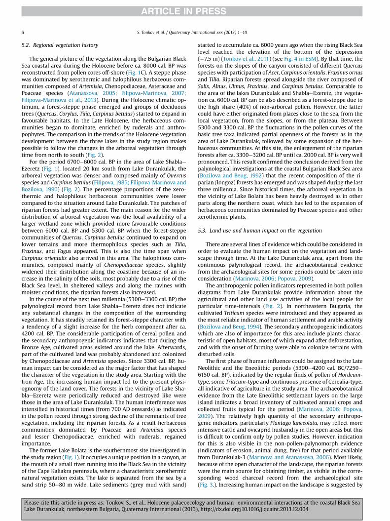
The general picture of the vegetation along the Bulgarian BlackSea coastal area during the Holocene before ca. 8000 cal. BP wasreconstructed from pollen cores off-shore (Fig. 1C). A steppe phasewas dominated by xerothermic and halophilous herbaceous com-munities composed of Artemisia, Chenopodiaceae, Asteraceae andPoaceae species (Atanassova, 2005; Filipova-Marinova, 2007;Filipova-Marinova et al., 2013). During the Holocene climatic op-timum, a forest-steppe phase emerged and groups of deciduoustrees (Quercus, Corylus, Tilia, Carpinus betulus) started to expand infavourable habitats. In the Late Holocene, the herbaceous com-munities began to dominate, enriched by ruderals and anthro-pophytes. The comparison in the trends of the Holocene vegetationdevelopment between the three lakes in the study region makespossible to follow the changes in the arboreal vegetation throughtime from north to south (Fig. 2).
For the period 6700e6000 cal. BP in the area of Lake ShablaeEzeretz (Fig. 1), located 20 km south from Lake Durankulak, thearboreal vegetation was denser and composed mainly of Quercusspecies and Carpinus betulus (Filipova, 1985; Filipova-Marinova andBozilova, 1990) (Fig. 2). The percentage proportions of the xero-thermic and halophilous herbaceous communities were lowercompared to the situation around Lake Durankulak. The patches ofriparian forests had greater extent. The main reason for the widerdistribution of arboreal vegetation was the local availability of alarger wetland zone which provided more favourable conditionsbetween 6000 cal. BP and 5300 cal. BP when the forest-steppecommunities of Quercus, Carpinus betulus continued to expand onlower terrains and more thermophilous species such as Tilia,Fraxinus, and Fagus appeared. This is also the time span whenCarpinus orientalis also arrived in this area. The halophilous com-munities, composed mainly of Chenopodiaceae species, slightlywidened their distribution along the coastline because of an in-crease in the salinity of the soils, most probably due to a rise of theBlack Sea level. In sheltered valleys and along the ravines withmoister conditions, the riparian forests also increased.
In the course of the next two millennia (5300e3300 cal. BP) thepalynological record from Lake ShablaeEzeretz does not indicateany substantial changes in the composition of the surroundingvegetation. It has steadily retained its forest-steppe character witha tendency of a slight increase for the herb component after ca.4200 cal. BP. The considerable participation of cereal pollen andthe secondary anthropogenic indicators indicates that during theBronze Age, cultivated areas existed around the lake. Afterwards,part of the cultivated land was probably abandoned and colonizedby Chenopodiaceae and Artemisia species. Since 3300 cal. BP, hu-man impact can be considered as the major factor that has shapedthe character of the vegetation in the study area. Starting with theIron Age, the increasing human impact led to the present physi-ognomy of the land cover. The forests in the vicinity of Lake Sha-blaeEzeretz were periodically reduced and destroyed like werethose in the area of Lake Durankulak. The human interference wasintensified in historical times (from 700 AD onwards) as indicatedin the pollen record through strong decline of the remnants of treevegetation, including the riparian forests. As a result herbaceouscommunities dominated by Poaceae and Artemisia speciesand lesser Chenopodiaceae, enriched with ruderals, regainedimportance.
The former Lake Bolata is the southernmost site investigated inthe study region (Fig.1). It occupies a unique position in a canyon, atthe mouth of a small river running into the Black Sea in the vicinityof the Cape Kaliakra peninsula, where a characteristic xerothermicnatural vegetation exists. The lake is separated from the sea by asand strip 50e80 m wide. Lake sediments (grey mud with sand)
Please cite this article in press as: Tonkov, S., et al., Holocene palaeoecolLake Durankulak, northeastern Bulgaria, Quaternary International (2013)
started to accumulate ca. 6000 years ago when the rising Black Sealevel reached the elevation of the bottom of the depression(�7.5 m) (Tonkov et al., 2011) (see Fig. 4 in ESM). By that time, theforests on the slopes of the canyon consisted of different Quercusspecies with participation of Acer, Carpinus orientalis, Fraxinus ornusand Tilia. Riparian forests spread alongside the river composed ofSalix, Alnus, Ulmus, Fraxinus, and Carpinus betulus. Comparable tothe area of the lakes Durankulak and ShablaeEzeretz, the vegeta-tion ca. 6000 cal. BP can be also described as a forest-steppe due tothe high share (40%) of non-arboreal pollen. However, the lattercould have either originated from places close to the sea, from thelocal vegetation, from the slopes, or from the plateau. Between5300 and 3300 cal. BP the fluctuations in the pollen curves of thebasic tree taxa indicated partial openness of the forests as in thearea of Lake Durankulak, followed by some expansion of the her-baceous communities. At this site, the enlargement of the riparianforests after ca. 3300e3200 cal. BP until ca. 2000 cal. BP is very wellpronounced. This result confirmed the conclusion derived from thepalynological investigations at the coastal Bulgarian Black Sea area(Bozilova and Beug, 1992) that the recent composition of the ri-parian (longoz) forests has emerged andwas shaped during the lastthree millennia. Since historical times, the arboreal vegetation inthe vicinity of Lake Bolata has been heavily destroyed as in otherparts along the northern coast, which has led to the expansion ofherbaceous communities dominated by Poaceae species and otherxerothermic plants.
5.3. Land use and human impact on the vegetation
There are several lines of evidence which could be considered inorder to evaluate the human impact on the vegetation and land-scape through time. At the Lake Durankulak area, apart from thecontinuous palynological record, the archaeobotanical evidencefrom the archaeological sites for some periods could be taken intoconsideration (Marinova, 2006; Popova, 2009).
The anthropogenic pollen indicators represented in both pollendiagrams from Lake Durankulak provide information about theagricultural and other land use activities of the local people forparticular time-intervals (Fig. 2). In northeastern Bulgaria, thecultivated Triticum species were introduced and they appeared asthe most reliable indicator of human settlement and arable activity(Bozilova and Beug, 1994). The secondary anthropogenic indicatorswhich are also of importance for this area include plants charac-teristic of open habitats, most of which expand after deforestation,and with the onset of farming were able to colonize terrains withdisturbed soils.
The first phase of human influence could be assigned to the LateNeolithic and the Eneolithic periods (5300e4200 cal. BC/7250e6150 cal. BP), indicated by the regular finds of pollen of Hordeum-type, some Triticum-type and continuous presence of Cerealia-type,all indicative of agriculture in the study area. The archaeobotanicalevidence from the Late Eneolithic settlement layers on the largeisland indicates a broad inventory of cultivated annual crops andcollected fruits typical for the period (Marinova, 2006; Popova,2009). The relatively high quantity of the secondary anthropo-genic indicators, particularly Plantago lanceolata, may reflect moreintensive cattle and ovicaprid husbandry in the open areas but thisis difficult to confirm only by pollen studies. However, indicationfor this is also visible in the non-pollen-palynomorph evidence(indicators of erosion, animal dung, fire) for that period availablefrom Durankulak-3 (Marinova and Atanassova, 2006). Most likely,because of the open character of the landscape, the riparian forestswere the main source for obtaining timber, as visible in the corre-sponding wood charcoal record from the archaeological site(Fig. 3.). Increasing human impact on the landscape is suggested by
ogy and humaneenvironmental interactions at the coastal Black Sea, http://dx.doi.org/10.1016/j.quaint.2013.12.004

S. Tonkov et al. / Quaternary International xxx (2013) 1e10 7
the archaeological evidence which indicated that the area hasbecome densely settled. Especially, in the first half of the V-thmillennium BC, several new settlements were founded, includingthose near the coastal lakes (Dimov, 2002, 2003; Todorova, 2002;Slavchev, 2004, 2008). Additional information for human activ-ities is provided by graves and surface finds from Balchik, Bozhur-ets, St. Konstantin, and from the shore of Lake Varna (Ivanov, 1978;Dimov, 2002, 2003; Slavchev, 2004).
Subsequently, only single finds of Hordeum-type ca. 3490 cal.BC/5440 cal. BP and Triticum-type ca. 3270e3050 cal. BC/5220e5000 cal. BP were recorded, along with Plantago lanceolata, P. avi-culare, Rumex, and Urtica. These finds precede the rise in Cheno-podiaceae which could reflect abandonment of arable land. Thehigher values for Plantago lanceolata, Taraxacum-type, Cirsium-typeand P. avicularemay reflect stock-breeding related to the next phaseof human activity for the time interval ca. 3400e2700 cal.BC/5350e4650 cal. BP (the period transitional between the Eneo-lithic and the Bronze Age) confirmed for the core Durankulak-3 alsoby the evidence from non-pollen palynomorphs (Marinova andAtanassova, 2006). The direct presence of human activity in thesurroundings is indicated by the burial mounds on the shore closeto the large island (Todorova, 2002).
The archaeopalynological evidence appears rather scarce forthe Early and Middle Bronze Age (3400e1650 cal. BC), whenthe vegetation had a rather open character. However, the ten-dency of increasing pasture and dung indicators observed for theprevious period became enhanced and reached a peak around2700e2200 cal. BC. During the Late Bronze Age and the Iron Ageafter ca. 1300 cal. BC, the increase in Hordeum-type and Triticum-type, together with Juglans and Castanea, indicates intensificationof the human activities and corroborates the archaeologicalevidence.
In the area of Lake Durankulak, the phases of human occupationand the activities of the local people since the Late Neolithic wereconnected with the changes in the surrounding environment. Thearchaeopalynological record from Lake ShablaeEzeretz (Filipova,1985; Filipova-Marinova and Bozilova, 1990) revealed that thephases of human occupation were synchronous with those fromLake Durankulak. In the pollen diagram of ShablaeEzeretz, acontinuous curve for Cerealia-type pollen and also more regularfinds of Triticum-type and Hordeum-type pollen occurred, indica-tive of arable farming for the time interval 5300e4000 cal.BC/7250e5950 cal. BP (Late Neolithic and Eneolithic) whencontinuous settlements and at least two necropolis (Peev, 2008)existed in the surroundings, marked by a decrease between 3450and 3100 cal. BC/5400 and 5050 cal. BP (the transition to and duringthe Early Bronze Age), and further increase ca. 3200e2400 cal.BC/4950e4350 cal. BP. The last well-pronounced phase of humanoccupation started at ca. 700 AD.
In the course of the last 6000 years, the vegetation of the areaaround the former Lake Bolata can be described as a forest-steppe due to existence of deciduous Quercus communitieswith Acer, Carpinus orientalis, Fraxinus ornus, Fagus and Tilia onthe slopes of the river valley. The archaeological evidence is stillincomplete, the existing remains of prehistoric settlements in thecanyon are still not excavated, and this imposes difficulties incorrelating the limited archaeopalynological record. It was sug-gested that the oldest occupation phase, documented by peaks inthe anthropogenic indicators, had existed ca. 4200e4050 cal.BC/6150e6000 cal. BP, coincident with the Eneolithic humanoccupation. Subsequently, between 3620 and 3220 cal. BC/5570and 5170 cal. BP, Triticum-type pollen occurs and indicates cerealcultivation near the site in a period corresponding to the EarlyBronze Age in the region. The next phase of continuouslyoccurring Cerealia-type pollen is related to the time span
Please cite this article in press as: Tonkov, S., et al., Holocene palaeoecolLake Durankulak, northeastern Bulgaria, Quaternary International (2013)
1500 BCe120 AD. The upper part of the pollen core indicatescontinuous human impact younger than ca. 400 cal. BP (Tonkovet al., 2011).
5.4. Black Seaecoastal lakes interactions
The development of the lakes along the Bulgarian Black Seacoast during the Holocene was influenced also by the fluctuationsof the sea level. The analysis of the composition of the fossilmolluscan (gastropod) fauna in the sediments of Lake Durankulakprovided some evidence for the periodic connections of the lakewith the sea (Shopov and Yankova, 1987) (see Fig. 8 in ESM). Theapplication of an ageedepth model for core Durankulak-2 made itpossible to define more precisely the duration of the changes in thelocal hydrological regime through time as recorded by the fossilmolluscan assemblages, and hence, the deposition of differenttypes of sediments. The first stage of sedimentation (D1) between7300 and 5500 cal. BP (600e440 cm) was characterized by thedominance of freshwater (Valvata cristata, Armiger crista, Planorbiscarinatus, etc.) and terrestrial gastropods, indicating a stableisolation of the lake from the sea, with occasional weak marineinfluence as documented by the presence of Hydrobia ventrosa,Cardium edule, and Theodoxus palasii. This stage ended withdeposition of clay with indeterminable molluscan detritus, plantremains, single ostracods, and disintegrated rock particles (440e420 cm), pointing to a catastrophical event (5500e5300 cal. BP)when probably most of the basin was dry. Afterwards, thecomposition of the fossil fauna dominated by Mytilus lineatus, H.ventrosa and Cardium edule suggests a short period (D2) of limansedimentation (5300e4900 cal. BP) with constant, though weakconnection of the lakewith the sea, which endedwith deposition ofmolluscan detritus at ca. 4900e4700 cal. BP. The next stage in limansedimentation (D3) continued for 3000 years (4700e1750 cal. BP)in the conditions of an increasing marine influence, particularlyafter ca. 4000 cal. BP, indicated by the finding of eurohaline gas-tropods (H. ventrosa, Rissoa splendida, Cardium edule) and typicalBlack Sea species Cingulopsis valvatioides, Loripes lacteus, and Retusatruncalata. The deposition of Phragmites peat in the lake startedafter 1750 cal. BP when the connection with the sea again becameperiodic.
It is reasonable to compare the changes in the composition ofthe molluscan fauna from Lake Durankulak with the generaltendencies in the fluctuations of the Black Sea level during theHolocene. According to the review paper of Marinova-Filipova(2007), sea-level changes during the Holocene have beendelimited by analyzing terrace complexes along the seashore,locating marine phases that denote sea-lake oscillations, andcomparing them with available radiocarbon dates. The con-structed paleoeustatic curve of sea-level fluctuations during thelast 11,000 years represents a suggestion only; tectonic factors,landslides, erosion, and some differences in the dating make ab-solute precision impossible. Following this curve, several impor-tant transgression/regression phases could be outlined. A steadyrise of the sea level began after 7650 cal. BP. until ca. 7000 cal. BPwhen sandy deposits with typical molluscan fauna of Mytilusgalloprovincialis and H. ventrosa were found, together withMytilaster lineatus, Corbula maeotica and Cardium edule. Thecomposition and the considerably more widespread occurrence ofthis assemblage, compared to the others, reflects conditions of anexpanding transgression and salinization of the sea in the mid-Holocene, which eventually brought about the final disappear-ance of Caspian species as the euryhaline marine species rose todominance. Most probably, this was a result of the influx ofMediterranean waters (Wall and Dale, 1974; Chepalyga, 2002;Ryan et al., 1997, 2003).
ogy and humaneenvironmental interactions at the coastal Black Sea, http://dx.doi.org/10.1016/j.quaint.2013.12.004

S. Tonkov et al. / Quaternary International xxx (2013) 1e108
For the period 7000e5500 cal. BP, sea-level was rather unstable,experiencing two distinct lowerings at 7000e6500 and 6000e5500 cal. BP, separated by a steep rise from 6500 to 6000 cal. BP.These fluctuations are in accordance with the slight changes in thecomposition of the fossil molluscan fauna at Lake Durankulak, asfor most of this period the lake remained isolated from the sea.With a generally rising sea level during the mid-Holocene, relativefalls can also be observed at 6800 cal. BP in Lake ShablaeEzeretz(Filipova, 1985) and at Lake Varna, where between 4.3 and 5 m indepth a cultural layer dated at 6190 cal. BP was found (Bozilova andBeug, 1994). Along the southern Bulgarian coast, the evidence alsoconfirmed this lowering of thewater level as settlements of the LateEneolithic existed at the sea side at a depth of several meters northof Cape Atia, in the harbors of Sozopol and Kiten (Draganov, 1995;Lazarov, 1996; Todorova, 2002; Filipova-Marinova and Bozilova,2003; Filipova-Marinova et al., 2011). A series of radiocarbon datesfrom these sites between 6400 and 6287 cal. BP (4840e4370 cal. BC) are in conformity with the radiocarbon chronology forBulgarian prehistory (Görsdorf and Boyadziev, 1997).
The rise in sea level after ca. 6500 cal. BP was particularly sharp,and an enlargement of the coastal lakes probably took place. Insupport for this suggestion is the Eneolithic burial place aroundLake Durankulak, where some of the graves are today under water(Todorova, 2002). The present estuarine bay of VarnaeBeloslav wasturned into a large embayment of the sea, reaching the mouth ofthe incoming rivers. Fragments of a marine terrace with somefossils survived at an elevation of 5 m close to the town of Beloslavindicating that at the beginning and end of the transgression thenatural reservoir was considerably fresher, with an abundance ofTheodoxus pallasi and Dreissena polymorpha. During the trans-gression, maximumhalophilous and thermophilousMediterraneanmolluscan species such as Ostrea edulis and M. lineatus invaded thebasin (Krastev et al., 1990).
The catastrophic event at Lake Durankulak ca. 5500e5300 cal. BP when molluscan detritus was deposited and probablylarge parts of the basin were dry, concides with the observed lowerlevel of the Black Sea at that time (Filipova-Marinova et al., 2011). Arelatively low and stable sea level for the period 5500e4200 cal. BP,combined with an increasing drought (Bozilova and Filipova, 1986),had caused not only the isolation of the lakes from the sea, but alsolowering of their water level as shown by the example of LakeDurankulak where a peat layer with molluscan detritus (4900e4700 cal. BP) was deposited and diatomswere absent (Bozilova andTonkov, 1998).
Similarly dry conditions were detected for the period 4720e3990 cal. BP in the northern Black Sea area (Kremenetskiy et al.,1999) and the archaeological remains excavated provided also ev-idence for a lowering of sea level during that period. Human ac-tivity along the western Black Sea coast resumed during the EarlyBronze Age and some settlements developed above remains of LateEneolithic settlements (Sozopol and Varna) while others arose innew locations (Atia, Ropotamo, Kiten, and Akhtopol). According toKuniholm et al. (1998), a combination of sea-level change andtectonic subsidence is thought to explain why apparent habitationsites are now 5e10 m under water. The next rise in sea level isshown by both the abandonment of the prehistoric Early BronzeAge settlements and the considerable presence of cysts of thetypical association of the euryhaline dinoflagellate Lingulodiniummachaerophorum and the acritarch Cymathiosphaera globulosa inmarine sediments after 3840 cal. BP. This steep rise in sea level forthe period 4200e3500 cal. BP (Filipova-Marinova et al., 2011) ismarked by the deposition of peat with molluscan detritus in thecoastal lakes as shown at Lake Durankulak. Marine deposits withdated shells of O. edulis (3840e3350 cal. BP) can be observed southof Cape Shabla on an abrasion terrace 4 m high as well as in cross-
Please cite this article in press as: Tonkov, S., et al., Holocene palaeoecolLake Durankulak, northeastern Bulgaria, Quaternary International (2013)
sections through the estuaries of several rivers running into theBlack Sea (Krastev et al., 1990).
The subsequent low level of the Black Sea until 1950 cal. BP mayhave been a result of lower rates of freshwater inflow during theFanagorian Regression from3200 to 2300 cal. BP (Chepalyga, 2002).A marked lowering of the water level in the coastal lakes and theaccumulation of a thick peat layer also occurred. From this period aswell, submerged ancient settlements are found, everywhere at adepth of 4e6 m, with remnants of harbor basins at depths of 8e12 m (Lazarov, 1975).
High precipitation levels in Europe generally coincided with theNymphaean Transgressionwhich started in the 1st century AD, andmaximum sea-level was attained in the late 7theearly 8th centuryAD (Shilick, 1997). Ports and ancient towns along the coast wereflooded. The archaeological evidence suggests higher rainfall andcomparatively moist conditions in Europe between 1950 and1300 cal. BP (Bouzek, 1983; Hay et al., 1991).
6. Conclusions
The analysis and synthesis of the palaeoecological informationfrom Lake Durankulak spanning the last ca. 8000 years, comparedwith the available data from other coastal lakes in southernDobrudza region (northeastern Bulgaria), has revealed in detail thebasic stages in vegetation and palaeoecological changes, history ofhuman occupation and impact on the environment, and the influ-ence of the Black Sea. The main results from this study can beoutlined as follows:
1. The xerothermic steppe vegetation prevailing on large areasduring the early Holocene, and dominated by Chenopodiaceae,Artemisia and Poacae species, was gradually transformed after6000 cal. BP into a forest-steppe, comprising oak woods withCarpinus betulus, Ulmus, Tilia, and Acer. Patches of riparian for-ests with Salix, Alnus, and F. excelsior developed in moister ra-vines and along the rivers running into the Black Sea.
2. The intensification of human activities since 3300 cal. BP can beconsidered as the primary factor for the periodical destructionand reduction of the oak woodland. Finally, the human impactled to replacement of the forests by arable land or xerothermicherbaceous communities enriched with anthropophytes andruderals.
3. The evidence of the anthropogenic impact on the vegetationderived from pollen studies and archaeobotanical finds alloweda detailed reconstruction of the occupation phases and subsis-tence strategies of the local population since the Late Neolithic(5300 cal. BC/7250 cal. BP). Distinct periods of intensive culti-vation of cereals (at ca. 5300e4200 cal. BC/7250e6150 cal. BP,1300e250 cal. BC/3250e2200 cal. BP) and stock-breeding ac-tivities (2700e2250 cal. BC/4650e4200 cal. BP) were inter-rupted by abandonment of the settlements and the arable landcaused by increasing drier/colder environmental conditions orsea level changes in the study region.
4. The development of the coastal lakes and their surroundingsduring the Holocene has been also influenced by the fluctua-tions in the water level of the Black Sea. In particular, the timeinterval 7700e5500 cal. BP was characterized by a rather un-stable sea level with alternating steep rises and falls.
5. The periodic connection/isolation of Lake Durankulak with theBlack Sea and the periods of marine influence were confirmedby the changes in the composition of the fossil molluscan faunaand the lithology of the sediments. The other coastal lakes hadalso experienced similar changes in their hydrological regimewith certain variations as a result of the local environmentalcharacteristics.
ogy and humaneenvironmental interactions at the coastal Black Sea, http://dx.doi.org/10.1016/j.quaint.2013.12.004

S. Tonkov et al. / Quaternary International xxx (2013) 1e10 9
Acknowledgements
The preliminary results of this synthesis were presented by S.Tonkov at the INQUA-SEQS meeting At the Edge of the Sea: Sedi-ments, Geomorphology, Tectonics and Stratigraphy in QuaternaryStudies held in Sassari, Italy, 26e27 September 2012, upon a kindinvitation and financial support provided by the organizers. Theauthors are grateful to I. Vajsov and P. Zidarov for the discussionon the archaeological chronology. The reviewers Prof. D. Magri andan anonymous colleague provided comments to improve themanuscript. Thanks are due to the editor Prof. M. Coltorti for hisuseful suggestions and the editing of the text. This paper is acontribution to Project N� DID 02/26/2009 supported by the Na-tional Science Fund at the Ministry of Education and Science inSofia.
Appendix A. Supplementary data
Supplementary data related to this article can be found at http://dx.doi.org/10.1016/j.quaint.2013.12.004
References
Atanassova, J., 2005. Palaeoecological setting of the western Black Sea area duringthe last 15 000 years. The Holocene 15, 576e584.
Bojadjiev, J., 1992. Chronology of the praehistoric cultures on the territory ofDobrudza. Dobrudza 9, 10e19 (in Bulgarian).
Bondev, I., 2002. Geobotanic regioning. In: Kopralev, I. (Ed.), Geography of Bulgaria.ForCom Publisher, Sofia, pp. 336e351 (in Bulgarian).
Bouzek, J., 1983. Climatic changes in central European prehistory. In: Harding, A.(Ed.), Climatic Change in Later Prehistory. Edinburgh University Press, pp. 179e191.
Bozilova, E., Beug, H.-J., 1992. On the Holocene history of vegetation in SE Bulgaria(Lake Arkutino, Ropotamo region). Vegetation History and Archaebotany 1, 19e32.
Bozilova, E., Beug, H.-J., 1994. Studies on the vegetation history of lake Varna region,northern Black Sea coastal area of Bulgaria. Vegetation History and Arch-aebotany 3, 143e154.
Bozilova, E., Filipova, M., 1986. Palaeoecological environment in NE Black Sea areaduring Neolithic, Eneolithic and Bronze Periods. Studia Praehistorica 88, 160e166.
Bozilova, E., Tonkov, S., 1985. Palaeoecological Studies in Lake Durankulak, vol. 76(2). Annual University of Sofia, Faculty of Biology, pp. 25e30.
Bozilova, E., Tonkov, S., 1990. The impact of man on the natural vegetation inBulgaria from the Neolithic to the Middle Ages. In: Bottema, S., et al. (Eds.),Man’s Role in the Shaping of the Eastern Mediterranean Landscape. Balkema,Rotterdam, pp. 327e332.
Bozilova, E., Tonkov, S., 1998. Towards the vegetation and settlement history of thesouthern Dobrudza coastal region, north-eastern Bulgaria: a pollen diagramfrom Lake Durankulak. Vegetation History and Archaebotany 7, 141e148.
Chepalyga, A., 2002. Marine basins. Black Sea. In: Velichko, A. (Ed.), Dynamics ofTerrestrial Landscape Components and Inner Marine Basins of Northern Eurasiaduring the Last 130000 Years. GEOS Publishers, Moscow, pp. 170e182 (inRussian).
Dimov, T., 2002. Archaeological finds of culture Hamangia along the Lower Danubeand the Western Black Sea coast. Scientific Reports e Dobrich 4, 141e155 (inBulgarian).
Dimov, T., 2003. Topography, stratigraphy and architecture of the settlements fromthe prehistoric culture Hamangia in Dobrudza. Dobrudza 21, 123e143.
Draganov, V., 1995. Submerged coastal settlements from Final Eneolithic and theEarly Bronze Age in the sea around Sozopol and Urdovitza Bay near Kiten. In:Bailey, D., et al. (Eds.), Monographs in World Archeology e 22. PrehistoricBulgariaPrehistory Press, Madison/Wisconsin, pp. 225e241.
Filipova, M., 1985. Palaeoecological investigations of Lake ShablaeEzeretz in NEBulgaria. Ecologia Mediterranea 11, 147e158.
Filipova-Marinova, M., 2007. Archaeological and paleontological evidence of climatedynamics, sea-level change, and coastline migration of the Bulgarian sector ofthe Circum-Pontic region. In: Yanko-Hombach, V., Gilbert, A., Panin, N.,Dolukhanov, P. (Eds.), The Black Sea Flood Question: Changes in Coastline,Climate, and Human Settlement. Springer, Dordrecht, pp. 453e482.
Filipova-Marinova, M., Bozilova, E., 1990. Palaeoecological investigation of LakeShablaeEzeretz on the Bulgarian Black Sea coast. In: Krastev, T. (Ed.), GeologicalEvolution of the Western Part of the Black Sea in Neogen-Quaternary. Pub-lishing House Bulgarian Academy of Sciences, Sofia, pp. 41e87 (in Russian).
Filipova-Marinova, M., Bozilova, E., 2003. Palaeoecological evidence of the vegeta-tion history and human occupation in the coastal area of Sozopol (SoutheasternBulgaria). Dobrudza 21, 279e291.
Please cite this article in press as: Tonkov, S., et al., Holocene palaeoecolLake Durankulak, northeastern Bulgaria, Quaternary International (2013)
Filipova-Marinova, M., Giosan, L., Angelova, H., Preisinger, A., Pavlov, D., Vergiev, S.,2011. Palaeoecology of submerged prehistoric settlements in Sozopol Harbour,Bulgaria. In: Benjamin, J., et al. (Eds.), Submerged Prehistory. Oxbow Books,pp. 230e244.
Filipova-Marinova, M., Pavlov, D., Coolen, M., Giosan, L., 2013. First high-resolution marinopalynological stratigraphy of Late Quaternary sedimentsfrom the central part of the Bulgarian Black Sea area. Quaternary Interna-tional 293, 170e183.
Görsdorf, J., Boyadziev, Y., 1997. Zur absoluten Chronologie der bulgarischen Urge-schichte. Berliner 14C Datierungen von bulgarischen archäologischen Fund-plätzen. Eurasia Antiqua 2, 105e173.
Grimm, E., 2011. TGView. Version 1.5.17. Illinois State Museum, Springfield, USA.Hay, B.J., Arthur, M., Dean, W., Neff, E., Honio, S., 1991. Sediment deposition in the
Late Holocene abyssal Black Sea with climatic and chronological implications.Deep Sea Research. Part A. Oceanographic Research Papers 38 (Suppl. 2),S1211eS1236.
Ivanov, I., 1978. Les fouilles archéologiques de la nécropole chalcolithique a Varna(1972e1976). Studia Praehistorica 1e2, 13e26.
Jordanov, D., 1936. On the distribution of the steppe vegetation in Bulgaria. In:Proceedings of Bulgarian Academy of Sciences, vol. XXXII, p. 105 (in Bulgarian).
Kozuharov, S., Dimitrov, D., Lazarova, M., Kozuharova, E., 1997. Characteristics ofFlora and Vegetation of the Natural Plant Complexes in South Dobrudzha.Dobrudzha and Kaliakra. Collection of Papers. Academic Publishing House ofAgricultural University, Plovdiv, pp. 42e58 (in Bulgarian).
Krastev, T., Svitoch, A., Yanina, T., Stoyanova, R., 1990. Biostratigraphy of marinePleistocene sediments in the Bulgarian Black Sea coast. In: Krastev, T. (Ed.),Geological Evolution of the Western Part of Black Sea Basin during the Neogen-Quaternary. Bulgarian Acad. Sci. Publ., Sofia, pp. 87e95 (in Russian).
Kremenetskiy, C., Chichagova, O., Shishlina, N., 1999. Palaeoecological evidence forHolocene vegetation, climate and land use change in the low Don basin andKalmuk area, southern Russia. Vegetation History and Archaeobotany 8, 233e246.
Kuniholm, P., Kromer, B., Tarter, S., Griggs, C., 1998. An Early Bronze Age settlementat Sozopol, near Burgas, Bulgaria. In: Stefanovich, M., et al. (Eds.) vol. 1JamesHarvey Gaul e In Memoriam, Sofia, pp. 399e409.
Lazarov, M., 1975. The Submerged Fleet. Georgi Bakalov Publ., Varna (in Bulgarian).Lazarov, M., 1996. Submerged settlements along the Western Black Sea coast in the
context of Pontian and Mediterranean history. Istoria 1, 48e61 (in Bulgarian).Marinova, E., 2003. The new pollen core Lake Durankulak-3: a contribution to the
vegetation history and human impact in Northeastern Bulgaria. In: Tonkov, S.(Ed.), Aspects of Palynology and Palaeoecology. Pensoft Publishers, Sofia-Mos-cow, pp. 257e268.
Marinova, E., 2006. Vergleichende paläoethnobotanische Untersuchung zurVegetationsgeschichte und zur Entwicklung der prähistorischen Land-nutzung in Bulgarien. Dissertationes Botanicae 401,406. J. Cramer. Berlin-Stuttgart, 164 pp.
Marinova, E., Atanassova, J., 2006. Anthropogenic impact on vegetation and envi-ronment during the Bronze Age in the area of Lake Durankulak, NE Bulgaria:pollen, microscopic charcoal, non-pollen palynomorphs and plant macrofossils.Review of Palaeobotany and Palynology 141 (1e2), 165e178.
Peev, P., 2008. Underwater sites in the area of cape Shabla (North-East Bulgaria). In:Kostov, R.I., R., Gaydarska, B., Gurova, E. (Eds.), Geoarchaeology and Archae-omineralogy Proceedings of the International Conference, 29e30 October 2008Sofia. Publishing House “St. Ivan Rilski”, Sofia, pp. 303e304.
Peev, P., 2009. The Neolithisation of the Eastern Balkan peninsula and fluctuationsof the Black Sea level. Quaternary International 197, 87e92.
Popova, Tz, 2009. Paleobotanic catalogue of the studied sites and studied remains(debries) in the territory of Bulgaria (1980e2008). Interdisciplinary Studies 20e21, 71e165.
Ryan, W., Pitman III, W., Major, C., Shimkus, K., Moskalenko, V., Jones, G.,Dimitrov, P., Görür, N., Sakinç, M., Yüce, H., 1997. An abrupt drowning of theBlack Sea shelf. Marine Geology 138, 119e126.
Ryan, W., Major, C., Lericolais, G., Goldstein, S., 2003. Catastrophic flooding of theBlack Sea. Annual Review Earth and Planetary Sciences 31, 525e554.
Shilick, K.-K., 1997. Oscillations of the Black Sea and ancient landscape. ColloquiaPontica 3, 115e129.
Shopov, V., Yankova, D., 1987. Holocene Gastropod fauna from the lakes of Duran-kulak and ShablaeEzeretz. Paleontology, Stratigraphy and Lithology 24, 70e89(in Bulgarian).
Slavchev, V., 2004. Four Eneolithic Sites to the North of the City of Varna. Izvestijana Narodnija Muzej, Varna, pp. 51e52 (2000/2001), 135e63. (in Bulgarian).
Slavchev, V., 2008. Some remarks on cultural relations in the area of today’sBulgarian Black Sea coast during the Late Neolithic. In: Slavchev, V. (Ed.), TheVarna Eneolithic Necropolis and Problems of Prehistory in Southeast Europe.Regional Archaeological Museum, Varna, pp. 43e56.
Stojanov, N., 1941. An Attempt to Characterize the Basic Phytocoenoses in Bulgaria,vol. 37 (3). Annual University of Sofia, Faculty of Physics and Mathematics,pp. 93e187 (in Bulgarian).
Todorova, H., 1995. The Neolithic, Eneolithic and transitional period in Bulgarianprehistory. In: Bailey, D., et al. (Eds.), Prehistoric Bulgaria. Prehistory Press,Madison, pp. 79e98.
Todorova, H., 2002. In: Durankulak. Band II. Die Praehistorishe Graberfelder. Teil 1.Publishing House Anubis, Berlin-Sofia.
Tonkov, S., Beug, H.-J., Bozilova, E., Filipova-Marinova, M., Jungner, H., 2011. Palae-oecological studies at the Kaliakra area, northeastern Bulgarian Black Sea coast:
ogy and humaneenvironmental interactions at the coastal Black Sea, http://dx.doi.org/10.1016/j.quaint.2013.12.004

S. Tonkov et al. / Quaternary International xxx (2013) 1e1010
6000 years of natural and anthropogenic change. Vegetation History andArchaeobotany 19 (4), 259e270.
Velchev, V., 2002. Types of vegetation. In: Kopralev, I. (Ed.), Geograpgy of Bulgaria.ForCom Publisher, Sofia, pp. 324e335 (in Bulgarian).
Wall, D., Dale, B., 1974. Dinoflagellates in Late Quaternary deep-water sediments ofBlack Sea. Memoir 20. In: Degens, E., Ross, D. (Eds.), The Black Sea e Geology,
Please cite this article in press as: Tonkov, S., et al., Holocene palaeoecolLake Durankulak, northeastern Bulgaria, Quaternary International (2013)
Chemistry and Biology. American Association of Petroleum Geologists, Tulsa,Oklahoma, pp. 364e380.
Yanko-Hombach, V., Gilbert, A., Dolukhanov, P., 2007. Controversy over the greatflood hypotheses in the Black Sea in light of geological, paleontological, andarchaeological evidence. Quaternary International 167e168, 91e113.
ogy and humaneenvironmental interactions at the coastal Black Sea, http://dx.doi.org/10.1016/j.quaint.2013.12.004